artículo valderredible rupestre
DESCRIPTION
Revista Cantabria InfinitaTRANSCRIPT
cantabria infinita 21
EL CONTEXTO
El municipio de Valderredible es el más meridional y más
extenso de Cantabria. Sobre su superficie de casi 300 kms.
cuadrados se integran más de cincuenta núcleos de pobla-
ción que acogen menos de 1.300 vecinos. Esta despoblación
contrasta con el notable patrimonio natural y cultural que el
mismo territorio atesora consecuencia, en gran medida, de su
posición fronteriza.
Hoy Valderredible es frontera geográfica y administrativa, pero
también fue frontera cultural y castrense. Su condición de fron-
tera geográfica viene dada por la transición entre el ámbito cos-
tero y la meseta donde el clima se extrema, los cultivos se tor-
nan extensivos y lo meridional parece más próximo que lo
m a r í t i m o. La frontera administrativa es relativamente reciente:
termina Cantabria para comenzar Castilla-León. Pero para refe-
rirse a su patrimonio cultural hay que tener presente su situa-
ción de frontera histórica; en sus latitudes se detuvo la ocupa-
ción musulmana separándose allí lo cristiano-visigótico de lo
m a h o m e t a n o- m u s u l m á n, configurando el escenario propicio
para incursiones, razias, escaramuzas y otras acciones bélicas
más o menos acordes con las modalidades guerreras del
m o m e n t o. Con independencia de diferencias culturales, revan-
chas y reconquistas, el norte aspira al cereal cultivable en la
meseta, sin que el sur renuncie a los principios expansionistas
que inspiraron la invasión de la península.
En este contexto fronterizo se implanta, o al menos consolida
su implantación de acuerdo con las teorías al respecto, un
notable conjunto de “cuevas artificiales” que constituyen una
p a rte fundamental y singular del patrimonio cultural de Canta-
bria, y en particular de Valderredible, por lo escaso de los tes-
timonios de la época que representan, por el número de ele-
mentos que lo integran, por la proximidad de sus emplaza-
mientos y por la calidad individual de algunos de ellos.
Estas “cuevas artificiales” se configuraron mediante excava-
ción de rocas naturales, probablemente aprovechando las
oquedades existentes, para formalizar así un espacio utilizable
de acuerdo con las posibilidades y necesidades del momento.
Una roca arenisca muy blanda que permite fácilmente su talla
mediante utensilios y herramientas elementales ha posibilitado
este tipo de actuaciones. Se trata, en consecuencia, de unas
arquitecturas muy primarias formadas mediante las extraccio-
nes de material interior con escasa, o nula, aportación de mate-
riales externos para conseguir un vacío partiendo de la roca
preexistente y con actuaciones muy limitadas sobre su aspec-
to externo, su “fachada”, que normalmente permanece en su
estado natural anterior a la interv e n c i ó n.
Atendiendo a su origen y utilización hay que distinguir dos
categorías de “cuevas artificiales” que dan lugar a situaciones
diferentes: las “iglesias rupestres” destinadas inequívoca-
mente a funciones de culto litúrgico como Santa María de
SITUADO A UNOS 120 KMS. DE SANTANDER, EL MUNICIPIO DE VALDERREDIBLE ES UN VALLE UN TANTO
DESCONOCIDO Y AÚN VIRGEN, POCO POBLADO Y APARTADO DE LAS RUTAS MÁS FRECUENTADAS. EL
PATRIMONIO HISTÓRICO QUE POSEE ES MUY EXTENSO Y EXISTEN EJEMPLOS DE DIVERSAS ÉPOCAS EN
CANTABRIA: ERMITAS RUPESTRES, IGLESIAS ROMÁNICAS, ARQUITECTURA MEDIEVAL, ETC. DESTACA SIN
EMBARGO EL MUNICIPIO POR LA SINGULARIDAD DE SUS ARQUITECTURAS RUPESTRES, SURGIDAS A
MODO DE “CUEVAS ARTIFICIALES” EXCAVADAS EN ROCAS NATURALES APROVECHANDO OQUEDADES
YA EXISTENTES Y CON DOS FINALIDADES INICIALES: EL CULTO Y EL COBIJO. ESTOS ASENTAMIENTOS
RUPESTRES, A PESAR DE EXTENDERSE A LO LARGO DE LA CORNISA CANTÁBRICA, CONCENTRAN EN
VALDERREDIBLE LOS EJEMPLARES MÁS SINGULARES.
ARQUITECTURAS RUPESTRES
EN VALDERREDIBLET E X TO Y FOTOGR AFÍA S / T EXT A N D PICT URE S E N RIQ UE BO L AD O GU TI ÉR REZ
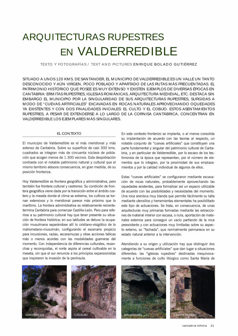
ARROYUELOS CADALSO SAN ANDRÉS CAMPO DE EBRO

22 cantabria infinita
Valverde, Campo de Ebro, Cadalso y Arroyuelos, y los “habi-
táculos de acogida” y/o “laudas rupestres” destinados al
albergue ermitaño o monacal, según el número de inte-
grantes del asentamiento y la complejidad de las relaciones
entre sus miembros (Quintanilla de Rucandio, Rebollar de
Ebro, …). Ambas categorías se implantarían simultánea-
mente en el tiempo y en ambos casos es posible y probable
que, al menos inicialmente, se superpusieran las dos funcio-
nes, culto y albergue, para especializarse a lo largo del tiem-
po por predominio de una de ellas. No resulta difícil imagi-
nar la transformación de un espacio que, por actuaciones
sucesivas y a medida de las demandas crecientes, relega su
función inicial de cobijo para dar paso a otro tipo de ocupa-
ción socialmente más complejo. La entidad física de una y
otra categoría es muy humilde: de la primera solamente
Santa María de Valverde supera los cien metros cuadrados,
mientras que el resto no supera los cincuenta. La segunda
categoría de las apuntadas es mucho más heterogénea en
cuanto a su superficie en función de las dimensiones de la
cavidad natural origen, presentando, en general, unas
dimensiones más modestas.
LAS TEORÍAS
La detección e investigación de estas iglesias en Va l d e r r e d i b l e
es muy reciente, iniciándose hace apenas cincuenta años con
trabajos de Carrión Irún, González Echegaray, García Guinea,
Bohígas Ro l d á n y otros que han dado los primeros y valiosos
pasos para su estudio y análisis hoy todavía incompletos.
Historiadores, arqueólogos y expertos no están plenamente
de acuerdo sobre el origen de estas iglesias. Dos cronologías
básicas, y distintos orígenes dentro de ellas, se han perfila-
do al respecto: la que vincula su origen con la evangelización
del territorio y la que vincula su origen con la repoblación del
mismo. La primera asocia estas “cuevas artificiales” a la
actividad de arcaicos misioneros quienes, para transmitir su
mensaje doctrinal, se asentarían en este territorio en épocas
anteriores a 711, año de La Batalla de Guadalete que se
toma como referente del inicio de la presencia musulmana
en la península, ocupando pequeñas cuevas dentro de la tra-
dición eremítica focalizada en el incipiente Monasterio de
Suso por San Millán de La Cogolla, quien visitó Cantabria
según se ha probado documentalmente. Se trataría pues de
una expansión en sentido sur-norte que, siguiendo el curso
del Ebro llega, se asienta y arraiga en Valderredible (Valle del
río Iber) imitando, tal vez, el modelo instaurado por el Santo
riojano en los montes de La Cogolla, con cuevas o celdillas
individuales y un cenobio común que aglutinaría una comu-
nidad embrionaria.
La segunda de las cronologías apuntadas asocia estas “cuevas
a rtificiales” con la repoblación cristiana del territorio y, conse-
cuentemente, retrasa algún siglo sus orígenes situando su
implantación dentro de dos posibles corrientes: en sentido
n o rte-sur como parte de la ocupación de vastas extensiones
débilmente pobladas dentro de la reconquista iniciada en tie-
rras asturianas, o en sentido sur- n o rte, como consecuencia de
TEMAS / PATRIMONIO

cantabria infinita 23
ARROYUELOS: LA ROCA
NATURAL Y LAS
TRANSFORMACIONES
PERFECTAMENTE INTEGRADAS
EN UN CONJUNTO IRREPETIBLE.
ARROYUELOS: NATURAL ROCKS
AND TRANSFORMATIONS
PERFECTLY INTEGRATED INTO A
UNIQUE SET.
SAN ANDRÉS DE VALDELOMAR:
CUEVA NATURAL CON
TRANSFORMACIONES. A SU
ENTRADA SE APRECIAN TRES
HABITÁCULOS ARTIFICIALES.
SAN ANDRÉS DE VALDELOMAR:
NATURAL CAVE WITH
TRANSFORMATIONS. THREE
ARTIFICIAL HABITATS ARE
DEPICTED AT ITS ENTRANCE.
ATENDIENDO A SU ORIGEN Y UTILIZACIÓN HAY QUE DISTINGUIR DOS CATEGORÍAS DE "CUEVAS
ARTIFICIALES": LAS "IGLESIAS RUPESTRES" DESTINADAS A FUNCIONES DE CULTO LITÚRGICO Y LOS
"HABITÁCULOS DE ACOGIDA" Y/O "LAUDAS RUPESTRES", DESTINADOS AL ALBERGUE ERMITAÑO O
MONACAL. ES POSIBLE QUE, AL MENOS INICIALMENTE, SE SUPERPUSIERAN ESTAS DOS FUNCIONES.
WE CAN DIFFERENTIATE BETWEEN TWO TYPES OF “ARTIFICIAL CAVES” BASED ON THEIR ORIGINS AND
USE: “PRIMITIVE CHURCHES” UNDOUBTEDLY USED FOR WORSHIP AND “SHELTERS” AND/OR
“PRIMITIVE HEADSTONES” USED AS SHELTER BY MONKS OR HERMITS. IT IS POSSIBLE THAT, INITIALLY IN
ANY EVENT, THE FUNCTIONS OF WORSHIP AND SHELTER OVERLAPPED.
asentamientos mozárabes procedentes de los territorios some-
tidos a la ocupación musulmana, todo ello consecuencia de la
posición fronteriza de Valderredible; otra vez la frontera entre
dos culturas antagónicas y militarmente enfrentadas.
Con independencia de su incierto origen, estos asentamien-
tos rupestres no constituyen un hecho aislado en Valderredi-
ble, ni siquiera en España. A lo largo de la Cornisa Cantábri-
ca y extendiéndose por el curso del Alto Ebro hasta La Rioja,
se localizan otras actuaciones similares. No obstante, es en
la zona de confluencia de Burgos, Palencia y Cantabria
donde, a nivel nacional y con Valderredible como epicentro,
se producen las concentraciones más notables y los ejempla-
res más singulares.
LAS ARQUITECTURAS
El aspecto, sobre todo interno, que ofrecen hoy estas “cuevas
artificiales”, sobre todo las denominadas “iglesias rupestres”,
no responde a una única y metódica actuación realizada en
tiempos remotos para conseguir espacios utilizables. Lo que
hoy podemos observar es el resultado de actuaciones sucesi-
vas y superpuestas realizadas a lo largo de siglos. Las labo-
res de talla interior y las aportaciones de elementos exterio-
res (muros, espadañas, huecos, cubiertas, …) han dado l u g a r
a espacios cada vez más complejos en los que se han formali-
zado elementos réplicas de los propios de la arquitectura tradi-

24 cantabria infinita
cional construida. Así, a lo largo del tiempo, se trazan arcos, se
configuran ábsides, se crean naves, incluso se dota al espacio
resultante de una mayor complejidad con la incorporación de
segundas plantas con sus correspondientes escaleras de acce-
so (Arroyuelos, Presillas de Bricia en Burgos, …).
Con la salvedad de las realizadas en tiempos recientes, estas
transformaciones se encuentran nada o escasamente docu-
mentadas, circunstancia que aporta dificultades añadidas a
la difícil tarea de datación que los expertos tienen pendien-
te, con la particularidad de que las transformaciones reali-
zadas con aportación de materiales externos pueden aportar
datos e indicios de su momento de ejecución por sus condi-
ciones “estilísticas” y las técnicas utilizadas y, normalmente,
puede recuperarse la situación anterior eliminando lo apor-
tado, mientras que las realizadas mediante extracción de
roca han borrado los vestigios de la situación anterior que se
hace irrecuperable.
Como consecuencia de su proceso constructivo el aspecto
externo no es que resulte perfectamente integrado con la
naturaleza del entorno, es que es naturaleza antes que edi-
ficio, sin que sea posible delimitar con precisión una y otro.
Solamente aquellos elementos aportados inequívocamente
por la mano del hombre resultan fácilmente diferenciables,
caso de las espadañas de Santa María de Valverde y, en
menor medida, de Cadalso (que ha sufrido unos cuantos
traslados sucesivos), y dejan patente la obra construida.
Pero, incluso estos hitos de señalización, con los que se
quiere poner de manifiesto la localización de una obra con
alto contenido simbólico, no resultan agresivos y, en todo
caso, son aportaciones posteriores a la creación del espacio
cerrado y cubierto. En los orígenes, tanto si se trata de una
actuación eremítica como si se trata de acciones coloniza-
doras, se puede pensar en este mimetismo como algo inten-
cionado o, al menos, útil: en el primer supuesto, el asenta-
miento sobre la naturaleza podría interpretarse como la
renuncia a todo lo superfluo que el ascetismo implica; en el
segundo se puede pensar, además, en camuflaje y disimulo
para dificultad de localización en las previsibles razias.
La categoría de los “habitáculos” es más numerosa que la de
las “iglesias” y sus emplazamientos relativos no indican, en
p r i n c i p i o, una relación directa entre una y otra.
Pero es en los interiores donde la intencionalidad humana se
pone de manifiesto y donde la diferenciación entre iglesias y
habitáculos se hace patente.
Los “habitáculos” hoy se nos muestran como sencillos y
venerables huecos con más valor simbólico que cultural, sin
apenas transformación, abandonados por el uso y con difícil
acceso en algunos casos. Su poco elaborado interior respon-
de a una concepción del espacio muy elemental, casi exclu-
sivamente utilitaria y condicionada por la oquedad origen.
Las transformaciones que han sufrido sus paramentos, que
incluso en algunos casos pueden responder a su configura-
ción inicial, puede hacer pensar que los mismos constituyen
el soporte de una valiosa información; no obstante, la roca
TEMAS / PATRIMONIO
CAMPO DE EBRO, EN EL INTERIOR DEL PUEBLO Y COMPITIENDO
CON LA IGLESIA DEL LUGAR POR EL ESPACIO EXTERIOR QUE
COMPARTEN.
CAMPO DE EBRO, IN THE VILL AGE, ITSELF, JOSTLING WITH THE
CHURCH FOR THE OUTDOOR SPACE THEY SHARE.
LA FASCINACIÓN QUE PRODUCEN ESTAS OBRAS
SE VE INCREMENTADA POR LO INCIERTO DE SUS
ORÍGENES, LO QUE SUPONE UN ALICIENTE Y
ESTÍMULO PARA LA IMAGINACIÓN DONDE EL
SIGNIFICADO TIENE MÁS VALOR QUE EL DATO.
THE FASCINATION PRODUCED BY THESE WORKS
IS ENHANCED BY THE DEBATE OVER THEIR
ORIGINS. THIS GAP IS A WELCOME STIMULUS FOR
THE IMAGINATION, WHERE MEANING IS MORE
IMPORTANT THAN INFORMATION.
cantabria infinita 25
también resulta blanda ante la erosión que ha borrado las
huellas que hoy serían valiosas.
Las categoría de las “iglesias rupestres” con emplazamiento
en Valderredible está integrada por cuatro notables ejempla-
res: Santa María de Valverde, Campo de Ebro, Cadalso y
Arroyuelos. Por la inmediatez de su emplazamiento y las
manifiestas vinculaciones con las anteriores, debe incluirse
en este grupo la iglesia rupestre de San Miguel en Presillas
de Bricia en la vecina Castilla-León, enclavada en uno de los
profundos apéndices que Burgos macla en Valderredible y
situada a escasos metros de sus límites.
Estas iglesias se nos presentan con complejidad espacial
diversa y equivalente a la de los edificios construidos para
similar función y en la misma época. Así la sencillez del
espacio unitario con definición de ábside en Campo de Ebro
y Cadalso da paso a la planta complicada de Santa María de
Valverde con dos naves bien definidas mediante arcos for-
meros sin ábsides diferenciados y con baptisterio acotado,
para complicar su perfil en Arroyuelos donde aparece una
segunda planta y su pilastra central esboza una segunda
nave, y llegar a Presillas de Bricia donde su segunda planta
junto con las pilastras que perfilan sus tres naves, sus tres
irregulares ábsides y sus altares también labrados sobre la
misma roca producen unos espacios muy singulares.
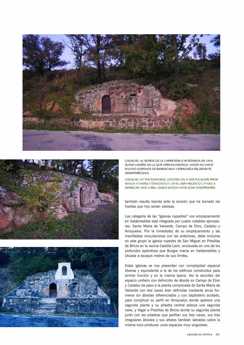
CADALSO. AL BORDE DE LA CARRETERA E INTEGRADA EN UNA
SUAVE LADERA DE LA QUE APENAS DESTACA. HASTA NO HACE
MUCHO DISPONÍA DE BARBACANA Y ESPADAÑA FELIZMENTE
DESAPARECIDAS.
CADALSO. AT THE ROADSIDE, LOCATED ON A GENTLE SLOPE FROM
WHICH IT HARDLY STANDS OUT. UNTIL VERY RECENTLY, IT HAD A
BARBICAN AND A BELL GABLE WHICH HAVE NOW DISAPPEARED.

26 cantabria infinita
TEMAS / PATRIMONIO
Las adaptaciones de las iglesias rupestres a las deman-
das sociales, culturales, funcionales y/o estéticas de
cada momento han transformado sus espacios interio-
res y/o su aspecto exterior.
En el caso de Santa María de Valverde su aspecto exter-
no inicial se vio alterado por la construcción de una
espadaña románica en el siglo XIII. Posteriormente y en
momento no determinado, tal vez en el siglo XVII, se
ejecutó sobre la cubierta pétrea natural una cubierta de
teja que se prolongaba sobre el acceso para constituir
un porche a modo de atrio. Con todo ello se protege
iglesia y fieles de las inclemencias climatológicas, en
particular de las aguas de lluvia, que sin duda, comen-
zarían a filtrarse por la cubierta y, sobre todo, se dota-
ba a este símbolo social de un aspecto tradicional para
satisfacción de los feligreses que dejan de congregarse
en una “cueva” para reunirse en un “edificio”, al menos
en su aspecto externo. Con esta imagen se llega hasta el
año 1977 en el que, por encargo de la Dirección Gene-
ral de Arquitectura y Tecnología de la Edificación, el
arquitecto José Mª Páez redacta un Proyecto con la
doble finalidad de recuperar la imagen inicial, median-
te la eliminación de cubierta y porche de teja, y la ade-
cuación del entorno. Acertadamente a este Proyecto se
le denomina de “descubrimiento” en atención a la eli-
minación física de la cubierta añadida y a la manifesta-
ción de lo que aquella ocultaba.
Con el aspecto inicial recuperado, o al menos intentada
su recuperación, llegamos a nuestros días en los que las
humedades por capilaridad y filtración deterioran la
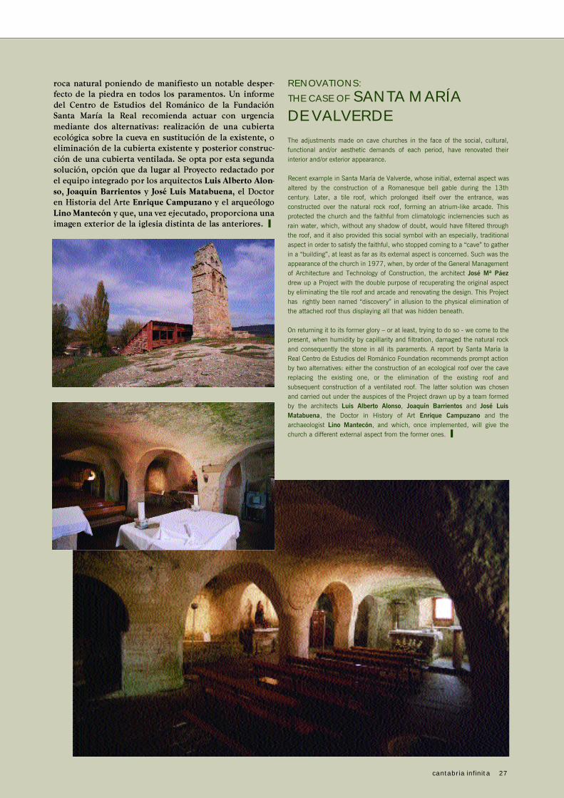
TRANSFORMACIONES:
EL CASO DE SANTA MARÍA
DE VALVERDE
PROYECTO DE “DESCUBRIMIENTO”, 1977.
“DISCOVERY” PROJECT, 1977.
ASPECTO ACTUAL DE SANTA MARÍA DE VALVERDE, 2004.
PRESENT ASPECT OF SANTA MARÍA DE VALVERDE, 2004.
CUBIERTA CONSERVADA HASTA 1977. ROOF PRESERVED UNTIL 1977.
FOTOGRAFÍA GENTILEZA DE / PICTURE COURTESY OF JOSÉ Mª PAEZ.
CUBIERTA CONSERVADA HASTA 1977. ROOF PRESERVED UNTIL 1977.
FOTOGRAFÍA GENTILEZA DE / PICTURE COURTESY OF JOSÉ Mª PAEZ.
cantabria infinita 27
roca n a t u ral poniendo de manifi e sto un notable desper-
fe c to de la piedra en todos los para m e n tos. Un info rm e
del Centro de Estudios del Románico de la Fu n d a c i ó n
S a n ta María la Real recomienda actuar con urge n c i a
m e d i a n te dos alte rn a t i vas: realización de una cubierta
ecológica sobre la cueva en sustitución de la ex i ste n te, o
eliminación de la cubierta ex i ste n te y poste rior const ru c-
ción de una cubierta ventilada. Se opta por esta segunda
solución, opción que da lugar al Proye c to re d a c tado por
el equipo inte grado por los arqu i te c tos Luis Alberto Alon-
s o, J o a quín Barri e n to s y José Luis Mata b u e n a, el Docto r
en Histo ria del Arte E n ri que Camp u z a n o y el arqu e ó l o g o
Lino Mante c ó n y que, una vez ejecutado, pro p o rciona una
i m a gen ex te rior de la iglesia dist i n ta de las ante ri o res. ❙
RENOVATIONS:
THE CASE OF SANTA MARÍA
DE VALVERDE
The adjustments made on cave churches in the face of the social, cultural,
functional and/or aesthetic demands of each period, have renovated their
interior and/or exterior appearance.
Recent example in Santa María de Valverde, whose initial, external aspect was
altered by the construction of a Romanesque bell gable during the 13th
century. Later, a tile roof, which prolonged itself over the entrance, was
constructed over the natural rock roof, forming an atrium-like arcade. This
protected the church and the faithful from climatologic inclemencies such as
rain water, which, without any shadow of doubt, would have filtered through
the roof, and it also provided this social symbol with an especially, traditional
aspect in order to satisfy the faithful, who stopped coming to a “cave” to gather
in a “building”, at least as far as its external aspect is concerned. Such was the
appearance of the church in 1977, when, by order of the General Management
of Architecture and Technology of Construction, the architect José Mª Páez
drew up a Project with the double purpose of recuperating the original aspect
by eliminating the tile roof and arcade and renovating the design. This Project
has rightly been named “discovery” in allusion to the physical elimination of
the attached roof thus displaying all that was hidden beneath.
On returning it to its former glory – or at least, trying to do so - we come to the
present, when humidity by capillarity and filtration, damaged the natural rock
and consequently the stone in all its paraments. A report by Santa María la
Real Centro de Estudios del Románico Foundation recommends prompt action
by two alternatives: either the construction of an ecological roof over the cave
replacing the existing one, or the elimination of the existing roof and
subsequent construction of a ventilated roof. The latter solution was chosen
and carried out under the auspices of the Project drawn up by a team formed
by the architects Luis Alberto Alonso, Joaquín Barrientos and José Luis
Matabuena, the Doctor in History of Art Enrique Campuzano and the
archaeologist Lino Mantecón, and which, once implemented, will give the
church a different external aspect from the former ones. ❙

28 cantabria infinita
Las cubiertas se forman con planos muy imperfectos o abo-
vedadas tanto en naves como en ábsides, mereciendo men-
ción especial el trazado en planta de estos últimos: de herra-
dura (ultrasemicircular) en Arroyuelos y Campo de Ebro, con
trazas distintas e irregulares en Presillas de Bricia y sin defi-
nir en Santa María de Valverde. Curiosamente, la orientación
de los ábsides, y como consecuencia del eje longitudinal de
la iglesia, es canónica este-oeste (ábside al oriente, pies a
poniente y acceso desde el sur) en Campo de Ebro, Cadalso
y Arroyuelos, formalismo que se instituyó en épocas posterio-
res a las teóricas fundaciones de estos templos.
La ausencia de aristas vivas (con la inestimable y permanente
colaboración de la erosión), la carencia de decoración, los ban-
cos perimetrales que recorren sus contornos (Arroyuelos, Campo
de Ebro, éste parcialmente oculto por una desafortunada inter-
vención pavimentadora) sus imperfectos trazados… dejan sus
interiores a medio camino entre lo natural y lo construido, entre
el edificio y la cueva, entre lo racional y lo excelso.
Estas iglesias hoy rescatadas del abandono se encuentran
debidamente atendidas, abiertas al culto en algún caso
(Santa María de Valverde) en disposición de acogida del culto
en otros (Cadalso) y custodiadas.
La fascinación que producen estas obras es consecuencia del
aspecto que ofrecen tanto interno como externo incrementa-
da por lo incierto de sus orígenes que, constituyendo una
laguna en el conocimiento científico-enciclopédico, supone
un aliciente y resulta un estímulo para la imaginación, donde
el significado tiene más valor que el dato. ❙
PRIMITIVE ARCHITECTURE
IN VALDERREDIBLE
Located 120 kilometres from Santander, the municipality of Valderredible is
a relatively undiscovered, virgin valley with a small population and at a
distance from well-used routes. The historical heritage of Valderredible is long
and there are examples from many of Cantabria’s different periods of history:
primitive hermitages, Romanesque churches, mediaeval architecture and
important remains of Roman civilisation. However, Valderredible is renowned
for its unique primitive architecture in the style of “artificial caves” excavated
from the rock by widening existing holes for two basic purposes: shelter and
worship. Although these caves can be found along the entire Cantabrian
coastal strip, the most important sites and unique examples of this primitive
“architecture” are to be found in Valderredible.
BACKGROUND
Valderredible is the southernmost and largest municipality of Cantabria.
Covering an area of almost 300 square kilometres, the municipality
encompasses over fifty towns with less than 1,300 residents. This
depopulation contrasts with the striking natural and cultural heritage of the
land, largely because of its position as a border region.
To d a y, Valderredible is a geographical and administrative border, but in the past it
was also a cultural and military border. As a geographical border it marks the
transition between the coastal area and the plateau where the climate becomes
more extreme, farming becomes more intensive and the south appears to be
nearer than the sea. The administrative border is relatively recent: it marks the end
of the Cantabrian region and the start of Castile-Leon. However, if we are to refer
to its cultural heritage, we need to bear in mind its role as a historical frontier. The
Muslim occupation of Spain stopped at its borders, separating the Christian
Visigoths from the Muslims and setting the scene for invasions, raids, minor battles
and other actions more or less in the style of the wars of the time. Setting aside
cultural differences, acts of revenge and reconquests, the North had its sights set
on the cereal farmed on the Spanish plateau, while the South refused to
compromise on the expansionist principles behind its invasion of the peninsula.
In this border context, large numbers of “artificial caves” were formed or, as
theories on their construction suggest, the formation of the caves was
consolidated. They are a unique, fundamental part of the cultural heritage of
Cantabria and of Valderredible in particular, because of the number of its caves,
the proximity of sites, the individual quality of some of these caves and because
remains from this period are few and far between.
These “artificial caves” were made by excavating the rock, probably by
widening existing holes, to create a space that could be used according to the
possibilities and needs of the time. The very soft sandstone could have easily
been carved out using elementary tools and instruments. These caves are
therefore very primitive architectural forms created by extracting the inner
material with few or no external materials to form a hollow from the pre-
existing rock and with very limited external alterations to the “façades”, which
normally remained in their natural states after the carving.
TEMAS / PATRIMONIO
cantabria infinita 29
We can differentiate between two types of “artificial caves” based on their
origins and use: “primitive churches” undoubtedly used for worship, examples
of which include Santa María de Valverde, Campo de Ebro, Cadalso and
Arroyuelos, and “shelters” and/or “primitive headstones” used as shelter by
monks or hermits, depending on the number of members of the settlement and
the hierarchy of relations between them (Quintanilla de Rucandio, Rebollar de
Ebro, etc.) The two types were constructed at the same point in time and it is
possible and indeed likely that, initially in any event, the functions of worship
and shelter overlapped. Over time, the functions of the caves would have
become specialised with one of the two prevailing over the other. It is not difficult
to imagine the transformation of a space that changed its initial function as a
shelter in response to successive actions and growing demands, to give way to a
different and more socially-complex type of occupation. The physical space of
both types of cave is very rudimentary: of the first type, only Santa María de
Valverde has over one hundred square metres, while the rest have less than fift y.
The second type is much more heterogeneous in terms of surface area and the
size of the original cavity, and these caves are generally smaller in size.
THE THEORIES
These churches were only recently discovered and investigated in
Valderredible. Just fifty years ago, work began on Carrión Irún, González
E c h e g a r a y, García Guinea, Bohígas Ro l d á n and others, and this has been
the first important step in their study and analysis, which as yet is still
i n c o m p l e t e .
Historians, archaeologists and experts do not entirely agree on the origins of
these churches. Two basic chronologies, each with different origins, have been
drawn up: one links them to the region’s conversion to Christianity and the
other to the repopulation of the land. The first attributes the “artificial caves”
to the activity of missionaries who settled in the region to preach their doctrine
prior to 711, the year of the Battle of Guadalete which marks the beginning of
the Muslim presence in the peninsula. They would have lived in small caves in
the hermit tradition centred around the incipient Monastery of Suso by Saint
Millán de la Cogolla, whose visit to Cantabria has been proven by documentary
evidence. This would therefore be a South to North expansion that followed the
course of the river Ebro before arriving, stopping and settling in Valderredible
(Valle of the river Iber), perhaps imitating the model introduced by the Riojan
Saint in the mountains of La Cogolla, with individual caves and cells and a
communal monastery where a community developed.
The second of the chronologies links these “artificial caves” to the Christian
repopulation of the area and hence dates their origins to a later century and
speculates as to two possible directions: north to south, as part of the
occupation of vast scarcely-populated regions during the reconquest that began
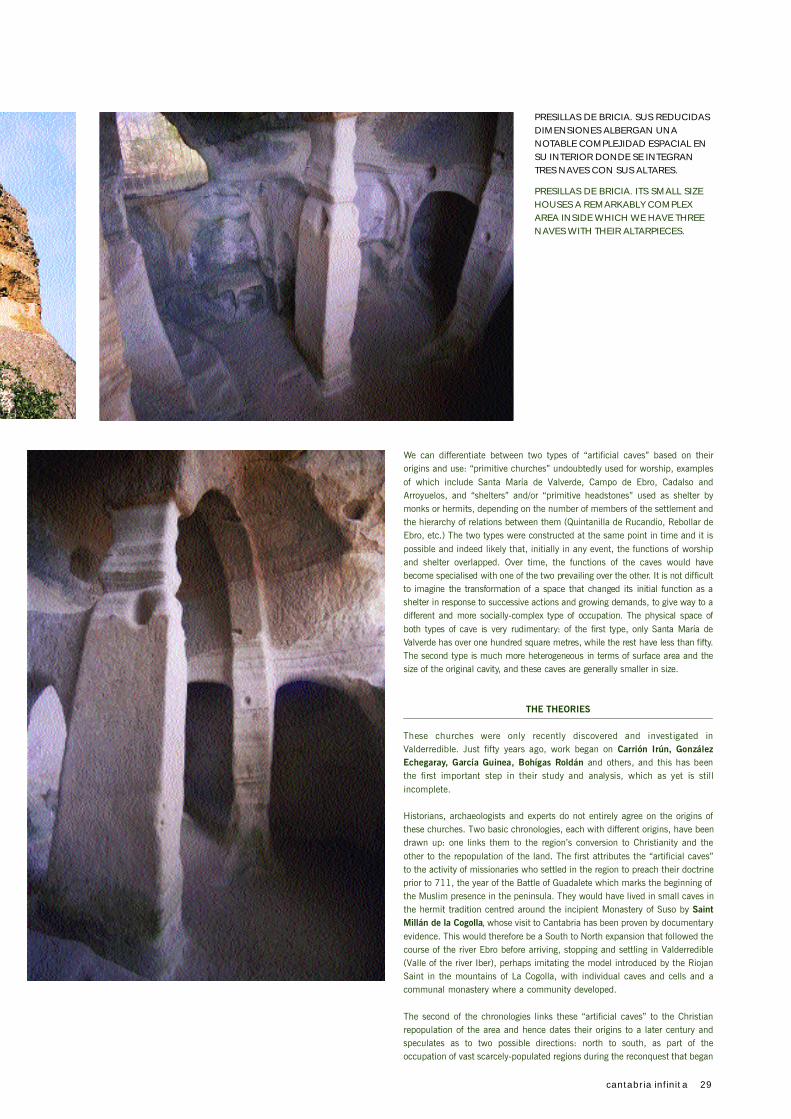
PRESILLAS DE BRICIA. SUS REDUCIDAS
DIMENSIONES ALBERGAN UNA
NOTABLE COMPLEJIDAD ESPACIAL EN
SU INTERIOR DONDE SE INTEGRAN
TRES NAVES CON SUS ALTARES.
PRESILLAS DE BRICIA. ITS SMALL SIZE
HOUSES A REMARKABLY COMPLEX
AREA INSIDE WHICH WE HAVE THREE
NAVES WITH THEIR ALTARPIECES.

30 cantabria infinita
in Asturias, or from south to north by the settlement of Mozarabs travelling
from Muslim-occupied regions. Both of these hypotheses would be due to the
border position of Valderredible, again the frontier between two antagonistic
cultures at war.
Despite their uncertain origins, these primitive settlements are not an isolated
finding in Valderredible or even in Spain. Similar sites can be observed all
along the Cantabrian coastal strip and the course of the Alto Ebro, right up to
La Rioja. However, it is in the area where Burgos, Palencia and Cantabria
meet, with Valderredible as the epicentre, that the largest concentrations and
most striking examples of these settlements are found in Spain.
THE ARCHITECTURE
The appearance of these “artificial caves”, particularly their interiors and those
termed “primitive churches”, is not the result of a single, conscientious action
carried out in remote times to obtain a usable space. Rather, we can observe
the result of a series of successive, superimposed actions carried out over the
centuries. The carving of the interiors and the introduction of external elements
(walls, bell gable, holes, roofs…) led to the creation of increasingly complex
spaces with elements similar to those in traditional buildings. Over time,
arches are introduced, apses are created, naves are formed and the space is
made even more complex with the addition of a second floor with its
corresponding staircases (Arroyuelos, Presillas de Bricia in Burgos, etc.)
With the exception of those incorporated more recently, these transformations
are not documented or else very rarely so, which adds to the difficulty of dating
the caves. The transformations that used external materials can provide
information about when they were added because of the “stylistic” conditions
and techniques used. Moreover, the situation prior to the transformation can
usually be recovered by removing the additions. However, transformations
made by removing rock have erased the traces of the previous condition of the
cave, which can no longer be retrieved.
Owing to the manner in which they were constructed, the external appearance
of the caves is not entirely in tune with nature in the area: it was nature before
it was a building, so it is impossible to draw the line between the former and
the latter. Only elements that were unmistakably incorporated by man are easy
to distinguish, such as the bell gable in Santa María de Valverde and, to a
lesser extent, Cadalso (which has been subject to a series of successive
removals), leaving the constructed work clearly on display. However, even
these milestone markers, used to denote the work's symbolic content, are not
out of place and, in all cases, are later additions to the creation of the covered,
closed spaces. Whether the caves are down to the activities of hermits or
colonisers, this mimesis in their origins can be regarded as intentional or at the
very least, useful: firstly, the settlement amidst nature could be interpreted as
being a rejection of excesses, typical of asceticism, and secondly, it could be
seen as camouflage to make the sites difficult to locate in raids.
There are more “shelters” than “churches” and their relative sites do not, in
theory, indicate a direct relationship between the two types.
However, it is inside the caves where we can observe man’s intentions and
appreciate the differences between the churches and the shelters.
Today, the “shelters” appear as simple, venerable holes with more symbolic
than cultural value; shelters that have been barely transformed, abandoned by
use and sometimes difficult to access. Their sparse interiors reveal a very
elementary concept of space, almost exclusively practical, and conditioned by
the original hole. The transformations of their walls, which in some cases may
represent the initial configuration, suggest that they hold valuable information.
However, the soft rock was eroded away along with any marks that might have
been valuable to us today.
There are four examples of “primitive churches” in Valderredible: Santa María
de Valverde, Campo de Ebro, Cadalso and Arroyuelos. Due to the proximity of
the site and the clear links with the others, this group will also include the
primitive church of San Miguel in Presillas de Bricia in neighbouring Castile-
Leon, situated in one of the extensions of Burgos in Valderredible and just a
stone’s throw from its border.
TEMAS / PATRIMONIO
RUTA POR LA ARQUITECTURA RUPESTRE DE VALDE
Los elementos más notables del
conjunto de iglesias, ermitas y
laudas que integran la arquitectura
rupestre de Valderredible se integran
en el entorno de un sencillo recorrido
que toma como base las carreteras
autonómicas de la red secundaria
C A - 2 7 2, C A - 2 7 3, C A - 2 7 4 y C A -
275, complementándose con alguna
carretera municipal. Este trayecto se
inicia en Quintanilla de las Torres
(Palencia) tomando la CA-273 para,
en un recorrido de aproximadamente
15 kms., encontrar:
SAN ANDRÉS DE VA L D E LO-
M A R.- Cueva natural que inicial-
mente se emplazó en el enclave
palentino de Cezura, y otras dos
cuevas art i f i c i a l e s .
SAN MARTÍN DE VALDELO-
MAR.- Cueva artificial en la lla-
mada Peña Castejón y otra a la
salida del caserío.
SA N TA MARÍA DE VA LV E R-
DE.- Junto al caserío, perfecta-
mente señalizada y abierta al culto
se encuentra la mejor conservada
y más notable de estas iglesias
rupestres. Declarada Bien de Inte-
rés Cultural con la categoría de
Monumento.
V I L LA N U E VA DE LA NÍA. -
Pequeña cueva artificial.
Pasado este último enclave, se llega
al cruce con la carretera CA-272 que
se toma hacia el este en dirección a
Polientes para, a lo largo de 13,5
kms., encontrar:
CAMPO DE EBRO.- Iglesia
rupestre integrada en el caserío
junto a la parroquial. Declarada
Bien de Interés Cultural con la
categoría de Monumento.
REBOLLAR DE EBRO.- Cueva
artificial inconclusa.
Llegados a Polientes finaliza la CA-
272 y debe tomarse su continuación
CA-274 hasta el cruce de ésta con la
CA-275. Tomando ésta última tam-
bién hacia el este en dirección a
Escalada encontramos:
CA DA LS O.- Iglesia rupestre al
borde de la carretera. Declarada
Bien de Interés Cultural con la
categoría de Monumento.
VILLAESCUSA DE EBRO.- Tres
cuevas en el lugar conocido como
“Tobazo”.
Desde este último punto, regresar por
la misma carretera CA-275 hasta el
cruce de ésta con la carretera muni-
cipal que parte hacia el norte en
dirección a Santa María de Hito para
visitar:
ARROYUELOS.- Iglesia rupestre
de San Acisclo y Santa Vitoria.
Declarada Bien de Interés Cultural
con la categoría de Monumento.
PRESILLAS DE BRICIA (BUR-
GOS).- Iglesia rupestre de San
Miguel. Esta iglesia se sitúa en la
provincia de Burgos pero debe
considerarse como perteneciente
al conjunto de iglesias rupestres
de Valderredible tanto por su pro-
ximidad geográfica como por su
configuración.
Al llegar al cruce con la CA-274 con-
tinuar al norte hacia el Puerto de
Carrales para visitar:
Q U I N TA N I L LA DE RU CA N-
DIO.- Cuatro cuevas artificiales en
el sitio denominado “Covachas”.
Algunos de los emplazamientos seña-
lados presentan dificultades de acce -
so que solo deben superarse por
aquellos que dispongan de una cierta
experiencia.
En cualquier caso, los hitos funda-
mentales de este recorrido están
constituidos por: Santa María de Val-
verde, Campo de Ebro, Cadalso, Arro-
yuelos y Presillas de Bricia (Burgos)
fáciles de localizar, bien señalizadas y
cuyos accesos se realizan sin ninguna
dificultad.
© ITM

cantabria infinita 31
DERREDIBLE
These churches display a diversity of spatial complexity on a par with buildings
constructed for similar purposes around the same time. The simplicity of the
communal space defined as an apse in Campo de Ebro and Cadalso gives way
to the complex floor structure of Santa María de Valverde with two defined
naves using wall ribs without differentiated apses and an enclosed baptismal
font. This profile is complicated further in Arroyuelos, which has a second floor
and a central pilaster to form a second nave. Finally, Presillas de Bricia has a
second floor and pilasters that form its three naves, three irregular apses and
altars carved out of the same rock to produce a very unique space.
The roofs are formed using irregular slabs or vaulting both in naves and apses.
The configuration of the latter is particularly striking: it uses the horseshoe arch
in Arroyuelos and Campo de Ebro, diverse, irregular lineation in Presillas de
Bricia, and ill-defined positioning in Santa María de Valverde. Curiously, the
direction of the apses, due to the longitudinal axis of the church is canonical
from east to west (apse in the east, base in the west and access from the south)
in Campo de Ebro, Cadalso and Arroyuelos, a formalism that was incorporated
in periods after the theoretical construction of these temples.
The absence of raw edges (with the constant and incalculable collaboration of
erosion), the lack of decoration, the benches around the perimeter of the caves
(Arroyuelos, Campo de Ebro is unfortunately hidden in part by paving) their
irregular outlines… all leave the interiors somewhere between nature and
construction, between building and cave, between the rational and the sublime.
These churches, now rescued from abandonment are being duly taken care of
and maintained, and are open for worship in some cases (Santa María de
Valverde) or available for worship in others (Cadalso).
The fascination produced by these works stems from their internal and external
appearance, and is enhanced by the debate over their origins. This gap in
scientific and encyclopaedic knowledge is a welcome stimulus for the
imagination, where meaning is more important than information. ❙
ENRIQUE BOLADO GUTIÉRREZ
Santander, 1948. Arquitecto especializa-
do en urbanismo, ejerce la profesión
como consultor privado de edificación y
urbanismo en estudios de Madrid y San-
tander y al servicio de la administración
pública como Arquitecto Municipal de
Torrelavega. Ha publicado el libro “Legis -
lación Urbanística de Cantabria. Concordancias. Síntesis,
Sinopsis y Sincronías” y como coautor “Paseo de Pereda y
Calle Castelar. Cuaderno de Apuntes”. Actualmente es miem-
bro de la Comisión Regional de Ordenación del Territorio y
Urbanismo y del Consejo de Ordenación del Territorio y Urba-
nismo en representación del Colegio Oficial de Arquitectos de
Cantabria.
Santander, 1948. An architect specialised in urbanism who
developed his work as a private consultant on building
c o n st ruction and urbanism in projects of Madrid and
Santander, at the service of the public administration as a
Local Architect in Torrelavega. He has published his book
“Legislación Urbanística de Cantabria. Concordancias. Síntesis,
Sinopsis y Sincronías” and has been coauthor of “Paseo de
Pereda y Calle Castelar. Cuaderno de Apuntes”. He is currently
a member of the Regional Commission for Land
Administration and Urbanism and of the Board of Land
Administration and Urbanism as the representative of the
Official Association of Architects of Cantabria.
I T I N E R A RY
The most noteworthy elements of
the set of churches, hermitages
and engraved tombstones which form
p a rt of the cave architecture of
Valderredible, appear in a simple
route with base at the CA-272, CA-
273, CA-274 and C A - 2 7 5 r e g i o n a l
roads of the secondary road network,
and supplemented by some
additional municipal roads. This route
s t a rts in Quintanilla de las To r r e s
( Palencia), where we must take the
C A - 2 7 3 and, in the space of 15 km.,
we will find:
SAN ANDRÉS DE VA L D E-
LOMAR.- A natural cave which
was initially located in the setting
of Cezura, in Palencia, as well as
two additional artificial caves.
SAN MARTÍN DE VALDELO-
MAR.- An artificial cave in the
so-called Peña Castejón, and an
additional one at the exit of the
hamlet.
SANTA MARÍA DE VALVER-
DE.- Near the hamlet, perfectly
signposted and open for services,
we find the best-preserved and
most noteworthy cave church.
Declared “Place of Cultural
Interest” with the category of
Monument.
VILLANUEVA DE LA NÍA.- A
small artificial cave.
Leaving this last cave behind, we
come to the crossroads at the CA-
272. We take to the east road
towards Polientes and in the space
of 13,5 km., we find:
CAMPO DE EBRO . - A cave
church in the centre of the hamlet
near the parish church. Declared
“Place of Cultural Interest” with
the category of Monument.
R E BO L LAR DE EBRO . -
Unfinished artificial cave.
On reaching Polientes, the CA-272
ends and we must take the CA-274
to the crossroads with the CA-275.
We go east along this road towards
Escalada:
CADALSO.- A cave church at the
roadside. Declared “Place of
Cultural Interest” with the
category of Monument.
V I L LA E S C U SA DE EBRO . -
Three caves located in “ Tobazo”.
From this last point, follow the CA-
275 road to the crossroads with the
municipal road to the north towards
Santa María de Hito, to visit:
ARROYUELOS.- Cave church of
San Acisclo and Santa Vitoria.
Declared “Place of Cultural
Interest” with the category of
Monument.
PRESILLAS DE BRICIA (BUR-
GOS).- Cave church of San
Miguel. This church is situated in
Burgos but it must be considered
p a rt of the group of cave
churches of Valderredible, both
for its proximity and its
configuration.
On reaching the crossroads with the
C A - 2 7 4, continue to the nort h
towards Carrales Mountain Pass to
visit:
Q U I N TA N I L LA DE RU CA N -
DIO.- Four artificial caves sited in
“Covachas”.
Some of the caves mentioned can
only be accessed by experienced
visitors.
In summary, the essential
milestones on this route are: Santa
María de Valverde, Campo de Ebro,
Cadalso, Arroyuelos and Presillas de
Bricia (Burgos), easily found,
properly signposted and all with
easy access.