articles the network dynamics hypothesis: how channel … 2004 bioscience… · last half-century.a...
TRANSCRIPT
May 2004 / Vol. 54 No. 5 • BioScience 413
Articles
Principles of fluvial geomorphology have guidedthe development of much of riverine ecology over the
last half-century. A prominent example is the influential rivercontinuum concept (RCC;Vannote et al. 1980). Based on earlyprinciples of fluvial geomorphology (e.g., Leopold et al.1964), the RCC emphasizes spatially and temporally averageddownstream changes in channel morphology over many or-ders of magnitude. It predicts gradual adjustments of biotaand ecosystem processes in rivers in accordance with thegeomorphic perspective of gradual downstream changes inhydrologic and geomorphic properties.
The linear perspective embodied in the RCC has dominatedriver ecology over the last 20 years (Fisher 1997), althoughdownstream interruptions in channel and valley morphology,caused by alternating canyons and floodplains, tributary con-fluences, and landslides, have long been observed. Some haveviewed these interruptions simply as adjustments to the orig-inal RCC (e.g., Bruns et al. 1984, Minshall et al. 1985), whereasothers have posited that they serve as the basis for a new view of a river as a “discontinuum” (e.g., Perry and Schaeffer 1987, Townsend 1989, Montgomery 1999, Rice etal. 2001). In essence, river discontinuum perspectives high-light the nonuniform or patchy distribution of habitats andtherefore emphasize habitat heterogeneity, expressed at thescale of meters to kilometers. Such heterogeneity also arisesbecause of the human perception of scale, in which fluviallandforms are hierarchically organized from valley segments
to stream bed particles (Frissell et al. 1986). Consequently, theidea of patchy and multiscale habitat formation and its relatedheterogeneity has imbued much current thinking in riverineecology (Frissell et al. 1986, Naiman et al. 1988, Townsend1996, Poff 1997).
Riverine ecology has also recognized the importance of physical disturbance (e.g., storms, fires, and floods) in dynamically creating and maintaining certain attributes ofhabitats and thus in influencing ecosystem function (e.g.,Resh et al. 1988, Swanson et al. 1988, Townsend 1989, Reeveset al. 1995, Poff et al. 1997). Just as habitat patches create discontinuities in space, disturbances create discontinuities in time. Concepts emphasizing disturbance or watershed
Lee Benda (e-mail: [email protected]) is a senior scientist with Earth Systems
Institute, 310 North Mount Shasta Boulevard, Mount Shasta, CA 96067.
N. LeRoy Poff is an associate professor in the Department of Biology, Colorado
State University, Fort Collins, CO 80523. Daniel Miller is a senior scientist with
Earth Systems Institute, 3040 NW 57th Street, Seattle, WA 98107. Thomas
Dunne is a professor in the Donald Bren School of Environmental Science and
Management, University of California, Santa Barbara, CA 93106. Gordon
Reeves is a research fisheries biologist with the US Department of Agriculture
Forest Service, Corvallis Forestry Sciences Laboratory, 3200 SW Jefferson Way,
Corvallis, OR 97331. George Pess and Michael Pollock are scientists with the
National Marine Fisheries Service, 2725 Montlake Boulevard East, Seattle, WA
98112. © 2004 American Institute of Biological Sciences.
The Network DynamicsHypothesis: How ChannelNetworks Structure Riverine Habitats
LEE BENDA, N. LEROY POFF, DANIEL MILLER, THOMAS DUNNE, GORDON REEVES,GEORGE PESS, AND MICHAEL POLLOCK
Hierarchical and branching river networks interact with dynamic watershed disturbances, such as fires, storms, and floods, to impose a spatial andtemporal organization on the nonuniform distribution of riverine habitats, with consequences for biological diversity and productivity. Abruptchanges in water and sediment flux occur at channel confluences in river networks and trigger changes in channel and floodplain morphology. Thisobservation, when taken in the context of a river network as a population of channels and their confluences, allows the development of testable pre-dictions about how basin size, basin shape, drainage density, and network geometry interact to regulate the spatial distribution of physical diversityin channel and riparian attributes throughout a river basin. The spatial structure of river networks also regulates how stochastic watershed distur-bances influence the morphology and ages of fluvial features found at confluences.
Keywords: river ecology, landscape ecology, fluvial geomorphology, river networks, disturbance

dynamics are generally applied in the context of a particularlocation within a watershed. However, recent advances inunderstanding watershed disturbance regimes indicate howdisturbance frequency and magnitude are organized by hier-archical and branching river networks (Benda and Dunne1997a, 1997b, Gomi et al. 2002).
In sum, although the RCC’s predictions of gradual down-stream change in river attributes and associated biologicalprocesses are valid over orders of magnitude in river size, threeother themes have arisen in riverine ecology over the past twodecades in the effort to address how deviations arise from theexpected mean state in physical attributes along a river pro-file. These themes are (1) patchiness or heterogeneity, (2)stochastic disturbance, and (3) hierarchical scaling. This suiteof concepts has been used to argue that riverine ecologyshould be guided by principles of landscape ecology, a disci-pline that incorporates a similar set of ideas (Schlosser 1991).Such a landscape view of rivers has led to the idea of “river-scapes” (Ward et al. 2002) and hence to an emphasis on theimportance of studying riverine habitats and their patchinessover multikilometer scales (e.g., Fausch et al. 2002, Wiens2002).
In a similar vein, a conceptual framework integrating het-erogeneity, disturbance, and hierarchical scaling has beenadvocated for general ecology under the title of “hierarchicalpatch dynamics”(Wu and Loucks 1995), and this concept mayapply well to riverine ecology (Townsend 1989, Poole 2002).While both hierarchical patch dynamics and the landscapeview of rivers hold promise for advancing the field of river-ine ecology, they are presently limited in doing so because theylack a physical basis for understanding or predicting the mor-phological implications of rivers as networks (as opposed to“linear features,” sensu Fisher [1997]) and for understandinghow stochastic watershed disturbances are translated into patterns of physical heterogeneity throughout the rivernetwork.
The purpose of this article is to develop a geomorphicframework in support of recent advances in river ecology. Tocreate this framework, which we call the network dynamicshypothesis, we developed testable predictions about how thespatial arrangement of tributaries in a river network interactswith stochastic watershed processes to influence spatiotem-poral patterns of habitat heterogeneity. We begin with a gen-eral review of how tributary confluences modify channelmorphology. Then we describe how tributary confluence ef-fects vary in terms of the specific attributes of a network’sstructure, including basin size, basin shape, network pattern,size difference between confluent channels, drainage den-sity, confluence density, local network geometry, and thepower law of stream sizes (figure 1). Next, we describe howstochastic watershed disturbances such as floods, fire, andstorms impose temporal heterogeneity on confluence effects,but in a predictable fashion that reflects the controls exertedby the underlying network structure. Finally, we considerhow the general principles developed in our hypothesis could
414 BioScience • May 2004 / Vol. 54 No. 5
Articles
a
b
c
d
Structure of river networks
(1) Basin size and (2) basinshape
(5) Drainage density and (6) confluence density
(3) Network configurationand (4) size difference between tributary channelsand main stem
(7) Network geometry:confluence angles and separation distance betweengeomorphically significanttributaries
Figure 1. Seven structural indexes of river networks areconsidered in this article. (a) Basin size is drainage area,and basin shape is determined by dividing the area of theriver basin by the square of the length of the main stem.(b) Confluence effects depend on the overall network pat-tern and on the size difference between confluent chan-nels (i.e., the size ratio of the tributary basin to the mainstem basin upstream of the confluence). (c) Drainage density and confluence density are related measures;drainage density is the total length of channels per unitarea of the basin, while confluence density is the numberof confluences per unit channel length or basin area.Channel sizes in a basin are distributed according to apower law. (d) Local network geometry (in the vicinity ofindividual confluences) depends on the tributary–mainstem area ratio, on the distance between confluences (Z),and on the confluence intersection angle (θ). Black dotsin panels b, c, and d represent tributary confluences.
advance the coupled disciplines of geo-morphology and riverine biology.
Effects of tributary confluences onchannel and valley morphology By definition, a tributary is the smaller of twointersecting channels, and the larger is themain stem. Strictly speaking, a tributaryjunction, or confluence, is defined as thepoint where two different streams meet. Inthe broader definition used in this article, atributary junction is the valley floor envi-ronment influenced by tributaries and mayinclude alluvial fans, terraces, secondarychannels, and wider floodplains. The nu-merous bifurcations and confluences of dis-tributaries in braided channel systems arenot covered here.
Three main types of processes are re-sponsible for transporting sediment and organic material down tributaries to con-fluences with the main stem. Debris flowstransport an unsorted mixture of sediment(including boulders and logs) and often cre-ate erosion-resistant deposits; normal runofffloods transport bed load and suspendedload and create stratified alluvial deposits;and flash floods transport extremely highsediment loads and create deposits inter-mediate between debris flows and runofffloods. These sediment transport processesoften create depositional fans where tribu-tary channels enter lower-gradient and widerchannels or valleys (Bull 1977).
The interaction of two independent sed-iment transport regimes at channel junc-tions can produce dramatic changes on thereceiving channel and valley floor (see table1 for a listing of these effects). Morpholog-ical effects at confluences, including forma-tion of fans, may be transient or persistent,depending on the rate at which organic ma-terial and sediment are transported to tributary junctionsand moved by receiving channels. Sediment deposits thatform at junctions can impose a topographic impedimentto the main channel, often locally constricting valley widthand displacing the main channel across the valley floor (figure 2). These topographic effects induce certain morphologic responses in main stem channels, such as alocalized flattening of the channel gradient upstream anda corresponding steepening of the gradient downstream(figure 2). Gradient-induced longitudinal variations insediment transport rate in the vicinity of junctions causeupstream reductions in substrate size, increases in chan-nel meandering, and increases in floodplain and terracewidth. These changes are offset by other tendencies on the
May 2004 / Vol. 54 No. 5 • BioScience 415
Articles
Tributary confluence effects
Longitudinal profile
Distance
Elev
atio
n
Zone of interference Zone of mixing
Morphological consequences
• Lower gradient
• Wider channel/floodplain
• Increased bank erosion
• Increased wood recruitment
• Finer substrates
• Greater lateral connectivity
• Higher disturbance magnitude
• Higher gradient
• Larger substrate sizes
• Deeper pools
• More bars
• Higher frequency and magnitudeof disturbance
North ForkBoise River
Upstream(zone of interference)
Tributary influxof sediment to
alluvial fan
Downstream(zone of mixing)
Alluvialfan
Figure 2. An alluvial fan, enlarged after a fire, triggers tributaryjunction effects in the North Fork Boise River (320-square-kilometer drainage area). Junction effects include expanded floodplain and terrace formation, increased channel meanderingand side channels upstream of the fan, and channel steepeningdownstream (Benda et al. 2003b). Confluence effects include up-stream interference in which a lower gradient and wider channelcause a reduction in the transport of sediment and wood and acorresponding increase in channel changes. “Mixing” effectsdownstream of the confluence, including a steeper channel gradi-ent and a higher frequency and magnitude of disturbance, arisefrom the abrupt introduction of sediment and wood from the tributary. Photograph: Steven Toth.
downstream side of the junction, including coarser substratesand increases in channel width, pool depth, and occurrenceof bars. The same general classes of channel changes occur atconfluences regardless of their location in the river network(see table 1), although certain types of changes, such as boul-der accumulations leading to rapids, occur predominantly neardebris flow or flash flood deposits. The morphological con-ditions near channel junctions differ from those in reaches lo-cated upstream or downstream; confluences are agents ofhabitat formation and increased morphological heterogene-ity (figure 2; Rice et al. 2001, Benda et al. 2003a). In this ar-ticle, we concentrate on the morphological effects at junctionslinked to tributary sources of sediment and wood, althoughour analysis of the influences of river network geometryshould also apply to more flow-related changes in morphol-
ogy at junctions in less erosion-prone landscapes (e.g., Best1986, Rhoads 1987).
Effects of river networks on the structure of riverine habitatsThe physical structure of river networks can be defined bybasin size, basin shape, network pattern, size difference betweenconfluent channels, the power law of stream sizes (e.g.,Horton 1945), drainage density and confluence density, andlocal network geometry (figure 1). Our predictions abouthow river network structure influences spatial patterns ofconfluence-related morphology (box 1) apply to a range ofchannel changes (e.g., changes in substrate size, channelwidth, or extent of floodplains and terraces), althoughmorphological effects can be broadly stratified according to
416 BioScience • May 2004 / Vol. 54 No. 5
Articles
Table 1. Fourteen studies documenting tributary confluence effects in 19 nonregulated streams and rivers across thewestern United States and Canada.
Climatic Type of sediment Contributing Receiving MorphologicalLocation region transport stream area (km2) stream area (km2) effects Source
Sekiu, Olympic Mountains, Humid Debris flow 0.02 to 0.73 0.67 to 4.2 a, b, d, g, k Benda et al. Washington 2003a
Ash Creek, Arizona Arid Flash flood 0.42 9.8 d, f Wohl and Pear-three 1991
Queen Charlotte Islands, Humid Debris flow 0.11 to 5.6 0.3 to 12.0 k Hogan et al. 1998British Columbia
Matheny and Sitkum, Olympic Humid Debris flow 0.37 20.3 a, b, d, g, j, k Benda et al. Mountains, Washington 2003a
Coast Range, Oregon Humid Debris flow 0.08 to 0.27 0.8 to 30 a, b, c, d, e, f, Everest and g, h, j, k, l Meehan 1981
Sheep Creek, Idaho Semiarid Alluvial 26.6 64.6 a, b, c, d, g Benda et al. 2003b
Oregon Cascades Humid Debris flow 0.11 to 3.0 51 to 71 e, f, g Grant and Swanson 1995
Crooked River, Idaho Semiarid Alluvial 3.4 219 a, b, c, d, g Benda et al. 2003b
Bear Creek, Colorado Semiarid Flash flood 5.9 to 23.9 193 to 407 e Grimm et al. 1995
North Fork Boise River, Idaho Semiarid Alluvial 0.6 to 29 322 to 461 a, b, c, d, f, g, h Benda et al. 2003b
Wenaha River, Oregon Semiarid Alluvial 18 to 71 446 to 516 f, g Baxter 2002
Snoqualmie River, Washington Humid Alluvial 85 to 750 712 to 1794 a, b, c, d Booth et al. 1991
Pine and Sukunka Rivers, Semiarid Alluvial 23 to 203 1579 to 2145 d Rice et al. 2001British Columbia
South Fork Payette River, Idaho Semiarid Flash flood 0.55 2470 e Meyer and Pierce 2003
Bella Coola River, Humid Alluvial 12.8 to 285 4779 to 5421 m Church 1983British Columbia
Middle Fork Salmon River, Idaho Semiarid Debris flow/ 2.5 to 295 1176 to 7096 a, b, e Meyer and flash flood Leidecker 1999
Grand Ronde, Oregon Semiarid Alluvial 764 to 1342 6953 to 7781 f, g Baxter 2002
Snake River, Oregon Semiarid Alluvial 9137 240,765 g, f Meyer and Pierce 2003
Colorado River Arid Debris flow/ 14.3 to 6076 280,000 to 386,800 a, d, e, i Melis et al. 1995(before dam), Colorado flash flood
a, gradient steepening; b, gradient lowering; c, upstream sediment deposition; d, changing substrate size; e, boulders and rapids; f, terraces; g, flood-plains; h, side channels; i, midchannel bars; j, ponds; k, logjams; l, meanders; m, channel instability.
Note: Sites are arrayed according to increasing drainage area of the main stem (in square kilometers). The studies indicate the dominant type ofsediment transport, the drainage areas of tributaries and main stems, and the type of morphological effects at confluences indicated by the authors.

upstream and downstream position relative to confluences(e.g., figure 2). We also predict local changes in heterogene-ity at confluences, which will usually increase. Heterogeneityis defined by the type, form, and age distribution of fluviallandforms. It is not yet possible to develop quantitative pre-dictions about specific morphological changes at conflu-ences because of the low resolution of data (e.g., table 1)and the complex nature of riverine environments (Rhoads1987).
The role of basin size. Consistent flow-related morphologicalchanges (i.e., in channel width and depth) occur at junc-tions where the ratio between tributary size and main stem
size approaches 0.6 or 0.7 (Rhoads 1987). We postulate thatmorphological effects caused by punctuated inputs of sedi-ment and wood at confluences will also scale to the size of thetributary relative to the main stem. We anticipate this resultbecause larger basins typically produce larger quantities of sed-iment, and because larger tributaries generally have larger fansassociated with them (Bull 1977). Moreover, larger and morepowerful rivers are more effective at removing tributary inputs of sediment (Benda et al. 2003a).
To evaluate this expectation, we analyzed the results of 14published field studies that document a range of confluenceeffects in 19 streams and rivers, caused by the abrupt intro-duction of sediment and wood (see table 1 for a listing of these
May 2004 / Vol. 54 No. 5 • BioScience 417
Articles
Testable predictions from the network dynamics hypothesis are listed below. The predictions apply to a range ofmorphological changes at confluences (including morphological heterogeneity), although they can be broadly stratifiedaccording to upstream and downstream position relative to confluences (see, e.g., figure 2). Presently, it is not feasible to make quantitative predictions of channel changes at confluences because of the complexity of channel environments(Rhoads 1987). Confluences that have identifiable morphological effects (including those confluences listed in table 1)are referred to as “geomorphically significant confluences.”
Predictions related to network structure• The likelihood of confluence effects increases with the ratio of tributary to main stem sizes.
• Heart-shaped and pear-shaped basins containing dendritic networks favor increasing tributary size and hence confluenceeffects downstream, compared with rectangular basins containing trellis or parallel networks, which do not.
• The separation distance between geomorphically significant junctions (and their morphological effects) increases downstream withincreasing basin size, particularly in dendritic networks.
• As basin size increases, the channel length and area affected by individual confluence-related channel and valley morphologicalmodifications will increase.
• Closely spaced tributaries will yield valley segments of higher physical heterogeneity, compared with valley segments that do not contain closely spaced geomorphically significant confluences.
• Basins with higher drainage density and corresponding higher junction density will have a higher degree of morphological heterogeneity. Correspondingly, basins of high topographic roughness, in part related to higher drainage density, should contain a higher degree of riverine heterogeneity.
Predictions related to watershed disturbances or dynamics• Basins with higher punctuated sediment supply and transport will be characterized by greater confluence effects.
• Channelized disturbances (i.e., floods and accelerated sediment and wood supply) will have greater frequency and magnitude prox-imal to and immediately downstream of confluences, leading to greater physical heterogeneity, including the age distribution of flu-vial landforms.
• Channelized disturbances will be magnified immediately upstream of geomorphically significant confluences, leading to greaterphysical heterogeneity, including the age distribution of fluvial landforms.
• In sufficiently large basins (approximately 102 km2), the age distribution of confluence-related landforms (i.e., fans, terraces,floodplains) will be skewed toward older geomorphic features in headwaters and toward younger features in downstream portions of the basin.
• Physical heterogeneity (i.e., diversity of forms and ages of channels, floodplains, terraces, and logjams) will be concentrated in certain parts of networks.
Box 1. The influence of river network structure on spatial patterns of confluence-related morphology
effects).We refer to confluences that have observable morpho-logical effects as “geomorphically significant.”Together, thesestudies describe 168 junctions along 560 kilometers (km) ofriver, spanning 7 orders of magnitude in drainage area in thewestern United States and Canada (see Benda et al. [2004] fora more detailed analysis). These data reveal that as the size ofthe main stem increases, geomorphically significant conflu-ences are associated with increasingly larger tributaries (fig-ure 3). For example, debris flows that originate from smallbasins (up to 1 km2 in drainage area) create tributary-junction effects in basins of only 1 to 50 km2. By contrast,tributary-junction effects in larger rivers (1000 to 300,000 km2)are associated with larger tributaries (10 to 10,000 km2).
The data in figure 3 also reveal a threshold below whichtributary basins less than approximately 1 km2 do not af-fect main stem rivers larger than approximately 50 km2. Thisis significant because it indicates how the “law of streamnumbers” (Horton 1945), the universal power law regard-ing the distribution of channel sizes (and, by analogy, of theconfluences linked to those channels), constrains confluenceeffects at the scale of entire networks. In humid landscapes,for example, the vast majority (80% to 90%) of tributarybasins are first or second order, with less than 1 km2 indrainage area (Benda and Dunne 1997a). On the basis ofthe threshold identified in figure 3, only 10% to 20% of trib-utary confluences (i.e., those of third order or higher) areavailable to significantly affect main stem rivers of a sizegreater than approximately 50 km2. This finding has im-portant ramifications for the increased downstream spac-ing of confluence effects as the size of the main stemincreases.
The variability of thedata in figure 3 is probablydue to factors such as basingeology (e.g., the durabil-ity and size distribution ofsediment), sediment trans-port processes (e.g., debrisflows and flash floods thattransport boulders and aremore likely to cause con-fluence effects), and localvalley width (e.g., wide val-leys that limit fan forma-tion and the associatedconfluence effects). Tem-poral variation in the his-tory of storms, fires, andfloods that create or reju-venate confluence effectsshould also cause the wax-ing and waning of conflu-ence effects.A more detailedanalysis of the data in figure3 allows for probabilisticpredictions of confluence
effects (Benda et al. 2004). For example, in humid environ-ments, a range of 0.6 to 0.9 for the probability of a confluenceeffect corresponds to a range of 0.04 to 0.8 for tributary–mainstem drainage area ratios.
The role of network pattern and basin shape. The scaling re-lationship between tributaries and main stem channels (fig-ure 3) allows us to consider how the factors that control thespatial distribution of tributary sizes in river networks influ-ence spatial patterns of confluence-related morphology andheterogeneity. Downstream trends in junction effects are in-fluenced by network patterns and hence by drainage basinshape. Two common types of network patterns are dendriticand trellis networks. Dendritic networks, which resemblethe hierarchical branching pattern of a tree, often form inhomogeneous and gently sloped geologic beds and createheart-shaped or pear-shaped basins. In contrast, trellis net-works, characterized by small tributaries intersecting mainstem channels, are often associated with elongate landformsin dipped and folded sedimentary rocks or in areas of paral-lel fractures; they create narrow, rectangular basins.
The spatial configuration of tributaries within a watershedchanges the likelihood of confluence effects downstream inriver networks. Since larger tributaries are required to creategeomorphic effects as the size of the main stem increases(e.g., figure 3), dendritic networks in heart-shaped or pear-shaped basins should promote confluence effects throughoutthe watershed (figure 4; see Benda et al. [2004] for more details). These effects occur because increasing the basinwidth downstream promotes the coalescing of hierarchicallybranched channels, resulting in larger tributaries forming
418 BioScience • May 2004 / Vol. 54 No. 5
Articles
Drainage area of main stem river (km2)
Humid debris flowSemiarid debris flow/flash floodHumid alluvialSemiarid alluvial
Transition from 1st and 2ndorder to higher-order channels
Dra
ina
ge a
rea
of trib
utar
y (k
m2)
Figure 3. A comparison between tributary basin area and main stem drainage area (in squarekilometers), for 168 tributaries where confluence effects (i.e., geomorphically significant conflu-ences) have been documented, reveals that larger main stem rivers require larger tributaries inorder to experience confluence effects (table 1; Benda et al. 2004). The dashed line represents theapproximate tributary drainage threshold for the first- and second-order streams that comprisethe vast majority of stream sizes and for their confluences in networks. Power law distributionof channel (confluence) sizes is shown on the left side of the figure; P refers to the proportion ofall channels of a given drainage area.
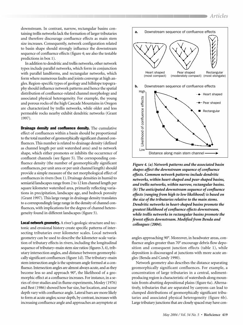
downstream. In contrast, narrow, rectangular basins con-taining trellis networks lack the formation of larger tributariesand therefore discourage confluence effects as main stemsize increases. Consequently, network configuration relatedto basin shape should strongly influence the downstreamsequence of confluence effects (figure 4; see also the testablepredictions in box 1).
In addition to dendritic and trellis networks, other networktypes include parallel networks, which form in conjunctionwith parallel landforms, and rectangular networks, whichform where numerous faults and joints converge at high an-gles. Region-specific types of geology and hillslope topogra-phy should influence network patterns and hence the spatialdistribution of confluence-related channel morphology andassociated physical heterogeneity. For example, the youngand porous rocks of the high Cascade Mountains in Oregonare characterized by trellis networks, while older and lesspermeable rocks nearby exhibit dendritic networks (Grant1997).
Drainage density and confluence density. The cumulativeeffect of confluences within a basin should be proportionalto the total number of geomorphically significant channel con-fluences. This number is related to drainage density (definedas channel length per unit watershed area) and to networkshape, which either promotes or inhibits the occurrence ofconfluent channels (see figure 5). The corresponding con-fluence density (the number of geomorphically significantconfluences, per unit area or per unit channel length) shouldprovide a simple measure of the net morphological effect ofconfluences in rivers (box 1). Drainage densities in humid tosemiarid landscapes range from 2 to 12 km channel length persquare kilometer watershed area, primarily reflecting varia-tions in precipitation, landscape age, and bedrock porosity(Grant 1997). This large range in drainage density translatesto a correspondingly large range in the density of channel con-fluences, with implications for the degree of channel hetero-geneity found in different landscapes (figure 5).
Local network geometry. A river’s geologic structure and tec-tonic and erosional history create specific patterns of inter-secting tributaries over kilometer scales. Local networkgeometry can be used to describe the kilometer-scale varia-tion of tributary effects in rivers, including the longitudinalsequence of tributary–main stem size ratios (figures 3, 4), trib-utary intersection angles, and distance between geomorphi-cally significant confluences (figure 1d). The tributary–mainstem intersection angle is the upstream angle formed at a con-fluence. Intersection angles are almost always acute, and as theybecome less so and approach 90°, the likelihood of a geo-morphic effect at a confluence increases. For instance, in a se-ries of river studies and in flume experiments, Mosley (1976)and Best (1986) showed how bar size, bar location, and scourdepth vary with confluence angle. Lateral bars are more likelyto form at acute angles; scour depth, by contrast, increases withincreasing confluence angle and approaches an asymptote at
angles approaching 90°. Moreover, in headwater areas, con-fluence angles greater than 70° encourage debris flow depo-sition and consequent junction effects (table 1), whiledeposition is discouraged at junctions with more acute an-gles (Benda and Cundy 1990).
Network geometry also describes the distance separatinggeomorphically significant confluences. For example, a concentration of large tributaries in a central, sediment-producing region is characteristic of watersheds along moun-tain fronts abutting depositional plains (figure 6a). Alterna-tively, tributaries that are separated by canyons can lead toclumped distributions of geomorphically significant tribu-taries and associated physical heterogeneity (figure 6b).Large tributary junctions that are closely spaced may have con-
May 2004 / Vol. 54 No. 5 • BioScience 419
Articles
Distance along main stem channel
Rectangular
a.
b.High
Like
lihoo
d of
con
fluen
ce e
ffect
s
Low
Pear shaped
Heart shaped
Heart shaped(most compact)
Pear shaped(moderately compact)
Rectangular (most elongate)
Figure 4. (a) Network patterns and the associated basinshapes affect the downstream sequence of confluence effects. Common network patterns include dendritic networks, within heart-shaped and pear-shaped basins,and trellis networks, within narrow, rectangular basins.(b) The anticipated downstream sequence of confluenceeffects (ranging from high to low likelihood) is based onthe size of the tributaries relative to the main stems.Dendritic networks in heart-shaped basins promote thegreatest likelihood of confluence effects downstream,while trellis networks in rectangular basins promote thefewest effects downstream. Modified from Benda and colleagues (2004).
Downstream sequence of confluence effects
Downstream sequence of confluence effects

fluence effects that overlap, particularly during watersheddisturbances such as floods and concentrated basin erosion.Confluence effects may also be less pronounced in wide valley floors, where fans are isolated from the main stem bybroad terraces or floodplains.
Scaling properties of confluence effects. The finding that largertributaries are required in order to affect the morphology oflarger rivers reveals two scaling effects on habitat patches
that develop near confluences. First, geomorphically signifi-cant confluences should be separated by increasing distancesdownstream in watersheds where tributary basins down-stream increase in size (e.g., dendritic networks in pear-shaped and heart-shaped basins; figure 4, box 1). Thisincreasing separation occurs because tributary length is relatedto tributary drainage area (Hack 1957), and thus the lengthand width of a basin increase with increasing tributary length.This spacing pattern is reflected in the field data (figure 7). Inthe upper portions of humid drainage basins, morphologi-cal effects are spaced on average hundreds of meters apart(Benda 1990, Hogan et al. 1998, Benda et al. 2003a), reflect-ing the spacing of low-order tributaries. By contrast, in largerbasins (up to 300,000 km2), the distances separating junctioneffects are on the order of several kilometers to tens ofkilometers (Baxter 2002, Benda et al. 2003b).
420 BioScience • May 2004 / Vol. 54 No. 5
Articles
Figure 5. Two basins in northern California illustratevariation in confluence densities. Black dots representconfluences, with tributary–main stem ratios indicatedby dot size. A watershed formed in relatively young andhomogeneous lava flows (top) has a drainage density of 3kilometers (km) channel length per square kilometerdrainage area and a corresponding confluence density of4.7 junctions per square kilometer. A watershed locatedin the older and geologically heterogeneous terrain (bot-tom) has a drainage density of 5 km channel length persquare kilometer and a corresponding confluence densityof 12 junctions per square kilometer. On the basis of thedifference in confluence density, the second watershed ispredicted to have higher confluence-related habitatheterogeneity (box 1). The probability of confluence effects depends on the increasing size ratio of tributary to main stem drainage area, as indicated by the size ofthe dots (Benda et al. 2004). Estimation of drainage density or confluence density should be sensitive to mapscale and to the method of depicting channel networks.
Figure 6. Local network geometry (kilometer scale) variesin response to the size, spacing, and confluence angles ofintersecting tributaries, which reflect underlying geologicstructure, topography, and erosion history. Different localgeometries are expected to lead to different patterns ofphysical heterogeneity, linked to tributary confluences.(a) With a number of large tributaries near the center of the network, confluence-related heterogeneity is con-centrated in a central, sediment-producing region. Thispattern is characteristic of watersheds located alongmountain fronts and abutting depositional plains.(b) When major tributaries are separated by canyons,the associated areas of physical heterogeneity are dividedas well.
Physical heterogeneity
a b
Higher Lower
Canyon
Tributary–main stemdrainage area ratio
Tributary–main stemdrainage area ratio
302 km2
299 km2

The second scaling property of confluence-related mor-phology is that the size of habitat patches associated with trib-utaries increases downstream (figure 7).Although the data aresparse, the length of channels affected by confluences rangesfrom tens or a few hundreds of meters (in basins less than ap-proximately 100 km2) to several kilometers (in basins betweenapproximately 1000 and 300,000 km2). We expect the size ofhabitat patches to increase farther downstream because thechannel gradient declines with increasing river size; therefore,any vertical obstruction in a channel that backs up sediment(e.g., fans, logjams, boulders) should influence a channeldistance upstream at least equivalent to the obstructionheight divided by the tangent of the underlying stream gra-dient.
Interaction of river networks with stochastic watershed processes A river network can be thought of as the landscape templatewithin which climatically induced stochastic fluctuations inthe supply and transport of water, sediment, and organicmaterial occur. The structure of a river network (basin size,
shape, network configuration, and so on; fig-ure 1) can be used to help understand therole of stochastic watershed processes inshaping riverine environments.
Disturbance. The role of tributary conflu-ences on longitudinal patterns of riverineheterogeneity, and the dependence of thisheterogeneity on basin scale, basin shape,network pattern, drainage density, and net-work geometry, can be framed as a generalset of testable predictions (see box 1). Thespatial configuration of a network thus pro-vides a template for organizing the transportand deposition of sediment, wood, and wa-ter through a watershed, but the supply andtransport of material that creates confluenceeffects varies dynamically over time becauseof climate-driven events (storms, floods,and fires). The watershed disturbanceregime (Miller et al. 2003)—the frequency,magnitude, and spatial extent of episodic cli-matic and geomorphic processes—can varywithin and among watersheds and thuscontribute to variation in heterogeneity atconfluences, including the waxing and wan-ing of effects over time.
Moderate to large disturbance-driven,landscape-scale fluctuations in the supplyand storage of in-channel sediment and or-ganic material create many of the morpho-logical changes observed at confluences.For example, the fluctuating supply of sed-iment storage at confluences creates fans,floodplains, terraces, logjams, secondary
channels, and fans (table 1; Small 1973, Benda et al. 2003b).The episodic nature of sediment-related disturbances createsthe form and age mosaic of the erosional and depositionallandforms characteristic of valley floors, ultimately con-tributing to physical heterogeneity and potentially to biologicaldiversity and increased productivity (Swanson et al. 1988).Al-though biological recovery processes, such as vegetation suc-cession, can also influence patterns of physical heterogeneityin the channel and valley floor (Gregory et al. 1991), that topicis beyond the scope of this article. For more comprehensivediscussions of the role of disturbances in riverine environ-ments, see Resh and colleagues (1988), Reeves and colleagues(1995), Poff and colleagues (1997), and Nakamura and colleagues (2000).
Amplification of disturbances at confluences. The channel dis-turbance regime can be altered at tributary confluences. First,tributaries represent abrupt increases in the supply of water,sediment, and wood, and therefore channel responses re-lated to those inputs should have a higher frequency andmagnitude near or immediately downstream of confluences.
May 2004 / Vol. 54 No. 5 • BioScience 421
Articles
Figure 7. Confluence effects in rivers (e.g., changes in substrate, floodplains, orchannel morphology) reveal two scaling properties. First, the distance separatinggeomorphically significant confluences (shown in meters) increases downstream,particularly in dendritic networks (top). Second, the length of altered habitatpatches associated with geomorphically significant confluences (also in meters)increases downstream (bottom).
Leng
th o
f inf
luen
ce (m
)S
paci
ng b
etw
een
geom
orph
ical
lysi
gnifi
cant
con
fluen
ces
(m)
Main stem drainage area (km2)
Main stem drainage area (km2)

Second, reductions in channel gradient, and expansion ofvalley floors upstream of confluences (e.g., figure 2), can interfere with the downstream and fluctuating transport ofsediment and wood. Where increased sediment and woodstorage occurs upstream of confluences that lead to wider andlower-gradient (i.e., more responsive) channels, the magni-tude of flow-related disturbances can increase. These inter-actions have been observed in the field and predicted bysimulation models (Benda and Dunne 1997a). For example,Church (1983) noted that the highest rates of channel me-andering occurred in the vicinity of tributary junctions incoastal British Columbia. Similarly, Jacobson (1995) docu-mented that the greatest fluctuations in sediment storageoccurred at and near confluences.
Since the supply and transport of significant amounts ofsediment is episodic, depositional areas at confluences, in-cluding fans (e.g., figure 2), should expand and contract overtime in response to storms, fires, and floods (Benda et al.2003b). Consequently, the spatial extent of these areas’ up-stream and downstream zones of influence should vary overtime (figure 8). Moreover, a disturbance that originates from
one tributary (i.e., a flash flood) is more likely toaffect a downstream area of a confluence if thetwo tributaries are relatively close together.
River network organization of disturbanceregimes. The locally altered disturbance regimeat a confluence is embedded within a larger pat-tern of disturbance frequency and magnitude,dictated by the hierarchical nature of branchingriver networks. Periods of flooding (and thus ofaccelerated sediment supply and transport)should increase in frequency and decrease inmagnitude downstream, because of several fea-tures of the coupled climate–landscape system(figure 9). First, the typical inverse relationshipbetween storm size and intensity causes floodhydrographs to be most spiked and erosion eventsto be most concentrated in small subbasins(Church 1998, Miller et al. 2003). Second, asriver size increases downstream (on the order of100 km2) through the intersection of tributaries,the number of potential sources of erosion risesabruptly at each confluence, increasing the tempoof sediment supply and transport (Benda andDunne 1997a). As channels widen and sedimentstorage capacity increases downstream, how-ever, it becomes more difficult to create largesediment-related disturbances (e.g., figure 9).Consequently, although the frequency of sediment-related disturbances should increase downstream,specifically at confluences, their magnitudeshould decline (Benda and Dunne 1997b).
This pattern of sediment-related disturbancefrequency and magnitude throughout a network(figure 9) has implications for confluence-
related morphology. Large-magnitude sediment pulses orig-inating from concentrated floods and erosion, in the upperregions of networks affected by large storms and fires, havea frequency on the order of many decades to a couple ofcenturies (Swanson et al. 1982, Meyer et al. 2001). Hence, anysnapshot of the age distribution of fluvial landforms in head-waters at the mouths of small basins is likely to be skewed to-ward older, eroded features whose effects on main stemchannels are minor and dependent on the time since the lastepisodic input (Benda et al. 2004). In contrast, at the tribu-tary mouths of larger basins characterized by more frequentand lower-magnitude sediment pulses during floods, the flu-vial landforms should have a higher proportion of youngerfeatures with more persistent effects in main stem rivers (box 1).
Concentration of heterogeneity in river networks. The increasedmorphological heterogeneity at confluences is controlled bythe size ratios of confluent tributaries, by the power law ofstream and confluence sizes, by network patterns, by local network geometry, and by the river networks’ organization of
422 BioScience • May 2004 / Vol. 54 No. 5
Articles
Figure 8. Channel disturbances (from fires, storms, or floods) are amplifiedat confluences, because tributary basins are point sources of water, sedi-ment, and wood, and because the topographic knick points created by confluences (e.g., shallowing of stream gradient) can interfere with thetransport of sediment and wood from upstream. (Black dots represent tributary confluences.) Because of the timing of disturbances, confluence effects expand and contract over time, and these effects could overlap withone another during periods of heightened watershed disturbance.
Zone ofconfluence effect
Heighteneddisturbance
Littledisturbance
Disturbed watersheds (burned)
Undisturbed watersheds
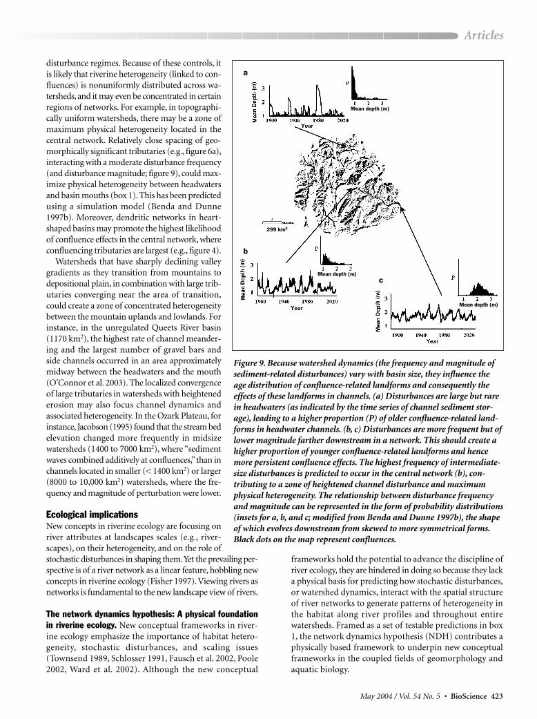
disturbance regimes. Because of these controls, itis likely that riverine heterogeneity (linked to con-fluences) is nonuniformly distributed across wa-tersheds, and it may even be concentrated in certainregions of networks. For example, in topographi-cally uniform watersheds, there may be a zone ofmaximum physical heterogeneity located in thecentral network. Relatively close spacing of geo-morphically significant tributaries (e.g., figure 6a),interacting with a moderate disturbance frequency(and disturbance magnitude; figure 9), could max-imize physical heterogeneity between headwatersand basin mouths (box 1). This has been predictedusing a simulation model (Benda and Dunne1997b). Moreover, dendritic networks in heart-shaped basins may promote the highest likelihoodof confluence effects in the central network, whereconfluencing tributaries are largest (e.g., figure 4).
Watersheds that have sharply declining valleygradients as they transition from mountains todepositional plain, in combination with large trib-utaries converging near the area of transition,could create a zone of concentrated heterogeneitybetween the mountain uplands and lowlands. Forinstance, in the unregulated Queets River basin(1170 km2), the highest rate of channel meander-ing and the largest number of gravel bars and side channels occurred in an area approximatelymidway between the headwaters and the mouth(O’Connor et al. 2003). The localized convergenceof large tributaries in watersheds with heightenederosion may also focus channel dynamics and associated heterogeneity. In the Ozark Plateau, forinstance, Jacobson (1995) found that the stream bedelevation changed more frequently in midsize watersheds (1400 to 7000 km2), where “sedimentwaves combined additively at confluences,” than inchannels located in smaller (< 1400 km2) or larger(8000 to 10,000 km2) watersheds, where the fre-quency and magnitude of perturbation were lower.
Ecological implications New concepts in riverine ecology are focusing onriver attributes at landscapes scales (e.g., river-scapes), on their heterogeneity, and on the role ofstochastic disturbances in shaping them.Yet the prevailing per-spective is of a river network as a linear feature, hobbling newconcepts in riverine ecology (Fisher 1997). Viewing rivers asnetworks is fundamental to the new landscape view of rivers.
The network dynamics hypothesis: A physical foundationin riverine ecology. New conceptual frameworks in river-ine ecology emphasize the importance of habitat hetero-geneity, stochastic disturbances, and scaling issues(Townsend 1989, Schlosser 1991, Fausch et al. 2002, Poole2002, Ward et al. 2002). Although the new conceptual
frameworks hold the potential to advance the discipline ofriver ecology, they are hindered in doing so because they lacka physical basis for predicting how stochastic disturbances,or watershed dynamics, interact with the spatial structureof river networks to generate patterns of heterogeneity inthe habitat along river profiles and throughout entire watersheds. Framed as a set of testable predictions in box1, the network dynamics hypothesis (NDH) contributes aphysically based framework to underpin new conceptualframeworks in the coupled fields of geomorphology andaquatic biology.
May 2004 / Vol. 54 No. 5 • BioScience 423
Articles
Figure 9. Because watershed dynamics (the frequency and magnitude ofsediment-related disturbances) vary with basin size, they influence theage distribution of confluence-related landforms and consequently the effects of these landforms in channels. (a) Disturbances are large but rarein headwaters (as indicated by the time series of channel sediment stor-age), leading to a higher proportion (P) of older confluence-related land-forms in headwater channels. (b, c) Disturbances are more frequent but oflower magnitude farther downstream in a network. This should create ahigher proportion of younger confluence-related landforms and hencemore persistent confluence effects. The highest frequency of intermediate-size disturbances is predicted to occur in the central network (b), con-tributing to a zone of heightened channel disturbance and maximumphysical heterogeneity. The relationship between disturbance frequencyand magnitude can be represented in the form of probability distributions(insets for a, b, and c; modified from Benda and Dunne 1997b), the shapeof which evolves downstream from skewed to more symmetrical forms.Black dots on the map represent confluences.
Mean depth (m)
Mean depth (m)
Mean depth (m)
a
b
c
299 km2
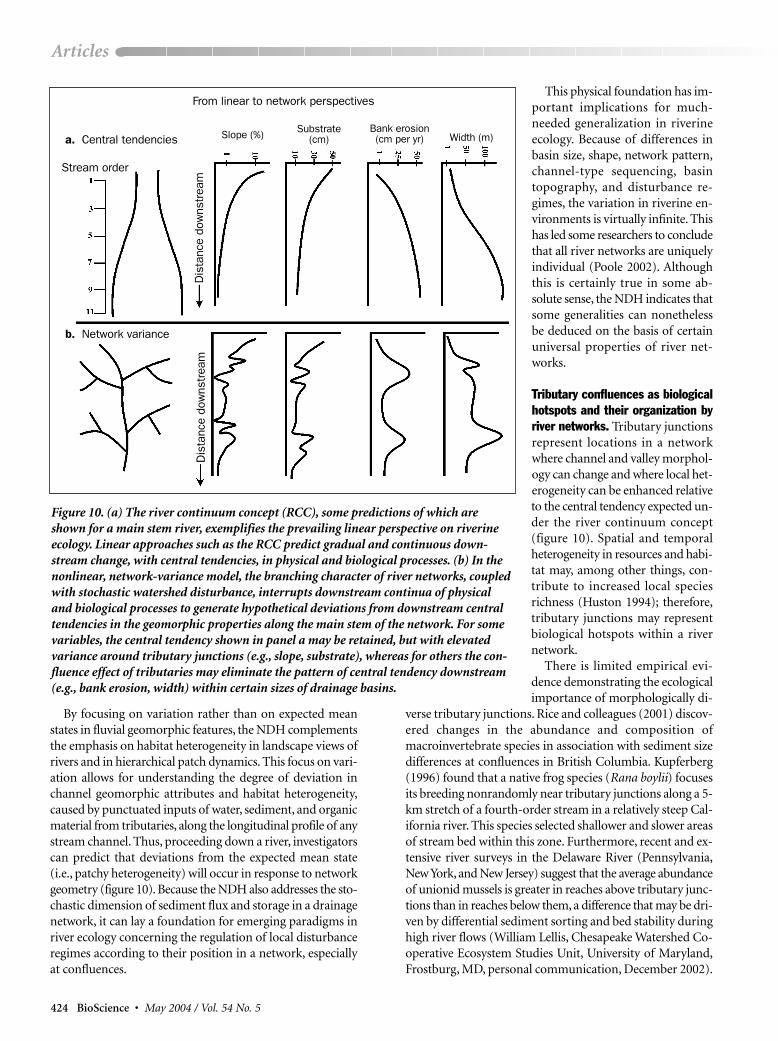
By focusing on variation rather than on expected meanstates in fluvial geomorphic features, the NDH complementsthe emphasis on habitat heterogeneity in landscape views ofrivers and in hierarchical patch dynamics. This focus on vari-ation allows for understanding the degree of deviation inchannel geomorphic attributes and habitat heterogeneity,caused by punctuated inputs of water, sediment, and organicmaterial from tributaries, along the longitudinal profile of anystream channel. Thus, proceeding down a river, investigatorscan predict that deviations from the expected mean state(i.e., patchy heterogeneity) will occur in response to networkgeometry (figure 10). Because the NDH also addresses the sto-chastic dimension of sediment flux and storage in a drainagenetwork, it can lay a foundation for emerging paradigms inriver ecology concerning the regulation of local disturbanceregimes according to their position in a network, especiallyat confluences.
This physical foundation has im-portant implications for much-needed generalization in riverineecology. Because of differences inbasin size, shape, network pattern,channel-type sequencing, basintopography, and disturbance re-gimes, the variation in riverine en-vironments is virtually infinite. Thishas led some researchers to concludethat all river networks are uniquelyindividual (Poole 2002). Althoughthis is certainly true in some ab-solute sense, the NDH indicates thatsome generalities can nonethelessbe deduced on the basis of certainuniversal properties of river net-works.
Tributary confluences as biologicalhotspots and their organization byriver networks. Tributary junctionsrepresent locations in a networkwhere channel and valley morphol-ogy can change and where local het-erogeneity can be enhanced relativeto the central tendency expected un-der the river continuum concept(figure 10). Spatial and temporalheterogeneity in resources and habi-tat may, among other things, con-tribute to increased local speciesrichness (Huston 1994); therefore,tributary junctions may representbiological hotspots within a rivernetwork.
There is limited empirical evi-dence demonstrating the ecologicalimportance of morphologically di-
verse tributary junctions. Rice and colleagues (2001) discov-ered changes in the abundance and composition ofmacroinvertebrate species in association with sediment sizedifferences at confluences in British Columbia. Kupferberg(1996) found that a native frog species (Rana boylii) focusesits breeding nonrandomly near tributary junctions along a 5-km stretch of a fourth-order stream in a relatively steep Cal-ifornia river. This species selected shallower and slower areasof stream bed within this zone. Furthermore, recent and ex-tensive river surveys in the Delaware River (Pennsylvania,New York, and New Jersey) suggest that the average abundanceof unionid mussels is greater in reaches above tributary junc-tions than in reaches below them, a difference that may be dri-ven by differential sediment sorting and bed stability duringhigh river flows (William Lellis, Chesapeake Watershed Co-operative Ecosystem Studies Unit, University of Maryland,Frostburg, MD, personal communication, December 2002).
424 BioScience • May 2004 / Vol. 54 No. 5
Articles
Figure 10. (a) The river continuum concept (RCC), some predictions of which areshown for a main stem river, exemplifies the prevailing linear perspective on riverineecology. Linear approaches such as the RCC predict gradual and continuous down-stream change, with central tendencies, in physical and biological processes. (b) In thenonlinear, network-variance model, the branching character of river networks, coupledwith stochastic watershed disturbance, interrupts downstream continua of physicaland biological processes to generate hypothetical deviations from downstream centraltendencies in the geomorphic properties along the main stem of the network. For somevariables, the central tendency shown in panel a may be retained, but with elevatedvariance around tributary junctions (e.g., slope, substrate), whereas for others the con-fluence effect of tributaries may eliminate the pattern of central tendency downstream(e.g., bank erosion, width) within certain sizes of drainage basins.
a. Central tendencies
b. Network variance
From linear to network perspectives
Bank erosion(cm per yr)
Dis
tanc
e do
wns
trea
mD
ista
nce
dow
nstr
eam
Stream order
Slope (%) Substrate(cm) Width (m)
Despite the lack of biological studies focusing on conflu-ences, general ecological principles allow us to infer other likelyeffects. For macroinvertebrates and fish, increasing the het-erogeneity of habitat conditions, including channel widthand depth, bed substrate, wood storage, and water velocity,should increase total species richness (Allan 1995). For ex-ample, increased channel-wide habitat diversity above sig-nificant tributary confluences should create habitatopportunities, such as side channels during flood events, forspecialized aquatic species or for life stages that require low-energy environments (e.g., Swales and Levings 1989, Reeveset al. 1995). This has been documented in the Oregon CoastRange, where increased wood storage and pool formation atlow-order confluences resulted in increased salmonid rear-ing (Everest and Meehan 1981). In the Olympic Mountains,Washington, correlations among low-order confluences—which are prone to debris flows, large pools, gravel deposits,and accumulation of wood—promoted increased availabil-ity of fish habitat. Likewise, for riparian communities, greatertopographic variation in floodplains and terraces should cre-ate local variation in inundation and soil moisture regimes,thereby increasing plant diversity (e.g., Kalliola and Puharta1988, Pollock et al. 1998), or provide interannual variation inriparian plant recruitment (Cooper et al. 2003). Such enhancedfloodplain and terrace topography has been documentedupstream of alluvial fans (e.g., figure 2; Small 1973, Benda etal. 2003b).
Other ecosystem processes may also be amplified at trib-utary junctions. For example, the localized flattening ofstream gradient and slowing of water velocity upstream ofa tributary fan can increase hydraulic head and enhance hyporheic flow through wedges of gravel substrate (Edwards1998). In this environment, dissolved organic nitrogen can bechemically transformed while in hyporheic transit and emergein surface water as dissolved nitrate, which can support in-creased primary productivity (Sedell and Dahm 1984). Sim-ilarly, emerging hyporheic flow typically exhibits a smallerrange of temperature extremes, which is favored by certain fish(e.g., see Baxter and Hauer 2000).
Of course, tributaries can also modify environmental con-ditions other than the sediment and morphology of receiv-ing rivers. The details of these modifications will be complexand will depend on the relative sizes and geochemical char-acteristics of the main stem and tributary streams. Higher in-puts of nutrients and invertebrates from tributaries havebeen shown to promote primary and secondary productiv-ity in receiving streams (e.g., Kiffney and Richardson 2001,Wipfli and Gregovich 2002). Fish may also use tributarymouths as thermal refugia (e.g., Scarnecchia and Roper 2000)or as dispersal corridors that support higher than expectedspecies diversity (Osborne and Wiley 1992).
ConclusionsStarting with the basic observation that the likelihood ofmorphologically significant perturbations to main stem chan-nels increases with the ratio of tributary to main stem size,
we deduced a set of predictions relating the degree and spatial distribution of physical heterogeneity in a river systemto general features of branching river networks (figure 1,box 1). This set of testable predictions—known collectivelyas the network dynamics hypothesis—provides a new frame-work for considering how the spatial structures of river net-works, combined with time-varying watershed disturbances,create and maintain habitat heterogeneity and thus potentially promote biological diversity and productivity in riverineecosystems.
The network dynamics hypothesis can serve as a physicallybased framework for recent advances in watershed-scale geo-morphology and aquatic biology, namely, hierarchical patchdynamics (Townsend 1989, Wu and Loucks 1995, Poole2002) and the application of landscape ecology to river sys-tems (Schlosser 1991, Fausch et al. 2002, Ward et al. 2002,Wiens 2002). Consequently, this hypothesis could provide afoundation for new research in riverine ecology. It also hasramifications for land management and for conservation orrestoration strategies. For example, network maps, based onthe location of geomorphically interesting confluences, couldbe generated to identify the highest likelihood of physical het-erogeneity (Benda et al. 2004). Putative biological hotspotscould thus be identified on the basis of network configura-tion and watershed disturbance regimes. Also, land man-agement practices that alter the spatial and temporaldistribution of sediment and organic matter (e.g., dams,dikes, and forestry practices) could be examined in terms oftheir effects on downstream habitat heterogeneity, as medi-ated through confluences in specific network structures. Suchanalyses could contribute to the development of strategies fortargeted restoration efforts in a whole-watershed context.
AcknowledgmentsThe development of this article was supported by a Bio-complexity in the Environment grant (DEB-0083937) fromthe National Science Foundation. The present version was sub-stantially improved by comments made on a previous draftby three anonymous reviewers.
References citedAllan JD. 1995. Stream Ecology: Structure and Function of Running Waters.
London: Chapman and Hall.Baxter CV. 2002. Fish movement and assemblage dynamics in a Pacific
Northwest riverscape. PhD dissertation, Oregon State University, Cor-vallis.
Baxter CV, Hauer FR. 2000. Geomorphology, hyporheic exchange, and se-lection of spawning habitat by bull trout (Salvelinus confluentus). Cana-dian Journal of Fisheries and Aquatic Sciences 57: 1470–1481.
Benda L. 1990. The influence of debris flows on channels and valley floorsof the Oregon Coast Range, U.S.A. Earth Surface Processes and Land-forms 15: 457–466.
Benda L, Cundy TW. 1990. Predicting deposition of debris flows in moun-tain channels. Canadian Geotechnical Journal 27: 409–417.
Benda L, Dunne T. 1997a. Stochastic forcing of sediment supply to thechannel network from landsliding and debris flow. Water ResourcesResearch 33: 2849–2863.
———. 1997b. Stochastic forcing of sediment routing and storage in chan-nel networks. Water Resources Research 33: 2865–2880.
May 2004 / Vol. 54 No. 5 • BioScience 425
Articles
Benda L,Veldhuisen C, Black J. 2003a. Debris flows as agents of morphologicalheterogeneity at low-order confluences, Olympic Mountains, Washing-ton. Geological Society of America Bulletin 115: 1110–1121.
Benda L, Miller D, Bigelow P, Andrus K. 2003b. Effects of post-wildfire ero-sion on channel environments, Boise River, Idaho. Journal of ForestEcology and Management 178: 105–119.
Benda L, Andras K, Miller D, Bigelow P. 2004. Effects of tributaries in rivernetworks: Role of basin scale, basin shape, network geometry, and dis-turbance regimes. Water Resources Research. Forthcoming.
Best JL. 1986. Sediment transport and bed morphology at river channel con-fluences. Sedimentology 35: 481–498.
Booth DB, Bell K, Whipple KX. 1991. Sediment Transport along the SouthFork and Mainstem of the Snoqualmie River. Seattle: King County De-partment of Public Works, Surface Water Management Division.
Bruns DA, Minshall GW, Cushing CE, Cummins KW, Brock JT,Vannote RC.1984. Tributaries as modifiers of the river continuum concept: Analysisby polar ordination and regression models. Archiv für Hydrobiologie 99:208–220.
Bull WB. 1977. The alluvial fan environment. Progress in Physical Geogra-phy 1: 222–270.
Church M. 1983. Pattern of instability in a wandering gravel bed channel.Special Publications of the International Association of Sedimentologists6: 169–180.
———. 1998. The landscape of the Pacific Northwest. Pages 13–22 in HoganDL, Tschaplinski PJ, Chatwin S, eds. Carnation Creek and Queen Char-lotte Islands Fish/Forestry Workshop: Applying 20 Years of Coastal Re-search to Management Solutions.Victoria (Canada): Ministry of ForestsResearch Program. Land Management Handbook no. 41.
Cooper DJ, Andersen DC, Chimner RA. 2003. Multiple pathways for woodyplant establishment on floodplains at local to regional scales. Journal ofEcology 91: 182–196.
Edwards RT. 1998. The hyporheic zone. Pages 399–429 in Naiman R, BilbyRE, eds. River Ecology and Management: Lessons from the PacificCoastal Ecosystem. New York: Springer.
Everest FH, Meehan WR. 1981. Forest management and anadromous fishhabitat productivity. Pages 521–530 in Transactions of the 46th NorthAmerican Wildlife and Natural Resources Conference. Washington(DC): Wildlife Management Institute.
Fausch KD, Torgersen CE, Baxter CV, Li HW. 2002. Landscapes to riverscapes:Bridging the gap between research and conservation of stream fishes. Bio-Science 52: 483–498.
Fisher SG. 1997. Creativity, idea generation, and the functional morphologyof streams. Journal of the North American Benthological Society 16:305–318.
Frissell CA, Liss WJ, Warren WJ, Hurley MD. 1986. A hierarchical frameworkfor stream habitat classification: Viewing streams in a watershed context.Environmental Management 10: 199–214.
Gomi T, Sidle RC, Richardson JS. 2002. Understanding processes and down-stream linkages of headwater systems. BioScience 52: 905–916.
Grant G. 1997. A geomorphic basis for interpreting the hydrologic behav-ior of large river basins. Pages 105–116 in Laenen A, Dunnette DA, eds.River Quality: Dynamics and Restoration. Boca Raton (FL): CRC Press.
Grant GE, Swanson FJ. 1995. Morphology and processes of valley floors inmountain streams, Western Cascades, Oregon. Pages 83–101 in Costa JE,Miller AJ, Potter KW, Wilcock PR, eds. Natural and Anthropogenic In-fluences in Fluvial Geomorphology: The Wolman Volume. Washington(DC): American Geophysical Union. Geophysical Monograph no. 89.
Gregory SV, Swanson FJ, McKee WA, Cummins KW. 1991.An ecosystem per-spective of riparian zones. BioScience 41: 540–551.
Grimm MM, Wohl EE, Jarrett RD. 1995. Coarse-sediment deposition asevidence of an elevation limit for flash flooding, Bear Creek, Colorado.Geomorphology 14: 199–210.
Hack JT. 1957. Studies of Longitudinal Stream Profiles in Virginia andMaryland. Washington (DC): US Government Printing Office. US Geological Survey Professional Paper no. 294-B.
Hogan DL, Bird SA, Hassan MA. 1998. Spatial and temporal evolution of smallcoastal gravel-bed streams: The influence of forest management onchannel morphology and fish habitats. Pages 365–392 in Klingeman
PC, Beschta RL, Komar PD, Bradley JB, eds. Gravel-Bed Rivers in the Environment. Highlands Ranch (CO): Water Resources Publications.
Horton RE. 1945. Hydrophysical approach to the morphology of hillslopesand drainage basins. Geological Society of America Bulletin 56: 275–370.
Huston MA. 1994. Biological Diversity: The Coexistence of Species onChanging Landscapes. Cambridge (United Kingdom): Cambridge Uni-versity Press.
Jacobson RB. 1995. Spatial controls on patterns of land-use induced streamdisturbance at the drainage-basin scale—an example from gravel-bedstreams of the Ozark Plateaus, Missouri. Pages 219–239 in Costa JE, MillerAJ, Potter KW, Wilcock PR, eds. Natural and Anthropogenic Influencesin Fluvial Geomorphology: The Wolman Volume. Washington (DC):American Geophysical Union. Geophysical Monograph no. 89.
Kalliola R, Puharta M. 1988. River dynamics and vegetation mosaicism: Acase study of the River Kamajohka, northernmost Finland. Journal of Bio-geography 15: 703–719.
Kiffney PM, Richardson JS. 2001. Interactions among nutrient, periphyton,and invertebrate and vertebrate grazers in experimental channels. Copeia2001: 422–429.
Kupferberg SJ. 1996. Hydrologic and geomorphic factors affecting conser-vation of a river-breeding frog (Rana boylii). Ecological Applications 6:1332–1344.
Leopold LB, Wolman MG, Miller JP. 1964. Fluvial Processes in Geo-morphology. San Francisco: W. H. Freeman.
Melis TS, Webb RH, Griffiths PG, Wise TW 1995. Magnitude and FrequencyData for Historic Debris Flows in Grand Canyon National Park and Vicin-ity, Arizona. Available from US Geological Survey, Information Ser-vices, Box 25286, Federal Center, Denver, CO 80225. Water-ResourcesInvestigations Report no. 94-4214.
Meyer GA, Leidecker ME. 1999. Fluvial terraces along the Middle ForkSalmon River, Idaho, and their relation to glaciation, landslide dams, andincision rates: A preliminary analysis and river-mile guide. Pages 219–235in Hughes SS, Thackray GD, eds. Guidebook to the Geology of EasternIdaho. Pocatello (ID): Idaho Museum of Natural History.
Meyer GA, Pierce JL. 2003. Climatic controls on fire-induced sedimentpulses in Yellowstone National Park and central Idaho: A long-termperspective. Forest Ecology and Management 178: 89–104.
Meyer GA, Pierce JL, Wood SH, Jull AJT. 2001. Fires, storms, and sedimentyield in the Idaho batholith. Hydrological Processes 15: 3025–3038.
Miller DJ, Luce CH, Benda LE. 2003. Time, space, and episodicity of physi-cal disturbance in streams. Forest Ecology and Management 178: 121–140.
Minshall WG, Cummins KW, Peterson BJ, Cushing CE, Bruns DA, Sedell JR,Vannote RL. 1985. Developments in stream ecosystem theory. CanadianJournal of Fisheries and Aquatic Sciences 42: 1045–1055.
Montgomery DR. 1999. Process domains and the river continuum. Journalof the American Water Resources Association 35: 397–410.
Mosley MP. 1976. An experimental study of channel confluences. Journal ofGeology 84: 535–562.
Naiman RJ, DeCamps H, Pastor J, Johnston CA. 1988. The potential im-portance of boundaries to fluvial ecosystems. Journal of the NorthAmerican Benthological Society 7: 289–306.
Nakamura F, Swanson FJ,Wondzell SM. 2000. Disturbance regimes of streamand riparian systems—a disturbance-cascade perspective. HydrologicalProcesses 14: 2849–2860.
O’Connor JE, Jones MA, Haluska TL. 2003. Floodplain and channel dynamicsof the Quinault and Queets Rivers, Washington, USA. Geomorphology51: 31–59.
Osborne LL, Wiley MJ. 1992. Influence of tributary spatial position on thestructure of warm water fish communities. Canadian Journal of Fisheriesand Aquatic Sciences 49: 671–681.
Perry JA, Schaeffer DJ. 1987. The longitudinal distribution of riverine ben-thos: A river discontinuum? Hydrobiologia 148: 257–268.
Poff NL. 1997. Landscape filters and species traits: Towards mechanisticunderstanding and prediction in stream ecology. Journal of the NorthAmerican Benthological Society 16: 391–409.
Poff NL, Allan JD, Bain MB, Karr JR, Prestegaard KL, Richter BD, Sparks RE,Stromberg JC. 1997. The natural flow regime: A paradigm for river con-servation and restoration. BioScience 47: 769–784.
426 BioScience • May 2004 / Vol. 54 No. 5
Articles

Pollock MM, Naiman RJ, Hanley TA. 1998. Predicting plant species richnessin forested and emergent wetlands—a test of biodiversity theory. Ecol-ogy 79: 94–105.
Poole GC. 2002. Fluvial landscape ecology: Addressing uniqueness within theriver discontinuum. Freshwater Biology 47: 641–660.
Reeves GH, Benda LE, Burnett KM, Bisson PA, Sedell JR. 1995.A disturbance-based ecosystem approach to maintaining and restoring freshwaterhabitats of evolutionarily significant units of anadromous salmonids inthe Pacific Northwest. American Fisheries Society Symposium 17:334–349.
Resh VH, Brown AV, Covich AP, Gurtz ME, Li HW, Minshall GW, Reice SR,Sheldon AL, Wallace JB, Wissmar R. 1988. The role of disturbance instream ecology. Journal of the North American Benthological Society 7:433–455.
Rhoads BL. 1987. Changes in stream characteristics at tributary junctions.Physical Geography 8: 346–361.
Rice SP, Greenwood MT, Joyce CB. 2001. Tributaries, sediment sources, andthe longitudinal organization of macroinvertebrate fauna along river sys-tems. Canadian Journal of Fisheries and Aquatic Sciences 58: 828–840.
Scarnecchia DL, Roper BB. 2000. Large-scale differential summer habitat useof three anadromous salmonids in a large river basin in Oregon, USA.Fisheries Management and Ecology 7: 197–209.
Schlosser IJ. 1991. Stream fish ecology: A landscape perspective. BioScience41: 704–712.
Sedell JR, Dahm CN. 1984. Catastrophic disturbances to stream ecosys-tems: Volcanism and clear-cut logging. Pages 531–539 in Klug MJ, ReddyCA, eds. Current Perspectives in Microbial Ecology: Proceedings of theThird International Symposium on Microbial Ecology, Michigan StateUniversity, 7–12 August 1983. Washington (DC): American Society forMicrobiology.
Small RJ. 1973. Braiding terraces in the Val d’Herens, Switzerland. Geogra-phy 58: 129–135.
Swales S, Levings CD. 1989. Role of off-channel ponds in the life cycle of coho
salmon (Oncorhynchus kisutch) and other juvenile salmonids in the
Coldwater River, British Columbia. Canadian Journal of Fisheries and
Aquatic Sciences 46: 232–242.
Swanson FJ, Fredriksen RL, McCorison FM. 1982. Material transfer in a west-
ern Oregon forested watershed. Pages 233–266 in Edmonds RL, ed.
Analysis of Coniferous Forested Ecosystems in the Western United
States. Stroudsburg (PA): Dowden, Hutchinson and Ross.
Swanson FJ, Kratz TK, Caine N, Woodmansee RG. 1988. Landform effects
on ecosystem patterns and processes. BioScience 38: 92–98.
Townsend CR. 1989. The patch dynamics concept of stream community ecol-
ogy. Journal of the North American Benthological Society 8: 36–50.
———. 1996. Concepts in river ecology: Pattern and process in the catch-
ment hierarchy. Archiv für Hydrobiologie 113 (suppl.): 3–21.
Vannote RL, Minshall GW, Cummins KW, Sedell JR, Cushing CE. 1980. The
river continuum concept. Canadian Journal of Fisheries and Aquatic Sci-
ences 37: 130–137.
Ward JV, Tockner K, Arscott DB, Claret C. 2002. Riverine landscape diver-
sity. Freshwater Biology 47: 517–539.
Wiens JA. 2002. Riverine landscapes: Taking landscape ecology into the
water. Freshwater Biology 47: 501–515.
Wipfli MS, Gregovich DP. 2002. Export of invertebrates and detritus from
fishless headwater streams in southeastern Alaska: Implications for
downstream salmonid production. Freshwater Biology 47: 957–969.
Wohl EE, Pearthree PP. 1991. Debris flows as geomorphic agents in the
Huachuca Mountains of southeastern Arizona. Geomorphology 4:
273–292.
Wu JG, Loucks OL. 1995. From balance of nature to hierarchical patch dy-
namics: A paradigm shift in ecology. Quarterly Review of Biology 70:
439–466.
May 2004 / Vol. 54 No. 5 • BioScience 427
Articles

NEW AD
University of California Press
full page
k428 BioScience • May 2004 / Vol. 54 No. 5