arthur highway eaglehawk neck safety upgrade project
TRANSCRIPT

Arthur Highway – Eaglehawk Neck Safety Upgrade Project Project Summary Document
Department of State Growth
15 September 2021
The Power of Commitment

The Power of Commitment
GHD Pty Ltd | ABN 39 008 488 373
2 Salamanca Square,
Hobart, Tasmania 7000, Australia
T +61 3 6210 0600 | F +61 3 8732 7046 | E [email protected] | ghd.com
Printed date 15/09/2021 10:40:00 AM
Last saved date 15 September 2021
File name G:\32\19059\3219059_CIVL_REPT_Project Summary Report - REV 1.docx
Author Abbey Luttrell
Project manager Abbey Luttrell
Client name Department of State Growth
Project name Arthur Highway - Eaglehawk Neck Widening
Document title Arthur Highway – Eaglehawk Neck Safety Upgrade Project | Project Summary Document
Revision version Rev 2
Project number 3219059
Document status
Status Code
Revision Author Reviewer Approved for issue
Name Signature Name Signature Date
S3 0 A Luttrell M Davis On file* S Lukies
21/08/2021
S4 1 A Luttrell C Monty On file* S Lukies
30/07/2021
S4 2 A Luttrell C Monty On file* S Lukies
15/09/2021
© GHD 2021
This document is and shall remain the property of GHD. The document may only be used for the purpose for
which it was commissioned and in accordance with the Terms of Engagement for the commission. Unauthorised
use of this document in any form whatsoever is prohibited.

GHD | Department of State Growth | 3219059 | Arthur Highway – Eaglehawk Neck Safety Upgrade Project i
Contents
1. Introduction 1
1.1 Purpose of this Report 1
1.1.1 Report Structure 1
1.2 Project Background 1
1.3 Approval Process 1
1.3.1 Reserve Activity Assessment 1
1.3.2 Planning Approval 1
1.4 Assessment Status of Proposal 1
1.5 Property Information 1
1.6 Scope and limitations 3
2. Proposal Description 4
2.1 Background to Proposal 4
2.2 Proposal Description 4
2.3 Project Objectives 5
2.4 Detailed Design Geometry 5
2.4.1 Horizontal Alignment 5
2.4.2 Vertical Alignment 5
2.4.3 Safety Barrier 6
2.5 Junction Geometric Design 6
2.5.1 Blowhole Road 6
2.5.2 Community Hall Access 7
2.6 Pavement Design 7
2.6.1 Road Surfacing 8
2.7 Provision for Pedestrians and Cyclists 9
2.8 Bus Stops 9
2.9 Revetment Design 9
2.10 Services 10
2.10.1 Telstra 10
2.10.2 TasNetworks 10
2.10.3 TasWater 11
2.10.4 NBN 11
2.10.5 TasGas 11
2.10.6 Stormwater 11
2.11 Connectivity to Existing Paths and Walkways 14
3. Project Alternatives 15
3.1 Do nothing – Active Monitoring 15
3.2 Project Options 15
3.2.1 Option Development 15
3.2.2 Option Workshop 15
3.2.3 Option 1: Shoulder Widening and Pathway 15
3.2.4 Option 2: Shoulder Widening, Turn Treatments (BAR) and New Path 16
3.2.5 Option 3: Shoulder Widening, Turn Treatments (CHRs) and New Path 16
3.2.6 Option 4: Shoulder Widening 16
3.2.7 Option 5: Shoulder Widening, Turn Treatments (CHRs) and New Off-road Path 17
3.3 Community Consultation on Shortlisted Options 17

GHD | Department of State Growth | 3219059 | Arthur Highway – Eaglehawk Neck Safety Upgrade Project ii
3.3.1 Original Design 17
3.3.2 Design Changes 17
4. Potential Impacts and Management 20
4.1 Flora and Fauna 20
4.1.1 Threatened Vegetation Communities 20
4.1.2 Threatened Flora 20
4.1.3 Threatened Fauna 20
4.1.4 Shorebirds 21
4.1.5 Weeds and Diseases 21
4.1.6 Acid Sulfate Soils 22
4.2 Heritage 22
4.2.1 Aboriginal Heritage 22
4.2.2 Historic Heritage 23
4.3 Geomorphology 24
4.4 Visual Impact Considerations 24
4.5 Construction Management of Effects 30
4.5.1 Construction Environmental Management Plan 30
5. Impacts on Reserved Land 32
5.1 Reserved Land 32
5.2 Reserve Boundaries 34
5.3 Fencing 34
5.4 Access to Community Hall 34
5.5 Pre-existing Maintenance Issue – Blowhole Road 34
5.6 Pre-existing Maintenance Issue – Community Hall Paddock 34
5.7 Ongoing access to reserved land that is likely to be required to undertake maintenance 35
6. Management Commitments 36
7. Conclusion 37
Table index
Table 1.1 Design Changes 2
Table 1.2 Summary of property information 2
Table 2.1 Horizontal Alignment Geometry 5
Table 2.2 Vertical Alignment Geometry 6
Table 2.3 Safety Barrier Extents 6
Table 2.4 Full depth granular pavement structure 7
Table 2.5 Full depth asphalt pavement structure 8
Table 3.1 Design Changes 18
Table 6.1 Management Commitments 36
Figure index
Figure 1.1 Concept plan 1
Figure 1.2 Approximate property boundaries and identification information 2
GHD | Department of State Growth | 3219059 | Arthur Highway – Eaglehawk Neck Safety Upgrade Project iii
Figure 2.1 Contributing storm water catchments 12
Figure 4.1 Foundations for the commissariat store 23
Figure 4.2 Locality Plan of 3D Modelling Images 25
Figure 4.3 Old Jetty Road, looking towards the bay 26
Figure 4.4 From the bay, looking towards the Community Hall 26
Figure 4.5 Arthur Highway, looking towards Eaglehawk Neck, near Old Jetty Road 27
Figure 4.6 Arthur Highway, heading northbound along the neck 27
Figure 4.7 Arthur Highway, heading northbound, opposite Blowhole Road 28
Figure 4.8 Arthur Highway / Blowhole Road junction 28
Figure 4.9 Arthur Highway, heading southbound, looking towards Blowhole Road 29
Figure 4.10 Imagery captured over project site 29
Figure 4.11 View from bay, looking towards the Community Hall 30
Figure 5.1 Public land classification (source: LISTMap) 32
Appendices
Appendix A Detailed Design Drawings
Appendix B Flora and Fauna Habitat Assessment
Appendix C Historic Heritage Assessment
Appendix D Land Tenure Sketch
Appendix E Archaeological Method Statement
Appendix F Geomorphology Report
Appendix G Footprint of work (2020 and 2021 design comparison)
Appendix H Construction Environmental Management Plan

GHD | Department of State Growth | 3219059 | Arthur Highway – Eaglehawk Neck Safety Upgrade Project 1
1. Introduction
1.1 Purpose of this Report GHD has been engaged by the Department of State Growth (State Growth) to prepare a document, which
summarises the Arthur Highway – Eaglehawk neck Safety Upgrade Project.
This document will be used by State Growth, to help satisfy Tasmania Parks and Wildlife Service (PWS)
requirements, as the project impacts on land in the ownership of PWS, and as such, is subject to the National
Parks and Reserves Management Act 2002 and Reserve Activity Assessment guidelines.
1.1.1 Report Structure
This report is separated into the following sections:
1. Introduction – overview of the proposal, the proponent and the assessment process.
2. Proposal Description – outlines the proposal including design and objectives
3. Project Alternatives
4. Potential Impacts and Management – describes each of the potential impacts of the proposal and how they
will be managed.
5. Impacts on PWS Infrastructure – describes the impacts of the proposal on PWS infrastructure
6. Management Commitments
7. Conclusions
1.2 Project Background In early 2020, a design for the upgrade was completed. Prior to the start of construction in November 2020,
concerns were raised by the Aboriginal community regarding the impact on cultural heritage in the area.
construction was paused while The Department of State Growth worked to address these concerns.
The Department of State Growth has since further consulted the Aboriginal community and regulatory authorities
to revise the design. The revised design addresses concerns raised by the Aboriginal community by removing all
ground disturbing activities within cultural heritage areas.
The revised design meets the safety objectives of the project by providing:
– A 1.5 m wide path for pedestrians from the bus stop opposite Old Jetty Road to Blowhole Road, including
safety barrier between the road and the path.
– 3 m wide traffic lanes and new safety barrier on the western side of the highway to improve safety for
vehicles.
– 1 m wide road shoulder in both directions.
The table below describes what is changing as part of the revised design and how this compares to the existing
highway.

GHD | Department of State Growth | 3219059 | Arthur Highway – Eaglehawk Neck Safety Upgrade Project 2
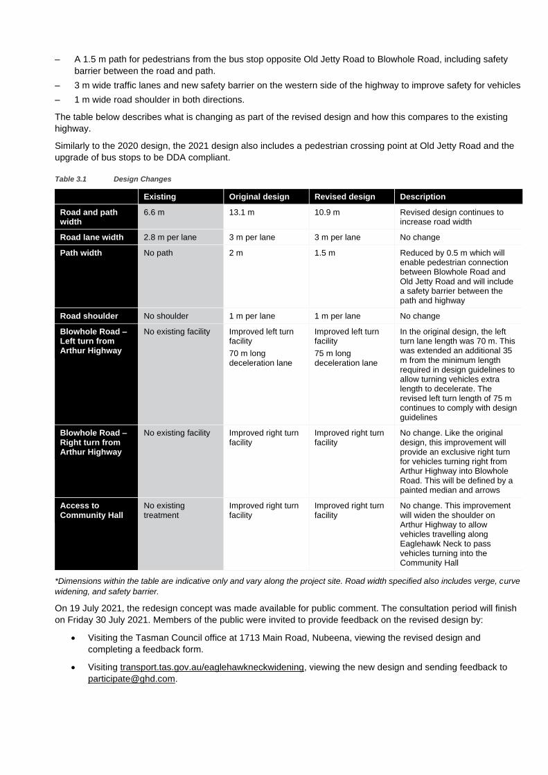
Table 1.1 Design Changes
Existing Original design 2020
Revised design 2021
Description
Road and path width
6.6 m total width 13.1 m total width
10.9 m total width
Revised design continues to increase road width
Road lane width
2.8 m per lane 3 m per lane 3 m per lane No change
Path width No path 2 m 1.5 m Reduced by 0.5 m which will enable pedestrian connection between Blowhole Road and Old Jetty Road and will include a safety barrier between the path and highway
Road shoulder No shoulder 1 m per lane 1 m per lane No change
Blowhole Road – Left turn from Arthur Highway
No existing facility
Improved left turn facility
70 m long deceleration lane
Improved left turn facility
75 m long deceleration lane
In the original design, the left turn lane length was 70 m. This was extended an additional 35 m from the minimum length required in design guidelines to allow turning vehicles extra length to decelerate.
The revised left turn length of 75 m continues to comply with design guidelines and reduces impact to Eaglehawk Neck Bay.
Blowhole Road – Right turn from Arthur Highway
No existing facility
Improved right turn facility
Improved right turn facility
No change. Like the original design, this improvement will provide an exclusive right turn for vehicles turning right from Arthur Highway into Blowhole Road. This will be defined by a painted median and arrows
Access to Community Hall
No existing treatment
Improved right turn facility
Improved right turn facility
No change. This improvement will widen the shoulder on Arthur Highway to allow vehicles travelling along Eaglehawk Neck to pass vehicles turning into the Community Hall
*Dimensions within the table are indicative only and vary along the project site. Road width specified also includes
verge, curve widening, and safety barrier.

GHD | Department of State Growth | 3219059 | Arthur Highway – Eaglehawk Neck Safety Upgrade Project 1
The concept plan for the revised design has been provided in Figure 1.1 below, while the detailed design drawings have been included in Appendix A. A plan
illustrating the differences in project footprint, between 2020 and 2021 has been provided in Appendix G.
Figure 1.1 Concept plan
1.3 Approval Process The proposed road upgrade requires approval under the following.
1.3.1 Reserve Activity Assessment
As the proposed work will encroach into Eaglehawk Neck Historic Site and Eaglehawk Neck-Flinders Bay
Conservation Area, assessment by Tasmanian Parks and Wildlife Service (PWS) through the Reserve Activity
Assessment (RAA) or equivalent process is required, before an authority under the National Parks and Reserved
Land Regulations 2009 can be granted by the Director of National Parks. The land tenure sketch in Appendix D
provides more detail on the location of reserve land boundaries.
The RAA is the Environmental Impact Assessment system that PWS use to assess whether activities proposed on
reserved land are environmentally, socially and economically acceptable.
1.3.2 Planning Approval
The proposed road works require approvals under various legislation. The overarching legislation for approval for
the proposal is the Land Use Planning and Approvals Act 1993. While the scale of the project is relatively small,
the natural and cultural values of the area pose matters for consideration under the Tasman Interim Planning
Scheme 2015.
Further legislation and related documents to take into consideration related to the statutory assessment
processes, are as follows:
– Land in the ownership of Parks and Wildlife is subject to the National Parks and Reserves Management Act
2002 and Reserve Activity Assessment guidelines
– Tasman National Park and Reserves Management Plan 2017, Department of Primary Industry Water and
Environment
– Approvals relevant to registered heritage places are to be aligned with the Historic Cultural Heritage Act 1995
– Referral to TasWater is required under the Water and Sewerage Act 2008, and in accordance with the Water
Management Act 1999
1.4 Assessment Status of Proposal As the State Government is the proponent for the development, the project was deemed to require a RAA or
equivalent process, to facilitate a transparent assessment of the project and its impacts.
The proposal will be assessed by Tasman Council, under the Tasman Interim Planning Scheme 2014, pursuant to
the Land Use Planning and Approvals Act 1993.
A Development Application was approved in December 2020 based on the original design. Tasman Council is yet
to determine whether a new development application will be required for the redesign or whether an amendment
will be acceptable.
1.5 Property Information The proposed development will be undertaken at a location comprised of three titles owned by the Crown. As
such, an application has been made to the Property Services branch of the Department of Primary Industries,
Parks, Water and Environment for consent to the making of the application pursuant to Section 52 of the Land Use
Planning and Approvals Act 1993.

Table 1.2 Summary of property information
Property Location
Property A
Flinders Bay Road Murdunna, south of Old Jetty Road Intersection
Property B
Eaglehawk Neck Historic Site – Arthur Highway
Property C
Strip of land at low watermark western side of Road
Property
Arthur Highway
Property D
Strip of land eastern side of Highway – opposite Old Jetty Road Junction
Property E
Parcel of land eastern side of Highway opposite Old Jetty Road Junction
Property F
Parcel of land on north-eastern side of Blowhole Road
Property G
Parcel of land on south-eastern side of Blowhole Road
Certificate of Title
N/A N/A N/A N/A 35824/6 41811/1 N/A N/A
Property ID Number
5959691 5992643 None indicated N/A N/A 7567130 None indicated None indicated
Current Property Owners
Parks and Wildlife Service
Parks and Wildlife Service
Parks and Wildlife
Service
State Growth
State Growth Parks and Wildlife Service
Parks and Wildlife Service
Parks and Wildlife Service
Current Use Reserve –
Eaglehawk Bay-Flinders Bay Conservation Area
Historic site –
Eaglehawk Neck Historic Site
Reserve – Eaglehawk Neck Historic Site
Acquired Road Reserve – Eaglehawk Neck Historic Site
Reserve – Pirates Bay Nature Recreation Area
Reserve – Pirates Bay Nature Recreation Area
Figure 1.2 Approximate property boundaries and identification information
Source: The LISTMap, State of Tasmania
Property A
Property B
Property C
Property D Property E
Property F
Property G

1.6 Scope and limitations This report: has been prepared by GHD for Department of State Growth and may only be used and relied on by
Department of State Growth for the purpose agreed between GHD and Department of State Growth as set out in
this report.
GHD otherwise disclaims responsibility to any person other than Department of State Growth arising in connection
with this report. GHD also excludes implied warranties and conditions, to the extent legally permissible.
The services undertaken by GHD in connection with preparing this report were limited to those specifically detailed
in the report and are subject to the scope limitations set out in the report.
The opinions, conclusions and any recommendations in this report are based on conditions encountered and
information reviewed at the date of preparation of the report. GHD has no responsibility or obligation to update this
report to account for events or changes occurring subsequent to the date that the report was prepared.
The opinions, conclusions and any recommendations in this report are based on assumptions made by GHD
described in this report. GHD disclaims liability arising from any of the assumptions being incorrect.
GHD has prepared this report on the basis of information provided by Department of State Growth and others who
provided information to GHD (including Government authorities), which GHD has not independently verified or
checked beyond the agreed scope of work. GHD does not accept liability in connection with such unverified
information, including errors and omissions in the report which were caused by errors or omissions in that
information.
2. Proposal Description
2.1 Background to Proposal In the late 1980’s, the Arthur Highway was widened to the north and south of Eaglehawk Neck. It is not known why
the section of the highway through Eaglehawk Neck was not widened at the time.
The existing carriageway width at Eaglehawk Neck is substandard for the current traffic volume. The cross section
currently has a sealed width of approximately 5.6 m. The shoulders are unsealed, and there are no edge lines.
Under the State Road Hierarchy, a Category 3 road of this type, would expect to have a carriageway width of 8 m,
comprising 3 m wide traffic lanes and 1 m wide sealed shoulders. The pavement is near the end of its expected
service life, with some defects present.
Either side of Eaglehawk Neck, the road cross section is more consistent with a typical Category 3 road (3 m lanes
and 1 m sealed shoulders). These sections extend for several kilometres in either direction. The highway through
Eaglehawk Neck is an isolated substandard section of road, which provides the only access to the Tasman
Peninsula.
Dating back to 2006, State Growth records show that community members and stakeholders have longstanding
concerns regarding the infrastructure at Eaglehawk Neck. This includes a request from RACT to State Growth in
2006, to “upgrade and widen the Arthur Highway at Eaglehawk Neck”.
Key issues raised by community members include:
– flooding at the Community Hall grounds (the paddock to the north of the hall)
– difficultly turning into Blowhole Road, particularly for larger vehicles, including those towing boats to the
nearby boat ramp
– absence of pedestrian and cycling infrastructure
– safety concerns regarding the substandard width of the road.
In the lead up to the 2018 Tasmanian election, the Tasmanian Government announced that, if re-elected, they
would commit $72 million towards improving iconic Tasmanian tourism roads. This funding would support several
projects to improve road safety for visitors and locals. Safety improvements will include sealing gravel roads,
building more passing lanes and adding new courtesy stopping bays.
In this package, funding was committed to widening the Arthur Highway at Eaglehawk Neck and providing for a
pedestrian access path between the Dog Line Memorial (dog line) and Blowhole Road. In 2019, State Growth
increased the project budget to provide additional safety improvements such as improvements to Blowhole Road
junction, upgrading existing bus stop infrastructure to be compliant with the Commonwealth Disability
Discrimination Act (1992) (DDA), and the provision of a pedestrian crossing refuge opposite Old Jetty Road.
2.2 Proposal Description The Arthur Highway – Eaglehawk Neck Safety Upgrade Project (the Project) aims to improve the safety of Arthur
Highway at Eaglehawk Neck by widening the road cross section, improving the road surface, and providing turning
facilities at Blowhole Road.
The Project also includes the construction of an on-road path along the eastern side of the highway, between Old
Jetty Road and Blowhole Road.
The proposal involves the following main elements.
– Road widening so that the cross section is consistent with a Category 3 road
– Pavement rehabilitation
– Provision of a concrete path between Old Jetty Road and Blowhole Road and pedestrian crossing refuge
opposite Old Jetty Road

– Turning facilities at Blowhole Road – Basic Left Turn treatment (BAL) and a short-Channelised Right Turn
treatment (CHRs)
– Turning facilities at the Community Hall (BAR)
– Upgrading existing bus stop facilities to be DDA compliant
– Provision of a revetment to protect the highway from coastal erosion.
2.3 Project Objectives The objective of this Project is to improve the safety of the Arthur Highway at Eaglehawk Neck, for all road users.
This Project aligns with the State Growth’s policy theme of ‘Focus of Customers’. It will support Tasmania’s visitor
economy, address long-standing safety concerns, and support the ‘Toward Zero’ initiative for safe roads and
roadsides.
2.4 Detailed Design Geometry
2.4.1 Horizontal Alignment
The horizontal design elements and associated design speed was designed with reference to Austroads Guide to
Road Design, Part 3: Geometric Design (AGRD03-10). The cross section adopted was consistent with State
Growth’s Professional Services Specification T3 – Road Design Standards.
Table 2.1 shows the Detailed Design horizontal elements and associated design speed with reference to the
Austroads Guide to Road Design, Part 3: Geometric Design (AGRD03-10).
Table 2.1 Horizontal Alignment Geometry
No. Start Ch. End Ch. Radius Superelevation Design Speed
1 3990.181 4104.627 240 m 7 % (existing) 80 km/h
2 4104.627 4159.627 Spiral 80 km/h
3 4159.627 4215.532 Straight 80 km/h
4 4215.532 4330.158 350 m 4 % 80 km/h
5 4330.158 4345.691 Straight 80 km/h
6 4345.691 4407.691 Spiral 80 km/h
7 4407.691 4460.654 153 m 7 % 80 km/h
8 4460.654 4505.654 Spiral 80 km /h
9 4505.654 4527.750 Straight 80 km/h
10 4527.750 4567.750 Spiral 80 km/h
11 4567.750 4652.489 102 m 7 % 70 km/h
12 4652.489 4679.636 Straight 70 km/h
13 4679.636 4700.000 360 m 4 % 80 km/h
2.4.2 Vertical Alignment
Table 2.2 shows the Detailed Design vertical elements and associated design speed with reference to the
Austroads Guide to Road Design, Part 3: Geometric Design (AGRD03-10).

Table 2.2 Vertical Alignment Geometry
No. Start Ch. End Ch. Grade Vertical Curve Length
Design Speed
1 3980.000 4032.500 -6.34 % 80 km/h
2 4032.500 4055.005 -5.62 % 80 km/h
3 4055.005 4076.703 -4.79 % 80 km/h
4 4076.703 4120.703 44 m 80 km/h
5 4120.703 4225.000 -0.50 % 80 km/h
6 4225.000 4250.000 -0.52 % 80 km/h
7 4250.000 4293.570 -0.29 % 80 km/h
8 4293.570 4310.436 -0.67 % 80 km /h
9 4310.570 4335.436 25 m 80 km/h
10 4335.436 4361.200 0.22 % 80 km/h
11 4361.200 4399.200 38 m 80 km/h
12 4399.200 4399.503 -0.54 80 km/h
13 4399.503 4423.503 24 m 80 km/h
14 4423.503 4447.707 0.00 % 80 km/h
15 4447.707 4479.707 32 m 80 km/h
16 4479.707 4506.700 1.88 % 80 km/h
17 4506.700 4587.700 81 m 80 km/h
18 4587.700 4589.116 -0.87 % 80 km/h
19 4589.116 4630.000 -1.11 % 80 km/h
20 4630.000 4659.628 -1.30 % 80 km/h
21 4659.628 4696.628 37 m 60 km/h
22 4696.628 4700.000 2.33 % 80 km/h
2.4.3 Safety Barrier
The design requires safety barrier to be installed at the following locations:
Table 2.3 Safety Barrier Extents
Start Ch. End Ch. Location Requirement
4100 4440 RHS Fill batter
4100 4173 LHS Fill batter and provide physical protection from traffic, to pedestrians using path
4210 4510 LHS Provide physical protection from traffic, to pedestrians using path.
4510 4725 RHS Fill batter
2.5 Junction Geometric Design
2.5.1 Blowhole Road
A basic left-turn treatment (BAL) and short channelised right-turn treatment (CHRs) has been proposed from
Arthur Highway to Blowhole Road.

The BAL treatment involves widening Arthur Highway shoulder, which assists turning vehicles to move further off
the through carriageway, making it easier for through vehicles to pass.
The CHR(s) treatment physically separates vehicles turning right into Blowhole Road, from faster moving through
traffic.
The left turn BAL length has been extended an additional 40 m over the minimum length stated in Table 8.1 of
Austroads Guide to Road Design Part 4A – Unsignalised and Signalised Intersections (2017). This is to allow
vehicles additional length to decelerate clear of the through traffic lane.
2.5.2 Community Hall Access
Access to the Eaglehawk Neck Community Hall is provided at Ch. 4180 (on the eastern side of the highway). A
basic right-turn treatment (BAR) will be provided opposite the access. This treatment, is essentially a widened
shoulder on the Arthur Highway which will allow through vehicles, having slowed, to pass vehicles turning into the
community hall.
As this is an access and not a junction to a side road, the edge line marking is proposed to continue through at the
lane width, and not following the widened shoulder edge as denoted on the Department of State Growth Standard
Drg.SD-84.013. This is to differentiate it from a junction treatment, and to minimise the impact on the beach, as
providing line marking as per SD-084.013 would require an additional 1m to provide the required widening width to
the line marking.
2.6 Pavement Design Unbound Flexible Pavement
An unbound flexible pavement comprised of a granular base and subbase with a thin asphalt or sprayed
bituminous seal surfacing is proposed for this site, to tie into the existing pavement.
In the area between Ch.4145 and Ch. 4225 where new full depth pavement is required and excavation of the
existing surface is not permitted, a full depth asphalt pavement is recommended to minimise future settlement
issues that may arise due to the contractor not being able to treat the subgrade as per the standard specifications.
If future settlement occurs and the pavement becomes uneven, the thick asphalt means that the surface can be
milled easily, and an asphalt overlay correction course can be placed. This allows for easier maintenance of
pavement defects in the future.
The existing lanes and widening works will have a single/single seal and the turning facilities at Blowhole Road
and the Community Hall access will be surfaced with asphalt.
New Full Depth Granular Pavement
The detailed design has adopted a full depth pavement structure as shown in Table 2.4 below.
Table 2.4 Full depth granular pavement structure
Material Depth
Class 2 Base* 150 mm
Class 3 Sub-base 150 mm
Class 4 Sub-base 150 mm
Total 450 mm
Note* Class 2 Base Course as traffic <7 x 10⁶ in accordance with VicRoads Code of Practice State Growth Supplement
(Pavements and Surfacings 2017).
If the California Bearing Ratio (CBR) is less than 5% the Contractor shall adopt an appropriate methodology to
achieve the required subgrade CBR of 5%.

New Full Depth Asphalt Pavement
For the 20 year design traffic loading of 3 x 10⁶ Equivalent Standard Axle (ESA) and a minimum subgrade CBR of
5%, the minimum full depth asphalt pavement thickness is 350 mm. This includes a 10 mm construction tolerance.
A geofabric and geogrid is proposed to be placed over the embankment surface to prevent loss of fill material into
the subgrade, to provide a stable platform and separation layer over the organic materials prior to placement of the
fill/pavement materials, and to provide additional stability.
The detailed design has adopted a full depth pavement structure as shown in Table 2.5 below.
Table 2.5 Full depth asphalt pavement structure
Material Depth
Wearing Course Asphalt Type N
40 mm
Intermediate Course Asphalt Type SI
80 mm
Base Course Asphalt Type SI
80 mm
Class 4 Crushed Rock* 150 mm
Total 350 mm
Note* Class 4 Crushed Rock as per VicRoads Code of Practice RC 500.22 Selection and Design of Pavement and Surfacings
Section 11.2.
Pavement Overlay
Deflectograph testing of the existing pavement was undertaken in January 2020 by Pitt&Sherry. The purpose of
this was to determine the actual pavement strengthening required. Where the design is over the existing
pavement, the detailed design has adopted pavement strengthening (and re-shaping) using a nominal 150 mm
minimum overlay.
2.6.1 Road Surfacing
It is recommended that asphalt surfacing be nominated in the local vicinity of Blowhole Road junction. This area is
subject to frequent heavy vehicle braking and turning movements, so asphalt is an appropriate treatment. This has
been provided nominally 25 m to 30 m on either side of Blowhole Road, on approach, where the main braking will
occur.
For the remainder of the surface required to be sealed refer to section below. The full extent of the sealed surface
is shown on the Detailed Design Drawings (Appendix A).
An asphalt seal across the full width of the highway is provided from the new bus stops at Old Jetty Road to the
BAR right turn widening at the Community Hall access. As an asphalt wearing course is required for the full depth
asphalt pavement from Ch. 4145 to Ch. 4225, the asphalt was extended for the full width of the highway and to the
bus stops to assist with buses braking and turning into the Community Hall access, and for appearances so there
were not small sections of existing seal that would have saw cuts and asphalt patches for the pedestrian refuge
and new culvert construction.
Single / Single Seal
In accordance with Austroads Guide to Pavement Technology Part 4K: Selection and Design of Sprayed Seal
(2018) - Table 4.7 Preliminary Guide to Seal Selection, the recommended surfacing treatment for the widening
works is a single/single spray seal.
In accordance with State Growth Standard Specification 408, the Contractor is responsible for choosing the
appropriate aggregate size and binder class, however a minimum 14 mm aggregate and C170 binder would be
appropriate.
This is based on the following:
• The pavement temperature category being Low (Table D1)
• The design traffic (vehicles/lane/day) is 1,006 and the percentage of Heavy Vehicles being <15% (12.4%)
Asphalt
For the intersection of Blowhole Road, the recommended surfacing is a 40 mm thickness of Type N Dense Graded
Asphalt with 14 mm aggregate and Class C170 binder on a 10 mm bitumen emulsion primerseal.
2.7 Provision for Pedestrians and Cyclists A 1.5 m wide concrete path has been proposed between Old Jetty Road and Blowhole Road, along the eastern
side of the highway. The majority of the on-road path will be constructed over the existing pavement or existing
unsealed formation.
The Project will also provide sealed 1.0 m shoulders, which may benefit cyclists.
To better facilitate pedestrian crossings of the highway, a pedestrian refuge island will be provided on the highway,
opposite Old Jetty Road.
2.8 Bus Stops The existing northbound and southbound bus stop facilities will be upgraded so they are in compliance with the
Disability Discrimination Act (DDA).
2.9 Revetment Design Due to the identification of Aboriginal areas of significance on the eastern side of the highway, widening is
restricted to the west of the highway. The design will require rock armouring (revetment) to minimise coastal
erosion of the road embankment.
The revetment has been designed based on technical standards to achieve a set of performance specifications
proposed throughout the concept, preliminary and detailed design phases.
The revetment design used the following information:
Site-specific bathymetry and topography
– Design wind speed (based on AS 1170 recommendations for Tasmania)
– Design water level based on local tide elevations and included allowances for storm tide and wave setup
– A basic numerical model was developed to estimate the effect of the geometry of Eaglehawk Neck Bay to
design wave parameters
– Rock sizing and profile design was based on well-established internationally recognised guidelines,
referencing site-specific design conditions summarised from the bullet points above
– The crest elevation of the revetment considers the subject being protected by the revetment and risk
tolerance to overtopping events
– The revetment toe design was based on the results of available geotechnical investigation, which resulted in
two types of toe details being specified
– The overtopping limits were selected to minimise the impact to tolerable levels during storm and ambient
conditions.
Given that rock structures are dynamic in nature, some maintenance may be required following storm events. In
the case of this Project, this impact may be slightly higher in the northern end where the width of the structure
arrangement was reduced to avoid the Aboriginal heritage values.
Revetment Design Finish
The revetment is to be formed by large rocks. The surface of the revetment is to present an angular uneven face
to the water. The revetment is to form a batter slope of 1V:1.5H, with its crest elevation the same as the verge.
Towards the northern end of the revetment, the revetment slowly tapers into the existing foredune.
The construction specification requires igneous or metamorphic rocks to be used for the revetment, which
generally presents as grey-black or pink-red colours. Dolerite (Igneous rock) can be found naturally at the southern
end of the site. The final colour of the revetment will depend on the type and source of rocks the Contractor elects
to use to satisfy the technical specification.
2.10 Services Given the relatively narrow width of Eaglehawk Neck around the Project area, there are a number of existing
services close to the existing road. Further details on each are provided below.
2.10.1 Telstra
Telstra fibre optic cables and telecommunication cables are located within the Project area.
– Telstra fibre optic cables run along the western side of the highway, between Ch. 4100 and Ch. 4540. They
cross the highway at Ch. 4540. For most of the route, they are buried within sand, along the foreshore.
– Telstra telecommunication cables run along the western side of the highway, between Ch. 4100 and Ch.
4560. They cross the highway at Ch. 4110, Ch. 4540 and Ch. 4560.
In May 2020, Telstra prepared the relocation design. Approximately 520 m of cable will need to be relocated.
In mid-2021, Telstra were provided a copy of the redesign drawings.
2.10.2 TasNetworks
TasNetworks’ overhead and underground electrical supply cables are located within the Project area.
Overhead Cables
Overhead supply cables cross Arthur Highway to the south-west corner of Old Jetty Road, between Ch. 3990 and
Ch. 4095. They also cross the highway, between Ch. 4560 and Ch. 4660. Overhead cables run along the western
side of Blowhole Road. TasNetworks have advised that these are to remain.
Underground Cables
Between Ch. 4095 and Ch. 4540 underground supply cables run along the western side of the Arthur Highway in
the existing gravel verge. There is a highway crossing at Ch. 4185 to the Community Hall, and at Ch. 4540 where
the underground cable connects to the overhead power. In 2020, TasNetworks advised that these are to remain.
Lighting
New lighting has been proposed at Ch. 4090 to illuminate the new pedestrian refuge crossing at opposite Old Jetty
Road, and at Ch. 4540, to illuminate the Blowhole Road junction. A new light has also been proposed at Ch. 4660.
This is to improve the safety of the southern curve.
In May 2020, TasNetworks were engaged by State Growth to undertake the lighting design. State Growth advised
that V5 level lighting would be appropriate in this location.
Proposed Work
In May 2020, the proposed work was discussed between State Growth, GHD and TasNetworks.
TasNetworks advised that their preference would be for the underground cable located within the limit of works, to
remain (provided there was sufficient cover over the cable during excavation works). They also advised that they
would not require the relocation of any power poles as part of the work.
In May 2020, UDM were engaged by GHD to locate the depth of the underground cable. Following this,
TasNetworks advised that there was sufficient cover provided over the cable, and the existing underground cables
located within the limit of works were to remain.
As a result of the new widening works, the existing underground cables will generally be located at the road
centreline.
In mid-2021, TasNetworks were provided with a copy of the redesign drawings.

2.10.3 TasWater
There are no TasWater water or sewer mains identified within the Project area.
2.10.4 NBN
There are no NBN services identified within the Project area.
2.10.5 TasGas
There are no TasGas services identified within the Project area
2.10.6 Stormwater
The drainage design was undertaken in accordance with Austroads Guide to Road Design Part 5 – Drainage and
State Growth’s Professional Services Specification T8 – Drainage Design Standards.
The following observations were made regarding existing stormwater drainage within the Project site:
– In some locations, the landform provides capacity for stormwater storage that combined with infiltration,
reduces or removes need for constructed drainage (such as culverts) to service trapped low-points. This is
particularly evident at the grassed paddock near the community centre and the north-eastern side of the
Blowhole Road intersection.
– Stormwater flows into the site from an external catchment (20 Ha) located to the north-west of the northern
site limit. This catchment comprises mostly of bushland, with some developed areas. An existing stormwater
system of pits and pipes, is located along the western kerb of the Arthur Highway formation that appears
intended to capture and convey run-off from this catchment. However modelling shows that the system is
insufficient to completely capture stormwater from storms less than common than approximately the 50%
AEP event.
– Stormwater in excess of the system capacity, continues along the surface of the Arthur Highway toward the
south and partially flows over the highway formation toward the east (approximately between Ch 3880 and
4000). This then passes into property adjoining the road reserve, and eventually flows into the Community
Centre grounds from the north and east. Modelling indicates that this stormwater flow contributes to the
flooding of the Community Centre ground, perceived by local community members.
This stormwater is captured by a proposed open drain and 600 mm culvert for all storms up to the design
event (2% AEP) but in less frequent storms, excess stormwater flows towards the east, into the property
adjoining the road reserve (5031 Arthur Highway), then continuing towards the east, and eventually flowing
into the Community Hall grounds where it will pond prior to infiltrating into the sand subsoil.
Generally, the amount of stormwater reporting to the Community Centre grounds will be reduced by the
proposed stormwater infrastructure, specifically the open channel, and 600 mm culvert located between 5031
Arthur Highway, and the highway road formation. Some extent of flooding will still occur due to stormwater
from the contributing catchment in Pirates Bay Drive.
– Two existing culverts are apparent within the site:
• Ch 4095 – This culvert is a 375 mm diameter concrete pipe that is located to drain the Community Hall
grounds to the west into Eaglehawk Bay.
• Ch 4549 –This culvert is a 450 mm diameter concrete pipe that is located to drain the south-eastern
catchment (generally bushland) toward the west and into Eaglehawk Bay.
– Two ‘trapped’ low points exist to the east of the highway, with no culverts to drain them. These are located at
approximately:
• Ch. 4295 (near the dog line) where the existing surface level is approximately 1.6 m below the adjacent
road level.
• Ch. 4504, at the north-east intersection of the Arthur Highway with Blowhole Road, where the existing
surface sits around 1.8 m below the existing road.

Figure 2.1 Contributing storm water catchments
Existing culvert performance – Culvert Ch. 4095
The total stormwater flow arriving in the Community Hall paddock, immediately upstream of this existing 375 mm
culvert (during the design 2% AEP storm) is 0.79 m3/s.
This flow comprises of:
– 0.181 m3/s from the directly contributing catchment, and
– 0.611 m3/s bypass flow from the external catchment to the north-east. This additional flow flows from the
north-bound kerb of the Arthur Highway towards the Community Hall, due to a one-way cross-fall constructed
in the road formation that is apparent from around Pirates Bay Drive south to Ch. 4100.
The available capacity of the 375 mm culvert is never reached due to the pipes invert level sitting slightly above
the level of the upstream paddock. This arrangement results in the overland stormwater flow arriving at the
paddock spreading over the surface, resulting in ponding and essentially forming an informal large
detention/infiltration basin.
As the soil beneath the paddock is sand, stormwater manages to infiltrate into the sub-soil at a fast rate. This
reduces both:
– The amount of time over which the paddock is inundated, and
– The stormwater flow arriving at the culvert.
Capacity of this culvert is unlikely to be a constraint to stormwater drainage in this location, as the ponded water
level is unlikely to reach the full depth of the pipe while the paddock surface allows such infiltration.
Existing culvert performance – Culvert Ch. 4549
This existing 450 mm culvert has enough capacity for the flow arriving from the directly contributing catchment
(0.14 m3/s during the design 2% AEP storm).
Trapped Low Points – Ch. 4320
A trapped low point exists at this chainage, near the dog line memorial, where the existing surface level sits
around 1.6 m below the adjacent road level.
The local terrain essentially forms an informal infiltration basin. As the local soil appears to be dune sand,
stormwater manages to infiltrate into the sub-soil at a fast rate.
It appears that infiltration of stormwater arriving at this point sufficiently drains runoff from the contributing
catchment (0.039 m3/s during the design storm) with the top surface level of ponded water never exceeding
Reduced Level (RL) 2.51 AHD. This allows approximately 0.55 m freeboard to the designed verge level of the
Arthur Highway formation.
The ponded stormwater is likely to remain for around 210 minutes following the storm event and is estimated to
reach 0.91 m deep. This ponded water may present a hazard to errant vehicle during rainfall events. The provision
of safety barrier at the road shoulder will address this risk.
Trapped Low Points – Ch. 4504
A trapped low point exists at the north-east intersection of the Arthur Highway with Blowhole Road, where the
surface sits around 1.8 m below the existing road.
The local terrain essentially forms an informal infiltration basin against the road embankment. As the local soil
appears to be dune sand it is anticipated that stormwater infiltrates the surface soil reasonably quickly.
It appears that stormwater arriving at this point sufficiently drains runoff from the contributing catchment through
infiltration, with the top surface level of ponded water never exceeding RL 1.97 AHD. This allows approximately
1.4 m freeboard to the designed verge level of the Arthur Highway formation negating the need for a culvert. The
ponded stormwater is likely to remain for around 160 minutes following the storm event, and is estimated to reach
0.17 m deep.
Proposed additional stormwater infrastructure
Additional drainage infrastructure has been designed to address the issue of excess stormwater passing from the
highway formation at the northern site limit into the property adjoining the road reserve and eventually contributing
to the flooding of the Community Hall grounds.
This additional infrastructure comprises of:
– An open drain located outside the eastern verge of the Arthur Highway between Ch 4000 and 4070
– A new culvert to discharge the stormwater captured within the open drain toward the west into Eaglehawk
Bay at approximately Ch. 4080.
Proposed additional stormwater infrastructure – Open Drain
The proposed open drain is intended to intercept the stormwater passing from the highway and convey that to the
proposed culvert (0.611 m3/s in the design event).
The trapezoidal shaped drain is intended to be a minimum of 0.50 m deep at the upstream end, and 1.0 m deep at
the downstream end, with 4:1 (horizontal: vertical) batters on the roadside and 2:1 batters on the property side.
The base of the drain is 0.50 m wide with a 3.35% longitudinal grade to the culvert inlet.
Modelling shows that the maximum flow velocity expected in the drainage channel is 2.6 m/s. This flow velocity will
quickly erode poorly lined drain surfaces.
New open drain is to be lined for the full width of the drain, with 50 mm thick topsoil and fescue turf or approved
equivalent (with 50mm minimum topsoil attached growth medium). Turf is to be pinned to the surface where
steeper than 6H:1V.
Proposed additional stormwater infrastructure – Proposed Culvert
A new culvert at approximately Ch. 4095 is proposed to convey the stormwater captured in the open drain toward
the west into Eaglehawk Bay.
This culvert comprises of 600 mm diameter Reinforced Concrete Pipe (RCP) laid at 1%, which allows sufficient
capacity for runoff from the design storm event.
While existing flooding of the paddock will be reduced through capture and redirection of that stormwater passing
from the highway into the paddock, some extent of flooding will still occur due to stormwater from the contributing
catchment in Pirates Bay Drive. This reduction will improve the extent of flooding currently experienced.
Drainage performance in the 1% AEP storm
– Modelling of the 1% AEP storm was conducted to determine the performance of the stormwater system in the
less frequent, more intense event. The site stormwater arrangement would be capable of catering for such
storm event: The existing and proposed culverts have sufficient capacity for this event and/or bypass routes
to other drainage features.
– Infiltration within trapped low points have sufficient infiltration capacity to dispose of stormwater without flow
encroaching onto the adjacent road formation.
Under such events, an additional quantity and depth of stormwater may be apparent over sections of the Arthur
Highway outside the Project area; however, these are not in the scope of the Project. The Community Hall
grounds will likely experience a greater level of inundation. This can be linked to additional flow into the proposed
open drain, from the northern section of Arthur Highway that is beyond the capacity required by the design storm
event.
2.11 Connectivity to Existing Paths and Walkways As per on-site meeting between State Growth, PWS and Tasman Council on the 6 August 2020, the current
pathway connections are as per the drawings provided at Appendix A.
At this meeting, changes to the pathway and connections were discussed to include a path on the western side of
the highway, from the bus stop to the dog line memorial (matching into the existing design pathway).
3. Project Alternatives
In developing this proposal, consideration was given to several project alternatives.
3.1 Do nothing – Active Monitoring Consideration of the ‘no project’ scenario was important in order to evaluate the implications of not undertaking the
Project.
The existing highway has a cross-section which is considered sub-optimal for current traffic volumes. There are no
facilities for pedestrians to walk between the dog line memorial and Blowhole Road. Currently, pedestrians walk on
the road to walk between the two locations.
This Project is a safety project and will significantly improve safety and accessibility for all road users. It will also
improve the surface of the road.
Without this project, vehicles would continue to utilise an existing road with a geometry that does not meet current
highway standards. This continued use, could result in road accidents. If this project was not constructed, there
would be a safety risk associated with continued use of pedestrians walking along the road.
3.2 Project Options
3.2.1 Option Development
During the design process, five options were developed with consideration of the following:
– Widening would be restricted to western side of the highway due to heritage values identified on the eastern
side of the highway
– Road widening to upgrade the cross section to be consistent with a Category 3 road (3 m wide traffic lanes
and 1 m wide sealed shoulders)
– Provision for a path between the dog line and Blowhole Road
– Other heritage values should be avoided, where possible.
3.2.2 Option Workshop
Given the significant site constraints, and the limited budget for the project, State Growth developed five options
for upgrading this section of the Arthur Highway. These five options are discussed in detail below.
The options developed were then discussed in an Option Workshop in October 2019, facilitated by GHD on behalf
of State Growth. As key stakeholders, representatives from Tasman Council (Melissa Geard), Parks and Wildlife
(Brian Campbell) and PWS Heritage Officers (Mike Nash) attended the workshop. From this workshop, two
options were selected for further investigation and community consultation.
3.2.3 Option 1: Shoulder Widening and Pathway
This option compromised of shoulder widening on the western side of the highway and the provision of a pathway
only. This option was discounted, because it did not improve the safety of the Community Hall access or Blowhole
Road.

3.2.4 Option 2: Shoulder Widening, Turn Treatments (BAR) and New Path
Option 2 comprised of:
– Shoulder widening
– Provision of a pathway
– Turning facilities at Blowhole Road (BAL and BAR) and the Community Hall Access (BAR)
This option was discounted because it had a similar footprint and cost to Option 3, but Option 3 would provide
better safety outcomes for the community. Option 2 only provides a basic right-turning (BAR) facility to Blowhole
Road as opposed to the short Channelised Right-turn (CHRs) treatment Option 3 implements.
3.2.5 Option 3: Shoulder Widening, Turn Treatments (CHRs) and New Path
Option 3 comprised:
– Shoulder widening
– Pathway
– Turning facilities at Blowhole Road (BAL and CHRs) and the Community Hall Access (BAL and CHRs)
From the workshop, it was agreed that this option should be modified so that a BAR would be provided into the
Community Hall, rather than a CHRs treatment. It was also decided that a BAL treatment should not be provided.
This was for three reasons.
1. State Growth does not encourage or want CHR treatments off highways into properties. They do not want to
maintain limited access to high speed highways.
2. The Community Hall is currently owned by DPIPWE and they are planning to relocate the community hall in
the future.
3. DPIPWE does not want to encourage parking at the Community Hall, due to the historical significance of the
site.
A BAR treatment would improve the safety for those waiting to turn right into the Community Hall. This treatment
would physically separate traffic waiting to turn right into the school, from faster moving through traffic.
This will still improve safety, while not promoting right-turns into the community hall (a CHRs treatment designates
a lane for right-turns, so it would encourage turning movements into the hall). A BAR treatment would be a
temporary safety measure, until DPIPWE relocates the community hall.
Following the workshop, Option 3 was modified so that the CHR(s) to the community hall is replaced with a BAR
treatment, and the BAL treatment was removed.
This option was presented to the community, along with Option 5. Refer to Section 3.2.7.
3.2.6 Option 4: Shoulder Widening
Option 4 compromised of shoulder widening only.
Representatives from Tasman Council, State Growth and DPIPWE agreed that because the dog line memorial
attracts a large number of visitors, and there is a lot of pedestrian activity at the site, a pathway between the dog
line and Blowhole Road junction, should be provided as part of this project.
It was also agreed that the design needs to cater for all road users (including pedestrians, cyclists and pram users)
so the project should include the provision of a pathway.
Option 4 was discounted because it did not include the provision of a pathway, and because it did not improve the
safety of Blowhole Road or the Community Hall access, which were key concerns of the community.

3.2.7 Option 5: Shoulder Widening, Turn Treatments (CHRs) and New Off-road Path
Option 5 comprised of:
– Shoulder widening
– Provision of a 1.0 m pathway (along the dunes)
– Turning facilities at Blowhole Road (BAL and CHRs) and the Community Hall access (BAL and CHRs)
DPIPWE recommended that the off-road path be closer to the roadway than proposed in the workshop, in the
lower dunes. DPIPWE also asked that this pathway be fenced.
From the workshop, it was decided that Option 5 be revised so that it had a reduced cross-section (shoulders and
verges will be reduced to 0.5 m) to minimise the impact of the road widening work on the bay. It was decided that it
should also include the provision of a 1.0 m pathway along the dunes. This pathway will link the dog line to the
Blowhole Road junction (rather than the Whale Watcher’s car park like originally proposed).
As with Option 3 (refer Section 3.2.5 for reasoning), Option 5 was also modified so that the CHR(s) to the
community hall is replaced with a BAR treatment, and the BAL treatment was removed.
3.3 Community Consultation on Shortlisted Options
3.3.1 Original Design
Between January – February 2020, stakeholder and community consultation was undertaken on the original
design. The community were invited to attend a public display at the Eaglehawk Neck Market Day on 11 January
2020. Materials from the two options (Options 2 and 5) selected from the Option Workshop were displayed.
Approximately 100 people attended these sessions, and Project team members were available to answer
questions and to actively seek and record feedback from attendees.
The two concept options were also displayed at Tasman Council from 13 January until 7 February 2020. Feedback
was predominately received via face-to-face interaction at the public display, feedback forms, and emails. The
public display was advertised in The Mercury and the Tasman Gazette newspapers, as well as on State Growth’s
social media pages.
There was a high level of interest from the community and residents in the Eaglehawk Neck area. Feedback
received comprised of 11 submissions received via email or post, 25 comments forms completed at the public
display, and 38 comments made on Facebook.
The feedback obtained from stakeholders and the community was used to inform aspects of the Preliminary
Design. The off-road option (Option 5) was originally considered to accommodate a community group-led project
for a pathway between the Tessellated Pavement car park and the Tasman Arch. However, this option was
removed based on consideration of feedback received from key stakeholders, residents, road users and
community groups.
Option 3 was ultimately selected to be progressed to Detailed Design. This option was also updated to also
include a pedestrian crossing point at Old Jetty Road, the upgrade of bus stops to be DDA compliant and based
on stakeholder and community feedback received.
3.3.2 Design Changes
In 2020, a design for Option 3 was completed. Prior to the start of construction in November 2020, concerns were
raised by the Aboriginal community about the impact on cultural heritage in the area and construction was paused.
The Department of State Growth has since further consulted the Aboriginal community by removing all ground
disturbing activities within cultural heritage areas.
The project still achieves the safety objectives of the project by providing:
– A 1.5 m path for pedestrians from the bus stop opposite Old Jetty Road to Blowhole Road, including safety
barrier between the road and path.
– 3 m wide traffic lanes and new safety barrier on the western side of the highway to improve safety for vehicles
– 1 m wide road shoulder in both directions.
The table below describes what is changing as part of the revised design and how this compares to the existing
highway.
Similarly to the 2020 design, the 2021 design also includes a pedestrian crossing point at Old Jetty Road and the
upgrade of bus stops to be DDA compliant.
Table 3.1 Design Changes
Existing Original design Revised design Description
Road and path width
6.6 m 13.1 m 10.9 m Revised design continues to increase road width
Road lane width 2.8 m per lane 3 m per lane 3 m per lane No change
Path width No path 2 m 1.5 m Reduced by 0.5 m which will enable pedestrian connection between Blowhole Road and Old Jetty Road and will include a safety barrier between the path and highway
Road shoulder No shoulder 1 m per lane 1 m per lane No change
Blowhole Road – Left turn from Arthur Highway
No existing facility Improved left turn facility
70 m long deceleration lane
Improved left turn facility
75 m long deceleration lane
In the original design, the left turn lane length was 70 m. This was extended an additional 35 m from the minimum length required in design guidelines to allow turning vehicles extra length to decelerate. The revised left turn length of 75 m continues to comply with design guidelines
Blowhole Road – Right turn from Arthur Highway
No existing facility Improved right turn facility
Improved right turn facility
No change. Like the original design, this improvement will provide an exclusive right turn for vehicles turning right from Arthur Highway into Blowhole Road. This will be defined by a painted median and arrows
Access to Community Hall
No existing treatment
Improved right turn facility
Improved right turn facility
No change. This improvement will widen the shoulder on Arthur Highway to allow vehicles travelling along Eaglehawk Neck to pass vehicles turning into the Community Hall
*Dimensions within the table are indicative only and vary along the project site. Road width specified also includes verge, curve
widening, and safety barrier.
On 19 July 2021, the redesign concept was made available for public comment. The consultation period will finish
on Friday 30 July 2021. Members of the public were invited to provide feedback on the revised design by:
• Visiting the Tasman Council office at 1713 Main Road, Nubeena, viewing the revised design and
completing a feedback form.
• Visiting transport.tas.gov.au/eaglehawkneckwidening, viewing the new design and sending feedback to

The community consultation was advertised in The Mercury as well as on State Growth’s social media pages. A
letter was also sent to residents of Eaglehawk Neck.
The feedback will be used to inform decisions about the project design. However any changes will continue to
avoid any ground disturbance or impact on Aboriginal cultural heritage.
Given the previous comments regarding the impetus for the change in design, and that the representations
received in the original proposal were largely also considered in the approvals process, it is considered that there
would unlikely be any new concerns raised about potential impacts.

4. Potential Impacts and Management
As part of the development of the Project, a range of surveys and other studies have been undertaken to
determine the potential for environmental impacts from the Project. These include the below elements:
– Flora and fauna
– Aboriginal and historic heritage
– Visual
4.1 Flora and Fauna In March 2020, State Growth engaged Stephen Casey Ecology to undertake a Flora and Fauna Habitat
Assessment of the Project area (Appendix B). A summary of the findings from this investigation, as well as
recommendations within the report have been provided below.
4.1.1 Threatened Vegetation Communities
– A small area of Eucalptus viminalis – E.globulus forest was recorded near the proposed works, on the corner
of Blowhole Road (north eastern side). This community is listed as a threatened vegetation community under
the Nature Conservation Act 2002.
– A small area of saltmarsh community, succulent saline saltmarsh, was found opposite Blowhole Road. This
community is listed as Vulnerable under the Environment Protection and Biodiversity Conservation Act 1999.
– The proposed work impacts approximately 100 m2 of the 290 m2 total saltmarsh area. The majority of impact
is associated with retaining the existing informal vehicle access to Eaglehawk Neck bay (opposite Blowhole
Road). If this access was to be removed, impact on the saltmarsh community would be reduced. Retaining
this access has been requested by PWS.
– The saltmarsh community patch is in isolation and does not meet the minimum patch size requirements as
per the EPBC Act Conservation Advice (requiring a minimum patch size to be >1ha or within a mosaic of
patches) and therefore considered to be lesser quality. An EMP will be prepared prior to construction and any
clearance works will be undertaken in accordance with the mitigation and management measures set forth in
this document and the sediment and erosion control plan. The remaining community will be protected by
temporary fencing and signage during construction.
Management of Effects
An EMP will be prepared prior to construction and any clearance works will be undertaken in accordance with the
mitigation and management measures set forth in this document and the sediment and erosion control plan. The
remaining community will be protected by temporary fencing and signage during construction.
4.1.2 Threatened Flora
No species of flora listed under either the Tasmanian Threatened Species Protection Act 1995 or the Environment
Protection and Biodiversity Conservation Act 1999 were recorded from the site or were considered likely to occur
in the project site.
4.1.3 Threatened Fauna
The Flora and Fauna Habitat Assessment determined that no fauna species (or habitat for such species) listed
under either the Tasmanian Threatened Species Protection Act 1995 or the Environment Protection and
Biodiversity Conservation Act 1999 is likely to be impacted by the works.
Management of Effects
During construction, any unanticipated issues with threatened fauna (or other fauna) will be addressed in the EMP.

4.1.4 Shorebirds
During the consultation period, State Growth received feedback from community members that they were
concerned that black swans that frequent Eaglehawk Bay would be impacted by the project. Black swans are not
listed as threatened fauna under the Threatened Species Protection Act 1995 nor the Environment Protection and
Biodiversity Conservation Act 1999.
Following this feedback, State Growth’s Environmental and Development Assessment team visited the Project
area. They found no evidence of nesting and determined that the beach in this area is not suitable for nesting.
The salt marsh area mentioned above may potentially be an attractive nesting area, but State Growth found no
evidence of this. Black swans may be disturbed during construction by noise, but State Growth believe they will
return upon completion of the project.
Eric Woehler of Birdlife Tasmania was contacted by State Growth in June 2020 and sent shapefiles of the project
to overlay on records of bird species around the Project. When overlayed none of the species listed in the
surrounds are in the area of proposed construction.
Birdlife Tasmania did identify one species, the Australian Pied Oystercatcher, for which there is the potential to
have adverse effects. Typically on the Eaglehawk Bay (western) foreshore, there are one or two pairs with
breeding territories. These birds nest on the foreshore above the high-water mark and feed in the inter-tidal zone.
It is likely that one or both pairs would lose their breeding and/or part of their feeding habitat during the
construction.
Birdlife Tasmania visited the site on the 2 July 2020 and found two pairs of Sooty Oystercatcher with two fledged
juveniles and a pair of Pied Oystercatchers, with no juveniles. All six oystercatchers were feeding in the shallows.
Neither Pied nor Sooty Oystercatchers are listed as threatened under the Tasmanian Threatened Species
Protection Act 1995 or the Environment Protection and Biodiversity Conservation Act 1999.
The Pied Oystercatchers are resident to the area. However, it cannot be determined where these birds' nesting
area is until later in the year. Birdlife Tasmania has been invited to visit the site prior to construction commencing
in August and September 2021. If nests are found within the footprint of the project a permit to remove may be
required.
Birdlife Tasmania suggested that the existing vehicle access, from Arthur Highway to the beach (southern end of
the project) be closed off to prevent cars from accessing the beach. Birdlife Tasmania also proposed that the
entire length of the beach be fenced off to protect these shorebirds.
During construction, access to the beach will be required for construction activities. However, public access to the
beach will not be encouraged. The proposed work does not change the informal access track from Arthur
Highway, to the beach. Ongoing management of this access will be managed by PWS.
Management of Effects
No shorebird species (listed as threatened under the Threatened Species Protection Act 1995 nor the
Environment Protection and Biodiversity Conservation Act 1999) would be impacted by the works. There is some
potential for disturbance to breeding shorebirds during construction, however, this is thought to be temporary and it
is not expected that there would be a permanent loss of habitat for resident shorebirds due to the project.
4.1.5 Weeds and Diseases
Four declared weed species were found in the Flora and Fauna Habitat Assessment
– Blackberry
– Boneseed
– English broom
– Spanish heath
There are statutory management plans for these weeds, which outline management measures in the Tasman
municipality. The management plans for all these species, apart from boneseed, focus on containment and their

spread from the municipality must be prevented. The management plan for boneseed focuses on eradicating the
species from the municipality.
No sign of disease was recorded from the site.
Management of Effects
As part of the EMP for the Project, the Contractor will develop a Weed and Hygiene Management Plan for
approval by State Growth, prior to construction.
Following construction, land will be rehabilitated using hydromulch. The seed mix used in the hydromulch will
contain species endemic to the area such as local natives and shall be used on all disturbed areas. Advice will be
sought for a qualified seed supplier to ascertain this mix.
4.1.6 Acid Sulfate Soils
Acid Sulfate Soil screening was undertaken to inform the design. Some of these results returned a value in excess
of 0.03%S, which indicates that these samples have the potential to generate acidity.
Management of Effects
The Contractor will prepare an Acid Sulfate Soil Management Plan prior to construction. This will be prepared in
accordance with Australian Standards and the Tasmanian Acid Sulphate Soils Management Guidelines (DPIPWE,
2009), and will include, but not be limited to:
– sampling and analysis to confirm treatment (neutralisation) requirements
– confirmation of proposed neutralisation material and adjusted treatment rates on the basis of the material
properties (i.e. effective neutralising value)
– proposed treatment methodology
– validation testing regime
4.2 Heritage
4.2.1 Aboriginal Heritage
In early-2019, State Growth engaged Austral Tasmania to undertake an Aboriginal Heritage Assessment of the
Project area to identify any areas of significance. This assessment was reviewed by Aboriginal Heritage Tasmania
(AHT) and the Aboriginal Heritage Council. The Aboriginal Heritage Officer consulted with the Aboriginal
community and received no comments. State Growth met and presented the project to the Aboriginal Heritage
Council in December 2019, who approved the project and its proceeding.
In early 2020, a design for the project was completed. Prior to the start of construction in November 2020,
concerns were raised by the Tasmanian Aboriginal community about the impact on cultural heritage in the area
and construction was paused.
Broad consultation was subsequently undertaken with the Aboriginal community and the Aboriginal Heritage
Council to understand these concerns and discuss options for avoidance and mitigation.
This included consultation with representatives from Aboriginal Heritage Tasmania, the Aboriginal Heritage
Council, the Tasmanian Aboriginal Centre, the local Parrdarrama Pungenna Aboriginal Corporation and Parks and
Wildlife Service.
Following this consultation, the project design was revised, and the current design avoids impact to Aboriginal
heritage by removing all ground disturbing activities within cultural heritage areas. All groups are in favour of the
redesign of the project.
In April 2021, the Aboriginal Heritage Council advised an Unanticipated Discovery Plan would be required for the
project, but a permit issued under the Aboriginal Heritage Act 1975 would not be required.
Management of Effects
Ground disturbing activities will not be undertaken within cultural heritage areas.
Areas of nominated archaeological and/or heritage values identified to be retained, shall be identified as ‘No-Go
Zones’ and protected by temporary fencing and signage. No signage will identify the nature of the ‘No-Go’ zone.
The management of unanticipated discoveries of Aboriginal relics will be undertaken in accordance with the
Aboriginal Heritage Act 1975 and the Unanticipated Discovery Plan as prescribed by Aboriginal Heritage
Tasmania.
4.2.2 Historic Heritage
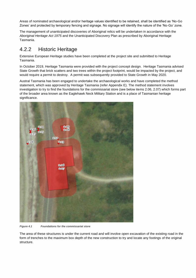
Extensive European Heritage studies have been completed at the project site and submitted to Heritage
Tasmania.
In October 2019, Heritage Tasmania were provided with the project concept design. Heritage Tasmania advised
State Growth that brick scatters and two trees within the project footprint, would be impacted by the project, and
would require a permit to destroy. A permit was subsequently provided to State Growth in May 2020.
Austral Tasmania has been engaged to undertake the archaeological works and have completed the method
statement, which was approved by Heritage Tasmania (refer Appendix E). The method statement involves
investigation to try to find the foundations for the commissariat store (see below items 2.06, 2.07) which forms part
of the broader area known as the Eaglehawk Neck Military Station and is a place of Tasmanian heritage
significance.
Figure 4.1 Foundations for the commissariat store
The area of these structures is under the current road and will involve open excavation of the existing road in the
form of trenches to the maximum box depth of the new construction to try and locate any footings of the original
structure.
The original dog line sentry box is also in this location shown as 2.08, 2.09 in the above image. This is not
affected by the works but will be protected. Additionally, brick scatters will be collected and documented (2.12 –
2.18).
If the investigation teams discover items of heritage value they will be documented, photographed and reported
and sent to the relevant authority. There is approval to destroy any brick fragments found but Austral will remove
what they can from site if feasible. If the bricks are found and are under the pavement of the new road they can
stay in place and be covered. A pavement engineer will be on call to investigate the depth of the bricks in relation
to the new pavement.
These investigations will take from two days to two weeks depending on what is found and will be done at the start
of construction in October 2021.
The contractor has been engaged to undertake the civil works and associated traffic management for these works.
The request by Heritage Tasmania for TL3 steel beam (guard rail) safety barriers to be finished in a neutral colour
and tone and not be reflective is being investigated by State Growth.
Management of Effects
The Contractor will undertake building surveys of heritage structures prior to construction to ensure that any
vibration from the works does not cause damage to these structures.
Areas of nominated archaeological and/or heritage values identified to be retained, shall be identified as ‘No-Go
Zones’ and protected by temporary fencing. No signage will identify the nature of the ‘No-Go’ zone.
4.3 Geomorphology A desktop geomorphology assessment has been undertaken for the revised design (refer Appendix F). This was
requested by PWS, as the project replaces/upgrades an existing revetment.
In designing the revetment, design guidelines were followed to minimise the footprint and impact of the rock
revetment on the beach. Listed below is a summary of related design considerations which influence the
geomorphological response of the beach:
– In upgrading the structure to support the new widened road, the footprint of the revetment was kept minimal
via the use of higher density material. For example, the specification requires igneous or metamorphic rocks
to be used for construction, rather than sedimentary rocks.
– The design utilised a buried rock toe so the surface area of the beach can be retained during the majority of
weather conditions. Under storm events, it is expected that some of the beach material immediately in front of
the revetment may be displaced (as it would have in the existing pre-upgrade revetment).
– The revetment provides a more stable structure and reduces risk of damage to the road and mixing of road
surface material with the beach.
Management of Effects
The Contractor will re-profile the beach (following construction) to the existing levels. Specifications have been put
in place, so the imported material resembles that currently on the beach.
4.4 Visual Impact Considerations In 2020, State Growth commissioned GHD to develop images of the Project, to demonstrate how the Project
would look after construction. These images were developed by:
– Building a composite survey model in Openroads – consisting of LIDAR, ground survey, and aerial imagery
– Importing the design surface into Openroads and applying materials
– Importing line-marking into Openroads and making 3D
– Exporting model to LumenRT to add water, atmosphere, etc
– Add details to the LumenRT model, e.g. safety barriers
– Photo capturing

The potential visual impact of the project has been assessed in relation to several key viewpoints listed below and
shown diagrammatically in Figure 4.2. These images have been produced for the 2020 design. As the footprint of
the work is similar with the 2021 design (refer Appendix G), these images have not been updated.
– Image 1: Old Jetty Road, looking towards the bay
– Image 2: From the bay, looking towards the Community Hall
– Image 3: Arthur Highway, looking towards Eaglehawk Neck, near Old Jetty Road
– Image 4: Arthur Highway, heading northbound along the neck
– Image 5: Arthur Highway, heading northbound, opposite Blowhole Road
– Image 6: Arthur Highway / Blowhole Road junction
– Image 7: Arthur Highway, heading southbound, looking towards Blowhole Road
– Image 8: Imagery captured over project site
– Image 9: View from bay, looking towards the Community Hall
Figure 4.2 Locality Plan of 3D Modelling Images
The imagery has been included below.
Image 1
Image 2
Image 3
Image 4
Image 5
Image 6
Image 7
Image 8
Image 9

Figure 4.3 Old Jetty Road, looking towards the bay
Figure 4.4 From the bay, looking towards the Community Hall

Figure 4.5 Arthur Highway, looking towards Eaglehawk Neck, near Old Jetty Road
Figure 4.6 Arthur Highway, heading northbound along the neck
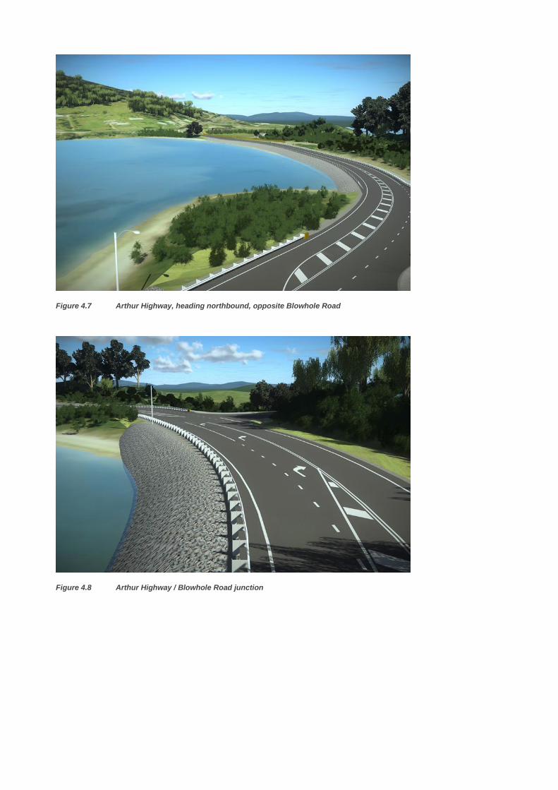
Figure 4.7 Arthur Highway, heading northbound, opposite Blowhole Road
Figure 4.8 Arthur Highway / Blowhole Road junction
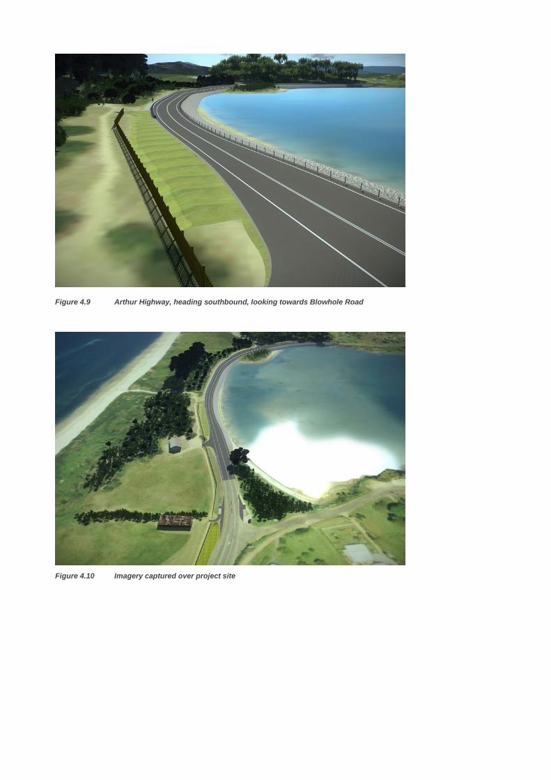
Figure 4.10 Imagery captured over project site
Figure 4.9 Arthur Highway, heading southbound, looking towards Blowhole Road

Figure 4.11 View from bay, looking towards the Community Hall
Management of Effects
When developing the design, a number of aspects were considered, to maintain existing visual amenity.
Vegetation removal was minimised to the maximum extent practicable.
Where new safety barrier is required, the design has adopted a wire rope barrier system, rather than steel
guardrail. Steel guardrail has only been adopted, where it is not possible to provide wire rope (e.g. when radius of
horizontal curve, is too 'tight' for wire rope).
Wire rope has been included along the western bay side, to minimise visual impediments to the view of the bay.
The wire rope safety barrier system runs along the western side of the highway for approximately 300 m.
The revetment is to be formed by natural rocks. The surface of the revetment is to present an angular uneven face
to the water. The colour of the revetment was not specified and depends on the type and source of rocks the
Contractor elected to use to satisfy the technical specification. However, the specification requires igneous or
metamorphic rocks to be used for the revetment, which generally presents grey-black or pink-red colours. Dolerite
(igenous rock) can be found naturally at the southern end of the site.
4.5 Construction Management of Effects A range of mitigation measures have been included in the design for the Project to minimise its impacts on
reserved land and its environment and heritage values.
During construction of the Project, there are a range of potential impacts to reserved land, and the Project will
develop a Construction Environmental Management Plan to provide a framework for managing key environmental
and heritage values.
In 2020, a Construction Environmental Management Plan was prepared for the design (Appendix H). This plan will
be updated for the redesign, prior to construction and is further discussed below.
4.5.1 Construction Environmental Management Plan
The Project will be constructed under a construction contract with State Growth. State Growth has a range of
standard specifications for environmental management, which form the minimum requirement for all construction
projects. For this project, a range of additional management measures will be adopted to minimise impacts to site-
specific environment and heritage matters. Management commitments for the Project are discussed under
Section 6.

Under the construction contract for the Project, all Works shall be undertaken so that impacts on the environment
are avoided or minimised. The Contractor shall ensure that the environmental objectives and measures outlined in
the relevant State and Federal legislation are complied with. Where different objectives are nominated, the more
stringent requirements shall be adopted.
A Construction Environmental Management Plan (EMP) will be prepared for the management of the activities that
impact on the environment, prior to construction. This EMP will provide:
– an overview of the environmental management processes to be utilised for work under the Contract, including
procedures to protect the beneficial uses of the environment; and
– details proposals/actions to be undertaken for the management of individual stages of work (defined by work
activity and/or location) that impact on the environment.
This EMP will consider but not be limited to, the following:
– Cultural Heritage
– Aboriginal Heritage
– Water Quality
– Air Quality
– Erosion and Sediment Control
– Contaminated Soils and Materials
– Waste and Resource Reuse
– Fuels and Chemicals
– Noise
– Flora and Fauna
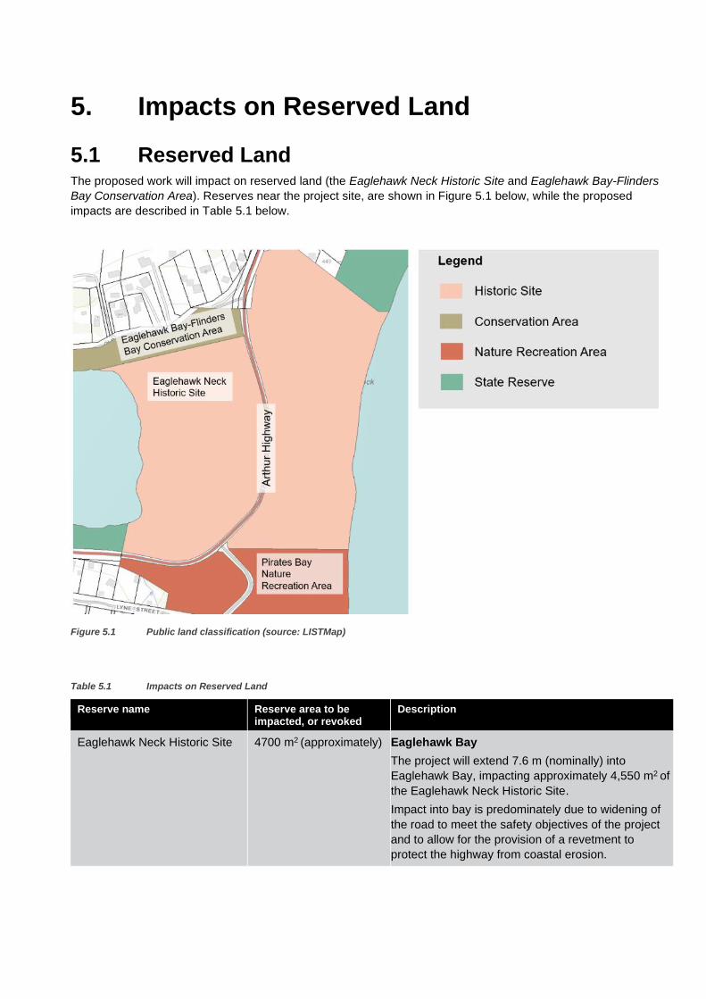
5. Impacts on Reserved Land
5.1 Reserved Land The proposed work will impact on reserved land (the Eaglehawk Neck Historic Site and Eaglehawk Bay-Flinders
Bay Conservation Area). Reserves near the project site, are shown in Figure 5.1 below, while the proposed
impacts are described in Table 5.1 below.
Figure 5.1 Public land classification (source: LISTMap)
Table 5.1 Impacts on Reserved Land
Reserve name Reserve area to be impacted, or revoked
Description
Eaglehawk Neck Historic Site 4700 m2 (approximately) Eaglehawk Bay
The project will extend 7.6 m (nominally) into
Eaglehawk Bay, impacting approximately 4,550 m2 of
the Eaglehawk Neck Historic Site.
Impact into bay is predominately due to widening of
the road to meet the safety objectives of the project
and to allow for the provision of a revetment to
protect the highway from coastal erosion.

Reserve name Reserve area to be impacted, or revoked
Description
Widening is restricted to the western side of the
highway to avoid cultural heritage values on the
eastern side of the highway.
To reduce impact to the bay, the following design
changes were made:
• The path width was reduced from 2 m to 1.5 m
• 1 m wide deflection zone (and subsequent
clearance to path) was removed behind the steel
beam safety barrier
• Verge width reduced from 1 m to 0.5 m on right
side (western side)
• Curve widening removed from northbound lane
Eastern side of highway, opposite Old Jetty Road
The project extends into the eastern side of
Eaglehawk Neck Historic Site, opposite Old Jetty
Road (reserve area impacted is approximately
150 m2).
This impact is required for the construction of an
open drain (between Ch 4000 and 4070).
Saltmarsh Community
A small area of saltmarsh community can currently
be found within the Eaglehawk Neck Historic Site.
This community is listed as Vulnerable under the
Environment Protection and Biodiversity
Conservation Act 1999.
The proposed work impacts approximately 100 m2 of
the 290 m2 total saltmarsh area. The majority of
impact is associated with retaining the existing
informal vehicle access to Eaglehawk Neck Bay
(opposite Blowhole Road). If this access was to be
removed, impact on the saltmarsh community would
be reduced. Retaining this access has been
requested by PWS.
Eaglehawk Bay-Flinders Bay Conservation Area
100 m2 (approximately) Approximately 100 m2 of Eaglehawk Bay-Flinders Bay Conservation Area will be impacted by the proposed works.
This area is required to provide a new culvert. This culvert will discharge stormwater captured within the eastern open drain into the existing lined drain that discharges into Eaglehawk Bay (approximately Ch. 4080).
Note: The area to be impacted is indicative only and is based on establishing a new reservation boundary at the
extent of the buried revetment toe, if the revetment is constructed on a sand foundation (nominally 3.5 m from the
visible revetment interface with the beach).
The land tenure sketch in Appendix D provides more detail on the location of reserve land boundaries.
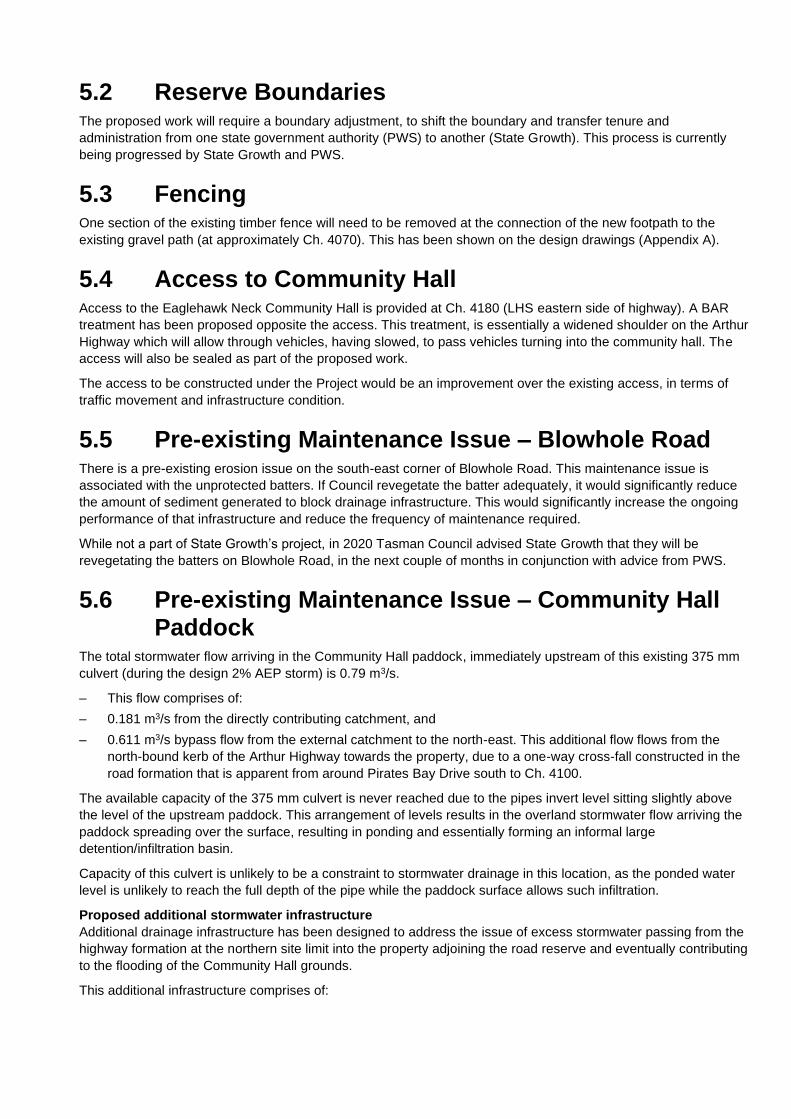
5.2 Reserve Boundaries The proposed work will require a boundary adjustment, to shift the boundary and transfer tenure and
administration from one state government authority (PWS) to another (State Growth). This process is currently
being progressed by State Growth and PWS.
5.3 Fencing One section of the existing timber fence will need to be removed at the connection of the new footpath to the
existing gravel path (at approximately Ch. 4070). This has been shown on the design drawings (Appendix A).
5.4 Access to Community Hall Access to the Eaglehawk Neck Community Hall is provided at Ch. 4180 (LHS eastern side of highway). A BAR
treatment has been proposed opposite the access. This treatment, is essentially a widened shoulder on the Arthur
Highway which will allow through vehicles, having slowed, to pass vehicles turning into the community hall. The
access will also be sealed as part of the proposed work.
The access to be constructed under the Project would be an improvement over the existing access, in terms of
traffic movement and infrastructure condition.
5.5 Pre-existing Maintenance Issue – Blowhole Road There is a pre-existing erosion issue on the south-east corner of Blowhole Road. This maintenance issue is
associated with the unprotected batters. If Council revegetate the batter adequately, it would significantly reduce
the amount of sediment generated to block drainage infrastructure. This would significantly increase the ongoing
performance of that infrastructure and reduce the frequency of maintenance required.
While not a part of State Growth’s project, in 2020 Tasman Council advised State Growth that they will be
revegetating the batters on Blowhole Road, in the next couple of months in conjunction with advice from PWS.
5.6 Pre-existing Maintenance Issue – Community Hall Paddock
The total stormwater flow arriving in the Community Hall paddock, immediately upstream of this existing 375 mm
culvert (during the design 2% AEP storm) is 0.79 m3/s.
– This flow comprises of:
– 0.181 m3/s from the directly contributing catchment, and
– 0.611 m3/s bypass flow from the external catchment to the north-east. This additional flow flows from the
north-bound kerb of the Arthur Highway towards the property, due to a one-way cross-fall constructed in the
road formation that is apparent from around Pirates Bay Drive south to Ch. 4100.
The available capacity of the 375 mm culvert is never reached due to the pipes invert level sitting slightly above
the level of the upstream paddock. This arrangement of levels results in the overland stormwater flow arriving the
paddock spreading over the surface, resulting in ponding and essentially forming an informal large
detention/infiltration basin.
Capacity of this culvert is unlikely to be a constraint to stormwater drainage in this location, as the ponded water
level is unlikely to reach the full depth of the pipe while the paddock surface allows such infiltration.
Proposed additional stormwater infrastructure
Additional drainage infrastructure has been designed to address the issue of excess stormwater passing from the
highway formation at the northern site limit into the property adjoining the road reserve and eventually contributing
to the flooding of the Community Hall grounds.
This additional infrastructure comprises of:
– An open drain located outside the eastern verge of the Arthur Highway between Ch. 4000 and 4070
– A new culvert to discharge the stormwater captured within the open drain toward the west into the existing
lined drain that discharges into Eaglehawk Bay at approximately Ch. 4080.
Open Drain
The proposed open drain is intended to intercept the stormwater passing from the highway and convey that to the
proposed culvert (0.611 m3/s in the design event).
The trapezoidal shaped drain is intended to be a minimum of 0.50 m deep at the upstream end, and 1.0 m deep at
the downstream end, with 4:1 (horizontal: vertical) batters on the roadside and 2:1 batters on the property side.
The base of the drain is 0.50 m wide with a 3.35 % longitudinal grade to the culvert inlet.
Modelling shows that the maximum flow velocity expected in the drainage channel is 2.6 m/s. This flow velocity will
quickly erode poorly lined drain surfaces. Mesh reinforced turf is generally suitable robust to withstand flow
velocities up to 2.7 m/s and this lining has been proposed for internal surfaces of this drain.
Proposed Culvert
A new culvert at approximately Ch. 4080 is proposed to convey the stormwater captured in the open drain toward
the west into the existing lined drain that discharges to Eaglehawk Bay.
This culvert comprises of 600 mm diameter Reinforced Concrete Pipe (RCP) laid at 1%, which allows sufficient
capacity for runoff from the design storm event.
While flooding of the paddock will be reduced through capture and redirection of that stormwater passing from the
highway into the paddock, some extent of flooding will still occur due to stormwater from the contributing
catchment in Pirates Bay Drive.
5.7 Ongoing access to reserved land that is likely to be required to undertake maintenance
Access to reserved land will be maintained as part of the Project.

6. Management Commitments
The table below summarises the management commitments made throughout this report.
Table 6.1 Management Commitments
No. Commitment
1 Prior to construction, a Construction Environmental Management Plan will be prepared for the Project, including all the relevant commitments.
2 The proposed work impacts approximately 100 m2 of the 290 m2 total saltmarsh area. An EMP will be prepared prior to construction and any clearance works will be undertaken in accordance with the mitigation and management measures set forth in this document and the sediment and erosion control plan. The remaining community will be protected by temporary fencing and signage during construction.
3 The CEMP will contain protocols for management of unanticipated issues with fauna.
4 A Weed and Hygiene Management Plan and Soil and Water Management Plan will be developed prior to construction (to be included within CEMP)
5 Land disturbed during construction will be rehabilitated using hydromulch, with an appropriate seed mix
6 An Acid Sulfate Soil Management Plan will be prepared prior to construction. This is to be included in the CEMP.
7 Areas of nominated archaeological and/or heritage values identified to be retained, shall be identified as ‘No-Go Zones’ and protected by temporary fencing and signage. No signage will identify the nature of the ‘No-Go’ zone.
8 No ground distributing activities will be undertaken within areas of potential heritage significance. An Unanticipated Discovery Plan for Aboriginal heritage will be included in the Project’s CEMP.
9 Prior to commencing operations, the Contractor shall engage a suitably qualified and experienced Building Surveyor to undertake inspections on all buildings and structures (including heritage structures) within a minimum distance of 100 m for general construction works.
10 Following construction, the beach at Eaglehawk Bay will be re-profiled to similar levels to existing.
11 Construction materials for the revetment will use imported materials that are of a similar type to existing materials on Eaglehawk Bay beach.
7. Conclusion
The proposed work is for several safety improvements at Arthur Highway – Eaglehawk Neck. The work proposed
includes widening the road cross section, improving the road surface, and providing turning facilities at Blowhole
Road.
The Project also includes the construction of an on-road path along the eastern side of the highway, between
Blowhole Road and the southbound bus stop.
It is considered that the works will not change or significantly intensify the use or have any adverse amenity
impacts on the locality.
The work has also been designed to not impact on environmental values, where reasonably practicable.
Preparation of a satisfactory CEMP will be a State Growth requirement for the successful contractor responsible
for the construction works. Implementation of this plan will help minimise potential environmental and heritage
impacts.

Appendices

Appendix A Detailed Design Drawings
Issued under separate cover

Appendix B Flora and Fauna Habitat Assessment

Appendix C Historic Heritage Assessment

Appendix D Land Tenure Sketch

Appendix E Archaeological Method Statement

Appendix F
Geomorphology Report

Appendix G Footprint of work (2020 and 2021 design
comparison)
Appendix H Construction Environmental Management
Plan

