arkansas office of information technology
TRANSCRIPT

PS-01 ASDI Data Loading Procedures 1 Rev. Date: 3/21/2019
Arkansas GIS Board Arkansas GIS Office 501.682.2767 Voice Sharon Hawkins, Chair 1 Capitol Mall, Suite 6D 501.407.0790 Fax Little Rock, AR 72201 http://gis.arkansas.gov/
Policy Statement
Arkansas Spatial Data Infrastructure (ASDI) Data Loading and Retirement Procedures
Process for Loading and Retiring Spatial Data on the
Arkansas Spatial Data Infrastructure (ASDI)
Document Number: PS-01
Effective Date:
Issued By: Arkansas State Geographic Information Systems Board Published By: Arkansas Geographic Information Systems Office
1.0 Purpose
The purpose of this policy statement is to define the policy and procedures for loading public spatial data submissions into and retiring spatial data from the ASDI. AR Code 15-21-501. Purpose.
(a) In recognition that a vast majority of all information used in the management of
government can be spatially referenced and that public institutions and private
firms expend considerable resources collecting and managing land information
records in diverse and disparate formats and scales, a modern automated
system of accessible land information data and technologies is required to serve
the essential needs of individuals, businesses, and government agencies.
(b) The essential component of all automated land information systems is valid,
consistent, comprehensive, available, and current data. Since federal, state,
regional, county, and municipal agencies, state universities and colleges, private
firms, and others require the same spatial data, it is desirable that unnecessary
duplication of effort be avoided, that existing data be shared in a coordinated
manner, and that new data be developed in an accurate and usable form in
accordance with the State of Arkansas Enterprise Architecture. Pursuant to this,

PS-01 ASDI Data Loading Procedures 2 Rev. Date: 3/21/2019
all state agencies, boards, and commissions are required to cooperate and
participate with the Arkansas Geographic Information Systems Board.
(c) Implementation of an overall Arkansas land and geographic resources program
requires cooperative methods for development and maintenance of spatial data
between state and local governments in the State of Arkansas.
(d) The board will determine, define, and implement short-term and long-term
strategies that will result in improved decision making, effective asset
management, and reduced costs for the citizens of Arkansas.
2.0 Scope
This policy and procedure statement applies to all public and private ASDI spatial data loading and retirement requests.
3.0 Background
In recognition of the need for coordination of spatial information resources serving both government and private entities, code was enacted to establish and maintain consistent spatial data collection procedures and standards within the State of Arkansas. The Arkansas Geographic Information Systems Board (GISB) has been charged with the implementation of this aim where the ASDI, a centralized warehouse for storing comprehensive geographic data for the entire state, is a result of this effort. Open participation and cooperation will help realize the ideals set forth in AR Code 15-21-501, and will minimize duplicative efforts and unnecessary use of resources for dissemination of the spatial data into the public domain. This policy statement establishes a logical way of prioritizing and loading geographic data into the ASDI.
4.0 References
AR Code 15-21-502.
(3) "Arkansas Spatial Data Infrastructure" means the combination of state framework data, data repository, distribution mechanisms, and the staff and organizational structures necessary to accomplish these activities;
(6) "Framework data" means commonly needed data themes developed, maintained, and integrated by public and private organizations within a geographic area. These data themes include, but are not limited to, digital cadastre, public land survey system, elevation, geodetic control, governmental units, hydrography, orthoimagery, transportation, soils, and geology;

PS-01 ASDI Data Loading Procedures 3 Rev. Date: 3/21/2019
(9) "Spatial data repository" means the physical location and content of the
state's consolidated spatial data;
(14) "State of Arkansas Enterprise Architecture" means the same as the definition set out at § 25-4-103(16).
(16) "State enterprise architecture" means a description of the elements of business processes and supporting technologies, policies, standards, procedures, solutions, and infrastructures that:
(A) Makes up an enterprise; and (B) Documents how the components described in this subdivision (16) relate to one another, and the principles that govern their design and evolution over time;
5.0 Policy
Spatial Data Loading Priorities for the ASDI The Arkansas GIS Board (GISB) appreciates the interest of all entities to have their data placed in the ASDI. The GISB believes this type of spatial data sharing will reduce duplicative efforts within the state of Arkansas. To this end the GISB will accept and load spatial data provided to them in the following manner:
1) The data loading request application will be received and examined by the Arkansas Geographic Information Systems Office (GIS Office). (see section 6)
2) The loading priority will be determined as follows: If the data falls within Priority 1 through 6, as per the criteria of Attachment 10.2, a layer specific priority list is submitted to the GISB for their review.
3) GISB approved data will then be loaded, as funds and/or GIS Office staff resources and ASDI hardware resources are available.
4) Should the data initially be determined to fall within Priority 7, a proposed data load cost model will be developed by the GIS Office and presented to the applicant. If the applicant agrees to provide funding as determined by the GIS Office cost model, data will then be placed in the layer specific priority list that will be submitted by the GIS Office to the GISB for consideration. Special consideration will be given to funded datasets.
Refer to Attachment 10.1 for a detailed decision flowchart. Refer to Attachment 10.2 for a detailed description of GIS Office evaluation procedures. Cost Model for loading, storing, and/or direct access to spatial data in ASDI Costs for applicants wishing to submit data not falling within Priorities 1 through 6:
PS-01 ASDI Data Loading Procedures 4 Rev. Date: 3/21/2019
a. Labor cost for placing data into ASDI with unrestricted access: Vector and Raster - $70/hr
b. Labor cost for placing data into ASDI with restricted access: Vector and Raster - $140/hr
c. Cost of disk space: $0.10/GB The rate structure includes disk space and storage, access and retrieval. In addition to data loading, applicants may request additional services. Rate structures for backup, maintenance and support will require additional costs and will be based upon the Department of Information Systems' rate structure. Spatial Data Retirement Priorities for the ASDI
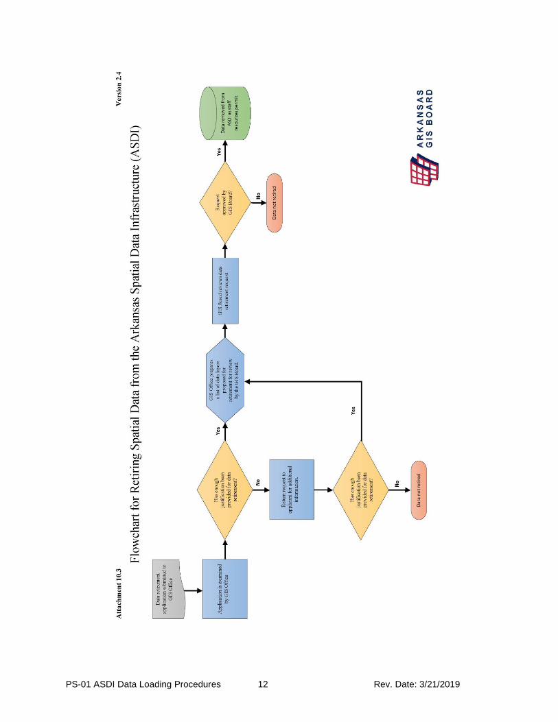
From time to time datasets stored within the ASDI may become outmoded or may have been discontinued or replaced by the data author or source agency. When this occurs, The GIS Board may entertain a request for the retirement of said data layers in order to maintain the most relevant and current data within the database. Requests may be submitted to the GISB in one of two manners:
1) From the credited data source 2) From the GIS Office
a. In this instance, the agency will have contacted the credited source to ascertain the status of the dataset in question, i.e. is it being actively maintained, and proceed with the steps outlined below if not.
To this end the GISB will accept data retirement requests provided to them in the following manner:
1) The data retirement request application will be received and examined or initiated by the Arkansas Geographic Information Systems Office (GIS Office).
2) The data retirement priority will be based upon the following criteria: a. Is the data still being maintained by the source or custodian? b. Has the source or custodial entity replaced the dataset? c. If the source or custodian is not the data author, is there an applicable
substitute for said dataset? d. Does the GIS Office possess usage and/or download statistics indicating
that a dataset is not being extensively utilized, and therefore may be a candidate for retirement?
3) The GIS Office will submit the data retirement request to the GISB at one of its regularly scheduled meetings.
6.0 Procedures
Loading Spatial Data into the ASDI The completion of the data loading application below will enable the ASDI staff to effectively determine the resources that will be required to load the applicant’s spatial
PS-01 ASDI Data Loading Procedures 5 Rev. Date: 3/21/2019
data layer and/or metadata. All applicants shall complete the following to the best of their knowledge and transmit it to the GIS Office. Should you require assistance completing this information, contact the GIS Office at 501-682-2767. 1) Name of Organization 2) Name of applicant filling out the application 3) Name of technical contact 4) Phone number of technical contact 5) E-mail of technical contact 6 Physical address of technical contact 7) Briefly describe the reason your organization is submitting the spatial data to be loaded into the ASDI. Why is this a benefit to the State of Arkansas? 8) Which framework data layer do you believe your spatial data layer should be placed in? a. Cadastral e. Hydrography b. Elevation f. Orthoimagery c. Geodetic Control g. Transportation d. Governmental Units h. Other (free text) 9. What format is your spatial data currently in? Vector Raster Tabular Esri Geodatabase GeoTIFF Excel
Esri shapefile Esri BIL CSV Esri e00 ASCII Grid Other DXF ENVI DWG ERDAS (IMG) DGN PCI MapInfo Tab TIFF/TFW
MapInfo Mif/Mid SID KML/KMZ Other Other 10. Are your files georeferenced? (If Yes, go to 11. If No, skip to 12.)
Yes No 11. What coordinate system is your spatial data stored in? NAD 83 Universal Transverse Mercator (UTM), Zone 15 North NAD 83 Universal Transverse Mercator (UTM), Zone 16 North NAD 83 Latitude / Longitude, Degrees NAD 83 AR State Plane, North Zone NAD 83 AR State Plane, South Zone

PS-01 ASDI Data Loading Procedures 6 Rev. Date: 3/21/2019
NAD 83 Latitude / Longitude, WGS 84 Other 12. What unit is your spatial data stored in? Meter US foot Decimal Degree Other 13. What is the total file size of your data set?
1.0 - 600 MB 601 - 999 MB 1 – 100 GB 101 – 500 GB 501 GB – 999 GB 1.0 - 1.5 TB 1.6 – 2.0 TB
14. How many thematic layers and layer tiles are in your spatial data set?
1-50 51-100 101-200 201-300 300- 400 400-500 500+
16. What date is the data current to?
17. What is the update frequency of the data?
Monthly Yearly As Needed Never 18. What is the mapping scale of your data?
1:100,000 1:24,000 1:12,000 1:2,400 1:1,200 Other (free text)
19. Do you have FGDC compliant metadata for this spatial data set?
Yes No Don’t know
20. Are there any security concerns? (Refer to: https://www.fgdc.gov/policyandplanning/Access%20Guidelines.pdf
Yes No
21. Who is the authorized and/or mandated custodian of the spatial data layer being submitted for consideration?

PS-01 ASDI Data Loading Procedures 7 Rev. Date: 3/21/2019
21. Is your spatial data topologically correct? Yes No Don’t Know 22. Is this data being submitted to the ASDI in order to meet federal requirements/standards? Yes No 23. What is your metadata format?
A. FGDC Encoded ASCII (.txt) B. FGDC Encoded SGML (.sgm, .sgml) C. Ordered xml (.xml) D. Other/Don’t know
24. Is your data seamless?
A. Yes B. No C. Don’t know
Retiring Spatial Data from the ASDI The completion of the data retirement application below will enable the ASDI staff to effectively ascertain the need to retire the applicant’s spatial data layer and/or metadata as well as determining a replacement dataset, if applicable. All applicants shall complete the following to the best of their knowledge and transmit it to the GIS Office. Should you require assistance completing this information, contact the GIS Office at 501-682-2767. 1) Name of Organization 2) Name of applicant filling out the application 3) Name of technical contact 4) Phone number of technical contact 5) E-mail of technical contact 6) Physical address of technical contact 7) Name of the dataset(s) to be retired 8) Briefly describe the reason your organization wishes to retire spatial data currently housed within the ASDI.
a) Has the dataset been deprecated, i.e. you no longer intend to maintain it?
b) Has the dataset been replaced by another that you maintain?
PS-01 ASDI Data Loading Procedures 8 Rev. Date: 3/21/2019
i. If so, what is its replacement? c) Has the dataset been replaced by another that you do not maintain, i.e.
another entity maintains an applicable replacement? i. If so, what is the replacement?
7.0 Revision History
Date Description of Change
12/04/2002 Original policy statement drafted.
06/03/2015 Name and contact information updated.
03/13/2019 Data retirement provisions added.
8.0 Definitions
Seamless Data
(a) Data set lacking gaps in the area of overlap between raster objects combined by tiling or mosaicking.
(b) Each layer shall be edge matched and seamless, i.e. not tiled or subset. Each layer shall be one unit of geography and not multiple units.
Custodian
(a) "Custodian," with respect to any public record, means the person having administrative control of that record.
(b) "Custodian" does not mean a person who holds public records solely for the purposes of storage, safekeeping, or data processing for others.
9.0 Inquiries
Direct inquiries about this policy to:
Arkansas GIS Office 1 Capitol Mall, Suite 6D Little Rock, AR 72201 Voice: 501-682-2767 Fax: 501-407-0790 Email: [email protected]
PS-01 ASDI Data Loading Procedures 9 Rev. Date: 3/21/2019
10.0 Attachments
10.1 Flowchart for Loading Spatial Data into the ASDI 10.2 GIS Office Evaluation Procedures 10.3 Flowchart for Retiring Spatial Data from the ASDI

PS-01 ASDI Data Loading Procedures 10 Rev. Date: 3/21/2019

PS-01 ASDI Data Loading Procedures 11 Rev. Date: 3/21/2019
Attachment 10.2
GIS Office Evaluation Procedures
1) Datasets that pertain to the framework data layers
2) Datasets that support current, statewide coordination activities
3) Critical infrastructure datasets required for homeland security
4) Statewide spatial data sets that are enhanced or unique to those currently in the
ASDI
5) Spatial data sets covering large geographic areas of Arkansas that are enhanced or
unique to those currently in the ASDI
6) City, County, or Local spatial data sets that are enhanced or unique to those
currently in the ASDI
7) Any entity may choose to cover the cost of having its spatial data placed in ASDI
at a higher priority. The cost to input the spatial data will be estimated from the
information provided in the procedural section.
PS-01 ASDI Data Loading Procedures 12 Rev. Date: 3/21/2019