arheologie Şi istorie veche - bcut.ro banatului arheologie-istorie/analele... · cuprins sommaire...
TRANSCRIPT

CUPRINS
SOMMAIRE INHALT CONTENTS
Vasile Râmneanţu, Omagiu Profesorului Nicolae Bocşan la împlinirea vârstei de 60 de ani .....
ARHEOLOGIE ŞI ISTORIE VECHE
FLORIN DRAŞOVEAN, The neolithic tells from Parţa and Uivar (South-west Romania). Similarities and diferences of the organization of the social space .................................................19
GEORGETA EL SUSI, Raport preliminar asupra resturilor faunistice de la Deta-Dudărie. Campania 2005 Preliminary report of the faunal remains from Deta-Dudărie. The 2005 campaign....................... 33
DOINA BENEA, Cu privire la administrarea salinelor din Dacia Romană Über die Verwaltung der Salzgruben aus römischen Dakien.........................................................41
RAOUL M. ŞEPTILICI, Două interesante monete descoperite în Banat Deux interessantes pièces de monnaie découvertent dans le Banat.................................................47
LIANA OŢA, Sarmaţii din Muntenia şi Imperiul RomanDie Sarmaten aus Muntenien und Römischen Reich.........................................................................51
ANA VOLOŞCIUC, Scrierea cursivă în Dacia romanăItalic writing in Roman Dacia.......................................................................................................57
ALEXANDRU FLUTUR, Un gladius din castrul BersobisA gladius from the Fortress at Bersobis.............................................................................................69
ALEXANDRU FLUTUR, LIANA FLUTUR, O pensetă chirurgicală şi un bronz din castrul Bersobis A Surgical Pincette and a Bronze from the Fortress at Bersobis..........................................................75
CĂLIN TIMOC, Barăcile soldaţilor romani de la TibiscumÜber die Soldatenbaracken der römischen Garnison von Tibiscum...............................................85
ALEXANDRU SONOC, Observaţii referitoare la unele podoabe descoperite în necropolele populaţiei daco-romane şi în cele ale dacilor liberiBetrachtungen bezüglich einiger in den Gräberfelder der dakisch-römischen Bevölkerung und in denjenigen der freien Daker entdeckten Schmuckstücke....................................................................97
MARIA HADJIJI VASINCA, Câteva consideraţii cu privire la cultul Cavalerilor Danubieni. Clasificări Quelques considerations à propos du Culte des Cavaliers Danubiens. Clasifications...........................131
ISTORIE MEDIE
ADRIAN MĂGINA, Între Luther şi Mahomed. Catolicii din Timişoara în a doua jumătate a secolului al XVI-leaBetween Luther and Mahomed. The Catholics from Timişoara în the second half of the XVI th
century.......................................................................................................................................135
FLORIN MĂRGINEAN, Cahle medievale târzii din colecţia Muzeului din AradLate Medieval stove tiles in Arad Museum collections.....................................................................143
IBOLYA ŞIPOŞ, Contribuţii la istoricul nobilimii lugojene,Contributions á l’histoire de la noblesse de la ville de Lugoj.............................................................155
LIGIA BOLDEA, Consideraţii asupra familiei unui viceban al Severinului: Mărganii Considerations sur la famille d’un viceban de Severin: Mărganii......................................................167
ISTORIE MODERNĂ ŞI CONTEMPORANĂ
MARLEN NEGRESCU, Desfiinţarea instituţiei comunionului pe teritoriul fostei graniţe militare bănăţeneDie Auflösung der Komunuion Institution auf der Grenzgebiet des XIII-ten Regimentes............177
ALICE REININGER, Wolfgang von Kempelen und die Bevölkerungspolitik unter Maria Theresia und Joseph II. im Banat (1. Teil) Wolfgang von Kempelen and the impopulation policy under Maria Theresia and Joseph II. in the Banat region (part I)....................................................................................................................187
LAVA BRATU, Evoluţia vieţii muzicale timişorene în perioada antebelicăEvolution of pre-war musical life in Timişoara....................................................................215
IONUŢ RAUL RUS, Camera de Comerţ şi Industrie Timişoara (1850-1938)Chamber of Commerce and Industry from Timişoara (1850-1938).................................................231
VASILE DUDAŞ, Aspecte privind situaţia Banatului în anii primei mari conflagraţii mondialeAuszüge aus der geschichte des Banats in den jahren des ersten weltkrigs.....................................239
DUMITRU TOMONI, Regionalismul cultural în Banatul interbelic. Înfiinţarea şi organizarea regionalei “Astra Bănăţeană” (1937)La Régionale „Astra Bănăţeană” – une forme de Manifestation du Régionalisme culturel de l’entre-deux-guerres...............................................................................................................................259
EUSEBIU NARAI, Aspecte din activitatea Partidului Naţional Ţărănesc în judeţul Severin (1944- 1947) Aspects of the PNŢ’s Activity in the County of Severin (1944-1947)..........................................273
VASILE RĂMNEANŢU, Câteva consideraţii privind situaţia politică şi economică din judeţul Timiş-Torontal în anul 1948Einige Wertschätzungen im Bezug mit der politische und wirtschaftliche Situation im Kreis Timiş-Torontal im Jahr 1948.......................................................................................................279
SÎNZIANA PREDA, Biografii exemplare în comunităţi de cehi din zona Banatului în secolele XIX-XX..Exemplary biographies in Czech communities from the Banat region in XIX-XX century...........285
GABRIEL SALA, Percepţia şi desfăşurarea judecăţii ţigăneşti la neamul romilor gabori .The Traditional Gabor Gypsy Court...........................................................................................295
ISTORIA CULTURII, ISTORIOGRAFIE, MUZEOLOGIE, CATALOAGE, VARIA
LUCIAN POPESCU, Istoriografia Annales în dezvoltarea gândirii contemporaneThe Annales historiography in the development of contemporary thinking........................................307

HEDY KISS, Steagul „Reuniunii de Cântări” (1882) şi steagul „Asociaţiei Iubitorilor de Muzică” (1871-1891), două mărturii deosebite ale vieţii muzicale din Timişoara. The standard of the „Reunion of Songs” (1882) and the standard of the „Association of Music Lovers” (1871-1891), two special testimonies about the musical life in Timişoara.......................321
RADU ARDELEAN, Reţetarul culinar al lui Petru Lupulov din 1857 Le Livre de cuisine de Petru (Pierre) Lupulov (Timişoara 1857)......................................................337
RĂZVAN GĂVAN, Ridicarea in situ, restaurarea şi conservarea unui cuptor de olar din sec. al III-lea- al IV-lea d. Chr. The Recovery, Preservation and Restoration of a 3rd – 4th Centuries AD Pottery Kiln..........................349
MARIA MÎŢU, Restaurarea şi conservarea tezaurului monetar descoperit la Timişoara- str. 9 Mai în anul 2006 Restauration and Conservation of the Monetary Hoard discovered at Timişoara, St. Gheorghe Square, in 2006..........................................................................................................................355
RECENZII
RAOUL ŞEPTILICI, Iliese Marcel, INSIGNELE AvIAţIEI MILITARE ROMâNE. Romanian Air force Badges, Ed. Mirton, Timişoara, 2007...............................................................................361
DAN SEBASTIAN CRIŞAN, Gérard Chouquer şi François Favory, DICţIONAR DE TERMENI ŞI EXPRESII GROMATICE, Casa Editorială Demiurg, Iaşi, 2006....................................................367
NORME DE PUBLICARE LA REVISTA ANALELE BANATULUI.....................................371
ABREVIERI BIBLIOGRAFICE.................................................................................................375


ARHEOLOGIE ŞI ISTORIE VECHE


19
ANALELE BANATULUI, S.N., ARHEOLOGIE - ISTORIE, XV, 2007http://muzeulbanatului.ro/mbt/istorie/publicatii/ab.htm
Tells are anthropogenic creations whose genesis, development and features are determined by certain pedo-climatic and relief conditions, by certain relations of production and social relations, by the character of the architecture and the type of the construction materials1. They are the material expression of an orderly use of a well-defined geographic space. From a morphological point of view the tells are the result of a cumulative process in which habitation traces accumulate vertically in a relatively consistent and regular way, within a well defined area.
In the Carpathian area tells appear starting from the Middle Neolithic and have their broadest distribution during the late Neolithic when many of the large settlements take on the features of a tell. In the Romanian Banat Neolithic tell typ habitations have been identified at Parţa I and II2, Bucovăţ3, Chişoda Veche4, Sânandrei5, Foeni6, Uivar7 and Liubcova8 (Fig. 1). Chronologically they have been traced back to the latter half of the 6th calibrated millenium and to the former half of the fifth millenium BC.
1.Geographic Setting.The two most important Banat tells, Parţa and
Uivar, are the focus of this paper. These lie in the Banat, in the low southern plain of Timiş, on the banks of the present-day Timiş and Bega rivers, at an elevation of 85 m (the Parţa tell) and 78 m (the Uivar tell). In this region, the plain had been
* Muzeul Banatului, P-ţa Huniade nr. 1, 300002 Timişoara, e-mail: [email protected] 1. Sherratt 1983; Chapman 1994; 1997; Halstead 1999; Kotsakis 1999; Bailey et alii 2002; Gogâltan 2003.2. Lazarovici 1972; 1979, 204-205; Draşovean 1994, 412; 1996, 32-33. Lazarovici et alii 2001; Lazarovici G.-Lazarovici M. 2003.3. Lazarovici 1979, 143, 188; 1991a; M. Lazarovici, G. Lazarovici 2006, 375-387. 4. Radu 1979; Draşovean 1991; 1994, 409-410; 1996, 30, 39.5. Draşovean 1994, 413; 1996, 336. Draşovean 1994a, 141-149; 1997, 55-63; 1999, 6-11.7. Schier-Draşovean 2004.8. Comşa 1969; Luca 1997.
cut by former meanders of the two rivers which the regularisation works carried out in the 18th century, had given rise to bogs and marshes that covered a great deal of the interfluve between the Timiş and Bega rivers.
The Parţa tell, located about 18 km SW of Uivar one, was situated on the banks of one of the a major branch of the Timiş river and, as it is shown by the 19th century maps drawn before the complete regularisation of the river (Fig. 2). Prior to chanalisation, the site was surrounded by a series of meanders channels to the west and south, and by marshy land to the east. Site excavation and the tests carried out on the sediments of the Timis river cliffs have revealed that the settlement originated on a higher river bank of one of the temporary meanders lying south of the habitation. This river meander continued to be active and was sufficiently deep throughout the developement of the tell so that the excavation out of a ditch in the area was not necessary9. Moreover the anthropogenic strata of the settlement lens out in the area of the former Timiş channel. From the sedimentological point of view, the first level of habitation lies over a brown clay layer which, in its turn, covers a thick layer of yellowish sandy sediments.
The Uivar tell, as is documented by sedimentological studies, was also founded on the bank of a former meander channel, this time of the Bega river (Fig. 3). The river lay south of the tell and was bounded by a low terrace which shielded the first inhabitants from the periodical flooding. The anthropogenic deposits lie over, as in the case of the Parţa tell, a brown fossil alluvial soil and a thick alluvial sandy layer rich in mica, which stems from the periodical flooding of the Bega river10.
From the pedological viewpoint, both tells lie in areas where the common soil types are vertisol, chernozem and degraded chernozem11 As a
9. Lazarovici et alii 2001, 197.10. Kadereit . Kadereit Kadereit et alii 2006, 20 şi fig. 9, 28.11. Tărău-Luca 2002, 213.
THE NEOLITHIC TELLS FROM PARŢA AND UIVAR. SIMILARITIES AND DIFERENCES OF THE ORGANIZATION OF THE SOCIAL SPACE
Florin Draşovean*
Keywords: Neolithic, Banat, Parţa and Uivar tells, organization of social space.

20
ANALELE BANATULUI, S.N., ARHEOLOGIE - ISTORIE, XV, 2007
consequence the relatively close location within the same geographic area, typified by identical relief and pedo-climatic conditions, mark off a single natural and environmental background within which the Parţa and Uivar communities developed. As such, the differences between the sites must be due to other factors and cannot have been caused by their environement.
2. The Genesis and Development of the Parţa and Uivar Tells.
2.1. The Tell of Parţa. The Parţa dwellings are first observed in level
7a (Fig. 4) which, from an architectural viewpoint, is typified by hollow pits, which have been taken for hovels and surface dwellings. The houses from this level are small and are usually grouped in pairs. This lay-out presumably was determined by the organisation of the family and by certain property relations. At the core of the settlement, an isolated house has been uncovered which, due to its central position and due to the fact that it was built above the sanctuaries 1 and 2, has been taken for a possible building for worship12. In this first stage, the Parţa settlement was not fortified13.
Starting with the level 7b, we can speak of a settlement planning in which the dwellings have been grouped around two structures of similar sizes, erected in the middle of the settlement (Fig. 5). Around the two structures, the houses lie at a certain distance forming a small square. With only two exceptions, houses P17a and P43a, all the houses are aligned along the east-west axis14, the orientation is dictated, we believe, by the strong gusts of the summer storms blown from the west.
The research carried out has shown that the two structures in the small square played a special role for the community life of Parţa.
One of the structures, 12,6 long and 7 m wide, is a sanctuary (Fig. 6) inside of which altars for offerings, monumental statues and columns once stood. On the northern wall there was an altar- table A which was oriented towards the south. On a clay socket stood an idol bust. In the western part, guarded by two posts, lay altar –table B. Inside the altar, several flint blades which were used for sacrifices were discovered. In the eastern part lay altar C, and at the centre of the sanctuary there stood a clay column.
To the south of sanctuary 1 lay a structure
12. Lazarovici G.-Lazarovici M. 2003, 385; M. Lazarovici - G. Lazarovici 2006, 219 sqq.13. Lazarovici et alii 2001, 100; Lazarovici G.-Lazarovici M. 2003, 385; 14. Lazarovici et alii 2001, 105; M. Lazarovici - G. Lazarovici 2006, 228-229.
of similar size that might have futfilled a social function and namely that of “the house of the tribe”15. A fortification system also was built into this level of habitation (7b) and was made up of four parallel ditches, lined inwards by four palisades that protected the settlement from the west, north and east sides16.
In the north, the ditches are so close to one another that17 they might suggest their buildings in different stages of the development of the fortification system. To the south, as noted earlier, the settlement was protected naturally by a channel of the Timiş. As a result there was not need for a ditch, only a stouter stockade that bounded the river bank18. To the north, between stockades 3 and 4, deep pits associated with some wooden constructions, possibly of surveillance towers were uncovered19. Inside the fortification system, along a stretch of land of about 15-20 m from these, no houses were built20. The defence system was constantly maintained as along ditch 3 traces of unsilting and maintenance works have been found which have led up to the alteration of the slope. The fortification system continued in use by the time of phase 6b and was subsequently abandoned due to the events determined by the arrival of the phase C Vinča culture bearers21.
On the next level, 7c, new houses were built next to existing ones which continued the architectural organisation of the previous level22 and betoken a well-defined settlement plan, which continued on for several generations (Fig. 7). The architecture of this level, and of level 6, is characterised by massivesness and, we might say, by the professional touch with which the constructions were erected.
For their construction, massive logs have used for the load-bearing structures (with diametres exceeding 30 cm) and the walls have a wattle structure on which a clay was layered. The massive posts for some structures had a technical rationale, as these were needed to bear the additional weight of a second story. As a rule the houses were grouped four by four23, which betokens a specific
15. Lazarovici et alii 2001, 243; Lazarovici G.-Lazarovici M. 2003, 459, fig. 53; M. Lazarovici - G. Lazarovici 2006, 22816. Lazarovici et alii 2001, 197-202; M. Lazarovici - G. Lazarovici 2006, 228.17. Lazarovici et alii 2001, 197, fig. 161.18. Idem, 197; M. Lazarovici - G. Lazarovici 2006, 366-367.19. Lazarovici et alii 2001, 245; 202-203; M. Lazarovici - G. Lazarovici 2006, 366 .20. Lazarovici G.-Lazarovici M. 2003, 197; M. Lazarovici - G. Lazarovici 2006, 366.21. Lazarovici et alii 2001, 201; M. Lazarovici - G. Lazarovici 2006, 369-370.22. M. Lazarovici - G. Lazarovici 2006, 232 sqq.23. Idem, 232.

21
social organisation structure. At the centre of the settlement the two community buildings continue in use: the sanctuary and the house of the tribe, which lie on the small central square. Around this square, the houses have been erected on the same location as the ones on level 7a. They are oriented along an east-west axis, and are built very close together, sometimes they even share a common wall. Between the houses there are very narrow spaces which form alleys which run east to the west and which intersects others, thus making up a „network structure”. The obvious cramming of the living space is the result of demographic growth, and the existence of the fortification system which did not allow a horizontal spread of the settlement. Two-storied constructions are first seen on this level, of which the most eloquent examples are houses P136B and P40-43 (Fig. 8). Sanctuary 2 was built on the same location as sanctuary 1 and is the most significant example of a building for worship from the entire area of the South-East European Neolithic24. This worship building functioned until phase IIC of the Banat Culture when level 6 of the settlement was completely and systematically destroyed under circumstances which might be linked to the arrival in the area of phase C Vinca culture bearers. After the destruction of the settlement the newcomers did not setttle down in this place, but a few hundred yards to the west, on the opposite river bank, where they established a new settlement, Tell 225. Despite the violent aspects, shortly after the event, the newcomers established relationships with the natives as this is shown by the IIC Banat Culture imports unearthed in the deep levels of Tell 226 and the Vinča C materials from level 5 of the settlement of Tell 127.
After the destruction of habitation level 6, the architecture becomes more rural. The houses decrease in size although the general orientation of the houses is maintained (Fig. 9). Now the fortification system is abandoned and the habitation expands westwards beyond the ditches. This level represents the end of the tell type dwelling from Parţa 1 and is covered by level 4, which belongs to the Eneolithic Tiszapolgar culture28, after a hiatus during the Vinča C culture and the Cultural Group of Foeni. From a chronological point of
24. Lazarovici 1988; Lazarovici . Lazarovici 1988; Lazarovici Lazarovici 1988; Lazarovici et alii 1991; Lazarovici G.-Lazarovici M. 2003; M. Lazarovici - G. Lazarovici 2006, 241-250.25. Lazarovici et alii 2001, 201; M. Lazarovici - G. Lazarovici, 2006, 370.26. Unpublished materials deposited in the Banat Museum from Timişoara.27. Draşovean 1996, 32, pl. CIII; M. Lazarovici - G. Lazarovici 2006, 370.28. Lazarovici et alii 2001, 181sqq.
view, the radiocarbon data show that the Parţa tell develops over three centuries, between 5300 and 4950 calibrated BC29.
2.2. The Tell of Uivar.We do not have precise data about the
beginning of the tell of Uivar as the research has not yet reached the deep habitation levels. At the same time, our conclusions are limited by the relatively small surface of the excavation compared to the large area of the neolithic habitation. Due to these limitations, data related to the beginnings of habitation, the horizontal strata, the linking of the fortification system to certain levels from the development sequence of the tell, the settlement lay-out and the architectural development of the constructions, will remain a goal for future research.
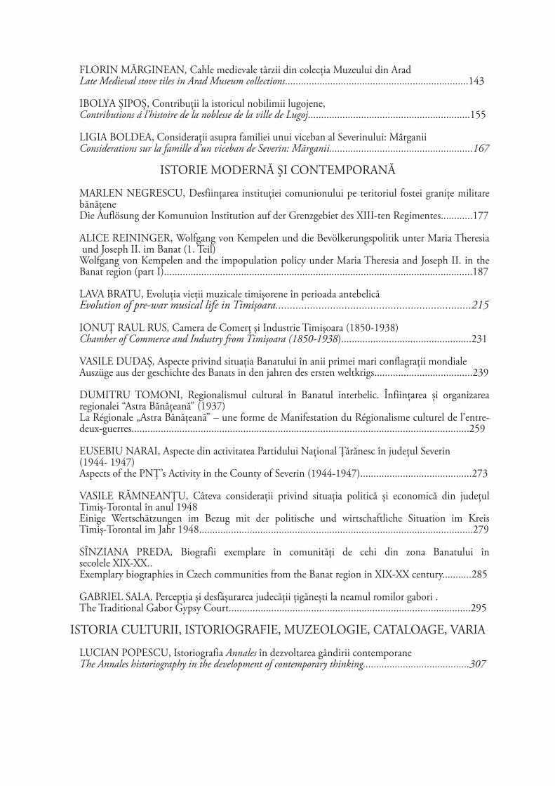
The study of the archeomagnetic plan (Fig. 10), whose precise outline has been generally confirmed by the excavation, permits a very accurate model of the settlement organisation to be constructed. It can clearly be seen that the settlement was protected by a fortification system made up of several concentric ditches that enclosed a central area30, which I term the ’’akropolis’’.
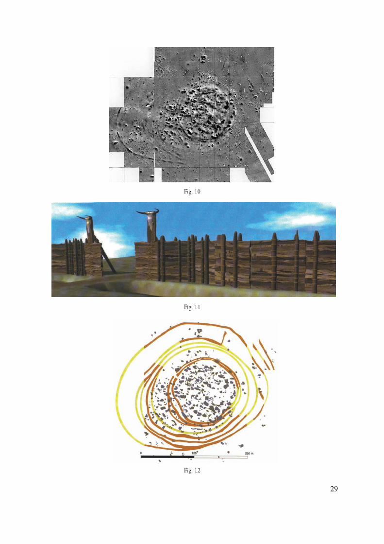
The fortification system of Uivar is one of the most elaborate and complex ones from this part of Europe. Though built in several stages, it is the result of a unitary defence conception being made up of a double ditch ring that protected the central area and additional concentrical ditches outwardly laid out beyond the central ring. The excavated materials in the ditch and the intersection of some ditches with other site features allow the development stages of the defence system of Uivar to be determined. Thus in S IV, which was destined to study the entrance gate to the inner precincts, the excavation revealed that in a previous phase there was only one ditch that protected the akropolis. From a chronological point of view, as represented by radiocarbon dates, this ditch is traceable to the watershed of the 6th and 5th millenia calibrated BC, which matches to the oldest radiocarbon date obtained from a double ditch fortification and which was buttressed by a wooden stockade lining the inside of the outer ditch (Fig. 11). This one, according to the radiocarbon data, was functional for 200 years, into the phase of Vinča C2. Unfortunately, the relatively limited excavation area, compared with the vastness of the tell, does not allow us to connect the three development stages of the system from the south-western part of the settlement to the other ditches
29. Mantu 2000, 79 and Table I; Lazarovici et alii 2005.30. Schier-Draşovean 2004, 150-154.

22
ANALELE BANATULUI, S.N., ARHEOLOGIE - ISTORIE, XV, 2007
of the system. Despite this limitation, and with the necessary measure of caution, the excavated materials in their fill, suggest that the ditches making up the last phase of the Vinča fortification system, were concommitantly excavated following a well-though-out plan. Thus, at about 120 m out from the tell centre, there was a ring ditch which, as was shown by a test in the south-eastern part of the tell, was not very deep nor very wide. It was lined inside by a stockade or by sturdy wooden watch-towers, which detail has been remarked in S VI, too which was destined to study this ditch along its north-west side. At about 10 m inside, the moat was doubled by another one that had a crowning length of 3,3 m and a depth of 3, 5 m and did not have a stockade. The same defence strategy may be found on the inner defence ring. Here, too, behind a ditch that, due to its relatively modest size and depth, might have given potential raiders the impression of vulnerability, there was an impressive ditch behind the stockade that could stem any invasion.
Archeomagnetic study has revealed the presence of several branches deriving from the main ditches (Fig. 12) and that represent different construction stages31. Unfortunately, at this point, it is hard to determine to which development stages these belong. It seems very likely that several branches that belong to the Vinča system, were excavated in the third phase of the defence system development.
As was previously noted, the fortification system operated for almost 200 years. From field observations of defence ditches in S IV, it has been observed that, after only three years, an almost 1 m thick layer of mud was washed off the slopes by rainwater and silted up the ditch due to natural weathering. This phenomenon must also have occured in the past and would have forced the Neolithic community to carry out regular maintenance and unsilting works. These unsilting works have been observed archeologically by the S IX excavation, where they have caused an alteration of the slope and gradient angle of the ditch.
The fortification ditches, in addition to protecting a certain area of the site, were also used to delimit several areas for specific functions within the social space. While the akropolis was meant for habitation-, social life-, and spiritual life-related purposes, the inner ring space and the outer ring space had different purposes.
The ring space, it might have been used as a safe haven and herd protection area from wild animals and from raids mounted by other communities, but it was meant for other lucrative activities. It was
31. Gerling et alii 2005.
probably here that the potters’ kilns lay, which, due to the fire peril that they posed, were not admitted into the crowded space of the akropolis. In other areas, the rarity of magnetic anomalies may suggest that a portion of the land was tilled. The use of this area changed when, due to the overcrowding of the akropolis space, houses were built in the southern part of it. It seems likely that this area was selected because the land here rose a bit in elevation and was less exposed to floods.
The chronological relationship between the settlement and fortification is also provided by the data obtained by the research in S IV. Here the post holes from some surface dwellings are cut by the two ditches of the third phase ring, and some storage pits were cut by the outer ditch that defended the akropolis. During a later stage, during the first two inner ring development phases, it was filled with successive ashes and charcoal layers on which, houses were build demonstrating the need for more habitation space.
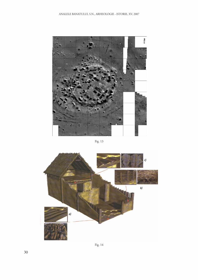
Returning to the archeomagnetic plan of the tell, if we eliminate the small magnetic anomalies from the core area of the akropolis, it is apparent that most houses are laid out on two concentrical circles surrounding a possible square at the heart of the tell (Fig. 13). At the same time, most houses are perpendicular to the inner fortification ring that belongs to the final, third stage, of the defence system development.
All this information bears out the idea of a well-conceived settlement plan that was followed by the Neolithic inhabitants of Uivar. This plan underwent alterations over time due to the necessity of the enlarging the habitation area beyond the akropolis, under the standing conflict for space between the area outlined by the fortification and the continously expanding population. This conflict was resolved very efficiently and, using a modern term, with professionalism, via the already mentioned southward enlargement of the area allotted for dwelling.
This need for more room is also reflected by the enlargement and two-storied design of some houses. One of these is feature 373, whose development could be determined throughout its use life. Most significant is its final stage in which the structure was to have three rooms of which the one to the west was covered by the flooring of an upper story (fig. 14)32. This organisation into three rooms and two stories did not exist in the structure’s first stage, and was added only in the last construction stage. Two-storey houses crop up
32. Schier-Draşovean 2004, 166 and Fig. 9. Gerling . Schier-Draşovean 2004, 166 and Fig. 9. Gerling et alii 2005, 39. Fig. 34.

23
in the Carpathian area in the late Neolithic and are strongly corelated with the appearance of tells33. The causes are multiple, but, most often, it appears to be a response to the limited tell area in the face of significant population growth.
Among the most important archeomagnetic anomalies cases of the akropolis is one lying in the southern part of the akropolis. The research carried out here has revealed a structure which, though damaged by later eneolithic and medieval complexes, has provided enough clues to present a coherent picture on the spiritual life and worship-designed architecture.
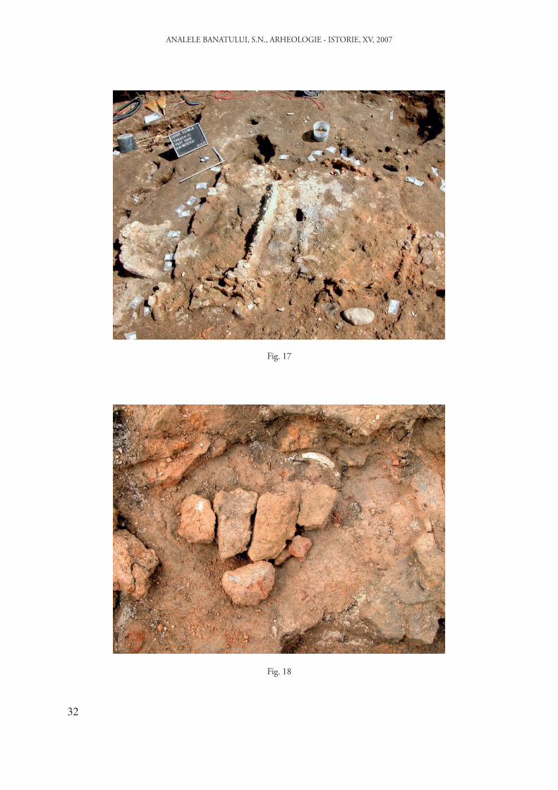
Having its long axis running north-east to south-west, the structure has imposing dimensions (14 m X 6 m.) and was made up of ground floor and upper floor. Research has shown that the upper level flooring did not entirely cover the lower floor area, thus leaving the third part from the south uncovered. The ground floor was divided into three rooms (Fig. 15). To the south there was one room of X m which had a rectangular hearth with rounded corners and raised edges in its north-western part (Fig. 16). The hearth lay next to the dividing wall that separated this room from the central room. On the west and east corners of the room the remnants of two large pots were discovered. At the centre of the building lay the largest room of X m in which most of the recovered ceramic items in the sanctuary, including several whole earthen pots, have been found. In each of the four corners of the room a small fire hearth with slightly raised edges was found. One of these, from the south-eastern corner, bore a median out bulging rib which split into two parts. Towards the northern wall, lay an oval-shaped grinder. The last room of the building, the northern room, was divided into four compartments by means of low walls (Fig. 17), which did not rise above one metre. Inside the compartments, on the north-east and north-west corners of the building, stood two additional large-sized earthen pots. At the centre of the northmost room, on the floor, was a well-burnt Bovidae horn and the very poorly preserved fragments of a clay-shaped ox head (Fig. 18).
This building, through the presence of the four fireplaces in the central room, of the four large-sized earthen pots on the four corners, through the existence of the ox head in the north room, had a purpose beyond its profane use, thus taking on a ritual role, and namely that of a sanctuary.
33. Kalicz-Raczky 1984, 100-107; Idem 1987, 18-19; Idem 1987a, . Kalicz-Raczky 1984, 100-107; Idem 1987, 18-19; Idem 1987a, 113-114 and Fig. 7; Horváth 1987, 39.
3. ConclusionsDrawing on the observations summarized
above, the following conclusions can be offered: 1. The Parţa and Uivar tells span a 600 year
development, between 5300 and 4700 calibrated BC34, over the watershed between the 6th and 5th millenia and being contemporary for a period that can be estimated to be a few decades. From a historical point of view, the Parţa tell belongs to the Middle Neolithic and experiences its florescent period at the end of this time span, in the second phase of the Banat culture which is contemporary to phase B2 of Vinca culture35. Its developement is violently ended by the new comers, the bearers of the Vinca culture, phase C, the same people that, through successive habitation waves, gave rise to the Parţa II and Uivar tells.
2. Both tells have well-developed defence systems whose building called for the concentration of significant manpower which could not be mobilised without the involvement of an authority able to speed up and coordinate the community social energy. In both cases, the defence systems also betoken a remarkable civil engineering design that presupposes organisational commitment of the elites for such wide-scale public works. Similarly, one can find a long-range strategy for the use and maintenance of the system and a unitary outlook concerning the settlement-defence system relationship. For example, in the Parta tell, even when the settlement became overcrowded, the building of houses near the defence ditches was avoided as these might have been easily set on fire by a potential aggressor, and the fire might have easily propagated to all the site buildings. As such, we find the existence of the global safety concept of all the inhabitants, of common good which is more important and which prevails over the ideas of expediance and individual benefit. At Uivar this view is present, too and thus one did not allow the constructions outside the defence system. Despite this planning, when the akropolis became overcrowded, the construction of houses in the southern part of the tell, between the central ring and the outer ditches was accepted.
In connection with the possibility of simultaneous existance of building phases of defence systems and of the houses of the settlement, we can assert that, in the case of both tells, these can be indirectly proved. Thus the digging of defence ditches at Uivar led to the removal of more than 10,000 cubic m of soil of which more than half is yellow clay. In historic times, this surplus soil
34. Schier-Draşovean 2004, 201-203; Lazarovici . Schier-Draşovean 2004, 201-203; Lazarovici et alii 2005.35. Lazarovici 1991, 34; Lazarovici et alii 2005.

24
ANALELE BANATULUI, S.N., ARHEOLOGIE - ISTORIE, XV, 2007
was used to built the stockade berm. The Uivar research carried out in the areas near the ditches has not found such deposits and nor has it found yellow clay strata that might derive from the ditches. Hence the obvious question: where did the inhabitants transport this enormous quantity of earth, enough to fill a 100 m sided cube? The situation is identical at Parţa or Chişoda Veche and we believe that only one answer can be accepted: namely that, as they dug out the defence ditches, they were also intensely engaged building houses. If this hypothesis is true, we shall have to rethink our assumptions about the organisation and leadership of Neolithic society.
3. The structure of the living space is determined by the family organisation, by the property relations and evolves in close connection to the demographic development of the family and to the dwelling enlargement possibility. At Parţa, the dwellings of the first level are made up of maximum two rooms, they do not have a second story and are grouped two by two, only to be grouped four by four at levels 7c-6. At these levels, where the possibility of enlargement was limited by the defence system, population growth triggered the construction of two-story buildings that offered the necessary living space to the more numerous family members. At Uivar, through the example of building 373, we find a similar development under the restrictive circumstances of the defence ditches, the house growing from two rooms, which it had at the moment of building, to three rooms and another floor level in its last functioning phase, alterations carried out in order to ensure living space for a greater number of family members.
4. The family space is much better outlined following the Parţa research. Here, the final development phase of buildings P. 40-43, underlines the fact that the ground floor of these constructions saw the development of productive activities such as weaving, bean grinding and meal preparation, whereas the upper floor space, as it is shown by the presence of different pots and small-sized ovens, was meant for sleeping and socialising activities.
5. Both communities had specialized buildings for worship which, although they were not identical, share many features in common. The Parţa sanctuary, through its monumental statues, ox heads, the ritual-related grinding and spinning, falls into the category of agrarian-pastoral worship, closely connected with nature’s yearly cycles. At Uivar, with the exception of the ox head, which is present, all the other elements are not so clear at first sight. On closer inspection, we can find the presence of four large-sized earthen food vessels,
each lying on the four corners of the building and the presence of four fireplaces on the four corners of the central room and of four compartments in the north-western room. This repetition of the number 4, I believe, is not a random event. It is connected to the four natural cycles and, in association with the symbol assigned to the ox head, these are the eloquent expression of the fertility and fecundity cult.
These are only some of the preliminary conclusions that might be drawn from the study of the Parţa and Uivar settlements. We are sure however that the ongoing research at the two tells, combined with work carried out on similar sites from this geographical area, will enable us to complete a string of conclusions which, at the present moment have only a preliminary status and might seem to present only the fragilest ground for discussion.
REFERENCES
Bailey et alii 2002D. Bailey, R. Andreescu, A. J. Howard, M. J. Macklin, S. Mills,
Alluvial landscapes in the temperate Balkan Neolithic: transition to tells. Antiquity 76 (2002), 349-355.
Chapman 1994J. Chapman, The origins of farming in south-east Europe.
Prehistoire Européenne 6 (1994), 133-156.
Chapman 1997J. Chapman, The origins of tells in Eastern Hungary. (P.
Topping), Neolithic Landscapes, Oxford (1997), 139-164.
Comşa 1969E. Comşa, Données concernant la civilisation de Vinča du sud-
ouest de la Roumanie. Dacia N.S. XIII (1969), 11-44.
Draşovean 1991F. Draşovean, Aşezarea neolitică de la Chişoda Veche (jud.
Timiş). (G. Lazarovici, F. Draşovean), Cultura vinča în România, Timişoara (1991), 71-72.
Draşovean 1994F. Draşovean, Die Stufe Vinča C im Banat. Germania, 72
(1994), 409-425.
Draşovean 1994aF. Draşovean, The Petreşti Culture in Banat. AnB, III (1994),
139-170.
Draşovean 1996F. Draşovean, Cultura vinča târzie (faza C) în Banat. BHAB I,
Editura Mirton, Timişoara (1996).
Draşovean 1997 F. Draşovean , Die Petreşti-Kultur im Banat. PZ, 72, 1 (1997),
54-80.

25
Draşovean 1999F. Draşovean, Cultura Petreşti în Banat. Studii privind aşezările
preistorice în arealul Mureşului inferior, Timişoara (1999).
Gerling et alii 2005 C. Gerling, M. Rehfeld, M. Woidich, Gräben, Gruben,
Häuser-Siedlungswesen und Arhitektur der späten Vinča-Kultur im Banat. (W. Schier), Maske, Menschen, Rituale. Alltag und Kult vor 7000 Jahren in der prähistorischen Siedlung von Uivar, Rumänien, Würzburg (2005), 35-40.
Gogâltan 2003F. Gogâltan, Die Tellsiedlungen im Karpatenbecken. Ein
Űberblick. (E. Jerem, P. Raczky), Morgenrot der Kulturen. Frühe Etappen der Menschheitsgeschichte in Mittel- und Südosteuropa. Festschrift für Nandor Kalicz zum 75. Geburtstag, Budapest (2003), 223-262.
Halstead 1999P. Halstead, Neighbours from Hell? The Household in Neolithic
Greece. (P. Halstead), Neolithic Society in Greece. Sheffield Studies in Aegean Archaeology, 67-95.
Horváth 1987F. Horváth, Hódmezövásárhely- Gorzsa. A settlement of the
Tisza culture. (L. Tálas), The Late Neolithic of the Tisza Region, Budapest-Szolnok (1987), 31-46.
Link 2006 T. Link, Das Ende der neolithische Tellsiedlingen. Ein kulturgeschichtliches Phänomenon des 5. Jahrtausemds v. Chr. im Karpatenbecken, verlag Dr. Rudolf Habelt Gmbh, Bonn (2006).
Kadereit et alii 2006A. Kadereit, B. Sponholz, M. Rösch, W. Schier, B. Kromer, G.
Wagner, Chronology of Holocene environmental changes at the tell site of Uivar, Romania, and its significance for late Neolithic tell evolution in the temperate Balkans. Z.Geomorph. N.F., Suppl.-Vol. 142 (2006), 19-45.
Kalicz-Raczky 1984N. Kalicz, P. Raczky, Preliminary Report on the 1977-1982
Excavations at the Neolithic and Bronze Age Tell Settlement of Beretyóújfalu-Herpály. Part I. Neolithic. ActaAH, 36 (1984), 85-136.
Kalicz-Raczky 1987N. Kalicz, P. Raczky, The Late Neolithic of the Tisza Region.
A survey of recent archaeological research. (L. Tálas), The Late Neolithic of the Tisza Region, Budapest-Szolnok (1987), 11-30.
Kalicz-Raczky 1987aN. Kalicz, P. Raczky, Berettyóújfalu-Herpály. A settlement
of the Herpálz culture. (L. Tálas), The Late Neolithic of the Tisza Region, Budapest-Szolnok (1987), 105-125.
Kotsakis 1999 K. Kotsakis, What Tells Can Tell: Social Space and Settlement
in the Greek Neolithic. (P. Halstead), Neolithic Society in Greece. Sheffield Studies in Aegean Archaeology, 66-76.
Lazarovici 1972G. Lazarovici, Aşezarea neolitică de la Parţa. Tibiscus, II (1972),
3-26.
Lazarovici 1979G. Lazarovici, Neoliticul Banatului. BMN IV, Cluj-Napoca
(1979).
Lazarovici 1991G. Lazarovici, Cultura Banatului. (G. Lazarovici, F. Draşovean),
Cultura vinča în România, Timişoara (1991), 32-40.
Lazarovici 1991aG. Lazarovici, Bucovăţ, Cremeniş (jud. Timiş). (G. Lazarovici,
F. Draşovean), Cultura vinča în România, Timişoara (1991), 54-58.
Lazarovici et alii 1991G. Lazarovici, F. Draşovean, L. Tulbure, Sanctuarul neolitic de
la Parţa, Reşiţa (1991).
Lazarovici 1989G. Lazarovici, Das neolithische Heiligtum von Parţa. S.
Bököniy (ed), Neolithic of Southeasern Europe and its near eastern connections, VAH, II, Budapest (1989), 149-174.
Lazarovici et alii 2001G. Lazarovici, F. Draşovean, Z. Maxim, Parţa, BHAB XIII,
Timişoara (2001).
G. Lazarovici.- M. Lazarovici 2003G. Lazarovici, M. Lazarovici, The Neo-Eneolithic architecture
in Banat, Transylvania and Moldavia. (D. Grammenos) Recent research in the prehistory of neolithischen the Balkans, Thessaloniki (2003), 369-486.
Lazarovici et alii 2005G. Lazarovici, C-M. Lazarovici, E. Jilot, Z. Maxim, Absolute
chronology of the Banat Culture. (V. Spinei, C-M. Lazarovici, D. Monah) Scripta praehistorica. Miscellanea in honorem nonagenarii magistri Mircea Petrescu-Dîmboviţa oblata, Iaşi (2005), 179-191.
M. Lazarovici - G. Lazarovici 2006M. Lazarovici, G. Lazarovici, Arhitectura neoliticului şi epocii
cuprului din România. I. Neoliticul, Iaşi (2006).
Luca 1998 S. A. Luca, Liubcova-Orniţa. Monografie arheologică, Ed.
Macarie, Târgovişte, (1997).
Mantu 2000C. M. Mantu, Relative and absolute chronology of the
Romanian Neolithic. AnB, VII-VIII (1999-2000), 75-105.
Radu 1979O. Radu, Plastica neolitică de la Chişoda Veche şi câteva
probleme ale neoliticului târziu din nordul Banatului. Tibiscus, V (1979), 67-76.
Schier-Draşovean 2004W. Schier, F. Draşovean, Vorbericht über die rumänisch-
deutschen Prospektionen und Ausgrabungen in der befestigten Tellsiedlung von Uivar, jud. Timiş, Rumänien (1998-2002). PZ, 79 (2004), 145-230.
Sherratt 1983A. Sherratt, The Neolithic period in Bulgaria in its European
context. (A. Poulter), Ancient Bulgaria: Papers presented to the International Symposium on the Ancient Historz and Archaeology of Bulgaria, University of Nottingham, 1981, Nothingham (1983), 188-198.
Tărău-Luca 2002D. Tărău, M. Luca, Panoptic al comunelor bănăţene din
perspectivă pedologică, Timişoara (2002).

26
ANALELE BANATULUI, S.N., ARHEOLOGIE - ISTORIE, XV, 2007
Fig. 1
Fig. 2
Fig. 3

27
Fig. 4
Fig. 5
Fig. 6

28
ANALELE BANATULUI, S.N., ARHEOLOGIE - ISTORIE, XV, 2007
Fig. 7
Fig. 8
Fig. 9
29
Fig. 10
Fig. 11
Fig. 12
30
ANALELE BANATULUI, S.N., ARHEOLOGIE - ISTORIE, XV, 2007
Fig. 13
Fig. 14

31
Fig. 15
Fig. 16
32
ANALELE BANATULUI, S.N., ARHEOLOGIE - ISTORIE, XV, 2007
Fig. 17
Fig. 18