aree marine protette puglia storie di mare
DESCRIPTION
La presente guida focalizza l’attenzione sul patrimonio naturalistico e storico-culturale della costa pugliese lunga circa 800 km, proponendo degli itinerari che prendono come punto di riferimento per l’esplorazione il mare protetto di Puglia, ossia le Aree Marine Protette delle Isole Tremiti, ricadenti nel Parco Nazionale del Gargano, di Torre Guaceto e Porto Cesareo. Partendo da queste aree di eccellenza ci si sposta verso interessanti tratti di costa limitrofi e aree rurali contermini per approfondirne la conoscenza naturalistica e storico-archeologica.TRANSCRIPT

AREE MARINE P R O T E T T EPuglia Storie di Mare
italiano/english
ISOLE TREMITI
ISOLE TREMITI
TORRE GUACETO
TORRE GUACETO
PORTO CESAREO
PORTO CESAREO
AR
EE
MA
RIN
E P
RO
TE
TT
EPu
glia
Sto
rie
di M
are
italia
no/e
nglis
h

1
Pubblicazione realizzata nell’ambito del progetto
Progettazione e coordinamento editorialeFrancesco TarantiniGianfranco CiolaFlo Tanzarella
TestiGiovanna BaldassarreAnna IntronaDanilo LeoneFrancesco De FrancoMargherita SemeraroPaolo D’AmbrosioLuciana MuscogiuriGiancomo MarzanoLeonardo BeccarisiMarcello Longo
TraduzionePeter Speedwell
FotografieArchivio Area Marina Protetta Torre GuacetoArchivio Area Marina Protetta Porto CesareoArchivio Parco del Gargano
IllustrazioniProgetto grafico, copertina, impaginazione, elaborazione mappePROGETTIPERCOMUNICARE s.n.c.
StampaLinea 80 Corato (Ba)
Tutti i diritti riservati, riproduzione vietata.
Edizione© 2011 PROGETTIPERCOMUNICARE s.n.c.di G. Schirone & Co. - Ceglie Messapica (Br)www.progettipercomunicare.it
ARCHEOLOGICA s.r.l.
partner
LEGAMBIENTE
Consorzio di GestioneArea Marina ProtettaPORTO CESAREO
Finanziato ai sensi della legge 29/03/2001 n°135, art.5 comma 5
Percorsi tra Natura e Storia
ISOLE TREMITI
TORRE GUACETOPORTO CESAREO
Puglia Storie di Mare
AREE MARINE P R O T E T T E

Introduzione
Un mare cristallino, dalle mille diverse sfumature, riflette la luce di Puglia.Dalle marine a Nord del Gargano, immerse nell’area umida dei laghetti salati e fronteggiate
dalle splendide Isole Tremiti, e dalle rocce del promontorio inframmezzate da meravigliose calette di sabbia, si scende alle saline e si giunge alla lunga linea di costa che fa dell’Adriatico un mare celebrato da poeti e letterati, con la sua acqua verd’azzurra che guarda verso Oriente ed evoca le navi dei viaggiatori e dei guerrieri che ne hanno animato la vita attraverso i secoli.
Dietro la linea di costa compaiono le maestose cattedrali, i castelli fortificati, i porticcioli turistici e i rifugi dei pescherecci, nella successione delle magiche dune di sabbia che sconfinano nella Riserva di Torre Guaceto terminando a Brindisi, storica città di mare e di passaggi di popoli.
Infine lo Ionio, con Gallipoli e Porto Cesareo affacciate sulla chiara trasparenza acquea da mar dei Caraibi, e Taranto con i suoi due mari, capitale della Magna Grecia, patria di cultura e luogo di fascino millenario.
Una Puglia speciale, quella del mare: una Puglia dal richiamo irresistibile, dai colori sorpren-denti, densa di storia e di poesia, che intriga il viaggiatore e lo cattura avvolgendolo nello splen-dore delle sue acque, nel calore della sua accoglienza, nel profumo dei suoi cibi antichi e nella vitalità delle sue genti
Silvia Godelli
Assessore Regionale al Mediterraneo
La presente guida focalizza l’attenzione sul patrimonio naturalistico e storico-culturale della costa pugliese lunga circa 800 km, proponendo degli itinerari che prendono come punto di riferimento per l’esplorazione il mare protetto di Puglia, ossia le Aree Marine Protette delle Isole Tremiti, ricadenti nel Parco Nazionale del Gargano, di Torre Guaceto e Porto Cesareo. Partendo da queste aree di eccellenza ci si sposta verso interessanti tratti di costa limitrofi e aree rurali contermini per approfondirne la conoscenza naturalistica e storico-archeologica.
In particolare gli itinerari costieri sono stati ripartiti in tre grandi macro-aree:•la costa del Gargano con l’itinerario garganico che illustra la costa dell’alto
Adriatico, e fa riferimento all’AMP delle Isole Tremiti;
•la costa medio-adriatica del Salento con l’itinerario adriatico che va da Mono-poli a Brindisi, e fa capo all’AMP di Torre Guaceto;
•la costa ionica del Salento con l’itinerario jonico che da Gallipoli arriva fino a Taranto ed ha come riferimento l’AMP Porto Cesareo.
La costa protetta in Puglia
La Puglia, con i suoi 800 km di litorale vanta lo sviluppo costiero più lungo d’Italia, regala paesaggi mozzafiato e conserva numerosi ambienti di grande valore naturalistico di rilievo na-zionale ed internazionale. La costa è molto diversificata, sono presenti zone umide, alte falesie rocciose, lunghe spiagge sabbiose accompagnate da cordoni dunari coperti da pinete e boschi a ginepro, basse scogliere, interrotte da intime calette sabbiose. Alcune aree costiere negli ultimi anni sono state oggetto di misure di tutela nel rispetto delle norme dettate dall’Unione europea e di convenzioni internazionali, al fine di tutelare l’elevato livello di biodiversità che le stesse racchiudono e nello stesso tempo i tratti più identitari della regione.
Si può constatare come la Puglia, pur avendo una superficie molto piccola ed un’alta densità abitativa, mostri un’elevata biodiversità rispetto alle altre aree di riferimento.
Rispetto al valore nazionale, in Puglia troviamo il 43% degli habitat individuati dalla Diret-tiva Habitat 92/43/EEC, il 65% degli uccelli nidificanti, il 44% dei mammiferi, dati che eviden-ziano l’enorme ricchezza della Puglia e la necessità di adottare misure concrete per conservare questo patrimonio.
Questa importanza ecologica è confermata da un sistema delle aree protette che, secondo diversi livelli normativi, protegge circa il 13% del territorio regionale.
Il sistema regionale delle aree protette è formato da un mosaico complesso di aree con diversi livelli di protezione. Sono presenti 2 Parchi Nazionali (il Parco Nazionale del Gargano e il Parco Nazionale dell’Alta Murgia), 3 Aree Marine Protette (Torre Guaceto, Isole Tremiti e Porto Cesareo), 16 Riserve Naturali dello Stato, oltre a un sistema di 18 aree protette regionali.
AR
EE
MA
RIN
E P
RO
TE
TT
E D
I P
UG
LIA
Puglia Storie di Mare
ital
iano
2 3

a
e
fg
h
i
c
lm
nt
d
zw
v
u
sr
q
p
o
b
Foggia
Taranto
Brindisi
Bari
Lecce
Parchi e Riservedella Regione Puglia
AR
EE
MA
RIN
E P
RO
TE
TT
E D
I P
UG
LIA
Puglia Storie di Mare
ital
iano
4 5
Parco Nazionale del GarganoApricena, Cagnano Varano, Carpino, Ischitella, Isole Tremiti, Lesina, Manfredonia, Mattinata, Monte Sant’Angelo, Peschici, Rignano Garganico, Rodi Garganico, San Giovanni Rotondo, San Marco in Lamis, Serracapriola, Vico del Gargano, Vieste
a
b Parco Nazionale dell’Alta MurgiaAndria, Corato, Ruvo di Puglia, Bitonto, Grumo Appula, Toritto, Cassano delle Murge, Santeramo in Colle, Gioia del Colle,Altamura, Gravina in Puglia, Poggiorsini, Spinazzola, Minervino Murge
c Riserva Naturale dello Stato di Torre GuacetoCarovigno, Brindisi
d Riserva Naturale dello Stato de Le CesineVernole
e Parco Naturale Bosco IncoronataFoggia
f Parco Naturale Fiume OfantoAscoli Satriano, Barletta, Candela, Canosa di Puglia, Cerignola,Margherita di Savoia, Minervino Murge, Rocchetta Sant’Antonio, San Ferdinando di Puglia, Spinazzola, Trinitapoli
g Parco Naturale Lama BaliceBari
h Riserva Naturale Orientata Laghi diConversano e Gravina di MonsignoreConversano
i Parco Naturale Dune costiereda Torre Canne a Torre San LeonardoOstuni, Fasano
l Riserva Naturale OrientataBosco di Santa Teresa e dei LucciBrindisi
m Parco Naturale Saline di Punta della ContessaBrindisi
n Riserva Naturale Orientata Bosco di CeranoBrindisi, San Pietro Vernotico
Riserva Naturale OrientataBosco delle PianelleMartina Franca
o
Parco Naturale Terra delle GravineCrispiano, Castellaneta, Venosa, Grottaglie, Laterza, Massafra,Martina Franca, Palagianello, Palagiano, Montemesola, Mottola, San Marzano di S. Giuseppe, Statte, Villa Castelli.
p
q Riserva Naturale Orientata Palude La VelaTarantotRiserva Naturale Orientata Litorale tarantinoManduria
r
s Riserva Naturale OrientataPalude del Conte e Duna Costiera - PortoCesareoPorto Cesareo
Parco Naturale Bosco e paludi di RauccioLecce
u Parco Naturale Porto Selvaggio e Palude del CapitanoNardò
v Riserva Naturale OrientataIsola di S. Andrea - Litorale di Punta PizzoNardò
w Parco Naturale Litorale di UgentoUgento
z Parco NaturaleBosco di Tricase - Costa Otranto - S. Maria di LeucaOtranto, Santa Cesarea Terme, Castro, Diso, Andrano, Alessano, Tricase, Corsano, Tiggiano, Gagliano del Capo, Castrignano del Capo

L A G O D I V A R A N O
L A G O D I L E S I N A
F O C E D IV A R A N O
FO
RT
OR
E
CA
N D E L A R O
T R I O L O
SA
L
SO
LA
C E L O N E
C A
ND
EL
AR
O
SP53
SP53
SP53
SP53
SP53
SP54
SP52
ter
SP52bis
SP52
bis
SP528
SP528
SP50
SP50
SP57
SP55
SP43
SP43
SP22
SP22
SP22
SP22
SP22
SP26
SP26
SP48
SP28
SP28
SP28
SP27
SP27
SP29
SP51
SP51
SP51bis
SP41
SP41
SP41
SP50bis
SP46bis
SP42
SP42
SP40
SP40
SP49
SP38
SP37
SP37
SS16
SP38bis
SP39
SP39
SP39
SP35
SP35
SP35
SP33
SP33
SP36
SP36
SP36
SP32
SP32
SP35
SP35
SP31
SP31
SP41bisSP41bis
SP41bis
SP42
bis
SP42
bis
SP13
SP13
SP30
SP30
SP46
SP11
SP10
SP12
SP12
SP58
SP25
SP25
SP24
SP23
SP74
SP20
SP16
SP16
SP10
9
SP18SP18
SP17
SP17
SP8
SP9
SS89
SS89
SS89
SS89
SS89
SS89
SS89
SS89
SS89
SS89
SS89
SS89
SS528
SS272
SS272
SS272
SS272
SS272
SS27
3
SS89dir1
SS693
SS693
SS693
SS693
SS693
SS16
SS16
SS16
SS16
SS16ter
SS16ter
SS16ter
SS159
A14E55
A14E55
A14E55
S.Rocco
S.Mariadi Calenella
S.Pietro sul Monte Tabor
S.Michele
S.Biagio
S.Nicola
S.MariaLa Pura
S.Mariadel Canneto
S.LorenzoMartire
Cappuccini
Cappuccini
S.Maria di Merino
Madonna di LoretoS.Mariadi Kalena
S.Mariadi Ripalta
Madonna d’Elio
città bizantina di Devia
Grottadi S.Michele
Bagno di Varano
Pugnochiuso
dell’Aglio
San Felice
Porticello
Sfinale
Usmai
CalalongaMonte Pucci
dei Preposti
CalarossaMileto
villaggio deipescatori
San Lorenzo dell’Aglio
Santa Croce
San Francesco
ManaccoraSan NicolaMontePucci
Casalini-Sfilzi
Malacologico
Etnografico
Maratea
FO
RE S T A U M B R A
P
R
O
M
O
NT
OR I O D E
L
GA
RG
A
N
O
MattinataMonte Sant’AngeloSan Giovanni Rotondo
San Marco in Lamis
San SeveroTorremaggiore
San Paolo in Civitate
Apricena
Poggio Imperiale
Lesina
Marina di Lesina
San Nicandro Garganico
Cagnano Varano
Carpino
Lido del Sole
Rodi Garganico
Ischitella
San Menaio
Vico del Gargano
Peschici
Vieste
Rignano Garganico
Manfredonia
-85
-55
-50
-70
-90
-80
-60
-65
-75
-35-45
-40
-80
-75
-65
-80
-65
-75
-75
-30
-20
-10
-5
-25
-15
-20
-15
-25
-15
-5
-25
-25
-5
-20
-5
-5
-5
-5
-30
-25
-30
-5
-5
-70
-70-75
-75
-75 -80
-85
-90
-70-65-60
-45
-40
-5-1
5
-20
-25
-30
-35
-40
-45
-50
-55-60-65-70
-80 -95
-85
-90
-100
-40
-75
-85
-80
-10
-40 -45
I S O L A S A N D O M I N O
I S O L A S A N N I C O L A
I S O L A C R E T A C C I O
I S O L A C A P R A I A
I S O L A P I A N O S A
0 10
20
30
40
50
60 70 80 90 100 110 120
130
140 150
160 170
180
190 200
210 220
230 240 250 260 270 280 290 300
31
0
320
330
340
350
Itinerario garganico - Garganic itinerary AREE MARINE PROTETTE DI PUGLIA Puglia Storie di Mare
Il grande storico romano Tito Livio, che scriveva negli anni a cavallo fra I sec. a.C. e I sec. d.C., considerava le coste adriatiche d’Italia “non adatte agli scali portuali” (importuosa Italiae lito-ra). Non era l’unico a pensarlo: il suo contemporaneo Strabone, autore di una Geografia in greco, le definiva, più o meno allo stesso modo, alimenoi, “senza porti”.
Alle difficoltà naturali della navigazione in questo iratum mare (per dirla con il poeta Ora-zio) si aggiungeva l’insidia della pirateria, che per secoli rappresentò una vera sciagura per gli scambi commerciali.
Ciò non ha impedito che l’Adriatico fungesse da via di comunicazione obbligata per i con-tatti con la Grecia e l’Oriente. La Puglia in particolare, quale naturale “porta d’Italia” affacciata sull’Adriatico, fu pienamente inserita nei circuiti commerciali mediterranei che influenzarono la sua cultura materiale, le modalità insediative e, più in generale, la vita economica, sociale e culturale, perlomeno dalla tarda Età del Bronzo (metà del II millennio), quando fu raggiunta dai traffici micenei, fino all’età moderna.
Uno degli aspetti peculiari di questa terra, circondata da due mari, è dunque la sua vocazio-ne marittima, che ha consentito nei secoli contatti, scambi e influenze: con gli uomini viaggia-rono non solo le idee, ma anche i miti e gli eroi, come l’Enea virgiliano che approdò con i suoi compagni nel Salento, e come Diomede, eroe del mare e fondatore di città daunie e non solo.
Di tali relazioni le acque pugliesi conservano numerose tracce archeologiche, illustrate in maniera esemplificativa negli itinerari qui proposti, che pongono l’attenzione anche al paesag-gio archeologico subacqueo nelle diverse fasi storiche.
Ripercorrendo idealmente questa via del mare è possibile dare inizio alla navigazione salpan-do dalle isole Diomedee (le Tremiti), importante scalo commerciale di età romana, le cui acque custodiscono numerosi relitti di navi, e visitare i siti archeologici che arricchiscono le coste gar-ganiche. Seguendo le antiche rotte di cabotaggio si può decidere di attraccare presso gli approdi di Torre Santa Sabina e Torre Guaceto, e inerpicarsi per le lame verso l’interno fino agli estesi in-sediamenti rupestri di Puglia e i centri interni della Messapia; ovvero, esplorare due grandi città portuali, Egnazia e Brindisi, per secoli strategiche basi militari e commerciali per e dall’Oriente; doppiando Santa Maria di Leuca, veleggiare lungo il litorale ionico, da Nardò a Porto Saturo, alla scoperta della civiltà messapica e approdare a San Pietro in Bevagna, per immergersi tra i 23 sarcofagi in marmo di Taso, carico di una nave destinata a Taranto, ma sfortunatamente affon-data tra la fine del II e la metà del III secolo d.C.; infine, concludere il nostro periglio solcando i due mari di Taras, “capitale” della Magna Grecia, ed ammirarne i tesori presso il MARTA Museo Nazionale Archeologico di Taranto.
Buona navigazione!
Archeologia«… l’Atlantico o il Pacifico sono i mari delle distanze,
il Mediterraneo è il mare della vicinanza,l’Adriatico è il mare dell’intimità»
P. MATVEJEVIC, Mediterraneo. Un nuovo breviario, trad. it., Milano 1991
Itinerario garganico
Area Marina ProtettaISOLE TREMITI
AR
EE
MA
RIN
E P
RO
TE
TT
E D
I P
UG
LIA
ital
iano
6

8 9
Dal punto di vista naturalistico il Gargano (lo Sperone d’Italia), promontorio di circa 2.000 km2, cinto da ripide scarpate e localizzato tra il mar Adriatico e la piana del Tavoliere delle Puglie, rappresenta un luogo caratterizzato da elevata biodiversità, per la presenza di nume-rosi ambienti che vanno dalla fascia costiera (con estesi ed incontaminati cordoni dunari, bianche falesie a picco sul mare, e intime ca-lette basse), alle colline e alle montagne più interne, con la presenza di boschi (è la zona più boscosa della Puglia), laghi (Lesina, Vara-no, Lago Salso), corsi d’acqua, cutini nelle zone interne, pascoli e steppe.
L’intervallo altimetrico tra la linea di costa e il monte Calvo presso San Giovanni Rotondo è di 1.055 m s.l.m.; il substrato geologico è prevalentemente calcareo; l’idrografia è princi-palmente costituita da corsi d’acqua a carattere torrentizio che percorrono valli profonde, deli-mitate da pareti rocciose scoscese. Nella mag-gior parte dei casi, questi corsi d’acqua giun-gono al mare, ma sul versante settentrionale si riscontra una serie di canali, spesso risultanti da opere di bonifica, il cui flusso idrico concorre ad alimentare i laghi di Lesina e di Varano. La scarsità di corpi idrici interni è un indizio della natura fortemente carsica del territorio. Infatti, la maggior parte dell’acqua piovana si disperde nel sottosuolo. Le grotte rappresentano vie di transito di flussi idrici e materializzano punti di contatto tra il sistema idrico superficiale e quello sotterraneo. Un fenomeno carsico di superficie molto diffuso sul promontorio è rap-presentato dalle doline, enormi imbuti nel ter-reno residui di antiche grotte le cui volte sono crollate e che in diversi casi accolgono specchi d’acqua più o meno permanente (cutino).
La maggior parte della costa è rocciosa ed elevata. Non mancano comunque gli arenili, diffusi soprattutto sul versante settentrionale (come Lago di Lesina, San Menaio). Il notevo-le sviluppo della costa, l’asperità del territorio, l’isolamento biogeografico, sono fattori che hanno influito ed influiscono enormemente sulle peculiarità naturalistiche del Gargano. La copertura boschiva e di macchia mediterranea è di oltre 39.000 ettari, il 18% dell’intero territo-rio garganico. È questo un dato significativo ed atipico rispetto alla Puglia, che ha una copertu-ra arborea complessiva pari a solo il 5% dell’in-tera superficie regionale. Non solo l’estensione complessiva, ma anche la ricchezza delle tipo-logie boschive sono degne di nota. Sui versanti costieri meridionale ed orientale prevalgono le pinete a pino d’Aleppo. Procedendo verso l’in-terno e salendo progressivamente di quota, si incontrano i boschi di leccio, di quercia vir-giliana, di cerro e di faggio (Foresta Umbra). Più rari, sparsi qua e là in piccole aree, sono i boschi a carpino bianco (Bosco Quarto presso Monte S. Angelo) e carpino orientale.
L’ambiente rupestre, diffuso sul Gargano, accoglie comunità vegetali che in primavera ed estate fanno mostra di sè con splendide fioriture. La campanula del Gargano, l’enula candida, la stellina del Gargano e la vedovina di Dallaporta sono specie che si rinvengono in questo ambiente, dai cui nomi si capisce la peculiarità e la distribuzione geografica di queste specie, endemiche del Gargano o trans-adriatiche. L’ambiente di pascolo, al confronto con quello rupestre, non è da meno; esso è ric-co di specie dalle fioriture spettacolari, come il giaggiolo del Gargano e numerosissime specie di orchidee.
L’Area Marina Protetta delle Isole Tremiti, isti-tuita con Decreto Ministeriale 14/07/1989, interessa il tratto di mare prossimo all’arcipe-lago, si estende per 1.466 ettari e rappresenta un compendio di bellezza sia per la natura in-contaminata dei suoi fondali sia per gli aspetti paesaggistici e storico-architettonici presenti soprattutto sulle due isole più grandi. Per la loro incantevole ed incontaminata bellezza sono definite “le perle dell’Adriatico”.
L’arcipelago delle Tremiti dista 13 miglia cir-ca a nord del promontorio garganico, è costitu-ito dalle isole di San Domino (la più grande), San Nicola, Capraia, Pianosa, la più lontana, a circa 11 miglia dalle altre, e dalla piccola isola denominata il Cretaccio.
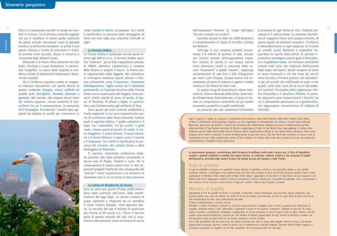
Le coste si elevano per alcune decine di metri sul mare. Diverse sono le grotte che si aprono in corrispondenza della costa, tra cui la Grotta delle Viole e quella del Bue Marino, vi-sitabili in imbarcazione. I fondali dell’arcipela-go includono habitat rilevanti come coralligeno e precoralligeno, su cui si insediano numerose specie vegetali ed animali tra cui poriferi, cni-dari (in particolare gorgoniacei e madreporari), policheti, bivalvi, echinodermi, tunicati. Anche la Posidonia oceanica è presente all’interno dell’arcipelago, unitamente alla Cymodocea nodosa, presente in una delle sue zone B, due fanerogame di estrema importanza nel Mediter-raneo.
Nell’arcipelago delle Tremiti, la frangia a Cystoseira (soprattutto Cystoseira amenta-cea) raggiunge percentuali di copertura molto elevate, soprattutto a Pianosa; la presenza di
quest’alga ha come conseguenza un aumen-to locale della biodiversità. Un’altra presenza estremamente importante è quella di Cladocora caespitosa, una madrepora coloniale che rappre-senta il più grosso fra i madreporari del Mediter-raneo, che cresce su fondali rocciosi o detritici a partire da pochi metri di profondità e può forma-re dei cuscinetti anche di 50 cm di diametro, dai 5 sino a 40 m di profondità.
Ai piedi delle scogliere che precipitano fino a 30 metri di profondità, fra gorgonie, spugne di ogni varietà e distese di alghe, tro-vano il loro habitat naturale orate, saraghi, pagelli, polpi e murene.
Nel 1998 la più grande statua di Padre Pio mai realizzata (e che, tra l’ altro, rappresenta la più grande statua sottomarina del mondo) è stata posta a 10 m di profondità vicino alla co-sta di Capraia. La statua è davvero imponente: 3 metri di altezza, per un peso di 12 quintali più 110 quintali di basamento.
L’isola di San Domino è interessata dalla
L’area marina protettadelle Isole Tremiti
Puglia Storie di Mare
Itinerario garganicoit
alia
no

10 11nia il villaggio neolitico di Prato Don Miche-le, sull’isola di San Domino, le isole Tremiti rappresentarono in età romana un importante scalo commerciale a carattere regionale, come attestato dai numerosi relitti di navi mercan-tili individuate.
Tra questi, degno di nota è il Relitto “A” detto delle “3 Senghe”, posto a 60 metri dalla costa e ad una profondità di -24 metri. Proba-bilmente le cattive condizioni del mare deter-minarono l’affondamento dell’imbarcazione alla fine del II - inizi del I secolo a.C. La nave, lun-ga 20/24 metri e larga 5, trasportava circa 900 anfore, disposte su 3 livelli, che contenevano vino, come dimostrano le tracce di pece presen-ti sulle pareti interne.
È possibile inoltre visitare il relitto medie-vale delle “Senghe B”, in località Punta del Dia-volo (Cala degli Inglesi), posto a -24 metri di profondità. Si tratta di una nave con carico di blocchi in pietra, lastre e colonne. Presso l’Isola di San Domino Cala degli Inglesi, Punta Vucco-lo, infine, è visitabile il relitto del piroscafo “Lombardo”, varato a Venezia il 1 maggio 1841 e utilizzato per trasportare i volontari di Gari-baldi a Marsala l’11 maggio del 1860.
vegetazione arborea a pino d’Aleppo e, nella parte più elevata, anche a leccio. Le altre isole sono caratterizzate dalla presenza di una bassa vegetazione a gariga e a macchia mediterranea in cui si rinviene l’euforbia arborescente, il mirto ed il lentisco.
Le Isole Tremiti, come un ponte biogeogra-fico sull’Adriatico, annoverano specie condivi-se con la Puglia peninsulare e/o con i Balcani (come l’alisso di Leuca, la stellina di Stalio, il limonio delle Tremiti).
A San Domino la falesia denominata Ripa dei Falconi è sito riproduttivo del falco pel-legrino, che un tempo qui veniva catturato e addestrato per la falconeria.
Ma le presenze più caratteristiche sono quelle delle berte, la maggiore e la minore, che nidificano in colonia nelle grotte marine e negli anfratti. Ogni anno raggiungono le isole al tempo della riproduzione. Di giorno cacciano sul pelo dell’acqua, spesso in branchi che si ra-dunano quando i piccoli pesci vengono spinti in superficie dai tonni. Al tramonto tornano
alla colonia e solo con il buio raggiungono i nidi. Nelle notti senza luna emettono carat-teristici versi simili ai vagiti dei neonati, che hanno originato leggende.
Itinerari subacquei lungo i fondali rocciosi circondano l’isola di San Domino, rappresenta-tivi degli aspetti naturalistici più rilevanti dei fondali dell’isola entro i 30 m di profondità.
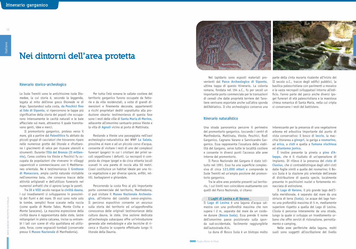
Chi non ama le attività subacquee resta co-munque rapito dalla moltitudine di paesaggi, che vanno dalle coste alte a picco, alle calette, agli scogli, alle pinete, e dalle architetture civili e religiose. Oltre ai resti delle mura e dei torrio-ni che circondano San Nicola, merita una visita l’abbazia di Santa Maria a Mare, che domina dall’alto l’isola. Fondata dai Benedettini nel 1045 e rimaneggiata nelle epoche successive, conser-va all’interno resti di un pregevole pavimento a mosaico del XI-XII secolo e all’esterno due chio-stri di epoca medievale e rinascimentale.
Abitate sin dalla preistoria, come testimo-
AR
EE
MA
RIN
E P
RO
TE
TT
E D
I P
UG
LIA
Puglia Storie di Mare
Itinerario garganicoit
alia
no
Cosa
si p
uò fa
re n
ell’a
rea
prot
etta Centro visite
Escursioni in barca
Nell’Isola di San Domino, all’interno del Centro Polifunzionale, è in fase di allestimento un modernis-simo centro di informazio-ne e di sensibilizzazione dove svolgere anche attività di educazione am-bientale. Qui si potranno ricevere informazioni su tutto il sistema turistico del Gargano e sulle emergenze naturalistiche, storico-culturali delle Isole Tremiti; un maxi schermo permetterà la visione di filmati inerenti le Isole Tremiti, la Riserva Marina
e i suoi abitanti marini; un info-webpoint, consentirà la navigazione nel sistema turistico del Parco del Gargano, la creazione d’itinerari personalizzati, l’informazione sulle strut-ture ricettive, sugli eventi organizzati; una serie di pannelli informativi forniranno notizie più dettagliate sugli habitat e le specie marine e terrestri delle Isole.
Escursioni a bordo di imbarcazioni adibite al trasporto dei turisti, sia lungo il periplo dell’Isola di San Domino per ammirare la sua costa, un piccolo museo di creazioni nate grazie all’opera erosiva del mare e del vento (calette,
architelli, grotte, pagliai, vere e proprie sculture rocciose, ecc) sia per raggiungere tutte le isole dell’arcipelago delle Tremiti (San Nicola, Cretaccio e Caprara), con la possibilità di soste per consentire bagni indimenticabili.
Escursioni naturalistichePresso l’isola di San Domino è presente un sentiero perimetrale di tutta l’isola da cui si dipartono brevi sentieri, che immersi nella pineta e nella tipica macchia mediterranea, conducono sino alle calette più belle dell’Isola o a incantevoli scorci panoramici. Presso l’isola di San Nicola, un sentiero immerso nella gariga, attraversando la Tagliata, raggiunge una vasta area denominata pianoro di
San Nicola che custodisce importanti testimonianze archeologiche, come la famosa tomba comunemente ritenuta di Diomede e una Domus romana e il cimitero libico. Durante il periodo primaverile è possibile andare alla scoperta di splendide orchidee selvatiche che fanno della Puglia e del Gargano in modo particolare, un punto di forza del turismo naturalistico.
Charter nautico
Bird watching
Come raggiungere le Isole TremitiVia mare: tramite traghetti e aliscafi
dai porti di: Termoli (tutto l’anno), Vieste, Peschici, Rodi Garganico.
Via aerea: mediante collegamento tra Foggia (aeroporto Gino Lisa) e l’eliporto di san Domino mediante collegamento tra l’e-liporto di Vasto e l’eliporto di San Domino (Isole Tremiti); da Bari–Palese Aeroporto Karol Wojtjla.
Info: 199.24.03.02
Aziende specializzate offrono una vasta gamma di imbarcazione che permetteranno di apprezzare, in tutta la loro bellezza, le tante calette e grotte e di fare
bagni in luoghi solitari e unici. A bordo di una imbarcazione si potrà gustare a pieno l’aspetto selvaggio e tranquillo di queste splendide Isole.
Le Isole Tremiti, per la loro posizione strategia al centro dell’Adriatico, assolvono alla funzione di riposo e sosta di numerose specie di uccelli migranti in direzione
Nord-Est in primavera e in direzione Sud-Ovest in autunno. In estate al tramonto è possibile udire il famoso canto delle berte.
Attività subacquee Divers specializzati accompagnano i subacquei ad ammirare gli splendidi fondali, ricchi di colori e di numerose forme di vita. Le Isole Tremiti sono uno dei gioielli più preziosi di tutto il Mediterraneo, un vero e proprio paradiso naturalistico per gli amanti del mare, ricche di siti di immersioni (circa 40) per ogni gusto (in parete, su secche,
su relitti, in grotte, ecc) e per ogni livello di preparazione (da semplici a molto impegnative), con la possibilità di osservare numerosissime specie di pesci, crostacei e molluschi nonché le splendide e coloratissime pareti ricoperte da axinelle, crinoidi, spirografi, gorgonie, coralli.
12 13
Nel lapidario sono esposti materiali pro-venienti dal Parco Archeologico di Siponto, ultima tappa di questo itinerario. La colonia romana, fondata nel 194 a.C., fu per secoli un importante porto commerciale per le transazioni di cereali che dalle proprietà terriere del Tavo-liere venivano esportate anche sull’altra sponda dell’Adriatico. Il sito archeologico conserva una
parte della cinta muraria risalente all’inizio del II secolo a.C., tracce degli edifici pubblici, la basilica paleocristiana con pavimenti a mosaico e la vasta necropoli sviluppatasi intorno all’edi-ficio. Fanno parte del parco anche diversi ipo-gei funerari di età paleocristiana e la maestosa chiesa romanica di Santa Maria, nella cui cripta si conservano i resti del battistero.
Le Isole Tremiti sono le antichissime isole Dio-medee, la cui storia è, secondo la leggenda, legata al mito dell’eroe greco Diomede re di Argo. Spostandosi sulla costa, da Peschici fino al lido di Siponto, si ripercorrono le tappe più significative della storia dei popoli che occupa-rono intensamente le cavità naturali e le baie affacciate sul mare, attraverso il quale transita-vano genti, idee e merci.
Il promontorio garganico, proteso verso il mare, già a partire dal Paleolitico fu abitato da piccoli gruppi di cacciatori che trovarono riparo nelle numerose grotte del litorale e sfruttaro-no i giacimenti di selce per ricavare utensili e strumenti. Durante l’Età del Bronzo (II millen-nio), l’area costiera tra Vieste e Peschici fu oc-cupata da popolazioni che vivevano in villaggi capannicoli e commerciavano con il Mediterra-neo orientale. Ne è testimonianza il Grottone di Manaccora, ampia cavità naturale visitabile nell’omonima baia, che conserva tracce delle attività artigianali e dell’utilizzo funerario nei numerosi anfratti che si aprono lungo le pareti.
Tra IX e VIII secolo nacque la civiltà dauna, i cui insediamenti si svilupparono in prossimi-tà dei fiumi e del mare. Di essi sono note solo le tombe, semplici fosse scavate nella roccia (come quelle di Monte Tabor, Monte Civita e Monte Saraceno). La massima espressione della civiltà dauna è rappresentata dalle stele, lastre rettangolari in pietra calcarea, incise su entram-bi i lati con scene di vita quotidiana ed utiliz-zate, forse, come segnacoli tombali (conservate presso il Museo Nazionale di Manfredonia).
Per tutta l’età romana le vallate costiere del territorio garganico furono occupate da fatto-rie e da ville residenziali, a volte di grandi di-mensioni e finemente decorate, appartenenti a ricchi proprietari dediti soprattutto alla pro-duzione olearia: testimonianza di questa fase sono i resti delle ville di Santa Maria di Merino, adiacente all’omonimo santuario presso Vieste e la villa di Agnuli vicino al porto di Mattinata.
Restando a Vieste una passeggiata nell’oasi archeologico-naturalistica del WWF La Salata, prossima al mare e ad un piccolo corso d’acqua, consente di visitare i resti di uno dei complessi funerari ipogeici in cui i cristiani dei primi se-coli seppellivano i defunti. La necropoli è com-posta da cinque ipogei e da circa ottanta loculi scavati in una parete di roccia alta 50 metri. L’oasi costituisce un habitat ideale per una ric-ca vegetazione e per diverse specie, anfibi, ret-tili, barbagianni e ghiandaie.
Percorrendo la costa fino al più importante porto commerciale del territorio, Manfredonia, si può visitare il Museo Nazionale Archeolo-gico, all’interno del castello svevo-angioino. Il percorso espositivo consente un excursus sulla storia del territorio ed un’approfondita conoscenza delle originali testimonianze della cultura dauna, le stele. Una sezione dedicata all’archeologia subacquea offre un’introduzione generale alle metodologie e alle tecniche di ri-cerca e illustra le scoperte effettuate lungo i1 litorale della Daunia.
Nei dintorni dell’area protetta
Itinerario storico-archeologico
Itinerario naturalistico
Una strada panoramica percorre il perimetro del promontorio garganico, toccando i centri di Manfredonia, Mattinata, Vieste, Peschici, Rodi Garganico, Cagnano Varano e Sannicandro Gar-ganico. Essa rappresenta l’ossatura della viabi-lità del Gargano, serve tutte le località costiere e consente in diversi punti l’accesso alle aree interne del promontorio.
Il Parco Nazionale del Gargano è stato isti-tuito nel 1991. Esso ha una superficie comples-siva di circa 121.000 ettari e comprende le Isole Tremiti ed un’ampia porzione del promon-torio garganico.
Tra le altre aree protette presenti sul territo-rio, i cui limiti non coincidono esattamente con quelli del Parco Nazionale, si citano:
I Laghi di Lesina e di Varano Il Lago di Lesina è una laguna d’acqua sal-mastra con una profondità massima che non supera i 2 m, separata dal mare da un cordo-ne dunare (Bosco Isola). Essa prende il nome dell’omonimo paese posizionato sulla spon-da sud-occidentale, facilmente raggiungibile dall’autostrada A14.
La duna di Bosco Isola è un biotopo molto
interessante per la presenza di una vegetazione arborea ed arbustiva importante dal punto di vista conservativo: il bosco di leccio, la mac-chia litoranea a ginepri, la gariga a rosmarino, ad erica, a cisti e quella a fumana vischiosa ed eliantemo jonico.
È inoltre presente la pineta a pino d’A-leppo, che è il risultato di un’operazione di impianto. Di rilievo è la presenza del cisto di Clusius, che si contraddistingue dagli altri cisti dalle foglie simili a quelle del rosmarino; il Bo-sco Isola è la stazione più orientale dell’areale di distribuzione di questa specie, localmente presente in pochissimi nuclei e fortemente mi-nacciata di estinzione.
Il Lago di Varano, il più grande lago dell’I-talia meridionale, è separato dal mare da una striscia di terra (Isola). Le acque del lago han-no una profondità massima di 5 m, mediamente superiore rispetto a quella del Lago di Lesina. L’Isola è percorsa interamente da una strada, lungo la quale si sviluppa un insediamento ur-bano che offre servizi di ristorazione, pernotta-mento e camping.
Nelle aree periferiche della laguna, molti suoli sono soggetti all’oscillazione del livello
AR
EE
MA
RIN
E P
RO
TE
TT
E D
I P
UG
LIA
Puglia Storie di Mare
Itinerario garganicoit
alia
no
14 15dell’imperatore Federico II, citata nell’opera “De arte venandi cum avibus”.
L’assetto attuale fu dato nel 1900 attraverso il completamento di opere di bonifica iniziate dai Borboni.
Tutt’oggi in uso, vengono prodotti annual-mente 5-6 milioni di quintali di sale, estratti con l’antico metodo dell’evaporazione solare. Èun sistema di vasche in cui l’acqua marina entra attraverso canali e, passando dalle va-sche “evaporanti” a quelle “salanti”, raggiunge concentrazioni di sale fino a 300 chilogrammi per metro cubo d’acqua. L’acqua marina che an-nualmente alimenta il sistema si aggira in media intorno ai 30 milioni di metri cubi.
In questo luogo di straordinario valore natu-ralistico, Riserva Naturale dello Stato, Zona Umi-da d’Importanza Internazionale, si tenta di tro-vare un compromesso sostenibile tra gli aspetti economico-produttivi e quelli ambientali.
La presenza del sale condiziona fortemente
la presenza di ogni forma di vita. L’habitat pre-valente è il salicornieto. Le presenze faunisti-che di maggiore rilievo sono quelle ornitiche, di specie legate ad ambienti acquatici. L’avifauna è abbondantissima in ogni stagione. In inverno gli anatidi (come fischioni e volpoche) fre-quentano le vasche della salina. In periodo ri-produttivo prevalgono specie quali il fenicotte-ro e il gabbiano roseo, che formano consistenti colonie sulle isole che originano dall’erosione degli argini dei bacini. Questi vengono di tanto in tanto ricostruiti e ciò che resta dei vecchi viene lasciato a formare preziosi siti riprodutti-vi per gli uccelli che nidificando al suolo e che quindi, sulle isole, sono più al sicuro dai preda-tori terrestri. Al margine della vegetazione nidi-fica l’avocetta e il cavaliere d’Italia. In perio-do migratorio sono numerosissimi i limicoli, tra cui il piovanello pancianera e il gambecchio, che raggiungono concentrazioni di migliaia di individui.
idrico e si presentano asciutti in estate ed inon-dati in inverno. Tra le diverse comunità vegetali che qui si insediano si citano quella costituita da specie annuali crassulente come la granata irsuta e la Salicornia europaea. La prima è una specie ritenuta a rischio di estinzione in Italia; la seconda viene raccolta, messa in conserva e consumata dagli abitanti locali.
Rilevante è la fauna ittica presente nei due laghi, sfruttata a scopo alimentare, in partico-lare l’anguilla. La pesca delle anguille è con-dotta a bordo di pittoresche imbarcazioni deno-minate sandali.
Ma è l’avifauna acquatica quella di maggio-re interesse naturalistico con specie tipiche di questo ambiente: folaghe, svassi, tuffetti ed anatidi quali moriglioni, morette, alzavole e germani. Nei canneti, che cingono alcuni tratti del sistema lagunare, vivono comunità di pas-seriformi tra cui il cannareccione, la cannaiola ed il forapaglia. Al tramonto i canneti sono rag-giunti da migliaia di uccelli per trascorrervi la
notte: rondini e storni, ad esempio. Tra i rettili è significativa la presenza della testuggine di terra che vive nelle aree arbustive limitrofe ai laghi.
La Foresta Umbra La Foresta Umbra è localizzata ad una quota in-torno agli 800 m s.l.m. Il termine Umbra signi-fica “ombroso”, per la folta vegetazione arborea. In effetti, elemento caratteristico e costante della Riserva è proprio il bosco, in buona par-te rappresentato dalla faggeta. Nel sottobosco si rinvengono numerose specie erbacee a fiori-tura primaverile, come il bucaneve, l’anemone dell’Appennino, l’aglio orsino ed il ciclamino primaverile. Le tipologie boschive della Foresta Umbra non si esauriscono alla faggeta. Sono pre-senti, infatti, boschi di cerro, di leccio, di tas-so, di farnetto, di alloro e tiglio, in quest’ul-timo caso limitatamente agli ambienti di forra.
Sono questi gli unici contesti ambientali a livello regionale in cui sono sopravvissute spe-cie di eccellenza della fauna stanziale italiana quali il capriolo italico, il gatto selvatico e il lupo, tra i mammiferi. Tra gli uccelli, il gufo reale, cinque specie di picchi (il verde, il ros-so maggiore, il rosso minore, il rosso mezza-no e il dorso bianco) e rapaci come il lanario e il biancone. Tra i rettili è significativa la pre-senza del cervone, del colubro liscio e della testuggine di Hermann.
Il capriolo, importante endemismo italia-no presente allo stato selvatico unicamente in alcune aree di Puglia, Calabria e Lazio. Per la conservazione di questa specie sono in atto im-portanti progetti finalizzati alla salvaguardia dei “preziosi” nuclei sopravvissuti e al tentativo di ripopolare aree in cui un tempo è stata presente.
Le Saline di Margherita di Savoia Sono le saline più grandi d’Italia (4500 ettari). Sono state costruite dall’uomo, dalla trasfor-mazione del lago Salpi, un bacino costiero di acque salmastre e stagnanti da cui prendeva il nome l’antica Salapia, città lagunare dau-na. La raccolta del sale è iniziata in quest’area già intorno al III secolo a.C.: Plinio il Vecchio parla di questa raccolta del sale che si accu-mulava naturalmente. L’area fu terreno di caccia
Itinerario garganicoit
alia
no
Ogni 15 agosto si svolge la consueta e tradizionale processione a mare della Patrone delle Isole Tremiti, Santa Maria a Mare, la Madonnina dell’arcipelago Pugliese, un rito suggestivo ed emozionante che attrae e incanta tanti visitatori. Numerosi, ogni anno, gli isolani e i turisti che assistono alla celebrazione religiosa via mare: le imbarcazioni partono dalla banchina di San Domino stracolmi di fedeli e raggiungono il molo di San Nicola dove sopraggiunge la statua della Madonna partita dalla chiesa della storica fortezza. Viene, quindi posta a bordo di una imbarcazione allestita a festa, dove salgono anche tutte le autorità. Il corteo di imbarcazioni fa poi rotta verso Cala dei Turchi per ascoltare la messa e per la deposizione in mare della tradizionale corona di fiori. Quindi si fa ritorno sulle isole dove comincia la festa con spettacoli, manifestazioni e magnifici fuochi pirotecnici.
Trad
izio
ni p
opol
ari
Rice
tte
trad
izio
nali
delle
Tre
miti
e d
el G
arga
no
Ragù di palamiteIl ragù di palamite si prepara con palamite fresco. Spinare il palamite e tritare o con macchina adatta o con coltello prèposto, mettere a soffriggere una cipolla tritata con olio extra vergine di oliva senza farla bruciare quindi a fuoco lento, aggiungere il Palamite tritato dopo pochi minuti, farlo saltare, aggiungere un bicchiere di vino bianco da far evaporare con fiamma più forte. Aggiungere quindi la salsa di pomodoro in misura ridotta per la quantità di palamite, sale e prezzemolo a fine cottura. Da far cuocere a fuoco lento. Il ragù per condire i diversi tipi di pasta è pronto!
Minestra di anguillaIngredienti: 8 etti di anguille di Lesina, 2-3 patate, 2 pomodori, mezza melanzana, una zucchina, mezzo peperone, una piccola cipolla, una costa di sedano, un ciuffo di cicoria di campo, una manciata di cime di rapa, fette di pane casereccio, olio extravergine di oliva, sale, peperoncino piccante.Tempo di preparazione e cottura: un’ora.Mondate e lavate le verdure. Scottate la cicoria in acqua bollente e tagliate tutto il resto a grandi pezzi. Eviscerate le anguille, eliminate testa e coda, diliscatele e tagliatele a tranci di tre-quattro centimetri. Tuffatele in due litri di acqua salata e portate a ebollizione. Schiumate e aggiungete la cicoria strizzata, le cime di rapa e tutte le altre verdure, nonché quanto peperoncino desiderate. Cuocete per una ventina di minuti, aggiustando di sale. Servite la minestra, condita con extravergine crudo, in piatti fondi in cui avrete sistemato crostini di pane.Era il cibo quotidiano dei pescatori che, un tempo, facevano per mesi la posta alle anguille intorno al lago, costruendo pagliai dove restavano giorno e notte in attesa che si riempissero le speciali trappole. Durante questi lunghi soggiorni i pescatori cucinavano le anguille con le erbe selvatiche che crescevano sulle rive del lago.
La gastronomia garganica, caratterizzata dalla riscoperta di prelibate rarità come il grano arso, è fatta di ingredienti semplici e genuini combinati in prodotti dal sapore intenso. La tradizione culinaria costiera è una variazione di quella dell’entroterra, arricchita dalla varietà di pesci dei fondali pescosi del Gargano e delle Tremiti.

SP90
SP3
SP163
SP4
SP21
2
SP18
7
SP11
3
SP11
3
SP11
3
SP129
SP146
SP12
0
SP121
SP114
SP96
SP81SP81
SP1
SP2
SP77
SP225SP227
SP162
SP16
2
SP59
SP6
SP7
SP5
SP9
SP8
SP11
SP134
SP11
9
SP12
SP13
SP64
SP14
SP17
SP19
SP10
SP20
SP21
SP34
SP33
SP32
SP35
SP36
SP37
SP37
SP38
SP39
SP37bis
SP46
SP47
SP48
SP48
SP30
SP28
SP28
SP26
SP24
SP23
SP16
SP22
SP29
SP41
NSA2
87
SP43
SP80
SP80
SP79
SP79
SP81
SP81
SP82
SP82
SP87
SP86
SP83
SP74
SP69
SP45
SP70
SP71
SP56SP55
SP50SP
24
SP68SP69
SP70
SP51
SP67
SP71
SP71
SP40
SP72dir
SP66
SP66
SP72
SP74
SP75
SP45
SP77
SP80
SP46
SP47
SP48
SP42
SP43
SP44
SP50
SP49
SP60
SP52
SP54
SP56
SP57 SP58
SP78
SP31
SP53
SP80
SP44
SS16
SS16
SS16
SS16
SS16
SS1bis
SS16
SS37
7
SS17
2dir
SS172
SS172
SS172
SS17
2
SS17
2
SS604
SS581
SS581
SS581
SS581
SS581
SS605
SS605E90SS7
E90SS7
E90SS7
E90
SS7
E55
SS16
E55
SS16
E55SS379
E55
SS379
E55
SS379
E55
SS613
Brindisi
Mesagne
Latiano
San Vito dei Normanni
San Michele Salentino
Grottaglie
Villa Castelli
Francavilla Fontana
Ceglie Messapica
MontemesolaStatte
Crispiano
Martina Franca
Alberobello
Fasano
Locorotondo
Cisternino
Carovigno
Ostuni
Monopoli
Polignano a Mare
Pezze di Greco
Montalbano
CARANNA??
Tuturano
San Paolo
PA L U D EL A V E L A
San Giovanni
Sciannolecchia
MA C C H I A S A N G I O V A N N I
F I O R E N T I N O
T E R R A E R O S A
Il tratto di costa tra la provincia di Brindisi e di Lecce che va da Torre Canne - Torre San Le-onardo nel Parco Naturale Regionale tra Ostuni e Fasano fino a Torre Chianca nella marina di Lecce è un territorio prevalentemente pianeg-giante, compreso negli intervalli altimetrici di 0-200 m s.l.m.
I corsi d’acqua sono di modeste dimensioni, in prevalenza a carattere torrentizio. Molti di essi, per alcuni tratti, si affossano all’interno di “lame”, canaloni rocciosi di origine carsica.
La costa si presenta sabbiosa (da Torre a Canne Torre San Leonardo) a tratti rocciosa, bassa (Torre Guaceto) oppure a falesia (Tor-re Mattarelle), che si eleva non oltre 10 m sul mare. Per il resto è sabbiosa, accompagnata da un cordone dunare normalmente appena abboz-zato, che però localmente può presentare di-mensioni considerevoli, come nel caso dell’are-nile ad est di Punta Penna Grossa, nella Riserva di Torre Guaceto, o quello del tratto di costa tra Torre Canne e Torre San Leonardo.
La matrice del paesaggio è di tipo agricolo. Tra le colture legnose, il vigneto ha un gran-de ruolo economico e culturale. L’olivo è un
elemento fondamentale del paesaggio. Ostuni e Fasano fanno parte della cosiddetta “Strada del Parco agrario degli olivi secolari dell’Alto Salento” che valorizza il paesaggio degli oliveti millenari presenti nella zona pianeggiante pro-spiciente al mare.
Il clima mediterraneo caldo favorisce la presenza di boschi di querce. Nell’area si con-giungono gli areali di distribuzione di specie sempreverdi come il leccio, la quercia spinosa e la sughera, che qui mantiene gli avamposti più orientali, e di specie caducifoglie come la quercia di Dalechamp e la quercia virgiliana.
Le aree naturali si concentrano soprattutto lungo la costa: il litorale roccioso e sabbioso, le zone umide, gli stagni salmastri. Agli occhi dell’interessato, anche l’entroterra può svelare inattesi lembi antichi di natura (boschi di quer-ce, aree di macchia mediterranea, pascoli, pare-ti rocciose naturali), incastonati come gioielli nella matrice dei campi coltivati.
Le strade statali 379 Bari-Brindisi-Lecce e 16, rappresentano le principali vie di comunicazione consentendo di raggiungere rapidamente sia i centri abitati che le diverse aree di interesse naturalistico.
17
Area Marina ProtettaTORRE GUACETO
Itinerario adriatico

Labridi come le donzelle comuni e le donzelle pavonine, che fanno capolino tra le rocce inte-ressati dal visitatore.
In questo basso tratto di fondale il paesag-gio è colorato da svariati Antozoi tra cui il po-modoro di mare e dal madreporario Cladocora caespitosa, che rappresenta il più grande dei madreporari mediterranei, dalla caratteristica forma a cuscino di fiori. Scendendo ulteriormen-te di profondità, Torre Guaceto offre gli ambien-ti più spettacolari della Riserva, ossia le prate-rie di Posidonia oceanica e il coralligeno.
I posidonieti sono ricchi di numerosissime specie, tra cui il più grande mollusco bivalve mediterraneo, la pinna nobile e gli Antozoi quali l’anemone dorato.
Al confine delle praterie si estende un al-tro degli habitat più importanti e spettacolari del Mediterraneo: il coralligeno, caratterizzato dalla presenza di gorgonie, quali le Eunicella cavolinii e E. singularis, dall’esile struttura ra-mificata, di briozoi quali il falso corallo e la fragile trina di mare, di antozoi come il Para-zoanthus axinellae, di spugne, quali le grandi Axinelle.
L’area della Riserva ha conservato tracce del-la presenza umana che vanno indietro nel tem-po fino al II millennio a.C. Infatti durante l’età del Bronzo sul promontorio di Torre Guaceto e sui due Scogli di Apani sorgevano villaggi difesi da mura e costituiti da capanne realizzate con elementi lignei e vegetali, le cui pareti erano coperte da intonaco d’argilla. Poche tracce sono riferibili alla presenza di abitati in età messapi-ca (metà VII- metà III sec. a.C.), mentre dopo la conquista romana quest’area costiera e gli isolotti prossimi alla costa furono densamente abitati, come dimostrano i ritrovamenti di ma-teriali ceramici: la Via Appia Traiana, che cor-reva immediatamente a monte dell’attuale area paludosa, determinò l’inserimento dell’area di Torre Guaceto nella rete di traffici e commerci che collegavano le ville e gli insediamenti rurali dell’interno con i grandi complessi produttivi costieri (come le fornaci individuate ad Apani). Per tutta l’età romana e fino al V-VI secolo l’a-rea rappresentò un approdo importante, come dimostrano i resti della torre-faro presenti sul terzo isolotto e un relitto coevo affondato nelle acque antistanti.
Le prime azioni a tutela di Torre Guaceto risal-gono al 1991, con l’istituzione dell’Area Marina protetta per una superficie complessiva protet-ta di 2.227 ettari e 8,41 km di costa; nel 2000 viene istituita la Riserva Naturale Statale, 1.100 ettari di territorio caratterizzato da un mosaico complesso di ambienti naturali e agricoli dalla sorprendente biodiversità.
Tre sono gli ambienti naturali più importan-ti della Riserva: il litorale, la macchia mediter-ranea e la zona umida.
Sulla sabbia depone le uova il fratino, uc-cello limicolo di piccole dimensioni; le uova hanno il colore della sabbia, vengono sistemate in una depressione e mimetizzate con conchi-glie e foglie di posidonia. Sono tante le spe-cie che frequentano questo ambiente nei mesi dell’anno, per ricercare il cibo o per riposare durante la migrazione. Tra tutti la più carat-teristica è la beccaccia di mare, dal lungo e colorato becco.
Lungo tutta la linea di costa della Riserva, gli arenili di sabbia si alternano a brevi tratti di scogliera; tra le vaschette riempite d’acqua salata e frequentate dai granchi, il finocchio marino, la salicornia ed il limonio pugliese fronteggiano il mare.
Dietro la duna numerose specie di arbusti sempreverdi crescono a stretto contatto l’uno con l’altro e si addensano a costituire le co-munità di macchia mediterranea e di gariga. Le specie sono adattate a contrastare il caldo e la siccità dell’estate: il lentisco, l’alaterno, l’asparago pungente, il timo arbustivo, il rosmarino, il mirto. Tra gli animali che fre-quentano l’ambiente della macchia si menziona
il tasso, un mammifero assai raro e schivo, la luscengola ed il ramarro.
Dietro la duna, dove la falda acquifera af-fiora, la cannuccia domina incontrastata. Insieme ad essa poche altre specie, come la campanella, che utilizza i fusti della cannuc-cia come tutori su cui arrampicarsi per esporre al cielo i suoi grandi fiori bianchi. Gli animali più frequenti ed appariscenti sono gli uccelli. Alcuni trascorrono tutta la vita in questo habi-tat, come il tarabuso, altri, come gli storni e le rondini, lo utilizzano solo di notte per riposare. Altri uccelli palustri, come la folaga ed il tuf-fetto, costruiscono grandi nidi galleggianti an-corati alle piante. Là dove la salinità dell’acqua è meno elevata vivono anche anfibi e rettili tra cui la testuggine d’acqua.
Nel mare di Torre Guaceto la diversità de-gli ambienti sommersi e le numerose specie di pregio naturalistico hanno determinato l’in-serimento dell’Area Marina Protetta di Torre Guaceto all’interno della Lista delle Aree Spe-cialmente Protette del Mediterraneo per la con-servazione della Biodiversità.
Torre Guaceto può essere apprezzata attra-verso una passeggiata con maschere e pinne, i primi metri sotto la superficie dell’acqua sono popolati da un “manto erboso”, costituito da diverse specie di alghe che offrono riparo e fonte di cibo ad una complessa comunità di or-ganismi. Un’attenta esplorazione lungo la costa rocciosa sommersa dà la possibilità di osser-vare numerose tane dove trovano riparo pesci appartenenti alla famiglia degli Sparidi tra cui saraghi e occhiate. Molto curiosi sono i comu-ni Serranidi come lo sciarrano e la perchia o i
L’area marina protettadi Torre Guaceto
AR
EE
MA
RIN
E P
RO
TE
TT
E D
I P
UG
LIA
ital
iano
Itinerario adriatico
18 19
Cosa
si p
uò fa
re n
ell’a
rea
prot
etta Centro visite Laboratori per bambini
ed eventi seraliRiserva è il centro visite AL GAWSIT, situato nella Borgata di Serranova, poco oltre i confini della Riserva. Questo spazio mette a disposizione dei visitatori materiali e informazioni utili per la conoscenza dell’area ed inoltre gode di spazi dedicati a mostre tematiche, video informativi, materiali e libri da consultare oltre che un piccolo bar/mercatino bio.I visitatori attraverseranno
virtualmente gli ambienti dell’area protetta e conoscerne i segreti più affascinanti, da quelli del canneto, ai colori e alle creature dei fondali nella sala degli acquari tra ricostruzioni, video e riproduzioni; potranno viaggiare nel tempo e ripercorrere la storia della Riserva. Nel centro visite è anche possibile noleggiare biciclette e acquistare gadget ricordo della Riserva.
Nel periodo estivo sulle spiagge si svolgono laboratori tematici per bambini e un interessante programma di eventi serali. I laboratori per bambini rappresentano proposte multidisciplinari di incontro con la natura e la scienza attraverso i linguaggi diversi dell’arte, del teatro, della musica e dell’astronomia. Le sere della Riserva diventano lo scenario naturale degli
eventi culturali di Torre Guaceto, che propone ogni anno un calendario di appuntamenti suggestivi e affascinanti tra racconti sospesi fra la terra e il mare.
A piedi, in bicicletta, con maschera e pinne a vela e in… treninoLa passeggiata in bicicletta porta a scoprire gli angoli più intimi della Riserva, tra oliveti secolari, masserie e case coloniche, pedalando tra degustazioni e incontri di campagna.Le escursioni a piedi attraversano la Riserva con un cammino accessibile a tutti, che va
dalla zona umida all’antica torre fino alla macchia mediterranea, ricca di miti e leggende.Per esplorare i fondali della Riserva è possibile partecipare alle attività di snorkeling: a pelo d’acqua con maschera e pinne per scoprire un angolo di Adriatico incontaminato. I più esperti con l’ausilio di
autorespiratori potranno essere accompagnati da guide subacquee autorizzate.Per gli amanti della vela si organizzano stage di avvicinamento alla Vela e corsi residenziali e non articolati su più livelli, per imparare a condurre derive, catamarani, windsurf e kite surf.
Nei mesi estivi è inoltre a disposizione un’ulteriore modalità di visita guidata con un trenino elettrico, che all’imbrunire di ogni giornata d’estate parte dalla spiaggia di Punta Penna Grossa per raggiungere il promontorio della torre e i luoghi più significativi e interni della Riserva.
L’itinerario conduce alla scoperta della storia millenaria di questa “terra degli ulivi” seguen-do idealmente il percorso dell’acqua che, dalle ultime propaggini murgiane, attraverso le lame, scorre fino al mare. Il percorso racconta delle co-munità che vissero in queste terre fertili e ricche di acque, sfruttando i ripari naturali, le pianeg-gianti coste e che viaggiarono con le merci e le idee lungo il pescoso Adriatico.
Il nostro percorso parte dal parco arche-ologico di S. Maria di Agnano, alla periferia della “città bianca” Ostuni. In un suggestivo paesaggio di ulivi monumentali si può visita-re una grotta che già nel Paleolitico Superiore (25.000-10.000 anni fa) fu frequentata, come riparo e luogo di culto, da cacciatori che vi sep-pellirono una giovane donna incinta, rinvenuta dagli archeologi in un eccezionale stato di con-servazione. Nella cavità, a partire dal VI secolo a.C., si svolgevano culti dedicati alla dea Deme-tra; poi, con una significativa continuità d’uso, nel XIV secolo sul sito sorse una chiesa dedi-cata alla Vergine e agli inizi del 1600 una cap-pella tuttora visibile. Le grotte continuarono ad essere occupate per secoli, lungo le lame infatti non mancavano terre fertili, acqua e una roccia tufacea tenera, facile da scavare e lavorare per ricavarne semplici ripari e complessi edifici.
Il Parco Rupestre di Lama d’Antico, San Giovanni e San Lorenzo è uno dei più estesi insediamenti rupestri pugliesi, utilizzato sin dalla preistoria. Nel Parco si conservano abita-zioni, ambienti artigianali, ricoveri per animali e tre chiese quasi totalmente scavate nel tufo e
decorate con affreschi databili a XI-XII secolo.Posta al limite tra Peucezia e Messapia,
esposta a influenze culturali provenienti da ter-ra e da mare, Egnazia fu per secoli (dai primi insediamenti di XVI secolo all’occupazione spo-radica di età medievale) un centro portuale e viario di grande importanza. Si possono visitare i resti della città, passeggiando in un sugge-stivo parco, tra abitazioni, complessi produttivi ed edifici pubblici posti lungo il tratto della via Traiana che, riprendendo una precedente strada, attraversava la città e collegava Roma a Brindi-si (una mostra permanente presso il contiguo Museo Archeologico Nazionale ha per tema la Via Traiana).
Pur non essendo ancora nota l’ubicazione del porto di Egnazia, è possibile attribuire le numerose strutture sommerse, visibili al largo dell’insenatura a nord dell’acropoli, a probabili moli per l’ancoraggio delle navi. Su un fonda-le spianato e sabbioso, a circa 6 metri di pro-fondità, il visitatore può ammirare due muri parallelepipedi realizzati in opus caementicium (pietre, calce e pozzolana), rivestiti con la tec-nica a reticolato, databili tra la fine dell’età re-pubblicana e l’inizio dell’età imperiale (I a.C.-I d.C.). Il percorso nell’antica Brundisium può iniziare dalle Colonne Romane, poste nel pun-to in cui finiva la via Appia che per secoli colle-gò Roma con il porto, simbolo della città e della sua vocazione di ponte culturale verso l’Oriente. È stata allestita anche una mostra permanente sul monumento presso la Sala della Colonna, nel palazzo Granafei-Nervegna. La visita al
Nei dintorni dell’area protetta
Itinerario storico-archeologico
AR
EE
MA
RIN
E P
RO
TE
TT
E D
I P
UG
LIA
Puglia Storie di Mare
ital
iano
Itinerario adriatico
20 21
Come raggiungere la Riserva
In auto: per raggiungere il Centro Visite dalla SS n. 379 Bari-Brindisi-Lecce prendere uscita Serranova e proseguire per Serranova; per la Riserva dalla SS 379 Bari-Brindisi-Lecce prendere uscita Torre Guaceto-Punta Penna Grossa e percorrere la complanare lato mare, fino al parcheggio di Punta Penna Grossa.
In treno: la Riserva dista 20 km dalla stazione ferroviaria di Brindisi, 8 km da quella di Carovigno e 99 km da quella di Bari.
In aereo: la Riserva dista 20 km dall’aeroporto di Brindisi e 112 km da quello di Bari.

COME RAGGIUNGERE IL PARCOLa zona umida di Fiume Morelli dalla SS n.
379 Bari-Brindisi-Lecce uscita Ostuni-Pilone-Rosa Marina, direzione Pilone, prendere complanare lato mare, fino alla zona umida di Fiume Morelli
La Casa del Parco In auto: dalla SS n. 379 Bari-Brindisi-Lecce
uscita Ostuni-Pilone-Rosa Marina, direzione Ostuni, seguire le indicazioni per la Casa del Parco - ex stazione di Fontevecchia svoltando a destra per la via Traiana, oppure dalla SP 1 bis (ex SS 16) Ostuni – Fasano svoltare a destra al km 871 per C.da Fontevecchia e seguire le in-dicazioni per la Casa del Parco – ex stazione di Fontevecchia.
In treno: Linea FS Bari-Lecce, dalla stazione di Cisternino lungo la via Traiana fino alla Casa del Parco
In aereo: Il Parco dista 40 km dall’aeroporto di Brindisi
Il Parco Naturale Regionale Salinadi Punta Della Contessa Il Parco ha una superficie di 950 ettari è loca-lizzato sulla costa a sud della città di Brindisi. I seminativi caratterizzano il paesaggio dell’en-troterra ed occupano l’80% della superficie dell’area naturale protetta. La principale pecu-liarità dell’area è la presenza di alcuni specchi d’acqua retrodunari che tendono a prosciugarsi in estate (Salina Vecchia e Salinella). La forte oscillazione del livello idrico e del grado di sali-nità sono i presupposti per l’instaurarsi di comu-nità vegetali particolari, tra cui si citano quella a erba dei chiozzi spiralata, a lisca marittima, lo spartineto, il giuncheto a giunco foglioso, i salicornieti perenni, le comunità annuali a sa-licornia annuale, cressa e granata irsuta. Rile-vante è la presenza di garighe ad erica pugliese e timelea barbosa.
L’area presenta elevati valori naturalistici, come evidenziato dal valore e quantità di spe-cie e di habitat presenti inseriti nelle direttive 79/409/CEE e 92/43/CEE e negli elenchi del Li-bro Rosso degli Animali d’Italia.
Nel Parco sono segnalate, tra gli uccelli, cir-ca 14 specie nidificanti e molte appartenenti ad altre categorie fenologiche che risultano d’inte-resse internazionale. Nell’area svernano alcune migliaia di esemplari tra ciconoformi, anseri-
formi e caradri formi, abbondantissime sono le presenze in periodo migratorio. Tra le specie più comuni: l’airone bianco e l’airone cenerino, il fischione ed il codone. Qui nidifica il cavaliere d’Italia e il fraticello. In inverno è possibile osservare anche il fenicottero e la spatola, il cigno reale e il chiurlo.
COME RAGGIUNGERE IL PARCOIn auto: dalla SS n. 379 Lecce-Brindisi-Bari,
uscita Brindisi Zona Industriale, si prosegue per la litoranea salentina in direzione Lecce. Giunti all’altezza della Masseria “Villanova” svoltare alla sinistra in direzione della Masseria didattica “La terra del Sale” di Anna Argento.
Provenendo da Bari percorrendo la SS n. 379 per Lecce, superato il centro abitato di Brindisi, uscire in direzione della zona industriale e segui-re le stesse indicazioni innanzi citate.
In treno: il Parco dista 5 km dalla stazione ferroviaria di Brindisi.
In aereo: il Parco dista 7 km dall’Aeroporto di Brindisi.
Il Parco Naturale Regionale Boscoe Paludi di Rauccio Nel Parco di 625 ettari, si alternano aree agrico-le ed ambienti naturali. E’uno spaccato del tipi-co paesaggio rurale salentino. Il bosco di lecci è ciò che resta dell’antica “Foresta di Lecce”, che nel medioevo si sviluppava sino ad Otranto e Brindisi. Tra la lecceta ed il mare è presente una vasta zona umida (Specchia della Milogna; milogna è il nome dialettale del tasso). La co-sta è sabbiosa, con presenza di dune a tratti an-cora ben formate. Le emergenze naturalistiche sono rappresentate dalla periploca maggiore, l’orchidea palustre, il tasso, il falco di palude e la raganella.
La masseria è stata oggetto di restauro ed ospita il centro recupero tartarughe marine di Lecce, che “in rete” con altre aree naturali sa-
MAPRI, il Museo Archeologico Provinciale, or-ganizzato in diverse sezioni tra cui una relativa ai ritrovamenti subacquei, consente di avere un quadro di insieme dell’evoluzione storica della città e del suo territorio.
La storia di Brundisium in età romana è invece direttamente leggibile tra i palazzi del centro storico, nei pavimenti a mosaico visibi-li in Via Casimiro e visitando l’area archeolo-gica di San Pietro degli Schiavoni (conservata al di sotto del teatro Verdi), un’insula romana
con edifici pubblici e privati anche con mosaici, ambienti termali e tratti di basolato stradale. Resti di un’abitazione di età romana si conser-vano a poca distanza, presso il Tempio di San Giovanni al Sepolcro, interessante edificio a pianta circolare dell’XI secolo.
Itinerario naturalistico
Oltre alla Riserva Naturale Statale di Torre Gua-ceto, le altre aree naturali protette presenti nel-la zona sono localizzate principalmente lungo la costa. Procedendo da nord verso sud troviamo i Parchi Naturali Regionali: Dune Costiere da Torre Canne a Torre San Leonardo, Salina di Punta del-la Contessa e Bosco e Paludi di Rauccio.
Il Parco Naturale Regionale Dune Costiere Da Torre Canne a Torre San Leonardo L’area naturale protetta istituita con L.R. 31/2006, si estende nei territori di Ostuni e Fa-sano su circa 1.100 ettari, lungo 8 km di costa inoltrandosi verso l’interno tra oliveti millena-ri ed estesi pascoli.
Nell’area protetta sono presenti numerosi habitat, alcuni dei quali considerati prioritari dall’Unione Europea. Dai lunghi cordoni dunali coperti con vegetazione a ginepro (con esem-plari monumentali di 500-600 anni) agli stagni retrodunali dove insistono fragili ambienti che ospitano numerosi uccelli migratori. L’area è fruibile con un sistema di sentieri e passerelle sospese tra i bacini di un antico impianto di acquacoltura risalente all’800 dove sono alle-vati, con metodi biologici, anguille e cefali.
Dagli stagni retrodunali, percorrendo una serie di sentieri, si giunge alle dune fossili con pseudosteppa e alle aree agricole con semi-nativi e oliveti monumentali, dove è possibile visitare masserie storiche del XVI - XVII secolo e frantoi ipogei medievali. Gli oliveti secolari sono intervallati da profonde incisioni carsiche dette “lame” che scorrono fino al mare. Le lame
custodiscono al proprio interno una folta e va-riegata vegetazione spontanea e interessanti insediamenti rupestri bizantini.
Il Centro visite, denominato Casa del Parco, è ospitato all’interno della stazione ferroviaria dismessa di Fontevecchia, una piccola stazio-ne di campagna, raggiungibile dall’antica via Traiana. Una rete escursionistica da percorrere a piedi o in bicicletta tra l’antico tracciato ro-mano e le strade rurali, permette di conoscere tutti gli ambienti del Parco. L’antica Via Traiana, attrezzata con segnaletica, aree di sosta e pun-ti d’informazione per cicloturisti, fa parte della ciclovia Adriatica, uno dei percorsi a lunga per-correnza della rete ciclistica nazionale di Bici-talia che da Venezia corre lungo tutto il litorale adriatico fino al capo di Santa Maria di Leuca.
Tante le iniziative organizzate nel Parco: escursioni, visite guidate ed eventi. Tutte pren-dono avvio dalla Casa del Parco presso la stazio-ne di Fontevecchia e coinvolgono cicloturisti e cicloescursionisti che giungono in treno con le bici al seguito, nelle vicine stazioni ferroviarie di Ostuni e Cisternino presso Pozzo Faceto. At-traverso un accordo tra Regione Puglia, Trenita-lia e Ferrovie Sud Est è infatti possibile traspor-tare la bici sul treno senza pagare supplemento.
Il Centro Visite o Casa del Parco è sito nella ex stazione ferroviaria di Fontevecchia, in Ostu-ni (Br). Escursioni e visite guidate si effettuano su prenotazione: [email protected], www.parcodunecostiere.org.
AR
EE
MA
RIN
E P
RO
TE
TT
E D
I P
UG
LIA
Puglia Storie di Mare
ital
iano
Itinerario adriatico
22 23

SP101
SP10
0
SP99
SP104
SP102
SP107
SP10
6
SP108
SP110
SP110
SP11
1
SP11
0dir
SP113
SP114
SP112
SP115
SP11
6
SP12
4
SP121
SP120
SP123
SP123
SP126
SP12
5
SP122
SP122
SP122
SP12
5
SP129
SP12
9
SP127SP129ter
SP128
SP118
SP117
SP86
SP86
SP134
SP130
SP131
SP132
SP13
6
SP13
6
SP135
SP137
SP141SP141
SP13
9
SP143
SP144
SP107
SP145SP219
SP78
SP82 SP81
SP80
SP7
SP603
SP90
SP92
SP87
SP52
SP94 SP93
SP53
SP51
SP51
SP51
SP54
SP96
SP57
SP97
SP98
SP59
SP58
SP60
SP61
SP62
SP63
SP64
SP68
SP74
SP75
SP75
SP65
SP109
SP109
SP174
SP174
SP359
SP359
SP359
SP219
SP21
7
SP255
SP111
SP111
SP110
SP11
3
SP220
SP21
SP17
SP17
SP17
SP10
4
SP101
SP95
SP79
SP78
SP327
SP365
SP102
SP97
SP4
SP4
SP4
SP5
SP96
SP100
SP29
6
SP230
SP92
SP15
SP15
SP10
5
SP106
SP120
SP10
3
SP4a
SP13
SP12
1
SP8
SP14
SP11
7 SP124
SP119
SP224
SP123
SP17aSP6
SP6
SP16
SP20
SP18
SP17
SP115SP114
SP286
SP286
SP112
SP261
SP17
SP129
SP90
SP194
SP52
SP19
SP53
SP361
SP215
SP33
0
SP282
SP54
SP221
SP53
SP70
SP69
SP43
SP50
SP51
SP47
SP85
SP340
SP140
SS7ter
SS7ter
SS7ter
SS7ter
SS7ter
SS7ter
SS7ter
SS7ter
SS17
2
SS605
SS16
SS16
SS613
SS613
SS101
SS10
1
SS274
SS7
SS7
SS106
Talsano
Leporano Pulsano
Faggiano
Roccaforzata
Monteparano
Uggiano Montefusco
Campomarino
Lizzano
Fragagnano
Carosino
San Giorgio Jonico
Lama
Monteiasi
San Marzano di San Giuseppe
Oria
Sava
Manduria
Torre Santa Susanna
Erchie
San Pancrazio Salentino
San Donaci
Cellino San Marco
Trepuzzi
Campi Salentina
Novoli
Guagnano
Salice Salentino
Torricella
Maruggio
San Pietro in Bevagna
Avetrana
Torre Colimena
Porto Cesareo
Veglie
Carmiano
Arnesano
Monteroni di Lecce
Leverano
Copertino
Nardò
Galatone
Sannicola
Alezio
Gallipoli
Santa CaterinaSanta Maria al Bagno
Taranto
Tuglie
Taviano
Squinzano
TorchiaroloSan Pietro Vernotico
Torre Lapillo
Inserraglio
M A R P I C C O L O
M A R G R A N D E
PA L U D EL A V E L A
T E R R A D E L L E G R AV I N E
R I S E R V E D E L L I T O R A L E TA R A N T I N O O R I E N TA L E
PA L U D E D E L C O N T E E D U N A C O S T I E R A - P O R T O C E S A R E O
P O R T O S E L VA G G I O E PA L U D E D E L C A P I TA N O
I S O L A D I S . A N D R E A - L I T O R A L E D I P U N TA P I Z Z O
SP359
SP359
SP359
SP10
9
SP122
SP340
SP14
0
SP141
SP286
SP11
3
SP220
SP21
SP112
SP11
4
Torre Colimena
Porto Cesareo
Torre Lapillo
Specchiarica
San Pietro in Bevagna
Torre dell’Inserraglio
0 100 200 300 400 500m50 150 250 350 450
50
100m
Scala
lentine (Porto Cesareo e Torre Guaceto), cura e rimette in libertà annualmente decine di esem-plari di tartaruga. Il Centro è sede estiva dei campi di ecovolontariato organizzati dal Centro Turistico Studentesco (CTS).
Nel Parco sono presenti quattro “sentie-ri natura” (botanico, faunistico, idrologico e storico-culturale) tra le attività turistiche si annoverano: visite guidate, trekking, bici-trekking, passeggiate, escursioni a piedi e/o a cavallo, laboratori didattici, corsi, seminari, stage, eventi culturali, eventi sportivi, giorna-te a tema, campi scuola, campi di soggiorno e
campi estivi rivolti a bambini ed adulti, noleg-gio di biciclette.
COME RAGGIUNGERE IL PARCOIn auto: dalla SS n. 379 Bari-Brindisi-Lecce
(uscita Squinzano – Santa Maria Cerrate), l’area è collegata alla Città di Lecce da una strada pro-vinciale: la Lecce/Torre Chianca
In treno: la stazione di Lecce (circa 18 Km dal Parco)
In aereo: l’Aeroporto Internazionale di Brin-disi (circa 35 Km dal parco) e l’Aeroporto privato Lecce-Lepore (circa 15 Km dal parco)
Area Marina ProtettaPORTO CESAREO
AR
EE
MA
RIN
E P
RO
TE
TT
E D
I P
UG
LIA
ital
iano
Itinerario adriatico
24
Itinerario ionico
La cavalcata di sant’Oronzo è la festa più attesa e importante di Ostuni. Ogni anno il 25, 26 e 27 di agosto, sono giorni dedicati al santo: un corteo di cavalli e cavalieri bardati a festa, sfila per le vie cittadine a scorta del protettore della città. Le origini della cavalcata risalgono al 1657. La peste invase il Salento risparmiando Ostuni ed altre città di Terra d’Otranto. Il miracolo venne attribuito a sant’Oronzo ed ogni 26 agosto gli ostunesi vollero recarsi in processione al santuario eretto in suo onore.
La cavalcata di sant’Oronzo ad Ostuni
La tradizione popolare e religiosa più importante per la cittadina carovignese è sicuramente la Nzegna, antico maneggio della bandiera legato al culto della Madonna santissima di Belvedere, patrona dalla città. Ogni lunedì e martedì successivi al giorno di Pasqua, viene riproposta la battitura della Nzegna (che letteralmente significa bandiera) accompagnata dalla processione per le vie del paese con la statua della Vergine di Belvedere.
Carovigno, città della Nzegna
La tradizionale “Processione al Mare” si svolge annualmente il sabato precedente la prima domenica di settembre nell’ambito delle solenni celebrazioni dei Santi Patroni della città San Teodoro d’Amasea e San Lorenzo da Brindisi. Questa cerimonia, nata nel 1776 ricorda un episodio miracoloso del 1210: le spoglie si San Teodoro, fatto uccidere in Turchia per non aver abiurato la sua Fede in Cristo, venivano trasportate dall’odierna Aukat (Turchia) a Brindisi, ma i marinai della nave, vistisi inseguiti da navi turche, misero le spoglie del Santo su una barca, che spinta dalla corrente, si diresse nel porto della città.
Festa di San Teodoro a Brindisi
Trad
izio
ni p
opol
ari
Ciceri e triaIngredienti per 4 persone:300 gr. di farina di frumento o di semola di grano duro; 250 gr. di ceci; 2 gambi di sedano, 1 cipolla bianca, qualche foglia di alloro; 3 cucchiai di olio extravergine di oliva, saleDisponete la farina a fontana , regolate di sale e impastate accuratamente con acqua tiepida fino a ottenere una massa liscia e compatta. Copritela con un telo e lasciatela riposare per una decina di minuti. Stendete una sfoglia sottile e con un coltello tagliatela a fettine di otto millimetri di larghezza circa. Mettetele ad asciugare su un canovaccio. Metà andranno cotte in acqua bollente con sedano e sale e metà saranno fritte nell’olio.A parte bollite i ceci in acqua aromatizzata con le foglie di alloro; scolate e versate in un tegame in qui avrete fatto soffriggere la cipolla tritata finemente.Unite alla pasta fritta le tagliatelle bollite e i ceci, mescolate il tutto e servite.Esempio di ricetta della memoria in qui sono esaltati i sapori tipici del Salento : la pasta fatta in casa, l’olio extravergine e i legumi e le verdure del territorio.
CiambottoIngredienti: un chilo e mezzo di pesci da zuppa, cianchettine, trigliette, merluzzetti, ghiozzi, scorfani, totani, un pomodoro, 3 spicchi d’aglio, un mazzetto di prezzemolo, olio extravergine di oliva, sale, peperoncino in polvere.Tempo di preparazione e cottura: due oreFate soffriggere in un tegame capace, con tre cucchiai d’olio, l’aglio, il prezzemolo tritato e il pomodoro spezzettato. Aggiungete il pesce, coprite con acqua e aggiustate di sale. Fate bollire finchè gli occhi dei pesci saranno diventati bianchi. Distribuite i pesci nei piatti con un po’ di brodo, condite con olio extravergine e spolverizzate con peperoncino.
Rice
tte
trad
izio
nali
della
cos
ta a
dria
tica
tra
Mon
opol
i e L
e Ce
sine

L’Area Marina Protetta Porto Cesareo (D. M. 12.12.1997), è gestita dal 2001 da un Consor-zio formato dai Comuni di Porto Cesareo, Nardò e dalla Provincia di Lecce. Ha una superficie di 16.654 ettari con una linea di costa di 32 Km circa, un litorale frastagliato, punteggiato di spiagge bianche e basse scogliere. La Riser-va nella parte orientale del Golfo di Taranto, a Nord di Gallipoli, è compresa tra le località di Punta Prosciutto e Torre dell’Inserraglio. Nel tratto di mare tutelato dall’AMP ricadono tre Siti di Importanza Comunitaria (SIC).
La limpidezza delle acque, la grande bio-diversità dei fondali, la particolare morfologia delle coste, sono i motivi che hanno determina-
to l’istituzione dell’Area marina Protetta.A partire dai 10-12 metri di profondità, nei
fondali sabbiosi si estendono le praterie di Po-sidonia Oceanica, una pianta marina endemica del Mediterraneo, paragonabile, per moltissime funzioni, alle foreste tropicali. All’interno delle praterie cresce indisturbata la Pinna nobilis, il più grande mollusco bivalve del Mediterraneo, specie in via di estinzione e protetta da norma-tive Comunitarie; nelle praterie si possono an-cora oggi incontrare anche i cavallucci marini (Hippocampus hippocampus e H. guttulatus).
Ciò che rende suggestiva la visita ai fonda-li della Riserva marina è anche la presenza del coloratissimo coralligeno, un habitat che si
L’itinerario si sviluppa lungo la costa Ionica pu-gliese e nell’immediato entroterra, un territorio molto vario sia da un punto di vista paesaggi-stico che naturalistico. A nord, a partire dalla costa meridionale tarantina, in località Torre Ovo, sino a Porto Cesareo il litorale si artico-la in basse scogliere e cale sabbiose. Da Punta Prosciutto sino ai caseggiati di Torre Lapillo si estende il Lido degli Angeli, una delle spiagge più grandi e belle della Penisola Salentina, con alti cordoni dunari di sabbia fine e bianca.
L’intero tratto di costa, soprattutto in pros-simità dell’abitato di Porto Cesareo, è dissemi-nato di piccoli scogli affioranti e isolotti, tanto da rendere la navigazione sottoscosta estrema-mente impegnativa ma davvero suggestiva. Da Porto Cesareo a Torre dell’Inserraglio la costa è rocciosa e si alza gradualmente fino a 5-6m sul livello del mare. A partire da Porto Selvag-gio, procedendo verso sud, la costa diventa roc-ciosa e si sviluppa in alte falesie che si tuffano a picco nel mare. All’interno di queste pareti si aprono moltissime grotte sommerse o semisom-merse, suggestiva meta di turismo subacqueo.
Tutta la linea di costa ionica ed adriatica è punteggiata da un sistema di torri fortificate del 1500: sono chiare costruzioni quadrangola-ri erette per difendere il territorio dagli assal-
ti dei pirati Saraceni. La posizione geografica della Puglia e le caratteristiche stesse delle sue coste, estesissime e per lunghi tratti prive di difese naturali, determinarono la necessità di dotarsi di un sistema difensivo e di avvistamen-to contro le incursioni provenienti dal mare. Le torri hanno dei criteri costruttivi comuni, base quadrata con sviluppo in elevato tronco-pirami-dale e caditoie su ogni lato. Sul basamento del-la torre era presente una grossa cisterna all’in-terno della quale si convogliavano, attraverso intercapedine muraria, le acque meteoriche del terrazzo. Inizialmente non vi erano le scalinate per l’accesso alla torre, bensì si accedeva attra-verso una scala in legno retraibile all’interno della torre stessa.
Da un punto di vista storico archeologico, l’itinerario proposto si snoda lungo il litorale ionico, da Nardò a Porto Saturo, lambendo il territorio di Oria e Manduria, un tempo culla della civiltà messapica.
L’itinerario guida alla scoperta delle vicende insediative della Puglia meridionale, dell’avvi-cendarsi di popolazioni indigene e di gruppi di coloni greci giunti dal mare, spesso in lotta tra di loro ma ugualmente capaci di segnarne lo sviluppo culturale ed economico.
L’area marina protettaPorto Cesareo
ital
iano
Itinerario ionico
26 27

Cosa
si p
uò fa
re n
ell’a
rea
prot
etta Itinerari sommersi
Per permettere la fruizione completa e consapevole dei diversi tipi di fondali, l’AMP Porto Cesareo ha definito individuato e descritto tre itinerari sommersi, adatti a turisti con differente grado di abilità:
- il primo itinerario propone la visita alle Colonne romane sommerse, a soli 5 metri di profondità, visitabili anche solo dall’imbarcazione o facendo snorkeling. Si tratta di 5 colonne di marmo cipollino adagiate a 5 metri di profondità in località Torre Chianca.
- il secondo itinerario prevede un percorso tra anfratti sommersi. Il punto di immersione, situato in Zona C dell’Area Marina Protetta, si sviluppa tra i 7 e i 19 metri di profondità lungo la Grotta “Il Camino”.
- il terzo itinerario è dedicato a subacquei più esperti e propone la visita al relitto del Neuralia, posto a poco più di un miglio dalla costa di Torre Inserraglio, a 32 metri di profondità i fondali. Il Neuralia è un relitto ricco di storia: la nave ha partecipato alla prima, alla seconda
guerra mondiale ed allo sbarco in Normandia. La vicenda del Neuralia si concluse il 1° maggio del 1945, all’altezza di Torre Inserraglio, quando, dirigendosi a Taranto per prelevare prigionieri di guerra tedeschi, si scontrò con una mina galleggiante ed affondò poco dopo. Il
relitto non è integro, ma si può ammirare ancora qualche elmetto militare e qualche maschera antigas. Sono suggestivi gli alberi, incrostati di spugne (Axinella cannabina, Axinella polypoides, Phorbas tenacior, Aplysina aerophoba), briozoi (il falso corallo Myriapora
truncata e la trina di mare Sertella septentrionalis), policheti (tra cui la bellissima Filograna implexa) contornati dai pesci, che tra le lamiere trovano riparo: saraghi, cernie, aragoste, orate, murene e gronghi.
punteggiano i fondi sabbiosi e fangosi degli an-fratti), briozoi (Filograna implexa, Myriapora truncata – il corallo degli sciocchi, Schizobra-chiella sanguinea, Sertella septentrionalis), pesci quali le Corvine (Sciaena umbra), le Mu-rene (Murena helena), il re di triglie (Apogon imberbis).
Il tratto di costa che lambisce l’AMP è sede di ben quattro Siti di Importanza Comunita-ria, racchiusi entro due Aree Protette Terre-stri: la Riserva Orientata Regionale “Palude del Conte e Duna Costiera, Porto Cesareo” a nord, ed il Parco Regionale “Porto Selvaggio, Palude del Capitano”, a sud. Questo tratto di costa è caratterizzato da un fenomeno carsico tipicamente locale, denominato in vernacolo “spunnulate”, che significa “sprofondata”: il carsismo attivo nel sottosuolo calcareo di que-sto tratto di territorio porta alla formazione di numerose cavità sotterranee larghe e basse e,
quando l’erosione dell’acqua ne assottiglia la volta sino a non poter più sopportare il peso stesso della roccia, la volta cede generando la “spunnulata”.
Le più note e spettacolari spunnulate sono la “Palude del Capitano”, anche Sito SIC, e le spunnulate in località Torre Castiglione, che si presentano come “laghetti” di acqua salmastra, dove si concentrano flora e fauna del tutto pe-culiari (ad es. il rarissimo spinaporci Sarcopote-rium spinosum e numerosi pesci eureliani, come il raro Aphanius fasciatus, detto Nono).
Lungo il tratto di costa dell’AMP Porto Ce-sareo sono ben sette le torri costiere (da sud a nord: Torre Inserraglio, Torre Santo Isidoro, Torre Squillace, Torre Cesarea, Torre Chianca, Torre Lapillo e Torre Castiglione, oggi solo un rudere). Tra tutte, Torre Lapillo è completamen-te restaurata e fruibile, sede del Centro Visite della Riserva Regionale “Palude del Conte e Duna Costiera”.
sviluppa in ambienti profondi e in condizioni di luce attenuata, costruito dalla sovrapposizio-ne, strato dopo strato, degli scheletri calcarei di molti e diversi organismi marini: alghe rosse briozoi, serpulidi e antozoi. Nell’AMP Porto Ce-sareo banchi di coralligeno si formano a partire dai 15 metri di profondità, formando panettoni di roccia, intervallati da chiazze di sabbia. Qua-lunque subacqueo, dunque, anche senza una particolare esperienza, può godere del colora-tissimo e variegato paesaggio sommerso gene-rato da questi ambienti. Tra gli organismi del Coralligeno, la Cladocora caespitosa è l’unica grande madrepora coloniale presente nel Medi-terraneo, assimilabile a quelle che formano le splendide barriere coralline nei mari tropicali.
L’habitat che caratterizza l’AMP Porto Ce-sareo, è costituito dal sistema di spettacolari
grotte sommerse, legato alla natura carsica della roccia. Moltissime sono le grotte sommer-se presenti all’interno dell’Area Marina Protetta, la maggior parte delle quali situate nel tratto di mare antistante il litorale di Torre Lapillo, e molte altre sono le cavità presenti in prossimità della Riserva.
L’ambiente delle grotte marine è molto par-ticolare. In esse si mescolano aspetti propri delle acque superficiali e caratteristiche tipiche degli ambienti profondi, per cui si vengono a creare condizioni adatte ad ospitare una fauna varia e diversificata: spugne multicolore (Spira-strella cunctatrix, Clathrina clathrus, Oscarel-la lobularis, Phorbas tenacior, Agelas oroides, Petrosia ficiformis), antozoi (Leptopsammia pruvoti, Parazoanthus axinellae - la marghe-rita di mare, Cerianthus membranaceus che
AR
EE
MA
RIN
E P
RO
TE
TT
E D
I P
UG
LIA
Puglia Storie di Mare
ital
iano
Itinerario ionico
28 29
Come raggiungere la Riserva
In auto: autostrada fino a Bari, uscita Bari Nord, superstrada per Lecce. Seguire la SS n. 101 Lecce-Galli-poli, con deviazione a Nardò. Da qui procedere per la SS n. 174 in direzione di Porto Cesareo. La costa si può anche raggiungere dall’interno lungo la strada litoranea che collega Taranto a Gallipoli.
In autobus: collegamenti diretti da Bari, Napoli, Roma, Milano e Torino a Lecce. Da Lecce servizio di bus locale (www.salentoinbus.it, www.stplecce.it).
In treno: stazione ferroviaria di Lecce (30 Km da Porto Cesareo, linea Bologna-Lecce). Dalla stazione bus fino a Porto Cesareo. (www.salentoinbus.it, www.stplecce.it).
In aereo: aeroporto “Papola-Casale” di Brindisi (45 Km da Porto Cesareo). Aereoporto “Karol Wojtyla” di Bari (136 km da Porto Cesareo).

un Parco Archeologico, è quella di Porto Satu-ro, nei pressi dell’omonima torre costiera di XVI secolo. Della villa, costruita nel III ed occupata fino al IV-V secolo d.C., sono visibili i lussuosi ambienti residenziali, un portico monumentale, un grande impianto termale e una sala trilobata con pavimento marmoreo.
Le indagini archeologiche subacquee effet-tuate nella stessa baia di Saturo hanno portato al rinvenimento di numerosi relitti. I materiali rinvenuti testimoniano la presenza di un appro-do portuale a lunga continuità di vita (II a.C. - V d.C.), verosimilmente funzionale alla vita di un santuario prima, e della villa poi.
La penisola salentina è particolarmente ricca di grotte, intensamente frequentate fra il Pa-leolitico e il Neolitico; tra queste una delle più antiche è la Grotta del Cavallo, nella Baia di Uluzzo all’interno del Parco naturale di Porto Selvaggio e Palude del Capitano a Nardò. Nella grotta sono stati rinvenuti resti di animali ma-cellati e strumenti in selce e in osso di più di 35.000 anni fa. Di notevole interesse storico e paesaggistico è anche il sito archeologico di Serra Cicora, visibile lungo il tratto di strada provinciale che da Sant’Isidoro conduce a Porto Selvaggio.
Nella fase finale dell’Età del Bronzo e nel corso dell’Età del Ferro (IX-VIII secolo), il ter-ritorio salentino, tra Taranto ed Egnazia a nord, fino al Capo di Leuca a sud, fu occupato dai Messapi. Tra i numerosi centri di nuova fon-dazione, troviamo Manduria, il cui abitato era circondato da una triplice cerchia muraria, da-tabile nella fase più antica al V-IV sec. a.C. e di cui possiamo vedere i resti all’interno del Parco archeologico delle Mura Messapiche. A nord della cinta esterna, si estende una vasta necro-poli composta da più di 1000 tombe, databili tra il IV e il II secolo a.C. Di epoca messapica è anche il Fonte Pliniano, una grande cavità naturale al cui interno è posta una vasca dove tuttora scorre l’acqua sorgiva. Fa parte del par-co anche la chiesa di San Pietro Mandurino, di epoca tardo-bizantina (VIII-IX sec.).
Spostandoci sulla costa, in località San Pie-tro in Bevagna, si conserva uno straordinario giacimento archeologico subacqueo. Si tratta
di 23 sarcofagi in marmo di Taso, semilavorati, disposti in posizione inclinata sul fondo. Il ca-rico, datato tra la fine del II e la metà del III secolo d.C., proveniva dall’Oriente ed era proba-bilmente destinato a Taranto.A partire dall’VIII sec. a.C., gruppi di coloni greci, provenienti da Sparta, fondarono i pri-mi centri, tra cui Satyrion, Saturo, sulla costa orientale del golfo di Taranto. Solo uno però di questi villaggi, quello che insisteva sull’acro-poli tarantina, sopravvisse e acquisì per la sua posizione strategica un ruolo dominante. Tra i monumenti superstiti dell’antica colonia greca, è possibile ancora oggi visitare, passeggiando per le strade della città moderna, le colonne del tempio dorico in piazza Castello (VI sec. a.C.), i resti dell’acquedotto romano in Corso Italia, all’interno dello spartitraffico, la tomba a camera detta “Tomba degli Atleti” in via Cri-spi, in un ambiente a piano terra della scuola media G. Mazzini (VI-V sec. a.C.), la necropoli di via Marche, nell’area antistante il Tribunale, datata tra VII e III sec. a.C.Molti dei reperti rinvenuti in questi contesti sono conservati presso il Museo Archeologico di Taranto, in via Cavour, nell’ex-convento di S. Pasquale, dove si può ammirare una delle più preziose collezioni di oreficerie del mondo, ov-vero gli Ori di Taranto, che facevano parte di corredi funerari databili tra la fine del IV e il II secolo a.C.
Nel corso dell’età romana e poi tardoantica, numerose ville sorsero lungo il litorale ionico; tra queste la meglio conservata, all’interno di
Nei dintorni dell’area protetta
Itinerario storico-archeologico
Riserva Orientata Regionale “Palude Del Conte e Duna Costiera – Porto Cesareo” La gestione è affidata al Comune di Porto Ce-sareo (Le). La Riserva si estende lungo la costa per 900 ettari, comprendendo la penisola della Strea, l’arcipelago cesarino, la collina “Belvede-re”, le “spunnulate” di Torre Castiglione, la zona umida e quel che resta del bosco di Arneo al confine con la provincia di Taranto. Oggi l’area è un complesso mosaico di ecosistemi con un ambiente salmastro ad habitat prioritari tutelati da norme comunitarie.
Parco Naturale Regionale“Porto Selvaggio – Palude del Capitano” La località di Porto Selvaggio, nel territorio di Nardò, ospita un Parco Regionale gestito dal Comune di Nardò (Le). È caratterizzato da un susseguirsi di calette lungo un litorale fatto da alte e panoramiche falesie, ricco di grotte in-teressanti sia da un punto di vista naturalistico che archeologico. Il Parco si estende per 1.100 ettari, dei quali 300 ettari di pineta ed una im-portante area umida. L’area del Parco comprende tre Siti di Interesse Comunitario (SIC).
Nardò sorge su una terra originariamente paludosa, dalla quale prende il nome (Neretum, dall’illirico: acqua). Il territorio comunale com-prende alcune tra le più belle marine della costa jonica tra cui oltre a Porto Selvaggio, si possono citare S. Maria al Bagno, S. Caterina, la Baia di Uluzzo, Serra Cicora.
Parco Naturale Regionale Litorale Di Ugento Il Parco Naturale Regionale “Litorale di Ugento” si estende per circa 1600 ettari e comprende la fascia costiera tra Torre S. Giovanni e Punta
del Macolone. La gestione è affidata in maniera provvisoria al Comune di Ugento. Il Parco è ca-ratterizzato da una elevata varietà di ambienti naturali che vanno dal litorale sabbioso a quel-lo roccioso, agli ambienti retrodunali umidi, a quelli palustri e le zone boscate, la macchia me-diterranea e gli uliveti secolari, fino ai numerosi bacini, alle spalle dell’arenile, realizzati a partire dagli anni ‘30 del secolo scorso per bonificare le paludi e che sono oggi un sito di importanza per la sosta e la nidificazione di numerosissime specie di uccelli migratori e stanziali.
Itinerario naturalistico
AR
EE
MA
RIN
E P
RO
TE
TT
E D
I P
UG
LIA
Puglia Storie di Mare
ital
iano
Itinerario ionico
30 31

Torre Ovo: Foresta Fossile In località Torre Ovo, a pochi chilometri da Cam-pomarino (Ta) si trova la “foresta fossile”: un sito sommerso di interesse internazionale un’a-rea di poco meno di un ettaro, che si estende nella zona rinchiusa in quel piccolo golfo delimi-tato a nord, dal promontorio su cui insiste Torre Ovo, a est dalla tonnara, ed a sud, in mare, da una barriera naturale fatta di scogli alta circa 2-3 m. Questa singolare situazione di barriere naturali, ha consentito alla foresta di restare protetta nei millenni dalla furia del mare. La fo-resta si appoggia su un fondo compatto di consi-stenza argillosa, ad una profondità variabile tra i 3 e i 6 m. Il nome improprio di “foresta fossile”
è dovuto al suo posto: ramificazione color sabbia contorte e pietrificate, grandi da pochi decimetri fino ad alcuni metri, simili ad una foresta pietri-ficata. In realtà l’origine del sito non è ancora chiara.
È possibile abbinare alla stessa giornata un’immersione al largo de “la secca di Torre Ovo” un tempo luogo di passo di tonni e grandi pelagici; oppure l’immersione alla sorgente di San Pietro in Bevagna, che sfocia nel mare e forma tre grandi pozze con profondità massima di 12 m in cui le acque estremamente limpide e la particolare vegetazione rendono l’ambiente suggestivo.
AR
EE
MA
RIN
E P
RO
TE
TT
E D
I P
UG
LIA
ital
iano
Itinerario ionico
32
PORTO CESAREO
Ogni anno a Porto Cesareo si svolge a gennaio la Festa di S. Antonio Abate (nella prima domenica successiva al 17 gennaio), con l’accensione di un falò nei pressi dello scalo d’alaggio, processione con la statua del Santo e fuochi pirotecnici.- A luglio il paese organizza la Sagra del Pesce, con gara di pesca dalle imbarcazioni, e stand in cui il pesce viene cotto secondo le ricette tradizionali e servito.- Il 22 agosto a Porto Cesareo si celebra la Festa di Santa Cesarea, con una suggestiva processione della statua a mare, con le imbarcazioni che partono dalla banchina di levante e procedono sino a Torre Lapillo. La festa prevede anche l’albero della cuccagna.- Tra l’8 e il 15 dicembre di ogni anno si svolge la sagra del calamaro.
Trad
izio
ni p
opol
ari
Lu quataru, ovvero la zuppa di pesce di Porto CesareoPorto Cesareo è presidio di un piatto tipico, inserito nell’elenco dei prodotti agroalimentari tradizionali della regione Puglia, detto “Quataru”: una zuppa di pesce, originariamente preparata con pesci di scarto, la cui preparazione è oggi rimasta sostanzialmente invariata dai tempi in cui costituiva il piatto unico dei pescatori durante le loro sortite di più giorni. “lu Quataru” prende il nome dalla caldaia di rame (quatàra) originariamente impiegata per la sua preparazione: qui i pescatori facevano riscaldare dell’olio di frantoio con una grossa cipolla tritata e appena questa accennava ad imbiondire, vi univano, a seconda della stagione, una bottiglia di salsa oppure una manciata di pomodorini ben maturi tagliuzzati. Lasciavano insaporire il tutto per un po’ e versavano dell’’acqua, metà marina e metà di sorgente, e quando riprendeva il bollore, vi aggiungevano pesci, crostacei e molluschi marini, seguendo un preciso ordine. Calavano prima i molluschi (come le immancabili seppie) poi i crostacei (granchi e cicale), infine i pesci, iniziando da quelli dalle carni più sode (nell’ordine: tracine, pesci prete, pesci bianchi, tranci di grongo e di murena, scorfani) terminando poi, con quelli dalle carni più tenere (ghiozzi, tordi e triglie).Una decina di minuti dopo aver calato gli ultimi pesci, il “quataro” veniva servito, talvolta direttamente nelle piccole conche della scogliera sterilizzate dallo iodio e dal sole, o in una pala di ficodindia incoppata dalla siccità.
Scapece gallipolinaIngredienti: 800 gr. di pesce azzurro di dimensioni molto piccole (2-10 cm), pescato dai pescatori di Gallipoli, farina 00, un litro di aceto di vino, un litro di olio, un kg di mollica di pane raffermo non lievitato grattugiato e passato al setaccio, 3 bustine di zafferano, sale.Tempo di preparazione: circa un’ora.Lavate i pesci senza rimuovere le lische. Infarinateli e friggeteli in abbondante olio fino a completa doratura. Salateli e poneteli a raffreddare su carta assorbente per eliminare l’olio in eccesso. In una terrina a parte sciogliete lo zafferano nell’aceto, mescolando. Prendete la mollica di pane, mettetela in un recipiente, versatevi sopra l’aceto fino a ricoprirla e lasciate riposare per alcuni minuti. In un contenitore alto disponete un primo strato di mollica imbevuta di aceto, quindi aggiungete sopra uno strato non troppo spesso di pesci. Continuate a disporre i pesci e la mollica a strati alterni fino ad esaurimento e terminate con uno strato di pane. Lasciate la scapece a marinare per almeno 24 ore. Conservate in luogo fresco.
Rice
tte
trad
izio
nali
della
cos
ta io
nica
da
Galli
poli
a Ta
rant
o
Lungo la costa jonica la gastronomia si fonda esclusivamente sui prodotti della pesca. Ostriche e cozze sono il vanto della città di Taranto e vengono gustate in diversi modi. I gamberoni rossi, i ricci di mare, la zuppa di pesce dominano nella cucina gallipolina.
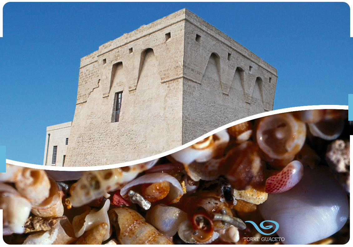
TORRE GUACETO
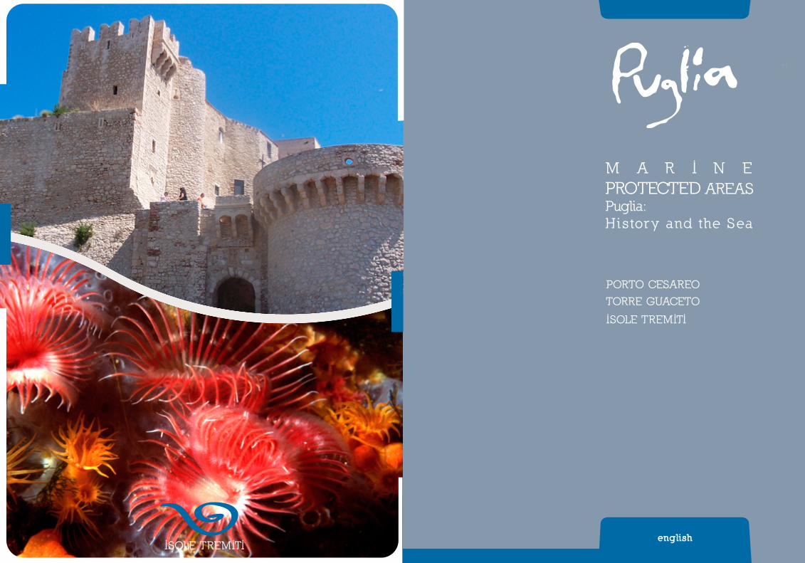
37
ISOLE TREMITI

Introduction
A crystal clear sea, with a thousand shades of blue, reflects the light of Puglia.There are the marinas at the north of the Gargano, found near the wetlands and salt lakes
which face the splendid Tremiti Islands. There is the rocky promontory interspersed with marvel-lous sandy bays. From here we go down to the salt marshes and reach the long coastline of the Adriatic, a sea celebrated by poets and writers, with its green-blue waters. It looks towards the East and evokes the ships of the travellers and war-makers who have safeguarded these waters over the centuries.
Behind the coastline there are majestic cathedrals, fortified castles, charming little ports and the shelters of fishing boasts found between the magical sand dunes that overlap into the reserve of Torre Guaceto and end at Brindisi, the historic marine city and transit point for many people.
Finally there is the Ionian Sea, with Gallipoli and Porto Cesareo that look over such transparent waters, it could be Caribbean. And there is Taranto with its two seas, the capital of Magna Grecia, the homeland of its culture and the central point of its millennial fascination.
The coastline of Puglia makes it special: it has irresistible attractions and surprising colours, it is rich in history and poetry. It intrigues the traveller and ensnares him, capturing him in the splendour of its waters, the warmth of its welcome, the fragrance of its ancient recipes and in the vitality of its peoples.
Silvia GodelliApulia Region Councillor for Culture,
Tourism and Mediterranean Affairs
This guide focuses its attention on the naturalistic and historical-cultural heritage of about 800 kilometres of Puglian coastline. We suggest some itineraries taking as our point of reference the Marine Protected Areas (MPAs) of the Tremiti Islands which belong to the Gargano National Park, and of Torre Guaceto and Porto Cesareo. Our starting point are these areas of particular inter-est and we move on to neighbouring stretches of coastline and adjacent rural areas, in order to broaden our knowledge of their nature, history and archaeology.
The coastal itineraries are divided into three major areas:• the Gargano coast (with the Gargano itinerary) which illustrates the coast of the upper
Adriatic and refers to the PMA of the Tremiti Islands;• the mid-Adriatic coast of the Salento with its Adriatic itinerary which starts at Monopoli
and ends at Brindisi and includes the PMA of Torre Guaceto;• the Ionian coast of the Salento region, with the Ionian itineraries, which extends from
Gallipoli to Taranto and includes the PMA of Porto Cesareo.
Puglia’s protected coast
Puglia boasts of the most extensive coastline in Italy – 800 kms. It offers breathtaking views and contains many areas of naturalistic interest recognised nationally and internationally. It is very varied and we can find wetlands, high rocky cliffs, long sandy beaches accompanied by lines of dunes covered with pine and juniper woods and low lines of cliffs interrupted by inti-mate sandy bays. The European Union and some International Conventions have given a meas-ure of protection to some of our coastal areas, in order to maintain the high level of biodiversity to be found here and protect the more characteristic areas of the region.
Puglia, while having a limited surface area and a high density of residential areas, can be said to show a high level of biodiversity when compared with the rest of the country.
In Puglia we find 43% of the national total of habitats included in the Habitat Directive 92/43/EEC, 65% of nesting birds and 44% of mammals. These data demonstrate Puglia’s rich-ness and the need for adopting concrete measures for conserving this heritage.
The ecological importance of Puglia is confirmed by a network of protected areas which, ac-cording to various calculations, protect about 13% of the area of the region.
The regional system of protection is formed by a mosaic of areas with various levels of protection. There are 2 National Parks (the Gargano National Park and the National Park of the Upper Murgia), 3 Marine Protected Areas (Torre Guaceto, the Tremiti Islands and Porto Cesareo), 16 National Nature Reserves, besides a network of 18 regional protected areas.
engl
ish
MA
RIN
E P
ROTE
CTE
D A
REA
S
Puglia: History and the Sea
38 39

L A G O D I V A R A N O
L A G O D I L E S I N A
F O C E D IV A R A N O
FO
RT
OR
E
CA
N D E L A R O
T R I O L O
SA
L
SO
LA
C E L O N E
C A
ND
EL
AR
O
SP53
SP53
SP53
SP53
SP53
SP54
SP52
ter
SP52bis
SP52
bis
SP528
SP528
SP50
SP50
SP57
SP55
SP43
SP43
SP22
SP22
SP22
SP22
SP22
SP26
SP26
SP48
SP28
SP28
SP28
SP27
SP27
SP29
SP51
SP51
SP51bis
SP41
SP41
SP41
SP50bis
SP46bis
SP42
SP42
SP40
SP40
SP49
SP38
SP37
SP37
SS16
SP38bis
SP39
SP39
SP39
SP35
SP35
SP35
SP33
SP33
SP36
SP36
SP36
SP32
SP32
SP35
SP35
SP31
SP31
SP41bisSP41bis
SP41bis
SP42
bis
SP42
bis
SP13
SP13
SP30
SP30
SP46
SP11
SP10
SP12
SP12
SP58
SP25
SP25
SP24
SP23
SP74
SP20
SP16
SP16
SP10
9
SP18SP18
SP17
SP17
SP8
SP9
SS89
SS89
SS89
SS89
SS89
SS89
SS89
SS89
SS89
SS89
SS89
SS89
SS528
SS272
SS272
SS272
SS272
SS272
SS27
3
SS89dir1
SS693
SS693
SS693
SS693
SS693
SS16
SS16
SS16
SS16
SS16ter
SS16ter
SS16ter
SS159
A14E55
A14E55
A14E55
S.Rocco
S.Mariadi Calenella
S.Pietro sul Monte Tabor
S.Michele
S.Biagio
S.Nicola
S.MariaLa Pura
S.Mariadel Canneto
S.LorenzoMartire
Cappuccini
Cappuccini
S.Maria di Merino
Madonna di LoretoS.Mariadi Kalena
S.Mariadi Ripalta
Madonna d’Elio
città bizantina di Devia
Grottadi S.Michele
Bagno di Varano
Pugnochiuso
dell’Aglio
San Felice
Porticello
Sfinale
Usmai
CalalongaMonte Pucci
dei Preposti
CalarossaMileto
villaggio deipescatori
San Lorenzo dell’Aglio
Santa Croce
San Francesco
ManaccoraSan NicolaMontePucci
Casalini-Sfilzi
Malacologico
Etnografico
Maratea
FO
RE S T A U M B R A
P
R
O
M
O
NT
OR I O D E
L
GA
RG
A
N
O
MattinataMonte Sant’AngeloSan Giovanni Rotondo
San Marco in Lamis
San SeveroTorremaggiore
San Paolo in Civitate
Apricena
Poggio Imperiale
Lesina
Marina di Lesina
San Nicandro Garganico
Cagnano Varano
Carpino
Lido del Sole
Rodi Garganico
Ischitella
San Menaio
Vico del Gargano
Peschici
Vieste
Rignano Garganico
Manfredonia
-85
-55
-50
-70
-90
-80
-60
-65
-75
-35-45
-40
-80
-75
-65
-80
-65
-75
-75
-30
-20
-10
-5
-25
-15
-20
-15
-25
-15
-5
-25
-25
-5
-20
-5
-5
-5
-5
-30
-25
-30
-5
-5
-70
-70-75
-75
-75 -80
-85
-90
-70-65-60
-45
-40
-5-1
5
-20
-25
-30
-35
-40
-45
-50
-55-60-65-70
-80 -95
-85
-90
-100
-40
-75
-85
-80
-10
-40 -45
I S O L A S A N D O M I N O
I S O L A S A N N I C O L A
I S O L A C R E T A C C I O
I S O L A C A P R A I A
I S O L A P I A N O S A
0 10
20
30
40
50
60 70 80 90 100 110 120
130
140 150
160 170
180
190 200
210 220
230 240 250 260 270 280 290 300
31
0
320
330
340
350
Itinerario garganico - Garganic itinerary AREE MARINE PROTETTE DI PUGLIA Puglia Storie di Mare
The great Roman historian Livy, who wrote at the end of the 1st century BC and the beginning of the 1st century AD considered the Adriatic coasts “not to be suitable for ports of call” (importuo-sa Italiae litora). He wasn’t the only one to think so: his contemporary Strabo, the author of the Greek work Geography, defined them more or less in the same way as, alimenoi, “without ports”.
It was difficult enough to navigate in this ‘angry sea’ iratum mare – as the poet Horace puts it, without adding to it the perils of piracy which for centuries was a real calamity for commer-cial trade.
But this did not stop the Adriatic functioning as a necessary means of communication with Greece and the Orient. Puglia in particular, that natural ‘stopping off point in Italy’ which faces the Adriatic, played an active role in the commercial circuits of the Mediterranean; and these influenced its material culture, the way in which settlements were built and, more generally, its economic, social and cultural life, at least from the late Bronze Age (middle of the 2nd Millen-nium), when it was reached by Mycenaean traders, until the modern age.
One of the particular aspects of this land, embraced by two seas, is, therefore, its maritime vocation, which has produced over the centuries, contacts, exchanges and influences: not only ideas travelled with the sailors, but also myths and heroes, like Virgil’s Aeneas who with his companions landed in the Salento region and like Diomedes, the hero of the sea and founder of the cities of Daunia (amongst other things).
The waters around Puglia preserve numerous archaeological remnants of these relationships, which are mentioned in our proposed itineraries, and which also draw attention to the underwa-ter archaeological stratum in its various historical phases.
We can follow this route in our minds, setting sail from the Islands of Diomedes (the islands of Tremiti) an important commercial port in the Roman age, whose waters hold numerous relics of ships, and visiting the archaeological sites which embellish the coast of the Gargano. Fol-lowing the ancient coasting routes, we can dock at Torre Santa Sabina and Torre Guaceto and climb the rainwater gullies inland until we find the extensive rock settlements of Puglia and the centres of the Messapian people. On the other hand we could explore two city-ports, Egnazia and Brindisi, which were for centuries strategic military and commercial bases for exchange with the Orient. Or we could sail round Santa Maria di Leuca and along the Ionic Coast, from Nardò to Porto Saturo, to discover the Messapian civilization and stop at San Pietro in Bevagna, where there are 23 sarcophaguses made of Thassos marble, the load of a ship which was destined for Taranto, but which unfortunately sank between the end of the 2nd and the beginning of the 3rd
century AD. Finally, we can reach safety, sailing in the two seas of Taras, the capital of Magna Grecia, and admire its treasures at the archaeological museum of Taranto (known as MARTA).
Have a good journey!
Archaeology «… the Atlantic and Pacific are oceans which divide us,
the Mediterranean makes us neighbours,and the Adriatic brings us into intimacy»
P. MATVEJEVIC, The Mediterranean. A New Breviary, It. trans., Milan 1991
Gargano itinerary
The marine protected area
TREMITI ISLANDS
engl
ish
MA
RIN
E P
ROTE
CTE
D A
REA
S
40

42 43
From the naturalistic point of view, the Gar-gano (also known as Italy’s Spur), a promon-tory of about 2.000 km2, surrounded by steep escarpments and placed between the Adriatic sea and the Tavoliere plain of Puglia is the home to a high level of biodiversity due to its many habitats which run from the coast (with extensive and uncontaminated areas of dunes, sheer white cliffs, and intimate low inlets ) to the hills and mountains further inland, with the presence of woods (it has the highest den-sity of woods in Puglia), lakes, water courses, underground reservoirs in the interior, grazing land and steppe.
The difference in height between the coast-line and Mount Calvo near San Giovanni Roton-do is 1.055 metres; the geological substratum is predominantly calcareous; fresh water is provided by torrential watercourses which run through deep valleys, with steep rocky walls. For the most part, these watercourses run to the sea, but on the northern side there is a series of canals, often the result of drainage work, whose waters feed the lakes of Lesina and Varano. The scarcity of fresh water inland is an indication of how carstic the terrain is. Indeed, the majority of rainwater is lost below ground. The grottos are points of transit for the flow of water and create points of contact between the surface and underground water. A common feature of limestone terrain, which is often found on the promontory are the dolines, enormous natural funnel-like water collectors, which are the remains of ancient caves whose vaults have collapsed and which in several cases form more or less permanent stretches of water called cutini.
For the most part the coast is high and
rocky. But there are sandy shores, especially on the north side (such as the Lakes of Lesina and San Menaio). The notable development of the coast, the ruggedness of the terrain and its geographical isolation are all factors which have had an enormous influence on the natu-ral characteristics to be found in the Gargano. There are more than 39,000 hectares of wood and Mediterranean maquis, 18% of the land area. This is a significant figure, as in Puglia as a whole, woodland and maquis amount to only 5% of the total land area of the region. But its woodlands are notable not only for their ex-tensiveness but also for their diversity. On the southern and eastern coasts the pine woods of Aleppo pines predominate. As we go inland, steadily climbing, we find woods of Holm oak, Italian oak, Turkey oak and beech trees (The Forest of Umbra). More rarely, spread out in small areas there are white hornbeam woods (in the Quarto Wood near Monte S. Angelo) and oriental hornbeam.
The rocky habitat which predominates in the Gargano, plays host to a varied community of plants which in Spring reveal themselves in a profusion of splendid flowers.
The Campanula del Gargano (a type of bellflower), the Enula candida, the Star of the Gargano and the Widow of Dallaporta are plants which are to be found in this habitat and, as their names suggest, are particular ex-amples of their species, native to the Gargano or to both Adriatic coasts. And the pasture-land is no less a rich habitat, when compared to the rocky terrain; there are many species which produce spectacular flowers, such as the Gargano Iris and many different species of orchids.
The Marine Protected Areas of the Tremiti Islands, instituted by Ministerial Decree 14/07/1989, concerns the stretch of sea near the archipelago. It is made up of 1,466 hectares and is an area of rich beauty both for the un-contaminated nature of its sea waters and for its landscapes and historical architecture to be found especially on the two largest islands. For their enchanting and pristine beauty, they are called the ‘Pearls of the Adriatic’.
The Tremiti archipelago is about 13 miles to the north of the promontory of the Garga-no, and includes the islands of San Domino (the largest), San Nicola, Capraia, Pianosa, the furthest away, around 11 miles from the other islands, and by the small island called Cretaccio.
Their coasts rise up some tens of metres above the sea. There are various grottos which open up to the sea, among which the Grotta delle Viole and Bue Marino are visitable by boat. The waters of the archipelago include important habitats which are coralligenous or precoralligenous, on which numerous plant and animal species settle, including porifers, cnidar-ians (in particular gorgonian and madreporar-ian) policheti, bivalves, echinoderms and tuni-cates. The Posidonia oceanica (Neptune Grass) is also present within the archipelago, together with Cymodocea nodosa, present in one of its ‘B’ zones, two seed producing plants of extreme importance in the Mediterranean.
In the Tremiti archipelago, the fringe of Cystoseira particularly (Cystoseira amentacea) reaches high levels of cover particularly at Pi-
anosa; the presence of this alga leads to a local increase in biodiversity. The presence of Cla-docora caespitosa is also extremely important, being the largest colonial madreporarian in the Mediterranean, which grows on rocky or detrital sea beds, even in shallow waters and can form cushions even of 50cms in diameter at a depth of between 5 and 40 metres.
At the foot of the cliffs which plunge down as far as 30 metres in depth, there are to be found sea fan, sponges of every variety and expanses of seaweed which provide a natural habitat for gilt head bream, white sea bream, sea bream, squid and moray eels.
In 1998 the largest statue of Padre Pio ever realised (and also the largest underwater statue in the world) was placed at a depth of 10 metres near the coast of Capraria island. The statue is really imposing: it is 3 metres high, weighs 1,200 kgs plus the 1,100 kgs of its base.
The trees to be found on the island of San Domino are the Aleppo Pine and in higher ar-
The marine protected areaof the Tremiti Islands
Puglia: History and the Sea
Gargano itineraryen
glis
h
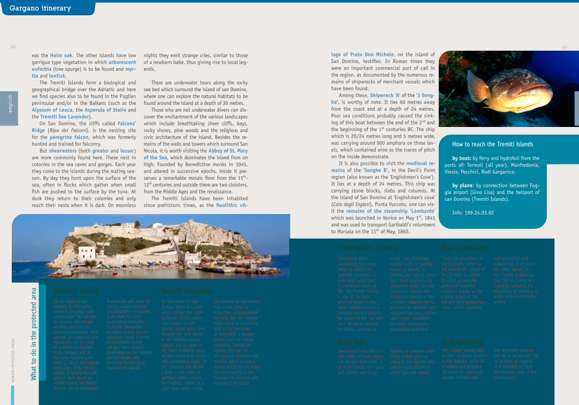
44 45lage of Prato Don Michele, on the island of San Domino, testifies. In Roman times they were an important commercial port of call in the region, as documented by the numerous re-mains of shipwrecks of merchant vessels which have been found.
Among these, Shipwreck ‘A’ of the ‘3 Seng-he’, is worthy of note. It lies 60 metres away from the coast and at a depth of 24 metres. Poor sea conditions probably caused the sink-ing of this boat between the end of the 2nd and the beginning of the 1st centuries BC. The ship which is 20/24 metres long and 5 metres wide, was carrying around 900 amphora on three lev-els, which contained wine as the traces of pitch on the inside demonstrate.
It is also possible to visit the medieval re-mains of the ‘Senghe B’, in the Devil’s Point region (also known as the ‘Englishmen’s Cove’). It lies at a depth of 24 metres. This ship was carrying stone blocks, slabs and columns. At the island of San Domino at ‘Englishmen’s cove’ (Cala degli Inglesi), Punta Vuccolo, one can vis-it the remains of the steamship ‘Lombardo’ which was launched in Venice on May 1st, 1841 and was used to transport Garibaldi’s volunteers to Marsala on the 11th of May, 1860.
eas the Holm oak. The other islands have low garrigue type vegetation in which arborescent euforbia (tree spurge) is to be found and myr-tle and lentisk.
The Tremiti Islands form a biological and geographical bridge over the Adriatic and here we find species also to be found in the Puglian peninsular and/or in the Balkans (such as the Alyssum of Leuca, the Asperula of Stalio and the Tremiti Sea Lavender).
On San Domino, the cliffs called Falcons’ Ridge (Ripa dei Falconi), is the nesting site for the peregrine falcon, which was formerly hunted and trained for falconry.
But shearwaters (both greater and lesser) are more commonly found here. These nest in colonies in the sea caves and gorges. Each year they come to the islands during the mating sea-son. By day they hunt upon the surface of the sea, often in flocks which gather when small fish are pushed to the surface by the tuna. At dusk they return to their colonies and only reach their nests when it is dark. On moonless
nights they emit strange cries, similar to those of a newborn babe, thus giving rise to local leg-ends.
There are underwater tours along the rocky sea bed which surround the island of san Domino, where one can explore the natural habitats to be found around the island at a depth of 30 metres.
Those who are not underwater divers can dis-cover the enchantment of the various landscapes which include breathtaking sheer cliffs, bays, rocky shores, pine woods and the religious and civic architecture of the island. Besides the re-mains of the walls and towers which surround San Nicola, it is worth visiting the Abbey of St. Mary of the Sea, which dominates the island from on high. Founded by Benedictine monks in 1045, and altered in successive epochs, inside it pre-serves a remarkable mosaic floor from the 11th-12th centuries and outside there are two cloisters, from the Middle Ages and the renaissance.
The Tremiti Islands have been inhabited since prehistoric times, as the Neolithic vil-
MA
RIN
E P
ROTE
CTE
D A
REA
S
Puglia: History and the Sea
Gargano itineraryen
glis
h
Wha
t to
do
in t
he p
rote
cted
are
a Visitors’ Centre
Boat excursions
On the Island of San Domino, an information centre is presently under construction. This will also be used for educational seminars focusing on environmental issues. Here you will get comprehensive information on the range of activities for tourists in the Gargano and all the facts concerning the history, culture and natural landscapes of the Tremiti Islands. A maxi-screen will project films about the Tremiti Islands, the Marine Reserve and its inhabitants.
A web-point will allow the user to navigate through the possibilities for tourists in the Park, to create personalised itineraries, to receive information on where to stay and on organised events. A series of educational boards will give more detailed information on the habitats and the marine and terrestrial species to be found on the islands.
There are excursions on tourist boats, either to sail around the island of San Domino to admire its coast, a veritable gallery of beautiful creations thanks to the erosive action of the sea and wind (producing coves, arches, grottoes
and wonderful rock sculptures), or to reach the other islands in the Tremiti archipelago (San Nicola, Cretaccio e Caprara), including the possibility of stopping to bathe in these beautiful waters.
Nature excursionOn the island of San Domino there is a path which follows the entire perimeter of the island, from which run off shorter paths which lead through the pine woods or the Mediterranean maquis and to some of the most beautiful coves on the island or to places with enchanting views. On the island of San Nicola, a path in the midst of garrigue which crosses the Tagliata, comes to a wide open space called
the plateau of San Nicola. This is the home to important archaeological remains, like the famous tomb which is commonly held to be the tomb of Diomedes, a Roman Domus and the Libyan cemetery. During the Spring, you can go discovering splendid wild orchids, which create a strong attraction in Puglia and particularly in the Gargano for tourists who are lovers of nature.
Boat hire Bird watching
How to reach the Tremiti Islands
by boat: by ferry and hydrofoil from the ports of: Termoli (all year), Manfredonia, Vieste, Peschici, Rodi Garganico.
by plane: by connection between Fog-gia airport (Gino Lisa) and the heliport of san Domino (Tremiti Islands).
Info: 199.24.03.02
Specialised firms offer a vast range of boats which can let you appreciate, in all their beauty, the coves and grottos and to go
bathing in tranquil spots. Using a boat you can enjoy to the full the wild and tranquil nature of these splendid islands.
The Tremiti Islands, due to their strategic position in the Adriatic, serve as a resting and stopping off point for numerous species of birds who
are migrating towards the NE in spring and SW in autumn. In summer it is possibile to hear the famous song of the shearwaters.
Underwater activitiesSpecialised divers accompany you under water to admire the splendid colourful sea beds which play host to numerous forms of life. The Tremiti Islands is one of the most precious jewels in the whole Mediterranean, a veritable natural paradise for lovers of the sea, with over 40 places suitable for diving, catering to
every taste (following coastal walls, in shallow water, on wrecks, in grottos, etc) and at every level from beginners to advanced, giving you the chance to observe the numerous species of fish, shellfish, molluscs not to mention the splendid and colourful barriers covered with cluster anenomes, sea lilies, spirographs, gorgonians and coral.

46 47
derwater archaeology offers a general introduc-tion to the methods and techniques of research and illustrates the discoveries made along the Daunian coast.
In the section of stone remains there is ma-terial that comes from the Archaeological Park of Siponto, the last stage of this itinerary. The Roman colony founded in 194 BC was for centu-ries an important commercial port for the trading of cereals which were transported from the land
of the Tavoliere and exported even to the other side of the Adriatic. The archaeological site pre-serves a part of the surrounding wall from the beginning of the 2nd century BC, traces of public buildings, the old Christian basilica with mosaic floors and the vast necropolis established around the building. There are also ancient Christian burial sites and the majestic Romanesque church of Saint Mary, in whose crypt the remains of the baptistery are preserved.
The Tremiti Islands are the ancient islands of Diomedes, whose story is, according to the leg-end, linked to the myth of the Greek hero Dio-medes, king of Argos. Moving along the coast, from Peschici to the lido of Siponto, we re-trace the stages in the history of the peoples who occupied the naturally formed caves and the bays that faced the sea, and through which people, ideas and goods were transported.
The promontory of the Gargano, reaching into the sea, was already inhabited by small groups of hunters from the Palaeolithic peri-od. These people found shelter in the numerous grottos on the coast and exploited the deposits of flint to make tools and utensils. During the Bronze Age (II Millennium), the coastal area between Vieste and Peschici was occupied by people who lived in villages of huts and traded with the eastern Mediterranean. The great Cave of Manaccora, a spacious natural grotto, which can be visited in the bay of the same name, bears witness to the presence of these people. It preserves traces of handicrafts and the use for funerals of the numerous gorges which open up along the walls.
Between the 9th and 8th centuries, the Daunian Civilisation came into being. Its set-tlements developed near the rivers and the sea. Only its tombs are well known, simple ditches carved into the rock (such as at Monte Tabor, Monte Civita and Monte Saraceno). The highest expression of Daunian culture is to be found in their stele, rectangular blocks of limestone, engraved on both sides with scenes of every-
day life and used, perhaps as funerary stones (kept in the National Museum of Manfredo-nia). During the entire Roman age, the coastal valleys of the Gargano were occupied by farms and residential villas, some of which were large and carefully decorated, belonging to the richer landowners who devoted themselves above all to the production of olive oil: the remains of the villas of Santa Maria di Merino bear wit-ness to this stage. They are to be found next to the sanctuary of the same name in Vieste with the villa of Agnuli near the port of Mattinata.
Staying in Vieste, we can walk in the WWF archaeology and nature reserve called La Sala-ta. It is next to the sea and a stream. Here we can visit the remains of one of the complex un-derground burial sites, in which the Christians of the first centuries AD buried their dead. The necropolis is made up of five burial sites and by around eighty burial niches carved into the wall of rock which is 50 metres high. The nature re-serve makes an ideal habitat for rich vegetation and various species of fauna, including amphib-ians, reptiles, barn owls and jays.
Continuing along the coast up to the most important commercial port in the area, Man-fredonia, you can visit the National Archaeo-logical Museum, within the Swabian-Angevin castle. Walking through the museum means you can improve your knowledge of the history of the area and of the original remains of the Dau-nian culture, the stele. A section devoted to un-
Around the protected area
Historic-archaeological itinerary
The naturalist’s itinerary
A high road with wonderful views runs round the perimeter of the Gargano promontory, passing the towns of Manfredonia, Mattinata, Vieste, Peschici, Rodi Garganico, Cagnano Var-ano and Sannicandro Garganico. This is part of the transport infrastructure in the Gargano: it serves all the coastal localities and, at various points, allows access inland.
The National Park of the Gargano was insti-tuted in 1991. It has an area of around 121.000 hectares and includes the Tremiti islands and a large section of the Gargano promontory.
Among the other protected areas to be found here, whose boundaries do not exactly coincide with those of the National Park, there are:
The Lakes of Lesina and of Varano The Lake of Lesina is a lagoon of brackish wa-ter with a maximum depth of 2 metres, sepa-rated from the sea by a cordon of dunes (Bosco Isola). This takes its name from the village to be found on the southwest side, easily reach-able by the A14 Motorway.
The dunes of Bosco Isola form a very inter-esting habitat due to the presence of trees and bushes which are important from a conserva-
tional point of view: there is a Holm oak wood, coastal maquis with juniper trees and garrigue with rosemary, heather, rock rose (including fumana vischiosa and Helianthemum Jonicum).
There is also a pine wood of Aleppo pines, the result of human intervention. The presence of the Clusius Rock Rose is also to be noted, which differs from the other rock roses in that it has leaves which are similar to those of rose-mary. Bosco Isola is the most eastern point in the area of distribution of this species, present in this area in only a very few groups and at great risk of extinction.
The Lake of Varano, the largest lake in southern Italy, is separated from the sea by a strip of land (Isola). The waters reach a depth of 5 metres, on average deeper than the Lake of Lesina. The strip of land (Isola) has a road along its entire length, where there are urban amenities including restaurants, hotels and camping sites.
Around the edges of the lagoon, the soil in many places is subject to changes in water level and is dry in summer and soaked in win-ter. Among the various plants that have settled here, there is the species of succulent annual
MA
RIN
E P
ROTE
CTE
D A
REA
S
Puglia: History and the Sea
Gargano itineraryen
glis
h

48 49The present layout was established in 1900,
by means of the completion of drainage works begun by the Bourbons.
Still in use today, 5-600 million kilograms of salt are produced annually, extracted using the ancient method of solar evaporation. This is a system of tanks, whereby sea water enters through canals and passing through ‘evaporat-ing’ tanks and ‘salting’ tanks, reaches concen-trations of 300 kilograms of salt per cubic metre of water. About 30 million cubic metres of sea water feed the salt marshes each year.
This is a place of extraordinary naturalistic value. It is a National Nature Reserve, and forms Wetlands of International Importance. Here a balance is attempted between the economic and productive aspects of the area and the en-vironmental considerations.
The presence of salt has a strong effect on every form of life. The dominant habitat
is formed by Salicornia. Birds dominate the wildlife here, and these are mainly water birds, abundant in every season. In winter we can see the anatidae (such as the widgeon and com-mon shelduck) which visit the tanks of the salt marsh. In the mating season species such as the flamingo and the slender-billed gull which form dense colonies on the islands that form from the erosion of embankments of the basins. These embankments are reconstructed from time to time and what is left of the old ones is left and forms a precious nesting site for the ground nesting birds as they are safer, here on the islands, from the threats of animals of prey. At the edge of the vegetation the avocet and the black-winged stilt make their nests. In the migrating season there are numerous mud-dwelling birds, including dunlins and sandpi-pers which gather in their thousands.
plants such as Granata Irsuta (Hairy Pome-granate) and Salicornia Europea. The first is thought to be at risk of extinction in Italy and the second is gathered, preserved and con-sumed by local inhabitants.
It is interesting to note the underwater wildlife to be found in the two lakes, used for food, particularly the eel. Eel fishing is prac-tised on picturesque boats called sandali.
But the aquatic bird life is particularly inter-esting to the naturalist, with species that are typical of this environment: there are coots, grebes, little grebes and birds of the Anati-dae family such as pochards, tufted ducks, teals and mallards. In the cane-brakes, which enclose certain stretches of the lakes, there are communities of passerines including the Great Reed Warbler, the Reed Warbler and the Sedge Warbler. At dusk thousands of birds reach the cane-brakes to pass the night: swallows and starlings for example. Among the reptiles there are a significant number of land tortoises which live in the bushy areas on the edge of the lakes.
The Forest of Umbra The Forest of Umbra lies at about 800 mtrs a.s.l. The word Umbra means “shady”, because of the density of the trees. Indeed, the character-istic element of this reserve is the woodland, for the most part made up of beech woods. In the undergrowth numerous plant species which flower in spring are to be found, such as the snowdrop, the anemone of the Appenines, ramsons, and the cyclamen. There are not only beech trees to be found in the Forest of Um-bra. There are also woods of Turkey oak, Holm oaks, yew, Italian oaks, laurel and lime trees. (In the case of the latter these are limited to gorge habitats).
These are the unique environments in the region, in which interesting species of non-migratory Italian wildlife have survived. These include the Italian roe deer, wild cat and wolf among the mammals. Amongst the birds there are the eagle owl, five species of woodpecker (green, great, middle and lesser spotted and white-backed) and birds of prey like the lanner falcon and the short-toed eagle. Among the reptiles the presence of the four-lined snake (Elaphne quatuorlinea), the smooth snake (Co-ronella austriaca) and the Hermann’s tortoise is to be noted.
The roe deer, an important native animal of Italy, lives in the wild only in certain areas of Puglia, Calabria and Lazio. In order to preserve this species important projects are underway to maintain the precious groups that survive and to attempt to repopulate areas in which it once lived.
The Salt Marshes of Margherita di Savoia They are the largest salt marshes in Italy (4500 hectares). They are human constructions, made from the transformation of Lake Salpi, a coastal basin of stagnant salt water from which the Daunian city on the lake, the ancient Salapia, took its name. The collecting of salt began in this area around the 3rd century BC: Pliny the Elder speaks of the harvesting of the salt that accumulated naturally. The area was a hunting ground of the Emperor Frederick II, mentioned in the work, “De arte venandi cum avibus” (On the art of hunting with birds).
Gargano itineraryen
glis
h
Every year on the 15th of August there is a traditional marine procession of the patron saint of the Tremiti Islands, Saint Mary of the Sea, Our Lady of the Puglian archipelago. It is a fascinating and moving rite which attracts and enthrals many visitors. Every year many islanders and tourists attend this religious celebration on the sea: the boats, carrying the congregation, set off from the quay of San Domino and reach the jetty of San Nicola, where they are joined by the statue of the Madonna, which comes from the church of the historic fortress. The statue is then placed on board a boat which is decked out for the festival, and the civic dignitaries also embark. The naval procession then makes its way to Cala dei Turchi (Turks’ Cove) to hear the mass and for the laying down of the traditional crown of flowers in the sea. Then everyone returns to the islands where the celebrations begin with plays, events and magnificent firework displays.
Popu
lar
trad
ition
sTr
aditi
onal
rec
ipes
fro
m the
Tre
miti
Isla
nds
and
the
Garg
ano Ragout of boulter fish
Boulter fish ragout is prepared with fresh fish. De-bone the fish and chop it either with a machine or a suitable knife. Fry a diced onion with extra virgin oil on a low heat, without browning, and add the chopped fish after a few minutes. Mix it around. Add a glass of white wine which should be evaporated on a fierce flame. Then add the tomato sauce judging the quantity by the amount of fish. Add salt and parsley at the end of cooking. It should be cooked on a slow flame. And then it’s ready! This ragout is to be added to various types of pasta.
Eel soupIngredients: 800 grams of eels from lake Lesina, 2-3 potatoes, 2 tomatoes, half an aubergine, a courgette, half a green pepper, a small onion, a celery stalk, a sprig of wild chicory, a handful of turnip top broccoli, slices of home-made bread, extra virgin olive oil, salt, hot red peppers.Cooking and preparation time: an hour.Peel and wash the vegetables. Scald the chicory in boiling water and then chop it into large pieces. Gut the eels, take off the head and tail, bone them and cut them into slices of between 3-4 cms. Put them into two litres of salted water and bring them to the boil. Skim off the foam and add the chicory, turnip tops and all the other vegetables, including as much hot red pepper as you want. Cook for about twenty minutes, adding more salt if necessary. Serve this soup, with fresh olive oil, in bowls in which you have already placed croutons.It was an everyday dish for fishermen who once laid in wait for the eels for months around the lake. Here they made piles of hay where they stayed day and night, waiting for the eels to fill their specially made traps. During these long waits, the fishermen cooked the eels with the wild herbs which grew on the banks of the lake.
The cuisine of the Gargano, characterised by the rediscovery of delicious rarities like toasted grain, is made of simple and genuine ingredients combined to produce an intense taste. The culinary tradition of the coast is a variation on the inland version, enriched with varieties of fish to be round in the waters of the Gargano and Tremiti Islands.

SP90
SP3
SP163
SP4
SP21
2
SP18
7
SP11
3
SP11
3
SP11
3
SP129
SP146
SP12
0
SP121
SP114
SP96
SP81SP81
SP1
SP2
SP77
SP225SP227
SP162
SP16
2
SP59
SP6
SP7
SP5
SP9
SP8
SP11
SP134
SP11
9
SP12
SP13
SP64
SP14
SP17
SP19
SP10
SP20
SP21
SP34
SP33
SP32
SP35
SP36
SP37
SP37
SP38
SP39
SP37bis
SP46
SP47
SP48
SP48
SP30
SP28
SP28
SP26
SP24
SP23
SP16
SP22
SP29
SP41
NSA2
87
SP43
SP80
SP80
SP79
SP79
SP81
SP81
SP82
SP82
SP87
SP86
SP83
SP74
SP69
SP45
SP70
SP71
SP56SP55
SP50SP
24
SP68SP69
SP70
SP51
SP67
SP71
SP71
SP40
SP72dir
SP66
SP66
SP72
SP74
SP75
SP45
SP77
SP80
SP46
SP47
SP48
SP42
SP43
SP44
SP50
SP49
SP60
SP52
SP54
SP56
SP57 SP58
SP78
SP31
SP53
SP80
SP44
SS16
SS16
SS16
SS16
SS16
SS1bis
SS16
SS37
7
SS17
2dir
SS172
SS172
SS172
SS17
2
SS17
2
SS604
SS581
SS581
SS581
SS581
SS581
SS605
SS605E90SS7
E90SS7
E90SS7
E90
SS7
E55
SS16
E55
SS16
E55SS379
E55
SS379
E55
SS379
E55
SS613
Brindisi
Mesagne
Latiano
San Vito dei Normanni
San Michele Salentino
Grottaglie
Villa Castelli
Francavilla Fontana
Ceglie Messapica
MontemesolaStatte
Crispiano
Martina Franca
Alberobello
Fasano
Locorotondo
Cisternino
Carovigno
Ostuni
Monopoli
Polignano a Mare
Pezze di Greco
Montalbano
CARANNA??
Tuturano
San Paolo
PA L U D EL A V E L A
San Giovanni
Sciannolecchia
MA C C H I A S A N G I O V A N N I
F I O R E N T I N O
T E R R A E R O S A
The stretch of coast between the provinces of Brindisi and Lecce starts at Torre Canne - Torre San Leonardo (in the Regional Nature Reserve between Ostuni and Fasano), and ends at Torre Chianca on the coast near the city of Lecce. It is mainly level terrain, with a variation in height of only 0-200 metres a.s.l. The fresh wa-ter courses are not very big and mainly from rainwater. Many of them, in some stretches, sink into rainwater gullies called ‘lame’, rocky canals of limestone origin.
The coast can be either sandy (from Torre Canne to Torre San Leonardo), rocky in places, low (Torre Guaceto) and forms cliffs at Torre Mat-tarelle which reach a height of not more than 10 metres above the sea. The rest of the coast is sandy, accompanied by a cordon of dunes which are normally barely noticeable, but which in some places can reach considerable dimensions, as in the case of the stretch of sand to the east of Punta Penna Grossa, in the Reserve of Torre Guaceto and in the stretch of coast between Torre Canne and Torre San Leonardo.
The landscape is agricultural and vineyards obviously play a great economic and cultural
role. The olive tree also forms an essential part of the landscape. Ostuni and Fasano form part of the ‘agricultural park of ancient olive trees in the Upper Salento’, making the most of the centuries old olive trees in the area that de-scends to the coast.
The hot Mediterranean climate favours the presence of oak woods. Both evergreen trees like the Holm oak, Kermes oak and Cork oak (which here are at the most eastern point of their distri-bution) and deciduous trees like the Dalechamp and the Italian oaks are to be found here.
The uncultivated areas are mainly to found along the coast – whether sandy or rocky – the wet lands and the saltwater pools. For the in-terested observer, even the cultivated areas in-land can reveal the unexpected ancient remains of the previous natural landscape (oak woods, areas of Mediterranean maquis, pastureland, natural forming rock walls) set like jewels in the network of cultivated fields.
The state roads SS379 and SS16 are the principle means of communication allowing us to swiftly reach both towns and the various ar-eas of naturalistic interest.
51
The marine protected area
TORRE GUACETO
Adriatic itinerary

made colourful by varied Anthozoans including the beadlet anemone and the madreporarian Cladocora caespitosa, which is the biggest of the Mediterranean madreporarians and has the characteristic form of a cushion of flowers. Go-ing further down, Torre Guaceto offers the most spectacular environments to be seen in the Re-serve, the ‘prairies’ of Posidonia oceanica and the coralligenous habitat.
Among the dense posidonia there are a great number of species, including the largest bivalve mollusc in the Mediterranean, the noble pen shell, and Anthozoans such as the sand actinia (Condylactis aurantiaca).
At the edge of the posidonia prairies is an-other of the most important and spectaular habitats in the Mediterranean: the corallig-enous algal reefs, characterised by the pres-ence of gorgonians such as the yellow sea fan (Eunicella cavolinii) and white sea fan (E. singularis), with its thin ramified structure, of bryozoans such as False Coral (Myriapora trun-cata) and the fragile sea lace (Reteporella gri-maldii), of anthozoans such as the yellow clus-ter anemone (Parazoanthus axinellae), and of sponges, like the large Axinelles.
The area of the Reserve has preserved traces of human habitation which go back right to the 2nd Millennium BC. In fact, during the Bronze Age on the promontory of Torre Guaceto and on the two cliffs of Apani there were villages with defensive walls and made up of huts re-alised with wood and leaves, whose walls were plastered with clay. Only a few traces refer to the presence of inhabitants during the Mes-sapic Age (mid 7th-mid 3rd centuries BC), while after the Roman conquest of this area of coast and of the small islands close by, both were densely inhabited, as demonstrated by the find of ceramic materials. The Appian Trajan Way, which ran immediately upstream of the present swamp, caused Torre Guaceto to be included in the transport network which linked the villas and the rural settlements inland with their large productive complexes, (like the furnaces found at Apani). For the whole of the Roman age and up to the 5th-6th centuries, the area represented an important landing place, as the remains of a lighthouse present on the third small island and the relic of a shipwreck from the same time, which sank nearby, demonstrate.
The first steps to protect Torre Guaceto took place in 1991, with the institution of the Ma-rine Protected Areas, with a total of 2,227 hectares and 8.41 kms of coastline under its protection. In 2000 it became a National Na-ture Reserve, which includes 1.100 hectares of this area, characterised by a complex mosaic of natural and cultivated habitats which allow for a surprisingly high level of biodiversity.
There are three major types of habitat in the Reserve: the coastal habitat, the Mediterranean maquis and the wet lands.
The kentish plover, a small mud-dwelling bird, lays its eggs on the sands. The eggs are themselves sand coloured and they are camou-flaged with shells and leaves of posidonia sea-weed. Many species visit this habitat during the year, either to look for food or to rest during migration. The most distinctive is the oyster catcher, with its long and colourful beak.
Along the Reserve’s coastline, the stretches of sand are interrupted briefly by low rocks. Here basins of saltwater are formed, which are visited by crabs, and rock samphire, sea lav-ender and salicornia grow next to the sea.
Behind the dunes numerous species of ev-ergreen bushes grow in close contact and form Mediterranean maquis and garrigue. The species that grow are suited to confronting the heat and drought of summer: lentisk, alatern, wild as-paragus, bushy thyme, rosemary and myrtle. Among the animals to be found in the maquis habitat are the badger, a very shy and rare mam-mal, the three-toed skink and the green lizard.
Behind the dunes, where the water table begins, cane-brakes reign unchallenged. There
are a few other species that grow with canes such as the bellflower, which uses the stalks of the canes to climb up and expose its large white flowers to the sun. Birds are the main wildlife to be seen here. Some, like the great bittern, spend their lives in this habitat. Others, like the swallows and starlings, use it only to rest overnight. Other swamp birds, like the coot and the little grebe, build large floating nests that are anchored to the canes. In the parts where there is less salinity amphibians and reptiles such as pond turtles are to be found.
The diversity of underwater habitats in the sea at Torre Guaceto and the numerous species of great interest have to lead it being included as the ‘Marine Protected Area of Torre Guaceto’ in the List of Specially Protected Areas in the Medi-terranean for the conservation of Biodiversity.
Torre Guaceto can be appreciated simply by swimming with a mask and flippers, the first few metres underwater are populated by a ‘mantle of seaweed’, made up of various species of algae which offer shelter and a source of food to a complex community of organisms. A careful un-derwater exploration of the rocky coast means that you can see numerous lairs where fish be-longing to the Sparidae family, including white bream and saddled bream, find shelter. The common Serranids, such as the painted comber (Serranus scriba) and the comber (Serranus cabrilla), are a curious sight. One can also see fishes of the Labridae family such as the Medi-terranean rainbow wrasse (Coris julis) or the ornate wrasse (Thalassoma Pavo), which peep among the rocks when a visitor approaches.
In this deeper stretch of sea the scenery is
The marine protected areaof Torre Guacetoen
glis
hM
AR
INE
PRO
TEC
TED
ARE
AS
Adriatic itinerary
52 53

Wha
t to
do
in the
pro
tect
ed a
rea
Visitors’ Centre Children’s workshopsand evening eventsThe first useful step for
gathering information on how to explore and get to know the Reserve is the visitors’ centre Al Gawsit, situated near the village of Serranova, just outside the boundary of the Reserve. This space offers useful materials and information for the visitor to get to know the area and also has spaces which are used for exhibitions on particular subjects, educational videos, books and materials to consult and also a small bar with a
shop of organic products.The visitors can virtually visit the habitats of the protected area and get to know its most fascinating secrets, from those of the cane-brakes, to the colours and creatures of the sea bed using the reconstructions, videos and reproductions to be found in the marine room; they can travel in time and experience the history of the Reserve. In the visitors’ centre you can also hire bikes and buy mementoes of the Reserve.
In summer on the beaches workshops on particular subjects are held for children and there is an interesting programme of evening events. The children’s workshops use art, theatre, music and astronomy to approach natural and scientific subjects in a multidisciplinary way. The evenings at the Reserve naturally become part of the cultural programme
of Torre Guaceto, which offers a series of fascinating events which explore the local culture, caught between land and sea.
On foot, by bike, with mask and flippers by boat and… by trainBy bike you can discover the most intimate corners of the Reserve, among the age-old olive trees, manor houses and farmhouses, go to food and wine tastings and country picnics.Excursions on foot follow a path which is accessible for all, which starts from the wet lands at the ancient tower and ends at
the Mediterranean maquis, an area which has given rise to many myths and legends.To explore the reserve’s sea bed, you can go snorkelling: on the sea surface with a mask and flippers to discover an uncontaminated corner of the Adriatic sea. The more experienced can dive with
aqualungs accompanied by authorised diving guides.For those who love sailing, there are beginners’ courses and residential and visitors’ courses at various levels, to learn how to sail with keels, catamarans, and how to windsurf and use kiteboards.In the summer months
there is also another means of making a guided tour of the Reserve: with a miniature electric train, which at dusk every summer evening sets off from the beach of Punta Penna Grossa and reaches the tower promontory, passing through some of the most important places within the Reserve.
The itinerary leads to the discovery of the his-tory over the millenia of our ‘land of olive trees’ following in our mind’s eye the flow of the water which, from the spurs of the Murgia escarpments, run down the rainwater gullies (lame) and into the sea. The journey recounts the story of the communities who lived in these fertile and water rich lands, making use of natural shelters, the coastal plains and who travelled with their goods and ideas along the Adriatic coast.
Our journey begins at the archaeological park of S. Maria di Agnano, just outside the “white town” of Ostuni. In a fascinating land-scape of monumental olive trees one can visit the cave which was already used in the Upper Palaeolithic (25.000-10.000 years ago), as a shelter and place of ritual, by hunters. Here they buried a young pregnant woman, found by archaeologists in an exceptional state of pres-ervation. In the cave from the 6th century BC cults, devoted to a goddess were practised; then with a surprising but meaningful continuity of use, in the 16th century AD, a church was built there dedicated to the holy virgin and at the beginning of the 17th century a chapel was to be seen. The caves continued to be occupied for centuries: along the rainwater gullies indeed there was no shortage of fertile land, water and of a soft tufaceous rock, easy to dig out and work to make simple shelters and complex build-ings. The Park of Lama d’Antico, San Giovanni and San Lorenzo is one of the most extensive rock settlements in Puglia, used since prehis-toric times. In the park, rooms, workshops, and
animal stalls have been preserved together with three churches all almost completely carved out of the soft ‘tufo’ rock and decorated with fres-coes that belong to the 11th-12th centuries.
Placed on the boundary between Peuceta (the region around Bari before the arrival of the Romans) and Messapia and exposed to cultural influences from both land and sea, Egnazia was for centuries (from the first settlements of the 16th century BC to its sporadic occupation in the Middle Ages) a city port and an important part of the transport network. One can visit the remains of the city, walking through a fascinat-ing park, past rooms, productive complexes and public buildings situated on the stretch of the Trajan Way, which following a previous road, crossed the city and connected Rome to Brindi-si (a permanent exhibition on the Trajan Way is to be found in the National Archaeological Museum next to the park).
Although we do not know the exact position of the port of Egnazia, the numerous submerged structures, visible offshore from the inlets to the north of the acropolis are thought to be the jet-ties for anchoring ships. On the flat and sandy sea bed, at a depth of about 6 metres, the visi-tor can admire two parallelepiped walls realised in opus caementicium (stone, whitewash and pozzolana), and covered using a form of trellis, which go back to the end of the republican pe-riod and the beginning of the Imperial Age (1st
century BC-1st century AD). Around the bay, one can sometimes come across materials that were dumped in the port and which the tides and cur-
Around the protected area
Historic-archaeological itinerary
engl
ish
MA
RIN
E P
ROTE
CTE
D A
REA
S
Puglia: History and the Sea
Adriatic itinerary
54 55
How to reach the Reserve
by car: to the Visitors’ Centre from SS 379 Bari-Brindisi-Lecce road, take the exit for Serranova and continue towards Serranova; or to the Reserve from the SS 379 Bari-Brindisi-Lecce road, take the exit for Torre Guaceto-Punta Penna Grossa and follow the parallel road, next to the sea, until reaching the carpark at Punta Penna Grossa.
by train: the Reserve is 20 kms from the train station of Brindisi, 8 kms from Carovi-gno station and 99 kms from Bari station.
by plane: the Reserve is 15 kms from Brindisi airport and 112 kms from Bari air-port.

The Visitors’ Centre or Park House is situated in the former railway station of Fontevecchia, in Ostuni (province of Brindisi). Excursions and guided tours can be organised through booking
HOW TO REACH THE PARKThe wet lands of River Morelli from the SS
n. 379 Bari-Lecce road take the exit Ostuni-Pi-lone-Rosa Marina, and make for Pilone, take the parallel service road next to the sea and continue to the wet lands of the River Morelli
The Park Houseby car: from the SS n. 379 Bari-Lecce road
take the exit Ostuni-Pilone-Rosa Marina, and go towards Ostuni, following signs for ‘Casa del Par-co – ex stazione di Fontevecchia’, turning right for the Trajan Way, or from the SP 1 bis (ex SS 16) Ostuni – Fasano road, turn right at km 871 for Contrada Fontevecchia and follow the signs for ‘Casa del Parco – ex stazione di Fontevecchia’
by train: Bari-Lecce line, from Cisternino sta-tion follow the Trajan Way to the Park House
by plane: The park is 40 kms away from Brindisi Airport
Regional Nature Reserve ofthe Salt Flats of Punta della Contessa The Park has an area of 950 hectares and is situ-ated on the coast south of the city of Brindisi. The area inland is predominantly arable land which occupies 80% of the area of the protect-ed natural park. The main characteristic of the area is the presence of some pools behind the dunes which tend to dry out in summer (Salina Vecchia and Salinella). The great differences in water levels and their salinity produce the perfect habitat for particular plants, including spiral ditch grass (Ruppia cirrhosa), saltmarsh bulrush (Bolboschoenus maritimus), colonies of cordgrass (Spartina versicolore) of leafy rushes (Juncus subulatus) and of perennial salicornia. There are also colonies of annual salicornia, cress and the succulent hairy pomegranate (granata irsuta). There is also garrigue with Puglian heather and thymelaea hirsuta.
The area is of great interest to the natural-ist, as shown by the value and quantity of spe-
cies and habitats present and inserted in the di-rectives 79/409/EEC and 92/43/EEC and in the lists of the Red Book of Animals in Italy.
There are around 14 species of nesting birds in the Park and many others belonging to other phenological categories which are of interna-tional interest. Thousands of birds spend their winter here including ciconiiformes, anseri-formes and charadriiformes, seen in great num-bers during the migratory period. Among the most common species are: the great egret (Ar-dea alba) and the grey heron (A. cinerea), the wigeon (Anas penelope) and the pintail (Anas acuta). The black-winged stilt and the little tern (Sternula albifrons) nest here. In winter it is also possible t observe the flamenco and the common spoonbill (Platalea leucorodia), the mute swan (Cygnus olor) and the curlew.
HOW TO REACH THE PARKby car: drom the SS n. 379 Lecce-Brindisi-
Bari road, take the exit for Brindisi’s Industrial Zone, follow the coast road in the direction of Lecce. When you reach the Masseria “Villanova” turn left towards the educational farmhouse “La terra del Sale” of Anna Argento.
Arriving from Bari on the SS n. 379 road for Lecce, and after passing the city of Brindisi, take the exit towards the industrial zone and follow the same directions as above.
by train the Park is 5 kms from Brindisi rail-way station.
by plane: the Park is 7 kms from Brindisi airport.
Regional Naure Park ofthe Wood and Swamps of Rauccio The park has an area of 625 hectares, divided between agricultural areas and natural habitats. It is really typical of the rural landscape of the Salento. The Holm oak wood is what is left of ancient ‘Forest of Lecce’, which in the middle ages spread as far as Otranto and Brindisi. Be-tween the Holm oak wood and the sea there is a huge tract of wet lands (Specchia della Milo-gna; milogna is the name in the local dialect for a badger). It has a sandy coast, also with dunes that in places are well formed. Species of great beauty to be found here include the silk vine
rents periodically bring to the surface.The trail through ancient Brundisium can
begin from the Roman Columns, situated at the point where the Appian Way ended, which for centuries connected Rome with the port, a symbol of the city and of its vocation as cultural bridge to the East. A permanent exhibition about this monument has been set up in the Sala della Colonna, in the Granafei-Nervagna palace. A vis-it to MAPRI, the Provincial Archaeological Mu-seum, which is organised into various sections including one on underwater finds, allows us to get an overall picture of the historical evolution of the city and the surrounding area.
However, the history of Brundisium in ro-man times is directly legible from the palaces in the historic centre, on the mosaic floors to be seen in Via Casimiro and visiting the archaeo-logical area of San Pietro degli Schiavoni (preserved under the Verdi theatre in the cen-tre of Brindisi). Here there is a roman ‘insula’ (apartment building) with public and private buildings also with mosaics, thermal baths and stretches of paved streets. The remains of a ro-man age house are to be found nearby, at the Temple of Saint John of the Sepulchre, which is itself an interesting building on a circular plan from the 11th century.
The naturalist’s itinerary
Apart from the National Nature Reserve of Torre Guaceto, the other protected natural areas in the area are principally found along the coast. Going from North to South we find the Regional Natural Reserves: the coastal dunes of Torre Canne and Torre San Leonardo, the salt plain of Punta della Contessa and the wood and wet lands of Rauccio.
Regional Nature Reserve of the coastaldunes from Torre Canne to Torre San Leonardo This protected area was instituted by Regional Law 31/2006, and lies between Ostuni and Fas-ano for about 1.100 hectares, along 8 kms of coast and moving inland among the centuries old olive trees and grazing land.
There are numerous habitats to be found in the protected area, some of which are given priority by the European Union. These go from the long cordons of dunes covered with juniper trees (with some monumental examples which are 500-600 years old), to the pools behind the dunes where there are still fragile habitats which are the home to many migrant birds. It is possible to visit the area and walk along a net-work of paths and catwalks placed between the tanks of a 19th century fish farm where eels and grey mullet were raised using organic methods.
From the pools behind the dunes, following a series of paths, we reach the fossil dunes with pseudosteppe and the agricultural areas with arable fields and monumental olive groves, where
it is possible to visit historic manor houses of the 16th-17th centuries and medieval under-ground olive presses. The ancient olive groves are divided by deep limestone gullies, called ‘lame’ which run down to the sea. The lame are the home to a rich and variegated vegetation and interesting Byzantine rock settlements.
The visitors’ centre, called the Park House, is located in the old railway station of Fon-tevecchia, a small country station, which can be reached from the old Trajan Way. A network of cycle and walking routes between the old ro-man road and the rural lanes, allow us to get to know all the environments within the Park. The old Trajan Way which is signposted and has stopping areas and information points for cy-clists, is a part of the Adriatic Cycle path, one of the long routes of the national cycle network of Bicitalia which run from Venice along the Adriatic coast right to Santa Maria di Leuca (the southernmost point of Puglia).
There are many initiatives organised in the park, including excursions, guided tours and events. These start from the Park House at the old station of Fontevecchia and involve cyclists on holiday, or touring here, who arrive with their bike in tow, at the nearby railway stations of Ostuni and Cisternino (at Pozzo Faceto). Thanks to an agreement between the Region of Puglia, Trenitalia and South East Trains it is possible to transport your bike by train without paying any supplement.
engl
ish
MA
RIN
E P
ROTE
CTE
D A
REA
S
Puglia: History and the Sea
Adriatic itinerary
56 57
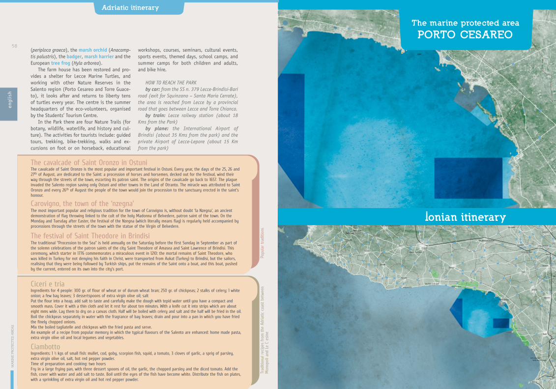
SP101
SP10
0
SP99
SP104
SP102
SP107
SP10
6
SP108
SP110
SP110
SP11
1
SP11
0dir
SP113
SP114
SP112
SP115
SP11
6
SP12
4
SP121
SP120
SP123
SP123
SP126
SP12
5
SP122
SP122
SP122
SP12
5
SP129
SP12
9
SP127SP129ter
SP128
SP118
SP117
SP86
SP86
SP134
SP130
SP131
SP132
SP13
6
SP13
6
SP135
SP137
SP141SP141
SP13
9
SP143
SP144
SP107
SP145SP219
SP78
SP82 SP81
SP80
SP7
SP603
SP90
SP92
SP87
SP52
SP94 SP93
SP53
SP51
SP51
SP51
SP54
SP96
SP57
SP97
SP98
SP59
SP58
SP60
SP61
SP62
SP63
SP64
SP68
SP74
SP75
SP75
SP65
SP109
SP109
SP174
SP174
SP359
SP359
SP359
SP219
SP21
7
SP255
SP111
SP111
SP110
SP11
3
SP220
SP21
SP17
SP17
SP17
SP10
4
SP101
SP95
SP79
SP78
SP327
SP365
SP102
SP97
SP4
SP4
SP4
SP5
SP96
SP100
SP29
6
SP230
SP92
SP15
SP15
SP10
5
SP106
SP120
SP10
3
SP4a
SP13
SP12
1
SP8
SP14
SP11
7 SP124
SP119
SP224
SP123
SP17aSP6
SP6
SP16
SP20
SP18
SP17
SP115SP114
SP286
SP286
SP112
SP261
SP17
SP129
SP90
SP194
SP52
SP19
SP53
SP361
SP215
SP33
0
SP282
SP54
SP221
SP53
SP70
SP69
SP43
SP50
SP51
SP47
SP85
SP340
SP140
SS7ter
SS7ter
SS7ter
SS7ter
SS7ter
SS7ter
SS7ter
SS7ter
SS17
2
SS605
SS16
SS16
SS613
SS613
SS101
SS10
1
SS274
SS7
SS7
SS106
Talsano
Leporano Pulsano
Faggiano
Roccaforzata
Monteparano
Uggiano Montefusco
Campomarino
Lizzano
Fragagnano
Carosino
San Giorgio Jonico
Lama
Monteiasi
San Marzano di San Giuseppe
Oria
Sava
Manduria
Torre Santa Susanna
Erchie
San Pancrazio Salentino
San Donaci
Cellino San Marco
Trepuzzi
Campi Salentina
Novoli
Guagnano
Salice Salentino
Torricella
Maruggio
San Pietro in Bevagna
Avetrana
Torre Colimena
Porto Cesareo
Veglie
Carmiano
Arnesano
Monteroni di Lecce
Leverano
Copertino
Nardò
Galatone
Sannicola
Alezio
Gallipoli
Santa CaterinaSanta Maria al Bagno
Taranto
Tuglie
Taviano
Squinzano
TorchiaroloSan Pietro Vernotico
Torre Lapillo
Inserraglio
M A R P I C C O L O
M A R G R A N D E
PA L U D EL A V E L A
T E R R A D E L L E G R AV I N E
R I S E R V E D E L L I T O R A L E TA R A N T I N O O R I E N TA L E
PA L U D E D E L C O N T E E D U N A C O S T I E R A - P O R T O C E S A R E O
P O R T O S E L VA G G I O E PA L U D E D E L C A P I TA N O
I S O L A D I S . A N D R E A - L I T O R A L E D I P U N TA P I Z Z O
SP359
SP359
SP359
SP10
9
SP122
SP340
SP14
0
SP141
SP286
SP11
3
SP220
SP21
SP112
SP11
4
Torre Colimena
Porto Cesareo
Torre Lapillo
Specchiarica
San Pietro in Bevagna
Torre dell’Inserraglio
0 100 200 300 400 500m50 150 250 350 450
50
100m
Scala
(periploca graeca), the marsh orchid (Anacamp-tis palustris), the badger, marsh harrier and the European tree frog (Hyla arborea).
The farm house has been restored and pro-vides a shelter for Lecce Marine Turtles, and working with other Nature Reserves in the Salento region (Porto Cesareo and Torre Guace-to), it looks after and returns to liberty tens of turtles every year. The centre is the summer headquarters of the eco-volunteers, organised by the Students’ Tourism Centre.
In the Park there are four Nature Trails (for botany, wildlife, waterlife, and history and cul-ture). The activities for tourists include: guided tours, trekking, bike-trekking, walks and ex-cursions on foot or on horseback, educational
workshops, courses, seminars, cultural events, sports events, themed days, school camps, and summer camps for both children and adults, and bike hire.
HOW TO REACH THE PARKby car: from the SS n. 379 Lecce-Brindisi-Bari
road (exit for Squinzano – Santa Maria Cerrate), the area is reached from Lecce by a provincial road that goes between Lecce and Torre Chianca.
by train: Lecce railway station (about 18 Kms from the Park)
by plane: the International Airport of Brindisi (about 35 Kms from the park) and the private Airport of Lecce-Lepore (about 15 Km from the park)
The marine protected area
PORTO CESAREO
Ionian itinerary
engl
ish
MA
RIN
E P
ROTE
CTE
D A
REA
SAdriatic itinerary
58
The cavalcade of Saint Oronzo is the most popular and important festival in Ostuni. Every year, the days of the 25, 26 and 27th of August, are dedicated to the Saint: a procession of horses and horsemen, decked out for the festival, wind their way through the streets of the town, escorting its patron saint. The origins of the cavalcade go back to 1657. The plague invaded the Salento region saving only Ostuni and other towns in the Land of Otranto. The miracle was attributed to Saint Oronzo and every 26th of August the people of the town would join the procession to the sanctuary erected in the saint’s honour.
The cavalcade of Saint Oronzo in Ostuni
The most important popular and religious tradition for the town of Carovigno is, without doubt ‘la Nzegna’, an ancient demonstration of flag throwing linked to the cult of the holy Madonna of Belvedere, patron saint of the town. On the Monday and Tuesday after Easter, the festival of the Nzegna (which literally means flag) is regularly held accompanied by processions through the streets of the town with the statue of the Virgin of Belvedere.
Carovigno, the town of the ‘nzegna’
The traditional “Procession to the Sea” is held annually on the Saturday before the first Sunday in September as part of the solemn celebrations of the patron saints of the city Saint Theodore of Amasea and Saint Lawrence of Brindisi. This ceremony, which starter in 1776 commemorates a miraculous event in 1210: the mortal remains of Saint Theodore, who was killed in Turkey for not denying his faith in Christ, were transported from Aukat (Turkey) to Brindisi, but the sailors, realising that they were being followed by Turkish ships, put the remains of the Saint onto a boat, and this boat, pushed by the current, entered on its own into the city’s port.
The festival of Saint Theodore in Brindisi
Popu
lar
trad
ition
s
Ciceri e triaIngredients for 4 people: 300 gr. of flour of wheat or of durum wheat bran; 250 gr. of chickpeas; 2 stalks of celery; 1 white onion; a few bay leaves; 3 dessertspoons of extra virgin olive oil; saltPut the flour into a heap, add salt to taste and carefully make the dough with tepid water until you have a compact and smooth mass. Cover it with a thin cloth and let it rest for about ten minutes. With a knife cut it into strips which are about eight mms wide. Lay them to dry on a canvas cloth. Half will be boiled with celery and salt and the half will be fried in the oil. Boil the chickpeas separately in water with the fragrance of bay leaves; drain and pour into a pan in which you have fried the finely chopped onions. Mix the boiled tagliatelle and chickpeas with the fried pasta and serve. An example of a recipe from popular memory in which the typical flavours of the Salento are enhanced: home made pasta, extra virgin olive oil and local legumes and vegetables.
CiambottoIngredients: 1 ½ kgs of small fish: mullet, cod, goby, scorpion fish, squid, a tomato, 3 cloves of garlic, a sprig of parsley, extra virgin olive oil, salt, hot red pepper powder.Time of preparation and cooking: two hoursFry in a large frying pan, with three dessert spoons of oil, the garlic, the chopped parsley and the diced tomato. Add the fish, cover with water and add salt to taste. Boil until the eyes of the fish have become white. Distribute the fish on plates, with a sprinkling of extra virgin oil and hot red pepper powder.
Trad
ition
al r
ecip
es fro
m the
Adr
iatic
coa
st b
etwe
enM
onop
oli a
nd L
e C
esin
e

The Marine Protected Areas of Porto Cesareo (D. M 12.12.1997), has been run since 2001 by a Consortium of the Town Councils of Porto Ce-sareo, Nardò and the Province of Lecce. It has an area of 16.654 hectares with a coastline of about 32 Kms: a jagged coast, dotted with white beaches and low cliffs. The Reserve is on the Eastern side of the Gulf of Taranto, to the North of Gallipoli, and is situated between Pun-ta Prosciutto and Torre dell’Inserraglio. In the stretch of sea overseen by the PMA there are 3 Sites of Community Importance (SCI).
The clarity of the waters, the great biodi-versity of the sea beds and the unusual shape of the coast, are the reasons why it has been
instituted as a Protected Marina Area.Starting at a depth of 10-12 metres, on the
sandy sea beds stretch the prairies of Posi-donia Oceanica, a marine plant native to the Mediterranean, comparable, for many of its functions, to the tropical forests. Within the prairies the noble pen shell grows undisturbed, the largest bivalve mollusc of the Mediterrane-an, a species at risk of extinction and protected by Community regulations; in the prairies you can still also glimpse sea horses (Hippocampus hippocampus and H. guttulatus).
What makes a visit to the sea beds of the Marine Reserve fascinating, though, is the pres-ence of the colourful coralligenous habitat:
The itinerary follows the Ionian coast of Puglia and goes a little inland. It is a very varied ter-rain in terms of landscape and nature. To the north, starting from the southern coast of Ta-ranto, at Torre Ovo, up to Porto Cesareo the coastline is made up of low cliffs and sandy bays. The ‘Lido degli Angeli’ stretches from Punta Prosciutto up to the groups of houses of Torre Lapillo, one of the largest and most beautiful beaches on the peninsula of the Salento, with high cordons of dunes with fine white sand.
The entire stretch of coast, above all near the town of Porto Cesareo, is strewn with small groups of rocks and small islands, enough to render navigation along the coast extremely difficult, but very rewarding. From Porto Ce-sareo up to Torre dell’Inserraglio the coast is rock and rises up to 5-6 metres above sea level. From Porto Selvaggio, heading south, the coast becomes rocky and develops into high sheer cliffs that plunge straight down into the sea. With the walls of the cliffs underwater there are many underwater caves, a fascinating objective for the underwater tourist.
The whole coast line of the Ionian and Adri-atic is dotted with fortified towers from the 1500’s: they are simple square constructions,
erected to defend the area from Saracen pirates. The geographical position of Puglia and the characteristics of its coast, very long and for long stretches without natural defences, lead to the need to adopt a system of defence and look outs against possible incursions from the sea. The towers were built with these common ele-ments: they have a square base and rise up in a truncated pyramid with embrasures on each side. At the base of the tower there is a large cistern where the rainwater from the terrace is collected, after passing through a hollow space between the walls. At first there were no stairs to gain access to the tower, but a retractable wooden ladder was used within the tower itself.
From the historical and archaeological point of view, the itinerary proposed unwinds along the Ionian coast, from Nardò to Porto Saturo, touching the areas of Oria and Manduria, once the cradle of the messapian civilisation.
The itinerary leads you to the discovery of the settlements in southern Puglia, of the alternation between indigenous peoples and groups of Greek settlers who arrived by sea, often struggling with each other, but both equally capable of leaving their cultural and economic marks.
The marine protected areaof Porto Cesareoen
glis
h
Puglia: History and the Sea
Ionian itinerary
60 61

Wha
t to
do
in t
he p
rote
cted
are
a Underwater toursIn order to enhance your enjoyment and knowledge of the different types of sea bed the PMA of Porto Cesareo has developed and written up three underwater itineraries suitable for divers of different abilities:
- the first itinerary offers a visit to the submerged roman columns, only 5 metres deep, also accessible from a boat or using a snorkel. There are 5 columns of ‘cipollino’ marble that lie at a depth of 5 metres in the area of Torre Chianca.
- the second itinerary offers a visit to some marine gorges. The diving point is situated in Area C of the Marine Protected Areas, and the visit explores depths of between 7 and 19 metres along the “Il Camino” grotto.
- the third itinerary is for more experienced divers and offers a visit to the wreck of the Neuralia, which lies a little more than a mile away from the coast of Torre Inserraglio, at a depth of 32 metres. The Neuralia is a shipwreck of great historical interest: the boat first participated in
the Second World War, at the Normandy landings. Neuralia’s career ended on the 1st of May, 1945, near Torre Inserraglio, when it was sailing to Taranto to pick up some german prisoners of war. It hit a floating mine and sank shortly after. The relic is not intact,
but one can still observe a few military helmets and gas masks. The masts of the ship are encrusted with sponges (Axinella cannabina, Axinella polypoides, Phorbas tenacior, Aplysina aerophoba), bryozoans (Myriapora truncate – false coral and
Sertella septentrionalis), polychaetes (including the beautiful Filograna implexa) and surrounded by fish which find refuge between the sheets of metal: white bream, grouper, crayfish, gilthead, moray and conger eels.
which dot the sandy and muddy bottoms of marine gorges), bryozoans (Filograna implexa, Myriapora truncata – also called False Coral, Schizobrachiella sanguinea, Sertella septen-trionalis), fish such as brown meagre (Sciaena umbra), the Mediteranean moray (Murena he-lena), and cardinalfish (Apogon imberbis).
The part of the coast which concerns the PMA contains the four Sites of Community Im-portance, enclosed between two (terrestrial) Protected Areas: the Regional Nature Park ‘Palude del Conte e Duna Costiera,Porto Ce-sareo’ to the north and the Regional Reserve ‘Porto Selvaggio, Palude del Capitano’, to the south. This stretch of coast has a typically lo-cal limestone phenomenon called “spunnulate” in the local dialect, which means ‘sunk’: the movements of the limestone rock in this part of the land creates numerous wide and low un-derground cavities, and when the water wears away the vault until it cannot bear the weight
of the rock any more, the vault gives way creat-ing the “spunnulata”.
The best known and spectacular of the spunnulate are at the Palude del Capitano (Captain’s Swamp), which is also a Site of Com-munity Importance. The spunnulate in the area of Torre Castiglione, which look like small lakes of brackish water, host the habitat of very unusual flora and fauna, for example, the very rare Porcupine plant (Sarcopoterium spinosum) and numerous euryhaline fish like the rare Med-iterranean killifish (Aphanius fasciatus).
Along the stretch of coast of the PMA of Porto Cesareo there are seven coastal towers (from south to north: Torre Inserraglio, Torre Santo Isidoro, Torre Squillace, Torre Cesarea, Torre Chianca, Torre Lapillo and Torre Cas-tiglione, now in ruins). Torre Lapillo is com-pletely restored and accessible, the seat of the Visitors’ Centre of the Regional Reserve “Palude del Conte e Duna Costiera”.
which develops at lower depths and in weak light conditions. It is constructed by the su-perimposition, layer by layer, of calcareous skeletons of many different kinds of marine organisms: the red algae, moss animals (Bryo-zoa), Serpulidae and Antozoans. In the PMA of Porto Cesareo banks of coralligenous habitat are formed, starting at a depth of 15 metres, creat-ing large loaf like structures in the rock, alter-nating with patches of sand. Any diver, there-fore, even if not very experienced, can enjoy the colourful and variegated underwater landscape which these habitats produce. Among the organ-isms on the us habitat, Cladocora caespitosa is the only large colonial madrepo-rarian present in the Mediterranean, similar to those which form the splendid coral reefs in tropical seas.
The habitat which really characterises the
PMA of Porto Cesareo is the system of spectacu-lar underwater caves, a result of the limestone nature of the rock. There are many underground caves around the Marine Protected Areas, the majority of which are situated in the stretch of sea in front of the coast of Torre Lapillo, and there are many other caves near the reserve.
The habitat of the marine caves is quite unusual. Here, aspects of the surface water and water at great depths are combined, so that the right conditions are created to play host to a great variety of sea wild life. There are few plants, given the lack of light. Here we find multicoloured sponges (Spirastrella cunc-tatrix, Clathrina clathrus, Oscarella lobularis, Phorbas tenacior, Agelas oroides, Petrosia ficiformis), anthozoans (Leptopsammia pru-voti, Parazoanthus axinellae – the yellow cluster anemone, Cerianthus membranaceus
engl
ish
MA
RIN
E P
ROTE
CTE
D A
REA
S
Puglia: History and the Sea
Ionian itinerary
62 63
How to reach the Reserve
by car: motorway to Bari, exit for Bari Nord, trunk road for Lecce. Follow the SS n. 101 Lecce-Gallipoli road, turning off to Nardò. From here take the SS n. 174 road to Porto Cesareo. You can also reach the coast from inland using the coastal road which connects Taranto and Gallipoli.
by bus: direct services to Lecce from Bari, Naples, Rome, Milan and Turin. From Lecce there is a local bus service (www.salentoinbus.it www.stplecce.it).
by train: Lecce railway station (30 Kms from Porto Cesareo, Bologna-Lecce line). From the station take the bus to Porto Cesareo. (www.salentoinbus.it www.stplecce.it).
by plane: Brindisi Airport (Papola-Casale) (45 Kms from Porto Cesareo). Bari Airport Karol Wojtyla (136 Kms from Porto Cesareo).

furnishings which are dated to between the end of the 4th and 2nd centuries BC.
During the Roman Age and later, many villas rose up along the Ionian coast. The best pre-served amongst these, in the Archaeological Park, is that of Porto Saturo, by the 16th cen-tury coastal tower of the same name. The villa was built in the 3rd century and occupied until 4th-5th centuries AD. And one can see its luxuri-ous residential parts, a monumental portico, a
large system of thermal baths and a room with three apses and marble flooring.
Underwater archaeological research in the bay of Saturo have resulted in the finds of nu-merous wrecks. The materials found bear wit-ness to the presence of a port of call, which had a long life (from the 2nd century BC to the 5th
AD), and probably served the sanctuary, from an earlier age, and then the villa.
The peninsula of the Salento has many caves, intensely used and settled between the Palaeo-lithic and Neolithic Periods. The oldest among them is the Grotta del Cavallo (‘Cave of the Horse’), in the bay of Uluzzo within the Na-ture Park of Porto Selvaggio and Palude del Capitano at Nardò. In the cave the remains of butchered animals have been found together with flint and bone tools from more than 35,000 years ago. The archaeological site of Serra Cicoria is also of particular historical and geographical interest. It can be seen along the stretch of the provincial road that leads from Sant’Isidoro to Porto Selvaggio.
In the final stage of the Bronze Age and during the Iron Age (9th -8th centuries BC), the Salento region between Taranto and Egnazia in the north and Capo di Leuca in the south, was occupied by the Messapians. Among the many newly founded centres, there is Manduria, whose town was surround by a triple circle of walls, the most ancient of which is datable to the 5th-6th centuries BC and whose remains we can still see in the Messapian Walls Ar-chaeological Park. To the north of the outer wall, there is a vast necropolis with more than 1,000 tombs, which date to between the 4th and 2nd century BC. The ‘Fonte Pliniano’ (Pliny’s Spring) is also from the Messapian pe-riod. It is a large natural cavity within which there is a basin where even today the spring water pours out. Saint Peter of Manduria, a late Byzantine church (8th-9th centuries) also forms part of the park.
Moving along the coast, near S. Pietro in Bevagna, an extraordinary underwater archae-ological find has been preserved. It is made up of 23 sarcophagi in Thassos marble, still unfin-ished, which still lean towards the sea bed. This load, dated to between the end of the 2nd and middle of the 3rd century AD, came from the Ori-ent and was probably en route to Taranto.
Staring from the 8th century BC, groups of Greek settlers, coming from Sparta, founded their first villages, including Satyrion (Saturo – in Italian) on the east coast of the gulf of Taranto. But only one of these villages survived and because of its strategic position acquired a dominant role. Among the remaining monu-ments of the ancient Greek colony, it is still possible, walking through streets of the town, to visit the columns of the Doric temple, in piazza Castello (6th cent. BC), the remains of the roman aqueduct in Corso Italia, and, within the median strip of via Crispi, the cham-ber tomb called “Tomba degli Atleti” (Ath-letes’ Tomb), in a ground floor area of the G. Mazzini Middle School, and the necropolis of via Marche (6th-5th centuries BC) in the area in front of the Court House dated to between the 7th and 3rd centuries BC.
Many of the objects found in these archaeo-logical sites are preserved in the Archaeologi-cal Museum of Taranto, in via Cavour, in the former convent of Saint Pasquale, where you can admire one of the most precious collections of the goldsmiths’ art in the world, known as the Gold of Taranto, which were part of funeral
Around the protected area
Historic-archaeological itineraryRegional Reserve “Palude del Conte e
Duna Costiera – Porto Cesareo” This is run by the town council of Porto Cesareo in the region of Lecce. The Reserve has an area of 900 hectares which stretches along the coast, including the peninsula of Strea, the archipelago of Cesareo, the hill of “Belvedere”, the “spun-nulate” of Torre Castiglione, the wet lands and what remains of Arneo wood on the boundary of the province of Taranto. Today the area is a complex mosaic of ecosystems in a saltwater environment and priority habitats protected by EEC laws.
Regional Nature Park“Porto Selvaggio – Palude Del Capitano“ Porto Selvaggio, in the area of Nardò, has a Re-gional Park run by the town council of Nardò in the province of Lecce. It is characterised by a series of bays along the coast made by high panoramic cliffs, with many caves of both natu-ralistic and archaeological interest. The Park has an area of 1,100 hectares, including 300 hec-tares of pine woods and an important area of wet lands. The area of the Park includes three Sites of Community Interest.
Nardò rose up on what was originally swamp land, from which it takes its name (Neretum means water in Illyrian). The area of Nardò em-braces some the most beautiful marinas on the Ionian coast including Porto Selvaggio, S. Ma-ria al Bagno, S. Caterina, la Baia di Uluzzo and Serra Cicora.
Regional nature park Ugento’s Coast The “Ugento Coast” Regional Nature Park has an area of 1600 hectares and includes the stretch of coast between Torre S. Giovanni and Punta del Macolone. It is run provisionally by the Town Council of Ugento. The Park has a high variety of natural habitats which go from the sandy and rocky shores, to the wet lands behind the dunes, to the swamps and wooded areas, Medi-terranean maquis and the ancient olive groves, finally reaching the many water basins, behind
The naturalist’s itinerary
engl
ish
MA
RIN
E P
ROTE
CTE
D A
REA
S
Puglia: History and the Sea
Ionian itinerary
64 65

the stretch of sand, begun in the 1930’s to drain the swamps and which are today an important site for a great number of migratory and resident birds which nest and rest there.
Torre Ovo: the Fossilised Forest In the area of Torre Ovo, a few kilometres from Campomarino in the province of Taranto, the “fossil forest” is to be found: a submerged site of international interest. It has an area of lit-tle less than one hectare and is to be found in the zone which is closed within the small gulf whose boundaries are, to the north: the prom-ontory where Torre Ovo lies, to the east: by the tuna fish plant. And to the south by a natural sea barrier of rocks which are about 2-3 metres high. This unusual position has allowed the forest to be protected over thousands of years
from the fury of the sea. The forest rests on a sea bed of compacted clay at a depth of be-tween 3 and 6 metres. The name ‘fossil forest’ is misguided and relies on the appearance of the site: the sand-coloured contorted and petrified ramifications between only a few decimetres in size up to some metres, make it look like a petrified forest. But actually the origins of this phenomenon are still not clear.
In the same day you can include a dive into the ‘shallows of Torre Ovo’ which was once a transit area for tuna fish and other sea fish; or try diving at the spring of San Pietro in Bevagna, which flows into the sea and forms three large pools with a maximum depth of 12 metres. Their extremely clear waters and the unusual vegetation to be found there make it a fascinating environment.
engl
ish
MA
RIN
E P
ROTE
CTE
D A
REA
SIonian itinerary
66
Every year in January at Porto Cesareo the festival of Saint Anthony is held (on the first Sunday after the 17th of January), with the lighting of a bonfire near the slip, and a procession with a statue of the saint and a firework display. - In july the town organises the Fish Festival, with a fishing competition, and stalls where fish are cooked and served following tradition recipes. - 22nd of August the Festival of Santa Cesarea is celebrated at Porto Cesareo, with a fascinating procession of the statue to the sea, with the boats that set off from the eastern jetty and proceed towards Torre Lapillo. In the festival there is also the traditional breaking of the horn of plenty.- From the 8th to the 15th of December every year the Squid Festival is held.
Popu
lar
trad
ition
s
“Lu quataru”, or fish soup of Porto CesareoPorto Cesareo is the home of a typical local dish, included in the list of traditional alimentary products of the region of Puglia, called “Quataru”: a fish soup, originally prepared with left over fish, the preparation of which remains substantially the same since the days when it was the only meal of the fishermen during their expeditions that lasted many days. “lu Quataru” takes its name from the copper boiling pot (quatàra) originally used in its preparation: the fishermen heated olive oil from the press with a large chopped onion and as soon as it began to become translucent, they added (depending on the season) a bottle of tomato ‘passata’ or a handful of ripe small tomatoes chopped up into bits. They left this for a while to bring out the flavour and poured on a few litres of water, half sea and half spring water. When it came back to the boil they added fish, crustaceans and sea molluscs, following a precise order. First they put in the molluscs (like squid, of course) and then shellfish (crabs and small slipper lobsters) and finally the fish beginning with those with a firmer flesh (in this order: weevers, priest fish (Uranoscopus scaber), whitefish, slices of conger eel and moray, and scorpion fish (Scorpaena scrofa)) and then finishing with more tender fleshed fish (like goby, wrasse and goatfish).Ten minutes after the last fish have gone in, the ‘quataru’ was served, sometimes directly into shells from the rocky shore already cleaned by iodine and the sun, or in scoops formed by dried out prickly pear leaves.
“Scapece” from the area of GallipoliIngredients: 800 gr. Of very small oily fish (2-10 cm), caught by the fishermen of Gallipoli, fine grain flour, a litre of wine vinegar, a litre of oil, a kg of stale, unleavened breadcrumbs, grated and then sieved, 3 herb bags of saffron, salt.Preparation time: about 1 hr..Wash the fish without removing the bones. Cover them with flour and fry them in plenty of oil until they are browned. Salt them and put them to cool on kitchen paper to eliminate the excess oil. In a separate terrine dissolve the saffron in the vinegar, and mix. Take the breadcrumbs put them in a dish, pour on the vinegar to cover the breadcrumbs and leave it to rest for a few minutes. In a deep dish put a layer of breadcrumbs soaked in vinegar and then add a layer (not too thick) of fish. Continue to lay the fish and breadcrumbs in alternate layers until they run out and finish with a layer of breadcrumbs. Leave the scapece to marinade for at least 24 hours. Keep in a cool place.
Trad
ition
al r
ecip
es o
f th
e Io
nian
coa
st fro
m G
allip
oli t
o Ta
rant
o
On the Ionian coast the cuisine is based exclusively on seafood. The city of Taranto boasts of its oysters and mussels and they are enjoyed in a variety of ways. Prawns, sea urchins and fish soup prevail in the cuisine of the Gallipoli area.

Indirizzi utili
Area marina protetta delle Isole Tremiti
IAT PESCHICI Regional tourism office Tel. 0884 915362
apertura 15 giu-15 setvisite con audioguida in più lingue costo biglietto € 6,00 adulti, € 3,00 bambini. Non attrezzato per disabiliOpen 15 Jun-15 Sep; visits with audio-guide in many languages; ticket price:€ 6,00 adults, € 3,00 children. Not equipped for disabled people.
La via dei Presìdi e delle ComunitàFood Communities Network:
Agrumi del GarganoGargano Citrus FruitFausta Munnocontrada Cannetto - Rodi Garganico (Fg)Tel. 0884 965626 - [email protected]
Alfredo Ricuccicorso Madonna, 102 - Rodi Garganico (Fg)Tel. 0884 965043 - 334 [email protected]
Caciocavallo podolico del GarganoGargano podolico Caciocavallo•Giuseppe Bramantecorso Umberto I, 44San Giovanni Rotondo (Fg)Tel. 0882 456288 - 368 3800207•Fracesco Saverio BiscegliaContrada Cornello - Monte Sant’Angelo (Fg)Tel. 340 7914714
Capra Garganica - Gargano Goat•Michele Sabatinovia Roma, 50 - Apricena (Fg)Tel. 0882 643190 - 347 [email protected]
Vacca podolica del Gargano Gargano Podolica Cow•Michele Sabatinovia Roma, 50 - Apricena (Fg)Tel. 0882 643190 - 347 [email protected]
Fava di Carpino Carpino broad beans Presidium•Michele CannarozziCarpino (Fg) - località Piscina VecchiaTel. 0884 992294•Mario Felice Ortorevia Mazzini, 65 - Carpino (Fg)Tel. 0884 997107 - [email protected]
Da visitare: Oasi Archeologico-Naturalisticadel Wwf La SalataAgenzia Sinergie - Tel. 0884 706635apertura ott-mag solo due turni al giorno su richiesta; giu-set più turni pomeridiani. Visite con guida anche in inglesenon attrezzato per disabiliwww.agenziasinergie.itOct-May, only two tours per day on request; jun-sep, plus afternoon tours. Guided tour also in English. Not equip-ped for disabled.
Parco Archeologico di Siponto Archaeological Park of SipontoTel. 0884 538831Apertura museo tutti i giorni 8.30-13.30 e 15.30-19.30; chiuso primo e ultimo lunedì del mese.Apertura parco tutti i giorni su prenotazione presso il museo.Costo biglietti solo museo € 2,50; solo parco € 2,00; museo + parco € 3,50; previste riduzioni, ingressi gratuiti, visite guidate a pagamento.Disponibili audio guide.Parco non attrezzato per disabili.www.thesauron.comMuseum open: every day 8.30-13.30 and 15.30-19.30; closed first and last Monday of month. Park open: every day on booking at the Museum. Ticket price: Museum only: € 2,50; Park only: € 2,00; museum + park: € 3,50; reductions free entrance available for certain categories, guided tours on extra payment; audio-guides available. The park is not equipped for disabled people.
Nei dintorni dell’area protetta
Marine Protected Area
Useful numbers and addresses
APT BRINDISI - Tourism officelungomare Regina Margherita, 44Tel. 0831562126 - Fax 0831 562149
Educazione ambientale,attività didattiche ed escursioniEnvironmental education, educational activities and excursions:
Thalassia Società Cooperativa Tel. 0831 989885 - Fax 0831 989986 [email protected] www.cooperativathalassia.it
Diving: Aquademia dive center Tel./Fax 0831 525650Cell. 338 [email protected]
Scuole di velaSailing schools:
Centro Velico Torre GuacetoTel. 011 2386312 - Fax 011 2478466 [email protected]
La via dei Presìdi e delle ComunitàFood Communities Network:
Pomodoro Regina di Torre CanneTorre Canne Regina tomato•Masseria Giumettadi Giovanni SabatelliContrada Ottava, 16Montalbano di Fasano (Br)Tel 347 0594894 - 360 [email protected]
Pomodoro Fiaschetto di Torre GuacetoTorre Guaceto Fiaschetto tomato•Mario Di LatteContrada Baccatani, 36Serranova di Carovigno (Br)Cell. 392 5038975 - [email protected]• Michele Grecovia Oberdan, 26 San Vito dei Normanni (Br)Tel. 0831 951610 - 335 [email protected]
www.grecoalimentare.it
Biscotto di Ceglie - Ceglie Biscuit•Giuseppe Allegrinivia Pisanelli, 14 - Ceglie Messapica (Br)Tel. 0831 383050•Giovanni Bellanovacontrada MontevicoliCeglie Messapica (Br)Tel. 0831 381312• Giovanni Convertinovia Archimede, 17 - Ceglie Messapica (Br)Tel. 0831 377387
Comunità dei pescatori di Torre Guaceto Torre Guaceto Sustainable FishermenMarcello Longo Cell. 347 4703926
Comunità dei Produttori Caseari dell’Alto Salento Alto Salento dairy Producers via Vito Oronzo Errico,33 San Vito dei Normanni (Br)Tel. 0831 981568
Comunità del Carrubo AmeleCarob tree Community•Francesco Milone via San Giovanni, 15San Vito dei Normanni (Br)Tel. 328 9688844•Stanislao Pagliaravia Garibaldi, 178San Vito dei Normanni (Br)Tel. 0831 985485- 346 8535333 [email protected]
Da visitare: Parco Archeologico di Santa Maria di Agnano - Archaeological Park of Santa Maria di AgnanoBiblioteca Comunale - Tel. 0831 303973www.museiostunifasano.it
Parco Rupestre di Lama D’antico, San Giovanni e San Lorenzo - Rupe-strian Park of Lama D’antico, San Giovanni e San LorenzoTel 3498241088 e Cell. [email protected]
www.museiostunifasano.it
Parco e Museo ArcheologicoNazionale di Egnazia -The National Archaeological Park and Museum of EgnaziaTel. 080 [email protected] http://xoomer.virgilio.it/egnaziawww.museiostunifasano.it
Sala della Colonna - The Hall of the ColumnTel. 0831 523072
MAPRI Museo Archeologico Ribezzomercoledì-sabato 9.30-13.00; martedì 9.30-13.00 e 15.30-18.30piazza Duomo - Brindisiingresso gratuito
San Giovanni al Sepolcroapertura martedì-domenica 9-13, 17-20
Parco Naturale Regionale Dune Costiere Da Torre Canne a Torre San Leonardo - Regional Nature Reserve Coastal Dunes from Torre Canne to Torre San Leonardosede legale c/o Comune di Ostunipiazza della Libertà - 72017 Ostuni (Br)[email protected] www.parcodunecostiere.org
Parco Naturale Regionale Regional nature park Salina di Punta Della ContessaComune di Brindisi, Settore AmbienteTel. 0831 229309 - Fax 0831 560715
Parco Naturale Regionale Regional nature park Bosco e Paludi di RauccioCooperativa Terradimezzo (esclusivista dei servizi al Parco)Cell. 328 5412181Tel./Fax 0832 302297terradimezzo.coop@tiscali.itwww.parcorauccio.comwww.coopterradimezzo.it
Ente Parco Nazionale del Gargano - Gargano National Park Foundationvia S. Antonio Abate, 121 – 71037 Monte Sant’Angelo (Fg) - Tel. 0884 568911-28 - Fax 0884 561348www.parcogargano.it - [email protected]
Comune Isole Tremiti - Town Councilpiazza Castello, 4 - Isola San Nicola - 71040 Isole Tremiti (Fg) - Tel. 0882 463063
Nei dintorni dell’area protetta
Area marina protetta di Torre Guaceto
Consorzio di Gestione di Torre Guaceto - Management Consortium of Torre Guacetovia Sant’Anna, 6 - 72012 Carovigno (Br) - Tel. 0831 990882 - Fax 0831 994916www.riservaditorreguaceto.it - [email protected]
Itinerario adriaticoAdriatic itinerary
Marine Protected Area
Around the protected area
Around the protected area
Puglia Storie di Mare
69
AR
EE
MA
RIN
E P
RO
TE
TT
E D
I P
UG
LIA
68
Itinerario garganicoGargano itinerary

Comunità dei Produttori di Porto Selvaggio e Palude del Capitano•Masseria BellimentoGiovanni Zuccaro strada del Brusca - Nardò (Le) Tel. 334 3082130
•Masseria Brusca Enzo Presiccestrada del BruscaTel. 339 5230705
Da visitare: Museo di Biologia Marina“Pietro Parenzan” - Museum of Marine Biology “Pietro Parenzan”via Vespucci, 13-17 - Porto Cesareo (Le) Apertura: martedì - domenica (inclusa) ore 10.00 - 12.00/17.30-21.30;chiuso lunedìInformazioni:Dott.ssa Anna Maria MigliettaTel. 0833 569502 - 0832 298854 [email protected] http://siba2.unile.it/biologiamarina
Parco Naturale di Porto Selvaggio e Palude del Capitano - The Nature Park of ‘Porto Selvaggio e Palude del Capitano’Tel. 0833 838111ingresso gratuitoParco visitabile solo a piediNon attrezzato per [email protected] entrance, you can only visit the park on foot, not equipped fordisabled people.
Parco Archeologicodelle Mura Messapiche - Messapian Walls Archaeological Park Manduria Tel. 331 7180401ente gestore: 339 5980737Fax 099 9738372Apertura: estivo, dal mar alla dom 9-20; invernale, dal mar alla dom 9-12.30; 15-18Costo biglietto: intero € 5,00 (visita guidata € 3,00), previste riduzioni e ingressi gratuitiNon attrezzato per disabiliwww.parcoarcheologico-manduria.itinfo@parcoarcheologico-manduria.itOpening hours: summer, Tues-Sun 9-20; winter, Tues-Sun 9-12.30; 15-18. Prices: all-in: € 5,00 (guided tour €
3,00), reductions and free entrance for suitable categories, not equipped for disabled people.
Museo Archeologico Nazionaledi Taranto - National Archaeological Museum of Tarantovia Cavour, 10 Tel. 099 4532112Costo biglietto: intero € 5,00, ridotto € 2,50. Ingresso gratuito dal 2 al 13 gennaio ore 13-16Orario continuato dalle 8.30 alle 19.30, chiuso il 1 maggioservizio bookshopVisita con audio-guidaservizi per i disabiliwww.museotaranto.itmuseoarch.taranto@arti.beniculturali.itPer visitare la Tomba degli Atleti rivol-gersi alla Soprintendenzawww.archeopuglia.beniculturali.itEntrance: Full price € 5,00, reduced € 2,50. Free entrance from 2-13 Jan., 13-16 hrs. Open all day from 8.30-19.30, closed 1 May. Bookshop, visits with audio-guides, facilities for the disabled. To visit the ‘Tomba degli Atleti’ (Athletes’ Tomb) contact the head office:www.archeopuglia.beniculturali.it
Visite guidatenella città vecchia di TarantoGuided tours of the old town of Taranto:
NoveluneTel. 338 6815176 - Fax 099 [email protected]
PolisviluppoTel. 340 9247013 - 333 3716581 [email protected]
Parco Archeologico di Porto SaturoArchaeological Park of Porto SaturoTel. 340 7641759 - 340 9247013Visite al parco e itinerario subacqueo su prenotazioneServizio guide: € 3,00 a personaguide subacquee: costi da concordarenon attrezzato per i [email protected] to the park and underwater itineraries need to be bookedGuide service: € 3,00. Diving guides:
by agreement. Not equipped for the disabled
Parco Naturale RegionaleRegional nature parkPorto Selvaggio e Palude del [email protected]
Gruppo speleologico neretinop.zza Mercato 13, I - 73048 Nardò (Le)Tel/Fax. 0833 87 10 65Cell. 328 [email protected] www.gsneretino.it
Costa del Sud Diving Servicevia Lungomare, 6 73050 Santa Caterina di Nardò (Le)Cell. Andrea 335 5273823Cell. Federico 347 7031404Cell. Angelica 333 [email protected]
Studio ambientale “Avanguardie”via Michele Grasso - 73048 Nardò (Le)[email protected]@[email protected] www.avanguardie.net
Centro Didattico Neretino Itinerario Culturale nell’Arte via A. De Gasperi, 29 - 73048 Nardò (Le) Tel. 347 9483279 [email protected]
Oasi “Le Frasche”Strada Bellimento - 73048 Nardò (Le) Tel. 320 9289868 [email protected]
Parco Naturale RegionaleLitorale di UgentoCentro visite (nel Centro di sviluppo sostenibile delle aree umide “WET SYS”) Tel./Fax 0833 986074www.parcolitoralediugento.it
IAT Regional tourism office TARANTOPalazzo Galeota, via Duomo Tel. 099 4581721/4581741
APT Tourism officecorso Umberto I, 121 Tel. 099 4532397/4532392/4532383
Pro Locopiazza Garibaldi Tel. 340 5589454
Diving center: Sasà Sub Diving Centerdi Salvatore GubelloTel. 338 8228056www.sasasubdivingcenter.com Costa del Sud Diving Servicedi Andrea CostantiniTel 335 5273823www.costadelsud.it
Visite guidate ed escursioni via terraGuided tours:
AvanguardieTel. 349 3788738 www.avanguardie.netVie del Mediterraneodi Maximilian TabassoTel. 339 2477312www.viedelmediterraneo.it
Escursioni in barcaBoat excursions:
Taxi Boat da CinziaTel. 333 8999719 www.taxiboat.org AMARE SalentoEscursioni in catamaranoCell. 339 7160531 www.amaresalento.it Vie del MediterraneoDi Maximilian TabassoTel. 339 2477312www.viedelmediterraneo.it Lo SqualoPorto Cesareo Tel. 3286675308 - 3336108131
Hotel: Hotel Fallivia C. Albano, Porto CesareoTel. 0833 569082www.hotelfalli.com Hotel Miramarepiazza N. Sauro - Porto CesareoTel. 0833 569025www.hotelmiramare-le.itHotel Piccadillyvia LamarmoraSanta Maria al Bagno - NardòTel. 0833 840127www.albergopiccadilly.itHotel Il Portovia Monti, 91 - Porto CesareoTel./Fax 0833 850409www.hotelilporto.itHotel Perla dello Joniovia Torre, 137 - Torre LapilloTel./Fax 0833 565159www.hotelperladelloionio.it
Stabilimenti balneariBathing establishments:
Bacino Grande strada prov.le Porto Cesareo Torre LapilloTel. 0833 565113www.bacinogrande.comBassamarea Lido Clublocalità Belvedere - Porto CesareoTel./Fax 0833 856030/856230www.bassamarealidoclub.itGoalocalità Belvedere - Porto CesareoTel. 331 3789501www.goaportocesareo.it Hookipa Beachlocalità Belvedere - Porto CesareoTel. 338 9194796 - 331 4539900www.hookipabeach.itLido dei Pirativia dei Bacini - Porto CesareoTel. 333 3823172Bahia del Solstrada prov.le Porto Cesareo
Torre LapilloTel./Fax 0833 565222www.bahiadelsol.it
Pescaturismo: Vivere il Mare di Giovanni Colelli Tel. 338 9983491 - 347 1650494www.pescaturismopervivereilmare.it
RistorantiRestaurants:
Diramarepiazza N. Sauro - Porto CesareoTel./Fax 0833 569025L’Aragosta da Còvia S. Pellico - Porto CesareoTel. 0833 569533Lu Cannizzupiazza N. Sauro - Porto CesareoTel. 0833 560335
Residences e Villaggi TuristiciTourist villages and Holiday Camps:
Riva degli AngeliLitoranea nord per Taranto Km 7.5 Porto CesareoTel. 0833 857420 - Cell. 347 0615765Fax 0833 857405www.rivadegliangeli.itPunta Grossastrada provinciale per Taranto Km 7 Porto CesareoTel. 0833 8551www.puntagrossa.it
Tour operator: Sasinae viaggip.zza Nazario Sauro, 24 - Porto Cesareo Tel. 0833 560328www.sasinaeviaggi.com
La via dei Presìdi e delle ComunitàFood Communities Network:
Capocollo di Martina Franca•Giuseppe Santorovia Domenico Grillo - Cisternino (Br)Tel. 080 4449731
Area marina protetta Porto Cesareo Marine Protected Area
Consorzio di Gestione A.M.P. Porto Cesareo - Management Consortium of Porto Cesareovia Cosimo Albano, sn. - Porto Cesareo (Le) - Tel. 0833 560144 - Fax. 0833 859105 [email protected] - www.ampportocesareo.it - account facebook: AMP Porto Cesareo
Nei dintorni dell’area protetta Around the protected area
Itinerario ionicoIonian itinerary
Puglia Storie di Mare
AR
EE
MA
RIN
E P
RO
TE
TT
E D
I P
UG
LIA
70 71
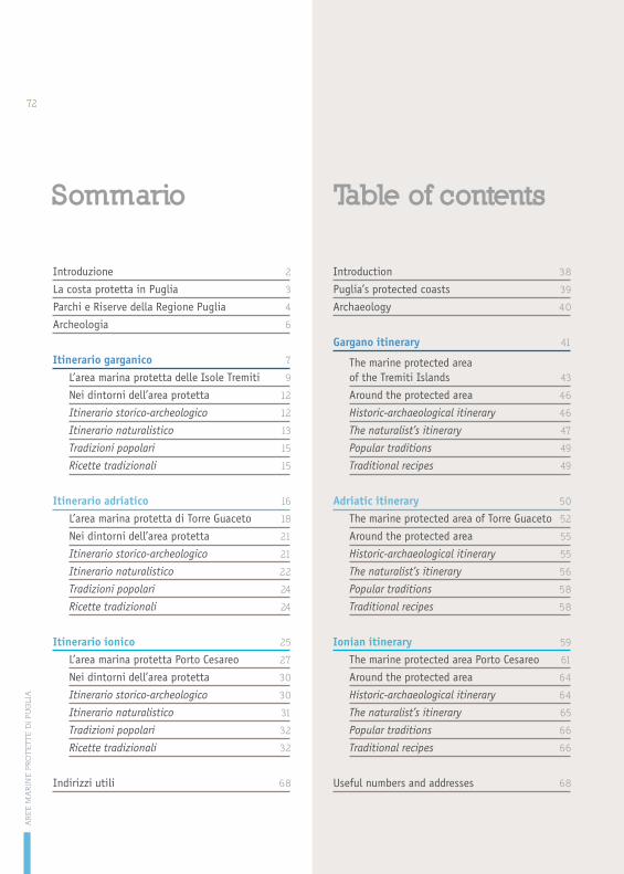
Introduzione 2
La costa protetta in Puglia 3
Parchi e Riserve della Regione Puglia 4
Archeologia 6
Itinerario garganico 7
L’area marina protetta delle Isole Tremiti 9
Nei dintorni dell’area protetta 12
Itinerario storico-archeologico 12
Itinerario naturalistico 13
Tradizioni popolari 15
Ricette tradizionali 15
Itinerario adriatico 16
L’area marina protetta di Torre Guaceto 18
Nei dintorni dell’area protetta 21
Itinerario storico-archeologico 21
Itinerario naturalistico 22
Tradizioni popolari 24
Ricette tradizionali 24
Itinerario ionico 25
L’area marina protetta Porto Cesareo 27
Nei dintorni dell’area protetta 30
Itinerario storico-archeologico 30
Itinerario naturalistico 31
Tradizioni popolari 32
Ricette tradizionali 32
Indirizzi utili 68
Introduction 38
Puglia’s protected coasts 39
Archaeology 40
Gargano itinerary 41
The marine protected area of the Tremiti Islands 43
Around the protected area 46
Historic-archaeological itinerary 46
The naturalist’s itinerary 47
Popular traditions 49
Traditional recipes 49
Adriatic itinerary 50
The marine protected area of Torre Guaceto 52
Around the protected area 55
Historic-archaeological itinerary 55
The naturalist’s itinerary 56
Popular traditions 58
Traditional recipes 58
Ionian itinerary 59
The marine protected area Porto Cesareo 61
Around the protected area 64
Historic-archaeological itinerary 64
The naturalist’s itinerary 65
Popular traditions 66
Traditional recipes 66
Useful numbers and addresses 68
Sommario Table of contents
AR
EE
MA
RIN
E P
RO
TE
TT
E D
I P
UG
LIA
72