ards and abc down area plan 2015 draft plan · plan 2015 draft plan shrigley ... • reasons, other...
TRANSCRIPT

ARDS AND DOWN AREA abcPLAN 2015
DRAFT PLAN
Shrigley
Allocation of Proposed HGI Updated Housing Supply Table Housing Objection Matrix
Objection Reference Numbers 1903/01/1542 1903/01/1590
March 2006
abcd


CONTENTS PAGE
Introduction
Allocation of proposed revised HGI and Additional housing Requirements in Down District
Updated Housing Supply Tables
Updated Housing Supply Map
Housing Objection Matrix
Map showing objections requesting inclusion of additional Housing Lands


Introduction.
The following Paper is intended to provide the following information to assist debate on the draft Plan housing distribution following the announcement by Department for Regional Development, (DRD), of draft revised Housing Growth Indicator Figures, (HGI), for both Ards and Down. This information was requested by the Planning Appeals Commission at previous pre-inquiry meetings. This Paper should be read in conjunction with both the Technical Supplement Volume 1, Population and Housing, published with the draft Ards and Down Plan and the Housing Allocation Paper, (for both Ards and Down) provided with detailed rebuttal evidence. Further copies can be obtained from the Divisional Planning Office.
The information provided is offered without prejudice to assist the Inquiry and the Commission in reaching its conclusions on the objections to the draft Ards and Down Plan. The assessment represents the Department’s provisional view on the acceptability or otherwise of the objection sites. Whilst it is indicative of the Department’s present thinking, the assessment has been made without adopting the formal statutory procedure required of the Department and is provided to facilitate debate at the Inquiry.
It provides:
• a revised housing allocation distributed across the settlement hierarchy in both Ards and Down based on the draft uplifted HGI;
• an indication of those objection sites, which are considered acceptable in principle for housing purposes, i.e. those sites not zoned in the plan solely on the basis that the Department considered they were not required on the basis of housing need;
• a broad ranking of those objection sites considered acceptable in principle by the Department based on a provisional view of a range of preference for inclusion;
• reasons, other than housing need, why the remaining objection sites are considered unacceptable in principle by the Department. In certain circumstances where we have indicated sites are unacceptable, a portion may be acceptable in principle. It is not possible to rank these because the extent of the lands that may be required is not known;
• confirmation by the Department of those settlements where there are insufficient objection lands to cater for uplifted housing need; and

• confirmation by the Department of those settlements where it is considered that there may be more appropriate alternative areas for housing, which are not subject to objection. The location of these areas is outlined in very broad terms.
This information is provided in the following format.
• A revised housing distribution table for both Ards Borough and Down District based on the draft revised HGI figures. It follows the same layout as Technical Supplement, Volume 1, Population and Housing, Appendix 2.2a and 2.2B, already published with the draft Plan.
• Housing supply tables updated to end of January 2006 for both Ards and Down based on the annual housing monitor together with housing supply tables and maps for each settlement in both council areas.
• A detailed matrix for each settlement in Ards and Down. This provides an assessment of each housing objection site against detailed planning criteria reflecting prevailing regional policy. The final columns provide the Department’s provisional assessment on whether each objection site is acceptable in principle together with estimated housing yield for such sites. The matrix merely provides a summary of the department’s published response to each objection and reference should also be made to the detailed rebuttal evidence on each.
The matrix also provides a number of footnotes, which confirm the Department’s broad ranking of those objection sites considered acceptable in principle in the context of the revised HGI. Sites are broadly ranked as: more preferred, preferred or less preferred. Where sites are judged to be of equal merit, this is shown. Footnotes also confirm where, in the Department’s opinion, there may be more suitable areas for inclusion not subject to objection and an indication in broad terms of their location.
• settlement maps showing those objection sites considered acceptable in principle for housing purposes, in whole or in part; and
• specific key design considerations for those objection sites considered acceptable in principle for development.
The Department reassessed the scoring mechanism used to assist the housing allocation in the draft Plan– see Para 2.00 of the Housing Allocation Paper for both Ards and Down. This was required to identify any obvious change, since the publication of the draft Plan, in the factors that may have influenced the scoring of each settlement when
assessed against each of the tests in the Evaluation Framework in the RDS, (Table 4, Page 114 of the RDS document). It was concluded that there were no major influential changes, apart from a slight positive impact that may be attributed to the Comber Bypass on the Transport Test scoring for Comber. The same scoring mechanism is used as a tool to aid distribution of the revised HGI figure throughout Ards and Down, including the rural area.
The Department would also wish to place on record a number of minor recording errors in the scoring attributed to a number of settlements in the Technical Supplement Volume 1, Population and Housing, Table 14A and 14B, published with the draft Ards and Down Plan.
Ards Borough
Comber: Score of 18 should read 17. Greyabbey: Score of 9 should read 10.
Down District.
Dundrum: Score of 12 should read 9.
It is considered that these errors are not so significant as to have had a major influence on the housing allocation in the draft Plan.


Allocation of proposed revised HGI and Additional Housing Requirements in Down District
Settlement (1)
Score (From
Table 14B)
(2)
Allocation (From Score
and Other Factors)
(3)
Units Built end Dec ’98
to end Dec ‘99
(4)
Sites Inside Urban
Footprint
(5)
Additional Windfall
Allowance
(6)
Committed Greenfield
Sites
(7)
Additional Greenfield
Land Proposed in Draft Plan
(8)
Total Built or Committed
(3)+(4)+(5)+ (6) + (7)
(9)
Need for Further
Greenfield Sites (2)-(8)
(10)
Revised Allocation to
Take Account of
(9) Downpatrick 19 3050 71 988 200 (57) 0 1324 2583 467 3050 Ballynahinch 19 1830 48 258 100 (13) 119 1024 1549 281 1830 Newcastle 15 980 50 455 75 (68) 164 180 924 56 980 Annsborough 10 60 14 39 10 (2) 41 0 104 -44 104 Ardglass 12 280 8 16 25 (19) 111 158 318 -38 318 Ballykinlar 8 60 7 5 10 (7) 71 0 93 -33 93 Castlewellan 14 370 21 282 20 (16) 0 0 323 47 370 Clough 9 60 0 17 15 (0) 0 0 32 28 60 Crossgar 13 310 0 64 25 (6) 106 79 274 36 310 Drumaness 10 180 10 56 10 (9) 21 73 170 10 180 Dundrum 9 150 18 251 25 (10) 104 0 398 -248 398 Killough 10 120 12 20 10 (7) 35 39 116 4 120 Killyleagh 12 240 5 327 20 (13) 100 0 452 -212 452 Saintfield 13 310 25 251 25 (16) 28 0 329 -19 329 Shrigley 9 60 1 11 5 (0) 0 0 17 43 60 Spa 8 60 2 31 5 (3) 0 0 38 22 60 Strangford 8 120 0 15 20 (3) 104 0 139 -19 139 TOTAL URBAN 8240 292 3086 600 (249) 1004 2877 7859 381 8853 RURAL ELEMENT
1220 146* ** 146 1074 1220
TOTAL UNITS 9460 438 3086 600 (249) 1004 2877 8005 1455 10073 Notes:
(1) Score from Table 14B of Population and Housing Technical Supplement with corrected total for Dundrum. (2) Initial draft Plan housing allocation from Appendix 2.2 B of Population and Housing Technical Supplement plus 22% uplift rounded to nearest 10.

(3) Some amendments due to annual analysis and refinement of the Housing Monitor figures. See individual settlement tables for more details. (4) Includes Units built from end Dec ’99 to end Jul ’05 and sites committed through planning approval to end January 2006. Also includes urban
capacity sites identified through the draft Plan. (5) This applies post end Jul ’01. Units approved and built or under construction on sites less than 10 units since end Jul ‘01 are shown in brackets for
information purposes and are considered to form part of the windfall allowance set at draft Plan stage. This figure does not include sites less than 10 units which have been approved but have not yet commenced work
(6) These are committed through planning approval and includes units built end Dec ’99 to end Jul ’05. (7) These are additional greenfield lands proposed through the draft Plan. (8) These are committed by Policy or through Approval. (9) This is in addition to committed sites from (6) and additional land proposed through the draft Plan. A negative score shows that commitments etc,
exceed allocation in (2). * no. approvals for new rural dwellings, excluding replacement dwellings, in 1999, extracted from the updated Pressure Analysis figures ** There is no information available on units built in the rural area for end Dec ‘99 to end Jul 05. Updated pressure analysis figures confirm 870 outline
approvals and 803 full and reserved matters approvals for new dwellings in the countryside including small settlements for the years 2000-2005

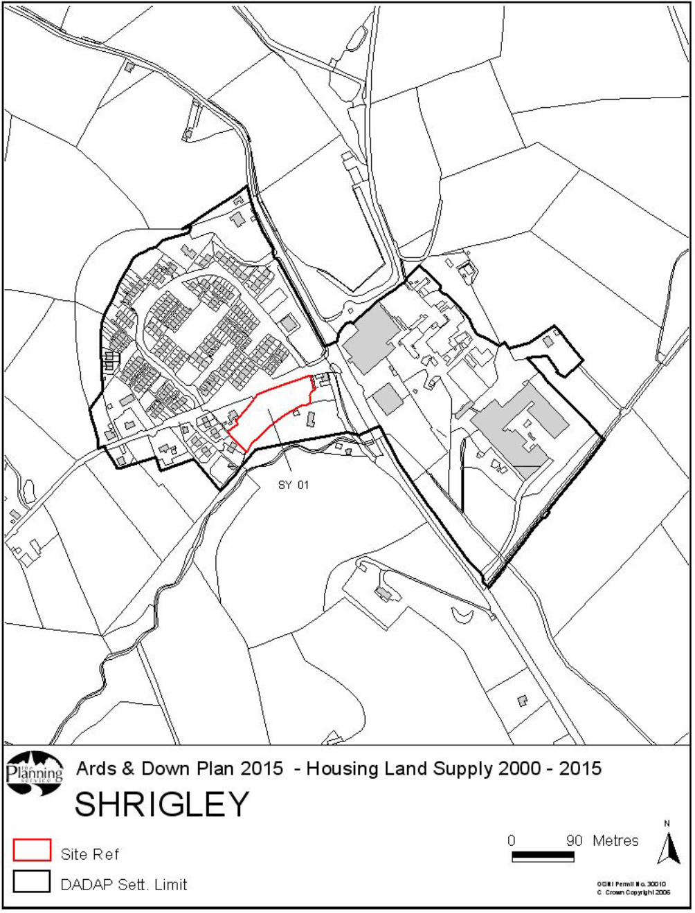
SHRIGLEY DRAFT PLAN HOUSING SUPPLY AT JAN 2006
The following Table details updated housing supply in the context of the Ards Down Plan 2000-2015 within the Settlement Limit of Shrigley at the outset of the Plan period to the end of Jan 06 and should be read in conjunction with the accompanying Map.
Site Ref (Draft Plan Site Ref)
Area (ha)
Urban Capacity
Site*
Existing Greenfield
Site* Estimated Windfall***
Additional Greenfield
Site* Units 98-00
Total Units
SY 01 Crossgar Road
0.54 11(0) 11
WINDFALL 5 (0) 5
UNITS BUILT 98-
00
1 1
TOTAL 0.54 11(0) 0 5 (0) 0 1 17
Source: Downpatrick Divisional Survey. * (numbers constructed between Jan 2000 – August 2005 indicated in brackets). ** denotes sites >10 units approved since the publication of the draft Plan in December 2002. ***units approved and under construction on sites less than 10 units since publication of the draft plan in December 2002 are shown in brackets for information purposes and are considered to form part of the windfall allowance set at draft Plan stage. This figure does not include sites less than 10 units which have been approved but have not yet commenced work.


Site Evaluation Matrix for Housing Objection Sites in Shrigley
Site
Ref
.
Sequ
entia
l Te
st
Topo
grap
hy
Nat
ural
/ B
uilt
H
erita
ge
Setti
ng
Urb
an F
orm
Serv
ice
Faci
litie
s
Land
Qua
lity
**
Wat
er &
Se
wer
age
Dra
inag
e
Roa
d A
cces
s
Roa
d N
etw
ork
Publ
ic
Tran
spor
t
NIE
Pow
er
Line
s
Prov
isio
nal
Ass
essm
ent
Pote
ntia
l Yi
eld
@
20dp
h
1542 / 1590
SW half urban capacity & NE half additional greenfield
Former industrial area is flat rising slightly to the north. Field to NE rises prominently and steeply from SE to NW. Dev may encroach too far up slopes E of chimney and be visible from main roads (LAB)
Dibney River corridor and area east of river is of nature conservation value. Continuity of planting along river is important to the character and wildlife linkages of Shrigley and Killyleagh. Dev would
Existing industrial buildings to S & W and individual dwelling also to S. Potential for noise, odour and contaminated land problems. Otherwise surrounded by open drumlin countryside. (southern part of site lies within proposed Dibney River LLPA). Woodland
Within urban area and contiguous
Convenient to 1 shop within Shrigley Approx. 700m to shops etc. in Killyleagh
Field to NE not BMV
Water supplies and foul sewer available. A foul sewage pumping station and upgrading of existing foul sewerage infrastructure may be required.
No record of significant flooding but portion of the site lies within floodplain of 2 designated watercourses
Suitable from Shrigley Road
Existing access to tannery closed up, right turn facility on Shrigley Road and adequate junction stagger with adjacent accesses
compromise future sustainable re-use of the
important in landscape and visual terms (LAB). Result in loss of
industrial trees, detrimental elements and to features of survival of any features of industrial
proposed LLPA. Read as sprawl detrimental to
heritage that survive there
village setting
Accessible Yes Unacceptable N/A in principle (required for industry, within proposed IPA)
* = No comment from relevant agency ** Land quality based on initial survey work undertaken by DARD in 2001. BMV = Best and most versatile land LAB = Landscape Architects Branch
Notes: There may be more suitable lands (subject to access arrangements) not subject to objection to the south west of the village.