architecting the arcgis platform: best practices · architecting the arcgis platform: best...
TRANSCRIPT

Architecting the ArcGIS Platform: Best Practices
May 2018

Copyright © 2018 Esri All rights reserved. Printed in the United States of America. The information contained in this document is the exclusive property of Esri. This work is protected under United States copyright law and other international copyright treaties and conventions. No part of this work may be reproduced or transmitted in any form or by any means, electronic or mechanical, including photocopying and recording, or by any information storage or retrieval system, except as expressly permitted in writing by Esri. All requests should be sent to Attention: Contracts and Legal Services Manager, Esri, 380 New York Street, Redlands, CA 92373-8100 USA. The information contained in this document is subject to change without notice. Esri, the Esri globe logo, ArcGIS, esri.com, and @esri.com are trademarks, service marks, or registered marks of Esri in the United States, the European Community, or certain other jurisdictions. Other companies and products or services mentioned herein may be trademarks, service marks, or registered marks of their respective mark owners.

Architecting the ArcGIS Platform: Best Practices
Copyright © 2018 Esri. All rights reserved.
What's New May 2018 This update includes revisions to two existing documents and a modification to the Conceptual Reference Architecture infographic to maintain alignment with the ArcGIS platform.
Modifications The best practice entitled Distributed GIS has been modified to reflect updates to ArcGIS platform capabilities, especially around distributed collaboration between ArcGIS Enterprise and ArcGIS Online.
The best practice for Project Prioritization has been updated and retitled to Prioritization Approach to better align the message with the intent, which is to prioritize capability delivery based on business value versus challenge to improve the return on investment in the ArcGIS platform.
The overview page was updated to reflect the name change to Prioritization Approach.
Conceptual Reference Architecture The Associated Best Practices section was updated to reflect the name change to Prioritization Approach.
Architecting the ArcGIS Platform: Best Practices May 2018
Maximize the value of the ArcGIS platform, in the context of organizational goals, through the application of guidelines presented in these best practices and implementation approaches.
Introduction The ArcGIS platform connects maps, apps, data, and people in ways that help organizations make more informed and
faster decisions, extending the reach of GIS across the enterprise. ArcGIS accomplishes this by making it easy for everyone
in an organization to discover, use, make, and share maps from any device, anywhere, anytime. Furthermore, ArcGIS is
designed to be flexible, offering these capabilities through multiple implementation patterns and approaches.
This document presents some implementation guidelines in the form of a conceptual reference architecture diagram and
associated best practice briefs. Organizations can use these guidelines to maximize the value of their ArcGIS
implementation and meet their organizational objectives.
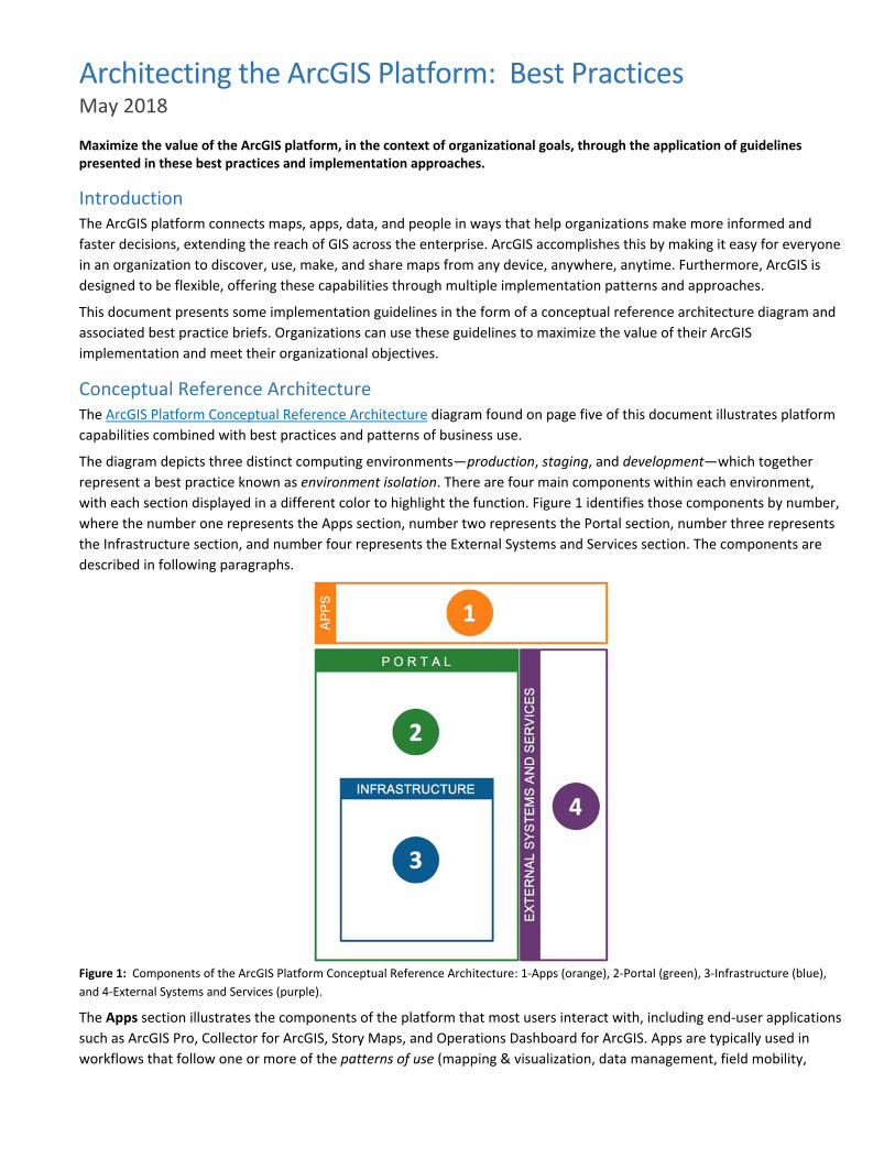
Conceptual Reference Architecture The ArcGIS Platform Conceptual Reference Architecture diagram found on page five of this document illustrates platform
capabilities combined with best practices and patterns of business use.
The diagram depicts three distinct computing environments—production, staging, and development—which together
represent a best practice known as environment isolation. There are four main components within each environment,
with each section displayed in a different color to highlight the function. Figure 1 identifies those components by number,
where the number one represents the Apps section, number two represents the Portal section, number three represents
the Infrastructure section, and number four represents the External Systems and Services section. The components are
described in following paragraphs.
Figure 1: Components of the ArcGIS Platform Conceptual Reference Architecture: 1‐Apps (orange), 2‐Portal (green), 3‐Infrastructure (blue),
and 4‐External Systems and Services (purple).
The Apps section illustrates the components of the platform that most users interact with, including end‐user applications
such as ArcGIS Pro, Collector for ArcGIS, Story Maps, and Operations Dashboard for ArcGIS. Apps are typically used in
workflows that follow one or more of the patterns of use (mapping & visualization, data management, field mobility,
monitoring, analytics, design & planning, decision support, constituent engagement, and sharing & collaboration). For
example, the sharing & collaboration pattern extends geospatial capabilities to everyone in the organization with a
destination (website and simple apps) for knowledge workers, executives, and field workers to discover, use, make, and
share maps. A person capturing damage assessment data in the field with Collector for ArcGIS is following the field
mobility pattern. The decision maker using Operations Dashboard to observe the real‐time information created by field
workers is following the decision support pattern. Apps connect people and their business workflows to the platform.
The Portal component of the platform organizes users and connects them with the appropriate content and capabilities
based on their role and privileges within the platform. The portal uses a person’s identity to deliver the right content to
the right person at the right time. From a product perspective, the portal is either ArcGIS Enterprise (software) or ArcGIS
Online (Software as a Service, or SaaS). The portal provides access controls, content management capabilities, and a
sharing model that enables users to share information products across the organization.
The Infrastructure component includes the hardware, software, services, and data repositories that are the core of the
ArcGIS platform. Numerous best practices—including load balancing, high availability, workload separation, and
publication strategies—are linked from and associated with the platform infrastructure. Follow the links from each best
practice label on the Conceptual Reference Architecture diagram to learn more about how these strategies affect
infrastructure decisions. Additional information can be found in the infrastructure page of this document.
The External Systems and Services components include other systems that either provide services to ArcGIS or consume
ArcGIS services to geospatially enable their capabilities. The ability to easily geo‐enable other enterprise business systems
is a key capability of ArcGIS.
Best Practices There are eighteen best practice briefs associated with the ArcGIS Platform Conceptual Reference Architecture diagram.
Eleven of these briefs—including Automation, Distributed GIS, Enterprise Integration, Environment Isolation, High
Availability, Infrastructure, Load Balancing, Publication Strategy, Real‐time GIS Strategy, Security, and Workload
Separation—reference technology practices that provide high‐level implementation guidelines based on business needs.
Following these best practices will help organizations meet requirements for performance, security, and availability. The
best practice briefs for Application Implementation Strategy, Capability Delivery, Patterns of Use, Managing Identities,
Prioritization Approach, and Workforce Development focus on people and how they should interact with ArcGIS. Finally,
the IT Governance brief offers a complementary process guideline that suggests ways to minimize risk, improve quality,
and increase productivity around ArcGIS solutions.
How to Use This Document The ArcGIS Platform Conceptual Reference Architecture diagram is a clickable graphic that contains links to each best
practice brief. You can use the diagram to explore how the individual briefs relate to the platform, or to visualize how the
ArcGIS platform will support organizational business needs.
Comments and Suggestions Any comments or suggestions regarding this document can be emailed to: [email protected].

Copyright © 2018 Esri. All rights reserved. May 2018
ArcGIS Platform ConceptualReference Architecture
EnterpriseSystems• CRM• EAM• BI• Microsoft Of�ce
Other• Social• Weather• Traf�c• Real-time Feeds• IoT Sensors
Users • Groups • Items • Tags(Content and Capabilities)
AP
PS
P O R TA LS D K s / A P I s
SD
Ks
/ A
PIs
S D K s / A P I s
I N F R A S T R U C T U R E
Data and Storage
EX
TE
RN
AL
SY
ST
EM
S A
ND
SE
RV
ICE
S
Dat
aM
anag
emen
t
Ana
lysis
Visu
aliza
tion
LO
AD
BA
LA
NC
ING
HIG
H A
VA
ILA
BIL
ITY
WORKLOAD SEPAR ATION
Web Maps Web Layers Tools Files
SD
Ks
/ A
PIs
PRODUCTION
ASSOCIATED BEST PRACTICES
STAGING DEVELOPMENT
Mapping &Visualization
Patterns of Use
Solutions
IT Governance • Prioritization Approach • Publication Strategy Automation • Capability Delivery • Security • Workforce Development
DataManagement Field Mobility Monitoring Analytics
Design &Planning
DecisionSupport
ConstituentEngagement
Sharing &Collaboration
Architecting the ArcGIS Platform: Best Practices
Back to Reference Architecture Copyright © 2018 Esri. All rights reserved.
Application Implementation Strategy May 2018
An application implementation strategy is an approach to delivering capabilities that minimizes cost and maximizes opportunities for improving development resource allocation. Applying a “configure first” philosophy helps organizations use the least effort‐intensive design patterns necessary to deliver applications that address their business needs and minimize lifetime costs.
Introduction ArcGIS provides a robust platform for applying the power of geography to workflows throughout an organization. Location‐
enabled apps, available at the right time on the right device, empower users to work more efficiently by leveraging ArcGIS
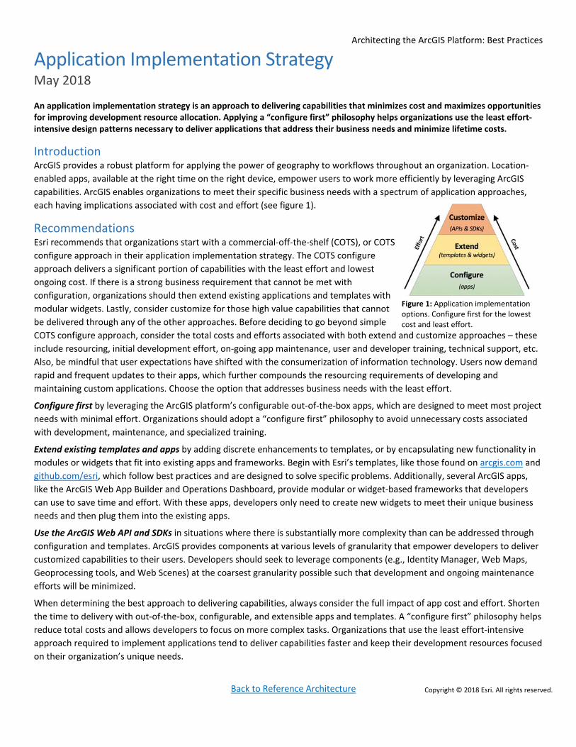
capabilities. ArcGIS enables organizations to meet their specific business needs with a spectrum of application approaches,
each having implications associated with cost and effort (see figure 1).
Recommendations Esri recommends that organizations start with a commercial‐off‐the‐shelf (COTS), or COTS
configure approach in their application implementation strategy. The COTS configure
approach delivers a significant portion of capabilities with the least effort and lowest
ongoing cost. If there is a strong business requirement that cannot be met with
configuration, organizations should then extend existing applications and templates with
modular widgets. Lastly, consider customize for those high value capabilities that cannot
be delivered through any of the other approaches. Before deciding to go beyond simple
COTS configure approach, consider the total costs and efforts associated with both extend and customize approaches – these
include resourcing, initial development effort, on‐going app maintenance, user and developer training, technical support, etc.
Also, be mindful that user expectations have shifted with the consumerization of information technology. Users now demand
rapid and frequent updates to their apps, which further compounds the resourcing requirements of developing and
maintaining custom applications. Choose the option that addresses business needs with the least effort.
Configure first by leveraging the ArcGIS platform’s configurable out‐of‐the‐box apps, which are designed to meet most project
needs with minimal effort. Organizations should adopt a “configure first” philosophy to avoid unnecessary costs associated
with development, maintenance, and specialized training.
Extend existing templates and apps by adding discrete enhancements to templates, or by encapsulating new functionality in
modules or widgets that fit into existing apps and frameworks. Begin with Esri’s templates, like those found on arcgis.com and
github.com/esri, which follow best practices and are designed to solve specific problems. Additionally, several ArcGIS apps,
like the ArcGIS Web App Builder and Operations Dashboard, provide modular or widget‐based frameworks that developers
can use to save time and effort. With these apps, developers only need to create new widgets to meet their unique business
needs and then plug them into the existing apps.
Use the ArcGIS Web API and SDKs in situations where there is substantially more complexity than can be addressed through
configuration and templates. ArcGIS provides components at various levels of granularity that empower developers to deliver
customized capabilities to their users. Developers should seek to leverage components (e.g., Identity Manager, Web Maps,
Geoprocessing tools, and Web Scenes) at the coarsest granularity possible such that development and ongoing maintenance
efforts will be minimized.
When determining the best approach to delivering capabilities, always consider the full impact of app cost and effort. Shorten
the time to delivery with out‐of‐the‐box, configurable, and extensible apps and templates. A “configure first” philosophy helps
reduce total costs and allows developers to focus on more complex tasks. Organizations that use the least effort‐intensive
approach required to implement applications tend to deliver capabilities faster and keep their development resources focused
on their organization’s unique needs.
Figure 1: Application implementation options. Configure first for the lowest cost and least effort.

Architecting the ArcGIS Platform: Best Practices
Back to Reference Architecture Copyright © 2018 Esri. All rights reserved.
Apply IT Governance May 2018
Information technology (IT) governance is a subset of the greater corporate governance framework focused specifically on IT systems, their performance, and risk management. IT governance ensures that solutions are built and managed properly within the IT landscape. This brief provides an overview of IT governance as it relates to ArcGIS platform implementations as well as guidelines that will help ArcGIS solutions deliver clear benefits and achieve long-term success.
Introduction Conceptually, governance is a framework, a cultural orientation, and a set of owned responsibilities that ensure the integrity and effectiveness of the organization's use of IT. Implementing governance involves monitoring, managing, and steering a business, information system, or IT landscape to deliver required business outcomes. Since the GIS domain is part of the IT landscape, IT governance should be applied to GIS, including the ArcGIS platform and the solutions built on it. One way to help the ArcGIS platform remain effective to an organization is to employ an IT governance strategy that includes software change management, data governance, and workforce development.
Recommendations Making changes to enterprise systems always introduces risk to business operations. Minimize risk by employing a software change management strategy. This strategy should include planning for upgrades to any enterprise system, including any part of the ArcGIS platform. Planning should include the testing of new software versions in one (or more) staging environments (ideally, ones that mirror the production environment) to ensure the business continuity of client applications and workflows. Testing should include, but not be limited to, functional testing, performance testing, and user acceptance testing. When testing is complete and the new software works as expected, the software upgrade to the production environment should be scheduled in advance. During the upgrade process itself, be sure necessary staff are available and that they have the permissions necessary to complete their assigned tasks. Document the upgrade process in case there is an unforeseen issue and the upgrade needs to be paused. It’s also recommended to have a rollback strategy in the event of an unrecoverable error in the change or upgrade process.
Data governance involves exercising positive control over data quality, availability, usability, and security across an enterprise. It is recommended that spatial data be included within an organization’s broader data governance framework and not treated separately. Furthermore, it is recommended that spatial data be maintained by data stewards within the business units and served to the rest of the organization’s enterprise from centrally managed databases. Responsibilities for data quality and usability must be upheld by the departmental data stewards, and accessibility and security responsibilities must be upheld by IT, the recommended “implementation managers” of the GIS platform.
Workforce development and training is essential to the long-term success of any enterprise system implementation. A modern GIS enables ubiquitous access to maps and spatial data throughout an organization, with knowledge workers continuously contributing to and leveraging GIS capabilities. It is recommended that the organization invest in workforce development and training in order to benefit both individual employees and the organization as a whole. Flexible programs should be available for staff to acquire focused GIS training on a routine basis. GIS training programs are needed to:
1. Increase productivity and efficiency in GIS operations so knowledge workers can accomplish more with fewer resources.
2. Prevent costly mistakes in new GIS implementations, system updates, and workflow procedures. 3. Enable staff to recognize opportunities for GIS to help increase operating efficiencies, save money, and provide better
government services.
Exercising IT governance across the GIS domain is critical for long-term organizational success and enables the ArcGIS platform to truly grow within the enterprise with limited risk. It is important to note that software change management, data governance, and workforce development are some key elements of an IT governance strategy; however, other elements, roles, and responsibilities (not covered in this brief) may also be necessary.

Architecting the ArcGIS Platform: Best Practices
Back to Reference Architecture Copyright © 2018 Esri. All rights reserved.
Automation May 2018
Automation is the process of automatically executing defined, repetitive workflows and tasks. Automating the execution of tasks is a recommended best practice because it improves efficiency, consistency, and productivity.
Introduction Repetitive tasks are common when using GIS to support data management, analysis, map production, or infrastructure
deployment and operations workflows. When performed manually, repetitive tasks take a lot of time, effort, and focus and
decrease overall throughput. These negative impacts are compounded as the number of repetitive tasks grows.
One way to mitigate these impacts is through automation. Automation allows technology to programmatically execute the
steps of a well‐defined workflow while limiting human interaction. Automation maximizes an organization’s investment in GIS
by improving efficiency, consistency, and productivity.
Recommendation Take advantage of automation resources—such as APIs, scripts, and other
tools—to maximize the value of GIS investments. Look for ways that
automation can improve:
1. Efficiency. Information is most useful to the decision‐making
process when it is delivered in a timely manner. Because
automating tasks improves efficiency, work can be completed faster
and new information can be delivered to stakeholders sooner.
Automate the execution of tasks so processes can be completed in
less time. Consider scheduling processes to run continuously within
set time windows, requiring no human interaction to automatically
turn data into actionable information. This boost in efficiency will
allow GIS to return greater value to the business.
2. Consistency. When repetitive tasks are executed manually,
mistakes are more prevalent and the outcomes are often
inconsistent, unreliable, and costly to the business. Use automation
to remove the potential for human error and to improve reliability
and consistency in outcomes. Once developed and properly tested,
automated processes are highly dependable and can be replicated
with identical and predictable results. They also save time by
minimizing duplicated efforts while increasing confidence in
business operations.
3. Productivity. Opportunities to increase productivity through automation exist throughout the ArcGIS platform, from initial
deployment to administrative and end user workflows. Use
automation to increase the number and speed of task executions, resulting in gains to overall productivity. By using
automation to increase productivity, the organization can apply GIS to additional business initiatives (such as strategic
projects, research and development efforts, and other high‐value projects) that otherwise may go unfulfilled.
Become familiar with the available and recommended approaches for automating ArcGIS workflows. Prioritize opportunities
for automation by analyzing task frequency, the level of effort for automating each task, and the potential positive impact that
automation will have on the business. If executed correctly, automation can improve the value of GIS through greater
efficiency, consistency, and productivity.
Automation Tames the Internet of Things (IoT)
As the volume and velocity of IoT data increases,
automation becomes both more necessary and
more valuable to the business.
Working manually, staff often struggle with
processing the high volumes of data produced
by IoT devices and scaling infrastructure
accordingly. This delays the transformation of
data into insight, which in turn reduces the
organization’s efficiency and makes its decisions
less responsive and less effective.
But with automation, infrastructure can be
configured to automatically add compute
resources as data volume and processing
requests spike. This keeps data flowing to key
business systems and workflows, improving
efficiency and leading to better, faster decisions.
This also frees resources to work on other tasks.
Automation allows data to be processed
efficiently, consistently, and routinely.
Ultimately, this improves the effectiveness and
timeliness of an organization’s decision‐making.
Architecting the ArcGIS Platform: Best Practices
Back to Reference Architecture Copyright © 2018 Esri. All rights reserved.
Capability Delivery May 2018
Capabilities are delivered across the enterprise to support key missions, goals, and initiatives. These capabilities should be determined by business needs, which will help maintain an effective use and alignment of resources. Once identified by the business, capabilities exposed through maps, apps, services, and information products should be rapidly delivered and continuously improved based on business needs and requirements.
Introduction To maximize the value of technology investments and meet the evolving demands of business, develop a cadence that offers
rapid delivery of high‐value information products focused on business needs. It is important to involve stakeholders in the
planning process early on, because this will help set reasonable expectations and allow new capabilities to provide discrete
and incremental value. People have a shrinking appetite for waiting—it is no longer acceptable to engage in large, complex
projects spanning years of development to deliver a complicated set of capabilities. A good path to effective capability
delivery is to use a business‐first approach, keep iterations brief, and establish a rapid delivery lifecycle.
Recommendations First, work with business stakeholders to envision a need for a specific capability. Engage stakeholders early to identify the
business value the capability will deliver, and balance that business value against risk. Then, plan and prioritize development
to capture early value and build long‐term success. With the shared vision in place, design and develop the output using a
configure‐first approach, where low‐effort, configurable functions are created first. Test the final product and gather feedback
from stakeholders.
Second, keep iterations brief so that value is delivered quickly and often. Manage expectations to focus on simple capabilities
that provide real value, and avoid extraneous functions that increase complexity and development time without adding
comparable value. Target releases for 30 days or less, with each iteration resulting in a useable deliverable. To meet the short
delivery schedule, keep requirements simple and
focused, and leverage COTS and configurable
solutions as much as possible. Solicit feedback from
stakeholders to drive the next iteration.
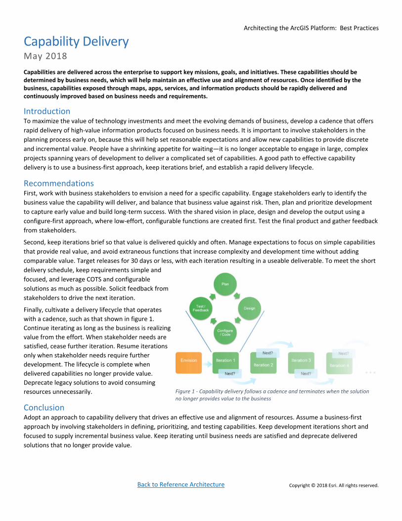
Finally, cultivate a delivery lifecycle that operates
with a cadence, such as that shown in figure 1.
Continue iterating as long as the business is realizing
value from the effort. When stakeholder needs are
satisfied, cease further iteration. Resume iterations
only when stakeholder needs require further
development. The lifecycle is complete when
delivered capabilities no longer provide value.
Deprecate legacy solutions to avoid consuming
resources unnecessarily.
Conclusion Adopt an approach to capability delivery that drives an effective use and alignment of resources. Assume a business‐first
approach by involving stakeholders in defining, prioritizing, and testing capabilities. Keep development iterations short and
focused to supply incremental business value. Keep iterating until business needs are satisfied and deprecate delivered
solutions that no longer provide value.
Figure 1 ‐ Capability delivery follows a cadence and terminates when the solution no longer provides value to the business

Architecting the ArcGIS Platform: Best Practices
Back to Reference Architecture Copyright © 2018 Esri. All rights reserved.
Distributed GIS May 2018
A distributed GIS is an integrated set of GIS deployments working together and sharing content as part of a trusted collaboration. Implementing a distributed GIS is an effective way to leverage authoritative data, foster communication and engagement across user types, and glean insights from data to generate powerful location intelligence. A distributed GIS also preserves departmental control over data and workflows while contributing to and supporting the needs of the enterprise.
A Modern Approach to Sharing Information Distributed GIS is a modern approach that supports a new type of sharing. With
distributed GIS, multiple GIS deployments are connected with each other, and users can
use web maps and apps to easily create, manage, analyze, publish, and share geospatial
content. This integrated approach preserves control and access within individual
departments while supporting the broader business needs of the organization. The
result is a truly collaborative environment—an integrated set of deployments working
towards shared goals.
For example, an organization might have multiple business units, each with their own
GIS deployment supporting different business functions. In a city, the police department,
fire department, public works department, and municipal water utility might each have
their own GIS, deployed to support their individual workflows. Distributed GIS offers an
approach for connecting those deployments so people across departments or outside
the organization can work together using authoritative data in a trusted collaboration.
Figure 1 illustrates these relationships between departments and with external users.
A distributed GIS expands a modern GIS by making its capabilities and data easier to
access within individual business units and across the enterprise. A distributed GIS
creates an organizational network where multiple systems can securely access
information products and data from a single source. This helps improve decision
making at both the business unit and enterprise levels.
To create a distributed GIS, you simply connect multiple ArcGIS Enterprise deployments and (optionally) an ArcGIS Online
organization. We call these connections “trusted collaborations.” You configure a trusted collaboration between deployments
using the out‐of‐the‐box capabilities of ArcGIS, which let you easily define how data is shared. No custom coding is required.
Trusted collaborations between deployments are secure, using your deployment’s existing security model. Users can share
data—either as a copy or as a reference to the source (which continues to require authentication)—to other collaboration
participants. Collaboration creates a network where multiple systems can access data and information products from their
own environment, keeping authoritative sources intact, with updates either in near real time or at scheduled intervals.
Each GIS deployment maintains its own maps, apps, and data, delivering the capabilities needed for that particular business
unit or function. At the same time, being part of a distributed GIS lets these deployments support and achieve larger
organizational goals using trusted collaborations, well‐defined sharing processes, and automation, all within ArcGIS.
Recommendations To fully leverage distributed GIS within your own organization:
1. Model your distributed GIS after your organization’s structure, with each department or business unit using and
maintaining its own GIS deployment.
2. Establish trusted collaborations between GIS deployments based upon business need – enabling the right people to
have access to the authoritative content they need.
3. Allow individual departments to maintain control of their data and share it when appropriate.
Figure 1 –Preserve control and access within individual departments while supporting the broader needs of the enterprise.
Architecting the ArcGIS Platform: Best Practices
Back to Reference Architecture Copyright © 2018 Esri. All rights reserved.
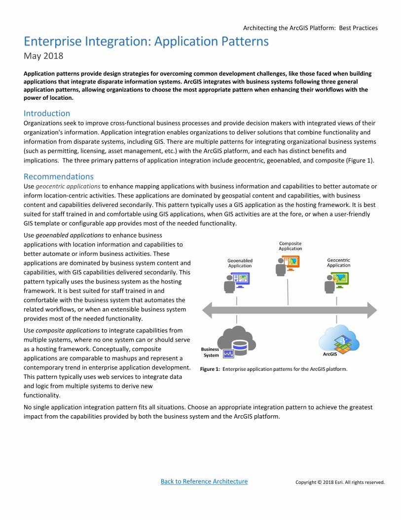
Enterprise Integration: Application Patterns May 2018
Application patterns provide design strategies for overcoming common development challenges, like those faced when building applications that integrate disparate information systems. ArcGIS integrates with business systems following three general application patterns, allowing organizations to choose the most appropriate pattern when enhancing their workflows with the power of location.
Introduction Organizations seek to improve cross‐functional business processes and provide decision makers with integrated views of their
organization's information. Application integration enables organizations to deliver solutions that combine functionality and
information from disparate systems, including GIS. There are multiple patterns for integrating organizational business systems
(such as permitting, licensing, asset management, etc.) with the ArcGIS platform, and each has distinct benefits and
implications. The three primary patterns of application integration include geocentric, geoenabled, and composite (Figure 1).
Recommendations Use geocentric applications to enhance mapping applications with business information and capabilities to better automate or
inform location‐centric activities. These applications are dominated by geospatial content and capabilities, with business
content and capabilities delivered secondarily. This pattern typically uses a GIS application as the hosting framework. It is best
suited for staff trained in and comfortable using GIS applications, when GIS activities are at the fore, or when a user‐friendly
GIS template or configurable app provides most of the needed functionality.
Use geoenabled applications to enhance business
applications with location information and capabilities to
better automate or inform business activities. These
applications are dominated by business system content and
capabilities, with GIS capabilities delivered secondarily. This
pattern typically uses the business system as the hosting
framework. It is best suited for staff trained in and
comfortable with the business system that automates the
related workflows, or when an extensible business system
provides most of the needed functionality.
Use composite applications to integrate capabilities from
multiple systems, where no one system can or should serve
as a hosting framework. Conceptually, composite
applications are comparable to mashups and represent a
contemporary trend in enterprise application development.
This pattern typically uses web services to integrate data
and logic from multiple systems to derive new
functionality.
No single application integration pattern fits all situations. Choose an appropriate integration pattern to achieve the greatest
impact from the capabilities provided by both the business system and the ArcGIS platform.

Architecting the ArcGIS Platform: Best Practices
Back to Reference Architecture Copyright © 2018 Esri. All rights reserved.
Environment Isolation May 2018
Isolating computing environments is a recommended approach that contributes to system reliability and availability by creating separate and distinct systems for operational, testing, and development activities. Environment isolation reduces risk and protects operational systems from unintentional changes and negative business impacts.
Introduction It is highly undesirable for an operational system to fail to deliver the functional or performance capabilities that customers
expect, whether because of resource contention, system failures, outages, or other issues that could have been avoided.
Environment isolation plays a crucial role in system design because it insulates the different computing environments from
unmanaged change, helping maintain the functionality and performance that users expect in the system.
Recommendations System changes are inevitable. It is a recommended practice to manage these changes in isolated computing environments,
which helps mitigate the risks associated with change and contributes to the delivery of stable, extensible, and high
performing business capabilities. Risk needs to be defined and documented in a contract or Service Level Agreement (SLA)
between technology service providers and business stakeholders. Within this contract, expectations for system reliability, in
measurable terms, will guide how environment isolation and its governance will support those expectations. Implementing at
least three isolated computing environments (production, staging, and development) is an important element to meeting SLAs
and is an essential practice for enterprise systems management (Figure 1).
A production environment is the “live” system that supports end users. Uptime requirements are defined by an SLA and are
supported by appropriate change management and governance.
Software, application, configuration, or network changes should never
be made to the production environment without first being tested and
evaluated in a staging environment.
A staging environment is a mirror of the production environment, and it
provides a venue to vet system changes and ensure system quality
before deploying changes to production. User acceptance testing,
performance testing, load testing, and training1 are often performed in
the safety of a staging environment without the risk of negatively
impacting the production system.
A development environment is a workspace where developers and
analysts can innovate, manage content, and make changes without impacting a large audience. This dedicated server
environment is typically used for unit testing, constructing business workflows, or creating new capabilities such as
applications, services, data models, or geoprocessing models. Any group or organization that is developing new capability
should have a development environment for these activities. The size and complexity of the environment will depend on the
level of risk generated by changes, the number of creators, and the potential impact of system outages and downtime.
Implementing separate computing environments enables organizations to deliver a stable, extensible, and high performing
system. SLAs should be created and publicized to support stakeholder expectations. The proper execution of change
management between computing environments helps shield the system from unexpected failure and associative business
disruption.
1 Many organizations may choose to implement each of these activities in separate computing environments instead of in a single staging
environment. Many risk adverse organizations will have upwards of four, five, and six or more different computing environments to support their
IT delivery needs.
Figure 1 ‐ Recommended (minimum) compute environments.

Architecting the ArcGIS Platform: Best Practices
Back to Reference Architecture Copyright © 2018 Esri. All rights reserved.
High Availability May 2018
High availability is a design approach that helps a system meet a prearranged level of operational performance over a specific
period of time.1 To achieve high availability, factors such as hardware, software, and governance need to be addressed. Highly
available systems provide customers with a reliable, and high performing environment that meets or exceeds their business
requirements for service delivery.
Introduction When GIS was merely a small, project level system for organizations, it was often acceptable (though undesirable) if GIS
capabilities were sometimes offline and unavailable. Today, however, GIS is engrained within the fabric of an enterprise and is
part of critical business operations and workflows; failure and downtime are no longer permissible. IT Managers and
Architects should consider high availability designs for their GIS deployments to mitigate the risks incurred from a
system/component failure.
Recommendations Before designing a solution for high availability, it is necessary to determine an organization’s acceptable level of system
downtime – typically described in a Service Level Agreement (SLA). An SLA is quantified by the percentage of required service
uptime (also known as the “number of nines”). For example, an organization may want to have their systems available
annually at a rate of 99.9% (three nines). This percentage equates to 8.76 hours of downtime annually or 10.1 minutes weekly.
Minimizing an organization’s downtime can be accomplished by reducing the number of
single points of failure, adequately testing the system, and monitoring the system to catch
issues early.
Reducing single points of failure within an ArcGIS platform implementation can be
accomplished through duplication and load balancing (Figure 1). Duplication involves
implementing multiple instances of a specific system component. Load balancing is a
technique for distributing client workload traffic requests across multiple system
components.
Test plans should be developed and executed regularly to evaluate a system’s ability to
meet a prearranged level of operational performance. These plans should include, but not
be limited to, stress, performance, and failover functions/activities. It is further
recommended that one or more test plans be developed and executed before going “live.”
All testing plans and associative activities should be part of the overall system governance.
A key part of maintaining a highly available system involves monitoring the health of the
system and having a plan in place to correct problems before they cause a widespread or
unrecoverable outage. A variety of system monitoring tools are available from Esri as well as third‐party vendors.
High availability is a set of approaches or strategies that are meant to minimize service downtime. The effective
implementation of these strategies (reducing single points of failure, adequate testing, and system monitoring) helps
maximize uptime and provides reliable and high performing service delivery.
1 High Availability (HA) while related to, should not be confused with Disaster Recovery (DR). Generally, HA strives to retain operational service delivery, whereas DR focuses on data retention and system restoration. DR is the process by which a system is restored to a previous, acceptable state after a disaster. While DR plans are executed it is typical for service delivery to be disrupted until the system has been restored.
Figure 1 – Duplication and load balancing for high availability
Architecting the ArcGIS Platform: Best Practices
Back to Reference Architecture Copyright © 2018 Esri. All rights reserved.
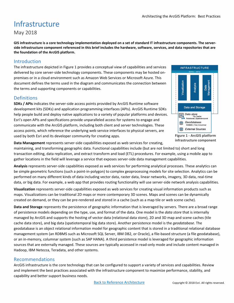
Infrastructure May 2018
GIS infrastructure is a core technology implementation deployed on a set of standard IT infrastructure components. The server‐side infrastructure component referenced in this brief includes the hardware, software, services, and data repositories that are the foundation of the ArcGIS platform.
Introduction The infrastructure depicted in Figure 1 provides a conceptual view of capabilities and services
delivered by core server‐side technology components. These components may be hosted on‐
premises or in a cloud environment such as Amazon Web Services or Microsoft Azure. This
document defines the terms used in the diagram and communicates the connection between
the terms and supporting components or capabilities.
Definitions SDKs / APIs indicates the server‐side access points provided by ArcGIS Runtime software
development kits (SDKs) and application programming interfaces (APIs). ArcGIS Runtime SDKs
help people build and deploy native applications to a variety of popular platforms and devices.
Esri’s open APIs and specifications provide unparalleled access for systems to engage and
communicate with the ArcGIS platform, including both client and server technologies. These
access points, which reference the underlying web service interfaces to physical servers, are
used by both Esri and its developer community for creating apps.
Data Management represents server‐side capabilities exposed as web services for creating,
maintaining, and transforming geographic data. Functional capabilities include (but are not limited to) short and long
transaction editing, data replication, and extract transform and load (ETL) procedures. For example, using a mobile app to
gather locations in the field will leverage a service that exposes server‐side data management capabilities.
Analysis represents server‐side capabilities exposed as web services for performing analytical processes. These analytics can
be simple geometric functions (such a point‐in‐polygon) to complex geoprocessing models for site selection. Analytics can be
performed on many different kinds of data including vector data, raster data, linear networks, imagery, 3D data, real‐time
data, or big data. For example, a web app that provides routing functionality will use server‐side network analysis capabilities.
Visualization represents server‐side capabilities exposed as web services for creating visual information products such as
maps. Visualizations can be traditional 2D maps or more contemporary 3D scenes. Maps and scenes can be dynamically
created on demand, or they can be pre‐rendered and stored in a cache (such as a map tile or web scene cache).
Data and Storage represents the persistence of geographic information that is leveraged by servers. There are a broad range
of persistence models depending on the type, use, and format of the data. One model is the data store that is internally
managed by ArcGIS and supports the hosting of vector data (relational data store), 2D and 3D map and scene caches (tile
cache data store), and big data (spatiotemporal big data store). Another persistence model is the geodatabase. The
geodatabase is an object relational information model for geographic content that is stored in a traditional relational database
management system (an RDBMS such as Microsoft SQL Server, IBM DB2, or Oracle), a file‐based structure (a file geodatabase),
or an in‐memory, columnar system (such as SAP HANA). A third persistence model is leveraged for geographic information
sources that are externally managed. These sources are typically accessed in read‐only mode and include content managed in
Hadoop, IBM Netezza, Teradata, and other systems.
Recommendations ArcGIS infrastructure is the core technology that can be configured to support a variety of services and capabilities. Review
and implement the best practices associated with the infrastructure component to maximize performance, stability, and
capability and better support business needs.
Figure 1 ‐ ArcGIS platform infrastructure component

Architecting the ArcGIS Platform: Best Practices
Back to Reference Architecture Copyright © 2018 Esri. All rights reserved.
Load Balancing May 2018
Load balancing is a technique for distributing client workloads across multiple computing resources (such as physical servers, virtual servers, or clusters). Load balancing, either by software or hardware devices, is a recommended best practice to balance system utilization, reduce risk, simplify service delivery and growth, and improve the security of backend servers.
Introduction With load balancers in place, client workload traffic can be optimized and distributed to server‐based resources to ensure the best performance and utilization possible. Load balancing algorithms, used to dispatch client requests, can vary from simple round‐robin approaches to more complex algorithms that consider factors such as current connection counts, host utilization, or real‐world response times. From a scalability perspective, a properly load balanced system supports the addition and subtraction of machines without having to modify or remove client applications from use. For example, machines may be added in response to increased client demand, or machines may be removed for maintenance purposes. Also, with load balancing in place, typically only one IP address is externally exposed to the internet/intranet, which greatly reduces security risks, because the internal topology of the network and systems is hidden and the number of breach points are reduced in case of attack. This method also simplifies service delivery and consumption by providing a single access point (e.g., a URL).
Recommendations The ArcGIS platform is designed to be scalable and can accommodate both small and large deployments. As the number of users increases, so will the deployment size and the number of GIS servers. The ArcGIS platform supports a variety of load balancing techniques and technologies to accommodate this growth efficiently and effectively. In its simplest configuration, a single machine ArcGIS Enterprise base deployment uses two ArcGIS Web Adaptors to manage traffic to the Enterprise portal and to the ArcGIS Server. In more complex configurations, third‐party load balancers may be deployed in front of multiple ArcGIS Servers (Figure 1).
The ArcGIS Web Adaptor is a software application that integrates with a web server to provide a single endpoint that distributes incoming requests and enables web‐tier authentication. Client workload traffic is directed by the ArcGIS Web Adaptor via a round‐robin technique to currently participating ArcGIS Servers. Because it is easy to install and configure, the ArcGIS Web Adaptor is an option that is very appealing to many customers – and it is required for the ArcGIS Enterprise base deployment.
Third‐party load balancers, with their advanced control features and tools, are commonly used by more advanced site and network administrators. Third‐party tools typically offer a variety of special capabilities including asymmetric load management, priority queuing, added http security, SSL offload and acceleration, and TCP buffering. Much like the ArcGIS Web Adaptor, client workload traffic is directed to the third‐party load balancer and then in turn forwarded to available servers, or to the ArcGIS Web Adaptors. The additional special features of the third‐party load balancer are typically leveraged to address specific and more advanced organizational and technical needs and requirements.
The ArcGIS platform supports a variety of load balancing techniques for distributing client workloads across multiple computing resources. It is a recommended best practice to implement load balancers to balance system utilization, reduce risk, simplify service delivery, and improve security of backend servers.
Figure 1 ‐ Multiple load balancers in a high availability configuration

Architecting the ArcGIS Platform: Best Practices
Back to Reference Architecture Copyright © 2018 Esri. All rights reserved.
Managing Identities May 2018
Identity information is used to uniquely and securely describe user access to maps, apps, data, and analysis within the ArcGIS platform. A person’s ArcGIS identity can be managed with built‐in security by ArcGIS or with a third‐party identity management system. Regardless of the approach, effective management of user identities and associative credentials is necessary for users to appropriately utilize and participate in the ArcGIS platform.
Introduction An ArcGIS identity allows a person to participate in the platform; access,
create, or share items as part of one or more groups; and use the
platform to play a more collaborative role in the organization (see figure
1). Identities may be managed within the ArcGIS Enterprise portal, or
they may be federated with an enterprise identity provider. People
access the ArcGIS platform through a role and set of privileges configured
by an administrator. Roles can be tailored to individual users and their
organizational responsibilities (examples include: viewer, editor,
publisher, analyst, field technician, and administrator). The privileges
associated with these roles ultimately permit people to join groups,
access their own resources (data, maps, apps, and capabilities), and access resources that have been shared with them.
An ArcGIS Identity is managed as a named user credential within the platform. This credential is used to sign into any app, on
any device, at any time, and to provide access to all maps, apps, data, and analysis a particular user is entitled to. As users sign
into the ArcGIS platform with their named user credentials, their identity gives them access to authoritative data, GIS
capabilities, shared content, apps, and their saved maps and items. The named user model allows an organization to securely
and appropriately extend the reach of its geospatial capabilities to everyone who needs them.
Users often participate in groups, an important aspect of the ArcGIS platform sharing model. A group is a collection of items
(such as maps, apps, and named users) typically related to a specific area of interest (such as a business unit, initiative, or
team). Groups are useful for organizing content and controlling access. If a group is private, only members will see the group
and its content.
Recommendations Depending on the needs of the organization, user identities can be managed with built‐in security by ArcGIS, or by using a
third‐party identity management system. For small implementations, an ArcGIS administrator will want to leverage the built‐in
security of the Enterprise portal to manually add and configure or batch import users. The administrator would then use a
simple web interface to manage these users, the roles they assume, and the privileges they are granted. For larger
implementations, enterprise identities and groups (managed external to ArcGIS) will be used by the Enterprise portal to
control access to the platform.1 These implementations can leverage enterprise credentials from an existing Lightweight
Directory Access Protocol (LDAP) server, an Active Directory server, or an identity provider that supports Security Assertion
Markup Language (SAML) 2.0 Web Single Sign On.
ArcGIS identities provide the organization with access control around platform content and capabilities and give users the
ability to discover, share, and participate in the secure environment. Two approaches are provided to give organizations
options for how to implement identity management within the ArcGIS platform. Choose the approach that best enables users
to accomplish their business objectives.
1 Differences in enterprise identity and group support between ArcGIS Enterprise and ArcGIS Online exist. Please reference ArcGIS Enterprise and ArcGIS Online documentation for details.

Architecting the ArcGIS Platform: Best Practices
Back to Reference Architecture Copyright © 2018 Esri. All rights reserved.
Patterns of Use May 2018
The patterns of use describe common geospatial functions that re‐occur across various organizational business models and environments. These patterns provide a framework for tracking current and future GIS utilization in a business context.
Introduction A common set of GIS usage patterns exists across industries, describing geospatial capabilities and usages that occur
independent of business models or environments. Business capabilities are represented against the patterns of use, helping
organizations understand how Esri’s platform aligns with specific business needs. Organizations that implement all of the
patterns in their location strategy typically reap the greatest business benefits and return on their GIS investments.
Mapping & Visualization is how people understand locations and relationships through visual representations. 2D and 3D
maps and charts bring data to life and provide context, so people can easily communicate and understand information.
Data Management is how people collect, organize, and maintain accurate locations and details about assets and resources.
Optimal data management involves the persistence of spatial data within a set of storage models, each optimized for unique
characteristics. Storage models include the geodatabase, spatiotemporal big data store, relational data store, and tile cache.
Field Mobility includes managing and enabling a mobile workforce to collect and access information in the field. Improve
visibility into the operational aspects of an organization, enhance workforce scheduling, reduce issues caused from stale data,
and empower personnel with information needed to perform tasks while on the move.
Monitoring allows people to track, manage, and monitor fixed and mobile assets and resources in real time. Organizations can
simultaneously tap into, analyze, and display streaming data from many sensors, devices, and social media feeds.
Analytics involves applying analytical techniques to transform data into actionable information. Discover, quantify, and
predict trends and patterns to empower decision making and improve business outcomes.
Design & Planning enables people to evaluate alternative solutions and create optimal designs. This supports the design
workflow by enabling users across organizations and communities to collaborate on design decisions.
Decision Support involves visualizing data on a map or dashboard to better understand activities, projects, and operations.
Combine data, metrics, and operational and analytical layers in a way that produces information valued by decision makers.
Constituent Engagement includes two‐way sharing of information with the public, partner agencies, or other external
stakeholders. Improve engagement and collaboration with communities of interest for more informed decision making.
Sharing & Collaboration provides self‐service capabilities, so people can discover, use, make, and share maps. Extend the
value of location information to the entire organization or community.
Recommendations Leverage the patterns of use as a categorical framework to track both current and future GIS utilization in a business context.
If gaps in pattern adoption are identified, consider leveraging capabilities of the ArcGIS platform to fill those gaps and to
maximize the value of the GIS investment.
Architecting the ArcGIS Platform: Best Practices
Back to Reference Architecture Copyright © 2018 Esri. All rights reserved.
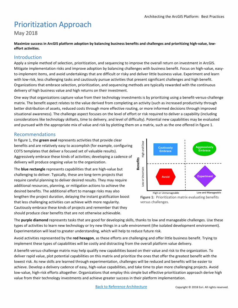
Prioritization Approach May 2018
Maximize success in ArcGIS platform adoption by balancing business benefits and challenges and prioritizing high‐value, low‐effort activities.
Introduction Apply a simple method of selection, prioritization, and sequencing to improve the overall return on investment in ArcGIS.
Mitigate implementation risks and improve adoption by balancing challenges with business benefit. Focus on high‐value, easy‐
to‐implement items, and avoid undertakings that are difficult or risky and deliver little business value. Experiment and learn
with low‐risk, less challenging tasks and cautiously pursue activities that present significant challenges and high benefit.
Organizations that embrace selection, prioritization, and sequencing methods are typically rewarded with the continuous
delivery of high business value and high returns on their investment.
One way that organizations capture value from their technology investments is by prioritizing using a benefit‐versus‐challenge
matrix. The benefit aspect relates to the value derived from completing an activity (such as increased productivity through
better distribution of assets, reduced costs through more effective routing, or more informed decisions through improved
situational awareness). The challenge aspect focuses on the level of effort or risk required to deliver a capability (including
considerations like technology skillsets, time to delivery, and level of difficulty). Potential new capabilities may be evaluated
and pursued with the appropriate mix of value and risk by plotting them on a matrix, such as the one offered in figure 1.
Recommendations In figure 1, the green oval represents activities that provide clear
benefits and are relatively easy to accomplish (for example, configuring
COTS templates that deliver a focused set of valuable results).
Aggressively embrace these kinds of activities; developing a cadence of
delivery will produce ongoing value to the organization.
The blue rectangle represents capabilities that are high‐value but
challenging to deliver. Typically, these are long‐term projects that
require careful planning to deliver desired results. They may require
additional resources, planning, or mitigation actions to achieve the
desired benefits. The additional effort to manage risks may also
lengthen the project duration, delaying the instant gratification boost
that less challenging activities can achieve with more regularity.
Cautiously embrace these kinds of projects and remember that they
should produce clear benefits that are not otherwise achievable.
The purple diamond represents tasks that are good for developing skills, thanks to low and manageable challenges. Use these
types of activities to learn new technology or try new things in a safe environment (the isolated development environment).
Experimentation will lead to greater understanding, which will help to reduce future risk.
Avoid activities represented by the red hexagon, as these efforts are challenging and offer little business benefit. Trying to
implement these types of capabilities will be costly and distracting from the overall platform value delivery.
A benefit‐versus‐challenge matrix may help qualify new capabilities based on their value and risk to the organization. To
deliver rapid value, plot potential capabilities on this matrix and prioritize the ones that offer the greatest benefit with the
lowest risk. As new skills are learned through experimentation, challenges will be reduced and benefits will be easier to
achieve. Develop a delivery cadence of easy, high‐value capabilities, and take time to plan more challenging projects. Avoid
low‐value, high‐risk efforts altogether. Organizations that employ this simple but effective prioritization approach derive high
value from their technology investments and achieve greater success in their platform implementation.
Figure 1: Prioritization matrix evaluating benefits versus challenges.

Architecting the ArcGIS Platform: Best Practices
Back to Reference Architecture Copyright © 2018 Esri. All rights reserved.
Publication Strategy: Geospatial Content Delivery May 2018
Publication is the act of delivering content (data, services, and applications) to appropriate consumers in an appropriate manner.
A geospatial content publication strategy is necessary for delivering content to consumers in a well performing, reliable, and
secure manner.
Introduction An effective geospatial content delivery strategy must address performance, reliability, and security. By addressing these
three areas, organizations can make certain that content will be available and delivered in a manner that is suitable for
consumers to use. This strategy should balance user expectations for performance and availability against security and load on
the infrastructure. The intent is to mitigate risk while meeting audience needs and expectations.
Recommendations One common publication need involves sharing internal information with people outside of the organization—for example, a
city sharing land ownership information with the public. A typical strategy would involve creating a publication geodatabase
(as a hosted service) deployed to a cloud environment, which is separated from internal systems. This strategy addresses the
elements of performance, reliability, and security.
Performance is addressed by separating information consumers from operational or transactional systems. In the example of
the city sharing land ownership information, the public consumes information from ArcGIS Online, which reserves the city’s
internal resources for transactional editing of the property boundaries. Separating consumers from transactional editing
reduces resource contention, increasing the available resources for editors. Leveraging a cloud‐hosted, software‐as‐a‐service
(SaaS) environment also provides a scalable, more elastic venue for consumers, so the available resources can grow in
response to demand (for example, to support a suddenly popular map). In the city’s example, performance is appropriately
addressed for information curators and consumers.
Reliability is an important aspect of an information system. Reliability can be expressed as a service level agreement (SLA) or
as an expectation of when the system will be available (for example, during work hours, or during a crisis). Organizations can
address reliability by following many of the other best practices, such as high availability, load balancing, workload separation,
and security. It can also be addressed by leveraging cloud capabilities. In the city’s example, reliability is addressed for the
public, because ArcGIS Online has a 99.9% SLA. There is a less strict SLA for editors, which does not warrant high availability.
Organizations (in this case, the city) should implement appropriate infrastructure to
support those less strict SLA requirements for their editors.
Security means exposing the right content to the right consumers, while still
protecting the enterprise. In the city’s example, consumers are allowed to view the
published land ownership information, but they have no access to update the
property boundaries. For reasons such as legality and cost, property boundaries
should only be edited by authorized experts and maintained in a secure system of
record. The example appropriately addresses geospatial content security on the
consumer side, but internally, the land records department maintains lots of
sensitive information, so a separate internal publication environment is appropriate
for other departmental access. In this case, the city might also consider a separate
internal publication environment for decision support, as shown in figure 1.
An effective geospatial content publication strategy will address performance,
reliability, and security. The strategy should strive to deliver content that meets the
needs and expectations of consumers, while protecting internal systems and data. Effective geospatial content delivery
exposes appropriate information to the broader audience while minimizing the impact on operations.
Figure 1 ‐ Publish content to the environment appropriate for the audience.

Architecting the ArcGIS Platform: Best Practices
Back to Reference Architecture Copyright © 2018 Esri. All rights reserved.
Real‐time GIS Strategy May 2018
Real‐time GIS allows organizations to tap into streaming data from sensors, devices, and social media feeds for simultaneous analysis and display. With real‐time GIS, maps and databases are continuously updated, trends are observed as they form, and key personnel are alerted the moment activity or performance reaches a critical threshold. Organizations that embrace location in their real‐time capabilities can quicken decision making and responsiveness.
Introduction Real‐time location data is increasingly important in modern enterprises, enabling organizations to track the location,
performance, and status of the assets and environments relevant to their missions. Real‐time GIS lets organizations manage,
analyze, and disseminate this data as observations occur. By treating real‐time GIS as a core capability, organizations can
enhance their operational awareness and maximize the impact of their decisions.
Recommendations Plan an approach to ingest and manage real‐time data, transform that data into actionable information through analytics, and
disseminate the intelligence to the right people as part of a real‐time GIS strategy.
Orchestrate real‐time data ingestion from a wide variety of locations and sources, so decision makers and operations teams
can access information as events occur. Ingestion can mean the consumption of real‐time data streams for immediate display,
as well as the persistence of observations for later analysis and use. ArcGIS ingests data regarding the location, performance,
and status of teams, assets, products, environments, and services from Internet of Things (IoT) sensors and devices, as well as
social media feeds and web APIs. Choose from a variety of patterns to manage the ingestion of real‐time data that will
contribute to operational awareness and business performance. Broadcast event data with a stream service to provide
immediate event visualization, and optionally archive the data to an enterprise relational database or spatiotemporal big data
store.
Once real‐time data is ingested, analyze and filter incoming data
on the fly so decision makers can address changes as they occur.
High‐volume and high‐velocity data can be overwhelming, even
when displayed on a map. Use location‐based and attribute‐based
filters to evaluate incoming data and determine its relevance and
importance. For example, apply a spatial filter based on a geo‐
fence to determine if an asset is inside, outside, entering, or
exiting an area (see figure 1). Additionally, to increase intelligence
and insight, analyze and enrich incoming data using processors
capable of performing mathematical, spatial, and geometric
operations. Transform and enrich real‐time data to make it more
relevant and actionable to decision makers.
Decision support is enhanced when organizations disseminate real‐
time data that has been transformed into actionable information. Dissemination occurs through notifications, including a
variety of output options that can be addressed to the appropriate user, application, or system for action. For example, the
location of moving assets (such as active snow plows) or the status change of stationary assets (such as radiological sensors)
can trigger a notification to key personnel via text message and/or to another system for action via a web API.
It is important to consider real‐time data from moving and stationary assets to optimize business performance and improve
decision support. Organizations need access to current and actionable information, which is increasingly being streamed from
sensors and devices. Organizations that embrace the location aspect of their real‐time data are able to react more quickly to
dynamic situations and make faster, more informed decisions.
Figure 1: Use of a spatial filter to determine the location of a moving asset in relation to a geo‐fenced area

Architecting the ArcGIS Platform: Best Practices
Back to Reference Architecture Copyright © 2018 Esri. All rights reserved.
Security May 2018
The topic of securing the ArcGIS platform should be addressed early in the design process, especially since the techniques and approaches may vary depending on business needs and environment. Information stored and delivered securely will improve the appropriate availability and reduce the risk of compromise. ArcGIS supports common security frameworks and should be configured to work within the organization’s established security model.
Introduction ArcGIS can meet the security and privacy challenges of organizations through a secure enterprise solution. Typically, the
security configuration involves integrated functions within Esri products, third‐party solutions, and implementation
approaches. Some key technical security mechanisms to consider in an ArcGIS implementation are user authentication and
authorization, filters, encryption, and logging/auditing.
Recommendations Regardless of the security mechanisms embraced, organizations should—early in their ArcGIS platform design process—
consider and identify the appropriate security measures needed to meet their enterprise business requirements and
security/privacy needs.
Authentication involves verifying credentials to confirm the identity of a person or application attempting to access the
system. The authentication process confirms the identity and then directs them to the items and datasets they have access to
via authorization. To help organizations secure resources through a single sign‐on experience and reduce the number of user
credentials that need to be managed, ArcGIS can leverage centralized authentication stores like Lightweight Directory Access
Protocol (LDAP), Integrated Windows Authentication, or Security Assertion Markup Language (SAML). Depending on the
organizational identity store, authentication may require specific technology configurations to authorize access to items.
Filtering hardware and software aims to intercept invalid or attack requests before a web or application server can execute
them. Firewalls can prevent unauthorized access to private resources; they can also be configured to inspect packets and
accept or reject them based on defined rules around the acceptable level of risk. Reverse proxies obscure details of the
internal network and should be configured to perform content filtering, URL rewriting, and load balancing. The ArcGIS Web
Adaptor is an application that forwards client requests to ArcGIS Enterprise machines in a site, obscuring machine and port
information and filtering access to ArcGIS Server Manager and Administrator directories.
Encryption of data in transit is an industry‐recognized best practice to enforce the security and privacy of data. To prevent the
interception of secure data communications, ArcGIS should be configured to use Transport Layer Security (TLS) encryption
protocol. Furthermore, strong encryption methods like Advanced Encryption Standard (AES) and Secure Hash Algorithms
(SHA) should be employed to encode the data and detect whether it has been tampered with or modified.
Auditing and analyzing system and application logs regularly is recommended to provide a baseline understanding of the
ArcGIS platform’s use in regular operations. Anomalies in the baseline can then be used to identify security incidents or to
provide information on system problems or unusual conditions. Application logs can also provide event‐level details around
specific security incidents and policy violations within the enterprise.
Authentication and authorization should use an organization’s existing centralized identity management system to simplify
user access and centralize credential management. Filtering hardware and software, such as the ArcGIS Web Adaptor, should
be used to inspect requests and obfuscate internal network components. Data encryption in transit and at rest should use the
most secure methods possible in relation to the acceptable level of risk, while regular auditing of application and system logs
can provide an understanding of baseline operations and help identify anomalies. Most importantly, security must be
considered early in the design and implementation process to confirm that risk assumptions and architecture decisions align.
For more information, please visit trust.arcgis.com – the most up to date resource for security, privacy, and compliance
information regarding the ArcGIS platform.

Architecting the ArcGIS Platform: Best Practices
Back to Reference Architecture Copyright © 2018 Esri. All rights reserved.
Workforce Development May 2018
Workforce development is meant to equip an organization’s most valuable asset—its people—with the knowledge and experience needed to effectively use and expand the reach of the ArcGIS platform. Devoting resources towards workforce development will help an organization achieve greater value and a faster return on investment from ArcGIS.
Introduction Organizations use ArcGIS to execute day‐to‐day operations, engage with customers and constituents, and create products and
services that improve business outcomes. Often, organizations are unable to fully leverage ArcGIS because their staff is not
current on the latest technology advancements. This can make it difficult for organizations to meet business demands, and it
may cause them to use inefficient legacy workflows or rely on consulting services to accomplish goals. These organizations can
utilize Esri’s training resources to better equip their workforces and achieve their strategic goals. Workforce development is
critical to a successful platform implementation because it improves awareness of contemporary workflows and
methodologies, encourages the use of appropriate methods and approaches for solving problems, and reduces reliance on
external resources.
Recommendations Esri is committed to helping customers solve problems with geography and provides thousands of hours of training content designed to contribute to customer success. Esri offers a wide variety of learning methods including instructor‐led training, web courses, training seminars, videos, conferences and user groups, professional services, and business partner knowledge transfer. Customers who have an Esri qualifying product with a current maintenance subscription also have unlimited access to all self‐paced e‐Learning resources. With these resources available, workforce development should be a part of every ArcGIS platform implementation and customers should build a plan for each GIS role within their organization. With expertise developed through workforce training and practice, organizations are better suited to utilize ArcGIS platform capabilities.
As technology evolves over time, new workflows and processes are developed within those technologies to improve efficiency and productivity. Esri training helps an organization’s employees understand these more efficient modern workflows, which in turn offsets the cost of training.
Workforce development also teaches organizations to use appropriate methods and approaches that minimize wasted time and unlock the ArcGIS platform’s full value. While there are multiple ways to achieve desired outcomes, knowing when and where to use the right tools and workflows allows organizations to reach their goals more quickly and more efficiently.
Organizations often need to use third‐party consultants to assist in developing new capabilities. Consultants will be more efficient and more effective if the resources managing those consultants have the proper expertise. Because trained employees are more capable of leading the new team, the organization retains better control over consultants’ activities. In addition, these employees are better positioned to experience knowledge transfer from the supplemented team, which makes them more likely to be able to take ownership of the consultants’ work.
Esri recommends that organizations regularly invest in workforce development to meet their business needs. Even though training often receives a smaller portion of funding in an overall location strategy, organizations that invest in workforce development achieve greater value and return on investment from the ArcGIS platform. With a trained workforce, organizations will be able to use ArcGIS efficiently and effectively, set and achieve their goals, and build a culture of self‐reliance and expertise.

Architecting the ArcGIS Platform: Best Practices
Back to Reference Architecture Copyright © 2018 Esri. All rights reserved.
Workload Separation May 2018
Workload separation is a design approach that enhances performance and reliability by aligning the technical implementation with organizational business requirements. Consider different business workflows to understand how each workflow impacts compute resources, and then use segregated and preplanned resource allocation to meet the needs of each workflow.
Introduction Specific business functions impact the performance of the ArcGIS platform in different ways. By allocating workloads to
appropriate server resources organized by business function, organizations can maximize performance, reduce risk, and meet
business‐defined service level agreements (SLAs). By implementing geospatial function isolation, organizations can reduce the
risk that high‐intensity processes will consume cycles needed to support critical applications, or that an abnormal spike in
requests will disrupt service for all users.
Recommendations Organizations should implement workload separation to maximize system performance and reduce risk. Workload separation
allows organizations to make best use of their compute resources and provide better, more reliable service to users.
System performance is maximized when service requests are directed to compute resources in a way that optimizes hardware
and reduces resource contention. Direct service requests that are known to be central processor unit (CPU) intensive, such as
complex analysis tasks, to an ArcGIS Server site containing machines with faster processors. Direct less intensive requests,
such as map visualization tasks, to more modest machines. This approach makes the best use of available compute resources
to achieve the highest performance.
Workload separation also reduces the risk of service interruption. System
stability is enhanced because overloaded machines cannot affect other
machines in the environment, which in turn protects critical tasks from
resource contention. Route user requests to the appropriate sites through
load balancers and deliver results securely and transparently.
An example of workload separation involves the isolation of analytic tasks
from decision support tasks. Back‐office analytics are typically CPU
intensive, executed sporadically, and maintained by lower SLAs. Because
analysts use geoprocessing tasks in an ad hoc fashion, the CPU may sit idle
for long periods, but then spike when several tasks are executed. On the
other hand, decision support activities often simply consume map‐based
information products to drive operational business decisions. They are
typically less CPU intensive, executed more consistently, and maintained by
higher SLAs. Because the characteristics of these tasks and workflows are
so different, it would be appropriate to use workload separation to
accommodate each set of activities.
Allocate hardware around core GIS capabilities, including data
management, analysis, and visualization functions, as recommended in
figure 1. Some organizations may have more detailed separation needs
around specific business functions (such as imagery, real‐time data, or
caching), hardware characteristics, or SLA definitions. Finally, use GIS patterns, SLAs, and performance expectations to
determine how to best direct workloads to appropriate compute resources.
Figure 1‐ Infrastructure components should be organized by business function

Comments or suggestions regarding this document may be sent to: [email protected]