archaeological survey june 2013
TRANSCRIPT

CORRANTREE LEAD MINE
ARCHAEOLOGICAL SURVEY
JUNE 2013
Report by
John Pickin
for
Forestry Commission
Scotland

Archaeological survey: Corrantree lead mine
1 | P a g e
CORRANTREE LEAD MINE
ARCHAEOLOGICAL SURVEY
JUNE 2013
Contents
Introduction: 2
History: 2
Site description and condition: 4
Historic maps: 15
Extent of site: 17
Health and Safety: 17
Management: 17
References: 18
Appendix 1 – list of photographs: 18
Report prepared for Forestry Commission Scotland
by
John Pickin
High Weirston House, Leswalt, Stranraer, Dumfries and Galloway DG9 0RQ
Email: [email protected] Tel: 01776 870270

Archaeological survey: Corrantree lead mine
2 | P a g e
CORRANTREE LEAD MINE
NGR: NM 8000 6590
Parish: Ardnamurchan
Area: Lochaber
Region: Highland
NMR: NM86NW4
HER: MHG 133
Scheduled monument: 5513
Survey photographs: CR 1- 24 (see Appendix 1 for details)
Introduction
In May 2013 Forestry Commission Scotland commissioned a survey of the Ccorrantree lead mine.
The aim of the survey was to locate and describe the principal archaeological features and provide
information on their condition and any associated health and safety issues. The survey was carried
out in June 2013.
The Corrantree lead mine, which is a Scheduled Ancient Monument, was worked intensively from
1722 to 1815 and reworked in the mid-nineteenth century; the site was examined in the 1950s but
no development took place. Features survive from all these periods and include opencasts, levels
and shafts, dressing floors, spoil tips, a mine office and associated building, a wheel pit and crushing
mill and a self-acting incline tramway.
All archaeological features were photographed and given a ten-figure grid reference and measured
sketches were also made of selected features.
A Monument Management Plan for the site was produced by Forestry Commission Scotland in 2009
and runs from 2011 to 2016.
History
Corrantree lead mine is the most westerly of the Strontian mines. The Strontian mines were
discovered in 1722 and worked as an integrated group by the proprietor of the estate, Sir Alexander
Murray of Stanhope. In 1729 the lease for the mines was given to the Duke of Norfolk and Company
who erected a four-hearth smelting mill at Strontian village. A few years later the lease was taken
up by the York Buildings Company who worked the mines continuously until 1815. Between 1817
and 1836 the mines were worked on a small scale by the owner and then leased again to a number
of companies with the final phase of operation being between 1850 and 1872. In 1901 a proposal

Archaeological survey: Corrantree lead mine
3 | P a g e
Plan of Corrantree lead mine. The numbers relate to the principal archaeological features recorded
during the survey.

Archaeological survey: Corrantree lead mine
4 | P a g e
was made to reopen the mines but work was confined to the Bellsgrove mine and no development
took place at Corrantree (Wilson 1921: 83).
The mine was resampled but not developed in the 1950s (Flett 1959: 108). In 1968 the Scottish
Canadian Company carried out a programme of drilling at Corrantree to establish the extent and
type of the remaining mineral deposits but no mining was undertaken (Kimbell 1986: 3). During the
1980s some of the other mines at Strontian were reopened for barite but the Corrnatree mine was
not part of this development.
Description and condition
The Corrantree mine worked a lead vein which outcrops at the surface between NM 8006 6560 and
NM 8048 6585. Mining consisted of a series of shallow opencast excavations (1, 9-11 below) and the
more westerly opencasts (9-11) were drained by a level (13) driven from the north bank of the Allt
Tarsuin. The opencast workings and their associated hand-dressing floors for ore treatment (2, 3, 6-
8) probably relate to the first phase of operation between 1722 and 1815. The manager’s house and
office (16) are likely to date to the same period but may have continued in use until the mine closed
in the 1870s.
A 122m long level (17), known as Deep Level, was driven beneath the opencast workings to explore
the vein at depth (Wilson 1921: 86). Ore from Deep Level was taken to a rope-operated incline (21-
22) and delivered to a water-powered crushing mill (23) at the bottom of the hill; given the large size
of the wheel pit, this phase of mining is probably 19th century and is liekely to belong to the 1850-
1872 period. The only evidence for 20th century working is the collapsed wooden shed or bothy with
broken drill cores (15) which probably was in use during the 1950s or 1968 drilling programme.
The individual features at the mine are described below:
1. Opencast mine working, NM 80408 65843 – 80478 65849 (Photos CR 1.1-7)
The mineral vein has been worked as an opencast vein for a distance of approximately 75m. The
dimensions of the opencast vary but average 6m deep and 3m wide. At NM 80438 65843 there is a
4m high rise; there is a good exposure of the mineral vein at this point.
Condition: fair.
2. Spoil tip and dressing floor, NM 80436 65 822 (Photos CR 2.1-5)
On the hill slope above and immediately S of opencast 1 is a level area of mine spoil, 20m x 22m. It
comprises two areas of finely broken quartz with a central section of broken unmineralised rock. In
the N part of the spoil heap is a low stone structure defining a space 2.5m x 3m; this is probably a
bench for the manual crushing (hand-dressing) of lead ore.
Condition: fair. Some erosion of tip material.

Archaeological survey: Corrantree lead mine
5 | P a g e
Sketch plan of dressing floor 2.
3. Mine level NM 80358 65840 (Photos CR 3.1-2)
Level, 1.6 m wide x 1.3m high, in a rock outcrop on N side of burn and partly concealed by mine
spoil. Immediately E of the level are some shallow rock- cut surface excavations on a quartz vein.
Condition; good. In competent rock. Entrance covered with modern grill.
4. Ore crushing bench, NM 80354 65828 (Photos CR 4.1-2)
A flat topped stone-built structure, approx. 2m x 2m, constructed against the natural slope on the S
side of the burn. Surrounded by finely crushed quartz. Probably a bench for the manual crushing
(hand-dressing) of lead ore.
Condition: fair.
5. Mine shaft, NM 80335 65839. (Photos CR 5)
A rectangular rock-cut shaft, 1.4m x 2.3m, in-filled with mine spoil on the N side. Flooded.
Condition: fair. Risk of infill from spoil tip above.
6. Mine level and dressing floor, NM 80 285 65863. (Photos CR 6.1-2)

Archaeological survey: Corrantree lead mine
6 | P a g e
Entrance to small mine level, 0.50m x 0.70m, excavated on an exposed mineral vein. Some 6m SW is
a flat-topped stone-built structure, 2m x 4m, constructed against the S bank of a gully; probably a
bench for the manual crushing (hand-dressing) of lead ore. On the opposite side of the gully is a 5m
length of dry stone retaining wall.
Condition: fair. Structures appear stable.
Sketch plan of mine level and dressing floor 6.
7. Building (possible), NM 80252 868. (Photos CR 7.1-2)
A series of discontinuous lengths of coursed stone define the foundations of an L-shaped structure,
6m x 12m, possibly a building or small enclosure. The ground inside and around the structure is
uneven, perhaps from shallow surface mining.
Condition: poor. Structures reduced to foundation course in places. Covered with vegetation
(mainly heather).
8. Ore crushing bench, NM 80253 80877. (Photos CR 8)
A flat-topped stone-built platform, 3m x 5m, constructed against the natural slope with a coursed
face on the S side. Probably a bench for the manual crushing (hand-dressing) of lead ore.
Condition: fair. Stable structure, no threat.

Archaeological survey: Corrantree lead mine
7 | P a g e
Opencast 1, view east. Opencast 1, mineral vein exposure
at NM 40438 65843.
Dressing floor 2, view west. Level 3 with vein working to right, view north east.
Hand-dressing bench 5, view south east . Shaft 6.

Archaeological survey: Corrantree lead mine
8 | P a g e
Level 6, view east . Dressing bench and retaining walls in front of level 6.
Ore dressing bench 8, view north. Opencast working 9, view east.
Opencast working 10, view east. Opencast working 11, view east.
.

Archaeological survey: Corrantree lead mine
9 | P a g e
9. Opencast working, NM 80221 65880. (Photos CR 9.1-2)
An opencast mine working, 2.5m x 8m, excavated on the ore vein and known as Allen Cameron’s
Sump (Wilson 1921, Fig. 13). The vein itself is exposed on the E face of the excavation and the
working is flooded. To the SW of the opencast is a short length of dry stone walling built against the
bank. E of the opencast a shallow rock-sided gully, 50m long, marks the line of the mineral vein and
may be a prospecting trench
Condition: fair. Rock appears stable. Fenced.
10. Opencast working, NM 80198 65888. (Photo CR 10)
A flooded opencast mine working, 3m x 10m, with a linear spoil tip on the S side. Known as Windlass
Stope (Wilson 1921, Fig. 13).
Condition: fair. Rock appears stable. Fenced.
11. Opencast working, NM 80165 65899. (Photo CR 11)
Large opencast mine working, approximately 2m wide and 30m long, with a sloping entrance at the
W end. On the s side is a low, linear spoil tip and to the W is a narrow, low spoil tip, 4m x 15m, with a
partial revetment wall.
Condition: fair. Rock appears stable. Fenced.
12. Structure (?) and spoil tip, NM 80133 65905. (Photo CR 12)
An area of crushed spoil, 3m x 6m, with a short length of stone walling to the E. Thick heather
obscures the full extent of this feature.
Condition; poor. Partly covered with vegetation.
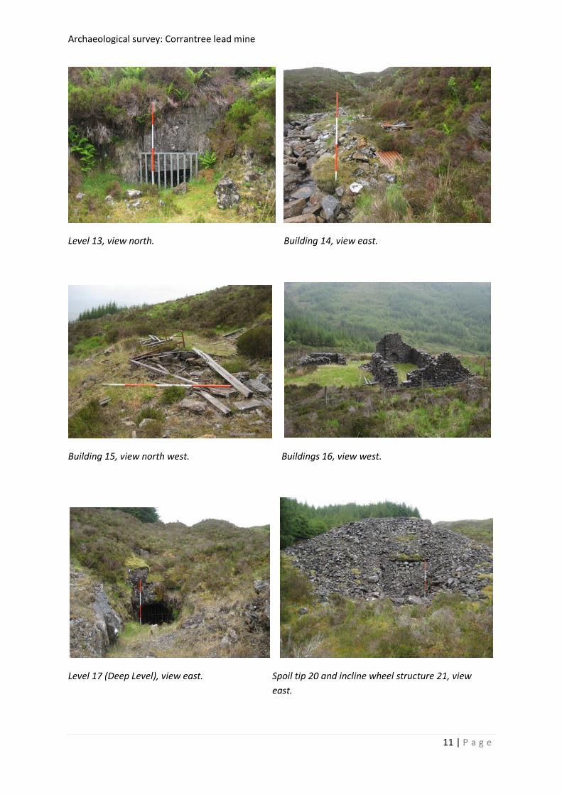
13. Mine level, NM 80120 65859. (Photo CR 13)
A rock-cut mine level, 1.10 m wide x 0.50m wide, on the N bank of the Allt Tarsuinn. Entrance
covered with a modern metal grill.
Condition: good. In competent rock. Metal grill across entrance.
14 Building, NM 80079 65855. (Photo CR 14)
On the S bank of the Allt Tarsuinn and downstream of level 13 are the degraded stone foundations
of a rectangular building, 3m x 8m. The NE corner of the structure has an angled buttress, probably
to prevent flood damage from the adjacent stream. The structure is partly covered with corrugated
iron sheets, presumably collapsed roofing material.
Condition: poor. Risk of flood damage

Archaeological survey: Corrantree lead mine
10 | P a g e
15 Building, NM 80056 65878. (Photos CR 15.1-3)
The collapsed remains of a timber-framed wooden shed built on a level terrace, 7m x 12m. Within
the structure are two iron bed frames and to the SE, in an annexe defined by three large floor
timbers, are a considerable number of broken drill cores. An earlier roofed building is shown at this
location on the First Edition edition OS map.
Condition: poor. The structure has collapsed.
16 Buildings, NM 800028 65914
Two adjacent buildings, probably the mine’s offices, stores and lodgings.
Building A is rectangular, 5.40m x 13.60m with a gable at the W end standing to 3.60m; it is divided
into two units. The larger unit is in the W section and has a central door and two side windows in
the S wall and central fireplaces in the gable and dividing walls. The smaller unit has a fireplace
against the dividing wall and a single opening or entrance in the S wall. The E end of the building is
constructed against the natural slope and is surrounded by a stone faced channel with a buttress
close to the NE corner on the N wall.
Building B is rectangular, 5.20m x 9.60m, and located SW of Building A. It is divided into two units of
similar size with openings in the S and E walls and a blocked doorway in the internal wall. There is a
fireplace against the W wall of the W unit.
Both buildings are shown as roofed structures on the First Edition OS map; the map also depicts a
rectangular enclosure is depicted on the N side of Building B.
Condition: good. Fallen rubble has been cleared from the around Building 16a and the wall heads are
clear of vegetation. The E room in Building 16b has also been cleared but the W room is partly
obscured with collapsed masonry; the wall heads are vegetation free. Saplings and heather have
been removed from within the fence enclosing the two buildings.
Sketch plan of Buildings 16a and 16b
Archaeological survey: Corrantree lead mine
11 | P a g e
Level 13, view north. Building 14, view east.
Building 15, view north west. Buildings 16, view west.
Level 17 (Deep Level), view east. Spoil tip 20 and incline wheel structure 21, view
east.

Archaeological survey: Corrantree lead mine
12 | P a g e
17. Mine level, NM 80058 65964
At the E end of a 20m long linear cutting is the entrance to a rock-cut mine level, 1.20m high x 1.40m
wide. There are some stretches of dry stone retaining wall along the sides of the trench.
Condition: good. The level has been driven in competent rock and is gated with a modern metal
grill.
18. Building (?), NM 80043 65973
At the NW end of the trench leading to mine level 17 are the stone foundations of a possible
structure, 2.50m x 2.50m, built against the natural slope and open on the S side.
Condition: poor. Reduced to foundation course.
19. Drain(?), NM 80035 65974.
W of the cutting leading to mine level 17 is a linear gully, 5m long, with slight stone banks along
either side which join at the W end. To the E the gully may continue upslope.
Condition: poor. The possible continuation to the E is masked with vegetation.
20. Spoil tip, NM 80031 65979
A large flat topped spoil tip, 9m x 24m, associated with mine level 17.
Condition: fair.
Sketch plan showing entrance to level 17, spoilt tip 20 and the top of the incline (21, 22).

Archaeological survey: Corrantree lead mine
13 | P a g e
21. Inclined plane wheel house, NM 80018 65985
Constructed against the W end of spoil tip 21 are the remains of a stone-built structure associated
with the top of a self-acting inclined plane tramway (22). A sloping section of coursed stone,
probably the base for a hopper or an ore chute, is a set above a timer-braced rectangular recess,
2.40m x 5.40m, which contains a cast iron pulley wheel, 2.06m diameter, set horizontally on the
floor. The pulley wheel appears to be in situ. Directly in front of the wheel house is a level area, 4m
x 7m, with retaining walls to the N, S and W; in the centre is a low stone wall aligned on the central
axis of the inclined plane.
Condition: fair. The masonry retaining walls appear stable but the horizontal timber brace above the
pulley chamber is decayed.
22. Inclined plane, NM 80016 65992 – NM 79874 66050
The inclined plane survives as a linear earthwork which runs downslope between the wheel house
(21) and the water wheel pit (22). For most of its length it is an angled embankment, 4m wide, with
a central axial bank but in the lower section it forms a linear gully. It terminates at the W end in a flat
topped mound which is connected to the NE corner of the wheel pit by raised tramway bank.
Condition: poor. The earthwork appears intact and stable but is masked by thick vegetation (mainly
heather).
Sketch plan showing the western end of the incline (22), the water wheel and crusher (23) and spoil
tip 24.

Archaeological survey: Corrantree lead mine
14 | P a g e
View down incline 22 with pulley in foreground. View up incline 22.
Water wheel structure 23– launder pillar . Water wheel structure 23, view west. Bank from
incline base at bottom right.
Water wheel structure 23, view north east Spoil tip 24.
with the crusher platform to the right.

Archaeological survey: Corrantree lead mine
15 | P a g e
23. Wheel pit, NM 79822 66040
A massive rectangular, stone-built structure, 15m x 4.50m x 3.75m high. Built against the natural
slope, its N, S and W faces are free-standing. A raised embankment connects the NE corner of the
wheel pit with the mound at the base of the incline. A recess in the central section of the S wall head
corresponds to the wheel’s axel. A terraced platform against the S wall , 3.25m x 7m, marks the
position of the crushing mill. Close to the W end of the wheel pit are a number of cast iron fittings
from the crusher including cogs and rollers.
At the E end of the wheel pit are three free standing stone pillars, 2.50m x 0.80m x 1.60m high (only
the W pillar survives intact); these pillars supported a wooden launder or trough taking water to the
wheel. The downslope end of the wheel lade is at NM 79865 66037.
Condition: poor. The condition of this structure was highlighted in the recent Monument
Management Plan and it is still an area of concern. As described in the MMP the W end of the wheel
pit has collapsed, the inner core of the two side walls is exposed and the roots of a rowan tree
growing within the interior wheel pit threatens the stability of the whole structure. Collapsed
masonry partly obscures the crusher base on the S side. There is thick ground cover within the
fenced area surrounding the wheel pit and this obscures the three launder pillars and the line of the
lade.
24. Spoil tip, NM 79797 66062
A large flat-topped spoil tip, 11m x 35m, W of the wheel pit. The tip, which is crossed by a burn in its
s section, is composed of finely crushed waste derived from the crushing mill.
Condition: poor. A stream cuts through the S section of the tip and is causing erosion.
Historic maps
OS First Edition six-inch. Argyllshire, Sheet XVII, survey date: 1872
The First Edition OS six-inch map shows the layout of the mine in 1872 just before final closure. It
depicts the entrance to Deep Level (17), the mine office and associated building 16a and 16b (the
latter with a garden(?) enclosure), a roofed building on Allt Tarsuinn (15), the line of the incline (22)
with a square structure at its base and the crushing mill and wheel pit (23). The map also shows a
reservoir and ‘sluice’ south east of the eastern opencast and two more reservoirs, ‘sluices’ and a
lade system associated with the water supply for the crushing mill; these features are now masked
by heather or within forestry plantations.

Archaeological survey: Corrantree lead mine
16 | P a g e
OS First Edition six-inch 1872.
OS Revised six-inch. Argyll and Bute sheet XVII.SE, revised 1897.
The Second or Revised edition, surveyed in 1897, marks the mine as disused and shows three roofed
structures (buildings 15, 16a and 16b), the wheel pit (23) and the entrance gully for Deep Level (17).
Mine plan and section 1871
Wilson (1921: Fig.13) includes a simplified plan and section of the mine in 1871. In addition to
surface features like ‘old water wheel’ and ‘old office’ it shows the extent of the underground mine
including the ‘stoped areas’ which are the actual workings on the mineral vein. The ‘shallow adit’
shown on the north bank of the Allt Tarsuin west of the top opencast was not located during the
present survey. It is apparent from the section that the mine was comparatively shallow.
A mine abandonment plan dated 1871 is held by the British Geological Survey (ref.: SP 1050) and is
likely to be the source of Wilson’s plan and section.

Archaeological survey: Corrantree lead mine
17 | P a g e
Plan and section of the mine (Wilson 1921: Fig. 13)
Extent of site
The area of the existing Scheduled Ancient monument includes all the key features with the
exception of the eastern end of opencast 1 and dressing floor 2. Extending the SE corner of the SAM
to NM 80451 65830 would incorporate all the known industrial features.
Health and safety
All the deep opencast workings and the mine levels are securely fenced and gated and the standing
structures (buildings 16 and the wheel pit) are within securely fenced enclosures. The poor
structural condition of the wheel pit poses a potential risk but the fence reduces this to an
acceptable level.
Management recommendations
With the exception of the wheel pit and buildings 14 and 15 most of the archaeological features are
in a fair condition and under no direct threat; these features should be monitored on a regular basis.
No evidence was seen during the present survey of disturbance to the tips by mineral collectors – as
noted in the MMP report – but the tips should be monitored to establish the degree of future
disturbance from this activity.
Much of the site is covered with thick heather which masks some known features and may be
concealing others. The previously unrecorded hand- dressing floors and shallow surface works (6-
10) in the E section of the site are in an area of particularly thick ground cover and more detailed
field survey here would aid interpretation and possibly lead to the recognition of new features.

Archaeological survey: Corrantree lead mine
18 | P a g e
Thick heather and mature plantations in the W section of the site conceal the systems of lades which
are shown on the First Edition OS map taking water to the wheel pit; this area would also benefit
form more detailed survey and interpretation. The lade system should be relocated and assessed
during future clearance work.
Building 14 is at risk from flood damage but the masonry buttress at the E end may be providing
adequate protection. The site should be monitored, ideally during flood conditions. If necessary a
realignment of boulders in the stream could provide an adequate barrier or diversion.
Building 15 has collapsed and the timber cladding and framework are at risk of decay. A
photographic survey would provide an adequate record.
The large rowan tree in the wheel pit appears to have been pruned or cut – as recommended in the
FCS MMP – but it is still alive and the roots continue to threaten the stability of the structure. If
possible the tree should be poisoned. Scrubby undergrowth within the wheel pit enclosure fence
should also be removed. Given the poor condition of the wheel pit it might be appropriate to
undertake a detailed measured survey in advance of further deterioration.
References
Flett, W. R. 1959. Problems Affecting the Exploitation of minerals in Scotland. In The future of non-
Ferrous mining in Britain and Ireland, 101-111. London: Institute of Mining and Metallurgy.
Kimbell, G. S. 1986. Geophysical surveys near Strontian. British Geological Survey: mineral
reconnaissance programme, report no.6. Keyworth.
Wilson, G. V. 1921. The Lead, Zinc, Copper and Nickel Ores of Scotland. Special Report on the Mineral
Resources of Great Britain, Vol. XVII. HMSO: Edinburgh.
APPENDIX 1
List of photographs (on disc).
Photo number Feature Description
CR 1.1 1 W end of opencast 1, view E.
CR 1.2 1 Detail of vein.
CR 1.3 1 Detail of vein.
CR 1.4 1 Detail of vein showing galena cubes in barite.
CR 1.5 1 Central section of opencast 1.
CR 1.6 1 View E to w end of opencast 1.
CR 1.7 1 View E to e end of opencast 1.

Archaeological survey: Corrantree lead mine
19 | P a g e
CR 2.1 2 Ore-dressing bench, view E.
CR 2.2 2 Ore-dressing bench, view N.
CR 2.3 2 Tip 2, view W
CR 2.4 2 Tip 2, view W
CR 2.5 2 Detail of ore-dressing bench, view S.
CR 3.1 3 Level and vein working, view NE.
CR 3.2 3 Detail of level entrance.
CR 4.1 4 Ore-dressing bench, view S.
CR 4.2 4 Detail of ore-dressing bench.
CR 5 5 View of shaft top.
CR 6.1 6 Level entrance with vein exposure above.
CR 6.2 6 Ore-dressing bench.
CR 6.3 6 View E showing level, dressing bench and revetment walls.
CR 7.1 7 Wall footings, view W.
CR 7.2 7 Length of isolated coursed walling, view E. Built over shallow excavation?
CR 8 8 Ore-dressing bench, view N.
CR 9.1 9 Opencast, view E.
CR 9.2 9 Shallow vein workings e of opencast 9.
CR 10 10 Opencast, view E.
CR 11 11 Opencast, view E.
CR 12 12 View W of wall and spoil tip.
CR 13 13 Level entrance, view N.
CR 14.1 14 General view of building.
CR 14.2 14 General view showing buttress atEe end.
CR 15.1 15 General view W.
CR 15.2 15 General view NW.
CR 15.3 15 Detail of drill cores.
CR 16.1 16 General view SW.
CR 16.2 16 16a, W gable fireplace
CR 16.3 16 16b, view W.
CR 16.4 16 16a, S face.
CR 16.5 16 16a, S face.
CR 16.6 16 16a, S face.

Archaeological survey: Corrantree lead mine
20 | P a g e
CR 16.7 16 16a, S face.
CR 16.8 16 16a E fireplace.
CR 16.9 16 16a E fireplace.
CR 16.10 16 16a W gable.
CR 16.11 16 16b, fireplace.
CR 16.12 16 16a, E gable.
CR 17 17 Level entrance, view E.
CR 18 18 General view N.
CR 19.1 19 General view E.
CR 19.2 19 General view S.
CR 19.3 19 General view W.
CR 20 20 View E across tip with level 17 in background.
CR 21.1 21 Wheel house, view E.
CR 21.2 21 View W down incline 22, pulley wheel in foreground.
CR 21.3 21 Wheel house, detailed view E.
CR 21.4 21 Wheel house, view NW.
CR 21.5 21 Detail of pulley wheel.
CR 21.6 21 Detail of pulley wheel.
CR 21.7 21 Top face of wheel house, view E.
CR 21.8 21 Wheel house, view E.
CR 21.9 21 Structure above hopper.
Cr 21.10 21 Pulley wheel, vertical view.
CR 22.1 22 View W down incline.
CR 22.2 22 View E up incline showing sunken section.
CR 23.1 23 View W with launder pillar and tramway bank.
CR 23.2 23 View of S face of wheel pit and crusher platform.
CR 23.3 23 Detail of cast iron crusher gearing.
CR 23.4 23 Detail of launder pillar, view E.
CR 23.5 23 Wheel pit wall head, view W.
CR 23.6 23 S face of wheel pit showing housing for water wheel axel.
CR 23.7 23 Crusher platform, view E.
CR 23.8 23 Detail of counter-weight from crusher.
CR 23.9 23 Cast iron crusher fittings.
CR 23.10 23 View E inside pit showing rowan tree.
CR 23.11 23 N and w faces of wheel pit.
CR 23.12 23 View E showing collapse of W wall.
CR 24.1 24 View SE.
CR 24.2 24 View e across tip.