archaeological report - stagpark 1, co. cork (ireland)
DESCRIPTION
A group of over a hundred pits, postholes and stakeholes were located on the hilltop at Stagpark. The features dated from the Early Bronze Age to the Middle Iron Age which would suggest that the hilltop was occupied over a long period of time. Four pits containing burnt fills were recorded in Area A and Area C. The pits were similar in terms of morphology, size and date. The two sets of pits were located within 1m of each other and c. 40m apart. Almost identical Early Bronze Age dates were returned for two of the pits. The pits may have functioned as cremation pits, although minute traces of burnt bone was recorded in only one of the fills. They may also have been utilised for a domestic purpose. One of the two large pits (C.1001) in Area B was dated to the Early Bronze Age. It is difficult to interpret the function of these pits as they are exceptionally large. Stakeholes recorded on the upper sides of pit C.1001, these may have formed a frame or covering for the pit. The recovery of two sherds of Late Bronze Age coarse ware from a pit, in the vicinity of the hearth-pit C.22, in the northwest section of Area A, would indicate that this area was utilised during the Late Bronze Age. A cluster of three pits and eight stakeholes were located to the southeast of the hearth. Four of the stakeholes in particular could have formed a shelter around the hearth open to the west. Although no dating evidence was obtained from the features in the vicinity of the large pits C.66 and C.90 it is possible that they are associated with the Late Bronze Age activity surrounding the hearth C.22.A Middle Iron Age date was returned from the later re-cut of the large pit C.110. An L-shaped alignment, consisting of three pits, 13 stakeholes and three postholes, extended to the north and east of the pit. The alignment measured c. 6m north-south by 13m east-west. It could be associated with the Middle Iron Age pit C.110, the Early Bronze Age cremation pits or the Late Bronze Age features. A number of fulachta fiadh were recorded downslope to the north and south of the site. Three burnt mounds were recorded (CO019-019, -020 and -021) within 500m of the site, while four other burnt mounds were excavated as part of this road project; Stagpark 1 (04E1119) was 600m to the south, Stagpark 2 (04E1121) was 200m away to the north and Mitchelstown 2 (04E1071) was 1.5km to the north. The fulachta fiadh are located on heavier clay subsoil. Radiocarbon dates obtained from some of the burnt mounds would suggest that these sites were utilized during the Early Bronze Age. The site, possibly located on the margins of prehistoric settlement, forms an interesting contrast to a Middle Bronze Age settlement site excavated at Mitchelstown 1 (04E1072). The remains of at least three circular houses were excavated at Mitchelstown 1. The site was located on a limestone ridge on the northern bank of the Gradoge River. The opposing site on the southern bank of the Gradoge River was subsequently occupied by the Anglo Normans in the thirteenth century. The material evidence recorded on site was scant. No associated pits and stakeholes were associated with the structures. It is possible that these features were located outside the route corridor.TRANSCRIPT

Issue 10 [ISSN 2009-2237]
Archaeological Excavation Report
04E1120 - Stagpark 1, Co. Cork
Bronze Age and Iron Age features
Eachtra Journal

The Forge,Innishannon, Co. Cork.Tel.: 021 470 16 16Fax: 021 470 16 28E-mail: [email protected] Site: www.eachtra.ie
Contact details:
July 2006
Client:
Final Excavation Report of Bronze Age and Iron Age features at Stagpark,N8 Mitchelstown Relief Road,Co. Cork
Cork County Council,National Roads Office,Richmond,Glanmire,Co. Cork.
04E1120
Bruce Sutton
Licence No.:
Licensee:

Permalink: http://eachtra.ie/index.php/journal/04e1120-stagpark1/ iii
Stagpark 1, Co. Cork - N8 Mitchelstown Relief Road04E1120 ISSUE 10: Eachtra Journal - ISSN 2009-2237
Table of Contents
i Acknowledgements ............................................................................................ iv
ii Project details .....................................................................................................v
iii Non-Technical Summary ................................................................................... vi
1 Introduction .......................................................................................................1
1.1 Site location ..................................................................................................1
1.2 Scope of the Project ......................................................................................1
1.3 Circumstances of discovery ..........................................................................1
1.4 Date and duration of excavation works .........................................................2
1.5 Size and composition of the excavation team ................................................2
2 Receiving Environment ......................................................................................3
2.1 The Natural Landscape ................................................................................3
2.2 The Human Landscape ................................................................................4
3 Original Research Framework ............................................................................8
4 Excavation Results ..............................................................................................9
4.1 Excavation Methodology ..............................................................................9
4.2 Full Stratigraphic Report ..............................................................................9
5 Conclusion ......................................................................................................... 15
6 Bibliography ...................................................................................................... 16
6.1 Other Sources .............................................................................................17
7 Figures ............................................................................................................... 18
8 Plates .................................................................................................................28
9 Appendices ........................................................................................................34
9.1 Appendix 1: Matrices .................................................................................34
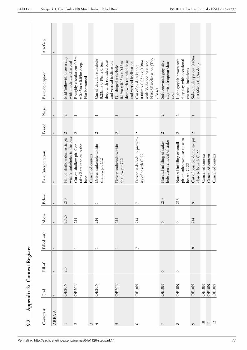
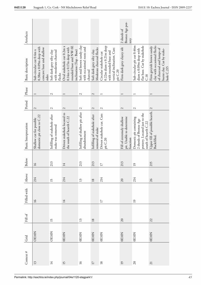
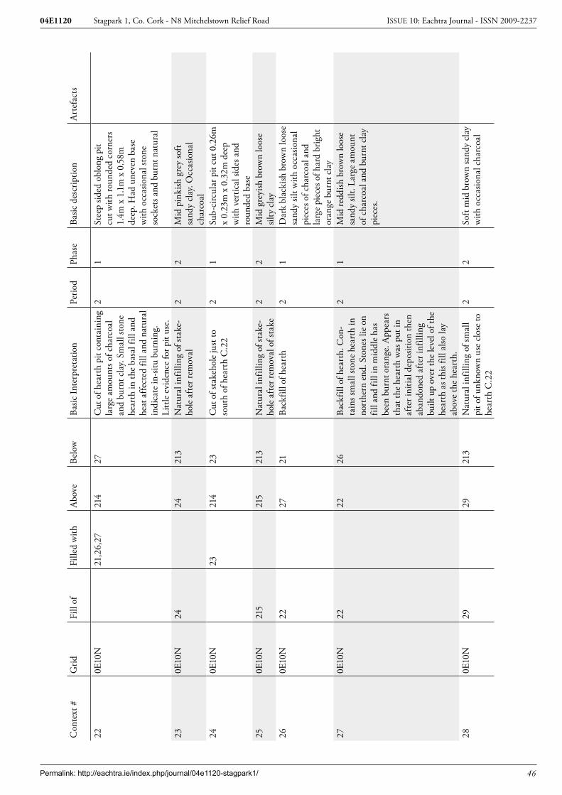
9.2 Appendix 2: Context Register .....................................................................44
9.3 Appendix 3: Finds Register .........................................................................71
9.4 Appendix 4: Plant Remains Report for 04E1120 ........................................72
9.5 Appendix 5: Pottery Report ........................................................................74
9.6 Appendix 6: Lithics Finds Report for 04E1020 – Mitchelstown .................76
9.7 Appendix 7: Bone Report ...........................................................................77
9.8 Appendix 8: Summary account of site archive .............................................78
9.9 Appendix 9: Dissemination Strategy ............................................................78

Permalink: http://eachtra.ie/index.php/journal/04e1120-stagpark1/ iv
Stagpark 1, Co. Cork - N8 Mitchelstown Relief Road04E1120 ISSUE 10: Eachtra Journal - ISSN 2009-2237
List of FiguresFigure 1: Portion of discovery map showing route of N8 Mitchelstown Relief Road. ...........................18
Figure 2: Portion of RMP sheets CO019 & CO010 showing route of the N8 Mitchelstown Relief Road. .. ..............................................................................................................................................19
Figure 3: Portion of 1st edition maps sheets 10 & 19 showing Mitchelstown Demesne and the route of the N8 Mitchelstown Road. ................................................................................................................. 20
Figure 4: Route of the N8 Mitchelstown Relief Road showing location of all archaeological sites. .......21
Figure 5 Portion of route of N8 Mitchelstown Relief Road showing location of Excavation Areas A, B and C. ..............................................................................................................................................22
Figure 6: Post-excavation plan Area A. .................................................................................................23
Figure 7: Post-excavation plan and section of hearth C.22 Area A. ..................................................... 24
Figure 8: Sections of C.66 and C.110 Area A. ......................................................................................25
Figure 9: Post-excavation plan and sections Area B. .............................................................................26
Figure 10: Post-excavation plan Area C. ...............................................................................................27
List of PlatesPlate 1: Area A post-excavation from east. .............................................................................................28
Plate 2: Area A post-excavation from west. ............................................................................................28
Plate 3: View of hearth C.22 mid-excavation Area A. ...........................................................................29
Plate 4: View of hearth C.22 post-excavation Area A. ...........................................................................29
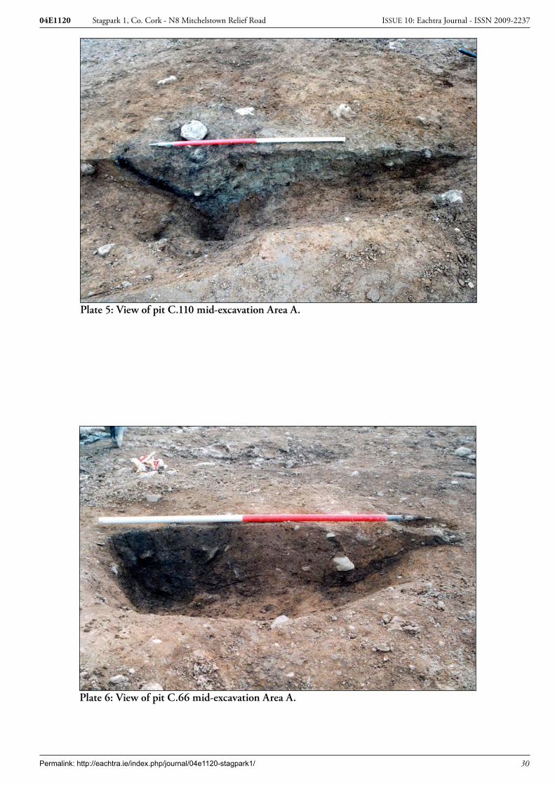
Plate 5: View of pit C.110 mid-excavation Area A. ................................................................................30
Plate 6: View of pit C.66 mid-excavation Area A. .................................................................................30
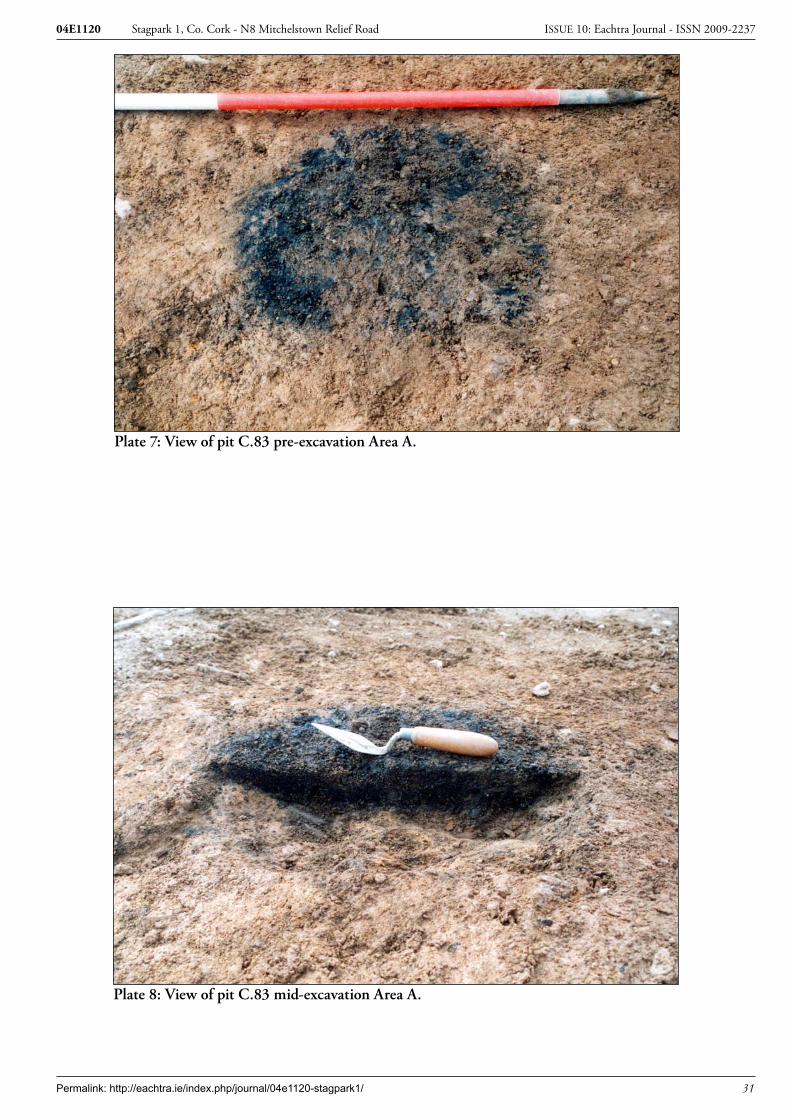
Plate 7: View of pit C.83 pre-excavation Area A. ...................................................................................31
Plate 8: View of pit C.83 mid-excavation Area A. .................................................................................31
Plate 9: View of pits C.1014 and C.1001 mid-excavation Area B. ..........................................................32
Plate 10: View of eastern section pit C.1001 Area B. .............................................................................32
Plate 11: View of pit C.2002 Area C. ....................................................................................................33
Plate 12: View of pit C.2004 Area C. ....................................................................................................33

Permalink: http://eachtra.ie/index.php/journal/04e1120-stagpark1/ v
Stagpark 1, Co. Cork - N8 Mitchelstown Relief Road04E1120 ISSUE 10: Eachtra Journal - ISSN 2009-2237
i Acknowledgements
Eachtra Archaeological Projects would like to acknowledge the following organisations and people for their contributions to this project.
Cork County Council Ken Hanley Project Archaeologist for Cork County CouncilDavid Herbert Plant Hire Ltd
The Site Excavation teamKaren Buckley, Helen Doyle, Ian Magee, Vera Manning, Ciaran O’Seaghdha and Bruce Sutton.
The Post-Excavation teamKaren Buckley, Sara Camplese, Anluan Dunne, Enda O’Mahoney, Bruce Sutton and Robin Turk.
Archaeological SpecialistsPlant remains report by Abigail Brewer and Penny Johnston, Burnt bone report by Linda Fibiger, Pot-tery report by Helen Roche and Eoin Grogan and Lithics report by Farina Sternke.

Permalink: http://eachtra.ie/index.php/journal/04e1120-stagpark1/ vi
Stagpark 1, Co. Cork - N8 Mitchelstown Relief Road04E1120 ISSUE 10: Eachtra Journal - ISSN 2009-2237
Project details
Project N8 Mitchelstown Relief RoadSite Name Stagpark 1Site Type Bronze Age and Iron Age featuresLicence No. 04E1120Licensee Bruce Sutton
Townland StagparkNat. Grid Ref. 180057 111912 – 180042 112007
Report Type Excavation ReportReport Status Final Report
Date of Submission July 2006Distribution Ken Hanley, Project Archaeologist Cork County Council, Dept. of the En-vironment, Heritage and Local Government, National Museum of Ireland and Cork Archaeological Survey Office.
Permalink: http://eachtra.ie/index.php/journal/04e1120-stagpark1/ vii
Stagpark 1, Co. Cork - N8 Mitchelstown Relief Road04E1120 ISSUE 10: Eachtra Journal - ISSN 2009-2237
Non-Technical SummaryThis report details the results of an archaeological excavation undertaken by Eachtra Archaeological Projects of a site on the route of the proposed N8 Mitchelstown Relief Road, on behalf of Cork County Council. The proposed bypass involves the construction of 4.5km of the N8 from Cloonlough, south of Mitchelstown, to the junction of the R513 and the N8, north of Mitchelstown.
Phase 1 of the project (archaeological testing of the route) was carried out in June, July and Septem-ber 2004 under licences 04E0889-04E0892 issued by Department of the Environment Heritage and Local Government (DoEHLG). The principal aim of this phase of the project was to test sites of ar-chaeological potential identified in the EIS and geophysical surveying and to test for any previously unknown sites by a programme of centreline and offset testing.
Phase 2 of the project (resolution) involved the resolution of all archaeological sites identified within the proposed road corridor prior to commencement of the construction of the bypass in order to avoid delays and costs during construction works. This phase of the project was carried out from September-December 2004 and excavations were conducted by two licensed directors under the management of a Senior Archaeologist. In total five sites were excavated during this phase of works and all excavations were carried out initially under separate licences issued by DoEHLG and subsequently under Ministe-rial Order.
One of these sites, Stagpark 1 is the subject of this report. It was identified in the testing in the town-land of Stagpark, between chainages 1400-1500 of the proposed road scheme and excavated under Licence Number 04E1120. The site comprised a complex of features dating to the Early Bronze Age, Late Bronze Age and Iron Age.

Permalink: http://eachtra.ie/index.php/journal/04e1120-stagpark1/ 1
Stagpark 1, Co. Cork - N8 Mitchelstown Relief Road04E1120 ISSUE 10: Eachtra Journal - ISSN 2009-2237
1 Introduction
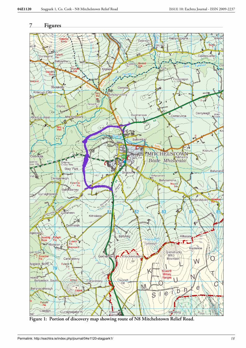
1.1 Site locationThis report details the results of the archaeological excavation of a site on N8 Mitchelstown Relief Road (MRR), County Cork (National Grid Co-ordinates 180057 111912 – 180042 112007). The site is located c.1.5 km to the west of Mitchelstown, 700m south of the N73 Mitchelstown to Mallow road (Figure 1). It is located in the townland of Stagpark, the Parish of Brigown and barony of Condons and Clangibbon.
1.2 Scope of the ProjectThis Archaeological Services Project was carried out on behalf of Cork County Council, National Roads Design Office, Richmond, Glanmire, Co. Cork. This project was funded by the Irish Govern-ment under the National Development Plan, 2000-2006. The purpose of the Project was to conduct Archaeological Site Investigations within the lands made available for the scheme and to assess the nature and extent of any new or potential archaeological sites uncovered. Phase 1 of the project (archaeological testing of the route) was carried out in June, July and Septem-ber 2004 under licences 04E0889-04E0892 issued by Department of the Environment Heritage and Local Government (DoEHLG). The principal aim of this phase of the project was to test sites of ar-chaeological potential identified in the EIS and geophysical surveying and to test for any previously unknown sites by a programme of centreline and offset testing. Phase 2 of the project (resolution) involved the resolution of all archaeological sites identified within the proposed road corridor prior to commencement of the construction of the bypass in order to avoid delays and costs during construction works. This phase of the project was carried out from September-December 2004 and excavations were conducted by two licensed directors under the management of a Senior Archaeologist. In total five sites were excavated during this phase of works and all excavations were carried out initially under separate licences issued by DoEHLG and subsequently under Ministe-rial Order.Following completion of fieldwork a dissemination strategy was undertaken and submitted to the project archaeologist. A programme of post-excavation analysis was agreed and commenced. It is pro-posed that all final reports will be submitted to the relevant authorities by December 2005 and that publication and public lectures/seminars will follow thereafter. A lecture on the preliminary findings was given to Mitchelstown Historical Society in May 2005 by the project and senior archaeologists. It is envisaged that a second lecture will be given to Mitchelstown Historical Society during their au-tumn/winter programme 2006-07.
1.3 Circumstances of discoveryPrehistoric archaeological material was discovered at Stagpark 1 during archaeological test trenching undertaken in June 2004 under licence 04E0890. Topsoil in the vicinity of the sites was subsequently stripped by tracked machine using a flat bucket under the direction of the licensed director. When the limits of the site had been determined, full excavation of the site commenced under license 04E1120.

Permalink: http://eachtra.ie/index.php/journal/04e1120-stagpark1/ 2
Stagpark 1, Co. Cork - N8 Mitchelstown Relief Road04E1120 ISSUE 10: Eachtra Journal - ISSN 2009-2237
1.4 Date and duration of excavation worksThe excavation commenced on 11th August 2004 under licence 04E1120 and was completed on the 3rd September 2004.
1.5 Size and composition of the excavation teamThe archaeological excavation team consisted of the license holder, one supervisor, three site assistants and one general operative.

Permalink: http://eachtra.ie/index.php/journal/04e1120-stagpark1/ 3
Stagpark 1, Co. Cork - N8 Mitchelstown Relief Road04E1120 ISSUE 10: Eachtra Journal - ISSN 2009-2237
2 Receiving Environment
2.1 The Natural Landscape
2.1.1 Geology
The topography of East Cork and Waterford consists of east-west orientated valleys separated by in-tervening ridges. The ridges consist of sandstones and mudstones of the Devonian Period (Old Red Sandstone) laid down 355-410 million years ago and the valleys of Carboniferous limestones laid down 290-355 million years ago. The sediments covering many of the rocks are mainly of glacial origin deposited by glacial ice or meltwater (Sleeman et al. 1995, 1). Major earth movements have resulted in the uplifting and folding of the rock units. Anticlines occur when local uplift results in a convex upward fold. Synclines occur when local uplift results in a concave upward fold (ibid. 3). The Mitchelstown Syncline is composed of a variety of Carboniferous Formations. Three of these for-mations are located in the area of the route of the N8 MRR. The Croane Formation is composed of a mixture of mudstones and cherts and is estimated to be about 300m thick (ibid. 31). The Rathronan Formation is composed of micrites, wackestones and cherts (ibid. 32). The O’Mahony’s Rock Forma-tion consists of micrites, packstones, wackestones and grainstones and is estimated to be about 100m thick. The type area is between Mitchestown Castle and Killee House to the west (ibid.).
2.1.2 Soils and their uses
The soils to the north of the Gradoge River to the west of Mitchelstown are characterised by a mix of acid brown earths, gleys and grey brown podzolics, which are derived from mixed sandstone and limestone glacial till while the underlying rock is Carboniferous limestone. The acid brown earths and gleys occur in the gently rolling valleys of Cork and Waterford mainly at altitudes of 0-75m (Gardiner 1980, 61). The soils have a wide use range and are suitable for tillage and grass production. The soils to the south of the Gradoge River are characterized by a mix of gleys and peaty gleys which are derived from glacial till of mixed sandstone-shale composition with a small admixture of limestone in places. They occur mostly at altitudes of 76m to 152m. The soils have a limited use range as they are poorly drained even on good slopes. They are best suited to grassland (ibid. 77-79)
2.1.3 Topography
The route of the N8 Mitchelstown relief road (MRR) traverses the townlands of Cloonlough, Stag Park and Mitchelstown on the western side of the town of Mitchelstown. The route extends from the N8 c. 1km south of Mitchelstown, crosses the N73 Mitchelstown/Mallow road, the Gradoge River Valley and traverses the ridge on the northern side of the river valley to the junction of the R513 Mitch-elstown/Ballylanders road and rejoins the N8. The northern half of the route traverses Mitchelstown Demesne, breaching the estate wall at the junction with the N73 and the R513. The southern half of the route climbs from c. 120m OD to 130m OD before descending to the banks of the Gradoge River, 80m OD and climbing northwards to the apex of the limestone ridge 110m OD.

Permalink: http://eachtra.ie/index.php/journal/04e1120-stagpark1/ 4
Stagpark 1, Co. Cork - N8 Mitchelstown Relief Road04E1120 ISSUE 10: Eachtra Journal - ISSN 2009-2237
The land is for the most part under pasture and is located at an altitude of between 80-130m OD. The landscape of the Mitchelstown area is dominated by the Galtee Mountains to the north, the Bal-lyhoura Mountains to the west and the Kilworth Mountains (the foothills of the Knockmealdown Mountains) to the south. The Gradoge River is a tributary of the Funshion River. It rises south of Mitchelstown on the southern slopes of the Kilworth Mountains and drains into the Funshion to the immediate west of the route of the N8 MRR. The River Funshion drains into the River Blackwater south of Kilworth.
The site of Stagpark 1 was located at the top of a hill in an area of pastoral grassland. The ground sloped away at a gentle gradient on all sides. The area commands extensive views in all directions, par-ticularly to the north and south. The drainage within the field was poor and there was a large active field drain that extended across the southwest corner of the site. The field to the south, which lay down slope, was also extremely waterlogged and an area of rushes could be traced around a depression in the field, possibly delineating the extent of an old pond.
2.2 The Human Landscape
2.2.1 Archaeological Background
There is a paucity of known archaeological sites within a 2 km radius of the route of the N8 MRR. Three prehistoric sites, fulachta fiadh (CO019-019, -020, -021) are recorded in Stagpark and Bal-lykearney between 100-500m of the route corridor. The site of Mitchelstown Castle (CO019-026), the associated demesne and the historic town of Mitchelstown (CO019-149) are the principle medieval and post-medieval sites in the vicinity of the route corridor (Figures 2 and 3).
2.2.2 Mesolithic 7000 BC - 4000 BC
The earliest known human settlement in Ireland dates from the Mesolithic period (c. 7000 BC - 4000 BC). In Munster, the majority of the evidence (flint scatters) for Mesolithic occupation has ‘come from the Blackwater valley in Co. Cork’ (Woodman 1989, 116). Flint scatters were recorded in the townlands of Ballynamona (CO018-099) and Wallstown (CO018-100) on the northern and southern sides of the Awbeg river respectively c. 15km to the west of the route of the N8 MRR (Power et. al. 2000, 2).
2.2.3 Neolithic 4000 BC -2500 BC
The Neolithic Period is characterised by the introduction of agriculture and the beginnings of the clearance of the woodlands. The population increased and became more sedentary in nature. Sub-stantial Neolithic settlement sites have been recorded at Lough Gur, Co. Limerick and Cloghers, Co. Kerry. The material culture includes the manufacture of pottery, flint and stone arrowheads, scrapers, axes etc. The range of monuments types includes Megalithic tombs (court tombs, portal tombs, pas-sage tombs and wedge tombs), single burial graves and stone circles.

Permalink: http://eachtra.ie/index.php/journal/04e1120-stagpark1/ 5
Stagpark 1, Co. Cork - N8 Mitchelstown Relief Road04E1120 ISSUE 10: Eachtra Journal - ISSN 2009-2237
There is a paucity of evidence for Neolithic settlement sites in the south-west of Ireland. Recent in-frastructural development has increased the amount of Neolithic sites in County Cork. The nearest known Neolithic house was excavated on the N8 Rathcormac-Fermoy in the townland of Gortore. The structure was dated to the Early Neolithic cal BC 3928-3655 (UB 6769). Further evidence of the Neolithic was recorded at Fermoy and Curraghprevin.
2.2.4 Bronze Age 2000 BC -500 BC
The Bronze Age is characterised by the introduction of metallurgy, the mining of copper ores and manufacture of copper, bronze and gold items. The range of burial site types includes, cist graves, pit and urn burials, cremation cemeteries, barrows, ring-ditches and wedge tombs. Stone circles and standing stones also date to the Bronze Age. Both enclosed and unenclosed settlement sites are known. The most prolific Bronze Age site type is the fulacht fiadh, over 2,000 examples have been recorded in County Cork alone. These monuments survive as low mounds of charcoal rich black silt packed with heat-shattered stones and are generally situated close to a water source. In many cases, however, all that survives to the present day are black spreads with fragments of shattered stones visible in ploughed fields. Fulachta fiadh are generally classified as ‘cooking places’, whereby stones were heated in a hearth and subsequently placed in a trough of water, the water continued to boil with the addition of hot stones and wrapped food was cooked within the hot water. The trough eventually filled with small stones, ash and charcoal that were removed and formed the basis of the familiar mound. The absence of animal remains and the scarcity of associated hearths have fuelled the debate in relation to the func-tion of the sites. Other theories on their interpretation include bathing and dyeing textiles together with the production of hot water and steam for curative purposes and sweat houses (Kelly 1989, 225). Waddell (1998, 177) suggests the semi-industrial purpose of using the boiling water for dipping hides as part of the preparation of the leather, while Dunne (pers. comm.) suggests a relationship between burnt mounds and Bronze Age funerary rites and burial practices.
There are few wedge tombs or stone circles known from north or east Cork. Two of the exceptions are wedge tombs located at Labbacallee (CO027-086) and at Manning (CO027-091) both located c. 8 km south of the N8 MRR. Labbacallee is one of the largest wedge tombs in the country.
The cemetery of Mitchelstowndown West contains 53 small barrows. Four of this group were selected for excavation by the Discovery Programme (Daly et. al. 1992, 44). The site of the cemetery is located 16 km to the north of the N8 MRR.
Until recently Bronze Age settlement sites were a rarity in North Cork. A Bronze Age occupation site was recorded underlying the medieval ringfort Lisleagh I (CO027-158) c.3.5km to the south of the N8 MRR (Power et. al. 2000, 210). A house site was excavated at Killydonoghoe on the route of the N8 Glanmire-Watergrasshill Bypass (Sherlock, 2003). A large Bronze Age settlement site consisting of four enclosures and three circular houses was excavated in 2003 at Ballybrowney on the route of the

Permalink: http://eachtra.ie/index.php/journal/04e1120-stagpark1/ 6
Stagpark 1, Co. Cork - N8 Mitchelstown Relief Road04E1120 ISSUE 10: Eachtra Journal - ISSN 2009-2237
N8 Rathcormac-Fermoy (Cotter 2004, 38). A Middle Bronze Age settlement site was excavated in Mitchelstown (04E1072), a complex of Early and Late Bronze Age pits were excavated in Stagpark (04E1120) and three fulachta fiadh were exca-vated in Stagpark (04E1121 & 04E1119) on the route of the N8 Mitchelstown Relief Road. In addition a rare and important hoard of Early Bronze Age pottery was excavated on the banks of the Gradoge River (04E1071).
2.2.5 Iron Age 500 BC – 400 AD
At present, there is little evidence of a significant Iron Age presence in the Cork region. Settlement sites are few and far between as well as being difficult to identify (Woodman, 2000) while the material cul-ture of this period is limited. Linear earthworks, which are believed to have marked tribal boundaries are one of the most visible monuments of the period. Three separate stretches of one such boundary, the Claidh Dubh, have been recorded in County Cork. The longest stretch, c. 24 km extends from the Nagle Mountains, across the Blackwater valley and into the Ballyhoura Hills. The Claidh Dubh crosses the N73 c. 12km west of the N8 MRR. Radiocarbon dating following excavation of a section of it revealed it dated to some time before 100AD (Doody 1995, 23).
Three of the five hillfort sites in Cork are located in North Cork (Power et al, 2000, 205). Caherdrinny is located at the western end of the Kilworth Mountains, c. 3 km to the south of the N8 MRR and Corrin is located at the eastern end of the Nagle Mountains c. 15 km to the south of the N8 MRR.
A complex of monuments in Conva townland (c. 15 km to the southwest of the N8 MRR) was identi-fied by aerial photography in the Blackwater Valley. Crop marks indicated three enclosures (CO034-7201, -7202, -7203) and a number of large pits (CO034-7204) possibly comprising a rectangular enclosure. The site was investigated in 1992 by Martin Doody of the Discovery Programme which involved geophysical prospection, topographic survey and trial excavation. Sections were dug through the three enclosures and through four of the large pits. Metal debris was discovered and radiocarbon dates indicated that the complex dated to the Iron Age/Early Medieval period.
A complex of pits, dating to the Iron Age, cal BC 346-45 (UB6719) was excavated in Stagpark (04E1120) on the route of the N8 Mitchelstown Relief Road.
2.2.6 Early Medieval 400 AD – 1000 AD
The Early Medieval Period/Early Christian Period is characterised by the arrival of Christianiaty to Ireland. Early ecclesiastical sites are located at Brigown (CO019-030) on the southeastern side of Mitchelstown and to the west of the N8 MRR at Aghacross (CO019-002), Leabba Molagga and Mar-shalstown. The monastery of Brigown founded in the 7th century gives its name to the modern parish (Power 1996, 3).

Permalink: http://eachtra.ie/index.php/journal/04e1120-stagpark1/ 7
Stagpark 1, Co. Cork - N8 Mitchelstown Relief Road04E1120 ISSUE 10: Eachtra Journal - ISSN 2009-2237
The characteristic monument type of the period was the ringfort. Ringforts are the most numerous archaeological monument dating to the Early Christian Period, found in Ireland, with estimates of between 30 and 50,000 illustrated on the first edition of the Ordnance Survey 6” maps of the 1840’s (Barry, 1987). As a result of continued research these monuments have a narrow date range during the Early Christian period between the 7th and 9th centuries AD. Although there are some very elaborate examples of ringforts they often take the form of a simple earth or stone enclosure and functioned as settlements for all classes of secular society (Stout, 1997). A major research excavation of two ringfort was undertaken at Lisleagh c. 3.5km to the south of the route of the N8 MRR. Structural, domestic and industrial evidence was recorded at both sites. A number of stake and wattle round houses, and iron working were recorded in Lisleagh I. Two phases of occupation were recorded at Lisleagh I. The Lisleagh I was constructed in the early seventh century and was occupied into the ninth century AD (Monk 1995, 105-116).
2.2.7 Medieval 1000 AD – 1300 AD & Late Medieval 1300 AD -1500 AD
The period is characterized by the arrival of the Anglo-Normans. Mitchelstown was formerly known as Brigown / Mitchelstown (CO019-149). It was listed as a market town in 1299 and was located on the southern bank of the Gradoge River, to the east of Mitchelstown Castle (Power, D. et al. 2000, 595). The town developed under the patronage of the House of Desmond. It passed into the hands of the Earls of Kingston in the 17th century (Power 1996, 23). Mitchelstown Castle was located on a limestone ridge on the southern bank of the Gradoge River. The first settlers, the Anglo-Norman FitzGibbons, held the title of White Knights. Their territory extended from Mitchelstown to Kilmallock (Power 2000, 1) and they built a tower house on the ridge. The White Knight lineage ended in the 17th century and the estate passed through marriage into the hands of the Fenton family (ibid. 3) and ultimately to the Kingstons. The earlier castle was destroyed in the wars of 1641.
A corn-drying kiln dating to the Later Medieval Period cal AD 1310-1434 (UB 6833) was excavated in Stagpark 2 (04E1121).
2.2.8 Post-Medieval 1500 AD – 1800 AD
In 1776 Lord Kingsborough, the 2nd earl of Kingston, created the new town of Mitchelstown. He demolished the old town between Kingston College and the Castle. Kingston College developed into a Georgian square. The new town was centred between the two parallel main streets of George Street and Cork Street. King Square and New Market Square became the focal points of the town (ibid.). St George’s Church, built in 1801, was located at the southern end of George Street and King Square at the northern end. New Market Square was located midway and on the western side of Cork Street. The new town was built on 138 acres.
Lord Kingsborough, the second earl of Kingston, built a new mansion on the site of the White Knights castle and a demesne around the mansion in the 18th century. A demesne wall was constructed around
Permalink: http://eachtra.ie/index.php/journal/04e1120-stagpark1/ 8
Stagpark 1, Co. Cork - N8 Mitchelstown Relief Road04E1120 ISSUE 10: Eachtra Journal - ISSN 2009-2237
the parkland of some 1240 acres. The wall was ‘six-and-a-quarter-mile long…between eight and ten feet in height’ (Power 1996, 24). All public roads that were located within the area of the demesne were closed and rerouted on the periphery of the wall. Entry to the demesne was gained through Mallow Gate also known as White Gate, Limerick Gate and the main entrance was at King Square. Extensive works were undertaken within the area of the demesne which resulted in ‘a quadrangle of buildings, a garden of five English acres surrounded by a wall, large conservatories and lavishly arranged gardens became part of the scene. Two artificial lakes were developed beneath the rockface on which the castle stood ’ (ibid., 24). Several hundred acres of woodland comprising of oak, ash, larch, beech and alder were planted within the demesne. In 1823 the third earl of Kingston demolished the Georgian house and built a new castle on the same site. The architects James and George Pain designed and built this neo-Gothic castellated mansion. The limestone buildings formed three sides of a courtyard (Power 1996, 42).
Mitchelstown Castle was burnt by Republican forces in 1922. The stone was bought by the Cistercian Monks of Mount Melleray and reused to build a church. Few traces of the castle are visible today. At present, Dairygold occupies the site of the former castle. The 1240 acres of parkland was divided into farms, the town park and a golf course.
3 Original Research FrameworkThe following issues will be addressed in this excavation report.The construction date or date of initial site activity and the date of abandonment.The absolute / relative chronology of site use in terms of phases and events.The location of known contemporaneous and comparable sites.The extent of the viable economic catchment area in terms of sources of water, food, raw materials,
transportation routes etc

Permalink: http://eachtra.ie/index.php/journal/04e1120-stagpark1/ 9
Stagpark 1, Co. Cork - N8 Mitchelstown Relief Road04E1120 ISSUE 10: Eachtra Journal - ISSN 2009-2237
4 Excavation Results
4.1 Excavation MethodologyThree areas were excavated under license 04E1120 at Stagpark 1 (Figure 5). The site was divided into three areas of activity, A, B and C. Area A was located on the summit of the hill, it measured 25m N-S by 38m E-W. Area B was located 15m to the north with an area of excavation that measured 15m N-S by 10m E-W. Area C was located 25m downslope to the north. The area of excavation measured 8m N-S by 15m E-W.
A grid was established in each area of excavation of Stagpark 1 and the ground within it was cleaned by hand to locate and identify all archaeological features. Each identified feature was excavated, planned, photographed and recorded, with every fill and cut being assigned a context number. Charcoal and soil samples were taken from appropriate fills where necessary. All artefacts were retrieved, registered, bagged and labelled.
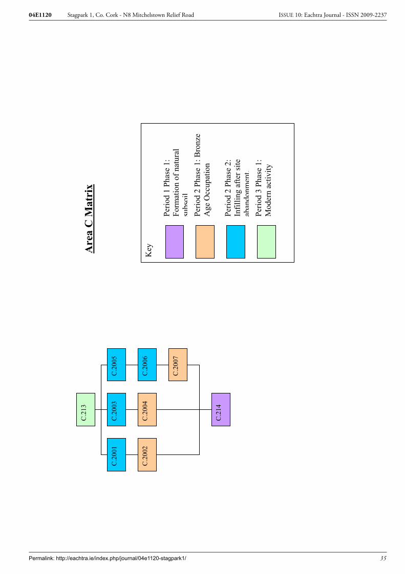
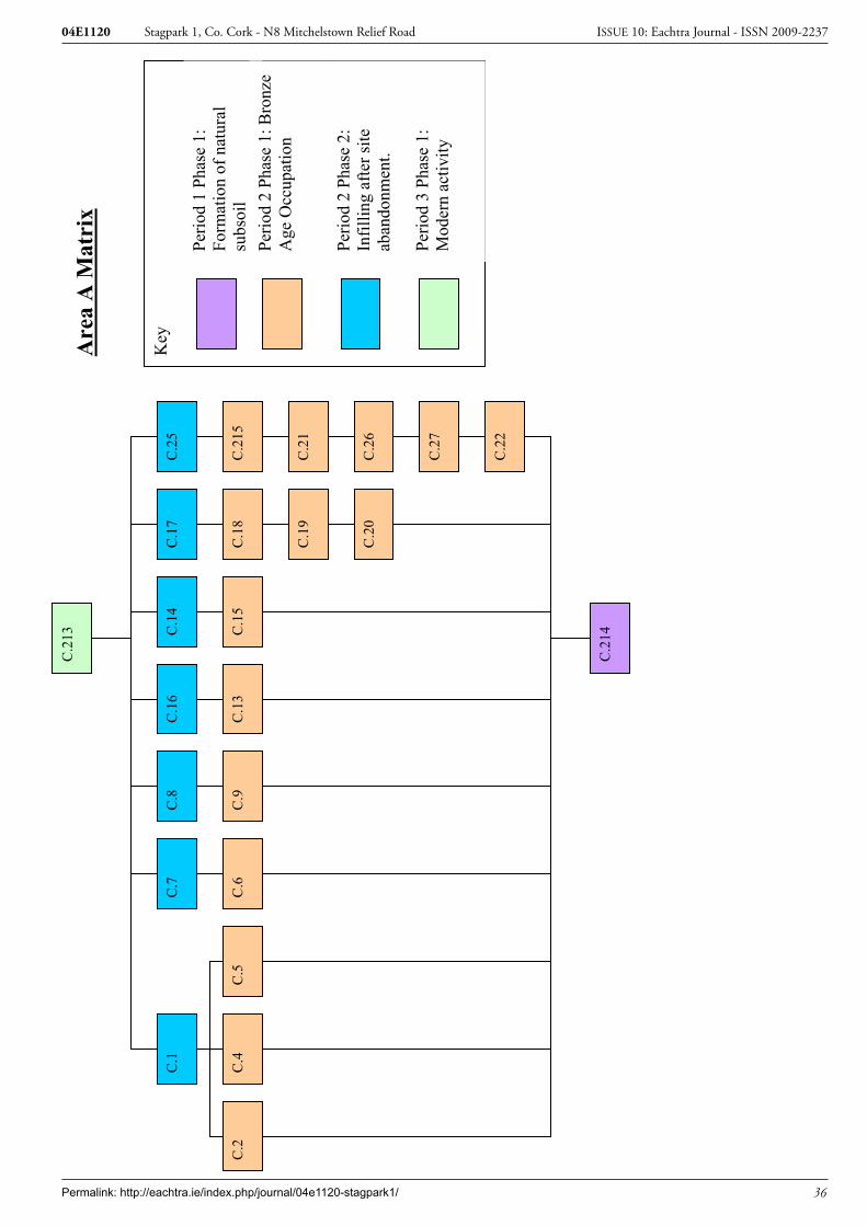
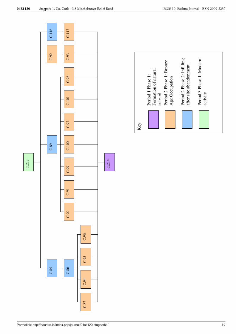
4.2 Full Stratigraphic ReportSee Appendix 1 for the full stratagraphic matrix
4.2.1 Stratigraphic sequencing
4.2.1.1 Area A
A total of 95 features were excavated across Area A at Stagpark 1 (Figure 6). This included 59 stake-holes, 10 postholes and 27 pits of various sizes. An Early Bronze Age date and a Middle Iron Age date were returned for two of the features.
A single fragment of flint (04E1120:213:4) was recovered from the topsoil in Area A; it was identified as a small core, un-diagnostic in nature. Many of the features can be roughly grouped in to clusters of pits, postholes and stakeholes, with some isolated features scattered across the site. Unless otherwise stated the features contained single fill.
Early Bronze AgeTwo small pits (C.83 and C.84) were located in the southern central portion of the site, 1.2m apart. Pit C.83 contained a single silt fill which included frequent charcoal. The charcoal was identified as ash and returned a radiocarbon date of cal BC 1885-1690 (UB-6721). Pit C.84 contained two fills (C.92 and C.93). The upper silt fill included charcoal and minute flecks of burnt bone. The burnt bone was too small and degraded to be extracted and identified but the charcoal from this pit was also identi-fied as ash. While the pits contained burnt fills the material had not been burnt in situ. The pits were similar in terms of size and fill to two pits (C.2002 and C.2004) located c.100m to the north in Area C and they were interpreted as possible cremation pits.
Permalink: http://eachtra.ie/index.php/journal/04e1120-stagpark1/ 10
Stagpark 1, Co. Cork - N8 Mitchelstown Relief Road04E1120 ISSUE 10: Eachtra Journal - ISSN 2009-2237
A single pit (C.143) and stakehole (C.136) were located c. 2m to the northeast of the possible cremation pits and another single pit (C.119), stakehole (C.124) and posthole (C.129) were located c. 5m to the south of the possible cremation pits.
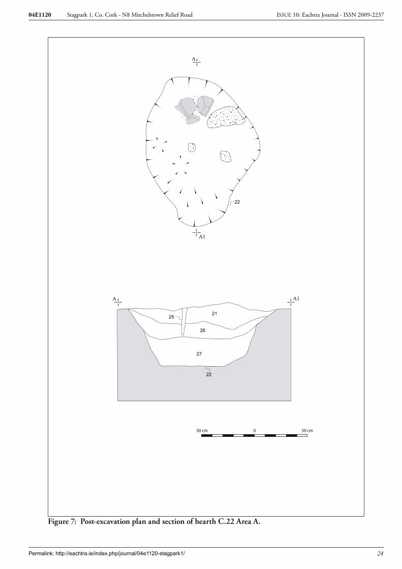
Late Bronze Age A large steep sided hearth-pit C.22 was located in the northwestern area of the site. The three fills (C.21, C.26 and C.27) included a large quantity of burnt clay and charcoal. The base of the hearth was heat-scorched. It was the only feature on site that displayed definite evidence of in situ burning. A single stakehole cut the base of the hearth and two stakeholes were located to the south and north of the hearth respectively.
A cluster of three pits (C.13, C.20 and C.29) were located to the southeast of the hearth. The fill of pit C.20 included two sherds of Late Bronze Age pottery (04E1120:19:1 and 2). Another pit C.9 was located to the northwest. Eight stakeholes (C.6, C.15, C.18, C.24, C.31, C.33, C.35 and C.39) were located within 2.5m of the hearth. Although the stakeholes appeared to form no obvious pattern or structure, it is possible that some (C.6, C.39, C.43, and C.45 in particular) may have formed a wind-break, spit or fire-side furniture associated with the hearth.
A shallow pit C.2, 0.05m in depth, was located 9m to the north of the hearth C.22. The base of the pit was cut by two stakeholes (C.4 and C.5).
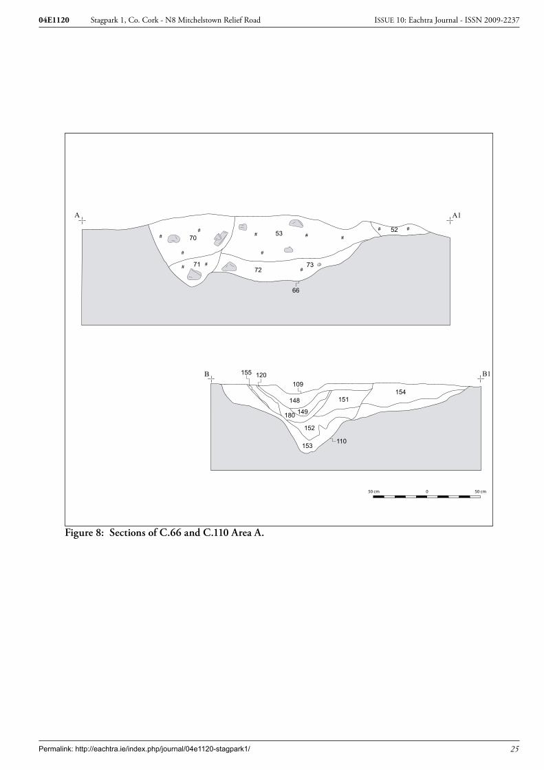
The features located in the south-western and northern central portion of the site are tentively dated to the Late Bronze Age on the basis of similarity with the Late Bronze Age features already described. A large pit C.66 was located in the south-western portion of the site. Two stakeholes (C.75 and C.77) were located to the north and south of the pit respectively, in a pattern similar to those located on the periphery of the hearth C.22. A further two stakeholes (C.51 and C.57) were located to the northwest. Eight stakeholes, two postholes and a pit were located in isolation or in small clusters c. 4m to the east and west of the pit C.66.
16 stakeholes (C.87, C.94, C.95, C.96, C.98, C.99, C.100, C.101, C.103, C.104, C.106, C.107, C.108, C.112 and C.113), two postholes (C.91 and C.97) and a pit C.90 were located in the northern central portion of the site. Four of the stakeholes cut the base of the pit (C.98, C.99, C.100 and C.101) and the remaining stakeholes, many of which were intercut, were located to the north of the pit. The two postholes were located at the western end of the pit. Four pits (C.162, C.165 C.168 and C.210) and a single stakehole (C.166) were located to the west of the pit C.90 and associated stakeholes.
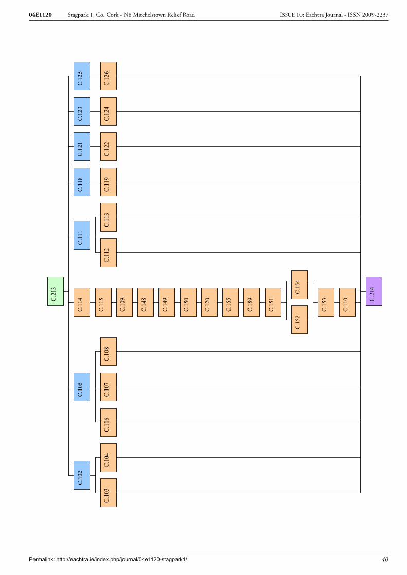
Middle Iron AgeA large pit C.110 was located in the southern central portion of the site. It had been re-cut twice, initially by pit C.159 and laterally by pit C.109. A radiocarbon date of cal BC 346-45 (UB 6719) was

Permalink: http://eachtra.ie/index.php/journal/04e1120-stagpark1/ 11
Stagpark 1, Co. Cork - N8 Mitchelstown Relief Road04E1120 ISSUE 10: Eachtra Journal - ISSN 2009-2237
returned from charcoal retrieved from the fill of pit C.109.
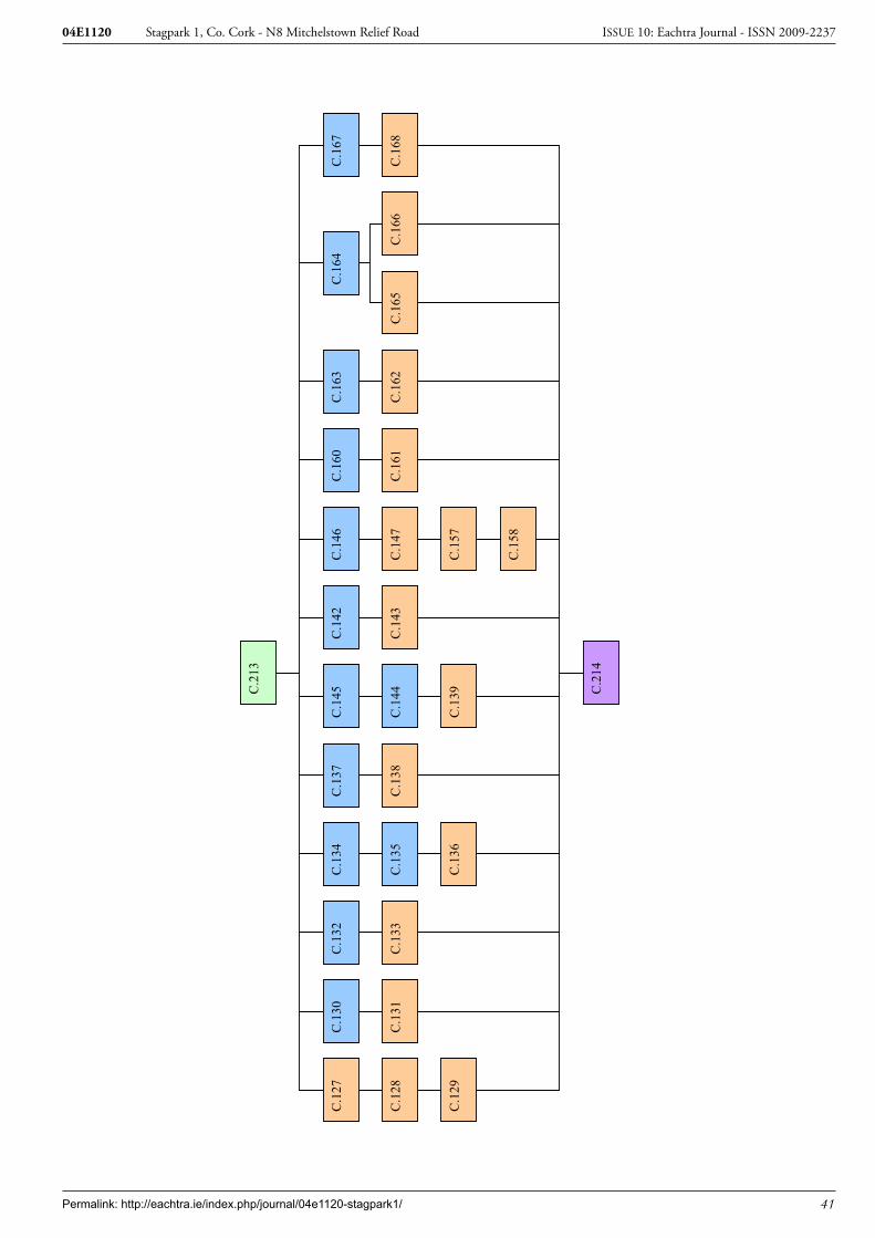
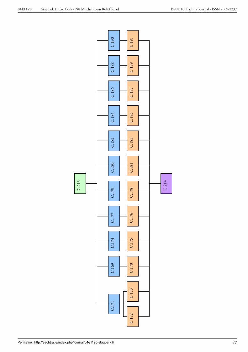
A shallow pit (C.139) and an alignment of six irregularly spaced stakeholes (C.117, C.122, C.126, C.131, C.133 and C.138) were located to the north of pit C.110. The stakeholes extended north-south for a distance of c. 3.5m. A further alignment of two pits (C.147 and C201) seven stakeholes (C.158, C.161, C.170, C.172, C.173, C.185 and C.207) and three postholes (C.183, C.204 and C.212) were located in the central eastern section of the site. The alignment extended c.13 m from east-west and formed a right angle with the alignment of six stakeholes to the west.
An alignment of four pits ((C.176, C.191, C.185 and C.197). three postholes (C.175, C.178 and C.187) and two small stakeholes (C.181 and C.189) was located to the east of pit C.110. The alignment was orientated northeast-southwest.
4.2.1.2 Area B
Early Bronze AgeThree pits (C.1001, C.1016 and C.1014) and a single posthole (C.1012) were excavated in Area B (Fig-ure 2, plate 1). Two of the pits (C.1001 and C.1014) were extremely large. C.1001 measured 6.25m by 3.25m by 2.18m deep and contained clay fills. The lower two fills included charcoal and burnt clay. Very occasional small fragments of burnt bone were retrieved from the lower fills of the pit and they were examined by L. Fibiger. The majority of the bone could not be identified as animal or human, though at least one animal bone fragment was present in the sample. A radiocarbon date of cal BC 2130-1887 (UB 6745) was returned from charcoal retrieved from the basal fill C.1011. 11 stakeholes were located around the upper southern half of the pit and five stakeholes around the upper northern and eastern half.
Pit C.1014 was located c. 1.5m southwest of pit C.1001. It measured 4.3m by 3.64m, by more than 2.05m in depth and had been re-cut. The full depth of the pit could not be realised due to health and safety reasons. The re-cut C.1025 measured 3.64 in diameter by 1.33m in depth.
The third pit C.1016 was located c. 4m to the north-west. It was irregular in plan and measured 0.64m by 0.34m by 0.12m deep. The posthole C.1012 (0.31m by 0.39m by 0.31m in depth) was located c. 3m south of the pit.
4.2.1.3 Area C
Early Bronze AgeThree pits (C.2002, C.2004 and C.2007) were recorded in Area C. The silt fill of pits C.2002 and C.2004 included frequent charcoal. Some of the charcoal was identified as hazel/alder. A radiocarbon date of cal BC 1885-1689 (UB-6720) was returned from charcoal from pit C.2002. The pits were simi-lar in terms of size and fill to two pits (C.83 and C.84) excavated in Area A. Pit C.2007 was located
Permalink: http://eachtra.ie/index.php/journal/04e1120-stagpark1/ 12
Stagpark 1, Co. Cork - N8 Mitchelstown Relief Road04E1120 ISSUE 10: Eachtra Journal - ISSN 2009-2237
1m to the north. It contained two clay fills (C.2005 and C.2006) which included occasional flecks of charcoal.
4.2.2 Stratigraphic discussion
A total of 103 features were excavated at Stagpark 1 these included 58 stakeholes, 12 postholes and 33 pits of various sizes, in an area that measured in total c. 48m N-S by 62m E-W. All of the features cut the sub-soil and no occupation horizons or discernible structures were recorded. The features can be grouped on the basis of radiocarbon dates and morphology to the Early Bronze Age, Late Bronze Age and Middle Iron Age. A group of four pits containing burnt fills and two very large pits were dated to the Early Bronze Age, at least three large pits with associated smaller pits, stakeholes and postholes were tentively dated to the Later Bronze Age and a large pit and associated L-shaped alignment of stakeholes and pits are dated to the Middle Iron Age.
4.2.2.1 Radiocarbon dates
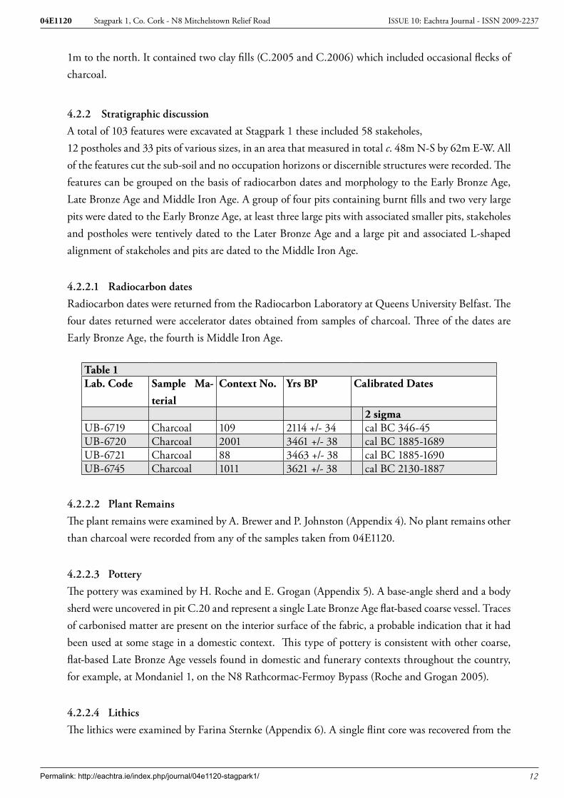
Radiocarbon dates were returned from the Radiocarbon Laboratory at Queens University Belfast. The four dates returned were accelerator dates obtained from samples of charcoal. Three of the dates are Early Bronze Age, the fourth is Middle Iron Age.
Table 1Lab. Code Sample Ma-
terialContext No. Yrs BP Calibrated Dates
2 sigmaUB-6719 Charcoal 109 2114 +/- 34 cal BC 346-45UB-6720 Charcoal 2001 3461 +/- 38 cal BC 1885-1689UB-6721 Charcoal 88 3463 +/- 38 cal BC 1885-1690UB-6745 Charcoal 1011 3621 +/- 38 cal BC 2130-1887
4.2.2.2 Plant Remains
The plant remains were examined by A. Brewer and P. Johnston (Appendix 4). No plant remains other than charcoal were recorded from any of the samples taken from 04E1120.
4.2.2.3 Pottery
The pottery was examined by H. Roche and E. Grogan (Appendix 5). A base-angle sherd and a body sherd were uncovered in pit C.20 and represent a single Late Bronze Age flat-based coarse vessel. Traces of carbonised matter are present on the interior surface of the fabric, a probable indication that it had been used at some stage in a domestic context. This type of pottery is consistent with other coarse, flat-based Late Bronze Age vessels found in domestic and funerary contexts throughout the country, for example, at Mondaniel 1, on the N8 Rathcormac-Fermoy Bypass (Roche and Grogan 2005).
4.2.2.4 Lithics
The lithics were examined by Farina Sternke (Appendix 6). A single flint core was recovered from the

Permalink: http://eachtra.ie/index.php/journal/04e1120-stagpark1/ 13
Stagpark 1, Co. Cork - N8 Mitchelstown Relief Road04E1120 ISSUE 10: Eachtra Journal - ISSN 2009-2237
topsoil. It is undiagnostic in nature but is likely to be associated with the Bronze Age features.
4.2.2.5 Cremated bone
The cremated bone assemblage was examined by L. Fibiger (Appendix 7). 17 fragments were retrieved from a fill of pit C.1001 in Area B. Surface preservation was poor and none of the fragments were diag-nostic. The majority of remains could therefore not be positively identified as either animal or human bone. At least one animal bone fragment appeared to be present, identified through its very smooth and almost polished cortical surface.
4.2.2.6 Discussion & Interpretation
A group of over a hundred pits, postholes and stakeholes were located on the hilltop at Stagpark. The features dated from the Early Bronze Age to the Middle Iron Age which would suggest that the hilltop was occupied over a long period of time. Four pits containing burnt fills were recorded in Area A and Area C. The pits were similar in terms of morphology, size and date. The two sets of pits were located within 1m of each other and c. 40m apart. Almost identical Early Bronze Age dates were returned for two of the pits. The pits may have functioned as cremation pits, although minute traces of burnt bone was recorded in only one of the fills. They may also have been utilised for a domestic purpose. One of the two large pits (C.1001) in Area B was dated to the Early Bronze Age. It is difficult to interpret the function of these pits as they are exceptionally large. Stakeholes recorded on the upper sides of pit C.1001, these may have formed a frame or covering for the pit.
The recovery of two sherds of Late Bronze Age coarse ware from a pit, in the vicinity of the hearth-pit C.22, in the northwest section of Area A, would indicate that this area was utilised during the Late Bronze Age. A cluster of three pits and eight stakeholes were located to the southeast of the hearth. Four of the stakeholes in particular could have formed a shelter around the hearth open to the west. Although no dating evidence was obtained from the features in the vicinity of the large pits C.66 and C.90 it is possible that they are associated with the Late Bronze Age activity surrounding the hearth C.22.
A Middle Iron Age date was returned from the later re-cut of the large pit C.110. An L-shaped align-ment, consisting of three pits, 13 stakeholes and three postholes, extended to the north and east of the pit. The alignment measured c. 6m north-south by 13m east-west. It could be associated with the Middle Iron Age pit C.110, the Early Bronze Age cremation pits or the Late Bronze Age features.
A number of fulachta fiadh were recorded downslope to the north and south of the site. Three burnt mounds were recorded (CO019-019, -020 and -021) within 500m of the site, while four other burnt mounds were excavated as part of this road project; Stagpark 1 (04E1119) was 600m to the south, Stagpark 2 (04E1121) was 200m away to the north and Mitchelstown 2 (04E1071) was 1.5km to the north. The fulachta fiadh are located on heavier clay subsoil. Radiocarbon dates obtained from some of the burnt mounds would suggest that these sites were utilized during the Early Bronze Age.

Permalink: http://eachtra.ie/index.php/journal/04e1120-stagpark1/ 14
Stagpark 1, Co. Cork - N8 Mitchelstown Relief Road04E1120 ISSUE 10: Eachtra Journal - ISSN 2009-2237
The site, possibly located on the margins of prehistoric settlement, forms an interesting contrast to a Middle Bronze Age settlement site excavated at Mitchelstown 1 (04E1072). The remains of at least three circular houses were excavated at Mitchelstown 1. The site was located on a limestone ridge on the northern bank of the Gradoge River. The opposing site on the southern bank of the Gradoge River was subsequently occupied by the Anglo Normans in the thirteenth century. The material evidence recorded on site was scant. No associated pits and stakeholes were associated with the structures. It is possible that these features were located outside the route corridor.

Permalink: http://eachtra.ie/index.php/journal/04e1120-stagpark1/ 15
Stagpark 1, Co. Cork - N8 Mitchelstown Relief Road04E1120 ISSUE 10: Eachtra Journal - ISSN 2009-2237
5 ConclusionThe archaeological evidence, including the range of dating evidence, from Stagpark 1 would suggest that the hilltop was occupied on a long-term intermittent basis. It was not possible to discern between all features that related to Bronze Age activity as opposed to Iron Age activity and it is possible that later phases of activity could have destroyed the earlier evidence. The majority of the material evidence would suggest that the occupation was domestic in nature, through the size of the assemblages was scanty. No coherent domestic structure was recorded at Stagpark but the scatter of pits, postholes and stakeholes would suggest that the features were peripheral to the core of the settlement, which may have been located outside the road corridor.
Permalink: http://eachtra.ie/index.php/journal/04e1120-stagpark1/ 16
Stagpark 1, Co. Cork - N8 Mitchelstown Relief Road04E1120 ISSUE 10: Eachtra Journal - ISSN 2009-2237
6 BibliographyBarry, T.B. 1987 The Archaeology of Medieval Ireland, Routledge, London and New York.
Buckley, V. 1990, ‘Experiments using a reconstructed fulacht with a variety of rock types: implications for the petro-morphology of fulachta fiadh’ in Buckley, V. (Ed.) Burnt Offerings: international contributions to Burnt Mound Archaeology, pp.170-172. Dublin.
Cotter, E. (2005) Bronze Age Ballybrowney County Cork in Recent Archaeological Discoveries on National Road Schemes 2004 NRA.
Daly, A., Grogan, E. (1992) Excavation of Four Barrows in Mitchelstowndown West, Knocklong, County Limerick. Discovery Programme Reports 1 pp44-60. Royal Irish Academy.
Doody, M. (1995), ‘Ballyhoura Hills project’, Discovery Programme Reports 2, 12-44. Royal Irish Academy. Dublin.
Doody, M. (1999), ‘Ballyhoura Hills project’, Discovery Programme Reports 5, 97-110. Royal Irish Academy. Dublin.
Kelly, M.J. (1989) Early Ireland An Introduction to Irish Prehistory. Cambridge University Press.
Monk, M. 1995 A Tale of Two Ringforts Lisleagh I and II in Journal of the Cork Historical and Archaeological Society Vol.100 p105-116.
NRA Archaeological Discoveries N8 Watergrasshill Bypass.
NRA Archaeological Discoveries N8 Rathcormac Fermoy.
Power, D., Lane, S., and Byrne, E., Egan, U., Sleeman, M., with Cotter, E., Monk, J. (2000), Archaeological Inventory of County Cork, Volume 4: North Cork Parts I & II. Dublin.
Roche, H. and Grogan, E. 2005 The N8 Rathcormac-Fermoy Bypass. The Prehistoric Pottery. Unpublished Report for ACS Ltd.
Sleeman A. G. and McConnell, B (1995) Geology of East Cork-~Waterford, Geological Survey of Ireland.
Waddell, J. (1998) The Prehistoric Archaeology of Ireland. GUP. Galway.
Woodman, P.C. (1989) ‘The mesolithic in Munster: a preliminary assessment’, in Bonsall, C (ed), The Mesolithic in Europe, 116-24. John Donald. Edinburgh.
Woodman, P.C. (2000) ‘Hammers and Shoeboxes: New Agendas for Prehistory’ in New Agendas in Irish Prehistory. Papers in commemoration of Liz Anderson. Wordwell, 1-10.

Permalink: http://eachtra.ie/index.php/journal/04e1120-stagpark1/ 17
Stagpark 1, Co. Cork - N8 Mitchelstown Relief Road04E1120 ISSUE 10: Eachtra Journal - ISSN 2009-2237
6.1 Other SourcesRecord of Monuments and Places (RMP), Department of the Environment, Heritage and Local
Government, 7 Ely Place Upper, Dublin 2.
Topographical Files of the National Museum of Ireland, Kildare Street, Dublin 2.
Permalink: http://eachtra.ie/index.php/journal/04e1120-stagpark1/ 18
Stagpark 1, Co. Cork - N8 Mitchelstown Relief Road04E1120 ISSUE 10: Eachtra Journal - ISSN 2009-2237
7 Figures
Figure 1: Portion of discovery map showing route of N8 Mitchelstown Relief Road.

Bronze Age
Medieval
Post-medieval
Legend
04E1071Mitchelstown 2
04E1072Mitchelstown 1
04E1121 Stagpark 2
04E1120Stagpark 1
04E1119Spagpark 3
Permalink: http://eachtra.ie/index.php/journal/04e1120-stagpark1/ 19
Stagpark 1, Co. Cork - N8 Mitchelstown Relief Road04E1120 ISSUE 10: Eachtra Journal - ISSN 2009-2237
Figure 2: Portion of RMP sheets CO019 & CO010 showing route of the N8 Mitchelstown Relief Road.

Well Field
Ballyarthur Field
Clyroe Field
Glen Field
Yeomens Field
Parkanimrish
Limekiln Field
GarraneDeer Park
Warren Field
High Field
Brick Field
Turnpike Field
Milk Field
Sund
ay W
ellSandpit Field
Donnellys Field
New Orchard Park
Fishpond
Laknock Field
Mitchelstown Castle
C
B
D
I
J
G
F
E
H
A
Extent of Mitchelstown Demense Line of N8, Mitchelstown Relief RoadA Barrett's GroveB Old PheasantryC Farm YardD Kiltaunave Old Grave YardE Carriganoura WoodF Whitegate GroveG Orchard GroveH Troopers LoughI Site of Church & GraveyardJ Parkaphuca
Reference
Permalink: http://eachtra.ie/index.php/journal/04e1120-stagpark1/ 20
Stagpark 1, Co. Cork - N8 Mitchelstown Relief Road04E1120 ISSUE 10: Eachtra Journal - ISSN 2009-2237
Figure 3: Portion of 1st edition maps sheets 10 & 19 showing Mitchelstown Demesne and the route of the N8 Mitchelstown Road.

Area A
Area B
Permalink: http://eachtra.ie/index.php/journal/04e1120-stagpark1/ 21
Stagpark 1, Co. Cork - N8 Mitchelstown Relief Road04E1120 ISSUE 10: Eachtra Journal - ISSN 2009-2237
Figure 4: Route of the N8 Mitchelstown Relief Road showing location of all archaeological sites.

Permalink: http://eachtra.ie/index.php/journal/04e1120-stagpark1/ 22
Stagpark 1, Co. Cork - N8 Mitchelstown Relief Road04E1120 ISSUE 10: Eachtra Journal - ISSN 2009-2237
Figure 5 Portion of route of N8 Mitchelstown Relief Road showing location of Excavation Areas A, B and C.

Permalink: http://eachtra.ie/index.php/journal/04e1120-stagpark1/ 23
Stagpark 1, Co. Cork - N8 Mitchelstown Relief Road04E1120 ISSUE 10: Eachtra Journal - ISSN 2009-2237
Figu
re 6
: Po
st-e
xcav
atio
n pl
an A
rea
A.
0 50 cm50 cm
A
A1
A A1
26
27
25
22
21
22
Permalink: http://eachtra.ie/index.php/journal/04e1120-stagpark1/ 24
Stagpark 1, Co. Cork - N8 Mitchelstown Relief Road04E1120 ISSUE 10: Eachtra Journal - ISSN 2009-2237
Figure 7: Post-excavation plan and section of hearth C.22 Area A.
0 50 cm50 cm
A A1
B B1
#
##
#
#
#
#
#
#
#
# #53
70
7172
73
52
154151
152
153
148
180 149
66
110
120155
109
Permalink: http://eachtra.ie/index.php/journal/04e1120-stagpark1/ 25
Stagpark 1, Co. Cork - N8 Mitchelstown Relief Road04E1120 ISSUE 10: Eachtra Journal - ISSN 2009-2237
Figure 8: Sections of C.66 and C.110 Area A.

Permalink: http://eachtra.ie/index.php/journal/04e1120-stagpark1/ 26
Stagpark 1, Co. Cork - N8 Mitchelstown Relief Road04E1120 ISSUE 10: Eachtra Journal - ISSN 2009-2237
Figure 9: Post-excavation plan and sections Area B.

Permalink: http://eachtra.ie/index.php/journal/04e1120-stagpark1/ 27
Stagpark 1, Co. Cork - N8 Mitchelstown Relief Road04E1120 ISSUE 10: Eachtra Journal - ISSN 2009-2237
Figure 10: Post-excavation plan Area C.

Permalink: http://eachtra.ie/index.php/journal/04e1120-stagpark1/ 28
Stagpark 1, Co. Cork - N8 Mitchelstown Relief Road04E1120 ISSUE 10: Eachtra Journal - ISSN 2009-2237
8 Plates
Plate 1: Area A post-excavation from east.
Plate 2: Area A post-excavation from west.

Permalink: http://eachtra.ie/index.php/journal/04e1120-stagpark1/ 29
Stagpark 1, Co. Cork - N8 Mitchelstown Relief Road04E1120 ISSUE 10: Eachtra Journal - ISSN 2009-2237
Plate 3: View of hearth C.22 mid-excavation Area A.
Plate 4: View of hearth C.22 post-excavation Area A.
Permalink: http://eachtra.ie/index.php/journal/04e1120-stagpark1/ 30
Stagpark 1, Co. Cork - N8 Mitchelstown Relief Road04E1120 ISSUE 10: Eachtra Journal - ISSN 2009-2237
Plate 5: View of pit C.110 mid-excavation Area A.
Plate 6: View of pit C.66 mid-excavation Area A.
Permalink: http://eachtra.ie/index.php/journal/04e1120-stagpark1/ 31
Stagpark 1, Co. Cork - N8 Mitchelstown Relief Road04E1120 ISSUE 10: Eachtra Journal - ISSN 2009-2237
Plate 7: View of pit C.83 pre-excavation Area A.
Plate 8: View of pit C.83 mid-excavation Area A.

Permalink: http://eachtra.ie/index.php/journal/04e1120-stagpark1/ 32
Stagpark 1, Co. Cork - N8 Mitchelstown Relief Road04E1120 ISSUE 10: Eachtra Journal - ISSN 2009-2237
Plate 9: View of pits C.1014 and C.1001 mid-excavation Area B.
Plate 10: View of eastern section pit C.1001 Area B.

Permalink: http://eachtra.ie/index.php/journal/04e1120-stagpark1/ 33
Stagpark 1, Co. Cork - N8 Mitchelstown Relief Road04E1120 ISSUE 10: Eachtra Journal - ISSN 2009-2237
Plate 11: View of pit C.2002 Area C.
Plate 12: View of pit C.2004 Area C.

Permalink: http://eachtra.ie/index.php/journal/04e1120-stagpark1/ 34
Stagpark 1, Co. Cork - N8 Mitchelstown Relief Road04E1120 ISSUE 10: Eachtra Journal - ISSN 2009-2237
C.1
010
C.1
006
C.2
13
C.1
003
C.1
012
C.1
002
C.1
016
C.1
011
C.1
009
C.1
007
C.1
008
C.1
005
C.1
004
C.1
020
C.1
018
C.1
017
C.1
013
C.1
024
C.1
001
C.1
023
C.1
014
C.1
022
C.1
025
C.1
019
C.1
021
C.2
14
C.1
015
Key
Perio
d 1
Phas
e 1:
Fo
rmat
ion
of n
atur
al
subs
oil
Perio
d 2
Phas
e 1:
Bro
nze
Age
Occ
upat
ion
Perio
d 2
Phas
e 2:
In
fillin
g af
ter s
ite
aban
donm
ent.
Perio
d 3
Phas
e 1:
M
oder
n ac
tivity
Are
a B
Mat
rix
9 A
ppen
dice
s
9.1
App
endi
x 1:
Mat
rice
s
Permalink: http://eachtra.ie/index.php/journal/04e1120-stagpark1/ 35
Stagpark 1, Co. Cork - N8 Mitchelstown Relief Road04E1120 ISSUE 10: Eachtra Journal - ISSN 2009-2237
C.2
001
C.2
003
C.2
002
C.2
13
C.2
004
C.2
005
C.2
006
C.2
14
C.2
007
Key
Perio
d 1
Phas
e 1:
Fo
rmat
ion
of n
atur
al
subs
oil
Perio
d 2
Phas
e 1:
Bro
nze
Age
Occ
upat
ion
Perio
d 2
Phas
e 2:
In
fillin
g af
ter s
ite
aban
donm
ent.
Perio
d 3
Phas
e 1:
M
oder
n ac
tivity
Are
a C
Mat
rix
Permalink: http://eachtra.ie/index.php/journal/04e1120-stagpark1/ 36
Stagpark 1, Co. Cork - N8 Mitchelstown Relief Road04E1120 ISSUE 10: Eachtra Journal - ISSN 2009-2237
C.2
2
C.7
C
.1
C.2
13
C.2
C.2
7
C.4
C
.5
C.6
C.8
C.9
C.2
14
C.2
15
C.2
5
C.1
3
C.1
4 C
.16
C.1
9
C.2
6
C.1
5
C.2
1
C.1
8
C.2
0
C.1
7 K
ey
Perio
d 1
Phas
e 1:
Fo
rmat
ion
of n
atur
al
subs
oil
Perio
d 2
Phas
e 1:
Bro
nze
Age
Occ
upat
ion
Perio
d 2
Phas
e 2:
In
fillin
g af
ter s
ite
aban
donm
ent.
Perio
d 3
Phas
e 1:
M
oder
n ac
tivity
Are
a A
Mat
rix

Permalink: http://eachtra.ie/index.php/journal/04e1120-stagpark1/ 37
Stagpark 1, Co. Cork - N8 Mitchelstown Relief Road04E1120 ISSUE 10: Eachtra Journal - ISSN 2009-2237
C.3
2
C.2
13
C.3
1
C.3
0
C.3
5 C
.24
C.4
2 C
.23
C.2
9
C.2
8
C.4
3
C.3
8 C
.34
C.3
3 C
.39
C.4
4
C.4
5
C.6
6
C.7
3
C.7
2
C.7
6 C
.71
C.7
0
C.5
3
C.5
2
C.5
1
C.5
0
C.4
9
C.4
8
C.4
7
C.4
6
C.7
7
C.2
14

Permalink: http://eachtra.ie/index.php/journal/04e1120-stagpark1/ 38
Stagpark 1, Co. Cork - N8 Mitchelstown Relief Road04E1120 ISSUE 10: Eachtra Journal - ISSN 2009-2237
C.5
5
C.2
13
C.5
6
C.5
7
C.5
8
C.5
9
C.6
0
C.6
1
C.6
2
C.6
3
C.6
4
C.6
5 C
.67
C.6
9
C.6
8 C
.74
C.7
5 C
.78
C.7
9
C.8
4
C.2
14
C.5
4
C.9
3 C
.83
C.8
8
C.8
2
C.8
1
C.8
0 C
.92
Permalink: http://eachtra.ie/index.php/journal/04e1120-stagpark1/ 39
Stagpark 1, Co. Cork - N8 Mitchelstown Relief Road04E1120 ISSUE 10: Eachtra Journal - ISSN 2009-2237
C.9
9 C
.100
C
.97
C.8
9
C.9
1
C.8
5
C.8
6
C.8
7 C
.94
C.9
5
C.9
0
C.9
6
C.1
01
C.9
8 C
.93
C.9
2
C.1
17
C.1
16
C.2
13
C.2
14
Key
Perio
d 1
Phas
e 1:
Fo
rmat
ion
of n
atur
al
subs
oil
Perio
d 2
Phas
e 1:
Bro
nze
Age
Occ
upat
ion
Perio
d 2
Phas
e 2:
Infil
ling
afte
r site
aba
ndon
men
t.
Perio
d 3
Phas
e 1:
Mod
ern
activ
ity
Permalink: http://eachtra.ie/index.php/journal/04e1120-stagpark1/ 40
Stagpark 1, Co. Cork - N8 Mitchelstown Relief Road04E1120 ISSUE 10: Eachtra Journal - ISSN 2009-2237
C.1
52
C.1
04
C.1
09
C.1
48
C.1
12
C.1
03
C.1
15
C.1
20
C.1
08
C.1
14
C.1
07
C.1
05
C.1
06
C.1
49
C.1
50 C.2
13
C.1
13
C.1
19
C.1
24
C.1
22
C.1
18
C.1
11
C.1
53
C.1
10 C
.154
C.1
51
C.1
59
C.1
55
C.1
02
C.1
21
C.1
26
C.1
23
C.1
25
C.2
14
Permalink: http://eachtra.ie/index.php/journal/04e1120-stagpark1/ 41
Stagpark 1, Co. Cork - N8 Mitchelstown Relief Road04E1120 ISSUE 10: Eachtra Journal - ISSN 2009-2237
C.2
13
C.1
28
C.1
27
C.1
29
C.1
30
C.1
31
C.1
32
C.1
33
C.1
36
C.1
34
C.1
35
C.1
37
C.1
38
C.1
45
C.1
44
C.1
39
C.1
42
C.1
43
C.1
46
C.1
47
C.1
57
C.1
58
C.1
60
C.1
61
C.1
63
C.1
62
C.1
65
C.2
14
C.1
67
C.1
68
C.1
64 C
.166
Permalink: http://eachtra.ie/index.php/journal/04e1120-stagpark1/ 42
Stagpark 1, Co. Cork - N8 Mitchelstown Relief Road04E1120 ISSUE 10: Eachtra Journal - ISSN 2009-2237
C.1
71
C.2
13
C.1
72
C.1
73
C.1
69
C.1
70
C.1
74
C.1
75
C.1
77
C.1
76
C.1
79
C.1
89
C.1
88
C.1
87
C.1
86
C.1
85
C.1
84
C.1
83
C.1
82
C.1
80
C.1
81
C.1
78 C.2
14
C.1
91
C.1
90

Permalink: http://eachtra.ie/index.php/journal/04e1120-stagpark1/ 43
Stagpark 1, Co. Cork - N8 Mitchelstown Relief Road04E1120 ISSUE 10: Eachtra Journal - ISSN 2009-2237
C.1
94
C.1
95
C.1
96
C.1
97
C.1
98
C.1
99
C.2
02
C.2
03
C.2
00
C.2
01
C.2
04
C.2
06
C.2
07
C.2
08
C.2
09
C.2
10
C.2
11
C.2
12
C.2
13
C.2
14 C
.205
Key
Perio
d 1
Phas
e 1:
Fo
rmat
ion
of n
atur
al
subs
oil
Perio
d 2
Phas
e 1:
B
ronz
e A
ge
Occ
upat
ion
Perio
d 2
Phas
e 2:
In
fillin
g af
ter s
ite
aban
donm
ent.
Perio
d 3
Phas
e 1:
M
oder
n ac
tivity
Permalink: http://eachtra.ie/index.php/journal/04e1120-stagpark1/ 44
Stagpark 1, Co. Cork - N8 Mitchelstown Relief Road04E1120 ISSUE 10: Eachtra Journal - ISSN 2009-2237
Con
text
#G
ridFi
ll of
Fille
d w
ithA
bove
Belo
wBa
sic In
terp
reta
tion
Perio
dPh
ase
Basic
des
crip
tion
Art
efac
ts
AR
EA A
**
**
**
**
**
1O
E20N
2,5
2,4,
521
3Fi
ll of
sha
llow
dom
estic
pit
with
2 st
akeh
oles
in th
e ba
se2
2M
id Y
ello
wish
bro
wn
clay
w
ith m
oder
ate
char
coal
2O
E20N
121
41
Cut
of
shal
low
pit.
Con
-ta
ins 2
stak
ehol
es in
the
base
21
Rou
ghly
circ
ular
cut
0.5
m
x 0.
45m
x 0
.05m
dee
p.
Flat
bot
tom
ed3
Can
celle
d co
ntex
t4
OE2
0N1
214
1D
riven
stak
ehol
e w
ithin
sh
allo
w p
it C
.22
1C
ut o
f circ
ular
stak
ehol
e 0.
23m
x 0
.19m
x 0
.16m
de
ep w
ith ro
unde
d ba
se
and
vert
ical
incl
inat
ion
5O
E20N
121
41
Driv
en st
akeh
ole
with
in
shal
low
pit
C.2
21
D -
shap
ed st
akeh
ole
0.19
m x
0.15
m x
0.1
3m
deep
with
roun
ded
base
an
d ve
rtic
al in
clin
atio
n 6
OE1
0N7
214
7D
riven
stak
ehol
e in
pro
xim
-ity
of h
eart
h C
.22
21
Cut
of o
val s
take
hole
0.
08m
x 0
.05m
x 0
.08m
w
ith V
-sha
ped
base
and
N
W-S
E in
clin
atio
n (T
op
- Bas
e)7
OE1
0N6
621
3N
atur
al in
fillin
g of
stak
e-ho
le a
fter r
emov
al o
f sta
ke2
2So
ft br
owni
sh g
rey
silty
cl
ay w
ith fr
eque
nt c
har-
coal
8O
E10N
99
213
Nat
ural
infil
ling
of sm
all
pit o
f unk
now
n us
e cl
ose
to
hear
th C
.22
22
Ligh
t gre
yish
bro
wn
soft
silty
cla
y w
ith o
ccas
iona
l ch
arco
al in
clus
ions
9O
E10N
821
48
Cut
of p
ossib
le d
omes
tic p
it cl
ose
to h
eart
h C
.22
21
Sub-
circ
ular
pit
cut 0
.48m
x
0.46
m x
0.1
7m d
eep
10O
E10N
Can
celle
d co
ntex
t11
OE1
0NC
ance
lled
cont
ext
12O
E10N
Can
celle
d co
ntex
t
9.2
App
endi
x 2:
Con
text
Reg
iste
r
Permalink: http://eachtra.ie/index.php/journal/04e1120-stagpark1/ 45
Stagpark 1, Co. Cork - N8 Mitchelstown Relief Road04E1120 ISSUE 10: Eachtra Journal - ISSN 2009-2237
Con
text
#G
ridFi
ll of
Fille
d w
ithA
bove
Belo
wBa
sic In
terp
reta
tion
Perio
dPh
ase
Basic
des
crip
tion
Art
efac
ts
13O
E10N
1621
416
Shal
low
cut
for p
ossib
le
dom
estic
pit
clos
e to
C.2
22
1Su
b-ci
rcul
ar c
ut 0
.4m
x
0.38
m x
0.0
9m d
eep
with
co
ncav
e ba
se a
nd sh
allo
w
sides
14O
E10N
1515
213
Infil
ling
of st
akeh
ole
afte
r st
ake
was
rem
oved
22
Soft
dark
gre
y sil
ty c
lay
with
mod
erat
e ch
arco
al
fleck
s15
0E10
N14
214
14D
riven
stak
ehol
e lo
cate
d to
th
e so
uth
of h
eart
h C
.22
21
Ova
l sta
keho
le c
ut 0
.2m
x
0.14
m x
0.1
7m d
eep
with
ro
unde
d ba
se a
nd N
W-S
E in
clin
atio
n (T
op -
Base
)16
0E10
N13
1321
3In
fillin
g of
shal
low
pit
afte
r ab
ando
nmen
t2
2So
ft m
id b
row
n sa
ndy
clay
w
ith o
ccas
iona
l roo
ts a
nd
char
coal
170E
10N
1818
213
Infil
ling
of st
akeh
ole
afte
r re
mov
al o
f sta
ke
22
Soft
dark
gre
y sil
ty c
lay.
Mod
erat
e ch
arco
al fl
ecks
180E
10N
1721
417
Driv
en st
akeh
ole
cut.
Cut
s pi
t C.2
02
1C
ircul
ar st
akeh
ole
cut
0.22
m d
iam
x 0
.21m
dee
p w
ith ro
unde
d ba
se a
nd
vert
ical
incl
inat
ion.
Cut
s pi
t C.2
019
0E10
N20
2021
3Fi
ll of
ext
rem
ely
shal
low
pi
t. U
nabl
e to
det
erm
ine
func
tion
21
Firm
dar
k gr
ey c
laye
y sil
t 2
sher
ds o
f Br
onze
Age
pot
-te
ry20
0E10
N19
214
19D
omes
tic p
it co
ntai
ning
2
sher
ds o
f Bro
nze
Age
po
tter
y. Lo
cate
d ju
st to
the
sout
h of
hea
rth
C.2
2
21
Sub-
circ
ular
pit
cut 0
.46m
di
am x
0.0
9m d
eep
with
fla
t bas
e. C
ut b
y st
akeh
ole
C.1
821
0E10
N22
2621
5U
pper
fill
of p
ossib
le h
eart
h.
Back
fille
d.2
1Fi
rm g
reyi
sh b
row
n sa
ndy
clay
with
occ
asio
nal f
leck
s of
cha
rcoa
l and
lum
ps o
f bu
rnt c
lay.
Cut
by
stak
e-ho
le C
.215
Permalink: http://eachtra.ie/index.php/journal/04e1120-stagpark1/ 46
Stagpark 1, Co. Cork - N8 Mitchelstown Relief Road04E1120 ISSUE 10: Eachtra Journal - ISSN 2009-2237
Con
text
#G
ridFi
ll of
Fille
d w
ithA
bove
Belo
wBa
sic In
terp
reta
tion
Perio
dPh
ase
Basic
des
crip
tion
Art
efac
ts
220E
10N
21,2
6,27
214
27C
ut o
f hea
rth
pit c
onta
inin
g la
rge
amou
nts o
f cha
rcoa
l an
d bu
rnt c
lay.
Smal
l sto
ne
hear
th in
the
basa
l fill
and
he
at a
ffect
ed fi
ll an
d na
tura
l in
dica
te in
-situ
bur
ning
. Li
ttle
evi
denc
e fo
r pit
use.
21
Stee
p sid
ed o
blon
g pi
t cu
t with
roun
ded
corn
ers
1.4m
x 1
.1m
x 0
.58m
de
ep. H
ad u
neve
n ba
se
with
occ
asio
nal s
tone
so
cket
s and
bur
nt n
atur
al
230E
10N
2424
213
Nat
ural
infil
ling
of st
ake-
hole
afte
r rem
oval
22
Mid
pin
kish
gre
y so
ft sa
ndy
clay
. Occ
asio
nal
char
coal
240E
10N
2321
423
Cut
of s
take
hole
just
to
sout
h of
hea
rth
C.2
22
1Su
b-ci
rcul
ar p
it cu
t 0.2
6m
x 0.
23m
x 0
.32m
dee
p w
ith v
ertic
al si
des a
nd
roun
ded
base
250E
10N
215
215
213
Nat
ural
infil
ling
of st
ake-
hole
afte
r rem
oval
of s
take
22
Mid
gre
yish
bro
wn
loos
e sil
ty c
lay
260E
10N
2227
21Ba
ckfil
l of h
eart
h2
1D
ark
blac
kish
bro
wn
loos
e sa
ndy
silt w
ith o
ccas
iona
l pi
eces
of c
harc
oal a
nd
larg
e pi
eces
of h
ard
brig
ht
oran
ge b
urnt
cla
y27
0E10
N22
2226
Back
fill o
f hea
rth.
Con
-ta
ins s
mal
l sto
ne h
eart
h in
no
rthe
rn e
nd. S
tone
s lie
on
fill a
nd fi
ll in
mid
dle
has
been
bur
nt o
rang
e. A
ppea
rs
that
the
hear
th w
as p
ut in
af
ter i
nitia
l dep
ositi
on th
en
aban
done
d af
ter i
nfill
ing
built
up
over
the
leve
l of t
he
hear
th a
s thi
s fill
also
lay
abov
e th
e he
arth
.
21
Mid
redd
ish b
row
n lo
ose
sand
y sil
t. La
rge
amou
nt
of c
harc
oal a
nd b
urnt
cla
y pi
eces
.
280E
10N
2929
213
Nat
ural
infil
ling
of sm
all
pit o
f unk
now
n us
e cl
ose
to
hear
th C
.22
22
Soft
mid
bro
wn
sand
y cl
ay
with
occ
asio
nal c
harc
oal
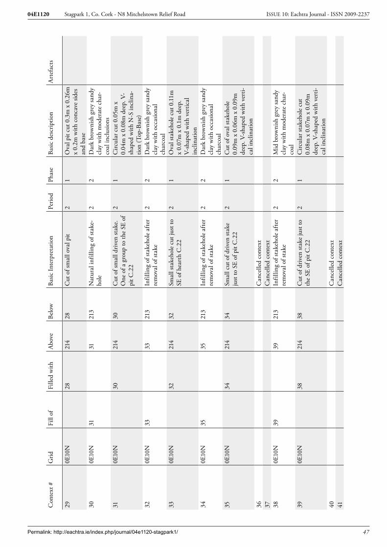
Permalink: http://eachtra.ie/index.php/journal/04e1120-stagpark1/ 47
Stagpark 1, Co. Cork - N8 Mitchelstown Relief Road04E1120 ISSUE 10: Eachtra Journal - ISSN 2009-2237
Con
text
#G
ridFi
ll of
Fille
d w
ithA
bove
Belo
wBa
sic In
terp
reta
tion
Perio
dPh
ase
Basic
des
crip
tion
Art
efac
ts
290E
10N
2821
428
Cut
of s
mal
l ova
l pit
21
Ova
l pit
cut 0
.3m
x 0
.26m
x
0.2m
with
con
cave
side
s an
d ba
se30
0E10
N31
3121
3N
atur
al in
fillin
g of
stak
e-ho
le2
2D
ark
brow
nish
gre
y sa
ndy
clay
with
mod
erat
e ch
ar-
coal
incl
usio
ns31
0E10
N30
214
30C
ut o
f sm
all d
riven
stak
e.
One
of a
gro
up to
the
SE o
f pi
t C.2
2
21
Circ
ular
cut
0.0
5m x
0.
04m
x 0
.08m
dee
p. V
-sh
aped
with
N-S
incl
ina-
tion
(Top
-Bas
e)32
0E10
N33
3321
3In
fillin
g of
stak
ehol
e af
ter
rem
oval
of s
take
2
2D
ark
brow
nish
gre
y sa
ndy
clay
with
occ
asio
nal
char
coal
330E
10N
3221
432
Smal
l sta
keho
le c
ut ju
st to
SE
of h
eart
h C
.22
21
Ova
l sta
keho
le c
ut 0
.11m
x
0.07
m x
0.1
m d
eep.
V-
shap
ed w
ith v
ertic
al
incl
inat
ion
340E
10N
3535
213
Infil
ling
of st
akeh
ole
afte
r re
mov
al o
f sta
ke
22
Dar
k br
owni
sh g
rey
sand
y cl
ay w
ith o
ccas
iona
l ch
arco
al35
0E10
N34
214
34Sm
all c
ut o
f driv
en st
ake
just
to S
E of
pit
C.2
22
1C
ut o
f ova
l sta
keho
le
0.09
m x
0.0
6m x
0.0
9m
deep
. V-s
hape
d w
ith v
erti-
cal i
nclin
atio
n36
Can
celle
d co
ntex
t37
Can
celle
d co
ntex
t38
0E10
N39
3921
3In
fillin
g of
stak
ehol
e af
ter
rem
oval
of s
take
2
2M
id b
row
nish
gre
y sa
ndy
clay
with
mod
erat
e ch
ar-
coal
390E
10N
3821
438
Cut
of d
riven
stak
e ju
st to
th
e SE
of p
it C
.22
21
Circ
ular
stak
ehol
e cu
t 0.
08m
x 0
.07m
x 0
.09m
de
ep. V
-sha
ped
with
ver
ti-ca
l inc
linat
ion
40C
ance
lled
cont
ext
41C
ance
lled
cont
ext

Permalink: http://eachtra.ie/index.php/journal/04e1120-stagpark1/ 48
Stagpark 1, Co. Cork - N8 Mitchelstown Relief Road04E1120 ISSUE 10: Eachtra Journal - ISSN 2009-2237
Con
text
#G
ridFi
ll of
Fille
d w
ithA
bove
Belo
wBa
sic In
terp
reta
tion
Perio
dPh
ase
Basic
des
crip
tion
Art
efac
ts
420E
10N
4343
214
Fill
of sm
all p
osth
ole
at S
E en
d of
pit
C.2
22
2Lo
ose
redd
ish b
row
n sa
ndy
clay
with
cha
rcoa
l fle
cks a
nd p
ossib
le p
ack-
ing
stone
s on
sout
hern
sid
e43
0E10
N42
214
42C
ut o
f sm
all s
take
hole
at S
E en
d of
pit
C.2
2. F
lat b
ase
indi
cate
s ins
ertio
n of
pos
t af
ter e
xcav
atio
n of
hol
e.
At o
ppos
ite e
nd o
f C.2
2 to
C
.45
21
Obl
ong
cut 0
.08m
x
0.05
m x
0.0
5m d
eep
with
ve
rtic
al si
des a
nd fl
at b
ase
440E
10N
4545
213
Infil
ling
of st
akeh
ole
afte
r re
mov
al o
f sta
ke. A
t NW
en
d of
pit
C.2
2
22
Mid
bla
ckish
bro
wn
sand
y sil
t with
cha
rcoa
l fle
cks
450E
10N
4421
444
Driv
en st
ake
cut a
t NW
end
of
hea
rth
C.2
2. O
n op
posit
e sid
e to
pos
thol
e C
.43
21
Circ
ular
stak
ehol
e cu
t 0.
06m
x 0
.05m
x 0
.08m
de
ep46
0E0N
4747
213
Infil
ling
of d
riven
pos
thol
e af
ter r
emov
al o
f pos
t2
2So
ft m
id g
rey
clay
ey sa
nd
with
occ
asio
nal c
harc
oal
incl
usio
ns47
0E0N
4621
446
Cut
of i
sola
ted
driv
en p
ost
21
Circ
ular
pos
thol
e 0.
26m
x
0.24
m x
0.4
9m d
eep.
S to
N
incl
inat
ion
(Top
-Bas
e)48
0E0N
4949
213
Infil
ling
of st
akeh
ole
afte
r re
mov
al o
f sta
ke2
2Lo
ose
yello
wish
bro
wn
sand
y cl
ay
490E
0N48
214
48C
ut o
f driv
en st
ake
just
to
the
SE o
f pit
C.2
22
1C
ircul
ar c
ut 0
.1m
x
0.09
m x
0.0
9m d
eep
with
v-
shap
ed b
ase
and
vert
ical
in
clin
atio
n50
0E0N
5151
213
Infil
ling
of st
akeh
ole
afte
r re
mov
al o
f sta
ke2
2So
ft m
id b
row
n sa
ndy
clay
w
ith o
ccas
iona
l cha
rcoa
l in
clus
ions
510E
0N51
214
51C
ut o
f driv
en st
ake
21
Ova
l cut
of s
take
hole
0.
15m
x 0
.1m
x 0
.12m
de
ep. V
-sha
ped
with
ver
ti-ca
l inc
linat
ion
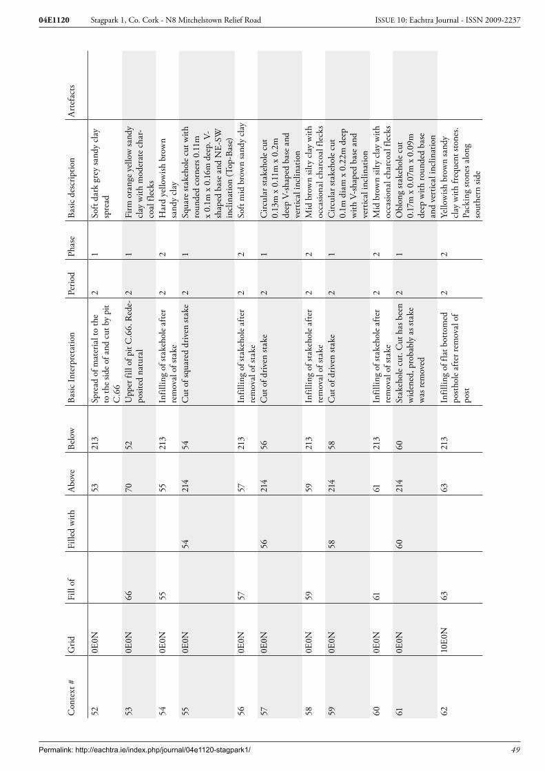
Permalink: http://eachtra.ie/index.php/journal/04e1120-stagpark1/ 49
Stagpark 1, Co. Cork - N8 Mitchelstown Relief Road04E1120 ISSUE 10: Eachtra Journal - ISSN 2009-2237
Con
text
#G
ridFi
ll of
Fille
d w
ithA
bove
Belo
wBa
sic In
terp
reta
tion
Perio
dPh
ase
Basic
des
crip
tion
Art
efac
ts
520E
0N53
213
Spre
ad o
f mat
eria
l to
the
to th
e sid
e of
and
cut
by
pit
C.6
6
21
Soft
dark
gre
y sa
ndy
clay
sp
read
530E
0N66
7052
Upp
er fi
ll of
pit
C.6
6. R
ede-
posit
ed n
atur
al2
1Fi
rm o
rang
e ye
llow
sand
y cl
ay w
ith m
oder
ate
char
-co
al fl
ecks
540E
0N55
5521
3In
fillin
g of
stak
ehol
e af
ter
rem
oval
of s
take
22
Har
d ye
llow
ish b
row
n sa
ndy
clay
550E
0N54
214
54C
ut o
f squ
ared
driv
en st
ake
21
Squa
re st
akeh
ole
cut w
ith
roun
ded
corn
ers 0
.11m
x
0.1m
x 0
.16m
dee
p. V
-sh
aped
bas
e an
d N
E-SW
in
clin
atio
n (T
op-B
ase)
560E
0N57
5721
3In
fillin
g of
stak
ehol
e af
ter
rem
oval
of s
take
22
Soft
mid
bro
wn
sand
y cl
ay
570E
0N56
214
56C
ut o
f driv
en st
ake
21
Circ
ular
stak
ehol
e cu
t 0.
13m
x 0
.11m
x 0
.2m
de
ep V
-sha
ped
base
and
ve
rtic
al in
clin
atio
n58
0E0N
5959
213
Infil
ling
of st
akeh
ole
afte
r re
mov
al o
f sta
ke2
2M
id b
row
n sil
ty c
lay
with
oc
casio
nal c
harc
oal f
leck
s59
0E0N
5821
458
Cut
of d
riven
stak
e 2
1C
ircul
ar st
akeh
ole
cut
0.1m
dia
m x
0.2
2m d
eep
with
V-s
hape
d ba
se a
nd
vert
ical
incl
inat
ion
600E
0N61
6121
3In
fillin
g of
stak
ehol
e af
ter
rem
oval
of s
take
22
Mid
bro
wn
silty
cla
y w
ith
occa
siona
l cha
rcoa
l fle
cks
610E
0N60
214
60St
akeh
ole
cut.
Cut
has
bee
n w
iden
ed, p
roba
bly
as st
ake
was
rem
oved
21
Obl
ong
stak
ehol
e cu
t 0.
17m
x 0
.07m
x 0
.09m
de
ep w
ith ro
unde
d ba
se
and
vert
ical
incl
inat
ion
6210
E0N
6363
213
Infil
ling
of fl
at b
otto
med
po
stho
le a
fter r
emov
al o
f po
st
22
Yello
wish
bro
wn
sand
y cl
ay w
ith fr
eque
nt st
ones
. Pa
ckin
g sto
nes a
long
so
uthe
rn si
de
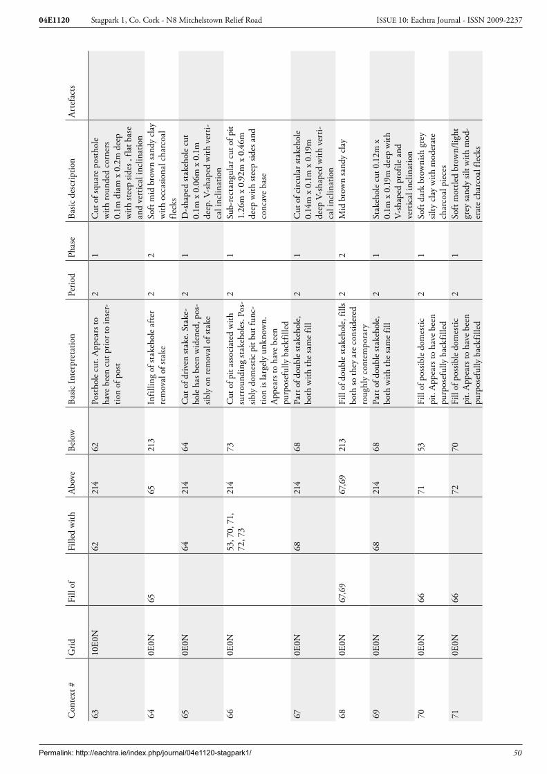
Permalink: http://eachtra.ie/index.php/journal/04e1120-stagpark1/ 50
Stagpark 1, Co. Cork - N8 Mitchelstown Relief Road04E1120 ISSUE 10: Eachtra Journal - ISSN 2009-2237
Con
text
#G
ridFi
ll of
Fille
d w
ithA
bove
Belo
wBa
sic In
terp
reta
tion
Perio
dPh
ase
Basic
des
crip
tion
Art
efac
ts
6310
E0N
6221
462
Post
hole
cut
. App
ears
to
have
bee
n cu
t prio
r to
inse
r-tio
n of
pos
t
21
Cut
of s
quar
e po
stho
le
with
roun
ded
corn
ers
0.1m
dia
m x
0.2
m d
eep
with
stee
p sid
es ,
flat b
ase
and
vert
ical
incl
inat
ion
640E
0N65
6521
3In
fillin
g of
stak
ehol
e af
ter
rem
oval
of s
take
22
Soft
mid
bro
wn
sand
y cl
ay
with
occ
asio
nal c
harc
oal
fleck
s65
0E0N
6421
464
Cut
of d
riven
stak
e. S
take
-ho
le h
as b
een
wid
ened
, pos
-sib
ly o
n re
mov
al o
f sta
ke
21
D-s
hape
d st
akeh
ole
cut
0.1m
x 0
.06m
x 0
.1m
de
ep. V
-sha
ped
with
ver
ti-ca
l inc
linat
ion
660E
0N53
, 70,
71,
72
, 73
214
73C
ut o
f pit
asso
ciat
ed w
ith
surr
ound
ing
stak
ehol
es. P
os-
sibly
dom
estic
pit
but f
unc-
tion
is la
rgel
y un
know
n.
App
ears
to h
ave
been
pu
rpos
eful
ly b
ackf
illed
21
Sub-
rect
angu
lar c
ut o
f pit
1.26
m x
0.9
2m x
0.4
6m
deep
with
stee
p sid
es a
nd
conc
ave
base
670E
0N68
214
68Pa
rt o
f dou
ble
stak
ehol
e,
both
with
the
sam
e fil
l2
1C
ut o
f circ
ular
stak
ehol
e 0.
14m
x 0
.1m
x 0
.19m
de
ep V
-sha
ped
with
ver
ti-ca
l inc
linat
ion
680E
0N67
,69
67,6
921
3Fi
ll of
dou
ble
stak
ehol
e, fi
lls
both
so th
ey a
re c
onsid
ered
ro
ughl
y co
ntem
pora
ry
22
Mid
bro
wn
sand
y cl
ay
690E
0N68
214
68Pa
rt o
f dou
ble
stak
ehol
e,
both
with
the
sam
e fil
l2
1St
akeh
ole
cut 0
.12m
x
0.1m
x 0
.19m
dee
p w
ith
V-sh
aped
pro
file
and
vert
ical
incl
inat
ion
700E
0N66
7153
Fill
of p
ossib
le d
omes
tic
pit.
App
ears
to h
ave
been
pu
rpos
eful
ly b
ackf
illed
21
Soft
dark
bro
wni
sh g
rey
silty
cla
y w
ith m
oder
ate
char
coal
pie
ces
710E
0N66
7270
Fill
of p
ossib
le d
omes
tic
pit.
App
ears
to h
ave
been
pu
rpos
eful
ly b
ackf
illed
21
Soft
mot
tled
brow
n/lig
ht
grey
sand
y sil
t with
mod
-er
ate
char
coal
flec
ks

Permalink: http://eachtra.ie/index.php/journal/04e1120-stagpark1/ 51
Stagpark 1, Co. Cork - N8 Mitchelstown Relief Road04E1120 ISSUE 10: Eachtra Journal - ISSN 2009-2237
Con
text
#G
ridFi
ll of
Fille
d w
ithA
bove
Belo
wBa
sic In
terp
reta
tion
Perio
dPh
ase
Basic
des
crip
tion
Art
efac
ts
720E
0N66
7371
Fill
of p
ossib
le d
omes
tic
pit.
App
ears
to h
ave
been
pu
rpos
eful
ly b
ackf
illed
21
Soft
light
bro
wni
sh y
ello
w
sand
y cl
ay w
ith o
ccas
iona
l ch
arco
al fl
ecks
730E
0N66
6672
Fill
of p
ossib
le d
omes
tic
pit.
App
ears
to h
ave
been
pu
rpos
eful
ly b
ackf
illed
21
Soft
light
gre
y sil
ty c
lay
with
mod
erat
e ch
arco
al
fleck
s74
0E0N
7575
213
Infil
ling
of st
akeh
ole
afte
r re
mov
al o
f sta
ke2
2Fi
rm d
ark
brow
nish
gre
y sil
ty c
lay
with
occ
asio
nal
char
coal
flec
ks75
0E0N
7421
474
Stak
ehol
e cu
t ass
ocia
ted
with
bac
kfill
ed p
it C
.66.
At
oppo
site
end
to st
akeh
ole
C.7
7
21
Circ
ular
stak
ehol
e cu
t 0.
085m
x 0
.09m
x 0
.11m
de
ep w
ith ro
unde
d ba
se
and
vert
ical
incl
inat
ion
760E
0N77
7721
3In
fillin
g of
stak
ehol
e af
ter
rem
oval
of s
take
. Sim
ilar t
o up
per f
ill o
f nea
rby
pit C
.66
21
Soft
dark
gre
y cl
ayey
silt
with
mod
erat
e ch
arco
al
fleck
ing
770E
0N76
214
76St
akeh
ole
cut n
ext t
o ba
ck-
fille
d pi
t C.6
6. A
t opp
osite
en
d to
stak
ehol
e C
.75
21
Circ
ular
stak
ehol
e cu
t 0.
125m
x 0
.11m
x 0
.095
m
deep
with
roun
ded
base
an
d ve
rtic
al in
clin
atio
n78
0E0N
7921
479
Driv
en st
ake
cut.
Driv
en o
n to
ston
e at
bas
e 2
1C
ut o
f circ
ular
stak
ehol
e.
0.08
m d
iam
x 0
.11m
dee
p w
ith fl
at b
ase
due
to b
eing
dr
iven
on
to a
ston
e.79
0E0N
7878
213
Infil
ling
of st
akeh
ole
afte
r re
mov
al o
f sta
ke2
2M
id b
row
n sa
ndy
clay
800E
0N82
8280
Upp
er fi
ll of
smal
l sha
llow
po
ssib
le d
omes
tic p
it. A
p-pe
ars t
o ha
ve b
een
back
-fil
led
21
Soft
mid
bro
wn
clay
ey
sand
with
occ
asio
nal
char
coal
810E
0N82
8280
Low
er fi
ll of
smal
l sha
llow
po
ssib
le d
omes
tic p
it. A
p-pe
ars t
o ha
ve b
een
back
-fil
led
21
Soft
mid
bro
wn
clay
ey
sand
with
occ
asio
nal
char
coal

Permalink: http://eachtra.ie/index.php/journal/04e1120-stagpark1/ 52
Stagpark 1, Co. Cork - N8 Mitchelstown Relief Road04E1120 ISSUE 10: Eachtra Journal - ISSN 2009-2237
Con
text
#G
ridFi
ll of
Fille
d w
ithA
bove
Belo
wBa
sic In
terp
reta
tion
Perio
dPh
ase
Basic
des
crip
tion
Art
efac
ts
820E
0N80
,81
214
81Sh
allo
w p
it, u
pper
fill
cont
aine
d a
larg
e am
ount
of
cha
rcoa
l but
ther
e w
ere
no si
gns o
f in-
situ
burn
ing,
su
gges
ting
it w
as b
ackf
illed
21
Ova
l pit
cut 0
.45m
x
0.25
m x
0.1
1 de
ep w
ith
roun
ded
base
8310
E0N
8821
488
Cut
of s
mal
l pit.
App
eare
d to
be
a cr
emat
ion
due
to
the
fill b
ut n
o bu
rnt b
one
evid
ent.
Clo
se to
cre
mat
ion
buria
l C.8
4
21
Sub-
circ
ular
pit
cut 0
.4m
x
0.38
m x
0.0
7m d
eep
with
flat
une
ven
base
8410
E0N
93,9
221
493
Cut
of p
ossib
le c
rem
atio
n bu
rial.
Clo
se to
sim
ilar
feat
ure
C.8
3
21
Sub-
circ
ular
cre
mat
ion
pit c
ut 0
.36m
x 0
.26m
x
0.15
m d
eep
with
roun
ded
base
8510
E0N
87,9
4,95
,96
8621
3U
pper
fill
of st
akeh
ole
grou
p. O
rigin
ally
thou
ght
to b
e a
smal
l pit
. Fill
s all
4 st
akeh
oles
22
Soft
brow
nish
bla
ck
clay
ey sa
nd w
ith fr
eque
nt
char
coal
8610
E0N
87,9
4,95
,96
87, 9
4,
95, 9
685
Low
er fi
ll of
stak
ehol
e gr
oup,
infil
ling
afte
r re-
mov
al o
f sta
kes
22
Soft
mid
bro
wn
clay
ey
sand
with
occ
asio
nal
char
coal
8710
E10N
85, 8
621
486
Driv
en st
akeh
ole
cut,
part
of
a g
roup
of 4
orig
inal
ly
thou
ght t
o be
a sm
all p
it
21
Tria
ngul
ar st
akeh
ole
cut
0.15
m x
0.1
m x
0.2
m
deep
. V-s
hape
d w
ith S
W-
NE
incl
inat
ion
(Top
-Bas
e)88
10E1
0N83
8321
3Fi
ll of
pit,
thou
ght t
o be
po
ssib
le c
rem
atio
n bu
rial.
Blac
k ch
arco
al ri
ch m
ater
ial
simila
r to
typi
cal c
rem
atio
ns
but c
onta
ined
no
evid
ent
burn
t bon
e
21
Firm
bla
ck m
ix o
f cha
r-co
al a
nd si
lt.
8910
E10N
90, 9
1, 9
7,
98, 9
9, 1
00,
101
90, 9
1, 9
7,
98, 9
9,
100,
101
213
Nat
ural
infil
ling
of p
it an
d st
akeh
oles
afte
r use
an
d ab
ando
nmen
t. St
akes
re
mov
ed p
rior t
o in
fillin
g
22
Ligh
t red
dish
bro
wn
sand
y cl
ay w
ith o
ccas
iona
l ch
arco
al fl
ecks
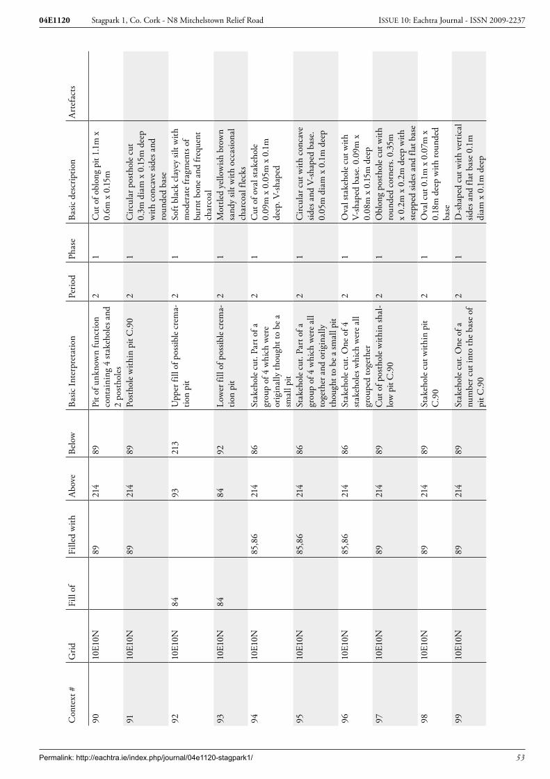
Permalink: http://eachtra.ie/index.php/journal/04e1120-stagpark1/ 53
Stagpark 1, Co. Cork - N8 Mitchelstown Relief Road04E1120 ISSUE 10: Eachtra Journal - ISSN 2009-2237
Con
text
#G
ridFi
ll of
Fille
d w
ithA
bove
Belo
wBa
sic In
terp
reta
tion
Perio
dPh
ase
Basic
des
crip
tion
Art
efac
ts
9010
E10N
8921
489
Pit o
f unk
now
n fu
nctio
n co
ntai
ning
4 st
akeh
oles
and
2
post
hole
s
21
Cut
of o
blon
g pi
t 1.1
m x
0.
6m x
0.15
m
9110
E10N
8921
489
Post
hole
with
in p
it C
.90
21
Circ
ular
pos
thol
e cu
t 0.
3m d
iam
x 0
.15m
dee
p w
ith c
onca
ve si
des a
nd
roun
ded
base
9210
E10N
8493
213
Upp
er fi
ll of
pos
sible
cre
ma-
tion
pit
21
Soft
blac
k cl
ayey
silt
with
m
oder
ate
frag
men
ts o
f bu
rnt b
one
and
freq
uent
ch
arco
al93
10E1
0N84
8492
Low
er fi
ll of
pos
sible
cre
ma-
tion
pit
21
Mot
tled
yello
wish
bro
wn
sand
y sil
t with
occ
asio
nal
char
coal
flec
ks94
10E1
0N85
,86
214
86St
akeh
ole
cut.
Part
of a
gr
oup
of 4
whi
ch w
ere
orig
inal
ly th
ough
t to
be a
sm
all p
it
21
Cut
of o
val s
take
hole
0.
09m
x 0
.05m
x 0
.1m
de
ep. V
-sha
ped
9510
E10N
85,8
621
486
Stak
ehol
e cu
t. Pa
rt o
f a
grou
p of
4 w
hich
wer
e al
l to
geth
er a
nd o
rigin
ally
th
ough
t to
be a
smal
l pit
21
Circ
ular
cut
with
con
cave
sid
es a
nd V
-sha
ped
base
. 0.
05m
dia
m x
0.1
m d
eep
9610
E10N
85,8
621
486
Stak
ehol
e cu
t. O
ne o
f 4
stak
ehol
es w
hich
wer
e al
l gr
oupe
d to
geth
er
21
Ova
l sta
keho
le c
ut w
ith
V-sh
aped
bas
e. 0
.09m
x
0.08
m x
0.15
m d
eep
9710
E10N
8921
489
Cut
of p
osth
ole
with
in sh
al-
low
pit
C.9
02
1O
blon
g po
stho
le c
ut w
ith
roun
ded
corn
ers.
0.35
m
x 0.
2m x
0.2
m d
eep
with
st
eppe
d sid
es a
nd fl
at b
ase
9810
E10N
8921
489
Stak
ehol
e cu
t with
in p
it C
.90
21
Ova
l cut
0.1
m x
0.0
7m x
0.
18m
dee
p w
ith ro
unde
d ba
se99
10E1
0N89
214
89St
akeh
ole
cut.
One
of a
nu
mbe
r cut
into
the
base
of
pit C
.90
21
D-s
hape
d cu
t with
ver
tical
sid
es a
nd fl
at b
ase
0.1m
di
am x
0.1
m d
eep

Permalink: http://eachtra.ie/index.php/journal/04e1120-stagpark1/ 54
Stagpark 1, Co. Cork - N8 Mitchelstown Relief Road04E1120 ISSUE 10: Eachtra Journal - ISSN 2009-2237
Con
text
#G
ridFi
ll of
Fille
d w
ithA
bove
Belo
wBa
sic In
terp
reta
tion
Perio
dPh
ase
Basic
des
crip
tion
Art
efac
ts
100
10E1
0N89
214
89St
akeh
ole
cut i
n th
e ba
se o
f sh
allo
w p
it C
.90
21
Ova
l cut
0.15
m x
0.0
7m x
0.
15m
dee
p w
ith V
-sha
ped
base
and
W-E
incl
inat
ion
(Top
-Bas
e)10
110
E10N
8921
489
Stak
ehol
e cu
t in
the
base
of
shal
low
pit
C.9
02
1C
ircul
ar st
akeh
ole
cut
0.1m
x 0
.08m
x 0
.12m
w
ith v
ertic
al si
des a
nd V
-sh
aped
bas
e10
210
E10N
103
103
213
Fill
of d
oubl
e st
akeh
ole,
fills
bo
th so
they
are
con
sider
ed
roug
hly
cont
empo
rary
22
Soft
mid
gre
yish
bro
wn
sand
y cl
ay w
ith o
ccas
iona
l ch
arco
al fl
ecks
103
10E1
0N10
221
410
2C
ut o
f sta
keho
le, p
art o
f do
uble
stak
ehol
e w
ith C
.104
21
Ova
l sta
keho
le c
ut 0
.1m
x
0.05
m x
0.15
m d
eep
with
ve
rtic
al si
des a
nd v
-sha
ped
base
104
10E1
0N10
221
410
4C
ut o
f sta
keho
le, p
art o
f do
uble
stak
ehol
e w
ith C
.103
21
Ova
l cut
0.1
3m x
0.0
8m x
0.
25m
dee
p w
ith v
ertic
al
sides
and
V-s
hape
d ba
se10
510
E10N
106
106
213
Fill
of tr
iple
stak
ehol
e af
ter
rem
oval
of s
take
s, al
l are
fil
led
with
the
sam
e m
ater
ial
22
Soft
mid
bro
wn
sand
y cl
ay
with
occ
asio
nal c
harc
oal
fleck
s10
610
E10N
105
214
105
Stak
ehol
e cu
t, pa
rt o
f trip
le
stak
ehol
e al
ong
with
C.1
07
and
C.1
08
21
Sub-
circ
ular
cut
0.1
m
x 0.
08m
x 0
.23m
dee
p w
ith v
ertic
al si
des a
nd V
-sh
aped
bas
e10
710
E10N
105
214
105
Stak
ehol
e cu
t, pa
rt o
f trip
le
stak
ehol
e w
ith C
.106
and
C
.108
21
Ova
l cut
mea
surin
g 0.
07m
x 0
.05m
x 0
.13m
de
ep w
ith c
onca
ve si
des
and
V-sh
aped
bas
e10
810
E10N
105
214
105
Cut
of s
take
hole
, one
of
thre
e w
hich
form
a tr
iple
st
akeh
ole.
All
are
fille
d w
ith
the
sam
e m
ater
ial
21
Circ
ular
stak
ehol
e cu
t 0.
06m
dia
m x
0.1
2m d
eep
with
V-s
hape
d ba
se
109
10E0
N11
4,11
511
521
4C
ut o
f pit
cont
aini
ng m
ate-
rial t
ypic
al o
f a c
rem
atio
n.
Cut
into
larg
er p
it C
.110
21
Circ
ular
cut
0.4
5m x
0.3
m
x 0.
09m
with
con
cave
sid
es a
nd b
ase
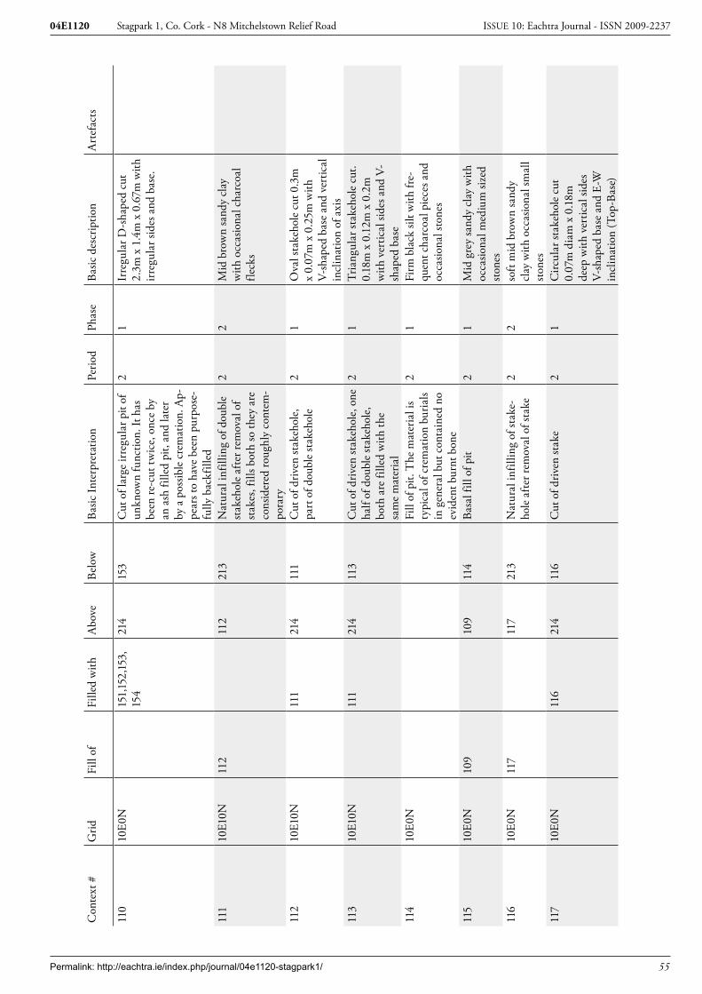
Permalink: http://eachtra.ie/index.php/journal/04e1120-stagpark1/ 55
Stagpark 1, Co. Cork - N8 Mitchelstown Relief Road04E1120 ISSUE 10: Eachtra Journal - ISSN 2009-2237
Con
text
#G
ridFi
ll of
Fille
d w
ithA
bove
Belo
wBa
sic In
terp
reta
tion
Perio
dPh
ase
Basic
des
crip
tion
Art
efac
ts
110
10E0
N15
1,15
2,15
3,
154
214
153
Cut
of l
arge
irre
gula
r pit
of
unkn
own
func
tion.
It h
as
been
re-c
ut tw
ice,
onc
e by
an
ash
fille
d pi
t, an
d la
ter
by a
pos
sible
cre
mat
ion.
Ap-
pear
s to
have
bee
n pu
rpos
e-fu
lly b
ackf
illed
21
Irre
gula
r D-s
hape
d cu
t 2.
3m x
1.4
m x
0.6
7m w
ith
irreg
ular
side
s and
bas
e.
111
10E1
0N11
211
221
3N
atur
al in
fillin
g of
dou
ble
stak
ehol
e af
ter r
emov
al o
f st
akes
, fill
s bot
h so
they
are
co
nsid
ered
roug
hly
cont
em-
pora
ry
22
Mid
bro
wn
sand
y cl
ay
with
occ
asio
nal c
harc
oal
fleck
s
112
10E1
0N11
121
411
1C
ut o
f driv
en st
akeh
ole,
pa
rt o
f dou
ble
stak
ehol
e2
1O
val s
take
hole
cut
0.3
m
x 0.
07m
x 0
.25m
with
V-
shap
ed b
ase
and
vert
ical
in
clin
atio
n of
axi
s11
310
E10N
111
214
113
Cut
of d
riven
stak
ehol
e, o
ne
half
of d
oubl
e st
akeh
ole,
bo
th a
re fi
lled
with
the
sam
e m
ater
ial
21
Tria
ngul
ar st
akeh
ole
cut.
0.18
m x
0.1
2m x
0.2
m
with
ver
tical
side
s and
V-
shap
ed b
ase
114
10E0
NFi
ll of
pit.
The
mat
eria
l is
typi
cal o
f cre
mat
ion
buria
ls in
gen
eral
but
con
tain
ed n
o ev
iden
t bur
nt b
one
21
Firm
bla
ck si
lt w
ith fr
e-qu
ent c
harc
oal p
iece
s and
oc
casio
nal s
tone
s
115
10E0
N10
910
911
4Ba
sal f
ill o
f pit
21
Mid
gre
y sa
ndy
clay
with
oc
casio
nal m
ediu
m si
zed
stone
s11
610
E0N
117
117
213
Nat
ural
infil
ling
of st
ake-
hole
afte
r rem
oval
of s
take
22
soft
mid
bro
wn
sand
y cl
ay w
ith o
ccas
iona
l sm
all
stone
s11
710
E0N
116
214
116
Cut
of d
riven
stak
e2
1C
ircul
ar st
akeh
ole
cut
0.07
m d
iam
x 0
.18m
de
ep w
ith v
ertic
al si
des
V-sh
aped
bas
e an
d E-
W
incl
inat
ion
(Top
-Bas
e)

Permalink: http://eachtra.ie/index.php/journal/04e1120-stagpark1/ 56
Stagpark 1, Co. Cork - N8 Mitchelstown Relief Road04E1120 ISSUE 10: Eachtra Journal - ISSN 2009-2237
Con
text
#G
ridFi
ll of
Fille
d w
ithA
bove
Belo
wBa
sic In
terp
reta
tion
Perio
dPh
ase
Basic
des
crip
tion
Art
efac
ts
118
10E0
N11
911
921
3N
atur
al in
fillin
g of
shal
low
pi
t of u
nkno
wn
func
tion
22
soft
grey
ish b
row
n cl
ayey
sa
nd w
ith o
ccas
iona
l cha
r-co
al fl
ecks
119
10E0
N11
821
411
8C
ut o
f sha
llow
pit
with
no
obvi
ous f
unct
ion
21
Sub-
squa
re p
it cu
t with
ro
unde
d co
rner
s and
fla
t bas
e 0.
25m
x 0
.3m
x
0.09
m12
010
E0N
159
155
150
Cha
rcoa
l ric
h lo
wer
fill
of
pit C
.159
whi
ch is
re-c
ut
into
C.1
10
21
soft
blac
k ch
arco
al ri
ch
silt w
ith o
ccas
iona
l sm
all
stone
s12
110
E0N
122
122
213
Nat
ural
infil
ling
of st
ake-
hole
afte
r rem
oval
of s
take
21
Soft
mid
bro
wn
sand
y cl
ay
with
occ
asio
nal c
harc
oal
fleck
incl
usio
ns12
210
E0N
121
214
121
Cut
of d
riven
stak
e2
1C
ut o
f circ
ular
stak
ehol
e 0.
08m
dia
m x
0.15
m d
eep
with
ver
tical
side
s and
V-
shap
ed b
ase
123
10E0
N12
412
421
3In
fillin
g of
stak
ehol
e,
char
coal
rich
but
with
no
evid
ence
for s
take
22
Firm
bla
ck c
laye
y sil
t w
ith fr
eque
nt c
harc
oal
and
occa
siona
l bur
nt c
lay
fleck
s. N
ot re
pres
enta
tive
of in
-situ
bur
ning
124
10E0
N12
321
412
3C
ut o
f driv
en st
ake,
mos
t lik
ely
asso
ciat
ed w
ith o
ther
s lo
cate
d in
sam
e ar
ea
21
Circ
ular
stak
ehol
e cu
t 0.
1m x
0.1
2m x
0.1
1m
deep
with
ver
tical
side
s an
d ro
unde
d ba
se12
510
E0N
126
126
213
Nat
ural
infil
ling
of st
ake-
hole
afte
r rem
oval
of s
take
22
Soft
grey
ish b
row
n cl
ayey
sa
nd
126
10E0
N12
521
412
5C
ut o
f driv
en st
ake,
pos
-sib
ly a
ssoc
iate
d w
ith o
ther
st
akeh
oles
in th
e sa
me
area
of
the
grid
21
Ova
l sta
keho
le c
ut 0
.11m
x
0.14
m x
0.1
8m d
eep
with
stee
p sid
es a
nd
roun
ded
base

Permalink: http://eachtra.ie/index.php/journal/04e1120-stagpark1/ 57
Stagpark 1, Co. Cork - N8 Mitchelstown Relief Road04E1120 ISSUE 10: Eachtra Journal - ISSN 2009-2237
Con
text
#G
ridFi
ll of
Fille
d w
ithA
bove
Belo
wBa
sic In
terp
reta
tion
Perio
dPh
ase
Basic
des
crip
tion
Art
efac
ts
127
10E0
N12
912
821
3U
pper
fill
of p
osth
ole,
ap
pear
s to
have
bee
n ba
ckfil
led
due
to th
e la
rge
amou
nt o
f cha
rcoa
l in
the
2 fil
ls
21
Loos
e m
id b
row
nish
gre
y sil
ty c
lay
with
freq
uent
ch
arco
al in
clus
ions
128
10E0
N12
912
912
7Ba
sal f
ill o
f pos
sibly
bac
k-fil
led
post
hole
21
Loos
e m
id re
ddish
bro
wn
silty
cla
y w
ith fr
eque
nt
larg
e ch
arco
al p
iece
s and
oc
casio
nal f
leck
s of b
urnt
cl
ay12
910
E0N
127,1
2821
312
8C
ut o
f pos
thol
e, a
ppea
rs to
ha
ve b
een
back
fille
d af
ter
the
rem
oval
of t
he p
ost d
ue
to th
e fr
eque
nt c
harc
oal
and
occa
siona
l bur
nt c
lay
incl
usio
ns
21
Shee
t miss
ing
130
10E0
N13
113
121
3N
atur
al in
fillin
g of
stak
e-ho
le a
fter t
he re
mov
al o
f the
st
ake
22
Soft
grey
ish b
row
n cl
ayey
sa
nd
131
10E0
N13
021
413
0C
ut o
f driv
en st
ake,
pos
sibly
as
soci
ated
with
oth
er st
akes
in
clo
se p
roxi
mity
in th
e sa
me
grid
21
Cut
of o
val s
take
hole
0.1
m
diam
x 0
.09m
dee
p w
ith
vert
ical
side
s and
roun
ded
base
132
10E0
N13
313
321
3In
fillin
g of
stak
ehol
e af
ter
the
rem
oval
of t
he st
ake
22
Soft
grey
ish b
row
n cl
ayey
sa
nd w
ith o
ccas
iona
l cha
r-co
al fl
ecks
133
10E0
N13
221
413
2C
ut o
f driv
en st
akeh
ole
with
pos
sible
ass
ocia
tion
to
near
by st
akeh
oles
in sa
me
grid
21
Circ
ular
cut
0.0
9m x
0.1
m
x 0.
12m
dee
p w
ith v
ertic
al
sides
and
roun
ded
base
134
10E0
N13
613
521
3In
fillin
g of
stak
ehol
e. A
p-pe
ars t
o ha
ve fi
lled
natu
rally
de
spite
the
fact
that
ther
e ar
e 2
fills
22
Soft
light
gre
y cl
ayey
silt
with
occ
asio
nal c
harc
oal
fleck
s

Permalink: http://eachtra.ie/index.php/journal/04e1120-stagpark1/ 58
Stagpark 1, Co. Cork - N8 Mitchelstown Relief Road04E1120 ISSUE 10: Eachtra Journal - ISSN 2009-2237
Con
text
#G
ridFi
ll of
Fille
d w
ithA
bove
Belo
wBa
sic In
terp
reta
tion
Perio
dPh
ase
Basic
des
crip
tion
Art
efac
ts
135
10E0
N13
613
613
4Ba
sal f
ill o
f sta
keho
le, a
p-pe
ars t
o be
nat
ural
infil
ling
afte
r rem
oval
of t
he st
ake
22
Soft
mid
bro
wn
silty
cla
y w
ith o
ccas
iona
l cha
rcoa
l fle
cks
136
10E0
N13
4,13
521
413
5C
ut o
f driv
en st
akeh
ole
with
th
e st
ake
rem
oved
prio
r to
infil
ling
21
Circ
ular
cut
0.2
m x
0.1
8m
x 0.
1m d
eep
with
stee
p to
p ve
rtic
al si
des a
nd
roun
ded
base
137
10E0
N13
813
821
3N
atur
al in
fillin
g of
stak
e-ho
le a
fter r
emov
al o
f sta
ke2
2So
ft br
own
sand
y cl
ay
138
10E0
N13
721
413
7C
ut o
f driv
en st
ake
with
po
ssib
le a
ssoc
iatio
n to
oth
er
simila
r sta
keho
les i
n th
e ar
ea
21
Circ
ular
stak
ehol
e cu
t 0.
07m
dia
m x
0.0
8m d
eep
with
ver
tical
side
s and
ro
unde
d ba
se13
910
E0N
144,
145
214
144
Cut
of s
hallo
w ro
unde
d pi
t whi
ch a
ppea
rs to
hav
e fil
led
in n
atur
ally.
Pos
sible
do
mes
tic p
it
21
Ova
l pit
cut 0
.89m
x
0.66
m x
0.1
2m d
eep
with
st
eep
sides
and
flat
bas
e
140
Can
celle
d co
ntex
t14
1C
ance
lled
cont
ext
142
10E0
N14
314
321
3Si
ngle
fill
of sm
all p
ossib
le
dom
estic
pit.
App
ears
to
have
infil
led
natu
rally
afte
r us
e
22
Mod
erat
ely
com
pact
mid
gr
eyish
bro
wn
silty
cla
y
143
10E0
N14
214
221
4C
ut o
f pos
sible
dom
estic
pit
21
Sub-
rect
angu
lar c
ut w
ith
conc
ave
sides
and
bas
e slo
ping
from
E-W
0.4
5m x
0.
20m
x 0
.15m
144
10E0
N13
913
914
5N
atur
al in
fillin
g of
pos
sible
do
mes
tic p
it. L
ower
fill
22
Soft
grey
sand
y cl
ay w
ith
char
coal
flec
k in
clus
ions
145
10E0
N13
914
421
3N
atur
al in
fillin
g of
pos
sible
do
mes
tic p
it af
ter u
se. U
p-pe
r fill
22
Soft
brow
n sa
ndy
clay
w
ith c
harc
oal f
leck
incl
u-sio
ns14
620
E0N
147
147
213
Infil
ling
of p
ossib
le sh
allo
w
dom
estic
pit.
2
2Fi
rm d
ark
grey
cla
yey
silt
with
mod
erat
e ch
arco
al
fleck
s

Permalink: http://eachtra.ie/index.php/journal/04e1120-stagpark1/ 59
Stagpark 1, Co. Cork - N8 Mitchelstown Relief Road04E1120 ISSUE 10: Eachtra Journal - ISSN 2009-2237
Con
text
#G
ridFi
ll of
Fille
d w
ithA
bove
Belo
wBa
sic In
terp
reta
tion
Perio
dPh
ase
Basic
des
crip
tion
Art
efac
ts
147
20E0
N14
615
714
6C
ut o
f sha
llow
pos
sible
do-
mes
tic p
it, p
roba
bly
asso
ci-
ated
with
nea
rby
stak
ehol
es
asso
ciat
ion
21
Ova
l pit
cut w
ith v
ertic
al
sides
and
flat
bas
e 0.
5m x
0.
44m
x 0
.09m
dee
p
148
10E0
N15
915
910
9Fi
ll of
re-c
ut o
f lar
ge p
it C
.110
. The
re-c
ut a
ppea
rs to
ha
ve b
een
back
fille
d du
e to
so
me
of th
e fil
ls co
ntai
ning
la
rge
quan
titie
s of a
sh. T
his
fill h
as b
een
cut b
y po
ssib
le
crem
atio
n C
.109
21
Mod
erat
e m
ottle
d br
own-
ish g
rey
sand
y cl
ay w
ith
occa
siona
l cha
rcoa
l fle
cks
149
10E0
N15
915
014
8Fi
ll of
re-c
ut C
.159
of la
rge
pit C
.110
. The
re-c
ut a
p-pe
ars t
o ha
ve b
een
back
-fil
led
due
to so
me
of th
e fil
ls co
ntai
ning
larg
e qu
antit
ies
of a
sh.
21
Mod
erat
ely
com
pact
ligh
t gr
ey si
lt/cl
ay/a
sh m
ix w
ith
occa
siona
l cha
rcoa
l inc
lu-
sions
150
10E0
N15
912
014
9Fi
ll of
re-c
ut C
.159
of la
rge
pit C
.110
. The
re-c
ut a
p-pe
ars t
o ha
ve b
een
back
-fil
led
due
to so
me
of th
e fil
ls co
ntai
ning
larg
e qu
antit
ies
of a
sh.
21
Mod
erat
ely
com
pact
mid
gr
ey c
laye
y sa
nd/a
sh w
ith
freq
uent
cha
rcoa
l inc
lu-
sions
151
10E0
N11
015
215
9Fi
ll of
larg
e irr
egul
ar p
it of
un
know
n fu
nctio
n, la
ter r
e-cu
t by
C.15
9 an
d cr
emat
ion
C.1
09
21
Mod
erat
ely
com
pact
mot
-tle
d ye
llow
ish/b
luish
gre
y cl
ayey
sand
with
occ
asio
n-al
cha
rcoa
l inc
lusio
ns15
210
E0N
110
153
152
Fill
of la
rge
irreg
ular
pit
of
unkn
own
func
tion,
late
r re-
cut b
y C
.159
and
crem
atio
n C
.109
21
Mod
erat
ely
com
pact
blu
-ish
gre
y sa
ndy
clay
with
oc
casio
nal c
harc
oal f
leck
s
153
10E0
N11
011
015
4Fi
ll of
larg
e irr
egul
ar p
it of
un
know
n fu
nctio
n, la
ter r
e-cu
t by
C.15
9 an
d cr
emat
ion
C.1
09
21
Mod
erat
ely
com
pact
or
ange
/bro
wn
sand
y cl
ay
with
occ
asio
nal c
harc
oal
fleck
incl
usio
ns
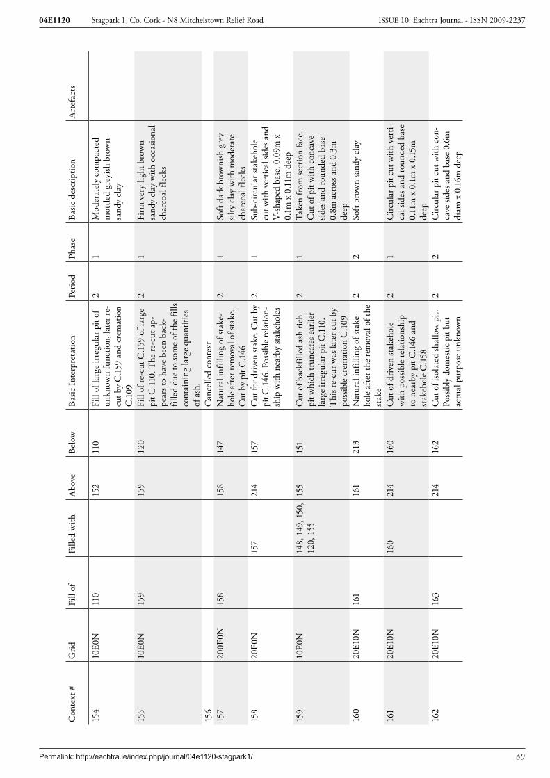
Permalink: http://eachtra.ie/index.php/journal/04e1120-stagpark1/ 60
Stagpark 1, Co. Cork - N8 Mitchelstown Relief Road04E1120 ISSUE 10: Eachtra Journal - ISSN 2009-2237
Con
text
#G
ridFi
ll of
Fille
d w
ithA
bove
Belo
wBa
sic In
terp
reta
tion
Perio
dPh
ase
Basic
des
crip
tion
Art
efac
ts
154
10E0
N11
015
211
0Fi
ll of
larg
e irr
egul
ar p
it of
un
know
n fu
nctio
n, la
ter r
e-cu
t by
C.15
9 an
d cr
emat
ion
C.1
09
21
Mod
erat
ely
com
pact
ed
mot
tled
grey
ish b
row
n sa
ndy
clay
155
10E0
N15
915
912
0Fi
ll of
re-c
ut C
.159
of la
rge
pit C
.110
. The
re-c
ut a
p-pe
ars t
o ha
ve b
een
back
-fil
led
due
to so
me
of th
e fil
ls co
ntai
ning
larg
e qu
antit
ies
of a
sh.
21
Firm
ver
y lig
ht b
row
n sa
ndy
clay
with
occ
asio
nal
char
coal
flec
ks
156
Can
celle
d co
ntex
t15
720
0E0N
158
158
147
Nat
ural
infil
ling
of st
ake-
hole
afte
r rem
oval
of s
take
. C
ut b
y pi
t C.1
46
21
Soft
dark
bro
wni
sh g
rey
silty
cla
y w
ith m
oder
ate
char
coal
flec
ks15
820
E0N
157
214
157
Cut
for d
riven
stak
e. C
ut b
y pi
t C.1
46. P
ossib
le re
latio
n-sh
ip w
ith n
earb
y st
akeh
oles
21
Sub-
circ
ular
stak
ehol
e cu
t with
ver
tical
side
s and
V-
shap
ed b
ase.
0.0
9m x
0.
1m x
0.1
1m d
eep
159
10E0
N14
8, 1
49, 1
50,
120,
155
155
151
Cut
of b
ackf
illed
ash
rich
pi
t whi
ch tr
unca
tes e
arlie
r la
rge
irreg
ular
pit
C.1
10.
Thi
s re-
cur w
as la
ter c
ut b
y po
ssib
le c
rem
atio
n C
.109
21
Take
n fr
om se
ctio
n fa
ce.
Cut
of p
it w
ith c
onca
ve
sides
and
roun
ded
base
0.
8m a
cros
s and
0.3
m
deep
160
20E1
0N16
116
121
3N
atur
al in
fillin
g of
stak
e-ho
le a
fter t
he re
mov
al o
f the
st
ake
22
Soft
brow
n sa
ndy
clay
161
20E1
0N16
021
416
0C
ut o
f driv
en st
akeh
ole
with
pos
sible
rela
tions
hip
to n
earb
y pi
t C.1
46 a
nd
stak
ehol
e C
.158
21
Circ
ular
pit
cut w
ith v
erti-
cal s
ides
and
roun
ded
base
0.
11m
x 0
.1m
x 0
.15m
de
ep16
220
E10N
163
214
162
Cut
of i
sola
ted
shal
low
pit.
Po
ssib
ly d
omes
tic p
it bu
t ac
tual
pur
pose
unk
now
n
22
Circ
ular
pit
cut w
ith c
on-
cave
side
s and
bas
e 0.
6m
diam
x 0
.16m
dee
p

Permalink: http://eachtra.ie/index.php/journal/04e1120-stagpark1/ 61
Stagpark 1, Co. Cork - N8 Mitchelstown Relief Road04E1120 ISSUE 10: Eachtra Journal - ISSN 2009-2237
Con
text
#G
ridFi
ll of
Fille
d w
ithA
bove
Belo
wBa
sic In
terp
reta
tion
Perio
dPh
ase
Basic
des
crip
tion
Art
efac
ts
163
20E1
0N16
216
321
3N
atur
al in
fillin
g of
shal
low
po
ssib
le d
omes
tic p
it2
1Fi
rm m
id g
reyi
sh b
row
n fin
e sa
ndy
silt w
ith
freq
uent
dec
ayed
ston
e in
clus
ions
164
20E2
0N16
5,16
621
316
5,16
6N
atur
al in
fillin
g of
dom
es-
tic p
it w
ith st
akeh
ole
in th
e ba
se. F
ills b
oth
feat
ures
.
22
Soft
dark
gre
yish
bro
wn
silty
cla
y w
ith m
oder
ate
char
coal
flec
ks16
520
E20N
164
214
164
Cut
of s
hallo
w d
omes
tic p
it w
ith a
stak
ehol
e in
the
base
. Bo
th a
re fi
lled
with
C.1
64
21
Ova
l pit
cut w
ith v
ertic
al
sides
and
flat
bas
e 0.
45m
x
0.35
m x
0.0
7m d
eep
166
20E2
0N16
421
416
4C
ut o
f driv
en st
akeh
ole
in
the
base
of p
it C
.165
. Bot
h ar
e fil
led
with
C.1
64
21
Ova
l sta
keho
le c
ut 0
.25m
x
0.14
m x
0.1
2m d
eep
with
ver
tical
side
s and
ro
unde
d ba
se16
720
E10N
168
168
213
Nat
ural
infil
ling
of p
ossib
le
dom
estic
pit
22
Mod
erat
ely
com
pact
mid
gr
eyish
bro
wn
silty
cla
y16
820
E10N
167
214
167
Cut
of p
it w
ith u
nkno
wn
func
tion,
pos
sibly
dom
estic
21
D-s
hape
d pi
t cut
with
ro
unde
d co
rner
s, ve
rtic
al
sides
and
flat
bas
e. 0
.45m
x
0.4m
x 0
.2m
dee
p16
920
E0N
170
170
213
Nat
ural
infil
ling
of d
riven
st
akeh
ole
afte
r rem
oval
of
stak
e
22
Firm
gre
yish
bro
wn
silty
cl
ay
170
20E0
N16
921
416
9C
ut fo
r driv
en st
ake.
Cut
by
pit C
.146
. Pos
sible
rela
tion-
ship
with
nea
rby
stak
ehol
es
21
Circ
ular
stak
ehol
e cu
t 0.
13m
x 0
.1m
x 0
.11m
de
ep w
ith ro
unde
d ba
se
and
vert
ical
incl
inat
ion
171
20E0
N17
2,17
317
2,17
321
3In
fillin
g of
dou
ble
stak
ehol
e af
ter r
emov
al o
f sta
kes
22
Mod
erat
e/lo
ose
oran
ge
brow
n sa
ndy
clay
172
20E0
N17
121
417
1C
ut o
f driv
en st
ake,
par
t of
a do
uble
stak
ehol
e 2
1C
ircul
ar st
akeh
ole
cut
0.1m
in d
iam
eter
x 0
.28m
de
ep w
ith v
ertic
al in
clin
a-tio
n of
axi
s and
V-s
hape
d ba
se

Permalink: http://eachtra.ie/index.php/journal/04e1120-stagpark1/ 62
Stagpark 1, Co. Cork - N8 Mitchelstown Relief Road04E1120 ISSUE 10: Eachtra Journal - ISSN 2009-2237
Con
text
#G
ridFi
ll of
Fille
d w
ithA
bove
Belo
wBa
sic In
terp
reta
tion
Perio
dPh
ase
Basic
des
crip
tion
Art
efac
ts
173
20E0
N17
121
417
1C
ut o
f driv
en st
ake,
one
hal
f of
dou
ble
stak
ehol
e2
1C
ircul
ar st
akeh
ole
cut
0.07
m in
dia
met
er x
0.
25m
dee
p w
ith V
-sh
aped
bas
e an
d ve
rtic
al
incl
inat
ion
of a
xis
174
20E0
N17
517
521
3In
fillin
g of
pos
thol
e af
ter
the
rem
oval
of t
he st
ake
22
Soft
dark
gre
y cl
ayey
silt
with
occ
asio
nal c
harc
oal
fleck
ing
175
20E0
N17
421
417
4C
ut o
f pos
thol
e, w
ould
ap-
pear
that
the
cut w
as m
ade
prio
r to
the
inse
rtio
n of
the
post
21
Cut
of c
ircul
ar p
osth
ole
0.18
m x
0.1
9m x
0.1
m
with
ver
tical
side
s and
flat
ba
se17
620
E10N
177
214
177
Smal
l dom
estic
pit
with
pos
-sib
le st
akeh
ole
in th
e ba
se2
1Su
b-ci
rcul
ar p
it cu
t 0.2
3m
x 0.
2m x
0.1
9m d
eep.
Bas
e is
roun
ded
with
V-s
hape
in
mid
dle.
The
pit
has
conc
ave/
vert
ical
side
s17
720
E10N
176
176
213
Infil
ling
of sm
all d
omes
tic
pit a
fter u
se2
2So
ft lig
ht-m
id b
row
n sa
ndy
clay
with
occ
asio
nal
char
coal
flec
ks17
820
E0N
179
214
179
Cut
of p
osth
ole.
Fla
t bas
e w
ould
indi
cate
that
cut
was
m
ade
prio
r to
inse
rtio
n of
th
e po
stho
le
21
Circ
ular
pos
thol
e cu
t 0.
2m in
dia
met
er x
0.1
3m
deep
with
ver
tical
side
s an
d fla
t bas
e17
920
E0N
178
178
213
Infil
ling
of p
osth
ole
afte
r th
e re
mov
al o
f the
pos
t2
2M
id g
rey/
brow
n sa
ndy
clay
with
mod
erat
e ch
ar-
coal
flec
ks18
020
E0N
181
181
213
Nat
ural
infil
ling
of st
ake-
hole
afte
r sta
ke re
mov
al2
2Fi
rm li
ght b
row
n sil
ty c
lay
with
occ
asio
nal c
harc
oal
fleck
s18
120
E0N
180
214
180
Cut
of d
riven
stak
e. P
rob-
ably
ass
ocia
ted
with
a
num
ber o
f sta
keho
les i
n th
e ar
eas
21
Circ
ular
stak
ehol
e cu
t 0.
07m
x 0
.065
m x
0.1
m
deep
with
ver
tical
side
s, ro
unde
d ba
se a
nd v
ertic
al
incl
inat
ion

Permalink: http://eachtra.ie/index.php/journal/04e1120-stagpark1/ 63
Stagpark 1, Co. Cork - N8 Mitchelstown Relief Road04E1120 ISSUE 10: Eachtra Journal - ISSN 2009-2237
Con
text
#G
ridFi
ll of
Fille
d w
ithA
bove
Belo
wBa
sic In
terp
reta
tion
Perio
dPh
ase
Basic
des
crip
tion
Art
efac
ts
182
20E0
N18
318
321
3N
atur
al in
fillin
g of
stak
e-ho
le a
fter r
emov
al o
f sta
ke2
2Fi
rm g
reyi
sh b
row
n cl
ayey
sil
t18
320
E0N
182
214
182
Cut
of f
lat b
ased
pos
thol
e,
indi
catin
g th
at c
ut w
as
mad
e pr
ior t
o in
sert
ion
of
post
21
Post
hole
cut
0.2
5m x
0.
19m
x 0
.12m
dee
p w
ith
vert
ical
side
s and
flat
bas
e
184
20E0
N18
518
521
3Fi
ll of
driv
en st
akeh
ole.
Fi
lled
natu
rally
afte
r re-
mov
al o
f sta
ke
22
Loos
e da
rk g
reyi
sh b
row
n cl
ayey
silt
185
20E0
N18
421
418
4C
ut o
f driv
en st
ake.
One
of
a nu
mbe
r in
this
area
whi
ch
are
mos
t lik
ely
rela
ted
21
Key
hole
shap
ed st
akeh
ole
cut w
ith st
eep
sides
and
V-
shap
ed b
ase
0.13
m x
0.
12m
x0.
2m d
eep
186
20E0
N18
718
721
3Fi
ll of
smal
l pos
thol
e w
hich
fil
led
in a
fter r
emov
al o
f the
po
st
22
Mod
erat
e da
rk g
rey/
brow
n fin
e cl
ayey
sand
w
ith m
oder
ate
char
coal
18
720
E0N
186
214
186
Smal
l fla
t bot
tom
ed p
ost-
hole
cut
, ind
icat
ing
that
cut
w
as m
ade
prio
r to
inse
rtio
n of
pos
t
21
Circ
ular
pos
thol
e cu
t 0.
15m
x 0
.13m
x 0
.11m
de
ep w
ith c
onca
ve si
des,
vert
ical
incl
inat
ion
and
flat b
ase
188
20E0
N18
918
921
3N
atur
al in
fillin
g of
stak
e-ho
le a
fter t
he re
mov
al o
f the
st
ake
22
Firm
dar
k br
own
silty
cla
y w
ith o
ccas
iona
l cha
rcoa
l fle
cks
189
20E0
N18
821
418
8C
ut o
f driv
en st
akeh
ole
likel
y as
soci
ated
with
oth
er
near
by st
akeh
oles
21
Ova
l sta
keho
le c
ut 0
.3m
x
0.2m
x 0
.07m
dee
p w
ith
vert
ical
side
s, ro
unde
d ba
se a
nd v
ertic
al in
clin
a-tio
n19
020
E0N
191
191
213
Nat
ural
infil
ling
of sm
all
dom
estic
pit
22
Firm
mot
tled
whi
te/
brow
n sa
ndy
clay
with
m
oder
ate
char
coal
flec
ks
and
freq
uent
dec
ayed
sto
ne

Permalink: http://eachtra.ie/index.php/journal/04e1120-stagpark1/ 64
Stagpark 1, Co. Cork - N8 Mitchelstown Relief Road04E1120 ISSUE 10: Eachtra Journal - ISSN 2009-2237
Con
text
#G
ridFi
ll of
Fille
d w
ithA
bove
Belo
wBa
sic In
terp
reta
tion
Perio
dPh
ase
Basic
des
crip
tion
Art
efac
ts
191
20E0
N19
021
419
0C
ut o
f sm
all o
val p
it. F
unc-
tion
unkn
own
but a
ssum
ed
to b
e do
mes
tic. P
ossib
ly a
s-so
ciat
ed w
ith n
earb
y st
akes
21
Ova
l pit
cut 0
.28m
x 0
.1m
x
0.12
m d
eep
with
a fl
at
base
and
slop
ing
sides
192
Can
celle
d co
ntex
t19
3C
ance
lled
cont
ext
194
20E-
0N19
519
521
3Po
ssib
le b
ackf
ill o
f sm
all
dom
estic
pit
21
Dar
k gr
ey/b
lack
silty
cla
y w
ith fr
eque
nt in
clus
ions
of
char
coal
195
20E-
0N19
421
419
4C
ut o
f sm
all i
sola
ted
pit.
Unk
now
n us
e bu
t ass
umed
to
be
dom
estic
21
Circ
ular
pit
cut 0
.14m
di-
amet
er x
0.1
1m d
eep
with
co
ncav
e sid
es a
nd sl
ight
ly
roun
ded
base
196
20E0
N19
719
721
3Fi
ll of
ext
rem
ely
shal
low
pit.
La
rge
amou
nt o
f cha
rcoa
l gi
ves e
vide
nce
of b
urni
ng
but l
ack
of h
eat a
ffect
ed
natu
ral w
ould
indi
cate
th
at b
urni
ng to
ok p
lace
el
sew
here
and
mat
eria
l was
du
mpe
d he
re
21
Har
d or
ange
bro
wn
sand
y cl
ay w
ith fr
eque
nt c
har-
coal
incl
usio
ns
197
20E0
N19
621
419
6Ve
ry sh
allo
w c
ut fo
r pit
of
unkn
own
use.
Fre
quen
t ch
arco
al in
the
fill w
ould
in
dica
te th
at th
e m
ate-
rial w
as d
umpe
d he
re fr
om
som
ewhe
re e
lse
21
Ova
l pit
cut w
ith c
onca
ve
sides
and
flat
bas
e 0.
85m
x
0.56
m x
0.0
6m d
eep
198
30E0
N19
919
921
3Ba
ckfil
l of s
hallo
w p
it, in
di-
cate
d by
the
larg
e am
ount
of
stone
s and
cha
rcoa
l
21
Firm
dar
k gr
eyish
bla
ck
clay
ey si
lt w
ith fr
eque
nt
char
coal
and
dec
ayed
sto
ne19
930
E0N
198
214
198
Cut
of p
it of
unk
now
n fu
nctio
n w
hich
trun
cate
s st
akeh
ole
C.2
03. A
ppea
rs to
ha
ve b
een
back
fille
d
21
Ova
l pit
cut 1
.31m
x 0
.9m
x
0.12
m d
eep
with
gen
tly
slopi
ng si
des a
nd fl
at b
ase
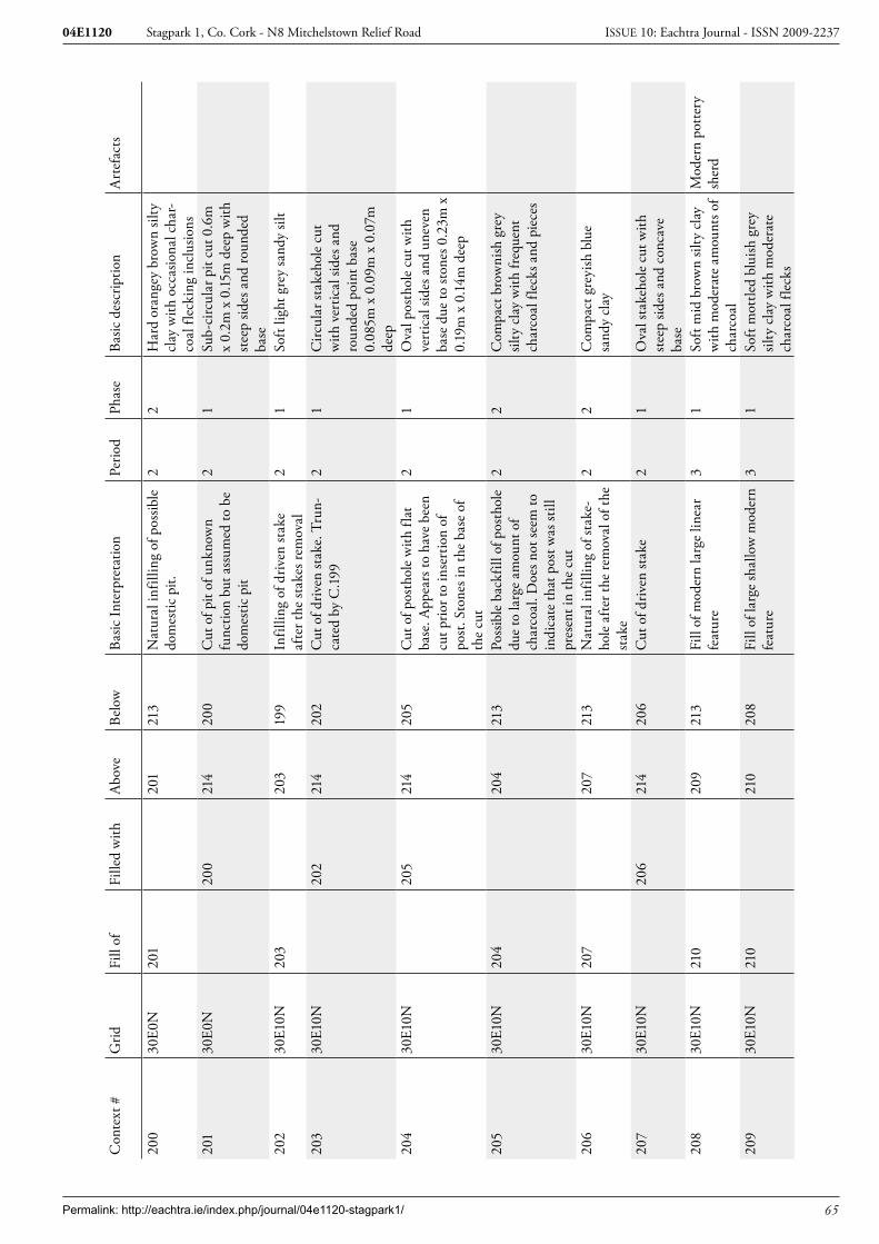
Permalink: http://eachtra.ie/index.php/journal/04e1120-stagpark1/ 65
Stagpark 1, Co. Cork - N8 Mitchelstown Relief Road04E1120 ISSUE 10: Eachtra Journal - ISSN 2009-2237
Con
text
#G
ridFi
ll of
Fille
d w
ithA
bove
Belo
wBa
sic In
terp
reta
tion
Perio
dPh
ase
Basic
des
crip
tion
Art
efac
ts
200
30E0
N20
120
121
3N
atur
al in
fillin
g of
pos
sible
do
mes
tic p
it.
22
Har
d or
ange
y br
own
silty
cl
ay w
ith o
ccas
iona
l cha
r-co
al fl
ecki
ng in
clus
ions
201
30E0
N20
021
420
0C
ut o
f pit
of u
nkno
wn
func
tion
but a
ssum
ed to
be
dom
estic
pit
21
Sub-
circ
ular
pit
cut 0
.6m
x
0.2m
x 0
.15m
dee
p w
ith
stee
p sid
es a
nd ro
unde
d ba
se20
230
E10N
203
203
199
Infil
ling
of d
riven
stak
e af
ter t
he st
akes
rem
oval
21
Soft
light
gre
y sa
ndy
silt
203
30E1
0N20
221
420
2C
ut o
f driv
en st
ake.
Tru
n-ca
ted
by C
.199
21
Circ
ular
stak
ehol
e cu
t w
ith v
ertic
al si
des a
nd
roun
ded
poin
t bas
e 0.
085m
x 0
.09m
x 0
.07m
de
ep20
430
E10N
205
214
205
Cut
of p
osth
ole
with
flat
ba
se. A
ppea
rs to
hav
e be
en
cut p
rior t
o in
sert
ion
of
post
. Sto
nes i
n th
e ba
se o
f th
e cu
t
21
Ova
l pos
thol
e cu
t with
ve
rtic
al si
des a
nd u
neve
n ba
se d
ue to
ston
es 0
.23m
x
0.19
m x
0.1
4m d
eep
205
30E1
0N20
420
421
3Po
ssib
le b
ackf
ill o
f pos
thol
e du
e to
larg
e am
ount
of
char
coal
. Doe
s not
seem
to
indi
cate
that
pos
t was
still
pr
esen
t in
the
cut
22
Com
pact
bro
wni
sh g
rey
silty
cla
y w
ith fr
eque
nt
char
coal
flec
ks a
nd p
iece
s
206
30E1
0N20
720
721
3N
atur
al in
fillin
g of
stak
e-ho
le a
fter t
he re
mov
al o
f the
st
ake
22
Com
pact
gre
yish
blu
e sa
ndy
clay
207
30E1
0N20
621
420
6C
ut o
f driv
en st
ake
21
Ova
l sta
keho
le c
ut w
ith
stee
p sid
es a
nd c
onca
ve
base
208
30E1
0N21
020
921
3Fi
ll of
mod
ern
larg
e lin
ear
feat
ure
31
Soft
mid
bro
wn
silty
cla
y w
ith m
oder
ate
amou
nts o
f ch
arco
al
Mod
ern
pott
ery
sher
d
209
30E1
0N21
021
020
8Fi
ll of
larg
e sh
allo
w m
oder
n fe
atur
e3
1So
ft m
ottle
d bl
uish
gre
y sil
ty c
lay
with
mod
erat
e ch
arco
al fl
ecks

Permalink: http://eachtra.ie/index.php/journal/04e1120-stagpark1/ 66
Stagpark 1, Co. Cork - N8 Mitchelstown Relief Road04E1120 ISSUE 10: Eachtra Journal - ISSN 2009-2237
Con
text
#G
ridFi
ll of
Fille
d w
ithA
bove
Belo
wBa
sic In
terp
reta
tion
Perio
dPh
ase
Basic
des
crip
tion
Art
efac
ts
210
30E1
0N20
8, 2
0921
420
9Ir
regu
lar s
hape
d fe
atur
e.
Mod
ern
31
Irre
gula
r sha
ped
cut,
all
sides
shal
low
gra
dien
t and
fla
t/irr
egul
ar b
ase.
2.15
m
x 0.
76m
x 0
.16m
dee
p21
130
E10N
212
212
213
Infil
ling
of p
osth
ole
afte
r th
e re
mov
al o
f the
pos
t2
2C
ompa
ct g
reyi
sh b
lue
sand
y cl
ay
212
30E1
0N21
121
421
1C
ut o
f fla
t bot
tom
ed p
ost-
hole
, ind
icat
ing
the
cut w
as
mad
e pr
ior t
o th
e in
sert
ion
of th
e po
st
21
Ova
l pos
thol
e cu
t with
sh
arp
sides
and
flat
bas
e du
e to
ston
es 0
.22m
x
0.12
m x
0.0
9m d
eep
213
entir
e sit
eTo
psoi
l3
1So
ft da
rk b
row
n sil
ty c
lay
with
occ
asio
nal m
oder
n po
tter
y sh
ards
. App
rox
0.3m
dee
p
Thr
ee p
ost-
med
ieva
l pot
tery
sh
erds
& f
lint
core
214
entir
e sit
eN
atur
al1
1O
rang
e/ye
llow
cla
y 21
50E
0N25
2125
Cut
of s
take
hole
in th
e to
p of
hea
rth
C.2
2.
21
Stak
ehol
e cu
t onl
y ev
iden
t in
sect
ion
face
0.0
5m x
0.
32m
dee
p w
ith v
ertic
al
sides
and
V-s
hape
d po
int.
Vert
ical
incl
inat
ion
AR
EA B
**
**
**
**
**
1001
B10
02, 1
003,
10
04, 1
005,
10
06, 1
007,
10
08, 1
009,
10
10, 1
011
214
1011
Cut
of e
xtre
mel
y la
rge
pit
with
evi
denc
e of
in-s
itu
burn
ing
and
stak
ehol
e gr
oups
in th
e no
rth
and
sout
h sid
es. N
ext t
o a
pit o
f sim
ilar s
ize
C.1
014.
Fun
c-tio
n un
know
n. T
he p
it di
d co
ntai
n so
me
smal
l pie
ces o
f bu
rnt b
one
21
Cut
of s
ub-c
ircul
ar p
it 6.
25m
x 3
.25m
x 2
.18m
de
ep w
ith st
eep
sides
and
ro
unde
d ba
se
1002
B10
0110
0321
3N
atur
al in
fillin
g of
pit
afte
r ab
ando
nmen
t2
2Li
ght b
row
nish
ora
nge
sand
y cl
ay w
ith o
ccas
iona
l ch
arco
al fl
ecks
0.1
2m
deep

Permalink: http://eachtra.ie/index.php/journal/04e1120-stagpark1/ 67
Stagpark 1, Co. Cork - N8 Mitchelstown Relief Road04E1120 ISSUE 10: Eachtra Journal - ISSN 2009-2237
Con
text
#G
ridFi
ll of
Fille
d w
ithA
bove
Belo
wBa
sic In
terp
reta
tion
Perio
dPh
ase
Basic
des
crip
tion
Art
efac
ts
1003
B10
0110
0410
02N
atur
al in
fillin
g of
pit
afte
r ab
ando
nmen
t2
2M
id b
row
n sa
ndy
clay
w
ith fr
eque
nt c
harc
oal
fleck
s 0.4
m d
eep
1004
B10
0110
0510
03N
atur
al in
fillin
g of
pit
afte
r ab
ando
nmen
t2
2Li
ght b
row
n sa
ndy
clay
w
ith o
ccas
iona
l cha
rcoa
l fle
cks 0
.37m
dee
p10
05B
1001
1006
1004
Nat
ural
infil
ling
of p
it af
ter
aban
donm
ent
22
Ligh
t bro
wni
sh g
rey
sand
y cl
ay w
ith c
harc
oal i
nclu
-sio
ns 0
.12m
dee
p10
06B
1001
1007
1005
Nat
ural
infil
ling
of p
it af
ter
aban
donm
ent
22
Ligh
t bro
wn
sand
y cl
ay
with
occ
asio
nal c
harc
oal
fleck
s 0.3
m d
eep
1007
B10
0110
0810
06N
atur
al in
fillin
g of
pit
afte
r ab
ando
nmen
t2
2M
id b
row
n sa
ndy
clay
w
ith o
ccas
iona
l cha
rcoa
l fle
cks 0
.35m
dee
p10
08B
1001
1009
1007
Nat
ural
infil
ling
of p
it af
ter
aban
donm
ent
22
Ligh
t bro
wn
sand
y cl
ay
with
occ
asio
nal c
harc
oal
fleck
s 0.3
3m d
eep
1009
B10
0110
1010
08N
atur
al in
fillin
g of
pit
afte
r ab
ando
nmen
t2
2D
ark
brow
nish
gre
y sil
ty
clay
with
occ
asio
nal c
har-
coal
0.15
m d
eep
& fl
ecks
of
bur
nt b
one
1010
B10
0110
1110
09T
his w
as a
laye
r of b
urnt
fill
whi
ch la
y cl
ose
to th
e ba
se
of th
e pi
t
21
Ora
nge
sand
y cl
ay w
ith
occa
siona
l cha
rcoa
l. A
p-pe
ared
to h
ave
been
hea
t af
fect
ed 0
.15m
dee
p10
11B
1001
1001
1010
A la
yer o
f ver
y ch
arco
al ri
ch
fill a
t the
ver
y ba
se o
f c10
012
1Li
ght b
row
nish
ora
nge
sand
y cl
ay w
ith o
ccas
iona
l ch
arco
al fl
ecks
& fl
ecks
of
burn
t bon
e 0
.1m
dee
p10
12B
1013
214
1013
Cut
of p
ossib
le p
osth
ole.
Fl
at b
ase
wou
ld in
dica
te
that
cut
was
prio
r to
inse
r-tio
n of
pos
t
21
Irre
gula
r sha
ped
pit c
ut
with
stee
p sid
es a
nd fl
at
base
0.3
1m x
0.3
9m x
0.
31m
dee
p

Permalink: http://eachtra.ie/index.php/journal/04e1120-stagpark1/ 68
Stagpark 1, Co. Cork - N8 Mitchelstown Relief Road04E1120 ISSUE 10: Eachtra Journal - ISSN 2009-2237
Con
text
#G
ridFi
ll of
Fille
d w
ithA
bove
Belo
wBa
sic In
terp
reta
tion
Perio
dPh
ase
Basic
des
crip
tion
Art
efac
ts
1013
B10
1210
1221
3Fi
ll of
pos
sible
inse
rted
po
stho
le a
fter r
emov
al o
f po
st
22
Mid
bro
wn
silty
cla
y w
ith
occa
siona
l cha
rcoa
l fle
cks
1014
B10
2221
410
22C
ut o
f ext
rem
ely
larg
e pi
t. N
o ev
iden
ce o
f in-
situ
burn
ing
but a
larg
e am
ount
of
cha
rcoa
l in
som
e of
the
low
er fi
lls. L
ater
re-c
ut b
y C
.102
5. In
clo
se p
roxi
m-
ity to
sim
ilar p
it C
.100
1.
Func
tion
unkn
own.
Thi
s pi
t was
not
bot
tom
ed d
ue to
he
alth
and
safe
ty re
ason
s so
the
true
dep
th is
unk
now
n bu
t the
re a
ppea
red
to b
e fr
eque
nt c
harc
oal d
epos
its a
t th
e ba
se. A
s the
re is
no
fur-
ther
evi
denc
e fo
r sub
sequ
ent
occu
patio
n on
the
sites
I am
go
ing
to a
ssum
e th
at th
is pi
t was
bac
kfill
ed a
nd la
ter
re-c
ut d
urin
g th
e sa
me
oc-
cupa
tiona
l pha
se
21
Sub-
oval
larg
e pi
t cut
with
st
eep/
vert
ical
side
s. N
ot
botto
med
due
to h
ealth
an
d sa
fety
reas
ons 3
.64m
x
4.3m
and
exc
avat
ed
dept
h w
as 2
.05m
1015
B10
1610
1621
3N
atur
al in
fillin
g of
pos
sible
pi
t afte
r aba
ndon
men
t2
1Bl
uish
bro
wn
sand
y cl
ay
with
mod
erat
e sm
all c
har-
coal
pie
ces
1016
B10
1521
410
15cu
t of i
rreg
ular
pit
with
un
know
n fu
nctio
n2
1Ir
regu
lar s
hape
d pi
t cut
w
ith g
entle
slop
ing
sides
0.
64m
x 0
.34m
x 0
.12m
de
ep10
17B
1025
1018
213
Upp
er fi
ll of
larg
e pi
t. A
p-pe
ars t
o be
a n
atur
al fi
ll af
ter a
band
onm
ent
22
Dar
k br
own
silty
cla
y w
ith
mod
erat
e ch
arco
al p
iece
s
1018
B10
2510
1910
17N
atur
al in
fillin
g of
re-c
ut o
f la
rge
pit
22
Mid
bro
wni
sh g
rey
silty
cl
ay w
ith o
ccas
iona
l fle
cks
of c
harc
oal0
.58m
dee
p

Permalink: http://eachtra.ie/index.php/journal/04e1120-stagpark1/ 69
Stagpark 1, Co. Cork - N8 Mitchelstown Relief Road04E1120 ISSUE 10: Eachtra Journal - ISSN 2009-2237
Con
text
#G
ridFi
ll of
Fille
d w
ithA
bove
Belo
wBa
sic In
terp
reta
tion
Perio
dPh
ase
Basic
des
crip
tion
Art
efac
ts
1019
B10
2510
2010
18N
atur
al in
fillin
g of
re-c
ut o
f la
rge
pit
22
Ligh
t ora
nge
clay
with
oc
casio
nal c
harc
oal f
leck
s 0.
34m
dee
p10
20B
1025
1021
1019
Nat
ural
infil
ling
of re
-cut
of
larg
e pi
t2
2M
id o
rang
e cl
ay w
ith
char
coal
flec
ks 0
.28m
de
ep10
21B
1025
1025
1020
Cha
rcoa
l ric
h la
yer a
t the
ba
se o
f the
re-c
ut o
f lar
ge p
it C
.101
4. P
ossib
ly d
epos
ited
laye
r
21
Dar
k br
owni
sh g
rey
silty
cla
y w
ith fr
eque
nt
char
coal
flec
ks a
nd p
iece
s 0.
08m
dee
p10
22B
1014
1014
1025
Thi
s is t
he in
itial
fill
of
larg
e pi
t c10
14, i
t was
re-c
ut
by C
.102
5
21
Mid
bro
wni
sh g
rey
silty
cl
ay w
ith m
oder
ate
char
-co
al in
clus
ions
1023
B?
214
?T
his w
as th
e nu
mbe
r giv
en
to a
gro
up o
f sta
keho
les t
hat
wer
e sit
uate
d in
the
sout
h-er
n ha
lf of
pit
C.1
001
in th
e up
per h
alf o
f the
side
21
Gro
up o
f 11
stak
ehol
es
all w
ere
circ
ular
in p
lan
with
N-S
incl
inat
ion
(top-
base
) and
dim
ensio
ns
of 0
.02-
0.06
m d
iam
eter
x
0.06
-0.2
m d
epth
1024
B?
214
?T
his w
as th
e nu
mbe
r giv
en
to a
gro
up o
f sta
keho
les t
hat
wer
e sit
uate
d in
the
nort
h-er
n ha
lf of
pit
C.1
001
in th
e up
per h
alf o
f the
side
21
Gro
up o
f 5 st
akeh
oles
on
the
nort
h an
d ea
st si
des
of p
it C
.100
1. A
ll w
ere
circ
ular
in p
lan
with
in-
clin
atio
n S-
N (T
op-B
ase)
. D
imen
sions
wer
e 0.
06-
0.12
m in
dia
met
er a
nd
0.06
-0.2
m d
eep
1025
B10
17,1
018,
10
19, 1
020,
10
21
1021
1022
Thi
s is t
he re
-cut
of l
arge
pi
t C.1
014.
It a
ppea
rs to
ha
ve w
iden
ed th
e cu
t alo
ng
with
trun
catin
g fil
l C.1
022.
T
here
is a
cha
rcoa
l ric
h la
yer
in th
e ba
se b
ut n
o sig
n of
in-
situ
burn
ing
sugg
estin
g th
is ch
arco
al w
as d
epos
ited
here
21
Rec
ut o
f lar
ge p
it.
Circ
ular
in p
lan
with
a
V-sh
aped
pro
file.
Tak
en
from
sect
ion
3.64
m a
cros
s x
1.33
m d
eep
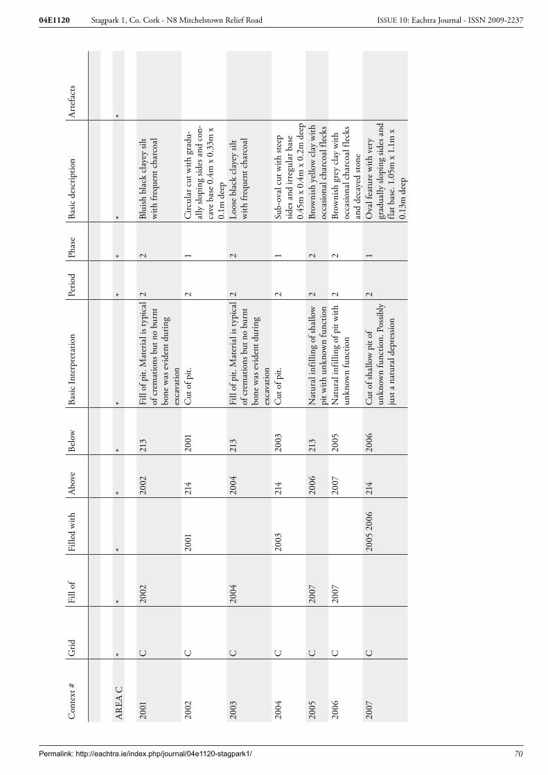
Permalink: http://eachtra.ie/index.php/journal/04e1120-stagpark1/ 70
Stagpark 1, Co. Cork - N8 Mitchelstown Relief Road04E1120 ISSUE 10: Eachtra Journal - ISSN 2009-2237
Con
text
#G
ridFi
ll of
Fille
d w
ithA
bove
Belo
wBa
sic In
terp
reta
tion
Perio
dPh
ase
Basic
des
crip
tion
Art
efac
ts
AR
EA C
**
**
**
**
**
2001
C20
0220
0221
3Fi
ll of
pit.
Mat
eria
l is t
ypic
al
of c
rem
atio
ns b
ut n
o bu
rnt
bone
was
evi
dent
dur
ing
exca
vatio
n
22
Blui
sh b
lack
cla
yey
silt
with
freq
uent
cha
rcoa
l
2002
C20
0121
420
01C
ut o
f pit.
2
1C
ircul
ar c
ut w
ith g
radu
-al
ly sl
opin
g sid
es a
nd c
on-
cave
bas
e 0.
4m x
0.3
3m x
0.
1m d
eep
2003
C20
0420
0421
3Fi
ll of
pit.
Mat
eria
l is t
ypic
al
of c
rem
atio
ns b
ut n
o bu
rnt
bone
was
evi
dent
dur
ing
exca
vatio
n
22
Loos
e bl
ack
clay
ey si
lt w
ith fr
eque
nt c
harc
oal
2004
C20
0321
420
03C
ut o
f pit.
2
1Su
b-ov
al c
ut w
ith st
eep
sides
and
irre
gula
r bas
e 0.
45m
x 0
.4m
x 0
.2m
dee
p20
05C
2007
2006
213
Nat
ural
infil
ling
of sh
allo
w
pit w
ith u
nkno
wn
func
tion
22
Brow
nish
yel
low
cla
y w
ith
occa
siona
l cha
rcoa
l fle
cks
2006
C20
0720
0720
05N
atur
al in
fillin
g of
pit
with
un
know
n fu
nctio
n2
2Br
owni
sh g
rey
clay
with
oc
casio
nal c
harc
oal f
leck
s an
d de
caye
d sto
ne20
07C
2005
200
621
420
06C
ut o
f sha
llow
pit
of
unkn
own
func
tion.
Pos
sibly
ju
st a
nat
ural
dep
ress
ion
21
Ova
l fea
ture
with
ver
y gr
adua
lly sl
opin
g sid
es a
nd
flat b
ase.
1.0
5m x
1.1
m x
0.
13m
dee
p

Permalink: http://eachtra.ie/index.php/journal/04e1120-stagpark1/ 71
Stagpark 1, Co. Cork - N8 Mitchelstown Relief Road04E1120 ISSUE 10: Eachtra Journal - ISSN 2009-2237
9.3 Appendix 3: Finds Register
Licence:Context:Find number Artefact Type Period04E1120:19:01 Pottery Late Bronze Age 04E1120:19:02 Pottery Late Bronze Age 04E1120:208:01 Pottery Post med/early modern04E1120:213:01 Pottery rim Post-medieval04E1120:213:02 Pottery base Post-medieval04E1120:213:03 Pottery handle Post-medieval04E1120:213:04 Flint Prehistoric
Permalink: http://eachtra.ie/index.php/journal/04e1120-stagpark1/ 72
Stagpark 1, Co. Cork - N8 Mitchelstown Relief Road04E1120 ISSUE 10: Eachtra Journal - ISSN 2009-2237
9.4 Appendix 4: Plant Remains Report for 04E1120
By: Abigail Brewer
Introduction
This report presents the results from scanning eleven bulk soil samples taken at a site at Stagpark 1, Co. Cork (04E1120). The site was excavated in three areas; samples from Area A included the fills of four pits, one stakehole fill and one pit fill, two samples from Area B were from charcoal rich fills of two large, adjacent, pits and three samples from Area C were from pits.
Methodology
The samples were collected on site as bulk soil and were processed using a simple flotation method. Each sample was saturated in water to allow carbonised plant material to float; this “flot” (the floating material) was then poured into a stack of geological sieves and trapped in the sieve meshes (the small-est measured 250µm). When all the carbonised material was collected the flot was then air-dried in paper-lined drying trays prior to storage in airtight plastic bags. Scanning of the flots was carried out using a low-powered binocular microscope (magnification x10 to x40) and the results are presented in Table 1 at the end of this report.
Results and Discussion
No plant remains other than charcoal were recorded from any of the samples taken from 04E1120. Although there was some cremated bone from the site, this was generally un-diagnostic, and one fragment was identified as potentially animal. This suggests a secular rather than ritual origin for the excavated deposits. The absence of charred plant remains from domestic contexts is perhaps surprising, although the site consisted of ephemeral archaeological deposits that were scattered over a large area, and with a range of dating evidence that suggests long-term, yet intermittent activity in the area (Early Bronze Age radiocarbon dates, Late Bronze Age ceramic fragments and Middle Iron Age radiocarbon dates). These anomalous archaeological remains may possibly be typical of activity associated with the margins of settlement in prehistory and, if this is the case, it is likely that activities such as cooking and processing of plant foods, when charring is likely to occur, was carried out closer to the structures and focus of the settlement(s). However, even within well defined house deposits there is often a dearth of plant remains material; the plant assemblage retrieved from Mitchelstown I (04E1072), where three Bronze Age structures were excavated, was small, it consisted mostly of weed seeds, and it was difficult to interpret. The presence or absence of plant remains in prehistoric site assemblages is often related to taphonomy; while plant resources were presumably widely used throughout prehistory, they are gener-ally only preserved at dryland sites if they were charred, and if the plant material at any given site was not brought into contact with fire no plant remains will be recovered.

Permalink: http://eachtra.ie/index.php/journal/04e1120-stagpark1/ 73
Stagpark 1, Co. Cork - N8 Mitchelstown Relief Road04E1120 ISSUE 10: Eachtra Journal - ISSN 2009-2237
Table 1: Scanning results for samples from Stagpark 1, Co. Cork (04E1120)
Context S.S. No. Cereals Weeds Charcoal Comments1021 8 **** poss ID 24g2001 9 **** 32g1011 11 **** 7g123 7 **** 5g2003 10 **** 137g109 5 **** 18g84 3 **** 15g2001 9 **** 31g114 5 * mod seed + nutshell **** poss ID 14g88 2 **** poss ID 250g120 6 **** 170g
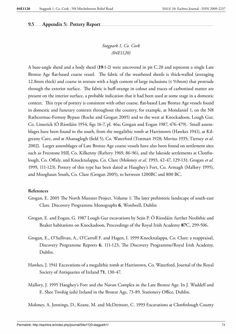
Permalink: http://eachtra.ie/index.php/journal/04e1120-stagpark1/ 74
Stagpark 1, Co. Cork - N8 Mitchelstown Relief Road04E1120 ISSUE 10: Eachtra Journal - ISSN 2009-2237
9.5 Appendix 5: Pottery Report
Stagpark 1, Co. Cork(04E1120)
A base-angle sherd and a body sherd (19:1-2) were uncovered in pit C.20 and represent a single Late Bronze Age flat-based coarse vessel. The fabric of the weathered sherds is thick-walled (averaging 12.8mm thick) and coarse in texture with a high content of large inclusions (≤ 9.0mm) that protrude through the exterior surface. The fabric is buff-orange in colour and traces of carbonised matter are present on the interior surface, a probable indication that it had been used at some stage in a domestic context. This type of pottery is consistent with other coarse, flat-based Late Bronze Age vessels found in domestic and funerary contexts throughout the country, for example, at Mondaniel 1, on the N8 Rathcormac-Fermoy Bypass (Roche and Grogan 2005) and to the west at Knockadoon, Lough Gur, Co. Limerick (Ó Ríordáin 1954, figs 16-7, pl. 46a; Grogan and Eogan 1987, 476-479). Small assem-blages have been found to the south, from the megalithic tomb at Harristown (Hawkes 1941), at Kil-greany Cave, and at Ahanaglogh (field 5), Co. Waterford (Tratman 1928; Movius 1935; Tierney et al. 2002). Larger assemblages of Late Bronze Age coarse vessels have also been found on settlement sites such as Freestone Hill, Co. Kilkenny (Raftery 1969, 86-96), and the lakeside settlements at Clonfin-lough, Co. Offaly, and Knocknalappa, Co. Clare (Moloney et al. 1993, 42-47, 129-131; Grogan et al. 1999, 111-123). Pottery of this type has been dated at Haughey’s Fort, Co. Armagh (Mallory 1995), and Mooghaun South, Co. Clare (Grogan 2005), to between 1200BC and 800 BC.
References
Grogan, E. 2005 The North Munster Project. Volume 1: The later prehistoric landscape of south-east Clare. Discovery Programme Monographs 6, Wordwell, Dublin
Grogan, E. and Eogan, G. 1987 Lough Gur excavations by Seán P. Ó Ríordáin: further Neolithic and Beaker habitations on Knockadoon, Proceedings of the Royal Irish Academy 87C, 299-506.
Grogan, E., O’Sullivan, A., O’Carroll F. and Hagen, I. 1999 Knocknalappa, Co. Clare: a reappraisal, Discovery Programme Reports 6, 111-123, The Discovery Programme/Royal Irish Academy, Dublin.
Hawkes, J. 1941 Excavations of a megalithic tomb at Harristown, Co. Waterford, Journal of the Royal Society of Antiquaries of Ireland 71, 130-47.
Mallory, J. 1995 Haughey’s Fort and the Navan Complex in the Late Bronze Age. In J. Waddell and E. Shee Twohig (eds) Ireland in the Bronze Age, 73-89. Stationery Office, Dublin.
Moloney, A. Jennings, D., Keane, M. and McDermott, C. 1993 Excavations at Clonfinlough County

Permalink: http://eachtra.ie/index.php/journal/04e1120-stagpark1/ 75
Stagpark 1, Co. Cork - N8 Mitchelstown Relief Road04E1120 ISSUE 10: Eachtra Journal - ISSN 2009-2237
Offaly. Irish Archaeological Wetland Unit Transactions 2, Office of Public Works/University College Dublin, Dublin.
Movius, H. 1935 Kilgreany Cave, County Waterford, Journal of the Royal Society of Antiquaries of Ireland 65, 254-96.
Ó Ríordáin, S.P. 1954 Lough Gur Excavations: Neolithic and Bronze Age Houses on Knockadoon, Proceedings of the Royal Irish Academy 56C, 297-459.
Raftery, B. 1969 Freestone Hill, Co. Kilkenny: an Iron Age hillfort and Bronze Age cairn, Proceedings of the Royal Irish Academy 68C, 1-108.
Roche, H. and Grogan, E. 2005 The N8 Rathcormac-Fermoy Bypass. The Prehistoric Pottery. Unpublished Report for ACS Ltd.
Tierney, J., Richardson, A. and Frazer, B. 2002 Ahanaglogh-Graigueshoneen. Prehistoric. In I. Bennett (ed.) Excavations 2000, 328-31. Wordwell, Dublin.
Tratman, E.K. 1928 Excavations at Kilgreany Cave, Co. Waterford, Proceedings of the Bristol Speleological Society 3, 109-153.

Permalink: http://eachtra.ie/index.php/journal/04e1120-stagpark1/ 76
Stagpark 1, Co. Cork - N8 Mitchelstown Relief Road04E1120 ISSUE 10: Eachtra Journal - ISSN 2009-2237
9.6 Appendix 6: Lithics Finds Report for 04E1020 – Mitchelstown
1. Stagpark (04E1020)
The lithic assemblage from Stagpark consists of a small flint core (04E1120:213:4) which was recov-ered from the topsoil.
Condition:
The flint is in slightly rolled condition.
Technology:
The core appears to have rested on an anvil during flake removal and was probably produced on a split pebble. It displays the negative removal scars of at least 6 small flake removals.
Dating:
The artefact is undiagnostic in nature, but is likely to be associated with the complex of Bronze Age pits and cremation pits at Stagpark which produced a radio-carbon date of cal BC 1885-1690.
Interpretation:
The core can be interpreted as a discarded waste product which is likely to be associated with the Bronze Age pits excavated at Stagpark.
Find No. Context Material Type Cond. Length (mm) Width (mm) Thickn. (mm) Complete Retouch
04E1120:213:4 Topsoil Flint Core Rolled 17 20 8 Yes No

Permalink: http://eachtra.ie/index.php/journal/04e1120-stagpark1/ 77
Stagpark 1, Co. Cork - N8 Mitchelstown Relief Road04E1120 ISSUE 10: Eachtra Journal - ISSN 2009-2237
9.7 Appendix 7: Bone Report
A Short Note on the Cremated Skeletal Remains from Mitchelstown, Co. Cork(04E1120)
Linda Fibiger BA (Hons) MSc MIAI
November 2005
One sample was submitted for analysis. It consisted of 17 bone fragments measuring between 0.2 and 2.3 cm in maximum length and weighing approximately 2 grams. All remains were greyish-white in colour, indicating that they had been thoroughly burned. Surface preservation was poor and none of the fragments were diagnostic. The majority of remains could therefore not be positively identified as either animal or human bone. At least one animal bone fragment appeared to be present, identified through its very smooth and almost polished cortical surface.
1001 - Sample 12Number of Fragments: 17Weight: 2 gSize: 0.2-2.3 cmColour: Greyish-WhiteIdentification: Includes cortical and trabecular bone

Permalink: http://eachtra.ie/index.php/journal/04e1120-stagpark1/ 78
Stagpark 1, Co. Cork - N8 Mitchelstown Relief Road04E1120 ISSUE 10: Eachtra Journal - ISSN 2009-2237
Appendix 8: Summary account of site archive
STAGPARK 1 04E1120Type Description Quantity NotesContexts Area A Validated contexts from excavation 215Area B 25Area C 7Plans 1:100 plan (sheets) 0
1:50 plan (sheets) 41:20 plan (sheets) 2
Sections 1:20 sections and profiles (Sheets) 12
Matrices 1Photographs 126 6 rollsRegisters Context 1
Photograph 1Drawing 1Finds 1Samples 1
9.9 Appendix 9: Dissemination Strategy
STAGPARK1 04E1120PublicationsExcavations 2004 Text submitted January 2004 Publication pending
NRA publication Text submitted February 2006 Publication pendingPresentation Lecture given to Mitchelstown and Mallow Historical Societies May & October 2005
Overview of the Scheme was given to the IAI conference in Cork April 2005
It is the right of Cork County Council (the Council) to fulfil some or all of the stated publication requirements, either in part or in full, should it so decide, and that copyright is aggisned to the Council in order that it may make such information available to the public.
It is the right of Cork County Council (the Council) to fulfil some or all of the stated presentation requirements, either in part or in full, should it so decide.