archaeological excavations at bolton hill quarry ... hill excavation... · archaeological...
TRANSCRIPT

Archaeological Excavations at Bolton Hill Quarry, Pembrokeshire
Excavations at Bolton Hill revealing in plan one of the numerous hearth-pits identified on the site
ARS Ltd Report No 2010/50
August 2010
Compiled By:
Ben Johnson and Adam Tinsley Archaeological Research Services Ltd
Angel House Portland Square
Bakewell Derbyshire DE45 1HB
Checked By:
Dr. Clive Waddington Tel: 01629 814540 Fax: 01629 814657
[email protected] www.archaeologicalresearchservices.com

Bolton Hill Quarry Excavation Report
© Archaeological Research Services Ltd
2
Bolton Hill Quarry, Pembrokeshire. Report on a strip, map and sample project
ARS Ltd Report 2010/50
August 2010
Archaeological Research Services Ltd
Contents
List of Illustrations………………………………… 1 Executive Summary………………………………... 2
1. Introduction……………………………………….. 3 2. Location, Geology and Land Use………………….. 3 3. Archaeological Background………………………... 4 4. Method Statement……...…………………………... 4 5. Results………………….…………………………… 12 6. Stratigraphic Report.....……………………………… 13 7. Radiocarbon results…………………………………. 66 8. Discussion…………………………………………. 79 8. Conclusions………………………………………... 82 9. Publicity, Confidentiality and Copyright………........ 82
10. Statement of Indemnity……………………………. 82 11. Acknowledgments…………………………………. 82
© ARS Ltd 2010

Bolton Hill Quarry Excavation Report
© Archaeological Research Services Ltd
3
List of Illustrations
Fig No.
Detail Page
1. Site location…………………………………………………………........ 5 2. Site plan north-west quadrant….………………………………………… 8 3. Site plan north-east quadrant….………………………………………… 9 4. Site plan south-west quadrant….……………………………………...... 10 5. Site plan south-east quadrant….………………………………………… 11 6. Plan and section of F186………………………………………………… 15 7. Photograph of F186 before excavation………………………………… 16 8. Plans and sections of F036 and F042…………………………………… 18 9. Photograph of F036 after half-sectioning……………………………… 19 10. Photograph of F042 after half-sectioning showing granitic block……… 20 11. Plans and sections of F046, F142, F218 and F554……………………… 21 12. Photograph of F046 before excavation………………………………… 22 13. Plan of Pit and posthole cluster 2……………………………………… 24 14. Sections of Pit and posthole cluster 2………………………………..... 25 15. Photograph of F318…………………………………………………… 26 16. Plan and section of F450……………………………………………… 27 17. Plan and section of F230……………………………………………… 29 18. Photograph of F230…………………………………………………. 30 19. Plan of Pit and posthole cluster 1…………………………………….. 32 20. Sections of Pit and posthole cluster 1………………………………… 33 21. Plan of post-medieval enclosure……………………………………… 37 22. Sections of post-medieval enclosure………………………………….. 38 23. Plans and sections of other pottery producing pits……………………. 40 24. Plans and sections of Hearth-pits…………………………………….. 44 25. Plans and sections of Hearth-pits…………………………………….. 45 26. Plans and sections of Hearth-pits…………………………………….. 46 27. Plans and sections of heat-affected surfaces………………………… 48 28. Photograph of F229…………………………………………………. 49 29. Plans and sections of other pits and postholes………………………. 53 30. Plans and sections of other pits and postholes………………………. 54 31. Plans and sections of other pits and postholes………………………. 55 32 Plans and sections of other pits and postholes………………………. 56 33. Plans and sections of other pits and postholes………………………. 57 34 Plans and sections of other pits and postholes………………………. 58 35. Plans and sections of other pits and postholes………………………. 59 36. Plans and sections of other pits and postholes………………………. 60 37. Plans and sections of other pits and postholes………………………. 61 38. Plans and sections of other pits and postholes………………………. 62 39. Probability distributions of dates from Impressed Ware pits…………. 70 40. Probability distributions of dates for Impressed Ware……………….. 70 41. Probability distributions of dates for Welsh Impressed Ware………… 71 42. Probability distributions of dates from Bronze Age………………….. 72 43. Probability distributions of dates from pits containing fire-cracked stones 73 44. Probability distributions of dates from Welsh Neolithic burnt features 73 45. Probability distributions of dates from Posthole and Pit Cluster 1…… 74 46. Probability distributions of dates from Posthole and Pit cluster 2……. 76 47. Probability distributions of dates from the ditched enclosure…………. 76

Bolton Hill Quarry Excavation Report
© Archaeological Research Services Ltd
4
Executive Summary Archaeological Research Services Ltd were commissioned by F.H. Gilman and Co to undertake an archaeological strip, map and sample across the site of an extension to the existing quarry works at Bolton Hill, Pembrokeshire, Wales, extending over an area of 12ha. This work was undertaken so as to allow for a complete mapped record of all archaeological remains surviving on the site together with targeted excavation of features. Activity of probable prehistoric date had been documented in advance of excavation and had suggested the presence of several possible burnt mounds. The site is also located in close proximity to a gold hoard dated to the Bronze Age, although no evidence for other hoards or a burnt mound was found during the excavation. The site revealed evidence of six phases of activity, predominantly from the prehistoric period, including a pit containing charred material and fire-cracked stones dating to the Mesolithic-Neolithic transition, midden pits associated with mid-Neolithic Impressed Ware, a cluster of pits and postholes of Chalcolithic (Beaker) date which may represent a building, an isolated pit containing early Bronze Age pottery and a smaller cluster of late Bronze Age pits and postholes, which may also be the heavily truncated remains of a building. An important assemblage of mid-Neolithic ceramics was recovered from the site. The material comprises Impressed Ware, sometimes referred to as ‘Peterborough Ware’, which came from the fills of isolated ‘midden’ pits cut into the substratum. Some Neolithic-derivative, Beaker and late Bronze Age ceramics were also recovered from the site, along with 38 chipped lithics. A post-medieval enclosure was also excavated, although the lack of any structural evidence or material culture associated with this feature makes ascribing a function to this feature impossible. The results of these excavations are of significance to research into the Neolithic and Bronze Age periods in Wales in particular, and in Britain more widely, given the radiometric dating associated with the Impressed Ware ceramics, as well as evidence for activity during the Mesolithic - Neolithic transition and possible buildings dating to the Chalcolithic (Beaker) and late Bronze Age. The results will be of use in developing understanding of Middle and Later Neolithic landscape occupation, as the tradition of burial of domestic midden material shown at Bolton Hill is in keeping with other sites in Wales, such as Parc Bryn Cegin (Kenney 2008), as well as further afield at sites as far apart as Kilverstone, Norfolk (Garrow et al. 2005) and Cheviot and Lanton Quarries in Northumberland (Johnson and Waddington 2008; Waddington 2009).

Bolton Hill Quarry Excavation Report
© Archaeological Research Services Ltd
5
1. Introduction 1.1 In accordance with the planning permission conditions (Planning Permission
number 07/0705/MN) for an extension of existing quarry works at Bolton Hill, Pembrokehsire, Wales, F.H. Gilman and Co commissioned Archaeological Research Services Ltd to undertake a programme of strip, map and sample ahead of ground reduction in preparation for mineral extraction at the site. This work was undertaken between 27th April and 11th September 2009 and took in an area measuring approximately 12 hectares in extent. This report describes the results of this programme of archaeological mitigation.
2. Location, Geology and Land Use 2.1 The extension to Bolton Hill Quarry, Pembrokeshire, is located at OS grid co-
ordinate SM919118 (centred) (Figure 1).
Figure 1. Location of Bolton Hill Quarry.
Ordnance Survey data copyright OS, reproduced by permission, Licence no. 100045420

Bolton Hill Quarry Excavation Report
© Archaeological Research Services Ltd
6
2.2 The site lies approximately three miles south-west of Haverfordwest and occupies a
prominent hill top which represents the second highest location in Pembrokeshire outside of the Preseli Mountains, towards which unrestricted views are possible along the northern scarp of the hill.
2.3 The underlying geology consists of a granitic outcrop within the wider South Wales
Lower and Middle coal measures with overlying till deposits. 2.4 The form of land use prior to ground works consisted of open pasture, although
cultivation of deep plough crops, such as potatoes, as well as other forms of agriculture had been practiced across the site in recent history.
3. Archaeological Background 3.1 Towards the start of the 20th century four burnt mounds were recorded as being
located within the confines of the development area by Cantril and Jones (1911) and are logged as PRNS 3339,3340, 3341 AND 3342. However, a subsequent pilot study of the area failed to locate these features (Williams 1995).
3.2 A desk-based assessment of the area was conducted in advance of the construction
of the Waste Repository Haul Road (Page and Wilson 1999) which concluded that while the potential for the survival of such burnt mounds remained, doubt may be cast upon their exact provenance due to the failed attempt to locate them. It did however establish that the current field system, tracks and roadways had been established by 1773. The desk-based assessment was followed up by the excavation of nine evaluation trenches, each measuring approximately 10m by 1.6m, which did not reveal any features of archaeological significance. Several linear cut features of unknown purpose were encountered but could not be adequately dated beyond speculation that they were of probable medieval or post-medieval date.
3.3 In 2004 an archaeological watching brief was carried out in relation to the
monitoring of several test pits on the site. This did not locate any archaeological features of significance and were deemed an unsatisfactory method for locating and assessing archaeological remains on the site (Crane 2004).
4. Method Statement
4.1.1 The strip, map and sample excavation (see Fig. 2) was carried out between April and September 2009 and comprised the stripping back of topsoil in spits using two 360° tracked excavators equipped with toothless ditching buckets. This was carried out under archaeological supervision at all times and continued until the underlying clay and bedrock deposits, into which the archaeological features were cut, had been exposed. As the machine stripped the ground, features were cleaned with a hoe and trowel, recorded in plan, and photographed before being marked with wooden pegs and ascribed context and feature numbers.
4.1.2 Each of the features identified during the stripping process were subject to sample
excavation and recording. This involved the sectioning of deposits to determine their

Bolton Hill Quarry Excavation Report
© Archaeological Research Services Ltd
7
form and dimensions, and the collection of artefacts and samples suitable for radiocarbon dating and environmental analysis. All excavation was undertaken with trowels and small tools. The content of all deposits were sieved through a 10mm mesh and deposits containing artefacts, or with potential for containing organic material, were subject to flotation through a 500µm sieve. All features were photographed using colour slide and black and white print film, and selective digital photographs were taken. All sections were drawn at 1:10 and features planned at 1:20. The section lines were surveyed to provide an Ordnance Survey datum for each feature.
4.1.3 All the deposits and cuts were recorded and described in the field on pro-forma
context sheets. The sheets contain prompts for the recording of sediment composition, compaction and colour, the dimensions of the deposit, its relationship to other deposits and features, artefact content, environmental samples, drawing and photographic records and an interpretative discussion to ensure consistency across all records. All features were described in accordance with MoLAS conventions. Drawings were produced on drawing film and on graph paper on the reverse side of the context sheets. Registers of all contexts, samples, finds, levels, and drawings were also made. Artefacts were bagged and assigned an individual finds number, with the site code and the deposit from which they were recovered clearly indicated. Ceramic finds were bubble-wrapped before being placed in labelled bags or boxes as appropriate. Any single entity charred material samples suitable for radiocarbon dating were wrapped in aluminium foil before being placed in labelled bags.
4.1.4 Flotation of sediments to recover organic materials was undertaken on site. The fill
of every feature deemed to be man made were dry-sieved through a 10mm mesh, and then passed through flotation to maximise recovery of small finds and organic material. The sediments were passed through four mesh sieves from 5mm down to the smallest which measured 500µm. Material from the sieve was air dried and then placed in a sealed bag marked with its context and environmental sample number. All the dating and environmental samples were recorded in a separate register.
4.1.5 A total of 60 archaeological features were identified. Non-archaeological features
were also noted including tree throws, rabbit burrows and burnt-out root systems. All such features were sampled to test whether they were of natural origin, and after such testing were excluded from further excavation or recording. They are not discussed further in this report.


Bolton Hill Quarry Excavation Report
© Archaeological Research Services Ltd
12
5. Results 5.1 Almost 200 individual features were examined during the course of excavations at
Bolton Hill (Figs. 2-5) of which 113 were of archaeological significance. The remainder were associated with natural processes or modern activity within the quarry. All features are grouped where possible and discussed according to period. All features encountered on the site had been heavily truncated as a result of past agricultural practices and were found to be cut into the underlying subsoil deposits which comprised a clay till.
5.2 The site produced evidence for six phases of activity, predominantly from the
prehistoric period, including a pit containing charred material and fire-cracked stones which was dated to the Mesolithic-Neolithic transition, mid-Neolithic midden pits associated with Impressed Ware pottery, a cluster of pits and postholes of Beaker date, which may represent a building and a smaller cluster of late Bronze Age pits and postholes, which may also be the heavily truncated remains of a building. A single pit containing one ceramic sherd, which was radiocarbon dated to the early Bronze Age, and a post-medieval single-ditched enclosure of unknown function were the only other significant archaeological features discovered. The majority of the archaeological features comprised isolated pits and postholes, occasionally occurring in small groups and clusters, as well as a small number of stakeholes and hearth-pits.
5.3 Ten of the features produced prehistoric pottery, the majority of which may be
identified with the Impressed Ware tradition. The ceramic assemblage also included a small quantity of Neolithic-derivative pottery (or Grooved Ware derivative), Beaker and associated pottery, a small quantity of early Bronze Age and late Bronze Age ceramics and a quantity of un-diagnostic material. A total of 38 lithic artefacts were recovered from nine of the features and the vast majority were not diagnostic. The absence of regular blade forms may suggest the assemblage post-dates the Mesolithic and is therefore of Neolithic or Bronze Age origin. Given the association of 19 of the lithics within a pit containing Impressed Ware, a mid to late Neolithic date for much of the assemblage can be assumed. The only diagnostic artefacts were recovered from two separate features within Pit and Posthole Cluster 2 and comprised a retouched blade and a scraper, the latter being recovered from a pit which also contained Neolithic-derivative pottery.
5.4 Twenty nine palaeoenvironmental samples were assessed and were found to contain
a low number of poorly-preserved plant macrofossils. These included a bread wheat grain and additional indeterminate cereal grain from a pit containing Beaker pottery (F450) and four barley grains with four indeterminate cereal grains from a posthole within Pit and Posthole Cluster 2. Two features, F296 and F310, within Pit and Posthole Cluster 1 produced two indeterminate cereal grains and a barley grain respectively. Large quantities of charred hazelnut were recovered from pit F042, which has been radiocarbon dated to the mid-Neolithic. Most of the samples also contained limited evidence of weeds typically associated with arable fields, such as Ranunculus spp. Polygonum lapthafolium and Chenopodium spp./Atriplex spp. The charcoal assessment indicated exploitation of a mixed woodland environment which included oak, hazel and alder.

Bolton Hill Quarry Excavation Report
© Archaeological Research Services Ltd
13
5.5 Sixteen pottery sherds were submitted for organic residue analysis and ten sherds were submitted for petrographic examination. The residue analysis revealed well-preserved lipids from animal fats, most of which may indicate a dairy source, from Impressed Ware and Beaker ceramics. The petrographic examination indicated that all the analysed pottery was probably made locally, with some being manufactured within the immediate vicinity of Bolton Hill, although others may well be from slightly further afield.
6. Stratigraphic Report 6.1 The topsoil (001) was found to comprise of medium orange-brown clay-silt from
which a small number of unstratified finds were recovered, including a single Elizabethan Coin, a small rim fragment from a Roman ceramic vessel and one undiagnostic lithic.
6.2 The underlying subsoil consisted primarily of a light to medium orange-brown silty
clay although outcrops of the underlying granite bedrock protruded to the base of the topsoil in places.
6.3 Truncation of features across the site was severe and consequently only those
features that had ever been cut to a significant depth have survived as archaeological features.
6.4 Where possible features have been grouped according to period. Where this was not
possible they are grouped according to similarities in form and content.

Bolton Hill Quarry Excavation Report
© Archaeological Research Services Ltd
14
Terminal Mesolithic – Early Neolithic 6.5 Pit containing fire-cracked stones and other charred material (Figs. 6 and ) 6.5.1 A pit which contained a high quantity of charred material as well as burnt and un-
burnt stone was identified on the site which has been radiocarbon dated to 4040-3800 cal BC. F186 measured 0.60m in diameter and only survived to a depth of 0.12m. The fill of the feature, comprising large quantities of fire-cracked stones and other charred material was very similar to four other such features which were distributed unevenly across the site, one of which produced a mid-Neolithic date. These other features are therefore discussed in more detail below. This feature, dating to the terminal Mesolithic or earliest Neolithic in South Wales, according to recent chronological modelling (Whittle et al. in press), is therefore very unusual. Having two separate but consistent dates from this context suggests that the date is unlikely to be from residual material and so a date in the Mesolithic-Neolithic transition seems acceptable.
Feature No.
Context No. Description Max Dimensions (mm)
Max Depth (mm)
Colour of Fill
Composition Small Finds
Radiocarbon Age (BP)
F186 (187)(220)/[186] A small circular pit
630 x 600 120 Dark Brown to Black
Several fill layers of Silty Clay distinguished by varying quantities of charcoal and burnt stone
5135±40 5200±40
Table 1. Pit containing fire-cracked stone and other charred material.

Bolton Hill Quarry Excavation Report
© Archaeological Research Services Ltd
15
Figure 6 Pland and section of F186

Bolton Hill Quarry Excavation Report
© Archaeological Research Services Ltd
16
Figure 7. Feature 186 containing burnt and unburnt rock within its fill.

Bolton Hill Quarry Excavation Report
© Archaeological Research Services Ltd
17
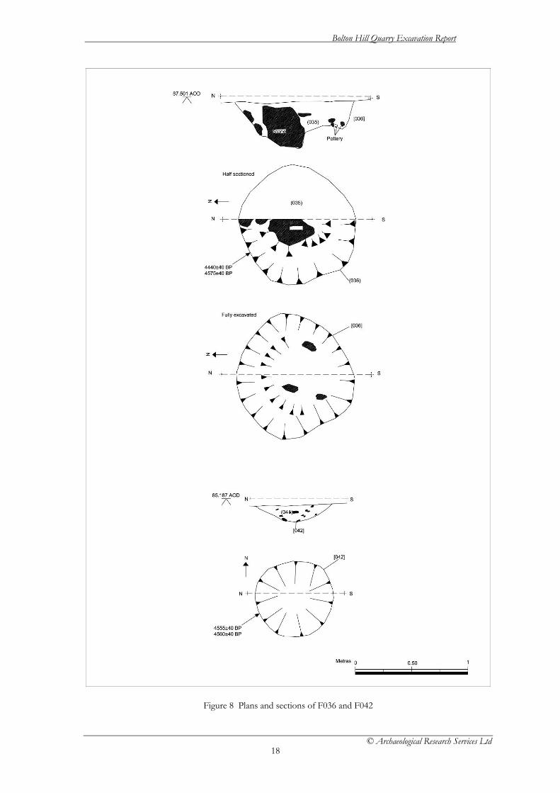
Mid Neolithic 6.6 Pottery producing pits (Figs. 8, 9 and 10) 6.6.1 A total of two pit features were found to produce pottery relating to the Impressed
Ware traditions and are summarised in Table 2.
Feature No.
Context No. Description Max Dimensions (mm)
Max Depth (mm)
Colour of Fill
Composition Small Finds
Radiocarbon Age BP
F036 (035)/[036] A medium sized circular pit
970 x 530 300 Medium Yellow Brown
Silty Clay 18-46 4440±40 4575±40
F042 (041)/[042] A small and shallow circular pit
770 x 680 150 Medium Yellow Brown
Silty Clay 03-17 4555±40 4560±40
Table 2. Pits containing Impressed Ware pottery.
6.6.2 Features F036 and F042 were located within 5m of each other towards the middle of
the site and approximately 25m south of the quarry road and initial quarry face. Both produced a small assemblage of pottery belonging to the Impressed Ware tradition and jointly may represent the remains of a minimum of three vessels or more. Feature F036 also produced a small quantity of undiagnostic struck flint and produced radiometric dates, on short-lived species, of 3340-3210 cal BC, 3190-3150 cal BC, 3150-2920 cal BC, 3500-3430 cal BC, 3380-3260 cal BC or 3240-3100 cal BC at 95% probability (4440±40 BP, SUERC-30113; 4575±40 BP, SUERC-30132. Due to their proximity and similar cultural content the two features may be grouped together. Of the two features F042 proved the shallowest and probably relates to the basal remains of a heavily ploughed out pit. However, it produced the more significant of the pottery assemblages and radiometric dates of 3490-3470 cal BC, 3380-3260 cal BC, 3250-3100 cal BC, 3350-3010 cal BC or 2980-2960 cal BC at 95% probability (4555±40BP, SUERC-30117; 4560±40 BP, SUERC30118). F036 was less truncated and contained a large quantity of granitic stone blocks, one of which was comparatively large and appeared to have been deliberately placed at the centre of the pit (Fig. 10). Residue analysis indicates the presence of animal fats, possibly from dairy sources, on sherds from both of these features. Both features produced a quantity of charred material, although only F042 produced significant botanical macrofossils, including 88 charred hazelnut fragments and limited weed seeds usually associated with arable fields. Both features were located in close proximity to a further feature, F046, interpreted as a pit containing burnt material associated with domestic activity, as well as F028, a possible small pit or posthole.
Bolton Hill Quarry Excavation Report
© Archaeological Research Services Ltd
18
Figure 8 Plans and sections of F036 and F042

Bolton Hill Quarry Excavation Report
© Archaeological Research Services Ltd
19
Figure 9. Pit feature 042 after half-sectioning.
Figure 10. Feature 036 after half-sectioning, showing large granitic block within fill.
6.7 Pits containing fire-cracked stones and other charred material (Figs. 11 and 12) 6.7.1 Four other pit features, in addition to the one discussed in section 6.5 above, which
also contained large quantities of fire-cracked rock and charred material were discovered on the site. One of these features was radiocarbon dated to 3630 – 3360 cal BC. For ease of discussion they are grouped together here, although it is recognised that the two different radiocarbon dates, separated by around half a

Bolton Hill Quarry Excavation Report
© Archaeological Research Services Ltd
20
millennium, from features with very similar morphological characteristics, may indicate a date of use of some of these features outside of the mid-Neolithic period.
6.7.2 Whilst the features may relate to the four burnt mounds previously identified across
the site they were cut features, not associated with any evidence of mounds, troughs or other trappings of a burnt mound, such as stakeholes, which were found during excavation at Parc Bryn Cegin (Kenney 2008), and are therefore considered more likely to represent a different form of hearth/fire pit retaining evidence of the use of heated stones. The lack of evidence of burning to the edges or base of the cut of the features indicates that the contents of the pits were not burnt in-situ.
6.7.3 All four features were irregularly spaced across the site although several appeared in
close proximity to other feature types encountered during excavation. F046 was located near to a pit containing Impressed Ware. Given the recent chronological modelling of Impressed Ware in the region (Whittle et al. in press), which places the start of the ceramic tradition between 3615 – 3140 cal BC, feature F046 could be associated with Impressed Ware pits F042 and F036, although there is no stratigraphic relationship between the features. The features are summarised in table 3 below.
Feature No.
Context No. Description Max Dimensions (mm)
Max Depth (mm)
Colour of Fill
Composition Small Finds
Radiocarbon Age (BP)
F046 (045)/[046] A large sub-circular pit
1450 x 1320 140 Dark Brown to Black
Silty Clay with a high component of charcoal and burnt/un-burnt stone
4680±40 4675±40
F142 (143)/[142] A medium sized sub-ovoid pit
1460 x 640 200 Dark Brown to Black
Clayey Silt with a high component of charcoal and burnt/un-burnt stone
F218 [218]/(222) A large sub-oval pit
1440 x 860 200 Dark Brown to Black
Clayey Silt with a high content of charcoal and burnt/un-burnt stone
F554 [554]/(555) A large sub-oval pit
1030 x 810 170 Medium Grey Brown to Black
Silty Clay
Table 3. Pits containing fire-cracked stone and other charred material.
6.7.4 F046 is located near to the Impressed Ware producing pits F042 and F036 and, given
the radiocarbon dates associated with these three features, may well be of the same period of occupation on the site. F186 occurs due north and within approximately 15m of a series of possible hearth features (F190/F192/F198/F200) located along the eastern boundary of the area of excavation, although again a direct chronological association is not certain. Feature F554 occurs towards the central western section of the excavated area and approximately 10m due southwest of one of the large fire pits, F408, but is otherwise isolated from any other significant features. F218 and

Bolton Hill Quarry Excavation Report
© Archaeological Research Services Ltd
21
F142 occur in relative isolation although it is possible that they relate to other
Figure 11 Plans and sections of F046, F142, F218 and F554

Bolton Hill Quarry Excavation Report
© Archaeological Research Services Ltd
22
features either destroyed by plough activity or, in the case of F218, located beyond the boundary of excavation.
6.7.5 All four features were of a similar shape and size and possessed a similar mix of large
quantities of burnt stone and charcoal within a silty clay matrix. None of the features produced small finds of any type.
Figure 12. Feature 046 before excavation showing large quantities of fire-cracked stone and charred material in the fill.
Chalcolithic (Beaker) period 6.8 Posthole and Pit Cluster 2 (Figs. 13, 14 and 15) 6.8.1 This group of pits and postholes is defined by the very close physical proximity of
the features, all of which occur within a 5m radius of each other, and includes a total of seven features. It was located within a central northern section of the excavated area approximately 25m south-east of feature F046. The details of the individual features are listed below in Table 4.
Feature No.
Context No. Description Max Dimensions (mm)
Max Depth (mm)
Colour of Fill Composition Small Finds
Radiocarbon Age (BP)
F316 [316]/(317) A large sub-oval possible pit
1550 x 1100 150 Dark Brown Silty Clay
F318 [318]/(319) A small circular pit
750 x 750 160 Dark Brown Silty Clay 71-75 3715±40 3810±40
F320 [320]/(321) A small sub-circular possible post hole
480 x 400 150 Medium Reddish Brown
Silty Clay 69
F322 [322]/(323) Base of a small 330 x 330 10 Dark Grey Silty Clay 3655±40

Bolton Hill Quarry Excavation Report
© Archaeological Research Services Ltd
23
circular post hole
Brown 3695±40
F324 [324]/(325) A small sub-circular area of heat affected natural
550 x 420 50 Medium Reddish Brown
Silty Clay
F354 [354]/(355) A small sub-circular post hole
260 x 250 130 Dark Brown Silty Clay
F362 [362]/(363) Remnants of a pit base
500 x 310 80 Dark Brown Silty Clay 76-79
Table 4. The constituent features of Post Hole and Pit Cluster 2.
6.8.2 No obvious pattern of spatial organisation is evident within the internal distribution
of the group of features although given that a number of the features are very heavily truncated it is possible that they represent the most basal deposits of pits or postholes and that other structural features initially associated with the group have been lost. Features F320, F322 and F354 represent the remains of three probable postholes which appeared to be loosely arranged in a triangle around the hearth feature F324. Of the three, F320 presented a slightly irregular edge and as such may have either been disturbed by animal or root activity. These could therefore have formed a structure or possible building, with posthole F364 at its approximate centre, adjacent to heat-affected area F324. All features within this group contained a similar homogenous fill of silty clay containing varying quantities of stone as well as charcoal and in some cases burnt hazelnut shell. Radiometric dates were obtained on cereal grains and short lived hazel charcoal. These were 2140-1910 cal BC, 2200-1960 cal BC2280-2250 cal BC, 2210-2010 cal BC, 2000-1970 cal BC, or 2460-2130 cal BC at 95% probability (3655±40 BP, SUERC-30133; 3695±40 BP, SUERC-30133; 3715±40 BP, SUERC-30138; 3810±40 BP, SUERC-30139)
6.8.3 F324, a heat-affected area of the natural sub stratum, lies in the centre of this cluster
of features approximately 1m to the north-east of pottery producing pit F318 and west of F362. It is possible that this represents the vestiges of a central hearth for a putative structure, since lost to ploughing. It was represented by a relatively shallow zone of discoloured natural material taken to indicate the effect of heat directly upon the surface.
6.8.4 Features F318 and F362 yielded a small assemblage of Neolithic-derivative ceramic.
Of the two features F362 was not initially observed in plan and was only located during cleaning of the area which revealed the assemblage of ceramic material associated with it. Further excavation revealed the pottery to be sitting within a very shallow depression that represents the very base of an almost entirely destroyed pit, and that this accompanied the more intact pit F318 in which a similar assemblage of pottery, possibly deriving from the same vessel, was also recovered. Residue analysis only revealed undiagnostic fatty acids. F318 also contained a flint scraper (small find 72), a small piece of quartz (small find 71) and a quantity of burnt clay. Posthole F322 produced four barley seeds and four indeterminate cereal grains, along with weed seeds which are usually associated with arable agriculture.
6.8.5 Of the remaining features F316 represents the remains of a possible large pit located
at the eastern edge of the group. It produced no cultural material but contained a small amount of charcoal. Some evidence was also noted for the possible disturbance of the feature by animal or root activity.

Bolton Hill Quarry Excavation Report
© Archaeological Research Services Ltd
24
Figure 13 Plan of pit and posthole cluster 2

Bolton Hill Quarry Excavation Report
© Archaeological Research Services Ltd
25
Figure 14 Sections of pit and posthole cluster 2

Bolton Hill Quarry Excavation Report
© Archaeological Research Services Ltd
26
Figure 15. Feature 318 after half-sectioning which produced Neolithic-derivative ceramics. 6.9 Pit feature (Fig. 16) 6.9.1 Feature F450 was located in close proximity to a second feature F446 located
approximately 2m further to the north-west. The two features occur in relative isolation towards the central-western edge of the excavation area. Both appear identical in form and content, each containing a quantity of large granitic blocks within their fill and, given their relative proximity to one another, may therefore be associated. However, while F446 was devoid of cultural material F450 produced a small assemblage of pottery. This included three rim sherds and represented the remains of a minimum of three vessels, at least one of which may be identified with the Beaker tradition. Lipids from animal fats were analysed on three of these vessels, although it was not clear whether these were from a dairy source or not. A radiometric date on a bread wheat grain of 2460-2360 cal BC or 2350-2130 cal BC (3805±40 BP, SUERC-30120) was obtained. Both features appear to have been severely truncated by plough action.
Feature No.
Context No. Description Max Dimensions (mm)
Max Depth (mm)
Colour of Fill
Composition Small Finds
Radiocarbon Age (BP)
F450 (451)/[450] A small sub-oval pit
950 x 920 260 Medium Reddish Brown
Sandy Clay 100-109
3805±40
Table 5. Feature 450.

Bolton Hill Quarry Excavation Report
© Archaeological Research Services Ltd
27
Figure 16. Plan and section of F450

Bolton Hill Quarry Excavation Report
© Archaeological Research Services Ltd
28
Early Bronze Age 6.10 Pit feature (Fig. 17 and 18) 6.10.1 Feature F230 was located towards the south-eastern edge of the excavation area and
approximately 2m further west of two other features, a small pit F228 and a large pit F226, which were linked by a zone of heat-affected subsoil discussed separately below. These features may or may not be associated due to their relative proximity. Feature F230 represents the remains of a small circular pit and produced a small assemblage of pottery. This included a single decorated rim sherd of early Bronze Age association. Residue analysis showed a presence of undiagnostic lipids on one of the vessels and, given the results of the thin-section analysis it is likely that the assemblage was made in the immediate vicinity. A radiometric date of 1890-1660 cal BC at 95% probability (3450±40 BP, SUERC-30121) was obtained from a piece of short-lived hazel charcoal.
Feature No.
Context No. Description Max Dimensions (mm)
Max Depth (mm)
Colour of Fill
Composition Small Finds
Radiocarbon Age BP
F230 (231)(266)/[230] A small circular pit
820 x 790 410 Medium Grey Brown
Silty Clay 52-54 3450±40
Table 6. Feature 230.

Bolton Hill Quarry Excavation Report
© Archaeological Research Services Ltd
29
Figure 17 Plan and section of F230

Bolton Hill Quarry Excavation Report
© Archaeological Research Services Ltd
30
Figure 18. Feature 230 after half-sectioning.
Bolton Hill Quarry Excavation Report
© Archaeological Research Services Ltd
31
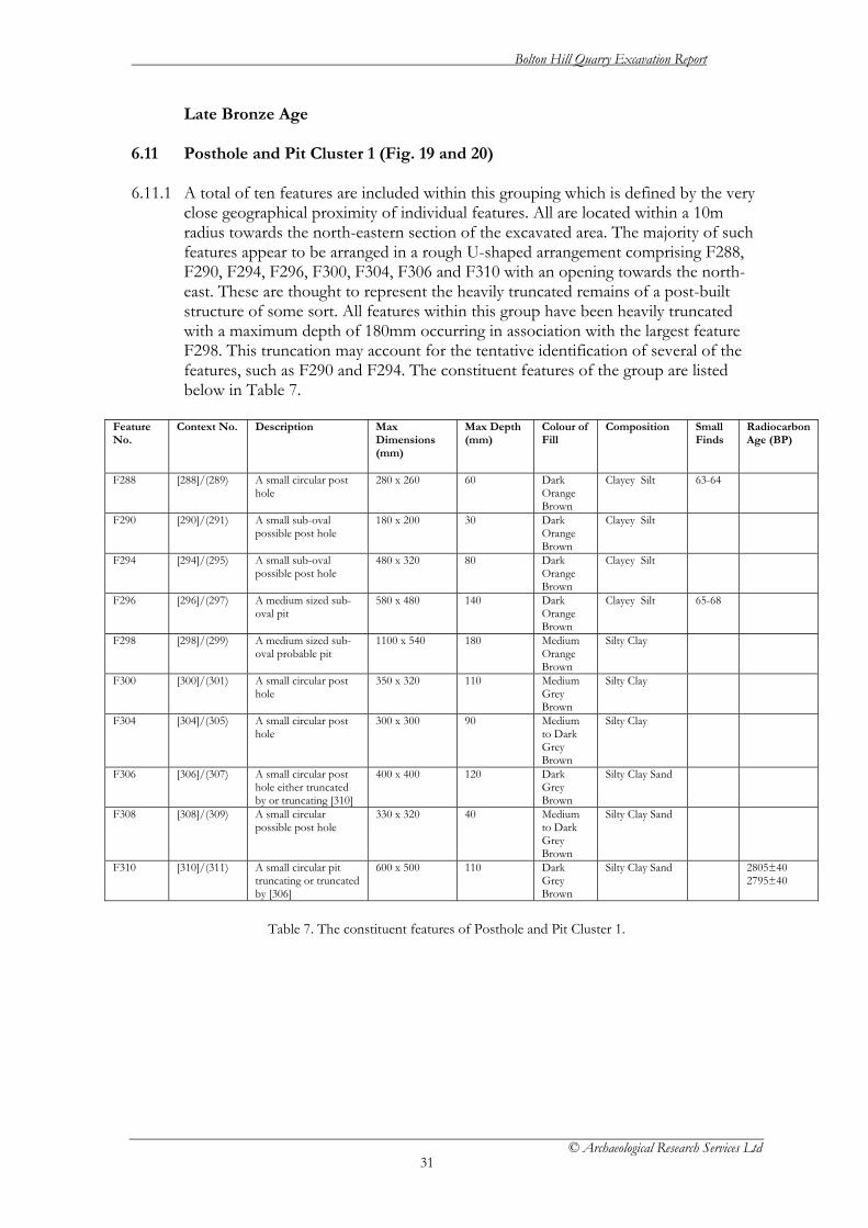
Late Bronze Age 6.11 Posthole and Pit Cluster 1 (Fig. 19 and 20) 6.11.1 A total of ten features are included within this grouping which is defined by the very
close geographical proximity of individual features. All are located within a 10m radius towards the north-eastern section of the excavated area. The majority of such features appear to be arranged in a rough U-shaped arrangement comprising F288, F290, F294, F296, F300, F304, F306 and F310 with an opening towards the north-east. These are thought to represent the heavily truncated remains of a post-built structure of some sort. All features within this group have been heavily truncated with a maximum depth of 180mm occurring in association with the largest feature F298. This truncation may account for the tentative identification of several of the features, such as F290 and F294. The constituent features of the group are listed below in Table 7.
Feature No.
Context No. Description Max Dimensions (mm)
Max Depth (mm)
Colour of Fill
Composition Small Finds
Radiocarbon Age (BP)
F288 [288]/(289) A small circular post hole
280 x 260 60 Dark Orange Brown
Clayey Silt 63-64
F290 [290]/(291) A small sub-oval possible post hole
180 x 200 30 Dark Orange Brown
Clayey Silt
F294 [294]/(295) A small sub-oval possible post hole
480 x 320 80 Dark Orange Brown
Clayey Silt
F296 [296]/(297) A medium sized sub-oval pit
580 x 480 140 Dark Orange Brown
Clayey Silt 65-68
F298 [298]/(299) A medium sized sub-oval probable pit
1100 x 540 180 Medium Orange Brown
Silty Clay
F300 [300]/(301) A small circular post hole
350 x 320 110 Medium Grey Brown
Silty Clay
F304 [304]/(305) A small circular post hole
300 x 300 90 Medium to Dark Grey Brown
Silty Clay
F306 [306]/(307) A small circular post hole either truncated by or truncating [310]
400 x 400 120 Dark Grey Brown
Silty Clay Sand
F308 [308]/(309) A small circular possible post hole
330 x 320 40 Medium to Dark Grey Brown
Silty Clay Sand
F310 [310]/(311) A small circular pit truncating or truncated by [306]
600 x 500 110 Dark Grey Brown
Silty Clay Sand 2805±40 2795±40
Table 7. The constituent features of Posthole and Pit Cluster 1.

Bolton Hill Quarry Excavation Report
© Archaeological Research Services Ltd
32
Figure 19 Plan of Pit and posthole cluster 1
Bolton Hill Quarry Excavation Report
© Archaeological Research Services Ltd
33
Figure 20 Sections of Pit and posthole cluster 1

Bolton Hill Quarry Excavation Report
© Archaeological Research Services Ltd
34
6.11.2 All features contained a similar single homogenous fill, apart from the intercut posthole and small pit (F306 and F310), and the nearby posthole F308. Each of these features contained a compacted fill with a high sand content that was quite distinct from other fill deposits associated with the feature group or that of other features from the wider site. This difference may suggest that the three features were not linked to the same phase of construction as the majority of features in the group, although the very similar botanical macrofossils recovered from F310 and F296 indicate that they had a similar environmental composition to their surroundings when the fills were deposited. The sequence of construction between F306 and F310 could not be deduced with certainty as the fill of the two features was fairly identical and it may be that they were constructed in relatively rapid succession.
6.11.3 Radiometric determinations were obtained from short lived species and cereal grains
in two of the features within this grouping. These were 1020-820 cal BC, 1070-830 cal BC and 1050-830 cal BC (2775±40 BP, SUERC-30119; 2805±40 BP, SUERC-30131 and SUERC-30129; 2795±40 BP, SUERC-30130).
6.11.4 Two of the features, F288 and F296, each produced a small quantity of pottery. In
both cases the assemblage comprises several small, worn and plain body sherds with little diagnostic value (small finds 63-64 and 65-66 respectively). F296 also produced two struck flint flakes (small finds 67-68). F288 represents the much truncated remains of a circular posthole while F296 represents a medium sized sub-oval pit at the centre of the western end. F296 therefore effectively closes the western end of the possible structure although this need not necessarily imply the presence of an upright post structure at this point. F296 contained two indeterminate cereal grains along with a limited number of weed seeds (including Ranunculus spp.and Polygonum lapathifolium) indicating arable agriculture close by.
Bolton Hill Quarry Excavation Report
© Archaeological Research Services Ltd
35
Post-medieval 6.12 Ditched Enclosure (Figs 21 and 22) 6.12.2 A single ditched enclosure was encountered during excavations towards the extreme
southern extent of the development area. The details of the feature are summarised in Table 9 below.
Feature No.
Context No.
Description Max Dimensions (mm)
Max Depth (mm)
Colour of Fill
Composition Small Finds
Radiocarbon Age (BP)
F364 [364]/(365) A ditched enclosure
Total feature dimensions 15000 x 8000 Individual ditches up to 2000 wide
Up to 200
Medium Orange Brown
Silty Clay 80, 94-95 110, 111, 114, 115
285±40
Table 8. The ditched enclosure.
6.12.3 The enclosure was approximately 15m in length by 9m wide and consisted of two
parallel ditches running along an east-west axis approximately 4m apart. It was enclosed at the western end by a much narrower ditch, approximately 1m wide, running north-south. The eastern end remained open but the ditches at either side turned in towards each other before terminating. This created a constricted bottle neck opening approximately 2m to 2.5m wide. Several metres beyond the entrance a single posthole was encountered, F348, and as discussed above may or may not be associated with the enclosure.
6.12.4 The ditch was examined in five sections cut across its width, one at the centre of
both the western terminal ditch and of each lateral ditch and one at each eastern terminal to the lateral ditches. These were excavated in order to obtain a representative profile across the enclosure ditches and which found them to be relatively shallow, with a maximum depth of approximately 0.2m. The ditches proved shallowest at both the eastern terminals as well as along the north-south aligned western ditch where a maximum depth of only 0.07m was achieved. The deepest section of the ditch was found to exist along the central and inner edge of the feature where the cut appeared almost vertical in nature. By contrast the outer edge of the ditch appeared to posses a shallow angle and so for the most part gradually tapered out towards the edge. The shallow nature of the ditches would suggest the enclosure had been heavily truncated by plough activity and in places this had almost resulted in its removal.
6.12.5 The content of the ditches appeared to largely comprise of a single homogenous silty
clay fill with varying, but slight, traces of charred material throughout. However, in places discrete lenses of other material were observed but not recorded in profile. This was particularly found to be the case along the length of the southern ditch. While these deposits may have derived from differential infilling of the ditch over time it may also indicate the presence of possible re-cuts.
6.12.6 No structural features were noted within the interior of the ditched enclosure.
However, a number of very shallow spreads of material were explored and while they appeared to lack any regular and well defined edge could derive from the final traces

Bolton Hill Quarry Excavation Report
© Archaeological Research Services Ltd
36
of ploughed out internal cut features. In this regard a number of plough score marks were also noted cutting across the interior of the enclosure.
6.12.7 A small number of small finds were recovered from the fully excavated remains of
the ditch fills. They included several small crumbs of pottery, too small and degraded to be of diagnostic value (small find 111) as well as a single plain body sherd of unknown type, but of probable prehistoric affinity (small find 114). Also recovered from the fill was a single struck flint flake (small find 116) as well as several small pieces of chalk (small finds 95, 110 and 115). In the last instance the chalk objects are obviously not indigenous to the local area but show no obvious signs of having been worked or otherwise having served any functional purpose.

Bolton Hill Quarry Excavation Report
© Archaeological Research Services Ltd
37
Figure 21 Plan of post-medieval enclosure

Bolton Hill Quarry Excavation Report
© Archaeological Research Services Ltd
38
Figure 22 Sections through post-medieval enclosure

Bolton Hill Quarry Excavation Report
© Archaeological Research Services Ltd
39
Undated features 6.13 Pottery producing pits (Fig. 23) 6.13.1 Two pit features containing undiagnostic pottery were located in isolation across the
site. 6.13.2 Feature F394 was located in relative isolation towards the south-eastern edge of the
excavation area although approximately 20m north-east of F230 and possible associated features. It represents the remains of a small sub-oval pit much disturbed by root activity. F394 produced a small quantity of pottery, representing a minimum of a single vessel, including three plain and relatively un-diagnostic body sherds and a single decorated rim sherd. A small quantity of charred material was also noted in the fill but proved too small to be identified and thus provide a radiocarbon date.
6.13.3 Feature F494 was located in relative isolation within the central western area of the
excavated area but approximately 10m northwest of the large hearth-pit F486. It represents the remains of a small and heavily truncated circular pit which contained a quantity of charred material and a single plain body sherd of indeterminate association.
Feature No.
Context No. Description Max Dimensions (mm)
Max Depth (mm)
Colour of Fill
Composition Small Finds
Radiocarbon Age BP
F394 (395)/[394] A small pit 720 x 460 220 Medium Grey Brown
Silty Clay 117
F494 (495)/[494] A small circular pit
680 x 600 70 Medium Grey Brown
Silty Clay 93
Table 9. Pottery producing pits of unknown date.

Bolton Hill Quarry Excavation Report
© Archaeological Research Services Ltd
40
Figure 23 Plans and sections of other pottery producing pits

Bolton Hill Quarry Excavation Report
© Archaeological Research Services Ltd
41
6.14 Hearth-pits (Figs. 24, 25 and 26) 6.14.1 A total of 19 features are grouped under this heading, the majority of which are
located in the north-western quarter of the site. Despite this relative concentration there does not appear to be any well defined spatial patterning to their distribution. F420, F490 (Fig. 20), F540, F488, F468, F408 and F004 (Fig. 21) may form part of a wide arc, however, they are distributed over a considerable distance and their spacing appears somewhat irregular for such a conclusion to be firmly drawn. Furthermore, features F274, F422, F410 and F476 do not appear to conform to this pattern. A smaller number of other features also exist outside of this area and extend across the centre of the site, predominantly in a southerly direction. The main characteristics of the individual features are described in Table 10 below.
Feature No.
Context No. Description Max Dimensions (mm)
Max Depth (mm)
Colour of Fill Composition Small Finds
F004 [004]/(003)(065) A large circular hearth-pit with evidence of in situ burning
2100 x 1900 340 Dark Grey Brown to Black
Silty clay with a charcoal rich base deposit
F012 [012]/(011)(066) A large circular hearth-pit with evidence of in situ burning
1130 x 1110 300 Dark Brown Silty clay with a charcoal rich base layer
F246 [246]/(247)(342) (343)(344)(582)
A large circular hearth-pit with evidence of in situ burning as well as a possible recut
1520 x 1480 300 Light Orange Brown to Black
Silty Clay with a charcoal rich base deposit and a clay filled possible recut
F252 [252]/(253)(338) (339)
A large circular hearth-pit with evidence for in situ burning
1730 x 1630 310 Medium Grey Brown to Black
Silty Clay with a charcoal rich base deposit
60,61
F274 [274]/(275)(276) (277)
A large circular hearth-pit with evidence for in situ burning
1900 x 1840 260 Dark Brown to Black
Silty Caly with a charcoal rich base deposit
55-57
F346 [346]/(347)(565) (567)(569)(571)
A large circular hearth-pit with evidence for two episodes of in situ burning
1950 x 1850 550 Medium/Dark Grey to Black
Silty clay with two separate charcoal rich layers
F408 [408]/(409) A large circular hearth-pit with evidence for in situ burning
1440 x 1790 260 Dark Grey Brown
Silty Clay 91
F410 [410]/(411)(503) A large circular hearth-pit with evidence for in situ burning
1500 x 1500 200 Dark Brown to Black
Silty Clay with a charcoal rich base deposit
F420 [420]/(421)(455) (457)
A large sub-oval hearth-pit with evidence for in situ burning
2120 x 1680 340 Dark Grey Brown to Black
Silty Clay with a charcoal rich base deposit
F422 [422]/(423)(499) A large circular hearth-pit with evidence for in situ burning
1200 x 1200 200 Dark Brown to Black
Silty Clay with a charcoal rich base deposit
F476 [476]/(513)(515) (517)
A large sub-circular hearth-pit with evidence for in situ burning
1520 x 1420 180 Dark Brown to Black
Silty Clay with a charcoal rich base deposit
F486 [486]/(487)(519) A large circular hearth-pit with evidence for in situ burning
1800 x 1800 250 Dark Brown to Black
Silty Clay with a charcoal rich base deposit
F488 [488]/(489)(521) A large circular hearth-pit with evidence for in situ burning
1900 x 1700 300 Dark Grey Brown to Black
Silty Clay with a charcoal rich base deposit
F490 [490]/(491)(522) (523) Stakeholes [524]/(525) [526]/(527) [528]/(529) Possible post hole (530)
A very large circular hearth-pit with evidence for in situ burning. Also with evidence of a possible internal arrangement of stakeholes.
2540 x 2500 460 Dark Grey Brown to Black
Silty Clay with a charcoal rich base deposit
F540 [540]/(541)(543) (545)
A large circular hearth-pit with evidence for in
1600 x 1600 360 Dark Grey Brown Black
Silty Clay with a charcoal rich

Bolton Hill Quarry Excavation Report
© Archaeological Research Services Ltd
42
situ burning base deposit F558 [558]/(559)(561)
(563) A large sub-circular hearth-pit with evidence for in situ burning
1900 x 1900 360 Medium Grey Brown to Black
Silty Clay with a charcoal rich base deposit
F572 [572]/(573) A large but shallow circular hearth-pit with limited evidence of in situ burning
1800 x 1560 100 Dark Brown Silty clay with a high charcoal content
F464 [464]/(465) A medium sized sub-circular hearth-pit
840 x 730 180 Medium Reddish Brown
Silty Clay
F474 [474]/(475) A large circular hearth-pit
1100 x 1120 270 Dark Brown Silty Clay
Table 10. Hearth-pits.
6.14.2 Only F246, F252 and F346 occur in relatively close proximity to one another and
represent a small concentration of such features within the southern extremity of the excavated area. F346 occurs approximately 5m to the north-west of F252 while F246 is slightly removed, being approximately 20m to 25m further east. This small concentration occurs in relative isolation to the main body of such features, the nearest link to which is represented by F558 over 100m to the north-west of F346. This feature is itself a distant outlier to the main group spread across the north-western quadrant of the site.
6.14.3 The features listed in Table 10 above have all been grouped together, despite their
wide pattern of geographical dispersal, as a result of evidence for in situ burning, primarily relating to the identification of heat affected surfaces within the cut of each pit, but also the consistent presence of charcoal-rich basal deposits. Only F572 (Fig. 21), F408, F464 and F475 lack such a basal deposit yet otherwise possessed evidence for a heat affected surface to the cut, as well as a quantity of charcoal and, in the case of F572, burnt hazelnut shell within their single fill.
6.14.4 The majority of such features possessed an upper homogenous fill overlying the
primary charcoal rich deposits, and are unlikely to have silted up gradually, but instead appear to have been deliberately backfilled. In a significant number of cases, for instance F246, F252, F274, F346, F420, F476, F490 and F558 further fill deposits were also recorded. In these instances the fill stratigraphically above the charred basal deposits have been interpreted as evidence for either the collapse of the pit edges following abandonment or the partial backfilling of the feature, perhaps in an effort to extinguish the fires within before its final backfilling.
6.14.5 In one case, F346, there was evidence for a second episode of burning within the cut
and this occurred immediately after the slumping of the sides or backfilling described above. This feature represented one of the deepest of the hearth.
6.14.6 Feature F246 appeared to have a fill of probable re-deposited natural (context 247) at
the centre, which produced an impression in plan of a doughnut-like shape to the cut. In section this was not found to extend to the full depth of the cut but terminated at a depth of 0.12m within a silting deposit (context 342). The regularity of the shape of this internal feature may suggest the presence of a very limited re-cut, or the possible insertion of a post within the upper fill of the pit. Below this final sequence a further silting deposit (context 582) overlay a backfill or slumping deposit (context 344) which in turn covers the charred primary fill (context 343).
Bolton Hill Quarry Excavation Report
© Archaeological Research Services Ltd
43
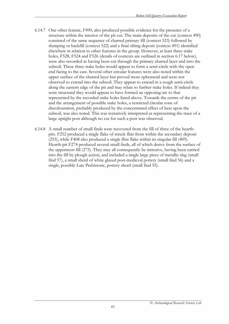
6.14.7 One other feature, F490, also produced possible evidence for the presence of a structure within the interior of the pit cut. The main deposits of the cut (context 490) consisted of the same sequence of charred primary fill (context 523) followed by slumping or backfill (context 522) and a final silting deposit (context 491) identified elsewhere in relation to other features in the group. However, at least three stake holes, F528, F524 and F526 (details of contexts are outlined in section 6.17 below), were also recorded as having been cut through the primary charred layer and into the subsoil. These three stake holes would appear to form a semi-circle with the open end facing to the east. Several other circular features were also noted within the upper surface of the charred layer but proved more ephemeral and were not observed to extend into the subsoil. They appear to extend in a rough semi-circle along the eastern edge of the pit and may relate to further stake holes. If indeed they were structural they would appear to have formed an opposing arc to that represented by the recorded stake holes listed above. Towards the centre of the pit and the arrangement of possible stake holes, a restricted circular zone of discolouration, probably produced by the concentrated effect of heat upon the subsoil, was also noted. This was tentatively interpreted as representing the trace of a large upright post although no cut for such a post was observed.
6.14.8 A small number of small finds were recovered from the fill of three of the hearth-
pits. F252 produced a single flake of struck flint from within the secondary deposit (253), while F408 also produced a single flint flake within its singular fill (409). Hearth-pit F274 produced several small finds, all of which derive from the surface of the uppermost fill (275). They may all consequently be intrusive, having been carried into the fill by plough action, and included a single large piece of metallic slag (small find 57), a small sherd of white glazed post-medieval pottery (small find 56) and a single, possibly Late Prehistoric, pottery sherd (small find 55).

Bolton Hill Quarry Excavation Report
© Archaeological Research Services Ltd
44
Figure 24 Plans and sections of Hearth-pits
Bolton Hill Quarry Excavation Report
© Archaeological Research Services Ltd
45
Figure 25 Plans and sections of Hearth-pits

Bolton Hill Quarry Excavation Report
© Archaeological Research Services Ltd
46
Figure 26 Plans and sections of Hearth-pits

Bolton Hill Quarry Excavation Report
© Archaeological Research Services Ltd
47
6.15 Heat-Affected Surfaces (Fig. 27) 6.15.1 Ten features were identified from across the site as representing the remains of
probable hearths. They are described in Table 11 below. 6.15.2 The best evidence for a possible hearth is represented by F228 located along the
south-eastern edge of the excavation area. F228 represents a probable cut feature in which a fire appears to have been made as represented by the heat-affected fill deposit F229 (Fig. 23). The fire, or at least effects of the heat, appear to have then spread east for a further 1m as represented by deposit 225. This deposit then appears to have been truncated by the construction of a large circular pit F226, into which at least part of the residue of the fire appears to have been deposited, including the remains of a small quantity of hazelnut shell. Due to the implication that the fire was originally contained within a cut pit, F226 could be included among the category of Hearth-Pits.

Bolton Hill Quarry Excavation Report
© Archaeological Research Services Ltd
48
Figure 27 Plans and sections of heat affected surfaces

Bolton Hill Quarry Excavation Report
© Archaeological Research Services Ltd
49
Figure 28. Feature 228 after half-sectioning. 6.15.3 None of the other features appeared to have been created within a purposeful cut
and all other cut numbers consequently refer to the excavated extent of the heat affected natural substratum. All such features were irregular in shape and profile and were defined by a single homogenous fill, in most cases a distinct reddish-brown clay although in some the definition was less pronounced.
6.15.4 Some doubt may be expressed in relation to the authenticity of F360 and this may
not actually represent the presence of a hearth. Its location in proximity to F356, itself, interpreted as evidence for the in situ burning of tree roots, may suggest a similar explanation or indeed indicate the effects of heat upon the natural substratum generated by the burning out of roots, either naturally or by design.
6.15.5 F326 was partially truncated along its western edge by part of a modern trackway
represented by features F020 and F022. In any case. this contrasts with other such features listed here in terms of its relatively large size as well as the fresher appearance of the fill. This feature, while probably indicative of the effects of heat upon the natural, possibly relates to a more recent, or at least non-prehistoric, use of fire, or perhaps even a natural episode of burning.
Feature No.
Context No. Description Max Dimensions (mm)
Max Depth (mm)
Colour of Fill Composition Small Finds
F048 (047)/[048] (085)
A small sub-oval area of heat affected natural
500 x 290 110 Medium Reddish Brown
Silty Clay
F052 (051)/[052] A small sub-circular area of heat affected natural
900 x 520 250 Medium Orange Brown
Silty Clay
F190 (191)/[190] A large sub-circular area of heat affected natural
1300 x 900 700 Light Reddish Brown
Silty Clay
F192 (193)/[192] A large sub-circular area of heat affected natural
1240 x 800 390 Dark Reddish Brown
Silty clay

Bolton Hill Quarry Excavation Report
© Archaeological Research Services Ltd
50
F198 (199)/[198] A small sub-oval area of heat affected natural
590 x 370 150 Dark Reddish Brown
Silty Clay
F200 (201)/[200] A small sub-oval area of heat affected natural
720 x 310 170 Dark Reddish Brown
Silty Clay
F326 (327)/[326] A large sub-circular area of heat affected natural
1200 x 1100 150 Medium Reddish Brown
Silty Sand
F324 (325)/[324] A small sub-circular area of heat affected natural
550 x 420 50 Medium Reddish Brown
Silty Clay
F360 (361)/[360] A small sub-oval area of heat affected natural
250 x 215 150 Medium Reddish Brown
Silty Clay
F228 [228]/(229) A possible medium sized but shallow circular pit
600 x 600 60 Medium Orange Brown
Sandy Clay
Table 11. Heat-affected surfaces.
6.15.6 Of the remaining features, F048 and F052 would appear to be associated as they
occur in close proximity to one another and to the west and east respectively of a possible, and otherwise isolated, post hole F050 (discussed separately below). These three features occur in a line extending east to west approximately 20m or more to the north-east of F046 and towards the northern extent of the excavated area, but are otherwise spatially unrelated to any other features of significance.
6.15.7 The remaining four features F190, F192, F198 and F200 occur in close association
with one another extending along a line from west to east respectively near the eastern boundary of the site. F190 and F192 appear to occur on one side and to the west of a probable pit F194, while F198 and F200 were located on the opposite eastern side of the same feature. All of these features appeared as highly distinct patches of a dark reddish-brown clay within the subsoil, with the exception of F190 which appeared less distinct in colour and was composed of perhaps two different nuclei linked by a more ephemeral zone of discolouration.
6.16 Pit and Posthole Features (Fig. 29 - 38) 6.16.1 A total of 55 other features were interpreted as representing evidence for further pits
and postholes. However, such features appeared across the site in relative isolation from one another, or at most within small groups of two or three. While discussion will highlight the smaller clusters, these features have been grouped under this heading as individual examples of cut features, the descriptions of which are set out in Table 12 below.
Feature No. Context No. Description Max
Dimensions (mm)
Max Depth (mm)
Colour of Fill Composition Small Finds
F014 [014]/(013) A rectangular post hole
300 x 210 110 Medium Brown Coarse Sand
F028 [028]/(027) A small circular possible post hole
520 x 440 200 Medium Brown Silty Clay
F050 [050]/(049) A small circular possible post hole
270 x 200 40 Yellowish Brown
Silty Clay
F058 [058]/(057) A sub-circular probable post hole
670 x 670 70 Dark Reddish Brown
Silty Clay
F060 [060]/(059) A small circular possible post hole
330 x 300 45 Dark Brown to Black
Silty Sandy Clay
F062 [062]/(061) A small pit or post hole
460 x 300 130 Light Brown Silty Clay

Bolton Hill Quarry Excavation Report
© Archaeological Research Services Ltd
51
F064 [064]/(063) A small pit 490 x 490 280 Medium Grey Brown
Silty Clay
F074 [074]/(073) A large probable pit 1480 x 960 200 Medium Pinkish Red
Sandy Clay
F078 [078]/(077) A possible small pit or post hole
540 x 380 90 Medium Orange Brown
Silty Clay
F080 [080]/(079) A possible small pit or post hole
460 x 450 90 Medium Orange Brown
Silty Clay
F112 [112]/(113) (169)
A rectangular shaped small pit
615 x 470 250 Light Brown Sandy Clay
F118 [118]/(119) A possible small circular post hole
200 x 130 85 Medium Reddish Brown
Clay
F130 [130]/(131) A possible small circular post hole
140 x 150 250 Medium Brown Sandy Clay
F140 [140]/(141) A possible small circular post hole
140 x 130 30 Light Brown Sandy Clay
F170 [170]/(171) A possible small pit 650 x 510 310 Medium Orange Brown
Clayey Silt
F178 [178]/(179) A possible small sub-circular pit or post hole
180 x 240 30 Light Brown Silty Clay
F184 [184]/(185) A small post hole 430 x 420 140 Dark Orange Brown
Clayey Silt
F188 [188]/(189) A small circular pit or post hole
430 x 420 70 Dark Orange Brown
Clayey Silt
F194 [194]/(195) A possible medium sized pit heavily disturbed by animal activity
840 x 660 250 Medium Reddish Brown
Sandy Clay
F204 [204]/(205) A possible small post hole
210 x 150 50 Dark Orange Brown
Clayey Silt
F212 [212]/(213) A possible small circular post hole
170 x 170 80 Medium Brown Silty Clay
F226 [226]/(227) (312) Cut through spread (025) associated with F228
A possible medium sized but shallow circular pit
600 x 600 60 Medium Orange Brown
Sandy Clay
F232 [232]/(233) A possible post hole 480 x 480 420 Medium Orange Brown
Silty Clay
F238 [238]/(239) A possible small pit or post hole
580 x 530 160 Medium Orange Brown
Silty Clay
F240 [240]/(241) A probable small post hole
240 x 230 100 Medium Grey Brown
Silty Clay
F258 [258]/(259) A probable small post hole
170 x 150 75 Medium Brown Silty Clay
F280 [280]/(281) A possible truncated post hole
380 x 290 60 Medium Reddish Brown
Silty Clay
F282 [282]/(283) A possible truncated post hole
630 x 380 60 Dark Brown Silty Clay
F284 [284]/(285) A possible truncated medium sized pit
820 x 680 350 Dark Brown Silty Clay
F286 [286]/(287) (313)
A large deep circular pit
1120 x 1100 620 Medium Grey Brown
Silty Clay
F314 [314]/(315) A large sub-circular pit
1300 x 1100 230 Medium Grey Brown
Silty Clay
F328 [328]/(329) A small circular pit or post hole
440 x 390 40 Medium Orange Brown
Silty Clay
F348 [348]/(349) A small circular post hole
260 x 210 80 Dark Brown Sandy Clay
F352 [352]/(353) A small sub-oval probable post hole
350 x 250 70 Dark Grey Brown
Silty Clay
F370 [370]/(371) A small truncated circular post hole
120 x 120 30 Light Brown Sandy Clay
F372 [372]/(373) (576)(577)
A large pit or post hole
900 X 900 480 Medium Grey Brown
Clayey Silt
F384 [384]/(385) (580)
A small sub-oval possible pit.
420 x 300 180 Dark Brown Sandy Clay
F388 [388]/(389) A small square 230 x 210 120 Light Brown Sandy Clay

Bolton Hill Quarry Excavation Report
© Archaeological Research Services Ltd
52
shaped post hole F398 [398]/(399) A small oval
possible pit 560 x 400 180 Medium Grey
Brown Silty Clay
F404 [404]/(405) A large rectangular pit feature.
2040 x 840 560 Dark Grey Brown
Large granitic stone blocks within a silty clay matrix
F412 [412]/(413) A small sub-rectangular possible pit
880 x 620 280 Medium Orange Brown
Silty Clay
F414 [414]/(415) (478)(479) (480)(481) (482)
A large circular pit truncating pit F484
1000 X 1000 500 Medium Grey Brown
Silty Clay
F424 [424]/(425) A medium sized oval pit
400 x 300 80 Dark Brown Silty Clay
F426 [426]/(427) A small sub-circular possible post hole
220 x 210 80 Medium Grey Brown
Clayey Silt
F430 [430]/(431) A medium sized circular possible pit
1000 x 1000 50 Dark Grey Brown
Silty Clay
F440 [440]/(441) A small circular possible post hole
350 x 250 100 Medium Yellow Brown
Sandy Clay
F442 [442]/(443) A small sub-circular possible post hole
400 X 300 100 Dark Grey Silty Clay
F446 [446]/(447) A large but shallow pit probably allied with pottery producing pit F450
1010 x 800 120 Medium Grey Brown
Silty Clay
F448 [448]/(449) A small sub-circular possible post hole
260 x 170 240 Dark Grey Brown
Silty Clay
F452 [452]/(453) A medium sized oval pit
830 x 600 88 Dark Grey Brown
Silty Clay
F460 [40]/(461) A truncated medium sized oval pit
980 x 620 100 Medium Grey Brown
Silty Clay
F484 [484]/(483) (485)
A large circular pit truncated by F414
1200 x 800 500 Medium Grey Brown to Light Reddish Brown
Silty Clay
F500 [500]/(501) (581)
A heavily truncated medium sized circular pit
570 x 460 170 Dark Grey Brown
Clayey Silt
F546 [546]/(547) A large sub-circular pit
1880 x 1360 300 Medium Orange Brown
Silty Clay 96
F579 [579]/(581) A small circular post hole
260 x 240 90 Dark Orange Brown
Sandy Clay
Table 12 Isolated pit and posthole features.

Bolton Hill Quarry Excavation Report
© Archaeological Research Services Ltd
53
Figure 29. Plans and sections of isolated pits and postholes
Bolton Hill Quarry Excavation Report
© Archaeological Research Services Ltd
54
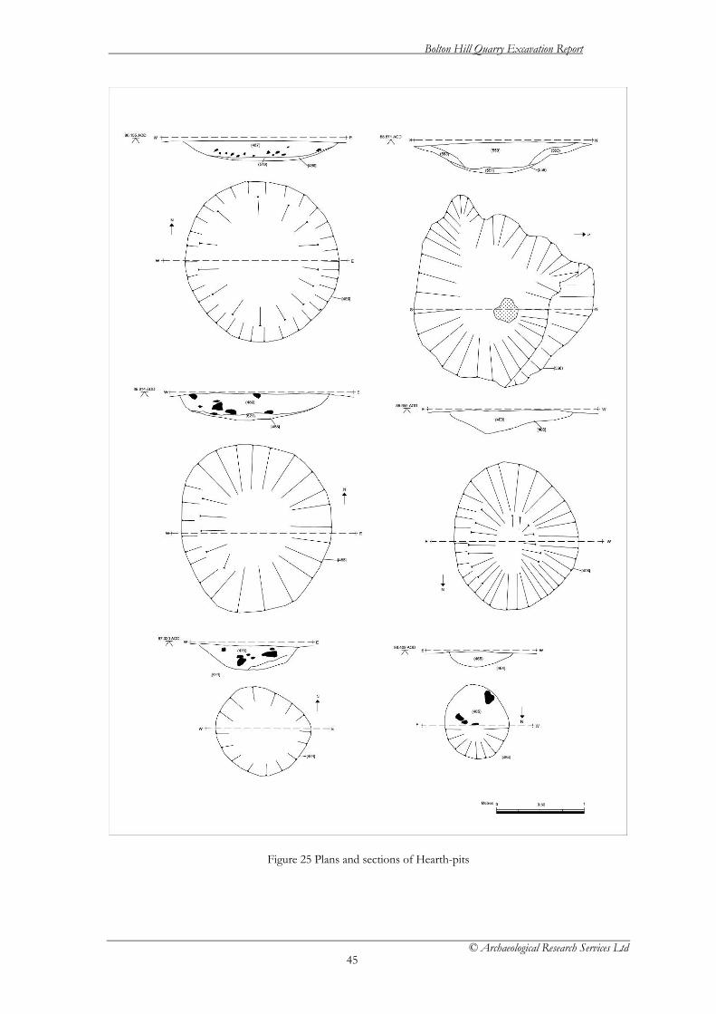
Figure 30. Plans and sections of isolated pits and postholes

Bolton Hill Quarry Excavation Report
© Archaeological Research Services Ltd
55
Figure 31. Plans and sections of isolated pits and postholes

Bolton Hill Quarry Excavation Report
© Archaeological Research Services Ltd
56
Figure 32. Plans and sections of isolated pits and postholes

Bolton Hill Quarry Excavation Report
© Archaeological Research Services Ltd
57
Figure 33. Plans and sections of isolated pits and postholes

Bolton Hill Quarry Excavation Report
© Archaeological Research Services Ltd
58
Figure 34. Plans and sections of isolated pits and postholes

Bolton Hill Quarry Excavation Report
© Archaeological Research Services Ltd
59
Figure 35. Plans and sections of isolated pits and postholes

Bolton Hill Quarry Excavation Report
© Archaeological Research Services Ltd
60
Figure 36. Plans and sections of isolated pits and postholes

Bolton Hill Quarry Excavation Report
© Archaeological Research Services Ltd
61
Figure 37. Plans and sections of isolated pits and postholes

Bolton Hill Quarry Excavation Report
© Archaeological Research Services Ltd
62
Figure 38. Plans and sections of isolated pits and postholes

Bolton Hill Quarry Excavation Report
© Archaeological Research Services Ltd
63
6.16.2 The majority of such features are represented by a single homogenous fill, predominantly composed of a silty clay matrix with variable quantities of charcoal and stone inclusions, within a cut of variable size but often circular or sub-circular form. In many cases the features appear to have been heavily truncated by plough action and are consequently relatively shallow with recorded depths regularly featuring below 100mm. This apparent truncation may explain the relative isolation of many of the features which, in the case of the potential postholes at least, would appear a somewhat curious occurrence. The possibility remains therefore, that the postholes which were identified could have formed part of structures that have since been largely destroyed.
6.16.3 In several instances individual features can be either directly or indirectly grouped
into small clusters of two or three. Pit F446 for instance has already been highlighted in association with the pottery producing pit F450 in terms of spatial proximity, form and general content. Similarly posthole F050, as well as the probable pit F194, have been discussed in relation to their potential spatial association with various hearth features detailed above. In a similar vein Features F058, F060, F314, F424, F426 and F 430 may all be highlighted as occurring within a similar distance from the possible structure identified as Post Hole and Pit Cluster 1, although it must be emphasised that this constitutes a loose spatial association only. Similarly posthole F348 may be associated with the ditched enclosure F364 in terms of its apparent placement a short distance from the eastern opening and near the central alignment of the enclosure. However, this relationship may also be entirely fortuitous and no direct link was established.
6.16.4 A more direct association may be drawn between pit features F414 and F484. In this
instance F414 was found to have been cut through, and therefore partially truncated the upper fill of F484. It would appear in this case that cut 414 was made after Feature F484 had fully silted, and as such was created some time after the construction of the latter pit. This sequence doe, however, represent one of only two instances where evidence for intercutting features was encountered. The other, represented by F306 and F310 has been discussed in relation to Post Hole and Pit Cluster 1 above. Given the relatively wide dispersal of features across the site, and the consequent low level of overlap between them, the construction of F414 over F484 may not have been entirely fortuitous, yet the exact purpose of this, as well as the function of either feature, remains uncertain.
6.16.5 A further association can be established between the large pit feature F226 and a
probable shallow hearth F228. Not only are they located just over 1m apart, but were also stratigraphically linked by the presence of a heat effected deposit (context 225) extending over an area between them, partially overlaying the fill of F228 and through which F226 appeared to have been cut. The content of F228, deposit 229, would appear to indicate a locus of heat for the fire as it contained a quantity of heat affected subsoil. It would appear therefore that a fire had been contained within F228 and possibly extended east across the surface of the subsoil creating deposit 225. At some point towards the end of this fire, pit F226 was cut through the eastern limit of the heat effected area of 225. Into this pit was placed a primary deposit of charred material including a quantity of hazelnut shell in the form of deposit 312. The pit was then either rapidly backfilled or allowed to gradually silt up with the formation of deposit 227.

Bolton Hill Quarry Excavation Report
© Archaeological Research Services Ltd
64
6.16.6 A small number of such features depart from the usual circular or sub-circular shape format and were found to be either square or rectangular to sub-rectangular in shape. Two postholes, F014 and F388, were found to be rectangular and square respectively in both plan and section while F112 and F412 represent probable rectangular or sub-rectangular pits. The angular form of these features would suggest a non-prehistoric and perhaps medieval to Modern origin, although this cannot be adequately verified given the lack of diagnostic finds. In either case they appear spatially isolated, both from each other and the wider distribution of features, and do not therefore appear to constitute any significant structure.
6.16.7 Feature F404 also constitutes a rectangular cut feature located towards the south-
eastern limit of the site. It was originally thought to represent a grave cut protected by an extensive stone capping. However, excavation revealed no human remains or finds of any kind. Instead the pit appeared entirely filled by the large granitic blocks originally thought to constitute the capping. A quantity of charcoal was observed throughout the fill as well as forming a thin layer across the base of the cut. In terms of its shape, size and content this feature appears unique within the site and no clue as to its possible function was recovered.
6.16.8 A single pit, F546, produced a single struck flint flake. 6.17 Stakeholes 6.17.1 Only five features can be identified within this group the majority of which can be
associated with the possible internal structure of the large hearth-pit F490. The details of the individual features are summarised in table 13 below.
Feature No.
Context No.
Description Max Dimensions (mm)
Max Depth (mm)
Colour of Fill
Composition Small Finds
F166 [166]/(167) A possible small circular stake hole
180 x 160 110 Medium Grey Brown
Clayey Silt
F334 [334]/(335) A possible stake hole
450 x 300 350 Medium Reddish Brown
Silty Clay
F524 [524]/(525) A small stake hole within pit F490
320 x 100 100 Dark Brown Silty Clay
F526 [526]/(527) A small stake hole within pit F490
300 X 100 120 Dark Brown Silty Clay
F528 [528]/(529) A small stake hole within pit F490
90 X 200 100 Dark Brown Silty Clay
Table 13 Stakeholes
6.17.2 Outside of the stakehole structure described in relation to the interior of hearth-pit
F490 only two other stakeholes can be identified, F166 and F334. In the case of F334 the dimensions of the cut would perhaps suggest a posthole rather than a stakehole. Both features occur in relative isolation, F334 approximately 10m north-east of pit feature F432 and F166 approximately 40-50m further north. In the case of F166 it lies near a large modern deposit that extended for several hundred metres in

Bolton Hill Quarry Excavation Report
© Archaeological Research Services Ltd
65
an easterly direction and was up to 15m wide (north to south). The deposit was created as a temporary surface for the heavy plant to run along during the extraction of loads to create the initial quarry road and had therefore been heavily compacted and pushed down into the subsoil. It is possible therefore that further features near to F166 have been obscured/removed.
6.17.3 Additionally, the surface of the subsoil and mode of mechanical stripping of the area
was not particularly conducive to the identification of such small features as potential stakeholes. The level of truncation across the site must also be taken into account. A combination of such factors may account for the low number of features encountered across the site. The possibility also remains that the isolated postholes for which no structural pattern can be advanced may have related to more ephemeral stakehole structures and that these have subsequently been lost to subsequent ploughing.
6.18 Field boundaries and Modern Features 6.18.1 This group includes a varied set of features that were encountered for the most part
towards the northern limits of the site and comprise either field boundaries associated with enclosure or are of modern origin. The constituent features are described in Table 14 below.
Feature No.
Context No.
Description Max Dimensions (mm)
Max Depth (mm)
Colour of Fill
Composition Small Finds
F010 [010]/(011) Rectangular quarry Test Pit NOT EXCAVATED
15000 x 6000 NA Dark Brown
Silty Clay
F020 [020]/(019) Linear feature paired with F022 Modern Track NOT EXCAVATED
20000 x 600 NA Dark Brown
Sandy Clay
F022 [022]/(021) Linear feature paired with F020 Modern Track NOT EXCAVATED
20000 x 600 NA Dark Brown
Sandy Clay
F024 [024] and [026] /(023) and (025)
Linear Post Medieval double ditched hedgerow extending north south at centre of site. Probably same as F114 located to the south beyond F076
100000 x 1700 120 Medium Reddish Brown
Silty Clay
F030 [030]/(029) A large linear Modern Test Pit extending north south. NOT EXCAVATED
33400 x 4000 NA Medium Yellow Brown
Sandy Clay
F032 [032]/(031) Part of a large Modern Test Pit extending north south. Partly masked by deposit F586 at its northern limit NOT EXCAVATED
4000 x 3100 NA Medium Yellow Brown
Sandy Clay
F054 [054]/(053) A large linear Modern Test Pit extending north south. NOT EXCAVATED
6700 X 4000 NA Medium Yellowish Brown
Sandy Clay
F056 [056]/(055) A large linear Modern 10500 x 6400 NA Medium Sandy Clay

Bolton Hill Quarry Excavation Report
© Archaeological Research Services Ltd
66
Test Pit extending east west NOT EXCAVATED
Yellowish Brown
F076 [076] same as[146] and [148]
The principle Post Medieval double ditched hedgerow running east west across the centre of the entire site. Sectioned at western end. Divides F024 from F114
400000 x 1700 120 Medium Reddish Brown
Silty Clay
F114 [114] and [116]/(115) and (117)
Post Medieval double ditched hedgerow extending northeast to southwest towards F024 at centre of site but divided by F076 NOT EXCAVATED
150000 X 1700 NA Medium Reddish Brown
Silty Clay
F196 [196]/(197) A large linear Modern Test Pit extending north south. NOT EXCAVATED
35000 X 3000 NA Medium Yellowish Brown
Sandy Clay
F262 [262] and [264]/(263) and (265)
Post Medieval double ditched hedgerow in the south west corner of the site extending northeast to southwest towards F114 NOT EXCAVTED
20000 X 1700 NA Medium Reddish Brown
Silty Clay
F270 [270] and [272]/(271) and (273)
Post Medieval double ditched hedgerow running east west across the north western corner of the site NOT EXCAVATED
100000 X 1800 NA Medium Reddish Brown
Silty Clay
F584 [584]/(585) A linear quarry test pit extending north south NOT EXCAVATED
16000 x 4000 NA Medium Yellow Brown
Sandy Clay
F586 (586) An irregular shaped deposit of stone laid down to consolidate a wagon run across the northern edge of the site
300000 x 30000 NA Medium Grey
Granitic Stone within a Clay matrix
Table 14. Field Boundaries and Modern Features.
6.18.2 The principle features of this group were a series of double ditched hedgerows that
extended across the site along either a north-south or east-west axis and divided it into approximately four quarters. These hedgerows had formed the principle field divisions on the site until development had required their removal. As discussed in the desk-based assessment for Bolton Hill Quarry the field system as it then stood had probably been established during the 18th century. A single section was excavated across both F024 and F076 in an attempt to confirm this but produced no datable evidence. They did demonstrate the ditches to be relatively shallow and U-shaped in profile with a maximum depth of only 0.12m.
6.18.3 A series of large rectangular cut features were also encountered entirely within the
northern section of the site. They were not excavated as they were obviously of a modern origin and related to an episode of geological test-pitting carried out in advance of the quarry development. They probably relate to the test pits monitored by the earlier watching brief during which no archaeological features were reported.

Bolton Hill Quarry Excavation Report
© Archaeological Research Services Ltd
67
6.18.4 A large, irregular shaped deposit of granitic stone (F586) was also encountered
extending across the central northern edge of the site along an east-west axis. This was reportedly laid down during earlier phases of the development in order to create a wagon run and vehicle access during the excavation of the quarry road. It is only recorded here as it masked a considerable area of the subsoil into which it had obviously been compacted by the weight of the heavy loads passing over it. It subsequently penetrated the subsoil to an unknown depth but almost certainly would have destroyed any surviving archaeology in this area.

Bolton Hill Quarry Excavation Report
© Archaeological Research Services Ltd
68
7 Radiocarbon Results
P D Marshall and G Cook 7.1 Introduction 7.1.1 Nineteen radiocarbon age determinations have been obtained on samples from 11
individual contexts spread across a selection of pits, postholes, and a ditch fill from Bolton Hill.
7.2 Methods 7.2.1 The samples, charcoal, carbonised seeds and hazelnuts, were submitted to the
Scottish Universities Environmental Research Centre (SUERC), East Kilbride (SUERC) and pre-treated following procedures described in Stenhouse and Baxter (1983), graphitised following the methods outlined in Slota et al (1987), and measured by Accelerator Mass Spectrometry (AMS) according to Xu et al (2004).
7.2.2 The laboratory maintains a continual programme of quality assurance procedures, in
addition to participation in international inter-comparisons (Scott 2003), which indicates no laboratory offsets and demonstrates the validity of the precision quoted.
7.3 Results 7.3.1 The radiocarbon results are given in Table 15, and are quoted in accordance with the
international standard known as the Trondheim convention (Stuiver and Kra 1986). They are conventional radiocarbon ages (Stuiver and Polach 1977).
7.4 Calibration 7.4.1 The calibrations of the results, relating the radiocarbon measurements directly to
calendar dates, are given in Table 15, and in Figures 33, 36, 37 and 39 - 40. All have been calculated using the calibration curve of Reimer et al (2009) and the computer program OxCal (v4) (Bronk Ramsey 1995; 1998; 2001; 2009). The calibrated date ranges cited in the text are those for 95% confidence. They are quoted in the form recommended by Mook (1986), with the end points rounded outwards to 10 years. The ranges in plain type have been calculated according to the maximum intercept method (Stuiver and Reimer 1986), while those shown in the figures are from the probability method (Stuiver and Reimer 1993).
7.5 Objectives and sampling strategy 7.5.1 The scientific dating programme was designed to achieve the following objectives:
1. To provide a precise date for selected pottery pits containing Impressed Ware, Grooved Ware and Bronze Age ceramics.
2. To determine the age of the pits containing burnt stone and other charred material.
3. To provide a date for the two Post Hole and Pit Clusters and determine their chronological relationship.

Bolton Hill Quarry Excavation Report
© Archaeological Research Services Ltd
69
4. To date the ditched enclosure.
7.5.2 The first stage in sample selection was to identify short-lived material, which was demonstrably not residual in the context from which it was recovered. The taphonomic relationship between a sample and its context is the most hazardous link in this process, since the mechanisms by which a sample came to be in its context are a matter of interpretative decision rather than certain knowledge. Material was selected only where there was evidence that a sample had been put fresh into its context. The main category of materials, which met these taphonomic criteria was charcoal – that is functionally related to its context (ie from fire pits/burnt mound material) and can reasonably be assumed to represent fuel.
7.5.3 Other samples with a less certain taphonomic origin submitted included material
from the fill of post-holes; interpreted as relating to the use of structures rather than its construction, as suggested by experimental archaeology (Reynolds 1995). Where possible duplicate samples from these contexts were submitted to test the assumption that the material was of the same actual age and also because of the severe truncation over much of the site.
7.6 Results
Pottery Producing pits
Impressed Ware pits (F036 and F042) 7.6.1 Features F036 and F042 were located within 5m of each other towards the middle of
the site and produced a small assemblage of pottery belonging to the Impressed Ware tradition which jointly may represent the remains of a minimum of three vessels or more. Both features were located in close proximity to a further feature, F046, a pit containing burnt stone and other charred material.
Pit F036
7.6.2 Two results (SUERC-30113 and SUERC-30132) were obtained from a charred hazel nutshell and a single fragment of Alnus sp. charcoal from the fill (035) of pit F036 (Fig. 33). The two results are not statistically consistent (T’=5.7; ν=1; T’(5%)=3.8; Ward and Wilson 1978) meaning the fill of the pit contains material of different ages, albeit close in age. Given the inconsistency of the measurements the later result (SUERC-30113) provides the best estimate for the date of the Impressed Ware in the pit – 3340-2920 cal BC.
Pit F042
7.6.3 Measurements (SUERC-30117 and SUERC-30118; Fig. 33) on charred hazel nutshells from the fill (041) of pit F042 are statistically consistent (T’=0.0; ν=1; T’(5%)=3.8; Ward and Wilson 1978) meaning the material could be of the same actual age. The latest result (SUERC-30117) from pit F042 provides the best estimate for the date of the Impressed Ware of 3490-3100 cal BC.
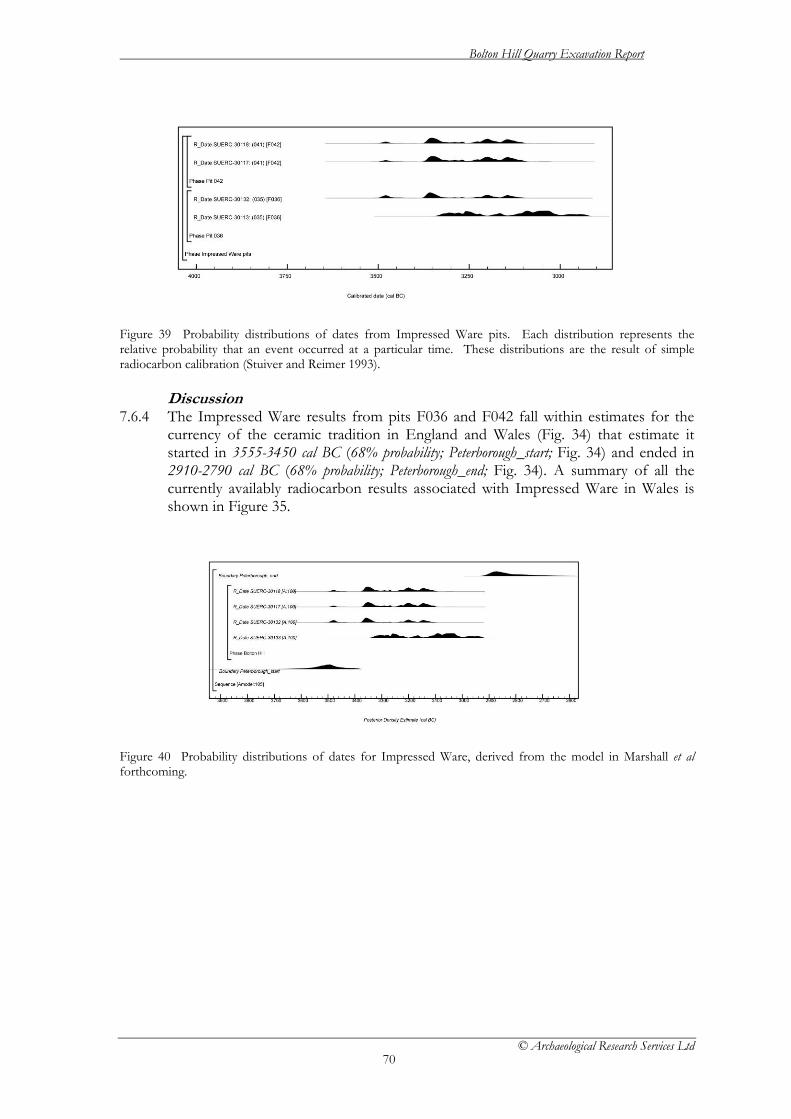
Bolton Hill Quarry Excavation Report
© Archaeological Research Services Ltd
70
Figure 39 Probability distributions of dates from Impressed Ware pits. Each distribution represents the relative probability that an event occurred at a particular time. These distributions are the result of simple radiocarbon calibration (Stuiver and Reimer 1993).
Discussion 7.6.4 The Impressed Ware results from pits F036 and F042 fall within estimates for the
currency of the ceramic tradition in England and Wales (Fig. 34) that estimate it started in 3555-3450 cal BC (68% probability; Peterborough_start; Fig. 34) and ended in 2910-2790 cal BC (68% probability; Peterborough_end; Fig. 34). A summary of all the currently availably radiocarbon results associated with Impressed Ware in Wales is shown in Figure 35.
Figure 40 Probability distributions of dates for Impressed Ware, derived from the model in Marshall et al forthcoming.
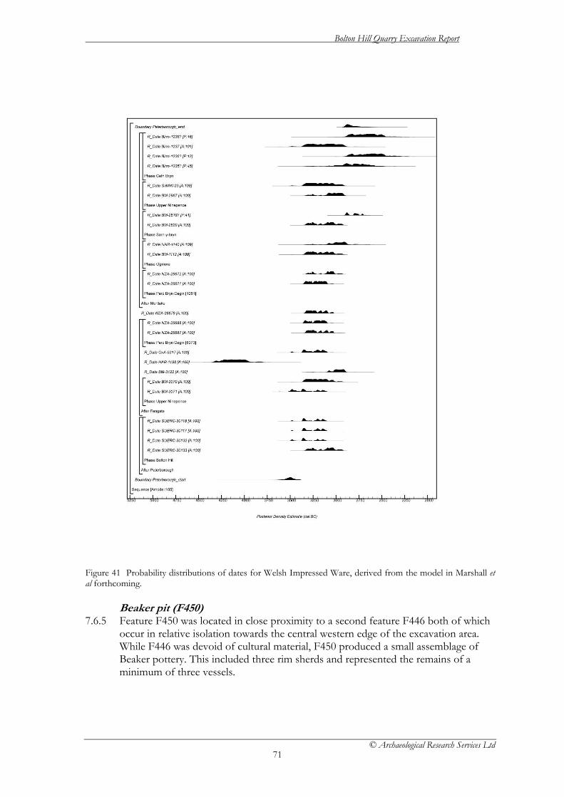
Bolton Hill Quarry Excavation Report
© Archaeological Research Services Ltd
71
Figure 41 Probability distributions of dates for Welsh Impressed Ware, derived from the model in Marshall et al forthcoming.
Beaker pit (F450) 7.6.5 Feature F450 was located in close proximity to a second feature F446 both of which
occur in relative isolation towards the central western edge of the excavation area. While F446 was devoid of cultural material, F450 produced a small assemblage of Beaker pottery. This included three rim sherds and represented the remains of a minimum of three vessels.
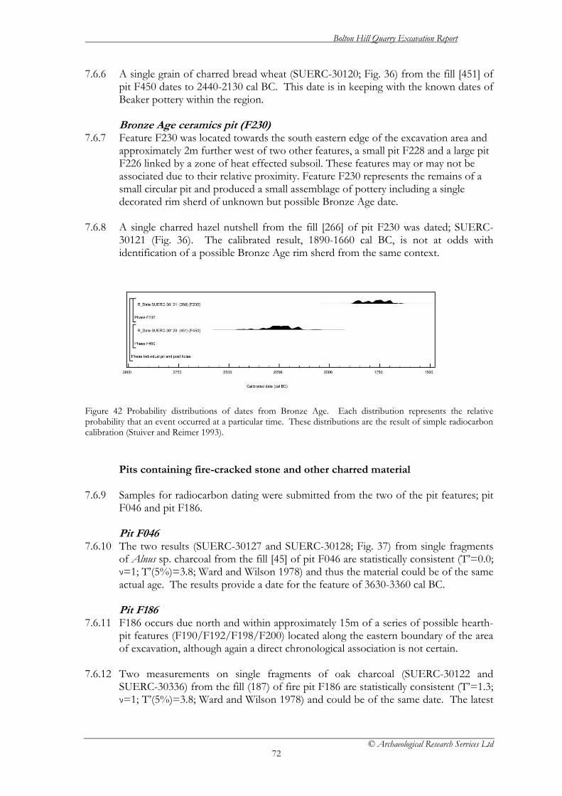
Bolton Hill Quarry Excavation Report
© Archaeological Research Services Ltd
72
7.6.6 A single grain of charred bread wheat (SUERC-30120; Fig. 36) from the fill [451] of pit F450 dates to 2440-2130 cal BC. This date is in keeping with the known dates of Beaker pottery within the region.
Bronze Age ceramics pit (F230)
7.6.7 Feature F230 was located towards the south eastern edge of the excavation area and approximately 2m further west of two other features, a small pit F228 and a large pit F226 linked by a zone of heat effected subsoil. These features may or may not be associated due to their relative proximity. Feature F230 represents the remains of a small circular pit and produced a small assemblage of pottery including a single decorated rim sherd of unknown but possible Bronze Age date.
7.6.8 A single charred hazel nutshell from the fill [266] of pit F230 was dated; SUERC-
30121 (Fig. 36). The calibrated result, 1890-1660 cal BC, is not at odds with identification of a possible Bronze Age rim sherd from the same context.
Figure 42 Probability distributions of dates from Bronze Age. Each distribution represents the relative probability that an event occurred at a particular time. These distributions are the result of simple radiocarbon calibration (Stuiver and Reimer 1993).
Pits containing fire-cracked stone and other charred material
7.6.9 Samples for radiocarbon dating were submitted from the two of the pit features; pit F046 and pit F186.
Pit F046
7.6.10 The two results (SUERC-30127 and SUERC-30128; Fig. 37) from single fragments of Alnus sp. charcoal from the fill [45] of pit F046 are statistically consistent (T’=0.0; ν=1; T’(5%)=3.8; Ward and Wilson 1978) and thus the material could be of the same actual age. The results provide a date for the feature of 3630-3360 cal BC.
Pit F186
7.6.11 F186 occurs due north and within approximately 15m of a series of possible hearth-pit features (F190/F192/F198/F200) located along the eastern boundary of the area of excavation, although again a direct chronological association is not certain.
7.6.12 Two measurements on single fragments of oak charcoal (SUERC-30122 and
SUERC-30336) from the fill (187) of fire pit F186 are statistically consistent (T’=1.3; ν=1; T’(5%)=3.8; Ward and Wilson 1978) and could be of the same date. The latest
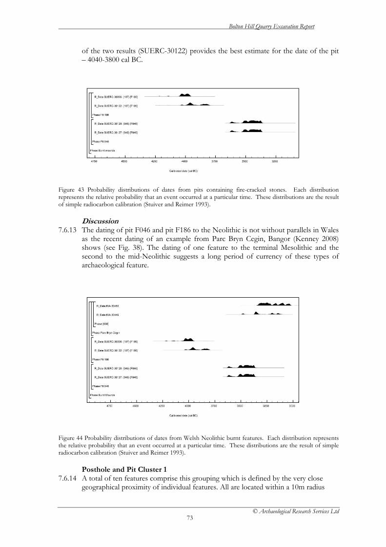
Bolton Hill Quarry Excavation Report
© Archaeological Research Services Ltd
73
of the two results (SUERC-30122) provides the best estimate for the date of the pit – 4040-3800 cal BC.
Figure 43 Probability distributions of dates from pits containing fire-cracked stones. Each distribution represents the relative probability that an event occurred at a particular time. These distributions are the result of simple radiocarbon calibration (Stuiver and Reimer 1993).
Discussion 7.6.13 The dating of pit F046 and pit F186 to the Neolithic is not without parallels in Wales
as the recent dating of an example from Parc Bryn Cegin, Bangor (Kenney 2008) shows (see Fig. 38). The dating of one feature to the terminal Mesolithic and the second to the mid-Neolithic suggests a long period of currency of these types of archaeological feature.
Figure 44 Probability distributions of dates from Welsh Neolithic burnt features. Each distribution represents the relative probability that an event occurred at a particular time. These distributions are the result of simple radiocarbon calibration (Stuiver and Reimer 1993).
Posthole and Pit Cluster 1 7.6.14 A total of ten features comprise this grouping which is defined by the very close
geographical proximity of individual features. All are located within a 10m radius

Bolton Hill Quarry Excavation Report
© Archaeological Research Services Ltd
74
towards the central north eastern section of the excavated area. Samples for radiocarbon dating were submitted from the two of the features comprising Posthole and Pit Cluster 1 – F296 and F310.
Pit F296
7.6.15 Two features, F288 and F296, form part of Posthole and Pit Cluster 1 situated towards the eastern centre of the excavated area. Feature F288 was located towards the south of the group and represents a small circular posthole that appears to have been much truncated by the plough. It contained a small amount of charred material in association with a small assemblage of relatively indistinct and consequently un-diagnostic body sherds and small crumbs. Approximately 2m west of feature F288 were the remains of a probable small pit or slightly larger posthole, feature F296. Feature F296 also produced a small quantity of charred material in association with a small assemblage of equally un-diagnostic ceramic body sherds.
7.6.16 Measurements on an indeterminate cereal grain (SUERC-30119) and a single
fragment of hazel charcoal (SUERC-30131) from the fill (297) of pit F296 are statistically consistent (T’=0.3; ν=1; T’(5%)=3.8; Ward and Wilson 1978) and could be of the same actual age. The latest of the two result (SUERC-30119) provides the best estimate for the date of the pit – 1020-820 cal BC.
Pit F310
7.6.17 Pit F310 was a small circular pit truncating or truncated by posthole [306]. Measurements on a grain of barley (SUERC-30129) and a single fragment of Alnus sp. charcoal (SUERC-30130) from the fill (311) of pit F310 are statistically consistent (T’=0.0; ν=1; T’(5%)=3.8; Ward and Wilson 1978) and could be of the same actual age. The latest result (SUERC-30130) provides the best estimate for the date of the pit – 1050-830 cal BC
Discussion
7.6.18 All four measurements from pits F296 and F410 (Fig. 39) are statistically consistent (T’=0.4; ν=3; T’(5%)=7.8; Ward and Wilson 1978) and could therefore be of the same actual age. Thus it is likely that the features comprising Posthole and Pit Cluster 1 represent a very short period of activity dating from the late Bronze Age.
Figure 45 Probability distributions of dates from Posthole and Pit Cluster 1. Each distribution represents the relative probability that an event occurred at a particular time. These distributions are the result of simple radiocarbon calibration (Stuiver and Reimer 1993).

Bolton Hill Quarry Excavation Report
© Archaeological Research Services Ltd
75
Posthole and Pit Cluster 2 7.6.19 Posthole and Pit Cluster 2 is defined by the very close physical proximity of
constituent members, all of which occur within a 5m radius of each other, and includes a total of seven features. It was located within a central northern section of the excavated area. Samples for radiocarbon dating were submitted from the two of the features comprising Posthole and Pit Cluster 2 – pit F318 and pit F322.
Pit F318
7.6.20 Feature F318 constitutes a small, sub-circular pit and produced a small assemblage of pottery identical in fabric but less diagnostic than that recovered from F362. Feature F362 was located approximately 1.5m north east of F318. It also produced a small assemblage of pottery including several rim sherds identified with the Grooved Ware tradition. The assemblage from both pits appear almost identical in terms of fabric and may indeed derive from the same vessel although no refit was possible
7.6.21 Measurements on two single fragments of hazel charcoal (SUERC-30138 and
SUERC-30139; Fig. 40) from the fill (319) of pit F318 are statistically consistent (T’=2.8; ν=1; T’(5%)=3.8; Ward and Wilson 1978) and could be of the same age. These dates; 2460-2130 cal BC (SUERC-30139) and 2280-1980 cal BC (SUERC-30138) would be very late for the current estimates for the currency of Grooved Ware (Marshall and Barclay unpublished).
Post hole F322
7.6.22 Features F320, F322 and F354 represent the remains of three probable postholes which appeared to be loosely arranged in a triangle around hearth-pit feature F324.
7.6.23 Measurements on two single charred barley grains (SUERC-30133 and SUERC -
30137; Fig. 40) from fill (323) of posthole F322 are statistically consistent (T’=0.5; ν=1; T’(5%)=3.8; Ward and Wilson 1978) and could be of the same actual age. The latest of the two results (SUERC-30133) provides the best estimate for the date of the pit – 2150-1910 cal BC
Discussion
7.6.24 Although the four measurements from pits F322 and F318 (Fig. 40) are not statistically consistent (T’=8.1; ν=3; T’(5%)=7.8; Ward and Wilson 1978) they only just fail a chi-squared test. It is thus likely that the features comprising Posthole and Pit Cluster 1 represent a relatively short period of activity dating from the early Bronze Age.

Bolton Hill Quarry Excavation Report
© Archaeological Research Services Ltd
76
Figure 46 Probability distributions of dates from post hole and pit cluster 2. Each distribution represents the relative probability that an event occurred at a particular time. These distributions are the result of simple radiocarbon calibration (Stuiver and Reimer 1993).
Ditched enclosure (F364) 7.6.25 The single ditched enclosure towards the extreme southern extent of the
development area was approximately 15m in length by 9m wide and consisted of two parallel ditches running along an east west axis approximately 4m apart. A radiocarbon measurement on single fragment of oak charcoal in the fill of ditch, SUERC-30123 (Fig. 41), of cal AD 1480-1800 provides a post-medieval date for the enclosure.
Figure 47 Probability distributions of dates from the ditched enclosure. Each distribution represents the relative probability that an event occurred at a particular time. These distributions are the result of simple radiocarbon calibration (Stuiver and Reimer 1993). 7.7 Conclusions 7.7.1 The results of the radiocarbon dating programme can be summarised as follows:
• The date of the pits (F036 and F042) containing Impressed Ware ceramics fall within the current estimated currency for this pottery tradition and add to a growing corpus of measurements from Wales.
• The pit (F450) containing the Beaker ceramics fall within the current estimated currency for this pottery tradition.
• The pit (F230) containing a possible Bronze Age decorated rim sherd was dated to 1890-1660 cal BC
• The two pits containing fire-cracked stones are of different dates dating to the terminal Mesolithic-early Neolithic and the mid-Neolithic periods.
• The two pit and posthole clusters are of very different ages being from the early and late Bronze Age respectively.
• The ditched enclosure has been dated to the post-medieval period.

Bolton Hill Quarry Excavation Report
© Archaeological Research Services Ltd
77
Table 15. Radiocarbon results from Bolton Hill Laboratory Number
Feat. No.
Cont. Sample Context Interpretation RC Age (BP)
δ13C (‰)
Calibrated date 95% confidence
Pottery producing pits Impressed Ware SUERC-30113 F036 (35) Carbonised
hazelnut, Corylus sp.
A medium sized circular pit that contained a small assemblage of Impressed Ware pottery and a small quantity of struck flint
4440±40 -26.3 3340–2920 cal BC
SUERC-30132 F036 (35) Charcoal, Alnus sp.
As SUERC-30113 4575±40 -26.6 3500–3110 cal BC
SUERC-30117 F042 (41) Carbonised hazelnut, Corylus sp.
A small and shallow circular pit that contained a small assemblage of Impressed Ware pottery
4555±40 -25.3 3490–3100 cal BC
SUERC-30118 F042 (41) Carbonised hazelnut, Corylus sp.
As SUERC-30117 4560±40 -24.7 3500–3100 cal BC
Carinated Bowl SUERC-30120 F450 (451) Carbonised
bread wheat: Triticum sp.
A small sub-oval pit which included three rim sherds of unidentified prehistoric ceramic
3805±40 -24.5 2440–2130 cal BC
? Bronze Age SUERC-30121 F230 (266) Carbonised
hazelnut, Corylus sp.
A small circular pit which contained a small rim sherd of possible Bronze Age association
3450±40 -23.0 1890–1660 cal BC
Burnt mounds/pits SUERC-30127 F046 (45) Charcoal,
Alnus sp. A large sub-circular pit 4680±40 -26.2 3630–3360
cal BC SUERC-30128 F046 (45) Charcoal,
Alnus sp. As SUERC-30127 4675±40 -25.9 3630–3360
cal BC SUERC-30122 F186 (187) Charcoal,
Quercus spp. A small circular pit 5135±40 -27.3 4040–3800
cal BC SUERC-30336 F186 (187) Charcoal,
Quercus spp. As SUERC-30122 5200±40 -26.6 4150–3950
cal BC Post Hole & Pit Cluster 1 SUERC-30119 F296 (297) Carbonised
grain: indet. cereal
A medium sized sub-oval pit 2775±40 -24.0 1020–820 cal BC
SUERC-30131 F296 (297) Charcoal, Corylus sp.
As SUERC-30119 2805±40 -27.5 1060–840 cal BC
SUERC-30129 F310 (311) Carbonised grain, Hordeum vulgare
Fill of pit 311 part of post hole and pit cluster 1
2805±40 -22.9 1060–840 cal BC
SUERC-30130 F310 (311) Charcoal, Alnus sp.
As SUERC-30129 2795±40 -26.3 1050–830 cal BC
Post Hole & Pit Cluster 2 SUERC-30133 F322 (323) Carbonised
grain, Hordeum vulgare
A small sub-circular post hole, part of a small triangular cluster of post holes
3655±40 -24.2 2150–1910 cal BC
SUERC-30137 F322 (323) Carbonised grain, Hordeum vulgare
As SUERC-30133 3695±40 -24.6 2210–1950 cal BC
SUERC-30138 F318 (319) Carbonised hazelnut, Corylus sp.
A small circular pit containing a small assemblage of Grooved Ware
3715±40 -25.0 2280–1980 cal BC
SUERC-30139 F318 (319) Carbonised hazelnut, Corylus sp.
As SUERC-30138 3810±40 -24.0 2460–2130 cal BC

Bolton Hill Quarry Excavation Report
© Archaeological Research Services Ltd
78
Ditched enclosure SUERC-30123 F364 (365) Charcoal,
Quercus spp. A ditched enclosure 285 ±40 -23.1 cal AD
1480–1800

Bolton Hill Quarry Excavation Report
© Archaeological Research Services Ltd
79
8. Discussion 8.1 The results of this excavation are of significance to research into the Neolithic and
Bronze Age periods in Wales in particular, and in Britain more widely, particularly given the radiometric dating associated with the ceramics and possible structures, with additional activity in the post-medieval period. The results will also be of use in developing understanding of Middle and Later Neolithic settlement, as the tradition of burial of domestic midden material shown at Bolton Hill Quarry is in keeping with other sites in Wales, such as Parc Bryn Cegin (Kenney 2008), as well as further afield at sites such as far away as Kilverstone, Norfolk (Garrow et al. 2005) and Cheviot and Lanton Quarries in Northumberland (Johnson and Waddington 2009; Waddington 2010).
Late Mesolithic/Early Neolithic
8.2 Evidence for activity occurring at Bolton Hill during the transitional Mesolithic-Neolithic transition is shown by the radiocarbon dates returned from a pit containing burnt material F187, which formed part of a cluster of possible hearths, along with four others. The dates of 4040-4010 cal BC, 4000-3890 cal BC, 3880-3790 cal BC or 4230-4200 cal BC, 4170-4120 cal BC, 4080-3940 cal BC at 95% probability (5135±40 BP, SUERC-30122 and 5200±40 BP, SUERC-30336), whilst taken from oak charcoal, place the burning activity firmly in the earliest part of the 4th millennium BC, which makes this feature (and possible the four other similar features) highly significant. Recent radiocarbon dating analysis undertaken by Alex Bayliss (Whittle et al. in press) for South Wales posits the start of the Neolithic in South Wales at 3765 -3655 cal BCC (95% probability), so the evidence from this pit at Bolton Hill indicates occupation of some form either during the terminal part of the Mesolithic or the earliest part of the Neolithic. The lack of any material culture from this feature, or from the site as a whole, dating to the early 4th millennium cal BC, makes interpreting the nature of this occupation difficult. F187 did contain a large amount of fire-cracked stones. The dates derived from the feature, together with the lack of evidence for a trough or any kind of lining clearly indicate that the burnt material is not from a burnt mound, which are typically of Bronze Age date, and therefore must be associated with some other form of heating activity, possibly for culinary purposes, during the terminal phase of the Mesolithic or Early Neolithic. A similar type of pit was encountered within a group of dated Neolithic pits at Cheviot Quarry, Northumberland (Johnson and Waddington 2009).
Mid Neolithic
8.3 The excavations at Bolton Hill Quarry have added significant information to the understanding of Neolithic occupation in southern Wales. Recent excavations at Parc Bryn Cegin (Kenney 2008) have produced similar evidence for pits and pit groups containing pottery and other remnants of domestic activity. At Parc Bryn Cegin however, the features appear to be part of more regular pit clusters, forming triangular, oval and linear arrangements, as opposed to the isolated pits and amorphous clusters discovered at Bolton Hill Quarry. Based on evidence from Parc Bryn Cegin and further afield (e.g. Garrow 2006) the practice of using midden pits by placing deposits of broken and used material within them continues throughout the Neolithic until around 2400 cal BC, at which point they become increasingly rare, and the excavated features and associated radiocarbon dates from Bolton Hill Quarry fall within this tradition.
Bolton Hill Quarry Excavation Report
© Archaeological Research Services Ltd
80
8.4 It is therefore argued that the archaeology from Bolton Hill Quarry primarily represents domestic settlement activity even though there is an absence of any obvious dwelling structures. None of the pits, hearths and post-holes can be neatly grouped into a building form, such as the earlier Neolithic buildings known from Parc Bryn Cegin (Kenney 2008), Gwernvale, Powys (Britnell and Savory 1984) and the Clegyr Boia, Pembrokeshire (Williams 1952). However, the evidence from the midden pits at Bolton Hill Quarry shows clear evidence of widespread human activity across the site which, given the complete absence of any obviously ritualised component of deposition, beyond the practice of burying midden itself, would be typically associated with settlement activity. The material culture, comprising broken, locally-produced ceramics with adhering animal fats probably indicating dairy products, undiagnostic lithics and small quantities of cereal grains is suggestive of domestic, rather than a more prosaic function, for the pits. However, even though there was no direct evidence for placed deposits within the pit fills, the deliberate burial of midden material is clearly a routine practice, and this in itself indicates the integration of structured routines and ideologically driven practice into what is ostensibly domestic practice.
8.5 It is possible that the lack of structural features associated with the midden pits
indicates a shift in domestic architectural styles from the Early Neolithic rectangular timber structures, such as the Llandygai I (Lynch 2001) and Llandygai II buildings (Kenney 2008), towards a more ephemeral architectural form, which has not yet been recognised in the archaeological record. It is also possible that the foundations for such structures simply haven’t survived the plough, an interpretation which, given the heavily truncated nature of most the archaeological features at Bolton Hill, is considered to be a possibility, especially given the presence of numerous apparently isolated postholes distributed across the site. Alternatively, the idea that there never were any structures associated with these midden pits must also be considered a possibility.
8.6 The dating programme has supplied radiocarbon dates on Impressed Ware which
will contribute to the emerging understanding of the period of use of this ceramic style in southern Wales. The radiocarbon dates retrieved from the site are taken primarily from short-lived samples, such as charred hazelnut shell fragments, directly associated with the ceramics. The dates show Impressed Ware being used on the site in the second half of the 3rd millennium BC, between 3500 cal BC and 2980 cal BC (see radiocarbon dating table for full details). These fit within the recently established chronology for Impressed Wares (Peterborough Ware) by Whittle et al. (in press), which places the start date for Peterborough Ware between 3615 – 3140 cal BC and the end of use at 2915 – 2670 cal BC (both at 95 % probability).
Chalcolithic/Beaker Period
8.7 The excavations have revealed limited evidence of Chalcolithic period occupation on the site, including possible evidence of a structural feature comprising pits and postholes. Following Needham, the term Chalcolithic is used here to denote the latter part of the 3rd millennium cal BC, which can also be termed the ‘Beaker period’. However, the presence of Neolithic-derivative pottery, as well as Beaker ceramics, makes it more appropriate to use a more generic term for the activity on site, rather than one which purely indicates “Beaker” activity.

Bolton Hill Quarry Excavation Report
© Archaeological Research Services Ltd
81
8.8 The possible structure, in which the component parts were located within a 5m radius, may represent the heavily truncated remains of a building, although the distribution of the features do not readily lend themselves to an obvious structural interpretation and further postholes may well have been lost to the plough. It is possible that the feature represents a similar type of structure to that excavated at Whitton Park, Nortumberland, which comprised a triangular arrangement of postholes radiocarbon dated to c. 2100 cal BC (Waddington 2006). The grouping of features at Bolton Hill has produced radiometric dates of 2460-2130 cal BC, 2280-2250 cal BC, 2210-2010 cal BC, 2000-190 cal BC, 2200-1960 cal BC or 2140-1910 cal BC (3810±40 BP, SUERC-30139; 3715±40 BP, SUERC-30138; 3695±40, SUERC-30137; 3655±40, SUERC-30133) from a pit feature and a posthole and limited amounts of Neolithic-derivative pottery were also recovered from the aforementioned pit, as well as another very heavily truncated pit. An additional radiometric date of 2460-2360 cal BC or 2350-2130 cal BC at 95% probability (3805±40 BP, SUERC-30120) was gained from a small pit which contained Beaker pottery which was located in isolation in the centre of the site.
8.9 This activity is considered to represent domestic settlement, given the presence of
broken ceramics of local production with adhering animal fats from cooking, and perhaps indicates a change in building form from the mid-Neolithic period on the site, for which no apparent structural features survive. However, triangular and trapezoidal post-built structures dating from the Neolithic period have been recognised in the archaeological record, as evidenced at sites such as Lanton Quarry (Stafford and Johnson, unpub.) Bolam Lake (Waddington and Davies 2002) and Whitton Park (Waddington 2006) with dates ranging from the early 4th millennium cal BC to the end of the 3rd millennium cal BC for similar types of structural features. The possible building at Bolton Hill Quarry would fit comfortably within this building tradition.
Early Bronze Age
8.10 There is very limited evidence of early Bronze Age activity, comprising one pit dated to 1890 – 1660 cal BC, associated with seven ceramic sherds, which were considered highly likely to have been produced in the immediate vicinity of the quarry. Little interpretative value can be placed on this isolated feature, but it may indicate small-scale early Bronze Age activity in this part of the landscape.
Late Bronze Age
8.11 Evidence for late Bronze Age activity comes from Pit and Posthole Cluster 1, which may represent the truncated remains of a small, Late Bronze Age structure. This U-shaped grouping of features, measuring approximately 5m in diameter, with other associated structures lying outside this arrangement, appeared to have an opening to the north-east. However, given that the features became increasingly truncated to the north, it is possible that further evidence of this structure has been lost. Radiometric determinations, on short-lived species and cereal grains, showed the features date to 1070-830 cal BC or 1020-820 cal BC at 95% probability (2775±40, SUERC-30119; 2805±40, SUERC-30131 and SUERC-30129; 2795±40, SUERC-30130). A few small, worn sherds of plain wares were recovered from a posthole and a small pit within this grouping of features. Whilst the function of this cluster of features is unclear, it is considered to most likely represent a badly truncated, and partially destroyed, Late Bronze Age building, possibly associated with domestic settlement,

Bolton Hill Quarry Excavation Report
© Archaeological Research Services Ltd
82
given the presence of cereal grains and undecorated ceramics within the posthole fills.
Post-Medieval
8.12 The final phase of activity identified at Bolton Hill Quarry is represented by the ditched enclosure at the southern end of the site, which measured 15m in length and 9m in width. A radiocarbon determination of 1480-1670 cal AD or 1780-1800 cal AD at 95% probability (285±40 cal BP, SUERC 30123) was obtained for this structure, placing it within the late medieval to post-medieval period. There may be an old wood offset on this date as well, as the result came from a piece of oak charcoal, so it is highly likely that the feature is post-medieval in origin. The lack of structural evidence, material culture, or other distinguishing features, along with the heavily truncated nature of the remains, makes any interpretation of this enclosure almost impossible.
9 Conclusions 9.1 The results of the excavations at Bolton Hill Quarry have provided significant
evidence for the development of settlement activity from the terminal Mesolithic or earliest Neolithic period, the Middle Neolithic, Chalcolithic/Beaker period, Early Bronze Age and Late Bronze Age for southern Wales, and which will also contribute to enhancing the wider corpus of material and chronology-building for the British Isles generally.
9.2 This report documents the full results of the excavation and analysis, including the
results of radiocarbon dating and ceramic analysis. A full publication is being submitted to Archaeologia Cambrensis. The archive will be deposited in the national Museum of Wales.
10 Publicity, Confidentiality and Copyright 10.1 Any publicity will be handled by the client. 10.2 Archaeological Research Services Ltd will retain the copyright of all documentary and photographic material under the Copyright, Designs and
Patent Act (1988).
11 Statement of Indemnity 11.1 All statements and opinions contained within this report arising from the
works undertaken are offered in good faith and compiled according to professional standards. No responsibility can be accepted by the author/s of the report for any errors of fact or opinion resulting from data supplied by any third party, or for loss or other consequence arising from decisions or actions made upon the basis of facts or opinions expressed in any such report(s), howsoever such facts and opinions may have been derived.

Bolton Hill Quarry Excavation Report
© Archaeological Research Services Ltd
83
12 Acknowledgements
12.1 Archaeological Research Services Ltd would like to thank our client, Mr Tony Gilman of F. H. Gilman and Co for facilitating our work. Thanks are also expressed to Charles Hill at Dyfed Archaeological Trust
13 References Ashmore, P, 1999 Radiocarbon dating: avoiding errors by avoiding mixed samples, Antiquity, 73, 124–30 Bradley, R, 2007 The Prehistory of Britain and Ireland, Cambridge University Press Britnell, W J and Savory, H N, 1984 Gwernvale and Penywyrlod: Two Neolithic long cairns in the Black Mountains of Brecknock, Cambrian Archaeological MonographsNo. 2, Cambrian Archaeological Association Bronk Ramsey, C, 1995 Radiocarbon calibration and analysis of stratigraphy: The OxCal program, Radiocarbon, 37, 425–30 Bronk Ramsey, C, 1998 Probability and dating, Radiocarbon, 40, 461–74 Bronk Ramsey, C, 2001 Development of the radiocarbon program OxCal, Radiocarbon, 43, 355–363 Bronk Ramsey, C, 2009 Bayesian analysis of radiocarbon dates, Radiocarbon, 51(1), 337–60 Cantril T.C. and Jones, O.C. 1911 Prehistoric cooking: Places and hearths in South Wales. Archaeologia Cambrensis. 6th Series 11, 253-286. Crane, P. 2004 Bolton Hill Quarry, Pembrokeshire: Interim evaluation report. Archaeoleg Cambria Archaeology Field Operations unpublished report Garrow, D, Beardsmore, E, and Knight, M 2005 Pit clusters and the temporality of occupation: an Earlier Neolithic site at Kilverstone, Thetford, Norfolk, Proceedings of the. Prehistoric Society, 71, 139–57 Garrow, D 2006 Pits, Settlement and Deposition during the Neolithic and Early Bronze Age in East Anglia, Oxford: Brit. Archaeol. Rep. Brit. Ser., 414 Johnson, B, and Waddington, C 2008 Prehistoric and Dark Age Settlement Remains from Cheviot Quarry, Milfield Basin, Northumberland. Archaeological Journal 165, 107-264 Kenney, J, 2008 Recent excavations at Parc Bryn Cegin Llandygai near Bangor, North Wales, Archaeologia Cambrensis 157, 9–142 Lynch, F and Musson, C 2001 A prehistoric and early medieval complex at Llandegai, near Bangor, North Wales, Archaeologia Cambrensis 150, 17-142

Bolton Hill Quarry Excavation Report
© Archaeological Research Services Ltd
84
Marshall, P D, Hamilton, W D, Woodward, A, Beamish, M, and Waddington, C, forthcoming A precise chronology for Peterborough Ware? Mook, W G, 1986 Business meeting: recommendations/resolutions adopted by the Twelfth International Radiocarbon Conference, Radiocarbon 28, 799 Page, N and Wilson, H. 1999 Bolton Hill Quarry: Archaeological Assessment and Field Evaluation. Archaeoleg Cambria Archaeology Field Operations unpublished report. Reimer, P J, Baillie, M G L, Bard, E, Bayliss, A, Beck, J W, Blackwell, P G, Bronk Ramsey, C, Buck, C E, Burr, G S, Edwards, R L, Friedrich, M, Grootes, P M, Guilderson, T P, Hajdas, I, Heaton, T J, Hogg, A G, Hughen, K A, Kaiser, K F, Kromer, B, McCormac, F G, Manning, S W, Reimer, R W, Richards, D A, Southon, J R, Talamo, S, Turney, C S M, van der Plicht, J, and Weyhenmeyer, C E, 2009 IntCal09 and Marine09 radiocarbon age calibration curves, 0–50,000 years cal BP, Radiocarbon, 51(4), 1111–50 Reynold, P, 1995 The life and death of a post-hole, Interpreting Stratigraphy, 5, 21–5 Scott, E M, 2003 The third international radiocarbon intercomparison (TIRI) and the fourth international radiocarbon intercomparison (FIRI) 1990 – 2002: results, analyses, and conclusions, Radiocarbon, 45, 135–408 Slota, Jr P J, Jull, A J T, Linick, T W, and Toolin, L J, 1987 Preparation of small samples for 14C accelerator targets by catalytic reduction of CO, Radiocarbon, 29, 303–6 Stenhouse, M J, and Baxter, M S, 1983 14C dating reproducibility: evidence from routine dating of archaeological samples, PACT, 8, 147–61 Stuiver, M, and Kra, R S, 1986 Editorial comment, Radiocarbon, 28(2B), ii Stuiver, M, and Polach, H A, 1977 Reporting of 14C data, Radiocarbon, 19, 355–63 Stuiver, M, and Reimer, P J, 1986 A computer program for radiocarbon age calculation, Radiocarbon, 28, 1022–30 Stuiver, M, and Reimer, P J, 1993 Extended 14C data base and revised CALIB 3.0 14C age calibration program, Radiocarbon, 35, 215–30 Waddington, C 2006 A Neolithic–Early Bronze Age settlement at 3 Whitton Park, Milfield, Northumberland, Archaeologia Aeliana, fifth ser., 35, 11–25 Waddington, C and Davies, J 2002 Excavation of a Neolithic settlement and late Bronze Age burial cairn near Bolam Lake, Northumberland, Archaeologia Aeliana, fifth ser., 30, 1–47 Ward, G K, and Wilson, S R, 1978 Procedures for comparing and combining radiocarbon age determinations: a critique, Archaeometry, 20, 19–31 Whittle, A, Healy, F, and Bayliss, A, in press Gathering time: dating the early Neolithic enclosures of southern Britain and Ireland, Oxford (Oxbow)

Bolton Hill Quarry Excavation Report
© Archaeological Research Services Ltd
85
Williams, A 1952 Clegyr Boia, St David’s (Pembrokeshire): excavations in 1943, Archaeologia Cambrensis 102, 20-47 Williams, G. 1995 A pilot assessment of the burnt mounds in Dyfed. DAT report 35851. Llandeilo Xu, S, Anderson, R, Bryant, C, Cook, G T, Dougans, A, Freeman, S, Naysmith, P, Schnabel, C, and Scott, E M, 2004 Capabilities of the new SUERC 5MV AMS facility for 14C dating, Radiocarbon, 46, 59–64

Appendix 1
Bolton Hill Quarry Ceramics Report By Adam S. Tinsley and Clive Waddington
1. Introduction 1.1 A total of 130 prehistoric pottery sherds, weighing a combined total of
approximately 735 grams (g), were recovered during excavations at Bolton Hill Quarry deriving from 12 individual features, the majority of which were small to medium sized pits or post holes and a small, single-ditched enclosure. The corpus, while comparatively small, contains material from at least four different ceramic traditions encompassing Impressed Ware, Beaker and Neolithic derivative pottery, Early Bronze Age material and Late Bronze Age material. Given the relative scarcity of finds of these traditions in Wales, the Bolton Hill Quarry assemblage constitutes a significant and important addition to the archaeological record, and particularly given the associated radiocarbon dating.
2. Method Statement 2.1 The pottery recovered during excavation was removed directly from the
excavated deposits and placed in acid-free paper before being individually wrapped in bubble wrap and then bagged and labelled in polythene bags. On return to the laboratory the pottery was lightly cleaned under running water and then left to air dry before being lightly brushed with a soft sable brush to remove excess soil.
2.2 The sherds were subsequently laid out by context and individually analysed and
grouped on the basis of fabric, size and form as well as the minimum number of vessels represented.
2.3 Visual inspection of the material was undertaken using a x10 hand held
magnifying glass. Fabric types were assessed based upon this level of examination and divided according to the type and quantity of identifiable deliberate inclusions noted across the surface of the sherds as well as within the edges of the breaks.
2.4 A summary of the fabric types encountered within the assemblage is listed in
Table 1 below.
2.5 No further cleaning or washing was undertaken so as to allow for the future possibility of residue analysis. The sherds that could be conjoined were glued together using a waterproof solvent-based adhesive.

Fabric Code Description Q1 Rare (<4%) quartz blocks, angular to sub-angular, moderately well sorted, the majority are
>4mm in size with some between 6-9mm. Q2 Common (>5%) quartz blocks, angular to sub-angular, moderately well sorted, the majority
are >5mm in size with some >9mm Q3 Rare (>3%) finely crushed quartz, small blocks <2mm in size well sorted. St1 Rare (>4%) unidentified stone inclusions, large angular to sub-angular blocks >7mm in
size. Rare (<3%) finely crushed inclusions may also be noted and possibly indicate a chalk component to the temper.
NI No visible temper inclusions. In some cases a slight waxy feeling to the sherds may indicate the use of grog although no such temper was recorded across the surface of the sherds or in cross section. Occasional voids were noted in relation to a limited number of sherds and could also indicate the use of mineral or organic agents that have since leached from the fabric. Such variations are noted in relation to the specific examples.
Table 1. Summary of the main fabric types.

3. Impressed Ware 3.1 Quantity and location 3.1.1 The assemblage is represented by a total of 42 sherds, having a combined weight
of 424.32g, deriving from two different pit features (F036 and F042) located towards the northern edge of the site in close proximity to one another. They were also located near a single possible post hole (F028) and the ploughed out remains of a pit containing a large quantity of fire-cracked stones and charred wood fragments (F046) which radiocarbon dating suggests could be contemporary with the Impressed Ware pits (see dating section of the main report above). It is worth noting that there was no evidence for in situ burning in the pit, but rather that the burnt material had been deposited in it after having been burnt elsewhere.
3.1.2 F042 appeared to have particularly suffered under the plough and was relatively
shallow compared to F036. Despite this it produced the greater proportion of the Impressed Ware assemblage, as well as some of the more diagnostic material which included several rim sherds. It produced a total of 33 sherds weighing a total of 283.62g and representing an estimated two vessels.
3.1.3 Feature F036 by contrast produced only nine sherds weighing a total of 140.7g,
all of which are body sherds including one good example from a section of a carinated shoulder. Differences in decoration and colour would suggest the presence of two possible vessels.
3.1.4 While no refits are possible between the two features, or indeed within each sub-
corpus, it is possible that the material collectively derives from the same vessels, and if this is the case then a minimum of two or three vessels is represented. However, given the different contexts and the lack of any joins this is considered less likely and hence the Impressed Ware material is likely to represent a minimum of four vessels.
Feature and Context
Vessel Number
Small Find Number/s
Weight (g) and quantity
Description
1 42, 44 2 sherds, 28.5g Two decorated body sherds in fabric Q1 with a light yellowish brown colour. Decorated with finger nail impressions set vertically side by side within several horizontal rows. Decoration and colour varies from other material from the same context and may subsequently indicate a different vessel although they may also derive from a differently decorated zone on the same vessel.
Feature F036, a large circular pit within 5m of F042
2 38-41, 43, 46 7 sherds, 112.14g
Six body sherds, the majority of which are decorated. One sherd derives from a section of a Carinated shoulder and is decorated with short lengths of twisted cord impressions set vertically side by side in at least three horizontal rows, one above the shoulder within the neck and two on the body below the shoulder. Each row appears to be separated by further impressions of longer single lengths of
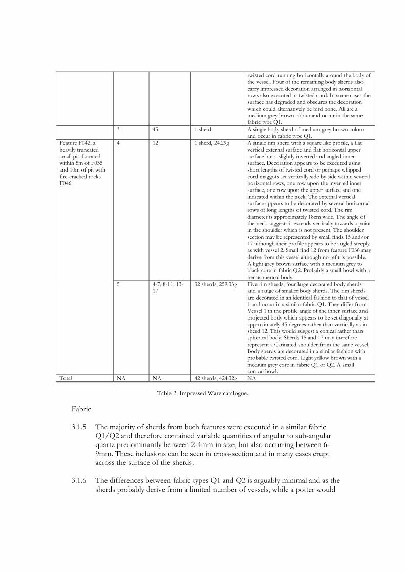
twisted cord running horizontally around the body of the vessel. Four of the remaining body sherds also carry impressed decoration arranged in horizontal rows also executed in twisted cord. In some cases the surface has degraded and obscures the decoration which could alternatively be bird bone. All are a medium grey brown colour and occur in the same fabric type Q1.
3 45 1 sherd A single body sherd of medium grey brown colour and occur in fabric type Q1.
4 12 1 sherd, 24.29g A single rim sherd with a square like profile, a flat vertical external surface and flat horizontal upper surface but a slightly inverted and angled inner surface. Decoration appears to be executed using short lengths of twisted cord or perhaps whipped cord maggots set vertically side by side within several horizontal rows, one row upon the inverted inner surface, one row upon the upper surface and one indicated within the neck. The external vertical surface appears to be decorated by several horizontal rows of long lengths of twisted cord. The rim diameter is approximately 18cm wide. The angle of the neck suggests it extends vertically towards a point in the shoulder which is not present. The shoulder section may be represented by small finds 15 and/or 17 although their profile appears to be angled steeply as with vessel 2. Small find 12 from feature F036 may derive from this vessel although no refit is possible. A light grey brown surface with a medium grey to black core in fabric Q2. Probably a small bowl with a hemispherical body.
Feature F042, a heavily truncated small pit. Located within 5m of F035 and 10m of pit with fire-cracked rocks F046
5 4-7, 8-11, 13-17
32 sherds, 259.33g Five rim sherds, four large decorated body sherds and a range of smaller body sherds. The rim sherds are decorated in an identical fashion to that of vessel 1 and occur in a similar fabric Q1. They differ from Vessel 1 in the profile angle of the inner surface and projected body which appears to be set diagonally at approximately 45 degrees rather than vertically as in sherd 12. This would suggest a conical rather than spherical body. Sherds 15 and 17 may therefore represent a Carinated shoulder from the same vessel. Body sherds are decorated in a similar fashion with probable twisted cord. Light yellow brown with a medium grey core in fabric Q1 or Q2. A small conical bowl.
Total NA NA 42 sherds, 424.32g NA
Table 2. Impressed Ware catalogue.
Fabric 3.1.5 The majority of sherds from both features were executed in a similar fabric
Q1/Q2 and therefore contained variable quantities of angular to sub-angular quartz predominantly between 2-4mm in size, but also occurring between 6-9mm. These inclusions can be seen in cross-section and in many cases erupt across the surface of the sherds.
3.1.6 The differences between fabric types Q1 and Q2 is arguably minimal and as the
sherds probably derive from a limited number of vessels, while a potter would

attempt an even seeding, in this case the slight variation probably represents the uneven distribution of temper throughout individual vessels rather than cause for further division in terms of numbers represented.
3.1.7 The colour of sherds varies slightly across the assemblage from a light yellow to a
medium grey-brown surface with a medium grey or black core. 3.1.8 The use of quartz, while reflecting the local geology, is undoubtedly a deliberate
addition as an opening agent and moreover depicts a trait common to the Impressed Ware tradition across Wales (Gibson 1995) and extending into areas of the north-east midlands of England and beyond (Tinsley 2009). The exposure of such inclusions across the surface of the vessel would also seem to be intentional and could potentially carry a cosmological significance linked to the visual characteristics of the material (Gibson 1995, 29; 1998, 60).
Form 3.1.9 As discussed above, two almost identical rim forms may be represented within
the assemblage. Both carry a square shaped profile with a flat, vertical, external surface and a flat horizontal upper surface, as well as an angled inverted internal surface.
3.1.10 Where the two forms may perhaps be distinguished relates to the angle of the
neck and body as it projects relative to the rim. In vessel 1 the angle of the neck appears to be almost vertical while in vessel 2 this appears to be set at an angle. In the first instance the projected line of the body would be more in keeping with perhaps a carinated spherical body, while in the later the overall shape of the vessel appears more in keeping with a conical form. The two vessels may also be distinguished by a slight variation in relation to the overall diameter of the respective rim sherds, vessel 1 measuring approximately 18cm across and vessel 2 measuring approximately 16cm across.
3.1.11 It is possible that such variation could occur within a single vessel, and as such
the two vessels as currently defined do appear to share identical decoration and fabric. However, if this were the case the variation along the diameter of the singular vessel would perhaps be extreme and while such skewed shapes are not unknown, the large Fengate jar from Icklingham, Suffolk, for example (Piggott 1954), it certainly would be uncommon.
3.1.12 The squared profile of the rim together with the inverted internal surface are not
particularly diagnostic of the mainstream Impressed Ware typology as set out by Smith (1956). However, some precedents do exist and parallels may be drawn with material from other Welsh sites such as vessel 26 from Gwernvale (Britnell and Savory 1984, Figure 41, 104; Gibson 1995), Ogmore (Gibson 1995, Fig 3.2.9, 26; 1998, Figure 4.16, 61) and Bryn yr Hen Bobl (Lynch 1969; Gibson 1995) where they have been likened to the Mortlake sub-style. Beyond the borders of Wales examples of a squared or rectangular rim form are not unknown and may be cited from sites as far apart as Baston Manor, Kent, (Philp

1973), Calling Low, Derbyshire (Piggot 1953; Gilks 1971) and Meldon Bridge in the Scottish Boarders (Burgess 1976; Speak and Burgess 1999).
3.1.13 The presence of inverted rim forms has also been identified among the Welsh
national corpus and includes examples from Mount Pleasant (Gibson 1995, Figure 3.6.1, 31) as well as those from Gwernvale and Bryn yr Hen Bobl listed above. In all such cases a definition as Mortlake Ware is affirmed. Beyond Wales such morphological elements are particularly identified with a regional variation of Mortlake Ware in Eastern Yorkshire (Manby 1975) and beyond.
3.1.14 Based on morphology a classification as Mortlake Ware therefore seems justified
and would certainly be in-keeping with the decorative treatment of the vessels (see below).
3.1.15 The majority of body sherds are approximately 1.2-1.5cm thick but some
examples are up to 1.9cm thick.
Fig. 1. Fragment of carinated shoulder from vessel 2, Find no. 38, from pit F(Scale = 1cm graduations).
Fig. 2. Rim sherd from vessel 4, Find no. 6, from pit F42 (Scale = 1cm graduations).

Decoration 3.4.1. As noted above in the catalogue the primary decorative media evident within the
assemblage are twisted cord impressions set vertically and arranged side by side in multiple, parallel horizontal rows. This is clearest on the shoulder sherd (Find no. 12) and body sherd (Find no. 4), from feature F036. In most other cases the clarity of the decorative media is slightly obscured by the degradation of the sherd surface, yet would appear to be the same. This includes the employment of longer lengths of twisted cord upon the various rim sherds from F042 and the shoulder sherd from F036 where they have been used to create continuous impressions set horizontally, and presumably running round the entire circumference of the vessel.
3.4.2. In the case of small find 12 the decorative motif varies slightly from the rest of
the corpus which employ a single decorative media in multiple horizontal lines. In this one instance multiple techniques are employed and they alternate between continuous lengths of twisted cord and shorter lengths set as per the rest of the assemblage. In both instances the motif is entirely in-keeping with the Impressed Ware tradition particularly as found among examples of the Mortlake Ware sub style.
3.4.3. Two sherds, small finds 42 and 44, are decorated in a different decorative motif
and have a series of fingernail impressions set side by side in multiple parallel horizontal rows. This difference in decorative media may indicate the presence of a different vessel, or alternatively may mark a separate zone of decoration upon a single vessel. This said, the two fingernail decorated sherds appear to derive from a vessel with a slightly thicker wall compared to those decorated using twisted cord and are further distinguished by subtle colour variation. They have consequently been identified as representing a separate vessel.

Fig. 3. Impressed Ware ceramics vessels 1 and 2.

Fig. 4. Impressed Ware ceramics vessels 4 and 5.
3.4.4. The use of twisted cord and fingernail impressions is commonplace among
Impressed Wares yet slightly unusual in Wales where there is a marked preference for the use of ‘bird bone’ techniques (Gibson 1995; 1998).
The Wider Context 3.5.1. While the assemblage of Impressed Ware is relatively small it has regional, and
potentially national, significance because the corpus for Impressed Ware in Wales is small and there is only a handful of sites that have produced reliable radiocarbon dates associated with this kind of early pottery. The most recent summary of Impressed Wares in Wales lists only two find sites in the Pembrokeshire area, each producing a single vessel (Gibson 1995, Figure 3.1, 25), although the recent catalogue of material held by the National Museums and Galleries of Wales (Burrow 2003 Figure 22, 57, and Catalogue entry 542, 230) only features that from the site of Daylight Rock Cave on Caldey Island (Lacaille and Grimes). The dates associated with the Impressed Ware from Bolton Hill Quarry fit within the date range for this type of ceramic based on a recent national survey (see Radiocarbon dating section above). The dates from Bolton Hill reveal activity in the second half of the 4th millennium cal BC in the centuries around 3490-2920 cal BC (see radiocarbon dating section for further discussion of the associated dates from features F036 and F042).
3.5.2. In national terms the Bolton Hill assemblage expands upon a growing, yet still
relatively small, number of Impressed Ware find sites recorded across the length and breadth of Wales. In his 1995 summary of the national corpus Gibson was able to list just over 30 Impressed Ware sites producing a total of approximately 140 vessels between them (Gibson 1995, 23). Of these, several assemblages have since been published, for example a small body of material from Llanilar, Ceredigion (Briggs 1997) and a sizeable assemblage from Walton, Radnorshire (Gibson 1999). Further isolated examples may also be added to the national corpus and include a possible single sherd from the site of Cwm Meudwy, Llandysul, Ceridigion (Murphy and Evans 2006). With the addition of the Bolton Hill assemblage the total number of Impressed Ware sites is now somewhere in the order of 35 with an estimated minimum of 145 vessels between them.
3.5.3. The majority of this assemblage comprises vessels of the Mortlake Ware sub-
style and in this regard the Bolton Hill assemblage conforms well with the emerging Welsh pattern and, furthermore, follows the decorative treatment and fabric types found among such vessels elsewhere in Wales.
3.5.4. As Gibson has noted, the distribution of these sites reflects the topography of
the country and appears restricted to the fertile edges, mainly along the river valleys of the border marches, but also along the coastal plains (Gibson 1995). The central massif of Wales is avoided and does not appear, on current evidence, to have been extensively exploited until much later during the Bronze Age (ibid). The location of Bolton Hill conforms to this pattern and extends the distribution

of such sites into a previously relatively barren area. This said, the relative scarcity of Impressed Wares within Pembrokeshire undoubtedly reflects as much the conditions of modern land use and development across the region rather than any real absence of Impressed Wares. It also highlights the importance of opportunities, such as that afforded by the quarry development, for the investigation of prehistoric activity in the region.
3.5.5. Given the recent critical assessment of available radiocarbon evidence associated
with the tradition (Gibson and Kinnes 1997) and the potential re-alignment of the typological sequence it subsequently may entail, the radiocarbon evidence derived from the Impressed Ware features will contribute to understanding the chronology of the Neolithic in Wales (see Radiocarbon dating section above) as well as the typological development and chronological currency of this distinctive ceramic type.

4. Neolithic derivative (or Grooved Ware-derivative) ceramics Quantity and Location
4.1.1 The assemblage is represented by a total of 34 sherds, with a combined weight of
145.4g, deriving from two separate pit or post hole features. These features are located towards the northern extent of the site and form part of a small cluster of features collectively termed Post Hole and Pit cluster 2 (PC2).
4.1.2 The larger portion of the assemblage derives from what appears to be the very
base of a heavily truncated and almost completely destroyed pit, feature F362, which contained 21 of the sherds, weighing 115.44g. This material represents the remains of a single vessel and includes the only rim sherds within the assemblage.
4.1.3 The remaining 13 sherds, weighing approximately 29.96g, derive from pit feature
F318 and include several decorated body sherds. Variation in terms of fabric type would suggest the presence of two vessels. The predominant fabric type is identical to the material from F362 and may also derive from the same vessel.
Feature and Context Vessel
Number Small Find Number
Weight (g) and quantity
Description
1 74 1 sherd, 11.72g
A single decorated body sherd in a hard course fabric in type Q1 with a light grey brown surface and medium grey core. The decoration appears to be executed with incised lines which, while poorly represented, are suggestive of an in-filled triangular motif.
Feature F318, a medium sized sub-circular pit within PC2.
2 70, 73 and 75 12 small sherds, 18.24g
All sherds appear to be in fabric type NI with some colour variation from light orange brown to light grey brown. All but the largest sherd, Find no. 73, are plain and un-diagnostic. The largest sherd has vague traces of impressed decoration upon the external surface perhaps indicative of whipped or twisted cord.
Feature F362, a medium sized, but very heavily truncated, pit within PC2.
3 76-79 21 sherds, 115.44g
A group of four rim sherds, three of which conjoin to form a single rim section, and 17 decorated and un-decorated body sherds, all in fabric NI with a light grey brown surface and medium grey core. The rim sherds are from a single vessel with a flat horizontal rim edge and external parallel horizontal cordon decoration. On the basis of fabric the body sherds are probably from the same vessel, although no conjoining sections occur. Several sherds contain traces of probable cord impressions although the external surface of a number is partially missing. The impressions are suggestive of an in-filled triangle motif yet are insufficiently represented to be certain. Impressions on one sherd may also indicate a chevron pattern.
Total NA NA 34 sherds, 145.4g
NA
Table 3. Neolithic-derivative ceramic catalogue.
Fabric 4.1.4 In all but one sherd the fabric type has been classified as type NI1 and, in
contrast to the Impressed Ware assemblage, contained no visible inclusions. A slight waxy feeling to the surface may indicate the use of grog, although no such inclusions were observed in the surface or cross section of the sherds. The colour is predominantly light grey brown with a medium grey core while a small number of sherds were of light orange brown colour.
4.1.5 A single sherd from feature F318 was found to be much coarser to the touch and
contained rare elements of quartz erupting at the surface. Consequently it was classified as of type Q1 and would appear to represent a second vessel. The colour is identical to that of the rest of the assemblage.
Form 4.1.6 The rim sherds from F362 all derive from a single vessel and indicate a simple
vertical form with a near flat horizontal upper rim edge. Estimation of the rim diameter produces a measurement of 22cm and wall thickness varying from 8mm – 11mm.
4.1.7 The external surface of the rim has been modified by the creation of several
horizontal cordons running parallel to one another around the neck of the vessel. They appear to be pinched out from the wall itself, rather than applied cordons, but are almost certainly decorative rather than serving a structural function.
4.1.8 No sections of the body are well represented and none of the body sherds can be
directly linked to the rim sherds other than by fabric type. They would appear to indicate a vertical-sided vessel.
4.1.9 Taken in combination these traits would suggest a tub or bucket-shaped vessel
and, together with the cordons, suggest a vessel with both Grooved Ware and Early Bronze Age affinities, and this is in keeping with the radiocarbon determinations recovered from other features in pit cluster 2 that have revealed Chalcolithic (Beaker) dates. Although such ceramics appear to have Grooved Ware traits it is worth noting that similar plain rim sherds with multiple horizontal cordons can be found in Bronze Age forms, such as those from the site of Dalnaglar in Perthshire (Burgess 1995, Figure 13.5.9-10, 153).

Fig. 5. Two conjoining rim sherds from Neolithic-derivative vessel 3, Find nos. 78 and 77, from pit F362 in pit cluster 2 (Scale = 1cm graduations).
Fig. 6. Decorated body sherd from Neolithic-derivative vessel 1, Find no. 74, from pit F318 in pit cluster 2 (Scale = 1cm graduations).
Decoration 4.1.10 The most striking characteristic of the assemblage relates to the rim sherds from
feature F362 in which the external surface displays several parallel horizontal cordons. Such cordons can be a characteristic of Grooved Ware decoration see, for example, the upper section of a vessel from the Links of Notland (Sheridan 1999, figure 12.7, 121), though it can equally be found on Early Bronze Age vessels (see above).

Fig. 7. Neolithic derivative ceramics vessels 1 – 3.

4.1.11 Vague traces of perhaps cord impressed decoration, poorly executed, is evident
on a number of the body sherds from the same context as the rim sherds and if from the same vessel perhaps indicate multiple individual zones of decoration. While no complete or even partial panel of decoration is preserved the traces of decoration that do exist would seem to suggest panel arrangements in-filled by multiple parallel lines perhaps arranged diagonally. Such decoration is reminiscent of Grooved Ware motifs, such as those of the Durrington Walls sub-style (Garwood 1999, figure 15.6, 158). However, such motifs have a long currency and are also common among the Fengate Ware subgroup of the Impressed Ware tradition, as well as Early Bronze Age ceramic traditions.
4.1.12 The closest parallels for such impressions may be found among several body
sherds also identified as Grooved Ware from the site of Llanilar, Ceridgion (Briggs 1997, Figure 8, 22) as well as Cwm Meudwy, Llandysul, Ceredigion (Murphy and Evans 2006). Given the dating associated with this material, which dates it to the final centuries of the 3rd millennium cal BC in the period 2460-1910 cal BC (see dating section above), it is material that appears to have developed from earlier Grooved Ware sensu stricto and was in use alongside Beaker ceramics. Such material has recently been termed ‘Neolithic derivative’ ceramics (Marshall et al. in press) giving recognition to non-Beaker, Neolithic-derived, native pottery that continued to be used during the Beaker period, and which provides a typological link with some Early Bronze Age ceramic forms that develop from both Neolithic and Beaker antecedents.
4.1.13 The single sherd from feature F318, represented in fabric type Q1, is decorated
with a series of probable incised lines which form a relatively clearly defined in-filled triangle motif. This type of motif may again be in keeping with a number of different Late Neolithic to Bronze Age ceramic traditions among which Grooved Ware may also be highlighted. Bearing in mind the variation in fabric type and the presence of incised rather than possible cord decoration, this would seem to confirm that this sherd derives from a second distinct vessel.
The Wider Context 4.1.14 Unfortunately no national overview of Grooved Ware and its derivative ceramics
has been published, as has been the case for Impressed Ware. Grooved Ware material can be noted with reference to several sites such as Sarn-y-bryn-caled 1 (Gibson 1994), Ogmore (Webley 1976; Gibson 1990) Walton (Gibson 1995) and Trelystan (Britnell 1982). Understanding the chronology of this ceramic style is long overdue and the occurrence of a ‘Neolithic-derivative’ style, that includes new elements which come to prominence in ceramics of the Early Bronze Age proper, needs to be studied and explained. Initial work on this topic has been undertaken by Marshall et al. (in press) based on ceramic assemblages and an examination of fabric type and associated radiocarbon dates in north Northumberland, but this work has yet to be extended to other parts of the British Isles.
4.1.15 The published catalogue of material held by the National Museums and Galleries
of Wales lists a total of 8 Grooved Ware sites across Wales, including those listed above, but all derive from northern areas of Wales and none are subsequently featured in relation to the immediate environs of Pembrokeshire (Burrow 2003 Figure 52, 98). Possible Grooved Ware material was identified among a predominantly Beaker assemblage from the site of Stackpole Warren on the southern Pembrokeshire coast (Benson et al. 1990), however, the identification is tentative and the sherds not illustrated in the publication.
4.1.16 A number of these sites, such as that of Upper Ninepence and Trelystan, are
represented by quite sizeable assemblages producing a minimum of 67 vessels and nine vessels respectively. The majority however appear even less well represented than at Bolton Hill with assemblages such as that from Lligwy and Trefignath on Anglesey comprising no more than three sherds each.
4.1.17 This would seem to confirm the rarity of Grooved Ware and derivative ceramics,
certainly within the Pembrokeshire area. As with the Impressed Ware from Bolton Hill, the Neolithic derivative assemblage, while relatively small, represents a significant addition to the regional, as well as national, corpus and adds significant new dating evidence for this material as well as expanding the distribution pattern for the tradition.
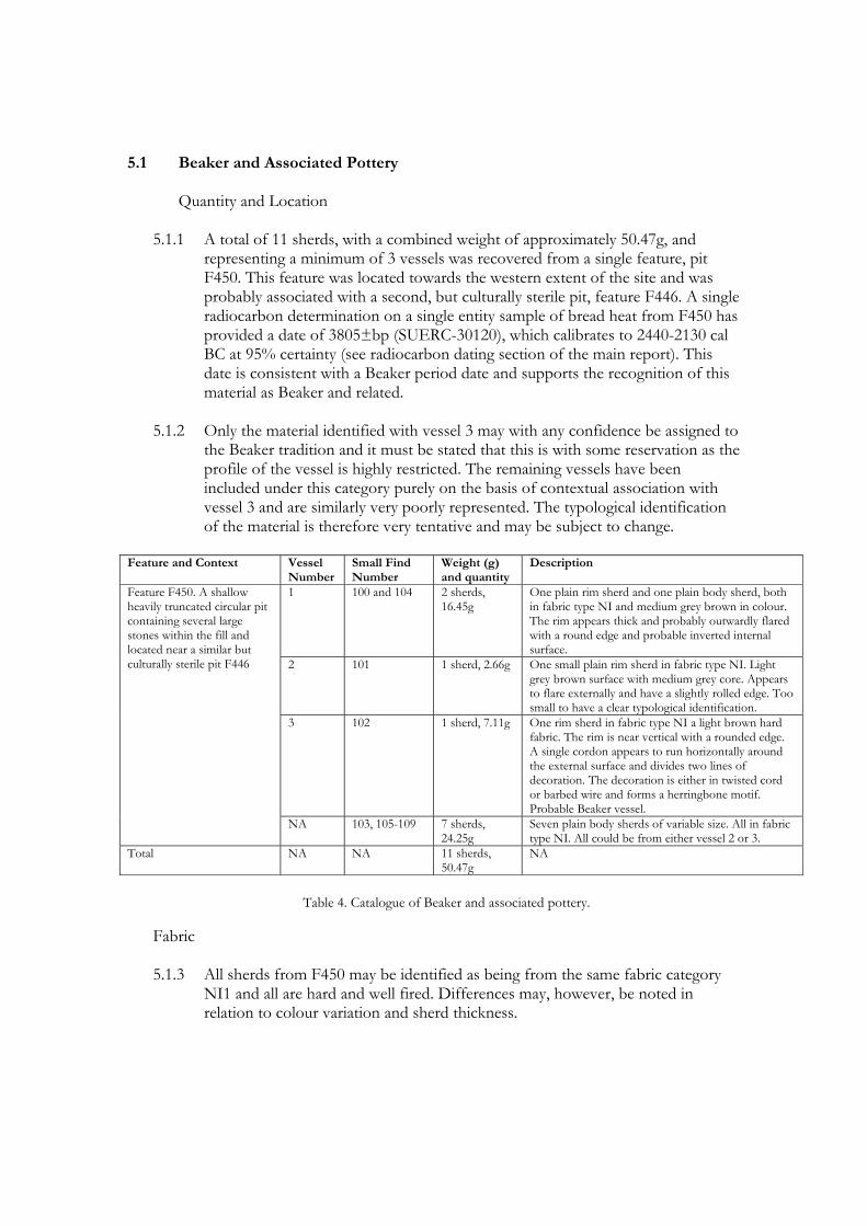
5.1 Beaker and Associated Pottery
Quantity and Location 5.1.1 A total of 11 sherds, with a combined weight of approximately 50.47g, and
representing a minimum of 3 vessels was recovered from a single feature, pit F450. This feature was located towards the western extent of the site and was probably associated with a second, but culturally sterile pit, feature F446. A single radiocarbon determination on a single entity sample of bread heat from F450 has provided a date of 3805±bp (SUERC-30120), which calibrates to 2440-2130 cal BC at 95% certainty (see radiocarbon dating section of the main report). This date is consistent with a Beaker period date and supports the recognition of this material as Beaker and related.
5.1.2 Only the material identified with vessel 3 may with any confidence be assigned to
the Beaker tradition and it must be stated that this is with some reservation as the profile of the vessel is highly restricted. The remaining vessels have been included under this category purely on the basis of contextual association with vessel 3 and are similarly very poorly represented. The typological identification of the material is therefore very tentative and may be subject to change.
Feature and Context Vessel
Number Small Find Number
Weight (g) and quantity
Description
1 100 and 104 2 sherds, 16.45g
One plain rim sherd and one plain body sherd, both in fabric type NI and medium grey brown in colour. The rim appears thick and probably outwardly flared with a round edge and probable inverted internal surface.
2 101 1 sherd, 2.66g One small plain rim sherd in fabric type NI. Light grey brown surface with medium grey core. Appears to flare externally and have a slightly rolled edge. Too small to have a clear typological identification.
3 102 1 sherd, 7.11g One rim sherd in fabric type NI a light brown hard fabric. The rim is near vertical with a rounded edge. A single cordon appears to run horizontally around the external surface and divides two lines of decoration. The decoration is either in twisted cord or barbed wire and forms a herringbone motif. Probable Beaker vessel.
Feature F450. A shallow heavily truncated circular pit containing several large stones within the fill and located near a similar but culturally sterile pit F446
NA 103, 105-109 7 sherds, 24.25g
Seven plain body sherds of variable size. All in fabric type NI. All could be from either vessel 2 or 3.
Total NA NA 11 sherds, 50.47g
NA
Table 4. Catalogue of Beaker and associated pottery.
Fabric 5.1.3 All sherds from F450 may be identified as being from the same fabric category
NI1 and all are hard and well fired. Differences may, however, be noted in relation to colour variation and sherd thickness.

5.1.4 The majority of the assemblage can be identified by a light orange brown surface and a medium grey core. This includes the two rim sherds from vessels 2 and 3 and the majority of body sherds which may derive from either example or indeed both. Such a hard well fired fabric is perhaps indicative of a Late Neolithic-Bronze Age origin and would certainly be in keeping with the Beaker tradition.
5.1.5 The remaining rim and body sherd identified with vessel 1, by contrast to the rest
of the material from F450, appear in a medium grey brown fabric with a slight waxy feeling to the surface.
Fig. 8 Rim sherd from possible Beaker vessel 3, Find no. 102 (Scale = 1cm graduations). Form 5.1.6 Vessel 1 is represented by a single plain and un-diagnostic body sherd and a
single plain rim sherd. The rim is poorly represented but indicates an approximate diameter to the vessel of 30cm. In profile it appears as a relatively thick wedge shape, tapering towards the lip which would appear to have a slightly flattened edge. It is unclear if this represents an outwardly flaring profile or an inverted form. The profile is insufficient to provide an accurate typological identification. The body sherd is approximately 11mm thick and the rim sherd up to 16mm at its widest point.
5.1.7 Vessel 2 is represented by a single very small rim sherd and possibly one or more
of the plain body sherds. The rim form is highly restricted but would seem to indicate a diameter somewhere in the region of 240mm. The rim appears to be outwardly flared with a rounded and slightly rolled lip. The difficulty of establishing the profile of this vessel is such that a firm identification is not possible. The rim sherd is approximately 7mm thick which is in keeping with body sherds from the same context.
5.1.8 Vessel 3 is represented by a single rim sherd and perhaps one or more of the
plain body sherds from the same context. In profile it appears near vertical and

perhaps flaring outwards very slightly with a rounded lip edge. A single cordon runs horizontally below the external edge of the lip, approximately half way down the body of the sherd. The rim edge is poorly represented but the diameter of the vessel may be estimated at approximately 220mm. The extent of the profile greatly limits a positive typological identification but based on a combination of form, fabric and decoration the vessel may with some reservation be identified with the Beaker tradition.
Decoration 5.1.9 Only the single rim sherd representing vessel 3 carries any form of decoration
among the material from F450. 5.1.10 As noted above a single horizontal cordon runs across the mid section of the
sherd’s external surface. This cordon serves as a dividing line between two further parallel horizontal rows of decoration. Such cordons, while not exclusively diagnostic of Beaker ceramics find parallels among many such vessels and were highlighted by Clarke as a ‘functional’ aspect of material from so called domestic contexts rather than burials (Clarke 1970, 36 and Figure VI., 37). Beaker pots featuring such morphological characteristics include a vessel from Radley, Berkshire (ibid, Figure 63, 288), and vessels from Durrington Walls, Wiltshire, and Fengate, Northamptonshire (ibid, Figures 228-230, 309) to name but a few.
5.1.11 The two rows either side of the cordon contain a number of impressions set at a
oblique angle side by side. Individual impressions are arranged within the two rows so as to mirror those in the opposing line to create a herringbone motif. The individual impressions are relatively ephemeral but would appear to be executed in either a twisted cord or perhaps barbed wire technique.
5.1.12 A herringbone motif would certainly be in-keeping with, although not exclusive
to, the Beaker tradition as would the use of twisted cord and more specifically barbed wire techniques, the latter of which is largely if not completely absent from previous Neolithic decorative repertoires.
5.1.13 Decoration upon Beaker vessels does tend to be applied within tightly defined
zones yet the relatively loose application of techniques as featured here is not unknown. For example, a vessel from Handley Down, Dorset, features loosely spaced rows of decoration forming a herringbone motif (ibid, Figure 218, 308).
The Wider Context 5.1.14 No detailed synthesis or reference corpus has yet been developed for Beaker
ceramics within Wales. However, the synthesis undertaken by Clarke in relation to the tradition within Great Britain and Ireland as a whole did note just over 40 find sites from Wales (Clarke 1970, Appendix 7 and associated maps). Of these

sites only four were noted as deriving from the vicinity of Pembrokeshire, including material identified as belonging to his Morthern/Middle Rhine series from the site of Ludchurch, Croft Quarries and Talbenny (ibid Appendix 7, 534) and a single example belonging to his rusticated series from the site at Caldey Island (Clark 1970, 555; Lacaille and Grimes 1961 Figure 6, 40).
5.1.15 This reference corpus was developed over four decades ago and undoubtedly the
number of find sites has increased somewhat since its publication. A sizeable assemblage has since been recovered from the site of Stackpole Warren (Benson et al. 1990) although no direct parallels with the Bolton Hill material are evident.
5.1.16 Based upon Clark’s corpus the relative distribution of Beaker find sites would
again seem to focus upon the fertile coastal and valley areas of the country and the recovery of material at Bolton Hill would seem to further reinforce this impression.
Fig. 9. Beaker ceramic vessels 1 -3.

Early Bronze Age Material
Quantity and Location 6.1.1 This small assemblage is represented by a total of seven sherds, with a combined
weight of 32.59g, representing the remains of a single vessel from a small pit F230.
6.1.2 Pit F230 was located towards the south-eastern edge of the excavated area and in
close proximity to pit F228 and a spread of charred material that appeared to extend from this feature, and through which a much larger pit had been cut, F226. Within this second pit feature a primary deposit of charred material including a quantity of hazelnut shell had been deposited before subsequent infilling. F230 contained a single decorated rim sherd and six small sherds, probably from the same vessel.
Feature and Context Vessel
Number Small Find Number
Weight (g) and quantity
Description
Feature F231, a small pit 1 52-54 7 sherds, 32.59g
A single rim sherd with incised decoration and a number of undecorated body sherds. Hard well-fired fabric with a light grey brown surface and medium grey core in type Q3.
Table 5. Catalogue of decorated Early Bronze Age material.
Fabric 6.1.3 The vessel recovered from feature F230 was executed in a hard well fired fabric
with the addition of a quartz temper. Unlike the majority of the quartz tempered fabrics represented in the assemblage the quartz element was finely crushed (Q3) and individual elements were not allowed to protrude from the surface which appears to have been burnished, or at least smoothed over. The inclusions are quite small and it is difficult to be sure of what material they are based on macroscopic inspection only.
Fig. 10. Find no. 53, Feature F231 (Scale = 1cm graduations).

Form 6.1.4 Very little of the vessel is represented by the few sherds recovered. Consequently
no positive typological identification has been possible. In profile the rim is relatively simple with no moulding or additional elaboration on either surface and extends at an angle towards a lip with a flattened upper surface. The diameter of the rim may be estimated at approximately 240mm or more but it is unclear from the limited profile what type of vessel this derives from.
6.1.5 The additional sherds recovered from the same context are undoubtedly from
the same vessel but do not add any further information or elaborate upon the basic profile. The wall of the vessel is approximately 13mm.
Decoration 6.1.6 The single rim sherd from feature F230 is clearly decorated with several incised
lines, one set horizontally along the external edge of the lip and a further three parallel lines extending vertically at near right angles to it.
6.1.7 Incised decoration is employed within the repertoire of numerous ceramic
traditions from Impressed Wares into the Bronze Age and beyond. The motif is insufficiently represented to provide definitive comment yet would seem to represent one or more in-filled zones.
Discussion 6.1.8 The restricted profile and poor condition of the featured material renders any
typological identification problematic. The vessel appears to be decorated with impressed or incised techniques which may be indicative of a range of different ceramic forms. The hard, well fired character of the fabric together with the apparent production of a burnished, or at least smoothed, surface is consistent with Bronze Age traditions. The fragments comprising this vessel all came from pit F230 which yielded a date of 1890-1660 cal BC supporting the attribution of this material as Early Bronze Age in date (see also radiocarbon dating section of the main report).

Fig. 11. The decorated rim from Early Bronze Age vessel 1.

7 Late Bronze Age Material Quantity and Location 7.1 This group is represented by a total of 29 small sherds with a collective weight of
30.91g. They represent a minimum of two vessels and derive from two separate post hole features in Pit Cluster 1. All are plain body sherds with no diagnostic features other than fabric type.
Feature and Context Vessel
Number Small Find Number
Weight (g) and quantity
Description
Feature F288, part of PC1
1 63-64 3 sherds, 3.15g Three small un-diagnostic sherds in fabric type Q1. Two have a light orange colour and one a medium grey brown.
Feature F296, part of PC1.
2 65 26 small sherds, 27.76g
26 small un-diagnostic sherds in fabric type NI. Colour predominantly light yellow brown.
Total 2 NA 29 sherds, 30.91g
NA
Table 6. Catalogue of Late Bronze Age material from pit cluster 1.
Fabric 7.2 Three sherds from feature F288 show the use of quartz as a temper and have
been classified in group Q1. The bulk of the group shows no evidence for the use of any temper agents and has been classed in group NI.
Form and Decoration
7.3 No specific vessel forms or decoration can be identified within the group. Date 7.4 The material from F296 has two consistent radiocarbon dates associated with it
confirming a Late Bronze Age association in the early 1st millennium cal BC in the period 1060-820 cal BC (see radiocarbon dating section of main report for further details).
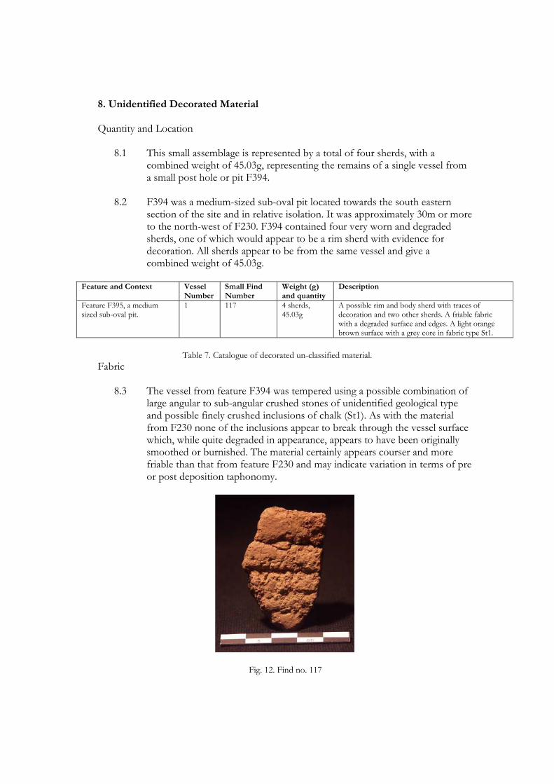
8. Unidentified Decorated Material
Quantity and Location
8.1 This small assemblage is represented by a total of four sherds, with a combined weight of 45.03g, representing the remains of a single vessel from a small post hole or pit F394.
8.2 F394 was a medium-sized sub-oval pit located towards the south eastern
section of the site and in relative isolation. It was approximately 30m or more to the north-west of F230. F394 contained four very worn and degraded sherds, one of which would appear to be a rim sherd with evidence for decoration. All sherds appear to be from the same vessel and give a combined weight of 45.03g.
Feature and Context Vessel
Number Small Find Number
Weight (g) and quantity
Description
Feature F395, a medium sized sub-oval pit.
1 117 4 sherds, 45.03g
A possible rim and body sherd with traces of decoration and two other sherds. A friable fabric with a degraded surface and edges. A light orange brown surface with a grey core in fabric type St1.
Table 7. Catalogue of decorated un-classified material.
Fabric
8.3 The vessel from feature F394 was tempered using a possible combination of large angular to sub-angular crushed stones of unidentified geological type and possible finely crushed inclusions of chalk (St1). As with the material from F230 none of the inclusions appear to break through the vessel surface which, while quite degraded in appearance, appears to have been originally smoothed or burnished. The material certainly appears courser and more friable than that from feature F230 and may indicate variation in terms of pre or post deposition taphonomy.
Fig. 12. Find no. 117

Form
8.4 Very little of the vessel is represented by the few sherds recovered. Consequently no positive typological identification has been possible. The possible rim sherd recovered from feature F394 can only really be identified as such by the traces of decoration upon what presumably is the external surface. Indeed at first glance the sherd was thought to derive from a possible base section. In profile the sherd therefore appears to project externally at an angle before terminating in an expanded lip with a flat, wide and angled edge. The quality of this sherd is poor and no estimate of the diameter could be gauged.
8.5 Given the poor preservation of this sherd it is possible that the decorated
surface actually relates to the interior of the vessel. If this is the case the angle of the profile alters slightly from an angled to a vertical one, although the exterior would still posses an angled bevel edge. In either scenario such a rim form may be in-keeping with profiles associated with the Impressed Ware tradition and the presence of impressed decoration on one or more surfaces may support this suggestion. In this regard it does posses a passing resemblance to the rim of the vessel recovered from Caldey Island located off of the south-western Pembrokeshire coast (Lacaille and Grimes 1961) and by extension a similar vessel from Llanilar, Ceredigion (Briggs 1997). Similar wedge shaped profiles, whether vertical or angled, are also known from the site of Ogmore (Gibson 1998) and more generally within the British Peterborough repertoire. The body sherds, such as there are, indicate a near vertical wall up to 17mm thick.
Decoration
8.6 The evidence for decoration on the vessel from F395 is ambiguous and does not provide any clear-cut typological associations.
8.7 At least two rows of probable fingernail impressions can be noted on what is
presumably, although not certainly, the external surface and below the rim edge. They appear to be set side by side in horizontal rows, a trait that again is indicative of a range of ceramic traditions of both the Neolithic and Bronze Age. The angled upper surface of the rim edge would seem to carry very vague traces of further decoration but the condition of the surface is very poor and if it is decoration the method of its execution is unknown. Similarly, the largest of the body sherds is subject to the same worn condition as the possible rim but also appears to carry vague traces of possible decoration.
Discussion
8.8 The vessel appears to be decorated with impressed or incised techniques which may be indicative of a range of different ceramic forms from Impressed Ware to Late Bronze Age types and beyond. The profile of the

rim and presence of fingernail decoration may suggest an association with the Impressed Ware tradition. The character of the fabric would seem out of keeping with other Impressed Ware vessels represented at the site although it need not rule out such an assignation as variation in fabric type can, and does, occur within the tradition, and certainly within individual assemblages. Indeed the poor quality of the fabric, while perhaps a reflection of other post-depositional factors, is also a common characteristic of the tradition.
8.9 With regard to the profile of the rim sherd the morphology has already been
highlighted with reference to the Impressed Ware vessel from Caldey Island identified as an example of the Mortlake subgroup. Further parallels may be highlighted with examples of Mortlake Ware the length and breadth of the British Isles, for example, several wedge-shaped profiles from the site of Ecton, Northamptonshire (Moore and Williams 1975). The poor quality and meagre quantity of the material is the only mitigating factor in a positive identification in this regard.

9 Unidentified Material Quantity and Location 9.1 This group is represented by a total of 3 small sherds and a few crumbs with a
collective weight of 20.29g. They represent a minimum of three vessels and derive from three separate features including the post-medieval ditched enclosure. All are plain body sherds with no diagnostic features other than fabric type.
Feature and Context Vessel
Number Small Find Number
Weight (g) and quantity
Description
Feature 364, ditched enclosure of post-medieval date
1 114 and 111 1 sherd and 7 very small crumbs, 6.42g
One plain body sherd in a hard well fired fabric, type NI, light reddish brown in colour, and seven very small crumbs in the same fabric type.
Feature F274, a large midden pit with possible contamination of upper fill 275.
1 55 1 sherd, 4.45g A single plain body sherd from the upper fill deposit 275. A hard well fired fabric in type NI with a light pink surface and light grey core. Possibly intrusive to the fill.
Feature 494, a shallow circular pit.
1 93 1 sherd and 2 small crumbs, 9.42g
A single body sherd in fabric type NI with a light brown surface and slightly darker core. Indentations on the surface may suggest decoration but no clear motif or technique.
Total 3 NA 3 sherds, 20.29g
NA
Table 8. Catalogue of unidentified ceramic material.
Fabric 9.2 The single sherd from the very upper fill of pit F274 appears quite distinctive in
terms of its colouration. The colour and well-fired nature of the sherd could suggest a Beaker or more likely later prehistoric or even historic origin. It was recovered from the upper fill of the feature together with a piece of metal slag and a small post-medieval sherd, all of which may be intrusive, carried into the fill by plough action.
9.3 The single sherd from the enclosure ditch also appears in a distinctive course and
well fired fabric which may similarly indicate a later prehistoric or historic date. The small crumbs from a separate section of the ditch are too small to allow further comment.
9.4 The single sherd from pit feature F494 can not be distinguished from other more
securely identified material from the site and is thought likely to be of Bronze Age date.
Form
9.5 No specific vessel forms can be identified within the group. The single sherd
from feature 274 can be further distinguished as deriving from a very thin-walled vessel with a thickness of 6mm. This adds further weight to the case for a later prehistoric or even historic origin. The remaining significant sherds from both

the enclosure and feature F494 appear unremarkable and are both approximately 7mm thick.. No comment can be made on the form of the smaller sherds and crumbs.
Decoration 9.6 The single sherd from feature F494 appears to carry several impressed crescent-
like marks on one surface. However, it is impossible to gauge if this represents decoration or some other accidental marking and no motif or decorative technique can be identified. The remaining sherds are unadorned body sherds, or are otherwise too small and worn to allow any identification.
10 Discussion
10.1 The corpus of ceramic material from Bolton Hill Quarry is relatively small
compared to many other prehistoric assemblages consisting of only 130 sherds representing approximately 17 vessels as a minimum. However, in terms of the regional context this constitutes a sizeable addition to the archaeological record due to the types of ceramics represented and the important contribution of the associated radiocarbon dates. The chronological span of the material is also significant and includes Impressed Ware (or ‘Peterborough Ware’), Neolithic derivative material, Beaker and Late Bronze Age material. Most of these traditions are poorly represented within the regional and national archaeological record and, in conjunction with the British Isles as a whole, join a somewhat restricted corpus.
10.2 The recovery of material from four or more vessels in the Impressed Ware
tradition contributes to a regional corpus previously comprising just two find sites each producing a single vessel. While the form and content of this small assemblage is not wholly characteristic of mainstream Impressed Ware typology it may with some confidence be aligned with aspects of the Mortlake Ware subgroup. In this respect it finds parallels not only among Welsh Impressed Ware material, sharing aspects of morphology as well as general choice of temper agent, but also aspects drawn from the British corpus as a whole.
10.3 The identification of the Neolithic derivative component of the assemblage is
important as it compares with similar material beginning to be recognised elsewhere in Britain. The limited representation of both vessel profile as well as decorative treatment renders any typological identification somewhat equivocal sharing, as this material tends to do, associations with the preceding Grooved Ware ceramic style as well as components borrowed from the contemporary Beaker repertoire as well as new ornamentation that anticipates their more common use in the Early Bronze Age. However, the collective ceramic evidence, together with the associated radiocarbon dates, suggest a classification as Neolithic derivative pottery dating to the Chalcolithic (or ‘Beaker period’) in the final centuries of the 3rd millennium cal BC. The assemblage from Bolton Hill, albeit small, expands upon a restricted and poorly understood tradition across Wales and the British Isles generally, though one which has recently been addressed by Marshall et al. (in press).
10.4 The identification of Beaker ceramics in relation to a single pit feature rests upon
the identification of a single poorly represented vessel and associated sherds. Yet the comparative evidence for such a typological assignation would seem justified on a number of grounds and this is supported by numerous parallels with material from a number of sites.
10.5 The material from pit cluster 1 can be classified as Late Bronze Age based on the
associated radiocarbon dates, and the somewhat featureless ceramic sherds are entirely in keeping with such a date. The Late Bronze Age is a relatively poorly

understood period nationally, particularly in lowland locations, and evidence for ceramics from what is most likely to be a settlement context adds an important contribution by recognising the presence of activity in this area, as well as the circumstances in which such sites may be found and encountered in the future.
10.6 The recovery of Neolithic-Late Bronze Age ceramic traditions within a single site
assemblage offers a relatively rare opportunity for study, certainly within the local and regional context, and while the activity it represents would seem limited in scope, and suggestive of perhaps short term and infrequent settlement occupation, it nonetheless indicates a pattern of land use that possesses some considerable longevity and an emphasis on the natural prominence that is Bolton Hill.

11. References Benson, D.G., Evans, J.G., Williams, G.H., Darvill, T. and David, A. 1990. Excavations at Stackpole Warren, Dyfed, Proceedings of the Prehistoric Society 56: 179-245. Briggs, S.C. 1997. A Neolithic and Early Bronze Age settlement and burial complex at Llanilar, Ceredigion. Archaeologia Cambrensis 146: 13-59. Britnell, W.J. 1982. The excavation of two round barrows at Trelystan, Powys, Proceedings of the Prehistoric Society 48: 133-201. Britnell, W.J. and Savory, H.N. 1984. Gwernvale and Penywyrlod: Two Neolithic Long Cairns in the Black Mountains of Brecknock. Cardiff, Cambrian Archaeological Monograph 2.
Burgess, C.B. 1976. Meldon Bridge: A Neolithic defended promontory complex near Peebles, in R. Micket and C.B. Burgess (eds) Settlement and Economy in the Third and Second Millennia BC, 151-79. Oxford, British Archaeological Reports British Series 33. Burgess, C. 1995. Bronze Age settlement and domestic pottery in Northern Britain: some suggestions. In I. Kinness and G Varndell (eds.) Unbaked Urns of Rudely Shape: Essays on British and Irish Pottery. Oxford, Oxbow Books, Oxbow Monograph 55: 145-158. Burrow, S. 2003. Catalogue of the Mesolithic and Neolithic Collections in the National Museums and Galleries of Wales. Cardiff, National Museums and Galleries of Wales. Clarke, D.L. 1970. Beaker pottery of Great Britain and Ireland Volumes 1 and 2. Cambridge, Cambridge University Press. Garwood, P. 1999. Grooved Ware in Southern Britain: Chronology and Interpretation. In R. M. J. Cleal and A MacSween (eds.) Grooved Ware in Britain and Ireland: Neolithic Studies Group Seminar Papers 3, Oxford, Oxbow Books: 145-176. Gibson, A.M. 1994. Excavations at the Sarn-y-bryn-caled cursus complex, Weshpool, Powys, and the timber circles of Great Britain and Ireland. Proceedings of the Prehistoric Society 60: 143-224. Gibson, A.M. 1995. First Impressions: a review of Peterborough Ware in Wales. In I. Kinnes and G. Varndell (eds.) Unbaked Urns of Rudely Shape: Essays on British and Irish Pottery, Oxford, Oxbow Books, Oxbow Monograph 55: 23-40. Gibson, A.M. 1998. Neolithic pottery from Ogmore, Glamorgan. Archaeologia Cambrensis 147: 56-67. Gibson, A.M. 1999. The Walton Basin Project: Excavation and Survey in a Prehistoric Landscape 1993-7. York, Council for British Archaeology, CBA Research Report 118. Gibson, A.M. and Kinnes, I.A. 1997. On the urns of a dilemma: radiocarbon and the Peterborough problem. Oxford Journal of Archaeology 16(1): 65-72.

Gilks, J.A. 1971. The Peterborough Ware bowl from Calling Low Dale, Derbyshire. Derbyshire Archaeological Journal 91: 37-39. Lacaille, A.D. and Grimes, W.F. 1961. The prehistory of Caldey: part 2. Archaeologia Cambrensis 110: 30-70. Lynch, F. 1969. The megalithic tombs of north Wales. In T.G.E., Powell (ed.) Megalithic enquiries in the West of Britain: 107-148. Liverpool, Liverpool University Press. Manby, T. 1975. Neolithic occupation sites on the Yorkshire Wolds. Yorkshire Archaeological Journal 47: 23-59. Marshall, P.D., Hamilton, W.D., Woodward, A., Beamish, M., and Waddington, C., (forthcoming). A precise chronology for Peterborough Ware? Marshall, P., Millson, D., C. Waddington (in press) Towards a sequence for Neolithic ceramics in Northumberland. Archaeologia Aeliana 5th Ser 39: Moore, W.R.G. and Williams, J.H. 1975 A late Neolithic site at Ecton, Northamptonshire, Northamptonshire Archaeology 10: 3-31. Murphy, K. and Evans, R.T.J. 2006 Excavation of Neolithic pits, three ring-ditches and a palisaded enclosure at Cwm Meudwy, Llandysul, Ceredigion, 2003, Archaeologia Cambrensis 155, 23-48. Philp, B. 1973. Excavations in West Kent 1960-70: The discovery of Prehistoric, Roman, Saxon and Medieval sites, mainly in the Bramley area and in the Darent Valley. Dover, Karu Publications, Site 1 A Neolithic site Near Baston Manor, Hayes, Kent, 5-19. Piggott, S 1954. The Neolithic Cultures of the British Isles. Cambridge, Cambridge University Press. Sheridan, A. 1999. Grooved Ware from the Links of Noltland, Westray, Orkney. In R. M.J. Cleal and A MacSween (eds.) Grooved Ware in Britain and Ireland: Neolithic Studies Group Seminar Papers 3. Oxford, Oxbow Books: 112-124. Smith, I.F. 1956. The decorative art of Neolithic ceramics in South-eastern England and its relations. Unpublished PhD Thesis, University of London. Speak, S. and C. B. Burgess. 1999. Meldon Bridge: a centre of the third millennium BC in Peebleshire. Proceedings of the Society of Antiquaries of Scotland 129: 1-118. Tinsley, A. 2009. The wider affinities of the Peterborough Ware ceramics from Willington. In Beamish, M.G. 2009. Island visits: Neolithic and Bronze Age activity on the Trent Valley Floor. Excavations at Eggington and Willington, Derbyshire, 1998-1999. Derbyshire Archaeological Journal 129: 17-172

Webley, D.P. 1976. How the west was won; prehistoric land-use in the southern Marches. In G.C. Boon and J.M. Lewis (eds.) Welsh Antiquity. Essays mainly on prehistoric topics presented to H.N. Savory upon his retirement as Keeper of Archaeology: 19-36. Cardiff.

BA-E 2047 Palaeoenvironmental Assessment at Bolton Hill Quarry
Plant Macrofossil and Charcoal Assessment of samples from Bolton
Hill Quarry, Pembrokeshire
R. McKenna
BA-E 2047 Palaeoenvironmental Assessment at Bolton Hill Quarry
Plant Macrofossil and Charcoal Assessment of samples from Bolton Hill Quarry, Pembrokeshire
By
R. McKenna
April 2010
Summary
This report describes the plant macrofossil and charcoal assessment of 29 samples from an archaeological site at Bolton Hill Quarry, Pembrokeshire. The concentration of plant macrofossil remains was low and the preservation generally poor, wheat, barley and pea were recorded with weeds typical of arable fields. The charcoal fragments included oak, hazel and alder. It is likely that the plant macrofossil assemblages reflect a general ‘background’ signal of domestic activity on the site whilst the charcoal evidence suggests the exploitation of wood from a mixed woodland environment, with the choice of taxa probably reflecting local availability and perhaps the suitability of different species for firewood. No further work is on these samples is recommended.
KEYWORDS: Bolton Hill Quarry, Neolithic, Plant Macrofossils, Charcoal
Contact address for authors: Birmingham Archaeo-Environmental Institute of Archaeology and Antiquity University of Birmingham Edgbaston Birmingham B15 2TT
Prepared for:
Archaeological Research Services Ltd Suite 1, First Floor,
Dunham House, Cross Street,
Sale, M33 7HH

BA-E 2047 Palaeoenvironmental Assessment at Bolton Hill Quarry
1. INTRODUCTION
Birmingham Archaeo-Environmental (BA-E) was contracted by Archaeological Research Services Ltd (ARS Ltd) to assess twenty nine samples from archaeological excavations at Bolton Hill Quarry for their plant macrofossil content. The excavation was carried out by ARS between the 27th April and the 11th September 2009. The samples were collected a range of features including pits, enclosures, burnt mounds, hearths, fire pits, and postholes mainly dating to the Neolithic period. 2. METHODS A programme of soil sampling from sealed contexts was implemented during the excavation. The aim of the sampling was to assess the type of preservation and the potential of the biological remains to provide information regarding:
• The nature of human activity on the site ;
• The environment of the surrounding area.
The material was submitted to Birmingham Archaeo Environmental was processed by staff at Archaeological Research Services using standard water flotation methods. The flot (the sum of the material from each sample that floats) was sieved to 0.5mm and air dried.
The heavy residue (the material which does not float) was not examined, and therefore the results presented here are based entirely on the material from the flot. The flot was examined under a low-power binocular microscope at magnifications between x12 and x40. A four point semi quantative scale was used, from ‘1’ – one or a few specimens (less than an estimated six per kg of raw sediment) to ‘4’ – abundant remains (many specimens per kg or a major component of the matrix). The flot was then sieved into convenient fractions (4, 2, 1 and 0.3mm) for sorting and identification of charcoal fragments. Identifiable material was only present within the 4 and 2mm fractions. A random selection of up to 100 fragments of charcoal of varying sizes was made, which were then identified. Where samples did not contain 100 identifiable fragments, all fragments were recorded. This information is presented with the results of the assessment in Table 3 below. Identification was made using the wood identification guides of Schweingruber (1978) and Hather (2000). Some taxa are identified to genus level only. 3. RESULTS The components recorded from each sample are shown in Table 1 and the results of this analysis are presented in Table 2. The samples produced small
Plant Macrofossil and Charcoal Assessment of samples from Bolton Hill Quarry, Pembrokeshire
BA-E 2047 Palaeoenvironmental Assessment at Bolton Hill Quarry
assemblages of plant remains both in volume and diversity. Charred plant macrofossils were present in eleven of the samples but were generally poorly preserved, and were lacking in diagnostic morphological characteristics. The samples contained very small numbers of poorly preserved charred cereal grains. Where it was possible to ascertain identifications, Triticum spp. (wheat) and Hordeum (barley) were represented, although mainly as single occurrences (samples 92, 101 and 159). Pisum sativum (Pea) was also recorded as a charred example in one of the samples (110). Charred legumes are likely to represent food waste, as they do not require parching in the processing sequence utilised in their harvest. Therefore, the only contact of this material with a fire would be during food preparation, and/or disposal/deposition of used foodstuffs. Corylus avellana macrofossils (hazel nuts) were also recorded in relative abundance in sample 7 and lower quantities in samples 71, 90, 103 and 110. These may represent the remains of edible foodstuffs gathered from the ‘wild’ . Another possible indirect indicator of plant remains from cultivated land is the presence of arable weeds in most of the samples. These Polygonum lapathifolium L. (pale leaved persicaria), Fallopia convovulus (black bindweed) and Chenopodium sp./Atriplex sp (goosefoot/orache) are characteristic weeds of arable fields. Charcoal was relatively abundant in most of the samples, scoring a ‘4’ on the abundance scale. However, the preservation of the charcoal was relatively variable even within the samples, although some of the fragments was firm and crisp and
allowed for clean breaks to the material permitting clean surfaces where identifiable characteristics were visible. Most of the fragments were very brittle and the material tended to crumble or break in uneven patterns making the identifying characteristics harder to distinguish. Material in twenty five of the samples was identifiable (see Table 3). The total range of taxa comprises Quercus (oak), Corylus (hazel) and Alnus (alder). These taxa represent common native tree/shrub species present in the mid-Holocene woodland. Oak is by far the most numerous and it is possible that this was the preferred fuel wood obtained from a local environment containing a broader range of species. Oak is often also a ‘first choice’ structural timber, but off-cuts, deadfall and other debris could also be utilised as fuel. Bark was present on some of the charcoal fragments, which may indicate that the material is more likely to have been firewood/felling debris, or the result of a natural fire, rather than woodworking debris. Alder was also well represented in the samples. This wood burns quickly, but can be suitable for charcoal production. Given that it is not the most abundant taxa, its presence probably represents a selection of available firewood. There are various largely unquantifiable factors that affect the composition of charcoal samples, which include bias in contemporary preference and collection, as well as sample taphonomy (Thery-Parisot 2002). The identified taxa cannot therefore be considered to be proportionately representative of the availability of wood resources in the palaeoenvironment.
BA-E 2047 Palaeoenvironmental Assessment at Bolton Hill Quarry
Root / rootlet fragments were also present within all of the samples. This indicates disturbance of the archaeological features, which may be due to some of the features being relatively close to the surface, as well as deep root penetration from overlying vegetation. The presence of insect fragments in three of the samples and earthworm egg capsules in two of the samples is a further indication of such disturbance. 4. CONCLUSIONS The samples produced low concentrations of plant macrofossils and charcoal. The archaeobotanical evidence shows that wheat, barley and peas were present on the site, with a range of weed species probably deriving from cultivated fields. The presence of hazelnuts may reflect the collection of edible food from the wild. The low concentration and poor preservation of the plant macrofossils prevents detailed comparison or consideration of the different contexts on the site, but there is no compelling evidence that any of the pit features were being used specifically for the storage or disposal of food stuffs. The samples may instead represent a more general ’background’ signal of domestic activity on the site. The assemblages were generally rather mixed in nature and may have formed through accumulation of waste from a number of different sources over time. The charcoal remains showed the exploitation of oak, alder and hazel as fire wood. Oak has good burning properties and would have made a fire suitable for most purposes (Edlin 1949). It is a particularly useful fire fuel as well as being a commonly used structural/artefactual wood that may
have had subsequent use as a fire fuel (Rossen and Olsen 1985). 5. RECOMMENDATIONS FOR FURTHER ANALYSIS The samples have been assessed and any interpretable data has been retrieved. No further work is required on any of the samples. 6. ARCHIVE All extracted fossils and flots are currently stored with the site archive in the stores at Birmingham Archae-Environmental, along with a paper and electronic record pertaining to the work described here. REFERENCES English Heritage (2002) Environmental Archaeology: A guide to the theory and practise of methods, from sampling and recovery to post-excavation. English Heritage Publications. Swindon. Edlin, H L, 1949. Woodland crafts in Britain: an account of the traditional uses of trees and timbers in the British countryside, London, Batsford Hather, J G. 2000 The identification of Northern European woods; a guide for archaeologists and conservators, London. Archetype Press. Kenward, H.K., Hall, A.R. and Jones A.K.G. (1980) A tested set of techniques for the extraction of plant and animal macrofossils from waterlogged archaeological deposits. Science and Archaeology 22, 315. Rossen, J, and Olson, J, 1985 The controlled carbonisation and archaeological analysis of SE US wood

BA-E 2047 Palaeoenvironmental Assessment at Bolton Hill Quarry
charcoals, Journal of Field Archaeology 12, 445-456 Schweingruber, F H, 1978 Microscopic wood anatomy. Birmensdorf. Swiss Federal Institute of Forestry Research Théry-Parisot, I, 2002, ‘Gathering of firewood during the Palaeolithic’ in S Thiébault (ed), Charcoal Analysis, Methodological Approaches, Palaeoecological Results and Wood Uses, BAR International Series 1063
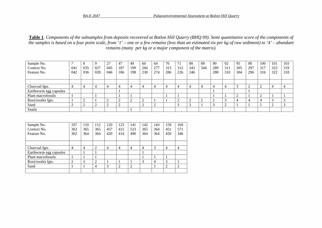
BA-E 2047 Palaeoenvironmental Assessment at Bolton Hill Quarry
Table 1. Components of the subsamples from deposits recovered at Botlon Hill Quarry (BHQ 09). Semi quantitative score of the components of the samples is based on a four point scale, from ‘1’ – one or a few remains (less than an estimated six per kg of raw sediment) to ‘4’ – abundant
remains (many per kg or a major component of the matrix). Sample No. Context No. Feature No.
7 041 042
8 035 036
9 027 028
27 045 046
47 187 186
49 199 198
60 266 230
64 277 274
70 313 286
71 312 226
88 343 246
89 344
90 289 288
92 311 310
95 305 304
98 297 296
100 317 316
101 323 322
103 319 318
Charcoal fgts. 4 4 4 4 4 4 4 4 4 4 4 4 4 4 3 2 2 4 4 Earthworm egg capsules 1 1 1 Plant macrofossils 1 1 1 1 1 1 1 1 2 1 2 1 1 Root/rootlet fgts. 1 2 1 2 2 2 2 1 1 2 2 2 2 3 4 4 4 3 3 Sand 2 2 2 2 2 2 2 3 3 1 3 2 1 1 1 2 3 Snails 1 Sample No. Context No. Feature No.
107 363 362
110 365 364
112 365 364
120 457 420
123 415 414
141 523 490
142 365 364
143 364 364
159 451 450
169 571 346
Charcoal fgts. 4 4 2 4 4 4 4 3 4 4 Earthworm egg capsules 1 1 1 Plant macrofossils 1 1 1 1 1 1 Root/rootlet fgts. 2 3 2 1 1 1 3 4 3 1 Sand 1 1 4 3 2 2 1 2 2

BA-E 2047 Palaeoenvironmental Assessment at Bolton Hill Quarry
Table 2: Complete list of taxa recovered from deposits recovered at Bolton Hill Quarry (BHQ 09).
Taxonomy and Nomenclature follow Stace (1997). Sample Number Context Number Feature Number
7 041 042
70313286
71312226
90289290
91311310
98297296
101 323 322
103319318
110365364
112365364
159451450
Small Pit
Large deep pit
Large circular pit – possible
hearth
Small pit/post
hole
Post hole
Post hole
Heavily truncated post hole
Sub-circular
pit
Rectangular ditched
enclosure
Truncated pit
Sample volume (ml)
100 >5 400 20 10 10 10 15 >5 20 20
LATIN BINOMIAL
COMMON NAME
Ranunuculus spp. 43 3 4 1 Buttercups Fumaria spp. 1 2 5 1 1 Fumitories Corylus avellana 88 11 3 3 1 Hazel Chenopodium spp / Atriplex spp.
2 1 6 6 6 3 7 Goosefoot/Orache
Silene spp. L. 1 1 Campions Polygonum lapathifolium
5 2 2 23 14 47 22 2 Pale persicaria
Fallopia convovulus 1 1 Black bindweed Rumex spp. 1 3 1 Dock BRASSICACEAE 2 3 1 2 3 Cabbage family Rubus spp. 1 2 Brambles Rubus idaeus 30 Raspberry FABACEAE 1 Pea family Pisum sativum L. 1 Garden pea

BA-E 2047 Palaeoenvironmental Assessment at Bolton Hill Quarry
Sonchus asper(L.) Hill
1 Prickly sow-thistle
Scirpus spp.L. 1 Wood club-rush Carex spp. 1 Sedge Hordeum spp. 1 4 Barley Triticum aestivum/compactum
1 Bread wheat
Indeterminate cereal 2 4 1 Unidentified 1 1

BA-E 2047 Palaeoenvironmental Assessment at Bolton Hill Quarry
Table 3. Complete list of taxa recovered from deposits at deposits recovered at Bolton Hill Quarry (BHQ 09). Taxonomy and nomenclature follow Schweingruber (1978). Numbers are identified charcoal fragment for each sample. Name Vernacular Sample 7
(041) 1000+ fgts max. size-12mm
Sample 8 (035) 500+ fgts max. size-18mm
Sample 9 (027) 200+ fgts max. size-14mm
Sample 27 (045) 200+ fgts. max. size-19mm
Sample 47 (187) 500+ fgts. max. size-13mm
Sample 49 (199) 24 fgts. max. size-8mm
Sample 60 (266) 1000+ fgts. max. size-27mm
Alnus glutinosa Alder 19 13 13 Corylus avellana Hazel 35 22 Quercus Oak 41 87 100 62 78 24 100 Indet. 5 3 22 Name Vernacular Sample 64
(277) 5000+ fgts max. size-24mm
Sample 71 (312) 5000+ fgts max. size-28mm
Sample 88 (343) 4000+ fgts max. size-15mm
Sample 89 (344) 1000+ fgts. max. size-9mm
Sample 90 (289) 100+ fgts max. size-16mm
Sample 92 (311) 50+ fgts max. size-10mm
Sample 98 (297) 20 fgts max. size-8mm
Alnus glutinosa Alder 35 Corylus avellana Hazel 20 20 Quercus Oak 100 72 75 100 100 Indet. 8 25 15

BA-E 2047 Palaeoenvironmental Assessment at Bolton Hill Quarry
Name Vernacular Sample 100 (317) 24 fgts max. size-5mm
Sample 101 (323) 50+ fgts max. size-8mm
Sample 103 (319) 100+ fgts max. size-12mm
Sample 112 (365) 12 fgts max. size-7mm
Sample 120 (457) 1000+ fgts max. size-13mm
Sample 123 (415) 500+ fgts max. size-11mm
Sample 141 (523) 5000+ fgts max. size-14mm
Alnus glutinosa Alder 11 Corylus avellana Hazel 16 31 7 Quercus Oak 6 34 58 2 100 100 100 Indet. 18 3 Name Vernacular Sample 142
(365) 32 fgts max. size-8mm
Sample 143 (364) 27 fgts max. size-13mm
Sample 159 (451) 50+ fgts max. size-11mm
Sample 169 (571) 500+ fgts max. size-18mm
Alnus glutinosa Alder Corylus avellana Hazel 9 50 Quercus Oak 23 27 100 Indet.

1
Appendix 3: Bolton Hill Lithic Assessment Dr Richard Chatterton Archaeological Research Services Ltd 1. FACTUAL DATA Quantity A total of 38 lithic artefacts were recovered from the excavations at Bolton Hill Quarry in 2009 and were identified as being of prehistoric date. Provenance Table 1 below lists the feature numbers/contexts from which the material was recovered. All of the artefacts were identified from the fills of cut features such as pits and postholes pit features.
Context No
Context Type No Lithics
Lithic Types Present Period
035 Pit fill 19 Flakes, core fragments 297 Pit fill 3 Flakes and broken blade 041 Pit fill 1 Core fragment 253 Pit fill 1 Flake 321 Pit fill 1 Retouched blade 319 Pit fill 1 Scraper 409 Pit fill 1 Flake 547 Pit fill 1 Flake 555 Pit fill 1 Flake Unstrat 9 Flakes, Core Total 38 Table 1. Lithic counts by context. Dating The vast majority of the lithic artefacts are not diagnostic of a particular period as flakes were produced in the production process during all periods. However, the general absence of regular blade forms may suggest that the assemblage principally post-dates the Mesolithic period and dates from either the Neolithic period or the Bronze Age. This is supported by the fact that pottery was discovered in many of the contexts that also produced lithics (035, 041, 297 and 319). Range and Variety The assemblage consists primarily of unaltered flakes made from small flint nodules. The only tools identified were a retouched blade and a scraper (Fig.1). These tool forms
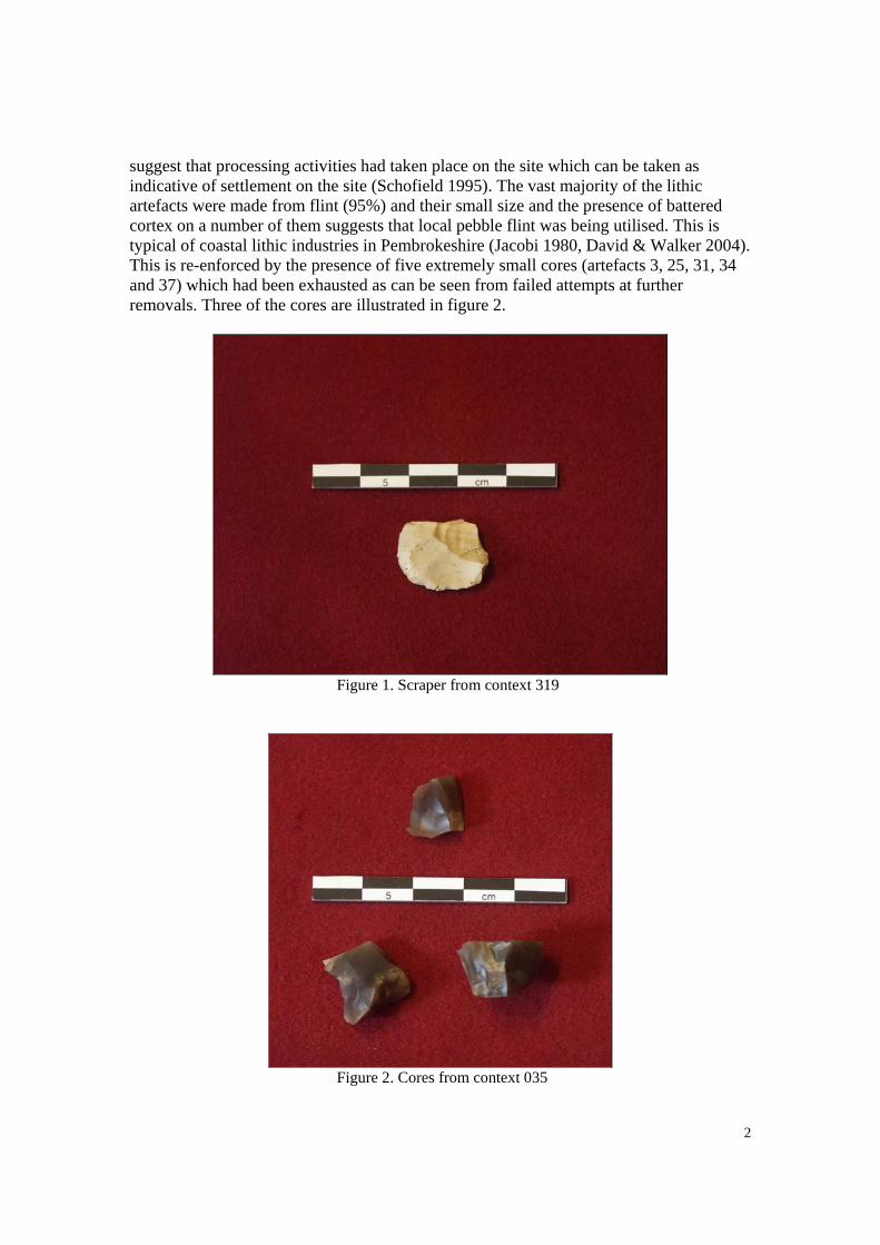
2
suggest that processing activities had taken place on the site which can be taken as indicative of settlement on the site (Schofield 1995). The vast majority of the lithic artefacts were made from flint (95%) and their small size and the presence of battered cortex on a number of them suggests that local pebble flint was being utilised. This is typical of coastal lithic industries in Pembrokeshire (Jacobi 1980, David & Walker 2004). This is re-enforced by the presence of five extremely small cores (artefacts 3, 25, 31, 34 and 37) which had been exhausted as can be seen from failed attempts at further removals. Three of the cores are illustrated in figure 2.
Figure 1. Scraper from context 319
Figure 2. Cores from context 035

3
The number of lithics made from different raw materials is shown in Table 2 below.
Raw Material Quantity Flint 36 Quartz 1 Chert 1 Other Total 38
Table 2. Breakdown of lithics by raw material. Contamination The lithic material that was discovered in discrete contexts came from cut features such as post-holes and pits. There is always the chance that some residual artefacts have been included within those features and all the features on the site had been heavily truncated. Residuality Excavations at Bolton Hill Quarry site have confirmed that this area of landscape has been favoured for settlement in the Neolithic and Bronze Age periods and therefore the potential for material to become incorporated in the fills of features cut into the ground at a later date will always remain. Condition None of the pieces show no fresh breaks and therefore the broken pieces have been broken in antiquity prior to discard. Primary Sources and Documentation There are no primary sources or documentation that might enhance the study of this collection. Means of Collecting the Data The lithics were excavated from the ground using hand tools (trowels and small tools) and from sieves with a 1cm2 mesh. Each lithic was washed in tap water and gently cleaned with a toothbrush before being left to air dry. Each lithic was placed in an individual plastic bag that was labelled with a unique small find number and the context number. For the assessment, the lithics were un-bagged and laid out on tables and grouped by context. lithic counts were recorded and a preliminary examination made of all pieces. The lithics were then re-bagged and packed, by context, into a sturdy plastic storage box. 2. STATEMENT OF POTENTIAL Value of the Data

4
This assemblage of material is very small and of little potential to inform research agendas for the region but should be combined with the other material from the excavations at the site and thus be available to future researchers. 3. ARCHIVE REQUIREMENTS Storage and Curation The lithics are currently contained in sealed and labelled plastic bags. Each lithic is individually bagged and those lithics from the same context all bagged again in a context specific larger bag. These bags are stored in a sturdy plastic storage box. Retention and Discard Policy It is recommended that all of this collection is kept for future study. 4. REFERENCES David, A. and Walker, E. A. 2004. Wales during the Mesolithic Period. In A. Saville (ed.) Mesolithic Scotland and its Neighbours: The Early Holocene Prehistory of Scotland, its British and Irish Context, and some northern European Perspectives, 299-388. Edinburgh: Society of Antiquaries of Scotland. Jacobi, R.M. 1980. The Early Holocene settlement of Wales. In J.A. Taylor (ed.). Culture and Environment in Prehistoric Wales, 131-206. Oxford: British Archaeological Reports (British Series 76). Schofield, A.J. 1995. Settlement Mobility and La Longue Duree: towards a Context for surface Lithic Material. In A.J. Schofield (ed.) Lithics in Context: Suggestions for the future direction of Lithic Studies,105-113. London: Lithic Studies Occasional Paper No.5

Report on the petrography of some
Neolithic pottery from Bolton Hill Quarry,
Pembrokeshire
By Julie Dunne
8/9/2010

2
Introduction
Ten Neolithic pottery sherds recovered from excavations at Bolton Hill Quarry by
ARS Ltd were received for petrographic examination. The analysis of these samples
aimed to characterise the fabric and mineralogical composition of the sherds and to
attempt to provenance the materials used in the fabrication of the pottery.
Methodology
The thin sections were prepared by The Open University using the standard technique
of fixing thin slices of pottery, abraded to a standard thickness of 0.03mm, to glass
slides. They were examined under a polarizing microscope at magnifications of 4,
10 and 40. The clay matrix was described by colour, texture and orientation, and,
where possible, anisotropy of the matrix was recorded and the fine grained inclusions
in the matrix were identified.
The inclusions (opening agents) were listed in approximate order from the most
abundant to the least and the shape of grains was identified using Pettijohn’s (1975)
visual chart for properties of roundness. Optical properties of the minerals, including
colour, cleavage, birefringence and refractive index are described and size, shape,
detail of the clay matrix and any visible inclusions were also recorded for the grog
that was present in some of the thin sections.
The technique of point-counting (modal analysis) was used in order to obtain an
accurate frequency distribution of the inclusions identified within the thin sections.
This was carried out using a polarising microscope which has an eyepiece with a
crosshair and a stage with an attachment that moves the thin section in fixed
increments beneath the crosshair. A series of 200 observations were made (per thin
section) at fixed intervals of 1mm and the grain visible on the crosshair at this point
was assigned to either the type of temper, such as mineral inclusion, grog or organic
material, or recorded as the clay matrix or void according to conventions as discussed
by Stoltman (1989, 148). If a grain covered more than one point a measurement was
recorded for each intersection.
These data form the basis for the quantitative assessments which lead to the
classification and interpretation of the pottery fabrics.

3
Characterisation
Sherd 035/38
Body sherd with slight oxidation on outer surface and a darker core. The clay matrix
is dark brown and medium textured containing detrital, silt–sized quartz, lithic
material and sparse platy muscovite mica. The clay particles show considerable
alignment which, together with the elongate vesicles which are also present in the
matrix, suggest that the clay was well worked.
The sherd is very densely textured (figure 1) with single and composite grains of
quartz which vary from 1 - 4 mm in size, with one of 7mm length. The quartz is
extremely strained, displaying strong undulose extinction and a high volume of fluid
inclusions indicating a hydrothermal origin. The quartz is very lustrous in appearance
and is characterised by its angularity and freshness of fracture, suggesting that it was
deliberately crushed and added to the clay.
Also present is one small clast (0.8mm) of strongly foliated, iron-stained slate
containing detrital grains of quartz and mica.
Figure 1. Pie chart showing proportions of matrix, voids and inclusions prepared from point count of
sherd 035/38.
Sherd 035/45
Body sherd with no visible oxidation. The clay matrix is dark brown and sparsely
textured with detrital, silt–sized quartz and lithic material. The fabric appears very
smooth and the clay particles show considerable alignment which suggests the clay
was well worked. The matrix is also defined by different textural zones and dark/light
banding. The lighter bands are much more densely textured and it seems likely that
clay from two different sources was combined together in this clay matrix.
There are few inclusions within the sherd (figure 2) but those that are present are very
angular, indicating that the source rock was deliberately crushed and added to the
matrix. The main inclusions, generally ˂1mm but one of 7mm, appear very weathered
and appear pegmatitic in origin. They comprise extremely strained and angular quartz
with very strong undulose extinction, altered feldspar and a small amount of platy
muscovite mica displaying 2nd
order interference colours.

4
Also present is sparse sub-rounded to sub-angular quartz up to 0.5mm and one grog
clast (1mm) with a dark brown fabric containing fine grained quartz, lithic and opaque
grains.
Figure 2. Pie chart showing proportions of matrix, voids and inclusions prepared from point count of
sherd 035/45.
Sherd 041/6
Rim sherd with slightly oxidised surface and darker core. The clay matrix is dark
brown and densely textured containing abundant detrital, silt–sized quartz, lithic
material and some platy muscovite mica.
The sherd is very densely textured (figure 3) with monocrystalline and polycrystalline
grains of sub-angular to angular quartz which varies from 0.1 - 4 mm in size. The
quartz is extremely strained, displaying strong undulose extinction and a high volume
of fluid inclusions indicating a hydrothermal origin. The larger quartz inclusions are
characterised by their angularity and freshness of fracture whereas the small quartz
grains are much more rounded.
There are also several fragments of a fine grained micaceous sandstone present (up to
2.5mm), containing well sorted, rounded quartz and opaque grains, together with a
more poorly sorted sandstone containing sub-angular, stressed quartz, sometimes
heavily masked with iron oxide.
Slate – up to 2mm, dark brown fragments displaying strong foliation and containing
detrital quartz and mica grains.
Flint/chert 0.5mm
Granite clast 0.6mm
Plagioclase feldspar grains exhibiting polysynthetic twinning. These fragments of
individual feldspar indicate that upon crushing the rock may have separated along the
edges of the larger crystals, resulting in their incorporation as single crystal fragments.

5
Figure 3. Pie chart showing proportions of matrix, voids and inclusions prepared from point count of
sherd 041/6.
Sherd 041/12
Rim sherd with slight oxidation on outer surface and a darker core. The clay matrix is
dark brown and densely textured with abundant detrital, silt–sized quartz, lithic
material and some platy muscovite mica.
The sherd is very densely textured (figure 4) with monocrystalline and polycrystalline
grains of sub-angular to angular quartz which varies from 0.2 - 4 mm in size. The
quartz is extremely strained, displaying strong undulose extinction and a high volume
of fluid inclusions indicating a hydrothermal origin. The larger quartz inclusions are
characterised by their angularity and freshness of fracture whereas the small quartz
grains are much more rounded.
Other inclusions include rounded clasts of fine-grained micaceous sandstone (up to
3.5mm) consisting of well sorted, rounded grains of quartz, plagioclase feldspar
displaying polysynthetic twinning, and lithic clasts, muscovite flakes and opaque
material. Also present is a poorly sorted, loosely packed sandstone (1.0 – 1.5mm)
comprising sub-angular to angular grains of quartz, plagioclase feldspar, muscovite
mica, and flint/chert in a micaceous groundmass.
Slate – up to 0.8mm, dark brown fragments displaying strong foliation and containing
detrital quartz and mica grains.
Flint/chert – several small fragments up to 0.5mm.
Granite clast 0.8mm
Rounded opaque grains, 0.02 – 0.04mm.
Figure 4. Pie chart showing proportions of matrix, voids and inclusions prepared from point count of
sherd 041/12.
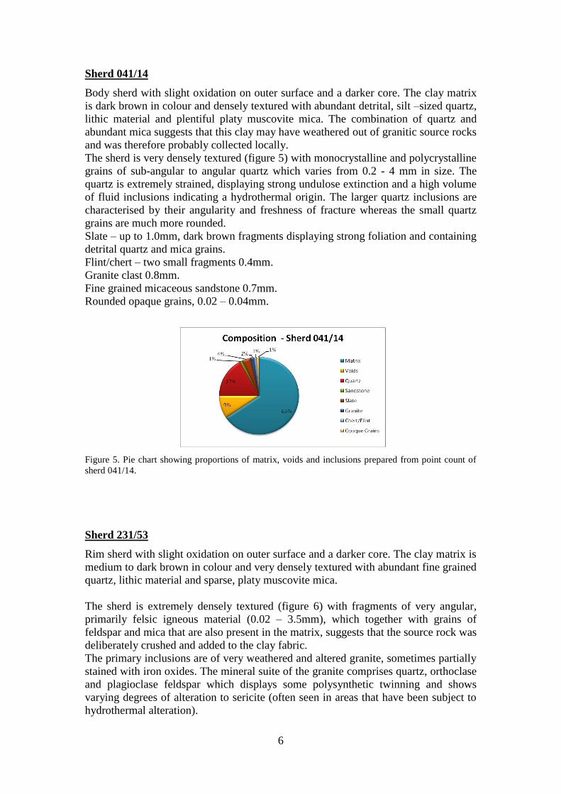
6
Sherd 041/14
Body sherd with slight oxidation on outer surface and a darker core. The clay matrix
is dark brown in colour and densely textured with abundant detrital, silt –sized quartz,
lithic material and plentiful platy muscovite mica. The combination of quartz and
abundant mica suggests that this clay may have weathered out of granitic source rocks
and was therefore probably collected locally.
The sherd is very densely textured (figure 5) with monocrystalline and polycrystalline
grains of sub-angular to angular quartz which varies from 0.2 - 4 mm in size. The
quartz is extremely strained, displaying strong undulose extinction and a high volume
of fluid inclusions indicating a hydrothermal origin. The larger quartz inclusions are
characterised by their angularity and freshness of fracture whereas the small quartz
grains are much more rounded.
Slate – up to 1.0mm, dark brown fragments displaying strong foliation and containing
detrital quartz and mica grains.
Flint/chert – two small fragments 0.4mm.
Granite clast 0.8mm.
Fine grained micaceous sandstone 0.7mm.
Rounded opaque grains, 0.02 – 0.04mm.
Figure 5. Pie chart showing proportions of matrix, voids and inclusions prepared from point count of
sherd 041/14.
Sherd 231/53
Rim sherd with slight oxidation on outer surface and a darker core. The clay matrix is
medium to dark brown in colour and very densely textured with abundant fine grained
quartz, lithic material and sparse, platy muscovite mica.
The sherd is extremely densely textured (figure 6) with fragments of very angular,
primarily felsic igneous material (0.02 – 3.5mm), which together with grains of
feldspar and mica that are also present in the matrix, suggests that the source rock was
deliberately crushed and added to the clay fabric.
The primary inclusions are of very weathered and altered granite, sometimes partially
stained with iron oxides. The mineral suite of the granite comprises quartz, orthoclase
and plagioclase feldspar which displays some polysynthetic twinning and shows
varying degrees of alteration to sericite (often seen in areas that have been subject to
hydrothermal alteration).

7
Also present are inclusions of an intermediate diorite with an inequigranular texture
containing generally subhedral crystals. These include heavily altered plagioclase
feldspar, augite with green – brown pleochroism, lath-shaped, dark brown hornblende
and fibrous chloritised biotite.
Figure 6. Pie chart showing proportions of matrix, voids and inclusions prepared from point count of
sherd 231/53.
Sherd 362/79
Rim sherd with slight oxidation on outer surface and a darker core. The clay matrix is
dark brown and almost isotropic with a lightly textured groundmass containing
detrital, silt–sized quartz, lithic material and some platy muscovite mica. There are
some shrinkage rims around inclusions which probably occurred during drying or
firing of the clay.
The sherd is densely tempered (figure 7) with angular grog fragments, up to 2mm.
The grog is homogeneous in composition and texturally similar to the clay matrix.
Inclusions visible within the grog include strained quartz and possibly some heavily
altered granite/diorite clasts.
Also present is a 2mm inclusion of very weathered and altered igneous rock, probably
a quartz diorite, which is partially masked by iron oxides. It contains a small amount
of quartz, feldspar altered to sericite, clinopyroxene, chloritised biotite and some dark
brown hornblende.
Sparse sub-rounded to sub-angular quartz grains, 0.01 – 0.05mm.
Figure 7. Pie chart showing proportions of matrix, voids and inclusions prepared from point count of
sherd 362/79.
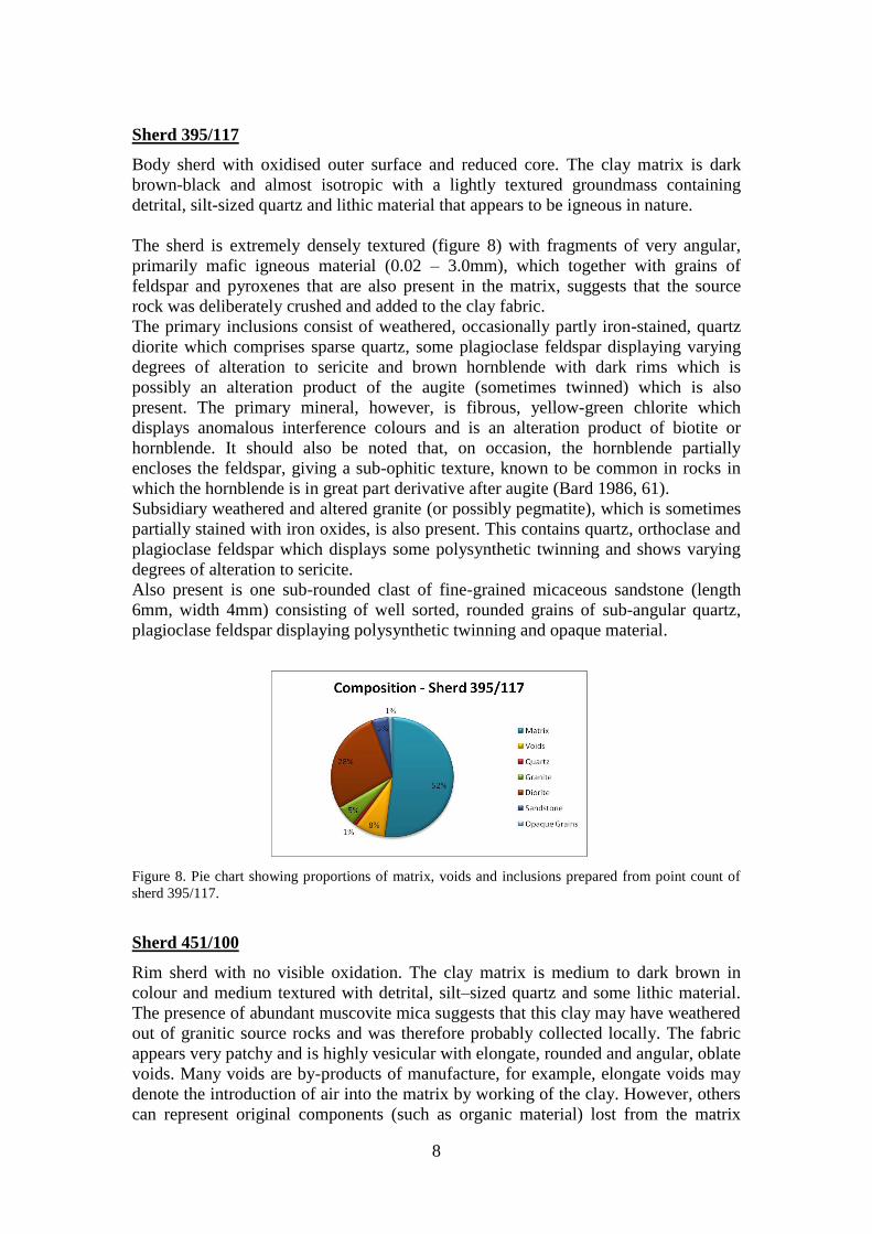
8
Sherd 395/117
Body sherd with oxidised outer surface and reduced core. The clay matrix is dark
brown-black and almost isotropic with a lightly textured groundmass containing
detrital, silt-sized quartz and lithic material that appears to be igneous in nature.
The sherd is extremely densely textured (figure 8) with fragments of very angular,
primarily mafic igneous material (0.02 – 3.0mm), which together with grains of
feldspar and pyroxenes that are also present in the matrix, suggests that the source
rock was deliberately crushed and added to the clay fabric.
The primary inclusions consist of weathered, occasionally partly iron-stained, quartz
diorite which comprises sparse quartz, some plagioclase feldspar displaying varying
degrees of alteration to sericite and brown hornblende with dark rims which is
possibly an alteration product of the augite (sometimes twinned) which is also
present. The primary mineral, however, is fibrous, yellow-green chlorite which
displays anomalous interference colours and is an alteration product of biotite or
hornblende. It should also be noted that, on occasion, the hornblende partially
encloses the feldspar, giving a sub-ophitic texture, known to be common in rocks in
which the hornblende is in great part derivative after augite (Bard 1986, 61).
Subsidiary weathered and altered granite (or possibly pegmatite), which is sometimes
partially stained with iron oxides, is also present. This contains quartz, orthoclase and
plagioclase feldspar which displays some polysynthetic twinning and shows varying
degrees of alteration to sericite.
Also present is one sub-rounded clast of fine-grained micaceous sandstone (length
6mm, width 4mm) consisting of well sorted, rounded grains of sub-angular quartz,
plagioclase feldspar displaying polysynthetic twinning and opaque material.
Figure 8. Pie chart showing proportions of matrix, voids and inclusions prepared from point count of
sherd 395/117.
Sherd 451/100
Rim sherd with no visible oxidation. The clay matrix is medium to dark brown in
colour and medium textured with detrital, silt–sized quartz and some lithic material.
The presence of abundant muscovite mica suggests that this clay may have weathered
out of granitic source rocks and was therefore probably collected locally. The fabric
appears very patchy and is highly vesicular with elongate, rounded and angular, oblate
voids. Many voids are by-products of manufacture, for example, elongate voids may
denote the introduction of air into the matrix by working of the clay. However, others
can represent original components (such as organic material) lost from the matrix
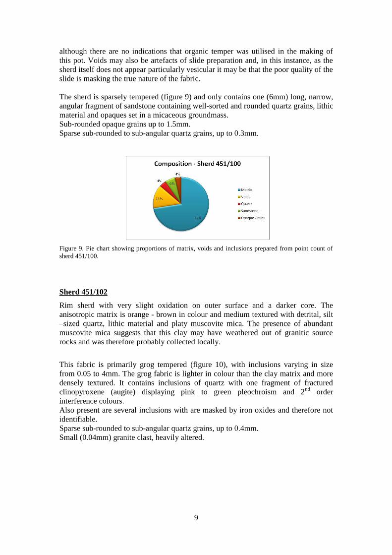
9
although there are no indications that organic temper was utilised in the making of
this pot. Voids may also be artefacts of slide preparation and, in this instance, as the
sherd itself does not appear particularly vesicular it may be that the poor quality of the
slide is masking the true nature of the fabric.
The sherd is sparsely tempered (figure 9) and only contains one (6mm) long, narrow,
angular fragment of sandstone containing well-sorted and rounded quartz grains, lithic
material and opaques set in a micaceous groundmass.
Sub-rounded opaque grains up to 1.5mm.
Sparse sub-rounded to sub-angular quartz grains, up to 0.3mm.
Figure 9. Pie chart showing proportions of matrix, voids and inclusions prepared from point count of
sherd 451/100.
Sherd 451/102
Rim sherd with very slight oxidation on outer surface and a darker core. The
anisotropic matrix is orange - brown in colour and medium textured with detrital, silt
–sized quartz, lithic material and platy muscovite mica. The presence of abundant
muscovite mica suggests that this clay may have weathered out of granitic source
rocks and was therefore probably collected locally.
This fabric is primarily grog tempered (figure 10), with inclusions varying in size
from 0.05 to 4mm. The grog fabric is lighter in colour than the clay matrix and more
densely textured. It contains inclusions of quartz with one fragment of fractured
clinopyroxene (augite) displaying pink to green pleochroism and 2nd
order
interference colours.
Also present are several inclusions with are masked by iron oxides and therefore not
identifiable.
Sparse sub-rounded to sub-angular quartz grains, up to 0.4mm.
Small (0.04mm) granite clast, heavily altered.

10
Figure 10. Pie chart showing proportions of matrix, voids and inclusions prepared from point count of
sherd 451/102.
Provenance
Local Geology
The site at Bolton Hill Quarry is located on the Pre-Cambrian rocks of the Johnston
Series. These plutonic igneous rocks are exposed in two small inliers in South
Pembrokeshire, occupying the area around Llangwm and Johnston (George 1970, 13).
Samples of rock from Bolton Hill Quarry were analysed by Thorpe (1970) who
identified granite, diorite and granodiorite comprising mineral suites of quartz,
plagioclase and hornblende. Thorpe (1970) notes that the plagioclase is often partially
altered to sericite and that the hornblende often shows replacement by chlorite, as
does the accessory mineral, biotite. The quartzo-feldspathic minerals show frequent
signs of strain and this alteration and deformation is regarded as being related to a low
grade metamorphic event. At many places within the outcrop of the Johnston Series
quartz-dolerites and veins of unfoliated pegmatites can be seen cutting the basic rock
types (Claxton 1963, 222).
Within the wider area, the Johnston series inliers are set within the Carboniferous
Coal Measures in which sandstones and shales are common. The bedrock geology of
Pembrokeshire is extremely complex and need not be detailed here but it should be
noted that Devonian Old Red Sandstone is found to the south and west of Johnston,
and both the Cambrian Lingula Flags Formation of siliceous sandstone, mudstones
and shales and Ordovician slate are situated to the east of St. Davids Head (George
1970).
Clast dominated fabrics
Sherds 231/53 and 395/117
The igneous material identified in sherds 231/53 and 395/117 comprises diorites and
granites containing extremely similar mineral suites to the Bolton Hill rocks described
by Thorpe (1970) and therefore it seems probable that these ceramics were tempered
with local material. Although it can sometimes be difficult to recognise the difference

11
between naturally occurring and deliberately added materials to a ceramic, angularity
and polymineralic composition are good indicators of deliberate crushing prior to
addition. The inclusions in these sherds certainly appear to have been deliberately
crushed and added to the clay and their weathered appearance suggests they were
more likely to have been ground up from rock debris lying on the ground although
they may have been collected from naturally weathered exposures.
It should be noted that the granitic rock described in both these sherds could also be
attributed to the veins of pegmatite aplite found in the Johnston Series.
Sherd 035/45
Sherd 035/45 is very sparsely textured with igneous material of pegmatitic origin,
together with sparse, small quartz grains and one undiagnostic grog fragment.
Pegmatite is found at Bolton Hill Quarry and therefore a local origin is possible for
this vessel. It is interesting to note that the fabric may contain two types of clay and is
extremely well worked.
It should be noted that, despite being found in the same context, sherds 035/38 and
035/45 are compositionally extremely different and therefore do not originate from
the same vessel.
Sherd 035/38
This sherd is densely textured with highly stressed white quartz of a very lustrous
appearance, characterised by its angularity and freshness of fracture. Although the
(very small) sherd itself does not externally display the characteristic white quartz
which breaks the surfaces of Peterborough Ware vessels (Gibson 1995, 29), it seems
likely that this vessel belongs within that tradition. Specks and sparse, small veins of
white quartz are found at the quarry (pers comm. Peter Sobel) and it is therefore
possible that this vessel was made locally.
The angular nature of the quartz, together with its polymineralic composition suggests
that it was deliberately crushed and added to the clay, for, as Gibson (1995, 29)
indicates, although quartz is undoubtedly common in Wales, the consistency with
which it appears as a deliberately added opening agent strongly suggests deliberate
selection.
Sherd 451/100
The presence of abundant muscovite mica in the matrix fabric suggests that this clay
may have weathered out of granitic source rocks and was therefore probably collected
locally. The sherd is characterised by its highly vesicular nature, which can indicate
the loss of original components from the matrix, such as the burning out of organic
temper or the leaching out of minerals. However, in this instance, as the sherd itself
does not appear particularly vesicular, this may just be a product of poor slide
preparation.
The sparse inclusions comprise one large fragment of sandstone together with minor
quantities of quartz and opaque grains. Sandstone is found locally, within the
Carboniferous Coal Measures, and could also have been sourced from pebbles and

12
boulders of glacial till strewn about on the surface, although this is unlikely to
originate from the Quarry area itself which is located on the top of a hill.
Sherds 041/6, 041/12 and 041/14
As can be seen (figure 11), sherds 041/6, 041/12 and 041/14 are virtually
compositionally identical and either originate from one vessel or were made in the
same ceramic tradition.
Figure 11. Chart showing proportions of matrix, voids and inclusions for sherds 041/6, 041/12 and
041/14.
These three sherds can be attributed to the Peterborough Ware tradition through the
presence of white quartz seen breaking from the surfaces of the sherds (Gibson 1995,
29). This white quartz is the primary inclusion within the three sherds. It consists of
both single and composite angular grains of an extremely strained nature, indicating
deliberate selection. Specks and sparse, small veins of white quartz are found at the
quarry (pers comm. Peter Sobel) and it is therefore possible that this vessel was made
locally, although as quartz is commonly found elsewhere throughout south Wales, a
different provenance is equally likely.
The secondary components used as opening agents include fine-grained micaceous
sandstone, a second poorly sorted, loosely packed sandstone and small igneous
fragments together with flint/chert, opaque grains and slate (possibly a foliated
siltstone). These are all of an angular nature and do not display the characteristics of
grains rounded by transport commonly found in river sands. These inclusions may
therefore originate from areas of sandstones, mudstones and shales previously
mentioned in the (brief) description of local geology and consequently been deposited
as the glacial till which now makes up the drift geology in the wider area.
13
Grog dominated fabrics
Sherd 362/79
Sherd 362/79 is primarily grog textured. Grog, although revealing in that it mirrors
the range of redundant pottery fabrics that were re-used, does not have the same
sensitivity as rock clasts for defining potential provenance. In this sherd, the grog
fragments are small (up to 2mm) and do not contain many inclusions. However, there
is some stressed quartz and possible granite clasts, which, together with the heavily
altered diorite found within this sherd, make it possible to suggest a likely local
origin.
Sherd 451/102
This primary opening agent used within this vessel is grog which is lighter in colour
and more densely textured than the clay matrix. However, the grog is generally
undiagnostic and does not contain many large inclusions, apart from one fragment of
augite which probably originated from rock of an igneous nature. Also present is a
small fragment of either granitic or pegmatitic origin which may also suggest a local
origin, but could also relate to other sources of volcanic rock in England or Wales.
Again, the presence of abundant muscovite mica in the matrix fabric suggests that this
clay may have weathered out of granitic source rocks and was therefore probably
collected locally. However, it should be noted that, despite being found in the same
context, sherds 451/100 and 451/102 are compositionally different and therefore do
not originate from the same vessel.
Discussion
The results of this petrographic analysis can be interpreted in terms of both the
provenance of the materials used and also in terms of affinities as a group. This data
could then be applied to their suggested typology.
The grog dominated sherds, 362/79 and 451/102, also both contain minor components
of an igneous material which is likely to have been sourced locally and thus form a
coherent group.
Sherds 035/45, 231/53 and 395/117, which are dominated by inclusions of diorite,
granite and pegmatite, can all be provenanced to the geology of the Johnston Series
and can therefore be attributed to a local origin. It should be noted that, of the total
assemblage analysed, sherd 231/53 can solely be attributed to the Grooved Ware
tradition.
The Peterborough Ware sherds, 041/6, 041/12 and 041/14, which probably originate
from the same vessel, and 035/38 which also contains angular white quartz as the

14
primary opening agent, also form a coherent group. A definite provenance cannot be
established but a local origin is possible.
Sherd 451/100 is very vesicular and contains inclusions of sparse sandstone.
Unfortunately, if inclusions in a ceramic consist of sedimentary rocks, such as
sandstone from more homogenous geological sequences, then it will only be possible
to define the provenance of the vessel with broad limits and confirm that local
production is possible.
Bibliography
Bard, J.P. (1986) Microtextures of Igneous and Metamorphic Rocks. (Dordrecht,
Holland: D. Reidel Publishing Company)
Claxton, C.W. (1963) An Occurrence of Regionally Metamorphosed Pre-Cambrian
Schists in South-West Pembrokeshire. Geological Magazine 100, 219-223
George, T.N. (1970) British Regional Geology: South Wales, third edition. (London:
Her Majesty’s Stationery Office)
Gibson, A. (1995) First impressions: a review of Peterborough Ware in Wales. In I.
Kinnes and G. Varndell (eds) ‘Unbaked Urns of Rudely Shape’ Essays on British and
Irish Pottery for Ian Longworth. (Oxford: Oxbow Books) 23-40
Pettijohn, F.J. (1975) Sedimentary Rocks 3rd
edition. (New York: Harper and Row
Publishers Inc.)
Stoltman, J.B. (1989) A Quantative Approach to the Petrographic Analysis of
Ceramic Thin Sections. American Antiquity 54, 147-160
Thorpe, R.S. (1970) The origin of a Pre-Cambrian diorite-granite plutonic series from
Pembrokeshire (Wales). Geological Magazine 107, 491-499

The analysis of absorbed residues from Bolton Hill Quarry: an interim report.
Lucy J E Cramp
Organic Geochemistry Unit, School of Chemistry, University of Bristol BS8 1TS
Introduction
The ceramic matrix of unglazed archaeological pottery provides favourable conditions for the absorption and subsequent preservation of lipid molecules deriving from the contents that were stored or processed within the vessels (Dudd et al., 1999; Evershed et al., 1990; Evershed et al., 1992; Evershed et al., 1999; Heron et al., 1991). The extraction and characterisation of these residues using solvent extraction and a combination of high temperature gas chromatography (HTGC) and gas chromatography/mass spectrometry (GC/MS) provides us with a fingerprint of ‘biomarkers’ that may be related back to the original contents of ancient vessels, allowing the reconstruction of the commodity or commodities that were utilised in antiquity. Further analysis of the isotopic composition of the major fatty acids (GC/C/IRMS) provides a more specific identification of the major source of animal fats (Evershed et al., 2002a).
Sixteen Neolithic pottery sherds from Bolton Hill Quarry in Pembrokeshire were submitted for organic residue analysis. This report provides the results of the initial stages of analysis. All sherds submitted have thus far been solvent extracted and screened via HTGC in order to quantify lipids preserved in residues and assess further analyses required. HTGC/MS was then performed upon selected aliquots in order to identify the components present within the residues.
Further analyses using GC/MS‐SIM and GC/C/IRMS will be performed in due course and may alter the current interpretation presented here.
Analytical protocol
The pottery sherds were photographed and then the exterior surfaces of approximately 2 g sherd cleaned using a modelling drill. The cleaned area was removed with a chisel and crushed to powder using a mortar and pestle. After the addition of 20 µg internal standard (C34 n‐alkane), the powdered sherd was then solvent‐extracted (2 x 10 ml CHCl3/MeOH, 2:1 v/v, sonication x 20 min and centrifugation x 15 min at 2500 rpm). After the removal of solvent using a gentle stream of N2, aliquots of the resultant total lipid extract (TLE) were filtered through a silica column and then treated with 40 µl N,O‐bis(trimethylsilyl)trifluoroacetemide (BSTFA, 70°, 1 h). These TMS ether and ester derivatives were dissolved in an appropriate volume of hexane and screened using high temperature gas chromatography (HTGC). Samples were introduced via a cool on‐column injector onto a non‐polar high temperature column coated with a 100 % dimethyl polysiloxane stationary phase (DB1‐HT, 15 m x 0.32 mm i.d. with 0.1 µm film thickness). The oven temperature comprised a 2 min isothermal at 50° and then ramped at 10° min‐1 to 350°, followed by a 15 min isothermal. The carrier gas was helium with a continuous column flow of 4 ml min‐1.

High temperature gas chromatography/mass spectrometry was performed on selected trimethylsilylated aliquots via a Perkin Elmer single quadropole TurboMass Gold mass spectrometer (electron energy of 40 ‐ 70 eV, scan range of m/z 50‐850 and a scan time of 0.2 s). The column and temperature programme was identical to that used for HTGC. Data were acquired using Turbomass version 4.5 and processed using Xcalibur (version 1.4 SR1). Compounds were identified by their elution times and orders and comparison with standards and library mass spectra.
Pottery sherd samples
A total of sixteen sherds from Bolton Hill were analysed; these are summarised in Table 1 below:
Table 1. List of sherds analysed from Bolton Hill Quarry
Lab ref Sample mass (g) Deposit Find no. Vessel part BHQ‐1 1.42 451 102 Rim BHQ‐2 1.41 451 100 Rim BHQ‐3 2.48 395 117 Mid‐body BHQ‐4 1.79 362 79 Mid‐body BHQ‐5 2.34 35 45 Mid‐body BHQ‐6 2.58 41 12 Mid‐body BHQ‐7 1.31 41 14 Mid‐body BHQ‐8 1.77 231 53 Mid‐body BHQ‐9 1.49 35 38 Mid‐body BHQ‐10 1.92 041 6 Mid‐body BHQ‐11 1.16 35 44 Mid‐body BHQ‐12 1.28 451 104 Mid‐body BHQ‐13 1.01 231 52 Mid‐body BHQ‐13 1.85 041 4 Mid‐body BHQ‐15 1.65 451 108 Mid‐body BHQ‐16 1.77 362 76 Mid‐body
Preservation and characterisation of absorbed lipid in Bolton Hill Quarry
Lipid was well‐preserved in residues extracted from the Bolton Quarry sherds (Table 2). Significant concentrations of lipid (> 5 ug lipid per gram of crushed pottery) were present in 13 (81 %) sherds analysed. Intact triacylglycerols, which comprise the major component of fresh fats, were present in seven residues, whilst the remainder comprised free fatty acids which are released via the hydrolytic degradation of the original triacylglycerols. The majority of residues contained high relative concentrations of C18:0 fatty acid (stearic acid) and distributions of intact tri‐, di‐ and monoacylglycerols that are characteristic of partially‐degraded animal fats (Table 2). Significant concentrations of odd‐ and branched chain fatty acids indicate a ruminant origin for the residues, whilst the carbon number range for the triacylglycerols was notably broad (C42‐C54) which is suggestive of a dairy origin for the fats (Christie, 1981). However, preferential loss of shorter‐chain fatty acids from dairy fats during burial results in a triacylglycerol distribution that can rarely reliably be distinguished from adipose fats (Dudd et al., 1998; Evershed et al., 2002b) and compound‐specific stable carbon isotope analysis is therefore required to confirm the origin of these fats. A distinctive distribution of mid‐chain ketones of carbon chain length 29‐35 was present in three residues. This distinctive pattern has been identified elsewhere in archaeological pottery residues and shown to
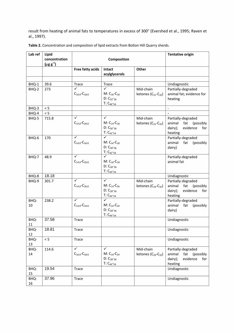
result from heating of animal fats to temperatures in excess of 300° (Evershed et al., 1995; Raven et al., 1997).
Table 2. Concentration and composition of lipid extracts from Bolton Hill Quarry sherds.
Lab ref Lipid concentration (μg g‐1)
Composition Tentative origin
Free fatty acids Intact acylglycerols
Other
BHQ‐1 39.6 Trace Trace Undiagnostic BHQ‐2 273
C16:0‐C18:0
M: C16‐C18 D: C32‐36 T: C46‐54
Mid‐chain ketones (C31‐C35)
Partially‐degraded animal fat; evidence for heating
BHQ‐3 < 5 ‐ BHQ‐4 < 5 ‐ BHQ‐5 715.8
C14:0‐C26:0
M: C14‐C18 D: C30‐36 T: C42‐54
Mid‐chain ketones (C31‐C35)
Partially‐degraded animal fat (possibly dairy); evidence for heating
BHQ‐6 170 C14:0‐C24:0
M: C14‐C18 D: C28‐36 T: C42‐54
Partially‐degraded animal fat (possibly dairy)
BHQ‐7 48.9 C14:0‐C20:0
M: C16‐C18 D: C28‐36 T: C44‐54
Partially‐degraded animal fat
BHQ‐8 18.18 Undiagnostic BHQ‐9 301.7
C14:0‐C26:0
M: C14‐C26 D: C28‐36 T: C44‐54
Mid‐chain ketones (C29‐C35)
Partially‐degraded animal fat (possibly dairy); evidence for heating
BHQ‐10
238.2 C14:0‐C24:0
M: C14‐C24 D: C28‐36 T: C44‐54
Partially‐degraded animal fat (possibly dairy)
BHQ‐11
37.58 Trace Undiagnostic
BHQ‐12
18.81 Trace Undiagnostic
BHQ‐13
< 5 Trace Undiagnostic
BHQ‐14
114.6 C16:0‐C18:0
M: C14‐C24 D: C28‐36 T: C44‐54
Mid‐chain ketones (C29‐C35)
Partially‐degraded animal fat (possibly dairy); evidence for heating
BHQ‐15
19.54 Trace Undiagnostic
BHQ‐16
37.96 Trace Undiagnostic

14 16 18 20 22 24 26 28 30 32 340
10
20
30
40
50
60
70
80
90
100
10
20
30
40
50
60
70
80
90
100R
elat
ive
abun
danc
e
Time (min)
C42 - C54 triacylglycerols
BHQ - 6
BHQ-9
C28-C36 diacylglycerols
Internal standard
Internal standard
C14 - C18 monoacylglycerols
16:0 fatty acid
18:0 fatty acid
14:0 fatty acid
16:0 fatty acid
14:0 fatty acid
18:0 fatty acid
C14 - C18 monoacylglycerolsC28-C36 diacylglycerols
C44 - C54 triacylglycerols
C35 K
C33 K
C31 K
Figure 1. Partial high temperature gas chromatograms from sherds BHQ‐6 and BHQ‐9. X:y fatty acid denotes the carbon chain length (x) and degree of unsaturation (y). K – mid‐chain ketone.
Summary and future work
Absorbed lipid residues were well‐preserved on ceramic sherds from Bolton Hill Quarry, with the majority of residues that could be characterised resembling degraded animal fat. The wide carbon distribution of triacylglycerols in a number of residues is suggestive of a ruminant dairy fat origin; however this may only be confirmed via GC/C/IRMS, to be performed in due course. The distinctive distribution of mid‐chain ketones identified in three residues is indicative that these sherds were heated, likely during the cooking of contents.
Since the analysis of these vessels was performed as part of a NERC‐funded large‐scale investigation into the detection of the processing of marine products in prehistory, the possible presence of specific marine biomarkers will be investigated in the future. These biomarkers include: i) isoprenoid fatty acids such as phytanic acid and trimethyltetradecanoic acid (4,8,12‐TMTD) which are present in marine lipids but only observed in low concentrations in terrestrial fats and ii) long chain (>C20) ω(o‐alkylphenyl)alkanoic acids which have been shown to form from the heating of unsaturated fatty acids which are characteristic of marine fats and oils (Hansel et al., 2004; Copley et al., 2004; Evershed et al., 2008). The GC/MS will be operated in full scan and selected ion monitoring mode in order to search for possible marine biomarkers at significantly higher sensitivity. Compound‐specific stable isotope analysis of the major fatty acid components of selected residues will also be performed to further elucidate the origins of fats and thus establish whether the major contributing sources were from a ruminant (bovine or ovine) adipose, ruminant dairy or non‐ruminant (e.g. porcine) or marine origin, through the comparison of the isotopic composition of palmitic (C16:0) and stearic (C18:0) acids with reference datasets.

References
Christie WW (1981). Effects of diet on lipid composition. In WW Christie (ed.), Lipid metabolism in ruminant animals, pp.203‐26. Oxford: Pergamon Press.
Copley MS et al. (2004). Organic residue evidence for the processing of marine animal products in pottery vessels from the pre‐colonial archaeological site of Kasteelberg D east, South Africa. South African Journal of Science 100 (5‐6): 279‐283.
Dudd SN et al. (1998). Assessing microbial contributions to absorbed acyl lipids during laboratory degradations of fats, oils and pure triacylglycerols absorbed in ceramic potsherds. Organic Geochemistry 29:1345‐54.
Dudd SN et al. (1999). Evidence for varying patterns of exploitation of animal products in different prehistoric pottery traditions based on lipids preserved in surface and absorbed residues. Journal of Archaeological Science 26: 1473‐82.
Evershed RP et al. (1990). Analysis of organic residues of archaeological origin by High Temperature Gas Chromatography and Gas Chromatography‐Mass Spectrometry. Analyst 115: 1339‐42.
Evershed RP et al. (1992). The survival of food residues: new methods of analysis, interpretation and application. Proceedings of the British Academy 77:187‐208.
Evershed RP et al. (1995). Formation of long‐chain ketones in ancient pottery vessels by pyrolysis of acyl lipids. Tetrahedron Letters 36: 8875‐8878.
Evershed RP et al. (1999). Lipids as carriers of anthropogenic signals from prehistory. Philosophical Transactions of the Royal Society of London B 354:19‐31.
Evershed RP et al. (2002a). Identification of animal fats via compound specific δ13C values of individual fatty acids: assessments of results for reference fats and lipid extracts of archaeological pottery vessels. Documenta Praehistorica 29:73‐96.
Evershed RP et al. (2002b). Chemistry of archaeological animal fats. Accounts of Chemical Research 35:660‐668.
Evershed RP et al. (2008). Experimental evidence for the processing of marine animal products and other commodities containing polyunsaturated fatty acids in pottery vessels. Archaeometry 50: 101‐113.
Hansel F A et al. (2004). Thermally produced omega‐(o‐alkylphenyl)alkanoic acids provide evidence for the processing of marine products in archaeological pottery vessels. Tetrahedron Letters 45(14): 2999‐3002.
Heron C et al. (1991). Effects of migration of soil lipids on organic residues associated with buried potsherds. Journal of Archaeological Science 18:641‐59.
Raven AM et al. (1997). Formation of long‐chain ketones in archaeological pottery vessels by pyrolysis of acyl lipids. Journal of Analytical and Applied Pyrolysis 40(1): 267‐85.
Acknowledgements: Lipid extraction and instrumental analyses were performed by Helen Whelton.