archaeological evidence for long-term occupation of the
TRANSCRIPT
PREROGATIVES, SEA LEVEL, AND THE STRENGTH OF PERSISTENT PLACES:
Archaeological Evidence for Long-Term Occupation of the Central Coast of British Columbia
Duncan McLaren, Farid Rahemtulla , Gitla (Elroy White) , and Daryl Fedje
Introduction
This article considers the phenomenon of archaeological sites with very long occupational records on the central BC coast. This area includes the well documented archaeological site of Namu
(ElSx-1), which was occupied repeatedly for at least the last ten thousand years (Cannon 1991, 2000, 2002, 2003; Carlson 1996; Rahemtulla 2006). Cannon (2003) argues that Namu and other sites on the central coast reveal a pattern of cultural continuity that is long-term and persistent. This article presents recently acquired archaeological data from the outer shore islands to the west of Namu, demonstrating that other archaeo-logical sites on the central coast have records of human occupation and use that are of similar spans. In our interpretation of the long-term processes that contributed to the formation of these persistent places, a combination of both social and environmental factors is considered. In particular, the ethnographically described systems of prerogatives – exclusive rights and privileges held and inherited by a person, class, or village – are explored in relation to how they could have contributed to long-term patterns of settlement. In addition to this, a specific environ-mental factor is considered: the stability of sea level in the region. This provided a relatively stable shoreline along which the accumulation of archaeological deposits could occur over many millennia. The central coast of British Columbia is today a relatively remote region, accessible only by boat or aircraft. Research presented here was gathered as a part of the Hakai Ancient Landscapes Archaeology Project and work carried out by the University of Northern British Columbia’s archaeology field school. The study area for this project, situated in the
155bc studies, no. 187, Autumn 2015

bc studies156
territories of the Heiltsuk, Wuikinuxv, and Nuxalk nations, includes the outer coast islands and skerries to the north and south of Hakai Passage as well as the mainland shoreline on the east side of Fitz Hugh Sound (Figure 1). Calvert and Hunter islands are two of the major outer coast islands included in the study area. Excavations undertaken at Namu in the 1960s, 1970s, and 1990s uncovered a long-term record of site occupation spanning over ten thousand years (Carlson 1996; Hester 1978a, 1978b; Rahemtulla 2006). Archaeological deposits in the order of four metres deep, with a com-prehensive radiocarbon chronology, show repeated occupation over millennia (Cannon 1991; Carlson 1996; Luebbers 1978; Rahemtulla 1995, 2006). The earliest deposits – eleven thousand to ten thousand calendar years before present (cal BP) – lack bone but include stone tools. This basal cultural assemblage is characterized by foliate-shaped bifaces and cobble tools. Sometime between 10,000 and 9000 cal BP, microblade technology was added to the lithic suite. In deposits dating after 7000 cal BP, bone and antler artefacts and faunal remains are preserved, and shell is the primary sedimentary matrix for cultural materials after 6000 cal BP. Bone artefacts were found in abundance dating from the mid-Holocene on. Contracting stem points and ground stone adzes appear in the assemblage around 5000 cal BP, and the microblade industry becomes less pronounced. After 3000 cal BP chipped stone projectiles tend to be notched and ground stone tool types increase. Faunal elements recovered from the shell midden at Namu (Cannon 1991) reveal the types of animals harvested for human use over the last seven thousand years. Major species identified include:
Mammals: deer, harbour seal, dolphins, porpoises, sea lion, northern fur seal, sea otter, mink, marten, river otter, porcupine, beaver, black bear, mountain goat, and whale;
Birds: loon, goose, duck, merganser, cormorant, grebe, auk, murrelet, murre, bald eagle, gulls, raven, shearwater, great blue heron, and owl;
Fish: salmon, herring, flatfish, rockfish, cod, greenling, sculpin, sablefish, dogfish, ratfish, skate, and bluefin tuna.
Published data and interpretation on the assemblage at Namu often focus on salmon as a keystone resource (e.g., Cannon 2001, 2002, 2003, 2011), although it is clear that many other species contributed to the diet as well. In an effort to contextualize Namu on the settlement landscape, Cannon (2000) launched an innovative program of archaeological

157Central Coast Occupation
site chronology building that tested sixteen shell midden sites in the vicinity of Namu. He acquired radiocarbon ages for the top and bottom of deposits bearing cultural materials from twelve of these sites. Three sites were found to have evidence of occupation older than 5000 cal BP: ElTa-18 (Kildidt Narrows), ElSx-5 (southwest King Island), and ElSx-10 (Fougner Bay). Most other sites were found to have basal ages that sug-gested they were first occupied in the late Holocene. Cannon argues that his data point to a pattern of an increasing number of villages starting 2500 BP. He relates this to a co-occurring drop in salmon availability at Namu that resulted in a dispersal of at least some of the village to neighbouring areas, notably Kisameet (ElSx-3 on King Island), Koeye River (EkSx-12), and Nulu (ElTb-1, north of Hakai Passage). Despite this hypothesized dispersal, Cannon (2002, 2003, 2011) in-terprets the chronological sequence and archaeological materials found at Namu and other sites on the central coast as evidence of continuity in occupation. He argues that:
Central coast archaeological investigations show a variety of evidence that together suggests long-term cultural continuity without major disruption from political conflict, migration and cultural replacement, or widespread environmental calamity. The clearest and most firmly established evidence is the indication that very few sites investigated
Figure 1. Location of major archaeological sites and places referred to in this article.

bc studies158
to date were permanently abandoned. The implication is that despite a wide variety of alternative localities suitable for habitation in the area … subsequent populations were drawn to use localities that had been initially established as settlements centuries or millennia earlier. (Cannon 2003, 11)
In light of this interpretation, this article presents further evidence of sites with long-term occupation sequences and considers the cultural and natural factors that contributed to these archaeological accumulations.
Stable Shorelines and the Long-Term Accumulation
of Archaeological Materials
A primary environmental factor that has contributed to the prevalence of long-term occupation sites on the central coast is relative sea level change or lack thereof (McLaren et al. 2014). Sea level histories vary along the Northwest Coast due to the differing effects of sea level rising and falling on a global basis and land rising and falling due to localized factors such as tectonic and/or isostatic depression and rebound. In most non-glaciated places, near-coastal sites were submerged by the 120-metre eustatic sea level rise that followed the end of the last glacial maximum (Peltier and Fairbanks 2006). In areas of major glaciation, an opposite pattern emerged, where sea level was higher than today by tens to hundreds of metres at the end of the last glacial maximum (Pirazzoli 1996). These raised shorelines are the result of the isostatic depression of the earth’s crust due to ice loading. This effect increases with proximity to glacial masses. By comparison, outer coast areas, such as Haida Gwaii, underwent an opposite effect as subcrustal material was pushed laterally by the ice loading, creating a forebulge that thrust the crust upwards, thus rendering the relative sea level lower (on the order of 140 metres) as opposed to higher (Clague et al. 1982; Clague 1983). With the waning of abrupt climatic change following the last glacial epoch, shorelines in non-tectonically active regions began to stabilize around 8000 years cal BP (Clague et al. 1982). In more tectonically active areas, sea level change has continued, although in most places at a slower pace than had occurred previously as a result of eustatic and/or isostatic factors (Shugar et al. 2014). With patterns such as this across the globe, coastally situated archaeological sites with over eight thousand years of occupation are rare as most have been submerged. In areas of glacial proximity, such as the Northwest Coast of North America, Norway, and Tierra del Fuego, shorelines are stranded inland and in some cases

159Central Coast Occupation
are well preserved (e.g., Bjerck 2008; McLaren et al. 2011). It is likely that some coastal peoples in post-glacial times were cognizant of these shoreline changes (Bjerck 2008; McLaren 2008) as the village sites of their parents or grandparents became submerged, or conversely, stranded inland and inconveniently located away from the shore. The many fjords, islands, and skerries that characterize the BC coast attest to the magnitude of past glaciations in the region. As more and more information has become available on where the sea level was at different times along the Northwest Coast, it is increasingly clear that past shoreline elevations are highly localized (Figure 2; Mackie et al. 2011; Shugar et al. 2014). As a consequence of these dynamics, the shoreline fourteen thousand years ago was submerged by 140 metres on northern Haida Gwaii (Barrie and Conway 2002; Fedje et al. 2005), was fourteen metres above modern level on the Dundas Islands (sixty kilometres east of Haida Gwaii) (McLaren 2008; McLaren et al. 2011), and was fifty metres higher at Lax Kw’alaams (Port Simpson, thirty kilometres east of the Dundas Islands) (Fedje et al. 2005). This pattern is the result of the relative proximity of each location to glacial loading. Northern Haida Gwaii was furthest west and on the forebulge, whereas the Dundas Islands and Lax Kw’alaams were within the sphere of isostatic depression on the mainland, albeit with different proximities to glacial loading.
Physical Evidence of Relative Sea Level on the Central Coast
A similar pattern is evident on the central coast. Based on data from ocean cores, Cook Bank off the northern tip of Vancouver Island and Goose Bank to the north are submerged areas that were formerly large, low, and flat outer coast islands at the end of the last glacial maximum (Barrie and Conway 2002; Luternauer 1989). Sometime after 11,000 cal BP these landforms were submerged and the outer coastline shifted radically to the east, where Calvert, Hunter, Goose and hundreds of smaller islands are now situated. These islands (and the adjacent mainland) of the central coast are situated in a unique position vis-à-vis this pattern of shifting and relative shorelines (Barrie and Conway 2002; Hall 2003; Luternauer et al. 1989; McLaren et al. 2014). Based on relative sea level data points, this stretch of coast had a remarkably stable shoreline (see the “Hakai West” curve on Figure 2), between an area to the west of relatively lower sea level and regions to the east that had higher than present relative sea level. This phenomenon is referred to as a sea level hinge (McLaren et al. 2014; Shugar et al. 2014), providing a relatively stable nearshore platform on which long-term occupation sites such as Namu could be built and perpetuated. This pattern is clearly different from other areas on the

bc studies160
Northwest Coast where late Pleistocene and early Holocene sea levels have not been stable. Examples of the latter include the southern Salish Sea, where sea level has risen at least twenty metres over the last seven thousand years (Fedje, Sumpter, and Southon 2009; James et al. 2009), and Haida Gwaii, where sea level has dropped fifteen metres over the last five thousand years (Fedje and Christensen 1999; Fedje et al. 2005). In the study area, to the east of Fitz Hugh Sound, a sea level data point indicates that the shoreline was higher than fourteen metres above the present high tide line prior to 14,000 cal BP (see the “Hakai East” curve on Figure 2). This pattern of higher relative sea levels increases to the northeast, with relict shoreline terraces in the Bella Coola valley being as high as two hundred metres above present (Retherford 1972). In sum, the long-term stability of sea level on the outer central coast provides a unique setting for the long-term habitation of specific places.
Figure 2. Chart showing the relationship of regional sea level curves from the Northwest Coast region and global eustatic sea level change. Source for different curves: Victoria ( James et al. 2009), Prince Rupert (including Laxwalaams) and Haida Gwaii (Fedje et al. 2005), Hakai East and West (McLaren et al. 2014), Global Eustatic (Peltier and Fairbanks 2006).

161Central Coast Occupation
Oral Histories Relating to Environmental and
Sea Level Change on the Northwest Coast
Creation stories of Northwest Coast peoples often relate episodes of geological change or upheaval, some of which appear to have parallels with the history of landscape change (McMillan and Hutchinson 2002). For example, in her review of oral histories from the central and northern coastal regions, Marsden (1998) found accounts among the Tlingit, Haida, Heiltsuk, and Wuikinuxv that refer to an early time, when the landscape of the outer coast was covered (or nearly covered) by ice. The Heiltsuk narrative, from the territory of the Nolawitx local group (at Nulu and Kildidt), concisely relates the early condition of the landscape: “In the beginning there was nothing but water and ice and a narrow strip of shore-line” (Farrand 1916, 883). This straightforward narrative opening is strikingly similar to the landscape as envisaged by geologists during the time of the last glacial maximum (Barrie and Conway 2002; Clague et al. 1982). During this time the now-submerged Goose Bank was a large low-lying island, which was less glacially influenced than more inland areas that were closer to the Cordilleran Ice Sheet (Barrie and Conway 2002). Willie Gladstone narrates a similar type of story from a more northerly part of Heiltsuk territory, which features a succession of environmental changes from barren stone to a forested and resource-rich landscape in the creation story of the village of Kokway (Qwúqwai) (Storie and Gould 1973, 60). The Wuikinuxv origin narrative begins in a similar manner: “Long, long ago there was no summer and nothing grew in the land, all living creatures suffered from the perpetual ice” (Marsden 1998). Oral traditions also relate episodes of sea level change that occurred after the ice receded. Stories of changing sea levels are common (Boas 2002), and, in some instances, as among the Haida, multiple deluge events are related (Kii7ilijuus and Harris 2005). Heiltsuk and Nuxalk accounts tell of at least one flood episode (Boas 1932). It is often not clear whether these relate to short-term tsunami events or higher sea levels as a result of isostatic and eustatic changes. If the latter is true, then the events described in the narrative may be very old. In his review of Nuxalk oral traditions concerning floods, Hall (2003) finds a reoccurring theme that suggests an epoch of higher sea levels to the east of Bella Coola and lower sea levels, exposing more land, to the west. Such patterns mirror the known sea level history of the region prior to ten thousand years ago. Heiltsuk oral history relates events that occurred at times when the sea level was lower (Boas 1932 17, 28; 2002, 482) and higher (Boas 1932, 2, 17) than modern levels. In the deluge stories of the Heiltsuk, each local

bc studies162
group appears to have taken refuge on a mountaintop within their ter-ritories, including those on the outer coastal islands. If these stories relate to events associated with isostatic depression, then they likely occurred prior to 15,000 years cal BP, as sea levels have been near modern since this time (McLaren et al. 2014). Regardless of whether these narratives speak to the same historic changes in the landscape as perceived by scientists, the long-term pro-cesses of isostatic and eustatic sea level change were evident to Northwest Coast peoples. Their ancestors experienced the effects of these geological changes and made note. As an example, a story from Tahltan territory to the north, entitled Raven Ballasts the Earth, demonstrates an intimate knowledge of the relationship between the sea level and glacial ice, while also including the intervention of Raven:
After the Great Flood, people were afraid that the earth might tip again, and cause another flood. It was very light in those days, and rolled up and down, displacing the ocean. Water would rush to one place and stay for a while. Then the earth would tip and the water would rush back again. This is said to have happened several times and some people say that the great Flood that destroyed people came about in this way. Therefore, to make the earth secure and steady, Raven put a large piece of ice on the earth to weigh it down and keep it from tipping. [Teit 1919, 219]
Similarly, the scientific explanation for changes in sea level in this area relies on the narrative of ice loading and earth tipping, although without the supernatural intervention of Raven. Clearly, these two different means of understanding the events of the earth’s history have striking similarities. In sum, the oral histories of Northwest Coast peoples contain infor-mation that is consistent with geological events known to have occurred during the late Pleistocene and early Holocene. The preservation of these events in creation cycles and oral history provides one evidentiary source that suggests a lengthy continuity of occupation. Below, we consider the physical evidence for this type of continuity and assess the cultural processes necessary to maintain it.
Archaeology, Long-Term History, and
Human Occupation
The following section describes the methods and results of our in-vestigation into continuity of occupation on the central coast. This is approached from two different perspectives. First, we consider the

163Central Coast Occupation
evidence from the archaeological sites that have been tested and dated. Second, we turn our attention to the cultural factors as described in ethnographic sources that outline a system of long-term occupation through the employment of origin stories, inheritance, and the concept of proprietorship.
Towards an Archaeology of Persistent Places
The following section describes the methods and results of recent ar-chaeological work conducted on the central coast. Two primary goals have guided this research to date: to locate and investigate archaeological sites dating to the late Pleistocene and early Holocene, and to find and investigate archaeological sites with evidence of long-term occupation and land use.
Archaeological Methods
A number of different methods were used to sample the study area’s deep sites, which often have four to five or more metres of deposits. Following the work of Cannon (2000), preliminary sampling was undertaken using percussion cores (two centimetres in diameter) and augers (seven centimetres in diameter). The basal sediments revealing or suspected of containing cultural material were sampled for radiocarbon dating. In many cases, samples higher in the stratigraphic sequence were also dated. All ages were calibrated with Calib 7.02, using the IntCal13 and Marine13 calibration curves (Reimer et al. 2013). Where long sequences of occupation were observed or suspected based on the result of this initial exploratory testing, further small controlled excavations were undertaken. Excavation units took the form of squares with either fifty-centimetre or one-metre sides. Some units were placed adjacent to each other to form trenches. All excavations proceeded by five-centimetre levels and natural layers. In situ artefacts and features were recorded in three dimensions and photographed. Excavated sediments were water screened through nested six-millimetre and three-millimetre mesh. Samples for dating were selected in situ during excavation and in column and bulk sediment samples taken for lab analysis.
Archaeological Sites
Based on research carried out between 2011 and 2014, a total of 110 ra-diocarbon ages have been used to assess the chronology of twenty-two archaeological sites (Table 1). Excavation work and further chronology building was undertaken at four sites, all of which have long-term records

bc studies164
of site occupation and reuse spanning close to or over ten thousand years: EjTa-15 (North Pruth Bay on Calvert Island), EjTa-4 (North Kwakshua Channel on Calvert Island), EkTb-9 (Kildidt Sound on Triquet Island), and ElTa-18 (Kildidt Narrows on Hunter Island) (Figure 1). These sites are described in detail in the following section. In addition, recent testing in the vicinity of Namu (ElSx-1) has uncovered a deposit bearing archaeological materials twenty metres above sea level that dates to 10,500 years cal BP. Based on preliminary testing, other sites shown to have occupation records that span more than five thousand years include ElSx-4 (southwestern King Island), EkTa-38 (Choked Passage), EjTa-14 (south Pruth Bay), and EiTa-1 (Blackney Island) (McLaren 2013; Porter 2013; Stafford 2013; Walker and McLaren 2013).
EjTa-15 – North Pruth Bay
This site was recorded in 2012 during archaeological inventory work undertaken in Pruth Bay on Calvert Island (Stafford 2013). Initial inves-tigations observed a scatter of chipped stone tools and two canoe runs in the intertidal zone. A thin shell midden and underlying shell-free archaeological strata were observed along the upper shoreline covering a fairly large area of about 290 by seventy metres but generally no more than two metres deep. These deposits extend into the intertidal zone, where they are buried by beach deposit. In 2013, controlled excavation was undertaken in the form of a one-by-three-metre trench extending from the upper intertidal zone into the tree line (Figure 3). Several distinct cultural strata were identified and dated. The topmost is a thin shell midden deposit. Underlying strata are shell-free but very charcoal-rich. These lower strata provided a total of sixty-nine obsidian, basalt, chert, and andesite tools and flakes (Porter 2013). The basal occupation layer has associated radiocarbon ages that span 10,160 to 9005 cal BP. Charcoal from directly beneath a cobble chopper was dated to 9515 to 9467 cal BP (Figure 4, Lithic #6). A hearth feature yielded charcoal that was dated to 10,151 to 9924 cal BP. A posthole with two stake-shaped stones in it (one shaped intentionally through chipping) was found adjacent to this hearth. A red-brown sand layer underlying this early occupation layer lacks charcoal but contains a few water-rolled artefacts, including a mi-croblade core, revealing some evidence of an even earlier (and undated) occupation. Overlying strata with archaeological material from the excavation trench date to a number of different time periods: 8683 to 8599, 3310 to 3080, 1811 to 1717, 1226 to 1088, 419 to 291, and 251 to 35 cal BP. The last two date ranges are associated with the thin shell midden deposit.

165Central Coast Occupation
In 2014, an additional eleven units were excavated, including two tests in the mid-intertidal zone, eight in the upper intertidal zone, and one seventeen metres inland and two metres above the high-tide line. Again, early Holocene deposits were found in the upper intertidal, starting at 10,367 to 10,241 cal BP. A large pebble and charcoal feature, revealed in a shoreline cut bank, dated between that time and 7623 cal BP. Other cultural strata include a deposit with an obsidian microblade located seventeen metres inland and dating from 9000 to 8019 cal BP. Tests in
Figure 4. Plan view of excavation trench EjTa-15-2014-A,B,C and ST X2 showing in situ lithics from component dating between 10,160 and 9005 cal BP.
Figure 3. South wall stratigraphic profile from EjTa-15-2013-A,B,C and shovel test EjTa-15-2012-X2.

bc studies166
the mid-intertidal revealed obsidian flakes and other lithic objects, but charcoal adhering to a cobble chopper was dated to only 1172 to 1006 cal BP. A second date on wood found beside another lithic object was returned as modern. It is likely that these two dates are the result of secondary deposition in the intertidal zone and do not reflect the time of occupation. Overall, the limited testing and dating of the complex stratigraphy at EjTa-15 reveals an early Holocene occupation between 10,367 and 7623 cal BP. Later occupations also occur, starting 3564 to 3484 cal BP and extending into the last hundred years. The most recent occupation differs from the earlier deposits as it includes shell in the matrix, although all earlier deposits include shellfish periosticum (uncalcified protein), sug-gesting that this pattern is the result of decay rather than changes in diet or availability. At this point we are uncertain if cultural deposits dating between 7623 and 3564 cal BP are present at this site. As testing has been limited, it is possible that this is the result of our sampling strategy. Strata dating to this gap appear at EjTa-4, a neighbouring site 1.4 kilometres to the east, and elsewhere in the study area.
EjTa-4 – North Kwakshua Channel
Excavations over the last four years at EjTa-4 have been conducted as part of the unbc archaeology field school (Rahemtulla 2014a, 2014b, n.d.). A large shell midden with deposits over four metres deep extends almost two hundred by thirty metres in horizontal extent and has underlying shell-free sediments that also contain cultural materials (Figure 5). In 2011 and 2012 the excavation focused on the upper two metres of de-posits. To sample deeper deposits in 2013 and 2014, controlled excavation of a two-by-one-metre unit was initiated, which has so far reached 4.7 metres below surface to an elevation that is 4.5 metres above high tide. Recovered artefacts include stone, bone, antler, shell, and chipped stone objects (Rahemtulla in prep.). In addition, a shell-free layer with wet preserved wood has been encountered at four metres below the surface, yielding calibrated dates of approximately 6000 BP. In general, radiocarbon dates from this deep test and from other units demonstrate a sequence of occupation spanning six thousand years, with at least one date from each millennium (Table 1). Although EjTa-4 has not yet shown evidence for an antiquity as great as that of Namu, it does show a similar and strong pattern of continuity without any gaps for at least six millennia.

167Central Coast Occupation
EkTb-9 – Triquet Island
This site is situated on an outer coast archipelago on the north side of Hakai Pass and was first recorded in 2008 (Stafford, Maxwell, and Christensen 2009). Through core and auger testing in 2011, the site was determined to have shell midden deposits up to five metres deep (Walker and McLaren 2013). Basal dates acquired through percussion core testing revealed that the midden began forming between 6244 and 6160 cal BP. In 2012, a single one-by-one-metre test unit was excavated seventy metres inland from the beach, in order to avoid the deep midden deposits. This location was chosen based on preliminary auger testing that revealed a layer of peat underlying the shell midden, suggesting the possibility that preserved organics might be encountered during excavation. The
Figure 5. Images from excavation at EjTa-4: A – north wall profile of units 10 and 15; B – photo of units showing shoring system with unbc Archaeology Field School student Adrian Marci standing in the bottom; C – bone arming point and antler valve found in situ; D – selection of bone and antler awls from EjTa-4. Photos by F. Rahemtulla.

bc studies168
Table 1
Radiocarbon dates from chronology building work undertaken at sites in the Hakai Passage and Fitz Hugh Sound Region 2011-14 All dates listed are associated with cultural material or with indicators that suggest that they are associated with cultural bearing deposits (see the “Rationale for dating” column). Labs are as follows: 1 – uciams; 2 – mams. All ages were calibrated using Calib 7.02 and the IntCal13 and Marine13 calibration curves (Reimer et al. 2013). A Delta-R correction of 331±80 was applied to marine samples for calibration (McNeely, Dyke, and Southon 2006).
Lab # Site and ESP test #Borden number
14C age BP
±
Calendar range
(older) 1sigma
Calendar range
(younger) 1sigma
Material dated Rationale for dating
Above or below
high tide (m)
+/- SourceCollection method
1 118006 EjTa15-2012-X2 T2 A2 EjTa15 90 15 251 35 Charred spherules (Cenococcum) Archaeological deposit 1.1 0.5 McLaren Excavation
1 142568 EjTa15-2014-K 137cm dbd EjTa15 150 20 273 10 Wood Associated with lithic -3.25 0.5 McLaren Excavation1 128276 ElSx4A ElSx4 345 20 378 320 Charcoal Top of shell midden 12.5 2 McLaren Excavation1 118005 EjTa15-2012-X2 A1 EjTa15 270 20 419 291 Charcoal Archaeological deposit 1.1 1 McLaren Excavation2 15392 EjTa4-2011-3 EjTa4 303 18 426 307 Charcoal Archaeological deposit Rahemtulla Excavation
1 102743 EkSw3-2011-A EkSw3 395 15 500 474 Disperse charcoalBasal organic silt over grey silt, in association with a piece of FCR
18 2 McLaren ESP
1 102744 EkSw3-2011-B EkSw3 405 15 502 482 Disperse charcoal Basal shell midden 18.5 2 McLaren ESP1 102761 ElTa18-2011-C ElTa18 1355 15 596 518 Urchin spine fragments Basal shell midden 5.3 1 McLaren ESP1 102754 ElSx4-2011-C ElSx4 1425 15 639 565 Clam shell fragments Basal shell midden 11.9 2 McLaren ESP2 15393 EjTa4-2011-2 EjTa4 611 18 646 557 Charcoal Archaeological deposit Rahemtulla Excavation
1 102761 ElTa18 C ElTa18 1355 15 655 535 Strongylocentrotus sp. spine fragments Basal shell midden 5.3 1 McLaren Excavation
1 102758 ElSx4-2011-IT ElSx4 660 20 663 567 Western hemlock needle
Intertidal test with underlying terrestrial deposits -2.7 0.5 McLaren ESP
1 128274 EjSx4-2013-A EjSx4 685 15 669 656 Disperse charcoal From "stone house" feature -0.5 0.5 McLaren Excavation1 118007 EjTa15-2012-X2 EjTa15 710 15 674 664 Charcoal Archaeological deposit 0.6 0.5 McLaren Excavation1 102754 ElSx4 C ElSx4 1425 15 722 566 Clam shell fragments Basal shell midden 11.9 2 McLaren Excavation1 102747 EkSx11-2011-D2 EkSx11 1530 20 824 663 Barnacle shell charcoal and shell -3.1 2 McLaren ESP1 102749 ElTb34-2011-E2 ElTb34 1540 15 832 670 Shell (clam) Basal shell midden 6.6 1 McLaren ESP1 128281 EjTa17-2013-ESP1 EjTa17 960 15 923 803 Wood From base of core 0 1 McLaren ESP
1 102691 ElSx11-2011-B ElSx11 1715 15 1032 841 Mussel shell and fish bone fragments Basal shell midden 9.4 1 McLaren ESP
2 15394 EjTa4-2011-2 EjTa4 1140 18 1064 989 Charcoal Archaeological deposit Rahemtulla Excavation2 15398 EjTa4-2011-3 EjTa4 1833 83 1147 963 Shell Archaeological deposit Rahemtulla Excavation
1 142567 EjTa15-2014-K 140-144cm dbd EjTa15 1160 20 1172 1006 Charcoal Adhering to cobble chopper -2 0.5 McLaren Excavation
1 128260 EjTa15-2013-A EjTa15 1225 20 1226 1088 Wood Top of Peat 1 1 0.5 McLaren Excavation
1 102753 ElSx11-2011-B ElSx11 1990 15 1292 1131 Mussel and barnacle fragments
Basal organic transition to brown mineral silt 9.3 1 McLaren ESP
1 102746 EkSx11-2011-C EkSx11 2050 15 1345 1183 Mussel shell Basal shell midden 2.9 1 McLaren ESP
1 128278 ElSx4A ElSx4 1475 25 1386 1336 Sclerotia (Cenococcum sp.)
From peat-like layer with artefacts 11.5 2 McLaren Excavation
1 102748 ElTb34-2011-E2 ElTb34 1595 15 1526 1418 Disperse charcoal Basal organic silt 8.6 2 McLaren ESP1 148119 EjTa4-2014-15 EjTa4 2335 81 1682 1477 Shell Archaeological deposit Rahemtulla Excavation
1 128277 ElSx4A ElSx4 1770 15 1713 1630 Charcoal From peat-like layer with artefacts 11.5 2 McLaren Excavation
1 128261 EjTa15-2013-A EjTa15 1820 20 1811 1717 Conifer charcoal Bottom of Peat 1 1 0.5 McLaren Excavation1 128329 EjTa23-2013-ESP1 EjTa23 2520 15 1883 1687 Mussel shell From base of shell midden 0 1 McLaren ESP1 128282 EkTa19-2013-ESP4 EkTa19 1945 15 1921 1875 Disperse charcoal Base of organic sediments 1 2 McLaren ESP
1 102745 EkSx11-2011-C EkSx11 2005 20 1988 1932 Disperse charcoalBlack organic silt likely cultural over olive silt with granite
2.7 2 McLaren ESP

169Central Coast Occupation
Lab # Site and ESP test #Borden number
14C age BP
±
Calendar range
(older) 1sigma
Calendar range
(younger) 1sigma
Material dated Rationale for dating
Above or below
high tide (m)
+/- SourceCollection method
1 118006 EjTa15-2012-X2 T2 A2 EjTa15 90 15 251 35 Charred spherules (Cenococcum) Archaeological deposit 1.1 0.5 McLaren Excavation
1 142568 EjTa15-2014-K 137cm dbd EjTa15 150 20 273 10 Wood Associated with lithic -3.25 0.5 McLaren Excavation1 128276 ElSx4A ElSx4 345 20 378 320 Charcoal Top of shell midden 12.5 2 McLaren Excavation1 118005 EjTa15-2012-X2 A1 EjTa15 270 20 419 291 Charcoal Archaeological deposit 1.1 1 McLaren Excavation2 15392 EjTa4-2011-3 EjTa4 303 18 426 307 Charcoal Archaeological deposit Rahemtulla Excavation
1 102743 EkSw3-2011-A EkSw3 395 15 500 474 Disperse charcoalBasal organic silt over grey silt, in association with a piece of FCR
18 2 McLaren ESP
1 102744 EkSw3-2011-B EkSw3 405 15 502 482 Disperse charcoal Basal shell midden 18.5 2 McLaren ESP1 102761 ElTa18-2011-C ElTa18 1355 15 596 518 Urchin spine fragments Basal shell midden 5.3 1 McLaren ESP1 102754 ElSx4-2011-C ElSx4 1425 15 639 565 Clam shell fragments Basal shell midden 11.9 2 McLaren ESP2 15393 EjTa4-2011-2 EjTa4 611 18 646 557 Charcoal Archaeological deposit Rahemtulla Excavation
1 102761 ElTa18 C ElTa18 1355 15 655 535 Strongylocentrotus sp. spine fragments Basal shell midden 5.3 1 McLaren Excavation
1 102758 ElSx4-2011-IT ElSx4 660 20 663 567 Western hemlock needle
Intertidal test with underlying terrestrial deposits -2.7 0.5 McLaren ESP
1 128274 EjSx4-2013-A EjSx4 685 15 669 656 Disperse charcoal From "stone house" feature -0.5 0.5 McLaren Excavation1 118007 EjTa15-2012-X2 EjTa15 710 15 674 664 Charcoal Archaeological deposit 0.6 0.5 McLaren Excavation1 102754 ElSx4 C ElSx4 1425 15 722 566 Clam shell fragments Basal shell midden 11.9 2 McLaren Excavation1 102747 EkSx11-2011-D2 EkSx11 1530 20 824 663 Barnacle shell charcoal and shell -3.1 2 McLaren ESP1 102749 ElTb34-2011-E2 ElTb34 1540 15 832 670 Shell (clam) Basal shell midden 6.6 1 McLaren ESP1 128281 EjTa17-2013-ESP1 EjTa17 960 15 923 803 Wood From base of core 0 1 McLaren ESP
1 102691 ElSx11-2011-B ElSx11 1715 15 1032 841 Mussel shell and fish bone fragments Basal shell midden 9.4 1 McLaren ESP
2 15394 EjTa4-2011-2 EjTa4 1140 18 1064 989 Charcoal Archaeological deposit Rahemtulla Excavation2 15398 EjTa4-2011-3 EjTa4 1833 83 1147 963 Shell Archaeological deposit Rahemtulla Excavation
1 142567 EjTa15-2014-K 140-144cm dbd EjTa15 1160 20 1172 1006 Charcoal Adhering to cobble chopper -2 0.5 McLaren Excavation
1 128260 EjTa15-2013-A EjTa15 1225 20 1226 1088 Wood Top of Peat 1 1 0.5 McLaren Excavation
1 102753 ElSx11-2011-B ElSx11 1990 15 1292 1131 Mussel and barnacle fragments
Basal organic transition to brown mineral silt 9.3 1 McLaren ESP
1 102746 EkSx11-2011-C EkSx11 2050 15 1345 1183 Mussel shell Basal shell midden 2.9 1 McLaren ESP
1 128278 ElSx4A ElSx4 1475 25 1386 1336 Sclerotia (Cenococcum sp.)
From peat-like layer with artefacts 11.5 2 McLaren Excavation
1 102748 ElTb34-2011-E2 ElTb34 1595 15 1526 1418 Disperse charcoal Basal organic silt 8.6 2 McLaren ESP1 148119 EjTa4-2014-15 EjTa4 2335 81 1682 1477 Shell Archaeological deposit Rahemtulla Excavation
1 128277 ElSx4A ElSx4 1770 15 1713 1630 Charcoal From peat-like layer with artefacts 11.5 2 McLaren Excavation
1 128261 EjTa15-2013-A EjTa15 1820 20 1811 1717 Conifer charcoal Bottom of Peat 1 1 0.5 McLaren Excavation1 128329 EjTa23-2013-ESP1 EjTa23 2520 15 1883 1687 Mussel shell From base of shell midden 0 1 McLaren ESP1 128282 EkTa19-2013-ESP4 EkTa19 1945 15 1921 1875 Disperse charcoal Base of organic sediments 1 2 McLaren ESP
1 102745 EkSx11-2011-C EkSx11 2005 20 1988 1932 Disperse charcoalBlack organic silt likely cultural over olive silt with granite
2.7 2 McLaren ESP

bc studies170
Lab # Site and ESP testBorden number
14C age BP
±
Calendar range
(older) 1sigma
Calendar range
(younger) 1sigma
Material dated Rationale for dating
Above or below
high tide (m)
+/- SourceCollection method
1 142559 EjTa4-2014-AB 104 cm dbd EjTa4 2090 20 2079 2006 Charcoal Archaeological deposits in
the upper intertidal zone -1 0.5 McLaren Excavation
1 102762 ElTa18-2011-C ElTa18 2260 15 2337 2208 Disperse charcoal Basal organics transition to brown sand 5.1 1 McLaren ESP
1 118013 EjTa5-2012-A 60-55 abd EjTa5 2370 15 2362 2346 Charcoal Archaeological deposit 1.6 0.5 McLaren Exposure
1 142560 EjTa4-2014-A 127 cm dbd EjTa4 2385 20 2451 2427 Wood Archaeological deposits in the upper intertidal zone 1.25 0.5 McLaren Excavation
1 148118 EjTa4-2014-10 EjTa4 3095 81 2610 2368 Shell Shell midden Rahemtulla Excavation1 151820 EkTb9-2011-ESPE 30-32 EkTb9 2460 25 2699 2459 Charcoal Top of shell midden McLaren ESP1 118012 EjTa5-2012-A 35-30 abd EjTa5 2475 15 2700 2488 Charcoal Archaeological deposit 1.3 0.5 McLaren Exposure1 118021 FaTc19-2012-A 74-75 FaTc19 2505 20 2713 2504 Charcoal Archaeological deposit -0.4 1 McLaren ESP1 117998 ElTa18-2012-A 137-142 ElTa18 2665 20 2775 2754 Charcoal Archaeological deposit 5.5 1 McLaren Excavation1 128269 ElTa18-2013-C ElTa18 2745 20 2858 2793 Conifer charcoal Hearth feature 1.5 1 McLaren Excavation1 118011 EjTa5-2012-A 35-40 dbd EjTa5 3020 15 3316 3172 Charcoal Archaeological deposit 0.7 0.5 McLaren Exposure1 118008 EjTa15-2012-X2 EjTa15 3080 20 3354 3265 Charcoal Archaeological deposit 0.4 0.5 McLaren Excavation1 112261 ElTa18-2012-A 190-195 ElTa18 3155 15 3389 3364 Charcoal Archaeological deposit 5 1 McLaren Excavation
1 142575 ElTa18-2014-D 103-108 cm dbd ElTa18 3225 20 3459 3402 Charred wood Associated with obsidian
flake in upper intertidal zone -0.5 0.5 McLaren Excavation
1 128273 EkTa5-2013-AT EkTa5 3230 15 3465 3409 Disperse charcoal Base of shell midden 1.5 1 McLaren Auger Test1 149117 EjTa4-2014-10 EjTa4 3850 81 3516 3316 Shell Archaeological deposit Rahemtulla Excavation1 118010 EjTa5-2013-A 80-85 dbd EjTa5 3260 20 3553 3447 Charcoal Archaeological deposit 0.2 0.5 McLaren Exposure1 128286 EkTa5-2013-ESP1 EkTa5 3270 20 3554 3452 Disperse charcoal Base of shell midden 1.5 1 McLaren ESP1 118009 EjTa15-2012-X2 D EjTa15 3310 15 3564 3484 Charcoal Archaeological deposit 0.3 0.5 McLaren Excavation1 102739 EjTa13-2011-C1 EjTa13 4025 20 3709 3486 Mussel shell fragments In discrete cultural layer 8.5 1 McLaren ESP1 102757 ElSx4-2011-E ElSx4 3350 20 3630 3568 Disperse charcoal Basal organic 9.6 2 McLaren ESP1 128268 ElTa18-2013-ATK1 ElTa18 3370 15 3636 3586 Conifer charcoal Archaeological deposit 2 2 McLaren Excavation
1 102740 EjTa13-2011-C2 EjTa13 3970 15 3639 3436 Clam and mussel shell fragments
Basal midden over transition into fine grey sand 7.5 1 McLaren ESP
1 102741 EjTa13-2011-C2 EjTa13 3480 15 3823 3703 Disperse charcoal Basal organic in dark grey sand 7 1 McLaren ESP
1 128270 ElTa18-2013-C ElTa18 3420 150 3844 3479 Conifer charcoal Cultural deposits 1 1 McLaren Excavation1 128275 ElSx4A ElSx4 3750 20 4148 4087 Charcoal From sediments under lithic 11.5 2 McLaren Excavation1 128288 EkTa37-2013-ESP1 EkTa37 3820 100 4406 4091 Pine needle Base of shell midden 1.5 1 McLaren ESP
1 102751 EkTb9-2011-E2 EkTb9 4775 20 4770 4515 Clam shell fragments Basal midden transition to grey sand 0.8 1 McLaren ESP
1 131390 EjTa4-2013-10 EjTa4 4860 20 5605 5589 Wood Preserved wood layer Rahemtulla Excavation1 117999 EkTb9-2012-A 120-125 EkTb9 4930 20 5658 5610 Charcoal Archaeological deposit 2.8 1 McLaren Excavation
1 118002 EkTb9-2012-A 140-145 EkTb9 4965 15 5712 5657 Sambucus racemosa seeds Archaeological deposit 2.6 1 McLaren Excavation
1 102742 EjTa4-2011-A2 EjTa4 5800 20 5925 5735 Clam shell fragment Shell midden from bottom of core 1 2 McLaren ESP
1 102750 EkTb9-2011-E2 EkTb9 5865 20 6029 5794 Mussel shell fragments Basal sediments shell in grey sand -0.5 McLaren ESP
1 148114 EjTa4-2014-10 EjTa4 5875 82 6057 5839 Shell Archaeological deposit Rahemtulla Excavation1 128299 EiTa1-2013-AT4 EiTa1 5275 20 6174 5991 Charcoal Archaeological deposit 2.5 1 McLaren Auger Test1 131394 EjTa4-2013-10 EjTa4 5320 20 6180 6018 Wood Preserved wood layer Rahemtulla Excavation1 102759 ElTa18-2011-B ElTa18 5350 25 6207 6023 Disperse charcoal Basal organic 5 1 McLaren ESP
1 102752 EkTb9-2011-F1 EkTb9 6155 20 6338 6161 Clam, mussel and barnacle fragments Basal shell midden 0.3 1 McLaren ESP
1 128287 EjTa14-2011-ESP1 EjTa14 5720 20 6540 6470 Disperse charcoal Base of organic sediments 1 1 McLaren ESP
1 118003 EkTb9-2012-A 175-180 EkTb9 5885 20 6726 6674 Tsuga heterophylla needle Archaeological deposit 2.25 1 McLaren Excavation

171Central Coast Occupation
Lab # Site and ESP testBorden number
14C age BP
±
Calendar range
(older) 1sigma
Calendar range
(younger) 1sigma
Material dated Rationale for dating
Above or below
high tide (m)
+/- SourceCollection method
1 142559 EjTa4-2014-AB 104 cm dbd EjTa4 2090 20 2079 2006 Charcoal Archaeological deposits in
the upper intertidal zone -1 0.5 McLaren Excavation
1 102762 ElTa18-2011-C ElTa18 2260 15 2337 2208 Disperse charcoal Basal organics transition to brown sand 5.1 1 McLaren ESP
1 118013 EjTa5-2012-A 60-55 abd EjTa5 2370 15 2362 2346 Charcoal Archaeological deposit 1.6 0.5 McLaren Exposure
1 142560 EjTa4-2014-A 127 cm dbd EjTa4 2385 20 2451 2427 Wood Archaeological deposits in the upper intertidal zone 1.25 0.5 McLaren Excavation
1 148118 EjTa4-2014-10 EjTa4 3095 81 2610 2368 Shell Shell midden Rahemtulla Excavation1 151820 EkTb9-2011-ESPE 30-32 EkTb9 2460 25 2699 2459 Charcoal Top of shell midden McLaren ESP1 118012 EjTa5-2012-A 35-30 abd EjTa5 2475 15 2700 2488 Charcoal Archaeological deposit 1.3 0.5 McLaren Exposure1 118021 FaTc19-2012-A 74-75 FaTc19 2505 20 2713 2504 Charcoal Archaeological deposit -0.4 1 McLaren ESP1 117998 ElTa18-2012-A 137-142 ElTa18 2665 20 2775 2754 Charcoal Archaeological deposit 5.5 1 McLaren Excavation1 128269 ElTa18-2013-C ElTa18 2745 20 2858 2793 Conifer charcoal Hearth feature 1.5 1 McLaren Excavation1 118011 EjTa5-2012-A 35-40 dbd EjTa5 3020 15 3316 3172 Charcoal Archaeological deposit 0.7 0.5 McLaren Exposure1 118008 EjTa15-2012-X2 EjTa15 3080 20 3354 3265 Charcoal Archaeological deposit 0.4 0.5 McLaren Excavation1 112261 ElTa18-2012-A 190-195 ElTa18 3155 15 3389 3364 Charcoal Archaeological deposit 5 1 McLaren Excavation
1 142575 ElTa18-2014-D 103-108 cm dbd ElTa18 3225 20 3459 3402 Charred wood Associated with obsidian
flake in upper intertidal zone -0.5 0.5 McLaren Excavation
1 128273 EkTa5-2013-AT EkTa5 3230 15 3465 3409 Disperse charcoal Base of shell midden 1.5 1 McLaren Auger Test1 149117 EjTa4-2014-10 EjTa4 3850 81 3516 3316 Shell Archaeological deposit Rahemtulla Excavation1 118010 EjTa5-2013-A 80-85 dbd EjTa5 3260 20 3553 3447 Charcoal Archaeological deposit 0.2 0.5 McLaren Exposure1 128286 EkTa5-2013-ESP1 EkTa5 3270 20 3554 3452 Disperse charcoal Base of shell midden 1.5 1 McLaren ESP1 118009 EjTa15-2012-X2 D EjTa15 3310 15 3564 3484 Charcoal Archaeological deposit 0.3 0.5 McLaren Excavation1 102739 EjTa13-2011-C1 EjTa13 4025 20 3709 3486 Mussel shell fragments In discrete cultural layer 8.5 1 McLaren ESP1 102757 ElSx4-2011-E ElSx4 3350 20 3630 3568 Disperse charcoal Basal organic 9.6 2 McLaren ESP1 128268 ElTa18-2013-ATK1 ElTa18 3370 15 3636 3586 Conifer charcoal Archaeological deposit 2 2 McLaren Excavation
1 102740 EjTa13-2011-C2 EjTa13 3970 15 3639 3436 Clam and mussel shell fragments
Basal midden over transition into fine grey sand 7.5 1 McLaren ESP
1 102741 EjTa13-2011-C2 EjTa13 3480 15 3823 3703 Disperse charcoal Basal organic in dark grey sand 7 1 McLaren ESP
1 128270 ElTa18-2013-C ElTa18 3420 150 3844 3479 Conifer charcoal Cultural deposits 1 1 McLaren Excavation1 128275 ElSx4A ElSx4 3750 20 4148 4087 Charcoal From sediments under lithic 11.5 2 McLaren Excavation1 128288 EkTa37-2013-ESP1 EkTa37 3820 100 4406 4091 Pine needle Base of shell midden 1.5 1 McLaren ESP
1 102751 EkTb9-2011-E2 EkTb9 4775 20 4770 4515 Clam shell fragments Basal midden transition to grey sand 0.8 1 McLaren ESP
1 131390 EjTa4-2013-10 EjTa4 4860 20 5605 5589 Wood Preserved wood layer Rahemtulla Excavation1 117999 EkTb9-2012-A 120-125 EkTb9 4930 20 5658 5610 Charcoal Archaeological deposit 2.8 1 McLaren Excavation
1 118002 EkTb9-2012-A 140-145 EkTb9 4965 15 5712 5657 Sambucus racemosa seeds Archaeological deposit 2.6 1 McLaren Excavation
1 102742 EjTa4-2011-A2 EjTa4 5800 20 5925 5735 Clam shell fragment Shell midden from bottom of core 1 2 McLaren ESP
1 102750 EkTb9-2011-E2 EkTb9 5865 20 6029 5794 Mussel shell fragments Basal sediments shell in grey sand -0.5 McLaren ESP
1 148114 EjTa4-2014-10 EjTa4 5875 82 6057 5839 Shell Archaeological deposit Rahemtulla Excavation1 128299 EiTa1-2013-AT4 EiTa1 5275 20 6174 5991 Charcoal Archaeological deposit 2.5 1 McLaren Auger Test1 131394 EjTa4-2013-10 EjTa4 5320 20 6180 6018 Wood Preserved wood layer Rahemtulla Excavation1 102759 ElTa18-2011-B ElTa18 5350 25 6207 6023 Disperse charcoal Basal organic 5 1 McLaren ESP
1 102752 EkTb9-2011-F1 EkTb9 6155 20 6338 6161 Clam, mussel and barnacle fragments Basal shell midden 0.3 1 McLaren ESP
1 128287 EjTa14-2011-ESP1 EjTa14 5720 20 6540 6470 Disperse charcoal Base of organic sediments 1 1 McLaren ESP
1 118003 EkTb9-2012-A 175-180 EkTb9 5885 20 6726 6674 Tsuga heterophylla needle Archaeological deposit 2.25 1 McLaren Excavation

bc studies172
Lab # Site and ESP testBorden number
14C age BP
±
Calendar range
(older) 1sigma
Calendar range
(younger) 1sigma
Material dated Rationale for dating
Above or below
high tide (m)
+/- SourceCollection method
1 128284 EkTa38-2014-ESP4 EkTa38 6250 20 7244 7164 Disperse charcoal Base of shell midden 1 2 McLaren ESP
1 118000 EkTb9-2012-A Mat Needle 196 EkTb9 6300 20 7261 7177 Yew wood mat needle Archaeological deposit 2.04 1 McLaren Excavation
1 128285 EkTa38-2013-ESP4 EkTa38 6560 70 7560 7423 Sclerotia Base of shell midden 1 2 McLaren ESP
1 142572 ElSx-2014-T1-E 144 cm dbd
ElSx-2014-T1 6640 25 7566 7507 Charcoal Near base of paleosol 18 1 McLaren Excavation
1 102760 ElTa18-2011-B ElTa18 6740 20 7610 7580 Disperse charcoal Basal organic 5.1 1 McLaren ESP
1 142563 EjTa15-2014-C 30-32 cm dbd EjTa15 6825 25 7679 7623 Charcoal Below in situ obsidian flake 1 0.5 McLaren Excavation
1 118004 EkTb9-2012-A 222-225 EkTb9 6840 20 7689 7630 Sambucus racemosa seeds Archaeological deposit 1.8 1 McLaren Excavation
1 128267 EjTa15-2013-STC EjTa15 6845 20 7690 7660 Conifer charcoal Associated with cultural material in shovel test 4 1 McLaren Excavation
1 128289 EjTa15D EjTa15 7190 20 8010 7976 Disperse charcoal Archaeological deposit 0 0.5 McLaren Exposure
1 142565 EjTa15-2014-F 115 cm dbd EjTa15 7260 25 8155 8019 Charcoal Cultural deposits on back (inland side) of berm 1 0.5 McLaren Excavation
1 102755 ElSx4-2011-C ElSx4 7345 25 8190 8055 Disperse charcoal Basal organic soil 11.76 2 McLaren ESP
1 102756 ElSx4-2011-C ElSx4 7370 25 8285 8165 Disperse charcoal Basal organic transition to grey sand 11.7 2 McLaren ESP
1 128262 EjTa15-2013-A EjTa15 7870 20 8683 8599 Disperse charcoal Top of Peat 2 0.5 0.5 McLaren Excavation
1 148126 EjTa15-2014-F 124-128 cm dbd char. EjTa15 8015 25 9000 8788 Charcoal Base of cultural stratum 1.25 0.5 McLaren Excavation
1 128266 EjTa15-2013-B EjTa15 8095 20 9025 9005 Disperse charcoal Beneath lithic - core topnot 0 0.5 McLaren Excavation1 128264 EjTa15-2013-C EjTa15 8455 20 9515 9467 Disperse charcoal Beneath lithic cobble chopper 0 0.5 McLaren Excavation1 128271 ElTa18-2013-C ElTa18 8670 70 9543 9697 Sclerotia Base of organic sediments 0 1 McLaren Excavation1 128272 ElTa18-2013-C ElTa18 8785 25 9709 9888 Disperse charcoal Base of organic sediments 0 1 McLaren Excavation1 112262 EjTa15-2012-X2; 140-150 EjTa15 8835 20 10116 9787 Charcoal Archaeological deposit 0 0.5 McLaren Excavation
1 142562 EjTa15-2014-A 107 cm dbd EjTa15 8905 25 10123 9941 Charcoal Archaeological deposits in the upper intertidal zone 0 0.5 McLaren Excavation
1 128265 EjTa15-2013-C EjTa15 8885 20 10151 9924 Conifer twig charcoal From hearth feature 0 0.5 McLaren Excavation1 128263 EjTa15-2013-A EjTa15 8905 20 10160 9940 Conifer charcoal Bottom of Peat 2 0 0.5 McLaren Excavation1 112263 EkTb9-2012-A; 220-225 EkTb9 9140 25 10238 10288 Charcoal Archaeological deposit 1.8 1 McLaren Excavation
1 142566 EjTa15-2014-G 87 cm dbd EjTa15 9110 30 10260 10229 Charcoal Archaeological deposits in the upper intertidal zone -0.5 0.5 McLaren Excavation
1 142564 EjTa15-2014-C 86 cm dbd EjTa15 9150 25 10367 10241 Charcoal At stratigraphic transition, base of rock hearth feature 0 0.5 McLaren Excavation
1 142571 ElSx-2014-T1-E 105 cm dbd
ElSx-2014-T1 9220 25 10476 10296 Charcoal Base of hearth feature 2 18 1 McLaren Excavation
1 134829 ElTa18-2013-D 30-40 cm dbs ElTa18 9355 25 10640 10517 Wood chip From sub-intertidal
archaeological deposit -0.5 0.5 McLaren Excavation
1 128290 EjTa15D EjTa15 9370 25 10653 10562 Disperse charcoal Between two discrete archaeological deposits 0 0.5 McLaren Excavation
1 142573 ElSx-2014-T1-E 155 cm dbd
ElSx-2014-T1 9365 30 10653 10524 Charcoal Near base of paleosol 17.5 1 McLaren Excavation
1 117995 ElTa18-2012-A 262-267 ElTa18 9475 20 10745 10692 Charcoal Archaeological deposit 4.3 1 McLaren Excavation
1 142570 ElSx-2014-T1-B 103 cm dbd
ElSx-2014-T1 9475 25 10749 10686 Charcoal 12 cm S of in situ pebble tool 18 1 McLaren Excavation
1 117997 ElTa18-2012-A 217-222 A ElTa18 9490 20 10757 10701 Charcoal Archaeological deposit 4.7 1 McLaren Excavation
1 142569 ElSx-2014-T1-A 26 cm dbd
ElSx-2014-T1 9570 25 11072 10785 Charcoal Orange stained sand in cut
bank 18 1 McLaren Excavation
1 118001 EkTb9-2012-A 230-235 EkTb9 9960 25 11396 11285 Charcoal Archaeological deposit 1.9 1 McLaren Excavation1 117996 ElTa18-2012-A 267-272 ElTa18 10920 25 12858 12701 Charcoal Archaeological deposit 4.23 1 McLaren Excavation
1 118046 ElTa18-2012-A 267-272 ElTa18 11720 80 13673 13454 Charred spherules (Cenococcum) Archaeological deposit 2.63 1 McLaren Excavation

173Central Coast Occupation
Lab # Site and ESP testBorden number
14C age BP
±
Calendar range
(older) 1sigma
Calendar range
(younger) 1sigma
Material dated Rationale for dating
Above or below
high tide (m)
+/- SourceCollection method
1 128284 EkTa38-2014-ESP4 EkTa38 6250 20 7244 7164 Disperse charcoal Base of shell midden 1 2 McLaren ESP
1 118000 EkTb9-2012-A Mat Needle 196 EkTb9 6300 20 7261 7177 Yew wood mat needle Archaeological deposit 2.04 1 McLaren Excavation
1 128285 EkTa38-2013-ESP4 EkTa38 6560 70 7560 7423 Sclerotia Base of shell midden 1 2 McLaren ESP
1 142572 ElSx-2014-T1-E 144 cm dbd
ElSx-2014-T1 6640 25 7566 7507 Charcoal Near base of paleosol 18 1 McLaren Excavation
1 102760 ElTa18-2011-B ElTa18 6740 20 7610 7580 Disperse charcoal Basal organic 5.1 1 McLaren ESP
1 142563 EjTa15-2014-C 30-32 cm dbd EjTa15 6825 25 7679 7623 Charcoal Below in situ obsidian flake 1 0.5 McLaren Excavation
1 118004 EkTb9-2012-A 222-225 EkTb9 6840 20 7689 7630 Sambucus racemosa seeds Archaeological deposit 1.8 1 McLaren Excavation
1 128267 EjTa15-2013-STC EjTa15 6845 20 7690 7660 Conifer charcoal Associated with cultural material in shovel test 4 1 McLaren Excavation
1 128289 EjTa15D EjTa15 7190 20 8010 7976 Disperse charcoal Archaeological deposit 0 0.5 McLaren Exposure
1 142565 EjTa15-2014-F 115 cm dbd EjTa15 7260 25 8155 8019 Charcoal Cultural deposits on back (inland side) of berm 1 0.5 McLaren Excavation
1 102755 ElSx4-2011-C ElSx4 7345 25 8190 8055 Disperse charcoal Basal organic soil 11.76 2 McLaren ESP
1 102756 ElSx4-2011-C ElSx4 7370 25 8285 8165 Disperse charcoal Basal organic transition to grey sand 11.7 2 McLaren ESP
1 128262 EjTa15-2013-A EjTa15 7870 20 8683 8599 Disperse charcoal Top of Peat 2 0.5 0.5 McLaren Excavation
1 148126 EjTa15-2014-F 124-128 cm dbd char. EjTa15 8015 25 9000 8788 Charcoal Base of cultural stratum 1.25 0.5 McLaren Excavation
1 128266 EjTa15-2013-B EjTa15 8095 20 9025 9005 Disperse charcoal Beneath lithic - core topnot 0 0.5 McLaren Excavation1 128264 EjTa15-2013-C EjTa15 8455 20 9515 9467 Disperse charcoal Beneath lithic cobble chopper 0 0.5 McLaren Excavation1 128271 ElTa18-2013-C ElTa18 8670 70 9543 9697 Sclerotia Base of organic sediments 0 1 McLaren Excavation1 128272 ElTa18-2013-C ElTa18 8785 25 9709 9888 Disperse charcoal Base of organic sediments 0 1 McLaren Excavation1 112262 EjTa15-2012-X2; 140-150 EjTa15 8835 20 10116 9787 Charcoal Archaeological deposit 0 0.5 McLaren Excavation
1 142562 EjTa15-2014-A 107 cm dbd EjTa15 8905 25 10123 9941 Charcoal Archaeological deposits in the upper intertidal zone 0 0.5 McLaren Excavation
1 128265 EjTa15-2013-C EjTa15 8885 20 10151 9924 Conifer twig charcoal From hearth feature 0 0.5 McLaren Excavation1 128263 EjTa15-2013-A EjTa15 8905 20 10160 9940 Conifer charcoal Bottom of Peat 2 0 0.5 McLaren Excavation1 112263 EkTb9-2012-A; 220-225 EkTb9 9140 25 10238 10288 Charcoal Archaeological deposit 1.8 1 McLaren Excavation
1 142566 EjTa15-2014-G 87 cm dbd EjTa15 9110 30 10260 10229 Charcoal Archaeological deposits in the upper intertidal zone -0.5 0.5 McLaren Excavation
1 142564 EjTa15-2014-C 86 cm dbd EjTa15 9150 25 10367 10241 Charcoal At stratigraphic transition, base of rock hearth feature 0 0.5 McLaren Excavation
1 142571 ElSx-2014-T1-E 105 cm dbd
ElSx-2014-T1 9220 25 10476 10296 Charcoal Base of hearth feature 2 18 1 McLaren Excavation
1 134829 ElTa18-2013-D 30-40 cm dbs ElTa18 9355 25 10640 10517 Wood chip From sub-intertidal
archaeological deposit -0.5 0.5 McLaren Excavation
1 128290 EjTa15D EjTa15 9370 25 10653 10562 Disperse charcoal Between two discrete archaeological deposits 0 0.5 McLaren Excavation
1 142573 ElSx-2014-T1-E 155 cm dbd
ElSx-2014-T1 9365 30 10653 10524 Charcoal Near base of paleosol 17.5 1 McLaren Excavation
1 117995 ElTa18-2012-A 262-267 ElTa18 9475 20 10745 10692 Charcoal Archaeological deposit 4.3 1 McLaren Excavation
1 142570 ElSx-2014-T1-B 103 cm dbd
ElSx-2014-T1 9475 25 10749 10686 Charcoal 12 cm S of in situ pebble tool 18 1 McLaren Excavation
1 117997 ElTa18-2012-A 217-222 A ElTa18 9490 20 10757 10701 Charcoal Archaeological deposit 4.7 1 McLaren Excavation
1 142569 ElSx-2014-T1-A 26 cm dbd
ElSx-2014-T1 9570 25 11072 10785 Charcoal Orange stained sand in cut
bank 18 1 McLaren Excavation
1 118001 EkTb9-2012-A 230-235 EkTb9 9960 25 11396 11285 Charcoal Archaeological deposit 1.9 1 McLaren Excavation1 117996 ElTa18-2012-A 267-272 ElTa18 10920 25 12858 12701 Charcoal Archaeological deposit 4.23 1 McLaren Excavation
1 118046 ElTa18-2012-A 267-272 ElTa18 11720 80 13673 13454 Charred spherules (Cenococcum) Archaeological deposit 2.63 1 McLaren Excavation

bc studies174
test unit reached a depth of 2.35 metres (Figure 6). The lowest stratum (I) was coarse brownish grey sand. The top of this stratum (Ib) was found to be charcoal-rich and to contain the oldest cultural materials at the site, dating between 11,396 and 10,238 cal BP. Stratum II, with ages between 7689 and 7261 cal BP, included preserved wooden artefacts, lithics, charcoal, and fauna. Overlying this are Strata III and IV, dense layers of peat. A thin sand wash lying in the peat of layer IV dates to between 6726 and 6674 cal BP, contemporaneous with much thicker sand deposits dated in a percussion core sample from the same site. There is some possibility that this represents an episode of higher sea level or a tsunami. Layer V, which contained much of the preserved wood encountered, dates between 5712 and 5610 cal BP. Overall, core testing and excavation were geared towards sampling and dating early period deposits, which is reflected in the radiocarbon dates from the site (Table 1). A single date from the upper part of this midden places occupation between 2699 and 2459 cal BP. Culturally modified trees recorded on the site provide evidence of more recent use. Most of the archaeological materials encountered were found in as-sociation with shell midden deposits (Stratum VI) and in four black charcoal-rich layers (Strata II, III, V, and VII). Charcoal and cultural
Figure 6. Stratigraphic section of excavation unit EkTa-9-2012-A. Objects found during excavation include A – carved wooden ball or knob; B – carved wood atlatl board or mat needle; C – Steller sea lion lumbar vertebra with cut mark shown by thick arrow.
175Central Coast Occupation
materials were also found in the sandy deposit associated with Stratum Ib. Preserved wood was found in strata underlying the shell midden (Strata II to V). Most wood recovered had no evidence of cultural modification, although over two hundred objects are clearly artefacts. These include a carved wooden ball, a carved wooden object, parts of compound fishhooks, and a large mat needle or atlatl board (Figure 6). Non-wooden objects include fire-cracked rock, animal bone, and seventy-one pieces of chipped stone (Fargo 2013; Porter 2013). Faunal materials, including sea mammal and rockfish bones and shell periosticum, were also found in the waterlogged deposits and underlying sediments (Fargo 2013).
ElTa-18 – Kildidt Narrows
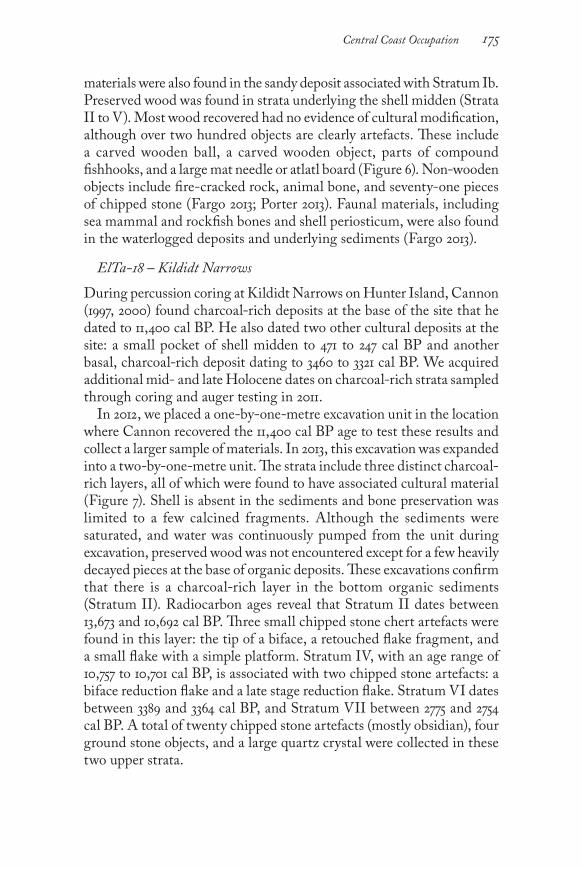
During percussion coring at Kildidt Narrows on Hunter Island, Cannon (1997, 2000) found charcoal-rich deposits at the base of the site that he dated to 11,400 cal BP. He also dated two other cultural deposits at the site: a small pocket of shell midden to 471 to 247 cal BP and another basal, charcoal-rich deposit dating to 3460 to 3321 cal BP. We acquired additional mid- and late Holocene dates on charcoal-rich strata sampled through coring and auger testing in 2011. In 2012, we placed a one-by-one-metre excavation unit in the location where Cannon recovered the 11,400 cal BP age to test these results and collect a larger sample of materials. In 2013, this excavation was expanded into a two-by-one-metre unit. The strata include three distinct charcoal-rich layers, all of which were found to have associated cultural material (Figure 7). Shell is absent in the sediments and bone preservation was limited to a few calcined fragments. Although the sediments were saturated, and water was continuously pumped from the unit during excavation, preserved wood was not encountered except for a few heavily decayed pieces at the base of organic deposits. These excavations confirm that there is a charcoal-rich layer in the bottom organic sediments (Stratum II). Radiocarbon ages reveal that Stratum II dates between 13,673 and 10,692 cal BP. Three small chipped stone chert artefacts were found in this layer: the tip of a biface, a retouched flake fragment, and a small flake with a simple platform. Stratum IV, with an age range of 10,757 to 10,701 cal BP, is associated with two chipped stone artefacts: a biface reduction flake and a late stage reduction flake. Stratum VI dates between 3389 and 3364 cal BP, and Stratum VII between 2775 and 2754 cal BP. A total of twenty chipped stone artefacts (mostly obsidian), four ground stone objects, and a large quartz crystal were collected in these two upper strata.

bc studies176
In addition, a fifty-by-fifty-centimetre unit in the upper intertidal zone revealed preserved wood, including a wood chip from a depth of thirty to forty centimetres. The chip dates to 10,640 to 10,517 cal BP, demonstrating the potential for early Holocene wet-site deposits. Overall, the density of archaeological material at ElTa-18 is relatively low. This is particularly the case for the earliest time periods. Based on his analysis of the varied faunal assemblage found in auger tests, Cannon (2002, 320; 2013, 24) classified this site as a small multi-purpose camp used for a variety of fishing, sea and land mammal hunting, and gathering activities. This may account for the lower densities of archaeological materials found at ElTa-18 compared to the other archaeological sites discussed here. Overall, the span of radiocarbon dates from ElTa-18, reported here and in Cannon (2000), suggests some gaps in the chronology of use. The record of initial occupation of the site is sparse and very early (13,673 to 10,692 cal BP), following closely on the heels of the last major glacial advance (McLaren et al. 2014). Several percussion core tests from the site each have different basal occupation date, suggesting a complex pattern of site use and chronology: 11,591 to 11,247 cal BP, 4410 to 4250 cal BP (Cannon 2000), 7610 to 6023 cal BP, and 655 to 535 cal BP
Figure 7. Stratigraphic profile (ElTa18-2012-A West Wall) and a selection of objects found (ElTa18-2012-A and ElTa18-2012-B) during excavations at ElTa-18. A – large quartz crystal; B – obsidian debitage; C – biface tip; D – edge of a retouched flake.

177Central Coast Occupation
(McLaren et al. 2014). After 4000 cal BP, the density of artefacts and cultural strata increases, and shell midden deposits are present with preserved fauna and bone. In summary, our archaeological excavation results demonstrates that there are at least four sites in addition to Namu with very long-term records of habitation. In the next section we consider cultural processes that may have contributed to patterns of long-term occupation and land use.
Origin Stories, Property Title, and Inheritance as Drivers of Long-Term Cultural Stability
To understand the cultural factors that contribute to the long-term habitation of place, we turn to the interrelated systems of origin stories, property rights, and inheritance that were employed by Northwest Coast cultures generally and specifically on the central coast. In most cases, the people inhabiting a specific location (a local group) can trace descent from a common original ancestor (Boas 1940, 423; Drucker 1943, 33). Various prerogatives, rights, privileges, and social networks of this local group derive from these original ancestors who bestowed them on their descendants. In many cases the origin story relates where the original ancestor came to earth and how the prerogatives, rights, and privileges of the local group came about. The original ancestors arrived from different places: descending from the sky, rising from the sea, from the land of the dead, or from elsewhere in the physical world (Drucker 1943; White 2006). The right to an origin story is considered to be extremely valuable property, to be protected through bloodshed if necessary (Boas 1898, 48; 1940, 423; McIlwraith 1992, 293). Stemming from this common origin, a local group is “politically autonomous with its own chiefs, resource sites, traditions, names, and ceremonial prerogatives” (Hilton 1990, 316) that are reified through feasting and potlatching. Among the Heiltsuk, a local group’s story is referred to as a nuym: “members of each household recite their specific nuym to acknowledge hereditary chiefs, lesser chiefs, and noble family members and their influence on social, political, and economical factors. Each nuym cites its ancestral origins to specific creations, hereditary names, ceremonial privileges and rights to resource sites” (White 2006, 21). The nuym also provides a basis for the social networking of interrelated family groups; even if dispersed to other villages through marriage or other means, close connections are maintained through a common affiliation to a story. Examples of Heiltsuk nuym have been recorded in ethnographic accounts

bc studies178
(e.g., Boas 1932, 2002; Storie and Gould 1973). Nuyms are dramatized in the modern Heiltsuk potlatch systems in the oldest dance series, called Peace Dances. A similar relationship between the people of a village and their common origin story is documented for the Wuikinuxv (Olson 1954, 215) and Nuxalk (Boas 1898, 48; McIlwraith 1992, 293). The term for these stories in Oowekyala (the language of the Wuikinuxv) is given as nu’yam (Olson 1954, 220), whereas in the Nuxalk language it is smaiusta:
These first people came in groups of two or three, brothers and sisters, or occasionally man and wife, each group descending, in many cases in animal form, to a certain mountain and then making their home at its foot. They brought with them animals and fish, tools and houses, also the knowledge of ceremonial dances. In fact, they differed from the Bella Coola of the recent past only in having greater supernatural power. These first people increased with extraordinary rapidity, until each group grew into a village bound together by a knowledge of their first ancestor. In course of time the occupants of certain villages combined, as some increased more rapidly than others, but on the whole each settlement maintained its character of being the descendants of one group of the first settlers of this world. (McIlwraith 1992, 4)
To the south, the Kwak’wala word for stories or histories is nuyǝm (Alfred 2004, 6; Berman 1992, 148). The term nuyǝm has several subdivisions, one of which (nuyǝmiɫ) refers directly to owned histories that pertain to how descent-group ancestors acquired prerogatives, privileges, and title (Berman 1992, 148). Some origin stories do not relate to events of the first people but, rather, are narratives of migration or hero stories that involve the acquisition of skills or title from supernatural beings. This is particularly the case to the north of the central coast.
A large part of the tales relate to the origin of tribal units, that is, of villages. In these the clan emblem is not very prominent. The ancestor is either described as being at the village site from the very beginning, or as descending from heaven in form of man or bird. The bird is not always the emblem of the clan. Sometimes it changes its form several times. The ancestor is accompanied by a woman or by several women … The attendants of these ancestors are supposed to have been on earth before the ancestors came down … These tales are analogous to those of the Bella Coola and Kwakiutl and also resemble those of the northern Coast Salish. They differ fundamentally from those of the northern

179Central Coast Occupation
tribes among whom ancestor tales refer rather to encounters of men with supernatural beings. (Boas 1932, vi)
Regardless of the type of narrative, it is the perpetuation of origin stories that provides a rooting mechanism for social groups and, in particular, for the title holders. The prerogatives associated with a particular story provide an exclusive claim of ownership, or “contingent proprietorship,” to place and resources (Trosper 2009, 106-7).
Now while the economic resources – fishing, hunting, and gathering grounds – pertained to the local group as a whole, titularly they belonged to individuals. We have to do here with the two overlapping and apparently not well differentiated concepts of property-right. Characteristically, a man is said to have “owned” an economically important tract. This “ownership” was expressed by him “giving permission,” as natives usually put it, to his fellows to exploit the locality of each season. At the same time fellow-members of his local group – his relatives – had an inalienable right to exploit the tract. The present writer time and again has heard statements by informants from northwest California to Tlingit country to the effect that a certain man “owned” a particular place, for example, a fishing-site, and his per-mission was required before other members of his society could use it. (Drucker 1939, 59)
Trosper (2009, 118) prefers the use of “contingent proprietorship” over “ownership” as land title is not bought and sold (in this respect it is inal-ienable property). This proprietorship is “contingent” as it is dependent on the title holder not only redistributing the wealth gathered from resource extraction but also demonstrating both knowledge of and an ability to care for the land and resources. Various types and levels of property are claimed through association with a particular origin story. These include title to a village or house and/or resource use area, and rights to names, stories, carvings, crests, and dances (Bobroff 2001, 1590-91; Drucker 1939, 59). In the context of ceremonial events such as potlatches, high-ranking individuals make public displays of their inherited rights through dances, use of regalia, name giving, and storytelling, providing a means of showcasing and reaffirming prerogatives to relations and neighbouring nations. Olson (1954, 220) discusses the privileges, prerogatives, rights, and obligations among the Wuikinuxv, who refer to them as suyaema. In most cases, suyaema are inherited through a connection to the origin story, although some suyaema may be acquired through marriage or

bc studies180
adoption. Stories, dances, and rites performed during the winter cer-emonials are often undertaken to reaffirm or lay claim to suyaema (239). In Hailhzaqvala (the language of the Heiltsuk), the term lhaxvai has a similar meaning, referring to the strength of these inherited rights and privileges (White 2006, 58). Inheritance is a key social and cultural factor in connecting origin stories to property, although marriage and adoption are also means through which title and prerogatives are gained. In the past, local endogamy was preferred among the Wuikinuxv, Nuxalk, and Heiltsuk nobility, and, for this reason, these marriage rules would have enhanced the maintenance of title, property, and prerogatives within the same bloodline (Boas 1940, 373). As it is a long-term connection to place that we are most concerned with here, it is the multi-generational maintenance of title to land that is of significance. Over long periods of time, the enactment of these customs and laws would foster the emergence of a pattern whereby the same descent group would occupy the same places generation after generation, in particular if they maintained their ceremonial obligations. It is reasonable to assume that, in ordinary circumstances, these obli-gations would be met so as to ensure that the claim to proprietorship was regularly reasserted in the public sphere (Trosper 2009). Furthermore, unless disrupted by uprooting forces such as war, disease, environmental collapse, infighting, or lack of leadership, it would be in the best interest of a local group and their title holders to remain in the vicinity of where their ancestor came to earth and where their property rights had been bestowed and inherited (Cannon 2002, 331). The ethnographic review presented here reveals that there are wide-spread cultural institutions on the central coast that are consciously and ceremonially re-enacted over generations to maintain title to property and resources. These practices continue today. The underlying mechanisms of this system are: (1) a consanguinal connection to an origin story, which is (2) passed on primarily through inheritance in trust for future generations and (3) publicly recognized and reaffirmed through the display of ceremonial rights. Although all ethnographic accounts of these cultural processes were recorded in the last two hundred years, they form a widespread underlying cultural convention that is very different from colonial systems of land title, making it likely that these practices are hundreds of years old. The connection of these systems to origin stories evokes the strong possibility that these systems are much older, on the order of thousands of years. Despite the upheavals of dislo-cation, disease, land pre-emption, and the outlawing of the potlatch that

181Central Coast Occupation
occurred between 1884 and 1951, these traditional rights and prerogatives are still recognized and negotiated in the communities of the central coast. As potlatching continues in full force, this system will be main-tained into the future. These widespread cultural practices may account for the longevity of site occupation on the central coast (Rahemtulla 2008).
Discussion
The ethnographic and environmental contexts of the central coast provide a combination of a stable sea level and a cultural propensity towards the long-term maintenance of land, rights, and title. We argue here that these factors have the potential to result in deep archaeological sites with long records of occupation. In light of this argument, our archaeological site chronology on the central coast incorporates physical evidence at four sites with records revealing over ten thousand years of repeated occupation and land use: EjTa-15, EkTb-9, ElTa-18, and ElSx-1 (Figure 8). Some of these records are more continuous than others, forming the basis of much of the discussion below. If, however, we take a landscape approach to the record of continuity, the data we have compiled here from twenty-two sites indicate a pattern of overwhelming long-term and repeated use of the study area (Figure 9). Of all these sites, Namu (ElSx-1) has the clearest record to date of per-sistent occupation. The amount of sampling that has taken place at Namu has been far greater than that at all of the other sites combined (Figure 8). Based on his analysis of the vertebrate fauna recovered, Cannon (2002) argues that there is a pattern of continuous occupation at Namu and that resource use and access remained similar over a period of seven thousand years. Changes occur in the relative number of salmon, which he attributes to periodic salmon shortages at Namu after 3800 BP and, in particular, after 2200 BP (Cannon 1991, 2002). Cannon (2002, 2003) suggests that these salmon shortfalls may have led to the dispersal of some of the local group at Namu to establish villages such as Kisameet (ElSx-3), Koeye (EkSx-12), and Nulu (ElTb-1), all of which have basal dates between 2700 and 2000 cal BP. Despite this hypothesized exodus to other sites, Cannon (2011) maintains that some people remained at Namu. EjTa-15 has both early and late Holocene occupational records (Figure 8). The lack of a mid-Holocene record may be the result of limited sampling, but it may also indicate environmental or cultural change. At EjTa-15 there appears to have been an encroachment of the intertidal zone over the early Holocene deposits sometime between 7623 and 3354 cal BP (see

bc studies182
Figure 8. Graph showing radiocarbon age estimates from archaeological site EjTa-15, EjTa-4, EkTb-9, ElTa-18, and ElSx-1. Dates from ElSx-1 are listed in Rahemtulla (2006). See Table 1 for details on all other radiocarbon dates.
Figure 9. All radiocarbon dates from chronology building work undertaken at sites in the Hakai Passage and Fitz Hugh Sound region. Ranges are given as 1 sigma calendar years BP. Details for all radiocarbon dates are presented in Table 1.

183Central Coast Occupation
Figure 3, where the stratum described as “grey sand with cobbles” lacks charcoal and other evidence of human presence). A higher relative sea level in the mid-Holocene of only fifty to seventy-five centimetres could account for this change. Further sampling and radiocarbon dating is necessary to clarify the current lack of a mid-Holocene record at the site. EjTa-4, located 1.4 kilometres east of EjTa-15, has a solid record of continuity from the mid- to late Holocene. Mid-Holocene deposits at the site are situated at least four to seven metres above the current high tide line. Shell midden deposits that span six thousand years provide evidence of occupational continuity throughout this period. Similarly, EkTb-9 on Triquet Island has shell midden deposits over four metres in depth. The deposition and preservation of the shell began shortly after 6000 BP. Early Holocene waterlogged deposits include abundant California mussel (Mytilus californianus) periosticum, revealing that shellfish were part of the diet in earlier times but that the shell was not preserved. Periosticum fragments were also found in the early “shell-free” Holocene deposits at EjTa-15 and ElTa-18. Although testing and dating of EkTb-9 has been limited, it demonstrates an extremely long occupation record, beginning at 11,396 to 11,285 years cal BP. Only one date has been run from the upper shell midden: 2699 to 2459 years cal BP. Culturally modified trees recorded at the site provide evidence of more recent use. The chronology at ElTa-18 includes a very low density of cultural material associated with very early dates, followed by punctuated evidence of usage up until 4000 years BP, after which the density of cultural material becomes greater. Gaps in the chronology at this site are likely due to the lower in-tensity of usage and the limitations of sampling. Despite the apparent gaps in the chronology, the site appears to have been used repeatedly throughout millennia. The archaeological deposits tend to be non-continuous lenses, making sampling and chronology difficult to resolve. However, the site is in a very strategic location, and the record of repeated occupation is intriguing given that this is a resource-gathering camp. Overall, our data indicate that numerous large shell middens on the outer coastal islands, such as EjTa-15, EjTa-4, EjTa-13, EjTa-14, EkTb-9, and EiTa-1, have evidence of being substantial in size and depth and likely represent major occupation sites. While these sites may not be located on salmon streams like Namu, outer coastal islands tend to have a higher general marine productivity than do inland waters (Breivik 2014), and, therefore, the inhabitants likely had a wealth of resources from which to draw.

bc studies184
We argue here that the central coast ethnographic literature provides substantial evidence of cultural factors that promote continuity of oc-cupation. Although conflicts and political upheavals doubtlessly occurred over the last several millennia, and recent history tells of the amalga-mation of some village sites and the abandonment of others, the system of oral histories, founding ancestors, contingent proprietorship, and inheritance persists and is cyclically reified through winter ceremonials (Cannon 2011; McIlwraith 1992; Trosper 2009; White 2006). On this point, McIlwraith (1992, 133) is quite clear:
Practically, a man hunts only in the grounds of those ancestral families in whose origin myths he has names, though theoretically, he is entitled to hunt on any hunting-ground of any ancestral family of which he is a member whether or not he holds a duly validated name from its origin myth … The Bella Coola regard land as almost inalienable. Though a man does not own the land of his wife’s ancestral family, he can use it and his children have full rights to it. Conversely, a wife can gather berries on her husband’s land, though it is not hers. A guest at a village may be allowed to use the territory of his hosts, but it does not become his. In the old days wars between the coastal tribes were common, but though slaves were taken freely, land was never seized; such is un-thinkable to the Bella Coola.
Overall, one would expect that the inalienability of title in the central coast cultural systems would lead to a continuity of occupation over the long term. The dislocation of populations in the past clearly occurred in other places on the Northwest Coast, as is evident from both the oral histories and archaeological record. Several Coast Tsimshian villages in the Prince Rupert Harbour region, for example, were abandoned around 1700 cal BP, when the populations relocated to the Skeena River (Archer 2001; Marsden 2001; Martindale and Marsden 2003). Despite this history of dislocation, the Tsimshian subsequently reoccupied Prince Rupert Harbour. Most recently, dna-based research on six-thousand-year-old human remains from Lucy Island (just west of Prince Rupert Harbour) demonstrated a mitochondrial genome that closely relates to a living Tsimshian individual from Prince Rupert, revealing a pattern of long-term consanguinal descent despite the known village abandonments and dislocations that occurred around seventeen hundred years ago (Ciu et al. 2013). Johnsen (1999) suggests that the traditional system of land and resource proprietorship on the Northwest Coast provided a means through which the population could avoid the “tragedy of the commons.” Trosper (2009) and Cannon (2011) make similar arguments. In general, the Northwest

185Central Coast Occupation
Coast system of contingent proprietorship fosters stewardship, hus-bandry, and management strategies to ensure that descendants of the lineage would continue to prosper. It is notable that the adoption of a hereditary system of title to land and resources would have eventually contributed to the creation of a class-based society. Those who are title holders become nobility. They must collect and centralize resources for ceremonial redistribution in order to maintain and reify titles by public sanction. They also have the privilege of restricting access or demanding a percentage of the harvest when their lands or resources are used. The stable sea level history on the central coast provides a unique context in which to pursue studies of long-term occupation of coastal oc-cupation sites (Figure 10). The combination of people actively inhabiting nearshore areas and the stability of the sea level over time has resulted in many archaeological sites with deep and complex stratigraphy. The sea level hinge differs substantially from that found on other parts of the Northwest Coast. The duration of shoreline stability on the central coast is particularly remarkable as global eustatic sea level rise in the order of 120 metres since the last glacial maximum (Peltier and Fairbanks 2006) has inundated most early coastal sites along the earth’s outer shores.
Figure 10. Relative sea level curves and applicable areas in the project study area.

bc studies186
Glacial proximal coastlines are the exception to this, as in some cases sea level was rendered higher as a result of isostatic depression. Research and interpretation of post-glacial archaeology in westernmost Scan-dinavia provides an analogue for the investigation of sea level change on the central coast. As in British Columbia, the early archaeological record in northern Norway is associated with early post-glacial shorelines that are regionally variable, in many places one hundred metres or more above modern levels (Breivik 2014). An early maritime economy is hypothesized based on the results of several decades of intensive investigation across Norway (outer coast, fjordlands, and inland regions). This work has shown that the initial occupation of the region dates from about twelve to ten thousand years ago and was characterized by a highly maritime-oriented hunter-gatherer adaptation. Similar to the BC coast, archaeological sites are situated on raised beaches on the outer islands and skerries in proximity to highly productive resources attractive to early maritime hunter-gatherers (Breivik 2014). There is strong evidence that the outer region of the northern Northwest Coast was similarly rich in maritime resources shortly after deglaciation (cf. Al-Suwaidi et al. 2006; Heaton and Grady 2003; McKay, Pedersen, and Kienast 2004), and we consider it likely that maritime-focused human occupation of the area will be shown to be similarly early.
Conclusion
This article presents the results of chronological assessments of deep and highly stratified archaeological sites on the central coast of British Columbia. Four of the archaeological sites have evidence of repeated occupation spanning at least ten thousand years. An additional five sites have evidence of at least five thousand years of residential use. A stable sea level in the region allowed people to gain access to the same shoreline over long periods of time, resulting in the accumulation of deep archaeological sites. Cultural factors contributing to the long-term accumulation of materials are based on the interrelated system of prerogatives that includes origin stories, property title, and inheritance.
Acknowledgments
All fieldwork has been based out of the Hakai Institute, a remote field and scientific research station on Calvert Island. All of the research presented here has been supported financially by Eric Peterson and Christina Munck through the Tula Foundation. Additional funding was provided by the unbc Office of Research. All radiocarbon samples were sent to the W.M. Keck Carbon Cycle Accelerator

187Central Coast Occupation
Mass Spectrometry Laboratory in California and the Curt-Engelhorn Centre for Archaeometry at the University of Tubingen via the Max Planck Institute for Human Evolution. Mike Richards (ubc and Max Planck Institute for Human Evolution) generously provided funding for some of the radiocarbon dates reported here. Richard Inglis and Jennifer Carpenter read through a draft of this document and provided comments and insights. Work reported on here was conducted under permits from the BC Archaeology Branch (2011-171, 2011-183, 2012-155 and 2013-159) and BC Parks (105588, 105935, 105603, and 106165). Many people assisted with fieldwork and logistics, including Wayne Jacob, Rod Wargo, Sky McEwan, Grant Callegari, Elroy White, Robert Windsor, Brodie Lawson, Andrea Walkus, Joshua Vickers, Jennifer Carpenter, Harvey Humchitt, Johnny Johnson, Becky Alway, Peter Johnson, Dana Lepofsky, Ken Lertzman, Julia Jackley, Jenny Cohen, Aurora Skala, Seonaid Duffield, David Fargo, Cecilia Porter, Brittany Walker, Jennifer Walkus, Cathy Rzeplinski, Jim Stafford, Steven Acheson, Bryn Fedje, Joanne McSporran, John Maxwell, Cal Abbott, Alisha Gauvreau, unbc Archaeology Field School students and teaching assistants, and the staff at the Hakai Beach Institute.
REFERENCES
Alfred, A. 2004. Paddling to Where I Stand: Agnes Alfred, Qwiqwasutinuxw Noblewoman / As Told to Martine J. Reid and Daisy Sewid-Smith. Vancouver: ubc Press.
Al-Suwaidi, M., B.C. Ward, M.C. Wilson, R.J. Hebda, D.W. Nagorsen, D. Marshall, B. Ghaleb, R.J. Wigen, and R.J. Enkin. 2006. “Late Wisconsinan Port Eliza Cave Sediments and Their Implications for Human Coastal Migration, Vancouver Island, Canada.” Geoarchaeology 21: 307-32.
Archer, D.J.M. 2001. “Village Patterns and the Emergence of Ranked Society in the Prince Rupert Harbour Area.” In Perspectives on Northern Northwest Coast Prehistory, ed. J.S. Cybulski, 202-22. Archaeological Survey of Canada, Mercury Series No. 160. Gatineau: Canadian Museum of Civilization.
Barrie, J.V., and K.W. Conway. 2002. “Rapid Sea-Level Change and Coastal Evolution on the Pacific Margin of Canada.” Sedimentary Geology 150: 171-83.
Berman, J. 1992. “Oolachen-Woman’s Robe: Fish, Blankets, Masks, and Meaning in Boas’ Kwakw’ala Texts.” In On the Translation of Native American Literatures, ed. B. Swann, 125-62. Washington, DC: Smithsonian Institution Press.
Bjerck, H.B. 2008. “Norwegian Mesolithic Trends: A Review.” In Mesolithic Europe, ed. G. Bailey and P. Spikins, 60-106, Cambridge: Cambridge University Press.
Boas, F. 1898. “The Mythology of the Bella Coola Indians.” In The Jesup North Pacific Expedition, vol. 1, part 2, ed. F. Boas, 26-127. Memoir of the American Museum of Natural History, New York.
—. 1932. “Bella Bella Tales.” Memoirs of the American Folk-Lore Society 25. New York.
—. 1940. Race, Language and Culture. New York: McMillan Company. —. 2002. Indian Myths and Legends from the North Pacific Coast of America: A
Translation of Franz Boas’ 1895 Edition of Indianische Sage der Nord-pacifischen kuste Amerikas, ed. R. Bouchard and D. Kennedy. Vancouver: Talonbooks.

bc studies188
Bobroff, K.H. 2001. “Retelling Allotment: Indian Property Rights and the Myth of Common Ownership.” Vanderbuilt Law Review 54: 1559-623.
Breivik, H.M. 2014. “Palaeo-Oceanographic Development and Human Adaptive Strategies in the Pleistocene-Holocene Transition: A Study from the Norwegian Coast.” Holocene 24: 1478-90.
Cannon, A. 1991. The Economic Prehistory of Namu. Burnaby: Archaeology Press, Simon Fraser University.
—. 1997. “Investigations at EISx-4, EISx-5, EISx-6, EISx-8, EISx-l0, EISx-18, ElTa18, EITa-21, EITb-1, and EITb-2 (Permit 1997-163).” Report on file, BC Archaeology Branch, Victoria.
—. 2000. “Settlements and Sea Levels on the Central Coast of British Columbia: Evidence from Shell Midden Cores.” American Antiquity 65: 67-77.
—. 2001. “Was Salmon Important in Northwest Coast Prehistory?” In People and Wildlife in Northern North America: Essays in Honor of R. Dale Guthrie, ed. S.C. Gerlach and M.S. Murray, 178-87. International Series, vol. S944. Oxford: British Archaeological Reports.
—. 2002. “Sacred Power and Seasonal Settlement on the Central Northwest Coast.” In Beyond Foraging and Collecting: Evolutionary Change in Hunter Gatherer Settlement Systems, ed. B. Fitzhugh and J. Habu, 311-38. New York: Kluwer.
—. 2003. “Long-Term Continuity in Central Northwest Coast Settlement Patterns.” In Archaeology of Coastal British Columbia, ed. R.L. Carlson, 1-12. Burnaby: Archaeology Press, Simon Fraser University.
—. 2011. “Cosmology and Everyday Perception in Northwest Coast Production, Reproduction, and Settlement.” In Structured Worlds: The Archaeology of Hunter-Gatherer Thoughts and Action, ed. A. Cannon, 54-68. Sheffield: Equinox.
—. 2013. “Revealing the Hidden Dimensions of Pacific Northwest Coast Shell Middens.” In Shell Energy: Mollusc Shells as Coastal Resources, ed. G.N. Bailey, K. Hardy and A. Camara, 21–34. Oxford: Oxbow Books.
Carlson, R.L. 1996. “Early Namu.” In Early Human Occupation in British Columbia, ed. R.L. Carlson and L. Dalla Bona, 83-102. Vancouver: ubc Press.
Ciu, Y., J. Lindo, C.E. Hughes, J.W. Johnson, A.G. Hernandez, B.M. Kemp, J. Ma, R. Cunningham, B. Petzelt, J. Mitchell, D.J.M. Archer, J.S. Cybulski, and R.S. Malhi. 2013. “Ancient dna Analysis of Mid-Holocene Individuals from the Northwest Coast of North America Reveals Different Evolutionary Paths of Mitogenomes.” PLoS ONE 8: e66948.
Clague, J.J. 1983. “Glacio-Isostatic Effects of the Cordilleran Ice Sheet, British Columbia, Canada.” In Shorelines and Isostasy, ed. D. Smith and A. Dawson, 321-43. London: Academic Press.
Clague, J.J., J.R. Harper, R.J. Hebda, and D.E. Howes. 1982. “Late Quaternary Sea Levels and Crustal Movements, Coastal British Columbia.” Canadian Journal of Earth Science 19: 597-618.
Drucker, P. 1939. “Rank, Wealth, and Kinship in Northwest Coast Society.” American Anthropologist 41: 55-65.
—. 1943. “Archaeological Survey on the Northern Northwest Coast.” In Bureau of American Ethnology Bulletin 133, Smithsonian Institution, Anthropological Papers No. 20, 16-132.
Fargo, D. 2013. Analysis of Fauna at EkTb9 (Triquet Island). In “Report for the Hakai Ancient Landscapes Archaeology Project 2011 and 2012 Field Seasons

189Central Coast Occupation
(Permit 2011-171),” ed. D. McLaren, 176-89. Report, BC Archaeology Branch, Victoria.
Farrand, L. 1916. “Appendix I – Bellabella and Nootka Tales.” In Tsimshian Mythology, by F. Boas, 883-935. Thirty-First Annual Report of the Bureau of American Ethnology. Washington: Smithsonian Institution.
Fedje, D.W., and T. Christensen. 1999. “Modeling Paleoshorelines and Locating Early Holocene Coastal Sites in Haida Gwaii.” American Antiquity 64: 635-52.
Fedje, D.W., H. Josenhans, J.J. Clague, J.V. Barrie, D.J.M. Archer, and J.R. Southon. 2005. “Hecate Strait Paleoshorelines.” In Haida Gwaii: Human History and Environments from the Time of Loon to the Time of the Iron People, ed. D. Fedje and R. Mathewes, 21-37. Vancouver: ubc Press.
Fedje, D.W., I.D. Sumpter, and J.R. Southon. 2009. “Sea-Levels and Archaeology in the Gulf Islands National Park Reserve.” Canadian Journal of Archaeology 33: 234-53.
Hall, D. 2003. “Paleoenvironments, the Tsini’Tsini Site, and Nuxalk Oral History.” In Archaeology of Coastal British Columbia, ed. R.L. Carlson, 13-28. Burnaby: Archaeology Press, Simon Fraser University.
Heaton, T.H., and F. Grady. 2003. “Late Wisconsin Vertebrate History of Prince of Wales Island, Southeast Alaska.” In Ice Age Cave Faunas of North America, ed. B.W. Schubert, J.I. Mead, and R.W. Graham, 17-53. Bloomington: Indiana University Press.
Hester, J.J. 1978a. “The Bella Bella Prehistory Project.” In Bella Bella Prehistory, ed. J.J. Hester and S.M. Nelson, 1-9. Burnaby: Archaeology Press, Simon Fraser University.
—. 1978b. “Conclusions: Early Tool Traditions in Northwestern North America.” In Bella Bella Prehistory, ed. J.J. Hester and S.M. Nelson, 101-12. Burnaby: Archaeology Press, Simon Fraser University.
Hilton, S. 1990. “Haihais, Bella Bella and Oowekeeno.” In Handbook of North American Indians. Vol. 7: Northwest Coast, ed. W. Suttles, 312-22. Washington, DC: Smithsonian Institution
James, T.S., E.J. Gowan, I. Hutchinson, J.J. Clague, J.V. Barrie, and K.W. Conway. 2009. “Sea-Level Change and Paleogeographic Reconstructions, Southern Vancouver Island, British Columbia, Canada.” Quaternary Science Reviews 28 (13-14): 1200-16.
Johnsen, D. 1999. “Property Rights, Salmon Husbandry and International Change among Northwest Coast Tribes.” George Mason University Society of Law, Working Papers in Law and Economics 14: http://papers.ssrn.com/sol3/papers.cfm?abstract_id=213816.
Kii7iljuus (B. Wilson), and H. Harris. 2005. “Tllsda Xaaydas K’aaygang.nga: Long, Long Ago Haida Ancient Stories.” In Haida Gwaii: Human History and Environment from the Time of Loon to the Time of the Iron People, ed. D.W. Fedje and R.W. Mathewes, 121-39. Vancouver: ubc Press.
Luebbers, R. 1978. “Excavations: Stratigraphy and Artifacts.” In Bella Bella Prehistory, ed. J.J. Hester and S.M. Nelson, 11-66. Burnaby: Archaeology Press, Simon Fraser University.
Luternauer, J.L., J.J. Clague, K.W. Conway, J.V. Barrie, B. Blaise, and R.W. Mathewes. 1989. “Late Pleistocene Terrestrial Deposits on the Continental Shelf of Western Canada: Evidence for Rapid Sea-Level Change at the End of the Last Glaciation.” Geology 17: 357-60.

bc studies190
Mackie, Q., D.W. Fedje, D. McLaren, N. Smith, and I. McKechnie. 2011. “Early Environments and Archaeology of Coastal British Columbia.” In Trekking the Shore: Changing Coastlines and the Antiquity of Coastal Settlement, ed. N.F. Bicho, J.A. Haws, and L.G. Davis, 51-103. New York: Springer.
Marsden, S. 1998. “Evidence of Early Environments in Northwest Coast Oral Histories.” Paper presented at the 31st meeting of the Canadian Archaeological Association, Halifax.
—. 2001. “Defending the Mouth of the Skeena: Perspectives on Tsimshian Relations.” In Perspectives on Northern Northwest Coast Prehistory, ed. J.S. Cybulski, 61-104. Ottawa: Mercury Series, Archaeological Survey of Canada Paper No. 160, Canadian Museum of Civilization.
Martindale, A.R.C., and S. Marden. 2003. “Defining the Middle Period (3500 BP to 1500 BP) in Tsimshian History through a Comparison of Archaeology and Oral Records.” BC Studies 138: 13-50.
McIlwraith, T.F. 1992. The Bella Coola Indians (reissued from 1948). Toronto: University of Toronto Press.
McKay, J.L., T.F. Pedersen, and S.S. Kienast. 2004 . “Organic Carbon Accumulation over the Last 16 kyr off Vancouver Island, Canada: Evidence for Increased Marine Productivity during the Deglacial.” Quaternary Science Reviews 23: 261-81.
McLaren, D. 2008. “Sea Level Change and Archaeological Site Locations on the Dundas Island Archipelago of North Coastal British Columbia.” PhD diss., University of Victoria.
—. 2013. Archaeological Site Test Excavations. In “Report for the Hakai Ancient Landscapes Archaeology Project 2011 and 2012 Field Seasons (Permit 2011-171),” ed. D. McLaren, 156-67. Report, BC Archaeology Branch, Victoria.
McLaren, D., D. Fedje, M. Hay, Q. Mackie, I.J. Walker, D.H. Shugar, J.B.R. Eamer, O.B. Lian, and C. Neudorf. 2014. “A Post-glacial Sea-Level Hinge on the Central Pacific Coast of Canada.” Quaternary Science Reviews 97: 148-69.
McLaren, D., A.R.C. Martindale, D.W. Fedje, and Q. Mackie. 2011. “Relict Shorelines and Shell Middens of the Dundas Archipelago.” Canadian Journal of Archaeology 35: 86-116.
McMillan, A.D., and I. Hutchinson. 2002. “When the Mountain Dwarfs Danced: Aboriginal Traditions of Paleoseismic Events along the Cascadia Subduction Zone of Western North America.” Ethnohistory 49 (1): 41-68.
McNeely, R., A.S. Dyke, and J.R. Southon. 2006. “Canadian Marine Reservoir Ages, Preliminary Data Assessment.” Geological Survey Canada Open File 5049: 3.
Olson, R. 1954. “Social Life of the Owikeno Kwakiutl.” University of California, Anthropological Records 14: 213-60.
Peltier, W., and R. Fairbanks. 2006. “Global Glacial Ice Volume and Last Glacial Maximum Duration from an Extended Barbados Sea-Level Record.” Quaternary Science Reviews 25: 3322-37.
Pirazzoli, P. 1996. Sea-Level Changes: The Last 20,000 Years. Chichester: John Wiley and Sons.
Porter, M.C. 2013. Analysis of Artifacts from Surface and Subsurface Contexts. In “Report for the Hakai Ancient Landscapes Archaeology Project 2011 and

191Central Coast Occupation
2012 Field Seasons (Permit 2011-171),” ed. D. McLaren, 211-44. Report, BC Archaeology Branch, Victoria.
Rahemtulla, F. 1995. “An Analysis of Lithic Debitage from the Early Period at Namu.” MA thesis, Simon Fraser University.
—. 2006. “Design of Stone Tool Technology during the Early Period (10,000-5,000 BP) at Namu, Central Coast of British Columbia.” PhD diss., Simon Fraser University.
—. 2008. Early Middens as Places on the Northwest Coast. Paper presented at the meeting of the Society for American Archaeology, Vancouver.
—. 2014a. “Research Investigation of Archaeological Site EjTa-0004 on Calvert Island as a Part of the University of Northern BC Field School, Central Coast (Permit 2011-0183).” Report, BC Archaeology Branch, Victoria.
—. 2014b. “Archaeological Investigations of the Site EjTa-0004 Located on Calvert Island, in the Hakai Luxvbalis Protected Area, Central Coast of BC (Permit 2012-0155).” Report, BC Archaeology Branch, Victoria.
—. n.d. “Archaeological Investigation of Archaeological Site EjTa-004, Located on North Calvert Island, Central Coast (Permit 2013-159),” in preparation.
Reimer, P.J., E. Bard, A. Bayliss, J.W. Beck, P.G. Blackwell, C.B. Ramsey, C. Buck, R.L. Edwards, M. Friedrich, P.M. Grootes, T.P. Guilderson, H. Haflidason, I. Hajdas, C. Hatté, T.J. Heaton, D.L. Hoffman, A.G. Hogg, K.A. Hughen, K.F. Kaiser, B. Kromer, S.W. Manning, M. Niu, R.W. Reimer, D.A. Richards, E.M. Scott, J.R. Southon, C.S.M. Turney, and J. van der Plicht. 2013. “IntCal13 and Marine13 Radiocarbon Age Calibration Curves 0-50,000 yr cal BP.” Radiocarbon 55 (4): 1869-87.
Retherford, R.M. 1972. “Late Quaternary Geologic Environments and Their Relation to Archaeological Studies in the Bella Bella–Bella Coola region of the British Columbia Coast.” MA thesis, University of Colorado.
Shugar, D.H., I.J. Walker, O.B. Lian, J.B.R. Eamer, C. Neudorf, D. McLaren, and D. Fedje. 2014. “Post-Glacial Sea-Level Change along the Pacific Coast of North America.” Quaternary Science Reviews 97: 170-92.
Stafford, J. 2013. Hakai Ancient Landscapes Project Inventory Results, 2011-2012. In “Report for the Hakai Ancient Landscapes Archaeology Project 2011 and 2012 Field Seasons (Permit 2011-171),” ed. D. McLaren, 64-113. Report, BC Archaeology Branch, Victoria.
Stafford, J., J. Maxwell, and T. Christensen. 2009. “Hakai Luxvbalis and Outer Coast Islands Conservancies, Archaeological Impact Assessment of 11 Selected Recreation Sites (Permit 2008-372).” Report, BC Archaeology Branch, Victoria.
Storie, S., and J. Gould, eds. 1973. Bella Bella Stories. Victoria: British Columbia Indian Advisory Committee.
Teit, J. 1919. “Tahltan Tales.” Journal of American Folklore 32: 198-250.Trosper. Ronald L. 2009. Resilience, Reciprocity, and Ecological Economics: Northwest
Coast Sustainability. Abingdon: Routledge.Walker, B., and D. McLaren. 2013. Analysis of Environmentalist’s Sub-Soil Probe
Samples. In “Report for the Hakai Ancient Landscapes Archaeology Project 2011 and 2012 Field Seasons (Permit 2011-171),” ed. D. McLaren, 119-55. Report, BC Archaeology Branch, Victoria.
White, E. 2006. “Heiltsuk Stone Fish Traps: Products of My Ancestors’ Labour.” MA thesis, Simon Fraser University.