archaeolandscapes europe
TRANSCRIPT
www.archaeolandscapes.eu
ArchaeoLandscapes Europe
ArchaeoLandscapes Europe A Remote Sensing Network For Cultural Heritage
---
ArchaeoLandscapes EuropeUna red de Sensores Remotos para el Patrimonio
Cultural
Dr. Axel G. PosluschnyRoman-Germanic Commission of the German Archaeological Inst [email protected]
www.archaeolandscapes.eu
ArchaeoLandscapes Europe
Roman-Germanic Commission
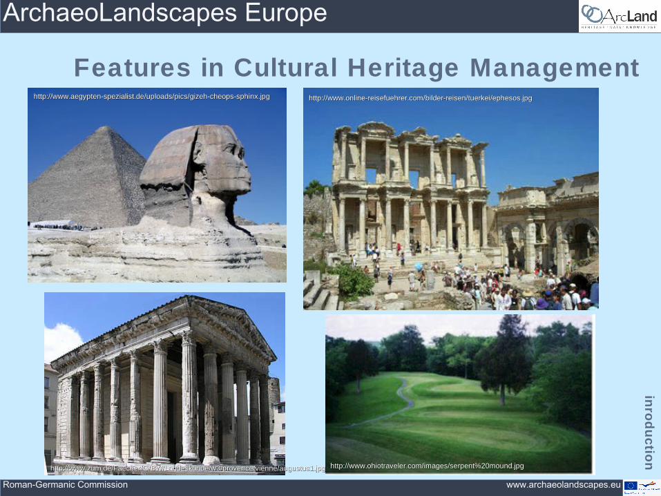
Features in Cultural Heritage Management
http://www.ohiotraveler.com/images/serpent%20mound.jpghttp://www.ohiotraveler.com/images/serpent%20mound.jpg
http://www.online-reisefuehrer.com/bilder-reisen/tuerkei/ephesos.jpghttp://www.online-reisefuehrer.com/bilder-reisen/tuerkei/ephesos.jpg
http://www.zum.de/Faecher/G/BW/Landeskunde/w3/provence/vienne/augustus1.jpghttp://www.zum.de/Faecher/G/BW/Landeskunde/w3/provence/vienne/augustus1.jpg
http://www.aegypten-spezialist.de/uploads/pics/gizeh-cheops-sphinx.jpghttp://www.aegypten-spezialist.de/uploads/pics/gizeh-cheops-sphinx.jpg
inro
du
ct ion

www.archaeolandscapes.eu
ArchaeoLandscapes Europe
Roman-Germanic Commission
Invisible Features in Cultural Heritage Management
intro
du
c tion

www.archaeolandscapes.eu
ArchaeoLandscapes Europe
Roman-Germanic Commission
Invisible Features in Cultural Heritage Management
inro
du
ct ion
Braasch/Christlein1982

www.archaeolandscapes.eu
ArchaeoLandscapes Europe
Roman-Germanic Commission
An example – aerial information
inro
du
ct ion
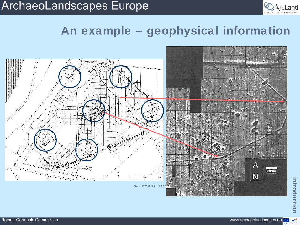
Germania 71, 1993Ber. RGK 72, 1993
www.archaeolandscapes.eu
ArchaeoLandscapes Europe
Roman-Germanic Commission
An example – geophysical information
intro
du
c tion
Ber. RGK 72, 1993

www.archaeolandscapes.eu
ArchaeoLandscapes Europe
Roman-Germanic Commission
Aerial Archaeology
surve
ying
tech
niq
ue
s
soil marks
crop marks
Braasch 2010Landesamt 1997

www.archaeolandscapes.eu
ArchaeoLandscapes Europe
Roman-Germanic Commission
Satellite Imagery
surve
ying
tech
niq
ue
s

www.archaeolandscapes.eu
ArchaeoLandscapes Europe
Roman-Germanic Commission
Satellite Imagery
surve
ying
tech
niq
ue
s
• Satellite images• increasing resolution• large scale availability
Cowley et al. 2010

www.archaeolandscapes.eu
ArchaeoLandscapes Europe
Roman-Germanic Commission
ALS / LiDAR
surve
ying
tech
niq
ue
s
• LiDAR => Light Detection And Ranging = Airborne Laserscan (ALS)
• A high-resolution digital surface model (DSM) can be derived and also a „vegetation-free“ digital elevation model (DEM)
• Many national cartography agencies produce these scans which can also be used for archaeological purposes
English Heritage 2010

www.archaeolandscapes.eu
ArchaeoLandscapes Europe
Roman-Germanic Commission
ALS / LiDAR
surve
ying
tech
niq
ue
s

www.archaeolandscapes.eu
ArchaeoLandscapes Europe
Roman-Germanic Commission
ALS / LiDAR
surve
ying
tech
niq
ue
s
www.archaeolandscapes.eu
ArchaeoLandscapes Europe
Roman-Germanic Commission
Geophysical Surveys
surve
ying
tech
niq
ue
s
• Geophysical surveying methods comprise a variety of different techniques:– Magnetometer survey– Earth resistance survey (geoelectric survey)– Ground-penetrating radar (GPR)
• They are:– non-destructive– machine-based– in most cases less expensive than excavations– can cover much larger areas than field walking, trial trenching or
even large scale excavations• Their disadvantage is the expert knowledge one has to have in many
cases to be able to handle the data derived from various measurements

www.archaeolandscapes.eu
ArchaeoLandscapes Europe
Roman-Germanic Commission
Geophysical Surveys – Geomagnetic
surve
ying
tech
niq
ue
s
• Is used to rapidly generate data of large scale areas, showing a wide variety of anomalies that have been cause by different kinds of human activities
• It uses one or more sensors to measure the gradient of the magnetic field i.e. the difference between the natural magnetic field of the Earth and the structures that have been cause by human impact
• Every kind of material has its own magnetic property, they all result in a different disturbance of the Earth’s magnetic field
• Other than earth resistance surveys, magnetometers do not usually detect walls or other stone structures (if not burned) directly
D. Peters
English Heritage 2008

www.archaeolandscapes.eu
ArchaeoLandscapes Europe
Roman-Germanic Commission
Geophysical Surveys – Geomagnetic
surve
ying
tech
niq
ue
s
Batora et al.

www.archaeolandscapes.eu
ArchaeoLandscapes Europe
Roman-Germanic Commission
Geophysical Surveys – Earth Resistance
surve
ying
tech
niq
ue
s
• Earth resistance survey (geoelectric survey) is measuring the local electrical resistance by inserting two or more sensors into the ground, which produce electrical circuits
• Features like ditches often contain more moisture than the surrounding soil and therefore have less resistivity while wall structures, foundings and so on usually have a higher resistivity
• The main disadvantage of a resistance survey is the limitation caused by the need for the sensors to make direct electrical contact by the insertion of electrodes. As a result resistance survey is mainly used for smaller areas
English Heritage 2008
English Heritage 2008
www.archaeolandscapes.eu
ArchaeoLandscapes Europe
Roman-Germanic Commission
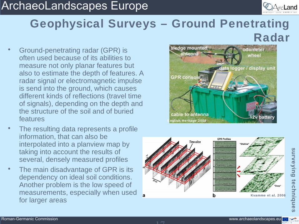
Geophysical Surveys – Ground Penetrating Radar
surve
ying
tech
niq
ue
s
17
• Ground-penetrating radar (GPR) is often used because of its abilities to measure not only planar features but also to estimate the depth of features. A radar signal or electromagnetic impulse is send into the ground, which causes different kinds of reflections (travel time of signals), depending on the depth and the structure of the soil and of buried features
• The resulting data represents a profile information, that can also be interpolated into a planview map by taking into account the results of several, densely measured profiles
• The main disadvantage of GPR is its dependency on ideal soil conditions. Another problem is the low speed of measurements, especially when used for larger areas
English Heritage 2008
Kvamme et al. 2006

www.archaeolandscapes.eu
ArchaeoLandscapes Europe
Roman-Germanic Commission
arcla
nd
Co-ordinator/Project Leader: 1. Roman-Germanic Commission, German Archaeological Institut (DE)
Co-organisers:1. In Flanders Fields Museum, Belgium (BE)
2. Cyprus Research and Education Foundation (STARC), Cyprus (CY)
3. Holstebro Museum, Denmark (DK)
4. State Heritage Service Baden-Württemberg, Germany (DE)
5. Institute for Mediterranean Studies (FORTH), Greece (GR)
6. Baranya County Museum Authority, Hungary (HU)
7. Institute of Archaeology, Iceland (IS)
8. Discovery Programme, Ireland (IE)
9. University College Dublin, Ireland (IE)
10. University of Foggia, Italy (IT)
11. University of Salento (LabTAF), Lecce, Italy (IT)
12. University of Siena (LAP&T), Italy (IT)
13. University of Klaipeda, Lithuania (LT)
14. University of Leiden, Netherlands (NL)
15. Norwegian Institute for Cultural Heritage Research (NIKU), Norway (NO)
16. Adam Mickiewicz University, Pozna , Poland (PL)ń17. Institute for Cultural Memory (CIMEC), Romania (RO)
18. Institute of Archaeology, Serbia (RS)
19. Slovak Academy of Sciences (SK)
20. Slovenian Academy of Sciences and Arts (ZRC SAZU) (SI)
21. University of Ljubljana, Slovenia (SI)
22. Instituto de Estudos Galeos Padre Sarmiento, Spain (ES)
23. English Heritage, United Kingdom (UK)
24. University of Exeter, United Kingdom (UK)
25. University of Glasgow, United Kingdom (UK)
26. Royal Commission on the Ancient and Historical Monuments of Scotland (UK)
Associated Partners (with no financial commitment within the project):1. University of Vienna, Austria
2. University of West Bohemia, Czech Republic
3. National Heritage Board of Estonia
4. National Museum of the Faroe Islands
5. Aalto University School of Science and Technology, Finland
6. Université de Franche Comté, France
7. University of Applied Sciences - i3mainz, Germany
8. University of Bamberg, Germany
9. University of Frankfurt, Germany
10. Aerial Archaeology Research Group
11. Culture Lab - International Cultural Expertise, Belgium
12. Dutch Expertise Centre for Archaeological Remote Sensing
13. Dundalk Institute of Technology, Ireland
14. Latvian Academy of Culture
15. University of Granada, Spain
16. University of Uppsala, Sweden
17. University of Ulster, United Kingdom
18. Landscape & Geophysical Services, Ireland
19. Macquarie University, NSW, Australia
20. The DART Project - University of Leeds, United Kingdom
21. Leuven University, Belgium
22. Department of Earth and Environment of the Italian National Research Council
23. University of Zagreb, Croatia
24. VU Amsterdam, The Netherlands
25. Moesgaard Museum, Denmark
26. The Rathcroghan Heritage Centre, Ireland
27. The Landscape Research Centre, United Kingdom
28. Polytechnic Institute of Tomar University, Portugal
more to come ...
Project Partners from all over Europe

www.archaeolandscapes.eu
ArchaeoLandscapes Europe
Roman-Germanic Commission
• Agreement Number: 2010-1486• Start: 15th September 2010• End: 14th September 2015• EU Funding: 2,5 Mio €• Overall Budget: 5 Mio €• Involved Partners: 55(so far)• Project Leader: Roman-Germanic Commission of the
German Archaeological Institute (Dr. Axel G. Posluschny, [email protected])
ArchaeoLandscape Europe is supported by the EU within the framework of the Culture
2007-2013 programme
arcla
nd

www.archaeolandscapes.eu
ArchaeoLandscapes Europe
Roman-Germanic Commission
Aims of the project
•To increase public appreciation, understanding and conservation .....
–of the landscape and archaeological heritage – of Europe ....
–through the application and international sharing of skills and experience ....
•in airborne and other forms of remote sensing
arcla
nd

www.archaeolandscapes.eu
ArchaeoLandscapes Europe
Roman-Germanic Commission
A busy 5-year programme ... • Create a self-supporting ArchaeoLandscapes Network Europe• Communicate the value of aerial survey, remote sensing and
landscape studies• Promote the pan-European exchange of people, skills and
experience• Enhance teaching in aerial survey, remote sensing and
landscape studies• Exploit existing air-photo archives more effectively• Support aerial survey, remote sensing and landscape
exploration• Explore laser, satellite and other forms of remote sensing to a
larger extent• Provide technical guidance and advice on best practice
arcla
nd

www.archaeolandscapes.eu
ArchaeoLandscapes Europe
Roman-Germanic Commission
Further information
If you want to know more about the project and the various (future) activities, opportunities and
so on, visit our website
http://www.archaeolandscapes.eu
arcla
nd

www.archaeolandscapes.eu
ArchaeoLandscapes Europe
Roman-Germanic Commission
Resume
con
clusi o
n
• One can only protect, monitor and manage what s/he knows• –> Large scale surveys are not only a technique for archaeological research but also for
Cultural Heritage Management• Site protection is an expensive as well as a time consuming task• –> Modern geophysical and remote sensing methods are a possible solution• The large variety of modern surveying methods have a number of great advantages:
– Non-destructive– Amend each other– Very precise– Nearly complete– Cover large areas– Fast– Much lower costs than caused by excavations
• Surveying data is the ideal basis for decision making in urban land-use planning, to assess the threads from erosion, looting and plundering or from ploughing and to monitor archaeological sites
• During building and construction planning the areas of archaeological interest can be taken into account –> not only Archaeology or Cultural Heritage Management benefit from large scale surveys but also investors and stakeholders

www.archaeolandscapes.eu
ArchaeoLandscapes Europe
Roman-Germanic Commission
Resume
con
clusi o
n
Knowing that the use of all these techniques and methods need skill, expertise and experience and being
aware of the fact that these factors are not evenly distributed all over Europe (as well as in the rest of the
world), the ArchaeoLandscapes Europe project, supported by the EU Culture 2007–2013 programme, aims for a better understanding and a more excessive use of modern archaeological surveying techniques as
well as for an exchange of people, working in these fields, their expertise and of new ideas
www.archaeolandscapes.eu
ArchaeoLandscapes Europe
Roman-Germanic Commission
Thank you very muchfor your attention