arcgis solutions for emergency management · 2019. 4. 22. · conduct damage assessment. understand...
TRANSCRIPT

ArcGIS Solutions for Emergency ManagementJennifer DillonRenee BernsteinRob Feuerstein

Emergency Management
• Create the framework within which communities reduce vulnerability to hazards and cope with disasters.
• Coordinate and integrate all activities … to mitigate against, prepare for, respond to, and recover from … disasters
Promoting safer, less vulnerable communities…
…with the capacity to cope with hazards and disasters.

We Face A New NormalCosts, Size and Frequency of incidents are all increasing

Internally, Organizations Are Challenged as Well
• Paper Processes that Do Not Scale• Lack of Actionable Information• Silo Point Solutions• Limited Staff Resources• Difficulty controlling the public message
Legacy issues can be difficult to overcome…
…leading to information latency that puts decisions at risk in this new normal.

Supporting Operations for Emergency ManagementCommon Challenges
• Understand the potential impact from an incident• Estimate and deploy limited resources• Monitor rapidly changing conditions• Assess and report damage• Provide real-time operational briefs • Communicate effectively with the public and media

MaintainSituationalAwareness
ConductDamage
Assessment
ManagePublic
Information
An Complete and Integrated SystemSupporting Emergency Management Operations

Maintain Situational AwarenessMonitor changing conditions. Put your plan into action. Brief your team in real-time.
Operations Dashboard
Operational Briefings
Operations Management
Anticipate your next move and make more informed decisions that can save lives and property.

Conduct Damage AssessmentUnderstand potential impact. Conduct damage assessments. Monitor reporting thresholds for your disaster declaration.
Impact Analysis
Damage Assessment Collection & Reporting
With lives at risk and disaster recovery funds on the line, time is critical.

Manage Public InformationDisseminate critical information that raises awareness and drives action.
Public Information Map
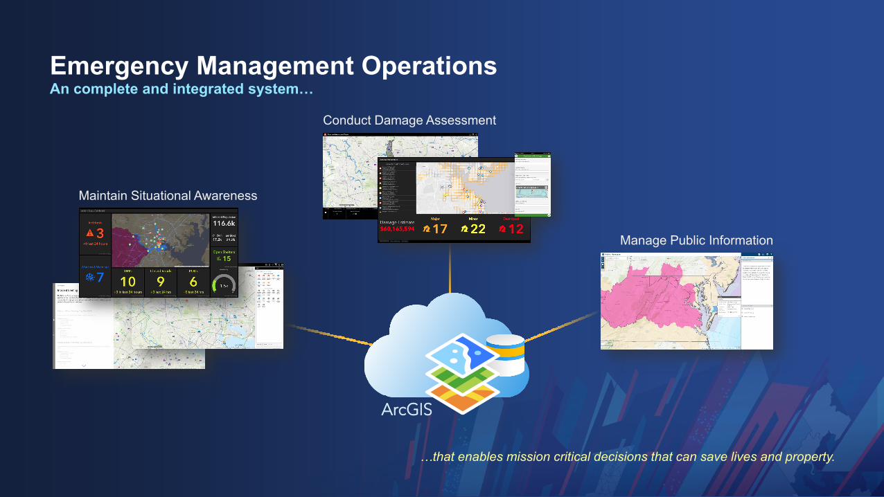
Emergency Management OperationsAn complete and integrated system…
…that enables mission critical decisions that can save lives and property.
ArcGIS
Maintain Situational Awareness
Conduct Damage Assessment
Manage Public Information

Demonstration: Emergency Management Operations
Story Map

Why Esri?Modernizing Operations with ArcGIS
Location Intelligence• Real-time data collection, visualization, and analysis from the field to the EOC• Analytics turn the noise into actionable information
Configurable Apps• Apps designed for your mission and workflows• As strategy evolves, technology goes with you:
• Re-configure your apps as processes evolve• Configure new apps as new processes emerge• Leverage your initial investment without the need for a new RFP
Decision Support• Real-Time access to mission critical KPIs
• Are our plans having the intended impact?• Are we resourced appropriately based on the current situation?
• Secure information sharing within and across the agency
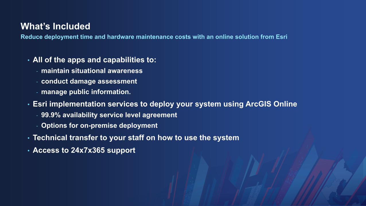
What’s Included
• All of the apps and capabilities to:- maintain situational awareness- conduct damage assessment- manage public information.
• Esri implementation services to deploy your system using ArcGIS Online- 99.9% availability service level agreement- Options for on-premise deployment
• Technical transfer to your staff on how to use the system• Access to 24x7x365 support
Reduce deployment time and hardware maintenance costs with an online solution from Esri

Esri Disaster Response Program (DRP)

Esri was founded to help solve some of the world’s most difficult problems. When disaster strikes, we’re here to support you.

Esri Offers Additional Support for Emergency Management Agencies
• Esri Public Safety Named User Model- Special pricing model to named user
purchases for shift work and for surging to support exercises or emergencies
• Esri Public Safety Enterprise License Agreements
- Discounted, unlimited access to Esri software for municipalities up to 250,000 persons
- Includes Esri Public Safety Named User Model
• Training Courses for Public Safety- Customers with on-maintenance licenses
have unlimited access to web courses at training.esri.com
- Instructor-Led Courses:- Using ArcGIS for Public Safety
Workflows- ArcGIS Analysis Workflows for Public
Safety

Esri Offers Additional Support for Emergency Management Agencies
• Esri Enterprise Advantage Program:- A Technical Advisor to help you realize your
vision- Flexible credits for training or services to help
you get there:- Configuration of additional solutions for resiliency,
preparedness, mitigation, and recovery- Deployment of secure on-premise web GIS using
Esri’s ArcGIS Enterprise- Deployment of GeoEvent Server to support real-
time data needs with GeoEvent Server- Rent-a-Tech Services for System Integration with
Web EOC, CAD, or other mission-critical systems - Online or in-person training courses for staff

We support disaster response operations with GISFor more than 20 years, we’ve provided disaster support worldwide as part of our corporate citizenship
• 1994 Northridge Earthquake
• 1995 Oklahoma City Bombing
• 1997 Hurricane Mitch
• 1998 FEMA Project Impact
• 2001 WTC and Pentagon Attacks
• 2003 Space Shuttle Columbia Disaster
• 2004 La Conchita Laguna Landslides
• 2004 Indian Ocean Tsunami
• 2005 Pakistan Earthquake
• 2006 Indonesian Earthquake
• 2007 Peru Earthquake
• 2007 Niigata Earthquake Japan
• 2008 China Earthquake
• 2009 Australia Bush Fires
• 2009 Influenza A – H1NA Outbreak
• 2010 Haiti Earthquake
• 2010 Chile Earthquake
• 2010 Tennessee Flooding
• 2010 Deepwater Horizon Oil Spill
• 2010 Pakistan Flooding
• 2010 Atlantic Hurricane Season
• 2010 Fourmile Canyon Fire
• 2010 Australia Flooding
• 2011 Spring Tornadoes
• 2011 Japan Earthquake and Tsunami
• 2011 US National Level Exercise
• 2011 Thailand Flooding
• 2011 Turkey Earthquake
• 2012 Duluth (MN) Flooding
• 2012 Philippines Flooding
• 2012 Hurricane Sandy
• 2013 Boston Marathon Bombing
• 2013 West Text Explosion
• 2013 Colorado Flooding
• 2013 Typhoon Yolanda/Haiyan
• 2014 Washington Mudslide
• 2014 CUSEC CAPSTONE Exercise
• 2014 Napa Earthquake
• 2014 MH17
• 2014 Ebola Outbreak
• 2015 Nepal Earthquake
• 2015 South Carolina Flooding
• 2015 Flint Water Crisis
• 2015 European Refugee Crisis
• 2016 Texas Flooding
• 2016 Wisconsin Flooding
• 2016 Louisiana Flooding
• 2016 Hurricane Matthew
• 2016 Gatlinburg / Southeast Fires
• 2017 Louisiana Tornadoes
• 2017 Atlanta I-85 Collapse
• 2017 Polio Outbreak
• 2017 Peak 2 Fire
• 2017 Hurricane Harvey
• 2017 Hurricane Irma
• 2017 Hurricane Maria
• 2017 Hurricane Nate
• 2017 Northern California Wildfires
• 2017 Southern California Wildfires
• 2018 North East “Bomb Cyclones”
• 2018 California Wildfires
• 2018 Columbia Gas Explosion
• 2018 Hurricane Florence
• 2018 Hurricane Michael

We can help when your capacity is exceeded
• ArcGIS Software• Workflow Implementation• Geospatial Data• Technical Support
The DRP is available 24x7…
…to support your organization’s response efforts
Request Assistance and Explore Resources:
www.esri.com/disaster
Request Assistance via Email:

Print Your Certificate of AttendancePrint Stations Located at L Street Bridge
Tuesday Wednesday12:30 pm – 6:30 pm GIS Solutions Expo Hall D
5:15 pm – 6:30 pm GIS Solutions Expo SocialHall D
10:45 am – 5:15 pm GIS Solutions Expo Hall D
6:30 pm – 9:00 pm Networking ReceptionNational Building Museum
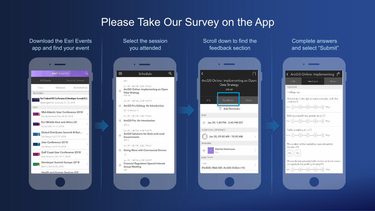
Please Take Our Survey on the AppDownload the Esri Events app and find your event
Select the session you attended
Scroll down to find the feedback section
Complete answersand select “Submit”
