applications for maritime situational awareness · 2 ground stations in o‘higgins (aq), inuvik...
TRANSCRIPT

Applications for Maritime Situational Awareness
Egbert Schwarz German Aerospace Center (DLR) Earth Observation Center (EOC) Maritime Security Lab Bremen | Neustrelitz
ASIAN SPACE TECNOLOGY SUMMIT 11TH & 12TH MAY 2017 @ KUALA LUMPUR

www.DLR.de • Chart 2
Presentation Outline
Introduction
DLR Maritime Application Development − Ship detection
− Wind and Wave
− Oil Detection
Project example − Real Time Service for Maritime Security
(Echtzeitdienste für die Maritime Sicherheit – Security; EMSec)
Current Development − Real Time Service for Navigation on Ice
Conclusion
Maritime Applications > Egbert Schwarz • ASIAN SPACE TECNOLOGY SUMMIT 2017 Earth Observation Center

www.DLR.de • Chart 3
Köln
Lampoldshausen Stuttgart
Oberpfaffenhofen
Braunschweig
Göttingen
Berlin-
Bonn
Trauen
Hamburg Neustrelitz
Weilheim
Bremen-
~ 8000 employees
39 research institutes and large test facilities at 20 sites across Germany
2 Ground stations in O‘Higgins (AQ), Inuvik (CA)
5 Liaison offices in Berlin, Brussels, Paris, Tokyo, Washington DC,
Germany's National Research Center for Aeronautics, Space, Energy, Transport & Security.
Space Agency
Project Management Agency
Aeronautics Space Transport Energy
German Aerospace Center, DLR
4 Maritime Security Lab‘s
Bremen Neustrelitz
Braunschweig
Oberpfaffenhofen
Maritime Safety and Security
Jülich
Augsburg
Stade
Maritime Applications > Egbert Schwarz • ASIAN SPACE TECNOLOGY SUMMIT 2017 Earth Observation Center
Bremerhaven Hamburg
Jena Dresden
Augsburg

www.DLR.de • Chart 4
Earth Observation Center – EOC
Oberpfaffenhofen
Neustrelitz National Ground Segment Maritime Security Lab
Berlin
Appr. 350 employees at 4 sites Chairs at 2 universities (Würzburg, Munich)
Bremen Maritime Security Lab
2 Institutes , German Remote Sensing Data Center (DFD) & Remote Sensing Technology Institute (IMF)
Maritime Applications > Egbert Schwarz • ASIAN SPACE TECNOLOGY SUMMIT 2017 Earth Observation Center

www.DLR.de • Chart 5
Neustrelitz Ground Station
− Ground Station and Processing Facility Neustrelitz support of currently 21 different Satellite missions
− Main reception and processing facility for SAR Mission TerraSAR-X (TerraSAR-X/ TanDEM-X)
− Collaborative Station for European Copernicus mission Sentinel-1 (Sentinel-1A/ Sentinel-1B)
− Radarsat-2 Regional Ground System
− Landsat-8 Global Network Station, United States Geological Survey (USGS)
− CartoSAT, ResourceSat, Oceansat supporting Gesellschaft für Angewandte Fernerkundung (GAFAG)
− Kompsat 3, 3A, 5 supporting Korea Aerospace Research Institute (KARI)
Maritime Applications > Egbert Schwarz • ASIAN SPACE TECNOLOGY SUMMIT 2017 Earth Observation Center

www.DLR.de • Chart 6
TerraSAR-X Capabilities
- Morning and evening timeline upload for a 12 h desirable / 12 h critical timeline with order deadline a few hours before
- for data take at end of timeline: allow about 17 hours for tasking
- based on satellite TSX or TDX acquisition
- Near real time product latency after downlink: about 15 – 30 minutes
- No orbit information available in X-band downlink
- usage of predicted orbit information only
- NRT ground station pool (Neustrelitz, Svalbard) - online raw data transfer to Neustrelitz
- Mission planning uses next possible pool contact for
NRT downlink
DLR TerraSAR-X Payload Data Ground Segment
Maritime Applications > Egbert Schwarz • ASIAN SPACE TECNOLOGY SUMMIT 2017 Earth Observation Center

www.DLR.de • Chart 7
Objective of the Maritime Security Lab Neustelitz Research and development of integrated applications enabling specific value added Maritime Information Products for the Maritime Situational Awareness in Near Real Time
Application Ice Oil Ship Wind Wave Activity Change
Maritime Applications > Egbert Schwarz • ASIAN SPACE TECNOLOGY SUMMIT 2017 Earth Observation Center

www.DLR.de • Chart 8
Architecture of Service Chain
DATA Collection
Processing environment
Processing Rules and Processors
Product Dissemination
Maritime Applications > Egbert Schwarz • ASIAN SPACE TECNOLOGY SUMMIT 2017 Earth Observation Center

www.DLR.de • Chart 9
Worldview-1
Worldview-2
Worldview-3
GeoEye-1
Deimos-2
Landsat-8
Firebird
Synthetic Aperture Radar (SAR) Optical
Satellite AIS
Sentinel-1A
Sentinel-1B
TerraSAR-X
TanDEM-X
Radarsat-2
Automatic Identification System
Terrestrial AIS
Worldview-4
Space Capabilities Maritime Applications > Egbert Schwarz • ASIAN SPACE TECNOLOGY SUMMIT 2017 Earth Observation Center

Space Capabilities
XSAR/SIRC
ERS-1/-2
Risat-1
ERS-2
Sentinel-1B
Operational Satellites Application 2015 2016 Earth Observation 333 374 Communications 705 713
Technology Demonstration 141 160
Navigation and Global Position 91 105 Space Science 65 67
− Number of Satellites and Satellite Constellations increase
− Higher Number of small satellites, with
lower costs of manufacture, launch, and operations
− Increased revisit time and flexibility
− Higher Coverage update and higher image resolution
− Higher service reliability More data New Products Shorter response time
sats-orbit 2015 | 2016 http://www.pixalytics.com
Maritime Applications > Egbert Schwarz • ASIAN SPACE TECNOLOGY SUMMIT 2017 Earth Observation Center www.DLR.de • Chart 10

www.DLR.de • Chart 11
Merit and Constrains of Remote Sensing using Synthetic Aperture Radar (SAR)
− SAR satellite data enable day/night monitoring independent from weather (clouds) and semi automated feature extraction
− Increasing number of satellite resources − different types of sensors and sensor modes (coverage, resolution) − SAR processing enable fast processing of large volumes of data and
information delivery within 15 - 30 minutes of image acquisition − data quality and false alarms constraints require operator supervision
e.g. for vessel detection application − Manly dusk dawn orbits − tasking nominal twice per day − SAR instrument orbit duty cycle, revisit and coverage capabilities − Order ( static planning cycle | user competition | dual use) − Pricing e.g. emergency tasking and very high resolution
Alos-2 CosmoSkymedKopsat-5 Radarsat-2 Risat Sentinel-1 TerraSAR-X TanDEM-X
Maritime Applications > Egbert Schwarz • ASIAN SPACE TECNOLOGY SUMMIT 2017 Earth Observation Center

www.DLR.de • Chart 12
Merit and Constrains of Remote Sensing using very high resolution optical data
− Very High resolution up to 31 cm panchromatic , up to 1.24 m multispectral resolution , 3,7 m short-wave infrared resolution
− High agility and flexibility, e.g. acquisition of coastlines − Increasing number of satellite resources and satellite constellations
e.g. Digital Globe, AIRBUS, Deimos, Kompsat, Planet
− Monitoring dependents on weather situation clouds
− Order, e.g. user competition and dual use
− Limited near real time capabilities compared to SAR
− Pricing, expensive
GeoEYE-1 Deimos-2 Pleiades Planet Kopsat-3, 3a Worldview 1-4
Maritime Applications > Egbert Schwarz • ASIAN SPACE TECNOLOGY SUMMIT 2017 Earth Observation Center

www.DLR.de • Chart 13
− Automated processing
− Target detection
− Data fusion
− Wind
− Wave
− Semi automated algorithms
− Target detection
− Activity detection
− Change detection
− Data fusion
− Operator Interface
− GUI with 3D viewer
Thematic Processing Chain
Maritime Applications > Egbert Schwarz • ASIAN SPACE TECNOLOGY SUMMIT 2017 Earth Observation Center

− Automated algorithm
− Target detection
− Data fusion
− Wind
− Wave
− Semi automated processing
− Target detection
− Activity detection
− Change detection
− Data fusion
− Operator Interface
− GUI with 3D viewer
Thematic Processing Chain
Operator GUI of Analysis Framework (client side) WorldView 3 © 2016, 2017 Digital Globe, Inc. provided by European Space Imaging
www.DLR.de • Chart 14 Maritime Applications > Egbert Schwarz • ASIAN SPACE TECNOLOGY SUMMIT 2017 Earth Observation Center

www.DLR.de • Chart 15
Ship- Detection Application (SAR)
Image: S1A_IW_GRDH_1SDV_20160924T0524
Value added products − SAR/ AIS merged products (in case of available AIS Data) − ASCII ; KMZ, GML; DER (EMSA); ESRI shape; JSON; − GeoTIFF (MRES_L1b; HRES_L1B)
Near real time ship detection application based on SAR images and AIS currently developed for: − TerraSAR-X, − TanDEM-X − CosmoSkyMed − Radarsat-2, − Sentinel-1A, − Sentinel-1B
Maritime Applications > Egbert Schwarz • ASIAN SPACE TECNOLOGY SUMMIT 2017 Earth Observation Center

www.DLR.de • Chart 16
Ship- Detection Application (SAR)
Maritime Applications > Egbert Schwarz • ASIAN SPACE TECNOLOGY SUMMIT 2017 Earth Observation Center
Partner:

Ship- Detection Application (Optic) www.DLR.de • Chart 17
− Value added products − OPT/ AIS merged products (in case of available AIS Data) − ASCII ; KMZ, GML; VDS (EMSA); ESRI shape; JSON; GeoTIFF
Landsat-8 OLI, pansharpend, 2016-09-07, 10:20 UTC
Near real time ship detection application based on optical data Core processor currently being developed by the Maritime Security Lab Neustrelitz value added products in near real time based on high and very high resolution images
Maritime Applications > Egbert Schwarz • ASIAN SPACE TECNOLOGY SUMMIT 2017 Earth Observation Center
www.DLR.de • Chart 18 Maritime Applications > Egbert Schwarz • ASIAN SPACE TECNOLOGY SUMMIT 2017 Earth Observation Center
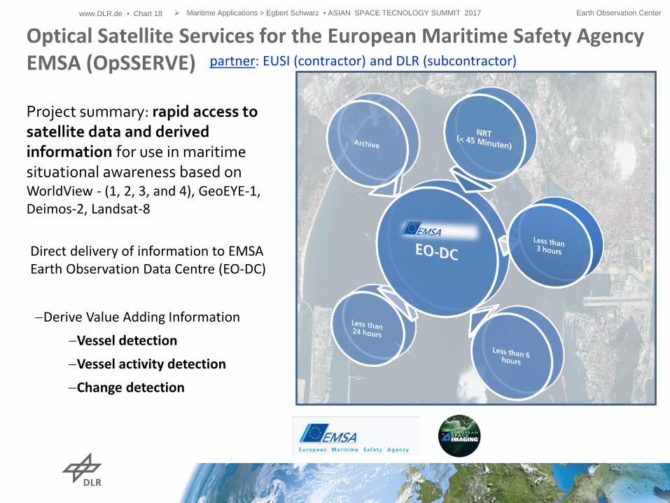
Optical Satellite Services for the European Maritime Safety Agency EMSA (OpSSERVE) Project summary: rapid access to satellite data and derived information for use in maritime situational awareness based on WorldView - (1, 2, 3, and 4), GeoEYE-1, Deimos-2, Landsat-8
Direct delivery of information to EMSA Earth Observation Data Centre (EO-DC)
−Derive Value Adding Information −Vessel detection −Vessel activity detection −Change detection
partner: EUSI (contractor) and DLR (subcontractor)

Near real time Wind detection application based on SAR images core function is the XMOD, CMOD processor developed at the Maritime Security Lab Bremen currently developed for: TerraSAR-X, TanDEM-X Radarsat-2, Sentinel-1A, Sentinel-1B
SAR based Wind Detection www.DLR.de • Chart 19
Ackn: S.Jacobsen; DLR- IMF DLR SAR WIND product (rectangles) derived from the Sentinel image and Level 1 quicklook product as background.
Image: S1A_IW_GRDH_1SDV_20170724T0527
Maritime Applications > Egbert Schwarz • ASIAN SPACE TECNOLOGY SUMMIT 2017 Earth Observation Center

Near real time Wave detection application based on SAR images core function is the XWAVE, CWAVE processor developed at the Maritime Security Lab Bremen currently developed for: − TerraSAR-X, TanDEM-X − Sentinel-1A, Sentinel-1B
SAR based Wave Detection www.DLR.de • Chart 20
Ackn: A. Pleskaschevski; DLR- IMF
Maritime Applications > Egbert Schwarz • ASIAN SPACE TECNOLOGY SUMMIT 2017 Earth Observation Center
DLR SAR WAVE product (rectangles) derived from the TerraSAR-X StripMap image, L1 quicklook product as background.

SAR based Oil Spill Detection www.DLR.de • Chart 21
S1A_IW_GRDH_1SDV_20141004T154824
Ackn: S. Singha; DLR- IMF Value added products
− ASCII ; KMZ, GML; OSN (EMSA); ESRI shape; pdf; − GeoTIFF (MRES_L1b; HRES_L1B)
Near real time oil spill detection application based on SAR images core function is the qualification algorithm developed by the Maritime Security Lab Bremen based on Neural Network currently developed for: − TerraSAR-X, TanDEM-X − Sentinel-1A, Sentinel-1B − Radarsat-2
Maritime Applications > Egbert Schwarz • ASIAN SPACE TECNOLOGY SUMMIT 2017 Earth Observation Center

www.DLR.de • Chart 22
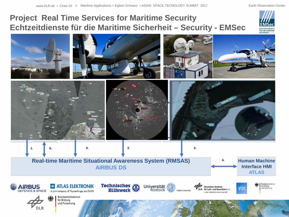
Project Real Time Services for Maritime Security Echtzeitdienste für die Maritime Sicherheit – Security - EMSec
Maritime Applications > Egbert Schwarz • ASIAN SPACE TECNOLOGY SUMMIT 2017 Earth Observation Center
Situational Awareness − improve revisit time and
near real time capabilities − deliver SAR/ Optic derived
target detection information − deliver SAR derived
wind and wave information − improve data fusion methods
and anomaly detection − improve detection quality of
hazardous materials and classification
− development of HMI interfaces Navigation − improve secure navigation − protection of navigation systems
(spoofing, jamming)
Objective

www.DLR.de • Chart 23
Realtime Maritime Situation Awareness System(RMSAS)Astrium
Bodenkontrollstation „Luftgestützte
Dienste“
Mensch-Maschine-Schnittstellen (MMS)
DemonstratorAtlas
AIS & Radar auf Flugzeug
Diamond (CAS)
Kamera auf FlugzeugDo 228
CAS Bodenstation
AIS(luftgestützt)
& Radar Daten
Flugplanung/Status
Plattform
OptischeSensordaten
VerbundadaptivesCommand & Control
Bodenkontrollstation Do228
OptischeSensordatenAIS-Jakota
DB-Service Modul
Flugplanung/Status
Plattform
2. 3.
4.
5.6.
Satelliten Bodenstation
Radar Satelliten
Radar Daten
1.
RY AIS Bodenstation
AIS DLR-RY Referenznetz
AIS Daten Command & ControlCommand & ControlCommand & Control
AIS Daten
Real-time Maritime Situational Awareness System (RMSAS) AIRBUS DS
Human Machine Interface HMI
ATLAS
Project Real Time Service for Maritime Security Echtzeitdienste für die Maritime Sicherheit – Security - EMSec
Maritime Applications > Egbert Schwarz • ASIAN SPACE TECNOLOGY SUMMIT 2017 Earth Observation Center
www.DLR.de • Chart 24
Realtime Maritime Situation Awareness System(RMSAS)Astrium
Bodenkontrollstation „Luftgestützte
Dienste“
Mensch-Maschine-Schnittstellen (MMS)
DemonstratorAtlas
AIS & Radar auf Flugzeug
Diamond (CAS)
Kamera auf FlugzeugDo 228
CAS Bodenstation
AIS(luftgestützt)
& Radar Daten
Flugplanung/Status
Plattform
OptischeSensordaten
VerbundadaptivesCommand & Control
Bodenkontrollstation Do228
OptischeSensordatenAIS-Jakota
DB-Service Modul
Flugplanung/Status
Plattform
2. 3.
4.
5.6.
Satelliten Bodenstation
Radar Satelliten
Radar Daten
1.
RY AIS Bodenstation
AIS DLR-RY Referenznetz
AIS Daten Command & ControlCommand & ControlCommand & Control
AIS Daten
Real-time Maritime Situational Awareness System (RMSAS) AIRBUS DS
Human Machine Interface HMI
ATLAS
Project Real Time Services for Maritime Security Echtzeitdienste für die Maritime Sicherheit – Security - EMSec
Maritime Applications > Egbert Schwarz • ASIAN SPACE TECNOLOGY SUMMIT 2017 Earth Observation Center

www.DLR.de • Chart 25
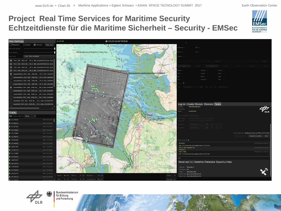
Project Real Time Services for Maritime Security Echtzeitdienste für die Maritime Sicherheit – Security - EMSec
Maritime Applications > Egbert Schwarz • ASIAN SPACE TECNOLOGY SUMMIT 2017 Earth Observation Center
− vessel monitoring and detection of anomaly behavior, simulation of hijacked ferry
− detection of people who have
gone overboard based on AIS-Search And Rescue Transmitter (SART)
− observing pollution of hazardous
substances
− jamming and spoofing – suppression of interference and decoy signals at sea
Test Scenarios
Monitoring
Assessment
Support
Response
Mission
www.DLR.de • Chart 26
Project Real Time Services for Maritime Security Echtzeitdienste für die Maritime Sicherheit – Security - EMSec
Maritime Applications > Egbert Schwarz • ASIAN SPACE TECNOLOGY SUMMIT 2017 Earth Observation Center

www.DLR.de • Chart 27
http://www.dlr.de/dlr/desktopdefault.aspx/tabid-10081/151_read-19273/
Demonstration Event for the EMSec Project Cuxhaven (North Sea), 8th of September 2016 - Real-Time data exchange - Data fusion capabilities - Detection of liquid hazardous materials
- Tracking of detected materials
- Validation of drift models provided by BSH (Federal
Maritime and Hydrographic Agency
Maritime Applications > Egbert Schwarz • ASIAN SPACE TECNOLOGY SUMMIT 2017 Earth Observation Center
Example: Optical Sensor based Hazard Detection

www.DLR.de • Chart 28 Maritime Applications > Egbert Schwarz • C-SIGMA VII> 20170420 Earth Observation Center
- Validation of drift models provided by BSH (Federal Maritime and Hydrographic Agency
Example: Optical Sensor based Hazard Detection

www.DLR.de • Chart 29 Maritime Applications > Egbert Schwarz • ASIAN SPACE TECNOLOGY SUMMIT 2017 Earth Observation Center
Outlook SAR Iceberg Detection
Frost, Anja und Ressel, Rudolf und Lehner, Susanne (2015) Iceberg Detection over Northern Latitudes Using High Resolution TerraSAR-X Images. In: 36th Canadian Symposium of Remote Sensing - Abstracts. 36th Canadian Symposium of Remote Sensing, 8.-11. June 2015, ST. JOHN’S, NEWFOUNDLAND AND LABRADOR, CANADA.
TerraSAR-X ScanSAR Mode, Polarisation: HH, 150 km range,
Near real time iceberg detection application to Support Maritime Situation Awareness - Ice Service Center - Support Exploration Management and Resource planning - Route management
Ackn: A. Frost; DLR- IMF

www.DLR.de • Chart 30 Maritime Applications > Egbert Schwarz • ASIAN SPACE TECNOLOGY SUMMIT 2017 Earth Observation Center
Outlook SAR Ice Classification
Near real time Ice drift application to Support Maritime Situation Awareness Core processor currently being developed by the Maritime Security Lab Bremen Planned value added products based on TerraSAR-X (DualPol)
Ackn: S. Singha; DLR- IMF
www.DLR.de • Chart 31 Maritime Applications > Egbert Schwarz • ASIAN SPACE TECNOLOGY SUMMIT 2017 Earth Observation Center
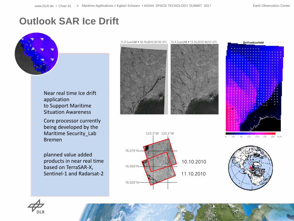
Outlook SAR Ice Drift
Near real time Ice drift application to Support Maritime Situation Awareness Core processor currently being developed by the Maritime Security_Lab Bremen planned value added products in near real time based on TerraSAR-X, Sentinel-1 and Radarsat-2
76.525°N
76.575°N
76.550°N
123.2°W 123.1°W
10.10.2010
11.10.2010

www.DLR.de • Chart 32
SAR Applications like Oil Spill Detection or Ship Detection based on SAR Satellite images and AIS for Maritime Domain Awareness are proven and established.
Optical Satellite Services based on very high resolution images being developed. Operator supervision still required
Near Real Time Services are one of the Key Performance Indicator New Satellites / Satellite Constellations enable Advanced revisit time and update rates New and innovative Products Enhanced availability of data
Complimentary Airplanes and/ or RPAS Solutions extends the monitoring capabilities
Conclusion
Maritime Applications > Egbert Schwarz • ASIAN SPACE TECNOLOGY SUMMIT 2017 Earth Observation Center

Egbert Schwarz DLR German Remote Sensing Data Center (DFD) National Ground Segment (NBS) Kalkhorstweg 53 17235 Neustrelitz Phone: + 49 03981/480-149 Fax: + 49 03981/480-299 E-mail: [email protected]