application of swat in a mountainous region in turkey ... · using remote sensing data bilal peker,...
TRANSCRIPT

Application of SWAT in a Mountainous Region in Turkey
using Remote Sensing DataBilal Peker, Dr. Arda Sorman
Eskisehir Technical University, Turkey
Department of Civil Engineering
Contact: [email protected]
15-19 July 2019 - Vienna, Austria

1. Motivation of the Study
2. Study Area
3. Data Sources & Base Model Setup
4. Snow Parameters Fitting using Remote Sensing Data
5. Automatic Flow Calibration & Validation
6. Snow Validation using Ground Stations
7. Conclusions & Recommendations
OUTLINE1/24

Motivation of the StudyThere are several successful SWAT model applications in Turkey,
however, all is about water quality, agricultural management and non-point source pollution control at low elevated snowless areas.
The mountainous and snow-dominated watersheds are selected for this work, therefore snow-melt process is very
important for the study area.
Remote sensing data is used for the morepreferable model setup in the study.
2/24

Study Area3/24
Turkey is a peninsula surrounded on
3 sides by the sea.
Average elevation of Turkey > 1100 m,
snow is frequent.
Most transboundary rivers are fed by
snowmelt.
4/24
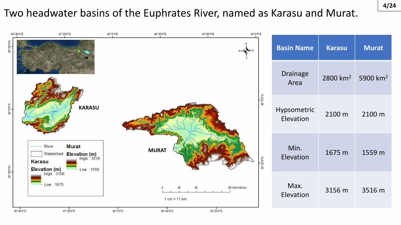
Two headwater basins of the Euphrates River, named as Karasu and Murat.
Basin Name Karasu Murat
DrainageArea
2800 km2 5900 km2
HypsometricElevation
2100 m 2100 m
Min. Elevation
1675 m 1559 m
Max. Elevation
3156 m 3516 m
KARASU
MURAT

Data Sources• HRU Definition Data
DEM (SRTM, 90x90 m) (3 Slope Classes for each basin)
Land Use (Corine, 1:100 000)
Soil (FAO, 1:5 000 000)
• Climate Data
Turkish Met. Office (Precipitation & Max./Min. Temperature)
CFSR (Relative Humidity, Solar Radiation & Wind Speed)
• Calibration & Validation Data
Turkish Hydro. Office (Discharge & Snow Ground Stations)
MODIS (Cloud-Filtered Snow-covered Images)
5/24

LAND COVER MAPS SOIL TYPE MAPS 6/24

GAGE STATIONS (Rainfall, Temperature, Stream, Snow)7/24

Base Model Setup
Karasu Murat
Interface ArcSWAT 2012.10_4.19
Subbasin Threshold Area 5 000 Ha 10 000 Ha
HRU Threshold (Soil/LU/Slope) 0/0/0 (%) 0/0/0 (%)
Subbasin Number 41 45
HRU Number 462 663
Elevation Band Number 10 10
Warm up 1999-2001 (3 yrs) 2000-2001 (2 yrs)
Calibration Period 2002-2007 (6 yrs) 2002-2007 (6 yrs)
Validation Period 2008-2011 (4 yrs) 2008-2011 (4 yrs)
8/24

PROCEDURE 9/24
Snow parameters should not be calibrated simultaneously with other parameters. (Abbaspour et al., 2017)

SWE (mm) – SCA (%) COMPARISON• HRU-BASED SWE
• SUBBASIN-BASED SWE
• BASIN-BASED SWE
SWAT BASIN-SCALE SWE (mm) values are obtained daily.
• MODIS Snow CoverArea (SCA) (%)
.hru output file
ArealPercentageWeights
SWE (mm)
10/24

EXAMPLE: MURAT BASIN 2004 HYDROLOGICAL YEAR
Start of snowsession
End of snowsession
Beginning of recession part

11/24
MURAT BASIN
KARASU BASIN

VISUALIZATION PROCESSSWAT SWE OUTPUTS ARE HRU-BASED AT EACH ELEVATION BAND.
.snw output file
DERIVATION OF SUB-SWE FOR EACH SUBBASINS AT EACH ELEVATION BAND
THRESHOLD SWE
SNOW
LAND
12/24

SWAT SUB-SWE VISUALIZATION MODIS IMAGE
OVERLAYING
13/24

• VISUALIZATION PROCESS IS IMPLEMENTED FOR EACH SUBBASIN AND BASIN-SCALE SWE MAPS ARE OBTAINED.
• 7 DATES ARE SELECTED:
04 DECEMBER 2005 (ACCUMULATION PERIOD)
30 DECEMBER 2005 (~100% SNOW COVER)
30 MARCH 2006 (RANDOMLY)
08 APRIL 2006 (RECESSION PERIOD)
13 APRIL 2006 (RANDOMLY)
18 APRIL 2006 (RANDOMLY)
12 MAY 2006 (~0% SNOW COVER)
14/24

04 DEC 05 30 DEC 05 30 MAR 06 08 APR 06
13 APR 06 18 APR 06 12 MAY 06
15/24


16/24
SWE THRESHOLD CAN CHANGE
BECAUSE SUBBASINS HAVE DIFFERENT ELEVATION RANGE AND
ASPECT

Adjustment of Snow Parameters & Lapse Rates
PARAMETER NAME
UNIT FITTING VALUE
SFTMP ̊C 1
SMTMP ̊C 0.5
SMFMX mm H2O/˚C-day 2.5
SMFMN mm H2O/˚C-day 0.5
TIMP unitless 1
SNOCOVMX mm H2O 55
SNO50COV unitless 0.55
PLAPS mm H2O/km 175
TLAPS ˚C/km -5.5
These values are fixed as a result of the many trialsaccording to the physical
meaning and experiences fromthe previous studies at the
study area.
17/24

AUTO-CALIBRATION PROCEDURE
Fitted Value
Parameter Name Initial Range MURAT KARASU
r_ CN2.mgt -0.3 0.3 -0.28 -0.16
v_ ESCO.hru 0.7 1 0.73 0.75
r_ SOL_Z.sol -0.3 0.3 -0.21 0.3
r_ SOL_K.sol -0.3 0.3 -0.19 0.3
r_ SOL_AWC.sol -0.3 0.3 0.29 0.19
v_ ALPHA_BF.gw 0.01 0.99 0.79 0.92
v_ GW_DELAY.gw 1 50 10.69 7.53
v_ GWQMN.gw 1 250 172.85 15.04
v_ RCHRG_DP.gw 0.2 0.5 0.36 0.4
SWAT-CUP is used for model calibration.
Same for each basin model.1000 simulations for 2 iterations.
Determinedsensitive
parameters. (One-at-a-time
procedure, Abbaspour,2013)
18/24
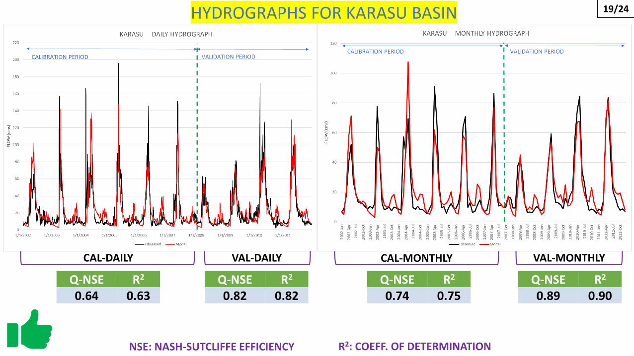
Q-NSE R2
0.64 0.63Q-NSE R2
0.82 0.82Q-NSE R2
0.74 0.75Q-NSE R2
0.89 0.90
CAL-DAILY CAL-MONTHLYVAL-DAILY VAL-MONTHLY
NSE: NASH-SUTCLIFFE EFFICIENCY R2: COEFF. OF DETERMINATION
19/24HYDROGRAPHS FOR KARASU BASIN

Q-NSE R2
0.73 0.74Q-NSE R2
0.67 0.76Q-NSE R2
0.83 0.87Q-NSE R2
0.76 0.86
CAL-DAILY CAL-MONTHLYVAL-DAILY VAL-MONTHLY
NSE: NASH-SUTCLIFFE EFFICIENCY
20/24
R2: COEFF. OF DETERMINATION
HYDROGRAPHS FOR MURAT BASIN
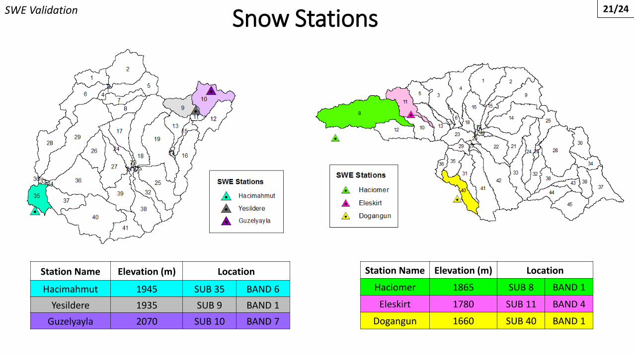
Snow Stations
Station Name Elevation (m) Location
Haciomer 1865 SUB 8 BAND 1
Eleskirt 1780 SUB 11 BAND 4
Dogangun 1660 SUB 40 BAND 1
Station Name Elevation (m) Location
Hacimahmut 1945 SUB 35 BAND 6
Yesildere 1935 SUB 9 BAND 1
Guzelyayla 2070 SUB 10 BAND 7
SWE Validation 21/24

22/24
Snow Validation
TREND IS MATCHING

CONCLUSIONS• SWAT was used for mountanious and snow-fed basins in Turkey.
• Before the model calibration, snow parameters were fitted with
two methods that utilized with MODIS.
• Auto-calibration procedure was applied according to flow data
and successful results were obtained.
• Calibrated model was validated for flow data and snow validation
was done using the ground snow station data.
23/24
Models are ready for future studies!

RECOMMENDATIONS24/24

Thank you for your attention.
Contact: [email protected]
Eskisehir Technical University, Turkey
Department of Civil Engineering – Hydraulics Division