application of geophysical methods in hydrogeology · utilizations of geophysical methods in...
TRANSCRIPT

Utilizations of Utilizations of geophysical methods in geophysical methods in
hydrogeologyhydrogeology
Abdul Rahim Abdul Rahim SamsudinSamsudinSchool of Environment & Natural Resource School of Environment & Natural Resource Sciences, Faculty of Science & Technology,Sciences, Faculty of Science & Technology,
University Kebangsaan MalaysiaUniversity Kebangsaan MalaysiaEmail: Email: [email protected]@ukm.my

Outline of presentationOutline of presentationIntroductionIntroductionWhy use geophysics and how?Why use geophysics and how?Designing a successful surveyDesigning a successful survey–– Planning the surveyPlanning the survey–– Choosing a contractorChoosing a contractor
Main purpose of Main purpose of hydrogeophysicshydrogeophysicsPhysical rock parameters measured by geophysical Physical rock parameters measured by geophysical methods and hydrological parametersmethods and hydrological parametersPhysical rock and hydrogeological parametersPhysical rock and hydrogeological parametersInfluence of hydrological parameters on geophysical Influence of hydrological parameters on geophysical measurementsmeasurementsGeophysical methodsGeophysical methodsConcluding remarksConcluding remarks

Introduction
Application of geophysical methods in hydrogeological studies has already had a long term tradition in many developing and developed countries including Malaysia.
Increasing trend in application of hydro-geophysics all over the world. They are closely tied with ever increasing consumption of potable water and water for industrial use, waters for agriculture, spa treatment and mineral water, which is connected with requirement both to locate new sources and to protect existing ones against contamination.
On the contrary interest in application of geophysical methods increases proportionally with increasing power in solving various and more complex hydrogeological tasks due to continuous and accelerating developments in instrumentation, computer technology and interpretation techniques.

Why use geophysics and how?Why use geophysics and how?
Trivially spoken, Trivially spoken, the answer to the first question is to get the answer to the first question is to get information about the subsurfaceinformation about the subsurface. This is particularly . This is particularly necessary when subsurface information cannot be provided necessary when subsurface information cannot be provided by by direct observation methods direct observation methods (i.e. geological mapping, (i.e. geological mapping, boreholes).boreholes).Geophysics should never be Geophysics should never be a standa stand--alonealone--tooltool, but should , but should be complemented by geological/hydrogeological background be complemented by geological/hydrogeological background information. Therefore, the methodology of extrapolating information. Therefore, the methodology of extrapolating information derived from direct observations in various spots information derived from direct observations in various spots to larger scales with geophysics is sensible. to larger scales with geophysics is sensible. Direct observations provide geological/hydrogeological Direct observations provide geological/hydrogeological information,information, whereas whereas geophysical methods provide geophysical methods provide information on the distribution of certain physical parameters information on the distribution of certain physical parameters in the subsurface, in the subsurface, which can be linked to the direct which can be linked to the direct observations. observations. Geophysics therefore does not provide a "photo" of the Geophysics therefore does not provide a "photo" of the subsurface but subsurface but suggests a model of the underground derived suggests a model of the underground derived from interpreting the distribution of these physical from interpreting the distribution of these physical parametersparameters. Thus it is called an . Thus it is called an indirect observation methodindirect observation method..

The main use of geophysics is for hydrocarbon exploration typically at depths greater than 1000m with significant technology advances in seismic reflection techniques.
In contrast , near surface geophysics for groundwater investigations is usually restricted to depth less than 250m below the surface and the development have not concentrated on one specific geophysical technique.
Groundwater applications of near surface geophysics include mapping the depth and thickness of aquifer, mapping aquitardsor confining units, locating preferencial fluid migration paths such as fractures and fault zones and mapping contamination to the groundwater such as that from saltwater intrusion.

Many geophysical techniques have been applied to groundwater investigations with some showing more success than others.
In the past, geophysics has either been used as a tool for groundwater resource mapping or as tool for groundwater character discrimination. For groundwater resource mapping it isnot the groundwater its self that is the target of the geophysics rather it is the geological situation in which the water exists.
Potential field methods, gravity and magnetics have been used to map regional aquifers and large scale basin features.
Seismic methods have been used to delineate bedrock aquifers and fractured rock systems.

Electrical and electromagnet methods have proved particularly applicable to groundwater studies as many of the geological formation properties that are critical to hydrogeology such as the porosity and permeability of rocks can be correlated with electrical conductivity signatures.
Most geophysical techniques have been used for groundwater characterisation but once again it is with the electrical and electromagnet methods that the greatest success has been shown in directly mapping and monitoring contamination and clean groundwater.

Designing a Successful Survey
Achieving a successful geophysical survey is reliant on three features:
• the geophysical survey should be implementing early in the project planning stages,
• designing the correct geophysical survey and
• choosing the appropriate geophysical contractor.

Planning the Survey
• Ideally the use of geophysics should be discussed early in the planning stages of a survey in order to gain most benefit from the geophysics.
• Unfortunately this is not always the case and geophysics is only used when all other investigation techniques have failed.
• This has led to unjustified bad publicity for geophysics; if all else has failed then it is unlikely that the geophysics willbe successful usually because the original survey objectives have not been clearly defined at the start of the project.

Designing the Geophysical Survey
• Paramount to designing a successful geophysical survey is the definition of a clear set of objectives and the choice of appropriate methods. For this it is important that the geophysical target has physical properties that can be distinguished from background signatures (geological and hydrogeological features) and background noise (ambient cultural noise together with system induced noise).
• The next stage in defining a project is to be able to provide an adequate site description along with any previous data that has been collected, site maps or other data that would pertain to the project. This includes logistical features such as access to the site, noise sources and working restrictions.

• Choosing the appropriate geophysical methods and applying the methods in an appropriate manner is also critical to a successful survey. Only once the objectives have been clearly defined and agreed on by both the client and the contractor can the appropriate geophysical methods be chosen. The incorrect choice of technique and insufficiently experienced personnel conducting the investigation have been cited as primary reasons for the failure of many geophysical surveys (Darracott and McCann, 1986; MacDonald et al.
• Quality control throughout all stages of the work is paramount to a successful outcome. Field quality control should include basic equipment calibration procedures, accurate field reporting including field printouts of digital data, checks for digital data recording and up-loading to computers, and repeat measurements at base or calibration sites.

Choosing a contractor
• Successful survey requires the choice of an appropriate contractor. This will be one who has the general knowledge to be able to suggest the most appropriate geophysical survey tools to meet the objectives.
• A good contractor should also possess the knowledge and professional integrity to admit the inadequacies of the geophysics if it is not likely to meet the survey objectives.
• The contractor should have sufficient specialist knowledge to be able to carry out the geophysics or to suggest an expert who has the necessary specialised knowledge.
• It may be that more than one contractor is needed with experts for field acquisition, for data processing and for data integration.

Main purpose of groundwater geophysics
The major intention of geophysics applied to hydrogeology is The major intention of geophysics applied to hydrogeology is to deliver parameters and subsurface models, which are helpful to deliver parameters and subsurface models, which are helpful for the decisionfor the decision--making process in:making process in:
groundwater exploration andgroundwater exploration andgroundwater protection.groundwater protection.
To address these two major purposes, groundwater geophysics can have the following basic aims:
• Discrimination of water bearing rock from non-water bearing rock (Exploration)• Delineation of the dimensions of an aquifer (Exploration, Protection)• Delineation of preferential groundwater flow paths (Exploration, Protection)• Existence and thickness of impermeable overburden (Protection)

In summary, the essential goal of hydrogeophysicsis the indirect mapping of the distribution of the hydrological parameters porosity and permeability.
Emphasis is again placed on the term "indirect" mapping since geophysics does not measure porosity and permeability themselves but physical parameters, which are linked to them.

Physical rock parameters measured by geophysical methods and hydrological parameters
Generally, one can classify three groups of physical rockparameters to which geophysical methods are sensitive:
1. mechanical properties, 2. electric properties and 3. magnetic properties.
Table 1 shows which parameters are essential for whichgeophysical method. If we have a look at the basichydrological parameters, we see that they influence thegeophysically measured parameters of Table 1

Table1: Physical rock parameters and geophysical methods

Hydrogeological parameter
a). Porosity (Φ)
.A basic property for the existence of groundwater is a sufficient "void volume" in pores or fissures, quantified by the porosity Φ, the ratio of the total volume of voids of a given porous medium to its total volume:
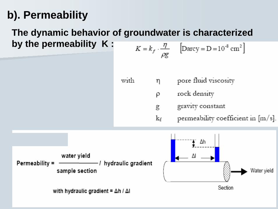
b). PermeabilityThe dynamic behavior of groundwater is characterized by the permeability K :

NUMERIC VALUES FOR VARIOUS TYPES OF ROCKS
TYPE OF ROCKSTYPE OF ROCKS POROSITY (%)POROSITY (%) PERMEABILITY PERMEABILITY (m/s)(m/s)
GravelGravel 3030 1010--22
SandSand 2525 1010--44
clayclay 5050 1010--1212
MassiveMassive 11 1010--1010
Fissured/fracturedFissured/fractured 55 1010--88
weatheredweathered 1515 1010--66
CONSOLIDATEDCONSOLIDATED(sandstone,(sandstone,
limestone,limestone,granite, basalt)granite, basalt)
UNCONSOLIDATEUNCONSOLIDATED (soft sediments)D (soft sediments)
NB: These values are only indicative and largely depend on local condition

Influence of hydrological parameters on Influence of hydrological parameters on geophysical measurementsgeophysical measurements
1).Seismic velocities strongly depend on the elastic properties of rock, which in turn are essentially controlled by its porosity.
The dependency of seismic velocities on the porosity of rock in an elementary form:

2). The formation factor F combines all properties influencing the behaviour of electric current flow, namely porosity Φ, pore geometry and degree of compaction :

3). Salinity of waters influencing the conductivity and resistivity of the electric current flow
Type of Type of waterwater
ResistivityResistivity(ohm.m)(ohm.m)
ConductivityConductivity(microS(microS/cm)/cm)
SalinitySalinity(mg/l)(mg/l)
Very FreshVery Fresh 200200 5050 3535
FreshFresh 2020 500500 850850
Salted Salted 1010 10001000 700700
Very saltedVery salted(sea water)(sea water)
0.30.3 3000030000 2100021000

4). Ion of salt dissolved (TDS) in the groundwater influencing the electric current flows into the ground and the resistivity of rocks
The resistivity of rocks depend on:
•The water content (porosity)
•The resistivity of the water
•The clay content
•The content of metallic mineral
Values of resistivity of rocks:0.1 ohm.m salted water
1 ohm.m massive sulphide10 ohm.m Clay
100 ohm.m sand, marl1000 ohm.m Dry sand, limestone10000 ohm.m Hard granite,basalt

GEOPHYSICAL METHODS1. Geoelectric methods:
Geoelectric methods obtain the distribution of the electric conductivity and resistivity which are strongly influenced by the porosity of rock and degree of water saturation of the pore volume. This technique is cost effective and suitable for hydrogeological study of porous aquifer than for karsticaquifer.

BASIC PRINCIPLESGroundwater, through the various dissolved salts its contain, is ionically conductive and enables electric currents to flow into the ground. Consequently, measuring the ground resistivity gives the possibility to identify the presence of ground water, taking in consideration in the following:
•A Hard rock without pores and fractures and a dry sand without water or clay are very resistive
•A porous or fractured rock bearing free water has resistivity which depends on the resistivity of the water
•An impermeable clay layer, which has bound water has a low resistivity
•Mineral orebodies (iron, sulphide..) have very low resistivities due to their electronic conduction

The depth of investigation is controlled by the distance between the current electrodes while the investigation depth increases with the electrode spacing.
Three types of measurements can be carried out:
1. Vertical Electrode Sounding (VES)
• Variation of lectrode spacing over a common centre point
• Provides the vertical resistivity variation under the centre point
• Applicable to horizontally layered homogenous ground
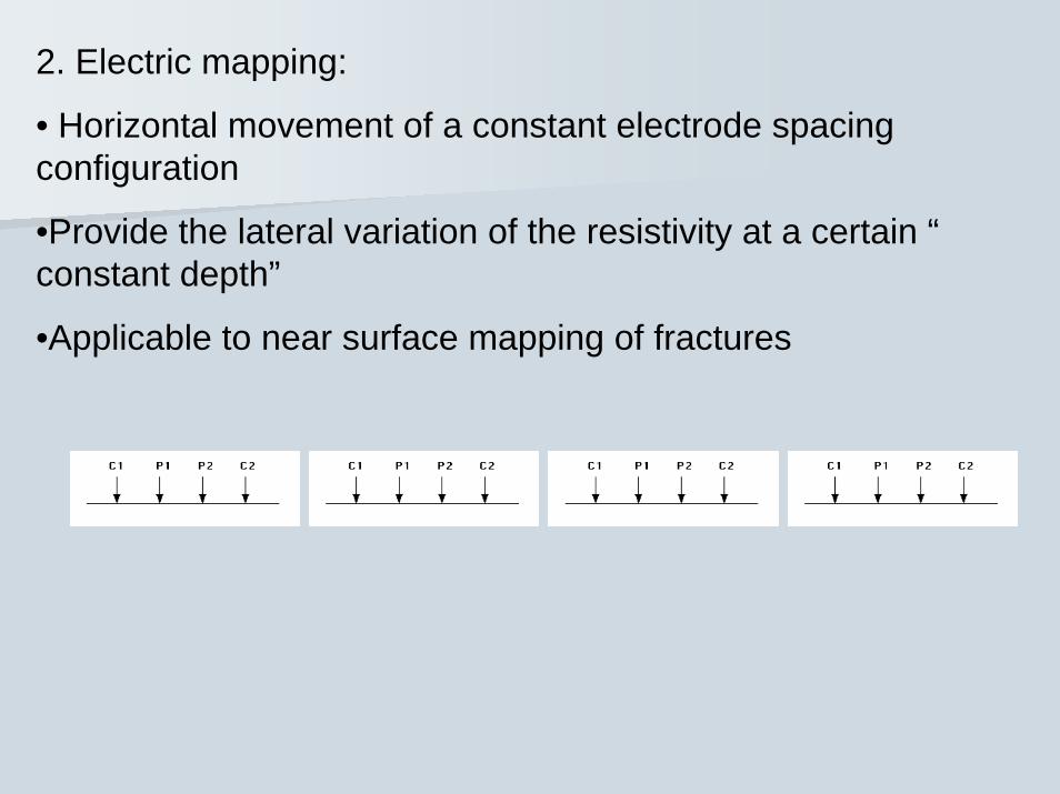
2. Electric mapping:
• Horizontal movement of a constant electrode spacing configuration
•Provide the lateral variation of the resistivity at a certain “constant depth”
•Applicable to near surface mapping of fractures

3. Multielectrode geoelectrics (Imaging, Tomography)
•Large number of electrodes controlled by a PC
•Combine VES and Mapping
•Provide 2-D images of the subsurface


2. Seismic method2. Seismic method


3.


CONCLUSIONS
The successful use of each geophysical technique is dependent not only on the careful design of the survey but also on the consideration of a number of key geological and cultural factorstogether with the geophysical data. These factors include:
Nature of the target: The target geophysical signature must be different to that of the background geology or hydrogeology.
Depth of burial of target: The depth of burial of the feature of interest is important as different techniques have different investigation ranges.
Target size: An estimation of the target size is necessary prior to selecting appropriate techniques. The target size should be considered in conjunction with the depth range for individual techniques.

Measurement station interval:
This will depend on the burial depth, target size and technique selected.Geophysical surveys have traditionally been conducted along line profiles or on grids and therefore the station spacing along the lines must be calculated together with the line separation in order not to miss a particular target size or to result in spatial aliasing the target (Reynolds, 1997). A rough rule of thumb is that a geophysical anomaly will be approximately twice the size of the object causing the anomaly so thiswill give the maximum line and station spacing.

Calibration of the data:
The key to success of any geophysical survey is the calibration of the geophysical data with both hydrogeological and geological ground truth information. Calibration data may be provided by both down-hole geophysical logs in boreholes, samples derived from boreholes by continuous sampling and through measuring the groundwater flux.
