application for a planning permit
TRANSCRIPT

Office Use Only
Application No.: Date Lodged: / /
Application for a Planning PermitIf you need help to complete this form, read MORE INFORMATION at the end of this form.
Any material submitted with this application, including plans and personal information, will be madeavailable for public viewing, including electronically, and copies may be made for interested parties forthe purpose of enabling consideration and review as part of a planning process under the Planningand Environment Act 1987. If you have any questions, please contact Council’s planning department.
Questions marked with an asterisk (*) must be completed.
If the space provided on the form is insufficient, attach a separate sheet.
Click for further information.i
Formal Land Description *Complete either A or B.
This information can be found on the certificate of title.
If this application relates to more than one address, attach a separate sheet setting out any additional property details.
The Land i
Address of the land. Complete the Street Address and one of the Formal Land Descriptions.
Postcode:Suburb/Locality:
Street Address *St. No.:Unit No.: St. Name:
Lot No.: No.:A
OR
B Crown Allotment No.: Section No.:
Parish/Township Name:
Lodged Plan Title Plan Plan of Subdivision
Application for a Planning Permit | Regional Council Page 1
For what use, development or other matter do you require a permit? *
i
The ProposalYou must give full details of your proposal and attach the information required to assess the application. Insufficient or unclear information will delay your application.
Provide additional information about the proposal, including: plans and elevations; any information required by the planning scheme, requested by Council or outlined in a Council planning permit checklist; and if required, a description of the likely effect of the proposal.
Estimated cost of any development for which the permit is required *
iCost $ You may be required to verify this estimate.
Insert ‘0’ if no development is proposed.
Planning EnquiriesPhone: (03) Web: www.hepburnshire.vic.gov.au

Title Information i
Encumbrances on title *
Provide a full, current copy of the title for each individual parcel of land forming the subject site. The title includes: the covering ‘register search statement’, the title diagram and the associated title documents, known as ‘instruments’, for example, restrictive covenants.
Does the proposal breach, in any way, an encumbrance on title such as a restrictrive covenant, section 173 agreement or other obligation such as an easement or building envelope?
Yes (If ‘yes’ contact Council for advice on how to proceed before continuing with this application.)
No
Not applicable (no such encumbrance applies).
Application for a Planning Permit | Regional Council Page 2
Applicant and Owner DetailsProvide details of the applicant and the owner of the land.
Applicant *
The person who wants the permit.
Organisation (if applicable):Postal Address: If it is a P.O. Box, enter the details here:
Title: First Name: Surname:
Postcode:State:Suburb/Locality:
St. No.:Unit No.: St. Name:
Name:
Contact person’s details* Same as applicant
Organisation (if applicable):
Where the preferred contact person for the application is different from the applicant, provide the details of that person.
Postcode:State:Suburb/Locality:
St. No.:Unit No.: St. Name:
Name:
Title: First Name: Surname:
Contact information for applicant OR contact person below
Business phone:
Mobile phone:
Email:
Fax:
Please provide at least one contact phone number *
Owner *
The person or organisation who owns the land
Where the owner is different from the applicant, provide the details of that person or organisation.
Organisation (if applicable):
Owner’s Signature (Optional): Date: day / month / year
Postcode:State:Suburb/Locality:
St. No.:Unit No.: St. Name:
Same as applicantName:
Title: First Name: Surname:
Postal Address: If it is a P.O. Box, enter the details here:
Postal Address: If it is a P.O. Box, enter the details here:
i
Describe how the land is used and developed now *For example, vacant, three dwellings, medical centre with two practitioners, licensed restaurant with 80 seats, grazing.
Existing Conditions i
Provide a plan of the existing conditions. Photos are also helpful.

Remember it is against the law to provide false or misleading information, which could result in a heavy fine and cancellation of the permit.
I declare that I am the applicant; and that all the information in this application is true and correct; and the owner (if not myself) has been notified of the permit application.
Signature: Date: day / month / year
Declaration i
This form must be signed by the applicant *
Application for a Planning Permit | Regional Council Page 3
Checklist i
Have you:
Filled in the form completely?
Paid or included the application fee?
Provided all necessary supporting information and documents?
A full, current copy of title information for each individual parcel of land forming the subject site.
A plan of existing conditions.
Plans showing the layout and details of the proposal.
Any information required by the planning scheme, requested by council or outlined in a council planning permit checklist.
If required, a description of the likely effect of the proposal (for example, traffic, noise, environmental impacts).
Completed the relevant council planning permit checklist?
Signed the declaration above?
Most applications require a fee to be paid. Contact Council to determine the appropriate fee.
LodgementLodge the completed and signed form, the fee and all documents with:
i
Need help with the Application? General information about the planning process is available at planning.vic.gov.au
Contact Council’s planning department to discuss the specific requirements for this application and obtain a planning permit checklist. Insufficient or unclear information may delay your application.
i
Has there been a pre-application meeting with a council planning officer?
No Yes If ‘Yes’, with whom?:
Date: day / month / year
Deliver application in person, by post or by electronic lodgement.
Planning epartmentHepburn Shire Council PO ox 1 Daylesford IC 460
Customer ervice Centre Cnr Duke & Albert Streets Daylesford IC 460
Contact information:Phone ( ) 5348 1577 Email: shire hepburn.vic.gov.au
If completing this form electronically, please tick the box to the right, include a date and type your name above to serve as a declaration that all the information in this application is true and correct; and the owner (if not myself) has been notified of the permit application.
Privacy Statement Your application and the personal information on this form is collected by council for the purposes of the planning process as set out in the Planning and Environment Act 1987 (PE Act). If you do not provide your name and address, council will not be able to consider your application. Your application will be available at the council office for any person to inspect and copies may be made available on request to any person for the relevant period set out in the PE Act.
You must not submit any personal information or copyright material of third parties without their informed consent. By submitting the material, you agree that the use of the material as detailed above does not breach any third party’s right to privacy and copyright. You can request access to your personal information by contacting Councils Governance Department.

Re: Application for two lot subdivision at 14 Victoria St Trentham
14 Victoria St Trentham 3458
[email protected] 0428331173
To whom it may concern The attached application is for a two lot subdivision at 14 Victoria St, Trentham (the “Subject Site”), with retention of the significant outbuilding. Both Coliban Water and NCCMA have been approached to ascertain their opinion of the development. In the first instance access to reticulated water and sewerage is readily available from access points on Victoria St. In the latter instance, while the site is likely to experience inundation from time to time, the outbuilding - a well-constructed shed constructed on cut and fill foundation, is high enough in the landscape that it is viewed by NCCMA as not being at risk of inundation. The proposed subdivision is in keeping with the Local Planning Policy Framework encouraging infill in the Township Zone. The rear block subdivision with carriageway access represents a “battle-axe” style subdivision for which there are precedents on Victoria St and more broadly throughout Trentham township. I have included:
• Town planning assessment pursuant to the relevant provisions of the Hepburn Shire Planning Scheme
• Current certificate of title • Plan of current site features • Plan of proposed subdivision • Clause 56 Assessment (Appendix 1) • Floodplain Management Advice from NCCMA • NVR Report
I respectfully commend the application for your consideration and trust that you will find it meets the intention of the Hepburn Shire Municipal Strategic Statement and Local Planning Policy Framework considerations. If you have any questions, please do not hesitate to contact me at 0428 33 11 73 or [email protected] Regards
Sebastian Klein

Subject Site and Surrounds The subject site is situated at 14 Victoria St, Trentham, to the north side of the street, directly fronting the intersection of Bath and Victoria Streets. The subject site is approximately 383 metres from the main street and business district of Trentham, meeting the Objective within the Hepburn Shire Plannings Scheme encouraging development within 400m of the main township activity centre. The subject site is of irregular, broadly rectangular shape, with a Victoria Street frontage of 99.4 metres, maximum depth of 57.78 metres and a total area of 5,144 sqm. The site currently comprises a single-storey, three bedroom dwelling to the south east of the property, and a heavily-constructed outbuilding shed to the north east of the property. Access is provided from a single-width cross-over the east of the site frontage. There are significant mature endemic and exotic trees, shrubs and grasses throughout the site. A plan diagram of the existing conditions has been provided with the application. Picture – Front of Subject Site

Picture - Aerial view of Subject Site
Subject Site and Surrounding town developments from VicPlan

Proposed development and subdivision The subdivision pattern of the surrounding area generally comprises conventional rectangular shaped allotments with a number of existing smaller lots created through infill development, often to the rear of existing blocks creating “battle-axe” style allotments. A plan diagram of the proposed subdivision has been provided with this application. It is proposed to subdivide the land resulting in two lots of 4327m2 and 817m2 respectively. The smaller block (Lot 2) including a carriageway easement of 217.4m2 running to the rear of the property to the north from the road access on Victoria St. Planning permit triggers Subdivision (Clause 32.08, 42.01-2) Planning assessment – Planning Policy Framework (PPF) Clause 11-19 provides the context for planning development and decision making. Development Response The subject land is located within an established residential area and is zoned accordingly. The proposed development and subdivision will integrate well with the surrounding subdivision pattern and will make use of existing services and infrastructure, as well as social and neighbourhood facilities in nearby Trentham. The proposal provides an opportunity for infill development that suitably adds to the choice of housing in the area. The dimensions and area of each lot will allow for future dwellings that respect the residential character of the area while allowing for an energy efficient design. Planning Assessment – Local Planning Policy Framework (LPPF) The Municipal Overview at Clause 21.01 sets out the strategic direction for the Hepburn Shire. The Municipal Profile identifies Trentham as being a key township within commuting distance to Melbourne. The Settlement and Housing section at Clause 21.05 identifies the key issue of consolidating existing towns and encouraging residential infill opportunities, with strategies in place to encourage “residential infill, with more diverse dwelling types and lot sizes ... in locations within 400m walking distance of designated town centres” Development Response The proposed development seeks to provide an infill residential allotment in an appropriate location within 0.38 km walking distance to the land identified as “town centre” on the Trentham Structure Plan. The subject land has good access to transport and amenities and will result in a more efficient use of land. The proposed development and subdivision are supported by the Municipal Strategic Framework.

Planning Assessment – General Residential Zone (GRZ1) Pursuant to Clause 32.08-3, a planning permit is required to subdivide land. The decision guidelines at Clause 32.08-13 require the responsible authority to consider the pattern of subdivision and its effect on the spacing of buildings. In response, it is submitted that the proposed lots have sufficient dimensions and areas for the siting of a dwelling in a residential context. An application to subdivide land, other than an application to subdivide land into lots each containing an existing dwelling or car parking space, must meet the requirements of Clause 56 and must meet the following objectives:
• Clauses 56.03-5, 56.04-2, 56.04-3, 56.04-5, 56.06-8 to 56.09-2 (2 lots). An assessment against Clause 56 has been provided below. Planning Assessment – Overlays Environmental Significance Overlay: A planning permit is required to construct a building or construct or carry out works, pursuant to Clause 42.01-2 (Environmental Significance Overlay). A planning permit is required to subdivide land, pursuant to Clause 42.01-2 (Environmental Significance Overlay). No permit is required pursuant to the ESO Schedule to remove, destroy or lop vegetation, including dead vegetation, as the site is smaller than 1ha and the existing vegetation is not within 30 metres of a waterway. Clause 56 – Residential Subdivision In accordance with Clause 32.08-3 an assessment against the relevant objectives of Clause 56 of the Planning Scheme has been provided in the table at Appendix 1 Clause 65.02 – Approval of application to subdivide land The following response is provided to the relevant decision guidelines of Clause 65.02 – Approval of an Application to Subdivide Land: Decision Guideline Development Response The suitability of the land for subdivision.
The land is suitable for subdivision. As determined above, the subdivision finds support in Planning Policy Framework including the Municipal Strategic Statement (MSS), and is consistent with the purpose of the General Residential Zone.
The existing use and possible future development of the land and nearby land.
The proposed subdivision will facilitate residential infill development on Lot 2 as is appropriate for the residential zone, and supported by the Municipal Strategic Statement (MSS). Surrounding land is also zoned residential and will remain for uses appropriate to the zone.
The availability of subdivided land in the locality, and the need for the creation of further lots.
There is a market demand for more residential allotments within the Trentham township. This subdivision presents itself as an urban consolidation opportunity, which is an outcome sought by PPF and LPPF.

The effect of development on the use or development of other land, which has a common means of drainage.
The proposed subdivision will not adversely affect the drainage regime associated with adjoining land or other land in the vicinity.
The subdivision pattern having regard to the physical characteristics of the land including existing vegetation.
The lot layout has been designed to accommodate the existing dwelling and provide one additional lot suitable for a future residential development. It takes into account open space, topography, access, views and vegetation.
The area and dimensions of each lot in the subdivision.
The proposed two lot subdivision will result in lot areas and dimensions that are consistent with those sought by the zoning, and those prevailing in the surrounding area.
The layout of roads having regard to their function and relationship to existing roads.
No new roads are proposed.
The movement of pedestrians and vehicles throughout the subdivision and the ease of access to all lots.
Direct access will be provided to Victoria Street via the shared carriageway.
The provision and location of reserves for public open space and other community facilities.
No public open space or community facilities are proposed within the subdivision, as is appropriate for a two-lot subdivision.
The staging of the subdivision. The subdivision is not staged. The design and siting of buildings having regard to safety and the risk of spread of fire.
The proposed addition of two (2) buildings to the land (dwellings) is appropriate. The siting of dwellings provides for appropriate egress from each dwelling. The land is not affected by the Bushfire Management Overlay.
The provision of off-street parking.
Sufficient land is available on Lot 2 to accommodate off-street car parking in association with the proposed dwelling.
The provision and location of common property.
A common property driveway is proposed to run along the length of the eastern boundary to connect all lots with Victoria St.
The functions of any body corporate.
N/A –No body corporate is proposed.
The availability and provision of utility services, including water, sewerage, drainage, electricity and gas.
Reticulated power, water, sewer, drainage and telecommunications are available and will be connected to the proposed allotment.
If the land is not sewered and no provision has been made for the land to be sewered, the capacity of the land to treat and retain all sewage and sullage within the boundaries of each lot.
N/A

Whether, in relation to subdivision plans, native vegetation can be protected through subdivision and siting of open space areas.
The lot boundaries have been placed to ensure the existing vegetation is protected.
Conclusion In summary, it is respectfully submitted that this proposed subdivision application is consistent with the objectives and strategies of both the Municipal Planning Strategy and the Planning Policy Framework of the Hepburn Planning Scheme, which seek to encourage infill development. Based on the above assessment, it is submitted that this application, which seeks planning permission for the subdivision of two lots with retention of outbuildings at 14 Victoria St Trentham is supportable by planning policy. It is respectfully submitted that the permission sought in this application should be supported. Sebastian Klein April 2021

VOLUME 08949 FOLIO 436 Security no : 124088683161N Produced 15/03/2021 07:18 PM
LAND DESCRIPTION
Lot 1 on Plan of Subdivision 096173.PARENT TITLE Volume 03808 Folio 450Created by instrument LP096173 30/10/1972
REGISTERED PROPRIETOR
Estate Fee SimpleSole Proprietor SEBASTIAN JOHN KLEIN of 14 VICTORIA STREET TRENTHAM VIC 3458 AM021504C 11/07/2015
ENCUMBRANCES, CAVEATS AND NOTICES
MORTGAGE AS097614P 17/04/2019 BANK AUSTRALIA LTD
Any encumbrances created by Section 98 Transfer of Land Act 1958 or Section 24 Subdivision Act 1988 and any other encumbrances shown or entered on the plan or imaged folio set out under DIAGRAM LOCATION below.
DIAGRAM LOCATION
SEE LP096173 FOR FURTHER DETAILS AND BOUNDARIES
ACTIVITY IN THE LAST 125 DAYS
NIL
------------------------END OF REGISTER SEARCH STATEMENT------------------------
Additional information: (not part of the Register Search Statement)
Street Address: 14 VICTORIA STREET TRENTHAM VIC 3458
ADMINISTRATIVE NOTICES
NIL
eCT Control 20000L BANK AUSTRALIA LTDEffective from 17/04/2019
DOCUMENT END
Copyright State of Victoria. This publication is copyright. No part may be reproduced by any process except in accordance with the provisions of the Copyright Act 1968 (Cth) and for thepurposes of Section 32 of the Sale of Land Act 1962 (Vic) or pursuant to a written agreement. The information is only valid at the time and in the form obtained from the LANDATA REGDTM System. None of the State of Victoria, LANDATA REGD TM System, Victorian Land Registry Services Pty. Ltd. ABN 86 627 986 396 as trustee for the Victorian Land Registry ServicesTrust ABN 83 206 746 897 accept responsibility for any subsequent release, publication or reproduction of the information.
REGISTER SEARCH STATEMENT (Title Search) Transfer of Land Act 1958
Page 1 of 1
Title 8949/436 Page 1 of 1


Appendix 1: Clause 56 Development Response
Objective & Standard Development Response Clause 56.03-5 Standard C6 Neighbourhood Character Objective To design subdivisions that respond to neighbourhood character
COMPLIES It is submitted, that the proposed two (2) lot subdivision allows for infill development that is appropriate to the requirements of the Township Zone, and responsive to the existing neighbourhood character. The subdivision has been designed with consideration of appropriate integration with surrounding development. Overall, due to the setback distance of the new lot from the road, it is considered that the subdivision will not have a detrimental impact on the existing residential character and identity.
Clause 56.04-2 Standard C8 Lot Area and Building Envelopes Objective - To provide lots with areas and dimensions that enable the appropriate siting and construction of a dwelling, solar access, private open space, vehicle access and parking, water management, easements and the retention of significant vegetation and site features.
COMPLIES Proposed Lot 1 has an area of 4372m2 which will accommodate the existing dwelling, private open space and off-street parking. Proposed Lot 2 is 812m2 including a 217m2 shared carriageway easement and can comfortably accommodate a dwelling that will enjoy a good level of amenity, including solar access and west-facing private open space, with a northern aspect over a public railway reserve.
Clause 56.04-3 Standard C9 Solar orientation of Lots Objective - To provide good solar orientation of lots and solar access for future dwellings.
COMPLIES All lots within the subdivision are considered to have appropriate solar orientation. The dimensions of proposed Lot 2 are ideal for a new dwelling to enjoy good solar access.
Clause 56.04-5 Standard C11 Common Area Objectives - To identify common areas and the purpose for which the area is commonly held. To ensure the provision of common area is appropriate and that necessary management arrangements are in place. To maintain direct public access throughout the neighbourhood street network.
COMPLIES The proposed carriageway easement attached to Lot 2 allows for vehicle access from Victoria Street to this property, while maintaining occasional vehicle and regular pedestrian access the rear door of the existing house on Lot 1.
Clause 56.06-8 Standard C21 Lot Access Objective - To provide for safe vehicle access between roads and lots.
COMPLIES Lot 1will continue to enjoy existing vehicular access from Victoria Street.

Lot 2 will be provided vehicle access utilising the existing crossover to Victoria Street, with a carriageway easement driveway proposed to run along the eastern boundary of the site.
Clause 56.07-1 Standard C22 Drinking Water Supply Objectives - To reduce the use of drinking water. To provide an adequate, cost-effective supply of drinking water.
COMPLIES Reticulated water is available to the subject land. Each of the proposed lots will be connected to water supply in accordance with the requirements of Coliban Water.
Clause 56.07-2 Standard C23 Reused and Recycled Water Objective - To provide for the substitution of drinking water for non-drinking purposes with reused and recycled water.
NOT APPLICABLE Coliban Water does not provide recycled water to the residential properties.
Clause 56.07-3 Standard C24 Wastewater Management Objective - To provide a wastewater system that is adequate for the maintenance of public health and the management of effluent in an environmentally friendly manner.
COMPLIES Reticulated sewer is available, and connections will be made to the satisfaction of Coliban Water
Clause 56.07-4 Standard C25 Stormwater Management Objectives - To minimise damage to properties and inconvenience to residents from stormwater. To ensure that the street operates adequately during major storm events and provides for public safety. To minimise increases in stormwater and protect the environmental values and physical characteristics of receiving waters from degradation by stormwater. To encourage stormwater management that maximises the retention and reuse of stormwater. To encourage stormwater management that contributes to cooling, local habitat improvements and provision of attractive and enjoyable spaces.
COMPLIES For a two-lot subdivision, stormwater runoff can be discharged to a legal point of discharge, in accordance with Council and catchment management authority requirements.
Clause 56.08-1 Standard C26 Site Management Objectives - To protect drainage infrastructure and receiving waters from sedimentation and contamination. To protect the site and surrounding area from environmental degradation or nuisance prior to and during construction of subdivision works. To encourage the re-use of materials from the site and recycled materials in the construction of subdivisions where practicable.
COMPLIES The proposed subdivision will not result in dust or chemical contamination.
Clause 56.09-1 Standard C27 Shared Trenching Objectives - To maximise the opportunities for shared trenching. To minimise constraints on landscaping within street reserves.
COMPLIES Each lot shall be connected to an existing infrastructure network via trenching to access points on Victoria Street. This will allow for the

overhead electricity supply to the existing residence on proposed Lot 1 to be relocated underground alongside other utility access to Lot 2. The meters and supply access for both properties will be located in a common steel utility box on the carriageway easement near the Victoria Street frontage.
Clause 56.09-2 Standard C28 Electricity, Telecommunications and Gas Objectives - To provide public utilities to each lot in a timely, efficient and cost-effective manner. To reduce greenhouse gas emissions by supporting generation and use of electricity from renewable sources
COMPLIES Each lot can be provided with reticulated electricity, water, sewer access and telecommunications. All services shall be installed in accordance with the requirements of the relevant servicing authorities.

Connecting rivers, landscapes, people
ABN 73 937 058 422
628-634 Midland Highway, Huntly
PO Box 18, Huntly Victoria 3551
Telephone 03 5448 7124
Email [email protected]
www.nccma.vic.gov.au
www.nccma.vic.gov.au
NCCMA Ref: NCCMA-F-2021-00261Date: 26 March 2021
Sophia Christoe14 Victoria StreetTrentham Vic 3458
Dear Sophia,
Floodplain Management Advice
Development Description: Two lot subdivision
Street Address: 14 Victoria Street Trentham Vic 3458
Cadastral Location: Lot 1 LP96173, Parish Of Trentham
Applicant: Sophia Christoe
Thank you for your enquiry of 04 March 2021 seeking flood advice for the above property.
Flood Information
Flood levels for the 1% AEP probability (100-year ARI) have not been determined for this area under the Water Act 1989. However, information available at North Central CMA indicates that in the event of a 1% AEP flood event it is likely that the property may be subject to inundation from Trent Creek.
Development Advice
North Central CMA does not object in principle to the development of a two-lot subdivision and is likely to require the following minimum conditions as part of the future planning permit application:
1. There can be no new buildings or works closer to the creek then the existing dwelling and shed. This is to ensure that the waterway corridor is protected, and potential flood damage is minimised.
Please note, this document does not constitute approval or otherwise of any development at this
location.
Should you have any queries, please do not hesitate to contact me on (03) 5440 1896. To assist the CMA in handling any enquiries please quote NCCMA-F-2021-00261 in your correspondence.
Yours sincerely,
Peter O'TooleWaterways and Floodplain Officer
Information contained in this correspondence is subject to the definitions and disclaimers below.
Connecting rivers, landscapes, people
ABN 73 937 058 422
628-634 Midland Highway, Huntly
PO Box 18, Huntly Victoria 3551
Telephone 03 5448 7124
Email [email protected]
www.nccma.vic.gov.au
www.nccma.vic.gov.au
Attached: Definitions and Disclaimers
Definitions and Disclaimers
1. The area referred to in this letter as the ‘proposed development location’ is the land parcel(s) that, according to the Authority’s assessment, represent(s) the location identified by the applicant. The identification of the ‘proposed development location’ on the Authority’s GIS has been done in good faith and in accordance with the information given to the Authority by the applicant(s) and/or local government authority.
2. While every endeavour has been made by the Authority to identify the proposed development location on its GIS using VicMap Parcel and Address data, the Authority accepts no responsibility for or makes no warranty with regard to the accuracy or naming of this proposed development location according to its official land title description.
3. AEP as Annual Exceedance Probability – is the likelihood of occurrence of a flood of given size or larger occurring in any one year. AEP is expressed as a percentage (%) risk and may be expressed as the reciprocal of ARI (Average Recurrence Interval).
Please note that the 1% probability flood is not the probable maximum flood (PMF). There is always a possibility that a flood larger in height and extent than the 1% probability flood may occur in the future.
4. ARI as Average Recurrence Interval - is the likelihood of occurrence, expressed in terms of the long-term average number of years, between flood events as large as or larger than the design flood event. For example, floods with a discharge as large as or larger than the 100-year ARI flood will occur on average once every 100 years.
5. AHD as Australian Height Datum - is the adopted national height datum that generally relates to height above mean sea level. Elevation is in metres.
6. No warranty is made as to the accuracy or liability of any studies, estimates, calculations, opinions, conclusions, recommendations (which may change without notice) or other information contained in this letter and, to the maximum extent permitted by law, the Authority disclaims all liability and responsibility for any direct or indirect loss or damage which may be suffered by any recipient or other person through relying on anything contained in or omitted from this letter.
7. This letter has been prepared for the sole use by the party to whom it is addressed and no responsibility is accepted by the Authority with regard to any third party use for the whole or any part of its contents. Neither the whole nor any part of this letter or any reference thereto may be included in any document, circular or statement without the Authority’s written approval of the form and context in which it will appear.
8. The flood information provided represents the best estimates based on currently available information. This information is subject to change as new information becomes available and as further studies are carried out.

A report to support an application to remove, destroy or lop native vegetation in the Intermediate Assessment Pathway using the modelled condition score
This report provides information to support an application to remove native vegetation in accordance with the Guidelines for the removal, destruction or lopping of native vegetation. The report is not an assessment by DELWP or local council of the proposed native vegetation removal. Biodiversity information and offset requirements have been calculated using modelled condition scores contained in the Native vegetation condition map.
Date and time: 15 March 2021 18:51 PM
Lat./Long.: -37.3861772505205,144.326248262537 Native vegetation report ID:
Address: VICTORIA STREET TRENTHAM 3458
14 VICTORIA STREET TRENTHAM 3458
18 VICTORIA STREET TRENTHAM 3458
329-20210315-015
Assessment pathwayThe assessment pathway and reason for the assessment pathwayAssessment pathway Intermediate Assessment Pathway
Extent of past plus proposed native vegetation removal
0.074 hectares
No. large trees 2 large tree(s)
Location category Location 1
The native vegetation is not in an area mapped as an endangered Ecological Vegetation Class, sensitive wetland or coastal area. Removal of less than 0.5 hectares will not have a significant impact on any habitat for a rare or threatened species.
Offset type General offset
Offset amount 0.026 general habitat units
Offset attributes
Vicinity North Central Catchment Management Authority (CMA) or Hepburn Shire Council
Minimum strategic biodiversityvalue score
0.376
Large trees 2 large tree(s)
The offset requirement that will apply if the native vegetation is approved to be removed
Offset requirement
Native vegetation removal report – report ID 329-20210315-015
Native vegetation removal report

Biodiversity information about the native vegetationDescription of any past native vegetation removalAny native vegetation that was approved to be removed, or was removed without the required approvals, on the same property or on contiguous land in the same ownership, in the five year period before the application to remove native vegetation is lodged is detailed below.
Description of the native vegetation proposed to be removed
Extent of all mapped native vegetation 0.074 hectares
Condition score of all mapped native vegetation 0.316
Strategic biodiversity value score of all mapped native vegetation 0.470
Extent of patches native vegetation 0.074 hectares
1 0.074 hectares
Extent of scattered trees 0 hectares
No. large trees within patches 2 large tree(s)
No. large scattered trees 0 large tree(s)
No. small scattered trees 0 small tree(s)
Permit/PIN number Extent of native vegetation (hectares)
None entered 0 hectares
Additional information about trees to be removed, shown in Figure 1Tree ID Tree circumference (cm) Benchmark
circumference (cm)Scattered / Patch Tree size
A 230 220 Patch Large
B 220 220 Patch Large
C 180 220 Patch Small
Native vegetation removal report – report ID 329-20210315-015
Native vegetation removal report

Applications to remove, destroy or lop native vegetation must include all the below information. If an appropriate response has not been provided the application is not complete.
Other information
Photographs of the native vegetation to be removed Recent, dated photographs of the native vegetation to be removed must be provided with the application. All photographs must be clear, show whether the vegetation is a patch of native vegetation or scattered trees, and identify any large trees. If the area of native vegetation to be removed is large, provide photos that are indicative of the native vegetation.
Ensure photographs are attached to the application. If appropriate photographs have not been provided the application is not complete.
Topographical and land informationDescription of the topographic and land information relating to the native vegetation to be removed, including any ridges, crests and hilltops, wetlands and waterways, slopes of more than 20 percent, drainage lines, low lying areas, saline discharge areas, and areas of existing erosion, as appropriate. This may be represented in a map or plan. This is an application requirement and your application will be incomplete without it.
There is a waterway, Trent Creek, on the western boundary of the proposed new lot. The block slopes from 688m above sea level down to 286m on the creek bank and 284m in the creek bed. There are three mature eucalypts on the block - a peppermint (E. radiata), a manna gum (E. viminialis), and a swamp gum (E. ovata). There are also intact remnant grasses and sedges along the creek bank - particularly Poa labillieri and Lomandra sp.
Avoid and minimise statementThis statement describes what has been done to avoid the removal of, and minimise impacts on the biodiversity and other values of native vegetation. This is an application requirement and your application will be incomplete without it.
I am only applying for the whole block because the shire planner suggested it - I do not in any way plan to clear the whole block! In the long term we hope to remove only one tree - "Tree A" in the diagram, the peppermint - though this may involve lopping the swamp gum as it is leaning on the peppermint. Additionally we have already begun planting endemic riparian species which were not already evident - these include Melaleuca lanceolata, Leptospermum scoparium and Callistemon sierberi.
Defendable space statementWhere the removal of native vegetation is to create defendable space, a written statement explaining why the removal of native vegetation is necessary. This statement must have regard to other available bushfire risk mitigation measures. This statement is not required if your application also includes an application under the Bushfire Management Overlay.
We are maintaining vegetation within the defendable space allowance, however the tree that is earmarked for removal is as close to the existing structure as to be touching it. Its proximity is the reason for removal. In terms of other options to for fire defense, we will be extending the domestic water supply throughout the garden and installing rainwater tanks. These elements will give us additional capacity to mitigate fire risk.
Offset statementAn offset statement that demonstrates that an offset is available and describes how the required offset will be secured. This is an application requirement and your application will be incomplete without it.
This application will subscribe to a third party offset.
Native vegetation removal report – report ID 329-20210315-015
Native vegetation removal report

© The State of Victoria Department of Environment, Land, Water and Planning Melbourne 2021.
This work is licensed under a Creative Commons Attribution 4.0 International licence. You are free to re-use the work under that licence, on the condition that you credit the State of Victoria as author. The licence does not apply to any images, photographs or branding, including the Victorian Coat of Arms, the Victorian Government logo and the Department of Environment, Land, Water and Planning logo. To view a copy of this licence, visit http://creativecommons.org/licenses/by/3.0/au/deed.en
Authorised by the Victorian Government, 8 Nicholson Street, East Melbourne.
For more information contact the DELWP Customer Service Centre 136 186
www.delwp.vic.gov.au
DisclaimerThis publication may be of assistance to you but the State of Victoria and its employees do not guarantee that the publication is without flaw of any kind or is wholly appropriate for your particular purposes and therefore disclaims all liability for any error, loss or other consequence which may arise from you relying on any information in this publication.
Obtaining this publication does not guarantee that an application will meet the requirements of Clauses 52.16 or 52.17 of planning schemes in Victoria or that a permit to remove native vegetation will be granted.
Notwithstanding anything else contained in this publication, you must ensure that you comply with all relevant laws, legislation, awards or orders and that you obtain and comply with all permits, approvals and the like that affect, are applicable or are necessary to undertake any action to remove, lop or destroy or otherwise deal with any native vegetation or that apply to matters within the scope of Clauses 52.16 or 52.17 of planning schemes in Victoria.
Next steps
Property Vegetation PlanLandowners can manage native vegetation on their property in the longer term by developing a Property Vegetation Plan (PVP) and entering in to an agreement with DELWP.
If an approved PVP applies to the land, ensure the PVP is attached to the application.
Applications under Clause 52.16An application to remove, destroy or lop native vegetation is under Clause 52.16 if a Native Vegetation Precinct Plan (NVPP) applies to the land, and the proposed native vegetation removal is not in accordance with the relevant NVPP. If this is the case, a statement that explains how the proposal responds to the NVPP considerations must be provided.
If the application is under Clause 52.16, ensure a statement that explains how the proposal responds to the NVPP considerations is attached to the application.
Applications to remove, destroy or lop native vegetation must address all the application requirements specified in Guidelines for the removal, destruction or lopping of native vegetation.If you wish to remove the mapped native vegetation you are required to apply for a permit from your local council. This Native vegetation removal reportmust be submitted with your application and meets most of the application requirements. The following needs to be added as applicable.
Native vegetation removal report – report ID 329-20210315-015
Native vegetation removal report
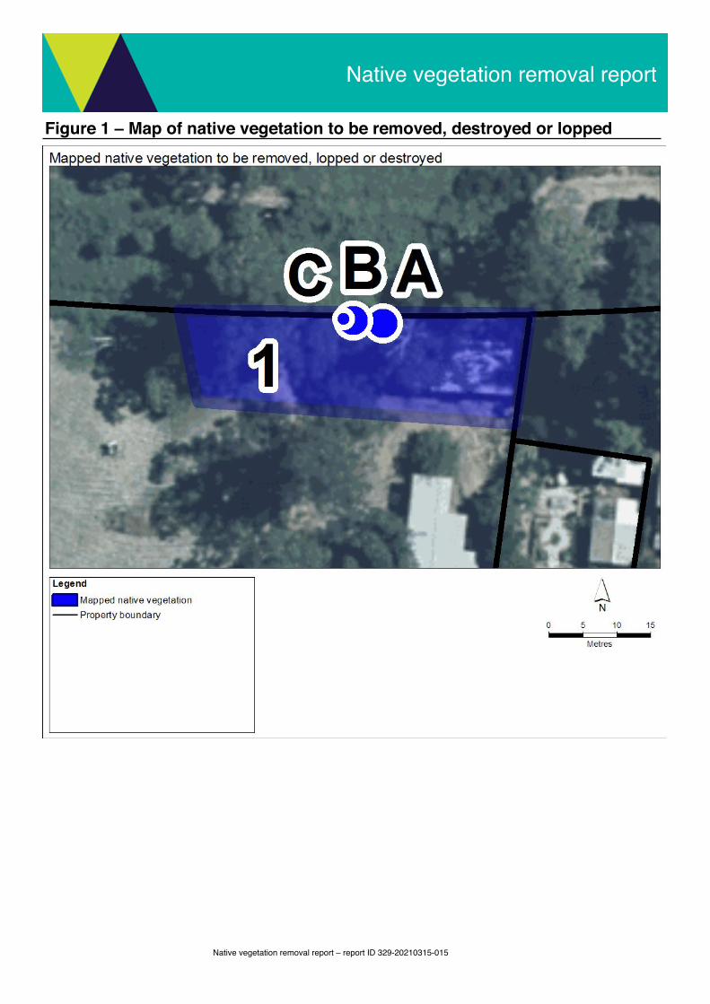
Figure 1 – Map of native vegetation to be removed, destroyed or lopped
Native vegetation removal report – report ID 329-20210315-015
Native vegetation removal report

Figure 2 – Map of property in context
Native vegetation removal report – report ID 329-20210315-015
Native vegetation removal report

Figure 3 – Biodiversity information maps
Native vegetation removal report – report ID 329-20210315-015
Native vegetation removal report

Native vegetation removal report – report ID 329-20210315-015
Native vegetation removal report

Native vegetation removal report – report ID 329-20210315-015
Native vegetation removal report

Appendix 1 - Details of offset requirements
* Offset requirements for partial removal: If your proposal is to remove parts of the native vegetation in a patch (for example only understorey plants) the condition score must be adjusted. This will require manual editing of the condition score and an update to the calculations that the native vegetation removal tool has provided: habitat hectares, general habitat score and offset amount.
Native vegetation to be removedExtent of all mapped native vegetation (for calculating habitat hectares)
0.074 The area of land covered by a patch of native vegetation and/or a scattered tree, measured in hectares. Where the mapped native vegetation includes scattered trees, each tree is assigned a standard extent and converted to hectares. A small scattered tree is assigned a standard extent defined by a circle with a 10 metre radius and a large scattered tree a circle with a 15 metre radius.
The extent of all mapped native vegetation is an input to calculating the habitat hectares.Condition score* 0.316 The condition score of native vegetation is a site-based measure that describes how close native vegetation
is to its mature natural state. The condition score is the weighted average condition score of the mapped native vegetation calculated using the Native vegetation condition map.
Habitat hectares 0.023 Habitat hectares is a site-based measure that combines extent and condition of native vegetation. It is calculated by multiplying the extent of native vegetation by the condition score:
Habitat hectares = extent x condition scoreStrategic biodiversity value score
0.470 The strategic biodiversity value score represents the complementary contribution to Victoria’s biodiversity of a location, relative to other locations across the state. This score is the weighted average strategic biodiversity value score of the mapped native vegetation calculated using the Strategic biodiversity value map.
General landscape factor
0.735 The general landscape factor is an adjusted strategic biodiversity value score. It has been adjusted to reduce the influence of landscape scale information on the general habitat score.
General habitat score
0.017 The general habitat score combines site-based and landscape scale information to obtain an overall measure of the biodiversity value of the native vegetation. The general habitat score is calculated as follows:
General habitat score = habitat hectares x general landscape factor
Offset requirementsOffset type General
offsetA general offset is required when the removal of native vegetation does not have a significant impact on any habitat for rare or threatened species. All proposals in the Basic and Intermediate assessment pathways will only require a general offset.
Offset multiplier 1.5 This multiplier is used to address the risk that the predicted outcomes for gain will not be achieved, and therefore will not adequately compensate the biodiversity loss from the removal of native vegetation.
Offset amount (general habitat units)
0.026 The general habitat units are the amount of offset that must be secured if the application is approved. This offset requirement will be a condition to any permit or approval for the removal of native vegetation.
General habitat units required = general habitat score x 1.5Minimum strategic biodiversity value score
0.376 The offset site must have a strategic biodiversity value score of at least 80 per cent of the strategic biodiversity value score of the native vegetation to be removed. This is to ensure offsets are located in areas with a strategic biodiversity value that is comparable to the native vegetation to be removed.
Vicinity North Central CMA or Hepburn Shire Council
The offset site must be located within the same Catchment Management Authority boundary or municipal district as the native vegetation to be removed.
Large trees 2 large tree(s)
The offset site must protect at least one large tree for every large tree removed. A large tree is a native canopy tree with a Diameter at Breast Height greater than or equal to the large tree benchmark for the local Ecological Vegetation Class. A large tree can be either a large scattered tree or a large patch tree.
Native vegetation removal report – report ID 329-20210315-015
Native vegetation removal report