appendix l - minnesotapower.blob.core.windows.net
TRANSCRIPT

Appendix L Duluth Loop Reliability Project
MPUC Docket No. E015/CN-21-140 MPUC Docket No. E015/TL-21-141
APPENDIX L
ENVIRONMENTAL IMPACT TABLES

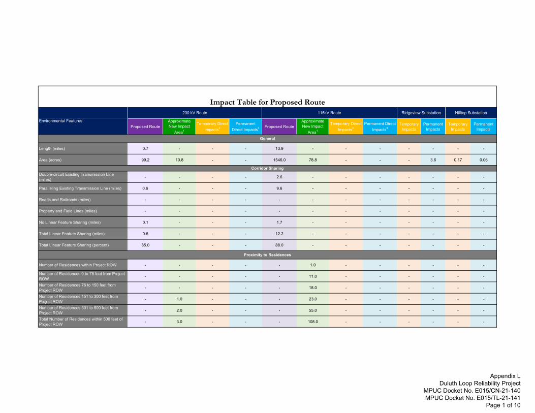
Proposed RouteApproximate New Impact
Area1
Temporary Direct Impacts2
Permanent Direct Impacts3 Proposed Route
Approximate New Impact
Area1
Temporary Direct Impacts2
Permanent Direct Impacts3
Temporary Impacts
Permanent Impacts
Temporary Impacts
Permanent Impacts
Length (miles) 0.7 - - - 13.9 - - - - - - -
Area (acres) 99.2 10.8 - - 1546.0 78.8 - - - 3.6 0.17 0.06
Double-circuit Existing Transmission Line (miles) - - - - 2.6 - - - - - - -
Paralleling Existing Transmission Line (miles) 0.6 - - - 9.6 - - - - - - -
Roads and Railroads (miles) - - - - - - - - - - - -
Property and Field Lines (miles) - - - - - - - - - - - -
No Linear Feature Sharing (miles) 0.1 - - - 1.7 - - - - - - -
Total Linear Feature Sharing (miles) 0.6 - - - 12.2 - - - - - - -
Total Linear Feature Sharing (percent) 85.0 - - - 88.0 - - - - - - -
Number of Residences within Project ROW - - - - - 1.0 - - - - - -
Number of Residences 0 to 75 feet from Project ROW - - - - - 11.0 - - - - - -
Number of Residences 76 to 150 feet from Project ROW - - - - - 18.0 - - - - - -
Number of Residences 151 to 300 feet from Project ROW - 1.0 - - - 23.0 - - - - - -
Number of Residences 301 to 500 feet from Project ROW - 2.0 - - - 55.0 - - - - - -
Total Number of Residences within 500 feet of Project ROW - 3.0 - - - 108.0 - - - - - -
Impact Table for Proposed Route
Proximity to Residences
115kV Route Ridgeview Substation Hilltop Substation
Environmental Features
230 kV Route
Corridor Sharing
General
Appendix L Duluth Loop Reliability Project
MPUC Docket No. E015/CN-21-140 MPUC Docket No. E015/TL-21-141
Page 1 of 10
Proposed RouteApproximate New Impact
Area1
Temporary Direct Impacts2
Permanent Direct Impacts3 Proposed Route
Approximate New Impact
Area1
Temporary Direct Impacts2
Permanent Direct Impacts3
Temporary Impacts
Permanent Impacts
Temporary Impacts
Permanent Impacts
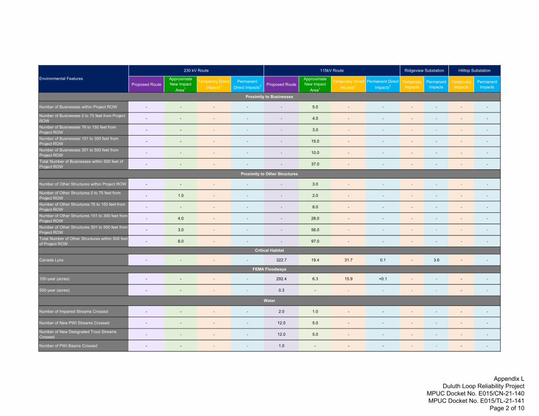
115kV Route Ridgeview Substation Hilltop Substation
Environmental Features
230 kV Route
Number of Businesses within Project ROW - - - - - 5.0 - - - - - -
Number of Businesses 0 to 75 feet from Project ROW - - - - - 4.0 - - - - - -
Number of Businesses 76 to 150 feet from Project ROW - - - - - 3.0 - - - - - -
Number of Businesses 151 to 300 feet from Project ROW - - - - - 15.0 - - - - - -
Number of Businesses 301 to 500 feet from Project ROW - - - - - 10.0 - - - - - -
Total Number of Businesses within 500 feet of Project ROW - - - - - 37.0 - - - - - -
Number of Other Structures within Project ROW - - - - - 3.0 - - - - - -
Number of Other Structures 0 to 75 feet from Project ROW - 1.0 - - - 2.0 - - - - - -
Number of Other Structures 76 to 150 feet from Project ROW - - - - - 8.0 - - - - - -
Number of Other Structures 151 to 300 feet from Project ROW - 4.0 - - - 28.0 - - - - - -
Number of Other Structures 301 to 500 feet from Project ROW - 3.0 - - - 56.0 - - - - - -
Total Number of Other Structures within 500 feet of Project ROW - 8.0 - - - 97.0 - - - - - -
Canada Lynx - - - - 322.7 19.4 31.7 0.1 - 3.6 - -
100-year (acres) - - - - 292.4 6.3 15.9 <0.1 - - - -
500-year (acres) - - - - 0.3 - - - - - - -
Number of Impaired Streams Crossed - - - - 2.0 1.0 - - - - - -
Number of New PWI Streams Crossed - - - - 12.0 5.0 - - - - - -
Number of New Designated Trout Streams Crossed - - - - 12.0 5.0 - - - - - -
Number of PWI Basins Crossed - - - - 1.0 - - - - - - -
Proximity to Other Structures
Critical Habitat
FEMA Floodways
Water
Proximity to Businesses
Appendix L Duluth Loop Reliability Project
MPUC Docket No. E015/CN-21-140 MPUC Docket No. E015/TL-21-141
Page 2 of 10

Proposed RouteApproximate New Impact
Area1
Temporary Direct Impacts2
Permanent Direct Impacts3 Proposed Route
Approximate New Impact
Area1
Temporary Direct Impacts2
Permanent Direct Impacts3
Temporary Impacts
Permanent Impacts
Temporary Impacts
Permanent Impacts
115kV Route Ridgeview Substation Hilltop Substation
Environmental Features
230 kV Route
Cultivated Crops (acres) - - - -0.2
- - - - - - -
Deciduous Forest (acres) 44.2 6.67.3 2.9 655.2 46.5 74.9 23.0 - 2.3 <0.1
-
Developed, High Intensity (acres) 7.7 - - -23.6 <0.1 1.7 <0.1 -
- - -
Developed, Low Intensity (acres) 1.6 - - -34.7 1.9 4.1 <0.1 - 0.1
- -
Developed, Medium Intensity (acres) 8.8 -0.1
-37.9 1.3 3.9 <0.1 -
- - -
Developed, Open Space (acres) 1.4 0.2 0.2 - 71.4 2.5 6.8 <0.1 - <0.1 - -
Emergent Herbaceous Wetlands (acres) 4.5 1.3 0.9 <0.1 30.5 1.2 2.4 <0.1 - - - -
Evergreen Forest (acres) - - - - 0.8 - - - - - - -
Hay/Pasture (acres) 1.5 - - - 28.4 0.2 0.7 <0.1 - - <0.1 -
Herbaceous (acres) 3.5 0.1 0.1 - 9.4 0.5 0.4 <0.1 - - 0.1 <0.1
Mixed Forest (acres) 6.4 0.6 1.4 0.2 48.6 4.0 5.0 1.8 - 0.4 - -
Open Water (acres) - - - - 0.3 - - - - - - -
Shrub/Scrub (acres) 6.4 0.1 0.3 - 15.7 0.3 1.3 <0.1 - 0.8 - -
Woody Wetlands (acres) 13.1 1.8 1.5 1.0 589.2 20.3 38.4 9.9 - - - -
Freshwater Emergent Wetland (acres) 1.7 - - - 101.7 2.1 14.51 1,528 sq ft - 0.47 - 0.03
Freshwater Forested Wetland (acres) - - - - 79.5 1.8 3.29 331 sq ft fill / 7.60 ac Conversion4 - - - -
Freshwater Forested/Emergent Wetland (acres) - - - - 12.4 - 0.33 - - - - -
Freshwater Forested/Shrub Wetland (acres) - - - - 34.8 - 2.14 - - - - -
Freshwater Pond (acres) 0.1 - - - 2.3 0.1 0.12 - - - - -
Freshwater Shrub Wetland (acres) - - - - 129.4 4.2 4.98 379 sq ft - - - -
Freshwater Shrub/Emergent Wetland (acres) 0.2 - - - 29.3 1.2 1.19 135 sq ft - - - -
Riverine (acres) - - - - 1.6 0.03 0.07 - - - - -
Wetlands
Land Cover
Appendix L Duluth Loop Reliability Project
MPUC Docket No. E015/CN-21-140 MPUC Docket No. E015/TL-21-141
Page 3 of 10

Proposed RouteApproximate New Impact
Area1
Temporary Direct Impacts2
Permanent Direct Impacts3 Proposed Route
Approximate New Impact
Area1
Temporary Direct Impacts2
Permanent Direct Impacts3
Temporary Impacts
Permanent Impacts
Temporary Impacts
Permanent Impacts
115kV Route Ridgeview Substation Hilltop Substation
Environmental Features
230 kV Route
Hermantown-Ahmeek (s3676) (acres) 44.4 7.8 8.4 <0.1 120.7 - 3.6 - - - - -
Hermantown-Finland (s3672) (acres) - - - - 1,425.5 78.9 135.9 0.5 - 3.6 0.2 <0.1
Dusler-Duluth (s3676) (acres) 54.8 2.9 3.5 <0.1 - - - - - - - -
Farmland of Statewide Importance (acres) 60.3 8.0 9.8 <0.1 576.5 34.3 48.9 0.2 - 3.3 - -
Not Prime Farmland (acres) 38.8 2.8 4.2 <0.1 969.7 44.6 88.6 0.3 - 0.3 0.2 <0.1
Number of Previously Recorded Archaeological Sites - - - - - - - - - - - -
Number of Previously Recorded Archaeological Sites within 1 mile of Proposed Route - - - - 6 - - - - - - -
Number of Historic Cemeteries - - - - 2 2 - - - - - -
Number of Historic Cemeteries within 1 mile of Proposed Route - - - - 1 - - - - - - -
Number of Ethnographic Study Place Names - - - - - - - - - - - -
Number of Ethnographic Study Place Names within 1 Mile of Prpoosed Route - - - - 1 - - - - - - -
Number of Fond du Lac THPO-Identified Resources - - - - 1 - - - - - - -
Number of Fond du Lac THPO-Identified Resources within 1 mile of Proposed Route - - - - 2 - - - - - - -
Number of Historic Architectural Resources - - - - 1 - - - - - - -
Number of Historic Architectural Resources within 1 mile of Proposed Route - - - - 70 - - - - - - -
Number of City of Duluth Trails - - - - 5 1 - - - - - -
Number of Existing/Future Hermantown Trails - - - - 5 1 - - - - - -
Number of Snowmobile Trails - - - - 2 1 - - - - - -
Number of T&E Species Within 1 mile of Route5- - - - 2 - - - - - - -
Soils
Cultural Resources
2 - Temporary impacts include access routes (30-foot-wide travel path along the proposed centerline of the project), structure work areas (100 foot by 100 foot per structure), and wire stringing areas (approximately 0.66 acres per location).3 - Permanent impacts are structure placement includes both H-Frame structure placement (56.5 sq feet per structure) and Monopole Structure Placement (78.5 sq ft per structure)
5 - DNR NHIS Data shows two records, however conversation with the DNR states that the Blandings turtle may occur within the proposed Project and that record is not recorded here since this is based from GIS data.
NHIS
Trails
1 - Proximity to residences, business, and other structures uses an approximate Project right-of-way location. Project ROW is an approximate existing and proposed ROW. Final ROW will be determined in final design.
4 - Permanent conversion impacts assumes that all forested, forested/emergent, and forested/shrub wetlands would be cleared and converted to either emergent or shrub wetlands within the within the existing and new right-of-way.
Appendix L Duluth Loop Reliability Project
MPUC Docket No. E015/CN-21-140 MPUC Docket No. E015/TL-21-141
Page 4 of 10

Description of the calculation assumptions for the Duluth Loop Route Permit Application
The Project has not yet started final design or engineering. Therefore, detailed design data is not available. As with all projects at this stage of development, it is necessary to employ appropriate assumptions as a basis for estimating impacts.
The assumptions described below were used for the impact analysis in Chapter 7. These assumptions are based on the information available at the time of analysis and the best professional judgment of engineering and environmental professionals developing the Proposed Project. In general, the Applicant has adopted conservative assumptions that are designed to err on the side of overestimating the magnitude of environmental effects.
No temporary right-of-way impacts are associated with the relocation, rebuild, removal, and double-circuiting of existing transmission lines within existing Minnesota Power right-of-way and are not included in the impact discussions because any impact will occur on previously disturbed Minnesota Power right-of-way or Minnesota Power-owned property and within an area of the same land use.
Temporary impacts are associated with the new structure work areas, access path, and pull and tension sites. Structures are permanent impacts within the rebuild segments.
The construction of relocated, rebuilt, and double-circuited existing transmission line facilities would result in no change from existing conditions. The removal segments would revegetate naturally with no continued maintenance activities.
Impact assumptions are as follows:
• The Study Area, for the existing conditions discussion, is the route width areas• The average spans for monopole and H-frame structures are 300 feet and 600 feet, respectively.• Structure type assumptions:
o From the Ridgeview Substation to a point east of Sundby Road (a point east of MillerTrunk Highway), H-frame structures will be used for the new line and rebuild
o From a point east of Sundby Road (crossing Miller Trunk Highway) to the MinnesotaPower property north of the Hermantown City Hall, monopole structures will be usedfor the new line and rebuild
o From the Minnesota Power property north of the Hermantown City Hall to theintersection of the existing 57 and 71 Lines, H-frame structures will be used for the newline and rebuild with the exception of a few spans on monopole structures as necessarythrough a known constrained area at the Hermantown Cemetery near Morris ThomasRoad
o For the double-circuit segment from the intersection of the existing 57 and 71 Lines tothe Hilltop Substation, monopole structures will be used
o The new 230 kV line extension and the 230 kV rebuild segment near Wild Rose TrailSubdivision will use monopole structures
• ROW impacts were calculated for an anticipated centerline, which generally was assumed to bein the center of the Route or adjacent to existing infrastructure located within the Route. Theanticipated centerline was developed using digital GIS data. The actual centerline will be
Appendix L Duluth Loop Reliability Project
MPUC Docket No. E015/CN-21-140 MPUC Docket No. E015/TL-21-141
Page 5 of 10

identified during final design and may be moved based on design requirements or to avoid or minimize affecting resources within or near the ROW.
• Total project ROW acres were calculated based on the below ROW widths multiplied by thelength of the segment. ROW width assumptions:
o The new 115kV single-circuit and 115kV double-circuit ROWs will be 100-feet-widecentered on the proposed alignment (50 ft on each side)
o The new parallel 115kV lines ROW will be 160-feet-wide centered on the mid-pointbetween the existing and new transmission lines – 60 feet of separation between thetwo lines and 50 ft on the centerline to the outside edge of the ROW. There may beareas where a narrower ROW is required due to specific local characteristics.
o The new single-circuit 230kV ROW will be 130-feet-wideo New corridors with 230kV line parallel to other transmission lines will be a total of 215-
feet-wide when collocated 115kV and 230kV lines and a total of 230-feet-wide whencollocated 230kV lines. The total 215-feet-wide right-of-way is calculated with 65 feet(ROW edge to 230 kV) + 100 feet (offset 230kV to adjacent 115kV or 230kV centerline) +50 feet (ROW edge to 115 kV). The total 230-feet-wide right-of-way is calculated with 65feet (ROW edge to 230 kV) + 100 feet (offset 230kV to adjacent 230kV centerline) + 65feet (ROW edge to 230 kV).
o The new distribution line 60 feet offset from transmission centerline.• Construction or laydown yards were not included in the calculation assumption. Therefore, no
new temporary or permanent impact. Ideally, yards may be located in a previously disturbedarea(s) within the project area or on Minnesota Power property to the extent practical.
• No new permanent access roads are being proposed at this time. Construction access will useexisting roads, driveways, and a temporary travel path along the ROW to the extent practical (nopermanent impacts)
• No temporary and permanent impacts for replacement of existing structures. No impactcalculations for replacement of existing structures
• Removal of existing structures are not counted as a temporary and permanent impacts• New line temporary impacts were calculated by summing the temporary construction impacts
from the new right-of-way (structures, temporary travel path), wire stringing areas outside ofthe new and existing right-of-way, and the new structures within the rebuild segments
• New line permanent impacts were determined by summing impacts from transmissionstructures, Ridgeview Substation, Hilltop Substation, and the new structures within the rebuildsegments
• Temporary impacts will include:
o 100 foot x 100 foot work area for each monopole and H-frame structure along new 115kV and 230 kV lines
o 100 foot x 100 foot work area every 0.5 mile or 2 additional structures per mile for therebuilt or realigned transmissions lines where H-frame structures remain as the primarystructure type in that segment. Within the rebuilt or realigned transmission linesegments where the primary structure type will change from H-Frame to monopole,there will be a 100 foot x 100 foot work area every 300 feet for the new monopolelocations.
o One 30-foot-wide temporary travel path is proposed to follow the proposed centerlinewithin the ROW for the length of the proposed new transmission line. It is assumed thatthere will be no grading or filling for permanent access; the Project may have a ‘2-track’
Appendix L Duluth Loop Reliability Project
MPUC Docket No. E015/CN-21-140 MPUC Docket No. E015/TL-21-141
Page 6 of 10

access path running the length of the transmission line. No permanent bridges are proposed.
o Wire stringing areas are located at approximately each point-of-inflection along theproposed route
• Permanent impacts will include:
o For the Ridgeview Substation, 3.6 acres will be permanently impacted. There will be notemporary disturbance by construction outside of permanent footprint.
o For the Hilltop Substation, 0.06 acres will be permanently impacted and 0.17 acres willbe temporarily impacted by construction outside of permanent footprint.
o No planned expansions at the Swan Lake Road, Haines Road, and Arrowheadsubstations, thus no permanent impacts
o A 5-foot radius for each monopole structure (approximately 78.5 square feet perstructure) representing the actual structure foundation
o A 3-foot radius for each pole of the H-frame structure (in total approximately 56.5square feet per structure (28.3 square feet per pole)) representing the actual structureimbedded in the ground
o Permanent clearing of the entire anticipated new line ROW is assumed includingclearing of forested vegetation
The final ROW for the Project will be developed during final design, which will be completed for the route selected through the permitting process.
Description of the impact assumptions by route segment
Below are assumptions for how impacts will be assessed by route segment. Calculations to quantify temporary and permanent impacts will be done for the proposed new line. Changes (rebuild and removal areas) will be described in the Route Permit Application, only specific temporary and permanent impacts will be quantified for additional structures every 0.5 mile where H-frames remain as the structure type in that segment, where as a structure type change from H-Frame to monopole will be quantified for the new monopole locations.
• Pull-tension sites extend from the edge of the ROW at points-of-inflectiono Temporary impacts from clearing and soil compaction and disturbance
• Ridgeview Substation to the existing 56/19 Lines split – The new 115 kV line would be placedbetween the existing 56 and 19 Lines within Minnesota Power’s existing ROW and disturbedland.
o No temporary impact from clearing, soil compaction and disturbance of the existingROW between the existing 56 and 19 Lines. Assume no additional permanent impactsfrom the ROW since the existing ROW was previously cleared during construction of theexisting 56 and 19 Lines.
o Temporary and permanent impacts to vegetation, soil, and wetlands from the newstructures (H-Frame) from the new 115 kV line within new Minnesota Power ROW
o Temporary and permanent impacts to vegetation, soil, and wetlands from the rebuilt 19Line will have new H-Frame structures every 0.5 mile or 2 additional structures per mile
Appendix L Duluth Loop Reliability Project
MPUC Docket No. E015/CN-21-140 MPUC Docket No. E015/TL-21-141
Page 7 of 10
• Existing 56/19 Lines split to Swan Lake Road Substation –New right-of-way needed southeast ofthe existing 19 Line
o No temporary impact from clearing, soil compaction and disturbance of the existing 19Line ROW
o Temporary and permanent impacts to vegetation, soil, and wetlands from the rebuilt 19Line will have new H-Frame structures every 0.5 mile or 2 additional structures per mile
o Permanent impacts to vegetation, soil, and wetlands from new H-Frame structures fromthe new 115 kV line within a new about 60-foot-wide right-of-way
o Temporary impact to vegetation from clearing, soil compaction, and wetland from anew about 60-foot-wide right-of-way for the new 115 kV line
• Swan Lake Road Substation to Haines Road Substation - New right-of-way needed southeast ofthe existing 52 Line. Distribution line on the eastside of the existing 52 Line (Swan Lake RoadSubstation to Arrowhead Road) is moved further east to accommodate the new 115 kV line. Thenew distribution line would be about 50 feet offset from the new 115 kV transmissioncenterline.
o No temporary impact to vegetation and soil from clearing, soil compaction, anddisturbance of the existing 52 Line ROW
o Temporary and permanent impacts to vegetation, soil, and wetlands from the rebuilt 52Line from Swan Lake Road Substation to a point east of Sundby Road will have new H-Frame structures every 0.5 mile or 2 additional structures per mile
o Temporary and permanent impacts to vegetation, soil, and wetlands from the rebuilt 52Line from a point east of Sundby Road to the Haines Road Substation will replace the H-Frame structures with monopole structures that will be about 300 feet apart
o Permanent impacts to vegetation, soil, and wetlands from new H-Frame structures fromthe new 115 kV line within a new about 60-foot-wide right-of-way
o Temporary impact to vegetation from clearing, soil compaction, wetlands, anddisturbance from a new about 60-foot-wide right-of-way for the new 115 kV line
o Permanent impacts to vegetation, soil, and wetlands from new distribution linestructures (single pole embedded)
o Temporary impact to vegetation from clearing, soil compaction, and disturbance from anew about 35-foot-wide added right-of-way for the distribution line
• Haines Road Substation to the existing 57 Line – Reroute along Market Street to move the newand existing 115 kV transmission lines from the buildings to increase safety would require newright-of-way. New 115 kV Line will use the existing 58-D alignment and would not result in newadded permanent impacts.
o Temporary and permanent impacts to vegetation, soil, and wetlands from the rebuiltexisting 58 Line and the new 115 kV line (on the existing 58-D Line) from the HainesRoad Substation to Minnesota Power’s property north of the Hermantown City Hall willreplace the H-Frame structures with monopole structures that are 300 ft apart
o Temporary and permanent impacts to vegetation, soil, and wetlands from the rebuiltexisting 58 Line and the new 115 kV line (on existing 58-D Line) from Minnesota Power’sproperty north of the Hermantown City Hall to junction of the existing 58 and 57 Lineswill have new H-Frame structures every 0.5 mile or 2 additional structures per mile
Appendix L Duluth Loop Reliability Project
MPUC Docket No. E015/CN-21-140 MPUC Docket No. E015/TL-21-141
Page 8 of 10

o Temporary and permanent impacts to vegetation, soil, and wetlands from clearing, soilcompaction, and disturbance from the new right-of-way along Market Street for therebuilt 58 Line and new 115 kV line (on existing 58-D Line)
o No temporary and permanent impacts are anticipated to vegetation from clearing, soilcompaction, and disturbance from the rebuild of existing 58 Line to new 58 Line forabout 1,000 feet east-west at western end of the section within existing MinnesotaPower ROW
o No temporary and permanent impacts are anticipated to vegetation from clearing, soilcompaction, and disturbance from the rebuild of the existing 57 Line to new 58 Line forabout 600 feet north-south at western end of the section within existing MinnesotaPower ROW
o No temporary and permanent impacts are anticipated to vegetation from clearing, soilcompaction, and disturbance from 0.3 mile of existing 58 Line removed at western endof the section within existing Minnesota Power ROW
o No temporary and permanent impacts are anticipated from the undergound fiber opticsegment within existing 58 Line ROW
• Existing 57 Line south to the Midway River – New about 160-foot-wide right-of-way needed forabout 1.5 miles to avoid Midway River, removal of 1.8 miles of the existing 57 Line
o Permanent impacts to vegetation, soil, and wetlands from new H-Frame structures fromthe two proposed lines (proposed 57 Line and new 115 kV line) within a new about 160-foot-wide right-of-way
o Temporary impact to vegetation from clearing, soil compaction, and wetland from anew about 160-foot-wide right-of-way for the new 115 kV line
o No temporary and/or permanent impacts from removing the existing 57 Line• Midway River to the existing 71 Line – The proposed 115 kV transmission line would parallel
the proposed 57 Line ROW on west side for 1.4 mile to the intersection with the existing 71 Line.New about 60-foot-wide right-of-way would be needed for the new 115 kV line west of theexisting 57 Line.
o No temporary impact from clearing, soil compaction and disturbance within the existing57 Line ROW
o Temporary and permanent impacts to vegetation, soil, and wetlands from the new andrebuilt 57 Line structures, anticipated to have new H-Frame structures every 0.5 mile or2 additional structures per mile
o Temporary and permanent impacts to vegetation, soil, and wetlands from the new andrebuilt 57 Line structures through the Hermantown Cemetery will replace the H-Framestructures with monopole structures that will be about 300 feet apart
o Permanent impacts to vegetation, soil, and wetlands from new H-Frame structures fromthe new 115 kV line within a new about 60-foot-wide right-of-way
o Temporary impact to vegetation from clearing, soil compaction, and wetland from anew about 60-foot-wide right-of-way for the new 115 kV line
• Existing 71 Line to Hilltop Substation – double circuit with existing 71 Line to the HilltopSubstation, reroute to remove the existing 71 Line from Wild Rose Trail area
Appendix L Duluth Loop Reliability Project
MPUC Docket No. E015/CN-21-140 MPUC Docket No. E015/TL-21-141
Page 9 of 10
o Temporary and permanent impacts to vegetation, soil, and wetlands from the double-circuit structures with proposed 115 kV line and existing 71 Line that will be about 300feet apart on existing Minnesota Power right-of-way
o Permanent impacts to vegetation, soil, and wetlands from new monopole structures onthe double circuit line in new ROW on Twin Ridges LLC properties
o Temporary impact to vegetation and soils from clearing, soil compaction, anddisturbance from a new 100-foot-wide ROW on Twin Ridges LLC properties
o Permanent impacts to vegetation, soil, and wetlands from new monopole structures forthe 230kV line shifting to a new 130-foot-wide ROW at Wild Rose Trail
o Temporary impact to vegetation and soils from clearing, soil compaction, anddisturbance from a new 130-foot-wide ROW for the 230kV line shifting to a new ROW atWild Rose Trail and where the new 230 line going into the Hilltop Substation
o Temporary and permanent impacts to vegetation, soil, and wetlands from newmonopole structures for the 230kV line going into the Hilltop Substation
o No temporary impact to vegetation from clearing, soil compaction, and disturbancefrom rebuilt 98 line within existing MP ROW
o No temporary impact to vegetation from clearing, soil compaction, and disturbancefrom the removal segment (Wild Rose Trail)
• 230kV Line Extension at Arrowheado Permanent impacts to vegetation, soil, and wetlands from new line single pole
structureso Temporary impact to vegetation from clearing, soil compaction, and disturbance from
new transmission line within new MP ROWo No temporary impact to vegetation from clearing, soil compaction, and disturbance
from the removal segment (parallel segment that crosses the Canadian NationalRailroad)
• 98 Line Thermal Upgradeo Temporary or permanent impacts were not considered
Appendix L Duluth Loop Reliability Project
MPUC Docket No. E015/CN-21-140 MPUC Docket No. E015/TL-21-141
Page 10 of 10