appendix j visual impact assessment - squarespace · pdf filelandscape character and visual...
TRANSCRIPT

Ap
pend
ix J – Visual im
pact assessm
ent
Appendix JVisual impact assessment


MOOREBANK INTERMODAL TERMINAL LANDSCAPE CHARACTER AND VISUAL IMPACT ASSESSMENT
REVISED PROJECT REPORTNS-1128
ISSUE C28.04.2015

Cover Image: View of Casula Powerstation from Carroll Park, looking south. This page: View over the Project site from Carroll Park, looking east.

Prepared by
CLOUSTON AssociatesLandscape Architects • Urban Designers • Landscape PlannersLevel 2, 17 Bridge Street • Sydney NSW 2000PO Box R1388 • Royal Exchange NSW 1225 • AustraliaTelephone +61 2 8272 4999 • Facsimile +61 2 8272 4998Contact: Leonard LynchEmail • [email protected] • www.clouston.com.au
Document Issue Date Status Verified ValidatedNS11278 A
BC
30/01/201523/02/201528/04/2015
DRAFTFINALFINAL
MKMKMK
CLCLCL
Note: This document is Preliminary unless Validated.
MOOREBANK INTERMODAL LANDSCAPE CHARACTER AND VISUAL IMPACT ASSESSMENTREVISED PROJECT REPORT
Client:Parsons BrinckerhoffLevel 27, Ernst & Young Centre680 George StreetGPO Box 5394SYDNEY NSW 2001AUSTRALIA

NS 1128 - MOOREBANK INTERMODAL FREIGHT TERMINAL LANDSCAPE CHARACTER AND VISUAL IMPACT ASSESSMENT4Goods train on the Southern Sydney Freight Line viewed from St Andrews Park

NS 1128 - MOOREBANK INTERMODAL FREIGHT TERMINAL LANDSCAPE CHARACTER AND VISUAL IMPACT ASSESSMENT 5
TABLE OF CONTENTS
S1 EXECUTIVE SUMMARY
S1 INTRODUCTION 6S2 THE PROJECT 6S3 SITE AND CONTEXT 6S4 LANDSCAPE CHARACTER 6S5 VISUAL IMPACT ASSESSMENT 7S6 MITIGATION RECOMMENDATIONS 7
1.0 INTRODUCTION 1.1 PURPOSE OF THE REPORT 101.2 METHODOLOGY 131.3 THE PROJECT 15
2.0 LANDSCAPE CHARACTER ASSESSMENT 2.1 EXISTING LANDSCAPE CHARACTER 282.2 LANDSCAPE CHARACTER ZONES 302.3 LANDSCAPE CHARACTER IMPACTS 40
3.0 VISUAL IMPACT ASSESSMENT 3.1 EXISTING VISUAL ENVIRONMENT 443.2 VISUAL CATCHMENT ANALYSIS 453.3 VISUAL ASSESSMENT 473.4 VISUAL IMPACT SUMMARY 86
4.0 MITIGATION AND CONCLUSION 4.1 MITIGATION 884.2 CONCLUSION 92
5.0 APPENDIX APPENDIX A - VISUAL IMPACT RATING TABLE 96

NS 1128 - MOOREBANK INTERMODAL FREIGHT TERMINAL LANDSCAPE CHARACTER AND VISUAL IMPACT ASSESSMENT6
S1 INTRODUCTIONThis Landscape Character and Visual Impact Assessment (LCVIA) report identifies and evaluates the landscape character and visual impacts of the revised Project, including an analysis of views from key vantage points and proposed management and mitigation measures to address the visual impact of the Project.
S2 THE PROJECTThe Moorebank Intermodal Terminal Project (‘the Project’) involves the development of freight terminal facilities linked to Port Botany and the interstate freight rail network. The Commonwealth Department of Finance and Deregulation (DoFD) is the proponent for the Project. When completed, the Project would include:• an import/export (IMEX) freight terminal where freight to and from Port Botany is
handled• an interstate freight terminal where freight is received or handled prior to distribution
outside the Sydney metropolitan region • a warehousing development.
The revised Project is proposed to be phased in its development with both construction and operational phases, which are likely to overlap at certain times. Five project development phases have been identified and detailed in this LCVIA.
S3 THE SITE AND ITS CONTEXTThe Project is situated on land in the Sydney suburb of Moorebank, NSW. The Project site is approximately 220 hectares (ha) in area, and is located within a locality that includes the residential suburbs of Casula, Wattle Grove and North Glenfield, as well as industrial, commercial and land occupied by the Department of Defence (DoD). The Project would provide connectivity to Port Botany by rail, and would connect to major regional and interstate roads and highways via the M5 and Hume Highway.
S4 LANDSCAPE CHARACTERThe landscape character surrounding the proposed Project site is typical of the district, being generally flat to gently undulating with adjoining slopes. There are large areas of development, interspersed by patches of parkland, public open space and riparian corridors. Four landscape character zones are identified within the report:• fragmented vegetation• riparian corridor• residential development• light industrial/commercial development.
Within the site, the Project is shown to have the greatest impact on fragmented vegetation due to expected requirements for removal, with a lesser impact on the surrounding residential areas due to the presence of screening vegetation and topography. A moderate/low impact rating is recorded on the riparian corridor along the Georges River and surrounding industrial/commercial zones due to the limited magnitude of the changes within these areas. The Project fits within a wider context of commercial and industrial built form present within the locality.
S1 EXECUTIVE SUMMARY

NS 1128 - MOOREBANK INTERMODAL FREIGHT TERMINAL LANDSCAPE CHARACTER AND VISUAL IMPACT ASSESSMENT 7
S5 VISUAL IMPACT ASSESSMENTThe proposed Project would lead to an increase in the scale, height and bulk of structures within the site. The locations identified as those with the greatest potential to be visually impacted by some aspect of the Project are:1. Southern section of Leacock Regional Park2. Leacock Regional Park and associated residential properties backing onto the parklands3. Carroll Park and associated residential properties backing onto the park4. Central section of Georges River Casula Parklands (northern rail alignment option only)5. St Andrews Park and associated residential properties near the park and along the eastern
edge of roads parallel to the Southern Sydney Freight Line. 6. Junction of M5 South Western Motorway and Moorebank Avenue.Assessment suggests that there is a moderate/high potential visual impact to a limited number of Casula based residential properties who overlook the site due to distance, existing visual barriers and topography. The greatest visual impact would be on the public parks and associated residential properties that are situated on the elevated land west of the Georges River. Direct views over the development will be available from properties directly adjacent to Leacock Park and Carroll Park. The most prominent views of the Project would be at localised site boundaries and public parks overlooking the site.
S6 MITIGATIONMitigation strategies have been investigated as part of the concept design process. These have included elements such as: • Retention of vegetation on site along the Georges River and establishment of this into
a conservation zone to provide a visual buffer and screening of project infrastructure.• The inclusion of landscaping zones (including existing vegetation retention) where
possible on the site complying with the local planning instrument building height requirements.
• The inclusion of setbacks along the northern and southern site boundaries.Mitigation strategies appropriate for detailed design include:Reduction • Maximising the integration of terminal facilities and the associated commercial
and warehousing precincts by providing screening.• Where possible retain existing native trees along Moorebank Avenue to mitigate
visual impact and provide a layered approach along the streetscape.• Consideration of the use of lower, more frequent light poles where possible to
mitigate light spill effects and ambient light impacts.• Integration of car parking, planting and signage to present as one cohesive
address.• Consideration of localised earth mounding. Alleviation• Choice of finishes and materials based on limiting the amount of contrast with the
surrounding landscape with the preferred use of muted colours.• On site planting of suitable vegetation species at a range of heights.• Utilise opportunities to commence early rehabilitation and supplementary planting
of endemic species to the conservation zone on the western boundary.• Encouraging higher buildings fronting Moorebank Avenue and Anzac Road to
provide a visual buffer from the terminal operations beyond.
Off site mitigation measures are not recommended.

NS 1128 - MOOREBANK INTERMODAL FREIGHT TERMINAL LANDSCAPE CHARACTER AND VISUAL IMPACT ASSESSMENT8
I n t r o d u c t i o n1.0
Leacock Regional Park looking south

NS 1128 - MOOREBANK INTERMODAL FREIGHT TERMINAL LANDSCAPE CHARACTER AND VISUAL IMPACT ASSESSMENT 9

NS 1128 - MOOREBANK INTERMODAL FREIGHT TERMINAL LANDSCAPE CHARACTER AND VISUAL IMPACT ASSESSMENT10
1.1 PURPOSE OF THE REPORTThe purpose of this Technical Paper and the overall Environmental Impact Statement (EIS) is to seek approval for the Moorebank revised Project design under both the Commonwealth Environment Protection and Biodiversity Conservation Act 1999 (EPBC Act) as a controlled action; and the NSW Environmental Planning and Assessment Act 1979 (EP&A Act), as a Stage 1 state significant development (SSD).
In seeking approval, the Department of Finance and Deregulation (DoFD) is looking to establish a staged approval process, whereby successive stages of development on the Project Site would be subject to further environmental assessment and separate planning approval once further detailed Project information is developed. That is, the DoFD is currently seeking approval for the Project ‘concept’ (i.e. the broad parameters of the Project), sufficient to satisfy both:• a Stage 1 SSD development application under the NSW EP&A Act
• Commonwealth EPBC Act requirements for the Project, in relation to impacts of the proposed controlled action on matters protected under the EPBC Act (which comprise listed threatened specials and communities and impacts on the environment by a Commonwealth agency).
This Technical Paper and the EIS assess the impacts of all five proposed development stages of the Project (Early works, Phase A, Phase B, Phase C and Project Full Build) to a concept level, but with more detailed assessment of matters protected under the EPBC Act. Both construction and operation phase impacts have been assessed and are presented.
Impacts from the project and appropriate mitigation measures would be confirmed following detailed design and during subsequent development application processes.
This Technical Paper has been prepared by CLOUSTON Associates to address environmental impact assessment requirements of both the Commonwealth Government under the EPBC Act (the ‘Final EIS Guidelines’); and the NSW Government under the EP&A Act (‘the Director-General’s Requirements (DGRs)’). Table 01 identifies these requirements and indicates where they are addressed in the paper.
1.0 INTRODUCTION

NS 1128 - MOOREBANK INTERMODAL FREIGHT TERMINAL LANDSCAPE CHARACTER AND VISUAL IMPACT ASSESSMENT 11
EPBC Act – Final EIS GuidelinesRequirement Where addressed in the technical paperProvide a detailed analysis and describe the changes to visual amenity on the proposed site and surrounding areas resulting from construction and operation of the facility.
Part 3.0 - Visual Impact Assessment
NSW EP&A Act - DGRsRequirement Where addressed in the technical paperIdentify and evaluate the visual impacts of the development including an analysis of views from key vantage points
Part 3.0 - Visual Impact Assessment
Propose management/mitigation measures to address the visual impact of the Project
Part 4.0 - Mitigation Recommendations
Analyse and describe the contribution and impacts of the proposed facility on light spill at the local scale and to sensitive receptors
A brief summary is covered under Part 4.0 - Mitigation Recommendations. A detailed light spill analysis has been undertaken as a separate technical assessment.
This assessment is an independent report and is based on a professional analysis of the landscape and the Project at the time of writing. The future and potential viewers (visual receptors) themselves have not been consulted about their perceptions; the analysis and conclusions are based solely on a professional assessment of the anticipated impacts, based on a best practice methodology.
Landscape Character and Visual Impact Assessment (LCVIA) are separate but closely linked process that operates within the overall framework of an EIS. It aims to ensure that all possible effects of change and development on the landscape, views and visual amenity are taken into account.
The two overall components of LCVIA are:• Landscape effects assessment - deals with changes to landscape as a resource. It
is concerned with issues like protected landscapes, the contribution of landscape character to sense of place and quality of life, and the way that change may affect individual components of the landscape;
• Visual effects assessment - concerned with how the surroundings of individuals or groups of people may be specifically affected by change in the landscape both quantitatively and qualitatively.
Judgement as to the significance of the effects are arrived at by a process of reasoning, based upon analysis of the baseline conditions, identification of receptors and assessment of their sensitivity, and the degree and nature of the changes that may result from the Project.
Table 01 - EPBC Act and DGR Requirements

NS 1128 - MOOREBANK INTERMODAL FREIGHT TERMINAL LANDSCAPE CHARACTER AND VISUAL IMPACT ASSESSMENT12
Report structure The LCVIA is structured into five parts:
1.0 - IntroductionIntroductory section that describes the existing site and the Project.2.0 - Landscape Character AssessmentAn analysis of the existing landscape that identifies landscape character zones according to their topography, drainage and urban form. Includes an assessment of likely impacts based on sensitivity and magnitude criteria.3.0 - Visual Impact Assessment An analysis of the existing visual environment including public and private domain, identifying key viewer locations. This is followed by the identification and analysis of visual impacts on key viewpoints of the Project based on sensitivity and magnitude criteria.4.0 - Mitigation Recommendations and ConclusionsConclusion on overall impact and discussion of the means by which the visual impacts identified can be precluded, reduced or offset. This is followed by a conclusion on the report’s findings. 5.0 - Appendices
Terms used within this reportThe following provides a brief explanation of the terms and abbreviations commonly used in LCVIA reports and which appear in this report:
View: The sight or prospect of some landscape or scene.Visual Amenity: The measure of the visual quality of a site or area experienced by residents, workers or visitors. It is the collective impact of the visual components which make a site or an area pleasant to be in. Viewshed: The area which the Project is visible to the human eye from a fixed vantage point.Visual Receptor: the public or community at large who would have views of the Project site either by virtue of where they live and/or work or from transport routes, paths, lookouts and the like.Duration: The length of time the visual receptor is exposed to the view. Magnitude of change: A quantitative assessment of the change in compositional elements of the view. Quantum of view: The openness of the view and the angle of the view to the visual receptor.Visual Impact Rating: Determined by cross referencing sensitivity with magnitude.Landscape Character: A distinct, recognisable and consistent pattern of elements, be it natural (soil, landform) and/or human (for example settlement and development) in the landscape that makes one landscape different from another.

NS 1128 - MOOREBANK INTERMODAL FREIGHT TERMINAL LANDSCAPE CHARACTER AND VISUAL IMPACT ASSESSMENT 13
1.2 METHODOLOGYLandscape Character and Visual Impact Assessment is by its nature not an exact science and consequently is subject to varied methodologies both in Australia and overseas. Potentially subjective assessment material and differences of opinion about how to best assess visual characteristics, qualities, degrees of alteration and viewer sensitivity often arise. As a consequence, and as identified by the NSW Land and Environment Court, the key to a robust process is to explain clearly the criteria upon which an assessment is made.
This report has adopted the Guidelines for Landscape Character and Visual Impact Assessment as published by the Roads and Maritime Service, RMS.
Key components of the LCVIA methodology include:• Siteanalysisandidentificationoflandscapecharacterzones-Based on
desk top and field analysis, the natural environment is identified and described as well as the human intervention and shaping of that environment, including settlements and the interaction between place and community.
• Assessment of landscape character impacts - The impact of the development and associated infrastructure on each zone is identified and assessed. Impacts are based on the sensitivity of the landscape character zone to change and the magnitude of the development within that landscape.
• Assessment of the visibility of the Project - Based on desk top and site analysis, the extent of the development that is visible is defined.
• Identificationof key viewpoints -Based on desktop and field analysis, a schedule of key viewpoints is developed. The final list of receptors does not represent the entire number of receptors likely to be visually impacted by the Project, but rather gives an indication of the typical range of views that receptors will have.
• Assessment of visual impacts - The unmitigated impact of the development on each representative viewpoint is assessed. Impacts are based on a composite of the sensitivity of the view and magnitude of the development in that view, before any mitigation strategy has been put in place.
• Development of mitigation strategy - Principles and strategies are developed to mitigate landscape character and visual impacts in the ongoing development of the design.

NS 1128 - MOOREBANK INTERMODAL FREIGHT TERMINAL LANDSCAPE CHARACTER AND VISUAL IMPACT ASSESSMENT14
1.2.1 Impact RatingsThe overall impact rating of the Project on any given visual receptor or landscape character is based on themes of magnitude and sensitivity. The relevance of magnitude and sensitivity for each assessment type is described below.
1.2.2 Landscape CharacterSensitivity - the degree to which a particular landscape type can accommodate change arising from a development, without detrimental effects on its character. This includes factors such as:• existing land use
• the pattern and scale of the landscape
• visual enclosure, openness of views and distribution of visual receptors
• the value placed on the landscape.
Magnitude - the magnitude of the effects of the development within the landscape. Consideration is given to existing built form in the landscape and how closely the development matches this in bulk, scale and form. Magnitude is a study of the scale or degree of change to the landscape resource, the nature of the effect and its duration including whether it is permanent or temporary.
1.2.3 Visual ImpactSensitivity - each visual receptor type has an inherent and varied sensitivity to change in the visual scene based on their personal context in which the view is being experienced. This will have a direct bearing on the perception of visual impact experienced by the receptor and qualifies the quantitative impacts.
Magnitude - the magnitude of the visual effects of the development within the landscape. A series of quantitative assessments are studied, including distance from development, quantum of view, duration of view and magnitude of change.
1.2.4 Overall Impact RatingThe severity of visual and landscape impacts is calculated using matrix Table 02 - based on a combination of magnitude and sensitivity.
Table 02: Overall Impact Rating as a combination of Sensitivity and Magnitude. Source: RMS Guidelines for Landscape Character and Visual Impact Assessment

NS 1128 - MOOREBANK INTERMODAL FREIGHT TERMINAL LANDSCAPE CHARACTER AND VISUAL IMPACT ASSESSMENT 15
Table 02: Overall Impact Rating as a combination of Sensitivity and Magnitude. Source: RMS Guidelines for Landscape Character and Visual Impact Assessment
1.3 THE PROJECTThe Moorebank Intermodal Terminal Project (the Project) involves the development of approximately 220 hectares (ha) of land at the Project site for the construction and operation of an Intermodal Terminal and associated infrastructure, facilities and warehousing. The Project includes a rail link connecting the Project site to the Southern Sydney Freight Line (SSFL) and road entry and exit points from Moorebank Avenue.
1.3.1 The Project SiteThe Project is situated on land in the Sydney suburb of Moorebank, NSW (refer Figure 01). The Project site is approximately 220 hectares (ha) in area, and is located within a locality that includes the residential suburbs of Casula, Wattle Grove and North Glenfield, as well as industrial, commercial and Department of Defence (DoD) land (refer Figure 02). The Project would provide connectivity to Port Botany by rail, and would connect to major regional and interstate roads and highways via the M5 and Hume Highway.
The site is currently an army base, primarily associated with the School of Military Engineering, utilised by the Australian Army. The site also contains the RAE museum and golf club. Multiple ancillary facilities and buildings to the RAE School and the Steele Barracks are located on site including parade grounds, recreation facilities and plant training areas.
North of the site are the existing Moorebank industrial developments of Amiens and Yulong. The residential suburb of Wattle Grove is located to the east, with Casula residential area to the west of the site, separated by the Georges River and SSFL. Land uses immediate to the site include industrial, public recreation, residential, national parks and nature reserves.
To the east of Moorebank Avenue is an area of land occupied by DoD which consists of a number of buildings used for logistics and warehousing. The Sydney Intermodal Terminal Alliance (SIMTA) proposes to develop this site into additional Intermodal warehousing. This development has not been assessed further within this report.
1.3.2 Project StagingThe Project is proposed to be phased (staged) in its development, as summarised in Table 03. The proposed indicative phasing includes both construction and operational phases, which are likely to overlap at certain times. For the purposes of assessment of the Project, five project development phases have been identified and detailed in this report. These are indicative only, but illustrate the type of construction and operation activities that would occur over time at the Project site.
The Project would likely commence in 2015 with the Early Works development phase and would progress with concurrent construction and operation through to the Project Full Build Phase (operation of full IMEX terminal, warehousing and interstate terminal) by approximately 2030.

NS 1128 - MOOREBANK INTERMODAL FREIGHT TERMINAL LANDSCAPE CHARACTER AND VISUAL IMPACT ASSESSMENT16
Figure 01 - Site context (not to scale)
Sydney CBD
Botany Bay
Chiping Norton Lake
Georges River Reserve
Moorebank
Figure 02 - Site location (not to scale)
Wattle Grove
Casula
Moorebank Business Park
Steele Army Barracks
DNSDC
Georges River
Source: Google Earth
Project boundarySIMTA boundary
Site location
Source: Google Earth
Existing RailExisting Road
Golf course
‘Dust bowl’ training area
Amiens
Hume
Highway
Geor
ges R
iver
Moor
eban
k Ave
nue

NS 1128 - MOOREBANK INTERMODAL FREIGHT TERMINAL LANDSCAPE CHARACTER AND VISUAL IMPACT ASSESSMENT 17
Table 03 - Project Staging

NS 1128 - MOOREBANK INTERMODAL FREIGHT TERMINAL LANDSCAPE CHARACTER AND VISUAL IMPACT ASSESSMENT18
1.3.3 Project ElementsThe key features/components of the Project comprise:• an IMEX freight terminal – designed to handle up to 1.05 million TEU per annum
(525,000 TEU inbound and 525,000 TEU outbound) of IMEX containerised freight to service ‘port shuttle’ train services between Port Botany and the Project;
• an Interstate freight terminal – designed to handle up to 500,000 TEU per annum (250,000 TEU inbound and 250,000 TEU outbound) of interstate containerised freight to service freight trains travelling to and from regional and interstate destinations; and
• warehousing facilities – with capacity for up to 300,000 square metres (m2) of warehousing to provide an interface between the Project and commercial users of the facilities such as freight forwarders, logistics facilities and retail distribution centres.
The Project is intended to connect to the SSFL, which was commissioned in January 2013 within the Main South Railway Line corridor. The SSFL connects Port Botany to west and south-western Sydney, and would provide a direct route for freight trains from Port Botany to the Project site.
The rail access would be from the south-western corner of the Project site, passing through the Glenfield Landfill site (owned by Glenfield Waste Services) and crossing the Georges River and floodplain.
Building and Infrastructure Height RestrictionsThe Warehousing Precinct is proposed to be controlled by a combination of building height restrictions and a maximum floor space ratio. There will be a setback control of 7.5m along the northern and southern boundaries. The lighting poles will be 30m high, the gantries 27.7m high and a 21m height restriction will be placed on warehousing - see Section S1.
No buildings will be permitted within the landscape buffer between the site and the Georges River.
Loaded containers would be stacked to a height of 13m or five containers (2.6 m high per container). Empty containers would typically be stacked separately from loaded containers in the storage yard and the first available container picked for export. Empty storage containers would be stacked to a height of 20.8 m or eight containers (2.6 m per container).
Road Access to the siteFreight trucks would access the Project site from Moorebank Avenue, via the M5 Motorway. Trucks would then access the M7 Motorway and Hume Highway by the M5 Motorway. An upgrade to the northern end of Moorebank Avenue would enable safe and efficient access to the Project site.

NS 1128 - MOOREBANK INTERMODAL FREIGHT TERMINAL LANDSCAPE CHARACTER AND VISUAL IMPACT ASSESSMENT 19
Conservation Zone A conservation area is to be established on the western edge of the project site adjacent to the Georges River through a process of conservation of existing vegetation, rehabilitation of degraded habitat and re-vegetation of bare areas close to the riverbank to create a largely continuous vegetated area along the river. The aim will be to provide an area that is protected and managed so as to:• minimise the clearing of existing vegetation within the Project development
• minimise clearing associated with construction plant and equipment
• maintain ongoing conservation management to maximise habitat value.
Construction ActivitiesActivities during the construction period will include:• clearing of the development area of the site prior to construction
• temporary fencing, lighting and builders’ compounds
• earthworks, infrastructure installation
• road and rail building
• stockpiling of materials.
During these processes, large construction cranes will be used as well as other construction equipment. Additional sources of visual impact during construction, such as the establishment of hoardings and construction fencing would tend to create highly localised visual impacts, primarily along Moorebank Avenue.
Although the construction activities would be temporary, they would potentially occur on site for periods of a few years at a time for each stage, as identified in Table 03.

NS 1128 - MOOREBANK INTERMODAL FREIGHT TERMINAL LANDSCAPE CHARACTER AND VISUAL IMPACT ASSESSMENT20
DA
TER
EVD
ESC
RIP
TIO
N
PR
OJE
CT
REV
.
100mm AT FULL SIZE
DE
SIG
NV
ERIF
YD
RA
WN
CH
EC
K
PR
OJE
CT
PR
OJE
CT
No.
DIS
CIP
LIN
EN
UM
BER
2103829A-DG-GE-0105
A1
OR
IGIN
AL
DO N
OT S
CALE
THI
S DR
AWIN
G - U
SE F
IGUR
ED D
IMEN
SION
S ON
LYVE
RIFY
ALL
DIM
ENSI
ONS
ON S
ITE
© P
arso
ns B
rinck
erho
ff A
ustra
lia P
ty L
imite
d ("P
B")
Cop
yrig
ht in
the
draw
ings
, inf
orm
atio
n an
d da
ta re
cord
ed in
this
doc
umen
t ("th
e in
form
atio
n") i
s th
e pr
oper
ty o
f PB.
Thi
sdo
cum
ent a
nd th
e in
form
atio
n ar
e so
lely
for t
he u
se o
f the
auth
oris
ed re
cipi
ent a
nd th
is d
ocum
ent m
ay n
ot b
e us
ed,
copi
ed o
r rep
rodu
ced
in w
hole
or p
art f
or a
ny p
urpo
se o
ther
than
that
for w
hich
it w
as s
uppl
ied
by P
B. P
B m
akes
no
repr
esen
tatio
n, u
nder
take
s no
dut
y an
d ac
cept
s no
resp
onsi
bilit
y to
any
third
par
ty w
ho m
ay u
se o
r rel
y up
on th
isdo
cum
ent o
r the
info
rmat
ion.
CLI
ENT
APP
RO
VED
DR
AW
N
DES
IGN
ED
CH
EC
KED
DA
TE
CH
EC
KED
Tele
phon
e +
61 2
927
2 51
00Fa
csim
ile
+61
2 9
272
5101
Syd
ney
NS
W 2
001
Em
ail:
sydn
ey@
pb.c
om.a
u
Leve
l 27,
Ern
st &
You
ng C
entre
680
Geo
rge
Stre
etS
ydne
y N
SW
200
0G
PO
BO
X 5
394
Aus
tralia
--
- --
-
RE
-ISS
UE
D F
OR
RE
FER
ENC
E D
ESIG
N09
.11.
112 1
ISS
UE
D F
OR
RE
FER
ENC
E D
ESIG
N30
.09.
11IS
SU
ED
FO
R 8
0% R
EFER
ENC
E D
ESIG
N09
.09.
110
--
--
--
-- -
--
--
-C
Z-
--
NC
--
- --
-C
Z
CZ
CD
30.0
9.11
RHSS
NC
MO
OR
EB
AN
K IN
TER
MO
DA
L TE
RM
INA
L
STAG
E 2
- SH
EET
1TY
PIC
AL
SEC
TIO
NS
GEN
ERAL
AR
RAN
GE
ME
NT
2103
829A
GE
0105
2
100
500
300
200
Full
Siz
e 1:
5000
; H
alf R
educ
tion
1:10
000
SC
ALE
(m)
2010
040
60
Full
Siz
e 1:
1000
; H
alf R
educ
tion
1:20
00S
CA
LE (m
)10
050
030
020
0
Full
Siz
e 1:
5000
; H
alf R
educ
tion
1:10
000
SC
ALE
(m)
Section S1 - Indicative section through the Project site showing lighting towers and container storage area subject to detailed design

NS 1128 - MOOREBANK INTERMODAL FREIGHT TERMINAL LANDSCAPE CHARACTER AND VISUAL IMPACT ASSESSMENT 21
Figure 3A Indicative concept layout - Scenario 1 (Phase A) Source: Parsons Brinckerhoff

NS 1128 - MOOREBANK INTERMODAL FREIGHT TERMINAL LANDSCAPE CHARACTER AND VISUAL IMPACT ASSESSMENT22Figure 3B Indicative concept layout - Scenario 2 (Phase B) Source: Parsons Brinckerhoff

NS 1128 - MOOREBANK INTERMODAL FREIGHT TERMINAL LANDSCAPE CHARACTER AND VISUAL IMPACT ASSESSMENT 23Figure 3C Indicative concept layout - Scenario 2b (Phase C) Source: Parsons Brinckerhoff

NS 1128 - MOOREBANK INTERMODAL FREIGHT TERMINAL LANDSCAPE CHARACTER AND VISUAL IMPACT ASSESSMENT24Figure 3D Indicative concept layout - Scenario 3 (Phase C) Source: Parsons Brinckerhoff

NS 1128 - MOOREBANK INTERMODAL FREIGHT TERMINAL LANDSCAPE CHARACTER AND VISUAL IMPACT ASSESSMENT 25Figure 3E Indicative concept layout - Full Build Source: Parsons Brinckerhoff

NS 1128 - MOOREBANK INTERMODAL FREIGHT TERMINAL LANDSCAPE CHARACTER AND VISUAL IMPACT ASSESSMENT26
Landscape Character Assessment
2.0Georges River

NS 1128 - MOOREBANK INTERMODAL FREIGHT TERMINAL LANDSCAPE CHARACTER AND VISUAL IMPACT ASSESSMENT 27

NS 1128 - MOOREBANK INTERMODAL FREIGHT TERMINAL LANDSCAPE CHARACTER AND VISUAL IMPACT ASSESSMENT28
2.1 EXISTING LANDSCAPE CHARACTERThe site is largely cleared, accommodating Defence buildings of varying sizes and uses. The site is zoned SP2 (Defence) as per the Liverpool Local Environment Plan 2008. Buildings associated with the Army Base range from single storey dwellings to storage facilities for plant machinery approximately 15m high. The buildings are surrounded by open lawn areas with some ornamental shrub and tree planting. Some parts of the site have been used as training facilities and are scarred, containing no vegetation. One such example is the plant and equipment training area called the ‘dust bowl’ which sits on the western boundary of the site.
A golf course is present in the southern section of the site which is mainly open in character with patches of mature trees. To the north of the site is the Amiens light industrial area with a small pond, falling just outside the site boundary (refer Figure 02).
The landscape condition along Moorebank Avenue is well maintained with many mature street trees appearing in sound condition as well as lawns and footpaths that have been kept tidy and free from rubbish.
Immediately to the west of the site lies the Georges River. The shoreline of the river is heavily vegetated, particularly along the eastern bank. The riparian vegetation is well established, providing a wildlife corridor and a buffer for the protection of soil stability, water quality and aquatic habitats. Riparian vegetation along the site boundary is dense but follows a narrow corridor generally 25 metres wide. Further west beyond the Georges River and the passenger/freight rail line marks a transition to the low density residential suburb of Casula and commercial properties along the Hume Highway. A number of major road and rail corridors also exist to the north, west and south (refer Figure 02).
2.1.1 TopographyThe site is generally flat to gently undulating, with the elevation over the majority of the site ranging from approximately 12.5 to 16.0m above Australian Height Datum (AHD). A terrace abuts the Georges River on the western boundary at a much lower elevation than the rest of the site. The terrace is well defined by a sharp change in elevation of approximately 6m and is the location of the current plant and equipment training ground - the ‘dustbowl’. To the west of the Georges River, the ground rises steeply towards Leacock Regional Park, as shown in the indicative cross section S2 below.
2.0 LANDSCAPE CHARACTER ASSESSMENT
Source: Google EarthSection S2- Indicative section across the site (east to west)
Georges River
Leacock Regional Park
Site boundary
Moorebank Avenue

NS 1128 - MOOREBANK INTERMODAL FREIGHT TERMINAL LANDSCAPE CHARACTER AND VISUAL IMPACT ASSESSMENT 29
2.1.2 VegetationPatches of remnant vegetation exist across the site with higher densities of trees along the Georges River riparian vegetation corridor and within the north west corner of the site. The vegetation serves as an informal visual buffer between areas of the site and screens views into the site from surrounding viewpoints.
The vegetation on site ranges from endemic stands of mature native vegetation (15 - 25m tall) to mature introduced species planted in avenues or as features. Native vegetation communities found within the site include stands of: • Alluvial Woodland (part of the River-Flat Eucalypt Forest on Coastal Floodplains)• Riparian Forest (part of the River-Flat Eucalypt Forest on Coastal Floodplains)• Castlereagh Swamp Woodland and• Castlereagh Scribbly Gum Woodland.
The core of the study area has low vegetation cover consisting chiefly of a mixture of planted and remnant indigenous and introduced trees within areas of cleared and disturbed land. The vegetation mostly obscures the current facilities from surrounding viewpoints but some filtered views of buildings are offered and higher buildings can be seen above the canopy in places.

NS 1128 - MOOREBANK INTERMODAL FREIGHT TERMINAL LANDSCAPE CHARACTER AND VISUAL IMPACT ASSESSMENT30
2.2 LANDSCAPE CHARACTER ZONESTo enable the assessment of impacts on landscape character, landscape character zones have been determined for the site. Landscape character zones are defined as having a distinct, recognisable and consistent pattern of elements, be it natural (soil, vegetation, landform) and/or human built form, distinguishing one landscape different from another.
The Project site and surrounds have been assessed and four landscape character zones have been established. These include:1. Fragmented vegetation2. Riparian corridor3. Residential development4. Commercial/Light Industrial development
Further description of these zones and their properties is provided in the following pages and shown in Figure 05. The overall impact rating of the Project on any given landscape character zone is based on themes of magnitude and sensitivity as described within the Methodology section of this report. The severity of these impacts is calculated using Table 02.
Table 02: Overall Impact Rating as a combination of Sensitivity and Magnitude. Source: RMS Guidelines for Landscape Character and Visual Impact Assessment

NS 1128 - MOOREBANK INTERMODAL FREIGHT TERMINAL LANDSCAPE CHARACTER AND VISUAL IMPACT ASSESSMENT 31
Figure 05 Landscape Character Zones (not to scale)
Geor
ges R
iver
Wattle Grove
Casula
Moorebank Business Park
M5
EAST HILLS RAIL LINE
SSFL
Steele Barracks Army Base
DNSDC
Anzac Creek
AB
C
D
KEY
Landscape Character Zone 3 - Residential development
Landscape Character Zone 1 - Fragmented vegetation
Landscape Character Zone 2 - Riparian corridor
Landscape Character Zone 4 - Commercial/Light industrial development
Location of landscape character photo (as provided in each zones description below)A
CommonwealthLand
Glenfield Landfill Site
Project boundarySIMTA boundary
MilitaryReserve
MilitaryReserve
M5
Transport CorridorCreekOther land use
Hume
Highway
Table 02: Overall Impact Rating as a combination of Sensitivity and Magnitude. Source: RMS Guidelines for Landscape Character and Visual Impact Assessment
Moor
eban
k Ave
nue

NS 1128 - MOOREBANK INTERMODAL FREIGHT TERMINAL LANDSCAPE CHARACTER AND VISUAL IMPACT ASSESSMENT32
2.2.1Landscapecharacterzone1-FragmentedVegetation
This zone within the site is characterised by fragmented vegetation cover consisting chiefly of a mixture of planted and remnant indigenous and introduced trees within areas of cleared and disturbed land. Vegetation communities listed as endangered under the Threatened Species Conservation Act 1995 (TSC) in this character zone include (see Figure 04):• Castlereagh Swamp Woodland found in small patches in low-lying areas in the east
of the site.• Castlereagh Scribbly Gum Woodland primarily in the east of the site along Moorebank
Avenue.
Botanical surveys of the site recorded the presence of two threat-listed species of plant:• Persoonia nutans - listed as Endangered under the Environmental Protection and
Biodiversity Conservation Act 1999 (EPBC) and TSC Act. • Grevillea parviflora subsp. parviflora (listed as Vulnerable under the EPBC Act and
TSC Act).
Table 04 summarises the landscape character elements for this zone.
Landscape Character ElementsElement DescriptionTopography Semi-cleared gently undulating landformHydrology Natural gullies draining into riparian areasGeology No exposed featuresEcology/vegetation Fragmented remnant vegetation - patches with some denser
standsLand use Military trainingBuilt form No built formSpatial Primarily open in character with interrupted views
Photo A - Typical fragmented vegetation within the site
Table 04 - Landscape character elements for fragmented vegetation

NS 1128 - MOOREBANK INTERMODAL FREIGHT TERMINAL LANDSCAPE CHARACTER AND VISUAL IMPACT ASSESSMENT 33
Description of SensitivityFragmented vegetation on the site is set within a partially degraded and altered landscape. The majority of vegetation located in this character zone is of a moderate ecological rating with small areas of highly rated ecological importance. The presence of endangered/vulnerable vegetation communities and two threatened species listed under the TSC Act has lead to a moderate/high sensitivity rating for this landscape zone.
Description of MagnitudeThe proposed terminal will require the clearing of a portion of vegetation located within this character zone (see Figure 04). The Project is deemed as having a moderate/high magnitude rating within this zone.
Sensitivity MODERATE/HIGHMagnitude HIGH
Overall Landscape Character Impact Rating HIGHFrom Table 02, using a combination of sensitivity and magnitude ratings.

NS 1128 - MOOREBANK INTERMODAL FREIGHT TERMINAL LANDSCAPE CHARACTER AND VISUAL IMPACT ASSESSMENT34
Landscape Character ElementsElement DescriptionTopography Mostly flat. Hydrology Natural gullies draining into riparian areas, river corridor and
creeksGeology No obvious/exposed geological features. Quaternary alluvial
deposits.
Ecology/vegetation Primary native stands of vegetation with some understory, cleared in locations
Land use NoneBuilt form No dwellingsSpatial Primarily enclosed in character with more distant views from
clearings
2.2.2Landscapecharacterzone2-RiparianCorridor
The Georges River riparian corridor is located along the western boundary of the main Project site, flowing north towards Lake Moore and Chipping Norton Lake. Anzac Creek moves through the south eastern section of the site, but does not contain riparian vegetation.
Riparian Forest and Alluvial Woodland (both considered part of the River-Flat Eucalypt Forest on Coastal Floodplains community) are found within the site in this character zone. Riparian Forest is found in the wettest areas on the lower banks of the Georges River. Alluvial Woodland occurs on the drier high alluvial terraces. Both vegetation types are considered to be part of the River-Flat Eucalypt Forest, occurring on Coastal Floodplains of the NSW North Coast, Sydney Basin and South East Corner. It is listed as Endangered ecological community under the TSC Act.
Table 05 summarises the landscape character elements for this zone.
Photo B - Georges River, looking east
Table 05 - Landscape character elements for riparian corridor

NS 1128 - MOOREBANK INTERMODAL FREIGHT TERMINAL LANDSCAPE CHARACTER AND VISUAL IMPACT ASSESSMENT 35
Description of SensitivityThis landscape character zone forms a distinctive edge to the western boundary of the site. Due to the presence of endangered communities listed under the TSC Act this landscape has a high sensitivity, although in this case, the impact of the development on this character zone is minimal, leading to a moderate/low sensitivity rating in the context of the Project.
Description of MagnitudeThe preliminary design retains the riparian corridor along the western boundary of the site, maintaining the vegetation containing the most important habitat on the site. The rail link connecting the Project site with the SSFL will be located in this character zone and will involve the construction of a bridge and associated rail infrastructure. The magnitude of the Project within this landscape zone is relatively small and hence unlikely to significantly affect the character of the whole zone. The riparian corridor may be bolstered by new planting associated with the establishment of the conservation zone. The Project is given a moderate/low magnitude rating within this landscape character zone.
Sensitivity MODERATE/LOWMagnitude MODERATE/LOW
Overall Landscape Character Impact Rating MODERATE/LOWFrom Table 02, using a combination of sensitivity and magnitude ratings.

NS 1128 - MOOREBANK INTERMODAL FREIGHT TERMINAL LANDSCAPE CHARACTER AND VISUAL IMPACT ASSESSMENT36
2.2.3Landscapecharacterzone3-ResidentialDevelopment
Landscape Character ElementsElement DescriptionTopography Mostly cleared undulating landformHydrology Drainage networks Geology No obvious geological featuresEcology/vegetation Sparse/dotted tree cover - disconnectedLand use Semi-urban. Residential
Built form Higher density of residential propertiesSpatial Primarily open in character with distant views from higher
elevations
This character type is found to the east and west of the Project site, concentrated within the suburbs of Casula and Wattle Grove.
Residential development in the area is typified by double and some single storey detached properties. Vegetation is limited to patches of public open space, private gardens and street tree planting. The density of built form blocks the majority of views towards the site, limiting visual accessibility to receptors at the edge of the residential development on elevated ground.
Table 06 summarises the landscape character elements for this zone.
Photo C - Typical residential property within the suburb of Casula
Table 06 - Landscape character elements for residential development

NS 1128 - MOOREBANK INTERMODAL FREIGHT TERMINAL LANDSCAPE CHARACTER AND VISUAL IMPACT ASSESSMENT 37
Description of SensitivityThis landscape zone constitutes a moderate density of residential development. A limited number of receptors have visual connections to the Project site and built form screens most long distance views. This zone is capable of absorbing moderate change without altering its character and is described as having a moderate sensitivity to change.
Description of MagnitudeThe scale and bulk of the proposed development is of a similar magnitude to existing elements within the wider study area, but of an increased scale and bulk when compared to buildings within this character zone. The Project is deemed to have a moderate magnitude within this landscape zone.
Sensitivity MODERATEMagnitude MODERATE
Overall Landscape Character Impact Rating MODERATEFrom Table 02, using a combination of sensitivity and magnitude ratings.

NS 1128 - MOOREBANK INTERMODAL FREIGHT TERMINAL LANDSCAPE CHARACTER AND VISUAL IMPACT ASSESSMENT38
2.2.4Landscapecharacterzone4-Commercial/LightIndustrial
Landscape Character ElementsElement DescriptionTopography Mostly cleared, level landformHydrology Drainage networks Geology No obvious geological featuresEcology/vegetation Sparse/dotted tree cover - disconnectedLand use Commercial, light industrial, administration and training and some
major infrastructureBuilt form Large, multistory buildings of varying heights.Spatial Primarily open in character with distant views from higher
elevations
Light industrial and commercial development is found to the north, east and on the site. Within the site, development constitutes buildings associated with the School of Military Engineering and other minor Moorebank units. To the east, the land is occupied by the Defence Storage Distribution Centre (DNSDC). The commercial/light industrial areas of Moorebank Business Park are located directly to the north of the site.
Development consists primarily of larger buildings including warehouses and storage facilities up to 15m in height. Sparse and fragmented vegetation is scattered through this character zone. Built form and the flat nature of the local terrain limit the majority of views towards the site.
Table 07 summarises the landscape character elements for this zone.
Photo D - Department of Defence Facility adjacent to Moorebank Avenue
Table 07 - Landscape character elements for commercial/light industrial development

NS 1128 - MOOREBANK INTERMODAL FREIGHT TERMINAL LANDSCAPE CHARACTER AND VISUAL IMPACT ASSESSMENT 39
Description of SensitivityThis landscape zone constitutes a high level of urban development with associated infrastructure and numerous large commercial and industrial buildings. Within the site a lower density of industrial buildings exist, related to its use as an army barracks. This landscape character has few sensitive receptors and a high ability to absorb change, leading to a low sensitivity to change.
Description of MagnitudeBuildings within the site will be demolished and replaced by the proposed Project and associated infrastructure. The scale and bulk of the proposed development is of a similar magnitude to existing infrastructure elements within the wider study area, but of an increased scale when compared to existing on-site buildings. The Project is deemed to have a moderate/low magnitude within this landscape zone.
Sensitivity LOWMagnitude MODERATE/LOW
Overall Landscape Character Impact Rating MODERATE/LOWFrom Table 02, using a combination of sensitivity and magnitude ratings.

NS 1128 - MOOREBANK INTERMODAL FREIGHT TERMINAL LANDSCAPE CHARACTER AND VISUAL IMPACT ASSESSMENT40
2.3 LANDSCAPE CHARACTER IMPACTSThe landscape character immediately surrounding the proposed Project site is typical of the district with large areas of residential, commercial and industrial development. These areas are broken by patches of parkland, public open space and riparian corridors. The impact of the Project on landscape character varies over the four character zones, depending on the landscape’s sensitivity and the magnitude of the Project within the landscape - see Table 08.
From a landscape character perspective, the Project is shown to have the greatest impact on fragmented vegetation within the site (high), requiring the permanent clearing of land and removal of a portion of this character zone. Several protected vegetation species/communities will be affected. The area of vegetation to be cleared within this zone totals approximately 50 hectares. It has been proposed to replace some of this lost vegetation with new planting within a conservation area to the west of the site, assisting in mitigating the impact of the Project on this landscape zone.
The riparian corridor is shown to have a moderate/low sensitivity to change despite the presence of valuable ecological habitat. The design of the facility includes the retention of the majority of this landscape zone, assisting in reducing its sensitivity to change. This has lead to a moderate/low overall impact rating. The new rail bridge across the Georges River will, however, be a noticeable addition within this character zone.
Residential development surrounding the Project site receives a moderate overall impact rating due to the number of potential visual receptors within this character zone, coupled with the fact that the Project would see an increase in the scale and bulk of development within the local area.
The Project fits within a wider context of commercial and industrial built form, including the nearby centres of Amiens and Yulong to the north. This reduces the commercial and light industrial character zones sensitivity to change, resulting in an impact rating of moderate/low.
Rail AlignmentThe southern rail alignment crosses the Glenfield landfill site. This area is zoned as Public Recreation within the Liverpool LEP 2008. Currently the site has a low sensitivity to change due to its degraded landscape character, although overtime it is likely to be re-vegetated and may become an area of public open space with high amenity value. The presence of existing rail infrastructure to the east and south of the landfill site will assist in reducing the magnitude of any landscape character impacts associated with the new rail spur in the future.

NS 1128 - MOOREBANK INTERMODAL FREIGHT TERMINAL LANDSCAPE CHARACTER AND VISUAL IMPACT ASSESSMENT 41
Table 08 - Summary Landscape Character Impact Rating Table
Summary of Landscape Character impactsFragmented Vegetation
Riparian Corridor Residential Development
Commercial/Light Industrial
Sensitivity Moderate/High Moderate/Low Moderate Low
Magnitude High Moderate/Low Moderate Moderate/Low
Overall Rating High Moderate/Low Moderate Moderate/Low

NS 1128 - MOOREBANK INTERMODAL FREIGHT TERMINAL LANDSCAPE CHARACTER AND VISUAL IMPACT ASSESSMENT42
V i s u a l I m p a c t Assessment
3.0Carroll Park looking east

NS 1128 - MOOREBANK INTERMODAL FREIGHT TERMINAL LANDSCAPE CHARACTER AND VISUAL IMPACT ASSESSMENT 43

NS 1128 - MOOREBANK INTERMODAL FREIGHT TERMINAL LANDSCAPE CHARACTER AND VISUAL IMPACT ASSESSMENT44
3.1 EXISTING VISUAL ENVIRONMENT3.1.1 Private domainThe site is principally visible from a number of residential properties located next to Leacock Regional Park, properties backing onto Carroll Park and properties backing onto St Andrews Park, as well as properties that back onto the SSFL near Lakewood Crescent. Views towards the site from other properties within the suburb of Casula are blocked by a combination of built form and topography.
3.1.2 Public domainThe site is principally visible from high points along the M5 South Western Motorway and along the length of Moorebank Avenue. It is also visible from parts of minor local roads Marsh Parade, Lakewood Crescent, St Andrew Boulevard and Leacocks Lane. Parks from which the site is visible from include Carroll Park, St Andrew Park and Leacock Regional Park to the west. Direct views north into the site are offered from the East Hills Line rail corridor south of the Project.
Figure 06 provides a summary of the visual catchment of the existing site.
In summary, visual accessibility into the site is highest at the following locations:
• from parks and selected residences on elevated ground to the west of the site
• along Moorebank Avenue
• from the M5 freeway overpass.
Multiple entries to the site are allocated along the length of Moorebank Avenue (refer Photo E and Figure 06) from roads including Jacquinot Road, Chatham Avenue, Bapaume Road and Ypres Road. Car parking facilities are also provided along Moorebank Avenue within the site boundary.
3.0 VISUAL IMPACT ASSESSMENT
Photo E - Moorebank Avenue looking south

NS 1128 - MOOREBANK INTERMODAL FREIGHT TERMINAL LANDSCAPE CHARACTER AND VISUAL IMPACT ASSESSMENT 45
3.2 VISUAL CATCHMENT ANALYSISPrior to preparing the detailed visual receptor analysis, a desktop study was conducted using aerial mapping to identify a visual catchment zone and key receptors that may be visually impacted by the Project. Figure 06 indicates the Zone of Theoretical Visibility (ZTV) as defined and created by topography, street layout, existing buildings and existing vegetation. This is for the existing site as it currently stands, without taking into account the proposed development.
3.2.1 Viewer Description The types of viewers which currently have visual access to the site include combined open space and residential receptors backing onto and surrounding Carrolls Park, Leacock Nature Reserve and St Andrews Park located on the western boundary. Other significant receptors identified include public road and transportation corridor receptors at the intersection of the M5 South Western Motorway and Moorebank Avenue, as well as road users along Moorebank Avenue. Public road corridor receptors also exist looking west along Anzac Rd in the suburb of Wattle Grove. Here filtered, oblique views of the site are offered. No residential receptors were identified within the suburb of Wattle Grove.
Residential receptors are limited by the nature of the topography and vegetation, restricting views into the site to a limited number of properties.
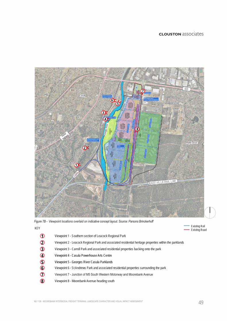
3.2.2 Viewer AnalysisDuring a visit to the site, a final list of eight key receptor sites with the potential to be visually impacted by some element of the Project were selected (refer Figure 07 and 7B). The final list does not represent the entire number of receptors likely to be visually impacted, but rather provides a representation of the range of viewers potentially impacted by the Project. Each selected viewpoint represents a group of receptors within that immediate area. The locations identified are:1. Southern section of Leacock Regional Park
2. Leacock Regional Park and associated residential heritage properties backing onto the parklands.
3. Carroll Park and associated residential properties backing onto the park.
4. Casula Powerhouse Arts Centre
5. Georges River Casula Parklands
6. St Andrews Park and associated residential properties surrounding the park, as well as properties that back onto the SSFL.
7. Junction of M5 South Western Motorway and Moorebank Avenue.
8. Moorebank Avenue heading south.

NS 1128 - MOOREBANK INTERMODAL FREIGHT TERMINAL LANDSCAPE CHARACTER AND VISUAL IMPACT ASSESSMENT46
Figure 06 Zone of Theoretical Visibility (ZVT) for the existing site
Visual Catchment within the site
Existing rail
Existing major roads
LAKEWOOD CRESCENT
LEACOCKS LANE
CARROLL PARK
WATTLE GROVE
MARSH PARADE
LEACOCK PARK
KEY
Direct views of the site
Filtered views of the site
Heavily filtered/screened views of the site
Project boundarySIMTA boundary
Visual Catchment outside the site (Approximated)
NB: Catchment analysis for the existing site was prepared prior to the site visit. It does not consider the placement of individual built elements within the masterplan of the proposed development.
Hume
Highway DNSDC
MOOR
EBAN
K AV
ENUE

NS 1128 - MOOREBANK INTERMODAL FREIGHT TERMINAL LANDSCAPE CHARACTER AND VISUAL IMPACT ASSESSMENT 47
3.3 VISUAL ASSESSMENT A detailed photographic survey was undertaken at each selected viewpoint (refer Figure 07 and 7B). An assessment of the expected visual impact for each Project development phase and concept layout was then conducted. The results are summarised within the following tables which include a description of the current view followed by a discussion of the visual impacts of the Project on that view.
Each phase of construction is analysed in the table, followed by the operational phase. The overall impact rating of the Project on any visual receptor is based on themes of magnitude and sensitivity as described with the Methodology section of this report. The severity of these impacts are calculated using Table 02.
For the three development phases (Scenario 1 - Phase A, Scenario 2 - Phase B and Scenario 2b - Phase C) one overall impact rating is given. This is a collective impact rating for all three stages and takes into account parts of the Project that are already operational at the conclusion of each phase.
For a detailed description of the assessment criteria and impact ratings used, see Appendix A.
Table 02: Overall Impact Rating as a combination of Sensitivity and Magnitude. Source: RMS Guidelines for Landscape Character and Visual Impact Assessment

NS 1128 - MOOREBANK INTERMODAL FREIGHT TERMINAL LANDSCAPE CHARACTER AND VISUAL IMPACT ASSESSMENT48
Figure 07 Viewpoint locations and direction of view
Casula
1
3
4
56
2Wattle Grove
Hume
Highway
Project BoundarySIMTA BoundaryExisting RailExisting Road
Viewpoint 1 - Southern section of Leacock Regional Park
KEY
1Viewpoint 2 - Leacock Regional Park and associated residential heritage properties within the parklands
Viewpoint 4 - Casula Powerhouse Arts Centre
2
4Viewpoint 3 - Carroll Park and associated residential properties backing onto the park
Viewpoint 5 - Georges River Casula Parklands
3
5Viewpoint 6 - St Andrews Park and associated residential properties surrounding the park6Viewpoint 7 - Junction of M5 South Western Motorway and Moorebank Avenue7Viewpoint 8 - Moorebank Avenue heading south8
8
Geor
ges R
iver
7
MOOR
EBAN
K AV
ENUE
NS 1128 - MOOREBANK INTERMODAL FREIGHT TERMINAL LANDSCAPE CHARACTER AND VISUAL IMPACT ASSESSMENT 49
Figure 7B - Viewpoint locations overlaid on indicative concept layout. Source: Parsons Brinckerhoff Project BoundarySIMTA BoundaryExisting RailExisting Road
Viewpoint 1 - Southern section of Leacock Regional Park
KEY
1Viewpoint 2 - Leacock Regional Park and associated residential heritage properties within the parklands
Viewpoint 4 - Casula Powerhouse Arts Centre
2
4Viewpoint 3 - Carroll Park and associated residential properties backing onto the park
Viewpoint 5 - Georges River Casula Parklands
3
5Viewpoint 6 - St Andrews Park and associated residential properties surrounding the park6Viewpoint 7 - Junction of M5 South Western Motorway and Moorebank Avenue7Viewpoint 8 - Moorebank Avenue heading south8
Casula
1
3
4
56
7
2
8
Wattle Grove
Hume
Highway
Existing RailExisting Road
Geor
ges R
iver