appendix g hazardous/regulated materials site listing · appendix g – hazardous/regulated...
TRANSCRIPT
Final Environmental Impact Statement
Appendix G – Hazardous/Regulated Materials Site Listing
S o u t h e a s t C o r r i d o r January 2007 G-1
APPENDIX G HAZARDOUS/REGULATED MATERIALS SITE LISTING
Materials that may constitute a hazardous waste include petroleum products, pesticides, organic compounds, heavy metals, or other compounds injurious to human health and the environment. At uncontrolled or abandoned hazardous waste sites, pollutants can seep into the ground, flow into rivers and lakes, and contaminate soil and groundwater.
Hazardous waste sites may be encountered during transit projects that involve construction, such as the development of fixed guide way transit or building of an anticipated maintenance facility. The nature and extent of contamination can vary widely. Early detection, evaluation, and remediation of hazardous waste are essential to ensure minimization of project delays, protection of the environment, and construction worker safety.
The presence of soil and/or groundwater contamination, or the existence of hazardous substances within the right-of-way of a proposed transportation improvement project, can have an adverse impact on the cost and schedule to complete the project. Contaminated groundwater drawn into the dewatering system during construction could require special treatment and permitting prior to disposal. Contaminated soil unearthed during construction may require treatment and disposal and would not be useable to backfill excavations. Therefore, the early identification of potential contamination sites, which could adversely impact the proposed project, provides valuable information for the alternatives evaluation, design, right-of-way acquisition, and construction phases.
G.1 Methodology
The hazardous materials assessment consisted of a review of selected regulatory agency databases to identify sites of concern. Minimum search distances were measured from the estimated Build Alternative centerline. The regulatory agency database report was obtained from a commercial source (GeoSearch, Inc.). Following the review of this information, a qualified environmental professional conducted a limited site reconnaissance within the study area to confirm and expand information obtained from the regulatory agency databases. Interviews were not conducted as part of this assessment. Right of entry was not obtained for any property and some properties were not accessible by public roads or rights-of-way.
The following is a description of the federal and state records reviewed:
Federal Databases
• National Priority Listing (NPL) – This database includes U.S. Environmental Protection Agency (EPA) NPL sites that fall under the EPA’s Superfund program, established to fund the cleanup of the most serious uncontrolled or abandoned hazardous waste sites identified for possible long-term remedial action.
Final Environmental Impact Statement Appendix G – Hazardous/Regulated Materials Site Listing
S o u t h e a s t C o r r i d o r G-2 January 2007
• Delisted NPL (DNPL) – This database includes EPA‘s Final NPL sites where remedies have proven to be satisfactory. It also includes sites where the original analyses were inaccurate, the sites are no longer appropriate for inclusion on the NPL, and final publication in the Federal Register has occurred.
• Records of Decision System (RODS) – These decision documents maintained by the EPA describe the chosen remedy for NPL site remediation. They also include history, site description, site characteristics, community participation, enforcement activities, past and present activities, contaminated media, the contaminants present, and scope and role of response action.
• Comprehensive Environmental Response, Compensation, and Liability Information System (CERCLIS) – CERCLIS is the repository for site and non-site specific Superfund information in support of the Comprehensive Environmental Response, Compensation, and Liability Act (CERCLA). This database contains an extract of sites that have been investigated or are in the process of being investigated for potential environmental risk.
• No Further Remedial Action Planned (NFRAP) – This database includes sites, determined by the EPA following preliminary assessment, which no longer pose a significant risk or require further activity under CERCLA. After initial investigation either no contamination was found, contamination was quickly removed, or contamination was not serious enough to require Federal Superfund action or NPL consideration.
• Resource Conservation and Recovery Act Information System (RCRIS) – The database includes hazardous waste Handlers, Generators (Large, Small, and Exempt), Transporters, Violations, Corrective Actions (CORRACTS), and Treatment, Storage and Disposal (TSD) facilities. This database contains selective information on sites which handle, generate, transport, store, treat, or dispose of hazardous wastes.
• Emergency Response Notification System (ERNS) – This database contains data on reported releases of oil and hazardous substances. The data comes from spill reports made to the EPA, U.S. Coast Guard, the National Response Center (NRC), and/or the Department of Transportation (DOT).
State of Texas Databases
• Texas Superfund Sites (TXSF) – The state Superfund program’s mission is to remediate abandoned or inactive sites within the state that pose an unacceptable risk to public health and safety or the environment, but which do not qualify for action under the federal Superfund program (NPL). Information in this database includes any recent developments and the anticipated action for these sites.
• Voluntary Cleanup Program (VCP) – The VCP provides administrative, technical, and legal incentives to encourage the cleanup of contaminated sites in Texas. Since all non-responsible parties, including future lenders and landowners, receive protection from liability to the state of Texas for cleanup of sites under the VCP, most of the constraints for completing real estate transactions at those sites are eliminated. As a result, many unused or underused properties may be restored to economically productive or community beneficial uses.

Final Environmental Impact Statement
Appendix G – Hazardous/Regulated Materials Site Listing
S o u t h e a s t C o r r i d o r January 2007 G-3
• Municipal Solid Waste Landfill (MSWL) – Sites listed within a solid waste landfill database may include active landfills and inactive landfills, where solid waste is treated or stored.
• Closed and Abandoned Landfill Inventory (CALF) – The Texas Commission of Environmental Quality (TCEQ), under a contract with Texas State University, and in cooperation with the 24 regional Council of Governments in Texas, has located over 4,000 closed and abandoned municipal solid waste landfills throughout the state. This listing contains “unauthorized sites”. Unauthorized sites have no permit and are considered abandoned. The information available for each site varies in detail.
• Leaking Petroleum Storage Tank (LPST) - The LPST listing is derived from the Petroleum Storage Tank (PST) database and is maintained by the TCEQ. This database includes facilities with reported LPSTs.
• PST – The underground storage tank (UST) listing is derived from the PST database which is administered by the TCEQ. Both the UST and aboveground storage tank (AST) listings are included in this report.
• Spills Listings (SPILLS) – The TCEQ provides this database. Information includes releases of hazardous or potential hazardous chemical/materials into the environment.
• Industrial and Hazardous Waste (IHW) – Owner and facility information is included in this database of industrial and hazardous waste sites. Industrial waste is waste resulting from, or incidental to, operations of industry, manufacturing, mining, or agriculture. Hazardous waste is defined as any solid waste listed as hazardous or possessing one or more hazardous characteristics as defined in federal waste regulations.
• Innocent Owner/Operator (IOP) – Texas IOP provides a certificate to innocent owners or operators if their properties are contaminated as a result of releases or migrations of contaminants from a source or sources not located on the properties, and they did not cause or contribute to the source or sources of contamination.
• Dry Cleaner Registration (DCR) – The DCR listing includes dry cleaning drop stations and facilities registered with the TCEQ.
• Brownfields Site Assessments (BSA) – The BSA database includes relevant information on contaminated Brownfields properties that are being cleaned.
Table G-1 and Table G-2 list the approximate search distances for the previously identified federal and state databases. The search distances generally follow the guidelines listed in American Society of Testing Materials (ASTM) E1527-00: Standard Practice for Environmental Site Assessments: Phase I Environmental Site Assessment Process.

Final Environmental Impact Statement Appendix G – Hazardous/Regulated Materials Site Listing
S o u t h e a s t C o r r i d o r G-4 January 2007
Table G-1. Federal Records Hazardous Materials Search
Federal Records Search Distance Superfund Sites – National Priority List (NPL) Sites 1.0 mile Delisted NPL Sites 1.0 mile Records of Decision (ROD) Sites 1.0 mile Comprehensive Environmental Response, Compensation, or Liability Information System (CERCLIS) Sites
0.5 mile
No Further Remedial Action Planned (NFRAP) Site 0.5 mile Resource Conservation and Recovery Act Information System (RCRIS) – Corrective Action Sites (CORRACTS)
1.0 mile
RCRIS – Transport Storage and Disposal (TSD) Sites 0.5 mile RCRIS Generator/Handler (G/H) Sites 0.25 mile Emergency Response Notification System (ERNS) Sites 0.25 mile
Source: Parsons Brinckerhoff, GeoSearch, Inc., 2006.
Table G-2. State Records Hazardous Materials Search
State Records Search Distance Texas Superfund Sites (TXSF) 1.0 mile Voluntary Cleanup Program (VCP) Sites 0.5 mile Municipal Solid Waste Landfill (MSWL) Sites 0.5 mile Closed and Abandoned Landfill Inventory (CALF) Sites 0.5 mile Leaking Petroleum Storage Tank (LPST) Sites 0.5 mile Petroleum Storage Tank (PST) Sites 0.25 mile Spills Listing (SPILLS) Sites 0.25 mile Industrial and Hazardous Waste (IHW) Sites 0.25 mile Innocent Owner/Operator Program (IOP) Sites 0.5 mile Dry Cleaner Registration (DCR) Sites 0.25 mile Brownfield Site Assessment (BSA) Sites 0.5 mile Source: Parsons Brinckerhoff, GeoSearch, Inc., 2006.
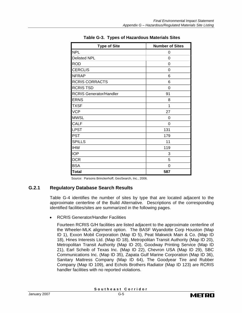
G.2 Results of Regulatory Database Search Based on a review of the regulatory agency databases report, 587 sites within the corridor search distance of the study area have been identified as having potential hazardous materials concerns. Table G-3 identifies the number of sites by type within the study area.
Final Environmental Impact Statement
Appendix G – Hazardous/Regulated Materials Site Listing
S o u t h e a s t C o r r i d o r January 2007 G-5
Table G-3. Types of Hazardous Materials Sites
Type of Site Number of Sites NPL 0 Delisted NPL 0 ROD 0 CERCLIS 0 NFRAP 6 RCRIS CORRACTS 6 RCRIS TSD 0 RCRIS Generator/Handler 91 ERNS 8 TXSF 1 VCP 27 MWSL 0 CALF 0 LPST 131 PST 179 SPILLS 11 IHW 119 IOP 3 DCR 5 BSA 0 Total 587 Source: Parsons Brinckerhoff, GeoSearch, Inc., 2006.
G.2.1 Regulatory Database Search Results
Table G-4 identifies the number of sites by type that are located adjacent to the approximate centerline of the Build Alternative. Descriptions of the corresponding identified facilities/sites are summarized in the following pages.
• RCRIS Generator/Handler Facilities
Fourteen RCRIS G/H facilities are listed adjacent to the approximate centerline of the Wheeler-MLK alignment option. The BASF Wyandotte Corp Houston (Map ID 1), Exxon Mobil Corporation (Map ID 5), Peat Makwick Main & Co. (Map ID 18), Hines Interests Ltd. (Map ID 18), Metropolitan Transit Authority (Map ID 20), Metropolitan Transit Authority (Map ID 20), Goodway Printing Service (Map ID 21), Earl Scheib of Texas Inc. (Map ID 22), Chevron USA (Map ID 29), SBC Communications Inc. (Map ID 35), Zapata Gulf Marine Corporation (Map ID 36), Sanitary Mattress Company (Map ID 64), The Goodyear Tire and Rubber Company (Map ID 109), and Echols Brothers Radiator (Map ID 123) are RCRIS handler facilities with no reported violations.
Final Environmental Impact Statement Appendix G – Hazardous/Regulated Materials Site Listing
S o u t h e a s t C o r r i d o r G-6 January 2007
• ERNS Site
One ERNS incident was listed adjacent to the approximate centerline of the Wheeler-MLK alignment option. On May 20, 1999, an unknown material release and discharge amount was reported at the 700 Block of Travis at Capitol (Map ID 24).
• VCP Sites
Three VCP sites are listed adjacent to the approximate centerline of the Wheeler-MLK alignment option:
- Downtown Houston - Blocks 183, 196, 197 (Map ID 17, Site ID 1178) - the site is at Capitol and St. Emanuel and consisted of a 4.3-acre rail yard/parking lot. A VCP application was filed on April 25, 2005 for excavation of contaminated soils (metals, TPH, PAHs) at the site.
1. Block 95 (Map ID 20, Site ID 1006) – the site is at 801 San Jacinto and consisted of a 1.45 commercial parking lot. A VCP application was filed on July 8, 1999 for contaminated souls (TPH, BTEX) at the site.
2. San Jacinto Street/Block 95 (Map ID 20, Site ID 1282) – the site is at 801/819 San Jacinto and consisted of a 1.43-acre commercial parking lot. A VCP application was filed on November 27, 2000 for contaminated soils (VOCs, TPH, metals) at the site.
• LPST Facilities
Nineteen LPST facilities are listed adjacent to the approximate centerline of the Wheeler-MLK alignment option:
1. Exxon 66953, 3506 Elgin (Map ID 5, LPST ID 111299)
2. Exxon 6 6953, 3506 Elgin (Map ID 5, LPST ID 115100)
3. York Warehouse, 1018 York (Map ID 12, LPST ID 103218)
4. Downtown Bus Multi Use Facility, 810 San Jacinto (Map ID 20, LPST ID 97256)
5. Former Texaco Service Station, 819 San Jacinto (Map ID 20, LPST ID 114789)
6. Street Maintenance, 803 Rusk (Map ID 26, LPST ID 108462)
7. Chevron 60108141, 3902 Scott (Map ID 29, LPST ID 94138)
8. Fire Station 25, 3902 Scott (Map ID 29, LPST ID 111117)
9. Gulf Oil Corp, 5203 Griggs (Map ID 30, LPST ID 093007)
10. El Expreso Bus Co., 812 Delano (Map ID 50, LPST IS 115508)
11. Conoco Gulf Freeway, 3503 Gulf Freeway (Map ID 52, LPST ID 092764)
12. University Texaco, 3505 Gulf Freeway (Map ID 53, LPST ID 108434)
13. Cuz-N-Laws, 3510 Leeland (Map ID 54, LPST ID 095716)
Final Environmental Impact Statement
Appendix G – Hazardous/Regulated Materials Site Listing
S o u t h e a s t C o r r i d o r January 2007 G-7
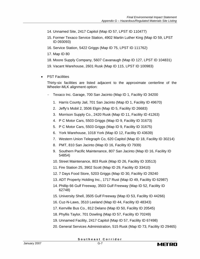
14. Unnamed Site, 2417 Capitol (Map ID 57, LPST ID 110477)
15. Former Texaco Service Station, 4902 Martin Luther King (Map ID 59, LPST ID 093093)
16. Service Station, 5422 Griggs (Map ID 75, LPST ID 111762)
17. Map ID 80
18. Moore Supply Company, 5607 Cavanaugh (Map ID 127, LPST ID 104831)
19. Vacant Warehouse, 2601 Rusk (Map ID 115, LPST ID 100983)
• PST Facilities
Thirty-six facilities are listed adjacent to the approximate centerline of the Wheeler-MLK alignment option:
- Texaco Inc. Garage, 700 San Jacinto (Map ID 1, Facility ID 34200
1. Harris County Jail, 701 San Jacinto (Map ID 1, Facility ID 49670)
2. Jeffy’s Mobil 2, 3506 Elgin (Map ID 5, Facility ID 26683)
3. Morrison Supply Co., 2420 Rusk (Map ID 11, Facility ID 41263)
4. P C Motor Cars, 5503 Griggs (Map ID 9, Facility ID 31673)
5. P C Motor Cars, 5503 Griggs (Map ID 9, Facility ID 31675)
6. York Warehouse, 1018 York (Map ID 12, Facility ID 43639)
7. Western Union Telegraph Co, 620 Capitol (Map ID 18, Facility ID 30214)
8. PMT, 810 San Jacinto (Map ID 16, Facility ID 7939)
9. Southern Pacific Maintenance, 807 San Jacinto (Map ID 16, Facility ID 54854)
10. Street Maintenance, 803 Rusk (Map ID 26, Facility ID 33513)
11. Fire Station 25, 3902 Scott (Map ID 29, Facility ID 33410)
12. 7 Days Food Store, 5203 Griggs (Map ID 30, Facility ID 29240
13. ADT Property Holding Inc., 1717 Rust (Map ID 49, Facility ID 62987)
14. Phillip 66 Gulf Freeway, 3503 Gulf Freeway (Map ID 52, Facility ID 62748)
15. University Shell, 3505 Gulf Freeway (Map ID 53, Facility ID 44266)
16. Cuz-N-Laws, 3510 Leeland (Map ID 44, Facility ID 48343)
17. Kerrville Bus Co., 812 Delano (Map ID 50, Facility ID 20545)
18. Phyllis Taylor, 701 Dowling (Map ID 57, Facility ID 70249)
19. Unnamed Facility, 2417 Capitol (Map ID 57, Facility ID 67498)
20. General Services Administration, 515 Rusk (Map ID 73, Facility ID 29465)

Final Environmental Impact Statement Appendix G – Hazardous/Regulated Materials Site Listing
S o u t h e a s t C o r r i d o r G-8 January 2007
21. Eagle Lake Concrete Products, 3101 McKinney (Map ID 74, Facility ID 42776)
22. Service Station, 5422 Griggs (Map ID 75, Facility ID 48100)
23. Wheeler Baptist Church, 3826 Wheeler (Map ID 93, Facility ID 64203)
24. PWE Street Maintenance District 10, 801 Ennis (Map ID 94, Facility ID 74763)
25. Goodyear Tire and Rubber, 5402 Palm Center (Map ID 109, Facility ID 13310)
26. Palm Center, 5400 Griggs (Map ID 109, Facility ID 49021)
27. Moore Supply Co. Master Warehouse, 2911 Rusk (Map ID 127, Facility ID 41014)
28. Ralph Leggett Cotton Co. Inc., 2702 Capitol (Map ID 138, Facility ID 10824)
29. Warehouse, 707 Live Oak (Map ID 138, Facility ID 59026)
30. Motor Lease Corporation, 2801 Capitol (Map ID 159), Facility ID 6753)
31. RCA Transportation, 1112 Paige (Map ID 111, Facility ID 34985)
32. Metropolitan Warehouse Facility, 1110 Paige (Map ID 111, Facility ID 3758)
33. Vacant Warehouse, 2601 Rusk (Map ID 115, Facility ID 61713)
34. Wald Company, 2611 Capitol (Map ID 162, Facility ID 56036)
35. South Texas Vendors, 2701 Capitol (Map ID 163, Facility ID 56016)
• IHW Facilities
Seventeen IHW facilities are listed adjacent to the approximate centerline of the Wheeler-MLK alignment option:
- BASF Wyandotte Houston, 701 N. San Jacinto (Map ID 1, Registration No. 71164, Inactive Waste Generator)
1. Jeffy’s Exxon Mobil, 3506 Elgin (Map ID 5, Registration No. 77116, Small Quantity Generator)
2. Peat Makwick Main, 700 Louisiana (Map ID 18, Registration No. 68663, Inactive Conditionally Exempt Small Quantity Generator)
3. Hines Interests Ltd., 700 Louisiana (Map ID 18, Registration No. 79599, Inactive Conditionally Exempt Small Quantity Generator)
4. Pacific Motor Trucking, 807 San Jacinto (Map ID 20, Registration No. 35714, Small Quantity Generator)
5. Metropolitan Transit Authority, 807 San Jacinto (Map ID 20, Registration No. 71116, Unknown Generator Type)

Final Environmental Impact Statement
Appendix G – Hazardous/Regulated Materials Site Listing
S o u t h e a s t C o r r i d o r January 2007 G-9
6. Buffalo Bayou Facility, 810 San Jacinto (Map ID 20, Registration No. 83479, Small Quantity Generator)
7. Chevron Geoscience, 815 Walker (Map ID 21, Registration No. 37396, Not Reported Generator Type)
8. Goodway Printing, 813 Milam (Map 21, Registration No. 51156, Conditionally Exempt Small Quantity Generator)
9. Earl Scheib, 5237 Griggs (Map ID 22, Registration No. 71873, Inactive Waste Generator)
10. Houston Bar Association, 707 Travis (Map ID 24, Registration No. 51181, Conditionally Exempt Small Quantity Generator)
11. Chevron Facility 108141, 3802 Wheeler (Map ID 29, Registration No. 79400, Small Quantity Generator)
12. SBC Capitol CO, 1121 Capitol (Map ID 35, Registration No. 71601, Inactive Waste Generator)
13. Zapata Marine Gulf, 711 Louisiana (Map ID 36, Registration No. 40732, Inactive Waste Transporter)
14. King Koil Sleep Products, 3425 Leeland (Map ID 64, Registration No. 23570, Small Quantity Generator)
15. The Goodyear Tire and Rubber Company, 5402 Palm Center (Map ID 109, Registration No. 73077, Inactive Conditionally Exempt Small Quantity Generator)
16. Echols Brothers, 2517 Capitol (Map ID 123, Registration No. 71323, Inactive Waste Generator)
• IOP Site
One IOP site is listed adjacent to the approximate centerline of the Wheeler-MLK alignment option. The Royal Plumbing Supply Company (Map ID 155, ID 0463), located at 2600 Texas, received an IOP on December 20, 2004. The site consisted of a 0.74-acre vacant property and according to an investigation, volatile organic compounds (VOCs) affected groundwater.
G.3 Results of Site Reconnaissance
In addition to the sites reported in the regulatory agency databases report, four sites were identified during the site reconnaissance that may be sites of concern. These sites are listed below:
• Pilgrim Cleaners – 5771 Cullen Boulevard, approximately 0.07 mile north of the Build Alternative centerline. Potential hazardous substances such as cleaning solvents may be present at this location.
• Abandoned service station – 3322 McKinney, approximately 0.06 mile east of the Build Alternative centerline. Potential petroleum products may be present at this location.
Final Environmental Impact Statement Appendix G – Hazardous/Regulated Materials Site Listing
S o u t h e a s t C o r r i d o r G-10 January 2007
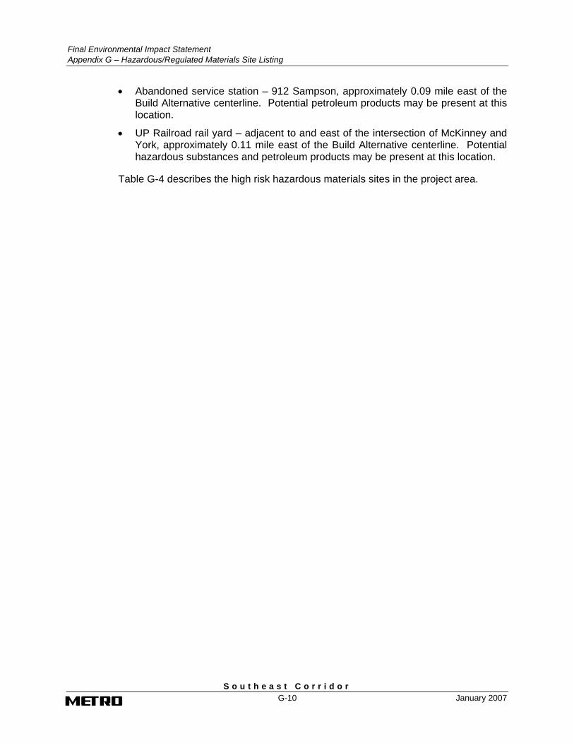
• Abandoned service station – 912 Sampson, approximately 0.09 mile east of the Build Alternative centerline. Potential petroleum products may be present at this location.
• UP Railroad rail yard – adjacent to and east of the intersection of McKinney and York, approximately 0.11 mile east of the Build Alternative centerline. Potential hazardous substances and petroleum products may be present at this location.
Table G-4 describes the high risk hazardous materials sites in the project area.

Final Environmental Impact Statement
Appendix G – Hazardous/Regulated Materials Site Listing
S o u t h e a s t C o r r i d o r January 2007 G-11
Table G-4. Regulatory Database Search Results: High Risk Sites
ID Site Name and Address Database Type(s) Build Alternative
Texaco Inc. Garage 700 N. San Jacinto PST (ID 34200)
The site is adjacent to the centerline of the proposed alignments. One 500-gallon used oil underground storage tank (UST) and one 4,000-gallon gasoline UST were permanently filled in place on October 9, 1992. Tank containment, release detection, and corrosion prevention information were not reported. Based on the proximity of this site relative to the proposed alignments, this site is considered a high risk to the construction of the project. 1
Harris County Jail 701 N. San Jacinto PST (ID 49670)
The site is adjacent to the centerline of the proposed alignments. One 8,000-gallon diesel UST was installed on January 1, 1990 and is currently in use. Tank and pipe containment, release detection, and spill/overfill information were not reported. Based on the proximity of this site relative to the proposed alignments, this site is considered a high risk to the construction of the project.
2 Jeffy’s Mobil 2/ Exxon 66953, 3506 Elgin Street
PST (ID 26683) LPST (ID 111299)LPST (ID 115100)
The site is adjacent to the centerline of the proposed alignments. Three gasoline USTs (8,000; 10,000; and 12,000-gallon capacities) were removed from ground on January 11, 2001. Two 12,000-gallon gasoline USTs were installed on May 30, 2001 and are currently in use. Also, based on the review of the LPST database, two incidents of a subsurface release of petroleum hydrocarbons occurred from this site. The first incident occurred on an unreported date and the second incident occurred on November 8, 2000. For both incidents, groundwater was not impacted and there were no apparent threats or impacts to receptors. The TCEQ has issued “Final Concurrence, Case Closed”. Based on the proximity of the PST and LPST sites relative to the proposed project alignments, the site is considered a high risk to the construction of the project.
3 PC Motor Cars 5503 Griggs Road PST (ID 31673)
The site is adjacent to the centerline of the proposed alignments. Three USTs of unknown capacities and contents were permanent filled in place on August 31, 1997. Tank and pipe materials, containment, release detection, corrosion protection, and spill/overfill protection information were not reported. Based on the proximity of this site relative to the proposed alignments, this site is considered a high risk to the construction of the project.
4 PC Motor Cars 5423 Griggs Road PST (ID 31675)
The site is adjacent to the centerline of the proposed alignments. Five USTs of unknown capacities and contents were permanent filled in place on August 31, 1997. Tank and pipe materials, containment, release detection, corrosion protection, and spill/overfill protection information were not reported. Based on the proximity of this site relative to the proposed alignments, this site is considered a high risk to the construction of the project.
5 Morrison Supply Co. 2420 Rusk PST (ID 41263)
The site is located approximately 0.01 mile east of the proposed alignments. A 500-gallon UST of unknown content was permanent filled in place on October 31, 1983 and a 4,000-gallon diesel UST was removed from the ground on August 17, 1999. Tank and pipe materials, release detection, corrosion protection, and spill/overfill protection information were not reported. Based on the proximity of this site relative to the proposed alignments, this site is considered a high risk to the construction of the project.
Final Environmental Impact Statement Appendix G – Hazardous/Regulated Materials Site Listing
S o u t h e a s t C o r r i d o r G-12 January 2007
Table G-4. Regulatory Database Search Results: High Risk Sites (continued)
ID Site Name and Address Database Type(s) Build Alternative
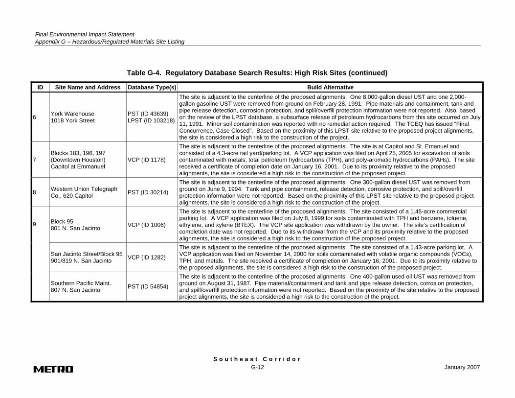
6 York Warehouse 1018 York Street
PST (ID 43639) LPST (ID 103218)
The site is adjacent to the centerline of the proposed alignments. One 8,000-gallon diesel UST and one 2,000-gallon gasoline UST were removed from ground on February 28, 1991. Pipe materials and containment, tank and pipe release detection, corrosion protection, and spill/overfill protection information were not reported. Also, based on the review of the LPST database, a subsurface release of petroleum hydrocarbons from this site occurred on July 11, 1991. Minor soil contamination was reported with no remedial action required. The TCEQ has issued “Final Concurrence, Case Closed”. Based on the proximity of this LPST site relative to the proposed project alignments, the site is considered a high risk to the construction of the project.
7 Blocks 183, 196, 197 (Downtown Houston) Capitol at Emmanuel
VCP (ID 1178)
The site is adjacent to the centerline of the proposed alignments. The site is at Capitol and St. Emanuel and consisted of a 4.3-acre rail yard/parking lot. A VCP application was filed on April 25, 2005 for excavation of soils contaminated with metals, total petroleum hydrocarbons (TPH), and poly-aromatic hydrocarbons (PAHs). The site received a certificate of completion date on January 16, 2001. Due to its proximity relative to the proposed alignments, the site is considered a high risk to the construction of the proposed project.
8 Western Union Telegraph Co., 620 Capitol PST (ID 30214)
The site is adjacent to the centerline of the proposed alignments. One 300-gallon diesel UST was removed from ground on June 9, 1994. Tank and pipe containment, release detection, corrosive protection, and spill/overfill protection information were not reported. Based on the proximity of this LPST site relative to the proposed project alignments, the site is considered a high risk to the construction of the project.
Block 95 801 N. San Jacinto VCP (ID 1006)
The site is adjacent to the centerline of the proposed alignments. The site consisted of a 1.45-acre commercial parking lot. A VCP application was filed on July 8, 1999 for soils contaminated with TPH and benzene, toluene, ethylene, and xylene (BTEX). The VCP site application was withdrawn by the owner. The site’s certification of completion date was not reported. Due to its withdrawal from the VCP and its proximity relative to the proposed alignments, the site is considered a high risk to the construction of the proposed project.
San Jacinto Street/Block 95 901/819 N. San Jacinto VCP (ID 1282)
The site is adjacent to the centerline of the proposed alignments. The site consisted of a 1.43-acre parking lot. A VCP application was filed on November 14, 2000 for soils contaminated with volatile organic compounds (VOCs), TPH, and metals. The site received a certificate of completion on January 16, 2001. Due to its proximity relative to the proposed alignments, the site is considered a high risk to the construction of the proposed project.
9
Southern Pacific Maint. 807 N. San Jacinto PST (ID 54854)
The site is adjacent to the centerline of the proposed alignments. One 400-gallon used oil UST was removed from ground on August 31, 1987. Pipe material/containment and tank and pipe release detection, corrosion protection, and spill/overfill protection information were not reported. Based on the proximity of the site relative to the proposed project alignments, the site is considered a high risk to the construction of the project.

Final Environmental Impact Statement
Appendix G – Hazardous/Regulated Materials Site Listing
S o u t h e a s t C o r r i d o r January 2007 G-13
Table G-4. Regulatory Database Search Results: High Risk Sites (continued)
ID Site Name and Address Database Type(s) Build Alternative
PMT/Downtown Bus Multi-use Facility, 810 N. San Jacinto 810 N. San Jacinto
PST (ID 7939) LPST (ID 097256)
The site is adjacent to the centerline of the proposed alignments. One 2,000-gallon UST and one 8,000-gallon UST of unknown contents, and one 1,000-gallon diesel UST were removed from ground on August 31, 1989. Tank and pipe containment, release detection, corrosion protection, and spill/overfill protection information were not reported. Also, based on the review of the LPST database, a subsurface release of petroleum hydrocarbons from this site occurred on August 18, 1989. Only soil contamination occurred, but the incident required a full site assessment and remedial action plan. The TCEQ has issued “Final Concurrence, Case Closed”. Based on the proximity of the PST and LPST site relative to the proposed project alignments, the site is considered a high risk to the construction of the project.
Former Texaco Service Station, 819 San Jacinto LPST (ID 114789)
The site is approximately 250 feet west of the proposed alignments. According to the database, a subsurface release of petroleum hydrocarbons from this site occurred on October 22, 1999. Groundwater was impacted, but there were no apparent threats or impacts to receptors. The TCEQ has issued “Final Concurrence, Case Closed”. Based on the proximity of this LPST site relative to the proposed project alignments, the site is considered a high risk to the construction of the project.
10 Raines 66 101 N. San Jacinto
PST (ID 13655) LPST (ID 093978)
The site is approximately 0.02 mile southwest of the proposed alignments. One 4,000-gallon gasoline UST, one 2,500-gallon gasoline UST, and one 2,500-gallon diesel UST were removed from ground on March 1, 1990. Tank and pipe containment, release detection, corrosion protection, and spill/overfill protection were not reported. Also, based on the review of the LPST database, a subsurface release of petroleum hydrocarbons from this site occurred on October 27, 1989. Groundwater was impacted, but there were no apparent threats or impacts to receptors. The TCEQ has issued “Final Concurrence, Case Closed”. Based on the proximity of the PST and LPST site relative to the proposed project alignments, the site is considered a high risk to the construction of the project.
11 Street Maintenance 803 Rusk
PST (ID 33513) LPST (ID 108462)
The site is adjacent to the centerline of the proposed alignments. Two 2,000-gallon gasoline USTs, one 2,000-gallon diesel UST, and one 1,500-gallon kerosene UST were removed from ground on March 3, 1994. Tank and pipe release detection, corrosion protection, and spill/overfill protection information were not reported. Also, based on a review of the LPST database, a subsurface release of petroleum hydrocarbons from this site occurred on July 12, 1994. Groundwater was impacted, but there were no apparent threats or impacts to receptors. The site has a TCEQ status code of “Monitoring”. Based on the proximity of the PST and LPST site relative to the proposed project alignments and the continued monitoring required, the site is considered a high risk to the construction of the project.
12 Chevron USA 3802 Wheeler Street
PST (ID 29278) LPST (ID 094138)
The site is adjacent to the centerline of the proposed alignments. Three 10,000-gallon gasoline USTs were removed from ground on December 8, 1994. Tank and pipe containment, release detection, corrosion protection, and spill/overfill protection information were not reported. Also, based on the review of the database, a subsurface release of petroleum hydrocarbons from this site occurred on December 6, 1990. Groundwater was impacted and a public/domestic water supply well was located within 0.25 to 0.5 mile of the incident. The site has a TCEQ status code of “Monitoring”. Based on the proximity of the PST and LPST site relative to the proposed project alignments and the continued monitoring required, the site is considered a high risk to the construction of the project.

Final Environmental Impact Statement Appendix G – Hazardous/Regulated Materials Site Listing
S o u t h e a s t C o r r i d o r G-14 January 2007
Table G-4. Regulatory Database Search Results: High Risk Sites (continued)
ID Site Name and Address Database Type(s) Build Alternative
Fire Station 25 3902 Scott Street
PST (ID 33410) LPST (ID 111117)
The site is adjacent to the centerline of the proposed alignments. Two 1,000-gallon gasoline USTs and one 1,000-gallon diesel UST are currently in use. An additional 1,000-gallon gasoline UST was removed from ground on March 24, 1998. Also, based on the review of the LPST database, a subsurface release of petroleum hydrocarbons from this site occurred on an unreported date. Groundwater was impacted, but there were no apparent threats or impacts to receptors. The TCEQ has issued “Final Concurrence Pending Documentation of Well Plugging”. Based on the proximity of the PST and LPST site relative to the proposed project alignments and the required well plugging, the site is considered a high risk to the construction of the project.
13 7 Days Food Store/ Gulf Oil Corp, 5203 Griggs Road
PST (ID 29240) LPST (ID 093007)
The site is adjacent to the centerline of the proposed alignments. Three 8,000-gallon gasoline USTs and one 550-gallon used oil UST were removed from ground on October 2, 1989. Tank and pipe containment, release detection, corrosion protection, and spill/overfill protection were not reported. Two 10,000-gallon gasoline USTs and one 10,000-gallon used oil UST were installed on August 1, 1989. All are currently in use. Spill/overfill protection information were not reported. Also, according to the LPST database, a subsurface release of petroleum hydrocarbons from this site occurred on May 12, 1989. Only soil contamination occurred, but the incident required a full site assessment and remedial action plan. The TCEQ has issued “Final Concurrence, Case Closed”. Based on the proximity of the PST and LPST site relative to the proposed project alignments, the site is considered a high risk to the construction of the project.
14 Yuco Coastal/Coastal Gas Station 6120 S. Loop E
PST (ID 23083) LPST (ID 091650)LPST (ID 114788)
The site is approximately 0.02 mile north of the centerline of the proposed alignments. One 8,000-gallon diesel UST, one 550-gallon used oil UST, and two 8,000-gallon gasoline USTs were installed on January 1, 1970. All are currently in use. One 12,000-gallon used oil UST was installed on August 14, 1996 and is currently in use. Also, according to the LPST database, two incidents of subsurface releases of petroleum hydrocarbons from this site occurred on February 5, 1988 and September 22, 1999. The first incident reported impact to groundwater other than drinking water aquifer with an incomplete site characterization. The second incident reported groundwater impact with no apparent threats or impacts to receptors. The TCEQ has issued “Final Concurrence, Case Closed” for both incidents. Based on the proximity of the PST and LPST site relative to the proposed project alignments, the site is considered a high risk to the construction of the project.
Fiesta 5600 Mykawa
PST (ID 1507) LPST (ID 099731)
The site is approximately 0.02 mile southwest of the proposed alignments. Three 10,000-gallon gasoline USTs were removed from ground on May 15, 1991. Also, according to the LPST database, a subsurface release of petroleum hydrocarbons from this site occurred on May 23, 1991. Groundwater was not impacted and there were no apparent threats or impacts to receptors. The TCEQ has issued “Final Concurrence, Case Closed”. Based on the proximity of the PST and LPST site relative to the proposed project alignments, the site is considered a high risk to the construction of the project. 15
Conoco Phillips 2706597 5600 Mykawa PST (ID 71286)
The site is adjacent to the centerline of the proposed alignments. Two 15,000-gallon gasoline USTs were removed from ground on December 10, 2002. Also, according to the LPST database, a subsurface release of petroleum hydrocarbons from this site occurred on May 23, 1991. Groundwater was not impacted and there were no apparent threats or impacts to receptors. The TCEQ has issued “Final Concurrence, Case Closed”. Based on the proximity of the PST and LPST site relative to the proposed project alignments, the site is considered a high risk to the construction of the project.
Final Environmental Impact Statement
Appendix G – Hazardous/Regulated Materials Site Listing
S o u t h e a s t C o r r i d o r January 2007 G-15
Table G-4. Regulatory Database Search Results: High Risk Sites (continued)
ID Site Name and Address Database Type(s) Build Alternative
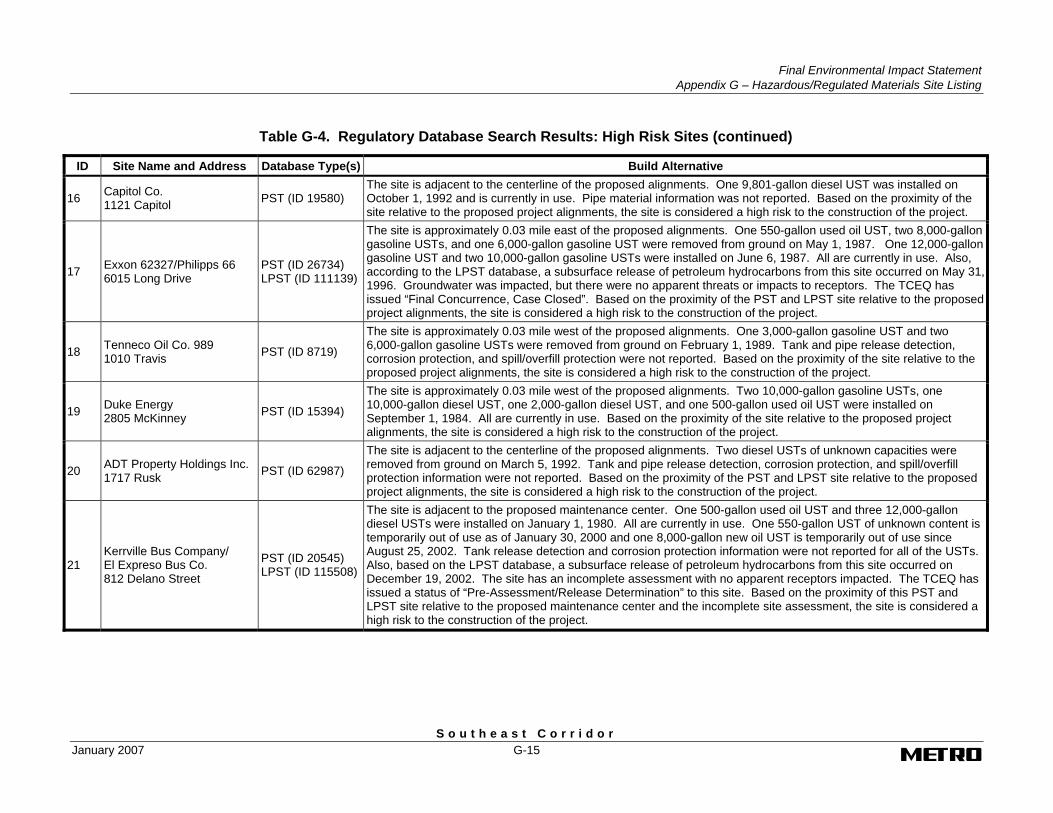
16 Capitol Co. 1121 Capitol PST (ID 19580)
The site is adjacent to the centerline of the proposed alignments. One 9,801-gallon diesel UST was installed on October 1, 1992 and is currently in use. Pipe material information was not reported. Based on the proximity of the site relative to the proposed project alignments, the site is considered a high risk to the construction of the project.
17 Exxon 62327/Philipps 66 6015 Long Drive
PST (ID 26734) LPST (ID 111139)
The site is approximately 0.03 mile east of the proposed alignments. One 550-gallon used oil UST, two 8,000-gallon gasoline USTs, and one 6,000-gallon gasoline UST were removed from ground on May 1, 1987. One 12,000-gallon gasoline UST and two 10,000-gallon gasoline USTs were installed on June 6, 1987. All are currently in use. Also, according to the LPST database, a subsurface release of petroleum hydrocarbons from this site occurred on May 31, 1996. Groundwater was impacted, but there were no apparent threats or impacts to receptors. The TCEQ has issued “Final Concurrence, Case Closed”. Based on the proximity of the PST and LPST site relative to the proposed project alignments, the site is considered a high risk to the construction of the project.
18 Tenneco Oil Co. 989 1010 Travis PST (ID 8719)
The site is approximately 0.03 mile west of the proposed alignments. One 3,000-gallon gasoline UST and two 6,000-gallon gasoline USTs were removed from ground on February 1, 1989. Tank and pipe release detection, corrosion protection, and spill/overfill protection were not reported. Based on the proximity of the site relative to the proposed project alignments, the site is considered a high risk to the construction of the project.
19 Duke Energy 2805 McKinney PST (ID 15394)
The site is approximately 0.03 mile west of the proposed alignments. Two 10,000-gallon gasoline USTs, one 10,000-gallon diesel UST, one 2,000-gallon diesel UST, and one 500-gallon used oil UST were installed on September 1, 1984. All are currently in use. Based on the proximity of the site relative to the proposed project alignments, the site is considered a high risk to the construction of the project.
20 ADT Property Holdings Inc. 1717 Rusk PST (ID 62987)
The site is adjacent to the centerline of the proposed alignments. Two diesel USTs of unknown capacities were removed from ground on March 5, 1992. Tank and pipe release detection, corrosion protection, and spill/overfill protection information were not reported. Based on the proximity of the PST and LPST site relative to the proposed project alignments, the site is considered a high risk to the construction of the project.
21 Kerrville Bus Company/ El Expreso Bus Co. 812 Delano Street
PST (ID 20545) LPST (ID 115508)
The site is adjacent to the proposed maintenance center. One 500-gallon used oil UST and three 12,000-gallon diesel USTs were installed on January 1, 1980. All are currently in use. One 550-gallon UST of unknown content is temporarily out of use as of January 30, 2000 and one 8,000-gallon new oil UST is temporarily out of use since August 25, 2002. Tank release detection and corrosion protection information were not reported for all of the USTs. Also, based on the LPST database, a subsurface release of petroleum hydrocarbons from this site occurred on December 19, 2002. The site has an incomplete assessment with no apparent receptors impacted. The TCEQ has issued a status of “Pre-Assessment/Release Determination” to this site. Based on the proximity of this PST and LPST site relative to the proposed maintenance center and the incomplete site assessment, the site is considered a high risk to the construction of the project.

Final Environmental Impact Statement Appendix G – Hazardous/Regulated Materials Site Listing
S o u t h e a s t C o r r i d o r G-16 January 2007
Table G-4. Regulatory Database Search Results: High Risk Sites (continued)
ID Site Name and Address Database Type(s) Build Alternative
22 Phillips 66 Gulf Freeway/ Conoco Gulf Freeway 3503 Gulf Freeway
PST (ID 62748) LPST (ID 092764)
The site is adjacent to the centerline of the proposed alignments. One 560-gallon used oil UST and three 6,000-gallon gasoline USTs were removed from ground on December 31, 1985. Pipe material containment, and tank and pipe release detection, corrosion protection, and spill/overfill protection information were not reported. The site also has one 10,000-gallon UST and one 12,000-gallon gasoline UST that were installed on March 25, 1997. They are currently in use. Tank and pipe release detection and spill/overfill protection information were not reported. Also, based on the LPST database, a subsurface release of petroleum hydrocarbons from this site occurred on March 13, 1989. Groundwater was impacted with no apparent threats or impacts to receptors. The TCEQ has issued a status of “Corrective Action Plan” to this site. Based on the proximity of this PST and LPST site relative to the proposed project alignments and the corrective action plan status, the site is considered a high risk to the construction of the project.
23 University Shell/ University Texaco 3505 Gulf Freeway
PST (ID 44266) LPST (ID 108434)
The site is adjacent to the centerline of the proposed alignments. One 550-gallon UST, one 4,000-gallon UST, and three 6,000-gallon gasoline USTs were removed from ground on July 20, 1994. Tank and pipe containment, release detection, corrosion protection, and spill/overfill protection information were not reported. The site also has two 10,000-gallon gasoline USTs that were installed on August 1, 1994 and are currently in use. Tank and pipe release detection and spill/overfill protection information were not reported. Also, according to the LPST database, a subsurface release of petroleum hydrocarbons from this site occurred on July 27, 1994. Groundwater was not impacted, but there were no apparent threats or impacts to receptors. The TCEQ has issued “Final Concurrence, Case Closed”. Based on the proximity of this PST and LPST site relative to the proposed project alignments, the site is considered a high risk to the construction of the project.
24 Cuz-N-Laws 3510 Leeland Street
PST (ID 48343) LPST (ID 095716)
The site is adjacent to the centerline of the proposed alignments. One 9,000-gallon gasoline UST was removed from ground on April 16, 1990. Tank and pipe containment, release detection, corrosive protection, and spill/overfill protection information were not reported. Also, according to the LPST database, a subsurface release of petroleum hydrocarbons from this site occurred on April 18, 1990. Groundwater was impacted, but there were no apparent threats or impacts to receptors. The TCEQ has issued “Final Concurrence, Case Closed”. Based on the proximity of this PST and LPST site relative to the proposed project alignments, the site is considered a high risk to the construction of the project.
25 Sanitary Mattress Co. 3507 Bell
PST (ID 0048814)LPST (ID 099508)
The site is approximately 0.03 mile east of the proposed alignments. One 8,000-gallon gasoline UST and one 12,000-gallon diesel UST were removed from the ground on July 10, 1991. Tank and pipe containment, release detection, corrosive protection, and spill/overfill protection information were not reported. Also, according to the LPST database, a subsurface release of petroleum hydrocarbons from this site occurred on July 15, 1991. Only soil contamination was impacted, but the incident required a full site assessment and a remedial action plan. The TCEQ has issued “Final Concurrence, Case Closed”. Based on the proximity of this PST and LPST site relative to the proposed project alignments, the site is considered a high risk to the construction of the project.

Final Environmental Impact Statement
Appendix G – Hazardous/Regulated Materials Site Listing
S o u t h e a s t C o r r i d o r January 2007 G-17
Table G-4. Regulatory Database Search Results: High Risk Sites (continued)
ID Site Name and Address Database Type(s) Build Alternative
26 U-Haul 6060 Long Drive
PST ID (0020873)LPST (ID 103467)
The site is approximately 0.03 mile north of the proposed alignments. Two 10,000-gallon gasoline USTs are currently in use and one 500-gallon used oil UST was removed from the ground on June 11, 1992. Pipe containment, release detection, corrosive protection, and spill/overfill protection information were not reported for all USTs. Also, according to the LPST database, a subsurface release of petroleum hydrocarbons from this site occurred on June 16, 1992. Only minor soil contamination occurred and the site did not require a remedial action plan. The TCEQ has issued “Final Concurrence, Case Closed”. Based on the proximity of this PST and LPST site relative to the proposed project alignments, the site is considered a high risk to the construction of the project.
Phyllis Taylor 701 Dowling Street PST (ID 70249)
The site is adjacent to the centerline of the proposed alignments. Three USTs of unknown contents and capacities were removed from ground on October 15, 1997. Tank and pipe material, containment, release detection, corrosive protection, and spill/overfill protection information were not reported. Based on the proximity of the PST site relative to the proposed project alignments, the site is considered a high risk to the construction of the project.
27
Unnamed Facility 2417 Capitol Street
PST (ID 67498) LPST ID (110477)
The site is adjacent to the centerline of the proposed alignments. One 1,000-gallon and one 3,000-gallon gasoline UST, and one 4,000-gallon diesel UST were removed from ground on January 3, 1996. Pipe material and containment, tank and pipe release detection, corrosion protection, and spill/overfill protection information were not reported. Also, according to the LPST database, a subsurface release of petroleum hydrocarbons from this site occurred on February 6, 1996. Groundwater was not impacted and there were no apparent threats or impacts to receptors. The TCEQ has issued “Final Concurrence, Case Closed”. Based on the proximity of this PST and LPST site relative to the proposed project alignments, the site is considered a high risk to the construction of the project.
28 Block 129/Houston Center LaBranch, McKinney, Austin, and Walker
VCP (ID 1358)
The site is approximately 0.03 mile north of the proposed alignments. The site consisted of a 1.4-acre multi-story office building. A VCP application was filed on May 23, 2001 for soils contaminated with VOCs, semivolatile organic compounds (SVOCs), and metals. The site received a certificate of completion on January 11, 2002. Due to its proximity relative to the proposed alignments, the site is considered a high risk to the construction of the proposed project.
29 Former Texaco Service Station, 4902 Martin Luther King Boulevard
LPST (ID 093093)
The site is adjacent to the centerline of the proposed alignment. According to the database, a subsurface release of petroleum hydrocarbons from this site occurred on June 7, 1989. Groundwater was impacted, but there were no apparent threats or impacts to receptors. The TCEQ has issued “Final Concurrence, Case Closed”. Based on the proximity of this LPST site relative to the proposed project alignment, the site is considered a high risk to the construction of the project.
30
International Mailing Systems/Brandt & Lawson Printing 815 Live Oak
VCP (ID 1126) PST (ID 49718) LPST (ID 093504)
The site is approximately 0.04 mile north of the centerline of the proposed alignments. The site consisted of a 1.435-acre mail sorting and addressing facility. A VCP application was filed on January 27, 2000. The site is listed as under an “investigation” phase. The media affected and completion date are not reported. The site is also listed in the LPST database which reports that a subsurface release of petroleum hydrocarbons from this site occurred on July 31, 1989. Only soil contamination was impacted, but this incident required a full site assessment and remedial action plan. The TCEQ has issued “Final Concurrence, Case Closed”. The site is also listed as a PST site. Two 2,000-gallon USTs of unknown contents were removed from ground on August 31, 1989. Based on the site’s lack of reportable data and the proximity of the VCP, PST, and LPST site relative to the proposed project alignments, the site is considered a high risk to the construction of the project.

Final Environmental Impact Statement Appendix G – Hazardous/Regulated Materials Site Listing
S o u t h e a s t C o r r i d o r G-18 January 2007
Table G-4. Regulatory Database Search Results: High Risk Sites (continued)
ID Site Name and Address Database Type(s) Build Alternative
31 General Services Administration 515 Rusk
PST (ID 29465
The site is adjacent to the centerline of the proposed alignments (bus route). One 3,000-gallon diesel UST was removed from ground on August 14, 1998. Tank and pipe containment, release detection, corrosion protection, and spill/overfill protection are not reported. Based on the proximity of this PST site relative to the proposed project alignments, the site is considered a high risk to the construction of the project.
32 Eagle Lake Concrete Products 3101 McKinney Street
PST (ID 42776)
The site is adjacent to the centerline of the proposed alignments. One 5,000-gallon UST of unknown contents was permanently filled in place on December 30, 1972. Tank and pipe containment, release detection, corrosion protection, and spill/overfill protection are not reported. Based on the proximity of this PST site relative to the proposed project alignments, the site is considered a high risk to the construction of the project.
33 Service Station 5422 Griggs Road
PST (ID 48100) LPST (ID 111762)
The site is adjacent to the centerline of the proposed alignments. Three USTs (1,000; 3,000; and two 5,000-gallons of unknown contents) were removed from ground on November 30, 1988. Tank and pipe containment, release detection, corrosive protection, and spill/overfill protection information were not reported. Also, according to the database, a subsurface release of petroleum hydrocarbons from this site occurred on an unreported date. Groundwater was not impacted and there were no apparent threats or impacts to receptors. The TCEQ has issued “Final Concurrence, Case Closed”. Based on the proximity of the PST and LPST site relative to the proposed project alignments, the site is considered a high risk to the construction of the project.
34 Store Properties Company/ Former Circle K 5002 Calhoun Road
PST (ID 8914) LPST (ID 105293)
The site is adjacent to the centerline of the proposed alignment. Two 6,000-gallon gasoline USTs were removed from ground on November 2, 1992. Tank and pipe containment, release detection, corrosive protection, and spill/overfill protection information were not reported. Also, according to the database, a subsurface release of petroleum hydrocarbons from this site occurred on November 12, 1992. Groundwater was impacted, but there were no apparent threats or impacts to receptors. The TCEQ has issued “Final Concurrence, Case Closed”. Based on the proximity of the PST and LPST site relative to the proposed project alignments, the site is considered a high risk to the construction of the project.
35 Abandoned Pyramid Roofing 2200 Texas
PST (ID 59154) LPST (ID 092105)
The site is approximately 0.05 mile northeast of the proposed alignments. Two 1,000-gallon USTs and one 3,000-gallon UST of unknown contents were removed from ground on August 1, 1988. Tank and pipe material, containment, release detection, corrosive protection, and spill/overfill protection information were not reported. Also, according to the database, a subsurface release of petroleum hydrocarbons from this site occurred on August 25, 1988. The incident report lists “Group 1 groundwater with an unlikely off-site migration”. The TCEQ has issued “Final Concurrence, Case Closed”. Based on the proximity of the PST and LPST site relative to the proposed project alignments, the site is considered a high risk to the construction of the project.
36 Sam Houston Coliseum and Music Hall 810 Bagby
VCP (ID 0697)
The site is located approximately 0.05 mile northwest of the proposed project alignments. The site consisted of a coliseum/music hall. A VCP application was filed on February 13, 1998 for soils contaminated with TPH and metals. The site received a certificate of completion on February 12, 1999. Due to its proximity relative to the proposed alignments, the site is considered a high risk to the construction of the project.
Final Environmental Impact Statement
Appendix G – Hazardous/Regulated Materials Site Listing
S o u t h e a s t C o r r i d o r January 2007 G-19
Table G-4. Regulatory Database Search Results: High Risk Sites (continued)
ID Site Name and Address Database Type(s) Build Alternative
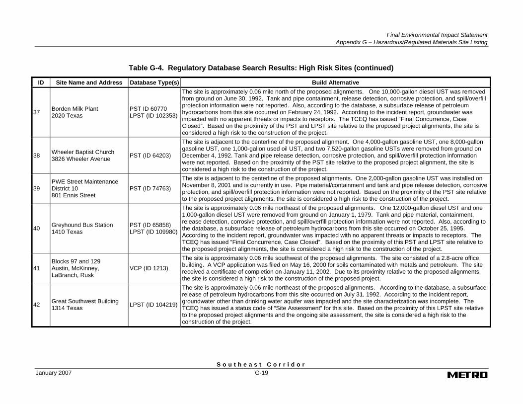
37 Borden Milk Plant 2020 Texas
PST ID 60770 LPST (ID 102353)
The site is approximately 0.06 mile north of the proposed alignments. One 10,000-gallon diesel UST was removed from ground on June 30, 1992. Tank and pipe containment, release detection, corrosive protection, and spill/overfill protection information were not reported. Also, according to the database, a subsurface release of petroleum hydrocarbons from this site occurred on February 24, 1992. According to the incident report, groundwater was impacted with no apparent threats or impacts to receptors. The TCEQ has issued “Final Concurrence, Case Closed”. Based on the proximity of the PST and LPST site relative to the proposed project alignments, the site is considered a high risk to the construction of the project.
38 Wheeler Baptist Church 3826 Wheeler Avenue PST (ID 64203)
The site is adjacent to the centerline of the proposed alignment. One 4,000-gallon gasoline UST, one 8,000-gallon gasoline UST, one 1,000-gallon used oil UST, and two 7,520-gallon gasoline USTs were removed from ground on December 4, 1992. Tank and pipe release detection, corrosive protection, and spill/overfill protection information were not reported. Based on the proximity of the PST site relative to the proposed project alignment, the site is considered a high risk to the construction of the project.
39 PWE Street Maintenance District 10 801 Ennis Street
PST (ID 74763)
The site is adjacent to the centerline of the proposed alignments. One 2,000-gallon gasoline UST was installed on November 8, 2001 and is currently in use. Pipe material/containment and tank and pipe release detection, corrosive protection, and spill/overfill protection information were not reported. Based on the proximity of the PST site relative to the proposed project alignments, the site is considered a high risk to the construction of the project.
40 Greyhound Bus Station 1410 Texas
PST (ID 65858) LPST (ID 109980)
The site is approximately 0.06 mile northeast of the proposed alignments. One 12,000-gallon diesel UST and one 1,000-gallon diesel UST were removed from ground on January 1, 1979. Tank and pipe material, containment, release detection, corrosive protection, and spill/overfill protection information were not reported. Also, according to the database, a subsurface release of petroleum hydrocarbons from this site occurred on October 25, 1995. According to the incident report, groundwater was impacted with no apparent threats or impacts to receptors. The TCEQ has issued “Final Concurrence, Case Closed”. Based on the proximity of this PST and LPST site relative to the proposed project alignments, the site is considered a high risk to the construction of the project.
41 Blocks 97 and 129 Austin, McKinney, LaBranch, Rusk
VCP (ID 1213)
The site is approximately 0.06 mile southwest of the proposed alignments. The site consisted of a 2.8-acre office building. A VCP application was filed on May 16, 2000 for soils contaminated with metals and petroleum. The site received a certificate of completion on January 11, 2002. Due to its proximity relative to the proposed alignments, the site is considered a high risk to the construction of the proposed project.
42 Great Southwest Building 1314 Texas LPST (ID 104219)
The site is approximately 0.06 mile northeast of the proposed alignments. According to the database, a subsurface release of petroleum hydrocarbons from this site occurred on July 31, 1992. According to the incident report, groundwater other than drinking water aquifer was impacted and the site characterization was incomplete. The TCEQ has issued a status code of “Site Assessment” for this site. Based on the proximity of this LPST site relative to the proposed project alignments and the ongoing site assessment, the site is considered a high risk to the construction of the project.
Final Environmental Impact Statement Appendix G – Hazardous/Regulated Materials Site Listing
S o u t h e a s t C o r r i d o r G-20 January 2007
Table G-4. Regulatory Database Search Results: High Risk Sites (continued)
ID Site Name and Address Database Type(s) Build Alternative
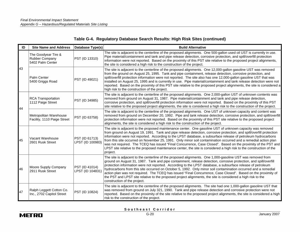
The Goodyear Tire & Rubber Company 5402 Palm Center
PST (ID 13310)
The site is adjacent to the centerline of the proposed alignments. One 500-gallon used oil UST is currently in use. Pipe material/containment and tank and pipe release detection, corrosive protection, and spill/overfill protection information were not reported. Based on the proximity of this PST site relative to the proposed project alignments, the site is considered a high risk to the construction of the project.
43
Palm Center 5400 Griggs Road PST (ID 49021)
The site is adjacent to the centerline of the proposed alignments. One 12,000-gallon gasoline UST was removed from the ground on August 25, 1995. Tank and pipe containment, release detection, corrosive protection, and spill/overfill protection information were not reported. The site also has one 12,000-gallon gasoline UST that was installed on August 25, 1995 and is currently in use. Pipe material/containment and tank release detection were not reported. Based on the proximity of this PST site relative to the proposed project alignments, the site is considered a high risk to the construction of the project.
RCA Transportation 1112 Paige Street PST (ID 34985)
The site is adjacent to the centerline of the proposed alignments. One 2,000-gallon UST of unknown contents was removed from ground on August 31, 1987. Pipe material/containment and tank and pipe release detection, corrosive protection, and spill/overfill protection information were not reported. Based on the proximity of this PST site relative to the proposed project alignments, the site is considered a high risk to the construction of the project. 44
Metropolitan Warehouse Facility, 1110 Paige Street PST (ID 63758)
The site is adjacent to the centerline of the proposed alignments. One UST of unknown capacity and content was removed from ground on December 20, 1992. Pipe and tank release detection, corrosive protection, and spill/overfill protection information were not reported. Based on the proximity of this PST site relative to the proposed project alignments, the site is considered a high risk to the construction of the project.
45 Vacant Warehouse 2601 Rusk Street
PST (ID 61713) LPST (ID 100983)
The site is adjacent to the proposed maintenance center. One gasoline UST of unknown capacity was removed from ground on August 19, 1991. Tank and pipe release detection, corrosive protection, and spill/overfill protection information were not reported. According to the LPST database, a subsurface release of petroleum hydrocarbons from this site occurred on November 25, 1991. Only minor soil contamination occurred and a remedial action plan was not required. The TCEQ has issued “Final Concurrence, Case Closed”. Based on the proximity of the PST and LPST site relative to the proposed maintenance center, the site is considered a high risk to the construction of the project.
46 Moore Supply Company 2911 Rusk Street
PST (ID 41014) LPST (ID 104831)
The site is adjacent to the centerline of the proposed alignments. One 1,000-gasoline UST was removed from ground on August 31, 1987. Tank and pipe containment, release detection, corrosive protection, and spill/overfill protection information were not reported. According to the LPST database, a subsurface release of petroleum hydrocarbons from this site occurred on October 5, 1992. Only minor soil contamination occurred and a remedial action plan was not required. The TCEQ has issued “Final Concurrence, Case Closed”. Based on the proximity of the PST and LPST site relative to the proposed project alignments, the site is considered a high risk to the construction of the project.
47 Ralph Leggett Cotton Co. Inc., 2702 Capitol Street PST (ID 10824)
The site is adjacent to the centerline of the proposed alignments. The site had one 1,000-gallon gasoline UST that was removed from ground on July 321, 1990. Tank and pipe release detection and corrosive protection were not reported. Based on the proximity of the site relative to the proposed project alignments, the site is considered a high risk to the construction of the project.

Final Environmental Impact Statement
Appendix G – Hazardous/Regulated Materials Site Listing
S o u t h e a s t C o r r i d o r January 2007 G-21
Table G-4. Regulatory Database Search Results: High Risk Sites (continued)
ID Site Name and Address Database Type(s) Build Alternative
48 Warehouse 707 Live Oak Street PST (ID 59026)
The site is adjacent to the centerline of the proposed alignments. One 9,999-gallon UST of unknown content was removed from ground on August 19, 1991. Tank and pipe material/containment, release detection, corrosive protection, and spill/overfill protection information were not reported. Based on the proximity of the site relative to the proposed project alignments, the site is considered a high risk to the construction of the project.
49 Motor Lease Corporation 2801 Capitol Street PST (ID 6753)
The site is adjacent to the centerline of the proposed alignments. Three USTs (one 4,000-gallon used oil, one 8,000-gallon kerosene, and one 4,000-gallon diesel) were permanently filled in place on January 14, 1988. An additional 4,000-gallon diesel UST has had a status of “out of use” since April 1, 2003. Tank and pipe release detection, corrosive protection, and spill/overfill protection information were not reported. Based on the proximity of the site relative to the proposed project alignments, the site is considered a high risk to the construction of the project.
50 Abandoned Service Station 3322 McKinney Unknown
This site of concern is approximately 0.06 mile east of the proposed alignments and was identified during the site reconnaissance. Potential hazardous substances may be present at this location. Based on the proximity of site relative to the proposed project alignments and the unknown potential hazardous substance, the site is considered a high risk to the construction of the project.
51 Abandoned service station 912 Sampson Street Unknown
This site of concern is adjacent to the proposed alignments and was identified during the site reconnaissance. Potential petroleum products may be present at this location. Based on the proximity of site relative to the proposed project alignments and the potential petroleum products present at this location, the site is considered a high risk to the construction of the project.
52 UP Railroad Rail and Rail Yard Unknown
These sites of concern are adjacent to the proposed alignments (adjacent to and east of the intersection of McKinney and York) and were identified during the site reconnaissance. Potential petroleum products and byproducts from railways and rail yard operations may be present at this location. Based on the proximity of these sites relative to the proposed project alignments and the nature of the railway operation, these sites are considered high risk to the construction of the project.
Source: Parsons Brinckerhoff and GeoSearch, Inc., 2006.


S o u t h e a s t C o r r i d o r
APPENDIX H MEMORANDUM OF AGREEMENT
