appendix e: existing vegetation references and codesappendix e: existing vegetation references and...
TRANSCRIPT

Region 3 Field Guide Appendix E: Existing Vegetation References and Codes
APPENDIX E: EXISTING VEGETATION REFERENCES AND CODES
February 2014
Existing Vegetation References Code Name Author
SAF Forest Cover Types of the United States and Canada. F.H. Eyre, Editor. Society of American Foresters (1980)
SRM Society for Range Management
Existing SAF Vegetation Codes Ref. Code Description
SAF 000 Non Forest Types SAF 206 Engelmann spruce-subalpine fir SAF 209 Bristlecone pine SAF 210 Interior Douglas-fir SAF 211 White fir SAF 216 Blue spruce SAF 217 Aspen - Western forests - Middle elevation - Interior SAF 219 Limber pine SAF 220 Rocky Mountain juniper SAF 235 Cottonwood - willow SAF 237 Interior ponderosa pine SAF 239 Pinyon – juniper SAF 240 Arizona cypress SAF 241 Western live oak SAF 242 Mesquite
Existing SRM Vegetation Codes Ref. Code Description
SRM 001 Urban SRM 002 Agriculture SRM 004 Forest Land SRM 005 Water SRM 007 Barren Land SRM 000 Non-vegetated SRM 109 Ponderosa pine – shrubland SRM 110 Ponderosa pine – grassland SRM 201 Blue oak woodland SRM 203 Riparian woodland SRM 207 Scrub oak mixed chaparral
E-1

Appendix E: Existing Vegetation References and Codes Region 3 Field Guide
Existing SRM Vegetation Codes (cont.) Ref. Code Description
SRM 208 Ceanothus mixed chaparral SRM 209 Montane shrubland SRM 210 Bitterbrush SRM 211 Creosote bush scrub SRM 212 Blackbush SRM 213 Alpine grassland SRM 215 Valley grassland SRM 216 Montane meadows SRM 217 Wetlands SRM 301 Bluebunch wheatgrass - blue grama SRM 303 Bluebunch wheatgrass - western wheatgrass SRM 310 Needle-and-thread - blue grama SRM 313 Tufted hairgrass – sedge SRM 317 Bitterbrush - bluebunch wheatgrass SRM 320 Black sagebrush - bluebunch wheatgrass SRM 322 Curlleaf mountain-mahogany - bluebunch wheatgrass SRM 401 Basin big sagebrush SRM 402 Mountain big sagebrush SRM 403 Wyoming big sagebrush SRM 405 Black sagebrush SRM 408 Other sagebrush types SRM 409 Tall forb SRM 410 Alpine rangeland SRM 411 Aspen woodland SRM 412 Juniper - pinyon woodland SRM 413 Gambel oak SRM 414 Salt desert shrub SRM 415 Curlleaf mountain-mahogany SRM 416 True mountain-mahogany SRM 417 Littleleaf mountain-mahogany SRM 418 Bigtooth maple SRM 419 Bittercherry SRM 420 Snowbush SRM 421 Chokecherry - serviceberry – rose SRM 422 Riparian SRM 501 Saltbush – greasewood SRM 502 Grama – galleta SRM 503 Arizona chapparal SRM 504 Juniper - pinyon pine woodland SRM 505 Grama - tobosa shrub SRM 506 Creosotebush - bursage SRM 507 Palo Verde - cactus SRM 508 Creosotebush - tarbush SRM 509 Oak - juniper woodland and mahogany-oak SRM 601 Bluestem prairie SRM 604 Bluestem - grama prairie SRM 605 Sandsage prairie
E-2

Region 3 Field Guide Appendix E: Existing Vegetation References and Codes
Existing SRM Vegetation Codes (cont.) Ref. Code Description SRM 606 Wheatgrass - bluestem - needlegrass SRM 607 Wheatgrass - needlegrass SRM 608 Wheatgrass - gama - needlegrass SRM 609 Wheatgrass - gama SRM 610 Wheatgrass SRM 611 Blue grama - buffalograss SRM 612 Sagebrush - grass SRM 613 Fesque grassland SRM 614 Crested wheatgrass SRM 615 Wheatgrass - saltgrass - grama SRM 701 Alkali sacaton - tobosagrass SRM 702 Black grama - alkali sacaton SRM 703 Black grama - sideoats grama SRM 704 Blue grama - western wheatgrass SRM 705 Blue grama - galleta SRM 706 Blue grama - sideoats grama SRM 707 Blue grama - sideoats grama - black grama SRM 708 Bluestem - dropseed SRM 709 Bluestem - grama SRM 710 Bluestem prairie SRM 711 Bluestem - sacahuista prairie SRM 712 Galleta - alkali sacaton SRM 713 Grama - muhly - threeawn SRM 714 Grama - bluestem SRM 715 Grama - buffalograss SRM 716 Grama - feathergrass SRM 717 Little bluestem - Indiangrass - Texas wintergrass SRM 718 Mesquite - grama SRM 722 Sand sagebrush - mixed prairie SRM 724 Sideoats grama - New Mexico feathergrass- winterfat SRM 725 Vine mesquite - alkali sacaton SRM 727 Mesquite - buffalograss SRM 728 Mesquite - granjeno - acacia SRM 729 Mesquite SRM 730 Sand shinnery oak SRM 733 Juniper - oak SRM 734 Mesquite - oak SRM 735 Sideoats grama - sumac - juniper SRM 801 Savanna SRM 805 Riparian SRM 809 Mixed hardwood and pine SRM 916 Sedge - shrub tundra SRM 917 Tall shrub swamp SRM 919 Wet meadow tundra SRM 921 Willow
E-3

Appendix E: Existing Vegetation References and Codes Region 3 Field Guide
This page intentionally left blank.
E-4

Region 3 Field Guide Appendix F: Potential Vegetation References
APPENDIX F: POTENTIAL VEGETATION REFERENCES
Code Name/Author
301 Plant Associations of Arizona and New Mexico, edition 3, July 1997. Volume 1: Forests and Volume 2: Woodlands.
F-1

Appendix E: Existing Vegetation References and Codes Region 3 Field Guide
This page intentionally left blank.
F-2

Region 3 Field Guide Appendix G: Potential Vegetation Codes
APPENDIX G: POTENTIAL VEGETATION CODES
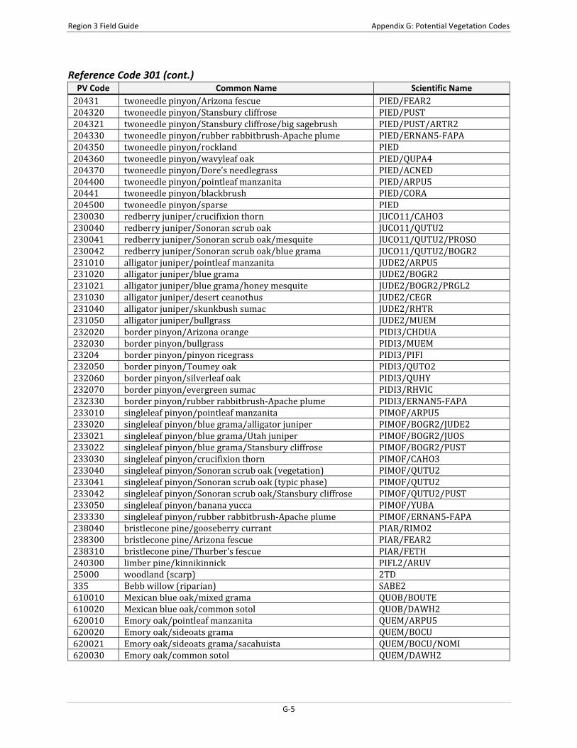
Reference Code 301 PV Code Common Name Scientific Name
001010 white fir/Rocky Mountain maple ABCO/ACGL 001011 white fir/Rocky Mountain maple/creeping barberry ABCO/ACGL/MARE11 001012 white fir/Rocky Mountain maple/rockspirea ABCO/ACGL/HODU 001013 white fir/Rocky Mountain maple (riparian) ABCO/ACGL 001020 white fir/creeping barberry ABCO/MARE11 001021 white fir/creeping barberry/New Mexico locust ABCO/MARE11/RONE 001022 white fir/creeping barberry/common juniper ABCO/MARE11/JUCO6 001030 white fir/sprucefir fleabane ABCO/EREX4 001040 white fir/Arizona fescue ABCO/FEAR2 001041 white fir/Arizona fescue/muttongrass ABCO/FEAR2/POFE 001042 white fir/Arizona fescue/Gambel oak ABCO/FEAR2/QUGA 001050 white fir/Gambel oak ABCO/QUGA 001051 white fir/Gambel oak/screwleaf muhly ABCO/QUGA/MUVI2 001052 white fir/Gambel oak/Arizona fescue ABCO/QUGA/FEAR2 001053 white fir/Gambel oak/pine muhly ABCO/QUGA/MUDU 001054 white fir/Gambel oak/rockspirea ABCO/QUGA/HODU 001060 white fir/screwleaf muhly ABCO/MUVI2 001070 white fir/Nevada pea ABCO/LALAL3 001080 white fir/bigtooth maple ABCO/ACGR3 001081 white fir/bigtooth maple/rockspirea ABCO/ACGR3/HODU 001090 white fir/kinnikinnick ABCO/ARUV 001100 white fir/whortleberry ABCO/VAMY2 001110 white fir/New Mexico locust ABCO/RONE 001111 white fir/New Mexico locust/dryspike sedge ABCO/RONE/CAFO3 001120 white fir/beardless wildrye ABCO/LETR5 001130 white fir/Arizona walnut ABCO/JUMA 001140 white fir/mountain snowberry/ponderosa pine ABCO/SYOR2/PIPO 001141 white fir/mountain snowberry/limber pine ABCO/SYOR2/PIFL2 001150 white fir/dryspike sedge ABCO/CAFO3 001160 white fir/burnet ragwort ABCO/PASA12 003 subalpine fir (riparian) ABLAL 003060 subalpine fir/tall fringed bluebells ABLAL/MECI3 003080 subalpine fir/sprucefir fleabane ABLAL/EREX4 003090 subalpine fir/common juniper ABLAL/JUCO6 003110 subalpine fir/moss ABLAL/2MOSS 003111 subalpine fir/moss/Engelmann spruce ABLAL/2MOSS/PIEN 003112 subalpine fir/moss/Douglas-fir ABLAL/2MOSS/PSME 003200 subalpine fir/whortleberry ABLAL/VAMY2 003201 subalpine fir/whortleberry/twinflower ABLAL/VAMY2/LIBO3 003202 subalpine fir/whortleberry/thimbleberry ABLAL/VAMY2/RUPA 003203 subalpine fir/whortleberry/fivepetal cliffbush ABLAL/VAMY2/JAAM 003231 subalpine fir/thimbleberry/Rocky Mountain maple ABLAL/RUPA/ACGL 003240 subalpine fir/thimbleberry ABLAL/RUPA 003300 subalpine fir/burnet ragwort ABLAL/PASA12 003301 subalpine fir/burnet ragwort/Douglas-fir ABLAL/PASA12/PSME
G-1

Region 3 Field Guide Appendix G: Potential Vegetation Codes
Reference Code 301 (cont.) PV Code Common Name Scientific Name
003310 subalpine fir/Nevada pea ABLAL/LALAL3 003320 subalpine fir/fivepetal cliffbush ABLAL/JAAM 003350 subalpine fir (scree) ABLAL 003370 subalpine fir/dryspike sedge ABLAL/CAFO3 004060 Engelmann spruce/moss PIEN/2MOSS 004061 Engelmann spruce/moss/Engelmann spruce PIEN/2MOSS/PIEN 004062 Engelmann spruce/moss/Douglas-fir PIEN/2MOSS/PSME 00415 Engelmann spruce/whortleberry/Jacob’s-ladder PIEN/VAMY2/POPUD3 004151 Engelmann spruce/whortleberry/Jacob’s-
ladder/Engelmann spruce PIEN/VAMY2/POPUD3/PIEN
004152 Engelmann spruce/whortleberry/Jacob’s-ladder/subalpine fir
PIEN/VAMY2/POPUD3/ABLA
004300 Engelmann spruce/Rocky Mountain maple PIEN/ACGL 004310 Engelmann spruce/sprucefir fleabane PIEN/EREX4 004320 Engelmann spruce/beardless wildrye PIEN/LETR5 004330 Engelmann spruce/Ross’ avens PIEN/GERO2 004340 Engelmann spruce/gooseberry currant PIEN/RIMO2 00435 Engelmann spruce/bittercress ragwort PIEN/PACA34 004350 Engelmann spruce/bittercress ragwort/subalpine fir PIEN/PACA34/ABLAL 004351 Engelmann spruce/bittercress ragwort/white fir PIEN/PACA34/ABCO 004360 Engelmann spruce/whortleberry PIEN/VAMY2 006010 blue spruce/redosier dogwood PIPU/COSES 00604 blue spruce/twinflower PIPU/LIBO3 006060 blue spruce/dryspike sedge PIPU/CAFO3 006070 blue spruce/sprucefir fleabane PIPU/EREX4 006071 blue spruce/sprucefir fleabane/ponderosa pine PIPU/EREX4/PIPO 006080 blue spruce/kinnikinnick PIPU/ARUV 006090 blue spruce/Arizona fescue PIPU/FEAR2 006130 blue spruce/bittercress ragwort PIPU/PACA34 011 blue spruce (riparian) PIPU 011030 ponderosa pine/blue grama PIPO/BOGR2 011031 ponderosa pine/blue grama/little bluestem PIPO/BOGR2/SCSC 011032 ponderosa pine/blue grama/sand bluestem PIPO/BOGR2/ANHA 011033 ponderosa pine/blue grama/big sagebrush PIPO/BOGR2/ARTR2 011034 ponderosa pine/blue grama/gray oak PIPO/BOGR2/QUGR3 011035 ponderosa pine/blue grama/Gambel oak PIPO/BOGR2/QUGA 011090 ponderosa pine/Arizona fescue PIPO/FEAR2 011091 ponderosa pine/Arizona fescue/Parry's oatgrass PIPO/FEAR2/DAPA2 011092 ponderosa pine/Arizona fescue/blue grama PIPO/FEAR2/BOGR2 011093 ponderosa pine/Arizona fescue/Gambel oak PIPO/FEAR2/QUGA 011130 white fir (scree) ABCO 011210 ponderosa pine/Gambel oak PIPO/QUGA 011211 ponderosa pine/Gambel oak/Arizona fescue PIPO/QUGA/FEAR2 011212 ponderosa pine/Gambel oak/longtongue muhly PIPO/QUGA/MULO 011213 ponderosa pine/Gambel oak/twoneedle pinyon PIPO/QUGA/PIED 011214 ponderosa pine/Gambel oak/mountain muhly PIPO/QUGA/MUMO 011215 ponderosa pine/Gambel oak/blue grama PIPO/QUGA/BOGR2 011216 ponderosa pine/Gambel oak/New Mexico locust PIPO/QUGA/RONE 011220 ponderosa pine/silverleaf oak PIPO/QUHY
G-2

Region 3 Field Guide Appendix G: Potential Vegetation Codes
Reference Code 301 (cont.) PV Code Common Name Scientific Name
011320 ponderosa pine/Stansbury cliffrose PIPO/PUST 011330 ponderosa pine/mountain muhly PIPO/MUMO 011340 ponderosa pine/screwleaf muhly PIPO/MUVI2 011341 ponderosa pine/screwleaf muhly/Gambel oak PIPO/MUVI2/QUGA 011350 ponderosa pine/Indian ricegrass PIPO/ACHY 011360 ponderosa pine/gray oak/mountain muhly PIPO/QUGR3/MUMO 011361 ponderosa pine/gray oak/longtongue muhly PIPO/QUGR3/MULO 011370 ponderosa pine/wavyleaf oak PIPO/QUPA4 011380 ponderosa pine/black sagebrush PIPO/ARNO4 011390 ponderosa pine/screwleaf muhly-Arizona fescue PIPO/MUVI2-FEAR2 011391 ponderosa pine/screwleaf muhly-Arizona fescue/blue
grama PIPO/MUVI2-FEAR2/BOGR2
011392 ponderosa pine/screwleaf muhly-Arizona fescue/Gambel oak
PIPO/MUVI2-FEAR2/QUGA
011400 ponderosa pine/kinnikinnick PIPO/ARUV 011410 ponderosa pine/Arizona white oak PIPO/QUAR 011411 ponderosa pine/Arizona white oak/blue grama PIPO/QUAR/BOGR2 011420 ponderosa pine/pointleaf manzanita PIPO/ARPU5 011430 ponderosa pine/netleaf oak PIPO/QURU4 011440 ponderosa pine/Emory oak PIPO/QUEM 011460 ponderosa pine (scree) PIPO 011470 ponderosa pine/Arizona walnut PIPO/JUMA 011500 ponderosa pine/rockland PIPO 01203 Douglas-fir/creeping barberry PSME/MARE11 01213 Douglas-fir/mountain ninebark PSME/PHMO4 012140 Douglas-fir/Gambel oak PSME/QUGA 012141 Douglas-fir/Gambel oak/Arizona fescue PSME/QUGA/FEAR2 012142 Douglas-fir/Gambel oak/screwleaf muhly PSME/QUGA/MUVI2 012143 Douglas-fir/Gambel oak/rockspirea PSME/QUGA/HODU 01231 Douglas-fir/kinnikinnick PSME/ARUV 012320 Douglas-fir/fringed brome PSME/BRCI2 012330 Douglas-fir/Arizona fescue PSME/FEAR2 012331 Douglas-fir/Arizona fescue/bristlecone pine PSME/FEAR2/PIAR 012332 Douglas-fir/Arizona fescue/limber pine PSME/FEAR2/PIFL2 012333 Douglas-fir/Arizona fescue/quaking aspen PSME/FEAR2/POTR5 012340 Douglas-fir/mountain muhly/twoneedle pinyon PSME/MUMO/PIED 012341 Douglas-fir/mountain muhly/limber pine PSME/MUMO/PIFL2 012350 Douglas-fir/screwleaf muhly PSME/MUVI2 012360 Douglas-fir/silverleaf oak/ponderosa pine PSME/QUHY/PIPO 012361 Douglas-fir/silverleaf oak/Chihuahuan pine PSME/QUHY/PILE 012362 Douglas-fir/silverleaf oak/netleaf oak PSME/QUHY/QURU4 012380 Douglas-fir (scree) PSME 01239 Douglas-fir/bigtooth maple PSME/ACGR3 01241 Douglas-fir/rockspirea PSME/HODU 01242 Douglas-fir/wavyleaf oak PSME/QUPA4 012420 Douglas-fir/wavyleaf oak PSME/QUPA4 012430 Douglas-fir/Arizona white oak PSME/QUAR 03101 Arizona cypress/silverleaf oak CUAR/QUHY 03102 Arizona cypress/Sonoran scrub oak CUAR/QUTU2
G-3

Region 3 Field Guide Appendix G: Potential Vegetation Codes
Reference Code 301 (cont.) PV Code Common Name Scientific Name
032010 Apache pine/longtongue muhly PIEN2/MULO 032030 Apache pine/silverleaf oak PIEN2/QUHY 033010 Chihuahuan pine/pinyon ricegrass PILE/PIFI 033020 Chihuahuan pine/Arizona white oak PILE/QUAR 033030 Chihuahuan pine/silverleaf oak PILE/QUHY 103 narrowleaf cottonwood (riparian) POAN3 104 Rio grande cottonwood (riparian) PODEW 123 thinleaf alder (riparian) ALINT 130 Arizona sycamore (riparian) PLWR2 201010 oneseed juniper/sideoats grama JUMO/BOCU 201011 oneseed juniper/sideoats grama/sacahuista JUMO/BOCU/NOMI 201020 oneseed juniper/blue grama JUMO/BOGR2 201040 oneseed juniper/big sagebrush JUMO/ARTR2 201331 oneseed juniper/rubber rabbitbrush-Apache plume JUMO/ERNAN5-FAPA 201332 oneseed juniper/rubber rabbitbrush-Apache plume/big
sagebrush JUMO/ERNAN5-FAPA/ARTR2
201333 oneseed juniper/rubber rabbitbrush-Apache plume/gray oak
JUMO/ERNAN5-FAPA/QUGR3
201340 oneseed juniper/sand bluestem JUMO/ANHA 201350 oneseed juniper/Bigelow sage JUMO/ARBI3 20140 oneseed juniper/winterfat JUMO/KRLA2 201400 oneseed juniper/wavyleaf oak JUMO/QUPA4 201410 oneseed juniper/sacahuista-lechuguilla JUMO/NOMI-AGLE 201420 oneseed juniper/lechuguilla JUMO/AGLE 201430 Pinchot's juniper/creosote bush JUPI/LATR2 202020 Utah juniper/big sagebrush JUOS/ARTR2 202320 Utah juniper/blue grama JUOS/BOGR2 202321 Utah juniper/blue grama/Stansbury cliffrose JUOS/BOGR2/PUST 202330 Utah juniper/tobosagrass/mesquite JUOS/PLMU3/PROSO 202331 Utah juniper/tobosagrass/singleleaf pinyon JUOS/PLMU3/PIMOF 202500 Utah juniper-oneseed juniper/sparse JUOS-JUMO 204010 twoneedle pinyon/big sagebrush/Utah juniper PIED/ARTR2/JUOS 204011 twoneedle pinyon/big sagebrush/oneseed juniper PIED/ARTR2/JUMO 204012 twoneedle pinyon/big sagebrush/Rocky Mountain juniper PIED/ARTR2/JUSC2 204021 twoneedle pinyon/blue grama/Utah juniper PIED/BOGR2/JUOS 204022 twoneedle pinyon/blue grama/oneseed juniper PIED/BOGR2/JUMO 204023 twoneedle pinyon/blue grama/alligator juniper PIED/BOGR2/JUDE2 204024 twoneedle pinyon/blue grama (hillslope) PIED/BOGR2 2040301 twoneedle pinyon/alderleaf mountain mahogany/wavyleaf
oak PIED/CEMO2/QUPA4
2040302 twoneedle pinyon/alderleaf mountain mahogany/gray oak PIED/CEMO2/QUGR3 2040303 twoneedle pinyon/alderleaf mountain mahogany/Gambel
oak PIED/CEMO2/QUGA
20404 twoneedle pinyon/Gambel oak PIED/QUGA 204050 twoneedle pinyon/antelope bitterbrush PIED/PUTR2 20406 twoneedle pinyon/muttongrass PIED/POFE 20410 twoneedle pinyon/pine muhly PIED/MUDU 20411 twoneedle pinyon/New Mexico muhly PIED/MUPA2 204300 twoneedle pinyon/sand bluestem PIED/ANHA
G-4
Region 3 Field Guide Appendix G: Potential Vegetation Codes
Reference Code 301 (cont.) PV Code Common Name Scientific Name
20431 twoneedle pinyon/Arizona fescue PIED/FEAR2 204320 twoneedle pinyon/Stansbury cliffrose PIED/PUST 204321 twoneedle pinyon/Stansbury cliffrose/big sagebrush PIED/PUST/ARTR2 204330 twoneedle pinyon/rubber rabbitbrush-Apache plume PIED/ERNAN5-FAPA 204350 twoneedle pinyon/rockland PIED 204360 twoneedle pinyon/wavyleaf oak PIED/QUPA4 204370 twoneedle pinyon/Dore’s needlegrass PIED/ACNED 204400 twoneedle pinyon/pointleaf manzanita PIED/ARPU5 20441 twoneedle pinyon/blackbrush PIED/CORA 204500 twoneedle pinyon/sparse PIED 230030 redberry juniper/crucifixion thorn JUCO11/CAHO3 230040 redberry juniper/Sonoran scrub oak JUCO11/QUTU2 230041 redberry juniper/Sonoran scrub oak/mesquite JUCO11/QUTU2/PROSO 230042 redberry juniper/Sonoran scrub oak/blue grama JUCO11/QUTU2/BOGR2 231010 alligator juniper/pointleaf manzanita JUDE2/ARPU5 231020 alligator juniper/blue grama JUDE2/BOGR2 231021 alligator juniper/blue grama/honey mesquite JUDE2/BOGR2/PRGL2 231030 alligator juniper/desert ceanothus JUDE2/CEGR 231040 alligator juniper/skunkbush sumac JUDE2/RHTR 231050 alligator juniper/bullgrass JUDE2/MUEM 232020 border pinyon/Arizona orange PIDI3/CHDUA 232030 border pinyon/bullgrass PIDI3/MUEM 23204 border pinyon/pinyon ricegrass PIDI3/PIFI 232050 border pinyon/Toumey oak PIDI3/QUTO2 232060 border pinyon/silverleaf oak PIDI3/QUHY 232070 border pinyon/evergreen sumac PIDI3/RHVIC 232330 border pinyon/rubber rabbitbrush-Apache plume PIDI3/ERNAN5-FAPA 233010 singleleaf pinyon/pointleaf manzanita PIMOF/ARPU5 233020 singleleaf pinyon/blue grama/alligator juniper PIMOF/BOGR2/JUDE2 233021 singleleaf pinyon/blue grama/Utah juniper PIMOF/BOGR2/JUOS 233022 singleleaf pinyon/blue grama/Stansbury cliffrose PIMOF/BOGR2/PUST 233030 singleleaf pinyon/crucifixion thorn PIMOF/CAHO3 233040 singleleaf pinyon/Sonoran scrub oak (vegetation) PIMOF/QUTU2 233041 singleleaf pinyon/Sonoran scrub oak (typic phase) PIMOF/QUTU2 233042 singleleaf pinyon/Sonoran scrub oak/Stansbury cliffrose PIMOF/QUTU2/PUST 233050 singleleaf pinyon/banana yucca PIMOF/YUBA 233330 singleleaf pinyon/rubber rabbitbrush-Apache plume PIMOF/ERNAN5-FAPA 238040 bristlecone pine/gooseberry currant PIAR/RIMO2 238300 bristlecone pine/Arizona fescue PIAR/FEAR2 238310 bristlecone pine/Thurber's fescue PIAR/FETH 240300 limber pine/kinnikinnick PIFL2/ARUV 25000 woodland (scarp) 2TD 335 Bebb willow (riparian) SABE2 610010 Mexican blue oak/mixed grama QUOB/BOUTE 610020 Mexican blue oak/common sotol QUOB/DAWH2 620010 Emory oak/pointleaf manzanita QUEM/ARPU5 620020 Emory oak/sideoats grama QUEM/BOCU 620021 Emory oak/sideoats grama/sacahuista QUEM/BOCU/NOMI 620030 Emory oak/common sotol QUEM/DAWH2
G-5
Region 3 Field Guide Appendix G: Potential Vegetation Codes
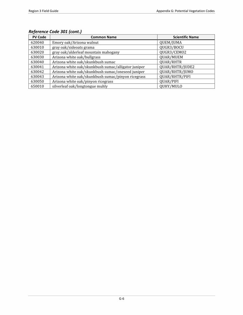
Reference Code 301 (cont.) PV Code Common Name Scientific Name
620040 Emory oak/Arizona walnut QUEM/JUMA 630010 gray oak/sideoats grama QUGR3/BOCU 630020 gray oak/alderleaf mountain mahogany QUGR3/CEMO2 630030 Arizona white oak/bullgrass QUAR/MUEM 630040 Arizona white oak/skunkbush sumac QUAR/RHTR 630041 Arizona white oak/skunkbush sumac/alligator juniper QUAR/RHTR/JUDE2 630042 Arizona white oak/skunkbush sumac/oneseed juniper QUAR/RHTR/JUMO 630043 Arizona white oak/skunkbush sumac/pinyon ricegrass QUAR/RHTR/PIFI 630050 Arizona white oak/pinyon ricegrass QUAR/PIFI 650010 silverleaf oak/longtongue muhly QUHY/MULO
G-6
Region 3 Field Guide Appendix H: Fuel Photo References and Codes
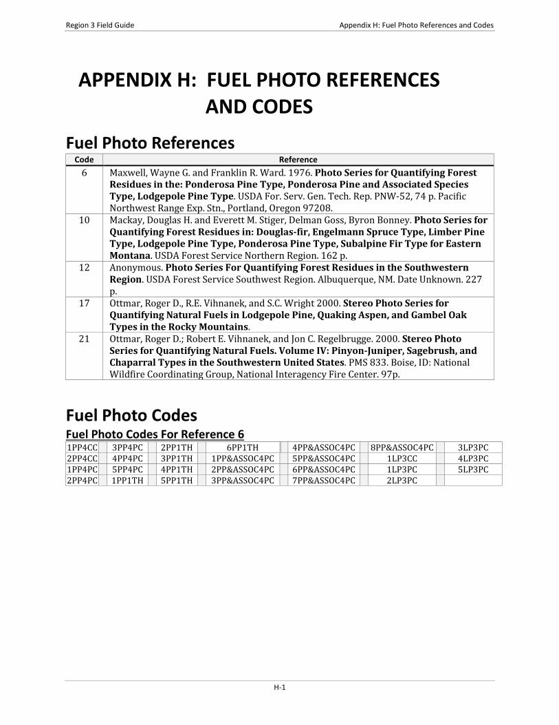
APPENDIX H: FUEL PHOTO REFERENCES AND CODES
Fuel Photo References Code Reference
6 Maxwell, Wayne G. and Franklin R. Ward. 1976. Photo Series for Quantifying Forest Residues in the: Ponderosa Pine Type, Ponderosa Pine and Associated Species Type, Lodgepole Pine Type. USDA For. Serv. Gen. Tech. Rep. PNW-52, 74 p. Pacific Northwest Range Exp. Stn., Portland, Oregon 97208.
10 Mackay, Douglas H. and Everett M. Stiger, Delman Goss, Byron Bonney. Photo Series for Quantifying Forest Residues in: Douglas-fir, Engelmann Spruce Type, Limber Pine Type, Lodgepole Pine Type, Ponderosa Pine Type, Subalpine Fir Type for Eastern Montana. USDA Forest Service Northern Region. 162 p.
12 Anonymous. Photo Series For Quantifying Forest Residues in the Southwestern Region. USDA Forest Service Southwest Region. Albuquerque, NM. Date Unknown. 227 p.
17 Ottmar, Roger D., R.E. Vihnanek, and S.C. Wright 2000. Stereo Photo Series for Quantifying Natural Fuels in Lodgepole Pine, Quaking Aspen, and Gambel Oak Types in the Rocky Mountains.
21 Ottmar, Roger D.; Robert E. Vihnanek, and Jon C. Regelbrugge. 2000. Stereo Photo Series for Quantifying Natural Fuels. Volume IV: Pinyon-Juniper, Sagebrush, and Chaparral Types in the Southwestern United States. PMS 833. Boise, ID: National Wildfire Coordinating Group, National Interagency Fire Center. 97p.
Fuel Photo Codes Fuel Photo Codes For Reference 6 1PP4CC 3PP4PC 2PP1TH 6PP1TH 4PP&ASSOC4PC 8PP&ASSOC4PC 3LP3PC 2PP4CC 4PP4PC 3PP1TH 1PP&ASSOC4PC 5PP&ASSOC4PC 1LP3CC 4LP3PC 1PP4PC 5PP4PC 4PP1TH 2PP&ASSOC4PC 6PP&ASSOC4PC 1LP3PC 5LP3PC 2PP4PC 1PP1TH 5PP1TH 3PP&ASSOC4PC 7PP&ASSOC4PC 2LP3PC
H-1
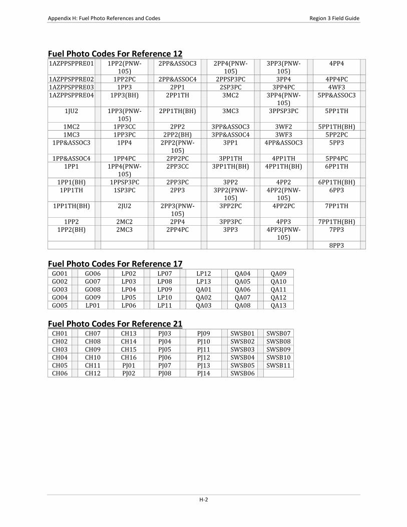
Appendix H: Fuel Photo References and Codes Region 3 Field Guide
Fuel Photo Codes For Reference 12 1AZPPSPPRE01 1PP2(PNW-
105) 2PP&ASSOC3 2PP4(PNW-
105) 3PP3(PNW-
105) 4PP4
1AZPPSPPRE02 1PP2PC 2PP&ASSOC4 2PPSP3PC 3PP4 4PP4PC 1AZPPSPPRE03 1PP3 2PP1 2SP3PC 3PP4PC 4WF3 1AZPPSPPRE04 1PP3(BH) 2PP1TH 3MC2 3PP4(PNW-
105) 5PP&ASSOC3
1JU2 1PP3(PNW-105)
2PP1TH(BH) 3MC3 3PPSP3PC 5PP1TH
1MC2 1PP3CC 2PP2 3PP&ASSOC3 3WF2 5PP1TH(BH) 1MC3 1PP3PC 2PP2(BH) 3PP&ASSOC4 3WF3 5PP2PC
1PP&ASSOC3 1PP4 2PP2(PNW-105)
3PP1 4PP&ASSOC3 5PP3
1PP&ASSOC4 1PP4PC 2PP2PC 3PP1TH 4PP1TH 5PP4PC 1PP1 1PP4(PNW-
105) 2PP3CC 3PP1TH(BH) 4PP1TH(BH) 6PP1TH
1PP1(BH) 1PPSP3PC 2PP3PC 3PP2 4PP2 6PP1TH(BH) 1PP1TH 1SP3PC 2PP3 3PP2(PNW-
105) 4PP2(PNW-
105) 6PP3
1PP1TH(BH) 2JU2 2PP3(PNW-105)
3PP2PC 4PP2PC 7PP1TH
1PP2 2MC2 2PP4 3PP3PC 4PP3 7PP1TH(BH) 1PP2(BH) 2MC3 2PP4PC 3PP3 4PP3(PNW-
105) 7PP3
8PP3 Fuel Photo Codes For Reference 17
GO01 GO06 LP02 LP07 LP12 QA04 QA09 GO02 GO07 LP03 LP08 LP13 QA05 QA10 GO03 GO08 LP04 LP09 QA01 QA06 QA11 GO04 GO09 LP05 LP10 QA02 QA07 QA12 GO05 LP01 LP06 LP11 QA03 QA08 QA13
Fuel Photo Codes For Reference 21
CH01 CH07 CH13 PJ03 PJ09 SWSB01 SWSB07 CH02 CH08 CH14 PJ04 PJ10 SWSB02 SWSB08 CH03 CH09 CH15 PJ05 PJ11 SWSB03 SWSB09 CH04 CH10 CH16 PJ06 PJ12 SWSB04 SWSB10 CH05 CH11 PJ01 PJ07 PJ13 SWSB05 SWSB11 CH06 CH12 PJ02 PJ08 PJ14 SWSB06
H-2
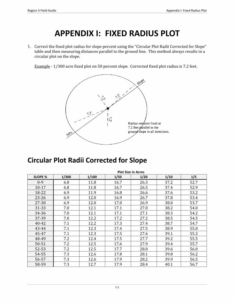
Region 3 Field Guide Appendix I: Fixed Radius Plot
APPENDIX I: FIXED RADIUS PLOT 1. Correct the fixed plot radius for slope percent using the “Circular Plot Radii Corrected for Slope”
table and then measuring distances parallel to the ground line. This method always results in a circular plot on the slope.
Example - 1/300 acre fixed plot on 50 percent slope. Corrected fixed plot radius is 7.2 feet.
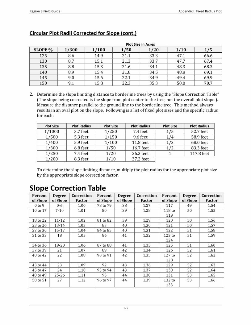
Circular Plot Radii Corrected for Slope Plot Size in Acres
SLOPE % 1/300 1/100 1/50 1/20 1/10 1/5 0-9 6.8 11.8 16.7 26.3 37.2 52.7
10-17 6.8 11.8 16.7 26.5 37.4 52.9 18-22 6.9 11.9 16.8 26.6 37.6 53.2 23-26 6.9 12.0 16.9 26.7 37.8 53.4 27-30 6.9 12.0 17.0 26.9 38.0 53.7 31-33 7.0 12.1 17.1 27.0 38.2 54.0 34-36 7.0 12.1 17.1 27.1 38.3 54.2 37-39 7.0 12.2 17.2 27.2 38.5 54.5 40-42 7.1 12.2 17.3 27.4 38.7 54.7 43-44 7.1 12.3 17.4 27.5 38.9 55.0 45-47 7.1 12.3 17.5 27.6 39.1 55.2 48-49 7.2 12.4 17.5 27.7 39.2 55.5 50-51 7.2 12.5 17.6 27.9 39.4 55.7 52-53 7.2 12.5 17.7 28.0 39.6 56.0 54-55 7.3 12.6 17.8 28.1 39.8 56.2 56-57 7.3 12.6 17.9 28.2 39.9 56.5 58-59 7.3 12.7 17.9 28.4 40.1 56.7
I-1

Appendix I: Fixed Radius Plot Region 3 Field Guide
Circular Plot Radii Corrected for Slope (cont.) Plot Size in Acres
SLOPE % 1/300 1/100 1/50 1/20 1/10 1/5 60-61 7.4 12.7 18.0 28.5 40.3 57.0 62-63 7.4 12.8 18.1 28.6 40.4 57.2 64-65 7.4 12.8 18.2 28.7 40.6 57.4 66-67 7.4 12.9 18.2 28.8 40.8 57.7 68-69 7.5 13.0 18.3 29.0 41.0 57.9
70 7.5 13.0 18.4 29.1 41.1 58.2 71-72 7.5 13.1 18.5 29.2 41.3 58.4 73-74 7.6 13.1 18.5 29.3 41.5 58.6
75 7.6 13.2 18.6 29.4 41.6 58.7 76-77 7.6 13.2 18.7 29.6 41.8 59.1 78-79 7.7 13.3 18.8 29.7 42.0 59.3
80 7.7 13.3 18.8 29.8 42.1 59.6 81-82 7.7 13.4 18.9 29.9 42.3 59.8
83 7.8 13.4 19.0 30.0 42.5 60.0 84-85 7.8 13.5 19.1 30.1 42.6 60.3
86 7.8 13.5 19.1 30.3 42.8 60.5 87-88 7.8 13.6 19.2 30.4 42.9 60.7
89 7.9 13.6 19.3 30.5 43.1 61.0 90-91 7.9 13.7 19.3 30.6 43.3 61.2
92 7.9 13.7 19.4 30.7 43.4 61.4 93-94 8.0 13.8 19.5 30.8 43.6 61.6
95 8.0 13.8 19.6 30.9 43.7 61.9 96-97 8.0 13.9 19.6 31.0 43.9 62.1
98 8.0 13.9 19.7 31.2 44.1 62.3 99-100 8.1 14.0 19.8 31.3 44.2 62.5
101 8.1 14.0 19.8 31.4 44.4 62.8 102 8.1 14.1 19.9 31.5 44.5 63.0
103-104 8.2 14.1 20.0 31.6 44.7 63.2 105 8.2 14.2 20.1 31.7 44.8 63.4
106-107 8.2 14.2 20.1 31.8 45.0 63.6 108 8.2 14.3 20.2 31.9 45.1 63.8 109 8.3 14.3 20.3 32.0 45.3 64.1
110-111 8.3 14.4 20.3 32.1 45.5 64.3 112 8.3 14.4 20.4 32.2 45.6 64.5 113 8.4 14.5 20.5 32.4 45.8 64.7
114-115 8.4 14.5 20.5 32.5 45.9 64.9 116 8.4 14.6 20.6 32.6 46.1 65.1 117 8.4 14.6 20.7 32.7 46.2 65.3
118-119 8.5 14.7 20.7 32.8 46.4 65.6 120 8.5 14.7 20.8 32.9 46.5 65.8 121 8.5 14.8 20.9 33.0 46.7 66.0 122 8.5 14.8 20.9 33.1 46.8 66.2
123-124 8.6 14.8 21.0 33.2 47.0 66.4
I-2
Region 3 Field Guide Appendix I: Fixed Radius Plot
Circular Plot Radii Corrected for Slope (cont.) Plot Size in Acres
SLOPE % 1/300 1/100 1/50 1/20 1/10 1/5 125 8.6 14.9 21.1 33.3 47.1 66.6 130 8.7 15.1 21.3 33.7 47.7 67.4 135 8.8 15.3 21.6 34.1 48.3 68.3 140 8.9 15.4 21.8 34.5 48.8 69.1 145 9.0 15.6 22.1 34.9 49.4 69.9 150 9.1 15.8 22.3 35.3 50.0 70.7
2. Determine the slope limiting distance to borderline trees by using the “Slope Correction Table”
(The slope being corrected is the slope from plot center to the tree, not the overall plot slope.). Measure the distance parallel to the ground line to the borderline tree. This method always results in an oval plot on the slope. Following is a list of fixed plot sizes and the specific radius for each:
Plot Size Plot Radius Plot Size Plot Radius Plot Size Plot Radius 1/1000 3.7 feet 1/250 7.4 feet 1/5 52.7 feet 1/500 5.3 feet 1/150 9.6 feet 1/4 58.9 feet 1/400 5.9 feet 1/100 11.8 feet 1/3 68.0 feet 1/300 6.8 feet 1/50 16.7 feet 1/2 83.3 feet 1/250 7.4 feet 1/20 26.3 feet 1 117.8 feet 1/200 8.3 feet 1/10 37.2 feet
To determine the slope limiting distance, multiply the plot radius for the appropriate plot size by the appropriate slope correction factor.
Slope Correction Table Percent of Slope
Degree of Slope
Correction Factor
Percent of Slope
Degree of Slope
Correction Factor
Percent of Slope
Degree of Slope
Correction Factor
0 to 9 0-6 1.00 78 to 79 38 1.27 117 49 1.54 10 to 17 7-10 1.01 80 39 1.28 118 to
119 50 1.55
18 to 22 11-12 1.02 81 to 82 39 1.29 120 50 1.56 23 to 26 13-14 1.03 83 40 1.30 121 50 1.57 27 to 30 15-17 1.04 84 to 85 40 1.31 122 51 1.58 31 to 33 18 1.05 86 41 1.32 123 to
124 51 1.59
34 to 36 19-20 1.06 87 to 88 41 1.33 125 51 1.60 37 to 39 21 1.07 89 42 1.34 126 52 1.61 40 to 42 22 1.08 90 to 91 42 1.35 127 to
128 52 1.62
43 to 44 23 1.09 92 43 1.36 129 52 1.63 45 to 47 24 1.10 93 to 94 43 1.37 130 52 1.64 48 to 49 25-26 1.11 95 44 1.38 131 53 1.65 50 to 51 27 1.12 96 to 97 44 1.39 132 to
133 53 1.66
I-3

Appendix I: Fixed Radius Plot Region 3 Field Guide
Slope Correction Table (cont.) Percent of Slope
Degree of Slope
Correction Factor
Percent of Slope
Degree of Slope
Correction Factor
Percent of Slope
Degree of Slope
Correction Factor
52 to 53 28 1.13 98 44 1.40 134 53 1.67 54 to 55 29 1.14 99 to
100 45 1.41 135 53 1.68
56 to 57 29 1.15 101 45 1.42 136 54 1.69 58 to 59 30 1.16 102 46 1.43 137 to
138 54 1.70
60 to 61 31 1.17 103 to104
46 1.44 139 54 1.71
62 to 63 32 1.18 105 46 1.45 140 54 1.72 64 to 65 33 1.19 106
to107 47 1.46 141 55 1.73
66 to 67 34 1.20 108 47 1.47 142 to 143
55 1.74
68 to 69 34 1.21 109 47 1.48 144 55 1.75 70 35 1.22 110 to
111 48 1.49 145 55 1.76
71 to 72 36 1.23 112 48 1.50 146 56 1.77 73 to 74 37 1.24 113 48 1.51 147 56 1.78
75 37 1.25 114 to 115
49 1.52 148 to 149
56 1.79
76 to 77 38 1.26 116 49 1.53 150 56 1.80
I-4

Region 3 Field Guide Appendix J: Variable Radius Plot
APPENDIX J: VARIABLE RADIUS PLOT
Table J-1: BAF 10 Plot Radii in Feet and Tenths of Feet from Plot Center to Face of Tree at DBH for 0% Slope
Inches 0 0.1 0.2 0.3 0.4 0.5 0.6 0.7 0.8 0.9 5 13.5 13.8 14.1 14.4 14.6 14.9 15.2 15.4 15.7 16.0 6 16.2 16.5 16.8 17.1 17.3 17.6 17.9 18.1 18.4 18.7 7 19.0 19.2 19.5 19.8 20.0 20.3 20.6 20.9 21.1 21.4 8 21.7 21.9 22.2 22.5 22.7 23.0 23.3 23.6 23.8 24.1 9 24.4 24.6 24.9 25.2 25.5 25.7 26.0 26.3 26.5 26.8
10 27.1 27.4 27.6 27.9 28.2 28.4 28.7 29.0 29.2 29.5 11 29.8 30.1 30.3 30.6 30.9 31.1 31.4 31.7 32.0 32.2 12 32.5 32.8 33.0 33.3 33.6 33.9 34.1 34.4 34.7 34.9 13 35.2 35.5 35.7 36.0 36.3 36.6 36.8 37.1 37.4 37.6 14 37.9 38.2 38.5 38.7 39.0 39.3 39.5 39.8 40.1 40.3 15 40.6 40.9 41.2 41.4 41.7 42.0 42.2 42.5 42.8 43.1 16 43.3 43.6 43.9 44.1 44.4 44.7 45.0 45.2 45.5 45.8 17 46.0 46.3 46.6 46.8 47.1 47.4 47.7 47.9 48.2 48.5 18 48.7 49.0 49.3 49.6 49.8 50.1 50.4 50.6 50.9 51.2 19 51.5 51.7 52.0 52.3 52.5 52.8 53.1 53.3 53.6 53.9 20 54.2 54.4 54.7 55.0 55.2 55.5 55.8 56.1 56.3 56.6 21 56.9 57.1 57.4 57.7 58.0 58.2 58.5 58.8 59.0 59.3 22 59.6 59.8 60.1 60.4 60.7 60.9 61.2 61.5 61.7 62.0 23 62.3 62.6 62.8 63.1 63.4 63.6 63.9 64.2 64.5 64.7 24 65.0 65.3 65.5 65.8 66.1 66.3 66.6 66.9 67.2 67.4 25 67.7 68.0 68.2 68.5 68.8 69.1 69.3 69.6 69.9 70.1 26 70.4 70.7 70.9 71.2 71.5 71.8 72.0 72.3 72.6 72.8 27 73.1 73.4 73.7 73.9 74.2 74.5 74.7 75.0 75.3 75.6 28 75.8 76.1 76.4 76.6 76.9 77.2 77.4 77.7 78.0 78.3 29 78.5 78.8 79.1 79.3 79.6 79.9 80.2 80.4 80.7 81.0 30 81.2 81.5 81.8 82.1 82.3 82.6 82.9 83.1 83.4 83.7 31 83.9 84.2 84.5 84.8 85.0 85.3 85.6 85.8 86.1 86.4 32 86.7 86.9 87.2 87.5 87.7 88.0 88.3 88.6 88.8 89.1 33 89.4 89.6 89.9 90.2 90.4 90.7 91.0 91.3 91.5 91.8 34 92.1 92.3 92.6 92.9 93.2 93.4 93.7 94.0 94.2 94.5 35 94.8 95.1 95.3 95.6 95.9 96.1 96.4 96.7 96.9 97.2 36 97.5 97.8 98.0 98.3 98.6 98.8 99.1 99.4 99.7 99.9 37 100.2 100.5 100.7 101.0 101.3 101.6 101.8 102.1 102.4 102.6 38 102.9 103.2 103.4 103.7 104.0 104.3 104.5 104.8 105.1 105.3 39 105.6 105.9 106.2 106.4 106.7 107.0 107.2 107.5 107.8 108.0 40 108.3 108.6 108.9 109.1 109.4 109.7 109.9 110.2 110.5 110.8 41 111.0 111.3 111.6 111.8 112.1 112.4 112.7 112.9 113.2 113.5 42 113.7 114.0 114.3 114.5 114.8 115.1 115.4 115.6 115.9 116.2 43 116.4 116.7 117.0 117.3 117.5 117.8 118.1 118.3 118.6 118.9 44 119.2 119.4 119.7 120.0 120.2 120.5 120.8 121.0 121.3 121.6 45 121.9 122.1 122.4 122.7 122.9 123.2 123.5 123.8 124.0 124.3 46 124.6 124.8 125.1 125.4 125.7 125.9 126.2 126.5 126.7 127.0 47 127.3 127.5 127.8 128.1 128.4 128.6 128.9 129.2 129.4 129.7 48 130.0 130.3 130.5 130.8 131.1 131.3 131.6 131.9 132.2 132.4 49 132.7 133.0 133.2 133.5 133.8 134.0 134.3 134.6 134.9 135.1 50 135.4 135.7 135.9 136.2 136.5 136.8 137.0 137.3 137.6 137.8
Prepared by multiplying the BAF 10 Plot Radius Factor 2.708 * DBH For example, if DBH = 14.3 inches, then 14.3 * 2.708 = 38.
J-1

Appendix J: Variable Radius Plot Region 3 Field Guide
Table J-2: BAF 20 Plot Radii in Feet and Tenths of Feet from Plot Center to Face of Tree at DBH for 0% Slope
Inches 0 0.1 0.2 0.3 0.4 0.5 0.6 0.7 0.8 0.9 5 9.5 9.7 9.9 10.1 10.3 10.5 10.7 10.8 11.0 11.2 6 11.4 11.6 11.8 12.0 12.2 12.4 12.6 12.8 12.9 13.1 7 13.3 13.5 13.7 13.9 14.1 14.3 14.5 14.7 14.8 15.0 8 15.2 15.4 15.6 15.8 16.0 16.2 16.4 16.6 16.7 16.9 9 17.1 17.3 17.5 17.7 17.9 18.1 18.3 18.5 18.6 18.8
10 19.0 19.2 19.4 19.6 19.8 20.0 20.2 20.4 20.6 20.7 11 20.9 21.1 21.3 21.5 21.7 21.9 22.1 22.3 22.5 22.6 12 22.8 23.0 23.2 23.4 23.6 23.8 24.0 24.2 24.4 24.5 13 24.7 24.9 25.1 25.3 25.5 25.7 25.9 26.1 26.3 26.5 14 26.6 26.8 27.0 27.2 27.4 27.6 27.8 28.0 28.2 28.4 15 28.5 28.7 28.9 29.1 29.3 29.5 29.7 29.9 30.1 30.3 16 30.4 30.6 30.8 31.0 31.2 31.4 31.6 31.8 32.0 32.2 17 32.4 32.5 32.7 32.9 33.1 33.3 33.5 33.7 33.9 34.1 18 34.3 34.4 34.6 34.8 35.0 35.2 35.4 35.6 35.8 36.0 19 36.2 36.3 36.5 36.7 36.9 37.1 37.3 37.5 37.7 37.9 20 38.1 38.3 38.4 38.6 38.8 39.0 39.2 39.4 39.6 39.8 21 40.0 40.2 40.3 40.5 40.7 40.9 41.1 41.3 41.5 41.7 22 41.9 42.1 42.2 42.4 42.6 42.8 43.0 43.2 43.4 43.6 23 43.8 44.0 44.1 44.3 44.5 44.7 44.9 45.1 45.3 45.5 24 45.7 45.9 46.1 46.2 46.4 46.6 46.8 47.0 47.2 47.4 25 47.6 47.8 48.0 48.1 48.3 48.5 48.7 48.9 49.1 49.3 26 49.5 49.7 49.9 50.0 50.2 50.4 50.6 50.8 51.0 51.2 27 51.4 51.6 51.8 52.0 52.1 52.3 52.5 52.7 52.9 53.1 28 53.3 53.5 53.7 53.9 54.0 54.2 54.4 54.6 54.8 55.0 29 55.2 55.4 55.6 55.8 55.9 56.1 56.3 56.5 56.7 56.9 30 57.1 57.3 57.5 57.7 57.9 58.0 58.2 58.4 58.6 58.8 31 59.0 59.2 59.4 59.6 59.8 59.9 60.1 60.3 60.5 60.7 32 60.9 61.1 61.3 61.5 61.7 61.8 62.0 62.2 62.4 62.6 33 62.8 63.0 63.2 63.4 63.6 63.8 63.9 64.1 64.3 64.5 34 64.7 64.9 65.1 65.3 65.5 65.7 65.8 66.0 66.2 66.4 35 66.6 66.8 67.0 67.2 67.4 67.6 67.7 67.9 68.1 68.3 36 68.5 68.7 68.9 69.1 69.3 69.5 69.6 69.8 70.0 70.2 37 70.4 70.6 70.8 71.0 71.2 71.4 71.6 71.7 71.9 72.1 38 72.3 72.5 72.7 72.9 73.1 73.3 73.5 73.6 73.8 74.0 39 74.2 74.4 74.6 74.8 75.0 75.2 75.4 75.5 75.7 75.9 40 76.1 76.3 76.5 76.7 76.9 77.1 77.3 77.5 77.6 77.8 41 78.0 78.2 78.4 78.6 78.8 79.0 79.2 79.4 79.5 79.7 42 79.9 80.1 80.3 80.5 80.7 80.9 81.1 81.3 81.4 81.6 43 81.8 82.0 82.2 82.4 82.6 82.8 83.0 83.2 83.4 83.5 44 83.7 83.9 84.1 84.3 84.5 84.7 84.9 85.1 85.3 85.4 45 85.6 85.8 86.0 86.2 86.4 86.6 86.8 87.0 87.2 87.3 46 87.5 87.7 87.9 88.1 88.3 88.5 88.7 88.9 89.1 89.3 47 89.4 89.6 89.8 90.0 90.2 90.4 90.6 90.8 91.0 91.2 48 91.3 91.5 91.7 91.9 92.1 92.3 92.5 92.7 92.9 93.1 49 93.2 93.4 93.6 93.8 94.0 94.2 94.4 94.6 94.8 95.0 50 95.2 95.3 95.5 95.7 95.9 96.1 96.3 96.5 96.7 96.9
Prepared by multiplying the BAF 20 Plot Radius Factor 1.902 * DBH. For example, if DBH = 14.3 inches, then 14.3 * 1.903 = 27.
J-2
Region 3 Field Guide Appendix J: Variable Radius Plot
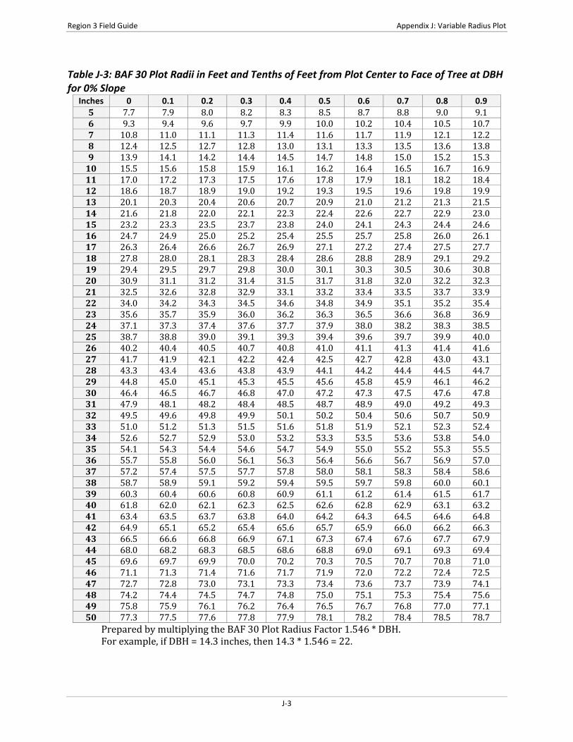
Table J-3: BAF 30 Plot Radii in Feet and Tenths of Feet from Plot Center to Face of Tree at DBH for 0% Slope
Inches 0 0.1 0.2 0.3 0.4 0.5 0.6 0.7 0.8 0.9 5 7.7 7.9 8.0 8.2 8.3 8.5 8.7 8.8 9.0 9.1 6 9.3 9.4 9.6 9.7 9.9 10.0 10.2 10.4 10.5 10.7 7 10.8 11.0 11.1 11.3 11.4 11.6 11.7 11.9 12.1 12.2 8 12.4 12.5 12.7 12.8 13.0 13.1 13.3 13.5 13.6 13.8 9 13.9 14.1 14.2 14.4 14.5 14.7 14.8 15.0 15.2 15.3
10 15.5 15.6 15.8 15.9 16.1 16.2 16.4 16.5 16.7 16.9 11 17.0 17.2 17.3 17.5 17.6 17.8 17.9 18.1 18.2 18.4 12 18.6 18.7 18.9 19.0 19.2 19.3 19.5 19.6 19.8 19.9 13 20.1 20.3 20.4 20.6 20.7 20.9 21.0 21.2 21.3 21.5 14 21.6 21.8 22.0 22.1 22.3 22.4 22.6 22.7 22.9 23.0 15 23.2 23.3 23.5 23.7 23.8 24.0 24.1 24.3 24.4 24.6 16 24.7 24.9 25.0 25.2 25.4 25.5 25.7 25.8 26.0 26.1 17 26.3 26.4 26.6 26.7 26.9 27.1 27.2 27.4 27.5 27.7 18 27.8 28.0 28.1 28.3 28.4 28.6 28.8 28.9 29.1 29.2 19 29.4 29.5 29.7 29.8 30.0 30.1 30.3 30.5 30.6 30.8 20 30.9 31.1 31.2 31.4 31.5 31.7 31.8 32.0 32.2 32.3 21 32.5 32.6 32.8 32.9 33.1 33.2 33.4 33.5 33.7 33.9 22 34.0 34.2 34.3 34.5 34.6 34.8 34.9 35.1 35.2 35.4 23 35.6 35.7 35.9 36.0 36.2 36.3 36.5 36.6 36.8 36.9 24 37.1 37.3 37.4 37.6 37.7 37.9 38.0 38.2 38.3 38.5 25 38.7 38.8 39.0 39.1 39.3 39.4 39.6 39.7 39.9 40.0 26 40.2 40.4 40.5 40.7 40.8 41.0 41.1 41.3 41.4 41.6 27 41.7 41.9 42.1 42.2 42.4 42.5 42.7 42.8 43.0 43.1 28 43.3 43.4 43.6 43.8 43.9 44.1 44.2 44.4 44.5 44.7 29 44.8 45.0 45.1 45.3 45.5 45.6 45.8 45.9 46.1 46.2 30 46.4 46.5 46.7 46.8 47.0 47.2 47.3 47.5 47.6 47.8 31 47.9 48.1 48.2 48.4 48.5 48.7 48.9 49.0 49.2 49.3 32 49.5 49.6 49.8 49.9 50.1 50.2 50.4 50.6 50.7 50.9 33 51.0 51.2 51.3 51.5 51.6 51.8 51.9 52.1 52.3 52.4 34 52.6 52.7 52.9 53.0 53.2 53.3 53.5 53.6 53.8 54.0 35 54.1 54.3 54.4 54.6 54.7 54.9 55.0 55.2 55.3 55.5 36 55.7 55.8 56.0 56.1 56.3 56.4 56.6 56.7 56.9 57.0 37 57.2 57.4 57.5 57.7 57.8 58.0 58.1 58.3 58.4 58.6 38 58.7 58.9 59.1 59.2 59.4 59.5 59.7 59.8 60.0 60.1 39 60.3 60.4 60.6 60.8 60.9 61.1 61.2 61.4 61.5 61.7 40 61.8 62.0 62.1 62.3 62.5 62.6 62.8 62.9 63.1 63.2 41 63.4 63.5 63.7 63.8 64.0 64.2 64.3 64.5 64.6 64.8 42 64.9 65.1 65.2 65.4 65.6 65.7 65.9 66.0 66.2 66.3 43 66.5 66.6 66.8 66.9 67.1 67.3 67.4 67.6 67.7 67.9 44 68.0 68.2 68.3 68.5 68.6 68.8 69.0 69.1 69.3 69.4 45 69.6 69.7 69.9 70.0 70.2 70.3 70.5 70.7 70.8 71.0 46 71.1 71.3 71.4 71.6 71.7 71.9 72.0 72.2 72.4 72.5 47 72.7 72.8 73.0 73.1 73.3 73.4 73.6 73.7 73.9 74.1 48 74.2 74.4 74.5 74.7 74.8 75.0 75.1 75.3 75.4 75.6 49 75.8 75.9 76.1 76.2 76.4 76.5 76.7 76.8 77.0 77.1 50 77.3 77.5 77.6 77.8 77.9 78.1 78.2 78.4 78.5 78.7
Prepared by multiplying the BAF 30 Plot Radius Factor 1.546 * DBH. For example, if DBH = 14.3 inches, then 14.3 * 1.546 = 22.
J-3
Appendix J: Variable Radius Plot Region 3 Field Guide
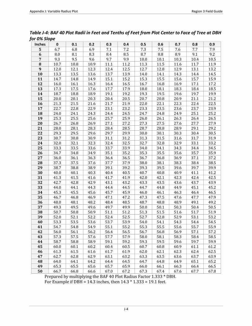
Table J-4: BAF 40 Plot Radii in Feet and Tenths of Feet from Plot Center to Face of Tree at DBH for 0% Slope
Inches 0 0.1 0.2 0.3 0.4 0.5 0.6 0.7 0.8 0.9 5 6.7 6.8 6.9 7.1 7.2 7.3 7.5 7.6 7.7 7.9 6 8.0 8.1 8.3 8.4 8.5 8.7 8.8 8.9 9.1 9.2 7 9.3 9.5 9.6 9.7 9.9 10.0 10.1 10.3 10.4 10.5 8 10.7 10.8 10.9 11.1 11.2 11.3 11.5 11.6 11.7 11.9 9 12.0 12.1 12.3 12.4 12.5 12.7 12.8 12.9 13.1 13.2
10 13.3 13.5 13.6 13.7 13.9 14.0 14.1 14.3 14.4 14.5 11 14.7 14.8 14.9 15.1 15.2 15.3 15.5 15.6 15.7 15.9 12 16.0 16.1 16.3 16.4 16.5 16.7 16.8 16.9 17.1 17.2 13 17.3 17.5 17.6 17.7 17.9 18.0 18.1 18.3 18.4 18.5 14 18.7 18.8 18.9 19.1 19.2 19.3 19.5 19.6 19.7 19.9 15 20.0 20.1 20.3 20.4 20.5 20.7 20.8 20.9 21.1 21.2 16 21.3 21.5 21.6 21.7 21.9 22.0 22.1 22.3 22.4 22.5 17 22.7 22.8 22.9 23.1 23.2 23.3 23.5 23.6 23.7 23.9 18 24.0 24.1 24.3 24.4 24.5 24.7 24.8 24.9 25.1 25.2 19 25.3 25.5 25.6 25.7 25.9 26.0 26.1 26.3 26.4 26.5 20 26.7 26.8 26.9 27.1 27.2 27.3 27.5 27.6 27.7 27.9 21 28.0 28.1 28.3 28.4 28.5 28.7 28.8 28.9 29.1 29.2 22 29.3 29.5 29.6 29.7 29.9 30.0 30.1 30.3 30.4 30.5 23 30.7 30.8 30.9 31.1 31.2 31.3 31.5 31.6 31.7 31.9 24 32.0 32.1 32.3 32.4 32.5 32.7 32.8 32.9 33.1 33.2 25 33.3 33.5 33.6 33.7 33.9 34.0 34.1 34.3 34.4 34.5 26 34.7 34.8 34.9 35.1 35.2 35.3 35.5 35.6 35.7 35.9 27 36.0 36.1 36.3 36.4 36.5 36.7 36.8 36.9 37.1 37.2 28 37.3 37.5 37.6 37.7 37.9 38.0 38.1 38.3 38.4 38.5 29 38.7 38.8 38.9 39.1 39.2 39.3 39.5 39.6 39.7 39.9 30 40.0 40.1 40.3 40.4 40.5 40.7 40.8 40.9 41.1 41.2 31 41.3 41.5 41.6 41.7 41.9 42.0 42.1 42.3 42.4 42.5 32 42.7 42.8 42.9 43.1 43.2 43.3 43.5 43.6 43.7 43.9 33 44.0 44.1 44.3 44.4 44.5 44.7 44.8 44.9 45.1 45.2 34 45.3 45.5 45.6 45.7 45.9 46.0 46.1 46.3 46.4 46.5 35 46.7 46.8 46.9 47.1 47.2 47.3 47.5 47.6 47.7 47.9 36 48.0 48.1 48.2 48.4 48.5 48.7 48.8 48.9 49.1 49.2 37 49.3 49.5 49.6 49.7 49.9 50.0 50.1 50.3 50.4 50.5 38 50.7 50.8 50.9 51.1 51.2 51.3 51.5 51.6 51.7 51.9 39 52.0 52.1 52.2 52.4 52.5 52.7 52.8 52.9 53.1 53.2 40 53.3 53.5 53.6 53.7 53.9 54.0 54.1 54.3 54.4 54.5 41 54.7 54.8 54.9 55.1 55.2 55.3 55.5 55.6 55.7 55.9 42 56.0 56.1 56.2 56.4 56.5 56.7 56.8 56.9 57.1 57.2 43 57.3 57.5 57.6 57.7 57.9 58.0 58.1 58.3 58.4 58.5 44 58.7 58.8 58.9 59.1 59.2 59.3 59.5 59.6 59.7 59.9 45 60.0 60.1 60.2 60.4 60.5 60.7 60.8 60.9 61.1 61.2 46 61.3 61.5 61.6 61.7 61.9 62.0 62.1 62.3 62.4 62.5 47 62.7 62.8 62.9 63.1 63.2 63.3 63.5 63.6 63.7 63.9 48 64.0 64.1 64.2 64.4 64.5 64.7 64.8 64.9 65.1 65.2 49 65.3 65.5 65.6 65.7 65.9 66.0 66.1 66.3 66.4 66.5 50 66.7 66.8 66.6 67.0 67.2 67.3 67.4 67.6 67.7 67.8
Prepared by multiplying the BAF 40 Plot Radius Factor 1.333 * DBH. For Example if DBH = 14.3 inches, then 14.3 * 1.333 = 19.1 feet.
J-4

Region 3 Field Guide Appendix J: Variable Radius Plot
Table J-5: BAF 60 Plot Radii in Feet and Tenths of Feet from Plot Center to Face of Tree at DBH for 0% Slope
Inches 0 0.1 0.2 0.3 0.4 0.5 0.6 0.7 0.8 0.9 5 5.4 5.5 5.6 5.7 5.8 5.9 6.1 6.2 6.3 6.4 6 6.5 6.6 6.7 6.8 6.9 7.0 7.1 7.2 7.4 7.5 7 7.6 7.7 7.8 7.9 8.0 8.1 8.2 8.3 8.4 8.5 8 8.6 8.8 8.9 9.0 9.1 9.2 9.3 9.4 9.5 9.6 9 9.7 9.8 9.9 10.1 10.2 10.3 10.4 10.5 10.6 10.7
10 10.8 10.9 11.0 11.1 11.2 11.4 11.5 11.6 11.7 11.8 11 11.9 12.0 12.1 12.2 12.3 12.4 12.5 12.6 12.8 12.9 12 13.0 13.1 13.2 13.3 13.4 13.5 13.6 13.7 13.8 13.9 13 14.1 14.2 14.3 14.4 14.5 14.6 14.7 14.8 14.9 15.0 14 15.1 15.2 15.4 15.5 15.6 15.7 15.8 15.9 16.0 16.1 15 16.2 16.3 16.4 16.5 16.6 16.8 16.9 17.0 17.1 17.2 16 17.3 17.4 17.5 17.6 17.7 17.8 17.9 18.1 18.2 18.3 17 18.4 18.5 18.6 18.7 18.8 18.9 19.0 19.1 19.2 19.3 18 19.5 19.6 19.7 19.8 19.9 20.0 20.1 20.2 20.3 20.4 19 20.5 20.6 20.8 20.9 21.0 21.1 21.2 21.3 21.4 21.5 20 21.6 21.7 21.8 21.9 22.1 22.2 22.3 22.4 22.5 22.6 21 22.7 22.8 22.9 23.0 23.1 23.2 23.3 23.5 23.6 23.7 22 23.8 23.9 24.0 24.1 24.2 24.3 24.4 24.5 24.6 24.8 23 24.9 25.0 25.1 25.2 25.3 25.4 25.5 25.6 25.7 25.8 24 25.9 26.1 26.2 26.3 26.4 26.5 26.6 26.7 26.8 26.9 25 27.0 27.1 27.2 27.3 27.5 27.6 27.7 27.8 27.9 28.0 26 28.1 28.2 28.3 28.4 28.5 28.6 28.8 28.9 29.0 29.1 27 29.2 29.3 29.4 29.5 29.6 29.7 29.8 29.9 30.1 30.2 28 30.3 30.4 30.5 30.6 30.7 30.8 30.9 31.0 31.1 31.2 29 31.3 31.5 31.6 31.7 31.8 31.9 32.0 32.1 32.2 32.3 30 32.4 32.5 32.6 32.8 32.9 33.0 33.1 33.2 33.3 33.4 31 33.5 33.6 33.7 33.8 33.9 34.1 34.2 34.3 34.4 34.5 32 34.6 34.7 34.8 34.9 35.0 35.1 35.2 35.3 35.5 35.6 33 35.7 35.8 35.9 36.0 36.1 36.2 36.3 36.4 36.5 36.6 34 36.8 36.9 37.0 37.1 37.2 37.3 37.4 37.5 37.6 37.7 35 37.8 37.9 38.1 38.2 38.3 38.4 38.5 38.6 38.7 38.8 36 38.9 39.0 39.1 39.2 39.3 39.5 39.6 39.7 39.8 39.9 37 40.0 40.1 40.2 40.3 40.4 40.5 40.6 40.8 40.9 41.0 38 41.1 41.2 41.3 41.4 41.5 41.6 41.7 41.8 41.9 42.1 39 42.2 42.3 42.4 42.5 42.6 42.7 42.8 42.9 43.0 43.1 40 43.2 43.3 43.5 43.6 43.7 43.8 43.9 44.0 44.1 44.2 41 44.3 44.4 44.5 44.6 44.8 44.9 45.0 45.1 45.2 45.3 42 45.4 45.5 45.6 45.7 45.8 45.9 46.1 46.2 46.3 46.4 43 46.5 46.6 46.7 46.8 46.9 47.0 47.1 47.2 47.3 47.5 44 47.6 47.7 47.8 47.9 48.0 48.1 48.2 48.3 48.4 48.5 45 48.6 48.8 48.9 49.0 49.1 49.2 49.3 49.4 49.5 49.6 46 49.7 49.8 49.9 50.1 50.2 50.3 50.4 50.5 50.6 50.7 47 50.8 50.9 51.0 51.1 51.2 51.3 51.5 51.6 51.7 51.8 48 51.9 52.0 52.1 52.2 52.3 52.4 52.5 52.6 52.8 52.9 49 53.0 53.1 53.2 53.3 53.4 53.5 53.6 53.7 53.8 53.9 50 54.1 54.2 54.3 54.4 54.5 54.6 54.7 54.8 54.9 55.0
Prepared by multiplying the BAF 60 Plot Radius Factor 1.081 * DBH. For Example, if DBH = 14.3 inches, then 14.3 * 1.081 = 15.5 feet.
J-5

Appendix J: Variable Radius Plot Region 3 Field Guide
Table J-6: Limiting Distance to Face of Tree and Slope Correction Factors for Various Basal Area Factors This table provides an expanded list of slope correction factors to the face of the tree for use with various basal area factors. To use the table, measure the slope and the distance from plot-center to the face of the tree at DBH. To obtain the corrected limiting distance to a tree multiply the trees DBH by the “combined factor” shown under the appropriate BAF heading.
% of Slope
Slope Correction Factor
Combined Factor 5 BAF 10 BAF 15 BAF 20 BAF 30 BAF 40 BAF
1 1.00000 3.847 2.708 2.203 1.902 1.546 1.333 2 1.00020 3.848 2.709 2.203 1.902 1.546 1.333 3 1.00045 3.849 2.709 2.204 1.903 1.547 1.334 4 1.00080 3.850 2.710 2.205 1.904 1.547 1.334 5 1.00125 3.852 2.711 2.206 1.904 1.548 1.335 6 1.00180 3.854 2.713 2.207 1.905 1.549 1.335 7 1.00245 3.856 2.715 2.208 1.907 1.550 1.336 8 1.00319 3.859 2.717 2.210 1.908 1.551 1.337 9 1.00404 3.863 2.719 2.212 1.910 1.552 1.338
10 1.00499 3.866 2.722 2.214 1.911 1.554 1.340 11 1.00603 3.870 2.724 2.216 1.912 1.555 1.341 12 1.00717 3.875 2.727 2.219 1.916 1.557 1.343 13 1.00841 3.879 2.731 2.222 1.918 1.559 1.344 14 1.00975 3.884 2.734 2.224 1.921 1.567 1.346 15 1.01119 3.890 2.738 2.228 1.923 1.563 1.348 16 1.01272 3.896 2.742 2.231 1.926 1.566 1.350 17 1.01435 3.902 2.747 2.235 1.921 1.568 1.352 18 1.01607 3.909 2.752 2.238 1.933 1.571 1.354 19 1.01789 3.916 2.756 2.245 1.936 1.574 1.357 20 1.01980 3.923 2.762 2.245 1.940 1.577 1.359 21 1.02181 3.931 2.767 2.251 1.943 1.580 1.362 22 1.02391 3.939 2.773 2.256 1.947 1.583 1.365 23 1.02611 3.947 2.779 2.261 1.952 1.586 1.368 24 1.02840 3.956 2.785 2.266 1.956 1.590 1.371 25 1.03078 3.965 2.791 2.271 1.967 1.594 1.374 26 1.03325 3.975 2.798 2.276 1.965 1.597 1.377 27 1.03581 3.985 2.805 2.282 1.970 1.601 1.381 28 1.03846 3.995 2.812 2.288 1.975 1.605 1.384 29 1.04120 4.005 2.820 2.294 1.980 1.610 1.388 30 1.04403 4.016 2.827 2.300 1.986 1.614 1.392 31 1.04695 4.028 2.835 2.306 1.991 1.619 1.396 32 1.04995 4.039 2.843 2.313 1.997 1.623 1.400 33 1.05304 4.051 2.852 2.320 2.003 1.628 1.404 34 1.05622 4.063 2.960 2.327 2.009 1.633 1.408 35 1.05948 4.076 2.869 2.334 2.015 1.638 1.412 36 1.06283 4.089 2.878 2.341 2.022 1.643 1.417 37 1.06626 4.102 2.887 2.349 2.028 1.648 4.421 38 1.06977 4.115 2.897 2.357 2.035 1.654 1.426 39 1.07336 4.129 2.907 2.365 2.042 1.659 1.431 40 1.07703 4.143 2.917 2.373 2.049 1.665 1.436 41 1.08079 4.158 2.927 2.381 2.056 1.671 1.441 42 1.08462 4.173 2.937 2.389 2.063 1.677 1.446
J-6

Region 3 Field Guide Appendix J: Variable Radius Plot
Table J-6: Limiting Distance to Face of Tree and Slope Correction Factors for Various Basal Area Factors (cont.)
% of Slope
Slope Correction Factor
Combined Factor 5 BAF 10 BAF 15 BAF 20 BAF 30 BAF 40 BAF
43 1.08853 4.188 2.948 2.398 2.070 1.683 1.451 44 1.09252 4.203 2.959 2.407 2.078 1.689 1.456 45 1.09659 4.219 2.970 2.416 2.086 1.695 1.462 46 1.10073 4.235 2.981 2.425 2.094 1.702 1.467 47 1.10494 4.251 2.992 2.434 2.102 1.708 1.473 48 1.10923 4.267 3.004 2.444 2.110 1.715 1.479 49 1.11360 4.284 3.016 2.453 2.118 1.723 1.484 50 1.11803 4.301 3.028 2.463 2.126 1.728 1.490 51 1.12254 4.318 3.040 2.473 2.135 1.735 1.496 52 1.12712 4.336 3.052 2.483 2.144 1.743 1.502 53 1.13177 4.354 3.065 2.493 2.153 1.750 1.509 54 1.13649 4.372 3.078 2.504 2.162 1.757 1.515 55 1.14127 4.390 3.091 2.514 2.171 1.764 1.521 56 1.14612 4.409 3.104 2.525 2.180 1.772 1.528 57 1.15104 4.428 3.117 2.536 2.189 1.780 1.534 58 1.15603 4.447 3.131 2.547 2.199 1.788 1.541 59 1.16108 4.467 3.144 2.558 2.208 1.795 1.548 60 1.16619 4.486 3.158 2.569 2.218 1.803 1.555 61 1.17137 4.506 3.172 2.581 2.228 1.811 1.561 62 1.17661 4.526 3.186 2.592 2.238 1.819 1.568 63 1.18191 4.547 3.201 2.604 2.248 1.827 1.575 64 1.18727 4.567 3.215 2.616 2.258 1.836 1.583 65 1.19269 4.588 3.230 2.627 2.268 1.844 1.590 66 1.19817 4.609 3.245 2.640 2.279 1.852 1.597 67 1.20370 4.631 3.260 2.652 2.289 1.861 1.605 68 1.20930 4.652 3.275 2.664 2.300 1.870 1.612 69 1.21949 4.691 3.302 2.687 2.319 1.885 1.626 70 1.22066 4.696 3.306 2.689 2.322 1.887 1.627 71 1.22642 4.718 3.321 2.702 2.333 1.896 1.635 72 1.23223 4.740 3.337 2.715 2.344 1.905 1.643 73 1.23810 4.763 3.353 2.728 2.355 1.914 1.650 74 1.24403 4.786 3.369 2.741 2.366 1.923 1.658 75 1.25000 4.809 3.385 2.754 2.378 1.933 1.666 76 1.25603 4.832 3.401 2.767 2.389 1.942 1.674 77 1.26210 4.855 3.418 2.780 2.401 1.951 1.682 78 1.26823 4.879 3.434 2.794 2.412 1.961 1.691 79 1.27440 4.903 3.451 2.808 2.424 1.970 1.699 80 1.28062 4.927 3.468 2.821 2.436 1.980 1.707 81 1.28690 4.951 3.485 2.835 2.448 1.990 1.715 82 1.29321 4.975 3.502 2.849 2.460 1.999 1.724 83 1.29958 4.999 3.519 2.863 2.472 2.009 1.732 84 1.30599 5.024 3.537 2.877 2.484 2.019 1.741 85 1.31244 5.049 3.554 2.891 2.496 2.029 1.749 86 1.31894 5.074 3.572 2.906 2.509 2.039 1.758 87 1.32548 5.099 3.589 2.920 2.521 2.049 1.767 88 1.33207 5.124 3.607 2.935 2.534 2.059 1.776 89 1.33870 5.150 3.625 2.949 2.546 2.070 1.784 90 1.34536 5.176 3.643 2.964 2.559 2.080 1.793
J-7

Appendix J: Variable Radius Plot Region 3 Field Guide
Table J-6: Limiting Distance to Face of Tree and Slope Correction Factors for Various Basal Area Factors (cont.)
% of Slope
Slope Correction Factor
Combined Factor 5 BAF 10 BAF 15 BAF 20 BAF 30 BAF 40 BAF
91 1.35207 5.201 3.661 2.979 2.572 2.090 1.802 92 1.35882 5.227 3.680 2.993 2.584 2.101 1.811 93 1.36561 5.254 3.698 3.008 2.597 2.111 1.820 94 1.37244 5.280 3.717 3.023 2.610 2.122 1.829 95 1.37931 5.306 3.735 3.039 2.623 2.132 1.839 96 1.38622 5.333 3.754 3.054 2.637 2.143 1.848 97 1.39316 5.359 3.773 3.069 2.650 2.154 1.857 98 1.40014 5.386 3.792 3.085 2.663 2.165 1.866 99 1.40716 5.413 3.811 3.100 2.676 2.175 1.876
100 1.41421 5.440 3.830 3.116 2.690 2.186 1.885 102 1.42843 5.495 3.868 3.147 2.717 2.208 1.904 103 1.43558 5.523 3.888 3.163 5.730 2.219 1.914 104 1.44278 5.550 3.907 3.178 2.744 2.231 1.923 105 1.45000 5.578 3.927 3.194 2.758 2.242 1.933 106 1.45726 5.606 3.946 3.210 2.772 2.253 1.943 107 1.46455 5.634 3.966 3.226 2.786 2.264 1.952 108 1.47187 5.662 3.986 3.243 2.799 2.276 1.962 109 1.47922 5.691 4.006 3.259 2.813 2.287 1.972 110 1.48661 5.719 4.026 3.275 2.828 2.298 1.982 111 1.49402 5.747 4.046 3.291 2.842 2.310 1.992 112 1.50147 5.776 4.066 3.308 2.856 2.321 2.001 113 1.50894 5.805 4.086 3.324 2.870 2.333 2.011 114 1.51644 5.834 4.107 3.341 2.884 2.344 2.021 115 1.52498 5.863 4.127 3.357 2.899 2.356 2.031 116 1.53154 5.892 4.147 3.374 2.913 2.368 2.042 117 1.53912 5.921 4.168 3.391 2.927 2.379 2.052 118 1.54674 5.950 4.189 3.407 2.942 2.391 2.062 119 1.55438 5.980 4.209 3.424 2.956 2.403 2.072 120 1.56205 6.000 4.230 3.441 2.971 2.415 2.082 121 1.56975 6.039 4.251 3.458 2.985 2.427 2.092 122 1.57747 6.069 4.272 3.475 3.000 2.439 2.103 123 1.58521 6.098 4.293 3.492 3.015 2.451 2.113 124 1.59298 6.128 4.314 3.509 3.030 2.463 2.123 125 1.60078 6.158 4.335 3.527 3.045 2.475 2.134 126 1.60860 6.188 4.356 3.544 3.060 2.487 2.144 127 1.61645 6.218 4.377 3.561 3.074 2.499 2.155 128 1.62432 6.249 4.399 3.578 3.089 2.511 2.165 129 1.63221 6.279 4.420 3.595 3.104 2.523 2.176 130 1.64012 6.310 4.441 3.613 3.120 2.536 2.186 131 1.64806 6.340 4.463 3.631 3.135 2.546 2.197 132 1.65602 4.370 4.485 3.648 3.150 2.560 2.207 133 1.66400 6.401 4.506 3.666 3.165 2.573 2.218 134 1.67200 6.432 4.528 3.683 3.180 2.585 2.229 135 1.68003 6.463 4.550 3.701 3.195 2.597 2.239 136 1.68808 6.494 4.571 3.719 3.211 2.261 2.250 137 1.69614 6.525 4.593 3.737 3.226 2.622 2.261 138 1.70423 6.556 4.615 3.754 3.241 2.635 2.272 139 1.71234 6.587 4.637 3.772 3.257 2.647 2.283
J-8

Region 3 Field Guide Appendix J: Variable Radius Plot
Table J-6: Limiting Distance to Face of Tree and Slope Correction Factors for Various Basal Area Factors (cont.)
% of Slope
Slope Correction Factor
Combined Factor 5 BAF 10 BAF 15 BAF 20 BAF 30 BAF 40 BAF
140 1.72047 6.619 4.659 3.790 3.272 2.660 2.293 141 1.72861 6.650 4.681 3.808 3.288 2.672 2.304 142 1.73678 6.681 4.703 3.826 3.303 2.685 2.315 143 1.74497 6.713 4.725 3.844 3.319 2.698 2.326 144 1.75317 6.744 4.748 3.862 3.335 2.710 2.337 145 1.76139 6.776 4.770 3.880 3.350 2.723 2.348 146 1.76963 6.808 4.792 3.898 3.366 2.736 2.359 147 1.77789 6.840 4.815 3.917 3.382 2.749 2.370 148 1.78617 6.871 4.837 3.935 3.397 2.761 2.381 149 1.79446 6.903 4.859 3.953 3.413 2.774 2.392
J-9

Appendix J: Variable Radius Plot Region 3 Field Guide
This page intentionally left blank.
J-10
Region 3 Field Guide Appendix K: Damage Categories, Agents, Severity Ratings, and Tree Parts
APPENDIX K: DAMAGE CATEGORIES, AGENTS, SEVERITY RATINGS, AND TREE PARTS
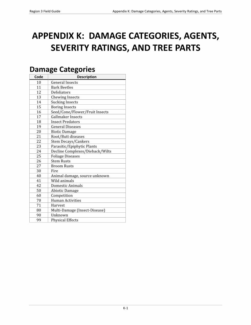
Damage Categories Code Description
10 General Insects 11 Bark Beetles 12 Defoliators 13 Chewing Insects 14 Sucking Insects 15 Boring Insects 16 Seed/Cone/Flower/Fruit Insects 17 Gallmaker Insects 18 Insect Predators 19 General Diseases 20 Biotic Damage 21 Root/Butt diseases 22 Stem Decays/Cankers 23 Parasitic/Epiphytic Plants 24 Decline Complexes/Dieback/Wilts 25 Foliage Diseases 26 Stem Rusts 27 Broom Rusts 30 Fire 40 Animal damage, source unknown 41 Wild animals 42 Domestic Animals 50 Abiotic Damage 60 Competition 70 Human Activities 71 Harvest 80 Multi-Damage (Insect-Disease) 90 Unknown 99 Physical Effects
K-1
Appendix K: Damage Categories, Agents, Severity Ratings, and Tree Parts Region 3 Field Guide
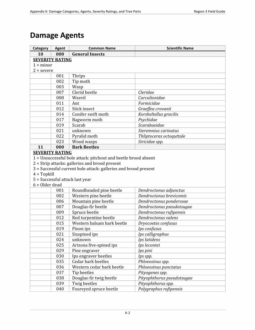
Damage Agents
Category Agent Common Name Scientific Name 10 000 General Insects
SEVERITY RATING 1 = minor 2 = severe
001 Thrips 002 Tip moth 003 Wasp 007 Clerid beetle Cleridae 008 Weevil Curculionidae 011 Ant Formicidae 012 Stick insect Graeffea crovanii 014 Conifer swift moth Korsheltellus gracilis 017 Bagworm moth Psychidae 019 Scarab Scarabaeidae 021 unknown Steremnius carinatus 022 Pyralid moth Thliptoceras octoquttale 023 Wood wasps Siricidae spp.
11 000 Bark Beetles SEVERITY RATING 1 = Unsuccessful bole attack: pitchout and beetle brood absent 2 = Strip attacks: galleries and brood present 3 = Successful current bole attack: galleries and brood present 4 = Topkill 5 = Successful attack last year 6 = Older dead
001 Roundheaded pine beetle Dendroctonus adjunctus 002 Western pine beetle Dendroctonus brevicomis 006 Mountain pine beetle Dendroctonus ponderosae 007 Douglas-fir beetle Dendroctonus pseudotsugae 009 Spruce beetle Dendroctonus rufipennis 012 Red turpentine beetle Dendroctonus valens 015 Western balsam bark beetle Dryocoetes confusus 019 Pinon ips Ips confusus 021 Sixspined ips Ips calligraphus 024 unknown Ips latidens 025 Arizona five-spined ips Ips lecontei 029 Pine engraver Ips pini 030 Ips engraver beetles Ips spp. 035 Cedar bark beetles Phloeosinus spp. 036 Western cedar bark beetle Phloeosinus punctatus 037 Tip beetles Pityogenes spp. 038 Douglas-fir twig beetle Pityophthorus pseudotsugae 039 Twig beetles Pityophthorus spp. 040 Foureyed spruce beetle Polygraphus rufipennis
K-2

Region 3 Field Guide Appendix K: Damage Categories, Agents, Severity Ratings, and Tree Parts
Damage Agents (cont.) Category Agent Common Name Scientific Name
11 (cont.) 048 True fir bark beetles Scolytus spp. 050 Fir engraver Scolytus ventralis 053 Four-eyed bark beetle Polygraphus spp. 055 Spruce ips Ips pilifrons 056 Mexican pine beetle Dendroctonus mexicanus
12 000 Defoliators SEVERITY RATING 1 = Light defoliation (1-25%), no topkill 2 = Light defoliation (1-25%), topkill ≤10% 3 = Light defoliation (1-25%), topkill >10% 4 = Moderate defoliation (26-75%), no topkill 5 = Moderate defoliation (26-75%), topkill ≤10% 6 = Moderate defoliation (26-75%), topkill >10% 7 = Heavy defoliation (76-100%), no topkill 8 = Heavy defoliation (76-100%), topkill ≤10% 9 = Heavy defoliation (76-100%), topkill >10%
001 Casebearer 002 Leaftier 003 Looper 004 Needleminer 005 Sawfly 006 Skeletonizer 008 Spanworm 009 Webworm 013 Whitefly Aleyrodoidae 014 Fall cankerworm Alsophila pometaria 015 Alder flea beetle Altica ambiens 016 Mountain mahogany looper Anacamptodes clivinaria profanata 037 Large aspen tortrix Choristoneura conflictana 040 Western spruce budworm Choristoneura occidentalis 043 Aspen leaf beetle Chrysomela crotchi 044 Cottonwood leaf beetle Chrysomela scripta 045 Leafhopper Cicadellidae 050 Ponderosa needleminer Coleotechnites spp. 052 Pandora moth Coloradia pandora 054 Lace bugs Corythucha spp. 059 Walkingstick Diapheromera femorata 066 White fir needleminer Epinotia meritana 067 Linden looper Erannis tiliaria 069 Pine needleminer Exoteleia pinifoliella 072 Geometrid moth Geometridae 075 Pale tussock moth Halisidota tessellaris 077 Brown day moth Hemileuca eglanterina 078 Buck moth Hemileuca maia 082 Fall webworm Hyphantria cunea 084 unknown Lambdina punctat
K-3

Appendix K: Damage Categories, Agents, Severity Ratings, and Tree Parts Region 3 Field Guide
Damage Agents (cont.) Category Agent Common Name Scientific Name
12 (cont.) 085 Tent caterpillar moth Lasiocampidae 094 Western tent caterpillar Malacosoma californicum 097 Southwestern tent caterpillar Malacosoma incurvum 098 Leafcutting bees Megachilidae 099 Blister beetle Meloidae 123 Douglas-fir tussock moth Orgyia pseudotsugata 154 Bagworm Thyridopteryx ephemeraeformis 155 Leafroller/seed moth Tortricidae 156 Willow defoliation Tortricidae 160 Pine needle sheathminer Zelleria haimbachi 162 Cottonwood leaf beetle Chrysomela spp. 165 Leaf roller Epinotia solandriana 166 New Mexico fir looper Gelenara cansimillis 171 Pinon sawfly Neodiprion edulicolus 172 unknown Neodiprion gilletti 174 Pine looper Phaeoura mexicanaria 175 unknown Zadiprion rohweri 176 unknown Zadiprion townsendi 190 Hickory tussock moth Halisidota caryae 191 Pin oak sawfly Caliroa lineata 192 Palmerworm Dichomeris ligulella 193 Pitch pine looper Lambdina athasaria pellucidaria 194 Red pine sawfly Neodiprion nanulus nanulus 195 Pine tip moth Argyrotaenia pinatubana 196 Baldcypress leafroller Archips goyerana 197 Winter moth Operophtera 198 Basswood thrips Neohydatothrips 199 Noctuid moth Xylomyges simplex (walker) 200 Pyralid moth Palpita magniferalis 201 Pacific silver fir budmoth Zeiraphera sp. destitutana
13 000 Chewing Insects SEVERITY RATING 1 = Minor: bottlebrush or shortened leaders, 0-2 forks on stem, OR <20% of branches affected 2 = Severe: 3 or more forks on bole, OR 20% or more branches affected, OR terminal leader dead
001 Grasshopper 002 Shorthorn grasshoppers Acrididae 006 Cicadas Cicadidae 019 Agamemnon butterfly Papilio agememnon 020 Northern pitch twig moth Petrova albicapitana 021 Ponderosa pine tip moth Rhyacionia zozana 022 Pine needle weevil Scythropus spp. 025 Unknown Thrips madronii 029 Deodar weevil Pissodes nemorensis 030 Adana tip moth Rhyacionia adana
K-4
Region 3 Field Guide Appendix K: Damage Categories, Agents, Severity Ratings, and Tree Parts
Damage Agents (cont.) Category Agent Common Name Scientific Name
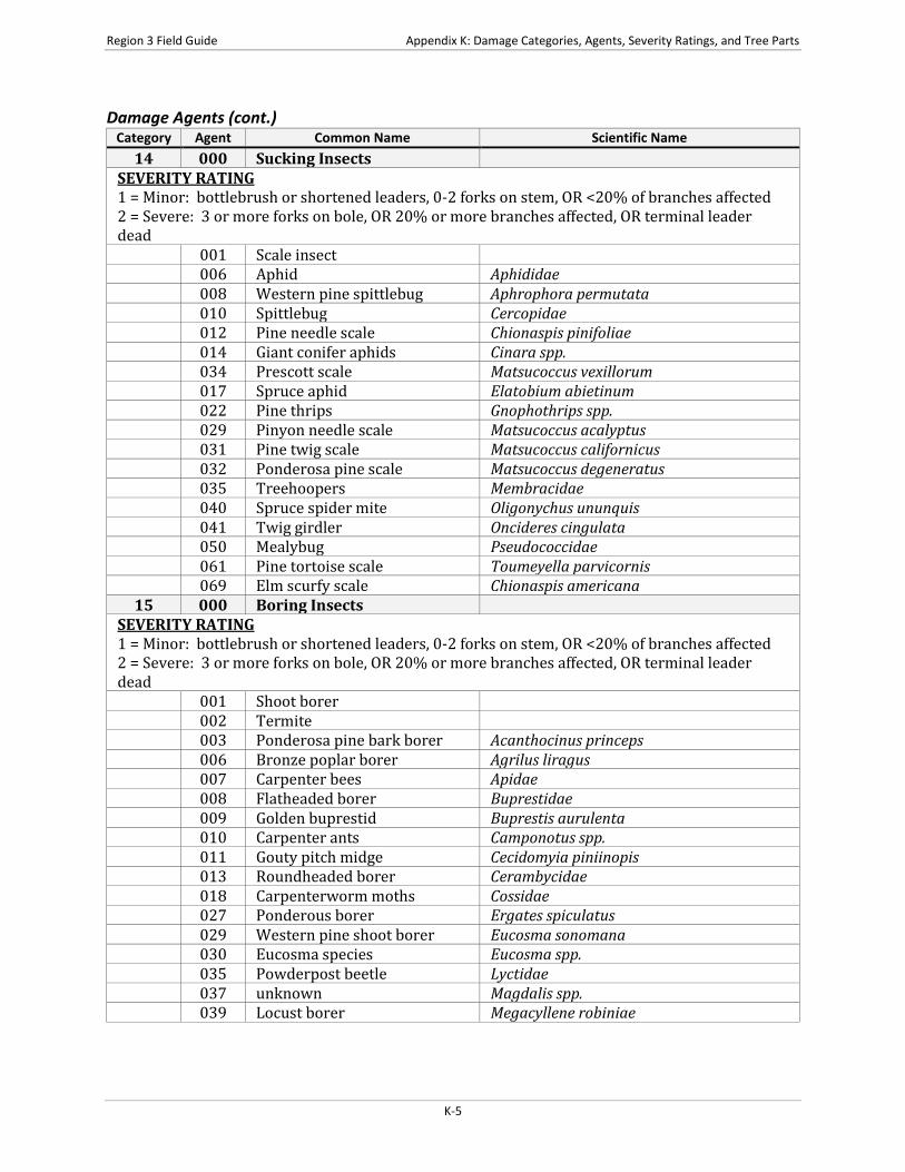
14 000 Sucking Insects SEVERITY RATING 1 = Minor: bottlebrush or shortened leaders, 0-2 forks on stem, OR <20% of branches affected 2 = Severe: 3 or more forks on bole, OR 20% or more branches affected, OR terminal leader dead
001 Scale insect 006 Aphid Aphididae 008 Western pine spittlebug Aphrophora permutata 010 Spittlebug Cercopidae 012 Pine needle scale Chionaspis pinifoliae 014 Giant conifer aphids Cinara spp. 034 Prescott scale Matsucoccus vexillorum 017 Spruce aphid Elatobium abietinum 022 Pine thrips Gnophothrips spp. 029 Pinyon needle scale Matsucoccus acalyptus 031 Pine twig scale Matsucoccus californicus 032 Ponderosa pine scale Matsucoccus degeneratus 035 Treehoopers Membracidae 040 Spruce spider mite Oligonychus ununquis 041 Twig girdler Oncideres cingulata 050 Mealybug Pseudococcidae 061 Pine tortoise scale Toumeyella parvicornis 069 Elm scurfy scale Chionaspis americana
15 000 Boring Insects SEVERITY RATING 1 = Minor: bottlebrush or shortened leaders, 0-2 forks on stem, OR <20% of branches affected 2 = Severe: 3 or more forks on bole, OR 20% or more branches affected, OR terminal leader dead
001 Shoot borer 002 Termite 003 Ponderosa pine bark borer Acanthocinus princeps 006 Bronze poplar borer Agrilus liragus 007 Carpenter bees Apidae 008 Flatheaded borer Buprestidae 009 Golden buprestid Buprestis aurulenta 010 Carpenter ants Camponotus spp. 011 Gouty pitch midge Cecidomyia piniinopis 013 Roundheaded borer Cerambycidae 018 Carpenterworm moths Cossidae 027 Ponderous borer Ergates spiculatus 029 Western pine shoot borer Eucosma sonomana 030 Eucosma species Eucosma spp. 035 Powderpost beetle Lyctidae 037 unknown Magdalis spp. 039 Locust borer Megacyllene robiniae
K-5
Appendix K: Damage Categories, Agents, Severity Ratings, and Tree Parts Region 3 Field Guide
Damage Agents (cont.) Category Agent Common Name Scientific Name
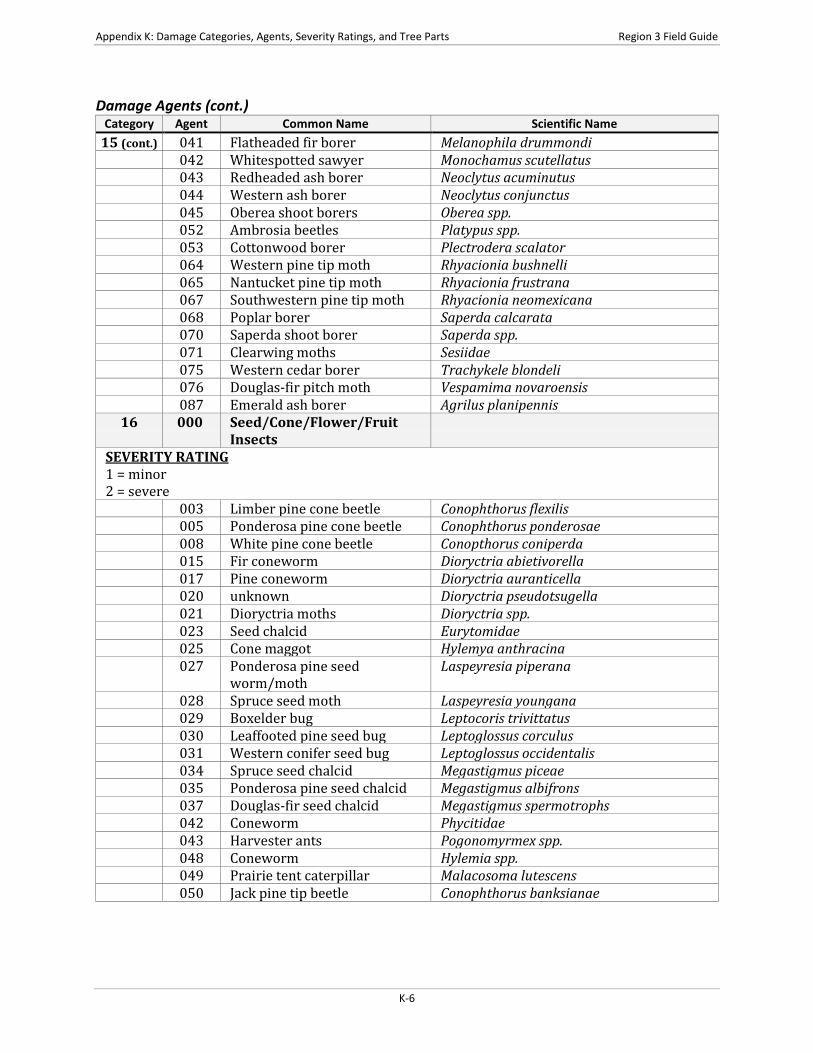
15 (cont.) 041 Flatheaded fir borer Melanophila drummondi 042 Whitespotted sawyer Monochamus scutellatus 043 Redheaded ash borer Neoclytus acuminutus 044 Western ash borer Neoclytus conjunctus 045 Oberea shoot borers Oberea spp. 052 Ambrosia beetles Platypus spp. 053 Cottonwood borer Plectrodera scalator 064 Western pine tip moth Rhyacionia bushnelli 065 Nantucket pine tip moth Rhyacionia frustrana 067 Southwestern pine tip moth Rhyacionia neomexicana 068 Poplar borer Saperda calcarata 070 Saperda shoot borer Saperda spp. 071 Clearwing moths Sesiidae 075 Western cedar borer Trachykele blondeli 076 Douglas-fir pitch moth Vespamima novaroensis 087 Emerald ash borer Agrilus planipennis
16 000 Seed/Cone/Flower/Fruit Insects
SEVERITY RATING 1 = minor 2 = severe
003 Limber pine cone beetle Conophthorus flexilis 005 Ponderosa pine cone beetle Conophthorus ponderosae 008 White pine cone beetle Conopthorus coniperda 015 Fir coneworm Dioryctria abietivorella 017 Pine coneworm Dioryctria auranticella 020 unknown Dioryctria pseudotsugella 021 Dioryctria moths Dioryctria spp. 023 Seed chalcid Eurytomidae 025 Cone maggot Hylemya anthracina 027 Ponderosa pine seed
worm/moth Laspeyresia piperana
028 Spruce seed moth Laspeyresia youngana 029 Boxelder bug Leptocoris trivittatus 030 Leaffooted pine seed bug Leptoglossus corculus 031 Western conifer seed bug Leptoglossus occidentalis 034 Spruce seed chalcid Megastigmus piceae 035 Ponderosa pine seed chalcid Megastigmus albifrons 037 Douglas-fir seed chalcid Megastigmus spermotrophs 042 Coneworm Phycitidae 043 Harvester ants Pogonomyrmex spp. 048 Coneworm Hylemia spp. 049 Prairie tent caterpillar Malacosoma lutescens 050 Jack pine tip beetle Conophthorus banksianae
K-6
Region 3 Field Guide Appendix K: Damage Categories, Agents, Severity Ratings, and Tree Parts
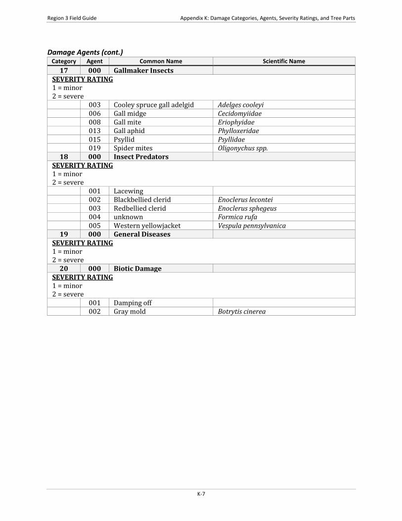
Damage Agents (cont.) Category Agent Common Name Scientific Name
17 000 Gallmaker Insects SEVERITY RATING 1 = minor 2 = severe
003 Cooley spruce gall adelgid Adelges cooleyi 006 Gall midge Cecidomyiidae 008 Gall mite Eriophyidae 013 Gall aphid Phylloxeridae 015 Psyllid Psyllidae 019 Spider mites Oligonychus spp.
18 000 Insect Predators SEVERITY RATING 1 = minor 2 = severe
001 Lacewing 002 Blackbellied clerid Enoclerus lecontei 003 Redbellied clerid Enoclerus sphegeus 004 unknown Formica rufa 005 Western yellowjacket Vespula pennsylvanica
19 000 General Diseases SEVERITY RATING 1 = minor 2 = severe
20 000 Biotic Damage SEVERITY RATING 1 = minor 2 = severe
001 Damping off 002 Gray mold Botrytis cinerea
K-7
Appendix K: Damage Categories, Agents, Severity Ratings, and Tree Parts Region 3 Field Guide
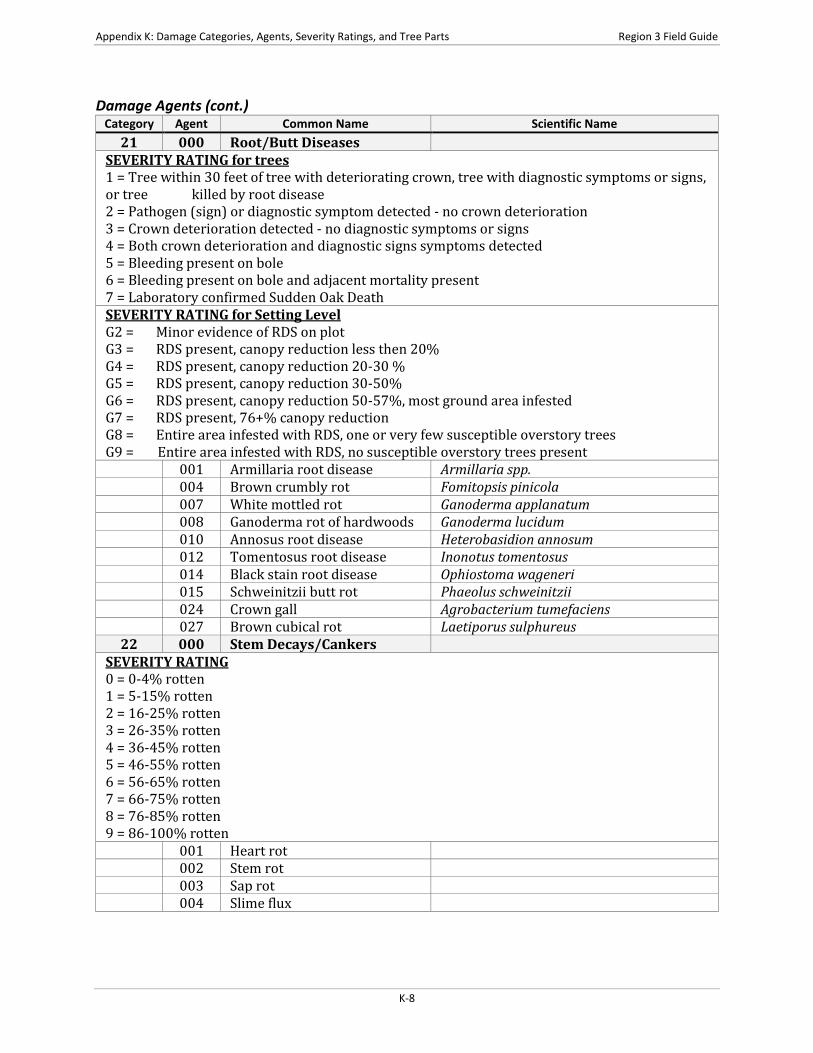
Damage Agents (cont.) Category Agent Common Name Scientific Name
21 000 Root/Butt Diseases SEVERITY RATING for trees 1 = Tree within 30 feet of tree with deteriorating crown, tree with diagnostic symptoms or signs, or tree killed by root disease 2 = Pathogen (sign) or diagnostic symptom detected - no crown deterioration 3 = Crown deterioration detected - no diagnostic symptoms or signs 4 = Both crown deterioration and diagnostic signs symptoms detected 5 = Bleeding present on bole 6 = Bleeding present on bole and adjacent mortality present 7 = Laboratory confirmed Sudden Oak Death SEVERITY RATING for Setting Level G2 = Minor evidence of RDS on plot G3 = RDS present, canopy reduction less then 20% G4 = RDS present, canopy reduction 20-30 % G5 = RDS present, canopy reduction 30-50% G6 = RDS present, canopy reduction 50-57%, most ground area infested G7 = RDS present, 76+% canopy reduction G8 = Entire area infested with RDS, one or very few susceptible overstory trees G9 = Entire area infested with RDS, no susceptible overstory trees present
001 Armillaria root disease Armillaria spp. 004 Brown crumbly rot Fomitopsis pinicola 007 White mottled rot Ganoderma applanatum 008 Ganoderma rot of hardwoods Ganoderma lucidum 010 Annosus root disease Heterobasidion annosum 012 Tomentosus root disease Inonotus tomentosus 014 Black stain root disease Ophiostoma wageneri 015 Schweinitzii butt rot Phaeolus schweinitzii 024 Crown gall Agrobacterium tumefaciens 027 Brown cubical rot Laetiporus sulphureus
22 000 Stem Decays/Cankers SEVERITY RATING 0 = 0-4% rotten 1 = 5-15% rotten 2 = 16-25% rotten 3 = 26-35% rotten 4 = 36-45% rotten 5 = 46-55% rotten 6 = 56-65% rotten 7 = 66-75% rotten 8 = 76-85% rotten 9 = 86-100% rotten
001 Heart rot 002 Stem rot 003 Sap rot 004 Slime flux
K-8

Region 3 Field Guide Appendix K: Damage Categories, Agents, Severity Ratings, and Tree Parts
Damage Agents (cont.) Category Agent Common Name Scientific Name
22 (cont.) 005 Virus 006 Black knot of cherry Apiosporina morbosa 007 Atropellis canker Atropellis piniphila 008 Siberian elm canker Botryodiplodia hypodermia 012 Black canker of aspen Ceratocystis fimbriata 013 Sycamore canker stain Ceratocystis fimbriata f.sp. plataini 024 Gray-brown saprot Cryptoporus volvatus 025 Cryptosphaeria canker of
aspen Cryptosphaeria populina
026 Cytospora canker of fir Cytospora abietis 027 Western red rot Dichomitus squalens 028 Rust-red stringy rot Echinodontium tinctorium 029 Sooty-bark canker Encoelia pruinosa 035 Amelanchier rust Gymnosporangium harknessianum 036 Cedar apple rust Gymnosporangium juniperi-virginianae 037 Hypoxylon canker of oak Hypoxylon atropunctatum 038 Hypoxylon canker of aspen Hypoxylon mammatum 039 Canker rot of oak Inonotus hispidus 040 Sterile conk trunk rot of birch Inonotus obliquus 047 Red ring rot Phellinus pini 048 Aspen trunk rot Phellinus tremulae 049 Stem decay of black walnut Phellinus weirianus 051 Phomopsis canker Phomopsis spp. 052 Leyland cypress canker Seiridium cardinale 054 Maple canker Steganosporium spp. 057 Cytospora canker of aspen Cytospora chrysosperma 059 Red belt fungus Fomitopsis pinicola 062 Brown heartrot Fomitopsis Officinalis 065 Purple conk Hirschioporus abietinus 068 False tinder fungus Phellinus igniarius 070 Yellow cap fungus Pholiota spp. 071 Oyster mushroom Pleurotus ostreatus 074 Cedar brown pocket rot Poria sericeomollis 075 Lachnellula canker Lachnellula flavovirens 076 Strumella canker Strumella coryneoidea 077 Phomopsis blight Phomopsis juniperovora 078 Fusarium canker of yellow
poplar Fusarium solani
079 Sterile conk of maple and beech
Inonotus glomeratus
080 Canker of spruce Aleurodiscus spp. 081 Birch conk Piptoporus betulinusai 082 Canker Discocainia treleasei
K-9

Appendix K: Damage Categories, Agents, Severity Ratings, and Tree Parts Region 3 Field Guide
Damage Agents (cont.) Category Agent Common Name Scientific Name
23 000 Parasitic/epiphytic plants SEVERITY RATING 1 = Hawksworth tree DMR rating = 1; light infection 2 = Hawksworth tree DMR rating = 2; light infection 3 = Hawksworth tree DMR rating = 3; medium infection 4 = Hawksworth tree DMR rating = 4; medium infection 5 = Hawksworth tree DMR rating = 5; heavy infection 6 = Hawksworth tree DMR rating = 6; heavy infection 7 = Vine damage: less than 50% of crown involved 8 = Vine damage: 50% or more of crown involved
001 Mistletoe 002 Parasitic plants 003 Vine damage 005 White fir dwarf mistletoe Arceuthobium abietinumf. sp. concoloris 007 Apache dwarf mistletoe Arceuthobium apachecum 010 Pinyon dwarf mistletoe Arceuthobium divaricatum 011 Douglas-fir dwarf mistletoe Arceuthobium douglasii 012 Chihuahua pine dwarf
mistletoe Arceuthobium gillii
014 Western spruce dwarf mistletoe
Arceuthobium microcarpum
017 Southwestern dwarf mistletoe Arceuthobium vaginatum subsp. crytopodum 018 Dodder Cuscuta spp. 019 White fir mistletoe Phoradendron bolleanum subsp. pauciflorum 020 True mistletoe (other) 022 Juniper true mistletoe Phoradendron juniperum
24 000 Decline Complexes/Dieback/Wilts
SEVERITY RATING 1 = Minor: minor crown symptoms 2 = Severe: severe crown symptoms
007 Complex 008 Decline 009 Fall hardwood defoliator
complex
010 Joga decline 011 Larch decline 012 Looper; abiotic complex 013 Maple decline 014 Oak decline 016 Sprout dieback 017 True fir pest complex 023 Bacterial wetwood Erwinia nimipressuralis 026 unknown Xylella fastidiosa 027 Wetwood 030 Elm phloem necrosis Mycoplasma
K-10

Region 3 Field Guide Appendix K: Damage Categories, Agents, Severity Ratings, and Tree Parts
Damage Agents (cont.) Category Agent Common Name Scientific Name
25 000 Foliage Diseases SEVERITY RATING 1 = Minor: <20% of foliage affected or <20% of crown in brooms 2 = Severe: >20% of foliage affected or >20% of crown in brooms
001 Blight 002 Broom rust 003 Juniper blights 004 Leaf spots 005 Needlecast 006 Powdery mildew 009 True fir needlecast 010 Sycamore anthracnose Apiognomonia veneta 011 Cercospora blight of juniper Cercospora sequoiae 014 Ink spot of aspen Ciborinia whetzelii 015 Pine needle rust Coleosporium spp. 016 Anthracnose on Russian olive Colletotrichum spp. 017 Coronado limb rust Cronartium arizonicum 022 Elytroderma disease Elytroderma deformans 023 Fire blight Erwinia amylovora 025 Anthracnose Gnomonia spp. 027 Brown felt blight Herpotrichia juniperi 031 Spruce needle cast Lirula macrospora 032 Fir needle cast Lirula spp. 033 White pine needle cast Lophodermella arcuata 034 Lophodermella needle cast Lophodermella spp. 035 Lophodermium needle cast Lophodermium spp. 036 Marssonina blight Marssonina populi 037 Melampsora rusts Melampsora medusae 040 Dothistroma needle blight Mycosphaerella pini 041 Brown felt blight of pines Neopeckia coulteri 042 Snow blight Phacidum abietis 044 Phoma blight Phoma spp. 045 Phyllosticta leaf spot Phyllosticta spp. 046 Bud rot Phytophthora palmivora 050 Douglas-fir needle cast Rhabdocline spp. 059 Leaf blister of oak Taphrina caerulescens 061 Shepherd’s crook Venturia tremulae 062 Dothistroma needle blight Dothistroma septospora 064 Broom rust Chrysomyxa arctostaphyli 066 Cedar leaf blight Gymnosporangium nootkatense 067 Spruce needle cast Lophodermium picea 068 Hardwood leaf rusts Melampsora spp. 071 Spruce needle cast Rhizosphaera pini 072 Sirococcus shoot blight Sirococcus strobilinus 073 Shephards crook Venturia populina 074 Delphinella shoot blight Delphinella abietis 075 Tar spot Rhytisma acerinum
K-11
Appendix K: Damage Categories, Agents, Severity Ratings, and Tree Parts Region 3 Field Guide
Damage Agents (cont.) Category Agent Common Name Scientific Name
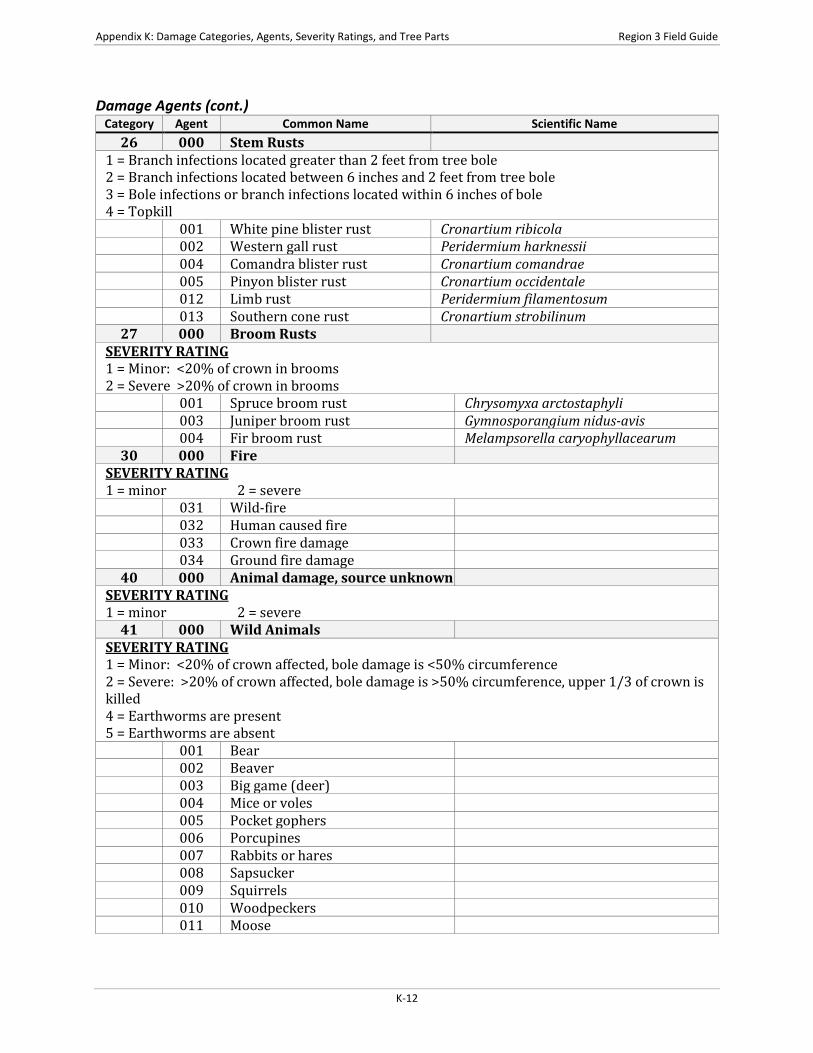
26 000 Stem Rusts 1 = Branch infections located greater than 2 feet from tree bole 2 = Branch infections located between 6 inches and 2 feet from tree bole 3 = Bole infections or branch infections located within 6 inches of bole 4 = Topkill
001 White pine blister rust Cronartium ribicola 002 Western gall rust Peridermium harknessii 004 Comandra blister rust Cronartium comandrae 005 Pinyon blister rust Cronartium occidentale 012 Limb rust Peridermium filamentosum 013 Southern cone rust Cronartium strobilinum
27 000 Broom Rusts SEVERITY RATING 1 = Minor: <20% of crown in brooms 2 = Severe >20% of crown in brooms
001 Spruce broom rust Chrysomyxa arctostaphyli 003 Juniper broom rust Gymnosporangium nidus-avis 004 Fir broom rust Melampsorella caryophyllacearum
30 000 Fire SEVERITY RATING 1 = minor 2 = severe
031 Wild-fire 032 Human caused fire 033 Crown fire damage 034 Ground fire damage
40 000 Animal damage, source unknown SEVERITY RATING 1 = minor 2 = severe
41 000 Wild Animals SEVERITY RATING 1 = Minor: <20% of crown affected, bole damage is <50% circumference 2 = Severe: >20% of crown affected, bole damage is >50% circumference, upper 1/3 of crown is killed 4 = Earthworms are present 5 = Earthworms are absent
001 Bear 002 Beaver 003 Big game (deer) 004 Mice or voles 005 Pocket gophers 006 Porcupines 007 Rabbits or hares 008 Sapsucker 009 Squirrels 010 Woodpeckers 011 Moose
K-12

Region 3 Field Guide Appendix K: Damage Categories, Agents, Severity Ratings, and Tree Parts
Damage Agents (cont.) Category Agent Common Name Scientific Name
012 Elk 013 Deer 014 Feral pigs 015 Mountain beaver 016 Deer or elk 17 Earthworm Lumbricidae
42 000 Domestic Animals SEVERITY RATING 1 = Minor <20% of crown affected, bole damage is <50% circumference 2 = Severe: >20% of crown affected, bole damage is >50% circumference, upper 1/3 of crown is killed
001 Cattle 002 Goats 003 Horses 004 Sheep
50 000 Abiotic Damage SEVERITY RATING 1 = Minor: <20% of crown affected, bole damage is <50% circumference 2 = Severe: >20% of crown affected, bole damage is >50% circumference, upper 1/3 of crown is killed
001 Air pollutants 002 Chemical 003 Drought 004 Flooding/high water 005 Frost 006 Hail 007 Heat 008 Lightning 009 Nutrient imbalances 010 Radiation 011 Snow/ice 013 Wind-tornado 014 Winter injury 015 Avalanche 016 Mud-land slide 017 Volcano 018 Other geologic events 019 Mechanical (non-human caused)
60 000 Competition SEVERITY RATING 1 = Minor: tree slightly deformed and has some live, terminal growth 2 = Severe: tree extremely deformed or has no live terminal, growth severely reduced relative to neighbors
K-13

Appendix K: Damage Categories, Agents, Severity Ratings, and Tree Parts Region 3 Field Guide
Damage Agents (cont.) Category Agent Common Name Scientific Name
70 000 Human Activities SEVERITY RATING 1 = minor 2 = severe
001 Herbicides 003 Imbedded objects 004 Improper planting technique 005 Land clearing 006 Land use conversion 007 Logging damage 008 Mechanical 009 Pesticides 010 Roads 011 Soil compaction 012 Suppression 013 Vehicle damage 014 Road salt
K-14
Region 3 Field Guide Appendix K: Damage Categories, Agents, Severity Ratings, and Tree Parts
Damage Agents (cont.) Category Agent Common Name Scientific Name
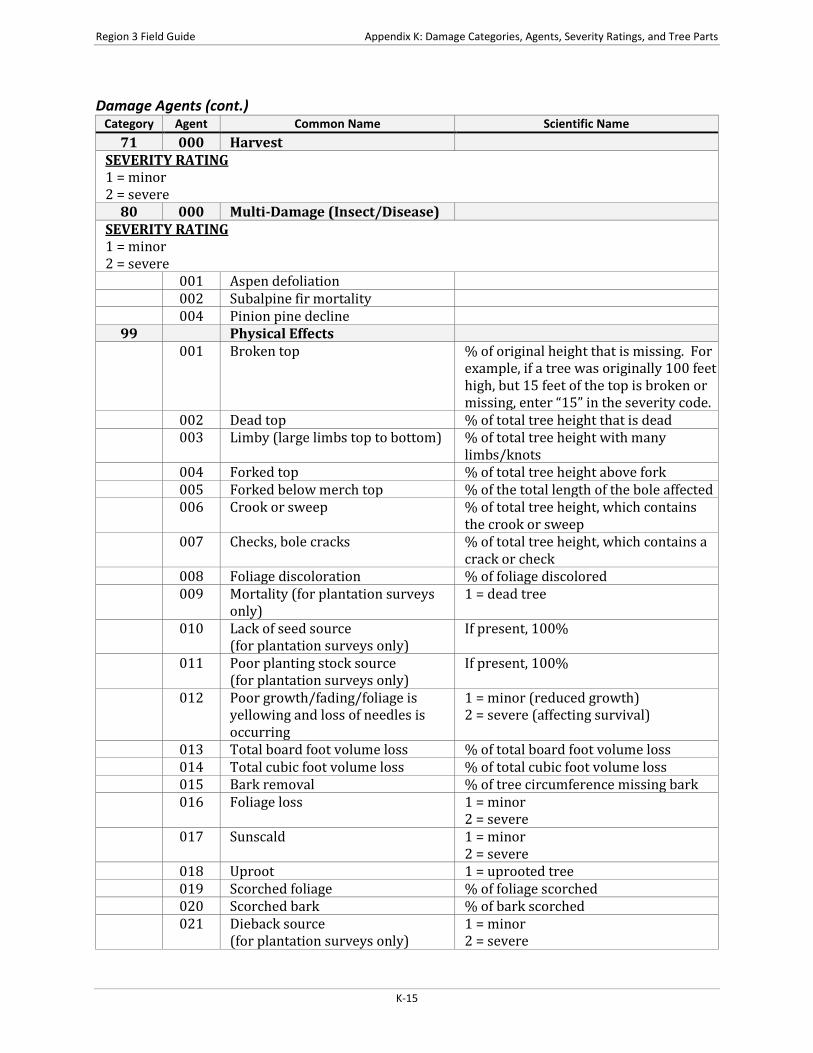
71 000 Harvest SEVERITY RATING 1 = minor 2 = severe
80 000 Multi-Damage (Insect/Disease) SEVERITY RATING 1 = minor 2 = severe
001 Aspen defoliation 002 Subalpine fir mortality 004 Pinion pine decline
99 Physical Effects 001 Broken top % of original height that is missing. For
example, if a tree was originally 100 feet high, but 15 feet of the top is broken or missing, enter “15” in the severity code.
002 Dead top % of total tree height that is dead 003 Limby (large limbs top to bottom) % of total tree height with many
limbs/knots 004 Forked top % of total tree height above fork 005 Forked below merch top % of the total length of the bole affected 006 Crook or sweep % of total tree height, which contains
the crook or sweep 007 Checks, bole cracks % of total tree height, which contains a
crack or check 008 Foliage discoloration % of foliage discolored 009 Mortality (for plantation surveys
only) 1 = dead tree
010 Lack of seed source (for plantation surveys only)
If present, 100%
011 Poor planting stock source (for plantation surveys only)
If present, 100%
012 Poor growth/fading/foliage is yellowing and loss of needles is occurring
1 = minor (reduced growth) 2 = severe (affecting survival)
013 Total board foot volume loss % of total board foot volume loss 014 Total cubic foot volume loss % of total cubic foot volume loss 015 Bark removal % of tree circumference missing bark 016 Foliage loss 1 = minor
2 = severe 017 Sunscald 1 = minor
2 = severe 018 Uproot 1 = uprooted tree 019 Scorched foliage % of foliage scorched 020 Scorched bark % of bark scorched 021 Dieback source
(for plantation surveys only) 1 = minor 2 = severe
K-15

Appendix K: Damage Categories, Agents, Severity Ratings, and Tree Parts Region 3 Field Guide
Damage Agents (cont.) Category Agent Common Name Scientific Name 022 Poor crown form 1 = minor
2 = severe 023 Severe forking % of bole with forks 026 Open wound % of bole or trunk affected using the
height and width of the wound. For example, if a tree is 100 feet tall and the wound covers 15 feet of the bole, enter a value of “15.”
031 Broken or dead branches % of branches broken or dead 033 Damaged shoots, buds, or foliage
(for plantation surveys only) 1 = minor 2 = severe
034 Excessively deformed sapling % of sapling deformed 036 Fire scar % of bole covered by fire scar 037 Leaning tree % lean from vertical 038 Charred bark Not recorded unless cambium is killed from
heating
Tree Parts
Code Description UN Unspecified TO Top FO Foliar (crown) LI Limb BO Bole, other than Top or Base BA Base RO Roots WT Whole Tree TT Top Third of Crown MT Middle Third of Crown BT Bottom Third of Crown
K-16

Region 3 Field Guide Appendix L: Accuracy Standards
APPENDIX L: ACCURACY STANDARDS
Settings Measurements
Field Tolerance Project Name No Errors Region No Errors Proclaimed Forest No Errors District No Errors Location No Errors Stand Number No Errors Ownership No Errors State No Errors County No Errors Administrative Forest No Errors Date No Errors Photo ID No Errors Exam Level No Errors Exam Purpose No Errors Stratum No Errors Existing Vegetation Composition Type No Errors Potential Vegetation Reference No Errors Potential Vegetation No Errors Structure No Errors Capable Growing Area ± 10 Percent Fuel Model No Errors Elevation ± 2 Contour Intervals Aspect ± 45 degrees Slope ± 10 Percent Slope Position ± 1 class Acres No Errors Radial Growth Interval No Errors Radial Growth Interval #2 No Errors Height Growth Interval No Errors Fuel Photo Reference No Errors Precision Protocol No Errors Examiner No Errors Stand Remarks No Errors Damage Category No Errors Damage Agent No Errors Damage Severity No Errors Species of Management Interest No Errors Sketch Map and Traverse Notes
L-1
Appendix L: Accuracy Standards Region 3 Field Guide
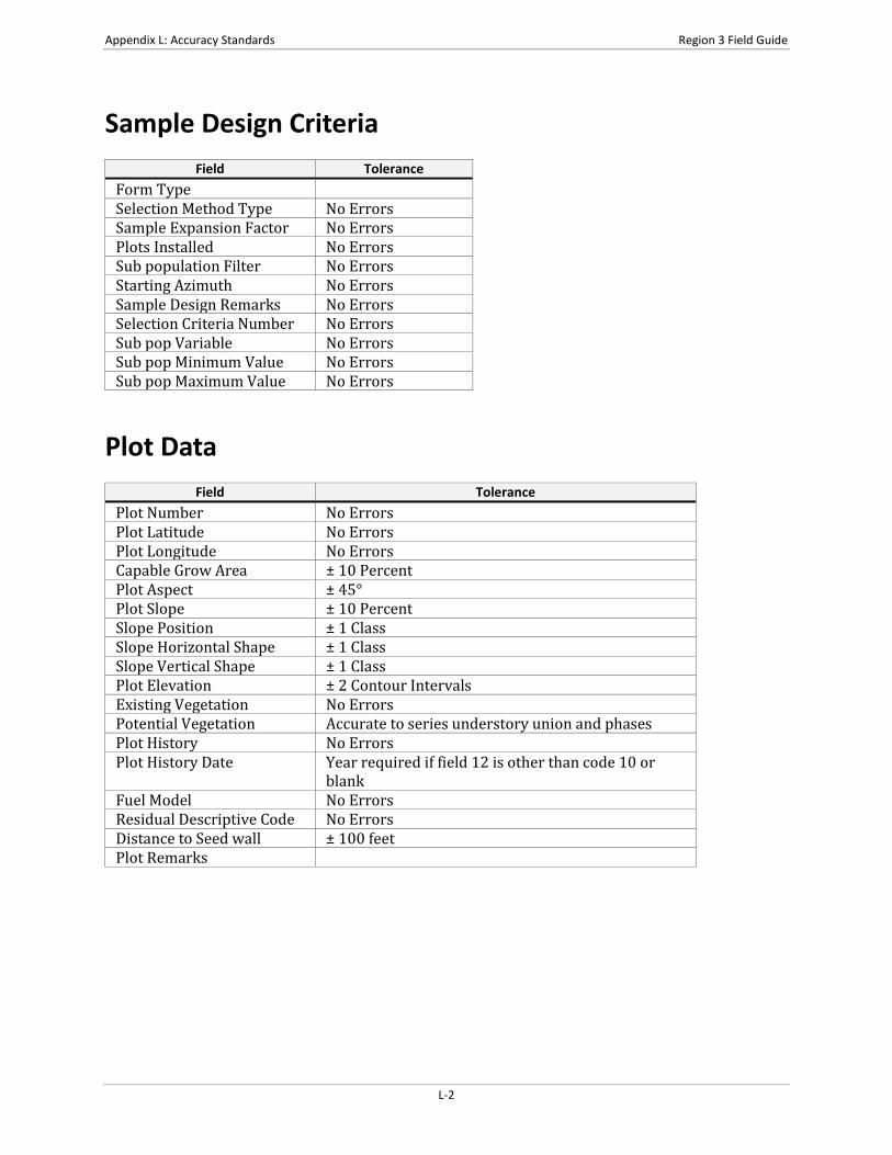
Sample Design Criteria
Field Tolerance Form Type Selection Method Type No Errors Sample Expansion Factor No Errors Plots Installed No Errors Sub population Filter No Errors Starting Azimuth No Errors Sample Design Remarks No Errors Selection Criteria Number No Errors Sub pop Variable No Errors Sub pop Minimum Value No Errors Sub pop Maximum Value No Errors
Plot Data
Field Tolerance Plot Number No Errors Plot Latitude No Errors Plot Longitude No Errors Capable Grow Area ± 10 Percent Plot Aspect ± 45° Plot Slope ± 10 Percent Slope Position ± 1 Class Slope Horizontal Shape ± 1 Class Slope Vertical Shape ± 1 Class Plot Elevation ± 2 Contour Intervals Existing Vegetation No Errors Potential Vegetation Accurate to series understory union and phases Plot History No Errors Plot History Date Year required if field 12 is other than code 10 or
blank Fuel Model No Errors Residual Descriptive Code No Errors Distance to Seed wall ± 100 feet Plot Remarks
L-2
Region 3 Field Guide Appendix L: Accuracy Standards
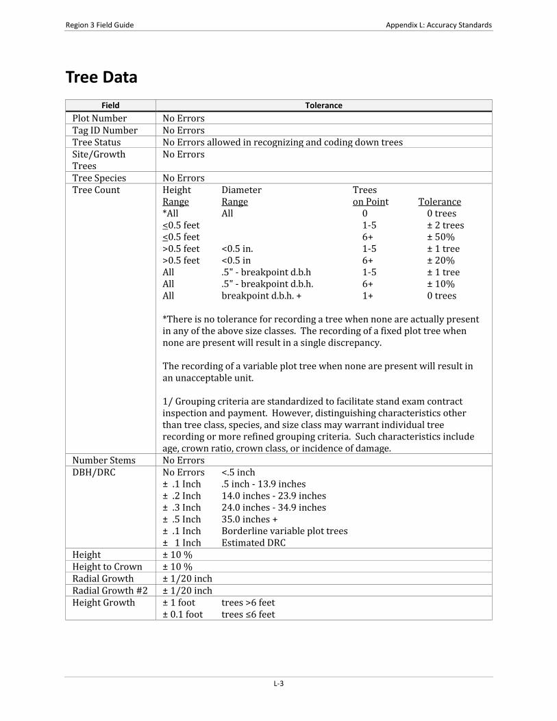
Tree Data
Field Tolerance Plot Number No Errors Tag ID Number No Errors Tree Status No Errors allowed in recognizing and coding down trees Site/Growth Trees
No Errors
Tree Species No Errors Tree Count Height Diameter Trees
Range Range on Point Tolerance *All All 0 0 trees <0.5 feet 1-5 ± 2 trees <0.5 feet 6+ ± 50% >0.5 feet <0.5 in. 1-5 ± 1 tree >0.5 feet <0.5 in 6+ ± 20% All .5" - breakpoint d.b.h 1-5 ± 1 tree All .5" - breakpoint d.b.h. 6+ ± 10% All breakpoint d.b.h. + 1+ 0 trees *There is no tolerance for recording a tree when none are actually present in any of the above size classes. The recording of a fixed plot tree when none are present will result in a single discrepancy. The recording of a variable plot tree when none are present will result in an unacceptable unit. 1/ Grouping criteria are standardized to facilitate stand exam contract inspection and payment. However, distinguishing characteristics other than tree class, species, and size class may warrant individual tree recording or more refined grouping criteria. Such characteristics include age, crown ratio, crown class, or incidence of damage.
Number Stems No Errors DBH/DRC No Errors <.5 inch
± .1 Inch .5 inch - 13.9 inches ± .2 Inch 14.0 inches - 23.9 inches ± .3 Inch 24.0 inches - 34.9 inches ± .5 Inch 35.0 inches + ± .1 Inch Borderline variable plot trees ± 1 Inch Estimated DRC
Height ± 10 % Height to Crown ± 10 % Radial Growth ± 1/20 inch Radial Growth #2 ± 1/20 inch Height Growth ± 1 foot trees >6 feet
± 0.1 foot trees ≤6 feet
L-3

Appendix L: Accuracy Standards Region 3 Field Guide
Tree Data (cont.) Field Tolerance
Tree Age ± 10% (Based on actual tree ring count at breast height for trees > 3.0" DBH otherwise based on total age recorded.)
Crown Ratio ± 10 % Crown Class No Errors Crown width No Errors Wildlife Use No Errors Log/Snag Decay No Errors Cone Serotiny No Errors Damage Category No Errors
Damage Category Damage Category Description Tolerance 11 Bark Beetles No misses on live trees with a severity of 2
or greater. 12 Defoliators No misses on live trees with a severity of 3
or greater. 13-17 Other Insects No misses of shoot moths or weevils on live
trees. 21 Root/Butt Diseases No misses on live trees with a severity of 2
or greater. 22 Stem Decays/Cankers No misses on live trees with a severity of 3
or greater. 25 Foliage Diseases No misses on Elytroderma on live trees.
41-42 Animal Damage No misses on live trees with terminal leader damage or with greater than 1/4 of bole circumference affected.
50 Abiotic Damage No misses on wind, snow, or ice bending, breakage, or bole cracks and frost damage to shoots on trees less than 1-inch diameter and lightning.
70 Human Damage No misses on live trees for logging damage or fire if the damage affects greater than 1/4 of the bole circumference or if an open wound is in contact with the ground.
Damage Agent Damage Part Damage Severity Tree Remarks
Ground Surface Cover
Field Tolerance Plot Number No Errors Cover Type No Errors Cover Percent ± 10 Percent
L-4

Region 3 Field Guide Appendix L: Accuracy Standards
Vegetation Composition
Field Tolerance Plot Number No Errors Live /Dead No Errors Layer No Errors Life form No Errors Species No Error in species level identification for dominant, common or
community type indicator plants. No plant name can be repeated within a layer.
Minimum Height ± 10% of Height Average Height ± 10% of Height Maximum Height ± 10% of Height Canopy Cover ± 10 Percent Average Diameter No Errors Maturity No Errors Cover Remarks User Field
Down Woody
Field Tolerance Plot Number No Errors First Duff ± 1/2 inch Second Duff ± 1/2 inch Fuel Depth No Errors Twigs 0 - .24 ± 40% Twigs .25 - .99 ± 30% Branch 1.0 - 2.99 ± 20% Volume 1 Weight 1 Volume 2 Weight 2 Volume 3 Weight 3 Volume 4 Weight 4 Piece Count No missed pieces Decay Class No Errors Diameter ± 1 inch on measurements Piece Length No Errors
L-5

Appendix L: Accuracy Standards Region 3 Field Guide
This page intentionally left blank.
L-6

Region 3 Field Guide Appendix M: Glossary of Terms
APPENDIX M: GLOSSARY OF TERMS
Term Definition Aspect A position facing or commanding a given direction; exposure. Aspect is
the compass direction of the prevailing slope with respect to true north. Azimuth A horizontal angular measure from true north to an object of interest. Basal Area The cross-sectional area of the stem or stems of a plant or of all plants in
a stand, generally expressed as square units per unit area. For trees, measured at 4.5 feet above ground, for forbs and grasses, measured at the root crown.
Bole Length The straight-line distance measured parallel to the main bole of a tree, from its base to its tip.
Breast Height A point located on the uphill side of the main stem, by measuring 4.5 feet along the uphill side of the bole from ground level or the predominant root collar. Preclude slight, non-compacted litter accumulations when establishing breast height.
CALVEG Classification and Assessment with LANDSAT of Visible Ecological Groupings. It is a California-wide system for classifying vegetative and non-vegetative cover types. The primary cover type relates to life form and uses a 3-character alpha code.
Canopy Cover The percent of a fixed area covered by the crown of an individual plant species or delimited by the vertical projection of its outermost perimeter; small openings in the crown are included.
Compacted Live Crown Ratio
The percent of the total height of the tree that supports a full, live crown. For trees that have uneven length crowns, occularly transfer lower branches to fill holes in the upper portions of the crown, until a full, even crown is created.
Compartment A land area, usually between 3,000 and 8,000 acres, easily identified on the ground by physical features. A compartment is comparable in size to a sub-watershed, or landscape management unit. It is used as a convenience for maintaining stand records and planning vegetation management projects.
Crown Class The relative position of the tree or shrub crown with respect to the competing vegetation around it. Crown class for each tree or shrub is judged in the context of its immediate environment, that its, those trees or shrubs which are competing for sunlight with the subject tree or shrub.
Crown Length The vertical distance from the top of the leader to the base of the crown, measured to the lowest live branch-whorl with live branches in at least 3 quadrants, and continuous with the main crown.
Crown Ratio The ratio of compacted live crown length to bole length. Lengths are measured parallel to the bole from the base of the tree to the tip.
DEM Digital Elevation Model. USGS geographic elevation data distributed in raster form. Digital representation of the shape of the earth’s surface. Typically, digital elevation data consists of arrays of values that represent topographic elevations measured at equal intervals on the Earth’s surface.
M-1
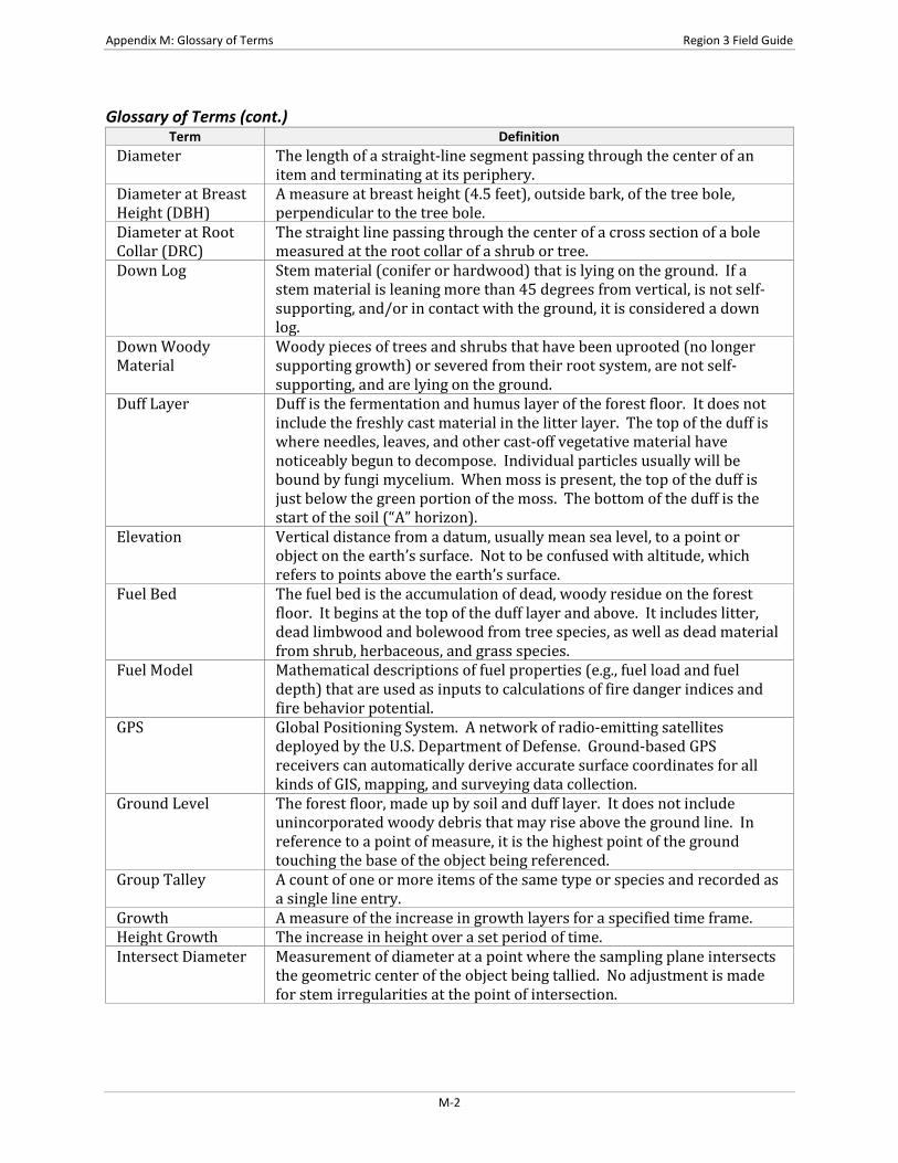
Appendix M: Glossary of Terms Region 3 Field Guide
Glossary of Terms (cont.) Term Definition
Diameter The length of a straight-line segment passing through the center of an item and terminating at its periphery.
Diameter at Breast Height (DBH)
A measure at breast height (4.5 feet), outside bark, of the tree bole, perpendicular to the tree bole.
Diameter at Root Collar (DRC)
The straight line passing through the center of a cross section of a bole measured at the root collar of a shrub or tree.
Down Log Stem material (conifer or hardwood) that is lying on the ground. If a stem material is leaning more than 45 degrees from vertical, is not self-supporting, and/or in contact with the ground, it is considered a down log.
Down Woody Material
Woody pieces of trees and shrubs that have been uprooted (no longer supporting growth) or severed from their root system, are not self-supporting, and are lying on the ground.
Duff Layer Duff is the fermentation and humus layer of the forest floor. It does not include the freshly cast material in the litter layer. The top of the duff is where needles, leaves, and other cast-off vegetative material have noticeably begun to decompose. Individual particles usually will be bound by fungi mycelium. When moss is present, the top of the duff is just below the green portion of the moss. The bottom of the duff is the start of the soil (“A” horizon).
Elevation Vertical distance from a datum, usually mean sea level, to a point or object on the earth’s surface. Not to be confused with altitude, which refers to points above the earth’s surface.
Fuel Bed The fuel bed is the accumulation of dead, woody residue on the forest floor. It begins at the top of the duff layer and above. It includes litter, dead limbwood and bolewood from tree species, as well as dead material from shrub, herbaceous, and grass species.
Fuel Model Mathematical descriptions of fuel properties (e.g., fuel load and fuel depth) that are used as inputs to calculations of fire danger indices and fire behavior potential.
GPS Global Positioning System. A network of radio-emitting satellites deployed by the U.S. Department of Defense. Ground-based GPS receivers can automatically derive accurate surface coordinates for all kinds of GIS, mapping, and surveying data collection.
Ground Level The forest floor, made up by soil and duff layer. It does not include unincorporated woody debris that may rise above the ground line. In reference to a point of measure, it is the highest point of the ground touching the base of the object being referenced.
Group Talley A count of one or more items of the same type or species and recorded as a single line entry.
Growth A measure of the increase in growth layers for a specified time frame. Height Growth The increase in height over a set period of time. Intersect Diameter Measurement of diameter at a point where the sampling plane intersects
the geometric center of the object being tallied. No adjustment is made for stem irregularities at the point of intersection.
M-2
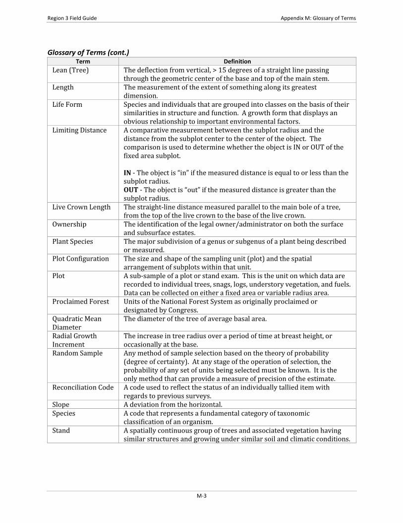
Region 3 Field Guide Appendix M: Glossary of Terms
Glossary of Terms (cont.) Term Definition
Lean (Tree) The deflection from vertical, > 15 degrees of a straight line passing through the geometric center of the base and top of the main stem.
Length The measurement of the extent of something along its greatest dimension.
Life Form Species and individuals that are grouped into classes on the basis of their similarities in structure and function. A growth form that displays an obvious relationship to important environmental factors.
Limiting Distance A comparative measurement between the subplot radius and the distance from the subplot center to the center of the object. The comparison is used to determine whether the object is IN or OUT of the fixed area subplot. IN - The object is “in” if the measured distance is equal to or less than the subplot radius. OUT - The object is “out” if the measured distance is greater than the subplot radius.
Live Crown Length The straight-line distance measured parallel to the main bole of a tree, from the top of the live crown to the base of the live crown.
Ownership The identification of the legal owner/administrator on both the surface and subsurface estates.
Plant Species The major subdivision of a genus or subgenus of a plant being described or measured.
Plot Configuration The size and shape of the sampling unit (plot) and the spatial arrangement of subplots within that unit.
Plot A sub-sample of a plot or stand exam. This is the unit on which data are recorded to individual trees, snags, logs, understory vegetation, and fuels. Data can be collected on either a fixed area or variable radius area.
Proclaimed Forest Units of the National Forest System as originally proclaimed or designated by Congress.
Quadratic Mean Diameter
The diameter of the tree of average basal area.
Radial Growth Increment
The increase in tree radius over a period of time at breast height, or occasionally at the base.
Random Sample Any method of sample selection based on the theory of probability (degree of certainty). At any stage of the operation of selection, the probability of any set of units being selected must be known. It is the only method that can provide a measure of precision of the estimate.
Reconciliation Code A code used to reflect the status of an individually tallied item with regards to previous surveys.
Slope A deviation from the horizontal. Species A code that represents a fundamental category of taxonomic
classification of an organism. Stand A spatially continuous group of trees and associated vegetation having
similar structures and growing under similar soil and climatic conditions.
M-3
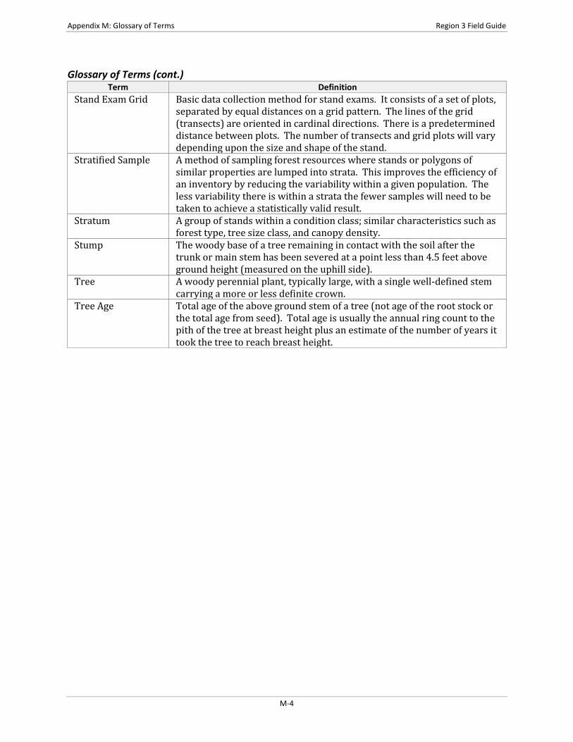
Appendix M: Glossary of Terms Region 3 Field Guide
Glossary of Terms (cont.) Term Definition
Stand Exam Grid Basic data collection method for stand exams. It consists of a set of plots, separated by equal distances on a grid pattern. The lines of the grid (transects) are oriented in cardinal directions. There is a predetermined distance between plots. The number of transects and grid plots will vary depending upon the size and shape of the stand.
Stratified Sample A method of sampling forest resources where stands or polygons of similar properties are lumped into strata. This improves the efficiency of an inventory by reducing the variability within a given population. The less variability there is within a strata the fewer samples will need to be taken to achieve a statistically valid result.
Stratum A group of stands within a condition class; similar characteristics such as forest type, tree size class, and canopy density.
Stump The woody base of a tree remaining in contact with the soil after the trunk or main stem has been severed at a point less than 4.5 feet above ground height (measured on the uphill side).
Tree A woody perennial plant, typically large, with a single well-defined stem carrying a more or less definite crown.
Tree Age Total age of the above ground stem of a tree (not age of the root stock or the total age from seed). Total age is usually the annual ring count to the pith of the tree at breast height plus an estimate of the number of years it took the tree to reach breast height.
M-4
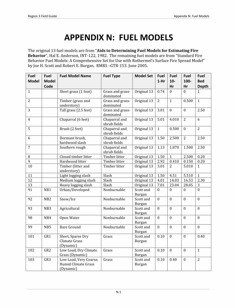
Region 3 Field Guide Appendix N: Fuel Models
APPENDIX N: FUEL MODELS The original 13 fuel models are from “Aids to Determining Fuel Models for Estimating Fire Behavior”, Hal E. Anderson, INT-122, 1982. The remaining fuel models are from “Standard Fire Behavior Fuel Models: A Comprehensive Set for Use with Rothermel’s Surface Fire Spread Model” by Joe H. Scott and Robert E. Burgan. RMRS –GTR-153. June 2005. Fuel Model
Fuel Model Code
Fuel Model Name Fuel Type Model Set Fuel 1-Hr
Fuel 10-Hr
Fuel 100-Hr
Fuel Bed Depth
1 Short grass (1 foot) Grass and grass-dominated
Original 13 0.74 0 0 1
2 Timber (grass and understory)
Grass and grass-dominated
Original 13 2 1 0.500 1
3 Tall grass (2.5 feet) Grass and grass-dominated
Original 13 3.01 0 0 2.50
4 Chaparral (6 feet) Chaparral and shrub fields
Original 13 5.01 4.010 2 6
5 Brush (2 feet) Chaparral and shrub fields
Original 13 1 0.500 0 2
6 Dormant brush, hardwood slash
Chaparral and shrub fields
Original 13 1.50 2.500 2 2.50
7 Southern rough Chaparral and shrub fields
Original 13 1.13 1.870 1.500 2.50
8 Closed timber litter Timber litter Original 13 1.50 1 2.500 0.20 9 Hardwood litter Timber litter Original 13 2.92 0.410 0.150 0.20 10 Timber (litter and
understory) Timber litter Original 13 3.01 2 5.010 1
11 Light logging slash Slash Original 13 1.50 4.51 5.510 1 12 Medium logging slash Slash Original 13 4.01 14.03 16.53 2.30 13 Heavy logging slash Slash Original 13 7.01 23.04 28.05 3 91 NB1 Urban/Developed Nonburnable Scott and
Burgan 0 0 0 0
92 NB2 Snow/Ice Nonburnable Scott and Burgan
0 0 0 0
93 NB3 Agricultural Nonburnable Scott and Burgan
0 0 0 0
98 NB4 Open Water Nonburnable Scott and Burgan
0 0 0 0
99 NB5 Bare Ground Nonburnable Scott and Burgan
0 0 0 0
101 GR1 Short, Sparse Dry Climate Grass (Dynamic)
Grass Scott and Burgan
0.10 0 0 0.40
102 GR2 Low Load, Dry Climate Grass (Dynamic)
Grass Scott and Burgan
0.10 0 0 1
103 GR3 Low Load, Very Coarse, Humid Climate Grass (Dynamic)
Grass Scott and Burgan
0.10 0.40 0 2
N-1
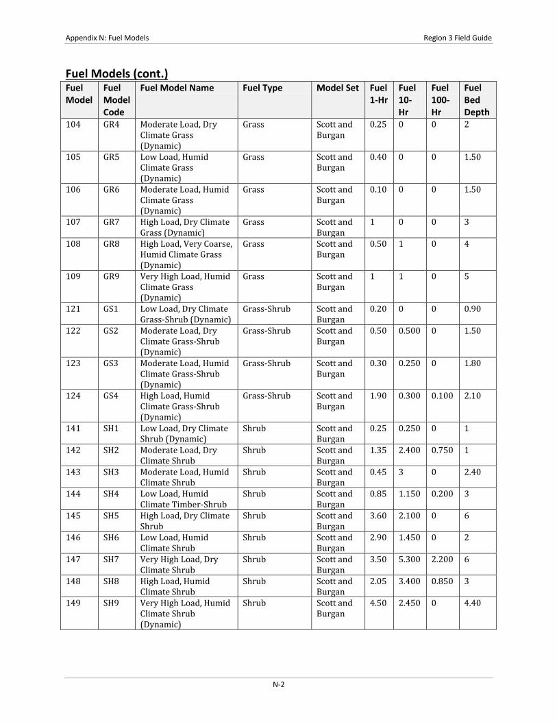
Appendix N: Fuel Models Region 3 Field Guide
Fuel Models (cont.) Fuel Model
Fuel Model Code
Fuel Model Name Fuel Type Model Set Fuel 1-Hr
Fuel 10-Hr
Fuel 100-Hr
Fuel Bed Depth
104 GR4 Moderate Load, Dry Climate Grass (Dynamic)
Grass Scott and Burgan
0.25 0 0 2
105 GR5 Low Load, Humid Climate Grass (Dynamic)
Grass Scott and Burgan
0.40 0 0 1.50
106 GR6 Moderate Load, Humid Climate Grass (Dynamic)
Grass Scott and Burgan
0.10 0 0 1.50
107 GR7 High Load, Dry Climate Grass (Dynamic)
Grass Scott and Burgan
1 0 0 3
108 GR8 High Load, Very Coarse, Humid Climate Grass (Dynamic)
Grass Scott and Burgan
0.50 1 0 4
109 GR9 Very High Load, Humid Climate Grass (Dynamic)
Grass Scott and Burgan
1 1 0 5
121 GS1 Low Load, Dry Climate Grass-Shrub (Dynamic)
Grass-Shrub Scott and Burgan
0.20 0 0 0.90
122 GS2 Moderate Load, Dry Climate Grass-Shrub (Dynamic)
Grass-Shrub Scott and Burgan
0.50 0.500 0 1.50
123 GS3 Moderate Load, Humid Climate Grass-Shrub (Dynamic)
Grass-Shrub Scott and Burgan
0.30 0.250 0 1.80
124 GS4 High Load, Humid Climate Grass-Shrub (Dynamic)
Grass-Shrub Scott and Burgan
1.90 0.300 0.100 2.10
141 SH1 Low Load, Dry Climate Shrub (Dynamic)
Shrub Scott and Burgan
0.25 0.250 0 1
142 SH2 Moderate Load, Dry Climate Shrub
Shrub Scott and Burgan
1.35 2.400 0.750 1
143 SH3 Moderate Load, Humid Climate Shrub
Shrub Scott and Burgan
0.45 3 0 2.40
144 SH4 Low Load, Humid Climate Timber-Shrub
Shrub Scott and Burgan
0.85 1.150 0.200 3
145 SH5 High Load, Dry Climate Shrub
Shrub Scott and Burgan
3.60 2.100 0 6
146 SH6 Low Load, Humid Climate Shrub
Shrub Scott and Burgan
2.90 1.450 0 2
147 SH7 Very High Load, Dry Climate Shrub
Shrub Scott and Burgan
3.50 5.300 2.200 6
148 SH8 High Load, Humid Climate Shrub
Shrub Scott and Burgan
2.05 3.400 0.850 3
149 SH9 Very High Load, Humid Climate Shrub (Dynamic)
Shrub Scott and Burgan
4.50 2.450 0 4.40
N-2
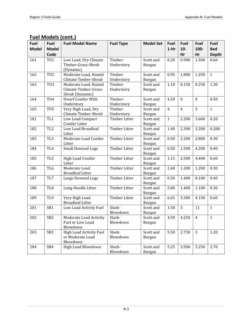
Region 3 Field Guide Appendix N: Fuel Models
Fuel Models (cont.) Fuel Model
Fuel Model Code
Fuel Model Name Fuel Type Model Set Fuel 1-Hr
Fuel 10-Hr
Fuel 100-Hr
Fuel Bed Depth
161 TU1 Low Load, Dry Climate Timber-Grass-Shrub (Dynamic)
Timber-Understory
Scott and Burgan
0.20 0.900 1.500 0.60
162 TU2 Moderate Load, Humid Climate Timber-Shrub
Timber-Understory
Scott and Burgan
0.95 1.800 1.250 1
163 TU3 Moderate Load, Humid Climate Timber-Grass-Shrub (Dynamic)
Timber-Understory
Scott and Burgan
1.10 0.150 0.250 1.30
164 TU4 Dwarf Conifer With Understory
Timber-Understory
Scott and Burgan
4.50 0 0 0.50
165 TU5 Very High Load, Dry Climate Timber-Shrub
Timber-Understory
Scott and Burgan
4 4 3 1
181 TL1 Low Load Compact Conifer Litter
Timber Litter Scott and Burgan
1 2.200 3.600 0.20
182 TL2 Low Load Broadleaf Litter
Timber Litter Scott and Burgan
1.40 2.300 2.200 0.200
183 TL3 Moderate Load Conifer Litter
Timber Litter Scott and Burgan
0.50 2.200 2.800 0.30
184 TL4 Small Downed Logs Timber Litter Scott and Burgan
0.50 1.500 4.200 0.40
185 TL5 High Load Conifer Litter
Timber Litter Scott and Burgan
1.15 2.500 4.400 0.60
186 TL6 Moderate Load Broadleaf Litter
Timber Litter Scott and Burgan
2.40 1.200 1.200 0.30
187 TL7 Large Downed Logs Timber Litter Scott and Burgan
0.30 1.400 8.100 0.40
188 TL8 Long-Needle Litter Timber Litter Scott and Burgan
5.80 1.400 1.100 0.30
189 TL9 Very High Load Broadleaf Litter
Timber Litter Scott and Burgan
6.65 3.300 4.150 0.60
201 SB1 Low Load Activity Fuel Slash-Blowdown
Scott and Burgan
1.50 3 11 1
202 SB2 Moderate Load Activity Fuel or Low Load Blowdown
Slash-Blowdown
Scott and Burgan
4.50 4.250 4 1
203 SB3 High Load Activity Fuel or Moderate Load Blowdown
Slash-Blowdown
Scott and Burgan
5.50 2.750 3 1.20
204 SB4 High Load Blowdown Slash-Blowdown
Scott and Burgan
5.25 3.500 5.250 2.70
N-3

Appendix N: Fuel Models Region 3 Field Guide
Detailed Description of the Fuel Models Code Detailed Description 1 Contains fine, very porous, and continuous herbaceous fuels that have cured or are nearly cured.
Generally less than one-third of the area contains shrubs or timber. Grasslands and savanna are represented along with stubble, grass-tundra, and grass-shrub combinations. Annual and perennial grasses are included in this fuel model.
2 Herbaceous material with litter and dead-down stem wood from the open shrub or timber overstory. Open shrub lands and pine stands or scrub oak stands that cover one-third to two-thirds of the area. Stand may include clumps and may include pinyon-juniper.
3 Stands are tall, averaging about three feet, but considerable variation may occur. Approximately one-third or more of the stand is considered dead and cured. May include cultivated grains that have not been harvested, tall prairie, and marshland grasses.
4 Stands of mature shrubs, 6 feet or more tall such as California mixed chaparral, the high pocosin along the east coast, the pine barrens of New Jersey, or the closed jack pine stands of the north-central states. Besides flammable foliage, stand may contain dead woody material. May contain a deep litter layer.
5 Shrubs are young with little dead material, and the foliage contains little volatile material. Usually shrubs are short and almost totally cover the area. Young, green stands with no dead wood qualify: laurel, vine maple, alder, or even chaparral, manzanita, or chamise.
6 The shrubs are older, but not as tall as model 4, nor do they contain as much fuel as model 4. This model covers a broad range of shrub conditions: intermediate stands of chamise, chaparral, oak brush, low pocosin, Alaskan spruce taiga, and shrub tundra. May include hardwood slash that has cured. Pinyon-juniper shrub lands may be represented.
7 Stands of shrubs are generally between 2 and 6 feet high. Palmetto-galliberry understory, with a pine overstory, is typical. Low pocosin may be represented. Black spruce shrub combinations in Alaska may also be represented.
8 Contains closed canopy stands of short needle conifers or hardwoods that have leafed out. The compact litter layer is mainly needles, leaves, and occasionally twigs because little undergrowth is present. Representative conifer types are white pine, lodgepole pine, spruce, fir, and larch.
9 Both long-needle conifer stands and hardwood stands, especially the oak-hickory types, are typical. Closed stands of long-needled pine like ponderosa, Jeffrey, red pines, or southern pine plantations are grouped in this model. May contain concentrations of dead-down woody material.
10 Dead-down fuels include quantities of 3-inch or larger limb wood resulting from over maturity or natural events that create a large load of dead material on the forest floor. Any forest type may be considered if heavy down material is present; examples are insect- or disease-ridden stands, wind thrown stands, overmature situations with deadfall, and aged light thinning or partial cut slash.
11 Contains slash and herbaceous material intermixed with slash. Light partial cuts or thinning operations in mixed conifer stands, hardwood stands, and southern pine harvests are considered. Clearcuts generally produce more slash than represented here. The less than 3-inch material load is less than 12 tons per acre. The greater than 3 inch is represented by not more than 10 pieces, 4 inches in diameter, along a 50 foot transect.
12 The visual impression is dominated by slash and much of it is less than 3 inches in diameter. The fuels are well distributed. Heavily thinned conifer stands; clearcuts, and medium or heavy partial cuts are represented. The material larger than 3 inches is represented by encountering 11 pieces, 6 inches in diameter along a 50 foot transect.
13 There is a continuous layer of slash. Large quantities of material larger than 3 inches are present. Clearcuts and heavy partial cuts in mature and over mature stands are depicted where the slash load is dominated by the greater than 3 inch diameter material. Fuels less than 3 inches are generally only 10 percent of the total load. May include situations where the slash still has “red” needles attached.
91 Land covered by urban and suburban development. The area must not support wildland fire spread. In some cases the area may experience structural fire losses during a wildland fire incident; however, structure ignition in those cases is either house-to-house or by firebrands, neither of which is directly modeled using fire behavior fuel models. If sufficient vegetation surrounds structures such that wildland fire spread is possible, then choose a fuel model appropriate for the wildland vegetation.
N-4

Region 3 Field Guide Appendix N: Fuel Models Detailed Description of the Fuel Models (cont.)
Code Detailed Description 92 Land covered by permanent snow and ice. Areas covered by seasonal snow and ice can be mapped to two
different fuels models. 93 Agricultural land maintained in a nonburnable condition; examples include irrigated annual crops, mowed
or tilled orchards, and so forth. However, there are many agricultural areas that are not kept in a non burnable condition. For example, grass is often allowed to grow beneath vines or orchard trees, and wheat or similar crops are allowed to cure before harvest; in those cases use a different fuel model.
98 Land covered by open bodies of water such as lakes, rivers and oceans. 99 Land devoid of enough fuel to support wildland fire spread. Such areas include gravel pits, arid deserts
with little vegetation, sand dunes, rock outcroppings, beaches and so forth. 101 The primary carrier of fire is sparse grass, though small amounts of fine fuel may be present. The grass is
generally short, either naturally or by grazing, and may be sparse or discontinuous. The moisture extraction is indicative of a dry climate fuelbed, but may also be applied in high-extinction moisture fuelbeds because in both cases predicted spread rate and flame length are low compare to other grass models.
102 The primary carrier of fire is grass, though small amounts of fine dead fuel may be present. Load is greater than 101, and fuelbed may be more continuous. Shrubs, if present, do not affect fire behavior.
103 The primary carrier of fire is continuous, coarse, humid-climate grass. Grass and herb fuel load is relatively light; fuelbed depth is about 2 feet. Shrubs are not present in significant quantity to affect fire behavior.
104 The primary carrier of fire is continuous, dry-climate grass. Load and depth are greater than 102; fuelbed depth is about 2 feet.
105 The primary carrier of fire is humid-climate grass. Load is greater than 103 but depth is lower, about 1-2 feet.
106 The primary carrier of fire is continuous humid-climate grass. Load is greater than 105 but depth is about the same. Grass is less coarse than 105.
107 The primary carrier of fire is continuous dry-climate grass. Load and depth are greater than 104. Grass is about 3 feet tall.
108 The primary carrier of fire is continuous, very coarse, humid-climate grass. Load and depth are greater than 106. Spread rate and flame length can be extreme if grass is fully cured.
109 The primary carrier of fire is dense, tall, humid-climate grass. Load and depth are greater than 108, about 6 feet tall. Spread rate and flame length can be extreme if grass is fully or mostly cured.
121 The primary carrier of fire is grass and shrubs combined. Shrubs are about 1 foot high, grass load is low. Spread rate is moderate; flame length is low. Moisture of extinction is low.
122 The primary carrier of fire is grass and shrubs combined. Shrubs are 1 to 3 feet high, grass load is moderate. Spread rate is high; flame length moderate. Moisture of extinction is low.
123 The primary carrier of fire is grass and shrubs combined. Moderate grass/shrub load, average grass/shrub depth less than 2 feet. Spread rate is high; flame length moderate. Moisture of extinction is high.
124 The primary carrier of fire is grass and shrubs combined. Heavy grass/shrub load, depth greater than 2 feet. Spread rate high; flame length very high. Moisture of extinction is high.
141 The primary carrier of fire is woody shrubs and shrub litter. Low shrub fuel load, fuelbed about 1 foot; some grass may be present. Spread rate is very low; flame length very low.
142 The primary carrier of fire is woody shrubs and shrub litter. Moderate fuel load (higher than 141), depth about 1 foot, no grass fuel present. Spread rate is very low; flame length low.
143 The primary carrier of fire is woody shrubs and shrub litter. Moderate shrub load, possibly with pine overstory or herbaceous fuel, fuel bed depth 2 to 3 feet. Spread rate is low; flame length low.
144 The primary carrier of fire is woody shrubs and shrub litter. Low to moderate shrub and litter load, possibly with pine overstory, fuel bed depth about 3 feet. Spread rate is high; flame length moderate.
145 The primary carrier of fire is woody shrubs and shrub litter. Heavy shrub load, depth 4-6 feet. Spread rate very high; flame length very high. Moisture of extinction is high.
146 The primary carrier of fire is woody shrubs and shrub litter. Dense shrubs, little or no herbaceous fuel, fuelbed depth about 2 feet. Spread rate is high; flame length high.
N-5

Appendix N: Fuel Models Region 3 Field Guide
Detailed Description of the Fuel Models (cont.) Code Detailed Description 147 The primary carrier of fire is woody shrubs and shrub litter. Very heavy shrub load, depth 4 to 6 feet.
Spread rate lower than 146, but flame length similar. Spread rate is high, flame length is very high. 148 The primary carrier of fire is woody shrubs and shrub litter. Dense shrubs, little or no herbaceous fuel,
fuelbed depth about 3 feet. Spread rate is high; flame length high. 149 The primary carrier of fire is woody shrubs and shrub litter. Dense, finely branched shrubs with
significant fine dead fuel, about 4-6 feet tall; some herbaceous fuel may be present. Spread rate is high; flame length very high.
161 The primary carrier of fire is low load of grass and/or shrub with litter. Spread rate is low; flame length is low.
162 The primary carrier of fire is moderate litter load with shrub component. High extinction moisture. Spread rate is moderate; flame length is low.
163 The primary carrier of fire is moderate forest litter with grass and shrub components. High extinction moisture. Spread rate is high; flame length is moderate.
164 The primary carrier of fire is short conifer trees with grass or moss understory. Spread rate is moderate; flame length is moderate.
165 The primary carrier of fire is heavy forest litter with a shrub or small tree understory. Spread rate is moderate; flame length is moderate.
181 The primary carrier of fire is compact forest litter. Light to moderate load, fuels 1 to 2 inches deep. May be used to represent a recently burned forest. Spread rate is very low; flame length is very low.
182 The primary carrier of fire is broadleaf (hardwood) litter. Low load, compact broadleaf litter. Spread rate is very low; flame length is very low.
183 The primary carrier of fire is moderate load conifer litter, light load of coarse fuels. Spread rate is very low; flame length low.
184 The primary carrier of fire is moderate load of fine litter and coarse fuels. Includes small diameter downed logs. Spread rate is low; flame length low
185 The primary carrier of fire is high load of fine litter; light slash or mortality fuel. Spread rate is low; flame length low.
186 The primary carrier of fire is moderate load broadleaf litter, less compact than 182. Spread rate is very moderate; flame length is low.
187 The primary carrier of fire is heavy load of forest litter, includes large diameter downed logs. Spread rate low; flame length low.
188 The primary carrier of fire is moderate load long-needle pine litter, may include small amount of herbaceous load. Spread rate is moderate; flame length low.
189 The primary carrier of fire is very high load, fluffy broadleaf litter. This can also be used to represent heavy needle-drape. Spread rate is very moderate; flame length moderate.
201 The primary carrier of fire is light dead and down activity fuel. Fine fuel load is 10 to 20 t/ac weighted towards fuels 1 to 3 inch diameter class; depth is less than 1 foot. Spread rate is moderate; flame length moderate.
202 The primary carrier of fire is moderate dead and down activity fuel or light blowdown. Fine fuel load is 7 to 12 t/ac, evenly distributed across 0 to 0.25, 0.25 to 1, and 1 to 3 inch diameter classes, depth is about 1 foot. Blowdown is scattered, with many trees still standing. Spread rate is moderate; flame length moderate.
203 The primary carrier of fire is heavy dead and down activity fuel or moderate blowdown. Fine fuel load is 7 to 12 t/ac, weighted toward 0 to 0.25 inch diameter class, depth is more than 1 foot. Blowdown is moderate; trees compacted to near the ground. Spread rate is high; flame length high.
204 The primary carrier of fire is heavy blowdown fuel. Blowdown id total, fuelbed is not compacted, most foliage and fine fuel still attached to blowdown. Spread rate is very high; flame length very high.
N-6