appendix e - department of city planningplanning.lacity.org/eir/studiocitysinglefam/deir/appendix...
TRANSCRIPT

Appendix E Biological Resources Technical Report

3599 Lankershim Blvd. Single-Family Residence
BIOLOGICAL RESOURCES TECHNICAL REPORT
Prepared by:
Sapphos Environmental, Inc. 430 North Halstead Street Pasadena, California 91107
JANUARY 2015

Single-Family Residence in Studio City Biological Resources Technical Report January 15, 2015 Sapphos Environmental, Inc. W:\PROJECTS\1259\1259-011\Documents\Updated BRTR\Biological Resources Technical Report_2014 12 18.doc i
TABLE OF CONTENTS SECTIONS PAGE 1.0 INTRODUCTION ........................................................................................................... 1-1
1.1 Purpose of the Proposed Project .......................................................................... 1-1 1.2 Purpose of the Biological Resources Technical Report ......................................... 1-1 1.3 Intended Audience .............................................................................................. 1-2 1.4 Definitions .......................................................................................................... 1-2
2.0 PROJECT DESCRIPTION ................................................................................................. 2-1
2.1 Project Location .................................................................................................. 2-1 2.2 Project Description .............................................................................................. 2-1 2.3 Impact Area ......................................................................................................... 2-2
3.0 REGULATORY FRAMEWORK ......................................................................................... 3-1
3.1 Federal ................................................................................................................ 3-1 3.1.1 Federal Endangered Species Act ............................................................... 3-1 3.1.2 Migratory Bird Treaty Act ......................................................................... 3-1 3.1.3 Section 404 of the Federal Clean Water Act ............................................. 3-2
3.2 State .................................................................................................................... 3-2 3.2.1 California Endangered Species Act ........................................................... 3-2 3.2.2 Sections 2080 and 2081 of the State Fish and Game Code ....................... 3-2 3.2.3 Native Plant Protection Act ...................................................................... 3-3 3.2.4 Sections 3503 and 3503.5 of the State Fish and Game Code .................... 3-3 3.2.5 Sections 1600 through 1603 of the State Fish and Game Code ................. 3-3
3.3 Local ................................................................................................................... 3-4 3.3.1 City of Los Angeles General Plan ............................................................. 3-4 3.3.2 Sherman Oaks–Studio City–Toluca Lake–Cahuenga Pass Community Plan ...................................................................................... 3-4 3.3.3 Protected Tree Ordinance ........................................................................ 3-5 3.3.4 Mulholland Scenic Parkway Specific Plan ................................................ 3-5
3.4 Authorizations, Permits, Reviews, and Approvals ................................................. 3-6 4.0. METHODS ...................................................................................................................... 4-1
4.1 Sensitive Plant and Animal Surveys ...................................................................... 4-1 4.2 Plant Community Surveys .................................................................................... 4-3 4.3 Jurisdictional Delineation .................................................................................... 4-4 4.4 Migratory Corridor ............................................................................................... 4-6 4.5 Ordinances .......................................................................................................... 4-6 4.6 HCPs ................................................................................................................... 4-6
5.0 RESULTS ......................................................................................................................... 5-1
5.1 Existing Conditions .............................................................................................. 5-1 5.1.1 Special-status Species: Listed, Candidate, and Sensitive Species ............... 5-1 5.1.2 Vegetation Communities and State-designated Sensitive Habitat ............ 5-10 5.1.3 Drainages, Wetlands, and Waterways .................................................... 5-13 5.1.4 Fish or Wildlife Movement Corridors or Nursery Sites ............................ 5-15 5.1.5 Plans and Policies .................................................................................. 5-16
Single-Family Residence in Studio City Biological Resources Technical Report January 15, 2015 Sapphos Environmental, Inc. W:\PROJECTS\1259\1259-011\Documents\Updated BRTR\Biological Resources Technical Report_2014 12 18.doc ii
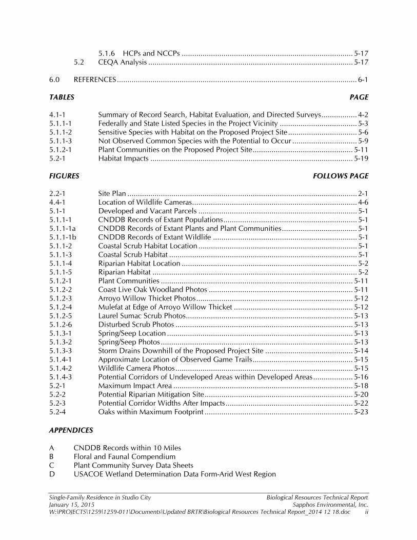
5.1.6 HCPs and NCCPs .................................................................................. 5-17 5.2 CEQA Analysis .................................................................................................. 5-17 6.0 REFERENCES ................................................................................................................... 6-1 TABLES PAGE 4.1-1 Summary of Record Search, Habitat Evaluation, and Directed Surveys ................. 4-2 5.1.1-1 Federally and State Listed Species in the Project Vicinity ..................................... 5-3 5.1.1-2 Sensitive Species with Habitat on the Proposed Project Site ................................. 5-6 5.1.1-3 Not Observed Common Species with the Potential to Occur ............................... 5-9 5.1.2-1 Plant Communities on the Proposed Project Site ................................................ 5-11 5.2-1 Habitat Impacts ................................................................................................. 5-19 FIGURES FOLLOWS PAGE 2.2-1 Site Plan .............................................................................................................. 2-1 4.4-1 Location of Wildlife Cameras ............................................................................... 4-6 5.1-1 Developed and Vacant Parcels ............................................................................ 5-1 5.1.1-1 CNDDB Records of Extant Populations ................................................................ 5-1 5.1.1-1a CNDDB Records of Extant Plants and Plant Communities .................................... 5-1 5.1.1-1b CNDDB Records of Extant Wildlife ..................................................................... 5-1 5.1.1-2 Coastal Scrub Habitat Location ............................................................................ 5-1 5.1.1-3 Coastal Scrub Habitat .......................................................................................... 5-1 5.1.1-4 Riparian Habitat Location .................................................................................... 5-2 5.1.1-5 Riparian Habitat .................................................................................................. 5-2 5.1.2-1 Plant Communities ............................................................................................ 5-11 5.1.2-2 Coast Live Oak Woodland Photos ..................................................................... 5-11 5.1.2-3 Arroyo Willow Thicket Photos ........................................................................... 5-12 5.1.2-4 Mulefat at Edge of Arroyo Willow Thicket ......................................................... 5-12 5.1.2-5 Laurel Sumac Scrub Photos ................................................................................ 5-13 5.1.2-6 Disturbed Scrub Photos ..................................................................................... 5-13 5.1.3-1 Spring/Seep Location ......................................................................................... 5-13 5.1.3-2 Spring/Seep Photos ............................................................................................ 5-13 5.1.3-3 Storm Drains Downhill of the Proposed Project Site .......................................... 5-14 5.1.4-1 Approximate Location of Observed Game Trails ................................................ 5-15 5.1.4-2 Wildlife Camera Photos ..................................................................................... 5-15 5.1.4-3 Potential Corridors of Undeveloped Areas within Developed Areas ................... 5-16 5.2-1 Maximum Impact Area ...................................................................................... 5-18 5.2-2 Potential Riparian Mitigation Site ....................................................................... 5-20 5.2-3 Potential Corridor Widths After Impacts ............................................................. 5-22 5.2-4 Oaks within Maximum Footprint ....................................................................... 5-23 APPENDICES A CNDDB Records within 10 Miles B Floral and Faunal Compendium C Plant Community Survey Data Sheets D USACOE Wetland Determination Data Form-Arid West Region

Single-Family Residence in Studio City Biological Resources Technical Report January 15, 2015 Sapphos Environmental, Inc. W:\PROJECTS\1259\1259-011\Documents\Updated BRTR\Biological Resources Technical Report_2014 12 18.doc 1-1
SECTION 1.0 INTRODUCTION
This Biological Resources Technical Report (BRTR) was prepared to determine if the proposed building of a single family residence at 3599 Lankershim Boulevard (proposed project) may have a significant impact to biological resources, thus requiring the consideration of mitigation measures or alternatives in accordance with Section 15063 of the State of California Environmental Quality Act (CEQA) Guidelines.1 1.1 PURPOSE OF THE PROPOSED PROJECT The goal of the project is to build a five-bedroom single-family residence. The location of the proposed residence is in close proximity to the property owner’s work places that are located nearby in the City of Los Angeles. The project would provide recreation areas, ventilation, exposure to sunlight, desirable city views, be located at an appropriate distance from adjacent properties, and contain a covered four-car stacked garage. The proposed project has been designed to offer the family comfortable living quarters and recreational areas within a desired Southern California neighborhood. 1.2 PURPOSE OF THE BIOLOGICAL RESOURCES TECHNICAL REPORT The purpose of this report is to provide a characterization of baseline conditions for biological resources, the regulatory framework that guides the consideration of biological resources, and the potential for the proposed project to result in significant impacts. For this assessment, biological resources are defined consistent with Appendix G to the State CEQA Guidelines. Pursuant to the Conservation and Open Space Element of the existing adopted City of Los Angeles General Plan2 and the Mulholland Scenic Parkway Specific Plan (MSPSP),3 this assessment was undertaken to determine if the proposed project would result in adverse significant impacts to biological resources. The potential for impacts to biological resources was assessed through the review of a combination of available information, including a query of the California Natural Diversity Database (CNDDB),4 the California Native Plant Society (CNPS) online inventory,5 field surveys results from 2002–2006 and October and November 2014, and a review of published literature. The proposed project would be subject to discretionary approvals by the City of Los Angeles Planning Department. Acting in its capacity as a lead agency under CEQA, the City Planning Department would need to determine the potential for the proposed project to result in significant impacts, consider mitigation measures and alternatives capable of avoiding significant impacts, and take the environmental effects of the proposed project into consideration as part of its decision-
1 California Code of Regulations. Title 14, Division 6, Chapter 3, Sections 15000–15387, Appendix G. 2 City of Los Angeles Department of City Planning. 26 September 2001. Conservation Element of the City of Los Angeles General Plan. Available at: http://www.ci.la.ca.us/PLN/ 3 City of Los Angeles, City Planning Commission. 22 May 2003. Mulholland Scenic Parkway Specific Plan: Design and Preservation Guidelines. Los Angeles, CA. 4 California Department of Fish and Game. 2014. Rarefind 5: A Database Application for the Use of the California Department of Fish and Game Natural Diversity Data Base. Sacramento, CA. 5 California Native Plant Society. Accessed 24 March 2014. Inventory of Rare and Endangered Plants. Sacramento, CA. Available at: http://cnps.web.aplus.net/cgi-bin/inv/inventory.cgi

Single-Family Residence in Studio City Biological Resources Technical Report January 15, 2015 Sapphos Environmental, Inc. W:\PROJECTS\1259\1259-011\Documents\Updated BRTR\Biological Resources Technical Report_2014 12 18.doc 1-2
making process. This BRTR provides the substantial evidence on which the required evaluation of feasibility, environmental analysis, and findings of fact in relation to biological resources can be made. 1.3 INTENDED AUDIENCE This BRTR has been prepared to support the analysis to determine if the proposed project is expected to result in significant impacts to biological resources, to be used by the City of Los Angeles to support the consideration of the proposed project, and whether the proposed project has the potential to result in significant impacts to biological resources requiring the consideration of mitigation measures or alternatives. CEQA requires that the information upon which the decision-making body will render their decision be made available for public review. Ultimately, the City of Los Angeles will use the environmental compliance documentation, and input from responsible and trustee agencies, and the public to advise their decision related to consideration of the proposed project. 1.4 DEFINITIONS Waters of the United States are defined as surface waters such as navigable waters and their tributaries, all interstate waters and their tributaries, natural lakes, all wetlands adjacent to other waters, and all impoundments of these waters. On April 21, 2014, the United States Environmental Protection Agency (EPA) proposed to refine the definition of waters of the United States to include all tributaries of traditional navigable waters, interstate waters, territorial seas, and impoundments of such tributaries; wetlands adjacent to the foregoing; and waters other than wetlands that are adjacent to other jurisdictional waters.6 Federal Wetlands are defined by the U.S. Army Corps of Engineers and the Environmental Protection Agency as: “Those areas that are inundated or saturated by surface or ground water at a frequency and duration sufficient to support, and that under normal circumstances do support, a prevalence of vegetation typically adapted for life in saturated soil conditions. Wetlands generally include swamps, marshes, bogs, and similar areas.”7 State Wetlands/Streams are defined by the California Fish and Game Code. A stream is defined as a body of water that flows at least periodically, or intermittently, through a bed or channel having banks and supporting fish or other aquatic life. Wetlands are defined as areas having riparian vegetation, without regard to wetland vegetation, soils, or hydrology. Streams as defined by Mulholland Scenic Parkway Specific Plan are defined as: “The streams protected by the Specific Plan are those water courses designated by the U.S. Geological Survey (USGS) and shown on the maps available for viewing at the Department of City Planning’s Van Nuys office and the Department’s web site. A stream may include a water course having a surface or subsurface flow that supports or has supported riparian vegetation.8, 9” 6 Federal Register. Vol. 79, No. 76, Monday April 21, 2014. Proposed Rules. Available at: http://www.gpo.gov/fdsys/pkg/FR-2014-04-21/pdf/2014-07142.pdf 7 U.S. Army Corps of Engineers. 1987. Corps of Engineers Wetland Delineation Manual. Vicksburg, MS. 8 City of Los Angeles, City Planning Commission. 22 May 2003. Mulholland Scenic Parkway Specific Plan: Design and Preservation Guidelines. Los Angeles, CA. 9 City of Los Angeles, Planning Department. 13 May 1992. Mulholland Scenic Parkway Specific Plan. Los Angeles, CA.

Single-Family Residence in Studio City Biological Resources Technical Report January 15, 2015 Sapphos Environmental, Inc. W:\PROJECTS\1259\1259-011\Documents\Updated BRTR\Biological Resources Technical Report_2014 12 18.doc 1-3
Special Status Species are those afforded special recognition by federal, state, and/or local resource agencies or jurisdictions, or recognized resource conservation organizations. Special status plant and wildlife species include those federally listed or state listed as endangered, threatened, or candidate species pursuant to the federal Endangered Species Act, the California Endangered Species Act, or other regulations enforced by a federal or state agency (such as BLM or the U.S. Forest Service [USFS]); or those considered by the scientific community to be rare. For this BRTR, special status species include listed, sensitive, and locally important species. Federally Listed Species are those provided with special legal protection under the federal Endangered Species Act. A federally listed endangered species is a species that is in danger of extinction throughout all, or a significant portion, of its range. A federally threatened species is one likely to become endangered in the absence of special protection or management efforts provided by the listing. A candidate species is one that is proposed by the federal government for listing as endangered or threatened. State-listed Species are those provided with special legal protection under the California Endangered Species Act. A state-listed endangered species is a species that is in danger of extinction throughout all, or a significant portion, of its range. A state-listed threatened species is one likely to become endangered in the absence of special protection or management efforts provided by the listing. A candidate species is one that is proposed by the federal or state government for listing as endangered or threatened. Sensitive Species are those not listed by the state government as endangered, threatened, or candidate species but categorized by the state as a species of special concern or fully protected species. A California species of special concern is defined by California Department of Fish and Wildlife (CDFW) as being a wildlife species that has declining population levels, a limited range, and/or continuing threats that have made it vulnerable to extinction. For the purpose of this BRTR, those plant species recognized by California Native Plant Society are considered sensitive species (Rare Plant Rank 1A, 1B, 2A, 2B, 3, or 4) 10 This designation also includes those species listed on the California Special Animals list that are not otherwise covered by other regulations.11 It also includes species afforded protection by the County General Plan, such as some native oak trees. Species of Special Concern are species, subspecies, or distinct population of an animal (bird, mammal, fish, reptile, and amphibian) native to California that currently satisfies one or more of the following criteria: a) is extirpated from the State or, in the case of birds, in its primary seasonal or breeding role; b) is listed as federally-, but not State-, threatened or endangered; c) meets the State definition of threatened or endangered but has not formally been listed; d) is experiencing, or formerly experienced, serious (noncyclical) population declines or range retractions (not reversed) that, if continued or resumed, could qualify it for State threatened or endangered status; e) has naturally small populations exhibiting high susceptibility to risk from any factor(s), that if realized, could lead to declines that would qualify it for State threatened or endangered status.
10 California Native Plant Society (CNPS). 2014. Inventory of Rare and Endangered Plants (online edition, v8-02). California Native Plant Society. Sacramento, CA. http://www.rareplants.cnps.org 11 California Department of Fish and Game, Biogeographic Data Branch. Accessed December 2014. Rarefind 5: A Database Application for the Use of the California Department of Fish and Game Natural Diversity Database. Sacramento, CA.
Single-Family Residence in Studio City Biological Resources Technical Report January 15, 2015 Sapphos Environmental, Inc. W:\PROJECTS\1259\1259-011\Documents\Updated BRTR\Biological Resources Technical Report_2014 12 18.doc 1-4
Sensitive Plant Community is a native plant community listed on CDFW Natural Communities List as being rare within California or threatened by human actions. Nursery Site is considered habitat in which native wildlife may establish nests, maternity roosts, dens, or otherwise engage in breeding and/or the rearing of offspring. Wildlife Movement Corridors are characterized as areas of habitat that are used by wildlife for the purpose of moving between locations. Natural Community Conservation Plan (NCCP) is defined by CDFW as a plan for the conservation of natural communities that identifies and provides for the regional or area-wide protection and perpetuation of plants, animals, and their habitats. Habitat Conservation Plans (HCPs) are required by the USFWS as part of an application for an incidental “take” permit for species listed pursuant to the federal ESA. HCPs describe the anticipated effects of the proposed taking, how the impacts will be minimized and mitigated, and how the HCP is to be funded.

Single-Family Residence in Studio City Biological Resources Technical Report January 15, 2015 Sapphos Environmental, Inc. W:\PROJECTS\1259\1259-011\Documents\Updated BRTR\Biological Resources Technical Report_2014 12 18.doc 2-1
SECTION 2.0 PROJECT DESCRIPTION
2.1 PROJECT LOCATION The proposed project site is located on a 22,284-square-foot lot in the community of Studio City, the City of Los Angeles, County of Los Angeles, California. The proposed project is located on the U.S. Geological Survey (USGS) 7.5-minute series Burbank topographic quadrangle12 (Township 1 North, Range 14 West) within the Rancho Ex Mission de San Fernando Land Grant Boundary at an elevation of 734 to 785 feet above mean sea level (MSL). The proposed project is approximately 0.4 mile southwest of U.S. Highway 101 (Hollywood Freeway). California State Highway 2 (Santa Monica Boulevard) is approximately 3 miles to the south, and U.S. Interstate Highway 405 (San Diego Freeway) is approximately 6 miles to the west. Nearby landmarks include Universal City, which is approximately 0.6 mile northeast. The proposed project site is located at the base of a canyon that is bounded by Ventura Boulevard to the North, Fredonia Road to the east, Wrightwood Lane to the south, and Willowcrest Avenue to the west. The Assessor’s Parcel Number for the lot is 2380-005-009. Access to the site is provided by a private driveway from Lankershim Boulevard that serves one existing home and would also serve the proposed home on the subject property and another currently vacant parcel adjacent to Lankershim Boulevard. 2.2 PROJECT DESCRIPTION The proposed project is the development of a two-story single-family residence with basement (approximately 3,826 square feet) including a stacked stall, four-car garage (Figure 2.2-1, Site Plan). The project would be designed in a modern style with natural exterior finish materials. The project would include a swimming pool, outdoor living areas (barbeque area and patio), a landscaped area, open space, a fence surrounding the property, and an entrance gate that conforms to local tradition, the climate, and the surrounding environment. The layout of the house would follow the natural grade by creating different levels and outdoor spaces in order to blend with the natural topography. A backyard retention wall (maximum height of 10 to 12 feet) would be designed to protect the building from mudslide and debris, and to divert rainwater. The foundation of the house would be composed of concrete footings and pads. The infrastructure system would consist of a wood structure and slab constructed at grade with movement-resistant frames and plywood shear walls. The roof would be constructed using “Class A,” fire retardant, roofing material in accordance with the Los Angeles Department of Building and Safety Codes. The design of the structure would comply with the Los Angeles Building Code 2002 Edition and the City of Los Angeles Fire Department’s requirements for water service, hydrant location, distance from the nearest fire station/installation of substitute watering sources, street width, access, turnaround, and brush clearance as required by the Los Angeles Municipal Code 57.21.07.
12 U.S. Geological Survey. [1966] Photoinspected 1972. 7.5-Minute Series, Burbank, California, Topographic Quadrangle. Scale 1:24,000. Reston, VA.

NEW 3,826 SF 2 STORY+ BASEMENT S.F.D.
15'-0"SIDE YARD (12'-0" req'd)(15'-0" SLOPE SETBACK)
REAR
YAR
D(2
4'-4"
req'd
)
E
2X STANDARD STALLSTACKED
ACLIFTS.COMFOUR POST LIFTBU-SUV-9000
19'-11"
26'-7
"
7'-6"POOL
SETBACK
19'-11" 15'-0" 20'-11" 6'-2"
15'-6
"27
'-6"
POOL DECKPOOL DECK
POOL12'x40'
POINT AT WHICH MAXIMUMENVELOPE HEIGHT ISCALCULATED - 733'-3"
12'-0"
SIDE YARD
(12'-0"
req'd)
19'-4
"
31'-3
"
21'-0" 13'-8"
29'-1
"
22'-5
"27
'-0"
6'-0"
6'-0"
(E)
sprink
ler
easem
ent
(E)
sprin
kler
ease
ment
5'-0"
(E)PublicUtility
easement
5'-0"
8'-0"(E)LA CitySewereasement
(E)PublicUtility
easement
SLOPE SETBACK
2X STANDARD STALLSTACKED
4 MATERIAL CALLOUT
DETAIL / ENLARGED CLOUD
DOOR TAG
WINDOW TAG
CHANGE OF LEVEL
EXIT / ENTRANCE
DETAIL TAGXXXX-X.XX
DRAWINGNUMBER
PAGENUMBER
XXX-X.XX
DRAWINGNUMBER
PAGENUMBER
SECTION TAG
XXX.X
XXX.X
TO. DBL. PL.
ROOM NAMEXXX
ROOM TAG
4 MATERIAL CALLOUT FIELD
SECTION /ELEVATION TAG
A.B. - ANCHOR BOLTADJ. - ADJACENTBLKG. - BLOCKINGBM. - BEAMB.O. - BOTTOM OF ______BRD. - BOARDB.U. - BUILT-UPB.W. - BOTTOM OF WALLCJ - CEILING JOISTCMU. - CONCRETE MASONRY UNITCONC. - CONCRETECONT. - CONTINUOUSDBL. - DOUBLEDIA. - DIAMETERDS. - DOWNSPOUTD/W - DISHWASHERDWG. - DRAWING(E) - EXISTINGEA. - EACHE.M. - EXTRUDED METALELEC M - ELECTRICAL METEREQ. - EQUALEXP. - EXPOSEDEXT. - EXTERIORF.FL. - FINISH FLOORFJ - FLOOR JOISTF.O.F. - FACE OF FINISHF.O.S. - FACE OF STUDF.S.H. - FIRE SPRINKLER HEADFTG. - FOOTINGG.I. - GALVANIZED IRONGM - GAS METERGYP. - GYPSUM WALL BOARDHDR. - HEADERHT. - HEIGHTINSL. - INSULATIONL.A.G. - LOWEST ADJACENT GRADEMAX. - MAXIMUM
EXISTING 1 STORY SFD TO REMAIN
2 STORY ADDITION
1 STORY ADDITION
EXISTING SFD FOR DEMO
C
97'-4
"
L
CL
19'-4
"
REQUIRED FRONT YARDSETBACK = 19'4"(20% LOT DEPTH NOT TOEXCEED 25'-0")
12'-0"
REQUIRED SIDE YARDSETBACK = 12'-0"(10% LOT WIDTH NOT TOEXCEED 10'; +1' FOREACH 10' INCREMENTABOVE 18')
LOT D
EPTH
=
LOT WIDTH =
24'-4
"
REQUIRED REAR YARDSETBACK = 24'-4"(25% LOT DEPTH NOT TOEXCEED 25'-0")
12'-0"
REQUIRED SIDE YARD SETBACK = 12'-0"(10% LOT WIDTH NOT TO EXCEED 10'; +1'FOR EACH 10' INCREMENT ABOVE 18')
12'-0"
SIDE
YARD
SIDEYARD
90Á
NEW 3,826 SF 2STORY + BASEMENT
S.F.D.230'-0"
MFR. - MANUFACTURERMLDG. - MOLDINGMTL. - METALN/C - NO CHANGENIC - NOT IN CONTRACT(N) - NEWO/ - OVERO.C. - ON CENTERPL. - PLATEPLN. - PLANPLWD. - PLYWOODP.S.P. - PER SEPERATE PERMITP.T. - PRESSURE TREATEDP.T.D.F. - PRESSURE TREATED DOUGLAS FIRP.U.E. - PUBLIC UTILITY EASEMENTR - RADIUSREQ'D - REQUIREDRM. - ROOMR.R. - ROOF RAFTERSCHD. - SCHEDULESHTHNG. - SHEATHING\SIM. - SIMILARSQ. - SQUARESTG. - STAGGEREDSTL. - STEELSTRUC. - STRUCTURALS.W.S. - SHEAR WALL SCHEDULET&G - TOUNGE AND GROOVETHK. - THICKT.O. - TOP OF ______T.W. - TOP OF WALLTYP. - TYPICALU.O.N. - UNLESS OTHERWISE NOTEDVIF. - VERIFY IN FIELDW/ - WITHWD. - WOODWM - WATER METER
ABBREVIATIONS 1VICINITY MAP 7
ARCHITECTURAL SET:
T - 1.10 TITLE SHEET | PLOT PLAN
G - 1.10 GENERAL NOTES AND SPECIFICATIONSG - 2.10 GREEN BUILDING NOTESG - 3.10 TITLE 24
A - 0.10 SITE PLANA - 1.10 BASEMENT FLOOR PLANA - 1.20 SECOND FLOOR PLANA - 1.30 THIRD FLOOR PLANA - 1.40 ROOF PLANA - 2.10 ELEVATIONSA - 2.20 ELEVATIONSA - 3.10 SECTIONSA - 3.20 SECTIONSA - 4.10 INTERIOR ELEVATIONS | ENLARGED PLANSA - 5.10 LIGHTING AND SWITCHING PLANSA - 5.20 A/V AND MECHANICAL PLAN DIAGRAMSA - 6.10 DOOR AND WINDOW SCHEDULESA - 6.20 PROJECT FINISH SPECIFICATIONS
AD - 1.10 ARCHITECTURAL DETAILS
ARCHITECTL&V ARCHITECTS INC.2332 Cotner Avenue Suite 303West Los Angeles, CA 90064t: (310) 914 - 5577f: (310) 914 - 5578www.LVARCH.com
4
PROJECT INFORMATION
OWNERKETAN PATELPNK Group Investments2010 N. Highland AveHollywood, CA 90068
6SYMBOLS PROJECT TEAM 3 SHEET INDEX
8PLOT PLAN
T- 1.101
8" =1'-0"
TITLE SHEET / PLOT PLAN
RE15-1-H
LEGAL DESCRIPTION
LOT SIZE
APN
TRACT
BLOCK
LOT
2380-005-009
ARB
ADDRESS: 3599 LANKERSHIM BOULEVARD
10
22,282.0 SQ.F.T
TR 12578
NONE
3
S. F. D.
SCALE 18" = 1'-0" 2
STRUCTURAL ENGINEER
TITLE 24
NEW
SIN
GLE
FA
MIL
Y DW
ELLI
NG
3599
LA
NKE
RSHI
M B
LVD
LOS
AN
GEL
ES, C
A 9
1604
page
L+Varchitects inc.2332 Cotner Ave., Suite 303West Los Angeles, CA 90064t: 310. 914. 5577; f: 310. 914. 5578
ALL IDEAS, DESIGNS, ARRANGEMENTS AND PLANS INDICATED OR REPRESENTED IN OR BY THIS DRAWING(S) ARE OWNED BY L&V ARCHITECTS INC. AND WERE CREATED AND DEVELOPED FOR USE AND IN CONNECTION WITH THE SPECIFIED PROJECT. NONE OF THE IDEAS, DESIGNS, ARRANGEMENTS OR PLANS SHALL BE DUPLICATED USED BY OR DISCLOSED TO FOR ANY PURPOSE WHATSOEVER WITHOUT THE EXPRESS WRITTEN AUTHORIZATION OF L&V ARCHITECTS INC.
10.13.2014
NO
T FO
R C
ON
STRU
CTIO
N
scale
date
title
R
E
N
E
W
AL
D
A
T
E
S
T
A
T
E
O
F
CA
L
I
F
O
R
N
I
A
V
L
A
D
I
M
I
R
T
O
M
A
L
E
V
S
K
I
L
I
C
E
N
S
E
D
A R
C
H
I
T
E
C
T
No. C 22417
project #13.01
ZONE USE
ZONING CODE INFORMATION
PERMITTED ENVELOPE HEIGHT
PARKINGREQUIRED
PROVIDED4 STALLS
PROPOSED MAXIMUM "PLUMB LINE" HEIGHT
HEIGHT
YARDS
FRONT YARD SETBACK
REAR YARD SETBACK
SIDE YARD SETBACK
ZONING CODE FLOOR AREA CALCULATION PER HILLSIDE
ORDINANCE #181624 (RESIDENTIAL FLOOR AREA - R.F.A.)
Elevator shafts and stairways shall only be counted once.Area excludes: required covered parking (200sf per car); covered porches, patios andbreezeways up to 5% of max RFA not less then 250 sf; the first 100 sf of over-in-heightceilings; and basements.
(N) THIRD FLOOR
(N) BASEMENT
(N) SECOND FLOOR
4 STALLS
SCOPE OF WORK- NEW 3 STORY (2 story with basement per hillside ordinance RFA definition)3,826 SF S.F.D. WITH 3-CAR GARAGE- NEW swimming pool per separate permit- NEW retaining walls per separate permit
2010 CALIFORNIA RESIDENTIAL CODE - BASED ONTHE 2009 INTERNATIONAL RESIDENTIAL CODE
CODE REFERENCES
GREEN BUILDING
PLANNING AND ZONING
BUILDING AND SAFETY
2011 LOS ANGELES GREEN BUILDING CODE
LOS ANGELES - PLANNING AND ZONING MUNICIPALCODE, CHAPTER 1)
REQUIRED
(N) TOTAL PROPOSED FLOOR AREA
20% lot depth or25'-0" max
0 SF
3,826 SF
10% lot width not to exceed 10'; +1'for each 10' increment above 18
PROJECT SITE
25% lot depth or25'-0" max
5SETBACK DIAGRAM SCALE 132" = 1'-0"
= 19'-4"
= 12'-0"
= 24'-4"
1,891 SF
1,750 SF - 129 SF (elev and stair) + 70 SF (covered patio)1,935 SF(elevator shaft and stairs excluded | 147 SF of patio excluded
| 70 SF of covered patio included (exceeds 250 sf exemption))
(floor above is <3' above grade for more than 60% of perimeter| 31 SF of covered porch excluded (entry porch)
(elevator and stairs counted once | 72 sf patio excluded)
2 stalls for the first 2,400 SF and 1 additional stall for each1,000 SF increment of additional floor area
5SCALE N.T.S.MULHOLLAND SPECIFIC PLAN PROJECT DATA
30'-0"
29'-10"
PROVIDED
NUMBER OF STORIES
2 stories over basementper Hillside Ordinance R.F.A. definition and CBC
per Zoning Code 3 stories
N/A(see plot plan)
12'-0"; 15'-0"
29'-1"

Single-Family Residence in Studio City Biological Resources Technical Report January 15, 2015 Sapphos Environmental, Inc. W:\PROJECTS\1259\1259-011\Documents\Updated BRTR\Biological Resources Technical Report_2014 12 18.doc 2-2
2.3 IMPACT AREA This BRTR assesses the maximum impact area associated with the proposed project area. The project footprint covers 0.22 acres, including the driveway (0.04 acres), house/patio (0.1 acres), and a 15-foot wide construction zone (0.08 acres) around the edge of the house to provide sufficient space for the construction crews of the residence. The construction zone has been limited to 5 feet wide, adjacent to the riparian habitat, in order to minimize and avoid impacts. It is anticipated that after the completion of the residence, the construction zone would be landscaped by the property owner; therefore, the construction zone has been included as a permanent impact area.
Single-Family Residence in Studio City Biological Resources Technical Report January 15, 2015 Sapphos Environmental, Inc. W:\PROJECTS\1259\1259-011\Documents\Updated BRTR\Biological Resources Technical Report_2014 12 18.doc 3-1
SECTION 3.0 REGULATORY FRAMEWORK
This regulatory framework identifies the federal, state, and local statutes, ordinances, policies, and guidelines that govern the conservation and protection of biological resources for the proposed Residence in the community of Studio City (proposed project). During the decision-making process, the City of Los Angeles and other regulatory agencies will utilize the regulatory framework discussed in this section to consider the potential for the proposed project to result in significant impacts to biological resources. 3.1 FEDERAL 3.1.1 Federal Endangered Species Act The federal Endangered Species Act (ESA) defines and lists species as “endangered” and “threatened” and provides regulatory protection for the listed species. The federal ESA provides a program for conservation and recovery of threatened and endangered species; it also ensures the conservation of designated critical habitat that the United States Fish and Wildlife Service (USFWS) has determined is required for the survival and recovery of these listed species. Section 9 of the federal ESA prohibits the “take” of species listed by USFWS as threatened or endangered. Take is defined as follows: “to harass, harm, pursue, hunt, shoot, wound, kill, trap, capture, or collect or attempt to engage in such conduct.” In recognition that take cannot always be avoided, Section 10(a) of the federal ESA includes provisions for take that is incidental to, but not the purpose of, otherwise lawful activities. Section 10(a)(1)(B) permits (incidental take permits) may be issued if take is incidental and does not jeopardize the survival and recovery of the species. As defined in the federal ESA, individuals, organizations, states, local governments, and other nonfederal entities are affected by the designation of critical habitat only if their actions occur on federal lands; require a federal permit, license, or other authorization; or involve federal funding.13 At this time, it is not anticipated that the proposed project involves federal lands; federal permit, licenses, or other authorizing; or federal funding. Due to the potential presence of federally listed species in the vicinity of the proposed project property, project compliance with the federal ESA was considered in this evaluation. 3.1.2 Migratory Bird Treaty Act The Migratory Bird Treaty Act (MBTA) makes it unlawful to pursue, capture, kill, or possess any migratory bird or part, nest, or egg of any such bird listed in wildlife protection treaties between the United States, Great Britain, Mexico, Japan, and Russia (formerly the Soviet Union). 14 Similar to the federal ESA, the MBTA authorizes the secretary of the interior to issue permits for incidental take. Due to documented presence of resident and migratory birds within the proposed project property, project compliance with the MBTA was considered in this evaluation. Nesting birds and the
13 U.S. Fish and Wildlife Service. Accessed July 2009. Federal Endangered Species Act. Available at: http://www.fws.gov/Endangered/pdfs/esaall.pdf 14 U.S. Fish and Wildlife Service. 1918. Migratory Bird Treaty Act of 1918. Available at: http://www.fws.gov/laws/lawsdigest/migtrea.html

Single-Family Residence in Studio City Biological Resources Technical Report January 15, 2015 Sapphos Environmental, Inc. W:\PROJECTS\1259\1259-011\Documents\Updated BRTR\Biological Resources Technical Report_2014 12 18.doc 3-2
contents of the nest within the proposed project property are afforded protection during the nesting season pursuant to the MBTA. 3.1.3 Section 404 of the Federal Clean Water Act Section 404 of the federal Clean Water Act, which is administered by the U.S. Army Corps of Engineers (USACOE), regulates the discharge of dredged and fill material into waters of the United States. USACOE has established a series of nationwide permits that authorize certain activities in waters of the United States, provided that a proposed activity can demonstrate compliance with standard conditions. Generally, USACOE requires an individual permit for an activity that will affect an area per crossing equal to or in excess of 0.3 acre of waters of the United States. Impacts less than 0.3 acre of waters of the United States per crossing can normally be conducted pursuant to one of the nationwide permits, if consistent with the standard permit conditions. Use of any nationwide permit is contingent on the activities that have no impacts to endangered species. The project has been documented to contain a series of springs, but there are no National Wetlands Inventory (NWI) wetlands documented on site. The springs within the project property have been evaluated to determine if they feed into navigable waters of the United States; therefore, the federal Clean Water Act was taken into consideration in the evaluation of the proposed project due to the potential for the project to impact federal jurisdictional drainages and wetlands within the project property during construction. 3.2 STATE 3.2.1 California Endangered Species Act The California ESA (California Fish and Game Code §§ 2050 et seq.) prohibits the take of listed species, except as otherwise provided in state law. The take for the California ESA is defined as it is in the federal ESA; however, unlike the federal ESA, the California ESA also applies the take prohibitions to species petitioned for listing as state candidates rather than only listed species. State lead agencies are required to consult with the California Department of Fish and Wildlife (CDFW) to ensure that any actions undertaken by the lead agency are not likely to jeopardize the continued existence of any state-listed species or result in destruction or degradation of required habitat. CDFW is authorized to enter into Memoranda of Understanding (MOUs) with individuals, public agencies, universities, zoological gardens, and scientific or educational institutions to import, export, take, or possess listed species for scientific, educational, or management purposes. Due to the potential presence of state-listed rare, threatened, endangered, or candidate species within the proposed project property, compliance with the California ESA was considered in the evaluation of the proposed project. 3.2.2 Sections 2080 and 2081 of the State Fish and Game Code Section 2080 of the State Fish and Game Code (Code) states,
No person shall import into this state [California], export out of this state, or take, possess, purchase, or sell within this state, any species, or any part or product thereof, that the commission [State Fish and Game Commission] determines to be an endangered species or threatened species, or attempt any of those acts, except as
Single-Family Residence in Studio City Biological Resources Technical Report January 15, 2015 Sapphos Environmental, Inc. W:\PROJECTS\1259\1259-011\Documents\Updated BRTR\Biological Resources Technical Report_2014 12 18.doc 3-3
otherwise provided in this chapter [Chapter 1.5, Endangered Species], or the Native Plant Protection Act, or the California Desert Native Plants Act.15
Pursuant to Section 2081 of the Code, the CDFW may authorize individuals or public agencies to import, export, take, or possess any state-listed endangered, threatened, or candidate species. These otherwise prohibited acts may be authorized through permits or MOUs as follows: (1) if the take is incidental to an otherwise lawful activity, (2) if impacts of the authorized take are minimized and fully mitigated, (3) if the permit is consistent with any regulations adopted pursuant to any recovery plan for the species, and (4) if the applicant ensures adequate funding to implement the measures required by CDFW. CDFW shall make this determination based on available scientific information and shall include consideration of the ability of the species to survive and reproduce. Due to the potential presence of state-listed rare, threatened, endangered, or candidate species within the proposed project property, Sections 2080 and 2081 of the Code were considered in the evaluation of the proposed project. 3.2.3 Native Plant Protection Act The Native Plant Protection Act includes measures to preserve, protect, and enhance rare and endangered native plants. The list of native plants afforded protection pursuant to the Native Plant Protection Act includes those listed as rare and endangered under the California ESA. The Native Plant Protection Act provides limitations that no person will import into the state—or take, possess, or sell within the state—any rare or endangered native plant, except in compliance with provisions of the act. Individual landowners are required to notify the CDFW at least 10 days in advance of changing land uses to allow the CDFW to salvage any rare or endangered native plant material. Due to the potential presence of rare and endangered native plants within the proposed project property, the Native Plant Protection Act was considered in the evaluation of the proposed project. 3.2.4 Sections 3503 and 3503.5 of the State Fish and Game Code These sections of the Code provide regulatory protection to resident and migratory birds and all birds of prey within the State of California, including the prohibition of the taking of nests and eggs, unless otherwise provided for by the Code. Specifically, these sections of the Code make it unlawful to take, possess, or needlessly destroy the nest or eggs of any bird, except as otherwise provided by the Code. Due to the potential presence of resident and migratory nesting birds within the proposed project property, Sections 3503 and 3503.5 of the Code were considered in the evaluation of the proposed project. 3.2.5 Sections 1600 through 1603 of the State Fish and Game Code All diversions, obstructions, or changes to the natural flow or bed, channel, or bank of any river, stream, or lake in California are subject to the regulatory authority of CDFW pursuant to Sections 1600 through 1603 of the Code and require preparation of a Streambed Alteration Agreement.
15 California Fish and Game Code. Sections 2080–2081. Accessed July 2009. Available at: http://caselaw.lp.findlaw.com/cacodes/fgc/2080-2085.html
Single-Family Residence in Studio City Biological Resources Technical Report January 15, 2015 Sapphos Environmental, Inc. W:\PROJECTS\1259\1259-011\Documents\Updated BRTR\Biological Resources Technical Report_2014 12 18.doc 3-4
Pursuant to the Code, a stream is defined as a body of water that flows at least periodically, or intermittently, through a bed or channel having banks and supporting fish or other aquatic life. Based on this definition, a watercourse with surface or subsurface flows that support or have supported riparian vegetation is a stream and is subject to CDFW jurisdiction. Altered or artificial waterways valuable to fish and wildlife are subject to CDFW jurisdiction. Due to the presence of springs on the proposed project property, Sections 1600 through 1603 of the Code were considered in the evaluation of the proposed project. 3.3 LOCAL 3.3.1 City of Los Angeles General Plan The City of Los Angeles General Plan includes the following policies related to biological resources:
Require evaluation, avoidance, and minimization of potential significant impacts, as well as mitigation of unavoidable significant impacts on sensitive animal and plant species and their habitats and habitat corridors relative to land development activities
Identify significant habitat areas, corridors and buffers and to take measures to protect, enhance and/or restore them
Work cooperatively with other agencies and entities in protecting local habitats and endangered, threatened, sensitive and rare species
Specifically, there are two policies that are applicable to the development of single-family residences.16 All other sections of the City of Los Angeles General Plan do not apply to the biological resources on the proposed project site. Section 6, Policy 1: continue to require evaluation, avoidance, and minimization of potential significant impacts, as well as mitigation of unavoidable significant impacts on sensitive animal and plant species and their habitats and habitat corridors relative to land development activities. Section 12, Policy 1: continue to identify significant habitat areas, corridors and buffers and to take measures to protect, enhance and/or restore them.
3.3.2 Sherman Oaks–Studio City–Toluca Lake–Cahuenga Pass Community Plan The Sherman Oaks–Studio City–Toluca Lake–Cahuenga Pass Community Plan portion of the City of Los Angeles General Plan17 had no additional regulations or policies on biological resources. The project applicant will be required to demonstrate compliance with the goals of the City of Los Angeles General Plan during the project entitlement process.
16 City of Los Angeles Department of City Planning, 26 September 2001. Conservation Element of the City of Los Angeles General Plan. Available at: http://www.ci.la.ca.us/PLN/ 17 City of Los Angeles Department of City Planning, 26 September 2001. Conservation Element of the City of Los Angeles General Plan. Available at: http://www.ci.la.ca.us/PLN/

Single-Family Residence in Studio City Biological Resources Technical Report January 15, 2015 Sapphos Environmental, Inc. W:\PROJECTS\1259\1259-011\Documents\Updated BRTR\Biological Resources Technical Report_2014 12 18.doc 3-5
3.3.3 Protected Tree Ordinance The City of Los Angeles has issued a protected tree ordinance No. 177404 that protects oaks, such as valley oak (Quercus lobata) and coast live oak (Q. agrifolia); Southern California black walnut (Juglans californica var. californica); western sycamore (Platanus racemosa); and California bay (Umbellularia californica) from relocation, removal, or any act that may result in the death of a protected tree without authorization. Further limitations prohibit construction activity within the dripline of a protected tree. Due to the presence of protected trees on the proposed project property, ordinance No. 177404 was considered in the evaluation of the proposed project. 3.3.4 Mulholland Scenic Parkway Specific Plan The Mulholland Scenic Parkway Specific Plan (MSPSP) has measures in place for potential development projects up to ½ mile away to ensure compatibility with the environment. These measures include restrictions on grading along prominent ridges, construction within a designated distance of a stream bank without approval, removal of oak trees without approval, and restrictions on plant species approved in landscaping. The proposed project lies within the outer corridor of the MSPSP; therefore, the MSPSP was considered in the evaluation of the proposed project. The proposed project site is located within the outer corridor of the MSPSP. Several of the protection measures do not apply to the proposed project, such as parklands, which are not within 200 feet of the proposed project site. As such, the following environmental protection measures could apply to the proposed project site:
1) Streams: No project shall be constructed and no more than 100 cubic yards of earth shall be moved within 100 feet of either stream bank without the prior written approval of the Director pursuant to Section 11. In granting an approval, the Director shall make the following findings: a. The applicant has employed a biologist to prepare a report which contains
the following: the location(s) of the stream's banks, an assessment of the riparian resources, an evaluation of the project's impact on the riparian resources and a recommendation of feasible mitigation measures.
b. The applicant has submitted to the Director for his approval, a copy of the biologist's report and a covenant and agreement which runs with the land and which states that the mitigation measures recommended by the biologist and approved by the Director will be incorporated in the project and maintained. The covenant and agreement shall be recorded by the applicant.
c. The project preserves the natural vegetation and the existing ecological balance.
d. The project protects prominent ridges, streams, and environmentally sensitive areas and the aquatic, biologic geologic and topographic features therein.
e. The project will not damage the integrity of a stream.
Single-Family Residence in Studio City Biological Resources Technical Report January 15, 2015 Sapphos Environmental, Inc. W:\PROJECTS\1259\1259-011\Documents\Updated BRTR\Biological Resources Technical Report_2014 12 18.doc 3-6
2) Oak Trees: No oak tree (Quercus agrifolia, Q. lobata, Q. virginiana) shall be removed, cut down or moved without the prior written approval of the Director. The Director may approve the removal, cutting down or moving of an oak tree after making the following findings: a. The removal, cutting down or moving of an oak tree will not result in
undesirable, irreversible soil erosion through diversion or increased flow of surface waters.
b. The oak tree is not located with reference to other trees or monuments in such a way as to acquire a distinctive significance at said location.
3.4 AUTHORIZATIONS, PERMITS, REVIEWS, AND APPROVALS This section summarizes the authorizations, permits, reviews, and approvals required for the proposed project that pertain to biological resources. State, local, and federal discretionary entitlements that may be required include:
CDFW Streambed Alteration Agreement Pursuant to Section 1600 of the State Fish and Game Code
Los Angeles Regional Water Quality Control Board Water Quality Certification pursuant to Section 401 of the Federal Clean Water Act
Approval from the Director of the City Planning Department City of Los Angeles Building Permit

Single-Family Residence in Studio City Biological Resources Technical Report January 15, 2015 Sapphos Environmental, Inc. W:\PROJECTS\1259\1259-011\Documents\Updated BRTR\Biological Resources Technical Report_2014 12 18.doc 4-1
SECTION 4.0 METHODS
This section describes the methods for surveys conducted in 2014. Prior to surveys, Sapphos Environmental, Inc. conducted a review of the existing data collected from previous visits to the proposed project site on April 15, 2002; January 22, 2003; April 23, 2004; March 10, 2005; June 8, 2005; and March 28, 2006.18,19,20,21,22 4.1 SENSITIVE PLANT AND ANIMAL SURVEYS Plant and wildlife records from the CNDDB were searched prior to any field surveys to establish species that have the potential to occur in the proposed project site. In 2003, Sapphos Environmental, Inc. searched CNDDB records for potentially sensitive species within the Burbank U.S. Geological Survey (USGS) 7.5-minute series topographic quadrangle. In 2014, Sapphos Environmental, Inc. expanded the search area by including all CNDDB records within a 10-mile radius around the project, which hereafter is referred to as the project vicinity. Searching the larger radius allows for a more thorough assessment of potentially occurring sensitive species and impacts that may occur as a result of the proposed project. In addition, the following databases were queried for additional records for sensitive plants and animals: CNPS, Consortium of California Herbaria (Herbaria), and eBird. Based on the CNDDB query of plant and wildlife records within 10 miles, the proposed project site is within the historical range of 51 listed and sensitive species (24 plant and 27 wildlife species; Appendix A, CNDDB Records within 10 Miles). As a result of further literature and record searches, two bird species were added to the list of potential species. However, 15 species (13 plant and 2 wildlife species) have been extirpated or presumed extirpated because of the high-level of development in the area; there was no evidence to suggest that these species are still extant on the proposed project site, supported by surveys conducted from 2002–2006 and in 2014. Therefore, habitat on the proposed project site was evaluated for 38 species (5 listed and 33 sensitive) with nearby extant populations, but only 8 species needed directed surveys after the habitat evaluation was performed.
18 City of Los Angeles Planning Department. June 2005. Revised Proposed Mitigated Negative Declaration: Proposed Residence in Studio City, City of Los Angeles, 3599 North Lankershim Boulevard, Study City, California 91604. Prepared by: Sapphos Environmental, Inc. Pasadena, CA. 19 Sapphos Environmental, Inc. 29 April 2002. Memorandum for the Record: Results of Riparian Assessment. Pasadena, CA. 20 Sapphos Environmental, Inc. 1 April 2005. Memorandum for the Record: Plant Community Assessment at 3599 Lankershim Boulevard. Pasadena, CA. 21 Sapphos Environmental, Inc. 31 March 2006. Memorandum for the Record: Plant Inventory of Restoration Areas at 3599 Lankershim Boulevard, Studio City, County of Los Angeles, California, for Streambed Alteration Agreement, Notification No. 1600-2005-0279. Pasadena, CA. 22 Sapphos Environmental, Inc. 9 June 2005. Memorandum for the Record: Wildlife Survey at 3599 Lankershim Boulevard, Studio City, Los Angeles County, California. Pasadena, CA.

Single-Family Residence in Studio City Biological Resources Technical Report January 15, 2015 Sapphos Environmental, Inc. W:\PROJECTS\1259\1259-011\Documents\Updated BRTR\Biological Resources Technical Report_2014 12 18.doc 4-2
TABLE 4.1-1 SUMMARY OF RECORD SEARCH, HABITAT EVALUATION, AND DIRECTED SURVEYS
Survey Process Federally and State Listed Sensitive Total
CNDDB records including extirpated Literature/record search 10 42 51
Added from other sources Literature/record search 0 2 2
Number of species with extant populations within 10 miles
Literature/record search 5 33 38
Number of species with habitat on the proposed project site
On-site habitat evaluation 0 8 8
Number of species present on the proposed project site
Directed surveys 0 1 1
On October 9, and 23, 2014, two Sapphos Environmental, Inc. biologists performed plant and wildlife surveys. One botanist performed a floristic survey of the entire property, by identifying all species of trees, shrubs, and forb observed on the proposed project site and immediately adjacent parcels.23 Given the small size of the parcel, plants were surveyed by walking the entirety of the property (area search) rather than transects. For herbaceous plants that were not currently flowering and could not be identified, the plants were collected by a botanist (Permit #2081(a)-13-2-V) and compared to sensitive plants to determine if the unknown forbs were sensitive species. For plant species that had habitat on the proposed project site and a fall bloom period, reference sites were visited.24 Oak tree larger than 3 inches in diameter at breast height (DBH) on the proposed project site had been previously tagged on March 28, 2006; therefore, evaluation in 2014 was simply to determine if each oak tree was present and determine the extent of their dripline. Plant species were identified using The Jepson Manual: Vascular Plants of California25 On October 9 and 23, 2014, a second biologist walked the entire parcel looking for wildlife species, including reptiles, birds, and mammals on the proposed project site and immediately adjacent parcels. Wildlife surveys consisted of area searches to ensure complete coverage of the site and to observe sign of wildlife usage within the proposed project area. Presence of wildlife and wildlife sign were noted and recorded. In addition, a bat roost survey was conducted at twilight on November 17, 2014 to search for tree roosting bat species. Two bat biologists used an Anabat SD2 acoustic bat detector to record bat calls as they searched trees and any tree cavities for sign of guano. Sunset was 4:47 p.m., and bats were surveyed from 4:15 to 5:45 p.m. in order to increase the likelihood of detecting bats during the emergence period. All survey personnel were experienced in the undertaking of field surveys for wildlife species, as well as knowledgeable about the identification and ecology of species within the area of the proposed project area. All
23 California Department of Fish and Game. 2009. Protocols for Surveying and Evaluating Impacts to Special Status Native Plant Populations and Natural Communities. Available at at: http://www.dfg.ca.gov/biogeodata/cnddb/pdfs/protocols_for_surveying_and_evaluating_impacts.pdf 24 California Department of Fish and Game. 2009. Protocols for Surveying and Evaluating Impacts to Special Status Native Plant Populations and Natural Communities. Available at: http://www.dfg.ca.gov/biogeodata/cnddb/pdfs/protocols_for_surveying_and_evaluating_impacts.pdf 25 Baldwin, B.G., D.H. Goldman, D.J. Keil, R. Patterson, T.J. Rosatti, and D.H. Wilken, eds. 2012. The Jepson Manual: Vascular Plants of California. 2nd ed. Berkeley, CA: University of California Press.

Single-Family Residence in Studio City Biological Resources Technical Report January 15, 2015 Sapphos Environmental, Inc. W:\PROJECTS\1259\1259-011\Documents\Updated BRTR\Biological Resources Technical Report_2014 12 18.doc 4-3
survey personnel were familiar with both federal and state statutes related to listed and sensitive wildlife species. All plant and animal species observed were compiled into a compendium (Appendix B, Floral and Faunal Compendium). 4.2 PLANT COMMUNITY SURVEYS Surveys of plant community type were conducted previously on April 15, 2002; January 22, 2003; April 23, 2004; March 10, 2005; and March 28, 2006 by Sapphos Environmental, Inc.26,27,28 However, these surveys used the Holland Classification System based on the Preliminary Descriptions of the Terrestrial Natural Communities of California.29 The Holland Classification system is no longer used by CNPS or CDFW. Instead, the current CDFW list of sensitive natural communities30 is based on A Manual of California Vegetation, second edition (MCV).31 Therefore, the plant communities on the proposed project site and adjacent parcels were reclassified based on MCV on October 9, 2014 and boundaries verified on October 23, 2014 in order to update the plant community to the current classification system. Sapphos Environmental, Inc. used the CNPS and CDFW approved Relevé method to assess the plant communities, in which the percent cover of all plant species within a plot is determined. Sapphos Environmental, Inc. used a 100-square-meter plot (10x10 meters), which is smaller than the recommended plot size of 1,000 square meters, but the small parcel size prohibited the use of the larger plots within existing plant communities. The parcel was first walked to determine potential stands and to determine locations that best represented the structure and composition in each stand within the parcel.32 Four plots were placed to assess four potential plant communities. A fifth plant community (Mulefat Scrub) primarily exists adjacent to the parcel and was not assessed using Relevé methods; however, the boundary of this plant community was delineated on October 9 and 23, 2014. Sapphos Environmental, Inc. recorded locational information (site, elevation, exposure, and slope) about the plot using an Ashtech Mobile Mapper GPS unit and compass. Soil texture and topography were determined on site, and the geology code was determined from existing records of the area. Standing from the southwest corner of the plot, photographs were taken clockwise in the four cardinal directions (north, east, south, and west) with additional photos of the canopy and across the plot facing the
26 Sapphos Environmental, Inc. 29 April 2002. Memorandum for the Record: Results of Riparian Assessment. Pasadena, CA. 27 Sapphos Environmental, Inc. 1 April 2005. Memorandum for the Record: Plant Community Assessment at 3599 Lankershim Boulevard. Pasadena, CA. 28 Sapphos Environmental, Inc. 31 March 2006. Memorandum for the Record: Plant Inventory of Restoration Areas at 3599 Lankershim Boulevard, Studio City, County of Los Angeles, California, for Streambed Alteration Agreement, Notification No. 1600-2005-0279. Pasadena, CA. 29 Holland, R.F. 1986. Preliminary Descriptions of the Terrestrial Natural Communities of California. Sacramento, CA: California Department of Fish and Game. 30 http://www.dfg.ca.gov/biogeodata/vegcamp/pdfs/natcomlist.pdf 31 Sawyer, J.O., T. Keeler-Wolf, and J.M. Evens. 2009. A Manual of California Vegetation. Second Edition. Sacramento, CA: California Native Plant Society Press. 32 California Native Plant Society. Available at: http://www.cnps.org/cnps/vegetation/pdf/protocol-combined-2014.pdf
Single-Family Residence in Studio City Biological Resources Technical Report January 15, 2015 Sapphos Environmental, Inc. W:\PROJECTS\1259\1259-011\Documents\Updated BRTR\Biological Resources Technical Report_2014 12 18.doc 4-4
northeastern corner.33 Surface cover of the abiotic substrates was estimated as water, basal area of stems, litter, bedrock, boulders (>60 centimeter diameter), stones (25-60 centimeter diameter), cobble (7.5-25 centimeter diameter), gravel (0.2-7.5 centimeter diameter), and fine sediments.34 Notes were taken about the stand history, disturbance, evidence of fire, bioturbation of underground mammals, and area punched down by hooves.35 Finally, percent cover of each species within the plot was recorded; plants with <1% cover were denoted with a “+” symbol. The boundary of the plant communities was mapped with the Ashtech GPS, and the data were post-processed to generate the highest spatial accuracy possible for the community limits. Mapping occurred on October 9, 2014 and was then further verified on October 23, 2014. The data collected on species composition were then compared to the community requirements within MCV to determine the plant community type and rarity. 4.3 JURISDICTIONAL DELINEATION Sapphos Environmental, Inc. used a combination of literature and database review, followed by field verification, to delineate non-wetland waters by identifying the Ordinary High Water Mark (OHWM). Sapphos Environmental, Inc. reviewed NWI Maps,36 the Burbank USGS 7.5-minute series topographic quadrangle map,37 and the previously prepared USACOE38 determination and Streambed Alteration Agreements (SAA)39,40,41 to assess the existing conditions on site. The OHWM is defined as “that line on the shore established by the fluctuation of water and indicated by physical characteristics such as a clear, natural line impressed on the bank; shelving; changes in the character of the soil; destruction of terrestrial vegetation; the presence of litter and debris; or other appropriate means that consider the characteristics of the surrounding areas.”42 Additional guidance was issued by the USACOE in 2005 to clarify the meaning of “or other appropriate means that consider the characteristics of the surrounding areas.” The USACOE further states that the following characteristics should be considered: wracking, matted down or bent vegetation, sediment sorting, leaf litter disturbed or washed away, scour, deposition, multiple observed flow events, bed and banks, water staining, and changes in plant communities.43 Based on the USACOE, an area is determined to be a federal wetland if “evidence of a minimum of one positive wetland indicator from each parameter (hydrology, soil, and vegetation) must be found in order to make a positive wetland determination.”44
33 California Native Plant Society. Available at: http://www.cnps.org/cnps/vegetation/pdf/protocol-combined-2014.pdf 34 California Native Plant Society. Available at: http://www.cnps.org/cnps/vegetation/pdf/protocol-combined-2014.pdf 35 California Native Plant Society. Available at: http://www.cnps.org/cnps/vegetation/pdf/protocol-combined-2014.pdf 36 http://www.fws.gov/Wetlands/Data/Mapper.html 37 U.S. Geologic Survey. 2012. 7.5-Minute Series, Burbank, California, Topographic Quadrangle. Reston, VA. 38 U.S. Army Corps of Engineers. 21 July 2006. Jurisdictional Determination (No. 200600988-KW). 39 California Department of Fish and Wildlife. 18 December 1991. Agreement Regarding Proposed Stream or Lake Alteration. Sacramento, CA. 40 California Department of Fish and Wildlife. 23 June 2006. Streambed Alteration Agreement #1600-2005-0279-R5. Sacramento, CA. 41 California Department of Fish and Game. 5 December 1999. Streambed Alteration Agreement No. 5-365-99 (between the State of California Department of Fish and Game and Ms. Fina Botnik). 42 Code of Federal Regulations 328.3(e). 43 United States Army Corps of Engineers. 2005. Regulatory Guidance Letter 05-05. Available at: http://www.usace.army.mil/Portals/2/docs/civilworks/RGLS/rgl05-05.pdf 44 United States Army Corps of Engineers. 1987. Corps of Engineers Wetland Delineation Manual. Vicksburg, MS.

Single-Family Residence in Studio City Biological Resources Technical Report January 15, 2015 Sapphos Environmental, Inc. W:\PROJECTS\1259\1259-011\Documents\Updated BRTR\Biological Resources Technical Report_2014 12 18.doc 4-5
Therefore, federal wetlands have three diagnostic features: 1) Vegetation: Dominated by plants composed of hydrophytic species that can grow in
anaerobic soil conditions.45,46 2) Soils: Presence of hydric soils or soils that possess characteristics of reduced soil
conditions. 3) Hydrology: An area permanently or periodically inundated with water to a depth of less
than 6.6 feet. CDFW’s jurisdiction is similar to that of the USACOE, but differs in placing more emphasis on habitat function and value and less on the OHWM. Riparian plant communities often fall under CDFW jurisdiction and occur above the ordinary high water level. CDFW jurisdictional wetlands (one subset of riparian habitats) do not need to exhibit the three criteria associated with federal jurisdiction (wetland hydrology, hydrophytic vegetation, and hydric soils). Pursuant to Sections 1600 through 1603 of the California Fish and Game Code, all diversions, obstructions, or changes to the natural flow or bed, channel, or bank of any river, stream, or lake in California are subject to the regulatory authority of CDFW. A field evaluation by Sapphos Environmental, Inc. was conducted on October 9, 2014 and October 23, 2014. The evaluation was completed by a wetland delineator certified by the Wetland Training Institute47 in accordance with the USACOE region-specific guidance for the Arid West48 and guidelines set forth by CDFW.49 The site assessment was performed by first looking for the OHWM along the entirety of a small drainage that bisects the property and then checking the upstream and downstream portions of the drainage. The results of the field verification were transferred to digital format using GIS software, for subsequent use in analyses. The botanist marked the boundaries of potential wetlands based on the presence of wetland/riparian plant species and/or bed and bank. Wetland boundaries and sampling locations were recorded using an Ashtech GPS unit with sub-meter accuracy. Within potential wetlands, a certified wetland delineator recorded vegetation, soil, and hydrology data as outlined in the standard USACOE data forms. Vegetation, soils, and hydrology were sampled at two locations: 1) in the center of the potential wetland and 2) at the location where water had been previously documented as pooled.50,51 The position of each sampling location was recorded using a GPS unit. 45 United States Army Corps of Engineers. 1987. Corps of Engineers Wetland Delineation Manual. Vicksburg, MS. 46 United States Army Corps of Engineers. 2008. Regional Supplement to the Corps of Engineers Wetland Delineation Manual: Arid West Region (Version 2.0), ed. J.S. Wakeley, R.W. Lichvar, and C.V. Noble. ERDC/EL TR-08-28. Vicksburg, MS. 47 Pierce, Robert J. 1999. Wetland Delineation Lecture Notes (developed in conjunction with Section 307(e) of the Water Resources Development Act of 1990 for the Wetland Delineator Certification Program by the U.S. Army Corps of Engineers). Prepared by: Wetland Training Institute, Inc., Glenwood, NM. 48 Lichvar, R., and S. McColley. August 2008. A Field Guide to the Identification of the Ordinary High Water Mark (OHWM) in the Arid West Region of the Western United States: A Delineation Manual. Hanover, NH: U.S. Army Corps of Engineers Engineer Research and Development Center. 49 California Department of Fish and Game. January 1994. A Field Guide to Lake and Streambed Alteration Agreements, Sections 1600-1607, California Fish and Game Code. Sacramento, CA. 50 Sapphos Environmental, Inc. 29 April 2002. Memorandum for the Record: Results of Riparian Assessment. Pasadena, CA. 51 Sapphos Environmental, Inc. 1 April 2005. Memorandum for the Record: Plant Community Assessment at 3599 Lankershim Boulevard. Pasadena, CA.

Single-Family Residence in Studio City Biological Resources Technical Report January 15, 2015 Sapphos Environmental, Inc. W:\PROJECTS\1259\1259-011\Documents\Updated BRTR\Biological Resources Technical Report_2014 12 18.doc 4-6
Each sampling point was classified as wetland or non-wetland based on the presence of hydrophytic plants, hydric soil, and wetland hydrology. Hydrophytic vegetation was determined based on visual estimates of percent cover in plots at sampling location. Plant species observed at potential wetlands were identified using The Jepson Manual: Vascular Plants of California52 and categorized based on their tendency to occur in wetlands or uplands.53Soil test pits were combined with vegetation sampling points where deemed necessary. At each sampling location, the depth, color, and texture of the soil, matrix, and redoximorphic features—spots of different colors within the dominant color of the layer—were documented. The soil from each pit was examined for hydric soil indicators, including low chroma, iron or manganese concentrations, organic layers, gleization, sulfuric odor, and so forth, as listed on the Data Form as primary hydric soil indicators. The soil pits were dug to a depth of approximately 20 inches whenever possible. The soil color was determined from moist soil samples using the Munsell Soil Color Charts.54 The Pocket Guide to Hydric Soil Field Indicators was used to assess the hydric soils at each pit.55 The entirety of the potential wetland was searched for wetland hydrological indicators. 4.4 MIGRATORY COORIDOR On October 9, 2014, five wildlife cameras were placed on the proposed project site to observe potential wildlife trails (Figure 4.4-1, Location of Wildlife Cameras). Wildlife cameras were placed along apparent game trails and aimed away from existing houses, such that only undeveloped areas were visible. Wildlife cameras had a sensor, such that when wildlife passed by the camera, the wildlife camera would take one photograph and then a short video. The wildlife cameras were removed on October 23, 2014 (14 days). All photos and video were reviewed for evidence of an animal. 4.5 ORDINANCES Sapphos Environmental, Inc. reviewed state policies and regulations on oak woodlands, the state Fish and Game Code, the Los Angeles General Plan, the City of Los Angeles ordinances, and the MSPSP in order to determine if the proposed project was in conflict with any of the policies specific to biological resources. 4.6 HCPs Sapphos Environmental, Inc. reviewed the boundaries of any Habitat Conservation Plan (HCP) or Natural Community Conservation Plan (NCCP) in relation to the proposed project site using CDFW’s NCCP California Regional Conservation Plans Map.56
52 Baldwin, B.G., D.H. Goldman, D.J. Keil, R. Patterson, T.J. Rosatti, and D.H. Wilken, eds. 2012. The Jepson Manual: Vascular Plants of California. 2nd ed. Berkeley, CA: University of California Press. 53 Lichvar, R.W., M. Butterwick, N.C. Melvin, and W.N. Kirchner. 2014. “The National Wetland Plant List: 2014 Update of Wetland Ratings.” Phytoneuron, 2014-41: 1–42. Available at: http://rsgisias.crrel.usace.army.mil/ 54 Munsell Color. 2012. Munsell Soil Color Book: Munsell Soil-Color Charts. Grand Rapids, MI. 55 Wetland Training Institute, Inc. 2013. 2013 Pocket Guide to Hydric Soil Field Indicators, Based on Field Indicators of Hydric Soils in the United States (version 7.0 with updates). Glenwood, NM. 56 https://www.wildlife.ca.gov/Conservation/Planning/NCCP

!.!.
!.
!.
!.
Camera 4Camera 3
Camera 2
Camera 1
Camera 5
Location of Wildlife Cameras
LEGEND!. Trail Camera Location
Project Boundary
FIGURE 4.4-1
SOURCE: SEI, ESRI
Q:\1259\Patel_Housing\ArcProjects\BRTR\WL_Cameras.mxdo 0 50 10025
Feet1:800
Single-Family Residence in Studio City Biological Resources Technical Report January 15, 2015 Sapphos Environmental, Inc. W:\PROJECTS\1259\1259-011\Documents\Updated BRTR\Biological Resources Technical Report_2014 12 18.doc 5-1
SECTION 5.0 RESULTS
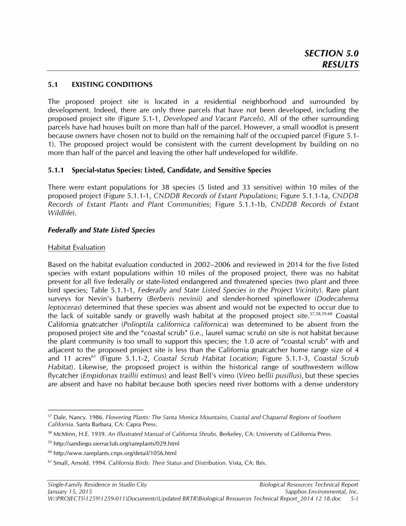
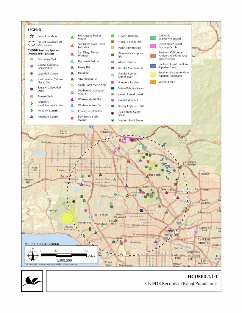
5.1 EXISTING CONDITIONS The proposed project site is located in a residential neighborhood and surrounded by development. Indeed, there are only three parcels that have not been developed, including the proposed project site (Figure 5.1-1, Developed and Vacant Parcels). All of the other surrounding parcels have had houses built on more than half of the parcel. However, a small woodlot is present because owners have chosen not to build on the remaining half of the occupied parcel (Figure 5.1-1). The proposed project would be consistent with the current development by building on no more than half of the parcel and leaving the other half undeveloped for wildlife. 5.1.1 Special-status Species: Listed, Candidate, and Sensitive Species There were extant populations for 38 species (5 listed and 33 sensitive) within 10 miles of the proposed project (Figure 5.1.1-1, CNDDB Records of Extant Populations; Figure 5.1.1-1a, CNDDB Records of Extant Plants and Plant Communities; Figure 5.1.1-1b, CNDDB Records of Extant Wildlife). Federally and State Listed Species Habitat Evaluation Based on the habitat evaluation conducted in 2002–2006 and reviewed in 2014 for the five listed species with extant populations within 10 miles of the proposed project, there was no habitat present for all five federally or state-listed endangered and threatened species (two plant and three bird species; Table 5.1.1-1, Federally and State Listed Species in the Project Vicinity). Rare plant surveys for Nevin’s barberry (Berberis nevinii) and slender-horned spineflower (Dodecahema leptoceras) determined that these species was absent and would not be expected to occur due to the lack of suitable sandy or gravelly wash habitat at the proposed project site.57,58,59,60 Coastal California gnatcatcher (Polioptila californica californica) was determined to be absent from the proposed project site and the “coastal scrub” (i.e., laurel sumac scrub) on site is not habitat because the plant community is too small to support this species; the 1.0 acre of “coastal scrub” with and adjacent to the proposed project site is less than the California gnatcatcher home range size of 4 and 11 acres61 (Figure 5.1.1-2, Coastal Scrub Habitat Location; Figure 5.1.1-3, Coastal Scrub Habitat). Likewise, the proposed project is within the historical range of southwestern willow flycatcher (Empidonax traillii extimus) and least Bell’s vireo (Vireo bellii pusillus), but these species are absent and have no habitat because both species need river bottoms with a dense understory
57 Dale, Nancy. 1986. Flowering Plants: The Santa Monica Mountains, Coastal and Chaparral Regions of Southern California. Santa Barbara, CA: Capra Press. 58 McMinn, H.E. 1939. An Illustrated Manual of California Shrubs. Berkeley, CA: University of California Press. 59 http://sandiego.sierraclub.org/rareplants/029.html 60 http://www.rareplants.cnps.org/detail/1056.html 61 Small, Arnold. 1994. California Birds: Their Status and Distribution. Vista, CA: Ibis.

Developed and Vacant Parcels
LEGENDParcels with DevelopmentUndeveloped Parcels
FIGURE 5.1-1
SOURCE: SEI, ESRI
Q:\1259\Patel_Housing\ArcProjects\BRTR\Dev_vs_Vacant.mxdo 0 50 100 150 20025
Feet1:1,500
XW
%2
!(#*
!(")
")
")
!(
!(
")
")
%2%2
")
#*#*
#*%2
XW #*#*#*
")
!(#*!(
$+$+
")
!(
!(
")
#*
#*#*
#*
XW
")
")
")
")
")
#*
#*#*")
#*#*#*
#* #*
#*
#*
#*
#*
#*
#*#*
#*
#*#*
#*
")
%2
")
")
!( %2
%2")
")
")
")
")
")
%2
%2
")
")
%2
")
")
XW
_̂
CNDDB Records of Extant Populations
LEGEND_̂ Project Location
Project Boundary 10-Mile Radius
CNDDB Sensitive Species(August 2014 dataset)!( Burrowing Owl
!(Coastal CaliforniaGnatcatcher
!( Least Bell's Vireo
!(Southwestern WillowFlycatcher
$+Santa Ana SpeckledDace
$+ Arroyo Chub
XWGertsch'sSocalchemmis Spider
XW Monarch Butterfly#* American Badger
#*Los Angeles PocketMouse
#*San Diego Black-TailedJackrabbit
#*San Diego DesertWoodrat
#* Big Free-tailed Bat#* Hoary Bat#* Pallid Bat#* Silver-haired Bat#* South Coast Marsh Vole
#*Southern GrasshopperMouse
#* Western Mastiff Bat#* Western Yellow Bat") Coulter's Goldfields
")Davidson's Bush-mallow
") Nevin's Barberry") Nuttall's Scrub Oak") Parish's Brittlescale
")Plummer's Mariposa-lily
") Mesa Horkelia") Slender Mariposa-lily
")Slender-hornedSpineflower
") Southern Tarplant") White Rabbit-tobacco%2 Coast Horned Lizard%2 Coastal Whiptail%2 Silvery Legless Lizard
%2Two-striped GarterSnake
%2 Western Pond Turtle
CaliforniaWalnut WoodlandRiversidian AlluvialFan Sage ScrubSouthern CaliforniaArroyo Chub/Santa AnaSucker StreamSouthern Coast Live OakRiparian ForestSouthern Sycamore AlderRiparian WoodlandWalnut Forest
FIGURE 5.1.1-1
SOURCE: SEI, ESRI, CNDDB
Q:\1259\Patel_Housing\ArcProjects\BRTR\CNDDB_Extant.mxdo 0 2.5 5 7.5
Miles1:300,000

")
")
")
")
")")
")
")
")
")
")
")
")
")
")
")
")
")
")
")
")
")
")
")
")
")
")
")
_̂
CNDDB Records of Extant Plants and Plant Communities
LEGEND_̂ Project Location
Project Boundary 10-Mile RadiusCNDDB Sensitive Plants and PlantCommunities (August 2014 dataset)") Coulter's Goldfields") Davidson's Bush-mallow") Nevin's Barberry") Nuttall's Scrub Oak
") Parish's Brittlescale") Plummer's Mariposa-lily") Mesa Horkelia") Slender Mariposa-lily") Slender-horned Spineflower") Southern Tarplant") White Rabbit-tobacco
CaliforniaWalnut WoodlandRiversidian AlluvialFan Sage ScrubSouthern Coast Live OakRiparian ForestSouthern Sycamore AlderRiparian WoodlandWalnut Forest
FIGURE 5.1.1-1a
SOURCE: SEI, ESRI, CNDDB
Q:\1259\Patel_Housing\ArcProjects\BRTR\CNDDB_Extant_A.mxdo 0 2.5 51.25
Miles1:225,000
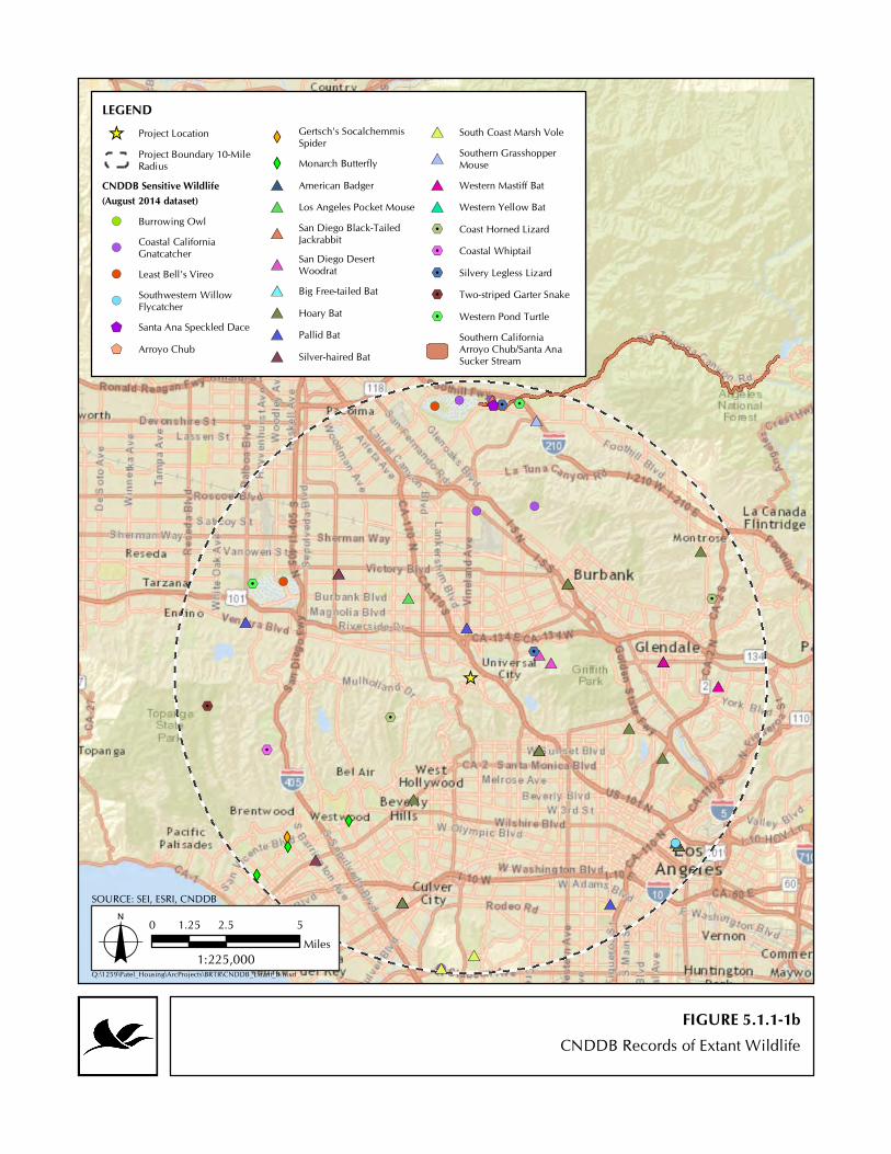
XW
%2
!(#*
!( !(
!( %2%2
#*#*
#*%2
XW #*#*#*!(#*!(
$+$+!(
!(
#*
#*#*
#*
XW
#*
#*#*
#*#*#*
#* #*
#*
#*
#*
#*
#*
#*#*
#*
#*#*
#*%2
!( %2
%2
%2
%2
%2
XW
_̂
CNDDB Records of Extant Wildlife
LEGEND_̂ Project Location
Project Boundary 10-MileRadius
CNDDB Sensitive Wildlife(August 2014 dataset)!( Burrowing Owl
!(Coastal CaliforniaGnatcatcher
!( Least Bell's Vireo
!(Southwestern WillowFlycatcher
$+ Santa Ana Speckled Dace$+ Arroyo Chub
XWGertsch's SocalchemmisSpider
XW Monarch Butterfly#* American Badger#* Los Angeles Pocket Mouse
#*San Diego Black-TailedJackrabbit
#*San Diego DesertWoodrat
#* Big Free-tailed Bat#* Hoary Bat#* Pallid Bat#* Silver-haired Bat
#* South Coast Marsh Vole
#*Southern GrasshopperMouse
#* Western Mastiff Bat#* Western Yellow Bat%2 Coast Horned Lizard%2 Coastal Whiptail%2 Silvery Legless Lizard%2 Two-striped Garter Snake%2 Western Pond Turtle
Southern CaliforniaArroyo Chub/Santa AnaSucker Stream
FIGURE 5.1.1-1b
SOURCE: SEI, ESRI, CNDDB
Q:\1259\Patel_Housing\ArcProjects\BRTR\CNDDB_Extant_B.mxdo 0 2.5 51.25
Miles1:225,000

Coastal Scrub Habitat Location
LEGENDProject BoundaryCoastal Scrub Habitat(0.14 acre within ParcelBoundary / 0.97 acre Total)
FIGURE 5.1.1-2
SOURCE: SEI, ESRI
Q:\1259\Patel_Housing\ArcProjects\BRTR\CoastalScrubHab.mxdo 0 50 100 15025
Feet1:1,000

FIGURE 5.1.1-3Coastal Scrub Habitat
PHOTO 1Coastal Scrub on adjacent parcel
PHOTO 2Coastal Scrub on western edge of parcel
Single-Family Residence in Studio City Biological Resources Technical Report January 15, 2015 Sapphos Environmental, Inc. W:\PROJECTS\1259\1259-011\Documents\Updated BRTR\Biological Resources Technical Report_2014 12 18.doc 5-2
dominated by shrubby willows, cottonwoods, and similar associated species.62,63,64,65 In contrast, the riparian habitat (i.e., an arroyo willow thicket) on and adjacent to the proposed project site is small (0.2 acre), isolated from other riparian areas, and lacking understory, meaning the proposed project site is not habitat for willow flycatcher or Bell’s vireo (Figure 5.1.1-4, Riparian Habitat Location, Figure 5.1.1-5, Riparian Habitat).66,67,68,69 Therefore, the proposed project would not impact federally or state listed species or their habitat.
62 Garrett, K. and J. Dunn. 1981. “Birds of Southern California: Status and Distribution.” Los Angeles Audubon Society, Los Angeles, CA. 63 http://www.fws.gov/nevada/protected_species/birds/species/swwf.html 64 United States Fish and Wildlife Service. 2002. Final Recovery Plan for the Southwestern Willow Flycatcher (Empidonax traillii extimus). Prepared by: Southwestern Willow Flycatcher Recovery Team Technical Subgroup. 65 United States Fish and Wildlife Service. 1998. Draft Recovery Plan for the Least Bell’s Vireo. Fish and Wildlife Service, Portland, OR. 139 pp. 66 Garrett, K. and J. Dunn. 1981. “Birds of Southern California: Status and Distribution.” Los Angeles Audubon Society, Los Angeles, CA. 67 http://www.fws.gov/nevada/protected_species/birds/species/swwf.html 68 United States Fish and Wildlife Service. 2002. Final Recovery Plan for the Southwestern Willow Flycatcher (Empidonax traillii extimus). Prepared by Southwestern Willow Flycatcher Recovery Team Technical Subgroup. 69 United States Fish and Wildlife Service. 1998. Draft Recovery Plan for the Least Bell’s Vireo. Fish and Wildlife Service, Portland, OR. 139 pp.

Riparian Habitat Location
LEGENDProject BoundaryRiparian Habitat(0.11 acre within ProjectBoundary / 0.16 acre Total)
FIGURE 5.1.1-4
SOURCE: SEI, ESRI
Q:\1259\Patel_Housing\ArcProjects\BRTR\RiparianHabitat.mxdo 0 50 10025
Feet1:800

FIGURE 5.1.1-5Riparian Habitat
PHOTO 2Downstream on northern edge of looking upstream

FIGURE 5.1.1-5Riparian Habitat
PHOTO 2View across the riparian area

Single-Family Residence in Studio City Biological Resources Technical Report January 15, 2015 Sapphos Environmental, Inc. W:\PROJECTS\1259\1259-011\Documents\Updated BRTR\Biological Resources Technical Report_2014 12 18.doc 5-3
TABLE 5.1.1-1 FEDERALLY AND STATE LISTED
SPECIES IN THE PROJECT VICINITY
Species Special Status
Status at Proposed Site Habitat Requirements and Historic Records
Plants
Nevin’s barberry (Berberis nevinii)
FE, SE, 1B.1
Absent/ No habitat
Preferred habitats include sandy and gravelly areas along margins of dry washes in the foothills of the Transverse and Peninsular Ranges below 2,000 feet in chaparral, coastal sage, cismontane woodland, and riparian scrub communities.70,71 One record is presumed to be a transplanted population in Griffith Park below water tower #113 along Vista Del Valle Road; this is the only record in the Santa Monica Mountains. Two naturally occurring records were from the Verdugo Mountains in Big Tujunga Wash and Wildwood Canyon.
slender-horned spineflower (Dodecahema leptoceras)
FE, SE, 1B.1
Absent/ No habitat
Preferred habitats include chaparral, coastal sage scrub, alluvial fan sage scrub, often found along flood deposited terraces and washes; once known from more than a dozen locations on outwash alluvial fans and terraces from the San Fernando Valley east along the San Gabriel Mountains frontage to the San Bernardino Valley and to Riverside County.72 Two records from within the Crescenta Valley; one record population is possibly extirpated due to development of La Crescenta-Montrose, but the second record in Big Tujunga Wash is likely extant.
Birds southwestern willow flycatcher (Empidonax traillii extimus)
FE, SE Absent/ No habitat
Requires riparian woodland and breeds in relatively dense riparian tree and shrub communities associated with rivers, swamps, and other wetlands. Habitat patches must be at least 0.25 acre in size and at least 9 m (30 ft) wide. One CNDDB record within 10-miles was from 1894. No habitat on the proposed project site given the riparian area is 0.1 acre and lacks understory.
least Bell's vireo (Vireo bellii pusillus)
FE, SE Absent/ No habitat
Habitat is riparian forest, riparian scrub, and riparian woodland with dense understory, which is required for nesting. Nests usually 1 m (3 ft) above ground. Population in Los Angeles County is increasing, with recent CNDDB records at Hansen Dam and Sepulveda Basin and numerous other eBird records in appropriate habitat. No habitat exists on the proposed project site given the riparian area is 0.1 acre and lacks understory.
coastal California gnatcatcher (Polioptila californica californica)
FT, SSC
Absent/ No habitat
A locally uncommon, non-migratory obligate nester of dense coastal sage scrub habitats occurring below or on arid hillsides, mesas, and washes. Its distribution is fragmented and restricted to Southern California; historical range extends from the southernmost coastal counties of Ventura, Los Angeles, Orange, San Diego, San Bernardino, and Riverside. Most recent records within 10 miles have been near Hansen Dam and Tujunga Valley. No habitat exists on the proposed project site given the level of surrounding development, plant community structure, and coastal scrub is about 1 acre.
KEY: FE = federal endangered FT = federal threatened SE = state endangered SSC = State of California Species of Special Concern CNPS categories: California Rare Plant Rank: List 1B: Rare, threatened, or endangered in California and elsewhere (0.1: Seriously endangered in California).
70 Munz, Philip A. 1974. A Flora of Southern California. Berkeley, CA: University of California Press. 71 Skinner, M.W. and B.M. Pavlik (eds.), 1994. California Native Plant Society’s Inventory of Rare and Endangered Vascular Plants of California. Sacramento, CA: California Native Plant Society. 72 Skinner, M.W. and B.M. Pavlik (eds.), 1994. California Native Plant Society’s Inventory of Rare and Endangered Vascular Plants of California. Sacramento, CA: California Native Plant Society.

Single-Family Residence in Studio City Biological Resources Technical Report January 15, 2015 Sapphos Environmental, Inc. W:\PROJECTS\1259\1259-011\Documents\Updated BRTR\Biological Resources Technical Report_2014 12 18.doc 5-4
Sensitive Species Habitat Evaluation Based on the habitat evaluation conducted in 2002–2006 and reviewed in 2014 for the 33 sensitive species with extant populations within 10 miles of the proposed project, there was no habitat for 25 of the 33 species of rare plants, species of special concern, or designated California special animals with species. The following species did not have habitat and would not occur:
Southern tarplant (Centromadia parryi ssp. australis), Coulter’s goldfields (Lasthenia glabrata ssp. coulteri), and Parish’s brittlescale (Atriplex parishii) because saline or alkaline wetlands were absent.
White rabbit-tobacco (Pseudognaphalium leucocephalum) because dry streambeds and washes were absent.
Plummer's mariposa-lily (Calochortus plummerae) because granitic and rocky soils were absent.
Mesa horkelia (Horkelia cuneata var. puberula) because the habitat is sandy or gravelly soils in maritime chaparral, cismontane woodland, and coastal scrub, especially foothills edges of the Los Angeles Basin. Recent records have only been along the foothills of the San Gabriel Mountains.
Nuttall’s scrub oak (Quercus dumosa) because the location of the CNDDB record is only “true,” un-hybridized Nuttall’s scrub oak in Los Angeles County. An oak survey on the site documented that only coast live oak and scrub oak were present on the parcel.73
Monarch butterfly (Danaus plexippus) roosts because Eucalyptus trees were absent. The distance from the coast and no sightings of this species in the fall 2014 surveys provide further evidence that no autumnal or winter roost occurs on the proposed project site.
Gertsch's socalchemmis spider (Socalchemmis gertschi) because records indicate that this species was first recognized as a species in 2001 from four museum specimens collected from 1936–1997 in the Santa Monica Mountains, mostly near Topanga Canyon.74 Scant other details exist on habitat requirements; therefore, this species was considered absent on the proposed project site.
Arroyo chub (Gila orcuttii), Santa Ana speckled dace (Rhinichthys osculus ssp. 3), western pond turtle (Emys marmorata), two-striped garter snake (Thamnophis hammondii), and south coast marsh vole (Microtus californicus stephensi) because freshwater wetlands or flowing water was absent.
Silvery legless lizard (Anniella pulchra pulchra) because looser soil types generally associated with active dune or old dune complexes were absent.
Burrowing owl (Athene cunicularia), San Diego black-tailed jackrabbit (Lepus californicus bennettii), and American badger (Taxidea taxus) because flat, open terrain was absent.
Peregrine falcon (Falco peregrinus) because there is no nesting or foraging habitat on the proposed project site given that these birds require open area in which to
73 Patel, Gunvant P. May 2002. Tree Report. Prepared by: Robert Hansen, West Hills, CA. 74 Platnick, N.I. and D. Ubick. 2001. “Revision of the North American Spiders of the New Genus Socalchemmis (Araneae, Tengellidae).” American Museum Novitates, no. 3339: 1–25.

Single-Family Residence in Studio City Biological Resources Technical Report January 15, 2015 Sapphos Environmental, Inc. W:\PROJECTS\1259\1259-011\Documents\Updated BRTR\Biological Resources Technical Report_2014 12 18.doc 5-5
hunt and cliffs or tall buildings for nesting.75,76 Further, their primary prey (i.e., ducks and pigeons) was absent from the proposed project site, and the forested community would be difficult for peregrine falcon to forage within because they hunt by diving at prey at an excess of 200 miles per hour.77 Even though nearby residents claimed to have observed peregrine falcon in the past,78 the observation would have been of a flyover (i.e., bird over the site but not using the habitat) or a misidentified raptor.
Western yellow bat (Lasiurus xanthinus) and roosts because palms and more arid environments were absent.
Western mastiff bat (Eumops perotis californicus) and big free-tailed bat (Nyctinomops macrotis) because rocky crevices were absent; furthermore, western mastiff bat generally avoids highly developed areas, such as the area surrounding the proposed project site.
Southern grasshopper mouse (Onychomys torridus ramona) because chenopod scrub in more arid environments was absent.
Los Angeles pocket mouse (Perognathus longimembris brevinasus) because the populations within the San Fernando Valley may all be extirpated.79
San Diego desert woodrat (Neotoma lepida intermedia) because habitat is coastal scrub, sagebrush scrub, chaparral often associated with large cactus patches. Although it can occur in oak woodlands, these woodlands have rocky outcroppings with crevices suitable for midden building; there were no rocky outcropping present that had crevices.
Directed Survey Of the 38 species with extant populations within 10 miles of the proposed project, only eight species had habitat on the proposed project site (Table 5.1.1-2, Sensitive Species with Habitat on the Proposed Project Site). The entire site is potential habitat for Davidson's bush-mallow (Malacothamnus davidsonii), Cooper’s hawk (Accipiter cooperii), silver-haired bat (Lasionycteris noctivagans), hoary bat (Lasiurus cinereus), and pallid bat (Antrozous pallidus). In addition, only the chaparral/coast sage scrub areas have habitat for slender mariposa-lily (Calochortus clavatus var. gracilis), coast horned lizard (Phrynosoma blainvillii), and coastal whiptail (Aspidoscelis tigris stejnegeri). Of these 8 species, 7 were determined to be absent based on directed surveys in 2002–2006 and 2014 (Table 5.1.1-2); only the Cooper’s hawk was observed to be present on the proposed project site.
75 Garrett, K. and J. Dunn. 1981. “Birds of Southern California: Status and Distribution.” Los Angeles Audubon Society, Los Angeles, CA. 76 White, Clayton M., Nancy J. Clum, Tom J. Cade and W. Grainger Hunt. 2002. Peregrine Falcon (Falco peregrinus), The Birds of North America Online (A. Poole, Ed.). Ithaca: Cornell Lab of Ornithology. Available at: http://bna.birds.cornell.edu/bna/species/660 77 White, Clayton M., Nancy J. Clum, Tom J. Cade and W. Grainger Hunt. 2002. Peregrine Falcon (Falco peregrinus), The Birds of North America Online (A. Poole, Ed.). Ithaca: Cornell Lab of Ornithology. Available at: http://bna.birds.cornell.edu/bna/species/660 78 Soluk, Alexandra and John. 2 January 2 2007. Appeal Letter/Master Appeal Form to the City Council of Los Angeles. Los Angeles, CA. Subject: CEQA: ENV. 2003-9111 MND; 3599 Lankershim Blvd. 79 California Department of Fish and Game. 1998. Terrestrial Mammal Species of Special Concern in California, ed. B.C. Bolster. Prepared by: Phillip V. Brylski, Paul W. Collins, Elizabeth D. Pierson, William E. Rainey, and Thomas E. Kucera.
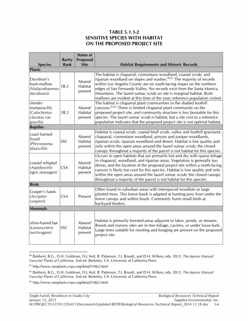
Single-Family Residence in Studio City Biological Resources Technical Report January 15, 2015 Sapphos Environmental, Inc. W:\PROJECTS\1259\1259-011\Documents\Updated BRTR\Biological Resources Technical Report_2014 12 18.doc 5-6
TABLE 5.1.1-2 SENSITIVE SPECIES WITH HABITAT ON THE PROPOSED PROJECT SITE
Species Rarity Rank
Status at Proposed
Site Habitat Requirements and Historic Records Plants
Davidson's bush-mallow (Malacothamnus davidsonii)
1B.2 Absent/ Habitat present
The habitat is chaparral, cismontane woodland, coastal scrub, and riparian woodland on slopes and washes.80,81 The majority of records within Los Angeles County are on south-facing slopes on the northern edges of San Fernando Valley. No records exist from the Santa Monica Mountains. The laurel sumac scrub on site is marginal habitat. Bush mallows are evident at this time of the year; reference population visited.
slender mariposa-lily (Calochortus clavatus var. gracilis)
1B.2 Absent/ Habitat present
The habitat is chaparral plant communities in the shaded foothill canyons.82,83 There is limited chaparral plant community on the proposed project site, and community structure is less favorable for this species. The laurel sumac scrub is habitat, but a site visit to a reference population indicates that the proposed project site is not optimal habitat.
Reptiles
coast horned lizard (Phrynosoma blainvillii)
SSC Absent/ Habitat present
Habitat is coastal scrub, coastal bluff scrub, valley and foothill grassland, chaparral, cismontane woodland, pinyon and juniper woodlands, riparian scrub, riparian woodland and desert. Habitat is low quality and only within the open areas around the laurel sumac scrub; the closed canopy throughout a majority of the parcel is not habitat for this species.
coastal whiptail (Aspidoscelis tigris stejnegeri)
CSA Absent/ Habitat present
Occurs in open habitats that are primarily hot and dry with sparse foliage in chaparral, woodland, and riparian areas. Vegetation is generally too dense, and the location of the proposed project site within a north-facing canyon is likely too cool for this species. Habitat is low quality and only within the open areas around the laurel sumac scrub; the closed canopy throughout a majority of the parcel is not habitat for this species.
Birds
Cooper’s hawk (Accipiter cooperii)
CSA Present
Often found in suburban areas with interspaced woodlots or large planted trees. This forest hawk is adapted at hunting prey from under the forest canopy and within brush. Commonly hunts small birds at backyard feeders.
Mammals
silver-haired bat (Lasionycteris noctivagans)
SSC Absent/ Habitat present
Habitat is primarily forested areas adjacent to lakes, ponds, or streams. Roosts and nursery sites are in tree foliage, cavities, or under loose bark. Large trees suitable for roosting and foraging are present on the proposed project site.
80 Baldwin, B.G., D.H. Goldman, D.J. Keil, R. Patterson, T.J. Rosatti, and D.H. Wilken, eds. 2012. The Jepson Manual: Vascular Plants of California. 2nd ed. Berkeley, CA: University of California Press. 81 http://www.rareplants.cnps.org/detail/1062.html 82 Baldwin, B.G., D.H. Goldman, D.J. Keil, R. Patterson, T.J. Rosatti, and D.H. Wilken, eds. 2012. The Jepson Manual: Vascular Plants of California. 2nd ed. Berkeley, CA: University of California Press. 83 http://www.rareplants.cnps.org/detail/1062.html

TABLE 5.1.1-2 SENSITIVE SPECIES WITH HABITAT
ON THE PROPOSED PROJECT SITE, Continued
Single-Family Residence in Studio City Biological Resources Technical Report January 15, 2015 Sapphos Environmental, Inc. W:\PROJECTS\1259\1259-011\Documents\Updated BRTR\Biological Resources Technical Report_2014 12 18.doc 5-7
Species Rarity Rank
Status at Proposed
Site Habitat Requirements and Historic Records Mammals
hoary bat (Lasiurus cinereus)
CSA Absent/ Habitat present
Forages over a wide range of habitats, but prefers open habitats with water and access to trees for roosting. Primarily roosts in trees and foliage. Large trees suitable for roosting and foraging are present on the proposed project site.
pallid bat (Antrozous pallidus)
SSC Absent/ Habitat present
Habitat is chaparral, coastal scrub, desert wash, Great Basin grassland, Great Basin scrub, Mojavean desert scrub, riparian woodland, Sonoran desert scrub, upper montane coniferous forest, and valley grassland. Roosts in within hollow trees, under bridges, and in buildings but sometimes in rock crevices. Large trees suitable for roosting and foraging are present on the proposed project site.
KEY: CNPS categories: California Rare Plant Rank: List 1B: Rare, threatened, or endangered in California and elsewhere; 0.1: Seriously endangered in California; 0.2: Fairly threatened in California. SSC = State of California Species of Special Concern CSA = California Special Animal: a general term that refers to all of the taxa the CNDDB is interested in tracking, regardless of their legal or protection status. The Department of Fish and Wildlife considers the taxa on this list to be those of greatest conservation need. For those species with statuses identified by USFWS and/or CDFW, the status is noted. Those species included on the list due to identification by other governmental agencies and/or non-governmental conservation organizations are listed as CSA.
Plants Davidson’s bush mallow is a shrub that primarily grows on the north side of San Fernando Valley on south-facing slopes of the foothills of the San Gabriel Mountains. It can be identified at any time of the year but was not observed on the proposed project site in 2014 or during surveys conducted from 2002–2006. Sapphos Environmental, Inc. performed a visit to a reference population of Davidson’s bush mallow, in which various bush mallow species were easily differentiated from other plant species. No bush mallows of any type were detected on the proposed project site. Therefore, Davidson’s bush mallow habitat is marginal and the species was determined to be absent from the proposed project site. Although 2014 surveys were conducted outside the bloom period for slender mariposa-lily, this species should have been detected during four different surveys conducted from 2002–2006 conducted during the spring bloom. Sapphos Environmental, Inc. performed a visit to a reference population of slender mariposa-lily. The reference population had desiccated seed heads that were apparent, indicating that slender mariposa-lily should have been detected on the proposed project site, if present. The reference population occurred within drier chaparral and was associated with different species than the dominant plants on the proposed project site. Therefore, slender mariposa-lily habitat is marginal and the species was determined to be absent from the proposed project site. Reptiles Coast horned lizard and coastal whiptail are associated with coastal scrub, chaparral, and open cismontane woodland. The woodlands on the proposed project site are not likely habitat given the dense canopy and litter cover, but the parcel uphill has a more open oak canopy, cleared understory, and a mix of chaparral-associated plant species. There is an opening in the woodlands

Single-Family Residence in Studio City Biological Resources Technical Report January 15, 2015 Sapphos Environmental, Inc. W:\PROJECTS\1259\1259-011\Documents\Updated BRTR\Biological Resources Technical Report_2014 12 18.doc 5-8
where coastal scrub/chaparral associated shrub species occur; however, most of the shrub community occurs adjacent to the proposed project site. The shrubs on the proposed project site are generally tall with a contiguous canopy, with most of the better quality habitat for coast horned lizard and coastal whiptail on the adjacent parcels. Therefore, habitat is low quality and only within the open areas around the laurel sumac scrub on the proposed parcel; these species were determined to be absent based on surveys in 2002–2006 and 2014. Birds Cooper’s hawk is a forest-dwelling hawk that lives in urban forested areas of Los Angeles County.84,85,86 Cooper’s hawk, a CDFW watch list species, was observed during surveys in 2014. This hawk has adapted to living in suburban areas and frequently hunts bird feeders for small birds. Although the proposed project would reduce potential nesting and foraging habitat, the overall effect would be minimal. Furthermore, if the proposed project used landscaping that attracted and benefited small birds, then Cooper’s hawk would also benefit from increased prey. Mammals No bats, bat signs, or bat roosts were observed during surveys. However, almost every large oak on the property had holes in the trunk that would be suitable roosts for tree-dwelling bats. Silver-haired bat, hoary bat, and pallid bat are tree-roosting bats that have the potential to occur in areas dominated by oaks. The woodlands on the proposed project site could serve as roosting and foraging habitat, but the lack of nearby water limits the value to these woodlands as roosting habitat. Although these trees may provide roosting habitat, these bats species are not typically faithful to a single roost,87 meaning that the loss of specific trees may not impact a population of tree roosting species because they will switch roost trees from night to night. Although habitat is present, these three species were determined to be absent based on directed surveys in 2014. Common Species The proposed project site serves as habitat for commonly encountered species of plants and animals that can tolerate a high level of urban development. As a result of surveys, Sapphos Environmental, Inc. observed 28 plants, 27 birds, 1 reptile, and 3 mammals (Appendix B). Forty-three (43) percent (12 of 28) of the plants species observed were nonnative species. Four (4) plant species had been previously observed but are currently extirpated, absent because of the drought, or present in very low abundance.
84 Garrett, K. and J. Dunn. 1981. “Birds of Southern California: Status and Distribution.” Los Angeles Audubon Society, Los Angeles, CA. 85 Ebird data 86 Curtis, Odette E., R. N. Rosenfield, and J. Bielefeldt. 2006. Cooper's Hawk (Accipiter cooperii), The Birds of North America Online (A. Poole, Ed.). Ithaca: Cornell Lab of Ornithology. Available at: http://bna.birds.cornell.edu/bna/species/075 87 Lewis, S.E. 1995. “Roost fidelity of bats: A review.” Journal of Mammalogy, 76: 481-496.

Single-Family Residence in Studio City Biological Resources Technical Report January 15, 2015 Sapphos Environmental, Inc. W:\PROJECTS\1259\1259-011\Documents\Updated BRTR\Biological Resources Technical Report_2014 12 18.doc 5-9
In addition to the species observed, CDFW and nearby residents identified 14 additional species, which were not observed during surveys, which have the potential to be present88,89 (Table 5.1.1-3, Not Observed Common Species with the Potential to Occur).
TABLE 5.1.1-3
NOT OBSERVED COMMON SPECIES WITH THE POTENTIAL TO OCCUR
Species Survey Results Habitat Notes
Amphibians California treefrog (Pseudacris cadaverina)
Absent/ No habitat
The typical habitat for this species is streams within canyons and rocky washes that have permanent pools.90,91
Pacific tree frog (Pseudacris regilla)
Absent/ Habitat present
In 2006, the Pacific tree frog was split into three species, with the local species being the Baja California treefrog (Pseudacris hypochondriaca). The species habitat can occur far from water, including woodlands, chaparral, and urban areas,92 all habitats documented on the proposed project site.
Reptiles
western toad (Anaxyrus boreas halophilus)
Absent/ Habitat present
The habitat for this species habitat includes a variety of areas, including streams, marshes, springs, and woodlands. The habitat on the proposed project site would be habitat for this species.
Birds black-chinned hummingbird (Archilochus alexandri)
Absent/ Habitat present
This is an uncommon species, and it does not associate with woodlands; however, the shrub community on and adjacent to the project site could be habitat for this species.
western scrub-jay (Aphelocoma californica)
Absent/ Habitat present
Presumed present because the presence of oaks could provide their primary food source of acorns.
northern rough-winged swallow (Stelgidopteryx serripennis)
Absent/ No habitat
There is no habitat for northern rough-winged swallow on the proposed project site because this species requires more open areas, especially near flowing or open water.93 The drainage on site is intermittent, and the vegetation cover is too dense for this species; however, it could forage in the skies above.
88 California Department of Fish and Wildlife. 23 June 2006. Streambed Alteration Agreement #1600-2005-0279-R5. Sacramento, CA. 89 Soluk, Alexandra and John. 2 January 2 2007. Appeal Letter/Master Appeal Form to the City Council of Los Angeles. Los Angeles, CA. Subject: CEQA: ENV. 2003-9111 MND; 3599 Lankershim Blvd. 90 http://www.californiaherps.com/frogs/pages/p.cadaverina.html 91 Stebbins, R.C. 2003. Western Reptiles and Amphibians. 3rd Edition. Houghton Mifflin Company, Boston, MA: pp. 221-222. 92 http://www.californiaherps.com/frogs/pages/p.hypochondriaca.html 93 De Jong, Michael J. 1996. Northern Rough-winged Swallow (Stelgidopteryx serripennis), The Birds of North America Online (A. Poole, Ed.). Ithaca: Cornell Lab of Ornithology. Available at: http://bna.birds.cornell.edu/bna/species/234

TABLE 5.1.1-3 NOT OBSERVED COMMON SPECIES
WITH THE POTENTIAL TO OCCUR, Continued
Single-Family Residence in Studio City Biological Resources Technical Report January 15, 2015 Sapphos Environmental, Inc. W:\PROJECTS\1259\1259-011\Documents\Updated BRTR\Biological Resources Technical Report_2014 12 18.doc 5-10
Species Survey Results Habitat Notes
Birds
Phainopepla (Phainopepla nitens)
Absent/ Habitat present
The oaks provide habitat; however, Phainopepla strongly associate with mistletoe, a primary food source.94 Given that mistletoe presence was observed to be absent-low within the surrounding woodland, this species is likely absent or rarely present.
song sparrow (Melospiza melodia)
Absent/ Habitat present
Potentially present. The lack of understory, especially a lack of understory in the riparian area, reduces the quality of the parcel for song sparrow; however, this species can be associated with houses.95
western screech-owl (Megascops kennicottii) /great horned owl (Bubo virginianus)
Absent/ Habitat present
Both species occurs in suburban to urban environments, but great horned owl is more likely to occur.
Mammals
raccoon (Procyon lotor) Absent/ Habitat present
This species is commonly associates with suburban to urban areas with tree cover.
striped skunk (Mephitis mephitis)
Absent/ Habitat present
This species associates with suburban to urban areas where natural areas border development.
bobcat (Lynx rufus) Absent/ Habitat present
This species is typically found within the foothills of the Santa Monica Mountains but is known to venture into proximal suburban areas.
rabbit species (Lepus curpaeums)
Absent/ Habitat present
The observers did not specify the type of rabbit species that have been observed,96 but cottontails (Sylvilagus sp.) are the only rabbit species within the area of the proposed project site. Cottontails associate with suburban to urban areas.
Virginia opossum (Didelphis virginiana)
Absent/ Habitat present
This species commonly associates with suburban to urban areas with tree cover.
5.1.2 Vegetation Communities and State-Designated Sensitive Habitat The soils on the proposed project site and the surrounding properties are classified as primarily consisting of weathered sandstone and claystone.97 The underlying rock unit is a member of the Topanga Formation from the Middle Miocene, and consists of steeply bedded, mostly gray
94 Chu, Miyoko and Glenn Walsberg. 1999. Phainopepla (Phainopepla nitens), The Birds of North America Online (A. Poole, Ed.). Ithaca: Cornell Lab of Ornithology. Available at: http://bna.birds.cornell.edu/bna/species/415 95 Arcese, Peter, Mark K. Sogge, Amy B. Marr and Michael A. Patten. 2002. Song Sparrow (Melospiza melodia), The Birds of North America Online (A. Poole, Ed.). Ithaca: Cornell Lab of Ornithology. Available at: http://bna.birds.cornell.edu/bna/species/704 96 Soluk, Alexandra and John. 2 January 2 2007. Appeal Letter/Master Appeal Form to the City Council of Los Angeles. Los Angeles, CA. Subject: CEQA: ENV. 2003-9111 MND; 3599 Lankershim Blvd. 97 Hoots, H. W. 1931. “Geology of the Eastern Part of the Santa Monica Mountains, Los Angeles, County, California.” Shorter Contributions to General Geology, 1930; U.S. Geological Survey Professional Paper, 165: 94–98.

Single-Family Residence in Studio City Biological Resources Technical Report January 15, 2015 Sapphos Environmental, Inc. W:\PROJECTS\1259\1259-011\Documents\Updated BRTR\Biological Resources Technical Report_2014 12 18.doc 5-11
micaceous clay shale or claystone, crumbly where weathered, and thin interbeds of gray to tan semi-friable sandstone.98 As a result of plant community mapping in 2005 using the Holland classification, the proposed project site was characterized as having three plant communities: mule fat scrub, Venturan coastal sage scrub, and coast live oak woodland.99,100 The plant community mapping has been updated using the MCV classification system and field surveys conducted in 2014. As a result, three plant communities were identified: coast live oak woodland , arroyo willow thicket, and laurel sumac scrub (Table 5.1.2-1, Plant Communities on the Proposed Project Site; Figure 5.1.2-1, Plant Communities, Appendix C, Plant Community Survey Data Sheets).
TABLE 5.1.2-1
PLANT COMMUNITIES ON THE PROPOSED PROJECT SITE
MCV Name Wildlife Habitat Type Available Acres Maximum Potential
Impact Area Coast Live Oak Woodland Oak Woodland 0.25 0.09Arroyo Willow Thicket Riparian 0.10 0.006Laurel Sumac Scrub Coastal Sage Scrub 0.14 0.12Developed Not applicable 0.01 0.01Total 0.50 0.226
Coast Live Oak Woodland (Quercus agrifolia Woodland Alliance) The small woodlot surrounded by developed houses is dominated by coast live oak woodland. The community is surrounded by existing houses. This community occurs along the hillside, both on the proposed project parcel and on adjacent parcels (Figure 5.1.2-1; Figure 5.1.2-2, Coast Live Oak Woodland Photos). Coast live oak woodland was determined to be present on the proposed project site based on a >50% cover of coast live oak in the tree canopy.101 Coast live oak woodland has a rarity ranking of G5 S4, and is not considered sensitive in California. In addition, the alliance found on the proposed project site is not considered sensitive. The non-drainage portions of the hillside are dominated by mature coast live oak, but the understory is generally lacking. Approximately 5–10 deer were noted within the small parcels and game trails, and hoof punch was noted throughout this plant community; the high concentration of deer may have resulted in a lack of understory, which has been noted in urban areas where deer are over abundant.102 In addition, the adjacent occupied parcel appears to have the understory vegetation cleared, which reduces the value for wildlife and sensitive plant species. Toyon (Heteromeles arbutifolia), poison oak (Toxicodendron diversilobum), and black sage (Salvia
98 Hoots, H. W. 1931. “Geology of the Eastern Part of the Santa Monica Mountains, Los Angeles, County, California.” Shorter Contributions to General Geology, 1930; U.S. Geological Survey Professional Paper, 165: 94–98. 99 Sapphos Environmental, Inc. 7 February 2003. Memorandum for the Record: Regulatory Permitting Support Services in Support of Development of a Single-Family Residence. Pasadena, CA. 100 Sapphos Environmental, Inc. 1 April 2005. Memorandum for the Record: Plant Community Assessment at 3599 Lankershim Boulevard. Pasadena, CA. 101 Sawyer, J.O., T. Keeler-Wolf, and J.M. Evens. 2009. A Manual of California Vegetation. Second Edition. Sacramento, CA: California Native Plant Society Press. 102 Rooney, T.P. 2001. Deer impacts of forest ecosystems: a North American perspective. Forestry (74):201-208.

Plant Communities
LEGENDProject BoundaryParcels
Plant Communities (Acreagewithin Project Boundary)
Arroyo Willow Thicket(0.11 acre)Coast Live Oak Woodland(0.25 acre)Developed (0.014 acre)Laurel Sumac Scrub(0.14 acre)
FIGURE 5.1.2-1
SOURCE: SEI, ESRI
Q:\1259\Patel_Housing\ArcProjects\BRTR\PlantCommunities.mxdo 0 50 100 150 20025
Feet1:1,500

FIGURE 5.1.2-2Coast Live Oak Woodland Photos
PHOTO 1Oak Woodlands on the eastern portion of the parcel

FIGURE 5.1.2-2Coast Live Oak Woodland Photos
PHOTO 2Oak Woodlands on the western portion of the parcel

FIGURE 5.1.2-2Coast Live Oak Woodland Photos
PHOTO 3Typical understory composition of Oak Woodlands on the parcel

Single-Family Residence in Studio City Biological Resources Technical Report January 15, 2015 Sapphos Environmental, Inc. W:\PROJECTS\1259\1259-011\Documents\Updated BRTR\Biological Resources Technical Report_2014 12 18.doc 5-12
mellifera) were observed within the eastern portion but were less prevalent on the western portion of the woodland on the parcel, but the western portion had some scrub oak (Quercus berberidifolia) in the understory. Other shrubs were present along the plant community boundaries where coast live oak woodland integrates with mulefat thickets, laurel sumac scrub, arroyo willow thickets, and annual brome grassland communities. There is 0.25 acre of coast live oak woodland on the proposed project parcel. The proposed project would convert approximately 0.09 acre of coast live oak woodland to development to accommodate a house and associated landscaping. Permanent impacts could be smaller if alternative project footprints were approved. In addition, although the buffer was analyzed as a permanent impact in this BRTR, it could be considered a temporary impact if landscaping within the project buffer were designed to restore the area to coast live oak woodland. Arroyo Willow Thicket (Salix lasiolepis Shrubland Alliance) The arroyo willow thickets occur on the proposed project site at the end of an existing driveway (Figure 5.1.2-1, Figure 5.1.2-3, Arroyo Willow Thicket Photos). Arroyo willow thickets were determined to be present on the proposed project site based on a >50% relative cover of arroyo willow (Salix lasiolepis) in the tree canopy and no other shrubs with greater relative cover.103 Arroyo willow thicket has a rarity ranking of G4 S4, and is not considered sensitive in California. The willow community occurs in an area that has been previously impacted (i.e., scrapped out and appears to have been anthropogenically flattened) and replanted. Further, a slight man-made berm at the end of the driveway may curtail the natural water flow such that water could pool. This flattened area is the only location that willows are growing within the drainage and the understory is lacking. The understory appears to have been heavily impacted by human foot traffic given a foot trail was observed. Indeed, the nearby residents stated that they regularly used the private parcel to access their adjoining lands.104 The understory species present were generally nonnative species: date palm (Phoenix sp.), Washington fan palm (Washingtonia robusta), oleander (Nerium oleander), horehound (Marrubium vulgare), tree tobacco (Nicotiana glauca), smilo grass (Stipa miliacea), ripgut brome (Bromus diandrus), leafy bent grass (Agrostis pallens), Italian thistle (Carduus pycnocephalus), and cape honeysuckle (Tecoma capensis). Slightly upstream, at the edge of the willow, mulefat (Baccharis salicifolia) is growing along a steep slope (Figure 5.1.2-4, Mulefat at Edge of Arroyo Willow Thicket); given the small size of the mulefat shrub, this congregation was classified as part of the arroyo willow thicket rather than an independent plant community. Water was observed below this plant community, draining into the arroyo willow thicket. Potentially, groundwater is flowing under the mulefat thickets, allowing this riparian species to occur on the steep slopes. Another “perennial spring” occurred at the edge of the existing driveway as recently as 2005;105 however, the area appears to have been naturally or unnaturally filled, such that the hole where the “spring” occurred is no longer visible.
103 Sawyer, J.O., T. Keeler-Wolf, and J.M. Evens. 2009. A Manual of California Vegetation. Second Edition. Sacramento, CA: California Native Plant Society Press. 104 Soluk, Alexandra and John Soluk. 9 October 2014. Conversation with Sapphos Environmental, Inc., Pasadena, CA. 105 Sapphos Environmental, Inc. 1 April 2005. Memorandum for the Record: Plant Community Assessment at 3599 Lankershim Boulevard. Pasadena, CA.

FIGURE 5.1.2-3Arroyo Willow Thicket Photos
PHOTO 1Center of Arroyo Willow Thicket
PHOTO 2View of Arroyo Willow Thicket looking upstream
Drainage infl ow

FIGURE 5.1.2-3Arroyo Willow Thicket Photos
PHOTO 3View of the Majority of the Arroyo Willow Thicket
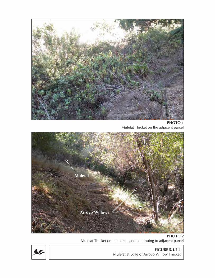
FIGURE 5.1.2-4Mulefat at Edge of Arroyo Willow Thicket
PHOTO 1Mulefat Thicket on the adjacent parcel
PHOTO 2Mulefat Thicket on the parcel and continuing to adjacent parcel
Mulefat
Arroyo Willows
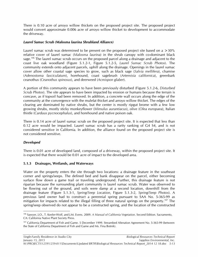
Single-Family Residence in Studio City Biological Resources Technical Report January 15, 2015 Sapphos Environmental, Inc. W:\PROJECTS\1259\1259-011\Documents\Updated BRTR\Biological Resources Technical Report_2014 12 18.doc 5-13
There is 0.10 acre of arroyo willow thickets on the proposed project site. The proposed project would convert approximate 0.006 acre of arroyo willow thicket to development to accommodate the driveway. Laurel Sumac Scrub (Malosma laurina Shrubland Alliance) Laurel sumac scrub was determined to be present on the proposed project site based on a >30% relative cover of laurel sumac (Malosma laurina) in the shrub canopy with co-dominant black sage.106 The laurel sumac scrub occurs on the proposed parcel along a drainage and adjacent to the coast live oak woodland (Figure 5.1.2-1, Figure 5.1.2-5, Laurel Sumac Scrub Photos). The community extends onto adjacent parcels, uphill along the drainage. Openings in the laurel sumac cover allow other coastal sage species to grow, such as black sage (Salvia mellifera), chamise (Adenostoma fasciculatum), horehound, coast sagebrush (Artemisia californica), greenbark ceanothus (Ceanothus spinosus), and deerweed (Acmispon glaber). A portion of this community appears to have been previously disturbed (Figure 5.1.2-6, Disturbed Scrub Photos). The site appears to have been impacted by erosion or humans because the terrain is concave, as if topsoil had been removed. In addition, a concrete wall occurs along the edge of the community at the convergence with the mulefat thicket and arroyo willow thicket. The edges of the clearing are dominated by native shrubs, but the center is mostly ripgut brome with a few low growing shrubs, mostly sticky monkeyflower (Mimulus aurantiacus), olive (Olea europaea), Italian thistle (Carduus pycnocephalus), and horehound and native poison oak. There is 0.14 acre of laurel sumac scrub on the proposed project site. It is expected that less than 0.12 acre would be impacted. Laurel sumac scrub has a rarity ranking of G4 S4, and is not considered sensitive in California. In addition, the alliance found on the proposed project site is not considered sensitive. Developed There is 0.01 acre of developed land, composed of a driveway, within the proposed project site. It is expected that there would be 0.01 acre of impact to the developed area. 5.1.3 Drainages, Wetlands, and Waterways Water on the property enters the site through two locations: a drainage feature in the southeast corner and springs/seeps. The defined bed and bank disappear on the parcel, either becoming surface flow down a game trail or traveling underground. Further, this drainage feature is not riparian because the surrounding plant community is laurel sumac scrub. Water was observed to be flowing out of the ground, and soils were damp at a second location, downhill from the drainage feature (Figure 5.1.3-1, Spring/Seep Location, Figure 5.1.3-2, Spring/Seep Photos). A previous land owner had to construct a perennial spring pursuant to SAA No. 5-365-99 as mitigation for impacts related to the illegal filling of three natural springs on the property.107 The spring/seep observed do not appear to be a constructed spring, and the location of the constructed
106 Sawyer, J.O., T. Keeler-Wolf, and J.M. Evens. 2009. A Manual of California Vegetation. Second Edition. Sacramento, CA: California Native Plant Society Press. 107 California Department of Fish and Game. 5 December 1999. Streambed Alteration Agreement No. 5-365-99 (between the State of California Department of Fish and Game and Ms. Fina Botnik).

FIGURE 5.1.2-5Laurel Sumac Scrub Photos
PHOTO 1Laurel Sumac Scrub and drainage on adjacent parcel
PHOTO 2Laurel Sumac Scrub with dense sumac
Drainage Feature
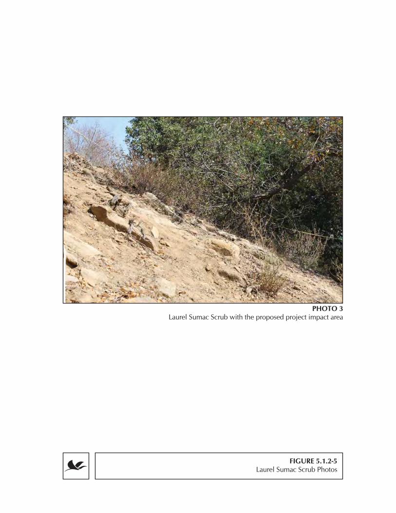
FIGURE 5.1.2-5Laurel Sumac Scrub Photos
PHOTO 3Laurel Sumac Scrub with the proposed project impact area

FIGURE 5.1.2-6Disturbed Scrub Photos
PHOTO 1Disturbed area highlighting the apparent erosion
or anthropogenic change on adjacent parcel

!(
!(
!(
!(
Spring/Seep Location
LEGEND!( Spring Location!( Soil Pit
Project BoundaryArroyo Willow ThicketPlant Community
FIGURE 5.1.3-1
SOURCE: SEI, ESRI
Q:\1259\Patel_Housing\ArcProjects\BRTR\SpringLocations.mxdo 0 50 10025
Feet1:800
FIGURE 5.1.3-2Spring/Seep Photos
G:\1259\1259-011\Documents\BRTR
PHOTO 1Extent of Surface Flow on Parcel

FIGURE 5.1.3-2Spring/Seep Photos
PHOTO 2Spring-Seep

FIGURE 5.1.3-2Spring/Seep Photos
PHOTO 3Close-up of Spring-Seep
FIGURE 5.1.3-2Spring/Seep Photos
PHOTO 4Wet Soil near Spring-Seep
Wet Soil

Single-Family Residence in Studio City Biological Resources Technical Report January 15, 2015 Sapphos Environmental, Inc. W:\PROJECTS\1259\1259-011\Documents\Updated BRTR\Biological Resources Technical Report_2014 12 18.doc 5-14
spring appears to have been naturally filled. However, the surface flow quickly returns underground. Any surface water from the drainage feature of the spring/seep would then enter a basin (Figure 5.1.2-3), which appears to be an area previously impacted by construction due to the presence of a cut-out cliff and spoils that direct the water away from the developed driveway. Downstream and off the parcels, the terrain is such that water is likely to flow along the edge of the existing driveway. Surface flow was observed at the bottom of the driveway, where water was flowing into a storm drain located at the end of Lankershim Boulevard. Based on existing data on terrain and storm drainages in the area, it is assumed that the storm drain connects to an existing storm drain system at the corner of Lankershim Boulevard and Vineland Avenue, which then drains into the Los Angeles River (Figure 5.1.3-3, Storm Drains Downhill of the Proposed Project Site). Federal Wetlands The NWI map for this project does not include any federal wetlands.108 Based on the wetland delineation performed on site in 2014, the proposed project does not have a wetland subject to USACOE jurisdiction because of a lack of wetland vegetation, soils, or hydrology. Previously, the USACOE surveyed the site and determined that the riparian area on the parcel is not subject to USACOE jurisdiction.109,110,111 The results of the 2014 wetland delineation found:
1) Vegetation: Facultative wetland and facultative plants were present in the Arroyo Willow Thicket and Mulefat Scrub communities. The tree stratum at both sampling locations was dominated by arroyo willow, a facultative wetland species, but the shrub and herb stratums were dominated by cape honeysuckle (Tecoma capensis), laurel sumac, leafy bent grass, and smilo grass, which are all facultative upland species. The vegetation at the sampling location at the center of the riparian area was positive for wetland vegetation, based on the Prevalence Index. Therefore, wetland vegetation was determined to be present (Appendix D, USACOE Wetland Determination Data Form-Arid West Region).
2) Soils: Given the presence of roots and compact soils, soil pits could be dug only to a depth of 17 and 13 inches. Soils within both soils pits did not have redox, color indicating wetland soils, or any of the other hydric soil indicators (Appendix D). Therefore, the soils were determined to be non-wetland.
3) Hydrology: No primary or secondary wetland hydrology features were observed (Appendix D). Therefore, the hydrology was classified as non-wetland.
108 U.S. Geologic Survey. 2012. 7.5-Minute Series, Burbank, California, Topographic Quadrangle. Reston, VA. 109 United States Army Corps of Engineers. 21 July 2006. Letter to Mr. Ketan Kumar. 110 Sapphos Environmental, Inc., 29 April 2002. Memorandum for the Record. Subject: Results of Riparian Assessment Prepared for: Mr. Gary Patel, Los Angeles, CA. Prepared by: Sapphos Environmental, Inc., Pasadena, CA. 111 Sapphos Environmental, Inc., 1 April 2005. Memorandum for the Record. Subject: Plant Community Assessment at 3599 Lankershim Boulevard. Prepared for: Mr. Gary Patel, Los Angeles, CA. Prepared by: Sapphos Environmental, Inc., Pasadena, CA.

!(
Storm Drains Downhill of the Proposed Project Site
LEGEND!( Storm Drain with Water Flow
Presumed Storm Drain ConnectionStandard Gravity MainLos Angeles RiverProject Boundary
FIGURE 5.1.3-3
SOURCE: SEI, ESRI, LA Co.
Q:\1259\Patel_Housing\ArcProjects\BRTR\StormDrains.mxdo 0 200 400100
Feet1:3,500
!(
Los Angeles River
1:20,000
0 500 1,000250Feet
Single-Family Residence in Studio City Biological Resources Technical Report January 15, 2015 Sapphos Environmental, Inc. W:\PROJECTS\1259\1259-011\Documents\Updated BRTR\Biological Resources Technical Report_2014 12 18.doc 5-15
State Wetlands No blue-line features were present on the site, and the USGS maps do not indicate the presence of streams. However, the presence of the riparian habitat and connection to the Los Angeles River via covered storm drains means that the proposed project is subject to the jurisdiction of CDFW and the Regional Water Quality Control Board (RWQCB). Based on CDFW’s definition of a wetland, the drainage feature and basin on the proposed project site is subject to CDFW jurisdiction. Indeed, SAAs had been previously issued by CDFW and the parcels had been mitigated for prior, unauthorized impacts from a previous land owner.112,113,114 CDFW typically asserts jurisdiction to the top of a stream bank, or the outer limits of riparian vegetation, whichever is greater. Therefore, mapping of the CDFW jurisdictional area followed the limit of the riparian vegetation except for downstream portions of the basin where vegetation was absent but a man-made bank was present (Figure 5.1.1-4, Figure 5.1.2-1); based on this, the limits of the CDFW jurisdiction included the springs/seeps but not where surface flow from the non-riparian drainage feature would be entering the riparian area and basin. All of the areas meeting criteria for CDFW jurisdiction also met the criteria for RWQCB jurisdiction. 5.1.4 Fish or Wildlife Movement Corridors or Nursery Sites Sapphos Environmental, Inc. observed worn game trails on the proposed project site that generally was parallel with the crest of the hill (Figure 5.1.4-1, Approximate Location of Observed Game Trails). In addition, 5–10 deer were observed moving on and adjacent to the proposed project parcel, especially higher up the slope on an occupied parcel where a wider man-made trail was created from a slope stabilization feature. Wildlife cameras took 249 sets of photos/videos on the proposed project site, but wildlife was detected only on 138 photos/videos (55%); the remainder of the photos without wildlife was not used because it was not possible to determine if wind-blown plants or fast-moving wildlife were the reason the camera activated. Sapphos Environmental, Inc. observed mule deer in 106 photo/video sets, a gray squirrel on 31 photo/video sets, and an unidentified snake in one (1) photo/video set (Figure 5.1.4-2, Wildlife Camera Photos). During the October 9, 2014 survey, biologists observed that deer were more frequently using trails upslope on undeveloped portions of occupied parcels. Biologists also noted coyote running up the driveway of the adjacent houses on Lankershim Boulevard, but the understory on the proposed project site is conducive for foraging only. Mule deer have a home range of 0.8 to 2 square miles, and coyotes have a home range of 4 to 8 square miles, meaning that both species could use the proposed project parcel for foraging only and be bedding down/denning in larger areas of contiguous habitat within several miles of the proposed project site. Camera 1 observed only squirrels (i.e., no deer); however, the numbers of deer photographs were similar among Camera 2–5, with 28, 20, 34, and 24 photos, respectively. However, despite similar number of photos, many of the photos from Camera 2 and 3 were of foraging deer; indeed, deer was observed at Camera 2 on 43 percent (6 of 14) and at Camera 3 on 36 percent (5 of 14) of the observation days. In contrast, Camera 4 photographed deer on 85 percent (12 of 14) and Camera 5 on 81 percent (9 of 11) of the observation days.
112 California Department of Fish and Wildlife. 18 December 1991. Agreement Regarding Proposed Stream or Lake Alteration. 113 California Department of Fish and Wildlife. 23 June 2006. Streambed Alteration Agreement #1600-2005-0279-R5 114 California Department of Fish and Game. 5 December 1999. Streambed Alteration Agreement No. 5-365-99 (between the State of California Department of Fish and Game and Ms. Fina Botnik).

!.!.
!.
!.
!.
Camera 4
Camera 3
Camera 2
Camera 1
Camera 5
Approximate Location of Observed Game Trails
LEGEND!. Trail Camera Location
Observed Game TrailsProject BoundaryParcels
FIGURE 5.1.4-1
SOURCE: SEI, ESRI
Q:\1259\Patel_Housing\ArcProjects\BRTR\ObservedGame.mxdo 0 50 10025
Feet1:800

FIGURE 5.1.4-2Wildlife Camera Photos
PHOTO 2Camera 2 Group of foraging deer
PHOTO 1Camera 1 Gray Squirrel

FIGURE 5.1.4-2Wildlife Camera Photos
PHOTO 3Camera 3 Foraging deer
PHOTO 4Camera 5 Deer with uphill game trail in the background

Single-Family Residence in Studio City Biological Resources Technical Report January 15, 2015 Sapphos Environmental, Inc. W:\PROJECTS\1259\1259-011\Documents\Updated BRTR\Biological Resources Technical Report_2014 12 18.doc 5-16
Based on the data, local deer movement in autumn seems to occur more regularly on the eastern and upper portions of the proposed project parcel. Impacts would occur in the lower and western portions of the parcel, close to Cameras 1 and 2, which had less frequent deer observations. Areas with more frequent deer observations would be preserved. Indeed, Cameras 4 and 5 were placed near this trail. Most likely, this slope stabilization feature serves as a primary movement route. Wildlife corridors are areas in between large tracts of habitat, in which wildlife pass through in order to reach higher quality habitat. Given the terrain, local movement would generally occur from an east to west/north-west direction. The parcel has limited value as a corridor because highly developed areas, such as Universal Studios and housing developments, occur north and west (Figure 5.1.4-3, Potential Corridors of Undeveloped Areas within Developed Areas). Wildlife moving westerly would cross Willowcrest Avenue to reach a woodlot surrounded by houses, but the movement farther west/north across Vineland Avenue and Sunshine Terrance is impeded by development. However, there are less developed lots to the south of the project, which could allow for wildlife movement near the ridge crest that Mulholland Drive bisects. Wildlife moving along these areas may enter the parcel from the east, but movement would end near Vineland Avenue and Sunshine Terrance. Two local game trails (including one cutoff) are expected to be impacted as a result of the proposed project parcel; however, the deer in the area persist despite development and are utilizing man-made trails. No migratory fish routes or nurseries would be affected as a result of the proposed project given the lack of permanent water connecting to waterways. Birds have a potential to nest on site; however, no rookeries are present. 5.1.5 Plans and Policies City of Los Angeles General Plan After further review of the City of Los Angeles General Plan, it was determined that one policy may potentially conflict with the proposed project.115 The proposed project would not be expected to conflict with Section 12, Policy 1. The proposed project is in conflict with Section 6, Policy 1 because sensitive wildlife has the potential to occur based on the presence of habitat and riparian habitat. Protected Tree Ordinance The Protected Tree Ordinance established which species are protected and the regulations enacted for those tree species within the boundaries of the City of Los Angeles. An oak tree survey was performed by a certified arborist, which documented two oak species, coast live oak and scrub oak, with a trunk diameter of 2 inches or greater;116 both species were observed on October 9 and 23, 2014. However, only the coast live oak is classified as “Protected Trees” under the oak tree ordinance because the ordinance does not extend to scrub oaks. Although the ordinance specifically calls out Quercus dumosa scrub oak, a rare plant, Q. dumosa is a term that is often applied to 6+ scrub oak species within the Q. dumosa complex, whose taxonomy has been
115 City of Los Angeles Department of City Planning, 26 September 2001. Conservation Element of the City of Los Angeles General Plan. Available at: http://www.ci.la.ca.us/PLN/ 116 Arbor Essence. 10 March 2005. 3599 Lankershim Boulevard, Oak Tree Report and Impact Evaluation Based on Proposed Development. Contact: Sapphos Environmental, Inc., Pasadena, CA.

Potential Corridors of Undeveloped Areas within Developed AreasFIGURE 5.1.4-3
SOURCE: SEI, ESRI
Q:\1259\Patel_Housing\ArcProjects\BRTR\PotentialCorridors.mxdo 0 1,500 3,000750
Feet1:20,000
LEGENDObserved Game TrailsProject BoundaryDeveloped Areas
0 100 200 30050Feet
1:3,500

Single-Family Residence in Studio City Biological Resources Technical Report January 15, 2015 Sapphos Environmental, Inc. W:\PROJECTS\1259\1259-011\Documents\Updated BRTR\Biological Resources Technical Report_2014 12 18.doc 5-17
periodically realigned.117 According to the oak tree report, there are 11 coast live oaks (Quercus agrifolia), eight (8) of which were rated D by the certified arborist, meaning that the trees are in various states of decline as a result of disease, pests, or stress and could be considered hazardous.118 Based on the tree condition specified by the certified arborist, these eight (8) trees may be permitted for removal, contingent on approval by the Board of Public Works, because the ordinance allows for removal of protected trees that show “a substantial decline from a condition of normal health and vigor, and restoration.” A maximum of three (3) protected oaks and one (1) scrub oak may be impacted as a result of the proposed project. In addition, the driplines of four (4) healthy protected oaks occur within the proposed project buffer; activity within the driplines are considered impacts under the City of Los Angeles ordinance because construction could damage the root system. Mulholland Scenic Parkway Specific Plan
Sapphos Environmental, Inc. reviewed USGS topographical maps of the proposed project site. Based on these maps, there were no streams located on the project parcel; rather, the riparian plants are present because an erosional drainage can provide enough water for these plants.119 Therefore, the proposed project is not in conflict with the stream provision of the MSPSP based on the MSPSP’s definition of streams. There are Quercus agrifolia (i.e., coast live oak) present on the proposed project site, which has a potential to conflict with the oak tree provision of the MSPSP. 5.1.6 HCPs and NCCPs The proposed project site is not located within the boundaries of any Habitat Conservation Plan (HCP) or Natural Community Conservation Plan (NCCP).120 This was confirmed by USFWS and CDFW.121,122 There are three HCPs/NCCPs in Los Angeles County: the West Mojave HCP and Desert Renewable Energy Conservation Plan NCCP/HCP located in the Mojave Desert and the Palos Verdes Peninsula NCCP/HCP. 5.2 CEQA ANALYSIS The State CEQA Guidelines recommend the consideration of the following six questions when addressing the potential for significant impacts to biological resources: (a) Have a substantial adverse effect, either directly or through habitat modification, on any
species identified as a candidate, sensitive, or special status species in local or regional
117 Fryer, Janet L. 2012. Quercus berberidifolia, Q. dumosa. In: Fire Effects Information System, [Online]. U.S. Department of Agriculture, Forest Service, Rocky Mountain Research Station, Fire Sciences Laboratory (Producer). Available: http://www.fs.fed.us/database/feis/ [2014, November 4]. 118 Arbor Essence. 10 March 2005. 3599 Lankershim Boulevard, Oak Tree Report and Impact Evaluation Based on Proposed Development. Contact: Sapphos Environmental, Inc., Pasadena, CA. 119 U.S. Geological Survey. [1966] Photo inspected 1972. 7.5-Minute Series, Burbank, California, Topographic Quadrangle. Scale 1:24,000. Reston, VA. 120 https://www.wildlife.ca.gov/Conservation/Planning/NCCP 121 Sapphos Environmental, Inc. 8 April 2003. Conversation with Bill Tibbets, California Department of Fish and Game, San Diego, CA. 122 Sapphos Environmental, Inc. 9 June 2003. Conversation with Ray Bransfield, U.S. Fish and Wildlife Services, Ventura Fish and Wildlife Office, Ventura, CA.

Single-Family Residence in Studio City Biological Resources Technical Report January 15, 2015 Sapphos Environmental, Inc. W:\PROJECTS\1259\1259-011\Documents\Updated BRTR\Biological Resources Technical Report_2014 12 18.doc 5-18
plans, policies, or regulations, or by the California Department of Fish and Game or the U.S. Fish and Wildlife Service?
There is no occupied habitat or potential habitat for the five listed state or federally threatened and endangered species; therefore, there are no impacts to listed species. There was 1 fully protect or sensitive species observed and habitat for seven other species. The proposed project would result the loss of less than 0.25 acre of habitat for: Davidson’s bush mallow, slender mariposa-lily, coast horned lizard, coastal whiptail, Cooper’s hawk, silver-haired bat, hoary bat, and pallid bat (Table 5.2-1, Habitat Impacts; Figure 5.2-1, Maximum Impact Area). Despite the fact that the majority of coastal scrub (i.e., Laurel Sumac Scrub) on the proposed project parcel would be lost, only 12 percent of the overall habitat would be lost when considering that the overall plant community extends onto adjacent developed parcels (Figure 5.1.1-2). However, the habitat is generally small or of low quality (i.e., some habitat conditions are not fully met), and none of the fully protected and sensitive species were observed. All of the large oak trees on the project site have the potential for roosting bats given that they have holes in the tree trucks. Although these trees may provide roosting habitat, these bats species are not typically faithful to a single roost,123 meaning that the loss of specific trees may not impact a population of tree roosting species because they will switch roost trees from night to night. Furthermore, no bats, bat signs, or bat roosts were observed during surveys. Therefore, impacts are not expected to be significant. However, out of an abundance of caution, one mitigation measure has been proposed to ensure that any potential impacts would be reduced to below the level of significance.
123 Lewis, S.E. 1995. “Roost fidelity of bats: A review.” Journal of Mammalogy, 76: 481-496.

Maximum Impact Area
LEGENDBuildingPatioPoolDrivewayMaximum Impact AreaProject Boundary
FIGURE 5.2-1
SOURCE: SEI, ESRI
Q:\1259\Patel_Housing\ArcProjects\BRTR\MaxImpactArea.mxdo 0 50 10025
Feet1:800

Single-Family Residence in Studio City Biological Resources Technical Report January 15, 2015 Sapphos Environmental, Inc. W:\PROJECTS\1259\1259-011\Documents\Updated BRTR\Biological Resources Technical Report_2014 12 18.doc 5-19
TABLE 5.2-1 HABITAT IMPACTS
Species Potential Habitat Plant Community Available Acres on the Parcel
Impact Area
Davidson's bush-mallow (Malacothamnus davidsonii)
Coastal scrub, riparian, cismontane woodlands
Laurel Sumac Scrub, Coast Live Oak Woodland
0.5 0.2
slender mariposa-lily (Calochortus clavatus var. gracilis)
Coastal scrub Laurel Sumac Scrub 0.14 0.12
coast horned lizard (Phrynosoma blainvillii)
Coastal scrub, riparian, cismontane woodlands
Laurel Sumac Scrub,* Arroyo Willow Thicket, Coast Live Oak Woodland
0.5 0.2
coastal whiptail (Aspidoscelis tigris stejnegeri)
Coastal scrub, riparian, cismontane woodlands
Laurel Sumac Scrub,* Arroyo Willow Thicket, Coast Live Oak Woodland
0.5 0.2
Cooper’s hawk (Accipiter cooperii)
Coastal scrub, riparian, cismontane woodlands
Laurel Sumac Scrub,* Arroyo Willow Thicket, Coast Live Oak Woodland
0.5 0.2
silver-haired bat (Lasionycteris noctivagans)
Coastal scrub, riparian, cismontane woodlands
Laurel Sumac Scrub, Arroyo Willow Thicket, Coast Live Oak Woodland*
0.549 0.21
hoary bat (Lasiurus cinereus)
Coastal scrub, riparian, cismontane woodlands
Laurel Sumac Scrub, Arroyo Willow Thicket, Coast Live Oak Woodland*
0.549 0.21
pallid bat (Antrozous pallidus)
Coastal scrub, riparian, cismontane woodlands
Laurel Sumac Scrub, Arroyo Willow Thicket, Coast Live Oak Woodland*
0.549 0.21
Note: * Indicates community that would be the primary habitat on the proposed project site
More than half of the 0.5-acre parcel would be untouched and remain as habitat for sensitive and common species. The proposed project is not expected to result in extirpation of these species, and these species would be expected to be observed even after construction is complete. None of the common species are afforded special protection, except for nests of breeding native birds pursuant to the MBTA. Construction of the proposed project would result in the loss of up to 0.2 acre of habitat; however, the species observed by biologists and local citizens are species that have persisted in the area despite a high-level of development and regular human disturbance (e.g., noise, pets, lawn care, traffic, etc.). Indeed, some of these species can benefit from development because of a potential for increased food sources, such as California towhee and song sparrow, which are birds that frequent bird feeders. Furthermore, human-tolerant species such as deer, raccoon, skunks, coyote, opossums, owls, hawks, small birds, and frogs and toads are known to survive in urban environments and can often become pests.124,125126,127 Therefore, impacts are not
124 California Department of Fish and Game. 1990. California’s Wildlife Vol. 2: Mammals, ed. D.C. Zeiner, W.F. Laudenslayer, K.E. Mayer, and M. White Eds. Sacramento, CA.

Single-Family Residence in Studio City Biological Resources Technical Report January 15, 2015 Sapphos Environmental, Inc. W:\PROJECTS\1259\1259-011\Documents\Updated BRTR\Biological Resources Technical Report_2014 12 18.doc 5-20
expected to be significant, but mitigation measures have been recommended to ensure that any potential impacts to nesting birds, roosting bats, and sensitive plants would be reduced to below the level of significance. Recommended Mitigation Measures BIO-1: Prior to initial ground-disturbance and vegetation removal activities for all project-related
construction activities, a qualified biologist shall conduct a pre-construction sweep of the project site for special-status wildlife. This includes at least one nocturnal survey for roosting bats and one diurnal survey for reptiles and birds.
BIO-2: Prior to initial ground-disturbance and vegetation removal activities for all project-related
construction activities, a qualified biologist shall conduct a breeding bird nest survey for raptors and owls (January 1–August 31) and small birds (February 1–August 31). Alternatively, clearing may occur in the non-breeding season (September 1–December 31) without a nesting bird survey.
(b) Have a substantial adverse effect on any riparian habitat or other sensitive natural
community identified in local or regional plans, policies, regulations; or by the California Department of Fish and Game or the U.S. Fish and Wildlife Service?
There are no state sensitive plant communities on the proposed project site.128 The proposed project would result in impacts for up to 0.226 acre of commonly occurring plant communities. Individual oak trees will be addressed further under the CEQA question related to ordinances. Although the buffer around the house was analyzed as a permanent impact in this BRTR, it could be considered a temporary impact if landscaping within the project buffer were designed to restore the area to coast live oak woodland. The springs/seeps present on the parcel would not be impacted as a result of the proposed project. Based on MCV, the riparian habitat was classified as arroyo willow thicket, which is not state sensitive. Given that this is community is riparian habitat, mitigation, or avoidance may be required for these plant communities should direct impacts occur. There is 0.1 acre of riparian habitat on the proposed project parcel and another 0.05 acre located on the adjacent property. A maximum of 0.006 acre of riparian habitat may be impacted as a result of construction of a driveway, which amounts to <6 percent of the total riparian area within the parcel and on the adjacent parcel (Figure 5.1.1-2). An area of disturbance occurs adjacent to the riparian areas, and ripgut brome extends into the existing springs/seeps; this area could be restored as a potential mitigation site (Figure 5.2-2, Potential Riparian Mitigation Site). The proposed house and patios would not be located within the inflow drainage, but soil stabilization may be needed along the inflow and riparian edges so that erosion would not affect the drainage. The driveway would have to be designed such that additional water would not contribute to soil erosion and additional
125 DeSefano, S. and R.M. DeGraaf. 2003. “Exploring the ecology of suburban wildlife.” Frontiers in Ecology and the Environment, 1:95-101. 126 Fedriani, J.M., T.K. Fuller, and R.M. Sauvajot. 2001. “Does availability of anthropogenic food enhance densities of omnivorous mammals? An example with coyotes in Southern California.” Ecography, 24:325–331. 127 Sauvajot, R.M., M. Buechner, D.A. Kamradt, and C.M. Schonewald. 1998. “Patterns of human disturbance and response by small mammals and birds in chaparral near urban development.” Urban Ecosystems, 2:279-297. 128 http://www.dfg.ca.gov/biogeodata/vegcamp/natural_communities.asp

Potential Riparian Mitigation Site
LEGENDProject BoundaryDisturbed Native Plant Community
Plant CommunitiesArroyo Willow ThicketCoast Live Oak WoodlandDevelopedLaurel Sumac Scrub
FIGURE 5.2-2
SOURCE: SEI, ESRI
Q:\1259\Patel_Housing\ArcProjects\BRTR\RiparianMitigation.mxdo 0 50 100 150 20025
Feet1:1,500
Single-Family Residence in Studio City Biological Resources Technical Report January 15, 2015 Sapphos Environmental, Inc. W:\PROJECTS\1259\1259-011\Documents\Updated BRTR\Biological Resources Technical Report_2014 12 18.doc 5-21
sediments into the riparian area. Alternatively, redesigning the driveway could avoid the riparian area altogether. A SAA between the property owner and the CDFW may be required to ensure that there is no net loss of habitat, thus reducing impacts to below the thresholds for significance.129,130 The final SAA shall specify any and all mitigation requirements, including performance standards, such as: 1) the provision of restoration of the riparian area, 2) a conservation easement through a portion of the proposed project site, 3) the placement a wildlife guzzler, or 4) the purchase of mitigation bank property. Therefore, impacts to biological resources in relation to the riparian habitat would be reduced to below the level of significance by the incorporation of the specified mitigation measures in the SAA. One mitigation measure has been recommended to reflect the need for a SAA to reduce impacts so that there is a “no net loss” of riparian habitat. Recommended Mitigation Measure BIO-3: Prior to the issuance of a building permit, the project applicant shall demonstrate:
a. A Streambed Alteration Agreement has been obtained from the California Department of Fish and Wildlife. All required avoidance and minimization measures, as finalized through consultations with the California Department of Fish and Game, shall be implemented during construction. Restoration and mitigation of riparian areas could be mitigated on site, especially adjacent to the springs/seeps where Annual Brome Grasslands encroach upon the springs/seeps. Alternatively, mitigation through a local mitigation bank may be acceptable.
b. Construction shall avoid the existing riparian vegetation except for the maximum of 0.01 acre needed to place the driveway. Construction crews shall avoid entering the riparian area outside of the project impact area unless a qualified biologist is present. Riparian areas within the buffer shall be avoided, but any temporary impacts will be restored post-construction with native riparian shrubs.
c. The driveway design shall be engineered to divert run-off away from the riparian area to avoid erosion.
d. Construction crew will be required to construct temporary erosion controls so that soil is not added to the existing drainage.
e. Landscaping post-construction shall be used to prevent further erosion into the existing riparian area. Potential soil erosion can also be controlled with appropriate structures, such as retaining walls.
f. In the event that construction activities take place during the rainy season, silt fence shall be put in place, near drainages, to minimize erosion.
g. Pollution resulting from servicing and refueling of equipment shall be prevented to the maximum extent feasible by disposing of waste properly and selecting service
129 California Department of Fish and Game. 28 January 2003. Letter to Mr. Dan O’Donnell, City of Los Angeles Planning Department, Van Nuys, CA. Subject: CEQA Compliance for Single Family Home Located at 3599 Lankershim Boulevard, Los Angeles County. 130 California Department of Fish and Game. 14 June 2005. Letter to Edward Belden, Sapphos Environmental, Inc., Pasadena, CA. Subject: Lake or Streambed Alteration Notification, Notification No. 1600-2005-0279-R5. 3599 Lankershim Boulevard Residence.

Single-Family Residence in Studio City Biological Resources Technical Report January 15, 2015 Sapphos Environmental, Inc. W:\PROJECTS\1259\1259-011\Documents\Updated BRTR\Biological Resources Technical Report_2014 12 18.doc 5-22
and refueling areas away from wet areas and surface water. All residues, waste oil, and other materials shall be removed from the proposed project property and disposed of properly.
(c) Have a substantial adverse effect on federally protected wetlands as defined by Section 404
of the Clean Water Act (including, but not limited to, marsh, vernal pool, coastal, etc.) through direct removal, filling, hydrological interruption, or other means?
The proposed project would not be expected to result in impacts to biological resources in relation to federally protected wetlands or as defined by Section 404 of the Clean Water Act through direct removal, filling, hydrological interruption, or other means. Therefore, this drainage is not subject to the jurisdiction of the USACOE pursuant to Section 404 of the Clean Water Act. Impacts to wetlands as defined by CDFW had been disclosed above within the CEQA question that addresses state-designated riparian habitat. Furthermore, implementation of the recommended mitigation measure BIO-3 would reduce impacts of state-designated wetlands to below the level of significance. (d) Interfere substantially with the movement of any native resident or migratory fish or wildlife
species or with established native resident or migratory wildlife corridors, or impede the use of native wildlife nursery sites?
The proposed project would not be expected to substantially interfere with the movement of any native resident or migratory fish or wildlife species because the majority of the parcel would not be subject to construction. The proposed project would not be expected to result in impacts to biological resources in relation to impeding the use of native wildlife nursery sites. Two game trails would be affected by the development of the house; a third game trial across the proposed project property would be slightly altered but not eliminated because the wildlife would likely access the trail via accessing the driveway. There are a large number of game trails on the parcel and on the adjacent parcels; removal of two trails may shift the local game movement but not completely eliminate the movement because most of the wildlife movement was observed upslope on a soil stabilization structure and on the eastern portions of the parcel. The location of the proposed house is within an existing potential wildlife corridor that is approximately 90 meters wide (Figure 5.2-3, Potential Corridor Widths After Impacts). The location of the proposed house has been situated so that the potential wildlife corridor shall remain at least 49 meters wide (i.e., the size of the existing potential wildlife corridor would be reduced by a maximum of 45). The 49 meters of potential wildlife corridor that would remain after the development of the house is comparable in size or larger than nearby existing potential wildlife corridors; for example, the undeveloped area to the east is 10–30 meters wide, given the proximity between existing houses (Figure 5.2-1). Although the size of the potential corridor is reduced, the connectivity is unchanged. Furthermore, the parcel and surrounding parcels may be a poor potential corridor because wildlife would have to travel back upslope given that the east-west movement of wildlife likely would not continue beyond Ventura Boulevard due to a high-level of development to the north and northwest. Wildlife that traversed the parcel from east to west would either have to turn around or cross developed neighborhood to the southwest in order to return to move westward along the Santa Monica Mountains. Note that undeveloped slopes located to the south near the crest of the ridge may function as a better potential wildlife movement corridor and, therefore, some wildlife

307 feet
368 feet pre-construction,267 feet post-construction 218 feet
289 feet pre-construction,197 feet post-construction
102 feet68 feet
41 feet
Potential Corridor Widths After Impacts
LEGENDCorridor WidthsCorridor WidthsPost-Construction LimitsDeveloped AreasProject FootprintProject Boundary
FIGURE 5.2-3
SOURCE: SEI, ESRI, LA Co.
Q:\1259\Patel_Housing\ArcProjects\BRTR\CorridorImpacts.mxdo 0 200 400100
Feet1:4,000

Single-Family Residence in Studio City Biological Resources Technical Report January 15, 2015 Sapphos Environmental, Inc. W:\PROJECTS\1259\1259-011\Documents\Updated BRTR\Biological Resources Technical Report_2014 12 18.doc 5-23
movement may occur on the proposed project site because of the proximity to these larger, undeveloped areas. The proposed project site does not act as a migratory corridor for fish. The species of bats potentially present on the proposed project site are not site faithful and their roost periodically move; therefore, the loss of up to three (3) oak trees is not expected to significantly potential impact bat roosts because of the number of oak trees on project parcel and the surrounding parcels. Furthermore, no bats, bat signs, or bat roosts were observed during surveys. The riparian habitat present at the proposed project site is of low value to wildlife because there is no connection to other riparian areas, including streams or bodies of water or open space. The area is more likely being used by local wildlife. However, the proposed project would not be expected to impact any potential wildlife corridors because 1) less than half of the existing potential corridor habitat would be reduced; 2) the remaining corridor would still be larger than the potential corridors to the east and west of the proposed project site; 3) two game trails may be impacts, but there are a large number of trails on site, including ones that currently bypass the proposed project; 4) any wildlife that wanted to move between Griffith Park and the western Santa Monica Mountains would likely be moving higher upslope where larger patches of habitat exist; and 5) east-west movement of wildlife across the proposed project site would either end at Ventura Boulevard or backtrack to traverse housing in order to get to larger tracts uphill. Therefore, there would be no expected impacts to biological resources related to movement of any migratory fish or wildlife species or with an established wildlife corridor, and no mitigation is required. Implementation of recommended mitigation measure BIO-1 would ensure protection of any roosting bats and reduce any potential impacts to below the level of significance. (e) Conflict with any local policies or ordinances protecting biological resources, such as a tree
preservation policy or ordinance? The proposed project would be expected to result in potentially significant impacts to biological resources in relation to conflicts with any local policies or ordinances protecting biological resources, thus requiring the consideration of mitigation measures. The City of Los Angeles Protected Tree Ordinance131 and the MSPSP132 both have protection on oak trees. Of the 11 coast live oak, a maximum of 7 could be impacted as a result of project implementation (Figure 5.2-4, Oaks within Maximum Footprint). However, a maximum of three (3) may need to be removed; therefore, four (4) trees that have dripline within the buffer around the proposed house could be avoided during construction. The arborist rated these trees as a C– (1 tree) or D (2 trees) because their overall condition was below average/poor.133 To ensure compliance with the MSPSP and the City of Los Angeles oak tree ordinance, prior written approval from the Director of the City Planning Department and the City of Los Angeles Board of Public Works would need to be obtained. In addition, the trees that would be removed may need to be replaced on site at a ratio of 4:1 to remain in compliance with the MSPSP and City of Los Angeles conditions for the removal of oak trees.134 131 City of Los Angeles Ordinance No. 177404 132 City of Los Angeles, Planning Department, 13 May 1992. Mulholland Scenic Parkway Specific Plan. Los Angeles, CA. 133 Arbor Essence. 10 March 2005. 3599 Lankershim Boulevard, Oak Tree Report and Impact Evaluation Based on Proposed Development. Contact: Sapphos Environmental, Inc., Pasadena, CA. 134 City of Los Angeles, Department of Public Works. Application for a Tree Removal Permit. Los Angeles, CA.

!(
!(
!(
!(
!(
!(
!(
!(
!(
Oaks within Maximum Footprint
LEGEND!( Coast Live Oak!( Scrub Oak
Oak DriplineProject BoundaryProject FootprintProject Footprint Buffer
FIGURE 5.2-4
SOURCE: SEI, ESRI
Q:\1259\Patel_Housing\ArcProjects\BRTR\Oaks.mxdo 0 50 10025
Feet1:800
Single-Family Residence in Studio City Biological Resources Technical Report January 15, 2015 Sapphos Environmental, Inc. W:\PROJECTS\1259\1259-011\Documents\Updated BRTR\Biological Resources Technical Report_2014 12 18.doc 5-24
The MSPSP oak tree provision allows for limited tree removal at the discretion of the Director. The MSPSP states:
No oak tree (Quercus agrifolia, Q. lobata, Q. virginiana) shall be removed, cut down or moved without the prior written approval of the Director. Therefore, the Director may approve the removal, cutting down or moving of an oak tree after making the following findings: a. The removal, cutting down or moving of an oak tree will not result in an undesirable, irreversible soil erosion through diversion or increased flow of surface waters. b. The oak tree is not located with reference to other trees or monuments in such a way as to acquire a distinctive significance at said location.
Therefore, the proposed project must demonstrate that soil erosion will not increase because of water flowing over the ground and that the trees are not distinctively significant. Based on the proposed site plan and site surveys:
1) The removal of trees would not contribute to increased erosion via surface flow
because a house will be placed on top of the tree locations, such that water flowing from uphill would have the energy reduced by the house and plants that will be planted around the house.
2) There are no monuments, not within an easily visible location, and the trees are in poor health, meaning that the removal of 27 percent (3 of 11 coast live oak) of the trees on the proposed project site is not expected to result in a loss of a distinctive significance of the location.
Therefore, the proposed project would reduce potential impacts to oak trees to below the level of significance by complying with local ordinances and regulations. Recommended Mitigation Measures BIO-4: Prior to the issuance of a building permit, the project applicant shall obtain approval from
the Director of the City Planning Department indicating that the removal of up to three (3) oak trees would not result in undesirable, irreversible soil erosion or the distinctive significance, if any were present.
BIO-5: Prior to the issuance of a building permit, the project applicant shall apply for and obtain a
Tree Removal Permit from the City of Los Angeles Department of Public Works. The project applicant shall consult with the Board of Public Works and the Bureau of Street Services to determine the value of the trees and determine the required mitigation, if any.
BIO-6: Prior to construction, a certified arborist shall place “No Work” buffers around coast live
oak trees that are not required to be moved in order to implement the proposed project. The minimum buffer size shall be the extent of the individual trees dripline. Only foot traffic is allowed within the “No Work” buffer. Activities prohibited within the “No Work” buffer include equipment storage, grading, vegetation removal, equipment movement, trimming, or the placement of fill. Equipment refueling shall not occur adjacent to the buffer.
(f) Conflict with the provisions of an adopted Habitat Conservation Plan, Natural Community
Conservation Plan, or other approved local, regional, or state habitat conservation plan?

Single-Family Residence in Studio City Biological Resources Technical Report January 15, 2015 Sapphos Environmental, Inc. W:\PROJECTS\1259\1259-011\Documents\Updated BRTR\Biological Resources Technical Report_2014 12 18.doc 5-25
The proposed project is not located within or near the boundaries of any HCP or NCCP; therefore the proposed project would not conflict with the provisions of any adopted HCP or NCCP. Given the lack of an HCP/NCCP, there will be no further analysis of alternative on HCPs/NCCPs in the EIR.

Single-Family Residence in Studio City Biological Resources Technical Report January 15, 2015 Sapphos Environmental, Inc. W:\PROJECTS\1259\1259-011\Documents\Updated BRTR\Biological Resources Technical Report_2014 12 18.doc 6-1
SECTION 6.0 REFERENCES
Arbor Essence. 10 March 2005. 3599 Lankershim Boulevard, Oak Tree Report and Impact
Evaluation Based on Proposed Development. Contact: Sapphos Environmental, Inc., Pasadena, CA.
Arcese, Peter, Mark K. Sogge, Amy B. Marr and Michael A. Patten. 2002. Song Sparrow (Melospiza
melodia), The Birds of North America Online (A. Poole, Ed.). Ithaca: Cornell Lab of Ornithology. Available at: http://bna.birds.cornell.edu/bna/species/704
Baldwin, B.G., D.H. Goldman, D.J. Keil, R. Patterson, T.J. Rosatti, and D.H. Wilken, eds. 2012.
The Jepson Manual: Vascular Plants of California. 2nd ed. Berkeley, CA: University of California Press.
California Code of Regulations. Title 14, Division 6, Chapter 3, Sections 15000–15387, Appendix
G. California Department of Fish and Game, Biogeographic Data Branch. Accessed December 2014.
Rarefind 5: A Database Application for the Use of the California Department of Fish and Game Natural Diversity Database. Sacramento, CA.
California Department of Fish and Game. 14 June 2005. Letter to Edward Belden, Sapphos
Environmental, Inc., Pasadena, CA. Subject: Lake or Streambed Alteration Notification, Notification No. 1600-2005-0279-R5. 3599 Lankershim Boulevard Residence.
California Department of Fish and Game. 1990. California’s Wildlife Vol. 2: Mammals, ed. D.C.
Zeiner, W.F. Laudenslayer, K.E. Mayer, and M. White Eds. Sacramento, CA. California Department of Fish and Game. 1998. Terrestrial Mammal Species of Special Concern in
California, ed. B.C. Bolster. Prepared by: Phillip V. Brylski, Paul W. Collins, Elizabeth D. Pierson, William E. Rainey, and Thomas E. Kucera.
California Department of Fish and Game. 2009. Protocols for Surveying and Evaluating Impacts to
Special Status Native Plant Populations and Natural Communities. Available at at: http://www.dfg.ca.gov/biogeodata/cnddb/pdfs/protocols_for_surveying_and_evaluating_impacts.pdf
California Department of Fish and Game. 2014. Rarefind 5: A Database Application for the Use of
the California Department of Fish and Game Natural Diversity Data Base. Sacramento, CA. California Department of Fish and Game. 28 January 2003. Letter to Mr. Dan O’Donnell, City of
Los Angeles Planning Department, Van Nuys, CA. Subject: CEQA Compliance for Single Family Home Located at 3599 Lankershim Boulevard, Los Angeles County.
California Department of Fish and Game. 5 December 1999. Streambed Alteration Agreement No.
5-365-99 (between the State of California Department of Fish and Game and Ms. Fina Botnik).
Single-Family Residence in Studio City Biological Resources Technical Report January 15, 2015 Sapphos Environmental, Inc. W:\PROJECTS\1259\1259-011\Documents\Updated BRTR\Biological Resources Technical Report_2014 12 18.doc 6-2
California Department of Fish and Game. January 1994. A Field Guide to Lake and Streambed Alteration Agreements, Sections 1600-1607, California Fish and Game Code. Sacramento, CA.
California Department of Fish and Wildlife. 18 December 1991. Agreement Regarding Proposed
Stream or Lake Alteration. Sacramento, CA. California Department of Fish and Wildlife. 23 June 2006. Streambed Alteration Agreement #1600-
2005-0279-R5. Sacramento, CA. California Fish and Game Code. Sections 2080–2081. Accessed July 2009. Available at:
http://caselaw.lp.findlaw.com/cacodes/fgc/2080-2085.html California Native Plant Society (CNPS). 2014. Inventory of Rare and Endangered Plants (online
edition, v8-02). California Native Plant Society. Sacramento, CA. http://www.rareplants.cnps.org
California Native Plant Society. Accessed 24 March 2014. Inventory of Rare and Endangered
Plants. Sacramento, CA. Available at: http://cnps.web.aplus.net/cgi-bin/inv/inventory.cgi California Native Plant Society. Available at: http://www.cnps.org/cnps/vegetation/pdf/protocol-
combined-2014.pdf Chu, Miyoko and Glenn Walsberg. 1999. Phainopepla (Phainopepla nitens), The Birds of North
America Online (A. Poole, Ed.). Ithaca: Cornell Lab of Ornithology. Available at: http://bna.birds.cornell.edu/bna/species/415
City of Los Angeles Department of City Planning, 26 September 2001. Conservation Element of the
City of Los Angeles General Plan. Available at: http://www.ci.la.ca.us/PLN/ City of Los Angeles Ordinance No. 177404 City of Los Angeles Planning Department. June 2005. Revised Proposed Mitigated Negative
Declaration: Proposed Residence in Studio City, City of Los Angeles, 3599 North Lankershim Boulevard, Study City, California 91604. Prepared by: Sapphos Environmental, Inc. Pasadena, CA.
City of Los Angeles, City Planning Commission. 22 May 2003. Mulholland Scenic Parkway
Specific Plan: Design and Preservation Guidelines. Los Angeles, CA. City of Los Angeles, Department of Public Works. Application for a Tree Removal Permit. Los
Angeles, CA. City of Los Angeles, Planning Department, 13 May 1992. Mulholland Scenic Parkway Specific
Plan. Los Angeles, CA. Code of Federal Regulations 328.3(e).
Single-Family Residence in Studio City Biological Resources Technical Report January 15, 2015 Sapphos Environmental, Inc. W:\PROJECTS\1259\1259-011\Documents\Updated BRTR\Biological Resources Technical Report_2014 12 18.doc 6-3
Curtis, Odette E., R. N. Rosenfield, and J. Bielefeldt. 2006. Cooper's Hawk (Accipiter cooperii), The Birds of North America Online (A. Poole, Ed.). Ithaca: Cornell Lab of Ornithology. Available at: http://bna.birds.cornell.edu/bna/species/075
Dale, Nancy. 1986. Flowering Plants: The Santa Monica Mountains, Coastal and Chaparral
Regions of Southern California. Santa Barbara, CA: Capra Press. De Jong, Michael J. 1996. Northern Rough-winged Swallow (Stelgidopteryx serripennis), The Birds
of North America Online (A. Poole, Ed.). Ithaca: Cornell Lab of Ornithology. Available at: http://bna.birds.cornell.edu/bna/species/234
DeSefano, S. and R.M. DeGraaf. 2003. “Exploring the ecology of suburban wildlife.” Frontiers in
Ecology and the Environment, 1:95-101. Ebird data Federal Register. Vol. 79, No. 76, Monday April 21, 2014. Proposed Rules. Available at:
http://www.gpo.gov/fdsys/pkg/FR-2014-04-21/pdf/2014-07142.pdf Fedriani, J.M., T.K. Fuller, and R.M. Sauvajot. 2001. “Does availability of anthropogenic food
enhance densities of omnivorous mammals? An example with coyotes in Southern California.” Ecography, 24:325–331.
Fryer, Janet L. 2012. Quercus berberidifolia, Q. dumosa. In: Fire Effects Information System,
[Online]. U.S. Department of Agriculture, Forest Service, Rocky Mountain Research Station, Fire Sciences Laboratory (Producer). Available: http://www.fs.fed.us/database/feis/ [2014, November 4].
Garrett, K. and J. Dunn. 1981. “Birds of Southern California: Status and Distribution.” Los Angeles
Audubon Society, Los Angeles, CA. Holland, R.F. 1986. Preliminary Descriptions of the Terrestrial Natural Communities of California.
Sacramento, CA: California Department of Fish and Game. Hoots, H. W. 1931. “Geology of the Eastern Part of the Santa Monica Mountains, Los Angeles,
County, California.” Shorter Contributions to General Geology, 1930; U.S. Geological Survey Professional Paper, 165: 94–98.
http://sandiego.sierraclub.org/rareplants/029.html http://www.californiaherps.com/frogs/pages/p.cadaverina.html http://www.californiaherps.com/frogs/pages/p.hypochondriaca.html http://www.dfg.ca.gov/biogeodata/vegcamp/natural_communities.asp http://www.dfg.ca.gov/biogeodata/vegcamp/pdfs/natcomlist.pdf http://www.fws.gov/nevada/protected_species/birds/species/swwf.html
Single-Family Residence in Studio City Biological Resources Technical Report January 15, 2015 Sapphos Environmental, Inc. W:\PROJECTS\1259\1259-011\Documents\Updated BRTR\Biological Resources Technical Report_2014 12 18.doc 6-4
http://www.fws.gov/Wetlands/Data/Mapper.html http://www.rareplants.cnps.org/detail/1056.html http://www.rareplants.cnps.org/detail/1062.html https://www.wildlife.ca.gov/Conservation/Planning/NCCP Lewis, S.E. 1995. “Roost fidelity of bats: A review.” Journal of Mammalogy, 76: 481-496. Lichvar, R., and S. McColley. August 2008. A Field Guide to the Identification of the Ordinary
High Water Mark (OHWM) in the Arid West Region of the Western United States: A Delineation Manual. Hanover, NH: U.S. Army Corps of Engineers Engineer Research and Development Center.
Lichvar, R.W., M. Butterwick, N.C. Melvin, and W.N. Kirchner. 2014. “The National Wetland
Plant List: 2014 Update of Wetland Ratings.” Phytoneuron, 2014-41: 1–42. Available at: http://rsgisias.crrel.usace.army.mil/
McMinn, H.E. 1939. An Illustrated Manual of California Shrubs. Berkeley, CA: University of
California Press. Munsell Color. 2012. Munsell Soil Color Book: Munsell Soil-Color Charts. Grand Rapids, MI. Munz, Philip A. 1974. A Flora of Southern California. Berkeley, CA: University of California Press. Patel, Gunvant P. May 2002. Tree Report. Prepared by: Robert Hansen, West Hills, CA. Pierce, Robert J. 1999. Wetland Delineation Lecture Notes (developed in conjunction with Section
307(e) of the Water Resources Development Act of 1990 for the Wetland Delineator Certification Program by the U.S. Army Corps of Engineers). Prepared by: Wetland Training Institute, Inc., Glenwood, NM.
Platnick, N.I. and D. Ubick. 2001. “Revision of the North American Spiders of the New Genus
Socalchemmis (Araneae, Tengellidae).” American Museum Novitates, no. 3339: 1–25. Rooney, T.P. 2001. Deer impacts of forest ecosystems: a North American perspective. Forestry
(74):201-208. Sapphos Environmental, Inc. 1 April 2005. Memorandum for the Record: Plant Community
Assessment at 3599 Lankershim Boulevard. Pasadena, CA. Sapphos Environmental, Inc. 29 April 2002. Memorandum for the Record: Results of Riparian
Assessment. Pasadena, CA. Sapphos Environmental, Inc. 31 March 2006. Memorandum for the Record: Plant Inventory of
Restoration Areas at 3599 Lankershim Boulevard, Studio City, County of Los Angeles, California, for Streambed Alteration Agreement, Notification No. 1600-2005-0279. Pasadena, CA.
Single-Family Residence in Studio City Biological Resources Technical Report January 15, 2015 Sapphos Environmental, Inc. W:\PROJECTS\1259\1259-011\Documents\Updated BRTR\Biological Resources Technical Report_2014 12 18.doc 6-5
Sapphos Environmental, Inc. 7 February 2003. Memorandum for the Record: Regulatory Permitting Support Services in Support of Development of a Single-Family Residence. Pasadena, CA.
Sapphos Environmental, Inc. 8 April 2003. Conversation with Bill Tibbets, California Department
of Fish and Game, San Diego, CA. Sapphos Environmental, Inc. 9 June 2003. Conversation with Ray Bransfield, U.S. Fish and Wildlife
Services, Ventura Fish and Wildlife Office, Ventura, CA. Sapphos Environmental, Inc. 9 June 2005. Memorandum for the Record: Wildlife Survey at 3599
Lankershim Boulevard, Studio City, Los Angeles County, California. Pasadena, CA. Sapphos Environmental, Inc., 1 April 2005. Memorandum for the Record. Subject: Plant
Community Assessment at 3599 Lankershim Boulevard. Prepared for: Mr. Gary Patel, Los Angeles, CA. Prepared by: Sapphos Environmental, Inc., Pasadena, CA.
Sapphos Environmental, Inc., 29 April 2002. Memorandum for the Record. Subject: Results of
Riparian Assessment Prepared for: Mr. Gary Patel, Los Angeles, CA. Prepared by: Sapphos Environmental, Inc., Pasadena, CA.
Sauvajot, R.M., M. Buechner, D.A. Kamradt, and C.M. Schonewald. 1998. “Patterns of human
disturbance and response by small mammals and birds in chaparral near urban development.” Urban Ecosystems, 2:279-297.
Sawyer, J.O., T. Keeler-Wolf, and J.M. Evens. 2009. A Manual of California Vegetation. Second
Edition. Sacramento, CA: California Native Plant Society Press. Skinner, M.W. and B.M. Pavlik (eds.), 1994. California Native Plant Society’s Inventory of Rare
and Endangered Vascular Plants of California. Sacramento, CA: California Native Plant Society.
Small, Arnold. 1994. California Birds: Their Status and Distribution. Vista, CA: Ibis. Soluk, Alexandra and John Soluk. 9 October 2014. Conversation with Sapphos Environmental,
Inc., Pasadena, CA. Soluk, Alexandra and John. 2 January 2 2007. Appeal Letter/Master Appeal Form to the City
Council of Los Angeles. Los Angeles, CA. Subject: CEQA: ENV. 2003-9111 MND; 3599 Lankershim Blvd.
Stebbins, R.C. 2003. Western Reptiles and Amphibians. 3rd Edition. Houghton Mifflin Company,
Boston, MA: pp. 221-222. U.S. Army Corps of Engineers. 1987. Corps of Engineers Wetland Delineation Manual. Vicksburg,
MS. U.S. Army Corps of Engineers. 21 July 2006. Jurisdictional Determination (No. 200600988-KW). U.S. Fish and Wildlife Service. 1918. Migratory Bird Treaty Act of 1918. Available at:
http://www.fws.gov/laws/lawsdigest/migtrea.html

Single-Family Residence in Studio City Biological Resources Technical Report January 15, 2015 Sapphos Environmental, Inc. W:\PROJECTS\1259\1259-011\Documents\Updated BRTR\Biological Resources Technical Report_2014 12 18.doc 6-6
U.S. Fish and Wildlife Service. Accessed July 2009. Federal Endangered Species Act. Available at: http://www.fws.gov/Endangered/pdfs/esaall.pdf
U.S. Geologic Survey. 2012. 7.5-Minute Series, Burbank, California, Topographic Quadrangle.
Reston, VA. U.S. Geologic Survey. 2012. 7.5-Minute Series, Burbank, California, Topographic Quadrangle.
Reston, VA. U.S. Geological Survey. [1966] Photo inspected 1972. 7.5-Minute Series, Burbank, California,
Topographic Quadrangle. Scale 1:24,000. Reston, VA. United States Army Corps of Engineers. 1987. Corps of Engineers Wetland Delineation Manual.
Vicksburg, MS. United States Army Corps of Engineers. 2005. Regulatory Guidance Letter 05-05. Available at:
http://www.usace.army.mil/Portals/2/docs/civilworks/RGLS/rgl05-05.pdf United States Army Corps of Engineers. 2008. Regional Supplement to the Corps of Engineers
Wetland Delineation Manual: Arid West Region (Version 2.0), ed. J.S. Wakeley, R.W. Lichvar, and C.V. Noble. ERDC/EL TR-08-28. Vicksburg, MS.
United States Army Corps of Engineers. 21 July 2006. Letter to Mr. Ketan Kumar. United States Fish and Wildlife Service. 1998. Draft Recovery Plan for the Least Bell’s Vireo. Fish
and Wildlife Service, Portland, OR. 139 pp. United States Fish and Wildlife Service. 2002. Final Recovery Plan for the Southwestern Willow
Flycatcher (Empidonax traillii extimus). Prepared by: Southwestern Willow Flycatcher Recovery Team Technical Subgroup.
Wetland Training Institute, Inc. 2013. 2013 Pocket Guide to Hydric Soil Field Indicators, Based on
Field Indicators of Hydric Soils in the United States (version 7.0 with updates). Glenwood, NM.
White, Clayton M., Nancy J. Clum, Tom J. Cade and W. Grainger Hunt. 2002. Peregrine Falcon
(Falco peregrinus), The Birds of North America Online (A. Poole, Ed.). Ithaca: Cornell Lab of Ornithology. Available at: http://bna.birds.cornell.edu/bna/species/660

APPENDIX A CNDDB RECORDS WITHIN 10 MILES

APPENDIX A CNDDB Records within 10 Miles
Single-Family Residence in Studio City Biological Resources Technical Report January 15, 2015 Sapphos Environmental, Inc. W:\PROJECTS\1259\1259-011\Documents\Updated BRTR\Biological Resources Technical Report_2014 12 18.doc A-1
Common Name Species
No. CNDDB
Records* / Records
within 50 years
First and Last Date of Record within 10-
miles
CNDDB Status with
project vicinity
CNDDB Global/ State Rarity
Ranking
State at Proposed
Site CNDDB Record and Habitat Notes PLANTS
Asteraceae
white rabbit-tobacco (Pseudognaphalium leucocephalum)
2 / 0 1/1/1907, 4/30/1932
Presumed Extant
G4 / S2 Absent/
No Habitat
Habitat is sandy or gravelly soils in dry streams and canyon bottoms, which are absent from the proposed project site.135,136 Both records within 10-miles of the project are more than 80 years old. Most records after 1950 in Los Angeles County have been near the Castaic Creek/Santa Clarita River conflux.
Los Angeles sunflower (Helianthus nuttallii ssp. parishii)
1 / 0 1903
Extirpated
G5TH / SH
ExtirpatedSpecies not seen since 1937. One CNDDB record but additional Herbaria records at 2 other sites in Los Angeles basin.
135 The Jepson Manual, Vascular Plants of California 2nd Ed. 136 Flora of the Santa Ana River and Environs.

APPENDIX A CNDDB Records within 10 Miles, Continued
Single-Family Residence in Studio City Biological Resources Technical Report January 15, 2015 Sapphos Environmental, Inc. W:\PROJECTS\1259\1259-011\Documents\Updated BRTR\Biological Resources Technical Report_2014 12 18.doc A-2
Common Name Species
No. CNDDB
Records* / Records
within 50 years
First and Last Date of Record within 10-
miles
CNDDB Status with
project vicinity
CNDDB Global/ State Rarity
Ranking
State at Proposed
Site CNDDB Record and Habitat Notes
southern tarplant (Centromadia parryi ssp. australis)
2 / 1 9/21/1957,5/28/1994
Presumed Extant
G3T2 / S2
Absent/ No
Habitat
Habitat is salt marshes, vernal pools, and mesic grasslands or coastal scrub and generally needs saline or alkaline soils, which are absent from the proposed project site.137,138,139 Records after 1950 in Los Angeles County have been in the vicinity of Santa Clarita, Torrence/Compton, Ballona Creek and Whitter Narrows.
Coulter's goldfields (Lasthenia glabrata ssp. coulteri)
1 / 0 3/18/1934 Presumed
Extant G4T2 /
S2
Absent/ No
Habitat
Habitat is saline alkaline soils within vernal pools, playas, and seasonal wetlands, which are absent from the proposed project site.140,141,142 Exact record location is unknown, but the 1934 CNDDB record indicates that the location is in Culver City area. After 1950, there are 2 records in Los Angeles County that have been documented south of Santa Clarita, both in 1962 and near Harbor Regional Park.
137 The Jepson Manual, Vascular Plants of California 2nd Ed. 138 Flora of the Santa Ana River and Environs. 139 http://www.rareplants.cnps.org/detail/144.html
140 The Jepson Manual, Vascular Plants of California 2nd Ed. 141 Flora of the Santa Ana River and Environs. 142 http://www.rareplants.cnps.org/detail/1706.html

APPENDIX A CNDDB Records within 10 Miles, Continued
Single-Family Residence in Studio City Biological Resources Technical Report January 15, 2015 Sapphos Environmental, Inc. W:\PROJECTS\1259\1259-011\Documents\Updated BRTR\Biological Resources Technical Report_2014 12 18.doc A-3
Common Name Species
No. CNDDB
Records* / Records
within 50 years
First and Last Date of Record within 10-
miles
CNDDB Status with
project vicinity
CNDDB Global/ State Rarity
Ranking
State at Proposed
Site CNDDB Record and Habitat Notes
San Bernardino aster (Symphyotrichum defoliatum)
2 / 0 1893,
8/1/1893 Extirpated G2 / S2 Extirpated
Development presumed to have caused extirpation of populations in the proposed project vicinity.
Greata's aster (Symphyotrichum greatae)
1 / 0 9/31/1932 Possibly
Extirpated G3 / S3 Extirpated
One additional Herbaria record from Benedict’s Canyon in San Monica Mountains. 143 Habitat is damp places in canyon.144
Berberideae
Nevin's barberry (Berberis nevinii)
4 / 4 6/25/1935,4/6/2007
Presume Extant /
Extirpated G1 / S1
Absent/ No
Habitat
Extant record in Burbank is a transplanted individual. Record from San Fernando is extirpated and no habitat remains at this site. Preferred habitats include sandy and gravelly areas along margins of dry washes in the foothills of the Transverse and Peninsular Ranges below 2,000 feet in chaparral, coastal sage, cismontane woodland, and riparian scrub communities. 145,146 One record is presumed to be a transplanted population in
143 The Consortium of California Herberia. 144 The Jepson Manual, Vascular Plants of California 2nd Ed. 145 Philip A. Munz, 1974. A Flora of Southern California. Berkeley, CA: University of California Press. 146 M.W. Skinner, and B.M. Pavlik (eds.), 1994. California Native Plant Society’s Inventory of Rare and Endangered

APPENDIX A CNDDB Records within 10 Miles, Continued
Single-Family Residence in Studio City Biological Resources Technical Report January 15, 2015 Sapphos Environmental, Inc. W:\PROJECTS\1259\1259-011\Documents\Updated BRTR\Biological Resources Technical Report_2014 12 18.doc A-4
Common Name Species
No. CNDDB
Records* / Records
within 50 years
First and Last Date of Record within 10-
miles
CNDDB Status with
project vicinity
CNDDB Global/ State Rarity
Ranking
State at Proposed
Site CNDDB Record and Habitat Notes Griffith Park below water tower #113 along Vista Del Valle Road; this is the only record in the Santa Monica Mountains. Two naturally occurring records were from the Verdugo Mountains in Big Tujunga Wash and Wildwood Canyon.
Boraginaceae
mud nama (Nama stenocarpum)
1 / 0 6/19/1902 Possibly
Extirpated G4G5 / S1S2
ExtirpatedHabitat is muddy embankments of lakes, rivers, other intermittently flooded locations; no habitat on the proposed project site.
Brassicaceae Gambel's water cress (Nasturtium gambelii)
1 / 0 7/8/1904 Extirpated G1 / S1 ExtirpatedNo suitable habitat left. Only three Herbaria records from Los Angeles County, all from the same location in the river basin.147
Caryophyllaceae
marsh sandwort (Arenaria paludicola)
1 / 0 8/26/1900 Extirpated G1 / S1 ExtirpatedCNDDB notes that the area with habitat is highly developed; no suitable habitat left. Jepson notes that only two populations remain, neither in Los Angeles County.148
Chenopodiaceae
Parish's brittlescale (Atriplex parishii)
1/ Unknown
Unknown Presumed
Extant G1G2 /
S1
Absent/ No
Habitat
Habitat is saline alkaline soils within flats, playas, vernal pools, and dry lakes, which are absent from the proposed project site.149 There are very few records within Los Angeles County and CNPS presumes the species is extirpated within the county.150 The closest Herbaria record is more than 125 years old and occurred near Anaheim.
147 The Consortium of California Herberia. 148 The Jepson Manual, Vascular Plants of California 2nd Ed. 149 The Jepson Manual, Vascular Plants of California 2nd Ed. 150 http://www.rareplants.cnps.org/detail/207.html

APPENDIX A CNDDB Records within 10 Miles, Continued
Single-Family Residence in Studio City Biological Resources Technical Report January 15, 2015 Sapphos Environmental, Inc. W:\PROJECTS\1259\1259-011\Documents\Updated BRTR\Biological Resources Technical Report_2014 12 18.doc A-5
Common Name Species
No. CNDDB
Records* / Records
within 50 years
First and Last Date of Record within 10-
miles
CNDDB Status with
project vicinity
CNDDB Global/ State Rarity
Ranking
State at Proposed
Site CNDDB Record and Habitat Notes Davidson's saltscale (Atriplex serenana var. davidsonii)
2 / 0 1902 Possibly
Extirpated G5T1 /
S1 Extirpated
CNDDB notes that the area is highly developed. Habitat is bluffs;151 there are no bluffs at the proposed project site.
Convolvolaceae
Santa Barbara morning-glory (Calystegia sepium ssp. binghamiae)
2 / 0 1899 Extirpated G5T1 /
S1 Extirpated
Habitat is coastal marshes and river bottoms; no habitat at the proposed project site.152 CNDDB notes that record location is highly developed; habitat may no longer exist. Herbaria noted one additional record from 1892 south of the Santa Monica Mountains.153
Crassulaceae
many-stemmed dudleya (Dudleya multicaulis)
1 / 0 1925 Possibly
Extirpated G2 / S2 Extirpated
Three collections from the Hollywood area, but another Herbaria record from Santa Monica; all records south of the Santa Monica Mountains.154 Development possibly extirpated western populations; more recent records south and east of Los Angeles County.
Fabaceae
Braunton's milk-vetch (Astragalus brauntonii)
3 / 0 7/8/1904, 5/21/1930
Possibly Extirpated
G2 / S2 Extirpated
CNDDB notes that the area with habitat is highly developed. Requires recently burned or disturbed areas with carbonate or sandstone soils. Although there is evidence of deer disturbance on the site, the disturbance does not favor this species.
Fagaceae
151 The Jepson Manual, Vascular Plants of California 2nd Ed. 152 The Jepson Manual, Vascular Plants of California 2nd Ed. 153 The Consortium of California Herberia. 154 The Consortium of California Herberia.

APPENDIX A CNDDB Records within 10 Miles, Continued
Single-Family Residence in Studio City Biological Resources Technical Report January 15, 2015 Sapphos Environmental, Inc. W:\PROJECTS\1259\1259-011\Documents\Updated BRTR\Biological Resources Technical Report_2014 12 18.doc A-6
Common Name Species
No. CNDDB
Records* / Records
within 50 years
First and Last Date of Record within 10-
miles
CNDDB Status with
project vicinity
CNDDB Global/ State Rarity
Ranking
State at Proposed
Site CNDDB Record and Habitat Notes
Nuttall's scrub oak (Quercus dumosa)
1 / 0 2009 Presumed
Extant G2 / S2
Absent/ Habitat Present
Most records from the Santa Monica Mountains are old, but habitat is present. The CNDDB record states that it is the only “true”, un-hybridized Nuttall’s scrub oak in Los Angeles County. Two scrub oaks (Quercus berberidifolia) were found on the parcel and one adjacent to the parcel.
Geraniaceae
round-leaved filaree (California macrophylla)
1 / 0 5/12/1906 Possibly
Extirpated G2 / S2 Extirpated
CNDDB notes that the area with habitat is highly developed; however, Herbaria records in the central Santa Monica Mountains in 2005.155 No habitat exists on the proposed project site.
Malvaceae
Davidson's bush-mallow (Malacothamnus davidsonii)
5 / 3 7/10/1928,1/18/2003
Presumed Extant
G2 / S2 Absent/ Habitat Present
The habitat is chaparral, cismontane woodland, coastal scrub, and riparian woodland on slopes and washes.156,157 The majority of records within Los Angeles County are on south-facing slopes on the northern edges of San Fernando Valley. No records exist from the Santa Monica Mountains. The laurel sumac scrub onsite is marginal habitat. Bush mallows are evident at this time of the year; reference population visited.
Polemoniaceae
155 The Consortium of California Herberia. 156 The Jepson Manual, Vascular Plants of California 2nd Ed. 157 http://www.rareplants.cnps.org/detail/1062.html

APPENDIX A CNDDB Records within 10 Miles, Continued
Single-Family Residence in Studio City Biological Resources Technical Report January 15, 2015 Sapphos Environmental, Inc. W:\PROJECTS\1259\1259-011\Documents\Updated BRTR\Biological Resources Technical Report_2014 12 18.doc A-7
Common Name Species
No. CNDDB
Records* / Records
within 50 years
First and Last Date of Record within 10-
miles
CNDDB Status with
project vicinity
CNDDB Global/ State Rarity
Ranking
State at Proposed
Site CNDDB Record and Habitat Notes
prostrate vernal pool navarretia (Navarretia prostrata)
1 / 0 5/1/1907 Possibly
Extirpated G2 / S2 Extirpated
Habitat is alkaline floodplains and vernal pools,158 which are absent from the proposed project site.
Polygonaceae
San Fernando Valley spineflower (Chorizanthe parryi var. fernandina)
2 / 0 5/11/1890 Possibly
Extirpated G2T1 /
S1 Extirpated
Believed to extinct until the species was rediscovered in 1999 from the undeveloped Newhall Ranch in the Santa Susana Mountains.
slender-horned spineflower (Dodecahema leptoceras)
2 / 1 7/1/1916, 8/21/2006
Presumed Extant/
Possible Extirpated
G1 / S1 Absent/
No Habitat
4 colonies mapped in 2006 in Big Tujunga Wash, which is a known location. One population extirpated. Preferred habitats include chaparral, coastal sage scrub, alluvial fan sage scrub, often found along flood deposited terraces and washes; once known from more than a dozen locations on outwash alluvial fans and terraces from the San Fernando Valley east along the San Gabriel Mountains frontage to the San Bernardino Valley and to Riverside County.159 Two records from within the Crescenta Valley; one record population is possibly extirpated due to development of La Crescenta-Montrose but the second record in Big Tujunga Wash is likely extant
Rosaceae
158 The Jepson Manual, Vascular Plants of California 2nd Ed. 159 M.W. Skinner, and B.M. Pavlik (eds.), 1994. California Native Plant Society’s Inventory of Rare and Endangered Vascular Plants of California. Sacramento, CA: California Native Plant Society.
APPENDIX A CNDDB Records within 10 Miles, Continued
Single-Family Residence in Studio City Biological Resources Technical Report January 15, 2015 Sapphos Environmental, Inc. W:\PROJECTS\1259\1259-011\Documents\Updated BRTR\Biological Resources Technical Report_2014 12 18.doc A-8
Common Name Species
No. CNDDB
Records* / Records
within 50 years
First and Last Date of Record within 10-
miles
CNDDB Status with
project vicinity
CNDDB Global/ State Rarity
Ranking
State at Proposed
Site CNDDB Record and Habitat Notes
mesa horkelia (Horkelia cuneata var. puberula)
5 / 0 1895,
6/17/1956
Presumed Extant / Possibly
Extirpated/ Extirpated
G4T1 / S1
Absent/ Habitat Present
Most records are classified as extirpated, but one record within Griffith Park is classified as extant. The habitat is sandy or gravelly soils in maritime chaparral, cismontane woodland, and coastal scrub, especially foothills edges of the Los Angeles Basin.160,161 Records after are generally spotty, with a mixture of old and newer records along the lower elevations of the mountains.162 The proposed project site is marginal habitat.
Liliaceae
slender mariposa-lily (Calochortus clavatus var. gracilis)
2 / 2 6/6/2001, 6/12/2009
Presumed Extant
G4T2T3 / S2S3
Absent/ Habitat Present
The habitat is chaparral plant communities in the shaded foothill canyons.163,164 There is limited chaparral plant community on the proposed project site and community structure is less favorable for this species. The laurel sumac scrub is habitat but a site visit to a reference population indicates that the proposed project site is not optimal habitat.
Plummer's mariposa-lily (Calochortus plummerae)
11 / 11 1989,
6/13/2009
Presumed Extant/
Possibly Extirpated
G4 / S4 Absent/
No Habitat
Only the population in the Topanga quad is presumed extirpated. The habitat is granitic and rocky soils of chaparral, cismontane woodland, coastal scrub, foothill grasslands, and lower montane conifer forest. Although the correct plant communities exist on the proposed project site, the soil is sedimentary with a sandy loam texture, which means there is no habitat for this species.
160 The Jepson Manual, Vascular Plants of California 2nd Ed. 161 http://www.rareplants.cnps.org/detail/1062.html 162 http://www.calflora.org/entry/observ.html#srch=t&taxon=Horkelia+cuneata+var.+puberula&after=1950&lpcli=t&cc=LAX&cch=t&inat=r 163 The Jepson Manual, Vascular Plants of California 2nd Ed. 164 http://www.rareplants.cnps.org/detail/1062.html

APPENDIX A CNDDB Records within 10 Miles, Continued
Single-Family Residence in Studio City Biological Resources Technical Report January 15, 2015 Sapphos Environmental, Inc. W:\PROJECTS\1259\1259-011\Documents\Updated BRTR\Biological Resources Technical Report_2014 12 18.doc A-9
Common Name Species
No. CNDDB
Records* / Records
within 50 years
First and Last Date of Record within 10-
miles
CNDDB Status with
project vicinity
CNDDB Global/ State Rarity
Ranking
State at Proposed
Site CNDDB Record and Habitat Notes INVERTEBRATES
Gertsch's socalchemmis spider (Socalchemmis gertschi)
1 / 0 11/14/195
2 Presumed
Extant G1 / S1
Absent/ No
Habitat
This species was first recognized as a species in 2001 has been described from four specimens collected from 1936-1997 in the Santa Monica Mountains, mostly near Topanga Canyon.165 Scant other details exist on habitat requirements; therefore this species was considered absent on the proposed project site.
Busck's gallmoth (Carolella busckana)
1 / 0 1/5/1929 Extirpated G1G3 ExtirpatedOriginally found in El Segundo Dunes,166 the species was split into two different species Eugnosta busckana and E. willettana.167,168 Extirpated from Los Angeles County.
monarch butterfly (Danaus plexippus)
3 / 3 11/6/1976,
1997 Presumed
Extant G5 / S3
Absent/No roost habitat present
Adults rely on coastal non-native woodlands (especially Eucalyptus) for winter roosting aggregations, which were absent from the proposed project site.
FISH
arroyo chub (Gila orcuttii)
1 / 1 5/8/2002 Presumed
Extant G2 / S2
Absent/No
Habitat
Needs flowing waterways. No flowing creeks or streams are present on site. Existing water on site does not connect to suitable habitat.
165 N.I. Platnick and D. Ubick. 2001. Revision of the North American Spiders of the New Genus Socalchemmis (Araneae, Tengellidae). American Museum Novitates
3339: 1-25. 166 Comstock, J.A. 1939. The fauna and flora of El Segundo Sand Dunes. Two new Phaloniid moths. Bulletin of the Southern California Academy of Sciences, 38(2):
115-119. 167 Comstock, J.A., 1941. Additional notes on Carolella willettana. Bulletin of the Southern California Academy of Sciences, 39(3): 201-202. 168 http://bugguide.net/node/view/492153

APPENDIX A CNDDB Records within 10 Miles, Continued
Single-Family Residence in Studio City Biological Resources Technical Report January 15, 2015 Sapphos Environmental, Inc. W:\PROJECTS\1259\1259-011\Documents\Updated BRTR\Biological Resources Technical Report_2014 12 18.doc A-10
Common Name Species
No. CNDDB
Records* / Records
within 50 years
First and Last Date of Record within 10-
miles
CNDDB Status with
project vicinity
CNDDB Global/ State Rarity
Ranking
State at Proposed
Site CNDDB Record and Habitat Notes
Santa Ana speckled dace (Rhinichthys osculus ssp. 3)
1 / 1 5/8/2002 Presumed
Extant G2 / S2
Absent/ No
Habitat
Needs flowing waterways. No flowing creeks or streams are present on site. Existing water on site does not connect to suitable habitat.
REPTILE
western pond turtle (Emys marmorata)
3 / 3 5/11/1917,4/26/2005
Presumed Extant / Possibly
Extirpated
G3G4 / S3
Absent/ No
Habitat
One of these records is from a population that is considered to be extirpated. The water/drainage on site is not habitat. Habitats for this species are: ponds, lakes, rivers, streams, creeks, and marshes with abundant vegetation.169
silvery legless lizard (Anniella pulchra pulchra)
2 / 2 5/6/2001, 7/16/2009
Presumed Extant
G3G4T3T4Q / S3
Absent/ No
Habitat
Habitat is chaparral, coastal dunes, and coastal scrub where it burrows in loose soil, especially in semi-stabilized sand dunes and also in other areas with sandy soil. Often found in leaf litter, under rocks, logs, and driftwood. The proposed project site lacks bush lupines which often indicate suitable conditions. Therefore the species is unlikely to occur.
coast horned lizard (Phrynosoma blainvillii)
5 / 1 6/4/1916, 4/18/2001
Presumed Extant / Possibly
Extirpated/ Extirpated
G3G4 / S3S4
Absent/ Habitat Present
Of the 5 records, one record from a population possibly extirpated and one is a fossil record from La Brea tar pits. Habitat is coastal scrub, coastal bluff scrub, valley and foothill grassland, chaparral, cismontane woodland, pinyon and juniper woodlands, riparian scrub, riparian woodland and desert. Habitat is low quality and only within the open areas around the laurel sumac scrub; the closed canopy throughout a majority of the parcel is not suitable habitat for this species.
coastal whiptail (Aspidoscelis tigris stejnegeri)
2 / 2 5/9/1988, 8/2/2007
Presumed Extant
G5T3T4 / S2S3
Absent/ Habitat Present
Occurs in open habitats that are primarily hot and dry with sparse foliage in chaparral, woodland, and riparian areas. Vegetation is generally too dense and the location of the proposed project site, within a north-facing canyon, is likely too cool for this species. Habitat is low quality and only within the
169 http://www.californiaherps.com/turtles/pages/a.pallida.html

APPENDIX A CNDDB Records within 10 Miles, Continued
Single-Family Residence in Studio City Biological Resources Technical Report January 15, 2015 Sapphos Environmental, Inc. W:\PROJECTS\1259\1259-011\Documents\Updated BRTR\Biological Resources Technical Report_2014 12 18.doc A-11
Common Name Species
No. CNDDB
Records* / Records
within 50 years
First and Last Date of Record within 10-
miles
CNDDB Status with
project vicinity
CNDDB Global/ State Rarity
Ranking
State at Proposed
Site CNDDB Record and Habitat Notes open areas around the laurel sumac scrub; the closed canopy throughout a majority of the parcel is not habitat for this species.
two-striped garter snake (Thamnophis hammondii)
1 / 1 5/28/2010 Presumed
Extant G4 / S3S4
Absent/ No
Habitat
Habitat is generally found in or near permanent fresh water, often along stream, or within marsh and swamp, riparian scrub, riparian woodland, and wetlands. Requires dense riparian vegetation, which is absent on the proposed project site.
BIRDS
Swainson's hawk (Buteo swainsoni)
2 / 0 5/13/1899,4/27/1904
Possibly Extirpated
G5 / S3 ExtirpatedNesting habitat had been developed; southern California breeding population considered extirpated.
burrowing owl (Athene cunicularia)
1 / 0 5/5/1921 Presumed
Extant G4 / S3
Absent/ No
Habitat
Generally needs flat open areas, such as grasslands, agricultural areas, or deserts, with ground burrowing small mammals. Avoids forests, such as the coast live oak woodland that dominates the proposed project site.
southwestern willow flycatcher (Empidonax traillii extimus)
1 / 0 5/20/1894 Presumed
Extant G5T1T2
/ S1
Absent/ No
Habitat
Requires riparian woodland and breeds in relatively dense riparian tree and shrub communities associated with rivers, swamps, and other wetlands. Habitat patches must be at least 0.25 acres in size and at least 9 m (30 ft) wide. One CNDDB record within 10-miles was from 1894. No habitat on the proposed project site given the riparian area is 0.1 acres and lacks understory.

APPENDIX A CNDDB Records within 10 Miles, Continued
Single-Family Residence in Studio City Biological Resources Technical Report January 15, 2015 Sapphos Environmental, Inc. W:\PROJECTS\1259\1259-011\Documents\Updated BRTR\Biological Resources Technical Report_2014 12 18.doc A-12
Common Name Species
No. CNDDB
Records* / Records
within 50 years
First and Last Date of Record within 10-
miles
CNDDB Status with
project vicinity
CNDDB Global/ State Rarity
Ranking
State at Proposed
Site CNDDB Record and Habitat Notes
coastal California gnatcatcher (Polioptila californica californica)
5 / 4 4/7/1901, 3/29/2008
Presumed Extant
G3T2 / S2
Absent/ No
Habitat
A locally uncommon, non-migratory obligate nester of dense coastal sage scrub habitats occurring below or on arid hillsides, mesas, and washes. Its distribution is fragmented and restricted to Southern California; historic range extends from the southernmost coastal counties of Ventura, Los Angeles, Orange, San Diego, San Bernardino, and Riverside. Most recent records within 10-miles have been near Hansen Dam and Tujunga Valley. No habitat exists on the proposed project site given the level of surrounding development, plant community structure, and coastal scrub is about 1 acre.
least Bell's vireo (Vireo bellii pusillus)
8 / 2 6/12/1893,5/11/2011
Presumed Extant / Possibly
Extirpated
G5T2 / S2
Absent/ No
Habitat
Most records indicate the extirpation except for around Hansen Dam and Sepulveda Basin. Habitat is riparian forest, riparian scrub, and riparian woodland with dense understory, which is required for nesting. Nests usually 1 m (3 ft) above ground. Population in Los Angeles County is increasing, with recent CNDDB records at Hansen Dam and Sepulveda Basin and numerous other ebird records in appropriate habitat. No habitat exists on the proposed project site given the riparian area is 0.1 acres and lacks understory.
MAMMALS
silver-haired bat (Lasionycteris noctivagans)
2 / 2 2/21/1985,11/22/198
5
Presumed Extant
G5 / S3S4
Absent/ Habitat Present
Habitat is primarily forested areas adjacent to lakes, ponds, or streams. Roosts and nursery sites are in tree foliage, cavities, or under loose bark. Large trees suitable for roosting and foraging are present on the proposed project site.
hoary bat (Lasiurus cinereus)
9 / 3 5/1/1928, 4/19/1992
Presumed Extant
G5 / S4? Absent/ Habitat Present
Forages over a wide range of habitats, but prefers open habitats with water and access to trees for roosting. Primarily roosts in trees and foliage. Large trees suitable for roosting and foraging are present on the proposed project site.
western yellow bat (Lasiurus xanthinus)
1 / 1 9/27/1984 Presumed
Extant G5 / S3
Absent/No
Habitat
Habitat is valley-foothill riparian, desert riparian, desert wash, palm oasis. Preferentially roosts in palm trees, which are absent from the proposed project site.

APPENDIX A CNDDB Records within 10 Miles, Continued
Single-Family Residence in Studio City Biological Resources Technical Report January 15, 2015 Sapphos Environmental, Inc. W:\PROJECTS\1259\1259-011\Documents\Updated BRTR\Biological Resources Technical Report_2014 12 18.doc A-13
Common Name Species
No. CNDDB
Records* / Records
within 50 years
First and Last Date of Record within 10-
miles
CNDDB Status with
project vicinity
CNDDB Global/ State Rarity
Ranking
State at Proposed
Site CNDDB Record and Habitat Notes
pallid bat (Antrozous pallidus)
4 / 2 4/2/1905, 5/24/1971
Presumed Extant
G5 / S3 Absent/ Habitat Present
Habitat is chaparral, coastal scrub, desert wash, Great Basin grassland, Great Basin scrub, Mojavean desert scrub, riparian woodland, Sonoran desert scrub, upper montane coniferous forest, and valley grassland. Roosts in within hollow trees, under bridges, and in buildings but sometimes in rock crevices. Large trees suitable for roosting and foraging are present on the proposed project site.
western mastiff bat (Eumops perotis californicus)
5 / 4 12/22/ 1925,
4/3/1991
Presumed Extant
G5T4 / S3?
Absent/ No
Habitat
Generally found away from human development within chaparral, oak woodland, pine forests, agricultural areas and desert washes. Roosts primarily in vertical rock crevices on cliffs. The high level of surrounding urban development and lack of rocky crevices do not support this species.
big free-tailed bat (Nyctinomops macrotis)
2 / 2
10/24/1985, 11/19/ 1987
Presumed Extant
G5 / S2 Absent/
No Habitat
Habitat is rocky terrain, cliff, desert, woodland – hardwood but primarily roosts in rock crevices and cliffs; the project site lacks crevices needed for roosting.
San Diego black-tailed jackrabbit (Lepus californicus bennettii)
1 / 1 5/6/2001 Presumed
Extant G5T3? /
S3?
Absent/ No
Habitat
Habitat is open coastal scrub with scattered thickets or patches of shrubs. No habitat at the proposed project site because the steep slope and vegetation density. Further, the level of surrounding urban development is too dense to support this species.
Los Angeles pocket mouse (Perognathus longimembris brevinasus)
1 / 0 11/1/1903 Presumed
Extant G5T1T2 / S1/S2
Absent/ No
Habitat
The habitat of this species includes lower elevation grassland, alluvial sage scrub, and coastal sage scrub. A single record from 1903 exists in the San Fernando Valley area. Given the habitats present and the old records, there is no habitat for this species on the proposed project site.
southern grasshopper mouse (Onychomys torridus ramona)
1 / 0 3/28/1904 Presumed
Extant G5T3? /
S3?
Absent/ No
Habitat
Habitat is chenopod scrub and arid habitats, which is absent from the proposed project site. One CNDDB record from 1904 from the Tujunga area.
San Diego desert woodrat (Neotoma lepida intermedia)
2 / 2 11/6/2006 Presumed
Extant G5G3? / S3?
Absent/ No
Habitat
Habitat is coastal scrub, sagebrush scrub, chaparral, often associated with large cactus patches. Also found in rocky outcroppings and boulder hillsides within chaparral and oak

APPENDIX A CNDDB Records within 10 Miles, Continued
Single-Family Residence in Studio City Biological Resources Technical Report January 15, 2015 Sapphos Environmental, Inc. W:\PROJECTS\1259\1259-011\Documents\Updated BRTR\Biological Resources Technical Report_2014 12 18.doc A-14
Common Name Species
No. CNDDB
Records* / Records
within 50 years
First and Last Date of Record within 10-
miles
CNDDB Status with
project vicinity
CNDDB Global/ State Rarity
Ranking
State at Proposed
Site CNDDB Record and Habitat Notes woodland habitats. Although oak woodlands are present, three are no rocky outcroppings; therefore the proposed project site is not habitat.
south coast marsh vole (Microtus californicus stephensi)
2 / 1 4/14/1957,3/17/1977
Presumed Extant
G5T1T2 / S1S2
Absent/ No
Habitat
Habitat is riparian, annual grassland, and wet meadows. This species occurs in a narrow band of wetland communities and associated grasslands in the immediate coastal zone from southern Ventura County to northern Orange County; both records within 10-miles of the proposed project are located near the Baldwin Hills south of Culver City.
American badger (Taxidea taxus)
1 / NA NA Presumed
Extant G5 S4
Absent/ No
Habitat
Habitat is low to moderate slopes in arid, open habitats, particularly grasslands, savannahs, mountain meadows, and desert scrub openings. Needs friable soils for digging. No habitat at the proposed project site because the steep slope. Further, the level of surrounding urban development too dense to support this species.
*Within 10 miles of the project boundary.

APPENDIX B FLORAL AND FAUNAL COMPENDIUM

Single-Family Residence in Studio City Biological Resources Technical Report January 15, 2015 Sapphos Environmental, Inc. W:\PROJECTS\1259\1259-011\Documents\Updated BRTR\Biological Resources Technical Report_2014 12 18.doc B-1
APPENDIX B FLORAL AND FAUNAL COMPENDIUM
PLANTS Technical note: Family delineations here follow the families given in the Jepson Manual170 and but updated based on CalFlora.171 Nonnative plants are indicated with an asterisk (*). Family Common Name Scientific Name ANGIOSPERMS: DICOTS Anacardiaceae – Sumac Family sugarbush Rhus ovata
poison oak Toxicodendron diversilobum Apocynaceae – Milkweed and Dogbane Family
*oleander Nerium oleander
Asteraceae – Sunflower Family California sagebrush Artemisia californica mulefat Baccharis salicifolia *Italian plumeless thistle Carduus pycnocephalus ladies’ tobacco Pseudognaphalium
californicum Bignoniaceae – Trumpet Creeper Family
*cape honeysuckle Tecoma capensis
Fabaceae – Legume Family deerweed Acmispon glaber Fagaceae – Oak Family coast live oak Quercus agrifolia var. agrifolia
scrub oak Quercus berberidifolia Lamiaceae – Mint Family
*horehound Marrubium vulgare black sage Salvia mellifera
Oleaceae – Olive Family *olive Olea europaea Phrymaceae – Lopseed Family sticky monkeyflower Mimulus aurantiacus Rhamnaceae – Buckthorn Family
greenbark ceanothus
Ceanothus spinosus
Rosaceae – Rose Family
chamise Adenostoma fasciculatum toyon Heteromeles arbutifolia holly-leaf cherry Prunus ilicifolia
Salicaceae – Willow Family arroyo willow Salix lasiolepis Solanaceae – Nightshade Family *tree tobacco Nicotiana glauca MONOCOTS Arecaceae – Palm Family *date palm Phoenix sp.
*Washington fan palm Washingtonia robusta Poaceae – Grass Family leafy bent grass Agrostis pallens
*ripgut brome Bromus diandrus *pampas grass Cortaderia selloana
170 Hickman, J.C. 1993. The Jepson Manual. Berkeley, CA: University of California Press. 171 www.calflora.org
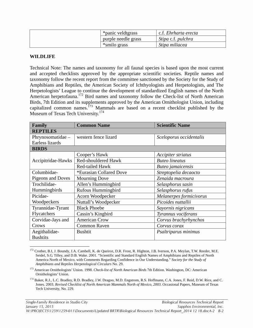
Single-Family Residence in Studio City Biological Resources Technical Report January 15, 2015 Sapphos Environmental, Inc. W:\PROJECTS\1259\1259-011\Documents\Updated BRTR\Biological Resources Technical Report_2014 12 18.docA-2 B-2
*panic veldtgrass c.f. Ehrharta erecta purple needle grass Stipa c.f. pulchra *smilo grass Stipa miliacea
WILDLIFE Technical Note: The names and taxonomy for all faunal species is based upon the most current and accepted checklists approved by the appropriate scientific societies. Reptile names and taxonomy follow the recent report from the committee sanctioned by the Society for the Study of Amphibians and Reptiles, the American Society of Ichthyologists and Herpetologists, and The Herpetologists’ League to continue the development of standardized English names of the North American herpetofauna.172 Bird names and taxonomy follow the Check-list of North American Birds, 7th Edition and its supplements approved by the American Ornithologist Union, including capitalized common names.173 Mammals are based on a recent checklist published by the Museum of Texas Tech University.174 Family Common Name Scientific Name REPTILES Phrynosomatidae – Earless lizards
western fence lizard Sceloporus occidentalis
BIRDS
Accipitridae-Hawks Cooper’s Hawk Accipiter striatus Red-shouldered Hawk Buteo lineatus Red-tailed Hawk Buteo jamaicensis
Columbidae-Pigeons and Doves
*Eurasian Collared Dove Streptopelia decaocto Mourning Dove Zenaida macroura
Trochilidae-Hummingbirds
Allen’s Hummingbird Selasphorus sasin Rufous Hummingbird Selasphorus rufus
Picidae-Woodpeckers
Acorn Woodpecker Melanerpes formicivorus Nuttall’s Woodpecker Picoides nuttallii
Tyrannidae-Tyrant Flycatchers
Black Phoebe Sayornis nigricans Cassin’s Kingbird Tyrannus vociferans
Corvidae-Jays and Crows
American Crow Corvus brachyrhynchos Common Raven Corvus corax
Aegithalidae-Bushtits
Bushtit Psaltriparus minimus
172 Crother, B.I, J. Boundy, J.A. Cambell, K. de Queiroz, D.R. Frost, R. Highton, J.B. Iverson, P.A. Meylan, T.W. Reeder, M.E.
Seidel, S.G. Tilley, and D.B. Wake. 2001. “Scientific and Standard English Names of Amphibians and Reptiles of North America North of Mexico, with Comments Regarding Confidence in Our Understanding.” Society for the Study of Amphibians and Reptiles Herpetological Circulars No. 29.
173 American Ornithologists’ Union. 1998. Check-list of North American Birds 7th Edition. Washington, DC: American Ornithologists’ Union.
174 Baker, R.J., L.C. Bradley, R.D. Bradley, J.W. Dragoo, M.D. Engstrom, R.S. Hoffmann, C.A. Jones, F. Reid, D.W. Rice, and C. Jones. 2003. Revised Checklist of North American Mammals North of Mexico, 2003. Occasional Papers, Museum of Texas Tech University, No. 229.
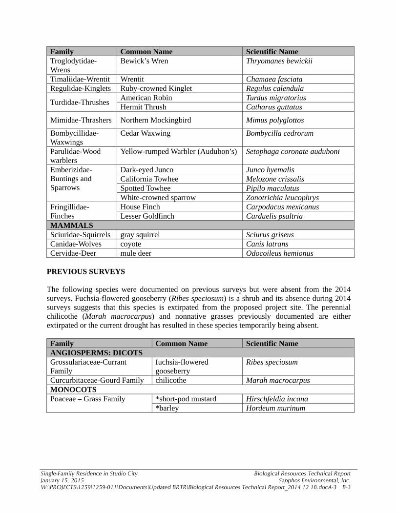
Single-Family Residence in Studio City Biological Resources Technical Report January 15, 2015 Sapphos Environmental, Inc. W:\PROJECTS\1259\1259-011\Documents\Updated BRTR\Biological Resources Technical Report_2014 12 18.docA-3 B-3
Family Common Name Scientific Name Troglodytidae-Wrens
Bewick’s Wren Thryomanes bewickii
Timaliidae-Wrentit Wrentit Chamaea fasciata Regulidae-Kinglets Ruby-crowned Kinglet Regulus calendula
Turdidae-Thrushes American Robin Turdus migratorius Hermit Thrush Catharus guttatus
Mimidae-Thrashers Northern Mockingbird Mimus polyglottos
Bombycillidae-Waxwings
Cedar Waxwing Bombycilla cedrorum
Parulidae-Wood warblers
Yellow-rumped Warbler (Audubon’s) Setophaga coronate auduboni
Emberizidae-Buntings and Sparrows
Dark-eyed Junco Junco hyemalis California Towhee Melozone crissalis Spotted Towhee Pipilo maculatus White-crowned sparrow Zonotrichia leucophrys
Fringillidae-Finches
House Finch Carpodacus mexicanus Lesser Goldfinch Carduelis psaltria
MAMMALS Sciuridae-Squirrels gray squirrel Sciurus griseus Canidae-Wolves coyote Canis latrans Cervidae-Deer mule deer Odocoileus hemionus
PREVIOUS SURVEYS The following species were documented on previous surveys but were absent from the 2014 surveys. Fuchsia-flowered gooseberry (Ribes speciosum) is a shrub and its absence during 2014 surveys suggests that this species is extirpated from the proposed project site. The perennial chilicothe (Marah macrocarpus) and nonnative grasses previously documented are either extirpated or the current drought has resulted in these species temporarily being absent. Family Common Name Scientific Name ANGIOSPERMS: DICOTS Grossulariaceae-Currant Family
fuchsia-flowered gooseberry
Ribes speciosum
Curcurbitaceae-Gourd Family chilicothe Marah macrocarpus MONOCOTS Poaceae – Grass Family *short-pod mustard Hirschfeldia incana
*barley Hordeum murinum

APPENDIX C PLANT COMMUNITY SURVEY DATA SHEETS


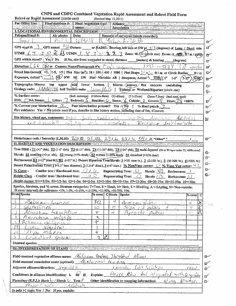
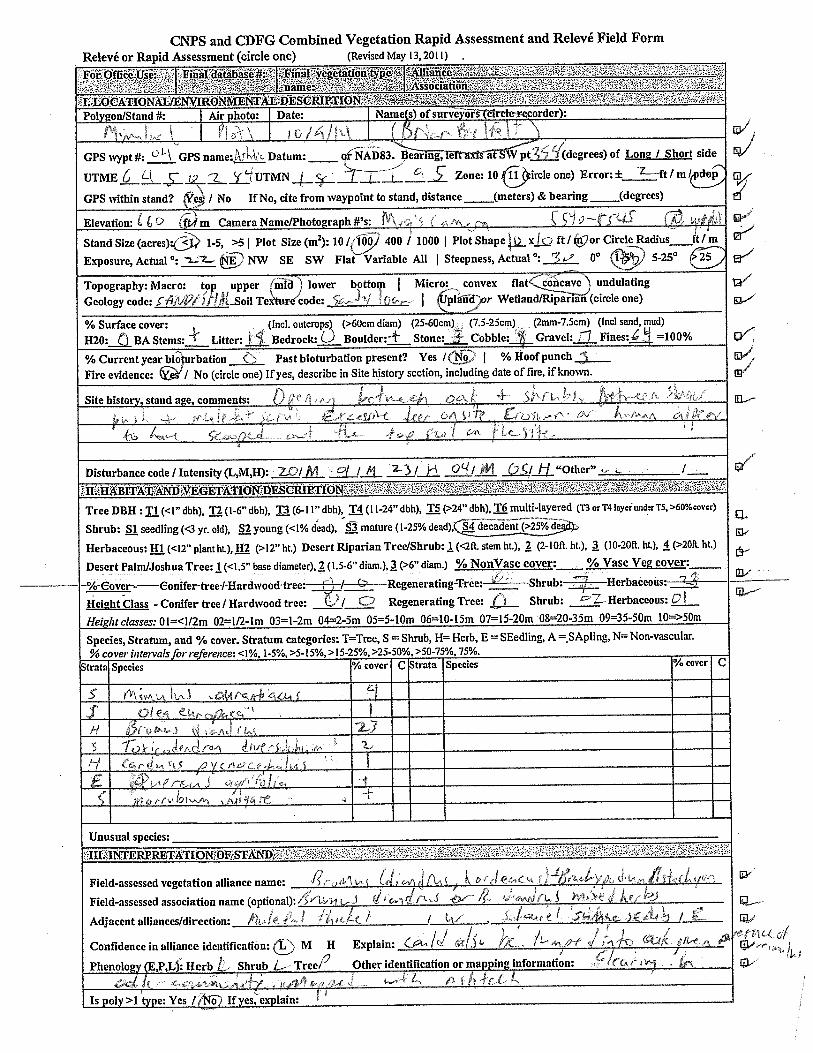

APPENDIX D USACOE WETLAND DETERMINATION DATA FORM—
ARID WEST REGION