appendix d phase i environmental site assessment phase ii ... · • the subject property is...
TRANSCRIPT

Appendix D
Phase I Environmental Site Assessment Phase II Subsurface Investigation
UST Removal Report

AEI
September 2, 2005
AEI Project No. 27141
Prepared For
Jensen + Partners
1212 South Flower Street Los Angeles, California 90015
Prepared By
AEI CONSULTANTS 2447 Pacific Coast Highway, Suite 101
Hermosa Beach, California 90254 (310) 798-4255
PHASE I
ENVIRONMENTAL SITE ASSESSMENT
Orthopaedic Hospital 7.9 Acres at the corner of Flower Street and 23rd Street
Los Angeles, California 90007

EXECUTIVE SUMMARY
AEI Consultants (AEI) was retained by Jensen + Partners to conduct a Phase I Environmental Site Assessment (ESA), in conformance with the scope and limitations of ASTM Standard Practice E1527-00, for the property located 7.5 Acres at the corner of Flower Street and 23rd Street in the City of Los Angeles, Los Angeles County, California. Any exceptions to, or deletions from, this practice are described in Section 1.2 of this report.
Property Description
The subject property, known as Orthopaedic Hospital, is comprised of two separate parcels herein referred to as the Main Campus and the Parking Lot. The Main Campus totals 7.5 acres, is located on the southeast corner of Flower Street and 23rd Street, and consists of five (5) medical buildings totaling approximately 337,208 square feet (Refer to Table 1 for descriptions of each building). Various medical offices and related hospital business tenants occupy the buildings. At the time of the report, the Hospital Building was being vacated. In addition to the buildings, the Main Campus is improved with asphalt-paved parking areas and associated landscaping. The Parking Lot totals approximately 0.47 acre, and consists of an irregular shaped parking lot, located on the west side of Flower Street, across from the Main Campus. The Parking Lot is used as an additional parking lot for hospital patients. The current improvements were constructed over a period of time from 1955 through 1985.
Table 1. Building Number
Building Name and Address Stories Size (sq ft)
1 Hospital/Diagnostic Center 2400 South Flower Street
5 and 6 with basement
224,567
2 Orthopaedic Medical Office 2300 South Flower Street
3 39,150
3 Medical Office Building 2300 South Hope Street
1 20,077
4 Physical Rehabilitation Center 2 19,158
5 Engineering Building and Thrift Shop
1 with partial basement
18,848
Flower Street borders the Main Campus to the west, beyond which is a hotel to the northwest and the Parking Lot to the southwest. The 110 Harbor Freeway borders the Parking Lot to the west and south. Hope Street borders the Main Campus to the north, beyond which is L.A. Trade Tech School. Orthopaedic High School borders the subject property to the east. Various

Phase I Environmental Site Assessment Project No. 27141 September 2, 2005
Page iii
AEI
medical buildings associated with the Orthopaedic Hospital, including the Outpatient Medical Center (not included in this assessment), border the Main Campus to the south.
Based on a review of historical sources, the Main Campus was developed with multiple residential dwellings and various buildings associated with the former L.A. Orthopaedic Hospital from as early as 1921 to 1953. A gasoline station was also present onsite at the southeast corner of Flower Street and West 23rd Street from approximately 1934 to 1955. Prior to 1921, the Main Campus was developed with multiple residential dwellings. The current use of the Parking Lot began in 1981. Prior to 1981, the Parking Lot was vacant land as early as 1956. A separate gasoline station and several automobile repair facilities were present on the Parking Lot from approximately 1938 to 1955. Prior to 1938, the Parking Lot was developed residentially. Based upon topographic map interpretation and site observations, the direction of groundwater flow beneath the subject property is inferred to be to the southwest. According to a previous environmental report, groundwater is estimated to be at 220 feet below ground surface (bgs).
Findings
Recognized environmental conditions (RECs) are defined by the ASTM Standard Practice E1527-00 as the presence or likely presence of any hazardous substances or petroleum products under conditions that indicate an existing release, a past release, or a material threat of a release into structures on the property or into the ground, groundwater, or surface water of the property. AEI’s investigation has revealed the following recognized environmental conditions associated with the subject property or nearby properties:
• According to historical sources, two areas of the subject property were previously developed with gasoline service stations. Historical records indicate that one gasoline station (herein referred to as Gasoline Station #1) was located on the southeast corner of South Flower Street and West 23rd Street (northwest corner of the subject property) from as early as 1934 to the late 1950s. The second gasoline station (herein referred to as Gasoline Station #2) was located on the west side of South Flower Street from as early as 1938 to 1954. Both areas are currently improved with asphalt-paved parking lots. The gasoline stations presumably stored large quantities of petroleum hydrocarbons in underground storage tanks (USTs). No records were available at the Los Angeles Fire Department (LAFD) indicating the number and/or capacity of the USTs formerly maintained by either gasoline station or indicting that soil samples were collected at the time of the UST removals to determine whether or not a release had occurred (the USTs were presumably removed at the time of the gasoline station demolitions). Based on the length of time that the subject property had been occupied by gasoline service stations, and the absence of data confirming whether a release had occurred following the removal of any USTs, it is possible that petroleum hydrocarbons may have impacted the subsurface of the subject property. Therefore, the presence of the former

Phase I Environmental Site Assessment Project No. 27141 September 2, 2005
Page iv
AEI
gasoline service station and presumed storage of petroleum hydrocarbons in underground storage tanks is considered a recognized environmental condition.
• The subject property is equipped with one (1) 10,000-gallon diesel UST located beneath the walkway between the Medical Office Building (2300 South Hope Street) and the Engineering Building on the Main Campus. The UST was reportedly installed in 1992 to supply fuel to the subject property emergency generators. The UST is constructed of double walled fiberglass with an interstitial monitoring system. The Director of Engineering at the subject property, Mr. Tom Walker, provided AEI with a March 2005 Certification of Electronic Monitoring System for the current Veeder Root monitor. The certification indicated that the monitoring systems’ probes and sensors are in compliance with the manufacturer’s recommendations; however, no documentation indicating the performance of a tank tightness/integrity test was on file at LAFD or provided to AEI for review. Therefore, the condition and compliance status of the current UST system is unknown. Based on this information and the age of the UST (approximately 13 years), the presence of the diesel UST represents a recognized environmental condition.
Historical recognized environmental conditions (HRECs) are defined by the ASTM Standard Practice E1527-00 as an environmental condition which in the past would have been considered a recognized environmental condition, but which may or may not be considered a recognized environmental condition currently. AEI’s investigation has revealed the following historical recognized environmental conditions associated with the subject property or nearby properties:
• No on-site historical recognized environmental conditions were identified during the course of this investigation.
Environmental issues include environmental concerns identified by AEI that warrant discussion but do not qualify as recognized environmental conditions, as defined by the ASTM Standard Practice E1527-00. AEI’s investigation has revealed the following environmental issues associated with the subject property or nearby properties:
• According to historical sources, several automotive repair facilities were formerly present on the Parking Lot for a period of time from 1938 to 1955. Hazardous substances, such as solvents and petroleum products, are typically associated with auto repair operations. The subject property is not listed for any spills or releases in connection with the use or handling of these materials. Moreover, no records indicating hazardous material storage or violations were on file at the Los Angeles City Fire Department (LAFD). Based on the lack of information documenting a release and/or the storage of hazardous materials on the subject property, and the small quantities of hazardous materials typically used during auto repair operations, the former auto repair operations at the subject property are not expected to represent a significant environmental concern.
• According to a 1992 Underground Storage Tank Removal Soil Sample Analysis- Orthopaedic Hospital, prepared by Geological Audit Services, Inc (GSI), two (2) USTs were removed from the site: one (1) 10,000-gallon diesel fuel removed on May 18, 1992, and one

Phase I Environmental Site Assessment Project No. 27141 September 2, 2005
Page v
AEI
(1) 1,000-gallon diesel fuel tank removed on June 24, 1992. Both USTs were removed under the direction of Inspector Armando Hogan of the City of Los Angeles Fire Department (LAFD). Three soil samples were collected from 3 feet below the center, east and west ends of the removed 10,000-gallon diesel fuel tank. One soil sample was collected from 3 feet below the center of the 1,000 gallon removed diesel fuel tank.
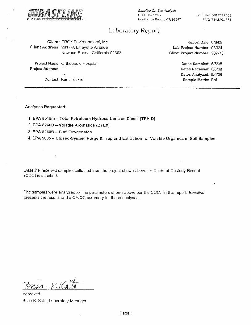
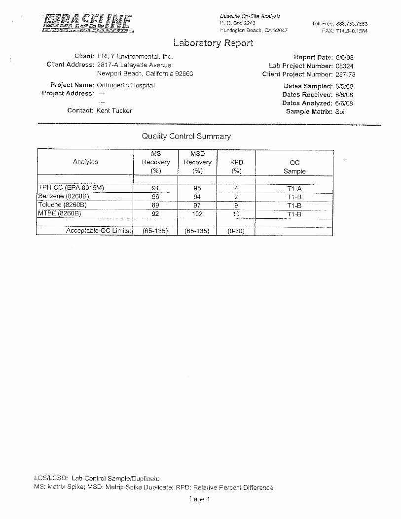
All soil samples were analyzed for total petroleum hydrocarbons (TPH), purgeable aromatics (benzene, toluene, ethylbenzene, and xylenes (BTEX)) and for total lead. The samples collected from the center of the 10,000-gallon UST and 1,000-gallon UST indicated the presence of TPH at 15 and 10 milligrams per kilogram (mg/kg), respectively. TPH was not detected in the remaining samples. Total lead was detected in all samples at concentrations ranging from 1 to 27 mg/kg. BTEX compounds were only detected in the spoils pile originating from the 10,000-gallon tank excavation. BTEX in these samples ranged from below detectable limits to 0.032 mg/kg.
Based on the non-detectable to very low levels of TPH, BTEX, and lead in the samples, GSI determined that the LAFD would not require further assessment and/or mitigation of the site. AEI concurs with GSI’s conclusion that LAFD would not require further assessment and/or mitigation at the site. No formal closure letter was found on file at LAFD. Based on the results of the previous subsurface investigations, a minor fuel release has occurred; however, based on the negligible concentrations, the presence of minor fuel contamination is considered de minimis. Therefore, the diesel release at this site is not expected to represent a significant environmental condition. AEI recommends that the property owner obtain a formal closure letter for removal activities associated with the former tanks.
• Many of the medical office tenants in the subject property buildings (2300 and 2400 South Flower Street) use and store hazardous substances such as photo-developing fluid, to develop x-rays. AEI noted X-ray film processing machines and mid-size containers of photo-developing chemicals associated with film development in these offices. No evidence of any improper storage or disposal of the developers or fixers was observed. In addition, no evidence of leakage from the equipment in any of the offices was observed during the site reconnaissance. The waste chemicals are typically removed directly from the equipment by a licensed contractor, so waste storage is generally limited. The subject property is not listed for any spills or releases in connection with the use or handling of these materials. Based on the small quantity of materials involved and the lack of a documented release, the storage and use of hazardous materials on the subject property is not expected to represent a significant environmental concern.
• AEI observed the following hazardous substances in the Engineering Building: one (1) 55-gallon drum of degreaser used in the pressure washer to steam clean sidewalks; five (5) 30-gallon drums of acid used to balance the pH of water in the rehabilitation pool; and eleven (11) 55-gallon drums of chlorine/bleach used to treat water in the rehabilitation pool. The drums of acid and chlorine/bleach were stored on secondary containment in the basement of the building. During the inspection, housekeeping practices were observed to be good, and no signs of spills, staining or conduits to the subsurface were observed. No records

Phase I Environmental Site Assessment Project No. 27141 September 2, 2005
Page vi
AEI
indicating any violations were on file at the Los Angeles City Fire Department (LAFD) and the subject property was not listed for any spills or releases in connection with the use or handling of these materials. Based on this information, the storage of these materials is not expected to represent a significant environmental concern.
• During the onsite reconnaissance, one (1) 50-gallon diesel fuel day tank was noted adjacent to two (2) emergency generators in the basement of the Engineering Building. The property engineer, Mr. Randy Herrington, indicated that the day tank is used as a reserve tank for the emergency generators. No floor drains, sumps, or other conduits to the subsurface were observed in the vicinity of the tank. Although no secondary containment was currently in place for the AST, no evidence of a release was observed during the site reconnaissance. Based on this information, the presence of the diesel AST is not expected to represent a significant environmental concern.
• AEI observed a long sewer drain and a four-stage clarifier pit in the basement of the Engineering Building. According to Mr. Herrington, laundry services were conducted in the basement of the building during the 1950s. Mr. Herrington indicated that no dry cleaning operations were conducted onsite. Mr. Herrington indicated that the drain and clarifier were used to direct rinse-water from linen cleaning to the local sewer. Two sumps with associated pumps were also observed in the main medical vacuum room of the basement. The sumps are used to collect and pump all waste water generated from the hospital to the local sewer and stormdrain. These features have the potential to act as conduits to the subsurface of the subject property. No significant stains were observed in the area of the sumps or clarifier, and no evidence of the improper discharge of hazardous materials or petroleum products was apparent. No storage of hazardous materials or petroleum products appeared present near the sumps or clarifier. Based on these observations, the presence of the sumps and clarifier is not expected to represent a significant environmental concern. However, if the clarifier will no longer be in use, AEI recommends that it be properly closed per requirements of the Sanitation Districts of Los Angeles County.
• Due to the age of the subject property buildings, there is a potential that asbestos-containing materials (ACMs) and/or lead-based paint are present. All suspect ACMs and painted surfaces were observed in good condition and are not expected to pose a health and safety concern to the occupants of the subject property at this time.

Phase I Environmental Site Assessment Project No. 27141 September 2, 2005
Page vii
AEI
• According to the City of Los Angeles Department of Building & Safety and Department of Planning, the subject property is located near significant oil production areas known as “Methane Zones”. Methane Zone sites include sites immediately surrounding gas sources and where testing and mitigation are required by the City of Los Angeles Department of Building and Safety. Due to the potential environmental risk associated with construction in Methane Zones, the property owner is required to conduct a methane assessment prior to the redevelopment of the subject property (Division 71 of the Los Angeles Building Code). AEI recommends that a methane assessment be conducted for the subject property prior to any future redevelopment activities.
Conclusions, Opinions, and Recommendations
AEI’s investigation revealed recognized environmental conditions associated with the subject property that requires further investigation. Based on the length of time the subject property was occupied by the former gasoline service stations, the lack of information documenting the removal of any USTs, and the absence of soil sampling data, AEI recommends a Phase II Subsurface Investigation in order to determine if the former gasoline service station operations impacted the subsurface of the subject property. AEI also recommends a Phase II Subsurface Investigation in order to determine whether or not a release has occurred from the current on-site diesel UST.

Phase I Environmental Site Assessment Project No. 27141 September 2, 2005
Page viii
AEI
TABLE OF CONTENTS
1.0 INTRODUCTION ..................................................................................................................1 1.1 Scope of Work .......................................................................................................................................................1 1.2 Limitations .............................................................................................................................................................1 1.3 Reliance..................................................................................................................................................................2 1.4 Limiting Conditions ...............................................................................................................................................2
2.0 SITE AND VICINITY DESCRIPTION...............................................................................3 2.1 Site Location and Description................................................................................................................................3 2.2 Site and Vicinity Characteristics ............................................................................................................................4 2.3 Geology and Hydrogeology ...................................................................................................................................4
3.0 HISTORICAL REVIEW OF SITE AND VICINITY.........................................................5 3.1 Aerial Photograph Review .....................................................................................................................................5 3.2 Local Agencies.......................................................................................................................................................7
3.2.1 Health Department ...............................................................................................................................7 3.2.2 Fire Department ...................................................................................................................................7 3.2.3 Building Department ............................................................................................................................8 3.2.4 Department of Oil and Gas.................................................................................................................10
3.3 Sanborn Fire Insurance Maps ..............................................................................................................................10 3.4 City Directories ....................................................................................................................................................11 3.5 Client-Provided Information and Interviews........................................................................................................12 3.6 Previous Reports Reviewed .................................................................................................................................12
4.0 REVIEW OF REGULATORY AGENCY RECORDS.....................................................14 4.1 Records Summary ................................................................................................................................................14 4.2 Contaminant Migration ........................................................................................................................................15 4.3 Record Details......................................................................................................................................................15
5.0 SITE INSPECTION AND RECONNAISSANCE .............................................................18 5.1 On-Site Observations ...........................................................................................................................................18 5.3 Adjacent Property Reconnaissance Findings .......................................................................................................26
6.0 FINDINGS AND CONCLUSIONS.....................................................................................27
7.0 SIGNATURE OF ENVIRONMENTAL PROFESSIONALS ..........................................31
FIGURES 1 SITE LOCATION MAP 2 SITE PLAN 3 AERIAL PHOTOGRAPHS
APPENDICES A PROPERTY PHOTOGRAPHS B REGULATORY DATABASE C REFERENCES D QUALIFICATIONS

Phase I Environmental Site Assessment Project No. 27141 September 2, 2005
Page 1
AEI
1.0 INTRODUCTION
This report documents the methods and findings of the Phase I Environmental Site Assessment (ESA) of the property located at 7.5 Acres at the corner of Flower Street and 23rd Street in the City of Los Angeles, Los Angeles County, California (Figure 1: Site Location Map, Figure 2: Site Map, and Appendix A: Property Photographs).
1.1 Scope of Work
The purpose of the Phase I Environmental Site Assessment is to identify potential environmental liabilities associated with the presence of hazardous materials, their use, storage, and disposal at and in the vicinity of the subject property, as well as regulatory non-compliance that may have occurred at the subject property. Property assessment activities focused on: 1) a review of federal, state, and local lists that identify and describe underground fuel tank sites, leaking underground fuel tank sites, hazardous waste generation sites, and hazardous waste storage and disposal facility sites within the ASTM approximate minimum search distance; 2) a property and surrounding site reconnaissance with personnel interviews to identify environmental contamination; and 3) a review of historical sources to help ascertain previous land use at the site and in the surrounding area.
The goal of AEI Consultants in conducting the environmental site assessment was to identify the presence or likely presence of any hazardous substances or petroleum products on the property that may indicate an existing release, a past release, or a material threat of a release of any hazardous substance or petroleum product into the soil, groundwater, or surface water of the property.
1.2 Limitations
Property conditions, as well as local, state, and federal regulations can change significantly over time. Therefore, the recommendations and conclusions presented as a result of this study apply strictly to the environmental regulations and property conditions existing at the time the study was performed. Available information has been analyzed using currently accepted assessment techniques and it is believed that the inferences made are reasonably representative of the property. AEI Consultants makes no warranty, expressed or implied, except that the services have been performed in accordance with generally accepted environmental property assessment practices applicable at the time and location of the study.
Considerations identified by ASTM as beyond the scope of a Phase I ESA that may affect business environmental risk at a given property include the following: asbestos-containing materials, radon, lead-based paint, lead in drinking water, wetlands, regulatory compliance, cultural and historic resources, industrial hygiene, health and safety, ecological resources, endangered species, indoor air quality, and high voltage lines. These environmental issues or conditions may warrant assessment based on the type of the property transaction; however, they are considered non-scope issues under ASTM Standard Practice E1527-00.

Phase I Environmental Site Assessment Project No. 27141 September 2, 2005
Page 2
AEI
If requested by the client, these non-scope issues are discussed in Section 5.2. Otherwise, the purpose of this investigation is solely to satisfy one of the requirements to qualify for the innocent landowner defense under the Comprehensive Environmental Response, Compensation and Liability Act (CERCLA), that is, ASTM Standard Practice E1527-00 constitutes “all appropriate inquiry into the previous ownership and uses of the property consistent with good commercial or customary practice” as defined in 42 USC § 9601(35)(B), referenced in the ASTM Standard Practice E1527-00.
The Phase I Environmental Site Assessment is not, and should not be construed as, a warranty or guarantee about the presence or absence of environmental contaminants that may affect the property. Neither is the assessment intended to assure clear title to the property in question. The sole purpose of investigation into property title records is to ascertain a historical basis of prior land use.
1.3 Reliance
This investigation was prepared for the sole use and benefit of Jensen + Partners. Neither this report, nor any of the information contained herein shall be used or relied upon for any purpose by any person or entity other than Jensen + Partners.
1.4 Limiting Conditions
Pursuant to ASTM Standards, historical sources were obtained to document property use back to the property’s first developed use or back to 1940, whichever is earlier. Historical data source failure may occur when standard historical sources are not reasonably ascertainable. Based on the quality of historical data obtained for this assessment, AEI does not expect historical data source failure to impact the conclusions or recommendations of this report.
The performance of this Phase I Environmental Site Assessment was limited by the following condition:
• AEI inspected a representative sample of interior units. Based on the nature of property occupancy, this method of inspection is presumed to be appropriate due to the size of the subject property.

Phase I Environmental Site Assessment Project No. 27141 September 2, 2005
Page 3
AEI
2.0 SITE AND VICINITY DESCRIPTION
2.1 Site Location and Description
The subject property, known as Orthopaedic Hospital, is comprised of two separate parcels herein referred to as the Main Campus and the Parking Lot. The Main Campus totals 7.5 acres, is located on the southeast corner of Flower Street and 23rd Street, and consists of five (5) medical buildings totaling approximately 337,208 square feet (Refer to Table 1 for descriptions of each building). Various medical offices and related hospital business tenants occupy the buildings. At the time of the report, the Hospital Building was being vacated. In addition to the buildings, the Main Campus is improved with asphalt-paved parking areas and associated landscaping. The Parking Lot totals 0.47 acre, and consists of an irregular shaped parking lot, located on the west side of Flower Street, across from the Main Campus. The Parking Lot is used as an additional parking lot for hospital patients. The current improvements were constructed over a period of time from 1955 to 1985.
Table 1. Building Number
Building Name and Address Stories Size (sq ft)
1 Hospital/Diagnostic Center 2400 South Flower Street
5 and 6 with basement
224,567
2 Orthopaedic Medical Office 2300 South Flower Street
3 39,150
3 Medical Office Building 2300 South Hope Street
1 20,077
4 Physical Rehabilitation Center 2 19,158
5 Engineering Building and Thrift Shop
1 with partial basement
18,848
According to the Los Angeles County Office of the Assessor, the subject property is identified by Assessor Parcel Numbers (APNs) 5126-017-002, -003, -004, -005, -006, -007, and -015. Heating and cooling systems on the subject property are fueled by natural gas and electricity provided by The Gas Company and Southern California Edison (SCE), respectively. Potable water and sewage disposal are provided by municipal services.
Refer to Figure 1: Site Location Map, Figure 2: Site Map, and Appendix A: Property Photographs for site location.
Phase I Environmental Site Assessment Project No. 27141 September 2, 2005
Page 4
AEI
2.2 Site and Vicinity Characteristics
The subject property is located in a commercial area of Los Angeles. Flower Street borders the Main Campus to the west, beyond which is a hotel to the northwest and the Parking Lot to the southwest. The 110 Harbor Freeway borders the Parking Lot to the west and south. Hope Street borders the Main Campus to the north, beyond which is L.A. Trade Tech School. Orthopaedic High School borders the subject property to the east. Various medical buildings associated with the Orthopaedic Hospital (not included in this assessment) including the Outpatient Medical Center, border the Main Campus to the south.
2.3 Geology and Hydrogeology
According to the United States Department of Agriculture’s Report and General Soil Map for Los Angeles County, the area surrounding the subject property is underlain by soils of the Hanford association. Hanford soils consist of well-drained soils on flood plains and alluvial fans. In a typical profile the surface layer is light brownish gray fine sandy loam seven inches thick. The material to a depth of 60 inches or more is yellowish-brown coarse sandy loam and gravelly coarse sand substratum. In the Los Angeles basin, these soils are used almost exclusively for residential and industrial purposes.
Hanford soils make up the remaining 5 percent. These soils are used primarily for residential development. Small areas are used for non-irrigated grain and for irrigated orchards.
Based on a review of the USGS Hollywood Quadrangle Topographic Map, the subject property is situated 207 feet above mean sea level, and the local topography is sloping southwest. The nearest surface water is a small lake at Macarthur Park located approximately 2 miles north. Based on topographic map interpretation, the inferred flow direction of groundwater at the subject property is to the southwest. According to a previous environmental report, groundwater is estimated to be at 220 feet bgs.
Phase I Environmental Site Assessment Project No. 27141 September 2, 2005
Page 5
AEI
3.0 HISTORICAL REVIEW OF SITE AND VICINITY
According to historical sources, the current subject property buildings were constructed over a period of time from 1955 through 1985. Prior to the construction of the buildings, the Main Campus was developed with multiple residential dwellings and various buildings associated with the former L.A. Orthopaedic Hospital as early as 1921. A gasoline station was also present onsite at the southeast corner of Flower Street and West 23rd Street from approximately 1934 to 1955. Prior to 1921, the Main Campus was developed with multiple residential dwellings. The current use of the Parking Lot began in 1981. Prior to 1981, the Parking Lot was vacant land as early as 1956. A separate gasoline station and several automobile repair facilities were present on the Parking Lot from approximately 1938 to 1955. Prior to 1938, the Parking Lot was developed residentially.
3.1 Aerial Photograph Review
On July 25, 2005, AEI Consultants reviewed aerial photographs of the subject property and surrounding area. Aerial photographs were reviewed for the following years:
Date: 1928 Scale: 1:18,000
Date: 1976 Scale: 1:24,000
Date: 1938 Scale: 1:20,000
Date: 1982 Scale: 1:36,000
Date: 1947 Scale: 1:24,000
Date: 1994 Scale: 1:40,000
Date: 1956 Scale: 1:14,400
Date: 2002 Scale: 1:40,000
Date: 1962 Scale: 1:12,000
In the 1928 aerial photograph, the majority of the Main Campus appears to be developed with multiple residential dwellings. The southwest portion of the Main Campus appears to be developed with the configuration of the former Orthopaedic Home and School, and associated administration buildings depicted on the 1922 Sanborn map. Palm Drive and Hope Street appear to run through the mid section of the Main Campus in north-south directions. Flower Street and an unnamed alley are visible to the west and east of the Main Campus, respectively. West 23rd and West Adams Boulevard are visible to the north and south of the Main Campus. The area of the current Parking Lot appears to be developed residentially. The surrounding properties appear to be developed residentially with the exception of two commercial buildings located adjacent to the north of the Parking Lot and southeast of the Main Campus. Based on a review

Phase I Environmental Site Assessment Project No. 27141 September 2, 2005
Page 6
AEI
of the 1922 Sanborn map, the former and later buildings were occupied by a perfume manufacturer and hospital clinic, respectively.
In the 1938 aerial photograph, the majority of the Main Campus appears to be unchanged with the exception of the northwest corner, which appears to be developed as a parking lot with an office building. The Parking Lot and the area immediately surrounding the lot appears to be developed with several residential dwellings, small commercial structures, and the configurations of two gasoline stations. At least one gasoline station and half of the commercial buildings appear to be located within the boundaries of the Parking lot. Based on a review of a 1944 Sanborn map, the commercial buildings were part of an automobile repair center, which was occupied by a machine shop and commercial store. The gasoline stations were associated with the automobile repair center. The surrounding properties appear to be developed with residential, commercial and hospital related structures.
In the 1947 aerial photograph, the Main Campus appears to be developed with residential dwellings and several additional buildings associated with the former Orthopaedic Hospital. The northwest corner of the Main Campus appears to be developed with the configuration of a gasoline station. No changes were noted to the Parking Lot. The surrounding properties appear to be developed with residential, commercial and hospital related structures.
In the 1956 aerial photograph, the entire Main Campus appears to be developed with several additional buildings associated with the former hospital. The northwest corner of the Main Campus appears to be unchanged. The north portion of the current Parking Lot appears to be undeveloped, while the south portion of the lot appears to be used as a parking lot. The surrounding properties appear to be unchanged.
In the 1962 aerial photograph, the Main Campus appears to be developed with the configurations of the current Orthopaedic Hospital Building and Engineering Building. Palm Drive no longer appears to run through the north portion of the subject property. The northwest portion of the Main Campus appears to be used as a parking lot. The remainder of the Main Campus appears to be developed with multiple buildings associated with the Hospital. The Parking Lot appears to be unchanged. The property adjacent to the north appears to be vacant. The remaining surrounding properties appear to be developed with mixed commercial and residential structures.
In the 1976 aerial photograph, the Main Campus appears to be developed with at least four of the current hospital buildings: the Hospital, Rehabilitation Building, Engineering Building and Medical Office Building on Hope Street. The remainder of the property appears to be used as a parking lot. The current parking lot appears to be vacant land. The surrounding properties appear to be developed with mixed commercial and residential structures.
In the 1982 aerial photograph, the Main Campus appears to be developed with the configuration of all of the current buildings: the Hospital, Rehabilitation Building, Engineering Building, and Medical Office Buildings on Flower Street and Hope Street. The remainder of the property appears to be used as a parking lot. The property adjacent to the north of the Main Campus appears to be developed with the current buildings associated with LA Trade Tech. The property

Phase I Environmental Site Assessment Project No. 27141 September 2, 2005
Page 7
AEI
adjacent to the east appears to be developed with the current buildings associated with the Orthopaedic Hospital. The property adjacent to the south appears to be developed with the present day hospital buildings, which are not part of this assessment. The current parking lot appears to be developed as it is today. The property adjacent to the north of the Parking Lot and northwest of the Main Campus appears to be developed with the current hotel building.
In the 1994 and 2002 aerial photographs, the subject property and surrounding properties are developed as they are today, as described above.
High-quality copies of reviewed aerial photographs are included as Figure 3.
3.2 Local Agencies
Local agencies, such as environmental health departments, fire prevention bureaus, and building departments are contacted to identify any current or previous reports of hazardous materials use, storage, and/or unauthorized releases that may have impacted the subject property.
3.2.1 Health Department
On July 20, 2005, the Los Angeles County Public Health Investigation (LACPHI) was contacted to review files on the subject property and nearby sites of concern. Files at the LACPHI may contain information regarding hazardous materials storage, as well as information regarding unauthorized releases of petroleum hydrocarbons or other contaminants that may affect the soil or groundwater in the area.
No information indicating current or previous hazardous materials use or storage on the subject property was on file with the LACPHI.
3.2.2 Fire Department
On July 26, 2005, the Los Angeles Fire Department (LAFD) was contacted for information on the subject property and/or nearby sites of concern to identify any evidence of previous or current hazardous material usage.
AEI reviewed the following hazardous materials documentation at LAFD:
• A 1992 UST Permit Application for one (1) 10,000-gallon capacity diesel double wall, fiberglass reinforced plastic UST with interstitial monitoring. The permit indicated that the UST was installed in 1992.
• A UST Permit dated March 20, 1992, was granted to the Orthopaedic Hospital by the Fire Marshal to abandon 2 atmospheric tanks (1,000-gallon and 10,000-gallon diesel) in place.

Phase I Environmental Site Assessment Project No. 27141 September 2, 2005
Page 8
AEI
• A 2004 Hazardous Materials Inventory listed the following hazardous materials stored onsite: sulfuric Acid, hydrochloric acid, chlorine, xenon, cesium, iodine, cobalt, phenol, nitric acid and compressed gases such as argon, oxygen, nitrogen and hydrogen.
In addition, various documents including UST Time Logs, a 1992 Tank Certification Report, Uniform Hazardous Waste manifests, a 1988 Fire Permit for USTs, and a 1994 Monitoring System Test and Certification were also reviewed for the Orthopaedic Hospital.
A previous environmental report was also reviewed, and is summarized as follows:
Underground Storage Tank Removal Soil Sample Analysis- Orthopaedic Hospital, Geological Audit Services, Inc. (August 5, 1992)
According to the report, one 10,000-gallon diesel fuel tank was removed from the site on May 18, 1992 under direction of Inspector Armando Hogan of the City of Los Angeles Fire Department (LAFD). Three soil samples were collected from 3 feet below the center, east and west ends of the removed 10,000 gallon diesel fuel tank. Approximately 15 cubic yards of soil were removed from the piping trench and stockpiled to the south of the trench. Grab samples were obtained from the tank excavation spoils pile.
On June 24, 1992, a 1,000-gallon diesel fuel tank was removed from the site under the direction of Inspector Armando Hogan of the LAFD. The excavation was adjacent to the previously removed underground storage tank. One soil sample was collected from 3 feet below the center of the 1,000 gallon removed diesel fuel tank. Estimated depth to groundwater is 220 feet bgs based on information from the County of Los Angeles Department of Public Works.
All soil samples were analyzed for total petroleum hydrocarbons (TPH), purgeable aromatics (BTEX) and for total lead. The samples collected from the center of the 10,000-gallon UST and 1,000-gallon UST indicated the presence of TPH at 15 and 10 milligrams per kilogram (mg/kg), respectively. TPH was not detected in the remaining samples. Total lead was detected in all samples at concentrations ranging from 1 to 27 mg/kg. BTEX compounds were only detected in the spoils pile originating from the 10,000 gallon tank excavation. BTEX in these samples ranged from below detectable limits to 0.032 mg/kg.
Based on the non-detectable to very low levels of TPH, BTEX, and lead in the samples, Geological Audit Services, Inc. determined that the LAFD would not require further assessment and/or mitigation of the site.
No formal closure letter was on file at LAFD for the removal activities associated with the former USTs.
3.2.3 Building Department
On August 5, 2005, the Los Angeles Department of Building and Safety (LADBS) was visited for information on the subject property in order to identify historical tenants and property use. Please refer to the following table for a listing of permits reviewed:

Phase I Environmental Site Assessment Project No. 27141 September 2, 2005
Page 9
AEI
Building Permits Reviewed Year(s) Applicant Description of Permit / Building Use 1913 Charles Silent (2407 Flower) Application to Alter, Repair or Demolish- Residence 1921 L.A. Orthopaedic Foundation (2408
Flower) Application for the Erection of Building- foundation only
1924 L.A. Orthopaedic Foundation Application to Alter, Repair or Demolish- Hospital school
1925 L.A. Orthopaedic Foundation (2400 Palm Dr)
Application for the Erection of Buildings- Pavilion for Administration Building
1925 L.A. Orthopaedic Foundation (2422 Palm Dr)
Application to Alter, Repair or Demolish- Clinic of Orthopaedic Hospital - School
1928 L.A. Orthopaedic Foundation (2400 Palm Dr)
Application for the Erection of Buildings- Boiler Plant
1929 Whiting Mead Co. (2430 Flower St) Application to Alter, Repair or Demolish-Demolish residence
1934 Lloyd (2407 Flower St) Application for Erection of a Building- wash rack canopy: 3 gas station-garage
1935 L.A. Orthopaedic Hospital (2400 Flower St)
Application to Alter, Repair or Demolish- Laundry and Boiler House Bldg and Recreation Bldg
1938 Standard Oil Company (2300 Flower St.)
Application for the Erection of a Building- Gasoline Service Station
1939 C.E. Lloyd Application for the Erection of a Building- Five service station buildings
1953 L.A. Orthopaedic Foundation (2422 Palm Dr)
Application to Alter, Repair or Demolish and for Certificate of Occupancy- entire hospital plant-
1953 L.A. Orthopaedic Foundation (2430 Palm Dr)
Application for the Erection of a Building and for a Certificate of Occupancy- Orthopaedic Rehabilitation Center
1955 L.A. Orthopaedic Foundation (2430 Palm Dr)
Certificate of Occupancy- L.A. Orthopaedic Foundation
1958 E.E. Smith (2309 Flower St.) Application for Certificate of Occupancy- Parking lot 1967 L.A. Orthopaedic Foundation (2400
Flower St) Certificate of Occupancy- 3-story diagnostic treatment center addition
1967 Orthopaedic Hospital (2423 S. Hope St.)
Application for Inspection of New Building and for Certificate of Occupancy – temp. additional parking for staff
1981 Orthopaedic Hospital (2427 S. Flower St.)
Certificate of Occupancy-Parking Lot
1985 Orthopaedic Hospital (2400 S. Flower St.)
Certificate of Occupancy- Six story, portion of basement converted to medical office and surgery spaces
1999 Orthopaedic Hospital (2300 S. Flower St.)
Application for Inspection and for Certificate of Occupancy- Add suite to existing medical office bldg
Building department records indicate that the current hospital buildings were constructed over a period of time from 1953 to the mid-1980s. The property was developed with different buildings associated with the former L.A. Orthopaedic Hospital from 1921 to 1953. Prior to 1921, the property was developed with multiple residential dwellings.
Phase I Environmental Site Assessment Project No. 27141 September 2, 2005
Page 10
AEI
3.2.4 Department of Oil and Gas
Department of Oil and Gas (DOG) maps concerning the subject property and nearby properties were reviewed. DOG maps contain information regarding oil and gas development.
According to the DOG map, there are no oil or gas wells within 500 feet of the subject property. No environmental concerns were noted during the DOG map review.
3.3 Sanborn Fire Insurance Maps
Sanborn Fire Insurance maps were developed in the late 1800s and early 1900s for use as an assessment tool for fire insurance rates in urbanized areas. A search was made of the Los Angeles Public Library’s collection of Sanborn Fire Insurance maps on July 29, 2005. Sanborn maps were available and reviewed for the years 1894, 1922, 1944 and 1954.
In the 1894 Sanborn map, the entire property is depicted as numerous vacant and developed parcels. With the exception of the current triangular shaped parking lot, the boundaries of the property extend from Flower Street (west) to Hope Street (east). Residential dwellings are depicted on the developed parcels, which are scattered throughout the property. Palm Drive and Hope Street are depicted as north-south running streets through the mid-portion of the property. The surrounding properties are depicted with residential dwellings.
In the 1922 Sanborn map, Palm Drive and Hope Street remain unchanged. Increased residential development is depicted throughout the subject property. The southwest portion of Main Campus is depicted with two large buildings labeled, Orthopaedic Home and School for Crippled Children and Administrative Building. The Administrative Building appears to be associated with the Orthopaedic Home. The properties adjacent to the north (across West 23rd Street) are depicted as residential dwellings. The majority of the properties adjacent to the east are depicted with residential dwellings. An Electric Motor Repairing shop and Cigar Manufacturing Building are depicted on two parcels adjacent to the northeast and southeast, respectively. Residential dwellings are depicted on the south adjacent property, west of Palm Drive. A Clinic presumably associated with the Orthopaedic Home is depicted on the south adjacent property, east side of Palm Drive. The area of the current Parking Lot is depicted with several residential dwellings. Residential dwellings are depicted to the south of the Parking Lot. A perfume manufacturer is depicted to the north of the Parking Lot.
In the 1944 Sanborn map, the majority of the Main Campus is depicted with several buildings associated with the Los Angeles Orthopaedic Hospital (Crippled Children’s Guild). The buildings include the Main Building, Administration Building, Laundry Building, School, Service Building, and clinic. A gasoline station and auto trailer sales lot are depicted on the southeast corner of South Flower Street and West 23rd Street. Residential dwellings are depicted on the properties to the north, east and west. Several buildings associated with the hospital are depicted to the south. The Parking Lot is depicted with residential dwellings and part of an automobile repair center which consists of a gasoline station, machine shop and commercial store. Residential dwellings are depicted on the properties to the north, west and south.

Phase I Environmental Site Assessment Project No. 27141 September 2, 2005
Page 11
AEI
In the 1954 Sanborn map, no significant changes were noted on the Main Campus. The Parking Lot is depicted with several vacant and residentially developed lots. The surrounding properties appear to be unchanged.
3.4 City Directories
A search of historic city directories was conducted for the subject property at Haines Criss Cross Directories and Sherman Library and Gardens on July 23 and 25, 2005. Directories were available and reviewed for the years 1956 through 2005. The following table summarizes the results of the city directory search.
City Directory Search Results Year(s) Occupant Listed 1956 500-520 W.23rd St = No Listings; Flower Street: 2315 = Apartments; 2327 = Edgar
Brooks; 2400 = Ortho. Hospital; 2309 = Residents; 2504 = John Riley; Hope Street: 2424 Residential Listing; 2505 = Apartment
1959 500-520 W.23rd St = No Listings; Flower Street: 2315 = Apartments; 2327 = Edgar Brooks; 2400 = Orthopaedic Hospital; Hope Street: 2424 Residential Listing; 2505 = Apartment
1964 500-520 W.23rd St = No Listings; Flower Street: 2309 = Heathkit Electronics Center; 2315 = Multi-residential listing; 2400 = Crippled Children’s Guild; 2327 = B. Edmon; 2400 = Orthopaedic Hospital; Hope Street: 2505 = Apartment; 2500 = P. Speen Inc.
1969 West23rd St.: 520 = Ira Garson Realty Co.; Flower Street: 2309 = Heathkit Electronics Center; 2315 = Multi-residential listing; 2400 = Crippled Children’s Guild; 2327 = B. Edmon; 2400 = Orthopaedic Hospital; Hope Street: 2500 = Crippled Children’s Society of LA County; 2505 = Apartment
1971 Flower Street: 2315 = Multiple residential listings; 2400 = Lowman, Chase MD., LA Orthopaedic Foundation, Crippled Children’s Guild and other Orthopaedic Hospital
1974 West23rd St.: 520 = Ira Garson Realty Co.; Flower Street: 2309 = Heathkit Electronics Center; 2315 = Multi-residential listing; 2400 = Crippled Children’s Guild; Hope Street: 2500 = Crippled Children’s Society of LA County
1976-1977 West23rd St.: 520 = Ira Garson Realty Co.; Flower Street: Multiple residential listings; 2400 = Lowman, Chase MD., LA Orthopaedic Foundation, Crippled Children’s Guild and other Orthopaedic Hospital
1982 West23rd St.: 520 = Ira Garson Realty Co.; Flower Street: 2309 = Heathkit Electronics Center; 2315 = Multi-residential listing; 2400 = Orthopaedic Hospital
1986 Flower Street: 2309 = Heathkit Electronics Center; 2300 = Multi-residential listings; 2400 = Orthopaedic Hospital
1992 West23rd St.: 520 = No Listings; Flower Street: 2300 = Multiple medical tenant listings; 2315 = Multi-residential listings; 2400 = Orthopaedic Hospital
1997 West23rd St.: 520 = No Listings; Flower Street: 2300 = Multiple medical tenant listings; 2315 = Multi-residential listings; 2400 = Orthopaedic Hospital
2005 West23rd St.: 520 = Worksite Wellness Project; Flower Street: 2300 = Multiple medical tenant listings; 2315 = Multi-residential listings; 2400 = Orthopaedic Hospital
City directories indicate that the subject property has been occupied by various residential tenants and medical tenants associated with the Orthopaedic Hospital since 1956.

Phase I Environmental Site Assessment Project No. 27141 September 2, 2005
Page 12
AEI
3.5 Client-Provided Information and Interviews
The client, Jensen + Partners, did not report to AEI any environmental liens encumbering the subject property or report any information to AEI regarding previous uses or ownership of the subject property that indicated recognized environmental conditions in connection with the subject property. The client did not provide any title records to AEI for review.
The Director of Engineering at the subject property, Mr. Tom Walker, was interviewed for this investigation. Mr. Walker was not aware of any pending, threatened, or past litigation relevant to hazardous substances or petroleum products in, on, or from the subject property; any pending, threatened, or past administrative proceedings relevant to hazardous substances or petroleum products in, on, or from the subject property; or any notices from a governmental entity regarding any possible violation of environmental laws or possible liability relating to hazardous substances or petroleum products.
Mr. Walker provided AEI with a Certification of Electronic Monitoring System, dated February 15, 2005. Petro-Clean Inc (PCI) performed the certification for the current 10,000-gallon UST. The certification indicated that the Veeder Root monitoring system passed both the calibration and certification tests conducted on February 15, 2005. The probes and sensors were noted to be working and in compliance with manufacturers recommendations.
3.6 Previous Reports Reviewed
Prior reports were provided to AEI the client during this investigation. A summary of the report follows:
Preliminary Environmental Site Investigation Phase I – Basic Site Reconnaissance and Records Search, Athanor Environmental Services Inc (AES) (January 1996)
The scope of the report included a visual inspection of the subject property and surrounding properties, a search of records of relevant regulatory agencies, and a search of all state and federal-designated hazardous waste sites. No historical searches were conducted.
According to an interview with the property contact, Mr. Stanson, the site was originally developed as an Orthopaedic Hospital in 1922 and at the time the existing site was mostly developed with residences. The first of the existing structures, the Rehabilitation Building, was constructed in 1954. The main hospital was constructed in 1957, 1961 and 1965. The Engineering Building was constructed in 1963 and the Orthomedics Building was constructed in 1965. The Hope Medical Office Building was constructed in 1965. The Orthopaedic Medical Office Building on Flower Street was constructed in 1981. The site has been used since the 1920s as an Orthopaedic Hospital Foundation.
AES noted the presence of low-emissions diesel fuel stored in a 10,000-gallon underground storage tank (UST) near the walkway south of 2300 Hope Street. The UST provides a supply for emergency generators located in the partial basement of Engineering Building. The UST replaced a former UST that was removed about five years ago under the supervision of the Los

Phase I Environmental Site Assessment Project No. 27141 September 2, 2005
Page 13
AEI
Angeles Fire Department (LAFD). According to AES, LAFD personnel determined that the former tank had not leaked. The existing UST is double-walled fiberglass construction and is equipped with an automated leak detection system. AES reported that the current UST has not been known to leak since it was installed in 1990. However, based on a review of historical sources, the UST was installed in 1992.
AES also noted the presence of the following hazardous materials: a bulk AST containing liquid oxygen, nitrous oxide and ethylene oxide stored in cylinders outdoors and in the hospital basement. Diesel fuel stored in small day tank adjacent to emergency generators, and hydraulic oil in tanks associated with three hydraulic elevators. X-ray developer and fixer, small solvents and reagents, boiler treatment chemicals and pool treatment chemicals were also observed during AES’ inspection. No other significant quantities of hazardous materials were observed onsite. No suspect staining was observed related to hazardous materials storage and use was noted.
The inspection of the subject property and subsequent discussions with regulatory authorities did not reveal any environmental concerns in terms of potential for impact to the land beneath the property.
Physical Master Plan Study Orthopaedic Hospital, OH/UCLA (June 29, 1999)
According to the report, the entire Orthopaedic Hospital campus is comprised of three neighboring sites, totaling approximately 12 1/2 acres. The largest site is about 12 acres, and is occupied by eight buildings and surface parking. The second largest is triangular, approximately 0.47 acres, and is occupied by surface parking. The third site is approximately 0.13 acres and is occupied by leased surface parking. The report summarizes information taken from available as-built documents for the eight existing buildings, which currently comprise the Orthopaedic Hospital campus. The summaries include building information such as the square footage, date of construction, and construction materials, which are discussed in previous sections throughout AEI’s report.

Phase I Environmental Site Assessment Project No. 27141 September 2, 2005
Page 14
AEI
4.0 REVIEW OF REGULATORY AGENCY RECORDS
The following information was obtained through a search of electronically compiled federal, state, county, and city databases provided by Track Info Services Environmental FirstSearch. The database search includes regulatory agency lists of known or potential hazardous waste sites, landfills, hazardous waste generators, and disposal facilities in addition to sites under investigation. The information provided in this report was obtained from publicly available sources. The locations of the sites listed in this report are plotted with a geographic information system utilizing geocoding of site addresses. The accuracy of these locations is generally +/- 300 feet. AEI's field representative has attempted to confirm the locations of listings on or adjacent to the subject property. Refer to the radius map (Appendix B: Regulatory Database Review Report) for the locations of the sites in relation to the subject property.
4.1 Records Summary
DATABASE REVIEWED SUBJECT PROPERTY
ADJACENT PROPERTY
Identification as National Priorities List (NPL) “Superfund” site No No
Identification as RCRA CORRACTS site No No
Identification as State (CalSites SPL/SCL) site No No
Identification as CERCLIS/NFRAP site No No
Reported as leaking underground storage tanks (LUST) site No No
Identification as solid waste landfill (SWLF) No No
Registered underground/aboveground storage tanks (UST/AST) Yes No
Identification as an Emergency Response Notification Systems (ERNS) site No No
Identification as hazardous waste handler and/or generator (RCRA-TSD, LG-GEN and/or SM-GEN) Yes No
Identification as SPILLS Site No No
The subject property was identified during the regulatory database search as a UST and RCRA generator site. Refer to section 4.3 for further information on this site.

Phase I Environmental Site Assessment Project No. 27141 September 2, 2005
Page 15
AEI
4.2 Contaminant Migration
Migration of petroleum hydrocarbon or volatile organic compound (VOC) contamination is generally via groundwater. Therefore, only those contaminant release sites located hydrologically upgradient relative to the subject property are expected to represent a potential environmental concern to the subject property. Contaminated sites located hydrologically downgradient of the subject property are not expected to represent a potential threat to the groundwater quality beneath the subject property. Sites that are situated hydrologically cross-gradient relative to the subject property are not expected to represent a concern unless close proximity allows for the potential of lateral migration. As discussed in Section 2.3, groundwater in the vicinity of the subject property is assumed to flow to the southwest.
4.3 Record Details
National Priorities List (NPL) is EPA's national listing of contaminated sites targeted for cleanup because they pose a threat to human health and the environment. The Comprehensive Environmental Response, Compensation, and Liability Act (CERCLA or Superfund) authorizes and requires the EPA to investigate, categorize, and enforce the cleanup of hazardous waste sites on the NPL. An NPL site on or near a particular property may threaten the environmental integrity of the property or affect its marketability. No sites within a 1-mile radius of the subject property were identified during the NPL database search. CORRACTS is an EPA-maintained database of Resource Conservation and Recovery Act (RCRA) facilities undergoing “corrective action”. A “corrective action order” is issued when there has been a release of hazardous waste or constituents into the environment from a RCRA facility. Corrective actions may be required beyond the facility’s boundary and can be required regardless of when the release occurred, even if it predates RCRA. No sites within a 1-mile radius of the subject property were identified during the CORRACTS database search. California Sites (CalSites) are provided by the California Environmental Protection Agency, Department of Toxic Substances Control and include state equivalent NPL (SPL) and CERCLIS (SCL) sites. Eleven sites within a 1-mile radius of the subject property were identified during the CalSites database search. All of these sites are located more than 1/8-mile from the subject property. Based on the relative distance, the regulatory status and/or assumed direction of groundwater flow, these sites are not expected to represent a significant environmental concern.

Phase I Environmental Site Assessment Project No. 27141 September 2, 2005
Page 16
AEI
CERCLIS/NFRAP is a list of sites that the EPA has investigated or is presently investigating for release or threatened release of hazardous substances, which may be subject to review in accordance with the terms and conditions of the Comprehensive Environmental Response, Compensation, and Liability Act of 1980 (CERCLA, also known as Superfund). Sites listed on the “No Further Remedial Action Planned” (NFRAP) database are sites where, following an initial investigation, no contamination was found, contamination was removed quickly, or the contamination was not serious enough to require federal Superfund or NPL consideration. No sites within a ½-mile radius of the subject property were identified during the CERCLIS/NFRAP database search. Leaking Underground Storage Tanks (LUST) List is a list produced by the Regional Water Quality Control Board (RWQCB) of known sites with current or former leaking underground storage tanks on the premises. Five sites within a ½-mile radius of the subject property were identified during the LUST database search. All of these sites are located more than 1/8-mile from the subject property. Based on the relative distance, the regulatory status and/or assumed direction of groundwater flow, these sites are not expected to represent a significant environmental concern.
Solid Waste Landfills (SWLF) is a database generated by the State of California Solid Waste Information System (SWIS), which includes active and inactive landfills and transfer stations within the state maintained by the California Integrated Waste Management Board. No sites within a ½-mile radius of the subject property were identified during the SWLF database search. Underground/Aboveground Storage Tanks (UST/AST) List is a comprehensive listing of registered underground and aboveground storage tanks located within the State of California. Fourteen sites within a ¼-mile radius of the subject property were identified during the UST/AST database search. • The subject property is listed on the regulatory database as a UST site. According to the
regulatory database, an active UST has been registered to the Orthopaedic Hospital as recent as May 2001. No other details were available. According to historical sources, the current UST was installed in 1992, and is constructed of double walled fiberglass with an interstitial monitoring system. A previous release from former USTs in the same area is discussed in Section 3.2.2. The Director of Engineering, Mr. Tom Walker, provided AEI with a March 2005 Certification of Electronic Monitoring System for the current Veeder Root monitor. The certification indicated that the monitoring systems’ probes and sensors are working, and in compliance with manufacturer’s recommendations. However, no documentation indicating the performance of a tank tightness/integrity test was on file at LAFD. Therefore, the condition and compliance status of the current UST system is unknown. Based on this
Phase I Environmental Site Assessment Project No. 27141 September 2, 2005
Page 17
AEI
information and the age of the UST, the presence of the diesel UST represents a recognized environmental condition.
The remaining sites are not located adjacent to the subject property. Due to the lack of a documented release or factors discussed in the LUST segment of Section 4.3, the storage of hazardous materials within registered tanks is not a significant environmental concern. Emergency Response Notification Systems (ERNS) List is EPA’s database of emergency response actions. No sites within a 1/8-mile radius of the subject property were identified during the ERNS database search. Resource Conservation and Recovery Act (RCRA) Program identifies and tracks hazardous waste from the point of generation to the point of disposal. Information from the RCRA database is divided into three categories: TSD, LG GEN and SM GEN. The TSD category is searched to a ½-mile radius and tracks facilities which treat, store and/or dispose of hazardous waste. LG GEN, or large generators, are facilities that generate more than 1000 kg of hazardous waste per month. SM GEN, or small generators, are facilities that generate between 100 and 1000 kg of hazardous waste per month. The LG-GEN and SM-GEN databases are searched up to a 1/8-mile radius from the subject property. No sites within a ½-mile radius of the subject property were identified during the RCRA-TSD database search. Three sites within a 1/8-mile radius of the subject property were identified during the RCRA (LG-and SM-GEN) database search. • Two onsite doctors offices located at 2300 South Flower Street and 2300 South Hope Street,
are listed as RCRA generator sites. According to the regulatory database, both of these offices generate small quantities of hazardous waste. No violations were noted in the database for both offices.
The storage, treatment, disposal and/or generation of hazardous materials at these sites is not a significant environmental concern based on the lack of a documented release or factors discussed in prior segments of Section 4.3. SPILLS sites are provided by the Regional Water Quality Control Board (RWQCB). This list includes sites that have recorded spills, leaks, investigations, and cleanups. No sites within a 1/8-mile radius of the subject property were identified during the SPILLS database search.

Phase I Environmental Site Assessment Project No. 27141 September 2, 2005
Page 18
AEI
5.0 SITE INSPECTION AND RECONNAISSANCE
On August 1, 2005, a site reconnaissance of the subject property and adjacent properties was conducted by Lyly Churchill of AEI in order to obtain information indicating the likelihood of recognized environmental conditions at the subject property and adjacent properties as specified in ASTM Standard Practice E1527-00 §8.4.2, 8.4.3 and 8.4.4.
5.1 On-Site Observations Identified
Yes No Observation
Hazardous Substances and/or Petroleum Products in Connection with Property Use
Aboveground & Underground Hazardous Substance or Petroleum Product Storage Tanks (ASTs / USTs)
Hazardous Substance and Petroleum Product Containers and Unidentified Containers not in Connection with Property Use
Unidentified Substance Containers Electrical or Mechanical Equipment Likely to Contain PCBs Interior Stains or Corrosion Strong, Pungent or Noxious Odors Pool of Liquid Drains and Sumps Pits, Ponds and Lagoons Stained Soil or Pavement Stressed Vegetation Solid Waste Disposal or Evidence of Fill Materials Waste Water Discharges Wells Septic Systems Other
The subject property is currently occupied by the Los Angeles Orthopaedic Hospital. On-site operations consist of medical examinations, administrative services and general hospital operations.
Hazardous Substances and/or Petroleum Products in Connection with Property Use
• Many of the medical office tenants in the subject property buildings (2300 and 2400 South Flower Street) use and store hazardous substances such as photo-developing fluid, to develop x-rays. AEI noted X-ray film processing machines and mid-size containers of photo-developing chemicals associated with film development in these offices. No evidence of any improper storage or disposal of the developers or fixers was observed. In addition, no evidence of leakage from the equipment in any of the offices was observed during the site reconnaissance. The waste chemicals are typically removed directly from the equipment by a licensed contractor, so waste storage is generally limited. The subject property is not listed

Phase I Environmental Site Assessment Project No. 27141 September 2, 2005
Page 19
AEI
for any spills or releases in connection with the use or handling of these materials. Based on the small quantity of materials involved and the lack of a documented release, the storage and use of hazardous materials on the subject property is not expected to represent a significant environmental concern.
• AEI observed six (6) 55-gallon plastic drums of solid medical waste (biohazardous, infectious, gauze, needles, and soiled towels) in the basement of the hospital building at 2400 South Flower Street. A licensed contractor routinely picks up the medical waste. Based on the nature of these materials and the small quantity involved, these materials are not expected to represent a significant environmental concern.
• Household chemicals in consumer quantities were observed in the Hospital Building and thrift shop. In addition, the majority of onsite chemicals in many of the doctors’ offices consisted of common medical supplies including disinfectants and alcohols. Chemical reagents such as hydrochloric acid and sodium hydroxide were also observed in the microbiology lab of the hospital. The reagents are reportedly used for research and experimentation. All observed chemicals were properly stored in cabinets, and all highly flammable/combustible materials were observed located in National Fire Protection Association-approved metal cabinets.
• The following hazardous substances were observed in the Engineering Building: one (1) 55-gallon drum of degreaser used in the pressure washer to steam clean sidewalks; five (5) 30-gallon drums of acid used to balance the pH of water in the rehabilitation pool; and eleven (11) 55-gallondrums of chlorine/bleach used to treat water in the rehabilitation pool. The drums of acid and chlorine/bleach were stored on secondary containment in the basement of the building. During the inspection, housekeeping practices were observed to be good, and no signs of spills, staining or conduits to the subsurface were observed. No records indicating any violations were on file at the Los Angeles City Fire Department (LAFD) and the subject property was not listed for any spills or releases in connection with the use or handling of these materials. Based on this information, the storage of these materials is not expected to represent a significant environmental concern.
Aboveground & Underground Hazardous Substance or Petroleum Product Storage Tanks (ASTs / USTs)
• The subject property is equipped with one (1) 10,000-gallon diesel UST located beneath the walkway between the Medical Office Building (2300 South Hope Street) and the Engineering Building on the Main Campus. The UST was reportedly installed in 1992 to supply fuel to the subject property emergency generators. The UST is constructed of double walled fiberglass with an interstitial monitoring system. The Director of Engineering at the subject property, Mr. Tom Walker, provided AEI with a March 2005 Certification of Electronic Monitoring System for the current Veeder Root monitor. The certification indicated that the monitoring systems’ probes and sensors are in compliance with the manufacturer’s recommendations; however, no documentation indicating the performance of a tank tightness/integrity test was on file at LAFD or provided to AEI for review. Therefore,

Phase I Environmental Site Assessment Project No. 27141 September 2, 2005
Page 20
AEI
the condition and compliance status of the current UST system is unknown. Based on this information and the age of the UST (approximately 13 years), the presence of the diesel UST represents a recognized environmental condition.
• Two large hot water tanks were observed in the basement of the Engineering Building.
According to the property engineer, Mr. Randy Herrington, the water tanks are used by the hospital for daily operations.
• One (1) 50-gallon diesel fuel day tank was noted adjacent to two emergency generators in the basement of the Engineering Building. Mr. Herrington indicated that the day tank is used as a reserve tank for the emergency generators. No floor drains, sumps, or other conduits to the subsurface were observed in the vicinity of the tank. Although no secondary containment was currently in place for AST, no evidence of a release was observed during the site reconnaissance. Based on this information, the presence of the diesel AST is not expected to represent a significant environmental concern.
• Liquid oxygen stored in a bulk AST was observed in a fenced compound located in the parking lot due south of the Hope Medical Office Building (2300 South Hope Street). The liquid oxygen is connected to the hospital via underground pipes for use during surgical procedures. A back up supply of nitrous oxide is stored in a bank of standard cylinders also located in the fenced compound. Based on the nature of theses materials, the presence of the AST and nitrous oxide on site is not expected to represent a significant environmental concern.
Electrical or Mechanical Equipment with the Potential to Contain PCBs
Toxic polychlorinated biphenyls (PCBs) were commonly used historically in electrical equipment such as transformers, fluorescent lamp ballasts, and capacitors. According to United States EPA regulation 40 CFR, Part 761, there are three categories for classifying such equipment: <50 ppm of PCBs is considered “Non-PCB”; between 50 and 500 ppm is considered “PCB-Contaminated”; and >500 ppm is considered “PCB-Containing”.
The management of potential PCB-containing transformers is the responsibility of the local utility or the transformer owner. Actual material samples need to be collected to determine if transformers are PCB-containing.
Numerous pad-mounted transformers were observed in the following locations of the hospital: the equipment room on the basement level; the electrical room of each floor; and the biohazardous waste room on the basement level. The transformers are owned and operated by the subject property, and are presumably not PCB containing. No spills, staining or leaks were observed on or around the transformers. Based on the good condition of the equipment, the transformers are not expected to represent a significant environmental concern.
The hydraulic fluid contained with elevator systems can potentially contain toxic polychlorinated biphenyls (PCBs). The subject property buildings are equipped with a total of five passenger

Phase I Environmental Site Assessment Project No. 27141 September 2, 2005
Page 21
AEI
elevators. The equipment for the elevators were inspected in each building. With the exception of the elevator equipment in 2300 South Flower Street (discussed below), no evidence of stains or leaks was observed at the base of the equipment during the site inspection. Schindler Elevator inspects the elevator equipment once a month. Based on the good condition of the elevator equipment, the elevators are not expected to represent a significant environmental concern. In addition, two (2) 5-gallon containers of hydraulic oil were observed in the freight elevator room of the hospital. No stains, leaks, or conduits were observed in the vicinity of the containers.
Pool of Liquid
A pool of yellow liquid was observed on the floor of the elevator room in the Rehabilitation Building. No drains were observed in the equipment room. The nature of the liquid was unknown; however, the pool appeared to accumulate beneath the elevator equipment, which indicates that the equipment may be leaking. According to Mr. Herrington, Schindler Elevator periodically services the elevator equipment in all of the buildings. AEI recommends that the leaking equipment be repaired and that absorbent be applied to the spill and disposed of as hazardous waste.
Drains and Sumps
Numerous drains were observed throughout hospital and supporting buildings. In addition, several storm drains were observed in the parking area of the subject property. No hazardous substances or petroleum products were noted in the vicinity of the drains. Based on the use of the drains solely for storm water runoff, the presence of the drains is not expected to represent a significant environmental concern.
Several drains were also observed in the x-ray film developing rooms of many of the doctors’ offices throughout the buildings. The drains are reportedly used to collect waste water used during rinsing of x-ray film. No improper storage of the photo-developing chemicals or associated releases was noted in the vicinity of the drains.
• A long sewer drain and clarifier pit was observed in the basement of the Engineering building. According to Mr. Herrington, laundry services were conducted in the basement of the building during the 1950s. No dry cleaning operations were conducted onsite. Mr. Herrington indicated that the drain and clarifier were used to direct rinse-water from linen cleaning to the local sewer. Two sumps with associated pumps were also observed in the main medical vacuum room of basement. The sumps are used to collect and pump all waste water generated from the hospital to the local sewer and storm drain. These features have the potential to act as conduits to the subsurface of the subject property. No significant stains were observed in the area of the sumps or clarifier, and no evidence of the improper discharge of hazardous materials or petroleum products was apparent. No storage of hazardous materials or petroleum products appeared present near the sumps or clarifier. Based on these observations, the presence of the sumps and clarifier is not expected to

Phase I Environmental Site Assessment Project No. 27141 September 2, 2005
Page 22
AEI
represent a significant environmental concern. However, if the clarifier will no longer be in use, AEI recommends that it be properly closed per requirements of the Sanitation Districts of Los Angeles County.

Phase I Environmental Site Assessment Project No. 27141 September 2, 2005
Page 23
AEI
5.2 Non-ASTM Services
Asbestos-Containing Building Materials
For buildings constructed prior to 1980, the Code of Federal Regulations (29 CFR 1926.1101) states that all thermal system insulation (boiler insulation, pipe lagging, and related materials) and surface materials must be designated as “presumed asbestos-containing material” (PACM) unless proven otherwise through sampling in accordance with the standards of the Asbestos Hazard Emergency Response Act.
Due to the age of the subject property buildings, there is a potential that ACMs are present. The condition and friability of the identified suspect ACMs is noted in the following table:
Suspect Asbestos Containing Materials (ACMs) Material Location Friable Condition Drywall Systems Throughout Building Interior No Good Vinyl Floor Tiles 2300,2400 Flower Street No Good Acoustic Ceiling Tiles 2300,2400 Flower Street No Good Roofing Systems Roof Not Inspected Not Inspected
All observed suspect ACMs were in good condition and are not expected to pose a health and safety concern to the occupants of the subject property at this time. Minor water stains noted on acoustic ceiling tiles in 2300 Flower Street.
Regardless of building construction date, the EPA’s National Emission Standards for Hazardous Air Pollutants (NESHAP) requires that an asbestos survey adhering to AHERA sampling protocol be performed prior to demolition or renovation activities that may disturb ACMs. This requirement is typically enforced by the local air pollution control or air quality management district, and specifies that all suspect asbestos-containing materials (ACMs) be sampled to determine the presence or absence of asbestos prior to any renovation or demolition activities to prevent potential exposure to workers and/or building occupants. Similarly, OSHA regulations require that specific work practices be implemented when handling construction materials and debris that contain lead-containing materials (see below).
Lead-Based Paint
Lead-based paint is defined as any paint, varnish, stain, or other applied coating that has 1 mg/cm2 (or 5,000 ug/g by dry weight) or more of lead. Section 1017 of the Housing and Urban Development Guidelines, Residential Lead-Based Paint Hazard Reduction Act of 1992, otherwise known as “Title X”, defines a lead-based paint hazard is “any condition that causes exposure to lead that would result in adverse human health effects” resulting from lead-contaminated dust, bare, lead-contaminated soil, and/or lead-contaminated paint that is deteriorated or present on accessible, friction, or impact surfaces. Therefore, under Title X, intact lead-based paint on most walls and ceilings would not be considered a “hazard”, although the paint should be maintained and its condition monitored to ensure that it does not deteriorate and become a hazard. Additionally, Section 1018 of this law directed HUD and EPA to require
Phase I Environmental Site Assessment Project No. 27141 September 2, 2005
Page 24
AEI
the disclosure of known information on lead-based paint and lead-based paint hazards before the sale or lease of most housing built before 1978. Most private housing, public housing, Federally owned housing, and housing receiving Federal assistance are affected by this rule.
In buildings constructed after 1978, it is very unlikely that lead-based paint is present. Due to the age of the subject property buildings, there is a potential that lead-based paint is present. Both interior and exterior painted surfaces were observed to be in good condition and are not expected to pose a health and safety concern to the occupants of the subject property at this time.
Local regulations may apply to lead-based paint in association with building renovation/demolition and worker/occupant protection. Actual material samples would need to be collected in order to determine if lead-based paint is present.
Radon
Radon is a naturally-occurring, odorless, invisible gas. Natural radon levels vary and are closely related to geologic formations. Radon may enter buildings through basement sumps or other openings.
The US EPA has prepared a map to assist National, State, and local organizations to target their resources and to implement radon-resistant building codes. The map divides the country into three Radon Zones, Zone 1 being those areas with the average predicted indoor radon concentration in residential dwellings exceeding the EPA Action limit of 4.0 picoCuries per Liter (pCi/L). It is important to note that the EPA has found homes with elevated levels of radon in all three zones, and the EPA recommends site specific testing in order to determine radon levels at a specific location. However, the map does give a valuable indication of the propensity of radon gas accumulation in structures.
Radon sampling was not requested as part of this investigation. According to the US EPA, the radon zone level for the area is Zone 2, which has a predicted average indoor screening level between 2 pCi/L and 4 pCi/L, below the action level of 4.0 pCi/L set forth by the EPA.
Drinking Water Sources and Lead in Drinking Water
The Metropolitan Water District of Southern California supplies potable water to the subject property. The most recent water quality report states that lead levels in the areas water supply were non-detect and therefore are well within standards established by the USEPA.
Mold/Indoor Air Quality Issues
Molds are simple, microscopic organisms, which can often be seen in the form of discoloration, frequently green, gray, white, brown or black. Molds grow by digesting organic material and gradually destroy whatever they grow on. Mold spores primarily cause health problems through the inhalation of mold spores or the toxins they emit when they are present in large numbers. This can occur primarily when there is active mold growth within places where people live or work.
Phase I Environmental Site Assessment Project No. 27141 September 2, 2005
Page 25
AEI
Mold, if present, may or may not visually manifest itself. Neither the individual completing this inspection, nor AEI has any liability for the identification of mold-related concerns except as defined in applicable industry standards. In short, this Phase I ESA should not be construed as a mold survey or inspection.
While a specific mold survey or study of indoor air quality (IAQ) in the building is beyond the scope of this assessment, AEI noted no indication of a significant IAQ problem during the site reconnaissance.
During the assessment, AEI inspected the accessed areas of the buildings for evidence of excessive or amplified mold growth, or for conditions favorable for mold growth (e.g. water damaged areas). No evidence of excessive or amplified mold growth was identified during the assessment.

Phase I Environmental Site Assessment Project No. 27141 September 2, 2005
Page 26
AEI
5.3 Adjacent Property Reconnaissance Findings Identified
Yes No Observation
Hazardous Substances and/or Petroleum Products in Connection with Property Use
Aboveground & Underground Hazardous Substance or Petroleum Product Storage Tanks (ASTs / USTs)
Hazardous Substance and Petroleum Product Containers and Unidentified Containers not in Connection with Property Use
Unidentified Substance Containers Electrical or Mechanical Equipment Likely to Contain PCBs Interior Stains or Corrosion Strong, Pungent or Noxious Odors Pool of Liquid Drains and Sumps Pits, Ponds and Lagoons Stained Soil or Pavement Stressed Vegetation Solid Waste Disposal or Evidence of Fill Materials Waste Water Discharges Wells Septic Systems Other
None of the above listed items were observed during the site inspection.

Phase I Environmental Site Assessment Project No. 27141 September 2, 2005
Page 27
AEI
6.0 FINDINGS AND CONCLUSIONS
Findings
Recognized environmental conditions (RECs) are defined by the ASTM Standard Practice E1527-00 as the presence or likely presence of any hazardous substances or petroleum products under conditions that indicate an existing release, a past release, or a material threat of a release into structures on the property or into the ground, groundwater, or surface water of the property. AEI’s investigation has revealed the following recognized environmental conditions associated with the subject property or nearby properties:
• According to historical sources, two areas of the subject property were previously developed with gasoline service stations. Historical records indicate that one gasoline station (herein referred to as Gasoline Station #1) was located on the southeast corner of South Flower Street and West 23rd Street (northwest corner of the subject property) from as early as 1934 to the late 1950s. The second gasoline station (herein referred to as Gasoline Station #2) was located on the west side of South Flower Street from as early as 1938 to 1954. Both areas are currently improved with asphalt-paved parking lots. The gasoline stations presumably stored large quantities of petroleum hydrocarbons in underground storage tanks (USTs). No records were available at the Los Angeles Fire Department (LAFD) indicating the number and/or capacity of the USTs formerly maintained by either gasoline station or indicting that soil samples were collected at the time of the UST removals to determine whether or not a release had occurred (the USTs were presumably removed at the time of the gasoline station demolitions). Based on the length of time that the subject property had been occupied by gasoline service stations, and the absence of data confirming whether a release had occurred following the removal of any USTs, it is possible that petroleum hydrocarbons may have impacted the subsurface of the subject property. Therefore, the presence of the former gasoline service station and presumed storage of petroleum hydrocarbons in underground storage tanks is considered a recognized environmental condition.
• The subject property is equipped with one (1) 10,000-gallon diesel UST located beneath the walkway between the Medical Office Building (2300 South Hope Street) and the Engineering Building on the Main Campus. The UST was reportedly installed in 1992 to supply fuel to the subject property emergency generators. The UST is constructed of double walled fiberglass with an interstitial monitoring system. The Director of Engineering at the subject property, Mr. Tom Walker, provided AEI with a March 2005 Certification of Electronic Monitoring System for the current Veeder Root monitor. The certification indicated that the monitoring systems’ probes and sensors are in compliance with the manufacturer’s recommendations; however, no documentation indicating the performance of a tank tightness/integrity test was on file at LAFD or provided to AEI for review. Therefore, the condition and compliance status of the current UST system is unknown. Based on this information and the age of the UST (approximately 13 years), the presence of the diesel UST represents a recognized environmental condition.

Phase I Environmental Site Assessment Project No. 27141 September 2, 2005
Page 28
AEI
Historical recognized environmental conditions (HRECs) are defined by the ASTM Standard Practice E1527-00 as an environmental condition which in the past would have been considered a recognized environmental condition, but which may or may not be considered a recognized environmental condition currently. AEI’s investigation has revealed the following historical recognized environmental conditions associated with the subject property or nearby properties:
• No on-site historical recognized environmental conditions were identified during the course of this investigation.
Environmental issues include environmental concerns identified by AEI that warrant discussion but do not qualify as recognized environmental conditions, as defined by the ASTM Standard Practice E1527-00. AEI’s investigation has revealed the following environmental issues associated with the subject property or nearby properties:
• According to historical sources, several automotive repair facilities were formerly present on the Parking Lot for a period of time from 1938 to 1955. Hazardous substances, such as solvents and petroleum products, are typically associated with auto repair operations. The subject property is not listed for any spills or releases in connection with the use or handling of these materials. Moreover, no records indicating hazardous material storage or violations were on file at the Los Angeles City Fire Department (LAFD). Based on the lack of information documenting a release and/or the storage of hazardous materials on the subject property, and the small quantities of hazardous materials typically used during auto repair operations, the former auto repair operations at the subject property are not expected to represent a significant environmental concern.
• According to a 1992 Underground Storage Tank Removal Soil Sample Analysis- Orthopaedic Hospital, prepared by Geological Audit Services, Inc (GSI), two (2) USTs were removed from the site: one (1) 10,000-gallon diesel fuel removed on May 18, 1992, and one (1) 1,000-gallon diesel fuel tank removed on June 24, 1992. Both USTs were removed under the direction of Inspector Armando Hogan of the City of Los Angeles Fire Department (LAFD). Three soil samples were collected from 3 feet below the center, east and west ends of the removed 10,000-gallon diesel fuel tank. One soil sample was collected from 3 feet below the center of the 1,000 gallon removed diesel fuel tank.
All soil samples were analyzed for total petroleum hydrocarbons (TPH), purgeable aromatics (benzene, toluene, ethylbenzene, and xylenes (BTEX)) and for total lead. The samples collected from the center of the 10,000-gallon UST and 1,000-gallon UST indicated the presence of TPH at 15 and 10 milligrams per kilogram (mg/kg), respectively. TPH was not detected in the remaining samples. Total lead was detected in all samples at concentrations ranging from 1 to 27 mg/kg. BTEX compounds were only detected in the spoils pile originating from the 10,000-gallon tank excavation. BTEX in these samples ranged from below detectable limits to 0.032 mg/kg.
Based on the non-detectable to very low levels of TPH, BTEX, and lead in the samples, GSI determined that the LAFD would not require further assessment and/or mitigation of the site.

Phase I Environmental Site Assessment Project No. 27141 September 2, 2005
Page 29
AEI
AEI concurs with GSI’s conclusion that LAFD would not require further assessment and/or mitigation at the site. No formal closure letter was found on file at LAFD. Based on the results of the previous subsurface investigations, a minor fuel release has occurred; however, based on the negligible concentrations, the presence of minor fuel contamination is considered de minimis. Therefore, the diesel release at this site is not expected to represent a significant environmental condition. AEI recommends that the property owner obtain a formal closure letter for removal activities associated with the former tanks.
• Many of the medical office tenants in the subject property buildings (2300 and 2400 South Flower Street) use and store hazardous substances such as photo-developing fluid, to develop x-rays. AEI noted X-ray film processing machines and mid-size containers of photo-developing chemicals associated with film development in these offices. No evidence of any improper storage or disposal of the developers or fixers was observed. In addition, no evidence of leakage from the equipment in any of the offices was observed during the site reconnaissance. The waste chemicals are typically removed directly from the equipment by a licensed contractor, so waste storage is generally limited. The subject property is not listed for any spills or releases in connection with the use or handling of these materials. Based on the small quantity of materials involved and the lack of a documented release, the storage and use of hazardous materials on the subject property is not expected to represent a significant environmental concern.
• AEI observed the following hazardous substances in the Engineering Building: one (1) 55-gallon drum of degreaser used in the pressure washer to steam clean sidewalks; five (5) 30-gallon drums of acid used to balance the pH of water in the rehabilitation pool; and eleven (11) 55-gallon drums of chlorine/bleach used to treat water in the rehabilitation pool. The drums of acid and chlorine/bleach were stored on secondary containment in the basement of the building. During the inspection, housekeeping practices were observed to be good, and no signs of spills, staining or conduits to the subsurface were observed. No records indicating any violations were on file at the Los Angeles City Fire Department (LAFD) and the subject property was not listed for any spills or releases in connection with the use or handling of these materials. Based on this information, the storage of these materials is not expected to represent a significant environmental concern.
• During the onsite reconnaissance, one (1) 50-gallon diesel fuel day tank was noted adjacent to two (2) emergency generators in the basement of the Engineering Building. The property engineer, Mr. Randy Herrington, indicated that the day tank is used as a reserve tank for the emergency generators. No floor drains, sumps, or other conduits to the subsurface were observed in the vicinity of the tank. Although no secondary containment was currently in place for the AST, no evidence of a release was observed during the site reconnaissance. Based on this information, the presence of the diesel AST is not expected to represent a significant environmental concern.
• AEI observed a long sewer drain and a four-stage clarifier pit in the basement of the Engineering Building. According to Mr. Herrington, laundry services were conducted in the basement of the building during the 1950s. Mr. Herrington indicated that no dry cleaning

Phase I Environmental Site Assessment Project No. 27141 September 2, 2005
Page 30
AEI
operations were conducted onsite. Mr. Herrington indicated that the drain and clarifier were used to direct rinse-water from linen cleaning to the local sewer. Two sumps with associated pumps were also observed in the main medical vacuum room of the basement. The sumps are used to collect and pump all waste water generated from the hospital to the local sewer and stormdrain. These features have the potential to act as conduits to the subsurface of the subject property. No significant stains were observed in the area of the sumps or clarifier, and no evidence of the improper discharge of hazardous materials or petroleum products was apparent. No storage of hazardous materials or petroleum products appeared present near the sumps or clarifier. Based on these observations, the presence of the sumps and clarifier is not expected to represent a significant environmental concern. However, if the clarifier will no longer be in use, AEI recommends that it be properly closed per requirements of the Sanitation Districts of Los Angeles County.
• Due to the age of the subject property buildings, there is a potential that asbestos-containing materials (ACMs) and/or lead-based paint are present. All suspect ACMs and painted surfaces were observed in good condition and are not expected to pose a health and safety concern to the occupants of the subject property at this time.
• According to the City of Los Angeles Department of Building & Safety and Department of Planning, the subject property is located near significant oil production areas known as “Methane Zones”. Methane Zone sites include sites immediately surrounding gas sources and where testing and mitigation are required by the City of Los Angeles Department of Building and Safety. Due to the potential environmental risk associated with construction in Methane Zones, the property owner is required to conduct a methane assessment prior to the redevelopment of the subject property (Division 71 of the Los Angeles Building Code). AEI recommends that a methane assessment be conducted for the subject property prior to any future redevelopment activities.
Conclusions, Opinions, and Recommendations
AEI’s investigation revealed recognized environmental conditions associated with the subject property that requires further investigation. Based on the length of time the subject property was occupied by the former gasoline service stations, the lack of information documenting the removal of any USTs, and the absence of soil sampling data, AEI recommends a Phase II Subsurface Investigation in order to determine if the former gasoline service station operations impacted the subsurface of the subject property. AEI also recommends a Phase II Subsurface Investigation in order to determine whether or not a release has occurred from the current on-site diesel UST.

Phase I Environmental Site Assessment Project No. 27141 September 2, 2005
Page 31
AEI
7.0 SIGNATURE OF ENVIRONMENTAL PROFESSIONALS
AEI Consultants has performed a Phase I Environmental Site Assessment for the property located at 7.5 Acres at the corner of Flower Street and 23rd Street in the City of Los Angeles, Los Angeles County, California, in conformance with the scope and limitations of ASTM Standard Practice E1527-00. Any exceptions to, or deletions from, this practice are described in Section 1.2 of this report.
Prepared By: Reviewed By: Lyly Churchill, REA, M.A. Orion Alcalay, REA, M.S. Environmental Scientist Senior Author

AEI
October 10, 2005
AEI Project Number 27509
Prepared For
MS. JENNY PORTER JENSEN + PARTNERS
1212 South Flower Street Los Angeles, California 90015
Prepared By
AEI CONSULTANTS 2447 Pacific Coast Highway, Suite 101
Hermosa Beach, California 90254 (310) 798-4255
PHASE II SUBSURFACE INVESTIGATION
Orthopaedic Hospital 7.9 Acres at the Corner of
South Flower Street and West 23rd Street Los Angeles, California 90007


w w w . a e i c o n s u l t a n t s . c o m
CHICAGO LOS ANGELES NEW YORK DENVER DALLAS MIAMI SAN FRANCISCO
2447 Pacific Coast Highway, Suite 101, Hermosa Beach, CA 90254-2714
Phone: (310) 798-4255 Fax: (310) 798-2841
Monday, October 10, 2005 Ms. Jenny Porter Jensen + Partners 1212 South Flower Street Los Angeles, California 90015 Subject: Phase II Subsurface Investigation Orthopaedic Hospital 7.9 Acres at the Corner of South Flower Street and West 23rd Street Los Angeles, California 90007 AEI Project Number 27509 Dear Ms. Porter: The following letter report describes the activities and results of the Phase II Subsurface Investigation conducted by AEI Consultants (AEI) at the above-referenced property. The purpose of the investigation was to determine whether or not a release had occurred from former on-site gasoline station activities and/or the current on-site underground storage tank (UST). Authorization to conduct the investigation and prepare this report was given by Orthopaedic Hospital through a signed copy of AEI Proposal Number 2005-3437. I Property Description The subject property is located in a commercial area of the City of Los Angeles, California. The site consists of two areas: the Main Campus and the Parking Lot. South Flower Street borders the Main Campus to the west, beyond which is a hotel and the Parking Lot. West 23rd Street borders the Main Campus to the north, beyond which is Los Angeles Trade Tech School. Orthopaedic High School borders the Main Campus to the east. Various medical buildings associated with Orthopaedic Hospital border the Main Campus to the south. The Parking Lot is on the west side of South Flower Street. A hotel is located to the north of the Parking Lot. The 110 Harbor Freeway borders the Parking Lot to the south and west. Please see Figure 1 for a site vicinity map. The subject property is currently occupied by Orthopaedic Hospital. Five buildings are located on the Main Campus and are occupied by various medical offices and hospital-related tenants. The remainder of the Main Campus is improved with asphalt-paved parking areas and associated landscaping. The Parking Lot was utilized as additional parking spaces for Orthopaedic Hospital patients. The Parking Lot was not in use at the time of this investigation. Please see Figure 2 for a site plan.

Phase II Subsurface Investigation Orthopaedic Hospital 7.9 Acres at the Corner of South Flower Street and West 23rd Street Los Angeles, California 90007 AEI Project Number 27509 October 10, 2005 Page 2 II Project History According to a Phase I Environmental Site Assessment (Phase I) Report prepared by AEI in September 2005, two areas of the subject property were previously developed with gasoline service stations. Historical records indicated that one gasoline station (herein referred to as Gasoline Station #1) was located on the southeast corner of South Flower Street and West 23rd Street on the Main Campus from as early as 1938 to the late 1950s. Historical records indicated that the second gasoline station (herein referred to as Gasoline Station #2) was located on a portion of the Parking Lot from as early as 1938 to 1954. The gasoline stations presumably stored large quantities of petroleum hydrocarbons in USTs. No records were available indicating the number and/or capacity of the USTs formerly maintained by either gasoline station or indicating that soil samples were collected at the time of the UST removals to determine whether or not a release had occurred. In addition, AEI observed a 10,000-gallon diesel UST that is currently on-site during the Phase I site inspection. The UST reportedly supplies fuel to the subject property emergency generators. Regulatory records indicated that the UST was installed in 1992. Based on the length of time the subject property was previously occupied by gasoline stations, the lack of information documenting the removal of the presumed USTs, and the absence of soil sampling data, the Phase I recommended a Phase II Subsurface Investigation in order to determine if the former on-site gasoline station activities had impacted the subject property subsurface. The Phase I also recommended a Phase II Subsurface Investigation to determine whether or not a release has occurred from the current on-site diesel UST. III Investigative Scope The scope of the Phase II Subsurface Investigation included a Geophysical Survey and a total of 12 soil borings (AEI-B1 through AEI-B12). Five of the borings (AEI-B1, AEI-B2, and AEI-B10 through AEI-B12) were advanced to address former Gasoline Station #1. Five of the borings (AEI-B3 through AEI-B7) were advanced to address former Gasoline Station #2. The remaining two borings (AEI-B8 and AEI-B9) were advanced to address the current on-site diesel UST. Site-Specific Health and Safety Plan A site-specific Health and Safety Plan was reviewed and signed by all persons involved with the investigation prior to the commencement of any drilling activities conducted at the subject property. Please see Appendix A for a copy of the signed Health and Safety Plan. Geophysical Survey Historical records were available indicating the locations of the former Gasoline Station #1 USTs and dispenser island. Please see Figure 3 for a map indicating the locations of the former

Phase II Subsurface Investigation Orthopaedic Hospital 7.9 Acres at the Corner of South Flower Street and West 23rd Street Los Angeles, California 90007 AEI Project Number 27509 October 10, 2005 Page 3 Gasoline Station #1 structures. However, insufficient information was available regarding the locations of the former Gasoline Station #2 USTs and dispenser island. To aide in determining the locations of the former USTs associated with former Gasoline Station #2, AEI conducted a Geophysical Survey in the Parking Lot. The purpose of the Geophysical Survey was to delineate the ground surface with detected traces of USTs and/or former tankholds. The approach was to integrate EM-31 metal detection and ground-penetrating radar (GPR) throughout the Parking Lot. A sampling grid with parallel and bi-directional traverses spaced 5 feet apart was established with data collected at 2.5-foot intervals. The data was processed on-site and used to generate contour maps to assist in identifying the location of subsurface anomalies typical of USTs and/or former tankholds. No anomalies with tankhold-like signatures were identified during the metal detection or GPR survey. Drilling Equipment and Duration of Subsurface Investigation Borings AEI-B1 through AEI-B7 were advanced with a direct-push, truck-mounted Model 5400 Geoprobe rig on September 19, 2005. Due to refusal at 10 feet below ground surface (bgs) in several boring attempts, borings AEI-B8 through AEI-B12 were advanced with a direct-push, tread-mounted Model 6600 Geoprobe rig on September 23, 2005. All casings and rods were decontaminated between boreholes to prevent cross-contamination. Soil Boring/Sampling Locations Borings AEI-B1 and AEI-B2 were advanced in the approximate vicinity of the former Gasoline Station #1 dispenser island (as indicated by historical site plans). Since the Geophysical Survey was unable to detect the former locations of the Gasoline Station #2 USTs, borings AEI-B3 and AEI-B4 were advanced in the approximate vicinity of the former Gasoline Station #2 dispenser island and borings AEI-B5 through AEI-B7 were advanced in the assumed locations of the former Gasoline Station #2 USTs as indicated by historical Sanborn Maps. Borings AEI-B8 and AEI-B9 were advanced in the vicinity of the current on-site diesel UST (please note that the placement of borings AEI-B8 and AEI-B9 were limited due to the presence of several underground utilities in the vicinity of the on-site UST). Borings AEI-B10 through AEI-B12 were advanced in the approximate vicinity of the former Gasoline Station #1 USTs (as indicated by historical site plans). Please see Figure 3 for a map indicating boring locations addressing former Gasoline Station #1 and the current on-site UST and the approximate locations of former Gasoline Station #1 features. Please see Figure 4 for a map indicating boring locations addressing former Gasoline Station #2 and the approximate location of former Gasoline Station #2.
Phase II Subsurface Investigation Orthopaedic Hospital 7.9 Acres at the Corner of South Flower Street and West 23rd Street Los Angeles, California 90007 AEI Project Number 27509 October 10, 2005 Page 4 Soil Sampling Depths Borings AEI-B1 through AEI-B4 were advanced to a terminal depth of 10 feet bgs with soil samples collected at 2, 5, and 10 feet bgs (poor recovery was encountered at 5 feet bgs in boring AEI-B2). Borings AEI-B5, AEI-B11, and AEI-B12 were advanced to a terminal depth of 15 feet bgs, where refusal was encountered, with a soil sample collected at the terminal depth. Borings AEI-B6 and AEI-B7 were advanced to a terminal depth of 25 feet bgs with soil samples collected in 5-foot intervals to the terminal depth. Borings AEI-B8 through AEI-B10 were advanced to a terminal depth of 20 feet bgs, where refusal was encountered, with soil samples collected at 15 and 20 feet bgs. Each borehole was backfilled with hydrated bentonite chips and the ground surface was refinished with concrete or asphalt upon completion of soil sampling. Soil Sampling Methods Soil samples were collected in acetate or brass tubes using the Geoprobe rig. Each sample was examined for lithological classification and field-screened with a photoionization detector (PID) and by visual and olfactory means. Please see Appendix B for boring logs from this investigation. Samples were collected from the brass and acetate tubes via EPA Method 5035 protocol using En Core samplers. Following EPA Method 5035 sample collection, the brass and acetate tubes were sealed on both ends with Teflon tape and plastic caps. All soil samples were then labeled for identification and stored in an iced cooler. Laboratory Analysis A total of 18 soil samples were collected and transported under proper chain-of-custody protocol to Southland Technical Services (STS), a state-certified laboratory [Environmental Laboratory Accreditation Program (ELAP) Number 1986] in the City of Montebello, California, for analysis on September 19, 2005. A total of eight soil samples were collected and transported under proper chain-of-custody protocol to STS on September 23, 2005. Based on field-screening results, 12 of the soil samples were analyzed for carbon chain total petroleum hydrocarbons (TPH-cc) via EPA Method 8015M and for volatile organic compounds (VOCs) via EPA Method 8260B. Please see Table 1, below, for a summary of the soil borings and sampling schedule.

Phase II Subsurface Investigation Orthopaedic Hospital 7.9 Acres at the Corner of South Flower Street and West 23rd Street Los Angeles, California 90007 AEI Project Number 27509 October 10, 2005 Page 5
Table 1: Soil Boring Locations and Sampling Schedule
Boring Identification Location
Terminal Depth*
(feet bgs)
Depths Sampled** (feet bgs)
AEI-B1 Former Gasoline Station #1 Dispenser Island 10 2, 5, 10
AEI-B2*** Former Gasoline Station #1 Dispenser Island 10 2, 10
AEI-B3 Former Gasoline Station #2 Dispenser Island 10 2, 5, 10
AEI-B4 Former Gasoline Station #2 Dispenser Island 10 2, 5, 10
AEI-B5 Former Gasoline Station #2 USTs 15 15
AEI-B6 Former Gasoline Station #2 USTs 25 15, 20, 25
AEI-B7 Former Gasoline Station #2 USTs 25 15, 20, 25
AEI-B8 East of Current On-Site UST 20 15, 20
AEI-B9 West of Current On-Site UST 20 15, 20
AEI-B10 Former Gasoline Station #1 USTs 20 15, 20
AEI-B11 Former Gasoline Station #1 USTs 15 15
AEI-B12 Former Gasoline Station #1 USTs 15 15
Notes: *Refusal encountered at depths in italic **Depths in bold laboratory analyzed for carbon chain total petroleum hydrocarbons (TPH-cc) via Environmental Protection agency (EPA) Method 8015M and for volatile organic compounds (VOCs) via EPA Method 8260B ***Poor recovery at 5 feet bgs bgs = below ground surface
IV Lithology and Hydrogeology Based on a review of the United States Geological Survey (USGS) Hollywood Quadrangle Topographic Map, the subject property is situated 207 feet above mean sea level (amsl) and the local topography is sloping to the southwest.

Phase II Subsurface Investigation Orthopaedic Hospital 7.9 Acres at the Corner of South Flower Street and West 23rd Street Los Angeles, California 90007 AEI Project Number 27509 October 10, 2005 Page 6 According to the United States Department of Agriculture’s Report and General Soil Map for Los Angeles County, the area surrounding the subject property is underlain by soils of the Hanford association. Hanford soils consist of well-drained soils on flood plains and alluvial fans. In a typical profile the surface layer is light brownish gray fine sandy loam seven inches thick. The material to a depth of 60 inches or more is yellowish-brown coarse sandy loam and gravelly coarse sand substratum. In the Los Angeles basin, these soils are used almost exclusively for residential and industrial purposes. Hanford soils make up the remaining 5 percent. These soils are used primarily for residential development. Small areas are used for non-irrigated grain and for irrigated orchards. Based on borings advanced during this investigation, the Main Campus is underlain with reddish brown or brown, slightly moist, loose to medium dense, fine- to coarse-grained sand (SW) with gravels to 20 feet bgs. The Parking Lot is underlain with greyish brown, slightly moist, loose, fine- to coarse-grained sand (SW) with gravels to 10 feet bgs and greyish brown, slightly moist, medium dense, clayey fine- to coarse-grained sand (SC) to 25 feet bgs. The nearest surface water is a small lake at Macarthur Park located approximately 2 miles north. Based on local topography, the inferred flow direction of groundwater at the subject property is to the southwest. No groundwater was encountered during this investigation. V Results of Analytical Laboratory Tests STS reported the results of the laboratory analyses on September 20 and 28, 2005, for the soil samples collected on September 19 and 23, 2005, respectively. Please see Tables 2 and 3 for a summary of the soil sample EPA Method 8015M and 8260B laboratory results, respectively.

Phase II Subsurface Investigation Orthopaedic Hospital 7.9 Acres at the Corner of South Flower Street and West 23rd Street Los Angeles, California 90007 AEI Project Number 27509 October 10, 2005 Page 7
Table 2: Soil Sample EPA Method 8015M Laboratory Results (mg/kg) Sample
Identification TPH-g TPH-d TPH-o
AEI-B1-5’ ND ND ND AEI-B2-10’ ND ND ND AEI-B3-5’ ND ND ND AEI-B4-5’ ND ND ND AEI-B5-15’ ND ND ND AEI-B6-15’ ND 8.8 ND AEI-B7-15’ ND 13 ND AEI-B8-20’ ND ND ND AEI-B9-15’ ND ND ND AEI-B10-15’ ND ND ND AEI-B11-15’ ND ND ND AEI-B12-15’ ND ND ND
Notes: EPA = Environmental Protection Agency mg/kg = milligrams per kilogram TPH-g = total petroleum hydrocarbons as gasoline TPH-d = total petroleum hydrocarbons as diesel TPH-o = total petroleum hydrocarbons as oil ND = not detected above laboratory reporting limits (refer to laboratory report for detection limits)
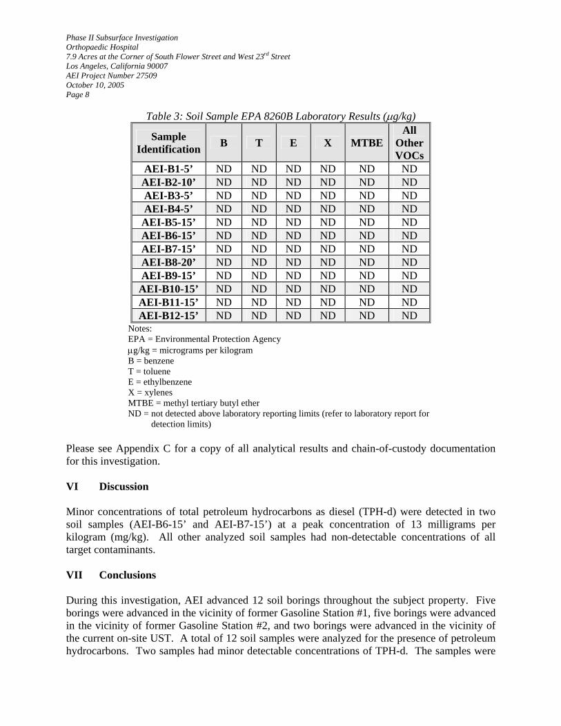
Phase II Subsurface Investigation Orthopaedic Hospital 7.9 Acres at the Corner of South Flower Street and West 23rd Street Los Angeles, California 90007 AEI Project Number 27509 October 10, 2005 Page 8
Table 3: Soil Sample EPA 8260B Laboratory Results (µg/kg)
Sample Identification B T E X MTBE
All Other VOCs
AEI-B1-5’ ND ND ND ND ND ND AEI-B2-10’ ND ND ND ND ND ND AEI-B3-5’ ND ND ND ND ND ND AEI-B4-5’ ND ND ND ND ND ND AEI-B5-15’ ND ND ND ND ND ND AEI-B6-15’ ND ND ND ND ND ND AEI-B7-15’ ND ND ND ND ND ND AEI-B8-20’ ND ND ND ND ND ND AEI-B9-15’ ND ND ND ND ND ND AEI-B10-15’ ND ND ND ND ND ND AEI-B11-15’ ND ND ND ND ND ND AEI-B12-15’ ND ND ND ND ND ND
Notes: EPA = Environmental Protection Agency µg/kg = micrograms per kilogram B = benzene T = toluene E = ethylbenzene X = xylenes MTBE = methyl tertiary butyl ether ND = not detected above laboratory reporting limits (refer to laboratory report for detection limits)
Please see Appendix C for a copy of all analytical results and chain-of-custody documentation for this investigation. VI Discussion Minor concentrations of total petroleum hydrocarbons as diesel (TPH-d) were detected in two soil samples (AEI-B6-15’ and AEI-B7-15’) at a peak concentration of 13 milligrams per kilogram (mg/kg). All other analyzed soil samples had non-detectable concentrations of all target contaminants. VII Conclusions During this investigation, AEI advanced 12 soil borings throughout the subject property. Five borings were advanced in the vicinity of former Gasoline Station #1, five borings were advanced in the vicinity of former Gasoline Station #2, and two borings were advanced in the vicinity of the current on-site UST. A total of 12 soil samples were analyzed for the presence of petroleum hydrocarbons. Two samples had minor detectable concentrations of TPH-d. The samples were
Phase II Subsurface Investigation Orthopaedic Hospital 7.9 Acres at the Corner of South Flower Street and West 23rd Street Los Angeles, California 90007 AEI Project Number 27509 October 10, 2005 Page 9 collected in the Parking Lot. All other soil samples had non-detectable concentrations of all target contaminants. No evidence of a large on-site release from the former on-site gasoline stations or the current on-site UST was detected during this investigation. Based on the results of this investigation, AEI recommends no further investigation at this time. VIII Report Limitation This report presents a summary of work completed by AEI, and has been prepared for Jensen + Partners as it pertains to the property consisting of 7.9 acres at the corner of South Flower Street and West 23rd Street in the City of Los Angeles, California. Neither this report, nor any of the information contained herein shall be used or relied upon by any other person or entity other than Jensen + Partners. The completed work includes observations and descriptions of site conditions encountered. Where appropriate, the report includes analytical results for samples taken during the course of the work. All conclusions and/or recommendations are based on these analyses, observations, and the governing regulations. Conclusions beyond those stated and reported herein should not be inferred from this document. The number and location of samples were chosen to provide the required information, but it cannot be assumed that they are representative of areas not sampled. The variations that may exist between sampling points cannot be anticipated, nor could they be entirely accounted for, in spite of exhaustive additional testing. This report should not be regarded as a guarantee that no further contamination beyond that which could have been detected within the scope of this investigation is present beneath the subject property. Undocumented, unauthorized releases of hazardous material, the remains of which are not readily identifiable by visual inspection and are of different chemical constituents, are difficult and often impossible to detect within the scope of a chemical specific investigation. All specified work has been performed in accordance with generally accepted practices in geotechnical environmental engineering, engineering geology, and hydrogeology. No other warranty, either expressed or implied, is made.

Phase II Subsurface Investigation Orthopaedic Hospital 7.9 Acres at the Corner of South Flower Street and West 23rd Street Los Angeles, California 90007 AEI Project Number 27509 October 10, 2005 Page 10 If you have any questions regarding this investigation, please do not hesitate to contact the undersigned at (310) 798-4255. Sincerely, AEI CONSULTANTS Rodolfo Nadres, EIT Staff Engineer Joseph P. Derhake, PE Principal Figures: 1. Site Vicinity Map 2. Site Plan 3. Gasoline Station #1 and Current On-Site UST Boring Locations 4. Gasoline Station #2 Boring Locations Appendices: A. Health and Safety Plan
B. Boring Logs C. Laboratory Results

Figures

USGS TOPOGRAPHIC MAPHOLLYWOOD QUADRANGLE
Created 1966, Revised 1981 Site Vicinity Map
Drawn by: RN Figure 1
Project # 27509Orthopaedic HospitalLos Angeles, California 90007
September 2005
Subject
Property
Subject
Property
Subject
Property
NAEI CONSULTANTS
2447 Pacific Coast Highway, Suite 101, Hermosa Beach, CA

LEGEND
N Subject Property Line
Site Plan
Approximate Scale
1" = 100’Drawn by: RN Figure 2
Project # 27509Orthopaedic HospitalLos Angeles, California 90007
September 2005
Main CampusParking
Lot
South
Flo
wer
Str
eet
West 23rd Street
110
Harb
orFre
ew
ay
AEI CONSULTANTS2447 Pacific Coast Highway, Suite 101, Hermosa Beach, CA
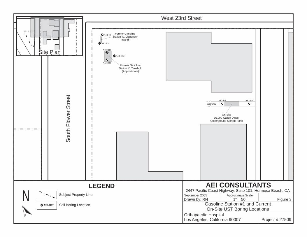
LEGEND
N Subject Property Line
Gasoline Station #1 and CurrentOn-Site UST Boring Locations
Approximate Scale
1" = 50’Drawn by: RN Figure 3
Project # 27509Orthopaedic HospitalLos Angeles, California 90007
September 2005
Soil Boring LocationAEI-B12
South
Flo
wer
Str
eet
West 23rd Street
Walkway
On-Site10,000-Gallon Diesel
Underground Storage Tank
Former GasolineStation #1 Tankhold
(Approximate)
Former GasolineStation #1 Dispenser
Island
AEI CONSULTANTS2447 Pacific Coast Highway, Suite 101, Hermosa Beach, CA
Site Plan
AEI-B8AEI-B9
AEI-B1
AEI-B2
AEI-B10
AEI-B11
AEI-B12

LEGEND
N Subject Property Line Approximate Scale
1" = 50’Drawn by: RN Figure 4
Project # 27509Orthopaedic HospitalLos Angeles, California 90007
September 2005
Soil Boring LocationAEI-B7 Gasoline Station #2 Boring Locations
ParkingLot
110
Harb
orFre
ew
ay Approximate
Location ofFormer Gasoline Station #2
South
Flo
wer
Stre
et
AEI CONSULTANTS2447 Pacific Coast Highway, Suite 101, Hermosa Beach, CA
Site Plan
AEI-B3
AEI-B4
AEI-B5
AEI-B6AEI-B7
Appendix A:
Health and Safety Plan

HEALTH AND SAFETY PLAN
Prepared for:
Phase II Subsurface Investigation at
Orthopaedic Hospital 2400 South Flower Street
Los Angeles, California 90007

A. INTRODUCTION This Health and Safety Plan is written for the Phase II Subsurface Investigation being conducted at 2400 South Flower Street in the City of Los Angeles, California. All job site personnel will follow CAL OSHA safe operating practices as outlined in 29 CFR 1910 and 1926, as well as established guidelines set forth by AEI or their respective companies. B. WORK DESCRIPTION Site Manager: Rodolfo Nadres 310-617-8948 Project Safety Manager: Joseph Derhake 310-798-4255 Address: 2400 South Flower Street Los Angeles, California 90007 All of the samples collected will be analyzed by a state certified laboratory, and the entire project will be performed under the responsible charge of a registered professional civil engineer. C. SITE/WASTE CHARACTERISTICS Hazard Level: Serious: Low: XXX Moderate: Unknown: Waste Type: Solid: XXX Sludge: Liquid: Gas: XXX Hazard Characteristics: Toxic D. HAZARD EVALUATION Potential hazards include skin and eye contact or inhalation exposure to potentially toxic concentrations of hazardous chemicals. The potential toxic compounds that may exist at the site are listed below with descriptions of specific health effects of each. The list includes the primary potential toxic constituents that may be found at sites currently and previously handling petroleum hydrocarbons.

1. Benzene a. Colorless to light yellow, flammable liquid with an aromatic odor. b. Toxic hazard by inhalation, adsorption, ingestion and skin and/or eye contact. c. Exposure may irritate eyes, nose and respiratory system and may cause acute
restlessness, convulsions, nausea, or depression. Benzene is carcinogenic.* d. Permissible exposure level (PEL) for a time weighted average (TWA) over an eight
hour period is 1.0 ppm. 2. Toluene a. Colorless liquid with a sweet, pungent, benzene like odor. b. Toxic hazard by inhalation, adsorption, ingestion and skin and/or eye contact. c. Exposure may cause fatigue, weakness, confusion, euphoria, dizziness, headaches,
dilated pupils, lacrimation, nervousness, insomnia, paresthesia, and dermatitis. d. Permissible exposure level for a time-weighted average over an eight-hour period is
100 ppm. 3. Xylene a. Colorless liquid with an aromatic odor. b. Toxic hazard by inhalation, adsorption, ingestion and skin and/or eye contact. c. Exposure may irritate eyes nose and throat and may cause dizziness, excitement,
drowsiness, incoordination, corneal vacuolization, anorexia, nausea, vomiting, and dermatitis.
d. Permissible exposure level for a time-weighted average over an eight-hour period is 100 ppm. 4. Ethylbenzene a. Colorless liquid with an aromatic odor. b. Toxic hazard by inhalation, ingestion, and skin and/or eye contact. Ethylbenzene is carcinogenic.* c. Exposure may irritate eyes and mucous membrane and may cause headaches,
dermatitis, narcosis and loss of consciousness. d. Permissible exposure level for a time-weighted average over an eight-hour period is 100 ppm. 5. Lead a. A heavy ductile soft gray metal. b. Toxic hazard by inhalation, ingestion, and skin and/or eye contact. c. Exposure may cause weakness, nausea, lassitude, diarrhea, insomnia, anorexia,
inflamed mucous membranes and abdominal pains. Lead is carcinogenic.* d. Permissible exposure level for a time-weighted average over an eight-hour period is
0.05 ppb (in vapor). 6. Gasoline a. Colorless liquid with a strong aromatic odor. Highly volatile and extremely flammable. b. Toxic hazard by inhalation, adsorption, ingestion and skin and/or eye contact.

c. Inhalation of vapors can cause depression of the central nervous system with symptoms such as headache, dizziness, nausea and loss of coordination. Skin contact can cause defatting of the skin, skin irritation and dermatitis. Benzene is a major constituent of gasoline.
d. Permissible exposure level for a time-weighted average over an eight-hour period is 300 ppm. 7. MTBE a. Colorless liquids with aromatic odor b. Toxic hazard by inhalation, absorption, ingestion and skin and/or eye contact. c. Exposure may irritate eyes, nose and respiratory system and may cause acute
restlessness, convulsions, nausea, or depression. MTBE is carcinogenic.* d. Permissible exposure level (PEL) for a time weighted average (TWA) over an eight
hour period is 1.0 ppm. All of the chemical hazards discussed above are primarily inhalation hazards. Work exposure will be monitored by the air-monitoring program, as discussed in Section F. * Known to the State of California to cause cancer. E. PERSONAL PROTECTIVE CLOTHING Based on evaluation of potential hazards, level "D" protective clothing has been designated as the appropriate protection for this project. The level of protective clothing will be upgraded if the organic vapor levels in the operator’s breathing zone exceed 5 ppm above background levels continuously for more than five minutes, or if any single reading exceeds 25 ppm. If this occurs then level C protection will be used. If the organic concentration in the operator's breathing zone exceeds 200 ppm for 5 minutes and/or the organic vapor concentration two feet above the excavation exceeds 1,000 ppm or 10% of the lower explosive limit, then the equipment will be shut down and the site evacuated. If organic vapor concentrations exceed 200 ppm and work continues then level B protection will be required. “EPA Standard Operating Safety Guidelines” defines the levels of protective clothing as follows: LEVEL A: Fully encapsulating suit / SCBA / Hard hat / Steel toe boots / Safety gloves. LEVEL B: Splash resistant suit / SCBA / Hard Hat / Steel toe boots / Safety gloves. LEVEL C: Half face respirator / Hard hat / Safety glasses / Steel toe boots / Coveralls / Gloves. LEVEL D: Coveralls / Hardhat / Safety Glasses / Steel toe boots / Gloves.

If air-purifying respirators are authorized, organic vapor w-filter is the appropriate canister for use with the involved substances and concentrations. A competent individual has determined that all criteria for using this type of respiratory protection have been met. NO CHANGES TO THE SPECIFIED LEVELS OF PROTECTION SHALL BE MADE WITHOUT THE APPROVAL OF THE COMPANY SAFETY OFFICER, J.P. DERHAKE. A FIRST AID KIT AND A 40 POUND BC FIRE EXTINGUISHER WILL BE AVAILABLE ON SITE. EMERGENCY SERVICES ARE AVAILABLE BY DIALING 911 ON THE TELEPHONE LOCATED IN THE SITE MANAGER'S VEHICLE. THIS VEHICLE WILL BE ON SITE AT ALL TIMES. F. MONITORING INSTRUMENTS A photoionization detector will be used to monitor ambient air contaminant concentration. The photoionization detector will be calibrated prior to the start of on-site activities by trained personnel. Readings will be taken at the discretion of the Site Manager based on on-site observations. G. WORKER SAFETY There will be a 3-foot boundary surrounding the work area. The area within this boundary is considered an exclusion zone and only qualified personnel will be allowed to enter. All personnel arriving or departing the site should log in before entering the exclusion zone. All activities on site must be cleared through the Site Manager. Rodolfo Nadres has been designated to coordinate access control and security on site. Joseph Derhake is the designated Project Safety Officer. All work will strictly follow OSHA guidelines. In the event of an emergency, the Site Manager must be notified. All emergency activities will be coordinated through the Project Safety Manager and local emergency personnel. Any injury must be promptly reported to arrange proper medical care. H. EMERGENCY INSTRUCTIONS In the event of an emergency, all on-site activities shall cease. If practical, all on-site equipment shall be shut down. All personnel are required to immediately report to the site manager for instructions. If complete site evacuation is necessary, all personnel shall meet at the reconnoiter spot, identified as the SOUTHEAST CORNER OF WEST 23RD STREET AND SOUTH FLOWER STREET. If necessary, local authorities and medical response agencies shall be notified. Work will commence again at the discretion of the Project Safety Manager and/or local authorities.


Appendix B:
Boring Logs

Asphalt @ surface Note: Visual unified soil classificationAsphalt and subbase thickness = 6”
AEI-B1
Boring Terminated @ 10’No Groundwater Encountered
--- ---0.5 SW--- No odor or discolorationAEI-
B1-10’
Reddish brown fine- to coarse-grainedSAND with gravels, loose (slightly moist)
27509; Orthopaedic Hospital
7.9 Acres at the Corner of S. Flower St. and W. 23rd St.
Kehoe
Geoprobe
Model 5400 Truck-Mounted Rig
Acetate Tube/5035
Refer to Figure 3
207 Feet Above Mean Sea Level
9/19/05 9/19/05
10 Feet
N/A N/A
RN
--- ---2.8 SW--- No odor or discolorationAEI-B1-2’
Reddish brown fine- to coarse-grainedSAND with gravels, loose (slightly moist)
--- ---3.5 SW--- No odor or discolorationAEI-B1-5’
Reddish brown fine- to coarse-grainedSAND with gravels, loose (slightly moist)
AEI CONSULTANTS2447 Pacific Coast Highway, Suite 101
Hermosa Beach, California 90254 LOG OF BOREHOLE:
PROJECT NUMBER/NAME:
PROJECT ADDRESS:
DRILLING CONTRACTOR:
DRILLING METHOD:
DRILLING EQUIPMENT:
SAMPLING METHOD:
HAMMER WEIGHT AND FALL:
COORDINATES:
ELEVATION:
START DATE:
TOTAL DEPTH:
DEPTH TO FIRSTGROUNDWATER:
LOGGED BY:
SHEET 1 OF 1
DEPTH TO STATICGROUNDWATER:
1
2
3
4
5
6
7
8
9
10
11
12
13
14
15
16
17
18
19
20
21
22
23
24
25
DE
PT
H(f
eet
bg
s)
SA
MP
LE
NU
MB
ER
SAMPLE DATA
RE
CO
VE
RY
BL
OW
CO
UN
T
PID
(pp
m)
US
CS
LIT
HO
LO
GY
SOIL DESCRIPTION REMARKS
END DATE:
N/A RESPONSIBLE PROFESSIONAL: JD

Asphalt @ surface Note: Visual unified soil classificationAsphalt and subbase thickness = 6”
AEI-B2
Boring Terminated @ 10’No Groundwater Encountered
--- ---5.0 SW--- No odor or discolorationAEI-
B2-10’
Reddish brown fine- to coarse-grainedSAND with gravels, loose (slightly moist)
27509; Orthopaedic Hospital
7.9 Acres at the Corner of S. Flower St. and W. 23rd St.
Kehoe
Geoprobe
Model 5400 Truck-Mounted Rig
Acetate Tube/5035
Refer to Figure 3
207 Feet Above Mean Sea Level
9/19/05 9/19/05
10 Feet
N/A N/A
RN
--- ---2.3 SW--- No odor or discolorationAEI-B2-2’
Reddish brown fine- to coarse-grainedSAND with gravels, loose (slightly moist)
Poor recovery
AEI CONSULTANTS2447 Pacific Coast Highway, Suite 101
Hermosa Beach, California 90254 LOG OF BOREHOLE:
PROJECT NUMBER/NAME:
PROJECT ADDRESS:
DRILLING CONTRACTOR:
DRILLING METHOD:
DRILLING EQUIPMENT:
SAMPLING METHOD:
HAMMER WEIGHT AND FALL:
COORDINATES:
ELEVATION:
START DATE:
TOTAL DEPTH:
DEPTH TO FIRSTGROUNDWATER:
LOGGED BY:
SHEET 1 OF 1
DEPTH TO STATICGROUNDWATER:
1
2
3
4
5
6
7
8
9
10
11
12
13
14
15
16
17
18
19
20
21
22
23
24
25
DE
PT
H(f
eet
bg
s)
SA
MP
LE
NU
MB
ER
SAMPLE DATA
RE
CO
VE
RY
BL
OW
CO
UN
T
PID
(pp
m)
US
CS
LIT
HO
LO
GY
SOIL DESCRIPTION REMARKS
END DATE:
N/A RESPONSIBLE PROFESSIONAL: JD

Soil @ surface Note: Visual unified soil classification
AEI-B3
Boring Terminated @ 10’No Groundwater Encountered
--- ---5.2 SW--- No odor or discolorationAEI-
B3-10’
Reddish brown fine- to coarse-grainedSAND with gravels, loose (slightly moist)
27509; Orthopaedic Hospital
7.9 Acres at the Corner of S. Flower St. and W. 23rd St.
Kehoe
Geoprobe
Model 5400 Truck-Mounted Rig
Acetate Tube/5035
Refer to Figure 4
207 Feet Above Mean Sea Level
9/19/05 9/19/05
10 Feet
N/A N/A
RN
--- ---3.7 SM--- No odor or discolorationAEI-B3-2’
Greyish brown Silty fine- to coarse-grained SAND with gravels, loose(slightly moist)
--- ---6.3 SW--- No odor or discolorationAEI-B3-5’
Reddish brown fine- to coarse-grainedSAND with gravels, loose (slightly moist)
AEI CONSULTANTS2447 Pacific Coast Highway, Suite 101
Hermosa Beach, California 90254 LOG OF BOREHOLE:
PROJECT NUMBER/NAME:
PROJECT ADDRESS:
DRILLING CONTRACTOR:
DRILLING METHOD:
DRILLING EQUIPMENT:
SAMPLING METHOD:
HAMMER WEIGHT AND FALL:
COORDINATES:
ELEVATION:
START DATE:
TOTAL DEPTH:
DEPTH TO FIRSTGROUNDWATER:
LOGGED BY:
SHEET 1 OF 1
DEPTH TO STATICGROUNDWATER:
1
2
3
4
5
6
7
8
9
10
11
12
13
14
15
16
17
18
19
20
21
22
23
24
25
DE
PT
H(f
eet
bg
s)
SA
MP
LE
NU
MB
ER
SAMPLE DATA
RE
CO
VE
RY
BL
OW
CO
UN
T
PID
(pp
m)
US
CS
LIT
HO
LO
GY
SOIL DESCRIPTION REMARKS
END DATE:
N/A RESPONSIBLE PROFESSIONAL: JD

Soil @ surface Note: Visual unified soil classification
AEI-B4
Boring Terminated @ 10’No Groundwater Encountered
--- ---5.6 SW--- No odor or discolorationAEI-
B4-10’
Greyish brown fine- to coarse-grainedSAND with gravels, loose (slightly moist)
27509; Orthopaedic Hospital
7.9 Acres at the Corner of S. Flower St. and W. 23rd St.
Kehoe
Geoprobe
Model 5400 Truck-Mounted Rig
Acetate Tube/5035
Refer to Figure 4
207 Feet Above Mean Sea Level
9/19/05 9/19/05
10 Feet
N/A N/A
RN
--- ---4.8 SW--- No odor or discolorationAEI-B4-2’
Greyish brown fine- to coarse-grainedSAND with gravels, loose (slightly moist)
--- ---6.2 SW--- No odor or discolorationAEI-B4-5’
Greyish brown fine- to coarse-grainedSAND with gravels, loose (slightly moist)
AEI CONSULTANTS2447 Pacific Coast Highway, Suite 101
Hermosa Beach, California 90254 LOG OF BOREHOLE:
PROJECT NUMBER/NAME:
PROJECT ADDRESS:
DRILLING CONTRACTOR:
DRILLING METHOD:
DRILLING EQUIPMENT:
SAMPLING METHOD:
HAMMER WEIGHT AND FALL:
COORDINATES:
ELEVATION:
START DATE:
TOTAL DEPTH:
DEPTH TO FIRSTGROUNDWATER:
LOGGED BY:
SHEET 1 OF 1
DEPTH TO STATICGROUNDWATER:
1
2
3
4
5
6
7
8
9
10
11
12
13
14
15
16
17
18
19
20
21
22
23
24
25
DE
PT
H(f
eet
bg
s)
SA
MP
LE
NU
MB
ER
SAMPLE DATA
RE
CO
VE
RY
BL
OW
CO
UN
T
PID
(pp
m)
US
CS
LIT
HO
LO
GY
SOIL DESCRIPTION REMARKS
END DATE:
N/A RESPONSIBLE PROFESSIONAL: JD

AEI-B5
Refusal Encountered @ 15’No Groundwater Encountered
--- ---5.1 SC--- No odor or discolorationAEI-
B5-15’
Dark grey Clayey fine- to coarse-grainedSAND with gravels, medium dense(slightly moist)
27509; Orthopaedic Hospital
7.9 Acres at the Corner of S. Flower St. and W. 23rd St.
Kehoe
Geoprobe
Model 5400 Truck-Mounted Rig
Acetate Tube/5035
Refer to Figure 4
207 Feet Above Mean Sea Level
9/19/05 9/19/05
15 Feet
N/A N/A
RN
Asphalt @ surface Note: Visual unified soil classificationAsphalt and subbase thickness = 6”
AEI CONSULTANTS2447 Pacific Coast Highway, Suite 101
Hermosa Beach, California 90254 LOG OF BOREHOLE:
PROJECT NUMBER/NAME:
PROJECT ADDRESS:
DRILLING CONTRACTOR:
DRILLING METHOD:
DRILLING EQUIPMENT:
SAMPLING METHOD:
HAMMER WEIGHT AND FALL:
COORDINATES:
ELEVATION:
START DATE:
TOTAL DEPTH:
DEPTH TO FIRSTGROUNDWATER:
LOGGED BY:
SHEET 1 OF 1
DEPTH TO STATICGROUNDWATER:
1
2
3
4
5
6
7
8
9
10
11
12
13
14
15
16
17
18
19
20
21
22
23
24
25
DE
PT
H(f
eet
bg
s)
SA
MP
LE
NU
MB
ER
SAMPLE DATA
RE
CO
VE
RY
BL
OW
CO
UN
T
PID
(pp
m)
US
CS
LIT
HO
LO
GY
SOIL DESCRIPTION REMARKS
END DATE:
N/A RESPONSIBLE PROFESSIONAL: JD

Boring Terminated @ 25’No Groundwater Encountered
--- ---2.3 SM--- No odor or discolorationAEI-
B6-25’
Brown Silty fine- to coarse-grained SANDwith gravels, medium dense (slightlymoist)
AEI-B6
27509; Orthopaedic Hospital
7.9 Acres at the Corner of S. Flower St. and W. 23rd St.
Kehoe
Geoprobe
Model 5400 Truck-Mounted Rig
Acetate Tube/5035
Refer to Figure 4
207 Feet Above Mean Sea Level
9/19/05 9/19/05
25 Feet
N/A N/A
RN
--- ---4.6 SC--- No odor or discolorationAEI-
B6-15’
Dark greyish brown Clayey fine- to coarse-grained SAND with gravels, medium dense(slightly moist)
--- ---2.8 SM--- No odor or discolorationAEI-
B6-20’
Brown Silty fine- to coarse-grained SANDwith gravels, medium dense (slightlymoist)
Asphalt @ surface Note: Visual unified soil classificationAsphalt and subbase thickness = 6”
AEI CONSULTANTS2447 Pacific Coast Highway, Suite 101
Hermosa Beach, California 90254 LOG OF BOREHOLE:
PROJECT NUMBER/NAME:
PROJECT ADDRESS:
DRILLING CONTRACTOR:
DRILLING METHOD:
DRILLING EQUIPMENT:
SAMPLING METHOD:
HAMMER WEIGHT AND FALL:
COORDINATES:
ELEVATION:
START DATE:
TOTAL DEPTH:
DEPTH TO FIRSTGROUNDWATER:
LOGGED BY:
SHEET 1 OF 1
DEPTH TO STATICGROUNDWATER:
1
2
3
4
5
6
7
8
9
10
11
12
13
14
15
16
17
18
19
20
21
22
23
24
25
DE
PT
H(f
eet
bg
s)
SA
MP
LE
NU
MB
ER
SAMPLE DATA
RE
CO
VE
RY
BL
OW
CO
UN
T
PID
(pp
m)
US
CS
LIT
HO
LO
GY
SOIL DESCRIPTION REMARKS
END DATE:
N/A RESPONSIBLE PROFESSIONAL: JD

Boring Terminated @ 25’No Groundwater Encountered
--- ---1.1 SW--- No odor or discolorationAEI-
B7-25’
Brown fine- to coarse-grained SAND withgravels, loose (slightly moist)
AEI-B6
27509; Orthopaedic Hospital
7.9 Acres at the Corner of S. Flower St. and W. 23rd St.
Kehoe
Geoprobe
Model 5400 Truck-Mounted Rig
Acetate Tube/5035
Refer to Figure 4
207 Feet Above Mean Sea Level
9/19/05 9/19/05
25 Feet
N/A N/A
RN
--- ---4.4 SC--- No odor or discolorationAEI-
B7-15’
Greyish brown Clayey fine- to coarse-grained SAND with gravels, medium dense(slightly moist)
--- ---2.8 SM--- No odor or discolorationAEI-
B7-20’
Greyish brown Clayey fine- to coarse-grained SAND with gravels, medium dense(slightly moist)
Asphalt @ surface Note: Visual unified soil classificationAsphalt and subbase thickness = 6”
AEI CONSULTANTS2447 Pacific Coast Highway, Suite 101
Hermosa Beach, California 90254 LOG OF BOREHOLE:
PROJECT NUMBER/NAME:
PROJECT ADDRESS:
DRILLING CONTRACTOR:
DRILLING METHOD:
DRILLING EQUIPMENT:
SAMPLING METHOD:
HAMMER WEIGHT AND FALL:
COORDINATES:
ELEVATION:
START DATE:
TOTAL DEPTH:
DEPTH TO FIRSTGROUNDWATER:
LOGGED BY:
SHEET 1 OF 1
DEPTH TO STATICGROUNDWATER:
1
2
3
4
5
6
7
8
9
10
11
12
13
14
15
16
17
18
19
20
21
22
23
24
25
DE
PT
H(f
eet
bg
s)
SA
MP
LE
NU
MB
ER
SAMPLE DATA
RE
CO
VE
RY
BL
OW
CO
UN
T
PID
(pp
m)
US
CS
LIT
HO
LO
GY
SOIL DESCRIPTION REMARKS
END DATE:
N/A RESPONSIBLE PROFESSIONAL: JD

Refusal Encountered @ 20’No Groundwater Encountered
--- ---0.9 SW--- No odor or discolorationAEI-
B8-20’
Reddish brown fine- to coarse-grainedSAND with gravels, medium dense(slightly moist)
AEI-B8
27509; Orthopaedic Hospital
7.9 Acres at the Corner of S. Flower St. and W. 23rd St.
Kehoe
Geoprobe
Model 6600 Tread-Mounted Rig
Brass Tube/5035
Refer to Figure 3
207 Feet Above Mean Sea Level
9/23/05 9/23/05
20 Feet
N/A N/A
RN
--- ---0.7 SW--- No odor or discolorationAEI-
B8-15’
Reddish brown fine- to coarse-grainedSAND with gravels, medium dense(slightly moist)
Reinforced concrete @ surface Note: Visual unified soil classificationConcrete thickness = 4”
AEI CONSULTANTS2447 Pacific Coast Highway, Suite 101
Hermosa Beach, California 90254 LOG OF BOREHOLE:
PROJECT NUMBER/NAME:
PROJECT ADDRESS:
DRILLING CONTRACTOR:
DRILLING METHOD:
DRILLING EQUIPMENT:
SAMPLING METHOD:
HAMMER WEIGHT AND FALL:
COORDINATES:
ELEVATION:
START DATE:
TOTAL DEPTH:
DEPTH TO FIRSTGROUNDWATER:
LOGGED BY:
SHEET 1 OF 1
DEPTH TO STATICGROUNDWATER:
1
2
3
4
5
6
7
8
9
10
11
12
13
14
15
16
17
18
19
20
21
22
23
24
25
DE
PT
H(f
eet
bg
s)
SA
MP
LE
NU
MB
ER
SAMPLE DATA
RE
CO
VE
RY
BL
OW
CO
UN
T
PID
(pp
m)
US
CS
LIT
HO
LO
GY
SOIL DESCRIPTION REMARKS
END DATE:
N/A RESPONSIBLE PROFESSIONAL: JD

Refusal Encountered @ 20’No Groundwater Encountered
--- ---0.4 SW--- No odor or discolorationAEI-
B9-20’
Brown fine- to coarse-grained SAND withgravels, medium dense (slightly moist)
AEI-B9
27509; Orthopaedic Hospital
7.9 Acres at the Corner of S. Flower St. and W. 23rd St.
Kehoe
Geoprobe
Model 6600 Tread-Mounted Rig
Brass Tube/5035
Refer to Figure 3
207 Feet Above Mean Sea Level
9/23/05 9/23/05
20 Feet
N/A N/A
RN
--- ---0.8 SW--- No odor or discolorationAEI-
B9-15’
Brown fine- to coarse-grained SAND withgravels, medium dense (slightly moist)
Reinforced concrete @ surface Note: Visual unified soil classificationConcrete thickness = 4”
AEI CONSULTANTS2447 Pacific Coast Highway, Suite 101
Hermosa Beach, California 90254 LOG OF BOREHOLE:
PROJECT NUMBER/NAME:
PROJECT ADDRESS:
DRILLING CONTRACTOR:
DRILLING METHOD:
DRILLING EQUIPMENT:
SAMPLING METHOD:
HAMMER WEIGHT AND FALL:
COORDINATES:
ELEVATION:
START DATE:
TOTAL DEPTH:
DEPTH TO FIRSTGROUNDWATER:
LOGGED BY:
SHEET 1 OF 1
DEPTH TO STATICGROUNDWATER:
1
2
3
4
5
6
7
8
9
10
11
12
13
14
15
16
17
18
19
20
21
22
23
24
25
DE
PT
H(f
eet
bg
s)
SA
MP
LE
NU
MB
ER
SAMPLE DATA
RE
CO
VE
RY
BL
OW
CO
UN
T
PID
(pp
m)
US
CS
LIT
HO
LO
GY
SOIL DESCRIPTION REMARKS
END DATE:
N/A RESPONSIBLE PROFESSIONAL: JD

Refusal Encountered @ 20’No Groundwater Encountered
--- ---2.5 SW--- No odor or discolorationAEI-B10-20’
Greyish brown fine- to coarse-grainedSAND with gravels, medium dense(slightly moist)
AEI-B10
27509; Orthopaedic Hospital
7.9 Acres at the Corner of S. Flower St. and W. 23rd St.
Kehoe
Geoprobe
Model 6600 Tread-Mounted Rig
Brass Tube/5035
Refer to Figure 3
207 Feet Above Mean Sea Level
9/23/05 9/23/05
20 Feet
N/A N/A
RN
--- ---2.7 SW--- No odor or discolorationAEI-B10-15’
Greyish brown fine- to coarse-grainedSAND with gravels, medium dense(slightly moist)
Asphalt @ surface Note: Visual unified soil classificationAsphalt and subbase thickness = 6”
AEI CONSULTANTS2447 Pacific Coast Highway, Suite 101
Hermosa Beach, California 90254 LOG OF BOREHOLE:
PROJECT NUMBER/NAME:
PROJECT ADDRESS:
DRILLING CONTRACTOR:
DRILLING METHOD:
DRILLING EQUIPMENT:
SAMPLING METHOD:
HAMMER WEIGHT AND FALL:
COORDINATES:
ELEVATION:
START DATE:
TOTAL DEPTH:
DEPTH TO FIRSTGROUNDWATER:
LOGGED BY:
SHEET 1 OF 1
DEPTH TO STATICGROUNDWATER:
1
2
3
4
5
6
7
8
9
10
11
12
13
14
15
16
17
18
19
20
21
22
23
24
25
DE
PT
H(f
eet
bg
s)
SA
MP
LE
NU
MB
ER
SAMPLE DATA
RE
CO
VE
RY
BL
OW
CO
UN
T
PID
(pp
m)
US
CS
LIT
HO
LO
GY
SOIL DESCRIPTION REMARKS
END DATE:
N/A RESPONSIBLE PROFESSIONAL: JD

Refusal Encountered @ 15’No Groundwater Encountered
--- ---1.7 SW--- No odor or discolorationAEI-B11-15’
Brown fine- to coarse-grained SAND withgravels, medium dense (slightly moist)
AEI-B11
27509; Orthopaedic Hospital
7.9 Acres at the Corner of S. Flower St. and W. 23rd St.
Kehoe
Geoprobe
Model 6600 Tread-Mounted Rig
Brass Tube/5035
Refer to Figure 3
207 Feet Above Mean Sea Level
9/23/05 9/23/05
15 Feet
N/A N/A
RN
Asphalt @ surface Note: Visual unified soil classificationAsphalt and subbase thickness = 6”
AEI CONSULTANTS2447 Pacific Coast Highway, Suite 101
Hermosa Beach, California 90254 LOG OF BOREHOLE:
PROJECT NUMBER/NAME:
PROJECT ADDRESS:
DRILLING CONTRACTOR:
DRILLING METHOD:
DRILLING EQUIPMENT:
SAMPLING METHOD:
HAMMER WEIGHT AND FALL:
COORDINATES:
ELEVATION:
START DATE:
TOTAL DEPTH:
DEPTH TO FIRSTGROUNDWATER:
LOGGED BY:
SHEET 1 OF 1
DEPTH TO STATICGROUNDWATER:
1
2
3
4
5
6
7
8
9
10
11
12
13
14
15
16
17
18
19
20
21
22
23
24
25
DE
PT
H(f
eet
bg
s)
SA
MP
LE
NU
MB
ER
SAMPLE DATA
RE
CO
VE
RY
BL
OW
CO
UN
T
PID
(pp
m)
US
CS
LIT
HO
LO
GY
SOIL DESCRIPTION REMARKS
END DATE:
N/A RESPONSIBLE PROFESSIONAL: JD
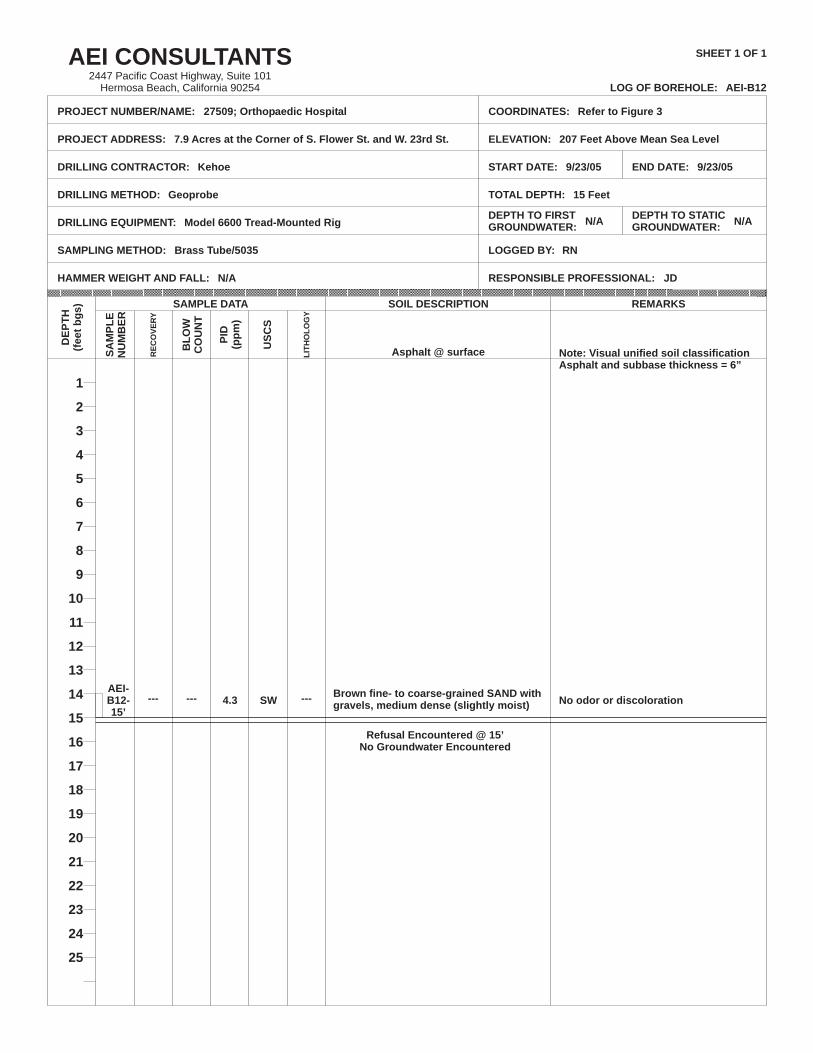
Refusal Encountered @ 15’No Groundwater Encountered
--- ---4.3 SW--- No odor or discolorationAEI-B12-15’
Brown fine- to coarse-grained SAND withgravels, medium dense (slightly moist)
AEI-B12
27509; Orthopaedic Hospital
7.9 Acres at the Corner of S. Flower St. and W. 23rd St.
Kehoe
Geoprobe
Model 6600 Tread-Mounted Rig
Brass Tube/5035
Refer to Figure 3
207 Feet Above Mean Sea Level
9/23/05 9/23/05
15 Feet
N/A N/A
RN
Asphalt @ surface Note: Visual unified soil classificationAsphalt and subbase thickness = 6”
AEI CONSULTANTS2447 Pacific Coast Highway, Suite 101
Hermosa Beach, California 90254 LOG OF BOREHOLE:
PROJECT NUMBER/NAME:
PROJECT ADDRESS:
DRILLING CONTRACTOR:
DRILLING METHOD:
DRILLING EQUIPMENT:
SAMPLING METHOD:
HAMMER WEIGHT AND FALL:
COORDINATES:
ELEVATION:
START DATE:
TOTAL DEPTH:
DEPTH TO FIRSTGROUNDWATER:
LOGGED BY:
SHEET 1 OF 1
DEPTH TO STATICGROUNDWATER:
1
2
3
4
5
6
7
8
9
10
11
12
13
14
15
16
17
18
19
20
21
22
23
24
25
DE
PT
H(f
eet
bg
s)
SA
MP
LE
NU
MB
ER
SAMPLE DATA
RE
CO
VE
RY
BL
OW
CO
UN
T
PID
(pp
m)
US
CS
LIT
HO
LO
GY
SOIL DESCRIPTION REMARKS
END DATE:
N/A RESPONSIBLE PROFESSIONAL: JD

Appendix C:
Laboratory Results