appendix c-9 stage 2 archaeological assessment and built ... · report stage 2 archaeological...
TRANSCRIPT

REPORT
Stage 2 Archaeological Assessment And Built Heritage -Technical Study Report DURHAM YORK RESIDUAL WASTE EA STUDY
REPORT NO. 1009497 CIF# P002-152-2008

Stage 2 Archaeological Assessment and Built Heritage
Technical Study ReportJuly 31, 2009
P.N. 1009497 Jacques Whitford © 2009
i
EXECUTIVE SUMMARY
A Stage 2 Archaeological Assessment was undertaken for the Proposed Thermal Treatment Facility Site (the Site), the preferred site for the location of a Proposed Thermal Treatment Facility (the Facility) in the Regional Municipality of Durham. Stage 1 Archeological Assessment had indicated that the Site had elevated potential for the presence of archaeological sites. A pedestrian survey of approximately 6 ha of the Site did not identify any archaeological resources. A small portion of the property was tested through shovel test pit survey in May, 2009. Based on the results of two separate Stage 2 assessments of portions of the overall project area the likelihood of significant, intact archaeological resources on the site is considered low. There are no significant built heritage features on the Site.

Stage 2 Archaeological Assessment and Built Heritage
Technical Study ReportJuly 31, 2009
P.N. 1009497 Jacques Whitford © 2009
ii
Table of Contents EXECUTIVE SUMMARY ............................................................................................................ i
REPORT .................................................................................................................................... 1
1.0 INTRODUCTION ........................................................................................................................ 1 1.1 The Environmental Assessment Process .................................................................................. 1 1.2 Purpose of the Report ................................................................................................................ 2 1.3 Overview of Report Contents ..................................................................................................... 2
2.0 STUDY METHODOLOGY ......................................................................................................... 3
3.0 DESCRIPTION OF EXISTING CONDITIONS ........................................................................... 8 3.1 Prehistoric Resources ................................................................................................................ 8 3.2 Historic Resources and Built Heritage ..................................................................................... 10 3.3 Stage 2 Archaeological Assessment ........................................................................................ 10
4.0 RESULTS OF ANALYSIS ....................................................................................................... 12
5.0 IMPACT MANAGEMENT ........................................................................................................ 12
6.0 SUMMARY AND CONCLUSION ............................................................................................. 13
7.0 CLOSURE ................................................................................................................................ 14
8.0 REFERENCES ......................................................................................................................... 15
List of Tables
Table 3-1 Prehistoric Sites Within 2.5 km of Clarington 01 Site ................................................ 10
List of Figures
Figure 2-1 Location of Clarington 01 Study Area .......................................................................... 4 Figure 2-2 Portions of Site Subject to Pedestrian Survey ............................................................. 5 Figure 2-3 Current Study Area and Site Previously Surveyed ...................................................... 6 Figure 2-4 Test Pits Excavated ..................................................................................................... 7 Figure 3-1 Proposed Clarington 01 Site ....................................................................................... 9
List of Appendices
APPENDIX A Photographs

Stage 2 Archaeological Assessment and Built Heritage
Technical Study ReportJuly 31, 2009
P.N. 1009497 Jacques Whitford © 2009
1
REPORT
1.0 INTRODUCTION Durham and York Regions (the Regions) have partnered to undertake a joint Residual Waste EA Planning Study. Both municipalities are in need of a solution to manage the residual solid waste that remains after diversion. The Regions are working together to address the social, economic, and environmental concerns through an Environmental Assessment (EA) Study process to examine potential long-term residual waste management alternatives.
1.1 The Environmental Assessment Process
The purpose of the undertaking (i.e., what the outcome of this EA Study is intended to do) as described in the Approved EA Terms of Reference is:
“To process - physically, biologically and/or thermally - the waste that remains after the application of both Regions’ at-source waste diversion programs in order to recover resources - both material and energy - and to minimize the amount of material requiring landfill disposal. In proceeding with this undertaking only those approaches that will meet or exceed all regulatory requirements will be considered.”
The EA Study follows a planning approach where environmental constraints or opportunities are considered in the context of the broadly defined environment under the Environmental Assessment Act (EAA) (i.e., the natural environment as well as the social, economic and heritage and other “environments” relevant to the undertaking) and potential effects are understood and addressed before development occurs. In accordance with the Approved EA Terms of Reference and EAA, the EA process evaluates: alternatives considering potential effects on the environment; the availability of mitigation measures that address, in whole or in part, the potential effects; and, the comparison of the advantages and disadvantages of the remaining or “net” effects. The result of this process provides the planning rationale and support for a preferred approach and method to implement the undertaking.
The EA document has been prepared and conducted in accordance with the EAA, including in accordance with the Terms of Reference approved by Ontario's Minister of the Environment on March 31, 2006. There are currently no federal environmental assessment process triggers identified and, therefore, this project does not require approval under the Canadian Environmental Assessment Act (CEAA).
It is understood and contemplated that environmental management measures recommended as part of the EA process and this Technical Study Report will in many cases be refined, updated, modified and/or superceded as a result of subsequent approval processes.
This EA process essentially consists of three parts taking place in stages including:
the Development and Approval of an EA Terms of Reference,

Stage 2 Archaeological Assessment and Built Heritage
Technical Study ReportJuly 31, 2009
P.N. 1009497 Jacques Whitford © 2009
2
the evaluation of “Alternatives to” the undertaking, and;
the evaluation of “Alternative methods” of implementing the undertaking.
Refer to the Environmental Assessment for a detailed description of the EA process undertaken as part of the Durham/York Residual Waste EA.
1.2 Purpose of the Report
This Report entitled Stage 2 Archaeological Assessment and Built Heritage has been prepared to determine the potential archaeological and heritage resource related impacts associated with the development of the Proposed Thermal Treatment Facility (the Facility) on the Proposed Thermal Treatment Facility Site, Clarington 01 (the Site). A potential disturbed area “footprint” equal to the maximum design capacity scenario of 400,000 tonnes per year was assumed to carry out the investigation. This Report will form part of the supporting documentation and materials for the EA study.
1.3 Overview of Report Contents
This Report describes the existing archaeological and heritage resource conditions related to the Site, followed by an effects analysis including net effects of the Project on the subject aspect(s) of the environment and summary of the required monitoring. The key sections of the Report are as follows:
Study Methodology;
Description of Existing Conditions;
Results of Analysis;
Impact Management Recommendations; and,
Summary and Conclusions.
The information contained in this Report has been used to complete the EA.
Stage 2 Archaeological Assessment and Built Heritage
Technical Study ReportJuly 31, 2009
P.N. 1009497 Jacques Whitford © 2009
3
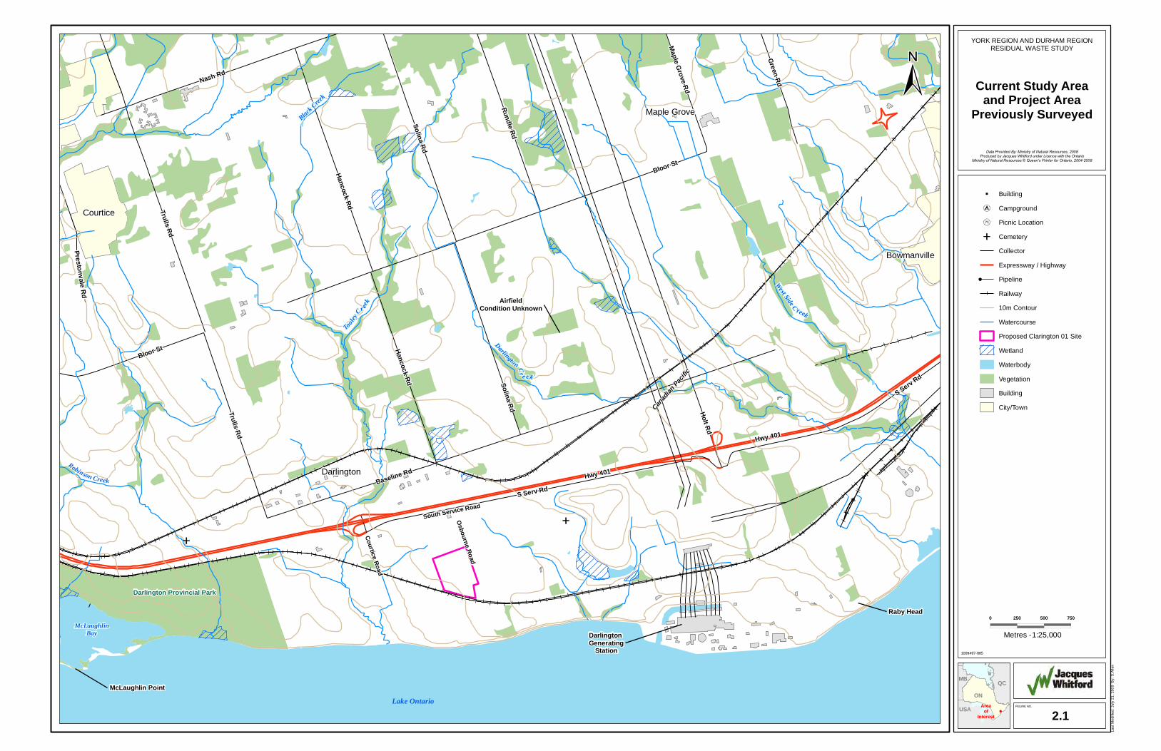
2.0 STUDY METHODOLOGY The Stage 1 Archaeological Assessment of the Site determined that the Site had an elevated potential for the presence of archaeological resources and that Stage 2 Archaeological Assessment would be required prior to any below grade Project-related activities (Jacques Whitford, 2007). Figure 2-1 indicates the location of the study area. A potential disturbed area “footprint” equal to the maximum design capacity scenario of 400,000 tpy was assumed to carry out the investigation.
Stage 2 Archaeological Assessment is the below grade survey that occurs in order to determine whether there are unknown archaeological resources located on the Site. The ideal situation, and required for currently cleared lands, is to have the ground ploughed and then pedestrian surveyed (e.g., walk the ploughed fields at 5 m intervals). During a pedestrian survey if a site is found (i.e., there are a number of artifacts identified in a specific areal context) those artifacts will be left in the field, with the exception of diagnostic artifacts (e.g., arrow heads, decorated pottery), but the area marked and recorded on large scale map or by GPS. If conditions do not allow for pedestrian survey, the area is surveyed by excavating a series of test pits, 40 x 40 cm or larger, and screening of all soil for artifacts. In this situation the artifacts are retained, and the location of the positive test pits recorded. If sites are identified during the Stage 2 assessment then the next step is to accurately delimit each site (Stage 3 Archaeological Assessment).
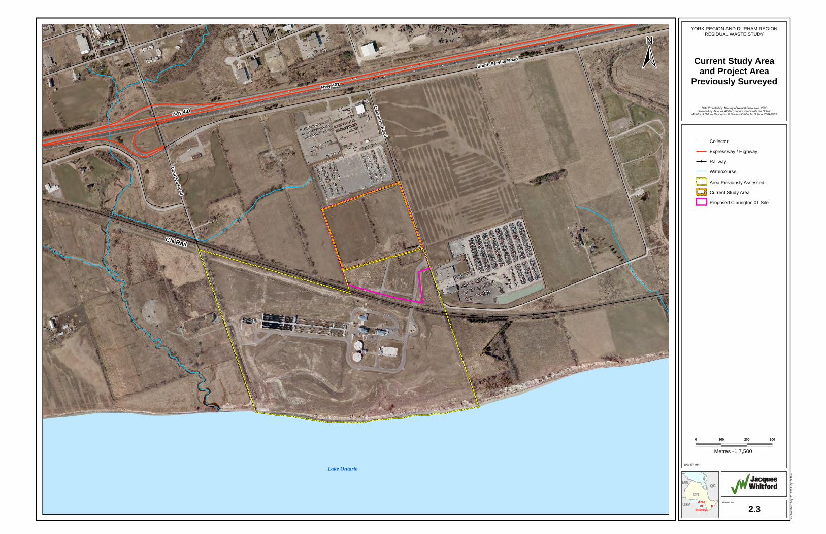
In the Stage 1 Archaeological Assessment of the property it was identified that portions of the Site would require pedestrian survey and that those parts of the property which had been used for cultivation would be required to be ploughed and weathered in advance of archaeological fieldwork. The ploughed portion of the current study area comprises approximately 6.0 ha of the 12.1 ha Site in two discrete fields (Figure 2-2). The remaining 6.0 ha are comprised of approximately 5 ha of land previously surveyed in 2004 and 1.0 ha of irregularly shaped parts of the property which were not cultivated (Figures 2-3 and 2-4). The Site fields were ploughed in mid-November, 2008 and allowed to weather through light rains, and one episode of heavy snow. As required, a shovel test surveying of unploughed portions of the Site was undertaken on May 6, 2009 (see Section 3.3).
A portion of the current Site was subject to Stage 2 archaeological assessment in 2004, completed in advance of the development of the Courtice Water Pollution Control Plant (WPCP) (Figure 2-2).

South Service Road
Osbourne Road
Courtice Road
Lake Ontario
Tooley Cr eek
Darlington Provincial Park
McLaughlinBay
McLaughlin Point
Darlington
Darlingto n Cr e ek
Maple Grove
West Side C reek
Raby Head
Darlington Generating
Station
Courtice
Black Creek
Bowmanville
AirfieldCondition Unknown
Canadia
n Paci
fic
Robinson Creek Hwy 401
Holt Rd
Baseline Rd
S Serv Rd
Nash Rd
Trulls Rd
Solina Rd
Bloor St
Rundle Rd
Hancock Rd
Green Rd
Prestonvale Rd
Maple G
rove Rd
Hwy 401
Solina Rd
Trulls Rd
S Serv Rd
Bloor St
Hancock Rd
ON
QCMB
USAFIGURE NO.
2.1Area
ofInterest
Last
Mod
ified
: Jul
y 21
, 200
9 B
y: S
.Alle
n
1009497-085
0 250 500 750
YORK REGION AND DURHAM REGIONRESIDUAL WASTE STUDY
Current Study Areaand Project Area
Previously Surveyed
Data Provided By: Ministry of Natural Resources, 2008Produced by Jacques Whitford under Licence with the Ontario
Ministry of Natural Resources © Queen’s Printer for Ontario, 2004-2008
Building
Campground
Picnic Location
Cemetery
Collector
Expressway / Highway
Pipeline
Railway
10m Contour
Watercourse
Proposed Clarington 01 Site
Wetland
Waterbody
Vegetation
Building
City/Town
1:25,000Metres -


Osbourne Rd
Courtice Rd
ON
QCMB
USAFIGURE NO.
2.2Area
ofInterest
Last
Mod
ified
: Jul
y 21
, 200
9 B
y: S
.Alle
n
1009497-086
0 25 50 75
YORK REGION AND DURHAM REGIONRESIDUAL WASTE STUDY
Portions of SiteSubject to
Pedestrian Survey
Data Provided By: Ministry of Natural Resources, 2008Produced by Jacques Whitford under Licence with the Ontario
Ministry of Natural Resources © Queen’s Printer for Ontario, 2004-2008
Collector
Expressway / Highway
Railway
Area Previously Assessed
Current Study Area
Frozen Ground, Not Tested
Proposed Clarington 01 Site
1:3,000Metres -

CN Rail
South Service Road
Osbourne Road
Courtice Road
Lake Ontario
Hwy 401
Hwy 401
ON
QCMB
USAFIGURE NO.
2.3Area
ofInterest
Last
Mod
ified
: Jul
y 21
, 200
9 B
y: S
.Alle
n
1009497-084
0 100 200 300
YORK REGION AND DURHAM REGIONRESIDUAL WASTE STUDY
Current Study Areaand Project Area
Previously Surveyed
Data Provided By: Ministry of Natural Resources, 2008Produced by Jacques Whitford under Licence with the Ontario
Ministry of Natural Resources © Queen’s Printer for Ontario, 2004-2008
Collector
Expressway / Highway
Railway
Watercourse
Area Previously Assessed
Current Study Area
Proposed Clarington 01 Site
1:7,500Metres -

Former Driveway
Poorly Drained Area
ON
QCMB
USAFIGURE NO.
2.4Area
ofInterest
Last
Mod
ified
: Jul
y 21
, 200
9 B
y: S
.Alle
n
1009497-082
0 10 20 30
YORK REGION AND DURHAM REGIONRESIDUAL WASTE STUDY
Test Pit Locations
Data Provided By: Ministry of Natural Resources, 2008Produced by Jacques Whitford under Licence with the Ontario
Ministry of Natural Resources © Queen’s Printer for Ontario, 2004-2008
Test Pit Location
Area Previously Assessed
Current Study Area
Frozen Ground, Not Tested
Proposed Clarington 01 Site
1:750Metres -


Stage 2 Archaeological Assessment and Built Heritage
Technical Study ReportJuly 31, 2009
P.N. 1009497 Jacques Whitford © 2009
8
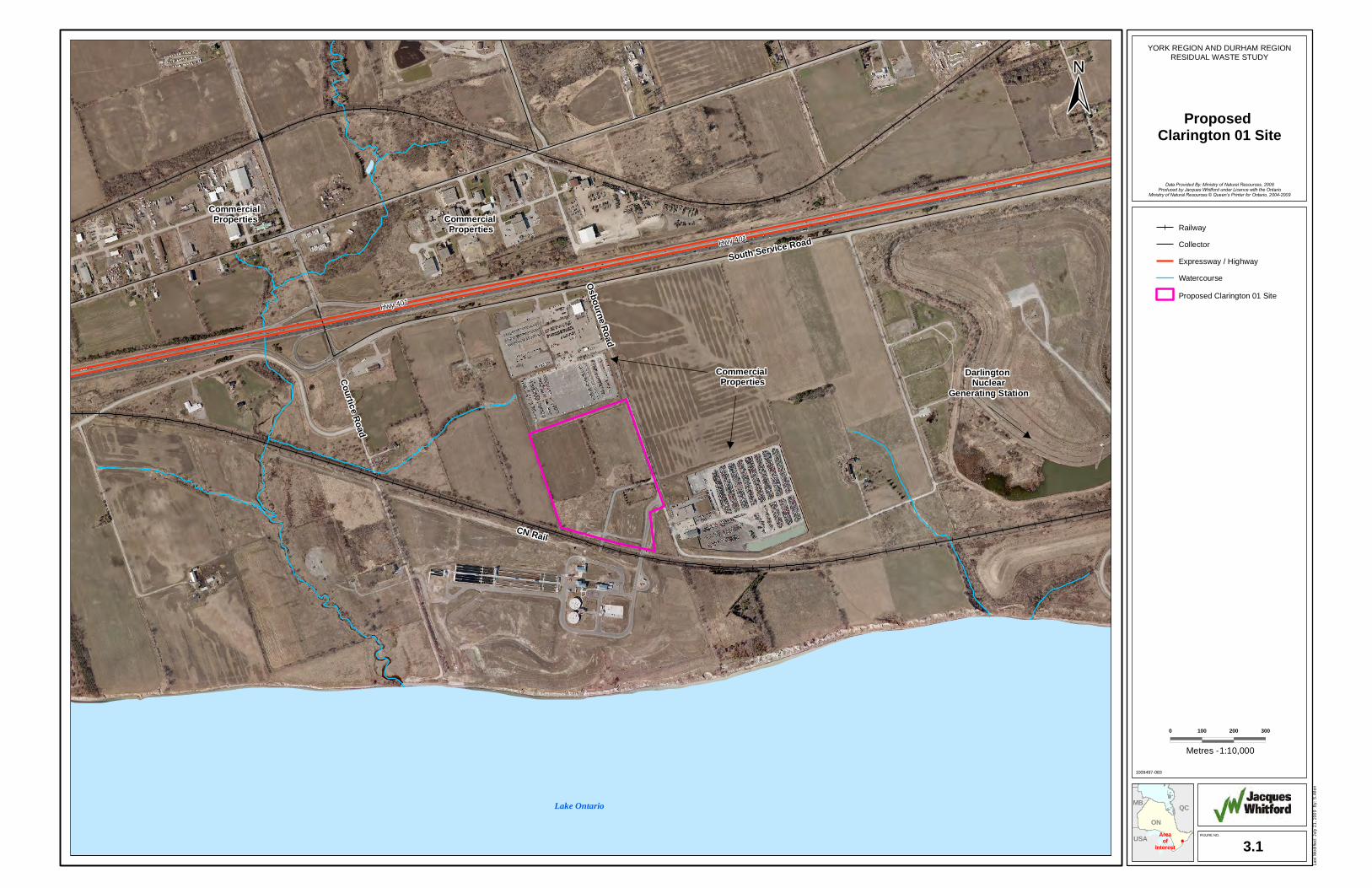
3.0 DESCRIPTION OF EXISTING CONDITIONS The Site is located in Lot 27, Broken Front Concession, on the west side of Osborne Road (Figure 3-1). The Site measures approximately 12.1 ha in size and is composed largely of fallow fields and is presently owned by the Region of Durham. The Site is located on the west side of Osborne Road north of a CN Rail corridor. There are commercial properties north and east of the Site. The lands northeast and west of the Site are undeveloped and are currently used for agricultural purposes. The Courtice Water Pollution Control Plant is just south of the Site. The Darlington Nuclear Generating Station is located approximately 1 km to the east. The nearest major intersection is Hwy 401 and Courtice Road, which is approximately 1.7 km from the Site. There is a meteorological tower in the central part of the Site.
Clarington 01 is located on Darlington Loam soils which exhibit good drainage, moderate sloping and few stones in the soil matrix (Webber et al, 1946). The general soil characteristics indicate that there were no restrictions for prehistoric or historic period use of the land. The topography of the Site is generally level, with a slight down slope in the south-west corner of the Site. There was no evidence of a watercourse visible on the Site, although the headwaters of a small watercourse are located to the north-west of the Site, and the Site is located on a terrace above the Lake Ontario shoreline, approximately 400 m south of the south edge of the Site.
3.1 Prehistoric Resources
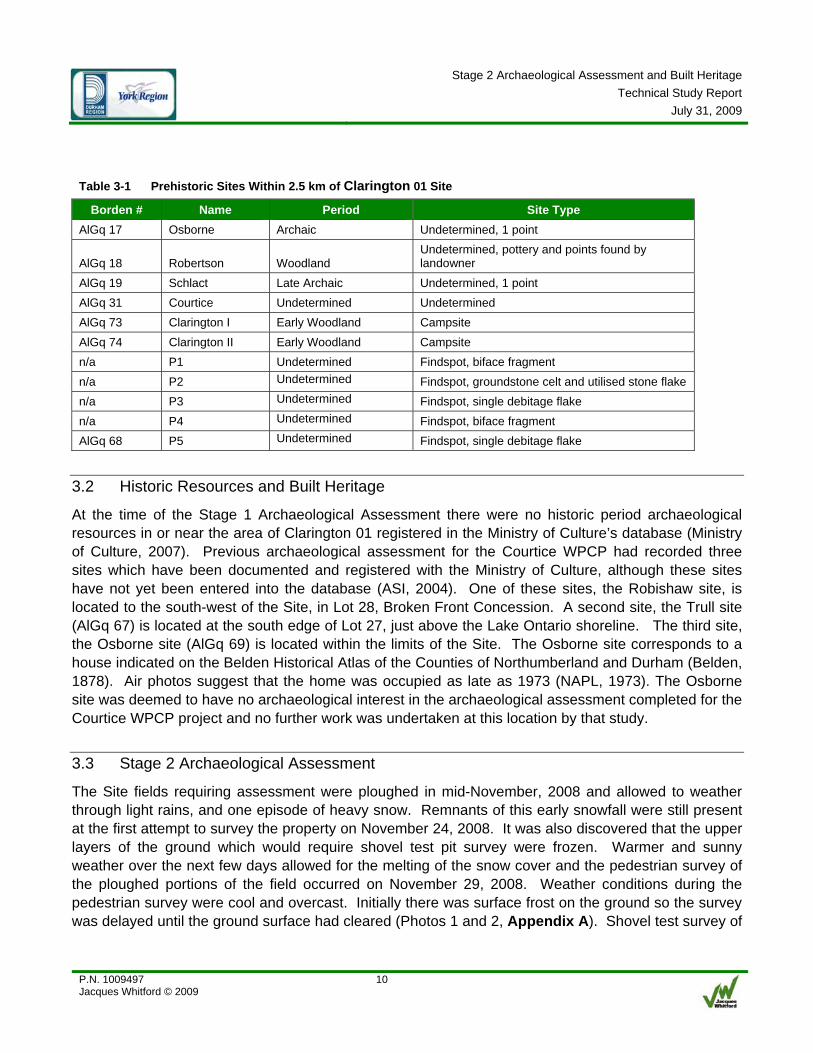
At the time of the Stage 1 Archaeological Assessment there were six (6) prehistoric archaeological sites within 2.5 km of the Site registered in the Ministry of Culture’s database (Ministry of Culture, 2007) (Table 3-1). A previous archaeological assessment for the Courtice WPCP had recorded five locations of isolated prehistoric material in the fields in Lot 28, between the railway corridor and the Lake Ontario shoreline (ASI, 2004) (Table 3-1). Four of these locations were not registered as archaeological sites, and thus have no Borden number designation. The other was an isolated flake found at the historic period Robishaw site (AlGq 68). Two of the sites are attributed to the Archaic Archaeological period, two others to the Early Woodland period, and one to the general Woodland period. The remaining sites are undetermined as to the period of occupation.

Commercial Properties
Darlington Nuclear
Generating Station
Commercial Properties
Commercial Properties
CN Rail
South Service Road
Osbourne Road
Courtice Road
Lake Ontario
Hwy 401
Hwy 401
ON
QCMB
USAFIGURE NO.
3.1Area
ofInterest
Last
Mod
ified
: Jul
y 21
, 200
9 B
y: S
.Alle
n
1009497-083
0 100 200 300
YORK REGION AND DURHAM REGIONRESIDUAL WASTE STUDY
Proposed Clarington 01 Site
Data Provided By: Ministry of Natural Resources, 2008Produced by Jacques Whitford under Licence with the Ontario
Ministry of Natural Resources © Queen’s Printer for Ontario, 2004-2009
Railway
Collector
Expressway / Highway
Watercourse
Proposed Clarington 01 Site
1:10,000Metres -

Stage 2 Archaeological Assessment and Built Heritage
Technical Study ReportJuly 31, 2009
P.N. 1009497 Jacques Whitford © 2009
10
Table 3-1 Prehistoric Sites Within 2.5 km of Clarington 01 Site
Borden # Name Period Site Type AlGq 17 Osborne Archaic Undetermined, 1 point
AlGq 18 Robertson Woodland Undetermined, pottery and points found by landowner
AlGq 19 Schlact Late Archaic Undetermined, 1 point AlGq 31 Courtice Undetermined Undetermined AlGq 73 Clarington I Early Woodland Campsite AlGq 74 Clarington II Early Woodland Campsite n/a P1 Undetermined Findspot, biface fragment n/a P2 Undetermined Findspot, groundstone celt and utilised stone flake n/a P3 Undetermined Findspot, single debitage flake n/a P4 Undetermined Findspot, biface fragment AlGq 68 P5 Undetermined Findspot, single debitage flake
3.2 Historic Resources and Built Heritage
At the time of the Stage 1 Archaeological Assessment there were no historic period archaeological resources in or near the area of Clarington 01 registered in the Ministry of Culture’s database (Ministry of Culture, 2007). Previous archaeological assessment for the Courtice WPCP had recorded three sites which have been documented and registered with the Ministry of Culture, although these sites have not yet been entered into the database (ASI, 2004). One of these sites, the Robishaw site, is located to the south-west of the Site, in Lot 28, Broken Front Concession. A second site, the Trull site (AlGq 67) is located at the south edge of Lot 27, just above the Lake Ontario shoreline. The third site, the Osborne site (AlGq 69) is located within the limits of the Site. The Osborne site corresponds to a house indicated on the Belden Historical Atlas of the Counties of Northumberland and Durham (Belden, 1878). Air photos suggest that the home was occupied as late as 1973 (NAPL, 1973). The Osborne site was deemed to have no archaeological interest in the archaeological assessment completed for the Courtice WPCP project and no further work was undertaken at this location by that study.
3.3 Stage 2 Archaeological Assessment
The Site fields requiring assessment were ploughed in mid-November, 2008 and allowed to weather through light rains, and one episode of heavy snow. Remnants of this early snowfall were still present at the first attempt to survey the property on November 24, 2008. It was also discovered that the upper layers of the ground which would require shovel test pit survey were frozen. Warmer and sunny weather over the next few days allowed for the melting of the snow cover and the pedestrian survey of the ploughed portions of the field occurred on November 29, 2008. Weather conditions during the pedestrian survey were cool and overcast. Initially there was surface frost on the ground so the survey was delayed until the ground surface had cleared (Photos 1 and 2, Appendix A). Shovel test survey of

Stage 2 Archaeological Assessment and Built Heritage
Technical Study ReportJuly 31, 2009
P.N. 1009497 Jacques Whitford © 2009
11
the unploughed portions of the Site could not be completed at that time due to the soils being still partially frozen or sodden. In either case, screening proved ineffective and it was decided that this small area of the project property would need to be tested in the spring of 2009.
Pedestrian survey occurred at 5 m intervals or less across the entirety of the two fields. Visibility of the ground was very good and the general lack of stones in the soils matrix made for ready observation of any materials in the soil. Despite careful observation of the soils no prehistoric artifacts or significant features were noted during the survey. Only a few small and non-diagnostic historic and modern period artifacts were noted. None of the items identified were in either sufficient density or proximity to indicate the presence of a discrete archaeological deposit or feature. The only deposits of any density noted during the survey were piles of modern refuse along the access road from Osborne Road into the Site. Along either side of the drive and at the terminus of the road were piles of larger modern items and smaller items were strewn about the area, the result of wind, animal and human disturbance.
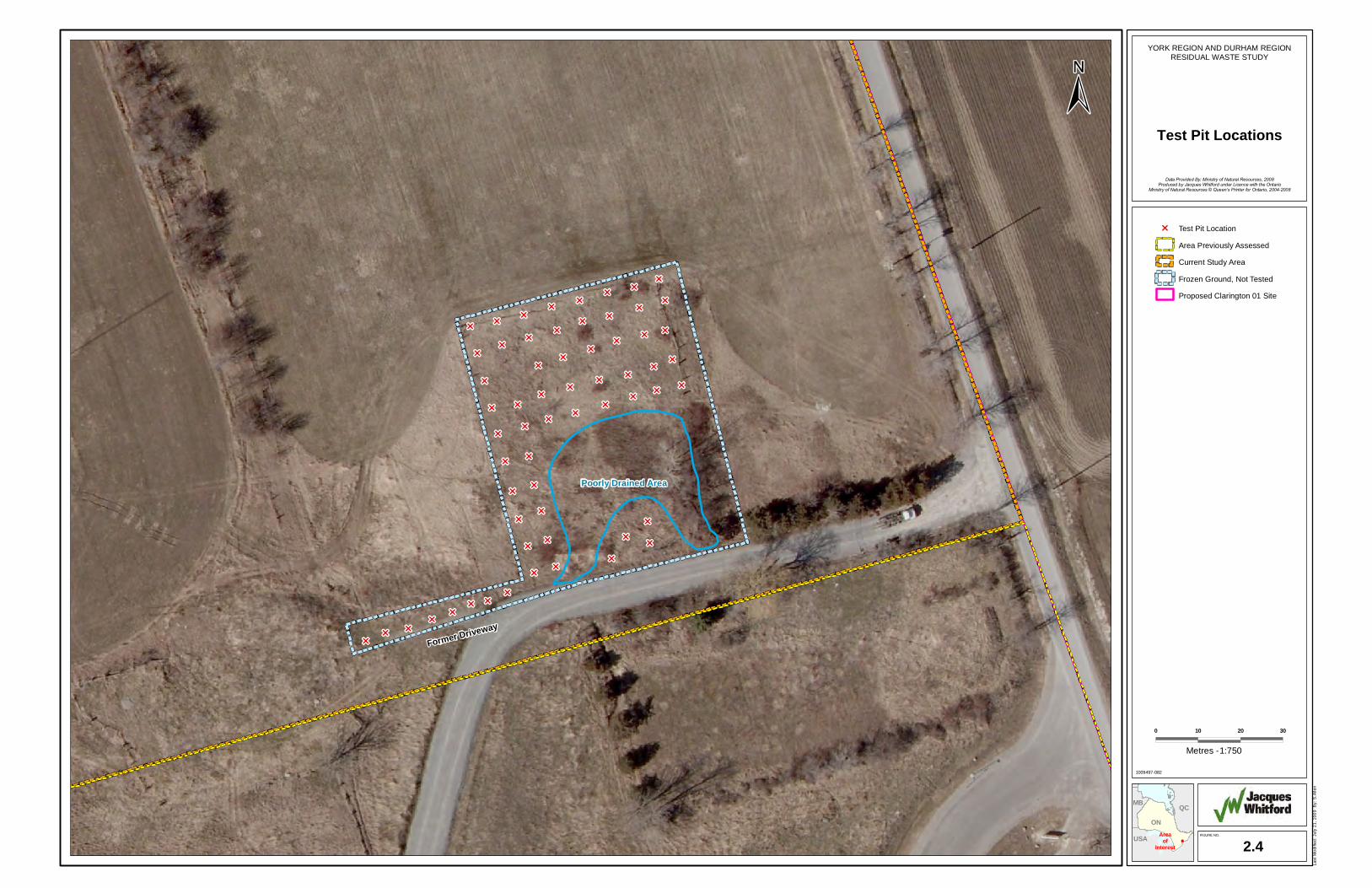
As required, a shovel test surveying of unploughed portions of the Site was undertaken on May 6, 2009. Weather conditions during the testing were warm and sunny, with excellent visibility. Poorly drained areas in the southeastern quadrant of the unploughed section of the Site were not tested. A total of 60 standard 40 x 40 cm test pits were excavated at 5 m intervals (Figure 2-4). All soils were screened for cultural materials. Topsoil throughout the area tested consisted of a consistent, dark brown clayey sand (Photo 3, Appendix A). Although some large stones were present in test pits along the southern edge of the area tested, the topsoil was, in general, free of stones. Subsoil consisted of sand, being golden brown throughout the area tested with the exception of Test Pit 29, which consisted of grey sand (Photo 4, Appendix A). In the case of Test Pit 29, soils were excavated to a depth of 56 cm at which point ground water was encountered. Subsoil depth varied from 21 cm to 42 cm throughout the area tested. No artifacts, anthropogenically altered soils or other items of archaeological of historic significance were discovered during the shovel test survey.
Stage 2 Archaeological Assessment and Built Heritage
Technical Study ReportJuly 31, 2009
P.N. 1009497 Jacques Whitford © 2009
12
4.0 RESULTS OF ANALYSIS Stage 2 Archaeological Assessment of the cultivated fields of the Site identified no new archaeological artifacts or sites of significance. It may be that the Site is too far removed from the shoreline of Lake Ontario or a notable watercourse to have been attractive as a habitation site, particularly for nomadic hunting and gathering peoples. It was thought that the Site might have been particularly attractive to Late Woodland period horticulturalists given the good soils and elevated topography above the lake. However, such sites are typically composed of villages of several hectares in size and thousands of artifacts and culturally modified soils and would have been readily identifiable during the survey. There are many similar locations along the lakeshore in the general project area, however, and the current Site may simply have not had enough other attractive characteristics to warrant settlement here. There are no significant built heritage features.
5.0 IMPACT MANAGEMENT Based on the results of the current work and those of the 2004 study it is highly unlikely that there will be significant archaeological deposits found in the portion of the Site which remains to be shovel tested. Nevertheless, the possibility of such sites cannot be entirely ruled out and it is recommended that those areas be archaeologically tested as soon as possible in the spring of 2009 to complete the Stage 2 assessment.
In the event that no significant archaeological deposits are identified during the test pit survey of the remaining untested area a recommendation for clearing the project of further archaeological conditions will be made. A report detailing the activities and results of the Stage 2 Archaeological Assessment will be submitted to the Ministry of Culture. At that time, a letter of concurrence with the findings and recommendations of the report will be requested. When the Ministry of Culture issues said letter it will enter the report into the provincial registry of reports and the project can be considered cleared to proceed.
In the event that significant archaeological deposits are identified in the as yet untested area further archaeological assessment (i.e., Stages 3 and/or 4), up to and including full mitigation excavation of the Site, may be required. At the conclusion of any follow-up work a report will be issued to the Ministry of Culture and the same schedule of events as identified above will proceed until the project is considered cleared of archaeological conditions.
Jacques Whitford Stantec Limited cautions, however, that it is possible that even after completion of archaeological testing, deeply buried archaeological resources could still exist within the limits of the proposed project and that the following standard conditions will continue to apply:
1. Should human remains be identified during operations, all work in the vicinity of the discovery will be suspended immediately. Notification will be made to the Ontario Provincial Police, or local police, who will conduct a site investigation and contact the district coroner. Notification must also

Stage 2 Archaeological Assessment and Built Heritage
Technical Study ReportJuly 31, 2009
P.N. 1009497 Jacques Whitford © 2009
13
be made to the Ministry of Culture and the Registrar of Cemeteries, Cemeteries Regulation Unit, Ministry of Small Business and Consumer Services.
2. Should other cultural heritage values (archaeological or historical materials or features) be identified during operations, all work in the vicinity of the discovery will be suspended and the Ministry of Culture archaeologist contacted. This condition provides for the potential for deeply buried or enigmatic local site areas that are not typically identified in archaeological field assessments.
6.0 SUMMARY AND CONCLUSION Based on the results of the 2008 and 2009 field assessments and previous studies in and around the Site it is considered likely that the current Site does not contain significant, intact archaeological or built heritage resources. The Project is considered to be cleared of archaeological conditions.
Given the accumulated knowledge regarding the archaeological history of the general Project area provided by any studies completed, the effects of the proposed Project on archaeological resources could be considered to be positive.

Stage 2 Archaeological Assessment and Built Heritage
Technical Study ReportJuly 31, 2009
P.N. 1009497 Jacques Whitford © 2009
14
7.0 CLOSURE This Report has been prepared by Jacques Whitford Stantec Limited. The assessment represents the conditions at the subject property only at the time of the assessment, and is based on the information referenced and contained in the Report. The conclusions presented herein respecting current conditions, and potential future conditions are at the subject property resulting from the Project, represent the best judgment of the assessor based on current environmental standards. Jacques Whitford Stantec Limited attests that to the best of our knowledge, the information presented in this Report is accurate. The use of this Report for other projects without written permission of Durham Region, York Region and Jacques Whitford Stantec Limited is solely at the user’s own risk.

Stage 2 Archaeological Assessment and Built Heritage
Technical Study ReportJuly 31, 2009
P.N. 1009497 Jacques Whitford © 2009
15
8.0 REFERENCES ASI (Archaeological Services Inc.), 2004. Stage 1 and 2 Archaeological Resources Assessment, Courtice Water Pollution Control Plant (WPCP), Part of Lots 25-28, Broken Front Concession, Municipality of Clarington, Regional Municipality of Durham, Ontario. Report submitted to the Works Department, Region of Durham, Whitby, ON.
Jacques Whitford, 2008. Stage 1 Archaeological Assessment, Four Proposed Project Sites, York-Durham Waste Management Facility, Municipal Townships Of East Gwillimbury and Clarington, ON. Report on file with the Ministry of Culture, Toronto, Ontario.
Jacques Whitford (Jacques Whitford Limited and Genivar Ontario Inc.), 2007. Application of Short-list Evaluation Criteria, Social and Cultural Considerations: Report on Archaeological and Cultural Resources. Report prepared for the Regional Municipality of Durham and the Regional Municipality of Durham.

APPENDIX A Photographs


