appendix a notice of preparation and initial study
TRANSCRIPT

Appendix A Notice of Preparation and Initial Study

Notice of Preparation and Scoping Meeting for the Lower Newport Harbor Confined Aquatic Disposal (CAD) Facility Construction Project (PA2019-020) Environmental Impact Report
1
DATE: November 18, 2019
TO: Reviewing Agencies and Other Interested Parties
FROM: City of Newport Beach, Community Development Department, 100 Civic Center Drive, Newport Beach, CA 92660
PROJECT TITLE/SUBJECT: Notice of Preparation (NOP) of an Environmental Impact Report (EIR) and Notice of Public Scoping Meeting for the Lower Newport Harbor Confined Aquatic Disposal (CAD) Facility Construction Project (PA2019-020).
PROJECT APPLICANT: City of Newport Beach (City)
NOTICE OF PREPARATION REVIEW PERIOD: November 18, 2019, through January 17, 2020 (60 days)
SCOPING MEETING: December 4, 2019, at 6:00 p.m. in the Friends Room of the Newport Beach Public Library, 1000 Avocado Avenue, Newport Beach CA
REQUEST FOR COMMENTS ON THE SCOPE OF THE ENVIRONMENTAL IMPACT REPORT:
The purpose of this NOP is to notify potential Responsible Agencies (Agencies) that the Lead Agency, the City, will prepare an EIR for the proposed Lower Newport Harbor CAD Facility Construction Project (Project) and to solicit comments and suggestions regarding: (1) the scope and content of the EIR and (2) the environmental issues and alternatives to be addressed in the EIR (California Environmental Quality Act [CEQA] Guidelines Section 15082). This NOP also provides notice to interested parties, organizations, and individuals of the preparation of the EIR and requests comments on the scope and contents of the environmental document. An Initial Study (IS) has been prepared to support the NOP.
PROJECT LOCATION:
The Project Site is located in Newport Beach, which is located at the western edge of Orange County (County) adjacent to the Pacific Ocean, and is bordered by Costa Mesa to the northwest, Huntington Beach to the west, Irvine to the northeast, and unincorporated portions of Orange County to the southeast. The Project Site encompasses approximately 844 acres of Lower Newport Harbor, encompassing the navigational channels and the proposed CAD facility. Lower Newport Harbor is a small craft harbor offering a wide range of recreational boating activities ranging from single-person kayaks to larger sailing and motor vessels capable of trans ocean navigation. Local beachfront and harbor-front communities support water-use recreational services.
PROJECT DESCRIPTION:
The City and U.S. Army Corps of Engineers (USACE) are conducting dredging within Lower Newport Harbor in Newport Beach. Newport Harbor is one of the largest recreational harbors in the United States, necessitating maintenance dredging to remove sediment that accumulates over time and impedes navigation. Because dredging will expose sediment that is unsuitable for open ocean disposal, dredging is not feasible without also identifying a practicable management option for the unsuitable sediment. Therefore, the City is proposing to construct a CAD facility as a solution for sediment dredged from within Lower Newport Harbor not suitable for open ocean placement or nearshore disposal. The location of the CAD facility would be within the anchorage east of Lido Isle as shown below in Figure 1.
Following initial construction of the CAD facility, the City and its residents would have an opportunity to place material dredged from outside the federal navigation channels into the CAD for a period of up to 10 years with agency approval under the City’s Regional General Permit (RGP) 54 or individual permit. A more detailed project description is provided in the attached project summary.

2
.
AVAILABILITY OF THE NOTICE OF PREPARTION AND INITIAL STUDY:
The City has prepared a NOP and IS to provide an overview of the Project. The City has made a determination that a full-scope EIR, inclusive of all environmental topics, is required for the proposed Project. The NOP and IS can be accessed online at: http://www.newportbeachca.gov/ceqa. Copies are also available for review at the City of Newport Beach Public Works Department, 100 Civic Center Drive, Newport Beach, CA 92660, and at the following locations:
Newport Beach Public Library Central Library 1000 Avocado Avenue Newport Beach, CA 92660
Newport Beach Public Library Mariners Branch 1300 Irvine Avenue Newport Beach, CA 92660
Newport Beach Public Library Balboa Branch 100 East Balboa Boulevard Newport Beach, CA 92660
Newport Beach Public Library Corona del Mar Branch 410 Marigold Avenue Corona del Mar, CA 92625
NOTICE OF PUBLIC SCOPING MEETING:
The City will conduct a public scoping meeting in conjunction with this NOP in order to present the Project and the EIR process and to receive public comments and suggestions regarding the scope and content of the EIR. The meeting will be held on December 4, 2019, at 6:00 p.m. in the Friends Room of the Newport Beach Public Library, 1000 Avocado Avenue, Newport Beach, CA 92660.
RESPONDING TO THIS NOTICE:
The City requests your careful review and consideration of this notice, and it invites any and all input and comments from interested Agencies, persons, and organizations regarding the preparation of the EIR. Pursuant to CEQA Section 21080.4, Agencies must submit any comments in response to this notice no later than 60 days beginning November 18, 2019 and ending at close of business on January 17, 2020. All comments or other responses to this notice should be submitted in writing to:
Chris Miller, Public Works Manager City of Newport Beach, Public Works Department
100 Civic Center Drive Newport Beach, California 92660
[email protected] 949.644.3043
Figure 1: Proposed Project Location, Lower Newport Harbor, Newport CA

3
Lower Newport Harbor Confined Aquatic Disposal (CAD) Facility Construction Project (PA2019-020) PROJECT SUMMARY
The City is the Lead Agency under the California Environmental Quality Act (CEQA) for the proposed Project. Section 15161 of the CEQA Guidelines states that an EIR “…should focus primarily on the changes in the environment that would result from the development of the project. The EIR shall examine all phases of the project including planning, construction, and operation.”
Existing Setting The Project Site is located in Newport Beach, which is located at the western edge of Orange County, adjacent to the Pacific Ocean, and is bordered by Costa Mesa to the northwest, Huntington Beach to the west, Irvine to the northeast, and unincorporated portions of Orange County to the southeast. The Project Site encompasses approximately 844 acres of Lower Newport Harbor, encompassing the navigational channels and the proposed CAD facility. Lower Newport Harbor is a small craft harbor offering a wide range of recreational boating activities ranging from single-person kayaks to larger sailing and motor vessels capable of trans ocean navigation.
General Plan and Zoning The Project Site is designated as TS (Tidelands and Submerged Lands) land use designation of the Land Use Element of the General Plan. The Project Site is not located within a Zoning District since it is located within the City’s harbor area.
Background Newport Harbor requires periodic maintenance dredging to remove sediment that accumulates over time and impedes navigation and full use of the harbor. Lower Newport Harbor was last dredged between May 2012 and January 2013, when 600,000 cubic yards (cy) of sediment was removed. Unsuitable sediment was placed at the Port of Long Beach’s Middle Harbor Fill Site, and clean sediment was placed at the LA-3 ocean disposal material disposal site (ODMDS). Prior to that (1998 to 1999), approximately 270,000 cy of sediment were removed from the Main Channel and the Upper Bay Channel and disposed of at the LA-3 ODMDS.
Maintenance dredging is necessary to remove approximately 1.2 million cy of sediment that has accumulated in the federal navigation channels for navigational safety and to allow continued use of the harbor for recreational activities. Sediment spoils from dredging are typically disposed of based on sediment characteristics at a variety of locations. The preferred sediment management alternative for clean sediment is beach nourishment. Sediment that is clean but not compatible with the receiver beach or nearshore area, and for which no other beneficial reuses are available, may be placed at an ODMDS. For sediment that is unsuitable for ocean disposal, the preferred management alternative is beneficial reuse in a fill project (nearshore confined disposal facility [CDF]). In the absence of a CDF, CAD sites have been shown to be an effective long-term management solution for contaminated sediment. A CAD facility is constructed underwater by placing contaminated sediment inside a depression, allowing it to settle, and capping it with clean sediment, typically to an elevation that matches the surrounding grade. In 2009, the City performed a CAD feasibility study1 and determined that constructing a CAD in Lower Newport Harbor was the best alternative for managing the City’s contaminated sediment. Therefore, the City is proposing to construct a CAD facility within the federal navigation channels.
1 Anchor QEA (Anchor QEA, LLC), 2009. Lower Newport Bay CAD Site Feasibility Study. Prepared for the City of Newport Beach. April 2009.

4
Description of Project The proposed Project includes the following elements:
• Dredging of approximately 300,000 cy of sediment to construct a CAD facility located in the central portion of theharbor between Lido Isle and Bay Island
‒ The CAD facility will accommodate approximately 106,900 cy of unsuitable material. • Disposal of an additional 50,000 cy in the CAD facility for a period of up to 10 years; only material dredged from
Lower Newport Harbor would be permitted for disposal within the CAD facility• Maintenance dredging of suitable and unsuitable material
Potential CAD site locations were selected based on preliminary feedback from the City’s Harbor Commissioners. The Harbor Commissioners recommended siting the CAD facility adjacent to or within locations where sediment was determined unsuitable and would require placement in the CAD facility. While the recommendation was integral to the siting process, other factors were evaluated that included analysis of geotechnical data to demonstrate compliance with current engineering standards and practices, feasibility to design and construct the CAD facility based on the volume of sediment to be managed in the CAD, logistics during construction, disruption to existing harbor moorings and anchorages, and public outreach. Technical support for the design and operation of the CAD facility is included in the Basis of Design Report.
Construction
The proposed Project includes construction of a CAD facility and periodic placement of sediment by the City and its residents, as authorized under RGP 54 or through an individual permit. The CAD facility has been designed to accommodate approximately 106,900 cy of sediment previously determined unsuitable for unconfined ocean disposal (generated by the federal maintenance project and the City’s dredging project). Additionally, the CAD facility has been designed to accommodate an additional 50,000 cy of material dredged from other locations within the harbor and outside the federal navigation channels. In order to accommodate the total volume—including contingency—and construct the CAD facility, excavation of approximately 307,000 cy is required. This incorporates side slopes and other engineering design considerations to safely achieve the desired size and capacity. Excavation of the CAD facility would occur using mechanical or hydraulic dredge equipment and material either disposed in the nearshore environment or at an approved open ocean disposal site.
Once the CAD facility is constructed, unsuitable sediment will be dredged using mechanical equipment and placed within the CAD facility using a bottom-dump barge. Sediment within the CAD facility will then be covered with clean sediment dredged from the remainder of the federal navigation channels as part of USACE’s maintenance dredging program. This clean sediment will serve as an interim cap to isolate the unsuitable material disposed as part of the federal navigation channels dredging project. Once the interim cap is placed, the City and its residents will have an opportunity for up to 10 years to place 50,000 cy of material in the CAD. Following the 10-year period, the City will ensure that a clean layer is placed as a final cap.
The City will be developing a sediment management plan in coordination with the resource and regulatory agencies to manage disposal of the material in the CAD facility, including interim placement of clean sand during the 10-year period, and the final cap. The final elevation of the CAD facility will be at -22 feet mean lower low water.
Long-Term Disposal and Monitoring
As previously stated, following construction of the CAD, up to 50,000 cy of additional material could be dredged from various areas of Lower Newport Harbor and placed in the CAD facility using for up to 10 years. Most dredging would occur mechanically or hydraulically with sediment placed in the CAD facility from a barge or through a pump.

5
An Operations Management and Monitoring Plan for the CAD facility will be developed for implementation by the City. The plan will describe the management and monitoring objectives for the CAD facility, a communications plan covering the entire CAD facility construction and sediment disposal process, construction monitoring and post‐disposal monitoring plans, contingency plans, annual monitoring plans, and long‐term management plans for the CAD facility once it has been capped.
Alternatives to the Proposed Project
CEQA Guidelines Section 15126.6(a) requires that “an EIR describe a range of reasonable alternatives to the Project, or to the location of the Project, which would feasibly attain most of the basic objectives of the Project but would avoid or substantially lessen any of the significant effects of the Project, and evaluate the comparative merits of the alternatives.” The alternatives, which will include the No Project Alternative and a Reduced Project Alternative, are introduced in the IS and will be analyzed as part of the EIR.
Discretionary Actions
Development of the proposed Project would require discretionary approvals from the following Agencies:
• City: EIR and Approval in Concept; Authorization of Project and construction contracts
• USACE: Reviews and authorizes CAD under Section 404 of the Clean Water Act; Section 103 of the MarineProtection, Research, and Sanctuaries Act; and Section 10 of the Rivers and Harbors Act
• California Coastal Commission: Reviews EIR documents to ensure compliance with the Coastal ZoneManagement Act and consistency with the California Coastal Act. Performs a federal ConsistencyDetermination. Reviews and considers issuance of a Coastal Development Permit.
Santa Ana Regional Water Quality Control Board (RWQCB): Reviews Project for authorization under the Porter-Cologne Water Quality Control Act, Waste Discharge Requirements, and Clean Water Act Section 401 State Certification of Water Quality and Section 402: National Pollutant Discharge Elimination System Permit.
Probable Environmental Effects of the Proposed Project The City has determined that the following environmental topics will be included and analyzed in the EIR for the proposed Project:
• Aesthetics • Hazards and Hazardous Materials• Air Quality • Hydrology and Water Quality• Biological Resources • Land Use and Planning• Cultural Resources • Noise• Geology and Soils • Recreation• Greenhouse Gas Emissions • Tribal Cultural Resources
Anticipated Schedule The Project schedule, as currently envisioned, contemplates that the Draft EIR will be available for public review in spring of 2020. A 45-day public review period will be provided, after which responses to comments received will be prepared. The Newport Beach Harbor Commission will then hold a public hearing and make a recommendation on certification of the EIR to the City Council. Public hearings are anticipated to occur in mid-2020.
Conclusion The City of Newport Beach requests the public’s careful review and consideration of this NOP and IS, and it invites any and all input and comments from interested agencies and persons regarding the preparation and scope of the Draft EIR.

Project Number: 180243-02.01
November 18, 2019 Lower Newport Harbor Confined Aquatic Disposal (CAD) Facility Construction Project (PA2019-020)
Initial Study
Prepared for City of Newport Beach Public Works Department 100 Civic Center Drive Newport Beach, CA 92660
Prepared by Anchor QEA, LLC 9700 Research Drive Irvine, CA 92618

Initial Study i November 18, 2019
TABLE OF CONTENTS 1 Project Overview ........................................................................................................................ 1
1.1 Project Summary ................................................................................................................................................. 1 1.2 Project Setting ...................................................................................................................................................... 1
1.2.1 Regional Setting ................................................................................................................................... 1 1.2.2 Local Setting .......................................................................................................................................... 1 1.2.3 Regional General Permit 54 ............................................................................................................. 2
1.3 Project Background ............................................................................................................................................ 2 1.4 Project Objectives ............................................................................................................................................... 3 1.5 Proposed Project ................................................................................................................................................. 4
1.5.1 Project Construction ........................................................................................................................... 4 1.5.2 Long-Term Disposal and Monitoring .......................................................................................... 5 1.5.3 Best Management Practices ............................................................................................................ 5
1.6 Proposed CEQA Analysis .................................................................................................................................. 6 1.6.1 CEQA Baseline ....................................................................................................................................... 6 1.6.2 Proposed Alternatives ........................................................................................................................ 6
2 Agency Approvals and Public Outreach .............................................................................. 8 2.1 Anticipated Project Approvals and Permits .............................................................................................. 8 2.2 Assembly Bill 52 ................................................................................................................................................... 9 2.3 Public Outreach .................................................................................................................................................... 9
3 Potential Environmental Impacts .......................................................................................... 11 Environmental Factors Potentially Affected ........................................................................................................ 11 3.1 Determination .................................................................................................................................................... 11
3.1.1 Aesthetics ............................................................................................................................................ 12 3.1.2 Agricultural and Forestry Resources ......................................................................................... 12 3.1.3 Air Quality ............................................................................................................................................ 14 3.1.4 Biological Resources ........................................................................................................................ 15 3.1.5 Cultural Resources ........................................................................................................................... 16 3.1.6 Energy ................................................................................................................................................... 17 3.1.7 Geology and Soils............................................................................................................................. 19 3.1.8 Greenhouse Gas Emissions ........................................................................................................... 20 3.1.9 Hazards and Hazardous Materials ............................................................................................. 20 3.1.10 Hydrology and Water Quality ...................................................................................................... 22 3.1.11 Land Use and Planning ................................................................................................................... 23

Initial Study ii November 18, 2019
3.1.12 Mineral Resources ............................................................................................................................ 24 3.1.13 Noise ..................................................................................................................................................... 25 3.1.14 Population and Housing ................................................................................................................ 26 3.1.15 Public Services ................................................................................................................................... 27 3.1.16 Recreation ........................................................................................................................................... 28 3.1.17 Transportation ................................................................................................................................... 29 3.1.18 Tribal Cultural Resources ............................................................................................................... 30 3.1.19 Utilities and Service Systems ........................................................................................................ 31 3.1.20 Wildfire ................................................................................................................................................. 34 3.1.21 Mandatory Findings of Significance .......................................................................................... 36
4 References ................................................................................................................................ 38
FIGURES Figure 1 Figure 2 Figure 3 Figure 4
Vicinity Map Federal Channels Maintenance Dredging Sediment Suitability Map Confined Aquatic Disposal Facility Confined Aquatic Disposal Facility Section

Initial Study iii November 18, 2019
ABBREVIATIONS AB Assembly Bill Basin South Coast Air Basin BMP best management practice CAD Confined Aquatic Disposal CCA California Coastal Act CCC California Coastal Commission CDF confined disposal facility CDFW California Department of Fish and Wildlife CEQA California Environmental Quality Act CHRIS California Historic Resources Information System City City of Newport Beach CLUP Coastal Land Use Plan CSTF LTMS Los Angeles Contaminated Sediments Task Force Long-Term Management
Strategy cy cubic yard DEIR Draft Environmental Impact Report DMMP Los Angeles Regional Dredged Material Management Plan EIR Environmental Impact Report FMP Fish Management Plan General Plan City of Newport Beach General Plan GHG greenhouse gas MLLW mean lower low water MRZ Mineral Resource Zone NAHC Native American Heritage Commission NOP Notice of Preparation NPDES National Pollutant Discharge Elimination System ODMDS Ocean Dredged Material Disposal Site proposed Project Lower Newport Harbor Confined Aquatic Disposal (CAD) Facility
Construction Project (PA2019-020) RGP 54 Regional General Permit 54 RWQCB Regional Water Quality Control Board SB Senate Bill SR State Route USACE U.S. Army Corps of Engineers VHFHSZ Very High Fire Hazard Severity Zone

Initial Study 1 November 18, 2019
1 Project Overview This Initial Study has been prepared to inform responsible and trustee agencies, public agencies, and the public that the City of Newport Beach (City), as the Lead Agency under the California Environmental Quality Act (CEQA), has independently determined that there are potential significant environmental impacts associated with the proposed Lower Newport Harbor Confined Aquatic Disposal (CAD) Facility Construction Project (PA2019-020) (hereafter referred to as the proposed Project) and an Environmental Impact Report (EIR) is required.
1.1 Project Summary The City and U.S. Army Corps of Engineers (USACE) are conducting dredging within Lower Newport Harbor in Newport Beach (Figure 1). Newport Harbor is one of the largest recreational harbors in the United States, necessitating maintenance dredging to remove sediment that accumulates over time and impedes navigation. Because dredging will expose sediment that is unsuitable for open ocean disposal, dredging is not feasible without also identifying a practicable management option for the unsuitable sediment (Figure 2). Therefore, the City is proposing to construct a CAD facility as a solution for sediment dredged from within Lower Newport Harbor not suitable for open ocean placement or nearshore disposal. The location of the CAD facility would be in the central portion of the harbor between Bay Island and Lido Isle (Figures 3 and 4).
Following authorization of the CAD facility, the City and its residents would have an opportunity to place material dredged from outside the federal navigation channels into the CAD for a period of up to 10 years with agency approval under the City’s Regional General Permit (RGP) 54 or individual permits.
1.2 Project Setting
1.2.1 Regional Setting The proposed Project is in Newport Beach, Orange County, California. Newport Beach is at the western edge of Orange County, adjacent to the Pacific Ocean. Newport Beach, a charter city with approximately 87,182 residents, is bordered by Costa Mesa to the northwest, Huntington Beach to the west, Irvine to the northeast, Laguna Beach to the south, and unincorporated portions of Orange County to the southeast.
1.2.2 Local Setting Upon entering the harbor from the Pacific Ocean, the Main Channel runs the three-mile length of the harbor, down the inside of the Balboa Peninsula, and among the seven harbor islands that make up several residential communities and villages of Newport Beach. The Coast Highway Bridge serves as the unofficial boundary of the lower (Lower Newport Harbor) and upper portions of the harbor. The project area encompasses approximately 844 acres of Lower Newport Harbor, encompassing the
Initial Study 2 November 18, 2019
navigational channels and the proposed CAD facility. Lower Newport Harbor is a small craft harbor offering a wide range of recreational boating activities ranging from single-person kayaks to larger sailing and motor vessels capable of trans-ocean navigation. Local beachfront and harbor-front communities support water-use recreational services.
1.2.3 Regional General Permit 54 The USACE issued the current RGP 54 to the City in December 2015 (amended July 2019). RGP 54 authorizes small-scale maintenance dredging, dock and bulkhead repairs, and in-kind dock and bulkhead replacement projects in Newport Harbor. Specifically, RGP 54 covers the following regulated activities in eligible areas of Newport Harbor:
• Maintenance dredging under and adjacent to private, public, and commercial docks, floats, and piers
• Discharge of dredged material at adjacent beach sites for beach nourishment, the LA-3 Ocean Dredged Material Disposal Site (ODMDS) confined disposal facilities (CDFs), or at approved upland disposal sites
1.3 Project Background Newport Harbor requires periodic maintenance dredging to remove sediment that accumulates over time and impedes navigation and full use of the harbor. Lower Newport Harbor was last dredged between May 2012 and January 2013, when 600,000 cubic yards (cy) of sediment were removed. Unsuitable sediment was placed at the Port of Long Beach’s Middle Harbor Fill Site, and clean sediment was placed at LA-3 ODMDS. Prior to that (1998 to 1999), approximately 270,000 cy of sediment were removed from the Main Channel and the Upper Bay Channel and disposed of at the LA-3 ODMDS.
Based on the most recent 2018 USACE harbor-wide bathymetric surveys, sedimentation has occurred in many areas of Lower Newport Harbor such that dredging is needed within the federal navigation channels to maintain safe navigation. Maintenance dredging is necessary to remove approximately 1.2 million cy of sediment that have accumulated in the federal navigation channels for navigational safety and to allow continued use of the harbor for recreational activities. The USACE is proposing to dredge the federal navigation channels to the currently authorized design depths as part of the federal maintenance dredging program authorized by the Rivers and Harbors Act of 1937 (maintenance) and 1945, modified by the Water Resources Development Act of 1986. USACE’s maintenance dredging project is analyzed in a separate Environmental Assessment (expected in 2020). Failure to remove this sediment could result in adverse impacts to navigational safety, resulting in loss of recreational boating opportunities.
Sediment spoils from dredging are typically disposed of based on sediment characteristics at a variety of locations. The preferred sediment management alternative for clean sediment is beach

Initial Study 3 November 18, 2019
nourishment. However, dredged sediment used to replenish eroding beaches must be clean and have comparable grain size and aesthetic characteristics to that of the beach under consideration. Sediment that is clean but not compatible with the receiver beach or nearshore area, and for which no other beneficial reuses are available, may be placed at an ODMDS. Prior to disposal, sediment must be tested in accordance with the Evaluation for Dredged Material Proposed for Ocean Disposal – Testing Manual (USEPA/USACE 1991). LA-3 is the closest ODMDS to Newport Harbor, located approximately 6 miles to the southwest.
Sediment management options in Southern California have been studied thoroughly and documented in two key regional documents: the Los Angeles Contaminated Sediments Task Force Long-Term Management Strategy (CSTF LTMS; CSTF 2005) and the Los Angeles Regional Dredged Material Management Plan (DMMP; USACE 2004). For sediment that is unsuitable for ocean disposal, the preferred management alternative, as outlined in the CSTF LTMS and DMMP, is beneficial reuse in a fill project (nearshore CDF). Nearshore CDFs are typically created by constructing a containment dike, placing contaminated dredged sediment and structural fill material (i.e., clean sand) behind a dike, using weirs to dewater the material, and covering the material with asphalt and/or concrete.
In absence of a CDF, CAD sites have been shown to be an effective long-term management solution for contaminated sediment (CSTF 2005). A CAD facility is constructed underwater by placing contaminated sediment inside a depression, allowing it to settle, and capping with clean sediment, typically to an elevation that matches the surrounding grade. Port of Hueneme, the Port of Long Beach Outer Harbor Sediment Placement and Ecosystem Restoration Site, and the North Energy Island Borrow Pit (City of Long Beach) are examples of regional CAD facilities used to manage contaminated sediment among other sites in the United States. These CAD sites locations have been constructed and/or are not available for additional capacity.
Based on Lower Newport Harbor sediment sampling, portions of sediment within the harbor have been determined unsuitable for open ocean disposal (Anchor QEA 2019a). In 2009, the City performed a CAD Feasibility Study and determined that constructing a CAD in Lower Newport Harbor was the best alternative for managing the City’s contaminated sediment (Anchor QEA 2009). Therefore, the City is proposing to construct a CAD facility within the federal navigation channels.
1.4 Project Objectives The proposed Project is being completed to meet the need for safe marine navigation, promote recreational maritime activities, and protect the marine environment from chemical contamination.
To accomplish this goal, the following key project objectives must be accomplished:
• Maintaining safe navigational depths to support recreational access • Identifying a disposal location for dredged material that is unsuitable for ocean disposal; the
location must be able to meet the following requirements:

Initial Study 4 November 18, 2019
‒ Safely and permanently contain contaminated material ‒ Be located within the Southern California area and be available for disposal ‒ Accommodate material over a period of 10 years
• Disposing of unsuitable dredged sediment in a manner that is safe to human and ecological health and minimizes secondary environmental impacts
1.5 Proposed Project The proposed Project includes the following elements:
• Dredging of approximately 300,000 cy of sediment to construct a CAD facility located in the central portion of the harbor between Lido Isle and Bay Island
‒ CAD facility will accommodate approximately 106,900 cy of unsuitable material. • Disposal of an additional 50,000 cy in the CAD facility for a period of up to 10 years; only
material dredged from Lower Newport Harbor would be permitted for disposal within the CAD facility
• Maintenance dredging of suitable and unsuitable material
Potential CAD site locations were selected based on preliminary feedback from the City’s Harbor Commissioners. The Harbor Commissioners recommended siting the CAD facility adjacent to or within locations where sediment was determined unsuitable and would require placement in the CAD facility. While the recommendation was integral to the siting process, other factors were evaluated that included analysis of geotechnical data to demonstrate compliance with current engineering standards and practices, feasibility to design and construct the CAD facility based on the volume of the sediment to be managed in the CAD, logistics during construction, disruption to existing harbor moorings and anchorages, and public outreach. Technical support for the design and operation of the CAD facility is included in the Basis of Design Report (Anchor QEA 2019b).
1.5.1 Project Construction The proposed Project includes construction of a CAD facility and periodic placement of sediment by the City and its residents authorized under RGP 54 or through an individual permit. The CAD facility has been designed to accommodate approximately 106,900 cy of sediment previously determined unsuitable for unconfined ocean disposal (generated by the federal maintenance project and the City’s dredging project). Additionally, the CAD has been designed to accommodate an additional 50,000 cy of material dredged from other locations within the harbor and outside the federal navigation channel. In order to accommodate the total volume—including contingency—and construct the CAD facility, excavation of approximately 307,000 cy is required. This incorporates side slopes and other engineering design considerations to safely achieve the desired size and capacity.
Excavation of the CAD facility would occur using mechanical or hydraulic dredge equipment and either disposed in the nearshore environment or open ocean LA 3 ODMDS.

Initial Study 5 November 18, 2019
Once the CAD facility is constructed, unsuitable sediment will be dredged using mechanical equipment and placed within the CAD facility using a bottom-dump barge. Sediment within the CAD facility will then be covered with clean sediment dredged from the remainder of the federal navigation channels as part of USACE’s maintenance dredging program. This clean sediment will serve as an interim cap to isolate the unsuitable material disposed as part of the federal navigation channels dredging project. Once the interim cap is placed, the City will have an opportunity for up to 10 years to place 50,000 cy of material in the CAD. Following the 10-year period, the City will ensure that a clean layer be placed as a final cap. The City will be developing a Sediment Management Plan in coordination with the resource and regulatory agencies to manage disposal of the material in the CAD, including interim placement of clean sand during the 10-year period, and final cap.
The authorized depths within the harbor range from -10 feet mean lower low water (MLLW) to -20 feet in the main channel. The final elevation of the CAD facility will be at -22 feet MLLW, which is deeper than the current authorized depth of -15 MLLW.
1.5.2 Long-Term Disposal and Monitoring As previously stated, following construction of the CAD, up to 50,000 cy of additional material could be dredged from various areas of Lower Newport Harbor and placed in the CAD facility using methods described in Section 1.5.1 for up to 10 years. Most dredging would occur mechanically or hydraulically with sediment placed in the CAD facility from a barge or through a pump.
An Operations Management and Monitoring Plan for the CAD facility will be developed for implementation by the City. The plan will describe the management and monitoring objectives for the CAD facility, a communications plan covering the entire CAD facility construction and sediment disposal process, construction monitoring and post-disposal monitoring plans, contingency plans, annual monitoring plans, and long-term management plans for the CAD facility once it has been capped.
1.5.3 Best Management Practices The City is committed to avoiding or minimizing environmental effects during dredging and disposal activities. The following best management practices (BMPs) will be incorporated into the proposed Project plans and contract specifications as appropriate:
• Rules and methods set out by the CSTF LTMS BMP toolbox (CSTF 2005) during dredging activities shall be provided to the dredge contractor to satisfy federal and state water quality requirements.
• General construction BMPs, including removing floating debris, implementing a water quality monitoring plan, preventing barge overflow, adjusting dredge cycle time and bucket velocity as it is raised and lowered, modifying bucket size or type if necessary, modifying the

Initial Study 6 November 18, 2019
operation of the dredging equipment to minimize resuspension of sediment, and washing the bucket to remove cohesive sediment, will be implemented if necessary.
• Prior to construction, the proposed Project site will be surveyed for the invasive alga Caulerpa taxifolia and eelgrass in compliance with federal and state protocols.
• Contractors will be required to have emergency spill response plans and employ general BMPs regarding vessel and equipment maintenance and fueling.
1.6 Proposed CEQA Analysis
1.6.1 CEQA Baseline Section 15125 of the CEQA Guidelines requires that an EIR include a description of the physical environmental conditions in the vicinity of the proposed Project as they exist at the time the NOP is published, or if no NOP is published, at the time the environmental analysis is commenced from both a local and regional perspective. These environmental conditions are referred to as the environmental setting. Further, Section 15125(a) of the CEQA Guidelines states that “the environmental setting normally constitutes the baseline physical conditions by which a Lead Agency determines whether an impact is significant.” The CEQA baseline is the set of conditions that prevails at the time an NOP is published. At the time of the NOP’s publication (November 2019), the proposed Project site is an active marine harbor with no dredging operations.
1.6.2 Proposed Alternatives According to Section 15126.6 of the CEQA Guidelines, an EIR need only examine in detail those alternatives that could feasibly meet most of the basic objectives of the proposed Project. The purpose of the proposed Project is to construct a CAD facility within Lower Newport Harbor as a solution for sediment dredged from within Lower Newport Harbor not suitable for open ocean disposal. The following alternatives are currently being considered for further analysis in the EIR.
1.6.2.1 No Project Alternative: No Dredging The No Project Alternative, which is required by CEQA, represents what would reasonably be expected to occur in the foreseeable future if the proposed Project were not approved. Under this alternative, no dredging of unsuitable material would occur, and material would remain in place
1.6.2.2 No CAD Construction Alternative Under the No CAD Construction Alternative, CAD construction would not occur. Dredging of unsuitable material would occur, and any dredged sediment deemed unsuitable for open ocean disposal would be trucked to a permitted upland landfill facility
Initial Study 7 November 18, 2019
1.6.2.3 Reduced Project Alternative The Reduced Project Alternative includes construction of a smaller CAD footprint. Under this reduced alternative, there could be two potential scenarios: either less dredging of unsuitable material would occur, or any dredged sediment deemed unsuitable for open ocean disposal that could not be placed into the smaller CAD site would be trucked to permitted upland facilities.

Initial Study 8 November 18, 2019
2 Agency Approvals and Public Outreach This section describes the anticipated approvals and permits required for the proposed Project as well as existing agency and public coordination and outreach conducted as part of project development.
2.1 Anticipated Project Approvals and Permits Projects or actions undertaken by the lead agency (in this case, the City) may require subsequent oversight, approvals, or permits from other public agencies. Other such agencies are referred to as responsible agencies and trustee agencies. Pursuant to CEQA Guidelines Sections 15381 and 15386, as amended, responsible and trustee agencies are defined as follows:
• A responsible agency is a public agency that proposes to carry out or approve a project for which a lead agency is preparing or has prepared an EIR or Negative Declaration. For the purposes of CEQA, the term “responsible agency” includes all public agencies other than the lead agency that have discretionary approval authority over a project (CEQA Guidelines Section 15381; see Table 1).
• A trustee agency is a state agency having jurisdiction by law over natural resources affected by a project that are held in trust for the people of the State of California (CEQA Guidelines Section 15386). Trustee agencies have jurisdiction over natural resources held in trust for the people of California but do not have a legal authority over approving or carrying out a project. CEQA Guidelines Section 15386 designates only the following four agencies as potential trustee agencies for projects subject to CEQA:
‒ California Department of Fish and Wildlife (CDFW), regarding fish and wildlife, native plants designated as rare or endangered, game refuges, and ecological reserves
‒ California State Lands Commission, regarding state-owned “sovereign” lands, such as the beds of navigable waters and state school lands
‒ California Department of Parks and Recreation, regarding units of the state park system ‒ University of California, regarding sites within the Natural Land and Water Reserves System
Table 1 summarizes relevant regulatory agencies, their jurisdiction (i.e., trustee or responsible agency), and their statutory authority.
Table 1 Regulatory Agencies and Authority
Regulatory Agency Jurisdiction Statutory Authority/Implementing Regulations
Federal Agencies
USACE Responsible agency
Review and authorize CAD under the Clean Water Act Section 404 and Rivers, Section 103 of the Marine Protection, Research and Sanctuaries Act and Harbors Act Section 10

Initial Study 9 November 18, 2019
Regulatory Agency Jurisdiction Statutory Authority/Implementing Regulations
National Oceanic and Atmospheric Administration, National Marine Fisheries Service, and U.S. Navy
Responsible agency
Compliance with the Endangered Species Act and Magnuson-Stevens Fishery Conservation and Management Act
State Agencies
California State Lands Commission Trustee agency
Reviews dredging and dredge material disposal activities in state tidelands. Would have oversight over the development of the CAD facility.
California Coastal Commission
Responsible agency
Reviews document to ensure compliance with the Coastal Zone Management Act and consistency with the California Coastal Act. Performs a federal Consistency Determination. Reviews and issues a Coastal Development Permit upon Project approval.
CDFW Trustee agency Reviews and submits recommendations in accordance with CEQA. City will consult with CDFW in accordance with the Fish and Wildlife Coordination Act.
Local Agencies
Santa Ana Regional Water Quality Control Board
Responsible agency
Permitting authority for water quality, including point and non-point source discharges. Reviews project for authorization under the Porter-Cologne Water Quality Control Act, Waste Discharge Requirements, and Clean Water Act Section 401 State Certification of Water Quality and Section 402: National Pollutant Discharge Elimination System (NPDES) Permit.
2.2 Assembly Bill 52 Assembly Bill (AB) 52 became effective on July 1, 2015, requiring lead agencies to consider the effects of projects on tribal cultural resources and to conduct notification and consultation with federally and non-federally recognized Native American tribes and Native American Heritage Commission (NAHC) early in the environmental review process. Three Native American tribes, Gabrieleño Band of Mission Indians – Kizh Nation, Juañeno Band of Mission Indians – Acjachemen Nation, and San Gabriel Band of Mission Indians, have requested consultation on CEQA documentation for projects in the City. The City initiated consultation with the three tribes and requested a search of NAHC’s Sacred Lands Information File in November 2019.
2.3 Public Outreach Given the public interest in the proposed Project, the City conducted several public stakeholder outreach meetings in October and November 2019. These meetings were informational in nature and helped to define the project need. A full list of groups included in this outreach is as follows:
• Still Protecting Our Newport (SPON) • Balboa Island Improvement Association • Hill’s Fuel Dock • Newport Beach Harbormaster
• Balboa Yacht Club • CoastKeeper • Local Chambers of Commerce • Coastal Bay Water Quality Committee

Initial Study 10 November 18, 2019
• City of Newport Beach Harbor Commission
• Lido Isle Mayor Town Hall • Bay Island Homeowners Association
• Newport Harbor Yacht Club • Island Marine • Curci Companies • Irvine Company
The City will conduct full CEQA scoping as part of the NOP, including a public scoping meeting on December 4, 2019.


Initial Study 12 November 18, 2019
3.1.1 Aesthetics
Except as provided in Public Resources Code Section 21099, would the project:
Potentially Significant
Impact
Less Than Significant
Impact After Mitigation
Less Than Significant
Impact No
Impact
a. Have a substantial adverse effect on a scenic vista?
b. Substantially damage scenic resources, including, but not limited to, trees, rock outcroppings, and historic buildings along a scenic highway?
c. Substantially degrade the existing visual character or quality of public views of the site and its surroundings? (Public views are those that are experienced from publicly accessible vantage point). If the project is in an urbanized area, would the project conflict with applicable zoning and other regulations governing scenic quality?
d. Create a new source of substantial light or glare that would adversely affect daytime or nighttime views in the area?
3.1.1.1 Discussion The City of Newport Beach General Plan identifies enhancement of the City’s visual resources as important goals. The General Plan designates visual resources, scenic corridors, public viewpoints, ocean views, cliffs, and hillsides as important scenic resources. While the proposed Project would not substantially damage scenic resources on a scenic highway or conflict with applicable zoning and other regulations governing scenic quality, the proposed Project includes construction activities that may be visible from a scenic highway and the neighboring communities. Therefore, the proposed Project would have the potential to result in temporary impacts to scenic vistas and create temporary sources of light and glare. However, the proposed Project is not expected have a permanent impact on scenic vista in comparison to baseline conditions. To further analyze the potential for impacts, the DEIR will include a full analysis of the proposed Project’s potential aesthetic impacts.
3.1.2 Agricultural and Forestry Resources
Would the project:
Potentially Significant
Impact
Less Than Significant
Impact After Mitigation
Less Than Significant
Impact No
Impact
a. Convert Prime Farmland, Unique Farmland, or Farmland of Statewide Importance (Farmland), as shown on the maps prepared pursuant to the Farmland Mapping and Monitoring Program of the California Resources Agency, to non-agricultural use?
b. Conflict with existing zoning for agricultural use or conflict with a Williamson Act contract?

Initial Study 13 November 18, 2019
Would the project:
Potentially Significant
Impact
Less Than Significant
Impact After Mitigation
Less Than Significant
Impact No
Impact
c. Conflict with existing zoning for or cause rezoning of forest land (as defined in Public Resources Code Section 12220(g)), timberland (as defined by Public Resources Code Section 4526), or timberland zoned Timberland Production (as defined by Government Code Section 51104(g))?
d. Result in the loss of forest land or conversion of forest land to non-forest use?
e. Involve other changes in the existing environment that, due to their location or nature, could result in conversion of Farmland to non-agricultural use or conversion of forest land to non-forest use?
3.1.2.1 Discussion Neither the proposed Project site nor the immediate surrounding areas currently support agricultural use or forestry resources. There are no timberland zoned properties within the City as of 2019 (City 2019a); the nearest forest areas are the Cleveland National Forest and the San Bernardino National Forest (National Forest 2019), which are more than 65 and 75 miles away, respectively. The project site is located in a waterway and is not zoned. Thus, it is not designated for agriculture or forestry resources. All property surrounding the proposed project site has been developed for residential, commercial, special purpose, and mixed-use land uses.
3.1.2.2 Impact Evaluation
A: Would the project convert Prime Farmland, Unique Farmland, or Farmland of Statewide Importance (Farmland), as shown on the maps prepared pursuant to the Farmland Mapping and Monitoring Program of the California Resources Agency, to non-agricultural use? No Impact. The proposed Project would not result in the conversion of Prime Farmland, Unique Farmland, or Farmland of Statewide Importance to non-agricultural use. Therefore, there would be no impact.
B: Would the project conflict with existing zoning for agricultural use or conflict with a Williamson Act contract? No Impact. No farmland exists in the proposed Project area. The project site is not zoned and is not subject to a Williamson Act contract. Therefore, there would be no impact.
Initial Study 14 November 18, 2019
C: Would the project conflict with existing zoning for, or cause rezoning of forest land (as defined in Public Resources Code Section 12220(g)), timberland (as defined by Public Resources Code Section 4526), or timberland zoned Timberland Production (as defined by Government Code Section 51104(g))? No Impact. The proposed Project would not conflict with or change any zoning or use of forest land, timberland, or timberland zoned Timberland Production. Therefore, there would be no impact.
D: Would the project result in the loss of forest land or conversion of forest land to non-forest use? No Impact. The proposed Project would not result in the conversion of forest land or timberland to non-forest use. Therefore, there would be no impact.
E: Would the project involve other changes in the existing environment that, due to their location or nature, could result in conversion of Farmland to non-agricultural use or conversion of forest land to non-forest use? No Impact. No forest or farmlands exist near the proposed Project area. Therefore, there would be no impact.
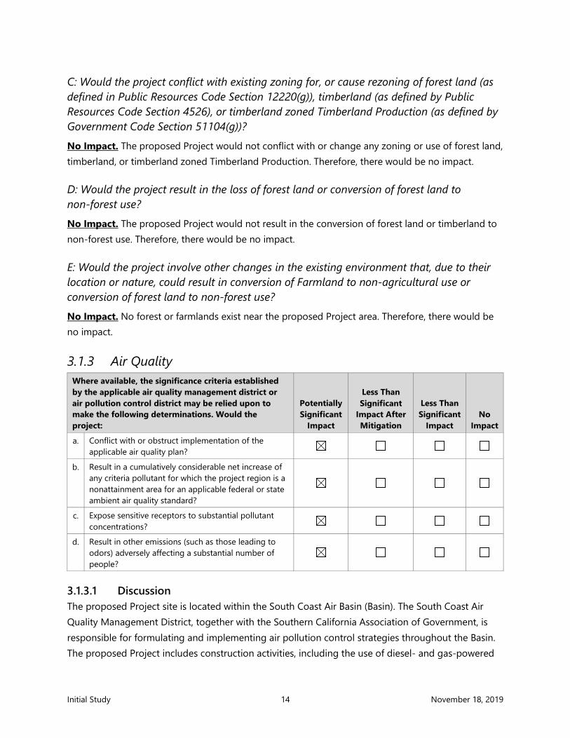
3.1.3 Air Quality Where available, the significance criteria established by the applicable air quality management district or air pollution control district may be relied upon to make the following determinations. Would the project:
Potentially Significant
Impact
Less Than Significant
Impact After Mitigation
Less Than Significant
Impact No
Impact
a. Conflict with or obstruct implementation of the applicable air quality plan?
b. Result in a cumulatively considerable net increase of any criteria pollutant for which the project region is a nonattainment area for an applicable federal or state ambient air quality standard?
c. Expose sensitive receptors to substantial pollutant concentrations?
d. Result in other emissions (such as those leading to odors) adversely affecting a substantial number of people?
3.1.3.1 Discussion The proposed Project site is located within the South Coast Air Basin (Basin). The South Coast Air Quality Management District, together with the Southern California Association of Government, is responsible for formulating and implementing air pollution control strategies throughout the Basin. The proposed Project includes construction activities, including the use of diesel- and gas-powered

Initial Study 15 November 18, 2019
construction equipment, which would result in increased emissions of criteria air pollutants. Emissions associated with construction have the potential to exceed applicable thresholds, conflict with an applicable air quality plan, or expose sensitive receptors to substantial pollutant concentrations. Therefore, the DEIR will include a full analysis of the proposed Project’s potential air quality impacts.
3.1.4 Biological Resources
Would the project:
Potentially Significant
Impact
Less Than Significant
Impact After Mitigation
Less Than Significant
Impact No
Impact
a. Have a substantial adverse effect, either directly or through habitat modifications, on any species identified as a candidate, sensitive, or special-status species in local or regional plans, policies, or regulations, or by the California Department of Fish and Game or U.S. Fish and Wildlife Service?
b. Have a substantial adverse effect on any riparian habitat or other sensitive natural community identified in local or regional plans, policies, or regulations, or by the California Department of Fish and Game or U.S. Fish and Wildlife Service?
c. Have a substantial adverse effect on state or federally protected wetlands (including, but not limited to, marshes, vernal pools, coastal wetlands, etc.) through direct removal, filling, hydrological interruption, or other means?
d. Interfere substantially with the movement of any native resident or migratory fish or wildlife species or with established native resident or migratory wildlife corridors, or impede the use of native wildlife nursery sites?
e. Conflict with any local policies or ordinances protecting biological resources, such as a tree preservation policy or ordinance?
f. Conflict with the provisions of an adopted habitat conservation plan, natural community conservation plan, or other approved local, regional, or state habitat conservation plan?

Initial Study 16 November 18, 2019
3.1.4.1 Discussion There are two Fish Management Plans (FMPs) that include waters adjacent to the proposed Project site: 1) the Coastal Pelagic FMP covering six species; and 2) the Pacific Groundfish FMP covering 89 species. In addition, birds protected under the Migratory Bird Treaty Act use the area for foraging. An eelgrass survey would be required prior to dredging. The proposed Project will not have a substantial adverse effect on state or federally protected wetlands as there are no such habitats in the project area. While the project area is largely developed and devoid of potential habitat for special-status species, portions of the project area may support, even temporarily, special-status species. Therefore, the DEIR will evaluate the potential for the Proposed project to impact biological resources.
3.1.5 Cultural Resources
Would the project:
Potentially Significant
Impact
Less Than Significant
Impact After Mitigation
Less Than Significant
Impact No
Impact
a. Cause a substantial adverse change in the significance of a historical resource pursuant to Section 15064.5?
b. Cause a substantial adverse change in the significance of an archaeological resource pursuant to Section 15064.5?
c. Disturb any human remains, including those interred outside of dedicated cemeteries?
3.1.5.1 Discussion The proposed Project is located in Newport Harbor. Prior to historic land modifications, the region was characterized by tidal flats and channels with dry land in the general vicinity available only on small hills and natural levees.
There are no structures in the project area, and the project does not include demolition or modification of any structure. Eleven properties in the City have been listed or designated eligible for listing on the National Register of Historic Places or California Register of Historical Resources, or otherwise listed as historic or potentially historic in the California Historic Resources Information System (CHRIS) maintained by the Office of Historic Preservation as well as seven properties in the City Register (City, 2006a) All identified properties are located outside the project area and there would be no impacts to historical resources.
There may be some potential for impacts to archaeological resources. Dredging activities began in the area in the early 1900s, and the major dredging and filling project that created the harbor was completed in 1936. Various maintenance dredging operations have occurred since that time. CAD

Initial Study 17 November 18, 2019
would be dredged below previously authorized depth and therefore would encounter native sediment. Though this sediment would have been in an active intertidal-beach area, there may be potential to encounter isolated archaeological artifacts or human remains. Therefore, the potential impact on cultural resources will be fully analyzed in the DEIR.
3.1.6 Energy
Would the project:
Potentially Significant
Impact
Less Than Significant
Impact After Mitigation
Less Than Significant
Impact No
Impact
a. Result in a potentially significant environmental impact due to wasteful, inefficient or unnecessary consumption of energy resources during project construction or operation?
b. Conflict with or obstruct a state or local plan for renewable energy or energy efficiency?
3.1.6.1 Discussion Senate Bill (SB) SX1-2 requires the State of California to produce 33% of its electricity from renewable sources by December 31, 2020; SB 350 requires the State to produce 50% of its electricity from renewable sources by December 31, 2030; and SB 100 requires the State to produce all electricity from renewable sources by 2045. A local partnership, the Orange County Cities Energy Partnership, identifies and creates projects to improve long-term energy efficiency and sustainability with a goal to reduce greenhouse gas (GHG) emissions and energy consumption by 15% from a 2010 baseline before 2020.
In order to comply with SB SX1-2 and SB 350 standards, the City has developed the City of Newport Beach Energy Action Plan (EAP) (Digital Energy Inc. 2013). The plan provides a roadmap for the City to reduce GHG through reductions in energy used in facility buildings and operations. Key objectives of the plan are as follows:
• Create a long-term vision for energy efficiency • Provide and assess information related to City energy use and greenhouse gas emissions • Highlight the City’s major energy-using facilities • Establish reduction targets for energy efficiency • Identify and prioritize goals, policies, and actions to achieve energy reductions • Provide a framework implementing the identified goals, policies, and actions
Southern California Edison and Southern California Gas Company are local providers in the vicinity of the proposed Project area.
Initial Study 18 November 18, 2019
3.1.6.2 Impact Evaluation
A: Would the project result in potentially significant environmental impact due to wasteful, inefficient, or unnecessary consumption of energy resources, during project construction or operation? No Impact. Proposed Project construction would involve equipment that consumes fossil fuels; however, the proposed Project would not require any unusual or excessive construction equipment or practices compared to projects of similar type and size. In addition, the proposed Project would comply with standard BMPs such as equipment idling restrictions and maintaining equipment according to manufacturers’ specifications. As such, construction of the proposed Project would not result in wasteful, inefficient, or unnecessary consumption of energy. Operation of the CAD would require energy demands that would be negligible. Therefore, there would be no impact, and this issue will not be addressed further in the DEIR.
B: Would the project conflict with or obstruct a state or local plan for renewable energy or energy efficiency? No Impact. The City would employ standard BMPs during construction, and operation of the CAD would occur in compliance with federal, state, and local regulations pertaining to emissions and efficiency. These measures would ensure that consumption of associated fossil fuels occur in compliance with existing plans and regulations.
Continued implementation of the City of Newport Beach Energy Action Plan (EAP) (Digital Energy Inc. 2013) would ensure that the proposed Project does not conflict with state regulations pertaining to renewable energy. Therefore, there would be no impact, and this issue will not be addressed further in the DEIR.

Initial Study 19 November 18, 2019
3.1.7 Geology and Soils
Would the project:
Potentially Significant
Impact
Less Than Significant
Impact After Mitigation
Less Than Significant
Impact No Impact
a. Directly or indirectly cause potential substantial adverse effects, including the risk of loss, injury, or death involving:
Rupture of a known earthquake fault, as delineated on the most recent Alquist-Priolo Earthquake Fault Zoning Map issued by the State Geologist for the area or based on other substantial evidence of a known fault? Refer to Division of Mines and Geology Special Publication 42.
Strong seismic ground shaking?
Seismic-related ground failure, including liquefaction?
Landslides?
b. Result in substantial soil erosion or the loss of topsoil?
c. Be located on a geologic unit or soil that is unstable or that would become unstable as a result of the project and potentially result in an on-site or off-site landslide, lateral spreading, subsidence, liquefaction, or collapse?
d. Be located on expansive soil, as defined in Table 18-1-B of the Uniform Building Code (1994), creating direct or indirect risks to life or property?
e. Have soils incapable of adequately supporting the use of septic tanks or alternative wastewater disposal systems in areas where sewers are not available for the disposal of wastewater?
f. Directly or indirectly destroy a unique paleontological resource or site or unique geologic feature?
3.1.7.1 Discussion The proposed Project is located in the marine environment; therefore, there would be no impact to soil or land-based erosion as a result of the project. As discussed in Section 3.1.5, while unlikely to encounter paleontological resources because the area has been previously dredged and developed, because dredging would encounter native soil, there is the potential for impacts to a unique paleontological resource. Because the proposed Project is close to the Newport-Inglewood Fault Zone, the proposed CAD could potentially be impacted in the event of seismic ground shaking. In addition, the proposed Project area is located in an area with a liquefaction potential (City 2006b).
Initial Study 20 November 18, 2019
Therefore, the DEIR will fully evaluate the potential for the proposed Project to cause potential substantial adverse effects on geology and soils.
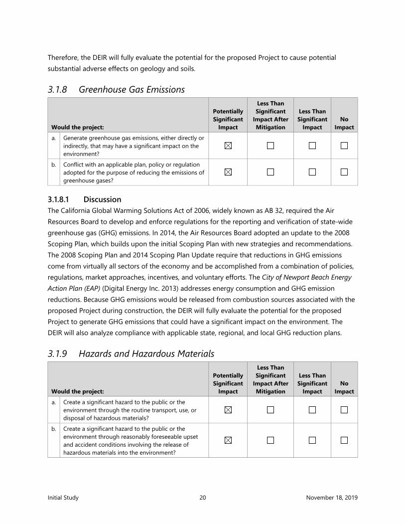
3.1.8 Greenhouse Gas Emissions
Would the project:
Potentially Significant
Impact
Less Than Significant
Impact After Mitigation
Less Than Significant
Impact No
Impact
a. Generate greenhouse gas emissions, either directly or indirectly, that may have a significant impact on the environment?
b. Conflict with an applicable plan, policy or regulation adopted for the purpose of reducing the emissions of greenhouse gases?
3.1.8.1 Discussion The California Global Warming Solutions Act of 2006, widely known as AB 32, required the Air Resources Board to develop and enforce regulations for the reporting and verification of state-wide greenhouse gas (GHG) emissions. In 2014, the Air Resources Board adopted an update to the 2008 Scoping Plan, which builds upon the initial Scoping Plan with new strategies and recommendations. The 2008 Scoping Plan and 2014 Scoping Plan Update require that reductions in GHG emissions come from virtually all sectors of the economy and be accomplished from a combination of policies, regulations, market approaches, incentives, and voluntary efforts. The City of Newport Beach Energy Action Plan (EAP) (Digital Energy Inc. 2013) addresses energy consumption and GHG emission reductions. Because GHG emissions would be released from combustion sources associated with the proposed Project during construction, the DEIR will fully evaluate the potential for the proposed Project to generate GHG emissions that could have a significant impact on the environment. The DEIR will also analyze compliance with applicable state, regional, and local GHG reduction plans.
3.1.9 Hazards and Hazardous Materials
Would the project:
Potentially Significant
Impact
Less Than Significant
Impact After Mitigation
Less Than Significant
Impact No
Impact
a. Create a significant hazard to the public or the environment through the routine transport, use, or disposal of hazardous materials?
b. Create a significant hazard to the public or the environment through reasonably foreseeable upset and accident conditions involving the release of hazardous materials into the environment?

Initial Study 21 November 18, 2019
Would the project:
Potentially Significant
Impact
Less Than Significant
Impact After Mitigation
Less Than Significant
Impact No
Impact
c. Emit hazardous emissions or involve handling hazardous or acutely hazardous materials, substances, or waste within 0.25 mile of an existing or proposed school?
d. Be located on a site that is included on a list of hazardous materials sites compiled pursuant to Government Code Section 65962.5 and, as a result, would it create a significant hazard to the public or the environment?
e. For a project within an airport land use plan area or, where such a plan has not been adopted, be within 2 miles of a public airport or public use airport, would the project result in a safety hazard or excessive noise for people residing or working in the project area?
f. Impair implementation of or physically interfere with an adopted emergency response plan or emergency evacuation plan?
g. Expose people or structures, either directly or indirectly, to a significant risk of loss, injury, or death involving wildland fires?
3.1.9.1 Discussion The proposed Project is not within an airport land use plan area nor within 2 miles of a public airport or public use airport and therefore would not result in a safety hazard or excessive noise for people residing or working in the project area. The proposed Project site is not included on a list of hazardous materials sites compiled pursuant to Government Code Section 65962.5 (also known as the Cortese List). In addition, as a marine-based project, there would be no impacts due to wildland fires as a result of the project. However, because the proposed Project would manage unsuitable sediment, there is potential for hazards and hazardous materials-related impacts on the environment. Therefore, the DEIR will evaluate whether the proposed Project would create a significant hazard to the public or environment through the routine transport of hazardous materials. The potential for impacts associated with hazards and hazardous materials will be fully analyzed in the DEIR.

Initial Study 22 November 18, 2019
3.1.10 Hydrology and Water Quality
Would the project:
Potentially Significant
Impact
Less Than Significant
Impact After Mitigation
Less Than Significant
Impact No
Impact
a. Violate any water quality standards or waste discharge requirements or otherwise substantially degrade surface or ground water quality?
b. Substantially decrease groundwater supplies or interfere substantially with groundwater recharge, such that the project may impede sustainable groundwater management of the basin.
c. Substantially alter the existing drainage pattern of the site or area, including through the alteration of the course of a stream or river, or through the addition of impervious surfaces, in a manner which would:
Result in substantial erosion or siltation on site or off site?
Substantially increase the rate or amount of surface runoff in a manner that would result in flooding on site or off site?
Create or contribute runoff water that would exceed the capacity of existing or planned stormwater drainage systems or provide substantial additional sources of polluted runoff?
Impede or redirect flood flows
d. In flood hazard tsunami, or seiche zones, risk release of pollutants due to project inundation?
e. Conflict with or obstruct implementation of a water quality control plan or sustainable groundwater management plan?
3.1.10.1 Discussion Generally, construction activities within the City would be regulated under the National Pollutant Discharge Elimination System (NPDES) program, as administered by the Santa Ana Regional Water Quality Control Board (RWQCB). The proposed Project will occur entirely within the marine environment and therefore would not affect groundwater or result in land-based erosion or runoff issues. However, while the proposed Project would include a number of BMPs to prevent impacts to water quality, because the proposed Project would result in dredging, it may result in potential effects to water quality, even temporarily. Therefore, the DEIR will fully evaluate whether the project would result in potential impacts to hydrology and water quality.

Initial Study 23 November 18, 2019
3.1.11 Land Use and Planning
Would the project:
Potentially Significant
Impact
Less Than Significant
Impact After Mitigation
Less Than Significant
Impact No
Impact
a. Physically divide an established community?
b. Cause a significant environmental impact due to a conflict with any land use plan, policy, or regulation adopted for the purpose of avoiding or mitigating an environmental effect?
3.1.11.1 Discussion The City’s General Plan (City 2006a) was adopted on July 25, 2006, and approved on November 7, 2006. The Plan provides both a comprehensive assessment of current land use and a forward-looking vision statement, which presents a description of the City that residents want Newport Beach to be in 2025. On January 8, 2019, the City Council conducted a study session to consider initiating a review and update of the General Plan. At the January 22, 2019, City Council meeting, the initiation and formation of a steering committee was approved, and an update meeting was held on September 25, 2019. While update planning is ongoing, the 2006 General Plan serves as the regulatory framework under which potential land use and planning impacts are assessed.
Newport Harbor is covered under several components in the 2006 General Plan, including the Harbor and Bay, Natural Resources, and Recreation, which address public access, water quality, and the environment.
The California Coastal Act (CCA) of 1976 (Public Resources Code §30000 et seq.) was enacted to establish policies and guidelines that provide direction for the conservation and development of the California coastline. The CCA established the California Coastal Commission (CCC) and created a state and local government partnership to ensure that public concerns regarding coastal development are addressed. The City’s Coastal Land Use Plan (CLUP) was prepared in accordance with the CCA, approved in 2005, and amended several times by the CCC—the most recent amendment adopted in January 2019. The City’s CLUP sets forth goals, objectives, and policies that govern the use of land and water in the coastal zone.
Because the proposed Project will be required to show compliance with the General Plan and the CLUP, the DEIR will include a full General Plan/CLUP policy analysis DEIR. Therefore, the DEIR will fully evaluate whether the proposed Project would result in potential impacts to land use and planning.

Initial Study 24 November 18, 2019
3.1.12 Mineral Resources
Would the project:
Potentially Significant
Impact
Less Than Significant
Impact After Mitigation
Less Than Significant
Impact No
Impact
a. Result in the loss of availability of a known mineral resource that would be of value to the region and the residents of the state?
b. Result in the loss of availability of a locally important mineral resource recovery site delineated on a local general plan, specific plan, or other land use plan?
3.1.12.1 Discussion Oil and gas seeps are common occurrences in many parts of Orange County, including in and around the proposed Project area. According to the California Department of Oil, Gas, and Geothermal Resources (2019), two separate production and reserve areas exist within the project area: the Newport oil field and the West Newport oil field. The project area is classified as a Mineral Resource Zone (MRZ)-1, an area where available geologic information indicates there is little or no likelihood for presence of significant mineral resources (City 2006b). Adequate information indicates that no significant mineral deposits are present, or it is judged that little likelihood exists for their presence. The proposed Project site does not contain any known mineral resources, including any rock, sand, or gravel resources.
3.1.12.2 Impact Evaluation
A: Would the project result in the loss of availability of a known mineral resource that would be of value to the region and the residents of the state? No Impact. The City’s General Plan encourages consolidation of existing oil and gas activities (Policy Natural Resources [NR] 19.4) but contains policies (NR 19.1 through 19.4) that prohibit additional, future oil extraction within the City and oppose new offshore oil and gas drilling activities (City 2006a). Moreover, due to the proposed Project’s location in an MRZ-1, continued development of the area would not limit access to any known mineral resources. As a result, the proposed Project would neither interfere with any existing extraction operations nor reduce the availability of any known mineral resources. Therefore, there would be no impact.

Initial Study 25 November 18, 2019
B: Would the project result in the loss of availability of a locally important mineral resource recovery site delineated on a local general plan, specific plan, or other land use plan? No Impact. The proposed Project area does not include a locally important mineral resource recovery site delineated on a local general plan, specific plan, or other land use plan. Therefore, there would be no impact.
3.1.13 Noise
Would the project result in:
Potentially Significant
Impact
Less Than Significant
Impact After Mitigation
Less Than Significant
Impact No
Impact
a. Generation of a substantial temporary or permanent increase in ambient noise levels in the vicinity of the project in excess of standards established in a local general plan or noise ordinance or applicable standards of other agencies?
b. Generation of excessive groundborne vibration or groundborne noise levels?
c. For a project located within the vicinity of a private airstrip or an airport land use plan area, or, where such a plan has not been adopted, within 2 miles of a public airport or public use airport and expose people residing or working in the Project area to excessive noise levels?
3.1.13.1 Discussion The proposed Project would not be located within the vicinity of a private airstrip or an airport land use plan area, nor within 2 miles of a public airport or public use airport and therefore will not expose people residing or working in the project area to excessive noise levels in such areas. Construction activities for the proposed Project would require the use of numerous pieces of noise-generating equipment and equipment that could cause excess noise and vibration. These activities would temporarily increase ambient noise levels and vibration levels on an intermittent basis. Therefore, the DEIR will fully evaluate the potential impacts from noise and vibration associated with the proposed Project.

Initial Study 26 November 18, 2019
3.1.14 Population and Housing
Would the project:
Potentially Significant
Impact
Less Than Significant
Impact After Mitigation
Less Than Significant
Impact No
Impact
a. Induce substantial unplanned population growth in an area, either directly (e.g., by proposing new homes and businesses) or indirectly (e.g., through extension of roads or other infrastructure)?
b. Displace a substantial number of existing people or housing units, necessitating the construction of replacement housing elsewhere?
3.1.14.1 Discussion The City’s General Plan designates the proposed project site for TS (Tidelands and Submerged Lands) (City 2006a). There is no housing within the project area, though a few residential areas are located near the project site (City 2006a). In 2018, the population of the City was approximately 87,182 people, and the number of housing units was 44,670 (SCAG 2019).
3.1.14.2 Impact Evaluation
A: Would the project induce substantial unplanned population growth in an area, either directly (e.g., by proposing new homes and businesses) or indirectly (e.g., through extension of roads or other infrastructure)? No Impact. No new homes would be constructed as part of the proposed Project. While the project would include temporary construction jobs, the jobs would be limited and are expected to be served by the existing population. Therefore, no new housing to accommodate workers is necessary. The CAD facility would not induce population growth.
B: Would the project displace a substantial number of existing people or housing units, necessitating the construction of replacement housing elsewhere? No Impact. There are no housing units in the proposed Project area. There are a few residential areas located near the proposed Project site. The proposed Project would have no effect on existing residential areas, and the site’s zoning precludes the potential for future housing developments in the immediate harbor area. Therefore, the proposed Project would have no impact on housing.
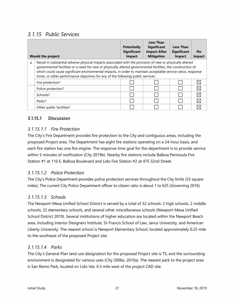
Initial Study 27 November 18, 2019
3.1.15 Public Services
Would the project:
Potentially Significant
Impact
Less Than Significant
Impact After Mitigation
Less Than Significant
Impact No
Impact
a. Result in substantial adverse physical impacts associated with the provision of new or physically altered governmental facilities or a need for new or physically altered governmental facilities, the construction of which could cause significant environmental impacts, in order to maintain acceptable service ratios, response times, or other performance objectives for any of the following public services:
Fire protection?
Police protection?
Schools?
Parks?
Other public facilities?
3.1.15.1 Discussion
3.1.15.1.1 Fire Protection The City’s Fire Department provides fire protection to the City and contiguous areas, including the proposed Project area. The Department has eight fire stations operating on a 24-hour basis, and each fire station has one fire engine. The response time goal for the department is to provide service within 5 minutes of notification (City 2019b). Nearby fire stations include Balboa Peninsula Fire Station #1 at 110 E. Balboa Boulevard and Lido Fire Station #2 at 475 32nd Street.
3.1.15.1.2 Police Protection The City’s Police Department provides police protection services throughout the City limits (53 square miles). The current City Police Department officer to citizen ratio is about 1 to 625 (Governing 2016).
3.1.15.1.3 Schools The Newport-Mesa Unified School District is served by a total of 32 schools: 2 high schools, 2 middle schools, 22 elementary schools, and several other miscellaneous schools (Newport-Mesa Unified School District 2019). Several institutions of higher education are located within the Newport Beach area, including Interior Designers Institute, St-Francis School of Law, Janus University, and American Liberty University. The nearest school is Newport Elementary School, located approximately 0.25 mile to the southeast of the proposed Project site.
3.1.15.1.4 Parks The City’s General Plan land use designation for the proposed Project site is TS, and the surrounding environment is designated for various uses (City 2006a, 2019a). The nearest park to the project area is San Remo Park, located on Lido Isle, 0.3 mile west of the project CAD site.
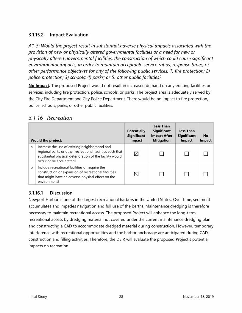
Initial Study 28 November 18, 2019
3.1.15.2 Impact Evaluation
A1-5: Would the project result in substantial adverse physical impacts associated with the provision of new or physically altered governmental facilities or a need for new or physically altered governmental facilities, the construction of which could cause significant environmental impacts, in order to maintain acceptable service ratios, response times, or other performance objectives for any of the following public services: 1) fire protection; 2) police protection; 3) schools; 4) parks; or 5) other public facilities? No Impact. The proposed Project would not result in increased demand on any existing facilities or services, including fire protection, police, schools, or parks. The project area is adequately served by the City Fire Department and City Police Department. There would be no impact to fire protection, police, schools, parks, or other public facilities.
3.1.16 Recreation
Would the project:
Potentially Significant
Impact
Less Than Significant
Impact After Mitigation
Less Than Significant
Impact No
Impact
a. Increase the use of existing neighborhood and regional parks or other recreational facilities such that substantial physical deterioration of the facility would occur or be accelerated?
b. Include recreational facilities or require the construction or expansion of recreational facilities that might have an adverse physical effect on the environment?
3.1.16.1 Discussion Newport Harbor is one of the largest recreational harbors in the United States. Over time, sediment accumulates and impedes navigation and full use of the berths. Maintenance dredging is therefore necessary to maintain recreational access. The proposed Project will enhance the long-term recreational access by dredging material not covered under the current maintenance dredging plan and constructing a CAD to accommodate dredged material during construction. However, temporary interference with recreational opportunities and the harbor anchorage are anticipated during CAD construction and filling activities. Therefore, the DEIR will evaluate the proposed Project’s potential impacts on recreation.

Initial Study 29 November 18, 2019
3.1.17 Transportation
Would the project:
Potentially Significant
Impact
Less Than Significant
Impact After Mitigation
Less Than Significant
Impact No
Impact
a. Conflict with a program, plan, ordinance, or policy addressing the circulation system including transit, roadway, bicycle and pedestrian facilities?
b. Conflict with or be inconsistent with CEQA Guidelines Section 15064.3, subdivision (b)?
c. Substantially increase hazards due to a geometric design feature (e.g., sharp curves or dangerous intersections) or incompatible uses (e.g., farm equipment)?
d. Result in inadequate emergency access?
3.1.17.1 Discussion Newport Beach faces the Pacific Ocean, causing the City to have access from only three directions. In addition, Upper Bay acts as a barrier, resulting in only two east/west routes through Newport Beach (Highway 1 and the Bristol Street/State Route [SR] 73 corridor).
Regional access to the City is provided by the following highways:
• Interstate 405 freeway runs north to south within Southern California and intersects both SR 73 and SR 55.
• SR 55 extends south from SR 91 and terminates in the City at Finley Avenue • SR 73 extends through the northerly part of the City, connecting SR 55 and Interstate 405 with
Interstate 5. • Highway 1 runs along the California coast and all the way through Newport Beach.
In addition to these major highways, there is an extensive network of City streets, such as Newport Boulevard, Balboa Boulevard, Jamboree Road, MacArthur Boulevard, Irvine Avenue, and Newport Coast Drive, that provide internal movement within the City.
3.1.17.2 Impact Evaluation
A: Would the project conflict with a program, plan, ordinance, or policy addressing the circulation system including transit, roadway, bicycle and pedestrian facilities? No Impact. The proposed Project is a harbor maintenance dredging project using aquatic sediment management techniques (the CAD facility) and will have no significant impact on the City’s street transportation, including transit, roadway, bicycle, and pedestrian facilities. Construction may include some truck trips for initial construction equipment staging. In addition, small amounts of debris (such

Initial Study 30 November 18, 2019
as rocks) may be removed from the proposed dredge footprint and, if so, will require transportation to a landfill. It is anticipated that a total of approximately five trucks will travel to and from the site over the entire construction period. These trips will not result in a substantial increase to traffic volume or vehicle trips nor will it affect the existing level of service standards. As for operation, no new vehicle trips would be required in the long term. Therefore, there would be no impact to existing traffic during construction and operation activities
B: Would the project conflict with or be inconsistent with CEQA Guidelines Section 15064.3, subdivision (b)? No Impact. The proposed Project is a harbor maintenance dredging project using aquatic sediment management techniques and will have no significant impact on the City’s street transportation.
C: Would the project substantially increase hazards due to a geometric design feature (e.g., sharp curves or dangerous intersections) or incompatible uses (e.g., farm equipment)? No Impact. The proposed Project does not include any modifications to the existing transportation network. Therefore, there would be no impact.
D: Would the project result in inadequate emergency access? No Impact. As stated above, the proposed Project would result in minor levels of new traffic during construction staging that would not affect area transportation levels of service. Therefore, there would be no impact to emergency access.
3.1.18 Tribal Cultural Resources
Would the project:
Potentially Significant
Impact
Less Than Significant
Impact After Mitigation
Less Than Significant
Impact No
Impact
a. Cause a substantial adverse change in the significance of a tribal cultural resource, defined in Public Resources Code section 21074 as either a site, feature, place, cultural landscape that is geographically defined in terms of the size and scope of the landscape, sacred place, or object with cultural value to a California Native American tribe, and that is:
Listed or eligible for listing in the California Register of Historical Resources, or in a local register of historical resources as defined in Public Resources Code section 5020.1(k), or

Initial Study 31 November 18, 2019
Would the project:
Potentially Significant
Impact
Less Than Significant
Impact After Mitigation
Less Than Significant
Impact No
Impact
A resource determined by the lead agency, in its discretion and supported by substantial evidence, to be significant pursuant to criteria set forth in subdivision (c) of Public Resources Code Section 5024.1. In applying the criteria set forth in subdivision (c) of Public Resource Code Section 5024.1, the lead agency shall consider the significance of the resource to a California Native American tribe.
3.1.18.1 Discussion CEQA establishes a formal consultation process for California Native American Tribes to identify potential significant impacts to tribal cultural resources, commonly known as the Assembly Bill 52 (AB 52) process. As specified in AB 52, lead agencies must provide notice to tribes that are traditionally and culturally affiliated with the geographic area of a proposed project if the tribe has submitted a written request to be notified. As discussed in Section 3.1.18, there are three tribes that have requested to be on the City’s AB 52 list, and the City has provided notice to the tribes. The tribe must respond to the lead agency within 30 days of receipt of the notification if it wishes to engage in consultation on the project, and the lead agency must begin the consultation process within 30 days of receiving the request for consultation. Any consultation under AB 52 will be included in the DEIR.
3.1.19 Utilities and Service Systems
Would the project:
Potentially Significant
Impact
Less Than Significant
Impact After Mitigation
Less Than Significant
Impact No
Impact
a. Require or result in the relocation or construction of new or expanded water, wastewater treatment facilities, storm water drainage, electrical power, natural gas or telecommunications facilities, the construction or relocation of which could cause significant environmental effects?
b. Have sufficient water supplies available to serve the project and reasonably foreseeable future development during normal, dry and multiple dry years?
c Result in a determination by the wastewater treatment provider that serves or may serve the project that it has adequate capacity to serve the project’s projected demand in addition to the provider’s existing commitments?
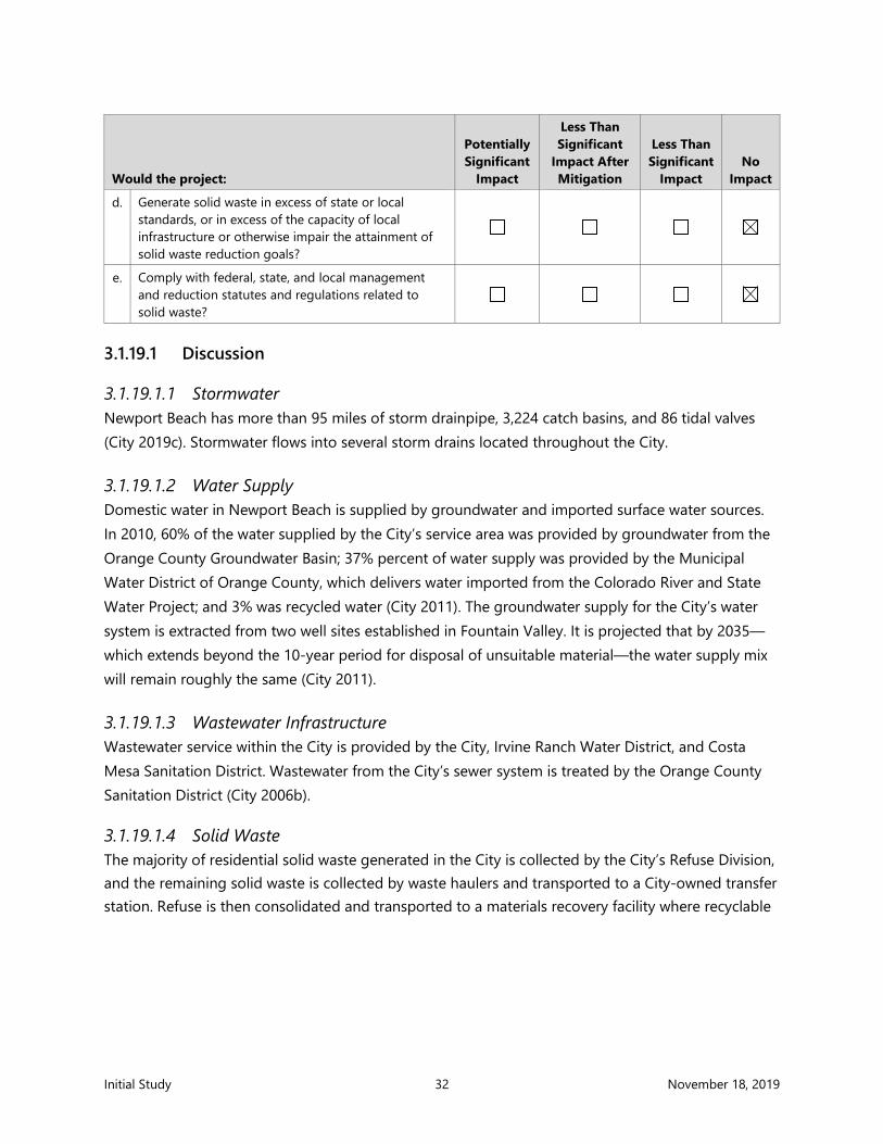
Initial Study 32 November 18, 2019
Would the project:
Potentially Significant
Impact
Less Than Significant
Impact After Mitigation
Less Than Significant
Impact No
Impact
d. Generate solid waste in excess of state or local standards, or in excess of the capacity of local infrastructure or otherwise impair the attainment of solid waste reduction goals?
e. Comply with federal, state, and local management and reduction statutes and regulations related to solid waste?
3.1.19.1 Discussion
3.1.19.1.1 Stormwater Newport Beach has more than 95 miles of storm drainpipe, 3,224 catch basins, and 86 tidal valves (City 2019c). Stormwater flows into several storm drains located throughout the City.
3.1.19.1.2 Water Supply Domestic water in Newport Beach is supplied by groundwater and imported surface water sources. In 2010, 60% of the water supplied by the City’s service area was provided by groundwater from the Orange County Groundwater Basin; 37% percent of water supply was provided by the Municipal Water District of Orange County, which delivers water imported from the Colorado River and State Water Project; and 3% was recycled water (City 2011). The groundwater supply for the City’s water system is extracted from two well sites established in Fountain Valley. It is projected that by 2035—which extends beyond the 10-year period for disposal of unsuitable material—the water supply mix will remain roughly the same (City 2011).
3.1.19.1.3 Wastewater Infrastructure Wastewater service within the City is provided by the City, Irvine Ranch Water District, and Costa Mesa Sanitation District. Wastewater from the City’s sewer system is treated by the Orange County Sanitation District (City 2006b).
3.1.19.1.4 Solid Waste The majority of residential solid waste generated in the City is collected by the City’s Refuse Division, and the remaining solid waste is collected by waste haulers and transported to a City-owned transfer station. Refuse is then consolidated and transported to a materials recovery facility where recyclable

Initial Study 33 November 18, 2019
materials are sorted from refuse by machines and other methods. The remaining solid waste (debris) is taken to one of three County landfills (Frank R. Bowerman, Prima Deshecha, and Olinda Alpha).
3.1.19.1.5 Electricity, Gas, and Telecommunications Southern California Edison Company is the primary distribution provider for electricity in the proposed Project area. Southern California Gas Company provides natural gas service for the Project area. AT&T provides telecommunication services to the area.
3.1.19.2 Impact Evaluation
A: Would the project require or result in the relocation or construction of new or expanded water, wastewater treatment facilities, storm water drainage, electrical power, natural gas or telecommunications facilities, the construction or relocation of which could cause significant environmental effects? No Impact. The State of California Government Code 4126 mandates that anyone performing excavation work shall call at least 2 working days prior to commencement of any excavation. Notice of this Project will be provided to area fiber optic, communications, and electrical providers to request additional information on the location, if any, of private cables or utilities. Although not active and abandoned, known in-water or overhead City-provided utilities are located within the proposed Project area, the contractor will be required to confirm the locations, alignments, and depths of any utilities potentially located within the Project area prior to dredging. In addition, as part of the construction plan, all overhead and buried upland utility lines will need to be demarcated and avoided by the contractor prior to initiating construction.
The proposed Project may generate small amounts of construction debris during maintenance dredging such as abandoned utility lines. Debris encountered during the CAD facility excavation would be removed and appropriately disposed. For disposal of commercial debris, the City currently has an open franchise system, in which the contractor will select a City-approved hauler who will dispose of or recycle the debris appropriately (construction and demolition projects generate a high volume of recyclable material that is counted toward the City’s recycling rate). The proposed Project will not affect utilities and service systems because it consists of removal of unsuitable sediment from the project for barge transport to the CAD location and does not result in additional demands on existing utilities and service systems or create future demand on them.
No potential direct or indirect impacts to utilities and service systems have been identified because no direct or indirect impacts will result from the proposed Project. It will also not result in cumulative impacts to utilities and service systems. The project will not generate wastewater or require treatment of wastewater and therefore will not exceed requirements of the Santa Ana RWQCB. The project will not require or result in the construction of new water or wastewater treatment facilities or

Initial Study 34 November 18, 2019
expansion of existing facilities. Therefore, the proposed Project will not require a determination by the wastewater treatment provider that it has adequate capacity to serve the project’s projected demand in addition to the provider's existing commitments.
B: Would the project have sufficient water supplies available to serve the project and reasonably foreseeable future development during normal, dry and multiple dry years? No Impact. No potential direct or indirect impacts to water supplies have been identified because the project will not use potable water supplies to implement the project.
C: Would the project result in a determination by the wastewater treatment provider which serves or may serve the project that it has adequate capacity to serve the project’s projected demand in addition to the provider’s existing commitments? No Impact. The project will not generate wastewater or require treatment of wastewater. Therefore, the proposed Project would not change the capacity of a wastewater treatment provider.
D: Would the project generate solid waste in excess of State or local standards, or in excess of the capacity of local infrastructure or otherwise impair the attainment of solid waste reduction goals? No Impact. The proposed project provides a safe means of disposal for unsuitable dredged materials within a CAD facility. Thus, the proposed Project would not generate significant solid waste requiring upland disposal and therefore would not affect the capacity of local solid waste landfill infrastructure or impair the attainment of solid waste reduction goals.
E: Would the project comply with federal, state, and local management and reduction statutes and regulations related to solid waste? No Impact. The proposed Project would be constructed within the parameters of applicable federal, state, and local solid waste regulations. The proposed Project may generate small amounts of construction debris during maintenance dredging such as abandoned utility lines. As described, area landfills are authorized to accept the types of waste potentially generated by proposed Project construction. Therefore, there would be no impact.
3.1.20 Wildfire
If located in or near state responsibility areas or lands classified as very high fire hazard severity zones, would the project:
Potentially Significant
Impact
Less Than Significant
Impact After Mitigation
Less Than Significant
Impact No
Impact
a. Substantially impair an adopted emergency response plan or emergency evacuation plan?

Initial Study 35 November 18, 2019
If located in or near state responsibility areas or lands classified as very high fire hazard severity zones, would the project:
Potentially Significant
Impact
Less Than Significant
Impact After Mitigation
Less Than Significant
Impact No
Impact
b. Due to slope, prevailing winds, and other factors, exacerbate wildfire risks, and thereby expose project occupants to, pollutant concentrations from a wildfire or the uncontrolled spread of a wildfire?
c. Require the installation or maintenance of associated infrastructure (such as roads, fuel breaks, emergency water sources, power lines or other utilities) that may exacerbate fire risk or that may result in temporary or ongoing impacts to the environment?
d. Expose people or structures to significant risks, including downslope or downstream flooding or landslides, as a result of runoff, post-fire slope instability, or drainage changes
3.1.20.1 Discussion According to California Fire Prevention (2019), the proposed Project is not located in or near state responsibility areas. The closest state responsibility area is the Crystal Cove State Park, located about 4 miles south of the project area. According to the California Department of Forestry and Fire Protection (2019), the project is not located in a Very High Fire Hazard Severity Zone (VHFHSZ). The closest VHFHSZ is in Newport Beach, approximately 1 to 2 miles south of the Project area.
3.1.20.2 Impact Evaluation
A: Would the project substantially impair an adopted emergency response plan or emergency evacuation plan? No Impact. The proposed Project would not impair implementation of or physically interfere with an adopted emergency response plan or emergency evacuation plan. Therefore, there would be no impact, and this issue will not be addressed further in the DEIR.
B: Would the project, due to slope, prevailing winds, and other factors, exacerbate wildfire risks, and thereby expose project occupants to pollutant concentrations from a wildfire or the uncontrolled spread of a wildfire? No Impact. The risk of wildfire is related to a variety of parameters, including fuel loading (vegetation), fire weather (winds, temperatures, humidity levels, and fuel moisture contents) and topography. For instance, steep slopes can contribute to fire hazard by intensifying the effects of wind and making fire suppression difficult (Estes et al. 2017). Fuels such as grass are highly flammable (Estes et al. 2017). The proposed Project site is located in the harbor, which is not

Initial Study 36 November 18, 2019
considered at a risk of wildfire. Therefore, there would be no impact, and this issue will not be addressed further in the DEIR.
C: Would the project require the installation or maintenance of associated infrastructure (such as roads, fuel breaks, emergency water sources, power lines, or other utilities) that may exacerbate fire risk or that may result in temporary or ongoing impacts to the environment? No Impact. The proposed Project involves constructing a CAD facility and does not require the installation or maintenance of associated infrastructure such as roads, fuel breaks, emergency water sources, power lines, or other utilities that may exacerbate fire risk or result in temporary or ongoing impacts to the environment. The proposed Project site is located in the harbor, which is not considered at a risk of wildfire. Therefore, there would be no impact, and this issue will not be addressed further in the DEIR.
D: Would the project expose people or structures to significant risks, including downslope or downstream flooding or landslides, as a result of runoff, post-fire slope instability, or drainage changes? No Impact. The proposed Project would not result of changes in runoff, post-fire slope instability, or drainage and therefore would not result in downstream flooding or landslides. The proposed Project site is located in the harbor, which is not considered at a risk of wildfire. There would be no impact, and this issue will not be addressed further in the DEIR.
3.1.21 Mandatory Findings of Significance
Potentially Significant
Impact
Less Than Significant
Impact After Mitigation
Less Than Significant
Impact No
Impact
a. Does the project have the potential to substantially degrade the quality of the environment, substantially reduce the habitat of a fish or wildlife species, cause a fish or wildlife population to drop below self-sustaining levels, threaten to eliminate a plant or animal community, substantially reduce the number or restrict the range of a rare or endangered plant or animal, or eliminate important examples of the major periods of California history or prehistory?
b. Does the project have impacts that are individually limited but cumulatively considerable? (“Cumulatively considerable” means that the incremental effects of a project are considerable when viewed in connection with the effects of past projects, the effects of other current projects, and the effects of probable future projects.)

Initial Study 37 November 18, 2019
Potentially Significant
Impact
Less Than Significant
Impact After Mitigation
Less Than Significant
Impact No
Impact
c. Does the project have environmental effects that will cause substantial adverse effects on human beings, either directly or indirectly?
3.1.21.1 Discussion As described in preceding sections, the proposed Project could have the potential to result in potentially significant impacts on the environment. Therefore, the DEIR will evaluate whether the proposed Project has the potential to substantially degrade the quality of the environment, both at a project level and cumulatively. The proposed Project could result in adverse impacts on human beings through environmental impacts, either directly or indirectly. Therefore, the DEIR will evaluate whether the proposed Project would cause direct or indirect adverse effects on human beings and will include a full analysis of Mandatory Findings of Significance.

Initial Study 38 November 18, 2019
4 References Anchor QEA (Anchor QEA, LLC), 2009. Lower Newport Bay CAD Site Feasibility Study. Prepared for the
City of Newport Beach. April 2009.
Anchor QEA, 2019a. Lower Newport Bay Federal Channels Dredging Sampling and Analysis Report. Prepared for the City of Newport Beach. Revised June 2019.Anchor QEA, 2019b. Lower Newport Bay CAD Basis of Design Report. Report currently in preparation. October 2019.
California Department of Forestry and Fire Protection, 2019. “Is Your Home in a High Hazard Severity Zone?” Accessed October 3, 2019. Available at: https://forestwatch.maps.arcgis.com/apps/Styler/index.html?appid=5e96315793d445419b6c96f89ce5d153.
California Department of Oil, Gas, and Geothermal Resources, 2019. Well Finder GIS. Accessed October 3, 2019. Available at: https://maps.conservation.ca.gov/doggr/wellfinder/#openModal/-117.99685/33.64624/13
California Fire Prevention, 2019. State Responsibility Area Viewer. Accessed October 3, 2019. Available at: https://bof.fire.ca.gov/projects-and-programs/state-responsibility-area-viewer/.
City (City of Newport Beach), 2006a City of Newport Beach General Plan. Adopted July 25, 2006 Accessed October 3, 2019. Accessed October 3, 2019. Available at: https://www.newportbeachca.gov/government/departments/community-development/planning-division/general-plan-codes-and-regulations/general-plan.
City 2006b. City of Newport Beach General Plan Update EIR. Accessed October 3, 2019. Available at: https://www.newportbeachca.gov/government/departments/community-development/planning-division/general-plan-codes-and-regulations/general-plan/general-plan-environmental-impact-repor.
City, 2011. 2010 Urban Water Management Plan. Prepared by Malcolm Pirnie, Inc. May 2011. Accessed October 3, 2019. Available at: https://www.newportbeachca.gov/home/showdocument?id=10182.
City, 2019a. Newport Beach GIS. Accessed October 3, 2019. Available at: https://nbgis.newportbeachca.gov/NewportHTML5Viewer/?viewer=publicsite.
City, 2019b. “Fire Operations Division.” Accessed October 3, 2019. Available at: https://www.newportbeachca.gov/government/departments/fire-department/fire-operations-division.

Initial Study 39 November 18, 2019
City, 2019c. “Storm Drains.” Accessed October 3, 2019. Available at: https://www.newportbeachca.gov/government/departments/utilities/storm-drains.
CSTF (Los Angeles Region Contaminated Sediments Task Force), 2005. Los Angeles Contaminated Sediments Task Force Long-Term Management Strategy. May 2005. Accessed October 3, 2019. Available at: https://www.coastal.ca.gov/sediment/long-term-mgmt-strategy-5-2005.pdf.
Digital Energy Inc, 2013. City of Newport Beach Energy Action Plan (EAP). Prepared for City of Newport Beach. July 2013. Accessed October 3, 2019. Available at: https://www.newportbeachca.gov/home/showdocument?id=16576.
Estes, B.L., E.E. Knapp, C.N. Skinner, J.D. Miller, and H.K. Preisler, 2017. “Factors influencing fire severity under moderate burning conditions in the Klamath Mountains, northern California, USA.” Ecosphere 8(5):e01794. Accessed October 3, 2019. Available at: https://esajournals.onlinelibrary.wiley.com/doi/abs/10.1002/ecs2.1794.
Governing, 2016. “Police Employment, Officers Per Capita Rates for U.S. Cities. Entry for Newport Beach.” Last modified July 2, 2018; accessed October 3, 2019. Available at: http://www.governing.com/gov-data/safety-justice/police-officers-per-capita-rates-employment-for-city-departments.html.
National Forest, 2019. “Find A Forest.” Accessed October 3, 2019. Available at: https://www.nationalforests.org/our-forests/find-a-forest.
Newport-Mesa Unified School District, 2019. “Facts At A Glance.” Accessed October 3, 2019. Available at: http://web.nmusd.us/factsataglance.
SCAG (Southern California Association of Governments), 2019. Profile of the City of Newport Beach. Local Profiles Report 2019. May 2019. Accessed October 3, 2019. Available at: https://www.scag.ca.gov/Documents/NewportBeach.pdf.
USACE (U.S. Army Corps of Engineers), 2004. Los Angeles Dredged Material Management Plan Feasibility Study, Baseline Conditions (F3) Report. August 2004. Accessed October 3, 2019. Available at: https://www.coastal.ca.gov/sediment/DMMPF3Report.pdf.
USEPA/USACE (U.S. Environmental Protection Agency and U.S. Army Corps of Engineers), 1991. Evaluation of Dredged Material Proposed for Ocean Disposal. Testing Manual. EPA 503/8-91/001. February 1991.

Figures

Project Location
CALIFORNIA
Not to Scale
Publish Date: 2019/11/12 4:45 PM | User: mpratschnerFilepath: K:\Projects\0243-City of Newport Beach\Dredging Options\0243-RP-001 VIC.dwg Figure 1
0
Feet
8,000
Figure 1Vicinity Map
Lower Newport Bay Confined Aquatic Disposal Facility Construction Project
Newport Beach
San Francisco
Los Angeles
San Diego
SOURCE: Image from Bing maps.HORIZONTAL DATUM: California State Plane, Zone 6, NAD83.VERTICAL DATUM: Mean Lower Low Water (MLLW).
Approximate Project Location:33° 36.540', 117° 54.230'
NearshorePlacement Area
LA-3N 2,135,560E 6,061,323
R=1,000'
NewportPier
Balboa Pier
Marina Park

-17-16
-18
-14
-12
-12
-18
-18
-18
-20
-18
-12
-19-18
-17
-19
-12
-12
-18
-18
-19
-20-22-21
-22-21
-11
-22-22-22
-19-18
-23
-20-21-20-21
-24
LIDOPENINSULA
UPPERNEWPORTBAY
LOWER NEWPORT BAY
LIDO ISLE
WEST LIDO CHAN
NEL
PACIFIC OCEAN
BALBOA ISLAND
LINDA ISLE
LIDO CHANNEL
Proposed ConfinedAquatic DisposalFacility
NearshorePlacement Area
NewportPier
Balboa Pier
Publish Date: 2019/11/12 4:51 PM | User: mpratschnerFilepath: K:\Projects\0243-City of Newport Beach\Federal Channel\0243-RP-010d SUITABILITY.dwg Figure 2
Figure 2 Federal Channels Maintenance Dredging Sediment Suitability Map
Lower Newport Bay Confined Aquatic Disposal Facility Construction Project
0
Feet
1,800
SOURCE: Drawing prepared from Bing maps.Bathymetric contours from U.S. Army Corpsof Engineers survey dated June 2017. Dredgeunits from U.S. Army Corps of Engineers.HORIZONTAL DATUM: California StatePlane, Zone 6, NAD83.VERTICAL DATUM: Mean Lower Low Water(MLLW).
-20
LEGEND:
Dredge Unit Boundary
Design Depth
Existing Bathymetry
Dredged Material NotSuitable for Open- OceanDisposal
Dredged MaterialSuitable for Open-OceanDisposal
Proposed Confined AquaticDisposal Facility
-10

440'
-10
-10
-10
-10
-12
-12
-12-12
-12-12
-12
-12
-12
-12
-11
-11-11
-11
-11
-11
-11-11-11
-9
-9
-9
-9
-8
-8
A
A'
440'
BAY ISLAND
HARBORISLAND
Newport Channel 3
LIDO ISLE-20
-20
-20-15
-15
-15
-15
-15
NHYC
F
Anchorage
Main Channel North 4
AT&T ArmoredSubmarine Cable(Approximate)-Protect in Place
SCE 12 Kv Submarine Cable(Approximate)Abandoned and De-energized;Removal Required Prior toConstruction
AT&T ArmoredSubmarine Cable (Approximate)
Abandoned and De-energized;Removal Required Prior
to Construction
Main Channel North 3
Bottom ofSlope -45FT MLLW
2.5:1 Side Slopes (Typ.)
Top of Slope -15 FT MLLW
Mooring Fields
0
Feet
300
Publish Date: 2019/11/06 4:54 PM | User: mpratschnerFilepath: K:\Projects\0243-City of Newport Beach\Federal Channel\0243-RP-013 BAY ISLAND CAD.dwg Figure 3
Figure 3 Confined Aquatic Disposal Facility
Lower Newport Bay Confined Aquatic Disposal Facility Construction Project
SOURCE: Drawing prepared from Bing maps.Bathymetric contours from U.S. Army Corpsof Engineers survey dated June 2018. Dredgeunits from U.S. Army Corps of Engineers.HORIZONTAL DATUM: California StatePlane, Zone 6, NAD83.VERTICAL DATUM: Mean Lower Low Water(MLLW).
LEGEND:
City of Newport BeachMooring Fields
Approximate ExistingUtilities
Proposed ConfinedAquatic Disposal Facility

Elev
atio
n in
Fee
t
Horizontal Distance in Feet2x Vertical Exaggeration
-60
-50
-40
-30
-20
-10
0
-60
-50
-40
-30
-20
-10
0
-60 -40 -20 0 20 40 60 80 100 120 140 160 180 200 220 240 260 280 300 320 340 360 380 400 420 440 460 480 500 520 540 560 580 600 620 640
A A'Federal Channel
Material Dedged fromOutside the Federal Channels(-30 to -25 FT MLLW)50,000 CY
Final Clean Sediment Cap(-25 to -22 FT MLLW) Interim Clean
Sediment Cap(-31 to -30 FT MLLW)
Federal Channels Material(Unsuitable for OpenOcean Disposal)(-46 to -31 FT MLLW)106,900 CY
1' Allowable Overdepth
Design Depth: -45' MLLW
0 60
Feet
Publish Date: 2019/11/06 4:55 PM | User: mpratschnerFilepath: K:\Projects\0243-City of Newport Beach\Federal Channel\0243-RP-013 BAY ISLAND CAD.dwg Figure 4
Figure 4 Confined Aquatic Disposal Facility Section
Lower Newport Bay Confined Aquatic Disposal Facility Construction Project
SOURCE: Drawing prepared from Bing maps.Bathymetric contours from U.S. Army Corpsof Engineers survey dated June 2018. Dredgeunits from U.S. Army Corps of Engineers.HORIZONTAL DATUM: California StatePlane, Zone 6, NAD83.VERTICAL DATUM: Mean Lower Low Water(MLLW).
LEGEND:
Unsuitable for Open Ocean Disposal
Suitable for Open Ocean Disposal
Existing Mudline