appendix a leed checklist and rating system - california courts
TRANSCRIPT

Appendix A LEED Checklist and Rating System


For Public Use and DisplayLEED 2009 for New Construction and Major Renovations Rating SystemUSGBC Member Approved November 2008 (Updated July 2010)

LEED 2009 for NEw CoNstruCtioN aND Major rENovatioNs
i
The built environment has a profound impact on our natural environment, economy, health, and productivity. Breakthroughs in building science, technology, and operations are now available to designers, builders, operators, and owners who want to build green and maximize both economic and environmental performance.
Through the LEED® green building certification program, the U.S. Green Building Council (USGBC) is transforming the built environment. The green building movement offers an unprecedented opportunity to respond to the most important challenges of our time, including global climate change, dependence on non sustainable and expensive sources of energy, and threats to human health. The work of innovative building professionals is a fundamental driving force in the green building moment. Such leadership is a critical component to achieving USGBC’s mission of a sustainable built environment for all within a generation.
USGBC MeMBerShipUSGBC’s greatest strength is the diversity of our membership. USGBC is a balanced, consensus based nonprofit with more than 18,000 member companies and organizations representing the entire building industry. Since its inception in 1993, USGBC has played a vital role in providing a leadership forum and a unique, integrating force for the building industry. USGBC’s programs have three distinguishing characteristics:
Committee-basedThe heart of this effective coalition is our committee structure, in which volunteer members design strategies that are implemented by staff and expert consultants. Our committees provide a forum for members to resolve differences, build alliances, and forge cooperative solutions for influencing change in all sectors of the building industry.
Member-drivenMembership is open and balanced and provides a comprehensive platform for carrying out important programs and activities. We target the issues identified by our members as the highest priority. We conduct an annual review of achievements that allows us to set policy, revise strategies, and devise work plans based on members’ needs.
Consensus-focusedWe work together to promote green buildings, and in doing so, we help foster greater economic vitality and environmental health at lower costs. We work to bridge ideological gaps between industry segments and develop balanced policies that benefit the entire industry.
Contact the U.S. Green Building Council 2101 L Street, NW Suite 500 Washington, DC 20037 (800) 795-1747 Office (202) 828-5110 Fax www.usgbc.org

LEED 2009 for NEw CoNstruCtioN aND Major rENovatioNs
ii
CopyriGht Copyright © 2009 by the U.S. Green Building Council, Inc. All rights reserved.
The U.S. Green Building Council, Inc. (USGBC®) devoted significant time and resources to create this LEED® Rating System. USGBC authorizes individual use of the LEED Rating System. In exchange for this authorization, the user agrees:
1. to retain all copyright and other proprietary notices contained in the LEED Rating System,
2. not to sell or modify the LEED Rating System, and
3. not to reproduce, display, or distribute the LEED Rating System in any way for any public or commercial purpose.
Unauthorized use of the LEED Rating System violates copyright, trademark, and other laws and is prohibited.
DiSClaiMerNone of the parties involved in the funding or creation of the LEED Rating System, including the USGBC, its members, its members, volunteers, or contractors, assume any liability or responsibility to the user or any third parties for the accuracy, completeness, or use of or reliance on any information contained in the LEED Rating System, or for any injuries, losses, or damages (including, without limitation, equitable relief ) arising from such use or reliance. Although the information contained in the LEED Rating System is believed to be reliable and accurate, all materials set forth within are provided without warranties of any kind, either express or implied, including but not limited to warranties of the accuracy or completeness of information or the suitability of the information for any particular purpose.
As a condition of use, the user covenants not to sue and agrees to waive and release the U.S. Green Building Council, its members, volunteers, and contractors from any and all claims, demands, and causes of action for any injuries, losses, or damages (including, without limitation, equitable relief ) that the user may now or hereafter have a right to assert against such parties as a result of the use of, or reliance on, the LEED Rating System.
U.S. Green Building Council 2101 L Street, NW Suite 500 Washington, DC 20037
traDeMarkSUSGBC®, U.S. Green Building Council® and LEED® are registered trademarks of the U.S. Green Building Council.

LEED 2009 for NEw CoNstruCtioN aND Major rENovatioNs
iii
aCknowleDGMentSThe LEED 2009 Rating System has been made possible only through the efforts of many dedicated volunteers, staff members, and others in the USGBC community. The Rating System improvement work was managed and implemented by USGBC staff and included review and input by many Technical Advisory Group (TAG) members with oversight by the LEED Steering Committee. We extend our deepest gratitude to all of our LEED committee members who participated in the development of this rating system, for their tireless volunteer efforts and constant support of USGBC’s mission:
leeD Steering Committee Scot Horst, Chair, LSC Horst, IncJoel Ann Todd, Vice-Chair, LSC Joel Ann ToddMuscoe Martin M2 ArchitectureStuart Carron JohnsonDiversey, Inc.Holley Henderson H2 Ecodesign, LLCChristine Magar GreenformKristin Shewfelt Architectural Energy Corporation Jessica Millman Agora DCBryna Dunn Moseley ArchitectsNeal Billetdeaux JJRGreg Kats Managing Good EnergiesMark Webster Simpson Gumpertz & HegerBob Thompson EPA Indoor Environment Management Branch Malcolm Lewis Constructive Technologies Group, Inc.John Boecker 7GroupSara O’Mara Choate Construction CompanyAlex Zimmerman Rep Canada Green Building CouncilIan Theaker Rep Canada Green Building Council
Sustainable Sites taGBryna Dunn, Chair Moseley ArchitectsStewart Comstock, Vice-Chair Maryland Department of the EnvironmentMichele Adams Cahill AssociatesGina Baker Burt HillTed Bardacke Global Green USAStephen Benz SasakiMark Brumbaugh Brumbaugh & AssociatesLaura Case Emory University Campus ServicesZach Christeson the HOK Planning GroupJay Enck Commissioning & Green Building ServicesRon Hand E/FECT. Sustainable Design SolutionsRichard Heinisch Acuity Lighting GroupMichael Lane Lighting Design LabMarita Roos HNTBZolna Russell Hord Coplan Macht, Inc.Alfred Vick Ecos Environmental Design, Inc.

LEED 2009 for NEw CoNstruCtioN aND Major rENovatioNs
iv
water efficiency taGNeal Billetdeaux, Chair JJR John Koeller, Vice-Chair Alliance for Water EfficiencyDavid Carlson Columbia University Bill Hoffman H.W. Hoffman and Associates, LLC Geoff Nara Civil & Environmental Consultants Stephanie Tanner U.S. Environmental Protection Agency Daniel Yeh University of South Florida David Bracciano Tampa Bay Water Robert Rubin NCSU-BAE and McKim & Creed Winston Huff SSR Engineers Robert Benazzi Jaros Baum & Bolles Gunnar Baldwin TOTO USA, INC Heather Kinkade Forgotten Rain, LLCShabbir Rawalpindiwala Kohler Company Bill Wall Clivus New England, Inc.
energy & atmosphere taG Greg Kats, Chair GoodEnergiesMarcus Sheffer, Vice-Chair 7groupDrury Crawley US Department of EnergyJay Enck Commissioning & Green Building Solutions, Inc. Ellen Franconi IPMVP and AECMark Frankel New Buildings InstituteNathan Gauthier Harvard Green Campus InitiativeRusty Hodapp Dallas/Fort Worth, Energy & Transportation ManagementJohn Hogan City of Seattle Department of Planning & DevelopmentBion Howard Building Environmental Science and TechnologyDan Katzenberger Engineering, Energy, and the EnvironmentBob Maddox Sterling PlanetBrenda Morawa BVM Engineering, Inc.Erik Ring LPA, Inc.Michael Rosenberg Oregon Department of EnergyMick Schwedler TraneGord Shymko IPMVP and G.F. Shymko & AssociatesGail Stranske CTG EnergeticsMichael Zimmer Thompson Hine LLP
Materials & resources taG Mark Webster, Chair Simpson Gumpertz & HegerSteven Baer, Vice Chair Five Winds InternationalPaul Bertram NAIMAChris Dixon NBBJAnn Edminster Design AVEnuesLee Gros Lee Gros Architect and Artisan, IncTheresa Hogerheide-Reusch Reusch Design Services Nadav Malin BuildingGreen, LLC.

LEED 2009 for NEw CoNstruCtioN aND Major rENovatioNs
v
Nancy Malone Siegel & Strain ArchitectsKirsten Ritchie GenslerWayne Trusty Athena Sustainable Materials InstituteDenise Van Valkenburg MASCO Retail Cabinet GroupGabe Wing Herman Miller, Inc.
indoor environmental Quality taGBob Thompson, Chair EPA Indoor Environment Management BranchSteve Taylor, Vice-Chair Taylor EngineeringNancy Clanton Clanton and AssociatesAlexis Kurtz Ove Arup &PartnersGeorge Loisos Loisos+ UbelohdePrasad Vaidya The Weidt GroupDaniel Bruck BRC Acoustics & Tech.David Lubman David Lubman & AssociatesCharles Salter Salter AssociatesOzgem Ornektekin DMJM HarrisJude Anders Shoreline Concepts, LLCBrian Cloward Mithun Architects+Designers+PlannersLarry Dykhuis Herman Miller, Inc Francis (Bud) Offerman Indoor Environmental EngineeringChristopher Schaffner The Green EngineerDennis Stanke Trane Company
The LEED 2009 for New Construction Rating System builds on the work of those who helped create previous versions:
leeD for new Construction Version 2.2 Core Committee James H. Goldman, Chair Turner ConstructionTom Scarola, Vice-Chair Tishman Speyer PropertiesLee Burgett Trane CompanyCraig Kneeland NYSERDAJoe Higgins Fidelity Real Estate CompanyHarry Gordon Burt Hill Kosar Rittelmann AssociatesMuscoe Martin Wallace Roberts & Todd, LLCChris Dixon MithunBill Odell HOK ArchitectsChris Schaffner The Green EngineerWayne Trusty Athena Sustainable Materials InstituteJerry Yudelson Greenway Consulting Group, LLCCharlotte Matthews Bovis Lend LeaseJohn McFarland WorkingBuildings LLCPrasad Vaidya The Weidt GroupAalok Deshmuk The Rocky Mountain Institute

LEED 2009 for NEw CoNstruCtioN aND Major rENovatioNs
vi
leeD 2009 for new ConStrUCtion anD Major renoVationS projeCt CheCkliSt
Sustainable Sites 26 possible pointsPrerequisite 1 Construction activity Pollution Prevention required
Credit 1 site selection 1
Credit 2 Development Density and Community Connectivity 5
Credit 3 Brownfield redevelopment 1
Credit 4.1 alternative transportation—Public transportation access 6
Credit 4.2 alternative transportation—Bicycle storage and Changing rooms 1
Credit 4.3 alternative transportation—Low-Emitting and fuel-Efficient vehicles 3
Credit 4.4 alternative transportation—Parking Capacity 2
Credit 5.1 site Development—Protect or restore Habitat 1
Credit 5.2 site Development—Maximize open space 1
Credit 6.1 stormwater Design—Quantity Control 1
Credit 6.2 stormwater Design—Quality Control 1
Credit 7.1 Heat island Effect—Nonroof 1
Credit 7.2 Heat island Effect—roof 1
Credit 8 Light Pollution reduction 1
water efficiency 10 possible pointsPrerequisite 1 water use reduction required
Credit 1 water Efficient Landscaping 2-4
Credit 2 innovative wastewater technologies 2
Credit 3 water use reduction 2-4
energy and atmosphere 35 possible pointsPrerequisite 1 fundamental Commissioning of Building Energy systems required
Prerequisite 2 Minimum Energy Performance required
Prerequisite 3 fundamental refrigerant Management required
Credit 1 optimize Energy Performance 1–19
Credit 2 on-site renewable Energy 1–7
Credit 3 Enhanced Commissioning 2
Credit 4 Enhanced refrigerant Management 2
Credit 5 Measurement and verification 3
Credit 6 Green Power 2
Materials and resources 14 possible pointsPrerequisite 1 storage and Collection of recyclables required
Credit 1.1 Building reuse—Maintain Existing walls, floors and roof 1-3
Credit 1.2 Building reuse—Maintain Existing interior Nonstructural Elements 1
Credit 2 Construction waste Management 1-2
Credit 3 Materials reuse 1-2
Credit 4 recycled Content 1-2

LEED 2009 for NEw CoNstruCtioN aND Major rENovatioNs
vii
Credit 5 regional Materials 1-2
Credit 6 rapidly renewable Materials 1
Credit 7 Certified wood 1
indoor environmental Quality 15 possible pointsPrerequisite 1 Minimum indoor air Quality Performance required
Prerequisite 2 Environmental tobacco smoke (Ets) Control required
Credit 1 outdoor air Delivery Monitoring 1
Credit 2 increased ventilation 1
Credit 3.1 Construction indoor air Quality Management Plan—During Construction 1
Credit 3.2 Construction indoor air Quality Management Plan—Before occupancy 1
Credit 4.1 Low-Emitting Materials—adhesives and sealants 1
Credit 4.2 Low-Emitting Materials—Paints and Coatings 1
Credit 4.3 Low-Emitting Materials—flooring systems 1
Credit 4.4 Low-Emitting Materials—Composite wood and agrifiber Products 1
Credit 5 indoor Chemical and Pollutant source Control 1
Credit 6.1 Controllability of systems—Lighting 1
Credit 6.2 Controllability of systems—thermal Comfort 1
Credit 7.1 thermal Comfort—Design 1
Credit 7.2 thermal Comfort—verification 1
Credit 8.1 Daylight and views—Daylight 1
Credit 8.2 Daylight and views—views 1
innovation in Design 6 possible pointsCredit 1 innovation in Design 1-5
Credit 2 LEED accredited Professional 1
regional priority 4 possible pointsCredit 1 regional Priority 1-4________________________________________________________________________
leeD 2009 for new Construction and Major renovations100 base points; 6 possible innovation in Design and 4 regional Priority points
Certified 40–49 points
silver 50–59 points
Gold 60–79 points
Platinum 80 points and above


LEED 2009 for NEw CoNstruCtioN aND Major rENovatioNs
ix
preface i
introduction xii. LEED® Green Building rating system™ xi
ii. overview and Process xiii
iii. Minimum Program requirements xiv
iv. Exemplary Performance strategies xv
Minimum program requirements xvi
Sustainable Sites (SS) 1Prerequisite 1 Construction activity Pollution Prevention 1
Credit 1 site selection 2
Credit 2 Development Density and Community Connectivity 3
Credit 3 Brownfield redevelopment 5
Credit 4.1 alternative transportation—Public transportation access 6
Credit 4.2 alternative transportation—Bicycle storage and Changing rooms 7
Credit 4.3 alternative transportation—Low-Emitting and fuel-Efficient vehicles 8
Credit 4.4 alternative transportation—Parking Capacity 10
Credit 5.1 site Development—Protect or restore Habitat 12
Credit 5.2 site Development—Maximize open space 13
Credit 6.1 stormwater Design—Quantity Control 14
Credit 6.2 stormwater Design—Quality Control 15
Credit 7.1 Heat island Effect—Nonroof 16
Credit 7.2 Heat island Effect—roof 17
Credit 8 Light Pollution reduction 18
water efficiency (we) 21Prerequisite 1 water use reduction 21
Credit 1 water Efficient Landscaping 23
Credit 2 innovative wastewater technologies 25
Credit 3 water use reduction 26
energy and atmosphere (ea) 29Prerequisite 1 fundamental Commissioning of Building Energy systems 29
Prerequisite 2 Minimum Energy Performance 31
Prerequisite 3 fundamental refrigerant Management 34
Credit 1 optimize Energy Performance 35
Credit 2 on-site renewable Energy 38
Credit 3 Enhanced Commissioning 39
Credit 4 Enhanced refrigerant Management 41

LEED 2009 for NEw CoNstruCtioN aND Major rENovatioNs
x
Credit 5 Measurement and verification 43
Credit 6 Green Power 45
Materials and resources (Mr) 47Prerequisite 1 storage and Collection of recyclables 47
Credit 1.1 Building reuse—Maintain Existing walls, floors, and roof 48
Credit 1.2 Building reuse—Maintain interior Nonstructural Elements 49
Credit 2 Construction waste Management 50
Credit 3 Materials reuse 51
Credit 4 recycled Content 52
Credit 5 regional Materials 53
Credit 6 rapidly renewable Materials 54
Credit 7 Certified wood 55
indoor environmental Quality (ieQ) 57Prerequisite 1 Minimum indoor air Quality Performance 57
Prerequisite 2 Environmental tobacco smoke (Ets) Control 58
Credit 1 outdoor air Delivery Monitoring 60
Credit 2 increased ventilation 61
Credit 3.1 Construction indoor air Quality Management Plan—During Construction 63
Credit 3.2 Construction indoor air Quality Management Plan—Before occupancy 64
Credit 4.1 Low-Emitting Materials—adhesives and sealants 66
Credit 4.2 Low-Emitting Materials—Paints and Coatings 68
Credit 4.3 Low-Emitting Materials—flooring systems 69
Credit 4.4 Low-Emitting Materials—Composite wood and agrifiber Products 71
Credit 5 indoor Chemical and Pollutant source Control 72
Credit 6.1 Controllability of systems—Lighting 73
Credit 6.2 Controllability of systems—thermal Comfort 74
Credit 7.1 thermal Comfort—Design 75
Credit 7.2 thermal Comfort—verification 76
Credit 8.1 Daylight and views—Daylight 77
Credit 8.2 Daylight and views—views 81
innovation in Design (iD) 83Credit 1 innovation in Design 83
Credit 2 LEED® accredited Professional 84
regional priority (rp) 85Credit 1 regional Priority 85

LEED 2009 for NEw CoNstruCtioN aND Major rENovatioNs
xi
i. leeD® Green BUilDinG ratinG SySteM
Background on leeD®
Following the formation of the U.S. Green Building Council (USGBC) in 1993, the organization’s members quickly realized that the sustainable building industry needed a system to define and measure “green buildings.” USGBC began to research existing green building metrics and rating systems. Less than a year after formation, the members acted on the initial findings by establishing a committee to focus solely on this topic. The composition of the committee was diverse; it included architects, real estate agents, a building owner, a lawyer, an environmentalist, and industry representatives. This cross section of people and professions added a richness and depth both to the process and to the ultimate product.
The first LEED Pilot Project Program, also referred to as LEED Version 1.0, was launched at the USGBC Membership Summit in August 1998. After extensive modifications, LEED Green Building Rating System Version 2.0 was released in March 2000, with LEED Version 2.1 following in 2002 and LEED Version 2.2 following in 2005.
As LEED has evolved and matured, the program has undertaken new initiatives. In addition to a rating system specifically devoted to building operational and maintenance issues (LEED for Existing Buildings: Operations & Maintenance), LEED addresses the different project development and delivery processes that exist in the U.S. building design and construction market, through rating systems for specific building typologies, sectors, and project scopes: LEED for Core & Shell, LEED for New Construction, LEED for Schools, LEED for Neighborhood Development, LEED for Retail, LEED for Healthcare, LEED for Homes, and LEED for Commercial Interiors.
Project teams interact with the Green Building Certification Institute (GBCI) for project registration
and certification. GBCI was established in 2008 as a separately incorporated entity with the support of the U.S. Green Building Council. GBCI administers credentialing and certification programs related to green building practice. These programs support the application of proven strategies for increasing and measuring the performance of buildings and communities as defined by industry systems such as LEED.
The green building field is growing and changing daily. New technologies and products are being introduced into the marketplace, and innovative designs and practices are proving their effectiveness. The LEED rating systems and reference guides will evolve as well. Project teams must comply with the version of the rating system that is current at the time of their registration.
USGBC will highlight new developments on its website on a continual basis at www.usgbc.org.
features of leeD®
The LEED Green Building Rating Systems are voluntary, consensus-based, and market-driven. Based on existing and proven technology, they evaluate environmental performance from a whole building perspective over a building’s life cycle, providing a definitive standard for what constitutes a green building in design, construction, and operation.
The LEED rating systems are designed for rating new and existing commercial, institutional, and residential buildings. They are based on accepted energy and environmental principles and strike a balance between known, established practices and emerging concepts. Each rating system is organized into 5 environmental categories:

LEED 2009 for NEw CoNstruCtioN aND Major rENovatioNs
xii
Sustainable Sites, Water Efficiency, Energy and Atmosphere, Materials and Resources, and Indoor Environmental Quality. An additional category, Innovation in Design, addresses sustainable building expertise as well as design measures not covered under the 5 environmental categories. Regional bonus points are another feature of LEED and acknowledge the importance of local conditions in determining best environmental design and construction practices.
the leeD Credit weightingsIn LEED 2009, the allocation of points between credits is based on the potential environmental impacts and human benefits of each credit with respect to a set of impact categories. The impacts are defined as the environmental or human effect of the design, construction, operation, and maintenance of the building, such as greenhouse gas emissions, fossil fuel use, toxins and carcinogens, air and water pollutants, indoor environmental conditions. A combination of approaches, including energy modeling, life-cycle assessment, and transportation analysis, is used to quantify each type of impact. The resulting allocation of points among credits is called credit weighting.
LEED 2009 uses the U.S. Environmental Protection Agency’s TRACI1 environmental impact categories as the basis for weighting each credit. TRACI was developed to assist with impact evaluation for life-cycle assessment, industrial ecology, process design, and pollution prevention.
LEED 2009 also takes into consideration the weightings developed by the National Institute of Standards and Technology (NIST); these compare impact categories with one another and assign a relative weight to each. Together, the 2 approaches provide a solid foundation for determining the point value of each credit in LEED 2009.
The LEED 2009 credit weightings process is based on the following parameters, which maintain consistency and usability across rating systems:
n All LEED credits are worth a minimum of 1 point.
n All LEED credits are positive, whole numbers; there are no fractions or negative values.
n All LEED credits receive a single, static weight in each rating system; there are no individualized scorecards based on project location.
n All LEED rating systems have 100 base points; Innovation in Design (or Operations) and Regional Priority credits provide opportunities for up to 10 bonus points.
Given the above criteria, the LEED 2009 credit weightings process involves 3 steps:
1. A reference building is used to estimate the environmental impacts in 13 categories associated with a typical building pursuing LEED certification.
2. The relative importance of building impacts in each category are set to reflect values based on the NIST weightings.2
3. Data that quantify building impacts on environmental and human health are used to assign points to individual credits.
Each credit is allocated points based on the relative importance of the building-related impacts that it addresses. The result is a weighted average that combines building impacts and the relative value of the impact categories. Credits that most directly address the most important impacts are given the greatest weight, subject to the system design parameters described above. Credit weights also reflect a decision by LEED to recognize the market implications of point allocation. The result is a significant change in allocation of points compared with previous LEED rating systems. Overall, the changes increase the relative emphasis on the reduction of energy consumption and greenhouse gas emissions associated with building systems, transportation, the embodied energy of water, the embodied energy of materials, and where applicable, solid waste.

LEED 2009 for NEw CoNstruCtioN aND Major rENovatioNs
xiii
The details of the weightings process vary slightly among individual rating systems. For example, LEED for Existing Buildings: Operations & Maintenance includes credits related to solid waste management but LEED for New Construction does not. This results in a difference in the portion of the environmental footprint addressed by each rating system and the relative allocation of points. The weightings process for each rating system is fully documented in a weightings workbook.
The credit weightings process will be reevaluated over time to incorporate changes in values ascribed to different building impacts and building types, based on both market reality and evolving scientific knowledge related to buildings. A complete explanation of the LEED credit weightings system is available on the USGBC website, at www.usgbc.org.
regional priority CreditsTo provide incentive to address geographically specific environmental issues, USGBC regional councils and chapters have identified 6 credits per rating system that are of particular importance to specific areas. Each regional priority credit is worth an additional 1 point, and a total of 4 regional priority points may be earned. Upon project registration, LEED Online automatically determines a project’s regional priority credits based on its zip code. If the project achieves more than 4 regional priority credits, the team can choose the credits for which these points will apply. The USGBC website also contains a searchable database of regional priority credits.
ii. oVerView anD proCeSSThe LEED 2009 Green Building Rating System for New Construction and Major Renovations is a set of performance standards for certifying the design and construction of commercial or institutional buildings and high-rise residential buildings of all sizes, both public and private. The intent is to promote healthful, durable, affordable, and environmentally sound practices in building design and construction.
Prerequisites and credits in the LEED 2009 for New Construction and Major Renovations addresses 7 topics:
n Sustainable Sites (SS)
n Water Efficiency (WE)
n Energy and Atmosphere (EA)
n Materials and Resources (MR)
n Indoor Environmental Quality (IEQ)
n Innovation in Design (ID)
n Regional Priority (RP)
LEED 2009 for New Construction and Major Renovations certifications are awarded according to the following scale:
Certified 40–49 points
silver 50–59 points
Gold 60–79 points
Platinum 80 points and above
GBCI will recognize buildings that achieve 1 of these rating levels with a formal letter of certification.

LEED 2009 for NEw CoNstruCtioN aND Major rENovatioNs
xiv
when to Use leeD 2009 for new ConstructionLEED for New Construction was designed primarily for new commercial office buildings, but it has been applied to many other building types by LEED practitioners. All commercial buildings, as defined by standard building codes, are eligible for certification as LEED for New Construction buildings. Examples of commercial occupancies include offices, institutional buildings (libraries, museums, churches, etc.), hotels, and residential buildings of 4 or more habitable stories.
LEED for New Construction addresses design and construction activities for both new buildings and major renovations of existing buildings. If the project scope does not involve significant design and construction activities and focuses more on operations and maintenance activities, LEED for Existing Buildings: Operations & Maintenance is more appropriate because it addresses operational and maintenance issues of working buildings.
Please see the Rating System Selection Policy, located in the LEED resources section of www.usgbc.org, for more information about choosing a rating system.
registrationProject teams interested in earning LEED certification for their buildings must first register the project with GBCI. Projects can be registered on the GBCI website (www.gbci.org). The website also has information on registration costs for USGBC national members as well as nonmembers. Registration is an important step that establishes contact with GBCI and provides access to software tools, errata, critical communications, and other essential information.
CertificationTo earn LEED certification, the applicant project must satisfy all the prerequisites and qualify for a minimum number of points to attain the established project ratings as listed below. Having satisfied the basic prerequisites of the program, applicant projects are then rated according to their degree of compliance within the rating system.
LEED 2009 for New Construction provides the option of splitting a certification application into two phases: design and construction. Documentation for design phase credits, identified in LEED-Online, can be submitted for review at the end of the design phase; the submittals for these credits can be fully evaluated based on documentation available during this phase of the project. For example, if a project site meets the requirements of LEED for New Construction SS Credit 3, Brownfield Redevelopment, the likelihood of credit achievement can be assessed before construction is complete. The LEED credit itself, however, is not awarded at the design review stage.
For more information on the LEED certification process including LEED-Online, Credit Interpretation Requests and Rulings, Appeals, and Fees please see the LEED Reference Guide for Green Building Design and Construction, 2009 Edition and visit www.usgbc.org or www.gbci.org.
iii. MiniMUM proGraM reQUireMentS The LEED 2009 Minimum Program Requirements (MPRs) define the minimum characteristics that a project must possess in order to be eligible for certification under LEED 2009. These requirements define the categories of buildings that the LEED rating systems were designed to evaluate, and taken together serve three goals: to give clear guidance to customers, to protect the integrity of the LEED program, and to reduce challenges that occur during the LEED certification process. It is expected that MPRs will evolve over time along with LEED rating system improvements. The requirements will apply only to those projects registering under LEED 2009.
To view the list of MPRs, please read the Minimum Program Requirements section of this document.

LEED 2009 for NEw CoNstruCtioN aND Major rENovatioNs
xv
iV. exeMplary perforManCe StrateGieSExemplary performance strategies result in performance that greatly exceeds the performance level or expands the scope required by an existing LEED 2009 for New Construction credit. To earn exemplary performance credits, teams must meet the performance level defined by the next step in the threshold progression. For credits with more than 1 compliance path, an Innovation in Design point can be earned by satisfying more than 1 compliance path if their benefits are additive.
The credits for which exemplary performance points are available through expanded performance or scope are noted in the LEED Reference Guide for Green Design & Construction, 2009 Edition and in LEED Online.
Endnotes1 Tools for the Reduction and Assessment of Chemical and Other Environmental Impacts (TRACI). U.S.
Environmental Protection Agency, Office of Research and Development. http://www.epa.gov/nrmrl/std/sab/traci/.
2 Relative impact category weights based on an exercise undertaken by NIST (National Institute of Standards and Technology) for the BEES program. http://www.bfrl.nist.gov/oae/software/bees/.

LEED 2009 for NEw CoNstruCtioN aND Major rENovatioNs
xvi
These Minimum Program Requirements were updated in October 2009 to include additional clarifying language. No new requirements have been added.
At this time U.S. Green Building Council, Inc. has authorized the Green Building Certification Institute (GBCI) to confer LEED Certification. A project must demonstrate compliance with all rating system requirements including each of these Minimum Program Requirements (MPRs) in order to achieve LEED Certification. Definitions, exceptions, and more extensive guidance relating to these MPRs are available in a separate document titled: LEED 2009 MPR Supplemental Guidance. Terms that are italicized and underlined here are defined in the Supplemental Guidance document (they are marked as such only the first time that they appear).
This document identifies the MPRs, or minimum characteristics that a project must possess in order to be eligible for LEED Certification. These requirements define the types of buildings that the LEED Green Building Rating Systems were designed to evaluate, and taken together serve three goals: to give clear guidance to customers, to protect the integrity of the LEED program, and to reduce complications that occur during the LEED Certification process. The requirements in this document will apply to all those, and only those projects seeking to demonstrate conformance with the rating systems listed above.
GBCI has agreed to consider requests for exceptions to MPRs that are not already defined in the LEED 2009 MPR Supplemental Guidance document on a case-by-case basis for special circumstances.
leeD 2009 Minimum requirements for new Construction & Major renovations
1. Must Comply with Environmental LawsThe LEED project building or space, all other real property within the LEED project boundary, and all project work must comply with applicable federal, state, and local building-related environmental laws and regulations in place where the project is located. This condition must be satisfied from the date of LEED project registration or the commencement of schematic design, whichever comes first, up and until the date that the building receives a certificate of occupancy or similar official indication that it is fit and ready for use.
A lapse in a project’s compliance with a building-related environmental law or regulation that results from an unforeseen and unavoidable circumstance shall not necessarily result in non-compliance with this MPR. Such lapses shall be excused so long as they are remediated as soon as feasibly possible.
2. Must be a Complete, Permanent Building or spaceAll LEED projects must be designed for, constructed on, and operated on a permanent location on already existing land. LEED projects shall not consist of mobile structures, equipment, or vehicles. No building or space that is designed to move at any point in its lifetime may pursue LEED Certification.
LEED projects must include the new, ground-up design and construction, or major renovation, of at least one commercial, institutional, or high-rise residential building in its entirety.
3. Must use a reasonable site Boundary1. The LEED project boundary must include all contiguous land that is associated with and supports normal
building operations for the LEED project building, including all land that was or will be disturbed for the purpose of undertaking the LEED project.
2. The LEED project boundary may not include land that is owned by a party other than that which owns the LEED project unless that land is associated with and supports normal building operations for the LEED project building.
LEED 2009 for NEw CoNstruCtioN aND Major rENovatioNs
xvii
3. LEED projects located on a campus must have project boundaries such that if all the buildings on campus become LEED certified, then 100% of the gross land area on the campus would be included within a LEED boundary. If this requirement is in conflict with MPR #7, Must Comply with Minimum Building Area to Site Area Ratio, then MPR #7 will take precedence.
4. Any given parcel of real property may only be attributed to a single LEED project building.
5. Gerrymandering of a LEED project boundary is prohibited: the boundary may not unreasonably exclude sections of land to create boundaries in unreasonable shapes for the sole purpose of complying with prerequisites or credits.
4. Must Comply with Minimum floor area requirementsThe LEED project must include a minimum of 1,000 square feet (93 square meters) of gross floor area.
5. Must Comply with Minimum occupancy rates The LEED project must serve 1 or more Full Time Equivalent (FTE) occupant(s), calculated as an annual average in order to use LEED in its entirety. If the project serves less than 1 annualized FTE, optional credits from the Indoor Environmental Quality category may not be earned (the prerequisites must still be earned).
6. Must Commit to sharing whole-Building Energy and water usage DataAll certified projects must commit to sharing with U.S, Green Building Council, Inc. all available actual whole-project energy and water usage data. The purpose of data collection is for research purposes to aid in improving the LEED program. USGBC may publish such data; however, any data that is made publicly available shall be presented in an aggregate form with no identifying project-specific characteristics. For all rating systems, Project Owners must comply with this MPR commencing on the project completion date and maintain their commitment to share data for a period of at least 5 years.
Sharing data includes supplying information on a regular basis in a free, accessible, and secure online tool or, in the alternative, either allowing USGBC to access the whole-project metering facility where such meters are in place, or taking any action necessary to authorize USGBC or its designee to collect project information directly from service or utility providers. LEED project buildings or spaces that do not have meters in place that measure energy and/or water usage for the entire LEED certified gross floor area will not be required to supply energy and/or water usage data unless and until such meters are installed.
If a LEED project is altered in such a way that the data for the original LEED project becomes impractical to collect, the building owner will no longer be required to provide the data or provide access to the data. Building owners must commit to using reasonable efforts to ensure that this commitment carries forward in the event that the building or space changes ownership or lessee. If all or part of a LEED project is sold, assigned or otherwise transferred in such a way that the data for the original LEED project becomes impractical to collect, the building owner will no longer be required to provide the data or provide access to the data.
7. Must Comply with a Minimum Building area to site area ratio The gross floor area of the LEED project building must be no less than 2% of the gross land area within the LEED project boundary.

LEED 2009 for NEw CoNstruCtioN aND Major rENovatioNs
xviii

LEED 2009 for NEw CoNstruCtioN aND Major rENovatioNs
1
SS prerequisite 1: Construction activity pollution prevention
required
intentTo reduce pollution from construction activities by controlling soil erosion, waterway sedimentation and airborne dust generation.
requirementsCreate and implement an erosion and sedimentation control plan for all construction activities associated with the project. The plan must conform to the erosion and sedimentation requirements of the 2003 EPA Construction General Permit OR local standards and codes, whichever is more stringent. The plan must describe the measures implemented to accomplish the following objectives:
n To prevent loss of soil during construction by stormwater runoff and/or wind erosion, including protecting topsoil by stockpiling for reuse.
n To prevent sedimentation of storm sewers or receiving streams.
n To prevent pollution of the air with dust and particulate matter.
The EPA’s construction general permit outlines the provisions necessary to comply with Phase I and Phase II of the National Pollutant Discharge Elimination System (NPDES) program. While the permit only applies to construction sites greater than 1 acre, the requirements are applied to all projects for the purposes of this prerequisite. Information on the EPA construction general permit is available at http://cfpub.epa.gov/npdes/stormwater/cgp.cfm.
potential technologies & StrategiesCreate an erosion and sedimentation control plan during the design phase of the project. Consider employing strategies such as temporary and permanent seeding, mulching, earthen dikes, silt fencing, sediment traps and sediment basins.

LEED 2009 for NEw CoNstruCtioN aND Major rENovatioNs
2
SS Credit 1: Site Selection
1 point
intentTo avoid the development of inappropriate sites and reduce the environmental impact from the location of a building on a site.
requirementsDo not develop buildings, hardscape, roads or parking areas on portions of sites that meet any of the following criteria:
n Prime farmland as defined by the U.S. Department of Agriculture in the United States Code of Federal Regulations, Title 7, Volume 6, Parts 400 to 699, Section 657.5 (citation 7CFR657.5)
n Previously undeveloped land whose elevation is lower than 5 feet above the elevation of the 100-year flood as defined by the Federal Emergency Management Agency (FEMA)
n Land specifically identified as habitat for any species on federal or state threatened or endangered lists
n Land within 100 feet of any wetlands as defined by the U.S. Code of Federal Regulations 40 CFR, Parts 230-233 and Part 22, and isolated wetlands or areas of special concern identified by state or local rule, OR within setback distances from wetlands prescribed in state or local regulations, as defined by local or state rule or law, whichever is more stringent
n Previously undeveloped land that is within 50 feet of a water body, defined as seas, lakes, rivers, streams and tributaries that support or could support fish, recreation or industrial use, consistent with the terminology of the Clean Water Act
n Land that prior to acquisition for the project was public parkland, unless land of equal or greater value as parkland is accepted in trade by the public landowner (park authority projects are exempt).
potential technologies & StrategiesDuring the site selection process, give preference to sites that do not include sensitive elements or restrictive land types. Select a suitable building location and design the building with a minimal footprint to minimize disruption of the environmentally sensitive areas identified above.

LEED 2009 for NEw CoNstruCtioN aND Major rENovatioNs
3
SS Credit 2: Development Density and Community Connectivity
5 points
intentTo channel development to urban areas with existing infrastructure, protect greenfields, and preserve habitat and natural resources.
requirements
oPtioN 1. Development DensityConstruct or renovate a building on a previously developed site AND in a community with a minimum density of 60,000 square feet per acre net. The density calculation is based on a typical two-story downtown development and must include the area of the project being built.
or
oPtioN 2. Community ConnectivityConstruct or renovate a building on a site that meets the following criteria:
n Is located on a previously developed site
n Is within 1/2 mile of a residential area or neighborhood with an average density of 10 units per acre net
n Is within 1/2 mile of at least 10 basic services
n Has pedestrian access between the building and the services
For mixed-use projects, no more than 1 service within the project boundary may be counted as 1 of the 10 basic services, provided it is open to the public. No more than 2 of the 10 services required may be anticipated (i.e., at least 8 must be existing and operational). In addition, the anticipated services must demonstrate that they will be operational in the locations indicated within 1 year of occupation of the applicant project.
Examples of basic services include the following:
n Bank
n Place of Worship
n Convenience Grocery
n Day Care Center
n Cleaners
n Fire Station
n Beauty Salon
n Hardware
n Laundry
n Library
n Medical or Dental Office
n Senior Care Facility
n Park
n Pharmacy
n Post Office
n Restaurant
n School
n Supermarket
n Theater
n Community Center
n Fitness Center
n Museum

LEED 2009 for NEw CoNstruCtioN aND Major rENovatioNs
4
Proximity is determined by drawing a 1/2-mile radius around a main building entrance on a site map and counting the services within that radius.
potential technologies & StrategiesDuring the site selection process, give preference to urban sites with pedestrian access to a variety of services.

LEED 2009 for NEw CoNstruCtioN aND Major rENovatioNs
5
SS Credit 3: Brownfield redevelopment
1 point
intentTo rehabilitate damaged sites where development is complicated by environmental contamination and to reduce pressure on undeveloped land.
requirements
oPtioN 1Develop on a site documented as contaminated (by means of an ASTM E1903-97 Phase II Environmental Site Assessment or a local voluntary cleanup program).
or
oPtioN 2Develop on a site defined as a brownfield by a local, state, or federal government agency.
potential technologies & StrategiesDuring the site selection process, give preference to brownfield sites. Identify tax incentives and property cost savings. Coordinate site development plans with remediation activity, as appropriate.

LEED 2009 for NEw CoNstruCtioN aND Major rENovatioNs
6
SS Credit 4.1: alternative transportation—public transportation access
6 points
intentTo reduce pollution and land development impacts from automobile use.
requirements
oPtioN 1. rail station ProximityLocate the project within 1/2-mile walking distance (measured from a main building entrance) of an existing or planned and funded commuter rail, light rail or subway station.
or
oPtioN 2. Bus stop ProximityLocate the project within 1/4-mile walking distance (measured from a main building entrance) of 1 or more stops for 2 or more public, campus, or private bus lines usable by building occupants.
potential technologies & StrategiesPerform a transportation survey of future building occupants to identify transportation needs. Locate the building near mass transit.

LEED 2009 for NEw CoNstruCtioN aND Major rENovatioNs
7
SS Credit 4.2: alternative transportation—Bicycle Storage and Changing rooms
1 point
intentTo reduce pollution and land development impacts from automobile use.
requirements
CasE 1. Commercial or institutional ProjectsProvide secure bicycle racks and/or storage within 200 yards of a building entrance for 5% or more of all building users (measured at peak periods)
Provide shower and changing facilities in the building, or within 200 yards of a building entrance, for 0.5% of full-time equivalent (FTE) occupants.
CasE 2. residential ProjectsProvide covered storage facilities for securing bicycles for 15% or more of building occupants.
potential technologies & StrategiesDesign the building with transportation amenities such as bicycle racks and shower/changing facilities.

LEED 2009 for NEw CoNstruCtioN aND Major rENovatioNs
8
SS Credit 4.3: alternative transportation—low-emitting and fuel-efficient Vehicles
3 points
intentTo reduce pollution and land development impacts from automobile use.
requirements
oPtioN 1Provide preferred parking1 for low-emitting and fuel-efficient vehicles2 for 5% of the total vehicle parking capacity of the site. Providing a discounted parking rate is an acceptable substitute for preferred parking for low-emitting/fuel-efficient vehicles. To establish a meaningful incentive in all potential markets, the parking rate must be discounted at least 20%. The discounted rate must be available to all customers (i.e., not limited to the number of customers equal to 5% of the vehicle parking capacity), publicly posted at the entrance of the parking area and available for a minimum of 2 years.
or
oPtioN 2Install alternative-fuel fueling stations for 3% of the total vehicle parking capacity of the site. Liquid or gaseous fueling facilities must be separately ventilated or located outdoors.
or
oPtioN 3 Provide low-emitting and fuel-efficient vehicles2 for 3% of full-time equivalent (FTE) occupants.
Provide preferred parking1 for these vehicles.
or
oPtioN 4Provide building occupants access to a low-emitting or fuel-efficient vehicle-sharing program. The following requirements must be met:
n One low-emitting or fuel-efficient vehicle must be provided per 3% of FTE occupants, assuming that 1 shared vehicle can carry 8 persons (i.e., 1 vehicle per 267 FTE occupants). For buildings with fewer than 267 FTE occupants, at least 1 low emitting or fuel-efficient vehicle must be provided.
n A vehicle-sharing contract must be provided that has an agreement of at least 2 years.
1 For the purposes of this credit “preferred parking” refers to the parking spots that are closest to the main entrance of the project (exclusive of spaces designated for handicapped persons) or parking passes provided at a discounted price.
2 For the purposes of this credit, low-emitting and fuel-efficient vehicles are defined as vehicles that are either classified as Zero Emission Vehicles (ZEV) by the California Air Resources Board or have achieved a minimum green score of 40 on the American Council for an Energy Efficient Economy (ACEEE) annual vehicle rating guide.

LEED 2009 for NEw CoNstruCtioN aND Major rENovatioNs
9
n The estimated number of customers served per vehicle must be supported by documentation.
n A narrative explaining the vehicle-sharing program and its administration must be submitted.
n Parking for low-emitting and fuel-efficient vehicles must be located in the nearest available spaces in the nearest available parking area. Provide a site plan or area map clearly highlighting the walking path from the parking area to the project site and noting the distance.
potential technologies & StrategiesProvide transportation amenities such as alternative-fuel refueling stations. Consider sharing the costs and benefits of refueling stations with neighbors.

LEED 2009 for NEw CoNstruCtioN aND Major rENovatioNs
10
SS Credit 4.4: alternative transportation—parking Capacity
2 points
intentTo reduce pollution and land development impacts from automobile use.
requirements
CasE 1. Non-residential Projects
oPtioN 1 Size parking capacity to meet but not exceed minimum local zoning requirements.
Provide preferred parking for carpools or vanpools for 5% of the total parking spaces.
or
oPtioN 2 For projects that provide parking for less than 5% of full-time equivalent (FTE) building occupants:
Provide preferred parking1 for carpools or vanpools, marked as such, for 5% of total parking spaces. Providing a discounted parking rate is an acceptable substitute for preferred parking for carpool or vanpool vehicles. To establish a meaningful incentive in all potential markets, the parking rate must be discounted at least 20%. The discounted rate must be available to all customers (i.e., not limited to the number of customers equal to 5% of the vehicle parking capacity), publicly posted at the entrance of the parking area, and available for a minimum of 2 years.
or
oPtioN 3Provide no new parking.
or
oPtioN 4For projects that have no minimum local zoning requirements, provide 25% fewer parking spaces than the applicable standard listed in the 2003 Institute of Transportation Engineers (ITE) “Parking Generation” study at http://www.ite.org.
CasE 2. residential Projects
oPtioN 1Size parking capacity to meet but not exceed minimum local zoning requirements
Provide infrastructure and support programs to facilitate shared vehicle use such as carpool drop-off areas, designated parking for vanpools, car-share services, ride boards and shuttle services to mass transit.
1 For the purposes of this credit “preferred parking” refers to the parking spots that are closest to the main entrance of the project (exclusive of spaces designated for handicapped persons) or parking passes provided at a discounted price.

LEED 2009 for NEw CoNstruCtioN aND Major rENovatioNs
11
or
oPtioN 2Provide no new parking.
CasE 3. Mixed use (residential with Commercial/retail) Projects
oPtioN 1Mixed-use buildings with less than 10% commercial area must be considered residential and adhere to the residential requirements in Case 2. For mixed-use buildings with more than 10% commercial area, the commercial space must adhere to non-residential requirements in Case 1 and the residential component must adhere to residential requirements in Case 2.
or
oPtioN 2Provide no new parking.
potential technologies & StrategiesMinimize parking lot/garage size. Consider sharing parking facilities with adjacent buildings. Consider alternatives that will limit the use of single occupancy vehicles.

LEED 2009 for NEw CoNstruCtioN aND Major rENovatioNs
12
SS Credit 5.1: Site Development—protect or restore habitat
1 point
intentTo conserve existing natural areas and restore damaged areas to provide habitat and promote biodiversity.
requirements
CasE 1. Greenfield sites1
Limit all site disturbance to the following parameters:
n 40 feet beyond the building perimeter;
n 10 feet beyond surface walkways, patios, surface parking and utilities less than 12 inches in diameter;
n 15 feet beyond primary roadway curbs and main utility branch trenches;
n 25 feet beyond constructed areas with permeable surfaces (such as pervious paving areas, stormwater detention facilities and playing fields) that require additional staging areas to limit compaction in the constructed area.
CasE 2. Previously Developed2 areas or Graded sitesRestore or protect a minimum of 50% of the site (excluding the building footprint) or 20% of the total site area (including building footprint), whichever is greater, with native or adapted vegetation3. Projects earning SS Credit 2: Development Density and Community Connectivity may include vegetated roof surface in this calculation if the plants are native or adapted, provide habitat, and promote biodiversity.
potential technologies & StrategiesSurvey greenfield sites to identify site elements and adopt a master plan for developing the project site. Carefully site the building to minimize disruption to existing ecosystems and design the building to minimize its footprint. Strategies include stacking the building program, tuck-under parking and sharing parking facilities with neighbors. Establish clearly-marked construction boundaries to minimize disturbance of the existing site and restore previously degraded areas to their natural state. For previously developed sites, use local and regional governmental agencies, consultants, educational facilities and native plant societies as resources for the selection of appropriate native or adapted plants. Prohibit plants listed as invasive or noxious weed species. Once established, native/adapted plants require minimal or no irrigation; do not require active maintenance such as mowing or chemical inputs such as fertilizers, pesticides or herbicides; and provide habitat value and promote biodiversity through avoidance of monoculture plantings.
1 Greenfield sites are those that are not previously developed or graded and remain in a natural state.2 Previously developed areas are those that previously contained buildings, roadways, parking lots or were graded or altered by direct human
activities.3 Native or adapted plants are plants indigenous to a locality or cultivars of native plants that are adapted to the local climate and are not
considered invasive species or noxious weeds.

LEED 2009 for NEw CoNstruCtioN aND Major rENovatioNs
13
SS Credit 5.2: Site Development—Maximize open Space
1 point
intentTo promote biodiversity by providing a high ratio of open space to development footprint.
requirements
CasE 1. sites with Local Zoning open space requirementsReduce the development footprint1 and/or provide vegetated open space within the project boundary such that the amount of open space exceeds local zoning requirements by 25%.
CasE 2. sites with No Local Zoning requirements (e.g. some university campuses, military bases)Provide a vegetated open space area adjacent to the building that is equal in area to the building footprint.
CasE 3. sites with Zoning ordinances but No open space requirementsProvide vegetated open space equal to 20% of the project site area.
aLL CasEsFor projects in urban areas that earn SS Credit 2: Development Density and Community Connectivity, vegetated roof areas can contribute to credit compliance.
For projects in urban areas that earn SS Credit 2: Development Density and Community Connectivity, pedestrian-oriented hardscape areas can contribute to credit compliance. For such projects, a minimum of 25% of the open space counted must be vegetated.
Wetlands or naturally designed ponds may count as open space and the side slope gradients average 1:4 (vertical: horizontal) or less and are vegetated.
potential technologies & StrategiesPerform a site survey to identify site elements and adopt a master plan for developing the project site. Select a suitable building location and design the building footprint to minimize site disruption. Strategies include stacking the building program, tuck-under parking and sharing parking facilities with neighbors to maximize the amount of open space on the site.
1 Development footprint is defined as the total area of the building footprint, hardscape, access roads and parking.

LEED 2009 for NEw CoNstruCtioN aND Major rENovatioNs
14
SS Credit 6.1: Stormwater Design—Quantity Control
1 point
intentTo limit disruption of natural hydrology by reducing impervious cover, increasing on-site infiltration, reducing or eliminating pollution from stormwater runoff and eliminating contaminants.
requirements
CasE 1. sites with Existing imperviousness 50% or Less
oPtioN 1Implement a stormwater management plan that prevents the postdevelopment peak discharge rate and quantity from exceeding the predevelopment peak discharge rate and quantity for the 1- and 2-year 24-hour design storms.
or
oPtioN 2Implement a stormwater management plan that protects receiving stream channels from excessive erosion. The stormwater management plan must include stream channel protection and quantity control strategies.
CasE 2. sites with Existing imperviousness Greater than 50% Implement a stormwater management plan that results in a 25% decrease in the volume of stormwater runoff from the 2-year 24-hour design storm.
potential technologies & StrategiesDesign the project site to maintain natural stormwater flows by promoting infiltration. Specify vegetated roofs, pervious paving and other measures to minimize impervious surfaces. Reuse stormwater for non-potable uses such as landscape irrigation, toilet and urinal flushing, and custodial uses.
LEED 2009 for NEw CoNstruCtioN aND Major rENovatioNs
15
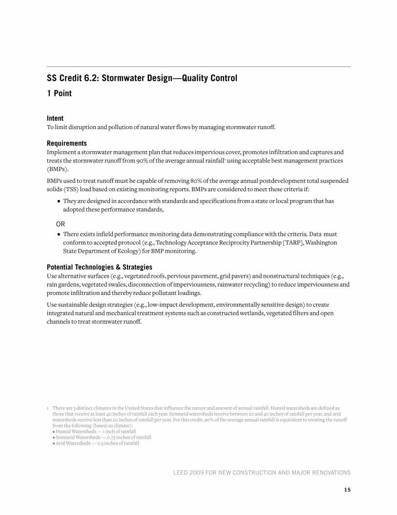
SS Credit 6.2: Stormwater Design—Quality Control
1 point
intentTo limit disruption and pollution of natural water flows by managing stormwater runoff.
requirementsImplement a stormwater management plan that reduces impervious cover, promotes infiltration and captures and treats the stormwater runoff from 90% of the average annual rainfall1 using acceptable best management practices (BMPs).
BMPs used to treat runoff must be capable of removing 80% of the average annual postdevelopment total suspended solids (TSS) load based on existing monitoring reports. BMPs are considered to meet these criteria if:
n They are designed in accordance with standards and specifications from a state or local program that has adopted these performance standards,
or n There exists infield performance monitoring data demonstrating compliance with the criteria. Data must
conform to accepted protocol (e.g., Technology Acceptance Reciprocity Partnership [TARP], Washington State Department of Ecology) for BMP monitoring.
potential technologies & StrategiesUse alternative surfaces (e.g., vegetated roofs, pervious pavement, grid pavers) and nonstructural techniques (e.g., rain gardens, vegetated swales, disconnection of imperviousness, rainwater recycling) to reduce imperviousness and promote infiltration and thereby reduce pollutant loadings.
Use sustainable design strategies (e.g., low-impact development, environmentally sensitive design) to create integrated natural and mechanical treatment systems such as constructed wetlands, vegetated filters and open channels to treat stormwater runoff.
1 There are 3 distinct climates in the United States that influence the nature and amount of annual rainfall. Humid watersheds are defined as those that receive at least 40 inches of rainfall each year. Semiarid watersheds receive between 20 and 40 inches of rainfall per year, and arid watersheds receive less than 20 inches of rainfall per year. For this credit, 90% of the average annual rainfall is equivalent to treating the runoff from the following (based on climate):
• Humid Watersheds — 1 inch of rainfall • Semiarid Watersheds — 0.75 inches of rainfall • Arid Watersheds — 0.5 inches of rainfall

LEED 2009 for NEw CoNstruCtioN aND Major rENovatioNs
16
SS Credit 7.1: heat island effect—nonroof
1 point
intentTo reduce heat islands1 to minimize impacts on microclimates and human and wildlife habitats.
requirements
oPtioN 1Use any combination of the following strategies for 50% of the site hardscape (including roads, sidewalks, courtyards and parking lots):
n Provide shade from the existing tree canopy or within 5 years of landscape installation. Landscaping (trees) must be in place at the time of occupancy.
n Provide shade from structures covered by solar panels that produce energy used to offset some nonrenewable resource use.
n Provide shade from architectural devices or structures that have a solar reflectance index2 (SRI) of at least 29.
n Use hardscape materials with an SRI of at least 29.
n Use an open-grid pavement system (at least 50% pervious).
or
oPtioN 2Place a minimum of 50% of parking spaces under cover3. Any roof used to shade or cover parking must have an SRI of at least 29, be a vegetated green roof or be covered by solar panels that produce energy used to offset some nonrenewable resource use.
potential technologies & StrategiesEmploy strategies, materials and landscaping techniques that reduce the heat absorption of exterior materials. Use shade (calculated on June 21, noon solar time) from native or adapted trees and large shrubs, vegetated trellises or other exterior structures supporting vegetation. Consider using new coatings and integral colorants for asphalt to achieve light-colored surfaces instead of blacktop. Position photovoltaic cells to shade impervious surfaces.
Consider replacing constructed surfaces (e.g., roof, roads, sidewalks, etc.) with vegetated surfaces such as vegetated roofs and open grid paving or specify high-albedo materials, such as concrete, to reduce heat absorption.
1 Heat islands are defined as thermal gradient differences between developed and undeveloped areas. 2 The solar reflectance index (SRI) is a measure of the constructed surface’s ability to reflect solar heat, as shown by a small temperature rise. It is
defined so that a standard black surface (reflectance 0.05, emittance 0.90) is 0 and a standard white surface (reflectance 0.80, emittance 0.90) is 100. To calculate the SRI for a given material, obtain the reflectance value and emittance value for the material. SRI is calculated according to ASTM E 1980. Reflectance is measured according to ASTM E 903, ASTM E 1918, or ASTM C 1549. Emittance is measured according to ASTM E 408 or ASTM C 1371.
3 For the purposes of this credit, under cover parking is defined as parking underground, under deck, under roof, or under a building.

LEED 2009 for NEw CoNstruCtioN aND Major rENovatioNs
17
SS Credit 7.2: heat island effect—roof
1 point
intentTo reduce heat islands1 to minimize impacts on microclimates and human and wildlife habitats.
requirements
oPtioN 1Use roofing materials with a solar reflectance index2 (SRI) equal to or greater than the values in the table below for a minimum of 75% of the roof surface.
Roofing materials having a lower SRI value than those listed below may be used if the weighted rooftop SRI average meets the following criteria:
area roof Meeting Minimum sri————————————————
total roof areax
sri of installed roof——————————
required sri≥ 75%
Roof Type Slope SRI
Low-sloped roof ≤ 2:12 78
steep-sloped roof > 2:12 29
or
oPtioN 2Install a vegetated roof that covers at least 50% of the roof area.
or
oPtioN 3Install high-albedo and vegetated roof surfaces that, in combination, meet the following criteria:
area roof Meeting Minimum sri————————————————
0.75+
area of vegetated roof——————————
0.5≥ total roof area
Roof Type Slope SRI
Low-sloped roof ≤ 2:12 78
steep-sloped roof > 2:12 29
1 Heat islands are defined as thermal gradient differences between developed and undeveloped areas.2 The solar reflectance index (SRI) is a measure of the constructed surface’s ability to reflect solar heat, as shown by a small temperature rise. It is
defined so that a standard black surface (reflectance 0.05, emittance 0.90) is 0 and a standard white surface (reflectance 0.80, emittance 0.90) is 100. To calculate the SRI for a given material, obtain the reflectance value and emittance value for the material. SRI is calculated according to ASTM E 1980. Reflectance is measured according to ASTM E 903, ASTM E 1918 or ASTM C 1549. Emittance is measured according to ASTM E 408 or ASTM C 1371.

LEED 2009 for NEw CoNstruCtioN aND Major rENovatioNs
18
potential technologies & StrategiesConsider installing high-albedo and vegetated roofs to reduce heat absorption. Default values will be available in the LEED Reference Guide for Green Building Design and Construction, 2009 Edition. Product information is available from the Cool Roof Rating Council Web site at http://www.coolroofs.org/ and the ENERGY STAR® Web site at http://www.energystar.gov/.

LEED 2009 for NEw CoNstruCtioN aND Major rENovatioNs
19
SS Credit 8: light pollution reduction
1 point
intentTo minimize light trespass from the building and site, reduce sky-glow to increase night sky access, improve nighttime visibility through glare reduction and reduce development impact from lighting on nocturnal environments.
requirementsProject teams must comply with 1 of the 2 options for interior lighting AND the requirement for exterior lighting.
for interior Lighting
oPtioN 1Reduce the input power (by automatic device) of all nonemergency interior luminaires with a direct line of sight to any openings in the envelope (translucent or transparent) by at least 50% between 11 p.m. and 5 a.m. After-hours override may be provided by a manual or occupant-sensing device provided the override lasts no more than 30 minutes.
or
oPtioN 2All openings in the envelope (translucent or transparent) with a direct line of sight to any nonemergency luminaires must have shielding (controlled/closed by automatic device for a resultant transmittance of less than 10% between 11 p.m. and 5 a.m.).
for Exterior LightingLight areas only as required for safety and comfort. Exterior lighting power densities shall not exceed those specified in ANSI/ASHRAE/IESNA Standard 90.1-2007 with Addenda 1 for the documented lighting zone. Justification shall be provided for the selected lighting zone. Lighting controls for all exterior lighting shall comply with section 9.4.1.3 of ANSI/ASHRAE/IESNA Standard 90.1- 2007, without amendments1.
Classify the project under 1 of the following zones, as defined in IESNA RP-33, and follow all the requirements for that zone:
LZ1: Dark (developed areas within national parks, state parks, forest land and rural areas)Design exterior lighting so that all site and building-mounted luminaires produce a maximum initial illuminance value no greater than 0.01 horizontal and vertical footcandles at the site boundary and beyond. Document that 0% of the total initial designed fixture lumens (sum total of all fixtures on site) are emitted at an angle of 90 degrees or higher from nadir (straight down).
1 The requirement to use ASHRAE Addenda I is unique to this credit and does not obligate Project teams to use ASHRAE approved addenda for other credits.

LEED 2009 for NEw CoNstruCtioN aND Major rENovatioNs
20
LZ2: Low (primarily residential zones, neighborhood business districts, light industrial areas with limited nighttime use and residential mixed-use areas) Design exterior lighting so that all site and building-mounted luminaires produce a maximum initial illuminance value no greater than 0.10 horizontal and vertical footcandles at the site boundary and no greater than 0.01 horizontal footcandles 10 feet beyond the site boundary. Document that no more than 2% of the total initial designed fixture lumens (sum total of all fixtures on site) are emitted at an angle of 90 degrees or higher from nadir (straight down).
LZ3: Medium (all other areas not included in LZ1, LZ2 or LZ4, such as commercial/ industrial, and high-density residential)Design exterior lighting so that all site and building-mounted luminaires produce a maximum initial illuminance value no greater than 0.20 horizontal and vertical footcandles at the site boundary and no greater than 0.01 horizontal footcandles 15 feet beyond the site. Document that no more than 5% of the total initial designed fixture lumens (sum total of all fixtures on site) are emitted at an angle of 90 degrees or higher from nadir (straight down).
LZ4: High2 (high-activity commercial districts in major metropolitan areas)Design exterior lighting so that all site and building-mounted luminaires produce a maximum initial illuminance value no greater than 0.60 horizontal and vertical footcandles at the site boundary and no greater than 0.01 horizontal footcandles 15 feet beyond the site. Document that no more than 10% of the total initial designed fixture lumens (sum total of all fixtures on site) are emitted at an angle of 90 degrees or higher from nadir (straight down).
LZ2, LZ3 and LZ4 - For site boundaries that abut public rights-of-way, light trespass requirements may be met relative to the curb line instead of the site boundary.
For All ZonesIlluminance generated from a single luminaire placed at the intersection of a private vehicular driveway and public roadway accessing the site is allowed to use the centerline of the public roadway as the site boundary for a length of 2 times the driveway width centered at the centerline of the driveway.
potential technologies & StrategiesAdopt site lighting criteria to maintain safe light levels while avoiding off-site lighting and night sky pollution. Minimize site lighting where possible, and use computer software to model the site lighting. Technologies to reduce light pollution include full cutoff luminaires, low-reflectance surfaces and low-angle spotlights.
2 To be LZ4, the area must be so designated by an organization with local jurisdiction, such as the local zoning authority.

LEED 2009 for NEw CoNstruCtioN aND Major rENovatioNs
21
we prerequisite 1: water Use reduction
required
intentTo increase water efficiency within buildings to reduce the burden on municipal water supply and wastewater systems.
requirementsEmploy strategies that in aggregate use 20% less water than the water use baseline calculated for the building (not including irrigation).
Calculate the baseline according to the commercial and/or residential baselines outlined below.1 Calculations are based on estimated occupant usage and must include only the following fixtures and fixture fittings (as applicable to the project scope): water closets, urinals, lavatory faucets, showers, kitchen sink faucets and prerinse spray valves.
Commercial Fixtures, Fittings, and Appliances Current Baseline
Commercial toilets1.6 gallons per flush (gpf)*Except blow-out fixtures: 3.5 (gpf)
Commercial urinals 1.0 (gpf)
Commercial lavatory (restroom) faucets
2.2 gallons per minute (gpm) at 60 pounds per square inch (psi), private applications only (hotel or motel guest rooms, hospital patient rooms)0.5 (gpm) at 60 (psi)** all others except private applications0.25 gallons per cycle for metering faucets
Commercial prerinse spray valves (for food service applications)
flow rate ≤ 1.6 (gpm) (no pressure specified; no performance requirement)
Residential Fixtures, Fittings, and Appliances Current Baseline
residential toilets 1.6 (gpf)***
residential lavatory (bathroom) faucets2.2 (gpm) at 60 psi
residential kitchen faucet
residential showerheads 2.5 (gpm) at 80 (psi) per shower stall****
* EPact 1992 standard for toilets applies to both commercial and residential models.** in addition to EPact requirements, the american society of Mechanical Engineers standard for public lavatory faucets is 0.5 gpm at 60 psi (asME a112.18.1-2005).
this maximum has been incorporated into the national uniform Plumbing Code and the international Plumbing Code.*** EPact 1992 standard for toilets applies to both commercial and residential models.**** residential shower compartment (stall) in dwelling units: the total allowable flow rate from all flowing showerheads at any given time, including rain systems, waterfalls,
bodysprays, bodyspas and jets, must be limited to the allowable showerhead flow rate as specified above (2.5 gpm) per shower compartment, where the floor area of the shower compartment is less than 2,500 square inches. for each increment of 2,500 square inches of floor area thereafter or part thereof, an additional showerhead with total allowable flow rate from all flowing devices equal to or less than the allowable flow rate as specified above must be allowed. Exception: showers that emit recirculated nonpotable water originating from within the shower compartment while operating are allowed to exceed the maximum as long as the total potable water flow does not exceed the flow rate as specified above.
1 Tables adapted from information developed and summarized by the U.S. Environmental Protection Agency (EPA) Office of Water based on requirements of the Energy Policy Act (EPAct) of 1992 and subsequent rulings by the Department of Energy, requirements of the EPAct of 2005, and the plumbing code requirements as stated in the 2006 editions of the Uniform Plumbing Code or International Plumbing Code pertaining to fixture performance.

LEED 2009 for NEw CoNstruCtioN aND Major rENovatioNs
22
The following fixtures, fittings and appliances are outside the scope of the water use reduction calculation:
n Commercial Steam Cookers
n Commercial Dishwashers
n Automatic Commercial Ice Makers
n Commercial (family sized) Clothes Washers
n Residential Clothes Washers
n Standard and Compact Residential Dishwashers
potential technologies & StrategiesWaterSense-certified fixtures and fixture fittings should be used where available. Use high-efficiency fixtures (e.g., water closets and urinals) and dry fixtures, such as toilets attached to composting systems, to reduce potable water demand. Consider using alternative on-site sources of water (e.g., rainwater, stormwater, and air conditioner condensate) and graywater for nonpotable applications such as custodial uses and toilet and urinal flushing. The quality of any alternative source of water used must be taken into consideration based on its application or use.

LEED 2009 for NEw CoNstruCtioN aND Major rENovatioNs
23
we Credit 1: water efficient landscaping
2–4 points
intentTo limit or eliminate the use of potable water or other natural surface or subsurface water resources available on or near the project site for landscape irrigation.
requirements
oPtioN 1. reduce by 50% (2 points)Reduce potable water consumption for irrigation by 50% from a calculated midsummer baseline case.
Reductions must be attributed to any combination of the following items:
n Plant species, density and microclimate factor
n Irrigation efficiency
n Use of captured rainwater
n Use of recycled wastewater
n Use of water treated and conveyed by a public agency specifically for nonpotable uses
Groundwater seepage that is pumped away from the immediate vicinity of building slabs and foundations may be used for landscape irrigation to meet the intent of this credit. However, the project team must demonstrate that doing so does not affect site stormwater management systems.
or
oPtioN 2. No Potable water use or irrigation1 (4 points)Meet the requirements for Option 1.
aND
PatH 1Use only captured rainwater, recycled wastewater, recycled graywater or water treated and conveyed by a public agency specifically for nonpotable uses for irrigation.
or
PatH 2Install landscaping that does not require permanent irrigation systems. Temporary irrigation systems used for plant establishment are allowed only if removed within a period not to exceed 18 months of installation.
1 If the percent reduction of potable water is 100% AND the percent reduction of total water is equal to or greater than 50%, both Option 1 and Option 2 are earned.

LEED 2009 for NEw CoNstruCtioN aND Major rENovatioNs
24
potential technologies & StrategiesPerform a soil/climate analysis to determine appropriate plant material and design the landscape with native or adapted plants to reduce or eliminate irrigation requirements. Where irrigation is required, use high-efficiency equipment and/or climate-based controllers.

LEED 2009 for NEw CoNstruCtioN aND Major rENovatioNs
25
we Credit 2: innovative wastewater technologies
2 points
intentTo reduce wastewater generation and potable water demand while increasing the local aquifer recharge.
requirements
oPtioN 1Reduce potable water use for building sewage conveyance by 50% through the use of water-conserving fixtures (e.g., water closets, urinals) or nonpotable water (e.g., captured rainwater, recycled graywater, on-site or municipally treated wastewater).
or
oPtioN 2Treat 50% of wastewater on-site to tertiary standards. Treated water must be infiltrated or used on-site.
potential technologies & StrategiesSpecify high-efficiency fixtures and dry fixtures (e.g., composting toilet systems, nonwater-using urinals) to reduce wastewater volumes. Consider reusing stormwater or graywater for sewage conveyance or on-site mechanical and/or natural wastewater treatment systems. Options for on-site wastewater treatment include packaged biological nutrient removal systems, constructed wetlands and high-efficiency filtration systems.
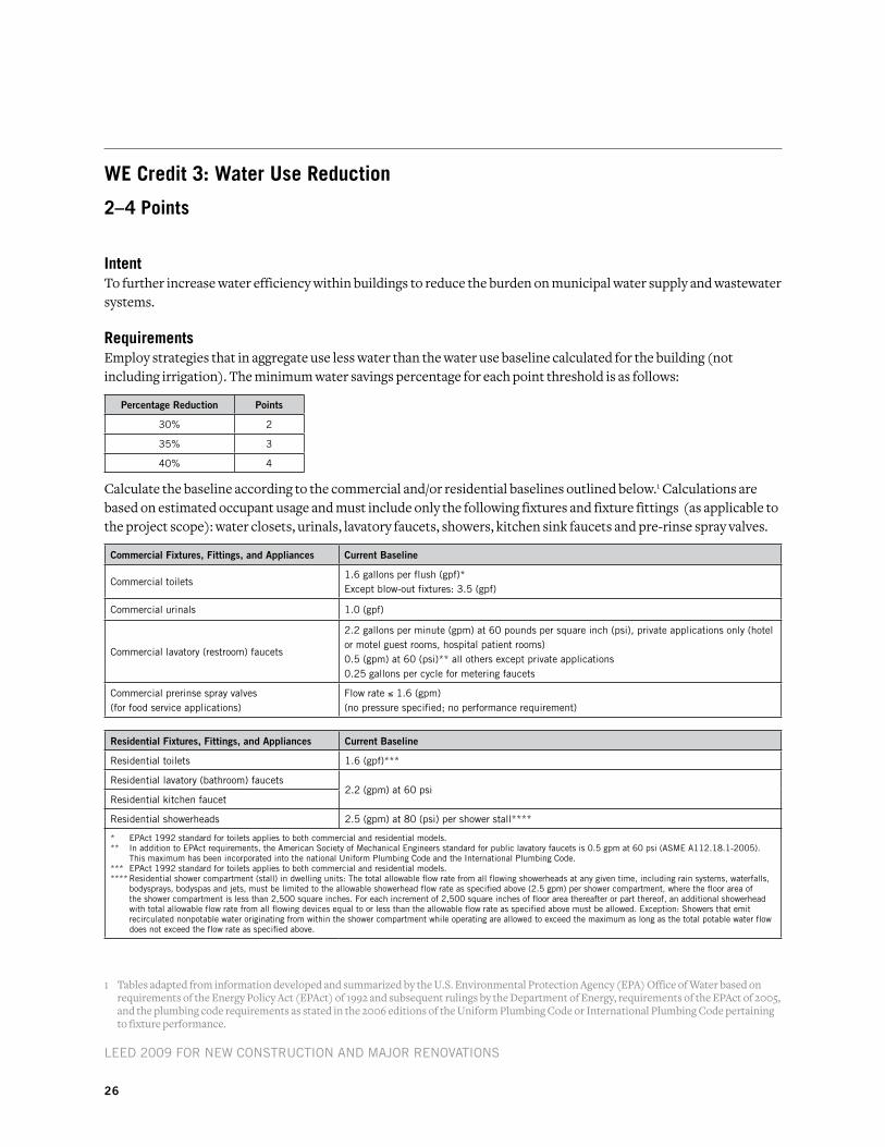
LEED 2009 for NEw CoNstruCtioN aND Major rENovatioNs
26
we Credit 3: water Use reduction
2–4 points
intentTo further increase water efficiency within buildings to reduce the burden on municipal water supply and wastewater systems.
requirementsEmploy strategies that in aggregate use less water than the water use baseline calculated for the building (not including irrigation). The minimum water savings percentage for each point threshold is as follows:
Percentage Reduction Points
30% 2
35% 3
40% 4
Calculate the baseline according to the commercial and/or residential baselines outlined below.1 Calculations are based on estimated occupant usage and must include only the following fixtures and fixture fittings (as applicable to the project scope): water closets, urinals, lavatory faucets, showers, kitchen sink faucets and pre-rinse spray valves.
Commercial Fixtures, Fittings, and Appliances Current Baseline
Commercial toilets1.6 gallons per flush (gpf)*Except blow-out fixtures: 3.5 (gpf)
Commercial urinals 1.0 (gpf)
Commercial lavatory (restroom) faucets
2.2 gallons per minute (gpm) at 60 pounds per square inch (psi), private applications only (hotel or motel guest rooms, hospital patient rooms)0.5 (gpm) at 60 (psi)** all others except private applications0.25 gallons per cycle for metering faucets
Commercial prerinse spray valves (for food service applications)
flow rate ≤ 1.6 (gpm) (no pressure specified; no performance requirement)
Residential Fixtures, Fittings, and Appliances Current Baseline
residential toilets 1.6 (gpf)***
residential lavatory (bathroom) faucets2.2 (gpm) at 60 psi
residential kitchen faucet
residential showerheads 2.5 (gpm) at 80 (psi) per shower stall****
* EPact 1992 standard for toilets applies to both commercial and residential models.** in addition to EPact requirements, the american society of Mechanical Engineers standard for public lavatory faucets is 0.5 gpm at 60 psi (asME a112.18.1-2005).
this maximum has been incorporated into the national uniform Plumbing Code and the international Plumbing Code.*** EPact 1992 standard for toilets applies to both commercial and residential models.**** residential shower compartment (stall) in dwelling units: the total allowable flow rate from all flowing showerheads at any given time, including rain systems, waterfalls,
bodysprays, bodyspas and jets, must be limited to the allowable showerhead flow rate as specified above (2.5 gpm) per shower compartment, where the floor area of the shower compartment is less than 2,500 square inches. for each increment of 2,500 square inches of floor area thereafter or part thereof, an additional showerhead with total allowable flow rate from all flowing devices equal to or less than the allowable flow rate as specified above must be allowed. Exception: showers that emit recirculated nonpotable water originating from within the shower compartment while operating are allowed to exceed the maximum as long as the total potable water flow does not exceed the flow rate as specified above.
1 Tables adapted from information developed and summarized by the U.S. Environmental Protection Agency (EPA) Office of Water based on requirements of the Energy Policy Act (EPAct) of 1992 and subsequent rulings by the Department of Energy, requirements of the EPAct of 2005, and the plumbing code requirements as stated in the 2006 editions of the Uniform Plumbing Code or International Plumbing Code pertaining to fixture performance.

LEED 2009 for NEw CoNstruCtioN aND Major rENovatioNs
27
The following fixtures, fittings and appliances are outside the scope of the water use reduction calculation:
n Commercial Steam Cookers
n Commercial Dishwashers
n Automatic Commercial Ice Makers
n Commercial (family-sized) Clothes Washers
n Residential Clothes Washers
n Standard and Compact Residential Dishwashers
potential technologies & StrategiesUse WaterSense-certified fixtures and fixture fittings where available. Use high-efficiency fixtures (e.g., water closets and urinals) and dry fixtures, such as toilets attached to composting systems, to reduce the potable water demand. Consider using alternative on-site sources of water (e.g., rainwater, stormwater, and air conditioner condensate, graywater) for nonpotable applications (e.g., toilet and urinal flushing, custodial uses). The quality of any alternative source of water being used must be taken into consideration based on its application or use.

LEED 2009 for NEw CoNstruCtioN aND Major rENovatioNs
28

LEED 2009 for NEw CoNstruCtioN aND Major rENovatioNs
29
ea prerequisite 1: fundamental Commissioning of Building energy Systems
required
intentTo verify that the project’s energy-related systems are installed, and calibrated to perform according to the owner’s project requirements, basis of design and construction documents.
Benefits of commissioning include reduced energy use, lower operating costs, fewer contractor callbacks, better building documentation, improved occupant productivity and verification that the systems perform in accordance with the owner’s project requirements.
requirementsThe following commissioning process activities must be completed by the project team:
n Designate an individual as the commissioning authority (CxA) to lead, review and oversee the completion of the commissioning process activities.
• The CxA must have documented commissioning authority experience in at least 2 building projects.
• The individual serving as the CxA must be independent of the project design and construction management, though the CxA may be an employee of any firm providing those services. The CxA may be a qualified employee or consultant of the owner.
• The CxA must report results, findings and recommendations directly to the owner.
• For projects smaller than 50,000 gross square feet, the CxA may be a qualified person on the design or construction team who has the required experience.
n The owner must document the owner’s project requirements. The design team must develop the basis of design. The CxA must review these documents for clarity and completeness. The owner and design team must be responsible for updates to their respective documents.
n Develop and incorporate commissioning requirements into the construction documents.
n Develop and implement a commissioning plan.
n Verify the installation and performance of the systems to be commissioned.
n Complete a summary commissioning report.
Commissioned systemsCommissioning process activities must be completed for the following energy-related systems, at a minimum:
n Heating, ventilating, air conditioning and refrigeration (HVAC&R) systems (mechanical and passive) and associated controls
n Lighting and daylighting controls
n Domestic hot water systems
n Renewable energy systems (e.g., wind, solar)

LEED 2009 for NEw CoNstruCtioN aND Major rENovatioNs
30
potential technologies & StrategiesEngage a CxA as early as possible in the design process. Determine the owner’s project requirements, develop and maintain a commissioning plan for use during design and construction and incorporate commissioning requirements in bid documents. Assemble the commissioning team, and prior to occupancy verify the performance of energy consuming systems. Complete the commissioning reports with recommendations prior to accepting the commissioned systems.
Owners are encouraged to seek out qualified individuals to lead the commissioning process. Qualified individuals are identified as those who possess a high level of experience in the following areas:
n Energy systems design, installation and operation
n Commissioning planning and process management
n Hands-on field experience with energy systems performance, interaction, start-up, balancing, testing, troubleshooting, operation and maintenance procedures
n Energy systems automation control knowledge
Owners are encouraged to consider including water-using systems, building envelope systems, and other systems in the scope of the commissioning plan as appropriate. The building envelope is an important component of a facility that impacts energy consumption, occupant comfort and indoor air quality. While this prerequisite does not require building envelope commissioning, an owner can achieve significant financial savings and reduce risk of poor indoor air quality by including it in the commissioning process.
The LEED Reference Guide for Green Building Design and Construction, 2009 Edition provides guidance on the rigor expected for this prerequisite for the following:
n Owner’s project requirements
n Basis of design
n Commissioning plan
n Commissioning specification
n Performance verification documentation
n Commissioning report

LEED 2009 for NEw CoNstruCtioN aND Major rENovatioNs
31
ea prerequisite 2: Minimum energy performance
required
intentTo establish the minimum level of energy efficiency for the proposed building and systems to reduce environmental and economic impacts associated with excessive energy use.
requirements
oPtioN 1. whole Building Energy simulation Demonstrate a 10% improvement in the proposed building performance rating for new buildings, or a 5% improvement in the proposed building performance rating for major renovations to existing buildings, compared with the baseline building performance rating.
Calculate the baseline building performance rating according to the building performance rating method in Appendix G of ANSI/ASHRAE/IESNA Standard 90.1-2007 (with errata but without addenda1) using a computer simulation model for the whole building project.
Appendix G of Standard 90.1-2007 requires that the energy analysis done for the building performance rating method include all energy costs associated with the building project. To achieve points using this credit, the proposed design must meet the following criteria:
n Comply with the mandatory provisions (Sections 5.4, 6.4, 7.4, 8.4, 9.4 and 10.4) in Standard 90.1-2007 (with errata but without addenda1).
n Include all energy costs associated with the building project.
n Compare against a baseline building that complies with Appendix G of Standard 90.1-2007 (with errata but without addenda1). The default process energy cost is 25% of the total energy cost for the baseline building. If the building’s process energy cost is less than 25% of the baseline building energy cost, the LEED submittal must include documentation substantiating that process energy inputs are appropriate.
For the purpose of this analysis, process energy is considered to include, but is not limited to, office and general miscellaneous equipment, computers, elevators and escalators, kitchen cooking and refrigeration, laundry washing and drying, lighting exempt from the lighting power allowance (e.g., lighting integral to medical equipment) and other (e.g., waterfall pumps).
Regulated (non-process) energy includes lighting (for the interior, parking garage, surface parking, façade, or building grounds, etc. except as noted above), heating, ventilation and air conditioning (HVAC) (for space heating, space cooling, fans, pumps, toilet exhaust, parking garage ventilation, kitchen hood exhaust, etc.), and service water heating for domestic or space heating purposes.
Process loads must be identical for both the baseline building performance rating and the proposed building performance rating. However, project teams may follow the exceptional calculation method (ANSI/ASHRAE/IESNA Standard 90.1-2007 G2.5) to document measures that reduce process loads. Documentation of process
1 Project teams wishing to use ASHRAE approved addenda for the purposes of this credit may do so at their discretion. Addenda must be applied consistently across all LEED credits.

LEED 2009 for NEw CoNstruCtioN aND Major rENovatioNs
32
load energy savings must include a list of the assumptions made for both the base and the proposed design, and theoretical or empirical information supporting these assumptions.
Projects in California may use Title 24-2005, Part 6 in place of ANSI/ASHRAE/IESNA Standard 90.1-2007 for Option 1.
or
oPtioN 2. Prescriptive Compliance Path: asHraE advanced Energy Design GuideComply with the prescriptive measures of the ASHRAE Advanced Energy Design Guide appropriate to the project scope, outlined below. Project teams must comply with all applicable criteria as established in the Advanced Energy Design Guide for the climate zone in which the building is located.
PatH 1. asHraE advanced Energy Design Guide for small office Buildings 2004 The building must meet the following requirements:
n Less than 20,000 square feet.
n Office occupancy.
PatH 2. asHraE advanced Energy Design Guide for small retail Buildings 2006The building must meet the following requirements:
n Less than 20,000 square feet.
n Retail occupancy.
PatH 3. asHraE advanced Energy Design Guide for small warehouses and self storage Buildings 2008
The building must meet the following requirements:
n Less than 50,000 square feet.
n Warehouse or self-storage occupancy.
or
oPtioN 3. Prescriptive Compliance Path: advanced Buildings™ Core Performance™ Guide Comply with the prescriptive measures identified in the Advanced Buildings™ Core Performance™ Guide developed by the New Buildings Institute. The building must meet the following requirements:
n Less than 100,000 square feet.
n Comply with Section 1: Design Process Strategies, and Section 2: Core Performance Requirements.
n Office, school, public assembly, and retail projects less than 100,000 square feet must comply with Section 1 and Section 2 of the Core Performance Guide.
n Other project types less than 100,000 square feet implement the basic requirements of the Core Performance Guide.
n Health care, warehouse and laboratory projects are ineligible for this path.

LEED 2009 for NEw CoNstruCtioN aND Major rENovatioNs
33
potential technologies & StrategiesDesign the building envelope and systems to meet baseline requirements. Use a computer simulation model to assess the energy performance and identify the most cost-effective energy efficiency measures. Quantify energy performance compared with a baseline building.
If local code has demonstrated quantitative and textual equivalence following, at a minimum, the U.S. Department of Energy (DOE) standard process for commercial energy code determination, then the results of that analysis may be used to correlate local code performance with ANSI/ASHRAE/IESNA Standard 90.1-2007. Details on the DOE process for commercial energy code determination can be found at http://www.energycodes.gov/implement/determinations_com.stm.

LEED 2009 for NEw CoNstruCtioN aND Major rENovatioNs
34
ea prerequisite 3: fundamental refrigerant Management
required
intentTo reduce stratospheric ozone depletion.
requirementsZero use of chlorofluorocarbon (CFC)-based refrigerants in new base building heating, ventilating, air conditioning and refrigeration (HVAC&R) systems. When reusing existing base building HVAC equipment, complete a comprehensive CFC phase-out conversion prior to project completion. Phase-out plans extending beyond the project completion date will be considered on their merits.
potential technologies & StrategiesWhen reusing existing HVAC systems, conduct an inventory to identify equipment that uses CFC-based refrigerants and provide a replacement schedule for these refrigerants. For new buildings, specify new HVAC equipment in the base building that uses no CFC-based refrigerants.

LEED 2009 for NEw CoNstruCtioN aND Major rENovatioNs
35
ea Credit 1: optimize energy performance
1–19 points
intentTo achieve increasing levels of energy performance beyond the prerequisite standard to reduce environmental and economic impacts associated with excessive energy use.
requirementsSelect 1 of the 3 compliance path options described below. Project teams documenting achievement using any of the 3 options are assumed to be in compliance with EA Prerequisite 2: Minimum Energy Performance.
oPtioN 1. whole Building Energy simulation (1–19 points)Demonstrate a percentage improvement in the proposed building performance rating compared with the baseline building performance rating. Calculate the baseline building performance according to Appendix G of ANSI/ASHRAE/IESNA Standard 90.1-2007 (with errata but without addenda1) using a computer simulation model for the whole building project. The minimum energy cost savings percentage for each point threshold is as follows:
New Buildings Existing Building Renovations Points
12% 8% 1
14% 10% 2
16% 12% 3
18% 14% 4
20% 16% 5
22% 18% 6
24% 20% 7
26% 22% 8
28% 24% 9
30% 26% 10
32% 28% 11
34% 30% 12
36% 32% 13
38% 34% 14
40% 36% 15
42% 38% 16
44% 40% 17
46% 42% 18
48% 44% 19
1 Project teams wishing to use ASHRAE approved addenda for the purposes of this credit may do so at their discretion. Addenda must be applied consistently across all LEED credits.

LEED 2009 for NEw CoNstruCtioN aND Major rENovatioNs
36
Appendix G of Standard 90.1-2007 requires that the energy analysis done for the building performance rating method include all the energy costs associated with the building project. To achieve points under this credit, the proposed design must meet the following criteria:
n Compliance with the mandatory provisions (Sections 5.4, 6.4, 7.4, 8.4, 9.4 and 10.4) in Standard 90.1-2007 (with errata but without addenda).
n Inclusion of all the energy costs within and associated with the building project.
n Comparison against a baseline building that complies with Appendix G of Standard 90.1-2007 (with errata but without addenda). The default process energy cost is 25% of the total energy cost for the baseline building. If the building’s process energy cost is less than 25% of the baseline building energy cost, the LEED submittal must include documentation substantiating that process energy inputs are appropriate.
For the purpose of this analysis, process energy is considered to include, but is not limited to, office and general miscellaneous equipment, computers, elevators and escalators, kitchen cooking and refrigeration, laundry washing and drying, lighting exempt from the lighting power allowance (e.g., lighting integral to medical equipment) and other (e.g., waterfall pumps).
Regulated (non-process) energy includes lighting (e.g., for the interior, parking garage, surface parking, façade, or building grounds, etc. except as noted above), heating, ventilating, and air conditioning (HVAC) (e.g., for space heating, space cooling, fans, pumps, toilet exhaust, parking garage ventilation, kitchen hood exhaust, etc.), and service water heating for domestic or space heating purposes.
For this credit, process loads must be identical for both the baseline building performance rating and the proposed building performance rating. However, project teams may follow the exceptional calculation method (ANSI/ASHRAE/IESNA Standard 90.1-2007 G2.5) to document measures that reduce process loads. Documentation of process load energy savings must include a list of the assumptions made for both the base and proposed design, and theoretical or empirical information supporting these assumptions.
Projects in California may use Title 24-2005, Part 6 in place of ANSI/ASHRAE/IESNA Standard 90.1-2007 for Option 1.
or
oPtioN 2. Prescriptive Compliance Path: asHraE advanced Energy Design Guide (1 point)Comply with the prescriptive measures of the ASHRAE Advanced Energy Design Guide appropriate to the project scope, outlined below. Project teams must comply with all applicable criteria as established in the Advanced Energy Design Guide for the climate zone in which the building is located.
PatH 1. asHraE advanced Energy Design Guide for small office Buildings 2004The building must meet the following requirements:
n Less than 20,000 square feet.
n Office occupancy.
PatH 2. asHraE advanced Energy Design Guide for small retail Buildings 2006 The building must meet the following requirements:
n Less than 20,000 square feet.
n Retail occupancy.

LEED 2009 for NEw CoNstruCtioN aND Major rENovatioNs
37
PatH 3. asHraE advanced Energy Design Guide for small warehouses and self storage Buildings 2008
The building must meet the following requirements:
n Less than 50,000 square feet.
n Warehouse or self-storage occupancy.
or
oPtioN 3. Prescriptive Compliance Path: advanced Buildings™ Core Performance™ Guide (1–3 points)
Comply with the prescriptive measures identified in the Advanced Buildings™ Core Performance™ Guide developed by the New Buildings Institute. The building must meet the following requirements:
n Less than 100,000 square feet.
n Comply with Section 1: Design Process Strategies, and Section 2: Core Performance Requirements.
n Health care, warehouse or laboratory projects are ineligible for this path.
Points achieved under Option 3 (1 point):
n 1 point is available for all projects (office, school, public assembly, and retail projects) less than 100,000 square feet that comply with Sections 1 and 2 of the Core Performance Guide.
n Up to 2 additional points are available to projects that implement performance strategies listed in Section 3, Enhanced Performance. For every 3 strategies implemented from this section, 1 point is available.
n The following strategies are addressed by other aspects of LEED and are not eligible for additional points under EA Credit 1:
• 3.1 — Cool Roofs
• 3.8 — Night Venting
• 3.13 — Additional Commissioning
potential technologies & StrategiesDesign the building envelope and systems to maximize energy performance. Use a computer simulation model to assess the energy performance and identify the most cost-effective energy efficiency measures. Quantify energy performance compared with a baseline building.
If local code has demonstrated quantitative and textual equivalence following, at a minimum, the U.S. Department of Energy (DOE) standard process for commercial energy code determination, the results of that analysis may be used to correlate local code performance with ANSI/ASHRAE/IESNA Standard 90.1-2007. Details on the DOE process for commercial energy code determination can be found at http://www.energycodes.gov/implement/determinations_com.stm.

LEED 2009 for NEw CoNstruCtioN aND Major rENovatioNs
38
ea Credit 2: on-site renewable energy
1–7 points
intentTo encourage and recognize increasing levels of on-site renewable energy self-supply to reduce environmental and economic impacts associated with fossil fuel energy use.
requirementsUse on-site renewable energy systems to offset building energy costs. Calculate project performance by expressing the energy produced by the renewable systems as a percentage of the building’s annual energy cost and use the table below to determine the number of points achieved.
Use the building annual energy cost calculated in EA Credit 1: Optimize Energy Performance or the U.S. Department of Energy’s Commercial Buildings Energy Consumption Survey database to determine the estimated electricity use.
The minimum renewable energy percentage for each point threshold is as follows:
Percentage Renewable Energy Points
1% 1
3% 2
5% 3
7% 4
9% 5
11% 6
13% 7
potential technologies & StrategiesAssess the project for nonpolluting and renewable energy potential including solar, wind, geothermal, low-impact hydro, biomass and bio-gas strategies. When applying these strategies, take advantage of net metering with the local utility.

LEED 2009 for NEw CoNstruCtioN aND Major rENovatioNs
39
ea Credit 3: enhanced Commissioning
2 points
intentTo begin the commissioning process early in the design process and execute additional activities after systems performance verification is completed.
requirementsImplement, or have a contract in place to implement, the following additional commissioning process activities in addition to the requirements of EA Prerequisite 1: Fundamental Commissioning of Building Energy Systems and in accordance with the LEED Reference Guide for Green Building Design and Construction, 2009 Edition:
n Prior to the start of the construction documents phase, designate an independent commissioning authority (CxA) to lead, review and oversee the completion of all commissioning process activities.
• The CxA must have documented commissioning authority experience in at least 2 building projects.
• The individual serving as the CxA:
– Must be independent of the work of design and construction.
– Must not be an employee of the design firm, though he or she may be contracted through them.
– Must not be an employee of, or contracted through, a contractor or construction manager holding construction contracts.
– May be a qualified employee or consultant of the owner.
• The CxA must report results, findings and recommendations directly to the owner.
n The CxA must conduct, at a minimum, 1 commissioning design review of the owner’s project requirements basis of design, and design documents prior to the mid-construction documents phase and back-check the review comments in the subsequent design submission.
n The CxA must review contractor submittals applicable to systems being commissioned for compliance with the owner’s project requirements and basis of design. This review must be concurrent with the review of the architect or engineer of record and submitted to the design team and the owner.
n The CxA or other project team members must develop a systems manual that gives future operating staff the information needed to understand and optimally operate the commissioned systems.
n The CxA or other project team members must verify that the requirements for training operating personnel and building occupants have been completed.
n The CxA must be involved in reviewing the operation of the building with operations and maintenance (O&M) staff and occupants within 10 months after substantial completion. A plan for resolving outstanding commissioning-related issues must be included.

LEED 2009 for NEw CoNstruCtioN aND Major rENovatioNs
40
potential technologies & StrategiesAlthough it is preferable that the CxA be contracted by the owner, for the enhanced commissioning credit the CxA may also be contracted through the design firms or construction management firms not holding construction contracts.
The LEED Reference Guide for Green Building Design and Construction, 2009 Edition provides detailed guidance on the rigor expected for the following process activities:
n Commissioning design review
n Commissioning submittal review
n Systems manual.

LEED 2009 for NEw CoNstruCtioN aND Major rENovatioNs
41
ea Credit 4: enhanced refrigerant Management
2 points
intentTo reduce ozone depletion and support early compliance with the Montreal Protocol while minimizing direct contributions to climate change.
requirements
oPtioN 1Do not use refrigerants.
or
oPtioN 2Select refrigerants and heating, ventilation, air conditioning and refrigeration (HVAC&R) equipment that minimize or eliminate the emission of compounds that contribute to ozone depletion and climate change. The base building HVAC&R equipment must comply with the following formula, which sets a maximum threshold for the combined contributions to ozone depletion and global warming potential:
LCGwP + LCoDP x 105 ≤ 100
Calculation definitions for LCGWP + LCODP x 105 ≤ 100
LCoDP = [oDPr x (Lr x Life +Mr) x rc]/Life
LCGwP = [GwPr x (Lr x Life +Mr) x rc]/Life
LCoDP: Lifecycle ozone Depletion Potential (lb CfC 11/ton-Year)
LCGwP: Lifecycle Direct Global warming Potential (lb Co2/ton-Year)
GwPr: Global warming Potential of refrigerant (0 to 12,000 lb Co2/lbr)
oDPr: ozone Depletion Potential of refrigerant (0 to 0.2 lb CfC 11/lbr)
Lr: refrigerant Leakage rate (0.5% to 2.0%; default of 2% unless otherwise demonstrated)
Mr: End-of-life refrigerant Loss (2% to 10%; default of 10% unless otherwise demonstrated)
rc: refrigerant Charge (0.5 to 5.0 lbs of refrigerant per ton of gross ari rated cooling capacity)
Life: Equipment Life (10 years; default based on equipment type, unless otherwise demonstrated)
For multiple types of equipment, a weighted average of all base building HVAC&R equipment must be calculated using the following formula:
∑ ( LCGwP + LCoDP x 105 ) x Qunit
——————————————————————————————Qtotal ≤ 100

LEED 2009 for NEw CoNstruCtioN aND Major rENovatioNs
42
Calculation definitions for [ ∑ (LCGWP + LCODP x 105) x Qunit ] / Qtotal ≤ 100
Qunit = Gross ari rated cooling capacity of an individual HvaC or refrigeration unit (tons)
Qtotal = total gross ari rated cooling capacity of all HvaC or refrigeration
Small HVAC units (defined as containing less than 0.5 pounds of refrigerant) and other equipment, such as standard refrigerators, small water coolers and any other cooling equipment that contains less than 0.5 pounds of refrigerant, are not considered part of the base building system and are not subject to the requirements of this credit.
Do not operate or install fire suppression systems that contain ozone-depleting substances such as CFCs, hydrochlorofluorocarbons (HCFCs) or halons.
potential technologies & StrategiesDesign and operate the facility without mechanical cooling and refrigeration equipment. Where mechanical cooling is used, utilize base building HVAC&R systems for the refrigeration cycle that minimize direct impact on ozone depletion and global climate change. Select HVAC&R equipment with reduced refrigerant charge and increased equipment life. Maintain equipment to prevent leakage of refrigerant to the atmosphere. Use fire suppression systems that do not contain HCFCs or halons.

LEED 2009 for NEw CoNstruCtioN aND Major rENovatioNs
43
ea Credit 5: Measurement and Verification
3 points
intentTo provide for the ongoing accountability of building energy consumption over time.
requirements
oPtioN 1Develop and implement a measurement and verification (M&V) plan consistent with Option D: Calibrated Simulation (Savings Estimation Method 2) as specified in the International Performance Measurement & Verification Protocol (IPMVP) Volume III: Concepts and Options for Determining Energy Savings in New Construction, April 2003.
The M&V period must cover at least 1 year of post-construction occupancy.
Provide a process for corrective action if the results of the M&V plan indicate that energy savings are not being achieved.
or
oPtioN 2Develop and implement a measurement and verification (M&V) plan consistent with Option B: Energy Conservation Measure Isolation, as specified in the International Performance Measurement & Verification Protocol (IPMVP) Volume III: Concepts and Options for Determining Energy Savings in New Construction, April 2003.
The M&V period must cover at least 1 year of post-construction occupancy.
Provide a process for corrective action if the results of the M&V plan indicate that energy savings are not being achieved.
potential technologies & StrategiesDevelop an M&V plan to evaluate building and/or energy system performance. Characterize the building and/or energy systems through energy simulation or engineering analysis. Install the necessary metering equipment to measure energy use. Track performance by comparing predicted performance to actual performance, broken down by component or system as appropriate. Evaluate energy efficiency by comparing actual performance to baseline performance.
While the IPMVP describes specific actions for verifying savings associated with energy conservation measures (ECMs) and strategies, this LEED credit expands upon typical IPMVP M&V objectives. Measurement & verification activities should not necessarily be confined to energy systems where ECMs or energy conservation strategies have been implemented. The IPMVP provides guidance on M&V strategies and their appropriate applications for various situations. These strategies should be used in conjunction with monitoring and trend logging of significant energy systems to provide for the ongoing accountability of building energy performance.

LEED 2009 for NEw CoNstruCtioN aND Major rENovatioNs
44
For the corrective action process, consider installing diagnostics within the control system to alert the staff when equipment is not being optimally operated. Conditions that might warrant alarms to alert staff could include:
n Leaking valves in the cooling and heating coils within air handling units;
n Missed economizer opportunities (e.g., faulty economizer damper controls) ;
n Software and manual overrides allowing equipment to operate 24 hours a day/7 days a week;
n Equipment operation during unusual circumstances (e.g., boiler on when outside air temperature is above 65 °F).
Besides control diagnostics, consider employing retro-commissioning services or dedicating staff to investigate increases in energy usage (such a staff member is usually a resource conservation manager — see http://www.energy.state.or.us/rcm/rcmhm.htm for additional information).

LEED 2009 for NEw CoNstruCtioN aND Major rENovatioNs
45
ea Credit 6: Green power
2 points
intentTo encourage the development and use of grid-source, renewable energy technologies on a net zero pollution basis.
requirementsEngage in at least a 2-year renewable energy contract to provide at least 35% of the building’s electricity from renewable sources, as defined by the Center for Resource Solutions’ Green-e Energy product certification requirements.
All purchases of green power shall be based on the quantity of energy consumed, not the cost.
oPtioN 1. Determine Baseline Electricity useUse the annual electricity consumption from the results of EA Credit 1: Optimize Energy Performance.
or
oPtioN 2. Estimate Baseline Electricity useUse the U.S. Department of Energy’s Commercial Buildings Energy Consumption Survey database to determine the estimated electricity use.
potential technologies & StrategiesDetermine the energy needs of the building and investigate opportunities to engage in a green power contract. Green power is derived from solar, wind, geothermal, biomass or low-impact hydro sources. Visit http://www.green-e.org/energy for details about the Green-e Energy program. The green power product purchased to comply with credit requirements need not be Green-e Energy certified. Other sources of green power are eligible if they satisfy the Green-e Energy program’s technical requirements. Renewable energy certificates (RECs), tradable renewable certificates (TRCs), green tags and other forms of green power that comply with the technical requirements of the Green-e Energy program may be used to document compliance with this credit.

LEED 2009 for NEw CoNstruCtioN aND Major rENovatioNs
46

LEED 2009 for NEw CoNstruCtioN aND Major rENovatioNs
47
Mr prerequisite 1: Storage and Collection of recyclables
required
intentTo facilitate the reduction of waste generated by building occupants that is hauled to and disposed of in landfills.
requirementsProvide an easily-accessible dedicated area or areas for the collection and storage of materials for recycling for the entire building. Materials must include, at a minimum: paper, corrugated cardboard, glass, plastics and metals.
potential technologies & StrategiesDesignate an area for recyclable collection and storage that is appropriately sized and located in a convenient area. Identify local waste handlers and buyers for glass, plastic, metals, office paper, newspaper, cardboard and organic wastes. Instruct occupants on recycling procedures. Consider employing cardboard balers, aluminum can crushers, recycling chutes and other waste management strategies to further enhance the recycling program.

LEED 2009 for NEw CoNstruCtioN aND Major rENovatioNs
48
Mr Credit 1.1: Building reuse—Maintain existing walls, floors and roof
1–3 points
intentTo extend the lifecycle of existing building stock, conserve resources, retain cultural resources, reduce waste and reduce environmental impacts of new buildings as they relate to materials manufacturing and transport.
requirementsMaintain the existing building structure (including structural floor and roof decking) and envelope (the exterior skin and framing, excluding window assemblies and non-structural roofing material). The minimum percentage building reuse for each point threshold is as follows:
Building Reuse Points
55% 1
75% 2
95% 3
Hazardous materials that are remediated as a part of the project must be excluded from the calculation of the percentage maintained. If the project includes an addition that is more than 2 times the square footage of the existing building, this credit is not applicable.
potential technologies & StrategiesConsider reusing existing, previously-occupied building structures, envelopes and elements. Remove elements that pose a contamination risk to building occupants and upgrade components that would improve energy and water efficiency such as windows, mechanical systems and plumbing fixtures.

LEED 2009 for NEw CoNstruCtioN aND Major rENovatioNs
49
Mr Credit 1.2: Building reuse—Maintain interior nonstructural elements
1 point
intentTo extend the lifecycle of existing building stock, conserve resources, retain cultural resources, reduce waste and reduce environmental impacts of new buildings as they relate to materials manufacturing and transport.
requirementsUse existing interior nonstructural elements (e.g., interior walls, doors, floor coverings and ceiling systems) in at least 50% (by area) of the completed building, including additions. If the project includes an addition with square footage more than 2 times the square footage of the existing building, this credit is not applicable.
potential technologies & StrategiesConsider reusing existing building structures, envelopes and interior nonstructural elements. Remove elements that pose a contamination risk to building occupants, and upgrade components that would improve energy and water efficiency such as mechanical systems and plumbing fixtures. Quantify the extent of building reuse.

LEED 2009 for NEw CoNstruCtioN aND Major rENovatioNs
50
Mr Credit 2: Construction waste Management
1–2 points
intentTo divert construction and demolition debris from disposal in landfills and incineration facilities. Redirect recyclable recovered resources back to the manufacturing process and reusable materials to appropriate sites.
requirementsRecycle and/or salvage nonhazardous construction and demolition debris. Develop and implement a construction waste management plan that, at a minimum, identifies the materials to be diverted from disposal and whether the materials will be sorted on-site or comingled. Excavated soil and land-clearing debris do not contribute to this credit. Calculations can be done by weight or volume, but must be consistent throughout. The minimum percentage debris to be recycled or salvaged for each point threshold is as follows:
Recycled or Salvaged Points
50% 1
75% 2
potential technologies & StrategiesEstablish goals for diversion from disposal in landfills and incineration facilities and adopt a construction waste management plan to achieve these goals. Consider recycling cardboard, metal, brick, mineral fiber panel, concrete, plastic, clean wood, glass, gypsum wallboard, carpet and insulation. Construction debris processed into a recycled content commodity that has an open market value (e.g., wood derived fuel [WDF], alternative daily cover material, etc.) may be applied to the construction waste calculation. Designate a specific area(s) on the construction site for segregated or comingled collection of recyclable materials, and track recycling efforts throughout the construction process. Identify construction haulers and recyclers to handle the designated materials. Note that diversion may include donation of materials to charitable organizations and salvage of materials on-site.

LEED 2009 for NEw CoNstruCtioN aND Major rENovatioNs
51
Mr Credit 3: Materials reuse
1–2 points
intentTo reuse building materials and products to reduce demand for virgin materials and reduce waste, thereby lessening impacts associated with the extraction and processing of virgin resources.
requirementsUse salvaged, refurbished or reused materials, the sum of which constitutes at least 5% or 10%, based on cost, of the total value of materials on the project. The minimum percentage materials reused for each point threshold is as follows:
Reused Materials Points
5% 1
10% 2
Mechanical, electrical and plumbing components and specialty items such as elevators and equipment cannot be included in this calculation. Include only materials permanently installed in the project. Furniture may be included if it is included consistently in MR Credit 3: Materials Reuse through MR Credit 7: Certified Wood.
potential technologies & StrategiesIdentify opportunities to incorporate salvaged materials into the building design, and research potential material suppliers. Consider salvaged materials such as beams and posts, flooring, paneling, doors and frames, cabinetry and furniture, brick, and decorative items.

LEED 2009 for NEw CoNstruCtioN aND Major rENovatioNs
52
Mr Credit 4: recycled Content
1–2 points
intentTo increase demand for building products that incorporate recycled content materials, thereby reducing impacts resulting from extraction and processing of virgin materials.
requirementsUse materials with recycled content1 such that the sum of postconsumer2 recycled content plus 1/2 of the preconsumer3 content constitutes at least 10% or 20%, based on cost, of the total value of the materials in the project. The minimum percentage materials recycled for each point threshold is as follows:
Recycled Content Points
10% 1
20% 2
The recycled content value of a material assembly is determined by weight. The recycled fraction of the assembly is then multiplied by the cost of assembly to determine the recycled content value.
Mechanical, electrical and plumbing components and specialty items such as elevators cannot be included in this calculation. Include only materials permanently installed in the project. Furniture may be included if it is included consistently in MR Credit 3: Materials Reuse through MR Credit 7: Certified Wood.
potential technologies & Strategies Establish a project goal for recycled content materials, and identify material suppliers that can achieve this goal. During construction, ensure that the specified recycled content materials are installed. Consider a range of environmental, economic and performance attributes when selecting products and materials.
1 Recycled content is defined in accordance with the International Organization of Standards document, ISO 14021 — Environmental labels and declarations — Self-declared environmental claims (Type II environmental labeling).
2 Postconsumer material is defined as waste material generated by households or by commercial, industrial and institutional facilities in their role as end-users of the product, which can no longer be used for its intended purpose.
3 Preconsumer material is defined as material diverted from the waste stream during the manufacturing process. Reutilization of materials (i.e., rework, regrind or scrap generated in a process and capable of being reclaimed within the same process that generated it) is excluded.

LEED 2009 for NEw CoNstruCtioN aND Major rENovatioNs
53
Mr Credit 5: regional Materials
1–2 points
intentTo increase demand for building materials and products that are extracted and manufactured within the region, thereby supporting the use of indigenous resources and reducing the environmental impacts resulting from transportation.
requirementsUse building materials or products that have been extracted, harvested or recovered, as well as manufactured, within 500 miles of the project site for a minimum of 10% or 20%, based on cost, of the total materials value. If only a fraction of a product or material is extracted, harvested, or recovered and manufactured locally, then only that percentage (by weight) can contribute to the regional value. The minimum percentage regional materials for each point threshold is as follows:
Regional Materials Points
10% 1
20% 2
Mechanical, electrical and plumbing components and specialty items such as elevators and equipment must not be included in this calculation. Include only materials permanently installed in the project. Furniture may be included if it is included consistently in MR Credit 3: Materials Reuse through MR Credit 7: Certified Wood.
potential technologies & StrategiesEstablish a project goal for locally sourced materials, and identify materials and material suppliers that can achieve this goal. During construction, ensure that the specified local materials are installed, and quantify the total percentage of local materials installed. Consider a range of environmental, economic and performance attributes when selecting products and materials.

LEED 2009 for NEw CoNstruCtioN aND Major rENovatioNs
54
Mr Credit 6: rapidly renewable Materials
1 point
intentTo reduce the use and depletion of finite raw materials and long-cycle renewable materials by replacing them with rapidly renewable materials.
requirementsUse rapidly renewable building materials and products for 2.5% of the total value of all building materials and products used in the project, based on cost. Rapidly renewable building materials and products are made from plants that are typically harvested within a 10-year or shorter cycle.
potential technologies & StrategiesEstablish a project goal for rapidly renewable materials, and identify products and suppliers that can support achievement of this goal. Consider materials such as bamboo, wool, cotton insulation, agrifiber, linoleum, wheatboard, strawboard and cork. During construction, ensure that the specified renewable materials are installed.

LEED 2009 for NEw CoNstruCtioN aND Major rENovatioNs
55
Mr Credit 7: Certified wood
1 point
intentTo encourage environmentally responsible forest management.
requirementsUse a minimum of 50% (based on cost) of wood-based materials and products that are certified in accordance with the Forest Stewardship Council’s principles and criteria, for wood building components. These components include at a minimum, structural framing and general dimensional framing, flooring, sub-flooring, wood doors and finishes.
Include only materials permanently installed in the project. Wood products purchased for temporary use on the project (e.g., formwork, bracing, scaffolding, sidewalk protection, and guard rails) may be included in the calculation at the project team’s discretion. If any such materials are included, all such materials must be included in the calculation. If such materials are purchased for use on multiple projects, the applicant may include these materials for only one project, at its discretion. Furniture may be included if it is included consistently in MR Credits 3, Materials Reuse, through MR Credit 7, Certified Wood.
potential technologies & StrategiesEstablish a project goal for FSC-certified wood products and identify suppliers that can achieve this goal. During construction, ensure that the FSC-certified wood products are installed and quantify the total percentage of FSC-certified wood products installed.

LEED 2009 for NEw CoNstruCtioN aND Major rENovatioNs
56

LEED 2009 for NEw CoNstruCtioN aND Major rENovatioNs
57
ieQ prerequisite 1: Minimum indoor air Quality performance
required
intentTo establish minimum indoor air quality (IAQ) performance to enhance indoor air quality in buildings, thus contributing to the comfort and well-being of the occupants.
requirements
Meet the minimum requirements of Sections 4 through 7 of ASHRAE Standard 62.1-2007, Ventilation for Acceptable Indoor Air Quality (with errata but without addenda1).
aND
CasE 1. Mechanically ventilated spaces Mechanical ventilation systems must be designed using the ventilation rate procedure or the applicable local code, whichever is more stringent.
CasE 2. Naturally ventilated spacesNaturally ventilated buildings must comply with ASHRAE Standard 62.1-2007, Paragraph 5.1 (with errata but without addenda1).
potential technologies & StrategiesDesign ventilation systems to meet or exceed the minimum outdoor air ventilation rates as described in the ASHRAE standard. Balance the impacts of ventilation rates on energy use and indoor air quality to optimize for energy efficiency and occupant comfort. Use the ASHRAE Standard 62.1-2007 Users Manual (with errata but without addenda1) for detailed guidance on meeting the referenced requirements.
1 Project teams wishing to use ASHRAE approved addenda for the purposes of this prerequisite may do so at their discretion. Addenda must be applied consistently across all LEED credits.

LEED 2009 for NEw CoNstruCtioN aND Major rENovatioNs
58
ieQ prerequisite 2: environmental tobacco Smoke (etS) Control
required
intentTo prevent or minimize exposure of building occupants, indoor surfaces and ventilation air distribution systems to environmental tobacco smoke (ETS).
requirements
oPtioN 1 Prohibit smoking in the building.
Prohibit on-property smoking within 25 feet of entries, outdoor air intakes and operable windows. Provide signage to allow smoking in designated areas, prohibit smoking in designated areas or prohibit smoking on the entire property.
or
oPtioN 2
CasE 1. Non-residential ProjectsProhibit smoking in the building except in designated smoking areas.
Prohibit on-property smoking within 25 feet of entries, outdoor air intakes and operable windows. Provide signage to allow smoking in designated areas, prohibit smoking in designated areas or prohibit smoking on the entire property.
Provide designated smoking rooms designed to contain, capture and remove ETS from the building. At a minimum, the smoking room must be directly exhausted to the outdoors, away from air intakes and building entry paths, with no recirculation of ETS-containing air to nonsmoking areas and enclosed with impermeable deck-to-deck partitions. Operate exhaust sufficient to create a negative pressure differential with the surrounding spaces of at least an average of 5 Pascals (Pa) (0.02 inches of water gauge) and a minimum of 1 Pa (0.004 inches of water gauge) when the doors to the smoking rooms are closed.
Verify performance of the smoking rooms’ differential air pressures by conducting 15 minutes of measurement, with a minimum of 1 measurement every 10 seconds, of the differential pressure in the smoking room with respect to each adjacent area and in each adjacent vertical chase with the doors to the smoking room closed. Conduct the testing with each space configured for worst-case conditions of transport of air from the smoking rooms (with closed doors) to adjacent spaces.
LEED 2009 for NEw CoNstruCtioN aND Major rENovatioNs
59
CasE 2. residential and Hospitality ProjectsProhibit smoking in all common areas of the building.
Locate any exterior designated smoking areas, including balconies where smoking is permitted, at least 25 feet from entries, outdoor air intakes and operable windows opening to common areas.
Prohibit on-property smoking within 25 feet of entries, outdoor air intakes and operable windows. Provide signage to allow smoking in designated areas, prohibit smoking in designated areas or prohibit smoking on the entire property.
Weather-strip all exterior doors and operable windows in the residential units to minimize leakage from outdoors.
Minimize uncontrolled pathways for ETS transfer between individual residential units by sealing penetrations in walls, ceilings and floors in the residential units and by sealing vertical chases adjacent to the units.
Weather-strip all doors in the residential units leading to common hallways to minimize air leakage into the hallway1.
Demonstrate acceptable sealing of residential units by a blower door test conducted in accordance with ANSI/ASTM-E779-03, Standard Test Method for Determining Air Leakage Rate By Fan Pressurization.
Use the progressive sampling methodology defined in Chapter 4 (Compliance Through Quality Construction) of the Residential Manual for Compliance with California’s 2001 Energy Efficiency Standards. Residential units must demonstrate less than 1.25 square inches leakage area per 100 square feet of enclosure area (i.e., sum of all wall, ceiling and floor areas).
potential technologies & StrategiesProhibit smoking in commercial buildings or effectively control the ventilation air in smoking rooms. For residential buildings, prohibit smoking in common areas and design building envelope and systems to minimize ETS transfer among dwelling units.
1 If the common hallways are pressurized with respect to the residential units then doors in the residential units leading to the common hallways need not be weather-stripped provided that the positive differential pressure is demonstrated as in Option 2, Case 1 above, considering the residential unit as the smoking room.

LEED 2009 for NEw CoNstruCtioN aND Major rENovatioNs
60
ieQ Credit 1: outdoor air Delivery Monitoring
1 point
intentTo provide capacity for ventilation system monitoring to help promote occupant comfort and well-being.
requirementsInstall permanent monitoring systems to ensure that ventilation systems maintain design minimum requirements. Configure all monitoring equipment to generate an alarm when airflow values or carbon dioxide (CO2) levels vary by 10% or more from the design values via either a building automation system alarm to the building operator or a visual or audible alert to the building occupants
aND
CasE 1. Mechanically ventilated spacesMonitor CO2 concentrations within all densely occupied spaces (those with a design occupant density of 25 people or more per 1,000 square feet). CO2 monitors must be between 3 and 6 feet above the floor.1
Provide a direct outdoor airflow measurement device capable of measuring the minimum outdoor air intake flow with an accuracy of plus or minus 15% of the design minimum outdoor air rate, as defined by ASHRAE 62.1-2007 (with errata but without addenda2) for mechanical ventilation systems where 20% or more of the design supply airflow serves nondensely occupied spaces.
CasE 2. Naturally ventilated spacesMonitor CO2 concentrations within all naturally ventilated spaces. CO2 monitors must be between 3 and 6 feet above the floor. One CO2 sensor may be used to monitor multiple nondensely occupied spaces if the natural ventilation design uses passive stack(s) or other means to induce airflow through those spaces equally and simultaneously without intervention by building occupants.
potential technologies & StrategiesInstall CO2 and airflow measurement equipment and feed the information to the heating, ventilating and air conditioning (HVAC) system and/or building automation system (BAS) to trigger corrective action, if applicable. If such automatic controls are not feasible with the building systems, use the measurement equipment to trigger alarms that inform building operators or occupants of a possible deficiency in outdoor air delivery.
1 CO2 monitoring is required in densely occupied spaces, in addition to outdoor air intake flow measurement.2 Project teams wishing to use ASHRAE approved addenda for the purposes of this credit may do so at their discretion. Addenda must be applied
consistently across all LEED credits.

LEED 2009 for NEw CoNstruCtioN aND Major rENovatioNs
61
ieQ Credit 2: increased Ventilation
1 point
intentTo provide additional outdoor air ventilation to improve indoor air quality (IAQ) and promote occupant comfort, well-being and productivity.
requirements
CasE 1. Mechanically ventilated spacesIncrease breathing zone outdoor air ventilation rates to all occupied spaces by at least 30% above the minimum rates required by ASHRAE Standard 62.1-2007 (with errata but without addenda1) as determined by IEQ Prerequisite 1: Minimum Indoor Air Quality Performance.
CasE 2. Naturally ventilated spacesDetermine that natural ventilation is an effective strategy for the project by following the flow diagram process shown in Figure 2.8 of the CIBSE Applications Manual 10: 2005, Natural Ventilation in Non-domestic Buildings.
aND
oPtioN 1Show that the natural ventilation systems design meets the recommendations set forth in the CIBSE manuals appropriate to the project space.
PATH 1. CIBSE Applications Manual 10: 2005, Natural Ventilation in Non-domestic Buildings
PATH 2. CIBSE AM 13:2000, Mixed Mode Ventilation
or
oPtioN 2Use a macroscopic, multizone, analytic model to predict that room-by-room airflows will effectively naturally ventilate, defined as providing the minimum ventilation rates required by ASHRAE 62.1-2007 Chapter 6 (with errata but without addenda1), for at least 90% of occupied spaces.
potential technologies & StrategiesFor mechanically ventilated spaces: Use heat recovery, where appropriate, to minimize the additional energy consumption associated with higher ventilation rates.
For naturally ventilated spaces, follow the 8 design steps described in the Carbon Trust Good Practice Guide 237:
n Develop design requirements.
n Plan airflow paths.
1 Project teams wishing to use ASHRAE approved addenda for the purposes of this credit may do so at their discretion. Addenda must be applied consistently across all LEED credits.

LEED 2009 for NEw CoNstruCtioN aND Major rENovatioNs
62
n Identify building uses and features that might require special attention.
n Determine ventilation requirements.
n Estimate external driving pressures.
n Select types of ventilation devices.
n Size ventilation devices.
n Analyze the design.
Use public domain software such as NIST’s CONTAM, Multizone Modeling Software, along with LoopDA, Natural Ventilation Sizing Tool, to analytically predict room-by-room airflows.

LEED 2009 for NEw CoNstruCtioN aND Major rENovatioNs
63
ieQ Credit 3.1: Construction indoor air Quality Management plan—During Construction
1 point
intentTo reduce indoor air quality (IAQ) problems resulting from construction or renovation and promote the comfort and well-being of construction workers and building occupants.
requirementsDevelop and implement an IAQ management plan for the construction and preoccupancy phases of the building as follows:
n During construction, meet or exceed the recommended control measures of the Sheet Metal and Air Conditioning National Contractors Association (SMACNA) IAQ Guidelines For Occupied Buildings Under Construction, 2nd Edition 2007, ANSI/SMACNA 008-2008 (Chapter 3).
n Protect stored on-site and installed absorptive materials from moisture damage.
n If permanently installed air handlers are used during construction, filtration media with a minimum efficiency reporting value (MERV) of 8 must be used at each return air grille, as determined by ASHRAE Standard 52.2-1999 (with errata but without addenda1). Replace all filtration media immediately prior to occupancy.
potential technologies & StrategiesAdopt an IAQ management plan to protect the heating, ventilating and air conditioning (HVAC) system during construction, control pollutant sources and interrupt contamination pathways. Sequence the installation of materials to avoid contamination of absorptive materials, such as insulation, carpeting, ceiling tile and gypsum wallboard. Coordinate with IEQ Credit 3.2: Construction IAQ Management Plan — Before Occupancy and IEQ Credit 5: Indoor Chemical & Pollutant Source Control to determine the appropriate specifications and schedules for filtration media.
If possible, avoid using permanently installed air handlers for temporary heating/cooling during construction. Consult the LEED Reference Guide for Green Building Design and Construction, 2009 Edition for more detailed information on how to ensure the well-being of construction workers and building occupants if permanently installed air handlers must be used during construction.
1 Project teams wishing to use ASHRAE approved addenda for the purposes of this credit may do so at their discretion. Addenda must be applied consistently across all LEED credits.

LEED 2009 for NEw CoNstruCtioN aND Major rENovatioNs
64
ieQ Credit 3.2: Construction indoor air Quality Management plan—Before occupancy
1 point
intentTo reduce indoor air quality (IAQ) problems resulting from construction or renovation to promote the comfort and well-being of construction workers and building occupants.
requirementsDevelop an IAQ management plan and implement it after all finishes have been installed and the building has been completely cleaned before occupancy.
oPtioN 1. flush-out1
PatH 1After construction ends, prior to occupancy and with all interior finishes installed, install new filtration media and , perform a building flush-out by supplying a total air volume of 14,000 cubic feet of outdoor air per square foot of floor area while maintaining an internal temperature of at least 60° F and relative humidity no higher than 60%.
or
PatH 2If occupancy is desired prior to completion of the flush-out, the space may be occupied following delivery of a minimum of 3,500 cubic feet of outdoor air per square foot of floor area. Once the space is occupied, it must be ventilated at a minimum rate of 0.30 cubic feet per minute (cfm) per square foot of outside air or the design minimum outside air rate determined in IEQ Prerequisite 1: Minimum Indoor Air Quality Performance, whichever is greater. During each day of the flush-out period, ventilation must begin a minimum of 3 hours prior to occupancy and continue during occupancy. These conditions must be maintained until a total of 14,000 cubic feet per square foot of outside air has been delivered to the space.
or
oPtioN 2. air testingConduct baseline IAQ testing after construction ends and prior to occupancy using testing protocols consistent with the EPA Compendium of Methods for the Determination of Air Pollutants in Indoor Air and as additionally detailed in the LEED Reference Guide for Green Building Design and Construction, 2009 Edition.
1 All finishes must be installed prior to flush-out.

LEED 2009 for NEw CoNstruCtioN aND Major rENovatioNs
65
Demonstrate that the contaminant maximum concentration levels listed below are not exceeded:
Contaminant Maximum Concentration
formaldehyde 27 parts per billion
Particulates (PM10) 50 micrograms per cubic meter
total volatile organic compounds (tvoCs) 500 micrograms per cubic meter
4-Phenylcyclohexene (4-PCH)* 6.5 micrograms per cubic meter
Carbon monoxide (Co) 9 part per million and no greater than 2 parts per million above outdoor levels
* this test is only required if carpets and fabrics with styrene butadiene rubber (sBr) latex backing are installed as part of the base building systems.
For each sampling point where the maximum concentration limits are exceeded, conduct an additional flush-out with outside air and retest the noncompliant concentrations. Repeat until all requirements are met. When retesting noncompliant building areas, take samples from the same locations as in the first test, although it is not required.
Conduct the air sample testing as follows:
n All measurements must be conducted prior to occupancy, but during normal occupied hours with the building ventilation system started at the normal daily start time and operated at the minimum outside air flow rate for the occupied mode throughout the test.
n All interior finishes must be installed, including but not limited to millwork, doors, paint, carpet and acoustic tiles. Movable furnishings such as workstations and partitions should be in place for the testing, although it is not required.
n The number of sampling locations will depend on the size of the building and number of ventilation systems. For each portion of the building served by a separate ventilation system, the number of sampling points must not be less than 1 per 25,000 square feet or for each contiguous floor area, whichever is larger. Include areas with the least ventilation and greatest presumed source strength.
n Air samples must be collected between 3 and 6 feet from the floor to represent the breathing zone of occupants, and over a minimum 4-hour period.
potential technologies & StrategiesPrior to occupancy, perform a building flush-out or test the air contaminant levels in the building. The flush-out is often used where occupancy is not required immediately upon substantial completion of construction. IAQ testing can minimize schedule impacts but may be more costly. Coordinate with IEQ Credit 3.1: Construction IAQ Management Plan — During Construction and IEQ Credit 5: Indoor Chemical & Pollutant Source Control to determine the appropriate specifications and schedules for filtration media.
The intent of this credit is to eliminate IAQ problems that occur as a result of construction. Architectural finishes used in tenant build-outs constitute a significant source of air pollutants and must be addressed to qualify for this credit.

LEED 2009 for NEw CoNstruCtioN aND Major rENovatioNs
66
ieQ Credit 4.1: low-emitting Materials—adhesives and Sealants
1 point
intentTo reduce the quantity of indoor air contaminants that are odorous, irritating and/or harmful to the comfort and well-being of installers and occupants.
requirementsAll adhesives and sealants used on the interior of the building (i.e., inside of the weatherproofing system and applied on-site) must comply with the following requirements as applicable to the project scope1:
n Adhesives, Sealants and Sealant Primers must comply with South Coast Air Quality Management District (SCAQMD) Rule #1168. Volatile organic compound (VOC) limits listed in the table below correspond to an effective date of July 1, 2005 and rule amendment date of January 7, 2005.
Architectural Applications VOC Limit
(g/L less water)Specialty Applications
VOC Limit (g/L less water)
indoor carpet adhesives 50 PvC welding 510
Carpet pad adhesives 50 CPvC welding 490
wood flooring adhesives 100 aBs welding 325
rubber floor adhesives 60 Plastic cement welding 250
subfloor adhesives 50 adhesive primer for plastic 550
Ceramic tile adhesives 65 Contact adhesive 80
vCt and asphalt adhesives 50 special purpose contact adhesive 250
Drywall and panel adhesives 50 structural wood member adhesive 140
Cove base adhesives 50 sheet applied rubber lining operations 850
Multipurpose construction adhesives 70 top and trim adhesive 250
structural glazing adhesives 100
Substrate Specific ApplicationsVOC Limit
(g/L less water)Sealants
VOC Limit (g/L less water)
Metal to metal 30 architectural 250
Plastic foams 50 Nonmembrane roof 300
Porous material (except wood) 50 roadway 250
wood 30 single-ply roof membrane 450
fiberglass 80 other 420
Sealant Primers VOC Limit (g/L less water)
architectural, nonporous 250
architectural, porous 775
other 750
1 The use of a VOC budget is permissible for compliance with this credit.

LEED 2009 for NEw CoNstruCtioN aND Major rENovatioNs
67
n Aerosol Adhesives must comply with Green Seal Standard for Commercial Adhesives GS-36 requirements in effect on October 19, 2000.
Aerosol Adhesives VOC Limit
General purpose mist spray 65% voCs by weight
General purpose web spray 55% voCs by weight
special purpose aerosol adhesives (all types) 70% voCs by weight
potential technologies & StrategiesSpecify low-VOC materials in construction documents. Ensure that VOC limits are clearly stated in each section of the specifications where adhesives and sealants are addressed. Common products to evaluate include general construction adhesives, flooring adhesives, fire-stopping sealants, caulking, duct sealants, plumbing adhesives and cove base adhesives. Review product cut sheets, material safety data (MSD) sheets, signed attestations or other official literature from the manufacturer clearly identifying the VOC contents or compliance with referenced standards.

LEED 2009 for NEw CoNstruCtioN aND Major rENovatioNs
68
ieQ Credit 4.2: low-emitting Materials—paints and Coatings
1 point
intentTo reduce the quantity of indoor air contaminants that are odorous, irritating and/or harmful to the comfort and well-being of installers and occupants.
requirementsPaints and coatings used on the interior of the building (i.e., inside of the weatherproofing system and applied on-site) must comply with the following criteria as applicable to the project scope1:
n Architectural paints and coatings applied to interior walls and ceilings must not exceed the volatile organic compound (VOC) content limits established in Green Seal Standard GS-11, Paints, 1st Edition, May 20, 1993.
n Anti-corrosive and anti-rust paints applied to interior ferrous metal substrates must not exceed the VOC content limit of 250 g/L established in Green Seal Standard GC-03, Anti-Corrosive Paints, 2nd Edition, January 7, 1997.
n Clear wood finishes, floor coatings, stains, primers, sealers, and shellacs applied to interior elements must not exceed the VOC content limits established in South Coast Air Quality Management District (SCAQMD) Rule 1113, Architectural Coatings, rules in effect on January 1, 2004.
potential technologies & StrategiesSpecify low-VOC paints and coatings in construction documents. Ensure that VOC limits are clearly stated in each section of the specifications where paints and coatings are addressed. Track the VOC content of all interior paints and coatings during construction.
1 The use of a VOC budget is permissible for compliance with this credit.

LEED 2009 for NEw CoNstruCtioN aND Major rENovatioNs
69
ieQ Credit 4.3: low-emitting Materials—flooring Systems
1 point
intentTo reduce the quantity of indoor air contaminants that are odorous, irritating and/or harmful to the comfort and well-being of installers and occupants.
requirements
oPtioN 1All flooring must comply with the following as applicable to the project scope:
n All carpet installed in the building interior must meet the testing and product requirements of the Carpet and Rug Institute Green Label Plus1 program.
n All carpet cushion installed in the building interior must meet the requirements of the Carpet and Rug Institute Green Label program.
n All carpet adhesive must meet the requirements of IEQ Credit 4.1: Adhesives and Sealants, which includes a volatile organic compound (VOC) limit of 50 g/L.
n All hard surface flooring must meet the requirements of the FloorScore2 standard (current as of the date of this rating system, or more stringent version) as shown with testing by an independent third-party. Mineral-based finish flooring products such as tile, masonry, terrazzo, and cut stone without integral organic-based coatings and sealants and unfinished/untreated solid wood flooring qualify for credit without any IAQ testing requirements. However, associated site-applied adhesives, grouts, finishes and sealers must be compliant for a mineral-based or unfinished/untreated solid wood flooring system to qualify for credit.
n Concrete, wood, bamboo and cork floor finishes such as sealer, stain and finish must meet the requirements of South Coast Air Quality Management District (SCAQMD) Rule 1113, Architectural Coatings, rules in effect on January 1, 2004.
n Tile setting adhesives and grout must meet South Coast Air Quality Management District (SCAQMD) Rule 1168. VOC limits correspond to an effective date of July 1, 2005 and rule amendment date of January 7, 2005.
or
oPtioN 2 All flooring elements installed in the building interior must meet the testing and product requirements of the California Department of Health Services Standard Practice for the Testing of Volatile Organic Emissions
1 The Green Label Plus program for carpets and its associated VOC emission criteria in micrograms per square meter per hour, along with information on testing method and sample collection developed by the Carpet & Rug Institute (CRI) in coordination with California’s Sustainable Building Task Force and the California Department of Public Health, are described in Section 9, Acceptable Emissions Testing for Carpet, DHS Standard Practice CA/DHS/EHLB/R-174, dated 07/15/04. This document is available at http://www.dhs.ca.gov/ps/deodc/ehlb/iaq/ VOCS/Section01350_7_15_2004_FINAL_PLUS_ADDENDUM-2004-01.pdf (also published as Section 01350 Section 9 [dated 2004] by the Collaborative for High Performance Schools [http://www.chps.net]).
2 FloorScore is a voluntary, independent certification program that tests and certifies hard surface flooring and associated products for compliance with criteria adopted in California for indoor air emissions of VOCs with potential health effects. The program uses a small-scale chamber test protocol and incorporates VOC emissions criteria, which are widely known as Section 1350, developed by the California Department of Health Services.

LEED 2009 for NEw CoNstruCtioN aND Major rENovatioNs
70
from Various Sources Using Small-Scale Environmental Chambers, including 2004 Addenda. Mineral-based finish flooring products such as tile, masonry, terrazzo, and cut stone without integral organic-based coatings and sealants and unfinished/untreated solid wood flooring qualify for credit without any IAQ testing requirements. However, associated site-applied adhesives, grouts, finishes and sealers must be compliant for a mineral-based or unfinished/untreated solid wood flooring system to qualify for credit.
potential technologies & StrategiesClearly specify requirements for product testing and/or certification in the construction documents. Select products that are either certified under the Green Label Plus program or for which testing has been done by qualified independent laboratories in accordance with the appropriate requirements.

LEED 2009 for NEw CoNstruCtioN aND Major rENovatioNs
71
ieQ Credit 4.4: low-emitting Materials—Composite wood and agrifiber products
1 point
intentTo reduce the quantity of indoor air contaminants that are odorous, irritating and/or harmful to the comfort and well-being of installers and occupants.
requirementsComposite wood and agrifiber products used on the interior of the building (i.e., inside the weatherproofing system) must contain no added urea-formaldehyde resins. Laminating adhesives used to fabricate on-site and shop-applied composite wood and agrifiber assemblies must not contain added urea-formaldehyde resins.
Composite wood and agrifiber products are defined as particleboard, medium density fiberboard (MDF), plywood, wheatboard, strawboard, panel substrates and door cores. Materials considered fixtures, furniture and equipment (FF&E) are not considered base building elements and are not included.
potential technologies & StrategiesSpecify wood and agrifiber products that contain no added urea-formaldehyde resins. Specify laminating adhesives for field and shop-applied assemblies that contain no added urea-formaldehyde resins. Review product cut sheets, material safety data (MSD) sheets, signed attestations or other official literature from the manufacturer.

LEED 2009 for NEw CoNstruCtioN aND Major rENovatioNs
72
ieQ Credit 5: indoor Chemical and pollutant Source Control
1 point
intentTo minimize building occupant exposure to potentially hazardous particulates and chemical pollutants.
requirementsDesign to minimize and control the entry of pollutants into buildings and later cross-contamination of regularly occupied areas through the following strategies:
n Employ permanent entryway systems at least 10 feet long in the primary direction of travel to capture dirt and particulates entering the building at regularly used exterior entrances. Acceptable entryway systems include permanently installed grates, grill s and slotted systems that allow for cleaning underneath. Roll-out mats are acceptable only when maintained on a weekly basis by a contracted service organization.
n Sufficiently exhaust each space where hazardous gases or chemicals may be present or used (e.g., garages, housekeeping and laundry areas, copying and printing rooms) to create negative pressure with respect to adjacent spaces when the doors to the room are closed. For each of these spaces, provide self-closing doors and deck-to-deck partitions or a hard-lid ceiling. The exhaust rate must be at least 0.50 cubic feet per minute (cfm) per square foot with no air recirculation. The pressure differential with the surrounding spaces must be at least 5 Pascals (Pa) (0.02 inches of water gauge) on average and 1 Pa (0.004 inches of water) at a minimum when the doors to the rooms are closed.
n In mechanically ventilated buildings, each ventilation system that supplies outdoor air shall comply with the following:
– Particle filters or air cleaning devices shall be provided to clean the outdoor air at any location prior to its introduction to occupied spaces.
– These filters or devices shall be rated a minimum efficiency reporting value (MERV) of 13 or higher in accordance with ASHRAE Standard 52.2.
– Clean air Filtration media shall be installed in all air systems after completion of construction and prior to occupancy.
potential technologies & StrategiesDesign facility cleaning and maintenance areas with isolated exhaust systems for contaminants. Maintain physical isolation from the rest of the regularly occupied areas of the building. Install permanent architectural entryway systems such as grills or grates to prevent occupant-borne contaminants from entering the building. Install high-level filtration systems in air handling units processing both return air and outside supply air. Ensure that air handling units can accommodate required filter sizes and pressure drops.

LEED 2009 for NEw CoNstruCtioN aND Major rENovatioNs
73
ieQ Credit 6.1: Controllability of Systems—lighting
1 point
intentTo provide a high level of lighting system control by individual occupants or groups in multi-occupant spaces (e.g., classrooms and conference areas) and promote their productivity, comfort and well-being.
requirementsProvide individual lighting controls for 90% (minimum) of the building occupants to enable adjustments to suit individual task needs and preferences
Provide lighting system controls for all shared multi-occupant spaces to enable adjustments that meet group needs and preferences.
potential technologies & StrategiesDesign the building with occupant controls for lighting. Strategies to consider include lighting controls and task lighting. Integrate lighting systems controllability into the overall lighting design, providing ambient and task lighting while managing the overall energy use of the building.

LEED 2009 for NEw CoNstruCtioN aND Major rENovatioNs
74
ieQ Credit 6.2: Controllability of Systems—thermal Comfort
1 point
intentTo provide a high level of thermal comfort system control1 by individual occupants or groups in multi-occupant spaces (e.g., classrooms or conference areas) and promote their productivity, comfort and well-being.
requirementsProvide individual comfort controls for 50% (minimum) of the building occupants to enable adjustments to meet individual needs and preferences. Operable windows may be used in lieu of controls for occupants located 20 feet inside and 10 feet to either side of the operable part of a window. The areas of operable window must meet the requirements of ASHRAE Standard 62.1-2007 paragraph 5.1 Natural Ventilation (with errata but without addenda2).
Provide comfort system controls for all shared multi-occupant spaces to enable adjustments that meet group needs and preferences.
Conditions for thermal comfort are described in ASHRAE Standard 55-2004 (with errata but without addenda2) and include the primary factors of air temperature, radiant temperature, air speed and humidity.
potential technologies & StrategiesDesign the building and systems with comfort controls to allow adjustments to suit individual needs or those of groups in shared spaces. ASHRAE Standard 55-2004 (with errata but without addenda2) identifies the factors of thermal comfort and a process for developing comfort criteria for building spaces that suit the needs of the occupants involved in their daily activities. Control strategies can be developed to expand on the comfort criteria and enable individuals to make adjustments to suit their needs and preferences. These strategies may involve system designs incorporating operable windows, hybrid systems integrating operable windows and mechanical systems, or mechanical systems alone. Individual adjustments may involve individual thermostat controls, local diffusers at floor, desk or overhead levels, control of individual radiant panels or other means integrated into the overall building, thermal comfort systems and energy systems design. Designers should evaluate the closely tied interactions between thermal comfort as required by ASHRAE Standard 55-2004 (with errata but without addenda2) and acceptable indoor air quality as required by ASHRAE Standard 62.1-2007 (with errata but without addenda2), whether natural or mechanical ventilation.
1 For the purposes of this credit, comfort system control is defined as control over at least 1 of the following primary factors in the occupant’s vicinity: air temperature, radiant temperature, air speed and humidity.
2 Project teams wishing to use ASHRAE approved addenda for the purposes of this credit may do so at their discretion. Addenda must be applied consistently across all LEED credits.

LEED 2009 for NEw CoNstruCtioN aND Major rENovatioNs
75
ieQ Credit 7.1: thermal Comfort—Design
1 point
intentTo provide a comfortable thermal environment that promotes occupant productivity and well-being.
requirementsDesign heating, ventilating and air conditioning (HVAC) systems and the building envelope to meet the requirements of ASHRAE Standard 55-2004, Thermal Comfort Conditions for Human Occupancy (with errata but without addenda1). Demonstrate design compliance in accordance with the Section 6.1.1 documentation.
potential technologies & StrategiesEstablish comfort criteria according to ASHRAE 55-2004 (with errata but without addenda) that support the desired quality and occupant satisfaction with building performance. Design the building envelope and systems with the capability to meet the comfort criteria under expected environmental and use conditions. Evaluate air temperature, radiant temperature, air speed and relative humidity in an integrated fashion, and coordinate these criteria with IEQ Prerequisite 1: Minimum IAQ Performance, IEQ Credit 1: Outdoor Air Delivery Monitoring, and IEQ Credit 2: Increased Ventilation.
1 Project teams wishing to use ASHRAE approved addenda for the purposes of this credit may do so at their discretion. Addenda must be applied consistently across all LEED credits.

LEED 2009 for NEw CoNstruCtioN aND Major rENovatioNs
76
ieQ Credit 7.2: thermal Comfort—Verification
1 point in addition to ieQ credit 7.1
intentTo provide for the assessment of building occupant thermal comfort over time.
requirementsAchieve IEQ Credit 7.1: Thermal Comfort—Design
Provide a permanent monitoring system to ensure that building performance meets the desired comfort criteria as determined by IEQ Credit 7.1: Thermal Comfort—Design.
Agree to conduct a thermal comfort survey of building occupants within 6 to 18 months after occupancy. This survey should collect anonymous responses about thermal comfort in the building, including an assessment of overall satisfaction with thermal performance and identification of thermal comfort-related problems. Agree to develop a plan for corrective action if the survey results indicate that more than 20% of occupants are dissatisfied with thermal comfort in the building. This plan should include measurement of relevant environmental variables in problem areas in accordance with ASHRAE Standard 55-2004 (with errata but without addenda1).
Residential projects are not eligible for this credit.
potential technologies & StrategiesASHRAE 55-2004 provides guidance for establishing thermal comfort criteria and documenting and validating building performance to the criteria. While the standard is not intended for purposes of continuous monitoring and maintenance of the thermal environment, the principles expressed in the standard provide a basis for the design of monitoring and corrective action systems.
1 Project teams wishing to use ASHRAE approved addenda for the purposes of this credit may do so at their discretion. Addenda must be applied consistently across all LEED credits.

LEED 2009 for NEw CoNstruCtioN aND Major rENovatioNs
77
ieQ Credit 8.1: Daylight and Views—Daylight
1 point
intentTo provide building occupants with a connection between indoor spaces and the outdoors through the introduction of daylight and views into the regularly occupied areas of the building.
requirementsThrough 1 of the 4 options, achieve daylighting in at least the following spaces:
Regularly Occupied Spaces
Points
75% 1
oPtioN 1. simulationDemonstrate through computer simulations that 75% or more of all regularly occupied spaces areas achieve daylight illuminance levels of a minimum of 25 footcandles (fc) and a maximum of 500 fc in a clear sky condition on September 21 at 9 a.m. and 3 p.m. Areas with illuminance levels below or above the range do not comply. However, designs that incorporate view-preserving automated shades for glare control may demonstrate compliance for only the minimum 25 fc illuminance level.
or
oPtioN 2. PrescriptiveUse a combination of side-lighting and/or top-lighting to achieve a total daylighting zone (the floor area meeting the following requirements) that is at least 75% of all the regularly occupied spaces.
For the Side-lighting Daylight Zone (see diagram on the next page):
n Achieve a value, calculated as the product of the visible light transmittance (VLT) and window-to-floor area ratio (WFR) of daylight zone between 0.150 and 0.180. The window area included in the calculation must be at least 30 inches above the floor.
0.150 < vLt x wfr < 0.180
n The ceiling must not obstruct a line in section that joins the window-head to a line on the floor that is parallel to the plane of the window; Is twice the height of the window-head above the floor in, distance from the plane of the glass as measured perpendicular to the plane of the glass.
n Provide sunlight redirection and/or glare control devices to ensure daylight effectiveness.

LEED 2009 for NEw CoNstruCtioN aND Major rENovatioNs
78
For Top-lighting Daylight Zone (see diagram on the next page):
n The daylight zone under a skylight is the outline of the opening beneath the skylight, plus in each direction the lesser of:
• 70% of the ceiling height,
or• 1/2 the distance to the edge of the nearest skylight,
or • The distance to any permanent opaque partition (if transparent show VLT) farther than 70% of the
distance between the top of the partition and the ceiling.
n Achieve skylight roof coverage between 3% and 6% of the roof area with a minimum 0.5 VLT.
n The distance between the skylights must not be more than 1.4 times the ceiling height.
n A skylight diffuser, if used, must have a measured haze value of greater than 90% when tested according to ASTM D1003. Avoid direct line of sight to the skylight diffuser.
Exceptions for areas where tasks would be hindered by the use of daylight will be considered on their merits.
Ceiling A
bove This L
ine H
2H

LEED 2009 for NEw CoNstruCtioN aND Major rENovatioNs
79
Hx0.7
H
35° 35°
Permanent Partition
Daylit Area
or
oPtioN 3. MeasurementDemonstrate through records of indoor light measurements that a minimum daylight illumination level of 25 fc has been achieved in at least 75% of all regularly occupied areas. Measurements must be taken on a 10-foot grid for all occupied spaces and recorded on building floor plans.
Only the square footage associated with the portions of rooms or spaces meeting the minimum illumination requirements may be counted in the calculations.
For all projects pursuing this option, provide daylight redirection and/or glare control devices to avoid high-contrast situations that could impede visual tasks. Exceptions for areas where tasks would be hindered by daylight will be considered on their merits.
or
oPtioN 4. CombinationAny of the above calculation methods may be combined to document the minimum daylight illumination in at least 75% of all regularly occupied spaces. The different methods used in each space must be clearly recorded on all building plans.
In all cases, only the square footage associated with the portions of rooms or spaces meeting the requirements may be applied toward the 75% of total area calculation required to qualify for this credit.
In all cases, provide glare control devices to avoid high-contrast situations that could impede visual tasks. Exceptions for areas where tasks would be hindered by the use of daylight will be considered on their merits.

LEED 2009 for NEw CoNstruCtioN aND Major rENovatioNs
80
potential technologies & StrategiesDesign the building to maximize interior daylighting. Strategies to consider include building orientation, shallow floor plates, increased building perimeter, exterior and interior permanent shading devices, high-performance glazing, and high-ceiling reflectance values; ly, additionally, automatic photocell-based controls can help to reduce energy use. Predict daylight factors via manual calculations or model daylighting strategies with a physical or computer model to assess footcandle levels and daylight factors achieved.

LEED 2009 for NEw CoNstruCtioN aND Major rENovatioNs
81
ieQ Credit 8.2: Daylight and Views—Views
1 point
intentTo provide building occupants a connection to the outdoors through the introduction of daylight and views into the regularly occupied areas of the building.
requirementsAchieve a direct line of sight to the outdoor environment via vision glazing between 30 inches and 90 inches above the finish floor for building occupants in 90% of all regularly occupied areas. Determine the area with a direct line of sight by totaling the regularly occupied square footage that meets the following criteria:
n In plan view, the area is within sight lines drawn from perimeter vision glazing.
n In section view, a direct sight line can be drawn from the area to perimeter vision glazing.
The line of sight may be drawn through interior glazing. For private offices, the entire square footage of the office may be counted if 75% or more of the area has a direct line of sight to perimeter vision glazing. For multi-occupant spaces, the actual square footage with a direct line of sight to perimeter vision glazing is counted.
potential technologies & StrategiesDesign the space to maximize daylighting and view opportunities. Strategies to consider include lower partitions, interior shading devices, interior glazing and automatic photocell-based controls.

LEED 2009 for NEw CoNstruCtioN aND Major rENovatioNs
82

LEED 2009 for NEw CoNstruCtioN aND Major rENovatioNs
83
iD Credit 1: innovation in Design
1–5 points
intentTo provide design teams and projects the opportunity to achieve exceptional performance above the requirements set by the LEED Green Building Rating System and/or innovative performance in Green Building categories not specifically addressed by the LEED Green Building Rating System.
requirementsCredit can be achieved through any combination of the Innovation in Design and Exemplary Performance paths as described below:
PatH 1. innovation in Design (1-5 points)Achieve significant, measurable environmental performance using a strategy not addressed in the LEED 2009 for New Construction and Major Renovations Rating System.
One point is awarded for each innovation achieved. No more than 5 points under IDc1 may be earned through PATH 1—Innovation in Design.
Identify the following in writing:
n The intent of the proposed innovation credit.
n The proposed requirement for compliance.
n The proposed submittals to demonstrate compliance.
n The design approach (strategies) used to meet the requirements.
PatH 2. Exemplary Performance (1-3 points)Achieve exemplary performance in an existing LEED 2009 for New Construction and Major Renovations prerequisite or credit that allows exemplary performance as specified in the LEED Reference Guide for Green Building Design & Construction, 2009 Edition. An exemplary performance point may be earned for achieving double the credit requirements and/or achieving the next incremental percentage threshold of an existing credit in LEED.
One point is awarded for each exemplary performance achieved. No more than 3 points under IDc1 may be earned through PATH 2— Exemplary Performance.
PatH 3. Pilot Credit (1 point)Attempt a pilot credit available in the Pilot Credit Library at www.usgbc.org/pilotcreditlibrary. Register as a pilot credit participant and complete the required documentation. Projects may pursue more than 1 pilot credit; however, a maximum of 1 point will be awarded.
potential technologies & StrategiesSubstantially exceed a LEED 2009 for New Construction and Major Renovations performance credit such as energy performance or water efficiency. Apply strategies or measures that demonstrate a comprehensive approach and quantifiable environment and/or health benefits.

LEED 2009 for NEw CoNstruCtioN aND Major rENovatioNs
84
iD Credit 2: leeD accredited professional
1 point
intentTo support and encourage the design integration required by LEED to streamline the application and certification process.
requirementsAt least 1 principal participant of the project team shall be a LEED Accredited Professional (AP).
potential technologies & StrategiesEducate the project team members about green building design and construction, the LEED requirements and application process early in the life of the project. Consider assigning integrated design and construction process facilitation to the LEED AP.

LEED 2009 for NEw CoNstruCtioN aND Major rENovatioNs
85
rp Credit 1: regional priority
1–4 points
intentTo provide an incentive for the achievement of credits that address geographically-specific environmental priorities.
requirementsEarn 1-4 of the 6 Regional Priority credits identified by the USGBC regional councils and chapters as having environmental importance for a project’s region. A database of Regional Priority credits and their geographic applicability is available on the USGBC website, http://www.usgbc.org.
One point is awarded for each Regional Priority credit achieved; no more than 4 credits identified as Regional Priority credits may be earned. Projects outside of the U.S. are not eligible for Regional Priority credits.
potential technologies & StrategiesDetermine and pursue the prioritized credits for the project location.

Appendix B Air Quality Data

Parenthetical URBEMIS2007 (Version 9.2.4) AssumptionsFor: Lakeport Courthouse
Date: July 2010
LAND USES
Amount Land Use Type Unit Type Trip Rate 50 Government office building 1,000 square feet 8.06
CONSTRUCTION SOURCES
Year Duration (months) Development2012 8 months Grading, Trenching, Paving, Building 2013 12 months Building, Coating 2014 1 month Building, Coating
Phase 1 - Grading:
Year Total Acreage Disturbed
AcreageDisturbed Daily
Duration-(days)
FugitiveDust
Soil Hauling (cubic yards)
EstimatedCut/Fill (cubic
yards)2012 5.74 2 20 Default
Grading Equipment (URBEMIS2007 Default):
Quantity Type Hours of Daily Operation 1 Grader 6 1 Rubber Tired Dozer 6 1 Tractor/Loaders/Backhoe 7 1 Water Trucks 8
Phase 2 - Trenching:
Year Duration2012 10 days
Trenching Equipment (URBEMIS2007 Default):
Quantity Type Hours of Daily Operation 2 Excavators 8 1 Other General Industrial
Equipment8
Phase 3 - Paving:
Year Duration(days) Acres
2012 10 5.74
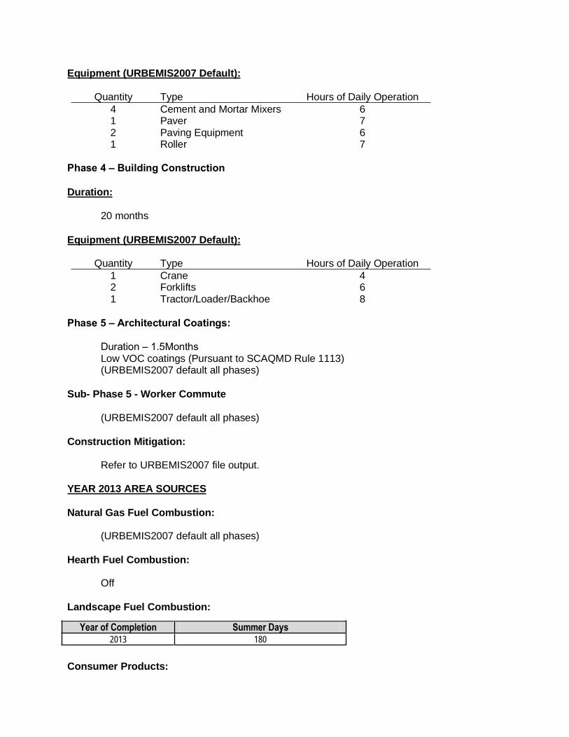
Equipment (URBEMIS2007 Default):
Quantity Type Hours of Daily Operation 4 Cement and Mortar Mixers 6 1 Paver 7 2 Paving Equipment 6 1 Roller 7
Phase 4 – Building Construction
Duration:
20 months
Equipment (URBEMIS2007 Default):
Quantity Type Hours of Daily Operation 1 Crane 4 2 Forklifts 6 1 Tractor/Loader/Backhoe 8
Phase 5 – Architectural Coatings:
Duration – 1.5Months Low VOC coatings (Pursuant to SCAQMD Rule 1113) (URBEMIS2007 default all phases)
Sub- Phase 5 - Worker Commute
(URBEMIS2007 default all phases)
Construction Mitigation:
Refer to URBEMIS2007 file output.
YEAR 2013 AREA SOURCES
Natural Gas Fuel Combustion:
(URBEMIS2007 default all phases)
Hearth Fuel Combustion:
Off
Landscape Fuel Combustion:
Consumer Products:
Year of Completion Summer Days 2013 180

(URBEMIS2007 default all phases)
Architectural Coating:
(URBEMIS2007 default all phases)
Area Source Mitigation:
Low VOC coatings (Pursuant to SCAQMD Rule 1113) Refer to URBEMIS2007 file output.
YEAR 2013 OPERATIONAL SOURCES
Vehicle Fleet %:
(URBEMIS2007 default all phases)
Year:
Year of Completion – 2013
Trip Characteristics:
(URBEMIS2007 Default all phases)
Temperature Data:
40 to 90 degrees Fahrenheit
Variable Starts:
(URBEMIS2007 default all phases)
Road Dust:
Paved – 100% Unpaved – 0%
Pass By Trips (On/Off):
Off
Double-Counting(On/Off):
Off
Operational Mitigation Measures:
Refer to URBEMIS2007 file output.


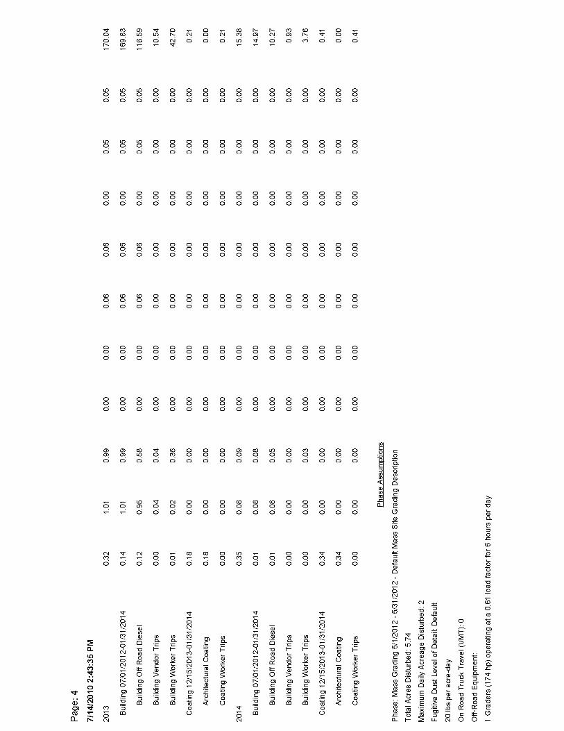


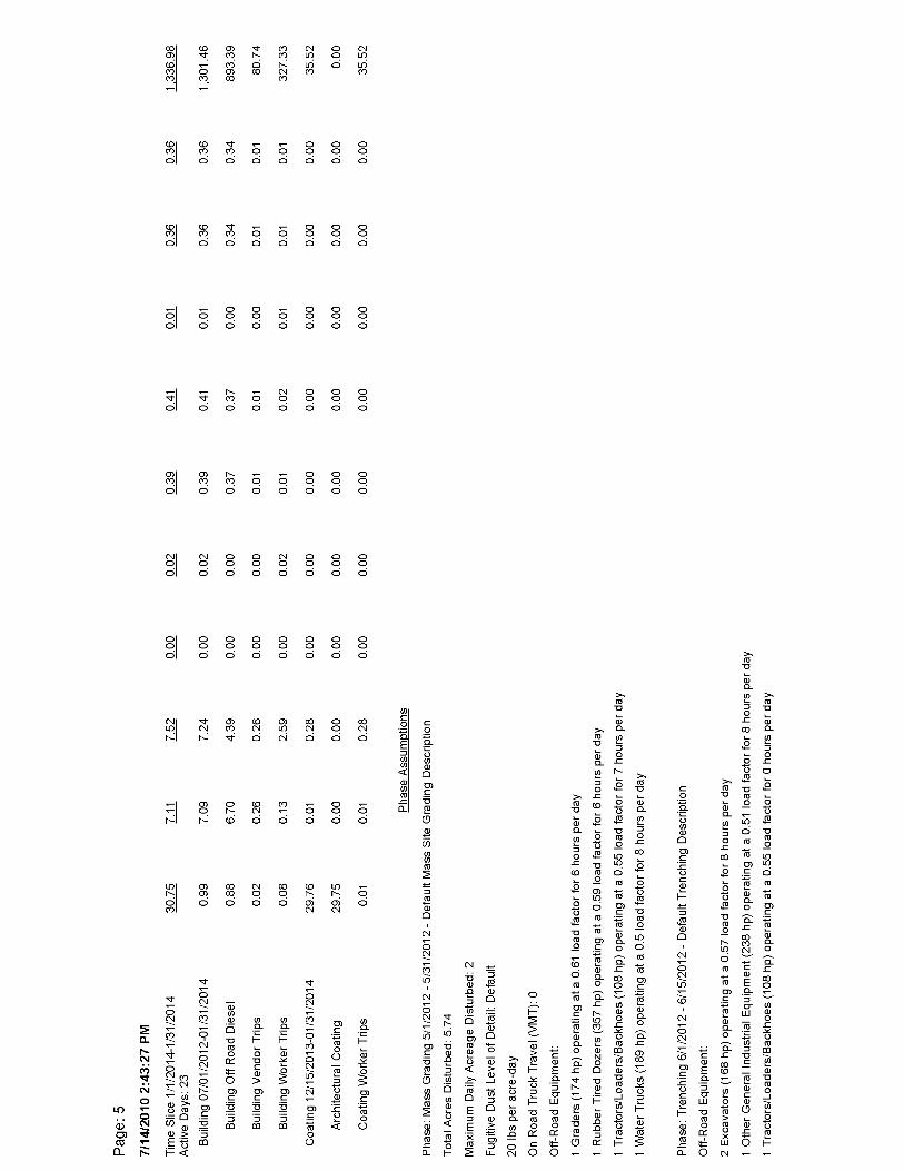
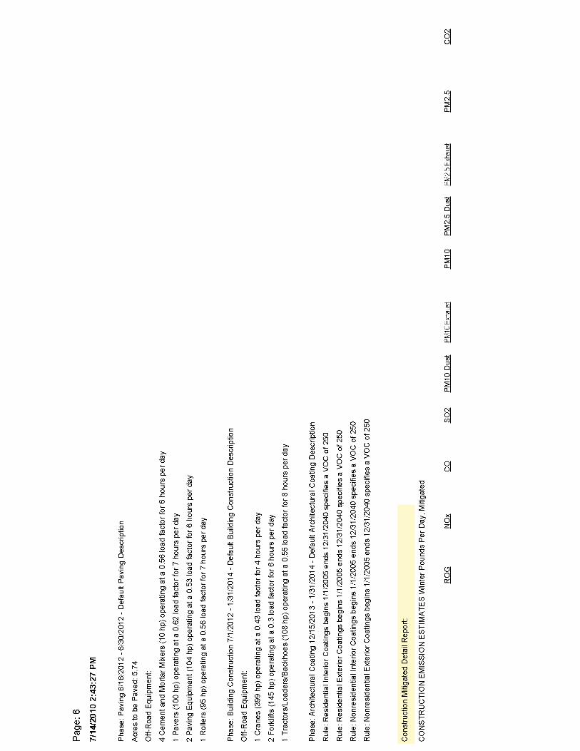


ConstructionCO.txt 07/14/10 14:37:28 *** SCREEN3 MODEL RUN *** *** VERSION DATED 96043 ***
C:\Documents and Settings\KCHIENE\My Documents\Lakes\Screen View\ConstructionCO
SIMPLE TERRAIN INPUTS: SOURCE TYPE = AREA EMISSION RATE (G/(S-M**2)) = 0.281600E-05 SOURCE HEIGHT (M) = 3.0000 LENGTH OF LARGER SIDE (M) = 152.4100 LENGTH OF SMALLER SIDE (M) = 152.4100 RECEPTOR HEIGHT (M) = 1.5000 URBAN/RURAL OPTION = URBAN THE REGULATORY (DEFAULT) MIXING HEIGHT OPTION WAS SELECTED. THE REGULATORY (DEFAULT) ANEMOMETER HEIGHT OF 10.0 METERS WAS ENTERED.
MODEL ESTIMATES DIRECTION TO MAX CONCENTRATION
BUOY. FLUX = 0.000 M**4/S**3; MOM. FLUX = 0.000 M**4/S**2.
*** FULL METEOROLOGY ***
********************************** *** SCREEN AUTOMATED DISTANCES *** **********************************
*** TERRAIN HEIGHT OF 0. M ABOVE STACK BASE USED FOR FOLLOWING DISTANCES ***
DIST CONC U10M USTK MIX HT PLUME MAX DIR (M) (UG/M**3) STAB (M/S) (M/S) (M) HT (M) (DEG) ------- ---------- ---- ----- ----- ------ ------ ------- 1. 35.00 5 1.0 1.0 10000.0 3.00 45. 100. 53.96 5 1.0 1.0 10000.0 3.00 45. 200. 31.29 5 1.0 1.0 10000.0 3.00 45. 300. 19.29 5 1.0 1.0 10000.0 3.00 45. 400. 13.60 5 1.0 1.0 10000.0 3.00 45. 500. 10.25 5 1.0 1.0 10000.0 3.00 45. 600. 8.064 5 1.0 1.0 10000.0 3.00 45. 700. 6.547 5 1.0 1.0 10000.0 3.00 42. 800. 5.449 5 1.0 1.0 10000.0 3.00 45. 900. 4.627 5 1.0 1.0 10000.0 3.00 45. 1000. 3.995 5 1.0 1.0 10000.0 3.00 45.
MAXIMUM 1-HR CONCENTRATION AT OR BEYOND 1. M: 115. 56.05 5 1.0 1.0 10000.0 3.00 45.
*************************************** *** SUMMARY OF SCREEN MODEL RESULTS *** ***************************************
CALCULATION MAX CONC DIST TO TERRAIN PROCEDURE (UG/M**3) MAX (M) HT (M) -------------- ----------- ------- ------- SIMPLE TERRAIN 56.05 115. 0.
*************************************************** ** REMEMBER TO INCLUDE BACKGROUND CONCENTRATIONS ** ***************************************************
Page 1

07/14/10
15:09:59 *** SCREEN3 MODEL RUN *** *** VERSION DATED 96043 ***
C:\Documents and Settings\KCHIENE\My Documents\Lakes\Screen View\ConstructionCO
SIMPLE TERRAIN INPUTS: SOURCE TYPE = AREA EMISSION RATE (G/(S-M**2)) = 0.497210E-05 SOURCE HEIGHT (M) = 3.0000 LENGTH OF LARGER SIDE (M) = 152.4100 LENGTH OF SMALLER SIDE (M) = 152.4100 RECEPTOR HEIGHT (M) = 1.5000 URBAN/RURAL OPTION = URBAN THE REGULATORY (DEFAULT) MIXING HEIGHT OPTION WAS SELECTED. THE REGULATORY (DEFAULT) ANEMOMETER HEIGHT OF 10.0 METERS WAS ENTERED.
MODEL ESTIMATES DIRECTION TO MAX CONCENTRATION
BUOY. FLUX = 0.000 M**4/S**3; MOM. FLUX = 0.000 M**4/S**2.
*** FULL METEOROLOGY ***
********************************** *** SCREEN AUTOMATED DISTANCES *** **********************************
*** TERRAIN HEIGHT OF 0. M ABOVE STACK BASE USED FOR FOLLOWING DISTANCES ***
DIST CONC U10M USTK MIX HT PLUME MAX DIR (M) (UG/M**3) STAB (M/S) (M/S) (M) HT (M) (DEG) ------- ---------- ---- ----- ----- ------ ------ ------- 1. 61.79 5 1.0 1.0 10000.0 3.00 45. 100. 95.28 5 1.0 1.0 10000.0 3.00 45. 200. 55.25 5 1.0 1.0 10000.0 3.00 45. 300. 34.06 5 1.0 1.0 10000.0 3.00 45. 400. 24.01 5 1.0 1.0 10000.0 3.00 45. 500. 18.10 5 1.0 1.0 10000.0 3.00 45. 600. 14.24 5 1.0 1.0 10000.0 3.00 45. 700. 11.56 5 1.0 1.0 10000.0 3.00 42. 800. 9.622 5 1.0 1.0 10000.0 3.00 45. 900. 8.170 5 1.0 1.0 10000.0 3.00 45. 1000. 7.053 5 1.0 1.0 10000.0 3.00 45.
MAXIMUM 1-HR CONCENTRATION AT OR BEYOND 1. M: 115. 98.96 5 1.0 1.0 10000.0 3.00 45.
*************************************** *** SUMMARY OF SCREEN MODEL RESULTS *** ***************************************
CALCULATION MAX CONC DIST TO TERRAIN PROCEDURE (UG/M**3) MAX (M) HT (M) -------------- ----------- ------- -------

SIMPLE TERRAIN 98.96 115. 0.
*************************************************** ** REMEMBER TO INCLUDE BACKGROUND CONCENTRATIONS ** ***************************************************

07/14/10
15:14:17 *** SCREEN3 MODEL RUN *** *** VERSION DATED 96043 ***
C:\Documents and Settings\KCHIENE\My Documents\Lakes\Screen View\ConstructionCO
SIMPLE TERRAIN INPUTS: SOURCE TYPE = AREA EMISSION RATE (G/(S-M**2)) = 0.928430E-05 SOURCE HEIGHT (M) = 3.0000 LENGTH OF LARGER SIDE (M) = 152.4100 LENGTH OF SMALLER SIDE (M) = 152.4100 RECEPTOR HEIGHT (M) = 1.5000 URBAN/RURAL OPTION = URBAN THE REGULATORY (DEFAULT) MIXING HEIGHT OPTION WAS SELECTED. THE REGULATORY (DEFAULT) ANEMOMETER HEIGHT OF 10.0 METERS WAS ENTERED.
MODEL ESTIMATES DIRECTION TO MAX CONCENTRATION
BUOY. FLUX = 0.000 M**4/S**3; MOM. FLUX = 0.000 M**4/S**2.
*** FULL METEOROLOGY ***
********************************** *** SCREEN AUTOMATED DISTANCES *** **********************************
*** TERRAIN HEIGHT OF 0. M ABOVE STACK BASE USED FOR FOLLOWING DISTANCES ***
DIST CONC U10M USTK MIX HT PLUME MAX DIR (M) (UG/M**3) STAB (M/S) (M/S) (M) HT (M) (DEG) ------- ---------- ---- ----- ----- ------ ------ ------- 1. 115.4 5 1.0 1.0 10000.0 3.00 45. 100. 177.9 5 1.0 1.0 10000.0 3.00 45. 200. 103.2 5 1.0 1.0 10000.0 3.00 45. 300. 63.60 5 1.0 1.0 10000.0 3.00 45. 400. 44.84 5 1.0 1.0 10000.0 3.00 45. 500. 33.79 5 1.0 1.0 10000.0 3.00 45. 600. 26.59 5 1.0 1.0 10000.0 3.00 45. 700. 21.59 5 1.0 1.0 10000.0 3.00 42. 800. 17.97 5 1.0 1.0 10000.0 3.00 45. 900. 15.26 5 1.0 1.0 10000.0 3.00 45. 1000. 13.17 5 1.0 1.0 10000.0 3.00 45.
MAXIMUM 1-HR CONCENTRATION AT OR BEYOND 1. M: 115. 184.8 5 1.0 1.0 10000.0 3.00 45.
*************************************** *** SUMMARY OF SCREEN MODEL RESULTS *** ***************************************
CALCULATION MAX CONC DIST TO TERRAIN PROCEDURE (UG/M**3) MAX (M) HT (M) -------------- ----------- ------- -------

SIMPLE TERRAIN 184.8 115. 0.
*************************************************** ** REMEMBER TO INCLUDE BACKGROUND CONCENTRATIONS ** ***************************************************

07/14/10
15:16:34 *** SCREEN3 MODEL RUN *** *** VERSION DATED 96043 ***
C:\Documents and Settings\KCHIENE\My Documents\Lakes\Screen View\ConstructionCO
SIMPLE TERRAIN INPUTS: SOURCE TYPE = AREA EMISSION RATE (G/(S-M**2)) = 0.211090E-05 SOURCE HEIGHT (M) = 3.0000 LENGTH OF LARGER SIDE (M) = 152.4100 LENGTH OF SMALLER SIDE (M) = 152.4100 RECEPTOR HEIGHT (M) = 1.5000 URBAN/RURAL OPTION = URBAN THE REGULATORY (DEFAULT) MIXING HEIGHT OPTION WAS SELECTED. THE REGULATORY (DEFAULT) ANEMOMETER HEIGHT OF 10.0 METERS WAS ENTERED.
MODEL ESTIMATES DIRECTION TO MAX CONCENTRATION
BUOY. FLUX = 0.000 M**4/S**3; MOM. FLUX = 0.000 M**4/S**2.
*** FULL METEOROLOGY ***
********************************** *** SCREEN AUTOMATED DISTANCES *** **********************************
*** TERRAIN HEIGHT OF 0. M ABOVE STACK BASE USED FOR FOLLOWING DISTANCES ***
DIST CONC U10M USTK MIX HT PLUME MAX DIR (M) (UG/M**3) STAB (M/S) (M/S) (M) HT (M) (DEG) ------- ---------- ---- ----- ----- ------ ------ ------- 1. 26.23 5 1.0 1.0 10000.0 3.00 45. 100. 40.45 5 1.0 1.0 10000.0 3.00 45. 200. 23.46 5 1.0 1.0 10000.0 3.00 45. 300. 14.46 5 1.0 1.0 10000.0 3.00 45. 400. 10.20 5 1.0 1.0 10000.0 3.00 45. 500. 7.683 5 1.0 1.0 10000.0 3.00 45. 600. 6.045 5 1.0 1.0 10000.0 3.00 45. 700. 4.908 5 1.0 1.0 10000.0 3.00 42. 800. 4.085 5 1.0 1.0 10000.0 3.00 45. 900. 3.469 5 1.0 1.0 10000.0 3.00 45. 1000. 2.994 5 1.0 1.0 10000.0 3.00 45.
MAXIMUM 1-HR CONCENTRATION AT OR BEYOND 1. M: 115. 42.02 5 1.0 1.0 10000.0 3.00 45.
*************************************** *** SUMMARY OF SCREEN MODEL RESULTS *** ***************************************
CALCULATION MAX CONC DIST TO TERRAIN PROCEDURE (UG/M**3) MAX (M) HT (M) -------------- ----------- ------- -------

SIMPLE TERRAIN 42.02 115. 0.
*************************************************** ** REMEMBER TO INCLUDE BACKGROUND CONCENTRATIONS ** ***************************************************

07/14/10
15:19:22 *** SCREEN3 MODEL RUN *** *** VERSION DATED 96043 ***
C:\Documents and Settings\KCHIENE\My Documents\Lakes\Screen View\ConstructionCO
SIMPLE TERRAIN INPUTS: SOURCE TYPE = AREA EMISSION RATE (G/(S-M**2)) = 0.735650E-05 SOURCE HEIGHT (M) = 3.0000 LENGTH OF LARGER SIDE (M) = 152.4100 LENGTH OF SMALLER SIDE (M) = 152.4100 RECEPTOR HEIGHT (M) = 1.5000 URBAN/RURAL OPTION = URBAN THE REGULATORY (DEFAULT) MIXING HEIGHT OPTION WAS SELECTED. THE REGULATORY (DEFAULT) ANEMOMETER HEIGHT OF 10.0 METERS WAS ENTERED.
MODEL ESTIMATES DIRECTION TO MAX CONCENTRATION
BUOY. FLUX = 0.000 M**4/S**3; MOM. FLUX = 0.000 M**4/S**2.
*** FULL METEOROLOGY ***
********************************** *** SCREEN AUTOMATED DISTANCES *** **********************************
*** TERRAIN HEIGHT OF 0. M ABOVE STACK BASE USED FOR FOLLOWING DISTANCES ***
DIST CONC U10M USTK MIX HT PLUME MAX DIR (M) (UG/M**3) STAB (M/S) (M/S) (M) HT (M) (DEG) ------- ---------- ---- ----- ----- ------ ------ ------- 1. 91.42 5 1.0 1.0 10000.0 3.00 45. 100. 141.0 5 1.0 1.0 10000.0 3.00 45. 200. 81.74 5 1.0 1.0 10000.0 3.00 45. 300. 50.40 5 1.0 1.0 10000.0 3.00 45. 400. 35.53 5 1.0 1.0 10000.0 3.00 45. 500. 26.78 5 1.0 1.0 10000.0 3.00 45. 600. 21.07 5 1.0 1.0 10000.0 3.00 45. 700. 17.10 5 1.0 1.0 10000.0 3.00 42. 800. 14.24 5 1.0 1.0 10000.0 3.00 45. 900. 12.09 5 1.0 1.0 10000.0 3.00 45. 1000. 10.44 5 1.0 1.0 10000.0 3.00 45.
MAXIMUM 1-HR CONCENTRATION AT OR BEYOND 1. M: 115. 146.4 5 1.0 1.0 10000.0 3.00 45.
*************************************** *** SUMMARY OF SCREEN MODEL RESULTS *** ***************************************
CALCULATION MAX CONC DIST TO TERRAIN PROCEDURE (UG/M**3) MAX (M) HT (M) -------------- ----------- ------- -------

SIMPLE TERRAIN 146.4 115. 0.
*************************************************** ** REMEMBER TO INCLUDE BACKGROUND CONCENTRATIONS ** ***************************************************

07/14/10
15:29:13 *** SCREEN3 MODEL RUN *** *** VERSION DATED 96043 ***
C:\Documents and Settings\KCHIENE\My Documents\Lakes\Screen View\ConstructionCO
SIMPLE TERRAIN INPUTS: SOURCE TYPE = AREA EMISSION RATE (G/(S-M**2)) = 0.858820E-06 SOURCE HEIGHT (M) = 3.0000 LENGTH OF LARGER SIDE (M) = 152.4100 LENGTH OF SMALLER SIDE (M) = 152.4100 RECEPTOR HEIGHT (M) = 1.5000 URBAN/RURAL OPTION = URBAN THE REGULATORY (DEFAULT) MIXING HEIGHT OPTION WAS SELECTED. THE REGULATORY (DEFAULT) ANEMOMETER HEIGHT OF 10.0 METERS WAS ENTERED.
MODEL ESTIMATES DIRECTION TO MAX CONCENTRATION
BUOY. FLUX = 0.000 M**4/S**3; MOM. FLUX = 0.000 M**4/S**2.
*** FULL METEOROLOGY ***
********************************** *** SCREEN AUTOMATED DISTANCES *** **********************************
*** TERRAIN HEIGHT OF 0. M ABOVE STACK BASE USED FOR FOLLOWING DISTANCES ***
DIST CONC U10M USTK MIX HT PLUME MAX DIR (M) (UG/M**3) STAB (M/S) (M/S) (M) HT (M) (DEG) ------- ---------- ---- ----- ----- ------ ------ ------- 1. 10.67 5 1.0 1.0 10000.0 3.00 45. 100. 16.46 5 1.0 1.0 10000.0 3.00 45. 200. 9.543 5 1.0 1.0 10000.0 3.00 45. 300. 5.883 5 1.0 1.0 10000.0 3.00 45. 400. 4.148 5 1.0 1.0 10000.0 3.00 45. 500. 3.126 5 1.0 1.0 10000.0 3.00 45. 600. 2.459 5 1.0 1.0 10000.0 3.00 45. 700. 1.997 5 1.0 1.0 10000.0 3.00 42. 800. 1.662 5 1.0 1.0 10000.0 3.00 45. 900. 1.411 5 1.0 1.0 10000.0 3.00 45. 1000. 1.218 5 1.0 1.0 10000.0 3.00 45.
MAXIMUM 1-HR CONCENTRATION AT OR BEYOND 1. M: 115. 17.09 5 1.0 1.0 10000.0 3.00 45.
*************************************** *** SUMMARY OF SCREEN MODEL RESULTS *** ***************************************
CALCULATION MAX CONC DIST TO TERRAIN PROCEDURE (UG/M**3) MAX (M) HT (M) -------------- ----------- ------- -------

SIMPLE TERRAIN 17.09 115. 0.
*************************************************** ** REMEMBER TO INCLUDE BACKGROUND CONCENTRATIONS ** ***************************************************

07/14/10
15:31:32 *** SCREEN3 MODEL RUN *** *** VERSION DATED 96043 ***
C:\Documents and Settings\KCHIENE\My Documents\Lakes\Screen View\ConstructionCO
SIMPLE TERRAIN INPUTS: SOURCE TYPE = AREA EMISSION RATE (G/(S-M**2)) = 0.119110E-05 SOURCE HEIGHT (M) = 3.0000 LENGTH OF LARGER SIDE (M) = 152.4100 LENGTH OF SMALLER SIDE (M) = 152.4100 RECEPTOR HEIGHT (M) = 1.5000 URBAN/RURAL OPTION = URBAN THE REGULATORY (DEFAULT) MIXING HEIGHT OPTION WAS SELECTED. THE REGULATORY (DEFAULT) ANEMOMETER HEIGHT OF 10.0 METERS WAS ENTERED.
MODEL ESTIMATES DIRECTION TO MAX CONCENTRATION
BUOY. FLUX = 0.000 M**4/S**3; MOM. FLUX = 0.000 M**4/S**2.
*** FULL METEOROLOGY ***
********************************** *** SCREEN AUTOMATED DISTANCES *** **********************************
*** TERRAIN HEIGHT OF 0. M ABOVE STACK BASE USED FOR FOLLOWING DISTANCES ***
DIST CONC U10M USTK MIX HT PLUME MAX DIR (M) (UG/M**3) STAB (M/S) (M/S) (M) HT (M) (DEG) ------- ---------- ---- ----- ----- ------ ------ ------- 1. 14.80 5 1.0 1.0 10000.0 3.00 45. 100. 22.82 5 1.0 1.0 10000.0 3.00 45. 200. 13.24 5 1.0 1.0 10000.0 3.00 45. 300. 8.160 5 1.0 1.0 10000.0 3.00 45. 400. 5.753 5 1.0 1.0 10000.0 3.00 45. 500. 4.335 5 1.0 1.0 10000.0 3.00 45. 600. 3.411 5 1.0 1.0 10000.0 3.00 45. 700. 2.769 5 1.0 1.0 10000.0 3.00 42. 800. 2.305 5 1.0 1.0 10000.0 3.00 45. 900. 1.957 5 1.0 1.0 10000.0 3.00 45. 1000. 1.690 5 1.0 1.0 10000.0 3.00 45.
MAXIMUM 1-HR CONCENTRATION AT OR BEYOND 1. M: 115. 23.71 5 1.0 1.0 10000.0 3.00 45.
*************************************** *** SUMMARY OF SCREEN MODEL RESULTS *** ***************************************
CALCULATION MAX CONC DIST TO TERRAIN PROCEDURE (UG/M**3) MAX (M) HT (M) -------------- ----------- ------- -------

SIMPLE TERRAIN 23.71 115. 0.
*************************************************** ** REMEMBER TO INCLUDE BACKGROUND CONCENTRATIONS ** ***************************************************

07/14/10
15:33:37 *** SCREEN3 MODEL RUN *** *** VERSION DATED 96043 ***
C:\Documents and Settings\KCHIENE\My Documents\Lakes\Screen View\ConstructionCO
SIMPLE TERRAIN INPUTS: SOURCE TYPE = AREA EMISSION RATE (G/(S-M**2)) = 0.232790E-06 SOURCE HEIGHT (M) = 3.0000 LENGTH OF LARGER SIDE (M) = 152.4100 LENGTH OF SMALLER SIDE (M) = 152.4100 RECEPTOR HEIGHT (M) = 1.5000 URBAN/RURAL OPTION = URBAN THE REGULATORY (DEFAULT) MIXING HEIGHT OPTION WAS SELECTED. THE REGULATORY (DEFAULT) ANEMOMETER HEIGHT OF 10.0 METERS WAS ENTERED.
MODEL ESTIMATES DIRECTION TO MAX CONCENTRATION
BUOY. FLUX = 0.000 M**4/S**3; MOM. FLUX = 0.000 M**4/S**2.
*** FULL METEOROLOGY ***
********************************** *** SCREEN AUTOMATED DISTANCES *** **********************************
*** TERRAIN HEIGHT OF 0. M ABOVE STACK BASE USED FOR FOLLOWING DISTANCES ***
DIST CONC U10M USTK MIX HT PLUME MAX DIR (M) (UG/M**3) STAB (M/S) (M/S) (M) HT (M) (DEG) ------- ---------- ---- ----- ----- ------ ------ ------- 1. 2.893 5 1.0 1.0 10000.0 3.00 45. 100. 4.461 5 1.0 1.0 10000.0 3.00 45. 200. 2.587 5 1.0 1.0 10000.0 3.00 45. 300. 1.595 5 1.0 1.0 10000.0 3.00 45. 400. 1.124 5 1.0 1.0 10000.0 3.00 45. 500. 0.8473 5 1.0 1.0 10000.0 3.00 45. 600. 0.6666 5 1.0 1.0 10000.0 3.00 45. 700. 0.5413 5 1.0 1.0 10000.0 3.00 42. 800. 0.4505 5 1.0 1.0 10000.0 3.00 45. 900. 0.3825 5 1.0 1.0 10000.0 3.00 45. 1000. 0.3302 5 1.0 1.0 10000.0 3.00 45.
MAXIMUM 1-HR CONCENTRATION AT OR BEYOND 1. M: 115. 4.633 5 1.0 1.0 10000.0 3.00 45.
*************************************** *** SUMMARY OF SCREEN MODEL RESULTS *** ***************************************
CALCULATION MAX CONC DIST TO TERRAIN PROCEDURE (UG/M**3) MAX (M) HT (M) -------------- ----------- ------- -------

SIMPLE TERRAIN 4.633 115. 0.
*************************************************** ** REMEMBER TO INCLUDE BACKGROUND CONCENTRATIONS ** ***************************************************

Emfac.rtsTitle : Lake County Air Basin Subarea Winter CYr 2015 Default TitleVersion : Emfac2007 V2.3 Nov 1 2006Run Date : 2010/07/13 16:15:33Scen Year: 2015 -- All model years in the range 1971 to 2015 selectedSeason : WinterArea : Lake (LC)***************************************************************************************** Year: 2015 -- Model Years 1971 to 2015 Inclusive -- Winter Emfac2007 Emission Factors: V2.3 Nov 1 2006
Lake (LC) Lake (LC) Lake (LC)
Table 1: Running Exhaust Emissions (grams/mile)
Pollutant Name: Reactive Org Gases Temperature: 70F Relative Humidity: 0%
Speed MPH LDA LDT MDT HDT UBUS MCY ALL
5 0.408 0.646 0.643 3.992 6.115 4.746 0.721 35 0.073 0.125 0.117 0.481 0.971 1.910 0.141
Pollutant Name: Carbon Monoxide Temperature: 70F Relative Humidity: 0%
Speed MPH LDA LDT MDT HDT UBUS MCY ALL
5 4.326 8.096 6.273 33.570 36.820 24.989 7.426 35 2.230 3.827 2.542 6.787 7.088 16.281 3.300
Pollutant Name: Oxides of Nitrogen Temperature: 70F Relative Humidity: 0%
Speed MPH LDA LDT MDT HDT UBUS MCY ALL
5 0.462 0.967 1.580 12.910 14.236 1.338 1.233 35 0.266 0.548 0.946 6.434 8.101 1.305 0.686
Pollutant Name: Carbon Dioxide Temperature: 70F Relative Humidity: 0%
Speed MPH LDA LDT MDT HDT UBUS MCY ALL
5 945.556 1161.349 1682.914 2611.395 2453.472 258.659 1167.527 35 308.007 384.654 519.841 1282.188 1660.838 134.622 395.307
Pollutant Name: Sulfur Dioxide Temperature: 70F Relative Humidity: 0%
Page 1

Emfac.rts
Speed MPH LDA LDT MDT HDT UBUS MCY ALL
5 0.009 0.011 0.016 0.025 0.024 0.003 0.011 35 0.003 0.004 0.005 0.012 0.016 0.002 0.004
Pollutant Name: PM2.5 Temperature: 70F Relative Humidity: 0%
Speed MPH LDA LDT MDT HDT UBUS MCY ALL
5 0.052 0.093 0.096 0.551 0.226 0.029 0.090 35 0.009 0.017 0.018 0.150 0.053 0.013 0.018
Pollutant Name: PM2.5 - Tire Wear Temperature: 70F Relative Humidity: 0%
Speed MPH LDA LDT MDT HDT UBUS MCY ALL
5 0.002 0.002 0.002 0.005 0.002 0.001 0.002 35 0.002 0.002 0.002 0.005 0.002 0.001 0.002
Pollutant Name: PM2.5 - Brake Wear Temperature: 70F Relative Humidity: 0%
Speed MPH LDA LDT MDT HDT UBUS MCY ALL
5 0.005 0.005 0.005 0.008 0.005 0.003 0.005 35 0.005 0.005 0.005 0.008 0.005 0.003 0.005
Pollutant Name: Gasoline - mi/gal Temperature: 70F Relative Humidity: 0%
Speed MPH LDA LDT MDT HDT UBUS MCY ALL
5 9.286 7.380 4.903 3.339 3.300 28.296 8.219 35 28.445 22.589 16.900 16.898 16.741 53.231 24.931
Pollutant Name: Diesel - mi/gal Temperature: 70F Relative Humidity: 0%
Speed MPH LDA LDT MDT HDT UBUS MCY ALL
5 28.298 29.070 19.538 4.688 4.175 0.000 15.502 35 28.298 29.070 19.538 6.114 4.175 0.000 16.105
Page 2
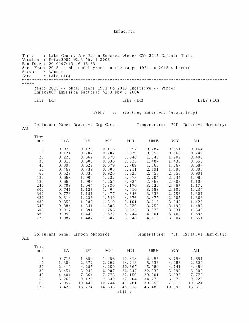
Emfac.rts
Title : Lake County Air Basin Subarea Winter CYr 2015 Default TitleVersion : Emfac2007 V2.3 Nov 1 2006Run Date : 2010/07/13 16:15:33Scen Year: 2015 -- All model years in the range 1971 to 2015 selectedSeason : WinterArea : Lake (LC)***************************************************************************************** Year: 2015 -- Model Years 1971 to 2015 Inclusive -- Winter Emfac2007 Emission Factors: V2.3 Nov 1 2006
Lake (LC) Lake (LC) Lake (LC)
Table 2: Starting Emissions (grams/trip)
Pollutant Name: Reactive Org Gases Temperature: 70F Relative Humidity:ALL
Time min LDA LDT MDT HDT UBUS MCY ALL
5 0.070 0.123 0.115 1.057 0.284 0.851 0.164 10 0.124 0.207 0.207 1.329 0.553 0.968 0.249 20 0.225 0.362 0.379 1.848 1.049 1.202 0.409 30 0.316 0.503 0.536 2.335 1.487 1.435 0.555 40 0.397 0.629 0.679 2.789 1.868 1.667 0.687 50 0.469 0.739 0.808 3.211 2.191 1.898 0.805 60 0.529 0.830 0.920 3.523 2.456 2.055 0.901 120 0.669 1.000 1.232 3.673 2.704 2.234 1.086 180 0.664 1.008 1.254 3.924 2.869 2.303 1.106 240 0.703 1.067 1.330 4.170 3.029 2.457 1.172 300 0.741 1.125 1.404 4.410 3.183 2.609 1.237 360 0.778 1.181 1.477 4.646 3.333 2.758 1.301 420 0.814 1.236 1.549 4.876 3.477 2.905 1.363 480 0.850 1.289 1.619 5.101 3.616 3.049 1.423 540 0.884 1.341 1.688 5.320 3.750 3.192 1.482 600 0.917 1.391 1.756 5.535 3.878 3.331 1.540 660 0.950 1.440 1.822 5.744 4.001 3.469 1.596 720 0.982 1.487 1.887 5.948 4.119 3.604 1.651
Pollutant Name: Carbon Monoxide Temperature: 70F Relative Humidity:ALL
Time min LDA LDT MDT HDT UBUS MCY ALL
5 0.716 1.359 1.256 10.818 4.255 3.756 1.651 10 1.304 2.372 2.292 14.218 8.338 4.086 2.629 20 2.419 4.285 4.259 20.667 15.984 4.741 4.484 30 3.451 6.049 6.087 26.647 22.938 5.392 6.200 40 4.401 7.664 7.778 32.159 29.201 6.037 7.779 50 5.268 9.129 9.330 37.204 34.773 6.677 9.220 60 6.052 10.445 10.744 41.781 39.652 7.312 10.524 120 8.420 13.774 14.635 48.918 45.483 10.593 13.810
Page 3

Emfac.rts 180 7.976 13.337 14.422 52.757 46.812 10.954 13.652 240 8.433 14.039 15.330 56.370 48.186 12.244 14.468 300 8.856 14.697 16.161 59.757 49.603 13.415 15.227 360 9.245 15.313 16.913 62.919 51.064 14.468 15.928 420 9.599 15.886 17.587 65.854 52.569 15.401 16.572 480 9.919 16.417 18.182 68.563 54.118 16.215 17.159 540 10.205 16.904 18.700 71.047 55.710 16.911 17.689 600 10.456 17.349 19.139 73.304 57.347 17.488 18.161 660 10.672 17.751 19.500 75.336 59.027 17.946 18.576 720 10.854 18.110 19.782 77.141 60.751 18.285 18.934
Pollutant Name: Oxides of Nitrogen Temperature: 70F Relative Humidity:ALL
Time min LDA LDT MDT HDT UBUS MCY ALL
5 0.251 0.391 1.005 0.963 1.261 0.175 0.480 10 0.288 0.456 1.123 1.412 1.900 0.210 0.565 20 0.354 0.572 1.332 2.202 3.022 0.271 0.715 30 0.408 0.667 1.506 2.847 3.936 0.322 0.838 40 0.451 0.743 1.646 3.346 4.643 0.362 0.936 50 0.483 0.798 1.751 3.699 5.142 0.393 1.008 60 0.504 0.834 1.821 3.907 5.433 0.413 1.053 120 0.529 0.872 1.932 3.936 5.472 0.416 1.099 180 0.531 0.874 1.932 3.919 5.452 0.410 1.099 240 0.527 0.868 1.918 3.893 5.421 0.402 1.091 300 0.522 0.858 1.897 3.858 5.380 0.392 1.080 360 0.514 0.846 1.868 3.815 5.328 0.380 1.064 420 0.504 0.830 1.831 3.763 5.266 0.366 1.045 480 0.493 0.811 1.787 3.703 5.192 0.350 1.022 540 0.479 0.790 1.735 3.635 5.109 0.331 0.995 600 0.464 0.765 1.675 3.557 5.014 0.311 0.965 660 0.446 0.737 1.608 3.472 4.909 0.288 0.930 720 0.427 0.706 1.533 3.377 4.793 0.264 0.892
Pollutant Name: Carbon Dioxide Temperature: 70F Relative Humidity:ALL
Time min LDA LDT MDT HDT UBUS MCY ALL
5 11.158 13.136 19.045 17.345 3.753 17.843 13.809 10 13.297 16.067 22.635 21.839 7.485 20.201 16.647 20 17.960 22.319 30.485 30.700 14.887 24.816 22.728 30 23.135 29.093 39.228 39.394 22.206 29.297 29.348 40 28.822 36.387 48.865 47.920 29.442 33.644 36.506 50 35.022 44.203 59.394 56.279 36.595 37.857 44.203 60 41.734 52.539 70.816 64.470 43.665 41.935 52.438 120 89.824 108.706 153.282 100.658 74.266 60.475 108.813 180 102.636 124.412 175.141 112.595 87.740 63.818 124.192 240 115.241 139.770 196.663 123.830 100.419 66.965 139.259 300 127.639 154.779 217.849 134.361 112.302 69.917 154.016 360 139.831 169.440 238.698 144.190 123.390 72.674 168.461 420 151.816 183.753 259.211 153.315 133.683 75.236 182.595 480 163.595 197.717 279.387 161.738 143.180 77.602 196.419 540 175.167 211.334 299.227 169.458 151.883 79.772 209.931 600 186.532 224.602 318.730 176.475 159.790 81.748 223.132 660 197.690 237.522 337.896 182.788 166.901 83.528 236.022
Page 4

Emfac.rts 720 208.642 250.093 356.726 188.399 173.218 85.113 248.601
Pollutant Name: Sulfur Dioxide Temperature: 70F Relative Humidity:ALL
Time min LDA LDT MDT HDT UBUS MCY ALL
5 0.000 0.000 0.000 0.000 0.000 0.000 0.000 10 0.000 0.000 0.000 0.000 0.000 0.000 0.000 20 0.000 0.000 0.000 0.001 0.000 0.000 0.000 30 0.000 0.000 0.000 0.001 0.001 0.000 0.000 40 0.000 0.000 0.001 0.001 0.001 0.000 0.000 50 0.000 0.001 0.001 0.001 0.001 0.001 0.001 60 0.001 0.001 0.001 0.001 0.001 0.001 0.001 120 0.001 0.001 0.002 0.002 0.001 0.001 0.001 180 0.001 0.001 0.002 0.002 0.002 0.001 0.001 240 0.001 0.002 0.002 0.002 0.002 0.001 0.002 300 0.001 0.002 0.002 0.002 0.002 0.001 0.002 360 0.002 0.002 0.003 0.002 0.002 0.001 0.002 420 0.002 0.002 0.003 0.003 0.002 0.001 0.002 480 0.002 0.002 0.003 0.003 0.002 0.001 0.002 540 0.002 0.002 0.003 0.003 0.002 0.001 0.002 600 0.002 0.002 0.003 0.003 0.003 0.001 0.002 660 0.002 0.003 0.004 0.003 0.003 0.001 0.003 720 0.002 0.003 0.004 0.003 0.003 0.001 0.003
Pollutant Name: PM2.5 Temperature: 70F Relative Humidity:ALL
Time min LDA LDT MDT HDT UBUS MCY ALL
5 0.001 0.001 0.001 0.001 0.001 0.007 0.001 10 0.001 0.002 0.002 0.002 0.001 0.007 0.002 20 0.003 0.005 0.003 0.002 0.002 0.005 0.003 30 0.004 0.007 0.004 0.003 0.003 0.004 0.005 40 0.005 0.009 0.005 0.004 0.004 0.003 0.006 50 0.006 0.010 0.007 0.004 0.005 0.003 0.008 60 0.007 0.012 0.008 0.005 0.005 0.003 0.009 120 0.010 0.018 0.012 0.007 0.007 0.006 0.013 180 0.011 0.019 0.013 0.007 0.007 0.008 0.014 240 0.012 0.021 0.013 0.008 0.007 0.011 0.015 300 0.013 0.022 0.014 0.008 0.008 0.013 0.016 360 0.013 0.023 0.015 0.009 0.008 0.015 0.017 420 0.014 0.024 0.015 0.009 0.008 0.016 0.018 480 0.014 0.025 0.016 0.009 0.008 0.018 0.018 540 0.015 0.026 0.016 0.010 0.009 0.019 0.019 600 0.015 0.026 0.017 0.010 0.009 0.019 0.019 660 0.015 0.027 0.017 0.010 0.009 0.020 0.020 720 0.015 0.027 0.017 0.010 0.009 0.020 0.020
Title : Lake County Air Basin Subarea Winter CYr 2015 Default TitlePage 5

Emfac.rtsVersion : Emfac2007 V2.3 Nov 1 2006Run Date : 2010/07/13 16:15:33Scen Year: 2015 -- All model years in the range 1971 to 2015 selectedSeason : WinterArea : Lake (LC)***************************************************************************************** Year: 2015 -- Model Years 1971 to 2015 Inclusive -- Winter Emfac2007 Emission Factors: V2.3 Nov 1 2006
Lake (LC) Lake (LC) Lake (LC)
Table 4: Hot Soak Emissions (grams/trip)
Pollutant Name: Reactive Org Gases Temperature: 70F Relative Humidity:ALL
Time min LDA LDT MDT HDT UBUS MCY ALL
5 0.136 0.183 0.058 0.067 0.088 0.203 0.137 10 0.252 0.340 0.108 0.123 0.163 0.379 0.254 20 0.431 0.582 0.185 0.211 0.278 0.662 0.436 30 0.556 0.753 0.240 0.272 0.359 0.872 0.563 40 0.603 0.818 0.261 0.295 0.389 0.956 0.612
Hot soak results are scaled to reflect zero emissions for trip lengths of less than 5 minutes (about 25% of in-use trips).
Title : Lake County Air Basin Subarea Winter CYr 2015 Default TitleVersion : Emfac2007 V2.3 Nov 1 2006Run Date : 2010/07/13 16:15:33Scen Year: 2015 -- All model years in the range 1971 to 2015 selectedSeason : WinterArea : Lake (LC)***************************************************************************************** Year: 2015 -- Model Years 1971 to 2015 Inclusive -- Winter Emfac2007 Emission Factors: V2.3 Nov 1 2006
Lake (LC) Lake (LC) Lake (LC)
Table 5a: Partial Day Diurnal Loss Emissions (grams/hour)
Pollutant Name: Reactive Org Gases Temperature: ALL Relative Humidity:ALL
Temp degF LDA LDT MDT HDT UBUS MCY ALL
70 0.218 0.327 0.113 0.029 0.005 0.452 0.260
Page 6

Emfac.rts
Title : Lake County Air Basin Subarea Winter CYr 2015 Default TitleVersion : Emfac2007 V2.3 Nov 1 2006Run Date : 2010/07/13 16:15:33Scen Year: 2015 -- All model years in the range 1971 to 2015 selectedSeason : WinterArea : Lake (LC)***************************************************************************************** Year: 2015 -- Model Years 1971 to 2015 Inclusive -- Winter Emfac2007 Emission Factors: V2.3 Nov 1 2006
Lake (LC) Lake (LC) Lake (LC)
Table 5b: Multi-Day Diurnal Loss Emissions (grams/hour)
Pollutant Name: Reactive Org Gases Temperature: ALL Relative Humidity:ALL
Temp degF LDA LDT MDT HDT UBUS MCY ALL
70 0.018 0.025 0.009 0.001 0.002 0.041 0.021
Title : Lake County Air Basin Subarea Winter CYr 2015 Default TitleVersion : Emfac2007 V2.3 Nov 1 2006Run Date : 2010/07/13 16:15:33Scen Year: 2015 -- All model years in the range 1971 to 2015 selectedSeason : WinterArea : Lake (LC)***************************************************************************************** Year: 2015 -- Model Years 1971 to 2015 Inclusive -- Winter Emfac2007 Emission Factors: V2.3 Nov 1 2006
Lake (LC) Lake (LC) Lake (LC)
Table 6a: Partial Day Resting Loss Emissions (grams/hour)
Pollutant Name: Reactive Org Gases Temperature: ALL Relative Humidity:ALL
Temp degF LDA LDT MDT HDT UBUS MCY ALL
70 0.083 0.129 0.048 0.013 0.002 0.142 0.100
Page 7

Emfac.rts
Title : Lake County Air Basin Subarea Winter CYr 2015 Default TitleVersion : Emfac2007 V2.3 Nov 1 2006Run Date : 2010/07/13 16:15:33Scen Year: 2015 -- All model years in the range 1971 to 2015 selectedSeason : WinterArea : Lake (LC)***************************************************************************************** Year: 2015 -- Model Years 1971 to 2015 Inclusive -- Winter Emfac2007 Emission Factors: V2.3 Nov 1 2006
Lake (LC) Lake (LC) Lake (LC)
Table 6b: Multi-Day Resting Loss Emissions (grams/hour)
Pollutant Name: Reactive Org Gases Temperature: ALL Relative Humidity:ALL
Temp degF LDA LDT MDT HDT UBUS MCY ALL
70 0.007 0.010 0.004 0.001 0.001 0.014 0.008
Title : Lake County Air Basin Subarea Winter CYr 2015 Default TitleVersion : Emfac2007 V2.3 Nov 1 2006Run Date : 2010/07/13 16:15:33Scen Year: 2015 -- All model years in the range 1971 to 2015 selectedSeason : WinterArea : Lake (LC)***************************************************************************************** Year: 2015 -- Model Years 1971 to 2015 Inclusive -- Winter Emfac2007 Emission Factors: V2.3 Nov 1 2006
Lake (LC) Lake (LC) Lake (LC)
Table 7: Estimated Travel Fractions
Pollutant Name: Temperature: ALL Relative Humidity:ALL
LDA LDT MDT HDT UBUS MCY ALL
%VMT 0.412 0.424 0.116 0.032 0.001 0.015 1.000 %TRIP 0.363 0.383 0.184 0.053 0.000 0.017 1.000 %VEH 0.389 0.423 0.095 0.037 0.000 0.056 1.000
Page 8

Emfac.rts
Title : Lake County Air Basin Subarea Winter CYr 2015 Default TitleVersion : Emfac2007 V2.3 Nov 1 2006Run Date : 2010/07/13 16:15:33Scen Year: 2015 -- All model years in the range 1971 to 2015 selectedSeason : WinterArea : Lake (LC)***************************************************************************************** Year: 2015 -- Model Years 1971 to 2015 Inclusive -- Winter Emfac2007 Emission Factors: V2.3 Nov 1 2006
Lake (LC) Lake (LC) Lake (LC)
Table 8: Evaporative Running Loss Emissions (grams/minute)
Pollutant Name: Reactive Org Gases Temperature: 70F Relative Humidity:ALL
Time min LDA LDT MDT HDT UBUS MCY ALL
1 0.030 0.942 0.499 1.233 0.716 0.024 0.510 2 0.031 0.493 0.262 0.655 0.373 0.062 0.275 3 0.034 0.347 0.185 0.464 0.260 0.083 0.199 4 0.038 0.276 0.148 0.369 0.205 0.096 0.163 5 0.041 0.234 0.127 0.313 0.172 0.105 0.143 10 0.050 0.156 0.087 0.203 0.109 0.132 0.106 15 0.056 0.137 0.078 0.170 0.091 0.149 0.098 20 0.061 0.134 0.077 0.156 0.085 0.163 0.099 25 0.066 0.138 0.080 0.150 0.084 0.176 0.102 30 0.069 0.145 0.084 0.156 0.088 0.184 0.107 35 0.071 0.151 0.087 0.161 0.091 0.193 0.111 40 0.073 0.157 0.091 0.167 0.095 0.201 0.116 45 0.075 0.163 0.094 0.172 0.098 0.209 0.120 50 0.077 0.168 0.097 0.177 0.101 0.215 0.123 55 0.078 0.174 0.100 0.182 0.104 0.221 0.126 60 0.079 0.179 0.103 0.187 0.107 0.227 0.130
Page 9

Bevins-Lakeport.lst1 CALINE4 - (DATED CALINE4x)
3.0.0 PC (32 BIT) VERSION (C) COPYRIGHT 2000, TRINITY CONSULTANTS
Run Began on 7/13/2010 at 16:30:35
CALINE4: CALIFORNIA LINE SOURCE DISPERSION MODEL JUNE 1989 VERSION PAGE 1
JOB: Bevins-Lakeport RUN: Hour 1 (WORST CASE ANGLE) POLLUTANT: Carbon Monoxide
I. SITE VARIABLES
U= 0.5 M/S Z0= 100. CM ALT= 0. (M) BRG= WORST CASE VD= 0.0 CM/S CLAS= 6 (F) VS= 0.0 CM/S MIXH= 1000. M AMB= 3.5 PPM SIGTH= 5. DEGREES TEMP= 15.0 DEGREE (C)
II. LINK VARIABLES
LINK * LINK COORDINATES (M) * EF H W DESCRIPTION * X1 Y1 X2 Y2 * TYPE VPH (G/MI) (M) (M) ----------------*-------------------------*------------------------------ 1. Y SB1 * 684 1256 711 1201 * AG 262 3.3 0.0 23.3 2. Y SB2 * 711 1201 745 1133 * AG 220 7.4 0.0 23.3 3. Y SB3 * 745 1133 800 1025 * AG 226 3.3 0.0 23.3 4. Y SB4 * 800 1025 858 906 * AG 226 3.3 0.0 23.3 5. Y NB1 * 868 911 813 1024 * AG 30 3.3 0.0 23.3 6. Y NB2 * 814 1024 761 1138 * AG 13 3.3 0.0 23.3 7. Y NB3 * 761 1138 728 1205 * AG 286 3.3 0.0 23.3 8. Y NB4 * 728 1205 700 1263 * AG 286 3.3 0.0 23.3 9. Y LT1 * 720 1198 753 1134 * AG 42 7.4 0.0 23.3 10. Y LT2 * 753 1134 802 1038 * AG 17 7.4 0.0 23.3 11. X EB1 * 596 1103 682 1125 * AG 1013 3.3 0.0 24.1 12. X EB2 * 682 1125 750 1141 * AG 740 7.4 0.0 24.1 13. X EB3 * 750 1141 826 1158 * AG 782 3.3 0.0 24.1 14. X EB4 * 826 1158 923 1182 * AG 782 3.3 0.0 24.1 15. X WB1 * 924 1170 832 1147 * AG 385 3.3 0.0 24.1 16. X WB2 * 832 1147 757 1128 * AG 379 7.4 0.0 24.1 17. X WB3 * 757 1128 687 1111 * AG 396 3.3 0.0 24.1 18. X WB4 * 687 1111 599 1090 * AG 396 3.3 0.0 24.1 19. X LT1 * 674 1115 753 1134 * AG 273 7.4 0.0 24.1 20. X LT2 * 753 1134 841 1157 * AG 6 7.4 0.0 24.1
III. RECEPTOR LOCATIONS
* COORDINATES (M) RECEPTOR * X Y Z ------------*--------------------- 1. Recpt 1 * 805 1099 1.8 2. Recpt 2 * 691 1157 1.8 3. Recpt 3 * 729 1093 1.8 4. Recpt 4 * 778 1179 1.8
Page 1

Bevins-Lakeport.lst
IV. MODEL RESULTS (WORST CASE WIND ANGLE )
* * PRED * CONC/LINK * BRG * CONC * (PPM) RECEPTOR * (DEG) * (PPM) * 1 2 3 4 5 6 7 8 -------------*-------*-------*---------------------------------------- 1. Recpt 1 * 289. * 3.8 * 0.0 0.0 0.0 0.0 0.0 0.0 0.0 0.0 2. Recpt 2 * 110. * 3.9 * 0.0 0.0 0.0 0.0 0.0 0.0 0.0 0.0 3. Recpt 3 * 359. * 3.9 * 0.0 0.1 0.0 0.0 0.0 0.0 0.0 0.0 4. Recpt 4 * 234. * 4.0 * 0.0 0.0 0.0 0.0 0.0 0.0 0.0 0.0
* CONC/LINK * (PPM) RECEPTOR * 9 10 11 12 13 14 15 16 ------------*---------------------------------------- 1. Recpt 1 * 0.0 0.0 0.0 0.2 0.0 0.0 0.0 0.0 2. Recpt 2 * 0.0 0.0 0.0 0.2 0.0 0.0 0.0 0.1 3. Recpt 3 * 0.0 0.0 0.0 0.2 0.0 0.0 0.0 0.0 4. Recpt 4 * 0.0 0.0 0.0 0.2 0.0 0.0 0.0 0.0
*CONC/LINK *(PPM) RECEPTOR * 17 18 19 20 ------------*-------------------------------------------------- 1. Recpt 1 * 0.0 0.0 0.1 0.0 2. Recpt 2 * 0.0 0.0 0.0 0.0 3. Recpt 3 * 0.0 0.0 0.1 0.0 4. Recpt 4 * 0.0 0.0 0.1 0.0
1
Run Ended on 7/13/2010 at 16:30:35
Page 2

Main-Lakeport.lst1 CALINE4 - (DATED CALINE4x)
3.0.0 PC (32 BIT) VERSION (C) COPYRIGHT 2000, TRINITY CONSULTANTS
Run Began on 7/13/2010 at 16:34:29
CALINE4: CALIFORNIA LINE SOURCE DISPERSION MODEL JUNE 1989 VERSION PAGE 1
JOB: Main-Lakeport RUN: Hour 1 (WORST CASE ANGLE) POLLUTANT: Carbon Monoxide
I. SITE VARIABLES
U= 0.5 M/S Z0= 100. CM ALT= 0. (M) BRG= WORST CASE VD= 0.0 CM/S CLAS= 6 (F) VS= 0.0 CM/S MIXH= 1000. M AMB= 3.5 PPM SIGTH= 5. DEGREES TEMP= 15.0 DEGREE (C)
II. LINK VARIABLES
LINK * LINK COORDINATES (M) * EF H W DESCRIPTION * X1 Y1 X2 Y2 * TYPE VPH (G/MI) (M) (M) ----------------*-------------------------*------------------------------ 1. Y SB1 * 684 1256 711 1201 * AG 683 3.3 0.0 20.3 2. Y SB2 * 711 1201 745 1133 * AG 647 7.4 0.0 20.3 3. Y SB3 * 745 1133 800 1025 * AG 647 3.3 0.0 20.3 4. Y SB4 * 800 1025 858 906 * AG 647 3.3 0.0 20.3 5. Y NB1 * 868 911 813 1024 * AG 384 3.3 0.0 20.3 6. Y NB2 * 814 1024 761 1138 * AG 311 3.3 0.0 20.3 7. Y NB3 * 761 1138 728 1205 * AG 714 3.3 0.0 20.3 8. Y NB4 * 728 1205 700 1263 * AG 714 3.3 0.0 20.3 9. Y LT1 * 720 1198 753 1134 * AG 36 7.4 0.0 20.3 10. Y LT2 * 753 1134 802 1038 * AG 73 7.4 0.0 20.3 11. X EB1 * 596 1103 682 1125 * AG 521 3.3 0.0 16.2 12. X EB2 * 682 1125 750 1141 * AG 118 7.4 0.0 16.2 13. X EB3 * 750 1141 826 1158 * AG 154 3.3 0.0 16.2 14. X EB4 * 826 1158 923 1182 * AG 154 3.3 0.0 16.2 15. X WB1 * 924 1170 832 1147 * AG 3 3.3 0.0 16.2 16. X WB2 * 832 1147 757 1128 * AG 3 7.4 0.0 16.2 17. X WB3 * 757 1128 687 1111 * AG 76 3.3 0.0 16.2 18. X WB4 * 687 1111 599 1090 * AG 76 3.3 0.0 16.2 19. X LT1 * 674 1115 753 1134 * AG 403 7.4 0.0 16.2 20. X LT2 * 753 1134 841 1157 * AG 0 7.4 0.0 16.2
III. RECEPTOR LOCATIONS
* COORDINATES (M) RECEPTOR * X Y Z ------------*--------------------- 1. Recpt 1 * 805 1099 1.8 2. Recpt 2 * 691 1157 1.8 3. Recpt 3 * 729 1093 1.8 4. Recpt 4 * 778 1179 1.8
Page 1

Main-Lakeport.lst
IV. MODEL RESULTS (WORST CASE WIND ANGLE )
* * PRED * CONC/LINK * BRG * CONC * (PPM) RECEPTOR * (DEG) * (PPM) * 1 2 3 4 5 6 7 8 -------------*-------*-------*---------------------------------------- 1. Recpt 1 * 314. * 3.8 * 0.0 0.2 0.0 0.0 0.0 0.0 0.1 0.0 2. Recpt 2 * 139. * 3.8 * 0.0 0.0 0.1 0.0 0.0 0.0 0.0 0.0 3. Recpt 3 * 357. * 3.9 * 0.0 0.2 0.0 0.0 0.0 0.0 0.0 0.1 4. Recpt 4 * 232. * 3.9 * 0.0 0.1 0.0 0.0 0.0 0.0 0.1 0.0
* CONC/LINK * (PPM) RECEPTOR * 9 10 11 12 13 14 15 16 ------------*---------------------------------------- 1. Recpt 1 * 0.0 0.0 0.0 0.0 0.0 0.0 0.0 0.0 2. Recpt 2 * 0.0 0.0 0.0 0.0 0.0 0.0 0.0 0.0 3. Recpt 3 * 0.0 0.0 0.0 0.0 0.0 0.0 0.0 0.0 4. Recpt 4 * 0.0 0.0 0.0 0.0 0.0 0.0 0.0 0.0
*CONC/LINK *(PPM) RECEPTOR * 17 18 19 20 ------------*-------------------------------------------------- 1. Recpt 1 * 0.0 0.0 0.0 0.0 2. Recpt 2 * 0.0 0.0 0.1 0.0 3. Recpt 3 * 0.0 0.0 0.1 0.0 4. Recpt 4 * 0.0 0.0 0.1 0.0
1
Run Ended on 7/13/2010 at 16:34:29
Page 2

sr29nbramp-lake.lst1 CALINE4 - (DATED CALINE4x)
3.0.0 PC (32 BIT) VERSION (C) COPYRIGHT 2000, TRINITY CONSULTANTS
Run Began on 7/13/2010 at 16:27:29
CALINE4: CALIFORNIA LINE SOURCE DISPERSION MODEL JUNE 1989 VERSION PAGE 1
JOB: SR29 NB Ramp-Lakeport Blvd RUN: Hour 1 (WORST CASE ANGLE) POLLUTANT: Carbon Monoxide
I. SITE VARIABLES
U= 0.5 M/S Z0= 100. CM ALT= 0. (M) BRG= WORST CASE VD= 0.0 CM/S CLAS= 6 (F) VS= 0.0 CM/S MIXH= 1000. M AMB= 3.5 PPM SIGTH= 5. DEGREES TEMP= 15.0 DEGREE (C)
II. LINK VARIABLES
LINK * LINK COORDINATES (M) * EF H W DESCRIPTION * X1 Y1 X2 Y2 * TYPE VPH (G/MI) (M) (M) ----------------*-------------------------*------------------------------ 1. Link A * 6284 -181 6284 -246 * AG 388 3.3 0.0 19.1 2. Link B * 6284 -246 6284 -300 * AG 388 7.4 0.0 19.1 3. Link C * 6284 -300 6279 -453 * AG 572 3.3 0.0 19.1 4. Link D * 6297 -460 6298 -378 * AG 769 3.3 0.0 19.1 5. Link E * 6298 -378 6298 -319 * AG 769 3.3 0.0 19.1 6. Link F * 6298 -319 6297 -176 * AG 769 3.3 0.0 19.1 7. Link G * 6284 -265 6300 -314 * AG 0 7.4 0.0 19.1 8. Link H * 6300 -314 6462 -325 * AG 0 3.3 0.0 23.7 9. Link I * 6523 -313 6380 -311 * AG 635 3.3 0.0 23.7 10. Link J * 6380 -311 6298 -301 * AG 451 7.4 0.0 23.7 11. Link K * 6370 -310 6284 -326 * AG 184 7.4 0.0 23.7
III. RECEPTOR LOCATIONS
* COORDINATES (M) RECEPTOR * X Y Z ------------*--------------------- 1. Recpt 1 * 6325 -280 1.7 2. Recpt 2 * 6315 -339 1.7 3. Recpt 3 * 6243 -327 1.7 4. Recpt 4 * 6246 -277 1.7
IV. MODEL RESULTS (WORST CASE WIND ANGLE )
* * PRED * CONC/LINK * BRG * CONC * (PPM) RECEPTOR * (DEG) * (PPM) * 1 2 3 4 5 6 7 8 -------------*-------*-------*---------------------------------------- 1. Recpt 1 * 199. * 3.9 * 0.0 0.0 0.1 0.0 0.1 0.0 0.0 0.0
Page 1

sr29nbramp-lake.lst 2. Recpt 2 * 344. * 4.0 * 0.0 0.1 0.0 0.0 0.0 0.2 0.0 0.0 3. Recpt 3 * 83. * 3.9 * 0.0 0.0 0.1 0.0 0.0 0.0 0.0 0.0 4. Recpt 4 * 105. * 3.9 * 0.0 0.1 0.0 0.0 0.0 0.1 0.0 0.0
*CONC/LINK *(PPM) RECEPTOR * 9 10 11 ------------*-------------------------------------------------- 1. Recpt 1 * 0.0 0.1 0.0 2. Recpt 2 * 0.0 0.1 0.1 3. Recpt 3 * 0.1 0.1 0.1 4. Recpt 4 * 0.0 0.2 0.0
1
Run Ended on 7/13/2010 at 16:27:29
Page 2

sr29sbramp-lake.lst1 CALINE4 - (DATED CALINE4x)
3.0.0 PC (32 BIT) VERSION (C) COPYRIGHT 2000, TRINITY CONSULTANTS
Run Began on 7/13/2010 at 16:25:31
CALINE4: CALIFORNIA LINE SOURCE DISPERSION MODEL JUNE 1989 VERSION PAGE 1
JOB: SR29 SB Ramp-Lakeport Blvd RUN: Hour 1 (WORST CASE ANGLE) POLLUTANT: Carbon Monoxide
I. SITE VARIABLES
U= 0.5 M/S Z0= 100. CM ALT= 0. (M) BRG= WORST CASE VD= 0.0 CM/S CLAS= 6 (F) VS= 0.0 CM/S MIXH= 1000. M AMB= 3.5 PPM SIGTH= 5. DEGREES TEMP= 15.0 DEGREE (C)
II. LINK VARIABLES
LINK * LINK COORDINATES (M) * EF H W DESCRIPTION * X1 Y1 X2 Y2 * TYPE VPH (G/MI) (M) (M) ----------------*-------------------------*------------------------------ 1. Link A * 6284 -181 6284 -246 * AG 572 3.3 0.0 17.0 2. Link B * 6284 -246 6284 -300 * AG 391 7.4 0.0 17.0 3. Link C * 6284 -300 6279 -453 * AG 391 3.3 0.0 17.0 4. Link D * 6297 -460 6298 -378 * AG 456 3.3 0.0 17.0 5. Link E * 6298 -378 6298 -319 * AG 456 3.3 0.0 17.0 6. Link F * 6298 -319 6297 -176 * AG 456 3.3 0.0 17.0 7. Link G * 6284 -265 6300 -314 * AG 181 7.4 0.0 17.0 8. Link H * 6300 -314 6462 -325 * AG 181 3.3 0.0 18.4 9. Link I * 6523 -313 6380 -311 * AG 0 3.3 0.0 18.4 10. Link J * 6380 -311 6298 -301 * AG 0 7.4 0.0 18.4 11. Link K * 6370 -310 6284 -326 * AG 0 7.4 0.0 18.4
III. RECEPTOR LOCATIONS
* COORDINATES (M) RECEPTOR * X Y Z ------------*--------------------- 1. Recpt 1 * 6325 -280 1.7 2. Recpt 2 * 6315 -339 1.7 3. Recpt 3 * 6243 -327 1.7 4. Recpt 4 * 6246 -277 1.7
IV. MODEL RESULTS (WORST CASE WIND ANGLE )
* * PRED * CONC/LINK * BRG * CONC * (PPM) RECEPTOR * (DEG) * (PPM) * 1 2 3 4 5 6 7 8 -------------*-------*-------*---------------------------------------- 1. Recpt 1 * 253. * 3.7 * 0.0 0.1 0.0 0.0 0.0 0.1 0.0 0.0
Page 1

sr29sbramp-lake.lst 2. Recpt 2 * 338. * 3.9 * 0.0 0.1 0.0 0.0 0.0 0.1 0.1 0.0 3. Recpt 3 * 40. * 3.7 * 0.0 0.1 0.0 0.0 0.0 0.0 0.0 0.0 4. Recpt 4 * 108. * 3.7 * 0.0 0.1 0.0 0.0 0.0 0.0 0.0 0.0
*CONC/LINK *(PPM) RECEPTOR * 9 10 11 ------------*-------------------------------------------------- 1. Recpt 1 * 0.0 0.0 0.0 2. Recpt 2 * 0.0 0.0 0.0 3. Recpt 3 * 0.0 0.0 0.0 4. Recpt 4 * 0.0 0.0 0.0
1
Run Ended on 7/13/2010 at 16:25:31
Page 2

Appendix C Biological Resources Documentation

Biological Study Report
Lake County Courthouse675 Lakeport Boulevard, Lakeport, CA
Prepared for:
RBF Consulting500-01
July 15, 2010
Prepared by:

500-01 Lake County Courthouse BSR ENPLANi
TABLE OF CONTENTS
1. INTRODUCTION ....................................................................................................... 1
2. METHODOLOGY AND STAFF QUALIFICATIONS................................................... 2
3. RESULTS ................................................................................................................. 4
Plant Communities/Wildlife Habitats .......................................................................... 4
Special-Status Plant Species..................................................................................... 7
Special-Status Animal Species ............................................................................... 10
Nesting Migratory Birds ........................................................................................... 11
Resource-Agency Permits ...................................................................................... 11
4. CONCLUSIONS AND RECOMMENDATIONS ....................................................... 13
5. REFERENCES CITED ............................................................................................ 15
APPENDICES
Appendix A. Figures
Appendix B. Site Photographs
Appendix C. Wildlife Habitat Relationships Report Summary
Appendix D Rarefind (CNDDB) Report Summary
Appendix E. Evaluation of the Potential for Special-Status Species or Other Species Identified by the CNDDB to Occur on the Site
Appendix F. Checklist of Vascular Plant Species Observed
Appendix G. Checklist of Wildlife Species Observed

500-01 Lake County Courthouse BSR ENPLAN1
1. INTRODUCTIONThe purpose of this biological study report is to identify and characterize sensitive
natural communities and plant and wildlife resources that are known or expected to
occur on a ±5.8-acre project site at 675 Lakeport Boulevard, in the City of Lakeport,
Lake County. The site, identified as Lake County -521-
410, is being evaluated for potential construction of a new courthouse. As shown in
Figure 1 of Appendix A, the site is located in near the center of Section 25, Township 14
North, Range 10 Lakeport 7.5-minute
quadrangle. Photographs of the site are provided in Appendix B.

500-01 Lake County Courthouse BSR ENPLAN2
2. METHODOLOGY AND STAFF QUALIFICATIONSPrior to conducting fieldwork, a biological records search was completed. This
consisted of reviewing the California Department of Fish and Game's California Natural
Diversity Data Base (CNDDB) as well as available local records. The CNDDB records
search covered a 10-mile radius around the site. This entailed review of records for
portions of the following quadrangles: Cow Mountain, Upper Lake, Bartlett Mountain,
Oaks, Hopland, Highland Springs,
Kelseyville, and Clearlake Highlands. Available local records consisted of a biological
study report and wetland delineation (Northwest Biosurvey, 2006) prepared for a site
approximately 0.3 miles to the north of the subject site on Martin Street, and an Initial
Study for the same site (City of Lakeport, 2010). The Martin Street site has physical
and biological characteristics similar to the subject site, supports several of the same
special-status plant species, and was used as a reference site to check the phenology
of local special-status plant species.
Upon completion of the pre-field review, a botanical field survey was undertaken
in general accordance with Protocols for Surveying and Evaluating Impacts to Special
Status Native Plant Populations and Natural Communities (DFG, 2009). Because of the
potential requirement for frontage improvements on Lakeport Boulevard, lands between
the subject parcel and the street were included in the biological study area. The
botanical survey was conducted on April 9 and 29, May 17, and June 19, 2010. All of
the special-status plant species potentially occurring in the study area would have been
evident at the time the fieldwork was conducted. The survey consisted of an intensive
and systematic evaluation of the site; the field survey effort included four to six hours of
field time during each of the four site visits.
The locations and approximate population numbers/densities of the identified
special-status plant populations were determined by gridding each population into a
number of small polygons and then estimating the number of plants in each polygon.
The wildlife evaluation was conducted in three phases. The first phase consisted
of the records search described above. Under the second phase, the habitats and
special habitat elements in the study area were determined through field
reconnaissance. A list of wildlife species that could potentially occur in the identified

500-01 Lake County Courthouse BSR ENPLAN3
Habitat Relationships (WHR)
System, Version 8.2 (DFG, 2008). This is a predictive system based on scientific
information regarding wildlife species and their known habitat relationships. It is useful
as a general pre-field screen and provides a somewhat broader view of special-status
species potentially occurring in the study area.
The wildlife survey was conducted on March 17, 2010. Many of the special-
status animal species potentially occurring in the study area would have been evident at
the time the fieldwork was conducted. The potential presence of species not readily
identifiable during the field surveys was determined on the basis of observed habitat
characteristics. The initial field effort included approximately three hours of field
observations; additional wildlife observations were made during the botanical field
survey visits.
The botanical field surveys were conducted by Donald Burk. Mr. Burk has a
Bachelor of Arts degree in Biological Sciences and a Master of Science degree in
Botany. He has over 25 years of experience in the design and implementation of
botanical field studies. He has previously conducted botanical surveys in Lakeport and
is familiar with flora of the region as well as state and federal statutes pertaining to
special-status species. The wildlife evaluation was conducted by Darrin Doyle. Mr.
Doyle has a Bachelor of Science degree in biology, and has 10 years of experience
conducting biological surveys in California. He is familiar with wildlife species of the
region and their habitat requirements.
California red-legged frog and vernal pool crustaceans.

500-01 Lake County Courthouse BSR ENPLAN4
3. RESULTSPlant Communities/Wildlife Habitats
The study site is situated between approximately 1,340 and 1,400 feet above sea
level, and is surrounded on three sides by urban development. The site was historically
an oak woodland, and was used for agriculture and grazing beginning in the late 1930s;
the site was cleared of trees and shrubs in the early 1970s, and was graded prior to
1988 (URS, 2009). Soils on the site are identified as Henneke-Montara-rock outcrop
complex, 15 to 50 percent slopes, with a negligible amount of Still loam, stratified
substratum, in the extreme northeast corner of the site (USDA, NRCS, 2009). The
Henneke-Montara complex consists of very deep, moderately well-drained soils formed
in alluvium from mixed rock types. However, grading activities dramatically altered the
soils and natural contours of the site. Roughly 20 feet of surface material was removed
from the upper portion of the site, resulting in two level terraces.
Small rocks of serpentine origin are exposed on the upper terrace and hillsides,
which support a serpentine herb community. The lower terrace supports a disturbed
annual grassland. These two communities are described in more detail below; locations
of the communities are shown on Figure 3 of Appendix A and photographs are provided
in Appendix B. Two small, shallow seasonal waters with rock substrates are present on
the upper terrace. Most runoff from the site enters constructed ditches that convey flow
to the east. Flow enters drain system, which discharges into Clear
Lake approximately ¼-mile east of the site.
Annual grassland
Annual grasslands are characterized by a sparse to dense cover of annual
Germination occurs with the onset of the fall rains; growth, flowering, and seed-set
occur from winter through spring. With a few exceptions, the plants are dead through
the summer-fall dry season, persisting as seeds. On the subject site, the annual
grassland community is best represented on the lower terrace of the site, on the eastern
edge of the study area. Common species in this community include wild oats, soft

500-01 Lake County Courthouse BSR ENPLAN5
chess, California meadow barley, cream sacs, winter vetch, Spanish lotus, and various
clovers. Although several special-status plant species were observed on the fringe of
the annual grassland community, the community itself is not considered unique or
sensitive.
High-quality annual grasslands are inhabited by a variety of wildlife species.
Common mammals include black-tailed jackrabbit, coyote, gophers, moles, and several
species of mice and voles. Snakes are often abundant in annual grasslands, feeding on
small rodents. Amphibians are relatively uncommon in annual grasslands; however,
species such as the western toad and Pacific treefrog may be locally abundant near
aquatic habitats. Annual grassland also provides nesting and foraging habitat for
certain migratory birds, including western meadowlarks, various sparrows, western
kingbirds, and horned larks. The WHR data base predicts that this habitat type may be
inhabited by 83 species of wildlife (Appendix C). However, because the onsite
grassland is a small, fragmented relic of the grassland that historically was interspersed
among the oak woodland, far fewer animal species are expected to be present. Overall,
the onsite grassland has low value to wildlife species.
Serpentine herb community
The onsite serpentine herb community generally consists of a sparse, low-
growing cover of annual and perennial forbs and grasses on the upper terrace and
hillsides. Serpentine soils have unique chemical properties that prohibit the growth of
many common plant species. A number of other plant species have evolved
mechanisms allowing them to survive on serpentine soils. The flora of serpentine sites
is thus unique and often supports plants of limited distribution, including a number of
endemic species. Plant species observed on the site include naked buckwheat, wicker
buckwheat, reflexed fescue, serpentine phacelia, fringed checkerbloom, bearded
. As discussed below,
four serpentine-adapted special-status plant species were also observed in this
community.
With the exception of crevices between boulders, the serpentine herb community
lacks sufficient cover objects for most animal species. Accordingly, this habitat type

500-01 Lake County Courthouse BSR ENPLAN6
supports relatively few species of wildlife. Ground squirrels, which are present in small
numbers on the site, create their own shelter by burrowing into hillsides or under large
boulders. A number of birds may forage in this habitat; gulls, ravens, and crows were
While the serpentine herb community does not provide tree-nesting habitat for birds,
ground-nesting species such as the killdeer could potentially nest on the site. Overall,
this habitat type has low value to wildlife species. No estimate on the number of
animals that may potentially utilize the serpentine herb community is available, as there
is no corresponding WHR habitat type for this community.
Site grading resulted in the creation of two very shallow depressions on the
western edge of the serpentine herb community. These depressions pond water to a
depth of two to three inches. Because of the underlying bedrock, the water ponds for
long duration. These features appear to be subject to U.S. Army Corps of Engineers
jurisdiction as non-
and southwest corners of the upper terrace and overflow enters small constructed
essentially unvegetated and provide minimal wildlife value. However, they do attract
some species, such as killdeer. A delineation of wetlands and other waters on the
subject site has been completed by ENPLAN and is presented in a separate report
(ENPLAN, 2010).
The serpentine herb community is considered to be a sensitive natural
community due to its somewhat restricted distribution and the high potential for endemic
plant species to be present. The onsite community has been highly disturbed by
grading. Although this has reduced the value of the site for some plant species, it has
r
special-status species. Loss of the serpentine herb community as a result of project
development is considered a significant adverse impact. Mitigation for this loss is best
considered in conjunction with impacts on the four special-status plant species, and is
addressed below.

500-01 Lake County Courthouse BSR ENPLAN7
Special-Status Plant SpeciesReview of CNDDB records showed that two special-status plant species, green
jewel-flower and mayacamas popcorn-flower, have been broadly mapped to include the
study area. Twenty-six other special-status plant species are known to occur within a
10-mile radius: -flowered fiddleneck,
Boggs Lake hedge-
ic snapdragon, eel-grass pondweed, glandular
moss, oval-leaved viburnum, Raiche
monardella, serpentine cryptantha, small-flowered calycadenia, small groundcone,
Sonoma canescent manzanita, two-carpellate western flax, and woolly meadowfoam
(Appendix D). The potential for each special-status plant species to utilize the study
area is evaluated in Appendix E.
The botanical survey confirmed the presence of four special-status plant species
on the project site: Colusa layia, bent-flowered fiddleneck, serpentine cryptantha, and
a special-status species not reported in the CNDDB records search).
The locations of the plant populations are shown in Figure 3 of Appendix A. A checklist
of vascular plant species observed during the botanical field surveys is provided in
Appendix F. Data forms documenting the special-status plant occurrences have been
submitted to the California Natural Diversity Data Base.
Colusa layia (Layia septentrionalis)
Colusa layia is an annual herb that occurs in oak woodlands, chaparral, valley
and foothill grasslands, and in sandy serpentinite. The species is not state or federally
listed, but is on CNPS List 1B.2 (Plants Rare, Threatened, or Endangered in California
and Elsewhere; Fairly Threatened in California). The species occurs between 300 and
3,600 feet in elevation. A total of 44 populations are reported in CNDDB records.
These populations occur in the North Coast Range and Sutter Buttes (Colusa, Glenn,
Lake, Mendocino, Napa, Sonoma, Sutter, Tehama, and Yolo counties). Reported
population sizes (available for only about 25 percent of the records) range mostly from
100 to 200 plants, with the largest reported population having about 2,000 plants. With

500-01 Lake County Courthouse BSR ENPLAN8
roughly 20,000 to 25,000 plants observed on the subject site, the onsite Colusa layia
population is by far the largest of those for which data is available. On the subject site,
the species is most abundant on hillsides within the serpentine herb community, with a
small number of plants present on the upper and lower terraces.
Bent-flowered fiddleneck (Amsinckia lunaris)
Bent-flowered fiddleneck occurs in cismontane woodlands, and valley and foothill
grassland. The species is not state or federally listed, but is on CNPS List 1B.2 (Plants
Rare, Threatened, or Endangered in California and Elsewhere; Fairly Threatened in
California). The species is reported between 50 and 1,500 feet in elevation. A total of
50 populations are reported in CNDDB records. Populations are known to occur in
Lake, Marin, Napa, Colusa, Contra Costa, Alameda, San Benito, Santa Clara, Santa
Cruz, Yolo, and San Mateo counties. Reported population sizes (available for only
about 35 percent of the records) range mostly from 10 to 300 plants. The largest
quantified population size estimate is 3,650 plants, although the plants are noted to be
. Approximately 500 bent-flowered fiddleneck plants were
observed on the subject site, primarily growing on hillsides within the serpentine herb
community.
Serpentine cryptantha (Cryptantha clevelandii ssp. dissita)
Serpentine cryptantha generally occurs on serpentine rock outcrops in chaparral
communities. The species is reported between 1,100 and 2,400 feet in elevation. The
species is not state or federally listed, but is on CNPS List 1B.1 (Plants Rare,
Threatened, or Endangered in California and Elsewhere; Seriously Threatened in
California). A total of 10 populations are reported in CNDDB records. Populations are
known to occur in Lake, Mendocino, Napa, and Sonoma counties. Six of the ten
populations were observed between 1902 and 1967, the remaining four populations
were observed between 1999 and 2003. No population size data is available.
Approximately 10,000 serpentine cryptantha plants were observed on the subject site.
Most of the plants occur within the serpentine herb community, on the upper terrace and
on the hillside just below the upper terrace.

500-01 Lake County Courthouse BSR ENPLAN9
Clarkia gracilis ssp. tracyi)
generally occurs on serpentine soils in chaparral communities.
The species is reported from 200 to 2,200 feet above sea level. The species is not
state or federally listed, but is on CNPS List 4.2 (Plants of Limited Distribution (A Watch
List); Fairly Threatened in California). Populations are known to occur in Colusa,
Humboldt, Lake, Mendocino, Napa, Trinity, and Tehama counties. Because of the
lower CNPS status, the CNDDB does not offer online data regarding the number of
recorded populations or population sizes. Nearly 10,000
observed on the site. All of these plants were growing on the periphery of the site, on
both undisturbed and highly disturbed soils.
As noted above, Colusa layia, serpentine cryptantha, and bent-flowered
fiddleneck are on the Californi B. Although not state or
federally listed, plants with this CNPS listing status are generally considered to qualify
as rare under Section 15380(d) of the California
Environmental Quality Act (CEQA) Guidelines and thus require consideration during
CEQA review. r
state listing, but may be locally significant. As such, potential impacts to this species
should also be evaluated during the CEQA process.
Because detailed site development plans have not yet been prepared, the extent
of impacts to the serpentine herb community and the four onsite special-status plant
species cannot be quantified. However, in general terms, site development has a high
potential to adversely affect these resources
the least sensitive of the plants, would be least affected because it primarily occurs on
the periphery of the site. Serpentine cryptantha, which is the most sensitive of the four
species on the site, is the most centrally located and would be the most difficult to avoid
during site development. Because all four of the special-status plant species have an
affinity for serpentine soils, mitigation for the loss of the plants would also provide at
least some mitigation for the loss of the serpentine herb community.
Department of Fish and Game staff were contacted following discovery of the
special-status plant populations. However, the DFG has not conducted a field review of

500-01 Lake County Courthouse BSR ENPLAN10
the site or provided guidance as to potential mitigation strategies. Because full
avoidance of the special-status plant populations and serpentine herb community does
not appear to be possible, we recommend that the project proponent prepare a
mitigation plan acceptable to DFG prior to project construction. Mitigation would likely
include avoidance of at least some of the onsite serpentine herb community and
associated special-status plant populations. Detailed mapping of the extent and
densities of the special-status plant communities prepared as part of the botanical study
(Figure 3 of Appendix A) will assist in preparing a site design that minimizes impacts to
the populations. We recommend that the mitigation plan be prepared as early as
possible, in conjunction with preparation of site design and development plans. Other
options for mitigation include preservation of other local populations of these special-
status plants, restoration of degraded populations on other sites in the area, and/or
creation or new populations.
Special-Status Animal SpeciesReview of CNDDB records showed that one special-status animal species,
American badger, has been broadly mapped as occurring within the study area. In
addition, eight other special-status animal species are known to occur within a 10-mile
radius: Clear Lake hitch, foothill yellow-legged frog, grasshopper sparrow, Pacific fisher,
-eared bat, tricolored blackbird, and western pond
turtle (Appendix D). The CNDDB records search also identified seven non-status
animal species within the search radius: Calasellus californicus sage sparrow,
blennosperma vernal pool andrenid bee, double-crested cormorant, great blue heron,
osprey, and silver-haired bat.
The potential for each special-status animal species to utilize the study area is
evaluated in Appendix E. No special-status animal species were observed in the study
area during the wildlife evaluation. However, as documented in Appendix E, two
special-status animal species, grasshopper sparrow -eared bat, as
well as the non-status silver-haired bat could potentially utilize the site as some point
during their life cycles. A checklist of wildlife species observed at the site is presented
in Appendix G.

500-01 Lake County Courthouse BSR ENPLAN11
The grasshopper sparrow, a migratory bird, has a low potential to nest in the
onsite annual grassland community. Potential adverse effects on nesting grasshopper
sparrows can be avoided through proper timing of vegetation removal (see Nesting
Migratory Birds below).
-eared bat and silver-haired bat could potentially forage on the
site. However, they are very unlikely to roost on the site, given the lack of suitable
roosting sites. Because suitable roosting habitat is much more available on other local
sites and similar or higher quality foraging habitat is widely available, site development
would have a negligible effect on these bat species; no mitigation is warranted.
Nesting Migratory BirdsAlthough no bird nests were observed in the study area during the field
inspections, it is possible that migratory birds, particularly ground-nesting species, could
nest on the study area in future years. The federal Migratory Bird Treaty Act requires
that nesting migratory birds not be adversely affected by human activities. To ensure
compliance with the Act, vegetation should be removed from the project area outside of
the nesting season. In the local area, most birds nest between March 1 and July 31.
Accordingly, the potential for adversely affecting nesting birds can be greatly minimized
by removing vegetation before March 1 or after July 31. If this is not possible, a nesting
survey should be conducted within two weeks prior to vegetation removal. If active
nests are present, work within 500 feet of the nest(s) should be postponed until the
young have fledged, unless a smaller nest buffer zone is authorized by the DFG.
Resource-Agency Permit RequirementsIf the Corps of Engineers confirms that the small depressions and constructed
ditches are waters subject to federal jurisdiction, a Department of the Army permit would
be required prior to fill of the features. As a condition of the Department of the Army
permit, issuance of a Water Quality Certification by the Regional Water Quality Control
Board would also be required. It is unlikely that a Streambed or Lakebed Alteration
Agreement would be required by the Department of Fish and Game; however, we
recommend this be confirmed through consultation with Department staff. As for any

500-01 Lake County Courthouse BSR ENPLAN12
project involving more than one acre of surface disturbance, a General Construction
Activity Storm Water Permit must be obtained from the State Water Resources Control
Board; this requires preparation and implementation of a Storm Water Pollution
Prevention Plan. Project implementation would also necessitate obtaining other permits
(e.g., encroachment permits, air quality permits), but these involve issues beyond the
scope of this document.

500-01 Lake County Courthouse BSR ENPLAN13
4. CONCLUSIONS AND RECOMENDATIONSIn summary, we find that the study area supports non-
a unique serpentine herb community, and four special-status plant
species: Colusa layia, serpentine cryptantha, bent-
clarkia. In addition, two special-status animal species (grasshopper sparrow and
-eared bat), the non-status silver-haired bat, and nesting migratory birds
could potentially utilize the site at some point during their life cycle.
Mitigation is not warranted for the bat species because they are unlikely to roost
on the site and foraging habitat is widely available. Mitigation is not warranted for
Tra
for the serpentine herb community and other three special-status plants is expected to
Implementation of the following measures would
reduce the remaining biological impacts to a level below that of significance.
1. Obtain Required Resource-Agency Permits. The project proponent shall obtain all necessary resource-agency permits prior to initiating any grading or construction activities w The required permits may include a Department of the Army Nationwide Permit from the U.S. Army Corps of Engineers, Water Quality Certification from the Regional Water Quality Control Board, andpossibly a Streambed Alteration Agreement from the California Department of Fish and Game.
2. Avoid/Minimize/Offset the Loss of the Serpentine Herb Community and Associated Special-Status Plants. The project proponent shall prepare a mitigation plan identifying specific impacts of the proposed courthouse project on the serpentine herb community, Colusa layia, serpentine cryptantha, and bent-flowered fiddleneck.The plan shall include measures to avoid and minimize impacts to these resources through careful site design and establishment of onsite avoidance areas. To the
If avoidance is not possible or does not provide sufficient mitigation, other mitigation measures shall be designated in the plan, including preservation of offsite serpentine habitats and special-status plant populations, restoration of degraded habitats on other local sites capable of supporting the sensitive resources, and/or creation of new habitats capable of supporting the sensitive resources. The mitigation plan shall be submitted to the California Department of Fish and Game for review, and must beapproved in writing by DFG prior to initiation of site construction activities.

500-01 Lake County Courthouse BSR ENPLAN14
3. Avoid Disturbance of Nesting Migratory Birds, Including Grasshopper Sparrow. If feasible, vegetation removal shall be conducted between August 1 and February 28. If vegetation removal must be conducted between March 1 and July 31, a nesting bird survey shall be conducted within two weeks prior to initiation of work; if active nests are present, work within 500 feet of the nest(s) shall be postponed until the young have fledged, unless a smaller nest buffer zone is authorized by the DFG.

500-01 Lake County Courthouse BSR ENPLAN15
5. REFERENCES CITEDCalifornia Department of Fish and Game. 2010. California Natural Diversity Data Base,
RareFind Printout, March 2010 Data.
_____. 2009. Protocols for Surveying and Evaluating Impacts to Special Status Native Plant Populations and Natural Communities. <http://nrm.dfg.ca.gov/documents/docviewer.aspx>
_____. 2008. California Interagency Wildlife Task Group. California Wildlife Habitat Relationships Systems, Version 8.2, personal computer version. Sacramento, California.
City of Lakeport. 2010. Mitigated Negative Declaration and Initial Environmental Study, Lakeport Pacific Associates. AR 10-03 / ARC 10-02 / ER 10-02.
ENPLAN. 2010. Pre-jurisdictional Delineation Report: Lake County Courthouse Site, 675 Lakeport Boulevard, Lakeport, California. Unpublished report on file with ENLAN.
Northwest Biosurvey. June 30, 2006. Biological Assessment with Botanical Survey and Wetland Delineation for the Scott Johnson Property, APN 025-431-35. <http://www.cityoflakeport.com/departments/docs.aspx>
URS Corporation. December 2009. Final Draft Phase I Environmental Site Assessment Report: Proposed New Lakeport Courthouse 675 Lakeport Boulevard Site. 675 Lakeport Boulevard, Lakeport CA 95453. Unpublished document on file with the Judicial Council of California, Administrative Office of the Courts.
U.S. Department of Agriculture, Natural Resources Conservation Service. 2009. Web Soil Survey, August 31, 2009 Map Data. <http://websoilsurvey.nrcs.usda.gov/app/.>

500-01 Lake County Courthouse BSR ENPLAN
Appendix AFigures

03.16.10
Figure 1Project Vicinity Map
Feature and boundary locations depicted are approximate only.
X 0 2,000Feet
Lake County, California
Site
Project Site

07.12.10
Figure 2Project APE and Area Surveyed
Feature and boundary locations depicted are approximate only.
X 0 300Feet
Site
Project APE and Area Surveyed

! !
!
!
!
!
!
!
!
!
!
!
!!
!
!
!!
!
!
!
!!
!
!
!
! !
!
! !
!
!!
!
!
!
!
!
!
!
! !
!
!
!!
!
!
!! !!
!
!
!
!
!
!
!
!!
!
!!!
!!!
!!
!
!
!!
!
!!
!
!
!!!
!
! !
!
!!
!
!
!!
!!
!!!!
!! !!!!!!
!
!!!
!
!
!!!
!!
! !!! !!
!! ! !!
!
!
! !
!
! !
!
!!!
!
!
!
!
!
!!
!
!
!!
!
!
!
!!
!! !
!
!
!
!
!
!
!
!!!! !
! !
!!
!
!
!!
!!
!
!! !!
!
!!!
!!!
!!
!! !!!!
!
!
!
!
!
!
!
!
!!
!!
!
!
!
! ! !!
!
!!
!!
!!
!
!!
!
!!
!
!
!
!
!
!
!
! !
!
!
!
!!!
!
!!!
!
!
!
! !
!!
!!
!
!!
!
!
!
!
!!!
!
!!
!
!
!!
!!!!
!
!
!
!
!
!!
!
!
!
!
!!
!
!!
!
!
!
!
!
!
!
!
!
!
!
!
!
!
!!
!
!
!
!
!
!
!
!
! !
!
!
!
!
!
!
!!!!
!
!
!!
!
!
!
!
!
!
!
!
! !
!
!!
!
!
!
!
!
!
!!
!!
!
!
!
!
!
!
!!
!
!!!
!!!
!
!
!
!
!
!!!!
!
!
!
!!
!
!
!
!!
!
!
!
!!
!
!
!
!! !
!
!
!
!
!
!!
!
! !
!!
!!
!
!
!!
!
!
!
!
!
!
!
!
!
!!
!
! !
!!
!
!!!
!
!
!
!
!
!!
!!
!!
!
!
!!!
!
!
!
!
!!
!
!!
!
!
!
!!!
!
!
!
!
!
!
!!!
! !!
!
!
!!
!
!
!
!
!
!
!
!!
!!
!
!
!
!
!
!
!
!
!
!
!
!
!
!
!
! !
!
!
!
!
!
!
!
! !
!
!
!
!
!
!
!! !
!
!
!
!
!
!
!
!
!
!
!
!
!
!
!
!!
!
!
!
!
! !!
!
!
!
!
!
!
!!
!
!
!!
!
!
!!
!
!
!
!
!
!
!!
!
!
!
!
!
!!
!
!!!!
!
!
!
!
!
!
!
!
!
!!
!
!
!!
!!
!
!
! !
!
! !
!
!
!
!
!!!
!
!
!!!!! !
!!
!!
!
!
!!
!
!
!!
!
!!!
!
!
!!
!! !
!
!
!!
!
!
!
!
! !
!
!
!!
!
!!
!
!
!!
!
!
!
!
!
!
!
!!
!
!
!!!
!
!
! !!
!
!
!
!
!
!
!
!!
!
!
!
!!!
!
!
!
!!
!
!!
!
!
!
!!
!!!!
!
!
!
!!
!
!
!
!
!
!
!
!
!
!
!
!
!
!
!!
!
!
!
!
!
!
!
!!!
!
!!!
!
!!
!!!
!
!
!
!
!!
!!!
!
!
!
!!!!
!
!!
!
!!!!
!
!
!!
!
!!
!!!
!!
!
!
!
!
!!
!
!
!
!!!
!!
!
!
!!
!
!!
!
!
!
!
!!
! !
!
!!
!
!!
!
!
!
!!
!
!
!!
!!
!
!!
!!
!
!!!
!!
!!
!
!!
! !!!!!
!!
!!
!
!!
!!
!
!!
!
!!
!!
!
!
! !!
!
!
!
!
!!!
!
!
! !
!
!!
! !!
! !
!!
!
!
!
!!
!!!! !
!
! !
!!
!
!
!
!
!
!
! !
! !!
! !
!!
!
!!!
!!!
!
!
!!!
!
!!
!
! !
!
! !
!
!
!
!
!
!
!
!!
!
!
!
!
!
!!
!!!
!
!
!
!
!
!
!
!
!
!
!
!!
!
!
!
!
!
!
!
!
!
!
!!
!
!!!
!
!
!!!
!! !
!!
!!!
!
!
!
!
!!!!
!
!
!
!!
!
!! !
!!
!
!
!!!!!!!
!
!!!!
!
!
!!
!
!
!
!
!
!
!
!
!
!
!
!
!
!
!
!
!
!
!
!
!
!
!
!!
!
!
!
!
!
!!
!
!
!
!
!
!
!
!
!
!
!
!
!
!
!
!!
!
!!!
!
!
!
!
!
!
!
!
!
!
!
!!
!
!
!
!
!
!
!
!
!
!
!
!
!
!
!
!
!
!
!
!
!!
!
!
!
!
!
!
!
!
!!
!
!
!
!
!!
!
!
!
!
!
!!
!
!
!
!
!
!
!
!
!
!!
!
!
!
!
!
!!
!
!
!
!
!
!
!
!
!
!
!
!
!!
!
!
!!
!
!
!
!
!
!!!
!!
!
!
!
!
!
!
!
!
!
!
!
!
!!
!
!
!
!
!
!
!
!
!!!
!!
!!
!
!
!
!
!
!
07.15.10
Special-Status Plant Population Locations and Density RepresentationFigure 3
Feature and boundary locations depicted are approximate only.
X 0 70Feet
Special Status Plant Occurrences
Bent-Flowered Fiddleneck (Amsinckia lunaris)! Colusa Layia (Layia septentrionalis)! Serpentine Cryptantha (Cryptantha clevelandii var. dissita)
!
1 Dot ± 15 Plants
Tracy's Clarkia (Clarkia gracilis ssp. tracyi)
Study Area Boundary
!
Parcel Boundary

500-01 Lake County Courthouse BSR ENPLAN
Appendix BSite Photographs

Site Photographs
500-01
Annual Grassland (front) and Serpentine Herb (back) Communities 3/17/10
Annual Grassland Community 6/17/10

500-01
Serpentine Herb Community on Upper Terrace 3/17/10
Serpentine Herb Community on Undisturbed Slope 6/17/10

500-01
Ponded Water on Upper Terrace 2/8/10
Constructed Drainage Ditch 4/29/10

500-01
Bent-flowered Fiddleneck 4/9/10
Colusa Layia 5/19/10

500-01
Serpentine Cryptantha 6/17/10
Serpentine Cryptantha on Hillside 6/17/10

500-01
Tracy's Clarkia 6/17/10
Tracy's Clarkia Habitat 6/17/10

500-01 Lake County Courthouse BSR ENPLAN
Appendix CWildlife Habitat Relationships Report Summary

ID SPECIES NAME1 2 3 4 5 6 7 8 9 10 11 12 13 14
A007 California newt 7A043 Foothill yellow-legged frog 7 11 12A046 Bullfrog 14A071 California red-legged frog 2 7R004 Western pond turtle 7 11 12R036 Western skink 7 11R048 Ringneck snake 12R057 Gopher snake 7R059 California mountain kingsnake 7 12R061 Common garter snake 1 3 5 7B051 Great blue heron 13B052 Great egret 13B071 Snow goose 14B075 Canada goose 14B077 Green-winged teal 14B079 Mallard 14B080 Northern pintail 14B083 Cinnamon teal 14B084 Northern shoverler 14B085 Gadwall 14B086 Eurasian wigeon 14B087 American widgeon 14B094 Lesser scaup 14B110 Osprey 13B111 White-tailed kite 5B113 Bald eagle 3 5 13B114 Northern harrier 7B124 Ferruginous hawk 11B126 Golden eagle 5 11 13B129 Peregrine falcon 3 5 12 13B133 Ring-necked pheasant 14B134 Sooty grouse 7 14B138 Wild turkey 14B140 California quail 7 14B141 Mountain quail 14B149 American coot 14B255 Mourning dove 14B269 Burrowing owl 7 11B272 Long-eared owl 7B273 Short-eared owl 7B338 Purple martin 7B342 Bank swallow 4B353 American crow 14B410 Loggerhead shrike 1 7B461 Common yellowthroat 7B487 Rufous-crowned sparrow 7B499 Savannah sparrow 3 7B501 Grasshopper sparrow 7B505 Song sparrow 7
WHR SPECIES SUMMARY REPORT (VERSION 8.2)
STATUS
675 Lakeport Boulevard, Lakeport, CALake County Courthouse
S:\01-Jobs Active\500-01 RBF Consulting - Lake County Courthouse\1-Documents\675 Lakeport Blvd\BSR\Appendix C - WHR\WHR report - 675 Lakeport Blvd.xls

ID SPECIES NAME STATUS
B519 Red-winged blackbird 7B520 Tricolored blackbird 7B522 Yellow-headed blackbird 7M001 Virginia opossum 14M006 Ornate shrew 1 7M018 Broad-footed mole 7M023 Yuma myotis 11M026 Fringed myotis 11M033 Western red bat 7 12M037 Townsend's big-eared bat 7 11 12M038 Pallid bat 7 11 12M045 Brush rabbit 1 3 14M047 Desert cottontail 14M051 Black-tailed jackrabbit 7 14M087 San Joaquin pocket mouse 7 11M105 California kangaroo rat 7 11M112 American beaver 14M117 Deer mouse 7M134 California vole 1 3 7 11M146 Coyote 14M147 Red fox 4 12 14M149 Gray fox 14M151 Black bear 14M152 Ringtail 5M153 Raccoon 14M157 Long-tailed weasel 14M160 American badger 7 14M161 Western spotted skunk 7 14M162 Striped skunk 14M165 Mountain lion 7M166 Bobcat 14M176 Wild pig 14M177 Elk 14M181 Mule deer 14
Total Number of Species: 83STATUS KEY:
1 = Federal EndangeredHabitats Selected: 2 = Federal Threatened
Annual grassland 3 = California Endangered4 = Caifornia Threatened5 = Caifornia Fully Protected6 = California Protected7 = California Species of Special Concern8 = Federally - Proposed Endangered9 = Federally - Proposed Threatened10 = Federal Candidate11 = BLM Sensitive12 = USFS Sensitive13 = CDF Sensitive14 = Harvest
S:\01-Jobs Active\500-01 RBF Consulting - Lake County Courthouse\1-Documents\675 Lakeport Blvd\BSR\Appendix C - WHR\WHR report - 675 Lakeport Blvd.xls

500-01 Lake County Courthouse BSR ENPLAN
Appendix DRarefind (CNDDB) Report Summary

500-01 Lake County Courthouse BSR ENPLAN
Rarefind (CNDDB) Report Summary (March 2010 Data)Lake County Courthouse
675 Lakeport Boulevard, Lakeport, CAListed Element Quadrangle1
Status2
CM UL BM PG LA LU CO HO HS KE CHAnimals
American badger SSCCalasellus californicus None
NoneBlennosperma vernal pool andrenid bee None
Clear Lake hitch SSCDouble-crested cormorant NoneFoothill yellow-legged frog SSCGrasshopper sparrow SSCGreat blue heron NoneOsprey NonePacific fisher FC, SSCSacramento perch SSCSilver-haired bat None
-eared bat SSCTricolored blackbird SSCWestern pond turtle SSC
PlantsAnthony Peak lupine 1B.3Beaked tracyina 1B.2Bent-flowered fiddleneck 1B.2Boggs Lake hedge-hyssop SE, 1B.2
1B.21B.2
Bristly sedge 2.1FE, SE,
1B.1Colusa layia 1B.2Dimorphic snapdragon 4.3Eel-grass pondweed 2.2Glandular western flax 1B.2Green jewel-flower 1B.2
1B.3Konocti manzanita 1B.3Mayacamas popcorn-flower 1A
Napa bluecurls 1B.22.2
Oval-leaved viburnum 2.31B.1
Rincon Ridge ceanothus 1B.1Robust monardella 1B.2Serpentine cryptantha 1B.1Small-flowered calycadenia 1B.2
Small groundcone 2.3Sonoma canescent 1B.2

500-01 Lake County Courthouse BSR ENPLAN
Rarefind (CNDDB) Report Summary (March 2010 Data)Lake County Courthouse
675 Lakeport Boulevard, Lakeport, CAListed Element Quadrangle1
Status2
CM UL BM PG LA LU CO HO HS KE CHmanzanitaTwo-carpellate western flax 1B.2
Woolly meadowfoam 4.2Natural Communities
Clear Lake Drainage Cyprinid /Catostomid Stream
None
Clear Lake Drainage Resident Trout Stream
None
Clear Lake Drainage Seasonal Lakefish Spawning Stream
None
Coastal and Valley Freshwater Marsh None
Northern Interior Cypress Forest None
Serpentine Bunchgrass None
Highlighting denotes the quadrangle in which the project site is located.
1Quadrangle CodeCM = Cow Mountain LA = Lakeport HS = Highland SpringsUL = Upper Lake LU = Lucerne KE = KelsevilleBM = Bartlet Mtn. CO = Clearlake Oaks CH = Clearlake Highlands
HO = Hopland
2Status CodesFederal/StateFE = Federally Listed Endangered FD = Federally Delisted SSC = State Species of Concern FT = Federally Listed Threatened SE = State Listed EndangeredFC = Federal Candidate Species ST = State Listed Threatened
California Native Plant SocietyList 1A = Plants Presumed Extinct in CaliforniaList 1B = Plants Rare, Threatened or Endangered in California and ElsewhereList 2 = Plants Rare, Threatened, or Endangered in California, But More Common ElsewhereList 3 = Plants About Which We Need More Information A Review ListList 4 = Plants of Limited Distribution A Watch List
Threat Ranks0.1 = Seriously Threatened in California0.2 = Fairly Threatened in California0.3 = Not Very Threatened in California

500-01 Lake County Courthouse BSR ENPLAN
Appendix EEvaluation of the Potential for Special-Status Species or Other Species Identified by the CNDDB to Occur at the Project Site


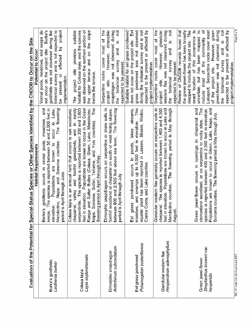


500-01 Lake County Courthouse BSR ENPLAN
Appendix FChecklist of Vascular Plant Species Observed
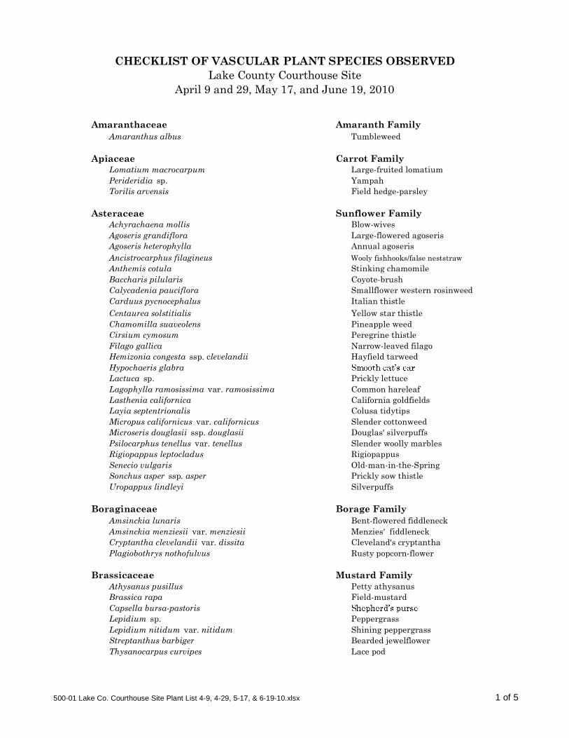
Amaranthaceae Amaranth FamilyAmaranthus albus Tumbleweed
Apiaceae Carrot FamilyLomatium macrocarpum Large-fruited lomatiumPerideridia sp. YampahTorilis arvensis Field hedge-parsley
Asteraceae Sunflower FamilyAchyrachaena mollis Blow-wivesAgoseris grandiflora Large-flowered agoserisAgoseris heterophylla Annual agoserisAncistrocarphus filagineus Wooly fishhooks/false neststrawAnthemis cotula Stinking chamomileBaccharis pilularis Coyote-brushCalycadenia pauciflora Smallflower western rosinweedCarduus pycnocephalus Italian thistleCentaurea solstitialis Yellow star thistleChamomilla suaveolens Pineapple weedCirsium cymosum Peregrine thistleFilago gallica Narrow-leaved filagoHemizonia congesta ssp. clevelandii Hayfield tarweedHypochaeris glabraLactuca sp. Prickly lettuceLagophylla ramosissima var. ramosissima Common hareleafLasthenia californica California goldfieldsLayia septentrionalis Colusa tidytipsMicropus californicus var. californicus Slender cottonweedMicroseris douglasii ssp. douglasii Douglas' silverpuffsPsilocarphus tenellus var. tenellus Slender woolly marblesRigiopappus leptocladus RigiopappusSenecio vulgaris Old-man-in-the-SpringSonchus asper ssp. asper Prickly sow thistleUropappus lindleyi Silverpuffs
Boraginaceae Borage FamilyAmsinckia lunaris Bent-flowered fiddleneckAmsinckia menziesii var. menziesii Menzies' fiddleneckCryptantha clevelandii var. dissita Cleveland's cryptanthaPlagiobothrys nothofulvus Rusty popcorn-flower
Brassicaceae Mustard FamilyAthysanus pusillus Petty athysanusBrassica rapa Field-mustardCapsella bursa-pastorisLepidium sp. PeppergrassLepidium nitidum var. nitidum Shining peppergrassStreptanthus barbiger Bearded jewelflowerThysanocarpus curvipes Lace pod
Lake County Courthouse SiteApril 9 and 29, May 17, and June 19, 2010
CHECKLIST OF VASCULAR PLANT SPECIES OBSERVED
500-01 Lake Co. Courthouse Site Plant List 4-9, 4-29, 5-17, & 6-19-10.xlsx 1 of 5

Lake County Courthouse SiteCHECKLIST OF VASCULAR PLANT SPECIES OBSERVED
Campanulaceae Bluebell FamilyGithopsis specularioides Common bluecup
Caryophyllaceae Pink FamilyCerastium glomeratum Mouse-eared chickweedMinuartia douglasii Douglas' sandwortPetrorhagia dubia Grass pinkScleranthus annuus ssp. annuus German knotgrass Spergularia rubra Ruby sand spurry
Convolvulaceae Morning Glory FamilyConvolvulus arvensis Bindweed
Crassulaceae Stonecrop FamilyCrassula tillaea Moss pygmy weed
Cucurbitaceae Gourd FamilyMarah sp. Man-root
Cuscutaceae Dodder FamilyCuscuta californica Chaparral dodder
Euphorbiaceae Spurge FamilyEremocarpus setigerus Dove weed
Fabaceae Legume FamilyAstragalus gambelianus Gambel's dwarf milkvetchLotus sp. LotusLotus denticulatus Riverbar birds-foot trefoilLotus humistratus Hairy lotusLotus purshianus Spanish lotusLupinus bicolor Bicolored lupineMedicago minima Hairy bur-cloverMedicago polymorpha California bur-cloverMedicago praecox Mediterranean bur-cloverTrifolium albopurpureum var. dichotomum Branched Indian cloverTrifolium bifidum var. decipiens Deceptive cloverTrifolium dubium Little hop cloverTrifolium hirtum Rose cloverTrifolium willdenovii Tomcat cloverVicia sativa ssp. nigra Garden vetchVicia villosa ssp. villosa Winter vetch
Fagaceae Oak FamilyQuercus lobata Valley oak (seedling)
Gentianaceae Gentian FamilyCentaurium muehlenbergii Muhlenberg's centaury
500-01 Lake Co. Courthouse Site Plant List 4-9, 4-29, 5-17, & 6-19-10.xlsx 2 of 5

Lake County Courthouse SiteCHECKLIST OF VASCULAR PLANT SPECIES OBSERVED
Geraniaceae Geranium FamilyErodium botrys Long-beaked filareeErodium brachycarpum Short-fruited storksbillErodium cicutarium Red-stemmed filaree
Hydrophyllaceae Waterleaf FamilyPhacelia corymbosa Serpentine phacelia
Iridaceae Iris FamilySisyrinchium bellum Blue-eyed grass
Juncaceae Rush FamilyJuncus bufonius Toad rush
Liliaceae Lily FamilyAllium falcifolium Scytheleaf onionBrodiaea californica var. californica California brodiaeaCalochortus vestae Coast Range mariposa lilyChlorogalum sp. Soap plantDichelostemma capitatum ssp. capitatum Blue dicks
Malvaceae Mallow FamilySidalcea diploscypha Fringed checkerbloom
Onagraceae Evening-Primrose Family Camissonia graciliflora Hill suncupClarkia gracilis ssp. gracilis Slender clarkiaClarkia gracilis ssp. tracyi Tracy's clarkiaClarkia purpurea ssp. quadrivulnera Winecup clarkiaEpilobium minutum Chaparral willowherb
Orobanchaceae Broom-rape FamilyOrobanche fasciculata Clustered broom-rape
Papaveraceae Poppy FamilyEschscholzia californica California poppyPlatystemon califonicus Creamcups
Plantaginaceae Plantain Family Plantago sp. PlantainPlantago erecta
Poaceae Grass Family Aegilops triuncialis Barbed goatgrassAira caryophyllea Silver hairgrassAvena barbata Slender wild oatsAvena fatua Wild oatsBromus carinatus var. carinatus California bromeBromus diandrus Ripgut grassBromus hordeaceus Soft chessBromus madritensis ssp. rubens Red bromeDeschampsia danthonioides Annual hairgrass
500-01 Lake Co. Courthouse Site Plant List 4-9, 4-29, 5-17, & 6-19-10.xlsx 3 of 5

Lake County Courthouse SiteCHECKLIST OF VASCULAR PLANT SPECIES OBSERVED
Elymus multisetus Big squirreltailHordeum brachyantherum ssp. californicum California barleyHordeum marinum ssp. gussoneanum Mediterranean barleyHordeum murinum Foxtail barleyLolium multiflorum Annual ryegrassMelica californica California melicNasella pulchra Purple needlegrassPoa annua Annual bluegrassPoa secunda ssp. secunda One-sided bluegrassScribneria bolanderi Scribner grassSecale cereale RyeTaeniatherum caput-medusae Medusa headVulpia microstachys var. ciliata Fringed fescueVulpia microstachys var. microstachys Small fescueVulpia microstachys var. pauciflora Few-flowered fescue Vulpia myuros var. myuros Rattail fescue
Polemoniaceae Phlox FamilyGilia capitata ssp. capita Globe giliaGilia tricolorLeptosiphon bolanderi Bolander's linanthusLinanthus bicolor Bicolored linanthus
Polygonaceae Buckwheat FamilyEriogonum nudum Naked buckwheatEriogonum vimineum Wicker buckwheatRumex crispus Curly dock
Portulacaceae Purslane Family Calandrinia ciliata Red maidsClaytonia exigua ssp. exigua Little miner's-lettuceClaytonia perfoliata
Primulaceae Primrose FamilyAnagallis arvensis Scarlet pimpernel
Pteridaceae Brake FamilyPentagramma triangularis ssp. triangularis Goldback fern
Ranunculaceae Buttercup FamilyDelphinium hansenii ssp. hansenii Eldorado larkspurRanunculus sp. Buttercup
Rosaceae Rose FamilyCrataegus sp. Hawthorn (horticultural)
Rubiaceae Madder FamilyGalium aparine CleaversGalium parisiense Wall bedstraw
500-01 Lake Co. Courthouse Site Plant List 4-9, 4-29, 5-17, & 6-19-10.xlsx 4 of 5

Lake County Courthouse SiteCHECKLIST OF VASCULAR PLANT SPECIES OBSERVED
Scrophulariaceae Snapdragon Family Castilleja attenuata Valley tasselsCastilleja exserta ssp. exserta Exserted Indian paintbrushCastilleja rubicundala ssp. lithospermoides Cream sacsCollinsia sparsiflora var. sparsiflora Spinster's blue eyed MaryMimulus guttatus Common monkey-flowerTriphysaria eriantha Johnny tuckVerbascum blattaria Moth mullein
Taxodiaceae Bald Cypress FamilySequoia sempervirens Redwood (horticultural)
Valerianaceae Valerian FamilyPlectritis macrocera White plectritis
500-01 Lake Co. Courthouse Site Plant List 4-9, 4-29, 5-17, & 6-19-10.xlsx 5 of 5

500-01 Lake County Courthouse BSR ENPLAN
Appendix GChecklist of Wildlife Species Observed

500-01 Lake County Courthouse BSR ENPLAN
Checklist of Wildlife Species ObservedLake County Courthouse
675 Lakeport Boulevard, Lakeport, CACommon Name Scientific Name Status
BIRDS
American crow Corvus brachyrhynchos None
Black-tailed jackrabbit Lepus californicus None
California gull Larus californicus None
Common raven Corvus corax None
Killdeer Charadrius vociferus None
Red-tailed hawk Buteo jamaicensis None
Western scrub-jay Aphelocoma californica None
MAMMALS
California ground squirrel Otospermophilus beecheyi None
Gopher Thomomys sp. None
REPTILES
Western fence lizard Sceloperus occidentalis None

Prepared for:
July 16, 2010Adminstrative Office of the Courts
500-01
Pre-jurisdictional Delineation Report
Lake County Courthouse Site675 Lakeport BoulevardLake County, California

500-01 Delineation Report Lake County Courthouse Site ENPLAN1
Lake County Courthouse Site
Pre-jurisdictional Delineation Report
Applicant/Land Owner:Administrative Office of the Courts2860 Gateway Oaks Drive, Suite 400Sacramento, CA 95833Attention: Laura Sainz
Access:From Lakeport, take Highway 29 to the Lakeport Boulevard exit. Travel east on Lakeport Boulevard approximately 1000 feet. The site is on the south side of Lakeport Boulevard and can be accessed from the road margin.
I. INTRODUCTIONThe ±6.4-acre study site is located east of the intersection of Lakeport Boulevard
and Highway 29 in the City of Lakeport, Lake County. The study site encompasses the
subject ±5.8-acre parcel as well as the southern fill slope along Lakeport Boulevard to
the north. As shown in Figure 1, the site is situated near the center of Section 25,
Township 14 North, Range 10 West (Lakeport, CA, 7.5-minute quadrangle). The site is
identified as Lake County Assessor Parcel Number 025-521-410 and is being
evaluated for potential construction of a new Lake County courthouse.
The site elevation ranges between 1,340 and 1,400 feet above sea level. The
site was historically an oak woodland, and was used for agriculture and grazing
beginning in the late 1930s; the site was cleared of trees and shrubs in the early 1970s,
and was graded prior to 1988 (URS, 2009). Grading dramatically altered the natural
contours of the site. Roughly 20 feet of surface material was removed from the upper
portion of the site, resulting in two level terraces.
Small rocks of serpentine origin are exposed on the upper terrace and hillsides,
which support a serpentine herb community. The serpentine herb community generally
consists of a sparse, low-growing cover of annual and perennial forbs and grasses
including naked buckwheat, wicker buckwheat, reflexed fescue, serpentine phacelia,
milkvetch. The lower terrace, on the eastern edge of the study area, supports an
annual grassland community. Common species in this community include wild oats,
soft chess, California meadow barley, cream sacs, winter vetch, Spanish lotus, and
various clovers. All of the above species have an indicator status of FACU or drier.

05.19.10
Figure 1
Project Vicinity Map
Feature and boundary locations depicted are approximate only.
X 0 2,000Feet
Lake County, California
Site
Project Site
USGS Lakeport 7.5-minute QuadrangleSection 25, Township 14 North, Range 10 WestCentroid: Lat: 39° 2' 1.56" Long: -122° 55' 14.54"

500-01 Delineation Report Lake County Courthouse Site ENPLAN3
According to the U.S. Department of Agriculture, Natural Resources
Conservation Service (NRCS, 2010), two soil units are present on the study site.
Henneke-Montara-rock outcrop complex, 15-30 percent slopes, covers nearly the
entirety of the study site. A very small amount of Still loam, stratified substratum, is
mapped as occurring in the extreme northeast corner of the site. The Henneke-
Montara-rock outcrop complex is not considered hydric, while the Still soil unit is partly
hydric, i.e., it may contain inclusions of hydric soils. It should be noted that past grading
activities on the site have resulted in removal and/or redistribution of most of the on-site
soils.
The climate of the project vicinity is of the Mediterranean type, with cool, moist
winters and hot, dry summers. Annual precipitation averages ±28.4 inches in the
community of Lakeport, which reasonably approximates conditions on the subject site
(Western Regional Climate Center, 2010).
II. METHODOLOGYPrior to undertaking the field studies, National Wetlands Inventory maps (U.S.
Fish and Wildlife Service, n.d.) were reviewed to determine if any jurisdictional waters
had been previously reported on or within one-half mile of the project site. Such data is
not available for the Lakeport quadrangle.
The primary field investigation was conducted on April 29 and 30, 2010. During
the field investigation, field conditions were relatively wet. Average April rainfall for the
City of Lakeport measures 2.19 inches; actual rainfall totals for April 2010 measured
6.89 inches (NOAA, 2010).
The wetland investigation was conducted in accordance with technical methods
outlined in the Corps of Engineers Wetlands Delineation Manual (U.S. Department of
the Army, Corps of Engineers, 1987) and under the Regional Supplement to the Corps
of Engineers Wetland Delineation Manual: Arid West Region (U.S. Department of the
Army, Corps of Engineers, 2008
this report. Wetland Determination Data Forms are presented in Appendix A of this
report.

500-01 Delineation Report Lake County Courthouse Site ENPLAN4
Although no wetlands were identified, several non-wetland waters of the United
States are present. these features
is represented by the ordinary high water mark. As described in the Code of Federal
Regulations Title 33: Navigation and Navigable Waters-Sec. 328.3(e), the ordinary high
water mark is defined as the line on the shore established by fluctuations of water
indicated by physical characteristics. These may include a clear/natural line on the
bank, shelving, changes in soil, destruction of terrestrial vegetation, presence of litter
and debris, or other appropriate means that consider the characteristics of the
surrounding areas. The limits of on-site ditches and seasonal waters were identified in
the field using these indicators.
Scientific nomenclature for plants cited in this report is in accordance with the
taxonomic treatments presented in A Synonymized Checklist of the Vascular Flora of
the United States, Canada, and Greenland (Kartesz, 1994). The wetland indicator
status of the plants was determined using the National List of Plant Species That Occur
in Wetlands: California (Region 0) (U.S. Department of the Interior, Fish and Wildlife
Service, 1988). Soil colors were identified using Munsell Soil Color Charts (Kollmorgen
Instruments Corporation, 2000).
Coordinates along the perimeters of non-linear waters were obtained using a
global positioning system (GPS) unit capable of sub-meter accuracy. Coordinates for
the centerlines of ditches were also recorded with the GPS unit; the aerial extent of the
ditches was calculated based on cross-sectional measurements taken at roughly 25-
foot intervals. The GPS coordinates were downloaded into ArcMap for mapping and
acreage calculations.
III. RESULTSDuring the field investigation, ENPLAN mapped eight non-wetland waters of the
United States within two categories: seasonal waters and constructed ditches. These
features are characterized below. The results of the field delineation effort are
summarized in Tables 1 and 2 and shown in Figure 2. Representative photos are
presented in Appendix B.

500-01 Delineation Report Lake County Courthouse Site5
Seasonal Waters: Two seasonal waters, on the western edge of the upper terrace, were created when the site was graded and bedrock was exposed.Water now ponds to a depth of two to three inches in these shallow depressionsunderlain by bedrock. Representative plant species include scribner grass (Scribneria bolanderi, UPL), annual hairgrass (Deschampsia danthonioides,FACW), and rigiopappus (Rigiopappus leptocladus, UPL), but vegetative cover is less than five percent. As described in the Arid West Supplement, features with an ordinary high water mark and less than five percent vegetative cover are non-wetland waters. The extent of ponding was documented through site inspections on February 8 and April 9, 29 and 30, 2010, as well as by the presence of water-stained rock, sediment deposits, and a biotic crust.
Constructed Ditches: Constructed ditches are excavated features that may be located in either wetlands or uplands, and may convey water collected from sheet flow or diverted from other water bodies. The jurisdictional status of constructed ditches depends in part on these characteristics. The on-site ditchesare constructed in uplands, and receive sheet-flow runoff and discharge from thetwo non-wetland waters on the upper terrace. Most of the ditches have only ephemeral flow. However, 3:CD and 8:CD do not drain well and support wetland plant species in their lower ends; species present include annual ryegrass(Lolium multiflorum = L. perenne, FAC*), Hordeum marinum ssp. gussoneanum= H. hystrix, FAC), and common monkey-flower (Mimulus guttatus, OBL).
Table 1Summary of Waters by Type
Type Areasq. ft. acres
Constructed Ditches 2,108 0.048Seasonal Waters 3,793 0.087
Total Waters 5,901 0.135
Table 2Waters by Map ID
Map ID Type Average
Width Length Areasq. ft. acres
1 Constructed Ditch 1.7 350 595 0.0142 Constructed Ditch 0.5 20 10 0.0003 Constructed Ditch 4.6 206 948 0.0224 Seasonal Water 2,599 0.0605 Seasonal Water 1,194 0.0276 Constructed Ditch 1.6 178 285 0.0077 Constructed Ditch 1.5 10 15 0.0008 Constructed Ditch 2.3 111 255 0.006
Total Waters 5,901 0.135

?
07.16.10Feature and boundary locations depicted are approximate only.
X 0 100Feet
Study Area Boundary
Parcel Boundary
Seasonal Water
Constructed Ditch
Culvert
Flow Direction
? Storm Drain Inlet
Data Point
1:CD 2:CD
4:SW
5:SW6:CD
7:CD
8:CD
3:CD
1:CD
DP1
DP3
Lakeport Boulevard
DP2
sq. f t. acres
1:CD Constructed Ditch 1.7 350 595 0.0142:CD Constructed Ditch 0.5 20 10 0.0003:CD Constructed Ditch 4.6 206 948 0.0224:RW Seasonal Water 2,599 0.0605:RW Seasonal Water 1,194 0.0276:CD Constructed Ditch 1.6 178 285 0.0077:CD Constructed Ditch 1.5 10 15 0.0008:CD Constructed Ditch 2.3 111 255 0.006
5,901 0.135
Potential Waters by Map IDArea
Map ID TypeAverage
Width (feet)Length(feet)
Total Waters
Project:Delineator:Date:Date Revised:
February 8 & April 9, 29, & 30, 2010
Lake County Courthouse SiteDon Burk
Figure 2Potential Waters of the U.S. and/or State

500-01 Delineation Report Lake County Courthouse Site ENPLAN7
IV. JURISDICTIONAL DETERMINATIONAs described in Regulatory Guidance Letter 08-02, the applicant concurs with the
Army Corps of Engineers that waters regulated under the Clean Water Act may be
present on the site. As such, these waters will be treated as jurisdictional for the
purpose of calculating fill and satisfying future mitigation requirements. The applicant
understands that they can later request and obtain an approved JD if that later becomes
necessary or appropriate during the permit process or during the administrative appeal
process.

500-01 Delineation Report Lake County Courthouse Site ENPLAN8
V. REFERENCESKartesz, J.T. 1994. A Synonymized Checklist of the Vascular Flora of the United
States, Canada, and Greenland. 2nd edition. Volume 1 Checklist, Volume 2 Thesaurus. Timber Press, Inc., Portland, Oregon.
Kollmorgen Instruments Corporation. 2000. Munsell Soil Color Charts.
URS Corporation. December 2009. Final Draft Phase I Environmental Site Assessment Report: Proposed New Lakeport Courthouse 675 Lakeport Boulevard Site. 675 Lakeport Boulevard, Lakeport CA 95453. Unpublished document on file with the Judicial Council of California, Administrative Office of the Courts.
U.S. Department of Agriculture, Natural Resources Conservation Service. 2009. Web Soil Survey, August 31, 2009 Map Data. <http://websoilsurvey.nrcs.usda.gov/app/.>
U.S. Department of the Army, Corps of Engineers. 1987. Corps of Engineers Wetlands Delineation Manual. Technical Report Y-87-1. National Technical Information Service, Springfield Virginia.
_____. 2008. Regional Supplement to the Corps of Engineers Wetland Delineation Manual: Arid West Region (Version 2.0), eds. J.S. Wakeley, R.W. Lichvar, and C.V. Noble. ERDC/EL TR-08-28. Vicksburg, MS: U.S. Army Engineer Research and Development Center.
U.S. Department of the Interior, Fish and Wildlife Service. 1988. National List of Plant Species That Occur in Wetlands: California (Region 0). Biological Report 88 (26.10).
_____. n.d. National Wetlands Inventory. www.wetlandsfws.er.usgs.gov.
U.S. Geological Survey. 1958. Lakeport, California, 7.5-minute quadrangle sheet. Photo-revised 1978.
Western Regional Climate Center (WRCC). 2010. Lakeport, CA. www.wrcc.dri.edu/climsum.html.

500-01 Delineation Report Lake County Courthouse Site ENPLAN
APPENDIX A
Wetland Determination Forms


500-01 Delineation Report Lake County Courthouse Site ENPLAN
APPENDIX B
Representative Photos

Representative Photos of On-site Waters
500-01
4:SW looking southeast 2/8/10
5:SW looking southeast 2/8/10

500-01
Biotic crust in 5:SW 4/29/10
1:CD looking west 4/29/10

500-01
Lower terminus of 1:CD and 2:CD, with discharge to uplands 4/29/10
3:CD looking north 4/29/10

500-01
6:CD (foreground) looking northeast 4/29/10
8:CD looking west toward culvert 3/17/10
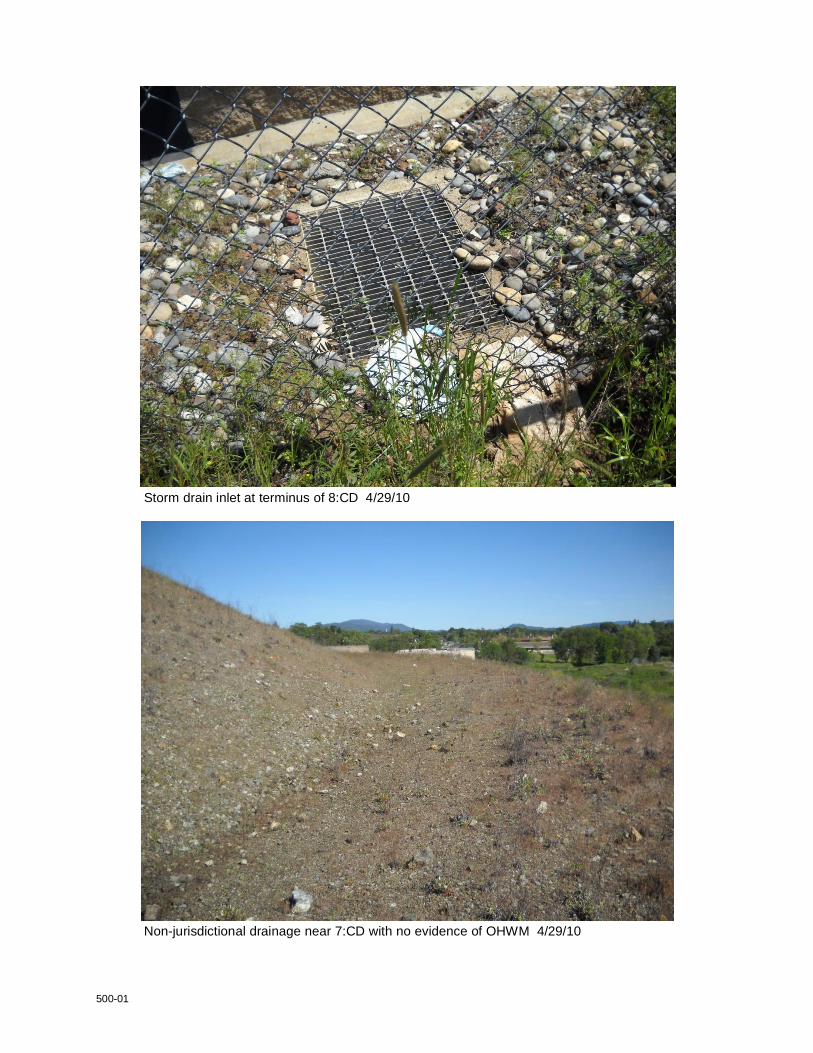
500-01
Storm drain inlet at terminus of 8:CD 4/29/10
Non-jurisdictional drainage near 7:CD with no evidence of OHWM 4/29/10

Appendix C Biological Resources Documentation

Biological Study Report
Lake County Courthouse675 Lakeport Boulevard, Lakeport, CA
Prepared for:
RBF Consulting500-01
July 15, 2010
Prepared by:

500-01 Lake County Courthouse BSR ENPLANi
TABLE OF CONTENTS
1. INTRODUCTION ....................................................................................................... 1
2. METHODOLOGY AND STAFF QUALIFICATIONS................................................... 2
3. RESULTS ................................................................................................................. 4
Plant Communities/Wildlife Habitats .......................................................................... 4
Special-Status Plant Species..................................................................................... 7
Special-Status Animal Species ............................................................................... 10
Nesting Migratory Birds ........................................................................................... 11
Resource-Agency Permits ...................................................................................... 11
4. CONCLUSIONS AND RECOMMENDATIONS ....................................................... 13
5. REFERENCES CITED ............................................................................................ 15
APPENDICES
Appendix A. Figures
Appendix B. Site Photographs
Appendix C. Wildlife Habitat Relationships Report Summary
Appendix D Rarefind (CNDDB) Report Summary
Appendix E. Evaluation of the Potential for Special-Status Species or Other Species Identified by the CNDDB to Occur on the Site
Appendix F. Checklist of Vascular Plant Species Observed
Appendix G. Checklist of Wildlife Species Observed

500-01 Lake County Courthouse BSR ENPLAN1
1. INTRODUCTIONThe purpose of this biological study report is to identify and characterize sensitive
natural communities and plant and wildlife resources that are known or expected to
occur on a ±5.8-acre project site at 675 Lakeport Boulevard, in the City of Lakeport,
Lake County. The site, identified as Lake County -521-
410, is being evaluated for potential construction of a new courthouse. As shown in
Figure 1 of Appendix A, the site is located in near the center of Section 25, Township 14
North, Range 10 Lakeport 7.5-minute
quadrangle. Photographs of the site are provided in Appendix B.

500-01 Lake County Courthouse BSR ENPLAN2
2. METHODOLOGY AND STAFF QUALIFICATIONSPrior to conducting fieldwork, a biological records search was completed. This
consisted of reviewing the California Department of Fish and Game's California Natural
Diversity Data Base (CNDDB) as well as available local records. The CNDDB records
search covered a 10-mile radius around the site. This entailed review of records for
portions of the following quadrangles: Cow Mountain, Upper Lake, Bartlett Mountain,
Oaks, Hopland, Highland Springs,
Kelseyville, and Clearlake Highlands. Available local records consisted of a biological
study report and wetland delineation (Northwest Biosurvey, 2006) prepared for a site
approximately 0.3 miles to the north of the subject site on Martin Street, and an Initial
Study for the same site (City of Lakeport, 2010). The Martin Street site has physical
and biological characteristics similar to the subject site, supports several of the same
special-status plant species, and was used as a reference site to check the phenology
of local special-status plant species.
Upon completion of the pre-field review, a botanical field survey was undertaken
in general accordance with Protocols for Surveying and Evaluating Impacts to Special
Status Native Plant Populations and Natural Communities (DFG, 2009). Because of the
potential requirement for frontage improvements on Lakeport Boulevard, lands between
the subject parcel and the street were included in the biological study area. The
botanical survey was conducted on April 9 and 29, May 17, and June 19, 2010. All of
the special-status plant species potentially occurring in the study area would have been
evident at the time the fieldwork was conducted. The survey consisted of an intensive
and systematic evaluation of the site; the field survey effort included four to six hours of
field time during each of the four site visits.
The locations and approximate population numbers/densities of the identified
special-status plant populations were determined by gridding each population into a
number of small polygons and then estimating the number of plants in each polygon.
The wildlife evaluation was conducted in three phases. The first phase consisted
of the records search described above. Under the second phase, the habitats and
special habitat elements in the study area were determined through field
reconnaissance. A list of wildlife species that could potentially occur in the identified

500-01 Lake County Courthouse BSR ENPLAN3
Habitat Relationships (WHR)
System, Version 8.2 (DFG, 2008). This is a predictive system based on scientific
information regarding wildlife species and their known habitat relationships. It is useful
as a general pre-field screen and provides a somewhat broader view of special-status
species potentially occurring in the study area.
The wildlife survey was conducted on March 17, 2010. Many of the special-
status animal species potentially occurring in the study area would have been evident at
the time the fieldwork was conducted. The potential presence of species not readily
identifiable during the field surveys was determined on the basis of observed habitat
characteristics. The initial field effort included approximately three hours of field
observations; additional wildlife observations were made during the botanical field
survey visits.
The botanical field surveys were conducted by Donald Burk. Mr. Burk has a
Bachelor of Arts degree in Biological Sciences and a Master of Science degree in
Botany. He has over 25 years of experience in the design and implementation of
botanical field studies. He has previously conducted botanical surveys in Lakeport and
is familiar with flora of the region as well as state and federal statutes pertaining to
special-status species. The wildlife evaluation was conducted by Darrin Doyle. Mr.
Doyle has a Bachelor of Science degree in biology, and has 10 years of experience
conducting biological surveys in California. He is familiar with wildlife species of the
region and their habitat requirements.
California red-legged frog and vernal pool crustaceans.
500-01 Lake County Courthouse BSR ENPLAN4
3. RESULTSPlant Communities/Wildlife Habitats
The study site is situated between approximately 1,340 and 1,400 feet above sea
level, and is surrounded on three sides by urban development. The site was historically
an oak woodland, and was used for agriculture and grazing beginning in the late 1930s;
the site was cleared of trees and shrubs in the early 1970s, and was graded prior to
1988 (URS, 2009). Soils on the site are identified as Henneke-Montara-rock outcrop
complex, 15 to 50 percent slopes, with a negligible amount of Still loam, stratified
substratum, in the extreme northeast corner of the site (USDA, NRCS, 2009). The
Henneke-Montara complex consists of very deep, moderately well-drained soils formed
in alluvium from mixed rock types. However, grading activities dramatically altered the
soils and natural contours of the site. Roughly 20 feet of surface material was removed
from the upper portion of the site, resulting in two level terraces.
Small rocks of serpentine origin are exposed on the upper terrace and hillsides,
which support a serpentine herb community. The lower terrace supports a disturbed
annual grassland. These two communities are described in more detail below; locations
of the communities are shown on Figure 3 of Appendix A and photographs are provided
in Appendix B. Two small, shallow seasonal waters with rock substrates are present on
the upper terrace. Most runoff from the site enters constructed ditches that convey flow
to the east. Flow enters drain system, which discharges into Clear
Lake approximately ¼-mile east of the site.
Annual grassland
Annual grasslands are characterized by a sparse to dense cover of annual
Germination occurs with the onset of the fall rains; growth, flowering, and seed-set
occur from winter through spring. With a few exceptions, the plants are dead through
the summer-fall dry season, persisting as seeds. On the subject site, the annual
grassland community is best represented on the lower terrace of the site, on the eastern
edge of the study area. Common species in this community include wild oats, soft
500-01 Lake County Courthouse BSR ENPLAN5
chess, California meadow barley, cream sacs, winter vetch, Spanish lotus, and various
clovers. Although several special-status plant species were observed on the fringe of
the annual grassland community, the community itself is not considered unique or
sensitive.
High-quality annual grasslands are inhabited by a variety of wildlife species.
Common mammals include black-tailed jackrabbit, coyote, gophers, moles, and several
species of mice and voles. Snakes are often abundant in annual grasslands, feeding on
small rodents. Amphibians are relatively uncommon in annual grasslands; however,
species such as the western toad and Pacific treefrog may be locally abundant near
aquatic habitats. Annual grassland also provides nesting and foraging habitat for
certain migratory birds, including western meadowlarks, various sparrows, western
kingbirds, and horned larks. The WHR data base predicts that this habitat type may be
inhabited by 83 species of wildlife (Appendix C). However, because the onsite
grassland is a small, fragmented relic of the grassland that historically was interspersed
among the oak woodland, far fewer animal species are expected to be present. Overall,
the onsite grassland has low value to wildlife species.
Serpentine herb community
The onsite serpentine herb community generally consists of a sparse, low-
growing cover of annual and perennial forbs and grasses on the upper terrace and
hillsides. Serpentine soils have unique chemical properties that prohibit the growth of
many common plant species. A number of other plant species have evolved
mechanisms allowing them to survive on serpentine soils. The flora of serpentine sites
is thus unique and often supports plants of limited distribution, including a number of
endemic species. Plant species observed on the site include naked buckwheat, wicker
buckwheat, reflexed fescue, serpentine phacelia, fringed checkerbloom, bearded
. As discussed below,
four serpentine-adapted special-status plant species were also observed in this
community.
With the exception of crevices between boulders, the serpentine herb community
lacks sufficient cover objects for most animal species. Accordingly, this habitat type

500-01 Lake County Courthouse BSR ENPLAN6
supports relatively few species of wildlife. Ground squirrels, which are present in small
numbers on the site, create their own shelter by burrowing into hillsides or under large
boulders. A number of birds may forage in this habitat; gulls, ravens, and crows were
While the serpentine herb community does not provide tree-nesting habitat for birds,
ground-nesting species such as the killdeer could potentially nest on the site. Overall,
this habitat type has low value to wildlife species. No estimate on the number of
animals that may potentially utilize the serpentine herb community is available, as there
is no corresponding WHR habitat type for this community.
Site grading resulted in the creation of two very shallow depressions on the
western edge of the serpentine herb community. These depressions pond water to a
depth of two to three inches. Because of the underlying bedrock, the water ponds for
long duration. These features appear to be subject to U.S. Army Corps of Engineers
jurisdiction as non-
and southwest corners of the upper terrace and overflow enters small constructed
essentially unvegetated and provide minimal wildlife value. However, they do attract
some species, such as killdeer. A delineation of wetlands and other waters on the
subject site has been completed by ENPLAN and is presented in a separate report
(ENPLAN, 2010).
The serpentine herb community is considered to be a sensitive natural
community due to its somewhat restricted distribution and the high potential for endemic
plant species to be present. The onsite community has been highly disturbed by
grading. Although this has reduced the value of the site for some plant species, it has
r
special-status species. Loss of the serpentine herb community as a result of project
development is considered a significant adverse impact. Mitigation for this loss is best
considered in conjunction with impacts on the four special-status plant species, and is
addressed below.

500-01 Lake County Courthouse BSR ENPLAN7
Special-Status Plant SpeciesReview of CNDDB records showed that two special-status plant species, green
jewel-flower and mayacamas popcorn-flower, have been broadly mapped to include the
study area. Twenty-six other special-status plant species are known to occur within a
10-mile radius: -flowered fiddleneck,
Boggs Lake hedge-
ic snapdragon, eel-grass pondweed, glandular
moss, oval-leaved viburnum, Raiche
monardella, serpentine cryptantha, small-flowered calycadenia, small groundcone,
Sonoma canescent manzanita, two-carpellate western flax, and woolly meadowfoam
(Appendix D). The potential for each special-status plant species to utilize the study
area is evaluated in Appendix E.
The botanical survey confirmed the presence of four special-status plant species
on the project site: Colusa layia, bent-flowered fiddleneck, serpentine cryptantha, and
a special-status species not reported in the CNDDB records search).
The locations of the plant populations are shown in Figure 3 of Appendix A. A checklist
of vascular plant species observed during the botanical field surveys is provided in
Appendix F. Data forms documenting the special-status plant occurrences have been
submitted to the California Natural Diversity Data Base.
Colusa layia (Layia septentrionalis)
Colusa layia is an annual herb that occurs in oak woodlands, chaparral, valley
and foothill grasslands, and in sandy serpentinite. The species is not state or federally
listed, but is on CNPS List 1B.2 (Plants Rare, Threatened, or Endangered in California
and Elsewhere; Fairly Threatened in California). The species occurs between 300 and
3,600 feet in elevation. A total of 44 populations are reported in CNDDB records.
These populations occur in the North Coast Range and Sutter Buttes (Colusa, Glenn,
Lake, Mendocino, Napa, Sonoma, Sutter, Tehama, and Yolo counties). Reported
population sizes (available for only about 25 percent of the records) range mostly from
100 to 200 plants, with the largest reported population having about 2,000 plants. With

500-01 Lake County Courthouse BSR ENPLAN8
roughly 20,000 to 25,000 plants observed on the subject site, the onsite Colusa layia
population is by far the largest of those for which data is available. On the subject site,
the species is most abundant on hillsides within the serpentine herb community, with a
small number of plants present on the upper and lower terraces.
Bent-flowered fiddleneck (Amsinckia lunaris)
Bent-flowered fiddleneck occurs in cismontane woodlands, and valley and foothill
grassland. The species is not state or federally listed, but is on CNPS List 1B.2 (Plants
Rare, Threatened, or Endangered in California and Elsewhere; Fairly Threatened in
California). The species is reported between 50 and 1,500 feet in elevation. A total of
50 populations are reported in CNDDB records. Populations are known to occur in
Lake, Marin, Napa, Colusa, Contra Costa, Alameda, San Benito, Santa Clara, Santa
Cruz, Yolo, and San Mateo counties. Reported population sizes (available for only
about 35 percent of the records) range mostly from 10 to 300 plants. The largest
quantified population size estimate is 3,650 plants, although the plants are noted to be
. Approximately 500 bent-flowered fiddleneck plants were
observed on the subject site, primarily growing on hillsides within the serpentine herb
community.
Serpentine cryptantha (Cryptantha clevelandii ssp. dissita)
Serpentine cryptantha generally occurs on serpentine rock outcrops in chaparral
communities. The species is reported between 1,100 and 2,400 feet in elevation. The
species is not state or federally listed, but is on CNPS List 1B.1 (Plants Rare,
Threatened, or Endangered in California and Elsewhere; Seriously Threatened in
California). A total of 10 populations are reported in CNDDB records. Populations are
known to occur in Lake, Mendocino, Napa, and Sonoma counties. Six of the ten
populations were observed between 1902 and 1967, the remaining four populations
were observed between 1999 and 2003. No population size data is available.
Approximately 10,000 serpentine cryptantha plants were observed on the subject site.
Most of the plants occur within the serpentine herb community, on the upper terrace and
on the hillside just below the upper terrace.

500-01 Lake County Courthouse BSR ENPLAN9
Clarkia gracilis ssp. tracyi)
generally occurs on serpentine soils in chaparral communities.
The species is reported from 200 to 2,200 feet above sea level. The species is not
state or federally listed, but is on CNPS List 4.2 (Plants of Limited Distribution (A Watch
List); Fairly Threatened in California). Populations are known to occur in Colusa,
Humboldt, Lake, Mendocino, Napa, Trinity, and Tehama counties. Because of the
lower CNPS status, the CNDDB does not offer online data regarding the number of
recorded populations or population sizes. Nearly 10,000
observed on the site. All of these plants were growing on the periphery of the site, on
both undisturbed and highly disturbed soils.
As noted above, Colusa layia, serpentine cryptantha, and bent-flowered
fiddleneck are on the Californi B. Although not state or
federally listed, plants with this CNPS listing status are generally considered to qualify
as rare under Section 15380(d) of the California
Environmental Quality Act (CEQA) Guidelines and thus require consideration during
CEQA review. r
state listing, but may be locally significant. As such, potential impacts to this species
should also be evaluated during the CEQA process.
Because detailed site development plans have not yet been prepared, the extent
of impacts to the serpentine herb community and the four onsite special-status plant
species cannot be quantified. However, in general terms, site development has a high
potential to adversely affect these resources
the least sensitive of the plants, would be least affected because it primarily occurs on
the periphery of the site. Serpentine cryptantha, which is the most sensitive of the four
species on the site, is the most centrally located and would be the most difficult to avoid
during site development. Because all four of the special-status plant species have an
affinity for serpentine soils, mitigation for the loss of the plants would also provide at
least some mitigation for the loss of the serpentine herb community.
Department of Fish and Game staff were contacted following discovery of the
special-status plant populations. However, the DFG has not conducted a field review of

500-01 Lake County Courthouse BSR ENPLAN10
the site or provided guidance as to potential mitigation strategies. Because full
avoidance of the special-status plant populations and serpentine herb community does
not appear to be possible, we recommend that the project proponent prepare a
mitigation plan acceptable to DFG prior to project construction. Mitigation would likely
include avoidance of at least some of the onsite serpentine herb community and
associated special-status plant populations. Detailed mapping of the extent and
densities of the special-status plant communities prepared as part of the botanical study
(Figure 3 of Appendix A) will assist in preparing a site design that minimizes impacts to
the populations. We recommend that the mitigation plan be prepared as early as
possible, in conjunction with preparation of site design and development plans. Other
options for mitigation include preservation of other local populations of these special-
status plants, restoration of degraded populations on other sites in the area, and/or
creation or new populations.
Special-Status Animal SpeciesReview of CNDDB records showed that one special-status animal species,
American badger, has been broadly mapped as occurring within the study area. In
addition, eight other special-status animal species are known to occur within a 10-mile
radius: Clear Lake hitch, foothill yellow-legged frog, grasshopper sparrow, Pacific fisher,
-eared bat, tricolored blackbird, and western pond
turtle (Appendix D). The CNDDB records search also identified seven non-status
animal species within the search radius: Calasellus californicus sage sparrow,
blennosperma vernal pool andrenid bee, double-crested cormorant, great blue heron,
osprey, and silver-haired bat.
The potential for each special-status animal species to utilize the study area is
evaluated in Appendix E. No special-status animal species were observed in the study
area during the wildlife evaluation. However, as documented in Appendix E, two
special-status animal species, grasshopper sparrow -eared bat, as
well as the non-status silver-haired bat could potentially utilize the site as some point
during their life cycles. A checklist of wildlife species observed at the site is presented
in Appendix G.

500-01 Lake County Courthouse BSR ENPLAN11
The grasshopper sparrow, a migratory bird, has a low potential to nest in the
onsite annual grassland community. Potential adverse effects on nesting grasshopper
sparrows can be avoided through proper timing of vegetation removal (see Nesting
Migratory Birds below).
-eared bat and silver-haired bat could potentially forage on the
site. However, they are very unlikely to roost on the site, given the lack of suitable
roosting sites. Because suitable roosting habitat is much more available on other local
sites and similar or higher quality foraging habitat is widely available, site development
would have a negligible effect on these bat species; no mitigation is warranted.
Nesting Migratory BirdsAlthough no bird nests were observed in the study area during the field
inspections, it is possible that migratory birds, particularly ground-nesting species, could
nest on the study area in future years. The federal Migratory Bird Treaty Act requires
that nesting migratory birds not be adversely affected by human activities. To ensure
compliance with the Act, vegetation should be removed from the project area outside of
the nesting season. In the local area, most birds nest between March 1 and July 31.
Accordingly, the potential for adversely affecting nesting birds can be greatly minimized
by removing vegetation before March 1 or after July 31. If this is not possible, a nesting
survey should be conducted within two weeks prior to vegetation removal. If active
nests are present, work within 500 feet of the nest(s) should be postponed until the
young have fledged, unless a smaller nest buffer zone is authorized by the DFG.
Resource-Agency Permit RequirementsIf the Corps of Engineers confirms that the small depressions and constructed
ditches are waters subject to federal jurisdiction, a Department of the Army permit would
be required prior to fill of the features. As a condition of the Department of the Army
permit, issuance of a Water Quality Certification by the Regional Water Quality Control
Board would also be required. It is unlikely that a Streambed or Lakebed Alteration
Agreement would be required by the Department of Fish and Game; however, we
recommend this be confirmed through consultation with Department staff. As for any

500-01 Lake County Courthouse BSR ENPLAN12
project involving more than one acre of surface disturbance, a General Construction
Activity Storm Water Permit must be obtained from the State Water Resources Control
Board; this requires preparation and implementation of a Storm Water Pollution
Prevention Plan. Project implementation would also necessitate obtaining other permits
(e.g., encroachment permits, air quality permits), but these involve issues beyond the
scope of this document.

500-01 Lake County Courthouse BSR ENPLAN13
4. CONCLUSIONS AND RECOMENDATIONSIn summary, we find that the study area supports non-
a unique serpentine herb community, and four special-status plant
species: Colusa layia, serpentine cryptantha, bent-
clarkia. In addition, two special-status animal species (grasshopper sparrow and
-eared bat), the non-status silver-haired bat, and nesting migratory birds
could potentially utilize the site at some point during their life cycle.
Mitigation is not warranted for the bat species because they are unlikely to roost
on the site and foraging habitat is widely available. Mitigation is not warranted for
Tra
for the serpentine herb community and other three special-status plants is expected to
Implementation of the following measures would
reduce the remaining biological impacts to a level below that of significance.
1. Obtain Required Resource-Agency Permits. The project proponent shall obtain all necessary resource-agency permits prior to initiating any grading or construction activities w The required permits may include a Department of the Army Nationwide Permit from the U.S. Army Corps of Engineers, Water Quality Certification from the Regional Water Quality Control Board, andpossibly a Streambed Alteration Agreement from the California Department of Fish and Game.
2. Avoid/Minimize/Offset the Loss of the Serpentine Herb Community and Associated Special-Status Plants. The project proponent shall prepare a mitigation plan identifying specific impacts of the proposed courthouse project on the serpentine herb community, Colusa layia, serpentine cryptantha, and bent-flowered fiddleneck.The plan shall include measures to avoid and minimize impacts to these resources through careful site design and establishment of onsite avoidance areas. To the
If avoidance is not possible or does not provide sufficient mitigation, other mitigation measures shall be designated in the plan, including preservation of offsite serpentine habitats and special-status plant populations, restoration of degraded habitats on other local sites capable of supporting the sensitive resources, and/or creation of new habitats capable of supporting the sensitive resources. The mitigation plan shall be submitted to the California Department of Fish and Game for review, and must beapproved in writing by DFG prior to initiation of site construction activities.

500-01 Lake County Courthouse BSR ENPLAN14
3. Avoid Disturbance of Nesting Migratory Birds, Including Grasshopper Sparrow. If feasible, vegetation removal shall be conducted between August 1 and February 28. If vegetation removal must be conducted between March 1 and July 31, a nesting bird survey shall be conducted within two weeks prior to initiation of work; if active nests are present, work within 500 feet of the nest(s) shall be postponed until the young have fledged, unless a smaller nest buffer zone is authorized by the DFG.

500-01 Lake County Courthouse BSR ENPLAN15
5. REFERENCES CITEDCalifornia Department of Fish and Game. 2010. California Natural Diversity Data Base,
RareFind Printout, March 2010 Data.
_____. 2009. Protocols for Surveying and Evaluating Impacts to Special Status Native Plant Populations and Natural Communities. <http://nrm.dfg.ca.gov/documents/docviewer.aspx>
_____. 2008. California Interagency Wildlife Task Group. California Wildlife Habitat Relationships Systems, Version 8.2, personal computer version. Sacramento, California.
City of Lakeport. 2010. Mitigated Negative Declaration and Initial Environmental Study, Lakeport Pacific Associates. AR 10-03 / ARC 10-02 / ER 10-02.
ENPLAN. 2010. Pre-jurisdictional Delineation Report: Lake County Courthouse Site, 675 Lakeport Boulevard, Lakeport, California. Unpublished report on file with ENLAN.
Northwest Biosurvey. June 30, 2006. Biological Assessment with Botanical Survey and Wetland Delineation for the Scott Johnson Property, APN 025-431-35. <http://www.cityoflakeport.com/departments/docs.aspx>
URS Corporation. December 2009. Final Draft Phase I Environmental Site Assessment Report: Proposed New Lakeport Courthouse 675 Lakeport Boulevard Site. 675 Lakeport Boulevard, Lakeport CA 95453. Unpublished document on file with the Judicial Council of California, Administrative Office of the Courts.
U.S. Department of Agriculture, Natural Resources Conservation Service. 2009. Web Soil Survey, August 31, 2009 Map Data. <http://websoilsurvey.nrcs.usda.gov/app/.>

500-01 Lake County Courthouse BSR ENPLAN
Appendix AFigures

03.16.10
Figure 1Project Vicinity Map
Feature and boundary locations depicted are approximate only.
X 0 2,000Feet
Lake County, California
Site
Project Site

07.12.10
Figure 2Project APE and Area Surveyed
Feature and boundary locations depicted are approximate only.
X 0 300Feet
Site
Project APE and Area Surveyed

! !
!
!
!
!
!
!
!
!
!
!
!!
!
!
!!
!
!
!
!!
!
!
!
! !
!
! !
!
!!
!
!
!
!
!
!
!
! !
!
!
!!
!
!
!! !!
!
!
!
!
!
!
!
!!
!
!!!
!!!
!!
!
!
!!
!
!!
!
!
!!!
!
! !
!
!!
!
!
!!
!!
!!!!
!! !!!!!!
!
!!!
!
!
!!!
!!
! !!! !!
!! ! !!
!
!
! !
!
! !
!
!!!
!
!
!
!
!
!!
!
!
!!
!
!
!
!!
!! !
!
!
!
!
!
!
!
!!!! !
! !
!!
!
!
!!
!!
!
!! !!
!
!!!
!!!
!!
!! !!!!
!
!
!
!
!
!
!
!
!!
!!
!
!
!
! ! !!
!
!!
!!
!!
!
!!
!
!!
!
!
!
!
!
!
!
! !
!
!
!
!!!
!
!!!
!
!
!
! !
!!
!!
!
!!
!
!
!
!
!!!
!
!!
!
!
!!
!!!!
!
!
!
!
!
!!
!
!
!
!
!!
!
!!
!
!
!
!
!
!
!
!
!
!
!
!
!
!
!!
!
!
!
!
!
!
!
!
! !
!
!
!
!
!
!
!!!!
!
!
!!
!
!
!
!
!
!
!
!
! !
!
!!
!
!
!
!
!
!
!!
!!
!
!
!
!
!
!
!!
!
!!!
!!!
!
!
!
!
!
!!!!
!
!
!
!!
!
!
!
!!
!
!
!
!!
!
!
!
!! !
!
!
!
!
!
!!
!
! !
!!
!!
!
!
!!
!
!
!
!
!
!
!
!
!
!!
!
! !
!!
!
!!!
!
!
!
!
!
!!
!!
!!
!
!
!!!
!
!
!
!
!!
!
!!
!
!
!
!!!
!
!
!
!
!
!
!!!
! !!
!
!
!!
!
!
!
!
!
!
!
!!
!!
!
!
!
!
!
!
!
!
!
!
!
!
!
!
!
! !
!
!
!
!
!
!
!
! !
!
!
!
!
!
!
!! !
!
!
!
!
!
!
!
!
!
!
!
!
!
!
!
!!
!
!
!
!
! !!
!
!
!
!
!
!
!!
!
!
!!
!
!
!!
!
!
!
!
!
!
!!
!
!
!
!
!
!!
!
!!!!
!
!
!
!
!
!
!
!
!
!!
!
!
!!
!!
!
!
! !
!
! !
!
!
!
!
!!!
!
!
!!!!! !
!!
!!
!
!
!!
!
!
!!
!
!!!
!
!
!!
!! !
!
!
!!
!
!
!
!
! !
!
!
!!
!
!!
!
!
!!
!
!
!
!
!
!
!
!!
!
!
!!!
!
!
! !!
!
!
!
!
!
!
!
!!
!
!
!
!!!
!
!
!
!!
!
!!
!
!
!
!!
!!!!
!
!
!
!!
!
!
!
!
!
!
!
!
!
!
!
!
!
!
!!
!
!
!
!
!
!
!
!!!
!
!!!
!
!!
!!!
!
!
!
!
!!
!!!
!
!
!
!!!!
!
!!
!
!!!!
!
!
!!
!
!!
!!!
!!
!
!
!
!
!!
!
!
!
!!!
!!
!
!
!!
!
!!
!
!
!
!
!!
! !
!
!!
!
!!
!
!
!
!!
!
!
!!
!!
!
!!
!!
!
!!!
!!
!!
!
!!
! !!!!!
!!
!!
!
!!
!!
!
!!
!
!!
!!
!
!
! !!
!
!
!
!
!!!
!
!
! !
!
!!
! !!
! !
!!
!
!
!
!!
!!!! !
!
! !
!!
!
!
!
!
!
!
! !
! !!
! !
!!
!
!!!
!!!
!
!
!!!
!
!!
!
! !
!
! !
!
!
!
!
!
!
!
!!
!
!
!
!
!
!!
!!!
!
!
!
!
!
!
!
!
!
!
!
!!
!
!
!
!
!
!
!
!
!
!
!!
!
!!!
!
!
!!!
!! !
!!
!!!
!
!
!
!
!!!!
!
!
!
!!
!
!! !
!!
!
!
!!!!!!!
!
!!!!
!
!
!!
!
!
!
!
!
!
!
!
!
!
!
!
!
!
!
!
!
!
!
!
!
!
!
!!
!
!
!
!
!
!!
!
!
!
!
!
!
!
!
!
!
!
!
!
!
!
!!
!
!!!
!
!
!
!
!
!
!
!
!
!
!
!!
!
!
!
!
!
!
!
!
!
!
!
!
!
!
!
!
!
!
!
!
!!
!
!
!
!
!
!
!
!
!!
!
!
!
!
!!
!
!
!
!
!
!!
!
!
!
!
!
!
!
!
!
!!
!
!
!
!
!
!!
!
!
!
!
!
!
!
!
!
!
!
!
!!
!
!
!!
!
!
!
!
!
!!!
!!
!
!
!
!
!
!
!
!
!
!
!
!
!!
!
!
!
!
!
!
!
!
!!!
!!
!!
!
!
!
!
!
!
07.15.10
Special-Status Plant Population Locations and Density RepresentationFigure 3
Feature and boundary locations depicted are approximate only.
X 0 70Feet
Special Status Plant Occurrences
Bent-Flowered Fiddleneck (Amsinckia lunaris)! Colusa Layia (Layia septentrionalis)! Serpentine Cryptantha (Cryptantha clevelandii var. dissita)
!
1 Dot ± 15 Plants
Tracy's Clarkia (Clarkia gracilis ssp. tracyi)
Study Area Boundary
!
Parcel Boundary

500-01 Lake County Courthouse BSR ENPLAN
Appendix BSite Photographs

Site Photographs
500-01
Annual Grassland (front) and Serpentine Herb (back) Communities 3/17/10
Annual Grassland Community 6/17/10

500-01
Serpentine Herb Community on Upper Terrace 3/17/10
Serpentine Herb Community on Undisturbed Slope 6/17/10

500-01
Ponded Water on Upper Terrace 2/8/10
Constructed Drainage Ditch 4/29/10

500-01
Bent-flowered Fiddleneck 4/9/10
Colusa Layia 5/19/10

500-01
Serpentine Cryptantha 6/17/10
Serpentine Cryptantha on Hillside 6/17/10
500-01
Tracy's Clarkia 6/17/10
Tracy's Clarkia Habitat 6/17/10

500-01 Lake County Courthouse BSR ENPLAN
Appendix CWildlife Habitat Relationships Report Summary
ID SPECIES NAME1 2 3 4 5 6 7 8 9 10 11 12 13 14
A007 California newt 7A043 Foothill yellow-legged frog 7 11 12A046 Bullfrog 14A071 California red-legged frog 2 7R004 Western pond turtle 7 11 12R036 Western skink 7 11R048 Ringneck snake 12R057 Gopher snake 7R059 California mountain kingsnake 7 12R061 Common garter snake 1 3 5 7B051 Great blue heron 13B052 Great egret 13B071 Snow goose 14B075 Canada goose 14B077 Green-winged teal 14B079 Mallard 14B080 Northern pintail 14B083 Cinnamon teal 14B084 Northern shoverler 14B085 Gadwall 14B086 Eurasian wigeon 14B087 American widgeon 14B094 Lesser scaup 14B110 Osprey 13B111 White-tailed kite 5B113 Bald eagle 3 5 13B114 Northern harrier 7B124 Ferruginous hawk 11B126 Golden eagle 5 11 13B129 Peregrine falcon 3 5 12 13B133 Ring-necked pheasant 14B134 Sooty grouse 7 14B138 Wild turkey 14B140 California quail 7 14B141 Mountain quail 14B149 American coot 14B255 Mourning dove 14B269 Burrowing owl 7 11B272 Long-eared owl 7B273 Short-eared owl 7B338 Purple martin 7B342 Bank swallow 4B353 American crow 14B410 Loggerhead shrike 1 7B461 Common yellowthroat 7B487 Rufous-crowned sparrow 7B499 Savannah sparrow 3 7B501 Grasshopper sparrow 7B505 Song sparrow 7
WHR SPECIES SUMMARY REPORT (VERSION 8.2)
STATUS
675 Lakeport Boulevard, Lakeport, CALake County Courthouse
S:\01-Jobs Active\500-01 RBF Consulting - Lake County Courthouse\1-Documents\675 Lakeport Blvd\BSR\Appendix C - WHR\WHR report - 675 Lakeport Blvd.xls

ID SPECIES NAME STATUS
B519 Red-winged blackbird 7B520 Tricolored blackbird 7B522 Yellow-headed blackbird 7M001 Virginia opossum 14M006 Ornate shrew 1 7M018 Broad-footed mole 7M023 Yuma myotis 11M026 Fringed myotis 11M033 Western red bat 7 12M037 Townsend's big-eared bat 7 11 12M038 Pallid bat 7 11 12M045 Brush rabbit 1 3 14M047 Desert cottontail 14M051 Black-tailed jackrabbit 7 14M087 San Joaquin pocket mouse 7 11M105 California kangaroo rat 7 11M112 American beaver 14M117 Deer mouse 7M134 California vole 1 3 7 11M146 Coyote 14M147 Red fox 4 12 14M149 Gray fox 14M151 Black bear 14M152 Ringtail 5M153 Raccoon 14M157 Long-tailed weasel 14M160 American badger 7 14M161 Western spotted skunk 7 14M162 Striped skunk 14M165 Mountain lion 7M166 Bobcat 14M176 Wild pig 14M177 Elk 14M181 Mule deer 14
Total Number of Species: 83STATUS KEY:
1 = Federal EndangeredHabitats Selected: 2 = Federal Threatened
Annual grassland 3 = California Endangered4 = Caifornia Threatened5 = Caifornia Fully Protected6 = California Protected7 = California Species of Special Concern8 = Federally - Proposed Endangered9 = Federally - Proposed Threatened10 = Federal Candidate11 = BLM Sensitive12 = USFS Sensitive13 = CDF Sensitive14 = Harvest
S:\01-Jobs Active\500-01 RBF Consulting - Lake County Courthouse\1-Documents\675 Lakeport Blvd\BSR\Appendix C - WHR\WHR report - 675 Lakeport Blvd.xls

500-01 Lake County Courthouse BSR ENPLAN
Appendix DRarefind (CNDDB) Report Summary

500-01 Lake County Courthouse BSR ENPLAN
Rarefind (CNDDB) Report Summary (March 2010 Data)Lake County Courthouse
675 Lakeport Boulevard, Lakeport, CAListed Element Quadrangle1
Status2
CM UL BM PG LA LU CO HO HS KE CHAnimals
American badger SSCCalasellus californicus None
NoneBlennosperma vernal pool andrenid bee None
Clear Lake hitch SSCDouble-crested cormorant NoneFoothill yellow-legged frog SSCGrasshopper sparrow SSCGreat blue heron NoneOsprey NonePacific fisher FC, SSCSacramento perch SSCSilver-haired bat None
-eared bat SSCTricolored blackbird SSCWestern pond turtle SSC
PlantsAnthony Peak lupine 1B.3Beaked tracyina 1B.2Bent-flowered fiddleneck 1B.2Boggs Lake hedge-hyssop SE, 1B.2
1B.21B.2
Bristly sedge 2.1FE, SE,
1B.1Colusa layia 1B.2Dimorphic snapdragon 4.3Eel-grass pondweed 2.2Glandular western flax 1B.2Green jewel-flower 1B.2
1B.3Konocti manzanita 1B.3Mayacamas popcorn-flower 1A
Napa bluecurls 1B.22.2
Oval-leaved viburnum 2.31B.1
Rincon Ridge ceanothus 1B.1Robust monardella 1B.2Serpentine cryptantha 1B.1Small-flowered calycadenia 1B.2
Small groundcone 2.3Sonoma canescent 1B.2

500-01 Lake County Courthouse BSR ENPLAN
Rarefind (CNDDB) Report Summary (March 2010 Data)Lake County Courthouse
675 Lakeport Boulevard, Lakeport, CAListed Element Quadrangle1
Status2
CM UL BM PG LA LU CO HO HS KE CHmanzanitaTwo-carpellate western flax 1B.2
Woolly meadowfoam 4.2Natural Communities
Clear Lake Drainage Cyprinid /Catostomid Stream
None
Clear Lake Drainage Resident Trout Stream
None
Clear Lake Drainage Seasonal Lakefish Spawning Stream
None
Coastal and Valley Freshwater Marsh None
Northern Interior Cypress Forest None
Serpentine Bunchgrass None
Highlighting denotes the quadrangle in which the project site is located.
1Quadrangle CodeCM = Cow Mountain LA = Lakeport HS = Highland SpringsUL = Upper Lake LU = Lucerne KE = KelsevilleBM = Bartlet Mtn. CO = Clearlake Oaks CH = Clearlake Highlands
HO = Hopland
2Status CodesFederal/StateFE = Federally Listed Endangered FD = Federally Delisted SSC = State Species of Concern FT = Federally Listed Threatened SE = State Listed EndangeredFC = Federal Candidate Species ST = State Listed Threatened
California Native Plant SocietyList 1A = Plants Presumed Extinct in CaliforniaList 1B = Plants Rare, Threatened or Endangered in California and ElsewhereList 2 = Plants Rare, Threatened, or Endangered in California, But More Common ElsewhereList 3 = Plants About Which We Need More Information A Review ListList 4 = Plants of Limited Distribution A Watch List
Threat Ranks0.1 = Seriously Threatened in California0.2 = Fairly Threatened in California0.3 = Not Very Threatened in California

500-01 Lake County Courthouse BSR ENPLAN
Appendix EEvaluation of the Potential for Special-Status Species or Other Species Identified by the CNDDB to Occur at the Project Site


500-01 Lake County Courthouse BSR ENPLAN
Appendix FChecklist of Vascular Plant Species Observed

Amaranthaceae Amaranth FamilyAmaranthus albus Tumbleweed
Apiaceae Carrot FamilyLomatium macrocarpum Large-fruited lomatiumPerideridia sp. YampahTorilis arvensis Field hedge-parsley
Asteraceae Sunflower FamilyAchyrachaena mollis Blow-wivesAgoseris grandiflora Large-flowered agoserisAgoseris heterophylla Annual agoserisAncistrocarphus filagineus Wooly fishhooks/false neststrawAnthemis cotula Stinking chamomileBaccharis pilularis Coyote-brushCalycadenia pauciflora Smallflower western rosinweedCarduus pycnocephalus Italian thistleCentaurea solstitialis Yellow star thistleChamomilla suaveolens Pineapple weedCirsium cymosum Peregrine thistleFilago gallica Narrow-leaved filagoHemizonia congesta ssp. clevelandii Hayfield tarweedHypochaeris glabraLactuca sp. Prickly lettuceLagophylla ramosissima var. ramosissima Common hareleafLasthenia californica California goldfieldsLayia septentrionalis Colusa tidytipsMicropus californicus var. californicus Slender cottonweedMicroseris douglasii ssp. douglasii Douglas' silverpuffsPsilocarphus tenellus var. tenellus Slender woolly marblesRigiopappus leptocladus RigiopappusSenecio vulgaris Old-man-in-the-SpringSonchus asper ssp. asper Prickly sow thistleUropappus lindleyi Silverpuffs
Boraginaceae Borage FamilyAmsinckia lunaris Bent-flowered fiddleneckAmsinckia menziesii var. menziesii Menzies' fiddleneckCryptantha clevelandii var. dissita Cleveland's cryptanthaPlagiobothrys nothofulvus Rusty popcorn-flower
Brassicaceae Mustard FamilyAthysanus pusillus Petty athysanusBrassica rapa Field-mustardCapsella bursa-pastorisLepidium sp. PeppergrassLepidium nitidum var. nitidum Shining peppergrassStreptanthus barbiger Bearded jewelflowerThysanocarpus curvipes Lace pod
Lake County Courthouse SiteApril 9 and 29, May 17, and June 19, 2010
CHECKLIST OF VASCULAR PLANT SPECIES OBSERVED
500-01 Lake Co. Courthouse Site Plant List 4-9, 4-29, 5-17, & 6-19-10.xlsx 1 of 5

Lake County Courthouse SiteCHECKLIST OF VASCULAR PLANT SPECIES OBSERVED
Campanulaceae Bluebell FamilyGithopsis specularioides Common bluecup
Caryophyllaceae Pink FamilyCerastium glomeratum Mouse-eared chickweedMinuartia douglasii Douglas' sandwortPetrorhagia dubia Grass pinkScleranthus annuus ssp. annuus German knotgrass Spergularia rubra Ruby sand spurry
Convolvulaceae Morning Glory FamilyConvolvulus arvensis Bindweed
Crassulaceae Stonecrop FamilyCrassula tillaea Moss pygmy weed
Cucurbitaceae Gourd FamilyMarah sp. Man-root
Cuscutaceae Dodder FamilyCuscuta californica Chaparral dodder
Euphorbiaceae Spurge FamilyEremocarpus setigerus Dove weed
Fabaceae Legume FamilyAstragalus gambelianus Gambel's dwarf milkvetchLotus sp. LotusLotus denticulatus Riverbar birds-foot trefoilLotus humistratus Hairy lotusLotus purshianus Spanish lotusLupinus bicolor Bicolored lupineMedicago minima Hairy bur-cloverMedicago polymorpha California bur-cloverMedicago praecox Mediterranean bur-cloverTrifolium albopurpureum var. dichotomum Branched Indian cloverTrifolium bifidum var. decipiens Deceptive cloverTrifolium dubium Little hop cloverTrifolium hirtum Rose cloverTrifolium willdenovii Tomcat cloverVicia sativa ssp. nigra Garden vetchVicia villosa ssp. villosa Winter vetch
Fagaceae Oak FamilyQuercus lobata Valley oak (seedling)
Gentianaceae Gentian FamilyCentaurium muehlenbergii Muhlenberg's centaury
500-01 Lake Co. Courthouse Site Plant List 4-9, 4-29, 5-17, & 6-19-10.xlsx 2 of 5

Lake County Courthouse SiteCHECKLIST OF VASCULAR PLANT SPECIES OBSERVED
Geraniaceae Geranium FamilyErodium botrys Long-beaked filareeErodium brachycarpum Short-fruited storksbillErodium cicutarium Red-stemmed filaree
Hydrophyllaceae Waterleaf FamilyPhacelia corymbosa Serpentine phacelia
Iridaceae Iris FamilySisyrinchium bellum Blue-eyed grass
Juncaceae Rush FamilyJuncus bufonius Toad rush
Liliaceae Lily FamilyAllium falcifolium Scytheleaf onionBrodiaea californica var. californica California brodiaeaCalochortus vestae Coast Range mariposa lilyChlorogalum sp. Soap plantDichelostemma capitatum ssp. capitatum Blue dicks
Malvaceae Mallow FamilySidalcea diploscypha Fringed checkerbloom
Onagraceae Evening-Primrose Family Camissonia graciliflora Hill suncupClarkia gracilis ssp. gracilis Slender clarkiaClarkia gracilis ssp. tracyi Tracy's clarkiaClarkia purpurea ssp. quadrivulnera Winecup clarkiaEpilobium minutum Chaparral willowherb
Orobanchaceae Broom-rape FamilyOrobanche fasciculata Clustered broom-rape
Papaveraceae Poppy FamilyEschscholzia californica California poppyPlatystemon califonicus Creamcups
Plantaginaceae Plantain Family Plantago sp. PlantainPlantago erecta
Poaceae Grass Family Aegilops triuncialis Barbed goatgrassAira caryophyllea Silver hairgrassAvena barbata Slender wild oatsAvena fatua Wild oatsBromus carinatus var. carinatus California bromeBromus diandrus Ripgut grassBromus hordeaceus Soft chessBromus madritensis ssp. rubens Red bromeDeschampsia danthonioides Annual hairgrass
500-01 Lake Co. Courthouse Site Plant List 4-9, 4-29, 5-17, & 6-19-10.xlsx 3 of 5

Lake County Courthouse SiteCHECKLIST OF VASCULAR PLANT SPECIES OBSERVED
Elymus multisetus Big squirreltailHordeum brachyantherum ssp. californicum California barleyHordeum marinum ssp. gussoneanum Mediterranean barleyHordeum murinum Foxtail barleyLolium multiflorum Annual ryegrassMelica californica California melicNasella pulchra Purple needlegrassPoa annua Annual bluegrassPoa secunda ssp. secunda One-sided bluegrassScribneria bolanderi Scribner grassSecale cereale RyeTaeniatherum caput-medusae Medusa headVulpia microstachys var. ciliata Fringed fescueVulpia microstachys var. microstachys Small fescueVulpia microstachys var. pauciflora Few-flowered fescue Vulpia myuros var. myuros Rattail fescue
Polemoniaceae Phlox FamilyGilia capitata ssp. capita Globe giliaGilia tricolorLeptosiphon bolanderi Bolander's linanthusLinanthus bicolor Bicolored linanthus
Polygonaceae Buckwheat FamilyEriogonum nudum Naked buckwheatEriogonum vimineum Wicker buckwheatRumex crispus Curly dock
Portulacaceae Purslane Family Calandrinia ciliata Red maidsClaytonia exigua ssp. exigua Little miner's-lettuceClaytonia perfoliata
Primulaceae Primrose FamilyAnagallis arvensis Scarlet pimpernel
Pteridaceae Brake FamilyPentagramma triangularis ssp. triangularis Goldback fern
Ranunculaceae Buttercup FamilyDelphinium hansenii ssp. hansenii Eldorado larkspurRanunculus sp. Buttercup
Rosaceae Rose FamilyCrataegus sp. Hawthorn (horticultural)
Rubiaceae Madder FamilyGalium aparine CleaversGalium parisiense Wall bedstraw
500-01 Lake Co. Courthouse Site Plant List 4-9, 4-29, 5-17, & 6-19-10.xlsx 4 of 5

Lake County Courthouse SiteCHECKLIST OF VASCULAR PLANT SPECIES OBSERVED
Scrophulariaceae Snapdragon Family Castilleja attenuata Valley tasselsCastilleja exserta ssp. exserta Exserted Indian paintbrushCastilleja rubicundala ssp. lithospermoides Cream sacsCollinsia sparsiflora var. sparsiflora Spinster's blue eyed MaryMimulus guttatus Common monkey-flowerTriphysaria eriantha Johnny tuckVerbascum blattaria Moth mullein
Taxodiaceae Bald Cypress FamilySequoia sempervirens Redwood (horticultural)
Valerianaceae Valerian FamilyPlectritis macrocera White plectritis
500-01 Lake Co. Courthouse Site Plant List 4-9, 4-29, 5-17, & 6-19-10.xlsx 5 of 5

500-01 Lake County Courthouse BSR ENPLAN
Appendix GChecklist of Wildlife Species Observed

500-01 Lake County Courthouse BSR ENPLAN
Checklist of Wildlife Species ObservedLake County Courthouse
675 Lakeport Boulevard, Lakeport, CACommon Name Scientific Name Status
BIRDS
American crow Corvus brachyrhynchos None
Black-tailed jackrabbit Lepus californicus None
California gull Larus californicus None
Common raven Corvus corax None
Killdeer Charadrius vociferus None
Red-tailed hawk Buteo jamaicensis None
Western scrub-jay Aphelocoma californica None
MAMMALS
California ground squirrel Otospermophilus beecheyi None
Gopher Thomomys sp. None
REPTILES
Western fence lizard Sceloperus occidentalis None

Prepared for:
July 16, 2010Adminstrative Office of the Courts
500-01
Pre-jurisdictional Delineation Report
Lake County Courthouse Site675 Lakeport BoulevardLake County, California

500-01 Delineation Report Lake County Courthouse Site ENPLAN1
Lake County Courthouse Site
Pre-jurisdictional Delineation Report
Applicant/Land Owner:Administrative Office of the Courts2860 Gateway Oaks Drive, Suite 400Sacramento, CA 95833Attention: Laura Sainz
Access:From Lakeport, take Highway 29 to the Lakeport Boulevard exit. Travel east on Lakeport Boulevard approximately 1000 feet. The site is on the south side of Lakeport Boulevard and can be accessed from the road margin.
I. INTRODUCTIONThe ±6.4-acre study site is located east of the intersection of Lakeport Boulevard
and Highway 29 in the City of Lakeport, Lake County. The study site encompasses the
subject ±5.8-acre parcel as well as the southern fill slope along Lakeport Boulevard to
the north. As shown in Figure 1, the site is situated near the center of Section 25,
Township 14 North, Range 10 West (Lakeport, CA, 7.5-minute quadrangle). The site is
identified as Lake County Assessor Parcel Number 025-521-410 and is being
evaluated for potential construction of a new Lake County courthouse.
The site elevation ranges between 1,340 and 1,400 feet above sea level. The
site was historically an oak woodland, and was used for agriculture and grazing
beginning in the late 1930s; the site was cleared of trees and shrubs in the early 1970s,
and was graded prior to 1988 (URS, 2009). Grading dramatically altered the natural
contours of the site. Roughly 20 feet of surface material was removed from the upper
portion of the site, resulting in two level terraces.
Small rocks of serpentine origin are exposed on the upper terrace and hillsides,
which support a serpentine herb community. The serpentine herb community generally
consists of a sparse, low-growing cover of annual and perennial forbs and grasses
including naked buckwheat, wicker buckwheat, reflexed fescue, serpentine phacelia,
milkvetch. The lower terrace, on the eastern edge of the study area, supports an
annual grassland community. Common species in this community include wild oats,
soft chess, California meadow barley, cream sacs, winter vetch, Spanish lotus, and
various clovers. All of the above species have an indicator status of FACU or drier.

05.19.10
Figure 1
Project Vicinity Map
Feature and boundary locations depicted are approximate only.
X 0 2,000Feet
Lake County, California
Site
Project Site
USGS Lakeport 7.5-minute QuadrangleSection 25, Township 14 North, Range 10 WestCentroid: Lat: 39° 2' 1.56" Long: -122° 55' 14.54"

500-01 Delineation Report Lake County Courthouse Site ENPLAN3
According to the U.S. Department of Agriculture, Natural Resources
Conservation Service (NRCS, 2010), two soil units are present on the study site.
Henneke-Montara-rock outcrop complex, 15-30 percent slopes, covers nearly the
entirety of the study site. A very small amount of Still loam, stratified substratum, is
mapped as occurring in the extreme northeast corner of the site. The Henneke-
Montara-rock outcrop complex is not considered hydric, while the Still soil unit is partly
hydric, i.e., it may contain inclusions of hydric soils. It should be noted that past grading
activities on the site have resulted in removal and/or redistribution of most of the on-site
soils.
The climate of the project vicinity is of the Mediterranean type, with cool, moist
winters and hot, dry summers. Annual precipitation averages ±28.4 inches in the
community of Lakeport, which reasonably approximates conditions on the subject site
(Western Regional Climate Center, 2010).
II. METHODOLOGYPrior to undertaking the field studies, National Wetlands Inventory maps (U.S.
Fish and Wildlife Service, n.d.) were reviewed to determine if any jurisdictional waters
had been previously reported on or within one-half mile of the project site. Such data is
not available for the Lakeport quadrangle.
The primary field investigation was conducted on April 29 and 30, 2010. During
the field investigation, field conditions were relatively wet. Average April rainfall for the
City of Lakeport measures 2.19 inches; actual rainfall totals for April 2010 measured
6.89 inches (NOAA, 2010).
The wetland investigation was conducted in accordance with technical methods
outlined in the Corps of Engineers Wetlands Delineation Manual (U.S. Department of
the Army, Corps of Engineers, 1987) and under the Regional Supplement to the Corps
of Engineers Wetland Delineation Manual: Arid West Region (U.S. Department of the
Army, Corps of Engineers, 2008
this report. Wetland Determination Data Forms are presented in Appendix A of this
report.
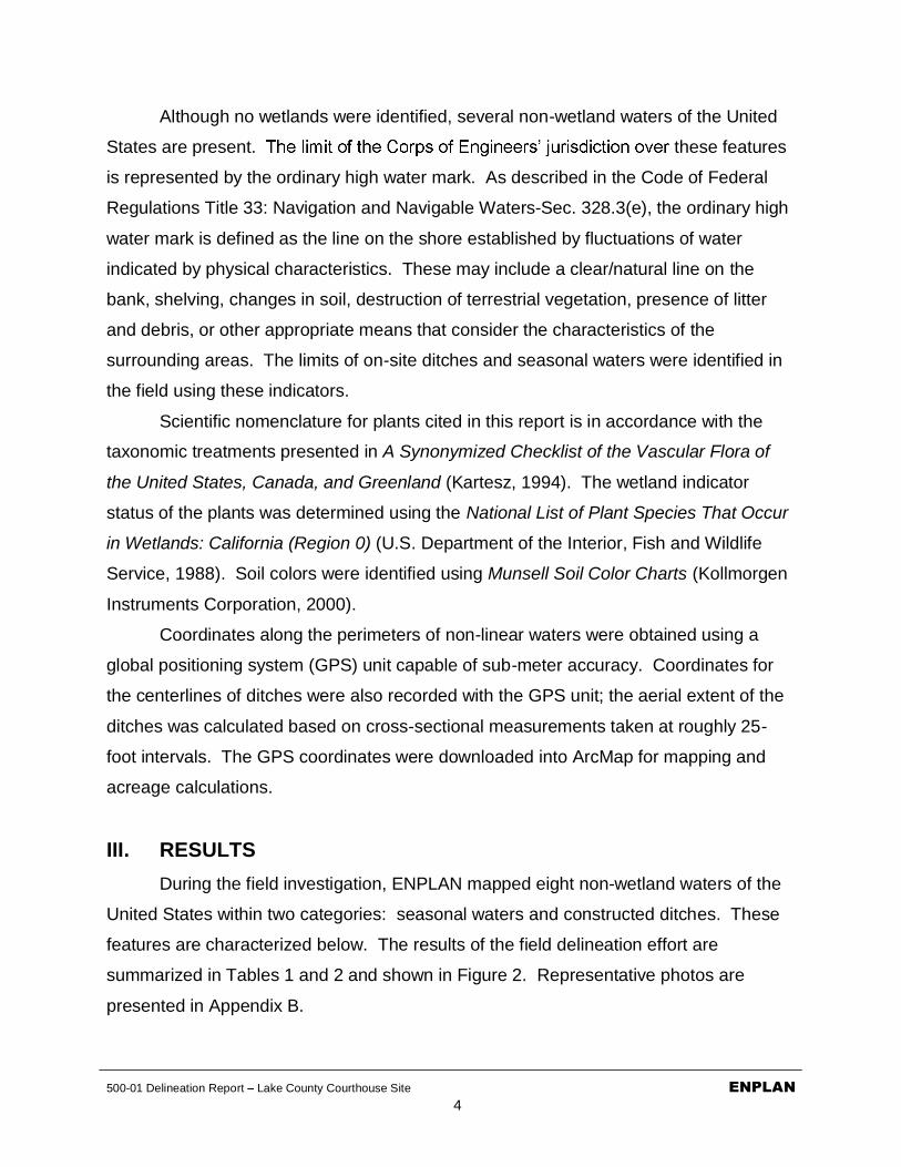
500-01 Delineation Report Lake County Courthouse Site ENPLAN4
Although no wetlands were identified, several non-wetland waters of the United
States are present. these features
is represented by the ordinary high water mark. As described in the Code of Federal
Regulations Title 33: Navigation and Navigable Waters-Sec. 328.3(e), the ordinary high
water mark is defined as the line on the shore established by fluctuations of water
indicated by physical characteristics. These may include a clear/natural line on the
bank, shelving, changes in soil, destruction of terrestrial vegetation, presence of litter
and debris, or other appropriate means that consider the characteristics of the
surrounding areas. The limits of on-site ditches and seasonal waters were identified in
the field using these indicators.
Scientific nomenclature for plants cited in this report is in accordance with the
taxonomic treatments presented in A Synonymized Checklist of the Vascular Flora of
the United States, Canada, and Greenland (Kartesz, 1994). The wetland indicator
status of the plants was determined using the National List of Plant Species That Occur
in Wetlands: California (Region 0) (U.S. Department of the Interior, Fish and Wildlife
Service, 1988). Soil colors were identified using Munsell Soil Color Charts (Kollmorgen
Instruments Corporation, 2000).
Coordinates along the perimeters of non-linear waters were obtained using a
global positioning system (GPS) unit capable of sub-meter accuracy. Coordinates for
the centerlines of ditches were also recorded with the GPS unit; the aerial extent of the
ditches was calculated based on cross-sectional measurements taken at roughly 25-
foot intervals. The GPS coordinates were downloaded into ArcMap for mapping and
acreage calculations.
III. RESULTSDuring the field investigation, ENPLAN mapped eight non-wetland waters of the
United States within two categories: seasonal waters and constructed ditches. These
features are characterized below. The results of the field delineation effort are
summarized in Tables 1 and 2 and shown in Figure 2. Representative photos are
presented in Appendix B.

500-01 Delineation Report Lake County Courthouse Site5
Seasonal Waters: Two seasonal waters, on the western edge of the upper terrace, were created when the site was graded and bedrock was exposed.Water now ponds to a depth of two to three inches in these shallow depressionsunderlain by bedrock. Representative plant species include scribner grass (Scribneria bolanderi, UPL), annual hairgrass (Deschampsia danthonioides,FACW), and rigiopappus (Rigiopappus leptocladus, UPL), but vegetative cover is less than five percent. As described in the Arid West Supplement, features with an ordinary high water mark and less than five percent vegetative cover are non-wetland waters. The extent of ponding was documented through site inspections on February 8 and April 9, 29 and 30, 2010, as well as by the presence of water-stained rock, sediment deposits, and a biotic crust.
Constructed Ditches: Constructed ditches are excavated features that may be located in either wetlands or uplands, and may convey water collected from sheet flow or diverted from other water bodies. The jurisdictional status of constructed ditches depends in part on these characteristics. The on-site ditchesare constructed in uplands, and receive sheet-flow runoff and discharge from thetwo non-wetland waters on the upper terrace. Most of the ditches have only ephemeral flow. However, 3:CD and 8:CD do not drain well and support wetland plant species in their lower ends; species present include annual ryegrass(Lolium multiflorum = L. perenne, FAC*), Hordeum marinum ssp. gussoneanum= H. hystrix, FAC), and common monkey-flower (Mimulus guttatus, OBL).
Table 1Summary of Waters by Type
Type Areasq. ft. acres
Constructed Ditches 2,108 0.048Seasonal Waters 3,793 0.087
Total Waters 5,901 0.135
Table 2Waters by Map ID
Map ID Type Average
Width Length Areasq. ft. acres
1 Constructed Ditch 1.7 350 595 0.0142 Constructed Ditch 0.5 20 10 0.0003 Constructed Ditch 4.6 206 948 0.0224 Seasonal Water 2,599 0.0605 Seasonal Water 1,194 0.0276 Constructed Ditch 1.6 178 285 0.0077 Constructed Ditch 1.5 10 15 0.0008 Constructed Ditch 2.3 111 255 0.006
Total Waters 5,901 0.135

?
07.16.10Feature and boundary locations depicted are approximate only.
X 0 100Feet
Study Area Boundary
Parcel Boundary
Seasonal Water
Constructed Ditch
Culvert
Flow Direction
? Storm Drain Inlet
Data Point
1:CD 2:CD
4:SW
5:SW6:CD
7:CD
8:CD
3:CD
1:CD
DP1
DP3
Lakeport Boulevard
DP2
sq. f t. acres
1:CD Constructed Ditch 1.7 350 595 0.0142:CD Constructed Ditch 0.5 20 10 0.0003:CD Constructed Ditch 4.6 206 948 0.0224:RW Seasonal Water 2,599 0.0605:RW Seasonal Water 1,194 0.0276:CD Constructed Ditch 1.6 178 285 0.0077:CD Constructed Ditch 1.5 10 15 0.0008:CD Constructed Ditch 2.3 111 255 0.006
5,901 0.135
Potential Waters by Map IDArea
Map ID TypeAverage
Width (feet)Length(feet)
Total Waters
Project:Delineator:Date:Date Revised:
February 8 & April 9, 29, & 30, 2010
Lake County Courthouse SiteDon Burk
Figure 2Potential Waters of the U.S. and/or State

500-01 Delineation Report Lake County Courthouse Site ENPLAN7
IV. JURISDICTIONAL DETERMINATIONAs described in Regulatory Guidance Letter 08-02, the applicant concurs with the
Army Corps of Engineers that waters regulated under the Clean Water Act may be
present on the site. As such, these waters will be treated as jurisdictional for the
purpose of calculating fill and satisfying future mitigation requirements. The applicant
understands that they can later request and obtain an approved JD if that later becomes
necessary or appropriate during the permit process or during the administrative appeal
process.

500-01 Delineation Report Lake County Courthouse Site ENPLAN8
V. REFERENCESKartesz, J.T. 1994. A Synonymized Checklist of the Vascular Flora of the United
States, Canada, and Greenland. 2nd edition. Volume 1 Checklist, Volume 2 Thesaurus. Timber Press, Inc., Portland, Oregon.
Kollmorgen Instruments Corporation. 2000. Munsell Soil Color Charts.
URS Corporation. December 2009. Final Draft Phase I Environmental Site Assessment Report: Proposed New Lakeport Courthouse 675 Lakeport Boulevard Site. 675 Lakeport Boulevard, Lakeport CA 95453. Unpublished document on file with the Judicial Council of California, Administrative Office of the Courts.
U.S. Department of Agriculture, Natural Resources Conservation Service. 2009. Web Soil Survey, August 31, 2009 Map Data. <http://websoilsurvey.nrcs.usda.gov/app/.>
U.S. Department of the Army, Corps of Engineers. 1987. Corps of Engineers Wetlands Delineation Manual. Technical Report Y-87-1. National Technical Information Service, Springfield Virginia.
_____. 2008. Regional Supplement to the Corps of Engineers Wetland Delineation Manual: Arid West Region (Version 2.0), eds. J.S. Wakeley, R.W. Lichvar, and C.V. Noble. ERDC/EL TR-08-28. Vicksburg, MS: U.S. Army Engineer Research and Development Center.
U.S. Department of the Interior, Fish and Wildlife Service. 1988. National List of Plant Species That Occur in Wetlands: California (Region 0). Biological Report 88 (26.10).
_____. n.d. National Wetlands Inventory. www.wetlandsfws.er.usgs.gov.
U.S. Geological Survey. 1958. Lakeport, California, 7.5-minute quadrangle sheet. Photo-revised 1978.
Western Regional Climate Center (WRCC). 2010. Lakeport, CA. www.wrcc.dri.edu/climsum.html.

500-01 Delineation Report Lake County Courthouse Site ENPLAN
APPENDIX A
Wetland Determination Forms


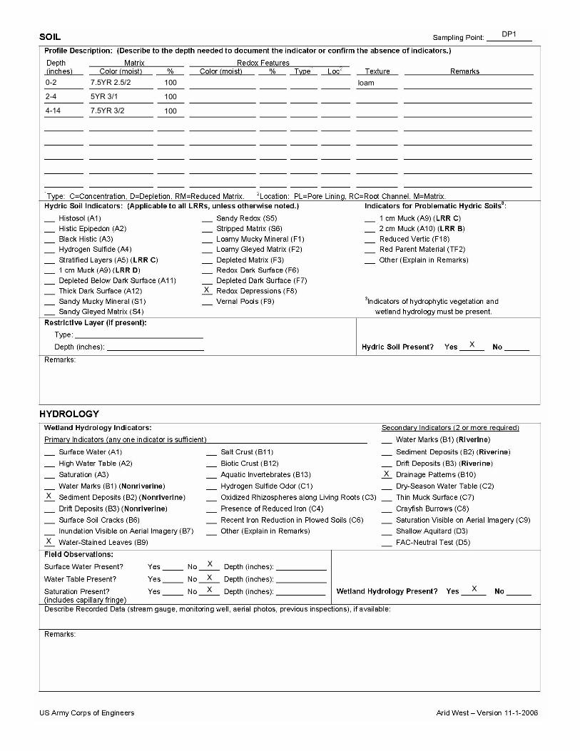


500-01 Delineation Report Lake County Courthouse Site ENPLAN
APPENDIX B
Representative Photos

Representative Photos of On-site Waters
500-01
4:SW looking southeast 2/8/10
5:SW looking southeast 2/8/10

500-01
Biotic crust in 5:SW 4/29/10
1:CD looking west 4/29/10

500-01
Lower terminus of 1:CD and 2:CD, with discharge to uplands 4/29/10
3:CD looking north 4/29/10

500-01
6:CD (foreground) looking northeast 4/29/10
8:CD looking west toward culvert 3/17/10

500-01
Storm drain inlet at terminus of 8:CD 4/29/10
Non-jurisdictional drainage near 7:CD with no evidence of OHWM 4/29/10

Appendix D Cultural Resources Inventory

Cultural Resources Inventory for the Proposed Lake County Courthouse Site, in the City of Lakeport, Lake County, California
Prepared for:
RBF Consulting500-01
July 2010
Prepared by:

500-01 Cultural Resources Inventory
Lakeport Courthouse Site i
TABLE OF CONTENTSPage No.
I. INTRODUCTION...................................................................................................... 1II. PROJECT DESCRIPTION ....................................................................................... 1III. AREA OF POTENTIAL EFFECTS (APE) ................................................................. 2IV. SOURCES CONSULTED......................................................................................... 2V. BACKGROUND........................................................................................................ 3
A. Environmental ..................................................................................................... 3B. Ethnographic....................................................................................................... 4C. Archaeological..................................................................................................... 4D. Historic ................................................................................................................ 5E. Sensitivity ............................................................................................................ 5
VII. FIELD METHODS .................................................................................................... 5VIII.SURVEY RESULTS ................................................................................................. 6IX. CONCLUSIONS AND RECOMMENDATIONS......................................................... 6X. REFERENCES......................................................................................................... 7
APPENDICES
Appendix A. FiguresFigure 1. Project Vicinity MapFigure 2. Project APE and Area Surveyed
Appendix B. CorrespondenceRequest for Sacred Lands Search letter sent to NAHC 3/16/10
NAHC response received dated 3/25/10
Request for Comment letters sent 4/2/10 to the Lake County Historical Society and appropriate individuals on distribution list provided by NAHC
Response from the Scott Valley Band of the Pomo Indians received 4/15/10
Records Search Request to NW/CHRIS sent 5/25/10
Response from NW/CHRIS dated 6/28/10

500-01 Cultural Resources Inventory ENPLANLake County Courthouse Project 1
INTRODUCTIONENPLAN was contracted by the RBF Consulting to conduct a cultural resources
inventory for construction of a new courthouse in Lake County, California, by the State of California Administrative Office of the Courts, Office of Court Construction and Management. The project site located on Lakeport Boulevard, in the City of Lakeport.The proposed project consists of the construction of a four-room courthouse for the Superior Court of California. As shown in Figure 1, the site is located in Township 14North, Range 10 West, Section 25 (U.S.G.S. Lakeport California 7.5-minute quadrangle).
This project has the potential to adversely affect cultural resources that may be located within the project area. A good faith effort was therefore made to identify any cultural resources within and immediately adjacent to the Area of Potential Effects (APE). All work associated with the project was conducted in compliance with the California Environmental Quality Act (CEQA) and its implementing regulations.
would be considered by the U.S. Army Corps of Engineers (ACOE) as a federal irements of Section 404 of the Clean Water
Act. Because the State of California Administrative Office of the Courts, Office of Court Construction and Management, may need a permit from the ACOE, Sacramento District, the cultural resources study was conducted in compliance with Section 106 of the National Historic Preservation Act (NHPA) and its implementing regulations (36 CFR Part 800).
An archaeological survey of the project area was conducted by ENPLAN on April 29, 2010. ENPLAN is an environmental consulting firm with over 30 years of
compliance with all applicable state and federal codes, acts, regulations, and orders relating to cultural resources, where applicable.
The survey was conducted and survey report prepared by Wayne Wiant, Senior Archaeologist, ENPLAN. Mr. Wiant holds an M.A. in Anthropology and has over 40 years of experience in California and Great Basin Archaeology.
PROJECT DESCRIPTIONThe proposed project consists of the construction of a four-room courthouse for
the Superior Court of California at 675 Lakeport Boulevard, adjacent to the Lakeport Visitors Center. The courthouse will be two stories high and will include space for associated support and records storage. Approximately 120 parking spaces will be associated with the new courthouse. The project site is a 5.74-acre vacant lot, and islarge enough to accommodate the proposed facility. The project area is shown in Figure 2.

500-01 Cultural Resources Inventory ENPLANLake County Courthouse Project 2
AREA OF POTENTIAL EFFECTS (APE)The APE for both CEQA and the National Historic Preservation Act and its
implementing regulations (36 CFR Part 800) has both a horizontal and vertical component. The APE consists of all areas needed for the construction of the courthouse including access, equipment storage, utility placement, and any other
The horizontal component encompasses all surface area required to construct the new facility. For the purposes of this project,the horizontal APE would encompass the entire proposed project site. The vertical component of the APE is based on the depth of excavation associated with the project.Although the scope of these excavations is unknown at this time, there is little chance of the project affecting subsurface cultural deposits since the majority of the project site has been previously leveled with up to 20 feet of the original hilltop having been removed. Little original ground remains .Area of Potential Effects (APE) is shown on Figure 2.
SOURCES CONSULTEDThe following sources were consulted to obtain information concerning known
archaeological sites, historic properties, and historic activities within and/or adjacent to the study area: the Northwestern Center of the California Historical Resources Information System at California State University, Sonoma (NW/CHRIS); the Native American Heritage Commission (NAHC); the Lakeport Historical Society; and members of the local Native American community.
A request for a records search was sent to the NW/CHRIS by ENPLAN onMay 26, 2010, and covered an approximate one-half-mile radius around the APE for previously recorded archaeological sites and for previous surveys. The size and scope of the search area was determined to be sufficient based on the results. Results of the records search were received on June 29, 2010. Research included reviewing maps and records for archaeological surveys, sites, and other cultural resources in this portion of Lake County and the following documents: National Register of Historic Places (1979-2002 and supplements); the California Register of Historical Resources (1992 and supplemental information to date); California Inventory of Historic Resources (1976); California Historical Landmarks (1996 and supplemental information to date); California Points of Historical Interest (1992 and supplemental information to date);Office of Historic Preservation Directory of Properties in the Historic Property Data File (2010) for Lakeport; and Historic Spots in California (Hoover et al. 1990). General Land Office Maps from 1868 and 1876 were also reviewed. Results of this research areoutlined below.
Records indicated that there are no recorded historic or archaeological siteswithin the APE. ighteen previoussurveys have been conducted within a half-mile radius of the project site. No sites were found during these surveys. The records, however, do show that three prehistoric sites have been recorded within one-half mile of the project. One, P-17-000492 known as Prayer Hill is located 1,000 feet southeast of the proposed courthouse site. There is no site record for this feature, but an article published by the Lake County Chamber of

500-01 Cultural Resources Inventory ENPLANLake County Courthouse Project 3
Commerce (Geoble ND), suggests that it was used by the local Native Americans forceremonies prior to the historic period. This feature has been substantially altered by a road cut and quarrying, with much of the hills top removed.
Historic features were also noted by the NW/CHRIS. According to their records,there are numerous historic structures documented throughout Lakeport, although none are within or adjacent to the project area.
A letter was sent to the NAHC requesting a sacred lands search on March 16,2010. The commission responded on March 25, 2010, and indicted that their files did not show the presence of any Native American cultural resources within the project area. They enclosed a list of other Native American organizations and individuals that might have additional information. Letters were sent to these organizations and to the Lakeport Historical Society on April 2, 2010. An email response was received from Mr. Shannon Ford of the Scotts Valley Band of the Pomo Indians on April 15, 2010. Mr. Ford requested that a member of his tribe monitor the area during ground disturbing activities. The Lakeport Historical Society contacted ENPLAN by phone on April 20, 2010. The society indicated that they had no concerns with the project. (Copies of project correspondence are attached in Appendix B.)
BACKGROUNDEnvironmental
The project area lies in a relatively low part of the Northern Coast Ranges that is surrounded by mountains. The elevation for Lakeport is 1,343 feet above mean sea level. Clear Lake, the largest natural lake in the Coast Ranges, lies just to the east of the project site (Figure 1). Lake County is characterized by warm, dry summers and cool, wet winters. The mean annual precipitation is about 20 to 40 inches. Most of the precipitation is rain, but some is snow. Mean annual temperature is about 50° to 56° F(Western Regional Climate Center 2009)
The site is surrounded by urban development. The site was historically an oak woodland, and was used for agriculture and grazing beginning in the late 1930s. The site was cleared of trees and shrubs in the early 1970s, and was graded prior to 1988. Grading activities dramatically altered the natural contours of the site, resulting in two level terraces (Figure 2). Small, weathered rocks of serpentine origin are exposed on the upper terrace and hillsides. The lower terrace supports a disturbed grassland while the upper terrace and hillsides support a serpentine herb community. Two small, shallow seasonal wetlands with rock substrates are present on the upper terrace. Soils on the site are identified as Henneke-Montara-rock outcrop complex. The complex consists of very deep, moderately well-drained soils, formed in alluvium from mixed rock types. Most runoff from the site enters constructed ditches that convey flow east. Flow enters drain system, which discharges into Clear Lake (approximately ¼-mile east of the site). The nearest named stream is Forbes Creek, a seasonal stream approximately 500 feet north of the site (ENPLAN 2010).

500-01 Cultural Resources Inventory ENPLANLake County Courthouse Project 4
Ethnographic The project area was inhabited by the Eastern Pomo at the time of Euro-
American contact. Ethnographic sources for the Eastern Pomo include Loeb (1926), Kroeber (1925), Gifford (1923, 1926) and McLendon and Lowy (1978). The following summary is taken from the latter source. The Pomo, identified as part of the Hokan language family, consisted of twelve groups who spoke seven separate, distinct dialects.
The Eastern Pomo followed a seasonal round that was based upon the environment of the Clear Lake area. Heavy winter rains led to rushing streams in the spring and a full lake at the beginning of summer. Dry summers led to a lower lake level and access to lakeside marshlands. Subsistence activities were tied to this weather pattern. Fish, which were dried for year-round use, were caught in streams in the spring while waterfowl were obtained in the fall. Acorns, a dietary staple, were gathered during the autumn. Roots were dug and tules were harvested in early summer;lake fishing and clam collection took place in early summer as well.
Villages were along the lake or permanent streams. They were occupied for much of the year; however, many of the inhabitants left the village at certain times of the year in order to obtain specific resources (e.g., acorns).
Tules were a key raw material used by the Eastern Pomo for housing, boats, and clothing, as well as household items and food. Clam shell beads were used as the medium of exchange for the Eastern Pomo. The shells were brought back from the coast, broken, shaped and drilled into beads. Although bartering sometimes took place, beads were principally used to trade for salt, obsidian blades, and a number of other items.
Archaeological The first archaeological work in the Clear Lake region was that of Harrington
(1948) at the Borax Lake site (CA-LAK-36). The site was estimated to date to 10000 B.P., a date that was later validated through obsidian hydration. Although no furtherlarge scale archaeological investigations took place in the area until work was conducted at Anderson Flat (White and Frederickson 1992, White et al. 1995, 2002),several broad chronological schemes were developed to interpret the prehistory of the area. White and Frederickson (1992) present a more specific framework for the Clear Lake Basin based upon six sites. The earliest human activity in the area is identified atthe Borax Lake site. This pattern (10000-7500 B.P.) is associated with large points, crescents, scrapers, and choppers and assumed to be related to big game hunting. However, the location of the site near the lake may indicate lacustrine use. Thesequence continues through the Houx Aspect of the Berkeley Pattern (7500-1200 B.P.),with a drier climate, a shift away from hunting to a more diversified subsistence strategy and increasing populations. The chronology ends with the late prehistoric to early historic Clear Lake Aspect (1200 B.P. historic contact). Interestingly, two distinct populations are identified occupying the area simultaneously between 4000- 1200 B.P. The intrusive Mendocino Pattern people exhibit similarities to cultures associated with

500-01 Cultural Resources Inventory ENPLANLake County Courthouse Project 5
the surrounding mountains while the pre-existing Houx Aspect peoples had ties to Clear Lake.
Historic The area now known as Lake County may have first been visited by Euro-
Americans in 1821 when Captain Luis Arguello led a military expedition north from San Francisco. Fur trappers, explorers and settlers soon followed. Miners travelling to and from the gold fields traversed the area beginning in the 1840s and many returned after the gold rush to settle here.
Lake County was formed from a part of Napa County. Lakeport was originally named Forbestown after an early settler. Forbes donated land to the local government in exchange for making the town the County Seat in1861. At the same time, a decision was made to change the name of the town to Lakeport to advertise its natural port.
Important industries in Lake County have included mining, agriculture, and ranching. Today, the economy is boosted by tourism, wineries, and agricultural products including nuts, fruit, and grapes(http://www.cityoflakeport.com/visitors/history.aspx).
SensitivityThe results of archival research, comment solicitation, previous surveys adjacent
to the study area, and the environmental context all contribute to an assessment of the sensitivity level for a given project area. Three prehistoric sites were noted near theproject area, and Clear Lake, a-half mile to the east, was a very important resource to the Pomo. Therefore, there is a likelihood of finding prehistoric sites near the project
Lakeport also suggests a moderate to high chance of historic use. However, the extensive amount of ground disturbance evident within the project greatly reduces the likelihood of finding intact evidence of prehistoric or historic cultural resources within or adjacent to the APE (Figure 2).
FIELD METHODSWayne Wiant, ENPLAN Staff Archaeologist, conducted the pedestrian survey of
the entire project APE on April 29, 2010. The survey focused on the exposed soil inroad cuts, cleared areas, and animal burrows. To address the possibility of buried cultural soils, the exposed cutbank on the parcelthe parcel were examined. The northern bank was visible to a depth of approximately20+ feet. Ground visibility varied from good (approximately 80% exposed ground on top of the hill) to fair (20% 30% visibility near the base) for the survey area. This survey is considered to have been adequate in locating any cultural resources present within the project APE.

500-01 Cultural Resources Inventory ENPLANLake County Courthouse Project 6
SURVEY RESULTSNo historic or prehistoric sites were noted during the cultural resources survey,
however, it should be noted that the entire top 20 feet of the project area was previously removed to create a building pad. This action would have destroyed any cultural resources which might have been present.
CONCLUSIONS AND RECOMMENDATIONSNo historic resources were identified during the cultural resource survey of the
Lake County Courthouse Project. Therefore, the proposed project will not affect any sites or structures eligible for inclusion on the California Register of Historical Resources or the National Register of Historic Places.
This report satisfies the requirements for CEQA, and, if the ACOE forwards this
concurs with this determination, then the ACOE will be in compliance with 36 CFR 800 regulations. ENPLAN recommends, however, that strict adherence to California Health and Safety Codes Section 7050.5 and 5097.98 (as amended by AB 2641) of the Public Resources Code be followed in the event that human remains are encountered as a result of project developments. We also recommend that the following stipulations be included as a condition of project approval by State of California Administrative Office of the Courts, and the ACOE, and that these stipulations be included on all project construction/design plans:
A. If any human remains are encountered during any phase of construction, all earth-disturbing work shall stop within 50 feet of the find until a qualified archaeologist can make an assessment of the discovery and recommend/implement mitigation measures as necessary.
B. If any previously unevaluated cultural resources (i.e., burnt animal bone, midden soils, projectile points or other humanly-modified lithics, historic artifacts, etc.) are encountered, all earth-disturbing work shall stop within 50 feet of the find until a qualified archaeologist can make an assessment of the discovery and recommend/implement mitigation measures as necessary. This stipulation does not apply to those cultural resources evaluated and determined not Historical Resources/Historic Properties in this report.
C. In the event that project plans change to include areas not surveyed, additional archaeological reconnaissance may be required.

500-01 Cultural Resources Inventory ENPLANLake County Courthouse Project 7
REFERENCESCity of Lakeport
2009
ENPLAN2010 Biological Study Report, Lake County Courthouse 675 Lakeport Boulevard,
Lakeport, CA. Report on File ENPLAN, Redding, CA
Geoble, MerionND The Old Indian Prayer Hill. Lake County Chamber of Commerce, Lakeport
CA.
Gifford, E.1923 Pomo Lands on Clear Lake. University of California Publications in American
Archaeology and Ethnology 20(5) 77-92. Berkeley.
1926 Clear Lake Pomo Society. University of California Publications in American Archaeology and Ethnology 18(2):287-390. Berkeley.
Harrington, J.P.1948 An Ancient Site at Borax Lake, California. Southwest Museum Papers 16,
Los Angeles.
Kroeber, Alfred L.1925 Handbook of the Indians of California. Dover Publications, New York (1976 printing).
Loeb, E.1926 Pomo Folkways. University of California Publications in American
Archaeology and Ethnology 19(2) 149-405. Berkeley.
McLendon, S. and M. Lowy1978 Eastern Pomo and Southeastern Pomo. Handbook of North American
Indians, Vol. 8, California. pp 306-323. Robert Heizer, ed. Smithsonian Institution, Washington.
White, G., and D.A. Fredrickson1992 A Research Design for the Anderson Flat Project, Archaeological Data
Recovery Investigation at Sites CA-Lak-72, 509, 501, 536, 542, and 1375, Lake County, California. Prepared for California Department ofTransportation, District 1, Eureka.

500-01 Cultural Resources Inventory ENPLANLake County Courthouse Project 8
White, G., D.A. Fredrickson, D.G. Bieling, J. Haney, J. Meyer, S. Psota, N. French, N. Thomas, W. Dworkin, C. Whatford, M. Love, and S. Searle
1995 Draft Final Report of the Anderson Flat Project, Lower Lake, Lake County, California. Volume I. Prepared for California State Department of Transportation, District 1, Eureka.
2002 Culture History and Culture Change in Prehistoric Clear Lake Basin: Final Report of the Anderson Flat Project. In Center for Archaeological Research at Davis, Publication No. 13, University of California, Davis.
Western Regional Climate Center2009. <http://www.wrcc.dri.edu/>

APPENDIX A. FiguresFigure 1. Project Vicinity MapFigure 2. Project APE and Area Surveyed

07.12.10Figure 1
Vicinity Map
Feature and boundary locations depicted are approximate only.
X 0 2,000Feet
!
!
!
!
!
!
Lake County, California
Project Site
Lakeport
Clearlake
Lower Lake
Upper Lake
Middletown
Site
USGS Quad - Lakeport 7.5-minute QuadrangleSection 25 - Township 14 N, Range 10 WCentroid: Lat: 39° 2' 20.86" N; Long: -122° 55' 25.36" W

07.12.10
Figure 2Project APE and Area Surveyed
Feature and boundary locations depicted are approximate only.
X 0 300Feet
Site
Project APE and Area Surveyed

APPENDIX B. CorrespondenceRequest for Sacred Lands Search letter sent to NAHC 3/16/10
NAHC response received dated 3/25/10
Request for Comment letters sent 4/2/10 to the Lake County Historical Society and appropriate individuals on distribution list provided by NAHC
Response from the Scott Valley Band of the Pomo Indians received 4/15/10
Records Search Request to NW/CHRIS sent 5/25/10
Response from NW/CHRIS dated 6/28/10

ENPLAN 3179 Bechelli Lane, Suite 100, Redding, CA 96002 530/221-0440 FAX 530/221-6963 www.enplan.comS:\01-Jobs Active\500-01 RBF Consulting - Lake County Courthouse\2-Communication\Cultural\NAHC Sacred Lands Search 3-16-10.doc
500-01March 16, 2010
REQUEST FOR SACRED LANDS SEARCH
TO: Native American Heritage Commission
FROM: Wayne Wiant, Archaeologist (530) 221-0440 Ext. 105
EMAIL: [email protected]
PROPOSED PROJECT: Lakeport Courthouse, Lake County, CA
SITE LOCATION: T14N, R10W, Section 25, USGS Lakeport 7.5-minute quadrangle
SITE SIZE: ±5 acres
ENPLAN is conducting the necessary records search and comment solicitation pursuant to Section 106 of the National Historic Preservation Act and the California Environmental Quality Act (CEQA).
The proposed project is to construct a new courthouse on a city lot within the City of Lakeport, Lake County, California.
We would appreciate any information you could provide regarding cultural resources in the area or Native American groups that we might contact for more information. You may respond by phone, letter, fax, or e-mail.
Thank you for your assistance.
Enclosure


ENPLAN 3179 Bechelli Lane, Suite 100, Redding, CA 96002 530/221-0440 FAX 530/221-6963 www.enplan.comS:\01-Jobs Active\500-01 RBF Consulting - Lake County Courthouse\2-Communication\Cultural\Request for Comments 4-2-10.docx
500-01April 2, 2010
REQUEST FOR COMMENT
TO: Native American Heritage CommissionValentino Jack, Chairperson, Big Valley Rancheria of Pomo IndiansSara Ryan, EPA Director, Big Valley Rancheria of Pomo IndiansDonald Arnold, Chairperson, Scott Valley Band of PomoShannon Ford, Cultural Resources/Environment, Scott Valley Band
of PomoNelson HopperLake County Historical Society
FROM: Wayne Wiant Archaeologist ((530) 221-0440 x105)
EMAIL: [email protected]
PROPOSED PROJECT: Lakeport Courthouse, Lake County, CA
SITE LOCATION: In the town of Lakeport, Township 14 North, Range 10 West,Section 25, USGS Lakeport 7.5-minute quadrangle
SITE SIZE: ± 5 acres
ENPLAN is conducting the necessary records search and comment solicitation pursuant to Section 106 of the National Historic Preservation Act and the California Environmental Quality Act (CEQA).
The proposed project is to construct a new courthouse on a city lot within the City of Lakeport, Lake County, California.
We would appreciate any information you could provide regarding known cultural resources in the project vicinity. You may respond by phone, letter, fax, or e-mail. We will attempt to reach you by phone to confirm your receipt of this letter. If we have not received a response within 30 days from the date of this letter, we will assume you have no concerns or relevant information to provide.
Thank you for your assistance.
Enclosure


ENPLAN 3179 Bechelli Lane, Suite 100, Redding, CA 96002 530/221-0440 FAX 530/221-6963 www.enplan.comS:\01-Jobs Active\500-01 RBF Consulting - Lake County Courthouse\2-Communication\Cultural\Records Search 5-23-10.docx
500-01May 25, 2010
RECORDS SEARCH REQUEST
TO: NW/CHRIS
FROM: Wayne Wiant, Archaeologist ((530) 221-0440 x105)
EMAIL: [email protected]
PROPOSED PROJECT: Lakeport Courthouse, Lake County, CA
SITE LOCATION: T14N, R10W, Section 25, USGS Lakeport 7.5-minute quadrangle(See attached Map)
SITE SIZE: ±5 acres
SEARCH RADIUS: 0.5 miles
PLEASE PROVIDE:
X Your standard informational abstract, without ethnographic information, unless related to specific villages in the locale.
X All site recordation forms for all sites/features located in the half-mile records search area.
X Report covers, results, and maps for all surveys within the half-mile records search area.
Full reports of any surveys conducted within or immediately adjacent to the project area.
Please feel free to call with any questions.
Thank you for your assistance.
Enclosure


Appendix E Greenhouse Gas Data

BuildingDuration (days): 120
CO2 CH4 N2O CO2 CH4 N2O CO2 CH4 N2OForklifts 54.4 0.0062 0.0014 6 2 108.8 0.0124 0.0028 39.1680 0.0045 0.0010Cranes 128.7 0.0144 0.0033 4 1 128.7 0.0144 0.0033 30.8880 0.0035 0.0008Tractors/Loaders/Backhoes 66.8 0.0092 0.0017 8 1 66.8 0.0092 0.0017 32.0640 0.0044 0.0008
102.1200 0.0123 0.0026
TrenchingDuration (days): 10
CO2 CH4 N2O CO2 CH4 N2O CO2 CH4 N2OExcavators 119.6 0.0134 0.0031 8 2 239.2 0.0268 0.0062 9.5680 0.0011 0.0002Other General Industrial Equipment 152.2 0.0166 0.004 8 1 152.2 0.0166 0.0040 6.0880 0.0007 0.0002
15.6560 0.0017 0.0004
PavingDuration (days): 10
CO2 CH4 N2O CO2 CH4 N2O CO2 CH4 N2OCement and Mortar Mixers 7.2 0.0009 0.0002 6 4 28.8 0.0036 0.0008 0.8640 0.0001 0.0000Pavers 77.9 0.016 0.002 7 1 77.9 0.0160 0.0020 2.7265 0.0006 0.0001Paving Equipment 68.9 0.012 0.0018 6 2 137.8 0.0240 0.0036 4.1340 0.0007 0.0001Rollers 67.1 0.0106 0.0018 7 1 67.1 0.0106 0.0018 2.3485 0.0004 0.0001
10.0730 0.0018 0.0003 Grading
Duration (days): 20
CO2 CH4 N2O CO2 CH4 N2O CO2 CH4 N2OGraders 132.7 0.0155 0.0035 6 1 132.7 0.0155 0.0035 7.9620 0.0009 0.0002Rubber Tired Dozers 239.1 0.0305 0.0062 6 1 239.1 0.0305 0.0062 14.3460 0.0018 0.0004Off-Highway Trucks 260.1 0.0224 0.0067 8 1 260.1 0.0224 0.0067 20.8080 0.0018 0.0005Tractors/Loaders/Backhoes 66.8 0.0092 0.0017 7 1 66.8 0.0092 0.0017 4.6760 0.0006 0.0001
47.7920 0.0052 0.0012Total Construction Emissions - Year 2012
175.64 0.02 0.00159.34 0.02 0.00159.34 5.91 0.09 165.34
BuildingDuration (days): 240
CO2 CH4 N2O CO2 CH4 N2O CO2 CH4 N2OForklifts 54.4 0.0062 0.0014 6 2 108.8 0.0124 0.0028 78.3360 0.0089 0.0020Cranes 128.7 0.0144 0.0033 4 1 128.7 0.0144 0.0033 61.7760 0.0069 0.0016Tractors/Loaders/Backhoes 66.8 0.0092 0.0017 8 1 66.8 0.0092 0.0017 64.1280 0.0088 0.0016
204.2400 0.0157 0.0032
Total Construction Emissions - Year 2013204.24 0.02 0.00185.28 0.01 0.00185.28 4.43 0.06 189.77
BuildingDuration (days): 20
CO2 CH4 N2O CO2 CH4 N2O CO2 CH4 N2OForklifts 54.4 0.0062 0.0014 6 2 108.8 0.0124 0.0028 6.5280 0.0007 0.0002Cranes 128.7 0.0144 0.0033 4 1 128.7 0.0144 0.0033 61.7760 0.0006 0.0001Tractors/Loaders/Backhoes 66.8 0.0092 0.0017 8 1 66.8 0.0092 0.0017 64.1280 0.0007 0.0001
132.4320 0.0013 0.0003
Total Construction Emissions - Year 2014132.43 0.00 0.00120.14 0.00 0.00120.14 0.37 0.01 120.51
ANNUALIZED (30 years)512.31 0.04 0.01464.76 0.03 0.01 464.80
15.49 0.36 0.01 15.85
Notes:
metric tons CO 2 eq/year
Emissions (tons/year)
Total Emissions
tons/yearmetric tons/year
Emission FactorsHours/day Quantity
Emissions (pounds/hour)
Quantity
Year 2014
Total Emissions
EquipmentEmission Factors
Hours/day Quantity
Emissions (tons/year)
Total Emissions
Emissions (pounds/hour) Emissions (tons/year)
Emissions (pounds/hour) Emissions (tons/year)
Total Emissions
EquipmentEmission Factors
Hours/day
Emission FactorsHours/dayEquipment
EquipmentEmission Factors
Hours/day
Total Emissions
QuantityEmissions (pounds/hour)
Refer to the URBEMIS 2007 assumptions and model output for construction equipment assumptionsConstruction Equipment Emission Factor Source: Provided by SCAQMD.
Emissions (pounds/hour)Emission Factors
Construction Emissions
tons/yearmetric tons/year
metric tons CO 2 eq/year
Year 2012
QuantityEmissions (pounds/hour) Emissions (tons/year)
Emissions (tons/year)
Total Emissions
Hours/day Quantity
metric tons CO 2 eq/year
Equipment
metric tons/yeartons/year
Equipment
tons/yearmetric tons/year
Year 2013
metric tons CO 2 eq/year


Appendix F Phase I Environmental
Site Assessment Report


24
FIGURES

SITE LOCATION MAP
Phase I Environmental Site AssessmentVacant Parcel
November, 2009 675 Lakeport Blvd.17326303.01001 Lakeport, California
FIGURE 1
Mapquest.com, Inc., November, 2009
Subject Property

Not to Scale SITE MAP
Phase I Environmental Site AssessmentVacant Parcel
November, 2009 675 Lakeport Blvd17326303.01001 Lakeport, California
FIGURE 2
SUBJECT PROPERTY BOUNDARY
Vacant
Lake County Agriculture Center Storage Facility
AT&T Telephone
Lake County Visitor's Information Center
Vista Point Center
Shop
ping
Cen
ter
Park
ing
LAKEPORT BOULEVARD
Shopping Center
(City of Lakeport)
Vacant
675 Lakeport Boulevard
APN 025-521-41
Upper Terrace
Lower Terrace
Approximate divide between upper and
lower terrace

25
APPENDICES

26
APPENDIX A SITE PHOTOGRAPHS

PHOTOGRAPHIC LOG
Administrative Office of the Court
Phase I ESA – Vacant Parcel 675 Lakeport Boulevard
Lakeport, California 95453
URS Project No. 17326303.01001
Date: 10/28/09
Photo No.
2
Direction Photo Taken: Looking west
Description: North side of the Subject Property along Lakeport Boulevard.
Photo No. 1
Direction Photo Taken: Looking southwest
Description: Entrance to the Subject Property from Lakeport Boulevard at the northeast corner of the parcel.

PHOTOGRAPHIC LOG
Administrative Office of the Court
Phase I ESA – Vacant Parcel 675 Lakeport Boulevard
Lakeport, California 95453
URS Project No. 17326303.01001
Date: 10/28/09
Photo No.
4
Direction Photo Taken: Looking southwest
Description: View of the upper terrace of the Subject Property from the northeast corner.
Photo No. 3
Direction Photo Taken: Looking east
Description: Northern approach to the upper terrace of the Subject Property. Lakeport Boulevard is on the left of the frame. Note the AT&T Telecommunications structure beyond the northeastern boundary of the Subject Property.

PHOTOGRAPHIC LOG
Administrative Office of the Court
Phase I ESA – Vacant Parcel 675 Lakeport Boulevard
Lakeport, California 95453
URS Project No. 17326303.01001
Date: 10/28/09
Photo No.
5
Direction Photo Taken: Looking south
Description: View of the upper terrace from the top of the northern approach in the northwest corner of the upper terrace. The hill in the background is beyond the south boundary of Subject Property.
Photo No.
6
Direction Photo Taken: Looking southwest
Description: View from the northeast corner of the upper terrace of the Subject Property. Structure on the next terrace is the Lakeport Visitor’s Center located on the parcel adjacent to the west of the Subject Property.
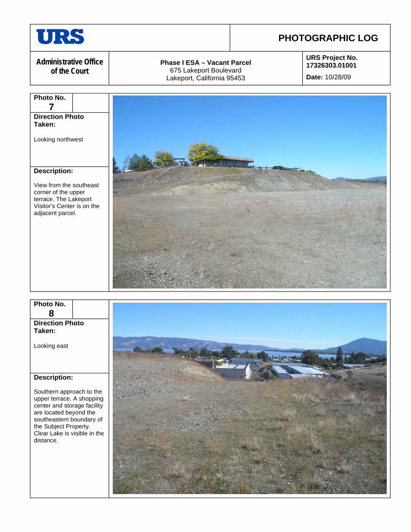
PHOTOGRAPHIC LOG
Administrative Office of the Court
Phase I ESA – Vacant Parcel 675 Lakeport Boulevard
Lakeport, California 95453
URS Project No. 17326303.01001
Date: 10/28/09
Photo No.
7
Direction Photo Taken: Looking northwest
Description: View from the southeast corner of the upper terrace. The Lakeport Visitor’s Center is on the adjacent parcel.
Photo No.
8
Direction Photo Taken: Looking east
Description: Southern approach to the upper terrace. A shopping center and storage facility are located beyond the southeastern boundary of the Subject Property. Clear Lake is visible in the distance.

PHOTOGRAPHIC LOG
Administrative Office of the Court
Phase I ESA – Vacant Parcel 675 Lakeport Boulevard
Lakeport, California 95453
URS Project No. 17326303.01001
Date: 10/28/09
Photo No.
9
Direction Photo Taken: Looking south
Description: View of the eastern side of the Subject Property and the lower terrace. A storage facility is located beyond the southeastern corner of the Subject Property.
Photo No.
10
Direction Photo Taken: Looking southeast
Description: Another view of the lower terrace on the southern side of the Subject Property.

PHOTOGRAPHIC LOG
Administrative Office of the Court
Phase I ESA – Vacant Parcel 675 Lakeport Boulevard
Lakeport, California 95453
URS Project No. 17326303.01001
Date: 10/28/09
Photo No.
11
Direction Photo Taken: Looking north
Description: View if the southern boundary and northeast corner of the Subject Property from the lower terrace. A Lakeport Boulevard and a strip mall are beyond the tall trees in the frame. An AT&T Telecommunications structure is located east of the northeast corner of the Subject Property.
Photo No.
12
Direction Photo Taken: Looking northeast
Description: View of the AT&T Telecommunications Structure west side, adjacent to the Subject Property. Note the above ground diesel storage tank (AST). Reportedly there was also a leaking underground storage tank (LUST) removed from the AT&T parcel and the LUST case has received regulatory agency closure.

27
APPENDIX B EDR ENVIRONMENTAL LienSearch™ REPORT

The EDR Environmental LienSearch™ Report
The Standard in Environmental Risk Information
440 Wheelers Farm Road Milford, Connecticut 06461 Nationwide Customer Service Telephone: 1-800-352-0050 Fax: 1-800-231-6802 Internet: www.edrnet.com
Project Number 02622183.10
October 27, 2009
675 LAKEPORT BOULEVARD SITE LAKE COUNTY
LAKEPORT, CA 95453

EDR Environmental LienSearch™ Report
The EDR Environmental LienSearch Report includes results from a search of available current land title records for environmental cleanup liens and other activity and use limitations, such as engineering controls and institutional controls. A network of professional, trained researchers follows established procedures to:
• search for parcel information, legal description, and ownership based on client supplied address information;
• research indexes and title repositories; • obtain a copy of the deed; • search for environmental encumbering instrument(s) associated with the deed; • provide a copy of any environmental encumbrance(s) based upon a review of key words in the
instrument (title, parties involved, and description); and • provide a copy of the deed.
Thank you for your business. Please contact EDR at 1-800-352-0050
with any questions or comments.
Disclaimer - Copyright and Trademark Notice
This report was prepared for the use of Environmental Data Resources, Inc., and NCO Financial Services, Inc. exclusively. This report is neither a guarantee of title, a commitment to insure, nor a policy of title insurance. NO WARRANTY, EXPRESSED OR IMPLIED, IS MADE WHATSOEVER IN CONNECTION WTH THIS REPORT. Environmental Data Resources, Inc. (EDR) and NCO Financial Services, Inc. specifically disclaim the making of any such warranties, including without limitation, merchantability or fitness for a particular use or purpose. The information contained in this report is retrieved as it is recorded from the various agencies that make it available. The total liability is limited to the fee paid for this report. Copyright 2006 by Environmental Data Resources, Inc. All rights reserved. Reproduction in any media or format, in whole or in part, of any report or map of Environmental Data Resources, Inc., or its affiliates, is prohibited without prior written permission.
EDR and its logos are trademarks of Environmental Data Resources, Inc. or its affiliates. All other trademarks used herein are the property of their respective owners.

EDR Environmental LienSearch™ Report
TARGET PROPERTY INFORMATION ADDRESS
75 LAKEPORT BOULEVARD SITE
ESEARCH SOURCE
6675 LAKEPORT BOULEVARD SITE LAKEPORT, CA 95453
R
ources: Lake County
EED INFORMATION
S D
ype of Deed: WD T QC D Other DEED
tle is vested in: Mary Paveloff Seregow, as Successor Trustee, of the John W. Seregow Trust dated September 24, 1984
tle received from: Mary Paveloff Seregow, as Successor Trustee, of the John W. Seregow Trust dated September 24, 1984
eed Dated: September 29, 1998
d:
Ti
and Amended April 22, 1991, an undivided 40% interest; The General Council of the Assemblies of God, aMissouri corporation, an undivided 60% interest
Tiand Amended April 22, 1991
DDeed Recorde September 30, 1998 Document No.: 98-017143 LEGAL DESCRIPTION Description: Legal attached as Exhibit “A.”
ssessor’s Parcel Number: 025-521-41
NVIRONMENTAL LIEN
A E
nvironmental Lien: Found E Not Found If yes:
Party:
nd Party:
ated:
st1
2 DRecorded: Book: Page: Comments: OTHER ACTIVITY AND USE LIMITATIONS (AULs) Other AUL's: Found Not Found
EDR Environmental LienSearch™ Report
EXHIBIT A

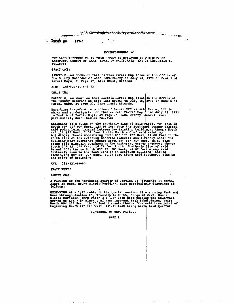


28
APPENDIX C EDR ENVIRONMENTAL DATABASE SEARCH

FORM-NULL-ASH
tropeR ™paM suidaR RDE ehT
440 Wheelers Farms RoadMilford, CT 06461Toll Free: 800.352.0050www.edrnet.com
675 Lakeport Boulevard Site675 Lakeport BoulevardLakeport, CA 95453
Inquiry Number: 2622183.9sOctober 23, 2009

SECTION PAGE
Executive Summary ES1
Overview Map 2
Detail Map 3
Map Findings Summary 4
Map Findings 7
Orphan Summary 41
Government Records Searched/Data Currency Tracking GR-1
GEOCHECK ADDENDUM
GeoCheck - Not Requested
TC2622183.9s Page 1
Thank you for your business.Please contact EDR at 1-800-352-0050
with any questions or comments.
Disclaimer - Copyright and Trademark Notice
This Report contains certain information obtained from a variety of public and other sources reasonably available to Environmental DataResources, Inc. It cannot be concluded from this Report that coverage information for the target and surrounding properties does not exist fromother sources. NO WARRANTY EXPRESSED OR IMPLIED, IS MADE WHATSOEVER IN CONNECTION WITH THIS REPORT. ENVIRONMENTALDATA RESOURCES, INC. SPECIFICALLY DISCLAIMS THE MAKING OF ANY SUCH WARRANTIES, INCLUDING WITHOUT LIMITATION,MERCHANTABILITY OR FITNESS FOR A PARTICULAR USE OR PURPOSE. ALL RISK IS ASSUMED BY THE USER. IN NO EVENT SHALLENVIRONMENTAL DATA RESOURCES, INC. BE LIABLE TO ANYONE, WHETHER ARISING OUT OF ERRORS OR OMISSIONS, NEGLIGENCE,ACCIDENT OR ANY OTHER CAUSE, FOR ANY LOSS OF DAMAGE, INCLUDING, WITHOUT LIMITATION, SPECIAL, INCIDENTAL,CONSEQUENTIAL, OR EXEMPLARY DAMAGES. ANY LIABILITY ON THE PART OF ENVIRONMENTAL DATA RESOURCES, INC. IS STRICTLYLIMITED TO A REFUND OF THE AMOUNT PAID FOR THIS REPORT. Purchaser accepts this Report "AS IS". Any analyses, estimates, ratings,environmental risk levels or risk codes provided in this Report are provided for illustrative purposes only, and are not intended to provide, norshould they be interpreted as providing any facts regarding, or prediction or forecast of, any environmental risk for any property. Only a Phase IEnvironmental Site Assessment performed by an environmental professional can provide information regarding the environmental risk for anyproperty. Additionally, the information provided in this Report is not to be construed as legal advice.
Copyright 2009 by Environmental Data Resources, Inc. All rights reserved. Reproduction in any media or format, in wholeor in part, of any report or map of Environmental Data Resources, Inc., or its affiliates, is prohibited without prior written permission.
EDR and its logos (including Sanborn and Sanborn Map) are trademarks of Environmental Data Resources, Inc. or its affiliates. All othertrademarks used herein are the property of their respective owners.
TABLE OF CONTENTS

EXECUTIVE SUMMARY
TC2622183.9s EXECUTIVE SUMMARY 1
A search of available environmental records was conducted by Environmental Data Resources, Inc (EDR).The report was designed to assist parties seeking to meet the search requirements of EPA’s Standardsand Practices for All Appropriate Inquiries (40 CFR Part 312), the ASTM Standard Practice forEnvironmental Site Assessments (E 1527-05) or custom requirements developed for the evaluation ofenvironmental risk associated with a parcel of real estate.
TARGET PROPERTY INFORMATION
ADDRESS
675 LAKEPORT BOULEVARDLAKEPORT, CA 95453
COORDINATES
39.034300 - 39˚ 2’ 3.5’’Latitude (North): 122.921500 - 122˚ 55’ 17.4’’Longitude (West): Zone 10Universal Tranverse Mercator: 506794.3UTM X (Meters): 4320378.0UTM Y (Meters): 1388 ft. above sea levelElevation:
USGS TOPOGRAPHIC MAP ASSOCIATED WITH TARGET PROPERTY
39122-A8 LAKEPORT, CATarget Property Map:1994Most Recent Revision:
TARGET PROPERTY SEARCH RESULTS
The target property was not listed in any of the databases searched by EDR.
DATABASES WITH NO MAPPED SITES
No mapped sites were found in EDR’s search of available ("reasonably ascertainable ") governmentrecords either on the target property or within the search radius around the target property for thefollowing databases:
STANDARD ENVIRONMENTAL RECORDS
Federal NPL site list
Proposed NPL Proposed National Priority List SitesNPL LIENS Federal Superfund Liens
Federal Delisted NPL site list
Delisted NPL National Priority List Deletions
Federal CERCLIS NFRAP site List
CERC-NFRAP CERCLIS No Further Remedial Action Planned

EXECUTIVE SUMMARY
TC2622183.9s EXECUTIVE SUMMARY 2
Federal RCRA CORRACTS facilities list
CORRACTS Corrective Action Report
Federal RCRA non-CORRACTS TSD facilities list
RCRA-TSDF RCRA - Transporters, Storage and Disposal
Federal RCRA generators list
RCRA-LQG RCRA - Large Quantity GeneratorsRCRA-CESQG RCRA - Conditionally Exempt Small Quantity Generator
Federal institutional controls / engineering controls registries
US ENG CONTROLS Engineering Controls Sites ListUS INST CONTROL Sites with Institutional Controls
Federal ERNS list
ERNS Emergency Response Notification System
State- and tribal - equivalent NPL
RESPONSE State Response Sites
State and tribal leaking storage tank lists
SLIC Statewide SLIC CasesINDIAN LUST Leaking Underground Storage Tanks on Indian Land
State and tribal registered storage tank lists
AST Aboveground Petroleum Storage Tank FacilitiesINDIAN UST Underground Storage Tanks on Indian Land
State and tribal voluntary cleanup sites
VCP Voluntary Cleanup Program PropertiesINDIAN VCP Voluntary Cleanup Priority Listing
ADDITIONAL ENVIRONMENTAL RECORDS
Local Brownfield lists
US BROWNFIELDS A Listing of Brownfields Sites
Local Lists of Landfill / Solid Waste Disposal Sites
DEBRIS REGION 9 Torres Martinez Reservation Illegal Dump Site LocationsODI Open Dump InventoryWMUDS/SWAT Waste Management Unit DatabaseHAULERS Registered Waste Tire Haulers Listing
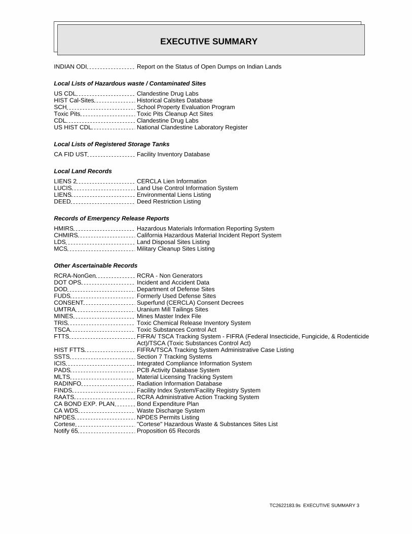
EXECUTIVE SUMMARY
TC2622183.9s EXECUTIVE SUMMARY 3
INDIAN ODI Report on the Status of Open Dumps on Indian Lands
Local Lists of Hazardous waste / Contaminated Sites
US CDL Clandestine Drug LabsHIST Cal-Sites Historical Calsites DatabaseSCH School Property Evaluation ProgramToxic Pits Toxic Pits Cleanup Act SitesCDL Clandestine Drug LabsUS HIST CDL National Clandestine Laboratory Register
Local Lists of Registered Storage Tanks
CA FID UST Facility Inventory Database
Local Land Records
LIENS 2 CERCLA Lien InformationLUCIS Land Use Control Information SystemLIENS Environmental Liens ListingDEED Deed Restriction Listing
Records of Emergency Release Reports
HMIRS Hazardous Materials Information Reporting SystemCHMIRS California Hazardous Material Incident Report SystemLDS Land Disposal Sites ListingMCS Military Cleanup Sites Listing
Other Ascertainable Records
RCRA-NonGen RCRA - Non GeneratorsDOT OPS Incident and Accident DataDOD Department of Defense SitesFUDS Formerly Used Defense SitesCONSENT Superfund (CERCLA) Consent DecreesUMTRA Uranium Mill Tailings SitesMINES Mines Master Index FileTRIS Toxic Chemical Release Inventory SystemTSCA Toxic Substances Control ActFTTS FIFRA/ TSCA Tracking System - FIFRA (Federal Insecticide, Fungicide, & Rodenticide Act)/TSCA (Toxic Substances Control Act)HIST FTTS FIFRA/TSCA Tracking System Administrative Case ListingSSTS Section 7 Tracking SystemsICIS Integrated Compliance Information SystemPADS PCB Activity Database SystemMLTS Material Licensing Tracking SystemRADINFO Radiation Information DatabaseFINDS Facility Index System/Facility Registry SystemRAATS RCRA Administrative Action Tracking SystemCA BOND EXP. PLAN Bond Expenditure PlanCA WDS Waste Discharge SystemNPDES NPDES Permits ListingCortese "Cortese" Hazardous Waste & Substances Sites ListNotify 65 Proposition 65 Records
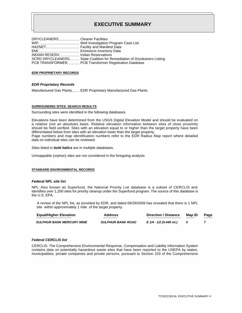
EXECUTIVE SUMMARY
TC2622183.9s EXECUTIVE SUMMARY 4
DRYCLEANERS Cleaner FacilitiesWIP Well Investigation Program Case ListHAZNET Facility and Manifest DataEMI Emissions Inventory DataINDIAN RESERV Indian ReservationsSCRD DRYCLEANERS State Coalition for Remediation of Drycleaners ListingPCB TRANSFORMER PCB Transformer Registration Database
EDR PROPRIETARY RECORDS
EDR Proprietary Records
Manufactured Gas Plants EDR Proprietary Manufactured Gas Plants
SURROUNDING SITES: SEARCH RESULTS
Surrounding sites were identified in the following databases.
Elevations have been determined from the USGS Digital Elevation Model and should be evaluated ona relative (not an absolute) basis. Relative elevation information between sites of close proximityshould be field verified. Sites with an elevation equal to or higher than the target property have beendifferentiated below from sites with an elevation lower than the target property.Page numbers and map identification numbers refer to the EDR Radius Map report where detaileddata on individual sites can be reviewed.
Sites listed in bold italics are in multiple databases.
Unmappable (orphan) sites are not considered in the foregoing analysis.
STANDARD ENVIRONMENTAL RECORDS
Federal NPL site list
NPL: Also known as Superfund, the National Priority List database is a subset of CERCLIS andidentifies over 1,200 sites for priority cleanup under the Superfund program. The source of this database isthe U.S. EPA.
A review of the NPL list, as provided by EDR, and dated 06/29/2009 has revealed that there is 1 NPL site within approximately 1 mile of the target property.
PageMap IDDirection / Distance Address Equal/Higher Elevation ____________________ ________ ___________________ _____ _____
SULPHUR BANK MERCURY MINE SULPHUR BANK ROAD E 1/4 - 1/2 (0.449 mi.) 0 7
Federal CERCLIS list
CERCLIS: The Comprehensive Environmental Response, Compensation and Liability Information Systemcontains data on potentially hazardous waste sites that have been reported to the USEPA by states,municipalities, private companies and private persons, pursuant to Section 103 of the Comprehensive

EXECUTIVE SUMMARY
TC2622183.9s EXECUTIVE SUMMARY 5
Environmental Response, Compensation and Liability Act (CERCLA). CERCLIS contains sites which are eitherproposed to or on the National Priorities List (NPL) and sites which are in the screening and assessment phasefor possible inclusion on the NPL.
A review of the CERCLIS list, as provided by EDR, and dated 06/30/2009 has revealed that there is 1 CERCLIS site within approximately 0.5 miles of the target property.
PageMap IDDirection / Distance Address Equal/Higher Elevation ____________________ ________ ___________________ _____ _____
SULPHUR BANK MERCURY MINE SULPHUR BANK ROAD E 1/4 - 1/2 (0.449 mi.) 0 7
Federal RCRA generators list
RCRA-SQG: RCRAInfo is EPA’s comprehensive information system, providing access to data supportingthe Resource Conservation and Recovery Act (RCRA) of 1976 and the Hazardous and Solid Waste Amendments (HSWA)of 1984. The database includes selective information on sites which generate, transport, store, treat and/ordispose of hazardous waste as defined by the Resource Conservation and Recovery Act (RCRA). Small quantitygenerators (SQGs) generate between 100 kg and 1,000 kg of hazardous waste per month.
A review of the RCRA-SQG list, as provided by EDR, and dated 11/12/2008 has revealed that there are 2 RCRA-SQG sites within approximately 0.25 miles of the target property.
PageMap IDDirection / Distance Address Lower Elevation ____________________ ________ ___________________ _____ _____
PACIFIC BELL 555 LAKEPORT BOULEVARD NE 0 - 1/8 (0.051 mi.) A4 13 BRUNO FOODS 355 LAKEPORT BLVD E 1/8 - 1/4 (0.165 mi.) 7 23
State- and tribal - equivalent CERCLIS
ENVIROSTOR: The Department of Toxic Substances Control’s (DTSC’s) Site Mitigation and BrownfieldsReuse Program’s (SMBRP’s) EnviroStor database identifes sites that have known contamination or sites for whichthere may be reasons to investigate further. The database includes the following site types: FederalSuperfund sites (National Priorities List (NPL)); State Response, including Military Facilities and StateSuperfund; Voluntary Cleanup; and School sites. EnviroStor provides similar information to the informationthat was available in CalSites, and provides additional site information, including, but not limited to,identification of formerly-contaminated properties that have been released for reuse, properties whereenvironmental deed restrictions have been recorded to prevent inappropriate land uses, and riskcharacterization information that is used to assess potential impacts to public health and the environment atcontaminated sites.
A review of the ENVIROSTOR list, as provided by EDR, and dated 08/27/2009 has revealed that there are 4 ENVIROSTOR sites within approximately 1 mile of the target property.
PageMap IDDirection / Distance Address Equal/Higher Elevation ____________________ ________ ___________________ _____ _____
PARKSIDE SUBDIVISION 1453 MARTIN STREET NW 1/2 - 1 (0.551 mi.) 21 38Status: No Further Action
PageMap IDDirection / Distance Address Lower Elevation ____________________ ________ ___________________ _____ _____
TIME OIL CO/JACKPOT FOOD MART 202 S MAIN ST NE 1/4 - 1/2 (0.429 mi.) D16 32Status: Refer: RWQCB
AN-LEE 201 S MAIN ST NE 1/4 - 1/2 (0.429 mi.) D18 35Status: Refer: RWQCB

EXECUTIVE SUMMARY
TC2622183.9s EXECUTIVE SUMMARY 6
PageMap IDDirection / Distance Address Lower Elevation ____________________ ________ ___________________ _____ _____
JACKPOT STATION 202 S MAIN NE 1/4 - 1/2 (0.429 mi.) D20 37Status: Refer: RWQCB
State and tribal landfill and/or solid waste disposal site lists
SWF/LF: The Solid Waste Facilities/Landfill Sites records typically contain an inventory of solidwaste disposal facilities or landfills in a particular state. The data come from the Integrated WasteManagement Board’s Solid Waste Information System (SWIS) database.
A review of the SWF/LF list, as provided by EDR, and dated 09/02/2009 has revealed that there is 1 SWF/LF site within approximately 0.5 miles of the target property.
PageMap IDDirection / Distance Address Lower Elevation ____________________ ________ ___________________ _____ _____
LAKEPORT TRANSFER STATION 910 BEVINS STREET W 0 - 1/8 (0.063 mi.) B6 22
State and tribal leaking storage tank lists
LUST: The Leaking Underground Storage Tank Incident Reports contain an inventory of reportedleaking underground storage tank incidents. The data come from the State Water Resources Control Board LeakingUnderground Storage Tank Information System.
A review of the LUST list, as provided by EDR, and dated 09/05/2009 has revealed that there are 10 LUST sites within approximately 0.5 miles of the target property.
PageMap IDDirection / Distance Address Lower Elevation ____________________ ________ ___________________ _____ _____
AT&T 555 LAKEPORT BOULEVARD NE 0 - 1/8 (0.051 mi.) A2 13 AT&T 555 LAKEPORT BOULEVARD NE 0 - 1/8 (0.051 mi.) A3 13
Status: Completed - Case Closed
TESORO 67075 975 MAIN ST SE 1/4 - 1/2 (0.332 mi.) 9 26Status: Open - Remediation
UNITED PARCEL SER CALAK 924 PARALLEL DR WNW 1/4 - 1/2 (0.342 mi.) 10 27Status: Completed - Case Closed
CHEVRON #1802 1050 MAIN ST S SE 1/4 - 1/2 (0.363 mi.) 11 29Status: Completed - Case Closed
LAKEPORT SHELL 301 MAIN ST S NE 1/4 - 1/2 (0.378 mi.) C12 30Status: Open - Verification Monitoring
SOPER-REESE COMMUNITY THEATER 275 SOUTH MAIN STREET NE 1/4 - 1/2 (0.389 mi.) C13 31Status: Completed - Case Closed
LANGE BROTHERS CONSTRUCTION CO 301 INDUSTRIAL AVE SSE 1/4 - 1/2 (0.398 mi.) 14 31Status: Completed - Case Closed
JACKPOT FOOD MART 202 MAIN ST S NE 1/4 - 1/2 (0.429 mi.) D17 34Status: Completed - Case Closed
EXXON 201 MAIN ST S NE 1/4 - 1/2 (0.429 mi.) D19 36Status: Completed - Case Closed

EXECUTIVE SUMMARY
TC2622183.9s EXECUTIVE SUMMARY 7
State and tribal registered storage tank lists
UST: The Underground Storage Tank database contains registered USTs. USTs are regulated underSubtitle I of the Resource Conservation and Recovery Act (RCRA). The data come from the State Water ResourcesControl Board’s Hazardous Substance Storage Container Database.
A review of the UST list, as provided by EDR, and dated 09/05/2009 has revealed that there is 1 UST site within approximately 0.25 miles of the target property.
PageMap IDDirection / Distance Address Lower Elevation ____________________ ________ ___________________ _____ _____
PACIFIC BELL TD-255/LKPTCA022 555 LAKEPORT BLVD NE 0 - 1/8 (0.051 mi.) A1 12
ADDITIONAL ENVIRONMENTAL RECORDS
Local Lists of Landfill / Solid Waste Disposal Sites
SWRCY: A listing of recycling facilities in California.
A review of the SWRCY list, as provided by EDR, and dated 09/25/2009 has revealed that there is 1 SWRCY site within approximately 0.5 miles of the target property.
PageMap IDDirection / Distance Address Lower Elevation ____________________ ________ ___________________ _____ _____
TOMRA PACIFIC INC 1155 S MAIN ST SE 1/4 - 1/2 (0.417 mi.) 15 32
Local Lists of Registered Storage Tanks
HIST UST: Historical UST Registered Database.
A review of the HIST UST list, as provided by EDR, and dated 10/15/1990 has revealed that there are 3 HIST UST sites within approximately 0.25 miles of the target property.
PageMap IDDirection / Distance Address Lower Elevation ____________________ ________ ___________________ _____ _____
PACIFIC BELL 555 LAKEPORT BOULEVARD NE 0 - 1/8 (0.051 mi.) A4 13 LAKE COUNTY DEPARTMENT OF AGRI 883 LAKEPORT BLVD W 0 - 1/8 (0.060 mi.) B5 19 CLEAR LAKE MARINA 1400 SO MAIN ST LAKEPOR ESE 1/8 - 1/4 (0.224 mi.) 8 25
SWEEPS UST: Statewide Environmental Evaluation and Planning System. This underground storage tanklisting was updated and maintained by a company contacted by the SWRCB in the early 1990’s. The listing is nolonger updated or maintained. The local agency is the contact for more information on a site on the SWEEPSlist.
A review of the SWEEPS UST list, as provided by EDR, and dated 06/01/1994 has revealed that there is 1 SWEEPS UST site within approximately 0.25 miles of the target property.
PageMap IDDirection / Distance Address Lower Elevation ____________________ ________ ___________________ _____ _____
PACIFIC BELL 555 LAKEPORT BOULEVARD NE 0 - 1/8 (0.051 mi.) A4 13

EXECUTIVE SUMMARY
TC2622183.9s EXECUTIVE SUMMARY 8
Other Ascertainable Records
ROD: Record of Decision. ROD documents mandate a permanent remedy at an NPL (Superfund) sitecontaining technical and health information to aid the cleanup.
A review of the ROD list, as provided by EDR, and dated 09/01/2009 has revealed that there is 1 ROD site within approximately 1 mile of the target property.
PageMap IDDirection / Distance Address Equal/Higher Elevation ____________________ ________ ___________________ _____ _____
SULPHUR BANK MERCURY MINE SULPHUR BANK ROAD E 1/4 - 1/2 (0.449 mi.) 0 7
HIST CORTESE: The sites for the list are designated by the State Water Resource Control Board [LUST],the Integrated Waste Board [SWF/LS], and the Department of Toxic Substances Control [CALSITES].
A review of the HIST CORTESE list, as provided by EDR, and dated 04/01/2001 has revealed that there are 7 HIST CORTESE sites within approximately 0.5 miles of the target property.
PageMap IDDirection / Distance Address Lower Elevation ____________________ ________ ___________________ _____ _____
TESORO 67075 975 MAIN ST SE 1/4 - 1/2 (0.332 mi.) 9 26 UNITED PARCEL SER CALAK 924 PARALLEL DR WNW 1/4 - 1/2 (0.342 mi.) 10 27 CHEVRON #1802 1050 MAIN ST S SE 1/4 - 1/2 (0.363 mi.) 11 29 LAKEPORT SHELL 301 MAIN ST S NE 1/4 - 1/2 (0.378 mi.) C12 30 LANGE BROTHERS CONSTRUCTION CO 301 INDUSTRIAL AVE SSE 1/4 - 1/2 (0.398 mi.) 14 31 JACKPOT FOOD MART 202 MAIN ST S NE 1/4 - 1/2 (0.429 mi.) D17 34 EXXON 201 MAIN ST S NE 1/4 - 1/2 (0.429 mi.) D19 36

EXECUTIVE SUMMARY
TC2622183.9s EXECUTIVE SUMMARY 9
Due to poor or inadequate address information, the following sites were not mapped:
Site Name Database(s)____________ ____________
TRANSFER STATION LUST, HIST CORTESELAKEPORT MS4 PHASE II NPDESPETES AUTOMOTIVE LUSTPETES AUTOMOTIVE LUSTLAKEPORT CHEVRON USTGRANITE HWY. 175 QUARRY ASTLAKEPORT LAGOONS MARINA ** ERNSWELL SITE NAME ERNSCITY OF LAKEPORT WWTP FINDSLAKEPORT WASTEWTR TREATMNT FAC FINDSLAKE COUNTY CSA 21 - NORTH LAKEPOR FINDSCOBB MOUNTAIN DUMP SITE FINDSWILLIAMS TANK LINES HIGHWAY 29 ACC SLIC

EDR Inc.EDR Inc.EDR Inc.EDR Inc.EDR Inc.EDR Inc.EDR Inc.EDR Inc.EDR Inc.EDR Inc.EDR Inc.EDR Inc.EDR Inc.EDR Inc.EDR Inc.EDR Inc.EDR Inc.EDR Inc.EDR Inc.EDR Inc.EDR Inc.EDR Inc.EDR Inc.EDR Inc.EDR Inc.EDR Inc.EDR Inc.EDR Inc.EDR Inc.EDR Inc.EDR Inc.EDR Inc.EDR Inc.EDR Inc.EDR Inc.EDR Inc.EDR Inc.EDR Inc.EDR Inc.EDR Inc.
110 kV
110
kV
110
kV
110 kV

EDR Inc.EDR Inc.EDR Inc.EDR Inc.EDR Inc.EDR Inc.EDR Inc.EDR Inc.EDR Inc.EDR Inc.EDR Inc.EDR Inc.EDR Inc.EDR Inc.EDR Inc.EDR Inc.EDR Inc.EDR Inc.EDR Inc.EDR Inc.EDR Inc.EDR Inc.EDR Inc.EDR Inc.EDR Inc.EDR Inc.EDR Inc.EDR Inc.EDR Inc.EDR Inc.EDR Inc.EDR Inc.EDR Inc.EDR Inc.EDR Inc.EDR Inc.EDR Inc.EDR Inc.EDR Inc.EDR Inc.

MAP FINDINGS SUMMARY
SearchTarget Distance Total
Database Property (Miles) < 1/8 1/8 - 1/4 1/4 - 1/2 1/2 - 1 > 1 Plotted
STANDARD ENVIRONMENTAL RECORDS
Federal NPL site list
1 NR 0 1 0 0 1.000NPL 0 NR 0 0 0 0 1.000Proposed NPL 0 NR NR NR NR NR TPNPL LIENS
Federal Delisted NPL site list
0 NR 0 0 0 0 1.000Delisted NPL
Federal CERCLIS list
1 NR NR 1 0 0 0.500CERCLIS
Federal CERCLIS NFRAP site List
0 NR NR 0 0 0 0.500CERC-NFRAP
Federal RCRA CORRACTS facilities list
0 NR 0 0 0 0 1.000CORRACTS
Federal RCRA non-CORRACTS TSD facilities list
0 NR NR 0 0 0 0.500RCRA-TSDF
Federal RCRA generators list
0 NR NR NR 0 0 0.250RCRA-LQG 2 NR NR NR 1 1 0.250RCRA-SQG 0 NR NR NR 0 0 0.250RCRA-CESQG
Federal institutional controls /engineering controls registries
0 NR NR 0 0 0 0.500US ENG CONTROLS 0 NR NR 0 0 0 0.500US INST CONTROL
Federal ERNS list
0 NR NR NR NR NR TPERNS
State- and tribal - equivalent NPL
0 NR 0 0 0 0 1.000RESPONSE
State- and tribal - equivalent CERCLIS
4 NR 1 3 0 0 1.000ENVIROSTOR
State and tribal landfill and/orsolid waste disposal site lists
1 NR NR 0 0 1 0.500SWF/LF
State and tribal leaking storage tank lists
10 NR NR 8 0 2 0.500LUST 0 NR NR 0 0 0 0.500SLIC 0 NR NR 0 0 0 0.500INDIAN LUST
TC2622183.9s Page 4

MAP FINDINGS SUMMARY
SearchTarget Distance Total
Database Property (Miles) < 1/8 1/8 - 1/4 1/4 - 1/2 1/2 - 1 > 1 Plotted
State and tribal registered storage tank lists
1 NR NR NR 0 1 0.250UST 0 NR NR NR 0 0 0.250AST 0 NR NR NR 0 0 0.250INDIAN UST
State and tribal voluntary cleanup sites
0 NR NR 0 0 0 0.500VCP 0 NR NR 0 0 0 0.500INDIAN VCP
ADDITIONAL ENVIRONMENTAL RECORDS
Local Brownfield lists
0 NR NR 0 0 0 0.500US BROWNFIELDS
Local Lists of Landfill / SolidWaste Disposal Sites
0 NR NR 0 0 0 0.500DEBRIS REGION 9 0 NR NR 0 0 0 0.500ODI 0 NR NR 0 0 0 0.500WMUDS/SWAT 1 NR NR 1 0 0 0.500SWRCY 0 NR NR NR NR NR TPHAULERS 0 NR NR 0 0 0 0.500INDIAN ODI
Local Lists of Hazardous waste /Contaminated Sites
0 NR NR NR NR NR TPUS CDL 0 NR 0 0 0 0 1.000HIST Cal-Sites 0 NR NR NR 0 0 0.250SCH 0 NR 0 0 0 0 1.000Toxic Pits 0 NR NR NR NR NR TPCDL 0 NR NR NR NR NR TPUS HIST CDL
Local Lists of Registered Storage Tanks
0 NR NR NR 0 0 0.250CA FID UST 3 NR NR NR 1 2 0.250HIST UST 1 NR NR NR 0 1 0.250SWEEPS UST
Local Land Records
0 NR NR NR NR NR TPLIENS 2 0 NR NR 0 0 0 0.500LUCIS 0 NR NR NR NR NR TPLIENS 0 NR NR 0 0 0 0.500DEED
Records of Emergency Release Reports
0 NR NR NR NR NR TPHMIRS 0 NR NR NR NR NR TPCHMIRS 0 NR NR NR NR NR TPLDS 0 NR NR NR NR NR TPMCS
Other Ascertainable Records
0 NR NR NR 0 0 0.250RCRA-NonGen
TC2622183.9s Page 5

MAP FINDINGS SUMMARY
SearchTarget Distance Total
Database Property (Miles) < 1/8 1/8 - 1/4 1/4 - 1/2 1/2 - 1 > 1 Plotted
0 NR NR NR NR NR TPDOT OPS 0 NR 0 0 0 0 1.000DOD 0 NR 0 0 0 0 1.000FUDS 0 NR 0 0 0 0 1.000CONSENT 1 NR 0 1 0 0 1.000ROD 0 NR NR 0 0 0 0.500UMTRA 0 NR NR NR 0 0 0.250MINES 0 NR NR NR NR NR TPTRIS 0 NR NR NR NR NR TPTSCA 0 NR NR NR NR NR TPFTTS 0 NR NR NR NR NR TPHIST FTTS 0 NR NR NR NR NR TPSSTS 0 NR NR NR NR NR TPICIS 0 NR NR NR NR NR TPPADS 0 NR NR NR NR NR TPMLTS 0 NR NR NR NR NR TPRADINFO 0 NR NR NR NR NR TPFINDS 0 NR NR NR NR NR TPRAATS 0 NR 0 0 0 0 1.000CA BOND EXP. PLAN 0 NR NR NR NR NR TPCA WDS 0 NR NR NR NR NR TPNPDES 0 NR NR 0 0 0 0.500Cortese 7 NR NR 7 0 0 0.500HIST CORTESE 0 NR 0 0 0 0 1.000Notify 65 0 NR NR NR 0 0 0.250DRYCLEANERS 0 NR NR NR 0 0 0.250WIP 0 NR NR NR NR NR TPHAZNET 0 NR NR NR NR NR TPEMI 0 NR 0 0 0 0 1.000INDIAN RESERV 0 NR NR 0 0 0 0.500SCRD DRYCLEANERS 0 NR NR NR NR NR TPPCB TRANSFORMER
EDR PROPRIETARY RECORDS
EDR Proprietary Records
0 NR 0 0 0 0 1.000Manufactured Gas Plants
NOTES:
TP = Target Property
NR = Not Requested at this Search Distance
Sites may be listed in more than one database
TC2622183.9s Page 6

MAP FINDINGSMap IDDirection
EDR ID NumberDistanceEPA ID NumberDatabase(s)SiteElevation
6/24/1988 0:00:00Date Completed: Not reportedDate Started: PROPOSAL TO NPLAction:
Low priority for further assessmentPriority Level: 6/1/1987 0:00:00Date Completed: Not reportedDate Started: SITE INSPECTIONAction:
Higher priority for further assessmentPriority Level: 6/1/1987 0:00:00Date Completed: Not reportedDate Started: PRELIMINARY ASSESSMENTAction:
Not reportedPriority Level: 6/1/1987 0:00:00Date Completed: Not reportedDate Started: HRS PACKAGEAction:
Not reportedPriority Level: 4/1/1985 0:00:00Date Completed: Not reportedDate Started: DISCOVERYAction:
CERCLIS Assessment History:
INACTIVE SULPHUR +MERCURY MINE ON CLEAR LAKE IN NORTHERN CALIFORNIASite Description:
92700Contact Title: Not reportedContact Tel: Not reportedContact Name:
92704Contact Title: Not reportedContact Tel: Not reportedContact Name:
92700Contact Title: Not reportedContact Tel: Not reportedContact Name:
13002Contact Title: Not reportedContact Tel: Not reportedContact Name:
92711Contact Title: Not reportedContact Tel: Not reportedContact Name:
CERCLIS Site Contact Name(s):
Not reportedNon NPL Status: Currently on the Final NPLNPL Status: Not a Federal FacilityFederal Facility: 0902228Site ID:
CERCLIS:
2370 ft.1/4-1/2 RODEast NPLCLEARLAKE OAKS, CA 95422Region FINDSSULPHUR BANK ROAD CAD980893275NPL CERCLISSULPHUR BANK MERCURY MINE 1000707971
TC2622183.9s Page 7

MAP FINDINGSMap IDDirection
EDR ID NumberDistanceEPA ID NumberDatabase(s)SiteElevation
Partially Cleaned upPriority Level: 10/30/1993 0:00:00Date Completed: 8/30/1993 0:00:00Date Started: REMOVALAction:
StabilizedPriority Level: 6/21/1993 0:00:00Date Completed: 5/14/1992 0:00:00Date Started: REMOVALAction:
Not reportedPriority Level: 12/29/1992 0:00:00Date Completed: 5/14/1992 0:00:00Date Started: REMOVAL COMMUNITY RELATIONSAction:
Admin Record Compiled for a Removal EventPriority Level: 5/27/1992 0:00:00Date Completed: 5/27/1992 0:00:00Date Started: ADMINISTRATIVE RECORDSAction:
Not reportedPriority Level: 3/30/1992 0:00:00Date Completed: Not reportedDate Started: Notice Letters IssuedAction:
Not reportedPriority Level: 4/26/1991 0:00:00Date Completed: 8/17/1989 0:00:00Date Started: NPL RP SEARCHAction:
Not reportedPriority Level: 1/31/1991 0:00:00Date Completed: 1/31/1991 0:00:00Date Started: REMOVAL ASSESSMENTAction:
Not reportedPriority Level: 11/29/1990 0:00:00Date Completed: Not reportedDate Started: Notice Letters IssuedAction:
Not reportedPriority Level: 8/30/1990 0:00:00Date Completed: Not reportedDate Started: FINAL LISTING ON NPLAction:
Not reportedPriority Level: 7/20/1990 0:00:00Date Completed: 7/20/1990 0:00:00Date Started: REMOVAL ASSESSMENTAction:
Not reportedPriority Level: 8/23/1989 0:00:00Date Completed: 8/23/1989 0:00:00Date Started: REMOVAL ASSESSMENTAction:
Not reportedPriority Level:
SULPHUR BANK MERCURY MINE (Continued) 1000707971
TC2622183.9s Page 8

MAP FINDINGSMap IDDirection
EDR ID NumberDistanceEPA ID NumberDatabase(s)SiteElevation
9/28/1990 0:00:00Date Started: COMBINED RI/FSAction:
Not reportedPriority Level: 8/27/2008 0:00:00Date Completed: 11/7/2007 0:00:00Date Started: NPL RP SEARCHAction:
Cleaned upPriority Level: 2/23/2008 0:00:00Date Completed: 1/22/2008 0:00:00Date Started: REMOVALAction:
Cleaned upPriority Level: 12/14/2006 0:00:00Date Completed: 6/13/2006 0:00:00Date Started: REMOVALAction:
Not reportedPriority Level: 4/6/2006 0:00:00Date Completed: 7/21/2005 0:00:00Date Started: ENGINEERING EVAL/COST ANALYSISAction:
Not reportedPriority Level: 4/12/2005 0:00:00Date Completed: 3/6/1992 0:00:00Date Started: NPL RP SEARCHAction:
Not reportedPriority Level: 12/8/2004 0:00:00Date Completed: Not reportedDate Started: ADMIN ORDER ON CONSENTAction:
StabilizedPriority Level: 1/18/2001 0:00:00Date Completed: 9/11/2000 0:00:00Date Started: REMOVALAction:
StabilizedPriority Level: 1/14/2000 0:00:00Date Completed: 9/29/1999 0:00:00Date Started: REMOVALAction:
Not reportedPriority Level: 9/21/1999 0:00:00Date Completed: Not reportedDate Started: ENGINEERING EVAL/COST ANALYSISAction:
StabilizedPriority Level: 6/23/1998 0:00:00Date Completed: 2/16/1998 0:00:00Date Started: REMOVALAction:
Cleaned upPriority Level: 6/23/1998 0:00:00Date Completed: 1/14/1995 0:00:00Date Started: REMOVALAction:
SULPHUR BANK MERCURY MINE (Continued) 1000707971
TC2622183.9s Page 9

MAP FINDINGSMap IDDirection
EDR ID NumberDistanceEPA ID NumberDatabase(s)SiteElevation
Currently on the Final NPLNPL Status:
6Category Value: Depth To Aquifer-<= 10 FeetCategory Description: Currently on the Final NPLNPL Status:
Category Details:
8/30/1990Final Date: NFederal: 09EPA Region: CAD980893275EPA ID:
NPL:
and School sites.including Military Facilities and State Superfund; Voluntary Cleanup;Superfund sites (National Priorities List (NPL)); State Response,EnviroStor database includes the following site types: Federalor sites for which there may be reasons to investigate further. TheSystem (GIS) tool for identifying sites that have known contamination(DTSC-EnviroStor) is an online search and Geographic InformationCalifornia Department of Toxic Substances Control EnviroStor System Environmental Interest/Information System
110033618011Registry ID:
and financial information.including an inventory of sites, planned and actual site activities,system contains information on all aspects of hazardous waste sites,to support management in all phases of the Superfund program. TheLiability Information System) is the Superfund database that is usedCERCLIS (Comprehensive Environmental Response, Compensation, and Environmental Interest/Information System
110009329164Registry ID:
FINDS:
Not reportedPriority Level: Not reportedDate Completed: 3/8/2004 0:00:00Date Started: TECHNICAL ASSISTANCE GRANTAction:
Not reportedPriority Level: Not reportedDate Completed: 11/18/1991 0:00:00Date Started: COMBINED RI/FSAction:
Not reportedPriority Level: Not reportedDate Completed: 9/28/1990 0:00:00Date Started: COMBINED RI/FSAction:
Not reportedPriority Level: Not reportedDate Completed:
SULPHUR BANK MERCURY MINE (Continued) 1000707971
TC2622183.9s Page 10
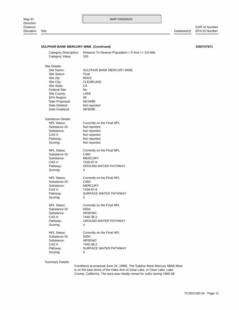
MAP FINDINGSMap IDDirection
EDR ID NumberDistanceEPA ID NumberDatabase(s)SiteElevation
County, California. The area was initially mined for sulfur during 1865-68.is on the east shore of the Oaks Arm of Clear Lake, in Clear Lake, LakeConditions at proposal June 24, 1988): The Sulphur Bank Mercury SBM) Mine
Summary Details:
3Scoring: SURFACE WATER PATHWAYPathway: 7440-38-2CAS #: ARSENICSubstance: D004Substance ID: Currently on the Final NPLNPL Status:
4Scoring: GROUND WATER PATHWAYPathway: 7440-38-2CAS #: ARSENICSubstance: D004Substance ID: Currently on the Final NPLNPL Status:
3Scoring: SURFACE WATER PATHWAYPathway: 7439-97-6CAS #: MERCURYSubstance: C460Substance ID: Currently on the Final NPLNPL Status:
4Scoring: GROUND WATER PATHWAYPathway: 7439-97-6CAS #: MERCURYSubstance: C460Substance ID: Currently on the Final NPLNPL Status:
Not reportedScoring: Not reportedPathway: Not reportedCAS #: Not reportedSubstance: Not reportedSubstance ID: Currently on the Final NPLNPL Status:
Substance Details:
08/30/90Date Finalized: Not reportedDate Deleted: 06/24/88Date Proposed: 09EPA Region: LAKESite County: NoFederal Site: CASite State: CLEARLAKESite City: 95422Site Zip: FinalSite Status: SULPHUR BANK MERCURY MINESite Name:
Site Details:
100Category Value: Distance To Nearest Population-> 0 And <= 1/4 MileCategory Description:
SULPHUR BANK MERCURY MINE (Continued) 1000707971
TC2622183.9s Page 11

MAP FINDINGSMap IDDirection
EDR ID NumberDistanceEPA ID NumberDatabase(s)SiteElevation
Full-text of USEPA Record of Decision(s) is available from EDR.ROD:
CAState: CLEARLAKECity: SULPHUR BANK MERCURY MINENPL Name:
Narratives Details:
Not reportedDeleted Date: 08/30/1990Final Date: 06/24/1988Proposed Date: FinalNPL Status:
Site Status Details:
Lake is probably from erosion of waste rock and tailings into the lake.late 1989. It indicated that the largest continued input of mercury to Clearfrom TPCA in April 1990. CRWQCB s study of Clear Lake was completed insubmitted their HAR to CRWQCB in July 1988. CRWQCB exempted the HermanPit1 mile from the site. Status August 30, 1990): The property ownerspeople obtain drinking water from Clear Lake Oaks Water District wells aboutsite. The study is scheduled to be completed in early 1989.An estimated 4,700pollution abatement study of the Oaks Arm of Clear Lake and the adjacent minethe TPCA. On November 4, 1987, CRWQCB awarded a contract for athe site prior to submitting a HAR to determine if the site may be exempt fromHAR). The property owners are conducting a waste characteri ation study ofUnder the act, BMC is required to submit a Hydrogeologic Assessment Reportthat the Herman Pit isregulated under the Toxic Pits Cleanup Act TPCA).is a major recreational area. On March 13, 1987, CRWQCB informed BMCissue an advisory on May 14, 1986 against consumption of the fish. The lakeof ClearLake. The levels of mercury in fish from Clear Lake led the State topresent in the tailings and in the biota and bottom sediments in the Oaks ArmDepartment of Fish and Game, and CRWQCB analyses indicate that mercury iscoordinating an ongoing investigation of SBM. Department of Health Services,The California Regional Water Quality Control Board CRWQCB) isupgradient of the lake. The pit is filled with water to a depth of 150 feet.shoreline. The Herman Pit covers approximately 23 acres and is 750 feetThe mine tailings extend into the Oaks Arm of Clear Lake along 1,320 feet ofand an open, unlined mine pit called the Herman Pit) are on the property.Mining Co. BMC) of San Francisco. Approximately 120 acres of tailingsCalifornia, has been inactive since 1957 and is presently owned by Bradleyand 1955-57. The mine, once one of the largest producers of mercury inmajority of the mercury ore was mined using open pit methods during 1922-47Mercury ore wasmined by underground methods during 1899-1902 and 1915-18. The
SULPHUR BANK MERCURY MINE (Continued) 1000707971
-122.91951Longitude:39.03463Latitude:4624Global ID:
UST:
267 ft. Site 1 of 4 in cluster A0.051 mi.
Relative:Lower
Actual:1350 ft.
< 1/8 LAKEPORT, CA 95453NE 555 LAKEPORT BLVD N/AA1 USTPACIFIC BELL TD-255/LKPTCA022 U003779259
TC2622183.9s Page 12

MAP FINDINGSMap IDDirection
EDR ID NumberDistanceEPA ID NumberDatabase(s)SiteElevation
N/AMTBE Code:LUSTProgram:RegionalLead Agency:GTMStaff Initials:DIESELSubstance:Soil onlyCase Type:170114Case Number:Case ClosedStatus:5Region:
LUST REG 5:
267 ft. Site 2 of 4 in cluster A0.051 mi.
Relative:Lower
Actual:1350 ft.
< 1/8 LAKEPORT, CA 95453NE 555 LAKEPORT BOULEVARD N/AA2 LUSTAT&T S108277126
Not reportedSite History: DieselPotential Contaminants of Concern: SoilPotential Media Affect: Not reportedFile Location: Not reportedLOC Case Number: Not reportedRB Case Number: LAKE COUNTYLocal Agency: Not reportedCase Worker: CENTRAL VALLEY RWQCB (REGION 5S)Lead Agency: 2006-11-27 00:00:00Status Date: Completed - Case ClosedStatus: LUST Cleanup SiteCase Type: -122.919696Longitude: 39.034643Latitude: T0603315849Global Id: STATERegion:
LUST:
267 ft. Site 3 of 4 in cluster A0.051 mi.
Relative:Lower
Actual:1350 ft.
< 1/8 LAKEPORT, CA 95453NE 555 LAKEPORT BOULEVARD N/AA3 LUSTAT&T S108086954
Not reportedContact address: Not reportedContact: SACRAMENTO, CA 95821 3707 KINGS WAY SEC A-6Mailing address: CAT080028863EPA ID: LAKEPORT, CA 95453 555 LAKEPORT BOULEVARDFacility address: PACIFIC BELLFacility name: 09/01/1996Date form received by agency:
RCRA-SQG:
SWEEPS UST267 ft. EMISite 4 of 4 in cluster A0.051 mi. HIST UST
Relative:Lower
Actual:1350 ft.
< 1/8 HAZNETLAKEPORT, CA 95453NE FINDS555 LAKEPORT BOULEVARD CAT080028863A4 RCRA-SQGPACIFIC BELL 1000251835
TC2622183.9s Page 13

MAP FINDINGSMap IDDirection
EDR ID NumberDistanceEPA ID NumberDatabase(s)SiteElevation
Large Quantity GeneratorClassification: PACIFIC BELLFacility name: 02/05/1981Date form received by agency:
Historical Generators:
Commercial status unknownOff-site waste receiver: NoUsed oil transporter: NoUsed oil transfer facility: NoUsed oil Specification marketer: NoUsed oil fuel marketer to burner: NoUser oil refiner: NoUsed oil processor: NoUsed oil fuel burner: UnknownFurnace exemption: UnknownOn-site burner exemption: NoUnderground injection activity: NoTreater, storer or disposer of HW: NoTransporter of hazardous waste: NoRecycler of hazardous waste: UnknownMixed waste (haz. and radioactive): UnknownU.S. importer of hazardous waste:
Handler Activities Summary:
Not reportedOwner/Op end date: Not reportedOwner/Op start date: OperatorOwner/Operator Type: PrivateLegal status: (415) 555-1212Owner/operator telephone: Not reportedOwner/operator country: NOT REQUIRED, ME 99999 NOT REQUIREDOwner/operator address: NOT REQUIREDOwner/operator name:
Not reportedOwner/Op end date: Not reportedOwner/Op start date: OwnerOwner/Operator Type: PrivateLegal status: (415) 555-1212Owner/operator telephone: Not reportedOwner/operator country: NOT REQUIRED, ME 99999 NOT REQUIREDOwner/operator address: THE PACIFIC TELEPHONE AND TELEGRAPH COOwner/operator name:
Owner/Operator Summary:
hazardous waste at any time waste during any calendar month, and accumulates more than 1000 kg of hazardous waste at any time; or generates 100 kg or less of hazardous waste during any calendar month and accumulates less than 6000 kg of Handler: generates more than 100 and less than 1000 kg of hazardousDescription: Small Small Quantity GeneratorClassification: 09EPA Region: Not reportedContact email: Not reportedContact telephone: Not reportedContact country: Not reported
PACIFIC BELL (Continued) 1000251835
TC2622183.9s Page 14

MAP FINDINGSMap IDDirection
EDR ID NumberDistanceEPA ID NumberDatabase(s)SiteElevation
PRODUCTTank Used for: 00001500Tank Capacity: 1970Year Installed: 1Container Num: 001Tank Num:
SAN FRANCISCO, CA 94107Owner City,St,Zip: 370 THIRD STREETOwner Address: PACIFIC BELLOwner Name: 4155426758Telephone: E.J. KOEHLERContact Name: 0001Total Tanks: SIC 4800Other Type: OtherFacility Type: 00000057526Facility ID: STATERegion:
HIST UST:
Not reportedFacility County: 2.91Tons: RecyclerDisposal Method: Aqueous solution with 10% or more total organic residuesWaste Category: San MateoTSD County: CAD009452657TSD EPA ID: LakesGen County: SAN RAMON, CA 945830995Mailing City,St,Zip: PO BOX 5095 RM 3E000Mailing Address: Not reportedMailing Name: Not reportedFacility Addr2: 9258675741Telephone: SHARON BAYLE/STAFF ASSOCContact: CAT080028863Gepaid:
HAZNET:
corrective action activities required under RCRA.program staff to track the notification, permit, compliance, andand treat, store, or dispose of hazardous waste. RCRAInfo allows RCRAevents and activities related to facilities that generate, transport,Conservation and Recovery Act (RCRA) program through the tracking ofRCRAInfo is a national information system that supports the Resource
facilities.generators, transporters, and treatment, storage, and disposalprovides California with information on hazardous waste shipments forCalifornia Hazardous Waste Tracking System - Datamart (HWTS-DATAMART)
their precursors, as well as hazardous air pollutants (HAPs).on stationary and mobile sources that emit criteria air pollutants andThe NEI (National Emissions Inventory) database contains information Environmental Interest/Information System
110002954857Registry ID:
FINDS:
No violations foundViolation Status:
PACIFIC BELL (Continued) 1000251835
TC2622183.9s Page 15

MAP FINDINGSMap IDDirection
EDR ID NumberDistanceEPA ID NumberDatabase(s)SiteElevation
1999Year:
0Part. Matter 10 Micrometers & Smllr Tons/Yr: 0Particulate Matter Tons/Yr: 0SOX - Oxides of Sulphur Tons/Yr: 0NOX - Oxides of Nitrogen Tons/Yr: 0Carbon Monoxide Emissions Tons/Yr: 0Reactive Organic Gases Tons/Yr: 0Total Organic Hydrocarbon Gases Tons/Yr: Not reportedConsolidated Emission Reporting Rule: Not reportedCommunity Health Air Pollution Info System: LAKE COUNTY AQMDAir District Name: 4911SIC Code: LAKAir District Name: 214Facility ID: LCAir Basin: 17County Code: 1998Year:
0Part. Matter 10 Micrometers & Smllr Tons/Yr: 0Particulate Matter Tons/Yr: 0SOX - Oxides of Sulphur Tons/Yr: 0NOX - Oxides of Nitrogen Tons/Yr: 0Carbon Monoxide Emissions Tons/Yr: 0Reactive Organic Gases Tons/Yr: 0Total Organic Hydrocarbon Gases Tons/Yr: Not reportedConsolidated Emission Reporting Rule: Not reportedCommunity Health Air Pollution Info System: LAKE COUNTY AQMDAir District Name: 4911SIC Code: LAKAir District Name: 214Facility ID: LCAir Basin: 17County Code: 1997Year:
0Part. Matter 10 Micrometers & Smllr Tons/Yr: 0Particulate Matter Tons/Yr: 0SOX - Oxides of Sulphur Tons/Yr: 0NOX - Oxides of Nitrogen Tons/Yr: 0Carbon Monoxide Emissions Tons/Yr: 0Reactive Organic Gases Tons/Yr: 0Total Organic Hydrocarbon Gases Tons/Yr: Not reportedConsolidated Emission Reporting Rule: Not reportedCommunity Health Air Pollution Info System: LAKE COUNTY AQMDAir District Name: 4911SIC Code: LAKAir District Name: 214Facility ID: LCAir Basin: 17County Code: 1996Year:
EMI:
NoneLeak Detection: Not reportedTank Construction: DIESELType of Fuel:
PACIFIC BELL (Continued) 1000251835
TC2622183.9s Page 16

MAP FINDINGSMap IDDirection
EDR ID NumberDistanceEPA ID NumberDatabase(s)SiteElevation
LAKE COUNTY AQMDAir District Name: 4911SIC Code: LAKAir District Name: 214Facility ID: LCAir Basin: 17County Code: 2002Year:
0Part. Matter 10 Micrometers & Smllr Tons/Yr: 0Particulate Matter Tons/Yr: 0SOX - Oxides of Sulphur Tons/Yr: 0NOX - Oxides of Nitrogen Tons/Yr: 0Carbon Monoxide Emissions Tons/Yr: 0Reactive Organic Gases Tons/Yr: 0Total Organic Hydrocarbon Gases Tons/Yr: Not reportedConsolidated Emission Reporting Rule: Not reportedCommunity Health Air Pollution Info System: LAKE COUNTY AQMDAir District Name: 4911SIC Code: LAKAir District Name: 214Facility ID: LCAir Basin: 17County Code: 2001Year:
0Part. Matter 10 Micrometers & Smllr Tons/Yr: 0Particulate Matter Tons/Yr: 0SOX - Oxides of Sulphur Tons/Yr: 0NOX - Oxides of Nitrogen Tons/Yr: 0Carbon Monoxide Emissions Tons/Yr: 0Reactive Organic Gases Tons/Yr: 0Total Organic Hydrocarbon Gases Tons/Yr: Not reportedConsolidated Emission Reporting Rule: Not reportedCommunity Health Air Pollution Info System: LAKE COUNTY AQMDAir District Name: 4911SIC Code: LAKAir District Name: 214Facility ID: LCAir Basin: 17County Code: 2000Year:
0Part. Matter 10 Micrometers & Smllr Tons/Yr: 0Particulate Matter Tons/Yr: 0SOX - Oxides of Sulphur Tons/Yr: 0NOX - Oxides of Nitrogen Tons/Yr: 0Carbon Monoxide Emissions Tons/Yr: 0Reactive Organic Gases Tons/Yr: 0Total Organic Hydrocarbon Gases Tons/Yr: Not reportedConsolidated Emission Reporting Rule: Not reportedCommunity Health Air Pollution Info System: LAKE COUNTY AQMDAir District Name: 4911SIC Code: LAKAir District Name: 214Facility ID: LCAir Basin: 17County Code:
PACIFIC BELL (Continued) 1000251835
TC2622183.9s Page 17

MAP FINDINGSMap IDDirection
EDR ID NumberDistanceEPA ID NumberDatabase(s)SiteElevation
.11NOX - Oxides of Nitrogen Tons/Yr: .02Carbon Monoxide Emissions Tons/Yr: .008367Reactive Organic Gases Tons/Yr: .01Total Organic Hydrocarbon Gases Tons/Yr: Not reportedConsolidated Emission Reporting Rule: Not reportedCommunity Health Air Pollution Info System: LAKE COUNTY AQMDAir District Name: 4911SIC Code: LAKAir District Name: 214Facility ID: LCAir Basin: 17County Code: 2005Year:
0.01Part. Matter 10 Micrometers & Smllr Tons/Yr: 0.01Particulate Matter Tons/Yr: 0.01SOX - Oxides of Sulphur Tons/Yr: 0.11NOX - Oxides of Nitrogen Tons/Yr: 0.02Carbon Monoxide Emissions Tons/Yr: 0.01Reactive Organic Gases Tons/Yr: 0.01Total Organic Hydrocarbon Gases Tons/Yr: Not reportedConsolidated Emission Reporting Rule: Not reportedCommunity Health Air Pollution Info System: LAKE COUNTY AQMDAir District Name: 4911SIC Code: LAKAir District Name: 214Facility ID: LCAir Basin: 17County Code: 2004Year:
0Part. Matter 10 Micrometers & Smllr Tons/Yr: 0Particulate Matter Tons/Yr: 0SOX - Oxides of Sulphur Tons/Yr: 0NOX - Oxides of Nitrogen Tons/Yr: 0Carbon Monoxide Emissions Tons/Yr: 0Reactive Organic Gases Tons/Yr: 0Total Organic Hydrocarbon Gases Tons/Yr: Not reportedConsolidated Emission Reporting Rule: Not reportedCommunity Health Air Pollution Info System: LAKE COUNTY AQMDAir District Name: 4911SIC Code: LAKAir District Name: 214Facility ID: LCAir Basin: 17County Code: 2003Year:
0Part. Matter 10 Micrometers & Smllr Tons/Yr: 0Particulate Matter Tons/Yr: 0SOX - Oxides of Sulphur Tons/Yr: 0NOX - Oxides of Nitrogen Tons/Yr: 0Carbon Monoxide Emissions Tons/Yr: 0Reactive Organic Gases Tons/Yr: 0Total Organic Hydrocarbon Gases Tons/Yr: Not reportedConsolidated Emission Reporting Rule: Not reportedCommunity Health Air Pollution Info System:
PACIFIC BELL (Continued) 1000251835
TC2622183.9s Page 18

MAP FINDINGSMap IDDirection
EDR ID NumberDistanceEPA ID NumberDatabase(s)SiteElevation
1Number Of Tanks: DIESELContent: PStg: M.V. FUELTank Use: 1500Capacity: 10-29-88Actv Date: 17-000-057526-000001Swrcb Tank Id: 1Owner Tank Id: ATank Status: 02-29-88Created Date: 10-29-88Act Date: Not reportedRef Date: 44-001027Board Of Equalization: 9Number: 57526Comp Number: AStatus:
SWEEPS UST:
.00976Part. Matter 10 Micrometers & Smllr Tons/Yr: .01Particulate Matter Tons/Yr: .01SOX - Oxides of Sulphur Tons/Yr: .11NOX - Oxides of Nitrogen Tons/Yr: .02Carbon Monoxide Emissions Tons/Yr: .008367Reactive Organic Gases Tons/Yr: .01Total Organic Hydrocarbon Gases Tons/Yr: Not reportedConsolidated Emission Reporting Rule: Not reportedCommunity Health Air Pollution Info System: LAKE COUNTY AQMDAir District Name: 4911SIC Code: LAKAir District Name: 214Facility ID: LCAir Basin: 17County Code: 2006Year:
.00976Part. Matter 10 Micrometers & Smllr Tons/Yr: .01Particulate Matter Tons/Yr: .01SOX - Oxides of Sulphur Tons/Yr:
PACIFIC BELL (Continued) 1000251835
LAKEPORT, CA 95453Owner City,St,Zip: 883 LAKEPORT BOULEVARDOwner Address: LAKE COUNTY DEPARTMENT OF AGRIOwner Name: 7072632271Telephone: DON TOMPKINSContact Name: 0001Total Tanks: OFFICEOther Type: OtherFacility Type: 00000031035Facility ID: STATERegion:
HIST UST:
316 ft. Site 1 of 2 in cluster B0.060 mi.
Relative:Lower
Actual:1385 ft.
< 1/8 LAKEPORT, CA 95453West EMI883 LAKEPORT BLVD N/AB5 HIST USTLAKE COUNTY DEPARTMENT OF AGRI U001610369
TC2622183.9s Page 19

MAP FINDINGSMap IDDirection
EDR ID NumberDistanceEPA ID NumberDatabase(s)SiteElevation
0NOX - Oxides of Nitrogen Tons/Yr: 0Carbon Monoxide Emissions Tons/Yr: 0Reactive Organic Gases Tons/Yr: 0Total Organic Hydrocarbon Gases Tons/Yr: Not reportedConsolidated Emission Reporting Rule: Not reportedCommunity Health Air Pollution Info System: LAKE COUNTY AQMDAir District Name: 7261SIC Code: LAKAir District Name: 178Facility ID: LCAir Basin: 17County Code: 2002Year:
0Part. Matter 10 Micrometers & Smllr Tons/Yr: 0Particulate Matter Tons/Yr: 0SOX - Oxides of Sulphur Tons/Yr: 0NOX - Oxides of Nitrogen Tons/Yr: 0Carbon Monoxide Emissions Tons/Yr: 0Reactive Organic Gases Tons/Yr: 0Total Organic Hydrocarbon Gases Tons/Yr: Not reportedConsolidated Emission Reporting Rule: Not reportedCommunity Health Air Pollution Info System: LAKE COUNTY AQMDAir District Name: 7261SIC Code: LAKAir District Name: 178Facility ID: LCAir Basin: 17County Code: 2001Year:
0Part. Matter 10 Micrometers & Smllr Tons/Yr: 0Particulate Matter Tons/Yr: 0SOX - Oxides of Sulphur Tons/Yr: 0NOX - Oxides of Nitrogen Tons/Yr: 0Carbon Monoxide Emissions Tons/Yr: 0Reactive Organic Gases Tons/Yr: 0Total Organic Hydrocarbon Gases Tons/Yr: Not reportedConsolidated Emission Reporting Rule: Not reportedCommunity Health Air Pollution Info System: LAKE COUNTY AQMDAir District Name: 7261SIC Code: LAKAir District Name: 178Facility ID: LCAir Basin: 17County Code: 2000Year:
EMI:
NoneLeak Detection: 4 inchesTank Construction: Not reportedType of Fuel: WASTETank Used for: 00001000Tank Capacity: 1975Year Installed: 1975 AGContainer Num: 001Tank Num:
LAKE COUNTY DEPARTMENT OF AGRI (Continued) U001610369
TC2622183.9s Page 20

MAP FINDINGSMap IDDirection
EDR ID NumberDistanceEPA ID NumberDatabase(s)SiteElevation
17County Code: 2006Year:
.007Part. Matter 10 Micrometers & Smllr Tons/Yr: .01Particulate Matter Tons/Yr: .004SOX - Oxides of Sulphur Tons/Yr: .09NOX - Oxides of Nitrogen Tons/Yr: .03Carbon Monoxide Emissions Tons/Yr: .006986Reactive Organic Gases Tons/Yr: .01Total Organic Hydrocarbon Gases Tons/Yr: Not reportedConsolidated Emission Reporting Rule: Not reportedCommunity Health Air Pollution Info System: LAKE COUNTY AQMDAir District Name: 7261SIC Code: LAKAir District Name: 178Facility ID: LCAir Basin: 17County Code: 2005Year:
0.01Part. Matter 10 Micrometers & Smllr Tons/Yr: 0.01Particulate Matter Tons/Yr: 0.004SOX - Oxides of Sulphur Tons/Yr: 0.09NOX - Oxides of Nitrogen Tons/Yr: 0.03Carbon Monoxide Emissions Tons/Yr: 0.01Reactive Organic Gases Tons/Yr: 0.01Total Organic Hydrocarbon Gases Tons/Yr: Not reportedConsolidated Emission Reporting Rule: Not reportedCommunity Health Air Pollution Info System: LAKE COUNTY AQMDAir District Name: 7261SIC Code: LAKAir District Name: 178Facility ID: LCAir Basin: 17County Code: 2004Year:
0Part. Matter 10 Micrometers & Smllr Tons/Yr: 0Particulate Matter Tons/Yr: 0SOX - Oxides of Sulphur Tons/Yr: 0NOX - Oxides of Nitrogen Tons/Yr: 0Carbon Monoxide Emissions Tons/Yr: 0Reactive Organic Gases Tons/Yr: 0Total Organic Hydrocarbon Gases Tons/Yr: Not reportedConsolidated Emission Reporting Rule: Not reportedCommunity Health Air Pollution Info System: LAKE COUNTY AQMDAir District Name: 7261SIC Code: LAKAir District Name: 178Facility ID: LCAir Basin: 17County Code: 2003Year:
0Part. Matter 10 Micrometers & Smllr Tons/Yr: 0Particulate Matter Tons/Yr: 0SOX - Oxides of Sulphur Tons/Yr:
LAKE COUNTY DEPARTMENT OF AGRI (Continued) U001610369
TC2622183.9s Page 21

MAP FINDINGSMap IDDirection
EDR ID NumberDistanceEPA ID NumberDatabase(s)SiteElevation
.007Part. Matter 10 Micrometers & Smllr Tons/Yr: .01Particulate Matter Tons/Yr: .004SOX - Oxides of Sulphur Tons/Yr: .09NOX - Oxides of Nitrogen Tons/Yr: .03Carbon Monoxide Emissions Tons/Yr: .006986Reactive Organic Gases Tons/Yr: .01Total Organic Hydrocarbon Gases Tons/Yr: Not reportedConsolidated Emission Reporting Rule: Not reportedCommunity Health Air Pollution Info System: LAKE COUNTY AQMDAir District Name: 7261SIC Code: LAKAir District Name: 178Facility ID: LCAir Basin:
LAKE COUNTY DEPARTMENT OF AGRI (Continued) U001610369
Tons/dayRemaining Capacity with Units: Not reportedRemaining Capacity: 200Permitted Capacity with Units: Tons/dayActual Throughput with Units: 200Permitted Throughput with Units: Not reportedProgram Type: Lakeport, CA 95453Issue & Observations: 17-AA-0002Swisnumber: Not reportedDisposal Acreage: Not reportedClosure Type: Not reportedClosure Date: Mixed municipalAccepted Waste: MonthlyInspection Frequency: 01Unit Number: Transfer/ProcessingCategory: MapGIS Source: CommercialLanduse Name: PermittedRegulation Status: Large Volume Transfer/Proc FacilityActivity: 2Permitted Acreage: PermittedPermit Status: 11/3/1995Permit Date: ActiveOperator’s Status: Lakeport, CA 95453Operator City,St,Zip: 333 North Second StreetOperator Address2: Not reportedOperator Address: 7072621760Operator Phone: County Of LakeOperator: Lakeport, CA 95453Owner City,St,Zip: 333 North Second StreetOwner Address2: Not reportedOwner Address: 7072621760Owner Telephone: County Of LakeOwner Name: 39.03455 / -122.9233Lat/Long: 17-AA-0002Facility ID: STATERegion:
SWF/LF (SWIS):
333 ft. Site 2 of 2 in cluster B0.063 mi.
Relative:Lower
Actual:1379 ft.
< 1/8 LAKEPORT, CA West 910 BEVINS STREET N/AB6 SWF/LFLAKEPORT TRANSFER STATION S102360551
TC2622183.9s Page 22

MAP FINDINGSMap IDDirection
EDR ID NumberDistanceEPA ID NumberDatabase(s)SiteElevation
SILVERWaste name: D011Waste code:
Hazardous Waste Summary:
Commercial status unknownOff-site waste receiver: NoUsed oil transporter: NoUsed oil transfer facility: NoUsed oil Specification marketer: NoUsed oil fuel marketer to burner: NoUser oil refiner: NoUsed oil processor: NoUsed oil fuel burner: UnknownFurnace exemption: UnknownOn-site burner exemption: NoUnderground injection activity: NoTreater, storer or disposer of HW: NoTransporter of hazardous waste: NoRecycler of hazardous waste: UnknownMixed waste (haz. and radioactive): UnknownU.S. importer of hazardous waste:
Handler Activities Summary:
Not reportedOwner/Op end date: Not reportedOwner/Op start date: OwnerOwner/Operator Type: PrivateLegal status: (707) 263-7337Owner/operator telephone: Not reportedOwner/operator country: LAKEPORT, CA 95453 355 LAKEPORT BLVDOwner/operator address: WILLIAM BRUNETTIOwner/operator name:
Owner/Operator Summary:
hazardous waste at any time waste during any calendar month, and accumulates more than 1000 kg of hazardous waste at any time; or generates 100 kg or less of hazardous waste during any calendar month and accumulates less than 6000 kg of Handler: generates more than 100 and less than 1000 kg of hazardousDescription: Small Small Quantity GeneratorClassification: 09EPA Region: Not reportedContact email: (707) 263-7337Contact telephone: USContact country: LAKEPORT, CA 954535412 355 LAKEPORT BLVDContact address: RAY STARKContact: CAR000032862EPA ID: LAKEPORT, CA 954535412 355 LAKEPORT BLVDFacility address: BRUNO FOODSFacility name: 10/20/1997Date form received by agency:
RCRA-SQG:
869 ft.0.165 mi.
Relative:Lower
Actual:1341 ft.
1/8-1/4 HAZNETLAKEPORT, CA 95453East FINDS355 LAKEPORT BLVD CAR0000328627 RCRA-SQGBRUNO FOODS 1001217358
TC2622183.9s Page 23

MAP FINDINGSMap IDDirection
EDR ID NumberDistanceEPA ID NumberDatabase(s)SiteElevation
355 LAKEPORT BLVDMailing Address: Not reportedMailing Name: Not reportedFacility Addr2: Not reportedTelephone: TOM ROGERS SAFETY MGRContact: CAR000032862Gepaid:
LakesFacility County: 0.62Tons: Transfer StationDisposal Method: Photochemicals/photoprocessing wasteWaste Category: LakesTSD County: CA0000084517TSD EPA ID: LakesGen County: LAKEPORT, CA 954535412Mailing City,St,Zip: 355 LAKEPORT BLVDMailing Address: Not reportedMailing Name: Not reportedFacility Addr2: 0Telephone: TOM ROGERS SAFETY MGRContact: CAR000032862Gepaid:
LakesFacility County: 2.0016Tons: Transfer StationDisposal Method: Photochemicals/photoprocessing wasteWaste Category: SacramentoTSD County: CA0000084517TSD EPA ID: LakesGen County: LAKEPORT, CA 954535412Mailing City,St,Zip: 355 LAKEPORT BLVDMailing Address: Not reportedMailing Name: Not reportedFacility Addr2: 7072637337Telephone: WILLIAM BRUNETTIContact: CAR000032862Gepaid:
HAZNET:
corrective action activities required under RCRA.program staff to track the notification, permit, compliance, andand treat, store, or dispose of hazardous waste. RCRAInfo allows RCRAevents and activities related to facilities that generate, transport,Conservation and Recovery Act (RCRA) program through the tracking ofRCRAInfo is a national information system that supports the Resource
facilities.generators, transporters, and treatment, storage, and disposalprovides California with information on hazardous waste shipments forCalifornia Hazardous Waste Tracking System - Datamart (HWTS-DATAMART) Environmental Interest/Information System
110002919637Registry ID:
FINDS:
No violations foundViolation Status:
BRUNO FOODS (Continued) 1001217358
TC2622183.9s Page 24

MAP FINDINGSMap IDDirection
EDR ID NumberDistanceEPA ID NumberDatabase(s)SiteElevation
3 additional CA_HAZNET: record(s) in the EDR Site Report.Click this hyperlink while viewing on your computer to access
Not reportedFacility County: 1Tons: Transfer StationDisposal Method: Photochemicals/photoprocessing wasteWaste Category: SacramentoTSD County: Not reportedTSD EPA ID: LakesGen County: LAKEPORT, CA 954535412Mailing City,St,Zip: 355 LAKEPORT BLVDMailing Address: Not reportedMailing Name: Not reportedFacility Addr2: --Telephone: TOM ROGERS SAFETY MGRContact: CAR000032862Gepaid:
LakesFacility County: .2502Tons: Transfer StationDisposal Method: Photochemicals/photoprocessing wasteWaste Category: SacramentoTSD County: CA0000084517TSD EPA ID: LakesGen County: LAKEPORT, CA 954535412Mailing City,St,Zip: 355 LAKEPORT BLVDMailing Address: Not reportedMailing Name: Not reportedFacility Addr2: 7072637337Telephone: WILLIAM BRUNETTIContact: CAR000032862Gepaid:
Not reportedFacility County: 0.07Tons: Transfer StationDisposal Method: Photochemicals/photoprocessing wasteWaste Category: SacramentoTSD County: CA0000084517TSD EPA ID: LakesGen County: LAKEPORT, CA 954535412Mailing City,St,Zip:
BRUNO FOODS (Continued) 1001217358
1400 SO MAIN ST LAKEPORT-B-5Owner Address: CHARLES YOZSAOwner Name: 7072636645Telephone: SAMEContact Name: 0003Total Tanks: BOATOther Type: Gas StationFacility Type: 00000006831Facility ID: STATERegion:
HIST UST:
1183 ft.0.224 mi.
Relative:Lower
Actual:1337 ft.
1/8-1/4 LAKEPORT, CA 95453ESE 1400 SO MAIN ST LAKEPORT-B-5 N/A8 HIST USTCLEAR LAKE MARINA U001610340
TC2622183.9s Page 25

MAP FINDINGSMap IDDirection
EDR ID NumberDistanceEPA ID NumberDatabase(s)SiteElevation
NoneLeak Detection: 10 gaugeTank Construction: REGULARType of Fuel: PRODUCTTank Used for: 00000550Tank Capacity: 1975Year Installed: 3Container Num: 003Tank Num:
NoneLeak Detection: 12 gaugeTank Construction: REGULARType of Fuel: PRODUCTTank Used for: 00000550Tank Capacity: 1975Year Installed: 2Container Num: 002Tank Num:
Stock InventorLeak Detection: 10 gaugeTank Construction: PREMIUMType of Fuel: PRODUCTTank Used for: 00001000Tank Capacity: 1975Year Installed: 1Container Num: 001Tank Num:
LAKEPORT, CA 95453Owner City,St,Zip:
CLEAR LAKE MARINA (Continued) U001610340
LUST Cleanup SiteCase Type: -122.915624842Longitude: 39.035484667Latitude: T0603300005Global Id: STATERegion:
LUST:
Not reportedFacility County: 0.88Tons: Transfer StationDisposal Method: Other organic solidsWaste Category: San BernardinoTSD County: Not reportedTSD EPA ID: LakesGen County: AUBURN, WA 980015931Mailing City,St,Zip: 3450 S 344TH ST STE 100Mailing Address: Not reportedMailing Name: Not reportedFacility Addr2: 2538968801Telephone: ROBERT HOOVERContact: CAL000252738Gepaid:
HAZNET:
1754 ft.0.332 mi.
Relative:Lower
Actual:1336 ft.
1/4-1/2 HIST CORTESELAKEPORT, CA 95453SE LUST975 MAIN ST N/A9 HAZNETTESORO 67075 S101295438
TC2622183.9s Page 26

MAP FINDINGSMap IDDirection
EDR ID NumberDistanceEPA ID NumberDatabase(s)SiteElevation
170013Reg Id: LTNKAReg By: 17Facility County Code: CORTESERegion:
CORTESE:
N/AMTBE Code:LUSTProgram:RegionalLead Agency:GTMStaff Initials:GASOLINESubstance:Drinking Water Aquifer affectedCase Type:170013Case Number:Remediation PlanStatus:5Region:
LUST REG 5:
Not reportedSite History: GasolinePotential Contaminants of Concern: Aquifer used for drinking water supplyPotential Media Affect: Not reportedFile Location: Not reportedLOC Case Number: Not reportedRB Case Number: LAKE COUNTYLocal Agency: Not reportedCase Worker: CENTRAL VALLEY RWQCB (REGION 5S)Lead Agency: 2006-08-10 00:00:00Status Date: Open - RemediationStatus:
TESORO 67075 (Continued) S101295438
Case ClosedStatus:5Region:
LUST REG 5:
Not reportedSite History: Waste Oil / Motor / Hydraulic / LubricatingPotential Contaminants of Concern: SoilPotential Media Affect: Not reportedFile Location: Not reportedLOC Case Number: Not reportedRB Case Number: LAKE COUNTYLocal Agency: Not reportedCase Worker: CENTRAL VALLEY RWQCB (REGION 5S)Lead Agency: 1996-08-20 00:00:00Status Date: Completed - Case ClosedStatus: LUST Cleanup SiteCase Type: -122.9278095Longitude: 39.0370332Latitude: T0603300017Global Id: STATERegion:
LUST:
1808 ft.0.342 mi. HIST CORTESE
Relative:Lower
Actual:1370 ft.
1/4-1/2 CA WDSLAKEPORT, CA 95453WNW NPDES924 PARALLEL DR N/A10 LUSTUNITED PARCEL SER CALAK S101307306
TC2622183.9s Page 27

MAP FINDINGSMap IDDirection
EDR ID NumberDistanceEPA ID NumberDatabase(s)SiteElevation
Not reportedSecondary Waste Type: Not reportedSecondary Waste: Not reportedPrimary Waste Type: Not reportedPrimary Waste: Not reportedSIC Code 2: 0SIC Code: PrivateAgency Type: Not reportedAgency Telephone: STAN PREDKIAgency Contact: SAN FRANCISCO 94103Agency City,St,Zip: 2222 17TH STAgency Address: UNITED PARCEL SERVICEAgency Name: STAN PREDKIFacility Contact: 4157373758Facility Telephone: 0Subregion: are assigned by the Regional Board CAS000001 The 1st 2 characters designate the state. The remaining 7NPDES Number: under Waste Discharge Requirements. Active - Any facility with a continuous or seasonal discharge that isFacility Status: pumping. repairing, oil production, storage and disposal operations, water washing, geothermal operations, air conditioning, ship building and processing operation of whatever nature, including mining, gravel semisolid wastes from any servicing, producing, manufacturing or Industrial - Facility that treats and/or disposes of liquid orFacility Type: 5S 17I002100Facility ID:
CA WDS:
94103Discharge Zip: CADischarge State: South San FranciscoDischarge City: 2222 17th StDischarge Address: United Parcel ServiceDischarge Name: Not reportedTermination Date Of Regulatory Measure: Not reportedExpiration Date Of Regulatory Measure: 3/30/1992Effective Date Of Regulatory Measure: Not reportedAdoption Date Of Regulatory Measure: INDSTWProgram Type: 5S17I002100WDID: 269125Place Id: Storm water industrialRegulatory Measure Type: 97-03-DWQOrder No: 198507Regulatory Measure Id: 5SRegion: 47846Agency Id: ActiveFacility Status: Not reportedNpdes Number:
NPDES:
N/AMTBE Code:LUSTProgram:RegionalLead Agency:GTMStaff Initials:WASTE OILSubstance:Soil onlyCase Type:170033Case Number:
UNITED PARCEL SER CALAK (Continued) S101307306
TC2622183.9s Page 28

MAP FINDINGSMap IDDirection
EDR ID NumberDistanceEPA ID NumberDatabase(s)SiteElevation
170033Reg Id: LTNKAReg By: 17Facility County Code: CORTESERegion:
CORTESE:
dairy waste ponds. dischargers having waste storage systems with land disposal such as disposal systems, such as septic systems with subsurface disposal, or management practices, facilities with passive waste treatment and cooling water dischargers or thosewho must comply through best Category C - Facilities having no waste treatment systems, such asComplexity: represent no threat to water quality. Level. A Zero (0) may be used to code those NURDS that are found to considered a minor threat to water quality unless coded at a higher to a major or minor threat. Not: All nurds without a TTWQ will be should cause a relatively minor impairment of beneficial uses compared Minor Threat to Water Quality. A violation of a regional board orderTreat To Water: Not reportedPOTW: Not reportedReclamation: 0Baseline Flow: 0Design Flow:
UNITED PARCEL SER CALAK (Continued) S101307306
4MTBE Code:LUSTProgram:RegionalLead Agency:GTMStaff Initials:GASOLINESubstance:Drinking Water Aquifer affectedCase Type:170063Case Number:Case ClosedStatus:5Region:
LUST REG 5:
Not reportedSite History: GasolinePotential Contaminants of Concern: Aquifer used for drinking water supplyPotential Media Affect: Not reportedFile Location: Not reportedLOC Case Number: Not reportedRB Case Number: LAKE COUNTYLocal Agency: Not reportedCase Worker: CENTRAL VALLEY RWQCB (REGION 5S)Lead Agency: 2001-01-16 00:00:00Status Date: Completed - Case ClosedStatus: LUST Cleanup SiteCase Type: -122.915511Longitude: 39.0345993Latitude: T0603300043Global Id: STATERegion:
LUST:
1918 ft.0.363 mi.
Relative:Lower
Actual:1336 ft.
1/4-1/2 LAKEPORT, CA 95453SE HIST CORTESE1050 MAIN ST S N/A11 LUSTCHEVRON #1802 S102427018
TC2622183.9s Page 29

MAP FINDINGSMap IDDirection
EDR ID NumberDistanceEPA ID NumberDatabase(s)SiteElevation
170063Reg Id: LTNKAReg By: 17Facility County Code: CORTESERegion:
CORTESE:
CHEVRON #1802 (Continued) S102427018
170090Reg Id: LTNKAReg By: 17Facility County Code: CORTESERegion:
CORTESE:
7MTBE Code:LUSTProgram:RegionalLead Agency:GTMStaff Initials:GASOLINESubstance:Drinking Water Aquifer affectedCase Type:170090Case Number:Post remedial action monitoringStatus:5Region:
LUST REG 5:
Not reportedSite History: GasolinePotential Contaminants of Concern: Aquifer used for drinking water supplyPotential Media Affect: Not reportedFile Location: Not reportedLOC Case Number: Not reportedRB Case Number: LAKE COUNTYLocal Agency: Not reportedCase Worker: CENTRAL VALLEY RWQCB (REGION 5S)Lead Agency: 2003-06-13 00:00:00Status Date: Open - Verification MonitoringStatus: LUST Cleanup SiteCase Type: -122.915274592Longitude: 39.040341935Latitude: T0603300069Global Id: STATERegion:
LUST:
1995 ft. Site 1 of 2 in cluster C0.378 mi.
Relative:Lower
Actual:1336 ft.
1/4-1/2 LAKEPORT, CA 95453NE HIST CORTESE301 MAIN ST S N/AC12 LUSTLAKEPORT SHELL S104403187
TC2622183.9s Page 30

MAP FINDINGSMap IDDirection
EDR ID NumberDistanceEPA ID NumberDatabase(s)SiteElevation
N/AMTBE Code:LUSTProgram:RegionalLead Agency:GTMStaff Initials:Not reportedSubstance:Drinking Water Aquifer affectedCase Type:170111Case Number:Post remedial action monitoringStatus:5Region:
LUST REG 5:
Not reportedSite History: Diesel, Waste Oil / Motor / Hydraulic / LubricatingPotential Contaminants of Concern: Aquifer used for drinking water supplyPotential Media Affect: ArchivedFile Location: Not reportedLOC Case Number: Not reportedRB Case Number: LAKE COUNTYLocal Agency: Not reportedCase Worker: CENTRAL VALLEY RWQCB (REGION 5S)Lead Agency: 2008-12-12 00:00:00Status Date: Completed - Case ClosedStatus: LUST Cleanup SiteCase Type: -122.915501333333Longitude: 39.0406176666667Latitude: T0603346446Global Id: STATERegion:
LUST:
2056 ft. Site 2 of 2 in cluster C0.389 mi.
Relative:Lower
Actual:1333 ft.
1/4-1/2 LAKEPORT, CA 95453NE 275 SOUTH MAIN STREET N/AC13 LUSTSOPER-REESE COMMUNITY THEATER S106859257
Not reportedSite History: GasolinePotential Contaminants of Concern: Aquifer used for drinking water supplyPotential Media Affect: Not reportedFile Location: Not reportedLOC Case Number: Not reportedRB Case Number: LAKE COUNTYLocal Agency: Not reportedCase Worker: CENTRAL VALLEY RWQCB (REGION 5S)Lead Agency: 1994-10-19 00:00:00Status Date: Completed - Case ClosedStatus: LUST Cleanup SiteCase Type: -122.9167741Longitude: 39.0281335Latitude: T0603300028Global Id: STATERegion:
LUST:
2101 ft.0.398 mi.
Relative:Lower
Actual:1341 ft.
1/4-1/2 LAKEPORT, CA 95453SSE HIST CORTESE301 INDUSTRIAL AVE N/A14 LUSTLANGE BROTHERS CONSTRUCTION CO S100851204
TC2622183.9s Page 31

MAP FINDINGSMap IDDirection
EDR ID NumberDistanceEPA ID NumberDatabase(s)SiteElevation
170047Reg Id: LTNKAReg By: 17Facility County Code: CORTESERegion:
CORTESE:
N/AMTBE Code:LUSTProgram:RegionalLead Agency:GTMStaff Initials:GASOLINESubstance:Drinking Water Aquifer affectedCase Type:170047Case Number:Case ClosedStatus:5Region:
LUST REG 5:
LANGE BROTHERS CONSTRUCTION CO (Continued) S100851204
Not reportedRefillable Beverage Containers Redeemed: Not reportedOther mat beverage containers redeemed: PLPlastic Beverage Containers Redeemed: GLGlass Beverage Containers Redeemed: ALAluminum Beverage Containers Redeemed: Not AcceptedConvenience Zone Where Faciltiy Located 7: Not AcceptedConvenience Zone Where Faciltiy Located 6: Not AcceptedConvenience Zone Where Faciltiy Located 5: Not AcceptedConvenience Zone Where Faciltiy Located 4: 5225Convenience Zone Where Faciltiy Located 3: 4621Convenience Zone Where Faciltiy Located 2: 459Convenience Zone Where Faciltiy Located: Not reportedWhether The Facility Is Grandfathered: Still operatingDate facility ceased operating: 10/1/1998Date facility began operating: 9/2/1998Date facility became certified: Not reportedFacility Phone Number: OCertification Status:
SWRCY:
2201 ft.0.417 mi.
Relative:Lower
Actual:1334 ft.
1/4-1/2 LAKEPORT, CA 95453SE 1155 S MAIN ST N/A15 SWRCYTOMRA PACIFIC INC S107138048
Not reportedMailing Name: Not reportedFacility Addr2: 2062864505Telephone: WALTER SPRAGUE GENERAL MANAGERContact: CAL000264271Gepaid:
HAZNET:
2267 ft. Site 1 of 5 in cluster D0.429 mi.
Relative:Lower
Actual:1335 ft.
1/4-1/2 LAKEPORT, CA 95453NE ENVIROSTOR202 S MAIN ST N/AD16 HAZNETTIME OIL CO/JACKPOT FOOD MART S101480526
TC2622183.9s Page 32

MAP FINDINGSMap IDDirection
EDR ID NumberDistanceEPA ID NumberDatabase(s)SiteElevation
Completed Info:
Not reportedAPN Description: NONE SPECIFIEDAPN:
Envirostor ID NumberAlias Type: 17510002Alias Name: Alternate NameAlias Type: Jackpot StationAlias Name: Envirostor ID NumberAlias Type: 17510010Alias Name: -122.914905087341Longitude: 39.0411134926845Latitude: Not reportedFunding: NORestricted Use: 2008-12-31 00:00:00Status Date: Refer: RWQCBStatus: * Rural County Survey ProgramSpecial Program: 02Senate: 01Assembly: Not reportedSite Code: 17510002Facility ID: SacramentoDivision Branch: Referred - Not AssignedSupervisor: Not reportedProgram Manager: NONE SPECIFIEDLead Agency: NONE SPECIFIEDRegulatory Agencies: NONPL: 1Acres: EvaluationSite Type Detailed: EvaluationSite Type:
ENVIROSTOR:
LakesFacility County: .6880Tons: RecyclerDisposal Method: Unspecified oil-containing wasteWaste Category: San MateoTSD County: CAD043260702TSD EPA ID: LakesGen County: SEATTLE, WA 981991233Mailing City,St,Zip: 2737 W COMMADORE WAYMailing Address: Not reportedMailing Name: Not reportedFacility Addr2: 0000000000Telephone: TIME OIL COContact: CAC001040032Gepaid:
Not reportedFacility County: Not reportedTons: Transfer StationDisposal Method: Unspecified organic liquid mixtureWaste Category: Los AngelesTSD County: CAD028409019TSD EPA ID: LakesGen County: SEATTLE, WA 981991257Mailing City,St,Zip: 2737 W COMMADORE WAYMailing Address:
TIME OIL CO/JACKPOT FOOD MART (Continued) S101480526
TC2622183.9s Page 33

MAP FINDINGSMap IDDirection
EDR ID NumberDistanceEPA ID NumberDatabase(s)SiteElevation
NONE SPECIFIEDPastUse: Not reportedSchedule Revised Date: Not reportedSchedule Due Date: Not reportedSchedule Document Type: Not reportedSchedule Sub Area Name: Not reportedSchedule Area Name: Not reportedPotenital Description: NONE SPECIFIEDPotential: Not reportedManagement Required Desc: NONE SPECIFIEDManagement Required:
Management:
Not reportedMedia Affected Desc: NONE SPECIFIEDMedia Affected: Not reportedFuture Due Date: Not reportedFuture Document Type: Not reportedFuture Sub Area Name: Not reportedFuture Area Name: Not reportedConfirmed Description: NONE SPECIFIEDConfirmed:
1988-07-14 00:00:00Completed Date: Site ScreeningCompleted Document Type: Not reportedCompleted Sub Area Name: PROJECT WIDECompleted Area Name:
1988-02-25 00:00:00Completed Date: * DiscoveryCompleted Document Type: Not reportedCompleted Sub Area Name: PROJECT WIDECompleted Area Name:
TIME OIL CO/JACKPOT FOOD MART (Continued) S101480526
Case ClosedStatus:5Region:
LUST REG 5:
Not reportedSite History: GasolinePotential Contaminants of Concern: Surface waterPotential Media Affect: Not reportedFile Location: Not reportedLOC Case Number: Not reportedRB Case Number: LAKE COUNTYLocal Agency: Not reportedCase Worker: CENTRAL VALLEY RWQCB (REGION 5S)Lead Agency: 1998-12-09 00:00:00Status Date: Completed - Case ClosedStatus: LUST Cleanup SiteCase Type: -122.9160671Longitude: 39.0402761Latitude: T0603300001Global Id: STATERegion:
LUST:
2267 ft. Site 2 of 5 in cluster D0.429 mi.
Relative:Lower
Actual:1335 ft.
1/4-1/2 LAKEPORT, CA 95453NE HIST CORTESE202 MAIN ST S N/AD17 LUSTJACKPOT FOOD MART S104164499
TC2622183.9s Page 34

MAP FINDINGSMap IDDirection
EDR ID NumberDistanceEPA ID NumberDatabase(s)SiteElevation
170003Reg Id: LTNKAReg By: 17Facility County Code: CORTESERegion:
CORTESE:
N/AMTBE Code:LUSTProgram:RegionalLead Agency:GTMStaff Initials:GASOLINESubstance:Surface WaterCase Type:170003Case Number:
JACKPOT FOOD MART (Continued) S104164499
PROJECT WIDECompleted Area Name:
1988-05-19 00:00:00Completed Date: * DiscoveryCompleted Document Type: Not reportedCompleted Sub Area Name: PROJECT WIDECompleted Area Name:
Completed Info:
Not reportedAPN Description: NONE SPECIFIEDAPN:
Envirostor ID NumberAlias Type: 17510005Alias Name: Alternate NameAlias Type: ExxonAlias Name: GeoTracker Global IDAlias Type: T0603300008Alias Name: -122.915440804965Longitude: 39.0410896750381Latitude: Not reportedFunding: NORestricted Use: 2008-12-31 00:00:00Status Date: Refer: RWQCBStatus: * Rural County Survey ProgramSpecial Program: 02Senate: 01Assembly: Not reportedSite Code: 17510005Facility ID: SacramentoDivision Branch: Referred - Not AssignedSupervisor: Not reportedProgram Manager: NONE SPECIFIEDLead Agency: NONE SPECIFIEDRegulatory Agencies: NONPL: 1Acres: EvaluationSite Type Detailed: EvaluationSite Type:
ENVIROSTOR:
2267 ft. Site 3 of 5 in cluster D0.429 mi.
Relative:Lower
Actual:1335 ft.
1/4-1/2 LAKEPORT, CA 95453NE 201 S MAIN ST N/AD18 ENVIROSTORAN-LEE S100714259
TC2622183.9s Page 35

MAP FINDINGSMap IDDirection
EDR ID NumberDistanceEPA ID NumberDatabase(s)SiteElevation
NONE SPECIFIEDPastUse: Not reportedSchedule Revised Date: Not reportedSchedule Due Date: Not reportedSchedule Document Type: Not reportedSchedule Sub Area Name: Not reportedSchedule Area Name: Not reportedPotenital Description: NONE SPECIFIEDPotential: Not reportedManagement Required Desc: NONE SPECIFIEDManagement Required:
Management:
Not reportedMedia Affected Desc: NONE SPECIFIEDMedia Affected: Not reportedFuture Due Date: Not reportedFuture Document Type: Not reportedFuture Sub Area Name: Not reportedFuture Area Name: Not reportedConfirmed Description: NONE SPECIFIEDConfirmed:
1988-07-14 00:00:00Completed Date: Site ScreeningCompleted Document Type: Not reportedCompleted Sub Area Name: PROJECT WIDECompleted Area Name:
1988-02-25 00:00:00Completed Date: * DiscoveryCompleted Document Type: Not reportedCompleted Sub Area Name:
AN-LEE (Continued) S100714259
170019Case Number:Case ClosedStatus:5Region:
LUST REG 5:
Not reportedSite History: GasolinePotential Contaminants of Concern: Aquifer used for drinking water supplyPotential Media Affect: Not reportedFile Location: Not reportedLOC Case Number: Not reportedRB Case Number: LAKE COUNTYLocal Agency: Not reportedCase Worker: CENTRAL VALLEY RWQCB (REGION 5S)Lead Agency: 2006-03-23 00:00:00Status Date: Completed - Case ClosedStatus: LUST Cleanup SiteCase Type: -122.9160671Longitude: 39.0402761Latitude: T0603300008Global Id: STATERegion:
LUST:
2267 ft. Site 4 of 5 in cluster D0.429 mi.
Relative:Lower
Actual:1335 ft.
1/4-1/2 LAKEPORT, CA 95453NE HIST CORTESE201 MAIN ST S N/AD19 LUSTEXXON S102429340
TC2622183.9s Page 36

MAP FINDINGSMap IDDirection
EDR ID NumberDistanceEPA ID NumberDatabase(s)SiteElevation
170019Reg Id: LTNKAReg By: 17Facility County Code: CORTESERegion:
CORTESE:
N/AMTBE Code:LUSTProgram:RegionalLead Agency:GTMStaff Initials:GASOLINESubstance:Drinking Water Aquifer affectedCase Type:
EXXON (Continued) S102429340
* DiscoveryCompleted Document Type: Not reportedCompleted Sub Area Name: PROJECT WIDECompleted Area Name:
Completed Info:
Not reportedAPN Description: NONE SPECIFIEDAPN:
Envirostor ID NumberAlias Type: 17510010Alias Name: Alternate NameAlias Type: Time Oil CompanyAlias Name: Alternate NameAlias Type: Jackpot Food MartAlias Name: GeoTracker Global IDAlias Type: T0603300001Alias Name: Envirostor ID NumberAlias Type: 17510002Alias Name: -122.914905087341Longitude: 39.0411134926845Latitude: Not reportedFunding: NORestricted Use: 2008-12-31 00:00:00Status Date: Refer: RWQCBStatus: * Rural County Survey ProgramSpecial Program: 02Senate: 01Assembly: Not reportedSite Code: 17510010Facility ID: SacramentoDivision Branch: Referred - Not AssignedSupervisor: Not reportedProgram Manager: NONE SPECIFIEDLead Agency: NONE SPECIFIEDRegulatory Agencies: NONPL: 1Acres: EvaluationSite Type Detailed: EvaluationSite Type:
ENVIROSTOR:
2267 ft. Site 5 of 5 in cluster D0.429 mi.
Relative:Lower
Actual:1335 ft.
1/4-1/2 LAKEPORT, CA 95453NE 202 S MAIN N/AD20 ENVIROSTORJACKPOT STATION S101480529
TC2622183.9s Page 37

MAP FINDINGSMap IDDirection
EDR ID NumberDistanceEPA ID NumberDatabase(s)SiteElevation
NONE SPECIFIEDPastUse: Not reportedSchedule Revised Date: Not reportedSchedule Due Date: Not reportedSchedule Document Type: Not reportedSchedule Sub Area Name: Not reportedSchedule Area Name: Not reportedPotenital Description: NONE SPECIFIEDPotential: Not reportedManagement Required Desc: NONE SPECIFIEDManagement Required:
Management:
Not reportedMedia Affected Desc: NONE SPECIFIEDMedia Affected: Not reportedFuture Due Date: Not reportedFuture Document Type: Not reportedFuture Sub Area Name: Not reportedFuture Area Name: Not reportedConfirmed Description: NONE SPECIFIEDConfirmed:
1988-07-13 00:00:00Completed Date: Site ScreeningCompleted Document Type: Not reportedCompleted Sub Area Name: PROJECT WIDECompleted Area Name:
1988-02-25 00:00:00Completed Date:
JACKPOT STATION (Continued) S101480529
101792Alias Name: EPA (FRS #)Alias Type: 110033610466Alias Name: 39.0384695239589 / -122.932305347295Lat/Long: Responsible PartyFunding: NORestricted Use: 2007-03-27 00:00:00Status Date: No Further ActionStatus: Voluntary Cleanup ProgramSpecial Programs Code: 02Senate: 01Assembly: 101792Site Code: SacramentoDivision Branch: Fernando A. AmadorSupervisor: TAMI TREARSEProject Manager: DTSC - Site Mitigation And Brownfield Reuse ProgramLead Agency Description: SMBRPLead Agency: SMBRP, LAKE COUNTYCleanup Oversight Agencies: NONational Priorities List: 22.4Acres: Voluntary CleanupSite Type Detail: Voluntary CleanupSite Type: 60000339Facility ID:
VCP:
2911 ft.0.551 mi.
Relative:Higher
Actual:1396 ft.
1/2-1 LAKEPORT, CA 95453NW ENVIROSTOR1453 MARTIN STREET N/A21 VCPPARKSIDE SUBDIVISION S108054453
TC2622183.9s Page 38

MAP FINDINGSMap IDDirection
EDR ID NumberDistanceEPA ID NumberDatabase(s)SiteElevation
02Senate: 01Assembly: 101792Site Code: 60000339Facility ID: SacramentoDivision Branch: Fernando A. AmadorSupervisor: TAMI TREARSEProgram Manager: SMBRPLead Agency: SMBRP, LAKE COUNTYRegulatory Agencies: NONPL: 22.4Acres: Voluntary CleanupSite Type Detailed: Voluntary CleanupSite Type:
ENVIROSTOR:
AGRICULTURAL - ORCHARDPastUse: Not reportedSchedule Revised Date: Not reportedSchedule Due Date: Not reportedSchedule Document Type: Not reportedSchedule Sub Area Name: Not reportedSchedule Area Name: Not reportedPotenital Description: SOILPotential: Not reportedManagement Required Desc: NONE SPECIFIEDManagement Required:
Management:
Not reportedMedia Affected Desc: 30001Media Affected: Not reportedFuture Due Date: Not reportedFuture Document Type: Not reportedFuture Sub Area Name: Not reportedFuture Area Name: ArsenicConfirmed Description: 30001Confirmed:
2007-03-27 00:00:00Completed Date: Preliminary Endangerment Assessment ReportCompleted Document Type: Not reportedCompleted Sub Area Name: PROJECT WIDECompleted Area Name:
2007-03-27 00:00:00Completed Date: CorrespondenceCompleted Document Type: Not reportedCompleted Sub Area Name: PROJECT WIDECompleted Area Name:
2006-06-16 00:00:00Completed Date: Voluntary Cleanup AgreementCompleted Document Type: Not reportedCompleted Sub Area Name: PROJECT WIDECompleted Area Name:
Completed Info:
Not reportedAPN Description: NONE SPECIFIEDAPN:
Envirostor ID NumberAlias Type: 60000339Alias Name: Project Code (Site Code)Alias Type:
PARKSIDE SUBDIVISION (Continued) S108054453
TC2622183.9s Page 39

MAP FINDINGSMap IDDirection
EDR ID NumberDistanceEPA ID NumberDatabase(s)SiteElevation
AGRICULTURAL - ORCHARDPastUse: Not reportedSchedule Revised Date: Not reportedSchedule Due Date: Not reportedSchedule Document Type: Not reportedSchedule Sub Area Name: Not reportedSchedule Area Name: Not reportedPotenital Description: SOILPotential: Not reportedManagement Required Desc: NONE SPECIFIEDManagement Required:
Management:
Not reportedMedia Affected Desc: 30001Media Affected: Not reportedFuture Due Date: Not reportedFuture Document Type: Not reportedFuture Sub Area Name: Not reportedFuture Area Name: ArsenicConfirmed Description: 30001Confirmed:
2007-03-27 00:00:00Completed Date: Preliminary Endangerment Assessment ReportCompleted Document Type: Not reportedCompleted Sub Area Name: PROJECT WIDECompleted Area Name:
2007-03-27 00:00:00Completed Date: CorrespondenceCompleted Document Type: Not reportedCompleted Sub Area Name: PROJECT WIDECompleted Area Name:
2006-06-16 00:00:00Completed Date: Voluntary Cleanup AgreementCompleted Document Type: Not reportedCompleted Sub Area Name: PROJECT WIDECompleted Area Name:
Completed Info:
Not reportedAPN Description: NONE SPECIFIEDAPN:
Envirostor ID NumberAlias Type: 60000339Alias Name: Project Code (Site Code)Alias Type: 101792Alias Name: EPA (FRS #)Alias Type: 110033610466Alias Name: -122.932305347295Longitude: 39.0384695239589Latitude: Responsible PartyFunding: NORestricted Use: 2007-03-27 00:00:00Status Date: No Further ActionStatus: Voluntary Cleanup ProgramSpecial Program:
PARKSIDE SUBDIVISION (Continued) S108054453
TC2622183.9s Page 40

ORPHAN SUMMARY
City EDR ID Site Name Site Address Zip Database(s)
LAKEPORT A100324015 GRANITE HWY. 175 QUARRY 4220 HIGHWAY 175 95453 ASTLAKEPORT S106230298 WILLIAMS TANK LINES HIGHWAY 29 ACC HIGHWAY 29, BETWEEN HIGHWAY 17 95453 SLICLAKEPORT S100224266 TRANSFER STATION BEVINS ST 95453 LUST, HIST CORTESELAKEPORT 91209999 LAKEPORT LAGOONS MARINA ** LAKEPORT LAGOONS MARINA ** ERNSLAKEPORT 1012085731 CITY OF LAKEPORT WWTP 2800 LINDA LANE 95453 FINDSLAKEPORT 1008210750 LAKEPORT WASTEWTR TREATMNT FAC 795 LINDA LANE 95453 FINDSLAKEPORT U003779275 LAKEPORT CHEVRON 1050 MAIN ST 95453 USTLAKEPORT 1008040044 LAKE COUNTY CSA 21 - NORTH LAKEPOR 230A MAIN STREET 95453 FINDSLAKEPORT S108087174 PETES AUTOMOTIVE 1665 MAIN STREET 95453 LUSTLAKEPORT S108147314 PETES AUTOMOTIVE 1665 MAIN STREET 95453 LUSTLAKEPORT S109448083 LAKEPORT MS4 PHASE II 255 PARK 95453 NPDESLAKEPORT 1006838838 COBB MOUNTAIN DUMP SITE 8583 SULPHER CREEK ROAD 95453 FINDSLAKEPORT 2008884438 WELL SITE NAME WELL SITE NAME ERNS
TC2622183.9s Page 41

To maintain currency of the following federal and state databases, EDR contacts the appropriate governmental agencyon a monthly or quarterly basis, as required.
Number of Days to Update: Provides confirmation that EDR is reporting records that have been updated within 90 daysfrom the date the government agency made the information available to the public.
STANDARD ENVIRONMENTAL RECORDS
Federal NPL site list
NPL: National Priority ListNational Priorities List (Superfund). The NPL is a subset of CERCLIS and identifies over 1,200 sites for prioritycleanup under the Superfund Program. NPL sites may encompass relatively large areas. As such, EDR provides polygoncoverage for over 1,000 NPL site boundaries produced by EPA’s Environmental Photographic Interpretation Center(EPIC) and regional EPA offices.
Date of Government Version: 06/29/2009Date Data Arrived at EDR: 07/31/2009Date Made Active in Reports: 09/21/2009Number of Days to Update: 52
Source: EPATelephone: N/ALast EDR Contact: 10/14/2009Next Scheduled EDR Contact: 01/25/2010Data Release Frequency: Quarterly
NPL Site Boundaries
Sources:
EPA’s Environmental Photographic Interpretation Center (EPIC)Telephone: 202-564-7333
EPA Region 1 EPA Region 6Telephone 617-918-1143 Telephone: 214-655-6659
EPA Region 3 EPA Region 7Telephone 215-814-5418 Telephone: 913-551-7247
EPA Region 4 EPA Region 8Telephone 404-562-8033 Telephone: 303-312-6774
EPA Region 5 EPA Region 9Telephone 312-886-6686 Telephone: 415-947-4246
EPA Region 10Telephone 206-553-8665
Proposed NPL: Proposed National Priority List SitesA site that has been proposed for listing on the National Priorities List through the issuance of a proposed rulein the Federal Register. EPA then accepts public comments on the site, responds to the comments, and places onthe NPL those sites that continue to meet the requirements for listing.
Date of Government Version: 06/29/2009Date Data Arrived at EDR: 07/31/2009Date Made Active in Reports: 09/21/2009Number of Days to Update: 52
Source: EPATelephone: N/ALast EDR Contact: 10/14/2009Next Scheduled EDR Contact: 01/25/2010Data Release Frequency: Quarterly
NPL LIENS: Federal Superfund LiensFederal Superfund Liens. Under the authority granted the USEPA by CERCLA of 1980, the USEPA has the authorityto file liens against real property in order to recover remedial action expenditures or when the property ownerreceived notification of potential liability. USEPA compiles a listing of filed notices of Superfund Liens.
Date of Government Version: 10/15/1991Date Data Arrived at EDR: 02/02/1994Date Made Active in Reports: 03/30/1994Number of Days to Update: 56
Source: EPATelephone: 202-564-4267Last EDR Contact: 08/17/2009Next Scheduled EDR Contact: 11/16/2009Data Release Frequency: No Update Planned
TC2622183.9s Page GR-1
GOVERNMENT RECORDS SEARCHED / DATA CURRENCY TRACKING

Federal Delisted NPL site list
DELISTED NPL: National Priority List DeletionsThe National Oil and Hazardous Substances Pollution Contingency Plan (NCP) establishes the criteria that theEPA uses to delete sites from the NPL. In accordance with 40 CFR 300.425.(e), sites may be deleted from theNPL where no further response is appropriate.
Date of Government Version: 06/29/2009Date Data Arrived at EDR: 07/31/2009Date Made Active in Reports: 09/21/2009Number of Days to Update: 52
Source: EPATelephone: N/ALast EDR Contact: 10/14/2009Next Scheduled EDR Contact: 01/25/2010Data Release Frequency: Quarterly
Federal CERCLIS list
CERCLIS: Comprehensive Environmental Response, Compensation, and Liability Information SystemCERCLIS contains data on potentially hazardous waste sites that have been reported to the USEPA by states, municipalities,private companies and private persons, pursuant to Section 103 of the Comprehensive Environmental Response, Compensation,and Liability Act (CERCLA). CERCLIS contains sites which are either proposed to or on the National PrioritiesList (NPL) and sites which are in the screening and assessment phase for possible inclusion on the NPL.
Date of Government Version: 06/30/2009Date Data Arrived at EDR: 08/11/2009Date Made Active in Reports: 09/21/2009Number of Days to Update: 41
Source: EPATelephone: 703-412-9810Last EDR Contact: 09/30/2009Next Scheduled EDR Contact: 01/11/2010Data Release Frequency: Quarterly
Federal CERCLIS NFRAP site List
CERCLIS-NFRAP: CERCLIS No Further Remedial Action PlannedArchived sites are sites that have been removed and archived from the inventory of CERCLIS sites. Archived statusindicates that, to the best of EPA’s knowledge, assessment at a site has been completed and that EPA has determinedno further steps will be taken to list this site on the National Priorities List (NPL), unless information indicatesthis decision was not appropriate or other considerations require a recommendation for listing at a later time.This decision does not necessarily mean that there is no hazard associated with a given site; it only means that,based upon available information, the location is not judged to be a potential NPL site.
Date of Government Version: 06/23/2009Date Data Arrived at EDR: 09/02/2009Date Made Active in Reports: 09/21/2009Number of Days to Update: 19
Source: EPATelephone: 703-412-9810Last EDR Contact: 09/09/2009Next Scheduled EDR Contact: 12/14/2009Data Release Frequency: Quarterly
Federal RCRA CORRACTS facilities list
CORRACTS: Corrective Action ReportCORRACTS identifies hazardous waste handlers with RCRA corrective action activity.
Date of Government Version: 06/30/2009Date Data Arrived at EDR: 07/01/2009Date Made Active in Reports: 09/21/2009Number of Days to Update: 82
Source: EPATelephone: 800-424-9346Last EDR Contact: 08/31/2009Next Scheduled EDR Contact: 11/30/2009Data Release Frequency: Quarterly
Federal RCRA non-CORRACTS TSD facilities list
RCRA-TSDF: RCRA - Transporters, Storage and DisposalRCRAInfo is EPA’s comprehensive information system, providing access to data supporting the Resource Conservationand Recovery Act (RCRA) of 1976 and the Hazardous and Solid Waste Amendments (HSWA) of 1984. The databaseincludes selective information on sites which generate, transport, store, treat and/or dispose of hazardous wasteas defined by the Resource Conservation and Recovery Act (RCRA). Transporters are individuals or entities thatmove hazardous waste from the generator offsite to a facility that can recycle, treat, store, or dispose of thewaste. TSDFs treat, store, or dispose of the waste.
TC2622183.9s Page GR-2
GOVERNMENT RECORDS SEARCHED / DATA CURRENCY TRACKING

Date of Government Version: 11/12/2008Date Data Arrived at EDR: 11/18/2008Date Made Active in Reports: 03/16/2009Number of Days to Update: 118
Source: Environmental Protection AgencyTelephone: (415) 495-8895Last EDR Contact: 10/07/2009Next Scheduled EDR Contact: 01/18/2010Data Release Frequency: Quarterly
Federal RCRA generators list
RCRA-LQG: RCRA - Large Quantity GeneratorsRCRAInfo is EPA’s comprehensive information system, providing access to data supporting the Resource Conservationand Recovery Act (RCRA) of 1976 and the Hazardous and Solid Waste Amendments (HSWA) of 1984. The databaseincludes selective information on sites which generate, transport, store, treat and/or dispose of hazardous wasteas defined by the Resource Conservation and Recovery Act (RCRA). Large quantity generators (LQGs) generateover 1,000 kilograms (kg) of hazardous waste, or over 1 kg of acutely hazardous waste per month.
Date of Government Version: 11/12/2008Date Data Arrived at EDR: 11/18/2008Date Made Active in Reports: 03/16/2009Number of Days to Update: 118
Source: Environmental Protection AgencyTelephone: (415) 495-8895Last EDR Contact: 10/07/2009Next Scheduled EDR Contact: 01/18/2010Data Release Frequency: Quarterly
RCRA-SQG: RCRA - Small Quantity GeneratorsRCRAInfo is EPA’s comprehensive information system, providing access to data supporting the Resource Conservationand Recovery Act (RCRA) of 1976 and the Hazardous and Solid Waste Amendments (HSWA) of 1984. The databaseincludes selective information on sites which generate, transport, store, treat and/or dispose of hazardous wasteas defined by the Resource Conservation and Recovery Act (RCRA). Small quantity generators (SQGs) generatebetween 100 kg and 1,000 kg of hazardous waste per month.
Date of Government Version: 11/12/2008Date Data Arrived at EDR: 11/18/2008Date Made Active in Reports: 03/16/2009Number of Days to Update: 118
Source: Environmental Protection AgencyTelephone: (415) 495-8895Last EDR Contact: 10/07/2009Next Scheduled EDR Contact: 01/18/2010Data Release Frequency: Quarterly
RCRA-CESQG: RCRA - Conditionally Exempt Small Quantity GeneratorsRCRAInfo is EPA’s comprehensive information system, providing access to data supporting the Resource Conservationand Recovery Act (RCRA) of 1976 and the Hazardous and Solid Waste Amendments (HSWA) of 1984. The databaseincludes selective information on sites which generate, transport, store, treat and/or dispose of hazardous wasteas defined by the Resource Conservation and Recovery Act (RCRA). Conditionally exempt small quantity generators(CESQGs) generate less than 100 kg of hazardous waste, or less than 1 kg of acutely hazardous waste per month.
Date of Government Version: 11/12/2008Date Data Arrived at EDR: 11/18/2008Date Made Active in Reports: 03/16/2009Number of Days to Update: 118
Source: Environmental Protection AgencyTelephone: (415) 495-8895Last EDR Contact: 10/07/2009Next Scheduled EDR Contact: 01/18/2010Data Release Frequency: Varies
Federal institutional controls / engineering controls registries
US ENG CONTROLS: Engineering Controls Sites ListA listing of sites with engineering controls in place. Engineering controls include various forms of caps, buildingfoundations, liners, and treatment methods to create pathway elimination for regulated substances to enter environmentalmedia or effect human health.
Date of Government Version: 03/31/2009Date Data Arrived at EDR: 04/22/2009Date Made Active in Reports: 05/05/2009Number of Days to Update: 13
Source: Environmental Protection AgencyTelephone: 703-603-0695Last EDR Contact: 09/18/2009Next Scheduled EDR Contact: 12/28/2009Data Release Frequency: Varies
TC2622183.9s Page GR-3
GOVERNMENT RECORDS SEARCHED / DATA CURRENCY TRACKING

US INST CONTROL: Sites with Institutional ControlsA listing of sites with institutional controls in place. Institutional controls include administrative measures,such as groundwater use restrictions, construction restrictions, property use restrictions, and post remediationcare requirements intended to prevent exposure to contaminants remaining on site. Deed restrictions are generallyrequired as part of the institutional controls.
Date of Government Version: 03/31/2009Date Data Arrived at EDR: 04/22/2009Date Made Active in Reports: 05/05/2009Number of Days to Update: 13
Source: Environmental Protection AgencyTelephone: 703-603-0695Last EDR Contact: 09/18/2009Next Scheduled EDR Contact: 12/28/2009Data Release Frequency: Varies
Federal ERNS list
ERNS: Emergency Response Notification SystemEmergency Response Notification System. ERNS records and stores information on reported releases of oil and hazardoussubstances.
Date of Government Version: 05/15/2009Date Data Arrived at EDR: 07/21/2009Date Made Active in Reports: 09/21/2009Number of Days to Update: 62
Source: National Response Center, United States Coast GuardTelephone: 202-267-2180Last EDR Contact: 10/06/2009Next Scheduled EDR Contact: 01/18/2010Data Release Frequency: Annually
State- and tribal - equivalent NPL
RESPONSE: State Response SitesIdentifies confirmed release sites where DTSC is involved in remediation, either in a lead or oversight capacity.These confirmed release sites are generally high-priority and high potential risk.
Date of Government Version: 08/27/2009Date Data Arrived at EDR: 08/27/2009Date Made Active in Reports: 09/18/2009Number of Days to Update: 22
Source: Department of Toxic Substances ControlTelephone: 916-323-3400Last EDR Contact: 08/27/2009Next Scheduled EDR Contact: 11/23/2009Data Release Frequency: Quarterly
State- and tribal - equivalent CERCLIS
ENVIROSTOR: EnviroStor DatabaseThe Department of Toxic Substances Control’s (DTSC’s) Site Mitigation and Brownfields Reuse Program’s (SMBRP’s)EnviroStor database identifes sites that have known contamination or sites for which there may be reasons to investigatefurther. The database includes the following site types: Federal Superfund sites (National Priorities List (NPL));State Response, including Military Facilities and State Superfund; Voluntary Cleanup; and School sites. EnviroStorprovides similar information to the information that was available in CalSites, and provides additional site information,including, but not limited to, identification of formerly-contaminated properties that have been released forreuse, properties where environmental deed restrictions have been recorded to prevent inappropriate land uses,and risk characterization information that is used to assess potential impacts to public health and the environmentat contaminated sites.
Date of Government Version: 08/27/2009Date Data Arrived at EDR: 08/27/2009Date Made Active in Reports: 09/18/2009Number of Days to Update: 22
Source: Department of Toxic Substances ControlTelephone: 916-323-3400Last EDR Contact: 08/27/2009Next Scheduled EDR Contact: 11/23/2009Data Release Frequency: Quarterly
State and tribal landfill and/or solid waste disposal site lists
SWF/LF (SWIS): Solid Waste Information SystemActive, Closed and Inactive Landfills. SWF/LF records typically contain an inve ntory of solid waste disposalfacilities or landfills. These may be active or i nactive facilities or open dumps that failed to meet RCRA Section4004 criteria for solid waste landfills or disposal sites.
TC2622183.9s Page GR-4
GOVERNMENT RECORDS SEARCHED / DATA CURRENCY TRACKING

Date of Government Version: 09/02/2009Date Data Arrived at EDR: 09/04/2009Date Made Active in Reports: 09/18/2009Number of Days to Update: 14
Source: Integrated Waste Management BoardTelephone: 916-341-6320Last EDR Contact: 09/04/2009Next Scheduled EDR Contact: 12/07/2009Data Release Frequency: Quarterly
State and tribal leaking storage tank lists
LUST REG 1: Active Toxic Site InvestigationDel Norte, Humboldt, Lake, Mendocino, Modoc, Siskiyou, Sonoma, Trinity counties. For more current information,please refer to the State Water Resources Control Board’s LUST database.
Date of Government Version: 02/01/2001Date Data Arrived at EDR: 02/28/2001Date Made Active in Reports: 03/29/2001Number of Days to Update: 29
Source: California Regional Water Quality Control Board North Coast (1)Telephone: 707-570-3769Last EDR Contact: 08/17/2009Next Scheduled EDR Contact: 11/16/2009Data Release Frequency: No Update Planned
LUST REG 8: Leaking Underground Storage TanksCalifornia Regional Water Quality Control Board Santa Ana Region (8). For more current information, please referto the State Water Resources Control Board’s LUST database.
Date of Government Version: 02/14/2005Date Data Arrived at EDR: 02/15/2005Date Made Active in Reports: 03/28/2005Number of Days to Update: 41
Source: California Regional Water Quality Control Board Santa Ana Region (8)Telephone: 909-782-4496Last EDR Contact: 10/16/2009Next Scheduled EDR Contact: 02/01/2010Data Release Frequency: Varies
LUST REG 7: Leaking Underground Storage Tank Case ListingLeaking Underground Storage Tank locations. Imperial, Riverside, San Diego, Santa Barbara counties.
Date of Government Version: 02/26/2004Date Data Arrived at EDR: 02/26/2004Date Made Active in Reports: 03/24/2004Number of Days to Update: 27
Source: California Regional Water Quality Control Board Colorado River Basin Region (7)Telephone: 760-776-8943Last EDR Contact: 08/17/2009Next Scheduled EDR Contact: 11/16/2009Data Release Frequency: No Update Planned
LUST REG 5: Leaking Underground Storage Tank DatabaseLeaking Underground Storage Tank locations. Alameda, Alpine, Amador, Butte, Colusa, Contra Costa, Calveras, ElDorado, Fresno, Glenn, Kern, Kings, Lake, Lassen, Madera, Mariposa, Merced, Modoc, Napa, Nevada, Placer, Plumas,Sacramento, San Joaquin, Shasta, Solano, Stanislaus, Sutter, Tehama, Tulare, Tuolumne, Yolo, Yuba counties.
Date of Government Version: 07/01/2008Date Data Arrived at EDR: 07/22/2008Date Made Active in Reports: 07/31/2008Number of Days to Update: 9
Source: California Regional Water Quality Control Board Central Valley Region (5)Telephone: 916-464-4834Last EDR Contact: 10/05/2009Next Scheduled EDR Contact: 01/18/2010Data Release Frequency: Quarterly
LUST REG 4: Underground Storage Tank Leak ListLos Angeles, Ventura counties. For more current information, please refer to the State Water Resources ControlBoard’s LUST database.
Date of Government Version: 09/07/2004Date Data Arrived at EDR: 09/07/2004Date Made Active in Reports: 10/12/2004Number of Days to Update: 35
Source: California Regional Water Quality Control Board Los Angeles Region (4)Telephone: 213-576-6710Last EDR Contact: 09/14/2009Next Scheduled EDR Contact: 12/21/2009Data Release Frequency: No Update Planned
LUST REG 2: Fuel Leak ListLeaking Underground Storage Tank locations. Alameda, Contra Costa, Marin, Napa, San Francisco, San Mateo, SantaClara, Solano, Sonoma counties.
TC2622183.9s Page GR-5
GOVERNMENT RECORDS SEARCHED / DATA CURRENCY TRACKING

Date of Government Version: 09/30/2004Date Data Arrived at EDR: 10/20/2004Date Made Active in Reports: 11/19/2004Number of Days to Update: 30
Source: California Regional Water Quality Control Board San Francisco Bay Region (2)Telephone: 510-622-2433Last EDR Contact: 09/23/2009Next Scheduled EDR Contact: 01/04/2010Data Release Frequency: Quarterly
LUST: Geotracker’s Leaking Underground Fuel Tank ReportLeaking Underground Storage Tank Incident Reports. LUST records contain an inventory of reported leaking undergroundstorage tank incidents. Not all states maintain these records, and the information stored varies by state. Formore information on a particular leaking underground storage tank sites, please contact the appropriate regulatoryagency.
Date of Government Version: 09/05/2009Date Data Arrived at EDR: 09/28/2009Date Made Active in Reports: 10/13/2009Number of Days to Update: 15
Source: State Water Resources Control BoardTelephone: see region listLast EDR Contact: 09/28/2009Next Scheduled EDR Contact: 01/04/2010Data Release Frequency: Quarterly
LUST REG 9: Leaking Underground Storage Tank ReportOrange, Riverside, San Diego counties. For more current information, please refer to the State Water ResourcesControl Board’s LUST database.
Date of Government Version: 03/01/2001Date Data Arrived at EDR: 04/23/2001Date Made Active in Reports: 05/21/2001Number of Days to Update: 28
Source: California Regional Water Quality Control Board San Diego Region (9)Telephone: 858-637-5595Last EDR Contact: 09/28/2009Next Scheduled EDR Contact: 01/11/2010Data Release Frequency: No Update Planned
LUST REG 3: Leaking Underground Storage Tank DatabaseLeaking Underground Storage Tank locations. Monterey, San Benito, San Luis Obispo, Santa Barbara, Santa Cruz counties.
Date of Government Version: 05/19/2003Date Data Arrived at EDR: 05/19/2003Date Made Active in Reports: 06/02/2003Number of Days to Update: 14
Source: California Regional Water Quality Control Board Central Coast Region (3)Telephone: 805-542-4786Last EDR Contact: 10/16/2009Next Scheduled EDR Contact: 02/01/2010Data Release Frequency: No Update Planned
LUST REG 6L: Leaking Underground Storage Tank Case ListingFor more current information, please refer to the State Water Resources Control Board’s LUST database.
Date of Government Version: 09/09/2003Date Data Arrived at EDR: 09/10/2003Date Made Active in Reports: 10/07/2003Number of Days to Update: 27
Source: California Regional Water Quality Control Board Lahontan Region (6)Telephone: 530-542-5572Last EDR Contact: 08/31/2009Next Scheduled EDR Contact: 11/30/2009Data Release Frequency: No Update Planned
LUST REG 6V: Leaking Underground Storage Tank Case ListingLeaking Underground Storage Tank locations. Inyo, Kern, Los Angeles, Mono, San Bernardino counties.
Date of Government Version: 06/07/2005Date Data Arrived at EDR: 06/07/2005Date Made Active in Reports: 06/29/2005Number of Days to Update: 22
Source: California Regional Water Quality Control Board Victorville Branch Office (6)Telephone: 760-241-7365Last EDR Contact: 09/18/2009Next Scheduled EDR Contact: 12/28/2009Data Release Frequency: No Update Planned
SLIC: Statewide SLIC CasesThe SLIC (Spills, Leaks, Investigations and Cleanup) program is designed to protect and restore water qualityfrom spills, leaks, and similar discharges.
TC2622183.9s Page GR-6
GOVERNMENT RECORDS SEARCHED / DATA CURRENCY TRACKING

Date of Government Version: 09/05/2009Date Data Arrived at EDR: 09/28/2009Date Made Active in Reports: 10/13/2009Number of Days to Update: 15
Source: State Water Resources Control BoardTelephone: 866-480-1028Last EDR Contact: 09/28/2009Next Scheduled EDR Contact: 01/04/2010Data Release Frequency: Varies
SLIC REG 1: Active Toxic Site InvestigationsThe SLIC (Spills, Leaks, Investigations and Cleanup) program is designed to protect and restore water qualityfrom spills, leaks, and similar discharges.
Date of Government Version: 04/03/2003Date Data Arrived at EDR: 04/07/2003Date Made Active in Reports: 04/25/2003Number of Days to Update: 18
Source: California Regional Water Quality Control Board, North Coast Region (1)Telephone: 707-576-2220Last EDR Contact: 08/17/2009Next Scheduled EDR Contact: 11/16/2008Data Release Frequency: No Update Planned
SLIC REG 2: Spills, Leaks, Investigation & Cleanup Cost Recovery ListingThe SLIC (Spills, Leaks, Investigations and Cleanup) program is designed to protect and restore water qualityfrom spills, leaks, and similar discharges.
Date of Government Version: 09/30/2004Date Data Arrived at EDR: 10/20/2004Date Made Active in Reports: 11/19/2004Number of Days to Update: 30
Source: Regional Water Quality Control Board San Francisco Bay Region (2)Telephone: 510-286-0457Last EDR Contact: 09/23/2009Next Scheduled EDR Contact: 01/04/2010Data Release Frequency: Quarterly
SLIC REG 3: Spills, Leaks, Investigation & Cleanup Cost Recovery ListingThe SLIC (Spills, Leaks, Investigations and Cleanup) program is designed to protect and restore water qualityfrom spills, leaks, and similar discharges.
Date of Government Version: 05/18/2006Date Data Arrived at EDR: 05/18/2006Date Made Active in Reports: 06/15/2006Number of Days to Update: 28
Source: California Regional Water Quality Control Board Central Coast Region (3)Telephone: 805-549-3147Last EDR Contact: 10/16/2009Next Scheduled EDR Contact: 02/01/2010Data Release Frequency: Semi-Annually
SLIC REG 4: Spills, Leaks, Investigation & Cleanup Cost Recovery ListingThe SLIC (Spills, Leaks, Investigations and Cleanup) program is designed to protect and restore water qualityfrom spills, leaks, and similar discharges.
Date of Government Version: 11/17/2004Date Data Arrived at EDR: 11/18/2004Date Made Active in Reports: 01/04/2005Number of Days to Update: 47
Source: Region Water Quality Control Board Los Angeles Region (4)Telephone: 213-576-6600Last EDR Contact: 10/05/2009Next Scheduled EDR Contact: 01/18/2010Data Release Frequency: Varies
SLIC REG 5: Spills, Leaks, Investigation & Cleanup Cost Recovery ListingThe SLIC (Spills, Leaks, Investigations and Cleanup) program is designed to protect and restore water qualityfrom spills, leaks, and similar discharges.
Date of Government Version: 04/01/2005Date Data Arrived at EDR: 04/05/2005Date Made Active in Reports: 04/21/2005Number of Days to Update: 16
Source: Regional Water Quality Control Board Central Valley Region (5)Telephone: 916-464-3291Last EDR Contact: 09/18/2009Next Scheduled EDR Contact: 12/28/2009Data Release Frequency: Semi-Annually
SLIC REG 6V: Spills, Leaks, Investigation & Cleanup Cost Recovery ListingThe SLIC (Spills, Leaks, Investigations and Cleanup) program is designed to protect and restore water qualityfrom spills, leaks, and similar discharges.
TC2622183.9s Page GR-7
GOVERNMENT RECORDS SEARCHED / DATA CURRENCY TRACKING

Date of Government Version: 05/24/2005Date Data Arrived at EDR: 05/25/2005Date Made Active in Reports: 06/16/2005Number of Days to Update: 22
Source: Regional Water Quality Control Board, Victorville BranchTelephone: 619-241-6583Last EDR Contact: 09/18/2009Next Scheduled EDR Contact: 12/28/2009Data Release Frequency: Semi-Annually
SLIC REG 6L: SLIC SitesThe SLIC (Spills, Leaks, Investigations and Cleanup) program is designed to protect and restore water qualityfrom spills, leaks, and similar discharges.
Date of Government Version: 09/07/2004Date Data Arrived at EDR: 09/07/2004Date Made Active in Reports: 10/12/2004Number of Days to Update: 35
Source: California Regional Water Quality Control Board, Lahontan RegionTelephone: 530-542-5574Last EDR Contact: 08/31/2009Next Scheduled EDR Contact: 11/30/2009Data Release Frequency: No Update Planned
SLIC REG 7: SLIC ListThe SLIC (Spills, Leaks, Investigations and Cleanup) program is designed to protect and restore water qualityfrom spills, leaks, and similar discharges.
Date of Government Version: 11/24/2004Date Data Arrived at EDR: 11/29/2004Date Made Active in Reports: 01/04/2005Number of Days to Update: 36
Source: California Regional Quality Control Board, Colorado River Basin RegionTelephone: 760-346-7491Last EDR Contact: 08/17/2009Next Scheduled EDR Contact: 11/16/2009Data Release Frequency: No Update Planned
SLIC REG 8: Spills, Leaks, Investigation & Cleanup Cost Recovery ListingThe SLIC (Spills, Leaks, Investigations and Cleanup) program is designed to protect and restore water qualityfrom spills, leaks, and similar discharges.
Date of Government Version: 04/03/2008Date Data Arrived at EDR: 04/03/2008Date Made Active in Reports: 04/14/2008Number of Days to Update: 11
Source: California Region Water Quality Control Board Santa Ana Region (8)Telephone: 951-782-3298Last EDR Contact: 09/18/2009Next Scheduled EDR Contact: 12/28/2009Data Release Frequency: Semi-Annually
SLIC REG 9: Spills, Leaks, Investigation & Cleanup Cost Recovery ListingThe SLIC (Spills, Leaks, Investigations and Cleanup) program is designed to protect and restore water qualityfrom spills, leaks, and similar discharges.
Date of Government Version: 09/10/2007Date Data Arrived at EDR: 09/11/2007Date Made Active in Reports: 09/28/2007Number of Days to Update: 17
Source: California Regional Water Quality Control Board San Diego Region (9)Telephone: 858-467-2980Last EDR Contact: 08/26/2009Next Scheduled EDR Contact: 11/23/2009Data Release Frequency: Annually
INDIAN LUST R4: Leaking Underground Storage Tanks on Indian LandLUSTs on Indian land in Florida, Mississippi and North Carolina.
Date of Government Version: 08/20/2009Date Data Arrived at EDR: 08/26/2009Date Made Active in Reports: 10/22/2009Number of Days to Update: 57
Source: EPA Region 4Telephone: 404-562-8677Last EDR Contact: 08/17/2009Next Scheduled EDR Contact: 11/16/2009Data Release Frequency: Semi-Annually
INDIAN LUST R9: Leaking Underground Storage Tanks on Indian LandLUSTs on Indian land in Arizona, California, New Mexico and Nevada
Date of Government Version: 08/21/2009Date Data Arrived at EDR: 10/06/2009Date Made Active in Reports: 10/22/2009Number of Days to Update: 16
Source: Environmental Protection AgencyTelephone: 415-972-3372Last EDR Contact: 08/17/2009Next Scheduled EDR Contact: 11/16/2009Data Release Frequency: Quarterly
TC2622183.9s Page GR-8
GOVERNMENT RECORDS SEARCHED / DATA CURRENCY TRACKING

INDIAN LUST R10: Leaking Underground Storage Tanks on Indian LandLUSTs on Indian land in Alaska, Idaho, Oregon and Washington.
Date of Government Version: 08/20/2009Date Data Arrived at EDR: 08/21/2009Date Made Active in Reports: 09/21/2009Number of Days to Update: 31
Source: EPA Region 10Telephone: 206-553-2857Last EDR Contact: 08/17/2009Next Scheduled EDR Contact: 11/16/2009Data Release Frequency: Quarterly
INDIAN LUST R1: Leaking Underground Storage Tanks on Indian LandA listing of leaking underground storage tank locations on Indian Land.
Date of Government Version: 02/19/2009Date Data Arrived at EDR: 02/19/2009Date Made Active in Reports: 03/16/2009Number of Days to Update: 25
Source: EPA Region 1Telephone: 617-918-1313Last EDR Contact: 08/17/2009Next Scheduled EDR Contact: 11/16/2009Data Release Frequency: Varies
INDIAN LUST R6: Leaking Underground Storage Tanks on Indian LandLUSTs on Indian land in New Mexico and Oklahoma.
Date of Government Version: 08/24/2009Date Data Arrived at EDR: 08/26/2009Date Made Active in Reports: 09/21/2009Number of Days to Update: 26
Source: EPA Region 6Telephone: 214-665-6597Last EDR Contact: 08/17/2009Next Scheduled EDR Contact: 11/16/2009Data Release Frequency: Varies
INDIAN LUST R7: Leaking Underground Storage Tanks on Indian LandLUSTs on Indian land in Iowa, Kansas, and Nebraska
Date of Government Version: 03/24/2009Date Data Arrived at EDR: 05/20/2009Date Made Active in Reports: 06/17/2009Number of Days to Update: 28
Source: EPA Region 7Telephone: 913-551-7003Last EDR Contact: 08/21/2009Next Scheduled EDR Contact: 11/16/2009Data Release Frequency: Varies
INDIAN LUST R8: Leaking Underground Storage Tanks on Indian LandLUSTs on Indian land in Colorado, Montana, North Dakota, South Dakota, Utah and Wyoming.
Date of Government Version: 08/24/2009Date Data Arrived at EDR: 09/10/2009Date Made Active in Reports: 10/22/2009Number of Days to Update: 42
Source: EPA Region 8Telephone: 303-312-6271Last EDR Contact: 08/17/2009Next Scheduled EDR Contact: 11/16/2009Data Release Frequency: Quarterly
State and tribal registered storage tank lists
UST: Active UST FacilitiesActive UST facilities gathered from the local regulatory agencies
Date of Government Version: 09/05/2009Date Data Arrived at EDR: 09/28/2009Date Made Active in Reports: 10/22/2009Number of Days to Update: 24
Source: SWRCBTelephone: 916-480-1028Last EDR Contact: 09/28/2009Next Scheduled EDR Contact: 01/04/2010Data Release Frequency: Semi-Annually
AST: Aboveground Petroleum Storage Tank FacilitiesRegistered Aboveground Storage Tanks.
Date of Government Version: 08/01/2009Date Data Arrived at EDR: 09/10/2009Date Made Active in Reports: 10/01/2009Number of Days to Update: 21
Source: State Water Resources Control BoardTelephone: 916-341-5712Last EDR Contact: 10/09/2009Next Scheduled EDR Contact: 01/25/2010Data Release Frequency: Quarterly
TC2622183.9s Page GR-9
GOVERNMENT RECORDS SEARCHED / DATA CURRENCY TRACKING

INDIAN UST R10: Underground Storage Tanks on Indian LandThe Indian Underground Storage Tank (UST) database provides information about underground storage tanks on Indianland in EPA Region 10 (Alaska, Idaho, Oregon, Washington, and Tribal Nations).
Date of Government Version: 08/20/2009Date Data Arrived at EDR: 08/21/2009Date Made Active in Reports: 09/21/2009Number of Days to Update: 31
Source: EPA Region 10Telephone: 206-553-2857Last EDR Contact: 08/17/2009Next Scheduled EDR Contact: 11/16/2009Data Release Frequency: Quarterly
INDIAN UST R5: Underground Storage Tanks on Indian LandThe Indian Underground Storage Tank (UST) database provides information about underground storage tanks on Indianland in EPA Region 5 (Michigan, Minnesota and Wisconsin and Tribal Nations).
Date of Government Version: 09/08/2008Date Data Arrived at EDR: 09/19/2008Date Made Active in Reports: 10/16/2008Number of Days to Update: 27
Source: EPA Region 5Telephone: 312-886-6136Last EDR Contact: 10/22/2009Next Scheduled EDR Contact: 11/16/2009Data Release Frequency: Varies
INDIAN UST R4: Underground Storage Tanks on Indian LandThe Indian Underground Storage Tank (UST) database provides information about underground storage tanks on Indianland in EPA Region 4 (Alabama, Florida, Georgia, Kentucky, Mississippi, North Carolina, South Carolina, Tennesseeand Tribal Nations)
Date of Government Version: 08/20/2009Date Data Arrived at EDR: 08/26/2009Date Made Active in Reports: 10/22/2009Number of Days to Update: 57
Source: EPA Region 4Telephone: 404-562-9424Last EDR Contact: 08/17/2009Next Scheduled EDR Contact: 11/16/2009Data Release Frequency: Semi-Annually
INDIAN UST R1: Underground Storage Tanks on Indian LandThe Indian Underground Storage Tank (UST) database provides information about underground storage tanks on Indianland in EPA Region 1 (Connecticut, Maine, Massachusetts, New Hampshire, Rhode Island, Vermont and ten TribalNations).
Date of Government Version: 02/19/2009Date Data Arrived at EDR: 02/19/2009Date Made Active in Reports: 03/16/2009Number of Days to Update: 25
Source: EPA, Region 1Telephone: 617-918-1313Last EDR Contact: 08/17/2009Next Scheduled EDR Contact: 11/16/2009Data Release Frequency: Varies
INDIAN UST R6: Underground Storage Tanks on Indian LandThe Indian Underground Storage Tank (UST) database provides information about underground storage tanks on Indianland in EPA Region 6 (Louisiana, Arkansas, Oklahoma, New Mexico, Texas and 65 Tribes).
Date of Government Version: 08/24/2009Date Data Arrived at EDR: 08/26/2009Date Made Active in Reports: 09/21/2009Number of Days to Update: 26
Source: EPA Region 6Telephone: 214-665-7591Last EDR Contact: 08/17/2009Next Scheduled EDR Contact: 11/16/2009Data Release Frequency: Semi-Annually
INDIAN UST R7: Underground Storage Tanks on Indian LandThe Indian Underground Storage Tank (UST) database provides information about underground storage tanks on Indianland in EPA Region 7 (Iowa, Kansas, Missouri, Nebraska, and 9 Tribal Nations).
Date of Government Version: 04/01/2008Date Data Arrived at EDR: 12/30/2008Date Made Active in Reports: 03/16/2009Number of Days to Update: 76
Source: EPA Region 7Telephone: 913-551-7003Last EDR Contact: 08/21/2009Next Scheduled EDR Contact: 11/16/2009Data Release Frequency: Varies
TC2622183.9s Page GR-10
GOVERNMENT RECORDS SEARCHED / DATA CURRENCY TRACKING

INDIAN UST R8: Underground Storage Tanks on Indian LandThe Indian Underground Storage Tank (UST) database provides information about underground storage tanks on Indianland in EPA Region 8 (Colorado, Montana, North Dakota, South Dakota, Utah, Wyoming and 27 Tribal Nations).
Date of Government Version: 08/24/2009Date Data Arrived at EDR: 09/10/2009Date Made Active in Reports: 10/22/2009Number of Days to Update: 42
Source: EPA Region 8Telephone: 303-312-6137Last EDR Contact: 08/17/2009Next Scheduled EDR Contact: 11/16/2009Data Release Frequency: Quarterly
INDIAN UST R9: Underground Storage Tanks on Indian LandThe Indian Underground Storage Tank (UST) database provides information about underground storage tanks on Indianland in EPA Region 9 (Arizona, California, Hawaii, Nevada, the Pacific Islands, and Tribal Nations).
Date of Government Version: 08/21/2009Date Data Arrived at EDR: 08/26/2009Date Made Active in Reports: 10/22/2009Number of Days to Update: 57
Source: EPA Region 9Telephone: 415-972-3368Last EDR Contact: 08/17/2009Next Scheduled EDR Contact: 11/16/2009Data Release Frequency: Quarterly
State and tribal voluntary cleanup sites
INDIAN VCP R7: Voluntary Cleanup Priority LisitngA listing of voluntary cleanup priority sites located on Indian Land located in Region 7.
Date of Government Version: 03/20/2008Date Data Arrived at EDR: 04/22/2008Date Made Active in Reports: 05/19/2008Number of Days to Update: 27
Source: EPA, Region 7Telephone: 913-551-7365Last EDR Contact: 04/20/2009Next Scheduled EDR Contact: 07/20/2009Data Release Frequency: Varies
INDIAN VCP R1: Voluntary Cleanup Priority ListingA listing of voluntary cleanup priority sites located on Indian Land located in Region 1.
Date of Government Version: 04/02/2008Date Data Arrived at EDR: 04/22/2008Date Made Active in Reports: 05/19/2008Number of Days to Update: 27
Source: EPA, Region 1Telephone: 617-918-1102Last EDR Contact: 10/05/2009Next Scheduled EDR Contact: 01/18/2010Data Release Frequency: Varies
VCP: Voluntary Cleanup Program PropertiesContains low threat level properties with either confirmed or unconfirmed releases and the project proponentshave request that DTSC oversee investigation and/or cleanup activities and have agreed to provide coverage forDTSC’s costs.
Date of Government Version: 08/27/2009Date Data Arrived at EDR: 08/27/2009Date Made Active in Reports: 09/18/2009Number of Days to Update: 22
Source: Department of Toxic Substances ControlTelephone: 916-323-3400Last EDR Contact: 08/27/2009Next Scheduled EDR Contact: 11/23/2009Data Release Frequency: Quarterly
ADDITIONAL ENVIRONMENTAL RECORDS
Local Brownfield lists
US BROWNFIELDS: A Listing of Brownfields Sites
TC2622183.9s Page GR-11
GOVERNMENT RECORDS SEARCHED / DATA CURRENCY TRACKING
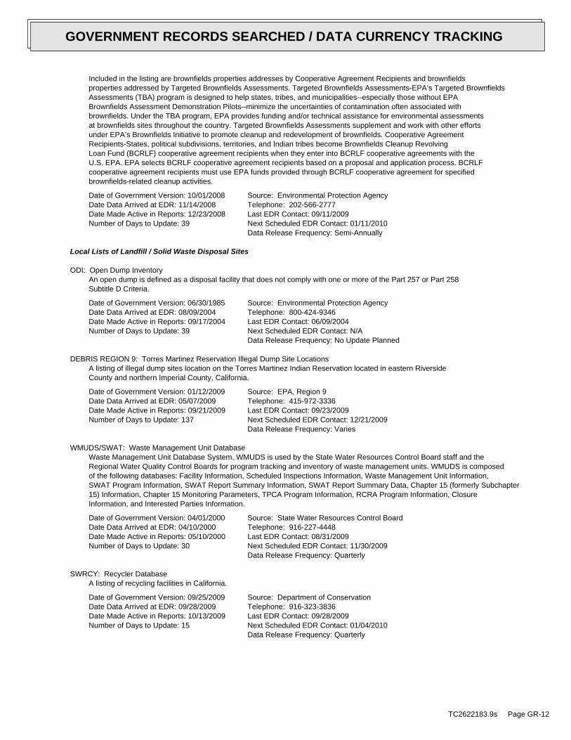
Included in the listing are brownfields properties addresses by Cooperative Agreement Recipients and brownfieldsproperties addressed by Targeted Brownfields Assessments. Targeted Brownfields Assessments-EPA’s Targeted BrownfieldsAssessments (TBA) program is designed to help states, tribes, and municipalities--especially those without EPABrownfields Assessment Demonstration Pilots--minimize the uncertainties of contamination often associated withbrownfields. Under the TBA program, EPA provides funding and/or technical assistance for environmental assessmentsat brownfields sites throughout the country. Targeted Brownfields Assessments supplement and work with other effortsunder EPA’s Brownfields Initiative to promote cleanup and redevelopment of brownfields. Cooperative AgreementRecipients-States, political subdivisions, territories, and Indian tribes become Brownfields Cleanup RevolvingLoan Fund (BCRLF) cooperative agreement recipients when they enter into BCRLF cooperative agreements with theU.S. EPA. EPA selects BCRLF cooperative agreement recipients based on a proposal and application process. BCRLFcooperative agreement recipients must use EPA funds provided through BCRLF cooperative agreement for specifiedbrownfields-related cleanup activities.
Date of Government Version: 10/01/2008Date Data Arrived at EDR: 11/14/2008Date Made Active in Reports: 12/23/2008Number of Days to Update: 39
Source: Environmental Protection AgencyTelephone: 202-566-2777Last EDR Contact: 09/11/2009Next Scheduled EDR Contact: 01/11/2010Data Release Frequency: Semi-Annually
Local Lists of Landfill / Solid Waste Disposal Sites
ODI: Open Dump InventoryAn open dump is defined as a disposal facility that does not comply with one or more of the Part 257 or Part 258Subtitle D Criteria.
Date of Government Version: 06/30/1985Date Data Arrived at EDR: 08/09/2004Date Made Active in Reports: 09/17/2004Number of Days to Update: 39
Source: Environmental Protection AgencyTelephone: 800-424-9346Last EDR Contact: 06/09/2004Next Scheduled EDR Contact: N/AData Release Frequency: No Update Planned
DEBRIS REGION 9: Torres Martinez Reservation Illegal Dump Site LocationsA listing of illegal dump sites location on the Torres Martinez Indian Reservation located in eastern RiversideCounty and northern Imperial County, California.
Date of Government Version: 01/12/2009Date Data Arrived at EDR: 05/07/2009Date Made Active in Reports: 09/21/2009Number of Days to Update: 137
Source: EPA, Region 9Telephone: 415-972-3336Last EDR Contact: 09/23/2009Next Scheduled EDR Contact: 12/21/2009Data Release Frequency: Varies
WMUDS/SWAT: Waste Management Unit DatabaseWaste Management Unit Database System. WMUDS is used by the State Water Resources Control Board staff and theRegional Water Quality Control Boards for program tracking and inventory of waste management units. WMUDS is composedof the following databases: Facility Information, Scheduled Inspections Information, Waste Management Unit Information,SWAT Program Information, SWAT Report Summary Information, SWAT Report Summary Data, Chapter 15 (formerly Subchapter15) Information, Chapter 15 Monitoring Parameters, TPCA Program Information, RCRA Program Information, ClosureInformation, and Interested Parties Information.
Date of Government Version: 04/01/2000Date Data Arrived at EDR: 04/10/2000Date Made Active in Reports: 05/10/2000Number of Days to Update: 30
Source: State Water Resources Control BoardTelephone: 916-227-4448Last EDR Contact: 08/31/2009Next Scheduled EDR Contact: 11/30/2009Data Release Frequency: Quarterly
SWRCY: Recycler DatabaseA listing of recycling facilities in California.
Date of Government Version: 09/25/2009Date Data Arrived at EDR: 09/28/2009Date Made Active in Reports: 10/13/2009Number of Days to Update: 15
Source: Department of ConservationTelephone: 916-323-3836Last EDR Contact: 09/28/2009Next Scheduled EDR Contact: 01/04/2010Data Release Frequency: Quarterly
TC2622183.9s Page GR-12
GOVERNMENT RECORDS SEARCHED / DATA CURRENCY TRACKING

HAULERS: Registered Waste Tire Haulers ListingA listing of registered waste tire haulers.
Date of Government Version: 10/05/2009Date Data Arrived at EDR: 10/05/2009Date Made Active in Reports: 10/13/2009Number of Days to Update: 8
Source: Integrated Waste Management BoardTelephone: 916-341-6422Last EDR Contact: 09/23/2009Next Scheduled EDR Contact: 12/07/2009Data Release Frequency: Varies
INDIAN ODI: Report on the Status of Open Dumps on Indian LandsLocation of open dumps on Indian land.
Date of Government Version: 12/31/1998Date Data Arrived at EDR: 12/03/2007Date Made Active in Reports: 01/24/2008Number of Days to Update: 52
Source: Environmental Protection AgencyTelephone: 703-308-8245Last EDR Contact: 08/26/2009Next Scheduled EDR Contact: 11/23/2009Data Release Frequency: Varies
Local Lists of Hazardous waste / Contaminated Sites
US CDL: Clandestine Drug LabsA listing of clandestine drug lab locations. The U.S. Department of Justice ("the Department") provides thisweb site as a public service. It contains addresses of some locations where law enforcement agencies reportedthey found chemicals or other items that indicated the presence of either clandestine drug laboratories or dumpsites.In most cases, the source of the entries is not the Department, and the Department has not verified the entryand does not guarantee its accuracy. Members of the public must verify the accuracy of all entries by, for example,contacting local law enforcement and local health departments.
Date of Government Version: 03/01/2009Date Data Arrived at EDR: 06/22/2009Date Made Active in Reports: 09/21/2009Number of Days to Update: 91
Source: Drug Enforcement AdministrationTelephone: 202-307-1000Last EDR Contact: 03/26/2009Next Scheduled EDR Contact: 06/22/2009Data Release Frequency: Quarterly
HIST CAL-SITES: Calsites DatabaseThe Calsites database contains potential or confirmed hazardous substance release properties. In 1996, CaliforniaEPA reevaluated and significantly reduced the number of sites in the Calsites database. No longer updated by thestate agency. It has been replaced by ENVIROSTOR.
Date of Government Version: 08/08/2005Date Data Arrived at EDR: 08/03/2006Date Made Active in Reports: 08/24/2006Number of Days to Update: 21
Source: Department of Toxic Substance ControlTelephone: 916-323-3400Last EDR Contact: 02/23/2009Next Scheduled EDR Contact: 05/25/2009Data Release Frequency: No Update Planned
SCH: School Property Evaluation ProgramThis category contains proposed and existing school sites that are being evaluated by DTSC for possible hazardousmaterials contamination. In some cases, these properties may be listed in the CalSites category depending on thelevel of threat to public health and safety or the environment they pose.
Date of Government Version: 08/27/2009Date Data Arrived at EDR: 08/27/2009Date Made Active in Reports: 09/18/2009Number of Days to Update: 22
Source: Department of Toxic Substances ControlTelephone: 916-323-3400Last EDR Contact: 08/27/2009Next Scheduled EDR Contact: 11/23/2009Data Release Frequency: Quarterly
TOXIC PITS: Toxic Pits Cleanup Act SitesToxic PITS Cleanup Act Sites. TOXIC PITS identifies sites suspected of containing hazardous substances where cleanuphas not yet been completed.
TC2622183.9s Page GR-13
GOVERNMENT RECORDS SEARCHED / DATA CURRENCY TRACKING

Date of Government Version: 07/01/1995Date Data Arrived at EDR: 08/30/1995Date Made Active in Reports: 09/26/1995Number of Days to Update: 27
Source: State Water Resources Control BoardTelephone: 916-227-4364Last EDR Contact: 01/26/2009Next Scheduled EDR Contact: 04/27/2009Data Release Frequency: No Update Planned
CDL: Clandestine Drug LabsA listing of drug lab locations. Listing of a location in this database does not indicate that any illegal druglab materials were or were not present there, and does not constitute a determination that the location eitherrequires or does not require additional cleanup work.
Date of Government Version: 06/30/2009Date Data Arrived at EDR: 07/23/2009Date Made Active in Reports: 08/03/2009Number of Days to Update: 11
Source: Department of Toxic Substances ControlTelephone: 916-255-6504Last EDR Contact: 10/05/2009Next Scheduled EDR Contact: 01/18/2010Data Release Frequency: Varies
US HIST CDL: National Clandestine Laboratory RegisterA listing of clandestine drug lab locations. The U.S. Department of Justice ("the Department") provides thisweb site as a public service. It contains addresses of some locations where law enforcement agencies reportedthey found chemicals or other items that indicated the presence of either clandestine drug laboratories or dumpsites.In most cases, the source of the entries is not the Department, and the Department has not verified the entryand does not guarantee its accuracy. Members of the public must verify the accuracy of all entries by, for example,contacting local law enforcement and local health departments.
Date of Government Version: 09/01/2007Date Data Arrived at EDR: 11/19/2008Date Made Active in Reports: 03/30/2009Number of Days to Update: 131
Source: Drug Enforcement AdministrationTelephone: 202-307-1000Last EDR Contact: 03/23/2009Next Scheduled EDR Contact: 06/22/2009Data Release Frequency: No Update Planned
Local Lists of Registered Storage Tanks
CA FID UST: Facility Inventory DatabaseThe Facility Inventory Database (FID) contains a historical listing of active and inactive underground storagetank locations from the State Water Resource Control Board. Refer to local/county source for current data.
Date of Government Version: 10/31/1994Date Data Arrived at EDR: 09/05/1995Date Made Active in Reports: 09/29/1995Number of Days to Update: 24
Source: California Environmental Protection AgencyTelephone: 916-341-5851Last EDR Contact: 12/28/1998Next Scheduled EDR Contact: N/AData Release Frequency: No Update Planned
UST MENDOCINO: Mendocino County UST DatabaseA listing of underground storage tank locations in Mendocino County.
Date of Government Version: 09/23/2009Date Data Arrived at EDR: 09/23/2009Date Made Active in Reports: 10/01/2009Number of Days to Update: 8
Source: Department of Public HealthTelephone: 707-463-4466Last EDR Contact: 09/23/2009Next Scheduled EDR Contact: 12/21/2009Data Release Frequency: Varies
HIST UST: Hazardous Substance Storage Container DatabaseThe Hazardous Substance Storage Container Database is a historical listing of UST sites. Refer to local/countysource for current data.
Date of Government Version: 10/15/1990Date Data Arrived at EDR: 01/25/1991Date Made Active in Reports: 02/12/1991Number of Days to Update: 18
Source: State Water Resources Control BoardTelephone: 916-341-5851Last EDR Contact: 07/26/2001Next Scheduled EDR Contact: N/AData Release Frequency: No Update Planned
TC2622183.9s Page GR-14
GOVERNMENT RECORDS SEARCHED / DATA CURRENCY TRACKING

SWEEPS UST: SWEEPS UST ListingStatewide Environmental Evaluation and Planning System. This underground storage tank listing was updated andmaintained by a company contacted by the SWRCB in the early 1990’s. The listing is no longer updated or maintained.The local agency is the contact for more information on a site on the SWEEPS list.
Date of Government Version: 06/01/1994Date Data Arrived at EDR: 07/07/2005Date Made Active in Reports: 08/11/2005Number of Days to Update: 35
Source: State Water Resources Control BoardTelephone: N/ALast EDR Contact: 06/03/2005Next Scheduled EDR Contact: N/AData Release Frequency: No Update Planned
Local Land Records
LIENS 2: CERCLA Lien InformationA Federal CERCLA (’Superfund’) lien can exist by operation of law at any site or property at which EPA has spentSuperfund monies. These monies are spent to investigate and address releases and threatened releases of contamination.CERCLIS provides information as to the identity of these sites and properties.
Date of Government Version: 08/18/2009Date Data Arrived at EDR: 08/21/2009Date Made Active in Reports: 09/21/2009Number of Days to Update: 31
Source: Environmental Protection AgencyTelephone: 202-564-6023Last EDR Contact: 08/17/2009Next Scheduled EDR Contact: 11/16/2009Data Release Frequency: Varies
LUCIS: Land Use Control Information SystemLUCIS contains records of land use control information pertaining to the former Navy Base Realignment and Closureproperties.
Date of Government Version: 12/09/2005Date Data Arrived at EDR: 12/11/2006Date Made Active in Reports: 01/11/2007Number of Days to Update: 31
Source: Department of the NavyTelephone: 843-820-7326Last EDR Contact: 09/08/2009Next Scheduled EDR Contact: 12/07/2009Data Release Frequency: Varies
LIENS: Environmental Liens ListingA listing of property locations with environmental liens for California where DTSC is a lien holder.
Date of Government Version: 08/13/2009Date Data Arrived at EDR: 08/14/2009Date Made Active in Reports: 08/20/2009Number of Days to Update: 6
Source: Department of Toxic Substances ControlTelephone: 916-323-3400Last EDR Contact: 10/19/2009Next Scheduled EDR Contact: 02/01/2010Data Release Frequency: Varies
DEED: Deed Restriction Listing
TC2622183.9s Page GR-15
GOVERNMENT RECORDS SEARCHED / DATA CURRENCY TRACKING

Site Mitigation and Brownfields Reuse Program Facility Sites with Deed Restrictions & Hazardous Waste ManagementProgram Facility Sites with Deed / Land Use Restriction. The DTSC Site Mitigation and Brownfields Reuse Program(SMBRP) list includes sites cleaned up under the program’s oversight and generally does not include currentor former hazardous waste facilities that required a hazardous waste facility permit. The list represents deedrestrictions that are active. Some sites have multiple deed restrictions. The DTSC Hazardous Waste ManagementProgram (HWMP) has developed a list of current or former hazardous waste facilities that have a recorded landuse restriction at the local county recorder’s office. The land use restrictions on this list were required bythe DTSC HWMP as a result of the presence of hazardous substances that remain on site after the facility (orpart of the facility) has been closed or cleaned up. The types of land use restriction include deed notice, deedrestriction, or a land use restriction that binds current and future owners.
Date of Government Version: 09/21/2009Date Data Arrived at EDR: 09/22/2009Date Made Active in Reports: 10/13/2009Number of Days to Update: 21
Source: Department of Toxic Substances ControlTelephone: 916-323-3400Last EDR Contact: 12/30/2009Next Scheduled EDR Contact: 12/28/2009Data Release Frequency: Semi-Annually
Records of Emergency Release Reports
HMIRS: Hazardous Materials Information Reporting SystemHazardous Materials Incident Report System. HMIRS contains hazardous material spill incidents reported to DOT.
Date of Government Version: 07/16/2009Date Data Arrived at EDR: 07/16/2009Date Made Active in Reports: 09/21/2009Number of Days to Update: 67
Source: U.S. Department of TransportationTelephone: 202-366-4555Last EDR Contact: 10/05/2009Next Scheduled EDR Contact: 01/11/2010Data Release Frequency: Annually
CHMIRS: California Hazardous Material Incident Report SystemCalifornia Hazardous Material Incident Reporting System. CHMIRS contains information on reported hazardous materialincidents (accidental releases or spills).
Date of Government Version: 12/31/2007Date Data Arrived at EDR: 05/09/2008Date Made Active in Reports: 06/20/2008Number of Days to Update: 42
Source: Office of Emergency ServicesTelephone: 916-845-8400Last EDR Contact: 08/18/2009Next Scheduled EDR Contact: 11/16/2009Data Release Frequency: Varies
LDS: Land Disposal Sites ListingThe Land Disposal program regulates of waste discharge to land for treatment, storage and disposal in waste managementunits.
Date of Government Version: 09/05/2009Date Data Arrived at EDR: 09/28/2009Date Made Active in Reports: 10/13/2009Number of Days to Update: 15
Source: State Water Qualilty Control BoardTelephone: 866-480-1028Last EDR Contact: 09/28/2009Next Scheduled EDR Contact: 01/04/2010Data Release Frequency: Quarterly
MCS: Military Cleanup Sites ListingThe State Water Resources Control Board and nine Regional Water Quality Control Boards partner with the Departmentof Defense (DoD) through the Defense and State Memorandum of Agreement (DSMOA) to oversee the investigationand remediation of water quality issues at military facilities.
Date of Government Version: 09/05/2009Date Data Arrived at EDR: 09/28/2009Date Made Active in Reports: 10/13/2009Number of Days to Update: 15
Source: State Water Resources Control BoardTelephone: 866-480-1028Last EDR Contact: 09/28/2009Next Scheduled EDR Contact: 01/04/2010Data Release Frequency: Quarterly
Other Ascertainable Records
TC2622183.9s Page GR-16
GOVERNMENT RECORDS SEARCHED / DATA CURRENCY TRACKING

RCRA-NonGen: RCRA - Non GeneratorsRCRAInfo is EPA’s comprehensive information system, providing access to data supporting the Resource Conservationand Recovery Act (RCRA) of 1976 and the Hazardous and Solid Waste Amendments (HSWA) of 1984. The databaseincludes selective information on sites which generate, transport, store, treat and/or dispose of hazardous wasteas defined by the Resource Conservation and Recovery Act (RCRA). Non-Generators do not presently generate hazardouswaste.
Date of Government Version: 11/12/2008Date Data Arrived at EDR: 11/18/2008Date Made Active in Reports: 03/16/2009Number of Days to Update: 118
Source: Environmental Protection AgencyTelephone: (415) 495-8895Last EDR Contact: 10/07/2009Next Scheduled EDR Contact: 01/18/2010Data Release Frequency: Varies
DOT OPS: Incident and Accident DataDepartment of Transporation, Office of Pipeline Safety Incident and Accident data.
Date of Government Version: 05/14/2008Date Data Arrived at EDR: 05/28/2008Date Made Active in Reports: 08/08/2008Number of Days to Update: 72
Source: Department of Transporation, Office of Pipeline SafetyTelephone: 202-366-4595Last EDR Contact: 08/27/2009Next Scheduled EDR Contact: 11/23/2009Data Release Frequency: Varies
DOD: Department of Defense SitesThis data set consists of federally owned or administered lands, administered by the Department of Defense, thathave any area equal to or greater than 640 acres of the United States, Puerto Rico, and the U.S. Virgin Islands.
Date of Government Version: 12/31/2005Date Data Arrived at EDR: 11/10/2006Date Made Active in Reports: 01/11/2007Number of Days to Update: 62
Source: USGSTelephone: 703-692-8801Last EDR Contact: 10/23/2009Next Scheduled EDR Contact: 02/01/2010Data Release Frequency: Semi-Annually
FUDS: Formerly Used Defense SitesThe listing includes locations of Formerly Used Defense Sites properties where the US Army Corps of Engineersis actively working or will take necessary cleanup actions.
Date of Government Version: 12/31/2007Date Data Arrived at EDR: 09/05/2008Date Made Active in Reports: 09/23/2008Number of Days to Update: 18
Source: U.S. Army Corps of EngineersTelephone: 202-528-4285Last EDR Contact: 09/30/2009Next Scheduled EDR Contact: 12/28/2009Data Release Frequency: Varies
CONSENT: Superfund (CERCLA) Consent DecreesMajor legal settlements that establish responsibility and standards for cleanup at NPL (Superfund) sites. Releasedperiodically by United States District Courts after settlement by parties to litigation matters.
Date of Government Version: 04/24/2009Date Data Arrived at EDR: 05/19/2009Date Made Active in Reports: 09/21/2009Number of Days to Update: 125
Source: Department of Justice, Consent Decree LibraryTelephone: VariesLast EDR Contact: 10/06/2009Next Scheduled EDR Contact: 01/18/2010Data Release Frequency: Varies
ROD: Records Of DecisionRecord of Decision. ROD documents mandate a permanent remedy at an NPL (Superfund) site containing technicaland health information to aid in the cleanup.
Date of Government Version: 09/01/2009Date Data Arrived at EDR: 09/22/2009Date Made Active in Reports: 10/22/2009Number of Days to Update: 30
Source: EPATelephone: 703-416-0223Last EDR Contact: 09/22/2009Next Scheduled EDR Contact: 12/28/2009Data Release Frequency: Annually
TC2622183.9s Page GR-17
GOVERNMENT RECORDS SEARCHED / DATA CURRENCY TRACKING

UMTRA: Uranium Mill Tailings SitesUranium ore was mined by private companies for federal government use in national defense programs. When the millsshut down, large piles of the sand-like material (mill tailings) remain after uranium has been extracted fromthe ore. Levels of human exposure to radioactive materials from the piles are low; however, in some cases tailingswere used as construction materials before the potential health hazards of the tailings were recognized.
Date of Government Version: 01/05/2009Date Data Arrived at EDR: 05/07/2009Date Made Active in Reports: 05/08/2009Number of Days to Update: 1
Source: Department of EnergyTelephone: 505-845-0011Last EDR Contact: 09/14/2009Next Scheduled EDR Contact: 12/14/2009Data Release Frequency: Varies
MINES: Mines Master Index FileContains all mine identification numbers issued for mines active or opened since 1971. The data also includesviolation information.
Date of Government Version: 05/28/2009Date Data Arrived at EDR: 06/23/2009Date Made Active in Reports: 09/21/2009Number of Days to Update: 90
Source: Department of Labor, Mine Safety and Health AdministrationTelephone: 303-231-5959Last EDR Contact: 09/18/2009Next Scheduled EDR Contact: 12/21/2009Data Release Frequency: Semi-Annually
TRIS: Toxic Chemical Release Inventory SystemToxic Release Inventory System. TRIS identifies facilities which release toxic chemicals to the air, water andland in reportable quantities under SARA Title III Section 313.
Date of Government Version: 12/31/2007Date Data Arrived at EDR: 04/09/2009Date Made Active in Reports: 06/17/2009Number of Days to Update: 69
Source: EPATelephone: 202-566-0250Last EDR Contact: 09/14/2009Next Scheduled EDR Contact: 12/14/2009Data Release Frequency: Annually
TSCA: Toxic Substances Control ActToxic Substances Control Act. TSCA identifies manufacturers and importers of chemical substances included on theTSCA Chemical Substance Inventory list. It includes data on the production volume of these substances by plantsite.
Date of Government Version: 12/31/2002Date Data Arrived at EDR: 04/14/2006Date Made Active in Reports: 05/30/2006Number of Days to Update: 46
Source: EPATelephone: 202-260-5521Last EDR Contact: 10/07/2009Next Scheduled EDR Contact: 01/11/2010Data Release Frequency: Every 4 Years
FTTS: FIFRA/ TSCA Tracking System - FIFRA (Federal Insecticide, Fungicide, & Rodenticide Act)/TSCA (Toxic Substances Control Act)FTTS tracks administrative cases and pesticide enforcement actions and compliance activities related to FIFRA,TSCA and EPCRA (Emergency Planning and Community Right-to-Know Act). To maintain currency, EDR contacts theAgency on a quarterly basis.
Date of Government Version: 04/09/2009Date Data Arrived at EDR: 04/16/2009Date Made Active in Reports: 05/11/2009Number of Days to Update: 25
Source: EPA/Office of Prevention, Pesticides and Toxic SubstancesTelephone: 202-566-1667Last EDR Contact: 09/10/2009Next Scheduled EDR Contact: 12/14/2009Data Release Frequency: Quarterly
FTTS INSP: FIFRA/ TSCA Tracking System - FIFRA (Federal Insecticide, Fungicide, & Rodenticide Act)/TSCA (Toxic Substances Control Act)A listing of FIFRA/TSCA Tracking System (FTTS) inspections and enforcements.
Date of Government Version: 04/09/2009Date Data Arrived at EDR: 04/16/2009Date Made Active in Reports: 05/11/2009Number of Days to Update: 25
Source: EPATelephone: 202-566-1667Last EDR Contact: 09/10/2009Next Scheduled EDR Contact: 12/14/2009Data Release Frequency: Quarterly
TC2622183.9s Page GR-18
GOVERNMENT RECORDS SEARCHED / DATA CURRENCY TRACKING

HIST FTTS: FIFRA/TSCA Tracking System Administrative Case ListingA complete administrative case listing from the FIFRA/TSCA Tracking System (FTTS) for all ten EPA regions. Theinformation was obtained from the National Compliance Database (NCDB). NCDB supports the implementation of FIFRA(Federal Insecticide, Fungicide, and Rodenticide Act) and TSCA (Toxic Substances Control Act). Some EPA regionsare now closing out records. Because of that, and the fact that some EPA regions are not providing EPA Headquarterswith updated records, it was decided to create a HIST FTTS database. It included records that may not be includedin the newer FTTS database updates. This database is no longer updated.
Date of Government Version: 10/19/2006Date Data Arrived at EDR: 03/01/2007Date Made Active in Reports: 04/10/2007Number of Days to Update: 40
Source: Environmental Protection AgencyTelephone: 202-564-2501Last EDR Contact: 12/17/2007Next Scheduled EDR Contact: 03/17/2008Data Release Frequency: No Update Planned
HIST FTTS INSP: FIFRA/TSCA Tracking System Inspection & Enforcement Case ListingA complete inspection and enforcement case listing from the FIFRA/TSCA Tracking System (FTTS) for all ten EPAregions. The information was obtained from the National Compliance Database (NCDB). NCDB supports the implementationof FIFRA (Federal Insecticide, Fungicide, and Rodenticide Act) and TSCA (Toxic Substances Control Act). SomeEPA regions are now closing out records. Because of that, and the fact that some EPA regions are not providingEPA Headquarters with updated records, it was decided to create a HIST FTTS database. It included records thatmay not be included in the newer FTTS database updates. This database is no longer updated.
Date of Government Version: 10/19/2006Date Data Arrived at EDR: 03/01/2007Date Made Active in Reports: 04/10/2007Number of Days to Update: 40
Source: Environmental Protection AgencyTelephone: 202-564-2501Last EDR Contact: 12/17/2008Next Scheduled EDR Contact: 03/17/2008Data Release Frequency: No Update Planned
SSTS: Section 7 Tracking SystemsSection 7 of the Federal Insecticide, Fungicide and Rodenticide Act, as amended (92 Stat. 829) requires allregistered pesticide-producing establishments to submit a report to the Environmental Protection Agency by March1st each year. Each establishment must report the types and amounts of pesticides, active ingredients and devicesbeing produced, and those having been produced and sold or distributed in the past year.
Date of Government Version: 12/31/2007Date Data Arrived at EDR: 05/19/2009Date Made Active in Reports: 09/21/2009Number of Days to Update: 125
Source: EPATelephone: 202-564-4203Last EDR Contact: 09/29/2009Next Scheduled EDR Contact: 01/11/2010Data Release Frequency: Annually
ICIS: Integrated Compliance Information SystemThe Integrated Compliance Information System (ICIS) supports the information needs of the national enforcementand compliance program as well as the unique needs of the National Pollutant Discharge Elimination System (NPDES)program.
Date of Government Version: 08/21/2009Date Data Arrived at EDR: 08/27/2009Date Made Active in Reports: 10/22/2009Number of Days to Update: 56
Source: Environmental Protection AgencyTelephone: 202-564-5088Last EDR Contact: 09/28/2009Next Scheduled EDR Contact: 01/11/2010Data Release Frequency: Quarterly
PADS: PCB Activity Database SystemPCB Activity Database. PADS Identifies generators, transporters, commercial storers and/or brokers and disposersof PCB’s who are required to notify the EPA of such activities.
Date of Government Version: 05/27/2009Date Data Arrived at EDR: 08/05/2009Date Made Active in Reports: 09/29/2009Number of Days to Update: 55
Source: EPATelephone: 202-566-0500Last EDR Contact: 10/21/2009Next Scheduled EDR Contact: 02/01/2010Data Release Frequency: Annually
TC2622183.9s Page GR-19
GOVERNMENT RECORDS SEARCHED / DATA CURRENCY TRACKING

MLTS: Material Licensing Tracking SystemMLTS is maintained by the Nuclear Regulatory Commission and contains a list of approximately 8,100 sites whichpossess or use radioactive materials and which are subject to NRC licensing requirements. To maintain currency,EDR contacts the Agency on a quarterly basis.
Date of Government Version: 07/06/2009Date Data Arrived at EDR: 07/13/2009Date Made Active in Reports: 09/21/2009Number of Days to Update: 70
Source: Nuclear Regulatory CommissionTelephone: 301-415-7169Last EDR Contact: 09/21/2009Next Scheduled EDR Contact: 12/28/2009Data Release Frequency: Quarterly
RADINFO: Radiation Information DatabaseThe Radiation Information Database (RADINFO) contains information about facilities that are regulated by U.S.Environmental Protection Agency (EPA) regulations for radiation and radioactivity.
Date of Government Version: 07/28/2009Date Data Arrived at EDR: 07/28/2009Date Made Active in Reports: 09/21/2009Number of Days to Update: 55
Source: Environmental Protection AgencyTelephone: 202-343-9775Last EDR Contact: 10/16/2009Next Scheduled EDR Contact: 01/25/2010Data Release Frequency: Quarterly
FINDS: Facility Index System/Facility Registry SystemFacility Index System. FINDS contains both facility information and ’pointers’ to other sources that contain moredetail. EDR includes the following FINDS databases in this report: PCS (Permit Compliance System), AIRS (AerometricInformation Retrieval System), DOCKET (Enforcement Docket used to manage and track information on civil judicialenforcement cases for all environmental statutes), FURS (Federal Underground Injection Control), C-DOCKET (CriminalDocket System used to track criminal enforcement actions for all environmental statutes), FFIS (Federal FacilitiesInformation System), STATE (State Environmental Laws and Statutes), and PADS (PCB Activity Data System).
Date of Government Version: 07/23/2009Date Data Arrived at EDR: 07/28/2009Date Made Active in Reports: 09/21/2009Number of Days to Update: 55
Source: EPATelephone: (415) 947-8000Last EDR Contact: 09/18/2009Next Scheduled EDR Contact: 12/28/2009Data Release Frequency: Quarterly
RAATS: RCRA Administrative Action Tracking SystemRCRA Administration Action Tracking System. RAATS contains records based on enforcement actions issued under RCRApertaining to major violators and includes administrative and civil actions brought by the EPA. For administrationactions after September 30, 1995, data entry in the RAATS database was discontinued. EPA will retain a copy ofthe database for historical records. It was necessary to terminate RAATS because a decrease in agency resourcesmade it impossible to continue to update the information contained in the database.
Date of Government Version: 04/17/1995Date Data Arrived at EDR: 07/03/1995Date Made Active in Reports: 08/07/1995Number of Days to Update: 35
Source: EPATelephone: 202-564-4104Last EDR Contact: 06/02/2008Next Scheduled EDR Contact: 09/01/2008Data Release Frequency: No Update Planned
BRS: Biennial Reporting SystemThe Biennial Reporting System is a national system administered by the EPA that collects data on the generationand management of hazardous waste. BRS captures detailed data from two groups: Large Quantity Generators (LQG)and Treatment, Storage, and Disposal Facilities.
Date of Government Version: 12/31/2007Date Data Arrived at EDR: 02/19/2009Date Made Active in Reports: 05/22/2009Number of Days to Update: 92
Source: EPA/NTISTelephone: 800-424-9346Last EDR Contact: 09/09/2009Next Scheduled EDR Contact: 12/07/2009Data Release Frequency: Biennially
TC2622183.9s Page GR-20
GOVERNMENT RECORDS SEARCHED / DATA CURRENCY TRACKING
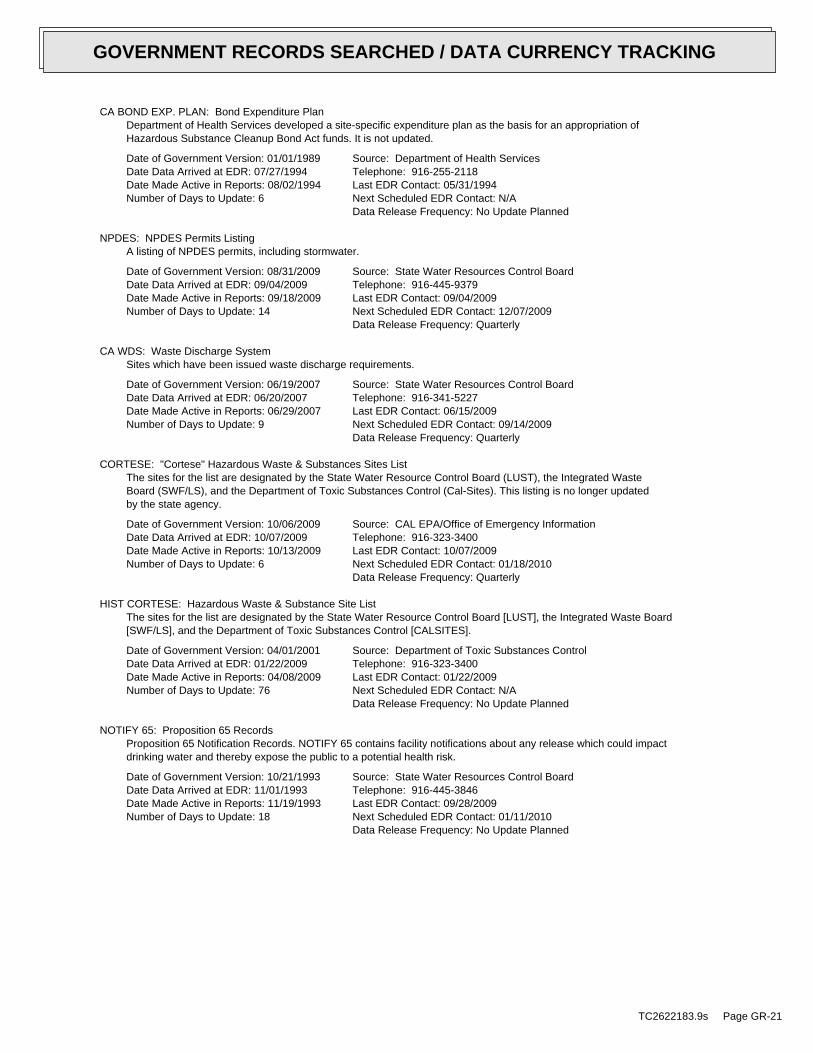
CA BOND EXP. PLAN: Bond Expenditure PlanDepartment of Health Services developed a site-specific expenditure plan as the basis for an appropriation ofHazardous Substance Cleanup Bond Act funds. It is not updated.
Date of Government Version: 01/01/1989Date Data Arrived at EDR: 07/27/1994Date Made Active in Reports: 08/02/1994Number of Days to Update: 6
Source: Department of Health ServicesTelephone: 916-255-2118Last EDR Contact: 05/31/1994Next Scheduled EDR Contact: N/AData Release Frequency: No Update Planned
NPDES: NPDES Permits ListingA listing of NPDES permits, including stormwater.
Date of Government Version: 08/31/2009Date Data Arrived at EDR: 09/04/2009Date Made Active in Reports: 09/18/2009Number of Days to Update: 14
Source: State Water Resources Control BoardTelephone: 916-445-9379Last EDR Contact: 09/04/2009Next Scheduled EDR Contact: 12/07/2009Data Release Frequency: Quarterly
CA WDS: Waste Discharge SystemSites which have been issued waste discharge requirements.
Date of Government Version: 06/19/2007Date Data Arrived at EDR: 06/20/2007Date Made Active in Reports: 06/29/2007Number of Days to Update: 9
Source: State Water Resources Control BoardTelephone: 916-341-5227Last EDR Contact: 06/15/2009Next Scheduled EDR Contact: 09/14/2009Data Release Frequency: Quarterly
CORTESE: "Cortese" Hazardous Waste & Substances Sites ListThe sites for the list are designated by the State Water Resource Control Board (LUST), the Integrated WasteBoard (SWF/LS), and the Department of Toxic Substances Control (Cal-Sites). This listing is no longer updatedby the state agency.
Date of Government Version: 10/06/2009Date Data Arrived at EDR: 10/07/2009Date Made Active in Reports: 10/13/2009Number of Days to Update: 6
Source: CAL EPA/Office of Emergency InformationTelephone: 916-323-3400Last EDR Contact: 10/07/2009Next Scheduled EDR Contact: 01/18/2010Data Release Frequency: Quarterly
HIST CORTESE: Hazardous Waste & Substance Site ListThe sites for the list are designated by the State Water Resource Control Board [LUST], the Integrated Waste Board[SWF/LS], and the Department of Toxic Substances Control [CALSITES].
Date of Government Version: 04/01/2001Date Data Arrived at EDR: 01/22/2009Date Made Active in Reports: 04/08/2009Number of Days to Update: 76
Source: Department of Toxic Substances ControlTelephone: 916-323-3400Last EDR Contact: 01/22/2009Next Scheduled EDR Contact: N/AData Release Frequency: No Update Planned
NOTIFY 65: Proposition 65 RecordsProposition 65 Notification Records. NOTIFY 65 contains facility notifications about any release which could impactdrinking water and thereby expose the public to a potential health risk.
Date of Government Version: 10/21/1993Date Data Arrived at EDR: 11/01/1993Date Made Active in Reports: 11/19/1993Number of Days to Update: 18
Source: State Water Resources Control BoardTelephone: 916-445-3846Last EDR Contact: 09/28/2009Next Scheduled EDR Contact: 01/11/2010Data Release Frequency: No Update Planned
TC2622183.9s Page GR-21
GOVERNMENT RECORDS SEARCHED / DATA CURRENCY TRACKING

DRYCLEANERS: Cleaner FacilitiesA list of drycleaner related facilities that have EPA ID numbers. These are facilities with certain SIC codes:power laundries, family and commercial; garment pressing and cleaner’s agents; linen supply; coin-operated laundriesand cleaning; drycleaning plants, except rugs; carpet and upholster cleaning; industrial launderers; laundry andgarment services.
Date of Government Version: 09/22/2009Date Data Arrived at EDR: 09/23/2009Date Made Active in Reports: 10/13/2009Number of Days to Update: 20
Source: Department of Toxic Substance ControlTelephone: 916-327-4498Last EDR Contact: 09/18/2009Next Scheduled EDR Contact: 12/28/2009Data Release Frequency: Annually
WIP: Well Investigation Program Case ListWell Investigation Program case in the San Gabriel and San Fernando Valley area.
Date of Government Version: 07/03/2009Date Data Arrived at EDR: 07/21/2009Date Made Active in Reports: 08/03/2009Number of Days to Update: 13
Source: Los Angeles Water Quality Control BoardTelephone: 213-576-6726Last EDR Contact: 10/15/2009Next Scheduled EDR Contact: 01/18/2010Data Release Frequency: Varies
HAZNET: Facility and Manifest DataFacility and Manifest Data. The data is extracted from the copies of hazardous waste manifests received each yearby the DTSC. The annual volume of manifests is typically 700,000 - 1,000,000 annually, representing approximately350,000 - 500,000 shipments. Data are from the manifests submitted without correction, and therefore many containsome invalid values for data elements such as generator ID, TSD ID, waste category, and disposal method.
Date of Government Version: 12/31/2007Date Data Arrived at EDR: 02/17/2009Date Made Active in Reports: 04/08/2009Number of Days to Update: 50
Source: California Environmental Protection AgencyTelephone: 916-255-1136Last EDR Contact: 10/21/2009Next Scheduled EDR Contact: 02/01/2010Data Release Frequency: Annually
EMI: Emissions Inventory DataToxics and criteria pollutant emissions data collected by the ARB and local air pollution agencies.
Date of Government Version: 12/31/2007Date Data Arrived at EDR: 07/14/2009Date Made Active in Reports: 07/23/2009Number of Days to Update: 9
Source: California Air Resources BoardTelephone: 916-322-2990Last EDR Contact: 10/08/2009Next Scheduled EDR Contact: 01/11/2010Data Release Frequency: Varies
INDIAN RESERV: Indian ReservationsThis map layer portrays Indian administered lands of the United States that have any area equal to or greaterthan 640 acres.
Date of Government Version: 12/31/2005Date Data Arrived at EDR: 12/08/2006Date Made Active in Reports: 01/11/2007Number of Days to Update: 34
Source: USGSTelephone: 202-208-3710Last EDR Contact: 10/23/2009Next Scheduled EDR Contact: 02/01/2010Data Release Frequency: Semi-Annually
SCRD DRYCLEANERS: State Coalition for Remediation of Drycleaners ListingThe State Coalition for Remediation of Drycleaners was established in 1998, with support from the U.S. EPA Officeof Superfund Remediation and Technology Innovation. It is comprised of representatives of states with establisheddrycleaner remediation programs. Currently the member states are Alabama, Connecticut, Florida, Illinois, Kansas,Minnesota, Missouri, North Carolina, Oregon, South Carolina, Tennessee, Texas, and Wisconsin.
Date of Government Version: 09/09/2009Date Data Arrived at EDR: 09/09/2009Date Made Active in Reports: 10/22/2009Number of Days to Update: 43
Source: Environmental Protection AgencyTelephone: 615-532-8599Last EDR Contact: 09/08/2009Next Scheduled EDR Contact: 11/09/2009Data Release Frequency: Varies
TC2622183.9s Page GR-22
GOVERNMENT RECORDS SEARCHED / DATA CURRENCY TRACKING

FEDLAND: Federal and Indian LandsFederally and Indian administrated lands of the United States. Lands included are administrated by: Army Corpsof Engineers, Bureau of Reclamation, National Wild and Scenic River, National Wildlife Refuge, Public Domain Land,Wilderness, Wilderness Study Area, Wildlife Management Area, Bureau of Indian Affairs, Bureau of Land Management,Department of Justice, Forest Service, Fish and Wildlife Service, National Park Service.
Date of Government Version: 12/31/2005Date Data Arrived at EDR: 02/06/2006Date Made Active in Reports: 01/11/2007Number of Days to Update: 339
Source: U.S. Geological SurveyTelephone: 888-275-8747Last EDR Contact: 10/23/2009Next Scheduled EDR Contact: 02/01/2010Data Release Frequency: N/A
PCB TRANSFORMER: PCB Transformer Registration DatabaseThe database of PCB transformer registrations that includes all PCB registration submittals.
Date of Government Version: 01/01/2008Date Data Arrived at EDR: 02/18/2009Date Made Active in Reports: 05/29/2009Number of Days to Update: 100
Source: Environmental Protection AgencyTelephone: 202-566-0517Last EDR Contact: 08/21/2009Next Scheduled EDR Contact: 11/16/2009Data Release Frequency: Varies
EDR PROPRIETARY RECORDS
EDR Proprietary Records
Manufactured Gas Plants: EDR Proprietary Manufactured Gas PlantsThe EDR Proprietary Manufactured Gas Plant Database includes records of coal gas plants (manufactured gas plants)compiled by EDR’s researchers. Manufactured gas sites were used in the United States from the 1800’s to 1950’sto produce a gas that could be distributed and used as fuel. These plants used whale oil, rosin, coal, or a mixtureof coal, oil, and water that also produced a significant amount of waste. Many of the byproducts of the gas production,such as coal tar (oily waste containing volatile and non-volatile chemicals), sludges, oils and other compoundsare potentially hazardous to human health and the environment. The byproduct from this process was frequentlydisposed of directly at the plant site and can remain or spread slowly, serving as a continuous source of soiland groundwater contamination.
Date of Government Version: N/ADate Data Arrived at EDR: N/ADate Made Active in Reports: N/ANumber of Days to Update: N/A
Source: EDR, Inc.Telephone: N/ALast EDR Contact: N/ANext Scheduled EDR Contact: N/AData Release Frequency: No Update Planned
COUNTY RECORDS
ALAMEDA COUNTY:
Contaminated SitesA listing of contaminated sites overseen by the Toxic Release Program (oil and groundwater contamination fromchemical releases and spills) and the Leaking Underground Storage Tank Program (soil and ground water contaminationfrom leaking petroleum USTs).
Date of Government Version: 07/20/2009Date Data Arrived at EDR: 07/20/2009Date Made Active in Reports: 08/03/2009Number of Days to Update: 14
Source: Alameda County Environmental Health ServicesTelephone: 510-567-6700Last EDR Contact: 10/05/2009Next Scheduled EDR Contact: 01/18/2010Data Release Frequency: Semi-Annually
Underground TanksUnderground storage tank sites located in Alameda county.
Date of Government Version: 07/20/2009Date Data Arrived at EDR: 07/20/2009Date Made Active in Reports: 07/31/2009Number of Days to Update: 11
Source: Alameda County Environmental Health ServicesTelephone: 510-567-6700Last EDR Contact: 10/05/2009Next Scheduled EDR Contact: 01/18/2010Data Release Frequency: Semi-Annually
CONTRA COSTA COUNTY:
TC2622183.9s Page GR-23
GOVERNMENT RECORDS SEARCHED / DATA CURRENCY TRACKING

Site ListList includes sites from the underground tank, hazardous waste generator and business plan/2185 programs.
Date of Government Version: 09/01/2009Date Data Arrived at EDR: 09/02/2009Date Made Active in Reports: 09/18/2009Number of Days to Update: 16
Source: Contra Costa Health Services DepartmentTelephone: 925-646-2286Last EDR Contact: 08/26/2009Next Scheduled EDR Contact: 11/23/2009Data Release Frequency: Semi-Annually
FRESNO COUNTY:
CUPA Resources ListCertified Unified Program Agency. CUPA’s are responsible for implementing a unified hazardous materials and hazardouswaste management regulatory program. The agency provides oversight of businesses that deal with hazardous materials,operate underground storage tanks or aboveground storage tanks.
Date of Government Version: 07/21/2009Date Data Arrived at EDR: 07/23/2009Date Made Active in Reports: 08/03/2009Number of Days to Update: 11
Source: Dept. of Community HealthTelephone: 559-445-3271Last EDR Contact: 10/16/2009Next Scheduled EDR Contact: 02/01/2010Data Release Frequency: Semi-Annually
KERN COUNTY:
Underground Storage Tank Sites & Tank ListingKern County Sites and Tanks Listing.
Date of Government Version: 09/18/2009Date Data Arrived at EDR: 09/18/2009Date Made Active in Reports: 10/01/2009Number of Days to Update: 13
Source: Kern County Environment Health Services DepartmentTelephone: 661-862-8700Last EDR Contact: 09/18/2009Next Scheduled EDR Contact: 11/30/2009Data Release Frequency: Quarterly
LOS ANGELES COUNTY:
San Gabriel Valley Areas of ConcernSan Gabriel Valley areas where VOC contamination is at or above the MCL as designated by region 9 EPA office.
Date of Government Version: 03/30/2009Date Data Arrived at EDR: 03/31/2009Date Made Active in Reports: 10/23/2009Number of Days to Update: 206
Source: EPA Region 9Telephone: 415-972-3178Last EDR Contact: 09/28/2009Next Scheduled EDR Contact: 01/11/2010Data Release Frequency: No Update Planned
HMS: Street Number ListIndustrial Waste and Underground Storage Tank Sites.
Date of Government Version: 05/28/2009Date Data Arrived at EDR: 08/13/2009Date Made Active in Reports: 08/20/2009Number of Days to Update: 7
Source: Department of Public WorksTelephone: 626-458-3517Last EDR Contact: 10/19/2009Next Scheduled EDR Contact: 02/01/2010Data Release Frequency: Semi-Annually
List of Solid Waste FacilitiesSolid Waste Facilities in Los Angeles County.
TC2622183.9s Page GR-24
GOVERNMENT RECORDS SEARCHED / DATA CURRENCY TRACKING

Date of Government Version: 08/10/2009Date Data Arrived at EDR: 08/17/2009Date Made Active in Reports: 08/20/2009Number of Days to Update: 3
Source: La County Department of Public WorksTelephone: 818-458-5185Last EDR Contact: 08/10/2009Next Scheduled EDR Contact: 11/09/2009Data Release Frequency: Varies
City of Los Angeles LandfillsLandfills owned and maintained by the City of Los Angeles.
Date of Government Version: 03/05/2009Date Data Arrived at EDR: 03/10/2009Date Made Active in Reports: 04/08/2009Number of Days to Update: 29
Source: Engineering & Construction DivisionTelephone: 213-473-7869Last EDR Contact: 09/08/2009Next Scheduled EDR Contact: 12/07/2009Data Release Frequency: Varies
Site Mitigation ListIndustrial sites that have had some sort of spill or complaint.
Date of Government Version: 02/11/2009Date Data Arrived at EDR: 04/23/2009Date Made Active in Reports: 05/11/2009Number of Days to Update: 18
Source: Community Health ServicesTelephone: 323-890-7806Last EDR Contact: 10/23/2009Next Scheduled EDR Contact: 02/08/2010Data Release Frequency: Annually
City of El Segundo Underground Storage TankUnderground storage tank sites located in El Segundo city.
Date of Government Version: 08/10/2009Date Data Arrived at EDR: 08/17/2009Date Made Active in Reports: 08/27/2009Number of Days to Update: 10
Source: City of El Segundo Fire DepartmentTelephone: 310-524-2236Last EDR Contact: 08/10/2009Next Scheduled EDR Contact: 11/09/2009Data Release Frequency: Semi-Annually
City of Long Beach Underground Storage TankUnderground storage tank sites located in the city of Long Beach.
Date of Government Version: 03/28/2003Date Data Arrived at EDR: 10/23/2003Date Made Active in Reports: 11/26/2003Number of Days to Update: 34
Source: City of Long Beach Fire DepartmentTelephone: 562-570-2563Last EDR Contact: 08/17/2009Next Scheduled EDR Contact: 11/16/2009Data Release Frequency: Annually
City of Torrance Underground Storage TankUnderground storage tank sites located in the city of Torrance.
Date of Government Version: 06/12/2009Date Data Arrived at EDR: 08/31/2009Date Made Active in Reports: 09/04/2009Number of Days to Update: 4
Source: City of Torrance Fire DepartmentTelephone: 310-618-2973Last EDR Contact: 10/19/2009Next Scheduled EDR Contact: 02/01/2010Data Release Frequency: Semi-Annually
MARIN COUNTY:
Underground Storage Tank SitesCurrently permitted USTs in Marin County.
Date of Government Version: 08/04/2009Date Data Arrived at EDR: 08/18/2009Date Made Active in Reports: 08/27/2009Number of Days to Update: 9
Source: Public Works Department Waste ManagementTelephone: 415-499-6647Last EDR Contact: 10/13/2009Next Scheduled EDR Contact: 01/25/2010Data Release Frequency: Semi-Annually
NAPA COUNTY:
TC2622183.9s Page GR-25
GOVERNMENT RECORDS SEARCHED / DATA CURRENCY TRACKING

Sites With Reported ContaminationA listing of leaking underground storage tank sites located in Napa county.
Date of Government Version: 07/09/2008Date Data Arrived at EDR: 07/09/2008Date Made Active in Reports: 07/31/2008Number of Days to Update: 22
Source: Napa County Department of Environmental ManagementTelephone: 707-253-4269Last EDR Contact: 09/14/2009Next Scheduled EDR Contact: 12/21/2009Data Release Frequency: Semi-Annually
Closed and Operating Underground Storage Tank SitesUnderground storage tank sites located in Napa county.
Date of Government Version: 01/15/2008Date Data Arrived at EDR: 01/16/2008Date Made Active in Reports: 02/08/2008Number of Days to Update: 23
Source: Napa County Department of Environmental ManagementTelephone: 707-253-4269Last EDR Contact: 09/14/2009Next Scheduled EDR Contact: 12/21/2009Data Release Frequency: Annually
ORANGE COUNTY:
List of Industrial Site CleanupsPetroleum and non-petroleum spills.
Date of Government Version: 07/01/2009Date Data Arrived at EDR: 08/31/2009Date Made Active in Reports: 09/18/2009Number of Days to Update: 18
Source: Health Care AgencyTelephone: 714-834-3446Last EDR Contact: 08/28/2009Next Scheduled EDR Contact: 11/30/2009Data Release Frequency: Annually
List of Underground Storage Tank CleanupsOrange County Underground Storage Tank Cleanups (LUST).
Date of Government Version: 08/13/2009Date Data Arrived at EDR: 09/04/2009Date Made Active in Reports: 09/18/2009Number of Days to Update: 14
Source: Health Care AgencyTelephone: 714-834-3446Last EDR Contact: 08/31/2009Next Scheduled EDR Contact: 11/30/2009Data Release Frequency: Quarterly
List of Underground Storage Tank FacilitiesOrange County Underground Storage Tank Facilities (UST).
Date of Government Version: 08/05/2009Date Data Arrived at EDR: 08/31/2009Date Made Active in Reports: 09/04/2009Number of Days to Update: 4
Source: Health Care AgencyTelephone: 714-834-3446Last EDR Contact: 12/02/2009Next Scheduled EDR Contact: 11/30/2009Data Release Frequency: Quarterly
PLACER COUNTY:
Master List of FacilitiesList includes aboveground tanks, underground tanks and cleanup sites.
Date of Government Version: 07/15/2009Date Data Arrived at EDR: 07/16/2009Date Made Active in Reports: 07/23/2009Number of Days to Update: 7
Source: Placer County Health and Human ServicesTelephone: 530-889-7312Last EDR Contact: 06/28/2009Next Scheduled EDR Contact: 09/28/2009Data Release Frequency: Semi-Annually
RIVERSIDE COUNTY:
TC2622183.9s Page GR-26
GOVERNMENT RECORDS SEARCHED / DATA CURRENCY TRACKING

Listing of Underground Tank Cleanup SitesRiverside County Underground Storage Tank Cleanup Sites (LUST).
Date of Government Version: 08/24/2009Date Data Arrived at EDR: 08/26/2009Date Made Active in Reports: 09/18/2009Number of Days to Update: 23
Source: Department of Public HealthTelephone: 951-358-5055Last EDR Contact: 09/28/2009Next Scheduled EDR Contact: 01/11/2010Data Release Frequency: Quarterly
Underground Storage Tank Tank ListUnderground storage tank sites located in Riverside county.
Date of Government Version: 08/24/2009Date Data Arrived at EDR: 08/26/2009Date Made Active in Reports: 09/16/2009Number of Days to Update: 21
Source: Health Services AgencyTelephone: 951-358-5055Last EDR Contact: 09/28/2009Next Scheduled EDR Contact: 01/11/2010Data Release Frequency: Quarterly
SACRAMENTO COUNTY:
Toxic Site Clean-Up ListList of sites where unauthorized releases of potentially hazardous materials have occurred.
Date of Government Version: 06/04/2009Date Data Arrived at EDR: 07/28/2009Date Made Active in Reports: 08/03/2009Number of Days to Update: 6
Source: Sacramento County Environmental ManagementTelephone: 916-875-8406Last EDR Contact: 10/16/2009Next Scheduled EDR Contact: 01/25/2010Data Release Frequency: Quarterly
Master Hazardous Materials Facility ListAny business that has hazardous materials on site - hazardous material storage sites, underground storage tanks,waste generators.
Date of Government Version: 06/04/2009Date Data Arrived at EDR: 07/28/2009Date Made Active in Reports: 08/03/2009Number of Days to Update: 6
Source: Sacramento County Environmental ManagementTelephone: 916-875-8406Last EDR Contact: 10/16/2009Next Scheduled EDR Contact: 01/25/2010Data Release Frequency: Quarterly
SAN BERNARDINO COUNTY:
Hazardous Material PermitsThis listing includes underground storage tanks, medical waste handlers/generators, hazardous materials handlers,hazardous waste generators, and waste oil generators/handlers.
Date of Government Version: 09/18/2009Date Data Arrived at EDR: 09/21/2009Date Made Active in Reports: 10/13/2009Number of Days to Update: 22
Source: San Bernardino County Fire Department Hazardous Materials DivisionTelephone: 909-387-3041Last EDR Contact: 08/31/2009Next Scheduled EDR Contact: 11/30/2009Data Release Frequency: Quarterly
SAN DIEGO COUNTY:
Hazardous Materials Management Division DatabaseThe database includes: HE58 - This report contains the business name, site address, business phone number, establishment’H’ permit number, type of permit, and the business status. HE17 - In addition to providing the same informationprovided in the HE58 listing, HE17 provides inspection dates, violations received by the establishment, hazardouswaste generated, the quantity, method of storage, treatment/disposal of waste and the hauler, and informationon underground storage tanks. Unauthorized Release List - Includes a summary of environmental contamination casesin San Diego County (underground tank cases, non-tank cases, groundwater contamination, and soil contaminationare included.)
TC2622183.9s Page GR-27
GOVERNMENT RECORDS SEARCHED / DATA CURRENCY TRACKING

Date of Government Version: 07/16/2008Date Data Arrived at EDR: 10/29/2008Date Made Active in Reports: 11/26/2008Number of Days to Update: 28
Source: Hazardous Materials Management DivisionTelephone: 619-338-2268Last EDR Contact: 09/24/2009Next Scheduled EDR Contact: 12/28/2009Data Release Frequency: Quarterly
Solid Waste FacilitiesSan Diego County Solid Waste Facilities.
Date of Government Version: 11/01/2008Date Data Arrived at EDR: 12/23/2008Date Made Active in Reports: 01/27/2009Number of Days to Update: 35
Source: Department of Health ServicesTelephone: 619-338-2209Last EDR Contact: 08/17/2009Next Scheduled EDR Contact: 11/16/2009Data Release Frequency: Varies
Environmental Case ListingThe listing contains all underground tank release cases and projects pertaining to properties contaminated withhazardous substances that are actively under review by the Site Assessment and Mitigation Program.
Date of Government Version: 08/18/2009Date Data Arrived at EDR: 09/22/2009Date Made Active in Reports: 10/13/2009Number of Days to Update: 21
Source: San Diego County Department of Environmental HealthTelephone: 619-338-2371Last EDR Contact: 09/22/2009Next Scheduled EDR Contact: 12/28/2009Data Release Frequency: Varies
SAN FRANCISCO COUNTY:
Local Oversite FacilitiesA listing of leaking underground storage tank sites located in San Francisco county.
Date of Government Version: 09/19/2008Date Data Arrived at EDR: 09/19/2008Date Made Active in Reports: 09/29/2008Number of Days to Update: 10
Source: Department Of Public Health San Francisco CountyTelephone: 415-252-3920Last EDR Contact: 08/31/2009Next Scheduled EDR Contact: 11/30/2009Data Release Frequency: Quarterly
Underground Storage Tank InformationUnderground storage tank sites located in San Francisco county.
Date of Government Version: 09/19/2008Date Data Arrived at EDR: 09/19/2008Date Made Active in Reports: 10/01/2008Number of Days to Update: 12
Source: Department of Public HealthTelephone: 415-252-3920Last EDR Contact: 09/14/2009Next Scheduled EDR Contact: 11/30/2009Data Release Frequency: Quarterly
SAN JOAQUIN COUNTY:
San Joaquin Co. USTA listing of underground storage tank locations in San Joaquin county.
Date of Government Version: 08/21/2009Date Data Arrived at EDR: 08/21/2009Date Made Active in Reports: 08/27/2009Number of Days to Update: 6
Source: Environmental Health DepartmentTelephone: N/ALast EDR Contact: 09/28/2009Next Scheduled EDR Contact: 01/11/2010Data Release Frequency: Semi-Annually
SAN MATEO COUNTY:
TC2622183.9s Page GR-28
GOVERNMENT RECORDS SEARCHED / DATA CURRENCY TRACKING

Business InventoryList includes Hazardous Materials Business Plan, hazardous waste generators, and underground storage tanks.
Date of Government Version: 07/27/2009Date Data Arrived at EDR: 07/28/2009Date Made Active in Reports: 08/03/2009Number of Days to Update: 6
Source: San Mateo County Environmental Health Services DivisionTelephone: 650-363-1921Last EDR Contact: 09/23/2009Next Scheduled EDR Contact: 01/04/2010Data Release Frequency: Annually
Fuel Leak ListA listing of leaking underground storage tank sites located in San Mateo county.
Date of Government Version: 04/07/2009Date Data Arrived at EDR: 04/07/2009Date Made Active in Reports: 05/11/2009Number of Days to Update: 34
Source: San Mateo County Environmental Health Services DivisionTelephone: 650-363-1921Last EDR Contact: 09/23/2009Next Scheduled EDR Contact: 01/04/2010Data Release Frequency: Semi-Annually
SANTA CLARA COUNTY:
HIST LUST - Fuel Leak Site Activity ReportA listing of open and closed leaking underground storage tanks. This listing is no longer updated by the county.Leaking underground storage tanks are now handled by the Department of Environmental Health.
Date of Government Version: 03/29/2005Date Data Arrived at EDR: 03/30/2005Date Made Active in Reports: 04/21/2005Number of Days to Update: 22
Source: Santa Clara Valley Water DistrictTelephone: 408-265-2600Last EDR Contact: 03/23/2009Next Scheduled EDR Contact: 06/22/2009Data Release Frequency: No Update Planned
LOP ListingA listing of leaking underground storage tanks located in Santa Clara county.
Date of Government Version: 05/29/2009Date Data Arrived at EDR: 06/01/2009Date Made Active in Reports: 06/15/2009Number of Days to Update: 14
Source: Department of Environmental HealthTelephone: 408-918-3417Last EDR Contact: 09/23/2009Next Scheduled EDR Contact: 12/21/2009Data Release Frequency: Varies
Hazardous Material FacilitiesHazardous material facilities, including underground storage tank sites.
Date of Government Version: 08/31/2009Date Data Arrived at EDR: 08/31/2009Date Made Active in Reports: 09/18/2009Number of Days to Update: 18
Source: City of San Jose Fire DepartmentTelephone: 408-277-4659Last EDR Contact: 08/31/2009Next Scheduled EDR Contact: 11/30/2009Data Release Frequency: Annually
SOLANO COUNTY:
Leaking Underground Storage TanksA listing of leaking underground storage tank sites located in Solano county.
Date of Government Version: 09/21/2009Date Data Arrived at EDR: 09/25/2009Date Made Active in Reports: 10/13/2009Number of Days to Update: 18
Source: Solano County Department of Environmental ManagementTelephone: 707-784-6770Last EDR Contact: 09/14/2009Next Scheduled EDR Contact: 12/21/2009Data Release Frequency: Quarterly
TC2622183.9s Page GR-29
GOVERNMENT RECORDS SEARCHED / DATA CURRENCY TRACKING
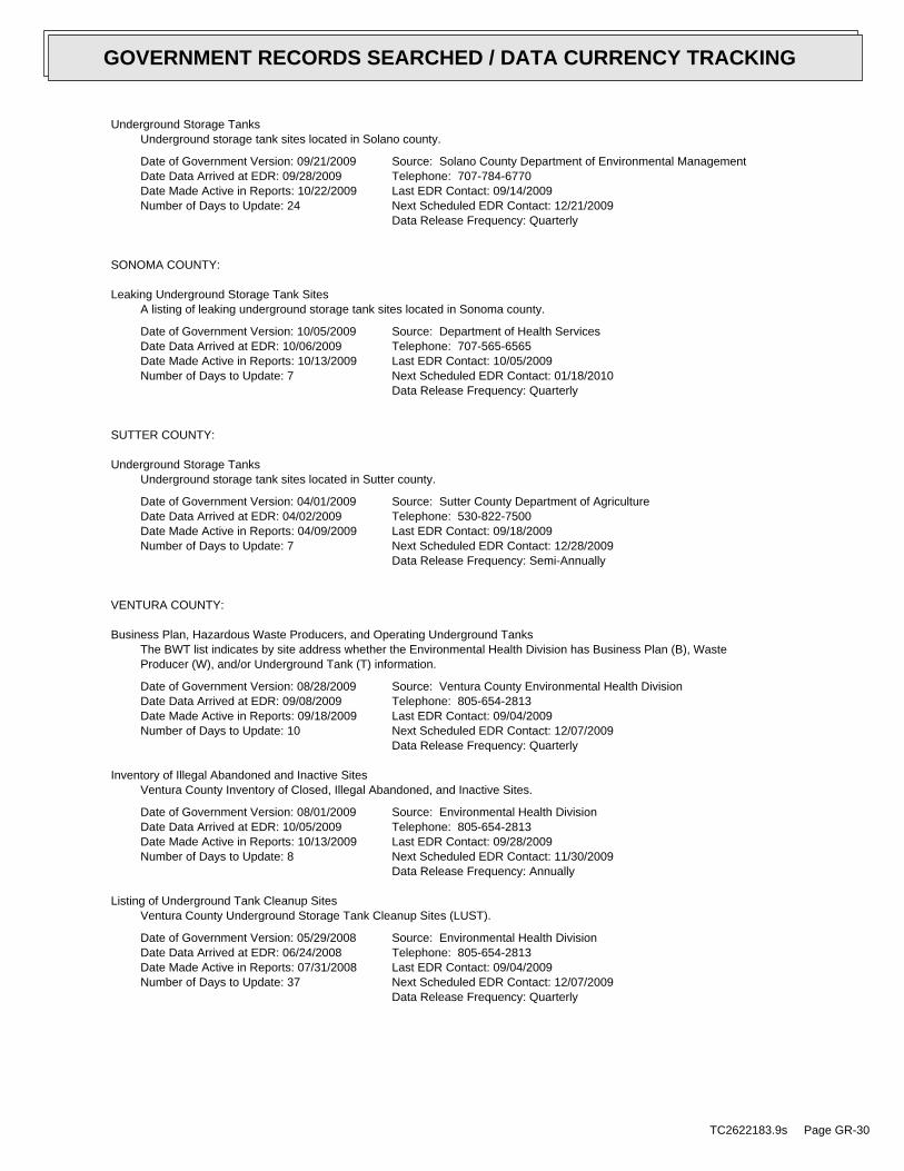
Underground Storage TanksUnderground storage tank sites located in Solano county.
Date of Government Version: 09/21/2009Date Data Arrived at EDR: 09/28/2009Date Made Active in Reports: 10/22/2009Number of Days to Update: 24
Source: Solano County Department of Environmental ManagementTelephone: 707-784-6770Last EDR Contact: 09/14/2009Next Scheduled EDR Contact: 12/21/2009Data Release Frequency: Quarterly
SONOMA COUNTY:
Leaking Underground Storage Tank SitesA listing of leaking underground storage tank sites located in Sonoma county.
Date of Government Version: 10/05/2009Date Data Arrived at EDR: 10/06/2009Date Made Active in Reports: 10/13/2009Number of Days to Update: 7
Source: Department of Health ServicesTelephone: 707-565-6565Last EDR Contact: 10/05/2009Next Scheduled EDR Contact: 01/18/2010Data Release Frequency: Quarterly
SUTTER COUNTY:
Underground Storage TanksUnderground storage tank sites located in Sutter county.
Date of Government Version: 04/01/2009Date Data Arrived at EDR: 04/02/2009Date Made Active in Reports: 04/09/2009Number of Days to Update: 7
Source: Sutter County Department of AgricultureTelephone: 530-822-7500Last EDR Contact: 09/18/2009Next Scheduled EDR Contact: 12/28/2009Data Release Frequency: Semi-Annually
VENTURA COUNTY:
Business Plan, Hazardous Waste Producers, and Operating Underground TanksThe BWT list indicates by site address whether the Environmental Health Division has Business Plan (B), WasteProducer (W), and/or Underground Tank (T) information.
Date of Government Version: 08/28/2009Date Data Arrived at EDR: 09/08/2009Date Made Active in Reports: 09/18/2009Number of Days to Update: 10
Source: Ventura County Environmental Health DivisionTelephone: 805-654-2813Last EDR Contact: 09/04/2009Next Scheduled EDR Contact: 12/07/2009Data Release Frequency: Quarterly
Inventory of Illegal Abandoned and Inactive SitesVentura County Inventory of Closed, Illegal Abandoned, and Inactive Sites.
Date of Government Version: 08/01/2009Date Data Arrived at EDR: 10/05/2009Date Made Active in Reports: 10/13/2009Number of Days to Update: 8
Source: Environmental Health DivisionTelephone: 805-654-2813Last EDR Contact: 09/28/2009Next Scheduled EDR Contact: 11/30/2009Data Release Frequency: Annually
Listing of Underground Tank Cleanup SitesVentura County Underground Storage Tank Cleanup Sites (LUST).
Date of Government Version: 05/29/2008Date Data Arrived at EDR: 06/24/2008Date Made Active in Reports: 07/31/2008Number of Days to Update: 37
Source: Environmental Health DivisionTelephone: 805-654-2813Last EDR Contact: 09/04/2009Next Scheduled EDR Contact: 12/07/2009Data Release Frequency: Quarterly
TC2622183.9s Page GR-30
GOVERNMENT RECORDS SEARCHED / DATA CURRENCY TRACKING

Underground Tank Closed Sites ListVentura County Operating Underground Storage Tank Sites (UST)/Underground Tank Closed Sites List.
Date of Government Version: 08/26/2009Date Data Arrived at EDR: 09/28/2009Date Made Active in Reports: 10/22/2009Number of Days to Update: 24
Source: Environmental Health DivisionTelephone: 805-654-2813Last EDR Contact: 09/28/2009Next Scheduled EDR Contact: 01/04/2010Data Release Frequency: Quarterly
YOLO COUNTY:
Underground Storage Tank Comprehensive Facility ReportUnderground storage tank sites located in Yolo county.
Date of Government Version: 07/22/2009Date Data Arrived at EDR: 09/04/2009Date Made Active in Reports: 09/16/2009Number of Days to Update: 12
Source: Yolo County Department of HealthTelephone: 530-666-8646Last EDR Contact: 10/13/2009Next Scheduled EDR Contact: 01/11/2010Data Release Frequency: Annually
OTHER DATABASE(S)
Depending on the geographic area covered by this report, the data provided in these specialty databases may or may not becomplete. For example, the existence of wetlands information data in a specific report does not mean that all wetlands in thearea covered by the report are included. Moreover, the absence of any reported wetlands information does not necessarilymean that wetlands do not exist in the area covered by the report.
CT MANIFEST: Hazardous Waste Manifest DataFacility and manifest data. Manifest is a document that lists and tracks hazardous waste from the generator throughtransporters to a tsd facility.
Date of Government Version: 12/31/2007Date Data Arrived at EDR: 08/26/2009Date Made Active in Reports: 09/11/2009Number of Days to Update: 16
Source: Department of Environmental ProtectionTelephone: 860-424-3375Last EDR Contact: 09/09/2009Next Scheduled EDR Contact: 12/07/2009Data Release Frequency: Annually
NJ MANIFEST: Manifest InformationHazardous waste manifest information.
Date of Government Version: 12/31/2008Date Data Arrived at EDR: 05/05/2009Date Made Active in Reports: 05/22/2009Number of Days to Update: 17
Source: Department of Environmental ProtectionTelephone: N/ALast EDR Contact: 10/20/2009Next Scheduled EDR Contact: 02/01/2010Data Release Frequency: Annually
NY MANIFEST: Facility and Manifest DataManifest is a document that lists and tracks hazardous waste from the generator through transporters to a TSDfacility.
Date of Government Version: 07/28/2009Date Data Arrived at EDR: 08/27/2009Date Made Active in Reports: 09/21/2009Number of Days to Update: 25
Source: Department of Environmental ConservationTelephone: 518-402-8651Last EDR Contact: 08/27/2009Next Scheduled EDR Contact: 11/23/2009Data Release Frequency: Annually
TC2622183.9s Page GR-31
GOVERNMENT RECORDS SEARCHED / DATA CURRENCY TRACKING

PA MANIFEST: Manifest InformationHazardous waste manifest information.
Date of Government Version: 12/31/2007Date Data Arrived at EDR: 09/11/2008Date Made Active in Reports: 10/02/2008Number of Days to Update: 21
Source: Department of Environmental ProtectionTelephone: N/ALast EDR Contact: 09/08/2009Next Scheduled EDR Contact: 12/07/2009Data Release Frequency: Annually
RI MANIFEST: Manifest informationHazardous waste manifest information
Date of Government Version: 06/01/2009Date Data Arrived at EDR: 06/12/2009Date Made Active in Reports: 06/29/2009Number of Days to Update: 17
Source: Department of Environmental ManagementTelephone: 401-222-2797Last EDR Contact: 09/14/2009Next Scheduled EDR Contact: 12/14/2009Data Release Frequency: Annually
WI MANIFEST: Manifest InformationHazardous waste manifest information.
Date of Government Version: 12/31/2008Date Data Arrived at EDR: 07/17/2009Date Made Active in Reports: 08/10/2009Number of Days to Update: 24
Source: Department of Natural ResourcesTelephone: N/ALast EDR Contact: 09/24/2009Next Scheduled EDR Contact: 01/04/2010Data Release Frequency: Annually
Oil/Gas Pipelines: This data was obtained by EDR from the USGS in 1994. It is referred to by USGS as GeoData Digital Line Graphsfrom 1:100,000-Scale Maps. It was extracted from the transportation category including some oil, but primarilygas pipelines.
Electric Power Transmission Line DataSource: PennWell CorporationTelephone: (800) 823-6277This map includes information copyrighted by PennWell Corporation. This information is providedon a best effort basis and PennWell Corporation does not guarantee its accuracy nor warrant itsfitness for any particular purpose. Such information has been reprinted with the permission of PennWell.
Sensitive Receptors: There are individuals deemed sensitive receptors due to their fragile immune systems and special sensitivityto environmental discharges. These sensitive receptors typically include the elderly, the sick, and children. While the location of allsensitive receptors cannot be determined, EDR indicates those buildings and facilities - schools, daycares, hospitals, medical centers,and nursing homes - where individuals who are sensitive receptors are likely to be located.
AHA Hospitals:Source: American Hospital Association, Inc.Telephone: 312-280-5991The database includes a listing of hospitals based on the American Hospital Association’s annual survey of hospitals.
Medical Centers: Provider of Services ListingSource: Centers for Medicare & Medicaid ServicesTelephone: 410-786-3000A listing of hospitals with Medicare provider number, produced by Centers of Medicare & Medicaid Services,a federal agency within the U.S. Department of Health and Human Services.
Nursing HomesSource: National Institutes of HealthTelephone: 301-594-6248Information on Medicare and Medicaid certified nursing homes in the United States.
Public SchoolsSource: National Center for Education StatisticsTelephone: 202-502-7300The National Center for Education Statistics’ primary database on elementaryand secondary public education in the United States. It is a comprehensive, annual, national statisticaldatabase of all public elementary and secondary schools and school districts, which contains data that arecomparable across all states.
TC2622183.9s Page GR-32
GOVERNMENT RECORDS SEARCHED / DATA CURRENCY TRACKING

Private SchoolsSource: National Center for Education StatisticsTelephone: 202-502-7300The National Center for Education Statistics’ primary database on private school locations in the United States.
Daycare Centers: Licensed FacilitiesSource: Department of Social ServicesTelephone: 916-657-4041
Flood Zone Data: This data, available in select counties across the country, was obtained by EDR in 1999 from the FederalEmergency Management Agency (FEMA). Data depicts 100-year and 500-year flood zones as defined by FEMA.
NWI: National Wetlands Inventory. This data, available in select counties across the country, was obtained by EDRin 2002 and 2005 from the U.S. Fish and Wildlife Service.
STREET AND ADDRESS INFORMATION
© 2009 Tele Atlas North America, Inc. All rights reserved. This material is proprietary and the subject of copyright protectionand other intellectual property rights owned by or licensed to Tele Atlas North America, Inc. The use of this material is subjectto the terms of a license agreement. You will be held liable for any unauthorized copying or disclosure of this material.
TC2622183.9s Page GR-33
GOVERNMENT RECORDS SEARCHED / DATA CURRENCY TRACKING

29
APPENDIX D HISTORICAL AERIAL PHOTOGRAPHS

The EDR Aerial Photo Decade Package
818 Lakeport Boulevard Site
818 Lakeport Boulevard
Lakeport, CA 95453
Inquiry Number: 2622183.5
October 27, 2009

EDR Aerial Photo Decade Package
Environmental Data Resources, Inc. (EDR) Aerial Photo Decade Package is a screening tool designed to assistenvironmental professionals in evaluating potential liability on a target property resulting from past activities. EDRsprofessional researchers provide digitally reproduced historical aerial photographs, and when available, provide one photoper decade.
When delivered electronically by EDR, the aerial photo images included with this report are for ONE TIME USEONLY. Further reproduction of these aerial photo images is prohibited without permission from EDR. For moreinformation contact your EDR Account Executive.
Thank you for your business.Please contact EDR at 1-800-352-0050
with any questions or comments.
Disclaimer - Copyright and Trademark Notice
This Report contains certain information obtained from a variety of public and other sources reasonably available to Environmental Data Resources, Inc.It cannot be concluded from this Report that coverage information for the target and surrounding properties does not exist from other sources. NOWARRANTY EXPRESSED OR IMPLIED, IS MADE WHATSOEVER IN CONNECTION WITH THIS REPORT. ENVIRONMENTAL DATARESOURCES, INC. SPECIFICALLY DISCLAIMS THE MAKING OF ANY SUCH WARRANTIES, INCLUDING WITHOUT LIMITATION,MERCHANTABILITY OR FITNESS FOR A PARTICULAR USE OR PURPOSE. ALL RISK IS ASSUMED BY THE USER. IN NO EVENT SHALLENVIRONMENTAL DATA RESOURCES, INC. BE LIABLE TO ANYONE, WHETHER ARISING OUT OF ERRORS OR OMISSIONS, NEGLIGENCE,ACCIDENT OR ANY OTHER CAUSE, FOR ANY LOSS OF DAMAGE, INCLUDING, WITHOUT LIMITATION, SPECIAL, INCIDENTAL,CONSEQUENTIAL, OR EXEMPLARY DAMAGES. ANY LIABILITY ON THE PART OF ENVIRONMENTAL DATA RESOURCES, INC. IS STRICTLYLIMITED TO A REFUND OF THE AMOUNT PAID FOR THIS REPORT. Purchaser accepts this Report AS IS. Any analyses, estimates, ratings,environmental risk levels or risk codes provided in this Report are provided for illustrative purposes only, and are not intended to provide, nor should theybe interpreted as providing any facts regarding, or prediction or forecast of, any environmental risk for any property. Only a Phase I Environmental SiteAssessment performed by an environmental professional can provide information regarding the environmental risk for any property. Additionally, theinformation provided in this Report is not to be construed as legal advice.
Copyright 2009 by Environmental Data Resources, Inc. All rights reserved. Reproduction in any media or format, in whole or in part, of any report or mapof Environmental Data Resources, Inc., or its affiliates, is prohibited without prior written permission.
EDR and its logos (including Sanborn and Sanborn Map) are trademarks of Environmental Data Resources, Inc. or its affiliates. All other trademarksused herein are the property of their respective owners.

Date EDR Searched Historical Sources:Aerial PhotographyOctober 27, 2009
Target Property:818 Lakeport Boulevard
Lakeport, CA 95453
Year Scale Details Source
1952 Aerial Photograph. Scale: 1"=555' Flight Year: 1952 Southwestern
1972 Aerial Photograph. Scale: 1"=333' Flight Year: 1972 CH2M Hill
1987 Aerial Photograph. Scale: 1"=666' Flight Year: 1987 USGS
1993 Aerial Photograph. Scale: 1"=666' Flight Year: 1993 USGS
1998 Aerial Photograph. Scale: 1"=666' Flight Year: 1998 USGS
2005 Aerial Photograph. 1" = 604' Flight Year: 2005 EDR
2622183.52

INQUIRY #:
YEAR:
2622183.5
1952
= 555'

INQUIRY #:
YEAR:
2622183.5
1972
= 333'

INQUIRY #:
YEAR:
2622183.5
1987
= 666'

INQUIRY #:
YEAR:
2622183.5
1993
= 666'

INQUIRY #:
YEAR:
2622183.5
1998
= 666'

INQUIRY #:
YEAR:
2622183.5
2005
= 604'

30
APPENDIX E HISTORICAL TOPOGRAPHIC MAPS

The EDR Historical Topographic Map Report
818 Lakeport Boulevard Site
818 Lakeport Boulevard
Lakeport, CA 95453
Inquiry Number: 2622183.4
October 26, 2009

EDR Historical Topographic Map Report
Environmental Data Resources, Inc.s (EDR) Historical Topographic Map Report is designed to assist professionals inevaluating potential liability on a target property resulting from past activities. EDRs Historical Topographic Map Reportincludes a search of a collection of public and private color historical topographic maps, dating back to the early 1900s.
Thank you for your business.Please contact EDR at 1-800-352-0050
with any questions or comments.
Disclaimer - Copyright and Trademark Notice
This Report contains certain information obtained from a variety of public and other sources reasonably available to Environmental Data Resources, Inc.It cannot be concluded from this Report that coverage information for the target and surrounding properties does not exist from other sources. NOWARRANTY EXPRESSED OR IMPLIED, IS MADE WHATSOEVER IN CONNECTION WITH THIS REPORT. ENVIRONMENTAL DATARESOURCES, INC. SPECIFICALLY DISCLAIMS THE MAKING OF ANY SUCH WARRANTIES, INCLUDING WITHOUT LIMITATION,MERCHANTABILITY OR FITNESS FOR A PARTICULAR USE OR PURPOSE. ALL RISK IS ASSUMED BY THE USER. IN NO EVENT SHALLENVIRONMENTAL DATA RESOURCES, INC. BE LIABLE TO ANYONE, WHETHER ARISING OUT OF ERRORS OR OMISSIONS, NEGLIGENCE,ACCIDENT OR ANY OTHER CAUSE, FOR ANY LOSS OF DAMAGE, INCLUDING, WITHOUT LIMITATION, SPECIAL, INCIDENTAL,CONSEQUENTIAL, OR EXEMPLARY DAMAGES. ANY LIABILITY ON THE PART OF ENVIRONMENTAL DATA RESOURCES, INC. IS STRICTLYLIMITED TO A REFUND OF THE AMOUNT PAID FOR THIS REPORT. Purchaser accepts this Report AS IS. Any analyses, estimates, ratings,environmental risk levels or risk codes provided in this Report are provided for illustrative purposes only, and are not intended to provide, nor should theybe interpreted as providing any facts regarding, or prediction or forecast of, any environmental risk for any property. Only a Phase I Environmental SiteAssessment performed by an environmental professional can provide information regarding the environmental risk for any property. Additionally, theinformation provided in this Report is not to be construed as legal advice.
Copyright 2009 by Environmental Data Resources, Inc. All rights reserved. Reproduction in any media or format, in whole or in part, of any report or mapof Environmental Data Resources, Inc., or its affiliates, is prohibited without prior written permission.
EDR and its logos (including Sanborn and Sanborn Map) are trademarks of Environmental Data Resources, Inc. or its affiliates. All other trademarksused herein are the property of their respective owners.

Historical Topographic Map
→
NTARGET QUADNAME: LAKEPORTMAP YEAR: 1938
SERIES: 15SCALE: 1:62500
SITE NAME: 818 Lakeport Boulevard SiteADDRESS: 818 Lakeport Boulevard
Lakeport, CA 95453LAT/LONG: 39.0344 / 122.922
CLIENT: URS CorporationCONTACT: Frank GegundeINQUIRY#: 2622183.4RESEARCH DATE: 10/26/2009

Historical Topographic Map
→
NTARGET QUADNAME: LAKEPORTMAP YEAR: 1958
SERIES: 7.5SCALE: 1:24000
SITE NAME: 818 Lakeport Boulevard SiteADDRESS: 818 Lakeport Boulevard
Lakeport, CA 95453LAT/LONG: 39.0344 / 122.922
CLIENT: URS CorporationCONTACT: Frank GegundeINQUIRY#: 2622183.4RESEARCH DATE: 10/26/2009

Historical Topographic Map
→
NTARGET QUADNAME: LAKEPORTMAP YEAR: 1958
SERIES: 15SCALE: 1:62500
SITE NAME: 818 Lakeport Boulevard SiteADDRESS: 818 Lakeport Boulevard
Lakeport, CA 95453LAT/LONG: 39.0344 / 122.922
CLIENT: URS CorporationCONTACT: Frank GegundeINQUIRY#: 2622183.4RESEARCH DATE: 10/26/2009

Historical Topographic Map
→
NTARGET QUADNAME: LAKEPORTMAP YEAR: 1978PHOTOREVISED FROM:1958SERIES: 7.5SCALE: 1:24000
SITE NAME: 818 Lakeport Boulevard SiteADDRESS: 818 Lakeport Boulevard
Lakeport, CA 95453LAT/LONG: 39.0344 / 122.922
CLIENT: URS CorporationCONTACT: Frank GegundeINQUIRY#: 2622183.4RESEARCH DATE: 10/26/2009
31
APPENDIX F SANBORN FIRE INSURANCE MAPS

Certified Sanborn® Map Report
818 Lakeport Boulevard Site
818 Lakeport Boulevard
Lakeport, CA 95453
Inquiry Number: 2622183.3
October 23, 2009

Certified Sanborn® Map Report 10/23/09
Site Name:818 Lakeport Boulevard Site818 Lakeport BoulevardLakeport, CA 95453
Client Name:URS Corporation2870 Gateway Oaks DriveSacramento, CA 95833
EDR Inquiry # 2622183.3 Contact: Frank Gegunde
The complete Sanborn Library collection has been searched by EDR, and fire insurance maps covering the targetproperty location provided by URS Corporation were identified for the years listed below. The certified Sanborn Librarysearch results in this report can be authenticated by visiting www.edrnet.com/sanborn and entering the certificationnumber. Only Environmental Data Resources Inc. (EDR) is authorized to grant rights for commercial reproduction ofmaps by Sanborn Library LLC, the copyright holder for the collection.
Certified Sanborn Results:
Site Name: 818 Lakeport Boulevard SiteAddress: 818 Lakeport BoulevardCity, State, Zip: Lakeport, CA 95453Cross Street:P.O. # 17326295.01001Project: 17326295.01001Certification # C1E5-44DE-A791
Library of Congress
University Publications of America
EDR Private Collection
The Sanborn Library includes more than 1.2 millionSanborn fire insurance maps, which track historicalproperty usage in approximately 12,000 Americancities and towns. Collections searched:
Sanborn® Library search resultsCertification # C1E5-44DE-A791
UNMAPPED PROPERTYThis report certifies that the complete holdings of the SanbornLibrary, LLC collection have been searched based on clientsupplied target property information, and fire insurance mapscovering the target property were not found.
Limited Permission To Make CopiesURS Corporation (the client) is permitted to make up to THREE photocopies of this Sanborn Map transmittal and each fire insurance mapaccompanying this report solely for the limited use of its customer. No one other than the client is authorized to make copies. Upon request madedirectly to an EDR Account Executive, the client may be permitted to make a limited number of additional photocopies. This permission isconditioned upon compliance by the client, its customer and their agents with EDR's copyright policy; a copy of which is available upon request.
Disclaimer - Copyright and Trademark noticeThis Report contains certain information obtained from a variety of public and other sources reasonably available to Environmental Data Resources, Inc. It cannot beconcluded from this Report that coverage information for the target and surrounding properties does not exist from other sources. NO WARRANTY EXPRESSED ORIMPLIED, IS MADE WHATSOEVER IN CONNECTION WITH THIS REPORT. ENVIRONMENTAL DATA RESOURCES, INC. SPECIFICALLY DISCLAIMS THEMAKING OF ANY SUCH WARRANTIES, INCLUDING WITHOUT LIMITATION, MERCHANTABILITY OR FITNESS FOR A PARTICULAR USE OR PURPOSE. ALLRISK IS ASSUMED BY THE USER. IN NO EVENT SHALL ENVIRONMENTAL DATA RESOURCES, INC. BE LIABLE TO ANYONE, WHETHER ARISING OUT OFERRORS OR OMISSIONS, NEGLIGENCE, ACCIDENT OR ANY OTHER CAUSE, FOR ANY LOSS OF DAMAGE, INCLUDING, WITHOUT LIMITATION, SPECIAL,INCIDENTAL CONSEQUENTIAL, OR EXEMPLARY DAMAGES. ANY LIABILITY ON THE PART OF ENVIRONMENTAL DATA RESOURCES, INC. IS STRICTLYLIMITED TO A REFUND OF THE AMOUNT PAID FOR THIS REPORT. Purchaser accepts this Report "AS IS". Any analyses, estimates, ratings, environmental risklevels or risk codes provided in this Report are provided for illustrative purposes only, and are not intended to provide, nor should they be interpreted as providingany facts regarding, or prediction or forecast of, any environmental risk for any property. Only a Phase I Environmental Site Assessment performed by anenvironmental professional can provide information regarding the environmental risk for any property. Additionally, the information provided in this Report is not to beconstrued as legal advice.
Copyright 2009 by Environmental Data Resources, Inc. All rights reserved. Reproduction in any media or format, in whole or in part, of any report or map ofEnvironmental Data Resources, Inc., or its affiliates, is prohibited without prior written permission.
EDR and its logos (including Sanborn and Sanborn Map) are trademarks of Environmental Data Resources, Inc. or its affiliates. All other trademarks used herein arethe property of their respective owners.
2622183 - 3 page 2

32
APPENDIX G CITY DIRECTORY ABSTRACT

818 Lakeport Boulevard Site
818 Lakeport BoulevardLakeport, CA 95453
Inquiry Number: 2622183.6November 03, 2009
The EDR-City Directory Abstract
440 Wheelers Farms RoadMilford, CT 06461800.352.0050www.edrnet.comEnvironmental Data Resources IncEnvironmental Data Resources IncEnvironmental Data Resources IncEnvironmental Data Resources Inc

TABLE OF CONTENTS
SECTION
Executive Summary
Findings
Thank you for your business. Please contact EDR at 1-800-352-0050
with any questions or comments.
Disclaimer - Copyright and Trademark Notice
This Report contains certain information obtained from a variety of public and other sources reasonably available to Environmental Data Resources, Inc. It cannot be concluded from this Report that coverage information for the target and surrounding properties does not exist from other sources. NO WARRANTY EXPRESSED OR IMPLIED, IS MADE WHATSOEVER IN CONNECTION WITH THIS REPORT. ENVIRONMENTAL DATA RESOURCES, INC. SPECIFICALLY DISCLAIMS THE MAKING OF ANY SUCH WARRANTIES, INCLUDING WITHOUT LIMITATION, MERCHANTABILITY OR FITNESS FOR A PARTICULAR USE OR PURPOSE. ALL RISK IS ASSUMED BY THE USER. IN NO EVENT SHALL ENVIRONMENTAL DATA RESOURCES, INC. BE LIABLE TO ANYONE, WHETHER ARISING OUT OF ERRORS OR OMISSIONS, NEGLIGENCE, ACCIDENT OR ANY OTHER CAUSE, FOR ANY LOSS OR DAMAGE, INCLUDING, WITHOUT LIMITATION, SPECIAL, INCIDENTAL, CONSEQUENTIAL, OR EXEMPLARY DAMAGES. ANY LIABILITY ON THE PART OF ENVIRONMENTAL DATA RESOURCES, INC. IS STRICTLY LIMITED TO A REFUND OF THE AMOUNT PAID FOR THIS REPORT. Purchaser accepts this Report "AS IS". Any analyses, estimates, ratings, environmental risk levels or risk codes provided in this Report are provided for illustrative purposes only, and are not intended to provide, nor should they be interpreted as providing any facts regarding, or prediction orforecast of, any environmental risk for any property. Only a Phase I Environmental Site Assessment performed by an environmental professional can provide information regarding the environmental risk for any property. Additionally, the information provided in this Report is not to be construed as legal advice.
Copyright 2009 by Environmental Data Resources, Inc. All rights reserved. Reproduction in any media or format, in whole or in part, of any report or map of Environmental Data Resources, Inc. or its affiliates is prohibited without prior written permission.
EDR and its logos (including Sanborn and Sanborn Map) are trademarks of Environmental Data Resources, Inc. or its affiliates. All other trademarks used herein are the property of their respective owners.

2009 Enhancements to EDR City Directory Abstract
New for 2009, the EDR City Directory Abstract has been enhanced with additional information and features. These enhancements will make your city directory research process more efficient, flexible, and insightful than ever before. The enhancements will improve the options for selecting adjoining properties, and will speed up your review of the report.
City Directory Report. Three important enhancements have been made to the EDR City Directory Abstract:
1. Executive Summary. The report begins with an Executive Summary that lists the sources consulted in the preparation of the report. Where available, a parcel map is also provided within the report, showing the locations of properties researched.
2. Page Images. Where available, the actual page source images will be included in the Appendix, so that you can review them for information that may provide additional insight. EDR has copyright permission to include these images.
3. Findings Listed by Location. Another useful enhancement is that findings are now grouped by address. This will significantly reduce the time you need to review your abstracts. Findings are provided under each property address, listed in reverse chronological order and referencing the source for each entry.
Options for Selecting Adjoining Properties. Ensuring that the right adjoining property addresses are searched is one of the biggest challenges that environmental professionals face when conducting city directory historical research. EDR's new enhancements make it easier for you to meet this challenge. Now, when you place an order for the EDR City Directory Abstract, you have the following choices for determining which addresses should be researched.
1. You Select Addresses and EDR Selects Addresses. Use the "Add Another Address" feature to specify the addresses you want researched. Your selections will be supplemented by addresses selected by EDR researchers using our established research methods. Where available, a digital map will be shown, indicating property lines overlaid on a color aerial photo and their corresponding addresses. Simply use the address list below the map to check off which properties shown on the map you want to include. You may also select other addresses using the "Add Another Address" feature at the bottom of the list.
2. EDR Selects Addresses. Choose this method if you want EDR's researchers to select the addresses to be researched for you, using our established research methods.
3. You Select Addresses. Use this method for research based solely on the addresses you select or enter into the system.
4. Hold City Directory Research Option. If you choose to select your own adjoining addresses, you may pause production of your EDR City Directory Abstract report until you have had a chance to look at your other EDR reports and sources. Sources for property addresses include: your Certified Sanborn Map Report may show you the location of property addresses; the new EDR Property Tax Map Report may show the location of property addresses; and your field research can supplement these sources with additional address information. To use this capability, simply click "Hold City Directory research" box under "Other Options" at the bottom of the page. Once you have determined what addresses you want researched, go to your EDR Order Status page, select the EDR City Directory Abstract, and enter the addresses and submit for production.
Questions? Contact your EDR representative at 800-352-0050. For more information about all of EDR's 2009 report and service enhancements, visit www.edrnet.com/2009enhancements

EXECUTIVE SUMMARY
DESCRIPTION
Environmental Data Resources, Inc.’s (EDR) City Directory Abstract is a screening tool designed to assist environmental professionals in evaluating potential liability on a target property resulting from past activities. EDR’s City Directory Abstract includes a search and abstract of available city directory data. For each address, the directory lists the name of the corresponding occupant at five year intervals.
RESEARCH SUMMARY
The following research sources were consulted in the preparation of this report. An "X" indicates where information was identified in the source and provided in this report.
Source TPYear Adjoining Text Abstract Source Image
2007 Haines Criss-Cross Directory X X X -
2000 Haines Criss-Cross Directory X X X -
1996 Haines Criss-Cross Directory X X X -
1992 Haines Criss-Cross Directory - X X -
2622183 - 6 Page 1

EXECUTIVE SUMMARY
MAP INFORMATION
The Overview Map provides information on nearby property parcel boundaries. Properties on this map that were selected for research are listed below the map.
SELECTED ADDRESSES
The following addresses were selected by the client. Detailed findings are contained in the findings section. An "X" indicates where information was identified.
Address Type Findings
910 BEVINS CT Map ID: 0 X
675 LAKEPORT BLVD Map ID: 0
1075 MARTIN ST Client Entered
818 Lakeport Boulevard Client Entered X
922 BEVINS CT Client Entered X
940 BEVINS CT Client Entered
958 BEVINS CT Client Entered X
2622183 - 6 Page 2

FINDINGS
TARGET PROPERTY INFORMATION
ADDRESS
818 Lakeport Boulevard MapID: 1Lakeport, CA 95453
FINDINGS DETAIL
Target Property research detail.
Year Uses Source
2007 Long Keith DDS Haines Criss-Cross Directory
2000 No Return Haines Criss-Cross Directory
1996 Lakeport Dental Gro Haines Criss-Cross Directory
2622183 - 6 Page 3

FINDINGS
ADJOINING PROPERTY DETAIL
The following Adjoining Property addresses were researched for this report. Detailed findings are provided for each address.
BEVINS CT
Not Mapped910 BEVINS CT
Year Uses Source
2007 Lake Co Waste Management Haines Criss-Cross Directory
2000 Lake Co Waste Management Haines Criss-Cross Directory
Lake Co Waste Mng Transfer Sta Haines Criss-Cross Directory
1996 Lake Co Solid Waste Haines Criss-Cross Directory
1992 Lake Co Solid Waste Haines Criss-Cross Directory
Not Mapped922 BEVINS CT
Year Uses Source
2007 Office Building (13 Occupants) Haines Criss-Cross Directory
2000 Office Building (13 Occupants) Haines Criss-Cross Directory
1996 Office Building (12 Occupants) Haines Criss-Cross Directory
1992 Office Building (16 Occupants) Haines Criss-Cross Directory
Not Mapped958 BEVINS CT
Year Uses Source
2007 Residential Haines Criss-Cross Directory
2622183 - 6 Page 4
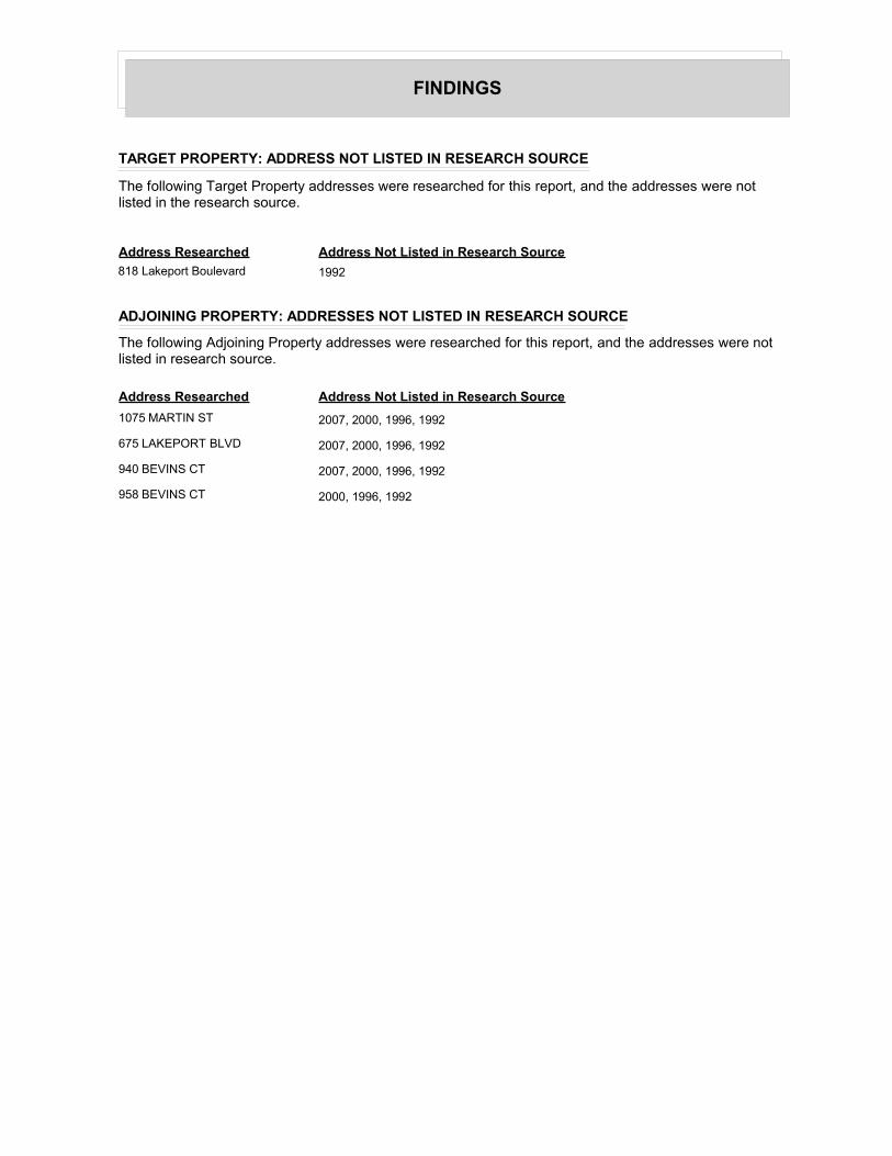
FINDINGS
TARGET PROPERTY: ADDRESS NOT LISTED IN RESEARCH SOURCE
The following Target Property addresses were researched for this report, and the addresses were not listed in the research source.
Address Researched Address Not Listed in Research Source
818 Lakeport Boulevard 1992
ADJOINING PROPERTY: ADDRESSES NOT LISTED IN RESEARCH SOURCE
The following Adjoining Property addresses were researched for this report, and the addresses were not listed in research source.
Address Researched Address Not Listed in Research Source
1075 MARTIN ST 2007, 2000, 1996, 1992
675 LAKEPORT BLVD 2007, 2000, 1996, 1992
940 BEVINS CT 2007, 2000, 1996, 1992
958 BEVINS CT 2000, 1996, 1992

33
APPENDIX H RESUMES OF ENVIRONMENTAL PROFESSIONALS

Oakland, CA\11-09\P:\AOC Courthouses\Resumes\Frank Gegunde 10-25-09.doc 1
FRANK L. GEGUNDE, P.G., R.E.A. Senior Geologist
Overview Mr. Gegunde is a California-licensed Professional Geologist and a Registered Environmental Assessor. Mr. Gegunde has extensive experience in conducting all aspects of Phase I and Phase II environmental site assessments (ESAs). Mr. Gegunde also has a thorough knowledge of soil boring and sampling techniques including continuous coring, split-spoon sampling, cone penetrometer testing technology (CPT) and Geoprobe™ direct push apparatus and in conducting bedrock fracture analysis using state-of-the-art field methods and RockWare™ stereonet software. He is well versed in monitoring well and piezometer installation methods as well as groundwater sampling and well monitoring procedures. Mr. Gegunde is proficient in the use of field-testing equipment including Hydac, YSI, and Horiba multiple parameter meters, photoionization hydrocarbon detection equipment, Explosimeters, PetroFLAG™ field hydrocarbon detection tests, and MiniTroll™ water monitoring data logger with Win-Situ or similar software. Mr. Gegunde also has conducted numerous passive soil gas investigations using GoreSorber™ technology to isolate “hotspots” of contamination for further subsurface investigation. Mr. Gegunde brings organizational and supervisory skills to URS from 27 years in the dairy and transportation industries.
Project Specific Experience Senior Geologist and Field Task Manager, McKittrick, CA, Confidential Client, 2008 - 2009: Provided observation and documentation for Health and Safety and Environmental Sensitivity aspects of the completion of a deep sandstone formation Class I Non-Hazardous Waste Injection Well. The well was authorized to inject into the Olig sand zone of the Reef Ridge Formation for the purpose of disposal of industrial nonhazardous wastewater fluids. These fluids consist primarily of cooling tower blowdown from a power plant cooling process, but also include boiler and evaporative cooler blowdown, wash water, filter backwash, equipment drains, and storm water from equipment containment.
Project Manager, Phase I Environmental Site Assessments, Kern County and Tulare County, CA, Confidential Client, 2008 - 2009, $26,000 to $32,000: Conducted Phase I environmental site assessments for a confidential client on properties in Kern and Tulare Counties, California. The Phase I ESAs were conducted with an emphasis on satisfying requirements for transferring property custodianship of multiple professional buildings between County and State agencies.
Site Auditor, Confidential Client, Limestone Mining and Cement Manufacturing, California, 2009: Environmental compliance audit and site assessment of this client’s mining and manufacturing sites in California.
Areas of Expertise Environmental Site Assessments Environmental Geology Landfill Investigations Water Resources
Years of Experience With URS: 3 Years With Other Firms: 6 Years
Education BS/Geology/2000/California State University, Fresno
Registration/Certification 2005/Professional Geologist/CA/ #7998/Expires June 2011 Registered Environmental Assessor/CA DTSC/#08095/Expires June 2010

Oakland, CA\11-09\P:\AOC Courthouses\Resumes\Frank Gegunde 10-25-09.doc 2
Senior Geologist, TDPI Pipeline Project, Bakersfield/Coalinga Area, CA, Chevron, 2008: Conducted oversight and supervision of Phase II pipeline viability assessments of idled or inactive oilfield pipelines in conjunction with other Chevron-subcontracted firms. Activities included a rigorous health and safety oversight regimen. Investigation included pipeline location, intrusive activities to reveal pipelines, connection isolation, sampling pipeline wrap for asbestos, wall thickness measurements, soil sampling, pipeline cold taps, pipeline content sampling, air quality monitoring, and project field documentation including Global Positioning System (GPS) documentation.
Project Manager, Phase I Environmental Site Assessments, Fresno, CA, Merced, CA, and Stockton, CA, Confidential Client, 2008, $6,000 to $8,000: Conducted Phase I environmental site assessments for a confidential client on properties in Fresno, Merced, and San Joaquin Counties, California. The Phase I ESAs were conducted with an emphasis on satisfying requirements for submission of applications for siting and construction of three natural gas-fired electrical power generation plants.
Senior Geologist, Heated-oil Pipeline Project, Coalinga Area, CA, Chevron, 2007: Conducted boring activities for a portion of the San Ardo Heated-oil Pipeline geotechnical investigation in advance of pipeline construction. Duties involved geotechnical boring and field-testing within a larger effort to assess feasibility of construction of the pipeline across geologically complex and abrupt terrain including multiple faults and landslides. Investigation included directing the drilling subcontractor to advance borings ranging from 30 to 60 feet below ground surface using Sonic drilling technology and HQ coring methodology, collection of continuous core samples, lithologic logging, and documentation of the investigation.
Senior Geologist, Retail Environmental Phase II Site Assessments, Los Angeles Area, CA, Shell, 2007: Supervised field activities for a portion of the Inland Empire portfolio within a larger effort to conduct 94 Phase II ESAs in 90 days. Field tasks included responsibility for a two person team overseeing drilling at active retail stations and coordination with project management to meet project objectives and schedule. Investigation of each site included directing the drilling subcontractor to advance several hollow stem auger borings ranging from 30 to 50 feet below ground surface, collection of samples, lithologic logging, and documentation of the investigation.
Senior Geologist, Storm Water Conveyance System Cross Connection Survey, Naval Air Station Lemoore, CA, Department of the Navy, 2007: Supervised field activities for the Illicit Connection Illicit Discharge (ICID) survey of selected storm water conveyance systems as necessary for National Pollutant Discharge Elimination System (NPDES) compliance for storm water management at NAVFAC SW facilities. Field survey methods included a review of all available as-built or best construction drawings, visual inspections, and where appropriate dye testing, smoke testing, closed circuit television inspection, and

Oakland, CA\11-09\P:\AOC Courthouses\Resumes\Frank Gegunde 10-25-09.doc 3
electromagnetic tracer survey. Results of the survey were documented in a comprehensive investigation report.
Associate Geologist and Technical Manager, Operational Unit 1, Purity Oil Sales Superfund Site, Fresno, CA, Chevron Environmental Management Company, 2002 - 2006: Oversaw the design, installation, and implementation of low flow sampling systems using QED MicroPurge® bladder pumps in 25 on- and offsite monitoring wells. Oversaw quarterly groundwater monitoring, sampling, and reporting for the extensive monitoring well network. Oversaw operation and maintenance (O&M) of the groundwater extraction and treatment system including a three-vessel greensands filtration system and a high-volume VOC airstripper. Oversaw several phases of CPT and HydroPunch investigations at the site. Reported monthly progress and activities to the lead agencies including the US Environmental Protection Agency, the Regional Water Quality Control Board, and the California Department of Toxic Substances Control.
Project Manager, Environmental Site Assessments (Phase I/II), San Joaquin Valley and Sacramento Valley Region, CA, Multiple Clients, 2000 – 2006, $1,500 to $10,000: Conducted Phase I environmental site assessments for GE Capital – Business Asset Funding on properties throughout the San Joaquin Valley including Fresno, Kings, and San Joaquin Counties, California. Conducted Phase I environmental site assessments and Environmental Facility Entrance Assessments for a confidential client in the health services field on properties throughout the San Joaquin Valley including Fresno, Stanislaus, Placer, Sacramento, and San Joaquin Counties, California. Conducted Phase I and Phase II environmental site assessments for Pacific Gas & Electric Company in Kern, Madera, Merced and Stanislaus Counties, California. Conducted Phase I environmental site assessment for Chevron Pipe Line Company for portions of the Wait-Midway crude oil pipeline in Kern County, California.
Project Manager, Drinking Water Availability Studies, Fresno/Madera Counties, CA, Private Landowners, 2005 – 2006, $5,900 to $7,800: Conducted groundwater availability investigations and potential yield analysis for drinking water sources in the foothill regions of Fresno County and Madera County, California. Investigations included local and regional aquifer surveys for groundwater use and groundwater conditions, and pumping tests for specific yield data for wells in compliance with regulatory mandates for such testing on drinking water sources.
Field Task Manager, Blue Hills Disposal Facility, Coalinga, CA, Fresno County Department of Public Works and Planning, 2005 – 2006: Supervised quarterly groundwater monitoring at the former agricultural chemicals container disposal facility in southwestern Fresno County. The California Department of Toxic Substances Control requires quarterly monitoring at the site due to elevated concentrations of constituents of concern including herbicides in groundwater underling the

Oakland, CA\11-09\P:\AOC Courthouses\Resumes\Frank Gegunde 10-25-09.doc 4
site. Also co-authored the revised Groundwater Monitoring Plan for the Site Corrective Action Plan.
Project Geologist and Field Task Manager, Goodyear Tire Service Centers, Multiple Locations, CA, Goodyear Tire and Rubber Company, 2004 – 2005: Performed soil boring and sampling at multiple Goodyear Service Centers in Fresno, Madera, Kings, Kern, Stanislaus, and Placer Counties. Borings were advanced inside the Center’s service bays adjacent to hydraulic lifts and oil/water separators.
Project Geologist and Field Task Manager, Woodville Solid Wastes Landfill, Tulare, CA, Tulare County Resource Management Agency, 2004 – 2005: Oversight of the implementation and upgrade of Detection Monitoring Plans and Evaluation Monitoring Plans (California Code of Regulations Title 27) at the Woodville solid waste landfill in Tulare County, California.
Awards 2007/2cd Quarter 2007 Outstanding Achievement Award – URS Corporation 2000/Department of Geology Special Recognition Award – California State University, Fresno
Specialized Training 2000/ OSHA 40-Hour HAZWOPER w/ subsequent 8-hour refreshers 2002/OSHA 8-Hour Hazardous Waste Site Supervisor 2005/RTBU (Chevron) Loss Prevention System 2007/American Red Cross Standard First Aid 2007/American Red Cross Adult CPR 2006/URS Loss Prevention System (Chevron/Exxon Mobile) 2008/Westec - Contractor Safety Orientation (BKF Area Oilfields) 2006/SJVBU (Chevron) Business Partner Orientation 2009/e-Railsafe Rail Security Awareness Training 2009/BNSF Railroad Contractor Orientation and Safety Course
Chronology 10/06 – Present: URS Corporation, Senior Geologist, Fresno, CA 07/00 – 10/06: SECOR International Incorporated, Associate
Geologist, Fresno, CA
Contact Information URS Corporation 30 River Park Place West, Suite 180 Fresno, CA 93720 Tel: 559.256.1444 Direct: 559.256.1468 Fax: 559.256.1478 [email protected]

Oakland, CA\1-09\P:\AOC Courthouses\Resumes\van Keppel_Casper 01-09-2009.doc 1
Casper van Keppel Project Engineer
Overview Mr. Van Keppel is a chemical process engineer with experience in process and environmental engineering, project management, site characterization, soil and groundwater remediation, unit operations design, construction oversight, start-up assistance, stormwater pollution prevention, air emissions reduction and dust control, and environmental compliance monitoring and sampling. Project Specific Experience
Environmental Compliance
Project Engineer, Confidential Client, Manure Digester Facilities, California and Nevada, 2008: Evaluation of environmental compliance of candidate dairy sites for proposed bio-energy generation through cow manure digesters. Project Manager, Navy Facilities, Lemoore Naval Air Station, CA, 2007: Housing and contractor park facilities inspection and preparation of an Environmental Conditions of Property report for base housing Public Private Venture project. Project Engineer, Alcoa-Kawneer, Visalia, CA, FAA, 2006: Hazardous materials inventory for TRI-ME air emissions program, administered by EPA. Project Engineer, Fresno Yosemite International Airport, Fresno, CA, FAA, 2003: Hazardous materials inventory of outdated radar installations. Site Auditor, Private Client, Shafter, CA, 2004: Phase One Site Assessment and follow-up Phase 2 investigation the former Air Force training base section of the Shafter Airport. This training base was active during World War II. Site Auditor, Private Client, Fremont, CA, 2004: Phase One Site Assessment and environmental compliance audit at an electronics production facility. Site Auditor, Unilever, Merced, CA, 2004: Environmental data verification audit at a tomato processing plant. Site Auditor, Grumman – Olsen, Visalia, CA, 2003: Phase One Site Assessment at a truck manufacturing facility. Site Auditor, Private Clients, over 40 sites in Central California, 2003-present: Phase One Site Assessments. Sites included hospitals,
Areas of Expertise Process Engineering Hazop Studies Emission Reduction Environmental Remediation Ethanol Production
Years of Experience With URS: 6 Years With Other Firms: 14 Years
Education Masters Degree (Ir.)/Chemical Engineer/1988/Delft University of Technology, Netherlands

Oakland, CA\1-09\P:\AOC Courthouses\Resumes\van Keppel_Casper 01-09-2009.doc 2
industrial production facilities, cellular phone antenna towers, former gas station properties, shopping centers, and undeveloped areas. Project Manager, Private Clients, near Chowchilla, CA, 2005 – Present: Environmental compliance assistance and groundwater monitoring for three dairy facilities. Project Manager, Private Client, Tulare County, CA, 2006: Preparation of spill prevention, control, and countermeasure plans for three agricultural chemicals distribution facilities.
NPDES-Related Projects
Project Manager / Process Engineer, Aquatic Pesticide Monitoring, Alta, Consolidated, and Fresno Irrigation Districts, CA, 2002-2003: Project management of monitoring program for aquatic herbicides (copper sulfate) application to the canal systems of the three districts working together as Upper Districts. Monitoring included observation and sampling of all spill locations to the San Joaquin River and Kings River during the herbicide application season. The monitoring program also included a study on the fate of the applied chemicals. Project Manager / Process Engineer, Aquatic Pesticide Monitoring, Fresno Irrigation Districts, CA, 2002-2003: Project management of a monitoring program for aquatic herbicide (acrolein) application to the canal system of Fresno Irrigation District. Monitoring included observation and sampling of all spill locations to the San Joaquin River during the herbicide application season. Project Engineer, Modern Custom Fabrication, Fresno, CA, 2002: Preparation of a spill prevention, control and countermeasure (SPCC) plan for tank manufacturing facility. Area Manger, United States Postal Service, Fresno and Bakersfield, CA, 2003-2006: Stormwater monitoring program for five USPS locations. Water Resources and Wastewater
Private Client, Fresno County, CA 2006: Evaluate current wastewater treatment facilities for a mountain resort, and make recommendations for upgrading to 100,000 gpd.
Community of Riverdale, Fresno County, CA 2006: Peer review of process design and operations manuals for arsenic removal installation at municipal well site.
Tulare County Resource Management Agency, Tulare, CA, 2005: The well and aquifer study included the evaluation of water demands, groundwater supplies and quality, water distribution network, water conservation BMPs, and available treatment technologies for existing and projected drinking water supplies within the Richgrove Community Services District (RCSD). Treatment alternatives addressed contaminants

Oakland, CA\1-09\P:\AOC Courthouses\Resumes\van Keppel_Casper 01-09-2009.doc 3
of concern in the drinking water supply, which included arsenic, dibromochloropropane, hydrogen sulfide, and nitrate.
Groundwater Remediation
Project Manager / Project Engineer, AAF-McQuay, Inc. (American Air Filter), Visalia, CA, 2002-present: Managing operations and maintenance of Visalia, California site groundwater remediation system. System involves several wells and two activated carbon adsorption units. Project Manager / Project Engineer, Private site, near Earlimart, CA, private client, 2003-2008: For this site with deep fuel contamination, following scope was implemented: Site characterization to 150-ft below ground surface with laser-induced fluorescence (push-probing); preparation of a feasibility study, corrective action plan, and remedial action plan; site remediation; and groundwater monitoring. Project Engineer, Private site, Pinehurst, CA, private, 2002: Design of well water treatment for private property. Site was characterized by passive soil gas sampling (Gore-Sorber TM technology), results were used to develop a groundwater monitoring plan, and to apply for Californina UST Fund project funding. Project Engineer, Former C&T Gas Station, Huron, CA, private, 2002-2003: Soil vapor extraction pilot test design and design of a soil vapor extraction system, comprising thermal oxidizer and carbon adsorption system. Application for air pollution control permit. Project Engineer, Gas-N-Save Gas Station, Merced, CA, private, 2002-2003: Design of soil vapor extraction system (thermal oxidizer), and applications for building permit and air pollution permit. Subcontracting construction activities. Process Engineer / Project Manager, Akzo-Nobel, Weert, Holland, Akzo-Nobel, 2001-2002: Design of soil remediation, ground water purification part Project manager and lead chemical engineering for tele-monitored smart pump-and-treat system, involving chlorinated and fluorinated hydrocarbons and heavy metals removal.

Oakland, CA\1-09\P:\AOC Courthouses\Resumes\van Keppel_Casper 01-09-2009.doc 4
Site Remediation (Brownfields)
Project Manager, Private Client, Voluntary Remediation of Former Crop Dusting Airport for Residential Development, Fresno, CA, 2004-present: Phase 1 Investigation, Phase 2 Site characterization, removal action plan preparation, interaction with Department of Toxic Substances Control, San Joaquin Valley Air Pollution Control District, and Fresno County, and turn-key excavation and disposal of the soils impacted by toxaphene, DDD, DDE and DDT. Clean-up to residential standards. Excavation and load-out was performed by URS’ Construction Division. Excavation volume approx. 50,000 cubic yards. Project Engineer, 50th Street Property, Rosamond, CA, Department of Toxic Substances Control, 2007: Remedial Action Workplan for metals-contaminated site. Remedial work will include excavation of impacted soils. Project Engineer, Proposed Livingston High School Site, Livingston, CA, Department of Toxic Substances Control, 2007: Supplemental Site Investigation Workplan review. Investigative work included soil sampling for organochlorine pesticides at a former farmstead. Project Engineer, Proposed Reedley Elementary School Site, Reedley, CA, Kings Canyon Unified School District, 2007: Preliminary Endangerment Assessment Report. Review of report on investigative work according DTSC guidelines for school sites. The report included risk assessment calculations. Project Engineer, Oakdale Unified School District/Department of Toxic Substances Control, Oakdale, CA, 2004: Preparation of a Remedial Action Workplan for a lead and pesticide contaminated future school site. Remedial work will include excavation of impacted soils. Project Engineer, Fresno Battery Exchange/Department of Toxic Substances Control, Fresno, CA, Department of Toxic Substances Control, 2004-2005: Preparation of a Remedial Action Workplan for lead contaminated future residential site. Remedial work will include debris removal and excavation of impacted soils. Project Engineer, H.S. Mann Property/Department of Toxic Substances Control, Fresno, CA, Department of Toxic Substances Control, 2004: Waste classification as part of Remedial Action Workplan for lead contaminated industrial site. Oversight air monitoring program during remediation activities. Project Manager and Project Engineer, Private Client, Remediation of Leaking Underground Storage Tank Site, Tulare County, CA, 2003-present: Managing groundwater monitoring, site characterization,

Oakland, CA\1-09\P:\AOC Courthouses\Resumes\van Keppel_Casper 01-09-2009.doc 5
and remediation of a farm property where leaking fuel tanks contaminated soil and deep groundwater.
Project Engineer, Former Railroad Property/City of Visalia, Visalia, CA, City of Visalia, 2002, Geophysical investigation and soil sampling oversight: Site investigation of railroad property within the City of Visalia. The Phase II Environmental Site Assessment of this property intended to provide additional information to City of Visalia regarding environmental risks related to acquisition of the property. At the time of the investigation, an automotive sale and repair shop and a fuel and oil storage and distribution company occupied parts of the property. After clearing the boring locations by a geophysical survey, soil samples from up to 60 feet below ground surface were collected with a low-profile direct-push rig and submitted to an analytical laboratory.
Industrial Projects
Starwood Midway Power, LLC, Fresno County, CA, 2008: Air Quality Construction Mitigation Manager. Preparer of dust control plan and stormwater pollution prevention plan. During construction phase responsible for contractor implementation of and compliance with particulate emissions mitigation measures. Process Engineer, Confidential Client, CA, 2008: Design of a sugar cane to ethanol plant. Specific tasks in conceptual design: vinasse evaporator design; overall design check; compliance with California water and wastewater regulations. Project halted in May 2008 due to funding issues. Panoche Energy Center, Fresno County, CA, 2007-2008: Air Quality Construction Mitigation Manager. Preparer of dust control plan. During construction phase responsible for contractor implementation of and compliance with particulate emissions mitigation measures. Lead Process Engineer, Colusa Biomass Energy Corporation, Colusa, CA, 2007-present: Process development of a cellulosic ethanol plant utilizing rice straw as feed stock, and producing silica as a byproduct. Project halted in development stage due to poor reproducibility of patented process on bench-scale. Project Engineer, City of Wasco, California, 2006: Managed and prepared the air quality section of the Envionmental Impact Report (EIR) for a new industrial park in Wasco, California. The project included a potential 100M GPY ethanol production plant. Project Engineer, Flying J Big West Refinery, Bakersfield, 2005-2006: Process safety study of the clean fuels retrofit EIR for this refinery. The study involved an inventory of hazardous materials and related release scenarios for the planned refinery upgrade, based on PFDs and P&IDs. Further, a conceptual design was developed for sulfuric acid alkylation as an alternative to hydrofluoric acid alkylation.

Oakland, CA\1-09\P:\AOC Courthouses\Resumes\van Keppel_Casper 01-09-2009.doc 6
Process Engineer, Pacific Ethanol California, Madera, CA, 2005: Report of Waste Discharge preparation for a double-lined evaporation basin. Process calculations and mass balance of generated waste indicated evaporation basin would not work at that location. Directed client to water treatment technology providers. Phoenix Bio Industries, LLC, Goshen, CA, 2005-2006: Preparation of a sampling protocol for monitoring potential ethanol emissions from the wet distillers grain storage. Following its preparation, the protocol was implemented during several sampling events. Process Engineer, TKV Containers, Inc., Fresno, CA, 2002: Vacuum and Cooling System design. Basic design of closed loop cooling system and centralized vacuum system for this Styrofoam box producer, to replace the existing open system. Process Engineer, Advanced Food Products, LLC, Visalia, CA, 2003: Monitoring of process wastewater from a cheese sauce plant via data logger technology, and preparation of an air toxics inventory. Process Engineer, Nedalco BV Bergen op Zoom, Holland, 1995-1999: Assistance process engineering department. Projects and processes dealt with are: • Debottlenecking consumption alcohol distillation, which resulted in a
15% increase of the production with only $100k investment. This project included distillation process simulations, reboiler heat transfer design calculations, and specification of process modifications.
• Reconstruction of a 7-effect falling film evaporator train for vinasse (distillation bottoms) to reduce scaling. This improved the performance with 30%. Work included numerical modeling of heat transfer and mass balance, calibrating the model, optimizing the flow rates and equipment sequence, specifying modifications to equipment internals, pumps, and piping, construction supervision, startup.
• Heat exchanger design checks with HTRI software, and specifying modifications to the existing equipment resulting in increased production capacity.
• Debottlenecking liquid ring vacuum systems, resulting in ethanol emissions reduction.
• Complete responsibility for various utility design and construction projects (steam system / cooling towers / water softener / storage tanks) resulting in increased operation efficiency.
Process Engineer, Distillerie Orbat, Forlimpopoli, Italy, 1998-1999: Debottlenecking consumption alcohol and absolute alcohol production. The quality of the produced alcohol was not high enough, therefore the distillation section had to be reorganized. Using as much of the existing equipment the alcohol quality was improved considerably, which gave the plant a better market position. Modifications were made based on computer simulations of the distillation and long-term experience of the

Oakland, CA\1-09\P:\AOC Courthouses\Resumes\van Keppel_Casper 01-09-2009.doc 7
Nedalco’s production staff. Further, the distillation bottoms concentrator (falling film evaporator train) was analyzed for possible optimizations. Site Auditor, Eridania, Ferrara, Italy, 1998: Technical and environmental assessment of the total production facility for consumption and technical grade alcohol on behalf of possible investors. Environmental permits and procedures were checked. The production process (including utilities and waste stream handling) evaluated. Maintenance of the equipment and necessary future investments were discussed. Process Engineer, S.C. Johnson Polymer B.V., Heerenveen, Holland, 1994: Basic design polymer production plant, tank farm and utilities (steam / cooling water / process water). A variety of processes and equipment were designed for the emulsion polymerization process of this new factory (Greenfield project). Process Engineer, Master Foods C.V., Oud-Beijerland, Holland, 1992-1993: Design, construction and start-up of a sauce production line within an existing plant (Hot Fill). Process Engineer, ARCO Chemie Nederland Ltd., Rozenburg, Holland, 1989: Design of a propylene oxide scrubbing system. Process Engineer, Avecia NeoResins, Waalwijk, Holland, 2000-2001: Pilot testing and engineering of dryer system for polymer powder. Lead process engineer, selection of test facilities at manufacturers’ laboratories, test oversight, evaluation of results, process design of full scale unit based on test results, preparation bid package, bid comparison. Process Engineer, Fuji Photo Film B.V., Tilburg, Holland, 1990-1992: Design, construction, and start-up of a photo-chemical emulsion plant. A variety of unit operations were used in the preparation of photographic emulsions. Equipment was sized, specified and ordered. Construction supervision and start-up of various systems was part of this job too. Lead Process Engineer, Allied Signal BV, Weert, Holland, 1995: Design of cooling water system based on canal water for refrigerant production plant. The project involved selection and installation of a surface water filtration system, a heat exchanger for process water cooling and a water cooled chiller as a backup for the summer season. Process Engineer, Vlisco BV, Helmond, Holland; Abidjan, Ivory Coast; Accra, Ghana, 2000-2001: Process design and budget estimates for various engineering/construction projects dealing with trichloroethylene recovery and emissions reduction in the client’s wax print processes in Europe and Africa. Some projects required design of pilot test equipment.

Oakland, CA\1-09\P:\AOC Courthouses\Resumes\van Keppel_Casper 01-09-2009.doc 8
Project Manager, Pasminco, Budel, Holland, 2000: Management of mechanical design for filtration press section in Cadmium plant of Zinc ore processing. Assisting client’s engineering group in designing piping and structural steel modifications necessary for installation of new low-emission filterpresses for cadmium precipitation and purification process. Process Engineer, Isover B.V., Etten-Leur, Holland, 1999: Technical evaluation of electrostatic precipitator section at fiberglass insulation manufacturer’s facility. The project involved collection of samples from the exhaust of the glass furnace and comparing renovation of the system with total replacement to comply with new emissions control act. Isover is part of the multinational Saint Gobain group. Hazop Team Chairman, Trespa BV, Weert, Holland, 2000: Hazop study on high-pressure (2000 psi) hydraulic and cooling water system, which is part of a woodchip/paper/resin construction laminate factory. Lead Chemical Engineer, FSM Europe, Sittard, Holland, 2000-2001: Basic design of production facilities for TV tube shadow masks. An improved design was made for the production of TV tube shadow masks out of steel sheeting. Special attention has been paid to the handling of strong acids used in the etching process. A hazop study was part of this project. Process Engineer, Fuji Photo Film B.V., Tilburg, Holland, 1990: Start-up of a silver recovery waste water treatment plant. Assistance at the start-up of this silver co-precipitation process. After start-up the process was supervised for several weeks to assure proper operation and to optimize dosing of various process chemicals. Process Engineer, AKZO Salt & Basic Chemicals, Holland, 1989-1990: Reconstruction of a rock salt exploitation location. Well head Christmas trees and booster pump stations for brine transportation had to be redesigned to facilitate future natural gas storage in the underground salt caverns. Process Engineer, DSM Engineering Stamicarbon, Urmond, Holland, 1995: Pressure relief system design check of the refinery’s butadiene plant according API rules. Process Engineer, Vlisco B.V. Helmond, Holland, 1994: Basic engineering resin recovery plant. A full-scale filtration system with dry cake discharge was designed to recover resin from an industrial waste water stream, based on pilot test results. Process Engineer, Master Foods C.V., Oud-Beijerland, Holland, 1998: Start-up of utility systems for new sauce production plant. Greenfield project.

Oakland, CA\1-09\P:\AOC Courthouses\Resumes\van Keppel_Casper 01-09-2009.doc 9
Process Engineer, Hoogers Chemisch Afval B.V., Geldrop, Holland, 1994: Emission calculations of solid waste handling activities. For this chemical waste handling facility, solvent emissions to air from the various recycling and processing steps were calculated. These calculations were the basis for their emissions permit. Professional Societies/Affiliates Association of Facilities Engineers, San Joaquin Valley Chapter Languages English, Dutch, German, French Specialized Training 2006 Dust Control Training San Joaquin Valley Air Pollution Control District 2005 HAZWOPER Supervisor 2003 HAZWOPER 40-hr (annual 8-hr updates since) 2002 Hazardous Waste Management Chronology 01/03 - Present: URS Corporation, Project Engineer, Fresno, CA 05/02 - 01/03: BSK Associates, Project Engineer, Fresno, CA 04/89 - 02/02: Tebodin Consultants and Engineers, Process Engineer and Project Manager, The Hague, Netherlands Contact Information URS Corporation 1333 Broadway, Suite 800 Oakland, CA 94612-1924 Tel: 510.893.3600 Direct: 559-2561461 Fax: 510.874.3268 [email protected]