appendix a essential fish habitat - philadelphia district, … · 2014-02-26 · essential fish...
TRANSCRIPT

APPENDIX A
Essential Fish Habitat
Life History Requirements for Essential Fish Habitat Species
ATLANTIC COD (Gadus morhua)
Atlantic cod is an economically important member of the family Gadidae. This fish ranges in
North America from southern Greenland and southeast Baffin Island, south to Cape Hatteras,
North Carolina (winter) (Robins and Ray, 1986). The proposed project area is designated EFH
for adult Atlantic cod, which are typically found in bottom habitats dominated by cobble, gravel
or rock substrates (NEFMC, 1998). Adults prefer water temperatures below 50ºF (10ºC),
depths from 33 to 492 feet (10 to 150 meters) and tolerate a wide range of salinities. Most
cods are observed spawning during the fall, winter and early spring (NEFMC, 1998).
ATLANTIC BUTTERFISH (Peprilus triacanthus)
For juveniles, offshore EFH is the pelagic waters found over the continental shelf
(from the coast out to the limits of the EEZ), from the Gulf of Maine through Cape Hatteras,
North Carolina. Inshore, EFH is the "mixing" and/or "seawater" portions of all the estuaries
where juvenile butterfish are "common," "abundant," or "highly abundant" on the Atlantic coast,
from Passamaquoddy Bay, Maine to James River, Virginia. Generally, juvenile butterfish are
present in depths between 10 meters (33 feet) and 366 meters (1,200 feet) and temperatures
between approximately 3°C (37oF) and 28°C (82
oF).
Both juveniles and adults are found over the shelf during the winter months, and spend the spring
and fall in the estuaries. Schools of adults and larger juveniles form over sandy, sandy-silt, and
muddy substrates. During summer, butterfish move toward the north and inshore to feed and
spawn. Spawning occurs from June to August, and peaks progressively later at higher latitudes.
During winter, butterfish move southward and offshore to avoid cool waters. Butterfish are
primarily pelagic, and form loose schools that feed upon small fish, squid, and crustaceans.
Smaller juveniles evade predation by associating with floating objects and organisms such as
jellyfish. Inshore and in the surf-zone, butterfish prey on plankton, thaliaceans, squid, and
copepods (Overholtz, 2000).
Juvenile and adult butterfish may be present at the dredging area, but would likely temporarily
vacate the shoal areas once dredging begins. No indirect impacts to juveniles or adults are
expected due to dredging because butterfish are pelagic and their prey is largely found in the
water column. The dredging area would be confined to portions of the two shoals and butterfish
prey species are present throughout the surrounding areas. Dredging operations should not cause
significant adverse impacts to the EFH for this species. Any adverse impacts, such as increased
turbidity and loss of benthic prey would be highly localized and temporary.
ATLANTIC SEA HERRING (Clupea harengus)
For adults, EFH consists of pelagic waters and bottom habitats in the Gulf of Maine, Georges
Bank, southern New England, and the middle Atlantic south to Cape Hatteras. Generally, the
following conditions exist where Atlantic herring adults are found: water temperatures below
10° C (50° F), water depths from 20 to 130 meters (66 to 427 feet), and salinities above 28 ppt.
Adult herring are found in pelagic waters and bottom habitats of the Mid-Atlantic Bight at water
depths from 20 to 130 meters (65 to 426 feet). They primarily feed on zooplankton, krill, and
fish larvae. Adult herring prefer temperatures below 10° C (50° F), and salinities above 28 ppt.
Spawning occurs at depths of 15 to 46 meters (50 to 150 feet), at temperatures below 15°C, and
salinities from 32 to 33 ppt. The bottom substrates on which they spawn consist of gravel, sand,
and shell fragments, and eggs are occasionally found on aquatic macrophytes. The eggs are
spawned in areas of well-mixed water, with tidal currents between 1.5 and 3.0 knots, with the
majority of spawning in and adjacent to the project area occurring between July and November.
Adult Atlantic herring may be present in the water column at the dredging areas. Atlantic
herring are highly motile and would be able to vacate the shoal areas during dredging operations.
Adult Atlantic herring are not generally associated with bottom habitats and are unlikely to be
affected by activities in the proposed project area. No indirect impacts to adults are expected due
to dredging as prey species are present throughout the surrounding areas.
BLACK SEA BASS (Centropristus striata)
EFH consists of: 1) north of Cape Hatteras, the pelagic waters found over the Continental Shelf
(from the coast out to the limits of the EEZ), from the Gulf of Maine to Cape Hatteras, North
Carolina; and 2) estuaries where black sea bass were identified as common, abundant, or highly
abundant in NOAA’s Estuarine Living Marine Resources (ELMR) database. Generally, the
habitats for the transforming (to juveniles) larvae are near the coastal areas and into marine parts
of estuaries between Virginia and New York. When larvae become demersal, they are generally
found on structured inshore habitat such as sponge beds. Wintering adults (November through
April) are generally offshore, south of New York to North Carolina. Temperatures above 6° C
(43oF) seem to be the minimum requirements. Structured habitats (natural and man-made), and
sand and shell substrate are preferred.
Black sea bass is a demersal species found in temperate and subtropical waters all along the
Atlantic coast, from the Gulf of Maine to the Gulf of Mexico. In the Mid-Atlantic, black sea
bass migrate to inshore coastal areas and bays in the springtime and offshore areas in the fall as
the temperatures change. The species is strongly associated with structured habitats including
jetties, piers, shipwrecks, submerged aquatic vegetation, and shell bottoms.
Potential impacts to the black sea bass EFH within both the offshore dredging site and the
nearshore sand placement area are expected to be minimal and limited to temporary disturbance
of bottom sediments. Significant displacement is not expected, as much of the underwater
habitat (i.e., structures) that the species is strongly associated with is not prevalent in the
proposed project area.
BLUEFIN TUNA (Thunnus thynnus) Spawning, eggs, and larvae: In the Gulf of Mexico from the 100 meter depth contour to the EEZ,
continuing to the mid-east coast of Florida. Juveniles (<231 cm FL): In waters off North
Carolina, south of Cape Hatteras, to Cape Cod. Adults (≥231 cm FL): In pelagic waters of the
central Gulf of Mexcio and the mideast coast of Florida. North Carolina from Cape Lookout to
Cape Hatteras, and New England from Connecticut to the mid-coast of Maine.
BLUEFISH (Pomatomus saltatrix)
EFH consists of: 1) North of Cape Hatteras, pelagic waters found over the continental
shelf (from the coast out to the limits of the EEZ) most commonly above 49 feet (15 meters),
from Montauk Point, New York, south to Cape Hatteras; 2) south of Cape Hatteras, 100% of the
pelagic waters greater than 45 feet over the continental shelf (from the coast out to the eastern
edge of the Gulf Stream) through Key West, Florida; and 3) the "slope sea" and Gulf Stream
between latitudes 29o 00' N and 40
o 00' N. Bluefish larvae are not generally found inshore so
there is no EFH designation inshore for larvae. Generally, bluefish larvae are present April
through September in temperatures greater than 18o C (64
oF) in shelf salinities greater than 30
ppt. Bluefish adults are highly migratory and distribution varies seasonally and according to
the size of the individuals comprising the schools. Bluefish are generally found in shelf salinities
greater than 25 ppt.
EFH is defined within the project area for juvenile and adult bluefish. Eggs of this
species are pelagic and highly buoyant; with hatching and early larval development occurring in
oceanic waters in the MAB, a coastal region running from Massachusetts to North Carolina. The
young move inshore to estuaries, which serve as chief habitat for juveniles. Adults travel
northward in spring and summer and to the south in fall and winter. Southerly migration may be
closer to shore than northerly movement, although movement in both directions is characterized
by inshore-offshore movement. It is believed that estuarine and nearshore waters are important
habitats for juveniles and adults from Maine to Florida (NMFS, 2006). Adult bluefish prey on
squid and other fish such as silverside.
Bluefish are a schooling, pelagic species not associated with bottom habitats; therefore dredging
operations should not significantly impact preferred habitat. Since bluefish are sight feeders,
increased turbidity in the proposed project area may affect their ability to locate prey. Being
highly mobile, however, bluefish should be able to avoid and/or quickly exit areas impacted by
dredging operations. Wilber et al. (2003) reported in a study of the response of surf zone fish to
beach nourishment in northern New Jersey that bluefish avoided areas of active beach fill
operations. Any adverse impacts, such as increased turbidity and loss of benthic prey would be
highly unlikely.
CLEARNOSE SKATE (Raja eglanteria)
The species occurs along the eastern U.S. coast from Nova Scotia to northeastern Florida, as well
as in the northern Gulf of Mexico from northwestern Florida to Texas. Adults and juveniles are
found year-round (bottom-trawls) and the species shows seasonal movements. In winter, most
are found on the Continental shelf from the Delmarva Peninsula to Cape Hatteras to the 200
meter depth contour. In spring/summer, both adults and juveniles concentrate inshore in
shallower waters. They are found on soft bottoms and rocky or gravelly bottoms. Egg cases are
deposited in spring and early summer on the east coast and hatch mid-summer. Prey items

include polychaetes, amphipods, shrimps, crabs and small fish. Adverse temporary impacts of
dredging operations may include larval entrainment, and decreased prey populations.
COBIA (Rachycentron canadum)
EFH for all stages of cobia includes sandy shoals of capes and offshore bars, high profile rocky
bottom and barrier island ocean-side waters, from the surf to the shelf break zone. For cobia,
EFH also includes high salinity bays, estuaries, and seagrass habitat. In addition the Gulf Stream
is an EFH because it provides a mechanism to disperse coastal migratory pelagic larvae. For
cobia. Cobia occur in the South and Mid-Atlantic Bights.
Cobia is a pelagic species found in small schools near piers, buoys, boats, and platforms, sandy
shoals, and offshore sandbars. Cobia are also associated with large marine animals such as sea
turtles, rays, and sharks; in fact, they are often mistaken for remora (suckerfish). While usually
found in the coastal areas, they occasionally inhabit inshore bays and inlets. Females form large
aggregations and spawn during the day in the inshore area just outside coastal bays, inside bays,
and in other areas within estuaries from June to mid-August. Spawning occurs once every 9 to
12 days, often up to 15 times per season (Florida Museum of Natural History, 2009). Cobia eggs
are planktonic, and float freely in the water column. In the spring, the adults migrate north from
the warmer waters of the Florida Keys to the coastal waters of Virginia. Cobia feed on
crustaceans, invertebrates, and occasionally other pelagic fish (NOAA, 2009).
This coastal migratory pelagic species may be impacted by proposed project activities, especially
juveniles and adults which tend to feed on crabs and inhabit inshore environments. Disturbance
to bottom habitat by dredging may affect prey availability in the project area. However, these
adverse impacts are likely to be highly localized and temporary.
DUSKY SHARK (Charcharinus obscurus)
For neonate/early juveniles, EFH consists of shallow coastal waters, inlets and estuaries to the
25-meter (82-foot) isobath from the eastern end of Long Island, New York, to Cape Lookout,
North Carolina; from Cape Lookout south to West Palm Beach, Florida, in shallow coastal
waters, inlets and estuaries and offshore areas to the 100-meter (328-foot) isobath.
For late juveniles/subadults, EFH includes off the coast of southern New England, coastal and
pelagic waters between the 25- and 200-meter (82- and 656-foot) isobaths; shallow coastal
waters, inlets and estuaries to the 200-meter (656-foot) isobath from Assateague Island at the
Virginia/Maryland border to Jacksonville, Florida (NOAA, 2008).
Dusky shark habitat ranges from shallow inshore waters to beyond the continental shelf.
Although the shark feeds near the bottom, it can also be found anywhere in the water column up
to 378 meters (1,240 feet) deep. Mating occurs in the spring, followed by a gestational period of
either 8 or 16 months, depending on the number of birth seasons in a given year. While juveniles
inhabit estuaries and shallow coastal waters, adults are not found in estuaries or waters with
lower salinities. The dusky shark preys on a variety of fish and invertebrates, such as herring,
grouper, sharks, skates, rays, crabs, squid, and starfish. The species is highly migratory, moving
north during the summer and wintering in warmer southern waters. Males and females make the
seasonal migrations separately (Florida Museum of Natural History, 2009).
EFH for neonates and juveniles may be adversely affected by dredging operations associated
with the proposed project, as the species is known to frequent the bottom habitats of coastal
areas. The disturbance of bottom sediments associated with dredging could interfere with
feeding, predation, avoidance, and migratory movements of this shark species. The dusky shark
would experience a deficit of prey items in the immediate dredging area; however, this adverse
impact is expected to be temporary and highly localized.
KING MACKEREL (Scomberomorus cavalla)
EFH for all stages of king mackerel includes sandy shoals of capes and offshore bars, high
profile rocky bottom and barrier island ocean-side waters, from the surf to the shelf break zone,
from the Gulf Stream shoreward, including Sargassum. For king mackerel, EFH also includes
high salinity bays, estuaries, and seagrass habitat. In addition, the Gulf Stream is considered
EFH because it provides a mechanism to disperse coastal migratory pelagic larvae. For king
mackerel, EFH occurs in the South Atlantic and Mid-Atlantic Bights (USACE, 2009).
King mackerel live in large schools in pelagic waters at depths from about 23 to 34 meters (75 to
112 feet). Spawning takes place over the Outer Continental Shelf from May through October,
with peaks between late May and early July, and between late July and early August. The larval
stage of this species is very brief, with growth rates of 0.51 mm to 1.27 mm (0.02 to 0.05 inches)
per day (Florida Museum of Natural History, 2009). Larvae are found in estuaries with water
temperatures from 26° to 31° C (79° to 88° F). Juveniles prey on fish larvae, small fish such as
anchovies, and squid. In addition to pelagic fish and squid, adults prey on mollusks, shrimp, and
other crustaceans. The adult king mackerel is present in waters with temperatures above 20° C
(68° F), so their migration along the Atlantic coast migration depends heavily on the temperature
of the coastal waters.
King mackerel is a coastal, pelagic species not associated with bottom habitats. Therefore
dredging operations should not significantly impact king mackerel EFH. Being highly mobile,
king mackerel should be able to avoid and/or quickly exit areas impacted by dredging operations.
Adverse impacts to king mackerel EFH, such as increased turbidity and decreased prey
populations, would be highly localized and temporary.
LITTLE SKATE (Leucoraja erinacea)
The species is occurs from Nova Scotia to Cape Hatteras and is one of the dominant members of
the demersal fish community of the Atlantic. The center of abundance is the northern section of
the Mid-Atlantic Bight and on Georges Bank, where it is found year-round over almost the entire
range of temperatures recorded for these areas. Little skate move seasonally (offshore/inshore)
as well as move north to south with seasonal temperature changes. Both juveniles and adults are
found out to the 200 meter depth contour in areas with sandy, gravelly bottoms and also occur in
mud. The Little skate buries in depression during the day and more active at night. Eggs are laid
in May-July and hatched November-January. Prey species include the invertebrates decapods
and amphipods, polychaetes, crabs, shrimps, bivalves, squid, and small fishes. Adverse
temporary impacts of dredging operations may include larval entrainment, and decreased prey
populations.
MONKFISH (Lophius americanus)
For eggs, EFH consists of surface waters of the Gulf of Maine, Georges Bank, southern New
England, and the Middle Atlantic south to Cape Hatteras, North Carolina. Generally, the
monkfish egg veils are found at sea surface temperatures below 18° C (64° F), and water depths
from 15 to 1000 meters (49 to 3,281 feet). Monkfish egg veils are most often observed from
March to September. For larvae, EFH is the pelagic waters of the Gulf of Maine, Georges Bank,
southern New England and the Middle Atlantic south to Cape Hatteras. Generally, the following
conditions exist where monkfish larvae are found: water temperatures 15° C (59°F) and water
depths from 25 - 1000 meters (82 to 3,281 feet). Monkfish larvae are most often observed from
March to September.
Monkfish are demersal, and prefer sand, mud, and shell habitats. They can be found from inshore
up to 899 meters (2,950 feet) deep, at a wide range of temperatures. Fish, crustaceans, mollusks,
shrimp, squid and even seabirds are prey for juvenile and adult monkfish. Larval monkfish prey
on zooplankton in the water column. Spawning occurs from February to October, from the
southern part of the range to the north. Monkfish are believed to spawn over inshore shoals and
in deeper offshore waters.
Monkfish eggs and larvae may be present in the water column within the project area from
March to September. If they are present at the offshore shoals during dredging, some eggs and
larvae may be entrained during dredging operations; however, this will be temporary and
localized to the area being dredged. In addition, eggs and larvae may be disturbed by the
turbidity created in the water column. The sediment is expected to settle from the water column
shortly after dredging activities cease. In addition, eggs and larvae may be when sand is pumped
along the shoreline. It is expected that these adverse impacts to monkfish EFH, however, would
be temporary and highly localized.
RED HAKE (Urophycis chuss)
EFH for eggs includes the surface waters of the Gulf of Maine, Georges Bank, the continental
shelf off southern New England, and the middle Atlantic south to Cape Hatteras. Generally,
hake eggs are found in areas where sea surface temperatures are below 10° C (50° F) along the
inner continental shelf with salinity less than 25 ppt. Eggs are most often present during the
months from May through November, with peaks in June and July. EFH for larvae includes
surface waters of Gulf of Maine, Georges Bank, the continental shelf off southern New England,
and the middle Atlantic south to Cape Hatteras. Generally, red hake larvae are found where sea
surface temperatures are below 19° C (66° F), water depths are less than 200 meters, and salinity
is greater than 0.5 ppt. Red hake larvae are most often observed from May through December,
with peaks in September and October. EFH for juveniles consists of bottom habitats with a
substrate of shell fragments, including areas with an abundance of live scallops, in the Gulf of

Maine, on Georges Bank, the continental shelf off southern New England, and the middle
Atlantic south to Cape Hatteras. Generally, red hake juveniles are found where water
temperatures are below 16° C (61° F), depths are less than 100 meters (328 feet), and salinity
ranges from 31 to 33 ppt.
Red hake migrate seasonally,coming from as far north as Maine to the warmer southern waters
of Virginia and North Carolina. Spawning for red hake populations throughout the eastern
Atlantic occurs in the Mid-Atlantic Bight. Not much is known about the eggs, other than that
they float near the surface and hatching occurs about a week after spawning. Larvae can be
found in the upper water column from May through December. Juveniles are pelagic and stay
close to floating debris and patches of Sargassum until they are approximately 2 months old, at
which time they become demersal. Juveniles prefer silty, fine sand sediments while adults favor
muddy substrates (NOAA, 1999b).
Potential impacts to red hake EFH would be limited to temporary disruption of juvenile habitats
due to dredging operations. Because significant population centers for this species tend to occur
from New Jersey northward of the project area, project impacts would negligible.
SANDBAR SHARK (Charcharinus plumbeus)
For neonates/early juveniles, EFH consists of shallow coastal areas to the 25-meter (82-foot)
isobath from Montauk, Long Island, New York, south to Cape Canaveral, Florida (all year);
nursery areas in shallow coastal waters from Great Bay, New Jersey, to Cape Canaveral, Florida,
especially Delaware and Chesapeake Bays (seasonal-summer); shallow coastal waters to up to a
depth of 50 meters (164 feet) on the west coast of Florida and the Florida Keys from Key Largo
to south of Cape San Blas, Florida. Typical parameters include salinity greater than 22 ppt and
temperatures greater than 21° C (70° F). For late juveniles/subadults, EFH includes offshore
southern New England and Long Island, both coastal and pelagic waters; also, south of Barnegat
Inlet, New Jersey, to Cape Canaveral, Florida, shallow coastal areas to the 25–meter (82-foot)
isobath; also, in the winter, in the Mid-Atlantic Bight, at the shelf break, benthic areas between
the 100- and 200-meter (328- and 656-foot) isobaths; also, on the west coast of Florida, from
shallow coastal waters to the 50–meter (164-foot) isobath, from Florida Bay and the Keys at Key
Largo north to Cape San Blas, Florida. For adults, EFH is on the east coast of the United States,
shallow coastal areas from the coast to the 50-meter (164-foot) isobath from Nantucket,
Massachusetts, south to Miami, Florida; also, shallow coastal areas from the coast to the 100-
meter (328-foot) isobath around peninsular Florida to the Florida panhandle near Cape San Blas,
Florida, including the Keys and saline portions of Florida Bay.
The sandbar shark is the most common gray shark along the Mid-Atlantic Coast (Chesapeake
Bay Program, 2009). From late May to early June, females head to the inlets and coastal bays of
Virginia to give birth to litters of between 6 and 13 pups. The pups remain in the area until
September or October, when they school and migrate south, along with the adults, to the warmer
waters of North Carolina and Florida. The sharks begin to return to the coastal waters of
Virginia around April. Pups and juveniles feed primarily on crustaceans, graduating to a more
diverse diet of fish from higher in the water column, as well as rays skates, mollusks, and
crustaceans near or in the benthic layer. The sharks are bottom-dwellers found in relatively
shallow coastal waters 18 to 61 meters (60 to 200 feet) deep on oceanic banks and sand bars with
smooth, sandy substrates. The adults can also occasionally be found in estuaries in turbid waters
with higher salinity (Florida Museum of Natural History, 2009).
Because sandbar sharks favor habitats such as sand shoals, EFH may be adversely affected by
dredging operations associated with the proposed project. No impacts to neonates/early juveniles
are expected, as they tend to congregate in estuaries. Juveniles and adults are opportunistic
bottom feeders whose prey items might be negatively impacted by dredging operations. The
disturbance of bottom sediments associated with dredging could interfere with feeding,
predation, avoidance, and migratory movements of this shark species. However, these adverse
impacts are expected to be temporary and highly localized.
SCALLOPED HAMMERHEAD (Sphyrna lewini)
Neonate/YOY (≤60 cm TL): Coastal areas in the Gulf of Mexico from Texas to the southern
west coast of Florida. Atlantic east coast from the mid-east coast of Florida to southern North
Carolina. Juveniles (61 to 179 cm TL): Coastal areas in the Gulf of Mexico from the southern to
mid-coast of Texas, eastern Lousainia to the southern west coast of Florida, and the Florida
Keys. Offshore from the mid-coast of Texas to eastern Louisiania. Atlantic east coast of Florida
through New Jersey. Adults (≥180 cm TL): Coastal areas in the Gulf of Mexico along the
southern Texas coast, and eastern Lousainia through the Florida Keys. Offshore from southern
Texas to eastern Louisiania. Atlantic east coast of Florida to Long Island, NY.
SCUP (Stenotomus chrysops)
For juveniles, EFH includes: 1) offshore, the demersal waters over the continental shelf (from the
coast out to the limits of the EEZ), from the Gulf of Maine to Cape Hatteras, North Carolina; and
2) inshore, the estuaries where scup are identified as being common, abundant, or highly
abundant in the ELMR database for the "mixing" and "seawater" salinity zones. In general
during the summer and spring, juvenile scup are found in estuaries and bays between Virginia
and Massachusetts, in association with various sands, mud, mussel and eelgrass bed type
substrates and in water temperatures greater than 7.2°C (45o F) and salinities greater than 15 ppt.
For adults, EFH consists of: 1) offshore, the demersal waters over the continental shelf (from the
coast out to the limits of the EEZ), from the Gulf of Maine to Cape Hatteras, North Carolina; and
2) inshore, the estuaries where scup were identified as being common, abundant, or highly
abundant in the ELMR database for the "mixing" and "seawater" salinity zones. Generally,
wintering adults (November through April) are usually offshore, south of New York to North
Carolina, in waters above 7.2° C (45o F).
Although EFH is not designated for eggs and larvae within the project areas, they can be found
inshore from May through September in Virginia in waters between 13 and 23° C (55 o and 73o
F) and in salinities greater than 15 ppt. Both juveniles and adults are demersal. Juveniles are
found in a variety of benthic habitats in offshore waters, as well as inshore estuaries and bays in
temperatures greater than 7° C (45o F) and salinities greater than 15 ppt. Adults are found both
inshore and offshore of Virginia during warmer months. From November through April, they
are found offshore in waters above 7° C (45o F). Scup form schools based on their body size,
utilizing a wide range of areas, such as smooth and rocky bottoms, and around piers, rocks,
underwater infrastructure, wrecks, and mussel beds, at depths of 2 to 37 meters (6 to 120 feet)
(MDFG, 2009). Migration occurs from the coastal waters in the summer to offshore waters in
the wintertime (USACE, 2009).
The disturbance of bottom sediments associated with dredging could adversely impact scup EFH
and interfere with the feeding, predation, avoidance, and migratory movements of scup juvenile
and adult pelagic life stages. As a demersal species, there is a possibility that scup may become
entrained in the dredge. However, no permanent effects to the species or the shallow water
habitat are anticipated. Any adverse impacts, such as increased turbidity and loss of benthic prey
would be highly localized and temporary.
SHORTFIN MAKO (Isurus oxyrinchus)
At this time, insufficient data is available to differentiate EFH by size classes, therefore, EFH is
the same for all life stages. Neonate/YOY, Juveniles, and Adults: EFH designation for all life
stages have been combined and are considered the same. Localized areas in the central Gulf of
Mexico and the Florida Keys. In the Atlantic, localized areas off of Florida, South Carolina, and
Maine, and from Cape Lookout though southern New England.
SMOOTH DOGFISH (Mustelus canis)
Neonate/YOY (≤59 cm TL): At this time, available information is insufficient for the
identification of EFH for this life stage, therefore all life stages are combined in the EFH
designation. Juveniles (60 to 80 cm TL): At this time, available information is insufficient for the
identification of EFH for this life stage, therefore all life stages are combined in the EFH
designation. Adults (≥81 cm TL): At this time, available information is insufficient for the
identification of EFH for this life stage, therefore all life stages are combined in the EFH
designation.
SPANISH MACKEREL (Scomberomorus maculatus)
EFH for all stages of Spanish mackerel includes sandy shoals of capes and offshore bars, high
profile rocky bottom and barrier island ocean-side waters, from the surf to the shelf break zone,
but from the Gulf Stream shoreward, including Sargassum. All coastal inlets and all state
designated nursery habitats are of particular importance to Spanish mackerel. EFH also includes
high salinity bays, estuaries, and seagrass habitat. In addition, the Gulf Stream is considered
EFH because it provides a mechanism to disperse coastal migratory pelagic larvae. For Spanish
mackerel, EFH occurs in the South Atlantic and Mid-Atlantic Bights.
Spanish mackerel eggs are found in open water off the coast of Virginia from April through
September. The Spanish mackerel is most commonly found in waters with a temperature above
20° C (68° F) and salinity greater than 30 ppt. The species prefers the waters from the surf zone
to shelf break from the Gulf Stream shoreward, especially sandy shoal and reef areas, and can
occasionally be found in shallow estuaries and in grass beds. In the open ocean, Spanish
mackerel feed on pelagic fish including herring, sardines, mullet, and anchovy; shrimp; crabs;
and squid (NOAA, 2009). Spanish mackerel are a fast-swimming, highly migratory species

which is found in large schools. They winter in the warm pelagic waters of Florida, moving
north along the coast to Virginia waters in April or May.
Spanish mackerel are a fast moving coastal, pelagic species not associated with bottom habitats.
Therefore, dredging operations should not significantly impact Spanish mackerel EFH. Being
highly mobile, Spanish mackerel should be able to avoid and/or quickly exit areas impacted by
dredging operations. Adverse impacts, such as increased turbidity and absence of prey would be
highly localized and temporary.
SUMMER FLOUNDER (Paralicthys dentatus)
EFH for larvae, juveniles and adults consists of: 1) north of Cape Hatteras, the demersal waters
over the continental shelf (from the coast out to the limits of the EEZ), from the Gulf of Maine to
Cape Hatteras, North Carolina; 2) south of Cape Hatteras, the waters over the continental shelf
(from the coast out to the limits of the EEZ) to depths of 150 meters (500 feet) from Cape
Hatteras, North Carolina, to Cape Canaveral, Florida; and 3) inshore, all of the estuaries where
summer flounder were identified as being present (rare, common, abundant, or highly abundant)
in the ELMR database for the "mixing" and "seawater" salinity zones. In general, juveniles use
several estuarine habitats as nursery areas, including salt marsh creeks, seagrass beds, mudflats,
and open bay areas in water temperatures greater than 3° C (37o F) and salinities from 10 to 30
ppt.
Generally summer flounder inhabit shallow coastal and estuarine waters during warmer months
and move offshore on the outer continental shelf at depths of 150 meters (500 feet) in colder
months. The geographical range of the summer flounder encompasses the shallow estuarine
waters and outer continental shelf from Nova Scotia to Florida. Adult and juvenile summer
flounder normally inhabit shallow coastal and estuarine water during the warmer months of the
year. Adults seem to prefer sandy habitat in order to avoid predation and conceal themselves
from prey. Seasonal temperature shifts appear to drive juveniles and adults in and out of estuary
habitats (NOAA, 1999c). Juveniles prey on crustaceans, small pelagic fish and shrimp, and
adults feed opportunistically on a variety of fish, crustaceans, squid, and polychaetes.
Larvae, juvenile and adult summer flounder may face minimal impacts from proposed project
activities. The project area itself does not appear to offer favorable habitat to this species which
seems to prefer estuarine environments. Minor temporary impacts, including disturbance of
bottom habitat by dredging operations, may occur as the flounder enter into and exit the favored
estuarine environments.. Also, flounder that remain on the bottom during dredging could be
entrained and destroyed.
SURF CLAM (Spisula solidissima)
Juveniles and adults are found throughout the substrate, to a depth of 1 meter (3 feet) below the
water/sediment interface, within Federal waters throughout the Atlantic Exclusive Economic
Zone (EEZ), which is the area that extends 200 nautical miles from the United States coastline.
The species generally occurs from the beach zone to a depth of about 61 meters (200 feet), but
beyond about 38 meters (125 feet) abundance is low.
The surf clam is a bivalve mollusk which prefers substrates of fine to medium grained sand, in
waters with salinities above 14 parts per thousand (ppt) (NJMSC, 2009). The clam rarely moves
locations unless it becomes uncovered, it filter-feeds on plankton in its immediate area. Surf
clams reproduce by releasing eggs and sperm directly into the water column. Larvae are
planktonic for approximately three weeks, at which time they grow a hard shell and settle to the
bottom (NEFSC, 2006).
The location of the offshore borrow areas fall within the area designated as EFH for the juvenile
and adult surf clam. The dredging of these offshore sand shoals is expected to cause temporary
adverse effects to this non-motile organism. Entrainment in the dredger would destroy surf clams
in the areas of the shoals where sand is dredged, but the population would have the ability to
rebound from undisturbed adjacent areas. Studies conducted from 1997 through 2012 do not
indicate a prominent presence of surf clam in the proposed borrow areas. Previous studies
indicate that benthic invertebrate communities destroyed by the dredge are able to rebound
within a few years (Diaz et al., 2004). Dredging would also cause an increase in turbidity, which
may temporarily impair the ability of the clams to feed by filtering plankton from the water.
TIGER SHARK (Galeocerdo cuvieri)
For tiger shark larvae (referred to as “neonates”), EFH extends from shallow coastal areas to the
200 m isobath in Cape Canaveral, Florida, north to offshore Montauk, Long Island, NY (south of
Rhode Island); and from offshore southwest of Cedar Key, FL north to the Florida/Alabama
border from shallow coastal areas to the 50 m isopath.
The tiger shark is found in turbid coastal and pelagic waters of the Continental shelf, at depths of
up to 350 meters (1,148 feet), although the shark has a tolerance for a wide variety of marine
habitats (MBS, 2009). Tiger sharks have been found in estuaries and inshore as well. Prey items
for the tiger shark include fish, crustaceans, mollusks, and plankton. Little is known about the
nursery areas for tiger sharks, though they are believed to occur in offshore areas (NMFS,
2006b). Females are thought to produce a litter of pups every other year.
Although it is possible that there may be tiger sharks in the project area, it is unlikely that they
would experience significant adverse effects. A highly mobile species, the shark would be able
to temporarily leave disturbed areas while dredging and placement of sand on the shoreline is
occurring. Because of the shark’s highly varied diet, the activities of the proposed action are not
expected to cause difficulties in finding prey. Only short-term localized impacts on the tiger
shark are anticipated.
WHITE SHARK (Carcharodon carcharias)
Neonate/YOY, Juveniles, and Adults: EFH designation for all life stages have been combined
and are considered the same. Along the mid- and southern west coast of Florida in the Gulf of
Mexico, and along the mid- and northern east coast of Florida, South Carolina, and North
Carolina in the Atlantic. Maryland to Cape Cod.
WINDOWPANE FLOUNDER (Scopthalmus aquosus)
For eggs and larvae, EFH consists of pelagic waters around the perimeter of the Gulf of Maine,
on Georges Bank, southern New England, and the middle Atlantic south to Cape Hatteras.
Generally, windowpane flounder larvae are found at sea surface temperatures less than 20° C
(68° F) and water depths less than 70 meters (230 feet). Larvae are often present from February
to November with peaks in May and October in the middle Atlantic and July through August on
Georges Bank. EFH for juveniles is bottom habitat with a substrate of mud or fine-grained sand,
around the perimeter of the Gulf of Maine, on Georges Bank, southern New England, and the
middle Atlantic south to Cape Hatteras. Generally, windowpane flounder juveniles are found at
water temperatures below 25° C (77° F), at depths from 1 to 100 meters (3 to 328 feet), and
salinities between 5.5 to 36 ppt. EFH for adults is comprised of bottom habitats with a substrate
of mud or fine-grained sand around the perimeter of the Gulf of Maine, on Georges Bank,
southern New England and the middle Atlantic south to the Virginia-North Carolina border.
Generally, windowpane flounder adults are found in water temperatures below 26.8° C (80° F),
depths from 1 to 75 meters (3 to 246 feet), and salinities between 5.5 to 36 ppt.
EFH for spawning adults is bottom habitats comprised of mud or fine-grained sand in the Gulf of
Maine, Georges Bank, southern New England and the middle Atlantic south to the Virginia-
North Carolina border. Spawning windowpane flounder are found in water temperatures below
21° C (70° F), depths from 1 to 75 meters (3 to 246 feet), and salinities between 5.5 to 36 ppt.
Windowpane flounder are most often observed spawning during the months February to
December with a peak in May in the middle Atlantic.
Windowpane flounder inhabit estuaries, nearshore waters, and the continental shelf of the middle
Atlantic. The species is demersal and prefers substrates of sand or mud. Juveniles that settle in
shallow inshore waters move to deeper waters as they grow, migrating to nearshore or estuarine
habitats in the southern MAB in the autumn. Juvenile and adult windowpane feed on small
crustaceans and various fish larvae.
There may be some limited adverse impacts to windowpane flounder, particularly juveniles and
adults due to their presence year-round (slightly less in the warmest summer months) in bottom
habitats like the type present at the dredging sites. The disturbance of benthic sediments
organisms caused by dredging operations would likely cause a temporary, localized reduction in
prey species.
WINTER FLOUNDER (Pleuronectes americanus)
For eggs, EFH consists of bottom habitats with a substrate of sand, muddy sand, mud, and gravel
on Georges Bank, the inshore areas of the Gulf of Maine, southern New England, and the middle
Atlantic south to the Delaware Bay. Generally, winter flounder eggs are found in water
temperatures less than 10° C (50° F), salinities from 10 to 30 ppt, and water depths of less than 5
meters (16 feet). On Georges Bank, winter flounder eggs are generally found in water less than
8° C (46° F) and less than 90 meters (295 feet) deep. Winter flounder eggs are often observed
from February to June with a peak in April on Georges Bank. For larvae, EFH consists of pelagic
and bottom waters of Georges Bank, the inshore areas of then Gulf of Maine, southern New
England, and the middle Atlantic south to the Delaware Bay. Generally, winter flounder larvae
are found in sea surface temperatures less than 15° C (59° F), salinities from 4 to 30 ppt, and
water depths of less than 6 meters (20 feet). On Georges Bank, winter flounder larvae are
generally found in water less than 8° C (46° F) and less than 90 meters (295 feet) deep. Winter
flounder larvae are often observed from March to July with peaks in April and May on Georges
Bank.
For juveniles, EFH is bottom habitats with a substrate of mud or fine grained sand on Georges
Bank, the inshore areas of the Gulf of Maine, southern New England and the middle Atlantic
south to the Delaware Bay. Generally, winter flounder juveniles are found in water temperatures
below 28°C (82° F), depths from 0.1 to 10 meters, and salinities from 5 to 33 ppt. Juveniles over
one year old prefer water temperatures below 25°C (77° F), depths from 1 to 50 meters (3 to 164
feet), and salinities between 10 and 30 ppt. For adults, EFH includes bottom habitats including
estuaries with a substrate of mud, sand, and gravel on Georges Bank, the inshore areas of the
Gulf of Maine, southern New England and the middle Atlantic south to the Delaware Bay.
Generally, winter flounder adults are found in water temperatures below 25° C (77° F), at depths
from 1 to 100 meters (3 to 328 feet), and salinities between 15 and 33 ppt.
EFH for spawning adults consists of bottom habitats, including estuaries with a substrate of sand,
muddy sand, mud, and gravel on Georges Bank, the inshore areas of the Gulf of Maine, southern
New England and the middle Atlantic south to the Delaware Bay. Spawning adults are found at
water temperatures below 15° C (59° F), depths of less than 6 meters (20 feet), except on
Georges Bank where they spawn as deep as 80 meters (262 feet), and salinities between 5.5 and
36 ppt. Winter flounder spawn from February through June.
Winter flounder eggs are found inshore on sandy bottoms and algal mats. Approximately six
weeks after hatching, larvae become demersal and their left eye migrates to the right side of their
body. The coloring of the winter flounder includes shades of light sandy brown, enabling the
fish to blend in with the substrate. Juveniles inhabit these inshore areas with sand or sand-silt
substrates until they reach one year of age. Adults are found in offshore waters during the warm
summer months, where they feed on shrimp, clams, worms, and other invertebrates. Winter
flounder feed during the day due to its dependence on eyesight to locate prey. During the winter,
adults migrate to inshore coastal areas with sandy, clay, and gravel bottoms. The flounder buries
itself so that only the eyes are above the substrate. Winter flounder spawn from winter through
springtime in shallow inshore waters, usually at the same location each year.
Winter flounder are demersal and can be found on sandy bottoms similar to those found in the
project area, and as a result EFH is likely to be adversely affected by the proposed project. If any
adult or juvenile flounder are present at the dredging sites, they would likely vacate the area
when dredging begins, however, juveniles may be more vulnerable because of slower swimming
speeds.
WINTER SKATE (Leucoraja ocellata)
This species occurs from the south coast of Newfoundland and the southern Gulf of St. Lawrence
to Cape Hatteras. Its center of abundance is on Georges Bank and in the northern section of the

Mid-Atlantic Bight, but in both areas it is second in abundance to the Little Skate (Leucoraja
erinacea). It is not quite evident if Winter skate undergo seasonal movements from collection
data, however adults were collected in fewer numbers than juveniles during spring and fall
Massachusetts inshore trawl surveys.
Adults and juveniles generally range from the shoreline to 371 meters in depth, and most
abundant at depths less than 111 meters as year-round residents. Winter skate has been recorded
over a temperature range of -1.2 to 19 degrees C and in to sandy and gravelly bottoms and
sometimes mud bottoms. Like the Little skate, Winter skate are known to remain buried in
depressions during the day and are more active at night, most likely due to diel foraging. Food
prey items are generally polychaetes and amphipods, decapods, isopods, bivalves, and fishes.
Adverse temporary impacts of dredging operations may include larval entrainment, and
decreased prey populations.
WITCH FLOUNDER (Glyptocephalus cynoglossus)
EFH for eggs consists of surface waters of the Gulf of Maine, Georges Bank, the continental
shelf off southern New England, and the middle Atlantic south to Cape Hatteras. Witch flounder
eggs are generally found at sea surface temperatures below 13° C (55° F) over deep water with
high salinities. Eggs are most often observed during March through October.
Witch flounder eggs are spawned from March through October, with May and June as the peak
months. Eggs are spawned close to the bottom of deep pelagic waters, but they rise to the top of
the water column where they develop and hatch. Eggs and larvae are found in waters with a
temperature between 4° to 13° C (40° to 55° F). After metamorphosis, juveniles become
demersal and generally remain in waters from 30 to 150 meters (98 to 492 feet), including the
continental slope off Virginia (NOAA, 1999a).
YELLOWTAIL FLOUNDER (Pleuronectes ferruginea)
Yellowtail flounder is a right-eye flounder (family Pleuronectidae) that ranges in North
America from southern Labrador south to Chesapeake Bay (Robins and Ray, 1986).
The proposed project area is a designated EFH for eggs, and larvae of this species. Yellowtail
flounder eggs are usually found in surface water below 59oF (15
oC). They are
found in water from 98 to 295 feet (30 to 90 meters) deep with salinities ranging from 32
to 34 ppt. Eggs are most commonly seen from mid-March to July, with a peak from April
to June. Yellowtail flounder larvae usually inhabit surface waters from 33 to 295 feet (10 to 90
meters) deep. They prefer waters below 63oF (17
oC) and salinities from 32 to 34ppt.
References: www.nero.noaa.gov
www.nefsc.noaa.gov

APPENDIX B
Air Quality Emissions


Attachment B
General Conformity Related Emission Estimates
US Army Corps of Engineers – Philadelphia District Barnegat Inlet to Little Egg Inlet ABU Project
General Conformity Related Emission Estimates
SCG 1 November 2013
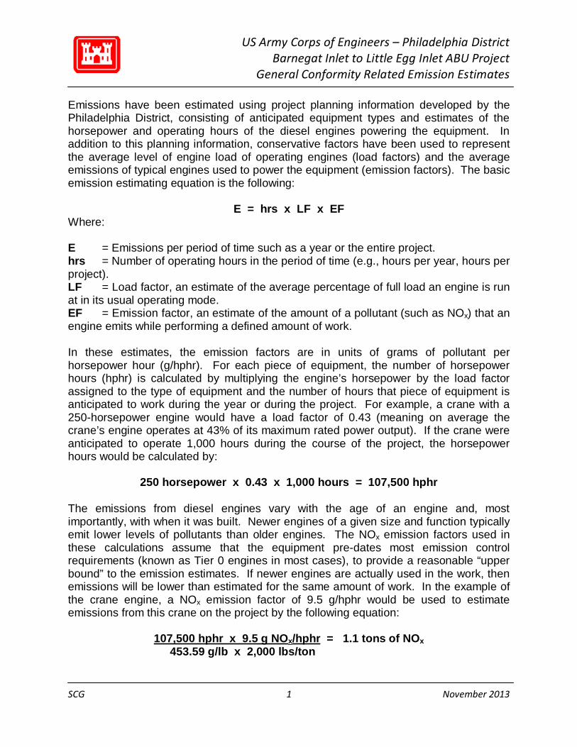
Emissions have been estimated using project planning information developed by the Philadelphia District, consisting of anticipated equipment types and estimates of the horsepower and operating hours of the diesel engines powering the equipment. In addition to this planning information, conservative factors have been used to represent the average level of engine load of operating engines (load factors) and the average emissions of typical engines used to power the equipment (emission factors). The basic emission estimating equation is the following:
E = hrs x LF x EF Where: E = Emissions per period of time such as a year or the entire project. hrs = Number of operating hours in the period of time (e.g., hours per year, hours per project). LF = Load factor, an estimate of the average percentage of full load an engine is run at in its usual operating mode. EF = Emission factor, an estimate of the amount of a pollutant (such as NOx) that an engine emits while performing a defined amount of work. In these estimates, the emission factors are in units of grams of pollutant per horsepower hour (g/hphr). For each piece of equipment, the number of horsepower hours (hphr) is calculated by multiplying the engine’s horsepower by the load factor assigned to the type of equipment and the number of hours that piece of equipment is anticipated to work during the year or during the project. For example, a crane with a 250-horsepower engine would have a load factor of 0.43 (meaning on average the crane’s engine operates at 43% of its maximum rated power output). If the crane were anticipated to operate 1,000 hours during the course of the project, the horsepower hours would be calculated by:
250 horsepower x 0.43 x 1,000 hours = 107,500 hphr The emissions from diesel engines vary with the age of an engine and, most importantly, with when it was built. Newer engines of a given size and function typically emit lower levels of pollutants than older engines. The NOx emission factors used in these calculations assume that the equipment pre-dates most emission control requirements (known as Tier 0 engines in most cases), to provide a reasonable “upper bound” to the emission estimates. If newer engines are actually used in the work, then emissions will be lower than estimated for the same amount of work. In the example of the crane engine, a NOx emission factor of 9.5 g/hphr would be used to estimate emissions from this crane on the project by the following equation:
107,500 hphr x 9.5 g NOx/hphr = 1.1 tons of NOx 453.59 g/lb x 2,000 lbs/ton
US Army Corps of Engineers – Philadelphia District Barnegat Inlet to Little Egg Inlet ABU Project
General Conformity Related Emission Estimates
SCG 2 November 2013
As noted above, information on the equipment types, horsepower, and hours of operation associated with the project have been obtained from the project’s plans and represent current best estimates of the equipment and work that will be required. Load factors have been obtained from various sources depending on the type of equipment. Marine engine load factors are primarily from a document associated with the New York and New Jersey Harbor Deepening Project (HDP): “Marine and Land-Based Mobile Source Emission Estimates for the Consolidated Schedule of 50-Foot Deepening Project, January 2004,” and from EPA’s 1998 Regulatory Impact Analysis (RIA): “EPA Regulatory Impact Analysis: Control of Commercial Marine Vessels.” Land-side nonroad equipment load factors are from the documentation for EPA’s NONROAD emission estimating model, “Median Life, Annual Activity, and Load Factor Values for Nonroad Engine Emissions Modeling, EPA420-P-04-005, April 2004.” Emission factors have also been sourced from a variety of documents and other sources depending on engine type and pollutant. The NOx emission factors for marine engines have been developed primarily from EPA documentation for the Category 1 and 2 standards (RIA, "Control of Emission from Marine Engines, November 1999) and are consistent with emission factors used in documenting emissions from the HDP, while the VOC emission factors for marine engines are from the Port Authority of New York and New Jersey’s “2010 Multi-Facility Emissions Inventory” which represent the range of marine engines operating in the New Jersey harbor and coastal region in terms of age and regulatory tier level. Nonroad equipment NOx emission factors have been derived from EPA emission standards and documentation, while the nonroad VOC emission factors have been based on EPA’s Diesel Emissions Quantifier (DEQ, accessed at: www.epa.gov/cleandiesel/quantifier/), run for moderately old equipment (model year 1995). On-road vehicle emission factors have also been developed from the DEQ, assuming a mixture of Class 8, Class 6, and Class 5 (the smallest covered by the DEQ) on-road trucks. As noted above, the emission factors have been chosen to be moderately conservative so as not to underestimate project emissions. Actual project emissions will be estimated and tracked during the course of the project and will be based on the characteristics and operating hours of the specific equipment chosen by the contractor to do the work. The following pages summarize the estimated emissions of pollutants relevant to General Conformity, NOx and VOC, in sum for the project and by calendar year based on the schedule information also presented (in terms of operating months per year). Following this summary information are project details including the anticipated equipment and engine information developed by the Philadelphia District, the load factors and emission factors as discussed above, and the estimated emissions for the project by piece of equipment.
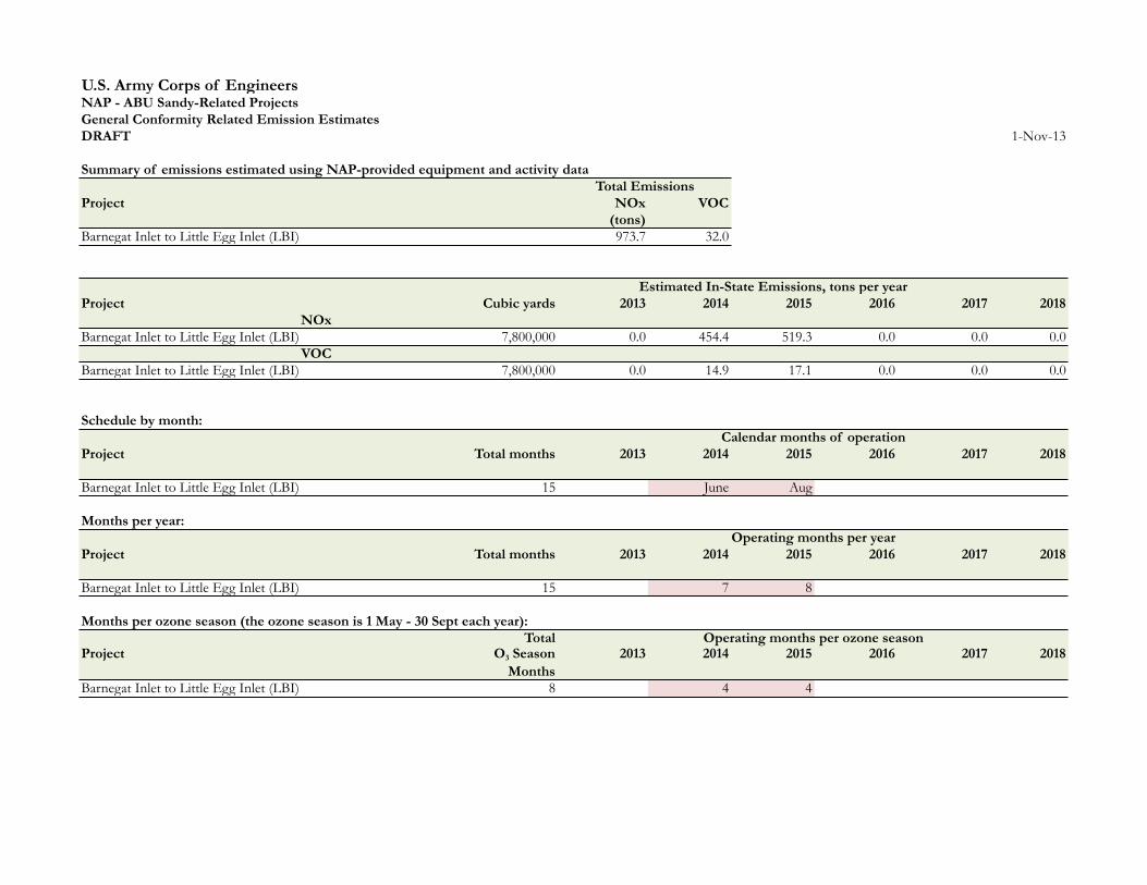
U.S. Army Corps of EngineersNAP - ABU Sandy-Related ProjectsGeneral Conformity Related Emission EstimatesDRAFT 1-Nov-13
Summary of emissions estimated using NAP-provided equipment and activity data
Project NOx VOC (tons)
Barnegat Inlet to Little Egg Inlet (LBI) 973.7 32.0
Estimated In-State Emissions, tons per yearProject Cubic yards 2013 2014 2015 2016 2017 2018
NOxBarnegat Inlet to Little Egg Inlet (LBI) 7,800,000 0.0 454.4 519.3 0.0 0.0 0.0
VOCBarnegat Inlet to Little Egg Inlet (LBI) 7,800,000 0.0 14.9 17.1 0.0 0.0 0.0
Schedule by month:
Project Total months 2013 2014 2015 2016 2017 2018
Barnegat Inlet to Little Egg Inlet (LBI) 15 June Aug
Months per year:
Project Total months 2013 2014 2015 2016 2017 2018
Barnegat Inlet to Little Egg Inlet (LBI) 15 7 8
Months per ozone season (the ozone season is 1 May - 30 Sept each year):Total
Project O3 Season 2013 2014 2015 2016 2017 2018Months
Barnegat Inlet to Little Egg Inlet (LBI) 8 4 4
Total Emissions
Calendar months of operation
Operating months per year
Operating months per ozone season
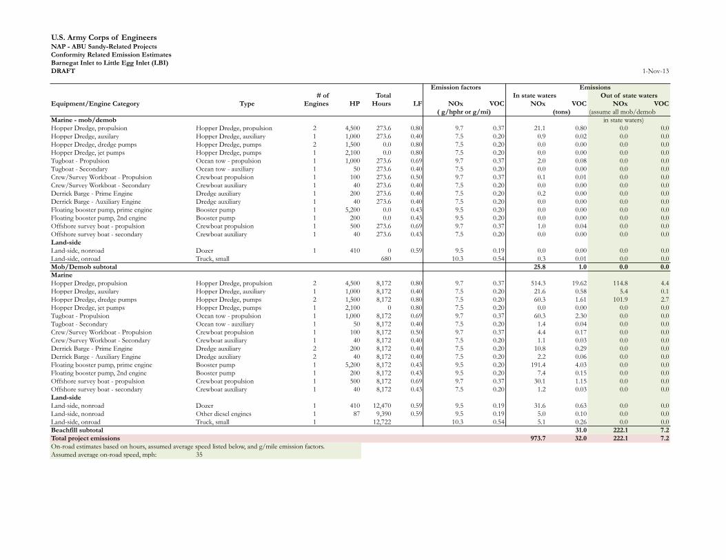
U.S. Army Corps of EngineersNAP - ABU Sandy-Related ProjectsConformity Related Emission EstimatesBarnegat Inlet to Little Egg Inlet (LBI)DRAFT 1-Nov-13
Emission factors Emissions# of Total In state waters
Equipment/Engine Category Type Engines HP Hours LF NOx VOC NOx VOC NOx VOC( g/hphr or g/mi) (tons) (assume all mob/demob
Marine - mob/demob in state waters)Hopper Dredge, propulsion Hopper Dredge, propulsion 2 4,500 273.6 0.80 9.7 0.37 21.1 0.80 0.0 0.0Hopper Dredge, auxilary Hopper Dredge, auxiliary 1 1,000 273.6 0.40 7.5 0.20 0.9 0.02 0.0 0.0Hopper Dredge, dredge pumps Hopper Dredge, pumps 2 1,500 0.0 0.80 7.5 0.20 0.0 0.00 0.0 0.0Hopper Dredge, jet pumps Hopper Dredge, pumps 1 2,100 0.0 0.80 7.5 0.20 0.0 0.00 0.0 0.0Tugboat - Propulsion Ocean tow - propulsion 1 1,000 273.6 0.69 9.7 0.37 2.0 0.08 0.0 0.0Tugboat - Secondary Ocean tow - auxiliary 1 50 273.6 0.40 7.5 0.20 0.0 0.00 0.0 0.0Crew/Survey Workboat - Propulsion Crewboat propulsion 1 100 273.6 0.50 9.7 0.37 0.1 0.01 0.0 0.0Crew/Survey Workboat - Secondary Crewboat auxiliary 1 40 273.6 0.40 7.5 0.20 0.0 0.00 0.0 0.0Derrick Barge - Prime Engine Dredge auxiliary 1 200 273.6 0.40 7.5 0.20 0.2 0.00 0.0 0.0Derrick Barge - Auxiliary Engine Dredge auxiliary 1 40 273.6 0.40 7.5 0.20 0.0 0.00 0.0 0.0Floating booster pump, prime engine Booster pump 1 5,200 0.0 0.43 9.5 0.20 0.0 0.00 0.0 0.0Floating booster pump, 2nd engine Booster pump 1 200 0.0 0.43 9.5 0.20 0.0 0.00 0.0 0.0Offshore survey boat - propulsion Crewboat propulsion 1 500 273.6 0.69 9.7 0.37 1.0 0.04 0.0 0.0Offshore survey boat - secondary Crewboat auxiliary 1 40 273.6 0.43 7.5 0.20 0.0 0.00 0.0 0.0Land-sideLand-side, nonroad Dozer 1 410 0 0.59 9.5 0.19 0.0 0.00 0.0 0.0Land-side, onroad Truck, small 680 10.3 0.54 0.3 0.01 0.0 0.0Mob/Demob subtotal 25.8 1.0 0.0 0.0MarineHopper Dredge, propulsion Hopper Dredge, propulsion 2 4,500 8,172 0.80 9.7 0.37 514.3 19.62 114.8 4.4Hopper Dredge, auxilary Hopper Dredge, auxiliary 1 1,000 8,172 0.40 7.5 0.20 21.6 0.58 5.4 0.1Hopper Dredge, dredge pumps Hopper Dredge, pumps 2 1,500 8,172 0.80 7.5 0.20 60.3 1.61 101.9 2.7Hopper Dredge, jet pumps Hopper Dredge, pumps 1 2,100 0 0.80 7.5 0.20 0.0 0.00 0.0 0.0Tugboat - Propulsion Ocean tow - propulsion 1 1,000 8,172 0.69 9.7 0.37 60.3 2.30 0.0 0.0Tugboat - Secondary Ocean tow - auxiliary 1 50 8,172 0.40 7.5 0.20 1.4 0.04 0.0 0.0Crew/Survey Workboat - Propulsion Crewboat propulsion 1 100 8,172 0.50 9.7 0.37 4.4 0.17 0.0 0.0Crew/Survey Workboat - Secondary Crewboat auxiliary 1 40 8,172 0.40 7.5 0.20 1.1 0.03 0.0 0.0Derrick Barge - Prime Engine Dredge auxiliary 2 200 8,172 0.40 7.5 0.20 10.8 0.29 0.0 0.0Derrick Barge - Auxiliary Engine Dredge auxiliary 2 40 8,172 0.40 7.5 0.20 2.2 0.06 0.0 0.0Floating booster pump, prime engine Booster pump 1 5,200 8,172 0.43 9.5 0.20 191.4 4.03 0.0 0.0Floating booster pump, 2nd engine Booster pump 1 200 8,172 0.43 9.5 0.20 7.4 0.15 0.0 0.0Offshore survey boat - propulsion Crewboat propulsion 1 500 8,172 0.69 9.7 0.37 30.1 1.15 0.0 0.0Offshore survey boat - secondary Crewboat auxiliary 1 40 8,172 0.43 7.5 0.20 1.2 0.03 0.0 0.0Land-sideLand-side, nonroad Dozer 1 410 12,470 0.59 9.5 0.19 31.6 0.63 0.0 0.0Land-side, nonroad Other diesel engines 1 87 9,390 0.59 9.5 0.19 5.0 0.10 0.0 0.0Land-side, onroad Truck, small 1 12,722 10.3 0.54 5.1 0.26 0.0 0.0Beachfill subtotal 31.0 222.1 7.2Total project emissions 973.7 32.0 222.1 7.2On-road estimates based on hours, assumed average speed listed below, and g/mile emission factors. Assumed average on-road speed, mph: 35
Out of state waters

U.S. Army Corps of EngineersNAP - ABU Sandy-Related ProjectsConformity Related Emission EstimatesFactors used in these project calculationsDRAFT 1-Nov-13
Load Factors / Emission Factors - Marine Load Factors / Emission Factors - Land-sideEmission factors, g/hphr Emission factors, g/hphr
Marine Engines Load Factor NOx VOCs Equip Types Load Factor NOx VOCsBlast barge - auxiliary 0.40 7.50 0.20 Backhoe 0.21 9.50 0.19Blast barge - compressor 0.43 7.50 0.20 Booster pump 0.43 9.50 0.19Booster pump 0.43 9.50 0.20 Compactor 0.59 9.50 0.19Clamshell - conventional 0.43 9.70 0.20 Compressor 0.43 9.50 0.19Clamshell - diesel electric 0.43 9.70 0.20 Concrete saw 0.59 9.50 0.19Crewboat auxiliary 0.40 7.5 0.20 Conveyor 0.43 9.50 0.19Crewboat propulsion 0.50 9.70 0.37 Crane 0.43 9.50 0.19Dredge auxiliary 0.40 7.50 0.20 Crawler tractor 0.21 9.50 0.19Excavator - conventional 0.59 9.70 0.20 Dozer 0.59 9.50 0.19Excavator - diesel hydraulic 0.59 9.70 0.20 Drilling rig 0.43 9.50 0.19Hopper Dredge, auxiliary 0.40 7.50 0.20 Excavator 0.59 9.50 0.19Hopper Dredge, compressor 0.80 7.50 0.20 Forklift 0.59 9.50 0.19Hopper Dredge, propulsion 0.66 9.70 0.37 Generator 0.43 9.50 0.19Hopper Dredge, pumps 0.80 7.50 0.20 Grader 0.59 9.50 0.19Hydraulic Pipeline Dredge - Main Pump 0.80 9.70 0.20 Light plants 0.43 9.50 0.19Hydraulic Pipeline Dredge - Secondary 0.43 7.50 0.20 Off-road truck 0.59 9.50 0.19Hydraulic Pipeline Dredge - El. Generator 0.43 7.50 0.20 Other diesel engines 0.57 9.50 0.19Ocean tow - auxiliary 0.40 7.5 0.20 Pump 0.43 9.50 0.19Ocean tow - propulsion 0.69 9.70 0.37 Rubber tired loader 0.59 9.50 0.19Other diesel engines 0.75 11.00 0.20 Screen 0.43 9.50 0.19Tender auxiliary 0.40 7.5 0.20 Skid Steer Loader 0.21 9.50 0.19Tender propulsion 0.69 9.70 0.37 Winch 0.43 9.50 0.19
Emission factor source: EPA emission standards (NOx); PANYNJ air emissions inventory (VOCs)2010 PANYNJ Emissions Inventory, marine vessel emisison factors used as a reasonable surrogate for the variety of vessels in use in the New York/New Jersey area in the absence of specific information regarding the vessels to be used on any specific project.
2010 PANYNJ Emissions Inventory VOC On-road emission factorsPropulsion (g/kWhr) Table 5.35 0.50 DEQ results (using MOVES)Propulsion (g/hphr) 0.37 Short Haul | Class 6 (19,501-26,000 lbs); Run with defaults, 2004 MY assumed, CY 2015, 1 truckAuxiliary (g/kWhr) Table 5.35 0.27 Short Haul | Class 8a (33,001-60,000); Run with Class 7 defaults (no Cl 8 short haul), 2004 MY assumed, CY 2015Auxiliary (g/hphr) 0.2 Short Haul | Class 5 (16,001-19,500 lbs); Run as closest to 8,600-lb vehicle available in DEQ, 2005 MY, 2015 CY
Truck type miles gallons NOx VOC*Off-road: DEQ results for representative 600 hp crawler tractor (MY 1995) Short Haul | Class 6 45,149 5,526 tpy 0.4061 0.038Default hrs/year: 936 g/mi 8.16 0.764Horsepower: 600 Short Haul | Class 8a 45,149 6,060 tpy 0.5334 0.033Emissions, short tons per year: 0.1925 g/mi 10.72 0.669Estimated EF, g/hphr:* 0.183 Short Haul | Class 5 19,610 2,448 tpy 0.2232 0.012Conversion factor, VOC/THC 1.053 g/mi 10.33 0.536Estimated VOC EF, g/hphr: 0.19 * Hydrocarbons provided by DEQ converted to VOC* Hydrocarbons provided by DEQ converted to VOCAssumed LF for off-road: 0.59 (from PANYNJ Emissions Inventory) Lookup table for emission estimating equations:Conversion factor 0.7457 kW/hp Emission factors, g/mile
g/kWhr x kW/hp = g/hphr NOx VOC*Truck, large 10.72 0.67Truck, medium 8.16 0.76Truck, small 10.33 0.54
REPLY TO ATTENTION OF
CENAP-PL-E
DEPARTMENT OF THE ARMY PHILADELPHIA DISTRICT, CORPS OF ENGINEERS WANAMAKER BUILDING, 100 PENN SQUARE EAST
PHILADELPHIA, PENNSYLVANIA 19107-3391
United States Army Corps of Engineers, Philadelphia District FINAL General Conformity Determination Notice
On October 30, 2012, New York State (DR-4085) and New Jersey State (DR-4086) declared Super Storm Sandy a Major Disaster. In response to the unprecedented breadth and scope of the damages sustained along the New York and New Jersey coastlines, the U.S. Congress passed Public Law (PL) 113-2 "Disaster Relief Appropriations Act 2013", also known as House Resolution (H.R.) 152-2 Title II which was signed into law on January 29, 2013. PL 113-2, which states ''That the amounts ... are designated by the Congress as being for an emergency requirement pursuant to section 251 (b)(2)(A)(i) of the Balanced Budget and Emergency Deficit Control Act of 1985", provides funding for numerous projects to repair, restore and fortify the coastline in both states as a result of the continuing emergency as people and property along the coast remain in a vulnerable condition until the coastline is restored and fortified. To this end, New Jersey Governor Christie signed Executive Order No. 140 on September 25, 2013, which authorized the means for the State to acquire all lands outside the State's ownership needed to ensure the sustainability of its coastline, and improve safeguards to diminish the impacts of future storm events, including flood protection for coastal communities that were impacted by the storm. To protect the investments by the Federal, State, local governments and individuals to rebuild damaged sites, it is imperative that these emergency disaster relief projects proceed as expeditiously as possible.
There are a number of coastal projects that were previously proposed and authorized but unconstructed (ABU). The Barnegat Inlet to Little Egg Harbor Inlet (Long Beach Island) [WRDA 2000, Title 1, §1 01 a (1)] project is an ABU project that is anticipated to start construction after April 2014 and this document represents the General Conformity Determination required under 40CFR§93.154 by the United States Army Corps of Engineers (USAGE). USAGE is the lead Federal agency that will contract, oversee, approve, and fund the project's work, and thus is responsible for making the General Conformity determination for this project.
USAGE has coordinated this determination with the New Jersey Department of Environmental Protection (NJDEP) [see NJDEP letter provided as Attachment A]. The Philadelphia-Wilmington-Atlantic City PA-New Jersey-Maryland-Delaware nonattainment area is currently classified as "marginal" non attainment for the 2008 8-hour ozone standard. Ozone is controlled through the regulation of its precursor emissions, which include oxides of nitrogen (NOx) and volatile organic compounds (VOCs).
The equipment associated with this project that is evaluated under General Conformity (40CFR§93.153) includes direct and indirect nonroad diesel sources, such as dredging equipment and land based earth-moving equipment. The primary precursor of concern with this type of equipment is NOx, as VOCs are generated at a significantly lower rate. The NOx emissions associated with the project are estimated to range from 455 to 520 tons per calendar year for 2014 and 2015 respectively (see emissions estimates provided as Attachment B). The project exceeds the NOx trigger level of 100 tons in any calendar year and as a result, the USAGE is required to fully offset the emissions of this project. The project does not exceed the VOC trigger level of 50 tons in any calendar year.
USAGE is committed to fully offsetting the emissions generated as a result of the disaster relief coastal work associated with this project. USAGE recognizes that the feasibility and cost-effectiveness of each offset option is influenced by whether the emission reductions can be achieved without introducing delay to the construction schedule that would prevent timely disaster relief.
USAGE will demonstrate conformity with the New Jersey State Implementation Plan by utilizing the emission offset options listed below. The demonstration can consist of any combination of options, and is not required to include all or any single options to meet conformity. The options for meeting general conformity requirements include the following:
a. Emission reductions from project and/or non-project related sources in an appropriately close vicinity to the project location. In assessing the potential impact of this offset option on the construction schedule, USAGE recognizes the possibility of lengthening the time period in which offsets can be generated as appropriate and allowable under the general conformity rule (40CFR§93.163 and §93.165).
b. Use of a portion of the Department of Defense Joint Base McGuire and Lakehurst State Implementation Plan emissions budget, as determined by the NJDEP, and in coordination with the United States Environmental Protection Agency (EPA).
c. Use of Clean Air Interstate Rule (CAIR) ozone season NOx Allowances with a distance ratio applied to allowances, similar to the one used by stationary sources found at N.J.A.C 7:27-18.5(c) Table 2.
d. Use of Surplus NOx Emission Offsets (SNEOs) generated under the Harbor Deepening Project (HOP). As part of the mitigation of the HOP, USAGE and the Port Authority of New York & New Jersey developed emission reduction programs coordinated through the Regional Air Team (RAT). The RAT is comprised of the USAGE, NJDEP, EPA, New York State Department of Environmental Conservation, and other stakeholders. SNEOs will be applied in concurrence with the agreed upon SNEO Protocols to ensure the offsets are real, surplus, and not double counted.
Due to unpredictable nature of dredge-related construction and the preliminary estimates of sand required to restore the integrity of the coastlines, the project emissions will be monitored as appropriate and regularly reported to the RAT to assist the USAGE in ensuring that the project is fully offset.
In summary, USAGE will achieve conformity for NOx using the options outlined above, as coordinated with the NJDEP and coordinated through the RAT.
Date Jo n C. BeckJng, P.E. Lieutenant Colonel, Corps of Engineers District Engineer

APPENDIX C
Correspondence

Post-1999 EIS Natural Resource Agency Coordination Letters
24 September 1999 PCOE letter to NMFS: Response to NMFS recommendations to eliminate borrow
areas B and E from the selected plan and provide an EFH assessment.
13 January 2000 USFWS letter to PCOE: providing recommendations to minimize impacts: eliminate
Borrow Areas B and E, avoid creation of deep pits, rotational dredging, and avoid shellfish and finfish
spawning areas.
27 June 2000: NMFS letter to PCOE: providing conservation recommendations for EFH. Identify Borrow
Areas A, D1, and D2 and recommend monitoring.
10 April 2001: PCOE letter to USFWS: submittal of Programmatic Biological Assessment.
27 December 2005: USFWS letter to PCOE: Final Programmatic Biological Opinion from USFWS.
11 October 2006 USFWS letter to PCOE: ESA coordination and response to streamlined (Tier 2)
consultation. Requesting documentation notifying affected municipalities to provide site specific Beach
Management Plans.
19 September 2006 PCOE letter to USFWS: Requesting streamline (Tier 2) consultation for Surf City.
1 February 2007 PCOE letter to USFWS: ESA coordination to confirm non-discretionary obligation to
ensure municipality responsibility for beach management planning.
27 February 2007 USFWS letter to PCOE: Response to formal (ESA) consultation request for Surf City.
18 August 2008 PCOE letter to USFWS: Requesting streamlined (Tier 2) consultation (ESA) for Harvey
Cedars.
6 October 2008 USFWS letter to PCOE: Response to ESA consultation for Harvey Cedars.
19 April 2010 NMFS letter to PCOE: EFH assessment review. Identify impacts to summer flounder EFH at
Borrow Area A. FWCA coordination suggesting seasonal restrictions for inlet dredging.
9 June 2010 PCOE letter to NMFS: ESA coordination and hopper dredge observer waiver request using
Discarded Military Munitions screens.
18 January 2011 PCOE letter to USFWS: Requesting streamlined Tier 2 consultation for Surf City.
9 June 2011 USFWS letter to PCOE: Provides Tier 2 consultation for Surf City.
6 July 2011 PCOE letter to USFWS: Requesting streamlined Tier 2 consultation for Brant Beach.
19 March 2012 USFES letter to PCOE: ESA coordination letter with suggested recommendations for
seabeach amaranth.

20 September 2012 PCOE letter to NMFS: Notification of BOEM serving as a cooperative agency and
request any comments/concerns relevant to offshore borrow areas.
20 September 2012 PCOE letter to USFWS: Notification of BOEM serving as a cooperative agency and
request any comments/concerns relevant to offshore borrow areas.
6 February 2013 PCOE letter to USFWS: Requesting streamlined Tier 2 consultation for Harvey Cedars,
Surf City, and Brant Beach.
28 February 2013 USFWS letter to PCOE: Response for Tier 2 streamlined consultation for Harvey
Cedars, Surf City, and Brant Beach.
6 August 2013 PCOE letter to NMFS: notification of plan to complete construction at remaining beaches
under the Disaster Relief Appropriations Act; ESA and EFH coordination; and names BOEM as
cooperating agency.
8 August 2013 PCOE letter to USFWS: Requesting consultation for Long Beach Township, Ship Bottom
Borough, and Beach Haven Borough.
29 August 2013 USFWS letter to PCOE: Response for Tier 2 streamlined consultation for renourishment
of Long Beach Township, Ship Bottom Borough, and Beach Haven Borough.


DEPARTMENT OF ThIE ARMYPHILA,DELPI.IIA DISTRICT, CORPS OF EI.IGINEERS
WANAMAKER BUILDING, 1OO PENN SQUARE EASTPHILADELPHIA, PENNSYLVANIA 1 91 07.3390
REPLY TO '
ATIENTION OF
Environmental Resources Branch
Mr. Eric Davis, SupervisorU.S. Fish and Wildlife Service927 North Main Street, Bldg DPleasantville, New Jersey 08232
F t B 0 6?0t3
Dear Mr. Davis.
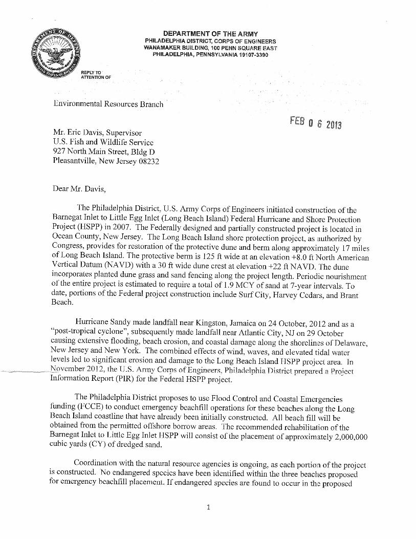
The Philadelphia District, U.S. Army Corps of Engineers initiated constnrction of theBarnegat Inlet to Little Egg Inlet (Long Beach Island) Federal Hurricane and Shgre protectionProject (HSPP) in2007. The Federally designed and partially constructed project is located inOcean County, New Jersey. The Long Beach Island shore protection project, as authorizedbyCongress, provides for restoration of the protective dune and berm along approximat ely 17 -i1.,of Long Beach Island. The protective berm is 125 ft wide at an elevation +g.0 ft l{orth Americanvertical Datum (NIAVD) with a 30 ft wide dune crest at elevation +22 ftNAVD. The duneincorporates planted dune grass and sand fencing along the project length. periodic nourishmentof the entire project is estimated to require atotalof 1.9 VCV of sand ut7-y"u, i'tervals. Todate, portions of the Federal project construction include Surf City, Harvey Ceda:s, and BrantBeach.
Hurricane Sandy made landfall near Kingston, Jamaica on24 October, 2012 and as a"post-tropical cyclone", subsequently made landfall near Atlantic City, NJ on 29 Octobercausing extensive flooding, beach erosion, and coastal damage along the shorelin,es of Delaware,New Jersey and New York. The combined effects of wind, waves, and elevated tidal waterlevels led to significant erosion and damage to the Long Beach Island HSPP projt:ct area. In\ovember 2012- the IJ.S. Atmy Coqn-s of Engineers, Philaclelphia District prepare:cl a projectInformation Report (PIR) for the Federal HSpp project.
The Philadelphia District proposes to use Flood Control and Coastal Emergenciesfunding (FCCE) to conduct emergency beachfill operations for these beaches alorrg the LongBeach Island coastline that have akeady been initially constructed. All beach fill will beobtained from the permitted offshore borrow areas. The recommended rehabilitalion of theBarnegat Inlet to Little Egg Inlet HSPP will consist of the placement of approximately 2,000,000cubic yards (CY) of dredged sand.
Coordination with the natural resource agencies is ongoing, as each portion of the projectis constructed' No endangered species have been identified within the three beaches ptopor"-dfor emergency beachfill placement. If endangered species are found to occur in th,e proposed
placement areas, the construction schedule would adhere to any established envir.onmentalwindows through coordination with your office.
Subsequent to completion of the Environmental Impact Statement and perrmiuingprocess, the Atlantic sturgeon (Acipenser oxyrinchus oxyrinchus) was added to t6e endangeredspecies list by the National Marine Fisheries Service in April 2012. The PhiladeJphia Districtwill be undergoing a formal Section 7 consultation with NMFS, and is preparing a programmaticbiological assessment (BA) for all District coastai projects. However, if foimat cgnsultation isnot completed in time for the beach repairs, informal consultation will be conducted in theinterimto insure compliance with the Endangered Species Act. The Coastal Zoner ConsistencyDetermination and Water Quality Certificate (WQC) were issued 15 June 2000 and 20 July2006. The borrow site(s), quantity, and work will fall within the scope of that authorized by theWQC.
In accordance with procedures outlined in the Biological Opinion on the liffects ofFederal Beach Nourishment Activities Along the Atlantic Coast of Ne* Jersey within the U.S,Army Corps of Engineers, Philadelphia District on the Piping Plover (Charadrius melodus) andSeabeach Amaranth (Amaranthus pumilus), this letter serves to request initiation of streamlined(Tier 2) formal consultation under Section 7 of the Endangered Speiies Act of lg73 (g7 StaI.884; 16 U.S.C. 1531 et seq.) with regard to the proposed beach nourishment activities at theabove-mentioned areas. A review of historical nesting information indicates thal the projectareas have not been utilized by nesting piping plovers in over 15 years and no seabeach amaranthplants have been observed within or in the immediate vicinity of the proposed placement areas.Based on the above information, and the factthatthe Corps will follow aoy conr.rvationmeasures proposed in our Biological Assessment necessary to protect any listed slpecies thatmayoccur in the project areas, and the reasonable and prudent measures outlined in thi: Service'sBiological Opinion, we have concluded that the proposed beach fill plan is not likely to directlyimpact piping plover or seabeach amaranth through burial or habitat alteration. Tlhese impacts,including potential indirect, secondary, and cumulative impacts, have been fully covered in theBiological Opinion, and are "not likely to adversely affect" either species. Theiefbre, we believethat the consultation for the emergency rehabilitation of these portions of the previouslyconstructed project can be concluded through informal consultation.
.p,opo,.t:HJ:ff ;ff#';ffi :Jtr.lHl",TTffi :ifffi H:1""il::t#.;::H:,i[anticipate that the Service's response will conclude the Section 7 consultation pro,;ess for thisphase of the project. We appreciate your attention in this matter. If you have any questions orrequire additional information, please contact Ms. Barbara Conlin of our EnvironmlntalResources Branch at (215\ 656-6557.
Sincerely,
IMCharles MaclntoshActing Chief of Planning
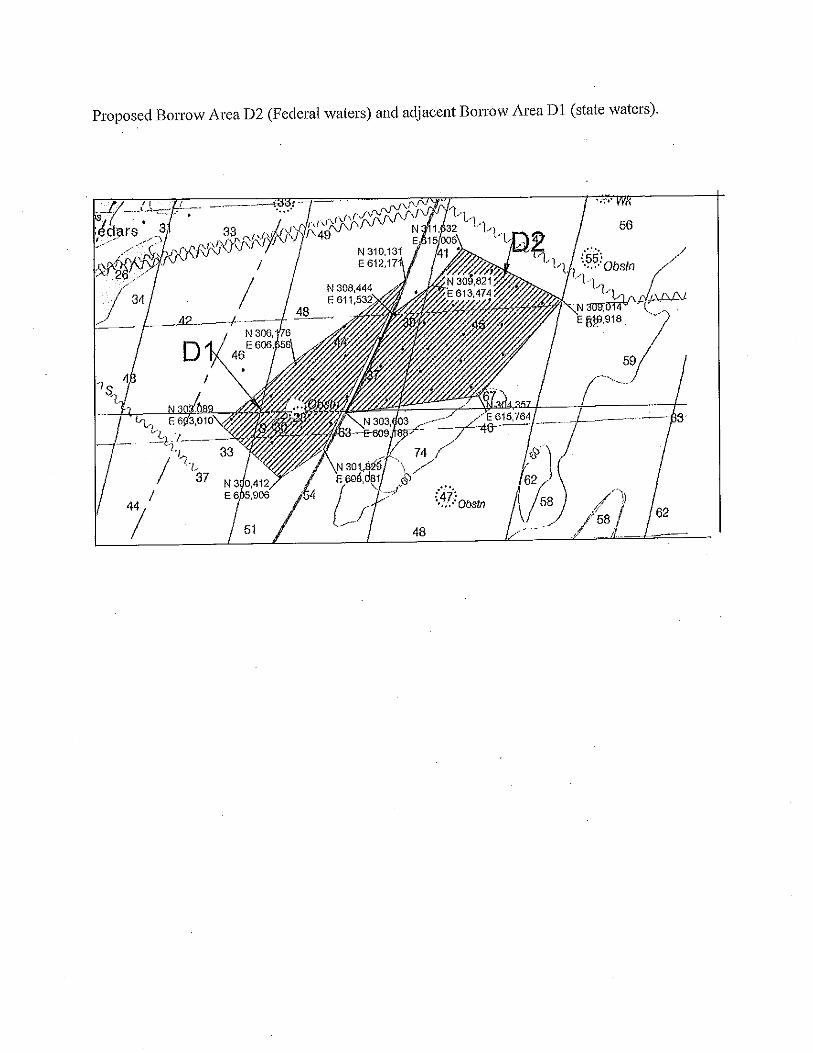


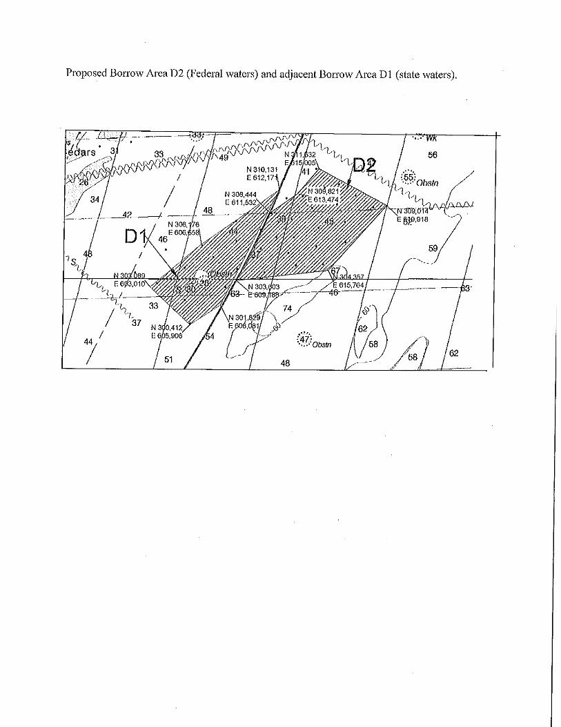
UNITED STATES DEPARTMENT OF COMMERCENational Oceanic and Atmospheric AdministrationNATIONAL MARINE FISHERIES SERVICENORTHEAST REGION55 Great Republic Dr¡veGlouceste( MA 01 930-2276
Peter Blum, Chief DEc 23 2ol3
Planning DivisionPhiladelphia DistrictU.S. Army Corps of Engineers'Wanamaker Building100 Penn Square EastPhiladelphia, PA 19107 -3390
ATTN: Barbara Conlin, Project BiologistRE: Draft Environmental Assessment, Barnegat Inlet to Little Egg Inlet (Long Beach Island)
Storm Damage Reduction Project
Dear Mr. Blum:
'We have reviewed the draft environmental assessment (DEA) for the Barnegat Inlet to Little Egg
Inlet Storm Damage Reduction Project dated November 2013. The 5O-year plan selected byyour agency involves the placement approximately 7.4 million cubic yards (cy) of sand alongapproximately 17 miles of coastline from Bamegat Inlet to Little Egg Inlet, including 4.95
million cy for the initial berm placement and 2.45 million cy for the dune placement. The 1999
Final Feasibility Report and Integrated Environmentql Impact Statement (FS/EIS) estimated that1.9 million cy would be needed for periodic nourishment every seven years. Since 2006, youhave constructed 4.5 miles of the project within the municipalities of Surf City, Ship Bottom,Harvey Cedars and Brant Beach, New Jersey.
As you are aware, the Magnuson-Stevens Fishery Conservation and Management Act (MSA)and the Fish and Wildlife Coordination Act require Federal agencies to consult with one another
on projects such as this. Insofar as a project involves essential fish habitat (EFH), as this projectdoes, this process is guided by the requirements of our EFH regulation at 50 CFR 600.905,which mandates the preparation of EFH Assessments and generally outlines each agenciesobligations in this consultation procedure. We offer the following comments andrecommendations on this project pursuant to the above referenced regulatory process.
General CommentsOver the past decade, we have provided you with comments on various documents and reportsprepared for this project. Most recently in April 2010, \À/e commented on EFH issues for the use
of borrow areas (Dl andD2) offshore of Long Beach Island and one just outside the BarnegatInlet (A). Only borrow area Dl, a 683-acre area centered approximately 2.5 miles off HarveyCedars, has been used in the partial construction of the project to date. The purpose of thisenvironmental assessment is to evaluate your proposed expansion of borrow area D2, as well as
any new information that has become available since the completion of the FSA/EIS in 1999,
According to the DEA, there are no economically viable land-based sources of sand for the largequantities of beach f,rll required. Consequently, the 1999 FS/EIS evaluated a number of offshoreborrow areas to supply the sand for this project. At that time, several borrow areas wereexcluded from consideration due to environmental concems, proximity to trans-Atlanticcommunication cables, and incompatible materials. The 1999 plan proposed the use of borrowareas A, B, D1 and E located offshore of Long Beach Island. Subsequently, borrow areas B andE were eliminated from consideration because they were identified as Prime Fishing Areas underNew Jersey's Rules on Coastal ZoneManagement (N.J.A.C 7'.7F,, as amended July 18, 1994).Borrow area A was eliminated due its grain size compatibility and the potential effects on thelongshore sediment transport. To offset the loss of material due to the elimination of these sandsources, you have identified a 572- acÍe area directly east of Dl, designated asD2, and a 542-acre area southeast of D2, designated as D3 as borrow areas for this project. Followingadditional geotechnical and geophysical sampling, D2 and D3 have been combined into a 1043-acre area now known as D2. This area is located with the Outer Continental Shelf (OSC) and isunder the jurisdiction of the Bureau of Ocean Energy Management (BOEM).
Magnuson Stevens Act (MSA)The dredging of sand for beach nourishment has the potential to impact both the EFH of aparticular species as well as the organisms themselves in a variety of ways. Dredging candamage fishery resources and their habitats through direct impingement of eggs and larvae,through the creation of undesirable suspended sediment levels in the water column, and throughdeposition of sediments on immobile eggs and early life stages. Such suspended sediment levelscan also reduce dissolved oxygen, can mask pheromones used by migratory fishes, and cansmother immobile benthic organisms and newly-settled juvenile demersal fish (Auld andSchubel 1978; Breitburg 1988; Newcombe and MacDonald 1991; Burton 1993;Nelson andWheeler I99l). Sustained water column turbulence can reduce the feeding success of sight-feeding fish such as winter flounder, tautog, and summer flounder. According to OlIa et al.(1974 and 1975 in Collette and Klein-MacPhee 2002), tautog are opportunistic sight feeders.Winter flounder are also sight feeders and are diurnally active in both inshore and offshorewaters (Pearcy 1962 in Collette and Klein-MacPhee 2002).
Dredging can also remove the substrate used by federally managed species as spawning, refugeand forage habitat. Benthic organisms that are food sources for federally managed species mayalso be removed during the dredging. These impacts may be temporary in nature if the substrateconditions return to preconstruction condition and benthic community recovers with the same orsimilar organisms. The impacts may be permanent if the substrate is altered in a way thatreduces its suitability as habitat, if the benthic community is altered in a way that reduces itssuitability as forage habitat or if the dredging occurs so often that the area does not have time torecover.
The EFH assessment included in the DEA evaluates many of the potential impacts to EFH andfederally managed species. Overall, the dredging and placement of sand along the coastline willhave an adverse effect on EFH and some federally managed species due to the entrainment ofearly life stages in the dredge, alteration or loss ofbenthic habitat and forage species, and altered
forage pattems and success due to increased, noise, turbidity and sedimentation, 'We agree that
some effects will be temporary. However, there are several potential adverse effects that are notevaluated adequately in the EFH assessment including the long-term or permanent alteration ofthe sediment characteristics and topography of the borrow area, andthe individual andcumulative effects to surf clams and their EFH,
The mining of sand from the borrow areas may change the geomorphic characteristics of theborrow area. Offshore shoals, including Dl,D2, and others typically targeted for use as sandborrow areas are irreplaceable geologic features ofthe near shore continental shelf. Shoals aredynamic features that diversify the sea floor, producing a variety of substrate types and foragingopportunities for hnfish and epibenthic fauna. These areas also serve as congregating featurðs fãrfinfish and provide guiding features for coastal migratory species. In past diicussions on thisproject, we have highlighted the importance of the shoals and the need to maintain the area'sgeomorphic integrity. In the original EFH assessment prepared for this project and datedSeptember 24,1999, you stated the dredging operations were designed to mitigate for impactsand to enhance the bottom topography by creating ridges. However, no data hãs been ptoiid.d toshow that this has been done, and anecdotal information from f,rsherman suggests that shoalhabitat in the region has been significantly impacted.
We are also concerned about the potential permanent alteration of the sediment characteristics inthe borrow area. According to the DEA, the use of munitions screens on the dredge intakes toprevent discarded military munitions from being deposited in the beaches, has resulted in borrowarea Dl becoming armored with pebbles, stones and hardened biological materials (i.e.,crustacean, mulluscan shells, etc.) that are larger than the diameter of the screens. This alterationof the sediment characteristics may result in permanent or long-term effects on EFH andfederally managed species that were not considered in the EFH assessment. To determine if anylong-term adverse effects have occurred, you should conduct sampling of the borrow areaaregular intervals to monitor sediment characteristics and use of the area by benthic organisms,including surf clams, as noted in our original January 2000 consultation on this projecl. As amonitoring plan has not been developed to date, we continue to recommend that you work withus and the New Jersey Department of Environmental Protection to develop an appropriatemonitoring plan. To more fully characterize the cumulative effects of the numerous beachnourishment projects you have in various stages plaruring and construction, the monitoringprogram should include all projects along New Jersey's Atlantic coast that are being planned,studied or under construction.
Over the 50-year life of the project, the EFH in the project area will be adversely affectednumerous times as each dredging and beach nourishment event occurs, Currentiy, there is noreporting of acres affected annually or notification to us when construction commences for eachproject segment or cycle. EFH designations may be modified, the status of a species' stock maychange in a manner that warrants additional management measures, or other néw informationmay become available that may change the basis of our EFH conservation recommendationsduring the life of this project. To ensure that we meet our joint responsibilities to protect,conserve and enhance EFH and minimize adverse effects to living marine resources and their

habitats, you should notify us prior to the commencement of each dredging event so that \ile mayconfirm that the EFH determinations and EFH conservation recommendations remain valid, anda full reinitiation of the EFH consultation is not required. This notification should be done priorto the solicitation of bids for the contract so suffrcient time is allowed for any recommendedmodifications to be including in the bid documents. It should also include the location of thesegment to be nourished, volumes of sand to be dredged, depth of sand to be removed and theboundaries of the dredging within the borrow area.
To track the cumulative effects of the project on EFH and to monitor the recovery of the borrowarea, bathymetric mapping of the borrow area should be provided to us following the completionof each dredging event to demonstrate that the dredge contractor has maintained the ridge andvalley structure of the borrow area as agreed to in our 1999 coordination on this project. Youshould also provide us with annual reporting of the acres of area dredging, volumes removed anddepth of removal so that the annual adverse effects to EFH can be quantihed.
Finally, we remain concemed about the direct and cumulative effects on surf clams and theirEFH. According to the EFH assessment, you have concluded that impacts to surf clams and surfclam EFH would be temporary, and that surf populations are expected to recover. However,from the information in the DEA, it does not appear that you plan to monitor or to demonstratethat recovery has occurred. As discussed above, the repeated dredging may alter the sedimentcharacteristics of the borrow area and change the topography in a manner that may make theborrow area less suitable as EFH for surf clams. To address this concem, we recommend thatyou include sampling of surf clam densities within the borrow area as part of the regionalmonitoring program discussed above. Current sampling data should be displayed on a map overthe borrow area. Depths and sediment data should be included on the map as well. A similarmap should be produced after each monitoring event. Areas of high densities of surf clamshould be avoided, such as the southern edge of D2.
Essential Fish Habitat Conservation RecommendationsPursuant to Section 305 (b) (4) (A) of the MSA, we recommend the following EFH conservationrecommendations be incorporated into the project:
1. Dredging should be designed and undertaken in a manner that maintains geomorphiccharacteristics of the shoals
Notification should be provided to our office prior to conìmencement of each dredgingevent. Annual reporting to our office should occur regarding acres of bonow area
disturbed, the location of the dredging, cubic yardage removed, depth of removal andpost-dredging bathymetry of the borrow area.
A regional monitoring program of all sand borrow sites should be developed to evaluate
recovery of benthic communities (including surf clams) and at all bonow areas used byyour agency, and,
J.
4. Areas of high surf clam densities, including the southern end of bonow area D2, shouldbe avoided
Please note that Section 305 (bX4XB) of the MSA requires you to provide us with a detailedwritten response to these EFH conservation recommendations, including the measures adoptedby you for avoiding, mitigating, or offsetting the impact of the project on EFH. In the case of aresponse that is inconsistent with our recommendations, Section 305 (b) (4) (B) of the MSA alsoindicates that you must explain its reasons for not following the recommendations. Included insuch reasoning would be the scientific justification for any disagreements with us over theanticipated effects of the proposed action and the measures needed to avoid, minimize, mitigateor offset such effect pursuant to 50 CFR 600.920 (k).
Please also note that a district and further EFH consultation must be reinitiated pursuant to 50CRF 600.920 C) if new information becomes available, or if the project is revised in such amanner that affects the basis for the above EFH conservation recommendations.
Endangered Species ActA number of federally listed threatened or endangered species under our jurisdiction are knownto occur in the vicinity of the project area. The species that are likely to be present includethreatened loggerhead (Caretta caretta) sea turtles as well as endangered Kemp's ridley(Lepidochelys kempi),leatherback (Dermochelys coriacea) and green (Chelonia mydas) seaturtles. In addition, threatened and endangered Atlantic sturgeon (Acipenser oxyrhynchusoxyrinchus) are known to occur within the nearshore, coastal waters of the Atlantic Ocean,primarily using these bodies of water throughout the year as a migratory pathway to and fromspawning, overwintering, and/or foraging grounds throughout their range.
The federally endangered North Atlantic right (Eubalaena glacialis), fin (Balaenopteraphysalus), and humpback whales (Megaptera novaeangliae) are found seasonally in the watersoff of New Jersey. North Atlantic right whales are likely to occur in the identified watersbetween November I and April 30. Humpback whales feed during the spring, summer, and fallover a range that encompasses the eastern coast of the United States. Fin whales may also bepresent off the coast of New Jersey year round. Sei (Balaenoptera borealis) and sperm (Phystermacrocephalus) whales may also be present in the deeper ofßhore waters. Humpback and finwhales have been observed off the coast of New Jersey.
Section 7 of the Endangered Species Act of 1973 (ESA), as amended requires federal agencies toconsult with us to ensure that any action authorized, funded, or carried out by such agency is notlikely to jeopardizethe continued existence of any endangered species or threatened species oradversely modify or destroy designated critical habitat. You have initiated coordination with ourProtected Resources Division (PRD) on this and other beach nourishment projects along the NewJersey coast. PRD is currently awaiting the receipt of a programmatic biological assessmentfrom your ofhce. Once the assessment is received, PRD will begin its review. If you have anyquestions regarding the section 7 process, or section 7 coordination, please contact Julie Crockerof our Protected Resources Division at (978)282-8480 or [email protected].
V/e look forward to continued coordination with your office on this project as it moves forward.If you have any questions or need additional information, please do not hesitate to contact KarenGreene at [email protected] or (732) 872-3023.
Assistant Regional Administratorfor Habitat Conservation
cc: NJDEP - Office of Dredging - S. DietrickBureau of Shellfisheries - J. Normant
FWS - Pleasantville- C.PopolizioEPA - Region II - D. MontellaMAFMCNEFMCASMFC
Literature Cited
Auld, A.H. and J.R. Schubel. 1978. Effects of suspended sediments on fish eggs and larvae: alaboratory assessment. Estuar. Coast. Mar. Sci. 6:153-164.
Breitburg, D.L. 1988. Effects of turbidity on prey consumption by striped bass larvae. Trans.Amer. Fish. Soc. lI7:72-77.
Burton, W.H. 1993. Effects of bucket dredging on water quality in the Delaware River and thepotential for effects on fisheries resources. Prepared for: Delaware Basin Fish and WildlifeManagement Cooperative, by Versar Inc, Columbia MD.
Collette, B.B. and G. Klein-MacPhee. eds. 2002. Bigelow and Schroeder's fishes of the Gulf ofMaine. Smithsonian Institution. V/ashington, D.C.
Nelson, D.A. and J.L. V/heel er. 1997 . The influence of dredging-induced turbidity andassociated contaminants upon hatching success and larval survival of winter flounder,Pleuronectes americanus, a laboratory study. Final report, Grant CWF #321-R, to ConnecticutDepartment Environmental Protection, by National Marine Fisheries Service, Milford CT.
Newcombe, C.P.and D.D. MacDonald.l99I. Effects of suspended sediments on aquaticecosystems. N. Amer. J. Fish. Manag. II:72-82.
Olla, B.L., A.J. Bejda, and A.D. Martin. 1974. Dailv activity, movements, feeding and seasonaloccuffence in tautog, Tautoga onitis. Fish, Bull. U.S. 72:27-35.
Olla,8.L., A.J. Bejda, and A.D. Martin. 1975. Activity, movements and feeding behavior of thecunner, Tautogoloabrus adspersLß ) and comparison of food habitats with young tautog, Tautogaonitis., off Long Island, New York. Fish. Bull. U.S. 73:895-900.
Pearcy, W.C.1962. Ecology of an estuarine population of winter flounder, Pseudopleuronectesamericanus (Walbaum). Bull. Bingham Oceanogr. Coll. l8(1):1-78.


United States Department of the InteriorFISH AND WILDLIFE SERVICE
New Jersey Field OfficeEcological Services
927 North Main Street, Building DPleasantville, New Jersey 08232
Tel: 609/646 9310Fax:609/646 0352
http : //www. fu s. go v/northeast/nj fi e ldoffice
Peter R. Blum, ChiefPlanning DivisionU.S. Army Corps of EngineersWanamaker Building100 Penn Square EastPhiladelphia, Pennsylvania 19107 -3390
Dear Mr. Blum:
JAN 0 7 2M4
The U.S. Fish and Wildlife Service (Service), New Jersey Field Office has reviewed the DraftEnvironmental Assessmentfor the Barnegat Inlet to Little Egg Inlet Storm Damage ReductionProiect presenting and evaluating new information pertaining to the U.S Army Corps ofEngineers' (Corps) 1999 Final Feasibility Report and Integrated Environmental ImpactStatement for the placement of beachfill sand within the 20-mile-long study area.
The Corps proposes to create a L2l-foot-wide beach berm at elevation +8.0 North AmericanVertical Datum (NAVD) and a dune at an elevation of +22 feet NAVD. The dune would be 30-feet wide at its crest and incorporate 347 acres of planted dune grasses and 540,000 linear feet ofsand fencing. For initial construction of the project, the Corps proposes to obtain approximately2.9 million cubic yards (mcy) from Borrow Area Dl and approximately 4.9 mcy from BorrowAreaD2. Borrow areas Dl andD2 are located in the Atlantic Ocean east of Surf City, NewJersey. The borrow areas are contiguous, with Dl within State Waters and D2 outside of StateWaters. About 2 mcy of sand will be required for periodic re-nourishment at 7 -year intervals foraperiod of50 years.
AUTHORITY
The following comments are provided pursuant to the National Environmental Policy Act (83Stat. 852:42 U.S.C. 4321 et seQ.), the Fish and Wildlife Coordination Act (48 Stat. 401; 16U.S.C. 661 et seq.), Section 7 of the Endangered Species Act of 1973 (57 Stat. 884, as amended;16 U.S.C. l53L et seq.), and the Migratory Bird Treaty Act of 1918 (40 Stat.755; 16 U.S.C. 703-712) as amended, ensuring the protection of federally listed endangered and threatened species,and migratory birds.
In Reply Refer To:t4-cPA-0071
FEDERALLY LISTED SPECIES
Piping Plover
The federally listed (threatened) piping plover (Charadrius melodus) in20l3 was documentednesting at Barnegat Light and within the Holgate Wilderness Area of the Edwin B. ForsytheNational Wildlife Refuge (Forsythe NWR). Barnegat Light has adequate dune and berm profilesand is not included in the project. The designation as wildemess requires the Forsythe NWR tomaintain the Holgate Unit in its natural state; therefore, it also is excluded from the project.
Piping plovers, as well as the State-listed least tern (Sterna antillarum) and black skimmer(Rhyncops niger), have not nested within the project area in recent years as the habitat is almostentirely unsuitable. The likelihood of nesting activity in the project area is very low. However,we cannot entirely rule out possible nesting if construction activity occurs during the breedingseason (March 15-August 3l). Rather than requiring the Corps to hire a biological constructionmonitor for any work during the breeding season under the protocol established by the Serviceand the New Jersey Endangered and Nongame Species Program (ENSP), we recommend that theCorps hire a monitor only if nesting activity is detected in20l4 during the initial re-nourishmentevent. If any nesting activity is detected, the Corps shall coordinate/consult with the Service andENSP to ensure adequate protection of piping plovers, least terns, and black skimmers.
Individual Tier 2 consultation with the Corps remains required prior to construction and for eachperiodic nourishment cycle. The Corps shall not rely on Service Tier 2letters for anynourishment cycle that is later cancelled, delayed, or otherwise modified, but shall rather re-submit updated project information to the Service for further individual Tier 2consultation.
Seabeach Amaranth
There are no records of the federally listed (threatened) seabeach amaranth (Amaranthuspumilus) occurring within the project area since 2002. It is very unlikely that seabeach amaranthwill occur in the project area in 2014but, if detected, we request that the Corps contact this officeto coordinate protective measures for this species.
OTHER COMMENTS AND RECOMMEI\DATIONS
As a condition for receiving Federal assistance for beach nourishment, all municipalities arerequired to develop a Beach Management Plan approved by the Service and the New JerseyDivision of Fish and Wildlife. At the moment, only Surf City and Harvey Cedars are the townswithin the project areathat have such plans.
The Corps shall require all municipalities within the study arcato coordinate with the Serviceand ENSP prior to placing sand fencing and planting dune-stabilizingnative vegetation followingeach re-nourishment event.

Finally, the Service concurs with the recommendations provided by the National MarineFisheries Service in their letter to the Corps dated December 23,2013. Please contact CarloPopolizio at (609) 383-3938, extension 32,if youhave any questions pertaining to thiscorrespondence.
Eric SchradingField Supervisor
Sincerely,
{/
/-

cc: [email protected]@dep. state. nj .us
NJFO:ES :cpopolizio :RP :ES:cap:l l2l | 4
P :/Shared/C arlo I | 4 -CPA-007 1