appendix a - amazon web services
TRANSCRIPT
FEMA 1763-DR-IA — Cedar Rapids Northwest Recreation Center Facility Draft Environmental Assessment – Appendix A
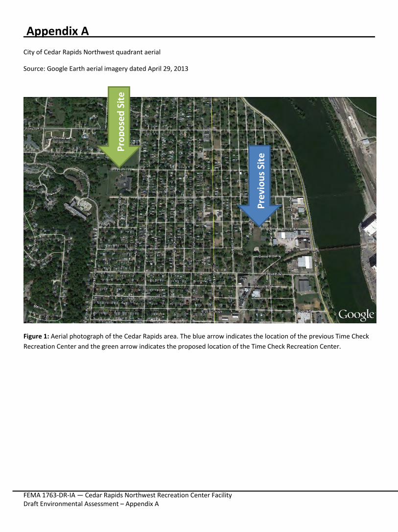
Appendix A City of Cedar Rapids Northwest quadrant aerial
Source: Google Earth aerial imagery dated April 29, 2013
Figure 1: Aerial photograph of the Cedar Rapids area. The blue arrow indicates the location of the previous Time Check Recreation Center and the green arrow indicates the proposed location of the Time Check Recreation Center.
Prop
osed
Site
Prev
ious
Site
FEMA 1763-DR-IA — Cedar Rapids Northwest Recreation Center Facility Draft Environmental Assessment – Appendix A
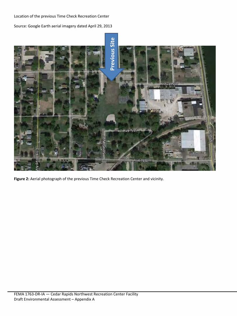
Location of the previous Time Check Recreation Center
Source: Google Earth aerial imagery dated April 29, 2013
Figure 2: Aerial photograph of the previous Time Check Recreation Center and vicinity.
Prev
ious
Site
FEMA 1763-DR-IA — Cedar Rapids Northwest Recreation Center Facility Draft Environmental Assessment – Appendix A
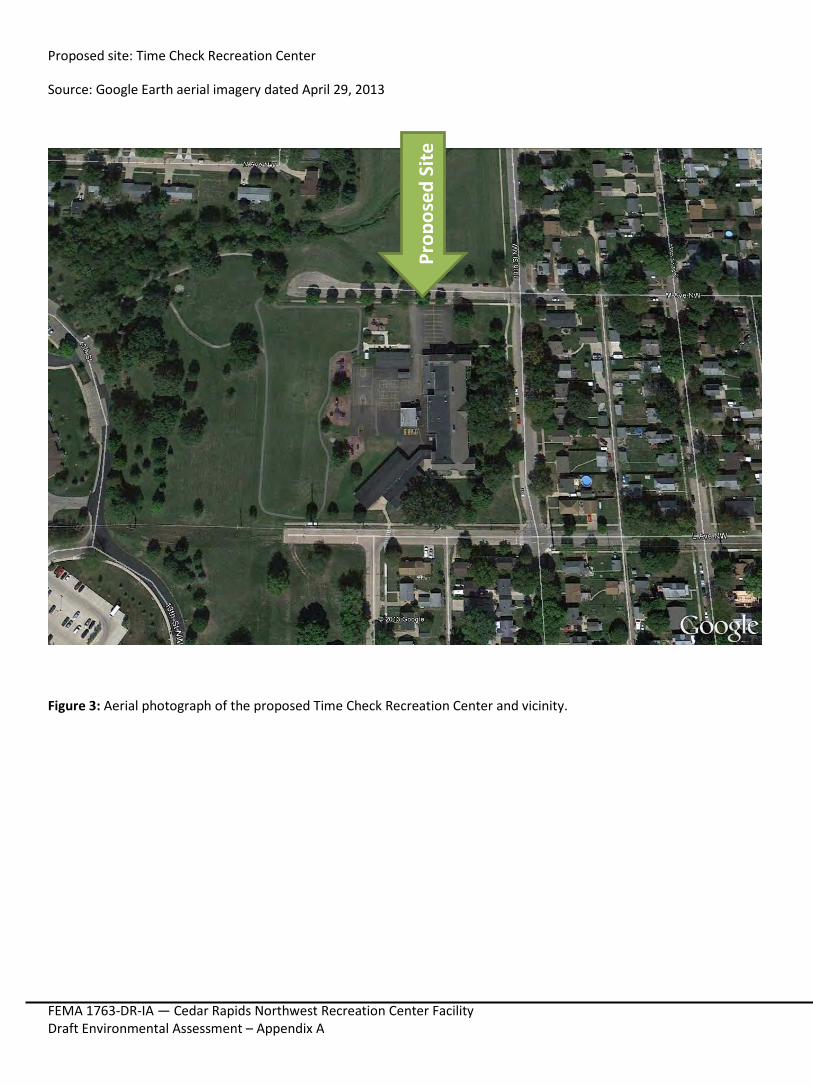
Proposed site: Time Check Recreation Center
Source: Google Earth aerial imagery dated April 29, 2013
Figure 3: Aerial photograph of the proposed Time Check Recreation Center and vicinity.
Prop
osed
Site
FEMA 1763-DR-IA — Cedar Rapids Northwest Recreation Center Facility Draft Environmental Assessment – Appendix A
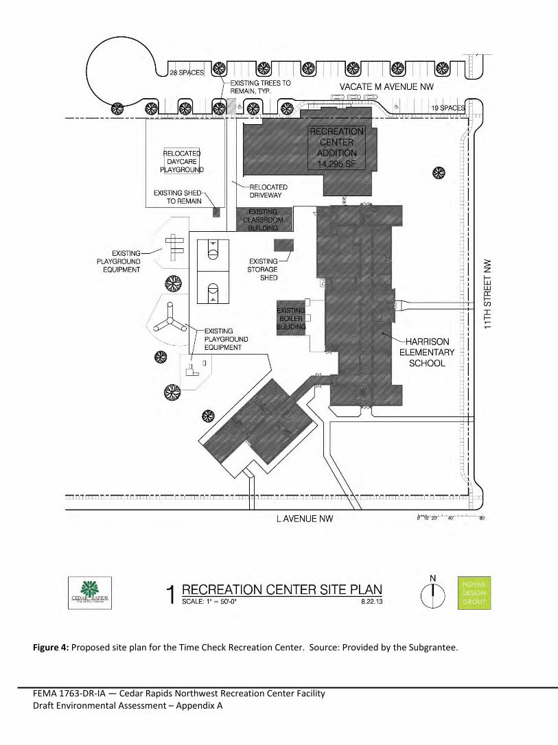
Figure 4: Proposed site plan for the Time Check Recreation Center. Source: Provided by the Subgrantee.
FEMA 1763-DR-IA — Cedar Rapids Northwest Recreation Center Facility Draft Environmental Assessment – Appendix A
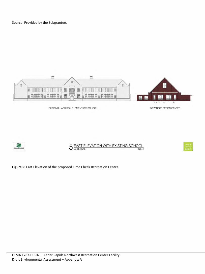
Source: Provided by the Subgrantee.
Figure 5: East Elevation of the proposed Time Check Recreation Center.
FEMA 1763-DR-IA — Cedar Rapids Northwest Recreation Center Facility Draft Environmental Assessment – Appendix A
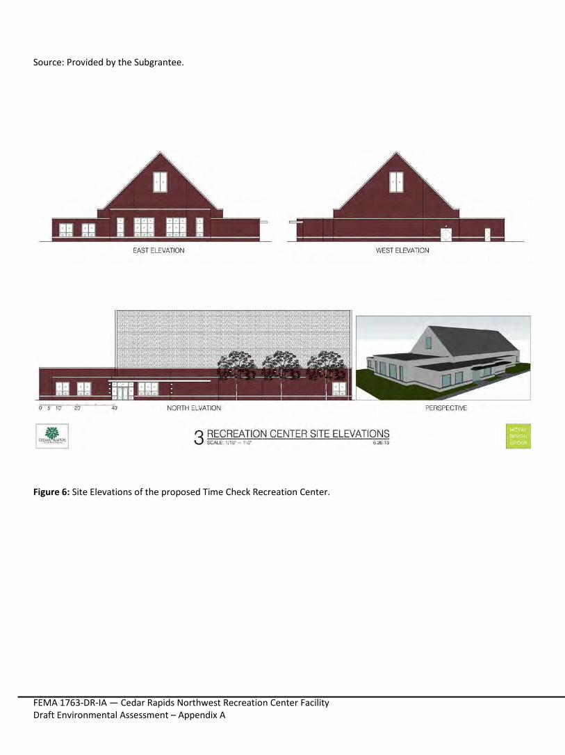
Source: Provided by the Subgrantee.
Figure 6: Site Elevations of the proposed Time Check Recreation Center.
FEMA 1763-DR-IA — Cedar Rapids Northwest Recreation Center Facility Draft Environmental Assessment – Appendix A
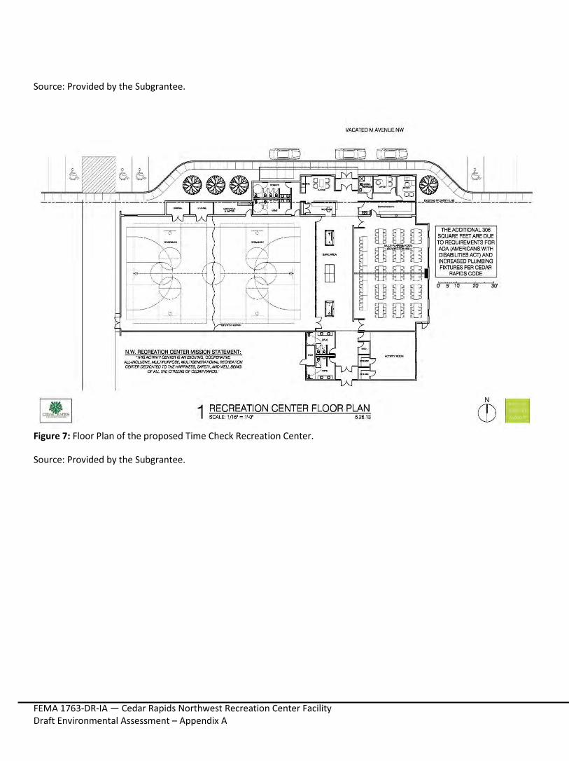
Source: Provided by the Subgrantee.
Figure 7: Floor Plan of the proposed Time Check Recreation Center.
Source: Provided by the Subgrantee.
FEMA 1763-DR-IA — Cedar Rapids Northwest Recreation Center Facility Draft Environmental Assessment – Appendix A
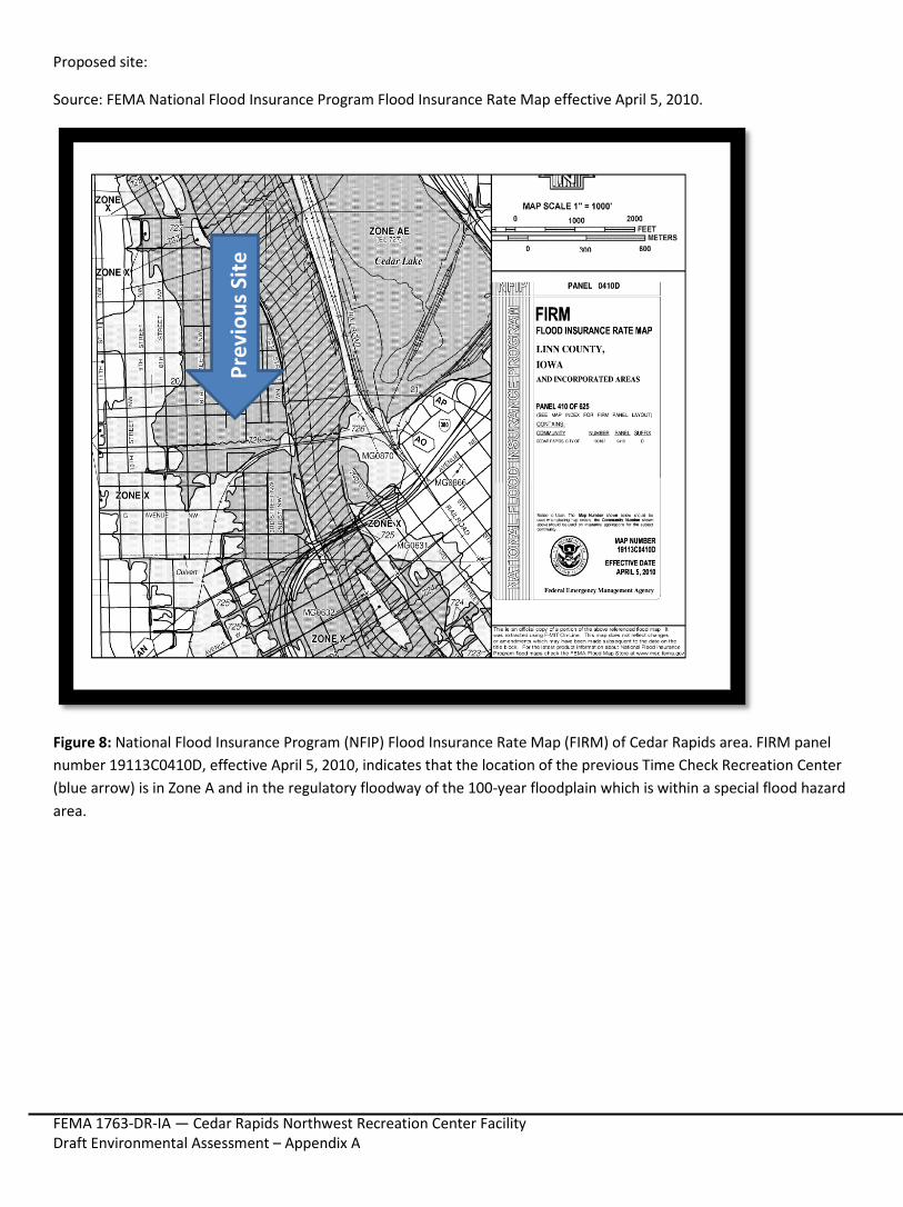
Proposed site:
Source: FEMA National Flood Insurance Program Flood Insurance Rate Map effective April 5, 2010.
Figure 8: National Flood Insurance Program (NFIP) Flood Insurance Rate Map (FIRM) of Cedar Rapids area. FIRM panel number 19113C0410D, effective April 5, 2010, indicates that the location of the previous Time Check Recreation Center (blue arrow) is in Zone A and in the regulatory floodway of the 100-year floodplain which is within a special flood hazard area.
Prev
ious
Site
FEMA 1763-DR-IA — Cedar Rapids Northwest Recreation Center Facility Draft Environmental Assessment – Appendix A
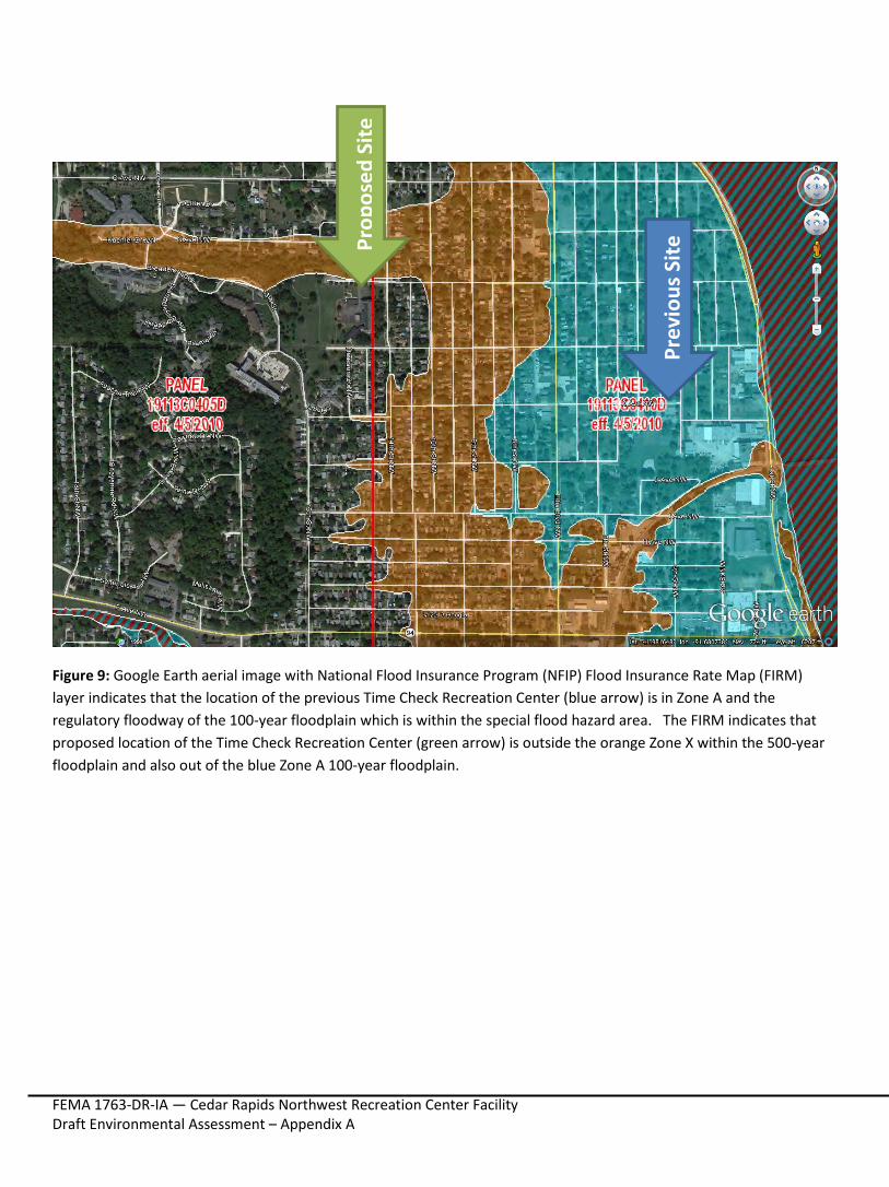
Figure 9: Google Earth aerial image with National Flood Insurance Program (NFIP) Flood Insurance Rate Map (FIRM) layer indicates that the location of the previous Time Check Recreation Center (blue arrow) is in Zone A and the regulatory floodway of the 100-year floodplain which is within the special flood hazard area. The FIRM indicates that proposed location of the Time Check Recreation Center (green arrow) is outside the orange Zone X within the 500-year floodplain and also out of the blue Zone A 100-year floodplain.
Prev
ious
Site
Prop
osed
Site
FEMA 1763-DR-IA — Cedar Rapids Northwest Recreation Center Facility Draft Environmental Assessment – Appendix A
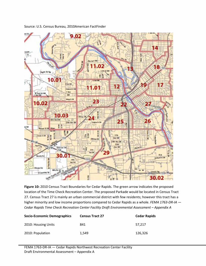
Source: U.S. Census Bureau, 2010American FactFinder
Figure 10: 2010 Census Tract Boundaries for Cedar Rapids. The green arrow indicates the proposed location of the Time Check Recreation Center. The proposed Parkade would be located in Census Tract 27. Census Tract 27 is mainly an urban commercial district with few residents; however this tract has a higher minority and low income proportions compared to Cedar Rapids as a whole. FEMA 1763-DR-IA — Cedar Rapids Time Check Recreation Center Facility Draft Environmental Assessment – Appendix A
Socio-Economic Demographics Census Tract 27 Cedar Rapids
2010: Housing Units 841 57,217
2010: Population 1,549 126,326
FEMA 1763-DR-IA — Cedar Rapids Northwest Recreation Center Facility Draft Environmental Assessment – Appendix A
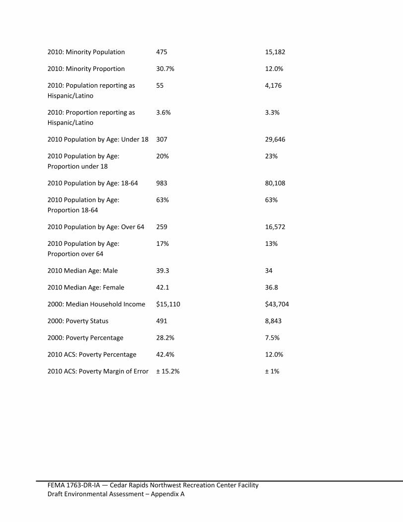
2010: Minority Population 475 15,182
2010: Minority Proportion 30.7% 12.0%
2010: Population reporting as Hispanic/Latino
55 4,176
2010: Proportion reporting as Hispanic/Latino
3.6% 3.3%
2010 Population by Age: Under 18 307 29,646
2010 Population by Age: Proportion under 18
20% 23%
2010 Population by Age: 18-64 983 80,108
2010 Population by Age: Proportion 18-64
63% 63%
2010 Population by Age: Over 64 259 16,572
2010 Population by Age: Proportion over 64
17% 13%
2010 Median Age: Male 39.3 34
2010 Median Age: Female 42.1 36.8
2000: Median Household Income $15,110 $43,704
2000: Poverty Status 491 8,843
2000: Poverty Percentage 28.2% 7.5%
2010 ACS: Poverty Percentage 42.4% 12.0%
2010 ACS: Poverty Margin of Error ± 15.2% ± 1%