appendix 9 melbourn greenway review 9 melbourn greenway review ... area of considerable housing as...
TRANSCRIPT

1
Appendix 9
Melbourn Greenway Review
Nigel Brigham & Associates
October 2016
A report for
2
Cambridge Area Greenways Review (V5) Melbourn Greenway —Appendix 9
October 2016
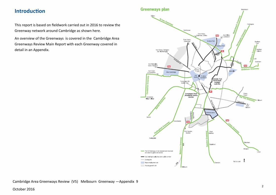
Introduction
This report is based on fieldwork carried out in 2016 to review the
Greenway network around Cambridge as shown here.
An overview of the Greenways is covered in the Cambridge Area
Greenways Review Main Report with each Greenway covered in
detail in an Appendix.

3
Melbourn Greenway
The Melbourn Greenway is one of the longest
Greenways and with its close association with the A10 it
is one of the most challenging. At the Cambridge end it
can connect very well with the Busway path giving
excellent access to employment sites in the south of
Cambridge, Cambridge Station etc. The route from
Trumpington Park & Ride site to the City Centre is
covered in the Haslingfield Greenway report.
Given the busy nature of the A10 the road itself is a
significant barrier as well as providing a potential
corridor for the Greenway. In places therefore routes
are recommended on both sides of the A10.
Due to the complex nature of the route it is inevitable
that it will be developed over time and parts of the route
are currently under construction or being planned.
A number of links and options have also been examined
including Meldreth and Shepreth. A link to Haslingfield is
recommended as the Haslingfield Greenway and
covered in that section.
An option for a route besides the railway between
Foxton and Hauxton could potentially link well with
Great Shelford, but a route to Trumpington is favoured.
©OpenStreetMap contributors
Cambridge Area Greenways Review (V5) Melbourn Greenway —Appendix 9
October 2016
Button End

4
The case for Works
The case for improvements along this corridor has already been identified as
a priority with a bid for Growth funding for the A505 bridge and funding
already allocated for the A10 corridor from various sources.
The existing link with Cambridge Biomedical Campus and employment sites
in the south of Cambridge means that links with Trumpington Park and Ride
site have potential to be very useful for those accessing employment sites.
The whole corridor of the Melbourn Greenway links with numerous villages
and the larger settlements of Royston and Melbourn and is likely to be an
area of considerable housing as well as employment growth and the case for
investment is strong particularly closer to Cambridge. The fact that the
Greenway links with the Haslingfield Greenway means that there is a
particularly strong case for the proposed new section of route past the
former Treatment Works site near Hauxton.
Cambridge Area Greenways Review (V5) Melbourn Greenway —Appendix 9
October 2016

5
Trip Generators and the focus of the Study
Key destinations that have been considered are:
Trumpington Park and Ride site for Cambridge Biomedical
Campus/Addenbrooke’s, Cambridge Station and City
Hauxton
Disused Treatment Works at Hauxton (possible development
site)
Harston
Button End
Foxton
Shepreth
Melbourn
Meldreth
Royston
Links that have also been considered include:
Little Shelford, Great Shelford
Haslingfield
Fowlmere
Cambridge Area Greenways Review (V5) Melbourn Greenway —Appendix 9
October 2016
Summary
Trumpington Park & Ride site to Harston
The proposed route uses an existing route over the M11 that links with
the A10. It then passes via Button End. The proposed alignment follows
field edges and is dependant on landowner’s agreement. A number of
options are possible with the aim being to link up with the Haslingfield
Greenway and a direct route towards Trumpington Park & Ride site.
It is recommended that this
route is taken forward in
conjunction with the
Haslingfield Greenway and in
parallel with the A10 route.
The County Council scheme
for Harston will be very
important for Harston
residents and those accessing
services, employment etc in Harston, but given the proposals for
Haslingfield Greenway an alternative alignment away from the A10 has
also been investigated.
Harston to Foxton
The route between Harston and Foxton was either under construction or
recently completed at the time of survey and is generally 2.5 m wide set
within highway verge.
Existing path from Trumpington
towards the A10

6
Foxton to Melbourn
There is already a good route being built along the A10 corridor between Foxton
and Dunsbridge Turnpike. Dunsbridge Turnpike is a quiet road that links to a
recently installed crossing to Shepreth and the A10 path to Foxton. For those
travelling between Foxton and Melbourn this would involve crossing the A10
twice and a route that linked Foxton with Melbourn without crossing the A10
would be very beneficial, especially if the A10 gets busier and if a new railway
crossing is built at Foxton. The missing section of just over 1km would be
challenging but of great benefit. A new path is recommended , as a long term
aim to complement the existing one.
From Dunsbridge Turnpike the proposed route follows the former A10 into
Melbourn. The very wide entrance to the Wyevale Garden Centre is a major
concern and it is recommended that this is avoided with the route crossing the
road after the Garden Centre .
Along the former A10 and beyond the built up area of Melbourn there is an
existing path within a wide verge which can easily be widened. The construction
of a path from near the A10 to the Science Park entrance is now underway. There
are some challenges along the route associated with accesses and services.
Within Melbourn the route will need to be on road and it would be appropriate
to designate the road through Melbourn as 20mph.
Cambridge Area Greenways Review (V5) Melbourn Greenway —Appendix 9
October 2016
Melbourn and Meldreth to Royston
Meldreth is on the opposite side of the A10 and the railway to
Melbourn and a good link is important . This will mean a largely on-
road route which can switch to an off-carriageway solution at the
pinch-point where the road crosses the railway on a narrow bridge. A
combination of on-road cycle provision and re-allocation of road space
is proposed with single-way working over the railway for motorised
traffic and a new two-way shared use path.
The Melbourn to Royston route is partly in Hertfordshire and is
dependent for its success on a new bridge over the A505 on the edge
of Royston. The bridge site is such that minimal ramps are needed and
the bridge links well with existing paths in Royston. Royston has a
good network in this part of the town but it would be unfortunate if
the bridge was not also accompanied by improvements to Melbourn
Road in Royston for a better link with the town centre than currently
exists.
The proposed route besides the A10 from Melbourn has already been
through the early stages of design and is seeking funding, so is not
discussed in detail in this report. From Melbourn to the A10 the route
the route will need to be on road initially on village roads and then
follow Cambridge Road Royston. A new route is needed in the highway
verge on the southern side. Construction of a route in this verge from
the junction with Back Lane is recommended.
7
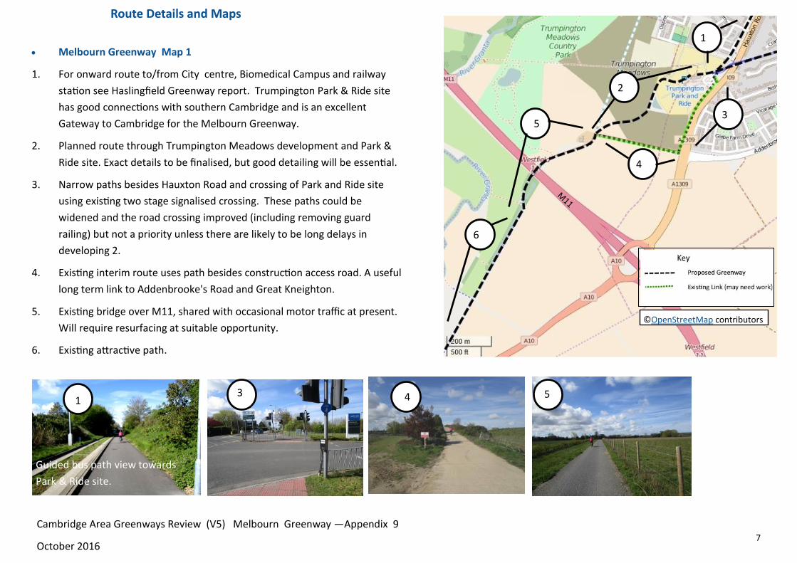
Melbourn Greenway Map 1
1. For onward route to/from City centre, Biomedical Campus and railway
station see Haslingfield Greenway report. Trumpington Park & Ride site
has good connections with southern Cambridge and is an excellent
Gateway to Cambridge for the Melbourn Greenway.
2. Planned route through Trumpington Meadows development and Park &
Ride site. Exact details to be finalised, but good detailing will be essential.
3. Narrow paths besides Hauxton Road and crossing of Park and Ride site
using existing two stage signalised crossing. These paths could be
widened and the road crossing improved (including removing guard
railing) but not a priority unless there are likely to be long delays in
developing 2.
4. Existing interim route uses path besides construction access road. A useful
long term link to Addenbrooke's Road and Great Kneighton.
5. Existing bridge over M11, shared with occasional motor traffic at present.
Will require resurfacing at suitable opportunity.
6. Existing attractive path.
1 3 5 4
4
1
©OpenStreetMap contributors
6
5 3
2
Guided bus path view towards
Park & Ride site.
Cambridge Area Greenways Review (V5) Melbourn Greenway —Appendix 9
October 2016
Route Details and Maps

8
Trumpington Park & Ride site to Foxton
Plans for the proposed route are shown on the following pages. This
is based on a new alignment that goes through the former treatment
works on the edge of Hauxton and then on a new alignment that
does not go through Harston.
It is unlikely that the whole new alignment will be achieved in one
stage and there may well need to be interim alignments, which is not
a significant issue for the Melbourn Greenway given that there is the
existing A10 route and there are a number of potential links.
The County Council proposed scheme, which does go through
Harston is not discussed because detailed plans have already been
prepared. The two complementary schemes link up via the bridleway
at the Hauxton end of Harston and finish at Church Street Harston.
The Harston route will be very important for Harston residents and
those accessing services, employment etc in Harston. It may also be
an attractive option at night when it will be better lit than the
alternative route, but the alternative route has the potential to be
quicker and more attractive than the route through Harston for those
heading to destinations beyond Harston.
The proposed bypass route passes via Button End with the option of
an on-road or off-road link with Button End. Button End is a small
community, but does include a small Industrial Estate, which is an
employment destination, but which also means that there is a high
proportion of lorry traffic on a relatively quiet road.
Whilst the whole route is dependent on reaching agreement with
landowners there does appear to be potential for a good direct alignment
and it is important that this is protected. It is recommended that this
route is taken forward in conjunction with the Haslingfield Greenway and
in parallel with the A10 route.
These two photos are taken in close proximity looking towards each other but there is
currently no easy access between the points. The track on the left comes from the
M11 overbridge and Trumpington and at present the only option is to turn left at the
end and join the path besides the A10 near Hauxton. If you could turn right and cross
the River Cam and the land associated with the former Treatment works you would
emerge in the distance on the photo on the right taken from near the existing
Haslingfield-Hauxton bridleway.
Cambridge Area Greenways Review (V5) Melbourn Greenway —Appendix 9
October 2016

9
54
Melbourn Greenway Map 2
7. Construct new path along farm track and through former Chemical Works site
with bridge over River Granta, to existing path, subject to landowner’s agreement.
Consider potential horse usage and bridleway dedication subject to agreement.
8. The existing path is narrow over this stretch. It can be widened by widening into
the highway verge and adding a new bridge over the drain near the path junction
point, but widening over the Granta bridge is more challenging. The path could be
widened by moving the guard railing and kerb into the carriageway, but 9 would
be a better option. This stretch and 11 reflect poorly on the whole route.
9. Subject to landowner’s agreement construct new path following river to link with
new bridge and 7.
10. Details of the Hauxton Meadows Housing development and how it links with
Hauxton have not been checked, but this is an obvious alignment, as is the whole
river corridor, but crossing the A10 at Hauxton Mill is particularly difficult so a
route using an existing Toucan crossing is the obvious one.
11. In this area paths have been widened and vary between 2m and 2.3 m with no
verge separation. They are not up to the standards elsewhere including the new
crossing of the former Chemical Works access road. Ideally paths should be re-
aligned and widened taking space from the wide carriageway.
8 9 11 10
11
©OpenStreetMap contributors
6
7
10
9
Informal path to south of
Granta viewed from A10.
6. Existing
attractive path.
New bridge needed
Existing Toucan Crossing
Cambridge Area Greenways Review (V5) Melbourn Greenway —Appendix 9
October 2016
8

10
Melbourn Greenway Map 3
7. Construct new path along farm track and through former Chemical
Works site with bridge over River Granta, to existing path, subject to
landowner’s agreement. Consider potential horse usage and
bridleway dedication subject to agreement. (See previous Page).
12. Existing A10 path—see previous page. This is an important route for
Harston and Hauxton residents particularly.
13. Surface existing bridleway/ farm track. This is an important link
and is likely to be an interim alignment pending completion of 7.
14. Haslingfield Greenway subject to landowner’s agreement.
15. Construct new path along field edges, subject to landowner’s
agreement. The preferred alignment and a possible alternative is
shown. The most direct route possible is preferred. Consider
possible horse-usage or bridleway dedication subject to agreement.
16. Construct new path along farm track to telecoms mast, subject to
landowner’s agreement. An alignment that allows the path to be
separated from farm traffic is preferred. Consider possible horse-
usage or bridleway dedication subject to agreement.
12 13 16 15
13
16
©OpenStreetMap contributors
7
15
14 12
Cambridge Area Greenways Review (V5) Melbourn Greenway —Appendix 9
October 2016
Telecoms Mast

11
For a route between Button End and the A10 there are two choices. The preferred alignment is an off
road route that follows field edges . This is favoured because of concern about traffic on the Button
End road and particularly HGVs serving Button End Industrial Estate. This is a small Industrial Estate
and traffic volumes are likely to be low, so there is a balance between cost and the attractiveness of
a route avoiding almost all traffic. The choice may need reviewing depending on land negotiations
and more details on traffic volumes and types.
18 19 20 20
19
20
©OpenStreetMap contributors
18
17
Melbourn Greenway Map 4
17. Harston A10 scheme due shortly. (See comments on following page).
18. Subject to landowner’s agreement construct path 2.5m wide along field edge and
parallel with Button End including link to Industrial Estate.
19. The best link between field edges and Church Street, Harston appears to be through
land adjoining a roadway signed as ”Access to the Footpath”. Subject to landowner’s
agreement construct path 2.5m wide with appropriate fencing, bollards etc for link
to public highway.
20. On road route. When surveyed the road was quiet but it needs to be considered at
peak times. The right turn into Button End on the bend of Haslingfield Road , for
those travelling from the south has poor visibility. Consider changing priority so that
Button End—Church Street is the priority or add mini roundabout at junction.
View from Church Street
showing possible route .
Industrial Estate on
right Haslingfield Road to right
Cambridge Area Greenways Review (V5) Melbourn Greenway —Appendix 9
October 2016
View towards A10—
Button End houses on right
12
Melbourn Greenway Map 5
21. On road route via Church Street.
22. The County Council has come up with an imaginative scheme to reorganise
highway space and create a much more pleasant and attractive
environment for cyclists and walkers, who are currently either squeezed
into a narrow strip with each other or are on the road with heavy traffic.
This route will be very important for Harston residents and those accessing
services, employment etc in Harston, but given the proposals for
Haslingfield Greenway an alternative alignment away from the A10 has also
been proposed. This is likely to be an attractive option for those heading to
destinations beyond Harston.
23. Recently completed path besides A10. 2.5m wide, with verge.
24. Potential link towards Hauxton and Shelford
following railway. Whilst this would be
possible subject to landowner’s agreement
and funding it has not been prioritised
because an alternative alignment from
Harston is recommended.
21 22 24 23
22
23
©OpenStreetMap contributors 21
24
24
Cambridge Area Greenways Review (V5) Melbourn Greenway —Appendix 9
October 2016
To Foxton Station
To London Road,
Harston

13
Melbourn Greenway Map 6
From Foxton to Dunsbridge Turnpike a good route will soon be completed on the north side of the
A10. In the longer term there is also an opportunity to develop a route on the south side of the
A10 . It is important that the two routes are seen as complimentary - each will have benefits for
different communities. The benefits of two routes will need to be weighed up against the ease and
safety of crossing the A10 particularly at peak time. This may change as the A10 changes and if a
new railway bridge or underpass is built at Foxton.
23. Recently completed path besides A10. 2.5m wide, with verge.
24. In the long term there are plans for a new grade separated road crossing of the railway at
Foxton. Any new bridge or underpass across the railway will need to include a safe grade
separated crossing from one side of the A10 to the other and this should become the final
Greenway alignment. In the mean time crossing the A10 will be challenging and the Greenway
should follow the existing A10 path.
25. Recently completed path besides A10. 2.5m wide, with verge.
26. At present the level crossing arrangements include a separate gate (locked when the level
crossing is closed). This gate will provide the interim route for the Greenway until a grade
separated crossing is provided ( see above).
27. Route on road through Foxton. Consider removing centre-line over whole route and 20mph
limit in village centre. Route continues on road through Foxton. Consider removing centre-line
over whole route and 20mph limit in village centre.
39 40 41
26
24
25
27
©OpenStreetMap contributors
23
.
Cambridge Area Greenways Review (V5) Melbourn Greenway —Appendix 9
October 2016
Foxton

14
Melbourn Greenway Map 7
See comments on previous page .The main advantage of a new route to the south-east of the
A10 would be for those travelling between Foxton and Melbourn, who would not need to cross
the A10. The benefits of two routes as opposed to one, will need to be weighed up against the
ease and safety of crossing the A10 particularly at peak time. This may change as the A10 changes
and if a new railway bridge or underpass is built at Foxton. The new alignment therefore needs
considering and protecting as along term alignment and is not an immediate priority.
25. Recently completed path besides A10. 2.5m wide, with verge.
28. Add refuge and approach paths to north-east of junction using hatched area for link
between A10 path and Shepreth Road.
29. Subject to agreement with landowners construct 2.5m path on field and paddock edges with
new bridge over brook.
30. Where the route crosses the brook near Shepreth Road the on highway option could
squeeze behind crash barriers although the bank may need to be built up.
31. Over this section a highway verge path would be possible but difficult and would involve
removing hedging. A combination of highway verge and field edge paths is possible, but the
preference is an entirely field edge path. Subject to agreement with landowners construct
2.5m path behind hedge on field edge.
29 30 31
29
30
31
©OpenStreetMap contributors
28
25
Cambridge Area Greenways Review (V5) Melbourn Greenway —Appendix 9
October 2016
31
2.2m
15
Melbourn Greenway Map 8
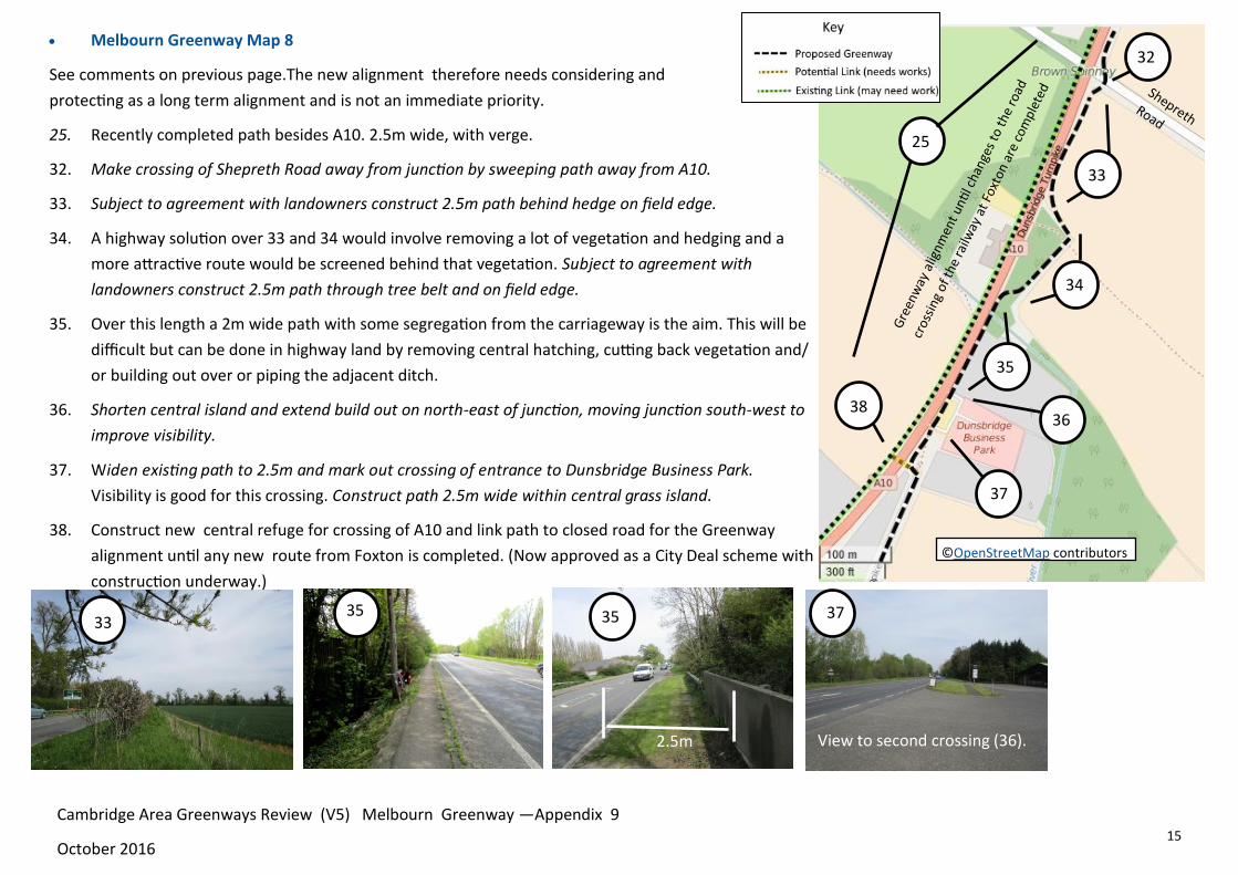
See comments on previous page.The new alignment therefore needs considering and
protecting as a long term alignment and is not an immediate priority.
25. Recently completed path besides A10. 2.5m wide, with verge.
32. Make crossing of Shepreth Road away from junction by sweeping path away from A10.
33. Subject to agreement with landowners construct 2.5m path behind hedge on field edge.
34. A highway solution over 33 and 34 would involve removing a lot of vegetation and hedging and a
more attractive route would be screened behind that vegetation. Subject to agreement with
landowners construct 2.5m path through tree belt and on field edge.
35. Over this length a 2m wide path with some segregation from the carriageway is the aim. This will be
difficult but can be done in highway land by removing central hatching, cutting back vegetation and/
or building out over or piping the adjacent ditch.
36. Shorten central island and extend build out on north-east of junction, moving junction south-west to
improve visibility.
37. Widen existing path to 2.5m and mark out crossing of entrance to Dunsbridge Business Park.
Visibility is good for this crossing. Construct path 2.5m wide within central grass island.
38. Construct new central refuge for crossing of A10 and link path to closed road for the Greenway
alignment until any new route from Foxton is completed. (Now approved as a City Deal scheme with
construction underway.)
33 35 37
38
35
33
34
35
©OpenStreetMap contributors
32
25
View to second crossing (36).
36
2.5m
Cambridge Area Greenways Review (V5) Melbourn Greenway —Appendix 9
October 2016
37
16
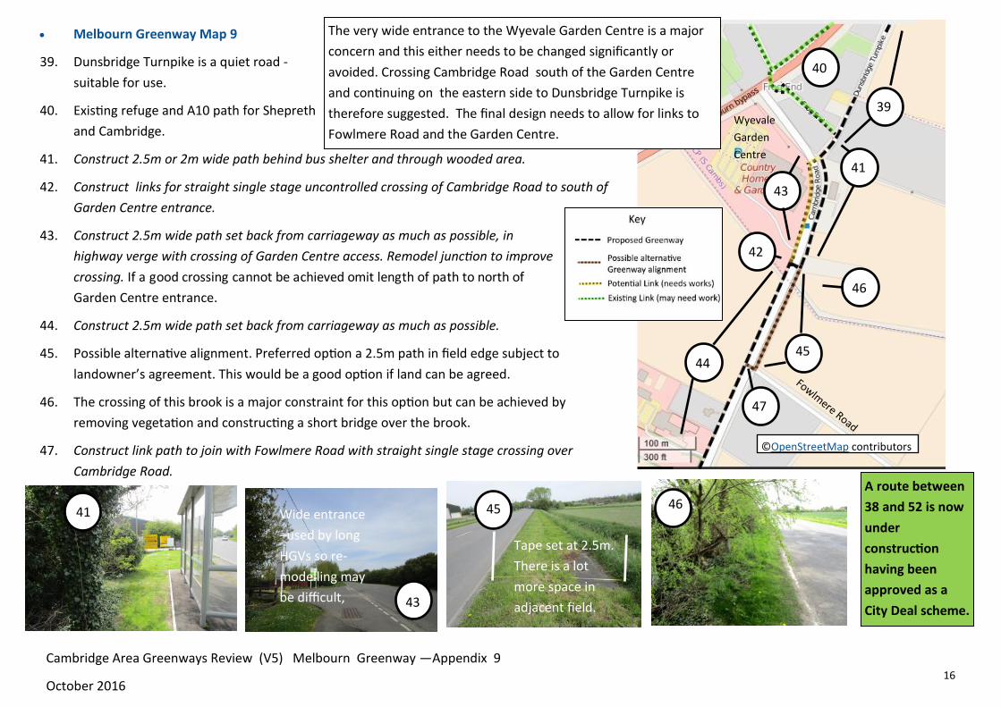
Melbourn Greenway Map 9
39. Dunsbridge Turnpike is a quiet road -
suitable for use.
40. Existing refuge and A10 path for Shepreth
and Cambridge.
41. Construct 2.5m or 2m wide path behind bus shelter and through wooded area.
42. Construct links for straight single stage uncontrolled crossing of Cambridge Road to south of
Garden Centre entrance.
43. Construct 2.5m wide path set back from carriageway as much as possible, in
highway verge with crossing of Garden Centre access. Remodel junction to improve
crossing. If a good crossing cannot be achieved omit length of path to north of
Garden Centre entrance.
44. Construct 2.5m wide path set back from carriageway as much as possible.
45. Possible alternative alignment. Preferred option a 2.5m path in field edge subject to
landowner’s agreement. This would be a good option if land can be agreed.
46. The crossing of this brook is a major constraint for this option but can be achieved by
removing vegetation and constructing a short bridge over the brook.
47. Construct link path to join with Fowlmere Road with straight single stage crossing over
Cambridge Road.
41
43
46
45
45
44
41
43
47
46
©OpenStreetMap contributors
39
42
40
Wyevale
Garden
Centre
The very wide entrance to the Wyevale Garden Centre is a major
concern and this either needs to be changed significantly or
avoided. Crossing Cambridge Road south of the Garden Centre
and continuing on the eastern side to Dunsbridge Turnpike is
therefore suggested. The final design needs to allow for links to
Fowlmere Road and the Garden Centre.
Cambridge Area Greenways Review (V5) Melbourn Greenway —Appendix 9
October 2016
Tape set at 2.5m.
There is a lot
more space in
adjacent field.
Wide entrance
–used by long
HGVs so re-
modelling may
be difficult,
A route between
38 and 52 is now
under
construction
having been
approved as a
City Deal scheme.

17
Melbourn Greenway Map 10
48. There is usually sufficient space in the highway verge to
construct a 2.5m wide path at least as far as the Science Park.
Construct 2.5m wide path set back from carriageway as much as
possible. There are some services along the route and these will
need detailed survey, but the most complicated issues are likely
to be the crossing of entrances to businesses. (See note 49).
50. In order to construct a 2.5m wide path from the Science Park
entrance towards Cambridge it will be necessary to either move
the existing hedge back or construct a new path on Science Park
land. Negotiate with Science Park to achieve 2.5m path separated from the
carriageway. It is more important to maintain at least 0.5m separation
from the carriageway than to maintain the 2.5m width so occasional
reduction to 2m + verge would be acceptable.
51. Construct new path 3m wide around entrance to Science Park between
Science Park signs and wall.
52. Use existing central refuge and remove Russett Way slip road for interface
between off road and on road routes. Those travelling to Melbourn to use
the refuge to join the carriageway, those travelling from Melbourn to join
off-road facility with flush cycle slip lane.
48 49 51
50
50
48
49
52
51
©OpenStreetMap contributors
49. There are a number of small
businesses along the route and good
crossings of the entrances will be vital.
The key will be in positioning and
shaping the path alignment .The
Phillimore Garden Centre is the largest
entrance to cross, but visibility is good
and with a clearly marked crossing this
should work well. Others are more
challenging ( see photo (49)).
Wide verge , but services on left
and layby on right. The best option
may be to remove the existing path
and construct a new path further
from the carriageway
Here (left) the best
options may be to
either remove some of
the hedge or move the
path away from the
hedge and alter the
junction details.
Cambridge Area Greenways Review (V5) Melbourn Greenway —Appendix 9
October 2016
A route between
38 and 52 is now
under
construction
having been
approved as a
City Deal scheme.

18
55
Melbourn Greenway Map 11
53. Route on road along Station Road. Consider options for traffic calming.
54. Route on road passes under A10. Consider options for traffic calming.
Remove central hatching and add cycle lanes
where there is space.
55. Subject to agreement with landowner construct
new path and ramp along field edge adjoining
Station Road.
56. Re-allocate road space over railway bridge by
removing one lane and adding signals with single-
way working. See similar example from Kennett
below.
57. Subject to agreement with landowner construct
new path and ramp along edge of industrial area
adjoining Station Road. Continue path in verge
towards Whitecroft Road. Create crossing by
constructing new path across corner of triangle
for onward route to station etc. Route continues
on road.
53 54 56
53
56
57 56
54
©OpenStreetMap contributors
55
56
57
Kennett with signals and single
-way working
Meldreth with no signals and
lack of space for walkers and
cyclists.
A good link with Meldreth is
important for Meldreth
residents and those wanting to
access Meldreth Station and
other facilities.
Cambridge Area Greenways Review (V5) Melbourn Greenway —Appendix 9
October 2016

19
Melbourn Greenway Map 12
58. Route on High Street on road from Science Park. Consider dedicating village centre as
20mph.
59. Construct new path across
green space by Back Lane
junction and add raised
table as Gateway feature
to High Street. Sweep path
away from Royston Road
at Back Lane crossing
London Way entrance on
a raised table and Back
Lane on a raised table.
60. Path to be 2.5m wide set
back from carriageway edge in verge of Royston Road. There appears to be sufficient space
on highway land, for a good route, although highway boundaries will need checking. There
is an existing path on the opposite side of the road but there is not sufficient space in
highway land at the Melbourn end of the route. Widen existing path through woods
between A10 highway verge and length of closed road.
58 59 60 60
60
59
58
Set path as far back
from road as possible
Three raised tables and
swept path for link
between on road and
off road route.
59
©OpenStreetMap contributors
©OpenStreetMap contributors
Cambridge Area Greenways Review (V5) Melbourn Greenway —Appendix 9
October 2016
Royston Road verge
View from closed road to
path through woods
Back Lane

20
Melbourn Greenway Map 13
This route is partly in Hertfordshire and both Cambridgeshire and Hertfordshire County
Councils are working with the A10 Cycle Campaign and others to progress it. Items 62 to 65
are in Hertfordshire.
61. Construct new path to east of Melbourn Road. Designs are already completed—
awaiting funding and awaiting completion of the new bridge.
63 65
61
View across Country Park . Headroom 1.4m under
railway
65
64 62
63
The A10 between Royston and
Melbourn has a narrow path (0.9m
wide) on one side (see above). The
proposed new path is on the opposite
side, where it will link better with
Melbourn and the new bridge.
Melbourn Road view
towards town centre. Existing paths near
proposed bridge site. ©OpenStreetMap contributors
Royston
Hertfordshire
Cambridgeshire
Items 62 to 65 are in
Hertfordshire. Item 61
is in Cambridgeshire.
Cambridge Area Greenways Review (V5) Melbourn Greenway —Appendix 9
October 2016
62. This route is dependent for its success on a new bridge over the A505 on the edge of
Royston. Preliminary designs have been completed and a funding bid has been sub-
mitted.
63. The bridge site is such that minimal ramps are needed and the bridge links well with
existing paths in Royston.
64. Existing route through Royston includes new underpass under railway. Royston has a
good network in this part of the town.
65. It would be unfortunate if the bridge was not also accompanied by improvements to
Melbourn Road in Royston for a better link with the town centre than currently exists.
The road is equivalent to Hills Road, so there are precedents, but this is a matter for
Hertfordshire.

21
Cambridge Area Greenways Review (V5) Melbourn Greenway —Appendix 9
October 2016
Construct new path besides A10 between A505 and Royston
Road, Melbourn for approximately 1.7km with new bridge over
A505 into Royston( span approximately 80m).
As a longer term scheme consider the need and options for
constructing a new path from Shepreth Road, Foxton to
Dunsbridge Turnpike on south-east side of A10 for
approximately 1.2km. Much of this can be done on highway land
although private land is needed for a good solution. The scheme
will need to be considered alongside any changes to the A10
including at Foxton crossing.
Recommendations
The plans for the A10 corridor have focused on a complete route and
completing a route between Royston and Cambridge is an obvious
priority. However additional links are also recommended. The
priorities are suggested to be:
Complete the Haslingfield Greenway including a new route into
Cambridge via the former Treatment Works site, for
approximately 750m with a new bridge over the River Cam
(span approximately 30m depending on Environment Agency
requirements).
Improve existing Hauxton path besides A10 for approximately
400m including re-allocating roadspace.
Agree route for new route from Harston to Button End and
linking with the Haslingfield Greenway and construct new path
on field edges for approximately 2km.
Construct new route to and through Melbourn from A10
ensuring continuity with a combination of new off-road paths
for approximately 3km and 20mph zone through the historic
centre of Melbourn for approximately 1km.
Complete Meldreth to Melbourn link including improving
arrangements at the existing railway bridge with new traffic
signals and new paths and ramps for approximately 400m.