appendix 11 risk assessment: potential impacts of ... · groundwater changes to groudwater...
TRANSCRIPT

GHD | Report for Arafura Resources Ltd ‐ Nolans Project Supplement Report, 4322529
Appendix 11 Risk assessment: Potential Impacts of Groundwater Changes to Groudwater Dependant Ecosystems (GDEs) (GHD, February 2017)

Arafura Resources LimitedNolans Project - EIS Supplement
Risk assessment: potential impacts of groundwater changesto Groundwater Dependent Ecosystems (GDEs)
February 2017


GHD | Report for Arafura Resources Limited - Nolans Project - EIS Supplement, 43/22301 | i
Executive summaryGHD has been engaged by Arafura Resources Limited (Arafura) to complete an assessment ofthe potential impacts of the proposed Nolans Rare Earths mine in central Australia, onGroundwater Dependent Ecosystems (GDEs).
Groundwater extraction is proposed to occur from the Nolans Mine Site for mine pit dewateringand within the Southern Basins borefield for process and potable water. In addition to active pitdewatering during mining, passive dewatering during groundwater rebound (the period followingpumping) and ongoing dewatering via evaporation were considered.
This has been assessed based on data from flora, fauna and groundwater studies of the area(GHD 2016a, GHD 2016b, GHD 2016c), and mapping of vegetation types to determine the areaof individual vegetation types potentially impacted under different groundwater drawdownscenarios (Desert Wildlife Services 2016), following groundwater extraction at the site.Groundwater extraction is proposed to occur from the Nolans Mine Site for pit dewatering(within the Ti-Tree Water Control District) and within the Southern Basins (borefield) for processand potable water.
This assessment uses the existing hydrogeological (groundwater) study for the Nolans ProjectEnvironmental Impact Statement (EIS) (GHD 2016a), and specifically, makes use of thegroundwater drawdown models. This report covers the Nolans mine site, processing site andborefield with the major emphasis on assessment the impacts of groundwater extraction fromthe borefield during operation, but also incorporating the cumulative effects of extraction ofgroundwater from the mine site both during operation and beyond closure.
As no formal risk assessment process for GDEs exists for the Northern Territory, it was decidedthat the most appropriate method for determining the potential impacts of groundwater changesto GDEs of the Nolans Project area was to follow the risk assessment guidelines forgroundwater dependent ecosystems developed by NSW Office of Water (Serov et al. 2012).The NSW Office of Water risk assessment guidelines for groundwater dependent ecosystemswas chosen as this was seen as the most comprehensive, systematic, current and relevantmethod to assess the effects of changes to groundwater on GDEs.
The main steps of the ecological valuation and risk assessment process are to:
1. Identify the type and location of GDEs;
2. Infer or determine groundwater dependency;
3. Identify High Ecological Value Assets of aquifer;
4. Determine ecological value of GDEs and the associated aquifer;
5. Determine the impact of an activity to identified GDEs;
6. Determine the magnitude of the risk to identified GDEs;
7. Apply the GDE Risk Matrix; and
8. Determine appropriate management actions.
The risk assessment result is: Moderate Value / Moderate to High Risk. Further informationand monitoring is required to confirm the risk level.

ii | GHD | Report for Arafura Resources Limited - Nolans Project - EIS Supplement, 43/22301
Groundwater drawdown within the borefield area will create a situation in which somevegetation communities are likely to need to adjust to changes in soil moisture availability in thesoil profile. It is difficult to predict whether these changes would impact tree condition with thelimited data available. Impacts in the short-term may be expected, particularly if pumping occursin drought years when trees are more heavily reliant on groundwater as their water source,during which time ability of trees to access water may decrease and may result in a decline intree condition. Such impacts may be short-term, if trees can respond and grow roots further intothe soil profile to access water deeper in the soil profile. Trees closer to creek and river linesmay be less affected than trees which are further away.
Given that there is uncertainty on potential impacts on tree condition, we recommend that amonitoring program is established. Following the risk matrix (Serov et al. 2012), the followingmanagement actions are recommended for high value/moderate risk proposal sites:
Short term
Protection measures, ideally for aquifer and GDEs, but also targeted at hotspots;
Baseline risk monitoring. Mitigation action.
Mid term
Protection measures, ideally for aquifer and GDEs, but also targeted at hotspots;
Monitoring and periodic assessment of mitigation.
Long term
Adaptive management. Continue monitoring.
Monitoring should include monitoring of water table levels, water table quality and tree condition.Tree condition monitoring should occur in patches of living River Red Gum, Ghost Gum, BeanTree, Desert Bloodwood and Coolabah, in areas where the groundwater is predicted to dropfollowing borefield pumping. In addition, monitoring points should be established at control sitesthat are not expected to be affected by groundwater drawdown.
This report is subject to, and must be read in conjunction with, the limitations set out in sections1.1, 1.2 and 1.3 and the assumptions and qualifications contained throughout the Report.

GHD | Report for Arafura Resources Limited - Nolans Project - EIS Supplement, 43/22301 | iii
Table of contents1. Introduction.....................................................................................................................................1
1.1 Purpose of this report...........................................................................................................1
1.2 Limitations Statement ..........................................................................................................1
1.3 Data limitations ....................................................................................................................2
1.4 Definitions ............................................................................................................................2
1.5 Location ...............................................................................................................................2
1.6 The study site.......................................................................................................................2
1.7 Groundwater Dependent Ecosystems (GDEs)....................................................................5
1.8 Potential impacts of groundwater changes to Groundwater DependentEcosystems (GDEs).............................................................................................................6
1.9 Proposed lowering of water table ........................................................................................7
1.10 Operational impacts .............................................................................................................7
1.11 Site inspection and ground-truthing .....................................................................................2
2. Risk assessment: potential impacts of groundwater changes to GDEs ........................................3
2.1 Approach..............................................................................................................................3
2.2 Type, location and groundwater dependency of GDEs.......................................................4
2.3 Impact of groundwater pumping on the GDE ......................................................................9
2.4 Application of the GDE risk matrix .....................................................................................11
3. Mitigation Measures .....................................................................................................................17
3.1 Mitigation of impacts ..........................................................................................................17
4. Conclusions..................................................................................................................................18
5. References...................................................................................................................................20
Table indexTable 1 General aquifer ecological valuation (from Serov et al 2012)..............................................6
Table 2 Summary of types and ecological values of GDEs at Nolans Project .................................7
Table 3 Comparison of water requirements to maintain adults and encouragerecruitment of River Red-Gum.............................................................................................8
Table 4 GDE checklist for a proposed activity (Table 5 from Serov et al. 2012)............................12
Table 5 Determining magnitude of potential risk - description of proposed activity (Table6 from Serov et al 2012) ....................................................................................................13
Table 6 GDE Risk Assessment Nolans Project area (Table 7 from Serov et al. 2012)..................15
Figure indexFigure 1 Map of Nolans Project study site. ........................................................................................4

iv | GHD | Report for Arafura Resources Limited - Nolans Project - EIS Supplement, 43/22301
Figure 2 Modelled drawdown at commencement of mining 1/1/2020 (Figure 30 in GHD2016a) ..................................................................................................................................1
Figure 3 Modelled drawdown at approximately mid-way through mining 1/1/2040 (Figure31 in GHD 2016a) ................................................................................................................1
Figure 4 Modelled drawdown at end of mining 1/1/2060 (Figure 32 in GHD 2016a) ........................1
Figure 5 Modelled drawdown at 100 years of closure 1/1/2160 (Figure 33 in GHD 2016a) .............1
Figure 6 Modelled drawdown at 1,000-years of closure 1/1/3060 (Figure 34 in GHD2016a) ..................................................................................................................................1
Figure 7 Conceptualisation of root structure within the soil profile (to 10 m) of River RedGum (from Doody et al. 2015) ...........................................................................................10
AppendicesAppendix A – Types of GDEs

GHD | Report for Arafura Resources Limited - Nolans Project - EIS Supplement, 43/22301 | 1
1. IntroductionGHD has been engaged by Arafura Resources Limited (Arafura) to complete an assessment ofthe potential impacts of the proposed Nolans Rare Earths mine in central Australia, onGroundwater Dependent Ecosystems (GDEs). This has been assessed based on data fromflora, fauna and groundwater studies of the area (GHD 2016a, GHD 2016b, GHD 2016c), andmapping of vegetation types to determine the area of individual vegetation types potentiallyimpacted under different groundwater drawdown scenarios (Desert Wildlife Services 2016),following groundwater extraction at the site. Groundwater extraction is proposed to occur fromthe Nolans Mine Site for pit dewatering (within the Ti-Tree Water Control District) and within theSouthern Basins (borefield) for process and potable water.
1.1 Purpose of this report
This report has not been prepared as a stand-alone document. The purpose of thisdocument is to provide content to be included within an EIS supplement for the Nolans project.
This report presents a risk assessment, undertaken to determine the potential impacts ofgroundwater changes to GDEs of the Nolans Project area following the risk assessmentguidelines for groundwater dependent ecosystems developed by NSW Office of Water (Serov etal. 2012). The NSW Office of Water risk assessment guidelines for groundwater dependentecosystems was chosen as this was seen as the most comprehensive, systematic, current andrelevant method to assess the effects of changes to groundwater on GDEs.
This assessment uses the existing hydrogeological (groundwater) study for the Nolans ProjectEnvironmental Impact Statement (EIS) (GHD 2016a), and specifically, makes use of thegroundwater drawdown models. This report covers the Nolans mine site, processing site andborefield with the major emphasis on assessment the impacts of groundwater extraction fromthe borefield during operation, but also incorporating the cumulative effects of extraction ofgroundwater from the mine site both during operation and beyond closure.
1.2 Limitations Statement
This report: has been prepared by GHD for Arafura Resources Limited (Arafura) and may onlybe used and relied on by Arafura for the purpose agreed between GHD and Arafura as set outin section 1.3 and within this report.
GHD otherwise disclaims responsibility to any person other than Arafura arising in connectionwith this report. GHD also excludes implied warranties and conditions, to the extent legallypermissible.
The services undertaken by GHD in connection with preparing this report were limited to thosespecifically detailed in the report and are subject to the scope limitations set out in the report.
The opinions, conclusions and any recommendations in this report are based on conditionsencountered and information reviewed at the date of preparation of the report. GHD has noresponsibility or obligation to update this report to account for events or changes occurringsubsequent to the date that the report was prepared.
The opinions, conclusions and any recommendations in this report are based on assumptionsmade by GHD described in this report. GHD disclaims liability arising from any of theassumptions being incorrect.

2 | GHD | Report for Arafura Resources Limited - Nolans Project - EIS Supplement, 43/22301
1.3 Data limitations
The Nolans Project is located within the Burt Plains bioregion, a data-limited region with regardto data availability related to GDEs. The majority of the datasets available are broad scale, andtherefore the information provides a baseline assessment only. It must be recognised that thelimitations of the data affect the level of certainty of the presence or absence of GDEs, andconclusions should be reassessed if further data becomes available.
The desktop assessment for the study area uses data from the Atlas of GroundwaterDependent Ecosystems managed by the Australian Government Bureau of Meteorology.
1.4 Definitions
For the purposes of this assessment, the following definitions are employed:
Study site – refers to the mine site, processing site, accommodation village, access roads,potable water pipeline, water supply pipeline, and borefields area as shown in Figure 1.1.
Study area – the area within a 20 km radius of the Study Site.
1.5 Location
The Nolans Project Study Site is located approximately 135 km north-west of Alice Springs,Northern Territory (NT), approximately 10 km west of the Stuart Highway and 65 km from theDarwin-Adelaide railway. The predominant land use in the area is cattle grazing on pastoraltenure, with stocking rates tending to vary according to rainfall patterns.
1.6 The study site
The Study site is situated in central Northern Territory within the Burt Plain bioregion. It islocated on the Aileron and Napperby pastoral stations. These stations have been used forgrazing since the early 1880’s. The Study area contains a wide variety of landforms includingrocky outcrops consisting of granitic orthogneiss and granite, alluvial plains and fans anddrainage channels (watercourses). The outcrops extend up to 150 m from the surrounding plain.
The proposed borefield area consists of gently undulating sandplains with limited surfacedrainage. Dominant vegetation types within the Study area include Acacia shrublands,hummock grasslands, and grassy eucalypt woodlands.
Groundwater extraction is proposed to occur from the Nolans Mine Site for pit dewatering andwithin the Southern Basins borefield for process and potable water. In addition to active pitdewatering during mining, passive dewatering during groundwater rebound (the period followingpumping) and ongoing dewatering via evaporation were considered.
An assessment of groundwater (GHD 2016a) as part of the projects EIS made a limitedconsideration of environmental users of water (not necessarily groundwater) in the study areaincluding riparian vegetation, vegetation on the plains and in the hills, as well as fauna. With nopermanent surface water across the study area, vegetation and fauna are either capable ofsurviving in between rainfall events or are able to tap into groundwater. Depths to groundwaterlevels are known to be shallow in isolated areas across the study area, but over the vastmajority of the area are generally below the reach of most vegetation (i.e. greater than 15m)(GHD 2016a).
Riparian vegetationRiparian vegetation is dominated by River Red Gums (Eucalyptus camaldulensis subsp. arida)and Bean Trees (Erythrina vespertilio), which line the larger creeks and rivers in the study area.These larger creeks and rivers with river red gums dominated riparian vegetation include, but

GHD | Report for Arafura Resources Limited - Nolans Project - EIS Supplement, 43/22301 | 3
may not be limited to, Napperby Creek, Day Creek and Woodforde River (Figure 1). It isconceivable that such riparian vegetation could tap groundwater (potentially even at depthsgreater than 15 m (GHD 2016a)) and therefore these areas are potential groundwaterdependant ecosystems (GDEs), and are considered in this impact assessment. River red gums,for example, tap surface water and either the main water table or elevated and perchedgroundwater associated with the creek and river channels flowing through the sub-surface.
Floodout vegetation and open woodlandsIn addition to riparian vegetation, groundwater may be important for vegetation in floodout areasat the toe of hills and ranges where runoff is highest, and potentially also to some trees in areasof open woodland which dominate much of the broader study area. Bloodwood (Corymbiaopaca), Coolabah (Eucalyptus coolabah subsp. arida) and Bean Trees (Erythrina vespertilio),are known facultative phreatophytic species (O' grady, et al., 2009; O' grady, et al., 2006;Loomes, 2010), trees which are deep rooted plant species that tap into groundwater, via thecapillary fringe, to satisfy at least some portion of their environmental water requirement, but willalso inhabit areas where their water requirements can be met by soil moisture reserves alone(Pritchard, et al., 2010). That is, the species will be groundwater dependent in someenvironments, but not in others
Groundwater extractionGroundwater is extracted from the Ti-Tree Basin for irrigation, stock and domestic purposes.Elsewhere in the study area, localised small-scale groundwater extraction occurs for stock anddomestic purposes. An additional groundwater extraction of 4.5 GL/year for a 43-year period isproposed for the Nolans Project. The impact of this extraction is the focus of the remainder ofthis study.
PalaeochannelsPalaeovalley alluvial sediments - Palaeovalley alluvials and palaeochannels represent remnantsof river channels that are associated with prehistoric drainage basins. They are typicallycomposed of unconsolidated material including fine to course grains sediments. Palaeovalleyaquifers are limited by their shallow depth (typically < 50m) and narrow width, but can extend forgreat distances longitudinally down-valley (typically tens to hundreds of kilometres), with goodaquifer connectivity along the length of a palaeovalley (from Serov et al 2012).
The previous groundwater study (GHD 2016a) identified a significant palaeochannel (theReaphook Palaeochannel), across which much of the southern borefield is located (Figure 1 inGHD 2016a). Palaeochannel (also known as a palaaeovalley) alluvial aquifers representremnants of river channels that are associated with prehistoric drainage basins. Althoughsurface water no longer flows in most palaeochannels, the sediment which has filled these oldriver channels still retain recharge and storage capacity. These aquifers are capable of storingsignificant quantities of groundwater which can support a variety of GDEs. Palaeochannelaquifers are typically limited by their shallow depth (mostly <50m) and narrow width, but canextend for great distances longitudinally down-valley (typically tens to hundreds of kilometres),with good aquifer connectivity along the length of the palaeochannel. However the ReaphookPalaeochannel of the Nolans Project study area was found to be highly irregular and up tohundreds of meters deep below the current surface level (GHD 2016a).

4 | GHD | Report for Arafura Resources Limited - Nolans Project - EIS Supplement, 43/22301
Figure 1 Map of Nolans Project study site.

GHD | Report for Arafura Resources Limited - Nolans Project - EIS Supplement, 43/22301 | 5
1.7 Groundwater Dependent Ecosystems (GDEs)
Groundwater Dependent Ecosystems (GDEs), also known as Groundwater SensitiveEcosystems (GSE) are ecosystems that require access to groundwater to meet all or some oftheir water requirements so as to maintain the communities of plants and animals, ecologicalprocesses they support, and ecosystem services they provide (Richardson, et al., 2011).Groundwater supply to ecosystems in particularly important in arid and semi –arid regions dueto low precipitation rates, high evaporation rates resulting in scarce supplies of surface water(Eamus, et al., 2006).
GDEs can be divided in three distinct classes (Eamus, et al., 2006; Richardson, et al., 2011):
Type 1: Aquifer and cave ecosystems- “These ecosystems typically include karst aquifersystems fractured rock and saturated (consolidated and unconsolidated) sedimentaryenvironments. The hyporheic zones of rivers, floodplains and coastal environments are alsoincluded in Type 1. The deep subsurface groundwater environment provides relatively stable,lightless environmental conditions with restricted inputs of energy and low productivity whichallows a particular suite of subsurface ecosystems to prosper. The ecological diversity iscreated from variable geology, oxygen, carbon and nutrient gradients (linked to the dynamics ofwater flow) and physico-chemical conditions. Subsurface ecosystems provide an importantsupporting service of bioremediation of contaminated groundwater, and provide an importantrole in carbon and nutrient cycling” (Richardson, et al., 2011).
Type 2: Ecosystems dependent on the surface expression of groundwater- These “includewetlands, lakes, seeps, springs, river baseflow, coastal areas and estuaries that constitutebrackish water and marine ecosystems. In these cases, the groundwater extends above theearth surface, as a visible expression. Examples include the mound springs of the GreatArtesian Basin), and wetlands in the south-eastern part of South Australia. In these situations,groundwater provides water to support aquatic biodiversity by providing access to habitat(especially when surface runoff is low) and regulation of water chemistry and temperature’(Richardson, et al., 2011).
Type 3: Ecosystems dependent on subsurface presence of groundwater- (via the capillaryfringe) include terrestrial vegetation that depends on groundwater fully or on a seasonal orepisodic basis in order to prevent water stress and generally avoid adverse impacts to theircondition. In these cases, and unlike the situation with Type 2 systems, groundwater is notvisible from the earth surface. These types of ecosystem can exist wherever the watertable iswithin the root zone of the plants, either permanently or episodically.
A sub-class of Type 3 GDEs includes facultative GDEs, which require groundwater in somelocations but not in others, particularly where an alternative source of water can be accessed tomaintain ecological function (Clifton et al, 2007; O’Grady et al, 2007). Dependence ongroundwater for facultative GDEs can range from opportunistic to being highly dependent.Ecosystems with a proportional dependence on groundwater do not generally exhibit thethreshold type response of the more dependent ecosystems. As a change occurs in agroundwater attribute; e.g. level, a proportional response generally occurs within the ecosystem,(Hatton and Evans, 1998). Opportunistic dependency occurs when ecosystems usegroundwater as required. For example, this may occur when surface water / soil moisture isunavailable, such as at the end of a dry period. Minor changes to the groundwater regime maynot have any adverse impacts but these ecosystems can die if a lack of access to groundwateris prolonged. It is however difficult to distinguish between proportional and opportunisticdependency.

6 | GHD | Report for Arafura Resources Limited - Nolans Project - EIS Supplement, 43/22301
1.8 Potential impacts of groundwater changes to GroundwaterDependent Ecosystems (GDEs)
It is a basic tenet of ecology that ecosystems will generally use resources in proportion to theiravailability. It is therefore assumed that if groundwater can be accessed, ecosystems willgenerally develop some degree of dependence and that dependence will likely increase withincreasing aridity (Hatton and Evans, 1998).
For many communities, depth to groundwater is an important parameter controlling theavailability of groundwater to a plant (Hatton and Evans 1998; Eamus et al, 2006; Froend andLoomes, 2006). Groundwater dependent communities require that groundwater levels beepisodically or periodically within their root zone for use when soil water availability is low so asto satisfy demands for water and nutrients (Hattermann et al, 2008; Groom et al, 2000).Information on root depth and morphology can therefore be used to determine dependency.However, little is known about the rooting depths of plants and reliance on groundwater whensurface water is unavailable.
The groundwater dependence of many ecosystems can be inferred from their position in thelandscape, their response to altered water regimes and the occurrence of vegetation or speciesassociated with shallow groundwater (Froend et al, 2004). The groundwater dependency ofmany ecosystems is self-evident; e.g. cave and aquifer ecosystems, base flow dependentecosystem. Groundwater dependency of wetlands and terrestrial vegetation can be inferredthrough the impact of altered water regimes on the distribution and composition of species. Theimportance of groundwater on more xeric or opportunistic species, such as the semi-arid areasof this study area, may be more difficult to infer.
Before undertaking a risk assessment, it is important to consider the impact of existingdisturbances on the ecosystems being assessed. For example, in assessing the risk ofextraction from new licences, it is important to consider the impact of current licences, if any.This was included in the groundwater study (GHD 2016a), which considered groundwaterextraction for a number of communities, station homesteads, livestock water points andagricultural irrigation projects.
To determine the significance of a change, the existing values and disturbance tolerances of theecosystem being affected must be understood. This includes the dispersal capabilities andopportunities of the associated biota. The level of anticipated impact is a comparison of thedegree of change relative to the ecological values being affected. In ecosystems that are totallydependent on groundwater and which have limited dispersal capabilities are disturbanceintolerant and more sensitive to change.
In ecosystems that only rely on groundwater during extreme climatic conditions (i.e. droughts)such as terrestrial vegetation communities, there may have to be a large change to warrant aresponse or the response may have a significant time lag from the disturbance event. Differentelements of an ecosystem will have different reaction times and responses to a particularimpact.
The reliance of central Australian vegetation on groundwater is poorly known. Vegetation thatmay be most likely to be reliant on groundwater are River Red Gum, Coolabah, Bloodwood andBean Tree (O’Grady et al. 2009; Santini et al. 2016). Ghost gums may also possibly accessgroundwater resources, but this has not been examined in central Australia. Tree height andtree basal area are considered good indicators of available water resources for tree growth(Zolfhager 2013).

GHD | Report for Arafura Resources Limited - Nolans Project - EIS Supplement, 43/22301 | 7
1.9 Proposed lowering of water table
A hydrological assessment that has been completed for the Project considers the impacts of theproposed groundwater extraction (GHD 2016a). Groundwater extraction is proposed to occurfrom the Nolans Mine Site for pit dewatering (within the Ti-Tree Water Control District) andwithin the Southern Basins (borefield) for process and potable water.
The groundwater flow regime is predicted to significantly change in the mine area and result in apermanent sink (i.e. perpetually discharging low point) due to evaporation of pit water.Drawdowns are expected to be very large at the pit site, reflective of pit levels during operation(i.e. as deep as 390 mAHD which equates to approximately 260 m of drawdown at thecompletion of mining), and then reflective of the pit lake levels (modelled levels at 575 mAHDwhich equates to approximately 80 m of drawdown) during closure as the water rebounds to alevel where groundwater flow equates to evaporation.
1.10 Operational impacts
The Nolans Project involves the clearing of vegetation, which has been considered in the EIS,with a focus on impacts to flora and fauna values. The operational impact considered here isfrom the taking of groundwater. Groundwater within the study site is typically greater than 15 mbelow the ground surface, considered to be below the reach of most vegetation, althoughgroundwater levels are known to be shallow in isolated areas across the study area (GHD2016a).
The propose borefield is expected to source about 12.87 ML/day of groundwater (GHD 2016a)from the Southern Basins aquifer. Modelling of the groundwater drawdown associated with mineand borefield groundwater extraction were completed for five key times:
Commencement of mining 1/1/2020 (Figure 2 (Figure 30 in GHD 2016a));
Approximately mid-way through mining 1/1/2040 (Figure 3 (Figure 31 in GHD 2016a));
End of mining 1/1/2060 (Figure 4 (Figure 32 in GHD 2016a));
100 years of closure 1/1/2160 (Figure 5 (Figure 33 in GHD 2016a)); and
1,000-years of closure 1/1/3060 (Figure 6 (Figure 34 in GHD 2016a)).
These models indicate that across the borefield area a maximum groundwater drawdown of 5 to10 metres will occur at the end of mining (Figure 4), over a very small area of the centralborefield, with larger areas experiencing a drawdown of 1 to 5 metres and 0.5 to 1 metres withinthis same timeframe. The surrounding area is projected to experience a drawdown of less than0.5 metres, which is unlikely to significantly impact terrestrial GDEs in this area. Modelling of thegroundwater drawdown following closure of the mine show groundwater levels reboundingslowly (Figure 5 and Figure 6).
These models also show a long term maximum groundwater drawdown in the area surroundingthe mine pit of 10 to 50 metres (and up to 260 metres immediately adjacent to the pit) will occurfollowing closure of the mine Figure 6. Acting as a permanent sink, the pit is predicted tosignificantly change the groundwater flow regime in this area (GHD 2016a). Groundwater ismodelled to draw down by one to five metres up to 15 km from the centre of the mine pit,potentially impacting GDEs across this area.
1.10.1 Southern Basins borefield
Modelled drawdown in the water table from the operation of the Southern Basins borefieldpeaks at approximately 6 m (Figure 46 in GHD 2016a) in the centre of the borefield. Thisexcludes actual drawdowns within the operating bores which is more likely to be a coupled

8 | GHD | Report for Arafura Resources Limited - Nolans Project - EIS Supplement, 43/22301
function of bore efficiency as well as aquifer drawdown. The drawdown-rebound is a typical log-linear response to aquifer pumping and recovery. Further away the response varies (asexpected) and results in a far slower response to recovery (i.e. Figure 47 and Figure 48 in GHD2016a). This is a function of the aquifer size, material properties and the limited modelledrecharge applied.
1.10.2 Day Creek
Modelled drawdown from the borefield peaks in the order of 1.5 m in the vicinity of Day Creek(Figure 47 in GHD 2016a) and rebounds rapidly once pumping ceases. If vegetation is currentlydependent on the groundwater at these locations, based on watertable level observations (ofapproximately 28 m below top of collar) in the adjacent bore SB0026 (RC00026 RN19038), treeroots must be capable of extracting water from greater than 20 m deep, which is consideredunlikely, even accounting for the river bank and collar heights. Watertable depths greater than20m are unlikely to support riparian woodland vegetation given tree response to water tabledepth elsewhere including in the adjacent Ti Tree basin. It seems more likely that trees alongDay Creek are utilising water from a perched water supply in recent alluvial material of the creekchannel, especially given the lack of tree species known to utilise groundwater away from thecreek channel and immediate banks (except near the Reaphook Hills) If vegetation is capable ofextending its root systems to such depths it is hypothesised that it is reasonable to expect that itcould gradually extend its root system a further 1.5 m over the predicted drawdown periodduring mining.
There are no planned surface works in the Day Creek catchment that are likely to affect therecharge to either the surficial alluvials or the deeper aquifer material. If the vegetation is relianton shallower or more temporary sources of water, there is no indication that there are any worksproposed (including pumping of the borefield) that would alter these conditions.
1.10.3 Napperby Creek
Like Day Creek, there are no planned surface works in the Napperby Creek catchment that arelikely to affect the recharge to the area. However unlike Day Creek, the modelled drawdowncone does not extend with significant magnitude to the Napperby Creek area during miningoperations, but doubles in magnitude in the approximately 50 years following closure (Figure 48in GHD 2016a) as the aquifer recovers at the centre and extends laterally. The magnitude is halfthat predicted at Day Creek but the duration to reach it is twice as long, therefore it isreasonable to assert that even less impact (if any) is expected at Napperby Creek.
1.10.4 Floodout vegetation
In the Southern Basins, there may be minor localised impacts to floodout vegetation and orsoaks due to a decrease in groundwater availability for evapotranspiration. The impact will bedetermined by the current groundwater dependence and how the difference in availability ofgroundwater affects floodout vegetation and soaks. Given the scale of distance, the minordrawdowns predicted, the percentage differences in groundwater available and the gradualnature of the predicted changes, it is expected that this impact will be negligible.
In the Reaphook Palaeochannel area of the Southern Basins the modelled difference ingroundwater available for evapotranspiration peaks at approximately 100 years after closure.This is well after the pumps in the borefield in the modelled scenario have ceased butcorresponds with the period the drawdown cone is still expanding laterally but decreasing in itsvertical extent at the epicentre.

GHD | Report for Arafura Resources Limited - Nolans Project - EIS Supplement, 43/22301 | 9
The peak decreases in groundwater availability for evapotranspiration in the ReaphookPalaeochannel area is 12% or 306 m3/day (3.5 L/s) and this rebounds to approach steady stateat a decrease of approximately 1% or 31 m3/day (0.35 L/s) (GHD 2016a).
1.10.5 Lake Lewis and surrounds
The key indication for impact to Lake Lewis is whether the area is within the modelleddrawdown cone but also if modelled net discharges to the area are affected.
The predicted drawdowns are negligible in the Lake Lewis area and not likely to bemeasureable. Despite this, the groundwater available for evapotranspiration, like in theReaphook Palaeochannel area to the north, is likely to be impacted in the Lake Lewis area. Thepeak decreases in groundwater availability for evapotranspiration in the Lake Lewis area of theSouthern Basins is 3% or 712 m3/day (8 L/s) and this rebounds to approach steady state with adecrease of approximately 0.5 % or 103 m3/day (1 L/s) (GHD 2016a).
1.10.6 Rock-holes
There are no conceivable impacts to water bodies in basement rock-holes along drainage linesor in depressions in the outcropping rock mass because they are perched in the bedrockwatertable and there is no conceivable change to bedrock permeability associated with theproposed activities (GHD 2016a).
1.10.7 Groundwater flow and quality
The modelled groundwater flow regime displays almost no change (impact) at the model(regional) scale when viewed from a flow direction or groundwater head perspective. As such,there is no justification for any speculation of material changes in groundwater chemistry orquality within the aquifer.
As all storage facilities are designed as zero discharge facilities (i.e. evaporation controlled),they should be designed or managed such that they do not breach or decant either to thesurface water bodies or groundwater system. As such, their design and management shouldensure that the water balance can demonstrate that they will remain evaporating controlledevents far greater than any probable maximum flood. Likewise, their design and managementshould ensure zero discharge occurs via leakage.

GHD | Report for Arafura Resources Limited - Nolans Project - EIS Supplement, 43/22301 | 1
Figure 2 Modelled drawdown at commencement of mining 1/1/2020 (Figure 30 in GHD 2016a)

GHD | Report for Arafura Resources Limited - Nolans Project - EIS Supplement, 43/22301 | 1
Figure 3 Modelled drawdown at approximately mid-way through mining 1/1/2040 (Figure 31 in GHD 2016a)

GHD | Report for Arafura Resources Limited - Nolans Project - EIS Supplement, 43/22301 | 1
Figure 4 Modelled drawdown at end of mining 1/1/2060 (Figure 32 in GHD 2016a)

GHD | Report for Arafura Resources Limited - Nolans Project - EIS Supplement, 43/22301 | 1
Figure 5 Modelled drawdown at 100 years of closure 1/1/2160 (Figure 33 in GHD 2016a)

GHD | Report for Arafura Resources Limited - Nolans Project - EIS Supplement, 43/22301 | 1
Figure 6 Modelled drawdown at 1,000-years of closure 1/1/3060 (Figure 34 in GHD 2016a)

2 | GHD | Report for Arafura Resources Limited - Nolans Project - EIS Supplement, 43/22301
1.11 Site inspection and ground-truthing
A site inspection to ground-truth and characterise the vegetation types of the Day Creek areawas completed on the 18th and 19th of October 2016 by Desert Wildlife Services (DWS 2016).The vegetation of the creek and floodplain was divided into six different units. Two of these, DayCreek channels and banks (RGC) and Corymbia alluvial woodlands (CAW), include a significantcomponent of tree species, namely River Red Gums (Eucalyptus camaldulensis subsp. arida),Bean Trees (Erythrina vespertilio) and Desert Bloodwoods (Corymbia opaca) which possiblyutilise groundwater resources. Localised flow and run-on areas supporting River Red Gums,Erythrina and Corymbia spp. occur in small areas on the greater alluvial floodplain at a scale thatis not readily mapped. The remainder of the alluvial floodplain was characterised by tree speciesincluding whitewood (Atalaya hemigaluca), ironwood (Acacia estrophiolata) and supplejack(Ventilago viminalis), which are not known to be associated with groundwater.
An additional unit (BWS, bloodwood sandplain) located between the Day Creek floodplain andbase of the Reaphook Hills was also assessed as indicative of good deep soil water resourceson the base of the size and density of bloodwood trees, which could potentially includegroundwater.
Besides large high-water use trees, there was a lack of other vegetation indicative of GDEs, suchas groundwater dependent sedges (e.g. perennial Cyperus spp.), in the Day Creek area.

GHD | Report for Arafura Resources Limited - Nolans Project - EIS Supplement, 43/22301 | 3
2. Risk assessment: potential impacts ofgroundwater changes to GDEsNo formal risk assessment process for GDEs exists for the Northern Territory.
Following previous experience assessing the potential risks and impacts to GDEs, it was decidedthat the most appropriate method for determining the potential impacts of groundwater changesto GDEs of the Nolans Project area was to follow the risk assessment guidelines for groundwaterdependent ecosystems developed by NSW Office of Water (Serov et al. 2012). The NSW Officeof Water risk assessment guidelines for groundwater dependent ecosystems was chosen as thiswas seen as the most comprehensive, systematic, current and relevant method to assess theeffects of changes to groundwater on GDEs.
2.1 Approach
A risk assessment was undertaken following the Risk assessment guidelines for groundwaterdependent ecosystems developed by NSW Office of Water (Serov et al. 2012). The main stepsof the ecological valuation and risk assessment process are:
1. Identify the type and location of GDEs;
2. Infer or determine groundwater dependency;
3. Identify High ecological Value Assets of aquifer (Table 1);
4. Determine ecological value of GDEs and the associated aquifer;
5. Determine the impact of an activity to identified GDEs;
6. Determine the magnitude of the risk to identified GDEs;
7. Apply the GDE Risk Matrix; and
8. Determine appropriate management actions.

4 | GHD | Report for Arafura Resources Limited - Nolans Project - EIS Supplement, 43/22301
2.2 Type, location and groundwater dependency of GDEs
Table 2 lists the GDE1 vegetation communities that have been identified as occurring within theNolans Project study area. These communities are in particular associated with a number ofephemeral and episodic waterways across the broader study area (including the WoodfordeRiver, Napperby Creek, Day Creek, Kerosene Camp Creek, Sandy Creek, Rabbit Creek,Wickstead Creek and Wallaby Creek), as well as broad back channels and run-on areas ofalluvial floodplain.
The Atlas of Groundwater Dependent Ecosystems identifies the borefield and surrounding areaas containing a number of the waterways as containing potential GDEs (reliant on surface and/orsubsurface expression of groundwater) and inflow dependent ecosystem (i.e. vegetation relianton water in addition to rainfall) (GDE types are presented in Appendix A), though these aremapped as having a low potential for subsurface groundwater interaction. The Atlas alsoidentifies these waterways as variously having low, moderate and high likelihood of InflowDependent Ecosystems (IDEs).
Woodland containing River Red Gum (Eucalyptus camaldulensis subsp. arida), Ghost Gum(Corymbia aparrerinja), Bean Tree (Erythrina vespertilio), Desert Bloodwood (Corymbia opaca)and Coolabah (Eucalyptus coolabah subsp arida) occur within the study site and within areaswhere groundwater drawdown is predicted to occur as a result of proposed groundwaterpumping. These species are all known to use groundwater as one of their sources of water,particularly in the absence of overland flooding and/or rainfall (Roberts and Marston 2011). RiverRed Gum, Ghost Gum and Coolabah in particular are considered GDEs because they are highlylikely to source some of their water from groundwater. They are considered facultative GDEs:
“A GDE that is not entirely dependent on groundwater, and may rely on groundwater on aseasonal basis or only during extended drought periods. At other times, water requirements maybe met by soil or surface water.”
Current data on water table levels across the study area show that groundwater is known to beshallow in isolated areas, but over the vast majority of the area are generally well below thereach of most vegetation (i.e. greater than 15 m), and is typically around 28 m below groundsurface (GHD 2016a). Therefore, it is highly likely that trees such as River Red Gum, GhostGum, Bean Tree, Desert Bloodwood and Coolabah are using soil stored moisture from within orabove the phreatic zone (zone above the water table).
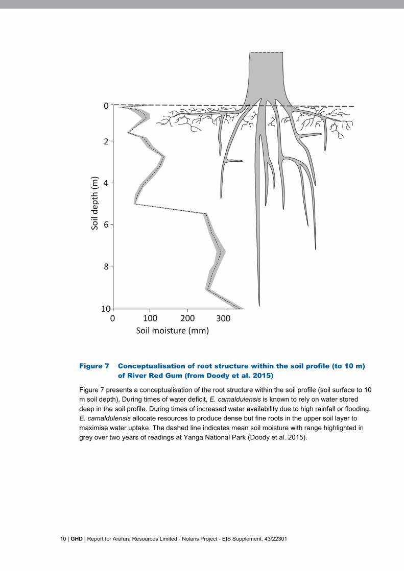
River Red Gum water requirements typically exceed those provided by rainfall alone, and areregularly met by the trees accessing groundwater (Feikema et al., 2010; Doody et al., 2009;2014a). As an adaptation to arid and semi-arid environments, it is opportunistic in its water use,sourcing water according to osmotic and matric water potential (Thorburn et al., 1993; Mensforthet al., 1994; Holland et al., 2006; Doody et al., 2009). Water sources include fresh to moderatelysaline groundwater, lateral bank recharge and overbank flooding which replenishes floodplaingroundwater (Thorburn et al., 1993; Mensforth et al., 1994; Holland et al., 2006; Doody et al.,2009; 2014b; Holland et al., 2009; Feikema et al., 2010). In areas with low rainfall and infrequentflooding, groundwater may provide the most temporally stable water resource (Mensforth et al.1994; Burges, et al. 2001). A conceptual drawing of River Red Gum roots and soil profile isshown in Figure 7.
1 Groundwater dependent ecosystem or GDEIs a broad, overarching term encompassing all ecosystems that use groundwater either permanently oroccasionally to survive. In this context the term covers a vast majority of terrestrial and aquaticecosystems.

GHD | Report for Arafura Resources Limited - Nolans Project - EIS Supplement, 43/22301 | 5
2.2.1 Ecological value
GDEs may be regarded as high value if they are considered to meet criterion a), b) or c) of theNSW Risk assessment guidelines for groundwater dependent ecosystems, as listed below andassessed in Table 1:
a) “Any Groundwater dependent communities where a slight to moderate change ingroundwater discharge or water tables would result in a substantial change in theirdistribution, species composition and/or health. This includes all ecosystems that areidentified and acknowledged as being entirely (or obligate) dependent on groundwater fortheir survival. These ecosystems included all Karst, springs, mound springs, subterraneanaquifer ecosystems and some wetlands including hanging swamps.”
b) “Those ecosystems that have already been identified as important by other environmentalagencies or within existing legislation or international agreements; ie. those GDEs that arepartly or wholly located within a State or Federal Reserve System; eg. National Park/Reserve; or are a recognised high conservation area, such as a sub-catchment identified ashigh conservation value; eg. stressed rivers; high value vegetation etc.”
c) “Any natural groundwater dependent system that is habitat for any endemic, relictual, rare, orendangered biota (fauna or flora) populations or communities as listed under state legislation{here the Territory Parks and Wildlife Conservation Act 2000} or the CommonwealthEnvironment Protection and Biodiversity Conservation Act 1999 or identified by anacknowledged expert taxonomist / ecologist.” (Serov et al. 2012)
Assessment of endemic, relictual, rare, or endangered biota (fauna or flora) populations orcommunities
Flora
No flora species listed under the EPBC Act have been recorded or are predicted to occur within20 km of the Study area, and it is highly unlikely that any of these species would occur within theStudy area due to the lack of suitable habitat (GHD 2016b). There were no communities ofnational significance known or predicted to occur within 100 km of the Study area. The DLRMherbarium database search identified 412 plant taxa known to occur within 20 km of the Studyarea. Under the TPWC Act, 390 are of ‘least concern’ (i.e. widespread and abundant taxa), eightare ‘not evaluated’, eight are ‘data deficient’ and six are listed as ‘near threatened’ (Holtz 2015).
Most of the vegetation types present within the Study area are well represented within the BurtPlain bioregion, however less than 1% of the Burt Plain bioregion is conserved within reserves;and thus vegetation communities within the Study area are poorly represented in the Nationalestate (e.g. hummock grassland 0.01%, Acacia woodland 0.05%, Eucalyptus low Woodland withTussock Grass Understorey 0.01% (NRETAS 2005)).
Mixed woodlands dominated by bean trees (Erythrina vespertilio) are in decline in the southernNorthern Territory (Neave 2006). This may be as a result of grazing pressure and inappropriatefire regimes (P. Latz pers comm. 2010). E. vespertilio was a co-dominant canopy species in twoof the vegetation communities in the Study area; riparian woodland and mixed woodlands onalluvial plains (Vegetation Types 1 and 3). This species was locally abundant on alluvial plainsadjacent riparian zones and at the foot of rocky outcrops (associated with groundwater springs).The size structure of the population indicates that these stands have adequate levels ofregeneration.
Neave et al (2006) provides an overview of important vegetation types within the Burt Plainbioregion. These include a number of wetlands and mesic areas, sites of botanical significanceand flora and fauna hotspots. The Study area does not contain any of these identified sites.There is however, a small wooded Coolibah swamp adjacent to the Nolans site (but outside theproposal site) that is considered an important vegetation type (Neave et al 2006).

6 | GHD | Report for Arafura Resources Limited - Nolans Project - EIS Supplement, 43/22301
Fauna
Forty-nine fauna species are listed under one or more category of threat (i.e. vulnerable, extinct,near threatened) under the EPBC Act and/or the TPWC Act. More than half (25) are mammals,and of those, 11 species are listed as extinct in the Northern Territory or across Australia. Theother threatened species are made up of birds (20 species) and reptiles (4 species) (GHD2016c). On the basis of habitat requirements and geographic distribution, the Study areapotentially provides at least some habitat for 27 of the 38 extant listed species.
Eleven threatened or Near Threatened fauna species were assessed as warranting furtherdetailed assessment due to their detection during the surveys (nine species), or as they wereconsidered likely to occur within the study area (GHD 2016c).
None of the threatened fauna species that are considered as present, or likely to be presentwithin the Study Area are considered to rely on a natural groundwater dependent system ashabitat.
Table 1 General aquifer ecological valuation (from Serov et al 2012)
Yes No
Does the aquifer or portion of it occur within a state reserveor support any GDEs within a sub-catchment identified asHigh Conservation Value; eg. Stressed Rivers; high valuevegetation, SEPP wetlands, DIWA wetland etc?
No
Does the aquifer support obligate/entirely dependent GDEsincluding: karsts, springs, mound springs, subterraneanaquifer ecosystems and some wetlands such as hangingswamps.
No
Any natural groundwater dependent system that is habitat forany endemic, relictual, rare, or endangered biota (fauna orflora) populations or communities as listed under statelegislation {here the Territory Parks and Wildlife ConservationAct 2000} or the Commonwealth Environment Protection andBiodiversity Conservation Act 1999 or identified by anacknowledged expert taxonomist / ecologist?
No

GHD | Report for Arafura Resources Limited - Nolans Project - EIS Supplement, 43/22301 | 7
Table 2 Summary of types and ecological values of GDEs at Nolans Project
Vegetation Type orcommunity
Vegetation type(from NolansProject 2010/11and 2015mapping)
GDE type General aquiferecologicalvaluation
Eucalyptus camaldulensissubsp. arida (river red gum),Corymbia aparrerinja (GhostGum) and Erythrinavespertilio (Bean Tree) aspart of ‘Riparian woodlandalong water courses anddrainage channels’
1 Phreatophytes –groundwater dependentterrestrial vegetation, andFacultative phreatophytes –may access some portionof water requirement fromgroundwater
Considered lowvalue as does notmeet any of theabove criteria.
Corymbia opaca (DesertBloodwood) and Erythrinavespertilio (Bean Tree) aspart of ‘Mixed woodland onalluvial plains’
3 Facultative phreatophytes –may access some portionof water requirement fromgroundwater
Considered lowvalue as does notmeet any of theabove criteria.
Corymbia opaca (DesertBloodwood) as part of‘Triodia schinzii hummockgrassland on red clayeysands’
4 Facultative phreatophytes –may access some portionof water requirement fromgroundwater
Considered lowvalue as does notmeet any of theabove criteria.
Corymbia opaca (DesertBloodwood) as part of‘Hakea/Senna shrubland oncalcareous alluvial plains andlow rises’
5 Facultative phreatophytes –may access some portionof water requirement fromgroundwater
Considered lowvalue as does notmeet any of theabove criteria.
Corymbia opaca (DesertBloodwood) as part of Acaciakempeana and/or mulgashrubland on gravel
9 Facultative phreatophytes –may access some portionof water requirement fromgroundwater
Considered lowvalue as does notmeet any of theabove criteria.
Eucalyptus coolabah subsparida (Coolabah) as part of‘Coolabah swamp associatedwith claypans’
14 Facultative phreatophytes –may access some portionof water requirement fromgroundwater
Considered lowvalue as does notmeet any of theabove criteria.
2.2.2 Known water requirements of River Red Gum
Table 3 summarises known tolerances of River Red Gum to periods of inundation and dryconditions. Lawrie et al (2012) reports that in the absence of a surface water resource (duringdrought conditions and/or due to regulation) access to groundwater may be principallyresponsible for supporting vegetation. While it is difficult to completely rule out other watersources, a degree of groundwater reliance may be likely when woody vegetation maintainsrelatively constant condition in the absence of surface water.
Eamus et al. (2006) reports that the greater the depth to groundwater, the lower the requirementfor groundwater and the more tolerant the vegetation to water-table decline, owing to thecorresponding increase in alternative water sources. These alternative sources are primarily thelarger volume of unsaturated zone (with increasing depth) exploitable by the plant’s root system.Currently, quantitative information suggests reduced importance of groundwater to vegetationwhere depths to groundwater exceed 10 m Zolfhager (2013). However, it is assumed that atdepths of 10–20 m there is a possibility of vegetation groundwater use, although it is thought tobe negligible in terms of total plant water use, and that at depths of over 20 m the probability ofgroundwater use is low (Froend and Zencich 2001).

8 | GHD | Report for Arafura Resources Limited - Nolans Project - EIS Supplement, 43/22301
Table 3 Comparison of water requirements to maintain adults andencourage recruitment of River Red-Gum
Hydrologicalcomponent
River Red-Gum River Red-Gum Recruitments
Ideal flood frequency tomaintain adults
1 in 1-3 years Flooding important for recruitment,however, immersion of seedlings<25 cm height for several months islethal.
Maximum inter-flood dryperiod
36-48 months Unknown, but probably related tolife-span of adult trees
Requirements forrecruitment of youngplants
N/A Large flood in late spring or winter,followed by wet winter-spring oreven shallow summer flooding.Floods in subsequent years maymaximise seedling survival
Source: Green et. al (1998), Roberts and Marston (2011), MDBC (2006), Rogers and Ralph (2011)
2.2.3 Known water requirements of Corymbia opaca (Desert Bloodwood)and Eucalyptus coolabah (Coolabah)
Both Corymbia opaca (Desert Bloodwood) and Eucalyptus coolabah (Coolabah) are knownfacultative phreatophytic species (O' grady, et al., 2009; O' grady, et al., 2006; Loomes, 2010),trees which are deep rooted plant species that tap into groundwater, via the capillary fringe, tosatisfy at least some portion of their environmental water requirement, but will also inhabit areaswhere their water requirements can be met by soil moisture reserves alone (Pritchard, et al.,2010). That is, the species will be groundwater dependent in some environments, but not inothers. Size and particularly the basal area of trees are often a good indicator of ground-wateraccess (Zolfhager 2013), and stands of larger trees at higher densities may indicate localised useof groundwater. Conversely, scattered isolated small trees such as bloodwoods may occur on thewider sandplain area suggests minimal or no access to groundwater.
A study conducted by Loomes (2010) in the Pilbara found Eucalyptus coolabah growing in areaswhere the water table was as low as 7 m from the ground. Corymbia opaca is reported to drawwater from as far as 20 m below ground level (Department of Natural Resources, Environment,the Arts and Sport, 2009). Groundwater depths reported in the groundwater studies are generallybeyond the range for both of these species (GHD 2016a).
GHD | Report for Arafura Resources Limited - Nolans Project - EIS Supplement, 43/22301 | 9
2.3 Impact of groundwater pumping on the GDE
A checklist of impacts on the GDEs is provided in Table 4, indicating likely and unlikely changesto groundwater from the proposal (in accordance with Serov et al. 2012). The main predictedchanges are:
Water quantity impacts:
o Alteration to the watertable levels (dropping water tables);
Water quality impacts
o An alteration to the natural groundwater chemistry and / or chemical gradients –possibly may occur as a result of changes to water levels.
2.3.1 Impacts on trees
Potential impacts of drawdown of groundwater on trees (facultative phreatophytes; such as RiverRed Gum, Ghost Gum, Bean Tree, Desert Bloodwood and Coolabah) may include:
The disconnection of roots from its aquifer by a rapid drop in the water table can causesevere stress and partial or complete mortality in large trees which cannot grow their rootsystems rapidly enough to maintain adequate water supplies to their extensive canopies,Le Maitre et al, 1999;
A prolonged period of drawdown can result in the disconnection of the root zone from thewater table, resulting in the subsequent drying out of the ecosystem over time. The loss ofspecies and changes in the vegetation community structure may have time lags of years todecades before becoming evident as different species of plants within a community havevarying groundwater dependency and stress thresholds, Froend and Sommer (2010) andLe Maitre et al, (1999);
The impact of a rapid or an extended drawdown can be exacerbated if it occurs duringperiods of environmental stress such as drought.
10 | GHD | Report for Arafura Resources Limited - Nolans Project - EIS Supplement, 43/22301
Figure 7 Conceptualisation of root structure within the soil profile (to 10 m)of River Red Gum (from Doody et al. 2015)
Figure 7 presents a conceptualisation of the root structure within the soil profile (soil surface to 10m soil depth). During times of water deficit, E. camaldulensis is known to rely on water storeddeep in the soil profile. During times of increased water availability due to high rainfall or flooding,E. camaldulensis allocate resources to produce dense but fine roots in the upper soil layer tomaximise water uptake. The dashed line indicates mean soil moisture with range highlighted ingrey over two years of readings at Yanga National Park (Doody et al. 2015).

GHD | Report for Arafura Resources Limited - Nolans Project - EIS Supplement, 43/22301 | 11
2.4 Application of the GDE risk matrix
The Risk matrix (Figure 5 from Serov et al. 2012) is a method of outlining the most appropriatemanagement response for a given environmental value under a particular activity. The risk is acombination of the likelihood that an altered groundwater regime or water quality will impactadversely on the ability of the asset to access sufficient groundwater or sufficient quality to meetits requirements and the degree of threat posed to the groundwater by the proposed or currentactivity. The matrix consists of two axes, one plots the level of ecological value and the other thelevel of risk of an activity does or may impose on the aquifer and its associated GDEs. The riskmatrix identifies both the level of management action required and the time frame in which thisaction needs to be implemented (action priority).
As there would be an alteration to the water table level (in this case dropping of water table), arisk assessment has been prepared (in accordance with Table 5 of Serov et al. 2012; Waterquantity impacts). The borefield would not be permanent, but would be operated continually forup to about forty years, then permanently decommissioned.
Table 6 presents the risk assessment for the GDEs (Table 7 from Serov et al. 2012). The impactsare considered moderate to high because reduction in “groundwater level(s) would be beyondseasonal variation, resulting in temporary (or permanent loss) or alteration of a defined habitattype.”
The risk assessment result is: Moderate Value / Moderate to High Risk. Further information(and monitoring) is required to confirm the risk level.
Following the risk matrix (Serov et al. 2012), the following management actions arerecommended for moderate value/moderate risk proposals:
Short term
Protection measures, ideally for aquifer and GDEs, but also targeted at hotspots;
Baseline risk monitoring. Mitigation action.
Mid term
Protection measures, ideally for aquifer and GDEs, but also targeted at hotspots;
Monitoring and periodic assessment of mitigation.
Long term
Adaptive management. Continue monitoring.
Monitoring should include monitoring of water table levels, quality and tree condition.

12 | GHD | Report for Arafura Resources Limited - Nolans Project - EIS Supplement, 43/22301
Table 4 GDE checklist for a proposed activity (Table 5 from Serov et al. 2012)
GDE impact assessment checklist Likely Unlikely Insufficientdata
Water quantity impactsWill there be an alteration to the watertable levels (rising or dropping water tables)? XWill there be any alteration to the aquifer flow paths? XWill there be any alteration of aquifer discharge volume to off site GDEs? XWill there be an alteration of the frequency/timing of water table level fluctuations? XWill there be any alteration of river base flow in the karst / cave? XWill there be an alteration of surface river base flow? XWill there a reduction in artesian/spring water pressure? XWater quality impactsWill there be an alteration to the natural groundwater chemistry and / or chemical gradients? XWill acid sulfate soils be exposed, resulting in the acidification of aquifer and acid runoff? XWill there be an alteration in nutrient loads? XWill there be an alteration in sediment loads? XWill there be an alteration in groundwater salinity levels? XWill there be an alteration in groundwater temperatures? XWill there be any bioaccumulation of heavy metals? XAquifer Integrity impactsWill there be any substrate alteration compaction; eg. aquifer, river gravel bed compaction by heavy machinery or overextraction of water?
X
Will there be any cracking or fracturing of the bedrock? XBiological integrity impactsWill there be an alteration to the number of native species within the groundwater dependent communities (fauna and flora)? XWill there be an alteration to the species composition of the groundwater dependent communities (fauna and flora)? XWill exotic flora or fauna be introduced? XWill there be any removal or alteration of a GDE type / subtype habitat; eg. quarrying of limestone around karsts, tramping ofcave habitats, sand and gravel extraction?
X
Total Impact 2 13 5

GHD | Report for Arafura Resources Limited - Nolans Project - EIS Supplement, 43/22301 | 13
Table 5 Determining magnitude of potential risk - description of proposed activity (Table 6 from Serov et al 2012)
Information requirements ResultsList of GDE subtype /habitats.
River Red Gum, Ghost Gum, Bean Tree, Desert Bloodwood and Coolabah in open woodlands: Phreatophytes – groundwater dependent terrestrial vegetation; and Facultative phreatophytes – may access some portion of water requirement from groundwater
Area of GDE subtype. Insufficient information to cover whole borefield area to be impacted. Hard to quantify area of river red gum as narrow corridors. River Red Gum Woodland - ha Desert Bloodwood in open woodlands - ha Coolabah in open woodlands - ha
Area and current condition ofall habitat and / or GDEsubtype listed above.
River Red Gum, Ghost Gum and Bean Tree Woodland: Good to moderate condition
Desert Bloodwood in open woodlands: Good to moderate condition
Coolabah in open woodlands: Good to moderate condition
Habitat groundwaterdependency.
Phreatophytes – groundwater dependent terrestrial vegetation River Red Gum and Coolabah trees are likely to use groundwater as one of their sources of water (in addition to rainfall and
overland flooding), particularly during drought periods (and absence of overland floods and low rainfall).Facultative phreatophytes – may access some portion of water requirement from groundwater Desert Bloodwood, Ghost Gum and Bean Tree may use groundwater as one of their sources of water (in addition to rainfall
and overland flooding), particularly during drought periods (and absence of overland floods and low rainfall).Natural water table levelfluctuations.
Insufficient information, but likely to be small.
Water level requirements foreach identified habitat type.
River Red Gum and Coolabah Woodland Opportunistic use of groundwater, particularly in low rainfall and/or lack of overland flooding. Roots may extend 10 m into soil
profile and thus access groundwater or soil moisture within this zone. Changes in water table level and soil moisture in thephreatic zone could impact tree condition, depending on root depth.
Desert Bloodwood, Ghost Gum and Bean Tree Woodland Not as well-known but opportunistic use of groundwater, particularly in low rainfall and/or lack of overland flooding.
Groundwater table level(average).
Generally greater than 15 m

14 | GHD | Report for Arafura Resources Limited - Nolans Project - EIS Supplement, 43/22301
Groundwater depth(thickness).
Layer 1 - 2 m thickLayer 2 - 16 m Napperby Formation Aquifer
Current species list of nativespecies within thegroundwater dependentcommunities (Fauna andFlora). Include list ofthreatened, rare, endangeredor vulnerable species.
No Territory or Nationally threatened species recorded or predicted to occur, which are likely to be dependent on these GDEcommunities or species.
List of exotic species. Refer to GHD (2016b) and GHD (2016c).

GHD | Report for Arafura Resources Limited - Nolans Project - EIS Supplement, 43/22301 | 15
Table 6 GDE Risk Assessment Nolans Project area (Table 7 from Serov et al. 2012)
Risk factors
High Moderate Low Insufficient informationWater quantity assetWhat will be the risk of a changein groundwater levels/pressure onGDEs?
Reduction in groundwater level(s) orpiezometric pressure beyondseasonal variation, resulting inpermanent loss or alteration ofdefined habitat type.
Reduction in groundwater level(s)or piezometric pressure beyondseasonal variation, resulting intemporary loss or alteration ofdefined habitat type.
No change toaquifer waterlevels orpressure.
There is currentlyinsufficient data todetermine if impacts arelikely to be temporary orpermanent.
What will be the risk of a changein the timing or magnitude ofgroundwater level fluctuations onGDEs?
Fluctuation in groundwater level(s) orpiezometric pressure beyondestablished seasonal variation,resulting in permanent loss oralteration of defined habitat type.
Fluctuation in groundwater level(s)or piezometric pressure beyondseasonal variation, resulting intemporary loss or alteration ofdefined habitat type.
No change intiming of waterlevel fluctuations.
There is currentlyinsufficient data todetermine if impacts arelikely to be temporary orpermanent.
Water quality assetWhat is the risk of changing thechemical conditions of theaquifer?
Permanent change; e.g. in pH, DO,nutrients, temperature and / orturbidity.
Temporary change; e.g. in pH, DO,nutrients, temperature and / orturbidity.
Negligible change(<5%).
What is the risk on the aquifer bya change in the freshwater/saltwater interface?
Permanent change in location orgradient of salt / freshwater interface.
Temporary change in location orgradient of salt / freshwaterinterface.
No change or notapplicable
Insufficient information
What is the likelihood of a changein beneficial use (BU) of theaquifer?
Reduction in water quality beyonddesignated BU category (foridentified trigger parameters).
Reduction in water quality withindesignated BU category (foridentified trigger parameters).
Negligible changefor identifiedtriggers (<5%).
Insufficient information
Aquifer integrity assetBiological integrity assetWhat is the risk of alterations tothe number of native specieswithin the groundwaterdependent communities (faunaand flora)?
> 10% reduction in No. of species. 10 to 5% reduction in No. ofspecies.
No reduction inNo. of species.
What is the risk of alterations tothe species composition of the
> 10% change in speciescomposition.
10 to 5% change in speciescomposition.
No change inspeciescomposition.

16 | GHD | Report for Arafura Resources Limited - Nolans Project - EIS Supplement, 43/22301
Risk factors
High Moderate Low Insufficient informationgroundwater dependentcommunities (fauna and flora)?What is the risk of increasing thepresence of exotic flora or fauna?
Large populations of one or morespecies.
Species in small numbers. None exist.
Risk valuation ModerateRisk Water quantity
Biological integrity
Note: cells highlighted green indicate responses to the questions.

GHD | Report for Arafura Resources Limited - Nolans Project - EIS Supplement, 43/22301 | 17
3. Mitigation Measures3.1 Mitigation of impacts
A Construction Environmental Management Plan (CEMP) outlines the environmental goalsduring construction of a project, the mitigation measures to be implemented, the timing ofimplementation, responsibilities for implementation and management, and a review process todetermine the effectiveness of the strategies. A CEMP should be prepared, implemented andmonitored and updated during construction of the proposed borefield and associated pipeline.
The following measures are recommended to minimise impacts to native vegetation, threatenedflora community and fauna present within the Study Site:
Pre-construction management of noxious and environmental weeds to reduce the risk ofthe spread of weed propagules during clearing and other construction activities. It isrecommended that weeds are treated as soon as practicable before construction toreduce the biomass of weeds and weed propagules on site when constructioncommences.
Rehabilitation of the disturbance footprint to its pre-disturbance state will ensure therecovery of potential habitat for ground dwelling fauna.
3.1.1 Groundwater dependent ecosystem management
The risk assessment result is: Moderate Value / Moderate to High Risk. Further informationand monitoring) is required to confirm the risk level.
Given that there is uncertainty on potential impacts on tree condition, we recommend that amonitoring program is established. Following the risk matrix (Serov et al. 2012), the followingmanagement actions are recommended for high value/moderate risk proposal sites:
Short term
Protection measures, ideally for aquifer and GDEs, but also targeted at hotspots;
Baseline risk monitoring. Mitigation action.
Mid term
Protection measures, ideally for aquifer and GDEs, but also targeted at hotspots;
Monitoring and periodic assessment of mitigation.
Long term
Adaptive management. Continue monitoring.
Monitoring should include monitoring of water table levels, water table quality and tree condition.Tree condition monitoring should occur in patches of living River Red Gum, Ghost Gum, BeanTree, Desert Bloodwood and Coolabah, in areas where the groundwater is predicted to dropfollowing borefield pumping. In addition, monitoring points should be established at control sitesthat are not expected to be affected by groundwater drawdown.

18 | GHD | Report for Arafura Resources Limited - Nolans Project - EIS Supplement, 43/22301
4. ConclusionsThe Study Site is situated in central Northern Territory within the Burt Plain bioregion. It islocated on the Aileron and Napperby pastoral stations. The Study area contains a wide varietyof landforms including rocky outcrops, alluvial plains and fans and drainage channels(watercourses). The proposed borefield area consists of gently undulating sandplains withlimited surface drainage. Dominant vegetation types within the Study area include Acaciashrublands, hummock grasslands, and grassy eucalypt woodlands.
Groundwater extraction is proposed to occur from the Nolans Mine Site for mine pit dewateringand within the Southern Basins borefield for process and potable water. In addition to active pitdewatering during mining, passive dewatering during groundwater rebound (the period followingpumping) and ongoing dewatering via evaporation were considered.
An assessment of groundwater (GHD 2016a) as part of the projects EIS made a limitedconsideration of environmental users of water (not necessarily groundwater) in the study areaincluding riparian vegetation, vegetation on the plains and in the hills, as well as fauna. With nopermanent surface water across the study area, vegetation and fauna are either capable ofsurviving in between rainfall events or are able to tap into groundwater. Depths to groundwaterlevels are known to be shallow in isolated areas across the study area, but over the vastmajority of the area are generally below the reach of most vegetation (i.e. greater than 15 m).
The proposed groundwater extraction would draw down groundwater and this has the potentialto impact on GDEs. The GDEs to be impacted include vegetation communities containing RiverRed Gum, Ghost Gum, Bean Tree, Desert Bloodwood and Coolabah. The proposed area to beimpacted by the changes to groundwater would impact a small proportion of these communitieswhich cover extensive areas in the broader region.
The groundwater flow regime is predicted to significantly change in the mine area and result in apermanent sink (i.e. perpetually discharging low point) due to evaporation of pit water.Drawdowns are expected to be very large at the pit site, reflective of pit levels during operation(i.e. as deep as 390 mAHD which equates to approximately 260 m of drawdown at thecompletion of mining), and then reflective of the pit lake levels (modelled levels at 575 mAHDwhich equates to approximately 80 m of drawdown) during closure as the water rebounds to alevel where groundwater flow equates to evaporation.
Lowering of the water table has the potential to result in a decline in availability of water toecosystems including riparian vegetation resulting in loss of habitat for species relying onriparian habitat. Riparian vegetation (dominated by Eucalyptus camaldulensis (River Red Gums)line the larger creeks and rivers in the study area including Napperby Creek, Day Creek andWoodforde River as well as a number of unnamed drainage lines that occur throughout thestudy area.
Groundwater dependent vegetation in discharge zones and floodout areas would be susceptibleto rapid changes in groundwater levels, in particular riparian woodlands, which are likely to be atleast partially dependant on groundwater. Lowering of the groundwater level may result in thedie back of riparian vegetation and/or changes to species composition within the community, inthe River Red Gum, Bean Tree and Ghost Gum growing along creeks and drainage lines in andaround the Nolans site, particularly if the drawdown occurs quickly, or the level of drawdown islarge. In either of these situations groundwater dependent species are unlikely to be able toadapt to the changing groundwater levels. Impacts are likely to be evident as far away as DayCreek, to the west of the bore fields.

GHD | Report for Arafura Resources Limited - Nolans Project - EIS Supplement, 43/22301 | 19
The riparian vegetation immediately adjacent to the mine area (both upstream to the point of thediversion and downstream in Kerosene Camp Creek to the confluence of Nolans Creek) ishighly likely to be heavily impacted by the mining operations (i.e. riparian vegetation may dieand not recolonise the area), and these conditions will persist beyond mining and into closure.The reason for this includes, but is not limited to:
the difference in availability of surface water and therefore recharge to groundwater aswell as water for direct contact with riparian vegetation (i.e. a section of the creek willlonger exist and a section of the creek will be diverted);
there will be no availability of groundwater within the mine drawdown cone.
It is reasonable to assert the impact will be greatest immediately adjacent to the pit anddecrease radially with distance from the pit. A reasonable estimate for the downgradient extentof this based on the both the modelled drawdown cone and where Kerosene Camp Creekreceives additional surface water flow from adjacent catchments (which is likely to in part maskthis impact) is the confluence with Nolans Creek. This length of Kerosene Camp Creek beyondthe mining area is approximately 1 km long. At this point the groundwater model predicts adrawdown of only 2 m during mining but approaches 20 m in the long term closure model (1000years).
Modelled drawdown from the borefield peaks in the order of 1.5 m in the vicinity of Day Creekand rebounds rapidly once pumping ceases (GHD 2016b). It is considered highly unlikely thatvegetation would currently dependent on the groundwater at these locations, based onwatertable level observations (of approximately 28 m below top of collar) in the adjacent boreSB0026, tree roots must be capable of extracting water from greater than 20 m deep, evenaccounting for the river bank and collar heights. If vegetation is capable of extending its rootsystems to such depths it is hypothesised that it is reasonable to expect that it could graduallyextend its root system a further 1.5 m over the predicted drawdown period during mining and itis therefore anticipated that the slow rate of drawdown would give riparian vegetation theopportunity to adapt to the lowering water table over time.
Groundwater modelling shows that no floodout areas within the Ti-Tree Basin will be impactedby groundwater abstraction in the mine area.
In the Southern Basins, there may be minor localised impacts to floodout vegetation and orsoaks due to a decrease in groundwater availability for evapotranspiration. The impact will bedetermined by the current groundwater dependence and how the difference in availability ofgroundwater affects floodout vegetation and soaks. Given the scale of distance, the minordrawdowns predicted, the percentage differences in groundwater available and the gradualnature of the predicted changes, it is assumed that this impact will be negligible.
Groundwater drawdown within the borefield area will create a situation in which somevegetation communities are likely to need to adjust to changes in soil moisture availability in thesoil profile. It is difficult to predict whether these changes would impact tree condition with thelimited data available. Impacts in the short-term may be expected, particularly if pumping occursin drought years when trees are more heavily reliant on groundwater as their water source,during which time ability of trees to access water may decrease and may result in a decline intree condition. Such impacts may be short-term, if trees can respond and grow roots further intothe soil profile to access water deeper in the soil profile. Trees closer to creek and river linesmay be less affected than trees which are further away. Given that there is uncertainty onpotential impacts on tree condition, it is recommend that a monitoring program is established.

20 | GHD | Report for Arafura Resources Limited - Nolans Project - EIS Supplement, 43/22301
5. References
Bren L 1987. The duration of inundation in a flooding river red gum forest. Australian ForestryResearch. 17, 191-202.
Desert Wildlife Services 2016. Vegetation of Day Creek and associated floodplain. A report byDesert Wildlife Services for GHD. October 2016
Dexter BD 1978 Silviculture of the river red gum forests of the Central Murray flood plain.Proceedings of the Royal Society of Victoria 90, 175-191.
Doody TM, Holland KL, Benyon RG, Jolly ID (2009). Effect of groundwater freshening onriparian vegetation water balance. Hydrological Processes 23: 3485–3499.
Doody TM, Benyon RG, Theiveyanathan S, Koul V, Stewart L. (2014a). Development of pancoefficients for estimating evapotranspiration from riparian woody vegetation. HydrologicalProcesses 28: 2129–2149.
Doody TM, Benger SN, Pritchard JL, Overton IC. (2014b). Ecological response of Eucalyptuscamaldulensis (River Red Gum) to extended drought and flooding along the River Murray,South Australia, 1997-2011 and implications for environmental flow management. Marine andFreshwater Research.
Doody TM, Colloff MJ, Davies M, Koul V, Benyon RG and Nagler PL. (2015). Quantifying waterrequirements of riparian river red gum (Eucalyptus camaldulensis) in the Murray-Darling Basin,Australia – implications for the management of environmental flows. Ecohydrology. DOI:10.1002/eco.1598
Feikema PM, Morris JD, Connell LD. (2010). The water balance and water sources of aEucalyptus plantation over shallow saline groundwater. Plant and Soil, 332: 429–449.
Froend, R and Sommer, B (2010) Phreatophytic vegetation response to climatic andabstraction-induced groundwater drawdown: Examples of long-term spatial and temporalvariability in community response. Ecological Engineering 36: 1191–1200.
GHD (2016a). Nolans Project Environmental Impact Statement Appendix K: Groundwater.
GHD (2016b). Nolans Project Environmental Impact Statement Appendix M: Biodiversity - Floraand Vegetation Assessment.
GHD (2016c). Nolans Project Environmental Impact Statement Appendix N: Biodiversity -Fauna and Threatened Species Assessment.
Hatton T and Evans R, (1998), Dependence of ecosystems on groundwater and its significanceto Australia, Occasional Paper No. 12/98, Land and Water Resources Research andDevelopment Corporation, Canberra
Holland K, Tyreman S, Mensforth L, Walker G. (2006). Tree water sources over shallow, salinegroundwater in the lower River Murray, south eastern Australia: implications for groundwaterrecharge mechanisms. Australian Journal of Botany 54: 193–205.
Leitch 1989. ‘Towards a strategy for managing the floodplain of Barmah Forest’. Department ofConservation, Forests and Lands, Benalla, Vic.
Le Maitre DC, Scott DF and Colvin C. (1999), A review of information on interactions betweenvegetation and groundwater. Water SA Vol 25 No. 2. April 1999.

GHD | Report for Arafura Resources Limited - Nolans Project - EIS Supplement, 43/22301 | 21
Mensforth L, Thorburn P, Tyerman S, Walker G. (1994). Sources of water used by riparianEucalyptus camaldulensis overlying highly saline groundwater. Oecologia 100: 21–28.
MDBC (2006) The Barmah–Millewa Forest icon site environmental management plan 2006–2007, MDBC, Canberra.
O’Grady, AP, Cook, PG, Eamus, D, Duguid, A, Wischusen, JDH, Fass, T, Worldege, D (2009)Convergence of tree water use within an arid-zone woodland. Oecologia 160:643–655 DOI10.1007/s00442-009-1332-y.
Roberts J and Marston F 2011. Water regime for wetland and floodplain plants: a source bookfor the Murray–Darling Basin, National Water Commission, Canberra.
Rogers and Ralph 2011 Floodplain Wetland Biota in the Murray-Darling Basin. CSIROPublishing
Santini, NS, Cleverly, J, Faux, R, Lestrange, C, Rumman, R and Eamus, D (2016) Xylem traitsand water-use efficiency of woody species co-occurring in the Ti Tree Basin arid zone. Trees30:295–303 DOI 10.1007/s00468-015-1301-5.
Serov P, Kuginis L, Williams J.P., May (2012), Risk assessment guidelines for groundwaterdependent ecosystems, Volume 1 – The conceptual framework, NSW Department of PrimaryIndustries, Office of Water, Sydney.
Thorburn P, Hatton T, Walker G. (1993). Combining measurements of transpiration and stableisotopes of water to determine groundwater discharge from forests. Journal of Hydrology 150:563–587.
TSSC (2011) Commonwealth Listing Advice on Coolibah – Black Box Woodlands of the DarlingRiverine Plains and the Brigalow Belt South Bioregions. Threatened Species ScientificCommittee (TSSC), Department of Sustainability, Environment, Water, Population andCommunities, Commonwealth of Australia.
Zolfhager, S (2013) Comparative ecophysiology of Eucalyptus woodlands along a depth-to-groundwater gradient. PhD Thesis, University of Technology, Sydney.

GHD | Report for Arafura Resources Limited - Nolans Project - EIS Supplement, 43/22301
Appendices

GHD | Report for Arafura Resources Limited - Nolans Project - EIS Supplement, 43/22301 | 23
Appendix A – Types of GDEs

24 | GHD | Report for Arafura Resources Limited - Nolans Project - EIS Supplement, 43/22301
Types of GDEs
The three primary classes for categorising GDEs are (Eamus et al., 2006):
1. Ecosystems reliant on surface expressions of groundwater – including baseflowrivers and streams, wetlands, some floodplains and mound springs and associatedvegetation (where surface expressions of groundwater may penetrate to the root zone)
2. Ecosystems reliant on subsurface presence of groundwater – terrestrial vegetationthat does not require surface expressions of groundwater
3. Aquifer and cave ecosystems.
Further discussion of these categories has been provided in previous studies (SKM 2011,BOM 2012). Within these three categories, six types of GDEs have been identified as occurringwithin Australia (Land and Water Australia, 2006). These are described below:
1. Terrestrial vegetation: vegetation communities (and dependent fauna) that obtain atleast part of their water requirements from groundwater but are not totally reliant onsurface waters
2. Wetlands: aquatic communities and fringing vegetation in which groundwater provides atleast seasonal waterlogging or inundation
3. River base flow systems: aquatic and riparian ecosystems that are dependent ongroundwater-derived stream flow or bank storage for their baseflow. This category ofGDE includes the hyporheic communities associated with river beds and banks
4. Estuarine and near shore marine systems: coastal, estuarine and near shore marineplant and animal communities at least partly dependent on groundwater discharge for thesupply of nutrients or modification of salinity regimes
5. Cave and aquifer ecosystems: such as karstic, fractured rock and alluvial aquiferswhere aquatic ecosystems occupy caves or aquifers, including stygofauna
6. Terrestrial fauna: native animals that directly use groundwater particularly for drinkingrather than the provision of habitat.
Eamus D, Froend R, Loomes R, Hose G, Murray B (2006) A functional methodology fordetermining the groundwater regime needed to maintain the health of groundwater-dependentvegetation. Australian Journal of Botany 54, 97–114.

GHD | Report for Arafura Resources Limited - Nolans Project - EIS Supplement, 43/22301 | 25

GHD
57 Orange AvenueMildura, Victoria 3500T: (03) 5018 5200 F: (03) 5018 5201 E: [email protected]
© GHD 2017
This document is and shall remain the property of GHD. The document may only be used for thepurpose for which it was commissioned and in accordance with the Terms of Engagement for thecommission. Unauthorised use of this document in any form whatsoever is prohibited.G:\43\22301\supplementary scoping\biodiversity\603889.docx
Document Status
Revision Author Reviewer Approved for IssueName Signature Name Signature Date
A D Eyles A Holmes NicoleConroy
16/02/2017

www.ghd.com