appendix 1: for archaeology - ac transit 1: area of potential ... additional field survey might be...
TRANSCRIPT


13
APPENDIX 1:
AREA OF POTENTIAL EFFECT (APE)FOR ARCHAEOLOGY

14
Figure 1: APE, Second Addendum Project Location, Fruitvale Traffic Mitigation Area

15
Figure 2: APE, Second Addendum Project Location, Off Street Lots,International Boulevard, Fruitvale District
16
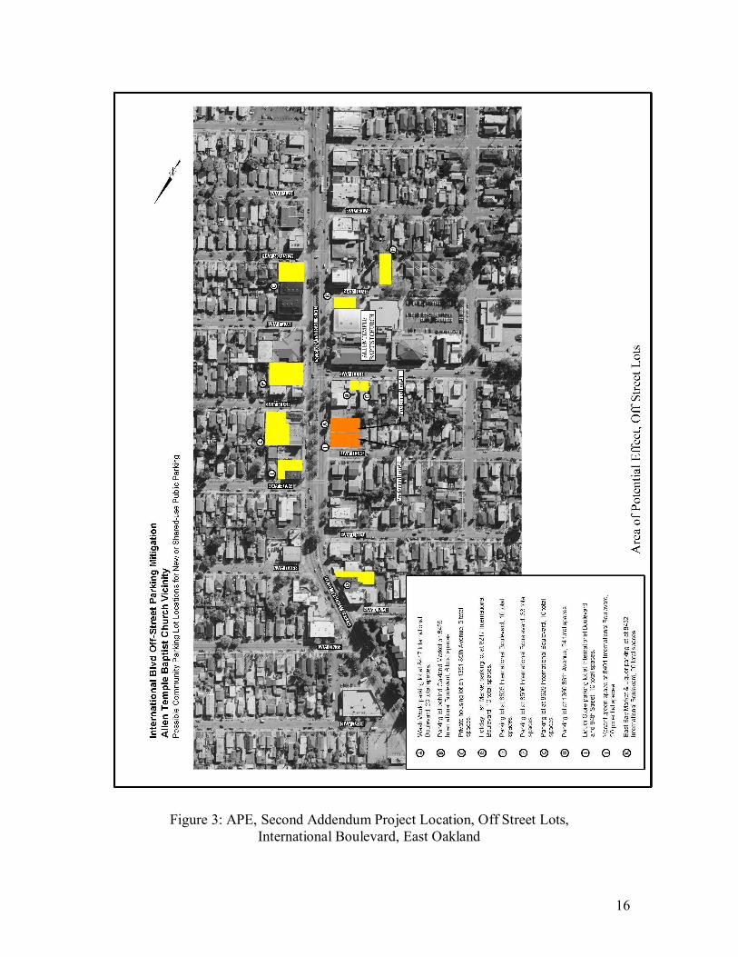
Figure 3: APE, Second Addendum Project Location, Off Street Lots,International Boulevard, East Oakland

17
Figure 4: APE, Second Addendum Project Location, Off Street Lots,Telegraph Avenue, Temescal District

18
APPENDIX 2:
AREA OF POTENTIAL EFFECT (APE) FOR HISTORIC ARCHITECTURE
Area of Potential Effect (APE) for Historic Architecture is included inAppendix 4: Second Addendum Historic Property Inventory and
Evaluation Report (HPIER), Appendix A: Maps

19
APPENDIX 3:
ADDENDUM ARCHAEOLOGICAL SURVEY REPORT (ASR)

Draft
SECOND ADDENDUM TO POSITIVE ARCHAEOLOGICAL SURVEY REPORTFOR THE ALAMEDA COUNTY TRANSIT DISTRICT’S
EAST BAY BUS RAPID TRANSIT PROJECTIN BERKELEY, OAKLAND, AND SAN LEANDRO, CALIFORNIA
Prepared by
Suzanne Baker, M.A, M.Sc. (ROPA)
Archaeological/Historical Consultants609 Aileen St.
Oakland, CA 94609
Prepared for
Kimley-Horn and Associates, Inc.111 West St. John St., Suite 440
San Jose, CA 945113
November 2011

i
EXECUTIVE SUMMARY
The Alameda County (AC) Transit District proposes to upgrade bus service to a high-level express service, known as East Bay Bus Rapid Transit (EBBRT), along anapproximately 18-mile arterial corridor through the cities of Berkeley, Oakland, and SanLeandro, California (Maps 1, 2a, 2b).
In 2005, Archaeological/Historical Consultants (A/HC) of Oakland, California carriedout an archaeological survey and prepared an Archaeological Survey Report toencompass proposed alternative routes for the EBBRT Project (Baker 2005). In 2010A/HC reviewed the project’s Preferred Alignment to determine whether there weresignificant changes from the alignment alternatives that had been previously surveyedand whether additional field survey might be necessary. No additional field survey wasdeemed necessary. Because the original record search was over five years old, an updatedrecord search for the study area was conducted at the Northwest Information Center ofthe California Historic Resources Information System (CHRIS) in February of 2010. AnAddendum Archaeological Survey report was completed in November 2010 (Baker2010).
In September 2011, A/HC was asked to evaluate travel mitigation improvements to anarea in East Oakland in the Fruitvale district that was outside of the original alignmentand thus not included in the two previous archaeological survey reports. Proposedimprovements will take place to Derby Avenue between 10th and 12th Streets and to SanLeandro Street/East 10th Street between Derby Avenue on the north and approximately33rd Avenue on the south. In addition, twenty vacant or underutilized off-street lots—fifteen located along International Boulevard and five on Telegraph Avenue—are alsobeing considered for acquisition for parking as mitigation for parking spacedisplacements by the EBBRT. These parcels were also included within the present studyarea.
The above locations were included within the study area of the two previousarchaeological record searches. No prehistoric or historic archaeological sites had beenreported in these areas and they had not been included within previous archaeologicalsurveys.
Suzanne Baker of A/HC inspected the travel mitigation improvement area and the vacantlots on foot on October 13, 2011. No prehistoric or historic sites were recorded within theAPE.
In the Fruitvale Traffic Mitigation Area, two or three tiny pieces of shell were noted in aparkway on San Leandro Street in the block south of Fruitvale Avenue. While shell isconsidered one indicator of a possible archaeological site, shell also occurs naturally andin fill. No accompanying prehistoric or historic cultural materials were noted. Althoughthere were too few indicators to record this location as an archaeological site, the areashould be considered of moderate archaeological sensitivity.

ii
Lots A and B on Telegraph Avenue in the Temescal District of North Oakland are in anarea of high archaeological sensitivity because of their proximity to a prehistoricarchaeological site and to the former location of the Vincent Peralta ranch complex, bothlocated within a few blocks of these parcels. The other three lots in the Temescal Districtshould be considered of moderate sensitivity.
The project is in a highly urbanized area with in-fill that obscures the ground surface.Archaeological survey cannot, therefore, be definitive. While the effects of the East BayBRT project are expected to be minimal, confined to surface or very shallow groundmodifications, it is recommended that an archaeologist monitor these two locationsduring construction, as is recommended for other areas of archaeological sensitivity alongthe EBBRT route (Baker 2005; 2010).
Throughout the entire project area care should be taken during any construction work. Ifcultural materials are unearthed during construction, work should be temporarily halted inthat area until a qualified archaeologist can assess the significance of the find.

iii
TABLE OF CONTENTS
Page
Executive Summary i
1.0 Introduction 1
2.0 Project Location and Description 22.1 Project Location 22.2 East Bay BRT Project Summary 22.3 Second Addendum Archaeological Survey Project Area Description 42.4 Area of Potential Effect 5
3.0 Research and Field Methods 53.1 Updated Record Search 53.2 Prehistoric and Historic Research 73.3 Archaeological Survey 7
4.0 Results of Reconnaissance 10
5.0 Summary and Conclusions 11
References 12
Maps and Figures
Map 1: Project Location ivMap 2a: Project Vicinity vMap 2b: Project Vicinity vi
Figure 1: APE, Second Addendum Project Location, Fruitvale Traffic Mitigation Area vii
Figure 2: APE, Second Addendum Project Location, Off Street Lots, International Boulevard, Fruitvale District viii
Figure 3: APE, Second Addendum Project Location, Off Street Lots, International Boulevard, East Oakland ix
Figure 4: APE, Second Addendum Project Location, Off Street Lots, Telegraph Avenue, Temescal District x

iv

v

vi

vii
Figure 1: APE, Second Addendum Project Location,Fruitvale Traffic Mitigation Area

viii
Figure 2: APE, Second Addendum Project Location, Off Street Lots,International Boulevard, Fruitvale District

ix
Figure 3: APE, Second Addendum Project Location, Off Street Lots,International Boulevard, East Oakland

x
Figure 4: APE, Second Addendum Project Location, Off Street Lots,Telegraph Avenue, Temescal District

1
1.0 INTRODUCTION
Archaeological/Historical Consultants (A/HC) conducted an archaeological survey of theproposed East Bay Bus Rapid Transit (EBBRT) Project in Alameda County, California,in November and December of 2004, followed by preparation of a PositiveArchaeological Survey Report (ASR) for that project (Baker 2005). The 2005 ASRreported that seven prehistoric sites and four places with subsurface historicarchaeological features had been previously recorded in or very near the corridors of thealternative project alignments. In addition, the 2005 on-foot archaeological survey forthe ASR found twelve other locations within the various alternative alignments thatcontain marine shell, which is considered a prehistoric site indicator. Shell alone may notbe definitive as to the presence of prehistoric archaeological sites, but, since surfaceinspection was limited by various obstructions, these locations were considered sensitivefor archaeological sites and were given Primary Numbers by the Northwest InformationCenter of the California Historic Resources Information System (CHRIS), at SonomaState University, Rohnert Park.
In 2010 A/HC reviewed the Preferred Alternative to determine whether there weresignificant changes from alignments that had been previously surveyed and whetheradditional field survey might be necessary. No additional on-foot inspection was deemednecessary. In addition, because the original record search at the Northwest InformationCenter of the California Historic Resources Information System (CHRIS) was over fiveyears old, an updated record search at the Northwest Information Center was completed.One prehistoric site in downtown Oakland had been recorded since the 2005 recordsearch. Recordation was based on locations given in old newspaper articles and the siteappears to have been the same as one previously recorded (Baker 2010)
In September 2011, A/HC was asked to evaluate travel mitigation improvements to anarea in East Oakland in the Fruitvale district that was outside of the original alignmentand thus not included in the two previous archaeological survey reports. In addition, ACTransit is considering for acquisition 20 vacant or underutilized lots for off-streetreplacement parking as mitigation for parking space displacement by the EBBRT Project.Fifteen are located along International Boulevard in the Fruitvale District and EastOakland and five are along Telegraph Avenue in the Temescal District of North Oakland.These have been included in the present Second Addendum Archaeological SurveyReport.
The above locations were included within the two previous archaeological record searchareas. No prehistoric or historic archaeological sites had been reported in these areas andthey had not been included within previous archaeological surveys.
The present Second Addendum Archaeological Survey Report incorporates the results ofthe 2005 and 2010 reports by reference and details the results of the archaeologicalsurvey of the travel mitigation improvements area and vacant lots.

2
JRP Historical Consulting (2011) has prepared separately the Second Addendum HistoricProperties Inventory and Evaluation Reports (HPIER), discussing historic architectureand features.
This Second Addendum Archaeological Survey Report has been prepared by SuzanneBaker, Principal Investigator (M.A., Anthropology/Archaeology; M.Sc., Rock ArtStudies, RPA certified); 37 years of field experience in California archaeology.
2.0 PROJECT LOCATION AND DESCRIPTION
2.1 Project Location
The larger East Bay Bus Rapid Transit Project is located in the cities of Berkeley,Oakland, and San Leandro in Alameda County, California (Maps 1, 2a, 2b; see also APEmaps appended to Baker 2010). It is found on the USGS 7.5’ Oakland West, OaklandEast, and San Leandro Quadrangles.
The area of proposed travel mitigation improvements included in this Second AddendumArchaeological Survey Report is found in the City of Oakland on Derby Avenue between10th and 12th Streets and on San Leandro Street/East 10th Street between Derby Avenueon the north and approximately 33rd Avenue on the south (Figure 1). In addition to theabove project area, AC Transit is considering acquisition of twenty vacant orunderutilized lots in Oakland for off-street parking. These have also been included in thepresent project area. Five of these are on International Boulevard between FruitvaleAvenue and 35th Avenue (Figure 2) and eleven are along International Boulevardbetween 82nd Avenue and 87th Avenue (Figure 3). Five others are on Telegraph Avenuebetween 46th Street and 52nd Street (Figure 4).
2.2 East Bay BRT Project Summary
The East Bay Bus Rapid Transit (BRT) Locally Preferred Alternative (LPA) providesenhanced transit service between the Downtown Berkeley BART station and the SanLeandro BART station, via Downtown Oakland. The service, to be provided primarilyon Telegraph Avenue and International Boulevard/E.14th Street, extends across anapproximately 14.38 mile long corridor. The East Bay BRT will replace Rapid BusRoutes 1 and 1R currently operating in the corridor.
General corridor-wide elements proposed for Oakland and San Leandro are as follows:
Dedicated median bus lanes for exclusive use by buses and emergency vehicles inmost of the corridor. Segments with dedicated median bus lanes will have single-platform, center median stations with level boarding.Dedicated right-hand, side-running bus lanes on some segments that givepreference to transit operations but permit right-turns and access to parking.These segments will have curbside stations with level or near-level boarding.
3
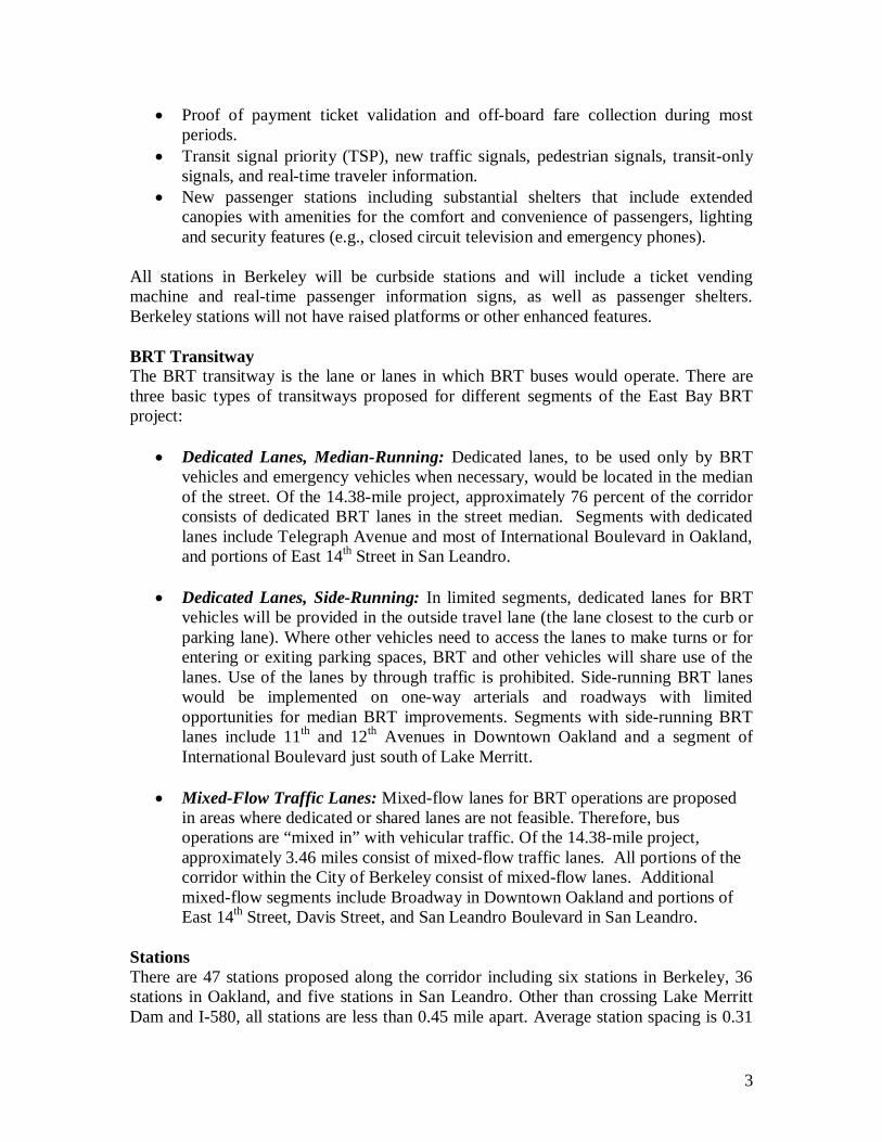
Proof of payment ticket validation and off-board fare collection during mostperiods.Transit signal priority (TSP), new traffic signals, pedestrian signals, transit-onlysignals, and real-time traveler information.New passenger stations including substantial shelters that include extendedcanopies with amenities for the comfort and convenience of passengers, lightingand security features (e.g., closed circuit television and emergency phones).
All stations in Berkeley will be curbside stations and will include a ticket vendingmachine and real-time passenger information signs, as well as passenger shelters.Berkeley stations will not have raised platforms or other enhanced features.
BRT TransitwayThe BRT transitway is the lane or lanes in which BRT buses would operate. There arethree basic types of transitways proposed for different segments of the East Bay BRTproject:
Dedicated Lanes, Median-Running: Dedicated lanes, to be used only by BRTvehicles and emergency vehicles when necessary, would be located in the medianof the street. Of the 14.38-mile project, approximately 76 percent of the corridorconsists of dedicated BRT lanes in the street median. Segments with dedicatedlanes include Telegraph Avenue and most of International Boulevard in Oakland,and portions of East 14th Street in San Leandro.
Dedicated Lanes, Side-Running: In limited segments, dedicated lanes for BRTvehicles will be provided in the outside travel lane (the lane closest to the curb orparking lane). Where other vehicles need to access the lanes to make turns or forentering or exiting parking spaces, BRT and other vehicles will share use of thelanes. Use of the lanes by through traffic is prohibited. Side-running BRT laneswould be implemented on one-way arterials and roadways with limitedopportunities for median BRT improvements. Segments with side-running BRTlanes include 11th and 12th Avenues in Downtown Oakland and a segment ofInternational Boulevard just south of Lake Merritt.
Mixed-Flow Traffic Lanes: Mixed-flow lanes for BRT operations are proposedin areas where dedicated or shared lanes are not feasible. Therefore, busoperations are “mixed in” with vehicular traffic. Of the 14.38-mile project,approximately 3.46 miles consist of mixed-flow traffic lanes. All portions of thecorridor within the City of Berkeley consist of mixed-flow lanes. Additionalmixed-flow segments include Broadway in Downtown Oakland and portions ofEast 14th Street, Davis Street, and San Leandro Boulevard in San Leandro.
StationsThere are 47 stations proposed along the corridor including six stations in Berkeley, 36stations in Oakland, and five stations in San Leandro. Other than crossing Lake MerrittDam and I-580, all stations are less than 0.45 mile apart. Average station spacing is 0.31

4
mile. Stations will include ticket vending machines, ticket validators, passengerinformation kiosks, canopy shelters, emergency telephones and security cameras. Stationplatforms will be at or slightly lower than the floor level of BRT buses, allowing fast andconvenient passenger loading and unloading. All station elements will conform to designstandards established by the Americans with Disabilities Act of 1990 (ADA), asamended.
Service PlanAssuming demand is as forecast, weekday BRT service will be provided atapproximately five-minute frequencies throughout the day, 10-minute frequencies in theevening, and hourly service from midnight to 5:00 a.m. On weekends, daytime servicewill be at approximately 15-minute intervals in the northern part of the corridor and 7.5-minute intervals in the southern part. Evening service will be at approximately15-minuteintervals and late night service will be hourly.
Downtown Oakland-San Leandro BRT AlternativeA second, less costly build alternative has been included for evaluation in the FinalEIS/EIR. The DOSL Alternative begins in the north at 20th Street (Uptown station) inDowntown Oakland. Under this alternative, there will be no dedicated BRT lanes orenhanced stations north of this point. South of this point, the BRT will run in center-running or side-running BRT lanes as described in the LPA. Features of the DOSLAlternative would be the same as the LPA, but with fewer stations (32).
Hours of operation and service frequencies for the DOSL Alternative would be the sameas proposed for the LPA in the Downtown Oakland to San Leandro BART segment ofthe corridor.
2.3 Second Addendum Archaeological Survey Project Area Description
Improvements for Traffic and Parking MitigationSeveral locations off the East Bay BRT alignment through the study area are proposed forimprovements to mitigate BRT project traffic and parking impacts. The improvementsinvolve acquisition of right-of-way, paving and, in some instances, adding traffic orparking control systems. These areas were also evaluated for possible archaeologicalresources of significance that could be affected by BRT project construction.
Fruitvale Traffic Mitigation: Expansion of Parallel Roadway CapacityTo address traffic impacts to International Boulevard through the Fruitvale district of EastOakland associated with a reduction of mixed-flow travel lanes (i.e., four to two laneswith BRT), the project will reconstruct segments of parallel and intersecting streets toallow autos to bypass the commercial center of Fruitvale, generally the area alongInternational Boulevard from Fruitvale Avenue to 38th Avenue. San Leandro Street southof Fruitvale Avenue and E.10th Street north of Fruitvale Avenue will be reconstructed andthe intersection of Fruitvale/San Leandro/E.10th realigned and widened to facilitate trafficflow. Derby Avenue and E.10th Street will be reconstructed to enhance the area betweenInternational Boulevard and the improved parallel route, San Leandro Street. The DerbyAvenue intersection with E.12th Street, both southbound and northbound, will be re-

5
striped and a traffic signal added to allow traffic on San Leandro Street to use E.12th
Street as an alternative to International Boulevard when proceeding to and fromdowntown Oakland. These improvements are shown in Figure 1. Right-of-wayacquisition will be required to realign the Fruitvale/San Leandro/E.10th intersection andto reconstruct E.10th Street (west curb) and Derby Avenue (south curb between E.10th andE.12th).
Parking Mitigation: New Off-Street Parking LotsIn three areas, the strategy for mitigation of parking space displacements by the BRTproject has been expanded to include providing replacement parking in surface lots offthe BRT-alignment. Normally, parking is mitigated by signing, striping and/or meteringspaces on cross streets located near where displacements are considered significant. Inthe Temescal and Fruitvale neighborhood commercial districts and in East Oakland from82nd Avenue to 86th Avenue, additional replacement parking is proposed in vacant orunderutilized parcels close to the BRT arterial. Several potential surface lots at each ofthese locations were identified, as shown in Figures 2-4. A preferred lot is indicated ateach site; however, further evaluation will be performed during future project phases, andthe alternate lots are, therefore, not eliminated from further consideration. Thearchaeological survey investigated all of the parcels shown. The BRT project wouldrepave the selected parcels and stripe, sign and meter spaces for public parking. Any newoff-street lots would ultimately be turned over to the city of Oakland for operation andmaintenance.
2.4 Area of Potential Effect (APE)
The APE for archaeology for the Preferred Alignment is the area of direct impact andincludes the EBBRT project right-of-way along the corridor from downtown Berkeley tothe San Leandro BART station as described above. It is generally contained withincurrent sidewalks, curbs and roadway (see APE maps appended in Baker 2010).
The APE for the new Derby Avenue Fruitvale Bypass project location, discussed in thisSecond Addendum Archaeological Survey Report, is shown on Figure 1. It includescurrent sidewalks, curb, and roadway, as well as areas of right-of-way acquisition at theintersection of Fruitvale/San Leandro/E. 10th Street, the intersection of Derby Avenue andE. 10th Street, and along Derby Avenue between E. 12th Street and E. 10th Street andalong the west side of E. 10th Street (Figure 1). The APE for the twenty InternationalBoulevard and Telegraph Avenue off-street parking locations is restricted to the footprintof the lots as shown in Figures 2-4.
3.0 RESEARCH AND FIELD METHODS
3.1 Updated Record Search
A record search for the EBBRT project area was conducted at the Northwest InformationCenter of the California Historical Resources Information Center at Sonoma State

6
University, Rohnert Park, in 2005. An updated record search took place on February 25,2010 for information on recorded sites and relevant reports submitted since the original2005 record search. The study area for the original record search and updated recordsearch included a width up to one-half mile on either side of the project alignment. TheAPEs for the project areas considered in this Second Addendum Archaeological SurveyReport are entirely within the original study area. The results of the two record searchesare included by reference (Baker 2005; 2010). The 2010 updated record search wasrecent enough that another update was not considered necessary for this SecondAddendum report.
No archaeological sites within the APE of the project areas considered in this SecondAddendum Archaeological Survey Report were identified during the record searches orthe previous archaeological survey (Baker 2005; 2010). No areas of particulararchaeological sensitivity were identified for the Fruitvale Traffic Mitigation Area or theFruitvale off-street lots or for the East Oakland off-street lots based on the prior reports(Baker 2005:13-14). An area of high archaeological sensitivity, however, was identifiedclose to the Temescal District off-street lots. This was along Telegraph Avenue between57th Street and 52nd Street (Baker 2005:13-14). Lots A and B are within or very near thislocation (Figure 4). One prehistoric or protohistoric site, P-01-010600, containing shellbeads, a piece of abalone shell, and a piece of Chinese ceramic, has been recorded on theeast side of Telegraph Avenue between 56th and 57th streets, a few blocks north ofTemescal Lot A (Schwartz 2002). This general area is also very near the former site ofthe Vicente Peralta ranch complex. The block bounded by 55 th and 56th streets, TelegraphAvenue, and Vicente Street was the location of four adobe structures, built between 1836and the 1850s by Vicente Peralta, and of a later frame house built in 1867 (Hendry andBowman 1940:589-591; Bowman (1951:224; map following 224). The adobes were alldemolished by the late 1880s, and the frame house was moved in 1892 to the northwestcorner of Claremont Avenue and Vicente Street, where it stood until it burned in June1932 (Bowman 1951:225). This block was largely destroyed by construction of Highway24, which passes over it; however, the possibility that outlier archaeological features mayexist in or near the present project area cannot be discounted. Temescal Creek (nowunderground at about 51st Street or 52nd Street) flows just to the south of the prehistoricsite and the former location of the Peralta adobes, near the intersection of ClaremontAvenue and Telegraph (Baker 2005:13). The fresh water of the creek undoubtedlyattracted both prehistoric and historic settlement. It is clear that the entire area between57th Street and 52nd Street along Telegraph Avenue in Oakland should be consideredsensitive for both prehistoric and historic resources.
No archaeological sites within the project area are currently listed on the NationalRegister of Historic Places (http://www.nps.gov/history/NR/research, accessedNovember 2011), the California Register of Historical Resources, and list of CaliforniaHistorical Landmarks (http://ohp.parks.ca.gov, accessed November 2011).
In 2005 as part of the process of identifying archaeological resources within the projectstudy area, letters of notification about the project were sent to the Native AmericanHeritage Commission and to a list of Alameda County native informants maintained by

7
the Heritage Commission (Baker 2005). The APE of this Second Addendum project areais entirely within the previous study area and no new letters were deemed necessary.
Historic buildings recorded in Oakland and Berkeley since 2005 are discussed inAddendum HRIERs prepared by JRP Historical Consulting (2010; 2011).
3.2 Prehistoric and Historic Research
Prehistoric, ethnographic, and historic overviews for the project study area were preparedfor the original Positive Archaeological Survey Report (Baker 2005). They areincorporated here by reference. The reader is referred to the 2005 report for details.
3.3 Archaeological Survey
The survey methodology for the original APE for the EBBRT project was and isconsistent with general cultural resources practices. The 2005 archaeological surveyincluded an on-foot inspection of the APE for archaeology within all alternativealignments for the project, including the Preferred Alignment. Details of that survey canbe found in Baker (2005).
The project areas included in this Second Addendum study are in a highly builtenvironment with little open space adjacent to the street alignment. Nevertheless, thestreetscape includes a few open planting areas, adjacent yards, and occasionally a vacantlot. Aside from the record search which pinpoints already recorded sites and historicareas, the only way to determine if sensitive locations exist within or adjacent to theproject alignment is to walk the APE and inspect adjacent open areas.
On October 13, 2011, Suzanne Baker of Archaeological/Historical Consultants inspectedon foot the project areas, along Derby Avenue, East 10th Street, Fruitvale Avenue and SanLeandro Street, and the proposed parking lots on International Boulevard and TelegraphAvenue. These areas were inspected for evidence of cultural modification, includingshell, midden soil, lithic debitage, groundstone, and historic artifacts and features.
A) Fruitvale Traffic Mitigation Area—Derby Avenue, E. 12th Street, E. 10th Street, SanLeandro Street, Fruitvale Avenue.
On the south side of Derby Avenue the right-of-way was entirely paved, while the northside had some exposed areas, but these were generally covered with gravel and groundvisibility was poor. The right-of-way on the west side of E. 10th Street was paved, exceptat the south end of the block adjacent to Fruitvale Avenue, where there is some exposedground. This was, however, covered in gravel or weeds and surface visibility was fair topoor. The east side of E. 10th had a few small planter/drainage areas in the parkways andadjacent to industrial buildings that line much of the block. These were generally coveredwith weeds and ground visibility varied from fair to poor; many had clearly beendisturbed by prior construction and emplacement of water pipes.
8
The west side of E. 12th Street, adjacent to a BART Park ‘N Ride lot, is paved within theright-of-way. Near its south end at Fruitvale the road splits at the corner and there is asmall grassy area in between the roadways. This is all turf and is probably fill. ElevatedBART tracks run just to the east; the area under the BART tracks is open, althoughcovered with turf. There was no ground visibility in these areas.
Fruitvale Avenue in the project right-of-way is entirely paved on both sides of the road.At the southeast corner of Fruitvale Avenue and San Leandro Street, there is a large,triangular vacant lot that is being considered for right-of-way acquisition. It was fenced,so could not be accessed, but was entirely covered with gravel, so that there was noground visibility.
On the east side of San Leandro Street, south of Fruitvale, the right-of-way in thenorthern quarter of the block is entirely paved, but the southern three-quarters hasplanting areas adjacent to the sidewalk with fairly good ground visibility. Two or threetiny fragments of shell were noted in the parkway in front of residences at 3218 and 3230San Leandro Street. These were confined to two small areas, which also containedconsiderable trash. In this area there are several late 19th or early 20th century residenceswith yards adjacent to the right-of-way.
The right-of-way and adjacent land on the west side of San Leandro Street is almostentirely paved or covered with structures. The only exception was at the southwest cornerof Frutivale Avenue and San Leandro Street, where there is a vacant lot. A portion of thislot may be acquired as right-of-way. The lot was fenced, so that there was no access, butthe lot was heavily covered in grass, weeds, and trash and had poor ground visibility.
B) International Boulevard Proposed AC Transit Off-Street Parking Lots
1) Fruitvale Avenue to 35th Avenue (Figure 2)Lot A. This is a large, irregularly shaped, parking lot, now used by the Bank ofAmerica. This is entirely paved with asphalt.
Lot B. This is a vacant lot at the northeast corner of 33rd Avenue and E. 12th
Street. Much of the north side of the lot was graveled with the rest covered withturf and weeds. Visibility was only fair. This lot probably once held one or moresingle-family dwellings (the lot is adjacent to three older single family residenceson the same block, probably dating to the early 20th century). The lot containssome debris, including plaster, butchered bone fragments, domestic trash(including the plastic shoe of a doll), and miscellaneous other recent trash, such asplastic and paper. Soil, where visible, was a brown silty clay.
Lot C. This is a square parcel at the northwest corner of 34th Avenue and FarnhamStreet. The lot is entirely paved.
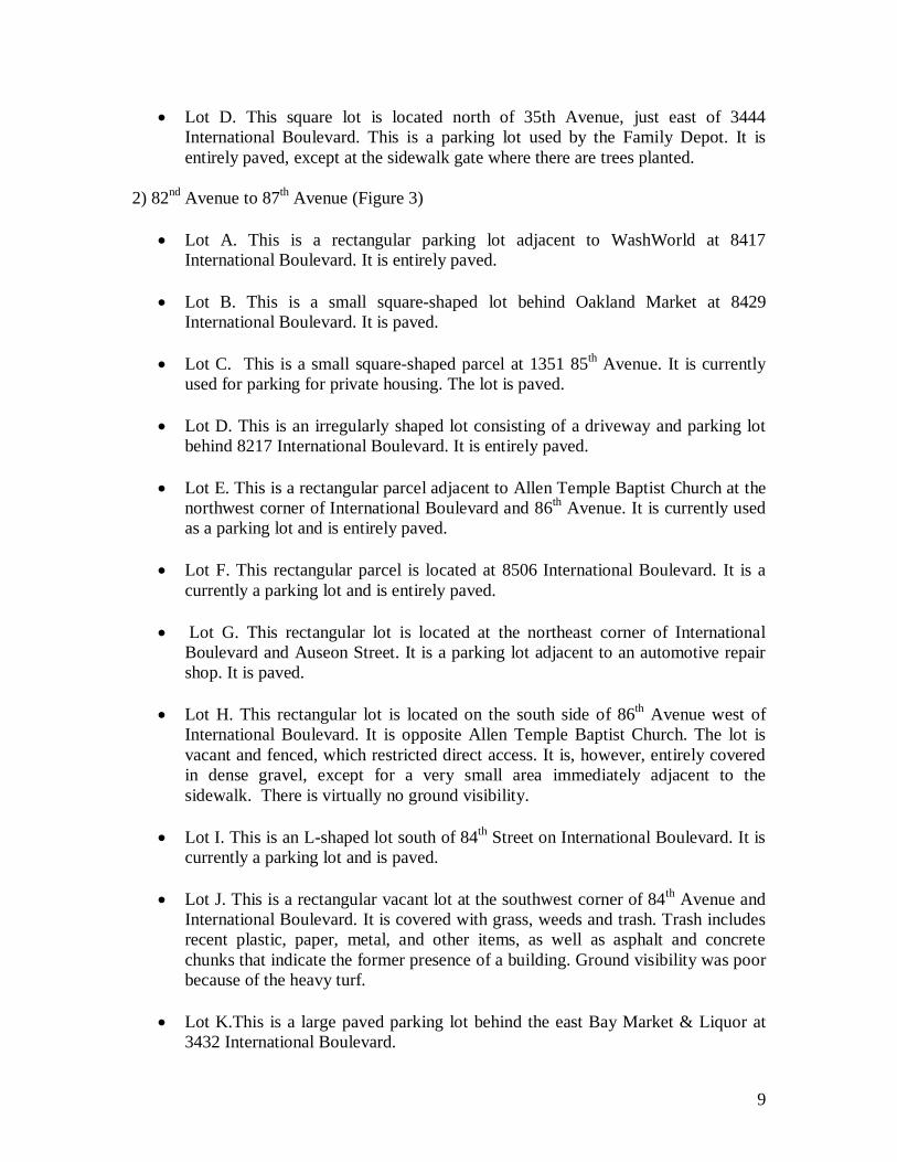
9
Lot D. This square lot is located north of 35th Avenue, just east of 3444International Boulevard. This is a parking lot used by the Family Depot. It isentirely paved, except at the sidewalk gate where there are trees planted.
2) 82nd Avenue to 87th Avenue (Figure 3)
Lot A. This is a rectangular parking lot adjacent to WashWorld at 8417International Boulevard. It is entirely paved.
Lot B. This is a small square-shaped lot behind Oakland Market at 8429International Boulevard. It is paved.
Lot C. This is a small square-shaped parcel at 1351 85th Avenue. It is currentlyused for parking for private housing. The lot is paved.
Lot D. This is an irregularly shaped lot consisting of a driveway and parking lotbehind 8217 International Boulevard. It is entirely paved.
Lot E. This is a rectangular parcel adjacent to Allen Temple Baptist Church at thenorthwest corner of International Boulevard and 86th Avenue. It is currently usedas a parking lot and is entirely paved.
Lot F. This rectangular parcel is located at 8506 International Boulevard. It is acurrently a parking lot and is entirely paved.
Lot G. This rectangular lot is located at the northeast corner of InternationalBoulevard and Auseon Street. It is a parking lot adjacent to an automotive repairshop. It is paved.
Lot H. This rectangular lot is located on the south side of 86th Avenue west ofInternational Boulevard. It is opposite Allen Temple Baptist Church. The lot isvacant and fenced, which restricted direct access. It is, however, entirely coveredin dense gravel, except for a very small area immediately adjacent to thesidewalk. There is virtually no ground visibility.
Lot I. This is an L-shaped lot south of 84th Street on International Boulevard. It iscurrently a parking lot and is paved.
Lot J. This is a rectangular vacant lot at the southwest corner of 84th Avenue andInternational Boulevard. It is covered with grass, weeds and trash. Trash includesrecent plastic, paper, metal, and other items, as well as asphalt and concretechunks that indicate the former presence of a building. Ground visibility was poorbecause of the heavy turf.
Lot K.This is a large paved parking lot behind the east Bay Market & Liquor at3432 International Boulevard.
10
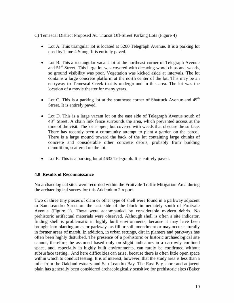
C) Temescal District Proposed AC Transit Off-Street Parking Lots (Figure 4)
Lot A. This triangular lot is located at 5200 Telegraph Avenue. It is a parking lotused by Time 4 Smog. It is entirely paved.
Lot B. This a rectangular vacant lot at the northeast corner of Telegraph Avenueand 51st Street. This large lot was covered with decaying wood chips and weeds,so ground visibility was poor. Vegetation was kicked aside at intervals. The lotcontains a large concrete platform at the north center of the lot. This may be anentryway to Temescal Creek that is underground in this area. The lot was thelocation of a movie theater for many years.
Lot C. This is a parking lot at the southeast corner of Shattuck Avenue and 49th
Street. It is entirely paved.
Lot D. This is a large vacant lot on the east side of Telegraph Avenue south of48th Street. A chain link fence surrounds the area, which prevented access at thetime of the visit. The lot is open, but covered with weeds that obscure the surface.There has recently been a community attempt to plant a garden on the parcel.There is a large mound toward the back of the lot containing large chunks ofconcrete and considerable other concrete debris, probably from buildingdemolition, scattered on the lot.
Lot E. This is a parking lot at 4632 Telegraph. It is entirely paved.
4.0 Results of Reconnaissance
No archaeological sites were recorded within the Fruitvale Traffic Mitigation Area duringthe archaeological survey for this Addendum 2 report.
Two or three tiny pieces of clam or other type of shell were found in a parkway adjacentto San Leandro Street on the east side of the block immediately south of FruitvaleAvenue (Figure 1). These were accompanied by considerable modern debris. Noprehistoric artifactual materials were observed. Although shell is often a site indicator,finding shell is problematic in highly built environments, because it may have beenbrought into planting areas or parkways as fill or soil amendment or may occur naturallyin former areas of marsh. In addition, in urban settings, dirt in planters and parkways hasoften been highly disturbed. The presence of a prehistoric or historic archaeological sitecannot, therefore, be assumed based only on slight indicators in a narrowly confinedspace, and, especially in highly built environments, can rarely be confirmed withoutsubsurface testing. And here difficulties can arise, because there is often little open spacewithin which to conduct testing. It is of interest, however, that the study area is less than amile from the Oakland estuary and San Leandro Bay. The East Bay shore and adjacentplain has generally been considered archaeologically sensitive for prehistoric sites (Baker

11
2005). This block also contains several late 19th or early 20th century residences. It isalways possible that shell could have been deposited in the historic period, when shellfishwas among the foodstuffs consumed. The possibility exists that subsurface remnants ofhistoric trash dumps and privies could exist adjacent to these residences.
The shell encountered here was too scant to allow recording as either a prehistoric orhistoric site in the project area. Because of its location close to the bayshore in an areagenerally sensitive for prehistoric sites and in an historic residential block, this part of theproject area should, however, be treated as another location of moderate archaeologicallysensitivity (see Baker 2005:13).
Sixteen of the 20 lots being considered for off-site parking are paved or covered withgravel and thus had no ground visibility for archaeological inspection. The other fourlots are vacant and generally covered with weeds and debris. One could not be accessedfor detailed inspection because of fencing. No archaeological materials were observed inopen areas and no archaeological sites were recorded in these lots.
Within the Temescal District of Telegraph Avenue in North Oakland, Lots A and B(Figure 4) are within an area of high archaeological sensitivity because they are near thelocations of a recorded prehistoric site and the former location of an important historicsite, the Vincent Peralta adobe(s). The other lots within the Temescal District should beconsidered of moderate archaeological sensitivity because of their proximity to theTemescal Creek drainage.
5.0 SUMMARY AND CONCLUSIONS
In 2004-2005, Archaeological/Historical Consultants (A/HC) carried out anarchaeological survey and prepared a Positive Archaeological Survey Report toencompass proposed alternative routes for the East Bay Bus Rapid Transit Project to belocated in Berkeley, Oakland, and San Leandro (Baker 2005). In 2010 A/HC reviewedthe project’s final Preferred Alternative alignment to determine whether there had beensignificant changes from the alignments that had been previously surveyed and whetheradditional field survey might be necessary. It was determined that none was required. Inaddition to this review, an updated record search was conducted at the NorthwestInformation Center of the California Historic Resources Information System (CHRIS),because the original record search was then over five years old. An Addendum to theoriginal Archaeological Survey Report was prepared (Baker 2010).
In September 2011 A/HC was asked to prepare a second Addendum to the originalArchaeological Survey Report to evaluate travel mitigation improvements to an area inEast Oakland in the Fruitvale district that was outside of the original alignment and thusnot included in the two previous archaeological survey reports. In addition, 20 lots thatare being considered for acquisition by AC Transit for off-site parking were also includedin the project.
12
An on-foot archaeological survey of the new project areas was undertaken in October2011. These areas are today within a densely inhabited region with a heavily builtinfrastructure. Houses, commercial buildings, streets, paving, and sidewalks almostcompletely obscure ground visibility. Archaeological survey of the project area, whilecomplete, was of necessity cursory, limited to inspection of open planting areas and a fewyards and vacant lots.
No archaeological sites were recorded within the Second Addendum ArchaeologicalSurvey APE.
Although no sites were recorded, Lots A and B within the Temescal District off-streetparking locations are in an area of high archaeological sensitivity because of theirproximity to a prehistoric site and a historic site location, located within three blocks ofthese lots. The other three lots in the Temescal District should be considered of moderatesensitivity.
One area with scant shell was found in a parkway within the Fruitvale Traffic Mitigationarea adjacent to San Leandro Street in the block south of Fruitvale Avenue. This block isalso the location of late 19th century residences. The shell encountered here was tooephemeral to allow recording as either a prehistoric or historic site in the project area.Because shell is sometimes an indicator of either prehistoric or historic culturaldeposition, the area should be treated as of at least moderate archaeological sensitivity.
The project is in a highly urbanized area with in-fill that obscures the ground surface.Archaeological survey cannot, therefore, be definitive. While the effects of the East BayBRT project are expected to be minimal, confined to surface or very shallow groundmodifications, it is recommended that, during construction, an archaeologist monitor thetwo areas of archaeological sensitivity discussed above, as is recommended for otherareas of archaeological sensitivity along the EBBRT route (Baker 2005; 2010).Throughout the entire project area care should be taken during any construction work. Ifprehistoric or historic cultural materials are unearthed during construction within theAPE, work should be temporarily halted in that area until a qualified archaeologist canassess the significance of the find.
Additional archaeological survey will be needed if project limits are extended outside thepresent survey limits.
REFERENCES
Baker, Suzanne2005 Positive Archaeological Survey Report for the Alameda-Contra Costa TransitDistrict’s East Bay Bus Rapid Transit Project in Berkeley, Oakland, and San Leandro.Prepared for Parsons, San Francisco.

13
2010 Addendum to Positive Archaeological Survey Report for the Alameda CountyTransit District’s East Bay Bus Rapid Transit Project in Berkeley, Oakland, and SanLeandro, California. Prepared for Kimley-Horn and Associates, Oakland, CA.
Bowman, J. N.1951 The Peraltas and Their Houses. California Historical Society Quarterly 30(3). SanFrancisco.
Hendry, G. W. and J. N. Bowman1940 The Spanish and Mexican Adobe and Other Buildings in the Nine San FranciscoBay Counties, 1776 to about 1850. Part VI, Alameda County. Manuscript, BancroftLibrary, University of California, Berkeley.
JRP Historical Consulting2010 Draft Addendum Historic Properties Inventory and Evaluation: AC Transit EastBay Bus Rapid Transit Project. Vols. 1 and 2. Submitted to Kimley-Horn andAssociates, Inc., Oakland.
2011 Draft Second Addendum Historic Properties Inventory and Evaluation: AC TransitEast Bay Bus Rapid Transit Project, Volume 1. Report for Kimley-Horn and Associates,Oakland, CA.
Schwartz, Richard2002 Archeological Site Record, P-01-010600. On file, Northwest Information Center,CHRIS, Sonoma State University, Rohnert Park, CA.

APPENDIX 4:
ADDENDUM HISTORIC PROPERTY INVENTORY AND EVALUATION REPORT(HPIER)

DDDRRRAAAFFFTTT
SECOND ADDENDUMHISTORIC PROPERTIES INVENTORY AND EVALUATION:
AC Transit East Bay Bus Rapid Transit Project
Volume 1
Prepared By:JRP Historical Consulting, LLC
2850 Spafford StreetDavis, CA 95618
October 2011

DDDRRRAAAFFFTTT
TABLE OF CONTENTS
EXECUTIVE SUMMARY ................................................................................................. 11. PROJECT DESCRIPTION ....................................................................................... 32. RESEARCH AND FIELD METHODS ....................................................................... 5
2.1. Preparers’ Qualifications ...........................................................................................73. DESCRIPTION OF RESOURCES ........................................................................... 8
3.1. Commercial .................................................................................................................83.2. Residential ..................................................................................................................93.3. Miscellaneous .............................................................................................................9
4. RESOURCE SIGNIFICANCE ................................................................................ 104.1. Application of National Register and California Register Criteria ........................ 104.2. Summary of National Register and CEQA Eligibility Status in the New APE ..... 114.3. General Discussion of Historical Significance of Properties in the New APE .... 11
5. FINDINGS AND CONCLUSIONS .......................................................................... 156. BIBLIOGRAPHY .................................................................................................... 17
ATTACHMENTS
Appendix A MapsAppendix B DPR 523 FormsAppendix C Local Historic Preservation ElementsAppendix D Concurrence Letters

Addendum HPIER AC Transit East Bay BRT October 2011
JRP Historical Consulting, LLC 1
EXECUTIVE SUMMARY
JRP Historical Consulting (JRP) has prepared this Addendum Historic PropertiesInventory and Evaluation Report (HPIER) based on research and fieldwork conducted inOctober 2011. This report is an addendum to the original AC Transit East Bay BusRapid Transit HPIER that JRP produced in October 2005 and the Addendum HistoricProperties Inventory and Evaluation Report (Addendum HPIER) produced in October2010 and addresses only those architectural resources that were not addressed in theprevious reports. Please refer to the October 2005 and October 2010 reports for a fulldescription of the previous architectural survey and evaluation results.
Further refinement of the project has resulted in modifications to the Area of PotentialEffects (APE). This report identifies and evaluates historic properties within the newArea of Potential Effects (APE) for Alameda-Contra Costa (AC) Transit District’s EastBay Bus Rapid Transit (BRT) Project located in Alameda County, California. ThisAddendum HPIER examines the potential eligibility of historic resources within the newareas of potential effect (hereafter referred to as new APE) for listing in the NationalRegister of Historic Places (referred to hereafter in this report as the National Register),as well as their potential eligibility for listing in the California Register of HistoricalResources (hereafter the California Register). The purpose of this document is to assistAC Transit and Federal Transit Administration (FTA) to comply with applicable sectionsof the National Historic Preservation Act of 1966 (16 USC 470), as amended, and theimplementing regulations of the Advisory Council on Historic Preservation (36 CFR Part800), as these pertain to federally-funded undertakings and their effects on historicproperties. It also seeks to help AC Transit to comply with requirements of theCalifornia Environmental Quality Act (CEQA) for this project, as it pertains to historicalresources. The resources studied for this report have been evaluated in accordancewith Section 15064.5(a)(2)-(3) of CEQA Guidelines using the California Register ofHistorical Resources criteria outlined in Section 5024.1 of the California PublicResources Code.
In general the project extends from Berkeley south along Oxford Street and ShattuckAvenue, east along Bancroft Way and Durant Avenue to Telegraph Avenue, where itthen continues in a southwesterly direction into downtown Oakland. There the projectruns a short distance along Broadway, turning southeast onto 11th and 12th streets, untilit intersects with 2nd Avenue. From 2nd Avenue the project follows 12th Street andInternational Boulevard (also known as East 14th Street) until 14th Avenue, and thenproceeds south into San Leandro, ending at the San Leandro BART station.
The new APE encompasses 31 parcels of which 23 contain historic-era resources or“survey population” resources, i.e. those buildings, groups of buildings or structures thatwere constructed in or before 1966. The inventory and evaluation efforts conducted forthis project address each resource of the survey population by applying the appropriateNational Register and California Register evaluation criteria. Although resourcesevaluated for these programs are usually 50 years old or older, this survey includes allresources within the new APE that are 45 years old or older as of 2011 to account forthe passage of time between the period of project review and project completion. The
Addendum HPIER AC Transit East Bay BRT October 2011
JRP Historical Consulting, LLC 2
remaining eight parcels were vacant or contained buildings, structures or objects thatwere constructed in or after 1966 lacked exceptional significance under NR CriteriaConsideration G regarding properties less than 50 years old, and were not subject toevaluation.
The general project location is shown in Maps 1 and 2. The new APE for historicarchitectural resources is shown in Map 3, Figures 1 through 46, and includes MapReference numbers keyed to the historic resources surveyed by this report. All of themaps are located in Appendix A. Evaluations of each of the historic resources withinthe new APE are presented on DPR 523 forms attached as Appendix B of this report.The survey population resources are summarized in Section 5 with summary tablesincluded in Section 5.1
As noted above this Addendum HPIER addresses a total of 23 survey populationresources buildings and structures that were not previously included in the originalsurvey and evaluation. These 23 resources have been added to the original surveybecause of refinements in the location of proposed BRT stations. Of the 23 surveypopulation resources identified within the new APE, only three are listed in the NationalRegister, have been determined eligible for the National Register, or appear eligible forlisting in the National Register. These properties are historical resources for thepurposes of CEQA. The new APE also includes one resource that does not appear tobe eligible for the National Register but is listed or eligible for listing in a local register ofhistoric resources; therefore it is considered a historical resource for the purposes ofCEQA. The remaining nineteen survey population resources did not appear to meet thecriteria for listing in the National Register, nor do they appear to be historical resourcesfor the purposes of CEQA.
1 JRP provided updates to those resources within the architectural APE that were previously listing in ordetermined eligible for the National Register to account for an alterations that could warrant changes in itsNational Register Status. JRP also prepared update forms for properties that had been evaluated morethan five years ago, and if additional information was required for Section 106 or CEQA compliance forthis project. Where possible, JRP included copies of the previous survey forms (see Appendix B).

Addendum HPIER AC Transit East Bay BRT October 2011
JRP Historical Consulting, LLC 3
1. PROJECT DESCRIPTION
The East Bay Bus Rapid Transit (BRT) Locally Preferred Alternative (LPA) providesenhanced transit service between the Downtown Berkeley BART station and the SanLeandro BART station, via Downtown Oakland. The service, to be provided primarily onTelegraph Avenue and International Boulevard/E.14th Street, extends across anapproximately 14.38 mile long corridor. The East Bay BRT will replace Rapid BusRoutes 1 and 1R currently operating in the corridor.
General corridor-wide elements proposed for Oakland and San Leandro are as follows:
Dedicated median bus lanes for exclusive use by buses and emergency vehiclesin most of the corridor. Segments with dedicated median bus lanes will havesingle-platform, center median stations with level boarding.
Dedicated right-hand, side-running bus lanes on some segments that givepreference to transit operations but permit right-turns and access to parking.These segments will have curbside stations with level or near-level boarding.
Proof of payment ticket validation and off-board fare collection during mostperiods
Transit signal priority (TSP), new traffic signals, pedestrian signals, transit-onlysignals, and real-time traveler information
New passenger stations including substantial shelters that include extendedcanopies with amenities for the comfort and convenience of passengers, lightingand security features (e.g., closed circuit television and emergency phones).
All stations in Berkeley will be curbside stations and will include a ticket vendingmachine and real-time passenger information signs, as well as passenger shelters.Berkeley stations will not have raised platforms or other enhanced features.
BRT TransitwayThe BRT transitway is the lane or lanes in which BRT buses would operate. There arethree basic types of transitways proposed for different segments of the East Bay BRTproject:
Dedicated Lanes, Median-Running: Dedicated lanes, to be used only by BRTvehicles and emergency vehicles when necessary, would be located in themedian of the street. Of the 14.38-mile project, approximately 76 percent of thecorridor consists of dedicated BRT lanes in the street median. Segments withdedicated lanes include Telegraph Avenue and most of International Boulevardin Oakland, and portions of East 14th Street in San Leandro.
Dedicated Lanes, Side-Running: In limited segments, dedicated lanes for BRTvehicles will be provided in the outside travel lane (the lane closest to the curb orparking lane). Where other vehicles need to access the lanes to make turns orfor entering or exiting parking spaces, BRT and other vehicles will share use ofthe lanes. Use of the lanes by through traffic is prohibited. Side-running BRT

Addendum HPIER AC Transit East Bay BRT October 2011
JRP Historical Consulting, LLC 4
lanes would be implemented on one-way arterials and roadways with limitedopportunities for median BRT improvements. Segments with side-running BRTlanes include 11th and 12th Avenues in Downtown Oakland and a segment ofInternational Boulevard just south of Lake Merritt.
Mixed-Flow Traffic Lanes: Mixed-flow lanes for BRT operations are proposed inareas where dedicated or shared lanes are not feasible. Therefore, busoperations are “mixed in” with vehicular traffic. Of the 14.38-mile project,approximately 3.46 miles consist of mixed-flow traffic lanes. All portions of thecorridor within the City of Berkeley consist of mixed-flow lanes. Additional mixed-flow segments include Broadway in Downtown Oakland and portions of East 14th
Street, Davis Street, and San Leandro Boulevard in San Leandro.
StationsThere are 47 stations proposed along the corridor including six stations in Berkeley, 36stations in Oakland, and five stations in San Leandro. Other than crossing Lake MerrittDam and I-580, all stations are less than 0.45 mile apart. Average station spacing is0.31 mile. Stations will include ticket vending machines, ticket validators, passengerinformation kiosks, canopy shelters, emergency telephones and security cameras.Station platforms will be at or slightly lower than the floor level of BRT buses, allowingfast and convenient passenger loading and unloading. All station elements will conformto design standards established by the Americans with Disabilities Act of 1990 (ADA),as amended.
Service PlanAssuming demand is as forecast, weekday BRT service will be provided atapproximately five-minute frequencies throughout the day, 10-minute frequencies in theevening, and hourly service from midnight to 5:00 a.m. On weekends, daytime servicewill be at approximately 15-minute intervals in the northern part of the corridor and 7.5-minute intervals in the southern part. Evening service will be at approximately15-minuteintervals and late night service will be hourly.
Downtown Oakland-San Leandro BRT AlternativeA second, less costly build alternative has been included for evaluation in the FinalEIS/EIR. The DOSL Alternative begins in the north at 20th Street (Uptown station) inDowntown Oakland. Under this alternative, there will be no dedicated BRT lanes orenhanced stations north of this point. South of this point, the BRT will run in center-running or side-running BRT lanes as described in the LPA. Features of the DOSLAlternative would be the same as the LPA, but with fewer stations (32).
Hours of operation and service frequencies for the DOSL Alternative would be the sameas proposed for the LPA in the Downtown Oakland to San Leandro BART segment ofthe corridor.

Addendum HPIER AC Transit East Bay BRT October 2011
JRP Historical Consulting, LLC 5
2. RESEARCH AND FIELD METHODS
The proposed project route begins near Shattuck and University in Berkeley, and runssouth along Telegraph Avenue to Broadway in Berkeley and Oakland. It then connectsto East 14th Street / International Boulevard and runs southeast to the project’s end inSan Leandro. All project modifications addressed in this addendum are located in theCity of Oakland and San Leandro. The project contemplates some changes inintersections, installation of dedicated bus lanes, construction of Bus Rapid Transit(BRT) stations, alterations to existing lane patterns, and areas of landscaping. Theoverall project location and vicinity are shown in Maps 1 and 2 (see Appendix A.)
The APE for historic architectural resources for the original East Bay BRT Project wasdeveloped by JRP and Parsons Transportation Group, in consultation with AC Transitand Federal Transit Administration (FTA), in 2003. FTA submitted the original HistoricProperties Inventory and Evaluation Report (HPIER) to the State Historic PreservationOffice in October 2005 and received concurrence on its APE and findings on March 15,2006. This letter is found in Appendix D of this Addendum HPIER.
In response to refinements in the project plans, JRP and Kimley Horn and Associates,Inc, again consulting with AC Transit and FTA, developed an amended APE in February2010. FTA submitted the amended HPIER to the State Historic Preservation Office inJanuary 2011. The State Historic Preservation Office concurred with the addendumAPE and findings on May 17, 2011 in a letter included in Appendix D.
The methodology for the original APE was consistent with general cultural resourcepractices at that time and included those properties that would be subject to direct orindirect effects of the proposed project. In general, the original APE took in parcelsimmediately adjacent to new BRT stations, at locations where there were proposedalterations to existing sidewalks and curb-lines, or at locations of proposed constructionof new traffic signals.
Beginning with the 2010 addendum, subsequent APEs for BRT projects do not includeparcels at all of these locations. Many of these actions are no longer considered topose an effect upon historic properties outside of the right-of-way because suchconstruction would not cause a change in the character or setting of historic properties.Therefore, the only proposed project actions that are assumed to have potential changeto the setting of a historic architectural resource is the construction of a BRT station, oractions requiring property taking. The new areas of potential effect covered by thisAddendum HRIER include adjacent parcels at all newly proposed BRT stations, eventhose completely within the existing curb-lines or medians, because their constructionwill affect the over-all streetscape in each location, and may have the potential toobstruct the view of historic resources at their locations. The APE also includes parcelswhere curb modifications will require acquisition of portions of the parcel. Currentmodifications involve the construction of median stations and a Fruitvale by-passrequiring curb modifications. The new areas of potential effect were set to take inparcels on both sides of the street at median stations to account for the streetscape andthe full parcel where partial property takes are planned.

Addendum HPIER AC Transit East Bay BRT October 2011
JRP Historical Consulting, LLC 6
Map 3 (see Appendix A), shows the original APE for historic architectural resources,the 2010 addendum APE, as well as the new areas of potential effect which areaddressed in this Addendum HPIER. The historic resources within the new APE areidentified on the APE maps with a reference number. Previously evaluated propertiesare not identified by reference numbers, please see the original HPIER and 2010addendum HPIER for information on those properties. The project team assigned mapreference numbers beginning at the northern end of the project in Oakland, and endingin San Leandro. Summary tables listing the status of the historic properties within thenew APE in relation to their National Register of CEQA status are found in Tables 1through 4 in Section 5.
JRP conducted background research to assess which resources would be part of thesurvey population for this Addendum HRIER and used the same research andrecordation methodology as the original HPIER. JRP conducted research in propertyrecords through First American Real Estate Solutions (FARES) commercial database,and also reviewed current and historic topographic and property maps, Alameda Countyassessment records, historic aerial photographs, and other documents including theresults of previous documentation of historic properties discussed below. Thisdetermined which buildings, groups of buildings, structures, and objects would bestudied in more detail as resources that appeared to have been built in or before 1966.This group constitutes the survey population for this report.
Although resources evaluated for the National Register and California Registerprograms are usually 50 years old or older, this survey included all resources within theAPE that were 45 years old or older as of 2011 to account for the passage of timebetween the period of project review and project completion. Buildings, structures, andobjects determined to have been built in 1967 or later and did not meet the exactingrequirements for recently constructed buildings as specified in National Register CriteriaConsideration G, and thus were considered non-historic and required no further study.
Of the 31 parcels within the new APE, 23 contain survey population resources, i.e.buildings, group of buildings, structures or objects constructed in or before 1966. Fiveparcels contained buildings or structures were constructed in or after 1966 and threeproperties were vacant at the time of the survey. In keeping with the guidance andrequirements of California Department of Parks and Recreation and Office of HistoricPreservation, the 23 survey population resources that required documentation for thisstudy were inspected in the field, photographed and described on standard DPR 523forms, as necessary. The DPR 523 forms are attached in Appendix B. Because theprevious studies covered the same area, no new contextual themes were developed.The themes of nineteenth and twentieth century residential and commercialdevelopment, and transportation are covered in the 2005 HPIER and 2010 AddendumHPIER and not duplicated in this report.
JRP also undertook property-specific research for individual resources in both archivaland published records. JRP staff conducted this research, both in conjunction with thefieldwork and after the field surveys were completed, in October 2011. Research wasconducted at Oakland Cultural Heritage Survey; Oakland Building Services-Permit

Addendum HPIER AC Transit East Bay BRT October 2011
JRP Historical Consulting, LLC 7
Center; and Oakland History Room, Main Oakland Library. For a complete listing ofmaterials consulted, please see the references listed in Section 7.
As part of the process to identify historic resources within the APE, JRP reviewedexisting information from previous surveys. JRP reviewed the National Register,California Register, California Historical Landmarks, and the California Points of HistoricInterest lists to assess the location of known historic properties within the APE. JRPalso examined previous historic resource inventory and evaluation surveys and reports.Given that there has long been a strong historic preservation presence in Oakland, JRPfound many historic resource inventory and evaluation records on properties within theAPE. JRP located most of the previous studies at Oakland Cultural Heritage Survey.JRP contacted interested parties through a notification letter circulated in January 2005.Please refer to the Appendix B or the October 2005 HPIER for copies of these lettersand their subsequent responses. In addition, JRP reviewed the literature of previouslyconducted cultural resources reports in or near the architectural APE provided by theCalifornia Historical Resources Information System, Northwest Information Center.
2.1. Preparers’ Qualifications
This project was conducted under the general direction of Rand Herbert (M.A.T. inHistory, University of California, Davis), a principal at JRP with more than 30 yearsexperience conducting these types of studies. Based on his level of experience andeducation, Mr. Herbert qualifies as a historian/architectural historian under the Secretaryof the Interior’s (SOI) Professional Qualification Standards, as defined in 36 CFR Part61).
JRP architectural historian Toni Webb was the project manager/lead historian for theproject. Ms. Webb directed research and field crews, data management and graphicsproduction, preparation of the contextual statement and evaluations, and edited forms.Ms. Webb received a B.F.A. in Historic Preservation from the Savannah College of Art& Design and has over 11 years of experience in public history and historicpreservation. Based on her level of experience and education, Ms. Webb qualifies asan architectural historian under the SOI Professional Qualification Standards.
Architectural historian Cheryl Brookshear (M.S., Historic Preservation--University ofPennsylvania) and research assistant Heather Miller (BA in History, Humboldt StateUniversity; certificate in Historic Preservation and Restoration Technology, College ofthe Redwoods) conducted field survey, research, and prepared DPR 523 forms. Basedon level of experience and education, Ms. Brookshear qualifies as an architecturalhistorian, under the SOI Professional Qualification Standards. Additionally, Productiontechnician Rebecca Flores assisted with graphics production.

Addendum HPIER AC Transit East Bay BRT October 2011
JRP Historical Consulting, LLC 8
3. DESCRIPTION OF RESOURCES
The new APE encompasses 23 buildings, groups of buildings, structures or objects, ofwhich were constructed in or before 1966. These 23 resources are summarized belowand constitute the survey population for this Addendum HPIER.
The new APE covers a long and narrow area of the northwestern portion of AlamedaCounty, passing through two cities. All of the survey population properties addressed inthis addendum are located within the limits of the City of Oakland.
3.1. Commercial
Eighty-seven percent of the survey population resources (20 properties) serve acommercial function, including offices, markets, hotels, gas stations and restaurants.Two properties were built for commercial use, but are now used for religious oreducational purposes; however, they retain many of their commercial attributes. Manyof these buildings were constructed as mixed-use buildings, with portions of the building(typically first floors) occupied by business and residence at the rear or on upper floors.These buildings were constructed in a time span between 1894 and 1957. Only onewas built during the nineteenth century and represents the earliest resource studied inthis addendum (Map Reference No. 10). The two story wood-frame building retainsintegrity and is one of the historic resources identified in the study. The former hotelbuilding is an example of the small hotels serving as saloon and shelter for immigrantsand poorer travelers.
Approximately 56% of commercial properties were constructed during a 41-year periodbetween 1900 and 1941 and represent a period of major change for northern AlamedaCounty. Improved roads and the growth of suburban electric rail lines opened up fordevelopment the unincorporated land between Berkeley, Oakland and San Leandro,resulting in commercial and residential construction along Telegraph Avenue,International Boulevard and East 14th Street. The growth of residential and commercialbuildings in this period is illustrated by the five properties which include first floor shopswith second floor residential flats.
Post World War II construction only accounts for just twenty six percent of thecommercial properties within the new APE. Most of these buildings were constructed inalready-developed commercial areas along the main transportation corridors andrepresent infill or replacement of nineteenth and early twentieth century residential orcommercial buildings. One building from this time period was an earlier building movedto the site to create a denser urban fabric.
Generally, the style and construction of these buildings are typical of commercialconstruction found in cities throughout the United States. The vast majority are one andtwo stories in height and utilized wood-frame and/or masonry (brick or concrete block)construction, with some use of reinforced concrete in the latter period. These buildingswere clad in wood and stucco siding. Two buildings, both constructed as mortuaries(Map Reference Nos. 4 and 7), have a high level of architectural styling. They illustratetwo different styles, Tudor Revival and Beaux Arts, both, popular styles of the 1920s

Addendum HPIER AC Transit East Bay BRT October 2011
JRP Historical Consulting, LLC 9
and 1930s. The emphasis on architectural style befits their role in people’s lives. Theother commercial properties lack the attention to style. While the early twentieth centurybuildings use modest elements of Art Deco (Map Reference No. 19), Spanish Revival(Map Reference No. 5), and Neo Classical (Map Reference 23) architecture they lackthe full expression of these styles. A large number of these have been so heavilymodified that they no longer convey an integrated design. These typically are unified bycharacteristics of one and two-part commercial block buildings, often referred to as earlytwentieth century commercial style, and comprise the bulk of this building type. Theremaining commercial buildings also utilize the one- and two-block composition;however, indicators of architectural styling are less prevalent. Early post-World War IIexamples use earlier styles including Spanish revival (Map Reference No. 9) othersinclude International styling (Map Reference No. 11).
3.2. Residential
Only two properties studied for this addendum are residential and constructed in the1940s. One of these includes both a residential building and commercial building on thesame parcel (Map Reference No. 18). This is distinct from the earlier commercialdevelopment that included residential and commercial uses in a single building. Theseparation of the buildings makes the residential unit much more similar to the othermulti-family property in the addendum APE. These two story frame buildings were builtin the 1940s for multifamily housing. Both include modest architectural detailing and aremodest examples of the Spanish Eclectic (Map Reference No. 2) and Monterey (mapReference No. 18) styles.
3.3. Miscellaneous
The remaining two survey population properties do not fall into the above categories.This includes Shuey Creamery (Map Reference No. 1), a terra cotta brick building in amix or Art Deco and Spanish Colonial styles, and a Caltrans Highway MaintenanceYard (Map Reference No. 8) from 1920 with utilitarian buildings. While both industrial innature the creamery nestled in a more residential neighborhood has more distinctivearchitecture and less industrial feel.

Addendum HPIER AC Transit East Bay BRT October 2011
JRP Historical Consulting, LLC 10
4. RESOURCE SIGNIFICANCE
4.1. Application of National Register and California Register Criteria
The eligibility criteria for listing in the National Register of Historic Places are codified in36 CFR Part 60. They are further expanded upon in numerous guidelines published bythe Keeper of the National Register.2 Eligibility to the National Register of HistoricPlaces rests on twin factors: significance and integrity. A property must have bothsignificance and integrity to be considered eligible for listing on the National Register.Loss of integrity, if sufficiently great, will overwhelm the historical significance of aresource and render it ineligible. Likewise, a resource can have complete integrity, butif it lacks significance, it must also be considered ineligible.
Integrity is determined through application of seven factors: location, design, setting,workmanship, materials, feeling, and association. These seven can be roughly groupedinto three types of integrity considerations. Location and setting relate to therelationship between the property and its environment. Design, materials, andworkmanship, as they apply to historic buildings, relate to construction methods andarchitectural details. Feeling and association are the least objective of the sevencriteria, pertaining to the overall ability of the property to convey a sense of the historicaltime and place in which it was constructed.
Historical significance is judged by application of four criteria, denominated A through D:
Criterion A: association with “events that have made a significant contribution tothe broad patterns of our history”
Criterion B: association with “the lives of persons significant in our past”
Criterion C: resources “that embody the distinctive characteristics of a type,period, or method of construction, or that represent the work of amaster, or that possess high artistic values, or that represent asignificant and distinguishable entity whose components may lackindividual distinction”
Criterion D: resources “that have yielded, or may be likely to yield, informationimportant to history or prehistory.”3
To apply these criteria, it is necessary to address both significance and integritybecause the period of significance establishes the baseline or standard against whichintegrity is measured. In addition, a resource must be at least 50 years old in order to
2 The most widely accepted guidelines are contained in US Department of the Interior, Guidelines forApplying the National Register Criteria for Evaluation, National Register Bulletin 15. (US GovernmentPrinting Office: 1991).3 This category is largely applied to archeological sites and, therefore, is not used in the evaluation ofmost historic architectural resources.
Addendum HPIER AC Transit East Bay BRT October 2011
JRP Historical Consulting, LLC 11
be eligible to the National Register, unless it meets specific and exacting criteria forspecial significance.
The eligibility criteria for listing a property in the California Register closely parallel thatof the National Register of Historic Places. CEQA requires consideration of the possibleimpacts to and the evaluation of historic resources using the criteria set forth by theCalifornia Register of Historic Resources (CRHR). Each resource must be determinedto be significant under the local, state, or national level under one of four criteria,paraphrased below, in order to be determined eligible:
Criterion 1: Resources associated with important events that have made asignificant contribution to the broad patterns of our history.
Criterion 2: Resources associated with the lives of persons important to our past.
Criterion 3: Resources that embody the distinctive characteristics of a type,period, or method of construction, or represents the work of a master.
Criterion 4: Resources that have yielded, or may be likely to yield, informationimportant in prehistory or history.4
4.2. Summary of National Register and CEQA Eligibility Status in the New APE
Of the 23 survey population resources within the new APE, ten were taken into accountin one or more previous inventory and evaluation surveys. This survey has included afield check of all previously evaluated resources, and JRP has prepared the appropriaterecordation documents, either an update or a completely new DPR 523 form, to verifycurrent conditions and previous evaluations. No survey population properties are listedin the National Register (and therefore automatically listed on the California Register).However, the California State Office of Historic Preservation has determined theeligibility of one property. See Table 1 (Section 5) for a list of properties listed in orpreviously determined eligible for listing in the National Register. Table 2 lists the twoproperties that appear to be eligible for listing in the National Register. One surveypopulation resources appear to be historical resources for the purposes of CEQA but donot appear to meet the criteria for listing in the National Register (Table 3) while theremaining 19 resources, shown in Table 4, do not appear to be eligible for the NationalRegister.
4.3. General Discussion of Historical Significance of Properties in the New APE
As noted earlier, the addendum APE for this project includes an area that extends fromnorthern Oakland, in northwestern Alameda County, south through San Leandro. All ofthe four survey population properties that are listed, determined eligible or appear to be
4 This category is largely applied to archeological sites and, therefore, is not used in the evaluation ofmost historic architectural resources; California Public Resources Code, Sections 4850 through 4858;California Office of Historic Preservation, “Instructions for Nominating Historical Resources to the CaliforniaRegister of Historical Resources,” August 1997.
Addendum HPIER AC Transit East Bay BRT October 2011
JRP Historical Consulting, LLC 12
eligible for the National Register are located within Oakland. Two properties (MapReference Nos. 4 and 10) are included on the City of Oakland’s Local Register ofHistorical Resources. All but one, the Grant D. Miller Mortuary at 2368-2372International Boulevard (Map Reference No. 7), were identified and thoroughlyevaluated in previous surveys. The current survey verified the previous survey andcompleted the evaluation for the mortuary. Below is a brief summary of the eligibility ofthese four historic properties.
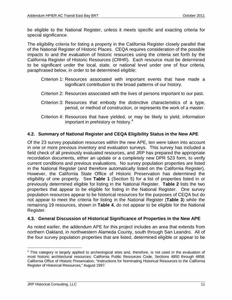
Map Reference No. 1 5960-5976 Telegraph AvenueThe Shuey Creamery was constructed in 1931 and is a historical resource under CEQA.The building is locally significant for its design combining Art Deco and Spanish Colonialarchitecture. The property is not eligible for the National Register or California Register.
Shuey Creamery (Map Reference No. 1)
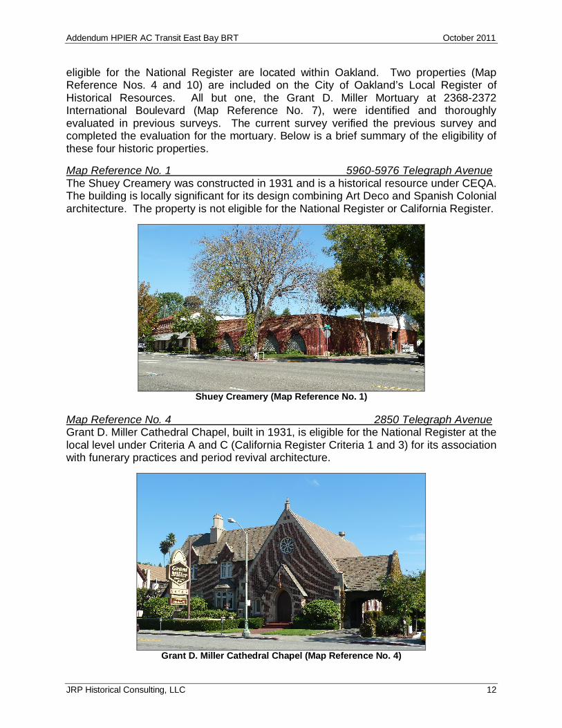
Map Reference No. 4 2850 Telegraph AvenueGrant D. Miller Cathedral Chapel, built in 1931, is eligible for the National Register at thelocal level under Criteria A and C (California Register Criteria 1 and 3) for its associationwith funerary practices and period revival architecture.
Grant D. Miller Cathedral Chapel (Map Reference No. 4)

Addendum HPIER AC Transit East Bay BRT October 2011
JRP Historical Consulting, LLC 13
Map Reference No. 7 2368-2378 International BoulevardThe Grant D. Miller Mortuary is a complex building constructed between 1923 and 1938.The main portion of the building, constituting main façade along International Boulevardand approximately 125 feet deep, appears eligible for the National Register (andCalifornia Register) under Criteria C(3), as an example of Beaux Arts architecturedesigned by Charles Miller and Carl Warneke. The main building is eligible at the locallevel and the period of significance is 1935-1938 when the redesign in the Beaux Artsstyle was complete. This property is also a contributor to the local 23rd AvenueCommercial District, an Oakland Area of Secondary Importance.
Grant D Miller Mortuary (Map Reference No. 7)
Map Reference No. 10 3221 San Leandro StreetThe Fruitvale Hotel constructed in 1894-1895 is eligible for listing in the NationalRegister and California Register under Criteria a (1) and C (3) for its association withlocal development patterns and example of a small hotel or lodging house. Theproperty is defined by the building’s footprint and is significant at the local level for theperiod 1850-1948.
Fruitvale Hotel (Map Reference No. 10)
Addendum HPIER AC Transit East Bay BRT October 2011
JRP Historical Consulting, LLC 14
The remaining 19 resources that do not appear to meet the criteria for listing in theNational Register or California Register make up the largest component of the surveypopulation. These resources do not appear to have important associations within thehistorical context in which they were constructed and used. None appear to haveimportant associations with trends, events or patterns of development within Oakland(Criterion A), nor did they appear to be associated with persons who made importantcontributions to local, state, or national history (Criterion B). Architecturally, none ofthese resources appear to embody distinctive characteristics of a type, period, ormethod of construction, appear to possess high artistic value, nor do they appear to bethe work of a master. It does not appear that any of these properties together representa cohesive or intact group of resources with historic integrity that would constitute ahistoric district (Criterion C). Furthermore, none of these properties appear to beimportant for their information potential (Criterion D).
Most of these 19 properties also suffered from a lack of historic integrity as a result ofalterations. At a minimum these changes often included replacement of windows andsiding, which were often completed over a period of years. Others were dramaticallychanged through additions or substantial remodeling. These resources are listed inTable 4 (Section 6). See Appendix C for local preservation elements for the City ofOakland.
Addendum HPIER AC Transit East Bay BRT October 2011
JRP Historical Consulting, LLC 15
5. FINDINGS AND CONCLUSIONS
Of the 31 parcels within the new APE for this project, there are 23 that contain historic-era resources. These resources constitute the survey population for this report. Of the23, three have been determined eligible for, or appear eligible for listing in the NationalRegister and are also considered to be historical resources for the purposes of CEQA.One additional property within the addendum APE does not appear to be eligible for theNational Register, but does appear to be historical resources for the purposes of CEQA.The remaining 19 resources do not appear to be eligible for the National Register. Thefollowing tables summarize the conclusions of this report:
Table 1: Properties listed in or previously determined eligible for listing in the National Register.Map Reference
No. APN Address Year Built CityCHRSCode5
CEQAResource Update
10 033-2189-001 3221 San Leandro Street 1894-1895 Oakland 2S2
Table 2: Properties that appear to be eligible for listing in the National Register.Map Reference
No. APN Address Year Built City CHRSCode6
CEQAResource Update
04 009-0688-015 2850 Telegraph Ave 1931 Oakland 3S
07 020-0153-016-01 2368-2378 International Blvd 1923, 1935-1938 Oakland 3S
Table 3: Properties that do not appear eligible for listing in the National Register but are of localinterest.Map Reference
No. APN Address Year Built City CHRSCode7
CEQAResource Update
01 016-1387-016 5960-5976 Telegraph Ave 1931 Oakland 5S2, 6Z
5 Office of Historic Preservation (OHP), California Historical Resources Information System, AlamedaCounty (October 2009). California Historical Resource Status Code (CHRS Code) descriptions: 1S:individual property listed in the National Register by the Keeper – listed in California Register; 2S2:individual property determined eligible for listing in the National Register by a consensus through Section106 process – listed in the California Register.6 Office of Historic Preservation (OHP), CHRS Code descriptions: 3S: appears eligible for the CaliforniaRegister as an individual property.7 Office of Historic Preservation (OHP). CHRS Code descriptions: 5B: locally significant (listed, eligible orappears eligible) both individually and as a contributor to a district that is locally listed, designated,determined eligible or appears eligible; 5D2: appears to be a contributor to a district that appears eligiblefor local listing or designation; 5S2: individual property that is eligible for local listing or designation; 6Z:found ineligible for National Register, California Register, or local designation.

Addendum HPIER AC Transit East Bay BRT October 2011
JRP Historical Consulting, LLC 16
Table 4: Properties that do not appear eligible for listing in the National Register, are not of localinterest, and do not appear to be historical resources for the purposes of CEQA.
Map ReferenceNo. APN Address Year Built City CHRS
Code8CEQA
Resource Update
02 015-1383-011-01 5960-5978 Racine Street 1942, 1943 Oakland6Z
03 013-1098-029 4308-4316 Telegraph Ave 1922 Oakland6Z
05 009-0697-004 2801-2811 Telegraph Ave 1916 Oakland6Z
06 020-0105-004 2345 International Blvd 1956 Oakland6Z
08 025-0693-007-02 1045 Derby Ave 1920 Oakland6Z
09 025-0692-005 1001 Fruitvale Ave 1957/1976 Oakland6Z
11 025-0719-007-01 3050 International Blvd 1945/1946 Oakland6Z
12 033-2156-001 3901 International Blvd 1928 Oakland6Z
13 035-2356-015 4416-4418 International Blvd 1925/1935 Oakland 6Z
14 035-2356-014 4428-4432 International Blvd 1900c./1923Oakland 6Z
15 034-2252-003-01 4425-4431 International Blvd 1947 Oakland 6Z
16 039-3243-032 6434 International Blvd Moved in1949 Oakland 6Z
17 039-3245-039 6500 International Blvd 1910Oakland 6Z
18 040-3321-037 7602-7618 International Blvd 1944, 1946Oakland 6Z
19 040-3355-056 7700-7704 International Blvd 1923Oakland 6Z
20 046-5424-023 9616-9628 International Blvd 1905-1912/1979 Oakland 6Z
21 044-4969-006 9625-9629 International Blvd 1936Oakland 6Z
22 044-4969-007 9631-9633 International Blvd 1905-1912Oakland 6Z
23 044-4969-008 9635-9637 International Blvd 1915Oakland 6Z
8 Office of Historic Preservation (OHP). CHRS Code descriptions: 6Z: found ineligible for NationalRegister, California Register, or local designation through survey evaluation; 6L: determined ineligible forthe National Register by consensus through Section 106 process – not evaluated for the CaliforniaRegister of local listing. [OHP, Technical Assistance Bulletin # 8: User’s Guide to the California HistoricalResource Status Codes and Historic Resource Inventory Directory.]

Addendum HPIER AC Transit East Bay BRT October 2011
JRP Historical Consulting, LLC 17
6. BIBLIOGRAPHY
Published MaterialAbbot, Carl. The Metropolitan Frontier: Cities in the Modern American West. Tucson:
University of Arizona Press, 1993.Bagwell, Beth. Oakland: The Story of a City. Novato: Presidio Press, 1982.
Barr, Mary Lee. A Timeline of San Leandro’s History: Bringing the Past into the Present. SanLeandro: San Leandro Public Library, 2004.
Belasco, Warren James. Americans on the Road: From Autocamp to Motel, 1910-1945.Cambridge: MIT Press, 1981.
Berkeley Historical Society. Looking Back at Berkeley: A Pictorial History of a Diverse City.Berkeley: Berkeley History Book Committee of the Berkeley Historical Society, 1984.
Bernhardi, Robert. The Buildings of Oakland. Oakland, CA: Forest Hill Press, 1979.
Blake, Evarts I. Greater Oakland, 1911: A Volume Dealing with the Big Metropolis on theShores of the San Francisco Bay. Oakland: Pacific Publishers Co., 1911.
Burdan, Tom. The Genesis of Suburban Development in San Leandro and Hayward, California.Hayward: California State College at Hayward, 1971.
Connor, Ann W., Thron Yound, Seonaid Khorsand, and Alice Marshall, eds. Saga of SanLeandro. n. p.: California History Center, 1973.
Cummings, G.A. and E.S. Padwell. Oakland . . . . A History. Oakland: The Grant MillerMortuaries Inc., 1942.
Drury, George. Southern Pacific in the Bay Area: The San Francisco-Sacramento-StocktonTriangle. Waukesha, WI: Kalmbach Books, 1996.
Ferrier, William Warren. Berkeley, California: The Story of the Evolution of a Hamlet into a Cityof Culture and Commerce. Oakland: West Coast Printing Company, 1933.
Ford, Robert S. Red Trains in the East Bay. Glendale: Interurban Publications, 1977.
Forsyth, Raymond and Joseph Hagwood. One Hundred Years of Progress: A PhotographicEssay on the Development of the California Transportation System. Sacramento, CA:Signature Press, 1996.
Galloway, Brent. A San Leandro Centennial Album. San Leandro: Honor Publication, n.d.
Hall, Harwood. Eden Township: Its Agriculture. Hayward: Hayward Area Historical Society,1997.
Hinkel, Edgar J., and William E. McCann, ed. Oakland 1852-1938: Some Phases of the Social,Political and economic History of Oakland, California, vol. 2. Oakland: Oakland PublicLibrary, 1939.
History of Alameda County, California: Geology, Topography, Soil, and Productions; TogetherWithin a Full and Particular Record of the Spanish Grants. Oakland: M.W. Wood,Publisher, 1883. Reprint, Oakland: Holmes Book Company, 1969.
Hoover, Mildred B., Hero E. Rensch, Ethel G. Rensch, and William N. Abeloe. Historic Spots inCalifornia. 2nd ed. Stanford: Stanford University Press, 1990.

Addendum HPIER AC Transit East Bay BRT October 2011
JRP Historical Consulting, LLC 18
_____. Historic Spots in California. 4th ed. Revised by Douglas E. Kyle. Stanford: StanfordUniversity Press, 1990.
Hornsby, Darlene, ed. A History of Hayward. Hayward: Sunset High School, 1970.
Jackson, Kenneth T. Crabgrass Frontier: The Suburbanization of the United States. NewYork: Oxford University Press, 1985.
Jones, Robert T. Authentic Small Houses of the Twenties. Reprint, New York: DoverPublications, Inc., 1987.
Kelt Directory Company. Kelt’s Geographical Directory: Oakland and East Bay Cities. Oakland:California 1936.
League of Women Voters of San Leandro. San Leandro Facts of Local Government. 3rd ed.San Leandro: League of Women Voters of San Leandro, 1982.
Liebs, Chester H. Main Street to Miracle Mile: American Roadside Architecture. Baltimore:Johns Hopkins University Press, 1989.
McArdle, Phil, ed. Exactly Opposite the Golden Gate, Essays on Berkeley’s History, 1845-1945. Berkeley: Berkeley Historical Society, 1983.
Margolies, John. Home Away From Home Motels in America. Toronto: Little, Brown andCompany, 1995.
Oakland Renewal Foundation. Final Report of Oakland Renewal Foundation, Inc. of ClintonPark Project Oakland, California. Oakland: 1961.
Perez, Crisostomo N. Land Grants in Alta California: A Compilation of Spanish and MexicanPrivate Land Claims in the State of California Giving Pertinent Data in Relations to theUnited States of America’s Confirmation and Patenting of Said Claims, Together withthe Compilation of Legislation and Litigation Affecting each Claim. Rancho Cordova,CA: Land Mark Enterprises, 1996.
Prentice, Helaine Kaplan and Blair Prentice. Rehab Right: How to Realize the Full Value ofYour Old House. Berkeley: Ten Speed Press, 1986.
Randall, Florence Carr, ed. Hayward: the First 100 Years. Haywood, CA: HaywoodCentennials Committee, 1975.
Rather, Lois. Oakland’s Image: A History of Oakland, California. Oakland: Rather Press, 1972.
Rifkind, Carole. A Field Guide to Contemporary American Architecture. New York: PenguinGroup, 2001.
Schweitzer, Robert and Michael W.R. Davis. America’s Favorite Homes: Mail OrderCatalogues as a Guide to Popular Early 20th Century Houses. Detroit: Wayne StateUniversity Press, 1990.
Scott, Mel. The San Francisco Bay Area: A Metropolis in Perspective. Berkeley: University ofCalifornia Press, 1985.
Shaffer, Harry E. A Garden Grows in Eden: The Centennial Story of San Leandro. San
Leandro: San Leandro Historical-Centennial Committee, 1972.
Southern Pacific Company. Southern Pacific’s First Century. San Francisco: Southern PacificCompany, 1955.

Addendum HPIER AC Transit East Bay BRT October 2011
JRP Historical Consulting, LLC 19
Stadtman, Verne. California Campus: The University of California at Berkeley. Berkeley:Howell-North, 1961.
Stuart, Reginald R. San Leandro: A History. San Leandro: First Methodist Church, 1951.
Longstreth, Richard. City Center to Regional Mall: Architecture, the Automobile, and Retailingin Los Angeles, 1920-1950. Cambridge: The MIT Press, 1997.
_____. The Buildings of Main Street: A Guide to American Commercial Architecture. WalnutCreek, CA: AltaMira Press, 2000.
Trimble, Paul C. Interurban Railways of the Bay Area. Fresno, CA: Valley Publishers, 1977.
Vance, James E., Jr. Geography and Urban Evolution in the San Francisco Bay Area.Berkeley: University of California Press, 1964.
Vieyra, Daniel. Fill'er Up: An Architectural History of America's Gas Stations. New York: CollierMacmillan Publishers, 1979.
Weber, David. Oakland: Hub of the West. Tulsa, OK: Continental Heritage Press Inc.: 1981.
Writers’ Program of the Work Project Administration in Northern California. Berkeley: The FirstSeventy-Five Years. Berkeley: James J. Gillick and Co., Inc., 1941.
Unpublished SourcesAlameda County Assessor Office Map Books. On file at the Hayward Area Historical Society,
Hayward, California.
“An Oakland Chronology.” 2nd edition, 1952. On file at the Oakland Public Library.
Architectural Resources Group. “City of San Leandro Neighborhood Survey & HistoricPreservation Ordinance” Volume II. Historical Resources Survey & Documentation,Appendix C, “San Leandro Town Site.”
California Department of Transportation Library, Sacramento, California. Miscellaneous records.
Campus Planning Study Group, Campus Historic Resources Survey, 1978.
City of Berkeley and The University of California, Berkeley. Draft Southside Plan: For PublicDiscussion. January 2000.
City of Berkeley, Department of Housing and Development, Application Requesting Designationfor Landmark Status, “Shattuck Hotel,” received November 9, 1987.
City of Berkeley, “Zoning Plan,” 1947. Berkeley Public Library, Berkeley History Room,Berkeley, California.
City of Oakland, Department of City Planning. Building Records.
City of Oakland Economic Development Agency. Fitchburg Sanitary District Records.
Environmental Science Associates. “Cultural Resources: Existing Environmental Conditions,Metropolitan Oakland International Airport.” Technical Memorandum #10 (draft), April1991.
Harland Bartholomew and Associates, “A Report on Freeways and Major Streets in Oakland,California,” July 1947.
Historic American Engineering Record, San Francisco-Oakland Bay Bridge. HAER No. CA-32.

Addendum HPIER AC Transit East Bay BRT October 2011
JRP Historical Consulting, LLC 20
McCarthy, “Berkeley: Rural Romance to Urban Ideal 1905 – 1946, Historic Context Statementfor the Granada at Sather Gate.”
Oakland Cultural Heritage Survey. Downtown Oakland Historic District, National RegisterNomination of Historic Places Nomination Form, July 1986.
_____. Oakland Point District, 1989.
_____. San Antonia Phase 2, 1996.
_____. Uptown Shopping/Entertainment District, Historic Inventory Record. 1985.
“Oakland History Timeline.” On file at the Oakland History Room of the Oakland Public Library.
San Leandro General Plan, 2002.Women Voters of San Leandro. San Leandro Facts of Local Government. (n.p.: WomenVoters of San Leandro, 1982.
Articles and Periodicals“1863-1960,” AC Transit Times. Special issue reprint, The Western Railroader 23, no. 11 issue
25 (November 1960): 32-33.
Fernandez-Gray, Carlos A. “Berkeley’s Lost Station.” BAHA News (Berkeley ArchitecturalHeritage Association) Spring/Summer 2002, 10.
Hanson, Erle C. “Early Days of the East Bay,” The Western Railroader 22, no. 4-5 (1958).
. “Oakland, San Leandro & Haywards Electric Railway,” Western Railroader 21, no. 7(May 1958).
. “East Shore and Suburban Railway: Along the East Shore of San Francisco Bay.”Pacific Railway Journal 2, no. 12 (1961).
MapsAerial Photographs. 1928. “University of California Campus.” 15th Photo Section, Air Corps
Crissy Field, Presidio of San Francisco, California. University of California, Berkeley,Earth Sciences and Map Library.
Aerial Photographs. 1937. Fairchild Aerial Surveys, Inc., for US Agricultural AdjustmentAdministration. University of California, Berkeley, Earth Sciences and Map Library.
Aerial Photographs. 1939. “University of California Campus.” US Agricultural AdjustmentAdministration. University of California, Berkeley, Earth Sciences and Map Library.
Aerial Photographs. 1946. Jack Ammann Photogrammetric Engineers for U.S. GeologicalSurvey. University of California, Berkeley, Earth Sciences and Map Library.
Aerial Photographs. 1950. Clyde Sunderland for City of Berkeley. University of California,Berkeley, Earth Sciences and Map Library.
Aerial Photographs. 1960. U.S. Air Force for U.S. Air Force. University of California, Berkeley,Earth Sciences and Map Library.
Alameda County Public Works. Subdivision Maps.
California Department of Transportation District 4, As Built Plans, Contract No. 56-4TC10-P,May 9, 1955.
California Department of Public Works, Division of Highways, Road Map of California, 1959.

Addendum HPIER AC Transit East Bay BRT October 2011
JRP Historical Consulting, LLC 21
Cooper, N. R. Map of the City of Oakland with Index to Streets. n.p., 1904.
Huggins, C.L. Map of Berkeley, Alameda County, California. Berkeley: Joseph J. Mason, 1897.
Map of Berkeley and Vicinity. Berkeley, CA: Charles Green, 1912.
Official Map of Alameda County. San Francisco: Walkup, W.B., 1900.
Sanborn Map Company. Sanborn Fire Insurance Maps, Berkeley, California. 1894 through1950.
_____. Sanborn Fire Insurance Maps, Oakland, California. 1889 through 1952.
_____. Sanborn Fire Insurance Maps, San Leandro, California. 1885 through 1950.
Smith, Joseph. Map of Berkeley. Berkeley: Carnall and Eyre, 1878.
Thompson and West. “Map of San Lorenzo,” Official and Historical Atlas Maps of AlamedaCounty. Oakland, CA: Thompson & West, 1878. Reprint, Fresno, CA: ValleyPublishers, 1976.
_____. “Map of the County of Alameda.” Official and Historical Atlas Maps of Alameda County.Oakland, CA: Thompson & West, 1878. Reprint, Fresno, CA: Valley Publishers, 1976.
Weber, C.F. & Company. Weber’s Map of Alameda County, CA. San Francisco: C.F. Weber &Co., 1914.
USGS. Concord, Quadrangle Map, 15 Minute Series. 1897, 1915, 1941, and 1948.
_____. Hayward, Quadrangle Map, 7.5 Minute Series. Various editions, 1947-1980.
_____. Hayward, Quadrangle Map, 15 Minute Series. Various editions, 1899-1959.
_____. Oakland East, Quadrangle Map, 7.5 Minute Series. Various editions, 1947-1980.
_____. Oakland West, Quadrangle Map, 7.5 Minute Series. Various editions 1949-1980.
_____. San Francisco, Quadrangle Map, 15 Minute Series. Various editions, 1895-1948.
_____. San Leandro, Quadrangle Map, 7.5 Minute Series. Various editions, 1947-1980.
Online Sources1920 Federal Population Census data imaged from National Archives and Records
Administration. Provo, UT: www.ancestry.com, 2001.
“BART: History and Facts.” www.bart.gov/about/history/history_1.asp#.
City of Oakland. “Oakland History Timeline.”http://www.oaklandnet.com/celebrate/Historytimeline.htm.
City of San Leandro. “City History.” http://www.sanleandro.org/about/history.asp.
“East Bay Public Transportation.” www.actransit.org/aboutac/eastbay.wu .
“History of the Shattuck Hotel.” http://www.hotelshattuckplaza.com/history/index.cfm.
Keiss, Gilbert H. “Fifty Candles for Western Pacific.” Milepost (March 1953).http://www.wprrhs.org/wphistory_50candles/wphistory_50candles_pt1.html.
Root, Henry. “Personal History and Reminiscences with Personal Opinions on ContemporaryEvents, 1845-1921.” Central Pacific Railroad Photographic History Museum.http://cprr.org/Museum/Henry_Root_1921.html.

Addendum HPIER AC Transit East Bay BRT October 2011
JRP Historical Consulting, LLC 22
Sessions, E. C. Map of Oakland and Brooklyn. San Francisco: G. T. Brown & Company, Lith.,1869. University of California, Berkeley. http://lib.berkeley.edu/EART/maps/g4364-o2-1869-s4.html.
State of California. “California Death Index, 1940-1997.” Sacramento, CA: State of CaliforniaDepartment of Health Services, Center for Health Statistics. Online database.
Wollenberg, Charles. “Berkeley, A City in History.” Berkeley: Berkeley Public Library, 2002.http://berkeleypubliclibrary.org/system/historytext.html.