api well number: 43047545820000 api well number - utah · pdf fileapi number assigned...
TRANSCRIPT
RECEIVED: October 02, 2014
STATE OF UTAHDEPARTMENT OF NATURAL RESOURCES
DIVISION OF OIL, GAS AND MINING
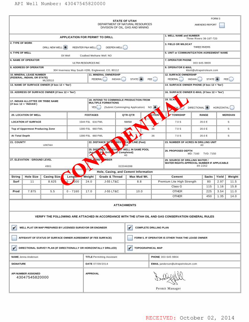
APPLICATION FOR PERMIT TO DRILL 1. WELL NAME and NUMBER
Three Rivers 36-16T-720
2. TYPE OF WORK
DRILL NEW WELL REENTER P&A WELL DEEPEN WELL 3. FIELD OR WILDCAT
THREE RIVERS
4. TYPE OF WELLOil Well Coalbed Methane Well: NO
5. UNIT or COMMUNITIZATION AGREEMENT NAME
6. NAME OF OPERATORULTRA RESOURCES INC
7. OPERATOR PHONE303 645-9809
8. ADDRESS OF OPERATOR304 Inverness Way South #295, Englewood, CO, 80112
9. OPERATOR [email protected]
10. MINERAL LEASE NUMBER(FEDERAL, INDIAN, OR STATE)
ML50510
11. MINERAL OWNERSHIP
FEDERAL INDIAN STATE FEE 12. SURFACE OWNERSHIP
FEDERAL INDIAN STATE FEE
13. NAME OF SURFACE OWNER (if box 12 = 'fee')
14. SURFACE OWNER PHONE (if box 12 = 'fee')
15. ADDRESS OF SURFACE OWNER (if box 12 = 'fee')
16. SURFACE OWNER E-MAIL (if box 12 = 'fee')
17. INDIAN ALLOTTEE OR TRIBE NAME(if box 12 = 'INDIAN')
18. INTEND TO COMMINGLE PRODUCTION FROMMULTIPLE FORMATIONS
YES (Submit Commingling Application) NO
19. SLANT
VERTICAL DIRECTIONAL HORIZONTAL
20. LOCATION OF WELL FOOTAGES QTR-QTR SECTION TOWNSHIP RANGE MERIDIAN
LOCATION AT SURFACE 1544 FSL 616 FWL NWSW 36 7.0 S 20.0 E S
Top of Uppermost Producing Zone 1300 FSL 660 FWL SWSW 36 7.0 S 20.0 E S
At Total Depth 1300 FSL 660 FWL SWSW 36 7.0 S 20.0 E S
21. COUNTYUINTAH
22. DISTANCE TO NEAREST LEASE LINE (Feet)660
23. NUMBER OF ACRES IN DRILLING UNIT40
25. DISTANCE TO NEAREST WELL IN SAME POOL(Applied For Drilling or Completed)
40
26. PROPOSED DEPTHMD: 7160 TVD: 7150
27. ELEVATION - GROUND LEVEL
4901
28. BOND NUMBER
022046398
29. SOURCE OF DRILLING WATER /WATER RIGHTS APPROVAL NUMBER IF APPLICABLE
49-2262
Hole, Casing, and Cement Information
String Hole Size Casing Size Length Weight Grade & Thread Max Mud Wt. Cement Sacks Yield Weight
Surf 11 8.625 0 - 1000 24.0 J-55 LT&C 8.8 Premium Lite High Strength 80 2.97 11.5
Class G 115 1.16 15.8
Prod 7.875 5.5 0 - 7160 17.0 J-55 LT&C 10.0 OTHER 225 3.54 11.0
OTHER 450 1.35 14.0
ATTACHMENTS
VERIFY THE FOLLOWING ARE ATTACHED IN ACCORDANCE WITH THE UTAH OIL AND GAS CONSERVATION GENERAL RULES
WELL PLAT OR MAP PREPARED BY LICENSED SURVEYOR OR ENGINEER COMPLETE DRILLING PLAN
AFFIDAVIT OF STATUS OF SURFACE OWNER AGREEMENT (IF FEE SURFACE) FORM 5. IF OPERATOR IS OTHER THAN THE LEASE OWNER
DIRECTIONAL SURVEY PLAN (IF DIRECTIONALLY OR HORIZONTALLY DRILLED) TOPOGRAPHICAL MAP
NAME Jenna Anderson TITLE Permitting Assistant PHONE 303 645-9804
SIGNATURE DATE 07/09/2014 EMAIL [email protected]
API NUMBER ASSIGNED
43047545820000
Permit Manager
APPROVAL
FORM 3
AMENDED REPORT
API Well Number: 43047545820000
CONFIDE
NTIAL
API Well Number: 43047545820000
FORM 3STATE OF UTAH
DEPARTMENTOF NATURALRESOURCES AMENDEDREPORTDIVISION OF OIL, GAS AND MINING
APPLICATION FOR PERMIT TO DRILL 1. WELL NAME andThNrUeMBRvRers36-16T-720
2. TYPE OF WORK 3. FIELD OR WILDCATDRILLNEWWELL REENTER P&AWELL DEEPEN WELLI THREE RIVERS
4. TYPE OF WELL 5. UNIT or COMMUNITIZATION AGREEMENT NAMEOil Well Coalbed Methane Well: NO
6. NAME OF OPERATOR 7. OPERATOR PHONEULTRARESOURCES INC 303 645-9809
8. ADDRESS OF OPERATOR 9. OPERATOR E-MAIL304 Inverness Way South #295, Englewood, CO, 80112 [email protected]
10. MINERAL LEASE NUMBER 11. MINERAL OWNERSHIP 12. SURFACE OWNERSHIP(FEDERAL,INDIAN,ORSTAMLO510 FEDERAL INDIANISTATE FEE FEDERAL INDIAN STATE FEEI
13. NAME OF SURFACE OWNER (if box 12 = 'fee') 14. SURFACE OWNER PHONE (if box 12 = 'fee')
15. ADDRESS OF SURFACE OWNER (if box 12 = 'fee') 16. SURFACE OWNER E-MAIL (if box 12 = 'fee')
17. INDIAN ALLOTTEE OR TRIBE NAME 18. INTEND TO COMMINGLE PRODUCTION FROM 19. SLANT
(if box 12 = 'INDIAN')MULTIPLE FORMATIONS
YES (Submit Commingling Application) NO VERTICAL DIRECTIONAL HORIZONTAL
20. LOCATION OF WELL FOOTAGES QTR-QTR SECTION TOWNSHIP RANGE MERIDIAN
LOCATION AT SURFACE 1544 FSL 616 FWL NWSW 36 7.0 S 20.0 E S
Top of Uppermost Producing Zone 1300 FSL 660 FWL S½SW 36 7.0 S 20.0 E S
At Total Depth 1300 FSL 660 FWL S½SW 36 7.0 S 20.0 E S
21. COUNTY 22. DISTANCE TO NEAREST LEASE LINE (Feet) 23. NUMBER OF ACRES IN DRILLING UNITUINTAH 660 40
25. DISTANCE TO NEAREST WELL IN SAME POOL 26. PROPOSED DEPTH(Applied For Drilling or Completed) MD: 7160 TVD: 7150
40
27. ELEVATION - GROUND LEVEL 28. BOND NUMBER 29. SOURCE OF DRILLING WATERIWATER RIGHTS APPROVAL NUMBER IF APPLICABLE
4901 022046398 49-2262
Hole, Casing, and Cement Information
Hole Size Casing Size Length Weight Grade & Thread Max Mud Wt. Cement Sacks Yield Weight
11 8.625 0 - 1000 24.0 J-55 LT&C 8.8 Premium Lite High Strength 80 2.97 11.5
Class G 115 1.16 15.8
7.875 5.5 0 - 7160 17.0 J-55 LT&C 10.0 OTHER 225 3.54 11.0
OTHER 450 1.35 14.0
ATTACHMENTS
VERIFY THE FOLLOWING ARE ATTACHED IN ACCORDANCE WITH THE UTAH OIL AND GAS CONSERVATION GENERAL RULES
WELL PLATOR MAP PREPARED BY LICENSED SURVEYOR OR ENGINEER COMPLETE DRILLING PLAN
AFFIDAVIT OF STATUS OF SURFACE OWNER AGREEMENT(IF FEE SURFACE) FORM 5. IF OPERATOR IS OTHER THAN THE LEASE OWNER
DIRECTIONAL SURVEY PLAN (IF DIRECTIONALLYOR HORIZONTALLY DRILLED) TOPOGRAPHICAL MAP
NAME Jenna Anderson TITLE Permitting Assistant PHONE 303 645-9804
SIGNATURE DATE 07/09/2014 EMAIL [email protected]
API NUMBER ASSIGNED APPROVAL I
43047545820000 I
Permit Manager
RECEIVED: October 02,
RECEIVED: July 09, 2014
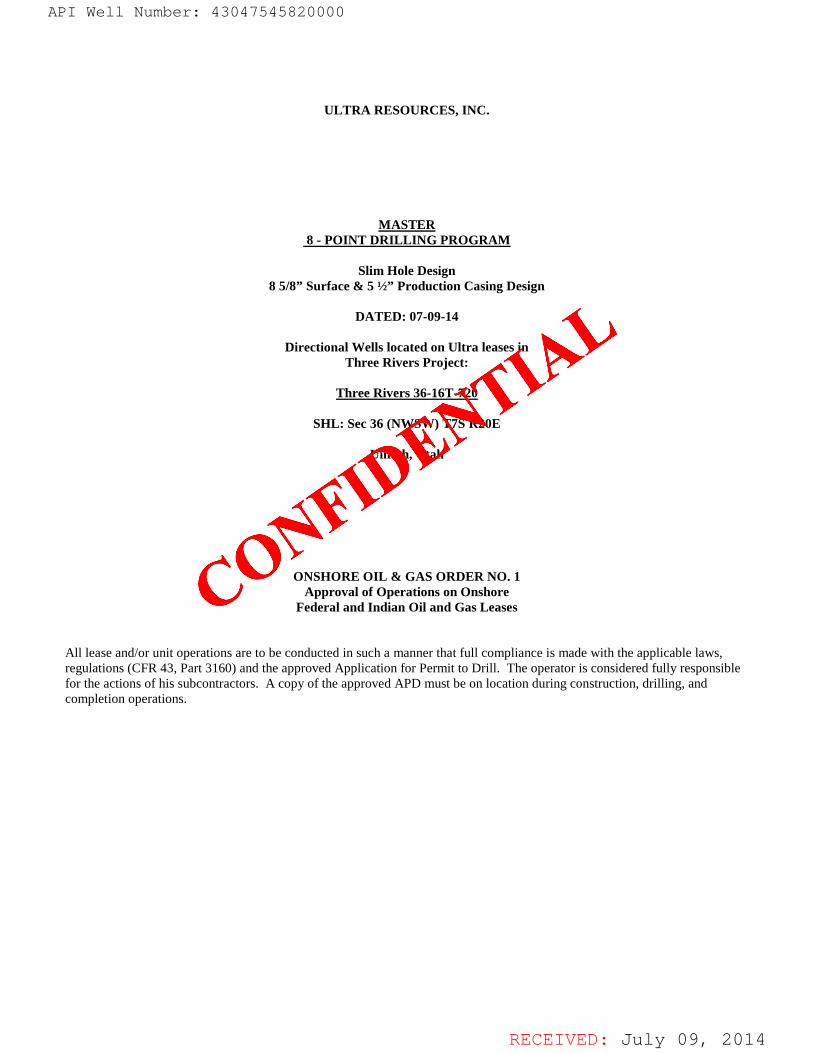
ULTRA RESOURCES, INC.
MASTER 8 - POINT DRILLING PROGRAM
Slim Hole Design
8 5/8” Surface & 5 ½” Production Casing Design
DATED: 07-09-14
Directional Wells located on Ultra leases in Three Rivers Project:
Three Rivers 36-16T-720
SHL: Sec 36 (NWSW) T7S R20E
Uintah, Utah
ONSHORE OIL & GAS ORDER NO. 1 Approval of Operations on Onshore
Federal and Indian Oil and Gas Leases
All lease and/or unit operations are to be conducted in such a manner that full compliance is made with the applicable laws, regulations (CFR 43, Part 3160) and the approved Application for Permit to Drill. The operator is considered fully responsible for the actions of his subcontractors. A copy of the approved APD must be on location during construction, drilling, and completion operations.
API Well Number: 43047545820000
CONFIDE
NTIAL
API Well Number: 43047545820000
ULTRA RESOURCES, INC.
MASTER8 - POINT DRILLING PROGRAM
Slim Hole Design8 5/8" Surface & 5 ½" Production Casing Design
DATED: 07-09-14
Directional Wells located on Ultra leases inThree Rivers Project:
Three Rivers 36-16T-720
SHL: Sec 36 (NWSW) T7S R20E
Uintah, Utah
ONSHORE OIL & GAS ORDER NO. 1Approval of Operations on Onshore
Federal and Indian Oil and Gas Leases
All lease and/or unit operations are to be conducted in such a manner that full compliance is made with the applicable laws,regulations (CFR 43, Part 3160) and the approved Application for Permit to Drill. The operator is considered fully responsiblefor the actions of his subcontractors. A copy of the approved APD must be on location during construction, drilling, andcompletion operations.
RECEIVED: July 09,
RECEIVED: July 09, 2014
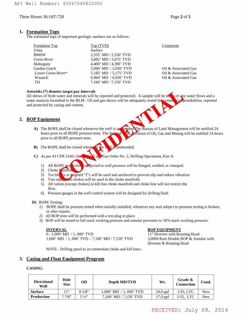
Three Rivers 36-16T-720 Page 2 of 5 1. Formation Tops
The estimated tops of important geologic markers are as follows:
Formation Top Top (TVD) Comments Uinta Surface BMSW 2,555’ MD / 2,550’ TVD Green River 3,082’ MD / 3,075’ TVD Mahogany 4,400’ MD / 4,390’ TVD
Garden Gulch 5,060’ MD / 5,050’ TVD Oil & Associated Gas Lower Green River* 5,185’ MD / 5,175’ TVD Oil & Associated Gas Wasatch 6,960’ MD / 6,950’ TVD Oil & Associated Gas TD 7,160’ MD / 7,150’ TVD
Asterisks (*) denotes target pay intervals All shows of fresh water and minerals will be reported and protected. A sample will be taken of any water flows and a water analysis furnished to the BLM. Oil and gas shows will be adequately tested for commercial possibilities, reported and protected by casing and cement.
2. BOP Equipment
A) The BOPE shall be closed whenever the well is unattended The Bureau of Land Management will be notified 24
hours prior to all BOPE pressure tests. The State of Utah, Division of Oil, Gas and Mining will be notified 24 hours prior to all BOPE pressure tests.
B) The BOPE shall be closed whenever the well is unattended. C) As per 43 CFR 3160, Onshore Oil and Gas Order No. 2, Drilling Operations, Part A:
1) All BOPE connections subjected to well pressure will be flanged, welded, or clamped. 2) Choke Manifold 3) Tee blocks or targeted ‘T’s will be used and anchored to prevent slip and reduce vibration. 4) Two adjustable chokes will be used in the choke manifold. 5) All valves (except chokes) in kill line choke manifold and choke line will not restrict the
flow. 6) Pressure gauges in the well control system will be designed for drilling fluid.
D) BOPE Testing: 1) BOPE shall be pressure tested when initially installed, whenever any seal subject to pressure testing is broken,
or after repairs. 2) All BOP tests will be performed with a test plug in place. 3) BOP will be tested to full stack working pressure and annular preventer to 50% stack working pressure.
INTERVAL BOP EQUIPMENT 0 - 1,000’ MD / 1, 000’ TVD 11” Diverter with Rotating Head 1,000’ MD / 1, 000’ TVD – 7,160’ MD / 7,150’ TVD 3,000# Ram Double BOP & Annular with
Diverter & Rotating Head NOTE: Drilling spool to accommodate choke and kill lines.
3. Casing and Float Equipment Program
CASING:
Directional
Well Hole Size OD Depth MD/TVD Wt. Grade &
Connection Cond.
Surface 11” 8 5/8” 1,000’ MD / 1, 000’ TVD 24.0 ppf J-55, LTC New Production 7 7/8” 5 ½” 7,160’ MD / 7,150’ TVD 17.0 ppf J-55, LTC New
API Well Number: 43047545820000
CONFIDE
NTIAL
API Well Number: 43047545820000
Three Rivers 36-16T-720 Page 2 of 5
1. Formation TopsThe estimated tops of important geologic markers are as follows:
Formation Top Top (TVD) CommentsUinta SurfaceBMSW 2,555' MD / 2,550' TVDGreen River 3,082' MD / 3,075' TVDMahogany 4,400' MD / 4,390' TVDGarden Gulch 5,060' MD / 5,050' TVD Oil & Associated GasLower Green River* 5,185' MD / 5,175' TVD Oil & Associated GasWasatch 6,960' MD / 6,950' TVD Oil & Associated GasTD 7,160' MD / 7,150' TVD
Asterisks (*)denotes target pay intervalsAll shows of fresh water and minerals will be reported and protected. A sample will be taken of any water flows and awater analysis furnished to the BLM. Oil and gas shows will be adequately tested for commercial possibilities, reportedand protected by casing and cement.
2. BOP Equipment
A) The BOPE shall be closed whenever the well is unattended The Bureau of Land Management will be notified 24hours prior to all BOPE pressure tests. The State of Utah, Division of Oil, Gas and Mining will be notified 24 hoursprior to all BOPE pressure tests.
B) The BOPE shall be closed whenever the well is unattended.
C) As per 43 CFR 3160, Onshore Oil and Gas Order No. 2, Drilling Operations, Part A:
1) All BOPE connections subjected to well pressure will be flanged, welded, or clamped.2) Choke Manifold3) Tee blocks or targeted 'T's will be used and anchored to prevent slip and reduce vibration.4) Two adjustable chokes will be used in the choke manifold.5) All valves (except chokes) in kill line choke manifold and choke line will not restrict the
flow.6) Pressure gauges in the well control system will be designed for drilling fluid.
D) BOPE Testing:1) BOPE shall be pressure tested when initially installed, whenever any seal subject to pressure testing is broken,
or after repairs.2) All BOP tests will be performed with a test plug in place.3) BOP will be tested to full stack working pressure and annular preventer to 50% stack working pressure.
INTERVAL BOP EQUIPMENT0 - 1,000' MD / 1, 000' TVD 11" Diverter with Rotating Head1,000' MD / 1, 000' TVD -7,160' MD / 7,150' TVD 3,000# Ram Double BOP & Annular with
Diverter & Rotating HeadNOTE: Drilling spool to accommodate choke and kill lines.
3. Casing and Float Equipment Program
CASING:
Hole Grade &Directional OD DepthMD/TVD Wt. Cond.Well Size Connection
Surface 11" 8 5/8" 1,000' MD / 1, 000' TVD 24.0 ppf J-55, LTC NewProduction 7 7/8" 5 ½" 7,160' MD / 7,150' TVD 17.0 ppf J-55, LTC New
RECEIVED: July 09,
RECEIVED: July 09, 2014
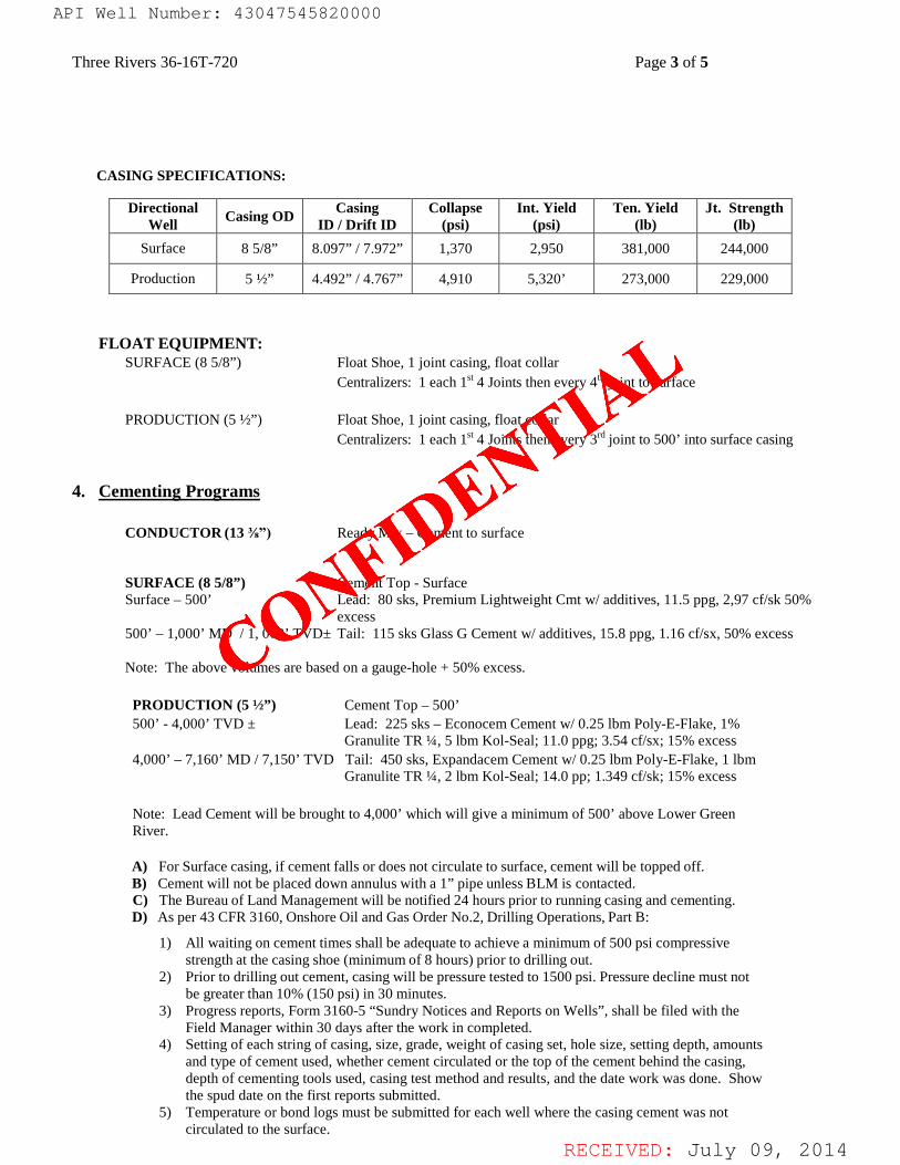
Three Rivers 36-16T-720 Page 3 of 5
CASING SPECIFICATIONS:
FLOAT EQUIPMENT:
SURFACE (8 5/8”) Float Shoe, 1 joint casing, float collar Centralizers: 1 each 1st 4 Joints then every 4th joint to surface PRODUCTION (5 ½”) Float Shoe, 1 joint casing, float collar Centralizers: 1 each 1st 4 Joints then every 3rd joint to 500’ into surface casing
4. Cementing Programs
CONDUCTOR (13 ⅜”) Ready Mix – Cement to surface
SURFACE (8 5/8”) Cement Top - Surface
Surface – 500’ Lead: 80 sks, Premium Lightweight Cmt w/ additives, 11.5 ppg, 2,97 cf/sk 50% excess
500’ – 1,000’ MD / 1, 000’ TVD± Tail: 115 sks Glass G Cement w/ additives, 15.8 ppg, 1.16 cf/sx, 50% excess
Note: The above volumes are based on a gauge-hole + 50% excess. PRODUCTION (5 ½”) Cement Top – 500’ 500’ - 4,000’ TVD ± Lead: 225 sks – Econocem Cement w/ 0.25 lbm Poly-E-Flake, 1%
Granulite TR ¼, 5 lbm Kol-Seal; 11.0 ppg; 3.54 cf/sx; 15% excess 4,000’ – 7,160’ MD / 7,150’ TVD Tail: 450 sks, Expandacem Cement w/ 0.25 lbm Poly-E-Flake, 1 lbm
Granulite TR ¼, 2 lbm Kol-Seal; 14.0 pp; 1.349 cf/sk; 15% excess Note: Lead Cement will be brought to 4,000’ which will give a minimum of 500’ above Lower Green River. A) For Surface casing, if cement falls or does not circulate to surface, cement will be topped off. B) Cement will not be placed down annulus with a 1” pipe unless BLM is contacted. C) The Bureau of Land Management will be notified 24 hours prior to running casing and cementing. D) As per 43 CFR 3160, Onshore Oil and Gas Order No.2, Drilling Operations, Part B:
1) All waiting on cement times shall be adequate to achieve a minimum of 500 psi compressive
strength at the casing shoe (minimum of 8 hours) prior to drilling out. 2) Prior to drilling out cement, casing will be pressure tested to 1500 psi. Pressure decline must not
be greater than 10% (150 psi) in 30 minutes. 3) Progress reports, Form 3160-5 “Sundry Notices and Reports on Wells”, shall be filed with the
Field Manager within 30 days after the work in completed. 4) Setting of each string of casing, size, grade, weight of casing set, hole size, setting depth, amounts
and type of cement used, whether cement circulated or the top of the cement behind the casing, depth of cementing tools used, casing test method and results, and the date work was done. Show the spud date on the first reports submitted.
5) Temperature or bond logs must be submitted for each well where the casing cement was not circulated to the surface.
Directional Well Casing OD Casing
ID / Drift ID Collapse
(psi) Int. Yield
(psi) Ten. Yield
(lb) Jt. Strength
(lb) Surface 8 5/8” 8.097” / 7.972” 1,370 2,950 381,000 244,000
Production 5 ½” 4.492” / 4.767” 4,910 5,320’ 273,000 229,000
API Well Number: 43047545820000
CONFIDE
NTIAL
API Well Number: 43047545820000
Three Rivers 36-16T-720 Page 3 of 5
CASING SPECIFICATIONS:
Directional Casing Collapse Int. Yield Ten. Yield Jt. StrengthWell Casing OD ID / Drift ID (psi) (psi) (lb) (lb)
Surface 8 5/8" 8.097" / 7.972" 1,370 2,950 38 1,000 244,000
Production 5 ½" 4.492" / 4.767" 4,910 5,320' 273,000 229,000
FLOAT EQUIPMENT:SURFACE (8 5/8") Float Shoe, 1 joint casing, float collar
Centralizers: 1 each 16'4 Joints then every 4thjOinÍÍO SUTface
PRODUCTION (5 ½") Float Shoe, 1 joint casing, float collarCentralizers: 1 each 16'4 Joints then every 3rdjOint to 500' into surface casing
4. Cementing Programs
CONDUCTOR (13 ¾") Ready Mix - Cement to surface
SURFACE (8 5/8") Cement Top - SurfaceSurface - 500' Lead: 80 sks, Premium Lightweight Cmt w/ additives, l1.5 ppg, 2,97 cf/sk 50%
excess500' - 1,000' MD / 1, 000' TVD± Tail: 115 sks Glass G Cement w/ additives, 15.8 ppg, 1.16 cf/sx, 50% excess
Note: The above volumes are based on a gauge-hole + 50% excess.
PRODUCTION (5 ½") Cement Top - 500'500' - 4,000' TVD ± Lead: 225 sks - Econocem Cement w/ 0.25 lbm Poly-E-Flake, 1%
Granulite TR ¼, 5 lbm Kol-Seal; 11.0 ppg; 3.54 cf/sx; 15% excess4,000' -7,160' MD / 7,150' TVD Tail: 450 sks, Expandacem Cement w/ 0.25 lbm Poly-E-Flake, l lbm
Granulite TR ¼, 2 lbm Kol-Seal; 14.0 pp; 1.349 cf/sk; 15% excess
Note: Lead Cement will be brought to 4,000' which will give a minimum of 500' above Lower GreenRiver.
A) For Surface casing, if cement falls or does not circulate to surface, cement will be topped off.B) Cement will not be placed down annulus with a 1" pipe unless BLM is contacted.C) The Bureau of Land Management will be notified 24 hours prior to running casing and cementing.D) As per 43 CFR 3160, Onshore Oil and Gas Order No.2, Drilling Operations, Part B:
1) All waiting on cement times shall be adequate to achieve a minimum of 500 psi compressivestrength at the casing shoe (minimum of 8 hours) prior to drilling out.
2) Prior to drilling out cement, casing will be pressure tested to 1500 psi. Pressure decline must notbe greater than 10% (150 psi) in 30 minutes.
3) Progress reports, Form 3160-5 "Sundry Notices and Reports on Wells", shall be filed with theField Manager within 30 days after the work in completed.
4) Setting of each string of casing, size, grade, weight of casing set, hole size, setting depth, amountsand type of cement used, whether cement circulated or the top of the cement behind the casing,depth of cementing tools used, casing test method and results, and the date work was done. Showthe spud date on the first reports submitted.
5) Temperature or bond logs must be submitted for each well where the casing cement was notcirculated to the surface.
RECEIVED: July 09,
RECEIVED: July 09, 2014
Three Rivers 36-16T-720 Page 4 of 5
6) A pressure integrity test of each casing shoe shall be performed. Formation at the shoe shall be tested to a minimum of the mud weight equivalent anticipated to control the formation pressure to the next casing depth or at total depth of the well. This test shall be performed after drilling 5-10 feet of new hole.
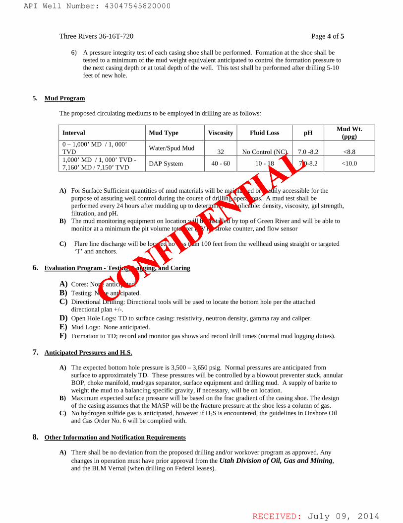
5. Mud Program The proposed circulating mediums to be employed in drilling are as follows:
Interval Mud Type Viscosity Fluid Loss pH Mud Wt. (ppg)
0 – 1,000’ MD / 1, 000’ TVD Water/Spud Mud 32 No Control (NC) 7.0 -8.2 <8.8 1,000’ MD / 1, 000’ TVD - 7,160’ MD / 7,150’ TVD DAP System 40 - 60 10 - 18 7.0-8.2 <10.0
A) For Surface Sufficient quantities of mud materials will be maintained or readily accessible for the
purpose of assuring well control during the course of drilling operations. A mud test shall be performed every 24 hours after mudding up to determine, as applicable: density, viscosity, gel strength, filtration, and pH.
B) The mud monitoring equipment on location will be installed by top of Green River and will be able to monitor at a minimum the pit volume totalizer (PVT), stroke counter, and flow sensor
C) Flare line discharge will be located no less than 100 feet from the wellhead using straight or targeted
‘T’ and anchors.
6. Evaluation Program - Testing, Logging, and Coring A) Cores: None anticipated. B) Testing: None anticipated. C) Directional Drilling: Directional tools will be used to locate the bottom hole per the attached
directional plan +/-. D) Open Hole Logs: TD to surface casing: resistivity, neutron density, gamma ray and caliper. E) Mud Logs: None anticipated. F) Formation to TD; record and monitor gas shows and record drill times (normal mud logging duties).
7. Anticipated Pressures and H.S.
A) The expected bottom hole pressure is 3,500 – 3,650 psig. Normal pressures are anticipated from
surface to approximately TD. These pressures will be controlled by a blowout preventer stack, annular BOP, choke manifold, mud/gas separator, surface equipment and drilling mud. A supply of barite to weight the mud to a balancing specific gravity, if necessary, will be on location.
B) Maximum expected surface pressure will be based on the frac gradient of the casing shoe. The design of the casing assumes that the MASP will be the fracture pressure at the shoe less a column of gas.
C) No hydrogen sulfide gas is anticipated, however if H2S is encountered, the guidelines in Onshore Oil and Gas Order No. 6 will be complied with.
8. Other Information and Notification Requirements
A) There shall be no deviation from the proposed drilling and/or workover program as approved. Any
changes in operation must have prior approval from the Utah Division of Oil, Gas and Mining, and the BLM Vernal (when drilling on Federal leases).
API Well Number: 43047545820000
CONFIDE
NTIAL
API Well Number: 43047545820000
Three Rivers 36-16T-720 Page 4 of 5
6) A pressure integrity test of each casing shoe shall be performed. Formation at the shoe shall betested to a minimum of the mud weight equivalent anticipated to control the formation pressure tothe next casing depth or at total depth of the well. This test shall be performed after drilling 5-10feet of new hole.
5. Mud Program
The proposed circulating mediums to be employed in drilling are as follows:
Mud WtInterval Mud Type Viscosity Fluid Loss pH °
(ppg)0 - 1,000' MD / 1, 000' Water/Spud MudTVD 32 No Control (NC) 7.0 -8.2 <8.8
1,000' MD / 1, 000' TVD -
DAP System 40 - 60 10 - 18 7.0-8.2 <10.07,160' MD / 7,150' TVD
A) For Surface Sufficient quantities of mud materials will be maintained or readily accessible for thepurpose of assuring well control during the course of drilling operations. A mud test shall beperformed every 24 hours after mudding up to determine, as applicable: density, viscosity, gel strength,filtration, and pH.
B) The mud monitoring equipment on location will be installed by top of Green River and will be able tomonitor at a minimum the pit volume totalizer (PVT), stroke counter, and flow sensor
C) Flare line discharge will be located no less than 100 feet from the wellhead using straight or targeted'T' and anchors.
6. Evaluation Program - Testing, Logging, and Coring
A) Cores: None anticipated.B) Testing: None anticipated.C) Directional Drilling: Directional tools will be used to locate the bottom hole per the attached
directional plan +/-.
D) Open Hole Logs: TD to surface casing: resistivity, neutron density, gamma ray and caliper.E) Mud Logs: None anticipated.F) Formation to TD; record and monitor gas shows and record drill times (normal mud logging duties).
7. Anticipated Pressures and H.S.
A) The expected bottom hole pressure is 3,500 - 3,650 psig. Normal pressures are anticipated fromsurface to approximately TD. These pressures will be controlled by a blowout preventer stack, annularBOP, choke manifold, mud/gas separator, surface equipment and drilling mud. A supply of barite toweight the mud to a balancing specific gravity, if necessary, will be on location.
B) Maximum expected surface pressure will be based on the frac gradient of the casing shoe. The designof the casing assumes that the MASP will be the fracture pressure at the shoe less a column of gas.
C) No hydrogen sulfide gas is anticipated, however if H2S is encountered, the guidelines in Onshore Oiland Gas Order No. 6 will be complied with.
8. Other Information and Notification Requirements
A) There shall be no deviation from the proposed drilling and/or workover program as approved. Anychanges in operation must have prior approval from the Utah Division of Oil, Gas and Mining,and the BLM Vernal (when drilling on Federal leases).
RECEIVED: July 09,
RECEIVED: July 09, 2014
Three Rivers 36-16T-720 Page 5 of 5
1) Anticipated starting date will be upon approval. It is anticipated that completion operations will begin within 15 days after the well has been drilled.
2) It is anticipated that the drilling and completion of this well will take approximately 90 days. B) Notification Requirements for Utah Division of Oil, Gas and Mining:
• Within 24 hrs. of spud (Carol Daniels at 801/538-5284) • 24 hrs. prior to testing BOP equipment (Dan Jarvis 801/538-5338 or 231-8956) • 24 hrs. prior to cementing or testing casing (Dan Jarvis) • Within 24 hrs. of making any emergency changes to APD (Dustin Doucet 801/538-
5281 or 733-0983) C) Notification Requirements BLM Vernal when drilling on Federal leases as follows: (Cade T Taylor @ [email protected] and [email protected]:
• Within 24 hrs. of spud (Carol Daniels at 801/538-5284) • 24 hrs. prior to testing BOP equipment (Dan Jarvis 801/538-5338 or 231-8956) • 24 hrs. prior to cementing or testing casing (Dan Jarvis) • Within 24 hrs. of making any emergency changes to APD (Dustin Doucet 801/538-
5281 or 733-0983) D) Any changes in the program must be approved by the Utah Division of Oil, Gas and Mining and
or the BLM Vernal Office. “Sundry Notices and Reports on Wells” (form 3160-5) must be filed for all changes of plans. Emergency approval may be obtained orally, but such approval does not waive the written report requirement. 1) Should the well be successfully completed for production, the BLM Pinedale Field Office must be
notified when it is placed in a producing status. The notification shall provide, as a minimum, the following information items: . Operator name, address, and telephone number. . Well name and number. . Well location (1/4 1/4, Section, Township, Range and P.M.) . Date well was placed in a producing status (date of first production for which royalty will
be paid). . The nature of the well’s production, (i.e., crude oil, or crude oil and casing head gas, or
natural gas and entrained liquid hydrocarbons). . The Federal or Indian lease prefix and number on which the well is located. As
appropriate, the unit agreement name, number and participating area name. As appropriate, the communitization agreement number.
API Well Number: 43047545820000
CONFIDE
NTIAL
API Well Number: 43047545820000
Three Rivers 36-16T-720 Page 5 of 5
1) Anticipated starting date will be upon approval. It is anticipated that completion operations willbegin within 15 days after the well has been drilled.
2) It is anticipated that the drilling and completion of this well will take approximately 90 days.
B) Notification Requirements for Utah Division of Oil, Gas and Mining:• Within 24 hrs. of spud (Carol Daniels at 801/538-5284)• 24 hrs. prior to testing BOP equipment (Dan Jarvis 801/538-5338 or 231-8956)• 24 hrs. prior to cementing or testing casing (Dan Jarvis)• Within 24 hrs. of making any emergency changes to APD (Dustin Doucet 801/538-
5281 or 733-0983)
C) Notification Requirements BLM Vernal when drilling on Federal leases as follows:(Cade TTaylor @[email protected] and [email protected]:• Within 24 hrs. of spud (Carol Daniels at 801/538-5284)• 24 hrs. prior to testing BOP equipment (Dan Jarvis 801/538-5338 or 231-8956)• 24 hrs. prior to cementing or testing casing (Dan Jarvis)• Within 24 hrs. of making any emergency changes to APD (Dustin Doucet 801/538-
5281 or 733-0983)
D) Any changes in the program must be approved by the Utah Division of Oil, Gas and Mining andor the BLM Vernal Office. "Sundry Notices and Reports on Wells" (form 3160-5) must be filed for allchanges of plans. Emergency approval may be obtained orally, but such approval does not waive thewritten report requirement.1) Should the well be successfully completed for production, the BLM Pinedale Field Office must be
notified when it is placed in a producing status. The notification shall provide, as a minimum, thefollowing information items:
. Operator name, address, and telephone number.
. Well name and number.
. Well location (1/4 1/4, Section, Township, Range and P.M.)
. Date well was placed in a producing status (date of first production for which royalty willbe paid).
. The nature of the well's production, (i.e., crude oil, or crude oil and casing head gas, ornatural gas and entrained liquid hydrocarbons).
. The Federal or Indian lease prefix and number on which the well is located. Asappropriate, the unit agreement name, number and participating area name. Asappropriate, the communitization agreement number.
RECEIVED: July 09,
RECEIVED: July 09, 2014
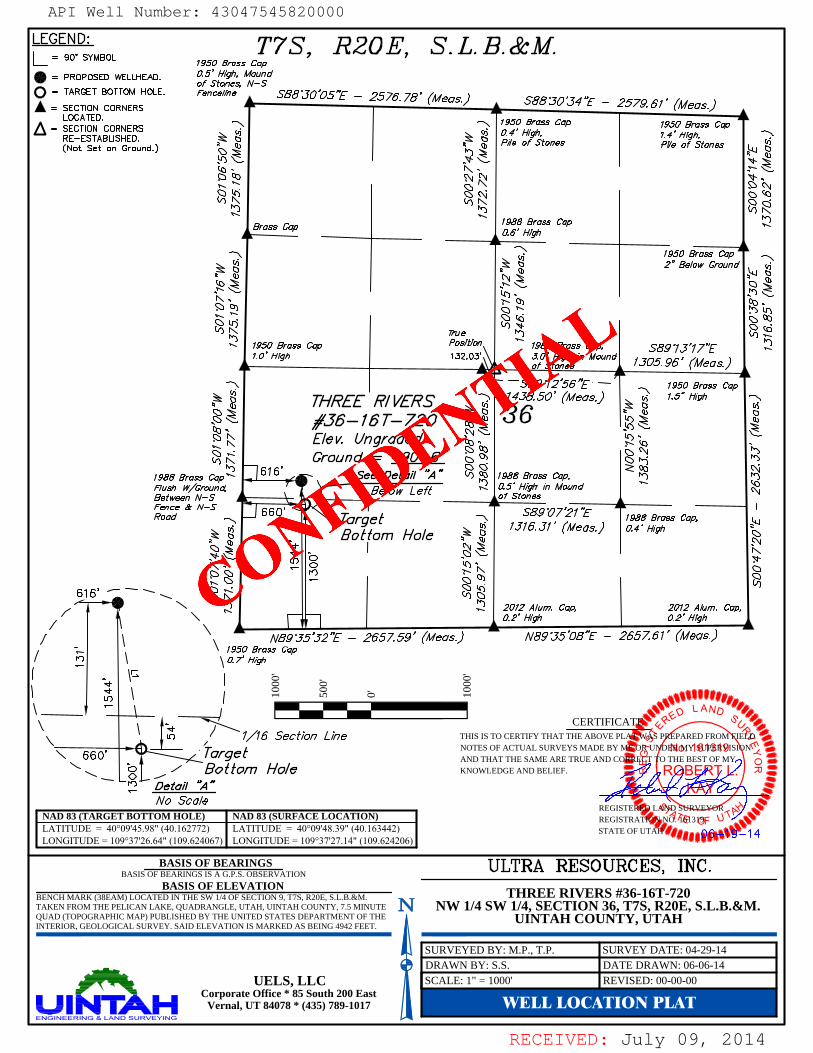
WELL LOCATION PLAT
ROBERT L.KAY
No. 161319
STATE O
R
AND SURVEY
O
THIS IS TO CERTIFY THAT THE ABOVE PLAT WAS PREPARED FROM FIELDNOTES OF ACTUAL SURVEYS MADE BY ME OR UNDER MY SUPERVISIONAND THAT THE SAME ARE TRUE AND CORRECT TO THE BEST OF MYKNOWLEDGE AND BELIEF.
CERTIFICATE
REGISTERED LAND SURVEYORREGISTRATION NO. 161319STATE OF UTAH
BASIS OF ELEVATION
BASIS OF BEARINGS BASIS OF BEARINGS IS A G.P.S. OBSERVATION
SURVEY DATE: 04-29-14SURVEYED BY: M.P., T.P.
1000
'
500'
0' 1000
'
NAD 83 (TARGET BOTTOM HOLE)LATITUDE = 40°09'45.98" (40.162772)LONGITUDE = 109°37'26.64" (109.624067)
NAD 83 (SURFACE LOCATION)LATITUDE = 40°09'48.39" (40.163442)LONGITUDE = 109°37'27.14" (109.624206)
DRAWN BY: S.S.UELS, LLC
Corporate Office * 85 South 200 EastVernal, UT 84078 * (435) 789-1017
DATE DRAWN: 06-06-14SCALE: 1" = 1000'
THREE RIVERS #36-16T-720NW 1/4 SW 1/4, SECTION 36, T7S, R20E, S.L.B.&M.
UINTAH COUNTY, UTAH
REVISED: 00-00-00
BENCH MARK (38EAM) LOCATED IN THE SW 1/4 OF SECTION 9, T7S, R20E, S.L.B.&M.TAKEN FROM THE PELICAN LAKE, QUADRANGLE, UTAH, UINTAH COUNTY, 7.5 MINUTEQUAD (TOPOGRAPHIC MAP) PUBLISHED BY THE UNITED STATES DEPARTMENT OF THEINTERIOR, GEOLOGICAL SURVEY. SAID ELEVATION IS MARKED AS BEING 4942 FEET.
API Well Number: 43047545820000
CONFIDE
NTIAL
API Well Number: 43047545820000
LEGEND: T7S R20E S.L.B.&M.=
90° SYMBOL 1950 Brass Cap= PROPOSED WELLHEAD. 0.5' High, Mound
= SEACRGETBCOORNEMRHOLE.nSctonees,H-s
SBB30'OST - 2576.78' (Meas.) SBB°JO'J4'T- 2579.61' (Meas.)
LOCATED. I k= SECTION CORNERS
1950 Brass CaP 1950 Brass CapRE-ESTABLISHED. 0.4' High, 1.4' High,(Not Set on Ground.) Pile of Stones Pile of Stones
Brass Cap 1988 Brass Cap0.6' High
1950 Brass Cap2" Below Ground
1950 Brass Cap Position 1988 Brass Cap, SB9'13'177
¯ SB9°12'56 Y -- 1950 Brass capTHREE R/VERS 1438.50' (Meas.) 1.5" High
6- 16 T- 720 36E/ev. UngradedGround = 4901.6'
1988 Brass Cap 616' See Detal/ "A"1988 Brass Cap,
Flush W/Ground, @ Below Left ""If I" "°""Between N-SS of StoS
9°07'217 ALisasBrass cap,
Bottom Ho/e
2012 Alum. Cap, 2012 Alum. Cap,
/ NB9'J5'J2'T -- 2657.59' (Meas.) NB9°35'08'T- 2657.61' (Meas.)
1950 Brass cap
o o o
\ - - L ACERTIFICAl
17/16 Section Lirle THIS IS TO CERTIFY THAT THE ABOVE PL 45P PARED FROlv ENOTES OF ACTUAL SURVEYS MADEBY L INgíY ($SI
660 Turgo É AND THAT THE SAME ARE TRUE AND C T O THE BEST OF MYBo t tom Ho/O KNOWLEDGE AND BELIEF. R B . ..
Detail "A"g*
INo Scole
REGISTNAD 83 (TARGET BOTTOM HOLE) NAD 83 (SURFACE LOCATION) REGISTRA 1 Gl3gLATITUDE = 40°09'45.98" (40.162772) LATITUDE = 40°09'48.39" (40.163442) STATE OF llLONGITUDE = 109°37'26.64" (109.624067) LONGITUDE = 109°37'27.14" (109.624206) 55
BASIS OF BEARINGs ULTRA RESOURCES INC.BASIS OF BEARINGS IS A G.P.S. OBSERVATION 'BASIS OF ELEVATION
BENCH MARK (38EAM) LOCATED IN THE SW 1/4 OF SECTION 9, T7S, R20E, S.L.B.&M. THREE RIVERS #36-16T-720TAKEN FROM THE PELICAN LAKE, QUADRANGLE, UTAH, UINTAH COUNTY, 7.5 MINUTE N NW 1/4 SW 1/4, SE CTION 36, T7S, R20E, S.L.B.& M.QUAD (TOPOGRAPHIC MAP) PUBLISHED BY THE UNITED STATES DEPARTMENT OF THE UINTAH COUNTY, UTAHINTERIOR, GEOLOGICAL SURVEY. SAID ELEVATION IS MARKED AS BEING 4942 FEET.
UELS, LLCCoreporate Offi4c0e* 85 S35)th 2900nElast
RECEIVED: July 09,
RECEIVED: July 09, 2014
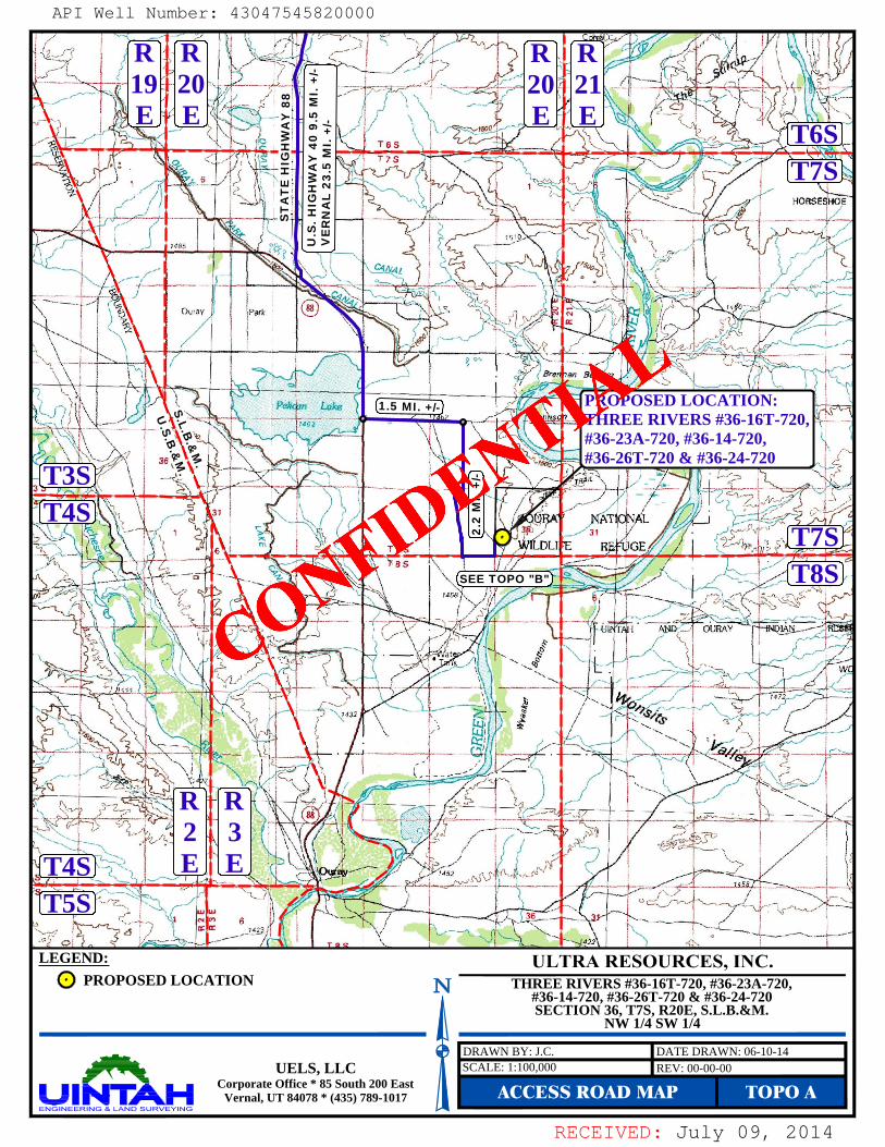
THREE RIVERS #36-16T-720, #36-23A-720,#36-14-720, #36-26T-720 & #36-24-720SECTION 36, T7S, R20E, S.L.B.&M.
NW 1/4 SW 1/4
LEGEND:PROPOSED LOCATION
ACCESS ROAD MAP TOPO ASCALE: 1:100,000DRAWN BY: J.C. DATE DRAWN: 06-10-14
REV: 00-00-00UELS, LLCCorporate Office * 85 South 200 East
Vernal, UT 84078 * (435) 789-1017
T8ST7S
T7ST6S
T5ST4S
T4ST3S
S.L.B.&
M.
U.S.B
.&M
.
R2E
R3E
R19E
R20E
R20E
R21E
SEE TOPO "B"
1.5 MI. +/-
2.2
MI.
+/-
ST
AT
E H
IGH
WA
Y 8
8
U.S
. HIG
HW
AY
40
9.5
MI.
+/-
VE
RN
AL
23.5
MI.
+/-
PROPOSED LOCATION:THREE RIVERS #36-16T-720,#36-23A-720, #36-14-720,#36-26T-720 & #36-24-720
API Well Number: 43047545820000
CONFIDE
NTIAL
API Well Number: 43047545820000
R R R R19 20 20 21E E E E
PROPOSED LOCATION:THREE RIVERS #36-16T-720#36-23A-720, #36-14-720,#36-26T-720 & #36-24-720
4ST5S
LEGEND: ULTRA RESOURCES, INC.PROPOSED LOCATION N THREI RIVERS #36-16T-720, #36-23A-720,
#36- 4-720, #36-26T-720 & #36-24-720SECTION 36, T7S, R20E, S.L.B.&M.
NW 1/4 SW 1/4
UELS, LLC
n,t tre 5 sos) oEast ACCESS ROAD MAP TOPO A
RECEIVED: July 09,
RECEIVED: July 09, 2014
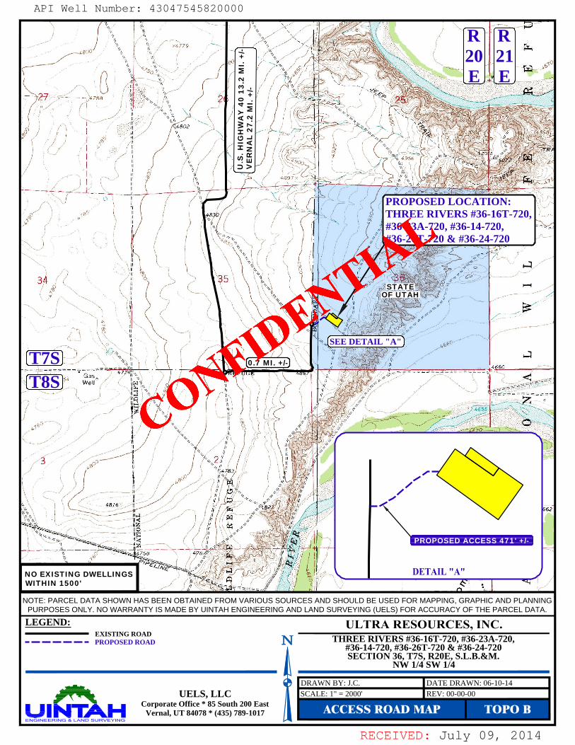
LEGEND:EXISTING ROADPROPOSED ROAD
NOTE: PARCEL DATA SHOWN HAS BEEN OBTAINED FROM VARIOUS SOURCES AND SHOULD BE USED FOR MAPPING, GRAPHIC AND PLANNING
PURPOSES ONLY. NO WARRANTY IS MADE BY UINTAH ENGINEERING AND LAND SURVEYING (UELS) FOR ACCURACY OF THE PARCEL DATA.
ACCESS ROAD MAP TOPO BREV: 00-00-00UELS, LLC
Corporate Office * 85 South 200 EastVernal, UT 84078 * (435) 789-1017
SCALE: 1" = 2000'DRAWN BY: J.C. DATE DRAWN: 06-10-14
SEE DETAIL "A"
NO EXISTING DWELLINGSWITHIN 1500'
PROPOSED ACCESS 471' +/-
PROPOSED LOCATION:THREE RIVERS #36-16T-720,#36-23A-720, #36-14-720,#36-26T-720 & #36-24-720
U.S
. HIG
HW
AY
40
13.2
MI.
+/-
VE
RN
AL
27.2
MI.
+/-
R20E
R21E
STATEOF UTAH
T8ST7S
THREE RIVERS #36-16T-720, #36-23A-720,#36-14-720, #36-26T-720 & #36-24-720SECTION 36, T7S, R20E, S.L.B.&M.
NW 1/4 SW 1/4
0.7 MI. +/-
API Well Number: 43047545820000
CONFIDE
NTIAL
API Well Number: 43047545820000
R R20 21
PROPOSED LOCATION:THREE RIVERS #36-16T-720#36-23A-720, #36-14-720,#36-26T-720 & #36-24-720
34 35STATE
OF UTAH
SEE DETAIL "A"
T7S) . MI. I-so
WITHIN 1500'
NOTE: PARCEL DATA SHOWN HAS BEEN OBTAINED FROM VARIOUS SOURCES AND SHOULD BE USED FOR MAPPING, GRAPHIC AND PLANNINGPURPOSES ONLY. NO WARRANTY IS MADE BY UINTAH ENGINEERING AND LAND SURVEYlNG (UELS) FOR ACCURACY OF THE PARCEL DATA.
LEGEND: ULTRA RESOURCES, INC.EXISTING ROAD
- - - - - - - PROPOSED ROAD N THREE RIVERS #36-16T-720, #36-23A-720,#36-14-720, #36-26T-720 & #36-24-720SECTION 36, T7S, R20E, S.L.B.&M.
NW 1/4 SW 1/4
UELS, LLCCorporate M4c0e* 85 S3outh200 East ACCESS ROAD MAP TOPO B
RECEIVED: July 09,
RECEIVED: July 09, 2014
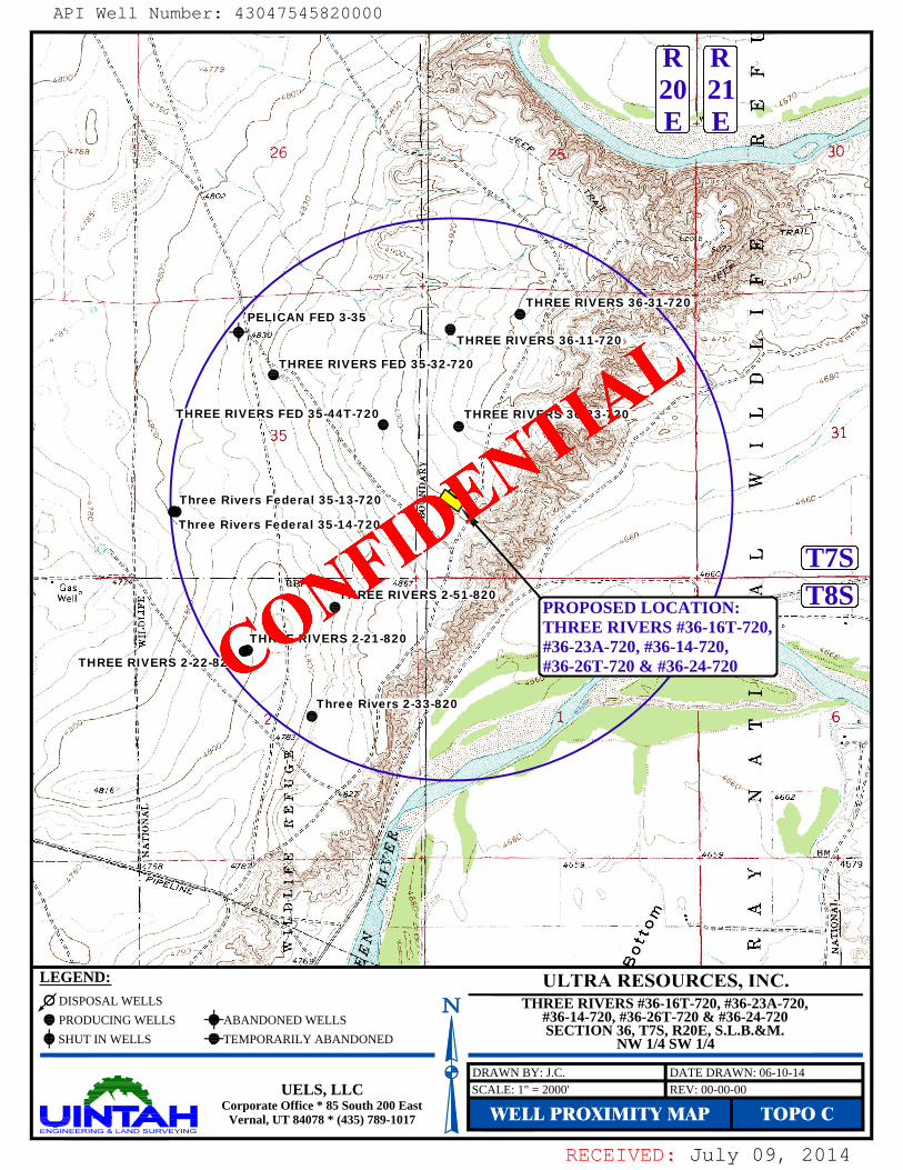
WELL PROXIMITY MAP TOPO CREV: 00-00-00UELS, LLC
Corporate Office * 85 South 200 EastVernal, UT 84078 * (435) 789-1017
SCALE: 1" = 2000'DRAWN BY: J.C. DATE DRAWN: 06-10-14
LEGEND:DISPOSAL WELLSPRODUCING WELLSSHUT IN WELLS
ABANDONED WELLSTEMPORARILY ABANDONED
THREE RIVERS 36-23-720
THREE RIVERS 36-11-720
THREE RIVERS 36-31-720PELICAN FED 3-35
THREE RIVERS FED 35-32-720
THREE RIVERS FED 35-44T-720
THREE RIVERS 2-21-820
THREE RIVERS 2-51-820
THREE RIVERS 2-22-820
Three Rivers Federal 35-14-720
Three Rivers Federal 35-13-720
Three Rivers 2-33-820
T8ST7S
R20E
R21E
PROPOSED LOCATION:THREE RIVERS #36-16T-720,#36-23A-720, #36-14-720,#36-26T-720 & #36-24-720
THREE RIVERS #36-16T-720, #36-23A-720,#36-14-720, #36-26T-720 & #36-24-720SECTION 36, T7S, R20E, S.L.B.&M.
NW 1/4 SW 1/4
API Well Number: 43047545820000
CONFIDE
NTIAL
API Well Number: 43047545820000
R R20 21E E
26
El I FED 3-
THREE E -
THREE RIVERS FED 35-32-720
THREE RIVER FED 3 T 72 TH E 2
31
Three Rivers Federal 35-13-720
Three Rivers Federal 35-14-720
T7S)e THREE RIVE S -5 -82 T8SPROPOSED LOCA ION:
THREE RIVERS #36-16T-720THREE RIVERS 2-21-820
#36-23A-720, #36-14-720,THREE RIVERS 2-22-820 #36-26T-720 & #36-24-720
Three Rivers 2-33-8201
LEGEND: ULTRA RESOURCES, INC.DISPOSAL WELLS N THREE RIVERS #36-16T-720, #36-23A-720,PRODUCING WELLS ABANDONED WELLS #36-14-720, #36-26T-720 & #36-24-720
SECTION 36, T7S, R20E, S.L.B.&M.SHUT IN WELLS - -TEMPORARILY ABANDONED NW 1/4 SW 1/4
UELS, LLCCorporate M4c0e* 85 S3outh200 East MLL PROXIMITY MAP TOPO C
RECEIVED: July 09,
RECEIVED: July 09, 2014
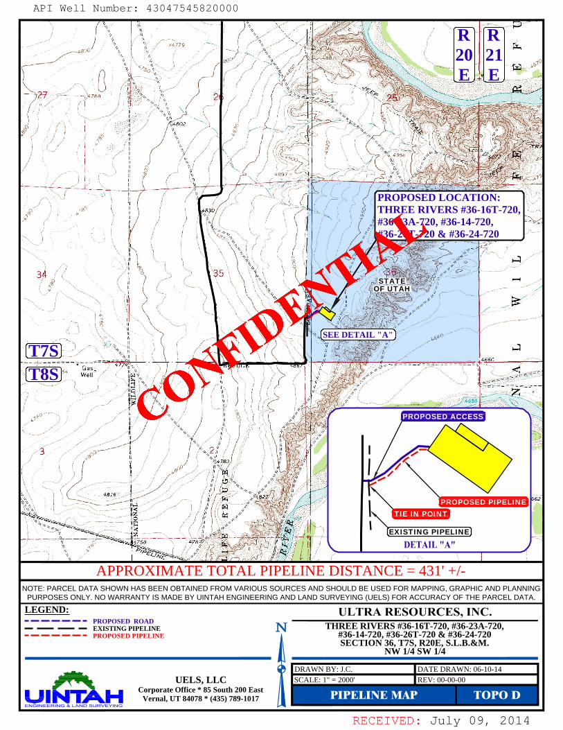
LEGEND:
NOTE: PARCEL DATA SHOWN HAS BEEN OBTAINED FROM VARIOUS SOURCES AND SHOULD BE USED FOR MAPPING, GRAPHIC AND PLANNING
PURPOSES ONLY. NO WARRANTY IS MADE BY UINTAH ENGINEERING AND LAND SURVEYING (UELS) FOR ACCURACY OF THE PARCEL DATA.
APPROXIMATE TOTAL PIPELINE DISTANCE = 431' +/-
PROPOSED ROADEXISTING PIPELINEPROPOSED PIPELINE
PIPELINE MAP TOPO DREV: 00-00-00UELS, LLC
Corporate Office * 85 South 200 EastVernal, UT 84078 * (435) 789-1017
SCALE: 1" = 2000'DRAWN BY: J.C. DATE DRAWN: 06-10-14
SEE DETAIL "A"
PROPOSED ACCESS
T8ST7S
PROPOSED LOCATION:THREE RIVERS #36-16T-720,#36-23A-720, #36-14-720,#36-26T-720 & #36-24-720
R20E
R21E
STATEOF UTAH
TIE IN POINTPROPOSED PIPELINE
EXISTING PIPELINE
THREE RIVERS #36-16T-720, #36-23A-720,#36-14-720, #36-26T-720 & #36-24-720SECTION 36, T7S, R20E, S.L.B.&M.
NW 1/4 SW 1/4
API Well Number: 43047545820000
CONFIDE
NTIAL
API Well Number: 43047545820000
PROPOSED LOCATION:THREE RIVERS #36-16T-720,#36-23A-720, #36-14-720,#36-26 & # 6-24 0
34 35STATE
SEE DETAIL "A"
(T7S8S
APPROXIMATE TOTAL PIPELINE DISTANCE = 431' +/-
NOTE: PARCEL DATA SHOWN HAS BEEN OBTAINED FROM VARIOUS SOURCES AND SHOULD BE USED FOR MAPPING, GRAPHIC AND PLANNINGPURPOSES ONLY. NO WARRANTY IS MADE BY UINTAH ENGINEERING AND LAND SURVEYlNG (UELS) FOR ACCURACY OF THE PARCEL DATA.
LEGEND: ULTRA RESOURCES, INC.- - - - - - - PROPOSED ROAD- -- -- - EXISTING PIPELINE N THREE RIVERS #36-16T-720, #36-23A-720,------- PROPOSED PIPELINE #36-14-720, #36-26T-720 & #36-24-720
SECTION 36, T7S, R20E, S.L.B.&M.NW 1/4 SW 1/4
UELS, LLCCorporate M4c0e* 85 S3outh200 East PIPELINE MAP TOPO D
RECEIVED: July 09,

RECEIVED: July 09, 2014
LEGEND:
NOTE: PARCEL DATA SHOWN HAS BEEN OBTAINED FROM VARIOUS SOURCES AND SHOULD BE USED FOR MAPPING, GRAPHIC AND PLANNING
PURPOSES ONLY. NO WARRANTY IS MADE BY UINTAH ENGINEERING AND LAND SURVEYING (UELS) FOR ACCURACY OF THE PARCEL DATA.
APPROXIMATE TOTAL POWER LINE DISTANCE = 485' +/-
PROPOSED ROADEXISTING POWER LINEPROPOSED POWER LINE
POWER LINE MAP TOPO EREV: 00-00-00UELS, LLC
Corporate Office * 85 South 200 EastVernal, UT 84078 * (435) 789-1017
SCALE: 1" = 2000'DRAWN BY: J.C. DATE DRAWN: 06-10-14
SEE DETAIL "A"
PROPOSED ACCESS
PROPOSED LOCATION:THREE RIVERS #36-16T-720,#36-23A-720, #36-14-720,#36-26T-720 & #36-24-720
R20E
R21E
STATEOF UTAH
T8ST7S
PROPOSED POWER LINE
PROPOSED POWER LINE(SERVICING OTHER WELLS)
THREE RIVERS FED#36-11-720
PROPOSED POWER LINEFOR THE THREE RIVERS#36-11-720
THREE RIVERS #36-16T-720, #36-23A-720,#36-14-720, #36-26T-720 & #36-24-720SECTION 36, T7S, R20E, S.L.B.&M.
NW 1/4 SW 1/4
API Well Number: 43047545820000
CONFIDE
NTIAL
API Well Number: 43047545820000
20 21
THREE RIVERS FED'
#36-11-720
PROPOSED LOCATION:THREE RIVERS #36-16T-720#36-23A-720, #36-14-720,#36-26T-720 & #36-24-720
34 35
SEE DETAIL "A"
(T7S
I AIL " "
NOTE: PARCEL DATA SHOWN HAS BEEN OBTAINED FROM VARIOUS SOURCES AND SHOULD BE USED FOR MAPPING, GRAPHIC AND PLANNINGPURPOSES ONLY. NO WARRANTY IS MADE BY UINTAH ENGINEERING AND LAND SURVEYlNG (UELS) FOR ACCURACY OF THE PARCEL DATA.
LEGEND: ULTRA RESOURCES, INC.------- PROPOSED ROAD- - - - - • • EXISTING POWER LINE N THREE RIVERS #36-16T-720, #36-23A-720,
#36-14-720, #36-26T-720 & #36-24-720PROPOSED POWER LINE SECTION 36, T7S, R20E, S.L.B.&M.(SERVICING OTHER WELLS) NW 1/4 SW 1/4
UELS, LLCCorporate M4c0e* 85 S3outh200 East POWER LINE MAP TOPO E
RECEIVED: July 09,
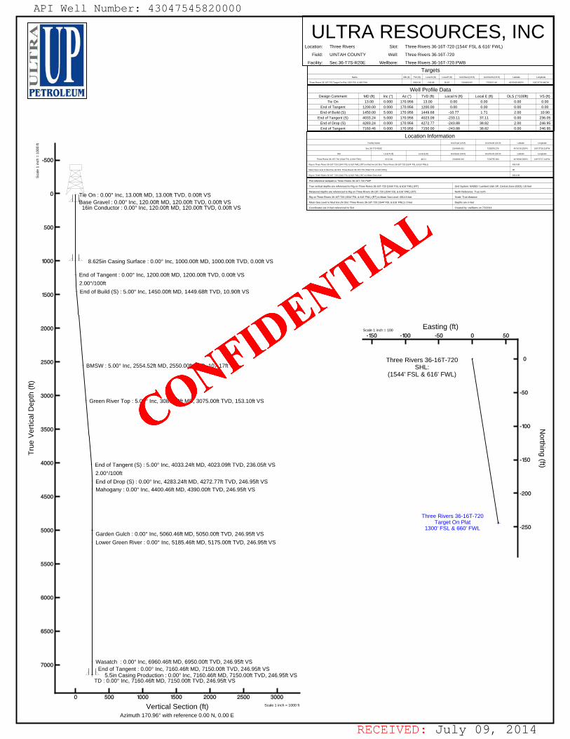
RECEIVED: July 09, 2014
Base Gravel : 0.00° Inc, 120.00ft MD, 120.00ft TVD, 0.00ft VSTie On : 0.00° Inc, 13.00ft MD, 13.00ft TVD, 0.00ft VS
16in Conductor : 0.00° Inc, 120.00ft MD, 120.00ft TVD, 0.00ft VS
2.00°/100ft
End of Tangent : 0.00° Inc, 1200.00ft MD, 1200.00ft TVD, 0.00ft VS
End of Build (S) : 5.00° Inc, 1450.00ft MD, 1449.68ft TVD, 10.90ft VS
8.625in Casing Surface : 0.00° Inc, 1000.00ft MD, 1000.00ft TVD, 0.00ft VS
BMSW : 5.00° Inc, 2554.52ft MD, 2550.00ft TVD, 107.17ft VS
Green River Top : 5.00° Inc, 3081.53ft MD, 3075.00ft TVD, 153.10ft VS
2.00°/100ft
Mahogany : 0.00° Inc, 4400.46ft MD, 4390.00ft TVD, 246.95ft VS
End of Tangent (S) : 5.00° Inc, 4033.24ft MD, 4023.09ft TVD, 236.05ft VS
End of Drop (S) : 0.00° Inc, 4283.24ft MD, 4272.77ft TVD, 246.95ft VS
Garden Gulch : 0.00° Inc, 5060.46ft MD, 5050.00ft TVD, 246.95ft VS
Lower Green River : 0.00° Inc, 5185.46ft MD, 5175.00ft TVD, 246.95ft VS
Wasatch : 0.00° Inc, 6960.46ft MD, 6950.00ft TVD, 246.95ft VS
TD : 0.00° Inc, 7160.46ft MD, 7150.00ft TVD, 246.95ft VS
End of Tangent : 0.00° Inc, 7160.46ft MD, 7150.00ft TVD, 246.95ft VS5.5in Casing Production : 0.00° Inc, 7160.46ft MD, 7150.00ft TVD, 246.95ft VS
Tru
e V
ertic
al D
epth
(ft
)
Vertical Section (ft)Azimuth 170.96° with reference 0.00 N, 0.00 E
Scale 1 inch = 1000 ft
Sca
le 1
inch
= 1
000
ft
Rig on Three Rivers 36-16T-720 (1544' FSL & 616' FWL) (RT) to Mean Sea Level
Mean Sea Level to Mud line (At Slot: Three Rivers 36-16T-720 (1544' FSL & 616' FWL))
Rig on Three Rivers 36-16T-720 (1544' FSL & 616' FWL) (RT) to Mud line (At Slot: Three Rivers 36-16T-720 (1544' FSL & 616' FWL))
Three Rivers 36-16T-720 (1544' FSL & 616' FWL)
Slot
Sec.36-T7S-R20E
Facility Name
-3122.84
Local N (ft)
-48.21
Local E (ft)
Location Information
2164606.910
Grid East (US ft)
2164589.621
Grid East (US ft)
7233755.383
Grid North (US ft)
7236878.276
Grid North (US ft)
4914.6ft
0ft
4914.6ft
40°09'48.390"N
Latitude
40°10'19.250"N
Latitude
109°37'27.140"W
Longitude
109°37'26.519"W
Longitude
Coordinates are in feet referenced to Slot
Mean Sea Level to Mud line (At Slot: Three Rivers 36-16T-720 (1544' FSL & 616' FWL)): 0 feet
Rig on Three Rivers 36-16T-720 (1544' FSL & 616' FWL) (RT) to Mean Sea Level: 4914.6 feet
Measured depths are referenced to Rig on Three Rivers 36-16T-720 (1544' FSL & 616' FWL) (RT)
True vertical depths are referenced to Rig on Three Rivers 36-16T-720 (1544' FSL & 616' FWL) (RT)
Plot reference wellpath is Three Rivers 36-16T-720 PWP
Created by: ewilliams on 7/3/2014
Depths are in feet
Scale: True distance
North Reference: True north
Grid System: NAD83 / Lambert Utah SP, Central Zone (4302), US feet
End of Tangent
End of Drop (S)
End of Tangent (S)
End of Build (S)
End of Tangent
Tie On
Design Comment
7160.46
4283.24
4033.24
1450.00
1200.00
13.00
MD (ft)
0.000 170.956
0.000 170.956
5.000 170.956
5.000 170.956
0.000 170.956
0.000 170.956
Inc (°) Az (°)
7150.00
4272.77
4023.09
1449.68
1200.00
13.00
TVD (ft)
Well Profile Data
-243.88
-243.88
-233.11
-10.77
0.00
0.00
Local N (ft) Local E (ft)
38.82
38.82
37.11
1.71
0.00
0.00
0.00
2.00
0.00
2.00
0.00
0.00
DLS (°/100ft)
246.95
246.95
236.05
10.90
0.00
0.00
VS (ft)
Facility:
Field:
Location:
ULTRA RESOURCES, INCSec.36-T7S-R20E
UINTAH COUNTY
Three Rivers
Wellbore:
Well:
Slot:
Three Rivers 36-16T-720 PWB
Three Rivers 36-16T-720
Three Rivers 36-16T-720 (1544' FSL & 616' FWL)
Three Rivers 36-16T-720 Target On Plat 1300' FSL & 660' FWL
Name MD (ft)
5000.00 -243.88
TVD (ft) Local N (ft)
Targets
38.82
Local E (ft)
2164650.83
Grid East (US ft)
7233512.40
Grid North (US ft)
40°09'45.980"N
Latitude
109°37'26.640"W
Longitude
Three Rivers 36-16T-720Target On Plat
1300' FSL & 660' FWL
Three Rivers 36-16T-720SHL:
(1544' FSL & 616' FWL)
Northing (ft)
Easting (ft)Scale 1 inch = 100
API Well Number: 43047545820000
CONFIDE
NTIAL
API Well Number: 43047545820000
ULTRA RESOURCES, INCLocation: Thoe Rivers Slot: Thoe Rivers 36-16T-720 (1544 FSL & 616' FWL)
Field: UINTAHCOUNTY Well: Thoe Rivers 36-16T-720
Facility: Sec.36-T7S-R20E Wellbore: Thoe Rivers 36-16T-720 PWB
Targets
PETROLEUM DesignCamment MDŒ) IncC)MCWell roft>leDaLaalN(ft)
LocalE(ft) DLS(/100ft) VS(ft)TieOn 13.00 0000 170956 1300
End of Tangent 1200 00 0 000 170 956 1200 00 0.00End of Build (S) 1450 00 5 000 170 956 1449 68 10 77 1.71 2 00 10.90
End of Tangent (S) 4033 24 5 000 170 956 4023 09 233 11 37 11 0 00 236.05End of Drap (S) 4283 24 0 000 170 956 4272 77 243 88 38 82 2 00 246.95End of Tangent 7160 46 0 000 170 956 7150 00 243 88 38 82 0 00 246.95
Location Information
-500 •
0 • Tie On :0.00° Inc, 13.00ft MD, 13.00ft TVD, 0.00ft VS
272 44 s a estens >ssies «suts
ase Gravel :0.00° Inc, 120.00ft MD, 120.00ft TVD, 0.00ft VS ssie 2oos44 suas
16in Conductor :0.00° Inc, 120.00ft MD, 120.00ft TVD, 0.00ft VS emson 2014
500 -
1000 • 8.625in Casing Surface :0.00° Inc, 1000.00ft MD, 1000.00ft TVD, 0.00ft VS
End of Tangent: 0.00° Inc, 1200.00ft MD, 1200.00ft TVD, 0.00ft VS2.00°/100ft
1500 -End of Build (S) :
5.00° Inc, 1450.00ft MD, 1449.68ft TVD, 10.90ft VS
2000 -Scale 1 inch = 100
Easting (ft)-150 -100 -50 0 50
I I I I I
2500 . Three Rivers 36-16T-720 - 0BMSW: 5.00° Inc, 2554.52ft MD, 2550.00ft TVD, 107.17ft VS SHL:
(1544' FSL & 616' FWL)
3000 •
- -50
Green River Top :5.00° Inc, 3081.53ft MD, 3075.00ft TVD, 153.10ft VS
3500 •
- -100
Z
- -150 -
4000 • End of Tangent (S) :5.00° Inc, 4033.24ft MD, 4023.09ft TVD, 236.05ft VS
2.00°/100ft
End of Drop (S) :0.00° Inc, 4283.24ft MD, 4272.77ft TVD, 246.95ft VS
4500 -
Mahogany :0.00° Inc, 4400.46ft MD, 4390.00ft TVD, 246.95ft VS
• -200
Three Rivers 36-16T-720Target On Plat
5000 • 1300' FSL & 660' FWL • -250
Garden Gulch :0.00° Inc, 5060.46ft MD, 5050.00ft TVD, 246.95ft VS
Lower Green River :0.00° Inc, 5185.46ft MD, 5175.00ft TVD, 246.95ft VS
5500 -
6000 -
6500 •
7000 -Wasatch :
0.00° Inc, 6960.46ft MD, 6950.00ft TVD, 246.95ft VSEnd of Tangent: 0.00° Inc, 7160.46ft MD, 7150.00ft TVD, 246.95ft VS
5.5in Casing Production :0.00° Inc, 7160.46ft MD, 7150.00ft TVD, 246.95ft VS
TD :0.00° Inc, 7160.46ft MD, 7150.00ft TVD, 246.95ft VS
IIIIIII0 500 1000 1500 2000 2500 3000
Vertical Section (ft) Scale1inch=1000ft
Azimuth 170.96° with reference 0.00 N, 0.00 E
RECEIVED: July 09,

RECEIVED: July 09, 2014
REFERENCE WELLPATH IDENTIFICATIONOperator ULTRA RESOURCES, INC Slot Three Rivers 36-16T-720 (1544' FSL & 616' FWL)Area Three Rivers Well Three Rivers 36-16T-720Field UINTAH COUNTY Wellbore Three Rivers 36-16T-720 PWBFacility Sec.36-T7S-R20E
REPORT SETUP INFORMATIONProjection System NAD83 / Lambert Utah SP, Central Zone (4302), US feet Software System WellArchitect® 3.0.0North Reference True User EwilliamsScale 0.999915 Report Generated 7/3/2014 at 1:08:16 PMConvergence at slot n/a Database/Source file WellArchitectDB/Three_Rivers_36-16T-720_PWB.xml
WELLPATH LOCATIONLocal coordinates Grid coordinates Geographic coordinates
North[ft] East[ft] Easting[US ft] Northing[US ft] Latitude LongitudeSlot Location -3122.84 -48.21 2164606.91 7233755.38 40°09'48.390"N 109°37'27.140"WFacility Reference Pt 2164589.62 7236878.28 40°10'19.250"N 109°37'26.519"WField Reference Pt 2156630.96 7236613.42 40°10'18.270"N 109°39'09.100"W
WELLPATH DATUMCalculation method Minimum curvature Rig on Three Rivers 36-16T-720 (1544' FSL & 616' FWL) (RT) to Facility Vertical DatumHorizontal Reference Pt Slot Rig on Three Rivers 36-16T-720 (1544' FSL & 616' FWL) (RT) to Mean Sea LevelVertical Reference Pt Rig on Three Rivers 36-16T-720 (1544' FSL & 616' FWL) (RT) Rig on Three Rivers 36-16T-720 (1544' FSL & 616' FWL) (RT) to Mud Line at Slot (Three Rivers 36-16T-720 (1544' FSL & 616' FWL))MD Reference Pt Rig on Three Rivers 36-16T-720 (1544' FSL & 616' FWL) (RT) Section OriginField Vertical Reference Mean Sea Level Section Azimuth
Planned Wellpath ReportThree Rivers 36-16T-720 PWP
Page 1 of 5
Page 1 of 5
7/3/2014
API Well Number: 43047545820000
CONFIDE
NTIAL
API Well Number: 43047545820000 Page 1 of 5
Planned Wellpath Report DYNAMICThree Rivers 36-16T-720 PWP GRAPHICS,INC,
Page1of5PETROLELT1
REFERENCE MILLPATH IDENTIHCATIONOperator ULTRA RESOURCES, INC Slot Three Rivers 36-16T-720 (1544' FSL & 616' FWL)
Area Three Rivers Well Three Rivers 36-16T-720
Field UINTAH COUNTY Wellbore Three Rivers 36-16T-720 PWB
Facility Sec.36-T7S-R20E
REPORT SETUP INFORMATIONProjection System NAD83 / Lambert Utah SP, Central Zone (4302), US feet Software System WellArchitect® 3.0.0
North Reference True User Ewilliams
Scale 0.999915 Report Generated 7/3/2014 at 1:08:16 PMConvergence at slot n/a Database/Source file WellArchitectDB/Three_Rivers_36-16T-720_PWB.xml
MILLPATH LOCATIONLocal coordinates Grid coordinates Geographic coordinates
North[ft] East[ft] Easting[US ft] Northing[US ft] Latitude Longitude
SlotLocation -3122.84 -48.21 2164606.91 7233755.38 40°09'48.390"N 109°37'27.140"W
FacilityReferencePt 2164589.62 7236878.28 40°10'19.250"N 109°37'26.519"W
Field Reference Pt 2156630.96 7236613.42 40°10'18.270"N 109°39'09.100"W
MILLPATH DATUMCalculation method Minimum curvature Rig on Three Rivers 36-16T-720 (1544' FSL & 616' FWL) (RT) to Facility Vertical Datum
Horizontal Reference Pt Slot Rig on Three Rivers 36-16T-720 (1544' FSL & 616' FWL) (RT) to Mean Sea Level
Vertical Reference Pt Rig on Three Rivers 36-16T-720 (1544' FSL & 616' FWL) (RT) Rig on Three Rivers 36-16T-720 (1544' FSL & 616' FWL) (RT) to Mud Line at Slot (Three Rivers 36-16T-720 (1544' FSL & 616' FWL)MD Reference Pt Rig on Three Rivers 36-16T-720 (1544' FSL & 616' FWL) (RT) Section Origin
Field Vertical Reference Mean Sea Level Section Azimuth
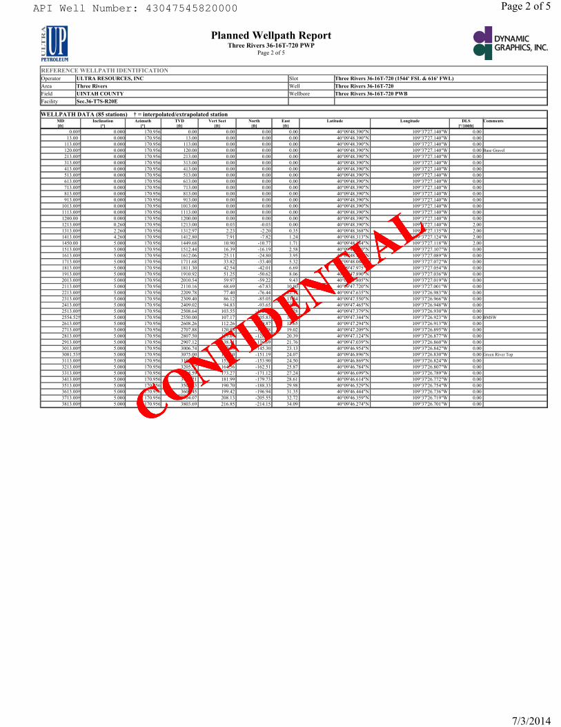
RECEIVED: July 09, 2014
REFERENCE WELLPATH IDENTIFICATIONOperator ULTRA RESOURCES, INC Slot Three Rivers 36-16T-720 (1544' FSL & 616' FWL)Area Three Rivers Well Three Rivers 36-16T-720Field UINTAH COUNTY Wellbore Three Rivers 36-16T-720 PWBFacility Sec.36-T7S-R20E
Planned Wellpath ReportThree Rivers 36-16T-720 PWP
Page 2 of 5
WELLPATH DATA (85 stations) † = interpolated/extrapolated stationMD[ft]
Inclination[°]
Azimuth[°]
TVD[ft]
Vert Sect[ft]
North[ft]
East[ft]
Latitude Longitude DLS[°/100ft]
Comments
0.00† 0.000 170.956 0.00 0.00 0.00 0.00 40°09'48.390"N 109°37'27.140"W 0.00 13.00 0.000 170.956 13.00 0.00 0.00 0.00 40°09'48.390"N 109°37'27.140"W 0.00
113.00† 0.000 170.956 113.00 0.00 0.00 0.00 40°09'48.390"N 109°37'27.140"W 0.00 120.00† 0.000 170.956 120.00 0.00 0.00 0.00 40°09'48.390"N 109°37'27.140"W 0.00 Base Gravel213.00† 0.000 170.956 213.00 0.00 0.00 0.00 40°09'48.390"N 109°37'27.140"W 0.00 313.00† 0.000 170.956 313.00 0.00 0.00 0.00 40°09'48.390"N 109°37'27.140"W 0.00 413.00† 0.000 170.956 413.00 0.00 0.00 0.00 40°09'48.390"N 109°37'27.140"W 0.00 513.00† 0.000 170.956 513.00 0.00 0.00 0.00 40°09'48.390"N 109°37'27.140"W 0.00 613.00† 0.000 170.956 613.00 0.00 0.00 0.00 40°09'48.390"N 109°37'27.140"W 0.00 713.00† 0.000 170.956 713.00 0.00 0.00 0.00 40°09'48.390"N 109°37'27.140"W 0.00 813.00† 0.000 170.956 813.00 0.00 0.00 0.00 40°09'48.390"N 109°37'27.140"W 0.00 913.00† 0.000 170.956 913.00 0.00 0.00 0.00 40°09'48.390"N 109°37'27.140"W 0.00
1013.00† 0.000 170.956 1013.00 0.00 0.00 0.00 40°09'48.390"N 109°37'27.140"W 0.00 1113.00† 0.000 170.956 1113.00 0.00 0.00 0.00 40°09'48.390"N 109°37'27.140"W 0.00 1200.00 0.000 170.956 1200.00 0.00 0.00 0.00 40°09'48.390"N 109°37'27.140"W 0.00 1213.00† 0.260 170.956 1213.00 0.03 -0.03 0.00 40°09'48.390"N 109°37'27.140"W 2.00 1313.00† 2.260 170.956 1312.97 2.23 -2.20 0.35 40°09'48.368"N 109°37'27.135"W 2.00 1413.00† 4.260 170.956 1412.80 7.91 -7.82 1.24 40°09'48.313"N 109°37'27.124"W 2.00 1450.00 5.000 170.956 1449.68 10.90 -10.77 1.71 40°09'48.284"N 109°37'27.118"W 2.00 1513.00† 5.000 170.956 1512.44 16.39 -16.19 2.58 40°09'48.230"N 109°37'27.107"W 0.00 1613.00† 5.000 170.956 1612.06 25.11 -24.80 3.95 40°09'48.145"N 109°37'27.089"W 0.00 1713.00† 5.000 170.956 1711.68 33.82 -33.40 5.32 40°09'48.060"N 109°37'27.072"W 0.00 1813.00† 5.000 170.956 1811.30 42.54 -42.01 6.69 40°09'47.975"N 109°37'27.054"W 0.00 1913.00† 5.000 170.956 1910.92 51.25 -50.62 8.06 40°09'47.890"N 109°37'27.036"W 0.00 2013.00† 5.000 170.956 2010.54 59.97 -59.22 9.43 40°09'47.805"N 109°37'27.019"W 0.00 2113.00† 5.000 170.956 2110.16 68.69 -67.83 10.80 40°09'47.720"N 109°37'27.001"W 0.00 2213.00† 5.000 170.956 2209.78 77.40 -76.44 12.17 40°09'47.635"N 109°37'26.983"W 0.00 2313.00† 5.000 170.956 2309.40 86.12 -85.05 13.54 40°09'47.550"N 109°37'26.966"W 0.00 2413.00† 5.000 170.956 2409.02 94.83 -93.65 14.91 40°09'47.465"N 109°37'26.948"W 0.00 2513.00† 5.000 170.956 2508.64 103.55 -102.26 16.28 40°09'47.379"N 109°37'26.930"W 0.00 2554.52† 5.000 170.956 2550.00 107.17 -105.83 16.85 40°09'47.344"N 109°37'26.923"W 0.00 BMSW2613.00† 5.000 170.956 2608.26 112.26 -110.87 17.65 40°09'47.294"N 109°37'26.913"W 0.00 2713.00† 5.000 170.956 2707.88 120.98 -119.48 19.02 40°09'47.209"N 109°37'26.895"W 0.00 2813.00† 5.000 170.956 2807.50 129.69 -128.08 20.39 40°09'47.124"N 109°37'26.877"W 0.00 2913.00† 5.000 170.956 2907.12 138.41 -136.69 21.76 40°09'47.039"N 109°37'26.860"W 0.00 3013.00† 5.000 170.956 3006.74 147.13 -145.30 23.13 40°09'46.954"N 109°37'26.842"W 0.00 3081.53† 5.000 170.956 3075.00 153.10 -151.19 24.07 40°09'46.896"N 109°37'26.830"W 0.00 Green River Top3113.00† 5.000 170.956 3106.35 155.84 -153.90 24.50 40°09'46.869"N 109°37'26.824"W 0.00 3213.00† 5.000 170.956 3205.97 164.56 -162.51 25.87 40°09'46.784"N 109°37'26.807"W 0.00 3313.00† 5.000 170.956 3305.59 173.27 -171.12 27.24 40°09'46.699"N 109°37'26.789"W 0.00 3413.00† 5.000 170.956 3405.21 181.99 -179.73 28.61 40°09'46.614"N 109°37'26.772"W 0.00 3513.00† 5.000 170.956 3504.83 190.70 -188.33 29.98 40°09'46.529"N 109°37'26.754"W 0.00 3613.00† 5.000 170.956 3604.45 199.42 -196.94 31.35 40°09'46.444"N 109°37'26.736"W 0.00 3713.00† 5.000 170.956 3704.07 208.13 -205.55 32.72 40°09'46.359"N 109°37'26.719"W 0.00 3813.00† 5.000 170.956 3803.69 216.85 -214.15 34.09 40°09'46.274"N 109°37'26.701"W 0.00
Page 2 of 5
7/3/2014
API Well Number: 43047545820000
CONFIDE
NTIAL
API Well Number: 43047545820000 Page2of5
Planned Wellpath Report DYNAMICThree Rivers 36-16T-720 PWP GRAPHICS,INC.
Page2of5PETROLEEP1
REFERENCE MILLPATH IDENTIFICATIONOperator ULTRA RESOURCES, INC Slot Three Rivers 36-16T-720 (1544' FSL & 616' FWL)
Area Three Rivers Well Three Rivers 36-16T-720
Field UINTAH COUNTY Wellbore Three Rivers 36-16T-720 PWB
Facility Sec.36-T7S-R20E
WELLPATH l ATA (85 station:) † = interps lated/extrapolited stationMD Inclination Azimuth TVD VertSect North East Latitude Longitude DLS Commentsfft1 [°1 f°1 fal fal fal fal f°/100ft1
0.001 0.00C 170.956 0.00 0.00 0.00 0.00 40°09'48.390"N 109°37'27.140"W 0.0013.00 0.00C 170.956 13.00 0.00 0.00 0.00 40°09'48.390"N 109°37'27.140"W 0.00
113.001 0.00C 170.956 113.00 0.00 0.00 0.00 40°09'48.390"N 109°37'27.140"W 0.00120.001 0.00C 170.956 120.00 0.00 0.00 0.00 40°09'48.390"N 109°37'27.140"W 0.00 Base Gravel
213.001 0.00C 170.956 213.00 0.00 0.00 0.00 40°09'48.390"N 109°37'27.140"W 0.00313.001 0.00C 170.956 313.00 0.00 0.00 0.00 40°09'48.390"N 109°37'27.140"W 0.00413.001 0.00C 170.956 413.00 0.00 0.00 0.00 40°09'48.390"N 109°37'27.140"W 0.00513.001 0.00C 170.956 513.00 0.00 0.00 0.00 40°09'48.390"N 109°37'27.140"W 0.00613.001 0.00C 170.956 613.00 0.00 0.00 0.00 40°09'48.390"N 109°37'27.140"W 0.00713.001 0.00C 170.956 713.00 0.00 0.00 0.00 40°09'48.390"N 109°37'27.140"W 0.00813.001 0.00C 170.956 813.00 0.00 0.00 0.00 40°09'48.390"N 109°37'27.140"W 0.00913.001 0.00C 170.956 913.00 0.00 0.00 0.00 40°09'48.390"N 109°37'27.140"W 0.00
1013.001 0.00C 170.956 1013.00 0.00 0.00 0.00 40°09'48.390"N 109°37'27.140"W 0.001113.001 0.00C 170.956 1113.00 0.00 0.00 0.00 40°09'48.390"N 109°37'27.140"W 0.001200.00 0.00C 170.956 1200.00 0.00 0.00 0.00 40°09'48.390"N 109°37'27.140"W 0.001213.001 0.26C 170.956 1213.00 0.03 -0.03 0.00 40°09'48.390"N 109°37'27.140"W 2.001313.001 2.26C 170.956 1312.97 2.23 -2.20 0.35 40°09'48.368"N 109°37'27.135"W 2.001413.001 4.26C 170.956 1412.80 7.91 -7.82 1.24 40°09'48.313"N 109°37'27.124"W 2.001450.00 5.00C 170.956 1449.68 10.90 -10.77 1.71 40°09'48.284"N 109°37'27.118"W 2.001513.001 5.00C 170.956 1512.44 16.39 -16.19 2.58 40°09'48.230"N 109°37'27.107"W 0.001613.001 5.00C 170.956 1612.06 25.11 -24.80 3.95 40°09'48.145"N 109°37'27.089"W 0.001713.001 5.00C 170.956 1711.68 33.82 -33.40 5.32 40°09'48.060"N 109°37'27.072"W 0.001813.001 5.00C 170.956 1811.30 42.54 -42.01 6.69 40°09'47.975"N 109°37'27.054"W 0.001913.001 5.00C 170.956 1910.92 51.25 -50.62 8.06 40°09'47.890"N 109°37'27.036"W 0.002013.001 5.00C 170.956 2010.54 59.97 -59.22 9.43 40°09'47.805"N 109°37'27.019"W 0.002113.001 5.00C 170.956 2110.16 68.69 -67.83 10.80 40°09'47.720"N 109°37'27.001"W 0.002213.001 5.00C 170.956 2209.78 77.40 -76.44 12.17 40°09'47.635"N 109°37'26.983"W 0.002313.001 5.00C 170.956 2309.40 86.12 -85.05 13.54 40°09'47.550"N 109°37'26.966"W 0.002413.001 5.00C 170.956 2409.02 94.83 -93.65 14.91 40°09'47.465"N 109°37'26.948"W 0.002513.001 5.00C 170.956 2508.64 103.55 -102.26 16.28 40°09'47.379"N 109°37'26.930"W 0.002554.521 5.00C 170.956 2550.00 107.17 -105.83 16.85 40°09'47.344"N 109°37'26.923"W 0.00 BMSW
2613.001 5.00C 170.956 2608.26 112.26 -110.87 17.65 40°09'47.294"N 109°37'26.913"W 0.002713.001 5.00C 170.956 2707.88 120.98 -119.48 19.02 40°09'47.209"N 109°37'26.895"W 0.002813.001 5.00C 170.956 2807.50 129.69 -128.08 20.39 40°09'47.124"N 109°37'26.877"W 0.002913.001 5.00C 170.956 2907.12 138.41 -136.69 21.76 40°09'47.039"N 109°37'26.860"W 0.003013.001 5.00C 170.956 3006.74 147.13 -145.30 23.13 40°09'46.954"N 109°37'26.842"W 0.003081.531 5.00C 170.956 3075.00 153.10 -151.19 24.07 40°09'46.896"N 109°37'26.830"W 0.00 GreenRiverTop
3113.001 5.00C 170.956 3106.35 155.84 -153.90 24.50 40°09'46.869"N 109°37'26.824"W 0.003213.001 5.00C 170.956 3205.97 164.56 -162.51 25.87 40°09'46.784"N 109°37'26.807"W 0.003313.001 5.00C 170.956 3305.59 173.27 -171.12 27.24 40°09'46.699"N 109°37'26.789"W 0.003413.001 5.00C 170.956 3405.21 181.99 -179.73 28.61 40°09'46.614"N 109°37'26.772"W 0.003513.001 5.00C 170.956 3504.83 190.70 -188.33 29.98 40°09'46.529"N 109°37'26.754"W 0.003613.001 5.00C 170.956 3604.45 199.42 -196.94 31.35 40°09'46.444"N 109°37'26.736"W 0.003713.001 5.00C 170.956 3704.07 208.13 -205.55 32.72 40°09'46.359"N 109°37'26.719"W 0.003813.001 5.00C 170.956 3803.69 216.85 -214.15 34.09 40°09'46.274"N 109°37'26.701"W 0.00
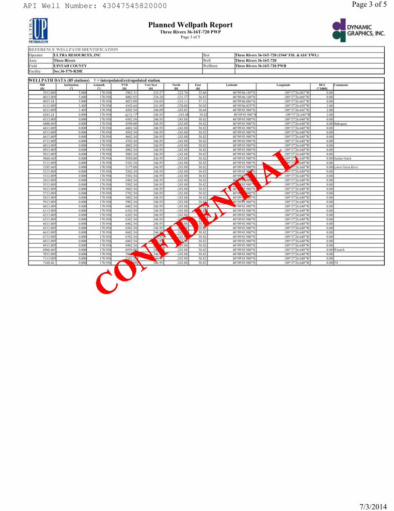
RECEIVED: July 09, 2014
REFERENCE WELLPATH IDENTIFICATIONOperator ULTRA RESOURCES, INC Slot Three Rivers 36-16T-720 (1544' FSL & 616' FWL)Area Three Rivers Well Three Rivers 36-16T-720Field UINTAH COUNTY Wellbore Three Rivers 36-16T-720 PWBFacility Sec.36-T7S-R20E
Planned Wellpath ReportThree Rivers 36-16T-720 PWP
Page 3 of 5
WELLPATH DATA (85 stations) † = interpolated/extrapolated stationMD[ft]
Inclination[°]
Azimuth[°]
TVD[ft]
Vert Sect[ft]
North[ft]
East[ft]
Latitude Longitude DLS[°/100ft]
Comments
3913.00† 5.000 170.956 3903.31 225.57 -222.76 35.46 40°09'46.189"N 109°37'26.683"W 0.00 4013.00† 5.000 170.956 4002.93 234.28 -231.37 36.83 40°09'46.104"N 109°37'26.666"W 0.00 4033.24 5.000 170.956 4023.09 236.05 -233.11 37.11 40°09'46.086"N 109°37'26.662"W 0.00 4113.00† 3.405 170.956 4102.64 241.89 -238.88 38.02 40°09'46.029"N 109°37'26.650"W 2.00 4213.00† 1.405 170.956 4202.54 246.09 -243.03 38.68 40°09'45.988"N 109°37'26.642"W 2.00 4283.24 0.000 170.956 4272.771 246.95 -243.88 38.82 40°09'45.980"N 109°37'26.640"W 2.00 4313.00† 0.000 170.956 4302.54 246.95 -243.88 38.82 40°09'45.980"N 109°37'26.640"W 0.00 4400.46† 0.000 170.956 4390.00 246.95 -243.88 38.82 40°09'45.980"N 109°37'26.640"W 0.00 Mahogany4413.00† 0.000 170.956 4402.54 246.95 -243.88 38.82 40°09'45.980"N 109°37'26.640"W 0.00 4513.00† 0.000 170.956 4502.54 246.95 -243.88 38.82 40°09'45.980"N 109°37'26.640"W 0.00 4613.00† 0.000 170.956 4602.54 246.95 -243.88 38.82 40°09'45.980"N 109°37'26.640"W 0.00 4713.00† 0.000 170.956 4702.54 246.95 -243.88 38.82 40°09'45.980"N 109°37'26.640"W 0.00 4813.00† 0.000 170.956 4802.54 246.95 -243.88 38.82 40°09'45.980"N 109°37'26.640"W 0.00 4913.00† 0.000 170.956 4902.54 246.95 -243.88 38.82 40°09'45.980"N 109°37'26.640"W 0.00 5013.00† 0.000 170.956 5002.54 246.95 -243.88 38.82 40°09'45.980"N 109°37'26.640"W 0.00 5060.46† 0.000 170.956 5050.00 246.95 -243.88 38.82 40°09'45.980"N 109°37'26.640"W 0.00 Garden Gulch5113.00† 0.000 170.956 5102.54 246.95 -243.88 38.82 40°09'45.980"N 109°37'26.640"W 0.00 5185.46† 0.000 170.956 5175.00 246.95 -243.88 38.82 40°09'45.980"N 109°37'26.640"W 0.00 Lower Green River5213.00† 0.000 170.956 5202.54 246.95 -243.88 38.82 40°09'45.980"N 109°37'26.640"W 0.00 5313.00† 0.000 170.956 5302.54 246.95 -243.88 38.82 40°09'45.980"N 109°37'26.640"W 0.00 5413.00† 0.000 170.956 5402.54 246.95 -243.88 38.82 40°09'45.980"N 109°37'26.640"W 0.00 5513.00† 0.000 170.956 5502.54 246.95 -243.88 38.82 40°09'45.980"N 109°37'26.640"W 0.00 5613.00† 0.000 170.956 5602.54 246.95 -243.88 38.82 40°09'45.980"N 109°37'26.640"W 0.00 5713.00† 0.000 170.956 5702.54 246.95 -243.88 38.82 40°09'45.980"N 109°37'26.640"W 0.00 5813.00† 0.000 170.956 5802.54 246.95 -243.88 38.82 40°09'45.980"N 109°37'26.640"W 0.00 5913.00† 0.000 170.956 5902.54 246.95 -243.88 38.82 40°09'45.980"N 109°37'26.640"W 0.00 6013.00† 0.000 170.956 6002.54 246.95 -243.88 38.82 40°09'45.980"N 109°37'26.640"W 0.00 6113.00† 0.000 170.956 6102.54 246.95 -243.88 38.82 40°09'45.980"N 109°37'26.640"W 0.00 6213.00† 0.000 170.956 6202.54 246.95 -243.88 38.82 40°09'45.980"N 109°37'26.640"W 0.00 6313.00† 0.000 170.956 6302.54 246.95 -243.88 38.82 40°09'45.980"N 109°37'26.640"W 0.00 6413.00† 0.000 170.956 6402.54 246.95 -243.88 38.82 40°09'45.980"N 109°37'26.640"W 0.00 6513.00† 0.000 170.956 6502.54 246.95 -243.88 38.82 40°09'45.980"N 109°37'26.640"W 0.00 6613.00† 0.000 170.956 6602.54 246.95 -243.88 38.82 40°09'45.980"N 109°37'26.640"W 0.00 6713.00† 0.000 170.956 6702.54 246.95 -243.88 38.82 40°09'45.980"N 109°37'26.640"W 0.00 6813.00† 0.000 170.956 6802.54 246.95 -243.88 38.82 40°09'45.980"N 109°37'26.640"W 0.00 6913.00† 0.000 170.956 6902.54 246.95 -243.88 38.82 40°09'45.980"N 109°37'26.640"W 0.00 6960.46† 0.000 170.956 6950.00 246.95 -243.88 38.82 40°09'45.980"N 109°37'26.640"W 0.00 Wasatch 7013.00† 0.000 170.956 7002.54 246.95 -243.88 38.82 40°09'45.980"N 109°37'26.640"W 0.00 7113.00† 0.000 170.956 7102.54 246.95 -243.88 38.82 40°09'45.980"N 109°37'26.640"W 0.00 7160.46 0.000 170.956 7150.00 246.95 -243.88 38.82 40°09'45.980"N 109°37'26.640"W 0.00 TD
Page 3 of 5
7/3/2014
API Well Number: 43047545820000
CONFIDE
NTIAL
API Well Number: 43047545820000 Page 3 of 5
Planned Wellpath Report DYNAMICThree Rivers 36-16T-720 PWP GRAPHICS,INC.
Page3of5PETROLEEP1
REFERENCE MILLPATH IDENTIFICATIONOperator ULTRA RESOURCES, INC Slot Three Rivers 36-16T-720 (1544' FSL & 616' FWL)
Area Three Rivers Well Three Rivers 36-16T-720
Field UINTAH COUNTY Wellbore Three Rivers 36-16T-720 PWB
Facility Sec.36-T7S-R20E
WELLPATH DATA (85 stations) † = inter¡ olated/extrapelated stationMD Inclination Azimuth TVD VertSect North East Latitude Longitude DLS Commentsfft1 [°1 f°1 fft1 fft1 fft1 fft1 f°/100ft1
3913.001 5.000 170.956 3903.31 225.57 -222.76 35.46 40°09'46.189"N 109°37'26.683"W 0.004013.001 5.000 170.956 4002.93 234.28 -231.37 36.83 40°09'46.104"N 109°37'26.666"W 0.004033.24 5.000 170.956 4023.09 236.05 -233.11 37.11 40°09'46.086"N 109°37'26.662"W 0.004113.001 3.405 170.956 4102.64 241.89 -238.88 38.02 40°09'46.029"N 109°37'26.650"W 2.004213.001 1.405 170.956 4202.54 246.09 -243.03 38.68 40°09'45.988"N 109°37'26.642"W 2.004283.24 0.000 170.956 4272.771 246.95 -243.82 38.82 40°09'45.980"> 109°37'26.640"M 2.004313.001 0.000 170.956 4302.54 246.95 -243.88 38.82 40°09'45.980"N 109°37'26.640"W 0.004400.461 0.000 170.956 4390.00 246.95 -243.88 38.82 40°09'45.980"N 109°37'26.640"W 0.00 Mahogany
4413.001 0.000 170.956 4402.54 246.95 -243.88 38.82 40°09'45.980"N 109°37'26.640"W 0.004513.001 0.000 170.956 4502.54 246.95 -243.88 38.82 40°09'45.980"N 109°37'26.640"W 0.004613.001 0.000 170.956 4602.54 246.95 -243.88 38.82 40°09'45.980"N 109°37'26.640"W 0.004713.001 0.000 170.956 4702.54 246.95 -243.88 38.82 40°09'45.980"N 109°37'26.640"W 0.004813.001 0.000 170.956 4802.54 246.95 -243.88 38.82 40°09'45.980"N 109°37'26.640"W 0.004913.001 0.000 170.956 4902.54 246.95 -243.88 38.82 40°09'45.980"N 109°37'26.640"W 0.005013.001 0.000 170.956 5002.54 246.95 -243.88 38.82 40°09'45.980"N 109°37'26.640"W 0.005060.461 0.000 170.956 5050.00 246.95 -243.88 38.82 40°09'45.980"N 109°37'26.640"W 0.00 Garden Gulch
5113.001 0.000 170.956 5102.54 246.95 -243.88 38.82 40°09'45.980"N 109°37'26.640"W 0.005185.461 0.000 170.956 5175.00 246.95 -243.88 38.82 40°09'45.980"N 109°37'26.640"W 0.00LowerG1eenRiver
5213.001 0.000 170.956 5202.54 246.95 -243.88 38.82 40°09'45.980"N 109°37'26.640"W 0.005313.001 0.000 170.956 5302.54 246.95 -243.88 38.82 40°09'45.980"N 109°37'26.640"W 0.005413.001 0.000 170.956 5402.54 246.95 -243.88 38.82 40°09'45.980"N 109°37'26.640"W 0.005513.001 0.000 170.956 5502.54 246.95 -243.88 38.82 40°09'45.980"N 109°37'26.640"W 0.005613.001 0.000 170.956 5602.54 246.95 -243.88 38.82 40°09'45.980"N 109°37'26.640"W 0.005713.001 0.000 170.956 5702.54 246.95 -243.88 38.82 40°09'45.980"N 109°37'26.640"W 0.005813.001 0.000 170.956 5802.54 246.95 -243.88 38.82 40°09'45.980"N 109°37'26.640"W 0.005913.001 0.000 170.956 5902.54 246.95 -243.88 38.82 40°09'45.980"N 109°37'26.640"W 0.006013.001 0.000 170.956 6002.54 246.95 -243.88 38.82 40°09'45.980"N 109°37'26.640"W 0.006113.001 0.000 170.956 6102.54 246.95 -243.88 38.82 40°09'45.980"N 109°37'26.640"W 0.006213.001 0.000 170.956 6202.54 246.95 -243.88 38.82 40°09'45.980"N 109°37'26.640"W 0.006313.001 0.000 170.956 6302.54 246.95 -243.88 38.82 40°09'45.980"N 109°37'26.640"W 0.006413.001 0.000 170.956 6402.54 246.95 -243.88 38.82 40°09'45.980"N 109°37'26.640"W 0.006513.001 0.000 170.956 6502.54 246.95 -243.88 38.82 40°09'45.980"N 109°37'26.640"W 0.006613.001 0.000 170.956 6602.54 246.95 -243.88 38.82 40°09'45.980"N 109°37'26.640"W 0.006713.001 0.000 170.956 6702.54 246.95 -243.88 38.82 40°09'45.980"N 109°37'26.640"W 0.006813.001 0.000 170.956 6802.54 246.95 -243.88 38.82 40°09'45.980"N 109°37'26.640"W 0.006913.001 0.000 170.956 6902.54 246.95 -243.88 38.82 40°09'45.980"N 109°37'26.640"W 0.006960.461 0.000 170.956 6950.00 246.95 -243.88 38.82 40°09'45.980"N 109°37'26.640"W 0.00 Wasatch
7013.001 0.000 170.956 7002.54 246.95 -243.88 38.82 40°09'45.980"N 109°37'26.640"W 0.007113.001 0.000 170.956 7102.54 246.95 -243.88 38.82 40°09'45.980"N 109°37'26.640"W 0.007160.46 0.000 170.956 7150.00 246.95 -243.88 38.82 40°09'45.980"N 109°37'26.640"W 0.00 TD
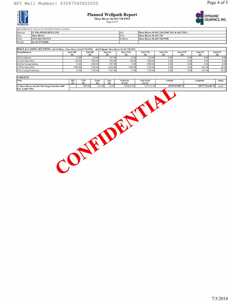
RECEIVED: July 09, 2014
REFERENCE WELLPATH IDENTIFICATIONOperator ULTRA RESOURCES, INC Slot Three Rivers 36-16T-720 (1544' FSL & 616' FWL)Area Three Rivers Well Three Rivers 36-16T-720Field UINTAH COUNTY Wellbore Three Rivers 36-16T-720 PWBFacility Sec.36-T7S-R20E
Planned Wellpath ReportThree Rivers 36-16T-720 PWP
Page 4 of 5
HOLE & CASING SECTIONS - Ref Wellbore: Three Rivers 36-16T-720 PWB Ref Wellpath: Three Rivers 36-16T-720 PWPString/Diameter Start MD
[ft]End MD
[ft]Interval
[ft]Start TVD
[ft]End TVD
[ft]Start N/S
[ft]Start E/W
[ft]End N/S
[ft]End E/W
[ft]16in Conductor 13.00 120.00 107.00 13.00 120.00 0.00 0.00 0.00 0.0012.25in Open Hole 120.00 1000.00 880.00 120.00 1000.00 0.00 0.00 0.00 0.008.625in Casing Surface 13.00 1000.00 987.00 13.00 1000.00 0.00 0.00 0.00 0.007.875in Open Hole 1000.00 7160.46 6160.46 1000.00 7150.00 0.00 0.00 -243.88 38.825.5in Casing Production 13.00 7160.46 7147.46 13.00 7150.00 0.00 0.00 -243.88 38.82
TARGETSName MD
[ft] TVD[ft]
North[ft]
East[ft]
Grid East[US ft]
Grid North[US ft]
Latitude Longitude Shape
1) Three Rivers 36-16T-720 Target On Plat 1300' FSL & 660' FWL
5000.00 -243.88 38.82 2164650.83 7233512.40 40°09'45.980"N 109°37'26.640"W point
Page 4 of 5
7/3/2014
API Well Number: 43047545820000
CONFIDE
NTIAL
API Well Number: 43047545820000 Page 4 of 5
Planned Wellpath Report DYNAMICThree Rivers 36-16T-720 PWP GRAPHICS,INC.
Page4of5PETROLELT1
REFERENCE MILLPATH IDENTIHCATIONOperator ULTRA RESOURCES, INC Slot Three Rivers 36-16T-720 (1544' FSL & 616' FWL)
Area Three Rivers Well Three Rivers 36-16T-720
Field UINTAH COUNTY Wellbore Three Rivers 36-16T-720 PWB
Facility Sec.36-T7S-R20E
HOLE & CASING SECTIONS -RefWellbore: Three Rivers 36-16T-720 PWB RefWelipath: Three Rivers 36-16T-720 PWPString/Diameter Start MD End MD Interval Start TVD End TVD StartN/S Start E/W End N/S End E/W
16in Conductor 13.00 120.00 107.00 13.00 120.00 0.00 0.00 0.00 0.00
12.25inOpenHole 120.00 1000.00 880.00 120.00 1000.00 0.00 0.00 0.00 0.008.625in Casing Surface 13.00 1000.00 987.00 13.00 1000.00 0.00 0.00 0.00 0.00
7.875inOpenHole 1000.00 7160.46 6160.46 1000.00 7150.00 0.00 0.00 -243.88 38.82
5.5in Casing Production 13.00 7160.46 7147.46 13.00 7150.00 0.00 0.00 -243.88 38.82
TARGETSName MD TVD North East GridEast GridNorth Latitude Longitude Shape
[R] [R] [ft] [ft] [US It [US R]
1) Three Rivers 36-16T-720 Target On Plat 1300' 5000.00 -243.88 38.8 2164650.8 7233512.4 40°09'45.980"N 109°37'26.640"W pointFSL & 660' FWL

RECEIVED: July 09, 2014
REFERENCE WELLPATH IDENTIFICATIONOperator ULTRA RESOURCES, INC Slot Three Rivers 36-16T-720 (1544' FSL & 616' FWL)Area Three Rivers Well Three Rivers 36-16T-720Field UINTAH COUNTY Wellbore Three Rivers 36-16T-720 PWBFacility Sec.36-T7S-R20E
Planned Wellpath ReportThree Rivers 36-16T-720 PWP
Page 5 of 5
WELLPATH COMMENTSMD[ft]
Inclination[°]
Azimuth[°]
TVD[ft]
Comment
120.00 0.000 170.956 120.00 Base Gravel2554.52 5.000 170.956 2550.00 BMSW3081.53 5.000 170.956 3075.00 Green River Top4400.46 0.000 170.956 4390.00 Mahogany5060.46 0.000 170.956 5050.00 Garden Gulch5185.46 0.000 170.956 5175.00 Lower Green River6960.46 0.000 170.956 6950.00 Wasatch 7160.46 0.000 170.956 7150.00 TD
Page 5 of 5
7/3/2014
API Well Number: 43047545820000
CONFIDE
NTIAL
API Well Number: 43047545820000 Page 5 of 5
Planned Wellpath Report DYNAMICThree Rivers 36-16T-720 PWP GRAPHICS,INC.
Page5of5PETROLELT1
REFERENCE MILLPATH IDENTIHCATIONOperator ULTRA RESOURCES, INC Slot Three Rivers 36-16T-720 (1544' FSL & 616' FWL)
Area Three Rivers Well Three Rivers 36-16T-720
Field UINTAH COUNTY Wellbore Three Rivers 36-16T-720 PWB
Facility Sec.36-T7S-R20E
WELLPATH COMMENTSMD Inclination Azimuth TVD Comment[ft] 1°l 1°l litl
120.00 0.000 170.956 120.00 Base Gravel2554.52 5.000 170.956 2550.00 BMSW3081.53 5.000 170.956 3075.00GreenRiverTop4400.46 0.000 170.956 4390.00 Mahogany5060.46 0.000 170.956 5050.00 Garden Gulch5185.46 0.000 170.956 5175.00 Lower Green River6960.46 0.000 170.956 6950.00 Wasatch7160.46 0.000 170.956 7150.00 TD

RECEIVED: July 09, 2014
API Well Number: 43047545820000
CONFIDE
NTIAL
API Well Number: 43047545820000
m h - a a§ 9 coa o
8 rn
a .
API Well Number: 43047545820000
m h - a a§ 9 coa o
8 rn
a .
API Well Number: 43047545820000
m h - a a§ 9 coa o
8 rn
a .
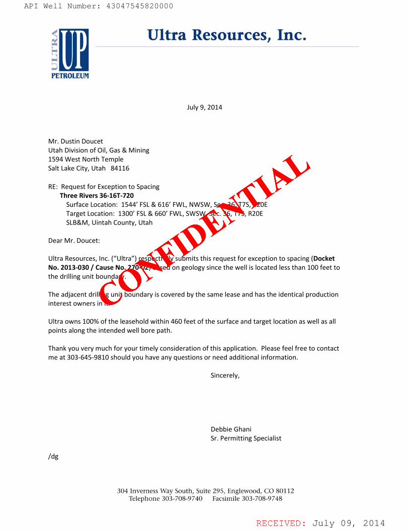
RECEIVED: July 09, 2014
July 9, 2014
Mr. Dustin Doucet Utah Division of Oil, Gas & Mining 1594 West North Temple Salt Lake City, Utah 84116
RE: Request for Exception to Spacing Three Rivers 36-16T-720 Surface Location: 1544’ FSL & 616’ FWL, NWSW, Sec. 36, T7S, R20E Target Location: 1300’ FSL & 660’ FWL, SWSW, Sec. 36, T7S, R20E SLB&M, Uintah County, Utah Dear Mr. Doucet: Ultra Resources, Inc. (“Ultra”) respectfully submits this request for exception to spacing (Docket No. 2013-030 / Cause No. 270-02) based on geology since the well is located less than 100 feet to the drilling unit boundary. The adjacent drilling unit boundary is covered by the same lease and has the identical production interest owners in it. Ultra owns 100% of the leasehold within 460 feet of the surface and target location as well as all points along the intended well bore path. Thank you very much for your timely consideration of this application. Please feel free to contact me at 303-645-9810 should you have any questions or need additional information. Sincerely, Debbie Ghani Sr. Permitting Specialist /dg
API Well Number: 43047545820000
CONFIDE
NTIAL
API Well Number: 43047545820000
Ultra Resources, Inc.
PETROLEUM
July 9, 2014
Mr. Dustin DoucetUtah Division of Oil, Gas & Mining1594 West North TempleSalt Lake City, Utah 84116
RE: Request for Exception to SpacingThree Rivers 36-16T-720
Surface Location: 1544' FSL & 616' FWL, NWSW, Sec. 36, T7S, R20ETarget Location: 1300' FSL & 660' FWL, SWSW, Sec. 36, T7S, R20ESLB&M, Uintah County, Utah
Dear Mr. Doucet:
Ultra Resources, Inc. ("Ultra") respectfully submits this request for exception to spacing (DocketNo. 2013-030 / Cause No. 270-02) based on geology since the well is located less than 100 feet tothe drilling unit boundary.
The adjacent drilling unit boundary is covered by the same lease and has the identical productioninterest owners in it.
Ultra owns 100% of the leasehold within 460 feet of the surface and target location as well as allpoints along the intended well bore path.
Thank you very much for your timely consideration of this application. Please feel free to contactme at 303-645-9810 should you have any questions or need additional information.
Sincerely,
Debbie GhaniSr. Permitting Specialist
/dg
304 Inverness Way South, Suite 295, Englewood, CO 80112Telephone 303-708-9740 Facsimile 303-708-9748
RECEIVED: July 09,
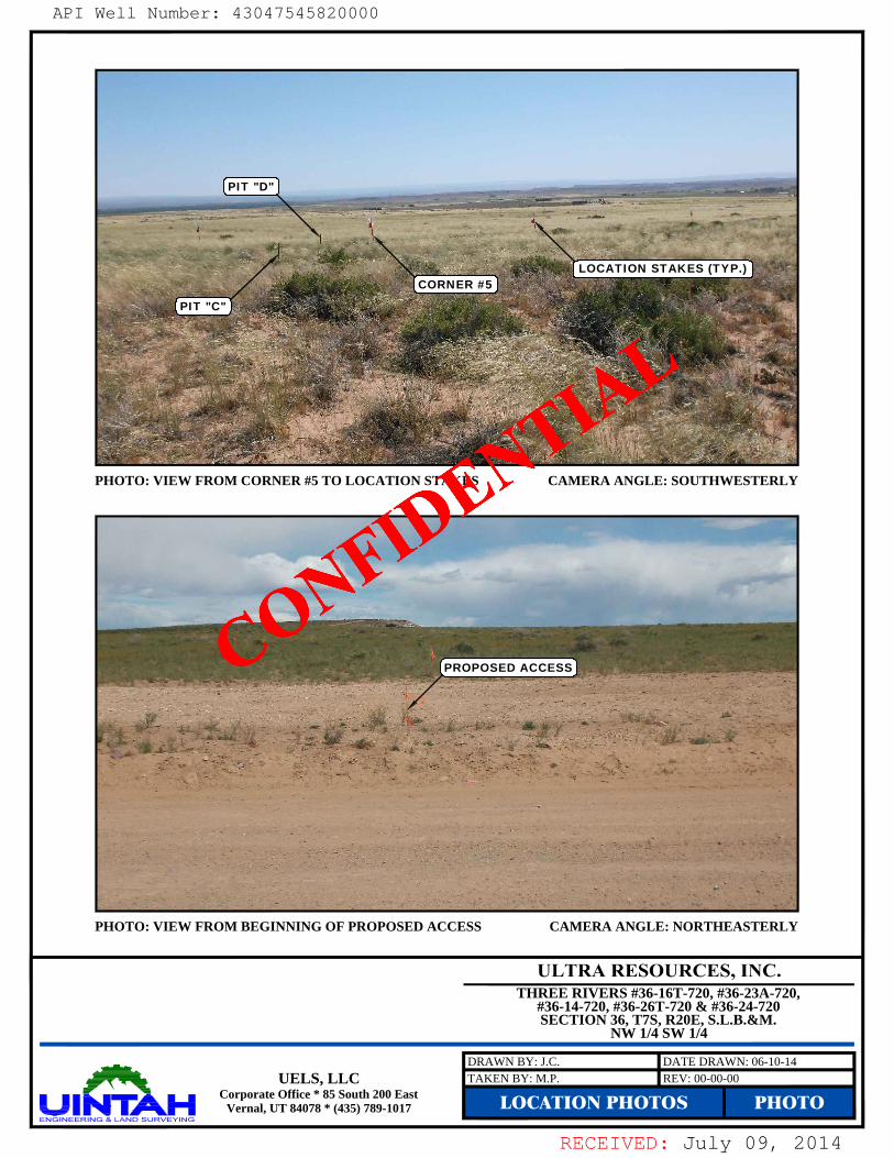
RECEIVED: July 09, 2014
CAMERA ANGLE: SOUTHWESTERLY
CAMERA ANGLE: NORTHEASTERLYPHOTO: VIEW FROM BEGINNING OF PROPOSED ACCESS
PHOTO: VIEW FROM CORNER #5 TO LOCATION STAKES
LOCATION PHOTOS PHOTOREV: 00-00-00UELS, LLC
Corporate Office * 85 South 200 EastVernal, UT 84078 * (435) 789-1017
TAKEN BY: M.P.DRAWN BY: J.C. DATE DRAWN: 06-10-14
PIT "C"
PROPOSED ACCESS
THREE RIVERS #36-16T-720, #36-23A-720,#36-14-720, #36-26T-720 & #36-24-720SECTION 36, T7S, R20E, S.L.B.&M.
NW 1/4 SW 1/4
PIT "D"
CORNER #5LOCATION STAKES (TYP.)
API Well Number: 43047545820000
CONFIDE
NTIAL
API Well Number: 43047545820000
PHOTO: VIEW FROM CORNER #5 TO LOCATION STAKES CAMERA ANGLE: SOUTHWESTERLY
PHOTO: VIEW FROM BEGINNING OF PROPOSED ACCESS CAMERA ANGLE: NORTHEASTERLY
ULTRA RESOURCES, INC.THREE RIVERS #36-16T-720, #36-23A-720,
#36-14-720, #36-26T-720 & #36-24-720SECTION 36, T7S, R20E, S.L.B.&M.
NW 1/4 SW 1/4
UELS, LLCCorporate Office * 85 South 200 East
Vernal, UT 84078 * (435) 789-1017
RECEIVED: July 09,
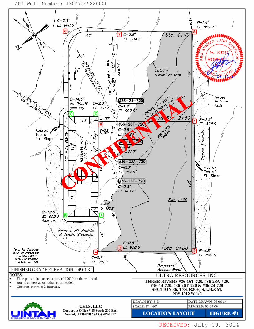
RECEIVED: July 09, 2014
NOTES: Flare pit is to be located a min. of 100' from the wellhead. Round corners at 35' radius or as needed. Contours shown at 2' intervals.
THREE RIVERS #36-16T-720, #36-23A-720,#36-14-720, #36-26T-720 & #36-24-720SECTION 36, T7S, R20E, S.L.B.&M.
NW 1/4 SW 1/4
LOCATION LAYOUT FIGURE #1
DRAWN BY: S.S. DATE DRAWN: 06-06-14SCALE: 1" = 60' REVISED: 00-00-00
FINISHED GRADE ELEVATION = 4901.3 '
UELS, LLCCorporate Office * 85 South 200 East
Vernal, UT 84078 * (435) 789-1017
ULTRA RESOURCES, INC.
ROBERT L.
KAY
No. 161319
A
API Well Number: 43047545820000
CONFIDE
NTIAL
API Well Number: 43047545820000
C-7.J' o9 E-1.4
"g E/. 908.6'
rgy 7 C-2.8' / Sta. 4+40 ggg
E/. 904.1' L AND p
No. 16131
7ransition Line 00
(4 ,
¯
C-195.8'
C-2.Jr, #36-24-/720 o Bo torn
tm. Pit) E/. 9016'¯ I'
.
HoleE/. 902.9'
37 150 a 2+60
Approx. / '-y¯¯¯ c-22' C-0.B'
Top of -
. g. 903 E/. 902.1'Cut Slope -
-
- 4 - 4----
.
36-14-720
#36-23A-720C-0.J Approx.E/. 901.6' Toe of
Fill Slope#36-16T-720 o .
C-0.J' Ñ -
E/. 901.6'
c-o.s'E/. 902.2'
C-12.0 oE/. 90 J. J'
tm. Pit)
Reserve Pit BackfillSpol/s Stockp//e
Total Pit Capacity / g E/. 900.8' Sto. 0+00 ,
w/2' of Fresboard ¯
y= 9,950 Bb/s.± , x / E/. 896.5Total Pit Volume : C-0.1 g
= 2890 Cu. Yds E/. 901.4'Proposed
FINISHED GRADE ELEVATION = 4901.3' Access RoadNOTES: ULTRA RESOURCES, INC.• Flare pit is to be located a min. of 100' from the wellhead.• Round corners at 35' radius or as needed. THREE RIVERS #36-16T-720, #36-23A-720,• Contours shown at 2' intervals. #36-14-720, #36-26T-720 & #36-24-720
SECTION 36, T7S, R20E, S.L.B.&M.NW 1/4 SW 1/4
UELS, LLCCorporate Office * 85 South 200 East
Vernal, UT 84078 * (435) 789-1017
RECEIVED: July 09,
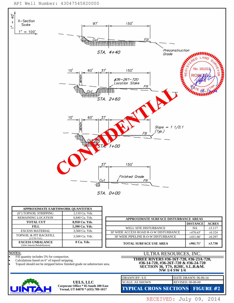
RECEIVED: July 09, 2014
(6") TOPSOIL STRIPPINGREMAINING LOCATION
EXCESS MATERIALTOPSOIL & PIT BACKFILL
(1/2 Pit Vol.)
EXCESS UNBALANCE(After Interim Rehabilitation)
2,110 Cu. Yds.6,840 Cu. Yds.
3,560 Cu. Yds.
3,560 Cu. Yds. 30' WIDE PIPELINE R-O-W DISTURBANCE30' WIDE ACCESS ROAD R-O-W DISTURBANCE
WELL SITE DISTURBANCE
±0.297±0.324±3.117NA
±470.65'±431.06'
NOTES: Fill quantity includes 5% for compaction. Calculations based on 6" of topsoil stripping. Topsoil should not be stripped below finished grade on substructure area.
ACRESDISTANCEAPPROXIMATE SURFACE DISTURBANCE AREAS
TOTAL SURFACE USE AREA ±901.71' ±3.738
APPROXIMATE EARTHWORK QUANTITIES
TOTAL CUTFILL 5,390 Cu. Yds.
8,950 Cu. Yds.
0 Cu. Yds.
FIGURE #2TYPICAL CROSS SECTIONSSCALE: AS SHOWN REVISED: 00-00-00UELS, LLC
Corporate Office * 85 South 200 EastVernal, UT 84078 * (435) 789-1017
THREE RIVERS #36-16T-720, #36-23A-720,#36-14-720, #36-26T-720 & #36-24-720SECTION 36, T7S, R20E, S.L.B.&M.
NW 1/4 SW 1/4
DRAWN BY: S.S. DATE DRAWN: 06-06-14
ULTRA RESOURCES, INC.
ROBERT L.
KAY
No. 161319
A
API Well Number: 43047545820000
CONFIDE
NTIAL
API Well Number: 43047545820000
^o
X-SectionScale ,
97, ,
150'
1" = 100'
Cut' F///
S M. 4+40 reconstruction
L AND
10' 60° 37' 150, g No. 16131m u.] O
SM. 2+60
10' 60' 37' 150'
S/ope = 1 1/2: 1
'I SM. 1+00
37' 150'
Finished GradeCu t / E///
so. o+oo
APPROXIMATE EARTHWORK QUANTITIES(6") TOPSOIL STRIPPING 2,110 Cu. Yds.REMAINING LOCATION 6,840 Cu. Yds APPROXIMATE SURFACE DISTURBANCE AREAS
TOTAL CUT 8,950 Cu. Yds. DISTANCE ACRESFILL 5,390 Cu. Yds. WELL SITE DISTURBANCE NA ±3.117
EXCESS MATERIAL 3,560 Cu. Yds 30' WIDE ACCESS ROAD R-O-W DISTURBANCE ±470.65' ±0.324TOPSOIL & PIT BACKFILL 3,560 Cu. Yds. 30' WIDE PIPELINE R-O-W DISTURBANCE ±431.06' ±0.297(1/2 Pit Vol.)
EXCESS UNBALANCE 0 Cu. Yds. TOTAL SURFACE USE AREA ±901.71' ±3.738(After Intenm Rehabilitation)
NOTES: ULTRA RESOURCES, INC.• Fill quantity includes 5% for compaction.• Calculations based on 6" of topsoil stripping. THREE RIVERS #36-16T-720, #36-23A-720,• Topsoil should not be stripped below finished grade on substructure area. #36-14-720, #36-26T-720 & #36-24-720
SECTION 36, T7S, R20E, S.L.B.&M.NW 1/4 SW 1/4
UELS, LLCCorporate Office * 85 South 200 East
Vernal, UT 84078 * (435) 789-1017
RECEIVED: July 09,

RECEIVED: July 09, 2014
NOTES: Flare pit is to be located a min. of 100' from the wellhead. Contours shown at 2' intervals.
TYPICAL RIG LAYOUT FIGURE #3REVISED: 00-00-00UELS, LLC
Corporate Office * 85 South 200 EastVernal, UT 84078 * (435) 789-1017
THREE RIVERS #36-16T-720, #36-23A-720,#36-14-720, #36-26T-720 & #36-24-720SECTION 36, T7S, R20E, S.L.B.&M.
NW 1/4 SW 1/4
DRAWN BY: S.S. DATE DRAWN: 06-06-14SCALE: 1" = 60'
ULTRA RESOURCES, INC.
ROBERT L.
KAY
No. 161319
A
API Well Number: 43047545820000
CONFIDE
NTIAL
API Well Number: 43047545820000
RO
Cut/EillTransition Line e
I I I I
PIPE R S
37 G HOUSE 150'Approx. io - -
Top ofCut Slope /
¯¯
I uMP TOILETO
MUD SHEDso6 | - o I iI o
-- e I o |HOPPER
I - I
Soe
¯^o¯
Re erve Pit &ckf///Spol/s Stockp//e
AGE
Total Pit Capacity /W/2' of Freeboard -
= 9, 950 Bb/s.±Total Pit Volume
= 2, 890 Cu. YdsProposedAccess Road
NOTES: ULTRA RESOURCES, INC.• Flare pit is to be located a min. of 100' from the wellhead.• Contours shown at 2' intervals. THREE RIVERS #36-16T-720, #36-23A-720,
#36-14-720, #36-26T-720 & #36-24-720SECTION 36, T7S, R20E, S.L.B.&M.
NW 1/4 SW 1/4
UELS, LLCCorporate Office * 85 South 200 East
Vernal, UT 84078 * (435) 789-1017
RECEIVED: July 09,
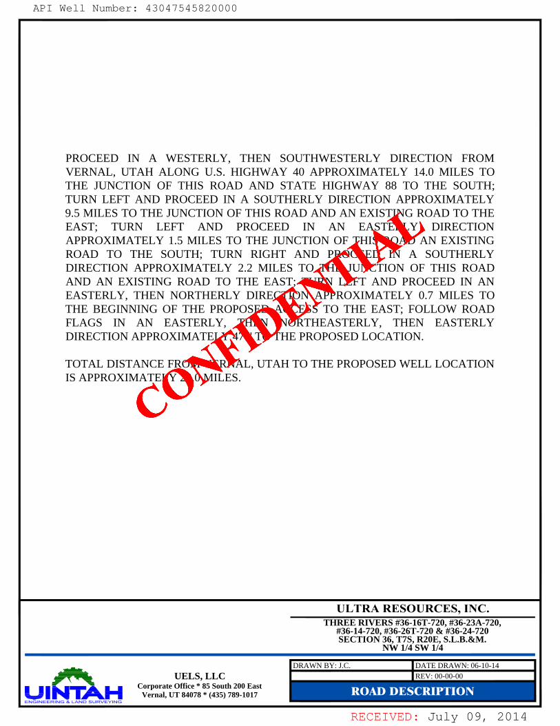
RECEIVED: July 09, 2014
PROCEED IN A WESTERLY, THEN SOUTHWESTERLY DIRECTION FROMVERNAL, UTAH ALONG U.S. HIGHWAY 40 APPROXIMATELY 14.0 MILES TOTHE JUNCTION OF THIS ROAD AND STATE HIGHWAY 88 TO THE SOUTH;TURN LEFT AND PROCEED IN A SOUTHERLY DIRECTION APPROXIMATELY9.5 MILES TO THE JUNCTION OF THIS ROAD AND AN EXISTING ROAD TO THEEAST; TURN LEFT AND PROCEED IN AN EASTERLY DIRECTIONAPPROXIMATELY 1.5 MILES TO THE JUNCTION OF THIS ROAD AN EXISTINGROAD TO THE SOUTH; TURN RIGHT AND PROCEED IN A SOUTHERLYDIRECTION APPROXIMATELY 2.2 MILES TO THE JUNCTION OF THIS ROADAND AN EXISTING ROAD TO THE EAST; TURN LEFT AND PROCEED IN ANEASTERLY, THEN NORTHERLY DIRECTION APPROXIMATELY 0.7 MILES TOTHE BEGINNING OF THE PROPOSED ACCESS TO THE EAST; FOLLOW ROADFLAGS IN AN EASTERLY, THEN NORTHEASTERLY, THEN EASTERLYDIRECTION APPROXIMATELY 471' TO THE PROPOSED LOCATION.
TOTAL DISTANCE FROM VERNAL, UTAH TO THE PROPOSED WELL LOCATIONIS APPROXIMATELY 28.0 MILES.
ROAD DESCRIPTIONREV: 00-00-00UELS, LLC
Corporate Office * 85 South 200 EastVernal, UT 84078 * (435) 789-1017
DRAWN BY: J.C. DATE DRAWN: 06-10-14
THREE RIVERS #36-16T-720, #36-23A-720,#36-14-720, #36-26T-720 & #36-24-720SECTION 36, T7S, R20E, S.L.B.&M.
NW 1/4 SW 1/4
API Well Number: 43047545820000
CONFIDE
NTIAL
API Well Number: 43047545820000
PROCEED IN A WESTERLY, THEN SOUTHWESTERLY DIRECTION FROMVERNAL, UTAH ALONG U.S. HIGHWAY 40 APPROXIMATELY 14.0 MILES TOTHE JUNCTION OF THIS ROAD AND STATE HIGHWAY 88 TO THE SOUTH;TURN LEFT AND PROCEED IN A SOUTHERLY DIRECTION APPROXIMATELY9.5 MILES TO THE JUNCTION OF THIS ROAD AND AN EXISTING ROAD TO THEEAST; TURN LEFT AND PROCEED IN AN EASTERLY DIRECTIONAPPROXIMATELY 1.5 MILES TO THE JUNCTION OF THIS ROAD AN EXISTINGROAD TO THE SOUTH; TURN RIGHT AND PROCEED IN A SOUTHERLYDIRECTION APPROXIMATELY 2.2 MILES TO THE JUNCTION OF THIS ROADAND AN EXISTING ROAD TO THE EAST; TURN LEFT AND PROCEED IN ANEASTERLY, THEN NORTHERLY DIRECTION APPROXIMATELY 0.7 MILES TOTHE BEGINNING OF THE PROPOSED ACCESS TO THE EAST; FOLLOW ROADFLAGS IN AN EASTERLY, THEN NORTHEASTERLY, THEN EASTERLYDIRECTION APPROXIMATELY 471' TO THE PROPOSED LOCATION.
TOTAL DISTANCE FROM VERNAL, UTAH TO THE PROPOSED WELL LOCATIONIS APPROXIMATELY 28.0 MILES.
ULTRA RESOURCES, INC.THREE RIVERS #36-16T-720, #36-23A-720,
#36-14-720, #36-26T-720 & #36-24-720SECTION 36, T7S, R20E, S.L.B.&M.
NW 1/4 SW 1/4
UELS, LLCCorporate Office * 85 South 200 East
Vernal, UT 84078 * (435) 789-1017
RECEIVED: July 09,
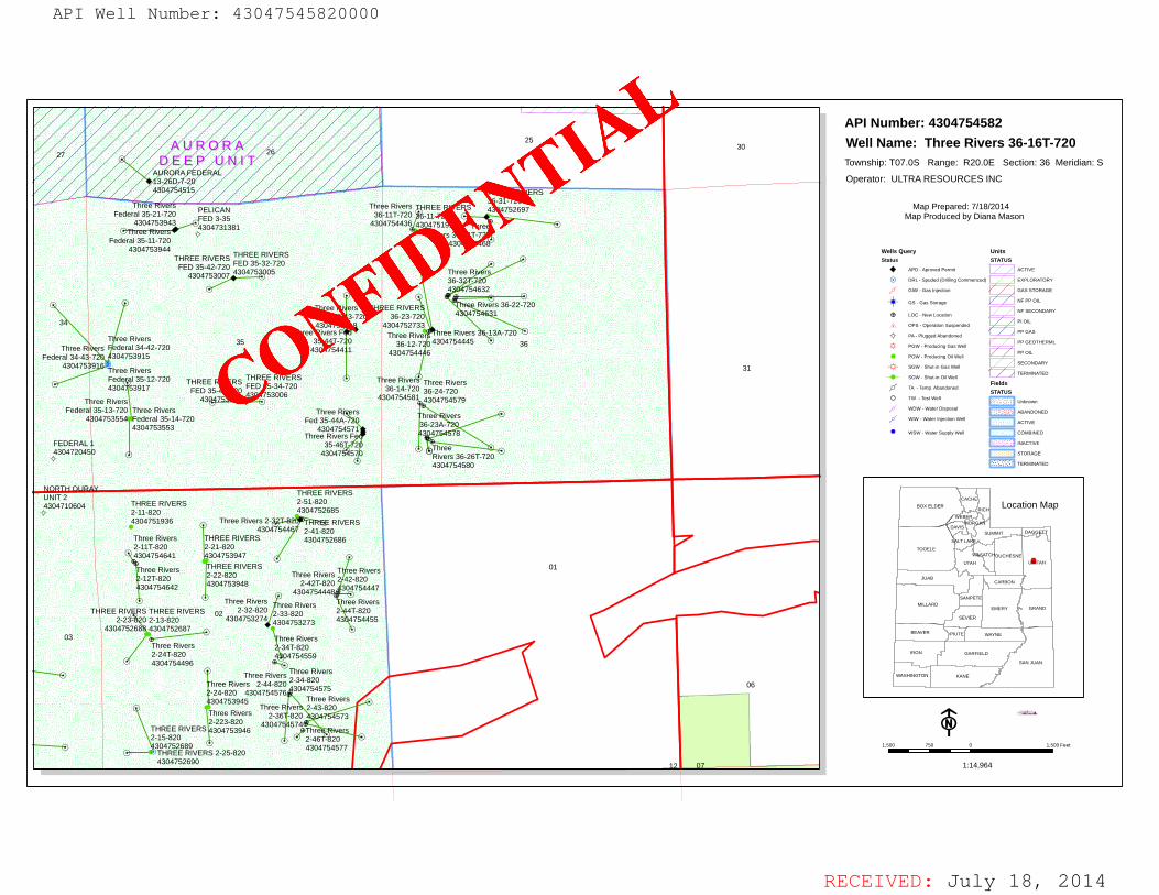
RECEIVED: July 18, 2014
ââ
â
â
â
â
ââ
â
â
â
â
â
â
â
â
â
â
â
â
â
â
â
ââ
â
â
â
â
â
â
â
â
â
â
â
â
â
â
â
â
â
â
â
â
â
âââ â
â
â ââ ââ
â
â
ââ
â
â
â
â
ª
ª
ª '
''
''
'H
'
'
'
'
''
HHH
H
''
''
!
!!
!!!
!
!
!
!
!!
!!
!
!
!
!
!
!!
!!!! !!
!!
12
03
01
31
35
34
27 2625
06
36
07
02
30
NORTH OURAYUNIT 24304710604
FEDERAL 14304720450
PELICANFED 3-354304731381
THREE RIVERS36-11-7204304751915
THREE RIVERS2-11-8204304751936
THREE RIVERS2-51-8204304752685
THREE RIVERS2-41-8204304752686
THREE RIVERS2-13-8204304752687
THREE RIVERS2-23-820
4304752688
THREE RIVERS2-15-8204304752689
THREE RIVERS 2-25-8204304752690
THREE RIVERS36-31-7204304752697
THREE RIVERS36-23-720
4304752733
THREE RIVERSFED 35-32-7204304753005
THREE RIVERSFED 35-34-7204304753006
THREE RIVERSFED 35-42-720
4304753007
THREE RIVERSFED 35-44-720
4304753008
Three Rivers2-33-8204304753273
Three Rivers2-32-820
4304753274
Three RiversFederal 35-14-7204304753553
Three RiversFederal 35-13-720
4304753554
Three RiversFederal 34-42-7204304753915
Three RiversFederal 34-43-720
4304753916 Three RiversFederal 35-12-7204304753917
Three RiversFederal 35-43-720
4304753918
Three RiversFederal 35-21-720
4304753943Three Rivers
Federal 35-11-7204304753944
Three Rivers2-24-8204304753945Three Rivers2-223-8204304753946
THREE RIVERS2-21-8204304753947THREE RIVERS2-22-8204304753948
Three Rivers Fed35-44T-720
4304754411
Three Rivers36-11T-720
4304754436
Three Rivers 36-13A-7204304754445
Three Rivers36-12-720
4304754446
Three Rivers2-42-8204304754447
Three Rivers2-42T-820
4304754448Three Rivers2-44T-8204304754455
Three Rivers 2-32T-8204304754467
ThreeRivers 36-21T-720
4304754468
Three Rivers2-24T-8204304754496
AURORA FEDERAL13-26D-7-204304754515
Three Rivers2-34T-8204304754559
Three Rivers Fed35-46T-720
4304754570
Three RiversFed 35-44A-720
4304754571
Three Rivers2-43-8204304754573
Three Rivers2-36T-820
4304754574
Three Rivers2-34-8204304754575
Three Rivers2-44-820
4304754576
Three Rivers2-46T-8204304754577
Three Rivers36-23A-7204304754578
Three Rivers36-24-7204304754579
ThreeRivers 36-26T-7204304754580
Three Rivers36-14-720
4304754581
Three Rivers 36-22-7204304754631
Three Rivers36-32T-7204304754632
Three Rivers2-11T-8204304754641
Three Rivers2-12T-8204304754642
A U R O R AA U R O R AD E E P U N I TD E E P U N I T
Map Produced by Diana Mason
F1,500 0 1,500750 Feet
1:14,964
Wells QueryStatus
APD - Aproved Permit
H DRL - Spuded (Drilling Commenced)
4 GIW - Gas Injection
!) GS - Gas Storage
! LOC - New Location
7 OPS - Operation Suspended
ª PA - Plugged Abandoned
* PGW - Producing Gas Well
' POW - Producing Oil Well
¸ SGW - Shut-in Gas Well
· SOW - Shut-in Oil Well
6 TA - Temp. Abandoned
" TW - Test Well
¸ WDW - Water Disposal
¸ WIW - Water Injection Well
=) WSW - Water Supply Well
UnitsSTATUS
ACTIVE
EXPLORATORY
GAS STORAGE
NF PP OIL
NF SECONDARY
PI OIL
PP GAS
PP GEOTHERML
PP OIL
SECONDARY
TERMINATED
FieldsSTATUS
Unknown
ABANDONED
ACTIVE
COMBINED
INACTIVE
STORAGE
TERMINATED
TOOELE
SAN JUAN
MILLARD
KANE
JUAB
IRON
EMERY
UINTAH
BOX ELDER
GARFIELD
GRAND
UTAH
WAYNEBEAVER
DUCHESNE
SEVIER
SUMMIT
RICH
WASHINGTON
CARBON
SANPETE
CACHE
PIUTE
DAVIS
WASATCH
WEBER
SALT LAKE
DAGGETT
MORGAN
Location Map
API Number: 4304754582Well Name: Three Rivers 36-16T-720 Township: T07.0S Range: R20.0E Section: 36 Meridian: S
Operator: ULTRA RESOURCES INC
Map Prepared: 7/18/2014
API Well Number: 43047545820000
CONFIDE
NTIAL
API Well Number: 43047545820000
API Number: 4304754582
A UROR A 2530 Well Name: Three Rivers 36-16T-720
27 DEEP UN I T26
Township: TO7.0S Range: R20.0E Section: 36 Meridian: SAURORA FEDERAL13-260-7-20
|_Operator: ULTRA RESOURCES INC
4304754515 THR1EE2ROIVER
Three overs PELICANThree Rivers THREE RIVERS 4304752697 Map Prepared: 7/18/2014
Feder 330547254F3EOD475381 4
41715 0145
9015Thre
Map Produced by Diana Mason
illee rsimi + Rivers 36-21T-72Federal 35-11-720
4304754464304753944
THREE RIVERS THREE RIVERS V e QuerySFED35-42-7204F3E0D47355205720
ThreeR r AproveePermit AcnvE4304753007 36-3 - o DRL spucee<oriiiingcommenese) ExPtoaAvoav
4 54632 eiw easinection cassvosAoE
Three Ri ers THllEE RIVER 4e Riv rs 36-22 20 "'3'° catNDARY
Federal 35- 3-720 36-23-72 e Loc New tocaion3 430475311 4304752733 . oPs opersionsuspended Piat
Three Rivers F Three River ree Rivers -13A-720 4 PA iuggeeAbandoneePPeas
ThreeR rsT rdeeera34er4s2-720 35 4335044745
44330647152 04304754445 36 y e ocoe cas,
°16ERM'
Feder 330447459
de4e
35e2-720 THREE RIVERS THREE RIVERS 1 iree River9Three Rivers
31
430 3917 FED 35-44-720 FED 35-34-720 36-14-720 36-24-720 o 1 vernpAbandonea
ree River43-753006 4304754581 4304754579 unan n
Federa 35-13-72 Three Rivers Three R rs now waeroisposaiABANooNED
4 04753554 Federal 35-14-720 Fed 35-44A- hr ers4304753553 Thre4e30 7 57
6023A-e usw watersuppiyweii coMeiNED
FEDERAL 35-443047204 43047 ivers 36-26T-720 svosAoE
4304754580 TERMIN^TED
- THREE RIVERS43N047210604RE8ERIVERS 2-350785220685 ' ""
icHLocation Map
4304751936 Three Rivers 2- RIVERS430 2-41-820 su y oo
H2 Thre4e3047e5r2s686
e Rivers 01uvAH
oucHEsN
3102458426042 42304753948 2-42T-820..340 78447
auAscAasoN
T REE RIV S THREE RIVERS 02
Thre28 2-h3r
842R304e7544482-hr 8Riv0ers MieLARD
EMeny eaAND
2-23 0 2-13-820 4304753274 4304753273 43 4754455 3 R
43047526 430475268703 ree Rivers
BEAvER PiuT wAvNE
Three Rivers 34T-8202-24T-820 47545594304754496 SAN JU^N
Three Rwers Three RiverswAsHiNovoN
ree Rivers 2-44-820 2-34-82006
-24-820 4304754576.4304754575
304753945 Three RiversThree er 2-43-820
Three Rivers 2-36 -820 573
THREE RIVER32024'5832904643047 574
ThreN
-15-820 2-46¾20304752689 4304754577 i soo veo a i soo Feet
-- THREE RIVERS 2-25-8204304752690 | 17 1:14,964
RECEIVED: July 18,

RECEIVED: September 03, 2014
9/3/2014 State of Utah Mail - Ultra Well Approvals
https://mail.google.com/mail/u/0/?ui=2&ik=8d7a8b69b3&view=pt&search=inbox&msg=1483d43916cb012b&siml=1483d43916cb012b 1/1
Diana Mason <[email protected]>
Ultra Well Approvals
Jeff Conley <[email protected]> Wed, Sep 3, 2014 at 2:45 PMTo: Diana Mason <[email protected]>, Bradley Hill <[email protected]>Cc: starpoint <[email protected]>, [email protected], [email protected], Jim Davis<[email protected]>
Hello,
The following wells have been approved by SITLA including arch and paleo with the stipulation that a paleomonitor be on site if bedrock is impacted:
(4304754573) Three Rivers 2-43-820(4304754574) Three Rivers 2-36T-820(4304754575) Three Rivers 2-34-820(4304754576) Three Rivers 2-44-820(4304754577) Three Rivers 2-46T-820(4304754578) Three Rivers 36-23A-720(4304754579) Three Rivers 36-24-720(4304754580) Three Rivers 36-26T-720(4304754581) Three Rivers 36-14-720(4304754582) Three Rivers 36-16T-720(4304754627) Three Rivers 36-32-720(4304754628) Three Rivers 36-22T-720(4304754629) Three Rivers 36-34T-720(4304754630) Three Rivers 36-24T-720(4304754631) Three Rivers 36-22-720(4304754632) Three Rivers 36-32T-720
Thanks,
Jeff ConleySITLA Resource [email protected]
API Well Number: 43047545820000
CONFIDE
NTIAL
API Well Number: 430475458200009/3/2014 State of Utah Mail - Ultra Well Approvals
Ultra Well Approvals
Jeff Conley <[email protected] Wed, Sep 3, 2014 at 2:45 PMTo: Diana Mason <[email protected], Bradley Hill <[email protected]
Cc: starpoint <[email protected]>, [email protected], [email protected],Jim Davis<[email protected]
Hello,
The following wells ham been approwd by SITLA including arch and paleo with the stipulation that a paleomonitor be on site if bedrock is impacted:
(4304754573) Three Rivers 2-43-820(4304754574) Three Rivers 2-36T-820(4304754575) Three Rivers 2-34-820(4304754576) Three Rivers 2-44-820(4304754577) Three Rivers 2-46T-820(4304754578) Three Rivers 36-23A-720(4304754579) Three Rivers 36-24-720(4304754580) Three Rivers 36-26T-720(4304754581) Three Rivers 36-14-720(4304754582) Three Rivers 36-16T-720(4304754627) Three Rivers 36-32-720(4304754628) Three Rivers 36-22T-720(4304754629) Three Rivers 36-34T-720(4304754630) Three Rivers 36-24T-720(4304754631) Three Rivers 36-22-720(4304754632) Three Rivers 36-32T-720
Thanks,
Jeff ConleySITLA Resource [email protected]
https:llmail.google.com/maillul0/?ui=2&ik-8d7a8b69b3&view-pt&search=inbox&msg=1483d43916cb012b&siml=1483d43916cb012b
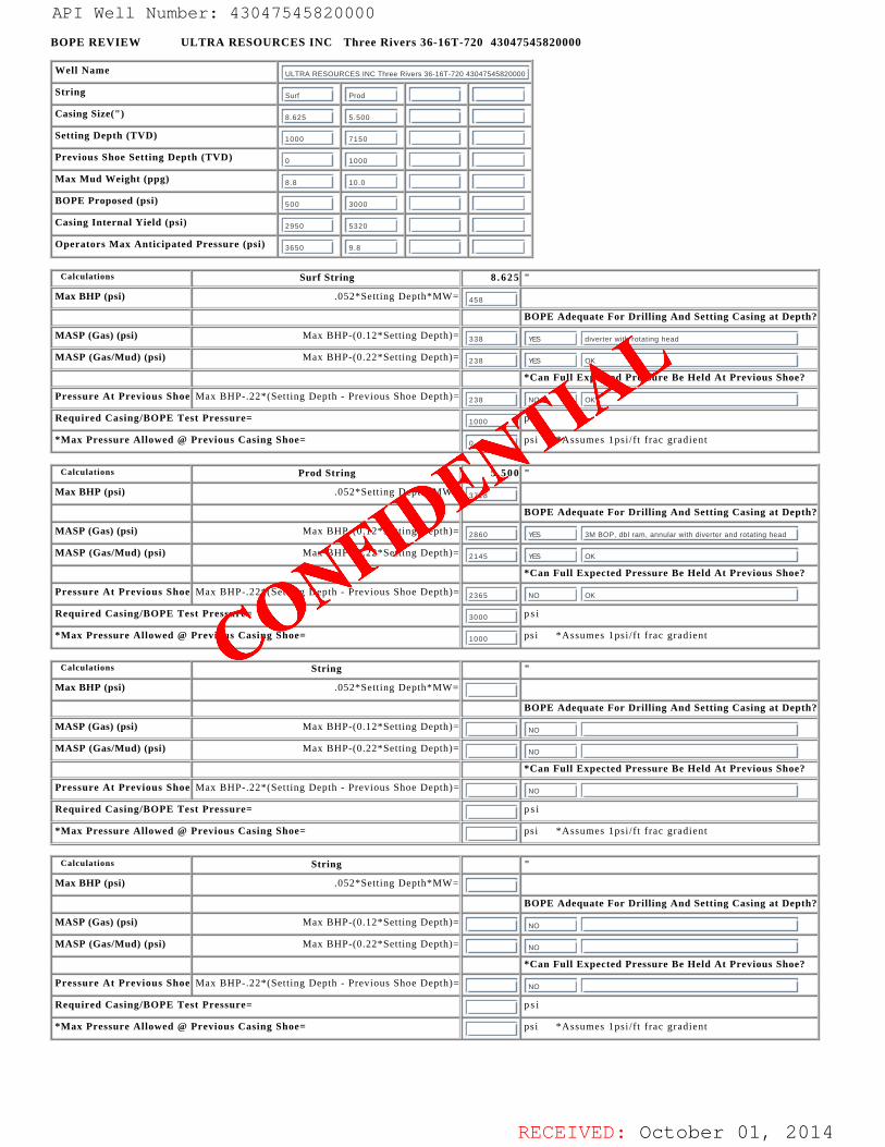
RECEIVED: October 01, 2014
BOPE REVIEW ULTRA RESOURCES INC Three Rivers 36-16T-720 43047545820000
Well Name ULTRA RESOURCES INC Three Rivers 36-16T-720 43047545820000
String Surf Prod
Casing Size(") 8.625 5.500
Setting Depth (TVD) 1000 7150
Previous Shoe Setting Depth (TVD) 0 1000
Max Mud Weight (ppg) 8.8 10.0
BOPE Proposed (psi) 500 3000
Casing Internal Yield (psi) 2950 5320
Operators Max Anticipated Pressure (psi) 3650 9.8
Calculations Surf String 8 . 6 2 5 "
Max BHP (psi) .052*Setting Depth*MW= 458
BOPE Adequate For Drilling And Setting Casing at Depth?
MASP (Gas) (psi) Max BHP-(0.12*Setting Depth)= 338 YES diverter with rotating head
MASP (Gas/Mud) (psi) Max BHP-(0.22*Setting Depth)= 238 YES OK
*Can Full Expected Pressure Be Held At Previous Shoe?
Pressure At Previous Shoe Max BHP-.22*(Setting Depth - Previous Shoe Depth)= 238 NO OK
Required Casing/BOPE Test Pressure= 1000 p s i
*Max Pressure Allowed @ Previous Casing Shoe= 0 psi *Assumes 1psi/f t frac gradient
Calculations Prod String 5 . 5 0 0 "
Max BHP (psi) .052*Setting Depth*MW= 3718
BOPE Adequate For Drilling And Setting Casing at Depth?
MASP (Gas) (psi) Max BHP-(0.12*Setting Depth)= 2860 YES 3M BOP, dbl ram, annular with diverter and rotating head
MASP (Gas/Mud) (psi) Max BHP-(0.22*Setting Depth)= 2145 YES OK
*Can Full Expected Pressure Be Held At Previous Shoe?
Pressure At Previous Shoe Max BHP-.22*(Setting Depth - Previous Shoe Depth)= 2365 NO OK
Required Casing/BOPE Test Pressure= 3000 p s i
*Max Pressure Allowed @ Previous Casing Shoe= 1000 psi *Assumes 1psi/f t frac gradient
Calculations String "
Max BHP (psi) .052*Setting Depth*MW=
BOPE Adequate For Drilling And Setting Casing at Depth?
MASP (Gas) (psi) Max BHP-(0.12*Setting Depth)= NO
MASP (Gas/Mud) (psi) Max BHP-(0.22*Setting Depth)= NO
*Can Full Expected Pressure Be Held At Previous Shoe?
Pressure At Previous Shoe Max BHP-.22*(Setting Depth - Previous Shoe Depth)= NO
Required Casing/BOPE Test Pressure= p s i
*Max Pressure Allowed @ Previous Casing Shoe= psi *Assumes 1psi/f t frac gradient
API Well Number: 43047545820000
CONFIDE
NTIAL
API Well Number: 43047545820000
BOPE REVIEW ULTRA RESOURCES INC Three Rivers 36-16T-720 43047545820000
Well Name ULTRA RESOURCES INC Three Rivers 36-16T-720 43047545820000
String surf Prod
Casing Size(") 8.625 5.500
Setting Depth (TVD) 1000 7150
Previous Shoe Setting Depth (TVD) o 1000
Max Mud Weight (ppg) 8.8 10.0
BOPE Proposed (psi) Soo 3000
Casing Internal Yield (psi) 2950 5320
Operators Max Anticipated Pressure (psi) 3650 9.8
Calculations Surf String 8.625 "Max BHP (psi) .052*Setting Depth*MW=
458
BOPE Adequate For Drilling And Setting Casing at Depth?
MASP (Gas) (psi) Max BHP-(0.12*Setting Depth)=338 diverter with rotating head
MASP (Gas/Mud) (psi) Max BHP-(0.22*Setting Depth)=238 OK
*Can Full Expected Pressure Be Held At Previous Shoe?
Pressure At Previous Shoe Max BHP-.22*(Setting Depth - Previous Shoe Depth)=238 NO OK
Required Casing/BOPE Test Pressure=1000 psi
*Max Pressure Allowed @ Previous Casing Shoe= psi *Assumes lpsi/ft frac gradient
Calculations Prod String 5.500 "Max BHP (psi) .052*Setting Depth*MW=
3718
BOPE Adequate For Drilling And Setting Casing at Depth?
MASP (Gas) (psi) Max BHP-(0.12*Setting Depth)=2860 3M BOP, dbl ram, annular with diverter and rotating head
MASP (Gas/Mud) (psi) Max BHP-(0.22*Setting Depth)=2145 OK
*Can Full Expected Pressure Be Held At Previous Shoe?
Pressure At Previous Shoe Max BHP-.22*(Setting Depth - Previous Shoe Depth)=2365 NO OK
Required Casing/BOPE Test Pressure=3000 psi
*Max Pressure Allowed @ Previous Casing Shoe=1000 psi *Assumes lpsi/ft frac gradient
Calculations String
Max BHP (psi) .052*Setting Depth*MW=
BOPE Adequate For Drilling And Setting Casing at Depth?
MASP (Gas) (psi) Max BHP-(0.12*Setting Depth)=NO
MASP (Gas/Mud) (psi) Max BHP-(0.22*Setting Depth)=NO
*Can Full Expected Pressure Be Held At Previous Shoe?
Pressure At Previous Shoe Max BHP-.22*(Setting Depth - Previous Shoe Depth)=NO
Required Casing/BOPE Test Pressure= psi
*Max Pressure Allowed @ Previous Casing Shoe= psi *Assumes lpsi/ft frac gradient
RECEIVED: October 01,

RECEIVED: October 01, 2014
API Well Number: 43047545820000
CONFIDE
NTIAL
API Well Number: 43047545820000
43047545820000 Thr e Rivers 36-16T-720Casing Schem¿ ic
Surface a N
ll Toc27
8-5/8" ' 'SurfaceMW 8.8 1000. MDFrac 19.3 1000. TVD
TOC @ $ þ99 Q L Q )1745. /
To SMSoo'±SM
5-1/2" ProductionMW 10. 7160. MD
7150. TVD
API Well Number: 43047545820000
43047545820000 Thr e Rivers 36-16T-720Casing Schem¿ ic
Surface a N
ll Toc27
8-5/8" ' 'SurfaceMW 8.8 1000. MDFrac 19.3 1000. TVD
TOC @ $ þ99 Q L Q )1745. /
To SMSoo'±SM
5-1/2" ProductionMW 10. 7160. MD
7150. TVD
API Well Number: 43047545820000
43047545820000 Thr e Rivers 36-16T-720Casing Schem¿ ic
Surface a N
ll Toc27
8-5/8" ' 'SurfaceMW 8.8 1000. MDFrac 19.3 1000. TVD
TOC @ $ þ99 Q L Q )1745. /
To SMSoo'±SM
5-1/2" ProductionMW 10. 7160. MD
7150. TVD
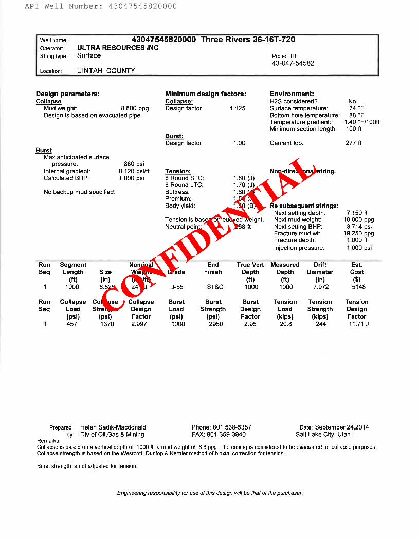
RECEIVED: October 01, 2014
API Well Number: 43047545820000
CONFIDE
NTIAL
API Well Number: 43047545820000
Weil name: 43047545820000 Three Rivers 36-16T-720Operator: ULTRA RESOURCES INCString type: Surface Project ID:
43-047-54582Location: UINTAH COUNTY
Design parameters: Minimum design factors: Environment:Collapse Collapse: H2S considered? No
Mud weight: 8.800 ppg Design factor 1.125 Surface temperature: 74 °FDesign is based on evacuated pipe. Bottom hole temperature: 88 °F
Temperature gradient: 1.40 °F/100ftMinimum section length: 100 ft
Burst:Design factor 1.00 Cement top: 277 ft
BurstMax anticipated surface
pressure: 880 psiInternal gradient: 0.120 psilft Tension: Non-directional string.Calculated BHP 1,000 psi 8 Round STC: 1.80 (J)
8 Round LTC: 1.70 (J)No backup mud specified. Buttress: 1.60 (J)
Premium: 1.50 (J)Body yield: 1.50 (B) Re subsequent strings:
Next setting depth: 7,150 ftTension is based on buoyed weight. Next mud weight: 10.000 ppgNeutral point: 868 ft Next setting BHP: 3,714 psi
Fracture mud wt: 19.250 ppgFracture depth: 1.000 ftInjection pressure: 1,000 psi
Run Segment Nominal End True Vert Measured Drift Est.Seq Length Size Weight Grade Finish Depth Depth Diameter Cost
(ft) (in) (Ibs/ft) (ft) (ft) (in) ($)1 1000 8.625 24.00 J-55 ST&C 1000 1000 7.972 5148
Run Collapse Collapse Collapse Burst Burst Burst Tension Tension TensionSeq Load Strength Design Load Strength Design Load Strength Design
(psi) (psi) Factor (psi) (psi) Factor (kips) (kips) Factor1 457 1370 2.997 1000 2950 2.95 20.8 244 11.71 J
Prepared Helen Sadik-Macdonald Phone: 801 538-5357 Date: September 24,2014by: Div of Oil,Gas & Mining FAX: 801-359-3940 Salt Lake City, Utah
Remarks:Collapse is based on a vertical depth of 1000 ft, a mud weight of 8.8 ppg The casing is considered to be evacuated for collapse purposes.Collapse strength is based on the Westcott, Dunlop & Kemler method of biaxial correction for tension.
Burst strength is not adjusted for tension.
Engineering responsibility for use of thisdesign will be that of the
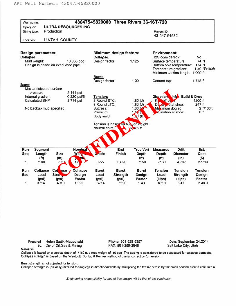
RECEIVED: October 01, 2014
API Well Number: 43047545820000
CONFIDE
NTIAL
API Well Number: 43047545820000
Well name: 43047545820000 Three Rivers 36-16T-720Operator: ULTRA RESOURCES INCString type: Production Project ID:
43-047-54582Location: UINTAH COUNTY
Design parameters: Minimum design factors: Environment:Collapse Collapse: H2S considered? No
Mud weight: 10.000 ppg Design factor 1.125 Surface temperature: 74 °FDesign is based on evacuated pipe. Bottom hole temperature: 174 °F
Temperature gradient: 1.40 °F/100ftMinimum section length: 1,000 ft
Burst:Design factor 1.00 Cement top: 1,745 ft
BurstMax anticipated surface
pressure: 2,141 psiInternal gradient: 0.220 psilft Tension: Directional Info - Build & DropCalculated BHP 3,714 psi 8 Round STC: 1.80 (J) Kick-off point 1200 ft
8 Round LTC: 1.80 (J) Departure at shoe: 247 ftNo backup mud specified. Buttress: 1.60 (J) Maximum dogleg: 2 °/100ft
Premium: 1.50 (J) Inclination at shoe: 0 °
Body yield: 1.60 (B)
Tension is based on buoyed weight.Neutral point: 6,076 ft
Run Segment Nominal End True Vert Measured Drift EstSeq Length Size Weight Grade Finish Depth Depth Diameter Cost
(ft) (in) (Ibs/ft) (ft) (ft) (in) ($)1 7160 5.5 17.00 J-55 LT&C 7150 7160 4.767 27739
Run Collapse Collapse Collapse Burst Burst Burst Tension Tension TensionSeq Load Strength Design Load Strength Design Load Strength Design
(psi) (psi) Factor (psi) (psi) Factor (kips) (kips) Factor1 3714 4910 1.322 3714 5320 1.43 103.1 247 2.40 J
Prepared Helen Sadik-Macdonald Phone: 801 538-5357 Date: September 24,2014by: Div of Oil,Gas & Mining FAX: 801-359-3940 Salt Lake City, Utah
Remarks:Collapse is based on a vertical depth of 7150 ft, a mud weight of 10 ppg The casing is considered to be evacuated for collapse purposes.Collapse strength is based on the Westcott, Dunlop & Kemler method of biaxial correction for tension.
Burst strength is not adjusted for tension.Collapse strength is (blaxially) derated for doglegs in directional wells by multiplying the tensile stress by the cross section area to calculate a
Engineering responsibility for use of this design willbe thatof the
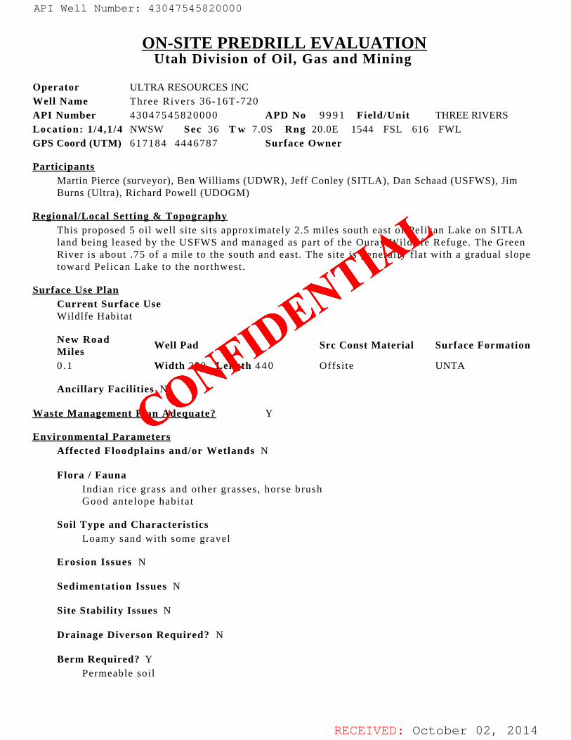
RECEIVED: October 02, 2014
ON-SITE PREDRILL EVALUATIONUtah Division of Oil, Gas and Mining
Operator ULTRA RESOURCES INC Well Name Three Rivers 36-16T-720API Number 43047545820000 APD No 9 9 9 1 Field/Unit THREE RIVERS Location: 1/4,1/4 NWSW Sec 36 T w 7.0S Rng 20.0E 1544 FSL 616 FWLGPS Coord (UTM) 617184 4446787 Surface Owner
ParticipantsMartin Pierce (surveyor), Ben Williams (UDWR), Jeff Conley (SITLA), Dan Schaad (USFWS), JimBurns (Ultra), Richard Powell (UDOGM)
Regional/Local Setting & TopographyThis proposed 5 oil well site sits approximately 2.5 miles south east of Pelican Lake on SITLAland being leased by the USFWS and managed as part of the Ouray Wildlife Refuge. The GreenRiver is about .75 of a mile to the south and east. The site is generally flat with a gradual slopetoward Pelican Lake to the northwest.
Surface Use PlanCurrent Surface UseWildlfe Habitat
New RoadMiles
Well Pad Src Const Material Surface Formation
0 .1 Width 250 Length 4 4 0 Offsite UNTA
Ancillary Facilities N
Waste Management Plan Adequate? Y
Environmental ParametersAffected Floodplains and/or Wetlands N
Flora / FaunaIndian r ice grass and other grasses, horse brush Good antelope habi tat
Soil Type and CharacteristicsLoamy sand with some gravel
Erosion Issues N
Sedimentation Issues N
Site Stability Issues N
Drainage Diverson Required? N
Berm Required? YPermeable soil
API Well Number: 43047545820000
CONFIDE
NTIAL
API Well Number: 43047545820000
ON-SITE PREDRILL EVALUATIONUtah Division of Oil, Gas and Mining
Operator ULTRA RESOURCES INCWell Name Three Rivers 36-16T-720
API Number 43047545820000 APD No 9991 Field/Unit THREE RIVERSLocation: 1/4,1/4 NWSW Sec 36 Tw 7.0S Rng 20.0E 1544 FSL 616 FWLGPS Coord (UTM) 617184 4446787 Surface Owner
ParticipantsMartin Pierce (surveyor), Ben Williams (UDWR), Jeff Conley (SITLA), Dan Schaad (USFWS), JimBurns (Ultra), Richard Powell (UDOGM)
Regional/Local Setting & TopographyThis proposed 5 oil well site sits approximately 2.5 miles south east of Pelican Lake on SITLAland being leased by the USFWS and managed as part of the Ouray Wildlife Refuge. The GreenRiver is about .75 of a mile to the south and east. The site is generally flat with a gradual slopetoward Pelican Lake to the northwest.
Surface Use PlanCurrent Surface UseWildlfe Habitat
New Road Well Pad Src Const Material Surface FormationMiles0.1 Width 250 Length 440 Offsite UNTA
Ancillary Facilities N
Waste Management Plan Adequate? Y
Environmental ParametersAffected Floodplains and/or Wetlands N
Flora / FaunaIndian rice grass and other grasses, horse brushGood antelope habitat
Soil Type and CharacteristicsLoamy sand with some gravel
Erosion Issues N
Sedimentation Issues N
Site Stability Issues N
Drainage Diverson Required? N
Berm Required? YPermeable soil
RECEIVED: October 02,
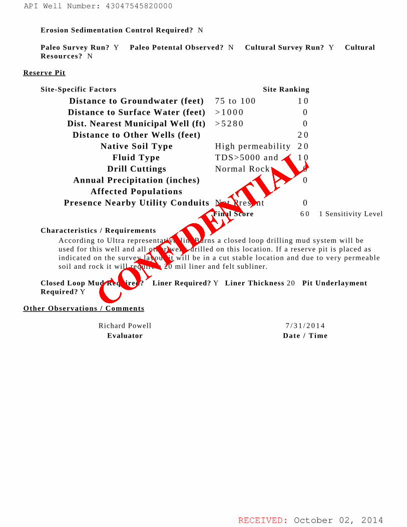
RECEIVED: October 02, 2014
Erosion Sedimentation Control Required? N
Paleo Survey Run? Y Paleo Potental Observed? N Cultural Survey Run? Y CulturalResources? N
Reserve Pit
Site-Specific Factors Site Ranking
Distance to Groundwater (feet) 75 to 100 1 0Distance to Surface Water (feet) > 1 0 0 0 0Dist. Nearest Municipal Well (ft) > 5 2 8 0 0
Distance to Other Wells (feet) 2 0Native Soil Type High permeability 2 0
Fluid Type TDS>5000 and 1 0Drill Cuttings Normal Rock 0
Annual Precipitation (inches) 0Affected Populations
Presence Nearby Utility Conduits Not Present 0
Final Score 6 0 1 Sensitivity Level
Characteristics / RequirementsAccording to Ultra representative Jim Burns a closed loop drilling mud system will beused for this well and all other wells drilled on this location. If a reserve pit is placed asindicated on the survey layout i t will be in a cut stable location and due to very permeablesoil and rock it will require a 20 mil liner and felt subliner.
Closed Loop Mud Required? Liner Required? Y Liner Thickness 20 Pit UnderlaymentRequired? Y
Other Observations / Comments
Richard Powell 7 / 3 1 / 2 0 1 4Evaluator Date / Time
API Well Number: 43047545820000
CONFIDE
NTIAL
API Well Number: 43047545820000
Erosion Sedimentation Control Required? N
Paleo Survey Run? Y Paleo Potental Observed? N Cultural Survey Run? Y CulturalResources? N
Reserve Pit
Site-Specific Factors Site Ranking
Distance to Groundwater (feet) 75 to 100 10Distance to Surface Water (feet) >1000 0Dist. Nearest Municipal Well (ft) >5280 0
Distance to Other Wells (feet) 2 0Native Soil Type High permeability 20
Fluid Type TDS>5000 and 10Drill Cuttings Normal Rock 0
Annual Precipitation (inches) 0Affected Populations
Presence Nearby Utility Conduits Not Present 0Final Score 60 1 Sensitivity Level
Characteristics / RequirementsAccording to Ultra representative Jim Burns a closed loop drilling mud system will beused for this well and all other wells drilled on this location. If a reserve pit is placed asindicated on the survey layout it will be in a cut stable location and due to very permeablesoil and rock it will require a 20 mil liner and felt subliner.
Closed Loop Mud Required? Liner Required? Y Liner Thickness 20 Pit UnderlaymentRequired? Y
Other Observations / Comments
Richard Powell 7/3 1/20 14Evaluator Date / Time
RECEIVED: October 02,
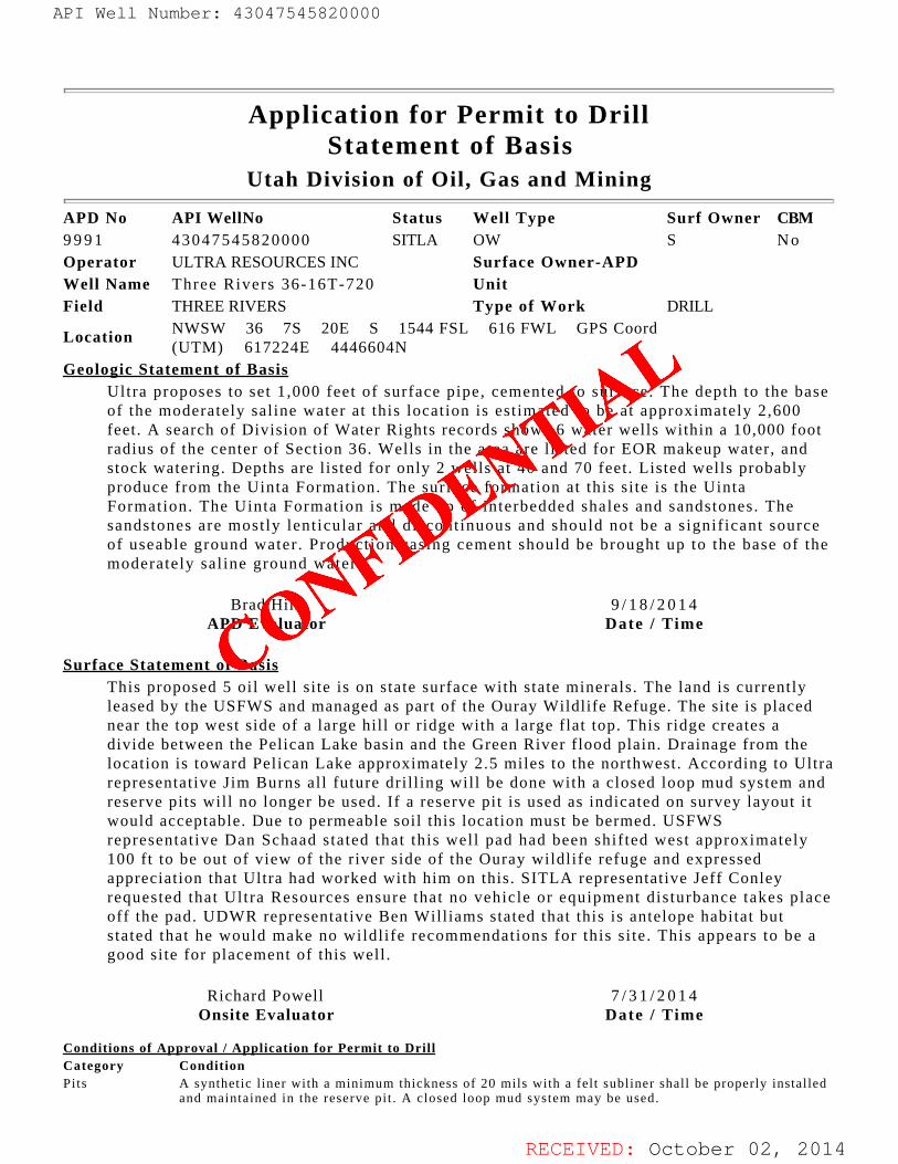
RECEIVED: October 02, 2014
Application for Permit to DrillStatement of Basis
Utah Division of Oil, Gas and Mining
APD No API WellNo Status Well Type Surf Owner CBM9 9 9 1 43047545820000 SITLA OW S N oOperator ULTRA RESOURCES INC Surface Owner-APDWell Name Three Rivers 36-16T-720 UnitField THREE RIVERS Type of Work DRILL
Location NWSW 36 7S 20E S 1544 FSL 616 FWL GPS Coord(UTM) 617224E 4446604N
Geologic Statement of BasisUltra proposes to set 1,000 feet of surface pipe, cemented to surface. The depth to the baseof the moderately saline water at this location is estimated to be at approximately 2,600feet. A search of Division of Water Rights records shows 6 water wells within a 10,000 footradius of the center of Section 36. Wells in the area are listed for EOR makeup water, andstock watering. Depths are listed for only 2 wells at 40 and 70 feet. Listed wells probablyproduce from the Uinta Formation. The surface formation at this si te is the UintaFormation. The Uinta Formation is made up of interbedded shales and sandstones. Thesandstones are mostly lent icular and discontinuous and should not be a s ignif icant sourceof useable ground water . Production casing cement should be brought up to the base of themoderately sal ine ground water .
Brad HillAPD Evaluator
9 / 1 8 / 2 0 1 4Date / Time
Surface Statement of BasisThis proposed 5 oil well site is on state surface with state minerals. The land is currentlyleased by the USFWS and managed as part of the Ouray Wildlife Refuge. The site is placednear the top west side of a large hill or ridge with a large flat top. This ridge creates adivide between the Pelican Lake basin and the Green River flood plain. Drainage from thelocation is toward Pelican Lake approximately 2.5 miles to the northwest. According to Ultrarepresentative Jim Burns all future dril l ing will be done with a closed loop mud system andreserve pits will no longer be used. If a reserve pit is used as indicated on survey layout itwould acceptable. Due to permeable soil this location must be bermed. USFWSrepresentat ive Dan Schaad stated that this well pad had been shif ted west approximately100 ft to be out of view of the river side of the Ouray wildlife refuge and expressedappreciation that Ultra had worked with him on this. SITLA representative Jeff Conleyrequested that Ultra Resources ensure that no vehicle or equipment disturbance takes placeoff the pad. UDWR representative Ben Williams stated that this is antelope habitat butstated that he would make no wildlife recommendations for this si te. This appears to be agood site for placement of this well.
Richard PowellOnsite Evaluator
7 / 3 1 / 2 0 1 4Date / Time
Conditions of Approval / Application for Permit to DrillCategory ConditionPits A synthetic l iner with a minimum thickness of 20 mils with a felt subliner shall be properly installed
and maintained in the reserve pit . A closed loop mud system may be used.
API Well Number: 43047545820000
CONFIDE
NTIAL
API Well Number: 43047545820000
I
Application for Permit to DrillStatement of Basis
Utah Division of Oil, Gas and MiningI
APD No API WellNo Status Well Type Surf Owner CBM9991 43047545820000 SITLA OW S NoOperator ULTRA RESOURCES INC Surface Owner-APD
Well Name Three Rivers 36-16T-720 UnitField THREE RIVERS Type of Work DRILL
. NWSW 36 7S 20E S 1544 FSL 616 FWL GPS CoordLocation(UTM) 617224E 4446604N
Geologic Statement of BasisUltra proposes to set 1,000 feet of surface pipe, cemented to surface. The depth to the baseof the moderately saline water at this location is estimated to be at approximately 2,600feet. A search of Division of Water Rights records shows 6 water wells within a 10,000 footradius of the center of Section 36. Wells in the area are listed for EOR makeup water, andstock watering. Depths are listed for only 2 wells at 40 and 70 feet. Listed wells probablyproduce from the Uinta Formation. The surface formation at this site is the UintaFormation. The Uinta Formation is made up of interbedded shales and sandstones. Thesandstones are mostly lenticular and discontinuous and should not be a significant sourceof useable ground water. Production casing cement should be brought up to the base of themoderately saline ground water.
Brad Hill 9/18/20 14APD Evaluator Date / Time
Surface Statement of BasisThis proposed 5 oil well site is on state surface with state minerals. The land is currentlyleased by the USFWS and managed as part of the Ouray Wildlife Refuge. The site is placednear the top west side of a large hill or ridge with a large flat top. This ridge creates adivide between the Pelican Lake basin and the Green River flood plain. Drainage from thelocation is toward Pelican Lake approximately 2.5 miles to the northwest. According to Ultrarepresentative Jim Burns all future drilling will be done with a closed loop mud system andreserve pits will no longer be used. If a reserve pit is used as indicated on survey layout itwould acceptable. Due to permeable soil this location must be bermed. USFWSrepresentative Dan Schaad stated that this well pad had been shifted west approximately100 ft to be out of view of the river side of the Ouray wildlife refuge and expressedappreciation that Ultra had worked with him on this. SITLA representative Jeff Conleyrequested that Ultra Resources ensure that no vehicle or equipment disturbance takes placeoff the pad. UDWR representative Ben Williams stated that this is antelope habitat butstated that he would make no wildlife recommendations for this site. This appears to be agood site for placement of this well.
Richard Powell 7/31/2014Onsite Evaluator Date / Time
Conditions of Approval / Application for Permit to DrillCategory ConditionPits A synthetic liner with a minimum thickness of 20 mils with a felt subliner shall be properly installed
and maintained in the reserve pit. A closed loop mud system may be used.
RECEIVED: October 02,

RECEIVED: October 02, 2014
Surface The well site shall be bermed to prevent fluids from entering or leaving the pad.Surface Measures (BMP's) shall be taken to protect steep slopes and topsoil pile from erosion, sedimentation
and stabili ty issues.Surface Drainages adjacent to the proposed pad shall be diverted around the location.Surface The reserve pit shall be fenced upon completion of dril l ing operations.
API Well Number: 43047545820000
CONFIDE
NTIAL
API Well Number: 43047545820000
Surface The well site shall be bermed to prevent fluids from entering or leaving the pad.Surface Measures (BMP's) shall be taken to protect steep slopes and topsoil pile from erosion, sedimentation
and stability issues.Surface Drainages adjacent to the proposed pad shall be diverted around the location.Surface The reserve pit shall be fenced upon completion of drilling operations.
RECEIVED: October 02,
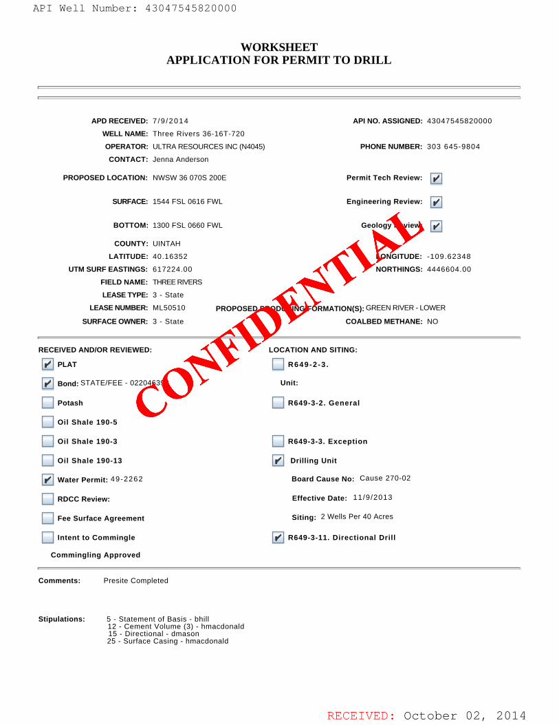
RECEIVED: October 02, 2014
WORKSHEETAPPLICATION FOR PERMIT TO DRILL
APD RECEIVED: 7 /9 /2014 API NO. ASSIGNED: 43047545820000
WELL NAME: Three Rivers 36-16T-720
OPERATOR: ULTRA RESOURCES INC (N4045) PHONE NUMBER: 303 645-9804
CONTACT: Jenna Anderson
PROPOSED LOCATION: NWSW 36 070S 200E Permit Tech Review:
SURFACE: 1544 FSL 0616 FWL Engineering Review:
BOTTOM: 1300 FSL 0660 FWL Geology Review:
COUNTY: UINTAH
LATITUDE: 40.16352 LONGITUDE: -109.62348
UTM SURF EASTINGS: 617224.00 NORTHINGS: 4446604.00
FIELD NAME: THREE RIVERS
LEASE TYPE: 3 - State
LEASE NUMBER: ML50510 PROPOSED PRODUCING FORMATION(S): GREEN RIVER - LOWER
SURFACE OWNER: 3 - State COALBED METHANE: NO
RECEIVED AND/OR REVIEWED: LOCATION AND SITING:
PLAT R649-2 -3 .
Bond: STATE/FEE - 022046398 Unit:
Potash R649-3-2. General
Oil Shale 190-5
Oil Shale 190-3 R649-3-3. Exception
Oil Shale 190-13 Drilling Unit
Water Permit: 49-2262 Board Cause No: Cause 270-02
RDCC Review: Effective Date: 11/9/2013
Fee Surface Agreement Siting: 2 Wells Per 40 Acres
Intent to Commingle R649-3-11. Directional Drill
Commingling Approved
Comments: Presite Completed
Stipulations: 5 - Statement of Basis - bhill 12 - Cement Volume (3) - hmacdonald 15 - Directional - dmason 25 - Surface Casing - hmacdonald
API Well Number: 43047545820000
CONFIDE
NTIAL
API Well Number: 43047545820000
WORKSHEETAPPLICATION FOR PERMIT TO DRILL
I
I
APD RECEIVED: 7/9/2014 API NO. ASSIGNED: 43047545820000
WELL NAME: Three Rivers 36-16T-720
OPERATOR: ULTRARESOURCES INC (N4045) PHONE NUMBER: 303 645-9804
CONTACT: Jenna Anderson
PROPOSED LOCATION: NWSW 36 070S 200E Permit Tech Review:
SURFACE: 1544 FSL 0616 FWL Engineering Review:
BOTTOM: 1300 FSL 0660 FWL Geology Review:
COUNTY: UINTAH
LATITUDE: 40.16352 LONGITUDE: -109.62348
UTM SURF EASTINGS: 617224.00 NORTHINGS: 4446604.00
FIELD NAME: THREE RIVERS
LEASE TYPE: 3 - State
LEASE NUMBER: ML50510 PROPOSED PRODUCING FORMATION(S): GREEN RIVER- LOWER
SURFACE OWNER: 3 - State COALBED METHANE: NO
I
RECEIVED ANDIOR REVIEWED: LOCATION AND SITING:
PLAT R649-2-3.
Bond: STATE/FEE - 022046398 Unit:
Potash R649-3-2. General
Oil Shale 190-5
Oil Shale 190-3 R649-3-3. Exception
Oil Shale 190-13 Drilling Unit
Water Permit: 49-2262 Board Cause No: Cause 270-02
RDCC Review: Effective Date: 11/9/2013
Fee Surface Agreement Siting: 2 Wells Per 40 Acres
Intent to Commingle R649-3-11. Directional Drill
Commingling Approved
I
Comments: Presite Completed
Stipulations: 5 - Statement of Basis - bhill12 - Cement Volume (3) - hmacdonald15 - Directional - dmason
25 - Surface Casing - hmacdonald
RECEIVED: October 02,
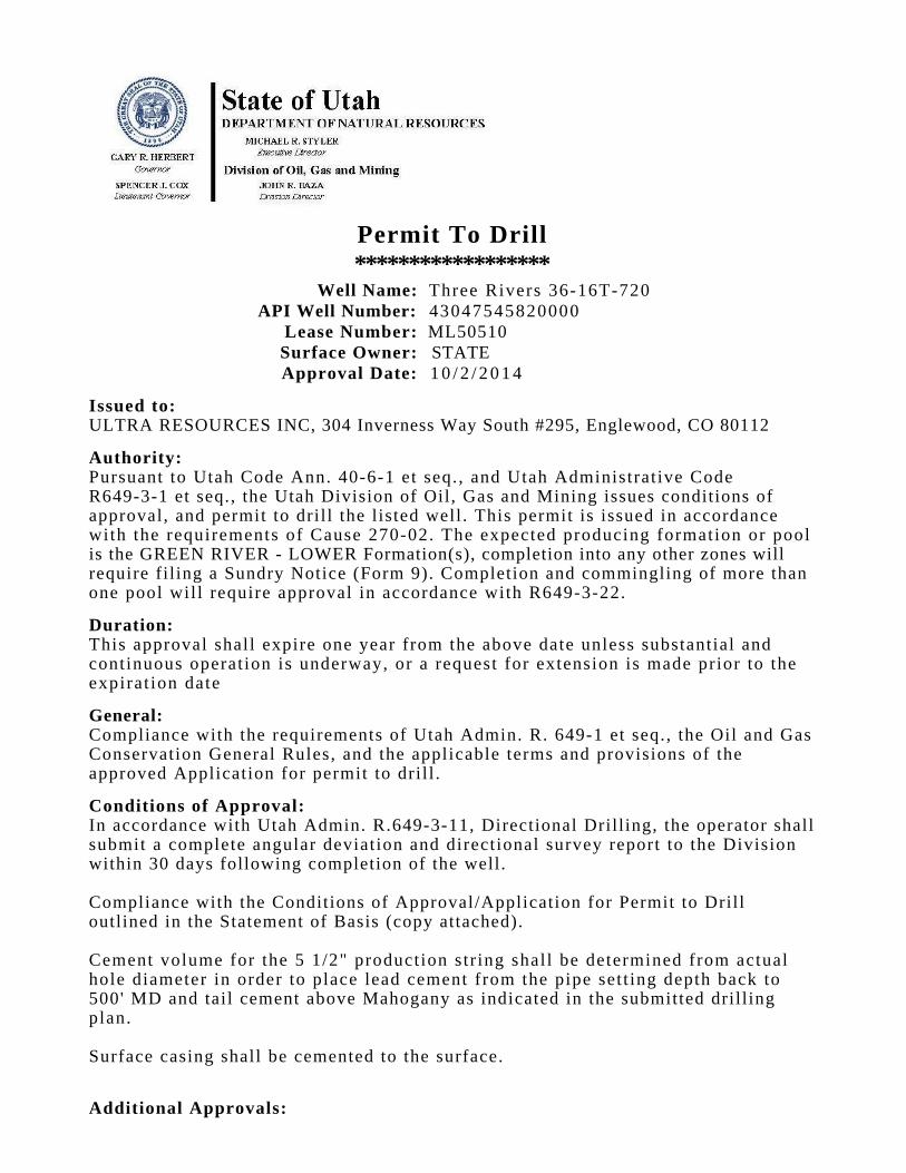
Permit To Drill******************
Well Name: Three Rivers 36-16T-720API Well Number: 43047545820000
Lease Number: ML50510Surface Owner: STATE Approval Date: 1 0 / 2 / 2 0 1 4
Issued to:ULTRA RESOURCES INC, 304 Inverness Way South #295, Englewood, CO 80112
Authority:Pursuant to Utah Code Ann. 40-6-1 et seq. , and Utah Administrat ive CodeR649-3-1 et seq., the Utah Division of Oil, Gas and Mining issues conditions ofapproval, and permit to drill the listed well. This permit is issued in accordancewith the requirements of Cause 270-02. The expected producing formation or poolis the GREEN RIVER - LOWER Formation(s), completion into any other zones willrequire filing a Sundry Notice (Form 9). Completion and commingling of more thanone pool will require approval in accordance with R649-3-22.
Duration:This approval shall expire one year from the above date unless substantial andcontinuous operat ion is underway, or a request for extension is made prior to theexpirat ion date
General:Compliance with the requirements of Utah Admin. R. 649-1 et seq., the Oil and GasConservation General Rules, and the applicable terms and provisions of theapproved Application for permit to dril l .
Conditions of Approval:In accordance with Utah Admin. R.649-3-11, Directional Drilling, the operator shallsubmit a complete angular deviation and directional survey report to the Divisionwithin 30 days following completion of the well.
Compliance with the Conditions of Approval/Application for Permit to Drilloutlined in the Statement of Basis (copy attached).
Cement volume for the 5 1/2" production str ing shall be determined from actualhole diameter in order to place lead cement from the pipe set t ing depth back to500' MD and tail cement above Mahogany as indicated in the submitted drill ingplan.
Surface casing shall be cemented to the surface.
Additional Approvals:
State of Utaha DEPARTMENT OF NATURAL RESOURCES
-
.,5., MICHAEL R. STYLER
GARY R HERBERT E wcunw Drector
Gowrnor Division of Oil, Gas and MiningSPEINCERJ. COX JOHN R. HAZAL2euternal Gowtror DWslanDirector
Permit To Drillkkkkkkkkkkkkkkkkkk
Well Name: Three Rivers 36-16T-720API Well Number: 43047545820000
Lease Number: ML50510Surface Owner: STATEApproval Date: 10/2/2014
Issued to:ULTRA RESOURCES INC, 304 Inverness Way South #295, Englewood, CO 80112
Authority:Pursuant to Utah Code Ann. 40-6-1 et seq., and Utah Administrative CodeR649-3-1 et seq., the Utah Division of Oil, Gas and Mining issues conditions ofapproval, and permit to drill the listed well. This permit is issued in accordancewith the requirements of Cause 270-02. The expected producing formation or poolis the GREEN RIVER - LOWER Formation(s), completion into any other zones willrequire filing a Sundry Notice (Form 9). Completion and commingling of more thanone pool will require approval in accordance with R649-3-22.
Duration:This approval shall expire one year from the above date unless substantial andcontinuous operation is underway, or a request for extension is made prior to theexpiration date
General:Compliance with the requirements of Utah Admin. R. 649-1 et seq., the Oil and GasConservation General Rules, and the applicable terms and provisions of theapproved Application for permit to drill.
Conditions of Approval:In accordance with Utah Admin. R.649-3-11, Directional Drilling, the operator shallsubmit a complete angular deviation and directional survey report to the Divisionwithin 30 days following completion of the well.
Compliance with the Conditions of Approval/Application for Permit to Drilloutlined in the Statement of Basis (copy attached).
Cement volume for the 5 1/2" production string shall be determined from actualhole diameter in order to place lead cement from the pipe setting depth back to500' MD and tail cement above Mahogany as indicated in the submitted drillingplan.
Surface casing shall be cemented to the surface.
Additional

The operator is required to obtain approval from the Division of Oil, Gas andmining before performing any of the following actions during the dril l ing of thiswell: • Any changes to the approved dri l l ing plan - contact Dustin Doucet • Significant plug back of the well - contact Dustin Doucet • Plug and abandonment of the well - contact Dustin Doucet
Notification Requirements:The operator is required to notify the Division of Oil, Gas and Mining of thefollowing actions during drilling of this well: • Within 24 hours following the spudding of the well - contact Carol Daniels OR submit an electronic sundry notice (pre-registration required) via the Utah Oil &Gas website at ht tp:/ /oi lgas.ogm.utah.gov • 24 hours prior to test ing blowout prevention equipment - contact Dan Jarvis • 24 hours prior to cementing or test ing casing - contact Dan Jarvis • Within 24 hours of making any emergency changes to the approved dril l ingp r o g r a m - contact Dustin Doucet • 24 hours pr ior to commencing operat ions to plug and abandon the well -contact Dan Jarvis
Contact Information:The following are Division of Oil, Gas and Mining contacts and their telephonenumbers (please leave a voicemail message if the person is not available to take thecall): • Carol Daniels 801-538-5284 - off ice • Dust in Doucet 801-538-5281 - off ice 801-733-0983 - after office hours • Dan Jarvis 801-538-5338 - office 801-231-8956 - after office hours
Reporting Requirements:All reports, forms and submittals as required by the Utah Oil and Gas ConservationGeneral Rules will be promptly filed with the Division of Oil, Gas and Mining,including but not l imited to: • Entity Action Form (Form 6) - due within 5 days of spudding the well • Monthly Status Report (Form 9) - due by 5th day of the following calendarm o n t h • Requests to Change Plans (Form 9) - due prior to implementation • Written Notice of Emergency Changes (Form 9) - due within 5 days • Notice of Operations Suspension or Resumption (Form 9) - due prior toimplementa t ion • Report of Water Encountered (Form 7) - due within 30 days after completion • Well Completion Report (Form 8) - due within 30 days after completion orplugging
Approved By:
The operator is required to obtain approval from the Division of Oil, Gas andmining before performing any of the following actions during the drilling of thiswell:
• Any changes to the approved drilling plan - contact Dustin Doucet• Significant plug back of the well - contact Dustin Doucet• Plug and abandonment of the well - contact Dustin Doucet
Notification Requirements:The operator is required to notify the Division of Oil, Gas and Mining of thefollowing actions during drilling of this well:
• Within 24 hours following the spudding of the well - contact Carol DanielsORsubmit an electronic sundry notice (pre-registration required) via the Utah Oil &
Gas websiteat http://oilgas.ogm.utah.gov
• 24 hours prior to testing blowout prevention equipment - contact Dan Jarvis• 24 hours prior to cementing or testing casing - contact Dan Jarvis• Within 24 hours of making any emergency changes to the approved drilling
program- contact Dustin Doucet
• 24 hours prior to commencing operations to plug and abandon the well -
contact Dan Jarvis
Contact Information:The following are Division of Oil, Gas and Mining contacts and their telephonenumbers (please leave a voicemail message if the person is not available to take thecall):
• Carol Daniels 801-538-5284 - office• Dustin Doucet 801-538-5281 - office
801-733-0983 - after office hours• Dan Jarvis 801-538-5338 - office
801-231-8956 - after office hours
Reporting Requirements:All reports, forms and submittals as required by the Utah Oil and Gas ConservationGeneral Rules will be promptly filed with the Division of Oil, Gas and Mining,including but not limited to:
• Entity Action Form (Form 6) - due within 5 days of spudding the well• Monthly Status Report (Form 9) - due by 5th day of the following calendar
month• Requests to Change Plans (Form 9) - due prior to implementation• Written Notice of Emergency Changes (Form 9) - due within 5 days• Notice of Operations Suspension or Resumption (Form 9) - due prior to
implementation• Report of Water Encountered (Form 7) - due within 30 days after completion• Well Completion Report (Form 8) - due within 30 days after completion or

Approved By:
For John RogersAssociate Director, Oil & Gas
approveu ny.
For John RogersAssociate Director, Oil &
approveu ny.
For John RogersAssociate Director, Oil &
approveu ny.
For John RogersAssociate Director, Oil &

RECEIVED: Sep. 17, 2015
STATE OF UTAHDEPARTMENT OF NATURAL RESOURCES
DIVISION OF OIL, GAS, AND MINING
FORM 9
5.LEASE DESIGNATION AND SERIAL NUMBER: ML50510
SUNDRY NOTICES AND REPORTS ON WELLS
Do not use this form for proposals to drill new wells, significantly deepen existing wells belowcurrent bottom-hole depth, reenter plugged wells, or to drill horizontal laterals. Use APPLICATIONFOR PERMIT TO DRILL form for such proposals.
6. IF INDIAN, ALLOTTEE OR TRIBE NAME:
7.UNIT or CA AGREEMENT NAME:
1. TYPE OF WELL Oil Well
8. WELL NAME and NUMBER: Three Rivers 36-16T-720
2. NAME OF OPERATOR: ULTRA RESOURCES INC
9. API NUMBER: 43047545820000
3. ADDRESS OF OPERATOR: PHONE NUMBER: 116 Inverness Drive East, Suite #400 , Englewood, CO, 80112 303 645-9809 Ext
9. FIELD and POOL or WILDCAT: THREE RIVERS
4. LOCATION OF WELL FOOTAGES AT SURFACE: 1544 FSL 0616 FWL QTR/QTR, SECTION, TOWNSHIP, RANGE, MERIDIAN: Qtr/Qtr: NWSW Section: 36 Township: 07.0S Range: 20.0E Meridian: S
COUNTY: UINTAH
STATE: UTAH
11.
CHECK APPROPRIATE BOXES TO INDICATE NATURE OF NOTICE, REPORT, OR OTHER DATA
TYPE OF SUBMISSION TYPE OF ACTION
NOTICE OF INTENTApproximate date work will start:
10/17 /2015
SUBSEQUENT REPORTDate of Work Completion:
SPUD REPORTDate of Spud:
DRILLING REPORTReport Date:
ACIDIZE ALTER CASING CASING REPAIR
CHANGE TO PREVIOUS PLANS CHANGE TUBING CHANGE WELL NAME
CHANGE WELL STATUS COMMINGLE PRODUCING FORMATIONS CONVERT WELL TYPE
DEEPEN FRACTURE TREAT NEW CONSTRUCTION
OPERATOR CHANGE PLUG AND ABANDON PLUG BACK
PRODUCTION START OR RESUME RECLAMATION OF WELL SITE RECOMPLETE DIFFERENT FORMATION
REPERFORATE CURRENT FORMATION SIDETRACK TO REPAIR WELL TEMPORARY ABANDON
TUBING REPAIR VENT OR FLARE WATER DISPOSAL
WATER SHUTOFF SI TA STATUS EXTENSION APD EXTENSION
WILDCAT WELL DETERMINATION OTHER OTHER:
12. DESCRIBE PROPOSED OR COMPLETED OPERATIONS. Clearly show all pertinent details including dates, depths, volumes, etc.
Ultra respectfully requests a one year extension of the state permit forthe referenced well. This is the first extension that has been requested.
NAME (PLEASE PRINT) PHONE NUMBER Jenna Anderson 303 645-9804
TITLE Permitting Assistant
SIGNATURE N/A
DATE 9 /17 /2015
September 17, 2015
Sundry Number: 66225 API Well Number: 43047545820000Sundry Number: 66225 API Well Number: 43047545820000
FORM 9STATE OF UTAH
DEPARTMENTOF NATURALRESOURCES5.LEASE DESIGNATION AND SERIAL NUMBER:DIVISION OF OIL, GAS, AND MINING ML50510
SUNDRY NOTICES AND REPORTS ON WELLS 6. IF INDIAN, ALLOTTEE OR TRIBE NAME:
Do not use this form for proposals to drill new wells, significantly deepen existing wells belowcurrent bottom-hole depth, reenter plugged wells, or to drill horizontal laterals. Use APPLICATION 7.UNITor CA AGREEMENT NAME:
FOR PERMIT TO DRILL form for such proposals.
1. TYPE OF WELL 8. WELL NAME and NUMBER:Oil Well Three Rivers 36-16T-720
2. NAME OF OPERATOR: 9. API NUMBER:ULTRARESOURCES INC 43047545820000
3. ADDRESS OF OPERATOR: PHONE NUMBER: 9. FIELD and POOL or WILDCAT:116 Inverness Drive East, Suite #400 , Englewood, CO, 80112 303 645-9809 Ext THREE RIVERS
4. LOCATION OF WELL COUNTY:FOOTAGESAT SURFACE: UINTAH
1544 FSL 0616 FWLQTRIQTR, SECTION, TOWNSHIP, RANGE, MERIDIAN: STATE:
QtrlQtr: NWSW Section: 36 Township: 07.0S Range: 20.0E Meridian: S UTAH
CHECK APPROPRIATE BOXES TO INDICATENATURE OF NOTICE, REPORT, OR OTHER DATA
TYPE OF SUBMISSION TYPE OF ACTION
ACI DIZE ALTER CASING CASING REPAIRNOTICE OF INTENT
Approximate date work will start: CHANGE TO PREVIOUS PLANS CHANGE TUBING CHANGE WELL NAME
10/17/2015CHANGE WELL STATUS COMMINGLE PRODUCING FORMATIONS CONVERT WELL TYPE
SUBSEQUENTREPORT DEEPEN FRACTURETREAT NEWCONSTRUCTIONDate of Work Completion:
OPERATOR CHANGE PLUG AND ABANDON PLUG BACK
PRODUCTION START OR RESUME RECLAMATION OF WELL SITE RECOMPLETE DIFFERENT FORMATIONSPUD REPORT
Date of Spud: REPERFORATE CURRENT FORMATION SIDETRACK TO REPAIR WELL TEMPORARY ABANDON
TUBING REPAIR VENT OR FLARE WATER DISPOSAL
DRILLING REPORT WATER SHUTOFF SI TA STATUS EXTENSION APD EXTENSIONReport Date:
WILDCAT WELL DETERMINATION OTHER OTHER:
12. DESCRIBE PROPOSED OR COMPLETED OPERATIONS. Clearly show all pertinent details including dates, depths, volumes, etc.
Ultra respectfully requests a one year extension of the state permit for Approved by thethe referenced well. This is the first extension that has been requested.
LReþtmlinhdod¯h,f2015OFI, Gas and Mining
Date:
NAME (PLEASE PRINT) PHONE NUMBER TITLEJenna Anderson 303 645-9804 Permitting Assistant
SIGNATURE DATEN/A 9/17/2015
RECEIVED: Sep. 17,
Sundry Number: 66225 API Well Number: 43047545820000
FORM 9STATE OF UTAH
DEPARTMENTOF NATURALRESOURCES5.LEASE DESIGNATION AND SERIAL NUMBER:DIVISION OF OIL, GAS, AND MINING ML50510
SUNDRY NOTICES AND REPORTS ON WELLS 6. IF INDIAN, ALLOTTEE OR TRIBE NAME:
Do not use this form for proposals to drill new wells, significantly deepen existing wells belowcurrent bottom-hole depth, reenter plugged wells, or to drill horizontal laterals. Use APPLICATION 7.UNITor CA AGREEMENT NAME:
FOR PERMIT TO DRILL form for such proposals.
1. TYPE OF WELL 8. WELL NAME and NUMBER:Oil Well Three Rivers 36-16T-720
2. NAME OF OPERATOR: 9. API NUMBER:ULTRARESOURCES INC 43047545820000
3. ADDRESS OF OPERATOR: PHONE NUMBER: 9. FIELD and POOL or WILDCAT:116 Inverness Drive East, Suite #400 , Englewood, CO, 80112 303 645-9809 Ext THREE RIVERS
4. LOCATION OF WELL COUNTY:FOOTAGESAT SURFACE: UINTAH
1544 FSL 0616 FWLQTRIQTR, SECTION, TOWNSHIP, RANGE, MERIDIAN: STATE:
QtrlQtr: NWSW Section: 36 Township: 07.0S Range: 20.0E Meridian: S UTAH
CHECK APPROPRIATE BOXES TO INDICATENATURE OF NOTICE, REPORT, OR OTHER DATA
TYPE OF SUBMISSION TYPE OF ACTION
ACI DIZE ALTER CASING CASING REPAIRNOTICE OF INTENT
Approximate date work will start: CHANGE TO PREVIOUS PLANS CHANGE TUBING CHANGE WELL NAME
10/17/2015CHANGE WELL STATUS COMMINGLE PRODUCING FORMATIONS CONVERT WELL TYPE
SUBSEQUENTREPORT DEEPEN FRACTURETREAT NEWCONSTRUCTIONDate of Work Completion:
OPERATOR CHANGE PLUG AND ABANDON PLUG BACK
PRODUCTION START OR RESUME RECLAMATION OF WELL SITE RECOMPLETE DIFFERENT FORMATIONSPUD REPORT
Date of Spud: REPERFORATE CURRENT FORMATION SIDETRACK TO REPAIR WELL TEMPORARY ABANDON
TUBING REPAIR VENT OR FLARE WATER DISPOSAL
DRILLING REPORT WATER SHUTOFF SI TA STATUS EXTENSION APD EXTENSIONReport Date:
WILDCAT WELL DETERMINATION OTHER OTHER:
12. DESCRIBE PROPOSED OR COMPLETED OPERATIONS. Clearly show all pertinent details including dates, depths, volumes, etc.
Ultra respectfully requests a one year extension of the state permit for Approved by thethe referenced well. This is the first extension that has been requested.
LReþtmlinhdod¯h,f2015OFI, Gas and Mining
Date:
NAME (PLEASE PRINT) PHONE NUMBER TITLEJenna Anderson 303 645-9804 Permitting Assistant
SIGNATURE DATEN/A 9/17/2015
RECEIVED: Sep. 17,
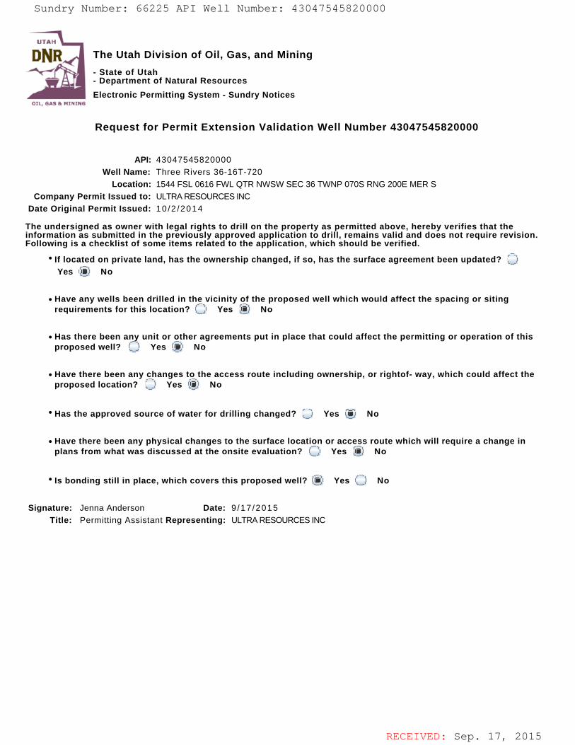
RECEIVED: Sep. 17, 2015
The Utah Division of Oil, Gas, and Mining
- State of Utah- Department of Natural Resources
Electronic Permitting System - Sundry Notices
Request for Permit Extension Validation Well Number 43047545820000
API: 43047545820000Well Name: Three Rivers 36-16T-720
Location: 1544 FSL 0616 FWL QTR NWSW SEC 36 TWNP 070S RNG 200E MER SCompany Permit Issued to: ULTRA RESOURCES INC
Date Original Permit Issued: 10 /2 /2014
The undersigned as owner with legal rights to drill on the property as permitted above, hereby verifies that theinformation as submitted in the previously approved application to drill, remains valid and does not require revision.Following is a checklist of some items related to the application, which should be verified.
If located on private land, has the ownership changed, if so, has the surface agreement been updated? Yes No
Have any wells been drilled in the vicinity of the proposed well which would affect the spacing or sitingrequirements for this location? Yes No
Has there been any unit or other agreements put in place that could affect the permitting or operation of thisproposed well? Yes No
Have there been any changes to the access route including ownership, or rightof- way, which could affect theproposed location? Yes No
Has the approved source of water for drilling changed? Yes No
Have there been any physical changes to the surface location or access route which will require a change inplans from what was discussed at the onsite evaluation? Yes No
Is bonding still in place, which covers this proposed well? Yes No
Signature: Jenna Anderson Date: 9 /17 /2015
Title: Permitting Assistant Representing: ULTRA RESOURCES INC
Sundry Number: 66225 API Well Number: 43047545820000Sundry Number: 66225 API Well Number: 43047545820000
UTAH
DNR The Utah Division of Oil, Gas, and Mining'
- State of Utah- Department of Natural Resources
Electronic Permitting System - Sundry NoticesOTI. EMI Pr N1NTrie
Request for Permit Extension Validation Well Number 43047545820000
API: 43047545820000Well Name: Three Rivers 36-16T-720
Location: 1544 FSL 0616 FWL QTR NWSW SEC 36 TWNP 070S RNG 200E MER SCompany Permit Issued to: ULTRARESOURCES INC
Date Original Permit Issued: 10/2/2014
The undersigned as owner with legal rights to drill on the property as permitted above, hereby verifies that theinformation as submitted in the previously approved application to drill, remains valid and does not require revision.Following is a checklist of some items related to the application, which should be verified.
* If located on private land, has the ownership changed, if so, has the surface agreement been updated? OYes No
• Have any wells been drilled in the vicinity of the proposed well which would affect the spacing or sitingrequirements for this location? O Yes No
• Has there been any unit or other agreements put in place that could affect the permitting or operation of thisproposed well? (_) Yes No
• Have there been any changes to the access route including ownership, or rightof- way, which could affect theproposed location? O Yes i No
· Has the approved source of water for drilling changed? O Yes No
• Have there been any physical changes to the surface location or access route which will require a change inplans from what was discussed at the onsite evaluation? Yes No
' Is bonding still in place, which covers this proposed well? Yes No
Signature: Jenna Anderson Date: 9/17/2015Title: Permitting Assistant Representing: ULTRARESOURCES INC
RECEIVED: Sep. 17,
Sundry Number: 66225 API Well Number: 43047545820000
UTAH
DNR The Utah Division of Oil, Gas, and Mining'
- State of Utah- Department of Natural Resources
Electronic Permitting System - Sundry NoticesOTI. EMI Pr N1NTrie
Request for Permit Extension Validation Well Number 43047545820000
API: 43047545820000Well Name: Three Rivers 36-16T-720
Location: 1544 FSL 0616 FWL QTR NWSW SEC 36 TWNP 070S RNG 200E MER SCompany Permit Issued to: ULTRARESOURCES INC
Date Original Permit Issued: 10/2/2014
The undersigned as owner with legal rights to drill on the property as permitted above, hereby verifies that theinformation as submitted in the previously approved application to drill, remains valid and does not require revision.Following is a checklist of some items related to the application, which should be verified.
* If located on private land, has the ownership changed, if so, has the surface agreement been updated? OYes No
• Have any wells been drilled in the vicinity of the proposed well which would affect the spacing or sitingrequirements for this location? O Yes No
• Has there been any unit or other agreements put in place that could affect the permitting or operation of thisproposed well? (_) Yes No
• Have there been any changes to the access route including ownership, or rightof- way, which could affect theproposed location? O Yes i No
· Has the approved source of water for drilling changed? O Yes No
• Have there been any physical changes to the surface location or access route which will require a change inplans from what was discussed at the onsite evaluation? Yes No
' Is bonding still in place, which covers this proposed well? Yes No
Signature: Jenna Anderson Date: 9/17/2015Title: Permitting Assistant Representing: ULTRARESOURCES INC
RECEIVED: Sep. 17,
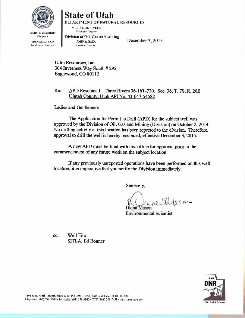
3 State of Utaha DEPARTMENT OF NATURAL RESOURCES
MICHAEL R. STYLER
GARY R. HERBERT Executive Director
Governor Division of Oil, Gas and MiningSPENCER J. COX JOHN R. BAZA December 3, 2015
Lieutenant Governor Division Director
Ultra Resources, Inc.304 Inverness Way South # 295Englewood, CO 80112
Re: APD Rescinded - Three Rivers 36-16T-720, Sec. 36, T. 7S, R. 20EUintah County, Utah API No. 43-047-54582
Ladies and Gentlemen:
The Application for Permit to Drill (APD) for the subject well wasapproved by the Division of Oil, Gas and Mining (Division) on October 2, 2014.No drilling activity at this location has been reported to the divisíon. Therefore,approval to drill the well is hereby rescinded, effective December 3, 2015.
A new APD must be filed with this office for approval prior to thecommencement of any future work on the subject location.
If any previously unreported operations have been performed on this welllocation, it is imperative that you notify the Division immediately.
Sincerely,
Environmental Scientist
cc: Well FileSITLA, Ed Bonner
UTAH
DNR
1594 West North Temple, Suite 1210, PO Box 145801, Salt Lake City, UT 84114-5801telephone (801) 538-5340 • facsimile (801) 359-3940 • TTY (801) 538-7458 • www.ogm.utah.gov I
OIL, GAS &