“road of no return” the story of travel through the little ...€¦ · idaho city and the boise...
TRANSCRIPT

1 | P a g e
“Road of No Return”
The Story of Travel Through the Little Salmon
River Canyon
1
By Amalia Baldwin, M.S., and Jennifer Stevens, Ph.D.
December 27, 2017

2 | P a g e
Table of Contents Introduction .................................................................................................................................................. 3
Early Travel in West Central Idaho, to 1885 ................................................................................................. 5
The North-South Wagon Road, 1885-1901 ................................................................................................ 11
A Highway is Born, 1902-1924 .................................................................................................................... 18
A Road Worth Travelling, 1924-1960s ........................................................................................................ 27
Appendix A: Meadows to Riggins Travel Timeline ...................................................................................... 33
Table of Figures
Figure 1 Map of Idaho showing inset of Central Idaho ................................................................................. 4
Figure 2 Central Idaho .................................................................................................................................. 5
Figure 3 Pictographs along the Little Salmon River ..................................................................................... 6
Figure 4 General Land Office Survey Plat of Township 21 North, Range 1 East showing several trails in the
Little Salmon Region, including one labelled “Old Indian Trail.” .................................................................. 7
Figure 5 "Packer John" Cabin ca. 1922.......................................................................................................... 8
Figure 6 Survey Plat of Township 20 North, Range 1 East showing a trail (dotted line on right) ascending
and descending the steep walls of the Little Salmon Canyon. The Little Salmon is the river at the bottom
of the canyon. ............................................................................................................................................... 9
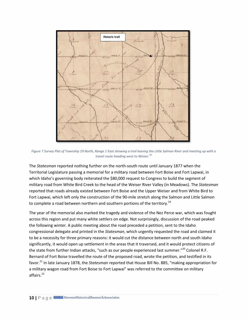
Figure 7 Survey Plat of Township 19 North, Range 1 East showing a trail leaving the Little Salmon River
and meeting up with a travel route heading west to Weiser. .................................................................... 10
Figure 8 Meadows, Idaho ca. 1897 ............................................................................................................. 12
Figure 9 Warren, Idaho ca. 1907 ................................................................................................................. 13
Figure 10 1916 Post Office Diagram for Riggins Site .................................................................................. 14
Figure 11 1901 Post Office Diagram for Riggins Site .................................................................................. 16
Figure 12 Riggins, Idaho ca. 1916................................................................................................................ 17
Figure 13 New Meadows Station ................................................................................................................ 21
Figure 14 Photo taken along the Little Salmon River showing the challenges for road construction ........ 22
Figure 15 Plowing a grade on the North-South Highway, 1922 ................................................................. 23
Figure 16 First crossing of the Little Salmon River, ca. 1925 ...................................................................... 25
Figure 17 North-South Highway, ca. 1925 .................................................................................................. 26
Figure 18 Clearing the road near Falls Creek, ca. 1925 ............................................................................... 28
Figure 19 Sections of the North-South Highway under 6 to 8 feet of water .............................................. 29
Figure 20 Rock slide and shoulder slough along the Little Salmon River ................................................... 30
Figure 21: 1931 Idaho Highway Map showing road surfacing material type. Black sections are graded
earth, yellow are crushed rock or gravel, and red are paved. .................................................................... 31
Figure 22 Landslide across U.S. 95 near Pollock, 1974 ............................................................................... 32

3 | P a g e
This report on the history of travel in the Little Salmon River corridor has been prepared as Section 106
mitigation for the loss of the historic Little Salmon River Bridge, which was replaced in 2017. Research
funding came from the Idaho Transportation Department.
Introduction
From the early 1800s, the impenetrability of Idaho’s central interior posed challenges to European
settlement and development. Characterized by rugged mountains, deep canyons, and swift rivers, west
central Idaho’s economic growth was stunted by its geography, even as more accessible areas to the
north and south, such as Lewiston and Boise, participated in the nation’s western expansion through
settlement and growth. As the century progressed, however, Idaho citizens insisted on opening this vast
interior territory, providing better access to its precious metals and fertile agricultural and grazing lands,
while connecting the state’s two political centers. Their greatest challenge was finding a suitable route.
The history of travel between north and south Idaho is a tale of difficult geography, regional competition
and grievances, native displacement and United States military forts, and Idaho’s overall economic
evolution. It is a region that was traversed first by Native Americans, then by pack trains, and eventually
by wagons and private stages that carried people, goods, and mail. Finally, in the mid-1920s, a road built
for automobiles tapped the coffers of territory, county, state, and federal governments and connected
north and south Idaho through one of the most stunning regions of the state.
In west central Idaho, mountain peaks climb to elevations of nearly 10,000 feet, while rivers course
through narrow valleys, making their way to the Snake River. It is in this rugged interior that the Little
Salmon River rises to the surface, flowing north and gathering tributary waters such as Goose Creek,
Boulder Creek, and Rapid River. The river flows north through the Meadows Valley, where today’s New
Meadows is situated, before it enters a narrow gorge at the north end of the valley, and merges with the
Salmon River approximately 50 miles downstream from New Meadows near the town of Riggins. The
Salmon River continues a northward flow, flanked by the Seven Devils mountain range and Hells Canyon
Wilderness on the west and the mountains of the Payette National Forest on the east. Many tributaries
contribute their flows from both the east and west banks, serving as conduits of the annual snowmelt
from the area’s towering peaks, before the Salmon empties into the Snake River upstream from
Lewiston.
Today this region is accessed by U.S. Highway 95 (U.S. 95). This is the story of one particular section of
U.S. 95: the stretch between what became the logging town of New Meadows and the frontier town of
Riggins. Between the two towns, the gentle grade along the Little Salmon and Salmon Rivers promised a
pathway of travel through the rugged and steep Salmon Mountains. The route, however, was fraught
with obstacles. The region’s topography slowed settlement, hampered government, restricted
commerce, and challenged engineers. For generations, people tried and failed to build a suitable road
linking north and south Idaho through this corridor. The task, first proposed in the 1870s as a possible
Fort Boise to Fort Lapwai Military Wagon Road, was not satisfactorily completed until the mid-1920s. In
the intervening half century, it was known by many names, including the Little Salmon River Wagon
Road, the Idaho-Pacific Highway, the North-South Highway, State Route 1, and eventually U.S. Highway

4 | P a g e
95. As it was built, the road influenced Idaho’s mining and recreational history, elucidating the role that
trails and roads play in shaping American history.
Figure 1 Map of Idaho showing inset of Central Idaho

5 | P a g e
Figure 2 Central Idaho
Early Travel in West Central Idaho, to 1885
Long before European Americans arrived in central Idaho, the Little Salmon River Basin lay at the heart
of the Nez Perce people’s homeland. Scholars have estimated the tribe’s aboriginal territory to have
been as large as 27,000 square miles, with a density of 5 to 12 people per 100 square miles. As one of
the Plateau tribes that was influenced by contact with Great Plains peoples after approximately 1700,2
the Nez Perce depended heavily on fishing and tuberous roots for their food base, supplemented by big
game hunting. They undertook seasonal migrations on horseback in search of food sources, moving
from river valleys in the spring to higher lands by late summer, and sometimes wintered with fellow
tribes in what is known as Montana today. The Nez Perces’ renowned horsemanship permitted them to
travel annually to the Great Plains for buffalo and antelope hunting over major trails such as Lolo Pass in
northern Idaho.3 Other trails used by the Nez Perce in their seasonal migrations crisscrossed their tribal
lands, and were noted and used by the Euro-Americans who first entered this territory in the early
1800s.
In 1846, Great Britain and the United States settled on a permanent boundary between the British
province of Canada and the United States through signing of the Oregon Treaty. This treaty ended the
joint occupation of the Pacific Northwest and created additional sovereign territory for the new country.

6 | P a g e
The territory encompassing Nez Perce land and today’s state of Idaho became a part of the United
States as a result, and the discovery of gold in 1860 accelerated its development and changed the course
of the state’s history. Several of the state’s earliest gold rushes took place on the ancestral land of the
Nez Perce tribe. Particularly notable was when prospectors struck gold in summer 1861 on lands south
of the Clearwater River in Salmon River country, and despite efforts to maintain secrecy regarding the
Florence basin discovery, a “stampede” over the mountains from the northern towns of Oro Fino and
Pierce, Idaho took place by October. By the following spring, 10,000 miners had arrived in Florence, and
during the course of the next several months, the boom moved south, first to Warrens, and then to
Idaho City and the Boise Basin.4 Soon, central Idaho was swarming with prospectors, and mining towns
sprung up to serve the new citizens.
Figure 3 Pictographs along the Little Salmon River5
Prospecting on Nez Perce land, of course, had been prohibited by the 1855 (ratified in 1859) treaty that
recognized the tribe’s historic use and occupation of the land. But stopping the white prospectors
proved to be a low priority for a country in the midst of civil war. The Nez Perce, whose country
stretched over millions of acres, depended on the lands for subsistence. But instead of defending the
original treaty and keeping the white prospectors out of these lands as originally promised, the United
States negotiated a new treaty – opposed by many tribal members – in 1863 (ratified in 1867), which
ceded 90% of the tribe’s original treaty lands to the United States, and effectively opened the lands to
the public.6
By the mid-1860s, two routes existed to get to Florence, the hotbed of mining, from the north. The first
brought travelers south from Lewiston across the Camas Prairie, over White Bird Hill, and down the
Salmon River to Slate Creek, where they turned up into the mountains to access Florence. The other
route turned east from a point much further north on the prairie near what is now the town of
Grangeville, and headed over Mount Idaho via the “Mose Milner” trail, constructed by Moses Milner in

7 | P a g e
1862.7 Both routes charged users a $1 toll per pack or saddle animal.8 Getting to Florence and the rest of
mining country from the south posed more of a challenge. From the Boise Basin or the Snake River near
Fort Boise, travelers had no way to reach the mining camps of Florence without leaving Idaho Territory
and heading into Oregon. They could get as far as Meadows1 on the west or Warrens on the east, but
had no means other than trails of ascending the final stretch through the very rugged terrain. Some of
these trails had been worn by native use and were shown on later General Land Office plats of the area.
(See Figure 4.) Meadows, then, served as a jumping off point for many travelers from the south.
Figure 4 General Land Office Survey Plat of Township 21 North, Range 1 East showing several trails in the Little Salmon Region,
including one labelled “Old Indian Trail.” 9
1 The town of Meadows, which was once referred to as “Little Salmon Meadows” or the “Meadows
Valley,” was replaced as an area of commerce by “New Meadows” when the Pacific and Idaho Northern terminated its rail line less than two miles west of the original town center in 1911. For simplicity, the town is referred to as “Meadows” until 1910 and “New Meadows” thereafter.
“Old Indian Trail”

8 | P a g e
It was in these early mining days that “Packer” John Walsh constructed a cabin (still visible today) in the
meadows near Goose Creek, a tributary to the Little Salmon River. From here, Packer John staged the
mail between the Boise Basin and Lewiston.10 In 1863, Idaho Republicans held their first territorial
convention meeting at his home, arriving by horseback with pack animals.11 This excursion probably left
little doubt in the leaders’ minds of the challenge they faced connecting the northern and southern
parts of the new territory, and roads and trails were no doubt part of the solution. By year’s end, the
new legislature, which met in Lewiston, passed an act making all roads “public,” and enabling counties
to create road districts and assess taxes.12
Figure 5 "Packer John" Cabin ca. 192213
With surging populations and the establishment of postal routes, it was becoming clear to those in the
north that they needed a reliable and passable route between Lewiston and the population centers to
the south. And, when the 1864 Territorial Legislature met in Boise instead of Lewiston, it was clear that
a competitive spirit between the two sections of the territory had developed, a rivalry that some
believed could only be cured with a physical connection between them.14 Recommendations on a route
were first made in 1872, when Washington town (in today’s Washington County) postmaster C.A. Sears
proposed a joint stock company to construct a toll road from Boise to the head of the Weiser Valley,
then down the Little Salmon River to the site of old Goff’s Ferry,15 situated at the mouth of Race Creek,
approximately six miles below the town of Pollock, near modern-day Riggins. Presumably, a traveler
could connect to other trails there and get to Florence. However, a new competition soon arose in the
quest to unite north and south Idaho, one that pitted one rough route against another. While residents
of Warrens desired the construction of a wagon road to their camp further east, which would then

9 | P a g e
connect over several mountainous divides to Florence via a rough trail, residents of the Weiser and
Meadows areas believed that traversing the Little Salmon River canyon was the more logical way to
proceed. Neither was ideal, though, thanks to the rough terrain, steep mountains and canyons, and the
raging rivers.
Territorial leaders nevertheless recognized both the importance of the link as well as the impossibility of
sparsely populated and poorly funded counties independently taking on the task of construction. In
January 1874, the Idaho Tri-Weekly Statesman first reported that the Idaho congressional delegation
was advocating a military wagon road between Fort Lapwai in the north and Fort Boise in the south,
traveling along the Little Salmon River from Goff’s Ferry, down the Weiser River valley and into the
Snake River valley to Boise. According to the paper, there was “already a trail over this whole route,”
and the paper urged the bill’s passage to improve communications between north and south Idaho and
to quiet northern rumblings regarding dividing the territory into northern and southern portions. The
1879 General Land Office surveys in the area show a trail along the Little Salmon River as well as another
trail, coming up the Weiser River Valley, and connecting with the Little Salmon trail. (See Figures 2 and
3.) Furthermore, the paper argued that branch roads to this route – including to Warrens – could be
constructed to allow for easier travel to the mining areas in the Salmon Mountains and for the
introduction of machinery to the mines, which would bring additional revenues. This road would also
shorten the route between from Boise to Lewiston from the existing 400 miles to a mere 260.16
Figure 6 Survey Plat of Township 20 North, Range 1 East showing a
trail (dotted line on right) ascending and descending the steep walls of the Little Salmon Canyon. The Little Salmon is the river at
the bottom of the canyon.17
Trail along Little
Salmon River
10 | P a g e
Figure 7 Survey Plat of Township 19 North, Range 1 East showing a trail leaving the Little Salmon River and meeting up with a
travel route heading west to Weiser.18
The Statesman reported nothing further on the north-south route until January 1877 when the
Territorial Legislature passing a memorial for a military road between Fort Boise and Fort Lapwai, in
which Idaho’s governing body reiterated the $80,000 request to Congress to build the segment of
military road from White Bird Creek to the head of the Weiser River Valley (in Meadows). The Statesman
reported that roads already existed between Fort Boise and the Upper Weiser and from White Bird to
Fort Lapwai, which left only the construction of the 90-mile stretch along the Salmon and Little Salmon
to complete a road between northern and southern portions of the territory.19
The year of the memorial also marked the tragedy and violence of the Nez Perce war, which was fought
across this region and put many white settlers on edge. Not surprisingly, discussion of the road peaked
the following winter. A public meeting about the road preceded a petition, sent to the Idaho
congressional delegate and printed in the Statesman, which urgently requested the road and claimed it
to be a necessity for three primary reasons: it would cut the distance between north and south Idaho
significantly, it would open up settlement in the areas that it traversed, and it would protect citizens of
the state from further Indian attacks, “such as our people experienced last summer.”20 Colonel R.F.
Bernard of Fort Boise travelled the route of the proposed road, wrote the petition, and testified in its
favor.21 In late January 1878, the Statesman reported that House Bill No. 885, “making appropriation for
a military wagon road from Fort Boise to Fort Lapwai” was referred to the committee on military
affairs.22
Historic trail

11 | P a g e
Although it seemed as though momentum was on the road’s side, there were detractors from the effort.
Northern Idahoans were less enthusiastic than their southern counterparts. On two occasions during
1877, the editors of The Teller, published in Lewiston, Idaho, had argued against the military wagon
road. First, the paper argued that the proposed road would be neither a military route nor a commercial
thoroughfare as there was little need for communication between the two regions of the Territory.
Northern Idaho had a natural outlet for its products via the Columbia River and southern Idaho had a
natural route for its products via the Central Pacific Railroad. The article stated that the only benefit of
the proposed road would be for localized settlement for stock raising. The article instead argued for a
road from Fort Lapwai or Camas Prairie to Warrens, in order to expand the mining potential of that
region.23 Furthermore, Lewiston complained that the military road’s proponents were motivated by the
idea of “checkmating the desire of the people of North Idaho for sloughing off to Washington
Territory.”24 In January 1878, the Statesman criticized the Lewiston Teller for seeking “to throw cold
water upon the enterprise of building a military wagon road,” noting that the Teller’s views were “short-
sighted” and “selfish” and that its proposal of an alternative road, to Warrens via Florence, was “too
absurd to merit attention.” Both mining towns could, in the Statesman’s opinion, more practically be
reached by branch roads from the proposed military road.25
The 1878 elections took the territorial representative’s attention away from obtaining congressional
funding for the road, but the Statesman urged its readers to “try, try again.”26 In April 1879, the
Statesman reported on the formation of Washington County, which, it argued, gave new life to the
military wagon road effort. The paper opined that the road would spur settlement, which was necessary
for the new county to support itself. The best way to encourage that, according to the article, was
through the construction of the military wagon road.27 The Statesman did not report on the subject
again. In 1884, Fort Lapwai was abandoned as a primary post and was turned into an outpost for Fort
Walla Walla.28
The North-South Wagon Road, 1885-1901
With the option of a military wagon road off the table, the territorial government turned to other
funding mechanisms to finance a north-south road.29 The threat of annexation and Indian uprisings
remained, as did the desire to improve access to mining districts in the Salmon River region. From 1885
to 1889, the government could find no way to adequately finance a road through the mountainous
heart of the territory. The Idaho County Free Press and the Idaho Tri-Weekly Statesman discussed the
merits of various proposals to connect Lewiston and Boise in 1887 and 1888, but it wasn’t until February
1889 that a proposal gained traction.30

12 | P a g e
Figure 8 Meadows, Idaho ca. 189731
On February 5, 1889, the Idaho Territorial Legislature passed the Mount Idaho to Little Salmon
Meadows Wagon Road Act financed by $50,000 in 20-year bonds. The act provided for state financing to
cover the cost of the route’s initial construction, but required counties to continue maintenance.32 The
press lauded the legislation, but the proposed route was controversial.33 The approved route originated
at Idaho County’s Mount Idaho, the county seat, and travelled south via Florence and Warm Springs
Resort (Burgdorf), then west to Little Salmon Meadows (Meadows) in Washington County, bypassing the
Little Salmon River entirely.2 (See Figure 2 for the town’s location.) The state intended for this route to
open more areas to settlement, connect the two regions of the territory, and provide easy transport of
military supplies and troops in the event of Indian uprisings.34 But detractors felt that this mountainous
route was far less sensible than the course of the proposed military road, which would have meandered
lower along the Little Salmon River.35 Some felt that Governor Norman Willey’s experience as a
prospector in Warren, a town more easily accessed by the mountain route, had unduly influenced the
route selection.36
2 When Adams County was established in 1911, Meadows fell within the new county’s boundaries. Meadows, now known as
New Meadows, remains in Adams County today.

13 | P a g e
Figure 9 Warren, Idaho ca. 190737
Despite the controversy, the U.S. Congress ratified the Idaho territorial wagon road legislation in May
1890. Following Idaho’s admittance to the Union on July 3, 1890, the state legislature began taking bids
for what came to be called the Mount Idaho-Little Salmon Meadows Wagon Road or hereafter the
Mount Idaho Road.38 This route traveled from Payette Lake up and over Secesh Summit, past Burgdorf,
and down to the Salmon River’s confluence with French Creek, well above the river’s confluence with
the Little Salmon. Here, it crossed the Salmon River and continued north to Florence.39 Work on this
road commenced immediately and continued to push through the ridges and valleys east of the Little
Salmon River for the next few years.40
As road construction progressed up in the mountains, advocates for the alternate route along the Little
Salmon River did not give up their cause. The Mount Idaho Road did open rough access to mining areas
(though it was incomplete), but the state still needed a road that easily facilitated settler access, and,
perhaps more importantly, would remain open even during winter and inclement weather.41 In January
1893, the State Legislature debated wagon road legislation that included a provision to connect
Meadows with Riggins via a branch road along the Little Salmon.42 Riggins itself was already connected
to Mount Idaho by the Salmon River Road. The measure passed, but required Idaho County to supply
some of the funding.43 As Idaho County stalled, the state completed surveys of new state wagon routes,
including a road that would connect the Salmon River Road with Meadows via the Little Salmon River
rather than the mountains. The State Wagon Road Commission began advertising and awarding bids for
construction of the road from Riggins south towards Meadows.44 By February 1894, however, Idaho
County still had not supplied any funds and the State Wagon Road Commission let half the contracts
go.45 Road building stopped near Pollock, leaving the canyon along the Little Salmon River still
untouched. The road gap between Meadows and Riggins had narrowed, but transportation between the
two towns still required travelers to brave an incomplete road through the mountains. [This gap is
represented on figure 2 above as the yellow area labeled “Little Salmon Canyon.”] In 1895, private
parties took it upon themselves to connect Meadows and Pollock with a trail along the surveyed Little
14 | P a g e
Salmon River wagon route. The trail allowed travel along the west bank of the Little Salmon River (see
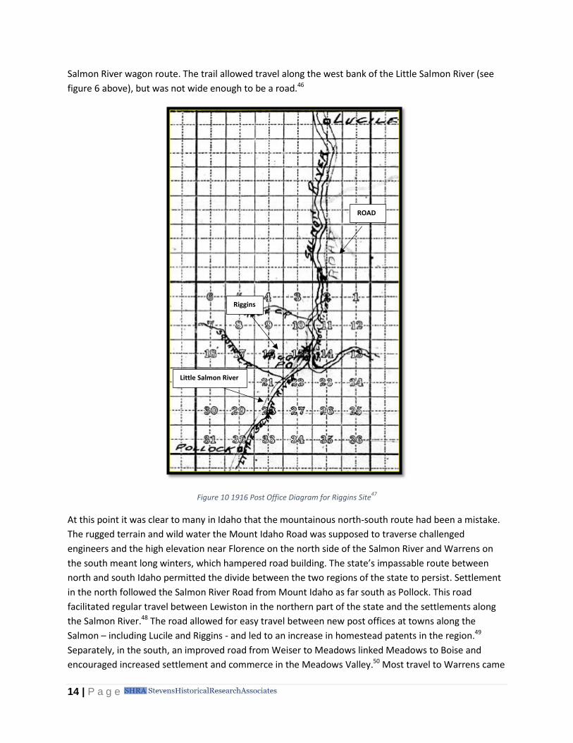
figure 6 above), but was not wide enough to be a road.46
Figure 10 1916 Post Office Diagram for Riggins Site47
At this point it was clear to many in Idaho that the mountainous north-south route had been a mistake.
The rugged terrain and wild water the Mount Idaho Road was supposed to traverse challenged
engineers and the high elevation near Florence on the north side of the Salmon River and Warrens on
the south meant long winters, which hampered road building. The state’s impassable route between
north and south Idaho permitted the divide between the two regions of the state to persist. Settlement
in the north followed the Salmon River Road from Mount Idaho as far south as Pollock. This road
facilitated regular travel between Lewiston in the northern part of the state and the settlements along
the Salmon River.48 The road allowed for easy travel between new post offices at towns along the
Salmon – including Lucile and Riggins - and led to an increase in homestead patents in the region.49
Separately, in the south, an improved road from Weiser to Meadows linked Meadows to Boise and
encouraged increased settlement and commerce in the Meadows Valley.50 Most travel to Warrens came
Little Salmon River
Riggins
ROAD

15 | P a g e
via a travel-worthy road from Meadows rather than from the north. In effect, north Idaho extended as
far south as Pollock, and south Idaho extended as far north as Meadows. Despite improved
infrastructure, the state was more divided than ever. During this time, the Idaho Daily Statesman
repeatedly published articles arguing that Idaho was losing emigrants to Washington and Oregon by not
having a viable north and south route.51
Continued postponement by a sluggish legislature and ambivalent constituents did not stop
adventurous travelers from making the connection between north and south via the Little Salmon.
Despite an 1897 bill to appropriate money to the cause, the Little Salmon River branch of the State
Wagon Road was indefinitely postponed amidst arguments that the people who would benefit most
from it had not contributed to the road financially, nor had they communicated their desire for the road
to the Legislature.52 Meanwhile, travelers who braved unimproved travel through the Little Salmon
Canyon were thrilled by its beauty and its danger. In summer 1899, E.W. Johnson, proprietor of Boise’s
Overland Hotel, completed a trip along the Little Salmon River route. Johnson described the canyon as
one of the most scenic and picturesque in the United States, yet: portions of the trail alongside the river
were, in Johnson's words, “very high above the river and exceedingly rough and dangerous. The bodies
of five men had been found in the eddy below, also several dozen pack animals, some with their packs
still on, that had gone over the precipice.” Johnson opined that this section should have a state wagon
road and connect north to south Idaho, and it would have a “great future.”53
Finally, in January 1901, the road issue moved forward again with Whitebird’s Statehouse
Representative Andrew W. Moore’s introduction of a bill to appropriate $12,000 for the completion of
the Little Salmon River Wagon Road.54 After much discussion about the misuse of past wagon road
appropriations throughout the state and the need for more accountability on the part of road
commissioners, the Idaho House and Senate passed the bill,55 and Governor Frank Hunt signed it into
law on March 6, 1901.56
After such a delayed start, the government wasted little time making the road a reality. Just 11 days
after signing the Little Salmon bill, Governor Hunt appointed three men to the Little Salmon Wagon
Road Commission, all three from areas where the road would traverse or to which it would connect.
One – R.E. Lockwood – was the editor of the Weiser Signal. It was their responsibility to fill contracts for
the road work up to $10,000.57 The first contract for the work was assigned to W.H. Harkin of Weiser for
construction of the southernmost six miles of work, including all the heavy rock work in the canyon; the
two bridges over the Little Salmon River; the bridges over Rapid River and Boulder Creek; and a section
of the road across a bank which was constantly slipping toward the river. The contract with Harkin also
granted him three more miles of heavy work to be determined by the commissioners. His total bid was
for $9,200, leaving just $800 in the budget for the remaining 18 miles of work. Despite this imbalance,
the commission accepted Harkin’s bid under the rationale that the heaviest and most difficult work
would be completed, including the bridges over what were unfordable rivers and the “heavy work,”
which would leave the road passable even if the remaining work was not done.58
As Harkin began the challenging work of opening the canyon and building bridges, it seemed possible
that budget would, indeed, prevent the official completion of the road. The Statesman, however, was
not the only voice advocating for a strong north-south link for increasing immigration and settlement.
16 | P a g e
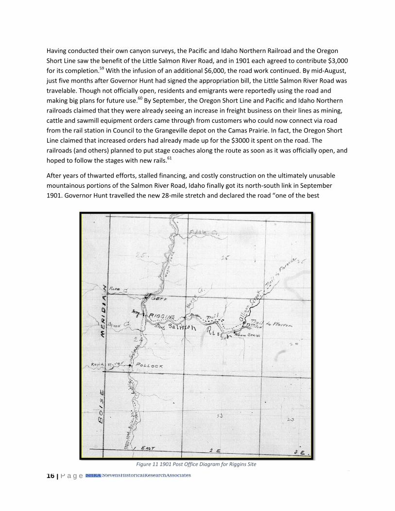
Having conducted their own canyon surveys, the Pacific and Idaho Northern Railroad and the Oregon
Short Line saw the benefit of the Little Salmon River Road, and in 1901 each agreed to contribute $3,000
for its completion.59 With the infusion of an additional $6,000, the road work continued. By mid-August,
just five months after Governor Hunt had signed the appropriation bill, the Little Salmon River Road was
travelable. Though not officially open, residents and emigrants were reportedly using the road and
making big plans for future use.60 By September, the Oregon Short Line and Pacific and Idaho Northern
railroads claimed that they were already seeing an increase in freight business on their lines as mining,
cattle and sawmill equipment orders came through from customers who could now connect via road
from the rail station in Council to the Grangeville depot on the Camas Prairie. In fact, the Oregon Short
Line claimed that increased orders had already made up for the $3000 it spent on the road. The
railroads (and others) planned to put stage coaches along the route as soon as it was officially open, and
hoped to follow the stages with new rails.61
After years of thwarted efforts, stalled financing, and costly construction on the ultimately unusable
mountainous portions of the Salmon River Road, Idaho finally got its north-south link in September
1901. Governor Hunt travelled the new 28-mile stretch and declared the road “one of the best
Figure 11 1901 Post Office Diagram for Riggins Site

17 | P a g e
investments the state ever made.”62 The road was more than a north-south corridor helping to hold the
state together politically; it was also a passage for settlement, an inducement to miners for increased
prospecting, a channel for mail and travelers, and a scenic wonder.63 Road commissioners were so
pleased with their feat that they planned to issue a commemorative “pass” as a souvenir marking the
opening of the long-awaited Little Salmon Wagon Road. The pass was engraved to the holder, “in
consideration of his very worthy qualities” and was issued with several conditions attached, including:
The person accepting this free pass over the Little Salmon river wagon road assumes all
risk of over-enthusiasm or exaltation of soul on beholding the inspiring scenery along
the route. He will not hold the giver of this pass responsible for excess of joy and
exhilaration while he, the holder, is viewing the towering mountains, the inviting
forests, the dashing cataracts and foaming waterfalls, the moss-grown cliffs, the limpid
streams and soothing, shaded parks along the way.64
The pass celebrated the road’s completion, but it also suggested the road’s bright future. The Little
Salmon River Wagon Road was completed just as a new technology, the automobile, entered the scene.
Americans’ love affair with the automobile soon transformed expectations for roads. The freedom and
independence offered by the new technology led to an increase in recreational travel and demand for
good roads that could lead them into the great outdoors.
Figure 12 Riggins, Idaho ca. 191665

18 | P a g e
A Highway is Born, 1902-1924
A flurry of settlement followed the Little Salmon River Road’s completion. In the year following its
opening, the General Land Office finished surveying the townships in the canyon, allowing settlers to file
land claims along a greater stretch of the river.66 A regular stage line and daily mail service also
facilitated travel between Grangeville and Meadows.67 With homesteaders, stage lines, and mail wagons
putting the road to use, it fell into disrepair. In this, it was not alone. Residents and the state
government recognized the challenge of maintaining the new state wagon roads, and despite legislative
efforts in 1905 to pass this role on to counties and local road districts, little came of the measure. Many
counties lacked the tax base, the knowledge, and the political will to maintain roads. As a result, Idaho
established a State Highway Commission in 1907 to take charge of the maintenance of all roads, bridges,
and trails that had been constructed with state funds. Nevertheless, this commission did not have the
political backing and financing to move forward with any major maintenance projects.68 As the state
equivocated over how to maintain its roads, the Little Salmon River Road’s condition continued to
deteriorate. In the years since construction, the road had become barely passable through sections of
tortuous canyons and steep grades, some of which exceeded 30 percent, and a large portion of the road
was entirely submerged during periods of high water.69 The road was certainly in no state to carry the
growing number of automobiles entering Idaho.
In 1913, Idaho boasted 2,000 registered cars, while the total across the United States was one million.70
To ready Idaho for the automobile, the Idaho State Legislature finally supported the new State Highway
Commission by giving it clearly defined responsibilities and reliable funding. In its infancy, the State
Highway Commission set about defining the most important travel corridors in the state on which to
focus its maintenance and construction efforts. Although the Little Salmon River Road had been
completed for only 12 years, the state placed it on the list tagged with “an urgent need” for
improvement.71 Though they knew maintenance and repair would be difficult, the State Highway
Commission nonetheless recognized the critical nature of maintaining an intra-state passageway
between Boise in the south and Lewiston in the north.72 The state planned to share road costs with the
counties through which the roads passed, and expected the counties’ contributions to come in the form
of grading and constructing culverts.73
Not surprisingly, road work progressed slowly on the stretch of road along the Little Salmon River. The
same topography that had severely hampered initial construction continued to challenge the engineers
of the early 20th century. In 1913 and 1914, State Highway Commission surveyors delineated a route for
800 miles of what they called the “North-South Highway,” the “Idaho Pacific Highway,” or simply “State
Route No. 1,” including the 70-mile stretch between the recently developed rail station town of New
Meadows3 and Whitebird through the Little Salmon River and Salmon River Canyons. The strenuousness
of surveying the actual route between the two towns was such that the crews averaged less than a mile
of survey a day. The route presented engineering problems that made it difficult to hold the maximum
grade to 5%. Crews determined that a few areas might require a grade of 6-8% to make financing the
3 The Pacific and Idaho Northern Railroad reached the Meadows area in 1911. Rather than take the rail
line all the way into Meadows, the company terminated its line about 2 miles west of the town at a new townsite it called New Meadows. Over time, Meadows commerce moved to New Meadows.

19 | P a g e
road possible.74 While the survey crews labored through the Little Salmon region, the State Highway
Commission itself spent much of 1914 in meetings with counties to negotiate the highway’s funding.75
The inter-jurisdictional meetings revealed that the financial difficulties that were responsible for the
road’s sluggish start would again rear their heads. While settlement had certainly increased following
the completion of the wagon route, improving both Adams and Idaho Counties’ tax bases, they
nevertheless remained sparsely populated and burdened by huge parcels of land that were tied up in
federal forest reserves. The tax base remained so low and the difficulty of the work so high that the
state could see no way of financing the road through a split of state and county funds alone.76 The State
Highway Commission made several funding suggestions, including asking the Forest Service to
contribute, as well as passing a resolution that recommended using convict labor as a way to reduce
costs.77 Even with these contingencies, the State Highway Commission estimated that the cost of
grading and widening the road between Weiser and Lewiston (which included the section between New
Meadows and Whitebird) would require $100,000 from the state and $55,000 from the counties
through which it passed.78
In 1915, the financial problems facing the North-South Highway were, at least temporarily,
insurmountable. In March, Idaho's new Democratic governor, Moses Alexander, vetoed the bill that
would have purchased road equipment for use by convict laborers.79 A month later, the Idaho Free Press
reported that Adams County was not prepared to vote on a bond issue for building the highway and
Idaho County did not think that it could bear the expense of its contribution. Work on the highway
slowed to a virtual halt (just 50 convict laborers conducted rock work on the road, by hand, to the north
in the Whitebird area) until commissioners could find the funds necessary to proceed.80 The public was
not happy.81
As the automobile’s growing place in American life was revealed, the need for federal government
assistance and guidance on road planning and construction grew more evident. As such, the Federal Aid
Road Act of 1916 and recognition amongst state officials that certain roads in Idaho deserved attention
regardless of financial contributions from counties, picked the North-South Highway back up again. The
1916 legislation was the first federal aid program for financing highway construction, and provided
matching funds of up to 50% for the construction and improvement of roads used for "free rural mail
delivery."82 Idaho's share of the federal funding was approximately $907,000 during a five-year period
ending June 30, 1921. The State Highway Commission used this infusion of funds as leverage in arguing
for an increase in state funding for road construction. In its 1916 report, the State Highway Commission
recommended that the state be liberal in providing funds for roads that added great value to the state
both at the present time and into the future. The report noted that the section of the North-South
Highway between New Meadows and Whitebird was an excellent example of a highway that the state
should invest heavily in.83
With the public’s support, the State Highway Commission’s interest, and federal funding available, it
seemed possible that the North-South Highway would progress quickly.84 But the path forward
remained long. Though grading and bridge construction did indeed move forward on certain portions of
the highway in the 1917-1918 biennium, the heart of the road stood idle. Following difficult survey work
conducted by two crews in the summer and fall of 1917, the State Highway Commission estimated that

20 | P a g e
the stretch of road along the Little Salmon and Salmon Rivers between New Meadows and Whitebird
was going be the most costly and grueling highway work in the state. The State Highway Commission
estimated that grading work in this canyon might run as high as $45,000 to $50,000 per mile.85 By 1919,
two of the most challenging segments of the North-South Highway remained incomplete, including the
stretch between New Meadows and Pollock. These segments were home to sheer canyon walls that
dropped to roaring rivers and left little to no space for travel.

21 | P a g e
Little Salmon Railroad In addition to constant discussion over the potential road, rail was another possibility considered by territorial leaders and private enterprise in the late 19th and early 20th centuries. While north and south Idaho were eventually connected by a road for automobiles, a north and south rail line was never completed, despite early indications to the contrary. As early as 1899, the Pacific and Idaho Northern Railroad (PIN) saw an opportunity to meet a transportation need and decided to take a stab at a north-south connection. On August 19, 1899, the Idaho Daily Statesman reported that the PIN had surveyed a railroad route north from Meadows, down the canyon of the Little Salmon, over the Salmon River and north to the Camas Prairie.86 In 1911, the PIN rail line reached New Meadows, connecting it with Weiser and increasing traffic on the stage line that ran from Meadows to Grangeville.87 The following year, the PIN filed plats showing the intent to carry their line from New Meadows down the Little Salmon Canyon as far as Riggins. Idaho’s Public Utilities Commission was in favor of the rail line from New Meadows through to Lewiston. The Statesman quoted a Commission report in 1913: "a rich country would be opened and developed by the construction of such a [rail]road." Connecting to Lewiston would provide the southern part of the state with access to "Idaho's only seaport," and spur "great development" in the "rough and precipitous" country along the Snake and Salmon River Canyons. In fact, the Commission appeared to favor the construction of a rail line over the construction of a road. In the 1913 report, the Commission noted its support for improvement of the state highway between New Meadows and Grangeville wherever it could be done "without conflicting with the location of the proposed railroad."88 In the following years, however, the scale began tipping in favor of the automobile. Between 1914 and 1915, the number of vehicles registered in Idaho jumped 111% from 1,263 to 3,728.89 Each year thereafter the number of autos climbed and support for the railroad gradually dwindled. While there was public support for a rail line through the remainder of the decade,90 by 1920 the project had fallen out of favor with the railroads. Construction down the Little Salmon Canyon would cost at least “one hundred thousand dollars per mile” and would face high maintenance costs, the railroads argued. Moreover, the rail line was, according to the railroad companies, “not required in the interest of public convenience or necessity.” Rail lines served both northern and southern Idaho and the two regions were connected by rail through Washington and Oregon.91 The North-South Highway became the link that connected Lewiston and Boise.
Figure 13 New Meadows Station
92
22 | P a g e
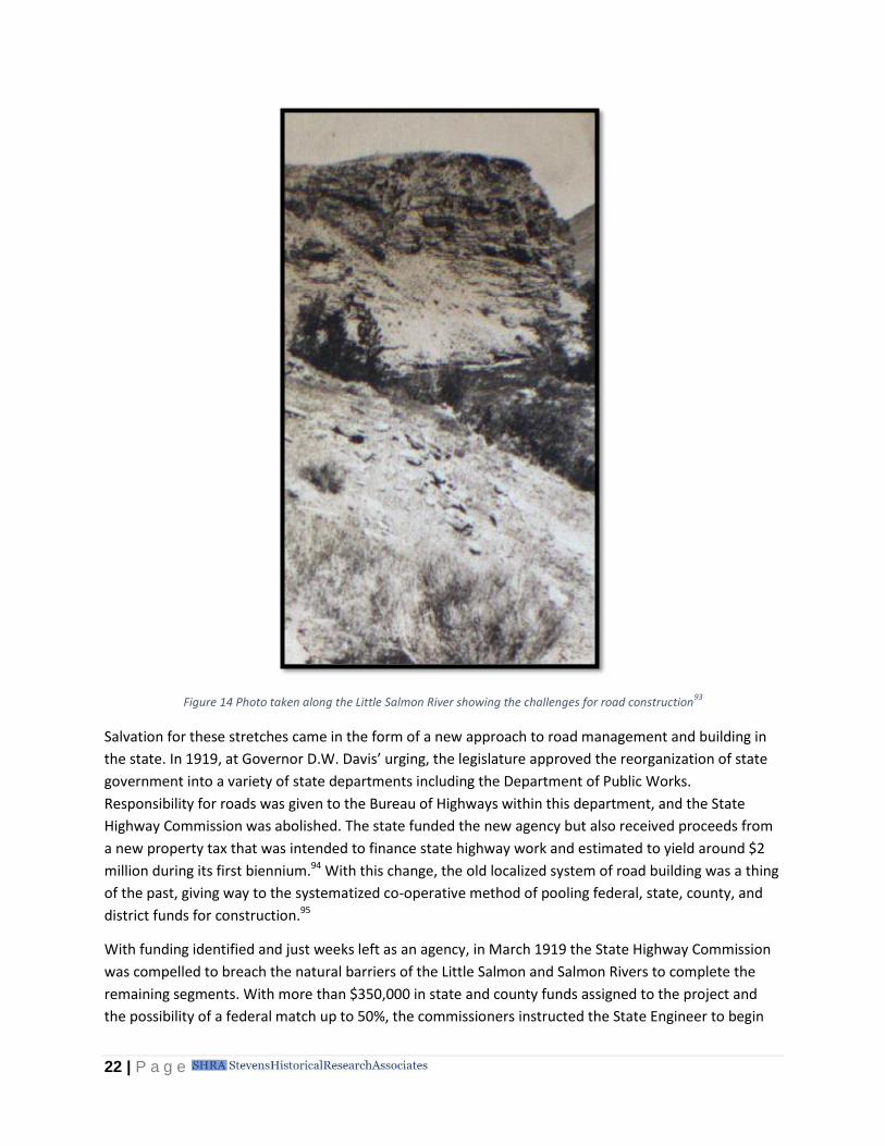
Figure 14 Photo taken along the Little Salmon River showing the challenges for road construction93
Salvation for these stretches came in the form of a new approach to road management and building in
the state. In 1919, at Governor D.W. Davis’ urging, the legislature approved the reorganization of state
government into a variety of state departments including the Department of Public Works.
Responsibility for roads was given to the Bureau of Highways within this department, and the State
Highway Commission was abolished. The state funded the new agency but also received proceeds from
a new property tax that was intended to finance state highway work and estimated to yield around $2
million during its first biennium.94 With this change, the old localized system of road building was a thing
of the past, giving way to the systematized co-operative method of pooling federal, state, county, and
district funds for construction.95
With funding identified and just weeks left as an agency, in March 1919 the State Highway Commission
was compelled to breach the natural barriers of the Little Salmon and Salmon Rivers to complete the
remaining segments. With more than $350,000 in state and county funds assigned to the project and
the possibility of a federal match up to 50%, the commissioners instructed the State Engineer to begin

23 | P a g e
letting contracts for the most challenging road stretches in the state.96 The Federal Bureau of Roads
confirmed in April that it would match half of the project funding through the "worst sections of the
road between New Meadows and Whitebird," under Federal Aid Project 9. With that, bidding for the
project began.97 That same month, the new Bureau of Highways took over the state’s roads.98
The Department of Public Works received four bids on August 23, 1919 from vendors wishing to
construct the 31.5 miles of road between New Meadows and Whitebird. However, none of the bids
were affordable; the lowest bid amounted to $779,758.44, nearly $100,000 more than the $680,000 in
available funds. In response, the Bureau of Highways collaborated with the contractor to reduce the
project scope, eliminating construction on certain sections of the road.99 At long last, in fall 1919, work
on the Little Salmon and Salmon River portions of the road began.
Figure 15 Plowing a grade on the North-South Highway, 1922100
From 1920 through 1923, stretches of the road between New Meadows and Whitebird were widened
and graded. Contractors covered portions of the road with crushed rock and constructed steel and
concrete truss bridges.101 Even as the road was constructed it had to be reconstructed as rock slides,
water damage, and deep rutting continued to present new obstacles.102 Funding challenges continued,
as well. The initial federal funding for the project ended in 1921, but a new Federal Highway Act that
same year again infused money into the North-South Highway project. Federal Aid Project 9 was
reopened, and Federal Aid Project 51 filled in needed construction gaps along the New Meadows to
Riggins corridor.103
Though far from complete, by 1921 the road was passable enough in good conditions to allow the first
auto-stage to travel between Grangeville and New Meadows.104 Private automobiles were driving it
regularly by 1923, and on July 9, 1924 the North-South Highway was officially dedicated at a ceremony
in Grangeville.105 At the ceremony, State Highway Department official Captain E.F. Ayers “presented”
the highway to Governor C.C. Moore, who stood as representative of the public. In speeches marking
the event, officials adopted a resolution to continue supporting road improvements.106 Despite its

24 | P a g e
dedication, the “highway” was primarily dirt and did not meet the road standards of the day through
many stretches including the Little Salmon Canyon.107 One 23-mile segment between New Meadows
and Grangeville referred to as the “neutral zone” still had not been touched by road engineers.108
Although the highway needed more improvements to adequately facilitate the travel and commerce
that promoters dreamed of, the opening was still a victory—a connection between north and south
Idaho and a remarkable engineering accomplishment.
25 | P a g e
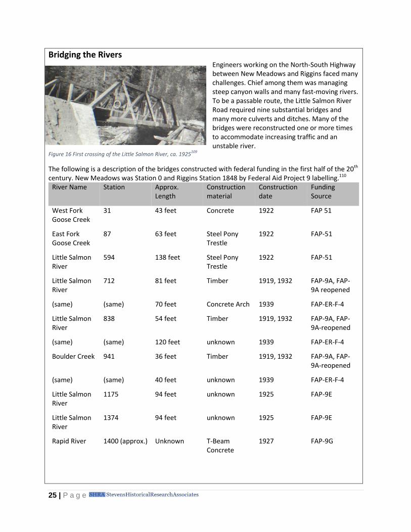
Bridging the Rivers Engineers working on the North-South Highway between New Meadows and Riggins faced many challenges. Chief among them was managing steep canyon walls and many fast-moving rivers. To be a passable route, the Little Salmon River Road required nine substantial bridges and many more culverts and ditches. Many of the bridges were reconstructed one or more times to accommodate increasing traffic and an unstable river.
Figure 16 First crossing of the Little Salmon River, ca. 1925109
The following is a description of the bridges constructed with federal funding in the first half of the 20th century. New Meadows was Station 0 and Riggins Station 1848 by Federal Aid Project 9 labelling.110
River Name Station Approx. Length
Construction material
Construction date
Funding Source
West Fork Goose Creek
31 43 feet Concrete 1922 FAP 51
East Fork Goose Creek
87 63 feet Steel Pony Trestle
1922 FAP-51
Little Salmon River
594 138 feet Steel Pony Trestle
1922 FAP-51
Little Salmon River
712 81 feet Timber 1919, 1932 FAP-9A, FAP-9A reopened
(same) (same) 70 feet Concrete Arch 1939 FAP-ER-F-4
Little Salmon River
838 54 feet Timber 1919, 1932 FAP-9A, FAP-9A-reopened
(same) (same) 120 feet unknown 1939 FAP-ER-F-4
Boulder Creek 941 36 feet Timber 1919, 1932 FAP-9A, FAP-9A-reopened
(same) (same) 40 feet unknown 1939 FAP-ER-F-4
Little Salmon River
1175 94 feet unknown 1925 FAP-9E
Little Salmon River
1374 94 feet unknown 1925 FAP-9E
Rapid River 1400 (approx.) Unknown T-Beam Concrete
1927 FAP-9G

26 | P a g e
Figure 17 North-South Highway, ca. 1925111
As soon as visitors from outside the region began using the route, their reports of the spectacular scenic
beauty of the road also created forward momentum on the project. The Little Salmon River was long a
physical obstacle, but from the first reports of non-native travelers using the trail alongside the river, to
those who travelled it by wagon stage, and finally, to those who travelled it by auto, the route was
stunning enough to be worth the trouble. Florence Campbell, who travelled the route by stage in 1914,
described Meadows Valley as the Gem of the Mountains, with its emerald valley set against forests of
pine and fir trees. As she headed north, she described the Little Salmon Canyon, where the road
narrowed. With a rock cliff to one side, and the powerful river on the other, the road abounded with
beautiful views: “The scene is far beyond description: you look up at the frowning cliffs, you look beside
you at the lovely roses and syringas in full bloom….You look down at the river, rushing and foaming and
beating against the rocks in its bed, throwing up glittering spray and swirling into eddies and
whirlpools.”112 Truly, Campbell argued, the road deserved its title, “The Scenic Route of Idaho.”113 Idaho
promotional travel articles of the time agreed, claiming that the link between Whitebird and New
Meadows on the “North-South Highway” would rival the famous Columbia River Highway for scenic
grandeur and difficulty of location.114

27 | P a g e
Caught up in the scenic automobile touring frenzy that was sweeping the country,115 photographer and
travel writer Otto Jones set out in summer 1919 to explore the Little Salmon River segment of the
North-South Highway in his automobile. He published his photos and his memories of the trip in the
Idaho Daily Statesman in September, recalling that the trip was so rough, “one has that feeling of relief
and satisfaction as the result of an arduous task completed.” Despite the jostling he experienced, Jones
loved the adventure: “It is like driving into a wilderness to be lost in its vastness for a period and then to
emerge again miles away into a land totally different, where one almost expects to hear a new and
strange language spoken.” Jones spotted fishermen and campers along the drive, who were clearly
enjoying the scenery and hot springs of the Little Salmon Canyon.116 Like Florence Campbell and others
who travelled the road, Jones believed it was poised to be a major destination route once it was
improved: “the Salmon River route with a real highway will be one of the most scenic drives in the
northwest.” He could see, however, that there would be endless challenges with building and
maintaining the road. He was held up on his own drive by washouts on the road, and he could see that
“with such great expanses of steep, unbroken watersheds, this entire country is more or less in a
position to court disaster at any time in the neighborhood of its ravines or depressions from
waterspouts or excessive rains.” Still, he argued, Idaho deserved its own north and south route and he
was enthusiastic about the survey work and road building he encountered.117
Jones was not alone. An increasing number of travelers began braving the road, and their reports
revealed a North-South Highway in need of improvements. The stretch along the Little Salmon River was
the worst: “There are many places where the road is just barely wide enough for a car, grades of 40 to
50 per cent [sic] with a ‘jack-knife turn’ at the top and an equally steep grade coming down again,”
wrote one tourist in a letter to the Idaho Daily Statesman urging other tourists not to travel the road in
1921.118 Former editor of the Lewiston Tribune, A.H. Alford, concurred. He argued in a 1923 Statesman
article that the effort to improve the highway from its wagon road origins had actually had the opposite
effect. Engineer’s attempts to reduce grades and re-route troublesome sections through the Little
Salmon and Salmon River region actually made the road less complete than it had been as a wagon road
and “cut off the north from the south and rendered unavailable to the tourist the 180 miles of ‘perfect
road’ from Boise to the mountain country on one side and the similarly good road from Lewiston to
Whitebird on the other.”119 With the North-South Highway officially opening in 1924 and the increasing
popularity of automobile-based nature vacations, the Bureau of Highways anticipated that travel along
the North-South Highway would continue to increase rapidly.120 To accommodate the volume of traffic,
however, the Bureau needed to spend more resources on the challenging New Meadows to Whitebird
corridor, a region that some had started to call “the road of no return.”121
A Road Worth Travelling, 1924-1960s
The remainder of the 1920s saw additional and significant improvement to the North-South Highway,
particularly in the Little Salmon and Salmon River regions, using a combination of federal, state and
county money. Indeed, work had been constant since the 1919 effort to complete the road through this
section, despite the dedication ceremony and sustained financial strain. Just as in previous eras, the
Bureau of Highways continued to have difficulty finding large sums of money at one time and instead
28 | P a g e
worked on the road on a segment-by-segment basis, often under county direction, as funding came
through.122
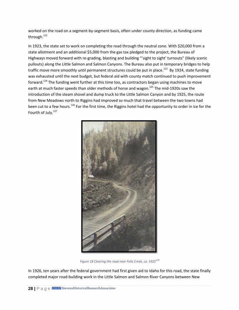
In 1923, the state set to work on completing the road through the neutral zone. With $20,000 from a
state allotment and an additional $5,000 from the gas tax pledged to the project, the Bureau of
Highways moved forward with re-grading, blasting and building “’sight to sight’ turnouts” (likely scenic
pullouts) along the Little Salmon and Salmon Canyons. The Bureau also put in temporary bridges to help
traffic move more smoothly until permanent structures could be put in place.123 By 1924, state funding
was exhausted until the next budget, but federal aid with county match continued to push improvement
forward.124 The funding went further at this time too, as contractors began using machines to move
earth at much faster speeds than older methods of horse and wagon.125 The mid-1920s saw the
introduction of the steam shovel and dump truck to the Little Salmon Canyon and by 1925, the route
from New Meadows north to Riggins had improved so much that travel between the two towns had
been cut to a few hours.126 For the first time, the Riggins hotel had the opportunity to order in ice for the
Fourth of July.127
Figure 18 Clearing the road near Falls Creek, ca. 1925128
In 1926, ten years after the federal government had first given aid to Idaho for this road, the state finally
completed major road-building work in the Little Salmon and Salmon River Canyons between New

29 | P a g e
Meadows and Riggins. The Bureau of Highways spent more than $100,000 to eliminate the steepest
grades, build new roadbed along the river, and construct two new bridges over the Little Salmon
River.129 The road remained dirt throughout its length,130 but was seeing increasingly heavy traffic.131 The
Bureau of Highways estimated that between 100 and 125 cars a day travelled the stretch between New
Meadows and Riggins.132 The Bureau of Highways held heated debates over the naming of U.S. highways
during the mid-1920s, and ultimately decided on a numbering system in which north-south highways
would be given odd numbers.133 As a result, in 1926, the North-South Highway officially became U.S. 95,
a part of the federal highway system.134
Work in the canyons was far from done after the initial road-building ended. As it had since the first
road entered its canyon, the Little Salmon River continued to present enormous obstacles to the Bureau
of Highways and the affiliated Highway Districts. A flood in the canyon in spring 1926 put sections of U.S.
95 in the Little Salmon Canyon under six to eight feet of water,135 while rock and landslides repeatedly
blocked stretches of the highway until they could be dug out.136 The earth surface of the road meant
that every time it rained, the road became slippery and deep ruts formed in the wake of every passing
car.137 Ice and snow made the road “practically impassable in winter.”138 Bridges needed near-constant
repair.139 The cash-strapped Bureau of Highways could do little to improve the road during the
remainder of the 1920s and left the maintenance of “unimproved” roads, including most of U.S. 95, to
the highway districts.140
Figure 19 Sections of the North-South Highway under 6 to 8 feet of water141

30 | P a g e
Figure 20 Rock slide and shoulder slough along the Little Salmon River142
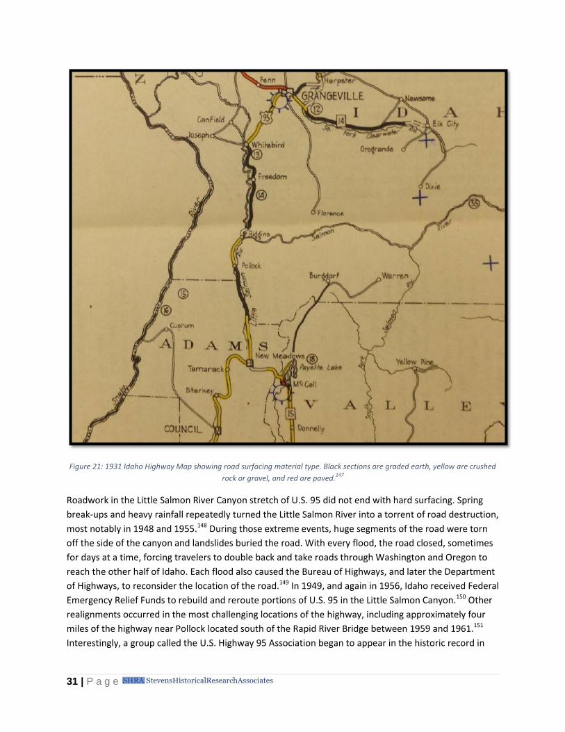
By the end of the 1920s, most of U.S. 95 between New Meadows and Riggins remained earth-surfaced.
Despite the wide availability of bituminous treatments by 1928, Idaho was slow to implement the hard
surface outside of major population centers. The Village of New Meadows funded the half the cost of
oiling the road in the town’s vicinity,143 and crushed rock covered the road north to the Idaho/Adams
County line,144 but most of the road did not see gravel until the mid-1930s.145 Bituminous cover finally
reached the New Meadows to Riggins corridor at the end of the 1930s but the road was not completely
surfaced until the 1940s.146
31 | P a g e
Figure 21: 1931 Idaho Highway Map showing road surfacing material type. Black sections are graded earth, yellow are crushed
rock or gravel, and red are paved.147
Roadwork in the Little Salmon River Canyon stretch of U.S. 95 did not end with hard surfacing. Spring
break-ups and heavy rainfall repeatedly turned the Little Salmon River into a torrent of road destruction,
most notably in 1948 and 1955.148 During those extreme events, huge segments of the road were torn
off the side of the canyon and landslides buried the road. With every flood, the road closed, sometimes
for days at a time, forcing travelers to double back and take roads through Washington and Oregon to
reach the other half of Idaho. Each flood also caused the Bureau of Highways, and later the Department
of Highways, to reconsider the location of the road.149 In 1949, and again in 1956, Idaho received Federal
Emergency Relief Funds to rebuild and reroute portions of U.S. 95 in the Little Salmon Canyon.150 Other
realignments occurred in the most challenging locations of the highway, including approximately four
miles of the highway near Pollock located south of the Rapid River Bridge between 1959 and 1961.151
Interestingly, a group called the U.S. Highway 95 Association began to appear in the historic record in

32 | P a g e
the late 1950s, coming before the State Highway Board to advocate for work on various segments of the
road.152
Figure 22 Landslide across U.S. 95 near Pollock, 1974153
Still, the difficulties continued. Even though the State Highway Commission, followed by the Bureau of
Highways, had been working on the North-South Highway in the Little Salmon Canyon more or less
continuously since 1913, with brief pauses when funding ran dry, the road consistently failed to meet
the standards of the time. At first the steep grades and narrow lanes frustrated drivers, then it was the
dirt roads that persisted long past the time that others roads were surfaced with pavement. In the
1960s, the slow speeds and winding route allowed Cecil Andrus to run for governor on the issue of
converting the “goat trail” of U.S. 95 into a proper highway.154 While the issues have changed, the root
of the difficulties has remained the same. In order to connect north and south Idaho, a road had to
travel through the rugged heart of the Salmon Mountains. The Little Salmon and Salmon Rivers provided
the natural route to accomplish that task, but presented challenges of their own. From the first wagon
road to today’s modern highway, the progress of the highway has always been tied to the geography
that surrounds it and the funding required to overcome the same.

33 | P a g e
Appendix A: Meadows to Riggins Travel Timeline
Prehistory
Nez Perce traveled throughout the Little Salmon River Basin, migrating seasonally for their food
supply.
1855 The first Nez Perce treaty was signed.
1860 Prospectors discovered gold in Idaho, and Florence became a town of 10,000 overnight.
1861 Negotiations with Nez Perce took place at Slate Creek regarding use of their reservation for
mining
1862 Population at Florence peaked, and settlers left to prospect in Boise Basin or Warrens.
Residents of Florence and others had built two trails into the settlement. One trail travelled
from Camas Prairie to White Bird and Slate Creek and then up into the mountains. The other
travelled from Mount Idaho across the mountains to Florence, called the Mose Milner Trail.
1863 A post office was established at Slate Creek.
The first Idaho Territorial Legislature was held in Lewiston and established public roads.
1864 The Idaho Territorial Legislature was held in Boise instead of Lewiston.
A trail that ran between Lewiston and Idaho City followed the Salmon River, cut through the
Meadows area and then headed down the Payette. The first cattle drive used the trail in 1865.
The trail appeared on the General Land Office Survey plat of the Meadows area surveyed in
1879.
1871 The postmaster in Washington County proposed a toll road to the head of Weiser Valley, and
then down the Little Salmon River to Goff’s old ferry, near present day Riggins.
1872 The Idaho Territorial Legislature asked U.S. Congress for a military wagon road between Fort
Lapwai in the north and Fort Boise in the south, to run along the Little Salmon River. The
requests were repeated through 1879 with no results.
1874 Travel by horseback or foot on any given route remained the only viable means of getting from
north to south Idaho and the route over the mountains was challenging in winter. Residents
recognized that a route down the Little Salmon Canyon would reduce the impact of snow on
travel.
1875 The Idaho Territorial Legislature authorized a wagon road to travel from White Bird up the
Salmon River as far as John Day’s Creek, downstream of the Little Salmon and Salmon Rivers
confluence.
1878 The first white settlement of Meadows began, though the area was not yet connected to the
rest of the state by reliable travel routes.

34 | P a g e
1879 The U.S. General Land Office began surveying the lands in the Meadows area.
1881 The Idaho Territorial Legislature prohibited new toll road franchises, and declared all publicly
used thoroughfares to be county roads.
1883 Calvin White submitted an application to establish a post office at Meadows. Settlement was
increasing rapidly in the area as a wagon route from Weiser developed.
1885 The Territorial Legislature began discussing a north/south wagon road but did not know how to
finance it.
1889 The Territorial Legislature passed the Mount Idaho to Little Salmon Meadows Wagon Road Act,
which used bond issues for financing. The route was to travel over the mountains, following the
Mose Milner Trail, rather than down the Little Salmon River Canyon.
1890 Idaho is admitted to the Union as a state on July 3.
1892 The Pollock Post Office was proposed near the mouth of the Rapid River.
1893 The Idaho Legislature passed the State Wagon Roads Act, authorizing the establishment of a
system of state wagon roads and providing for construction of a branch wagon road to travel
down the Little Salmon River, linking Meadows with the Mount Idaho Road at Slate Creek. It
required Idaho County to fund part of the road.
1894 Idaho County failed to raise enough money for its contribution to the Little Salmon River Branch
Road and the project stalled. Routes were surveyed, however.
1895 Private groups completed a trail along the Little Salmon River to connect Meadows with Pollock
along the surveyed route of the Little Salmon River Branch Road.
1901 The Idaho Legislature passed a bill to appropriate funds to complete the construction of the
Little Salmon River Branch Road. The north-south road over the mountains was completed as
was the Little Salmon River Branch Road.
A post office opened in Riggins.
1903 The U.S. General Land Office finished surveying the lands along the Little Salmon River for
settlement.
Settlement picked up in the townships north of Meadows along the Little Salmon and Salmon
River Canyons and continued until approximately 1910.
1907 Idaho established a State Highway Commission to take control of all roads that had received
state funding. The commission was not given official duties or power until 1913.
1911 The Pacific and Idaho Northern Railroad reached Meadows Valley and created a new town
named New Meadows two miles west of Meadows.

35 | P a g e
1913 The State Highway Commission began survey work for a lengthy state highway called the Idaho
Pacific Highway, the construction of which would include replacing the segment of wagon road
between New Meadows to Lewiston. It was a priority route.
1916 The Idaho Pacific Highway was officially re-designated the North-South Highway.
The Federal Government passed the Federal Aid Road Act, which provided much-needed
funding to the North-South Highway project.
1917 Surveyors estimated that the stretch of road between New Meadows and Whitebird would be
very costly, perhaps $45,000-$50,000 a mile.
1919 The State Highway Commission was replaced by the Bureau of Highways in the Department of
Public Works.
Construction on the North-South Highway between New Meadows and Whitebird began, with
funding that included federal aid dollars.
1921 The first auto-stage route on the North-South Highway between New Meadows and Grangeville
started.
1924 The North-South Highway was officially dedicated at a ceremony in Grangeville.
1926 The North-South Highway became U.S. 95 as part of the introduction of a federal route
numbering system.
1926 Road building in the Little Salmon Canyon was complete.
1939 The Riggins to New Meadows road segment was finally covered with bituminous surfacing.
1948 Higher than average precipitation caused flooding in the Little Salmon Canyon, causing
landslides and road destruction.
1949 Idaho received federal funding to repair the portions of U.S. 95 that were destroyed the
previous year. Specifically, the funding was earmarked for channelizing and rip rapping sections
of the Little Salmon River, constructing new sections of road in the channelized areas, and
removing old sections of road after the new sections were completed. Some funding also went
toward improving the Squaw Creek Bridge.
1955 Higher than average precipitation caused flooding in the Little Salmon Canyon, causing
landslides and road destruction.
1956 Federal and state funds were used to repair the portions of U.S. 95 that were destroyed during
1955 flooding. Specifically, federal funding went towards repairing a concrete bridge over the
Little Salmon at Hazard Creek and state emergency funds went toward building new sections of
road at higher elevations than previous stretches.
1961 A 4.5-mile section of U.S. 95 was relocated south of the Rapid River Bridge near Pollock.

36 | P a g e
1974 A landslide covered parts of U.S. 95 in the Little Salmon River Canyon.
1 R.H. Shoemaker, “Showing Storm Damage,” February 18, 1925, Bureau of Public Roads, MS 281, Binder Series, Box 7, Folder 9,
Binder 10 39-C, Photos, Idaho State Archives. 2 Deward E. Walker, Jr. Indians of Idaho (Moscow: The University Press of Idaho, 1980), 25.
3 Walker, 70-73.
4 Idaho State Historical Society, Idaho: An Illustrated History (Boise, ID: Idaho Bureau of Printing Services, 1976), 33–34; “Wagon
Road,” Idaho Tri-Weekly Statesman, November 30, 1872. 5 “68-86.19, Roads (North-South Road), Salmon River Area,” n.d., Vertical Files, General Subjects, Roads (North-South Road),
Idaho State Archives. 6 “Nez Perce National Historic Park,” accessed April 10, 2017, https://www.nps.gov/nepe/learn/historyculture/the-treaty-
era.htm. 7 Zona Chedsey and Carolyn Frei, eds., Idaho County Voices: From Pioneers to the Present (Idaho County, ID: Idaho County
Centennial Committee, 1990). 8 John Hailey, The History of Idaho (Boise, ID, 1910), 30.
9 Joseph Perrault, General Land Office Survey Plat for Township No. 21 North, Range 1 East of the Boise Meridian, Idaho, January
30, 1899, January 30, 1899, Record Group 49, Records of the Bureau of Land Management, National Archives. 10
Agnes Johnson Ranney, The Valley I Remember (Portland, OR, 1973), 7. 11
Betty Derig, Roadside History of Idaho (Missoula, MT: Mountain Press Publishing, 1996), 248. 12
Leif F. Erickson, Idaho’s Highway History 1863-1975 (Boise, ID: Idaho Transportation Department, 1985). 13
“305, Meadows, Idaho - Buildings, Packer John’s Cabin,” August 26, 1922, Vertical Files, Idaho Towns, Meadows, Idaho State Archives. 14
Arthur Hart, “Idaho History: North Idaho Tried for a Generation to Be Free of Boise,” Idaho Statesman, May 24, 2015. 15
Idaho Tri-Weekly Statesman, May 25, 1872. 16
“Military Road,” Idaho Tri-Weekly Statesman, January 4, 1874. 17
William P. Chandler, General Land Office Survey Plat for Township No. 20 North, Range 1 East of the Boise Meridian, Idaho, January 28, 1880, January 28, 1880, Record Group 49, Records of the Bureau of Land Management, National Archives. 18
William P. Chandler, General Land Office Survey Plat for Township No. 19 North, Range 1 East of the Boise Meridian, Idaho, October 23, 1880, October 23, 1880, Record Group 49, Records of the Bureau of Land Management, National Archives. 19
“Memorials,” Idaho Tri-Weekly Statesman, January 23, 1877. 20
“Public Meeting,” Idaho Tri-Weekly Statesman, December 13, 1877; “Military Wagon Road,” Idaho Tri-Weekly Statesman, December 13, 1877; “Legislative,” Idaho Tri-Weekly Statesman, December 22, 1877. 21
“Military Wagon Road,” December 13, 1877; “The Military Wagon Road,” Idaho Tri-Weekly Statesman, January 1878. 22
“Fort Boise and Fort Lapwai Military Road,” Idaho Tri-Weekly Statesman, January 24, 1878. 23
“Wagon Road Memorial,” The Teller, February 3, 1877. 24
“Military Wagon Road,” The Teller, December 22, 1877. 25
“The Military Wagon Road.” 26
“The Military Wagon Road and the Public Buildings for the Territory,” Idaho Tri-Weekly Statesman, November 12, 1878. 27
“The Fort Boise and Fort Lapwait Military Wagon Road,” Idaho Tri-Weekly Statesman, April 5, 1879. 28
“Abandonment of Fort Lapwai,” Idaho Tri-Weekly Statesman, July 31, 1884; “Fort Lapwai,” Idaho Tri-Weekly Statesman, August 9, 1884. 29
Leif F. Erickson, Idaho’s Highway History 1863-1975 (Boise, ID: Idaho Transportation Department, 1985), 20. 30
“Annexation in Danger,” May 26, 1887; Wallace Glenn Lewis, Idaho’s North and South Route: Its Significance and Historical Development Since Territorial Days (University of Idaho, 1991); Cheryl Helmers, “[No Title], Idaho County Free Press (Grangeville), 1/14/1887,” Warren Times: A Collection of News About Warren, Idaho (Wolfe City, TX: Henington Publishing Company, 1988); Cheryl Helmers, “Salmon River Wagon Road, Idaho County Free Press (Grangeville), 1/20/1888,” Warren Times: A Collection of News About Warren, Idaho (Wolfe City, TX: Henington Publishing Company, 1988). 31
“1876-d, Meadows, Idaho, Streets, ca. 1897,” January 1, 1897, Vertical Files, Idaho Towns, Meadows, Idaho State Archives. 32
Lewis, Idaho’s North and South Route: Its Significance and Historical Development Since Territorial Days, 45. 33
Erickson, Idaho’s Highway History 1863-1975, 1985. 34
Cheryl Helmers, “[No Title], Idaho County Free Press (Grangeville), 3/8/1889,” in Warren Times: A Collection of News About Warren, Idaho (Wolfe City, TX: Henington Publishing Company, 1988); “An Act to Provide for a Wagon Road,” Idaho Daily Statesman, February 24, 1889. 35
Erickson, Idaho’s Highway History 1863-1975, 1985, 21. 36
Zona Chedsey and Carolyn Frei, eds., Idaho County Voices: From Pioneers to the Present (Idaho County, ID: Idaho County Centennial Committee, 1990), 151. 37
“66-74.39,202, Warren, Idaho, 1907,” January 1, 1907, Vertical Files, Idaho Towns, Warren, Idaho State Archives.

37 | P a g e
38
Lewis, Idaho’s North and South Route: Its Significance and Historical Development Since Territorial Days, 46. 39
Erickson, Idaho’s Highway History 1863-1975, 1985, 20–21. 40
Cheryl Helmers, “‘The Wagon Road Contracts,’ Idaho County Free Press (Grangeville), 9/12/1890,” in Warren Times: A Collection of News About Warren, Idaho (Wolfe City, TX: Henington Publishing Company, 1988); “The Governor’s Recent Trip,” Idaho Daily Statesman, July 1, 1891; Chedsey and Frei, Idaho County Voices: From Pioneers to the Present, 1990, 105. 41
“Talks With Visitors,” Idaho Daily Statesman, January 5, 1901. 42
“The Wagon Road Bill,” Idaho Daily Statesman, January 31, 1893; Lewis, Idaho’s North and South Route: Its Significance and Historical Development Since Territorial Days, 48. 43
“[Grangeville; Elk City; Little Salmon],” Idaho Daily Statesman, November 17, 1893. 44
Erickson, Idaho’s Highway History 1863-1975, 1985, 27. 45
“The State Wagon Road Prospects of Litigation Over Idaho County Division,” Idaho Daily Statesman, February 23, 1894;
Erickson, Idaho’s Highway History 1863-1975, 1985, 27. The case ended up going to the Supreme Court, which ruled that the
state had to honor the contracts it could which amounted to half. For more information see “Idaho’s Beautiful North and South
Highway” Idaho Daily Statesman, May 23, 1937. 46
Joseph Perrault, General Land Office Survey Plat for Township No. 21 North, Range 1 East of the Boise Meridian, Idaho, January 30, 1899, January 30, 1899, Record Group 49, Records of the Bureau of Land Management, National Archives; Erickson, Idaho’s Highway History 1863-1975, 1985, 28. 47
“Post Office Diagram, Riggins Site,” December 26, 1916, R.G. 28, Microfilm M1126, Roll 130, Post Office Dept. Reports of Site Locations, U.S. National Archives. 48
“Grangeville-Salmon River-New Meadows Stage Lines,” Idaho State Historical Society Reference Series, no. 793 (1985); “Some Facts Concerning the Country Tributary to Wieser That Will Be Penetrated by the New Railroad,” Idaho Daily Statesman, May 17, 1899; “Pollock Post Office Reports,” December 10, 1892, Record Group 28, Post Office Department Reports of Site Locations, Microfilm M1126, Roll 130, National Archives. 49
Chedsey and Frei, Idaho County Voices: From Pioneers to the Present, 1990. 50
Cheryl Helmers, “[No Title], Idaho County Free Press, (Grangeville), 9/13/1895,” in Warren Times: A Collection of News About Warren, Idaho (Wolfe City, TX: Henington Publishing Company, 1988); “Little Salmon Meadows,” Idaho Tri-Weekly Statesman, August 30, 1883. 51
“[Grangeville; Elk City; Little Salmon]”; “[Boise; Custer; Lemhi; Elk City; Little Salmon],” Idaho Daily Statesman, December 30, 1893. 52
“Busy Legislative Day,” Idaho Daily Statesman, February 17, 1897. 53
“In Seven Devils,” Idaho Daily Statesman, July 6, 1899. 54
“Some More Bills,” Idaho Daily Statesman, January 19, 1901; “Lots of Talk on Wagon Road,” Idaho Daily Statesman, January 31, 1901. 55
“Day in the House,” Idaho Daily Statesman, February 7, 1901; “Proceedings of Legislature Condensed for Busy People,” Idaho Daily Statesman, February 16, 1901; “Proceedings of Legislature Condensed for Busy People,” Idaho Daily Statesman, February 19, 1901; “Rehash in Senate,” Idaho Daily Statesman, February 16, 1901. 56
“Give Moore the Pen,” Idaho Daily Statesman, March 6, 1901. 57
“LIttle Salmon Wagon Road,” Idaho Daily Statesman, March 17, 1901. 58
“Little Salmon Wagon Road,” Idaho Daily Statesman, May 4, 1901. 59
“Money to Complete Little Salmon Road,” Idaho Daily Statesman, July 12, 1901. 60
“Big Racing Event at the Meadows Will Attract People from All Idaho,” Idaho Daily Statesman, August 15, 1901; “Little Salmon Road,” Idaho Daily Statesman, August 29, 1901. 61
“State Wagon Road,” Idaho Daily Statesman, September 12, 1901; “In Seven Devils,” Idaho Daily Statesman, September 19, 1901; “News from Near-By Places,” Idaho Daily Statesman, March 16, 1901. 62
“Governor Hunt Says Little Salmon Road Is of the Greatest Benefit,” Idaho Daily Statesman, September 25, 1901. 63
“State Wagon Road,” Idaho Daily Statesman, August 5, 1901; “Mail Route Over Little Salmon Road,” Idaho Daily Statesman, October 18, 1901. 64
“Unique Pass Over the Little Salmon Wagon Road,” Idaho Daily Statesman, July 16, 1901. 65
“79-93.3, Riggins, Idaho - Streets,” January 1, 1916, Vertical Files, Idaho Towns, Riggins, Idaho State Archives. 66
Ernest Eagleson, General Land Office Survey Plat for Township No. 22 North, Range 1 East of the Boise Meridian, Idaho, September 2, 1903, September 2, 1903, Record Group 49, Records of the Bureau of Land Management, National Archives; Ernest Eagleson, General Land Office Survey Plat for Township No. 23 North, Range 1 East of the Boise Meridian, Idaho, September 2, 1903, September 2, 1903, Record Group 49, Records of the Bureau of Land Management, National Archives; Ernest Eagleson, General Land Office Survey Plat for Township No. 24 North, Range 1 East of the Boise Meridian, Idaho, September 2, 1903, September 2, 1903, Record Group 49, Records of the Bureau of Land Management, National Archives; Ernest Eagleson, General Land Office Survey Plat for Township No. 24 North, Range 1 East of the Boise Meridian, Idaho, August 25, 1906, August 25, 1906, Record Group 49, Records of the Bureau of Land Management, National Archives.

38 | P a g e
67
“Grangeville-Salmon River-New Meadows Stage Lines,” Idaho State Historical Society Reference Series, no. 793 (1985). 68
Lewis, Idaho’s North and South Route: Its Significance and Historical Development Since Territorial Days, 73; Erickson, Idaho’s Highway History 1863-1975, 1985, 30. 69
Idaho State Highway Commission, First Biennial Report for the Period Ending December 31, 1914 (Pocatello, ID, 1914), http://books.google.com/books?id=AyQ8AQAAMAAJ. 70
Idaho Department of Public Works, “Annual Statistical Report,” 1926, Bureau of Public Roads, MS 281, Statistical Records, Box 5, Folder 2, Idaho State Archives; Lewis, Idaho’s North and South Route: Its Significance and Historical Development Since Territorial Days, 73–74; Paul Sutter, Driven Wild: How the Fight against Automobiles Launched the Modern Wilderness Movement (Seattle: University of Washington Press, 2002), 24. 71
Idaho State Highway Commission, First Biennial Report for the Period Ending December 31, 1914. 72
“State System of Highways Planned,” Idaho Daily Statesman, September 30, 1913. 73
“State System of Highways Planned.” 74
Idaho State Highway Commission, First Biennial Report for the Period Ending December 31, 1914, 48. 75
Idaho State Highway Commission, First Biennial Report for the Period Ending December 31, 1914. 76
A population density map using 1920 Census data showed Idaho County’s population density as less than 2 people per square
mile and Adams as 2 to 6 people per square mile. Idaho Department of Public Works, “Annual Statistical Report,” 1926; Idaho
State Highway Commission, First Biennial Report for the Period Ending December 31, 1914, 27. 77
Idaho State Highway Commission, First Biennial Report for the Period Ending December 31, 1914, 48; “Highway Bond Issue Purpose of Measure,” Idaho Daily Statesman, January 30, 1915. 78
“Highway Bond Issue Purpose of Measure”; Cheryl Helmers, “‘North and South Highway,’ Idaho County Free Press, (Grangeville), 2/4/1915,” in Warren Times: A Collection of News About Warren, Idaho (Wolfe City, TX: Henington Publishing Company, 1988). 79
“Trying to Raise Barriers,” Idaho Daily Statesman, March 13, 1915; Cheryl Helmers, “‘Construction of Highway Abandoned,’ Idaho County Free Press, (Grangeville), 4/8/1915,” in Warren Times: A Collection of News About Warren, Idaho (Wolfe City, TX: Henington Publishing Company, 1988). It seems that Governor Alexander believed that the state should not step in with funding where communities were unable to foot the bill for infrastructure improvements. “Inconsistencies of a Governor,” Idaho Daily Statesman, Aug. 28, 1915. 80
Helmers, “‘Construction of Highway Abandoned,’ Idaho County Free Press, (Grangeville), 4/8/1915”; “Convict Road Building Crew Is Doing Good Work on North and South Highway,” Idaho Daily Statesman, September 10, 1916; “Do Returns Justify Costs of Using Prisoners on Highways?,” Idaho Daily Statesman, May 19, 1918. 81
“Do Arms Open for Governor?,” Idaho Daily Statesman, October 19, 1916. 82
Erickson, Idaho’s Highway History 1863-1975, 1985, 51–52; Lewis, Idaho’s North and South Route: Its Significance and Historical Development Since Territorial Days, 84. 83
Idaho State Highway Commission, Report of the State Highway Commission of Idaho For the Period Ending October 31, 1916, 1916. 84
“North and South Road Plans Rapidly Advance,” Idaho Daily Statesman, March 31, 1917. 85
Idaho State Highway Commission, Third Biennial Report of the State Highway Commission For the Period Ending October 31, 1918 (Boise, ID: Syms-York Co., 1918). Note – the highway had to be re-surveyed with greater detail to earn federal funds. 86
“Washington County’s Road,” Idaho Daily Statesman, August 19, 1899. 87
“North and South Road Is Dangerous Says Idaho Man,” Idaho Daily Statesman, July 17, 1921; Agnes Johnson Ranney, The Valley I Remember (Portland, OR, 1973); “Strategic Position Held by P. & I. N. Ry.-Improvements, Extensions,” Idaho Daily Statesman, December 29, 1912. 88
“Favor Line to Lewiston via New Meadows,” Idaho Daily Statesman, May 30, 1915. 89
Idaho Department of Public Works, “Annual Statistical Report State of Idaho,” 1928, Bureau of Public Roads, MS 281, Statistical Records, Box 5, Folder 4, Idaho State Archives. 90
“Crane Creek to Demonstrate in Glad New Year,” Idaho Daily Statesman, January 1, 1914; “From the ‘Pin’ Terminal,” Idaho Daily Statesman, January 31, 1915; “Commission on North and South Railroad Recommends Immediate Action,” Idaho Daily Statesman, January 30, 1916. 91
“Big Objections Made to North and South Line,” Idaho Daily Statesman, May 27, 1920. 92
“72-7.13 New Meadows, Idaho, Railroad Stations, P&IN Railroad Engine 103,” n.d., Vertical Files, Idaho Towns, Meadows, Idaho State Archives. 93
“68-86.19, Roads (North-South Road), Salmon River Area,” n.d., Vertical Files, General Subjects, Roads (North-South Road), Idaho State Archives. 94
Erickson, Idaho’s Highway History 1863-1975, 1985, 62–63. 95
Jack Danohue, “Joining North and South Idaho,” New West Magazine, April 1, 1919, 47. 96
Idaho Transportation Department, “Commissioner Meeting Minutes, 1913-1919,” 1919, 235, Idaho State Archives. 97
“North and South Highway’s Final Link Is Approved,” Idaho Daily Statesman, April 11, 1919.

39 | P a g e
98
Erickson, Idaho’s Highway History 1863-1975, 1985, 63. 99
Idaho Transportation Department, “Commissioner Meeting Minutes, 1919-1921,” 1921, Idaho State Archives. 100
R.H. Shoemaker, “Plowing A Grade,” April 18, 1922, Bureau of Public Roads, MS 281, Binder Series, Box 6, Folder 3, Binder No. 2 38-B 1 of 2, Idaho State Archives. 101
Idaho Transportation Department, “Construction Project Log Record,” n.d., AR 24, Records of the Idaho Transportation
Department, Federal Aid Project U.S. 95 Binder, Idaho State Archives; Lewis, Idaho’s North and South Route: Its Significance and
Historical Development Since Territorial Days, 116–24. 102
Otto Jones, “State Road Leaves Timbered Littled Salmon; Emerges into Cattle Country near Riggins,” Idaho Sunday Statesman, September 21, 1919; Idaho Transportation Department, “Commissioner Meeting Minutes, First Trip Minute Book, Beginning May 27, 1919 Closes June 26, 1923,” June 26, 1923, Idaho State Archives; “Government Aid on Maintenance,” Idaho Daily Statesman, July 6, 1921; “North and South Road Is Dangerous Says Idaho Man.” 103
Idaho Department of Public Works, “Federal Aid Project 51,” 1922, Bureau of Public Roads, MS 281, Project Histories and
Other, Box 13, Folder 5, Project History 47-59, Idaho State Archives; “Federal Highway Man Inspects Idaho Plans,” Idaho Daily
Statesman, March 26, 1922. 104
Lewis, Idaho’s North and South Route: Its Significance and Historical Development Since Territorial Days, 115. 105
Lewis, 125; “Editors Close Annual Meet At Grangeville,” Idaho Daily Statesman, July 10, 1924. 106
“Editors Close Annual Meet At Grangeville.” 107
Erickson, Idaho’s Highway History 1863-1975, 1985, 73; Lewis, Idaho’s North and South Route: Its Significance and Historical Development Since Territorial Days, 99; Idaho Department of Public Works, “First Annual Statistical Report for the State of Idaho,” 1923, Bureau of Public Roads, MS 281, Statistical Records, Box 5, Folder 1, Idaho State Archives. 108
Idaho Transportation Department, “Memoranda of Trips and Conferences, August 22-24-1923, North and South Highway,
Adams-Idaho Counties, Neutral Zone,” 1923, Commissioner Meeting Minutes, Trip Minute Book #2, July 3, 1923-Dec. 12, 1925,
Idaho State Archives. 109
“First Crossing of the Little Salmon River,” January 1, 1925, Bureau of Public Roads, MS 281, Binder Series, Box 7, Folder 9, Binder 10 39-C, Photos, Idaho State Archives. 110
Idaho Transportation Department, “FAP 1-50 Primary Book 1,” July 1, 1924, AR 24, Records of the Idaho Transportation Department, Federal Aid Project Blueprint Binder, Idaho State Archives; Idaho Transportation Department, “Federal Aid Project No. ER-F-4,” 1949, AR 24, Records of the Idaho Transportation Department, Federal Aid Project Blueprint Binders, Book 8, District 2, Route 4113, Idaho State Archives; Idaho Department of Public Works, “Federal Aid Project 9,” 1917, Bureau of Public Roads, MS 281, Project Histories and Other, Box 13, Folder 2, Project History 9-14, Idaho State Archives; Idaho Department of Public Works, “Federal Aid Project 51.” 111
R.H. Shoemaker, “Salmon River Canyon,” n.d., Bureau of Public Roads, MS 281, Binder Series, Box 7, Folder 9, Binder 10 39-C, Photos, Idaho State Archives. 112
Florence Campbell, “The Scenic Route of Idaho,” Idaho Club Woman, May 1914, 31. 113
Campbell, 31. 114
Lewis, Idaho’s North and South Route: Its Significance and Historical Development Since Territorial Days, 114–15. 115
Sutter, Driven Wild, 23–48. 116
Otto Jones, “Rough Journey Over North and South Highway Has Ample Compensations for Willing Tourist,” Idaho Sunday Statesman, September 14, 1919. 117
Jones, “State Road Leaves Timbered Littled Salmon; Emerges into Cattle Country near Riggins.” 118
George W. Moyer, “Advises Against North and South State Highway,” Idaho Daily Statesman, September 23, 1921. 119
“Famed Highway Is Rough Route,” Idaho Daily Statesman, August 11, 1923. 120
Sutter, Driven Wild, 23–48; “State Highway to Be Improved, Board Declares,” Idaho Daily Statesman, August 28, 1923. 121
“Famed Highway Is Rough Route.” 122
Idaho Department of Public Works, “Bureau of Highways Construction Activities, Annual Statistical Report, State of Idaho,” 1926, Bureau of Public Roads, MS 281, Statistical Records, Box 5, Folder 2, Idaho State Archives. 123
.“State Highway to Be Improved, Board Declares”; Idaho Transportation Department, “Memoranda of Trips and Conferences,
August 22-24-1923, North and South Highway, Adams-Idaho Counties, Neutral Zone”; Idaho State Highway Commission,
“Commissioner Meeting Minutes, North and South Highway, Adams and Idaho Counties, Neutral Zone, December 24, 1923,”
1923, Idaho State Archives. 124
Idaho Transportation Department, “FAP 1-50 Primary Book 1”; Idaho Department of Public Works, “Annual Statistical Report,” 1926. 125
David Loth, J. A. Terteling & Sons: Earth Movers (J.A. Terteling & Sons, 1982), 16. 126
Loth, 16; Eunice Clay Manser and Murrielle McGaffee Wilson, Riggins on the Salmon River (Idaho, 1983), 20. 127
Manser and Wilson, Riggins on the Salmon River, 20.

40 | P a g e
128
“Salmon River Canyon, Falls Creek Bridge,” n.d., Bureau of Public Roads, MS 281, Binder Series, Box 7, Folder 9, Binder 10 39-C, Photos, Idaho State Archives. 129
“State Completes Work on Stretch of Highway,” Idaho Daily Statesman, October 27, 1926. 130
Idaho Department of Public Works, “Annual Statistical Report,” 1926, Bureau of Public Roads, MS 281, Statistical Records, Box 5, Folder 2, Idaho State Archives. 131
“Travel Heavy over North and South Road,” Idaho Daily Statesman, June 22, 1926; “Idaho Turns Her Attention to Highways,” Idaho Sunday Statesman, April 10, 1927. 132
Idaho Department of Public Works, “Annual Statistical Report,” 1926. 133
https://www.fhwa.dot.gov/infrastructure/numbers.cfm; https://www.fhwa.dot.gov/highwayhistory/us95.cfm, , visited on December 6, 2017. 134
Lewis, Idaho’s North and South Route: Its Significance and Historical Development Since Territorial Days, 134. 135
R.H. Shoemaker, “Idaho FAP 9- Section ‘D,’ No. 8, Taken Between Section ‘F’ and Section ‘D,’” 1926 1925, Bureau of Public Roads, MS 281, Binder Series, Box 7, Folder 9, Binder 10 39-C, Photos, Idaho State Archives. 136
Idaho State Highway Commission, “North and South Highway, Idaho County, Pollock Riggins Section, Federal Aid Project #9-G, May 28, 1927,” 1927, Idaho Transportation Department Commission Meeting Minutes, 1925-1929, Idaho State Archives. 137
“Travel Heavy over North and South Road.” 138
Cheryl Helmers, “No Title], Idaho County Free Press, (Grangeville), 7/21/1927,” in Warren Times: A Collection of News About Warren, Idaho (Wolfe City, TX: Henington Publishing Company, 1988). 139
Idaho Transportation Department, “Construction Project Log Record”; Idaho State Highway Commission, “North and South Highway, Idaho County, Pollock Riggins Section, Federal Aid Project #9-G, May 28, 1927.” 140
Idaho Department of Public Works, “Bureau of Highways Maintenance Activities, Annual Statistical Report for the State of Idaho,” 1927, Bureau of Public Roads, MS 281, Statistical Records, Box 5, Folder 3, Idaho State Archives. 141
R.H. Shoemaker, “Idaho FAP 9- Section ‘D,’ No. 8, Taken Between Section ‘F’ and Section ‘D,’” 1926 1925, Bureau of Public Roads, MS 281, Binder Series, Box 7, Folder 9, Binder 10 39-C, Photos, Idaho State Archives. 142
R.H. Shoemaker, “Looking South from Station 852,” n.d., Bureau of Public Roads, MS 281, Binder Series, Box 7, Folder 9, Binder 10 39-C, Photos, Idaho State Archives. 143
Idaho State Highway Commission, “North and South Highway, Adams County, Misc #411, October 25, 1928,” 1928, Idaho Transportation Department Commission Meeting Minutes, 1925-1929, Idaho State Archives. 144
Idaho Department of Public Works, “Annual Statistical Report, State of Idaho,” 1929, Bureau of Public Roads, MS 281,
Statistical Records, Box 5, Folder 5, Idaho State Archives. 145
Idaho Department of Public Works, “Annual Statistical Report, State of Idaho,” 1930, Bureau of Public Roads, MS 281, Statistical Records, Box 5, Folder 6, Idaho State Archives; Lewis, Idaho’s North and South Route: Its Significance and Historical Development Since Territorial Days, 139; Idaho Transportation Department, “North and South Highway, Adams and Idaho Counties, Idaho Federal Aid Projects 9-AB, 51-A, Reopened, June 13, 1936,” 1936, Idaho Transportation Department Commission Meeting Minutes, 1935-1936, Idaho State Archives. 146
“Idaho FAP Route Number 1,” 1942, Bureau of Public Roads, MS 281, Project Histories and Other, Box 13, Folder 19, Idaho State Archives; Idaho Transportation Department, “North and South Highway, Adams and Idaho Counties, State Aid Project 229-A, June 16, 1937,” 1937, Idaho Transportation Department Commission Meeting Minutes, 1936-1937, Idaho State Archives; Idaho Transportation Department, “North and South Highway & Payette Highway, Adams and Valley Counties, Federal Aid Project 51-AB(2), 130(3), & 130-E, July 16, 1938,” 1938, Idaho Transportation Department Commission Meeting Minutes, 1938-1939, Idaho State Archives. 147
Idaho Department of Public Works, “Annual Statistical Report, State of Idaho,” 1930, Bureau of Public Roads, MS 281, Statistical Records, Box 5, Folder 6, Idaho State Archives. 148
Cheryl Helmers, “‘Highway Closed,’ Idaho County Free Press, (Grangeville), 4/15/1937,” in Warren Times: A Collection of News About Warren, Idaho (Wolfe City, TX: Henington Publishing Company, 1988); “Rain-Swollen Rivers Cause Road Damage,” Idaho Daily Statesman, March 28, 1940; “Flood Closes North-South Highway 95,” Idaho Daily Statesman, June 4, 1948; “Several Days’ Work Involved to Open Road,” Idaho Daily Statesman, June 5, 1948; Lewis, Idaho’s North and South Route: Its Significance and Historical Development Since Territorial Days; Erickson, Idaho’s Highway History 1863-1975, 1985. 149
“Flood Closes North-South Highway 95”; “Several Days’ Work Involved to Open Road”; “Bids Sought on Building of Two Spans,” Idaho Daily Statesman, December 28, 1956; “Repairs to Idaho Roads Estimated at $300,000,” Idaho Daily Statesman, December 28, 1955; “Restoration of Highway 95 Estimated at $1,000,000,” Idaho Daily Statesman, January 12, 1956; “State Highway Officials Plan Road Opening,” Idaho Daily Statesman, January 4, 1956. 150
Idaho Transportation Department, “Federal Aid Project No. ER-F-4”; Idaho Transportation Department, “Minutes of the Idaho Board of Highway Directors and the Idaho Transportation Board,” 1955, Idaho Transportation Department Commissioner Meeting Minute Books, Idaho State Archives; Idaho Transportation Department, “Minutes of the Regular Meeting of the Idaho

41 | P a g e
Board of Highway Directors,” 1956, Idaho Transportation Department Commissioner Meeting Minute Books, Idaho State Archives. 151
Idaho Board of Highway Directors, “Minutes of the Regular Meeting of the Idaho Board of Highway Directors, April 28, 1959,” 1959, Idaho Transportation Department Commissioner Meeting Minute Books, Idaho State Archives; Idaho Board of Highway Directors, “Minutes of the Regular Meeting of the Idaho Board of Highway Directors, February 12, 1959,” 1959, Idaho Transportation Department Commissioner Meeting Minute Books, Idaho State Archives; Idaho Board of Highway Directors, “Minutes of the Regular Meeting of the Idaho Board of Highway Directors, July 12, 1960,” 1960, Idaho Transportation Department Commissioner Meeting Minute Books, Idaho State Archives; Idaho Board of Highway Directors, “Minutes of the Regular Meeting of the Idaho Board of Highway Directors, August 22,1961,” 1961, Idaho Transportation Department Commissioner Meeting Minute Books, Idaho State Archives; Idaho Board of Highway Directors, “Minutes of the Regular Meeting of the Idaho Board of Highway Directors, October 18,1961,” 1961, Idaho Transportation Department Commissioner Meeting Minute Books, Idaho State Archives. 152 As just one example, see Idaho Transportation Department Commissioner Meeting Minutes, Minutes of the Regular Meeting of the Idaho Board of Highway Directors, Oct. 15, 1963. 153
“74-5.49/a,b Landslides, Landslide Which Covered U.S. 95 near Pollock, Idaho,” June 1, 1974, Vertical FIles, General Subjects, Landslides, Idaho State Archives. 154
Lewis, Idaho’s North and South Route: Its Significance and Historical Development Since Territorial Days, 8, 165–66.