annular solar eclipse of 10 may 1994 - nasa · annular solar eclipse of 10 may 1994 fred espenak...
TRANSCRIPT

NASAReferencePublication1301
1993
National Aeronautics and
Space Administration
Office of Management
Scientific and Technical
information Program
Annular Solar Eclipseof 10 May 1994
Fred Espenak
Goddard Space Flight Center
Greenbelt, Maryland
USA
Jay Anderson
Prairie Weather Centre
Winnipeg, Manitoba
CANADA
L 2
-2
! -
https://ntrs.nasa.gov/search.jsp?R=19930017868 2018-07-19T06:38:11+00:00Z


PREFACE
Since 1949, the U. S. Naval Observatory has published a special series of circulars containing detailedinformation for upcoming solar eclipses. These predictions were provided as a public service and were ofvital importance to the international astronomical community in the planning and execution of successfuleclipse expeditions. Unfortunately, the USNO Circulars were discontinued in 1991.
This has left a real and tangible void for detailed and accurate predictions for future solar eclipses. Theinformation is not only of great interest and value to the scientific community in general, but to NASA in
particular. For instance, Hubble Space Telescope passed through the Moon's shadow during the recent totalsolar eclipse of 11 July 1991. Without adequate advanced warning of this event, the eclipse would have hadserious consequences on HST's energy budget in the rapidly diminishing sunlight. Furthermore, solareclipses are known to have important effects on Earth's ionosphere and therefore play a significant role inthe interaction and understanding of the Earth-Sun environment. Finally, NASA has a history of
participating in various solar eclipse experiments through both ground based and aerial (i.e. - KuiperAirborne Observatory, sounding rockets) investigations.
With the issuance of this NASA Reference Publication, the authors plan to continue the tradition of
providing special bulletins containing extensive, detailed and accurate predictions and meteorological data forfuture solar eclipses of interest. The eclipse bulletins are provided as a public service to both the
professional and lay communities, including educators and the media. In order to provide a reasonable leadtime for planning purposes, subsequent NASA RP's for future eclipses will be published 18 to 24 monthsbefore each event. Single copies of these RP's will be available at no cost, provided a written request isreceived after publication. A special request form for the eclipse RP's may be found on the last page of thispublication, and may be returned to Jay Anderson. Comments, suggestions, criticisms and corrections aresolicited in order to improve the content and layout in subsequent editions of this publication series, and
may be sent to Fred Espenak.
Permission is freely granted to reproduce any portion of this Reference Publication, including data. figures,
maps, tables and text (except for material noted as having been published elsewhere, or by persons otherthan the authors). All uses and/or publication of this material should be accompanied by an appropriateacknowledgment of the source (e.g. - "Reprinted from Annular Solar Eclipse of 10 May 1994, Espenak andAnderson, 1993"). This work is in no way associated with or supported by the U. S. Naval Observatory or
its Circulars series of publications.
Fred EspenakNASA/Goddard Space Flight CenterPlanetary Systems Branch, Code 693Greenbelt, MD 20771USA
Jay AndersonPrairie Weather Cenlle900-266 Graham Avenue
Winnipeg, MB,CANADA R3C 3V4
Next NASA Eclipse RP •Available.
Total Solar Eclipse of 3 November 1994Autumn 1993
111
PREeL_ING PAGE I_LANK NOT FILM:


ANNULAR SOLAR ECLIPSE OF 10 MAY 1994
Table of Contents
Eclipse Predictions ................................................................................. 1Introduction ................................................................................ 1
Path And Visibility ........................................................................ 1General Maps of the Eclipse Path ....................................................... 2
Orthographic Projection Map of the Eclipse Path ............................ 2Stereographic Projection Map of the Eclipse Path ........................... 3Equidistant Conic Projection Maps of the Eclipse Path ..................... 3
Elements, Shadow Contacts and Eclipse Path Tables ................................ 3Local Circumstances Tables ............................................................. 4
Detailed Maps of the Umbral Path ...................................................... 5Estimating Times of Second And Third Contacts ..................................... 5Mean Lunar Radius ....................................................................... 6Lunar Limb Profile ....................................................................... 7Limb Corrections To The Path Limits: Graze Zones ................................. 8
Saros History .............................................................................. 9Weather Prospects for the Eclipse ............................................................... 10
Overview ................................................................................... 10Mexico ..................................................................................... 10
Western Baja ...................................................................... - ....... 10Along the Gulf of California ............................................................. 11Mainland Mexico .......................................................................... 11Across the United States and Canada ................................................... 12
Strategies to Cope with the Weather .................................................... 12The Azores ................................................................................. 13Morocco .................................................................................... 13
Observing the Eclipse ............................................................................. 14Eye Safety During Solar Eclipses ....................................................... 14Sky At Maximum Eclipse ................................................................ 14Eclipse Photography ...................................................................... 15Contact Timings from the Path Limits .................................................. 15Plotting the Path on Maps ................................................................ 16
Algorithms, Ephemerides and Parameters ...................................................... 17Acknowledgments ................................................................................. 17Bibliography ........................................................................................ 18
References ................................................................................. 18
Further Reading ........................................................................... 18
Figures .............................................................................................. 19Tables ............................................................................................... 31
Maps of the Umbral Path ......................................................................... 77Request Form ...................................................................................... 87
PRE6EOtN_ PAGE _t.AiqK _'-_3"t

ANNULAR SOLAR ECLIPSE OF 10 MAY 1994
Figures. Tables and Maps
Figures ............................................................................................... 19
Figure 1: Orthographic Projection Map of the Eclipse Path .................................. 21Figure 2: Stereographic Projection Map of the Eclipse Path ................................. 22Figure 3: The Eclipse Path in North America .................................................. 23Figure 4: The Annular Path in Western North America ...................................... 24Figure 5: The Annular Path in Eastern North America ....................................... 25Figure 6: The Annular Path in the North Atlantic and Africa ................................ 26Figure 7: The Lunar Limb Prof'de ............................................................... 27
Figure 8: Frequency of Clear Skies During May - Mexico ................................... 28Figure 9: Frequency of Clear Skies During May - Morocco ................................. 28Figure 10: Frequency of Clear Skies... - Western North America .......................... 29Figure 11: Frequency of Clear Skies... - Eastern North America ........................... 30
Tables ................................................................................................ 31
Table 1: Elements of the Annular Solar Eclipse of 10 May 1994 ............................ 33Table 2: Shadow Contacts and Circumstances ................................................ 34Table 3: Path of the Umbral Shadow ........................................................... 35
Table 4: Physical Ephemeris of the Umbral Shadow ......................................... 36Table 5: Local Circumstances on the Center Line ............................................. 37
Table 6: Topocentric Data and Path Corrections ............................................... 38Table 7: Mapping Coordinates for the Umbral Path .......................................... 39Table 8: Maximum Eclipse and Circumstances for Mexico ................................. 42Table 9: Maximum Eclipse and Circumstances for C. America and Caribbean ........... 44Table 10: Maximum Eclipse and Circumstances for United States ......................... 46Table 11: Maximum Eclipse and Circumstances for Canada ................................ 66Table 12: Maximum Eclipse and Circumstances for Europe ................................ 70Table 13: Maximum Eclipse and Circumstances for North Atlantic ........................ 74Table 14: Maximum Eclipse and Circumstances for Africa ................................. 74Table 15: Climate Statistics During May ....................................................... 76
Maps of the Umbral Path ...................................................................... 77Map 1: Baja Mexico ............................................................................... 79Map 2: Mexico - SouthWest U.S.A ............................................................ 80Map 3: Central U.S.A ............................................................................ 81Map 4: Great Lakes ............................................................................... 82Map 5: New England ............................................................................. 83Map 6: Maritime Canada ......................................................................... 84
Map 7: Azores ..................................................................................... 85Map 8: Morroco ................................................................................... 86
vi

ECLIPSE PREDICTIONS
INTRODUCTION
On 10 May 1994, an annular eclipse of the Sun will be widely visible from the WesternHemisphere. The Moon's anti-umbral shadow delineates a path through North America including northernMexico, the American southwest and midwest, the southern Great Lakes region, New England and maritime
Canada. The path crosses the North Atlantic where it sweeps over the Azores and ends at sunset inMorocco. From within the much broader path of the Moon's penumbral shadow, a partial eclipse will beseen from North American, eastern Siberia, western Europe and north Africa (Figures 1 and 2).
PATH AND VISIBILITY
The path of the Moon's anti-umbral shadow begins in the Pacific Ocean about 700 kilometerssoutheast of the Hawaiian Islands. As the shadow first contacts Earth along the sunrise terminator (15:21
UT), the path is 311 kilometers wide and the annular eclipse lasts 4 minutes 34 seconds. Quickly sweepingeast-northeast across the Pacific, the shadow's first landfall occurs at 15:54 UT along the western coast of
Baja California (Figures 3 and 4). The path width has diminished to 267 kilometers as the curvature ofEarth's surface brings subsequent points in the path closer to the vertex of the umbra. Nevertheless, theduration of annularity has increased to 5 minutes 28 seconds. This occurs because the surface or ground
component of the velocity vector in the direction c,f the shadow's motion has increased fast enough to overcompensate for the effects that the narrower path width has on the duration of annularity. From Baja, theSun will appear 40 ° above the horizon and the eclipse magnitude will reach 0.939 at maximum eclipse.This corresponds to an obscuration of 0.882 of the total surface area of the Sun's disk. As the anti-umbrarushes across the Golfo de California it moves with a ground speed of 0.9 km/s to the northeast.
After traveling through Mexico, the shadow reaches the American southwest where it enters south-ern Arizona, New Mexico and western Texas (Figure 4). E1 Paso lies just south of the center line and willwitness a 5 minutes 40 second annular eclipse beginning 16:07 UT. Continuing through the panhandle of
Texas, the path enters Oklahoma where Oklahoma City lies just inside the southern limit. Kansas andMissouri are the next two states in the shadow's path. Kansas City lies just outside the northern limit
while Springfield barely lies within the southern limit. Both cities witness maximum eclipse at 16:45 UTwith the Sun -62 ° above the horizon. St. Louis, Springfield and Decatur also lie in the path of annularity,
while Chicago and Indianapolis lie just outside the northern and southern limits, respectively (Figure 5).
The instant of greatest eclipse 1 occurs at 17:11:27 UT when the length of annularity reaches itsmaximum duration of 6 minutes 13 seconds. The Sun's altitude is then 66 ° and the path is 230 kilometerswide. Toledo stands on the center line as the anti-umbra heads across Lake Erie. Here, observers alongboth Canadian and U. S. shores of Lake Erie and Lake Ontario will witness the annular phase. Toronto, the
largest Canadian city in the path, lies just inside the northern limit where maximum eclipse occurs at 17:24UT. After skirting northwestern Pennsylvania, the path crosses upper New York State where Buffalo andRochester witness the annular phase. Most of Vermont and New Hampshire fall within the path limitswhich continue across the southern half of Maine. Returning to Canada, the shadow crosses southern NewBrunswick and Nova Scotia. At 17:56 UT, Halifax experiences an annular phase lasting 5 minutes 53seconds with a solar altitude of 55 °.
As the shadow leaves North America, it sweeps across the North Atlantic where it reaches the
Azores at approximately 18:45 UT (Figure 6). The Sun is now 27 ° high, the path width has grown to 270kilometers and the central duration has diminished to 5 minutes 10 seconds. Several minutes later, the anti-umbra reaches the Atlantic coast of Morocco and heads inland where the leading edge of the shadow leavesEarth's surface at 18:57 UT. Casablanca witnesses the rare 'ring of fire' as the 4 minute 32 second annular
eclipse occurs just 3 ° above the western horizon. Finally, the annular eclipse ends at 19:02 UT as thetrailing edge of the shadow leaves Earth along the sunset terminator. In a period of 3 hours and 42 minutes,the Moon's shadow sweeps along a path almost 14,000 kilometers long, encompassing 0.72 % of Earth'ssurface area.
1 The instant of greatest eclipse occurs when the distance between the Moon's shadow axis and Earth's
geocenter reaches a minimum. Although greatest eclipse differs slightly from the instants of greatestmagnitude and greatest duration (for total eclipses), the differences are usually negligible.

GENERAL MAPS OF THE ECLIPSE PATH
ORTHOGRAPHIC PROJECTION MAP OF THE ECLIPSE PATH
Figure 1 is an orthographic projection map of Earth [adapted from Espenak, 1987] showing thepath of penumbral (partial) and umbral (annular) eclipse. The daylight terminator is plotted for the instantof greatest eclipse with north towards the top. The sub-Earth point is centered over the point of greatesteclipse and is marked by a '*' or asterisk. Earth's sub-solar point at that instant is indicated by a '0' or star
shaped character.The limits of the Moon's penumbral shadow delineate the region of visibility of the partial solar
eclipse. This irregular or saddle shaped region often covers more than half of the daylight hemisphere ofEarth and consists of several distinct zones or limits. At the northern and/or southern boundaries lie the
limits of the penumbra's path. Partial eclipses have only one of these limits, as do central eclipses whenthe shadow axis falls no closer than about 0.45 radii from Earth's center. Great loops at the western andeastern extremes of the penumbra's path identify the areas where the eclipse begins/ends at sunrise andsunset, respectively. If the penumbra has both a northern and southern limit, the rising and setting curvesform two separate, closed loops. Otherwise, the curves are connected in a distorted figure eight. Bisectingthe 'eclipse begins/ends at sunrise and sunset' loops is the curve of maximum eclipse at sunrise (western
loop) and sunset (eastern loop). The points PI and P4 mark the coordinates where the penumbral shadowfirst contacts (partial eclipse begins) and last contacts (partial eclipse ends) Earth's surface. If the penumbralpath has both a northern and southern limit (as does the May 1994 eclipse), then points P2 and P3 are alsoplotted. These correspond to the coordinates where the penumbral shadow cone becomes internally tangentto Earth's disk.
A curve of maximum eclipse is the locus of all points where the eclipse is at maximum at a giventime. Curves of maximum eclipse are plotted at each half hour Universal Time. They generally run fromthe northern to the southern penumbral limits, or from the maximum eclipse at sunrise and sunset curves toone of the limits. The curves of maximum eclipse run through the half-hourly outlines of the umbralshadow, from which the Universal Time of each curve can be identified. The curves of constant eclipsemagnitude 2 delineate the locus of all points where the magnitude at maximum eclipse is constant. These
curves run exclusively between the curves of maximum eclipse at sunrise and sunset. Furthermore, they'reparallel to the northern]southern penumbral limits and the umbral paths of central eclipses. The northernand southern limits of the penumbra may be thought of as curves of constant magnitude of 0.0. Theadjacent curves are for magnitudes of 0.2, 0.4, 0.6 and 0.8. For total eclipses, the northern and southernlimits of the umbra are curves of constant magnilude of 1.0. Umbral path limits for annular eclipses arecurves of maximum eclipse magnitude. The magnitude is always less than 1.0 for annular eclipses.
In the upper left corner of Figure 1 are the Universal Times of greatest eclipse and conjunction ofthe Moon and Sun in right ascension, followed by the minimum distance of the Moon's shadow axis fromEarth's center in Earth radii GAMMA and the geocentric ratio of diameters of the Moon and the SunRATIO. To the upper right are exterior contact times of the Moon's shadow with Earth. P1 and P4 arethe first and last contacts of the penumbra; they mark the start and end of the partial eclipse. U 1 and U4are the first and last contacts of the umbra; they denote the start and end of the annular eclipse. Below themap are the geocentric coordinates of the Sun and Moon at the instant of greatest eclipse. They include ofthe right ascension RA, declination DEC, apparent semi-diameter SD and equatorial horizontal parallaxHP. The Saros series for the eclipse is listed, followed by a pair of numbers in parentheses. The firstnumber identifies the sequence order of the eclipse in the Saros, while the second is the total number of
eclipses in the series. The Julian Date JD at greatest eclipse is given, followed by the extrapolated value ofAT_used in the calculations. Finally, the geodetic coordinates of the point of greatest eclipse are given, aswell as the local circumstances there. In particular, the Sun's altitude ALT and azimuth AZ are listedalong with the duration of umbral eclipse (minutes:seconds) and the width of the path (kilometers).
2 Eclipse magnitude is defined as the fraction or percentage of the Sun's diameter occulted by the Moon.It's usually expressed at greatest eclipse. Eclipse magnitude is strictly a ratio of diameters and should notbe confused with eclipse obscuration which is a measure of the Sun's surface area occulted by the Moon.
3 AT is the difference between Terrestrial Dynamical Time and Universal Time
2

STEREOGRAPEIIC PROJECTION MAP OF THE ECLIPSE PATH
The stereographic projection of Earth in Figure 2 depicts the path of penumbral and umbral eclipsein greater detail. The map is oriented with the point of greatest eclipse near the center and north is towardsthe top. International political borders are shown and circles of latitude and longitude at plotted at 20 °increments. The saddle shaped region of penumbral or partial eclipse includes labels identifying thenorthern and southern limits, curves of eclipse begins or ends at sunrise, curves of eclipse begins or ends atsunset, and curves of maximum eclipse at sunrise and sunset. Curves of constant eclipse magnitude areplotted for 20%, 40%, 60% and 80%, as are the limits of the annular path. Also included are curves of
greatest eclipse for every thirty minutes Universal Time.Figure 2 may be used to quickly determine the approximate time and magnitude of greatest eclipse
for any location from which the eclipse is visible.
EQUIDISTANT CONIC PR_ON MAPS OF THE ECLIPSE PATH
Figures 3, 4, 5 and 6 are equidistant conic projection maps which isolate specific regions of theeclipse path. The projection was selected to minimize distortion over the regions depicted. Once again,curves of maximum eclipse and constant eclipse magnitude are plotted along with identifying labels. Alinear scale is included for estimating approximate distances (kilometers) in each figure. Within thenorthern and southern limits of the annular path, the outline of the umbral shadow is plotted at ten minuteintervals. Figures 4, 5 and 6 are drawn at the same scale (-1:12,270,000) and include the center line as wellas the positions of many of the larger cities or metropolitan areas in and near the central path. The size ofeach city is logarithmically proportional to its population.
ELEMENTS, SHADOW CONTACTS AND ECLIPSE PATH TABLES
The geocentric ephemeris for the Moon and Sun, various parameters and constants used in thepredictions, the besselian elements (polynomial form) are given in Table 1. The eclipse predictions andelements were derived from solar and lunar data contained in the DE200 and LE200 ephemerides developedjointly by the Jet Propulsion Laboratory and the U. S. Naval Observatory for use in the AstronomicalAlmanac for 1984 and after. Unless otherwise stated, all predictions are based on center of mass positionsfor the Sun and Moon with no corrections made for center of figure, center of motion, lunar limb profile oratmospheric refraction. Furthermore, these predictions depart from IAU convention by using a smallerconstant for the mean lunar radius k for all umbral contacts (see: LUNAR LIMB PROFILE). Times are
expressed in either Terrestrial Dynamical Time (TDT) or in Universal Time (UT) where the best value ofAT available at the time of preparation is used.
Table 2 lists all external and internal contacts of penumbral and umbral shadows with Earth. Theyinclude TDT times and geodetic coordinates with and without corrections for AT. The external contacts ofthe penumbral P1 and P4 mark the instants when the partial eclipse begins and ends, respectively. Theexternal contacts of the umbral U1 and U4 mark the instants when the umbral eclipse begins and ends.Likewise, the extremes of the penumbral and umbral paths, and extreme limits of the center line are given.The IAU longitude convention is used throughout this publication (i.e. - eastern longitudes are positive;western longitudes are negative; negative latitudes are south of the Equator).
The path of the umbral shadow is delineated at five minute intervals of Universal Time in Table 3.The coordinates of the northern limit, the southern limit and the center line are listed to the nearest tenth ofan arc-minute (-185 m at the Equator). The Sun's altitude and azimuth, the path width and umbral durationare calculated for the center line coordinates. Table 4 presents a physical ephemeris for the umbral shadowat five minute intervals of Universal Time. The center line coordinates are followed by the topocentric ratio
of the apparent diameters of the Moon and Sun, the eclipse obscuration 4, and the Sun's altitude at that
instant. The path azimuth differs from the Sun's azimuth and represents the direction of the umbralshadow's motion projected onto the surface of the Earth. The central path width, the umbral shadow's majorand minor axes and its instantaneous velocity with respect to Earth's surface are included. Finally, thecenter line duration of the annular phase is given.
Local circumstances for each center line position listed in Tables 3 and 4 are presented in Table 5.The first three columns give the Universal Time of maximum eclipse, the center line duration of annularityand the altitude of the Sun at that instant. The following columns list each of the four eclipse contact
4 Eclipse obscuration is defined as the fraction of the Sun's surface area occulted by the Moon.

times followed by their related contact position angles and the corresponding altitude of the Sun. The fourcontacts 5 identify significant stages in the progress of the eclipse. The position angles P and V identify
the point along the Sun's disk where each contact occurs 6. The altitude of the Sun at second and thirdcontact is omitted since it's always within 1° of the altitude at maximum eclipse (column 3).
Table 6 presents topocentric values at maximum eclipse for the Moon's horizontal parallax, semi-diameter, relative angular velocity with respect to the Sun, and libration in longitude. The altitude andazimuth of the Sun are given along with the azimuth of the umbral path. The northern limit position angleidentifies the point on the lunar disk defining the umbral path's northern limit. It's measured counter-clockwise from the north point of the lunar disk. In addition, corrections to the path limits due to the lunarlimb profile are listed. The irregular profile of the Moon results in a zone of 'grazing eclipse' at each limitwhich is delineated by interior and exterior contacts of lunar features with the Sun's limb. The section
LIMB CORRECTIONS TO THE PATH LIMITS: GRAZE ZONES describes this geometry in greater detail.Corrections to the center line durations due to the lunar limb profile are also included. When added to thedurations in Tables 3, 4, 5 and 7, a slightly shorter central annular phase is predicted.
To aid and assist in the plotting of the umbral path on large scale maps, the path coordinates arealso tabulated at 1° intervals in longitude in Table 7. The latitude of the northern limit, southern limit andcenter line for each longitude is tabulated along with the Universal Time of maximum eclipse at eachposition. Finally, local circumstances on the center line at maximum eclipse are listed and include theSun's altitude and azimuth, the umbral path width and the central duration of annularity.
LOCAL CIRCUMSTANCES TABLES
Local circumstances from over 900 cities, metropolitan areas and places in North America, Europeand Africa are presented in Tables 9 through 14. Each table is broken down into two parts. The first part,labeled a, appears on even numbered pages and gives circumstances at maximum eclipse 7 for each location.
The coordinates are listed along with the location's elevation (meters) above sea-level, if known. If theelevation is unknown (i.e. - not in the data base), then the local circumstances for that location arecalculated at sea-level. In any case, the elevation does not play a significant role in the predictions unlessthe location is near the umbral path limits and the Sun's altitude is relatively small (>20°). The Universal
Time of maximum eclipse (either partial or annular) is listed to an accuracy of 0.1 seconds. If the eclipse isannular, then the umbral duration and the path width are given. Next, the altitude and azimuth of the Sun at
maximum eclipse are listed along with the position angles P and V of the Moon's disk with respect to theSun. Finally, the magnitude and obscuration are listed at the instant of maximum eclipse. Note that forumbral eclipses (annular and total), the eclipse magnitude is identical to the topocentric ratio of the Moon'sand Sun's apparent diameters. Furthermore, the eclipse magnitude is always less than 1 for annular eclipsesand equal to or greater than 1 for total eclipses.
The second part of each table, labeled b, is found on odd numbered pages. It gives localcircumstances for each location listed on the facing page at each contact during the eclipse. The UniversalTime of each contact is given along with the altitude of the Sun, followed by position angles P and V.These angles identify the point along the Sun's disk where each contact occurs and are measured counter-clockwise from the north and zenith points, respectively. Locations outside the umbral path miss the
umbral eclipse and only witness fn'st and fourth contacts. The effects of refraction have included in thesecalculations although no correction has been applied for center of figure or the lunar limb profile.
Locations were chosen based on position near the central path, general geographic distributionand population. The primary source for geographic coordinates is The New International Atlas (RandMcNally, 1991). Elevations for major cites were taken from Climates of the World (U. S. Dept. ofCommerce, 1972). In this rapidly changing political world, it is often difficult to ascertain the correct name
5 First contact is defined as the instant of external tangency between the Sun and Moon; it marks the
beginning of the partial eclipse.Second and third contacts define the two instants of internal tangency between the Sun and Moon; theysignify the commencement and termination of the umbral (total or annular) phase.
Fourth contact is the instant of last external contact and it marks the end of the partial eclipse.6 p is defined as the contact angle measured counter-clockwise from the north point of the Sun's disk.
V is defined as the contact angle measured counter-clockwise from the zenith point of the Sun's disk.7 For partial eclipses, maximum eclipse is the instant when the greatest fraction of the Sun's diameter is
occulted. For umbral eclipses (total or annular), maximum eclipse is the instant of mid-totality or mid-annularity.
4

or spelling for a given location. Therefore, the information presented here is for location purposes only andis not meant to be authoritative. Furthermore, it does not imply recognition of status of any location bythe United States Government. Corrections to names, spellings, coordinates and elevations is solicited inorder to update the geographic data base for future eclipse predictions.
DETAILED MAPS OF THE UMBRAL PATH
The path of annularity has been plotted by hand on a set of eight detailed maps appearing in thelast section of this publication. The maps are Global Navigation and Planning Charts or GNC's from theDefense Mapping Agency which use a Lambert conformal conic projection. More specifically, GNC-2covers the North American section of the path while GNC-11 covers Africa. GNC's have a scale of1:5,000,000 (1 inch ~ 69 nautical miles), which is adequate for showing major cities, highways, airports,rivers, bodies of water and basic topography required for eclipse expedition planning including site selection,transportation logistics and weather contingency sllategies.
Northern and southern limits as well as the center line of the path are draw using predictions fromTable 3. No corrections have been made for center of figure or lunar limb profile. However, suchcorrections have little or no effect at this scale. Although, atmospheric refraction has not been included, it'seffects play a significant role only at low solar altitudes (i.e. - Morocco). In any case, refraction correctionsto the path are uncertain since they depend on the atmospheric temperature-pressure profile which cannot bepredicted in advance. If observations from the graze zones are planned, then the path must be plotted onhigher scale maps using limb corrections in Table 6. See PLOTTING THE PATH ON MAPS for sources andmore information. The GNC paths also depict the curve of maximum eclipse at five minute increments inUniversal Time [Table 3].
ESTIMATING TIMES OF SECOND AND THIRD CONTACTS
The times of second and third contact for any location not listed in this publication can beestimated using the detailed maps found in the final section. Alternatively, the contact times can beestimated from maps on which the umbral path has been plotted. Table 7 lists the path coordinates
conveniently arranged in 1° increments of longitude to assist plotting by hand. The path coordinates inTable 3 define a line of maximum eclipse at five minute increments in time. These lines of maximumeclipse each represent the projection diameter of the umbral shadow at the given time. Thus, any point onone of these lines will witness maximum eclipse (i.e.: mid-annularity) at the same instant. The coordinatesin Table 3 should be added to the map in order to construct lines of maximum eclipse.
The estimation of contact times for any one point begins with an interpolation for the time ofmaximum eclipse at that location. The time of maximum eclipse is proportional to a point's distancebetween two adjacent lines of maximum eclipse, measured along a line parallel to the center line. Thisrelationship is valid along most of the path with the exception of the extreme ends where the shadowexperiences its largest acceleration. The center line duration of annularity D and the path width W aresimilarly interpolated from the values of the adjacent lines of maximum eclipse as listed in Table 3. Sincethe location of interest probably does not lie on the center line, it's useful to have an expression forcalculating the duration of annularity d as a function of its perpendicular distance a from the center line:
where:
d = D (1 - (2 a/W)2) if2 seconds
D = duration of annularity on the center line (seconds)W ---width of the path (kilometers)a = perpendicular distance from the center line (kilometers)
[1]
If tm is the interpolated time of maximum eclipse for the location, then the approximate times of second
and third contacts (t 2 and ta, respectively) are:
Second Contact: t 2 = t m - d]2 [2]
Third Contact: t 3 = t., + d/2 [3]
The position angles of second and third contact (either P or V) for any location off the center lineare also useful in some applications. First, linearly interpolate the center line position angles of second and
5
third contacts from the values of the adjacent lines of maximum eclipse as listed in Table 5. If X z and X_
are the interpolated center line position angles of second and third contacts, then the position angles xz and
x3 of those contacts for an observer located a kilometers from the center line are:
Second Contact: x2 = X: - ArcSin (2 a/W) [41
Third Contact: xa = X 3 + ArcSin (2 a/W) [5]
where: X n -- the interpolated position angle (either P or V) of contact n on center line
xa = the interpolated position angle (either P or V) of contact n at location
D = duration of annularity on the center line (seconds)W = width of the path (kilometers)
a ---perpendicular distance from the center line (kilometers)(use negative values for locations south of the center line)
MEAN LUNAR RADIUS
A fundamental parameter used in the prediction of solar eclipses is the Moon's mean radius k,expressed in units of Earth's equatorial radius. The actual radius of the Moon varies as a function ofposition angle and libration due to the irregularity of the lunar limb profile. From 1968 through 1980, theNautical Almanac Office used two separate values for k in their eclipse predictions. The larger value(k=0.2724880) representing a mean over lunar topographic features was used for all penumbral (i.e. -exterior) contacts and for annular eclipses. A smaller value (k=0.272281) representing a mean minimumradius was reserved exclusively for umbral (i.e. - interior) contact calculations of total eclipses [ExplanatorySupplement, 1974]. Unfortunately, the use of two different values of k for umbral eclipses introduces adiscontinuity in the case of hybrid or annular-total eclipses.
In August 1982, the IAU General Assembly adopted a value of k=0.2725076 for the mean lunarradius. This value is currently used by the Nautical Almanac Office for all solar eclipse predictions [Fialaand Lukac, 1983] and is believed to be the best mean radius, averaging mountain peaks and low valleysalong the Moon's rugged limb. In general, the adoption of one single value for k is commendable becauseit eliminates the discontinuity in the case of annular-total eclipses and ends confusion arising from the useof two different values. However, the use of even the best 'mean' value for the Moon's radius introduces a
problem in predicting the character and duration of umbral eclipses, particularly total eclipses. A totaleclipse can be defined as an eclipse in which the Sun's disk is completely occulted by the Moon. Thiscannot occur so long as any photospheric rays are visible through deep valleys along the Moon's limb[Meeus, Grosjean and Vanderleen, 1966]. But the use of the IAU's mean k guarantees that some annular or
annular-total eclipses will be misidentified as total. A case in point is the eclipse of 3 October 1986. TheAstronomical Almanac identified this event as a total eclipse of 3 seconds duration when in it was in fact abeaded annular eclipse. Clearly, a smaller value of k is needed since it is more representative of the deepestlunar valley floors, hence the minimum solid disk radius and ensures that an eclipse is truly total.
Of primary interest to most observers are the times when central eclipse begins and ends (secondand third contacts, respectively) and the duration of the central phase. When the IAU's mean value for k isused to calculate these times, they must be corrected to accommodate low valleys (total) or high mountains(annular) along the Moon's limb. The calculation of these corrections is not trivial but must be performed,especially if one plans to observe near the path limits [Herald, 1983]. For observers near the center line of atotal eclipse, the limb corrections can be closely approximated by using a smaller value of k whichaccounts for the valleys along the profde.
This work uses the IAU's accepted value of k (k=0.2725076) for all penumbral (exterior) contacts.
In order to avoid eclipse type misidentification and to predict central durations which are closer to the actualdurations observed at total eclipses, we depart from convention by adopting the smaller value for k(k=0.272281) for all umbral (interior) contacts. This is consistent with predictions published in Fifty YearCanon of Solar Eclipses: 1986 - 2035 [Espenak, 1987]. Consequently, the smaller k produces shorterumbral durations and narrower paths for total eclipses when compared with calculations using the IAU valuefor k. Similarly, the smaller k predicts longer umbral durations and wider paths for annular eclipses.
6

LUNAR LIMB PROFILE
Eclipse contact times, the magnitude and the duration of annularity all ultimately depend on theangular diameters and relative velocities of the Sun and the Moon. Unfortunately, these calculations arelimited in accuracy by the departure of the Moon's limb from a perfectly circular figure. The Moon'ssurface exhibits a rather dramatic topography which manifests itself as an irregular limb when seen inprofile. Most eclipse calculations assume some mean lunar radius which averages high mountain peaks andlow valleys along the Moon's rugged limb. Such an approximation is acceptable for many applications,but if higher accuracy is needed, the Moon's actual limb profile must be considered. Fortunately, anextensive body of knowledge exists on this subject in the form of Watt's limb charts [Watts, 1963]. Thesedata are the product of a photographic survey of the marginal zone of the Moon and give limb profileheights with respect to an adopted smooth reference surface (or datum). Analyses of lunar occultations ofstars by Van Flandern [1970] and Morrison [1979] have shown that the average cross-section of Watts'datum is slightly elliptical rather than circular. Furthermore, the implicit center of the datum (i.e. - thecenter of figure) is displaced from the Moon's center of mass. In a follow-up analysis of 66000occultations, Morrison and Appleby [1981] have found that the radius of the datum appears to vary withlibration. These variations produce systematic errors in Watts' original limb profile heights which attain0.4 arc-seconds at some position angles. Thus, corrections to Watts' limb profile data are necessary toensure that the reference datum is a sphere with its center at the center of mass.
The Watts charts have been digitized by Her Majesty's Nautical Almanac Office in Herstmonceux,England, and transformed to grid-profile format at the U. S. Naval Observatory. In this computer readableform, the Watts limb charts lend themselves to the generation of limb profiles for any lunar libration.Ellipticity and libration corrections may be applied to refer the profile to the Moon's center of mass. Sucha profile can then be used to correct eclipse predictions which have been generated using a mean lunar limb.
Along the eclipse path, the Moon's topocentric libration (physical + optical libration) in longituderanges from 1=-0.7 ° to 1=-2.5 °. Thus, a limb profile with the appropriate libration is required in any detailedanalysis of contact times, central duration's, etc.. Nevertheless, a profile with an intermediate libration isvaluable for general planning for any point along the path. The center of mass corrected lunar limb profilepresented in Figure 7 is for the center line at the instant of greatest eclipse (17:11:27 UT). At that time,the Moon's topocentric librations are 1=-1.65 °, b=-0.12 ° and c=-17.18 °, and the apparent topocefitric semi-diameters of the Sun and Moon are 950.3 and 896.2 arc-seconds respectively. The Moon's angular velocityis 0.289 arc-seconds per second with respect to the Sun.
The radial scale of the profile in Figure 7 (see scale to upper left) is greatly exaggerated so that thetrue limb's departure from the mean lunar limb is readily apparent. The mean limb with respect to thecenter of figure of Watts' original data is shown along with the mean limb with respect to the center ofmass. Note that all the predictions presented in this paper are calculated with respect to the latter limbunless otherwise noted. Position angles of various lunar features can be read using the protractor in thecenter of the diagram. The position angles of second and third contact are clearly marked along with thenorth pole of the Moon's axis of rotation and the observer's zenith at mid-annularity. The dashed linearrows identify the points on the limb which define the northern and southern limits of the path. To theupper left of the profile are the Moon's mean lunar radius k (expressed in Earth equatorial radii), topocentricsemi-diameter SD and horizontal parallax HP. As discussed in the section MEAN LUNAR RADIUS, theMoon's mean radius k (k=0.2722810) is smaller than the adopted IAU value (k=0.2725076). To the upperright of the profile are the Sun's semi-diameter SUN SD, the angular velocity of the Moon with respect tothe Sun VELOC. and the position angle of the path's northern/southern limit axis LIMITS. In thelower right are the Universal Times of the four contacts and maximum eclipse. The geographic coordinatesand local circumstances at maximum eclipse are given along the bottom of the figure.
In investigations where accurate contact times are needed, the lunar limb profile can be used tocorrect the nominal or mean limb predictions. For any given position angle, there will be a high mountain
(annular eclipses) or a low valley (total eclipses) in the vicinity which ultimately determines the true instantof contact. The difference, in time, between the Sun's position when tangent to the contact point on themean limb and tangent to the highest mountain (annular) or lowest valley (total) at actual contact is thedesired correction to the predicted contact time. On the exaggerated radial scale of Figure 7, the Sun's limbcan be represented as an epicyclic curve which is tangential to the mean lunar limb at the point of contact

and departs from the limb by h as follows:
h = S (m-l) (l-cos[C]) [6]
where: S = the Sun's semi-diameter
m = the eclipse magnitudeC = the angle from the point of contact
Herald [1983] has taken advantage of this geometry to develop a graphical procedure for estimatingcorrection times over a range of position angles. Briefly, a displacement curve of the Sun's limb isconstructed on a transparent overlay by way of equation [6]. For a given position angle, the solar limboverlay is moved radially from the mean lunar limb contact point until it is tangent to the lowest lunarprofile feature in the vicinity. The solar limb's distance d (arc-seconds) from the mean lunar limb is thenconverted to a time correction A by:
A = d v cos[X - C] [7]
where: d = the distance of Solar limb from mean lunar limb (arc-see)v = the angular velocity of the Moon with respect to the Sun (arc-sec/sec)X = the center line position angle of the contactC = the angle from the point of contact
This operation may be used for predicting the formation and location of Bailey's beads. When calculationsare performed over large range of position angles, a contact time correction curve can then be constructed.
Since the limb profile data are available in digital form, an analytic solution to the problem ispossible which is straight forward and quite robust. Curves of corrections to the times of second and thirdcontact for most position angles have been computer generated and are plotted in Figure 7. In interpretingthese curves, the circumference of the central protractor functions as the nominal or mean contact time(using the Moon's mean limb) as a function of position angle. The departure of the correction curve fromthe mean contact time can then be read directly from Figure 7 for any position angle by using the radialscale in the upper right corner (units in seconds of time). Time corrections external to the protractor (mostsecond contact corrections) are added to the mean contact time; time corrections internal to the protractor (allthird contact corrections) are subtracted from the mean contact time.
Across most of North America, the Moon's topocentric libration in longitude at maximum eclipse
is within half a degree of its value at greatest eclipse. Therefore, the limb profile and contact correctiontime curves in Figure 7 may be used in all but the most critical investigations.
LIMB CORRECTIONS TO THE PATH LIMITS: GRAZE ZONES
The northern and southern umbral limits provided in this publication were derived using theMoon's center of mass and a mean lunar radius. They have not been corrected for the Moon's center offigure or the effects of the lunar limb profile. In applications where precise limits are required, Watt's limbdata must be used to correct the nominal or mean path. Unfortunately, a single correction at each limit isnot possible since the Moon's libration in longitude and the contact points of the limits along the Moon'slimb each vary as a function of time and position along the umbral path. This makes it necessary tocalculate a unique correction to the limits at each point along the path. Furthermore, the northern andsouthern limits of the umbral path are actually paralleled by a relatively narrow zone where the eclipse isneither penumbral nor umbral. An observer positioned here will witness a solar crescent which isfragmented into a series of bright beads and short segments whose morphology changes quickly with therapidly varying geometry of the Moon with respect to the Sun. These beading phenomena are caused by theappearance of photospheric rays which alternately pass through deep lunar valleys and hide behind highmountain peaks as the Moon's irregular limb grazes the edge of the Sun's disk. The geometry is directlyanalogous to the case of grazing occultations of stars by the Moon. The graze zone is typically five to ten
kilometers wide and its interior and exterior boundaries can be predicted using the lunar limb prof'de. Theinterior boundaries define the actual limits of the umbral eclipse (both total and annular) while the exteriorboundaries set the outer limits of the grazing eclipse zone.
Table 6 provides topocentric data and corrections to the path limits due to the true lunar limbprofile. At five minute intervals, the table lists the Moon's topocentric horizontal parallax, the semi-
diameter, the relative angular velocity of the Moon with respect to the Sun and lunar libration in longitude.The center line altitude and azimuth of the Sun is given, followed by the azimuth of the umbral path. The
8

position angle of the point on the Moon's limb which defines the northern limit of the path is measuredcounter-clockwise (i.e. - eastward) from the north point on the limb. The path corrections to the northernand southern limits are listed as interior and exterior components in order to define the graze zone. Positivecorrections are in the northern sense while negative shifts are in the southern sense. These corrections[minutes of arc in latitude] may be added directly to the path coordinates listed in Table 3. Corrections tothe center line umbral durations due to the lunar limb profile are also included and they are all negative.Thus, when added to the central durations given in Tables 3, 4, 5 and 7, a slightly shorter central annularphase is predicted.
SAROS HISTORY
The annular eclipse of 10 May 1994 is the fifty-seventh member of Saros series 128, as defined by
van den Bergh (1955). All eclipses in the series occur at the Moon's descending node and gamma 8 increaseswith each member in the series. The family began on 29 Aug 984 with a partial eclipse in the southernhemisphere. During the next four centuries, a total of twenty-four partial eclipses occurred with the eclipsemagnitude of each succeeding event gradually increasing. Finally, the first umbral eclipse occurred on 16May 1417. The event was a total eclipse of short duration which was followed by three more eclipses withsimilar characteristics. The twenty-ninth event occurred on 28 Jun 1489 and was of annular/total nature.The ensuing three members were also annular/total eclipses of monotonically decreasing duration. This wasa direct consequence of the Moon's increasing distance with each event. Eventually, the character of the
series changed to pure annular with the thirty-third member on 11 Aug 1561.For almost three centuries, Saros 128 continued to produce annular eclipses where each event was
of progressively smaller magnitude and increasing duration. The trend culminated with the annular eclipsesof 1 Feb 1832 and 12 Feb 1850, each of which was characterized by an eclipse magnitude of 0.934 and agreatest duration of 8m 35s. Having reached its orbital apogee, the Moon's distance began to decrease witheach succeeding eclilbse, resulting in annular eclipses of increasing magnitude and decreasing duration.Although the annular eclipse of 10 May 1994 still reaches a magnitude of 0.943 and a maximum durationof 6 minutes 14 seconds, each subsequent event is of rapidly diminishing maximum duration. To illustrate,
the eclipses of 20 May 2012, 1 Jun 2030 and 11 Jun 2048 will exhibit maximum durations of 5m 46s, 5m21s and 4m 58s respectively as the path of each event shifts northward. Member sixty-four is the lastcentral eclipse of the series and occurs on 15 Jul 2120. The remaining nine events are partial in the
northern hemisphere with the last and seventy-third member occurring on 1 Nov 2282.In summary, Saros series 128 includes 73 eclipses with the following distribution:
Ear.aal Annular Ann/Total TotalNon -Central 33 0 0 0Central -- 32 4 4
8 Gamma is measured in Earth radii and is the minimum distance of the Moon's shadow axis from Earth's
center during an eclipse. This occurs at and defines the instant of greatest eclipse. Gamma takes onnegative values when the shadow axis is south of the Earth's center.
9

WEATHER PROSPECTS FOR THE ECLIPSE
OVERVIEW
The mid latitude track of the May 1994 eclipse takes it across some of the more active weather
regions of the Northern Hemisphere. At its southernmost extent over Mexico, weather patterns are regularand reliable, with relatively small variation from season to season. At the apex of its path over NovaScotia, weather is cloudy and changeable. And at sunset over Morocco, there is a combination of both - the
sunny disposition of the sub tropics combined with the vagaries of passing temperate zone lows and highs.
MEXICO
The eclipse track crosses one of the driest and sunniest parts of Mexico, in spite of a jumbledterrain which includes cool beaches, deserts, 3000 meter peaks and a broad 1500 meter plateau. Each ofthese features has an influence on the weather, but the moisture supply is so low in most areas that, with
only one exception, cloud cover is sparse and sunshine plentiful. The main control on the weather is a largeand permanent high pressure cell which resides in the eastern Pacific about half way between Hawaii andSan Francisco. This semi-permanent anticyclone suppresses rain bearing weather systems along theCalifornia and Baja coasts, bringing the dry summers for which the area is well known.
During the winter months, weather systems arrive over the eclipse track on upper level westerlywinds. During the summer, easterly low level trade winds carry the moisture which builds thunderstormsand brings the rainy season or "tiempo des aguas". May is the intermediate season, too soon for the moist
easterlies, and getting very late for westerly disturbances. Still, what weather occurs on eclipse day is likelyto come with the last westerly troughs moving in from the Pacific.
WESTERN BAJA
Although its one of the drier places in the world, the west coast of the Baja Peninsula is plaguedby a persistent low level cloudiness and fog. The dull grey skies, mostly in the morning, come courtesy ofthe high pressure system which camps in the eastern Pacific. Wind circulations around the high build astrong temperature inversion which traps moisture in the lowest 2000 meters of the atmosphere.
A cold California Current flows southward along the coast, lowering the air temperature, andbringing the atmosphere to saturation. Winds, mostly out of northwest, carry the cloud onshore to plagueeclipse chasers (as many discovered in July 1991). The sun is usually able to burn this cloud away by noon,but that will be much too late for this eclipse. Depending on the lie of the coast, some areas are more pronethan others to intercept the flow of moist air from the ocean. First among these is the prominent fishhook
peninsula jutting from the Baja coast, terminating at Punta Eugenia. The hook creates a large bay - BahiaSebastian Vizcaino - which scoops the moist northwest flow from the ocean and directs it inland. And it'shere that the eclipse first comes ashore.
Satellite pictures show that low cloud and fog often fill the entire Desierto de Vizcaino which lies
at the bottom of the Bay. Statistics collected over a 30 year period show that the cloud does not usuallypenetrate as far as San Ignacio but it doesn't miss by much. Nearby El Alamo records fog nearly 6 days ofthe month. Some of the cloudiest areas along the Baja coast report fog on one day out of three. If there werea station on the coast of the Bahia Sebastian Vizcaino it is likely that it would be a strong challenger forthe foggiest location.
Those who wish to challenge the statistics and be the first to greet the ringed sun on the west sideof the Baja should keep a weather eye peeled for evidence of impending cloudiness. While fog and low cloudare obvious, even a feeling of humidity or mugginess may signal that cloud will form once the sun rises.
Be wary of cloud and fog in the distance, for the rising sun will quickly warm the ground and strengthen theonshore breezes which will carry the cloud inland.
All-in-all, eclipse chasers would do well to avoid much of western Baja, and seek better weatherprospects elsewhere. And better prospects are only a short distance away, on the east slopes of the peninsulaand along its mountain spine.
10

ALONG THE GULF OF CALIFORNIA
The sunniest skies along the entire eclipse track can be found on the eastern slopes of the BajaPeninsula and the western coast of mainland Mexico. Figure 8 shows that the frequency of clear skies (less
than 1/3 cloud cover) in May ranges from 80 to 90 percent 9. The Gulf of California is protected in the eastby the Sierra Madre Occidental and in the west by the mountain backbone of the Baja Peninsula. Windsarriving from nearly every direction have to travel downslope - drying and losing what little cloud mightremain. Only high level disturbances can cross the mountains undisturbed and the climatological recordshows that most of the cloudiness comes from ice crystal cirrus clouds. These clouds tend to be thinner thantheir water vapor cousins. The eclipse should be visible through cirrus cloud, and the cloud might even addan attractive element to the sky.
Roads along the eastern side of the Baja Peninsula are limited and mostly unpaved. Fortunatelyit's only necessary to travel just far enough inland to get away from the Pacific marine cloud. El Arco, justsouth of the center line and on the main highway is probably blessed with good prospects. For those whowant to capture Bailey's beads from the north limit, the skies around Punta Prieta are very promising.
On the east side of the Gulf of California access is almost unlimited and the weather is excellent.
Hermosillo and Guaymas show clear skies or scattered cloud on 77% of the days in May. Prospects are evenbetter along the beaches of the Gulf, with the coastal pueblo of Bahia Kino likely offering the best weatherprospects of any position along the entire eclipse Irack. It's also very close to the center line.
MAINLAND MEXICO
Climbing the Sierra Madre Occidental, the eclipse track moves onto the Interior Plateau ofmainland Mexico. The height of the Sierra, 3200 meters high, keeps all but the largest Pacific systemsfrom bringing precipitation. These Pacific disturbances, borne on westerly winds in the upper atmosphere,are primarily a winter feature, and in May are becoming increasingly rare. Cloud cover increases slowly asthe track travels from Hermosillo to El Paso in Texas. Some of this increase in cloud cover is a result of
heating of the eastward facing mountain slopes. Bubbles of warm air cool as they rise, becoming saturatedand turning into puffy cumulus. At worst, only scattered cumulus can be expected since eclipse time isaround 10:15 AM CST in northern Mexico. Cloud development doesn't peak until 2 PM when temperatures
are approaching their maximum.Morning fog and stratus is more likely to be a problem in the jumble of mountainous terrain.
High and dry elevations cool rapidly overnight. Cool air collects in the valleys where temperatures may falllow enough to allow the air to become saturated. Overnight lows average 59-F at Hermosillo in May. Incomparison to the frequency of foggy mornings along the outer Baja coast, it's a minor problem in themountains, and can be avoided by moving a short distance. Most overnight fogs will have likely burned offby eclipse time. Fog may redevelop as the ground cools during the eclipse, but the temperature decline in anannular eclipse will be smaller than that during a total. The outcome will depend on the moisture available.
Whether in dry or wet climates, mountains generate cloudiness. The Interior Plateau is noexception. Satellite images from May of 1992 show that the Sierra Madres are often spotted with patchymorning clouds, though usually not too heavily. These clouds are often at middle and high levels - 6000feet or more above ground. Flatter areas away from the mountains (i.e. - up toward Ciudad Juarez and ElPaso, Texas) are probably better sites, but for the most part the cloud which forms over the Sierra willblow toward them anyway. The effects of this cloud can be seen in Figure 8 as the area within the 50%contour which surrounds Temosachic.
During the spring months the sub-tropical jet stream can usually be found over northern Mexico,
arcing across the Baja Peninsula and into the southern United States. The jet stream is occasionally markedby a band of cirrus and altostratus cloud, sometimes thick, but usually thin and wispy. Depending on theweather patterns of the day, the jet may lie south of the eclipse track, or a little to the north, though theformer is more likely. In general, it's found close to the track, and may be difficult or impossible to avoid.
9 This figure is derived from data collected at selected intervals during the daylight hours. The chart is notdirectly comparable with Figures 9 to 11 because of national differences in data collection. However thepatterns of heavy and light cloudiness are similar.
11

ACROSS THE UNITED STATES AND CANADA
As the eclipse track moves northeastward, it encounters higher latitude weather systems wherecloudiness increases steadily. Figures 10 and 11 show the frequency of clear skies (less than 1/3 cloud cover)in May for the U. S. and Canada. Excellent weather greets the umbra as it enters the U. S.. Discouragingstatistics bid it farewell over the Atlantic, the Azores and Africa. Even under conditions of scattered
cloudiness (<50% sky coverage), the annular eclipse should be visible. Based on climatology only, NewMexico, southeast Arizona and El Paso are the best destinations. May 1992 satellite photos show that theEl Paso area had favorable conditions at eclipse time on 21 days. Areas in Mexico faired even better.
The Gulf of Mexico supplies most of the moisture which fuels the weather systems of spring. InMay, low level winds have turned to the south across much of the Gulf coast and Great Plains. Warm
humid air floods northward to mark the beginning of summer. Thunderstorms often erupt across the Statesas weather disturbances and frontal systems collide with the humid air. The westward flow of Gulf air isblocked by the Rocky Mountain chain, and is re-directed into Oklahoma, Kansas, Missouri, and eastward toenvelop the lower Great Lakes. The Appalachians block the flow to some extent, but the Atlantic Ocean,another moisture source, is ready to fill in when winds turn easterly.
The western edge of this giant atmospheric river lies very nearly along the eclipse track. Upperlevel westerlies carry high altitude disturbances over the humid air where they trigger the giantthunderstorms which characterize springtime American weather. Afterwards the westerlies push the humidityand cloud eastward for a short time, returning dry and sunny skies to the Plains for a few days. Inexorably,southerly flow begins again and the Gulf moisture returns to fuel yet another disturbance.
Over northern sections, along the Great Lakes, New England States and over southern Canada,
occasional polar air masses make a sortie southward. Marked by low pressure systems, and strong warm andcold fronts, these systems come with extensive cloud shields and usually rain. The lows pause briefly alongthe west slopes of the Appalachians, gathering resources to push over the peaks and into New England. Its acloudy area, because of the lingering polar lows, the mountains, the Atlantic Ocean and the Gulf moisture.Figure 11 shows that the frequency of good eclipse weather drops below 30% from West Virginia to Maine,and again over Nova Scotia. The cloudiest area of all lies over New Hampshire and Vermont.
Since thunderstorms usually form in the afternoon and evening, a morning eclipse will escape thegreatest threat of heavy weather. Cloud cover also increases during the day, reaching a maximum in the lateafternoon. Figures 10 and 11 are drawn from morning cloud statistics, better reflecting the climatology thatapplies to the eclipse. Humid Gulf air masses also bring hazy polluted skies to areas east of theMississippi. However, it's not likely to be much of a problem for an annular eclipse.
In western regions [Texas and Oklahoma], the dust storm season ends by May 10. Strong surfacewinds may whip up the dirt in small areas downwind from bare fields, but growing crops will bind the soiland tame more widespread storms. May is the month for tornadoes and hail across much of the mid west and
through the Great Lakes, but is still a month or more away from the start of the hurricane season.
STRATEGIES TO COPE WITH THE WEATHER
Outside of the southwestern U. S. and Mexico, weather becomes much more variable. Cloudiness
changes with each passing high and low. Fortunately North America is blessed with a profusion of weatherforecasting services. Forecasts suitable for initial planning should be available 5 to 6 days before theeclipse. By the third day - May 7 - forecasters should be able to zero in more accurately and chasers canbegin to plan their final site. Look for a dry westerly flow behind a strong cold front, if possible. In May1984 those conditions brought clear skies across the southern states and a fine annular eclipse was enjoyedby millions from Georgia to the Carolina's. The motion of these systems can be forecast quite accuratelyabout 36 to 48 hours ahead of lime, allowing lots of time for planning and travel.
If weather systems expected for eclipse day are weak or poorly defined, forecasts will be less
accurate and inclined to change as the day approaches. Chasers may have to travel over greater distances toreach areas where forecasters are more certain of events on eclipse day. Staying closer to home and using thesatellite imagery shown on commercial television to plan at short notice is another alternative. A few hours
driving may place you in an opening in an otherwise unpromising sky. Be careful when using such images,since many television stations process the pictures for a more attractive display and may lose some of thefiner and smaller cloud details. The larger weather systems with the greatest amount of cloud are alwaysvisible. Watch the various forecasts from several different channels, or contact the U. S. National Weather
Service or Environment Canada to allay any doubts.
12

THE AZORES
A few rocky islands in the eastern Atlantic offer a landsman's perch from which to watch theeclipse as it speeds to Africa. The islands are located under a strong and permanent high pressureanticyclone, but skies are anything but clear in the humid air. Santa Maria Island shows only a 15%frequency of scattered cloud at eclipse time. Clear skies have a frequency of zero! However, this altogetherdismal statistic may not be entirely representative of the eclipse prospects. Oceanic islands often have aconsiderable variation in cloudiness between leeward and windward sides. In this case the improvement isprobably meager. Table 15 shows that none of the sites in the Azores have promising statistics.
MOROCCO
As the golden-ringed sun settles toward the horizon it reaches the shores of Morocco and the cityof Casablanca. It's not an auspicious ending. Casablanca is a fairly cloudy city, with a climate thatresembles that in the Baja. As in Mexico, the controlling influence on cloudiness in northwest Africa is alarge and permanent high pressure cell - the same one which controls the weather of the Azores. Strongnortherly winds circulating around this high push the cool Canary Current southward along the coast ofMorocco. The by now familiar combination of cool ocean breezes and moist air trapped beneath a
temperature inversion conspire to cloak the coast in low clouds and occasional fogs. The eclipse ends inmuch the same weather as it began.
Inland regions usually escape the marine cloudiness, especially on the rising slopes of thetowering Atlas mountains. The probability of a sunny sunset increases from a dismal 30% on the Atlantic
shores to a promising 50% near the end of the track (Figure 9). Cloud seems to pile up against themountains in the neighborhood of Ifrane, which reports fewer sunshine hours than any other Moroccanlocation in Table 15. Cloudiness in the interior comes from a variety of sources. The most likely is a lowpressure depression related to more intense systems moving over Europe. Another is a passing low pressuredisturbance which travels eastward into the Mediterranean. Sometimes the latter originate in the Atlantic,and pass through the Straits of Gibraltar. At other times they form on the east side of the Atlas Mountainsand move across the northern reaches of the Sahara Desert through Algeria and Libya.
If the track is just right, these lows can draw hot oppressive dusty air from the desert, a windknown as the sahat in Morocco and the scirocco elsewhere in north Africa. The scirocco is not usually asintense over Morocco as other parts of the Mediterranean, but the dust can be a considerable problem for
eclipse chasers. One description, though not over Morocco, confesses to a yellowish leaden sky "throughwhich the sun can be seen only as pale disk, if at all." Satellites have traced Saharan dust all the way to the
Caribbean. From Tangier eastward about 5 scirocco days per month are reported in May.As the scirocco lows move eastward, winds turn northerly again and moist air is drawn inland
against the Atlas Mountains. Lifted by the terrain, clouds build deeply, bringing the occasional rains andthundershowers of spring. These variable weather systems are especially favored in May. Even so, sunshineis the dominant element, with most inland areas receiving an amount comparable to northern Mexico.
One of the major problems for sunset eclipses is the apparent thickening of cloud near the horizon
due to perspective effects. Skies must be fairly clear to hold promise of an open horizon, as manydiscovered in southern California in 1992. Haze may obscure the horizon, hiding low cloud layers untilsilhouetted by the declining sun, leaving only a half hour or less for movement to a more promisinglocation. Since the terminus of the eclipse is on the Sahara side of the Atlas Mountains, the horizon viewto the west will be blocked by the terrain. These are significant peaks with some summits reaching over
3500 meters along the center line. The most promising chances are likely to be found about 150 kilometersinland, perhaps somewhere along the road joining Marrakech and Meknes where the view to the setting sunis unobstructed. Another promising route is along the highway from Casablanca to Khouribga and beyond,climbing steadily upward from the coastal plain.
Chasers will have the best chance of success if they've scouted a few locations beforehand. Up-to-date weather information and a commitment to mobility will also help. Luckily the eclipse is late in theday, affording considerable time and daylight for planning and decisions.
13

OBSERVING THE ECLIPSE
EYE SAFETY DURING SOLAR ECLIPSES
The Sun can be viewed safely with the naked eye only during the few brief minutes of a total solareclipse. Annular and partial solar eclipses are never safe to watch without taking special precautions.Although more than 88% of the Sun's surface is obscured during May's annular phase, the remainingphotospheric annulus is intensely bright and cannot be viewed directly without eye protection. Do notattempt to observe the partial or annular phases of the eclipse with the naked eye.Failure to use appropriate filtration may result in permanent eye damage or blindness!
Generally, the same equipment, techniques and precautions used to observe the Sun outside ofeclipse are required [Chou, 1981; Marsh, 1982]. There are several safe methods which may be used towatch the partial and annular phases. The safest of these is projection, in which a pinhole or small openingis used to cast the image of the sun on a screen placed a half-meter or more beyond the opening. Projectedimages of the sun may even be seen on the ground in the small openings created by interlacing fingers, orin the dappled sunlight beneath a tree. Binoculars can also be used to project a magnified image of the sunon a white card, but you must avoid the temptation of using these instruments for direct viewing.
Direct viewing of the sun should only be done using filters specifically designed for this purpose.Such filters usually have a thin layer of aluminum, chromium or silver deposited on their surfaces whichattenuates both the visible and the infrared energy. Experienced amateur and professional astronomers mayuse one or two layers of completely exposed and fully developed black-and-white film, provided the filmcontains a silver emulsion. Since developed color films lack silver, they are unsafe for use in solarviewing. A widely available alternative for safe eclipse viewing is a number 14 welder's glass. However,only Mylar or glass filters specifically designed for the purpose should used with telescopes or binoculars.
Unsafe filters include color film, smoked glass, photographic neutral density filters and polarizingfilters. Deep green or grey filters often sold with inexpensive telescopes are also dangerous. They shouldnot be used for viewing the sun at any time since they often crack from overheating. Do not experimentwith other filters unless you are certain that they are safe. Damage to the eyes comes predominantly frominvisible infrared wavelengths. The fact that the sun appears dark in a filter or that you feel no discomfort
does not guarantee that your eyes are safe. Avoid all unnecessary risks. Your local planetarium or amateurastronomy club is a good source for additional information.
SKY AT MAXIMUM ECLIPSE
Since annular eclipses are not accompanied by the twilight skies seen during total eclipses, they donot present an especially good opportunity to view planets in the daytime sky. Nevertheless, Venus can be
observed in broad daylight provided that the sky is cloud free and of high transparency (i.e. - no dust orparticulates). During the May 1994 eclipse, Venus will be located 27.7 ° east of the Sun. Look for theplanet by first covering the eclipsed Sun with an extended hand. Other planets may be attempted butchances of successful detection are quite small. The following ephemeris [using Brentagnon and Simon,1986] gives the positions of the naked eye planets during the eclipse. Delta is the distance of the planetfrom Earth (A.U.'s), V is the apparent visual magnitude of the planet, and Eiong gives the solarelongation or angle between the Sun and planet. Note that Jupiter is near opposition and will be below thehorizon during the eclipse for all observers.
Planetary Ephemeris: i0 May 1994 17:00:00 UT Equinox of Mean Date
Planet RA Declination Delta V Diameter Phase Elong
Sun 3 h 9m25 s 17°41'14" 1.0099 -26.7 1900.5"
Mercury 3 57 1 21 56 39 1.2204 -1.2 5.5 0.87 12.0°E
Venus 5 5 20 23 58 50 1.4370 -3.4 11.6 0.88 27.7°E
Mars 1 15 15 6 58 12 2.1730 1.4 4.3 0.97 29.8°W
Jupiter 14 26 II -13 1 -5 4.4349 -2.0 44.4 1.00 168.6°E
Saturn 22 51 57 -8-57-48 10.0626 0.4 16.4 1.00 68.9°W
14

ECLIPSE PHOTOGRAPHY
The eclipse may be safely photographed provided that the above precautions are followed. Almostany kind of camera with manual controls can be used to capture this rare event. However, a lens with afairly long focal length is recommended to produce as large an image of the Sun as possible. A standard 50mm lens yields a minuscule 0.5 mm image, while a 200 mm telephoto or zoom produces a 1.9 mm image.A better choice would be one of the small, compact catadioptic or mirror lenses which have become widelyavailable in the past ten years. The focal length of 500 mm is most common among such mirror lensesand yields a solar image of 4.6 mm. Adding 2x tele-converter will produce a 1000 mm focal length whichdoubles the Sun's size to 9.2 mm. Focal lengths in excess of 1000 mm usually fall within the realm ofamateur telescopes. If full disk eclipse photography on 35 mm format is planned, the focal length of thetelescope or lens must be 2600 mm or less. Longer focal lengths will only permit photography of aportion of the Sun's disk. For any particular focal length, the diameter of the Sun's image is approximatelyequal to the focal length divided by 109.
A mylar or glass solar filter must be used on the lens at all times for both photography and safeviewing. Such filters are most easily obtained through manufacturers and dealers listed in Sky & Telescopeand Astronomy magazines. These filters typically attenuate the Sun's visible and infrared energy by a factorof 100,000. However, the actual filter attenuation and choice of ISO film speed will play critical roles indetermining the correct photographic exposure. A low to medium speed film is recommended (ISO 50 to100) since the Sun gives off abundant light. The easiest method for determining the correct exposure isaccomplished by running a calibration test on the uneclipsed Sun. Shoot a roll of f'dm of the mid-day Sunat a fixed aperture If/8 to f/16] using every shutter speed between 1/1000 and 1/4 second. After the film isdeveloped, the best exposures are noted and may be used to photograph the partial and annular phases sincethe Sun's surface brightness remains constant throughout the eclipse.
Another interesting way to photograph the eclipse is to record its various phases all on one frame.This is accomplished by using a stationary camera capable of making multiple exposures (check the camerainstruction manual). Since the Sun moves through the sky at the rate of 15 degrees per hour, it slowlydrifts through the field of view of any camera equipped with a normal focal length lens (i.e. - 35 to 50 mm).If the camera is oriented so that the Sun drifts along the frame's diagonal, it will take over three hours forthe Sun to cross the field of a 50 mm lens. The proper camera orientation can be determined through trialand error several days before the eclipse. This will also insure that no trees or buildings obscure the camera'sview during the eclipse. The Sun should be positioned along the eastern (left) edge or corner of theviewfinder shortly before the eclipse begins. Exposures are then made throughout the eclipse at five minuteintervals. The camera must remain perfectly rigid during this period and may be to clamped to a wall orfence post since tripods are easily bumped. The final photograph will consist of a string of Suns, eachshowing a different phase of the eclipse.
Finally, an eclipse effect which is easily captured with point-and-shoot or automatic camerasshould not be overlooked. During the eclipse, the ground under nearby shade trees is covered with smallimages of the crescent Sun. The gaps between the lree leaves act like pinhole cameras and each one projectsits own tiny image of the Sun. The effect can be duplicated by forming a small aperture with one's handsand watching the ground below. The pinhole camera effect becomes more prominent with increasing
eclipse magnitude. Virtually any camera can be used to photograph the phenomenon, but automaticcameras must have their flashes turned off since this will obliterate the pinhole images.
For more information on eclipse photography, observations and eye safety, see FURTHERREADING in the BIBLIOGRAPHY.
CONTACT TIMINGS FROM THE PATH LIMITS
Precise timings of second and third contacts, made near the northern and southern limits of the
umbral path (i.e. - the graze zones), are of value in determining the diameter of the Sun relative to theMoon at the time of the eclipse. Such measurements are essential to an ongoing project to monitorchanges in the solar diameter. Due to the conspicuous nature of the eclipse phenomena and their strongdependence on geographical location, scientifically useful observations can be made with relatively modestequipment. Inexperienced observers are cautioned to use great care in making such observations. The safesttiming technique consists of the inspection of a projected image of the rather than direct viewing of thesolar disk. The observer's geodetic coordinates are required and can be measured from USGS or other largescale maps. If a map is unavailable, then a detailed description of the observing site should be included
15

which provides information such as distance and directions of the nearest towns/settlements, nearbylandmarks, identifiable buildings and road intersections. The method of contact timing should also bedescribed, along with an estimate of the error. The precisional requirements of these observations are _+0.5seconds in time, 1" (-30 meters) in latitude and longitude, and _+20 meters (-,60 feet) in elevation. TheInternational Occultation Timing Association (IOTA) coordinates observers world-wide during each eclipse.For more information and submission of graze observations, write to:
International Occultation Timing AssociationDr. David W. Dunham1177 Collins Ave., SWTopeka, KS 66604U.S.A.
PLOTTING THE PATH ON MAPS
If high resolution maps of the umbral path are needed, the coordinates listed in Table 7 areconveniently provided at 1' increments of longitude to assist plotting by hand. The path coordinates inTable 3 define a line of maximum eclipse at five minute increments in Universal Time. It is also advisableto include lunar limb corrections to the northern and southern limits listed in Table 6, especially if
observations are planned from the graze zones. Global Navigation Charts (1:5,000,000), OperationalNavigation Charts (scale 1:1,000,000) and Tactical Pilotage Charts (1:500,000) of many parts of the worldcan be obtained from the Defense Mapping Agency. For specific information about map availability,purchase prices, and ordering instructions, call DMA at 1-800-826-0342 (USA) or (301) 227-2495 (outsideUSA). The address is:
Defense Mapping Agency CSCAttn: PMA
Washington, DC 20315-0010, USA.
Topographic maps of the United States at various scales ( 1:24,000, 1:62,500, 1:100,000,1:250,000) can be ordered from:
Branch of Distribution
U. S. Geological Survey1200 South Eads Street
Arlington, Virginia 22202, U. S. A.
It's also advisable to check the telephone directory for any map specialty stores in your city ormetropolitan area. They often have large inventories of many maps which available for immediate delivery.
16

ALGORITHMS, EPHEMERIDES AND PARAMETERS
Algorithms for the eclipse predictions were developed Espenak primarily from the ExplanatorySupplement [1974] with additional algorithms from Meeus, Grosjean and Vanderleen [1966]. The solar andlunar ephemerides were generated from the JPL DE200 and LE200, respectively. All eclipse calculationswere made using a value for the Moon's radius of k=0.2722810 for umbral contacts, and k=0.2725076[adopted IAU value] for penumbral contacts. Center of mass coordinates were used except where noted. An
exlrapolated value for AT of 59.5 seconds was used to convert the predictions from Terrestrial DynamicalTime to Universal Time.
The primary source for geographic coordinates used in the local circumstances tables is The NewInternational Atlas (Rand McNally, 1991). Elevations for major cites were taken from Climates of theWorld (U. S. Dept. of Commerce, 1972).
ACKNOWLEDGMENTS
Most of the predictions presented in this publication were generated on a Macintosh IIfx.Additional computations, particularly those dealing with Watts' datum and the lunar limb profile wereperformed on a DEC VAX 11/785 computer. Word processing and page layout for the publication weredone on a Macintosh using Microsoft Word v5.1. Figure annotation was done with Claris MacDraw Pro.
We thank Francis Reddy who helped develop the data base of geographic coordinates for majorcities used in the local circumstances predictions. Dr. Wayne Warren graciously provided a draft copy of theIOTA Observer's Manual for use in describing contact timings near the path limits. We also want to thankDr. John Bangert for several valuable discussions and for sharing the USNO mailing list for the eclipseCirculars. The format and content or this work has drawn heavily upon over 40 years of eclipse Circularspublished by the U. S. Naval Observatory. We owe a debt of gratitude to past and present staff of thatinstitution who have performed this service for so many years. In particular, we would like to recognize thework of Julena S. Duncombe, Alan D. Fiala, Marie R. Lukac, John A. Bangert and William T. Harris.The support of Environment Canada is acknowledged in the acquisition and arrangement of the weather data.Finally, the authors thank Goddard's Laboratory for Extraterrestrial Physics for several minutes of CPUtime on the LEPVX2 computer.
The names and spellings of countries, cities and other geopolitical regions are not authoritative,nor do they imply any official recognition in status. Corrections to names, geographic c_xnrdinates andelevations are actively solicited in order to update the data base for future eclipses. All calculations,diagrams and opinions presented in this publication are those of the authors and they assume fullresponsibility for their accuracy.
17

BIBLIOGRAPHY
REFERENCES
Brentagnon, P. and Simon, J. L., Planetary Programs and Tables from -4000 to +2800, Willmann-Bell,Richmond, Virginia, 1986.
Chou, B. R., "Safe Solar Filters", Sky & Telescope, August 1981, p. 119.Climates of the WorM, U. S. Dept. of Commerce, Washington DC, 1972.Dunham, J. B, Dunham, D. W. and Warren, W. H., IOTA Observer's Manual, (draft copy), 1992.Espenak, F., Fifty Year Canon of Solar Eclipses: 1986 - 2035, NASA RP-1178, Greenbelt, MD, 1987.Explanatory Supplement to the Astronomical Ephemeris and the American Ephemeris and Nautical
Almanac, Her Majesty's Nautical Almanac Office, London, 1974.Herald, D., "Correcting Predictions of Solar Eclipse Contact Times for Ihe Effects of Lunar Limb
Irregularities", J. Brit. Ast. Assoc., 1983, 93, 6.Marsh, J. C. D., "Observing the Sun in Safety", J. Brit. Ast. Assoc., 1982, 92, 6.Meeus, J., Grosjean, C., and Vanderleen, W., Canon of Solar Eclipses, Pergamon Press, New York, 1966.Morrison, L. V., "Analysis of lunar occultations in the years 1943-1974...", Astr. J., 1979, 75, 744.
Morrison, L.V. and Appleby, G.M., "Analysis of lunar occultations - III, Systematic corrections to Watts'limb-profiles for the Moon", Mon. Not. R. Astron. Soc., 1981, 196, 1013.
The New International Atlas, Rand McNally, Chicago/New York/San Francisco, 1991.van den Bergh, Periodicity and Variation of Solar (and Lunar) Eclipses, Tjeenk Willink, Haarlem,
Netherlands, 1955.
Watts, C. B., "The Marginal Zone of the Moon", Astron. Papers Amer. Ephem., 1963, 17, 1-951.
FURTHER READING
Allen, D. and Alien, C., Eclipse, Allen & Unwin, Sydney, 1987.Astrophotography Basics, Kodak Customer Service Pamphlet P150, Eastman Kodak, Rochester, 1988.Brewer, B., Eclipse, Earth View, Seattle, 1991.Covington, M., Astrophotographyfor the Amateur, Cambridge University Press, Cambridge, 1988.Espenak, F., "Total Eclipse of the Sun", Petersen's PhotoGraphic, June 1991, p. 32.Fiala, A. D., DeYoung, J. A. and Lukac, M. R., Solar Eclipses, 1991-2000, USNO Circular No. 170, U.
S. Naval Observatory, Washington, DC, 1986.Littmann, M. and Willcox, K., Totality, Eclipses of the Sun, University of Hawaii Press, Honolulu, 1991.Lowenthal, J., The Hidden Sun: Solar Eclipses and Astrophotography, Avon, New York, 1984.Mucke, H. and Meeus, J., Canon of Solar Eclipses: -2003 to +2526, Astronomisches Biiro, Vienna, 1983.North, G., Advance Amateur Astronomy, Edinburgh University Press, 1991.Oppolzer, T. R. yon, Canon of Eclipses, Dover Publications, New York, 1962.Sherrod, P. C., A Complete Manual of Amateur Astronomy, Prentice-Hall, 1981.Sweetsir, R. and Reynolds, M., Observe: Eclipses, Astronomical League, Washington DC, 1979.Zirker, J. B., Total Eclipses of the Sun, Van Nostrand Reinhold, New York, 1984.
18

ANNULAR SOLAR ECLIPSE OF 10 MAY 1994
FIGURES
19

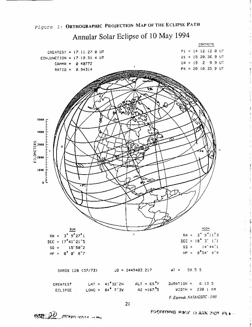
Figure l : ORTHOGRAPHIC PROJECTION MAP OF THE ECLIPSE PATH
Annular Solar Eclipse of 10 May 1994
GREATEST = 17:11:27.0 UT
CONJUNCTION = 17:19:51.4 UT
GAMMA = 0.40772
RATIO = 0.94314
CONTACTS
PI = [4: 12: [2. 0 UT
UI = t5:28: 36. 9 UT
U4 = [9: 2: 9,9 UT
P4 = 20: 10: 35. 9 UT
5000 -
4000 -
u3c_ 3000 -WI,-,-L.U [-120J 2009
1090
SUN
RA = 3" 9"27 '.I
DEC = 17'41'211'5
SD = 15' 501'2
HP = Oj 0' 81'7
MOON
RA = 3" 9"11s3
DEC = 18' 3' 11'1
SD = 14' 441'1
HP = 0'54' 41'4
SAROS 128 (57/73) JD = 2449483.217 aT = 59.5 S
GREATEST LAT =
ECLIPSE : LONG =
41'32.'2N ALT = 65.'7
84' 7.'3W AZ =167.'5
21
DURATION = 6:13 5
WIDTH = 230 I KM
F.E_en_,NASA/GSFC-I/93
PRE$',EI3,1NG P_r;F O. A(¢K P,_O_rF_Ii .-

\
<
x\\
\
\\
\
at
\
\\\
at Sunrise
i/
/./
.//
/
/"
/. Sunrise!
/II
22

Z
23
- I

\
0
24
• !
........__"

0
!,
0 0
0
• ...... ! .....
0
" ""0 I
25

0
Cr_
",'1
......
O
O_
OoO
0O)
/
°°
O
_0
26
0O_
r,3
O- 0
CO
_ -_._i: - |
i o _'i - o.. _
J M
2 --

Figure 7: THE LUNAR LIMB PROFILE
ANNULAR SOLAR ECLIPSE OF 10 MAY 1994
L = -I .65 B = -0.12 C =-17.18
E
N
0/
I
Contaci /Time Correction Curve
!!
/I
_ I,.
@ I
_/ 081
/I/lII
Second ContactTime Correction Curve
SUN 5D =
VELOC. =
LIMITS =
N
1RUE LUNAR LIMB
MERN LUNAR LIMB(CENTERDF FIGUREI
MEAN LUNAR LIMB(CENTER OF MQSS)
GREflTEST ECLIPSE
$
LRT : 4]'3212N MAXIMUM ALl : 6517
LONG • 84' 7:3W ECLIPSE : RZ -167_5
CONTACTS
Cl : t5:29:26.7 UT
C2 : I7: 8:20.2 UT
C_ = 17;1q'_3.6 UT
Cq = iB:SB:IO.q UT
MAX = 17:11:26.8 UT
DURATION = 6:13.4
RATIO = 0.9431_
F.E_enak, NASAIGSFC.i193
27
!
7
L
T

Figure 8: FREQUENCY OF CLEAR SKIES DURING MAY- MEXICO
Percent Frequency ofone-third cloud cover
or less m May
Flguz'e 9: FREQUENCY OF CLEAR SKIES DURING MAY- MOROCCO
Caalz_,/"-..._.-"Percem Frequency of ,L so'..¢_°-
Clear Skies or so ...... . _ , Mediterranean Sea• "*_ /angler 'Ceu_
3cattered Cloud at 4o .... "'-. '_c._,
Eclipse Time ..... -.. ""-../ "_',_
._.o _',,,,, • o;;-:::.......' _,,Rabat_. ,, g / "_ T_a i
o-,_. j... ,," ....... _._. ........... _:..... .
40/. ... "'° Marrakech • _ /0 / Ksar'e$*sOuk ......................
2°-:/...._-..-.-.---::..........:....._.._/: ,,,,,,;o_'.';- ...... ",, Algeria"-°" • i ." .......
28
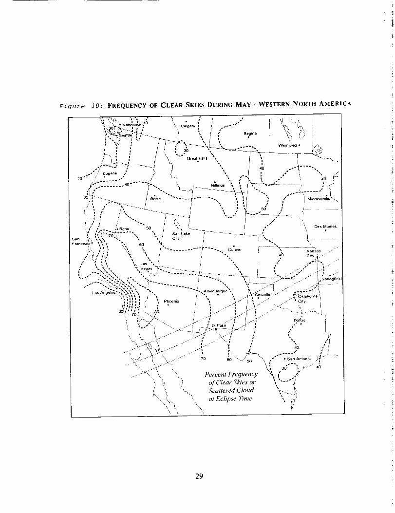
Figure i0: FREQUENCY OF CLEAR SKIES DURING MAY- WESTERN NORTH AMERICA
"S I a t
/',-b , '-' _ l ', _ • _ b_ {.,,_ : f / .----ve_.____-../ . _ i
...,20" • s m • .
i ...--__ " { /_... -'" __ ,.J
I Boise "" -" * _ ** t _ •) ---_..- , • } M,..e.po_,,/ t • _ • I _' e
• • tl _ l I # bO ., __ -----
t ,: / .. _ ',.J _ r
b' .., /iReno "'50 / _ /_ , k OesMoine$
r ,,'"'-,gt .....", ", I sa, Law_ _-/---_--_--__ ; k "sa,-, ,", • -, , , / c,,y t _q , |Francnsco/ _ _" • _ / I "_
,:-,, '\ ,, / ......../- -... ,:,..... /-- ,, ,_._,,../," [I , ', ', I t ". _ 40 c,t.....
,, , , ,, ,,, _.s .. / / .. i ." ._-t ...., "-.'. ,, ';;.Veo,s"g:-......... I ," _ I 'w
.-" -._J--.-.','-'.-. 7 ....... ", ",?_-_" _ _' -
",' ,it' , _ ", [ ., • ., JA--Am_,,,o .bj ,_.. _ \I I _ _ I _ ' • I I • _-" _4 ,oKlanoma
i'' '1 (_ i Phoemx t _- j/l i / I / .... ti-._,_1 i_ _ e - / , .l_ I / _ /_ _l.. /
"'_' 7o: _._ t .... " I A", ..-/ -.-v,,_\!
_) _.,. L\ _, j/, ' El Paso i .¢" i ," - ]
t C 7-_-___f-., .stT-_i :-_u : ,." /
_, \_,---'_ /- , ...... \ _' , ,. ,'_/_ i -- " t tl -i •__ & _ .--r i . ,o /1
o /" '. .- .... " , .L____'_)J-W X I, 60 "v/_J_ ," I SanAntonlo J
_-'_ _ \ \ Percem bT"eque,cy _\ i" . _">) ) ','---lC. ; v, Scal,ereaClo,,a "....._._
\\ %, '_ at Eclipse Time ,,
\ \ It
29

Figure 11 : FREQUENCY OF CLEAR SKIES DURING MAY - EASTERN NORTH AMERICA
• I
30
Boston
30

ANNULAR SOLAR ECLIPSE OF 10 MAY 1994
TABLES
31


Table 1
ELEMENTS OF THE ANNULAR SOLAR ECLIPSE OF 10 MAY 1994
Geocentric Conjunction
of Sun & Moon in R.A.:
Instant of
Greatest EcliPse:
17:20:50.88 TDT
(=17:19:51.38 UT)
17:12:26.49 TDT
(=17:11:26.99 UT)
J.D. = 2449483.222811
J.D. = 2449483.216973
Geocentric Coordinates of Sun & Moon at Greatest Eclipse (DE200/LE200) :
Sun: R.A. = 3h 9m 27.149s Moon: R.A. = 3h 9m Ii.285s
Dec. = 17 ° 41" 21.51" Dec. = 18 ° 3" i.i0"
Semi-Diameter = 15" 50.22" Semi-Diameter = 14" 44.08"
Eq. Hor. Par. = 8.71" Eq. Hor. Par. = 0 ° 54" 4.35"
A R.A. : 9.772s/h A R.A. = 122.984s/h
A Dec. = 39.06"/h A Dec. = 320.89"/h
Lunar Radius
Constants:
kl = 0.2725076 (Penumbra
k2 = 0.2722810 (Umbra)
Shift in Ab = 0.0"
Lunar Position: A1 = 0.0"
Geocentric Libration: 1 : -1.6 °
(Optical + Physical) b = -0.5 °
c = -17.2 °
Brown Lun. Nbr. = 1167
Saros Series = 128 (57/73)
Ephemeris = (DE200/LE200)
Eclipse Maqnitude : 0.94314 Gamma = 0.40772 A__T_T: 59.5 s
Polynomial Besselian Elements for:
n x y d 11 12
0 -0.1734118 0.3836521 17.6861305 0.5669329 0.0206722
1 0.4990638 0.0869394 0.0106418 -0.0000318 -0.0000317
2 0.0000296 -0.0001183 -0.0000040 -0.0000098 -0.0000097
3 -0.0000056 -0.0000009
Tan fl = 0.0046308 Tan /2 = 0.0046077
At time 't I ' (decimal hours), each besselian element is evaluated by:
x = x 0 + xl*t + x2*t 2 + x3*t 3 (or x : _ [Xn*tn]; n : 0 to 3)
where: t : t I - t O (decimal hours) and t O = 17.000
i0 May 1994 17:00:00.0 TDT (:t O )
75.905975
15.001621
-0.000002
Note that all times are expressed in Terrestrial Dynamical Time (TDT) .
Saros Series 128: Member 57 of 73 eclipses in series.
33
PRECEDING PAGE BLANK i_:OT FILW!ED
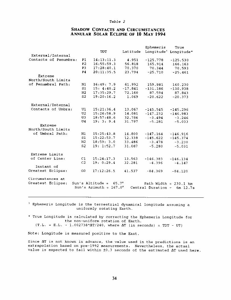
Table 2
SHADOW CONTACTS AND CIRCUMSTANCES
ANNULAR SOLAR ECLIPSE OF I0 MAY 1994
External/Internal
Contacts of Penumbra:
Extreme
North/South Limits
of Penumbral Path:
External/Internal
Contacts of Umbra:
Extreme
North/South Limits
of Umbral Path:
Extreme Limits
of Center Line:
Instant of
Greatest Eclipse:
Circumstances at
Greatest Eclipse:
TDT Latitude
P1 14:13:11.3 4.951
P2 16:55:59.3 56.818
P3 17:28:40.1 70.370
P4 20:11:35.5 23.794
Ephemeris True
Longitude _ Longitude*
-125.778 -125.530
165.914 166.163
70.344 70.593
-25.710 -25.461
N1 16:49: 7.9 61.992
S1 15: 4:40.2 -17.841
N2 17:35:29.7 72.160
S2 19:20:16.2 1.069
159.981 160.230
-131.186 -130.938
87.594 87.843
-20.622 -20.373
U1 15:21:36.4 13.067
U2 15:26:58.9 14.081
U3 18:57:48.6 32.786
U4 19: 3: 9.4 31.797
-145.545 -145.296
-147.232 -146.983
-3.494 -3.246
-5.281 -5.033
N1 15:25:43.8 14.800
S1 15:22:53.7 12.338
N2 18:59: 3.0 33.486
S2 19:1:52.7 31.087
-147.164 -146.916
-145.622 -145.374
-3.478 -3.230
-5.280 -5.031
C1 15:24:17.3 13.563
C2 19: 0:29.4 32.281
GO 17:12:26.5 41.537
-146.383 -146.134
-4.396 -4.147
-84.369 -84.120
Sun's Altitude = 65.7 °
Sun's Azimuth = 167.0 °
Path Width = 230.1 km
Central Duration = 6m 12.7s
t Ephemeris Longitude is the terrestrial dynamical longitude assuming a
uniformly rotating Earth.
* True Longitude is calculated by correcting the Ephemeris Longitude for
the non-uniform rotation of Earth.
(T.L. = E.L. - 1.002738"AT/240, where AT (in seconds) = TDT - UT)
Note: Longitude is measured positive to the East.
Since AT is not known in advance, the value used in the predictions is an
extrapolation based on pre-1992 measurements. Nevertheless, the actual
value is expected to fall within ±0.3 seconds of the estimated AT used here.
34
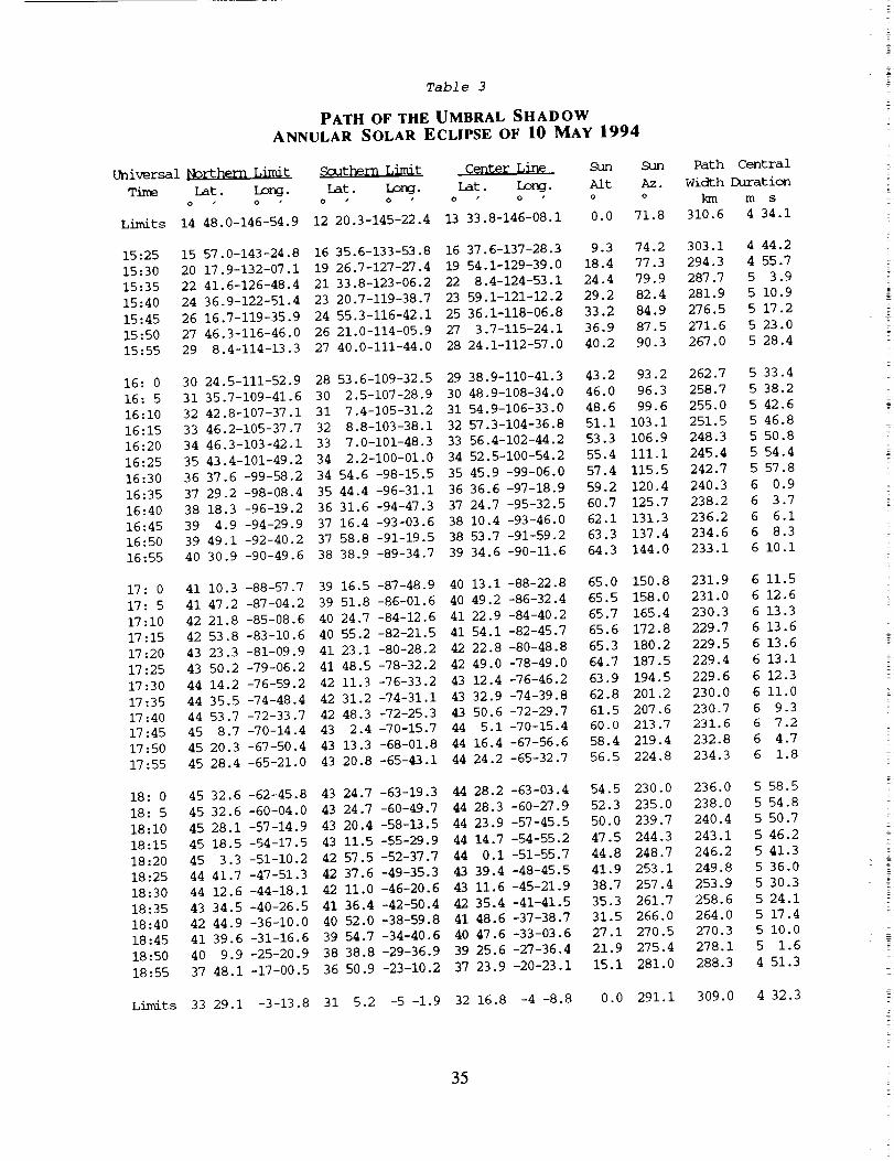
Table 3
PATH OF THE UMBRAL SHADOW
ANNULAR SOLAR ECLIPSE OF 10 MAY 1994
Universal _ _ Ce,nter Line Sun Sun Path Central
Time Lat. Long. iat. Long. lat. Long. Alt Az. Width Duration
o o o o o o o o _'1 rn s
Limits 14 48.0-146-54.9 12 20.3-145-22.4 13 33.8-146-08.1 0.0 71.8 310.6 4 34.1
15:25 15 57.0-143-24.8 16 35.6-133-53.8 16 37,6-137-28.3 9.3 74.2 303.1 4 44.2
15:30 20 17,9-132-07.1 19 26.7-127-27.4 19 54.1-129-39.0 18.4 77.3 294.3 4 55.7
15:35 22 41.6-126-48.4 21 33.8-123-06.2 22 8.4-124-53.1 24.4 79.9 287.7 5 3.9
15:40 24 36.9-122-51.4 23 20.7-119-38.7 23 59.1-121-12.2 29.2 82.4 281.9 5 10.9
15:45 26 16.7-119-35.9 24 55.3-116-42.1 25 36.1-118-06.8 33.2 84.9 276.5 5 17.2
15:50 27 46.3-116-46.0 26 21.0-114-05.9 27 3.7-115-24.1 36.9 87.5 271.6 5 23.0
15:55 29 8.4-114-13.3 27 40.0-111-44.0 28 24.1-112-57.0 40.2 90.3 267.0 5 28.4
16:0 30 24.5-111-52.9 28 53.6-109-32.5 29 38.9-110-41.3 43.2 93.2 262.7 5 33.4
16:5 31 35.7-109-41.6 30 2.5-107-28.9 30 48.9-108-34.0 46.0 96.3 258.7 5 38.2
16:10 32 42.8-107-37.1 31 7.4-105-31.2 31 54.9-106-33.0 48.6 99.6 255.0 5 42.6
16:15 33 46.2-105-37.7 32 8.8-103-38.1 32 57.3-104-36.8 51.1 103.1 251.5 5 46.8
16:20 34 46.3-103-42.1 33 7.0-101-48.3 33 56.4-102-44.2 53.3 106.9 248.3 5 50.8
16:25 35 43.4-101-49.2 34 2,2-100-01.0 34 52.5-100-54.2 55.4 iii. I 245.4 5 54.4
16:30 36 37.6 -99-58.2 34 54.6 -98-15.5 35 45.9 -99-06.0 57.4 115.5 242.7 5 57.8
16:35 37 29.2 -98-08.4 35 44.4 -96-31.1 36 36.6 -97-18.9 59.2 120.4 240.3 6 0.9
16:40 38 18.3 -96-19.2 36 31.6 -94-47.3 37 24.7 -95-32.5 60.7 125.7 238.2 6 3.7
16:45 39 4.9 -94-29.9 37 16.4 -93-03.6 38 10,4 -93-46.0 62.1 131.3 236.2 6 6.1
16:50 39 49.1 -92-40.2 37 58.8 -91-19.5 38 53.7 -91-59.2 63.3 137.4 234.6 6 8.3
16:55 40 30.9 -90-49.6 38 38.9 -89-34.7 39 34.6 -90-11.6 64.3 144.0 233.1 6 i0.i
17:0 41 10.3 -88-57.7 39 16.5 -87-48.9 40 13.1 -88-22.8 65.0 150.8 231.9 6 11.5
17:5 41 47.2 -87-04.2 39 51.8 -86-01.6 40 49.2 -86-32.4 65.5 158.0 231.0 6 12.6
17:10 42 21.8 -85-08.6 40 24.7 -84-12.6 41 22.9 -84-40.2 65.7 165.4 230.3 6 13.3
17:15 42 53.8 -83-10.6 40 55.2 -82-21.5 41 54.1 -82-45.7 65.6 172.8 229.7 6 13.6
17:20 43 23.3 -81-09.9 41 23.1 -80-28.2 42 22,8 -80-48.8 65.3 180.2 229.5 6 13.6
17:25 43 50.2 -79-06.2 41 48.5 -78-32.2 42 49.0 -78-49.0 64.7 187.5 229.4 6 13.1
17:30 44 14.2 -76-59.2 42 11.3 -76-33.2 43 12,4 -76-46.2 63.9 194.5 229.6 6 12.3
17:35 44 35.5 -74-48.4 42 31.2 -74-31.1 43 32.9 -74-39.8 62.8 201.2 230.0 6 ii.0
17:40 44 53.7 -72-33.7 42 48.3 -72-25.3 43 50.6 -72-29.7 61.5 207.6 230.7 6 9.3
17:45 45 8.7 -70-14.4 43 2.4 -70-15.7 44 5.1 -70-15.4 60.0 213.7 231.6 6 7.2
17:50 45 20.3 -67-50.4 43 13.3 -68-01.8 44 16.4 -67-56.6 58.4 219.4 232.8 6 4.7
17:55 45 28.4 -65-21.0 43 20.8 -65-43.1 44 24,2 -65-32.7 56.5 224.8 234.3 6 1.8
18:0 45 32.6 -62-45.8 43 24.7 -63-19.3 44 28.2 -63-03.4 54.5 230.0 236.0 5 58.5
18:5 45 32.6 -60-04.0 43 24.7 -60-49.7 44 28.3 -60-27.9 52.3 235.0 238.0 5 54.8
18:10 45 28.1 -57-14.9 43 20.4 -58-13.5 44 23.9 -57-45.5 50.0 239.7 240.4 5 50.7
18:15 45 18.5 -54-17.5 43 11.5 -55-29.9 44 14.7 -54-55.2 47.5 244.3 243.1 5 46.2
18:20 45 3.3 -51-10.2 42 57.5 -52-37.7 44 0.I -51-55.7 44.8 248.7 246.2 5 41.3
18:25 44 41.7 -47-51.3 42 37.6 -49-35.3 43 39.4 -48-45.5 41.9 253.1 249.8 5 36.0
18:30 44 12.6 -44-18.1 42 Ii.0 -46-20.6 43 11.6 -45-21.9 38.7 257.4 253.9 5 30.3
18:35 43 34.5 -40-26.5 41 36.4 -42-50.4 42 35.4 -41-41.5 35.3 261.7 258.6 5 24.1
18:40 42 44.9 -36-10.0 40 52.0 -38-59.8 41 48.6 -37-38.7 31.5 266.0 264.0 5 17.4
18:45 41 39.6 -31-16.6 39 54.7 -34-40.6 40 47.6 -33-03,6 27.1 270.5 270.3 5 i0.0
18:50 40 9.9 -25-20.9 38 38.8 -29-36.9 39 25.6 -27-36.4 21.9 275.4 278.1 5 1.6
18:55 37 48.1 -17-00.5 36 50.9 -23-10.2 37 23.9 -20-23.1 15.1 281.0 288.3 4 51.3
Limits 33 29.1 -3-13.8 31 5.2 -5 -1.9 32 16.8 -4 -8.8 0.0 291.1 309.0 4 32.3
35
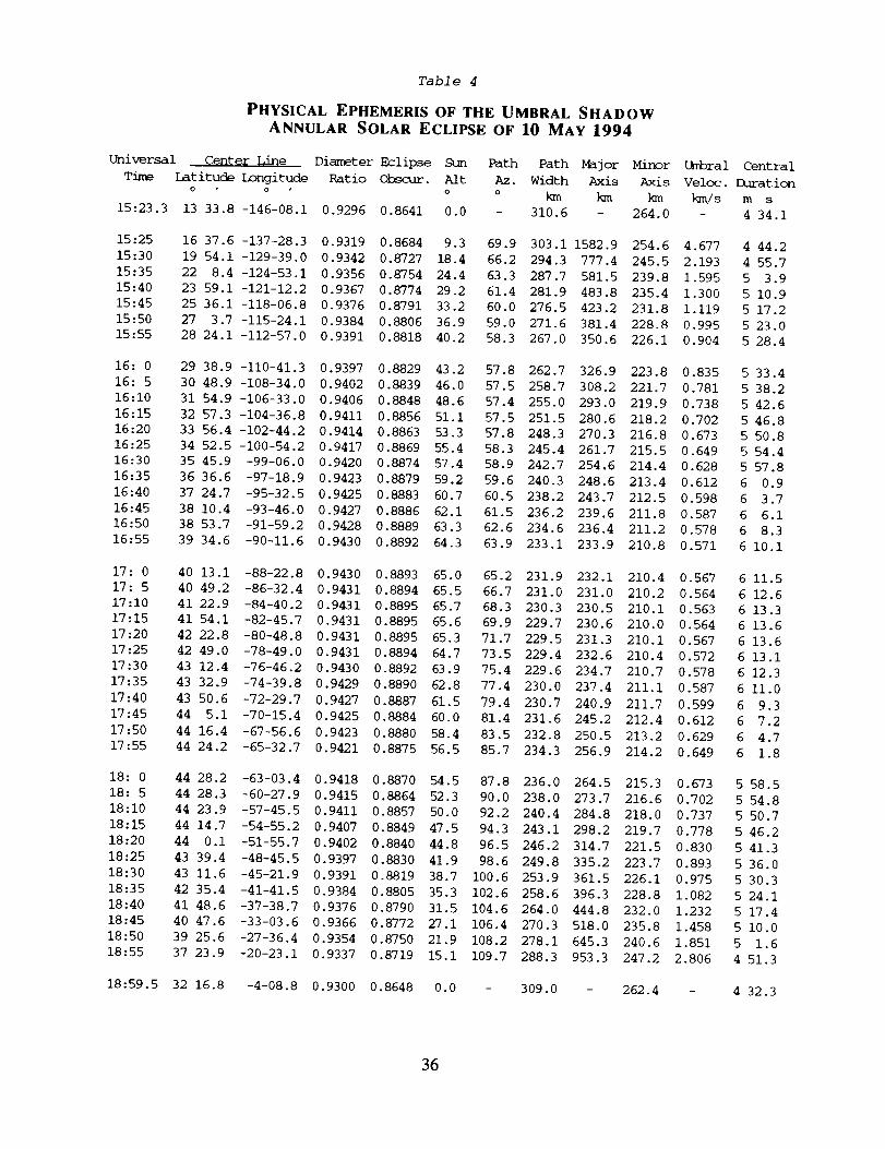
Table 4
PHYSICAL EPHEMERIS OF THE UMBRAL SHADOW
ANNULAR SOLAR ECLIPSE OF 10 MAY 1994
Universal Cente_ _i_e Diameter Eclipse Sun Path Path Major Minor
Time Latitude Longitude Ratio Obscur. Aft Az. Width Axis Axis
o o o o _ _
15:23.3 13 33.8 -146-08.1 0.9296 0.8641 0.0 - 310.6 - 264.0
Umbral Central
Veloc. Duration
km/s m s
- 4 34.1
15:25 16 37.6 -137-28.3 0.9319 0.8684 9.3 69.9 303.1 1582.9 254.6 4.677 4 44.2
15:30 19 54.1 -129-39.0 0.9342 0.8727 18.4 66.2 294.3 777.4 245.5 2.193 4 55.7
15:35 22 8.4 -124-53.1 0.9356 0.8754 24,4 63.3 287.7 581.5 239.8 1.595 5 3.9
15:40 23 59.1 -121-12.2 0.9367 0.8774 29.2 61.4 281.9 483.8 235.4 1.300 5 10.9
15:45 25 36.1 -118-06.8 0.9376 0.8791 33,2 60.0 276.5 423.2 231.8 1.119 5 17.2
15:50 27 3.7 -115-24.1 0.9384 0.8806 36.9 59.0 271.6 381.4 228.8 0.995 5 23.0
15:55 28 24.1 -112-57.0 0.9391 0.8818 40,2 58.3 267.0 350.6 226.1 0.904 5 28.4
16:0 29 38.9 -110-41.3 0.9397 0.8829 43.2 57.8 262.7 326.9 223.8 0.835 5 33.4
16:5 30 48.9 -108-34.0 0.9402 0.8839 46,0 57.5 258.7 308.2 221.7 0.781 5 38.2
16:10 31 54.9 -106-33.0 0.9406 0.8848 48.6 57.4 255.0 293.0 219.9 0.738 5 42.6
16:15 32 57.3 -104-36.8 0.9411 0,8856 51,1 57.5 251.5 280.6 218.2 0.702 5 46.8
16:20 33 56.4 -102-44.2 0.9414 0.8863 53.3 57.8 248.3 270.3 216.8 0.673 5 50.8
16:25 34 52.5 -100-54.2 0.9417 0.8869 55.4 58.3 245.4 261.7 215.5 0.649 5 54.4
16:30 35 45.9 -99-06.0 0.9420 0.8874 57.4 58.9 242.7 254.6 214.4 0.628 5 57.8
16:35 36 36.6 -97-18.9 0.9423 0.8879 59.2 59.6 240.3 248.6 213.4 0.612 6 0.9
16:40 37 24.7 -95-32.5 0.9425 0,8883 60.7 60.5 238.2 243.7 212.5 0.598 6 3.7
16:45 38 10.4 -93-46.0 0.9427 0.8886 62.1 61.5 236.2 239.6 211.8 0.587 6 6.1
16:50 38 53.7 -91-59.2 0.9428 0.8889 63.3 62.6 234.6 236.4 211.2 0.578 6 8.3
16:55 39 34.6 -90-11.6 0.9430 0,8892 64.3 63.9 233.1 233.9 210.8 0.571 6 I0.I
17:0 40 13.1 -88-22.8 0.9430 0,8893 65.0 65.2 231.9 232.1 210.4 0.567 6 11.5
17:5 40 49.2 -86-32.4 0.9431 0,8894 65.5 66.7 231.0 231.0 210.2 0.564 6 12.6
17:10 41 22.9 -84-40.2 0.9431 0,8895 65.7 68.3 230.3 230.5 210.1 0.563 6 13.3
17:15 41 54.1 -82-45.7 0.9431 0.8895 65.6 69.9 229.7 230.6 210.0 0.564 6 13.6
17:20 42 22.8 -80-48.8 0.9431 0.8895 65.3 71.7 229.5 231.3 210.1 0.567 6 13.6
17:25 42 49.0 -78-49.0 0.9431 0,8894 64.7 73.5 229.4 232.6 210.4 0.572 6 13.1
17:30 43 12.4 -76-46.2 0.9430 0,8892 63.9 75.4 229.6 234.7 210.7 0.578 6 12.3
17:35 43 32.9 -74-39.8 0.9429 0,8890 62.8 77.4 230.0 237.4 211.1 0.587 6 Ii.0
17:40 43 50.6 -72-29.7 0.9427 0.8887 61.5 79.4 230.7 240.9 211.7 0.599 6 9.3
17:45 44 5.1 -70-15.4 0.9425 0,8884 60.0 81.4 231.6 245.2 212.4 0.612 6 7.2
17:50 44 16.4 -67-56.6 0.9423 0,8880 58.4 83.5 232.8 250.5 213.2 0.629 6 4.7
17:55 44 24.2 -65-32.7 0.9421 0,8875 56.5 85.7 234.3 256.9 214.2 0.649 6 1.8
18:0 44 28.2 -63-03.4 0.9418 0,8870 54.5 87.8 236.0 264.5 215.3 0.673 5 58.5
18:5 44 28.3 -60-27.9 0.9415 0.8864 52.3 90.0 238.0 273.7 216.6 0.702 5 54.8
18:10 44 23.9 -57-45.5 0,9411 0.8857 50.0 92.2 240.4 284.8 218.0 0.737 5 50.7
18:15 44 14.7 -54-55.2 0.9407 0.8849 47.5 94.3 243.1 298.2 219.7 0.778 5 46.2
18:20 44 0.i -51-55.7 0.9402 0,8840 44.8 96,5 246.2 314.7 221.5 0.830 5 41.3
18:25 43 39.4 -48-45.5 0.9397 0.8830 41,9 98.6 249.8 335.2 223.7 0.893 5 36.0
18:30 43 11.6 -45-21.9 0.9391 0.8819 38.7 100.6 253,9 361.5 226.1 0,975 5 30.3
18:35 42 35.4 -41-41.5 0.9384 0.8805 35.3 102.6 258.6 396.3 228.8 1.082 5 24.1
18:40 41 48.6 -37-38.7 0.9376 0.8790 31,5 104.6 264.0 444.8 232,0 1.232 5 17,4
18:45 40 47.6 -33-03.6 0.9366 0.8772 27.1 106.4 270.3 518.0 235.8 1.458 5 10.0
18:50 39 25.6 -27-36.4 0.9354 0.8750 21.9 108.2 278.1 645.3 240.6 1.851 5 1.6
18:55 37 23.9 -20-23.1 0.9337 0.8719 15,1 109.7 288.3 953.3 247.2 2.806 4 51.3
18:59.5 32 16.8 -4-08.8 0.9300 0.8648 0.0 - 309.0 - 262.4 - 4 32.3
36
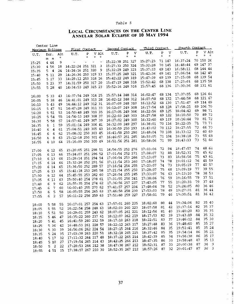
Tabl e 5
LOCAL CIRCUMSTANCES ON THE CENTER LINE
ANNULAR SOLAR ECLIPSE OF 10 MAY 1994
Center Line
Max/mum EcliPse First Contact Second Contact Third CQ_act Fourth Contac_ ,
U.T. Dur. Alt U.T. P V Aft U.T. P V U.T. P V U.T. P V Alt0 0 O 0 0 0 0 0 0 0 0m s
15:25 4 44 9 - - - 15:22:38 251 327 15:27:23 71 147 16:37:24 70 150 26
15:30 4 56 18 14:22:24 251 321 3 15:27:33 250 324 15:32:28 70 145 16:48:44 69 147 37
15:35 5 4 24 14:24:16 251 320 9 15:32:29 249 323 15:37:33 69 143 16:58:11 68 144 44
15:40 5 II 29 14:26:36 250 319 13 15:37:25 249 321 15:42:36 69 141 17:06:54 68 142 49
15:45 5 17 33 14:29:12 250 318 16 15:42:22 249 319 15:47:39 69 139 17:15:08 68 139 54
15:50 5 23 37 14:31:59 250 317 20 15:47:19 248 318 15:52:42 68 138 17:23:01 68 135 58
15:55 5 28 40 14:34:53 249 315 23 15:52:16 248 316 15:57:45 68 136 17:30:36 68 131 61
16:00 5 33 43 14:37:54 249 314 25 15:57:14 248 314 16:02:47 68 134 17:37:55 68 126 64
16:05 5 38 46 14:41:01 249 313 28 16:02:12 248 312 16:07:50 68 132 17:44:58 68 121 67
16:10 5 43 49 14:44:12 249 312 31 16:07:09 248 310 16:12:52 68 130 17:51:47 69 114 69
16:15 5 47 51 14:47:28 249 311 33 16:12:07 249 308 16:17:54 68 128 17:58:21 69 106 70
16:20 5 51 53 14:50:48 249 310 35 16:17:05 249 306 16:22:56 69 125 18:04:42 69 98 71
16:25 5 54 55 14:54:13 249 308 37 16:22:03 249 303 16:27:58 69 122 18:10:50 70 89 72
16:30 5 58 57 14:57:41 249 307 39 16:27:02 249 300 16:32:60 69 119 18:16:44 70 81 72
16:35 6 1 59 15:01:14 249 306 41 16:32:00 249 297 16:38:01 70 116 18:22:25 71 73 71
16:40 6 4 61 15:04:51 249 305 43 16:36:59 250 293 16:43:02 70 112 18:27:55 72 66 70
16:45 6 6 62 15:08:32 250 303 45 16:41:58 250 290 16:48:04 70 108 18:33:12 72 60 69
16:50 6 8 63 15:12:18 250 301 47 16:46:57 251 285 16:53:05 71 104 18:38:18 73 55 68
16:55 6 i0 64 15:16:09 250 300 49 16:51:56 251 281 16:58:06 71 99 18:43:13 73 51 66
17:00 6 12 65 15:20:05 251 298 51 16:56:55 252 276 17:03:06 72 94 18:47:57 74 48 64
17:05 6 13 66 15:24:07 251 296 52 17:01:54 252 271 17:08:07 72 88 18:52:31 75 45 62
17:10 6 13 66 15:28:14 251 294 54 17:06:54 253 266 17:13:07 73 83 18:56:56 75 43 61
17:15 6 14 66 15:32:28 252 291 56 17:11:54 253 260 17:18:07 74 78 19:01:12 76 41 59
17:20 6 14 65 15:36:50 252 289 57 17:16:54 254 255 17:23:07 74 73 19:05:19 77 40 57
17:25 6 13 65 15:41:18 253 285 58 17:21:54 255 250 17:28:07 75 68 19:09:19 77 39 55
17:30 6 12 64 15:45:55 253 282 60 17:26:54 255 245 17:33:07 76 63 19:13:10 78 38 53
17:35 6 ii 63 15:50:40 254 278 61 17:31:55 256 241 17:38:06 76 59 19:16:55 79 37 51
17:40 6 9 62 15:55:35 254 274 62 17:36:56 257 237 17:43:05 77 55 19:20:33 79 37 48
17:45 6 7 60 16:00:40 255 270 62 17:41:57 257 234 17:48:04 78 52 19:24:05 80 36 46
17:50 6 5 58 16:05:55 256 265 63 17:46:58 258 230 17:53:03 78 49 19:27:31 81 36 44
17:55 6 2 57 16:11:22 256 259 63 17:51:60 259 227 17:58:01 79 46 19:30:51 81 36 42
18:00 5 58 55 16:17:01 257 254 63 17:57:01 260 225 18:02:60 80 44 19:34:06 82 35 40
18:05 5 55 52 16:22:54 258 248 63 18:02:03 260 223 18:07:58 81 42 19:37:16 82 35 37
18:10 5 51 50 16:29:01 259 243 62 18:07:05 261 221 18:12:56 81 40 19:40:20 83 35 35
18:15 5 46 47 16:35:22 260 237 61 18:12:07 262 219 18:17:53 82 39 19:43:19 84 35 32
18:20 5 41 45 16:41:59 260 232 59 18:17:10 263 218 18:22:51 83 37 19:46:12 84 35 30
18:25 5 36 42 16:48:53 261 228 57 18:22:12 263 217 18:27:48 83 36 19:48:60 85 35 27
18:30 5 30 39 16:56:06 262 224 54 18:27:15 264 216 18:32:46 84 35 19:51:41 85 35 24
18:35 5 24 35 17:03:38 263 220 51 18:32:18 265 215 18:37:42 85 35 19:54:14 86 35 21
18:40 5 17 32 17:11:32 264 217 48 18:37:22 265 214 18:42:39 85 34 19:56:38 86 35 17
18:45 5 i0 27 17:19:54 265 214 43 18:42:25 266 213 18:47:35 86 33 19:58:48 87 35 13
18:50 5 2 22 17:28:53 266 212 38 18:47:30 267 212 18:52:31 87 33 20:00:38 87 36 9
18:55 4 51 15 17:38:57 267 210 30 18:52:35 267 212 18:57:26 87 32 20:01:47 87 36 3
37
2
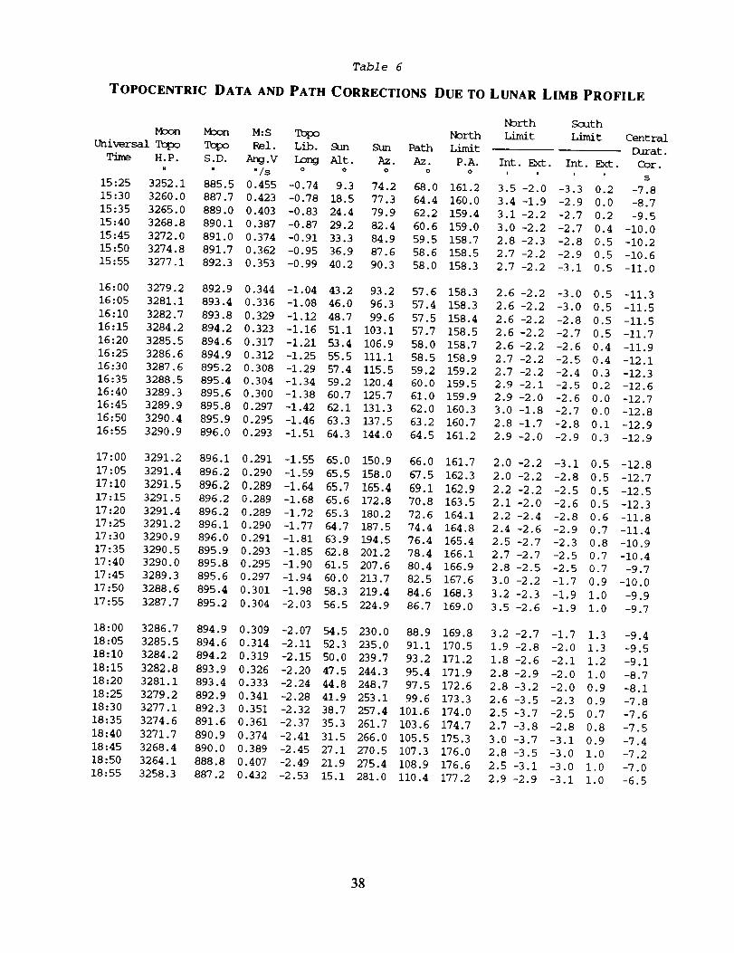
Table 6
TOPOCENTRIC DATA AND PATH CORRECTIONS DUE TO LUNAR LIMB PROFILE
Universal Tc_o
Time H.P.u
15:25 3252.1
15:30 3260.0
15:35 3265.0
15:40 3268.8
15:45 3272.0
15:50 3274.8
15:55 3277 .i
M_on
TopoS.D.
" "/S 0 0 0
885.5 0.455 -0.74 9.3 74.2
887.7 0.423 -0.78 18.5 77.3
889.0 0.403 -0.83 24.4 79.9
890.1 0.387 -0.87 29.2 82.4
891.0 0.374 -0.91 33.3 84.9
891.7 0.362 -0.95 36.9 87.6
892.3 0.353 -0.99 40.2 90.3
M:S Tc_0o
Rel. Lib. Sun
Ang.V Long Aft.
North South
North Limit Limit Central
Sun Path Limit Durat.
Az. Az. P.A. Int. Ext. Int. Ext. Cor.
0 0 , i i t S
68.0 161.2 3.5 -2.0 -3.3 0.2 -7.8
64.4 160.0 3.4 -1.9 -2.9 0.0 -8.7
62.2 159.4 3.1 -2.2 -2.7 0.2 -9.5
60.6 159.0 3.0 -2.2 -2.7 0.4 -i0.0
59.5 158.7 2.8 -2.3 -2.8 0.5 -10.2
58.6 158.5 2.7 -2.2 -2.9 0.5 -10.6
58.0 158.3 2.7 -2.2 -3.1 0.5 -ii.0
16:00 3279.2
16:05 3281.1
16:10 3282.7
16:15 3284.2
16:20 3285.5
16:25 3286.6
16:30 3287.6
16:35 3288.5
16:40 3289.3
16:45 3289.9
16:50 3290.4
16:55 3290.9
892.9 0.344 -1.04 43.2 93.2
893.4 0.336 -1.08 46.0 96.3
893.8 0.329 -1.12 48.7 99.6
894.2 0.323 -1.16 51.1 103.1
894.6 0.317 -1.21 53.4 106.9
894.9 0.312 -1.25 55.5 iii.I
895.2 0.308 -1.29 57.4 115.5
895.4 0.304 -1.34 59.2 120.4
895.6 0.300 -1.38 60.7 125.7
895.8 0.297 -1.42 62.1 131.3
895.9 0.295 -1.46 63.3 137.5
896.0 0.293 -1.51 64.3 144.0
57.6 158.3 2.6 -2.2 -3.0 0.5 -11.3
57.4 158.3 2.6 -2.2 -3.0 0.5 -11.5
57.5 158.4 2.6 -2.2 -2.8 0.5 -11.5
57.7 158.5 2.6 -2.2 -2.7 0.5 -11.7
58.0 158.7 2.6 -2.2 -2.6 0.4 -11.9
58.5 158.9 2.7 -2.2 -2.5 0.4 -12.1
59.2 159.2 2.7 -2.2 -2.4 0.3 -12.3
60.0 159.5 2.9 -2.1 -2.5 0.2 -12.6
61.0 159.9 2.9 -2.0 -2.6 0.0 -12.7
62.0 160.3 3.0 -1.8 -2.7 0.0 -12.8
63.2 160.7 2.8 -1.7 -2.8 0.i -12.9
64.5 161.2 2.9 -2.0 -2.9 0.3 -12.9
17 :00
17 :05
17 :10
17 :15
17:20
17:25
17:30
17:35
17:40
3291.2 896.1 0.291 -1.55 65.0 150.9 66.0 161.7
3291.4 896.2 0.290 -1.59 65.5 158.0 67.5 162.3
3291.5 896.2 0.289 -1.64 65.7 165.4 69.1 162.9
3291.5 896.2 0.289 -1.68 65.6 172.8 70.8 163.5
3291.4 896.2 0.289 -1.72 65.3 180.2 72.6 164.1
3291.2 896.1 0.290 -1.77 64.7 187.5 74.4 164.8
3290.9 896.0 0.291 -1.81 63.9 194.5 76.4 165.4
3290.5 895.9 0.293 -1.85 62.8 201.2 78.4 166.1
3290.0 895.8 0.295 -1.90 61.5 207.6 80.4 166.9
17:45 3289.3 895.6 0.297 -1.94 60.0 213.7 82.5 167.6
17:50 3288.6 895.4 0.301 -1.98 58.3 219.4 84.6 168.3
17:55 3287.7 895.2 0.304 -2.03 56.5 224.9 86.7 169.0
2.0-2.2 -3.1 0.5 -12.8
2.0-2.2 -2.8 0.5 -12.7
2.2-2.2 -2.5 0.5 -12.5
2.1-2.0 -2.6 0.5 -12.3
2.2-2.4 -2.8 0.6 -11.8
2.4-2.6 -2.9 0.7 -11.4
2.5-2.7 -2.3 0.8 -10.9
2.7-2.7 -2.5 0.7 -10.4
2.8-2.5 -2.5 0.7 -9.7
3.0 -2.2 -1.7 0.9 -i0.0
3.2 -2.3 -1.9 1.0 -9.9
3.5 -2.6 -1.9 1.0 -9.7
18:00 3286.7 894.9 0.309 -2.07 54.5 230.0 88.9 169.8 3.2 -2.7 -1.7 1.3 -9.4
18:05 3285.5 894.6 0.314 -2.11 52.3 235.0 91.1 170.5 1.9 -2.8 -2.0 1.3 -9.5
18:10 3284.2 894.2 0.319 -2.15 50.0 239.7 93.2 171.2 1.8 -2.6 -2.1 1.2 -9.1
18:15 3282.8 893.9 0.326 -2.20 47.5 244.3 95.4 171.9 2.8 -2.9 -2.0 1.0 -8.7
18:20 3281.1 893.4 0.333 -2.24 44.8 248.7 97.5 172.6 2.8 -3.2 -2.0 0.9 -8.1
18:25 3279.2 892.9 0.341 -2.28 41.9 253.1 99.6 173.3 2.6 -3.5 -2.3 0.9 -7.8
18:30 3277.1 892.3 0.351 -2.32 38.7 257.4 101.6 174.0 2.5 -3.7 -2.5 0.7 -7.6
18:35 3274.6 891.6 0.361 -2.37 35.3 261.7 103.6 174.7 2.7 -3.8 -2.8 0.8 -7.5
18:40 3271.7 890.9 0.374 -2.41 31.5 266.0 105.5 175.3 3.0 -3.7 -3.1 0.9 -7.4
18:45 3268.4 890.0 0.389 -2.45 27.1 270.5 107.3 176.0 2.8 -3.5 -3.0 1.0 -7.2
18:50 3264.1 888.8 0.407 -2.49 21.9 275.4 108.9 176.6 2.5 -3.1 -3.0 1.0 -7.0
18:55 3258.3 887.2 0.432 -2.53 15.1 281.0 110.4 177.2 2.9 -2.9 -3.1 1.0 -6.5
38

ummmm_
O
-146 00.0
-145 00.0
-144 00.0
-143 00.0
-142 00.0
-141 00.0
-140 00.0
-139 00.0
-138 00.0
-137 00.0
-136 00.0
-135 00.0
-134 00.0
-133 00.0
-132 00.0
-131 00.0
-130 00.0
-129 00.0
-128 00 0
-127 00 0
-126 00 0
-125 00 0
-124 00 0
-123 00 0
-122 00 0
-121 00 0
-120 00 0
-119 00 0
-118 00 0
-117 00 0
-116 00 0
-115 00 0
-114 00 0
-113 00 0
-112 00 0
-Iii 00 0
-ii0 00 0
-109 00.0
-108 00.0
-107 00.0
-106 00.0
-105 00.0
-104 00.0
-103 00.0
-102 00.0
-i01 00.0
-I00 00.0
Table 7
MAPPING COORDINATES FOR THE UMBRAL PATH
Latitude of:
Northern Southern
Limit LimitO O
15 05.5
15 25.1 12 26.9
15 45.1 12 47.5
16 05.5 13 08.2
16 26.4 13 29.1
16 47.7 13 50.3
17 09.5 14 12.2
17 31.8 14 34.5
17 54.5 14 57.2
18 17.7 15 20.5
18 41.4 15 44.2
19 05.6 16 08.4
19 30.2 16 33.0
19 55.3 16 58.2
20 20.9 17 23.9
20 47.0 17 50.0
21 13.6 18 16.7
21 40.6 18 43.8
22 08.2 19 11.5
22 36.2 19 39.6
23 04.6 20 08.2
23 33.5 20 37.3
24 02.8 21 06.9
24 32.6 21 36.9
25 02.8 22 07.4
25 33.3 22 38.2
26 04.2 23 09.5
26 35.5 23 41.2
27 07.0 24 13.2
27 38.8 24 45.6
28 10.9 25 18.2
28 43.1 25 51.2
29 15.5 26 24.3
29 48.1 26 57.6
30 20.6 27 31.1
30 53.2 28 04.6
31 25.8 28 38.2
31 58.2 29 11.7
32 30.5 29 45.2
33 02.6 30 18.5
33 34.4 30 51.6
34 05.9 31 24.5
34 37.1 31 57.0
35 07.8 32 29.1
35 38.0 33 00.8
36 07.7 33 32.0
36 36.8 34 02.7
Center
LineO
13 36.4
13 55.9
14 15.9
14 36.4
14 57.2
15 18.6
15 40.4
16 02.7
16 25.4
16 48.6
17 12.3
17 36.5
18 01.2
18 26.3
18 51.9
19 18.1
19 44.7
20 ii. 8
20 39.4
21 07.4
21 36.0
22 05.0
22 34.4
23 04.3
23 34.6
24 05.3
24 36.5
25 07.9
25 39.7
26 ii. 8
26 44.2
27 16.8
27 49.6
28 22.5
28 55.529 28.6
30 01.7
30 34.7
31 07.6
31 40.3
32 12.7
32 44.9
33 16.8
33 48.2
34 19.2
34 49.6
35 19.5
Universal Time at:
Northern
Limit
h m s
15:24:45.1
15:24:56.7
15:24:54.0
15:25:04.0
15:25:15.7
15:25:30.3
15:25:47.8
15:26:08.3
15:26:32.1
15:26:59.0
15:27:29.3
15:28:02.9
15:28:40.1
15:29:21.0
15:30:05.5
15:30:53.8
15:31:46.1
15:32:42.3
15:33:42.6
15:34:47.0
15:35:55.7
15:37:08.7
15:38:26.1
15:39:47.9
15:41:14.3
15:42:45.1
15:44:20.5
15:46:00.4
15:47:44.9
15:49:33.9
15:51:27.4
15:53:25.2
15:55:27.4
15:57:33.8
15:59:44.4
16:01:58.8
16:04:17.0
16:06:38.7
16:09:03.9
16:11:32.1
16:14:03.2
16:16:37.0
16:19:13.0
16:21:51.2
16:24:31.1
16:27:12.5
16:29:55.2
Southern Center
Limit Line
h m s h m s
- 15:22:27.9
15:21:54.0 15:23:19.4
15:21:56.4 15:23:23.6
15:22:01.4 15:23:30.4
15:22:08.9 15:23:40.0
15:22:19.1 15:23:52.4
15:22:32.2 15:24:07.7
15:22:48.3 15:24:26.0
15:23:07.5 15:24:47.4
15:23:29.8 15:25:12.0
15:23:55.3 15:25:39.9
15:24:24.1 15:26:11.2
15:24:56.4 15:26:45.9
15:25:32.3 15:27:24.2
15:26:11.8 15:28:06.2
15:26:55.0 15:28:52.0
15:27:42.1 15:29:41.7
15:28:33.2 15:30:35.3
15:29:28.3 15:31:33.1
15:30:27.6 15:32:34.9
15:31:31.1 15:33:41.1
15:32:39.0 15:34:51.6
15:33:51.3 15:36:06.5
15:35:08.2 15:37:25.8
15:36:29.6 15:38:49.8
15:37:55.7 15:40:18.3
15:39:26.6 15:41:51.5
15:41:02.1 15:43:29.3
15:42:42.5 15:45:11.8
15:44:27.7 15:46:59.0
15:46:17.7 15:48:50.9
15:48:12.5 15:50:47.3
15:50:12.0 15:52:48.3
15:52:16.1 15:54:53.7
15:54:24.9 15:57:03.5
15:56:38.1 15:59:17.4
15:58:55.6 16:01:35.4
16:01:17.3 16:03:57.3
16:03:43.0 16:06:22.9
16:06:12.4 16:08:51.9
16:08:45.4 16:11:24.1
16:11:21.7 16:13:59.3
16:14:01.1 16:16:37.2
16:16:43.1 16:19:17.4
16:19:27.7 16:21:59.8
16:22:14.4 16:24:44.0
16:25:03.0 16:27:29.8
Circtm_tances
on the Center Line
Sun Sun Path Central
Alt Az.Width Durat.
o o km m s
1 72 310 4 35.2
2 72 309 4 36.3
3 73 308 4 37.4
4 73 307 4 38.6
5 73 306 4 39.8
6 73 306 4 41.0
8 74 305 4 42.2
9 74 304 4 43.5
i0 74 303 4 44.9
ii 75 302 4 46.2
12 75 301 4 47.6
13 75 299 4 49.0
14 76 298 4 50.5
16 76 297 4 52.0
17 77 296 4 53.6
18 77 295 4 55.1
19 78 293 4 56.8
20 78 292 4 58.4
22 79 291 5 00.I
23 79 289 5 01.9
24 80 288 5 03.7
26 80 286 5 05.5
27 81 285 5 07.4
28 82 283 5 09.3
29 83 282 5 11.3
31 83 280 5 13.3
32 84 278 5 15.3
33 85 276 5 17.4
35 86 275 5 19.5
36 87 273 5 21.7
37 88 271 5 23.8
39 89 269 5 26.0
40 90 267 5 28.2
41 91 265 5 30.5
43 93 263 5 32.7
44 94 261 5 35.0
45 96 259 5 37.2
47 97 258 5 39.4
48 99 256 5 41.7
49 I01 254 5 43.8
51 102 252 5 46.0
52 104 250 5 48.1
53 106 249 5 50.2
54 109 247 5 52.3
55 Iii 246 5 54.2
56 113 244 5 56.1
39

Lonaitude
O
-99 00.0
-98 00 0
-97 00 0
-96 00 0
-95 00 0
-94 00 0
-93 00 0
-92 00 0
-91 00 0
-90 00 0
-89 00
-88 00
-87 00
-86 00
-85 00
-84 00
-83 00
-82 00
-81 00
-80 00
-79 00
-78 00
-77 00
-76 00
-75 00
-74 00 0
-73 00.0
-72 00.0
-71 00.0
-70 00.0
-69 00.0
-68 00.0
-67 00.0
-66 00.0
-65 00.0
-64 00.0
-63 00.0
-62 00.0
-61 00.0
-60 00.0
-59 00.0
-58 00.0
-57 00.0
-56 00.0
-55 00.0
-54 00.0
-53 00.0
-52 00.0
-51 00.0
-50 00.0
Table 7
MAPPING COORDINATES FOR THE UMBRAL PATH
Latitude of:
Northern Southern Center
Limit Limit Line0 0 0 "
37 05.3 34 32.7 35 48.8
37 33.1 35 02.1 36 17.4
38 00.2 35 30.8 36 45.3
38 26.7 35 58.8 37 12.5
38 52.3 36 26.0 37 38.9
39 17.2 36 52.4 38 04.5
39 41.3 37 17.9 38 29.4
40 04.6 37 42.7 38 53.4
40 27.1 38 06.5 39 16.5
40 48.7 38 29.5 39 38.8
0 41 09.5 38 51.5 40 00.2
0 41 29.4 39 12.7 40 20.8
0 41 48.5 39 33.0 40 40.4
0 42 06.8 39 52.3 40 59.2
0 42 24.2 40 10.8 41 17.2
0 42 40.8 40 28.3 41 34.2
0 42 56.5 40 45.0 41 50.4
0 43 11.5 41 00.7 42 05.7
0 43 25.6 41 15.6 42 20.2
0 43 38.9 41 29.6 42 33.9
0 43 51.4 41 42.7 42 46.7
0 44 03.1 41 55.0 42 58.7
0 44 14.1 42 06.4 43 09.9
0 44 24.3 42 17.0 43 20.3
0 44 33.7 42 26.8 43 29.9
44 42.4 42 35.8 43 38.7
44 50.4 42 44.0 43 46.8
44 57.6 42 51.4 43 54.1
45 04.2 42 58.0 44 00.7
45 i0.0 43 03.9 44 06.6
45 15.2 43 09.0 44 11.7
45 19.7 43 13.4 44 16.2
45 23.5 43 17.1 44 19.9
45 26.7 43 20.1 44 23.0
45 29.2 43 22.4 44 25.4
45 31.1 43 24.0 44 27.2
45 32.4 43 24.9 44 28.3
45 33.0 43 25.2 44 28.8
45 33.1 43 24.8 44 28.6
45 32.6 43 23.8 44 27.8
45 31.4 43 22.1 44 26.4
45 29.7 43 19.9 44 24.5
45 27.5 43 17.0 44 21.9
45 24.6 43 13.5 44 18.7
45 21.2 43 09.4 44 15.0
45 17.3 43 04.8 44 10.7
45 12.8 42 59.6 44 05.9
45 07.8 42 53.8 44 00.5
45 02.3 42 47.4 43 54.6
44 56.3 42 40.6 43 48.1
Universal Time at:
Northern Southern Center
Limit Limit Line
h m s h m s h m s
16:32:38.8 16:27:53.1 16:30:16.7
16:35:23.1 16:30:44.5 16:33:04.7
16:38:07.8 16:33:36.8 16:35:53.3
16:40:52.6 16:36:29.9 16:38:42.4
16:43:37.5 16:39:23.3 16:41:31.5
16:46:22.0 16:42:16.9 16:44:20.7
16:49:06.1 16:45:10.4 16:47:09.5
16:51:49.4 16:48:03.5 16:49:57.8
16:54:32.0 16:50:56.1 16:52:45.4
16:57:13.5 16:53:47.9 16:55:32.1
16:59:53.9 16:56:38.8 16:58:17.8
17:02:33.1 16:59:28.7 17:01:02.2
17:05:10.9 17:02:17.2 17:03:45.4
17:07:47.2 17:05:04.4 17:06:27.2
17:10:22.0 17:07:50.2 17:09:07.4
17:12:55.1 17:10:34.3 17:11:46.0
17:15:26.6 17:13:16.8 17:14:22.9
17:17:56.4 17:15:57.5 17:16:58.1
17:20:24.4 17:18:36.5 17:19:31.6
17:22:50.5 17:21:13.5 17:22:03.1
17:25:14.9 17:23:48.7 17:24:32.9
17:27:37.4 17:26:21.9 17:27:00.7
17:29:58.1 17:28:53.2 17:29:26.6
17:32:16.9 17:31:22.4 17:31:50.6
17:34:33.8 17:33:49.7 17:34:12.6
17:36:48.9 17:36:14.9 17:36:32.8
17:39:02.1 17:38:38.2 17:38:50.9
17:41:13.4 17:40:59.4 17:41:07.1
17:43:22.9 17:43:18.5 17:43:21.4
17:45:30.6 17:45:35.7 17:45:33.8
17:47:36.3 17:47:50.8 17:47:44.2
17:49:40.3 17:50:03.9 17:49:52.7
17:51:42.4 17:52:15.0 17:51:59.3
17:53:42.8 17:54:24.1 17:54:04.0
17:55:41.3 17:56:31.2 17:56:06.7
17:57:38.1 17:58:36.3 17:58:07.6
17:59:33.0 18:00:39.4 18:00:06.6
18:01:26.2 18:02:40.5 18:02:03.8
18:03:17.6 18:04:39.7 18:03:59.0
18:05:07.3 18:06:36.8 18:05:52.4
18:06:55.2 18:08:32.1 18:07:44.0
18:08:41.4 18:10:25.3 18:09:33.7
18:10:25.8 18:12:16.6 18:11:21.6
18:12:08.5 18:14:05.9 18:13:07.6
18:13:49.5 18:15:53.3 18:14:51.7
18:15:28.7 18:17:38.6 18:16:34.0
18:17:06.2 18:19:22.1 18:18:14.5
18:18:41.9 18:21:03.5 18:19:53.1
18:20:15.9 18:22:43.0 18:21:29.8
18:21:48.1 18:24:20.5 18:23:04.7
Circtm_tances
on the Center Line
Sun Sun Path Central
Alt Az.Width Durat.
o o _ m s
57 116 243 5 58.0
58 118 241 5 59.7
59 121 240 6 01.4
60 124 239 6 03.0
61 127 238 6 04.4
62 131 236 6 05.8
63 134 235 6 07.1
63 137 235 6 08.3
64 141 234 6 09.3
64 145 233 6 10.2
65 148 232 6 ii.I
65 152 232 6 11.8
65 156 231 6 12.4
66 160 231 6 12.9
66 164 230 6 13.2
66 168 230 6 13.5
66 172 230 6 13.6
66 176 230 6 13.7
65 180 229 6 13.6
65 183 229 6 13.4
65 187 229 6 13.2
64 190 229 6 12.8
64 194 230 6 12.4
64 197 230 6 11.8
63 200 230 6 11.2
62 203 230 6 10.5
62 206 231 6 09.7
61 209 231 6 08.9
61 212 231 6 07.9
60 214 232 6 06.9
59 217 232 6 05.9
58 219 233 6 04.8
58 222 233 6 03.6
57 224 234 6 02.4
56 226 235 6 01.i
55 228 235 5 59.8
54 230 236 5 58.4
54 232 237 5 57.0
53 234 238 5 55.5
52 236 238 5 54.1
51 238 239 5 52.6
50 239 240 5 51.0
49 241 241 5 49.5
48 243 242 5 47.9
48 244 243 5 46.3
47 246 244 5 44.7
46 247 245 5 43.1
45 249 246 5 41.4
44 250 247 5 39.8
43 251 248 5 38.1
4O

Table 7
MAPPING COORDINATES FOR THE UMBRAL PATH
Latitude Q[;
Northern Southern
Limit LimitO O O
-49 00.0 44 49.8 42 33.2
-48 00.0 44 42.7 42 25.2
-47 00.0 44 35.2 42 16.8
-46 00.0 44 27.2 42 07.9
-45 00.0 44 18.8 41 58.4
-44 00.0 44 09.8 41 48.5
-43 00.0 44 00.5 41 38.1
-42 00.0 43 50.6 41 27.3
-41 00.0 43 40.4 41 16.0
-40 00.0 43 29.7 41 04.2
-39 00.0 43 18.6 40 52.0
-38 00.0 43 07.0 40 39.4
-37 00.0 42 55.1 40 26.4
-36 00.0 42 42.8 40 13.0
-35 00.0 42 30.1 39 59.2
-34 00.0 42 17.0 39 45.1
-33 00.0 42 03.6 39 30.5
-32 00.0 41 49.8 39 15.7
-31 00.0 41 35.7 39 00.4
-30 00.0 41 21.2 38 44.9
-29 00.0 41 06.4 38 29.0
-28 00.0 40 51.3 38 12.9
-27 00.0 40 35.9 37 56.4
-26 00.0 40 20.2 37 39.7
-25 00.0 40 04.3 37 22.7
-24 00.0 39 48.1 37 05.4
-23 00.0 39 31.6 36 47.9
-22 00.0 39 14.8 36 30.1
-21 00.0 38 57.9 36 12.2
-20 00.0 38 40.7 35 54.0
-19 00.0 38 23.3 35 35.7
-18 00.0 38 05.7 35 17.1
-17 00.0 37 47.9 34 58.4
-16 00.0 37 29.9 34 39.5
-15 00.0 37 11.7 34 20.5
-14 00.0 36 53.4 34 01.4
-13 00.0 36 35.0 33 42.1
-12 00.0 36 16.4 33 22.7
-ii 00.0 35 57.7 33 03.2
-I0 00.0 35 38.9 32 43.6
-9 00.0 35 20.0 32 23.9
-8 00.0 35 00.9 32 04.2
-7 00.0 34 41.8 31 44.4
-6 00.0 34 22.6 31 24.4
-5 00.0 34 03.4
-4 00.0 33 44.0
-3 00.0
Center
LineO
43 41.2
43 33.7
43 25.7
43 17.3
43 08.3
42 58.9
42 49.0
42 38.7
42 27.9
42 16.7
42 05.0
41 53.0
41 40.5
41 27.6
41 14.4
41 00.8
40 46.8
40 32.5
40 17.8
40 02.8
39 47.5
39 31.8
39 15.9
38 59.7
38 43.2
38 26.4
38 09.4
37 52.2
37 34.7
37 17.1
36 59.2
36 41.1
36 22.8
36 04.4
35 45.8
35 27.1
35 08.2
34 49.2
34 30.1
34 10.9
33 51.6
33 32.2
33 12.7
32 53.2
32 33.6
Universal Time at:
Northern Southern Center
Limit Limit Line
h m s h m s h m s
18:23:18.6 18:25:56.0 18:24:37.8
18:24:47.3 18:27:29.5 18:26:08.9
18:26:14.3 18:29:01.1 18:27:38.2
18:27:39.5 18:30:30.6 18:29:05.5
18:29:02.9 18:31:58.0 18:30:31.0
18:30:24.5 18:33:23.5 18:31:54.5
18:31:44.3 18:34:46.9 18:33:16.2
18:33:02.2 18:36:08.2 18:34:35.8
18:34:18.4 18:37:27.5 18:35:53.6
18:35:32.6 18:38:44.7 18:37:09.4
18:36:45.0 18:39:59.8 18:38:23.1
18:37:55.6 18:41:12.7 18:39:34.9
18:39:04.2 18:42:23.6 18:40:44.7
18:40:11.0 18:43:32.3 18:41:52.5
18:41:15.8 18:44:38.9 18:42:58.3
18:42:18.7 18:45:43.3 18:44:02.0
18:43:19.6 18:46:45.5 18:45:03.6
18:44:18.6 18:47:45.6 18:46:03.2
18:45:15.6 18:48:43.5 18:47:00.7
18:46:10.6 18:49:39.1 18:47:56.0
18:47:03.6 18:50:32.6 18:48:49.3
18:47:54.6 18:51:23.8 18:49:40.5
18:48:43.6 18:52:12.9 18:50:29.5
18:49:30.5 18:52:59.7 18:51:16.4
18:50:15.4 18:53:44.2 18:52:01.2
18:50:58.3 18:54:26.6 18:52:43.8
18:51:39.0 18:55:06.7 18:53:24.3
18:52:17.8 18:55:44.5 18:54:02.7
18:52:54.4 18:56:20.1 18:54:38.8
18:53:29.0 18:56:53.5 18:55:12.9
18:54:01.5 18:57:24.7 18:55:44.7
18:54:31.9 18:57:53.6 18:56:14.5
18:55:00.2 18:58:20.4 18:56:42.1
18:55:26.6 18:58:44.9 18:57:07.5
18:55:50.8 18:59:07.2 18:57:30.8
18:56:13.0 18:59:27.4 18:57:52.0
18:56:33.1 18:59:45.4 18:58:11.1
18:56:51.1 19:00:01.2 18:58:28.0
18:57:07.2 19:00:14.9 18:58:42.9
18:57:21.1 19:00:26.5 18:58:55.7
18:57:33.1 19:00:36.0 18:59:06.5
18:57:43.1 19:00:43.4 18:59:15.2
18:57:51.5 19:00:48.6 18:59:21.8
18:57:54.9 19:00:52.0 18:59:26.5
18:58:00.9 - 18:59:29.1
18:58:49.7 - -
Circumstances
on the Center Line
Sun Sun Path Central
Alt Az.Width Durat.
o o kln m s
42 253 250 5 36.4
41 254 251 5 34.7
40 255 252 5 33.1
39 257 253 5 31.4
38 258 254 5 29.7
37 259 256 5 28.0
37 260 257 5 26.3
36 261 258 5 24.6
35 262 259 5 23.0
34 264 261 5 21.3
33 265 262 5 19.6
32 266 263 5 18.0
31 267 265 5 16.4
30 268 266 5 14.7
29 269 268 5 13.1
28 270 269 5 11.5
27 271 270 5 09.9
26 272 272 5 08.3
25 272 273 5 06.8
24 273 275 5 05.2
23 274 276 5 03.7
22 275 277 5 02.2
21 276 279 5 00.7
20 277 280 4 59.2
19 277 282 4 57.8
19 278 283 4 56.4
18 279 285 4 54.9
17 280 286 4 53.6
16 281 287 4 52.2
15 281 289 4 50.8
14 282 290 4 49.5
13 283 292 4 48.2
12 283 293 4 46.9
ii 284 294 4 45.6
i0 285 296 4 44.4
9 285 297 4 43.2
8 286 298 4 41.9
7 287 300 4 40.8
6 287 301 4 39.6
5 288 302 4 38.5
4 288 303 4 37.3
4 289 305 4 36.2
3 290 306 4 35.2
2 290 307 4 34.1
1 291 308 4 33.1
41

Leca_ion Name
MF.xlco
_guasc_lient esBu_navent ul-a
Cm_x_heCelayaChihuahua
Ciudad Juarez
Ciudad M_dero
Ciudad Obregon
Ciudad Victoria
Coat zacoaloos
CuernavacaCLLIiacan
Durarm3oI_nsenada
Ouadalajara
GuaymasHermosillo
Iz-apc_to
Jalaps
La Paz
Leon
Los Mochi s
MagdaleraMatamor(m3
Mazatlan
Merida
M6_cic_li
Mexico CityMinat itfan
Mcnclova
MonterreyMDrelia
Naoozari
Nuevo Ix)redo
Orizah_
Oaxac_
Pachuca
Poza Rica HidalgoPuebla
Queretaro
R_Salina Cruz
Saltillo
San IgnacioSan Luis PoCosiSanta Aria
Santa Rosalia
TamPloOTepic
Tijuana
TolucaTorreon
Tuxt la GuCierrez
UruapanVeracruz
Table 8aCIRCUMSTANCES AT MAXIMUM ECLIPSE ON 10 MAY 1994
FOR MEXICO
Latitude Longitude Elev. U.T.m h m s
Umbral Path Sun Sun
Durat. Width Alt Az. p v
m s km
Eclipse Eclipse
Mag. Obs.
16 51.0 -99-55.0 3 15:51:02.5 51 82 335 60 0.535 0,421
21 53.0 -102-18.0 - 15:56:42.3 50 88 336 53 0.688 0.597
29 51.0 -107-29.0 - 16:04:34.2 47 96 337 42 0.936 0,883
19 51.0 -90-32.0 - 16:16:44.2 66 91 335 56 0.478 0.361
20 31.0 -100-49.0 - 15:56:29.9 51 87 335 55 0.636 0.536
28 38.0 -106-05.0 1453 16:04:08.3 48 95 337 43 0,892 0.839
31 44.0 -106-29.0 - 16:09:44.1 5 38.4 256 49 99 337 39 0.941 0.88522 16.0 -97-50.0 - 16:05:21.4 56 91 335 52 0.638 0.538
27 29.0 -109-56.0 - 15:56:44.4 43 91 337 46 0.914 0.86223 43.8 -99-09.0 - 16:05:48.2 55 93 336 49 0.690 0.600
18 09.0 -94-25.0 - 16:04:05.5 59 86 335 59 0.489 0.372
18 57.0 -99-13.0 - 15:56:14.3 53 85 335 57 0.576 0.468
24 48.0 -107-24.0 - 15:54:50.5 45 89 336 49 0.822 0.756
24 01.0 -104-40.0 - 15:57:11.0 48 90 336 50 0.769 0.693
31 52.0 -116-37.0 - 15:57:50.5 38 92 158 221 0,855 0.794
20 40,0 -103-20.0 1704 15:52:43.9 48 86 336 54 0.674 0,58027 56.0 -110-54.0 - 15:56:26.2 42 91 337 45 0.935 0,881
29 04.0 -110-58.0 - 15:58:32.2 5 16.9 265 43 92 337 44 0.940 0.883
20 41.0 -101-21.0 - 15:55:55.8 51 87 335 54 0.647 0.549
19 32.0 -96-55.0 - 16:01:41.1 56 87 335 56 0.558 0.448
24 10.0 -110-17.0 - 15:50:03.2 41 87 337 50 0.844 0.78221 07.0 -101-40.0 - 15:56:14.8 51 88 335 54 0.662 0.566
25 45.0 -108-57.0 - 15:54:38.8 44 90 337 48 0.863 0.805
30 38.0 -110-57.0 - 16:01:36.0 3 19.0 262 43 94 157 222 0.940 0.88325 53.0 -97-30.0 - 16:13:20.6 58 98 336 45 0.720 0.635
23 ii.0 -106-25.0 - 15:53:05.4 46 88 336 51 0.773 0.697
20 58.0 -89-37.0 24 16:21:27.2 68 94 335 53 0.495 0.37832 40.0 -115-29.0 - 16:00:29.6 39 93 158 220 0.851 0.790
19 24.0 -99-09.0 2408 15:57:11.4 53 B6 335 56 0.586 0.47917 59.0 -94-31.0 - 16:03:32,5 59 85 335 59 0.486 0.369
26 54.0 -101-25.0 - 16:08:07.1 53 96 336 45 0.795 0.72425 40.0 -100-19.0 568 16:07:33.9 54 95 336 47 0.752 0.672
19 42.0 -I01-07,0 - 15:54:25.6 51 86 335 56 0.620 0.518
30 24.0 -109-39.0 - 16:02:45.8 5 32.9 261 45 95 157 222 0.940 0.88327 30.0 -99-31.0 - 16:12:44.4 56 99 336 43 0.785 0.712
18 51.0 -97-06.0 - 15:59:58.6 56 86 335 57 0.544 0.432
17 05.0 -96-43.0 - 15:57:16.4 55 83 335 60 0.495 0.379
20 07.0 -98-44.0 - 15:59:23.0 54 87 335 55 0.598 0.492
20 33.0 -97-27,0 - 16:02:39.8 56 89 335 55 0.591 0.484
19 03.0 -96-12.0 - 16:02:09.3 57 87 335 57 0.536 0.424
20 36.0 -i00-23.0 - 15:57:23.9 52 B7 335 54 0.632 0.531
26 07.0 -98-18.0 - 16:12:14.7 57 98 336 45 0.736 0.654
16 ii.0 -95-12.0 60 15:58:33.3 57 82 334 62 0.451 0.332
25 25.0 -I01 00.0 - 16:05:51.7 53 94 336 47 0.755 0.676
27 27.0 -112-51.0 - 15:53:18.6 3 50.7 269 40 89 337 46 0.939 0.882
22 09.0 -100-59.0 - 15:59:24.1 52 89 335 52 0.677 0.58433 38.0 -117-57.0 - 15:59:58.0 37 92 159 220 0.805 0.735
27 19.0 -112-17.0 - 15:53:40.7 41 90 337 46 0.938 0.882
22 13.0 -97-51.0 26 16:05:13.4 56 91 335 52 0.637 0.537
21 30.0 -104-54.0 - 15:52:01.6 47 87 336 53 0.714 0.627
32 32.0 -117-01.0
19 17.0 -99-40.0
25 33.0 -103-26.0
16 45.0 -93-07.0
19 25.0 -102-04.0
19 13.2 -96-07.2
- 15:58:44.0
- 15:56:05.3
- 16:02:04.9
- 16:04:10.1
- 15:52:21.3
17 16:02:39.3
37 92 158 221 0.837 0.773
52 86 335 56 0.590 0.484
50 93 336 47 0.789 0.717
60 84 334 62 0.436 0.316
49 85 335 56 0.626 0.525
57 87 335 57 0.540 0.427
42

Table 8b
LOCAL CIRCUMSTANCES DURING THE ANNULAR SOLAR ECLIPSE OF 10 MAY 1994
FOR MEXICO
Location Name First Cclqtact _ond Cantact qhird Ccntact Fourth Cantact .
U.T. Alt P V U.T. Aft P V U.T. Alt P V U.T. Alt P V
h m s h m s h m s h m s
MEXICO
A_u/co 14:31:12.5 32 273 354
Aguascalientes 14:32:36.5 31 264 339
Buenaventura 14:39:55.0 29 251 316
_e 14:49:27.9 45 277 356
Celaya 14:32:50.7 32 267 344
C_lihuahua 14:38:44.5 30 253 320
Ciudad Juarez 14:43:54.3 30 249 312
Ciudad Madero 14:38:21.9 36 267 342
Ciudad Obregon 14:34:37.5 25 252 320
Ciudad Victor.., 14:38:15.9 35 264 337
Coatzaeoaleos 14:40:44,6 39 276 357
Oaerr_vaca 14:33:32.2 33 271 350
Culiacan 14:32:01.8 26 257 328
Durango 14:32:59.3 29 260 332
_ise_ada 14:40:07.5 21 243 305
Guadalajara 14:30:15.0 29 265 341
Guaymas 14:34:54.2 24 251 318
Hermosillo 14:36:46.3 25 250 315
II-apuato 14:32:23.4 31 267 343
Jalapa 14:37:18.4 37 272 350
La Paz 14:29:29.4 23 256 327
Leon 14:32:28.2 31 266 342
LOS Fff_his 14:32:27.9 25 255 324
Magdalena 14:39:31.8 26 248 312
M_tamDrc_ 14:43:02.2 38 262 333
Mazatlan 14:30:32.9 27 260 332
Merida 14:52:03,7 47 276 354
Mexicali 14:41:52.6 23 243 304
Mexico City 14:33:55.4 34 270 348
Minatitlan 14:40:29.9 39 276 357
Manclova 14:39:57.9 34 258 328
MbnterreF 14:39:21.8 35 261 331
M_relia 14:31:44.8 31 268 346
Naoozari 14:39:42.3 27 249 313 15:59:59.1
Nuevo Lorecb 14:42:51.5 36 259 328
Orizaba 14:36:32.9 36 273 352
Oaxaca 14:36:10.9 36 276 357
Pachuca 14:35:07.5 34 270 347
Poza Rics Hid.. 14:37:18.3 36 270 347
Puebla 14:38:07.1 37 273 352
Queretaro 14:33:26.4 33 268 344
ReSznosa 14:42:19,9 37 262 332
Salina Cruz 14:38:33.5 3B 279 2
Saltillo 14:38:18.0 34 261 332
San Ignacio 14:33:20.7 22 250 319 15:51:25.0
San Luis Pot_. 14:34:19.0 32 265 340
Santa Ana 14:43:20.4 21 241 301
Santa Rosalia 14:33:20.2 23 251 318
Tampioo 14:38:17.4 36 267 342
Tepic 14:29:44.3 28 263 338
Tijuana 14:41:19.6 21 242 304
Toluca 14:33:11.7 33 270 348
Torreon 14:36:07.6 31 259 329
q_xtia Gutien.. 14:42:51.2 41 280 3
Ur0apan 14:30:25.0 30 268 345
Veracruz 14:38:21.6 37 273 352
16:06:55.6 48 258 320 16:12:34.0 49 59 121
15:55:54.8 42 266 333 16:01:11.7 43 50 117
15:59:54.0 43 195 260 16:03:13.0 44 122 186
44 241 306 16:05:32.0 45 76 140
40 294 2 15:55:15.7 40 23 92
17:30:22.6 74 40 131
17:40:19.2 74 50 123
17:45:47.7 68 66 119
18:04:26.2 87 39 4
17:40:00.6 76 47 123
17:46:51.3 70 63 118
17:51:37.4 69 68 114
17:52:39.2 81 47 108
17:35:27.6 65 64 127
17:53:16.0 79 51 107
17:47:56,2 84 37 123
17:38:59.4 77 43 125
17:35:31.6 68 58 126
17:40:07.3 71 55 123
17:28:59.5 57 75 134
17:34:29.6 72 49 127
17:34:10.7 64 66 128
17:36:11.8 64 67 127
17:39:13.1 75 47 124
17:46:31.2 81 42 119
17:27:41.2 64 60 131
17:39:42.4 75 48 123
17:34:05.2 66 61 128
17:39:05.2 64 70 126
18:03:11.0 80 53 86
17:33:58.9 69 55 127
18:10:58,7 85 40 350
17:32:36.5 58 76 132
17:40:35.1 77 43 124
17:47:04.0 83 37 125
17:55:03.7 76 58 106
17:55:05.6 77 55 105
17:36:51.0 75 45 126
17:41:39.7 65 68 124
18:01:26.4 78 57 94
17:43:46.2 80 41 123
17:38:26.2 79 37 129
17:43:52.7 79 44 121
17:48:27.5 81 44 116
17:46:41.0 82 40 121
17:41:18.4 76 46 122
18:01:33,9 79 54 91
17:38:30.8 81 34 133
17:52:42.3 77 55 108
17:28:59.9 61 66 132
17:44:17.0 76 49 119
17:29:05.7 55 79 135
17:29:56.9 62 66 131
17:52:27.9 81 47 108
17:33:10.5 70 51 127
17:29:15.2 56 77 134
17:38:59.3 77 44 125
17:46:48.4 73 57 116
17:45:42.5 84 34 134
17:33:47.5 73 46 128
17:47:28.0 82 41 119
43

Lmc_t i_n Name
BELIZE
Belize City
Be_COSTA RICACaLf t_o
L_
P_t aLrer_s
San Jose
EL SALVADOR
San Miguel
San Salvador
Santa A_
GUATEMALA
Ant igua
Guat erala City
Mazat_o
Queza i t enango
HONDURASSan Pedro Sula
Teguciga ida
NICARAGUABlue fields
Granada
Leon
M_nnagua
PANAMA
Colon
David
Panama City
San Miguel ito
ANGUELLA
_he Valley
ANTIGUA
St. Johns
THE BAHAMAS
Nassau
Freeport
BARBADOS
Bridgetown
CUBA
Havan_
Camaguey
Cienfuegos
Guantanamo
Santiago de Cuba
DOMINICAN REPUBLIC
Santiago
Santo DGmir_o
MARTINIQUEFort -de-France
GUADELOUPE
Basse-Terre
HAITIPort -au -Prince
JAMAICA
Kingston
PUERTO RICOSan Juan
PQnce
ST. KITTS & NEWTS
Basseterre
MONSERRAT
Plymouth
US VIRGIN ISLANDS
Charlotte Am., St_,,
Christ iansted, St..
Table 9a
CIRCUMSTANCES AT MAXIMUM ECLIPSE ON 10 MAY 1994
FOR CENTRAL AMERICA AND CARIBBEAN
Latitude Lcngitude Elev. U.T.
m hms
17 30.0 -88-12.0 6 16:18:07.8
17 15.0 -88-46.0 - 16:16:02.4
9 51.0 -83-55.0 - 16:15:29.7
9 59.0 -83-01.0 - 16:18:49.1
9 58.0 -84-50.0 - 16:12:45.5
9 56.0 -84-05.0 1234 16:15:05.2
13 28.0 88-10.0 - 16:09:56.5
13 42.0 -89-12.0 734 16:07:36.8
14 00.0 -89-33.0 - 16:07:18.8
14 33.0 -90-42.0 - 16:05:29.8
14 38.0 -90-31.0 1593 16:06:05.4
14 31.0 -91-30.0 - 16:03:29.2
14 51.0 -91-31.0 - 16:04:06.4
15 27.0 -88-02.0 - 16:14:21.5
14 06.0 -87-13.0 - 16:13:54.9
12 00.0 -83-49.0 - 16:20:12.6
ii 56.0 -85-58.0 - 16:13:12.2
12 25.0 -86-53.0 - 16:11:27.4
12 09.0 -86-17.0 - 16:12:41.3
9 22.0 -79-54.0 - 16:29:16.9
8 26.0 -82-26.0 - 16:17:44.5
8 58.0 -79-31.0 - 16:30:02.1
ii 24.0 -84-54.0 - 16:15:26.1
18 15.0 -63-05.0 - 18:03:41.1
17 06.0 -61-51.0 - 18:08:33.9
25 05.0 -77-21.0 4 17:09:37.6
26 30.0 -78-45.0 - 17:06:40.6
13 06.0 -59-37.0 59 18:17:09.7
23 08.0 -82-22.0 26 16:48:01.0
21 23.0 -77-55.0 - 17:01:19.3
22 09.0 -80-27.0 - 16:52:58.3
20 08.0 -75-12.0 - 17:10:35.3
20 01.0 -75-49.0 - 17:07:43.1
19 27.0 -70-42.0 - 17:30:03.9
18 28.0 -69-54.0 19 17:32:43.4
14 36.0 -61-05.0 4 18:11:17.8
16 00.0 -61-44.0 574 18:08:50.8
18 32.0 -72-20.0 40 17:21:13.1
18 00.0 -76-48.0 36 16:59:54.2
18 28.0 -66-07.0 4 17:50:28.5
18 01.0 -66-37.0 - 17:47:52.5
15 18.0 -62-43.0 - 18:04:22.4
.16 43.0 -62-12.0 - 18:07:01.5
18 21.0 -64-56.0 4 17:55:43.9
17 45.0 -64-42.0 - 17:56:29.2
Umbral Path Sun SL_
Durat. Width Alt Az.
m s kln
P V
Eclipse Eclipse
Mag. obs.
68 86 335 62 0.386 0.266
67 85 335 62 0.387 0.267
70 65 334 85 0.126 0.052
71 64 335 87 0.117 0.046
68 67 334 83 0.142 0.062
70 66 334 84 0.130 0.055
66 77 334 71 0.281 0.168
64 78 334 70 0.302 0.187
64 78 334 69 0.315 0.198
63 80 334 67 0.345 0.227
63 80 334 67 0.345 0.226
61 80 334 66 0.356 0.237
61 80 334 66 0.365 0.245
67 81 335 67 0.331 0,213
68 78 334 71 0.284 0.171
72 70 335 81 0.181 0.089
68 72 334 77 0.210 0.II0
67 74 334 74 0.235 0.130
68 73 334 76 0.220 0.118
76 53 335 i00 0.059 0.017
71 59 334 91 0.068 0.021
76 50 335 103 0.043 0.011
70 70 334 80 0.181 0.088
63 273 348 263 0.206 0.107
60 276 349 262 0.172 0.082
83 187 340 333 0.470 0,352
81 173 340 346 0.521 0,407
55 282 350 258 0.056 0.015
80 120 337 35 0.463 0.345
86 157 339 2 0.369 0.250
83 126 338 31 0.416 0.296
86 233 340 287 0.310 0.194
87 220 339 299 0.312 0.196
78 264 343 262 0.260 0.151
76 269 343 258 0.227 0,124
59 280 349 258 0.098 0,036
60 278 349 260 0.139 0.060
82 266 341 258 0.243 0.136
89 ii0 338 55 0,263 0.153
69 271 346 261 0.215 0.114
70 272 345 259 0.203 0.104
62 279 348 257 0.117 0.047
61 276 349 261 0.160 0.074
66 272 347 262 0.210 0.ii0
66 274 347 261 0.191 0.096
44
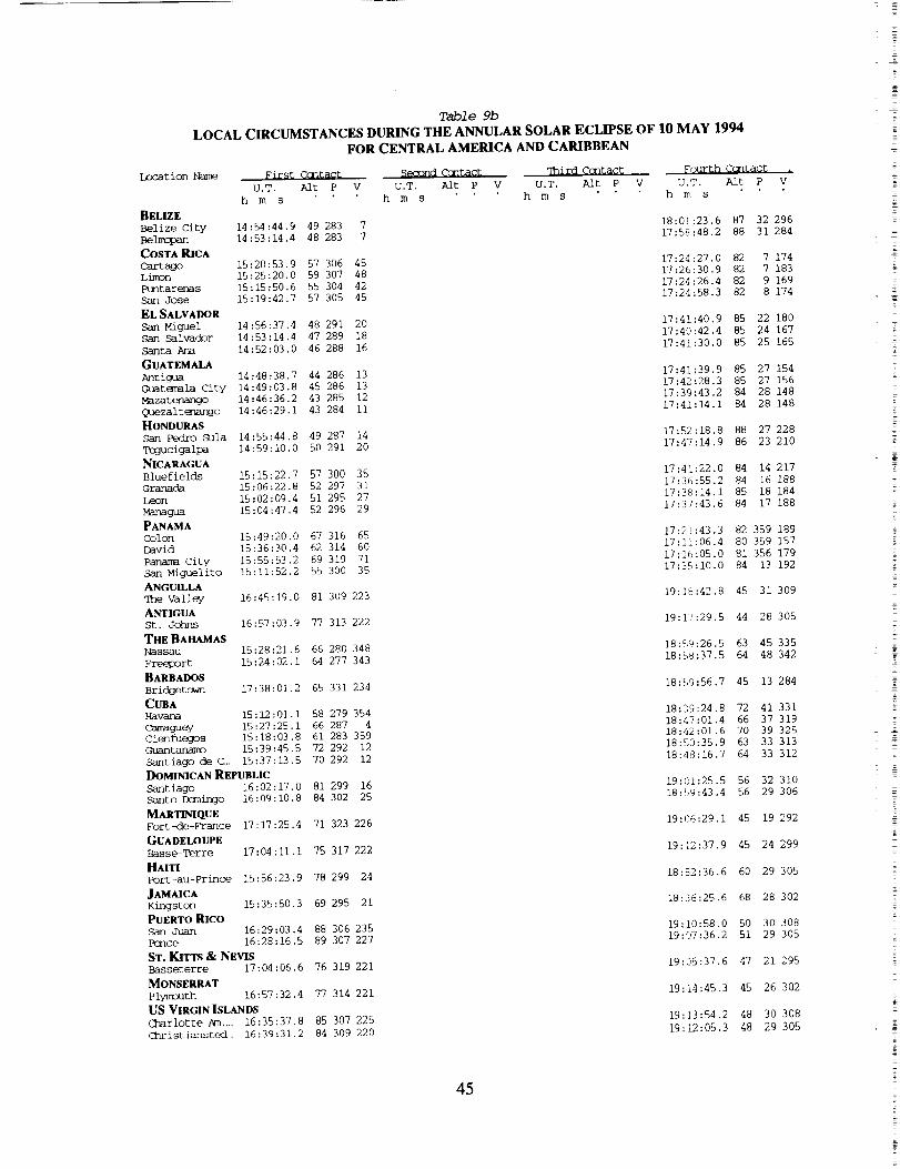
Table 9b
LOCAL CIRCUMSTANCES DURING THE ANNULAR SOLAR ECLIPSE OF 10 MAY 1994
FOR CENTRAL AMERICA AND CARIBBEAN
Location Name First Ccntact
U.T. Alt P
h m s
BELIZE
Belize City 14:54:44.9 49 283 7
Be_ 14:53:14.4 48 283 7
COSTA RICA
Cartago 15:20:53.9 57 306 45Limon 15:25:20.0 59 307 48Ptmtarer_s 15:15:50.6 55 304 42
San Jose 15:19:42.7 57 305 45
EL SALVADOR
San Miguel 14:56:37.4 48 291 20San Salvador 14:53:14.4 47 289 18
Santa Ana 14:52:03.0 46 288 16
GUATEMALA
Antigua 14:48:38.7 44 286 13
(_atemala City 14:49:03.8 45 286 13
Mazatenango 14:46:36.2 43 285 12
Q_ezalt_ngo 14:46:29.1 43 284 11
HONDURAS
San Pedro Sula 14:55:44.8 49 287 14
Tegucigalpa 14:59:10.0 50 291 20
NICARAGUA
Bluefields 15:15:22.7 57 300 35
Granada 15:06:22.8 52 297 31
Leon 15:02:09.4 51 295 27
Managua 15:04:47.4 52 296 29
PANAMAColon 15:49:20.0 67 316 65
David 15:36:30.4 62 314 60
Panama City 15:55:53.2 69 319 71
San Miguelito 15:11:52.2 55 300 35
ANGU1LLAqhe Valley 16:45:19.0 81 309 223
ANTIGUASt. Johns 16:57:03.9 77 313 222
THE BAHAMASNassau 15:28:21.6 66 280 348
Freeport 15:24:02.1 64 277 343
BARBADOS
Brid_etown 17:38:01.2 65 331 234
CUBAHavana 15:12:01.1 58 279 354
Camaguey 15:27:25.1 66 287 4
Cienfuegos 15:18:03.8 61 283 359Guantanam_ 15:39:45.5 72 292 12
Santiago de C_ 15:37:13.5 70 292 12
DOMINICAN REPUBLIC
Santiago 16:02:17.0 81 299 16
Santo D(mJixJo 16:09:10.8 84 302 25
MARrmaQUE
Fort-de-France 17:]7:25.4 71 323 226
GUADELOUPE
Basse-Terre 17:04:11.1 75 317 222
HAI_
Port-au-Prince 15:56:23.9 78 299 24
JAMAICAKingston 15:35:50.3 69 295 21
PUERTO RICOSan Juan 16:29:03.4 88 306 235
l_nce 16:28:16.5 89 307 227
ST. KITTS & NEVISBasseterre 17:04:06.6 76 319 221
MONSERRAT
Plymouth 16:57:32.4 77 314 221
US VIRGIN ISLANDS
Charlotte Am .... 16:35:37.8 85 307 225
<lhristiansted_ 16:39:31.2 84 309 220
Second Ccntact Third Ccntact _ourth Ccntact
V U.T. AIr P V U.T. Aft P V U.T. Alt P Vh m s h m s h m s
18:01..23.6 87 32 296
17:58:48.2 88 31 284
17:24:27.0 82 7 174
17:26:30.9 82 7 18317:24:26.4 82 9 169
17:24:58.3 82 8 174
17:41:40.9 85 22 180
17:40:42.4 85 24 167
17:41:30.0 85 25 165
17:41:39.9 85 27 154
17:42:28.3 85 27 156
17:39:43.2 84 28 148
17:41:14.1 84 28 148
17:52:18.8 88 27 22817:47:14.9 86 23 210
17:41:22.0 84 14 217
17:36:55.2 84 16 188
17:38:14.1 85 18 184
17:37:43.6 84 17 188
17:21:43.3 82 359 189
17:11:06.4 80 359 157
17:]6:05.0 81 356 ]79
17:35:10.0 84 13 192
19:]8:42.8 45 31 309
19:]7:29.5 44 28 305
18:59:26.5 63 45 335
18:58:37.5 64 48 342
18:59:56.7 45 13 284
18:39:24.8 72 41 331
18:47:01.4 66 37 31918:42:01.6 70 39 325
18:50:35.9 63 33 313
18:48:16.7 64 33 312
19:0[:25.5 56 32 310
18:59:43.4 56 29 306
19:06:29.1 45 19 292
19:12:37.9 45 24 299
18:52:36.6 60 29 305
18:36:25.6 68 28 302
19:10:58.0 50 30 30819:07:36.2 51 29 305
19:05:37.6 47 21 295
19:14:45.3 45 26 302
19:13:54.2 48 30 308
19:12:05.3 48 29 305
45

Location Name
ALABAMA
Anniston
Birmingham
Gadsden
Htmtsville
M,3bile
Mantgumery
Tuscaloosa
ALASKA
AnchorageFairhsnks
J_qeau
ARIZONA
Flagstaff
Glendale
Mesa
Phoenix
Scottsdale
TempeTucsctn
Yuma
ARKANSAS
Fort Smith
Little Rock
N Little Rock
Pine Bluff
CALIFORNIA
Alameda
A.].ha_rrbr a
Anaheim
Bakersfield
Baldwin Park
Bel I flower
Berkeley
Buena Park
Burbank
CarsQn
Cerritos
C_u la Vista
Cc_pton
Ccncord
Cosa Mesa
DalycityDowney
E1 Cajon
E1 Mante
Eseondicb
Eureka
Fairfield
Fountain valley
Fremsnt
Fresno
Fullerton
Garden Grove
GlexK_le
Hawthorne
_d
H_mt ington Beach
Ingl_
Irvine
Lak_
La Mesa
Ix]ng Beach
Los Angeles
M3desto
Table 10a
CIRCUMSTANCES AT MAXIMUM ECLIPSE ON 10 MAY 1994FOR THE UNITED STATES OF AMERICA
Latitude Lcngitude Elev. U.T.
m hms
33 39.0 -85-47.0 - 16:56:17.8
33 31.8 -86-48.6 203 16:53:21.8
34 00.6 -86-00.6 182 16:56:16.5
34 43.9 -86-35.2 210 16:55:55.7
30 40.8 -88-06.6 2 16:44:53.1
32 21.6 -86-18.0 52 16:52:44.9
33 12.0 -87-32.4 - 16:50:53.4
61 12.0 -149-48.0 28 16:37:26.2
64 50.0 -147-48.0 143 16:44:49.6
58 18.2 -134-24.5 4 16:36:30.5
35 12.6 -111-37.2 2264 16:09:45.4
33 30.0 -112-15.0 - 16:05:39.5
33 25.0 -111-50.0 - 16:05:59.3
33 30.0 -112-04.8 366 16:05:51.3
33 30.0 -111-53.0 - 16:06:05.5
33 24.0 -111-54.0 - 16:05:52.5
32 13.2 -110-55.2 784 16:04:44.1
32 42.0 -114-37.8 52 16:01:26.5
35 22.8 -94-24.0 144 16:38:37.3
34 44.4 -92-19.2 94 16:42:00.5
34 46.0 -92-13.0 - 16:42:17.5
34 13.2 -92-01.2 - 16:41:44.4
37 46.0 -122-15.0 - 16:04:14.8
34 05.0 -118-08.0 - 16:00:39.6
33 50.0 -117-55.0 - 16:00:22.8
35 23.0 -119 00.0 131 16:02:22.5
34 05.0 -117-58.0 - 16:00:48.8
33 53.0 -118-08.0 - 16:00:16.6
37 52.0 -122-17.0 13 16:04:24.8
33 52.0 -118 00.0 - 16:00:22,0
34 ii.0 -118-19.0 - 16:00:41.1
33 49.0 -118-16.0 - 16:00:01.7
33 52.0 -118-05.0 - 16:00:17.4
32 38.0 -117-05.0 - 15:58:51.6
33 54.0 -118-14.0 - 16:00:13.1
37 58.0 -122-02.0 - 16:04:48.1
33 39.0 -118-54.0 - 15:59:08.7
37 43.0 -122-31.0 - 16:03:56.6
33 56.0 -118-08.0 - 16:00:22.4
32 48.0 -116-58.0 - 15:59:17.4
34 04.0 -118-02.0 - 16:00:43.2
33 07.0 -117 00.0 - 15:59:51.9
40 45.0 -124-10.0 - 16:08:32.9
38 14.0 -122-02.0 - 16:05:18.9
33 42.0 -117-57.0 - 16:00:05.6
37 33.0 -122 00.0 - 16:04:01.6
36 46.2 -119-46.8 94 16:04:21.8
33 53.0 -117-56.0 - 16:00:27.6
33 47.0 -117-56.0 - 16:00:16.1
34 09.0 -118-15.0 - 16:00:40.9
33 55.0 -118-22.0 - 16:00:07.8
37 40.0 -122-06.0 - 16:04:10.3
33 39.0 -118 00.0 - 15:59:57.1
33 57,0 -118-22.0 - 16:00:11.6
33 40.0 -117-45.0 - 16:00:12.9
33 50.0 -118-09.0 - 16:00:10.0
32 46.0 -117-01.0 - 15:59:10.7
33 46.0 -118-12.0 - 15:59:59.6
34 04.8 -118-22.2 32 16:00:26.3
37 39.0 -121 00.0 - 16:05:01.6
Umbral Path Sun Sum
Durat. Width Alt Az.
m s km
Eclipse Eclipse
P V Mag. obs.
71 146 339 8 0.780 0.707
71 141 339 12 0.787 0.715
71 146 339 8 0.792 0.721
70 146 339 9 0.816 0.750
71 128 338 23 0.727 0.643
72 140 339 13 0.752 0.673
70 138 338 15 0.786 0.714
21 90
22 95
28 103
165 195 0.165 0.077
165 192 0.147 0.065
164 196 0.276 0.164
44 99
43 97
43 97
43 97
43 97
43 97
44 96
40 94
158 216 0.842 0.780
158 219 0.871 0.813
158 219 0.877 0.821
158 219 0.872 0.816
158 218 0.875 0.818
158 219 0.877 0.820
158 220 0.912 0.861
158 220 0.860 0.801
62 124
65 127
65 127
65 127
338 24 0.911 0.861
338 22 0.874 0.819
338 22 0.873 0.818
338 22 0.858 0.800
34
37
37
36
37
37
34
37
37
37
37
37
37
34
36
34
37
38
37
38
33
34
37
34
36
37
37
37
37
34
37
37
37
37
38
37
37
35
93 160 216 0.681 0.588
93 159 219 0.794 0.722
93 159 219 0.801 0.730
93 159 218 0.759 0.680
93 159 219 0.796 0.724
93 159 219 0.798 0.726
93 160 216 0.679 0.585
93 159 219 0.800 0.729
93 159 219 0.790 0.717
92 159 219 0.798 0.726
93 159 219 0.799 0.727
92 158 221 0.834 0.770
93 159 219 0.796 0.725
94 160 215 0.680 0.586
92 159 220 0.794 0.722
93 160 216 0.679 0.586
93 159 219 0.797 0.725
92 158 220 0.832 0.767
93 159 219 0.795 0.723
93 158 220 0.825 0.759
95 160 213 0.609 0.505
94 160 215 0.675 0.580
93 159 220 0.803 0.733
93 159 216 0.688 0.596
94 159 216 0.725 0.639
93 159 219 0.800 0.729
93 159 219 0.802 0.731
93 159 219 0.791 0.719
92 159 219 0.795 0.723
93 160 216 0.685 0.592
92 159 220 0.804 0.734
92 159 219 0.794 0.722
93 159 220 0.806 0.737
93 159 219 0.799 0.727
92 158 220 0.832 0.768
92 159 220 0.799 0.728
93 159 219 0.791 0.719
94 159 216 0.696 0.605
46

Table lOb
LOCAL CIRCUMSTANCES DURING THE ANNULAR SOLAR ECLIPSE OF 10 MAY 1994
FOR THE UNITED STATES OF AMERICA
Location Name First Ccntact Semond Ccntact qhird Ccntact _ourth C(]ntact .
U.T. Alt P V U.T. Aft P V U.T. Alt P V U.T. Ak P V
m s h m s h m s h m s
ALABAMA
Anniston 15:13:23.4 54 261 318 18:50:10.5 68 62 21
Birmingham 15:11:13.5 52 260 318 18:47:16.6 69 62 23
Gadsden 15:13:28.6 53 260 317 18:49:56.7 67 63 22
Huntsville 15:13:29.3 53 259 314 18:49:07.0 67 64 26
5k]bile 15:04:39.7 51 263 326 18:39:45.6 73 58 18
M_ntgcmery 15:10:31.2 53 262 322 18:47:15.4 69 60 18
Tuscaloosa 15:09:21.7 52 260 319 18:44:54.1 70 62 24
ALASKA
Anchorage 15:58:56.8 16 200 230 17:16:31.9 25 131 161
Fairhenks 16:07:51.4 18 198 225 17:22:00.5 26 134 160
Juneau 15:45:18.4 22 209 243 17:29:32.7 35 120 150
ARIZONA
Flagstaff 14:48:04.8 27 242 301 17:44:55.2 62 77 123
Glendale 14:44:25.9 26 244 305 17:40:55.7 62 75 126
Mesa 14:44:25.2 26 244 305 17:41:44.0 62 74 125
Phoenix 14:44:29.3 26 244 305 17:41:18.4 62 75 126
ScDttsdale 14:44:33.9 26 244 305 17:41:45.1 62 74 125
Tempe 14:44:21.7 26 244 305 17:41:33.4 62 74 125
ql_cscn 14:42:28.0 26 246 308 17:41:52.2 64 72 124
Yt_a 14:42:08.7 23 243 305 17:34:27.6 59 75 131
ARKANSAS
Fort Smith 15:02:19.7 44 253 310 18:28:48.0 72 68 58
Little Rock 15:04:01.3 46 255 313 18:33:40.9 72 66 47
N Little Rock 15:04:13.3 46 255 313 18:33:59.6 72 66 47
Pine Bluff 15:03:33.1 47 256 314 18:33:52.6 72 65 44
CALIFORNIA
Alameda 14:51:43.3 20 234 289 17:26:46.8 50 87 139
Alhambra 14:44:12.9 21 240 300 17:29:24.7 55 79 135
Anaheim 14:43:44.5 21 240 300 17:29:27.8 55 79 135
Bakersfield 14:46:46.3 21 238 296 17:29:36.7 54 82 136
Baldwin Park 14:44:14.1 21 240 300 17:29:44.5 55 79 135
Bellflc_er 14:43:48.9 21 240 300 17:29:06.6 55 79 135
Berke]ey 14:51:56.4 20 234 289 17:26:51.0 50 87 139
Buena Park 14:43:47.8 21 240 300 17:29:20.9 55 79 135
Burbank 14:44:23.6 21 240 299 17:29:11.9 55 80 135
Carscn 14:43:40.0 21 240 300 17:28:44.8 55 79 135
Cerritos 14:43:47.2 21 240 300 17:29:11.0 55 79 135
Chula Vista 14:41:30.5 21 242 303 17:29:16.6 56 77 134
Ccrnpton 14:43:50.2 21 240 300 17:28:56.3 55 79 135
cencord 14:52:09.3 20 234 289 17:27:26.2 50 87 139
Cosa Mesa 14:43:16.2 20 240 300 17:27:15.5 54 79 136
Daly City 14:51:37.1 20 234 289 17:26:14.0 50 87 139
Dcx4ney 14:43:54.9 21 240 300 17:29:11.1 55 79 135
E1 Cajon 14:41:51.0 21 242 303 17:29:46.4 56 77 134
E1 Monte 14:44:11.6 21 240 300 17:29:35.0 55 79 135
Escondicb 14:42:27.6 21 242 302 17:30:12.1 56 77 134
Eureka 14:58:29.1 20 230 282 17:27:08.9 48 92 141
Fairfield 14:52:44.4 20 233 289 17:27:47.1 50 88 139
Fountain Vall.. 14:43:28.3 21 240 301 17:29:11.8 55 79 135
Fremont 14:51:14.8 20 234 290 17:26:56.8 50 87 139
Fresno 14:49:37.7 21 236 293 17:30:02.7 53 84 136
Fullerten 14:43:50.3 21 240 300 17:29:30.4 55 79 135
Garden Grove 14:43:38.4 21 240 300 17:29:21.3 55 79 135
Glendale 14:44:20.1 21 240 299 17:29:16.8 55 80 135
Hawthome 14:43:51.2 21 240 300 17:28:42.1 55 79 135
Kayward 14:51:30.1 20 234 290 17:26:55.2 50 87 139
Huntington Be. 14:43:22.0 21 240 301 17:29:01.3 55 79 135
Inglewood 14:43:55.2 21 240 300 17:28:45.1 55 79 135
Irvine 14:43:25.9 21 241 301 17:29:32.6 55 79 135
Lakewood 14:43:42.8 21 240 300 17:29:00.1 55 79 135
La Mesa 14:41:46.6 21 242 303 17:29:37.2 56 77 134
Ix]rig Beach 14:43:34.5 21 240 300 17:28:48.2 55 79 135
Los Angeles 14:44:10.8 21 240 299 17:28:56.3 55 80 135Modesto 14:51:28.3 21 235 290 17:28:55.4 51 86 137
47

Location Name
CALIFORNIA
Mmnt_bel io
Monterey Park
Mountain View
NapaNewport BeachNorwalk
Oakland
Oceanside
Ontario
Orange
O_nard
Palo Alto
Pasadena
Pioo Rivera
Pcrm_a
Rancho Cucamonga
Redondo Beach
Redwood City
RichmDnd
Riverside
Sacramento
Salinas
San Berna rdino
San Buenav_nL ura
San Diego
San Francisco
San Jose
San Leandro
San Mateo
Santa Aria
Santa Barbara
Santa Clara
Santa Mcnica
Santa Rosa
simi Valley
South Gate
Stockton
Shmnyvale
qT_)usand Oaks
Torrance
Vallejo
Visalia
Walnut Creek
West Covina
Westminster
Whittier
COLORADOArvada
Aurora
Boulder
Colorado Springs
Denver
Durango
Fort Collins
Grand Junction
Greeley
Lakew:oJ
Pueblo
westminster
Table 10a
CIRCUMSTANCES AT MAXIMUM ECLIPSE ON 10 MAY 1994
FOR THE UNITED STATES OF AMERICA
Latitude Lcngitude
34 01.0 -118-06.0
34 04.0 -118-08.0
37 25.0 -122-07.0
38 20.0 -122-17.0
33 36.0 -117-55.0
33 54.0 -118-05.0
37 48.0 -122-16.0
33 ii.0-117-22.0
34 04.0 117-39,0
33 48.0 -117-51.0
34 08.0 -119-12.0
37 27.0 -122-09.0
34 09.0 -118-09.0
34 01.0 -118-05.0
34 04.0 -117-45.0
34 05.0 -117-35.0
33 50.0 -118-23.0
37 29.0 -122-13.0
37 56.0 -122-21.0
33 59.0 -117 21.0
38 35.0 -121-30.0
36 41,0 -121-40.0
34 07.0 -117-19.0
34 18.0-119-18.0
32 45.0 -117-08.4
37 45.6 -122-26.4
37 20.0 -121-54.0
37 43.0 -122-10.0
37 34.0 -122-20.0
33 41.0 117 57.0
34 26.0 -119-43.0
37 21.0 -121-56.0
34 01.0 -118-29.0
38 27.0 -122-42.0
34 16,0 -118-47.0
33 57.0 -118-13.0
37 57.5 121-17.3
37 23.0 -122-02.0
34 i0.0-118-50.0
33 50.0 -118-20.0
38 06,0 -122-15.0
36 20.0 -119-18.0
37 54.0 -122-04,0
34 04.0 -117-55.0
33 45.0 -117-59.0
33 58.0 -118-02.0
39 48.0 -105-05.0
39 43.0 -104-49.0
40 00.2 -105-15.7
38 49.0 -104-48.0
39 43.2 -104-58,8
37 15.0 -107-55.0
40 36.0 -105-04.0
39 04.2 -108-33.0
40 25.0 -104-41,0
39 44.0 -105-06.0
38 17,4 -104-38.4
39 50.0 -105-02.0
Umbral Path Sun Stm
Elev. U.T. Durat. Width Alt Az. P
m h m s m s krn
V
Eclipse Eclipse
Mag. obs.
272
- 16:00:33.8 37 93 159 219 0.796 0.724
- 16:00:37.7 37 93 159 219 0.794 0.722
- 16:03:40.7 34 93 159 216 0.689 0.597
- 16:05:18.6 34 94 160 215 0.670 0.575
- 15:59:56.0 37 92 159 220 0.806 0,736
- 16:00:21.3 37 93 159 219 0.798 0.727
8 16:04:17.9 34 93 160 216 0.680 0.587
- 15:59:38.7 37 92 158 220 0.820 0.753
- 16.01:04.5 37 93 159 219 0.799 0.728
- 16:00:22,6 37 93 159 219 0.803 0.732
i0
354
7
21
3O
15:59:48.3 36 92 159 219 0.781 0.707
16:03:43.0 34 93 160 216 0.688 0.596
16:00:46,2 37 93 159 219 0.792 0,720
16:00:34,7 37 93 159 219 0.796 0.724
16:00:58.9 37 93 159 219 0.798 0.727
16:01:10.2 37 93 159 219 0.800 0.729
15:59:57,3 36 92 159 219 0.796 0.724
16:03:43.7 34 93 160 216 0.687 0.594
16:04:29,3 34 93 160 216 0.677 0,583
16:01:11.8 38 93 159 219 0.804 0.734
33
7
16:06:25.2 35 95 160 215 0.674 0,579
16:02:37.7 34 93 ]59 217 0.707 0.618
16:01:28.9 38 93 159 219 0.802 0.731
16:00:02.2 36 92 159 219 0.777 0.702
15:59:01.8 37 92 158 221 0.831 0.766
16:04:05.2 34 93 160 216 0.679 0.586
16:03:41.4 34 93 159 216 0.693 0.601
16:04:12.9 34 93 160 216 0.683 0.590
16:03:47.9 34 93 160 216 0.684 0.591
16:00:03,7 37 93 159 220 0.804 0.734
15:59:55.9 35 92 159 219 0.770 0.693
16:03:41.7 34 93 159 216 0.692 0.601
16:00:12.9 36 92 159 219 0.791 0,719
16:05:12,7 34 94 160 215 0.664 0,568
16:00:25.6 36 92 159 219 0.783 0.709
16:00:19.7 37 93 159 219 0.796 0.724
16:05:23.1 35 94 159 215 0.687 0.595
16:03:40.8 34 93 159 216 0.690 0.599
16:00:11.4 36 92 159 219 0.785 0.711
15:59:60.0 37 92 159 219 0.797 0.725
34 94 160 215
36 94 159 217
34 94 160 216
37 93 159 219
37 93 159 219
37 93 159 219
1932
1732
1506
1539
- 16:04:53.3
- 16:03:56.5
- 16:04:38.8
- 16:00:49.6
- 16:00:09,5
- 16:00:31.7
51 114 159 207
51 114 159 206
51 114 159 206
51 112 158 208
51 114 159 207
48 106 158 212
51 115 159 205
48 108 159 210
51 115 159 205
51 113 159 207
52 112 158 209
51 114 159 206
16:27:44.8
16:27:59.4
16:27:52.1
16:26:15.9
16:27:44.2
16:18:38.8
16:29:18.3
16:21:20.6
16:29:32.1
16:27:35.6
16:25:29.4
16:27:53.1
0,675 0,581
0.738 0.655
0.681 0,587
0.797 0.725
0.802 0,732
0.797 0.726
0.818 0.752
0.823 0.757
0.812 0.745
0,842 0.780
0.821 0.755
0.841 0.779
0.802 0.732
0.797 0.726
0.810 0.741
0.820 0.753
0,855 0,795
0.818 0.752
48

Table 10b
LOCAL CIRCUMSTANCES DURING THE ANNULAR SOLAR ECLIPSE OF 10 MAY 1994
FOR THE UNITED STATES OF AMERICA
Location Name _irst Contact $_nd Contact q_rd Contact
U.T. Alt P V U.T. Alt P V U.T. Aft P
h m s h m s h m s
CALIFORNIA
Mantebello 14:44:05.1 21 240 300
Mcnterey Park 14:44:10.9 21 240 300
M_untain View 14:50:57.6 20 234 290
Napa 14:52:57.7 20 233 288
Newport Beach 14:43:16.7 21 241 301
Norwalk 14:43:51.2 21 240 300
Oakland 14:51:47.6 20 234 289
Oceanside 14:42:32.0 21 241 302
Ontario 14:44:14.6 21 240 300
Orange 14:43:41.0 21 240 300
Oxnard 14:44:12.5 20 239 299
Palo Alto 14:51:01.9 20 234 290
Pasadena 14:44:20.6 21 240 299
Pico Rivera 14:44:05.2 21 240 300
Pclnona 14:44:13.8 21 240 300
Rancho Cucam__ 14:44:17.1 22 240 300
Redondo Beach 14:43:41.2 21 240 300
Red_ City 14:51:06.3 20 234 290
Richmond 14:52:05.2 20 234 289
Riverside 14:44:07.1 22 240 300
Sacramento 14:53:30.7 21 233 288
Salinas 14:49:23.1 20 235 292
San Bernardino 14:44:23.3 22 240 300
San Buenavent . 14:44:32.1 20 239 298
San Diego 14:41:43.5 21 242 303
San Francisco 14:51:42.6 20 234 289
San Jose 14:50:46.7 20 234 290
San _o 14:51:36,7 20 234 290
San Mateo 14:51:17.3 20 234 290
Santa Ana 14:43:26.3 21 240 301
Santa Barbara 14:44:46.5 20 239 298
Santa Clara 14:50:48.8 20 234 290
Santa Mcnica 14:44:02.5 21 240 300
Santa Rosa 14:53:13.7 20 233 288
Simi Valley 14:44:30.8 21 239 299
South c_te 14:43:56.3 21 240 300
stockton 14:52:08.3 21 234 290
Sunnyvale 14:50:53.2 20 234 290
q%]ousand Oaks 14:44:18.4 21 239 299
Torrance 14:43:41.5 21 240 300
Vallejo 14:52:26.9 20 234 289
Visalia 14:48:44.1 21 237 294
_inut Creek 14..52:00.6 20 234 289
West Covina 14:44:12.5 21 240 300
Westminster 14:43:34.0 21 240 300
Whittier 14:43:59.6 21 240 300
COLORADO
Arvada 15:01:19.1 35 241 295
Aurora 15:01:18.4 35 241 295
Boulder 15:01:39.6 35 241 294
Colorado Spri,- 14:59:18.8 35 242 297
D_nver 15:01:11.6 35 241 295
Darango 14:54:04.0 31 242 299
Fort Collins 15:03:07.8 35 240 293
Grand Jtunction 14:57:42.1 32 240 295
Greeley 15:02:57.9 36 241 293
Lakewood 15:01:09.6 35 241 295
Pueblo 14:58:16.6 35 243 298
Westminster 15:01:25.5 35 241 295
_'gur th Contact ,
V U,T. Aft P V
h m s
17:29:22.6 55 79 135
17:29:23.2 55 79 135
17:26:33.5 50 87 139
17:27:27.6 50 88 139
17:29:06.6 55 79 135
17:29:14.1 55 79 135
17:26:47.6 50 87 139
17:29:34.0 56 78 134
17:30:20.8 55 79 134
17:29:32,8 55 79 135
17:27:24.2 54 80 136
17:26:32.5 50 87 139
17:29:28.5 55 80 135
17:29:24.6 55 79 135
17:30:08.8 55 79 135
17:30:30.3 56 79 134
17:28:32.6 55 79 135
17:26:27.9 50 87 139
17:26:49,1 50 87 139
17:30:49.4 56 79 134
17:29:12.9 51 88 138
17:26:23.4 51 85 139
17:31:05.2 56 79 134
17:27:27.4 53 81 137
17:29:20.8 56 77 134
17:26:25.6 50 87 139
17:26:50.4 50 86 139
17:26:51.9 50 87 139
17:26:21.9 50 87 139
17:29:10.2 55 79 135
17:26:51.3 53 81 137
17:26:48.1 50 86 139
17:28:37.3 54 80 136
17:26:51.6 49 88 139
17:28:24.5 54 80 136
17:29:02.8 55 79 135
17:28:47.6 51 87 138
17:26:39.9 50 86 139
17:28:09.8 54 80 136
17:28:38.5 55 79 135
17:27:13.0 50 88 139
17:30:22.2 53 83 136
17:27:17.3 50 87 139
17:29:48.9 55 79 135
17:29:12.3 55 79 135
17:29:26.0 55 79 135
18:06:07.4 65 80 104
18:06:41.0 66 79 103
18:05:53.9 65 80 104
18:05:46.2 66 78 103
18:06:17.2 65 79 103
17:56:22.5 65 77 113
18:06:56.9 65 81 103
17:57:04.8 63 80 114
18:07:41.6 65 80 102
18:06:00.9 65 79 104
18:05:34.7 67 77 102
18:06:16.7 65 80 103
49
%
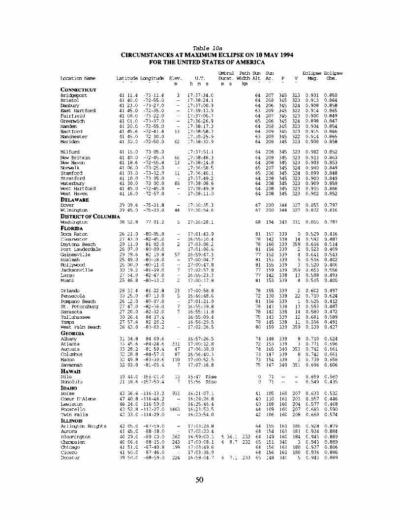
LocationNameCONNECTICUT
Bric_r t
Bristol
mmmurwEast Hartford
Fairfield
Gr_ich
Ha,den
Hart ford
Manchester
Meriden
Mi i ford
New Britain
New Haven
Norwalk
StamfordStratford
Waterbury
West Hartford
West Haven
DELAWARE
Dover
Wilmington
Table 10a
CIRCUMSTANCES AT MAXIMUM ECLIPSE ON 10 MAY 1994FOR THE UNITED STATES OF AMERICA
Umbral Path Sun sam
Latitude Longitude Elev, U.T. Durat. Width Alt Az. P
m h m s m s km
41 11.4 -73-11.4 3 17:37:34.0 64 207 345
41 40.0 -72-55.0 - 17:38:24.1 64 208 345
41 23.0 -73-27.0 - 17:37:00.3 64 206 345
41 45.0 -72-35.0 - 17:39:13.9 63 209 345
41 08.0 -73-22.0 - 17:37:06.7 64 207 345
41 01.0 -73-37.0 - 17:36:26.9 65 206 345
41 20.0 -72-55.0 - 17:38:17.3 64 208 345
41 45,6 -72-41.4 13 17:38:58.7 64 209 345
41 45.0 -72-30.0 -- 17.39:25.9 63 209 345
41 30.0 -72-50.0 62 17:38:32.9 64 208 345
DISTRICT OF COLUMBIA
41 15.0 -73-05,0 - 17:37:51,1 64 208 345
41 40.0 -72-45.0 66 17:38:48.3 64 209 345
41 18.6 -72-55.8 13 17:38:14.8 64 208 345
41 06.0 -73-25.0 - 17:36:58.5 65 207 345
41 03.0 -73-32.0 ii 17:36:40.1 65 206 345
41 i0.0 -73-05.0 - 17:37:49.2 64 208 345
41 30,0 -73 00.0 85 17:38:08.6 64 208 345
41 45.0 -72-45.0 - 17:38:49.9 64 208 345
41 16,0 -72-57.0 - 17:38:11,0 64 208 345
39 09.6 -75-31.8 - 17:30:35.3 67 200 344
39 45,0 -75-33.0 44 17:30:54.6 67 200 344
Washington 38 52.8
FLORIDA
Boca Raton 26 21.0
Clearwater 27 43.0
Daytona Beach 29 Ii.0
Fort Lauderdale 26 07.0
Gainesvil le 29 39.6
Hia leah 25 49.0
Hollywood 26 00.0
Jacksonville 30 19.2
Largo 27 54.0
Miami 25 46.8
Orlando 28 32.4
Pensacola 30 25.0
Pmmpano Beach 26 12.0
St. Petersburg 27 47.0
Sarasota 27 20.0
Tal lahassee 30 26.4
Tampa 27 57.6
West Palm Beach 26 43.0
GEORGIA
Albany 31 34.8
Atlanta 33 45.6
Augusta 33 28.2
Columbus 32 28.8
Macon 32 49.8
Savarnah 32 03.0
HAWAH
Hilo 19 44.0
Hcnolulu 21 18.6
IDAHO
Boise 43 36.6
Coeur D'Alene 47 40.8
Lewiston 46 24.0
Pocatel Io 42 52.8
Twin Falls 42 33.0
ILLINOIS
Arlington Heights 42 05.0
Aurora 41 45.0
Blocmingt on 40 29.0
Champaign 40 06.6
(hhicago 41 51.0
Cicero 41 50.0
Decatur 39 50.0
323
323
324
322
323
324
323
323
322
323
323
323
323
324
324
323
323
323
323
327
327
Eclipse Eclipse
Mag, Obs.
0.901 0.850
0.913 0.864
0.908 0.858
0.914 0.865
0.900 0.849
0.898 0.847
0.904 0.854
0,915 0.866
0.914 0.865
0.908 0.858
0,902 0.852
0.913 0.863
0.903 0.853
0.900 0.849
0.899 0.848
0.900 0.849
0.909 0.859
0.915 0.866
0.902 0.852
0.855 0.797
0.872 0.816
-77-01.2 5 17:26:28.1 68 194 343 331 0.855 0.797
-80-05,0 - 17:01:43,9 81 157 339 0 0.529 0.416
-82-45.0 - 16:55:10.4 78 142 338 14 0.592 0.487
-81-02.0 2 17:03:08.2 78 160 339 358 0.616 0.514
-80-09.0 - 17:01:06.6 81 156 339 2 0.523 0.409
-82-19,8 57 16:59:47,3 77 152 339 4 0.641 0.543
-80-18.0 - 17:00:04.7 81 153 339 5 0.516 0.402
-80-11,0 - 17:00:47.8 81 155 339 3 0.520 0.406
-81-39.0 7 17:02:57.8 77 159 339 359 0.653 0.556
-82-47.0 - 16:55:23.3 77 142 338 13 0.598 0.493
-80-13.2 2 17:00:17.8 81 153 339 4 0.515 0.400
-81-22.8 23 17:00:58.8 78 155 339 2 0.602 0.497
-87-13,0 5 16:46:48.6 72 130 338 22 0.710 0.624
-80-07.0 - 17:01:21.9 81 156 339 1 0.525 0.412
-82-38.0 7 16:55:39.8 78 143 338 13 0.593 0.487
-82-32.0 7 16:55:11.8 78 142 338 14 0.580 0.472
-84-17.4 - 16:55:09.4 75 143 339 12 0.681 0.589
-82-28.2 - 16:56:29.5 78 145 338 ii 0.596 0.491
-80-03,2 -- 17:02:26.5 80 159 339 359 0.539 0,427
84-09.6 - 16:57:26.5 74 148 339 8 0.710 0.624
-84-24.6 331 17:00:12.8 72 153 339 3 0.771 0,696
-81-59.4 47 17:06:38.0 74 165 340 353 0.742 0,661
-84-57.0 87 16:56:40.3 73 147 339 8 0.742 0,661
-83-39.6 ii0 17:00:52.5 73 154 339 2 0.739 0.658
-81-05.4 7 17:07:16.8 75 167 340 351 0.696 0,606
-155-01.0 13 15:47 Rise 0 71 - - 0.659 0.560
-157-50.4 7 15:56 Rise 0 71 - - 0.549 0.435
-116-13.2 931 16:21:07.1 41 105 160 207 0.633 0,532
-116-46.2 - 16:28:26.8 40 ii0 161 203 0.557 0,446
-116-59.0 - 16:25:46.4 40 108 160 204 0.577 0.468
-112-27.0 1463 16:23:50.5 44 109 160 207 0.683 0.590
-114-29.0 - 16:20:54.0 42 106 160 208 0.669 0,574
-87-59.0 - 17:03:28.8 64 155 161 180 0.928 0,879
-88-18.0 - 17:02:20.4 64 154 161 181 0.934 0.884
-89 00.0 262 16:59:00.3 5 36.1 232 64 149 160 184 0,943 0.889
-88-15.0 243 17:00:08.1 6 8.7 232 65 151 340 3 0,943 0.889
-87-40.8 199 17:03:49.6 64 156 161 180 0,937 0.886
-87-46.0 - 17:03:36.9 64 156 161 180 0,936 0.886
-88-59.0 224 16:58:04.7 6 7.1 233 65 148 340 5 0.943 0.889
5O

Table 10b
LOCAL CIRCUMSTANCES DURING THE ANNULAR SOLAR ECLIPSE OF I0 MAY 1994
FOR THE UNITED STATES OF AMERICA
Location Name
CONNECTICUT
Bridgeport 15:50:54.8
Bristol 15:52:04.6
Danbury 15:50:32.7
East Hartford 15:52:55.4
Fairfield 15:50:26.7
Greenwich 15:49:44.5
Hamden 15:51:41.9
Hartford 15:52:41.6
Manchester 15:53:06.8
Meriden 15:52:04.5
Milford 15:51:13.4
New Britain 15:52:27.2
New Haven 15:51:38.5
Norwalk 15:50:17.6
Stamford 15:49:58.2
Stratford 15:51:07.8
Waterbury 15:51:41.8
West Hartford 15:52:32.8
West Haven 15:51:32.8
DELAWARE
Dover 15:43:09.7
Wilmington 15:43:49.7
DISTRICT OF COLUMBIA
Washington 15:39:24.2
FLORIDA
Boca Raton 15:19:55.6
Clearwater 15:13:22.9
Daytona Beach 15:19:03.8Fort Lauderd_., 15:19:37.7
Gainesville 15:16:09.7
Hialeah 15:19:03.6
Hollywood 15:19:28.9
Jacksonville 15:18:29.9
Largo 15:13:26.7Miami 15:19:17.2
Orlando
Pensacola
Pompano Beach
St. Petersburg
Sarasota
Tal lahassee
TampaWest Palm Be_.
GEORGIA
ALbanyAtlanta
Augusta
Columns
Macon
Savannah
HAWAII
Hilo
Honolulu
IDAIIO
Boise
Coeur D 'Alene
Lewiston
Pocatello
Twin Falls
ILUNOIS
Arlington 8el...
Aurora
Bloomington
Cha_ignChicago
Cicero
Decatur
First Contact
U.T. Aft P V
h m s
63 258 283
63 257 281
63 257 283
63 257 280
63 258 284
63 258 284
63 258 282
63 257 281
63 257 280
63 258 282
63 258 283
63 257 281
63 258 282
63 258 284
63 258 284
63 258 283
63 258 282
63 257 281
63 258 282
63 260 293
63 259 291
62 259 296
62 276 343
58 271 338
60 271 333
62 276 344
58 269 331
61 276 345
62 276 344
59 268 329
58 271 337
62 277 345
15:17:37.6 60 271 335
15:06:03.8 52 264 327
15:19:45.8 62 276 344
15:13:44.2 58 271 337
15:13:38.9 58 272 339
15:12:20.0 56 266 328
15:14:18.1 58 271 337
15:20:10.9 62 275 342
15:13:58.9 56 265 324
15:16:19.1 55 261 317
15:21:11.7 58 264 318
15:13:26.4 55 263 321
15:16:39.5 56 263 320
15:21:39.6 60 266 323
15:05:43.7 27 231 281
15:15:48.0 28 227 272
15:12:30.4 28 228 274
15:04:55.9 30 234 284
15:03:33.8 28 233 284
15:24:18.2 51 248 292
15:23:10.5 51 249 293
15:19:39.0 50 250 297
15:20:03.8 51 251 298
15:24:17.8 51 249 293
15:24:08.0 51 249 293
15:18:25.0 50 251 299
_'cond Contact Third Contact
U.T. /Lit P V U.T. Alt P
h m s h m s
16:56:]0.2 64 227 252 17:01:46.3 65 96 120
16:57:04.5 65 259 284 17:03:13.2 65 64 86
]6:55:02.1 65 260 287 17:01:09.2 65 63 87
Vourth Contact .
V U.T. Aft P V
h m s
19:21:01.0 50 75 29
19:21:16.1 50 76 30
19:20:26.0 50 75 30
19:21:49.7 49 76 30
19:20:42.8 50 75 29
19:20:17.9 50 75 28
19:21:27.0 50 75 29
19:21:37.7 49 76 30
19:21:58.7 49 76 30
19:21:30.9 50 76 30
19:21:11.0 50 75 29
19:21:34.4 49 76 30
19:21:26.2 50 75 29
19:20:38.2 50 75 29
19:20:26.4 50 75 29
19:21:13.6 50 75 29
19:21:12.5 50 76 30
19:21:31.5 49 76 30
19:21:25.3 50 75 29
19:17:06.8 53 71 24
19:16:57.1 53 72 26
19:14:01.1 55 71 24
18:54:30.8 66 48 343
18:49:43.1 69 51 352
18:57:12.2 65 53 355
18:53:48.3 66 47 342
18:54:22.4 67 55 359
18:52:41.4 67 47 341
18:53:26.8 66 47 341
18:57:14.7 65 56 0
18:49:59.1 68 51 353
18:52:50.2 66 47 340
18:55:08.9 66 52 353
18:41:51.6 72 57 14
18:54:05.2 66 47 342
18:50:11.1 68 51 352
18:49:33.9 69 50 350
18:50:07.8 68 56 6
18:50:59.7 68 51 352
18:55:23.0 65 48 344
18:52:06.8 67 58 9
18:53:57.4 66 62 18
19:00:01.5 63 62 12
18:51:05.9 68 60 15
18:54:58.9 66 61 13
19:00:56.5 63 59 6
16:34:47.4 10 85 157
16:35:55.6 8 88 159
17:45:16.8 54 91 128
17:47:55.3 52 97 129
17:46:25.6 52 95 129
17:52:22.3 58 88 121
17:47:45.4 56 89 126
18:49:17.2 62 77 52
18:48:29.9 63 77 52
18:46:31.0 64 75 50
18:48:13.3 64 74 47
18:49:58.4 62 77 51
18:49:46.0 62 77 51
18:46:19.3 65 74 48
51
¥
f
2

Loc_ t ion Name
ILLINOIS
Des Plaines
East St. Louis
Elgin
Evanston
Jol let
Mount Prospect
Oak Lawn
Oak Park
Peoria
Rockford
Scha_urg
Skokie
Springfield
Urbana
INDIANA
Anderson
Bloomington
Evansville
Fort Wayne
GaryHammcnd
Ind_anapol is
Muncie
South Bend
Terre Haute
IOWAAmes
Cedar Rapids
Council Bluffs
DavemportDes Moines
Dubuque
Iowa City
Sioux City
Waterloo
KANSAS
[X_e City
Irdepe_denoeKansas City
Lawrence
Overland Park
Parsons
Salina
Wichita
KENTUCKY
Bowling Green
Corbin
Frankfort
Lodn_onLouisville
Owensboro
Paducah
LOUISIANA
Alexandria
Eaton Rouge
Bossier City
Kenner
Lafayette
Lake C_ar le_
Monroe
New Orleans
Shreveport
Table 10a
CIRCUMSTANCES AT MAXIMUM ECLIPSE ON 10 MAY 1994
FOR THE UNITED STATES OF AMERICA
Umbral Path Sun St_
Latitude Lor_itude Elev. U.T. Durat. Width Aft Az. P
m h m s m s km
Eclipse Eclipse
V M_g. Obs.
42 02.0 -87-54.0 - 17:03:35.6 64 155 161 180 0.930 0.881
38 38.0 -90-10.0 - 16:53:34.1 3 31.7 234 65 142 339 i0 0.943 0.889
42 03.0 -88-16.0 17:02:49.3 64 154 161 181 0.927 0.878
42 02.0 -87-41.0 - 17:04:03.9 64 156 161 179 0.932 0.882
41 37.0 -88-05.0 - 17:02:37.7 64 154 161 181 0.939 0.888
42 03.0 -87-56.0 - 17:03:32.6 64 155 161 180 0.930 0.880
41 43.0 -87-45.0 - 17:03:29.7 64 155 161 180 0.939 0.888
41 53.0 -87-48.0 - 17:03:36.6 64 155 161 180 0.935 0.885
40 42.6 -89-36.6 154 16:58:00.2 3 43.0 233 64 148 160 185 0.943 0.889
42 16.2 -89-04.2 235 17:01:24.4 63 152 161 182 0.915 0.865
42 02.0 88 05,0 - 17:03:11.8 64 155 161 180 0.929 0.879
42 02.0 -87-45.0 - 17:03:55.2 64 156 161 179 0.931 0.882
39 48.0 -89-39.0 200 16:56:32.6 6 10.3 233 65 146 160 187 0.943 0.889
40 06.3 -88 13.5 238 17:00:11.0 6 8.1 232 65 151 340 3 0.943 0.889
40 05.0 -85-50.0 - 17:05:39.5 3 13.6 231 66 159 341 357 0.943 0.890
39 12.6 -86-34.8 - 17:02:42.5 67 155 340 0 0.931 0.882
37 58.8 -87-33.0 126 16:58:36.4 67 149 340 5 0.908 0.858
41 04.2 -85-09.0 259 17:08:30.7 6 9.2 231 66 163 341 354 0.943 0.890
41 35.0 -87-21.0 194 17:04:11.8 2 41.5 231 65 156 161 179 0.943 0.889
41 37.0 -87-31.0 - 17:03:52.4 i 23.4 231 64 156 161 179 0.943 0.889
39 47.4 -86-08.4 260 17:04:32.8 67 158 340 358 0.942 0.889
40 11.5 -85-23.3 312 17:06:50.8 2 57.4 231 67 161 341 356 0.943 0.890
41 40.0 -86-20.0 233 17:06:34.1 4 26.5 231 65 160 161 177 0.943 0.889
39 28,1 -87-24.4 163 17:01:08.3 1 55.8 232 66 153 340 2 0.943 0.890
42 02.4 -93-36.6 - 16:51:47.4
41 58.0 91-39.9 240 16:55:33.9
41 16.0 -95-53.0 - 16:46:07.8
41 32.4 -90-35.4 194 16:57:08.8
41 36.0 -93-37.8 308 16:51:02.6
42 30.0 -90-43.0 269 16:58:18.0
41 40.2 -91-31.8 225 16:55:23.4
42 30.0 -96-24.0 331 16:47:14.9
42 30.0 -92-22.0 279 16:54:57.9
60 139 160 191 0.881 0.827
62 144 160 187 0.900 0.849
59 133 159 195 0.878 0.824
63 146 160 186 0.920 0.871
61 138 160 191 0.892 0.839
62 148 160 185 0.896 0.844
62 144 160 188 0.909 0.859
58 134 160 194 0.845 0.785
61 143 160 188 0.882 0.828
37 45.6 -100-01.2 847 16:32:08.9 56 118 158 206 0.916 0.866
37 13.0 -95-42.0 - 16:39:19.4 6 1.7 239 61 125 338 22 0.942 0.888
39 06,0 -94-39.0 246 16:44:48.4 61 131 159 197 0.941 0.888
38 57.6 -95-15.0 - 16:43:21.6 61 129 159 198 0.938 0.886
38 59.0 -94-40.0 - 16:44:34.2 i 18.1 237 61 131 159 197 0.943 0.888
37 20.0 -95-16,0 - 16:40:24.8 5 59.5 238 61 126 338 21 0.943 0.888
38 50.1 -97-36.5 403 16:38:34.3 58 124 159 201 0.917 0.867
39 02.4 -95-41.4 305 16:42:37.8 60 129 159 199 0.932 0.882
37 40.8 -97-19.8 423 16:36:58.4 3 2.3 240 59 123 158 203 0.942 0.888
38 28.6 -82-38.4 176 17:11:26.1
36 59.0 -86-27.0 167 16:59:47.2
36 56.4 -84-06.0 - 17:05:41.7
38 12.0 -84-51.6 - 17:05:29.2
38 03.6 -84-29.4 313 17:06:13.4
38 13.2 -85-45.0 156 17:03:19.0
37 45.0 -87-05.0 - 16:59:23.0
37 05.0 -88-36/ 113 16:54:42.4
69 170 341 350 0.881 0.827
69 151 340 4 0.873 0.818
70 161 340 356 0.852 0.793
68 160 340 357 0.891 0.839
69 161 340 356 0.884 0.831
68 157 340 360 0.899 0.848
68 151 340 4 0,898 0.847
67 144 339 9 0.895 0.844
31 18.0 -92-28.0
30 27.0 -91-08.4
32 31.0 -93-42.0
29 58.0 -90-15.0
30 13.2 -92-01.2
30 12.D -93-12.0
32 30.6 -92-06.0
29 58.2 -90-04.8
32 28.2 -93-46.2
-- 16:35:11.4
19 16:36:42.9
- 16:34:43.6
- 16:37:59.5
- 16:34:08.5
- 16:31:21.5
- 16:38:21.8
2 16:38:25.6
67 16:34:28.8
65 118 337 30 0.791 0.719
67 119 337 30 0.754 0.676
64 118 337 29 0.834 0.772
68 120 337 30 0.732 0.650
66 116 337 32 0.759 0.681
64 114 337 33 0.772 0.697
66 122 338 26 0.816 0.750
68 120 337 29 0.730 0.647
64 118 337 29 0.834 0.772
52

Tab/e / 0b
LOCAL CIRCUMSTANCES DURING THE ANNULAR SOLAR ECLIPSE OF 10 MAY 1994
FOR THE UNITED STATES OF AMERICA
Location Name
ILLINOIS
Des Plaines
East St. icu_s
Elgin
Evanston
Joliet
Mount Prospect
Oak Lawn
Oak Park
Peoria
Rock ford
sd%at_mlrg
skokie
Springfield
Urbarm
INDIANA
Anderson
Blommingt on
_Jansvi ] le
Fort Wayne
Gary
_d
Indianapo i is
Muncie
South Bend
Terre Haute
IOWAAmes
cedar Rapids
Council Bluffs
Davenport
Des Mmines
Dubuque
Ic_za City
Sioux City
Waterloo
KANSAS
Dodge City
Independence
Kansas City
Lavrrence
Overland Park
Parsc_s
Salina
Topeka
wichita
KENTUCKY
Ashland
Bowl ing Green
Corbin
Frankfort
Lexinotcn
Louisville
(A0emshoro
Paducah
LOUISIANA
Al_dria
Baton Rouge
Bossier City
Kenner
Lafayette
Lake Charles
MmRroe
New Orleans
Shreve_or t
First Ccntact SeQond CQntact qhird CQntact FQurth Ccntact ,
U.T. Alt P V U.T. A/t P V U.T. Aft P V U.T. Aft P V
h m s h m s h m s h m s
15:24:19.7 51 249 293
15:14:21.5 49 251 302
15:23:49.1 51 248 293
15:24:39.1 51 249 293
15:23:14.1 51 249 294
15:24:18.7 51 249 293
15:23:55.9 51 249 293
15:24:10.9 51 249 293
15:19:12,3 49 249 297
15:23:05,9 50 248 292
15:24:03.3 51 248 293
15:24:33.1 51 249 293
15:17:21.7 49 250 299
15:20:05.5 51 251 298
15:23:54.5 53 252 298
15:21:04.5 53 253 301
15:17:14.9 52 254 304
15:26:51.0 54 251 295
15:24:16.8 52 249 294
15:24:05.4 51 249 294
15:22:51.5 53 252 299
15:24:51.3 54 252 298
15:26:01.7 52 250 293
15:20:11.2 52 252 300
15:16:43.0 46 245 293
15:18:57.8 48 246 293
15:12:28.5 44 245 294
15:19:30.2 49 248 294
15:15:45.1 46 246 294
15:21:18.8 48 246 292
15:18:31.2 48 247 294
15:14:38.1 43 243 291
15:19:12.2 47 245 292
15:00:50.5 39 246 302
15:04:15.6 43 250 305
15:09:18,3 45 248 300
15:08:18.7 44 248 301
15:09:02.9 45 248 301
15:05:00.4 44 250 305
15:05:27.4 42 247 300
15:07:58.1 44 247 300
15:03:21.5 42 248 303
15:26:57.8 57 256 302
15:17:24.3 53 256 307
15:21:41.5 55 257 307
15:22:19.2 54 255 303
15:22:45.9 55 256 304
15:20:45.3 53 255 304
15:17:37.6 52 254 305
15:13:55.5 51 254 307
14:58:03.1 45 259 322
14:58:53.8 47 261 325
14:58:12.1 44 257 318
14:59:44.2 48 262 327
14:57:06.7 46 261 326
14:55:14.9 44 260 325
15:00:33.1 46 258 319
15:00:02.6 48 262 327
14:58:01.4 44 257 318
18:49:28.6 62 77 52
16:51:52.4 65 306 337 16:55:24,1 65 16 45 18:42:45,7 67 72 48
18:48_37.1 63 77 53
18:49:59.0 62 77 51
18:48:59.4 63 76 51
18:49:24.0 62 77 52
18:49:47.4 63 76 50
18:49:41.6 62 77 51
16:56:04.6 64 199 225 16:59:47.6 64 124 149 18:45:06.2 65 75 52
18:46:45.7 63 78 55
18:49:02.8 62 77 52
18:49:49.6 62 77 51
16:53:27.5 64 250 278 16:59:37.8 65 73 99 18:44:39.5 65 74 50
16:57:07.8 65 260 284 17:03:15.9 65 64 85 18:48:16.9 64 74 47
17:04:07.3 66 311 328 17:07:20,9 67 13 29 18:54:02.9 62 73 41
18:51:59.6 64 72 40
18:49:01.4 66 70 39
17:05:27.0 66 261 276 17:11:36.2 66 64 76 18:55:48.3 61 75 43
17:02:46.4 64 188 207 17:05:27.8 65 136 154 18:50:42.9 62 76 49
17:03:05.6 64 175 194 17:04:29.0 64 149 168 18:50:19.6 62 76 50
18:53:14.7 63 73 41
17:05:26.8 66 314 330 17:08:24.2 67 ii 25 18:55:07.9 62 74 41
17:04:17.3 65 208 225 17:08:43.8 65 117 131 18:53:06.0 62 76 47
17:00:15.4 66 324 346 17:02:11.2 66 360 21 18:50:03.7 64 73 43
16:36:19.2 60 256 300 16:42:20.9 61 64 107
16:43:50.4 61 173 211 16:45:08.5 61 148 186
16:37:25.9 61 259 303 16:43:25.4 62 61 103
16:35:23,2 59 190 235 16:38:25.5 59 129 174
18:35:50.7 65 78 67
18:40:31,1 64 78 61
18:29:55.5 66 78 73
18:42:59.0 64 77 57
18:35:37.3 66 78 66
18:42:54.9 64 78 60
18:40:45.2 65 77 60
18:29:17.6 65 80 77
18:38:59.3 64 79 64
18:16:37.7 69 74 85
18:27:17.9 70 71 66
18:31:37.8 68 74 65
18:29:59.4 69 74 67
18:31:30.1 68 74 65
18:28:32.9 70 71 65
18:23:51.i 69 75 76
18:28:55.6 69 74 69
18:23:29,8 70 73 74
19:01:16.8 61 70 30
18:51:13.8 65 68 33
18:57:07.9 63 68 28
18:55:49.7 63 70 33
18:56:41.0 63 70 32
18:53:38.7 64 70 35
18:50:04.4 65 70 37
18:45:46.3 67 69 39
18:28:27.4 76 60 41
18:30:46.3 76 58 31
18:26:55.3 75 63 50
18:32:27.1 75 57 25
18:27:51.8 76 58 36
18:24:30.0 77 59 43
18:31:21.8 74 62 41
18:32:56.6 75 57 24
18:26:39.4 75 63 50
i
+
53

Location Name
MAINE
Augusta
BangorEastport
Port land
MARYLAND
Ara3apolis
Baltimore
Bethesda
College Park
_Ik
Greenbelt
Ooean City
Silver _gpr ing_aton
MASSACHUSETTS
_ton
B_3kl J_
C_bric_
Fall River
FraminghamHolyoke
Lawrence
Lowell
Lynn
Malden
Medford
New Bedford
Newtcn
Pittsfield
QuincySGmerville
Springfield
Waltham
weymouthWorcester
MICmGAN
Ann Arbor
Battle Creek
Clinton
Dearborn
Dearborn Heights
Detroit
Farmington Hills
Flint
Grand Rapids
Kalammzoo
LansingLivcnia
Mount Pleasant
Pcntiac
Redford
Rosevil le
Royal Oak
Saginaw
St. Clair _nores
Sault Ste. Marie
Southfield
Sterling Heights
Taylor
Tr_yWarren
Table 10a
CIRCUMSTANCES AT MAXIMUM ECLIPSE ON 10 MAY 1994
FOR THE UNITED STATES OF AMERICA
Latitude Longitude Elev. U.T.
m h m s
LldDral Path Sun Shin Eclipse Eclipse
Durat. Width Aft Az. P V Mmg. Obs.
m s km
44 19.2 -69-46.2
44 47.0 -68-47.0
44 54.0 -67 00.0
43 40.2 -70-16.8
38 58.2 -76-30.0
39 18.6 -76-37.2
39 00.0 -77-10.0
39 00.1 -76-57.3
39 16.0 -76-31.0
39 01.2 -76-49.6
38 23.4 -75-04.8
39 00.0 -77 00.0
39 05.0 -77-05.0
42 19.2 -71-05.4
42 04.0 -71-01.0
42 20.0 -71-08.0
42 22.8 -71-07.8
42 10.0 -72-35.0
41 42.0 -71-07.0
42 16.0 -71-25.0
42 10.0 -72-40.0
42 42.0 -71-09.0
42 38.0 -71-18.0
15 17:46:04.1 6 0.i 232 60 215 166 141 0.942 0.888
7 17:48:10.1 5 6.0 232 59 217 167 140 0.942 0.888
- 17:51:52.8 5 5.2 233 57 221 167 138 0.942 0.888
15 17:44:55.3 5 38.6 231 60 214 346 321 0.943 0.888
- 17:27:54.4
7 17:27:50.4
- 17:26:10.6
- 17:26:44.0
- 17:28:04.7
- 17:27:05.1
- 17:31:17.2
- 17:26:36.8
- 17:26:27.6
7 17:42:54.6
43 17:43:02.3
- 17:42:48.7
7 17:42:49.7
- 17:39:21.4
13 17:42:44.0
- 17:42:08.1
38 17:39:09.6
21 17:42:50.1
33 17:42:28.6
68 196 343 330 0.855 0.797
68 196 343 330 0.865 0.809
68 194 343 332 0.859 0.802
68 195 343 331 0.858 0.801
68 196 343 330 0.863 0.807
68 195 343 331 0.858 0.800
68 202 344 325 0.832 0.769
68 194 343 331 0.859 0.801
68 194 343 331 0.861 0.804
62 213 346 320 0.925 0.876
62 213 346 320 0.918 0.869
62 213 346 320 0.926 0.876
62 213 346 320 0.927 0.878
63 209 345 323 0.926 0.877
63 214 345 320 0.908 0.858
62 212 345 321 0.925 0.875
63 208 345 323 0.926 0.877
62 212 346 321 0.936 0.885
62 212 346 321 0.934 0.884
42 28.0 -70-57.0 - 17:43:15.7
42 26.0 -71-04.0 - 17:42:59.1
42 25.0 -71-07.0 - 17:42:51.9
41 38.2 -70-55.7 5 17:43:10.3
42 21.0 -71-13.0 - 17:42:37.2
42 25.0 -73-15.0 333 17:37:51.7
42 15.0 -71 00.0 - 17:43:06.6
42 23.0 -71-06.0 5 17:42:53.9
42 06.6 -72-33.0 28 17:39:25.2
42 22.0 -71-14.0 - 17:42:35.0
42 44.0 -70-57.0 - 17:43:18.1
42 16.2 -71-48.6 156 17:41:12.7
62 213 346 320 0.929 0.879
62 213 346 320 0.928 0.879
62 213 346 321 0,928 0.879
63 214 346 319 0.906 0.855
62 213 346 321 0.926 0.877
63 206 345 325 0.935 0.885
62 213 346 320 0.923 0.874
62 213 346 320 0.927 0.878
63 209 345 323 0.924 0.875
62 213 346 321 0.927 0.878
62 213 346 321 0.936 0.885
63 211 345 322 0.926 0.877
42 16.8 -83-44.4 289 17:13:09.5 5 3.1 230 65 170 162 170 0.943 0.889
42 19.0 -85-11.0 269 17:09:56.5 1 29.7 230 65 165 161 173 0.943 0.889
42 04.0 -83-58.0 - 17:12:24.3 5 34.0 230 65 169 162 170 0.943 0.889
42 18.0 -83-15.0 - 17:14:17.8 5 26.8 230 65 171 162 169 0.943 0.889
41 43.0 -87-48.0 - 17:03:23.1 64 155 161 180 0.939 0.888
42 22.8 -83-05.4 192 17:14:44.8 5 19.3 230 65 172 162 168 0.943 0.889
42 28.0 -83-23.0 - 17:14:10.2 4 39.0 230 65 171 162 169 0.943 0.889
43 01.8 -83-41.4 246 17:14:04.6 64 171 162 169 0.936 0.886
42 57.6 -85-39.6 200 17:09:38.8 64 164 161 174 0.924 0.875
42 35.0 -86 00.0 248 17:08:27.0 64 162 161 175 0.931 0.882
42 43.2 -84-33.6 272 17:11:47.9 65 167 162 171 0.938 0.887
42 25.0 -83-23.0 - 17:14:07.0 4 53.0 230 65 171 162 169 0.943 0.889
43 36.0 -84-46.2 - 17:12:18.7 64 168 162 171 0.914 0.865
42 37.0 -83-17.0 - 17:14:33.3 3 55.9 230 65 172 162 168 0.943 0.889
42 25.0 -83-16.0 - 17:14:22.9 5 0.8 230 65 171 162 169 0.943 0.889
42 30.0 -82-55.0 - 17:15:16.0 5 2.7 230 65 173 162 168 0.943 0.889
42 29.0 -83-09.0 - 17:14:43.1 4 51.5 230 65 172 162 168 0.943 0.889
43 25.0 -84 00.0 195 17:13:47.9 64 170 162 170 0.924 0.875
42 30.0 -82-54.0 - 17:15:18.3 5 3.7 230 65 173 162 168 0.943 0.889
46 28.0 -84-22.0 237 17:16:04.7 61 171 163 169 0.845 0.784
42 28.0 -83-13.0
42 34.0 -83-01.0
42 14.0 -83-16.0
42 34.0 -83-09.0
42 33.0 -83-03.0
- 17:14:32.9 4 51.3 230 65 172 162 168 0.943 0.889
- 17:15:06.5 4 37.7 230 65 172 162 168 0.943 0.889
- 17:14:11.2 5 37.6 230 65 171 162 169 0.943 0.889
- 17:14:48.3 4 26.8 230 65 172 162 168 0.943 0.889
- 17:15:00.9 4 40.1 230 65 172 162 168 0.943 0.889
54

Table lOb
LOCAL CIRCUMSTANCES DURING THE ANNULAR SOLAR ECLIPSE OF 10 MAY 1994
FOR THE UNITED STATES OF AMERICA
Location Name First Cantact Second Cc_tact Third Ccntact
U.T. Alt P V U.T. Aft P V U.T. Aft P
h m s h m s h m s
_our th Ccntact .
V U.T. AIr P V
h m s
MAINE
Augusta 16:01:57.2 62 255 268 17:43:03.2 60 247 223 17:49:03.3 59 88 62 19:24:38.7 46 80 37
Bangor 16:04:33.5 62 255 265 17:45:34.5 59 225 199 17:50:40.5 58 iii 83 19:25:43.7 45 81 38
Eastport 16:08:32.3 63 255 261 17:49:17.7 58 226 197 17:54:22.9 57 iii 81 19:28:15.1 43 82 37
Portland 16:00:09.4 63 256 271 17:42:07.9 61 281 256 17:47:46.6 60 54 28 19:24:24.4 46 79 35
MARYLAND
Armapolis 15:40:41.9 62 259 295 19:15:07.0 54 71 24
Baltimore 15:40:51.3 62 259 294 19:14:49.4 54 72 25
Bethesda 15:39:13.6 62 259 296 19:13:41.8 55 71 25
College Park 15:39:42.3 62 259 296 19:14:08.9 55 71 25Dundalk 15:41:02.0 62 259 294 19:15:02.7 54 72 25
Greenbelt 15:40:01.1 62 259 295 19:14:25.2 55 71 25
Ocean City 15:43:20.1 64 261 295 19:18:08.9 53 70 21
Silver Spring 15:39:36.1 62 259 296 19:14:03.2 55 71 25
_leaton 15:39:31.3 62 259 296 19:13:52.1 55 71 25
MASSACHUSETTSBostan 15:56:55.8 64 257 276 19:24:06.0 48 77 31
Brockton 15:56:50.1 64 258 276 19:24:24.1 48 77 30
Brookline 15:56:50.7 64 257 276 19:24:00.9 48 77 31
Cambridge 15:56:54.1 64 257 276 19:23:59.3 48 77 31
Chiozpee 15:53:23.8 63 257 279 19:21:34.6 49 77 31
Fall River 15:56:13.9 64 258 278 19:24:28.1 48 76 29
Framingham 15:56:07.9 64 257 277 19:23:34.3 48 77 31
Holyoke 15:53:12.6 63 257 279 19:21:25.7 49 77 31
Lawrence 15:57:11.7 63 257 275 19:23:43.5 48 78 32
Ix_w_ll 15:56:47.3 63 257 275 19:23:31.0 48 78 32
17:10:34.9 65 218 227 17:15:38.0 65 109 116
17:09:06.6 65 177 189 17:10:36.3 65 149 161
17:09:35.0 65 227 237 17:15:09.0 65 99 107
17:11:31.9 65 225 233 17:16:58.7 65 102 108
17:12:02.5 65 223 230 17:17:21.8 65 104 109
17:11:47.2 65 212 220 17:16:26.2 65 115 121
Lynn 15:57:24.1 64 257 275
Malden 15:57:06.1 64 257 276
Medford 15:56:58.3 64 257 276
New Bedford 15:56:36.4 64 258 278
Newtcn 15:56:40.4 64 257 276
Pittsfield 15:52:12.9 62 256 280
Quinc/ 15:57:03.8 64 257 276
somerville 15:56:58.4 64 257 276
Springfield 15:53:24.4 63 257 279
_altham 15:56:39.2 64 257 276
_th 15:57:40.8 63 257 275
%_brcester 15:55:14.8 63 257 277
MICHIGAN
Ann Arbor 15:31:26.3 55 251 291
Battle Creek 15:29:06.2 53 250 291
Clinton 15:30:40.0 54 251 291
Dearborn 15:32:19.0 55 251 290
Dearborn Heig_ 15:23:51.3 51 249 293
Detroit 15:32:44.1 55 251 290
Farmington Hi.. 15:32:23,2 55 251 290
Flint 15:32:53.4 54 250 288
Grand Rapids 15:29:33.8 53 249 289
Kalamazoo 15:28:18.3 53 249 291
Lansing 15:30:52.5 54 250 290
Livonia 15:32:17.8 55 251 290 17:11:37.3 65 215 223 17:16:30.3 65 iii 117
M_�t_nt Pleasant 15:32:11.8 53 248 287
R3ntiac 15:32:49.7 55 251 289 17:12:31.3 65 203 210 17:16:27.2 65 124 130
Redford 15:32:29.8 55 251 290 17:11:49.4 65 217 225 17:16:50.3 65 109 115
Roseville 15:33:15.0 55 251 289 17:12:41.6 65 218 225 17:17:44.3 65 109 114
Royal Oak 15:32:49.0 55 251 290 17:12:14.1 65 215 223 17:17:05.6 65 112 117
Saginaw 15:33:05.6 54 249 287
St. Clair _Q_ 15:33:16.8 55 251 289 17:12:43.4 65 218 225 17:17:47.1 65 109 113
Sault Ste. Ma_ 15:38:22.9 53 245 279
17:12:04.0 65 215 223
17:12:44.1 65 212 219
17:11:20.3 65 228 237
17:12:31.2 65 209 217
17:12:37.4 65 212 219
19:24:14.1 47 77 31
19:24:03.6 47 77 31
19:23:59.2 48 77 31
19:24:50.2 48 76 29
19:23:51.6 48 77 31
19:20:13.4 50 77 33
19:24:18.2 47 77 31
19:24:02.3 48 77 31
19:21:40.3 49 77 31
19:23:49.2 48 77 31
19:24:02.4 47 78 32
19:22:53.1 48 77 31
Southfield 15:32:40.3 55 251 290
Sterling Heir. 15:33:11.8 55 251 289
Taylor 15:32:10.1 55 251 290
Troy 15:32:58.0 55 251 289
_arren 15:33:06.5 55 251 289
18:58:58.6 59 77 44
18:55:44.3 60 77 47
18:58:29.5 59 76 44
19:00:03.4 59 77 43
18:49:40.4 63 76 51
19:00:23,9 59 77 43
18:59:44.2 59 77 44
18:58:57,9 59 78 46
18:54:36.9 60 78 50
18:53:52.5 61 78 49
18:57:06.0 59 78 47
18:59:44.7 59 77 44
18:56:29.2 59 79 50
18:59:55.8 59 77 44
19:00:00.1 59 77 44
19:00:45.2 58 77 43
19:00:14.8 59 77 44
18:58:12.4 59 79 48
19:00:47.4 58 77 43
18:56:20.3 57 84 57
17:16:55.3 65 112 117 19:00:06.2 59 77 44
17:17:21.8 65 115 120 19:00:31.4 58 77 44
17:16:57.8 65 98 104 19:00:01.7 59 77 43
17:16:58.1 65 118 123 19:00:13.9 58 77 44
17:17:17.5 65 115 120 19:00:27.2 58 77 44
55
E
2

Location N_ne
MICHIGAN
MINNESOTA
Bl_on
Duluth
Internat' 1 Falls
Mankato
Minneapol is
Northfield
Rochester
St, cloud
St. Paul
MISSISSIPPI
Aberdeen
Bilc_i
Greenville
Jackson
Meridian
Vicksburg_ssoumCape GirardeauColtm_ia
FayetteFlorissant
IndependenceJefferson City
Kansas City
Mexico
Nevada
St. Joseph
St. Louis
Sedalia
Springfield
MONTANA
Billings
Bozeman
Butte
Great Falls
Helena
Missoula
NEBRASKA
Grand Island
Lincoln
North Platte
Onaha
Scottsbluf f
NEVADA
Car san City
Las Vegas
Reno
NEW HAMPSHIRECcncord
Hanover
Manchester
Nashua
NEw JERSEYAtlantic City
BayoDne
Camden
Cape May
Cherry Hill
Clifton
East Orange
Ediscn
Elizabeth
Irvington
Jet sesz City
Table l Oa
CIRCUMSTANCES AT MAXIMUM ECLIPSE ON 10 MAY 1994
FOR THE UNITED STATES OF AMERICA
Umbral Path Sun SAm Eclipse Eclipse
Latitude imngitude Elev. U,T. Durat. Width Alt Az. P V Frog. obs.
m h m s m s km
42 19.0 -83-24.0 - 17:13:58.3 5 15.7 230 65 171 162 169 0.943 0.889
42 54.0 -85-42.0 - 17:09:29.2 64 164 161 174 0.925 0.876
44 50.0 -93-18.0 - 16:56:40.i 59 145 161 186 0.819 0.753
46 47.4 -92-06.6 200 17:01:36.5 58 151 161 182 0.783 0.710
47 25.2 -92-55.2 - 17:01:00.5 57 149 161_ 183 0.763 0.686
48 36.0 -93-24.6 - 17:01:44.3 56 150 162 182 0,732 0,650
44 09.6 -94 00.0 - 16:54:21.2 59 142 160 188 0.829 0.765
44 57.6 -93-16.2 274 16:56:54.6 59 145 161 186 0.816 0.750
44 27.6 -93-09.6 - 16:56:22.8 59 145 160 186 0.829 0.765
44 01.0 -92-30.0 - 16:56:58.8 60 146 160 186 0.845 0.784
45 34.0 -94-10.4 341 16:56:08.9 58 144 161 187 0.795 0.724
44 57.0 -93-05.0 256 16:57:14.6 59 146 161 186 0.818 0.752
33 49.0 -88-33.0 - 16:49:22.2 69 136 338 16 0.812 0.745
30 24.6 -88-55.2 7 16:42:14,9 70 125 337 26 0.729 0.645
33 25.0 -91 00,0 - 16:42:39.0 67 127 338 22 0.827 0.763
32 19.2 -90-12.0 98 16:42:33.9 68 127 338 24 0.791 0.720
32 21.0 -88-41.0 - 16:46:26.1 69 131 338 20 0.776 0,702
32 20.0 -90-50.0 - 16:41:02.6 67 125 338 25 0.798 0.729
37 18.6 -89-31.8 - 16:52:53.0 66 141 339 ii 0.909 0,860
38 55.0 -92-19.0 240 16:49:19.8 6 4.5 235 63 137 159 194 0.943 0.889
39 09.0 -92-42,0 - 16:48:54.6 5 26.8 235 63 136 159 194 0.943 0.889
38 47.0 -90-20.0 - 16:53:26.1 4 46.0 234 65 142 339 i0 0.943 0.889
39 06.0 -94-26.0 - 16:45:14.7 0 43.9 237 61 132 159 197 0.943 0.888
38 34.2 -92-10.8 - 16:49:02.6 6 0.3 235 63 136 339 14 0,943 0.889
39 05.0 -94-35.0 243 16:44:54,7 61 131 159 197 0.942 0,888
39 10.0 -91-53.0 - 16:50:40.3 6 0.7 235 63 138 159 192 0,943 0.889
37 51.0 -94-22,0 - 16:43:11.2 6 4.8 237 62 129 339 19 0,943 0.889
39 44.0 -94-49.0 279 16:45:34.2 61 132 159 196 0.924 0.875
38 37.8 -90-15.0 149 16:53:22.5 3 44.4 234 65 142 339 I0 0.943 0.889
38 42.0 -93-14.0 - 16:47:01.7 5 54.1 236 62 134 159 196 0.943 0.889
37 12.0 -93-17.4 427 16:44:17.7 i 15.3 237 63 130 339 18 0.943 0.889
45 46.8 -108-32.4 1024 16:34:12.1 47 118 160 201 0.664 0.569
45 41.0 -iii 00.0 - 16:30:57.2 45 114 160 202 0.644 0.545
46 00.0 -112-31.0 1891 16:29:45.6 44 113 160 203 0.624 0.522
47 30.0 -111-15.0 1096 16:34:03.5 45 117 160 200 0.608 0.503
46 35.4 -112-01.8 1363 16:31:26.5 44 114 160 202 0.617 0.514
46 51.6 -114 00.0 1047 16:29:44.7 43 112 160 202 0.595 0.489
40 55.8 -98-21.0 - 16:40:59.5 57 127 159 199 0.862 0.805
40 48.6 -96-40.2 377 16:43:51,6 59 130 159 197 0.881 0.827
41 08.0 -100-45.0 - 16:37:11.0 55 123 159 201 0.834 0.771
41 18.0 -95-57.0 341 16:46:03.5 59 132 159 195 0.877 0.822
41 51.6 -103-39.6 - 16:33:49.7 52 119 159 202 0.790 0.718
39 09.0 -i19-46.8 1535 16:08:58.1 37 97 159 214 0.680 0.587
36 10,2 -115-10.2 709 16:07:37.6 40 97 159 216 0.784 0.711
39 31,5 -119-48.7 1445 16:09:40.3 37 97 160 213 0.673 0.578
43 i0.0 -71-30.0 95 17:42:06.7 4 2.7 231 62 211 346 322 0.943 0.889
43 42.3 -72-17.0 - 17:40:26.6 6 5,1 231 62 208 345 324 0,943 0.889
42 59.4 -71-27.6 57 17:42:10.3 2 16.4 231 62 211 346 322 0.943 0.889
42 47.0 -71-23.0 - 17:42:18.6 62 212 346 321 0,939 0.887
39 21.6 -74-26.4 3 17:33:33.5 67 204 344 324 0,856 0.797
40 40.0 -74-07.0 - 17:35:03.0 65 205 344 325 0,890 0.838
39 56.0 -75-06,0 i0 17:32:10.6 66 202 344 326 0,875 0.820
38 56.4 -74-54.6 - 17:32:05.0 67 203 344 325 0.846 0.786
39 56.0 -75-01.0 - 17:32:23.4 66 202 344 326 0.874 0.819
40 35.0 -74-09,0 - 17:34:55.6 65 205 344 325 0.888 0.836
40 46.0 -74-12.0 - 17:34:53.4 65 204 344 325 0.894 0.842
40 27.0 -74-18.0 - 17:34:29.2 66 204 344 325 0.885 0.832
40 40.0 -74-13.0 7 17:34:48.0 65 204 344 325 0.891 0.839
40 43.0 -74-15.0 - 17:34:44.4 65 204 344 325 0.892 0.841
40 43.0 -74-05.0 7 17:35:09.4 65 205 344 325 0.892 0.840
56
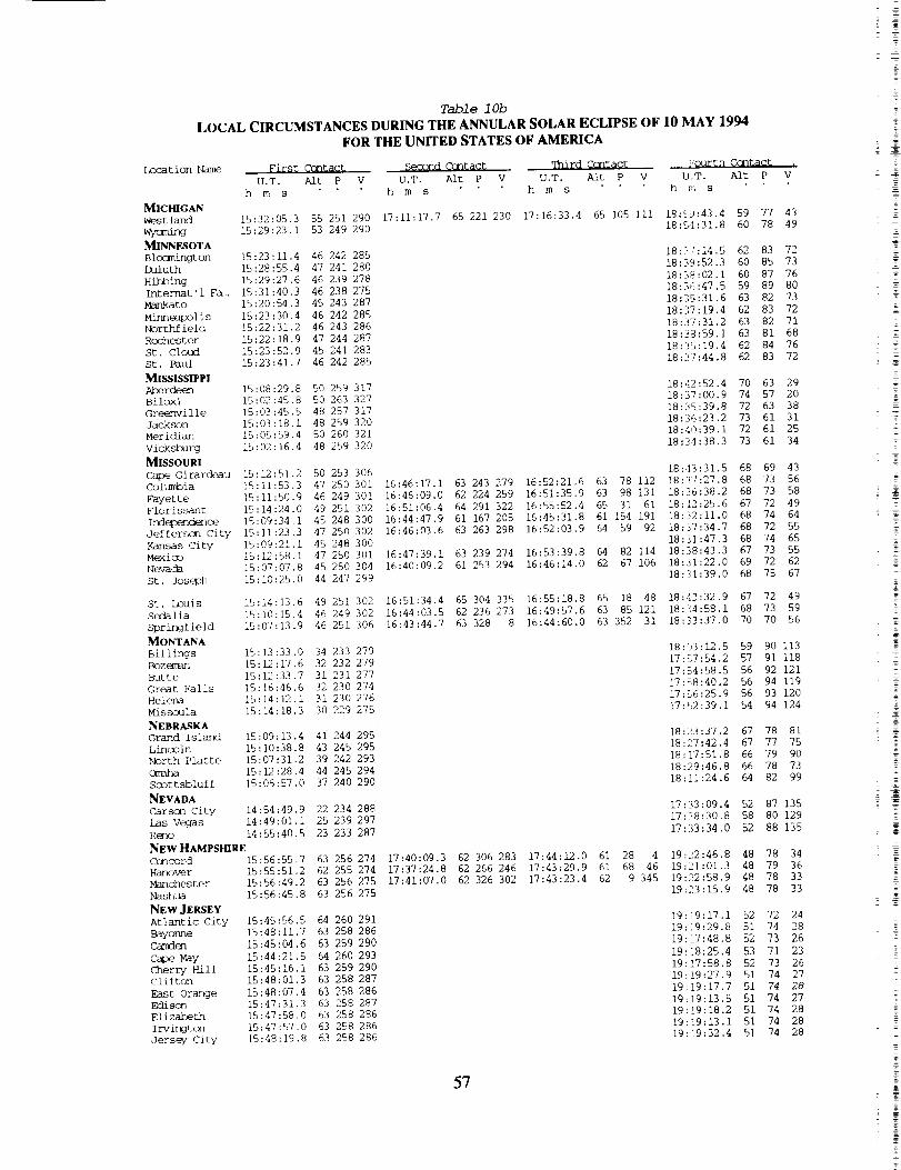
Tab2e I 0b
LOCAL CIRCUMSTANCES DURING THE ANNULAR SOLAR ECLIPSE OF 10 MAY 1994
FOR THE UNITED STATES OF AMERICA
Location Name First Ccntact Seo0nd Ccntact qhird Ccntact ...._'ourth CQntact .
U.T. Aft P V U.T. Aft P V U.T. Alt P V U,T. Aft P V
h m s h m s h m s h m s
MICHIGAN
Westland 15:32:05.3 55 251 290
Wymming 15:29:23.1 53 249 290
MINNESOTA
Blo(m/ngton 15:23:11.4 46 242 285
IAl]uth 15:28:55.4 47 241 280
Hi]J3ing 15:29:27.6 46 239 278
Internat'l F&. 15:31:40.3 46 238 275
Mankato 15:20:54.3 45 243 287
Minneapolis 15:23:30.4 46 242 285
Northfield 15:22:31.2 46 243 286
Rcc-hester 15:22:18.9 47 244 287
St. Cloud 15:23:52.9 45 241 283
St. Paul 15:23:41.7 46 242 285
MISSISSIPPI
Aberdeen 15:08:29,8 50 259 317
Biloxi 15:02:45.8 50 263 327
Greenville 15:03:45.5 48 257 317
Jackson 15:03:18.1 48 259 320
Meridian 15:05:59.4 50 260 321
vicksburg 15:02:16.4 48 259 320
MISSOURI
Cape Girardeau 15:12:51.2 50 253 306
Columbia 15:11:53.3 47 250 301
Fayette 15:11:50.9 46 249 301
Florissant 15:14:24.0 49 251 302
Ind6z)e_nde_oe 15:09:34.1 45 248 300
Jefferscn City 15:11:23.3 47 250 302
Kansas City 15:09:21.1 45 248 300
Mexico 15:]2:58.1 47 250 301
Nevada 15:07:07.8 45 250 304
St. Joseph 15:10:25.0 44 247 299
St. Louis 15:14:13.6 49 251 302
Sedalia 15:10:15.4 46 249 302
Springfield 15:07:13.9 46 251 306
MONTANA
Billings 15:13:33.0 34 233 279
Bozef_n 15:/2:17.6 32 232 279
Butte 15:12:33.7 31 231 277
Great Falls 15:16:46.6 32 230 274
Heler_ 15:14:12.1 31 230 276
Missoula 15:14:18.3 30 229 275
NEBRASKA
Grand Island 15:09:13.4 41 244 295
Lincoln 15:10:38.8 43 245 295
North Platte 15:07:31.2 39 242 293
<_mb_ 15:12:28.4 44 245 294
Scottsbluff 15:06:57,0 37 240 290
NEVADA
Carson City 14:54:49.9 22 234 288
Las Vegas 14:49:01.1 25 239 297
Reno 14:55:40.5 23 233 287
NEW HAMPSHIRE
Concord 15:56:55.7 63 256 274
Hanover 15:55:51.2 62 255 274
Manchester 15:56:49.2 63 256 275
Nashua 15:56:45.8 63 256 275
NEWJERSEY
Atlantic City 15:45:56.5 64 260 291
Bayonne 15:48:11,7 63 258 286
Camden 15:45:04.6 63 259 290
Cape May 15:44:21.5 64 260 293
Cherry Hill 15:45:16.1 63 259 290
clifton 15:48:01.3 63 258 287
East Orange 15:48:07.4 63 258 286
Edison 15:47:31.3 63 258 287
Elizabeth 15:47:58.0 63 258 286
Irvington 15:47:57.0 63 258 286
Jersey City 15:48:19.8 63 258 286
17:11:17.7 65 221 230 17:16:33.4 65 105 iii 18:5_:43.4 59 77 43
18:54:31.8 60 78 49
16:46:17.1 63 243 279 16:52:21.6 63 78 112
16:46:09.0 62 224 259 16:51:35.9 63 98 131
16:51:06.4 64 291 322 16:55:52.4 65 31 61
16:44:47.9 61 167 205 16:45:31.8 61 154 191
16:46:03.6 63 263 298 16:52:03.9 64 59 92
16:47:39.1 63 239 274 16:53:39.8 64 82 114
16:40:09.2 61 253 294 16:46:14.0 62 67 106
16:51:34.4 65 304 335 16:55:18.8 65 18 48
16:44:03.5 62 236 273 16:49:57.6 63 85 121
16:43:44.7 63 328 8 16:44:60.0 63 352 31
17:40:09.3 62 306 283 17:44:12.0 61 28 4
17:37:24.8 62 266 246 17:43:29.9 61 68 46
17:41:07.0 62 326 302 17:43:23.4 62 9 345
18:3/:14.5 62 83 72
18:39:52,3 60 85 73
18:38:02.1 60 87 76
18:36:47.5 59 89 80
18:35:31.6 63 82 73
18:37:19.4 62 83 72
18:37:31.2 63 82 71
18:38:59.1 63 81 68
18:35:19.4 62 84 76
18:37:44.8 62 83 72
18:42:52.4 70 63 29
18:37:00.9 74 57 20
18:35:39.8 72 63 38
18:36:23.2 73 61 31
18:40:39.1 72 61 25
18:34:38.3 73 61 34
18:43:31.5 68 69 43
18:37:27.8 68 73 56
18::36:38.2 68 73 58
18:42:25.6 67 72 49
18:32:11.0 68 74 64
18:37:34.7 68 72 55
18:31:47.3 68 74 65
18:38:43.3 67 73 55
18:31:22.0 69 72 62
18:11:39.0 68 75 67
18:42:32.9 67 72 49
18:34:58.1 68 73 59
18:33:37.0 70 70 56
18:03:12.5 59 90 113
17:57:54.2 57 91 118
17:5,4:58.5 56 92 121
17:58:40.2 56 94 119
17:5,6:25.9 56 93 120
17:52:39.1 54 94 124
18:23:37.2 67 78 81
18:27:42.4 67 77 75
18:17:51.8 66 79 90
18:29:46.8 66 78 73
18:!1:24.6 64 82 99
17:33:09.4 52 87 135
17:38:30.8 58 80 129
17:33:34.0 52 88 135
19:22:46.8 48 78 34
19:21:01.3 48 79 36
19:22:58.9 48 78 33
19:23:15.9 48 78 33
19:i9:17.1 52 72 24
19:]9:29.8 51 74 28
19:!7:48.8 52 73 26
19:18:25.4 53 71 23
19:17:58.8 52 73 26
19:i9:27.9 51 74 27
19:19:17.7 51 74 28
19:19:13.5 51 74 27
19:[9:18.2 51 74 28
19:i9:13.1 51 74 28
19:!9:32.4 51 74 28
57

Locat ien Name
NEW JERSEY_rkPassaic
Paterson
Prinoetcn
_t_
Non_¢_ City
VJnel_
NEW MEXlCO_mn_cjor_3
_er_e
clovis
Las Cruces
Portales
Roswell
Santa Fe
S_nspot
NEW YORK
Binghamton
Buffalo
Cbeekt owaga
Ironci_oitIthacm
Jamestown
Mount Verncn
New Rochelle
New York
Niagara Falls
Poughkeepsie
Rochester
Schenectady
Syracuse
Tcnawanda
TroyUtica
West Seneca
Ycnkers
NORTH CAROLINAAsheville
C_arlotte
Durham
Fayettevil le
Greensboro
High Point
Raleigh
WilmingtonWinston-Salem
NORTH DAKOTA
FargoGrand Forks
_not
Omo
10¢ron
<_antc_
Cincinnati
Cleveland
Cleveland HeiSt s
Columbus
mm/ton
Elyria
Euclid
Hamilton
Table 10a
CIRCUMSTANCES AT MAXIMUM ECLIPSE ON 10 MAY 1994FOR THE UNITED STATES OF AMERICA
Umbral Path Sun Sum
Latitude Ix_ngitude Elev. U.T. Durat. Width Alt Az.
m h m s m s )_n
P VEclipse Eclipse
Mag. Obs.
40 44.4 -74-11.4 - 17:34:54.1
40 52.0 -74-08.0 - 17:35:06.1
40 55.0 -74-10.0 33 17:35:02.6
40 21.0 -74-39.6 - 17:33:31.6
40 13.2 -74-45.6 Ii 17:33:12,2
40 41.0 -74-15.0 - 17:34:43.5
40 46.0 -74-01.0 - 17:35:20.8
39 30.0 -75 00.0 - 17:32:10.9
65 204 344 325 0,893 0.841
65 204 344 325 0.896 0.845
65 204 344 325 0.898 0.846
66 203 344 326 0.884 0.831
66 203 344 326 0.881 0.827
65 204 344 325 0.891 0.839
65 205 344 325 0.893 0.841
67 202 344 326 0.862 0.805
32 54.0 -105-57.0
35 05.0 -106-40.0 1742
34 24.0 -103-12.0
32 16.0 -107-45.0
32 20.4 -106-43.8
34 ii.0 -103-20.0
33 23.0 -104-32.0
35 40.2 -105-57.0 2280
32 47.2 -105-49.2
16:12:50.9 5 0.3 254 50 102 157 217 0.941 0.885
16:16:07.3 49 104 158 214 0.900 0.848
16:20:08.8 4 56.6 249 53 107 158 214 0.941 0,886
16:08:59.4 3 52.8 256 47 99 157 219 0.940 0.884
16:10:35.1 5 16.1 255 49 100 157 218 0.941 0.885
16:19:29.9 5 17.3 249 53 107 157 214 0.941 0.886
16:15:58.9 5 32.1 252 51 104 157 216 0.941 0.886
16:18:20.4 50 106 158 213 0.896 0.843
16:12:49.0 5 22.0 254 50 102 157 217 0.941 0.885
42 39.6 -73-46.8 7 17:36:42.0
42 05.0 -75-55.0 284 17:31:22.4
42 54.6 -78-51.0 231 17:24:59.7
42 54.0 -78-46.0 - 17:25:10.8
43 12.0 -77-36.0 - 17:28:04.8
42 26.4 -76-29.4 - 17:30:12.6
42 06.6 -79-14.4 - 17:23:28.0
40 55.0 -73-51.0 - 17:35:49.7
40 55.0 -73-47.0 - 17:35:59.6
40 43,8 -73-55.2 43 17:35:34.3
43 06.0 -79-02.0 187 17:24:42.7
41 42.0 -73-55.2 - 17:35:59.5
43 09.6 -77-36.6 169 17:28:02.0
42 47.0 -73-53.0 80 17:36:30.3
43 05.0 -76-10.0 131 17:31:19.6
43 01.0 -78-53.0 - 17:24:59.7
42 45.0 -73-45.0 II 17:36:48.2
43 06.2 -75-13.6 136 17:33:30.9
42 50.0 -78-45.0 - 17:25:10.2
40 57.0 -73-54.0 3 17:35:43.1
1 32.4 230 63 205 345 326 0.943 0.889
65 198 344 330 0.937 0.887
6 ii.I 229 65 187 163 157 0.943 0.889
6 12.0 229 65 188 163 157 0.943 0.889
6 8.7 229 64 192 164 155 0.943 0.889
3 58.8 230 65 196 344 332 0.943 0.889
5 6.2 229 65 186 343 338 0.943 0.890
65 205 344 324 0.896 0.845
65 206 344 324 0.896 0.845
65 205 344 324 0.891 0.839
5 54.2 229 64 187 163 158 0.943 0.889
64 205 345 325 0.918 0.869
6 10.4 229 64 192 164 155 0.943 0.889
3 24.5 230 63 204 345 326 0.943 0.889
6 4.0 230 64 197 344 331 0.943 0.889
6 4.9 229 65 187 163 158 0.943 0.889
2 52.6 230 63 205 345 326 0.943 0.889
5 50.3 230 63 200 344 329 0.943 0.889
6 13.1 229 65 188 163 157 0.943 0.889
65 205 344 324 0.897 0.846
35 35.4 -82-33.6 702 17:07:57.7
35 13.2 -80-49.8 236 17:12:17.8
36 00.0 -78-54.6 133 17:18:38.4
35 02.0 -78-54.0 - 17:17:36.8
36 04.2 -79-48.6 275 17:16:11.0
35 55.0 -80 00.0 - 17:15:28.4
35 47.4 -78-39.0 120 17:19:09.4
34 13.2 -77-55.8 9 17:19:34.9
36 06.0 -80-15.6 282 17:14:57.6
72 166 340 353 0.804 0.735
72 174 341 346 0.780 0.707
72 185 342 337 0.788 0.716
73 184 341 338 0.761 0.684
72 180 341 341 0.796 0.726
72 179 341 342 0.793 0.722
72 186 342 336 0.780 0.707
73 190 342 333 0.732 0.649
72 178 341 343 0.800 0.731
46 48.6 -100-46.8 540 16:47:03.0
46 52.2 -96-47.4 295 16:53:33.8
47 55.0 -97-05.0 - 16:54:39.8
48 14.4 -101-18.0 509 16:48:36.8
53 132 160 193 0.712 0.625
55 140 161 188 0.745 0.664
55 141 161 187 0.719 0.634
52 133 161 192 0.678 0.585
41 05.0 -81-30.7 287 17:17:06.9
40 50.0 -81-25.0 338 17:17:05.5
39 08.4 -84-30.6 180 17:07:35.7
41 28.8 -81-39.6 217 17:17:09.4
41 30.0 -81-35.0 - 17:17:21.5
39 58.8 -82-59.4 256 17:12:20.3
39 45.0 -84-15.0 188 17:09:00.1
41 22.0 -82-07.0 - 17:15:57.5
41 34.0 -81-32.0 - 17:17:32.6
39 22.0 -84-33.0 197 17:07:47.4
67 177 342 345 0.942 0.889
67 177 342 344 0.935 0.885
68 163 341 355 0.913 0.863
4 47,2 230 66 177 342 345 0.943 0.890
4 47.3 230 66 177 342 345 0.943 0.890
67 170 341 349 0.923 0.874
67 165 341 353 0.926 0.878
4 47.4 230 66 175 342 346 0.943 0.890
5 2.1 230 66 177 342 344 0.943 0.890
68 163 341 355 0.919 0.870
58

T_d_le 10b
LOCAL CIRCUMSTANCES DURING THE ANNULAR SOLAR ECLIPSE OF 10 MAY 1994
FOR THE UNITED STATES OF AMERICA
Location
NEW JERSEY
Newark
Passaic
Paterson
Princeton
Trenton
Union City
Vineland
NEW MEXICO
Alarrac_rcb
A]2xtquer_eClovis
Las Cruces
Portales
Rc_wel 1
Santa Fe
Sunspot
NEWYORK
Bin_ton
Buffalo
_k-t_ga
Iron--it
Ithaca
Jamestown
Mount Verncn
New Rochelle
New York
First Ccntact _eGond Contact qTLird Contact Fourth contact .
U.T. Alt P V U.T. Alt P V U.T. Alt P V U.T. Alt P V
h m s h m s h m s h m s
15:48:06.9 63 258 286
15:48:23.6 63 258 286
15:48:22.6 63 258 286
15:46:34.9 63 258 288
15:46:11.9 63 258 289
15:47:54.7 63 258 286
15:48:32.4 63 258 286
15:44:47.6 63 259 291
14:46:25.9 32 248 310
14:50:14.9 32 245 305
14:51:19.1 35 248 308
14:44:07.8 30 248 310
14:44:52.5 31 248 311
14:50:47.5 35 248 309
14:48:20.2 33 249 310
14:51:52.9 33 245 304
14:46:18.2 32 248 310
15:51:21.8 62 256 280
15:46:03.3 61 255 284
15:41:22.8 58 253 285
15:41:31.5 58 253 285
15:44:15.2 59 253 283
15:45:21.7 60 254 284
15:39:21.9 58 253 288
15:49:05.7 63 258 285
15:49:14.8 63 258 285
15:48:43.0 63 258 286
Niagara Falls 15:41:20.0
Poughkeepsie 15:49:52.3
Rochester 15:44:10.4
schenectady 15:51:17.8
Syracuse 15:46:56.3
Tcnawanda 15:41:29.2
q_ 15:51:32.4
Utica 15:48:53.5
West Seneca 15:41:27.1
Ycnkers 15:49:01.2
NORTH CAROLINAAsheville 15:22:46.2
Charlotte 15:26:02.8
Durham 15:31:26.6
Fayetteville 15:30:19.0
Greensboro 15:29:27.4
High Point 15:28:49.7
Raleigh 15:31:48.1
wilmington 15:31:49.0
Winston-Sal_m 15:28:28.8
NORTH DAKOTABismarck 15:20:48.0
Fargo 15:24:17.9
G_ Forks 15:26:31.6
M/r_t 15:23:55.8
OmoAkron 15:33:21.4
Canton 15:33:07.5
Cincinnati 15:24:32.9
Cleveland 15:33:44.4
Cleveland Hei... 15:33:55.0
Columbus 15:28:45.2
Daytcn 15:26:03.9
Elyria 15:32:42.5
Euclid 15:34:07.3
Hamilton 15:24:52.0
58 252 285
63 257 283
59 253 283
62 255 279
60 254 282
58 252 285
62 255 279
61 254 280
58 253 285
63 258 285
57 260
59 262
61 262
62 263
60 261
60 261
62 263
63 265
60 261
40 236
43 238
43 237
40 234
57
57
55
57
5756
55
565755
311
312
308
311
308
309
308
313
308
279
280
277
276
254 293
254 294
254 300
253 292
253 292
254 297
254 299
253 293
253 292
254 300
16:10:19.1 49 219 280 16:15:19.4 50 98 157
16:17:38.5 52 217 273 16:22:35.1 53 i01 157
16:07:00.5 47 202 263 16:10:53.3 48 115 177
16:07:55.8 48 226 287 16:13:11.9 49 91 152
16:16:49.7 52 224 281 16:22:07.1 53 93 150
16:13:11.9 51 232 291 16:18:44.0 52 85 144
16:10:06.8 49 228 288 16:15:28.9 50 89 149
17:36:00.9 63 332 313 17:37:33.4 63 i 342
17:21:53.7 65 249 245 17:28:04.8 65 80 73
17:22:04.4 65 251 246 17:28:16.4 65 79 72
17:24:59.8 64 247 240 17:31:08.5 64 83 73
17:28:17.4 65 306 294 17:32:16.2 64 25 12
17:20:58.0 66 290 286 17:26:04.2 65 39 34
17:21:44.0 65 237 233 17:27:38.2 64 93 86
17:24:56.3 64 249 242 17:31:06.7 64 81 71
17:34:52.4 63 313 295 17:38:17.0 63 20 0
17:28:18.7 64 268 256 17:34:22.7 64 63 49
17:21:56.2 65 243 239 17:28:01.1 64 86 79
17:35:26.6 63 319 300 17:38:19.2 63 14 355
17:30:37.5 64 276 262 17:36:27.8 63 56 40
17:22:03.6 65 255 250 17:28:16.7 65 75 68
17:14:49.3 66 294 298 17:19:36.5 66 34
17:15:01.4 66 294 297 17:19:48.6 66 34
17:13:37.3 66 294 299 17:18:24.7 66 33
17:15:04.8 66 290 294 17:20:06.8 66 37
19:19:19.5 51 74 28
19:19:22.9 51 74 28
19:19:17.8 51 74 29
19:18:33.4 52 74 27
19:18:24.2 52 73 27
19:19:13.9 51 74 28
19:19:38.8 51 74 28
19:18:07.5 52 72 25
17:54:53.8 69 70 iii
17:56:27.2 67 73 Iii
18:04:10.8 71 70 I00
17:49:25.7 67 70 117
17:52:02.6 68 69 114
18:03:31.1 71 70 100
17:59:13.9 70 70 106
17:59:02.7 67 74 108
17:55:02.2 69 69 iii
19:19:06.1 50 77 34
19:15:23.6 52 76 34
19:09:11.9 55 78 39
19:09:22.1 55 78 39
19:11:33.1 53 78 39
19:14:06.1 53 77 35
19:08:41.7 55 76 37
19:19:54.1 51 75 28
19:20:01.7 51 75 28
19:19:50.9 51 74 28
19:08:44.8 55 78 40
19:19:23.5 51 76 31
19:11:33.3 53 78 38
19:18:50.2 50 78 34
19:14:23.5 52 78 37
19:09:05.0 55 78 39
19:19:06.0 50 78 34
19:16:09.4 51 78 36
19:09:25.8 55 77 39
19:19:47.5 51 75 28
19:00:13.0 63 65 20
19:04:17.6 61 65 16
19:09:19.0 58 66 17
19:08:53.5 59 64 13
19:07:12.6 59 66 18
19:06:40.9 60 66 18
19:09:50.7 58 66 16
19:10:45.9 58 63 10
19:06:08.6 60 66 19
18:20:44.9 61 88 95
18:29:35.5 61 87 85
18:29:01.2 60 89 87
18:19:58.6 59 90 98
19:04:03.1 58 75 37
19:04:17.1 58 74 36
18:56:59.4 62 72 36
35 19:03:40.5 58 75 38
35 19:03:50.3 58 75 38
19:00:43.1 60 73 36
18:57:44.6 61 73 37
37 19:02:40.8 58 75 39
38 19:03:56.2 58 75 38
18:56:57.1 62 72 36
Z
%
T
59

Location Name
OHIO
Ket tering
Lakewood
Lima
Lora in
Mansfield
Parma
Springfield
Steubenvi 1 le
Tolecb
Warren
Youngstown
OKLAHOMAClinton
}{Zlid
LawtGn
Midwest City
Norman
Muskogee
Oklahcm_ City
Pmnca City
Tulsa
OREGON
Burns
Cor_llis
EuO_
Medford
PendletQn
Port land
Salem
PENNSYLVANIA
All_tcx_
Altocrk_
Bethlehem
Erie
Harrisburg
Lancaster
Penn Hills
Philadelphia
Pittsburgh
Reading
Scra_]ton
u_r DarbyWilkes-Barre
RHODE ISLAND
Cranston
East Providence
Pawtucket
Providence
warwickSOUTH CAROLINA
Charleston
Columbia
Greenville
North C_ar leston
Spar tanburg
SOUTH DAKOTA
Pierre
Rapid City
Sioux Falls
TENNESSEE
_t t_xx_ja
Clarksville
Knoxville
Memphis
Nashvi I le
Table 10a
CIRCUMSTANCES AT MAXIMUM ECLIPSE ON 10 MAY 1994FOR THE UNITED STATES OF AMERICA
Umbral Path Sun st_ Eclipse Eclipse
Latitude Longitude Elev. U.T. Durat. Width Aft Az. P V Meg. Obs.
m h m s m s km
39 40.0 -84-15.0 17:08:53.8
41 29.0 -81-48.0 - 17:16:49.7
40 45.0 -84-06.0 284 17:10:34.6
41 28.0 -82-10.0 200 17:15:56.6
40 45.0 -82-30.0 - 17:14:23.3
41 23.0 -81-44.0 - 17:16:53.1
39 55.0 -83-50.0 322 17:10:12.9
40 22.0 -80-37.0 217 17:18:35.1
41 40.2 -83-34.2 192 17:12:52.5
41 15.0 -80-50.0 - 17:18:54.5
41 05.4 [email protected] 276 17:19:12.0
67 165 341 353 0.924 0.875
4 57.6 230 66 176 342 345 0.943 0.890
4 21.1 230 66 167 341 352 0.943 0.890
5 16.1 230 66 175 342 346 0.943 0.890
67 173 342 347 0.940 0.888
4 21.6 230 66 176 342 345 0.943 0.890
67 167 341 352 0.928 0.879
67 180 342 342 0.917 0.868
6 13.5 230 66 170 342 350 0.943 0.890
66 180 342 343 0.942 0.889
67 180 342 342 0.937 0.886
35 31.0 -98-59.0
36 23.7 -97-52.5
34 36.0 -98-25.0
35 26.0 -97-23.0
35 13.0 -97-25.0
35 44.0 -95-21.0
35 28.8 -97-31.8
36 42.0 -97-05.0
36 08.4 -95-56.4
- 16:29:44.3 5 47.9 243 58 115 338 29 0.942 0.887
407 16:33:30.9 5 59.6 241 59 119 158 206 0.942 0.888
- 16:29:01.6 58 114 338 30 0.937 0.885
- 16:32:38.1 2 23.4 242 59 118 338 27 0.942 0.888
- 16:32:09.2 59 117 338 28 0.940 0.887
- 16:37:17.5 61 122 338 24 0.930 0.880
422 16:32:26.1 3 25.6 242 59 118 338 27 0.942 0.888
- 16:35:37.4 6 1.2 240 59 121 338 25 0.942 0.888
264 16:36:50.6 2 45.8 240 61 122 338 24 0.942 0.888
43 35.0 -119-05.0 - 16:18:16.9
44 34.0 -123-16.0 - 16:16:39.0
44 03.0 -123-06.0 138 16:15:46.2
42 19.0 -122-52.0 - 16:12:34.5
45 40.2 -118-48.0 - 16:22:36.9
45 31.2 -122-39.0 7 16:18:59.8
44 55.8 -123-01.8 51 16:17:32.6
38 102 160 208 0.607 0.502
35 i00 161 208 0.552 0.441
35 99 160 209 0.562 0.452
35 98 160 211 0.594 0.488
39 105 160 206 0.573 0.464
35 i01 161 207 0.542 0.429
35 i00 161 208 0.548 0.436
40 35.0 75-30.0 84 17:31:32.4
40 25.0 -78-25.0 387 17:24:06.4
40 40.0 -75-25.0 77 17:31:47.8
42 07.2 -80-04.8 225 17:21:29.4
40 16.2 -76-52.8 120 17:27:51.7
40 05.0 -76-20.0 116 17:29:07.2
40 28.0 -79-51.0 -- 17:20:34.6
40 00.0 -75-09.0 33 17:32:05.2
40 26.4 -79-58.2 245 17:20:15.3
40 20.0 -75-55.0 87 17:30:20.4
66 200 344 328 0.894 0.843
67 189 343 336 0.905 0.855
66 200 344 328 0.896 0.845
5 44.1 229 66 183 343 340 0.943 0.890
67 195 343 331 0.893 0.841
67 197 343 330 0.885 0.832
67 183 342 340 0.915 0.866
66 201 344 327 0.877 0.822
67 182 342 340 0.915 0.866
66 198 344 329 0.890 0.837
41 24.6 -75-40.2 238 17:31:35.6
39 58,0 -75-16.0 -- 17:31:46.2
41 14,5 -75-53.3 210 17:30:57.7
65 199 344 329 0.918 0.869
67 201 344 327 0.876 0.822
66 198 344 329 0.914 0.865
41 46.0 -71-25.0
41 49.0 -71-22.0
41 53.0 -71-23.0
41 49.2 -71-25.8
41 42.0 -71-27.0
-- 17:42:01.9
- 17:42:09.7
-- 17:42:08.1
-- 17:42:00.6
26 17:41:56.2
63 213 345 320 0.911 0.861
63 213 345 320 0.912 0.862
63 213 345 320 0.914 0.865
63 212 345 320 0.912 0.863
63 213 345 320 0.909 0.859
32 48.6 -79-57.6 3 17:11:45.5
34 00.6 -81 00.0 62 17:10:15.1
34 51.0 -82-23.4 317 17:07:25.4
32 49.0 -79-57.0 -- 17:11:47.9
34 56.4 -81-55.8 287 17:08:50.0
75 176 341 344 0.707 0.620
74 171 340 348 0.748 0.669
72 165 340 353 0.782 0.710
75 176 341 344 0.707 0.620
72 168 340 351 0.781 0.708
44 22.2 -100-20.4 486
44 04.2 -103-13.8 1060
43 32.4 -96-42.6 364
16:43:37.1
16:38:32.1
16:48:24.8
54 129 160 196 0.768 0.692
52 123 160 199 0.747 0.667
57 135 160 193 0.819 0.753
35 02.4 -85-16.8 221 16:59:50.2
36 30.0 -87-23.0 -- 16:56:43.8
35 58.8 -83-56.4 292 17:04:46.6
35 07.2 -89-59.4 90 16:48:06.4
36 09.6 -86-46.2 194 16:57:43.5
71 152 339 4 0.812 0.745
68 147 339 7 0.869 0.813
71 160 340 357 0.825 0.761
67 135 338 17 0.859 0.802
69 148 339 6 0.855 0.796
6O

Table lOb
LOCAL CIRCUMSTANCES DURING THE ANNULAR SOLAR ECLIPSE OF 10 MAY 1994
FOR THE UNITED STATES OF AMERICA
Location
OHIO
Ket tering
Lake_ood
Lima
Lora in
Mansfield
Parma
Springfield
Steubenvil le
Toledo
Warren
Youngstown
OKLAHOMA
Clinton
_id
Lawton
Midwest city
No_
Muskogee
oklab_ City
P(]nca City
Tulsa
OREGONBurns
Corvallis
Eugene
Medford
pendletcn
Port land
Salem
PENNSYLVANIA
Allentown
Bethlehem
Erie
Harrisburg
Lancaster
Penn Hills
Phi iade iph ia
Pittsburgh
Reading
Scranton
Upper I]arby
Wilkes-Barre
RHODE ISLAND
Cranston
Fast Providen
Pawtucket
Providence
W_urwick
First Cantact Second Centact qhird CQntact Fourth Contact
U.T. Aft P V U.T. Aft P V U,T. Aft P V U.T, Aft P
h m s h m s h m s h m s
15:25:55,4 55 254 299
15:33:29.3 57 253 292
15:28:04.7 55 252 295
15:32:47.1 56 253 292
15:30:57.5 56 253 295
15:33:26.6 57 253 292
15:27:06.1 55 254 298
15:33:55.4 58 255 295
15:30:38.2 55 252 292
15:34:55.0 57 254 292
15:35:00.5 58 254 292
14:57:18.5 39 250 308
15:00:11.3 41 249 306
14:56:07.5 40 251 311
14:58:50.6 41 251 309
14:58:23.4 41 251 309
15:01:47.7 43 252 309
14:58:46.0 41 250 309
15:01:39.4 42 249 306
15:01:51.7 43 251 308
15:05:15.5 25 230 279
15:07:31.3 23 226 275
15:06:15.3 22 227 276
15:02:05.2 22 229 280
15:10:25.6 26 228 275
15:09:51.9 23 226 273
15:08:24.6 23 226 274
15:44:58.7 62 258 289
15:38:27.8 60 256 293
15:45:16.2 62 257 288
15:37:45.8 58 253 289
15:41:32.1 61 257 291
15:42:29.3 62 258 291
15:35:36.3 59 255 294
15:45:02.6 63 259 290
15:35:19.3 59 255 294
15:43:44.1 62 258 290
SOUTH CAROUNA
Charleston
Coltmlbia
Greenville
North Char le__
Spar tanburg
SOUTH DAKOTA
Pierre
Rapid City
Sioux Falls
TENNESSEE
C_tt_
Clarksvi 1 le
_lle
Ma_phi s
Nas hvi 11 e
15:45:40.5 62 256 286
15:44:44.3 63 259 290
15:44:58.9 61 256 287
15:55:36.4 64 258 278
15:55:46.4 64 258 278
15:55:48.3 64 258 278
15:55:37.9 64 258 278
15:55:27.6 64 258 278
15:25:15.2
]5:24:08.1
15:22:06.4
15:25:17.1
15:23:13.8
15:15:18.1
15:12:25.3
15:16:39.4
15:16:27.0
15:14:57.2
15:20:31.0
15:08:14.6
15:15:27.5
61 266 320
59 263 316
58 261 314
61 266 320
58 262 313
40 239 285
38 238 285
43 242 288
54 259 313
52 256 309
56 259 310
49 256 313
53 257 310
|
V
16:26:51.5 57 263 314 16:32:39.4 58 55 106 18:16:43.2 72 70 80
16:30:31.1 58 247 296 16:36:30.7 59 72 119 18:20:42.2 71 71 75
18:17:01.4 73 68 77
16:31:30.3 59 316 5 16:33:53.7 59 2 52 18:20:51.8 72 69 72
18:20:30.2 72 69 73
18:26:39.3 72 69 63
16:30:46.9 59 305 354 16:34:12.5 59 14 63 28:20:31.9 72 69 73
16:32:37.0 59 250 297 16:38:38.2 60 69 115 18:23:07.6 71 71 72
16:35:31.7 60 312 359 16:38:17.6 61 7 52 18:25:32.4 72 70 66
17:18:39.5 66 278 277 17:24:23.6 66 51 48
17:39:39.4 52 93 133
17:33:03.7 48 97 139
17:32:47.7 48 96 139
17:31:16.6 49 93 139
17:42:17.6 51 95 132
17:35:08.2 48 97 138
17:33:51.5 48 97 138
19:16:48.9 53 74 28
19:10:51.3 55 73 31
19:16:57.2 52 74 29
19:06:56.2 56 76 38
19:14:06.2 54 73 29
19:15:16.4 54 73 28
19:07:45.6 57 74 32
19:17:41.7 52 73 26
19:07:30.3 57 74 33
19:16:03.4 53 73 28
19:16:10.4 52 75 31
19:17:28.1 53 73 26
19:15:48.5 53 75 31
19:23:54.0 48 76 30
19:23:57.3 48 76 30
19:23:53.0 48 76 30
19:23:50.6 48 76 30
19:23:53.0 48 76 29
19:04:38.9 61 60 7
19:03:01.6 62 62 12
19:00:08.3 63 64 18
19:04:40.8 61 60 7
19:01:22.0 62 64 17
18:20:49.4 63 84 91
18:13:58.3 63 85 99
18:28:59.3 64 82 79
18:52:49.9 66 65 24
18:48:30.0 67 68 34
18:56:58.7 64 66 24
18:40:23.8 70 66 38
18:49:50.4 66 67 31
61
18:57:43.6 61 73 37
17:14:24.2 66 291 295 17:19:21.8 66 36 38 19:03:21.9 58 75 38
17:08:28.0 66 299 310 17:12:49.1 67 27 37 18:58:12.8 61 74 40
17:13:21.5 66 286 292 17:18:37.6 66 41 44 19:02:33.7 58 75 39
19:01:51.7 59 74 37
17:14:46.2 66 300 304 17:19:07.8 66 28 30 19:03:31.5 58 75 38
18:58:45.1 61 73 37
19:06:05.4 58 73 33
17:09:45.9 66 254 264 17:15:59.4 66 72 79 18:59:24.9 59 76 42
19:05:30.8 57 75 36
19:05:56.4 57 75 36

LocationName
TEXAS
Abi lene
Amarillo
Arlin_onAustin
BaytownBeaumant
Brownsville
Corpus (_hrist i
Da I las
E1 Paso
Fort Worth
Galveston
Garland
Grand Prairie
Houston
IrvingLaredoU.gvi_Lubbock
McAllen
Mesc_tit e
Midland
Odessa
Pasadena
Plano
Port Arthur
Plainsvlew
Richardson
San Angelo
San Antonio
q_ler
Victoria
Waco
Wichita Falls
UTAH
LoganOgdenOrem
Provp
Salt Lake City
Sandy City
VERMONT
Bratt leboro
BurlingtonNtntpelier
WmCm_AAlexandria
ArlirgtonBristol
(3nar lot tesvi 1 le
_eDanville
Hampton
Lynchburg
Newport News
Norfolk
Petersburg
Port smooth
Ri_
Rcanoke
Virginia Beach
Table 10a
CIRCUMSTANCES AT MAXIMUM ECUPSE ON 10 MAY 1994FOR THE UNITED STATES OF AMERICA
L_bral Path Sun Sun
Latitude Ixmqgitude Elev. U,T. Durat. Width Alt Az. P
m h m s m s km
32 25.0 -99-45.0 561 16:22:12.4
35 12.0 -101-51.0 1209 16:23:59.0
32 44.0 -97-07.0 - 16:27:54.9
30 17.4 -97-43.8 196 16:21:49.2
29 44.0 -95-01.0 - 16:26:20,6
30 04.8 -94-07.2 7 16:29:00,8
25 54.6 -97-29.4 5 16:13:25,1
27 45.0 -97-24.6 ii 16:17:19.4
32 47.4 -96-47,4 143 16:28:41.1
31 47.4 -106-25,2 1285 16:09:55.6
32 44.9 -97-19.7 220 16:27:31.2
29 18.0 -94-48.6 2 16:25:55.5
32 55.0 -96-39.0 - 16:29:13,1
32 45.0 -97 00.0 - 16:28:11.0
29 45.0 -95-23.4 13 16:25:34.2
32 49.0 -96-57.0 - 16:28:24.9
27 31.0 -99-29.0 144 16:12:50.0
32 29.0 -94-44,0 - 16:32:23,6
33 35.0 -101-51.0 1048 16:20:47.0
26 12.0 -98-13.0 - 16:12:34.5
32 46.0 -96-35.0 - 16:29:03.6
32 05.0 -102-05.0 - 16:17:23.8
31 51.0 -102-22.0 - 16:16:26,8
29 43.0 -95-13.0 - 16:25:52.6
33 01.0 -96-42.0 - 16:29:18,8
29 52.0 -93-59.0 3 16:28:53.7
34 ii.0 -101-43,0 - 16:22:12.8
32 56.0 -96-44,0 - 16:29:04,9
31 28,0 -100-22.0 605 16:19:10.6
29 25.8 -98-30.0 213 16:18:34.5
32 21.0 -95-19.0 - 16:30:52.9
28 48.0 -97 00.0 - 16:20:17.0
31 33.2 -97-08.0 133 16:25:32.6
33 54.0 -98-30.0 310 16:27:29.8
41 46.0 -111-51.0 - 16:22:24.0
41 13.5 -111-58.4 1409 16:21:11.1
40 15.0 -111-50.0 - 16:19:27.3
40 15.0 -111-40.0 1493 16:19:38.8
40 45.6 -111-52.2 1385 16:20:24,0
40 36.0 -111-53.0 - 16:20:04.8
42 51.1 -72-33.8 98 17:39:35.8
44 28.8 -73-13.2 36 17:38:32.7
44 15.6 -72-34.2 159 17:39:55.7
38 49.2 -77-04.8 - 17:26:15.8
38 55.0 -77-10.0 - 17:26:06.6
36 36.6 -82-10.8 - 17:10:19.6
38 02.4 -78-29.4 - 17:21:50.3
38 48.0 -76-16.0 - 17:28:24.0
36 35.4 -79-24.0 - 17:17:53.9
37 02.0 -76-21.0 - 17:26:49.1
37 24.6 -79-09.6 - 17:19:24.9
37 03.0 -76-28.8 - 17:26:28.2
36 54.0 -76-16.2 3 17:26:56.1
37 13.2 -77-24.0 - 17:24:03.6
36 50.0 -76-19.0 3 17:26:45.0
37 32.4 -77-27,6 52 17:24:10,6
37 16.8 -79-57.6 297 17:17:06.5
36 50.0 -75-58,0 - 17:27:44.0
57 108
4 36.3 247 54 ii0
60 113
59 107
62 109
63 112
58 98
59 102
60 113
5 39.7 256 49 99
4 37.6 248
5 44.7 248
59 112
62 109
60 114
60 113
62 109
60 113
56 99
63 116
54 107
57 98
60 114
54 105
53 104
62 109
60 114
63 iii
55 109
60 114
56 105
58 104
62 115
60 105
60 ii0
58 113
45 108
44 107
45 106
45 106
45 107
44 106
2 8.3 231
4 26.5 230
5 36.6 231
62 208
61 205
61 207
68 194
68 194
71 169
70 188
68 197
71 183
70 198
70 185
70 197
70 198
70 193
70 198
70 192
70 181
70 199
Eclipse Eclipse
V Mag. Obs.
337 35 0.902 0.851
158 211 0.942 0.887
337 32 0.879 0.824
337 37 0.828 0.764
337 36 0,782 0.709
337 35 0.780 0.707
336 45 0.721 0.636
336 42 0.764 0.687
337 32 0.876 0,821
337 39 0.941 0.885
337 32 0.881 0.827
337 37 0.769 0.694
337 31 0.878 0.823
337 32 0.878 0.823
337 37 0.787 0.715
337 32 0.879 0.824
336 43 0.785 0.712
337 30 0.845 0,785
337 34 0.942 0.887
336 45 0.737 0,655
337 32 0.873 0.818
337 37 0.922 0.871
337 37 0,920 0.869
337 36 0.784 0.712
337 31 0,880 0.826
337 35 0.773 0.698
337 33 0.942 0.887
337 31 0.879 0.824
337 37 0.887 0,834
336 39 0.817 0.751
337 31 0.849 0.789
336 40 0.784 0.711
337 34 0.851 0.791
337 31 0.922 0.872
159 208 0.710 0.622
159 208 0.719 0.633
159 210 0.740 0.657
159 210 0.741 0.659
159 209 0,729 0.6_5
159 209 0.732 0,649
345 324 0.943 0.889
165 146 0.943 0.889
165 145 0.943 0.889
343 331 0.854 0.796
343 332 0.857 0.799
341 350 0.828 0.764
342 336 0.841 0.780
343 329 0.849 0.790
342 339 0.807 0.739
343 328 0.801 0.731
342 338 0.828 0.764
343 328 0.802 0.733
343 328 0.796 0.727
342 332 0.812 0.745
343 328 0.795 0.725
343 332 0.821 0.756
342 341 0.830 0.767
343 327 0.793 0.722
62

Table lOb
LOCAL CIRCUMSTANCES DURING THE ANNULAR SOLAR ECLIPSE OF 10 MAY 1994
FOR THE UNITED STATES OF AMERICA
_tion Name First Cantact Second CQntact qhir_ Cc_tact Fourth CQntact .
U.T. Aft P V U.T. Aft P V U.T. Aft P V U.T. Aft P V
h m s h m s h m s h m s
TEXAS
Abile_e 14:50:41.1 38 253 315 18:10:11.4 74 65 86
Amarillo 14:53:59.6 36 248 307 16:21:38.4 54 211 265 16:26:14.7 55 107 161 18:08:47.6 71 71 93
Arlingt(]n 14:54:08.8 41 254 316 18:17:49.8 75 65 70
Austin 14:49:15.4 39 257 322 18:11:59.0 77 61 76
Baytown 14:51:52.5 42 259 325 18:18:29.0 78 59 56
Beat_ont 14:53:41.0 43 259 325 18:21:39.6 77 59 S0
Brownsville 14:43:05.1 38 262 333 18:03:16.5 80 53 86
Corpus Christi 14:45:43.9 39 260 328 18:07:44.1 79 56 79
Dallas 14:54:38.0 41 254 316 18:18:48.7 75 65 68
E1 Paso 14:44:02.0 31 249 312 16:07:06.4 48 256 318 16:12:46.0 49 60 122 17:51:52.3 69 68 114
Fort _brth
Galvestcln
Garland
Grand Prairie
Houston
Irving
Larecb
Umgview
Lubbock
McAllen
Mesquite
Midland
Odessa
Pasadena
Plano
Port Arthur
Plainsview
Richardson
San Angelo
San Antonio
q_ler
Victoria
Waco
Wichita Falls
UTAH
Or_
Salt Lake City
Sandy City
VERMONT
Bratt leh_ro
BurlingtonMmntpelier
VmGINIAAlexandria
Arlir_gton
Bristol
Char lot tesvil...
ChesapeakeDsnville
Hampton
Lync_hburg
Newport NewsNorfolk
14:53:55.4 40 254 316 18:17:16.5 75 65 72
14:51:30.6 42 260 326 18:18:13.5 78 58 55
14:55:01.7 41 254 316 18:19:23.2 75 65 68
14:54:18.9 41 254 316 18:18:10.S 75 65 70
14:51:23.1 42 259 325 18:17:28.0 78 59 59
14:54:29.5 41 254 316 18:18:24.8 75 65 69
14:42:55.1 36 259 328 18:01:34.0 78 57 94
14:56:43.1 43 256 318 18:24:00.2 75 63 56
14:50:51.3 36 250 311 16:18:30.6 54 287 344 16:23:08.2 55 30 87 18:06:27.6 72 68 95
14:42:32.9 37 262 332 18:01:59.4 79 54 90
14:54:50.6 41 254 316 18:19:20.4 75 64 67
14:47:52.7 35 252 315 18:03:26.7 73 66 97
14:47:12.5 35 252 315 18:02:18.4 73 66 99
14:51:34.3 42 259 325 18:17:53.4 78 59 58
14:55:08.8 41 254 315 18:19:24.1 75 65 68
14:53:33.5 43 260 325 18:21:38.9 78 58 49
14:52:08.0 36 249 310 16:19:21.4 54 261 317 16:25:06.2 55 56 112 18:07:42.4 72 69 94
14:54:57.5 41 254 316 18:19:11.1 75 65 68
14:48:22.6 37 253 317 18:06:56.4 75 64 90
14:46:58.2 38 257 323 18:08:13.5 77 60 83
14:55:43.0 42 256 318 18:22:11.0 75 63 59
14:47:48.6 39 259 326 18:11:05.5 78 58 73
14:52:04.5 40 255 319 18:15:52.2 76 63 71
14:54:42.8 39 252 312 18:15:49.4 73 67 78
15:02:29.9 30 235 287 17:52:33.8 59 86 120
15:01:10.8 30 236 288 17:51:42.9 59 85 121
14:58:59.1 29 237 290 17:50:57.9 60 84 121
14:59:02.1 29 237 290 17:51:19.3 60 84 121
15:00:08.2 30 236 289 17:51:26.4 60 85 121
14:59:46.3 29 236 289 17:51:14.7 60 84 121
15:54:14.1 62 256 277 17:38:36.7 63 327 305 17:40:44.9 62 7 345 19:21:09.8 49 78 34
15:54:51.6 61 253 274 17:36:16.1 61 213 195 17:40:42.6 61 120 i01 19:18:47.2 49 80 39
15:55:55.5 61 254 273 17:37:05.3 61 233 214 17:42:41.9 61 i01 80 19:20:05.2 48 80 38
15:39:11.5 62 259 296 19:13:53.6 55 71 24
15:39:07.2 62 259 296 19:13:42.1 55 71 25
15:25:02.6 57 259 308 19:01:42.7 62 67 23
15:35:00.5 61 259 301 19:10:47.1 57 69 23
15:41:01.4 63 260 296 19:15:37.5 54 71 23
15:31:03.6 60 261 306 19:08:22.6 59 67 19
15:38:45.6 63 262 302 19:15:25.0 55 68 18
15:32:40.6 60 260 303 19:09:09.7 58 68 22
15:38:27.8 63 262 302 19:15:08.0 55 68 18
15:38:48.4 64 262 302 19:15:34.5 55 68 17
Petersburg 15:36:28.1 62 261 302 19:13:07.0 56 68 19
Portsmouth 15:38:37.1 64 262 302 19:15:27.7 55 67 17
Richmond 15:36:43.0 62 261 301 19:13:01.7 56 69 20
Roanoke 15:30:43.9 60 260 304 19:07:16.8 59 68 22
Virginia Beach 15:39:28.6 64 263 302 19:16:13.9 55 67 17
i
V
z
63

Loc_t ion Name
WASHINGTON
Bellevue
Bil lingham
Everett
Mr. Rainier
Olympia
PullmanRichland
Seattle
Spokane
Taoamm
Walla Walla
Yakima
WEST VIRGINIA
Charleston
Gre_nbank
Htmt ington
Wheeling
WISCONSIN
Appleton
Eau Claire
Green Bay
Janesville
Kenosha
La Crosse
Madison
Milwaukee
oshkosh
Racine
Sbe/x_gan
Waukesha
Wauwat osa
West Allis
WYOMING
Casper
CheyenneSheridan
Table 10a
CIRCUMSTANCES AT MAXIMUM ECLIPSE ON 10 MAY 1994
FOR THE UNITED STATES OF AMERICA
Umbral Path Sun Sun Eclipse Eclipse
Latitude Langitude Elev. U.T. Durat. Width Alt Az. P V Nmg. obs.
m h m s m s km
47 37.0 -122-12.0 - 16:23:26.7 36 104
48 45.0 -122-28.6 - 16:25:25.4 36 105
47 59.0 -122-11.0 -- 16:24:10.3 36 104
46 50.0 -121-45.0 - 16:22:17.4 36 104
47 03.0 -122-53.0 - 16:21:47.7 35 103
46 46.0 -117-09.0 -- 16:26:19.0 40 108
46 17.0 -119-17.0 -- 16:23:21.8 38 105
47 37.8 -122-19.8 131 16:_3:21.9 36 104
47 40.2 -117-24.6 773 16:_7:47.9 40 109
47 16.0 -122-30.0 36 16:22:31.3 36 103
161 205 0.511 0.396
161 203 0,491 0.374
161 204 0.506 0.389
161 205 0.528 0.414
161 205 0.515 0.399
161 204 0.569 0.459
161 205 0.559 0.448
161 205 0.510 0.394
161 203 0.551 0.439
161 205 0.515 0.399
46 05.0 -118-18.0 - 16:23:53.2
46 35.7 -120-30.8 348 16:22:52.4
39 106 160 205 0.571 0.461
37 105 161 205 0.543 0.430
38 21.0 -81-37.8 197 17:13:52.8
38 26.3 -79-50.2 -- 17:18:39.1
38 24.6 -82-25.8 185 17:11:53.5
40 04.2 -80-42.0 213 17:18:05.1
69 174 341 346 0.870 0.815
69 182 342 340 0.860 0.803
69 171 341 349 0.878 0.824
68 179 342 343 0.910 0.860
44 14.0 -88-27.0 -- 17:05:18.7
44 48.6 -91-30.0 -- 17:00:02.4
44 30.0 -88-04.0 194 17:06:25.7
42 41.0 -89-03,0 -- 17:02:01,2
42 34.0 -87-50.0 -- 17:04:26.8
43 48.6 -91-13,8 -- 16:59:09.4
43 05.4 -89-23.4 282 17:01:52.2
43 03.0 -87-57.0 208 17:04:49.8
44 01.0 -88-35.0 -- 17:04:45.7
42 43.0 -87-49.0 207 17:04:40.7
62 157 161 178 0,872 0.816
60 149 161 183 0.834 0.772
62 158 161 177 0.868 0.812
63 153 161 181 0.905 0.855
63 156 161 179 0.918 0.868
61 148 161 184 0.860 0.802
62 153 161 182 0.892 0.840
63 157 161 179 0.905 0.854
62 156 161 179 0.876 0.821
63 157 161 179 0.914 0.864
43 45.6 -87-44.9 207 17:06:09.6
43 01.0 -88-13.0 -- 17:04:13.3
43 03.0 -88 00.0 -- 17:04:43.4
43 01.0 -88-01.0 -- 17:04:38.7
63 158 161 178 0.889 0.836
63 156 161 179 0.903 0.853
63 157 161 179 0.904 0.854
63 156 161 179 0.905 0.855
42 50.4 -106-19.2 - 16:31:43.3
41 08.4 -104-48.0 2010 16:30':43,3
44 47.8 -106-57.7 1301 16:34:28.5
50 117 159 203 0.743 0.662
51 116 159 204 0.793 0,721
49 119 160 201 0.698 0,608
64

Table 10b
LOCAL CIRCUMSTANCES DURING THE ANNULAR SOLAR ECLIPSE OF 10 MAY 1994
FOR THE UNITED STATES OF AMERICA
Location Name First Contact Second Ccntact qhird Ccntac_
U.T. Alt P V U.T. Aft P V U.T. Alt P
h m s h m s h m s
WAS_NGTON
Bellevue 15:15:09.4 25 224 269
Billingh_m 15:18:04.3 25 223 267
Everett 15:16:05.8 25 224 269
Mr. Rainier 15:13:10.i 25 225 271
olympia 15:13:42,8 24 224 270
_i_ 15:13:24.5 28 227 273
Richland 15:11:55.0 26 227 273
Seattle 15:15:11.4 25 224 269
spokane 15:15:40.2 28 226 271
Taccm_ 15:14:15.7 24 224 270
Walla _lla 15:11:31,2 27 227 274
Yakima 15:12:36,7 25 226 2"72
WEST VIRGINIA
Charleston 15:28:46.3 58 257 302
GreeJnbank 15:32:37.4 59 258 300
Huntington 15:27:16,2 57 256 302
Wheeling 15:33:17.6 58 255 296
Wtsco_s_
Appleton 15:27:59.0 50 246 286
Eau Claire 15:25:14.9 48 243 285
Green Bay 15:29:03.9 50 246 286
Janesville 15:23:58.0 50 247 291
K6_osha 15:25:29,0 51 248 291
La Crosse 15:23:25.3 48 245 288
Madison 15:24:19.5 49 246 290
Milwaukee 15:26:16.7 51 247 290
oshkosh 15:27:21.1 50 246 287
Racine 15:25:48.3 51 248 291
She_gan 15:28:00.1 51 247 288
Waukesha 15:25:49.6 51 247 290
_umratosa 15:26:12.4 51 247 290
West Allis 15:26:06.9 51 247 290
W YOM ING
Casper 15:07:33,9 35 237 287
Chey_ne 15:04:31.1 36 240 292
Sheridan 15:11:54.5 35 235 282
FQur th Cc_tact .
V U.qk Aft P V
h m s
17:37:L8.8 48 i00 137
17:38:_2.6 47 i01 137
17:38:21.0 48 I00 137
17:38:Jl.5 48 99 136
17:36:i5.3 47 99 138
17:46:J5,7 52 96 129
17:41:o8,3 51 96 133
17:37:45.9 48 i00 137
17:46:41.7 51 97 130
17:37:07.6 48 i00 137
17:43:{7.6 S1 96 131
17:40::!0.3 49 98 135
19:03:_8.0 60 70 28
19:07:47,3 58 70 26
19:01:45.6 61 70 30
19:05:55.2 58 73 32
18:48:i4,3 61 81 59
18:41_20.2 62 82 67
18:49:@4.0 60 81 59
18:46:_,i.4 62 78 56
18:49_0.4 62 78 53
18:41:%4.1 63 81 64
18:46:n6.2 62 79 58
18:49:25.2 62 79 55
18:47:57.2 61 80 59
18:49:43.2 62 78 53
18:49:51.2 61 80 56
18:48:48.3 62 79 55
19:49:£8,2 62 79 55
18:49:[5.9 62 79 55
18:05:58.7 62 85 107
19:08:04.7 64 81 103
18:05:59.4 60 88 109
l
L
T
65
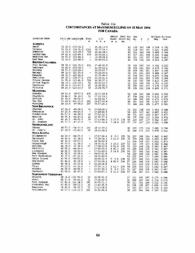
Table lla
CIRCUMSTANCES AT MAXIMUM ECLIPSE ON 10 MAY 1994
FOR CANADA
Ix)cation NameUmbral Path Sun Stm
Latitude Longitude Elev. U.T. Durat. Width Aft Az. P
m h m s m s km
ALBERTA
Banff
Calgary
F_ton
Lethbridge
Medicine Hat
Red Deer
BRITISH COLUMBIA
Fort Nelson
Kamloops
Kelo_na
Mat squi
Nanaimo
Pent ictcLq
Prince George
Prinoe Rt_er t
Vanoc_/ver
Victoria
MANITOBA
BroJ-_n
C_ur_ill
Selkirk
Pas
winnipeg
NEw BRUNSWICK<]%atham 47 02.0 -65-28.0
Edmunstcn 47 22.0 -68-20.0
Fredericton 45 57.0 -66-38,5
Mcncton 46 05.4 -64-47.4
St. John 45 16.0 -66-03,0
St. Ste_en 45 12.0 -67-17.0
NEWFOUNDLAND
Gander
St. John' s
NOVA SCOTIABridgewater 44 23.0 -64-31.0
DartnrxJth 44 40.0 -63-34.0
Glace Bay 46 12.0 -59-57.0
&h/ysborough 45 23.0 -61-30.0
Halifax 44 39.0 -63-36.0
Kentville 45 05.0 -64-30.0
Liverpool 44 02.0 -64-43.0
New Glasgow 45 35.0 -62-39.0
Port Hawkesbury 45 37.0 -61-21.0
Sable Island 43 55.0 -59-50.0
Shelbur_e 43 46.0 -65-19.0
Sydney 46 08.4 -60-10.8
Truro 45 22.0 -63-16.0
Windsor 44 59.0 -64-08.0
Yarmouth 43 50.0 -66-07.0
NORTHWEST TERRITORY
Aklavik 68 14.0 -135 00,0
Alert 82 31,0 -62-20,0
Fort S inlDSCn
Frobisher Bay
Resolute
Yel imwkni fe
Eclipse Eclipse
V Fag. Obs.
51 i0.0 -115-34.0 - 16:36:13.0
51 03.0 -114-05.0 1161 16:37:29.6
53 33.0 -113-28.0 728 16:42:38.1
49 41.4 -112-49.2 979 16:36:20.1
50 03.0 -110-40.0 - 16:39:24,5
52 16.0-113-48.0 - 16:40:00.2
41 116 161 198 0.508 0.392
42 118 161 197 0.521 0.406
42 121 162 194 0.484 0.366
43 117 161 198 0.555 0.444
45 121 161 197 0.566 0,457
42 119 162 196 0.503 0.387
58 50.0 -122-35.0 411 I::44:22.9
50 40.0 -120-20.0 - ib:30:53.2
49 53.0 -119-29.0 - 16:30:07.7
49 12.0 -122-25.0 - 16:26:20.6
49 i0.0 -123-56,0 - 16:25:06.0
49 19.2 -119-37.2 370 16:28:55.6
53 55.0 -122-45,0 728 16:35:07,1
54 19.2 -130-19.2 56 16:30:53.7
49 16.0 -123-07.0 42 16:25:55.2
48 26.0 -123-23,0 19 16:24:05.7
35 116 163 193 0.342 0.223
38 109 161 200 0.478 0.360
38 109 161 201 0.497 0.380
36 105 161 203 0.484 0.367
35 104 161 203 0.473 0.354
38 109 161 202 0.505 0.389
36 ii0 162 198 0.410 0.290
31 103 163 199 0.351 0.232
35 105 161 203 0.478 0.359
35 104 161 204 0,489 0,371
49 51.0 -99-57.0 415 16:53:09.4
58 46.0 -94-10.0 31 17:12:19.2
50 i0.0 -96-52.0 - 16:58:16.7
53 49.8 -101-15.0 292 16:57:15.8
49 53.0 -97-09.0 257 16:57:26.3
52 138 161 188 0.656 0.559
47 158 164 176 0.512 0.397
53 144 162 185 0.673 0.579
49 141 162 185 0.567 0.457
53 144 161 185 0.677 0.583
36 17:54:20.1 55 222 168 139 0.900 0.848
- 17:48:46.9 56 215 167 142 0.887 0.833
i0 17:52:22,6 56 221 167 139 0.927 0.877
12 17:55:57.4 55 225 168 137 0.926 0.876
39 17:53:44.0 3 17.8 234 56 223 167 137 0,942 0.887
- 17:51:14.4 3 18.4 233 57 220 167 138 0.942 0.888
48 57.0 -54-37.0 163 18:11:10,2
47 34.0 -52-43.0 69 18:15:14.5
46 239 170 134 0.845 0.784
45 244 171 131 0.878 0.822
- 17:57:06.6 6 0.i 235 56 227 348 314 0.942 0.887
8 17:_8:54.3 5 51.9 235 55 229 168 134 0.942 0.887
- 18:04:50.9 51 234 169 133 0.924 0.873
-- 18:02:31.8 3 10.3 237 53 232 169 133 0.942 0.886
27 17:58:50.8 5 53.0 235 55 229 168 134 0.942 0.887
- 17:56:53.5 4 45.2 235 55 226 168 135 0.942 0.887
-- 17:56:49.2 5 34.8 235 56 227 348 314 0.942 0.887
-- 18:00:15.8 54 229 168 134 0.941 0.886
-- 18:02:40.6 52 232 169 133 0.940 0.886
-- 18:06:32.0 5 5.9 238 52 237 349 310 0.941 0.886
- 17:55:39.4 4 46.9 234 57 226 348 314 0.942 0.888
5 18:04:28.8 51 233 169 133 0.925 0.875
- 17:59:11.2 3 11,7 235 54 229 168 135 0.942 0.887
-- 17:57:39.3 5 9.9 235 55 227 168 135 0.942 0.887
- 17:53:57.3 5 11,3 234 57 224 347 315 0.942 0,888
i0 16:55:01.9
31 17:36:22,9
61 45.0 -121-14.0 182 16:50:31.3
63 45.0 -68-33.0 36 17:43:35.9
74 43,0 -94-59.0 72 17:23:58.9
62 27,0 -114-21.0 221 16:56:46.4
27 Iii 165 187 0.175 0.084
25 204 169 166 0.154 0.070
35 121 164 189 0.312 0.195
42 204 168 157 0.486 0.369
33 165 167 171 0,234 0.129
38 130 164 186 0.340 0.222
66

Table llb
LOCAL CIRCUMSTANCES DURING THE ANNULAR SOLAR ECLIPSE OF 10 MAY 1994
FOR CANADA
Location Name First Ccntact Second Ccntact qhird Ccntact _ourth C_tact .
U.T. Alt P V U.T. Alt P V U.T. Alt P V U.T. Alt P V
m s h m s h m s h m s
ALBERTABanff 15:25:07.9 30 224 265 17:52:39.6 50 i01 127
Calgary 15:25:09.5 31 225 265 17:55:18.8 51 100 125
F/gmonton 15:32:00,1 32 223 260 17:57:40.8 50 103 125
LethbrickTe 15:21:55.3 32 227 269 17:56:55.4 53 98 122Medicine Hat 15:23:33.8 33 228 269 18:01:19.4 54 97 119
Red Deer 15:28:28.0 32 224 263 17:56:29.7 51 102 125
BRITISH COLUMBIAFort Nelson 15:45:23.3 28 214 246 17:45:37.4 42 114 138
Kamloops 15:23:10.1 27 222 264 17:43:50.1 48 103 134Kelowna 15:21:10.1 27 223 266 17:44:42.5 49 i01 133
Matsqui 15:19:14.5 25 222 266 17:39:02.7 47 102 137Nanaimo 15:19:10.6 24 222 265 17:36:28.1 46 103 139Penticton 15:19:40.9 27 224 267 17:44:00.7 49 i01 133
Prince George 15:31:48.7 27 218 256 17:42:15.1 44 108 137
Prince Rupert 15:33:33.5 22 214 252 17:31:21.9 39 113 146Vancouver 15:19:25.0 25 222 265 17:37:55.2 46 102 138
Victoria 15:17:15.7 24 223 267 17:36:42,8 46 102 138
MANITOBABrand3n 15:28:55.1 41 233 272 18:23:01.1 58 92 96
Churchill 15:55:32.3 42 226 250 18:30:11.6 49 104 101Selkirk 15:32:09.8 43 234 271 18:29:21.1 58 92 90
7he Pas 15:38:08.1 40 228 262 18:20:13.1 54 99 104
Winnipeg 15:31:13.8 43 235 272 18:28:48.3 58 92 90
NEW BRUNSWICKChatham 16:13:37,9 61 253 254 19:27:49.4 41 85 43DJmunston 16:08:10.3 60 251 258 19:23:29.4 44 85 45
Fredericton 16:10:14.1 62 254 258 19:27:34.5 43 84 40
MQncton 16:14:16.7 62 254 255 19:29:54.4 41 84 40
St. John 16:10:55.0 62 255 259 17:52:01.4 56 202 172 17:55:19.2 56 136 105 19:29:11.4 42 83 38
St. Stephen 16:08:11.4 62 255 261 17:49:31.4 57 202 174 17:52:49.9 57 135 106 19:27:31.0 43 82 38
NEWFOUNDLANDGander 16:36:21.2 56 252 234 19:36:28.5 33 91 48
St. John's 16:39:53.8 57 255 232 19:40:16.1 31 89 44
NOVA SCOTIA
Bridgewater 16:13:39.7 63 257 257 17:54:06.7 56 262 229 18:00:06.8 55 76 42 19:32:16.8 41 81 35Dartmouth 16:15:58.7 63 257 255 17:55:57.4 55 248 215 18:01:49.3 54 91 56 19:33:12.7 40 82 36
Glace Bay 16:24:41.7 61 255 245 19:35:34.7 37 85 40
Guysborough 16:20:57.7 62 256 249 18:00:53.2 53 203 167 18:04:03.5 53 138 102 19:34:53.8 38 84 38Halifax 16:15:53.6 63 257 255 17:55:53.4 55 249 216 18:01:46.4 54 90 55 19:33:11.3 40 82 36Kentville 16:14:10.3 63 256 256 17:54:28.2 56 222 190 17:59:13.4 55 117 84 19:31:30.2 41 83 37
Liverpool 16:12:58.7 64 257 258 17:54:03.5 56 282 248 17:59:38.4 56 57 23 19:32:23.5 41 81 34
New GlasGow 16:18:32.9 62 256 251 19:33:15.3 39 84 38Port Hawkesbtt.. 16:21:24.3 62 256 249 19:34:46.3 38 84 38
Sable Island 16:24:09.7 63 259 248 18:04:01.1 52 291 252 18:09:07,0 52 50 I0 19:38:39,3 37 82 34
Shelburne 16:11:25.6 64 258 260 17:53:18.9 57 297 264 17:58:05.7 56 41 7 19:31:50.6 42 80 34
Sydney 16:24:10,6 61 255 246 19:35:24.4 37 85 40Truro 16:17:04.2 62 256 253 17:57:31.8 54 202 169 18:00:43.5 54 137 103 19:32:45.4 40 83 38
windsor 16:14:54.8 63 256 255 17:55:02.1 55 229 197 18:00:12.1 55 ii0 76 19:32:06.2 41 82 37YarmoJth 16:09:38.7 64 257 262 17:51:24.1 58 290 259 17:56:35.4 57 48 15 19:30:38.4 42 80 34
NORTHWEST TERRITORYAklavik 16:13:09.6 24 201 224 17:36:56.6 31 131 150
Alert 16:57:15.4 25 203 201 18:14:17.1 24 137 133
Fort Simpson 15:53:36.5 29 212 241 17:48:55.0 40 117 137
Frobisher Bay 16:29:01.2 44 228 228 18:55:06.4 38 110 90Resolute 16:33:45.6 31 208 216 18:13:10.3 33 128 128
Yellowknife 15:56:20.1 32 214 241 17:58:32.2 42 115 130
67
Z
?
r

Table lla
CIRCUMSTANCES AT MAXIMUM ECLIPSE ON
Location Name Latitude hangitude Elev.
m
ONTARIO
Barrie 44 24.0 -79-40.0 -
Brantford 43 08.0 -80-16.0 23]
Cambridge 43 22.0 -80-19.0 -
C_atham 42 24.0 -82-11.0 -
Corrm_ll 45 02.0 -74-44.0 -
Guelph 43 33.0 -80-15.0 349
Hamilton 43 15.0 -79-51.0 108
Kapuskasing 49 25.0 -82-28.0 244
K_ston 44 15.0 -76-38.0 87
Kitchener 43 27.0 -80-29.0 361
Lcnckn 42 59.0 -81-14.0 270
Niagara Falls 43 06.0 -79-04.0 194
North Bay 49 19.0 -79-28.0 399
Ottawa 45 25.0 -75-42.0 123
oshawa 43 54.0 -78 51.0 115
Peterborough 44 18.0 -78-19.5 221
Port Arthur 48 22.0 -89-19.0 211
Pt. Pelee N.P. 41 57.0 -82-30.0 -
St, Catharines 43 i0.0 -79-15.0 119
St. qhc_ms 42 47.0 -81-12.0
Sarnia 42 58.0 -82-23.0 -
Sault St. Marie 46 31.8 -84 19.8 193
Su_ 46 28.0 -81 00.0 279
qhunder Bay 48 25.2 -89-13.8 202
Toronto 43 39.0 -79-23.0 124
Welland 43 04.0 -79-03.0
windsor 42 18,0 -83-01.0 198
Woodstock 43 08.0 -80 45.0 -
Prince Edward Island
Charlottetown 46 14.0 -63 08.0 59
QUEBECchicoutimi 48 26.0 -71-04.0 -
Drummondville 45 53.0 -72-29,0 -
Knob Lake 54 48.0 -66-49.0 562
M_ntreal 45 31,0 -73-34.0 61
Quebec City 46 49.0 -71-14.0 78
Shawinigan 46 33.0 -72-45.0 -
Sherbrooke 45 25.0 -71-54.0 176
Trois-Rivieres 46 21.0 -72-33.0 38
SASKATCHEWANMoose Jaw 50 23.0 -105-32.0 585
Regina 50 25.0 -104-39.0 618
Saskatocn 52 07.0 -106-38.0 554
YUKON TERRITORY
Inuvik 68 25.0 -133-30.0 -
Wn/t_horse 60 43,0 135-03.0 756
FOR CANADA
Umbral Path Sun
U.T. Durat. Width Aft
h m s m s km
10 MAY 1994
Sun
Az. P VEclipse Eclipse
M_g. Obs.
17:24:14,4 63 185 163 160 0.925 0.876
17:21:54.6 5 2.4 229 65 182 163 161 0.943 0.889
17:21:59.2 3 40.1 229 64 182 163 161 0,943 0.889
17:16:50,8 5 53.0 230 65 175 162 166 0.943 0.889
17:35:24,4 61 200 165 150 0.931 0.881
17:22:17,3 i 42.5 229 64 183 163 161 0.943 0.889
17:22:57.3 4 55.9 229 64 184 163 160 0.943 0.889
17:22:11.1 58 178 164 165 0.783 0.709
17:30:52,8 i 49.4 230 63 195 164 153 0.943 0,889
17:21:40,8 2 28,2 229 64 182 163 161 0.943 0.889
17:19:34.5 4 43.8 230 65 179 162 163 0.943 0.889
17:24:38,1 5 53.4 229 64 187 163 158 0.943 0.889
17:27:43,4 58 186 164 160 0.800 0.730
17:33:28,0 61 197 165 152 0.917 0.868
17:25:42.1 64 187 163 158 0.943 0.889
17:27:08,5 63 189 164 157 0.935 0.884
17:08:37,6 58 159 162 176 0.767 0.690
17:15:39.5 6 13.6 230 66 174 342 347 0.943 0.890
17:24:15,8 5 39.2 229 64 186 163 158 0.943 0.889
17:19:28.1 5 31.6 230 65 179 162 163 0.943 0.889
17:16:56.8 2 55.1 230 65 175 162 166 0.943 0.889
17:16:12.7 61 171 163 169 0.844 0.783
17:22:55.1 61 181 163 162 0.864 0.807
17:08:50.6 58 160 162 176 0.766 0.690
17:24:19.3 2 54.4 229 64 186 163 159 0.943 0.889
17:24:38.9 5 57.5 229 65 187 163 158 0.943 0.889
17:14:49.8 5 37.3 230 65 172 162 168 0,943 0.889
17:20:48.4 4 32.4 229 65 181 163 162 0,943 0.889
17:59:02.5 54 228 168 136 0.923 0.873
17:43:27.5 57 208 166 147 0.852 0.793
17:40:28.6 60 206 166 147 0.916 0.867
17:49:16.4 49 212 168 149 0.697 0.607
17:38:03,8 60 203 165 148 0.922 0.873
17:43:05.7 58 209 166 146 0.895 0.843
17:39:59.1 59 205 166 148 0.898 0.846
17:41:35,2 60 208 166 145 0.931 0.881
17:40:21.9 59 206 166 147 0.903 0.853
16:46:16.6 48 129 161 193 0.602 0.496
16:47:29.3 49 131 161 192 0.608 0.504
16:47:46.9 47 130 162 192 0.560 0.450
16:55:56,2 28 113 165 186 0,180 0.088
16:40:51.8 28 104 164 194 0.246 0.139
68
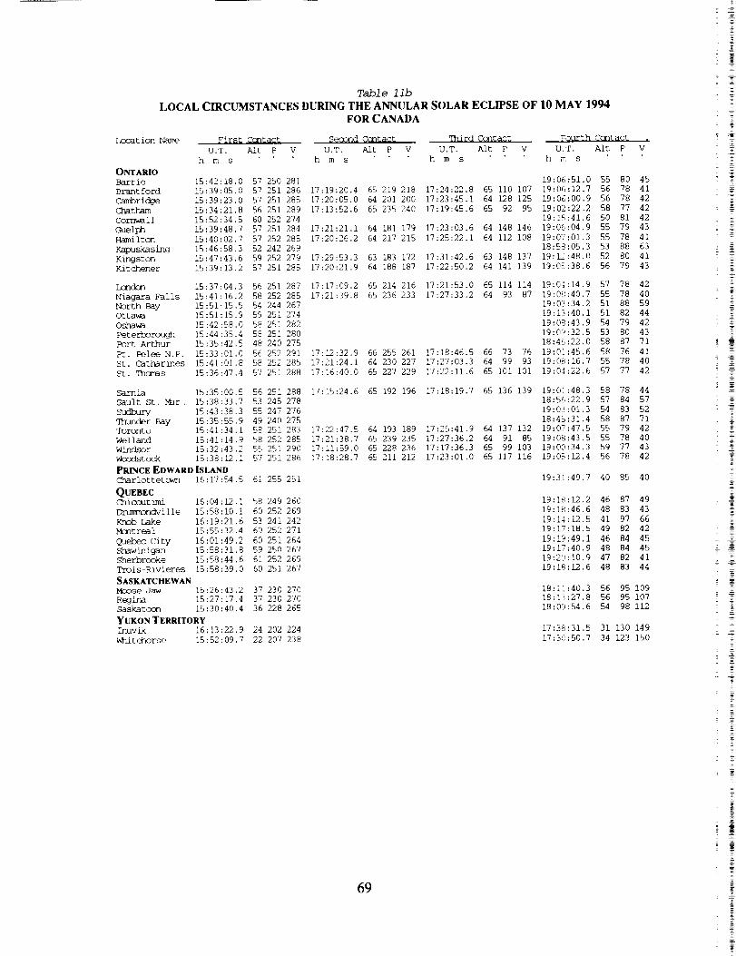
Table llb
LOCAL CIRCUMSTANCES DURING THE ANNULAR SOLAR ECLIPSE OF I0 MAY 1994
FOR CANADA
Location Name First Contact Second Contact _]rd Contact FQurth Contact
U.T. Aft P V U.T. Aft P V U.T. Alt P V U.T. A/t P
h m s h m s h m s h m s
ONTARIO
Barrie 15:42:18.0 57 250 281 19:06:51.0 55 80 45
Brantford 15:39:05.0 57 251 286 17:19:20.4 65 219 218 17:24:22.8 65 ii0 107 19:06:12.7 56 78 41
Cambridge 15:39:23.0 57 251 285 17:20:05.0 64 201 200 17:23:45.1 64 128 125 19:06:00.9 56 78 42
(]]atham 15:34:21.8 56 251 289 17:13:52.6 65 235 240 17:19:45.6 65 92 95 19:02:22.2 58 77 42
Corrm_ll 15:52:34.5 60 252 274 19:15:41.6 50 81 42
Guelph 15:39:48.7 57 251 284 17:21:21.i 64 181 179 17:23:03.6 64 148 146 19:06:04.9 55 79 43
Hamilton 15:40:02.7 57 252 285 17:20:26.2 64 217 215 17:25:22.1 64 112 108 19:07:01.3 55 78 41
Kapuskasing 15:46:58.3 52 242 269 18:58:05.3 53 88 63
Kingston 15:47:43.6 59 252 279 17:29:53.3 63 183 172 17:31:42.6 63 148 137 19:12:48.0 52 80 41
Kitchener 15:39:13.2 57 251 285 17:20:21.9 64 188 187 17:22:50.2 64 141 139 19:05:38.6 56 79 43
Lc_dcn 15:37:04.3 56 251 287 17:17:09.2 65 214 216 17:21:53.0 65 114 114 19:04:14.9 57 78 42
Niagara Falls 15:41:16.2 98 252 285 17:21:39.8 65 236 233 17:27:33.2 64 93 87 19:09:40.7 55 78 40
North Bay 15:51:15.5 54 244 267 19:03:34.2 51 88 59
Ottawa 15:51:15.9 59 251 274 19:13:40.1 51 82 44
Oshawa 15:42:58.0 58 251 282 19:08:43.9 54 79 42
Peterborough 15:44:35.4 58 251 280 19:09:32.5 53 80 43
Port Arthur 15:35:42.5 48 240 275 18:45:22.0 58 87 71
Pt. Pelee N.P. 15:33:01.0 56 252 291 17:12:32.9 66 255 261 17:18:46.5 66 73 76 19:0]:45.6 58 76 41
St. CatharLnes 15:41:01.8 58 252 285 17;21:24.1 64 230 227 17:27:03.3 64 99 93 19:08:16.7 55 78 40
St. qhamss 15:36:47.4 57 251 288 17:16:40.0 65 227 229 17:22:11.6 65 i01 i01 19:04:22.6 57 77 42
Sarnia 15:35:00.5
Sault St, Mar. 15:38:33.7
Sudbury 15:43:38.3
qhunder Bay 15:35:55.9
Toronto 15:41:34.1
Welland 15:41:14.9
windsor 15:32:43.2
_xlstock 15:38:12.1
PRINCE EDWARD ISLAND
56 251 288 17:15:24.6 65 192 196 17:18:19.7 65 136 139 19:01:48.3 58 78 44
53 245 278 18:56:22.9 57 84 57
55 247 276 19:03:01.3 54 83 52
49 240 275 18:45:31.4 58 87 71
58 251 283 17:22:47.5 64 193 189 17:25:41.9 64 137 132 19:07:47.5 55 79 42
58 252 285 17:21:38.7 65 239 235 17:27:36.2 64 91 85 19:08:43.5 55 78 40
55 251 290 17:11:59.0 65 228 236 17:17:36.3 65 99 103 19:00:34.3 59 77 43
57 251 286 17:18:28.7 65 211 212 17:23:01.0 65 117 116 19:05:12.4 56 78 42
Charlottetcwn 16:17:54.5 61 255 251
QUEBECChicoutimi 16:04:12.1 58 249 260
_ndville 15:58:10.i 60 252 269
Knob Lake 16:19:21.6 53 241 242
Mantreal 15:55:32.4 60 252 271
Qu_ City 16:01:49.2 60 251 264
shawhnig_un 15:58:31.8 59 250 267
Sherbrooke 15:58:44.6 61 252 269
Trois-Rivieres 15:58:39.0 60 251 267
SASKATCHEWAN
Mc_Dse Jaw 15:26:43.2 37 230 270
ReGina 15:27:17.4 37 230 270
Saskatocn 15:30:40.4 36 228 265
YUKON TERRITORY
Inuvik 16:13:22.9 24 202 224
Whitehorse 15:52:09.7 22 207 238
19:31:49.7 40 85 40
19:18:12.2 46 87 49
19:18:46.6 48 83 43
19:14:12.5 41 97 66
19:17:18.5 49 82 42
19:19:49.1 46 84 45
19:17:40.9 48 84 45
19:20:10.9 47 82 41
19:18:12.6 48 83 44
18:11:40.3 56 95 109
18:13:27,8 56 95 107
18:09:54.6 54 98 112
17:38:31.5 31 130 149
17:3(:50.7 34 123 150
= Z
2 =
- £
#
69

imc_t ion Name
ANDORRA
Andorra la Vella
AUSTRIAVienna
BEU_mM
AntwerpBrussels
Liege
B_LARUS
Minsk
CZECHOSLOVAKIA
Ost rava
Prague
DENMARK
ESTOMA_ll_n
FINLAND
Helsinki
FRANCE
Lille
Lyt>n
Marseille
Paris
Toulouse
GERMANY
Aachen
Berlin
Bielefeld
Hcmqn
Bremen
Dor_
Dresden
Dui_Dusseldorf
Essen
Frankfurt
Hamburg
Hannover
Koln
Leipzig
Mannheim
Mtaqich
_rg
Stuttgart
Wiesbsden
W_rtal
HUNGARY
_st
IRELAND
_l_n
ITALY
Bolocjna
Catania
Florence
C_qova
Milano
N_oli
Palen_o
Rcrae
Torino
LATVIA
Riga
Table 12a
CIRCUMSTANCES AT MAXIMUM ECLIPSE ON 10 MAY 1994
FOR EUROPE
Umbral Path Sun Stm Eclipse Eclipse
Latitude Longitude Elev. U.T. Durat. Width Alt Az, P V _g. obs.
m h m s ms kln
42 30.0 1 31.0 1162 18:46:57.7 2 292 177 131 0.700 0.608
48 13.0 16 20.0 218 18:22 Set 0 298 - - 0.454 0.334
51 13.0 4 25.0 - 18:35:18.5
50 50.0 4 20.0 - 18:35:50.2
50 38.0 5 34.0 - 18:35:44.3
5 292 176 138 0.516 0.400
5 292 176 138 0.523 0.408
4 293 176 138 0.520 0.404
53 54.0 27 35.0 242 17:59 Set 0 303 - - 0.235 0.129
49 50.0 18 17.0 - 18:16 Set 0 299 - - 0.398 0.276
50 05.0 14 28.0 217 18:33:03.7 0 299 176 140 0.477 0.358
55 40.0 12 35.0 14 18:26:53.6
59 26.0 24 44.0 - 18:17:18.7
60 i0.0 24 58.0 i0 18:16:18.9
44 50.0 0-34.0 52 18:44:46.7
50 38.0 3 04.0 46 18:36:26.4
45 43.0 5 04.0 308 18:41:59.6
43 18.0 5 24.0 81 18:44:39.3
48 52.0 2 20.0 54 18:38:56.3
43 36.0 1 26.0 177 18:45:41.8
50 47.0 6 05.0 - 18:35:23.2
52 31.0 13 24.0 61 18:30:35.8
52 01.0 8 31.0 - 18:33:01.1
50 44.0 7 05.0 - 18:35:08.0
53 04,0 8 49.0 17 18:31:33.6
51 31.0 7 28.0 - 18:34:00.3
51 03.0 13 44.0 - 18:32:14.4
51 25.0 6 46.0 - 18:34:21.4
51 12.0 6 47.0 - 18:34:37.9
52 43.0 7 57.0 - 18:32:17.6
50 07.0 8 40.0 Iii 18:35:22.1
53 33.0 9 59.0 22 18:30:32.7
52 24.0 9 44.0 - 18:32:06.8
50 56.0 6 59.0 - 18:34:54.6
51 19.0 12 20.0 - 18:32:29.7
49 29.0 8 29.0 - 18:36:12.9
48 08.0 ii 35.0 571 18:36:35.9
49 27.0 ii 04.0 344 18:35:15.8
48 46.0 9 Ii.0 - 18:36:49.5
50 05.0 8 14.0 - 18:35:33.7
51 16.0 7 ii.0 - 18:34:25.1
47 30.0 19 05.0 129 18:08 Set
53 20.0 -6-15.0 51 18:34:07.5
44 29.0 ii 20.0 - 18:27 Set
37 30.0 15 06.0 - 17:55 Set
43 46.0 II 15.0 - 18:25 Set
44 25.0 8 57.0 104 18:38 Set
45 28.0 9 12.0 - 18:40:39.8
40 51.0 14 17.0 27 18:07 Set
38 07.0 13 21.0 116 18:05 Set
41 54.0 12 29.0 124 18:18 Set
45 03.0 7 40.0 - 18:41:46.5
56 57.0 24 06.0 - 18:20:33.8
4 296 175 143 0.398 0.277
2 304 175 148 0.286 0.172
2 304 175 149 0.276 0.163
5 291 177 132 0.667 0.570
6 291 176 137 0.534 0.420
2 294 177 134 0.613 0.507
1 295 177 133 0.658 0.559
5 291 176 136 0.571 0.460
3 292 177 132 0.678 0.583
4 293 176 138 0.514 0.398
2 298 176 141 0.443 0.322
4 295 176 140 0.479 0.360
4 294 176 138 0.509 0.392
4 294 176 140 0.460 0.340
4 294 176 139 0.493 0.375
1 298 176 140 0.465 0.345
4 294 176 139 0.499 0.381
4 294 176 139 0.503 0.385
4 294 176 140 0.470 0.351
3 295 176 138 0,510 0.394
4 295 176 141 0.445 0.325
3 295 176 140 0.466 0.346
4 294 176 139 0,506 0.389
2 297 176 140 0,469 0.349
2 295 176 138 0.523 0.407
0 298 176 138 0.528 0.412
1 297 176 138 0.508 0.391
2 296 176 138 0.531 0.416
3 295 176 138 0.514 0.397
4 294 176 139 0.499 0.382
0 298 - - 0.330 0.211
12 283 175 138 0.539 0.425
0 296 - - 0.535 0.420
0 293 - - 0,i05 0.039
0 295 - - 0.525 0.409
0 296 - - 0.608 0.502
0 297 177 135 0.591 0.483
0 294 - - 0.300 0.185
0 293 -- - 0.258 0.148
0 295 - - 0.446 0.325
0 296 177 135 0.609 0.503
0 305 175 147 0.321 0.203
7O
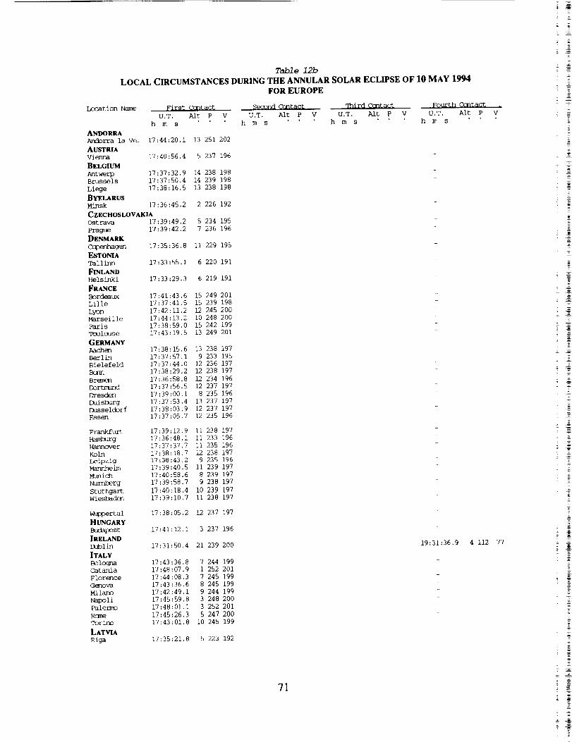
Table 12b
LOCAL CIRCUMSTANCES DURING THE ANNULAR SOLAR ECLIPSE OF 10 MAY 1994FOR EUROPE
Loc_ tion Name
ANDORRAAndorra la Ve.
AUSTRIA
vienna
BEUSmM
Antwerp
Brussels
Liege
BYELARUS
Mb_sk
First C(3ntact SL_3ond Ctntact _hird Ccntact
U.T. Alt P V U.T. Alt P V U.T. AIu P
h m s h m s h m s
17:44:20.i 13 251 202
17:40:56.4 5 237 196
17:37:32.9 14 238 198
17:37:50.4 14 239 198
17:38:16.5 13 238 198
17:36:45.2 2 226 192
CZECHOSLOVAKIA17:39:49.2 5 234 195
17:39:42.2 7 236 196
17:35:36.8 ii 229 195
17:33:55.1 6 220 191
17:33:29.3 6 219 191
17:41:43.6 15 249 20117:37:41.5 15 239 198
17:42:11.2 12 245 200
17:44:13.2 i0 248 20017:38:59.0 15 242 199
17:43:19.5 13 249 201
17:38:15.6 13 238 197
17:37:57.1 9 233 19517:37:44.0 12 236 197
17:38:29.2 12 238 197
17:36:58.8 12 234 19617:37:56.5 12 237 197
17:39:00.1 8 235 196
17:37:53.4 13 237 197
17:38:03.9 12 237 197
17:37:05.7 12 235 196
17:39:12.9 ii 238 19717:36:48.1 Ii 233 196
17:37:37.7 ii 235 196
17:38:18.7 12 238 19717:38:43.2 9 235 196
17:39:40.5 ii 239 197
17:40:58.6 8 239 197
17:39:58.7 9 238 197
17:40:18.4 i0 239 197
17:39:10.7 ii 238 197
Ost ravaPrague
DENMARK
Cq3enhagen
ESTONIATallinn
FINLANDHelsinki
FRANCE
BordeauxLille
LyonMar seil le
.:aris
Toulouse
GERMANYAachenBerlinBielefeld
Bcrm
Br6rnenDortmund
Dresden
Duisburg
DusseldorfEssen
Frankfurt
Hamburg
Hannover
Koln
LeipzigMannheim
Munich
Nurnberg
StuttgartWiesbaden
W_rtal
HUNGARY
Budapest
IRELANDDublin
ITALYBolcGnaCatamaFlorence_r_va
PalermoRcx__r_
LATVIA
Riga
17:38:05.2 12 237 197
17:41:12.1 3 237 196
17:31:50.4 21 239 200
17:43:36.8 7 244 199
17:48:07.9 1 252 201
17:44:08.3 7 245 199
17:43:36.6 8 245 199
17:42:49.1 9 244 199
17:45:59.8 3 248 200
17:48:01.1 3 252 201
17:45:26.3 5 247 200
17:43:01.8 10 245 199
17:35:21.8 5 223 192
Fo_/rth Contact
V U.T. Alt P
h m s
19:31:36.9 4 112
71
77
< 7
g
= _
= _
= =
= N
_ _
2_N
"i
g
g
= =_ N
g
= g
_N= _2 _
5 _
2 _

Location Name
LIECHTENSTEIN
Vaduz
LITHUANIA
Vilnius
LUXEMBOURG
Luxembourg
MALTA
Valletta
MONACO
Mznaco
NETHERLANDS
Amsterdam
Rot terdmm
S'Gr-avenhage
Utrecht
NORWAY
Oslo
POLAND
C<_sk
K_raka._
_zi3,2tn
Warsaw
Wroclaw
PORTUGAL
Lisbon
Porto
SAN MARINO
San M_r ino
SPAN
Barcelona
Bi_
Madrid
Mmlaga
Sevi 1 le
Valencia
Zaragoza
SWEDEN
Go£eb3rg
Stockholm
SWITZERLAND
Basel
Bern
Zurich
UKRainEL'vov
U_ED K_GDOMBelfast
Birmingham
Bristol
Cardiff
Coventry
mUnburghGlasgow
Leeds
Liverpool
Ix_ndcn
Manchester
Middlesbrough
Newc_st le
NottinghamSheffield
YUGOSLAVIA
Belgrade
Zagreb
Table 12aCIRCUMSTANCES AT MAXIMUM ECLIPSE ON 10 MAY 1994
FOR EUROPE
Umbral Path Sun S_
Latitude Ix]ngitude Elev. U.T. Durat. Width Alt Az. P V
m h m s m s km
Eclipse Eclipse
Mag. Obs.
47 09.0 9 31.0 - 18:38:36,2
54 40.0 25 26.0 - 18:06 Set
49 36.0 6 09.0 360 18:36:52.7
35 54.0 14 31.0 76 17:56 Set
43 44.0 7 25.0 59 18:42 Set
52 22.0 4 54.0 2 18:33:39.0
51 55.0 4 28.0 - 18:34:22.0
52 06.0 4 18.0 - 18:34:10.0
52 05.0 5 08.0 - 18:33:57.8
59 55.0 i0 45.0 i01 18:21:38.0
54 23.0 18 40,0 12 18:26:06.0
50 03.0 19 58.0 237 18:14 Set
51 46.0 19 30.0 - 18:18 Set
52 25.0 16 55.0 - 18:29:13.4
52 15.0 21 00.0 96 18:16 Set
51 06.0 17 00,0 158 18:29 Set
38 43.0 -9-08.0 103 18:53:46.6
41 i0.0 -8-36.0 - 18:50:47.1
43 55.0 12 28,0 - 18:21 Set
41 23.0 2 ii.0 102 18:47:59.2
43 15.0 -2-58.0 - 18:47:17.3
40 24.0 -3-41.0 718 18:50:50.5
36 34.0 -4-25.0 - 18:55:16.0
37 23,0 -5-59.0 32 18:54:45.3
39 28,0 0-22.0 26 18:50:57.5
41 38,0 0-53.0 - 18:48:40.6
57 43,0 ii 58.0 18 18:24:21.I
59 20,0 18 03.0 48 18:20:07.7
47 33,0 7 35.0 - 18:38:53.5
46 57,0 7 26.0 616 18:39:40.1
47 23,0 8 32.0 531 18:38:43.9
49 50.0 24 00.0 321 17:57 Set
54 35.0 -5-55.0 19 18:32:15.0
52 29,0 -1-55.0 176 18:34:55.1
51 27.0 -2-35.0 - 18:36:28.2
51 29.0 -3-13.0 67 18:36:30.7
52 25.0 -1-30.0 - 18:34:56.9
55 57.0 -3-13.0 145 18:30:00.9
55 53.0 -5-15.0 - 18:30:15.553 50.0 -1-35.0 - 18:32:56.4
53 25.0 -2-55,0 65 18:33:42.9
51 30.0 0-i0,0 49 18:35:59.8
1 297 176 136 0.558 0.446
0 303 - - 0.291 0.177
4 294 176 137 0.535 0.420
0 293 - - 0.096 0.035
0 296 - -- 0.635 0.533
6 292 176 139 0.493 0.375
6 292 176 139 0.504 0.386
6 292 176 139 0.501 0.384
5 292 176 139 0.497 0.379
7 293 175 146 0.345 0.225
1 301 175 144 0.385 0.264
0 300 - -- 0.378 0.257
0 300 -- - 0.393 0.272
0 300 176 142 0.425 0.304
0 301 -- - 0.377 0.256
0 300 - - 0.444 0.324
7 287 177 125 0.855 0.792
8 287 177 127 0.798 0.724
0 295 - - 0.479 0.360
i 293 177 130 0.718 0.629
5 289 177 130 0.715 0.626
4 290 177 128 0.780 0.702
3 290 177 125 0.869 0.807
4 289 177 125 0.862 0,799
2 292 177 128 0.776 0.698
3 291 177 130 0.734 0.648
5 295 175 144 0,371 0.250
4 299 175 147 0.318 0.201
2 295 176 136 0.563 0.451
1 295 176 136 0.575 0.464
1 296 176 136 0.560 0.448
0 300 - - 0.223 0.119
53 28.0 -2-15,0 - 18:33:33.5
54 35.0 -i-14.0 - 18:31:48.4
52 26.0 -3-06.0 - 18:35:08.9
52 58.0 -1-10.0 - 18:34:07.1
53 23.0 -1-28,0 - 18:33:34.2
44 50.0 20 30,0 149 17:54 Set
45 48.0 15 58,0 - 18:12 Set
13 283 175 139 0.514 0.398
9 287 176 138 0.530 0.415
9 287 176 137 0.553 0.440
i0 286 176 137 0.556 0.443
9 287 176 138 0.529 0.414
12 284 175 140 0.476 0.357
13 283 175 140 0.488 0.370
i0 287 175 139 0.504 0.387
I0 286 175 138 0.519 0.403
8 289 176 137 0.538 0.424
10 286 175 138 0.514 0.398
i0 286 175 139 0.489 0.371
i0 286 176 137 0.538 0.424
9 287 176 138 0.517 0.401
i0 287 175 138 0,512 0.395
0 296 - - 0,160 0.073
0 296 - - 0.382 0.260
72

Table 12b
LOCAL CIRCUMSTANCES DURING THE ANNULAR SOLAR ECLIPSE OF 10 MAY 1994
FOR EUROPE
Location Name First Contact _emond Contact qhird Ccntact _+'ourth Cc[itact
U.T. Aft P V U,T. Air P V U.T. Air P V U T. A]t P
h m s h m s h m s h m s
LIECHTENSTEIN
Vaduz 17:41:33.8 9 241 198
LITHUANIA
Vilnius 17:36:33.9 3 225 192
LUXEMBOURG
Luxe_Ttourg 17:39:13.5 12 240 198
MALTA
Valletta 17:49:20.5 i 254 202
MONACO
Nkx_aco 1-7:44:03.1 9 247 200
NETHERLANDS
Amsterdam 17:36:43.8 14 236 197
Rotterdam 17:36:59.4 14 237 198
S'Gravenhage 17:36:48.0 14 237 198
Utrecht 17:37:00.8 14 237 197
NORWAYOslo 17:32:09.6 13 225 194 19:{,_::42.2 2 125 99
POLAND
@gansk 17:36:56.5 7 229 194
Krak_w 17:39:35.6 4 233 195
Lodz 17:38:34.4 5 231 194
Poznan 17:38:11.1 7 232 195
Warsaw 17:38:13.1 4 230 194
Wroclaw 17:39:02.9 6 233 195
PORTUGALLisbc_ 17:44:40.9 20 260 206
Porto 17:42:19.0 21 257 205
SAN MARINO
San _rino 17:44:00.1 6 244 199
SPAIN
Barcelona 17:45:25.5 12 252 202
Bilbao 17:42:27.9 17 252 202
M_drid 17:45:00.0 16 256 204
Malaga 17:48:38.8 15 262 206
Seville ]7:47:19.9 17 261 206
Valencia 17:46:43.0 13 256 203
Zaraqoza 17:44:34.6 15 253 203
SWEDENGotehorg 17:34:0] .4 12 227 194 19:11]:09.5 0 123 96
Stockholm 17:33:39.5 9 223 192
SWITZERLANDBasel 17:41:03.6 ii 242 198
Bern 17:41:31.4 i0 243 199
Zurich 17:41:18,4 i0 242 198
UKRAINE
L'vov 17:39:17,8 2 232 194
UNITED KINGDOM
Belfast 17:30:55.0 21 237 200 19:29:01.6 5 113 79
Birmingham 17:34:30.0 18 239 199 19:30:54,1 2 113 78
Bristol 17:35:08.1 19 240 200 19:33:08,9 1 iii 76
Cardiff 17:34:51.0 19 241 200 19:33:26.8 2 iii 75
Coventry 17:34:42.9 18 239 199 19:30:47.0 2 113 78
Fxlinkurgh 17:30:59.9 20 235 198 19:2,1:57.9 5 116 84
Glasgow 17:30:07.5 21 235 199 19:26:06.6 6 115 82
Leeds 17:33:28.0 19 237 199 19:28:12.2 3 114 81
Liverpool 17:33:17.3 19 238 199 19:29:43.7 3 113 79
imnchn 17:35:59.1 17 239 199 19:_1:38.0 1 112 77
Manchester 17:33:31.0 19 238 199 19:29:16.0 3 114 80
Middlesbrough 17:32:58.0 18 236 198 19:26:34.8 3 115 82
Newcastle 17:34:03.8 19 239 199 19:91:39.5 2 112 77
Nottingham 17:34:22.1 18 238 199 19:29:35.0 2 113 79
Sheffield 17:33:53.8 18 237 199 19:28:58.9 2 114 80
'YUGOSLAV|A
Belgrade 17:42:35.3 1 240 197
Zagreb 17:42:32.0 4 241 197
= =
73
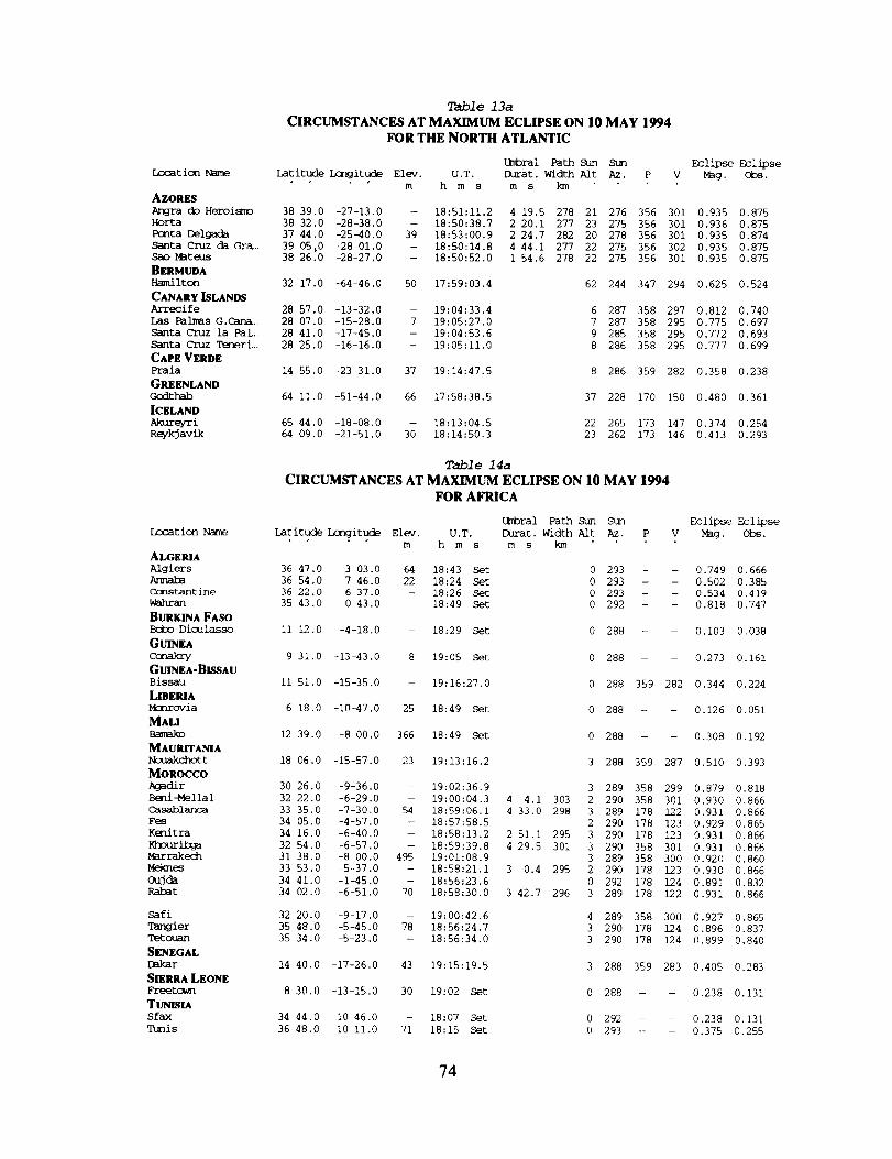
Table 13a
CIRCUMSTANCES AT MAXIMUM ECUPSE ON 10 MAY 1994
FOR THE NORTH ATLANTIC
Lo3at ion Name
Umbral Path Ddn St_
Latitude Longitude Elev. U.T. Durat. Width Alt Az. P
m h m s m s km
AZORES
Anora do Heroismo 38 39.0 -27-13,0
Horta 38 32.0 -28-38.0
Ponta Delgada 37 44.0 -25-40.0
Santa Cruz da Gra., 39 05:0 -28-01.0
38 26.0 -28-27.0
32 17.0 -64-46.0
28 57.0 -13-32.0
28 07.0 -15-28.0
28 41.0 -17-45.0
28 25.0 -16-16.0
14 55.0 -23-31.0
64 ii.0 -51-44.0
65 44.0 -18-08.0
64 09.0 -21-51.0
Sao Mat eus
BERMUDA
Hami iron
CANARY ISLANDS
Arrecife
Las Palmas G.Cana.,
Santa Cruz la Pal.,
Santa Cruz Teneri_
CAPE VERDE
Praia
GREENLAND
Godthab
ICELAND
Akureyri
ReykJ avik
Eclipse Eclipse
V Mag. Obs.
- 18:51:11.2 4 19.5 278 21 276 356 301 0.935 0.875
- 18:50:38.7 2 20.1 277 23 275 356 301 0.936 0.875
39 18:53:00.9 2 24.7 282 20 278 356 301 0.935 0.874
-- 18:50:14.8 4 44,1 277 22 275 356 302 0.935 0.875
- 18:50:52.0 1 54.6 278 22 275 356 301 0.935 0.875
50 17:59:03.4
- 19:04:33.4
7 19:05:27.0
- 19:04:53.6
- 19:05:11.0
37 19:14:47.5
66 17:58:38.5
- 18:13:04.5
30 18:14:50.3
62 244 347 294 0.625 0.524
6 287 358 297 0,812 0.740
7 287 358 295 0.775 0.697
9 285 358 295 0.772 0.693
8 286 358 295 0.777 0.699
8 286 359 282 0.358 0.238
37 228 170 150 0.480 0.361
22 265 173 147 0.374 0.254
23 262 173 146 0.413 0.293
Location Name
ALGE_
Algiers
Annaba
Constant ine
Wahran
BURKINA FASO
Bcico-Dioulasso
GUNEAConakry
GUINEA-BISSAU
Bissau
LmE_A
Mcnrovia
MAU
Bamako
MAURITANIA
Ncuakchot t
MOROCCO
Agadir
Beni-Mella 1
Casablarr-_
Fes
Kenitra
Khourib_
Marraked3
Meknes
Oujda
Rabat
Safi
Tangier
q_:touan
SENEGAL
[_kar
SIERRA LEONE
Freetown
TUNISIA
S fax
_is
Table 14a
CIRCUMSTANCES AT MAXIMUM ECLIPSE ON 10 MAY 1994
FOR AFRICA
Latitude Ix]rgitude Elev. U.T.
m h m s
Umbral Path Sun Stm
Durat. Width Aft Az. P V
m s kln
Eclipse Eclipse
M_g. Obs.
36 47.0 3 03.0 64 18:43 Set
36 54.0 7 46.0 22 18:24 Set
36 22.0 6 37.0 - 18:26 Set
35 43.0 0 43,0 - 18:49 Set
0 293 - - 0.749 0.666
0 293 - - 0.502 0.385
0 293 - - 0.534 0.419
0 292 - - 0.818 0.747
ii 12.0 -4-18,0 - 18:29 Set 0 288 - - 0.103 0.038
9 31.0 -13-43.0 8 19:05 Set 0 288 - - 0.273 0.161
ii 51,0 -15-35.0 - 19:16:27.0 0 288 359 282 0,344 0.224
6 18.0 -10-47.0 25 18:49 Set 0 288 - - 0.126 0,051
12 39,0 -8 00.0 366 18:49 Set 0 288 - - 0.308 0.192
18 06.0 -15-57.0 23 19:13:16.2 3 288 359 287 0.510 0.393
30 26.0 -9-36.0 - 19:02:36.9 3 289 358 299 0.879 0.818
32 22.0 -6-29.0 - 19:00:04,3 4 4.1 303 2 290 358 301 0.930 0.866
33 35.0 -7-30.0 54 18:59:06.1 4 33.0 298 3 289 178 122 0.931 0.866
34 05.0 -4-57.0 - 18:57:58.5 2 290 178 123 0.929 0.865
34 16,0 -6-40.0 - 18:58:13.2 2 51.1 295 3 290 178 123 0.931 0.866
32 54.0 -6-57.0 - 18:59:39.8 4 29,5 301 3 290 358 301 0.931 0.866
31 38.0 -8 00.0 495 19:01:08.9 3 289 358 300 0.920 0.860
33 53,0 -5-37.0 - 18:58:21.1 3 0.4 295 2 290 178 123 0,930 0.866
34 41.0 -1-45.0 - 18:56:23.6 0 292 178 124 0.891 0.832
34 02.0 -6-51.0 70 18:58:30.0 3 42.7 296 3 289 178 122 0.931 0.866
32 20.0 -9-17.0
35 48.0 -5-45.0
35 34.0 -5-23.0
- 19:00:42.6
78 18:56:24.7
- 18:56:34.0
4 289 358 300 0.927 0.865
3 290 178 124 0.896 0.837
3 290 178 124 0.899 0.840
14 40.0 -17-26.0 43 19:15:19.5 3 288 359 283 0.405 0.283
8 30.0 -13-15,0 30 19:02 Set 0 288 - - 0.238 0.131
34 44.0 i0 46.0
36 48.0 I0 ii.0
- 18:07 Set
71 18:15 Set
0 292 - - 0.238 0.131
0 293 - - 0.375 0.255
74

Table 13b
LOCAL CIRCUMSTANCES DURING THE ANNULAR SOLAR ECLIPSE OF 10 MAY 1994
FOR THE NORTH ATLANTIC
Location Name First Ccntact Seaond Ccntact
U,T. Alt P V U.T. Alt P
h m s h m s
qhir_ Cantact
V U.T. Alt P
h m s
Fourth Ccntact .
V U.T. Alt P V
h m s
AZORES
Angra do Hero_ 17:30:19.6 37 267 212 18:49:02.1 22 297 242 18:53:21.6 21 56 1 20:01:31.6 8 86 34Horta 17:28:44.1 39 267 213 18:49:30.0 23 329 274 18:51:50.1 22 24 329 20:01:44.0 9 85 33
Pcnta Delgada 17:33:17,8 35 268 212 18:51:49.7 20 328 272 18:54:14.4 19 26 330 20:02:25.2 6 86 33
Santa Cruz d_. 17:28:48.4 38 266 212 18:47:53.2 23 287 232 18:52:37.3 22 67 12 20:01:03.8 9 86 35
Sao M_teus 17:29:05.6 38 268 213 18:49:56.2 23 335 279 18:51:50.8 22 19 324 20:01:50.6 9 85 33
BERMUDA
Ha_nilton 16:10:27.3 75 277 281 19:37:56.5 42 61 359
CANARY ISLANDS
Arrecife 17:54:34.9 20 277 212
Las Palmas G .... 17:54:53.4 22 279 213
Santa Cruz la. 17:52:51.9 24 279 213
Santa Cruz Te_ 17:54:03.9 23 279 213
CAPE VERDE
Praia 18:16:12.7 22 308 227
GREENLAND
Godthab 16:46:49.3 41 230 218 19:06:07.0 31 112 87
ICELAND
Akure/ri 17:15:18.2 28 225 201 19:07:23.8 16 121 96
Reykjavik 17:13:42.7 30 228 203 19:11:59.2 17 119 91
Table 14b
LOCAL CIRCUMSTANCES DURING THE ANNULAR SOLAR ECLIPSE OF 10 MAY 1994
FOR AFRICA
Location Name First Ccntact $_iond Cantact q%_ir_ ¢cntact Fourth Ccntact .
U,T. Alt P V U.T. Alt P V U.T. Alt P V U.T. Alt P V
h m s h m s h m s h m s
ALGERIA
Algiers 17:49:37.1 i0 258 204Armak_ 17:49:31.3 6 256 203
Cc_nstantine 17 :50 :00.8 7 257 203
Wahran 17:50:25.0 ii 261 205
BURKINA FASO
Boto-Dioulasso 18:20:36.3 2 303 224
GU_EACc*3akl_ 18:28:03.2 8 313 230
GUINEA-BISSAU
Bissau 18..23:20.5 12 309 228
LIBERIA
Mcnrovia 18:34:11.7 3 319 234
MAU18:19:40.0 6 302 224
MAURITANIA
Nouakchott 18:10:51.2 17 297 221
MOROCCOAgadir 17:54:04.7 17 273 210Beni-Mellal 17:52:39.6 16 269 208 18:58:02.3 2 295 238 19:02:06.4 2 61
Casablanca 17:51:00.1 17 267 208 18:56:49.6 4 260 204 19:01:22.5 3 96
Fes 17:51:08.0 15 266 207
Kenitra 17:50:29.0 16 266 207 18:56:47.7 3 216 161 18:59:38.7 3 139
Khouribga 17:51:56.1 16 268 208 18:57:25.0 3 279 223 19:01:54.5 2 76
Marrakec_ 17:53:06.8 17 270 209
Meknes 17:51:11.4 15 266 207 18:56:51.0 3 219 164 18:59:51.4 2 136
Oujda 17:51:07.2 12 263 206Rabat 17:50:41.4 17 266 207 18:56:38.6 4 232 176 19:00:21.4 3 124
Safi 17:51:52.8 18 270 209
Tangier 17:49:05.1 16 263 206
Tetouan 17:49:26.2 16 264 206
SENEGALDskar 18:17:27,4 16 304 225
SIERRA LEONE
Freetown 18:30:15.0 7 315 232
TuNIsIASfax 17:50:54.0 3 258 203
q_/nis 17:49:24.1 4 255 202
4
4O
84
20
81
68
75
= _
=
Z
= __
_g_ g
z N
= Z-
_ 7
- N_ N_ N
=
_ N
. =
- N

Table 15
CLIMATE STATISTICS DURING MAY
FOR SELECTED STATIONS WITHIN THE UMBRAL PATH
Station
Mexico
Mean
HighTemp.
"F
MeanLow
Temp."F
PrevailingWind
Days with<311othscloud and
goodvisibility
Sunshinehours
E : eslimatad
DayswithRain
Puerto Cortes 69 62 N 21.7 1.0Hermosilio 96 59 24.0 0.5
Guaymas 70 58 24.7 310 0.5Chihuahua 87 58 21.7 284 0.9Nuevo Casas Grandes 91 62 20.6 0.9United States
8585
4955604955
Bisbee-Douglas r ArizonaAlamagordo r New MexicoLas Cruces I New MexicoDemingr New MexicoRoswellr New MexicoEl Paso r TexasLubbock r TexasChildress r TexasAmarillo I TexasAltusf OklahomaOklahoma City r OklahomaWichita r KansasKansas City r KansasJefferson City r MissouriSpringfield I IllinoisToledo r OhioDetroitr MichiganClevelandf Ohio
Rochester r New YorkBurlingtonr VermontPortland_ MaineAugusta, MaineCanada
57S
WSW
83
19.716.717.4
15.6
Toronto r OntarioSt Johnr New BrunswickHalifax r Nova ScotiaAzores= PortugalCorv% FlorasHorta r Ilha do PicoLajes r Ilha TemeiraPonta Delgada,
Ilha de Sao Mi_uelMorocco
17.6
8585
388E360E370E380E33037387
0.30.51.10.63.21.1
83 55 S 12.5 315E 5.881 57 11.3 305E 7.179 52 S 12.3 305 5.982 60 SSE 9.9 300E 6.8
S 10.5 29O79 58 7.377 55 S 8.2 291 6.374 54 S 7.3 278 7.275 54 6.9 280E 7.174 53 S 7.2 282 7.371 47 ENE 6.2 253 6.670 47 W 5,1 263 5.769 48 N 7.4 274 6.768 46 WSW 6.5 274 6.367 44 S 5.2 244 6.363 43 S 6.8 268 6.665 43 - 4.5 290E 6.7
65 233N43 5.8 7.858 38 SSW 7.0 203 8.158 39 S - 207
65 59 - 3.3 162 6.667 57 - 5.8 177 5.966 57 NW 0.7 160 4.167 56 - 3.2 158 5.0
Marrakesh 84 57 W 29.3 288 1.5Casablanca 72 56 N 12.8 292 2.2Ifrane 66 41 - - 244Midelt 73 48 - - 303
NW 12.5 2985875Kenitra 2.0
76

ANNULAR SOLAR ECLIPSE OF 10 MAY 1994
MAPS
O F THE
UMB RAL PATH
2
Y
Z
i
i
77


I
I
II
II
\I
79
3957
PREeEOING P.-_GE BLANK NOT t-'i
=

980
/
IUCUMCARI
I
8O

NORIH PLATT
N.rth
a
IAYES CENIER
GARDEN CITY
ULYSSES "_Dod _'e Cit
STONIWALI J °
PRINi
_IDI_ND
CENTRAL N| ASKA REGIONA
(;r.lr
I
GREAT
ward
BROWNWOOD 184,5
81
0
2
=
=
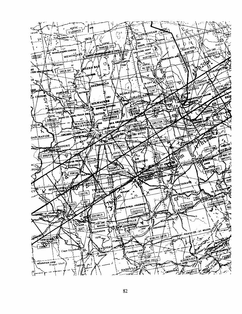
82

83
$
. =
! %

\
\
\
84

'1
\
\
\\\
\\
\\
0
f/J
L
II
't
i
u_
L_ o
_b
85
i
'1
N2_C
z _
_ _r
_r _
_L
w

\
\
\k \
\
86
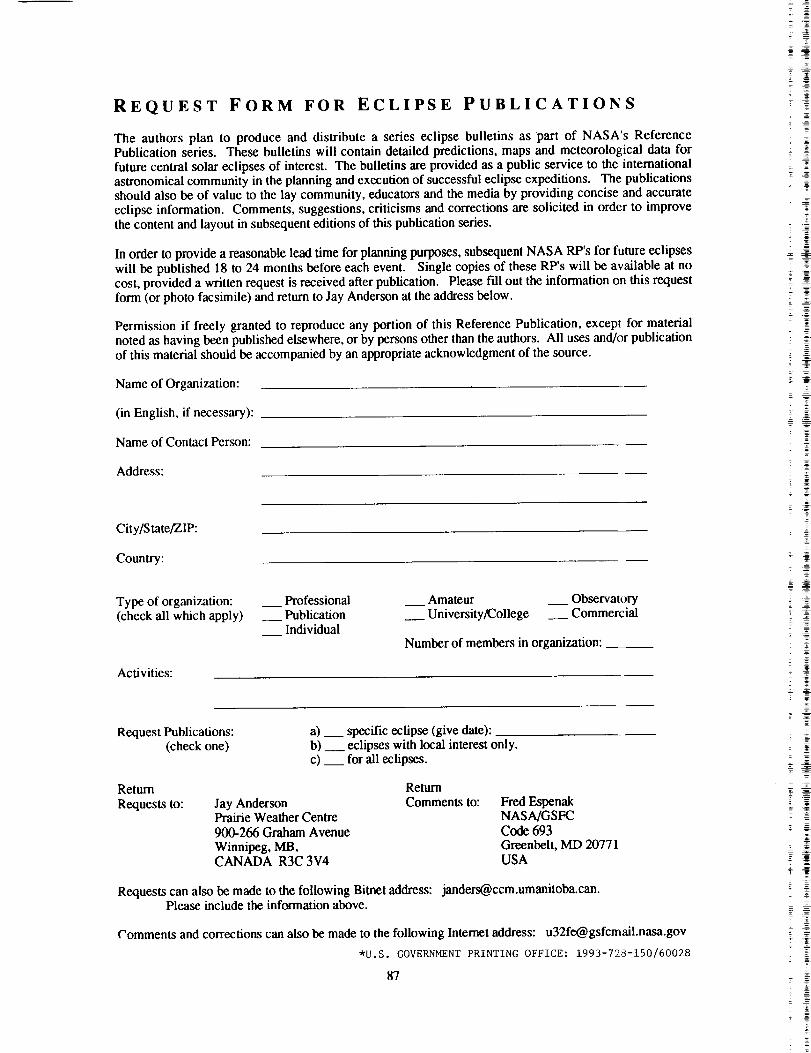
REQUEST FORM FOR ECLIPSE PUBLICATIONS
The authors plan to produce and distribute a series eclipse bulletins as part of NASA's Reference
Publication series. These bulletins will contain detailed predictions, maps and meteorological data for
future central solar eclipses of interest. The bulletins are provided as a public service to the international
astronomical community in the planning and execution of successful eclipse expeditions. The publications
should also be of value to the lay community, educators and the media by providing concise and accurate
eclipse information. Comments, suggestions, criticisms and corrections are solicited in order to improve
the content and layout in subsequent editions of this publication series.
In order to provide a reasonable lead time for planning purposes, subsequent NASA RP's for future eclipses
will be published 18 to 24 months before each event. Single copies of these RP's will be available at no
cost, provided a written request is received after publication. Please fill out the information on this requestform (or photo facsimile) and return to Jay Anderson at the address below.
Permission if freely granted to reproduce any portion of this Reference Publication, except for material
noted as having been published elsewhere, or by persons other than the authors. All uses and/or publication
of this material should be accompanied by an appropriate acknowledgment of the source.
Name of Organization:
(in English, if necessary):
Name of Contact Person:
Address:
City/State/ZIP:
Country:
Type of organization: __ Professional
(check all which apply) __ Publication
Individual
Activities:
__ Amateur __ Observatory
__ University/College __ Commercial
Number of members in organization:
Request Publications:
(check one)
a) __ specific eclipse (give date):
b) __ eclipses with local interest only.
c) __ for all eclipses.
Return Return
Requests to: Jay Anderson Comments to:Prairie Weather Centre
900-266 Graham AvenueWinnipeg, MB,CANADA R3C 3V4
Fred Espenak
NASA/GSFC
Code 693
Greenbelt, MD 20771
USA
Requests can also be made to the following Bitnet address: [email protected] include the information above.
Comments and corrections can also be made to the following Internet address: [email protected]
*u.s. GOVERNMENT PRINTING OFFICE: 1993-728-150/60028
87
T
=T
. A
T
Z
= _


Form Approved
REPORT DOCUMENTATION PAGE oMe No oTo_o,ee
Public reOort,nq burden for ,h4scoilec1¢on of information ,s estlm&te_ to average ) hour De? respOese. _nclud+.g the time )or cevlewlng instruc"[ion%_ParCrllrlq e=lsi,ng data sources9athef,ng and maintaining the data needed, and comp_etl.g and rev,ew,ng _he collection of _nformatlon Send comments regard,ng this burden e_,mate or anv other a_Dec_ o, _h_¢ollecl,o_ ot _nformatJon. ,ncludlog $uqgest_on, tot reductng this Dur0en ro Washtngton HeadQuarters Serv=ces, OtreClorate for informalron ODeratJon_ an0 Re_rls, 12_5 JeffersonDavlsHighwaV. _.uhte 1204. Arhngton. VA 22202-4302_ and _othe Office o_ Management _nd Budget Paperwork Reduc_lomPrOleC_(0704-0188), Wash_n@ton DC 2050]
1. AGENCY USE ONLY (Leave blank) 2. REPORT DATE
April 1993
4. TITLE AND SUBTITLE 5. FUNDING NUMBERS
Annular Solar Eclipse of i0 May 1994
6. AUTHOR(S)
Fred Espenak and Jay Anderson
7. PERFORMINGORGANIZATION NAME{S]ANO ADDRESS(ES)
Goddard Space Flight Center
Greenbelt, Maryland 20771
9. SPONSORING/MONITORING AGENCY NAME,S) AND AODRESS(ES)
National Aeronautics and Space Administration
Washington, D.C. 20546-OOO1
3. REPORTTYPE AND DATES COVERED
Reference Publication
693
8. PERFORMING ORGANIZATION
REPORT NUMBER
93B00052
10. SPONSORING / MONITORINGAGENCY REPORT NUMBER
NASA RP-1301
11. SUPPLEMENTARY NOTES
Espenak: Goddard Space Flight Center, Greenbelt, Maryland, USA;
Anderson: Prairie Weather Centre, Winnipeg, Manitoba, CANADA.
12a. DISTRIBUTION/AVAILABILITY STATEMENT
Unclassified - Unlimited
Subject Category 89
12b. DISTRIBUTION CODE
13. ABSTRACT(Maximum200words)
An annular eclipse of the Sun will be widely visible from the Western Hemisphere
on I0 May 1994. The path of the Moon's shadow passes through Mexico, the United
States of America, maritime Canada, the North Atlantic, the Azores and Morocco.
Detailed predictions for this event are presented and include tables of geographic
coordinates of the annular path, local circumstances for hundreds of cities, maps
of the path of annular and partial eclipse, weather prospects, and the lunar limb
profile.
14. SU_ECTTERMS
solar eclipse; celestial mechanics; ephemeris; sun; moon
17. SECU_TY CLASSIFICATIONOF REPORT
Unclassified
NSN 7540_1-280-5500
18. SECURITY CLASSIFICATION
OF THIS PAGE
Un¢l_$sifi_d
19. SECURITY CLASSIFICATIONOF ABSTRACT
IInelnnsi lied
15. NUMBER OF PAGES
9616. PRICE CODE
A05
20. LIMITATION OF ABSTRACT
lIT.
Standard Form 298 (Rev 2-89)Pr(._rll)ecl b_ ANSI Std Z]9-18298-102
_4
4
= --- &
_-
-
_ g
;g=
2 _
