annual conference on contract opportunities · annual conference on contract opportunities. ... ddc...
TRANSCRIPT

Eric Macfarlane, P.E., M.ASCE
Deputy Commissioner
Department of Design and Construction
1
REBUILDING NEW YORK CITY’S BASIC MUNICIPAL INFRASTRUCTURE
OCTOBER 30, 2017
ANNUAL CONFERENCE ON CONTRACT OPPORTUNITIES

The New York City Department of Design and Construction (DDC) is charged with the mission of coordinating, designing and constructing all capital projects related to New York City’s infrastructure needs within the five boroughs.
• A major objective of DDC is the overall coordination of the different project components requested by the various client agencies. This includes all aspects of a project including: public buildings constructions or rehabilitation/upgrade, sewers, (both replacement and relining), water mains (distribution and trunk), utility coordination, curbs, traffic signals, lighting, pedestrian ramps, trees, hydrants, catch basins, Urban landscaping, Plazas, Retaining Walls, Step Streets, complete street reconstruction.
DDC’s MISSION

24 DDC Client Agencies
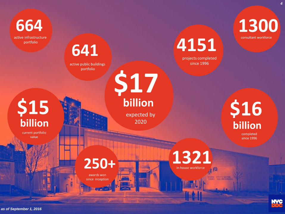
$17billion
expected by 2020
$15billion
current portfolio value
1321in-house workforce
1300consultant workforce
4151projects completed
since 1996
641active public buildings
portfolio
664active infrastructure
portfolio
as of September 1, 2016
250+awards won
since inception
4
$16billion
completed since 1996
Street Infrastructure Projects Delivery
Challenges

12 / 2010 6NYC Quality of life is sustained by a vast underground of public and private utility network

“Statement of Need:
•The Public is served by a complex infrastructure network beneath the streets and
properties of the city. Components of this infrastructure network are independently
managed by an array of distinct city agencies, private corporations, and public
authorities, each operating within its own legal authority, operational framework and
business model.
•Despite having separated responsibility for unrelated utility networks, the network
components are yet related by location, and system managers share the same need to
access information about the locations to manage components of network
infrastructure. These locations typically occupy public space, and host multiple
systems in proximity to one another, both below and above ground.
•The historic cities of the world have long employed intricate infrastructure to support
dynamic urban environments and New York City is no exception. Long-established
traditional methods often impede established cities in their efforts to upgrade to new
ways of working. In many ways building a new city from scratch using modern
methods is far easier than understanding and upgrading an existing city.”
by Kenneth J. Rozsahegyi, MPA - Deputy Director, CAD-GIS Coordinator (2014)
Upgrading vast underground utility network - Kenneth J. Rozsahegyi, MPA - Deputy Director, CAD-GIS Coordinator (2014)

Water main breaks – Flooding due to poor drainagePrivate Utilities failures
Street undermining due to sewer collapse
STATE OF BASIC MUNICIPAL INFRASTRUCTURE

Statistics of City’s Basic Municipal Infrastructure
• Streets – 6,375 miles (or 19,000 lane miles)
– 1/3 of the streets are rated “fair to poor”
– Design Life is 40 years vs. replacement cycle 200 years ! (current annual replacement of 25 to 30 miles)
• Sewers (Storm, Sanitary & Combine)
– 7,500 miles (current annual replacement approx. 30 miles)
– Size – 6” to over 90” diameter
– Design Life is 60 years. Age – 66.4 % built prior to 1940
• Water Mains
– 6,800 miles (current annual replacement approx. 30 miles)
– Size 6” to over 72” diameter
– Design Life is 60 years. Age – 59.4% built prior to 1940
1,000 miles (15%) of water mains are in excess of 100 years
NYC SELECT STATISTICS

Extreme weather events – Super Storm Sandy (Oct. 2012)

NYC CRITICAL INFRASTRUCTURE ASSETS
➢ 322 square miles - City area
➢ 6,375 miles of streets
➢ 7,500 miles of sewers
➢ 144,000 Catch Basins
➢ 6,800 miles of water mains
➢ 14 miles of public Beaches
➢ 520 miles of water front
➢ 149 miles of interceptor sewers
➢ 14,000 acres of Staten Island "Blue Belt" storm water management system (BMP)
➢ 2,000 square miles of watershed
➢ 19 Clean Water Reservoirs; 3 controlled lakes
➢ 580 billion gallons drinking water storage capacity
➢ 700 miles of subway
➢ 90,000 miles underground power cables
➢ 14 Wastewater Treatment Plants
➢ 2,000 bridges and tunnels
➢ 5.2 million trees
➢ 6,000 acres of wetlands
NYC CRITICAL MUNICIPAL ASSETS
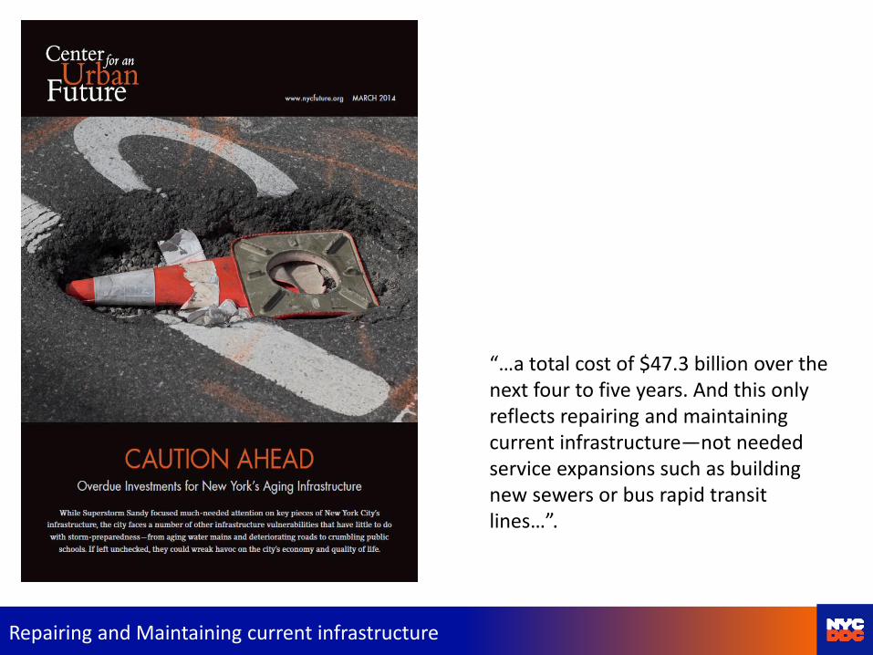
“…a total cost of $47.3 billion over the next four to five years. And this only reflects repairing and maintaining current infrastructure—not needed service expansions such as building new sewers or bus rapid transit lines…”.
Repairing and Maintaining current infrastructure

Infrastructure Portfolio 664 Projects
Estimated Construction value $ 11 billion
Status of CM Projects No. of Projects Est. Constr. Cost
To Bid 20 $674,142,417
Awarded 24 $1,201,282,231
Active Construction 144 $ 2,377,341,435
Close-Out 158 $ 1,219,367,789
TOTAL 346 $ 5,472,133,872
Status of Design Projects No. of Projects Est. Constr. Cost
In-House engineering Design (61%) 194 $3,500,000,000
Engineering Consultant Design (39%) 124 $2,000,000,000
TOTAL 318 $ 5,500,000,000

Main causes of Projects delays
• Massive private utility facilities network located underground within a public project area.
• Utilities are likely to be interfering with water main and sewer construction and must be relocated/ reconstructed ahead of City projects at significant cost to Utility operators.
• City Schedule is greatly impacted in spite extensive efforts during design to identify these interferences and coordinate new construction.
Project construction completion delays - Kenneth J. Rozsahegyi, MPA - Deputy Director, CAD-GIS Coordinator (2014)

New Private Utility companies facilities may need to be installed before or after existing facilities are taken out of service to make way for public construction.
• Relocation of Oil-O-Statics (130 KV Transmission) may take two years to coordinate• Primary electric (13KV) cannot be done in summer.
• Gas/steam work cannot be done in winter.
• CDOT MPT Stipulations may limit access
Private Utilities

Private Utility construction

Private Utility construction
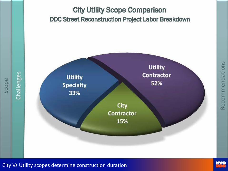
City Vs Utility scopes determine construction duration

JOINT BIDDING LAWS
• 2004 – Coordinated Construction Act for Lower Manhattan
• 2014 - S 3. a. Notwithstanding any general, special or local law or rule or regulation to the contrary, the city of New York may include utility interference work in any contract for a public work project
NYS – NYC Contract Laws Kenneth J. Rozsahegyi, MPA - Deputy Director, CAD-GIS Coordinator (2014)

• NYCDDC developed two methods to deal with these issues
– Contract languages (Section U), which specify the interaction between Utility Operators and City Contractors during construction and interference removal process, and
– Joint Bidding law, which is permits the City to include Privately funded Utility Work in City Work.
• In both cases the key to successfully minimize delays and costs depend on Pre-Engineering and coordination and sharing of data.
• JOINT BIDDING with Non-City Utilities
Joint Bid of City and Private Utilities Kenneth J. Rozsahegyi, MPA - Deputy Director, CAD-GIS Coordinator (2014)

Design coordination

The Benefits of Coordinated Work
• Digging up the street in New York dense urban environment is a disruptive event that should be carefully considered so that it occurs infrequently. DDC , created in 1996, was given the coordinating role on behalf of all city agencies. Streets are disturbed for public work capital
construction only in a carefully planned and scheduled way, and newly paved streets are
guaranteed to stay undisturbed for 5 years.
The Benefits of Coordinated Planning
• To achieve even more coordination requires more data to plan farther ahead. Data about services under the street including all the utility and services network systems. Mapping technology today is ready for this data, but the data remains hidden within the private utility and service companies that “own” and manage them.
Continuous Daily Use in a Location Awareness Workflow
• Location awareness is the capability that allows workers to proceed safely, in coordination with other asset owners, and with minimal risk of causing damage to the components of other systems. Empowering the field engineers with multisystem awareness enables new workflows to realize process efficiency gains and enjoy the benefits of clash avoidance, providing the public with fewer disruptions to services.
Stability & Reliability
• Upgrade Planning: Cross-system location awareness is an effective tool for long term planning. The characteristics of infrastructure components can be made visible on the map, and the co-location of more than one at-risk component of any system will indicate a priority for street opening and upgrade. This planning tool would promote overall system stability and long-term reliability and avoid catastrophic failure.
Planning; Coordination; Data Sharing Kenneth J. Rozsahegyi, MPA - Deputy Director, CAD-GIS Coordinator (2014)
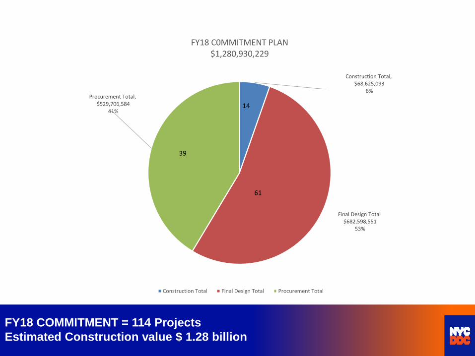
Construction Total,$68,625,093
6%
Final Design Total$682,598,551
53%
Procurement Total,$529,706,584
41%
FY18 C0MMITMENT PLAN$1,280,930,229
Construction Total Final Design Total Procurement Total
61
14
FY18 COMMITMENT = 114 Projects
Estimated Construction value $ 1.28 billion
39

Eric Macfarlane, P.E., M.ASCE
Deputy Commissioner, Infrastructure Division
Department of Design and Construction
30-30 Thomson Avenue, LIC 11101
718-391-3142