annual assessment of the effectiveness of site-wide ... · pdf filesite-wide institutional...
TRANSCRIPT

Annual Assessment of the Effectiveness of Site-Wide Institutional Controls Applied to the Former DOE Mound Site Property June 2009
LMS/MND/S05263

This page intentionally left blank

LMS/MND/S05263
Annual Assessment of the Effectiveness of Site-Wide Institutional Controls
Applied to the Former DOE Mound Site Property
June 2009

This page intentionally left blank
U.S. Department of Energy Annual Assessment of the Effectiveness of Site-Wide Institutional Controls June 2009 Doc. No. S05263 Page i
Contents Abbreviations................................................................................................................................. iii 1.0 Introduction ............................................................................................................................1 2.0 Overview of Parcel Transfer Process .....................................................................................1 3.0 Overview of Institutional Controls (ICs) ...............................................................................4 4.0 Period of Review....................................................................................................................5 5.0 Aerial View of the Mound Site Property ...............................................................................5 6.0 Summary of Previous Year’s Annual Assessment.................................................................5 7.0 Summary of Physical Inspections Performed ........................................................................7
7.1 Parcel D ........................................................................................................................8 7.2 Parcel H ........................................................................................................................9 7.3 Parcel 3 .......................................................................................................................12 7.4 Parcel 4 .......................................................................................................................14 7.5 Phase I Parcel..............................................................................................................17
8.0 Interviews and Records Reviews .........................................................................................27 8.1 Interviews with City Personnel and Review of City or MMCIC Records .................27 8.2 Records, Other Than Permits, Issued by the City of Miamisburg..............................32
9.0 Conclusions ..........................................................................................................................33 10.0 Recommendations ................................................................................................................33 11.0 For Further Information .......................................................................................................34 12.0 References ............................................................................................................................36
Figures Figure 1. Parcel Map of the Former DOE Mound Site Property, Miamisburg, Ohio.................. 3 Figure 2. April 2006 Aerial View of Mound Plant Showing Parcel Boundaries ......................... 6 Figure 3. Parcel D 2006 Aerial View........................................................................................... 8 Figure 4. Parcel H 2006 Aerial Photo .......................................................................................... 9 Figure 5. Parcel H Soil Removal Exclusion Area ...................................................................... 10 Figure 6. Parcel H DOE (Green) and OEPA (White) Air Monitors .......................................... 11 Figure 7. Parcel 3 View from Parking Lot East toward Mound Museum Building................... 12 Figure 8. Parcel 3 2006 Aerial View.......................................................................................... 13 Figure 9. Parcel 4 MMCIC Flex Building in Southwest Corner of Parcel 4. Looking West from
Old Construction Road Entrance in Parcel 4. ............................................................. 14 Figure 10. Parcel 4 Locked Gate, Facing South on Old Construction Road................................ 14 Figure 11. Parcel 4 2006 Aerial View.......................................................................................... 15 Figure 12. Parcel 4 MMCIC Retention Pond with New Signage. Bike Path at Left of Photo..... 16 Figure 13. Parcel 4 Well 0444, Locked and in Good Repair ....................................................... 17 Figure 14. Well 0444 Identification Marker ................................................................................ 17 Figure 15. Parcel 4 Fallen Log Lying across Fence. Fence Was Peeled Back. ........................... 17 Figure 16. Phase I MNA Remedy Monitoring Locations ............................................................ 19 Figure 17. Parcel Phase IA 2006 Aerial View ............................................................................. 20 Figure 18. Parcel Phase IB 2006 Aerial View.............................................................................. 21 Figure 19. Parcel Phase IC 2006 Aerial View.............................................................................. 22 Figure 20. Phase IB Empty Salt Storage Shed ............................................................................. 23 Figure 21. Phase IB Well 0411, Locked, Labeled, and in Good Repair ...................................... 23
Annual Assessment of the Effectiveness of Site-Wide Institutional Controls U.S. Department of Energy Doc. No. S05263 June 2009 Page ii
Figure 22. Parcel IB Well 0442, Locked, Labeled, and in Good Repair ..................................... 23 Figure 23. Parcel IB Well 0443, Locked, Labeled, and in Good Repair ..................................... 24 Figure 24. Parcel IB Groundwater Seep 0617.............................................................................. 24 Figure 25. Parcel IB Water Diversion Project.............................................................................. 24 Figure 26. Parcel IB Drainage Improvements.............................................................................. 24 Figure 27. Parcel IC Well 0445, Locked, Labeled, and in Good Repair ..................................... 25 Figure 28. Parcel IC Well 0400, Locked, Labeled, and in Good Repair ..................................... 25 Figure 29. Parcel IC Well 0319, Locked, Labeled, and in Good Repair ..................................... 25 Figure 30. Parcel IC Well P033, in Good Repair and with a Permanent Identification Marker.. 26 Figure 31. Parcel IC—Marker for P033....................................................................................... 26 Figure 32. Parcel 9 MNA Well 0353, Locked, Labeled, and in Good Repair ............................. 27 Figure 33. Parcel 9 MNA Well 0353 Showing Drainage Problem North of Well....................... 27 Figure 34. Parcel 9 MNA Well 0402, Locked, Labeled, and in Good Repair ............................. 27 Figure 35. Mound Site Buildings and Parcels.............................................................................. 30
Tables Table 1. Monitoring Wells and Seeps in Parcels Inspected or Part of Phase I Remedy............... 18 Table 2. Crosswalk of Street Addresses to DOE Building Identifications ................................... 29 Table 3. City of Miamisburg Permit Files on Mound Site (April 8, 2008, to March 24, 2009)... 31 Table 4. City of Miamisburg Files⎯Planning Commission Reviews.......................................... 31 Table 5. Recommendations from Previous Inspections of ICs..................................................... 34 Table 6. Recommendations from 2009 Annual Inspection for ICs .............................................. 34
Appendixes Appendix A Field Inspection Checklists for Parcels D, H, 4, 3, and I Appendix B Real Estate Easement for Utility Work Performed on MMCIC Property Appendix C Institutional Controls: A Citizen’s Guide to Understanding Institutional Controls
at Superfund, Brownfields, Federal Facilities, Underground Storage Tank, and Resource Conservation and Recovery Act Cleanups

U.S. Department of Energy Annual Assessment of the Effectiveness of Site-Wide Institutional Controls June 2009 Doc. No. S05263 Page iii
Abbreviations
CERCLA Comprehensive Environmental Response, Compensation, and Liability Act CRP Comprehensive Reuse Plan DOE U.S. Department of Energy EM Office of Environmental Management EPA U.S. Environmental Protection Agency IC institutional controls LM Office of Legacy Management MMCIC Miamisburg Mound Community Improvement Corporation MNA monitored natural attenuation NESHAPs National Emission Standards for Hazardous Air Pollutants O&M Operations and Maintenance ODH Ohio Department of Health ODNR Ohio Department of Natural Resources OEPA Ohio Environmental Protection Agency OU Operable Unit ROD record of decision TCE trichloroethylene

Annual Assessment of the Effectiveness of Site-Wide Institutional Controls U.S. Department of Energy Doc. No. S05263 June 2009 Page iv
This page intentionally left blank

U.S. Department of Energy Annual Assessment of the Effectiveness of Site-Wide Institutional Controls June 2009 Doc. No. S05263 Page 1
1.0 Introduction
This report documents the U.S. Department of Energy (DOE) Office of Legacy Management (LM) 2009 annual assessment of the effectiveness of site-wide institutional controls (ICs) for the Mound Site1 in Miamisburg, Ohio. This 2009 annual assessment covers only those parcels that have completed the Comprehensive Environmental Response, Compensation, and Liability Act (CERCLA) 120(h) requirements for property transfer. The ICs, which are legal and administrative tools in the form of deed restrictions, are defined in the record of decision (ROD) for each parcel and are described in the Operation and Maintenance (O&M) Plan for the Implementation of Institutional Controls at the 1998 Mound Plant Property, Phase I Parcel update, Rev. 1, February 17, 2004 (O&M Plan). This annual assessment for the period from April 15, 2008, to April 14, 2009, includes the ICs for Parcels D, H, 3, and 4 and the Phase I Parcel (comprising sub-parcels A, B, and C) of the Mound Site. The Miamisburg Mound Community Improvement Corporation (MMCIC) currently owns all of these parcels. Parcels 6, 6A, 7, 8, and 9 are not included in this IC assessment because they have not completed the CERCLA process. The ICs are developed and presented in the ROD process, which includes input from the public, the City of Miamisburg, the regulators, and MMCIC. RODs require that DOE perform an annual assessment to document the effectiveness of the ICs (in the form of deed restrictions) and to confirm that all site changes comply with them. Section 3.0 describes the ICs in detail. Each annual assessment includes a physical inspection of land parcels; discussions with the property owners; a review of all applicable records, including (but not limited to) construction, street opening, occupancy, and other permits; zoning modification requests; and well drilling logs. DOE contacted the U.S. Environmental Protection Agency (EPA), the Ohio Environmental Protection Agency (OEPA), and the Ohio Department of Health (ODH) 30 days before the visual inspection. DOE must submit the draft annual assessment report to EPA and OEPA no later than June 13 of each year.
2.0 Overview of Parcel Transfer Process
In January 1998, DOE executed the original sales agreement with MMCIC. The agreement calls for the transfer of discrete land parcels to MMCIC, via a series of quitclaim deeds, after the parcels have been declared excess to DOE’s needs and after all requirements of CERCLA 120(h) have been met for property transfer. When MMCIC acquires a parcel, it becomes part of the Mound Advanced Technology Center, which is a light industrial/technology park operated by MMCIC. The same parcel transfer process was continued in the revised sales agreement, Sales Contract by and between the United States Department of Energy and the Miamisburg Mound Community Improvement Corporation, August 28, 2008.
1 The Mound Site was also formerly identified as the Mound Laboratory and the Mound Plant.
Annual Assessment of the Effectiveness of Site-Wide Institutional Controls U.S. Department of Energy Doc. No. S05263 June 2009 Page 2
The following properties covered by this annual assessment were transferred to MMCIC on the dates shown:
• March 1999⎯Parcel D (formerly called Release Block D), containing approximately 12.5 acres of land and two buildings.
• August 1999⎯Parcel H (formerly called Release Block H), containing approximately 14.3 acres of land, a large parking lot, and a site-access road.
• April 2001⎯Parcel 4, containing approximately 95 acres of undeveloped land. MMCIC has built the Flex Building on this parcel.
• August 2002—Parcel 3, containing approximately 5 acres of land and Buildings GH and GP-1.
• February 2009⎯Phase I Parcel (A, B, and C), containing approximately 52 acres of land; Buildings 3, 87, and 102; and Magazines 80 through 84.
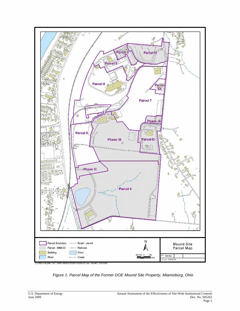
The O&M Plan for site-wide ICs applies to all land parcels that have undergone the CERCLA 120(h) process for property transfer, whether or not title to those parcels has actually been transferred to MMCIC. This annual assessment includes Parcels D, H, 3, and 4 and the Phase I land parcel, which represent approximately 60 percent of the total acreage of the former DOE Mound Site Property (estimated total acreage: 306). The remaining acreage has been divided into five parcels (Parcels 6, 6A, 7, 8, and 9). DOE is completing the CERCLA 120(h) requirements for Parcels 6, 7, 8, and 9. Parcel 6A is not part of the CERCLA process. Figure 1 shows the original boundaries of the former DOE Mound Site Property divided into parcels:
• Parcels D, H, 3, and 4 and the Phase I Parcel (A, B, and C) have completed the CERCLA 120(h) process and been transferred to MMCIC.
• Parcels 6, 7, and 8 have not completed the CERCLA 120(h) process for property transfer. EM still owns them.
• Parcel 9 has not completed the CERCLA 120(h) process and is still owned by LM.
• Parcel 6A is not covered by CERCLA and is still owned by LM.
U.S. Department of Energy Annual Assessment of the Effectiveness of Site-Wide Institutional Controls June 2009 Doc. No. S05263 Page 3
Figure 1. Parcel Map of the Former DOE Mound Site Property, Miamisburg, Ohio

Annual Assessment of the Effectiveness of Site-Wide Institutional Controls U.S. Department of Energy Doc. No. S05263 June 2009 Page 4
3.0 Overview of Institutional Controls (ICs)
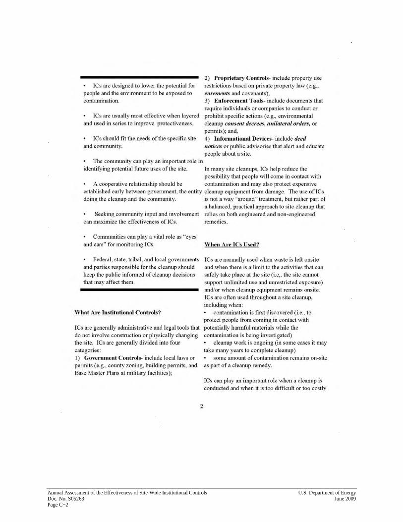
The ICs are defined in the RODs for each parcel and are described in the O&M Plan. They are developed and presented in the ROD process, which includes input from the public, the City of Miamisburg, the regulators, and MMCIC. The former DOE Mound Site Property was remediated to EPA’s risk-based standards for industrial/commercial use only. Certain restrictions, called ICs (which are in the form of deed restrictions), were placed on the property and its use. ICs are legal and administrative tools for protecting human health and the environment. (See Appendix C.) Each parcel ROD contains deed-restriction language to be embedded in the quitclaim deed and includes the CERCLA 120(h) Summary Notice of Hazardous Substances for the parcel. Because both the quitclaim deed and the CERCLA summary notice are recorded with Montgomery County, Ohio, all future property owners will know about the deed restrictions that the CERCLA remedy has imposed on their property. The three deed restrictions for the five parcels are designed to:
1. Prohibit the removal of soil from the original DOE Mound Site Property boundaries, unless prior written approval from OEPA and ODH has been obtained.
2. Prohibit the extraction, consumption, exposure, or use in any way of the groundwater underlying the premises, unless prior written approval from EPA and OEPA has been obtained.
3. Limit land use to industrial/commercial only. Each parcel ROD identifies land uses that will not be permitted, but the list is not all-inclusive. Parcels may not be used for any residential or farming activities, or any activities that could result in the chronic exposure of children under 18 years of age to soil or groundwater from the premises. Restricted uses include, but are not limited to:
• Single or multi-family dwellings or rental units.
• Daycare facilities.
• Schools or other educational facilities for children under 18 years of age.
• Community centers, playgrounds, or other recreational or religious facilities for children under 18 years of age.
The preceding language on the deed restrictions is a summary only. RODs for individual land parcels contain the parcel-specific deed-restriction language. RODs for parcels, as well as other parcel-specific CERCLA documents, are available in the CERCLA Public Reading Room, located at 955 Mound Road, Miamisburg, Ohio 45342. These RODs are also available electronically on the LM Mound website (http://www.lm.doe.gov/land/sites/oh/mound/ mound.htm) by clicking the “CERCLA Administrative Record” link.

U.S. Department of Energy Annual Assessment of the Effectiveness of Site-Wide Institutional Controls June 2009 Doc. No. S05263 Page 5
4.0 Period of Review
This annual assessment covers the period from April 14, 2008, to April 14, 2009. Each annual assessment identifies new information, such as new construction, demolition, or excavation; lot-splits or the sale of parcels to new landowners; and permit applications filed by property owners or their agents since the last reporting period. All previous annual assessments are available in the CERCLA Public Reading Room or online at the LM Mound website (http://www.lm.doe.gov/land/sites/oh/mound/mound.htm) by clicking the “CERCLA Administrative Record” link.
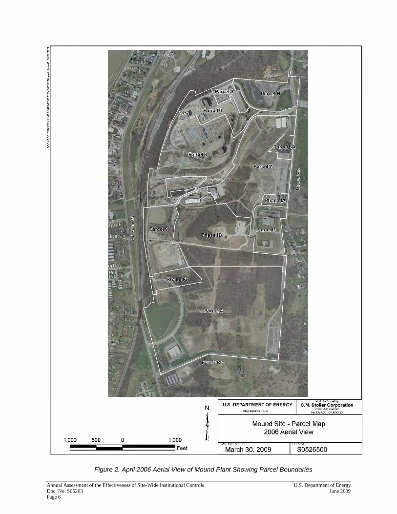
5.0 Aerial View of the Mound Site Property
Figure 2 and the following individual parcel figures are from an April 2006 aerial photograph of the Mound Site, showing parcel and phase boundaries. The actual photographs were taken at low altitude, using a nominal negative scale of 1:4800, and were developed using 1”=100’ scale planimetric mapping (the scale sizes of figures in this assessment vary). Photographic-controls points were Horizontal Datum: NAD83, Vertical Datum: NAVD88, U.S. Survey Feet, and State Plane – Ohio South Zone.
6.0 Summary of Previous Year’s Annual Assessment
The 2008 Annual Assessment of the Effectiveness of Site-Wide Institutional Controls Applied to the Former DOE Mound Site Property (2008 annual assessment) concluded that the ICs functioned as designed, adequate oversight mechanisms appeared to be in place to identify possible violations, and adequate resources were available to correct or mitigate any problems if a violation were to occur. The 2008 annual assessment made three new recommendations:
1. The LM contractor will add a label to well P033.
2. The landowner or management organization will notify LM when address or street names change on site. (Building permits are filed by street address.)
3. LM will add landowner or management organization (MMCIC) contracts and easement documents to those reviewed for the annual IC assessment.
Annual Assessment of the Effectiveness of Site-Wide Institutional Controls U.S. Department of Energy Doc. No. S05263 June 2009 Page 6
Figure 2. April 2006 Aerial View of Mound Plant Showing Parcel Boundaries

U.S. Department of Energy Annual Assessment of the Effectiveness of Site-Wide Institutional Controls June 2009 Doc. No. S05263 Page 7
7.0 Summary of Physical Inspections Performed
DOE conducted the physical inspections in stages during April 2008. Art Kleinrath, LM Site Manager, and S.M. Stoller Corporation (Stoller) personnel conducted preliminary physical inspections of all areas, observed changes, and took photos. The annual physical inspection of Parcels D, H, 3, and 4 and the Phase I Parcel occurred on April 14, 2009. Participants included Art Kleinrath, LM; Paul Lucas, DOE Office of Environmental Management (EM); Tim Fisher, EPA; Brian Nickel, OEPA; Joe Crombie, ODH; Frank Bullock, MMCIC; Ellen Stanifer, City of Miamisburg; Gary Weidenbach, Stoller; and Joyce Massie, Stoller. The results of the physical inspection for each parcel are summarized in the following sections. A copy of the physical inspection checklist is also included (Appendix A).

Annual Assessment of the Effectiveness of Site-Wide Institutional Controls U.S. Department of Energy Doc. No. S05263 June 2009 Page 8
7.1 Parcel D In Parcel D (Figure 3), there were no observations of noncompliance with the ICs. In particular, there was no evidence of unauthorized well installation or soil removal from the original boundaries of the DOE Mound Site Property.
Figure 3. Parcel D 2006 Aerial View

U.S. Department of Energy Annual Assessment of the Effectiveness of Site-Wide Institutional Controls June 2009 Doc. No. S05263 Page 9
7.2 Parcel H In Parcel H (Figure 4), there were no observations of noncompliance with the ICs. In particular, there was no evidence of unauthorized well installation or soil removal within the original boundaries of the DOE Mound Site Property.
Figure 4. Parcel H 2006 Aerial Photo

Annual Assessment of the Effectiveness of Site-Wide Institutional Controls U.S. Department of Energy Doc. No. S05263 June 2009 Page 10
One area of Parcel H is exempt from the soil removal restriction. This area, shown in Figure 5, was isolated from the original Mound property during modifications of the entry and rerouting of Mound Road.
Figure 5. Parcel H Soil Removal Exclusion Area
U.S. Department of Energy Annual Assessment of the Effectiveness of Site-Wide Institutional Controls June 2009 Doc. No. S05263 Page 11
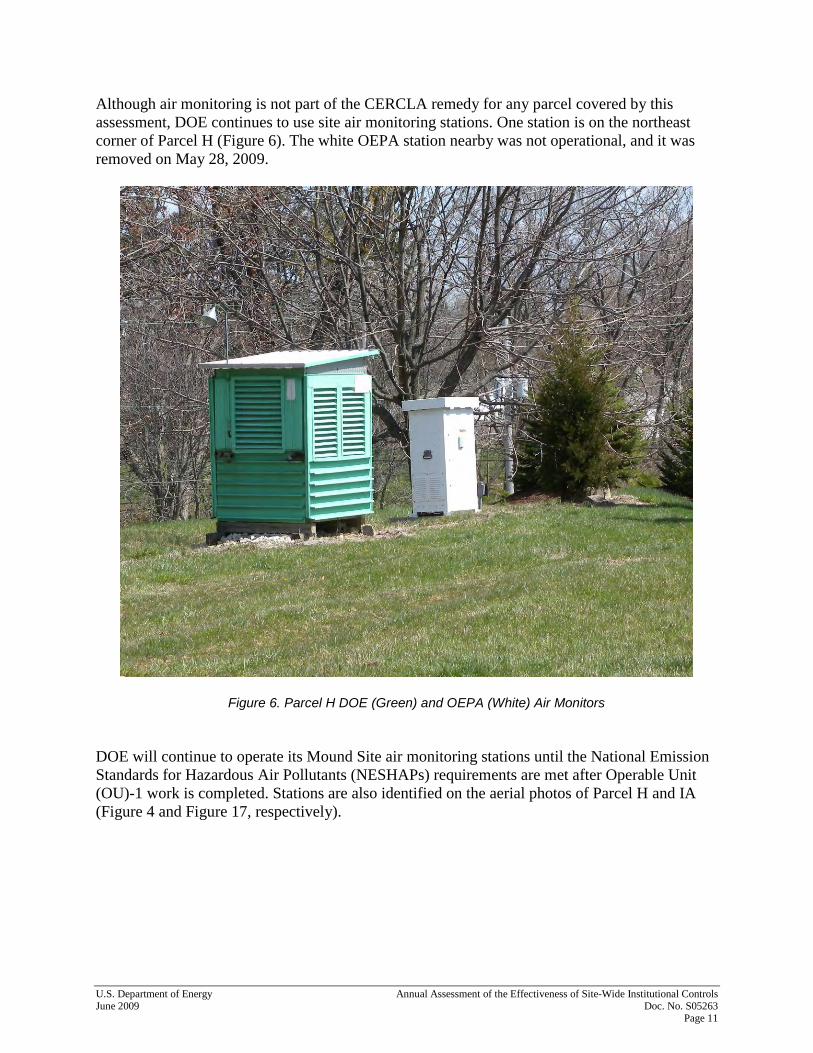
Although air monitoring is not part of the CERCLA remedy for any parcel covered by this assessment, DOE continues to use site air monitoring stations. One station is on the northeast corner of Parcel H (Figure 6). The white OEPA station nearby was not operational, and it was removed on May 28, 2009.
Figure 6. Parcel H DOE (Green) and OEPA (White) Air Monitors DOE will continue to operate its Mound Site air monitoring stations until the National Emission Standards for Hazardous Air Pollutants (NESHAPs) requirements are met after Operable Unit (OU)-1 work is completed. Stations are also identified on the aerial photos of Parcel H and IA (Figure 4 and Figure 17, respectively).

Annual Assessment of the Effectiveness of Site-Wide Institutional Controls U.S. Department of Energy Doc. No. S05263 June 2009 Page 12
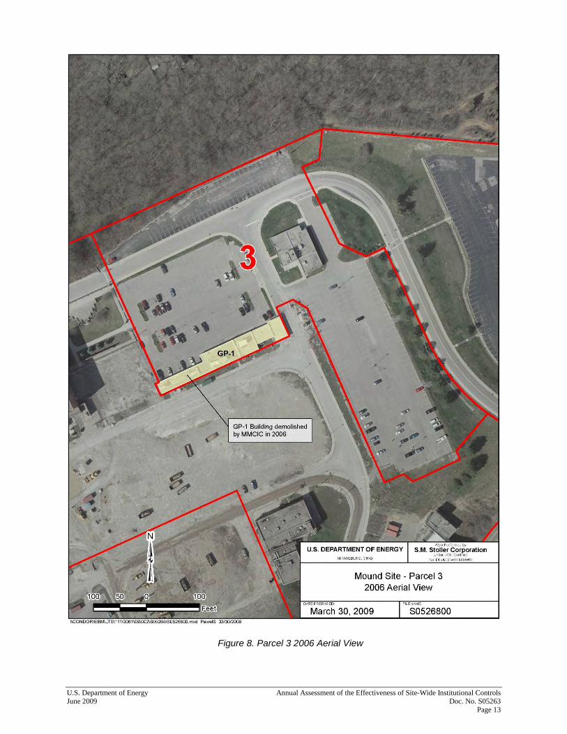
7.3 Parcel 3 In Parcel 3 (Figure 8), there were no observations of noncompliance with the ICs. In particular, there was no evidence of unauthorized well installation or soil removal within the original boundaries of the DOE Mound Site Property. There are no groundwater monitoring wells in Parcel 3. Figure 7 shows the Mound Museum Association building located in Parcel 3.
Figure 7. Parcel 3 View from Parking Lot East toward Mound Museum Building
U.S. Department of Energy Annual Assessment of the Effectiveness of Site-Wide Institutional Controls June 2009 Doc. No. S05263 Page 13
Figure 8. Parcel 3 2006 Aerial View

Annual Assessment of the Effectiveness of Site-Wide Institutional Controls U.S. Department of Energy Doc. No. S05263 June 2009 Page 14
7.4 Parcel 4 In Parcel 4 (Figure 11), there were no observations of noncompliance with the ICs. In particular, there was no evidence of unauthorized well installation or soil removal within the original boundaries of the DOE Mound Site Property. The Flex Building in the southwest corner of Parcel 4 (Figure 9) is leased to a single tenant. The tenant’s line of business is consistent with the City of Miamisburg’s I-2 General Industrial District Zoning ordinance. Unauthorized vehicular access to the old southeast construction road is still prohibited by a sidewalk installed along Benner Road. The northern entrance to this road is blocked by fencing and a locked gate (Figure 10).
Figure 9. Parcel 4 MMCIC Flex Building in Southwest Corner of Parcel 4. Looking West from Old Construction Road Entrance in Parcel 4.
Figure 10. Parcel 4 Locked Gate, Facing South on Old Construction Road

Figure 11. Parcel 4 2006 Aerial View
U.S. D
epartment of E
nergy
Annual A
ssessment of the E
ffectiveness of Site-Wide Institutional C
ontrols June 2009
D
oc. No. S05263
Page 15
Flex Building Old construction road entrance
Annual Assessment of the Effectiveness of Site-Wide Institutional Controls U.S. Department of Energy Doc. No. S05263 June 2009 Page 16
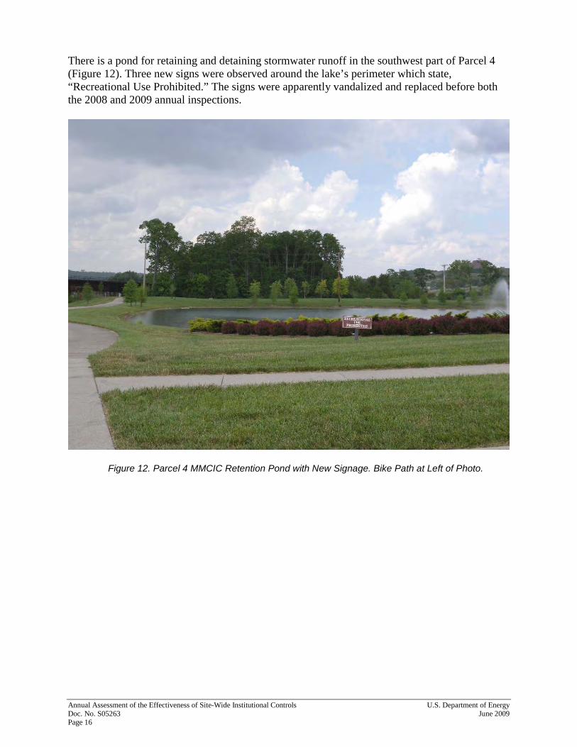
There is a pond for retaining and detaining stormwater runoff in the southwest part of Parcel 4 (Figure 12). Three new signs were observed around the lake’s perimeter which state, “Recreational Use Prohibited.” The signs were apparently vandalized and replaced before both the 2008 and 2009 annual inspections.
Figure 12. Parcel 4 MMCIC Retention Pond with New Signage. Bike Path at Left of Photo.
U.S. Department of Energy Annual Assessment of the Effectiveness of Site-Wide Institutional Controls June 2009 Doc. No. S05263 Page 17
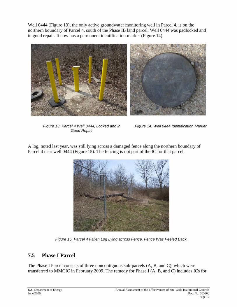
Well 0444 (Figure 13), the only active groundwater monitoring well in Parcel 4, is on the northern boundary of Parcel 4, south of the Phase IB land parcel. Well 0444 was padlocked and in good repair. It now has a permanent identification marker (Figure 14).
Figure 13. Parcel 4 Well 0444, Locked and in
Good Repair
Figure 14. Well 0444 Identification Marker
A log, noted last year, was still lying across a damaged fence along the northern boundary of Parcel 4 near well 0444 (Figure 15). The fencing is not part of the IC for that parcel.
Figure 15. Parcel 4 Fallen Log Lying across Fence. Fence Was Peeled Back. 7.5 Phase I Parcel The Phase I Parcel consists of three noncontiguous sub-parcels (A, B, and C), which were transferred to MMCIC in February 2009. The remedy for Phase I (A, B, and C) includes ICs for
Annual Assessment of the Effectiveness of Site-Wide Institutional Controls U.S. Department of Energy Doc. No. S05263 June 2009 Page 18
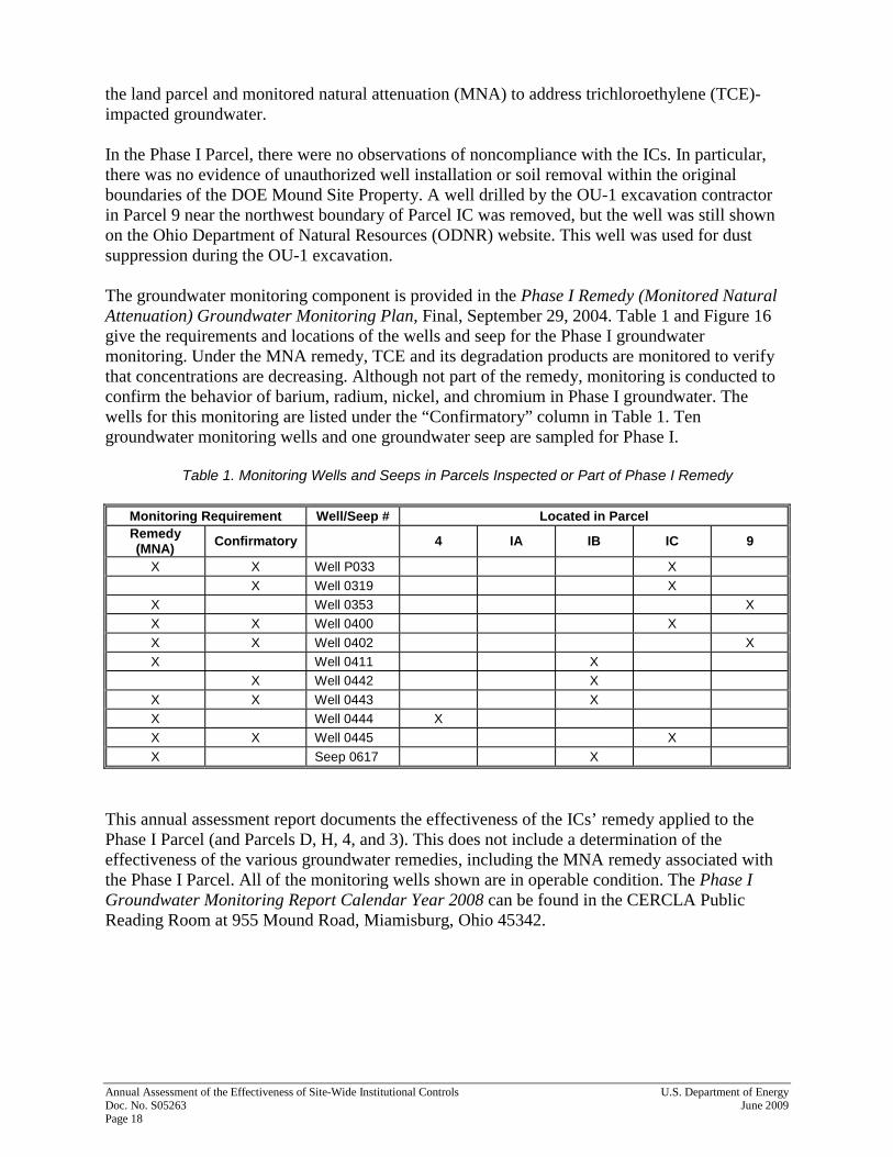
the land parcel and monitored natural attenuation (MNA) to address trichloroethylene (TCE)-impacted groundwater. In the Phase I Parcel, there were no observations of noncompliance with the ICs. In particular, there was no evidence of unauthorized well installation or soil removal within the original boundaries of the DOE Mound Site Property. A well drilled by the OU-1 excavation contractor in Parcel 9 near the northwest boundary of Parcel IC was removed, but the well was still shown on the Ohio Department of Natural Resources (ODNR) website. This well was used for dust suppression during the OU-1 excavation. The groundwater monitoring component is provided in the Phase I Remedy (Monitored Natural Attenuation) Groundwater Monitoring Plan, Final, September 29, 2004. Table 1 and Figure 16 give the requirements and locations of the wells and seep for the Phase I groundwater monitoring. Under the MNA remedy, TCE and its degradation products are monitored to verify that concentrations are decreasing. Although not part of the remedy, monitoring is conducted to confirm the behavior of barium, radium, nickel, and chromium in Phase I groundwater. The wells for this monitoring are listed under the “Confirmatory” column in Table 1. Ten groundwater monitoring wells and one groundwater seep are sampled for Phase I.
Table 1. Monitoring Wells and Seeps in Parcels Inspected or Part of Phase I Remedy
Monitoring Requirement Well/Seep # Located in Parcel Remedy (MNA) Confirmatory 4 IA IB IC 9
X X Well P033 X
X Well 0319 X X Well 0353 X X X Well 0400 X
X X Well 0402 X X Well 0411 X X Well 0442 X
X X Well 0443 X X Well 0444 X X X Well 0445 X
X Seep 0617 X
This annual assessment report documents the effectiveness of the ICs’ remedy applied to the Phase I Parcel (and Parcels D, H, 4, and 3). This does not include a determination of the effectiveness of the various groundwater remedies, including the MNA remedy associated with the Phase I Parcel. All of the monitoring wells shown are in operable condition. The Phase I Groundwater Monitoring Report Calendar Year 2008 can be found in the CERCLA Public Reading Room at 955 Mound Road, Miamisburg, Ohio 45342.

U.S. Department of Energy Annual Assessment of the Effectiveness of Site-Wide Institutional Controls June 2009 Doc. No. S05263 Page 19
Figure 16. Phase I MNA Remedy Monitoring Locations

Figure 17. Parcel Phase IA 2006 Aerial View
Annual A
ssessment of the E
ffectiveness of Site-Wide Institutional C
ontrols
Doc. N
o. S05263
June 2009 Page 20

Figure 18. Parcel Phase IB 2006 Aerial View
U.S. D
epartment of E
nergy
Annual A
ssessment of the E
ffectiveness of Site-Wide Institutional C
ontrols June 2009
D
oc. No. S05263
Page 21

Figure 19. Parcel Phase IC 2006 Aerial View
Annual A
ssessment of the E
ffectiveness of Site-Wide Institutional C
ontrols
Doc. N
o. S05263
June 2009 Page 22

U.S. Department of Energy Annual Assessment of the Effectiveness of Site-Wide Institutional Controls June 2009 Doc. No. S05263 Page 23
The salt storage shed shown in Figure 20 and the concrete pad in Parcel IB remain empty.
Figure 20. Phase IB Empty Salt Storage Shed Wells 0411 (Figure 21), 0442 (Figure 22), and 0443 (Figure 23) in Phase IB were locked, labeled, and in good repair. Seep 0617 (Figure 24) was in good condition.
Figure 21. Phase IB Well 0411, Locked, Labeled,
and in Good Repair
Figure 22. Parcel IB Well 0442, Locked, Labeled,
and in Good Repair

Annual Assessment of the Effectiveness of Site-Wide Institutional Controls U.S. Department of Energy Doc. No. S05263 June 2009 Page 24
Figure 23. Parcel IB Well 0443, Locked, Labeled,
and in Good Repair
Figure 24. Parcel IB Groundwater Seep 0617
There were several observations of areas of dirt disturbance, but no evidence of dirt being removed from the site in Parcel IB. The water diversion project, which extended into the west corner near magazines (Figure 25), diverts water from Parcel IB through a pipe under Parcel 9 into the Miami Conservancy District ditch west of OU-1. Another project to improve drainage in the west of PerkinElmer building was conducted after the pond was removed in Parcel 9 (Figure 26).
Figure 25. Parcel IB Water Diversion Project
Figure 26. Parcel IB Drainage Improvements

U.S. Department of Energy Annual Assessment of the Effectiveness of Site-Wide Institutional Controls June 2009 Doc. No. S05263 Page 25
Well 0445 (Figure 27) in Parcel IC was locked, labeled, and in good repair. Wells 0400 (Figure 28) and 0319 (Figure 29) were locked, labeled, and in good repair. Well P033 (Figure 30) was in good repair and had a permanent identification marker (Figure 31).
Figure 27. Parcel IC Well 0445, Locked, Labeled, and in Good Repair
Figure 28. Parcel IC Well 0400, Locked, Labeled, and in Good Repair
Figure 29. Parcel IC Well 0319, Locked, Labeled, and in Good Repair

Annual Assessment of the Effectiveness of Site-Wide Institutional Controls U.S. Department of Energy Doc. No. S05263 June 2009 Page 26
Figure 30. Parcel IC Well P033, in Good Repair and with a Permanent Identification Marker
Figure 31. Parcel IC—Marker for P033

U.S. Department of Energy Annual Assessment of the Effectiveness of Site-Wide Institutional Controls June 2009 Doc. No. S05263 Page 27
Monitoring wells 0353 (Figure 32) and 0402 (Figure 34) for the Phase I Remedy (Monitored Natural Attenuation) Groundwater Monitoring Plan are in Parcel 9. These wells were locked and in good repair. Well 0353 has a drainage problem causing a wet area as shown in Figure 33.
Figure 32. Parcel 9 MNA Well 0353, Locked, Labeled, and in Good Repair
Figure 33. Parcel 9 MNA Well 0353 Showing Drainage Problem North of Well
Figure 34. Parcel 9 MNA Well 0402, Locked, Labeled, and in Good Repair
8.0 Interviews and Records Reviews
8.1 Interviews with City Personnel and Review of City or MMCIC Records In addition to the physical inspections for the annual assessment, DOE reviews documents from local governments to assure that ICs are being followed. These may include construction, street opening, occupancy, or other permits; zoning modification requests; planning commission requests; and well logs issued for land parcels that have completed the CERCLA 120[h] process

Annual Assessment of the Effectiveness of Site-Wide Institutional Controls U.S. Department of Energy Doc. No. S05263 June 2009 Page 28
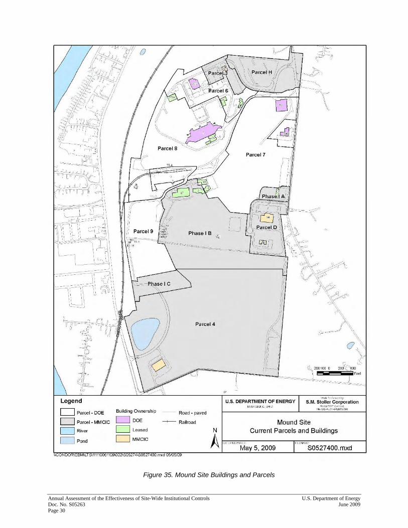
for property transfer. Documents may be located at the City of Miamisburg, at Miami Township, at Montgomery County, or in ODNR’s well log files. LM and Stoller personnel visited the City of Miamisburg Engineering and City Planning departments on March 24, 2009, and reviewed permits maintained by those departments for work performed by MMCIC, and its tenants or subcontractors, in Parcels D, H, 4, and 3 and the Phase I land parcel. The following tables do not repeat information on permits included in previous years’ DOE assessment reports on the effectiveness of the site-wide ICs. Furthermore, each year’s report does not necessarily list permits filed by MMCIC or its tenants or subcontractors for work performed on DOE-owned, MMCIC-leased property. Instead, the following tables are typically limited to permits filed after a ROD has been executed for a particular parcel, since DOE is responsible for the O&M of the site-wide ICs remedy (regardless of whether DOE has conveyed title of that parcel, in whole or in part, to MMCIC). Although the property is not subject to City of Miamisburg permitting requirements until DOE conveys the land parcel to MMCIC, the City-permitting process familiarizes the City with the properties that will eventually belong to MMCIC. This can reduce the time it takes for MMCIC to receive City approval (e.g., for a building occupancy permit) in the future. City files are maintained by street address. DOE has performed spot-checks of permits in the City Engineering files since May 2001 to confirm that the permits are maintained under configuration control. The City of Miamisburg does not maintain files on buildings that MMCIC plans to demolish. City files do exist on buildings that have been demolished; however, those files are now considered obsolete. Table 2 shows the DOE building identification and the Miamisburg street addresses for each building. Seven buildings (3, 87, 100, 102, 105, Flex, and GH), four magazines (81 through 84), and a salt storage shed are in land parcels transferred to MMCIC. Figure 35 shows the location of site buildings. Since City permits are filed by address, MMCIC must inform DOE of changes to the street names or building addresses.

U.S. Department of Energy Annual Assessment of the Effectiveness of Site-Wide Institutional Controls June 2009 Doc. No. S05263 Page 29
Table 2. Crosswalk of Street Addresses to DOE Building Identifications
DOE Building ID Former Address Current Miamisburg Street Address Parcel
2 To be demolished 7
28 925 Capstone Drive 6
45 930 Capstone Drive 6
61 885 Mound Road 7
63 1070 Vanguard Boulevard 7
87 and 3 1100 Vanguard Boulevard IB a
100 790 Enterprise Court D a
102 1075 Mound Road IA a
105 1195 Mound Road D a
126 955 Mound Road 6A
COS 965 Capstone Drive 8
GH 500 Capstone Circle 500 Vantage Point 3 a
OSE 480 Capstone Circle 480 Vantage Point 6
OSW 460 Capstone Circle 460 Vantage Point 8
T 945 Capstone Drive 8
Magazines 81–84 None None IB a
(new) Flex Building 1390 Vanguard Boulevard 4 a aParcel has been transferred to MMCIC.
Annual Assessment of the Effectiveness of Site-Wide Institutional Controls U.S. Department of Energy Doc. No. S05263 June 2009 Page 30
Figure 35. Mound Site Buildings and Parcels

U.S. Department of Energy Annual Assessment of the Effectiveness of Site-Wide Institutional Controls June 2009 Doc. No. S05263 Page 31
None of the permits reviewed pertained to work that was performed on or could have impacted transferred parcels since DOE’s last assessment. All permits on file for the site are detailed in Table 3. Jane Hansel, City of Miamisburg Building Inspection Department, provided the records for review on March 24, 2009.
Table 3. City of Miamisburg Permit Files on Mound Site (April 8, 2008, to March 24, 2009)
Location of Work Permit Number
Date of Permit
Application Submitted By Nature of Work Work Performed By
COS 965 Capstone Drive 2008 0059B 4/22/08 Not on record Fire alarms A1 Systems Integration
OSW 460 Vantage Point
2008 0093B 6/3/08 MMCIC Building alteration To be determined
OSW 460 Vantage Point 2008 0076H 6/3/08 MMCIC HVAC To be determined
OSW 460 Vantage Point 2008 0077E 6/3/08 MMCIC Electrical Key Electric
OSW 460 Vantage Point 2008 0180B 9/5/08 Not on record Antenna Phecors
OSW 460 Vantage Point
2008 0181B 9/11/08 MMCIC Fire suppression Dayton Fire Protection
OSW 460 Vantage Point 2008 0184E 11/26/08 MMCIC
Generator, Uninterruptable Power Supply system
Chappel Electric
OSW 460 Vantage Point 2008 0202H 12/15/08 Not on record
Heating, ventilation, and air-conditioning
Rieck Services
Table 4 lists work requests that did not require a City permit but did require review by the City Planning Commission. These requests included excavation or paving activities.
Table 4. City of Miamisburg Files⎯Planning Commission Reviews
Location of Work ID Number Date of Application
Submitted By Nature of Work Parcel/
Building Status
No Commission reviews were performed during this period.
All work that was performed by MMCIC or other parties (e.g., contractors to MMCIC) on the former DOE Mound Site Property, which Art Kleinrath (LM) and Frank Bullock (MMCIC) were aware of during the 12-month reporting period, appeared to be adequately covered by permits submitted to, and approved by, the City of Miamisburg. As noted in previous annual reports on the effectiveness of site-wide ICs, the City of Miamisburg implemented an electronic permits database in 2003, which allows permits to be queried via keyword search (e.g., permit number, date, location, nature of work). Permits issued by the City prior to the implementation of the City’s new database (i.e., permits documented in DOE’s annual reports dating back to 2001) may not be in the City’s database. However, the City retains paper copies of all permits in accordance with a records-retention plan that meets all State of Ohio requirements.

Annual Assessment of the Effectiveness of Site-Wide Institutional Controls U.S. Department of Energy Doc. No. S05263 June 2009 Page 32
Permits filed with the City of Miamisburg do not have an expiration date. Therefore, DOE and the property owner (at present, MMCIC) should remain knowledgeable of permits filed with the City of Miamisburg, where work covered by that permit may have been postponed. This will provide a checks-and-balances system to ensure that work requiring a permit and performed since the last DOE annual assessment is approved by the appropriate City officials. In general, the permit-review process demonstrated that the City of Miamisburg’s recordkeeping system is adequate. 8.2 Records, Other Than Permits, Issued by the City of Miamisburg MMCIC and all future property owners must comply with the ICs associated with the former DOE Mound Site Property to maintain the CERCLA remedy. MMCIC currently ensures that contractors performing work for MMCIC (e.g., landscaping, utility work involving excavation, construction) are aware of and comply with the ICs. MMCIC embeds the following language in the “Technical Requirements” section of its requests for proposal and subsequent work orders:
Excavated soils must be managed and remain on MMCIC property. Soils from excavation shall be placed at an on-site location, as directed by MMCIC.
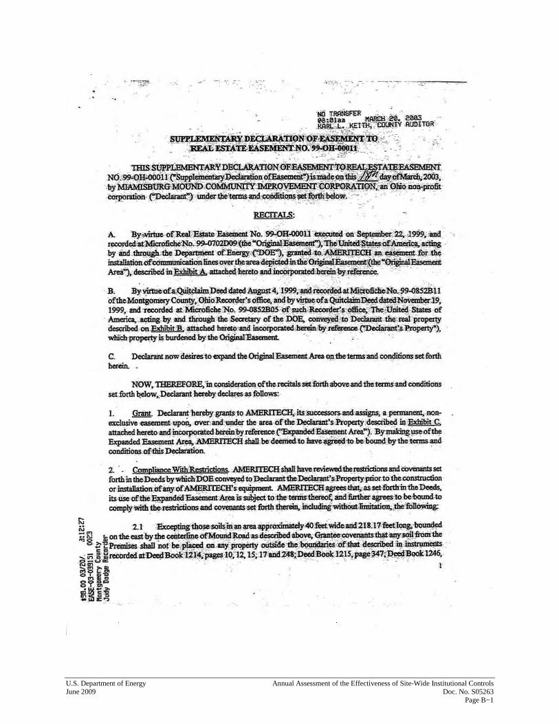
The MMCIC project manager, who oversees site work, monitors the vendor’s work and conformance to technical requirements in the work order. MMCIC provides the vendor with a real estate easement in addition to the technical requirements. This easement is recorded with Montgomery County as a matter of public record. An example of a real estate easement used for utility work on MMCIC property is included as Appendix B. Note that Section 2 of the easement gives the utility provider/vendor detailed information on the ICs associated with MMCIC’s property. This requires compliance with restrictions, which are the ICs. Continuing public education is an important component of DOE’s post-closure responsibilities. Appendix C is an EPA document with information concerning ICs. Educating all future property owners on their responsibility to comply with the ICs will be an important element of DOE’s public-education campaign. It is also important to educate the general public on the importance of adhering to the site-wide ICs. Therefore, postings (such as warning signs near the MMCIC pond, which state that recreational use is prohibited) are an important part of educating the public about complying with ICs. Prior to initiating construction on any land parcel, MMCIC will provide the builder with a pre-construction package that includes a description of the ICs associated with that particular parcel. This is how MMCIC ensures that the builder is aware of applicable ICs. In a new-construction scenario, probably the most important IC to educate builders about is the prohibition against removing any soils from the original boundaries of the approximately 306 acres that constitute the former DOE Mound Site Property. As recommended in the 2008 annual assessment, DOE will examine these documents during the annual IC assessments after the site has been transferred. This will ensure that the necessary wording continues to be included in contracts or easements after site transfer.
U.S. Department of Energy Annual Assessment of the Effectiveness of Site-Wide Institutional Controls June 2009 Doc. No. S05263 Page 33
MMCIC’s Comprehensive Reuse Plan Update, December 31, 2003 (CRP) identifies each building at the Mound Advanced Technology Center with its own lot. A copy of the CRP is available in the CERCLA Reading Room. Eventually, MMCIC plans to plat the entire former DOE Mound Site Property. In order to receive financing (i.e., for new construction) on land parcels that make up the original DOE Mound Site Property, MMCIC will record a lot-split with the Montgomery County Recorder’s Office. If MMCIC does not require financing for property improvements within a parcel, MMCIC does not have to immediately record a Miamisburg Planning Commission–approved lot-split with the County. However, if MMCIC decides to sell the property, MMCIC has to record the lot-split with the County at that time. The recorded real estate documentation would include the original quitclaim deed that DOE issued to MMCIC for the parcel, as a whole, as well as the CERCLA 120(h) Summary Notice of Hazardous Substances associated with the original parcel. This will ensure that future property owners of individual lot-splits know of the site-wide ICs imposed on acreage that lies within the boundaries of the parcels as originally conveyed by DOE to MMCIC. The property owner’s adherence to the ICs imposed on a land parcel is vital to the effective maintenance of those ICs. MMCIC currently coordinates the movement of soil and site grading, as DOE oversees completion of the OU-1 Project in Parcel 9. After DOE’s environmental management mission is complete, managing the movement of soil throughout the site should be an effective way for the property owners to ensure that soil is not being removed from the site as a whole. To accomplish this task, MMCIC’s CRP establishes locations where future construction/property improvements will occur on the former DOE Mound Site Property. The CRP also includes a site-wide soil-grading plan. The CRP was adopted by the City of Miamisburg, and it was incorporated into the City’s comprehensive plan. The City’s comprehensive plan is the basis for the zoning of properties that fall within the city limits. If MMCIC subdivides the former DOE Mound Site Property and sells portions (or all) of the property, the new property owners would be required to comply with the CRP and the City’s comprehensive plan.
9.0 Conclusions
The ICs for Parcels D, H, 3, and 4 and the Phase I land parcel continue to function as designed. Adequate oversight mechanisms appear to be in place to identify possible violations of ICs, and adequate resources are available to correct or mitigate any problems if violations occur.
10.0 Recommendations
Table 5 and Table 6 list previous inspections’ recommendations for improving ICs, the status of those recommendations, and new recommendations from this year’s inspection.

Annual Assessment of the Effectiveness of Site-Wide Institutional Controls U.S. Department of Energy Doc. No. S05263 June 2009 Page 34
Table 5. Recommendations from Previous Inspections of ICs
Origin Issue/ Recommendation
Status 2008 Report Corrected? Current Status
2009 Report
1 2007 Annual
Determine when OEPA removes air monitoring station in Parcel H.
OEPA was working with DOE-EM to dispose of their air monitoring stations on site.
Yes Removed on May 28, 2009
2 2008 Annual
DOE-LM contractor will add label to well P033. New Yes Complete
3 2008 Annual
Landowner or management organization will notify DOE-LM when there are changes of address or street names on site. Building permits are filed by street addresses.
New No In process
4 2008 Annual
Add landowner or management organization (MMCIC) contracts and easement documents to those reviewed for the annual IC assessment.
New Yes
Paul Lucas or LM contractor (Stoller) currently reviews all MMCIC contracts. LM will review these documents during annual IC assessments after site transfers.
Table 6. Recommendations from 2009 Annual Inspection for ICs
Number Issue/ Recommendation Responsible 1 Confirm that the aRc well was abandoned correctly and removed from the ODNR website. Stoller
2 Improve drainage in the area north of Well 0353 Stoller
11.0 For Further Information
For further information on the content of this annual report or the former DOE Mound Site Property in general, contact either:
Mr. Paul Lucas Remedial Project Manager DOE Office of Environmental Management 955 Mound Road Miamisburg, Ohio 45342 (937) 847-8350 ext. 301 or Mr. Art Kleinrath Site Manager DOE Office of Legacy Management 955 Mound Road Miamisburg, Ohio 45342 (937) 847-8350 ext. 318
U.S. Department of Energy Annual Assessment of the Effectiveness of Site-Wide Institutional Controls June 2009 Doc. No. S05263 Page 35
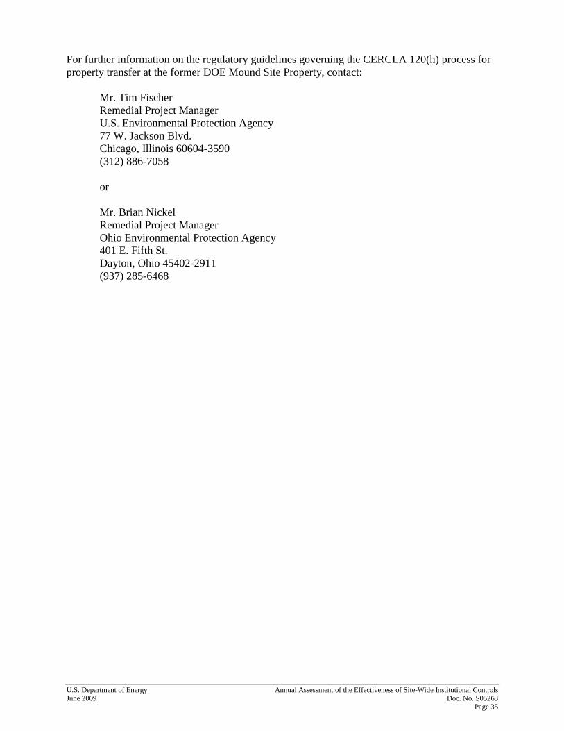
For further information on the regulatory guidelines governing the CERCLA 120(h) process for property transfer at the former DOE Mound Site Property, contact:
Mr. Tim Fischer Remedial Project Manager U.S. Environmental Protection Agency 77 W. Jackson Blvd. Chicago, Illinois 60604-3590 (312) 886-7058 or Mr. Brian Nickel Remedial Project Manager Ohio Environmental Protection Agency 401 E. Fifth St. Dayton, Ohio 45402-2911 (937) 285-6468

Annual Assessment of the Effectiveness of Site-Wide Institutional Controls U.S. Department of Energy Doc. No. S05263 June 2009 Page 36
12.0 References
DOE (U.S. Department of Energy), 1999a. Record of Decision for Release Block D, Final, February. DOE (U.S. Department of Energy), 1999b. Record of Decision for Release Block H, Final, June. DOE (U.S. Department of Energy), 2001a. Parcel 3 Record of Decision, Final, August. DOE (U.S. Department of Energy), 2001b. Parcel 4 Record of Decision, Final, February. DOE (U.S. Department of Energy), 2003. Phase I Record of Decision, Final, July. DOE (U.S. Department of Energy), 2004a. Operation and Maintenance (O&M) Plan for the Implementation of Institutional Controls at the 1998 Mound Plant Property, Phase I Parcel, update, Rev. 1, February. DOE (U.S. Department of Energy), 2004b. Phase I Remedy (Monitored Natural Attenuation) Groundwater Monitoring Plan, Final, September. DOE (U.S. Department of Energy), 2006. Second Five-Year Review for the Mound, Ohio, Site, Miamisburg, Ohio, September. DOE (U.S. Department of Energy), 2008a. Annual Assessment of the Effectiveness of Site-Wide Institutional Controls Applied to the Former Mound Site Property, June. DOE (U.S. Department of Energy), 2008b. Phase I Remedy (Monitored Natural Attenuation) Groundwater Monitoring Annual Report, March. DOE (U.S. Department of Energy), 2008c. Sales Contract by and between the United States Department of Energy and the Miamisburg Mound Community Improvement Corporation, August 28, 2008, August. MMCIC (Miamisburg Mound Community Improvement Corporation), 2003. Comprehensive Reuse Plan Update, December.

Appendix A
Annual Assessment Checklists For Parcels D, H, 4, and 3 and Phase I Land Parcel
(Physical Walkover Conducted on April 14, 2009)

This page intentionally left blank

CHECKLIST WORKSHEET – COMBINED – ALL PARCELS Review of Effectiveness of Institutional Controls
U.S. Department of Energy Annual Assessment of the Effectiveness of Site-Wide Institutional Controls June 2009 Doc. No. S05263 Page A−1
Parcels reviewed: D, H, 3, 4, Phase I (A, B and C) Date(s) Performed: March 23, March 24 and April 8 Review led by: Art Kleinrath, DOE LM Phone #: 937-847-8350 X318 Participants in Physical Inspection Walk Around on April 14, 2009: Tim Fischer, U.S. EPA; Brian Nickel and Anthony Campbell, Ohio EPA; Joe Crombie, ODH; Ellen Stanifer, City of Miamisburg; Frank Bullock, MMCIC; Art Kleinrath, DOE LM; Paul Lucas, DOE EM; Joyce Massie and Gary Weidenbach, S.M. Stoller Summary of property improvements since DOE’s sale of parcel or since the previous Review (whichever is most recent). For example, have buildings been demolished or erected? Has surface water flow been modified? Has landscaping been done? Parcel D - no evidence of property improvements Parcel H - no evidence of property improvements Parcel 3 - no evidence of property improvements Parcel 4 - no evidence of property improvements Phase 1A - Grading and grass was sewn behind Building 102 Phase 1B - New grating had been installed over a section of storm sewer along road southwest of salt shed; Water diversion project in west corner near magazines which diverted water from pond area through a pipe under Parcel 9 into the Miami Conservancy District ditch west of OU-1; Drainage improvements were made in the northwest area of I B west of PerkinElmer building. Work was conducted after pond removal was completed in Parcel 9. Phase 1C no evidence of property improvements Evidence of Soil removal from the “1998 Mound Plant Property”? Yes ( ) No ( X ) Parcel D no evidence of soil removal Parcel H no evidence of soil removal Parcel 3 no evidence of soil removal Parcel 4 no evidence of soil removal Phase 1A no evidence of soil removal Phase 1B no evidence of soil removal Phase 1C no evidence of soil removal Evidence of (non-DOE) Groundwater use? Yes ( ) No ( X ) Parcel D no record of new wells on Ohio Department of Natural Resources (ODNR) website Parcel H no record of new wells on Ohio Department of Natural Resources (ODNR) website Parcel 3 no record of new wells on Ohio Department of Natural Resources (ODNR) website Parcel 4 no record of new wells on Ohio Department of Natural Resources (ODNR) website Phase 1A no record of new wells on Ohio Department of Natural Resources (ODNR) website Phase 1B no record of new wells on Ohio Department of Natural Resources (ODNR) website Phase 1C Well log number 2009362 at upper left corner near road is located in Parcel 9. Used by aRc during OU-1 excavation for construction use. Well was removed, but it is still listed on the ODNR website.

CHECKLIST WORKSHEET Review of Effectiveness of Institutional Controls
Annual Assessment of the Effectiveness of Site-Wide Institutional Controls U.S. Department of Energy Doc. No. S05263 June 2009 Page A−2
Evidence of land use other than “Industrial” (e.g., residential)? Yes ( ) No ( X ) Parcel D None observed Parcel H None observed Parcel 3 None observed Parcel 4 None observed Phase 1A None observed Phase 1B None observed Phase 1C None observed Signage/Markers in good repair (if applicable)? Yes ( X ) No ( ) Parcel D N/A. Signage is not an IC for this parcel Parcel H N/A. Signage is not an IC for this parcel Parcel 3 N/A. Signage is not an IC for this parcel Parcel 4 Signage is a part of the ICs for the retention pond. New signs were observed during the walk down inspection on April 14, 2009. Phase 1A N/A. Signage is not an IC for this parcel Phase 1B N/A. Signage is not an IC for this parcel Phase 1C N/A. Signage is not an IC for this parcel Fencing in good repair (if applicable)? N/A ( X ) Yes ( ) No ( ) Fencing is not an IC for any parcel covered by this inspection Groundwater Monitoring Wells maintained properly? Yes ( X ) No ( ) Parcel D N/A. There are no monitoring wells in this parcel, Parcel H N/A. There are no monitoring wells in this parcel. Parcel 3 N/A. There are no monitoring wells in this parcel Parcel 4 Well 0444 – Well was locked and in good repair. Marker was in place. Phase 1A N/A. There are no monitoring wells in this parcel Phase 1B Well 0411 – Well was locked and in good repair. Marker was in place. Well 0442 – Well was locked and in good repair. Marker was in place. Well 0443 – Well was locked and in good repair. Marker was in place. Seep 0617 – In good condition Phase 1C P033 – Added a marker per recommendation last year Well 0319 – Well was locked and in good repair. Marker was in place. Well 0400 – Well was locked and in good repair. Marker was in place. Well 0445 – Well was locked and in good repair. Marker was in place. Parcel 9 – Wells for Phase I parcel Well 0353 - Well was locked and in good repair. Marker was in place Well 0402 - Well was locked and in good repair. Marker was in place.

CHECKLIST WORKSHEET – COMBINED – ALL PARCELS Review of Effectiveness of Institutional Controls
U.S. Department of Energy Annual Assessment of the Effectiveness of Site-Wide Institutional Controls June 2009 Doc. No. S05263 Page A−3
Air Monitoring Stations maintained properly (if applicable)? Yes ( X ) No ( ) Parcel D N/A Air monitoring is not an IC for this parcel Parcel H N/A Air monitoring is not an IC for this parcel. There are two air monitoring stations at the NE corner of the parking lot. EPA plans to remove its station. DOE will maintain its station 212 until the NESHAPs monitoring requirements are satisfied following the work in Parcel 9 on OU-1 excavation. Parcel 3 N/A. Air monitoring is not an IC for this parcel Parcel 4 N/A. Air monitoring is not an IC for this parcel Phase 1A N/A. Air monitoring is not an IC for this parcel. Air monitor 216 is located in back of Building 102. DOE will maintain this station until the NESHAPs monitoring requirements are satisfied following the work in Parcel 9 on OU-1 excavation. Phase 1B N/A. Air monitoring is not an IC for this parcel Phase 1C N/A. Air monitoring is not an IC for this parcel Containment system(s) in good repair (if applicable)? N/A ( X ) Yes ( ) No ( ) Containment systems are not an IC for any parcel covered by this inspection Site Surveillance equipment in good repair (if applicable?) N/A ( X ) Yes ( ) No ( ) Site surveillance equipment is not an IC for any parcel covered by this inspection Other equipment associated with maintenance of the N/A ( X ) Yes ( ) No ( ) Institutional Controls in good repair (if applicable)? There are no other equipment items associated with maintenance of the ICs for any parcel covered by this inspection.

CHECKLIST WORKSHEET Review of Effectiveness of Institutional Controls
Annual Assessment of the Effectiveness of Site-Wide Institutional Controls U.S. Department of Energy Doc. No. S05263 June 2009 Page A−4
Summary and status of open issues or recommendations from previous reviews Dates of previous reviews: Five-year review (2006) and Annual reports 2007 and 2008
Origin Issue/Recommendation Status 2008 Report Corrected? Current status 2009 Report
1 Five-Year
Permanent ID markers are not installed on all long-term groundwater monitoring wells.
Five wells are without permanent markers. All are marked with waterproof ink and are identified on site maps.
Yes
The permanent brass markers were installed in the concrete pads of wells 0442, 0443, 0444, 0445, and P033 (all in Phase I) during 2008. This is documented in the Phase I annual GW report.
2 2007 Annual
Determine when OEPA will remove air monitoring station in Parcel H.
OEPA is working with DOE-EM to dispose of their air monitoring stations on site.
No
There is still an OEPA air monitoring station in Parcel H.
3 2008 Annual
DOE-LM contractor will add label to well P033. New Yes
The permanent brass marker is installed in the concrete pad.
4 2008 Annual
Landowner or management organization will notify DOE-LM when there are changes of address or street names on site. Building permits are filed by street addresses.
New
5 2008 Annual
Add landowner or management organization (MMCIC) contracts and easement documents to those reviewed for the annual IC assessment.
New
Paul Lucas or LM contractor (Stoller) currently reviews all MMCIC contracts.
CHECKLIST WORKSHEET – COMBINED – ALL PARCELS Review of Effectiveness of Institutional Controls
U.S. Department of Energy Annual Assessment of the Effectiveness of Site-Wide Institutional Controls June 2009 Doc. No. S05263 Page A−5
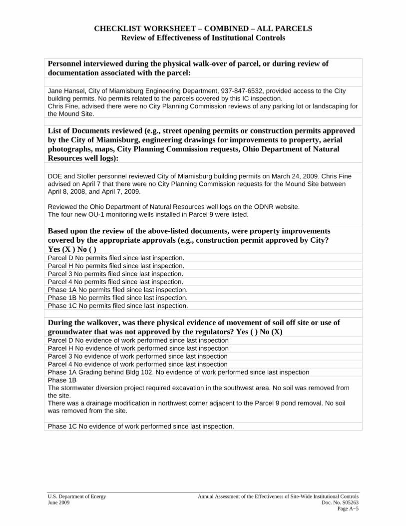
Personnel interviewed during the physical walk-over of parcel, or during review of documentation associated with the parcel: Jane Hansel, City of Miamisburg Engineering Department, 937-847-6532, provided access to the City building permits. No permits related to the parcels covered by this IC inspection. Chris Fine, advised there were no City Planning Commission reviews of any parking lot or landscaping for the Mound Site. List of Documents reviewed (e.g., street opening permits or construction permits approved by the City of Miamisburg, engineering drawings for improvements to property, aerial photographs, maps, City Planning Commission requests, Ohio Department of Natural Resources well logs): DOE and Stoller personnel reviewed City of Miamisburg building permits on March 24, 2009. Chris Fine advised on April 7 that there were no City Planning Commission requests for the Mound Site between April 8, 2008, and April 7, 2009. Reviewed the Ohio Department of Natural Resources well logs on the ODNR website. The four new OU-1 monitoring wells installed in Parcel 9 were listed. Based upon the review of the above-listed documents, were property improvements covered by the appropriate approvals (e.g., construction permit approved by City? Yes (X ) No ( ) Parcel D No permits filed since last inspection. Parcel H No permits filed since last inspection. Parcel 3 No permits filed since last inspection. Parcel 4 No permits filed since last inspection. Phase 1A No permits filed since last inspection. Phase 1B No permits filed since last inspection. Phase 1C No permits filed since last inspection. During the walkover, was there physical evidence of movement of soil off site or use of groundwater that was not approved by the regulators? Yes ( ) No (X) Parcel D No evidence of work performed since last inspection Parcel H No evidence of work performed since last inspection Parcel 3 No evidence of work performed since last inspection Parcel 4 No evidence of work performed since last inspection Phase 1A Grading behind Bldg 102. No evidence of work performed since last inspection Phase 1B The stormwater diversion project required excavation in the southwest area. No soil was removed from the site. There was a drainage modification in northwest corner adjacent to the Parcel 9 pond removal. No soil was removed from the site. Phase 1C No evidence of work performed since last inspection.

CHECKLIST WORKSHEET Review of Effectiveness of Institutional Controls
Annual Assessment of the Effectiveness of Site-Wide Institutional Controls U.S. Department of Energy Doc. No. S05263 June 2009 Page A−6

Appendix B
Real Estate Easement for Utility Work Performed on MMCIC Property

This page intentionally left blank
U.S. Department of Energy Annual Assessment of the Effectiveness of Site-Wide Institutional Controls June 2009 Doc. No. S05263 Page B−1

Annual Assessment of the Effectiveness of Site-Wide Institutional Controls U.S. Department of Energy Doc. No. S05263 June 2009 Page B−2

U.S. Department of Energy Annual Assessment of the Effectiveness of Site-Wide Institutional Controls June 2009 Doc. No. S05263 Page B−3

Annual Assessment of the Effectiveness of Site-Wide Institutional Controls U.S. Department of Energy Doc. No. S05263 June 2009 Page B−4
This page intentionally left blank

Appendix C
Institutional Controls: A Citizen’s Guide to Understanding Institutional Controls at
Superfund, Brownfields, Federal Facilities, Underground Storage Tank, and Resource Conservation and Recovery Act Cleanups

This page intentionally left blank

U.S. Department of Energy Annual Assessment of the Effectiveness of Site-Wide Institutional Controls June 2009 Doc. No. S05263 Page C−1
Annual Assessment of the Effectiveness of Site-Wide Institutional Controls U.S. Department of Energy Doc. No. S05263 June 2009 Page C−2

U.S. Department of Energy Annual Assessment of the Effectiveness of Site-Wide Institutional Controls June 2009 Doc. No. S05263 Page C−3

Annual Assessment of the Effectiveness of Site-Wide Institutional Controls U.S. Department of Energy Doc. No. S05263 June 2009 Page C−4
U.S. Department of Energy Annual Assessment of the Effectiveness of Site-Wide Institutional Controls June 2009 Doc. No. S05263 Page C−5

Annual Assessment of the Effectiveness of Site-Wide Institutional Controls U.S. Department of Energy Doc. No. S05263 June 2009 Page C−6

U.S. Department of Energy Annual Assessment of the Effectiveness of Site-Wide Institutional Controls June 2009 Doc. No. S05263 Page C−7

Annual Assessment of the Effectiveness of Site-Wide Institutional Controls U.S. Department of Energy Doc. No. S05263 June 2009 Page C−8
This page intentionally left blank