annexure a: dea&dp’s approval of plan of study for eir
TRANSCRIPT

MOSSEL BAY OCGT EIA: FINAL ENVIRONMENTAL IMPACT REPORT
© Ninham Shand (2005) No unauthorised reproduction, copy or adaptation, in whole or in part, may be made. BL\17 October 2005\E:\FEIR\Final EIR.doc
ANNEXURE A:
DEA&DP’S APPROVAL OF PLAN OF STUDY FOR EIR


MOSSEL BAY OCGT EIA: FINAL ENVIRONMENTAL IMPACT REPORT
© Ninham Shand (2005) No unauthorised reproduction, copy or adaptation, in whole or in part, may be made. BL\17 October 2005\E:\FEIR\Final EIR.doc
ANNEXURE B:
BOTANICAL STUDY

____________________________________________________________________
NICK HELME BOTANICAL SURVEYS PO Box 22652 Scarborough 7975
Ph: 021 780 1420 Fax: 021 780 1868 cell: 082 82 38350 email: [email protected] VAT Reg. # 4930216892
BOTANICAL ASSESSMENT OF PROPOSED ESKOM OCGT PLANT & ASSOCIATED TRANSMISSION LINES &
SUBSTATION, MOSSEL BAY
Compiled for: Ninham Shand Consulting Services, Cape Town
Client : Eskom
7 Aug 2005

EXECUTIVE SUMMARY This specialist botanical assessment was commissioned in order to help inform
decisions relating to the application by Eskom to construct an Open Cycle Gas
Turbine (OCGT) plant in the Mossgas area, some 13km west of Mossel Bay. Also
investigated were three new alternative transmission line routes from the plant to the
existing Proteus substation, and an access route to the plant from the N2 highway.
The site was visited in March 2005, and again in July 2005. The vegetation is best
categorised using the Subtropical Thicket Ecosystem Planning Project (or STEP)
classification, which refers to Herbertsdale Renoster Thicket (which accurately
describes the mix of Thicket and Renosterveld vegetation). Urbanization is having a
substantial negative impact on this vegetation type in the Mossel Bay, Hartenbos,
and Groot Brak areas, and only 38% is left intact, and it is thus regarded as an
Endangered vegetation type. An alternative source, the latest SA vegetation map,
indicates that Proteus is located within Swellendam Silcrete Fynbos, which is an
Endangered vegetation type (57% remaining), and that the original natural vegetation
in the proposed plant area at Mossgas was primarily Mossel Bay Shale
Renosterveld, which is also an Endangered vegetation type (42% remaining).
The natural vegetation in the vicinity of the proposed plant (up to 25ha in extent) has
been largely transformed by agriculture. Extensive ploughing has meant that today
this area has a Low regional conservation value, with no rare or localised plant
species recorded or likely. However, about 200m east of the proposed plant is a
small (1ha) patch of Shale Renosterveld, which must be avoided by all infrastructure,
as it is an Endangered vegetation type, and supports numerous specimens of at least
one Red Data listed species (Bobartia robusta). About 400m south of the proposed
plant is a natural wetland area around a farm dam that should also be avoided for
ecological reasons, although from a botanical point of view this area is of Low –
Moderate significance.
The three alternative transmission line routes all cross some sensitive areas such as
linear streams, small wetlands, and rocky outcrops, all of which must be avoided
during construction. The preferred route is the central (straightest) one that crosses
the least natural vegetation (20% less than other two routes), and where there is an
existing line. Final tower placements should be checked and approved by the
botanist.
2
2
Expansion of Proteus substation by about 9m to the north (within outer fence) will
result in the loss of about 0.5ha of partly disturbed Silcrete Fynbos, which has a
Moderate regional conservation value. Any tower placements outside the fence will
need to be checed and approved by the botanist. No rare or localised plant species
were recorded in the proposed expansion area. No expansion of the substation
must be allowed to the east, outside the existing fence, as this is a highly sensitive
area.
The alternative access roads / pipeline routes cross mostly disturbed areas of no
botanical significance. However, both Alternatives 1 & 2 pass close to a sensitive
area immediately east of the site, and this must be avoided, by means of bringing the
road into the site 50m further south. Alternative 3 (from the N2) requires
realignment in order to avoid impacting on small, scattered patches of natural
vegetation within 50m of the boundary fence, and a larger patch near the bend.
Even with realignment it will impact on a small strip of Moderate sensitivity
vegetation. If the alignment is redesigned to incoporate the above recommendations
the final alignment should have Low botanical impact, but on balance the mitigated
versions of Alternatives 1 or 2 would still be preferred.
If all recommendations contained herein are implemented the overall impact on the
natural vegetation in the area is likely to be Very Low.
A detailed Environmental Management Plan (EMP), which will incorporate the
guidelines in this report, should be prepared for construction and operational phases.

3
3
1. INTRODUCTION AND STUDY AREA Ninham Shand Consulting Services were appointed by Eskom to conduct an EIA
process for the proposed development of an Open Cycle Gas Turbine (OCGT) plant
and associated infrastructure (roads and transmission lines) near Mossgas, on the
farm Bartelsfontein. The proposed OCGT site is about 1km west of Mossgas, just
south of the railway line, and is located in what is currently a cultivated field. A
proposed new access road to the site from the N2 highway was investigated, and
three alternative transmission line routes from the plant to Proteus substation were
also looked at. These cross a mix of agricultural lands and natural vegetation. The
central, most direct route, would parallel an existing line, whilst the eastern route
would be very close to the Herbertsdale road (R327) for much of its length. Finally, a
small extension to the northern side of Proteus substation was surveyed, where a
new road and limited infrastructure is required, covering up to 0.5ha of partly natural
vegetation within the boundary fence.
The underlying geology in the Proteus area consists of sandy loams derived from
Buffelskloof formation conglomerates and river terrace gravels and silcretes, whilst in
the Mossgas area the soils are sandy loams derived from a mix of acid sands and
the underlying Bokkeveld group shales (Malan 1987).
The sites were visited in March and July 2005.
2. TERMS OF REFERENCE The terms of reference for this study were as follows:
• Source and review baseline information and participate in finalisation of TOR;
• Provide a broad description of the ecological characteristics of the site and
surrounds;
• Describe plant diversity patterns at community and ecosystem level (main
vegetation type, plant communities, and threatened ecosystems), species
level (Red Data listed species), and in terms of significant landscape features,
and presence of aliens.
• Provide a general comment on whether important plant processes are likely
to be affected;
• Describe the significance of potential impacts, and make recommendations to
prevent or mitigate these;

4
4
• Rank the transmission line routes in terms of likely impact on the vegetation;
• Provide a map of the salient elements discussed.
3. STUDY APPROACH
The sites were visited in March 2005, and again in July 2005. Characteristic plant
species were noted, as well as any rare or threatened plant species or habitats.
Unknown plants were identified in the Compton Herbarium at Kirstenbosch. The GIS
based SA National Biodiversity Institute (SANBI) vegetation map for South Africa
(Mucina & Rutherford 2003) was consulted, along with the available regional
conservation plans (STEP and CAPE), and conclusions were drawn based on this
documentation and professional experience in the area. The National Spatial
Biodiversity Assessment results (Rouget et al 2004) were also consulted.
One of the primary assumptions of this study is that sufficient botanical information
could be gathered during the site visit to make accurate conclusions regarding the
conservation value of the area. Although by no means all plant species likely to be
present on the site were recorded (eg. various annuals and bulbs were not at an
identifiable stage), it is likely that a sufficiently accurate picture of the plant diversity
was obtained, which is partly a result of using a habitat based approach, where
habitats (type, quality, rarity) rather than species are used to inform mapping and
decision making. As many Scoping studies do not specifically look at animals
(mammals, birds, reptiles, etc.) or invertebrates, the botanical study is often used as
a surrogate for these groups, the assumption being that presence of quality habitat is
a major determinant of the likely presence of the animal species.
4. DESCRIPTION OF THE AFFECTED ENVIRONMENT At least three different recent projects have mapped the original vegetation of this
area, and this is confusing, as all three use different terminology, and do not draw the
same boundaries. The CAPE project (Cowling et al 1999) maps the whole study
area (at a relatively coarse scale) as being on the edge of Blanco Fynbos /
Renosterveld Mosaic and Riversdale Coast Renosterveld (57% and 83.5%
Irreplaceable respectively, according to that analysis).
The SANBI vegetation map (Mucina & Rutherford 2003) maps the Mossgas area as
a mix of Albertinia Sand Fynbos and Mossel Bay Shale Renosterveld. The
vegetation in the Proteus area is indicated as being Swellendam Silcrete Fynbos.

5
5
The recent National Spatial Biodiversity Assessment (Rouget et al 2004) indicates
that the Sand Fynbos is a Vulnerable vegetation type (74% remaining), that the
Silcrete Fynbos (57% remaining) and Shale Renosterveld (42% remaining) are both
Endangered vegetation types.
The most accurate description is that of the STEP project, which refers to the entire
study area as Herbertsdale Renoster Thicket (Cowling et al 2003), which accurately
describes the mix of Thicket and Renosterveld vegetation in the area. This
vegetation type is dominant in the area between the Gouritz River and Mossel Bay,
occurring on the shale and conglomerate hills, but has been heavily impacted by
agriculture, and as a result persists mostly on the steeper slopes. Rapid urbanization
is having a substantial negative impact on this vegetation type (on both flats and
steep slopes) in the Mossel Bay, Hartenbos, and Groot Brak areas, where it is also
impacted by quarrying activities. Herbertsdale Renoster Thicket has been reduced
to 38% of its original extent, with a conservation target of 25% (of the original extent),
and it is thus regarded as an Endangered vegetation type in terms of STEP (Pierce
2003). The fact that both STEP (Pierce 2003) and the National Spatial Biodiversity
Assessment (Rouget et al 2004) find that the area supports Endangered vegetation
types in a regional and national context is significant.
3.1 OCGT Site The actual site for the plant itself has not been fixed, but ample space exists within
the identified agricultural field to locate the plant with minimal impact on any natural
vegetation. The field in question has been recently and regularly ploughed, and is
also grazed by livestock (see Plate 1). It is likely that the field has been planted with
pasture grasses, as it was dominated by grazing grasses at the time of the visits,
such as Eragrostis curvula (weeping lovegrass), Lolium sp. (ryegrass), and Cynodon
dactylon (fynkweek), along with a few indigenous but weedy species such as Gnidia
sp., Kyllinga sp., Oxalis obtusa (suuring), Lobelia erinus, Arctotheca calendula (Cape
weed), and the alien dandelion. No rare or localised plant species are likely to
persist. This area has a Very Low local and regional conservation value.
Sensitive areas in the vicinity of the proposed plant include a 10m wide strip
immediately south of the railway line, where remnant Renosterveld can be found.
Species diversity here is reduced due to agricultural activities, but includes Barleria
pungens, Digitaria velutina, Gnidia laxa, Gerbera piloselloides, Pycreus
polystachyos, Hermannia saccifera, Aspalathus hispida, Drimia capensis (maerman,

6
6
jeukbol), and Scabiosa columbaria. No rare or localised species were found, and the
likelihoof of such species is Low. This area has a Moderate local and regional
conservation value.
Plate 1: View of proposed OCGT site (upper left), showing agricultural land
dominated by grasses, and sheep clustered around higher sensitivity wetland area
(see Figure 1). The bluegums in the background are north of the proposed site.
The most sensitive area within 0.4km of the proposed site is an approx. 1ha patch of
Shale Renosterveld about 200m to the east. This patch occurs immediately east of a
farm fence, and its northern border is the railway line. The vegetation here is a
remnant piece of Mossel Bay Shale Renosterveld, which as noted, is an Endangered
vegetation type (Rouget et al 2004).

7
7
Figure 1: Botanical sensitivity map of the area. Note that only special areas close to
proposed developments are individually mapped. For the remainder of the area
crossed by the transmission lines the aerial photograph clearly indicates natural
vegetation (darker areas) which are of higher conservation value and sensitivity than
the agricultural lands (beige). Scale unknown.

8
8
The site is dominated by Bobartia robusta (blombiesie; see Plate 2), which is a Red
Data listed species (“Rare” ; Hilton Taylor 1996) restricted to this vegetation type
west and north of Mossel Bay. Other species include Rhus lucida (blinktaaibos),
Metalasia pungens (blombos), Cynodon dactylon, Hypoxis setosa, and Falkia
repens. Various bulbs species are likely to be common, some of which may be rare
and/or localised. This area has a Very High local, and High regional conservation
value, and should not be disturbed. Similar, but larger patches of remnant
Renosterveld occur about 0.7km west of the proposed site (see Figure 1).
Plate 2: View to the south, showing sensitive remnant Shale Renosterveld patch
some 200m east of proposed site. The prominent reed like plants in the foreground
are Bobartia robusta (blombiesie), which is a Red Data listed species. The wetland
area is visible in the right background.
The other habitat of moderate concern is a grassy wetland area to the southeast of
the proposed site, featured in Plates 1 and 2 (and see Figure 1). This was a natural
drainage line, but has been dammed and quite heavily transformed by agriculture,
notably heavy stock grazing. The vegetation is dominated by grasses and sedges,
most of which are common and widespread, resilient species, but occasional rare
bulb species could be present. Botanical conservation value is Low - Moderate. The

9
9
value of this area is an ecological value, in that it is a wetland area, supporting
populations of frogs, invertebrates, and birds. The wetland effect extends at least
200m towards the current Mossgas plant from the small dam.
3.2 Proteus substation The vegetation in the vicinity of the substation has been mapped for the new
vegetation map of South Africa (Mucina & Rutherford 2003) as Swellendam Silcrete
Fynbos. Only 57% of this vegetation type remains (primarily due to transformation by
agriculture), and it is regarded as an Endangered vegetation (Rouget et al 2004).
The CAPE project (Cape Action for People and the Environment) classified this area
as Blanco Fynbos / Renosterveld Mosaic (Cowling & Heijnis 2001), and this was
given a 57% Irreplaceability rating (Cowling et al 1999), meaning that just over half of
the remaining area needs to be conserved in order to achieve conservation targets.
The vegetation in the study area (abutting northern edge of existing yard) has been
partly disturbed by previous developments at the substation (see Plate 3). Species
indicative of disturbance include Cynodon dactylon (kweek grass), Anthospermum
spathulatum, Hermannia saccifera, Carpobrotus edulis (suurvy), Eragrostis curvula,
Melinis repens (Natal redtop grass), Hyparrhenia hirta (thatching grass), Aristida
junciformis (steekgras), and Chrysanthemoides monilifera (bietou). Also indicative of
disturbance are the relative lack of succulents, bulbs, and large Proteaceae. Other
species in the area are Metalasia pungens, Erica discolor, Erica copiosa,
Elytropappus rhinocerotis (renosterbos), Oedera capensis, O. genistifolia, Hermannia
alnifolia, Helichrysum patulum (kooigoed), Aspalathus alopecurus, Ficinia oligantha,
Ischyrolepis triflorus, Selago dolosa, Cliffortia serpyllifolia, Crassula ericoides, and
Oxalis obtusa. There is no significant alien invasive vegetation in the area.
The site has a Low – Moderate local and Low regional conservation value. No rare
species were recorded, and none is likely. The only currently known locality of the
very rare orchid Satyrium muticum lies some 400m to the east of Proteus (B. Liltved
– pers.comm.), but no orchids were seen on the expansion area.

10
10
Plate 3: View of northern edge of existing Proteus yard, inside outer fence. Partly
disturbed vegetation, indicated by abundance of grass and lack of Proteas, bulbs,
and succulents.
3.3 Transmission lines Three alternative routes were identified for the new transmission lines between
Proteus and the OCGT (Figure 1). In all three cases the routes cross about 60%
agricultural land, and about 40% natural vegetation. However, the central route is
the most direct, and crosses about 20% less natural vegetation than the other two
routes. Due to the disrtances involved and lack of exact routings, the entire routes
were not surveyed in detail, but the following observations are relevant.
The natural vegetation type is Swellendam Silcrete Fynbos, with elements of Shale
Renosterveld, especially on the lower slopes. In the gulleys and drainage lines a
type of Thicket is present (along with wetland elements in some cases), with an
abundance of large shrubs. Species include Aloe ferox, Rhus pterota, Rhus
rehmanniana, Rhus lucida (blinktaaibos), Rhus pallens, Diospyros dichrophylla
(bladder nut), Polygala myrtifolia (Septemberbossie), Carissa bispinosa (num num),
Euclea undulata (guarrie), Gymnosporia buxifolia (pendoring), Sideroxylon inerme

11
11
(milkwood), Schotia latifolia (boerboon), Sarcostemma viminale (melkbos),
Rhoicissus digitata, and Grewia occidentalis (cross berry).
It should be noted that milkwoods are protected under the Forestry Act (122 of 1984),
and may only be disturbed (this includes cutting or pruning in any way) with the
relevant permit from Dept. Water Affairs and Forestry. Rare species are unlikely in
the Thicket patches.
Dominant species in the Renosterveld component here are Rhus lucida, Oedera
genistifolia, Elytropappus rhinocerotis (renosterbos), Merxmuellera stricta
(wiregrass), Ficinia oligantha, Cymbopogon sp. (turpentine grass), Cynodon dactylon
(kweekgras), and Themeda triandra (rooigras). There are numerous bulb species,
including Polyxena ensifolia, Crossyne guttata (Maartblom), Babiana prob.
patersoniae (uintjie), Massonia depressa (krimpvarkies), Oxalis pardalis, Oxalis
heterophylla (suuring), Hypoxis setosa (dwarf African potato), Drimia capensis
(jeukbol), and Ledebouria ovalifolia. Other species include Knowltonia vesicatoria,
Falkia repens, Hibiscus aethiopicus, Pelargonium elongatum, Gerbera pilosellifolia,
Sutera revoluta, Eriocephalus africanus (kapokbossie), Crassula ericoides, Crassula
nudicaulis, Stachys sublobata, Hermannia saccifera, Hermannia cuneifolia
(poprosie), Hermannia lavandulifolia, Asparagus capensis (katdoring), Barleria
pungens, Muraltia linearis, Muraltia juniperifolia, Trichodiadema cf. attonsum, Freesia
fergusoniae, Ischyrolepis triflorus, Acrodon bellidiflorus, Tephrosia capensis,
Commelina africana, Tribolium uniolae (haasgras), Agathosma ovata (buchu), Falkia
repens, and Indigofera alopecuroides. The high bulb diversity is typical of the
Renosterveld vegetation, and there is a low – moderate likelihood of rare species.
At least two rare species are common and widespread in the loams on conglomerate
(Bobartia robusta; Red Data Book listed as “Rare”; and Protea lanceolata – recently
listed as “Endangered”; Rebelo et al – In press), and there is a low - moderate
likelihood of certain very rare cryptic dwarf succulents such as Euphorbia bayeri
(local endemic), or various Haworthia species. There is also a small likelihood that
the very rare Satyrium muticum could occur here. As noted, the milkwoods are a
Protected Species.
All areas of natural vegetation have a High local and regional conservation value in
this area.

12
12
3.4 New access road to OCGT plant The three alternative new road (and possible pipeline) routes cross mostly heavily
disturbed, agricultural lands, dominated by grazing grasses such as Cynodon
dactylon (fynkweek). For sensitive areas see Figure 2.
Figure 2: Map of proposed alternative road access routes in relation to sensitive
botanical areas. Scale unknown.
3.4.1 Alternatives 1 & 2 Both these Alternative routes are very similar from a botanical perspective, and from
the details provided it would appear that both will avoid any sensitive areas. Most of
the routes cross heavily disturbed ground of Very Low botanical significance. The
key area that must be avoided is identified in Figure 1 and 2, and lies just east of the
proposed site. This is an area of High conservation value Renosterveld vegetation,
with large numbers of the Red Data listed species Bobartia robusta. The road
alignments appear to run along the southern edge of this sensitive area, and it is
recommended that a buffer of at least 50m be maintained between the road edge
and the sensitive area.

13
13
3.4.3 Alternative 3 All but 95% of the route has previously been ploughed. Species diversity is very low,
and there is an almost zero likelihood of any rare or localised plant species ocurring
along the route, except within the area described below.
Scattered Thicket elements, such as Rhus lucida (blinktaaibos) occur within 5m of
the fence line (see Plate 4), and are important roosting and shelter sites for
numerous birds and insects, and thus have ecological value, although botanical
value is Low - Moderate. About 50m southwest of where the proposed road bends to
the north is a patch of heavily disturbed natural Renosterveld vegetation of Moderate
conservation value. Species diversity is relatively low, due to heavy grazing by stock,
and only one species of conservation concern was noted, being Bobartia robusta
(illustrated in Plate 2). This species is quite common in this patch, being non-
palatable. The species is a regional endemic, and is Red Data listed, and this patch
should thus be avoided.
Plate 4: View to the southwest from main bend in Alternative 3 access road,
showing remnant vegetation along edge of ploughed fields. The Moderate
conservation value patch of vegetation is on the left hand side of the fence in the
foreground.

14
14
4. GENERAL MITIGATION AND MANAGEMENT RECOMMENDATIONS
The proposed development can be mitigated by a number of primary steps
(construction and planning phases), as well as the implementation of various
management actions (operational phase).
Construction and planning phase mitigation for the primary impact (loss of natural
vegetation within the development footprints) should involve:
• The OCGT plant and associated infrastructure (except transmission lines)
must be located in old agricultural lands, at least 100m away from all sensitive
areas identified in Figure 1.
• The preferred route for the new transmission line is the central route, which
minimises the distance over natural vegetation. There would not appear to be
a significant difference between the eastern and western routes in terms of
impact on vegetation.
• Pylon positions must be carefully placed when impacting on areas of natural
vegetation is unavoidable – all wetlands and rocky outcrops should be
specifically avoided. All pylon (tower) positions should be checked by the
botanist once they have been identified, and moved where necessary.
• Expansion of the Proteus yard by about 10m to the north will not result in the
loss of any critical species or plant community, as this area is previously
partly disturbed.
• There should not be any expansion of the Proteus yard or outer fence to the
east, as this is a highly sensitive area.
• Mitigation for the Access Road Alternatives 1 & 2 involves keeping the road
50m south of the sensitive area identifed east of the site, which will then avoid
all sensitive botanical areas. Mitigation for the Alternative 3 access road
involves keeping the road reserve at least 50m south and east of the
boundary fence, to avoid impacting on the small patches of remnant
vegetation of Moderate conservation value. It will have to cross a narrow strip
of Moderate sensitivity vegetation, which would have a Low negative impact
(see proposed Alternative 3 layout in Figure 2).
• No specific Search and Rescue program should be necessary if all sensitive
areas are avoided.

15
15
Operational phase mitigation should involve:
• all areas of natural vegetation witin 200m of any installations should be
cleared of alien invasive plant species on an ongoing (annual) basis, by hand,
(using DWAF approved means), and sufficient funds should be made
available for this by Eskom.
• For landscaping purposes no Category 1 invasive alien plants (see CARA
regulations) should be used on the sites. This means no seringa, Brazilian
pepper tree, pampas grass, etc. Furthermore, it is also recommended that
buffalo or kweek grass be used instead of kikuyu (highly invasive). This is
extremely important as otherwise some of these highly invasive (and in many
cases illegal to plant; see CARA regulations) species are likely to spread into
adjacent natural areas, and result in their gradual degradation and costly
clearance.
If all the above recommendations are taken into account and implemented it is likely
that the overall negative impact of the development on the natural vegetation in the
area will be Very Low - Low.
7. REFERENCES Cowling, R.M., R. Pressey, C. Heijnis, D. Richardson, and A. Lombard. 1998.
Systematic conservation planning for the CAPE project. Conceptual approach and
protocol for the terrestrial biodiversity component. Institute for Plant Conservation
Report 9803, University of Cape Town. Cape Town.
Cowling, R., R. Pressey, A. Lombard, D. Richardson, C. Heijnis, and N. Cole. 1999.
Framework for a conservation plan for the Cape Floristic Region. Institute for Plant
Conservation Report 9902, University of Cape Town. Cape Town
Cowling, R., A. Lombard, M. Rouget, G. Kerley, T.Wolf, R. Sims-Castley, A. Knight,
J. Vlok, S. Pierce, A. Boshoff, and S. Wilson. 2003. A conservation assessment for
the Subtropical Thicket Biome. Terrestrial Ecology Research Unit, Univ. of Port
Elizabeth. Report 43.

16
16
Malan, J. 1987. 1: 250 000 geology map of Riversdale. Council for Geoscience,
Bellville.
Mucina, L. and M. Rutherford (eds.). 2003. Vegetation map of South Africa, Lesotho,
and Swaziland. Beta version 2, Dec 2003. National Botanical Institute, Kirstenbosch.
Pierce, S.M. 2003. The STEP Handbook. Terrestrial Ecology Research Unit Report
No. 47. University of Port Elizabeth, South Africa.
Rebelo, A., N. Helme, J. Victor, D. Euston-Brown, W. Foden, I. Ebrahim, B.
Bomhard, E.G.H. Oliver, D. Raimondo, J. Van der Venter, R. van der Walt, C. Von
Witt, C.N Forshaw, A.B. Low, C. Paterson Jones, D. Pillay, P.M. Holmes, S.H.
Richardson, J.P. Rourke, and J. Vlok. In Preparation. Southern African Red Data list
for Proteaceae.
Rouget, M., Reyers, B., Jonas, Z., Desmet, P., Driver, A., Maze, K., Egoh, B. &
Cowling, R.M. 2004. South African National Spatial Biodiversity Assessment 2004:
Technical Report. Volume 1: Terrestrial Component. Pretoria: South African National
Biodiversity Institute.

MOSSEL BAY OCGT EIA: FINAL ENVIRONMENTAL IMPACT REPORT
© Ninham Shand (2005) No unauthorised reproduction, copy or adaptation, in whole or in part, may be made. BL\17 October 2005\E:\FEIR\Final EIR.doc
ANNEXURE C:
AVIFAUNAL STUDY

Report No: 3973/400850
AVIFAUNAL IMPACT ASSESSMENT
PROPOSED OPEN CYCLE GAS TURBINE POWER PLANT, FUEL SUPPLY PIPELINE,
SUBSTATION AND TRANSMISSION LINES AT MOSSEL BAY
FINAL REPORT
October 2005 (revision 1)
81 Church Street P.O. Box 1347 Cape Town 8000
Eskom Holdings Ltd.Eskom Transmission
Eskom GenerationMegawatt ParkMaxwell Drive
Sandton 2199
Tel: (021) 481 2400 Tel: (011) 800 5111Fax: (021) 424 5588 Fax: (011) 800 3111Email: [email protected] Website: www.eskom.co.za/EIA

PROJECT DETAILS TITLE : Avifaunal Impact Assessment: Proposed Open Cycle
Gas Turbine Power Plant, Fuel Supply Pipeline, Substation and Transmission Lines at Mossel Bay.
AUTHOR : B Lawson CLIENT : Eskom Holdings Ltd (Eskom Transmission and Generation Divisions) PROJECT NAME : Mossel Bay OCGT EIA REPORT STATUS : Final (revision 1) REPORT NUMBER : 3973 DATE : October 2005 .......................................... ........................................... BRETT LAWSON MIKE LUGER Associate: Environmental Department Director: Environmental Department This report is to be referred to in bibliographies as: NINHAM SHAND. 2005. Avifaunal Impact Assessment: Proposed Open Cycle Gas Turbine Power Plant, Fuel Supply Pipeline, Substation and Transmission Lines at Mossel Bay. Final Report (revision 1). Report No. 3973/ 400850.

Avifaunal Impact Assessment: Mossel Bay OCGT EIA 1
© Ninham Shand (2005) No unauthorised reproduction, copy or adaptation, in whole or in part, may be made E:\FEIR\Annexures\C~ Avifaunal Study\AvifaunaRev1.doc .
CONTENTS 1 BACKGROUND................................................................................................................2
1.1 Project overview.......................................................................................................2 1.2 Terms of reference and approach to study ..............................................................4 1.3 Assumptions and limitations.....................................................................................4
2 DESCRIPTION OF STUDY AREA ...................................................................................5 2.1 Land use ..................................................................................................................5 2.2 Habitats ....................................................................................................................5 2.3 Avifauna ...................................................................................................................6
2.3.1 General description ......................................................................................6 2.3.2 Conservation status......................................................................................7
3 PROJECT DESCRIPTION................................................................................................8 3.1 Structures.................................................................................................................9 3.2 Routes......................................................................................................................9 3.3 Towers ...................................................................................................................12 3.4 Potential impacts on avifauna ................................................................................12
4 EVALUATION.................................................................................................................14 4.1 OCGT power plant and substation.........................................................................14 4.2 Transmission line routes ........................................................................................14
5 CONCLUSION ................................................................................................................15 5.1 Recommendations .................................................................................................15 5.2 Mitigation................................................................................................................15
6 BIBLIOGRAPHY.............................................................................................................16 FIGURES: Figure 1: Locality map.......................................................................................................3 Figure 2: OCGT site.........................................................................................................10 Figure 3: Transmission line routes..................................................................................12 ANNEXURES: Annexure 1: Southern African Bird Atlas Project report for ¼ degree grid square 3421BB Herbertsdale. Annexure 2: Photographs of the OCGT site and transmission line route alternatives.

Avifaunal Impact Assessment: Mossel Bay OCGT EIA 2
© Ninham Shand (2005) No unauthorised reproduction, copy or adaptation, in whole or in part, may be made E:\FEIR\Annexures\C~ Avifaunal Study\AvifaunaRev1.doc .
AVIFAUNAL IMPACT ASSESSMENT
PROPOSED OPEN CYCLE GAS TURBINE POWER PLANT, FUEL SUPPLY PIPELINE, SUBSTATION AND TRANSMISSION LINES AT MOSSEL BAY
~ Final Report ~
1 BACKGROUND In their forward planning for energy supply in South Africa, Eskom has identified the need for additional electricity generation by about 2006. As part of their electricity supply plan, Open Cycle Gas Turbine (OCGT) generation technology has been recognised as a means of providing peaking capacity in the short term. As a consequence of this forward planning process, two OCGT plants are proposed in the Western Cape, one at Atlantis near to Cape Town and the other adjacent to the PetroSA facility (previously known as Mossgas) near Mossel Bay. See Figure 1 for a locality map. The information presented in this report refers only to the proposed Mossel Bay OCGT power plant and associated infrastructure. Ninham Shand Consulting Services has been appointed by Eskom to undertake an avifaunal specialist study as part of the Environmental Impact Assessment (EIA) process for the proposed OCGT power plant and associated infrastructure. This report was reviewed by Chris van Rooyen and Jon Smallie of the Endangered Wildlife Trust and the amendments necessitated by their review are reflected in italics in the text to follow. 1.1 Project overview An OCGT power plant produces electricity by means of hot gas that turns a turbine, which powers a generator. The hot gas is produced by introducing fuel to compressed air in a combustion chamber. The fuel in this case would be kerosene and the plant would exhaust to the atmosphere. The proposed project would be made up of the following components: • The OCGT power plant (consisting of three or four gas turbines with an output of 150 to 250
MW each) adjacent to the existing PetroSA facility. The extent of the OCGT power plant and associated substation would be approximately 25 ha;
• A fuel supply pipeline to transport kerosene from the PetroSA facility to the OCGT plant; • A substation adjacent to the OCGT plant, to feed the generated electricity to the
transmission lines; and • Two transmission lines of 400 kV capacity each from the OCGT substation to Proteus
substation, to introduce the generated electricity into the national grid. Proteus substation is located approximately 10 km north west of PetroSA.

Avifaunal Impact Assessment: Mossel Bay OCGT EIA 3
© Ninham Shand (2005) No unauthorised reproduction, copy or adaptation, in whole or in part, may be made E:\FEIR\Annexures\C~ Avifaunal Study\AvifaunaRev1.doc
N2
Mossel Bay OCGT EIA
N
Existing railway line
R327
Mossel Bay 13 km
Existing PetroSA gas-to-liquid plant
Location map
Existing Proteus Substation
PROPOSED SITE OF OCGT POWER PLANT AND SUBSTATION
Figure 1 Source: 1:50 000 topographical sheet 3421 BB Herbertsdale
0 1kilometers
N2
Mossel Bay OCGT EIA
N
Existing railway line
R327
Mossel Bay 13 km
Existing PetroSA gas-to-liquid plant
Location map
Existing Proteus Substation
PROPOSED SITE OF OCGT POWER PLANT AND SUBSTATION
Figure 1 Source: 1:50 000 topographical sheet 3421 BB Herbertsdale
0 1kilometers

Avifaunal Impact Assessment: Mossel Bay OCGT EIA 4
© Ninham Shand (2005) No unauthorised reproduction, copy or adaptation, in whole or in part, may be made E:\FEIR\Annexures\C~ Avifaunal Study\AvifaunaRev1.doc .
It is envisaged that the OCGT power plant would operate for an average of two hours each morning and each evening. This is, however, dependent on electricity demand and system requirements. It could thus be necessary to operate for up to eight hours at a time. 1.2 Terms of reference and approach to study The terms of reference for the specialist avifaunal study for the proposed OCGT project are to assess the potential impacts on birdlife in the area, to determine whether the proposed power plant site and the alternative transmission line routes will pose particular risks, and how any such risks should be dealt with. More specifically, the study entailed carrying out the following tasks: • Providing a general description of the occurrence and status of birdlife in the study area; • Describing the avifaunal habitats likely to be affected; • Identifying rare or endangered species occurring in the study area; • Assessing the potential interactions between the identified bird species and the transmission
line route alternatives; and • Providing a report capturing the above and including recommendations to mitigate possible
impacts on birdlife. The approach to the study has relied on: • Two site visits between February and June 2005; • An examination of a variety of photo- and cartographic material; • Accessing the Southern African Bird Atlas Project (SABAP) report for the ¼ degree grid
square that covers the study area (3421BB Herbertsdale); • Consultation with Eskom personnel responsible for their infrastructure in the study area, as
well as with other specialists and experts; and • Reference to available information on the ecological conditions prevailing in the study area. 1.3 Assumptions and limitations Since the location of the OCGT power plant and associated substation was determined during an earlier screening study undertaken by Eskom, prior to the inception of the EIA that this study forms part of, alternatives can only be addressed in terms of design and technology choice. This avifaunal study thus does not address the possible avifaunal impacts resulting from the OCGT power plant in the same amount of detail as it does the alternative transmission line routes. This study is based on available information and the author’s familiarity with wildlife interactions with utility structures in the study area (Lawson, 1993; Lawson & Wyndham, 1992). No specific recording or monitoring of the extant avifauna in the study area was undertaken during this specialist study. However, this is not believed to be inimical to the outcome of the assessment.

Avifaunal Impact Assessment: Mossel Bay OCGT EIA 5
© Ninham Shand (2005) No unauthorised reproduction, copy or adaptation, in whole or in part, may be made E:\FEIR\Annexures\C~ Avifaunal Study\AvifaunaRev1.doc .
2 DESCRIPTION OF STUDY AREA The study area is located on the lowland plain of the coastal hinterland of the Southern Cape, to the west and north of Mossel Bay. The site of the proposed OCGT power plant is adjacent to the western boundary of the PetroSA facility and the Proteus substation is located approximately 10km northwest of the proposed power plant (see Figure 1). Located at a distance of 1,5km and 3km respectively to the south and north of the proposed site are the N2 National Road and the R327 respectively, while the Kleinberg-Mossdustria railway line runs along the boundary immediately to the north. PetroSA owns the land on which the proposed OCGT power plant and substation would be located. Although zoned for industrial purposes, it is currently being leased as grazing pasture to the adjacent farmer. The site is a changed environment as a result of the agricultural activities practiced there over a long period of time. The proposed fuel pipeline and access road routes also traverse similarly disturbed land owned by PetroSA. 2.1 Land use The broader area is of a rural nature, with PetroSA constituting an industrial node within a largely agricultural landscape. The terrain within the study area is characterised by a combination of relatively flat areas and undulating valleys. The predominant farming activity in the study area is the cultivation of wheat as well as stock farming with cattle and sheep. The proposed alternative routes for the transmission lines traverse a number of farms between the proposed OCGT power plant and the existing Proteus substation. The proposed alternative route alignments traverse, to a greater or lesser degree, a number of relatively undisturbed valleys, particularly within the vicinity of the Proteus substation. No water bodies or wetlands of sufficient significance to be the origins or destinations of mass movement of birds are present in the study area. 2.2 Habitats As far as avifaunal habitat is concerned, the proposed site for the OCGT power plant and associated substation presently comprises agricultural land dedicated to crop production and grazing for stock. Typical pasture grasses predominate and the conservation value of the area is regarded as very low at both the local and regional levels (Helme, 2005), notwithstanding the occurrence of a few small patches of remnant indigenous vegetation found on the margins or boundaries of fenced camps. A shallow water table and indications of inundation to the southeast of the proposed site were identified but the transformed nature of the landform and low level of differentiated vegetation would indicate that its functionality as a wetland is limited. Given the depauperate floral conditions, avifaunal habitat is consequently generally homogenous and of low diversity. With reference to the areas transected by the proposed transmission line routes, similarly changed floral conditions pertain in the areas subjected to agricultural activity. Generally, in the

Avifaunal Impact Assessment: Mossel Bay OCGT EIA 6
© Ninham Shand (2005) No unauthorised reproduction, copy or adaptation, in whole or in part, may be made E:\FEIR\Annexures\C~ Avifaunal Study\AvifaunaRev1.doc .
order of 60% of each route alignment comprises agricultural land, with the balance being relatively undisturbed indigenous vegetation (Helme, 2005)1. While a scattering of dams occur in the southern and eastern sections of the transmission line study area, these are mainly confined to the upper reaches of the drainage lines as well as the pediment of the higher ground that the R327 traverses. The indigenous vegetation found along the alignments of the transmission line route alternatives is referred to as to Herbertsdale Renoster Thicket2 and provides a description of the array of plant communities found in the drainage lines and on the more exposed slopes. The Thicket vegetation in the drainage lines is typified by large shrubs such as various taaibos species, num nums, guarries, milkwoods and others. Where Renosterveld is found, grasses, smaller shrubs and geophytes are more in evidence. The conservation value of the areas of natural vegetation over which the proposed alternative transmission line routes would pass are all regarded as locally and regionally high (Helme, 2005). It is axiomatic that this high conservation value is a consequence of the species-richness of the indigenous vegetation. Based on the concept of a systems approach, whereby the state of the habitat rather than that of individual species is used to determine ecological health, it can be expected that the diversity and abundance of avifauna in these areas will be significantly greater than in the agricultural areas. However, insofar the blue crane is concerned, it is necessary to adopt a species approach and recognise their dependence on cultivated lands3. 2.3 Avifauna 2.3.1 General description The SABAP data available for the study area (1:50 000 topo sheet no. 3421BB, Herbertsdale) provide the basis of the understanding of the extant avifauna reflected in this report. One hundred and fifty seven bird species have been recorded in the area, of which 22 species are known to have been breeding. Of the swimming, diving and wading birds, the expected array of cormorants, herons, egrets, geese and ducks have been recorded. It is interesting that flamingoes have not been recorded, probably due to the absence of suitable shallow water bodies. African black duck have also not been recorded but this might be due to their cryptic nature. As far as diurnal raptors are concerned, the only two surprising absentees are the black eagle and the African goshawk. The fact that no owls were recorded can only be ascribed to observational shortcomings, since barn and eagle owls are sure to occur. Neither the common European or fierynecked nightjar was recorded and this, together with the absence of owls, would suggest that nocturnal observations were limited.
1 Note however that the central route alternative transects a larger proportion of agricultural land. 2 Derived from the Subtropical Thicket Ecosystem Planning Project classification. 3 The phenomenon of a westward extension of the blue crane’s historic distribution, as a result of human transformation of the original indigenous vegetation to extensive grain cultivation areas, is recognised.

Avifaunal Impact Assessment: Mossel Bay OCGT EIA 7
© Ninham Shand (2005) No unauthorised reproduction, copy or adaptation, in whole or in part, may be made E:\FEIR\Annexures\C~ Avifaunal Study\AvifaunaRev1.doc .
Terrestrial and ground nesting birds are well represented, as are the aerial-feeders. As far as the latter are concerned, a few of the summer visitors are absent from the records. The conglomeration of species that make up the passerines comprises the bulk of the remaining records. The array that is represented is typical of what would be expected to occur in the study area. 2.3.2 Conservation status The following species are recorded as having particular conservation status in the SABAP report for the ¼ degree grid square that the study area is located in: • Cape cormorant ~ near threatened This cormorant is endemic to southern Africa and is more common on the west coast than the east, where the study area is located. Essentially a marine species, they breed on offshore islands and feed in coastal waters. Nesting occasionally occurs on the mainland close to the shoreline or in estuaries but always in dense colonies. There are no records of them breeding in the study area. Given their preferred habitats for foraging and breeding, it is unlikely that the OCGT power plant, substation and transmission lines would pose any risk to this species. • Secretary bird ~ near threatened Widespread throughout South Africa, this large ground-feeding bird does not spend much time in flight. Nevertheless, although they are ungainly on take-off and landing, secretary birds are strong fliers and can soar to great heights. Roosting and nesting occurs on the tops of trees but there are no breeding records in the study area. Due to their foraging in the open veld, they would certainly be found in proximity to the proposed transmission lines. The risk to this species is recognised, particularly since their frequency of occurrence in the area appears from the SABAP records to be high. However, this risk must be seen in the light of the little time they spend in the air, the height and visibility of the transmission line structures and their strong flying ability. • Cape vulture ~ vulnerable Cape vultures were known to roost in a deeply incised section of the Gourits River just north of where it cuts through the Langeberg mountains south of Van Wyksdorp (pers obs). Although these birds forage very widely, the records from the study area indicate no breeding activity and a low frequency of reporting. Cape vultures often perch on transmission line towers. However, their low level of incidence and little likelihood of electrocution would suggest that the risk to this species is slight. • African marsh harrier ~ vulnerable Typically found over marshlands, this resident raptor also occurs over cultivated lands. However, their feeding behaviour is to fly low over the ground. They also nest at ground level, although there are no records of breeding in the study area. This harrier is known to perch on low structures such as fences but also soars to some height. The risk to this species is not considered to be significant.

Avifaunal Impact Assessment: Mossel Bay OCGT EIA 8
© Ninham Shand (2005) No unauthorised reproduction, copy or adaptation, in whole or in part, may be made E:\FEIR\Annexures\C~ Avifaunal Study\AvifaunaRev1.doc .
• Black harrier ~ near threatened The black harrier is a local migrant and occurs in a wide range of habitats. It typically hunts close to the ground where it also perches on termite mounds or low structures. Nesting also occurs close to the ground, although there are no breeding records from the study area. Given its feeding and nesting behaviour, it is unlikely that the transmission line structures would pose a significant risk to this species. • Blue crane ~ vulnerable The blue crane has broadened its range in the last few decades into the extensive croplands of the Western Cape. Feeding and nesting on the ground, this bird nevertheless flies strongly and soars to considerable height. There are records of it breeding in the study area but it is not known to perch on transmission line towers. Their flight behaviour would suggest a real threat from collision with transmission line conductors and more particularly the earth wires mounted above the conductors. While acknowledging the high incidence of blue crane mortality through collision with transmission lines generally, the size and visibility of the 400kV transmission line conductors in this case make this less of a risk than with the smaller transmission and distribution line structures in the area. • Stanley’s bustard ~ vulnerable A resident of the eastern arid and grassveld areas of South Africa, this bustard feeds and nests on the ground. There are no breeding records from the study area. Although it is a strong flyer and achieves some height, it is not known to use elevated perches such as trees or transmission line towers. While there may be some risk to this species, since they are known to collide with smaller transmission and distribution line conductors, the greater size and visibility of the 400kV structures would suggest that this likelihood is not particularly significant. Although not listed as having Red Data status, another species that must be mentioned is the white stork: • White stork ~ Protected under Bonn Convention on Migratory Species The white stork visits southern Africa from Europe during the northern winter. Although they do not breed here4, these storks congregate in large numbers where sources of food are to be found. They are ground foraging birds and although they seek out dry savannahs and open grasslands when wintering, they also tend to congregate near to drainage lines and impoundments. The flight behaviour of white storks is to soar at considerable height on thermal air currents. They are nevertheless vulnerable to collision with transmission lines and the risk to this species is recognised. 3 PROJECT DESCRIPTION A general description of the proposed project was provided in Section 1.1 above. This section describes the structures that would comprise the OCGT power plant, substation and
4 The known exceptions to this are acknowledged.

Avifaunal Impact Assessment: Mossel Bay OCGT EIA 9
© Ninham Shand (2005) No unauthorised reproduction, copy or adaptation, in whole or in part, may be made E:\FEIR\Annexures\C~ Avifaunal Study\AvifaunaRev1.doc .
transmission lines, as well as the route and tower alternatives for the latter, from the point of view of affected habitats and possible consequences for avifauna. 3.1 Structures The OCGT power plant and associated substation would comprise the turbines themselves with air intake structures and exhaust stacks, generator transformers, storage tanks, workshops, stores and administrative buildings. The substation would comprise transformers, coolant structures and an array of bus bars and gantries to support the outgoing conductors. There are clearly numerous components of these structures that pigeons, starlings and similar birds would seek out for roosting purposes. See Figure 2 for a site plan of the OCGT facility. However, the OCGT site would be located on agricultural land of low conservation significance, with a concomitantly low diversity of habitat-specific bird species. None of the conservation-worthy species identified in the study area that are dependent on cultivated land are likely to be affected, since the area of land that would need to be taken for the purpose is insignificant in terms of the available area of cultivated land in the Southern Cape. Dealing with the occurrence of those birds that seek to roost and nest within the OCGT power plant and associated substation would be a design and management issue. The use of modular components, as opposed to earlier “piperack” designs, will ensure that less suitable nesting places are available, and a variety of repellents such as the silicone-based “Hotfoot” product are available. 3.2 Routes Three route alignments between the OCGT power plant site and the Proteus substation have been identified (Ninham Shand, 2005). For all the alternatives, the two transmission lines would run parallel to each other. In addition, for all alternatives, the transmission lines would pass south of the Proteus substation and then around to enter the substation at its north-western side. See Figure 3 for a plan of the transmission line route alternatives. • The first route alternative would exit the OCGT power plant on its north-western side, cross
over the railway line, run in a north-north-westerly direction for approximately 2km along a farm boundary, towards the R327. Thereafter the proposed route runs adjacent to the R327 for the remaining 10km to Proteus substation. This alternative crosses farmland before forming part of an existing utility corridor comprising a road, telephone lines and distribution lines. Several dams are found in proximity to most of the length of this route. The total length would be approximately 12km, of which about 5km comprises natural vegetation.
• The second route alternative would exit the OCGT power plant on its north-western side and
follow the alignment of the existing two 132kV transmission lines that run between PetroSA and Proteus substation. The proposal is to erect the two new transmission lines parallel and to the west of the existing transmission lines. The alignment would traverse a number of farms, a secondary road and cultivated land. A few dams are found in proximity to the southern part of this route. The total length would be approximately 10km, of which just more than 3km comprises natural vegetation.
Avifaunal Impact Assessment: Mossel Bay OCGT EIA 10
© Ninham Shand (2005) No unauthorised reproduction, copy or adaptation, in whole or in part, may be made E:\FEIR\Annexures\C~ Avifaunal Study\AvifaunaRev1.doc .

Avifaunal Impact Assessment: Mossel Bay OCGT EIA 11
© Ninham Shand (2005) No unauthorised reproduction, copy or adaptation, in whole or in part, may be made E:\FEIR\Annexures\C~ Avifaunal Study\AvifaunaRev1.doc .
Mossel Bay OCGT EIA Site LayoutFigure 2 Not to ScaleMossel Bay OCGT EIA Site LayoutFigure 2 Not to Scale

Avifaunal Impact Assessment: Mossel Bay OCGT EIA 12
© Ninham Shand (2005) No unauthorised reproduction, copy or adaptation, in whole or in part, may be made E:\FEIR\Annexures\C~ Avifaunal Study\AvifaunaRev1.doc .
• The third route alternative would exit the OCGT power plant on its western side and run
parallel and to the north of the railway line in a westerly direction for approximately 4km to Kleinberg. It would then cross over an existing secondary road to run parallel to an existing 66 kV distribution line. Thereafter, the transmission lines would then follow a route of about 10km running northwards along a valley to the Proteus substation. This alignment follows an existing utility corridor (railway line), and traverses cultivated land as well as less disturbed valleys. A few dams are found in proximity to this route and it should be noted that it follows a drainage line for much of its distance. The total length would be approximately 14km, of which about 6km comprises natural vegetation.
Although the mobility of avifauna in general would suggest that the presence of natural vegetation is not of particular relevance to the desirability of transmission line structures, at a localised level it may be argued that intrusions into these more diverse habitats should be avoided. The proximity of dams to each of the route alternatives is recognised, while noting that fewer such features occur along the second route alternative. At this coarse level of evaluation, the second route alternative, i.e. along the existing 132kV alignment, could be argued to be the preferred option. However, at the species level, it is acknowledged that blue cranes in particular are more dependent on cultivated areas. 3.3 Towers Alternatives in tower structures have also been identified (Ninham Shand, 2005), as follows:
• Compact cross rope suspension towers; • Cross rope suspension towers; • Self supporting bend or strain towers; and • Self supporting towers. Given the configuration of the conductor bundles and their supporting insulator strings, the cross rope suspension towers offer less likelihood of faeces contamination from bird streamers, and indeed the possibility of electrocution of perching birds. One of the two cross rope alternatives would thus be the preferred tower configuration. 3.4 Potential impacts on avifauna Injury or mortality often result from interactions between animals and transmission line structures. Interaction with such structures poses a very real threat to some populations of rare or endangered bird species. The cranes and larger raptors are cases in point in southern Africa. Interaction is usually in the form of collision with transmission line conductors and, most frequently, the earth wires that are at a higher elevation than the conductors. However, electrocution at towers also occurs. Not only wild birds are at risk. Primates and domestic animals and birds are also known to come into contact with transmission line structures. Any rare or endangered species of wildlife likely to occur in, or migrate through, a transmission line

Avifaunal Impact Assessment: Mossel Bay OCGT EIA 13
© Ninham Shand (2005) No unauthorised reproduction, copy or adaptation, in whole or in part, may be made E:\FEIR\Annexures\C~ Avifaunal Study\AvifaunaRev1.doc .
Source: 1:50 000 topographical sheet 3421 BB Herbertsdale
Mossel Bay OCGT EIAROUTE ALTERNATIVES FOR TRANSMISSION LINES
0 1kilometers
Existing Proteus Substation
PROPOSED SITE OF OCGT POWER PLANT AND SUBSTATION
Existing PetroSAgas-to-liquid plant
Existing railway line
R327
Mossel Bay 13 km
N
Figure 3 Source: 1:50 000 topographical sheet 3421 BB Herbertsdale
Mossel Bay OCGT EIAROUTE ALTERNATIVES FOR TRANSMISSION LINES
0 1kilometers
Existing Proteus Substation
PROPOSED SITE OF OCGT POWER PLANT AND SUBSTATION
Existing PetroSAgas-to-liquid plant
Existing railway line
R327
Mossel Bay 13 km
N
Figure 3

Avifaunal Impact Assessment: Mossel Bay OCGT EIA 14
© Ninham Shand (2005) No unauthorised reproduction, copy or adaptation, in whole or in part, may be made E:\FEIR\Annexures\C~ Avifaunal Study\AvifaunaRev1.doc .
corridor should be identified and protected, to ensure that the diversity of wildlife in the area is maintained. A variety of mitigatory measures are available, such as insulation and line marking, and animal interactions can usually be significantly reduced by application of these measures. It must be noted that the impacts that result from animal interactions with transmission lines are not only of ecological significance. Animal interactions often result in outages, i.e. temporary disconnections, of the electricity supply and this has significance for the business performance of the electricity company concerned. Contamination of insulators by the faeces from birds nesting, roosting or perching on transmission line towers, increases the risk of flashovers that result in outages. However, the greatest proportion of electricity supply loss on smaller transmission systems often results from interactions with less rare but numerically more abundant species like crows. 4 EVALUATION 4.1 OCGT power plant and substation As described in Section 3.1 above, none of the conservation-worthy bird species identified for special attention in the study area would be likely to be negatively affected by the construction and operation of the OCGT power plant and substation. While there would be localised disturbance from construction activity and operational noise and heat, the displacement of birdlife would not pose threats that are inimical to the viability of the affected species or to the feasibility of the proposed development. Dealing with the operational impacts resulting from the roosting and nesting activities of pigeons, starlings and similar species should be recognised as a management task. 4.2 Transmission line routes From discussions with Eskom’s Senior Supervisor responsible for the transmission system in the study area, it appears that bird fatalities have not been recorded on the existing 132kV lines (Scott, pers com). However, carcasses in the veld are rapidly scavanged5 and this information must be regarded as anecdotal, notwithstanding the fact that such large structures and concomitant conductor diameters are seldom the cause of bird collisions. Of interest in this discussion was reference to tortoise shells frequently being found at the Proteus substation. The small size and manner in which they are predated would suggest that crows are responsible (Palmer, pers com). Further information provided by Eskom personnel indicates that the risk of bird faeces causing failure of the insulator strings is higher on the sections of 400kV transmission line between Droërivier and Proteus, and Bacchus and Proteus, where streamers are more frequently seen, than on the 132kV section to the PetroSA facility. It was also noted that spurwinged geese and Egyptian geese are the most frequently seen birds perching on the towers (Scott, pers com).
5 Up to 70% in 24 hours, as cited by Brown & Lawson, 1989.

Avifaunal Impact Assessment: Mossel Bay OCGT EIA 15
© Ninham Shand (2005) No unauthorised reproduction, copy or adaptation, in whole or in part, may be made E:\FEIR\Annexures\C~ Avifaunal Study\AvifaunaRev1.doc .
With reference to Section 2.3.2 above, secretary birds, blue cranes, Stanley’s bustards and white storks are the only species that emerge as potentially at some risk from the proposed transmission lines. However, recommending the central alignment along the existing 132kV transmission line is also substantiated by the very presence of the existing line. Having been a feature in the landscape for many years, and acknowledging that the risk in this case is from possible collision with conductors, optimising on an existing transmission line corridor would not see the introduction of a new physical intrusion into the landscape. The fact that spurwinged and Egyptian geese presently perch safely on the 132kV towers indicate that the more wide-ranging species that perch at height are not at risk. It should be noted that secretary birds, blue cranes, Stanley’s bustards and white storks do not typically perch on transmission line towers. The greater homogeneity of an already less diverse habitat when compared to the first and third route alternatives also suggests that localised impacts on birdlife will be minimal. Notwithstanding the opinion expressed in the previous paragraph, it is acknowledged that under stormy weather conditions of high winds and reduced visibility, the risk of collision with the transmission line conductors is considerably higher. However, avifauna exposed to such conditions while in flight are generally at a higher risk of injury from various other causes and specific mitigation, such as bird flight diverters installed on the conductors, are then in any event ineffective. As far as the visibility of the transmission line structures for aviation activities is concerned, optimising the existing 132kV alignment will also mean that warning spheres will not be required since the combined utility corridor would be well recognised in the landscape. 5 CONCLUSION 5.1 Recommendations Localised impacts on avifauna that result from the construction and operation of the OCGT power plant and substation are not considered significant and can be addressed as a management responsibility. The construction Environmental Management Plan (EMP) and operational Environmental Management System (EMS) likely to be conditions of the authorisation of the project could provide the means of achieving this. As far as the transmission line route is concerned, the recommendation is that the second or central alternative should be adopted. This would see the new 400kV transmission lines routed to the west and parallel to the existing 132kV transmission lines. While the considerable widening of the present servitude is acknowledged, it is our opinion that this alignment would result in the least harmful consequences for avifauna in both the local and regional area. 5.2 Mitigation Provided that a construction EMP and an operational EMS are put in place that include adequate reference to managing avifaunal impacts, no specific mitigatory measures are required for the OCGT power plant and substation. Respective examples of such management actions are
Avifaunal Impact Assessment: Mossel Bay OCGT EIA 16
© Ninham Shand (2005) No unauthorised reproduction, copy or adaptation, in whole or in part, may be made E:\FEIR\Annexures\C~ Avifaunal Study\AvifaunaRev1.doc .
ensuring that driptrays are emptied before birds have access to them and the use of bird repellants. Presupposing that the second or central route alternative is adopted and that one of the cross rope tower designs is specified, no specific mitigatory measures in the form of bird guards or aviation spheres are envisaged for the transmission line conductors or towers. However, given the height and lower visibility of the earth wires, it is recommended that bird flight diverters are installed on those sections of the transmission line route that cross cultivated land. 6 BIBLIOGRAPHY Brown, C J & Lawson, J L 1989. Birds and Electricity Transmission Lines in South West
Africa/Namibia. Madoqua 16(1).
Helme, N 2005. Botanical Assessment of Proposed Eskom OCGT Plant & Associated Transmission Lines & Substation, Mossel Bay. Nick Helme Botanical Surveys for Ninham Shand/ Eskom.
Lawson, A B 1996. Environmental Impact Assessment in the Routing of High Voltage Overhead Transmission Lines: Theory and Practice in South Africa. Unpublished MA Dissertation. University of Cape Town, 1996.
Lawson, A B 1993. Monitoring Wildlife and Powerline Interactions in the Fynbos Biome. In Monitoring Requirements for Fynbos Management, Marais, C & Richardson, D M (eds), Programme Report Series No. 11, FRD. (Short communication)
Lawson, A B & Wyndham, M J 1992. A System of Monitoring Wildlife Interactions with Electricity Distribution Installations in a Supply Region of the Cape Province in Southern Africa. Proceedings of the EPRI International Workshop on Avian Interactions with Utility Structures, Miami, Sept. 1992.
Ninham Shand 2005. Environmental Impact Assessment: Proposed Open Cycle Gas Turbine Power Plant, Fuel Supply Pipeline, Substation and Transmission Lines at Mossel Bay. Final Scoping Report, Report No. 3907 / 400850.
Personal communications G Palmer, Biologist, Cape Nature, Jonkershoek, 29/07/2005. K Scott, Senior Supervisor, Eskom Transmission, George, 28/07/2005.

Avifaunal Impact Assessment: Mossel Bay OCGT EIA
© Ninham Shand (2005) No unauthorised reproduction, copy or adaptation, in whole or in part, may be made E:\FEIR\Annexures\C~ Avifaunal Study\AvifaunaRev1.doc .
Annexure 1: Southern African Bird Atlas Project report for ¼
degree grid square 3421BB Herbertsdale.

Avifauna report~Annexure 1 SABAP records
BIRD ATLAS PROJECT - SABAP
Run on: 08-04-2005--13:25
A V I A N D E M O G R A P H Y U N I T University of Cape Town, Rondebosch 7701, RSA [email protected] http://www.aviandemographyunit.org SOUTHERN AFRICAN BIRD ATLAS PROJECT This is a summary report for squares. The number of checklists taken monthly is given, as well as the number of species present and breeding. A list of recorded species is given followed by a string of characters: 1. A string of 12 numbers (one for each month). These numbers are "pertenages" of the number of times the bird was recorded against the number of checklists taken in that month, i.e. reporting rates. A star denotes that no checklists have been taken. 2. The 13th column gives the percentage of total sightings against total checklists taken, i.e. the reporting rate. 3. In column 14 is N, the number of checklists taken. For breeding records the figures have a different significance. The monthly "pertenage" given here is of the number of times the species was recorded breeding in the month against the total number of breeding records, thus reflecting in which months it breeds more often. The total number of breeding records is given in the last column. Notation used: * a pertenage of 1 denotes a reporting rate of 5%-14.9% * a pertenage of 2 denotes a reporting rate of 15%-24.9%, and so on. * R denotes 'rare' for a reporting rate of 1%-4.9% * V denotes 'vagrant' for a reporting rate of <1% * X denotes unseasonal breeding (<5%). Red Data Status: C Critical E Endangered NT Near-threatened V Vulnerable RE Regionally Extinct Reference: K.N. Barnes (Ed). 2000. The Eskom Red Data Book of Birds of South Africa, Lesotho and Swaziland. Johannesburg: BirdLife South Africa (c) Avian Demography Unit, UCT �
square: 3421BB HERBERTSDALE
Number of cards per month : JAN FEB MAR APR MAY JUN JUL AUG SEP OCT NOV DEC TOTAL 3 3 6 4 3 0 4 3 2 3 5 3 39
Page 1

Avifauna report~Annexure 1 SABAP records
Number of species present : JAN FEB MAR APR MAY JUN JUL AUG SEP OCT NOV DEC TOTAL 71 71 79 63 69 * 82 91 89 68 127 91 157
Number of species breeding : JAN FEB MAR APR MAY JUN JUL AUG SEP OCT NOV DEC TOTAL 3 * 3 * 1 * 1 2 3 8 11 5 22
All Records Breeding Records --------------------- ------------------- JFMAMJ JASOND % N JFMAMJ JASOND N ---------------------------------------------------------------------- OSTRICH 001 ***5** ***3** 8 3 ****** ****** 0 DABCHICK 008 775*3* 335*49 41 16 5***** *****5 2WHITBRST CORMORANT 055 332*** **5*43 18 7 ****** ****** 0 CAPE CORMORANT NT 056 332*3* ****2* 13 5 ****** ****** 0 REED CORMORANT 058 7*233* 595*6* 36 14 ****** ****** 0 DARTER 060 3323** ****** 10 4 ****** ****** 0 GREY HERON 062 7*233* 875343 38 15 ****** ****** 0 BLACKHEADED HERON 063 99757* 879997 79 31 ****** ****** 0 GREAT WHITE EGRET 066 ****** *****3 3 1 ****** ****** 0 LITTLE EGRET 067 **2*** ****43 10 4 ****** ****** 0 CATTLE EGRET 071 33589* 999783 69 27 ****** ****** 0 HAMERKOP 081 *3**9* *3**** 13 5 ****** ****** 0 WHITE STORK 083 792*** ****23 21 8 ****** ****** 0 SACRED IBIS 091 73259* 599*69 56 22 ****** ****** 0 HADEDA IBIS 094 37559* *35*47 44 17 ****** ****** 0 AFRICAN SPOONBILL 095 3*33** 33**** 15 6 ****** ****** 0 EGYPTIAN GOOSE 102 79753* 895789 72 28 3***** **3*3* 3S AFRICAN SHELDUCK 103 372*** 3*5*63 26 10 ****** ****** 0 YELLOWBILLED DUCK 104 733*7* 875797 56 22 ****** ****9* 2 CAPE TEAL 106 *32*** 3***2* 10 4 ****** ****** 0 REDBILLED TEAL 108 333*** 5***67 28 11 ****** ****** 0 CAPE SHOVELLER 112 333*** ****4* 15 6 ****** ****** 0 SPURWINGED GOOSE 116 33237* 395383 44 17 ****** ****9* 1 SECRETARYBIRD NT 118 **53** 335*4* 23 9 ****** ****** 0 CAPE VULTURE V 122 ****** ***3** 3 1 ****** ****** 0BLACKSHOULDRD KITE 127 77787* 839387 67 26 ****** ****** 0 BOOTED EAGLE 136 ****** *35*** 5 2 ****** ****** 0AFRICAN FISH EAGLE 148 *323** ****23 13 5 ****** ****** 0 STEPPE BUZZARD 149 995*** ***399 46 18 ****** ****** 0 FOREST BUZZARD 150 ****** ****2* 3 1 ****** ****** 0 JACKAL BUZZARD 152 *9283* 535*93 46 18 ****** ****** 0REDBRS SPARROWHAWK 155 *3**** *3**** 5 2 ****** ****** 0 BLACK SPARROWHAWK 158 **2*** ****** 3 1 ****** ****** 0 AFR MARSH HARRIER V 165 **2*** *****3 5 2 ****** ****** 0 BLACK HARRIER NT 168 **5*** 5**363 26 10 ****** ****** 0 GYMNOGENE 169 ****** *3**23 8 3 ****** ****** 0 ROCK KESTREL 181 37593* 835*43 49 19 ****** ****** 0GREYWING FRANCOLIN 190 **2*3* *7*3** 13 5 ****** ****** 0 CAPE FRANCOLIN 195 7**37* 575369 44 17 ****** ****** 0REDNECKD FRANCOLIN 198 ****** **5*** 3 1 ****** ****** 0 COMMON QUAIL 200 ****** ***74* 10 4 ****** ****** 0HELMETD GUINEAFOWL 203 99857* 899799 85 33 ****** ****** 0 BLUE CRANE V 208 99583* 379769 67 26 **9*** ****** 1 MOORHEN 226 ****3* *35**3 10 4 ****** *****9 1 REDKNOBBED COOT 228 77333* 5***27 33 13 ****** ****** 0 STANLEY'S BUSTARD V 231 37357* 575*23 41 16 **5*** **5*** 2 BLACK KORHAAN 239 *3237* 575783 44 17 ****** ****** 0 KITTLITZ'S PLOVER 248 ****** *3**2* 5 2 ****** ****** 0THREEBANDED PLOVER 249 3*233* 3*5*2* 18 7 ****** ****** 0 GREY PLOVER 254 ****** ****2* 3 1 ****** ****** 0 CROWNED PLOVER 255 79757* 899993 77 30 ****** ****** 0 BLACKSMITH PLOVER 258 97597* 899999 85 33 ****** ****55 2 TURNSTONE 262 ****** ****2* 3 1 ****** ****** 0 COMMON SANDPIPER 264 3***** ****43 10 4 ****** ****** 0 WOOD SANDPIPER 266 **2*** ****** 3 1 ****** ****** 0
Page 2

Avifauna report~Annexure 1 SABAP records MARSH SANDPIPER 269 ****** ****2* 3 1 ****** ****** 0 GREENSHANK 270 33**** **5*27 15 6 ****** ****** 0 CURLEW SANDPIPER 272 ****** ****2* 3 1 ****** ****** 0 LITTLE STINT 274 ****** ****2* 3 1 ****** ****** 0 RUFF 284 3***** ****23 8 3 ****** ****** 0 BLACKWINGED STILT 295 33**** 3***23 13 5 ****** ****** 0 SPOTTED DIKKOP 297 ****** **5*2* 5 2 ****** ****** 0 WATER DIKKOP 298 3***** ****2* 5 2 ****** ****** 0 KELP GULL 312 7353** 53532* 33 13 ****** ****** 0 WHISKERED TERN 338 ****** ****23 5 2 ****** ****** 0 ROCK PIGEON 349 37*33* 895763 46 18 ****** ****** 0 RAMERON PIGEON 350 ****** ****23 5 2 ****** ****** 0 REDEYED DOVE 352 79339* 899989 74 29 ****** ****** 0 CAPE TURTLE DOVE 354 79799* 875799 82 32 ****** ****** 0 LAUGHING DOVE 355 99357* 899797 74 29 ****** ****** 0�
square: 3421BB HERBERTSDALE (cont.)
All Records Breeding Records --------------------- ------------------- JFMAMJ JASOND % N JFMAMJ JASOND N ---------------------------------------------------------------------- NAMAQUA DOVE 356 372*** ****2* 13 5 ****** ****** 0 TAMBOURINE DOVE 359 ****** 3**3** 5 2 ****** ****** 0 REDCHESTED CUCKOO 377 ****** ****2* 3 1 ****** ****** 0 JACOBIN CUCKOO 382 3***** ***76* 15 6 ****** ****** 0 DIEDERIK CUCKOO 386 ****** ****69 15 6 ****** ****** 0 BURCHELL'S COUCAL 391 ****** *75*** 8 3 ****** ****** 0 WHITERUMPED SWIFT 415 ****** ****2* 3 1 ****** ****** 0 LITTLE SWIFT 417 ****** ****2* 3 1 ****** ****** 0SPECKLED MOUSEBIRD 424 77353* 899399 67 26 ****** ****** 0REDFACED MOUSEBIRD 426 ****** 33*32* 10 4 ****** ****** 0 PIED KINGFISHER 428 **2*** *3**23 10 4 ****** ****** 0 GIANT KINGFISHER 429 ***33* *3**** 8 3 ****** ****** 0MLCHITE KINGFISHER 431 ****** **5*** 3 1 ****** ****** 0 BRWNHD KINGFISHER 435 ****** *****3 3 1 ****** ****** 0 HOOPOE 451 ****3* 375*23 18 7 ****** ****** 0 PIED BARBET 465 *32*** 535323 23 9 ****** ****** 0 GROUND WOODPECKER 480 ****** *3**** 3 1 ****** ****** 0 LONGBILLED LARK 500 33*33* 599997 54 21 ****** ****** 0 REDCAPPED LARK 507 ***3** 335793 31 12 ****** ****9* 1 THICKBILLED LARK 512 ****** 33598* 26 10 ****** ****** 0 EUROPEAN SWALLOW 518 772*** **5367 31 12 ****** ****** 0WHITETHRTD SWALLOW 520 ****** ***323 8 3 ****** ****** 0GRTR STRPD SWALLOW 526 *35*** ***387 28 11 ****** ****** 0 ROCK MARTIN 529 ****3* 3***2* 8 3 ****** ****** 0 HOUSE MARTIN 530 *3**** ****** 3 1 ****** ****** 0BROWNTHRTED MARTIN 533 ****** **5*4* 8 3 ****** ****** 0 BANDED MARTIN 534 ****** ****2* 3 1 ****** ****** 0BLK SAWWNG SWALLOW 536 3***** ****** 3 1 ****** ****** 0 FORKTAILED DRONGO 541 *3283* 87*387 46 18 ****** ****** 0BLACKHEADED ORIOLE 545 ****** ****2* 3 1 ****** ****** 0 BLACK CROW 547 79333* 395783 54 21 ****** ****** 0 WHITENECKED RAVEN 550 ****3* 375347 26 10 ****** ****** 0 CAPE BULBUL 566 73589* 999399 77 30 ****** ****** 0 SOMBRE BULBUL 572 *3339* 3*5*67 36 14 ****** ****** 0 CAPE ROCK THRUSH 581 ****3* 33**** 8 3 ****** ****** 0 CAPPED WHEATEAR 587 73233* 539367 44 17 ****** ***9** 1 FAMILIAR CHAT 589 ****** **5*2* 5 2 ****** ****** 0 STONECHAT 596 37*37* 59532* 36 14 ****** ****** 0 CAPE ROBIN 601 3*533* 899397 56 22 ****** ****** 0 KAROO ROBIN 614 ****** *79727 23 9 ****** ****** 0 AFR SEDGE WARBLER 638 ****** ****2* 3 1 ****** ****** 0BARTHROATED APALIS 645 **2*** 379369 33 13 ****** ****** 0LONGBILLED CROMBEC 651 ****** *3**** 3 1 ****** ****** 0 GRASSBIRD 661 ***3** *35*23 13 5 ****** ****** 0
Page 3

Avifauna report~Annexure 1 SABAP recordsLEVAILNT CISTICOLA 677 ****** **5**3 5 2 ****** ****** 0 NEDDICKY 681 3***3* 375*47 26 10 ****** ****** 0 SPOTTED PRINIA 686 33333* 579*83 44 17 ****** ****** 0SPOTTED FLYCATCHER 689 ***3** ****** 3 1 ****** ****** 0 DUSKY FLYCATCHER 690 ****3* 33**2* 10 4 ****** ****** 0 FISCAL FLYCATCHER 698 375*9* 999387 64 25 ****** ****** 0 CAPE BATIS 700 ****** ****2* 3 1 ****** ****** 0PARADSE FLYCATCHER 710 ****** ***32* 5 2 ****** ****** 0 CAPE WAGTAIL 713 39583* 879783 64 25 ****** ***9** 1 RICHARD'S PIPIT 716 3***** 575369 33 13 ****** ****9* 1 LONGBILLED PIPIT 717 3***** 335*23 15 6 9***** ****** 1 PLAINBACKED PIPIT 718 ****** **5*2* 5 2 ****** ****** 0ORNGTHRTD LONGCLAW 727 7723** *75383 38 15 ****** ****** 0 FISCAL SHRIKE 732 99899* 999999 97 38 ****** ***9** 1 SOUTHERN BOUBOU 736 33*3** 835349 36 14 ****** ****** 0 SOUTHERN TCHAGRA 742 ****** *35*2* 8 3 ****** ****** 0 BOKMAKIERIE 746 99787* 599799 82 32 ****** ***9** 1 EUROPEAN STARLING 757 79257* 995997 72 28 ****** ****** 0 PIED STARLING 759 79887* 899989 85 33 **5*** ***5** 2 WATTLED STARLING 760 ****** ***343 10 4 ****** ****** 0REDWINGED STARLING 769 *3**3* 53*34* 21 8 ****** ****** 0 CAPE SUGARBIRD 773 ***37* 875*** 23 9 ****** ****** 0 MALACHITE SUNBIRD 775 ****9* 87932* 31 12 ****** ****** 0ORANGBRSTD SUNBIRD 777 ****7* 575*23 23 9 ****** ****9* 1LSR DBLCLR SUNBIRD 783 **5*9* 875*** 31 12 ****** ****** 0GTR DBLCLR SUNBIRD 785 *3*33* 595*43 31 12 ****** ****** 0 BLACK SUNBIRD 792 **233* *****3 10 4 ****** ****** 0 CAPE WHITE-EYE 796 **2*** 3*5*67 21 8 ****** ****** 0 HOUSE SPARROW 801 *7**** 339*67 28 11 ****** ****9* 1 CAPE SPARROW 803 99597* 899799 85 33 ****** ***9** 1 CAPE WEAVER 813 97789* 899999 87 34 ****1* *11231 9 MASKED WEAVER 814 ****3* 375*2* 15 6 ****** 33**3* 3 RED BISHOP 824 7*337* 579389 54 21 ****** ***353 4YELLOWRUMPED WIDOW 827 73359* 579999 69 27 ****** ****** 0 COMMON WAXBILL 846 39233* *79367 44 17 ****** ****** 0 PINTAILED WHYDAH 860 993*** *39767 46 18 ****** ****** 0 CAPE CANARY 872 **23** 335323 21 8 ****** ****** 0 CAPE SISKIN 874 ****** ****2* 3 1 ****** ****** 0�
square: 3421BB HERBERTSDALE (cont.)
All Records Breeding Records --------------------- ------------------- JFMAMJ JASOND % N JFMAMJ JASOND N ---------------------------------------------------------------------- BULLY CANARY 877 *7257* 579347 46 18 ****** ****** 0 YELLOW CANARY 878 79757* 899983 74 29 ****** ****** 0WHITETHRTED CANARY 879 77357* 89974* 56 22 ****** ****** 0STREAKYHDED CANARY 881 3*2*** *3**2* 10 4 ****** ****** 0 CAPE BUNTING 885 *32*** 5753** 21 8 ****** ****** 0 ----------------------------------------------------------------------�
Page 4

Avifaunal Impact Assessment: Mossel Bay OCGT EIA
© Ninham Shand (2005) No unauthorised reproduction, copy or adaptation, in whole or in part, may be made E:\FEIR\Annexures\C~ Avifaunal Study\AvifaunaRev1.doc .
Annexure 2: Photographs of the OCGT site and transmission line
route alternatives

���������������� ���������� ������� ��� ��
�� � ��� ���������������������������������� ����� ������� ����� �������
�������������� ������� ������� ��� ����� �
����!"�� ������������������ ����� ������� ����� ����� �
������� ��#���� ����������$��$��������������
%� &�� �������$������������� ������'����� �(���� ������� ����� ��������������� ���� ���������������������������������������
���������#���� ���'��������$��$�����������������������!"���'����)

MOSSEL BAY OCGT EIA: FINAL ENVIRONMENTAL IMPACT REPORT
© Ninham Shand (2005) No unauthorised reproduction, copy or adaptation, in whole or in part, may be made. BL\17 October 2005\E:\FEIR\Final EIR.doc
ANNEXURE D:
HERITAGE STUDY

INITIAL HERITAGE STATEMENT: PROPOSED OPEN CYCLE GAS TURBINE SITE AND
TRANSMISSION LINES AT MOSSEL BAY SOUTH WESTERN CAPE
Prepared for
Ninham Shand Consulting
July 2005
Prepared by
Tim Hart
Archaeology Contracts Office Department of Archaeology
University of Cape Town Private Bag Rondebosch
7701
Phone (021) 650 2357 Fax (021) 650 2352
Email [email protected]

2
Executive summary The Archaeology Contracts Office of the University of Cape Town was appointed by Ninham Shand Consulting to compile a heritage statement on the proposed Open Cycle Gas Turbine Power Station adjacent to the PetroSA facility at Mossel Bay. A site inspection and desktop study revealed that: The proposed site is likely to have a very low impact on archaeological material or historical material and is in keeping with the dominant industrial landscape created by the massive PetroSA facility. The three transmission line routes which will carry the output to Proteus Substation have been ranked in terms of possible impacts that may occur. The direct route is marginally favoured. The proposed OCGT site is considered suitable, provided that on-site monitoring occurs during initial earthworks.

3
CONTENTS 1 Introduction ................................................................................................................................................. 4
1.1 The need for the project...................................................................................................................... 4 1.2 The receiving environment.................................................................................................................. 5 1.3 Archaeological background................................................................................................................. 5
2 Method ........................................................................................................................................................ 5 3 Findings ...................................................................................................................................................... 6
3.1 Fuel pipe line and access from PetroSA ............................................................................................. 6 3.2 OCGT site........................................................................................................................................... 6 3.3 Transmission line routes ..................................................................................................................... 6
3.3.1 Archaeology and artefacts.......................................................................................................... 6 3.3.2 Intangible heritage...................................................................................................................... 6
3.4 Ranking of routes................................................................................................................................ 7 4 Sources of risk.............................................................................................................................................. 7
4.1 OCGT site........................................................................................................................................... 8 4.2 Transmission line routes ..................................................................................................................... 8
5 Future requirements ..................................................................................................................................... 8 6 References ................................................................................................................................................... 8

4
1 Introduction The Archaeology Contracts Office of the University of Cape Town was appointed by Ninham Shand Consulting on behalf of their client Eskom to compile a heritage statement with respect to the site of a proposed Open Cycle Gas Turbine plant (OCGT) at Mossel Bay. This report is not a heritage Impact Assessment but a component of the initial stages of the Environmental Impact Assessment and management process. The terms of reference provided by Ninham Shand for the study are as follows:
• Attend a one-day site inspection on Wednesday 23 February 2005 (completed). • Review information and participate in the finalisation of the ToR. • Undertake a heritage study that is reflected in a Heritage Statement. The Heritage
Statement will comprise the following: o A problem statement, in terms of where, why and how heritage resources may
be impacted on; o A description of the affected environment; o Expected impacts related to the site and route selection in general; and o A ranking in terms of heritage impact severity of the transmission line route
alternatives in particular. 1.1 The need for the project Studies completed by Eskom and their various consultants have forecast that the company’s electricity generating capacity will be under pressure to meet the needs of the nation by 2007 considering the current rate of growth of the economy. This is particularly so in the Western Cape Province where local growth rates exceed the national average. Eskom is responding to this situation by taking measures to expand the company’s generating and distribution capacity in a number of ways. Locally this will take the form of various upgrades to the power distribution system as well as the proposed construction of two Open Cycle Gas Turbine power stations which would provide supplementary power during periods of peak electricity usage. These potential sites are located at Atlantis near Cape Town and Mossel Bay – the Mossel Bay site being the subject of this particular study. Open Cycle Gas Turbines are designed to startup quickly at times of peak need, and contribute large amounts of power into the distribution network for limited periods of time. It is expected that three or more units will be installed at Mossel Bay along with fuel storage tanks and/or gas pipelines from the nearby PetroSA plant, support facilities 400kv distribution line which will link the proposed power station to the national grid via the Proteus substation. Three possible options have been chosen for the routes of the transmission lines which are indicated on Figure 2. These were not subject to any surveys as part of this assessment, however, they are ranked in terms of heritage preference. This proposed new infrastructure has the potential to impact heritage resources protected by the National Heritage Resources Act of 1999 - namely:
o Archaeological material that is more than 100 years of age o Buildings that are more than 60 years of age o Historic landscapes and intangible heritage

5
1.2 The receiving environment This is presently agricultural land (grazing) situated immediately west of the PetroSA plant. The landscape between the PetroSA plant and the proposed OCGT site, has been subject to extensive earthmoving when PetroSA was built. Thus the context of the proposed site is in part agricultural but also heavily industrial being bordered to the east by the massive PetroSA facilities. The broader surrounding landscape is characterized by low rolling hills, fields and grazing land. A railway line runs past the north side of the site which is fringed by a row of gum trees. The proposed site has been chosen on account of its relative remoteness’ from the urban areas of Mossel Bay and its proximity to PetroSA – a convenient fuel supplier. The proposed site is situated well away from known important heritage sites in that it is an area that contains few features or outcrops that would have attracted pre-colonial settlement. 1.3 Archaeological background The main cave at Cape St Blaize was excavated in 1888 by Lieth (Nilssen pers com) and by Goodwin in the 1920’s revealing an extensive archaeological deposit dating from 200 000 years (Middle Stone Age) to the relatively recent shell middens of pre-colonial San and/or Khoekhoen herders. For many years since the excavations of Cape St Blaize cave, very little archaeological research has taken place in the area until the extensive cave and rock shelters of Pinnacle Point were brought to the Attention of Prof Curtis Marean (Stoneybrook University, New York and Dr Peter Nilssen (Mossel Bay Archaeological Project). A detailed program of research commenced funded by the American National Science Foundation. This has resulted in the excavation of several sites resulting in the discovery of some very early fragmentary human remains and a complex Middle Stone Age sequence. Work is currently in progress. No colonial period archaeological research has ever taken place in the area so very little is known about early colonial period settlement, apart from that which is historically recorded. In terms of the study area itself, no prior studies have taken place. Since the study lies in rolling open landscape away from the coast, the expectation is that the kind of archaeological material that will be found will consist of open scatters of Early and Middle Stone Age artifacts (with rarer concentrations of later material) which tend to occur ubiquitously throughout Southern Africa. It is only when such scatters are found in association with fossil bone or in clusters of discernable density that significant impacts can occur. Since there are no rocky outcrops, shelters or natural foci in the study area, occurrences of Late Stone Age archaeological material are not expected to be frequent. 2 Method The proposed site for the OCGT was inspected by archaeologist Tim Hart while on a general site inspection with the other members of the specialist team. At the time of inspection the site was agricultural land that had been ploughed in the past but now vegetated with grass. The dry summer grass provided enough ground surface visibility to gain some idea of the sensitivity of the site. The three possible power line transmission line routes were not ground proofed but viewed from several vantage points during the group site inspection to get some idea of visual impacts. Once a suitable route is chosen, further fieldwork will be necessary to ground proof tower base locations.

6
Existing PetroSA Plant
Proposed OCGT Plant
Figure 1 Location of proposed OCGT power plant. (1:50 000 sheets 3421BB Herbertsdale & 3422AA Mossel Bay, mapping information supplied by Chief Directorate, surveys and mapping, website: w3sli.wcape.gov.org)
3 Findings 3.1 Fuel pipe line and access from PetroSA The proposed fuel pipeline and access road from PetroSA to the proposed site crosses land which was heavily disturbed by earthmoving during and after the construction of PetroSA. No impacts are expected. 3.2 OCGT site A brief visual inspection of the OCGT site showed no surface evidence of significant archaeological material. A single flake of probable MSA origin was noted on the surface. 3.3 Transmission line routes Three possible transmission line routes are proposed. These are: Route1. R327 route which runs adjacent to the R327 road following mainly existing road systems to link up with Proteus substation. Route 2. Proposed route runs along the servitude of an existing distribution line directly to Proteus Substation. Route 3. Railway line route that commences adjacent to existing railway line, then diverts across country from Kleinberg Station to Proteus. 3.3.1 Archaeology and artefacts In terms of impacts to pre-colonial archaeological material, no route can be favoured over any other as not enough is known about the archaeological sensitivity of any of the options. It is however, logical to suggest that route 2, being the most direct and shortest, has the smallest chance of impacting any archaeological sites. 3.3.2 Intangible heritage Route 1 follows the alignment of the R327 which is a drive with scenic qualities. This option

7
will cause impacts to “sense of place and sense of remoteness” to the traveler. Route 2 is a very direct route across the country. Since this option utilizes high ground on the top of a ridge, the lines will be visible against the skyline from certain parts of the R327 and in the distance from the N2. There may be cultural landscape impacts to the homestead on Patrysfontein as it is more than 60 years of age. Route 3, a rather more indirect route will probably successfully hide the transmission lines and towers against the backdrop of rolling hills and shallow valleys which it crosses. Its construction will probably require the removal of part of the tree line adjacent to the railway line – a source of risk to cultural landscape. The significance of the tree line is unclear, but it was probably a wind break to limit spread of locomotive exhaust embers.
3.4 Ranking of routes 1 (most favoured) 3 (least favoured). 1. Route 2 (on account of remoteness and directness). 2. Route 3 (on account of remoteness) 3. Route 1 (expected to carry visual impacts). 4 Sources of risk In heritage terms, the chances of impacts at both the proposed OCGT site and proposed routes are considered to be low, however the following factors need to be considered;
2

8
4.1 OCGT site In terms of the proposed OCGT site access road and pipelines, impacts will be of very low significance due to the disturbed nature of the landscape, the existing nearby industrial context and the paucity of heritage material or archaeological sites in the area.
o All though there is very little evidence of surface archaeological material on the proposed site, the existence of sub-surface lenses of archaeological material is unknown. This can only be established once geotechnical/trial excavations are underway.
4.2 Transmission line routes In terms of the routing of transmission lines, there are unknown factors that could result in impacts to heritage of a moderate intensity. Given existing knowledge, the most direct route is favoured as the chances of direct impacts are decreased. Identified sources of risk are at present:
o A homestead on farm Patrysfontein is known to be more than 60 years of age and is therefore protected by NHRA. While the route will not directly impact any historic fabric, and is unlikely to impact archaeological material associated with the farm, the presence of the transmission lines approximately 600m away could affect the cultural landscape by altering sense of place and ambience associated with the farm buildings. While further work may be required to establish if the presence of the transmission lines represent an acceptable degree of “change” to the place, this issue should be dealt with in the visual impact assessment for this project.
o The as yet un-established presence of archaeological or historical sites along the proposed routes. This can be assessed through on-site monitoring during the initial earthworks.
5 Future requirements If development of the proposed OCGT site takes place, an archaeologist should be contracted to inspect geotechnical excavations on the site that may precede development, or alternatively be present at the commencement of any bulk excavations that are necessitated by development of the site. An initial archival assessment and inspection would need to be undertaken to determine the heritage status of the farm buildings at the Patrysfontein farm, should their structural integrity be threatened by the proposed transmission lines. However, it must be noted that there is very little likelihood of this being the case. Once a transmission line route is favoured, the servitude will have to be ground proofed for archaeological/historical material. If tower bases and service roads pose any impacts, these can be mitigated through minor base location adjustments or archaeological sampling. 6 References Goodwin, AJH. 1929. The Stone Age Cultures of South Africa. Marean, CW, NiIlssen, P., Brown, K., Jerardino, A., Stynder, D. 2004. Palaeoanthropological investigations of Middle Stone Age sites at Pinnacle Point, Mossel Bay, South Africa. On Line Journal of the Palaeoanthropological Society, Pennsylvania.

9
Above Plate 1: Proposed location of OCGT . West to east aerial view provided by Eskom and PetroSA Below: Plate 2: Proposed location of OCGT in immediate foreground. East to west aerial view provided by Eskom and PetroSA.

10
Plate 3: View over the proposed OCGT site looking east towards PetroSA.
Plate 4: Railway line (Cape Town – Mossel Bay) with tree line.
11
Plate 5:View over landscape from Proteus Substation (typical).
Plate 6: Flake of Early Stone Age origin found at proposed OCGT site.

MOSSEL BAY OCGT EIA: FINAL ENVIRONMENTAL IMPACT REPORT
© Ninham Shand (2005) No unauthorised reproduction, copy or adaptation, in whole or in part, may be made. BL\17 October 2005\E:\FEIR\Final EIR.doc
ANNEXURE E:
VISUAL STUDY

VISUAL IMPACT ASSESSMENT OCGT POWER PLANT AND TRANSMISSION LINES
MOSSEL BAY
Prepared for
ESKOM SOUTH AFRICA
On behalf of
NINHAM SHAND 81 CHURCH STREET
CAPE TOWN
Prepared by
AUGUST 2005
CNdV AFRICA
environmental planning, landscape architecture, urban design

CNdV africa Planning and Design (Pty) Ltd Registration Number 2003/014373/07
VISUAL IMPACT ASSESSMENT OCGT POWER PLANT AND TRANSMISSION LINES
MOSSEL BAY
Prepared for
ESKOM SOUTH AFRICA
On behalf of
NINHAM SHAND 81 CHURCH STREET
CAPE TOWN
By
CNdV africa
P O Box 10211, Caledon Square, 7905
Tel: 461-6302 Fax: 461-6466
e-mail: [email protected]
AUGUST 2005

CNdV africa 5 1286 OCGT MOSSEL BAY environmental planning, landscape architecture, urban design AUGUST 2005
i
CONTENTS EXECUTIVE SUMMARY
1. Introduction 1.1 Scope of Work
1.2 Assumptions and Limitations
1.3 Methodology
1.4 Key Issues
2. Status of Study Area and Project Overview 2.1 Status of the Study Area
3 Description of Visual Characteristics 3.1 General Description of Area
3.2 Visual Significance of the Area
3.3 Description of the Proposed Development
3.4 Geology / Landform
4 Identification of Potential Visual Risks and Opportunities 4.1 Potential Risks
4.2 Potential Opportunities
Table 1 : Visibility of Site
5 Visual Impact Assessment 5.1 No-Development Alternative
5.2 Viewshed
5.3 Visibility of OCGT Plant
5.4 Visibility of Transmission Lines
Table 1 : Visibility of Site
5.5 Visual impact Assessment
5.5.1 The Extent of the Visual Impact
5.5.2 Magnitude of Visual impact
5.5.3 Duration of Impact
5.5.4 Significance of Visual Impact
5.5.5 Probability
5.5.6 Confidence
Table 2: Summary of Visual Impact Ratings

CNdV africa 5 1286 OCGT MOSSEL BAY environmental planning, landscape architecture, urban design AUGUST 2005
ii
6 Recommended Mitigation Measures
6.1 The OCGT Plant and Associated Infrastructure
6.1.1 Siting and Earthworks
6.1.2 Access
6.1.3 Finished and Textures
6.1.4 Visual Screening of Structures
6.1.5 Lighting
6.1.6 Fencing
6.1.7 Signage
6.1.8 Required Infrastructure
6.1.9 Mitigation Measures During Construction
6.2 The transmission Lines and Proteus Extension
6.2.1 Choice of Route
6.2.2 Choice of Towers
6.2.3 Tree Lines
6.2.4 Access for Construction and Maintenance
6.2.5 Mitigation Measures During Construction
6.3 Controlling future Development
7 Monitoring and Review Programme 8 Conclusions and Recommendations 9 Addendum – Assessment Definitions and Ratings

CNdV africa 5 1286 OCGT MOSSEL BAY environmental planning, landscape architecture, urban design AUGUST 2005
iii
Figures: Figure 1 Regional Locality
Figure 2 Local Context
Figure 3 Site Development Plan
Figure 4 Approximate Unit Size and Generic Plan
Figure 5 Alternative Access and Pipeline Routes
Figure 6 Alternative transmission Line routes
Figure 7a Alternative Tower Options
Figure 7b Alternative Tower Options
Figure 8 Viewshed and Distance Radii
Figure 9 Panorama from Site
Figure 10 Panoramas from R327
Figure 11 View from the N2 Near Kleinberg Looking North-east
Addendum 1
Assessment definitions and ratings
CNdV africa 5 1286 OCGT MOSSEL BAY VIA environmental planning, landscape architecture, urban design AUGUST 2005
1
EXECUTIVE SUMMARY. The scope of this report is to assess the visual impact of the proposed development of an Open Cycle Gas Turbine power plant on land near Mossel Bay which at present belongs to PetroSA. The project also involves the construction of two 400kV transmission lines between the OCGT plant and the Proteus substation 10km to the northwest of the site. The questions of alternative sites, or the use of alternative power generation technologies fall beyond the scope of this report, previous investigations having been undertaken and accepted as the starting point for this study. This report is limited by the amount of available information as to the exact size and siting of the plant and is based on generic information rather than the submission of final plans. The area that will be visually affected by the OCGT plant and transmission lines lies adjacent to the N2, a significant tourist route, just west of an area of significant tourist activity, the Garden Route. It appears, however that there are no significant tourist facilities that will be directly visually affected by the proposed development. This report looks at the development of the plant and site itself, three alternative access routes to the site, and three alternative routes for the transmission lines from the site to Proteus. The various alternative tower options for the transmission lines are also examined. The ‘No-development’ option is looked at but since there will be no change in the status quo; it is not investigated as thoroughly as the development options. The viewshed is relatively broken up with few natural features forming significant visual boundaries. Because of the gently undulating but relatively flat terrain objects slide in and out of view with distance being the main limiting factor. The exception is the ridgeline running to the north and east of the R327 which alone forms a significant visual barrier to views from the north. The site is visible from the N2, the R327 and PetroSA. It is not significantly visible from any existing urban development, the closest such development being Danabaai from which no significant views are expected. The overall significance of the development has been determined as being Medium with a regional extent. Mitigation can lower the significance slightly Of the three possible transmission line alignments, the shortest central route is expected to have the least visual impact. This report carries a list of proposed mitigation measures which will aid in limiting the intensity of the visual impacts. It is felt that the visual impacts are acceptable within the context, provided that the mitigation measures are carried out in full.

CNdV africa 5 1286 OCGT MOSSEL BAY VIA environmental planning, landscape architecture, urban design AUGUST 2005
2
1. INTRODUCTION 1.1 SCOPE OF WORK The scope of work included in this specialist study is to:
• Describe the existing visual characteristics of the site and its environs.
• Determine which, if any, restrictions/regulations pertain to the site in terms of its location.
• Determine the area from which the proposed development will be visible (i.e. the viewshed).
• Assess the visual impact of the development from areas within the viewshed.
• Propose possible mitigation measures.
1.2 ASSUMPTIONS AND LIMITATIONS Because much of the planning will only be finalised once the findings of the EIR, and specifically the input of the various specialists, has been obtained, both the final siting and the exact form and size of the plant is as yet unknown. This complicates the work of the visual specialist who has to work with the available incomplete information while trying to cover all the possible permutations that may occur in the final design and implementation phase. All attempts will be made for this visual impact assessment to be as thorough as possible, but it must be understood that any parameters that, in the final design, (should the project go ahead,) differ from the received proposals significantly, may affect the findings of this report. This visual impact assessment is based on information obtained from various sources including the information contained in slides from a public participation presentation by Eskom dated 24th January 2005, a plan of the possible layout received in July 2005, a plan prepared by Environmental Partnership, date unknown, Figure 4 in the Final Scoping Report, dated June 2005, and other information from the scoping report. Information was also obtained by consultation with some of those involved in the project including representatives of Eskom. Any discussion of the question of alternative sitings for the OCGT plant will not be dealt with in this report. A comprehensive screening study was undertaken by Eskom in which alternative sites were investigated. That study was ratified by the environmental team and was accepted by the environmental authorities as the point of departure for this EIA.

CNdV africa 5 1286 OCGT MOSSEL BAY VIA environmental planning, landscape architecture, urban design AUGUST 2005
3
The question of alternative methods of power generation is also not part of this study, the various issues being part of other on-going studies. Eskom has provided a rationale for the need for the adoption of this particular type of power generation at this particular time, and this rationale has been accepted as the starting point for this report. 1.3 METHODOLOGY The following sequence was employed in this Visual Impact Assessment study:
• A desktop survey was made using 1:50 000 trigonometrical survey maps, 1:250 000 geological survey maps and 1:10 000 aerial photographs. These were used to identify landforms and landscape patterns, as well as to determine the viewshed.
• An extensive photographic survey of the site and surrounding area was conducted which determined the visibility of the site and the proposed development from various viewpoints.
• An evaluation was made of potential visual impacts using standard criteria such as geographic viewsheds and viewing distances, as well as qualitative criteria such as importance to tourism, landscape rarity, and compatibility with existing landscapes and settlements.
• Various mitigation methods will be discussed as they apply to the visual impacts related to specific parts of the project.
1.4 KEY ISSUES Some of the issues relating to visual concerns arising from the assessment of the site and the proposed development are:
• The potential visibility of the site from the surrounding area including the N2 tourist route.
• The potential visual effect of the proposed development on the scenic nature of the area.
• The assessing of the various alternatives for the transmission lines with a view to their prospective visual impacts.
• The potential negative visual impact during the construction phase.
• Possible mitigation measures to reduce the impacts.

CNdV africa 5 1286 OCGT MOSSEL BAY VIA environmental planning, landscape architecture, urban design AUGUST 2005
4
2. STATUS OF THE STUDY AREA The site of the proposed OCGT plant and substation is at present owned by PetroSA and lies on the northern boundary of the PetroSA site behind the existing landfill site, adjacent to the N2. The land is zoned for industrial use, but at present it is being leased to a farmer for agricultural activities, pasturage and crops. The development directly associated with the OCGT plant and its substation will be confined to land presently owned by PetroSA. The transmission lines between the OCGT plant and the Proteus substation will traverse largely land zoned for agricultural.


LOCAL CONTEXT FIGURE 2
MOSSEL BAY
N2
PROTEUS SUBSTATION
PETROSA
MOSSDUSTRIAKLEINBERG
DANABAAI
HARTENBOS
THE SITE
R327
TO CAPE TOWN
TO PORT ELIZABETH
N2

CNdV africa 5 1286 OCGT MOSSEL BAY VIA environmental planning, landscape architecture, urban design AUGUST 2005
5
3. DESCRIPTION OF VISUAL CHARACTERISTICS 3.1 GENERAL DESCRIPTION OF THE AREA (See Figure 2) The site lies approximately 13km west of Mossel Bay in an area that is largely agricultural in nature. PetroSA forms an industrial node, and on its eastern boundary, along the R327, there is a small industrial area called Mossdustria. Immediately to the north of the site lies a railway line which in this area is marked by a line of Eucalyptus trees, such tree lines being a characteristic of the area. Along the railway line, approximately 3km to the east of the site, is the Mossdustria siding, and approximately 5km to the west lies Kleinberg station with its grain silos and stand of mature trees. The N2 highway with its east-west orientation lies approximately 1.5km south of the site. Further south, at a minimum distance of approximately 6km, lies the coast and the Indian Ocean. Although the coastline itself is entirely hidden from the N2 and the site, the water can be seen in the distance from places in the area. To the southeast, at a distance of approximately 6.5km lies the residential area of Danabaai. This is the closest residential area to the proposed site. Mossel Bay lies further to the east and southeast, at a distance of approximately 14km. The terrain along this section of the N2 is fairly flat gently sloping northwards towards the site. Further north, beyond the site, the land becomes more undulating and slowly rises towards the ridge on which the Proteus substation stands. (The N2, about 1,5km south of the site is approximately 180m amsl, the maximum height on the site is approximately 200m amsl, and Proteus substation, 10 km northwest of the site, stands at approximately 340m amsl.) The terrain immediately south of Proteus substation is generally the steepest in the area as it falls away from the ridge southwards to the farmlands below. Proteus substation is clearly seen on the ridge against the skyline when viewed from the N2 looking north. Much further north, behind the ridge on which Proteus stands, there are glimpses of the peaks of the Outeniqua Mountains in the distance. Most of the land around the site, (other than the enclosed PetroSA site,) has been disturbed by ploughing, grazing and other agricultural activities. There are however narrow, sometimes winding depressions which have retained their natural Fynbos vegetation. These increase both in size and density as they approach the ridge along which the R327 runs.
CNdV africa 5 1286 OCGT MOSSEL BAY VIA environmental planning, landscape architecture, urban design AUGUST 2005
6
3.2 VISUAL SIGNIFICANCE OF THE AREA The N2 highway carries a high volume of tourist, and other traffic, between Cape Town and the Garden Route. It is the visual quality of the area which draws these tourists. Any changes to the landscape can therefore have an impact on the tourist trade as well as affecting the visual experience of the local population. Many people consider Mossel Bay to be the start of the Garden Route. When driving towards Mossel Bay from Cape Town there is a sense of the changing landscape as the sea draws closer in the south and the jagged peaks of the Outeniqua Mountains rise more and more spectacularly above the proximate landscape to the north. Approximately 7.5km east of the site, along the N2, at the Mossel Bay turnoff, the land drops dramatically away and the bay, the mountains, the seaside villages and the water bodies that are characteristic of the Garden Route are suddenly laid out before the viewer. This view is one of the signature views in the area and on the Garden Route. Compared to the landscape east of this point on the N2, (i.e. the Garden Route proper,) the scenic quality of the landscape west of this point, (i.e. around the proposed site,) is less visually stimulating although it is still a beautiful and interesting landscape by any standards. The signature view will not be affected in any way by the proposed development, but views along the N2 west of Mossel Bay tend to be drawn northwards to the promise of the mountains in the distance. This means that travellers tend to look to the peaks beyond, across the PetroSA site, Mossdustria, the site of the proposed OCGT plant and the path of the proposed transmission lines. Although Mossel Bay and the areas to the east of Mossel Bay entertain significant tourist activity, there do not appear to be any tourist facilities in the area that will be visually affected by the development of the plant and transmission lines. Only the transit of tourist through the area may be visually affected. 3.3 DESCRIPTION OF THE PROPOSED DEVELOPMENT 3.3.1 Alternative 1 – No Development This alternative means that there will be no development by Eskom on the site. It will remain the property of PetroSA and will be used for development within their own plans if, or when necessary. In the meanwhile it will probably continue to be leased to a farmer for agricultural purposes. There will be no need to develop the transmission lines and so the status quo will be maintained along all three of the proposed routes for the lines, and there will

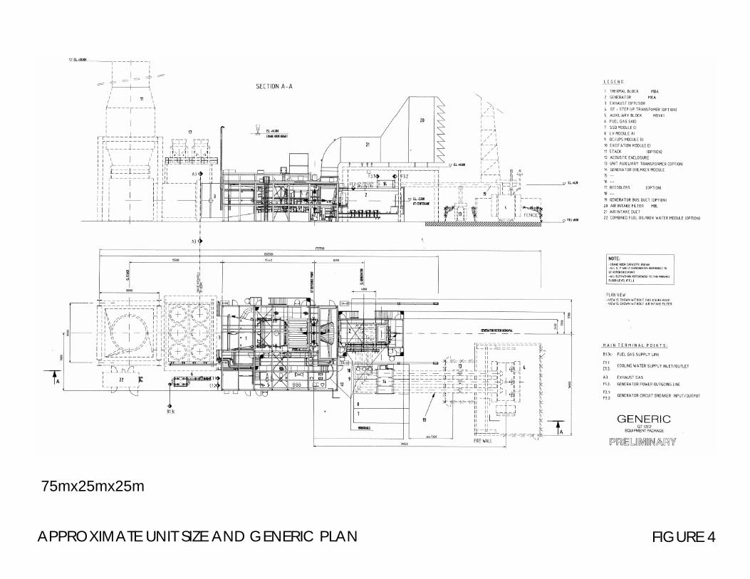
APPROXIMATE UNIT SIZE AND GENERIC PLAN FIGURE 4
75mx25mx25m

CNdV africa 5 1286 OCGT MOSSEL BAY VIA environmental planning, landscape architecture, urban design AUGUST 2005
7
be no need to enlarge the infrastructure of the transformers at Proteus substation. 3.3.2 Alternative 2 – As Contained in the Scoping Report This alternative consists of several interlinked parts, each of which has its own alternatives. The entire scope of the development can be described as follows: 3.3.3 The Site Itself See Figure 3 The building platform: A flat building platform of approximately 480X300m
will need to be created. The siting of this platform has not been finalised as it will partly be determined by the input of the specialist reports in the EIA phase.
The OCGT power plant: This will consist of three or four gas turbines each of
which takes up an area of approximately 75X25 meters. • The bulk of the structures will be less than 20m in height, but each
turbine will require a stack the height of which could be 30m or more and is approximately 6m diameter at the top.
• The final height of the stacks is to be determined in consultation with the air quality specialist.
The substation: Immediately adjacent to the OCGT units a 400kV
substation will be needed for the distribution of the generated electricity to the transmission lines to Proteus.
The fuel line: To provide fuel for the turbines there will be a fuel pipeline
running from PetroSA to the site. • There are two possible alignments for this pipeline. (See Figure 5) • The pipeline will be approximately 100mm in diameter and run slightly
raised from the ground on concrete pylons or alternatively the pylons and pipe could be set slightly into a trench so that they will not be seen above ground level.
Water: Water is used as a pollution abatement method and is only
required with the use of certain types of fuel. Dry NOx abatement measures do not require the use of water in the combustion process. Wet NOx abatement measures however will require approximately 547 000 kilo litres of demineralised water annually. • Demineralised water could either be obtained from PetroSA in which
case an additional pipeline would be required to carry the water from PetroSA to the site. This pipeline would follow the same route as the fuel pipeline.
• Alternatively water would be sourced elsewhere and Eskom would have to build a pipeline from the water source to the site and a demineralisation plant on the site. This alternative is unlikely as
CNdV africa 5 1286 OCGT MOSSEL BAY VIA environmental planning, landscape architecture, urban design AUGUST 2005
8
PetroSA has sufficient excess capacity both in its water supply line and at its demineralisation plant. Eskom would only need to obtain the permits to draw the extra water through the existing pipe line.
• There are three factors that determine whether the plant will run under dry NOx or wet NOx abatement measures. These are 1) the type of fuel used, 2) the type of turbine and, 3) the permissible level of emissions. There is a possibility that the plant may start out using dry NOx abatement measures but convert to wet NOx measures during its lifetime. The presence of the water storage tanks is therefore taken as necessary irrespective of which system is to be used initially.
Storage tanks: There will need to be storage tanks for fuel, raw water,
demineralised water, neutralised water, acid and caustic. • The exact size and position of these tanks is unknown at present and
will remain so until design work is further advanced. They are however not anticipated to be more than approximately 6m in height.
• If the wet NOx alternative is used, approximately 5 million litres of stored water may be required on site.
Buildings: Several small buildings will be needed to house the
maintenance building, station control room, stores, facilities for staff, etc. Access to the site: There are three alternative access routes from the N2 to
the site that are to be assessed. • Alternatives 1 and 2 use the existing PetroSA access to the landfill site
west of PetroSA. • Alternative 1 continues further north along the boundary of PetroSA
until reaching the railway line after which it turn westwards towards the site.
• Alternative 2 continues along the alignment of the existing 132kV transmission lines between the boundary of PetroSA and the site.
• Both of these alternatives will allow for the alignment of the proposed fuel pipeline and any other services coming from PetroSA resulting in a single utility corridor.
• Alternative 3 takes access from the N2 approximately 2.5km west of the PetroSA road to the landfill site which would be used in alternatives 1 and 2, and runs in a northeasterly direction for approximately 2 km before reaching the site.
Fencing: The site will be surrounded by the standard triple security fencing
that is found at most substations. Lighting: There will be a need for security lighting along the perimeter,
aircraft warning beacons on the stacks and such local lighting as will be required for operation of the plant.

ALTERNATIVE ACCESS AND PIPE LINE ROUTES FIGURE 5
ALTERNATIVE 1
ALTERNATIVE 2
ALTERNATIV
E 3
EXISTING PETROSA
ENTRANCE
PROPOSED NEW ENTRANCE
Notes: The routes as shown are approximate
THE SITE
PETROSA LANDFILL SITE
PETROSA
RAILWAY LINE
NATURAL VEGETATION TO
BE RETAINED

CNdV africa 5 1286 OCGT MOSSEL BAY VIA environmental planning, landscape architecture, urban design AUGUST 2005
9
3.3.4 The Transmission Lines See Figure 6 In order to connect the OCGT power plant to the existing national
transmission network two 400kV transmission lines will be required to carry the power from the substation on site to the Proteus substation northwest of the plant. There are three alternative alignments that are being investigated.
Alternative 1: The two transmission lines would exit the OCGT power plant on its north-western side, cross over the railway line, run in a north-north-westerly direction for approximately 2km along a farm boundary, towards the R327. Thereafter the proposed route runs adjacent to the R327 for the remaining 10km to Proteus substation. This alternative crosses farmland before forming part of an existing utility corridor comprising a road, telephone lines and distribution lines. The total length would be approximately 12km. Alternative 2: The two transmission lines would exit the OCGT power plant on its north-western side and follow the alignment of the existing two 132kV transmission lines that run between PetroSA and Proteus substation. The proposal is to erect the two new transmission lines parallel and to the west of the existing transmission lines. The alignment would traverse a number of farms, a secondary road and cultivated land. The total length would be approximately 10km. Alternative 3: This route alignment exits the OCGT power plant on its western side and runs parallel and to the north of the railway line in a westerly direction for approximately 4km to Kleinberg. The transmission lines would cross over an existing secondary road to run parallel to an existing 66kV distribution line. The transmission lines would then follow a route of about 10km running northwards along a valley to the Proteus substation. This alignment follows an existing utility corridor (railway line), and traverses cultivated land as well as less disturbed valleys. The total length would be approximately 14km.
3.3.5 Proposed Tower Options See Figures 7a and 7b Several tower structure options have been identified as being suitable for
the project. The final choice of tower types will depend partly on the terrain and route alignment chosen. A combination of tower types will be needed whatever alignment is chosen because, for example, special self supporting strain towers will be required at any point where the direction of the line alters, even if one of the cross rope suspension towers are used for the straight sections of line.
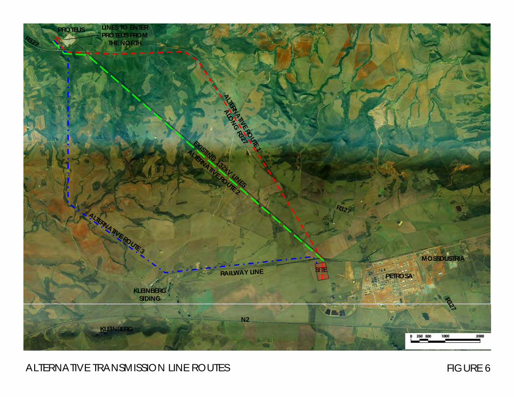
ALTERNATIVE TRANSMISSION LINE ROUTES FIGURE 6
PETROSASITE
PROTEUS
N2KLEINBERG
KLEINBERG SIDING
ALTERNATIVE ROUTE 1
ALONG R327
ALTERNATIVE ROUTE 2
ALTERNATIVE ROUTE 3
LINES TO ENTER PROTEUS FROM
THE NORTH
MOSSDUSTRIA
R327
R327
R327
RAILWAY LINE
EXISTING 132kV LINES

CNdV africa 5 1286 OCGT MOSSEL BAY VIA environmental planning, landscape architecture, urban design AUGUST 2005
10
Compact cross rope suspension towers: The compact cross rope suspension tower (including stays wires) is approximately 49m wide and 38m high (see Figure 7a). The conductors are suspended in a triangular configuration and the tower resembles a V-type structure with the top width being 19m wide.
Cross rope suspension tower: A larger version of the compact cross-rope
tower, these structures are characterised by two steel vertical legs and a cross-rope forming the horizontal arm from which the conductors are suspended. Stay wires are used to securely anchor the structure (see Figure 7a). The tower configuration is approximately 38m high and 21m wide (excluding the anchors). The distance between the anchors at the base of the structure can be up to 80m.
Self supporting bend or strain towers: These suspension towers consist of a number of steel components that are joined together to form a steel-intensive structure. The tower is approximately 30m high and 22.5m wide (see Figure 7b). These types of structures are typically used at bend point on a transmission line alignment.
Self supporting tower: The self-supporting towers consist of a number of steel components that are joined together to form a steel-intensive structure (see Figure 7b). The tower is approximately 30m high and 20m wide at the apex. The base of the tower is approximately 8.8m wide.
3.3.6 The upgrading of the Proteus substation: Additional infrastructure will be
required at the Proteus substation in order to link the new lines into the system. All this development will be within the existing boundaries of the substation on building platforms that have already been created. Entrance of the new power lines will have to be from the north where the existing platforms are.
3.4 GEOLOGY / LANDFORM There are no specific geological features on the site that from a visual point of view need preservation. The entire area of the site has been disturbed by agricultural activity. It is not known whether sub soil geological conditions exist which may affect the siting of the OCGT plant. There are small areas of natural vegetation in the north eastern corner of the site and at places along the railway line which must be preserved.

ALTERNATIVE TOWER OPTIONS FIGURE 7aCROSS ROPE SUSPENSION TOWER SOURCE: ESKOM
COMPACT CROSS ROPE SUSPENSION TOWER

ALTERNATIVE TOWER OPTIONS FIGURE 7b
SELF SUPPORTING TOWERSOURCE: ESKOM
SELF SUPPORTING STRAIN TOWER

CNdV africa 5 1286 OCGT MOSSEL BAY VIA environmental planning, landscape architecture, urban design AUGUST 2005
11
4. IDENTIFICATION OF POTENTIAL VISUAL RISKS AND OPPORTUNITIES
4.1 POTENTIAL RISKS (VISUAL)
• Dust generated during construction. • The potential visual impact of the use of construction vehicles and
equipment over the period of construction. • The visibility of the plant and associated structures and transmission
lines from the N2 and the R327. • The potential visual impact of the entrance road. • The potential visual impact of possible fencing and/or security
measures. • The potential visual impact of signage. • The potential visual impact of light pollution at night. • The potential for scarring of the landscape on the areas affected by
the construction of the transmission lines and access road. 4.2 POTENTIAL OPPORTUNITIES
• The possibility of creating a sensitive development that could be used as a model for future plants of such a nature

CNdV africa 5 1286 OCGT MOSSEL BAY VIA environmental planning, landscape architecture, urban design AUGUST 2005
12
5. VISUAL IMPACT ASSESSMENT 5.1 “No Development” Alternative If the no-development alternative is implemented the status quo will be maintained and there will consequently be no visual impacts of any kind. This applies to the site for the OCGT plant and also for the routes of the transmission lines as these will no longer be required. The land is however zoned for industrial use and there is no guarantee that PetroSA will not expand their operations onto the site, or that other industrial development will not take place on it at some future date. The potential visual impacts of this kind of development cannot be known at this stage. 5.2 VIEWSHED (See Figure 8 – Viewshed and Distance Radii) The "viewshed" refers to the theoretical outer-most extent or area from which a site can be seen. It must, however, be remembered that visibility may be obscured in reality by objects within the viewshed such as existing buildings, trees, lower ridges, outcrops and other geographical or natural features, and also by distance where an object can visually blend into its background or be completely lost to sight. Because of the gentle slope and undulation of the land surrounding the site there are few visual barriers that stand out from the landscape to create a natural viewshed. The ridge line to the east and west of Proteus and northeast of the R327 does however form a visual barrier to views from the north and east. The exception to this is the possible visibility of the towers and extra structures at Proteus from the north. Because of the lack of viewers in this area, and the presence of the existing substation against which these additions will be seen, these views are not expected to be significant. To the east, south and west of the proposed plant and transmission lines the viewshed is broken by the local topography with the various elements of the proposed development sliding in and out of site as they are viewed in relation to the local topography. In many instances the mitigation of distance will form the viewshed for specific views rather than the geographical features.
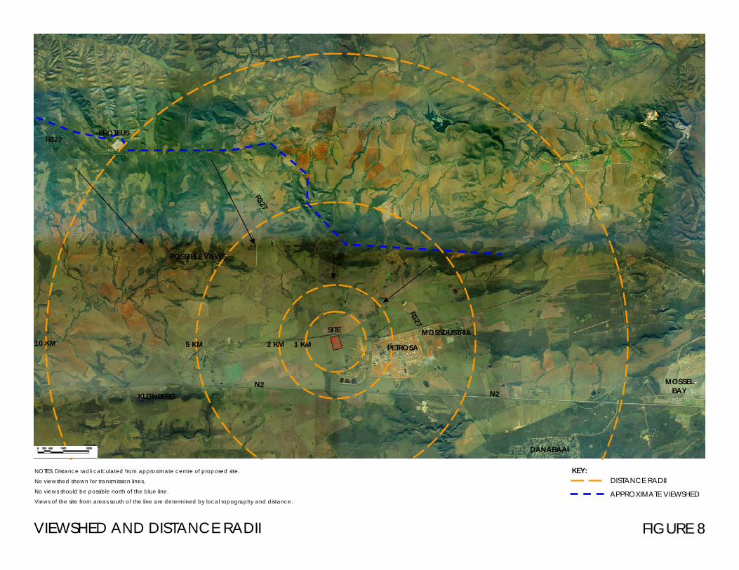
1 KM
VIEWSHED AND DISTANCE RADII FIGURE 8
KEY:DISTANCE RADII
APPROXIMATE VIEWSHED
NOTES: Distance radii calculated from approximate centre of proposed site.
No viewshed shown for transmission lines.
No views should be possible north of the blue line.
Views of the site from areas south of the line are determined by local topography and distance.
2 KM5 KM10 KM PETROSA
DANABAAI
MOSSEL BAY
PROTEUSR327
R327
R327MOSSDUSTRIA
N2N2
SITE
KLEINBERG
POSSIBLE VIEWS

CNdV africa 5 1286 OCGT MOSSEL BAY VIA environmental planning, landscape architecture, urban design AUGUST 2005
13
5.3 VISIBILITY OF THE OCGT PLANT (See Figures 9-11) 5.3.1 The N2
The most significant area of visibility for the plant is from the N2 starting in the west where the N2 skirts the base of Kleinberg and continuing until south of the PetroSA plant, a distance of approximately 8 km. Westwards of Kleinberg the undulations of the topography and the distance make views of the plant unlikely. East of the PetroSA plant the OCGT plant will be seen, if at all, behind the foreground of the existing plant and should represent negligible additional visual impacts. The signature view, looking west over the bay from the point where the Mossel Bay turnoff leaves the N2 will be unaffected by the development. The most significant views along this stretch of the N2 will be when travelling from the west towards Mossel Bay. Viewing distances range between 6 and 1.5 kilometres. The views from the slope of the foot of Kleinberg will be the most comprehensive, although mitigated by distance, and the closer views should be partial and intermittent as the local topography alternately shields and reveals the site. From closer to the site the viewer needs to look northwards away from the orientation of the road in order to view the OCGT plant. The existing PetroSA plant will form the general context of all views from this direction except when directly south of the site. If one of the alternative access routes that follow the existing access road to the PetroSA landfill site is used, little additional visual impact would be incurred by the entrance. If, however, the option of an entirely new access road 2.5km west of the existing alternative is used, there will be an additional turn off and gate along the N2 which will add to the cumulative visual impact of the project. The impact of the new road could also be significant, although it should be seen in the context of the other farm roads.
5.3.2 The R327
Little or nothing of the plant should be visible from where the R327 turns off of the N2 until beyond the northern edge of Mossdustria, the plant being shielded by the existing industrial development. West and northwest of this point the road climbs to its highest point at the Proteus substation, which allows for views over the lower land to the south, including the OCGT site. In the highest area along the ridgeline, near Proteus, most views to the south and southeast are mitigated by the vegetation along the sides of the road. The loss of this vegetation through
CNdV africa 5 1286 OCGT MOSSEL BAY VIA environmental planning, landscape architecture, urban design AUGUST 2005
14
fire or human activity would greatly increase the visibility of the site from this section of road. Potential views along the R327 range from a minimum of 1.5km from the site to approximately 10km at Proteus. All views should be intermittent and partial with most significant views being mitigated by distance.
5.3.3 Danabaai and Surrounding Areas
It is unlikely that the plant will be visible from Danabaai. Any potential views will be mitigated by distance, in excess of 6kms, and by the fact that the OCGT plant should be screened by the existing PetroSA structures.
5.3.4 Surrounding Farms
Several farmsteads in the area may have their views affected by the presence of the plant to a greater or lesser extent. A detailed analysis of each farmstead is beyond the scope of this report.
5.4 VISIBILITY OF THE TRANSMISSION LINES 5.4.1 N2
Visibility from various viewpoints will depend largely on which alternative route for the transmission lines is chosen. Alternative 1: This alternative which follows the R327 seems to hold the least initial visibility from the N2 as it is further from the N2 than the other routes, however, depending on the exact positioning of the towers in relation to the R327 some of them may be visible against the skyline, especially in the area where the R327 follows the ridgeline. Visually this could be very intrusive to views of the mountains from the N2. Alternative 2: This alternative that follows that route of the existing 132kV lines would be intermittently visible from the N2 but should be mitigated by distance. The towers should also not be seen against the skyline at any point except for a very limited distance directly south of the Proteus substation where Proteus itself can be clearly seen against the skyline. This view would have a minimum distance of approximately 8kms. Alternative 3: This alternative which follows the railway line westwards to Kleinberg before turning northwest and then northwards towards Proteus will be the most visible from the N2. It runs parallel to the N2 at a minimum distance of 1.2km for a length of approximately 4kms. The section from Kleinberg to where it turns north will also be partially and intermittently visible when travelling in both directions along the N2, the towers closer to the N2 having less shielding from the local topography. The northward section of the line should be less visible because of its situation in a narrow
CNdV africa 5 1286 OCGT MOSSEL BAY VIA environmental planning, landscape architecture, urban design AUGUST 2005
15
valley, but just south of Proteus the towers will once again be seen against the skyline from certain points.
5.4.2 The R327
Alternative 1: As this line follows the R327 on its southern side, the towers and lines will be significantly visible and intrusive to views over the lower lying land to the south over a distance of approximately 14kms. Placing the towers on the northern side of the road would merely place them on higher ground and ensure their significant presence along the skyline. Alternative 2: Except for a few limited places near the site, the road, being more elevated than the towers, should ensure that the towers are viewed against the background of the surrounding terrain thus greatly decreasing the significance of their visibility. Alternative 3: This alternative, being further from the R327 than the other two, should have the lowest visual influence on views from the R327. It must be noted that for all three alternatives the lines will have to cross the R327 at a point near Proteus in order to approach the substation. The visibility of all three alternatives should be similar at this point. There could be additional visual impact to those travelling on the R327 from Herbertsdale towards Mossel Bay while still to the north and west of Proteus. The visual impact is not however expected to be significant because all new development, except for the towers where the lines cross the R327 at Proteus is expected to be seen against the backdrop of the existing infrastructure at the substation.
5.4.3 Danabaai and Surrounding Areas
It is unlikely that any of the three alternatives should be significantly visible from Danabaai and the surrounding areas.
5.4.4 The Surrounding Farms
Some of the surrounding farms may have their views affected by each of the three alternative routes. A detailed analysis of each farmstead is beyond the scope of this report.

PANORAMA FROM THE SITE FIGURE 9
Notes: This panorama is included because the site will be visible from all points visible in these images. i.e. these images give a good idea of the extent of the viewshed.
CHAPMAN’S PEAK DRIVE
N2
EAST SOUTH EAST
SOUTH SOUTH WEST
MOSSEL BAY JUST BECOMING VISIBLE OVER RIDGE (14KM)
PETROSA CHIMNEYS 110M TALL
PETROSA PLANTNORTHEAST CORNER OF SITENORTHEAST
PETROSA PLANT LANDFILL SITE
INDIAN OCEAN
OCGT PLANT WILL STAND IN THIS AREA

PANORAMAS FROM THE R327 FIGURE 10
Notes: all development will be behind the tree line where it is maintained. A break in the tree line will be required for the passage of the new transmission lines
PETROSA PLANT
APPROXIMATE NORTHERN BOUNDARY OF SITE
APPROXIMATE NORTHERN BOUNDARY OF SITE
PETROSA
PETROSA
GAP IN TREE LINE FOR EXISTING 132kV LINE
View from the R327 North of the site
View from the R327 from Northeast of the Site
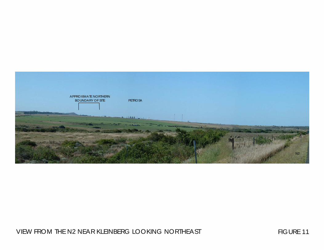
VIEW FROM THE N2 NEAR KLEINBERG LOOKING NORTHEAST FIGURE 11
PETROSAAPPROXIMATE NORTHERN
BOUNDARY OF SITE
N2

CNdV africa 5 1286 OCGT MOSSEL BAY VIA environmental planning, landscape architecture, urban design AUGUST 2005
16
Table 1 : Visibility of Site
VIEWPOINTS DISTANCE KM VISIBILITY
THE OCGT PLANT AND SUBSTATION
N2 Approx. 1km and further
Most significant views when travelling west towards Mossel bay. View mostly partial and intermittent. Most significant views directly south of site and at right angle to road
R327 Approx. 1,5km to 14km
Views largely mitigated by distance and local vegetation along south of R327
Danabaai and surrounds Approx. 6km+ No significant views expected. Site largely
shielded by existing PetroSA plant
Surrounding farms Varies Several farmsteads may have their views affected
THE TRANSMISSION LINES AND PROTEUS EXTENSIONS
N2
Alternative route 1 Alternative route 2 Alternative route 3
Furtherest away from N2 but possibility of towers visible along the ridgeline Route with least visual impact on N2. Route parallel to N2 at distance of 1.2 km for 4km high potential visual impact
R327
Alternative route 1 Alternative route 2 Alternative route 3
Holds significant visual implications for views to the south Except for near Proteus, towers to be seen against surrounding terrain Lowest visual influence on views from R327
Danabaai and surroundings All alternatives Unlikely to be significantly visible
Surrounding farms All alternatives Some farmsteads could have their views significantly affected

CNdV africa 5 1286 OCGT MOSSEL BAY VIA environmental planning, landscape architecture, urban design AUGUST 2005
17
5.5 VISUAL IMPACT ASSESSMENT (For a description of the criteria and their ratings see Addendum 1.) Visual impacts have been assessed in terms of the following criteria: 5.5.1 The Extent of the Visual Impact
The Plant and Surrounding Infrastructure: • The extent of the impact can be described as regional because
visual impacts will be experienced, albeit at a low intensity, up to 10km away.
• The extent of the impact will not by affected by the implementation of the mitigation measures
The Transmission Lines and Proteus Upgrade:
• The extent of the impact will be regional as elements of the lines will be visible from 10kms away and more.
• This assessment is the same for all three route alternatives. • The extent of the impact will not by affected by the
implementation of the mitigation measures
5.5.2 Magnitude of Visual Impact
The plant and Surrounding Infrastructure • The magnitude of the impact is assessed as Medium because,
within the greater context of the PetroSA plant and Mossdustria the Natural and/or social functions and/or processes should only be slightly altered.
• The use of the access road alternative 3 may raise the magnitude because of the perceived change of use along the N2.
• With full mitigation, because much of the plant will be hidden by the berms, the magnitude could drop to medium – low, but the size of the stacks would make an assessment low magnitude impossible
The Transmission Lines and Proteus Upgrade:
• Alternative 1 – the magnitude of the impact will be medium • Alternative 2 – The magnitude of the impact should be low
because less people will be visually affected by it than by the other two alternatives.
• Alternative 3 – The magnitude of the visual impact could be high because the perceived agricultural nature of the area will be affected by the section of the lines adjacent to the N2 which will guide the viewer’s attention directly towards the plant.
5.5.3 Duration of Impact
The plant and Surrounding Infrastructure • The duration of the visual impact will be long term.

CNdV africa 5 1286 OCGT MOSSEL BAY VIA environmental planning, landscape architecture, urban design AUGUST 2005
18
The Transmission Lines and Proteus Upgrade: • The duration of the visual impact will be long term.
5.5.4 Significance of the Visual Impact
The Plant and Surrounding Infrastructure: • The significance of the impact will be medium • The significance of the impact will be affected by the
implementation of the mitigation measures and could become medium to low.
The Transmission Lines and Proteus Upgrade:
• Alternative 1 – the significance of the impact will be high • Alternative 2 – The significance of the impact will be medium • Alternative 3 – The significance of the impact will be high • The significance of the visual impact will not by affected by the
implementation of the mitigation measures 5.5.5 Probability
The Plant and Surrounding Infrastructure: • It is highly probable that the visual impact will occur
The Transmission Lines and Proteus Upgrade:
• It is highly probable that the visual impact will occur 5.5.6 Confidence
The Plant and Surrounding Infrastructure: • The ratings are sure provided that the final design remains within
the parameters described above in this document. Any large changes to the layout and size of the equipment to be installed would necessitate a reworking of these assessments.
The Transmission Lines and Proteus Upgrade:
• The ratings are sure provided that the final design remains within the parameters described above. Any large changes to the tower sizes, or alternative routing would necessitate a reworking of these assessments.

CNdV africa 5 1286 OCGT MOSSEL BAY VIA environmental planning, landscape architecture, urban design AUGUST 2005
19
Table 2 : Summary: Visual Impact Ratings
CRITERIA OF RATING
1 Extent of impact: The area of visual influence.
• OCGT plant and infrastructure • Transmission lines alternative1 • Transmission lines alternative 2 • Transmission lines alternative 3
Regional
2
Magnitude of Impact: The amount of influence the impact will have on natural processes and social functions.
• OCGT plant and infrastructure
with access alternatives 1 and 2 • OCGT plant with access
alternative 3 • OCGT plant with full mitigation • Transmission lines alternative1 • Transmission lines alternative 2 • Transmission lines alternative 3
Medium
Medium
Medium-low
Medium Low High
3
Significance of Visual Impact: Combines the above assessments and determines impact as a whole
• OCGT plant and infrastructure • OCGT plant with full mitigation • Transmission lines alternative1 • Transmission lines alternative 2 • Transmission lines alternative 3
Medium
Medium-low High
Medium High
4 Duration of Impact • OCGT plant and infrastructure • Transmission lines
Long-term Long-term
5 Probability • OCGT plant and infrastructure • Transmission lines
Highly Probable Highly Probable
6
Confidence
• OCGT plant and infrastructure • Transmission lines
Sure Sure
Both with conditions

CNdV africa 5 1286 OCGT MOSSEL BAY VIA environmental planning, landscape architecture, urban design AUGUST 2005
20
6. RECOMMENDED MITIGATION MEASURES With a structure the size of the OCGT plant, or with the geographic spread of the transmission lines, it is usually impossible to apply mitigation measures entirely satisfactorily to a point where the significance of the visual impact is greatly reduced. The following recommended mitigation measures are therefore primarily intended to minimise the intensity of the visual impacts. The overall significance of the entire project should remain unchanged at medium but the significance of the OCGT plant itself, if all mitigation measures are applied could be lowered to medium to low. 6.1 THE OCGT PLANT AND ASSOCIATE INFRASTRUCTURE 6.1.1 Siting and Earthworks
• The structures are to be sited as close to the PetroSA boundary as possible. The sense of there being a ‘gap’ between the two developments must be minimised and any shielding capabilities of the landfill site to the south must be utilised.
• The natural vegetation in the northeastern corner of the site and along
the railway line is to be maintained. • It is proposed that buffer zones of 50 meters external to the security
fencing be secured for the implementation of the mitigation measures for the visual impact of the plant.
• If it is geotechnically and financially feasible the platform within the
security fencing must be levelled predominantly by means of cut, rather than by balancing both cut and fill. The excess fill must then be used to create large berms thus enclosing much of the site. (This could have the side effect of aiding with noise abatement.)
• Berms should be created on the southeast and southwest boundaries as
this is the direction from which the plant will be most visible along the N2. The existing tree line along the railway line must be retained and will provide a certain amount of shielding from the north.
• The berms can undulate and meander within the buffer zone creating a
natural feel rather than an engineered one. • The slopes of berms should not exceed 1:4 so that erosion is minimised, the
planting can easily take hold, and the appearance of ‘natural’ slopes be emphasised.
• A landscape architect should be appointed to work with the engineers in
creating an affordable but natural looking environment.
CNdV africa 5 1286 OCGT MOSSEL BAY VIA environmental planning, landscape architecture, urban design AUGUST 2005
21
• Within the limits of engineering feasibility structures are to be set as low as possible into the platform. The storage tanks are to be fully or partially below ground level if at all possible from an engineering and safety perspective.
6.1.2 Access
• Access to the site should be by either alternative one or two, using the existing access off the N2 to the PetroSA landfill site.
6.1.3 Finishes and Textures
• To a large extent the finishes and textures used at the plant will be determined by the engineering requirements of the project.
• All painted surfaces are to use muted earth tones or in the case of large
surfaces such as roofs, storage tanks and the stacks, medium grey chosen for its ability to blend in to the background. Bright colours are not to be used except for the safety markings as required by the industry. Reds, greens, whites and blues must be avoided.
• The fuel and other pipelines are to be painted grey unless set in a trench
in which case muted colours can be used. • The use of face brick should be avoided. • Glass surfaces, if there are any, should be shielded to avoid glare and
reflections.
6.1.4 Visual Screening of the Structures
• The berms are to be planted with indigenous Fynbos species and grasses so as to minimise the need for irrigation and maintenance.
• Trees are to be planted where possible, the top and slopes of the berms
being ideal for maximum screening capacity. • Either groups of trees can be used or new tree lines created in imitation of
those in the existing landscape. • Trees can be used provided that their species is not on the invasive aliens
list. Although it would be preferable to use indigenous species, gums and other exotic trees found locally have become part of the cultural landscape and provided that they are sensitively used would be in keeping with the visual nature of the existing landscape.
• A landscape architect should be appointed to plan the landscaping so
that is looks natural within its environment. i.e. formal flowering gardens on
CNdV africa 5 1286 OCGT MOSSEL BAY VIA environmental planning, landscape architecture, urban design AUGUST 2005
22
the berms would be unacceptable as there is no precedent in the existing landscape, but the judicious use of tree lines would be acceptable and desirable.
• Kikuyu is not to be used anywhere on site because it’s particular green is
not found naturally in the surrounding landscape and large expanses of it can be visually intrusive.
6.1.5 Lighting
• If not properly handled, the visual impact of lighting could be significant because it can give a project a far greater zone of visual influence at night than the structures have during the day.
• All lighting is to be kept to a minimum within the requirements of safety
and efficiency.
• Where such lighting is deemed necessary low-level lighting, which is shielded to reduce light spillage and pollution, should be used.
• No external up-lighting of any parts of the structures, including the stacks
must be allowed. • External lighting must be by the use of down-lighters shielded in such a
way as to minimise light spillage and pollution beyond the extent of the area that needs to be lit.
• Security and perimeter lighting must also be shielded so that no light falls
outside the area needing to be lit. Overly tall light poles are to be avoided.
• No naked light sources are to be directly visible from a distance, (except
for the aircraft warning lights.) Only reflected light should be visible from outside the site.
• All necessary aircraft warning lights are to be installed as per the
government requirements. 6.1.6 Fencing
• The type and height of the fencing will be determined by the security policy of Eskom.
• Fencing must be visually permeable and in a medium to dark grey colour.
The use of razor wire must be avoided. Electrification and isolators to be in matching colour

CNdV africa 5 1286 OCGT MOSSEL BAY VIA environmental planning, landscape architecture, urban design AUGUST 2005
23
• The fencing should be shielded by the berms, or failing that, by screen planting along, but away from the fence so as not to allow breaches in security.
6.1.7 Signage
• No backlit or neon signage is to be allowed.
• All necessary signage should be limited in size, and its colours and finishes should be chosen for their appropriateness to the colours of the site and its semi-rural nature. The use of corporate colours and logos is excluded from this.
6.1.8 Required Infrastructure
• All infrastructure is to be designed to have as little visual impact as possible.
• The access road and security gates, and if necessary, the guardhouse,
are to be unobtrusive and scaled in such a way as to minimise the visual impact.
• If there are any excavations outside the boundaries of the site to install
infrastructure, these areas must be fully rehabilitated and fall within the responsibility of the ECO.
6.1.9 Mitigation Measures During Construction
• An attempt must be made to control dust generation during the excavation and construction stage.
• All stockpiles are to be protected from dispersion to the surrounding terrain
by wind or water. • All substances, such as cement, that could be toxic to the flora and fauna
are to be strictly controlled to avoid sterilization or degradation of parts of the surrounding environment.
• Workers must be trained in good environmental practices and such areas
as the wetland in the northeastern area of the site are to be off limits to them
• Damage to existing flora and fauna is to be a punishable offence. • Toilets are to be provided and used by the workers and not the bush. • Litter is to be strictly controlled.

CNdV africa 5 1286 OCGT MOSSEL BAY VIA environmental planning, landscape architecture, urban design AUGUST 2005
24
6.2 THE TRANSMISSION LINES AND PROTEUS EXTENSION 6.2.1 Choice of Route
• Route 2, directly from the OCGT plant along the route of the existing 132kV lines, is its own best mitigation.
• The line being the shortest will entail the construction of the least number
of towers thereby automatically reducing the potential visual impact. • The route is roughly equidistant from the two roads that would be visually
affected, the N2 and the R327, thereby limiting the visual impact to both of them.
• From both above and from below the bulk of the line should be seen
against the backdrop of the surrounding terrain and not against the skyline.
• The fact that the route is straighter than the others means that there will be
less need for the heavier strain towers. 6.2.2 Choice of Towers
• The compact cross-rope towers are to be used wherever possible with the
self supporting strain towers being used where necessary. • These towers should entail less disturbance of vegetation at ground level,
having a smaller footprint. • The slanting uprights should be more readily absorbed by the surrounding
landscape than vertical ones would be. 6.2.3 Tree Lines
• The railway line will have to be crossed necessitating the removal of the
trees within the servitude. • As many trees as possible must be retained. • The removal and trimming of natural vegetation where the line must cross
the R327 must also be minimised.
CNdV africa 5 1286 OCGT MOSSEL BAY VIA environmental planning, landscape architecture, urban design AUGUST 2005
25
6.2.4 Access For Construction And Maintenance
• Where possible the access and maintenance road used for the existing 132kV lines is to be utilised for construction and access to the new 400kV lines
• Where new stretches of road are necessary the design is to ensure that
the least visual impact is incurred. • Where hardening of the surface of the access road is required, two
concrete or concrete block strips are to be used rather than solid paving or tar.
6.2.5 Mitigation Measures During Construction
• An Environmental Control Officer is to be appointed to ensure that the mitigation measures are conscientiously applied.
• The construction camp is to be accommodated on previously disturbed
land as close to existing development as possible. • The visual impact of the camp is to be taken into account and minimised
by its siting and through the use of screening. • Construction workers are to be trained in the basic conservation issues
that pertain to the construction of the line and the terrain over which it is to be built, and good conservation practices are to be followed.
• Any sensitive areas of Fynbos lying in or adjacent to the construction path
must be marked off, and access to these areas by the construction crews forbidden.
• Damage of local flora and fauna, i.e. the collecting of fire wood, must be
a punishable offence. This must be enforced by the ECO. • Every caution must be taken against the possibility of veld fires. • Toilets are to be provided and used by the workers and not the bush. • Litter is to be strictly controlled. • The area of the construction camp is to be fully rehabilitated as soon as
the construction work is complete. • All stockpiles are to be protected from dispersion to the surrounding terrain
by wind or water.
CNdV africa 5 1286 OCGT MOSSEL BAY VIA environmental planning, landscape architecture, urban design AUGUST 2005
26
• All substances, such as cement, that could be toxic to the flora and fauna are to be strictly controlled to avoid damage to the surrounding environment.
6.3 CONTROLLING FUTURE DEVELOPMENT
• Any future changes, improvements, additions or enlargements must be subject to a separate visual impact assessment.

CNdV africa 5 1286 OCGT MOSSEL BAY VIA environmental planning, landscape architecture, urban design AUGUST 2005
27
7. MONITORING AND REVIEW PROGRAMME A review of the final plans once they have been completed must be undertaken to ascertain whether they still fall within the assessments of this document and whether the mitigation measures can and will be adequately implemented.

CNdV africa 5 1286 OCGT MOSSEL BAY VIA environmental planning, landscape architecture, urban design AUGUST 2005
28
8. CONCLUSION AND RECOMMENDATIONS
The project as a whole is expected to have a visual impact of Medium significance and provided that the mitigation measures found in this document are applied the intensity of the visual impact is deemed to be acceptable for a project of this nature. This is especially true for the use of screening berms for the OCGT plant which, while not able to screen the entire plant, will reduce its significance to medium to low. Although on a tourist route, (the N2,) the area surrounding the site and transmission lines does not seem to contain any significant tourist facilities that should be negatively affected by the proposed development. Of the alternative access routes to the site, one of the alternatives using the existing access to the PetroSA landfill site is recommended, the third alternative to the west of these two being considered as having potentially a much higher visual impact. Of the possible routes for the transmission lines, alternative 2, the direct route from the proposed plant to Proteus is recommended as having the lowest overall visual impact. The use of alternatives 1 and 3 will raise the visual impact of the lines significantly. The use of the compact cross-rope type of tower with self supporting strain towers where necessary is considered to be the tower option with the least visual impact and is therefore recommended. It is recommended that a review of the findings of this report be made once the plans for the site and transmission lines are at a more advanced stage.

CNdV africa 5 1286 OCGT MOSSEL BAY VIA environmental planning, landscape architecture, urban design AUGUST 2005
29
9. Addendum Assessment Ratings and definitions Table 1: Assessment criteria for the evaluation of impacts CRITERIA CATEGORY DESCRIPTION
Regional Beyond a 7km radius of the OCGT power plant and associated infrastructure
Local Within a 7km radius of the OCGT power plant and associated infrastructure
Extent of spatial influence of impact
Site specific On site or within 100m of the OCGT power plant and associated infrastructure
High Natural and/or social functions and/or processes are severely altered
Medium Natural and/or social functions and/or processes are notably altered
Low Natural and/or social functions and/or processes are slightly altered
Very low Natural and/or social functions and/or processes are negligibly altered
Magnitude of impact (at the indicated spatial scale)
Zero Natural and/or social functions and/or processes remain unaltered
Construction period Up to 18 months
Medium term 0-10 years (after construction) Duration of impact
Long term More than 10 years (after construction)
The SIGNIFICANCE of the impact is derived by taking into account the temporal and spatial scales and magnitude and combining them as follows:. Table 2: Definition of significance ratings SIGNIFICANCE RATINGS LEVEL OF CRITERIA REQUIRED High ● High magnitude with a regional extent and long term duration
● High magnitude with either a regional extent and medium term duration or a local extent and long term duration
● Medium magnitude with a regional extent and long term duration Medium ● High magnitude with a local extent and medium term duration
● High magnitude with a regional extent and construction period or a site specific and long term duration
● High magnitude with either a local extent and construction period duration or a site specific extent and medium term duration
● Medium magnitude with any combination of extent and duration except site specific and construction period or regional and long term
● Long magnitude with a regional extent and long term duration Low ● High magnitude with a site specific extent and construction period duration
● Medium magnitude with a site specific extent and construction period duration ● Low magnitude with any combination of extent and duration except site specific and
construction period or regional and long term ● Very low magnitude with a regional extent and long term duration

CNdV africa 5 1286 OCGT MOSSEL BAY VIA environmental planning, landscape architecture, urban design AUGUST 2005
30
Very low ● Low magnitude with a site specific extent and construction period duration ● Very low magnitude with any combination of extent and duration except regional and long
term
Neutral ● Zero magnitude with any combination of extent and duration
Table 3: Definition of probability ratings PROBABILITY RATINGS LEVEL OF CRITERIA REQUIRED
Definite Estimated greater than 95% chance of the impact occurring.
Highly probably Estimated 80 to 95% chance of the impact occurring.
Probably Estimated 20 to 80% chance of the impact occurring.
Possible Estimated 5 to 20% chance of the impact occurring.
Unlikely Estimated less than 5% chance of the impact occurring.
Table 4: Definition of confidence ratings CONFIDENCE RATINGS LEVEL OF CRITERIA REQUIRED
Certain Wealth of information on and sound understanding of the environmental factors potentially influencing the impact.
Sure Reasonable amount of useful information on and relatively sound understanding of the environmental factors potentially influencing the impact.
Unsure Limited useful information on and understanding of the environmental factors potentially influencing this impact.