andre wink-al-hind the making of the indo-islamic world, vol. 3, indo-islamic society, 14th-15th...
TRANSCRIPT


AL-HINDTHE MAKING OF THE INDO-ISLAMIC WORLD
VOLUME III

This page intentionally left blank
AL-HINDTHE MAKING OF THE
INDO-ISLAMIC WORLD
BY
ANDRÉ WINKProfessor of History
University of Wisconsin, Madison
VOLUME III
INDO-ISLAMIC SOCIETY14th-15th CENTURIES
BRILL
LEIDEN • BOSTON
2004
This book is printed on acid-free paper.
Library of Congress Cataloging-in-Publication Data
Wink, André.Al-Hind, the making of the Indo-Islamic world / by André Wink. —
p. cm.Includes bibliographical references and index.Contents: v. 3. Indo-Islamic Society, 14th-15th Centuries
ISBN 9004095098 (set). — ISBN 9004135618 (v.3)1. India—History—1000-1765. 2. Indian Ocean Region—History.
3. Muslims—India—Civilization. I. Title.DS452.W56. 1997954.02—dc20 91-22179
CIP
ISBN 90 04 13561 8ISBN (set) 90 04 09509 8
© Copyright 2004 by Koninklijke Brill, Leiden, The Netherlands
All rights reserved. No part of this publication may be reproduced, translated, stored ina retrieval system, or transmitted in any form or by any means, electronic,mechanical, photocopying, recording or otherwise, without prior written
permission from the publisher.
Authorization to photocopy items for internal or personaluse is granted by Brill provided that
the appropriate fees are paid directly to The CopyrightClearance Center, 222 Rosewood Drive, Suite 910
Danvers MA 01923, USA.Fees are subject to change.
PRINTED IN THE NETHERLANDS

CONTENTS
Maps ............................................................................................ VII
Abbreviations .............................................................................. IX
Preface ........................................................................................ XI
Introduction ................................................................................ 1
Chapter I. From the Mediterranean to the Indian Ocean:
medieval history in geographic perspective .......................... 5
Chapter II. Medieval cities ........................................................ 64
Chapter III. Frontier and settled society .................................. 79
Chapter IV. Post-nomadic empires .......................................... 119
Chapter V. Islam, trade and the coastal societies of the
Indian Ocean .......................................................................... 170
Conclusion .................................................................................. 244
Bibliography ................................................................................ 245
Index ............................................................................................ 259

This page intentionally left blank
MAPS
Map 1. East Africa .................................................................... 18
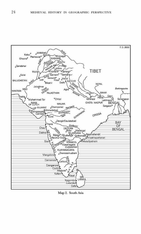
Map 2. South Asia .................................................................... 24
Map 3. Southeast Asia .............................................................. 36
Map 4. Arabia and Persian Gulf .............................................. 188

This page intentionally left blank
ABBREVIATIONS
Duarte Barbosa M. Longworth Dames (ed.), The Book of Duarte
Barbosa: An account of the countries bordering on the
Indian Ocean and their inhabitants, written by Duarte
Barbosa and completed about the year 1518 A.D.,
2 Volumes (New Delhi, 1989).
FFS A. Rashid (ed.), Futu˙àt-i-Fìroz Shàhì (Aligarh,
1949).
FS A. M. Husain (ed.), Futù˙ as-Salà†ìn of 'Ißàmì
(Agra, 1938).
IM A. Rashid (ed.), Inshà"-i-Màhrù (Lahore, 1965).
KF M. W. Mirza (ed.), ‡azà"ìn al-Futù˙ of Óazrat
Amìr Khusrau Dihlawì (Calcutta, 1953).
Pires, Suma Oriental The Suma Oriental of Tomé Pires: An Account of the
East, from the Red Sea to Japan, written in Malacca
and India in 1512–1515, 2 Volumes (New Delhi,
1990).
TA B. De (transl.), The abaqàt-i-Akbarì: A History of
India from the Early Musulman Invasions to the 38th
Year of the Reign of Akbar by Khwajah Nizàmuddìn
Ahmad (New Delhi, 1990; or 1939).
TF Ta"rì¶-i-Firishta (Lucknow, 1864). Two volumes
in one; second volume indicated II.
TFS S. Ahmad Khan (ed.), Ta"rì¶-i-Fìroz Shàhì of
¸ìà" ad-Dìn Baranì (Calcutta, 1862).
TFSA Ta"rì¶-i-Fìroz Shàhì of Shams-i-Siràj 'Afìf (Calcutta,
1888).
TKJ S. M. Imam ad-Dìn (ed.), The Tàrì¶-i-Khàn
Jahànì wa Makhzan-i-Afghànì of Khwajah Ni'mat
Allah, 2 Volumes (Dacca, 1960–2).
TMS M. Hidayat Hosaini (ed.), Ta"rì¶-i-Mubàrakshàhì
of Ya˙ya bin A˙mad bin 'Abdullàh as-Sirhindì (Cal-
cutta, 1931).
X
TS M. Hidayat Hosaini (ed.), Tàrì¶-i-Shàhì (also known as Tàrì¶-
i-Salà†ìn-i-Afàghìna) of A˙mad Yàdgàr (Calcutta, 1939).
ZN M. Abbàsì (ed.), ¸afarnàma of Sharaf ad-Dìn 'Alì Yazdì, Volume II
(Teheran, 1336/1957).
PREFACE
The research on which this book is based was done largely during the
academic year 1997–98, which I spent as a Fellow at the Netherlands
Institute for Advanced Study (NIAS) in Wassenaar. I am immensely
grateful to the staff at NIAS for the efforts they made to facilitate
my research, and to the Rector, Henk L. Wesseling, for encourag-
ing me to apply and making this such an intellectually rewarding
year. I would also like to thank the NIAS and Wim Stokhof, of the
International Institute for Asian Studies, for funding a small inter-
national conference on Nomads in the Sedentary World in July 1998
at Leiden, which, for me at least, clarified some of the issues dealt
with in this book.
The book was completed during the Fall semester of 2002, at the
Institute for Advanced Study (IAS) in Princeton, where I was generously
supported by the Agnes Gund and Daniel Shapiro Membership. I
would like to thank the faculty of the School of Historical Studies
not only for approving my application but also for providing quite
stimulating company during many lunches and occasional dinners. I
particularly benefited from numerous conversations with Patricia Crone.
Between Institutes, I received considerable research support from
the Graduate School of the University of Wisconsin, including a sab-
batical in the Fall of 2001. I presented outlines and chapters of the
book during seminars in Madison, as well as in lectures at a great
many universities in the U.S., Europe and Asia. Over the years this
allowed me to considerably sharpen some of the arguments, while
forcing me to abandon others. For this I must thank all the audiences
that attended these seminars and lectures. In addition I would like
to acknowledge a debt to Leonard Hochberg for stimulating my
interest in geography; to Jan Heesterman for his sensitive commentary
on some of the ideas I develop here; to Silvia Montiglio for some
of the classical references and generous criticism; and to Anatoly
Khazanov for numerous discussions on nomadism. Finally, my thanks
are due to Lynne Miles-Morillo for her editorial work.
Madison, WI
May 2003

INTRODUCTION
This volume begins with a broad outline of some of the main geo-
graphical features of the Indian Ocean area and attempts to show
in what essential ways these differed from the Mediterranean and
Europe. Thus, Chapter I focuses attention on the role of rivers, river
plains, and deltas. It proposes that the presence of a large number
of major river systems is the most important characteristic of the
geography of the entire region. Alluvial river plains and deltas pro-
vided the agricultural settings for the major Indian Ocean civiliza-
tions from early times. Reaching deeply inland, rivers locked land
and sea into a highly differentiated but coherent political economy
of exchange. Following the Indian Ocean coastline, the chapter analy-
ses the inland connections and functional roles of major riverine and
coastal subregions from the Zambezi in East Africa and the Swahili
coast to Ethiopia and Eritrea, the great plains of the Tigris and
Euphrates, the Panjab, the Ganges-Yamuna Doab, the Bengal delta,
the Indian peninsula, and the Irrawaddy, Chao Phraya, Tonle Sap,
Mekong, and, finally, Indonesia. Chapter I concludes that a second
important feature of rivers in the Indian Ocean area is to be found
not in the hydraulic demands they made on the state but in their
hydrological instability. Environmental change associated with river
instability, soil erosion in alluvial plains, earthquakes, and delta for-
mation, was pervasive. The Indian Ocean was, for this reason, an
area of environmentally disrupted human settlement, of lost rivers,
lost civilizations, and lost cities. No hydraulic effort on the part of
the state could ever change this basic geographic factor. Environmental
change was largely beyond the control of man.
Against this backdrop, the second chapter proposes that medieval
Indian Ocean cities were characteristically fragile, lacking in conti-
nuity, and relatively undifferentiated from an overwhelmingly agrar-
ian context. ‘Labile rurbanism’ is another fact of historical geography
that set the Indian Ocean apart from the Mediterranean and Europe.
The instability of Indian cities, while primarily due to geophysical
and hydrological factors, was enhanced by demographic volatility
associated with the monsoon climate and the generally very high
mobility of the Indo-Islamic ruling elites. Hence, it is argued here,
2
the Indian city as such was not a privileged source of social change
nor the site of a precocious economic rationality.
Instead, as Chapter III proposes, some of the major sources of
change were to be found not in medieval cities but on the frontier
of the settled society of the river plains: in the deserts and steppes
of the arid zone stretching from North Africa to Central Asia and
into the Indian subcontinent, as well as in the maritime world of
the Indian Ocean itself. This chapter identifies these geographic
spaces as the ‘nomadic frontier’ and the ‘maritime frontier’ respec-
tively, and argues that they have much in common, since both fos-
tered movement and had great potential for resource mobilisation.
Together they constituted the ‘frontier of mobile wealth,’ of nomadism,
of raiding and long-distance trade, and of precious metals. Both the
nomadic population of the arid zone and the seafaring population
of the coasts and islands eluded the territorial grid and hierarchy of
settled society and were therefore regarded as illegitimate. But the
Indo-Islamic world was the result of the fusion of the people and
modes of organization of the frontier of mobile wealth with those
of the settled societies of the river plains. As a transitional area
between the arid zone and the humid tropics, the Indian subconti-
nent was ecologically unsuitable for extensive pastoral nomadism and,
while it was exposed to conquest movements by post-nomadic peo-
ple, it was not subjected to widespread nomadisation. The new Islamic
horse-riding elites imposed more effective fiscal measures on settled
society and enhanced its commercial and financial capacity. They
mediated between sedentary investment and the mobilisation of
resources of military entrepreneurs, pastoralists and mercantile groups.
Likewise, the same centuries that witnessed the rise of post-nomadic
polities saw the rise of maritime people, an increase in naval war-
fare and piracy, and the emergence of new coastal centres through-
out the Indian Ocean. These too were drawn into the orbit of Islam
and these too were characterized by a high degree of the unregulated
competition that was representative of the new age of commerce.
The final two chapters describe and analyse in more detail these
two types of Indo-Islamic political formations of the medieval period,
viz. the post-nomadic and the coastal/maritime empires, that emerged
on the interface of frontier and settled society. Chapter IV, on ‘post-
nomadic empires,’ argues that the Mongols, like earlier nomads
throughout history, have been unable to establish empires in the
monsoon climate of Hind. As long as they practiced nomadism, they

3
were constrained by insufficient pasture land. Thus, Mongol armies
venturing across the Hindu-Kush had to remain on the move and
then return to their pastoral habitats. Timur’s expedition of 1398
was the final demonstration that the ecological conditions of Hind
posed insuperable limitations to nomadic penetration. The Indo-
Islamic empires of the eleventh to fifteenth centuries were, as this
chapter attempts to show, not the creations of nomads but of post-
nomadic military elites who migrated into Hind from the arid zone
and left their nomadism behind but retained their horsemanship and
control of horse imports. Such elites of nomadic origin included
Turks, Afghans, Khalajìs, Ghùrìs, Tàjìks, as well as Mongol con-
verts, and other groups of a variety of ethnic origins from across the
Islamic world and as far as East Africa. As post-nomadic conquerors,
such people often developed local connections by marrying Indian
wives, and they created the Indo-Islamic empire of Delhi and its
regional offshoots in the Deccan, Bengal, Jaunpur and elsewhere. In
the regional Indo-Islamic empires, Indian converts and non-converted
Indians played a larger role than in Delhi itself, but even here post-
nomadic elites from outside the subcontinent continued to dominate.
Similarly, the new dynasties of the peninsular Hindu empires of
Warangal and Vijayanagara were highly militarised post-nomadic
political formations with indigenous roots among highly mobile pas-
toral groups in the ecologically marginal zones. Their rise, like the
rise of the Indo-Islamic states, epitomises the increased importance
of the arid zone which is in evidence everywhere. The chapter culmi-
nates in a more general analysis of the condition of post-nomadism
that appears to characterise all major political formations of the
Indian subcontinent of the period. This condition comprised a high
degree of military mobilisation, with a heavy reliance on relatively
small contingents of mounted archers that were extraordinarily mobile.
The post-nomadic empires had few or no formal and enduring insti-
tutions, relied on peripatetic sovereignty, arose and disintegrated
almost instantaneously, and consisted of multiethnic horse-warrior
elites who were recruited from the frontier with cash and whose
dynastic continuity was in constant jeopardy. Concomitant with the
high degree of militarisation, the enslavement of non-Muslim subjects
appears to have been a significant factor in the conversion to Islam.
But, straddling the worlds of the nomadic frontier and monsoon agri-
culture, the main challenge of the post-nomadic empires was the
raising of land revenue from an unconverted Hindu peasantry. The
4
difficulties of revenue collection were aggravated by the regularly
recurring droughts which were a feature of the monsoon climate—
another major environmental scourge of medieval Hind.
Chapter V establishes the connection between long-distance mari-
time trade, coastal societies and Islam in the Indian Ocean. Expanding
in the context of a maritime trading boom, Islam became the com-
mon denominator on all coasts of the Indian Ocean. A number of
major maritime and coastal configurations emerged between East
Africa and the Sulu archipelago, specializing in different trading
products that were either obtained from their own hinterlands or
from overseas. They were polyglot, multiethnic frontiers, stimulating
the rise of diaspora communities and migration and settlement over
great distances. Even though their relationships with the inland states
varied a great deal, politically these coastal communities had in com-
mon that they were integrated by the networks of interests and the
constraints generated by commercial society. They were like the post-
nomadic empires of the subcontinent in the sense that they were sit-
uated on the interface of settled society and the frontier of mobile
wealth. In making this argument, the chapter provides a detailed
analysis of the trading world of the Indian Ocean on the eve of the
arrival of the Portuguese.

CHAPTER I
FROM THE MEDITERRANEAN TO THE INDIAN OCEAN:
MEDIEVAL HISTORY IN GEOGRAPHIC PERSPECTIVE1
It is widely acknowledged that Orientalist notions of political econ-
omy were marred by geographic determinism. From Marx to Wittfogel,
generic concepts such as the ‘Asiatic mode of production,’ the
‘hydraulic state’ or ‘Oriental despotism’ involved simplistic observa-
tions relating to climate and, particularly, the presence of large rivers
and alluvial plains which were invoked to explain essential and per-
sistent differences with the West.2 Considering its overwhelmingly
important role in this earlier literature, it is remarkable that the his-
torical geography of the rivers and river plains of the Indian Ocean
has not yet been explored in any depth. It is perhaps to avoid being
stung by charges of determinism that historians of India and the
Indian Ocean area in recent decades have, if anything, downplayed
the importance of geography. And, as W. A. McDougall has recently
argued, it appears as if current thinking in general has become ‘sus-
picious of a subject [geography] that emphasizes distinctions among
regions, invites unflattering comparisons and hierarchy among nations
and cultures, and has been used in the past as an intellectual tool
of empire.’3 By and large, what K. N. Chaudhuri observed in 1978
still holds true: ‘There can be few aspects of Indian studies more
neglected than that of historical geography.’4 One of the major aims
1 Parts of this and the following chapters were published as an article, with thesame title, in Comparative Studies in Society and History, 44 (2002), pp. 416–45.
2 Cf. R. Inden, ‘Orientalist Constructions of India,’ Modern Asian Studies, 20, 3(1986), pp. 422–3.
3 W. A. McDougall, ‘You can’t argue with geography,’ Essay excerpted from apaper commissioned by the Thomas B. Fordham Foundation as part of the History-Geography Project for publication in the Middle States Yearbook 2001; on theneglect of geography, see also E. W. Fox, History in Geographic Perspective: The OtherFrance (New York, 1971); E. G. Genovese and L. Hochberg (eds), Geographic Perspectivesin History: Essays in Honor of Edward Whiting Fox (Oxford and Cambridge, Mass.,1989).
4 K. N. Chaudhuri, ‘Some Reflections on the Town and the Country in MughalIndia,’ Modern Asian Studies, 12, 1 (1978), p. 77. In two later works, Trade and Civilisation

6
of this volume is to re-introduce a geographic dimension in the his-
tory of the Indian Ocean area—one that is not overly deterministic
and helps to account not only for continuities but also for changes
in social and economic organization over an extended period of time.
R,
From the point of view of geography—taking our cue from the older
literature—the Indian Ocean does provide a sharp contrast to the
more familiar world of the Mediterranean. The ancient civilizations
of the Mediterranean did not follow the course of big rivers—with
the exception of Egypt, which followed the Nile. The Greeks and
Romans knew mostly short rivers, along the Tyrrhenian coast up to
the Arno, and along the Adriatic.5 A typical Mediterranean river is
relatively short, suffers from great seasonal variability in its water
flow, and is navigable only near its mouth. The one major river in
Italy, the Po, whose basin includes the widest and most fertile plain
in the Mediterranean, is difficult to navigate because of sandbanks.6
The Rhône, rising in the central Alps, is the only major river which
has its origin in non-Mediterranean Europe and flows directly into
the sea.7 Generally speaking, the ancient Mediterranean was vital-
ized by constant movement along shores and sea-lanes, but not along
rivers. It was a milieu of relatively easy seaborne communications
(as described in the early Greek periploi ) which coexisted with a quite
unusually fragmented topography of the sea’s coastlands, peninsulas
and islands.8
What is striking in the lands of the Indian Ocean—this too is gen-
erally agreed upon—is the great variety and abundance of river land-
scapes along an immense coastline, running from the Zambezi in
in the Indian Ocean: An Economic History from the Rise of Islam to 1750 (Cambridge, 1985)and Asia before Europe: Economy and Civilisation of the Indian Ocean from the Rise of Islamto 1750 (Cambridge, 1990), Chaudhuri made some attempts to remedy this situa-tion, but they are faint.
5 See M. Grant and R. Kitzinger (eds), Civilization of the Ancient Mediterranean: Greeceand Rome, Volume I (New York, 1988), pp. 104–6; P. Squatriti, Water and Society inEarly Medieval Italy, A.D. 400–1000 (Cambridge, 1998).
6 Grant and Kitzinger, op. cit., pp. 104–5.7 Ibid., p. 104.8 See P. Horden and N. Purcell, The Corrupting Sea: A Study of Mediterranean History
(Oxford and Cambridge, Mass., 2000), pp. 5, 30.
7
East Africa to the Euphrates and the Tigris, to the Indus and its
tributaries, the Ganges and the Yamuna, the Brahmaputra, the rivers
of the Indian peninsula, and, beyond, to the Irrawaddy, Chao Praya,
Mekong, the Solo and the Brantas, and other rivers in its eastern
parts. Even more striking is that many of these rivers are of extra-
ordinary magnitude and reach deeply inland. In sharp contrast to
the Mediterranean, most of the civilizations that arose in the Indian
Ocean area from protohistoric and ancient times onwards were typ-
ically alluvial river plain and delta civilizations. The names of rivers
are among the most ancient and persistent in the area. Human set-
tlement generally followed the shifting courses of the rivers, and maps
of stone-age sites along the large rivers show vestiges of palaeolithic
occupation.9 The Indus-Saraswati or Harappa civilization (fl. 3000–1500
BC) exemplifies how in protohistoric times the first urban centres in
India, as in Mesopotamia and Egypt, arose on the banks of very
large rivers, while the various agricultural and pastoral societies that
developed in many parts of the subcontinent in post-Harappa times
were also essentially based on rivers. The Rigveda speaks of the
‘seven rivers’—of which the Saraswati was pre-eminent—as the ‘givers
of life.’ Rivers in general were regarded as sacred, and the word
tìrtha, which was used for a place of pilgrimage, literally meant a
ford in a river.10 Rivers gave rise to a distinctive iconography and
appeared frequently in representations on coins from as early as the
third century B.C. For the ancient Indians probably no features of
the landscape had greater significance than did rivers.11 And the
major urban centres of the ancient period were located on the banks
of rivers, both in the Gangetic valley and in the peninsula.12
From these early beginnings onwards, rivers remained of the utmost
importance in India and throughout the Indian Ocean for agricul-
tural development and irrigation. The seed-yield ratios of these river
basins were far higher than those of medieval European soils, allowing
9 Cf. B. Subbarao, The personality of India: a study in the development of material cul-ture of India and Pakistan (Baroda, 1956), pp. 63, 70; J. Deloche, La Circulation en Inde,Avant la Révolution des Transports, Tome II, La Voie d’Eau (Paris, 1980), pp. 8–9.
10 J. B. Harley and D. Woodward (eds), The History of Cartography, Volume 2, Book1: Cartography in the Traditional Islamic and South Asian Societies (Chicago and London,1992), p. 311.
11 Ibid.12 M. S. Mate, A History of Water Management and Hydraulic Technology in India (1500
B.C. to 1800 A.D.) (New Delhi, 1998), p. 123.
8
for much higher population densities, and providing an environment
which was quite unlike that of the marginal Mediterranean lands.13
River irrigation achieved prominence as a means to sustain large
populations where monsoon rains were seasonal and erratic, in par-
ticular outside the equatorial belt. Rivers were also important because
many of them served as communication links and trade routes, and
hence to bridge the distance between inland population centres and
seaports. The majority of the largest rivers had excellent navigabil-
ity, most of all those of the northern Indian plains. Even though
these rivers would normally deposit vast amounts of alluvial mate-
rial in their beddings, and their seasonal variation was considerable,
they benefited both from the monsoon rains and from melting
Himalayan snow, which attenuated the dry season.14 The Indus and
the Ganges, like the most important rivers in other parts of the
Indian Ocean region, were avenues of great traffic for many cen-
turies. The rivers of the Indian peninsula are much more irregular
than those of the northern plains, and their navigability has corre-
spondingly been more limited.15 But even where these were not nav-
igable traffic would follow the course of the rivers. Some of these
rivers, like the Narmada and the Godavari, still have sections of a
hundred kilometres or so which are as favourable to navigation as
the rivers of the north, and these allow the use of barges, whereas
elsewhere on these rivers we find raft navigation.16 In the peninsula,
at the same time, the limited navigability of the rivers is to some
extent compensated for by coastal traffic—as it is in certain of the
island archipelagoes of the Indian Ocean. Wherever navigation was
possible without too much difficulty, transportation by water was
cheaper and more convenient than transportation by land.17 Water
transport, using thousands of locally available boats, often in com-
bination with bullock trains, was also a mainstay of military cam-
paigns, particularly for the conveyance of bulk supplies.18 During the
13 On the inferior fertility of European soils, see E. L. Jones, The European Miracle:Environments, Economies and Geopolitics in the History of Europe and Asia (Cambridge, 1987),p. 8; on the marginality of the Mediterranean environment, see Horden and Purcell,op. cit., pp. 178 ff.
14 Deloche, La Circulation en Inde, II, p. 6, and note 7.15 Ibid.16 Ibid.17 Ibid., note 2.18 See, for instance, TFS, p. 231; TFSA, pp. 198–9.

9
rainy season, rivers could easily turn into obstacles for military cam-
paigning, and the assembled armies would at times glower at each
other for months from opposite banks, but they were rarely impass-
able.19 Rivers were the first ‘ramparts of Hindustan,’20 but boat-
bridges could be constructed, sometimes in a matter of days, while
fording was often successfully attempted at certain advantageous spots
(the location and strategic value of all fords of the major rivers being
well-known), and lines of elephants could be used to break the force
of the waterflow, or to carry baggage, treasure, soldiers, wives, cour-
tesans, and campfollowers across.21 We just as often read of ferries
being used, even during the rainy season, and numerous floating
devices such as rafts, leather baskets and inflated skins, and of armies
swimming across rivers, with their horses.22
A third and final major function of rivers in many parts of the
Indian Ocean littoral was that they compensated for the lack of nat-
ural deep-water harbours.23 The littoral ports were almost all exposed
to the tide and sea, while in the Red Sea and parts of Indonesia
the approach to existing ports was obstructed by coral reefs. The
situation was worst on the eastcoast of the Indian subcontinent, where
there was no natural protection at all. On the westcoast, conditions
were more favourable in the Konkan, due to the presence of rocks,
islands and small gulfs, which penetrated deeply into the interior.24
Goa, and later Mumbai, as well as other harbours on this section
of the coast, were well protected. But almost everywhere else we
observe, from ancient times onwards, that seaports had to be located
at the mouths of rivers or river channels. Only here ships could take
refuge and find protection against the tide and bad weather, often
at some distance from the open sea.
19 E.g., TFS, pp. 218–19; TF, p. 286; TF, II, p. 118; TA, p. 461.20 W. Davy (transl.), Political and Military Institutes of Tamerlane, Recorded by Sharfuddin
Ali Yezdi (Delhi, 1972), p. 47; H. M. Elliot and J. Dowson, The History of India astold by its own Historians, 8 vols (London, 1867–77), III, p. 395.
21 TF, p. 155; TF, II, p. 350; Elliot and Dowson, History of India, III, pp. 408,412, 433, 477; TFS, pp. 246, 301; TFSA, p. 111; C. Defrémery and B. R. Sanguinetti(eds and transl.), Voyages d’Ibn Batoutah, 4 vols (Paris, 1853–58), III, p. 354.
22 TF, pp. 309–10; Defrémery and Sanguinetti, Ibn Batoutah, III, pp. 355, 359;Elliot and Dowson, History of India, III, p. 420; and cf. Ch. Masson, Narrative ofVarious Journeys in Belochistan, Afghanistan and the Panjab, 4 vols (orig. London, 1842–44;reprint Karachi, 1974–77), I, p. 174.
23 Cf. Deloche, La Circulation en Inde, II, pp. 42–43; Chaudhuri, Trade and Civilisation,pp. 161–2.
24 Deloche, La Circulation en Inde, II, pp. 42–43.
10
T ‘’ I O:
,
Archaeologists have produced new data on fragments of the Indian
Ocean world which survived from very early times. Most significantly
perhaps, their efforts have sharpened our awareness of environmen-
tal change associated with river instability, soil erosion, earthquakes
and delta formation, and this, in its turn, has led to the realization
that India is a land of ‘lost’ cities and ‘lost’ rivers, of the violent
obliteration of entire civilizations by natural disaster.25 Much more
than anywhere in the temperate zone, geomorphological change
appears to have been pervasive in the vast alluvial river lands and
deltas all around the Indian Ocean.
For this reason, the historical study of the Indian Ocean is, to a
considerable degree, the study of changing landscapes, and here not
only archaeology but also hydrology and geology are indispensable
auxiliary sciences. Geomorphological change is in evidence wherever
we follow the Indian Ocean coastline, and numerous difficulties are
encountered in attempts to merely trace the names of places, of
towns and river estuaries in the amphibious world of the seaboard
as well as in the alluvial plains inland. Hence it is not merely the
medieval legendary sources that present difficulties for the historian,
but even the more recent and prosaic accounts of sea voyages by
Portuguese, English or Dutch merchants.
This can be illustrated when we attempt, for instance, to recon-
struct the itinerary of the first Dutch ship in the Persian Gulf (an
inner sea of the Indian Ocean) in 1645, from the published journal
of its captain, Cornelis Roobacker.26 The Dutch ship can be fol-
lowed quite easily, until it approaches the Shatt al-'Arab, in southern
Iraq, from which point the route becomes unrecognizable. It becomes
25 See for instance V. N. Misra, ‘Human Adaptations to the Changing Landscapeof the Indian Arid Zone During the Quaternary Period’, in: J. M. Kenoyer (ed.),Old Problems and New Perspectives in the Archaeology of South Asia (Madison, 1989), pp.3–20; B. Allchin, ‘Early Man and Environment in South Asia, 10.000 B.C.–500A.D.’, in: R. H. Grove, V. Damodaran and S. Sangwan (eds), Nature and the Orient:The Environmental History of South and Southeast Asia (Delhi, 1998), pp. 33–44.
26 A. Hotz, ‘Cornelis Cornelisz Roobacker’s Scheepsjournaal Gamron Basra (1645);De Eerste Reis der Nederlanders door de Perzische Golf; Uitgegeven, met Inleidingen Noten’, Tijdschrift van het Koninklijk Aardrijkskundig Genootschap, Tweede Serie, DeelXXIV (1907), pp. 289–405.
11
abundantly clear that this enormous delta has changed tremendously
since the seventeenth century. For one thing, since Roobacker’s jour-
ney the Bahmishir river, which gave access to Basra, has become
almost entirely unnavigable. For another, the coastline has moved
up no less than sixteen kilometres. Areas that Roobacker described
as deep sea have become sandbanks, while his sandbanks have become
land. And we can extrapolate that transformations of the same order
have in fact been going on for millennia. Over the last three mil-
lennia alluvial deposition has added more than a hundred miles of
land in the area.27 In even earlier times, the Persian Gulf extended
all across what later became Mesopotamia (‘the land between the
rivers’) and now consists entirely of alluvial river deposits.
The silting-up of the deep-water channels of rivers and the retreat
of the sea was one form of environmental change affecting the his-
torical development of Indian Ocean civilizations throughout history.
Of even more pervasive impact was the general instability of rivers
everywhere, particularly because the changes resulting from river
shifts were often abrupt rather than gradual. River instability and
hydrological disorder, of course, are not phenomena that are unique
to the Indian Ocean area, but the enormous digressions that occur
here on a regular basis certainly do not have their equivalent in the
Mediterranean,28 and not even in the Netherlands (where, in any
case, the rivers have been tamed by dikes). It is well known that the
hydrographic map of the alluvial plains of North India has changed
dramatically. There is not a river in the Indo-Gangetic plains that
in historical times has not changed its course a hundred times over,
not infrequently with catastrophic consequences. This makes it hard
or impossible to identify the sites of numerous places.29
The causes of such river instability are multiple and show con-
siderable regional variation.30 Surface erosion is particularly intense
in areas of soft alluvium which have alternating wet and dry seasons,
27 Ibid., p. 342.28 For environmental mutability in the Mediterranean, see Horden and Purcell,
op. cit., esp. p. 6; Squatriti, op. cit., pp. 71–72.29 See especially H. G. Raverty, The Mihran of Sind and its Tributaries (1892) (Lahore,
1979 reprint); W. H. Arden Wood, ‘Rivers and man in the Indus-Ganges alluvialplain’, The Scottish Geographical Magazine, XL (1924), pp. 1–16.
30 Cf. Arden Wood, op. cit., p. 8; Deloche, La Circulation en Inde, II, p. 11; E. H. G.Dobby, Southeast Asia (London, 1950), pp. 48–50, 55–56, 383; D. N. Wadia, Geologyof India (London, 1953), pp. 54, 388–9.
12
areas affected by monsoon rains. Here, alterations in the courses of
rivers are the consequence of vast amounts of silt being deposited
in their beds and raising them to the level of the surrounding flat
countryside. Erosion and the resulting very heavy silt load of rivers
in the wet season also gave them a great capacity for rapidly build-
ing up deltas, depositing sediment in the estuaries, and thus block
harbours. Every large delta of the Indian Ocean shows frequent
migration of distributaries, and old channels in various stages of
abandonment are found at every river mouth. In Indonesia volca-
noes add to the problem, when unconsolidated ash is washed into
the rivers and spread out over the estuaries. As a result, the Solo
river in Java carries about sixty times as much sediment as the Rhine,
although it is sixty percent shorter.31 The Solo and Tjimanoek deltas
of Java extend outward, into shallow seas, at a rate of a hundred
meters annually. But even without volcanoes, such rivers as the
Mekong and Irrawaddy annually add to their deltas at a rate of
sixty meters or more.
North India is well known for its seismic instability, associated
with mountain building. This sometimes results in violent earth-
quakes, of a type that is already reported by Strabo.32 The alluvial
sheet between the Indus and the Ganges river systems is not level
and still subject to earth movements. The Himalayas, and the Siwaliks
in front of them, continue to rise and are, at the same time, noto-
rious for violent storms and heavy rainfall. Earthquakes have pro-
duced landslides, and extremely severe floods in the spring and
monsoon seasons were the result of rivers being blocked by debris
swept down from the hills and forming lake reservoirs which ulti-
mately burst. At present, the existence of five million people is threat-
ened by precisely such a situation in the Moergab river in the Pamir
mountains. Natural disasters of perhaps comparable magnitude have
been recorded, and one terrible flood, connected with disturbances
in the mountains in the north, is known to have devastated the
31 Dobby, op. cit., pp. 49–50, 55–56, 383.32 Strabo, Geography (Cambridge, Mass. 1949), 15.1.19; Raverty, Mihran, p. 324;
Arden Wood, ‘Rivers and man’, p. 2. A nineteenth-century author, Charles Masson,writes about earthquakes in the Kabul area: ‘I had become somewhat accustomedto these phenomena, yet not altogether reconciled to them. It is esteemed correctand deferential to the will of heaven to sit tranquil during their occurrence.’ (Narrativeof Various Journeys, III, p. 8)
13
Panjab in the early fourteenth century, changing abruptly its entire
hydrographic network.33 Most earthquakes produced a shock which,
as Charles Masson observed, ‘is so transient that it has passed as
soon as felt’;34 but others have made it into the historical record for
having turned entire regions into desert, disrupting rivers, destroy-
ing towns and villages, and burying thousands of people under the
rubble of collapsing buildings.35 The once populous and famous city
of Ghazna started to sink into insignificance after having been badly
damaged during a sudden river flood in 1031 AD, which swept away
its bridge and bazaars, and which was probably caused by earth
movements and accompanying landslides.36 According to Ibn Battuta,
the major part of Ghazna was again devastated around the mid-
fourteenth century.37 Kabul, too, had declined to village status—for
reasons that are not clear, but may be related to the above.38 The
‘Greek’ city of Begram, about forty kilometres from Kabul, accord-
ing to local tradition was overwhelmed by some natural catastrophe
at some unknown date in medieval times and had ceased to exist
at the time of Timur’s expedition.39 In other areas, climatic changes
probably contributed to changes in the river courses or the extinc-
tion of rivers. The Thar desert shows traces of a hydrographic net-
work that was only recently covered by sand, indicating that the
region was formerly less arid. Climatic changes, contributing to shifts
in the courses of many rivers, are also in evidence in the Multan
area. Here we continue to read about the ‘rainy season’ up to Timur’s
invasion; but there is no rainy season so far westward at present.40
The instability of rivers, and the resulting changes in plains, coast-
lines and deltas, could not fail to have the most profound conse-
quences for human settlement and economic activity, the more so
33 Arden Wood, ‘Rivers and man’, p. 15.34 Masson, Narrative of Various Journeys, III, p. 8.35 Thus, for instance, the earthquakes in Agra of 1505 (TF, p. 183), and in the
Kashmir valley of 1555 (TA, p. 728) and of 1470 (S. L. Sadhu (ed.), Medieval Kashmir:Being a reprint of the Rajataranginis of Jonaraja, Shrivara and Shuka, as translated into Englishby J. C. Dutt and published in 1898 A.D. under the title “Kings of Kashmira”, Vol. III (NewDelhi, 1993), p. 161).
36 H. R. Raverty, Ghaznin and its environs: geographical, ethnographical and historical (Or.1888; Lahore, 1995), pp. 67–70.
37 Defrémery and Sanguinetti, Ibn Batoutah, III, p. 88.38 Cf. ibid., p. 99: ‘it used to be an important city but is not more than a vil-
lage [now] . . .’39 Masson, Narrative of Various Journeys, III, pp. 148–63.40 Raverty, Mihran, p. 271.
14
since such environmental change was always inevitable. Only in some
places, like in Varanasi or Nasik, could measures be taken against
the erosion of river banks, for instance by building protective ghats—
typically on the concave banks of rivers.41 Navigation had to adapt
itself continuously,42 as did irrigation.43 Because river shifts could lead
to desiccation, we find that sometimes canals were dug to improve
or maintain existing irrigation systems, or to create new ones. Sultan
Firuz Shah Tughluq undertook the construction of canals when some
of the tributaries of the Hakra river were drying up, around 1355.44
In Java, from times immemorial, sawah irrigation made cultivators
independent of river fluctuations and allowed them to control, to
some extent, the deposition of silt and manure.45 But archaeological
evidence shows numerous remnants of abandoned cities and towns,
including forts, and villages, wherever rivers changed their courses.
There is virtually no district on the alluvial plains that does not have
mounds which mark places of historical importance. Every deserted
river bed meant the disruption of human settlement on some scale.
And, inevitably too, India became a graveyard of cities.
Larger changes, particularly if they were abrupt, could bring dis-
aster to a great city, or the removal of its water supply, or the loss
of strategic or commercial advantages.46 Former capital cities and
major commercial centres such as Cambay, Kanauj, Ayudhya, Debal,
Mansura, Cranganore, Kayal, and Gaur are among the most famous
casualties on this list.47 A river might also cause the abandonment
of a town or city without actually destroying it. A common pheno-
menon in the floodplains and deltas of the Indian Ocean was that
of deserted river branches becoming stagnant and choked with veg-
etation, and hence infested with malaria, leading to their final aban-
donment. In the thirteenth century, the beginnings of the declines
41 Mate, Water Management, p. 77.42 Deloche, La Circulation en Inde, II, p. 14.43 Mate, Water Management, p. 77; Raverty, Mihran, p. 123.44 Cf. Raverty, Mihran, p. 123.45 W. A. van der Meulen, ‘Irrigation in the Netherlands Indies’, Bulletin of the
Colonial Institute, III, 3–4 (1940), pp. 142–59.46 Arden Wood, ‘Rivers and man’, p. 3.47 Al-Hind, I, pp. 181, 183–5; Raverty, Mihran, pp. 9, 165; Duarte Barbosa, II, pp.
88–89, note 3, 122, 140, note 1, 171–2 & passim; Pires, Suma Oriental, II, p. 271,note 1; H. Yule and H. Cordier (eds), The Travels of Marco Polo, 2 Volumes (NewYork, 1992), II, pp. 371–4; V. Ball and W. Crooke (eds and transl.), Travels in Indiaby Jean-Baptiste Tavernier (1676), 2 Volumes (New Delhi, 1977), I, p. 56.

15
of Angkor, the great Khmer capital of Cambodia, of Shrivijaya, the
capital of Indonesia’s first maritime empire, and of Anuradhapura
and Polonnaruva, the northern Buddhist capitals of Sri Lanka, were all
associated with problems of water management in the wake of mil-
itary invasion, deforestation, climatic shifts, and the spread of malaria
in expanding riverine swamps or stagnant backwaters.48 In the Ganges
delta, the number of cities, and even capitals, buried in the marshes,
is simply uncountable. And in Sind, according to Richard Burton,
‘Deserts spring up, cities, ports and towns fall in the space of time whichit takes the Indus to shift its bed for a few miles, or a native prince toremove his capital. Except in a few cases, it is vain to speculate on thetopography of the country fifty years ago.’49
An example is Thatta, Burton’s ‘Tattah’:
‘Under the Moslem dynasties, it was the capital of the Delta, and the mostconsiderable place in Sindh. At one time the Indus washed its walls, bring-ing to its gates the wealth and traffic which Kurrachee now monopolizes;at present the stream is about three miles distant. Its population, ancientlyestimated at 280,000, probably does not amount to 7,000 souls; and somemigrate every year to towns and districts which suffer less from malariafever. The town is a squalid mass of ruins, with here and there a loftybrick house or a glittering minaret, the vestiges of old prosperity . . .’50
Due to the obstruction of the Indus river, Multan too lost a consid-
erable amount of its river traffic, and many artisans and merchants
are reported to have left Multan for this reason.51 Lahore was similarly
48 Al-Hind, II, pp. 164–5, 287, 374.49 R. F. Burton, Sindh and the Races that inhabit the Valley of the Indus (1851) (Karachi,
1973), pp. 3–4. The truth of Burton’s statements is born out in countless Indo-Persian letters and chronicles; see, for instance IM, pp. 110–2 (letter no. 52) andpp. 49–51 (letter no. 21) on the threat of floods in the rivers Ravi and Chenab tothe two forts of Multan, and changes in the course of a river channel threateningUchh, both in the fourteenth century; Elliot and Dowson, History of India, I, pp.256–7, 271, describing the decline of the city of Muhammad Tur due to chang-ing river courses and how the want of water ruined the lands of the Sumras, belowBhakkar.
50 Burton, Sindh, pp. 5–6. Tavernier, in the seventeenth century, wrote: ‘Thecommerce of Tatta, which was formerly considerable, decreasing rapidly, becausethe entrance to the river becomes worse from day to day, and the sands, whichhave accumulated, almost close the passage’ (Ball and Crooke, op. cit., p. 10).
51 Ball and Crooke, op. cit., pp. 73–74; S. Sen (ed.), Indian Travels of Thevenot andCareri (New Delhi, 1949), p. 77. In the early fifteenth century the drying up of theRavi had also caused considerable desolation (TMS, p. 219).
16
affected. The Mughal emperor Jahangir (1605–28) still frequently vis-
ited the city, but after his reign Lahore lost its status as the premier
trading city in the long-distance trade between the eastern Mediter-
ranean and India.52 The silting up of the Indus around Thatta was
one reason for the decline of this ‘very lofty’ city, but the Ravi river,
on the banks of which Lahore was built, also changed its course,
causing much damage through flooding and making commercial
access more difficult; extremely heavy rainfall further contributed to
the decline.53
The devastating power of excessive rain is abundantly illustrated
in the medieval Indian sources. A fifteenth-century Sanskrit chroni-
cle of Kashmir, Shrivara’s Jainaràjataranginì, describes how in 1476
AD flood bubbles, the harbingers of incessant rain, appeared on the
water
‘and the clouds which raised the bubbles threatened to destroy all thatwould grow: . . . The Vitasta, the Ledari, the Sindhu, the Kshipitaka andother rivers, seemed to vie with one another, and drowned the villages ontheir banks in their fury. . . . The waters then became ungovernable andcaused mischief . . . They swept away beasts and kine and living beings, aswell as houses, grain and other things, and became terrible as a host ofthe mlecchas. . . . The Vitasta, far away from her lord the ocean . . . turnedin her course, and flowed in an opposite direction. Landmarks were sub-merged, roads were destroyed, and the land was full of water and pollutedwith mud . . .’54
Similarly, in Kashmir in 1360 AD, excessive and prolonged rain-
fall alone appears to have caused ‘a cruel inundation’:
‘What the sun is to the kamuda flower, or a hero to his enemies, so wasthe inundation to the city and the trees. The city was under water, butthe mighty inundation still increased and reached the hills which shed tearsin the shape of waterfalls. There was not a tree, not a boundary mark, nota bridge, not a house, that stood in the way of the inundation, which itdid not destroy . . .’55
Prone to environmental disruption, forever sustained but also threat-
ened by water, Indian Ocean civilizations, thus, provided fertile
52 Cf. Chaudhuri, ‘Reflections’, pp. 87–88.53 F. Bernier, Travels in the Mogul Empire, A.D. 1656–1668 (Sec. revised edition by
V. A. Smith, Delhi, 1989), pp. 382–4; Ball and Crooke, op. cit., p. 77.54 Sadhu, Medieval Kashmir, pp. 106–7.55 Ibid., pp. 42–43.
17
ground for the romantic imagination. People with a romantic interest
in ruins have, for example, long preferred to believe that almost
nothing was known about the Khmer monuments. In Pèlerin d’Angkor,
Pierre Loti wrote:
‘Here there once were palaces, in which lived those prodigiously luxuriouskings, of whom we know nothing, who have passed into oblivion withoutleaving so much as a name engraved either in stone or in memory.’56
The Khmer, according to the French writer, having suddenly
appeared from abroad and settled on the banks of the Mekong, dis-
appeared as mysteriously.
T I O:
If pervasive environmental change is in evidence back to the fur-
thest reaches of the archaeological record, there are also remarkably
stable patterns in the general geography of the Indian Ocean. In
particular, the connections of land and sea, and the degree of impor-
tance and accessibility of the hinterlands, although extremely vari-
able in the different geographic subregions, have changed little over
time. Here again, rivers and other geographical features were essen-
tial. They set the conditions for the unification of the Indian Ocean
world in medieval times. This unification was hardly complete, and
is perhaps better characterized as a form of regional interrelated-
ness, one which was often tenuous, and open-ended. Its importance
will be demonstrated below by following the ocean’s coastline from
west to east.
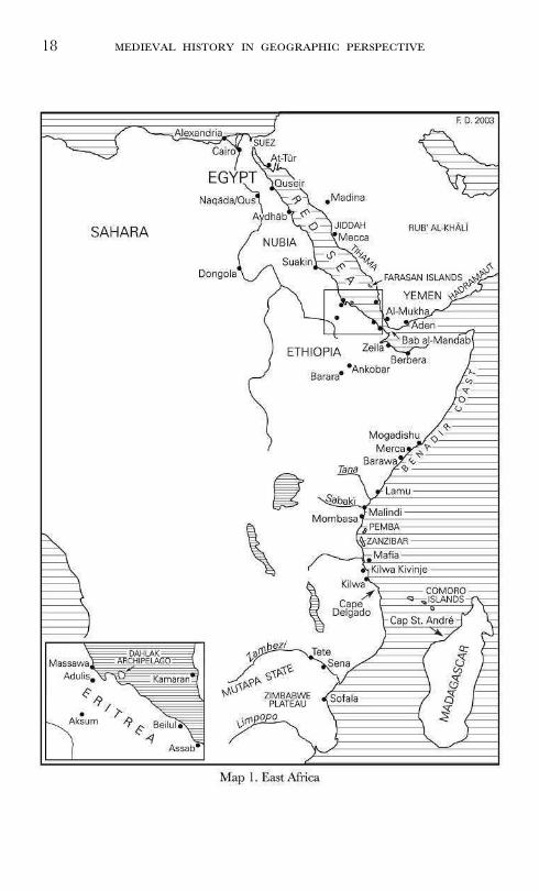
Africa has always been hard to penetrate from the Indian Ocean
due to the general lack of navigable rivers on the eastcoast. Swahili
(Ar. ‘coastal’) culture was sea-borne and did not spread far into the
interior, contributing to the perception that the coast was separated
from the interior.57 In the late sixteenth century the Portuguese still
56 Quoted in G. Coedès, Angkor (Singapore, 1986), p. 10.57 See D. Nurse and T. Spear, The Swahili: Reconstructing the History and Language
of an African Society, 800–1500 (Philadelphia, 1985); T. Spear, ‘Early Swahili HistoryReconsidered’, The International Journal of African Historical Studies, 33, 2 (2000), pp.257–290.
18
19
had very little idea about the geography of the African interior.58
Even so, connections existed. Agricultural colonization had proceeded
from the coast inwards. The growth of dense populations in the
moist and warm regions of the coast, in the Zambezi valley, the
lakes area, and in the perennially watered valleys around the great
mountains, had been made possible by the introduction of food plants
like banana, rice, coconut, the coco-yam, and the Asian yam by
Indonesia’s ‘people of the sea’ in the early centuries AD.59 There
was, in fact, a considerable difference between the southern and
northern Swahili coasts in terms of the access they provided to the
interior of Africa.60 The southern rivers, like the Zambezi and Limpopo
(among other, smaller ones), were navigable for hundreds of kilo-
metres inland, even though their entrances were hazardous, with the
main channels shifting as a result of obstruction by mud banks in
the upper reaches.61 Conditions on the great Zimbabwe plateau,
where much gold was produced, were healthier than in the north-
ern wilderness, allowing for the rise of large internal political for-
mations, like the Mutapa state, with which the ports interacted.62
Swahili Muslims sometimes did penetrate the south, and they made
converts far up the Zambezi valley and onto the Zimbabwe plateau.63
Gold, ivory and slaves were brought to the Zambezi river ports of
Sena and Tete (respectively 260 and 515 kilometres from the sea,
with a portage in between them at Lupata Gorge) by Shona speakers,
or to inland bazaars at Tete, and there exchanged for goods brought
58 Maps of the period still reflect the generally accepted idea of the time that allthe great rivers of Africa flowed from one central lake (Duarte Barbosa, I, p. 13,note 2).
59 R. K. Kent, ‘The Possibilities of Indonesian Colonies in Africa with SpecialReference to Madagascar’, Mouvements de Populations dans l’Océan Indien (Paris, 1979),pp. 93–105; R. A. Oliver and J. D. Fage, A Short History of Africa (New York, 1988),p. 80; R. Blench, ‘The Ethnographic Evidence for Long-Distance Contacts BetweenOceania and East Africa’, in: J. Reade (ed.), The Indian Ocean in Antiquity (London,1996), pp. 417–38; R. Oliver, ‘The Problem of Bantu Expansion’, in: J. D. Fageand R. A. Oliver (eds), Papers in African Prehistory (Cambridge, 1970), pp. 141–56.
60 M. N. Pearson, Port Cities and Intruders: the Swahili Coast, India and Portugal in theEarly Modern Era (Baltimore and London, 1998), esp. pp. 20, 68–69, 83–85, 93–94.
61 Duarte Barbosa, I, p. 14, note 1.62 Pearson, Port Cities and Intruders, pp. 69, 85. Barbosa writes that the Zambezi
[Cuama] ‘is a very great river . . . which leads into the inner country over againstthe kingdom of Benametapa more than a hundred and seventy leagues [about 850kilometres]’ (Duarte Barbosa, I, pp. 13–14).
63 Pearson, op. cit., p. 20.
20
by Muslim (and later Portuguese) traders.64 Vasco da Gama bestowed
upon the Zambezi delta the name ‘Rio dos bons Signaes’ because
of the presence here of men of civilized appearance, whereas Barbosa
refers to it as the site of ‘a very great town of Moors,’ which he
calls Angoya.65 Somewhat to the north there was another port city,
Braboa, located inland on a river, which was visited by Gujarati
ships and had extensive contacts with the interior and with the
Mutapa state.66 Sofala, the most southern city in ‘the land of the
Zanj,’ was a famous entrepôt for the gold and ivory trade, located
on a bay, and with a wide hinterland of mines and alluvial gold
washings, to which, however, it was connected by numerous overland
routes rather than its river ‘of no great size.’67 Generally, the key
elements in the human geography of the Swahili coast have not been
rivers, but rather the many bays, inlets, and sounds protected by
coral reef (behind which there were sheltered sandy beaches on which
even large ships could be beached at high tide), as well as islands
and projecting headlands.68 Coastal lowlands, and shallow arms of
river deltas which had previously silted up, were often drowned by
the sea, forming shallow straits between islands and between islands
and mainland.69 It is these features that facilitated coastal traffic and
gave rise to settlements and settlement clusters, and they intensified
the maritime orientation of the coast. Most importantly, the city-
state of Kilwa, with domains embracing settlements on the Tanzanian
coast up to Kilwa Kivinje and possibly the Rufiji, the island of Mafia,
and Sofala, owed its fifteenth-century prosperity to the control of the
gold exports from Sofala, not the export of products from its own
interior.70 The huge, mosquito-infected delta of the Rufiji, to the
north of Kilwa, like the swamps of the Lamu archipelago from the
Tana river up to Somalia, produced mangrove poles which were
64 Ibid., pp. 39, 54, 94.65 Duarte Barbosa, I, p. 13, note 2, and pp. 14–15.66 Pearson, Port Cities and Intruders, p. 40.67 Duarte Barbosa, I, pp. 5–8, note 3; Pearson, op. cit., p. 93.68 See A. H. J. Prins, Sailing from Lamu: A Study of Maritime Culture in East Africa
(Assen, 1965), pp. 17–18; Pearson, op. cit., pp. 41, 54.69 Thus, for instance, the Lamu delta was transformed into an archipelago when
the river channels dwindled to mere trickles (Prins, Sailing from Lamu, p. 18).70 J. Kirkman, ‘The history of the coast of East Africa up to 1700’, in:
N. Posnansky (ed.), Prelude to East African History (London, 1966), p. 117; Pearson,op. cit., p. 43.

21
much in demand in Arabia and the Persian Gulf.71 The more north-
ern Swahili towns, like Kilwa, characteristically spawned satellite set-
tlements along the coasts with their clusters of islands rather than
inland. Mombasa was a rising town on the coast, whose Shaykh was
reported to have been an offshoot of the royal house of Kilwa and
pursued an aggressive policy towards Malindi, essentially two groups
of towns on the Tana and Sabaki estuaries, somewhat further to the
north.72 Pate, the political capital of the Lamu archipelago, subjected
the entire coast from Mogadishu to Cape Delgado in the fourteenth
century.73
Land-locked Ethiopia has, throughout history, been crucially depen-
dent on the northern Mareb Mellash or Eritrea for access to the sea.74
Overseas interests and the tendency to look towards the contempo-
rary culture of the Hellenized eastern Mediterranean already shaped
some of the institutions of the Aksumite state (c. first–early seventh
century), turning it into a ‘Black Byzantium.’ Ethiopia became Constan-
tinople’s trading partner in the Indian Ocean, and was often con-
fused in the sources with India itself.75 Even nowadays access to the
sea is an issue over which Ethiopia and Eritrea go to war, and the
autobiography of the late emperor Haile Selassie contains a great
deal of material relating to this recurrent problem. Over the long
term, Ethiopia’s history is suspended between a tendency to retreat
into its mountain fastnesses, on the one hand, and a need for contact
with the outside world through access to the Eritrean sea, on the
other. In the first century AD, the Periplus Maris Erythraei presented
the first detailed account of the winds, shoals, and landing procedures
at Adulis, the fabled port, halfway down the Gulf of Zula in the
71 E. B. Martin and Ch. P. Martin, Cargoes of the East: The Ports, Trade and Cultureof the Arabian Seas and Western Indian Ocean (London, 1978), pp. 1, 6, 64, 70, 74–75,103, 108–9.
72 Kirkman, ‘History of the coast of East Africa’, pp. 116–7.73 Ibid., p. 116.74 F. A. Dombrowski, Ethiopia’s Access to the Sea (Leiden, 1985); R. Pankhurst, An
Introduction to the Economic History of Ethiopia from Early Times to 1800 (London, 1961);R. Pankhurst, ‘The history of Ethiopia’s relations with India prior to the nineteenthcentury’, in: IV Congresso Internazionale di Studi Ethiopici, 1 (1974), pp. 205–311; S. C. H.Munro-Hay, ‘The foreign trade of the Aksumite port of Adulis’, Azania, 17 (1982),pp. 107–25; S. C. H. Munro-Hay, ‘Aksumite Overseas Interests’, in: J. Reade (ed.),The Indian Ocean in Antiquity (London, 1996), pp. 403–16.
75 Munro-Hay, ‘Aksumite Overseas Interests’, p. 403; for the medieval identificationof Ethiopia and India, see Al-Hind, I, pp. 47 ff.
22
Red Sea, which was buried under sand brought down by the Haddas
river in the eighth century.76 In 522 AD, Kosmas Indikopleustes (the
‘Indian navigator’) described the caravan route from Adulis to the
capital of Aksum through Qohaito and Matara, cities which are now,
like Adulis itself, archaeological sites, with remains of storehouses
and palaces still visible. The 1,151 kilometres of Eritrean coast pro-
vided numerous safe anchorages which made an important nexus of
commerce for millennia for Egyptians, Sabaeans, Aksumites, Indians,
and Persians, who obtained here quantities of gum, gold, honey,
wax, and myrrh. By the fifteenth century, the ports of Zeila and
Berbera were the most important outlets of Ethiopian trade in the
Red Sea.77 Ankobar, with Aliu Amba, was at the end of a trade
route leading to Zeila, at the very edge of the Ethiopian plateau and
nearly 3,000 metres above sea level. About 46 kilometres to the east
was the great mercantile centre of Gendevelu, where the bales of
Indian spices were taken off the camels—which could not climb to
the heights. Mogadishu and Merca were closely allied with the Somali
tribe of the Ajuran, with whom they exploited the rich valley of the
Webbe Shebeli river and through it a profitable route which extended
into the highlands of Ethiopia. To the south of Mogadishu, the oli-
garchic state of Barawa depended on similar conditions. The benadir
coast declined, however, in the fifteenth century, due to the inter-
vention of the Amhara kings of Ethiopia who diverted much of the
trade to the alternative Red Sea route.78
Further to the north and east on this route along the Indian Ocean’s
shoreline, the quadrilateral landmass of the Jazìrat al-'Arab or ‘Island
of the Arabs’—by which term was meant the Arabian peninsula—
was mostly inhabited by scattered nomadic populations who used
camels and also horses.79 In some parts of the Rub' al-Khàlì or ‘Empty
Quarter’ no rain may fall for ten years on end. The southern part
of the peninsula, comprising the Yemen and parts of the Hadramaut,
was however deeply affected by the monsoon, and in this sense can
be said to belong to the world of the Indian Ocean. The Yemen,
and Hadramaut and Oman, have denser, agricultural populations
and contain numerous cities, as do a few other places in the Hijaz
76 L. Casson (ed. and transl.), The Periplus Maris Erythraei (Princeton, 1989).77 O. G. S. Crawford (ed.), Ethiopian Itineraries, circa 1400–1524 (Cambridge, 1958).78 Kirkman, ‘History of the coast of East Africa’, p. 116.79 Encyclopaedia of Islam, Volume I (Leiden, 1986), pp. 533–47, s.v. Djazìrat al-'Arab.

23
and the coastal plain of Tihama. But generally the coasts of the
Arabian peninsula have no major indentions anywhere, and no large
perennial rivers. The paucity of shelters for ships here is unparal-
leled in the Indian Ocean. The one good natural harbour along the
southern coast is Aden.
The only serious alternative to the Red Sea, therefore, was the
spice route which ran through the Persian Gulf and then followed
the great rivers of Mesopotamia, to split at Mosul, either in the
direction of Aleppo to reach the Mediterranean, or going northward
to Trebizond on the Black Sea. Important caravan routes at one
time also branched off towards Palmyra, one of the greatest com-
mercial sites of late antiquity, deriving most of its wealth from the
India trade. The rivers of Mesopotamia, too, despite their tendency
to change their beds, provided the homeland of some of the earli-
est, if not the earliest, literate civilizations in the world.80 Along the
Indian Ocean routes they maintained early links with the Indus
Valley civilization, which was also urban and literate, as well as sim-
ilarly founded on river irrigation, already more than fifteen hundred
kilometres inland. For medieval times, the information presented on
the Tigris and the Euphrates, and their plains, by such authors as
Marco Polo, Marignolli and Conti, or even Pires and Barbosa, is
remarkably deficient and still partly legendary, harking back to the
idea that the Euphrates was one of the rivers that sprang from the
earthly paradise.81 The early Italian and Iberian accounts produce
the impression that the Euphrates was better navigable with light
boats than the Tigris, which was narrower and had a swifter flow.82
In truth, both rivers had their navigational difficulties, due to shoals
and uneven seasonal waterflows. But most places in Mesopotamia
could be reached through a network of rivers and canals.83 Navigation
was easiest in the lower reaches of the two combined rivers, the area
known as the Shatt al-'Arab, even though the position of waterways,
lakes and marshes was in a constant flux here.84 Between Mesopotamia
80 In the region near Nippur, meanders of an old river course of about the samesize as the modern Euphrates can still be seen (M. Roaf, Cultural Atlas of AncientMesopotamia and the Ancient Near East (Oxford, 1990).
81 R. H. Major (ed.), India in the Fifteenth Century (Delhi, 1974), II, p. 5; Pires,Suma Oriental, I, p. 30; Duarte Barbosa, I, p. 88, and note 1.
82 Major, India, II, p. 5; Pires, Suma Oriental, I, p. 30; Duarte Barbosa, I, p. 88.83 Roaf, Cultural Atlas, p. 122.84 Cf. pp. 10–11.
24
25
and the Indus plains, the huge Persian plateau lacked great rivers.
Pires mentions but one river in this area, which appears to correspond
to the Rio dos Nautaques, the present Dasht river, and which played
an important role in the irrigation of Baluchi (‘Nodakhi’) villages on
the Makran coast, ‘because it waters the whole plain.’85 Throughout
much of the Persian plateau, agriculture was dependent on a system of
underground water channels, known as qanàts, and remained precarious,
while traffic depended on caravan routes rather than waterways.
The Indus itself is a great trans-Himalayan river, and, with 2,900
kilometres, one of the longest in the world, navigable in one way or
another up to the foothills.86 In the plains, the river and its tribu-
taries could, at least seasonally, reach such formidable dimensions
that it would seem the natural ‘boundary of Hind and Sind’ to an
invader from the west.87 It has an annual flow which is twice that
of the Nile and three times that of the Tigris and Euphrates com-
bined. Henry Pottinger, approaching the low and flat coast of Sind
from the southwest, writes of the
‘extraordinary, and to a person unacquainted with the cause, alarmingappearance which the sea presented, owing to the great body of water thatis disembogued by the River Indus, causing a very confused rippling, which,added to the discoloured sea, impresses an idea of a bank with a few inchesof water upon it; though, on sounding, we found there were several fathoms.’88
In some parts of lower Sind, near Thatta, as a fourteenth-century
historian observes, ‘from the great breadth of the stream, the land
on the opposite side was not discernible.’89 The fordable spots were
far to the north, near Attock, where the river was interspersed with
many islands that could be defended, and near Multan, 460 kilo-
metres down from Attock. Timur, however, commemorates that, in
85 Pires, Suma Oriental, I, p. 31.86 See O. H. K. Spate and A. T. A. Learmonth, India and Pakistan: A General and
Regional Geography (London, 1967), passim; D. Ross, The Land of the Five Rivers andSindh (London, 1883); H. T. Lambrick, Sind: A General Introduction (Hyderabad, 1964);J. Fairley, The Lion River: The Indus (New York, 1975); Deloche, La Circulation en Inde,II, pp. 15–18.
87 Al-Hind, I, p. 132; Raverty, Mihran, p. 10, note 3; Defrémery and Sanguinetti,Ibn Batoutah, III, p. 93; Pires, Suma Oriental, I, p. 38.
88 H. Pottinger, Travels in Beloochistan and Sinde; accompanied by a geographical and his-torical account of those countries, with a map (London, 1816), pp. 8–9.
89 TFSA, p. 235.
26
1398 AD, he succeeded in constructing boat-bridges across the Indus
and Chenab at other sites, also far to the north, where his Mongol
predecessors Chingiz Khan and Tarmashirin Khan, had failed or
were turned back; while elsewhere he and his army appear to have
crossed some of the smaller rivers simply by boats and by swimming.90
The Indus drainage basin includes the region of the Panjab or
‘five-river’ land, where it is joined by the Jhelum, Chenab, Ravi,
Sutlej, and Beas; but it also passes for hundreds of kilometres through
the rainless country of Sind without tributaries, steadily losing water
in a Nilotic landscape. The soils of both the upper and lower basins
of the Indus, corresponding to the Panjab and Sind respectively, con-
sist largely of rich alluvial deposits brought down by the rivers. Where
they are annually flooded they produce two, in some places three,
crops per year (grains, pulses, oilseeds, dye-plants, drugs, fruits, cotton,
sugar).91 In Sind, beyond the ‘spils’ of the river, the soil changes into
a barren drifting sand and becomes impregnated with saltpetre and
salt by evaporation.92 If, in Sind, sometimes for two or even three
years together no rain falls, at other times up to ninety cm may fall
within forty-eight hours, resulting in torrents of water sweeping away
bridges and embankments.93 Highly unstable in their courses, the
Indus or ‘Mihràn’ and all the Panjab rivers caused constant muta-
tions in the hydrographic map and the patterns of cultivation and
settlement, and, not surprisingly, a great part of the delta south of
Thatta has been formed relatively recently, after the mid-fourteenth
century.94 Richard Burton wrote about Sind:
90 Elliot and Dowson, History of India, III, pp. 408, 412, 420; ZN, II, pp. 41–42.91 Ross, Land of the Five Rivers and Sindh, p. 2.92 Ibid.93 Ibid.94 Raverty, Mihran, pp. 9, 171, 126; Wadia, Geology of India, pp. 389–90; M. B.
Pithawalla, ‘Identification and Description of some Old Sites in Sind’, The Journalof the Sind Historical Society, III, 4 (1938); M. A. Stein, An Archaeological Tour along theGhaggar-Hakra River (Meerut, 1989); A. Cunningham, The Ancient Geography of India(Calcutta, 1924); A. H. Dani, ‘Sindhu-Sauvìra’, in: H. Khuhro (ed.), Sindh throughthe Centuries (Karachi, 1981), pp. 35–42; S. Q. Fatimi, ‘The Twin Ports of Daybul’,in: ibid., pp. 97–105; M. R. Haig, The Indus Delta Country (London, 1894); J. M.Murdo, ‘An Account of the Country of Sindh’, Journal of the Royal Asiatic Society, 1(1834), pp. 223–57; C. F. Oldham, ‘Notes on the Lost River of the Indian Desert’,Calcutta Review, 59 (1874), pp. 1–27; R. D. Oldham, ‘On Probable Changes in theGeography of the Panjab and its Rivers: A Historical-Geographical Survey’, Journalof the Asiatic Society of Bengal, LV, 2 (1886), pp. 322–43; Deloche, La Circulation enInde, II, pp. 11–12; A. G. O’Brien, The Ancient Chronology of Thar: The Bhàttika, Laukikaand Sindh Eras (Delhi, 1996), pp. 39, 43, 58.

27
‘The province is a sloping surface of silt and sand, through which the Induscuts its varying way with a facility that passes description. The erection ofeven a few feet of brickwork built up in the bed of the Indus as it stillflows, might divert the stream into another channel, cause the decline anddownfall of a metropolis and twenty towns, convert a garden into a siltdesert, and transfer plenty a population to what a month before was a glar-ing waste. As regards the ancient course of the Lower Indus infinite hasbeen the speculation, the theorization, the dissertation, the argument, andthe contradiction upon this much vexed subject.’95
In Upper and Middle Sind, wrote Major Raverty, in a book espe-
cially devoted to the subject, ‘there is scarcely any part of this vast
alluvial tract, over which in the course of ages, the Ab-i-Sind or
Indus has not flowed at some time or other.’96 The most pronounced
environmental phenomenon throughout its recorded history has been
the westering of the Indus and all of the Panjab tributaries.97 The
shifting of the Indus system and the drying up of the Hakra or
Wahinda river (probably the Saraswati of ancient times) already had
far-reaching effects on the development of the cities of Mohenjodaro
and Harappa.98 The effects of later shifts and floodings on such cities
as Thatta, Multan, Lahore, or Muhammad Tor, while varied, were
often no less disastrous.99 The Sutlej, whose Sanskrit name ‘Shatadru’
means ‘hundred-mouthed,’ is the most erratic of the Panjab rivers
and is notorious for leaving the country behind as it shifts its bed,
overlaid with sand.100 The Beas, too, especially below Lahore, has
always been remarkable for its erratic course, which is so irregular
that it has been impossible to tell where its channel would be from
one year to another.101 In the Panjab, lines of mounds marking aban-
doned villages along former riverbeds are so common that they have
a special name, thehs.102 Inland navigation has adjusted and was never
interrupted. The Indus, after leaving the mountains, allows only raft
95 Quoted in Raverty, Mihran, pp. 339–341.96 Raverty, Mihran, p. 163.97 Ibid.; Oldham, ‘On Probable Changes.’98 Wadia, Geology of India, p. 390; Misra, ‘Human Adaptations to the Changing
Landscape of the Indian Arid Zone.’99 Cf. pp. 15–16.
100 Raverty, Mihran, p. 357.101 Ibid., p. 210.102 Arden Wood, ‘Rivers and man’, p. 3.
28
navigation up to Attock.103 In its middle and lower courses, in spite
of the irregularity and variation in its bedding, there was through-
out the year enough deep water to allow the movement of ships of
all sorts.104 Here river traffic was intense and supplanted that of car-
avan routes, or complemented them, as in so many amphibious mil-
itary campaigns.105 The Panjab rivers, too, were large, and capable
of carrying big ships up to the foothills of the Himalayas during
floods. Below the foothills, a profusion of small boats accommodated
itself to low levels of water during the rest of the year.106 The upshot
is that through this vast system of shifting waterways and feeder
streams, the whole of north-western India was linked to the western
Indian Ocean. We have evidence showing that Firuz Shah Tughluq,
in the fourteenth century, was drafting plans for the excavation of
navigable canals between the Sutlej and the Yamuna, a tributary of
the Ganges; had these been executed, there would have been unin-
terrupted inland navigation from the frontiers of China to those of
Persia.107
The Panjab remained connected to the Doab or ‘two-river’ land
of the Ganges and the Yamuna by land routes, but the land routes
are short by comparison with the river routes. Physiographically, the
Gangetic plain resembles the Lombardy plain and Mesopotamia, but
it dwarfs them.108 On a rough estimate, the Ganges and its tribu-
taries nowadays affect the lives of more than five hundred million
people. Between its source in the Himalayas and the Bay of Bengal
it has a length of more than 2,400 kilometres and flows through one
of the most fertile areas of the world, draining about a quarter of
the South Asian subcontinent. The Gangetic plain has been the
heartland of successive Indian civilizations, from the period of the
early Buddhist kingdoms in the centuries BC to that of the imper-
ial Mughals in the early modern era. There is an ancient bas-relief
of the confluence of the Ganges and the Yamuna at Prayàga (modern
Allahabad), dating back to about 400 AD, which appears to be a
103 Deloche, La Circulation en Inde, II, pp. 14–15, 17.104 Ibid., p. 18.105 See, for instance, TFSA, pp. 198–9.106 Deloche, La Circulation en Inde, II, p. 18.107 Cf. Deloche, La Circulation en Inde, II, p. 6, note 2; Raverty, Mihran, pp. 121–3.108 E. H. G. Dobby, Monsoon Asia (London, 1967), p. 230.
29
symbolic representation of Madhyadesha, the Middle Country, and
shows clearly the importance of these rivers in the political geography
of what was then the core region of the Gupta empire.109 Even
though Prayàga, the capital of this empire, was far from the sea, an
extensive body of water below the confluence of the two rivers is
shown as if it were an ocean (samudra), rather than a continuing
stream, and in the words of one analyst, ‘the merging [of ] streams
into a single mighty river, or great rivers into an enormous ocean’
signified the emperor’s drawing together under a unified central
authority the disparate states of India.’110
The history of settlement and agricultural expansion in these
immense river plains has yet to be written. Textual evidence on this
subject is exceedingly vague. Barbosa, for instance, in the early six-
teenth century, wrote that the Ganges river was very great and fair
on both banks and well peopled with fair and wealthy Heathen
cities.’111 And Nicolo Conti, in the fifteenth century perhaps the first
European to sail upriver, observed that
‘on both banks of the stream there are most charming villas and planta-tions and gardens, wherein grow vast varieties of fruits, and above all thosecalled Musa [banana], which are more sweet than honey, resembling figs,and also the nuts which we call nuts of India.’112
In the fourteenth and fifteenth centuries the Gangetic plains must
still have had large areas of forest and jungle, but padi rice was
already widely cultivated in the delta and lowlands of the Ganges,
whereas outside Bengal sorghum, millets and other tropical cereals
were the staple crops.113
River navigation in the northern Indian plains and the elaborate
organization of their waterways have been the subject of detailed
legislation from Mauryan to Mughal times.114 The tributaries which
join the Ganges from the right, from the forested heights of the
peninsula, such as the Kamanàshà, the Phalgu, and the Son, offered
little scope for navigation during any time of the year.115 But the
109 Harley and Woodward, History of Cartography, II–1, p. 312, figure 15.9.110 F. M. Asher, quoted ibid.111 Duarte Barbosa, II, p. 134.112 Major, India, II, p. 10.113 Cf. Dobby, Monsoon Asia, pp. 62, 237.114 Deloche, La Circulation en Inde, II, p. 12.115 Deloche, La Circulation en Inde, II, p. 21.

30
Yamuna was navigable from Delhi onwards by flat boats, except
only in the middle of the dry season, from January to March.116
Most importantly, the Ganges’ ability to establish links between the
sea and the interior of the subcontinent was enhanced by an entire
series of major tributaries on its left, while in its delta it could accom-
modate a great amount of traffic through a multiplicity of arms.117
The rivers of the left bank, while hardly navigable in their high
basins, had sufficient water in the plains throughout the year to be
navigable for a diverse range of boats.118 Thus the Ràmgangà, Gomatì,
Sàì, Ghàgharà or Sarù, Ràptì, the Small and Great Gandak, the
Bàghmatì, the Lakhnandàì, and other rivers on the left side of the
Ganges constituted a thicket of waterways which were of prime
importance for navigation.119 The Ganges itself, upstream of what is
now Allahabad, could be embarked from Hardwar during high waters
by small boats, and to the south of Garhmukteshvar (at the level of
Delhi) by larger vessels according to the season.120 Due, in part, to
its many tributaries, from Allahabad onwards, the Ganges became
the most important of all river routes, with a very gradual descent
and regular flow. Like the lower Indus, the river was so wide that,
being in the middle of it, in Conti’s words, ‘you cannot see land on
either side.’121 From Patna to Bengal, the river was virtually the only
means to travel, since here the terrain on both sides of the river dis-
couraged any other traffic.122 To the south of this area, the plain is
bordered by the mountainous belt of the Chota Nagpur, a heavily
wooded massif; to the north, by a labyrinth of riverbeds, alluvial
folds and marshlands. Nowhere else in the Ganges basin are the
jungles of the central hills so close to the Himalayan Terai. Beyond
this corridor, the Brahmaputra, with the Tista, is the most impor-
tant tributary to the Ganges, with its origins deep in southern and
western Tibet. The Brahmaputra constitutes yet another vast allu-
116 Ibid., p. 19.117 Ibid., p. 18.118 Ibid., pp. 19, 21–23.119 For references to some of these rivers in contemporary sources, see TFS, pp.
14, 228, 269, 301; TFSA, p. 111; Defrémery and Sanguinetti, Ibn Batoutah, III, p. 355; Elliot and Dowson, History of India, III, p. 433.
120 Deloche, La Circulation en Inde, II, p. 19.121 Major, India, II, p. 10.122 J. Deloche, Transport and Communications in India prior to Steam Locomotion, Volume I:
Land Transport (New Delhi, 1993), p. 39.
31
vial plain, submerged during part of the year by swollen rivers, which
leave behind abandoned rills, marshes and silt tracks in the dry sea-
son.123 Problems related to communication, drainage, and cultivation
of the land have been addressed here by raising extensive embank-
ments in the plains exposed to inundation, which were both roads
and dikes.124 The Brahmaputra was navigable up to Guwahati for
large barges, while the small boats of the Assamese could go much
farther. But in the valley of Assam river navigation was much less
common than in Bengal, and here again the riverbanks were in
many places covered with a thick jungle.
The innumerable river shifts have made it difficult to recover the
sites of many cities and towns throughout the Indo-Gangetic plains,
particularly in the softer and newer alluvial soils.125 Tributaries of
the Ganges often displaced themselves during floods, or filled up
ancient dry beddings.126 Up to c. 1595 AD, for instance, the Sarju
river still met the Ghaghara at Ayudhya, having already absorbed
the water of the Kauralia.127 The cyclical dessication of Haryana
seems to have depended on the ability of the Yamuna to feed the
Chitang. By the fourteenth century the whole tract was waterless,
and did not revive until Firuz Shah Tughluq constructed a canal
from the Yamuna to Hansi and Hisar.128 The region north of the
Delhi-Multan line was once better watered than it is now; Muslim
chronicles describe a much more productive region here, and a direct
route between Delhi and Multan which passed through many large
towns, while a ‘rainy season’ is mentioned in places where there is
now an annual rainfall of between 12 and 25 cm.129
Hydrological change is even more in evidence in the Ganges delta,
the area now constituting Bangla Desh and a wedge of eastern India,
where the Ganges is joined by the Brahmaputra. The vast cascade
of water coming down from these two rivers never had a perma-
nent path to the ocean. Rather, its numerous shifting channels have
123 Ibid., p. 110.124 Ibid.125 Cf. Arden Wood, ‘Rivers and man’, pp. 1–5.126 Deloche, La Circulation en Inde, II, p. 12; I. Habib, ‘The Geographical Background’,
in: T. Raychaudhuri and I. Habib (eds), The Cambridge Economic History of India,Volume I, c. 1200–c. 1750 (Delhi, 1984), p. 4.
127 Habib, ‘Geographical Background’, p. 4.128 Ibid.; TF, p. 146.129 Arden Wood, ‘Rivers and man’, p. 12.
32
incessantly created and destroyed islands on which, over the centuries,
millions of Bengalis have attempted to live.130 Navigation was of para-
mount significance in the Gangetic plains generally, but in the delta,
again, there often were virtually no other routes of communication,
and as a result, according to a fourteenth-century Arab account,
‘there are two lakh small and large boats always moving in the
Ganges in Bengal.’131 While the delta, with its shifting islands became
an exceptionally fertile rural area in the medieval period, it contin-
ued to be plagued by recurrent catastrophes, including river floods
which could inundate up to half of the country, and sometimes inva-
sions by the sea. Even in very recent times, the Brahmaputra is
known to have claimed forever 16 square kilometres of land in a
single night. Local tradition provides a mythical origin to the Ganges
delta which evokes the violence of the changes that has accompa-
nied, in the course of time, the encounter of river and sea.132 Between
the twelfth and the sixteenth century the entire Bengal river system
underwent profound modifications, including a gradual shift east-
wards which brought about the intensification of wet-rice cultivation
and the expansion of a society of Muslim peasants in its wake.133
More land is now under padi in the Gangetic plain than in the
whole of China. Older cities of western Bengal were eclipsed by new
cities in the east. The coast itself has again advanced considerably
since the sixteenth century, and the archaeological remains of all the
ports mentioned in early Portuguese accounts are today much far-
ther from the open sea than they were then. Due to the silting and
drying up of river channels, the ports of Sonargaon and Satgaon
lost their importance in the early sixteenth century.134 The great city
130 W. A. Inglis, ‘Some of the problems set us by the rivers of Bengal’, Journaland Proceedings of the Asiatic Society of Bengal, New series, V (1909), pp. 393–405; N. D.Bhattacharya, ‘Changing Courses of the Padma and Human Settlements’, NationalGeographic Journal of India, 24, nos 1 & 2 (1978), pp. 62–76; D. Schwartz, Delta: ThePerils, Profits and Politics of Water in South and Southeast Asia (London, 1997).
131 I. H. Siddiqi and Q. M. Ahmad (transl.), A Fourteenth Century Arab Account ofIndia under Sultan Muhammad bin Tughluq (Being an English Translation of the Chapters onIndia from Shihab al-Din al-'Umari’s Masalik al-absar fi-mamalik al-amsar (Aligarh, 1971),p. 31.
132 G. Bouchon and L. F. Thomaz, Voyage dans les Deltas du Gange et de l’Irraouaddy.Relation Portugaise Anonyme (1521) (Paris, 1988), p. 170.
133 R. M. Eaton, The Rise of Islam and the Bengal Frontier, 1204–1760 (Berkeley,Los Angeles and London, 1993).
134 Duarte Barbosa, II, p. 140, note.
33
of Gaur was the capital of Bengal prior to the sixteenth century,
commanding the opening to the delta at the confluence of the Ganges
and the Mahananda, and regulating access to Sonargaon and Chitta-
gong, but was abandoned by 1575.135 The flight of the river east-
wards left many lost rivers in the moribund delta while at the same
time vast new areas were made inhabitable. At the end of the eight-
eenth century, when the first systematic study of the lower basin of
the Ganges was undertaken by James Rennell, there were no less
than eight mouths which at one time or another had been the prin-
cipal channel of the Ganges.136
The enormous triangle of land which the Indian peninsula projects
into the ocean has given it a privileged position in maritime life. But
rivers of the peninsula, while important in many places for agriculture
and generally as sources of water, are rarely navigable, except in their
estuaries and coastal plains, and this factor severely limited inland
river traffic.137 The rivers Chambal, Narmada and Tapti provided
Malwa with an extensive agricultural basis. And in the Deccan and
the South such rivers as the Godavari, Krishna and Kaveri have
also been exploited by large-scale agricultural communities from early
times; in their coastal plains on the eastcoast, with seasonally heavy
rain, wet padi has been extensively cultivated. More characteristically,
however, the geomorphological character of the Deccan plateau, with
its forest-covered uplands and agriculturally marginal semi-arid jungle
zones between river basins, has ensured that settlement was more var-
ied and isolated here than in the northern plains.138 Consistent with
the ecology of the region, many communities in peninsular India
retained a balance of sedentary-agricultural and pastoral activities.139
135 Bouchon and Thomaz, Voyage, pp. 141–2.136 Ibid., pp. 169–72.137 A minor exception is the Mahanadi river, in Orissa, which was an artery of
dense traffic from the plains of Chattìsgarh to the ports of the delta, along whichwent cereals from the interior, and salt and manufactures from the coast. Thepeninsular rivers typically had not only poor navigability but could also be difficultto cross, since their banks were steep in many places (KF, p. 32; Deloche, LaCirculation en Inde, II, pp. 15, 32–40; Duarte Barbosa, I, pp. 150–1, 158–9, 164–7,170–1, 181–2 & II, pp. 133–5; Pires, Suma Oriental, I, pp. 48–49, 54–55).
138 B. Stein, ‘South India: Some General Considerations of the Region and itsEarly History’, in: T. Raychaudhuri and I. Habib (eds), The Cambridge History ofIndia, Volume I, c. 1200–c. 1750 (Delhi, 1984), p. 17.
139 B. Stein, A History of India (Oxford, 1998), pp. 24, 156.
34
In some poorly watered parts of the Deccan and the peninsular
South, as well as in the northern zone of Sri Lanka, rulers made
investments in agrarian development by the construction of tanks,
or reservoirs for capturing rainwater and other drainage, by means
of bunds and sluice works.140 On the Malabar coast, except in a few
southern portions of the coastal plain where there is canal and tank
irrigation, moisture for cultivation in the areas behind the coastal
backwaters has been almost exclusively dependent on the double
monsoon (producing two crops per year), rather than river irrigation.
Generally, in the Deccan and the peninsula, the possibilities for
silt deposition and the formation of alluvial plains are confined to
the lowlands of the major eastward-flowing rivers.141 These plains
are much smaller than in the north. But their mutability is almost
as great, and we observe in these regions a pattern of environmen-
tal change that is similar to the north. The coastline of the Godavari
delta has clearly changed direction over the centuries.142 In the delta
of the Krishna, the mouths of the river are obstructed by deposits
of salt and mud. In the Kaveri delta, river sedimentation and migra-
tion can be traced, through many abandoned sites, to very early
times.143 In the Karnataka, the bed of the Kaveri has gradually been
raised by sediment of gravel and sand, and this rise had to be met
by a corresponding elevation of the artificial embankment. Consequently
the entire river, throughout its course in the Karnataka, was lifted
as much as a meter above the surrounding countryside—a situation
with great potential for hydraulic warfare. Further north, in Gujarat,
the mudflats of the Mahi river, and silting, interfered, over hundreds
of years, with navigation in the Gulf of Cambay, contributing to the
decline of the port.144 Chaul, once the most important port in the
Konkan, was choked with sandbanks in the estuary of the Kondulika
river by the end of the fifteenth century.145 In Malabar, the decline
of Cranganore was due to the water of the lagoon finding its way
140 For Sri Lanka, cf. Al-Hind, II, pp. 359–60; for the Deccan, see Chapter III,p. 88.
141 Mate, Water Management, p. 8.142 Harley and Woodward, History of Cartography, II–1, p. 261.143 Mate, Water Management, pp. 117–8.144 Cf. Chaudhuri, Trade and Civilisation, p. 117; S. Arasaratnam and A. Ray,
Masulipatnam and Cambay: a history of two port-towns, 1500–1800 (New Delhi, 1994),pp. 119 ff.
145 J. Gerson Da Cunha, History of Chaul and Bassein (Bombay, 1876); Duarte Barbosa,I, pp. 158–9, and note 1.

35
into the sea near Cochin and the consequent drying up of the Cranga-
nore channel from the beginning of the fourteenth century, while
the progression of the offshore bar closed the port of Eli.146 Mantai,
in northeastern Sri Lanka, one of the few identifiable ports of the
Anuradhapura period, became unusable for navigation due to sedi-
mentation.147 Old Kayal, once a famous port near the extreme south-
ern part of India, opposite Sri Lanka, and the port of Korkai were
both in the delta of the Tamraparni river, and had to be abandoned
due to the accumulation of silt and the advance of the shore at the
mouth of the river.148
Because of influences of land and sea, as well as the availability
of river estuaries, the situation in the peninsula favored an excep-
tionally large coastal trade. Such coastal trade, in terms of total ton-
nage and the number of boats involved, has probably always been
more important than long-distance navigation.149 In the past the small
vessels used in this trade needed only the most rudimentary shelter,
and they could be pulled onto the beach. To accommodate such
traffic, there was an almost infinite number of minuscule anchoring
points and maritime establishments, as well as small harbours, on
India’s peninsular coasts, either on the seaboard itself or in small
bays and inlets, at the mouths of rivers and in lagunas.150 The great
historical ports, like Calicut in Malabar, Cambay and Surat in Gujarat,
or Masulipatnam on the Coromandel, receiving the traffic from dis-
tant parts of the Indian Ocean, were invariably at the mouths of
rivers. The same was true for a host of mid-size ports. But since
these rivers were not navigable for any long distance inland, trade
in these ports was dependent on caravan traffic through the arid
and semi-arid parts of the subcontinent, especially on India’s west-
coast, in Gujarat and the Deccan.
146 Duarte Barbosa, II, pp. 88–89, note 3; G. Bouchon and D. Lombard, ‘TheIndian Ocean in the Fifteenth Century’, in: A. Das Gupta and M. N. Pearson (eds),India and the Indian Ocean, 1500–1800 (Delhi, 1987), p. 58.
147 B. E. S. J. Bastiampillai, ‘Maritime relations of Sri Lanka (Ceylon) up to thearrival of the Westerners’, in: K. S. Mathew (ed.), Mariners, Merchants and Oceans:Studies in Maritime History (New Delhi, 1995), pp. 80–81.
148 Pires, Suma Oriental, I, p. 81, note 2 & II, p. 271, note 1; Duarte Barbosa, II,pp. 122–3; Yule, Marco Polo, II, pp. 371–4.
149 Deloche, La Circulation en Inde, II, pp. 40–42.150 Deloche, La Circulation en Inde, II, p. 42; Arasaratnam and Ray, Masulipatnam
and Cambay, pp. 3, 24, 119 ff.; Pires, Suma Oriental, I, pp. 48–49, 54–55, 60–63;Duarte Barbosa, I, pp. 79–95, 136, 139, 142, 150–1, 156–9, 164–7, 170–1, 181–2,185, 187, 193, 195–6 & II, pp. 120–8; Stein, ‘South India’, p. 18.

36

37
The eastern parts of the Indian Ocean, from the Bay of Bengal to
the Java Sea and the South China Sea, can again be characterized
as an environment of rivers, alluvial plains, deltas, and sea-arms,
with a decisive influence on the patterns of settlement and the for-
mation of states generally. However, the plains of the Irrawaddy,
Chao Phraya, and the Mekong, as well as the entire Malay-Indonesian
archipelago, until recently were a region of remarkably low popula-
tion density, not exceeding ten million in 1800, even if we include
their hilly terrain and highlands.151 Malaya had about a quarter of
a million people; Java perhaps four million, and Burma (Myanmar)
less than two million.152 In the medieval period these figures must
have been considerably lower still, and would have represented no
more than a fraction—perhaps between five and twenty percent of
the South Asian population figures. Typically, all land masses from
which the rivers have emptied out on the Sunda Platform are fringed
with huge, flat marshlands, and every delta in this area shows evi-
dence of frequent migrations of rivers and river bed sedimentation
in the lower reaches, with shifting patterns of irrigation and low pop-
ulation figures until as late as the turn of the nineteenth century.
The Tonle Sap alluvial plain and lake in Cambodia are the result
of Mekong sedimentation in more distant times. Here a shallow arm
of the sea was turned into a plain and swamp as the lower Mekong
built up mudflats; and, curiously, the Tonle Sap lake still contains
fish that are adaptations of marine species.153 The Malayan penin-
sula is flanked with broad alluvial plains created by small rivers whose
deltas continued to be reshaped by the sea into compact belts of
swamps.154 Malacca, an estuarial port, was rendered useless by silt-
ing.155 So was Baruas, once perhaps the second most important port
of the peninsula.156 The distributaries of the Chao Phraya, in Thailand,
have changed their courses considerably in medieval times, and silt-
ing is a common problem here too, in the channels and the fields,
and particularly in the river mouths.157 The main channels once ran
further to the west. Streams from the western mountains however
151 Dobby, Southeast Asia, p. 385.152 Ibid.153 Ibid., pp. 50, 55, 301, 303.154 Dobby, Monsoon Asia, p. 200.155 Ibid., p. 204.156 Pires, Suma Oriental, I, p. 107, note 1.157 Dobby, Monsoon Asia, p. 187.
38
brought down substantial silt, raising the alluvial surface in the west
and making it less reliable for padi rice cultivation by reducing the
effect of sheet-floods, while the construction of tanks proved inadequate.
The result is that there are now large areas of bushland in the west
which serve as coarse grazing land for cattle, and historic ruins are
to be found along the former channels which cover the plain. In
the fourteenth and fifteenth centuries the western distributaries were
still the centres of farming activity; the Chao Phraya then reached
the sea by the now silted-up Tachin river, and intensive rice culti-
vation was practiced in the Suphanburi area.
Settlement and the formation of states on the mainland followed
the major north-south river corridors which facilitated agricultural
expansion and gave access to the Indian Ocean.158 States were con-
solidated in the basins of the Irrawaddy in Burma, the Chao Phraya
in Thailand, the Tonle Sap in Cambodia, the Mekong in Laos and
southern Vietnam, and the Song-koi in north and central Vietnam.
In the western and central mainland, the invaders who developed
these states came from the barren and inhospitable north, from areas
which suffered from unreliable rainfall, not from the sea or the as
yet undeveloped southern deltas. Thus the Burmans, who entered
the central Irrawaddy plain by the ninth century, brought along agri-
cultural conceptions of the dry rather than wet environment.159 Under
the Pagan rulers rice agriculture came to be irrigated through this
river system.160 By the fourteenth century the first state embracing
the Irrawaddy basin and the adjacent Shan plateau emerged, and
by the fifteenth century we witness the rise to dominance of the
Mon coastal ports, in Pegu, Bassein, Syriam, and Martaban, in the
river delta.161 The Irrawaddy drains about two-thirds of Burma’s sur-
face, and, with a navigable length of 1,400 kilometres (from Bhamo
to the sea), it is by far the most important Burmese river, although
there are several subsidiary river systems, notably those of the
Chindwin, the Sittang and the Salween, with varying degrees of use-
158 V. Lieberman, ‘Local Integration and Eurasian Analogies: Structuring SoutheastAsian History, c. 1350–c. 1830’, Modern Asian Studies, 27, 3 (1993), p. 482.
159 Dobby, Southeast Asia, pp. 167–8; Al-Hind, I, pp. 346–51.160 Al-Hind, II, pp. 374–5.161 A. Reid, Southeast Asia in the Age of Commerce, 1450–1680, Volume II: Expansion
and Crisis (London and New Haven, 1993), pp. 54–55, 62–63; Major, India, II,p. 15; Pires, Suma Oriental, I, pp. 94, 97–98; Duarte Barbosa, II, pp. 149–50, 152–3,note 1, 154, 156–157, note 2.
39
fulness.162 The rivers of Arakan are small and unusable for navigation,
except the Kaladan which can be used almost to Paletwa; in so far
as they are important it is because it is only in their estuaries and
lower zones of sedimentation that settlement of some density can
occur. The longitudinal valleys of the folded Arakan Yoma range
have remained largely unused except by scattered hill-tribes living
on the healthier slopes and hill-tops where they practiced shifting
cultivation.163 Like those of Arakan, the rivers of the Tenasserim are
short tropical streams with heavy silt loads, leading to rapid coastal
sedimentation.164 In the past some of these were used by merchants
for harbourage and a trans-isthmus route but now almost none of
them are still usable for sailing craft.
Similar to Burma, Thailand (Siam) has a south-facing trough form
with a focus on a single major river system, the Chao Phraya, where
rice cultivation came to dominate everything else, even though it
never occupied more than a quarter of the surface.165 The thickly
forested western mountain range which, with its long valleys, extends
into Burma and continues southward into the Kra Isthmus, as well
as the northern mountains which are an extension of the Shan range,
the Korat plateau in the east, and the Cardamom mountains in the
southeast, have been irregularly inhabited, most commonly by shift-
ing cultivators.166 In a way similar to the earlier migration of the
Burmans, the ancestors of the Thai began to disperse in the centuries
after 1000 AD, moving from their barren northern homelands into
areas as far west as Assam and as far south as modern Thailand.167
The great Thai achievement was the settlement of the Chao Phraya
valley and delta. Superseding Angkor in Cambodia, two major Thai
states established themselves in the thirteenth and fourteenth centuries:
Sukhothai and Chiangmai. With seaborne commerce with China
and Indonesia expanding, by the fifteenth century power shifted to
162 Dobby, Southeast Asia, pp. 154–8, 160–1, 193; Reid, Age of Commerce, II, pp.54, 60–61; Al-Hind, I, p. 348; Major, India, II, pp. 10, 15. The Salween, with itsnarrow, ribbon-like drainage basin, is probably the least useful major river in Burma.
163 Dobby, Southeast Asia, pp. 154, 193; Major, India, II, p. 10; Duarte Barbosa, II,p. 150.
164 Dobby, Southeast Asia, p. 155.165 Dobby, Southeast Asia, pp. 259, 263–4, 270; Dobby, Monsoon Asia, pp. 178,
185–6.166 Dobby, Southeast Asia, pp. 259, 261–3.167 Cf. Al-Hind, II, pp. 377–9.
40
trade-based cities.168 Hence the new capital of Ayudhya emerged at
exactly the point in the river at which ocean-going ships give way
to river traffic.169 The Chao Phraya system is navigable up to Phitsa-
nulok, making northern Thailand a place difficult to reach and
effectively an extension of the Shan hill states (whose currencies they
shared until recently).170 To the south, Thailand in the fifteenth
century exercised supremacy over the Kra Isthmus and large parts
of the Malay peninsula, with their seaports in the river estuaries
(kuala) on both sides (Tenasserim, Junkceylon, Terram, Kedah, Patani,
Kelanten, Baruas, Johore, Perak, Malacca, and numerous others).171
Here there were also overland connections between east and west,
such as the Takuapa-Bandon route which was used by small river
boats, with a short portage section in the forest.172 By the fifteenth
century the deltaic plains on the coasts to the northeast and north-
west, with their ports, were becoming the nuclei of Muslim-Malay
states, with self-contained padi farming and fishing economies, but
also producing pepper, and minerals such as tin and gold.
In Cambodia, from the fifteenth century onwards, the capital of
Phnom Penh was, like Ayudhya, located at a point which could still
be reached by ocean-going ships, at the junction of the Tonle Sap
and Mekong. The Mekong, from its source on the Tibetan plateau
to the South China Sea, passes, under a variety of names, through
China, Laos, Cambodia, and Vietnam, and, with 4,500 kilometres
is one of the world’s largest rivers.173 Its water supply is essential to
agriculture in southern Laos, Cambodia and the ever-expanding
deltaic region of southern Vietnam. When the monsoon adds its rain
to the melting snow that feeds the river in Tibet, the Mekong floods
the sun-parched padi fields, irrigating the lands along its course and
leaving a rich silt on the floodplains.174 The amount of water in the
river during the flood season is so enormous that it starts to back
up along its tributary the Tonle Sap, at Phnom Penh, thus reversing
168 Cf. Pires, Suma Oriental, I, pp. 103–6; Duarte Barbosa, II, pp. 162–3.169 Reid, Age of Commerce, II, p. 54.170 Ibid.; Dobby, Southeast Asia, pp. 284–5.171 Duarte Barbosa, II, pp. 162–3; Pires, Suma Oriental, I, pp. 103–7 & II, pp.
232–44; Reid, Age of Commerce, II, pp. 207–8.172 Dobby, Southeast Asia, p. 261; Dobby, Monsoon Asia, p. 197.173 M. Osborne, River Road to China: The Mekong River Expedition 1866–1873 (New
York, 1975), p. 15; Dobby, Monsoon Asia, pp. 177–8.174 Osborne, River Road to China, p. 16.

41
the flow of the latter river into a northern direction.175 The water
flowing backwards up the Tonle Sap replenishes the Great Lake in
central Cambodia and starts a breeding cycle for fish, so that after
the rains have stopped a mass of fish is brought down when the
river starts to flow south again.176
The most ancient civilization with its centre in the Mekong delta
and the basin of the Tonle Sap or ‘Great Lake’ had been that of
Funan.177 In its deltaic port of Oc Eo a significant number of Roman
and western Asian objects have been found.178 When Funan was
bypassed by the Chinese trade, the rice lands of the upper Mekong
delta were beginning to be developed. This was centuries before any
great drainage efforts were made, and the lower Mekong area was
then still a patchwork of lakes and streams, a scene of faster silt
deposition and more dangerous inundation than early technology
could deal with.179 As a contemporary Chinese traveler put it, one
could ‘sail through Cambodia.’180 During the seventh century, in the
still primeval forests of the north, the Mekong provided a passage
for the Khmers who were migrating southwards from an area which
is now in southern Laos.181 One of the earliest Khmer inscriptions
stood in the riverbed, affirming piety to the Hindu god Sambhu
(Shiva), the name of which is reflected in the name of a village
nearby, below a series of Mekong rapids.182 From here, the Khmer
went on to found the Cambodian kingdom of Angkor, where they
further developed rice agriculture, especially in the Tonle Sap area,
at the same time initiating commercial communication along the
river systems of the Mekong and the Chao Phraya.183 The Mekong
and its tributaries thus became vital arteries for travel and trade, as
well as for military campaigns, from early times. The Chams sailed
their warships up the Mekong and the Tonle Sap to attack Angkor
from the Great Lake. The Chinese envoy Chou Ta-kuan followed
the same route in 1296. Chinese connections are likely to have
175 Ibid.176 Ibid.177 Al-Hind, I, pp. 342–4.178 Reid, Age of Commerce, II, p. 65; L. Malleret, L’archéologie du delta du Mekong,
4 vols (Paris, 1959–63).179 Dobby, Southeast Asia, p. 303.180 Osborne, River Road to China, p. 17.181 Ibid.182 Ibid.183 Al-Hind, I, pp. 344–6.
42
encouraged the emergence of the new capital at Phnom Penh as
well.184 After Angkor had begun to decline, a new Tai principality
emerged in the fourteenth century at Luang Prabang, on the upper
Mekong, in Laos. By the sixteenth century it was able to move its
capital to the fertile plains and the long navigable stretch of the
middle Mekong, to Vientiane.185 When, in the mid-sixteenth century,
a Portuguese missionary, Father Da Cruz, traveled on the Mekong,
he discovered that merchants from distant Laos descended the river
to trade in the capital of Lovek, on the Tonle Sap.186 But, like other
early European visitors, he was unable to obtain any real knowledge
of the Mekong to the north of Vientiane.187 The isolation of the
intermontane valleys of interior Laos, where shifting cultivation was
practiced by the Man, Liao, Moi and Lolo hill-peoples, is long-
standing.188 In effect, there were formidable natural barriers (like
numerous, seemingly endless, rapids and falls) to navigation even in
the lower reaches of the river between Phnom Penh and Vientiane.
Laotian merchants took as long as three months to make their way
back up the river between those two cities.189
The Indonesian archipelago, with a length of over 3,600 kilometres,
is the only large-scale equatorial environment which is easily acces-
sible through stretches of sea.190 It also has sheltered lagoons behind
the coasts, and rivers serving as trade arteries running through forests
and swamps. People from India, China, Arabia, Persia, and later
Europe have been using these waterways for centuries. The islands,
however, all followed to a large extent their own historical trajecto-
ries, depending in part on the accessibility of their interiors. Java
was the most densely inhabited island and the cultural and political
focus of much of the archipelago, with political power centred around
the productive riverine and volcanic zones, or in the amphibious
coastal fringes at the mouths of navigable rivers—the most impor-
tant of which were the Solo and the Brantas, both penetrating deeply
into the interior. Java was the only island which resembled the
184 Reid, Age of Commerce, II, pp. 206–7.185 Reid, Age of Commerce, II, p. 210.186 Osborne, River Road to China, p. 19.187 Ibid.188 Dobby, Monsoon Asia, pp. 180, 196.189 Ibid., p. 20; Reid, Age of Commerce, II, pp. 53–57.190 Dobby, Southeast Asia, pp. 196–7; Dobby, Monsoon Asia, p. 199.
43
Southeast-Asian mainland demographically and politically. ‘Outer
islands’ like Sumatra, Kalimantan or Irian Jaya were covered by
forests and here, again, coastal people were often relatively isolated
from the interior, as in parts of the eastcoast of Africa. Even Sumatra
combined a cosmopolitan, coastal civilization with ties to India, China
and Arabia, with an inland culture that has invariably been described
as ‘savage’ and as the domain of ‘naked cannibals’ by early Muslim
and European authors alike.191
On an abstract level, two major types of Indonesian political sys-
tems can be identified.192 One, that of the inland, agriculture-oriented
societies of Central Java, based on alluvial river plains, and compa-
rable in their settlement patterns to those of the drainage basins of
the Irrawaddy, the Chao Phraya, and the Tonle Sap/Mekong. Two,
that of the commercial city states and entrepôts of the thinly-popu-
lated coastlines of the large landmasses of all the other islands of
the Indonesian archipelago and of the Malay peninsula. From a geo-
graphical point of view, the latter states were primarily focused on
a river and the sea, involving the control of a drainage basin open-
ing to the sea by a centre located at or near the mouth of the major
channel of the river. River-mouth city states were the rule every-
where south of Thailand and outside of Java.193 Ephemeral in their
physical lay-out, rising and falling with striking rapidity, and mak-
ing sparing use of politico-religious monuments, the river-mouth states
of the archipelago differed from those found elsewhere on the Indian
Ocean littoral by their typically much greater (although certainly not
unique) dependence on forested hinterlands with dispersed and mobile
populations and, hence, a relatively unusual and specialized pattern
of export trade.194 With infertile hinterlands marred by limited cul-
tivation, small populations, and a small and specialized economic
production, historically known coastal states in the region were depen-
dent on trade even for necessities.195 Typically, the interfluvial country-
side of the drainage basin was either marshy, forested or mountainous,
191 Cf. Al-Hind, I, pp. 351–5; II, pp. 285–93.192 B. Bronson, ‘Exchange at the Upstream and Downstream Ends: Notes toward
a Functional Model of the Coastal State in Southeast Asia’, in: K. L. Hutterer (ed.),Economic Exchange and Social Interaction in Southeast Asia: Perspectives from Prehistory, History,and Ethnography (Ann Arbor, 1977), pp. 39–52.
193 Ibid., p. 51.194 Ibid., pp. 40, 51–52. 195 Ibid., p. 40.
44
so that all movement of goods was confined to water routes, while
the basin itself also did not have the agricultural potential to per-
mit the development of a true peasant society.196 The resulting eco-
nomic network was closely congruent with the dendritic pattern
formed by the main river and its tributaries, comprising the initial
concentration points for forest-gathered and swidden-grown products
originating in the most remote parts of the watershed.197 Wars between
such river-mouth based states, accompanied by a high incidence of
population transfers, were frequent, and the entire political configuration
of the region was, hence, in a constant flux.
Shrivijaya was the longest lasting and the epitome of such Indonesian
rivermouth states with a maritime orientation. Among modern inter-
preters of Shrivijaya, O. W. Wolters confirms that here ‘perhaps the
most obvious feature of the landscape is its extraordinary access to
riverine communications’ and that the most significant spatial unit
was not the capital city but a network of settlements up and down
the river.198 Wolters presents Shrivijaya as a ‘paddle-based culture’
in which ‘neighbourly obedience in a riverine landscape represented
. . . a spatial integration comparable with the congregations of small
shrines around the royal temples in central Java.’199 Local craft
manned by peddlars could make the 80 kilometres journey from
Palembang to the estuary of the Musi in a few hours during the
ebbing tide, and goods sent to the Pasemah region were brought
upriver to Muara Malang, close to the foothills of the Barisan moun-
tain range, over 480 kilometres in fourteen days, and then by land
to the Pasemah in one day.200 This ‘riverine situation,’ in which read-
ily mobilized paddle-power made permanent fortifications unneces-
sary, was characterized by the absence of elaborately walled cities.201
The capital, with defence works made of earth, felled trees, and
bamboo, was nonetheless a major entrepôt where, in addition to
extracted riverine produce, commercial products from all over the
Indian Ocean were exchanged.202
196 Ibid., p. 43.197 Ibid., pp. 44 ff.198 O. W. Wolters, ‘Studying Srivijaya’, Journal of the Malayan Branch of the Royal
Asiatic Society, 52, 2 (1979), pp. 17, 21; see also J. Miksic, ‘Classical Archaeology inSumatra’, Indonesia, 30 (1980), pp. 43–44.
199 Wolters, ‘Studying Srivijaya’, p. 18.200 Ibid., p. 17.201 Ibid., p. 19.202 Ibid.
45
The coastal marsh in which Shrivijaya was situated, occupying the
least populated zone of Sumatra and about half of the island, was
produced by prolonged sedimentation of tropical rivers flowing east-
ward from the Barisan mountains into the shallow sea of the Strait
of Malacca.203 Such sedimentation, beginning at least five thousand
years ago, was aided by volcanic eruption in inner Sumatra in
medieval times, as well as by forest cutting, heavy rainfall, and tec-
tonic movement. The eastern flatlands, with their crocodile-ridden
rivers and mangrove forests, are amphibious areas which are even
now frequently inundated by tides during the rainy season. In places,
the alluvial swamps extend inward from the now relatively even
coastline for as much as 240 kilometres, giving the island its pecu-
liarly bulging shape. Sumatran folklore is full of legends of coastal
change. It appears that in earlier times several large bays or estu-
aries indented the eastcoast. Very rapid changes in the coastline
probably caused the decline of large kingdoms in eastern Sumatra
in the ‘Kelasik’ period (fourth to late fifteenth century). Most of the
region, extending along two-thirds of the eastcoast, from Tanjungbalai
downwards, has been unsuited for human habitation, especially since
the thirteenth century, when the thick swamp forests became increas-
ingly malaria-infested—a factor contributing significantly to the decline
of Shrivijaya.204 The whole region was an area of frequent natural
calamities. Settlements along rivers have often been obliterated when
mud-flows swept down loose ashes from volcanoes.205 The name
‘Dungai Mati’ or ‘Dead River’ occurs at times in the lowlands, indi-
cating that the death of a river is recorded in local memory. The
confluence of the Musi and Upang rivers, now 40 kilometres from
the Bangka Strait, was as much a riverine as a coastal site in
Shrivijayan times.206 And the southern shore of the Musi opposite of
Palembang was then probably an archipelago of gradually enlarged
mud islands. Alluvial soil suitable for wet rice cultivation is found
mainly near the river courses, including those that have become
silted in. Villages on their banks are separated by long distances.
203 Cf. Dobby, Southeast Asia, pp. 301, 383–4; Dobby, Monsoon Asia, pp. 210–12.204 Ch. Dobbin, Islamic Revivalism in a Changing Peasant Economy: Central Sumatra,
1784–1847 (London and Malmö, 1983), p. 7; Al-Hind, II, p. 164.205 Dobby, Southeast Asia, pp. 198–202; Dobby, Monsoon Asia, p. 210; Miksic,
‘Classical Archaeology’, pp. 43–46.206 Wolters, ‘Studying Srivijaya.’
46
The rivers across the swamps are however navigable, in spite of the
shifting sandbanks, and this established east-west lines of communica-
tion. Some of the eastcoast rivers allow ocean-going ships to sail far
inland; the port of Jambi, for instance, is over 100 kilometres up the
Barang Hari, while Palembang is about 93 kilometres up the Musi.
By the end of the fifteenth century every navigable river in Sumatra
had become the site of a small coastal state with a ruler able to
mobilize a riverine neighbourhood and with overseas connections,
the most famous of them still being those of the east and southeast
of the island, where there was little fertile land, at some distance
from the producing areas, and sending tribute to Malacca or Java.207
The Shrivijayan empire had broken up, allowing older centres to re-
emerge with greater independence, some of which may have corre-
sponded with states that had sent missions to China before the late
seventh century, or with those described in the Cola inscriptions of
the eleventh century, when they were raided from South India.208
Barbosa writes that ‘the great and beautiful Island of Camatra . . .
has many very prosperous seaports, the more part of them occupied
by Moors but some by Heathen, but for the most part the Heathen
dwell inland.’209 Palembang, the main focus of the riverine network
of the former Shrivijayan empire, was on the banks of the relatively
broad and (by Sumatran standards) very mature Air Musi. Like the
other river states of eastern Sumatra—Jambi, Indragiri and Siak—
it was situated near the transshipment point between ocean-going
and river craft.210 In the late fourteenth century Palembang had
begun a new life as a centre for Chinese and Muslim Orang Laut,
over whom Chwang Ho established some kind of Chinese author-
ity in 1407.211 No city in any conventional sense of the term ever
existed, in this period, in the creek-riddled landscape of the Air Musi
estuary at modern Palembang.212 Much the same can be said about
207 Pires, Suma Oriental, I, p. 154; Duarte Barbosa, II, p. 187, note 2; Reid, Age ofCommerce, II, pp. 207–8.
208 Miksic, ‘Classical Archaeology’, pp. 48–50.209 Duarte Barbosa, II, p. 182.210 Reid, Age of Commerce, II, p. 54; Dobby, Southeast Asia, p. 201. 211 J. V. G. Mills (ed. and transl.), Ma Huan, Ying-yai Sheng-lan [The Overall Survey
of the Ocean’s Shores] (Cambridge, 1970), pp. 98–100; Reid, Age of Commerce, II, p. 207.
212 Wolters, ‘Studying Srivijaya’, pp. 25, 28; O. W. Wolters, ‘A note on Sungsangvillage at the estuary of the Musi River in southeastern Sumatra: a reconsiderationof the historical geography of the Palembang region’, Indonesia, 27 (1979), pp. 33–50.
47
Jambi, the emporium of Malayu to which Shrivijaya lost its preeminent
position in Sumatra in the late eleventh century, located near Muara
Jambi further up the eastcoast on the Batang Hari river. Archaeological
remains at Muara Jambi point at Malayu’s importance in the twelfth
and thirteenth centuries.213 Some brick structures may have existed
at this site. The Sultan of Jambi is said to have built his palace of
bricks from their ruins, but nothing remains of them.214 Ceramics
found in the area are of no earlier date than the fifteenth century.
Most importantly, the Jambi territories, through which flows one of
the largest and most beautiful rivers in Sumatra, were accessible from
the Minangkabau lands of Central Sumatra overland through the
piedmont.215 The regional designation of Malayu, dating from as early
as the seventh century, in fact, appears to have referred to the deep
hinterland reaching into the Minangkabau highlands as well as the
riverine plains in which we have to situate the port of Jambi proper.216
In the fifteenth century, the trade of the port of Jambi consisted of
gold dust, pepper and canes.217 The gold was mined in the Minang-
kabau highlands and was also washed out of the earth of the riverbeds.
‘Manancbo . . . is the principal source of the mined gold found in
this island,’ writes Barbosa. ‘It is like that found on the shores of
streams and rivers, a wonderful thing . . . gold found here, which they
take to Malaca in dust.’218
It was the rivers flowing east—the Indragiri, the Kampar and the
Siak, and their tributaries—and not the east Sumatran alluvial land-
mass itself, that were important to the Minangkabau world in the
highlands.219 Through these meandering rivers, with their constantly
changing courses, the highlands have, over the centuries, been able
to communicate with the commercial world of the straits, and hence
far beyond. Linked to one another by an intricate network of water-
ways, they are navigable for ocean-going ships for a considerable
distance inland, and local vessels can go up to the Bukit Barisan
slopes. Through the gold trade, external influences, particularly from
213 Al-Hind, II, p. 288.214 F. M. Schnitger, Hindoe-Oudheden aan de Batang Hari (Leiden, 1936), p. 5.215 Cf. Pires, Suma Oriental, I, p. 154 and note 1; Dobby, Southeast Asia, p. 207.216 Wolters, ‘Studying Srivijaya’, p. 23; Duarte Barbosa, II, pp. 186–7, and note 3.217 Duarte Barbosa, II, pp. 186–7, note 3.218 Ibid., p. 186.219 Dobbin, Islamic Revivalism, pp. 6–7, 46–47.
48
South India, had begun to make themselves felt in the Tanah Datar
region of the Minangkabau highlands by the twelfth and thirteenth
centuries.220 By the fourteenth century the highlands had built a pow-
erful state and commercial system on the same basis, superseding
the eastcoast in importance.221 Throughout these centuries, the river
outlets on the eastcoast remained essential, and, in addition to Jambi
and Palembang, there appears to have been a number of other river-
based centres which served as transmission points for trading prod-
ucts of this part of Central Sumatra, most important of which, by
the end of the fifteenth century, was still the gold.222 Intensive agri-
culture and dense populations also developed mainly on the fertile
volcanic plateaus of the west, among such hill communities as the
Minangkabau and the Batak, and in the alluvial plains of the north-
coast (the later Achin), which were all close to external routes of
communication. Without the river highways linking it to the outside
world, the Minangkabau would not have been able to realize its
agricultural potential and would probably have developed in virtual
isolation, like so much of Sumatra. Blanketed with equatorial rain-
forest, Sumatra has historically been dependent more on shifting cul-
tivation than on sedentary farming, and many of the hill peoples
depended on roots, the oldest indigenous form of food cultivation.
There were at least five more riverine trading states on the east
Sumatran coast. On the Indragiri, there was a kingdom of the same
name, Barbosa’s Andragao.223 It was bounded on the south by the
land of Tongkal, also named after a river, and to the north by what
Pires named ‘the land of Campocan,’ which was probably another
state, centred on the small river of Kateman.224 Immediately to the
north of that area we find in the fifteenth century a settlement on
the Kampar river which was the centre of a considerable kingdom,
over which the Minangkabau claimed titular rights and the rulers
of which were related to the kings of Malacca.225 Characteristically,
the land of Kampar was sterile, but one could travel up the river
for seven or eight days; upstream there was Muara Takus, a site
220 Al-Hind, II, p. 289.221 Ibid.222 Pires, Suma Oriental, I, p. 164, and notes 1 and 2.223 Duarte Barbosa, II, p. 186.224 Pires, Suma Oriental, I, pp. 152–3, and notes.225 Pires, Suma Oriental, I, pp. 150–1; Duarte Barbosa, II, pp. 185–6.
49
with temples consisting of a complex of brick structures estimated to
date back to a period between the eighth and fourteenth centuries
and which may have been linked to the barren Padang Lawas or
‘Great Plain’ region.226 Padang Lawas (or more precisely Padang
Bolak) was about 96 kilometres to the north, on the eastern fringe
of the Barisan mountain range, the site of the kingdom of Panai or
‘Pannai’ and located at the point of easiest passage between the east-
and westcoast in the entire mountain chain. Most of the temple
remains here date from between the twelfth and thirteenth centuries,
with some older ones and some of later date.227 There is evidence
of important external trade from places across this area, which had
access to the valuable forest resins of the Bukit Barisan as well as
alluvial gold deposits in the south. Two large rivers originate in the
plain, the Barumun and the Panai, both flowing eastwards, but
archaeological research still has to explore the possibility that there
may be remains of an emporium near the mouth of either of these
rivers.228 As it is, there are only two important river states along the
mid-Sumatran eastcoast to the north of Kampar about which we
have solid knowledge. One was that of Siak, a country which ‘con-
tains large rivers which come far inland.’229 The other is Aru, on
the Rakan (modern Delo) river, the only state on the central por-
tion of the eastcoast which is mentioned by the Chinese accounts of
the fourteenth and fifteenth centuries, under the name of A-lu, chiefly
as a source of aromatic drugs.230 Pires says of the king of Aru that
‘he is the greatest king in all Sumatra, and the most powerful in
plundering raids. He is a Moor and lives in the hinterland, and has
many rivers in his country. The land itself is marshy and cannot be
penetrated.’231 The Rakan is the largest river of Sumatra and often
difficult to navigate, especially at its mouth.232 Inland, the kingdom
of Aru extended into the Minangkabau and the Batak lands, and
here river navigation appears to have been good.233 The association
226 Pires, Suma Oriental, I, p. 151; Miksic, ‘Classical Archaeology’, pp. 56–59; Al-Hind, II, pp. 288–9.
227 Miksic, ‘Classical Archaeology’, pp. 58–59; Al-Hind, II, p. 288.228 Miksic, ‘Classical Archaeology’, p. 59.229 Pires, Suma Oriental, I, p. 149; Reid, Age of Commerce, II, p. 54.230 Pires, Suma Oriental, I, pp. 147–8; Duarte Barbosa, II, pp. 185–8.231 Pires, Suma Oriental, I, p. 147.232 Duarte Barbosa, II, p. 185, note 1.233 Cf. Pires, Suma Oriental, I, p. 148: ‘Some of the land of Aru is in the land of

50
of Aru with the Bataks or ‘Battas’ explains why the early Portuguese
accounts consider the inhabitants of the state to have been ‘Heathen
who are the eaters of human flesh.’234
The Batak lands around Lake Toba were really a hinterland for
a much larger part of Sumatra’s northeast coast and had multiple
river-based trade outlets, through which horses, gold, rice, cassia,
tree resins like camphor and benzoin, and other vegetable and ani-
mal products of the North-Sumatran forests and mountains were
exchanged with the outside world for salt, cloth and iron.235 It is
possible that the relative importance of the various ports on this
coast varied in the course of the fourteenth and fifteenth centuries,
but this is not easy to establish in the current state of our knowl-
edge. It may be speculated that prior to the rise of Aru the port at
the archaeological site of Kota Cina (‘fortified Chinese settlement’),
near Medan’s port of Belawan, at the confluence of the Belawan
and Delo rivers, was more important.236 This site was intensively
occupied for perhaps 100 to 150 years in the period between the
twelfth and fourteenth century and counted South-Indian and Chinese
trader communities among its inhabitants. Some of the coins found
on the site originated from Sri Lanka. Potsherds possibly made their
way here from the Persian Gulf, and the site contained thousands
of copper coins from China, as well as a great deal of high-quality
porcelain. Up the Deli river, about 12 kilometres inland from the
mouth, another site, Kota Jawa, turned up Chinese porcelain of the
Sung and Yuan dynasties, while at Deli Tua, 30 kilometres inland,
there are two more fortifications where northern Thai and Sung-
Ming earthenware and porcelain have appeared.237 The location of
these inland sites is significant. Kota Jawa marks the point where
the land becomes more suitable for agriculture and less marshy than
the flood-prone area downstream. And near Deli Tua the Deli river
becomes navigable, the Karo plateau giving way to coastal lowland,
providing a good location for the regulation of trade along the high-
land-lowland route.238
Minangkabau, and there they have great rivers inland along which the whole islandof Sumatra can be navigated.’
234 Duarte Barbosa, II, p. 186; Pires, Suma Oriental, I, p. 146.235 Al-Hind, II, pp. 298–90.236 Ibid., p. 290; Miksic, ‘Classical Archaeology’, pp. 62–64.237 Miksic, ‘Classical Archaeology’, p. 64.238 Ibid.
51
Further up the northeast coast, the early Islamic states of Samudra-
Pasai, Perlak, Samalanga, and Pedir (Pidie) were located at or near the
end of short, fast-flowing rivers descending from the Bukit Barisan.239
Some of these states had extensive trading contacts as far as South
India and China, and in this area of Sumatra pepper cultivation had
become important by the fourteenth and fifteenth centuries, as had
the production of silk.240 Particularly Pedir had long been famous as
a pepper port. Achin was the first country on the tip of Sumatra,
with rivers running through it, but as yet of little significance. The
rise of Achin was to occur after the arrival of the Portuguese.241
The contrast between the east- and westcoast of Sumatra could
hardly be more striking. The Strait between Sumatra and the Malay
peninsula represents one of the Indonesian archipelago’s most shel-
tered waterways, devoid of dangerous coral reefs, studded with inter-
mediate insular ports of call, and liberally endowed with estuarial
ports.242 The westcoast of Sumatra had numerous navigational prob-
lems. Exposed to the full force of the monsoon, it had tempestuous
seas and heavy surf, while at the end of the monsoon season dan-
gerous shifting bars would form and the mouths of rivers shift or
silt up.243 Coastal coral reefs prevailed here and suitable anchorage
places and sheltered bays were few and mainly confined to a very
small part of the coastline south of modern Padang and to one or
two coral islets offshore to the north.244 Since the watershed between
east- and west-flowing rivers is hardly anywhere more than 50 kilo-
metres from the westcoast, the rivers which disgorge themselves from
the mountains are navigable only for a very short distance from the
coast. The narrow coastal plains of the westcoast also posed obstacles
to human habitation.245 Near the ocean, the plains turn into sand
dunes, covered with coconut palms or casuarina trees, and between
these and the Bukit Barisan foothills lie swampy lagoons and marshes
where malaria has long been endemic. While some of the larger
239 Al-Hind, II, p. 191.240 Al-Hind, II, pp. 291–2; Pires, Suma Oriental, I, pp. 138, 142–4; Duarte Barbosa, II,
pp. 181–3.241 Cf. Pires, Suma Oriental, I, pp. 138–9.242 Dobbin, Islamic Revivalism, p. 5.243 Ibid.244 Ibid.245 Ibid.
52
rivers have built extensive alluvial flatlands in which settled agricul-
ture is feasible, in many parts of the coast plains disappear entirely
and mountain spurs coming down to the coast make it wild and
rocky.246 An exception on Sumatra’s westcoast was Barus, its old-
est—river-based—port, which features in Arab accounts (under the
name of ‘Fansur’) in the ninth century, boasts an inscription estab-
lishing the presence of a Tamil trading guild in the eleventh century,
and has the oldest collection of imported ceramics and the earliest
Muslim grave dated in the island (1206/7).247 Barus was the most
important centre for the export of Sumatra’s camphor, the most
prized variety of which came from a limited area on a tributary of
the Singkel river. Pires still speaks of
‘the very rich kingdom of Baros, which is also called Panchur or Pansur . . .[and which] is at the head of the trade in these things in all the island ofSumatra, because this is the port of call through which the gold goes, andthe silk, benzoin, camphor in quantities, apothecary’s lignaloes, wax, honey,and other things in which this kingdom is more plentiful than any of theothers up to now.’248
If control of a drainage basin of a river and limited interfluvial
agricultural development in a forested, marshy or mountainous envi-
ronment in Sumatra was typically associated with a low level of mon-
umentality, in Java a relatively dense distribution of Hindu monuments,
or candi, of the pre-Muslim era is almost prima facie evidence for
the existence of a peasant-based society.249 Here, the debris of some
85 volcanoes—17 still active and 18 newly dormant—which run
lengthwise down the middle of the island is washed down by rivers
to supply the nutrients that allow the otherwise thin soils to main-
tain fertility despite prolonged cultivation.250 Such fertile soils, con-
stantly replenished by further ejecta from the volcanoes, are found
both inland among the mountains and along the coast on the river-
transported alluvials. Wet-rice agriculture flourished in Java since the
246 Ibid.247 L. van Vuren, ‘De handel van Barus, als oudste haven op Sumatra’s Westkust
verklaard,’ Tijdschrift van het Aardrijkskundig Genootschap, 25 (1908); Pires, Suma Oriental,I, pp. 160–1; Miksic, ‘Classical Archaeology,’ pp. 59–62; Al-Hind, I, p. 288.
248 Pires, Suma Oriental, I, p. 161.249 Bronson, ‘Exchange at the Upstream and Downstream Ends,’ p. 51.250 Dobby, Monsoon Asia, pp. 205–6; Dobby, Southeast Asia, p. 228; C. Geertz,
Agricultural Involution: The Process of Ecological Change in Indonesia (Berkeley, Los Angelesand London, 1963), p. 38.
53
beginning of the Christian era, beginning in all likelihood in the cen-
tral and eastern parts of the island, in the enclosed inner reaches of
the northward-flowing rivers or in the upper basins of the generally
shorter southward-flowing ones.251 Over time, the gradually sloping
surfaces of the increasingly more densely peopled intermontane val-
leys were levelled into terraces for padi growing. Such sawah culti-
vation is dependent on rainfall as well as irrigation by water diverted
from the streams and rivers.252 Java, however, has been densely settled
only in restricted areas. In the fourteenth and fifteenth centuries
much of it remained forested, and there were then, as now, many
areas in which porous limestone occurs, and others which are too
cold and windy for farming, while a great deal of bare rock and
bush prevails along the southcoast. Javanese agriculture did not yet
have the great intensity and variety that it was to develop in Dutch
times, when it was geared to produce exportable cash crops.253 Pires
emphasizes that in Java (and Sunda) the chief merchandise are ‘infinite
quantities of rice of four or five kinds, and very white, better than
anywhere else’ as well as other foodstuffs, vegetables, livestock, and
pepper.254 The flowering of the port towns depended to a large degree
on the ability to provide rice and control rice deliveries of the peas-
ants in the interior and the alluvial coastal plains.255
The northern rivers are much more important in the geography
of Java than the southern ones, and historically this has led to a sit-
uation in which all major states were situated in the north, just as
in Sumatra they were almost always in the east. The main watershed
of the island, in most parts, lies much closer to the south- than to
the northcoast, so that only a third of the island is drained to the
south.256 Only exceptionally, mostly in the middle and in the east-
ern corner, the watershed is closer to the northcoast; here the south-
coast has extensive lowland plains and these contain the large drainage
areas of the Tanduwi, Seraju, Bongowonto, Bondojudo, and Majang.257
251 Geertz, Agricultural Involution, p. 42.252 Ibid., pp. 40–41; Dobby, Monsoon Asia, p. 206.253 Dobby, Southeast Asia, p. 228; Dobby, Monsoon Asia, p. 206.254 Pires, Suma Oriental, I, p. 180; and see pp. 168–171, 183–6, 189, 191, 198.255 H. J. De Graaf and Th. G. Th. Pigeaud, De Eerste Moslimse Vorstendommen op
Java: Studien over de Staatkundige Geschiedenis van de 15de en 16de Eeuw (’s-Gravenhage,1974), p. 24.
256 Dobby, Southeast Asia, p. 225; P. J. Veth, Java, Geografisch, Ethnologisch, Historisch,4 Volumes (Haarlem, 1896–1907), III, pp. 146–7.
257 Veth, Java, III, p. 146.
54
Everywhere else, along the long mountainous coasts of east and west
Java, the watershed is located far to the south. This had a favourable
effect on waterborne traffic to the north, which concentrates over-
whelmingly in the Java Sea. Many of the numerous northward-
flowing rivers in Java have been navigable, at least in their most
significant parts, for rivercraft, until heavy deforestation in modern
times caused them to silt up completely.258 Even the smaller north-
ward-flowing rivers are known to have been important transportation
routes from early times, intersecting at numerous points with landroads,
where ferries were extensively used, and wagons.259 The favourable
effect of the southern position of the watershed is least in evidence
in the Prianger, due to the circumstance that here there are merely
two drainage basins which extend far to the south, and the rivers
of both, the Tarum and the Manoek, reach the plains through deep
gorges, in which they are unnavigable altogether.260 The sources of
the Tjimanoek, the river which separated the Sunda lands from Java
proper, are only 27 kilometres removed from the southcoast. To the
east of the Tjimanoek, the main watershed follows the Galung-gung-
putri chain and shifts no less than 55 kilometres to the north.261 The
predominance of the north over the south is most fully realized to
the east of this area, in the broad eastern portion of the island, in
the drainage basins of the Solo and, even more, that of the Brantas.
Here, in one place, the Bay of Gemah, the watershed is merely
1 kilometre removed from the southern sea.262 And, while in the
Solo the Ngawai gorge still hinders traffic somewhat, the Brantas
runs through flat plains from the south to the northcoast. The Solo
(or Bengawan) and the Brantas are the longest rivers of Java, in the
middle-east where the island is broadest, and both rivers were major
arteries of trade until the eighteenth century, with rice and cotton
being taken down on numerous long, shallow vessels to the port
cities at their mouths during the high-water season, and salt and
other trade goods being taken back to the Surakarta plain on the
258 Reid, Age of Commerce, II, p. 54.259 Veth, Java, I, pp. 53–55; De Graaf and Pigeaud, Eerste Moslimse Vorstendommen,
p. 26; Th. G. Th. Pigeaud, Java in the Fourteenth Century, A Study in Cultural History:The Nàgara-Kertàgama by Rakawi Prapanca of Majapahit, 1365 A.D., 5 Volumes (TheHague, 1960), V, pp. 416–32; Pires, Suma Oriental, I, p. 191.
260 Veth, Java, III, p. 146.261 Ibid., p. 147.262 Ibid.
55
Solo and to Kediri on the Brantas.263 The Brantas has two main
tributaries (in addition to numerous smaller ones, and formerly a
large third one) which enclose its delta, the Kali Surabaya or Kali
Mas and the Kali Porong.264 According to indigenous accounts the
Kali Porong had an artificial origin, having allegedly been dug in
the fifteenth century.265 The Brantas delta, with the adjacent low-
land of Modjokarto-Pasuruan included, was the largest area with
very dense population in Java, more extended even than the coastal
plain of Bagelen, although less densely packed than the districts of
Tegal and Pekalongan, with villages lying in long, west-to-east run-
ning strips alongside former riverbeds.266
As in Sumatra, in Java little kingdoms are known to have been
wiped out in a few hours by volcanoes, for instance in 1006 AD,
when the city of Dharmavamsa was reduced to ashes by ‘a great
calamity’—probably an eruption of the Merapi.267 Here too, hydro-
logical instability is most in evidence in alluvial plains. Since the
rivers of Java varied greatly in volume in different seasons and car-
ried huge amounts of mud to the sea, highly instable lowland plains
are to be found especially on the coasts. The rivers reach their great-
est volume between October and May, when the rains are heaviest
and torrential downpours cause extensive flooding. A part of the
heavy sedimentation load forms a network of levees across the north-
ern plains.268 Particularly in the lower courses of the Solo and the
Brantas sedimentation during floods tended to create higher strips
of land along the riverbanks.269 Few of the major rivers run a straight
course. Meandering is more conspicuous in the Brantas than in any
other river in the world, turning towards every point of the com-
pass in its 550 kilometres course. Everywhere, dead riverarms have
been created, most of which are covered by sediment and brought
under cultivation. There is evidence that hydraulic works and embank-
ments were undertaken in Java from very early times onwards, both
for irrigation purposes (canals for sawah cultivation) and water con-
trol, e.g. for the diversion of a major river if there was a danger of
263 Ibid., pp. 478, 481; Reid, Age of Commerce, II, p. 54.264 Veth, Java, III, p. 548.265 Ibid.266 Ibid., p. 553.267 Dobby, Southeast Asia, p. 383.268 Dobby, Southeast Asia, p. 225; and see Veth, Java, III, pp. 150–1, 155, 159.269 Veth, Java, III, p. 158.
56
flooding.270 The larger rivers of the northcoast all created deltas. And
such deltas invariably protruded into the sea, except when they filled
in sea-arms, as in the case of the great common delta of the Tanggul
Angin and Kali Demak which closed up the sea to the south of the
Murya mountain.271 The Brantas delta has originally been a landfill,
but now protrudes into the sea as well, expanding outward, near
Surabaya, at seven meters per year. There are, however, no deltas
on Java’s southern coast, with its deep sea and strong tide.272 To the
contrary, vast amounts of sand were dumped on the southcoast by
the sea, making sand dunes predominant on the southern lowland
coasts—a feature entirely lacking in the north.
Between the eleventh and fifteenth centuries the hegemonic cen-
tres of royal authority were located in the lands of the Brantas river
basin in East Java—the last of which was ‘pagan’ Majapahit.273 Just
prior to this, in the tenth and eleventh centuries, volcanic eruptions
in the Opak and Praga basins of Mataram appear to have caused
a major population shift from these areas to the eastern parts of the
island.274 The territories of Old Mataram with their Shaivite and
Buddhist stone temples, in south-central Java, were among the crown-
lands of the East-Javanese dynasty, but they were among the less
important ones, and the memory of Old Mataram appears to have
been receding to the background.275 Up to 1222 the capital of Java
was in the region of the modern town of Kadiri on the Brantas
river, then for seventy years afterwards, up to 1292, it was at Sing-
hasari, further to the east, a little to the north of modern Malang,
where it was still separated by a row of mountains from the Brantas
valley, which extends from Kadiri to Janggala at the mouth, or in
modern terms from Kadiri to Surabaya.276 For geographic reasons,
the capital was then re-established, with the aid of a large Chinese-
Mongol army which sailed up the river, at Majapahit, again in the
Brantas valley, but neither deeply inland nor on the coast: it was
halfway between Kadiri and Surabaya on a site called Trowulan,
270 Veth, Java, I, pp. 20, 50; III, pp. 161–2.271 Veth, Java, III, p. 84.272 Ibid., p. 87.273 De Graaf and Pigeaud, Eerste Moslimse Vorstendommen, p. 207.274 Ibid., p. 7.275 Ibid., pp. 207, 220–1.276 S. O. Robson, ‘Java at the Crossroads,’ Bijdragen tot de Taal-, Land- en Volkenkunde,
137 (1981), p. 260.

57
near Mojokarto.277 Equidistant to Kadiri and Singhasari, Majapahit
commanded the biggest river valley in East Java.278 In 1294, its king,
after betraying its Mongol allies, proclaimed himself lord of the entire
island.279 Majapahit clearly combined the advantages of agrarian and
port states: uniting the two traditional ‘halves’ of the realm, Janggala
and Kadiri, it was situated in a wide rice-producing plain and close
enough to the ports to control them.280 The result was that Majapahit
became a bigger power than any that had ever existed in Java,
emphasizing agriculture but also projecting its power far beyond Java,
its sailors navigating the length and breadth of the Indian Ocean.
It made rice a major export, and turned Javanese ports into entre-
pôts for spices carried from the Moluccas.281 Meanwhile, it was vis-
ited by Chinese, Arabs, Parsis, Gujaratis, Bengalis, and many other
nations that came to trade in its ports.282 ‘And they flourished so
greatly’, writes Pires, ‘that Mohammed and his followers determined
to introduce their doctrines in the sea-coasts of Java [together] with
merchandise.’283
Rivers were also a major geographical factor in the formation of
the pasisir polities centred on the ports of Java’s northcoast, espe-
cially those of the northeast. This river-mouth and coastal civiliza-
tion was still by no means entirely Muslim in the fifteenth century,
even though the expansion of commerce was beginning to bring it
into a closer relationship with Islam in some of the most important
places.284 In a large western section of the island, to the west of the
Tjimanoek river, the kingdom of Sunda in the fifteenth century was
ruled from Pakuwan by the Hindu dynasty of Pajajaran, indepen-
dent of Majapahit, and ‘averse to admit Muslims for fear they would
encroach upon its affairs in the way they did in Java.’285 Generally,
the northern ports of Java (including Sunda) were provisioning centres
for the maritime trade of the entire archipelago and beyond, where
rice, locally grown or obtained from the interior, was supplied, as
277 Ibid., p. 261; Veth, Java, I, pp. 62, 66; Al-Hind, II, pp. 38–39.278 Robson, ‘Java at the Crossroads,’ p. 262.279 Veth, Java, I, p. 66.280 Ibid.281 Ibid., pp. 262–3; Pires, Suma Oriental, I, p. 174.282 Pires, Suma Oriental, I, pp. 174–80.283 Ibid., p. 174.284 De Graaf and Pigeaud, Eerste Moslimse Vorstendommen, p. 71.285 Pires, Suma Oriental, I, p. 167; and see p. 173.
58
well as other foodstuffs, and pepper.286 And they were becoming
more and more important as stapling points for the spice trade of
especially the eastern archipelago. This was a trade in the hands of
local merchants, who were however related in a variety of ways to
the overseas trading groups, as well as to the local nobility and even
the royal family.287 The ports were also places where shipdocks and
even shipbuilding facilities existed, and where ship owners were con-
centrated who could invest the considerable capital needed in the
maritime trading ventures.288 The typical pattern is that they were
relatively small (of a few thousand inhabitants), with some of the
bigger ones accessible for junks, and that they were at or near the
mouths of navigable rivers reaching inland: Bantam, Pontang, Sunda
Kalapa, Cirebon, Japura, Tegal, Semarang, Demak, Tuban, Gresik,
Surabaya, Panarukan, and Pajarakan among them.289
To the north of Java and east of Sumatra, the large island of
Kalimantan, formerly known as Borneo, has always remained remark-
ably isolated, largely on account of its geographical conditions, and
its fame, paradoxically, has been enhanced in no small measure by
the fact that Joseph Conrad immortalized it as one of the still ‘for-
gotten, unknown places of the earth.’ There is, in effect, some evi-
dence of an early Chinese interest in the island’s birds’ nests and
pearls and of some Indian penetration of the rivers in the first mil-
lennium AD. But the same geographical features, which are similar
throughout the various subregions of the island, have persisted through-
out history and exemplify what was probably much more common
in some other parts of the archipelago half a millennium ago.290 Off
the major shipping routes, the compact landmass of Kalimantan was
surrounded by shallow seas, shifting bars of sand across the mouths
of its rivers, and in the east by an abundance of dangerous off-shore
coral reefs.291 Almost entirely covered by forests, the island had poor
soils and few indigenous agriculturists, an unfavourable climate with
286 De Graaf and Pigeaud, Eerste Moslimse Vorstendommen, p. 24.287 Ibid., p. 25.288 Ibid.289 Cf. Pires, Suma Oriental, I, pp. 170 ff.290 Dobby, Southeast Asia, p. 244; Dobby, Monsoon Asia, p. 212.291 Dobby, Southeast Asia, pp. 244–7. For a first-hand account of Kalimantan’s
dangerous eastcoast, see G. Young, In Search of Conrad (London, 1991).
59
low sunshine, and no minerals.292 The aboriginal peoples of the inte-
rior, which were collectively known as ‘Dayaks’—mostly hunters-and-
gatherers, river fishermen and shifting cultivators, living in ‘long
houses’ or branch leantos—were so scarce that even footpath travel
was difficult and most inland movement was dependent on shallow
river boats.293 Conrad’s novel An Outcast of the Islands evocatively
describes how Willems, Captain Lingard’s protégé, got caught up in
‘the enigmatical solitudes of the gloomy and silent forests’ which
closed in on the Berau river:
‘Here and there he could see the beginnings of chopped-out pathways, and,with the fixed idea of getting out of sight of the busy river, he would landand follow the narrow and winding path, only to find that it led nowhere,ending abruptly in the discouragement of thorny thickets. He would goback slowly, with a bitter sense of unreasonable disappointment and sad-ness; oppressed by the hot smell of earth, dampness, and decay in that for-est which seemed to push him mercilessly back into the glittering sunshineof the river . . . to enter the lonely stretches of sparkling brown water bor-dered by the dense and silent forest . . . The brown water was there, readyto carry friends or enemies, to nurse love or hate on its submissive andheartless bosom, to help or hinder, to save life or give death; the great andrapid river: a deliverance, a prison, a refuge or a grave.’294
The oral literature of the headhunting Dayaks often concerns itself
with accounts of the men who were the first to reach various rivers,
migrations along river ‘highways,’ the clearing of virgin forests for
agriculture, the establishment of landing places near longhouses, and
the extension of authority over river segments in various parts of the
island.295 The rivers often have difficult rapids and these too figure
in the stories of early migrations. Burial customs frequently include
themes of river voyages. And tribal cosmology assigns an important
place to rivers serving as a means of contact with deities of the upper
air and the upstream, and with deities, dragons and serpents of the
underworld and downstream.296 Reliable historical information hardly
292 Dobby, Monsoon Asia, p. 212; Dobby, Southeast Asia, pp. 244–5.293 Ibid.294 J. Conrad, An Outcast of the Islands (Or. 1896; Middlesex, 1975), Preface of
1919, and pp. 225, 61–62, 101, 178.295 B. Sandin, The Sea Dayaks of Borneo before the White Rajah Rule (London, 1967),
esp. pp. 1–59.296 Ch. Healey, ‘Tribes and States in “Pre-Colonial” Borneo: Structural Contra-
dictions and the Generation of Piracy,’ Social Analysis, 18 (1985), p. 11.
60
exists, and certain rivers of Kalimantan, particularly the Berau, are
still relatively unknown.297 The Berau—which had been ‘Sambir’ to
Almayer, and ‘Patusan’ to Lord Jim and Marlow—was really the
result of the meeting of two rivers which came from the deep, forested
interior of Kalimantan, the hill country of the Dayaks: the Segai in
the north, and the Kelai, more to the south. After these two rivers
meet, they create the Berau, which flows through the tidal flats of
delta to the sea. The other river that Captain Lingard discovered
was the Bulungan, which was also remote and little known. The
entire region between the two rivers was a tangle of mud-blocked
waterways, with dangerous coral reefs in its approach from the sea,
and the secret passage which had given Lingard unique access to
the upstream settlements came to be called ‘Oversteek van Lingard’
or ‘Lingard’s Crossing’ on old Dutch charts.298 Lingard, ‘with infinite
trouble’ had found out and surveyed the entrances to ‘his river,’ the
river that made him rich.299 The business of the Berau and Bulungan
rivers was the rattans, wax, dammar resin, gutta-percha, kayu gahara
(aromatic wood) and birds’ nests brought from the Dayak lands and
carried to Makassar, Singapore or Palembang. Local rajas in the
area, collaborating with Orang Laut or ‘Sea-rovers,’ were constantly
at war, conducting slave raids in their war-prahus, but when Lingard
made his way here, a new settlement of Malays was forming, and
his trade ‘brought prosperity to the young state, and the fear of his
heavy hand secured its internal peace for many years . . .’300 Lingard
kept his rivers secret for ten years, until he was betrayed by Willems,
who sold out to Syed Abdullah, the eldest son of a Strait merchant,
and thus ‘brought the Arabs into the river.’301
The commercial exploitation of Kalimantan’s rivers in the four-
teenth and fifteenth centuries was probably in essential respects not
very different from what went on in the 1880s, when Lingard’s
monopoly was broken. Only on the island’s coasts, at river outlets,
were found immigrant Malays, Chinese, Arabs, and people from
Sumatra, Java and Sulawesi, who were there to trade upstream with
the Dayaks of the forest, or brought new agricultural activities. In
297 Young, Conrad, esp. pp. 2, 4, 128, 163, 169, 190, 225, 232–93 (‘Rivers’).298 Young, Conrad, pp. 241–2.299 Conrad, Outcast, p. 101.300 Ibid.301 Ibid., p. 9 (Preface 1919).

61
the northern part of the island, the small Malay sultanate of Brunei
originated at just such a river-mouth, rice-growing settlement, extend-
ing its authority inland along scattered ribbons, its domains consist-
ing not of territory but of rights to tax the inhabitants of a river.302
Kuching was such a river port and market, and Sambas, and Pontiak,
on the Kapoeas river. Banjarmasin, the later capital of Kalimantan,
was on a distributary of the Barito, and traded in forest products.
To the east of Kalimantan and Java, most of the islands are vol-
canic, set in very deep seas, and, in spite of the dangers of navigation
presented by coral reefs and the many small islands that are hardly
above water, sea-routes rather than land- or river-routes become
overwhelmingly important here, even for local traffic. In the eastern
archipelago, Sulawesi, Bali and Lombok accommodated the vast
majority of people. Halmahera, which resembles Sulawesi in its spider-
like form, and its offshore islands, the Moluccas, produced cloves
and other spices. In the latter regions and, even more, in Irian Jaya,
population thins out, and geographical references in the pre-sixteenth-
century sources become increasingly rare.
Sulawesi is still large enough to resemble, in some respects, Kali-
mantan and parts of Sumatra.303 There is a virtual absence of over-
land routes linking the four peninsulas stretching out from the
mountainous centre. But there were some easy crossings of the penin-
sulas themselves. Tropical rainforests can be found in all parts of
the island. However, in contrast to Kalimantan and Sumatra, most
rivers in Sulawesi are not navigable deeply inland and have short
courses which are, moreover, broken by waterfalls and gorges.304 The
important exceptions were, in South Sulawesi, the Cénrana and
Walenaé rivers, and some other rivers, like the Saddang and the
Karama, which were navigable in their lower courses and had val-
leys which could be used for inland travel on foot.305 The shorter
rivers were still useful in that they provided harbours for traders and
travelers and allowed them to cross the usually quite narrow or
swampy coastal plains which were fringed by inundated mangrove
302 D. E. Brown, Brunei: The Structure and History of a Bornean Malay Sultanate (Brunei,1970), pp. 79 ff; Healey, ‘Tribes,’ p. 16.
303 Cf. Ch. Pelras, The Bugis (Oxford and Cambridge, Mass., 1996), esp. pp. 5–7;Dobby, Southeast Asia, pp. 252–4.
304 Pelras, Bugis, p. 6; Dobby, Southeast Asia, p. 253.305 Pelras, Bugis, p. 6.
62
forests. There was, thus, a rather rudimentary system of land- and
water-routes which could be used to transport the island’s forest
products like rattans, sandalwood, resins and vegetable poisons, as
well as sea-products like tortoiseshell, mother-of-pearl and mangrove
dyes, and in addition iron, copper ore, and gold dust.306 The mar-
itime route between Malacca and the Moluccas, which went through
the Butung and Salayar straits, made South Sulawesi into an impor-
tant entrepôt, and historically this has been the home of the most
active seafaring people of these parts of the Indian Ocean, the Bugis
and Makassarese, who were notorious as ‘corsairs’ and slave raiders.307
But dense settlement was confined to the coast. Inland there was
only a wandering population in the isolated valleys and basins, col-
lectively known as Torajas, animists practicing shifting yam cultiva-
tion, with large tracts of the country unpopulated, and without the
terraced sawah cultivation that has been developed in Java.308
In the political constellation of the Indian Ocean, Irian Jaya rep-
resents the easternmost periphery. The first reference to this enormous
island is probably to be found in the Nàgarakertàgama, the panegyric
poem written in fourteenth-century Majapahit.309 Pires called it ‘the
island Papua’ and, while it is unclear who held authority over var-
ious parts of the island, it probably was already then an area both
dangerous on account of the indigenous disease situation (particu-
larly malaria) and warlike population but also attractive on account
of the slaves that could be bought or captured there.310 Sedentary
agriculture has been rare in Irian Jaya throughout history. In most
of the lowlands, the soil is leached and barren. In the southern parts
of the island extensive mangrove and swamp lands are found, with
sago palms producing a bland and gummy staple crop. Further
inland, there were lowland tropical forests and forested foothills,
changing into moss forest at higher altitudes with constant cloud
cover. It may be doubted that, apart from slaves and the famed
306 Ibid., pp. 6–7.307 Ibid., p. 7; Dobby, Southeast Asia, p. 254; Pires, Suma Oriental, I, pp. 226–7.308 Dobby, Southeast Asia, p. 254.309 K. W. Galis, ‘Geschiedenis,’ in: W. C. Lein (ed.), Nieuw Guinea; De ontwikkel-
ing op economisch, sociaal en cultureel gebied, in Nederlands en Australisch Nieuw Guinea, Deel I(’s-Gravenhage, 1953), p. 6.
310 Pires, Suma Oriental, I, p. 222; Galis, ‘Geschiedenis’, pp. 6, 17; J. Miedeman,De Kebar 1855–1980 (Dordrecht, 1984); P. Schoorl (ed.), Besturen in Nederlandsch-Nieuw-Guinea: Ontwikkelingswerk in een periode van politieke onrust (Leiden, 1996), p. 7.
63
feathers of Paradise Birds, Irian Jaya exported many forest products
in the fifteenth century along its numerous southward-flowing rivers.
There do not appear to have been river-mouth kingdoms, engaging
in such trade, of the type which was encountered in Sumatra or
Kalimantan. Major ports in the estuaries of rivers are nowhere in
evidence. There are however agriculturists in some of the fertile river
valleys in the central highlands, most importantly in the Baliem.311
An open plain of 60 to 25 kilometres with a cool climate, the Baliem
valley was one of the most densely populated parts of Irian Jaya,
isolated by impassable swamps, jungles and mountains from the rest
of the archipelago, its culture characterized by bloody tribal wars.
How long these people, with their remarkable agricultural and hor-
ticultural skills, had been there is not known, but their use of iron
tools seems to point at trade connections with the coast at some
point in their history.
311 Schoorl, Nederlandsch-Nieuw-Guinea, pp. 73–116; R. Archbold, ‘Unknown NewGuinea,’ National Geographic (1941), pp. 315–44.

CHAPTER II
MEDIEVAL CITIES
A major new study of Mediterranean history by Peregrine Horden
and Nicholas Purcell, The Corrupting Sea, concludes that ‘the Mediter-
ranean has probably been the most durably and densely urbanized
region in world history.’1 Cities such as Athens, Rome, Alexandria,
Antioch, Constantinople, Marseille, Cordoba, Barcelona, Pisa, Florence,
Venice, and a long list of others have been prominent centres of
power and civilization, determining the fortunes of Mediterranean
people over many centuries and indeed, in some cases, millennia.2
Correspondingly, there is a long tradition of Mediterranean historio-
graphy that has privileged towns and cities. This tradition runs from
H. Pirenne’s Medieval Cities3 to M. Rostovtzeff ’s The Social and Economic
History of the Roman Empire4 and The Social and Economic History of
the Hellenistic World,5 to S. D. Goitein’s A Mediterranean Society,6 to
F. Braudel’s The Mediterranean and the Mediterranean World in the Age of
Philip II.7 It is a tradition that tallies with the much broader current
of social and economic thought—represented by, among others, Adam
Smith, Karl Marx and Max Weber—which has elevated towns and
cities generally into a highly distinctive and supremely significant cat-
egory.8 In Braudel’s words, cities were ‘electric transformers’, ‘water-
sheds of human history,’ and the conviction has been widely shared
that they have been the ‘driving force in not only the industrial, but
1 Horden and Purcell, op. cit., p. 90.2 Ibid.3 H. Pirenne, Medieval Cities: Their Origins and the Revival of Trade (Princeton, 1925).4 M. Rostovtzeff, The Social and Economic History of the Roman Empire, 2 Volumes (Or.
1926; 2nd revised ed. Oxford, 1957).5 M. Rostovtzeff, The Social and Economic History of the Hellenistic World, 3 vols
(Oxford, 1941).6 S. D. Goitein, A Mediterranean Society: The Jewish Communities of the Arab World as
Portrayed in the Documents of the Cairo Geniza, 5 Volumes (Berkeley, Los Angeles andLondon, 1967–88).
7 F. Braudel, The Mediterranean and the Mediterranean World in the Age of Philip II, 2Volumes (Or. 1949; London and New York, 1972–73).
8 Horden and Purcell, Corrupting Sea, p. 91.
65
also the preindustrial, world economy.’9 In all cases, cities have been
considered significant as an historical category precisely because they
are set apart from the countryside.10 In the context of the historio-
graphy of the medieval Mediterranean and of medieval Europe, the
role of cities has, inevitably, been linked to the historiography of
capitalism, industrialization and modernity, as also to the debates
about the uniqueness of the European development. Debates about
the distinctiveness of Mediterranean and European cities revolved
around the extent to which such cities were ‘islands in a feudal sea’
and ‘autonomous communities.’ In America, urban studies have taken
Chicago as the paragon city, and here rural-urban polarity was
emphasized to an extreme degree;11 the city was seen as an enclave
on the frontier, staking out extensive commercial claims over huge
hinterlands in the drive to the West.12
But cracks have appeared in the very definition of the city as an
historical category.13 Attempts to define urban centres by size or on
the basis of crude demographic criteria (e.g. ten thousand people or
more) are no longer convincing.14 Nor, it seems, can any particular
political, legal, social, or architectural criteria be deployed to estab-
lish unambiguously what makes an urban settlement not merely quan-
titatively but qualitatively different from other types of settlement.15
The preceding observations on the instability of rivers, changing
coastlines, and the pervasiveness of environmental change in the
Indian Ocean area have already made it apparent that cities were
much less durable here than in the Mediterranean, and that tradi-
tions of urbanism were less continuous.16 A starting point for the
9 F. Braudel, Civilization and Capitalism 15th–18th Century, Volume One: The Structuresof Everyday Life, The Limits of the Possible (New York, 1985), p. 479; Horden andPurcell, Corrupting Sea, p. 91.
10 See J. Friedmann, ‘Cities in Social Transformation,’ Comparative Studies in Societyand History, 4 (1961–1962), p. 88; L. Mumford, The City in History, Its Origins, ItsTransformations, and Its Prospects (New York, 1961); S. Thrupp, ‘The Creativity ofCities: A Review Article,’ Comparative Studies in Society and History, 4 (1961–1962), pp.53–64.
11 F. Benet, ‘Sociology Uncertain: The Ideology of the Rural-urban Continuum,’Comparative Studies in Society and History, 6 (1963–1964), pp. 3, 17–18.
12 For a recent example of this reinterpretation of the American frontier thesis,see W. Cronon, Nature’s Metropolis: Chicago and the Great West (New York, 1991).
13 See Horden and Purcell, Corrupting Sea, pp. 91–94.14 Ibid., p. 93.15 Ibid., pp. 93–96.16 On this issue, see also D. Lombard, ‘Pour une histoire des villes du Sud-Est
asiatique,’ Annales, 25, 4 (1970), p. 849.

66
renewed study of Indian urbanism must be a clear understanding
that cities and towns, like all settlements, were physically vulnerable
to hydrological instability and other geophysical factors. Recognition
of this basic fact will help steer us clear of at least some of the faulty
decline theories that have plagued Indian history for long. It may
also help us explain the more or less constant re-alignments of urban
patterns observable throughout the Indian Ocean over time. The
instability of urban centres has meant innumerable urban sites but
hardly any of the great cities like those in the Mediterranean, which
go back to an ancient past. Indian urbanism was labile, and fol-
lowed a paradigm that was already established in pre-historic Harappa
and Mohenjodaro, the first urban civilization of the Indus and the
‘lost’ Saraswati river.
Exceptions to this paradigm occur, but they are not common. One
that comes to mind is the sacred city of Varanasi, with its magnificent
river-front display of temples and stone steps.17 Here we do have a
city with ancient origins, a vestige of Hindu urbanism that by the
seventeenth century could still be described as ‘a large and very well-
built town, the majority of the houses being of brick and cut stone,
and more lofty than those of other towns of India . . .’18 But the con-
tinued existence from ancient times of Varanasi reflects an excep-
tional situation: it stands on a riverbank which is made of beds of
kankar or hard clay.19 Kankar is an impure limestone, the nearest
approach to rock, found in nodules in the older alluvium of the
Indo-Gangetic plains, an area normally made of much softer mate-
rial. Kankar is relatively resistant to erosion and this accounts for the
longevity of Varanasi (and also of Patna and Mathura).
Geophysical factors probably explain other important aspects of
historical Indian cities, such as why cities were often paid little atten-
tion, and why they were mostly casually built from perishable mate-
rials. We find residential parts made of mud and bamboo or wood,
and with stone or brick used exclusively for fortress walls, temples,
mosques, palaces, and mansions for nobles and rich merchants.
Medieval accounts present most Indian cities as hugely extended vil-
17 On this city, see also Chaudhuri, Asia before Europe, p. 350; and idem, ‘Reflections,’p. 94.
18 Ball and Crooke, Tavernier, pp. 96–97.19 Arden Wood, ‘Rivers and man,’ pp. 1–2.
67
lages. The settled river plains of the Indian Ocean must have pro-
vided an overwhelmingly rural spectacle, even where settlements were
large. Agro-towns and ‘semi-rural cities’ (Weber’s Ackerburgerstädte)
existed in the Mediterranean too,20 and an ‘agricultural’ sector was
present within Mediterranean settlements of every type and size:
large open spaces of uncultivated or agricultural land and orchards
could be found in even the largest and most crowded of Mediterranean
cities, including Rome, Milan and Cairo.21 Here too, extensive sub-
urbs and extra-mural sprawl often made the transition from city to
countryside a gradual one.22 But in the lands of the Indian Ocean
‘agrarian cities’ and ‘rurban’ settlements of all sizes have been the
general rule throughout the medieval period.23
The Khmer city of Angkor, for instance, was at the core of a
group of buildings which left ruins over an area of approximately
thirty-two by twenty-two kilometres, constituting the most important
Indianized site of Cambodia.24 Angkor was the residence of a king
with an administration and an army, and it was a commercial and
even a spiritual centre; but it was more an agrarian than an urban
agglomeration, consisting of a grandiose but precarious collection of
hydraulic works and canals which facilitated the cultivation of rice-
lands inside the ‘city’ as well as for kilometres around.25 It was the
focal point of an agricultural economy in which the use of money
appears to have been minimized, and in its sacred geography it
accommodated a hierarchical society in which the Buddhist and
Hindu clergy occupied a privileged position—hence the site is strewn
with the remnants of temples as well.26 In the same broad region,
20 See M. Weber, The City (New York and London, 1958), p. 70; Horden andPurcell, Corrupting Sea, p. 110.
21 Horden and Purcell, Corrupting Sea, p. 110.22 Ibid.23 The term ‘rurban’ was introduced by Charles J. Galpin in 1922, and applied
to Rajput lineage centres in North India by Richard Fox to underscore the spuri-ousness of the distinction between ‘urban’ and ‘rural’ in this context (see R. G.Fox, ‘Rurban Settlements and Rajput “Clans” in Northern India,’ in: R. G. Fox(ed.), Urban India: Society, Space and Image (Durham, 1970), pp. 167–85). Fox uses theterm ‘rurban’ to indicate ‘small urban-like centers associated with kin bodies (“clans”)of locally dominant castes in parts of northern India’ (p. 171). The same term canbe used for even the largest of India’s medieval cities.
24 See Lombard, ‘Villes du Sud-Est asiatique,’ pp. 850–1.25 Ibid.26 Ibid., p. 851.
68
sites contemporary with Angkor, such as Pagan, Sukhothai and
Majapahit, and Pakuwan, while less studied, appear to show similar
patterns, as do places such as Amarapura, Mandalay, Kartasura,
Surakarta, and Yogyakarta, well after the fifteenth century.27 Mercantile
centres that arose in the Malay-Indonesian archipelago from the thir-
teenth and particularly the fifteenth century, like Malacca, were usu-
ally sited at river mouths and consisted essentially of unwalled
aggregates of villages, the houses of which might be rebuilt in a few
days if necessary.28 These centres could be quite large even by
European or Chinese standards, and their residents were cosmopolitan
in culture and familiar with the use of money, but to visitors from
outside they often did not look like cities at all. Even these com-
mercial centres had the appearance of agrarian settlements. Visitors
from Europe and China were struck by their greenness, the rural
pattern of city life, and the virtual non-existence of a boundary
between city and countryside.29 Manpower and fruit-trees were the
main assets of such cities.30
In the Indian subcontinent very similar observations have been
made almost everywhere until recent times. It should be emphasized
that the vast majority of the now ‘lost’ cities of India have not yet
been the object of much study. But the evidence is overwhelming
that most Indian cities, especially those of the northern river plains,
were sprawling agrarian agglomerations which were both amorphous
and ephemeral. This is how Babur (1483–1530), the founder of the
Mughal empire, described what he found in Hindustan:
‘The cities and provinces of Hindustan are all unpleasant. All cities, alllocales are alike. The gardens have no walls, and most places are flat asboards. . . . In Hindustan the destruction and building of villages and ham-lets, even of cities, can be accomplished in an instant. Such large cities inwhich people have lived for years, if they are going to be abandoned, can
27 Ibid. About the city of Pakuwan or ‘Dayo’, the residence of the rulers ofPajajaran in Sunda, which was probably founded in 1433–4, Pires says: ‘The cityhas well-built houses of palm leaf and wood’ (Suma Oriental, I, p. 168).
28 Ibid., pp. 851–4; A. Reid, ‘The Structure of Cities in Southeast Asia, Fifteenthto Seventeenth Centuries,’ Journal of Southeast Asian Studies, 11, 2 (Sept. 1980), pp.235–50; Reid, Age of Commerce, II, pp. 87–90. Tuban, exceptionally, as the princi-pal port of Majapahit, appears to have been a town surrounded by a brick wall,while every important house in it had a bricked enclosure (Pires, Suma Oriental, I,p. 190).
29 Reid, ‘Structure of Cities,’ pp. 240–1.30 Ibid., p. 241.
69
be left in a day, even half a day, so that no sign or trace remains. . . .There is no limit to the people. . . . There is no making of houses or rais-ing of walls. They simply make huts from the plentiful straw and innu-merable trees, and instantly a village or city is born.’31
These are not isolated observations. Ferishta makes the same point:
that the depopulation of settlements in India occurs with dazzling
speed, complete desolation following in its wake, since houses were
normally made of thatch, cattle could be taken along, and domes-
tic utensils of earthenware could be easily replaced.32 Gaur, the cap-
ital of Bengal, according to Tomé Pires, had forty thousand inhabitants,
all inhabiting ‘palm-leaf huts’ except the king who lived in a well-
built adobe house.33 Francois Bernier, in the mid-seventeenth cen-
tury, writes that Delhi, ‘the capital of Hindoustan,’ was ‘not destitute
of handsome buildings’ but consisted very largely of ‘thatched cot-
tages’ and, he adds,
‘it is because of these wretched mud and thatch houses that I always rep-resent to myself Delhi as a collection of many villages, or as a militaryencampment with a few more conveniences than are usually found in suchplaces.’34
Only slightly later, Jean-Baptiste Tavernier wrote of Delhi as ‘a
large town’ but broken down since the court had moved to Shahjaha-
nabad, and he observed that even the remaining nobles now lived
in tents:
‘There are narrow streets and houses of bamboo as in all India, and onlythree or four nobles of the court reside at Delhi, in large enclosures, inwhich they have their tents pitched.’35
The same writer made compelling observations about other Indian
cities. He describes how the governor of Dhaka [Dacca] also used
to live in tents:
‘Dacca . . . is a large town. . . . Its length exceeds 2 coss; and from the lastbrick bridge, which I have mentioned above, up to Dacca, there is a suc-cession of houses. . . . These houses are, properly speaking, only miserablehuts made of bamboo, and mud which is spread over them. Those of
31 W. M. Thackston (transl.), The Baburnama: Memoirs of Babur, Prince and Emperor(New York, 1996), p. 334.
32 TF, II, p. 419.33 Pires, Suma Oriental, I, pp. 90–91.34 Bernier, Travels, pp. 248, 246.35 Ball and Crooke, Tavernier, p. 78.
70
Dacca are scarcely better built, and that which is the residence of theGovernor is an enclosure of high walls, in the middle of which is a poorhouse merely built of wood. He ordinarily resides under tents, which hepitches in a large court in this enclosure.’36
Burhanpur, a provincial capital in the northern Deccan, was ‘a
large, much ruined town, the houses of which are for the most part
thatched.’37 Sironj was ‘a large town, of which the majority of the
inhabitants are Banian merchants and artisans, who have dwelt there
from father to son, which is the reason why it contains some houses
of stone and brick.’38 Patna was
‘one of the largest towns in India, and is situated on the margin of theGanges, on its western side, and is not less than two coss in length. Thehouses are not better than those in the majority of the other towns of India,and they are nearly all roofed with thatch or bamboo.’39
Masulipatnam ‘is a straggling town (village), the houses in which
are built of wood, and stand detached from one another.’40 Of the
famous trading port of Surat, Tavernier says that
‘the walls of the city are built of earth, and the houses of private personsare like barns, being constructed of nothing but reeds, covered with cow-dung mixed with clay, to fill the interstices, and to prevent those outsidefrom seeing between the reeds what goes on inside. In the whole of Suratthere are only nine or ten well-built houses, and the Shahbandar or chiefof the merchants, owns two or three of them.’41
Tavernier describes Agra as ‘the largest town in India’ and a
beautiful city; but even so, the same city had, in the estimate of
Bernier, ‘the appearance of a country town, especially when viewed
from an eminence.’42 Building styles in Agra were clearly mixed. We
learn that ‘the palaces and gardens take up the greatest part of it . . .
[but] the ordinary houses are low, and those of the commoner sort
of people are but straw, containing but few people a piece.’43 There
36 Ibid., p. 105.37 Ibid., p. 42.38 Ibid., p. 46.39 Ibid., p. 100.40 Ibid., p. 141.41 Ibid., p. 6.42 Ball and Crooke, Tavernier, p. 86; Bernier, Travels, p. 285.43 Sen, Thevenot, p. 49.
71
were over eight hundred baths in Agra, and many mosques, cara-
vanserais, and tombs.44 Nonetheless, Bernier elaborates:
‘The prospect it presents is rural, varied, and agreeable; for the grandeeshaving made it a point to plant trees in their gardens and courts for thesake of shade, the mansions of Omrahs, Rajas, and others are all inter-spersed with luxuriant and green foliage, in the midst of which the loftystone houses of Banyanes or Gentile merchants have the appearance of oldcastles buried in forests . . .’45
Spacious houses, as in Agra, that were exposed on all sides to the
wind, were attractive, although they had to be concealed by high
walls in order to prevent the women from being seen.46 The thatched
cottages of the ordinary people may have been well-suited to the
hot climate, and they could be easily built and rebuilt, but their
presence made Indian cities subject to frequent conflagrations.47
It was not different on the Malabar coast. Here rapid sedimen-
tation of the shore and river flooding had rendered the ports of
Cranganore and Eli unusable by 1341, giving increased importance
to Cochin, Cannanore, and especially Calicut, the Indian city whose
wealth came to surpass that of any other in the medieval European
imagination and which was ‘ruined by the King of Portugal.’48 That
Calicut, in the fifteenth century, was in fact one of the busiest trad-
ing cities of the world is beyond doubt.49 It was not only an impor-
tant entrepôt and a stopover for merchants from all over the Indian
Ocean, and even China, but situated at the very source of pepper
production. Contemporary Portuguese writings mention that the city
was large, larger even than Lisbon.50 Ma Huan, in 1414, calls it ‘the
great country of the Western Ocean’ and devotes almost one-tenth
of his book to it.51 He writes that there were twenty or thirty mosques
44 Ibid., pp. 46–48.45 Bernier, Travels, p. 285.46 See Bernier, Travels, p. 246; Ball and Crooke, Tavernier, p. 86.47 Bernier, Travels, p. 246.48 J. Winter Jones (transl.), The Itinerary of Ludovico di Varthema of Bologna from 1502
to 1508 (London, 1928), p. 71.49 See R. M. Eaton, ‘Multiple Lenses: Differing Perspectives of Fifteenth-century
Calicut,’ in: L. Sears (ed.), Autonomous Histories, Particular Truths: Essays in Honour ofJohn Smail (Madison, 1993), pp. 71–86.
50 W. Brooks Greenlee (transl.), The Voyage of Pedro Alvares Cabral to Brazil and India,From Contemporary Documents and Narratives (London, 1938), p. 78; Eaton, ‘MultipleLenses,’ p. 73.
51 Mills, Ma Huan, pp. 137–46 and s. v.
72
in the city and a settled Muslim population which constituted the
majority of the people.52 But Calicut (Koli Koddai, the ‘fortress of the
cock’) had no wall around it.53 The city was built on an inhospitable
shore and had to rely on neighbouring ports at some distance from
the city which itself was without a port.54 Varthema observes that
the houses of Calicut ‘extend for about a mile, built close together,
and then the wide houses, that is, the houses separate one from the
other, cover a space of about six miles.’55 There were ‘many empty
spaces’ in the city, and ‘large lakes of water.’56 Pepper was grown
right within the city.57 And about the quality of the houses Varthema
has this to say:
‘The houses are very poor. The walls are about as high as a man on horse-back, and the greater part are covered with leaves, and without any upperroom. The reason is this, that when they dig down four or five spans, wateris found, and therefore they cannot build large houses. However, the houseof a merchant is worth fifteen or twenty ducats. Those of the commonpeople are worth half a ducat each, or one or two ducats at the most.’58
Varthema then had an opportunity to observe the king’s palace,
which he describes as follows:
‘The palace of the king is about a mile in circumference. The walls arelow, as I have mentioned above, with very beautiful divisions of wood, withdevils carved in relief. The floor of the house is all adorned with cowdung.The said house is worth 200 ducats and thereabouts. I now saw the rea-
52 Mills, Ma Huan, p. 140. Varthema, almost a century later, says that ‘in Calicutthere are at least fifteen thousand Moors, who are for the greater part natives ofthe country’ (Winter Jones, Itinerary of Ludovico di Varthema, p. 61). The latter figuremay reflect a sharp drop in the Muslim population of Calicut after the arrival ofthe Portuguese, but the extent of this remains beyond computation.
53 Winter Jones, Itinerary of Ludovico di Varthema, p. 55; Brooks Greenlee, Voyage ofPedro Alvares Cabral, p. 78.
54 Winter Jones, Itinerary of Ludovico di Varthema, p. 55.55 Ibid.56 Brooks Greenlee, Voyage of Pedro Alvares Cabral, pp. 78–79.57 Winter Jones, Itinerary of Ludovico di Varthema, p. 63.58 Winter Jones, Itinerary of Ludovico di Varthema, p. 55. In the larger houses of
merchants, according to Cabral, stone was used, but even these were thatched withpalm-leaf (Brooks Greenlee, Voyage of Pedro Alvares Cabral, p. 78). The more generalsituation in the cities of Malabar is probably not very different from that in Cochin,as described by Ma Huan: ‘As to the houses in which the people live: to constructthem they use coconut-trees; and to cover them they use coconut-leaves woven intostrips, like thatch, through which the rain cannot leak. Every family uses a store-house built of layers of bricks and mud’ (Mills, Ma Huan, p. 132).
73
son why they could not dig foundations, on account of the water, whichis close to them.’59
The instability of Indian cities was enhanced by volatile demo-
graphic factors: sharp seasonal fluctuations of the number of their
inhabitants, the general mobility of large numbers of people, the
long tradition of internal migration caused by military invasions and
raids, famines, epidemics and droughts, as well as the general volatil-
ity of Indian political and military life.60 During some Mongol cam-
paigns vast crowds from the surrounding countryside and towns
would congregate within Delhi, trying to get into one of the fortified
areas.61 Instability of the population, and seasonal migration, was
also particularly in evidence in the Persian Gulf ports.62 Every sum-
mer, a great migration to the mainland depopulated Hormuz.63 It
was hard to tell how many people lived in Surat, says Thevenot,
because of the seasons; there were many all year round, but in the
monsoon time, from January to April (when ships could come and
go) there were so many that lodgings could hardly be obtained and
all the suburbs were full.64 Highly peripatetic political elites were
instrumental in creating numerous new towns and cities in the four-
teenth and fifteenth centuries, and the fortunes of these places remained
intimately tied to the fortunes of these ruling elites themselves.65 If
there were about 250 urban or ‘rurban’ localities in the sixteenth-
and seventeenth-century Mughal empire, many of these centres were
founded on the initiative of local political rulers, either in Mughal
59 Ibid., p. 63.60 When Timur was making his way through the Panjab, entire towns would
empty out, with people choking the roads and submerging other towns which stillprovided safety (cf. Elliot and Dowson, History of India, III, pp. 422, 427, 431). Seealso Chaudhuri, ‘Reflections’, p. 92.
61 TFS, pp. 254–5; TF, p. 104. When Timur was about to sack Delhi, ‘greatnumbers of Hindus and gabrs, with their wives and children, and goods and valu-ables had come into the city from all the country around . . .’(Elliot and Dowson,History of India, III, p. 445).
62 J. Aubin, ‘Le royaume d’Ormuz au début du xvie siècle’, Mare Luso-Indicum, II(1973), pp. 151–2.
63 Ibid., p. 152.64 Sen, Thevenot, p. 21.65 See, for instance, TF, pp. 146 151, 277, 308, 324, 328, 342; TF, II, pp. 13,
98–99, 183, 198, 200, 202, 234, 237, 254, 279, 281 339; TFSA, pp. 63, 124–8,134–7, 148–9, 329; TMS, p. 232; TA, pp. 191, 209, 210, 255, 491, 530, 642, 639,655. See also H. C. Verma, Dynamics of Urban Life in Pre-Mughal India (Delhi, 1986).
74
times or in the not so distant past.66 Some of the major cities were
virtually new creations of the Mughal emperors themselves. Thus
Agra was ‘no more but a Bourg which had a little Castle of Earth’
before it mushroomed under Akbar (1556–1605).67 Lahore was not
old,
‘for before King Humayun [1530–40; 1555–56], it was at best a bourg:that king made a city of it, built a castle, and kept his court there, and itincreased so in short time, that with the suburbs it made three leagues inlength.’68
Firuzabad, Jaunpur, Husainabad, Gulbarga, Bidar, Ahmadabad
and numerous other cities were created by Indo-Islamic rulers which
preceded the Mughals, and many of these cities had already lost
their significance by the early sixteenth century. Even the largest
capitals had trouble surviving the frequent relocations of the impe-
rial court.69 When the fourteenth-century Moroccan traveler Ibn
Battuta first saw Delhi, he described it as
‘the imperial residence of Delhi, capital of the country of India (qà'ida bilàdal-hind ), a very illustrious city, large, combining beauty and power. It is sur-rounded by a wall which does not have its equal in the universe. It is thegreatest of the cities of India (mudun al-hind ) and even of all the cities ofthe Islamic East.’70
Shortly afterwards he observed that Delhi was ‘entirely aban-
doned . . . without fire, smoke, or torch . . . immense city that it is . . .
66 Cf. Chaudhuri, ‘Reflections’, pp. 83, 88.67 Sen, Thevenot, p. 46. Agra existed as a village for centuries prior to 1499, when
Sikandar Lodi decided to make it his capital. Its early history as a city is thus asso-ciated with the expansion of Afghan power. The earthquake (zalzala) of 1505, whichlevelled its major buildings and left several thousand dead, is described as the mostviolent one that had ever occurred (TF, pp. 182–3; Elliot and Dowson, History ofIndia, IV, pp. 446, 450, 465; TKJ, pp. 175, 195–7, 209).
68 Sen, Thevenot, p. 85. In 1421, during the rebellion of Jasrat Shaykh Khokhar,Lahore was deserted; after which it was restored through royal favour (TMS, p. 197).
69 There was also the practice of kings and dynasties to build entire new sub-urbs and palace complexes for themselves. Ibn Battuta writes: ‘. . . it is commonusage in Hind to discard the palace of the king, on his death, with everything init; people do not touch it, his successor builds himself another palace’ (Defrémeryand Sanguinetti, Ibn Battoutah, III, pp. 271–2). This practice may well have beenmotivated by health problems associated with the build-up of mould in old buildings.
70 Defrémery and Sanguinetti, Ibn Batoutah, III, pp. 145–6.
75
it was empty, abandoned and its population completely scattered.’71
Battuta’s account is perhaps exaggerated, but it does illustrate the
devastating consequences of Muhammad bin Tughluq’s decision to
relocate his capital in the Deccan, in Daulatabad.72 Centuries later,
the temporary departure of the imperial Mughal court would still
have a comparable effect on the city of Delhi. Thevenot reported
in 1666 that Delhi ‘appears to be a desart when the king is absent.’73
In medieval times Delhi was depopulated on several other occasions,
when famine raged.74 And it was again destroyed in 1398–9 by
Timur.
Still in the eighteenth century, French accounts of India emphasize
the general lack of monumentality of Indian cities.75 Louis de Féderbe
de Modave, in 1776, observes that ‘in the cities of India . . . the
majority of the houses are merely of earth.’76 The architectural splen-
dour of the Mughals and other Muslim dynasties, which consisted
largely of forts, palaces, mosques, gardens, and mausoleums, offers
a stark contrast to the residential mud architecture which served
ordinary people. Monumental Muslim architecture, like its Hindu
counterparts, however, served dynastic, imperial, and even religious
ambitions, but it is not conceptually linked to the city as such. Rare
as it is, it could be fitted into any landscape, whether rural or urban.
Dutch and British servants of the East India Companies some-
times blamed the carelessness, inefficiency, and indolence of Indian
officials for the neglect of cities. Thus Francisco Pelsaert regarded
the port city of Surat, while immensely wealthy and important and
the gateway to Mecca, as an underdeveloped city, threatened by fires
71 Ibid., pp. 315–6.72 Itself a city of wildly fluctuating fortune (cf. FS, pp. 227, 439–40, 443, 447;
TF, pp. 135–6).73 Sen, Thevenot, p. 60; and cf. Ball and Crooke, Tavernier, p. 78; other imperial
capitals such as Lahore and Agra were similarly affected by the departure of thecourt (cf. Bernier, Travels, p. 384; Sen, Thevenot, pp. 49, 85).
74 For the history of Delhi and the role of various rulers in the creation of its‘suburbs’ and major buildings, see TFS, pp. 176, 302, 326, 341, 459, 473–4, 481–2,484–7; TF, pp. 89, 112, 136–7, 159, 161; FS, pp. 294, 431–6, 438; KF, pp. 12,23–30; Defrémery and Sanguinetti, Ibn Batoutah, III, pp. 145–53, 341–2; and below,Chapter IV.
75 G. Deleury, Les Indes Florissantes: Anthologie des Voyageurs Francais (1750–1820)(Paris, 1991), p. 473.
76 ‘. . . dans les villes des Indes . . . la plupart des maisons ne sont que de terre’(ibid., p. 135).

76
and by the sedimentation of its harbour which its corrupt officials
chose to ignore.77 Surat hardly had any permanent infrastructure,
not even a marketplace. It had unpaved streets and there were no
considerable public buildings within the precincts of the city.78 Even
in the seventeenth century, it had only the flimsiest defence works,
with earthen walls. There was a fortress, but it was a poor one, and
no-one thought that a determined invader would be unable to take
it.79 In the estimate of Richard Burton, most cities in the area were
similarly furnished. Thus Hyderabad, in Sind, ‘like most native cap-
itals in this part of Asia, consists of a huge mass of huts and houses,
bazaars, and mosques, with a fort or citadel of formidable appear-
ance, but of no real value . . .’80 All provincial capitals, in fact, lacked
an urban regime that could have guaranteed their survival in a time
of crisis.
It can be concluded, then, that the city had little or no autonomy
in the historical Indian Ocean region. And however one may wish
to evaluate the Mediterranean and European city and its historical
role, the Indian city as such was certainly not the privileged locus
of sustained and cumulative social change. The medieval chronicles
of India preserved a record of events that have occurred in partic-
ular cities, but there are no surviving civic records of any nature in
any of them. In India, as in all other parts of the Indian Ocean
area, we encounter ‘labile rurbanism’ from the earliest times, a form
of city life that was relatively undifferentiated from the agrarian order
and precarious in nature. In some places, such as Ethiopia, we even
encounter a medieval civilization that was entirely without urbanism
of any kind, with elite positions rurally dispersed; the Ethiopians of
the state which succeeded Aksum did not have cities or houses at
all since they lived in tents and in cottages.81 Elsewhere on the East-
African coast historical sources show that settlements of considerable
size, not uncommonly on off-shore islands, had developed by the
77 See J. C. Heesterman, ‘Littoral et Intérieur de L’Inde’, in: L. Blussé, H. L.Wesseling and G. D. Winius (eds), History and Underdevelopment: Essays on Underdevelopmentand European Expansion in Asia and Africa (Leiden, 1980), pp. 87–92.
78 Sen, Thevenot, p. 23.79 Heesterman, ‘Littoral et Intérieur’, p. 89; Ball and Crooke, Tavernier, p. 6.80 Burton, Sindh, p. 6.81 F. C. Gamst, ‘Peasantries and Elites without Urbanism: The Civilization of
Ethiopia,’ Comparative Studies in Society and History, 12 (1970), pp. 373–92.
77
middle of the second millennium AD.82 Places such as Mogadishu
and Kilwa have been described as beautiful, well-constructed and
walled cities by fourteenth- and fifteenth-century travelers from the
Muslim world and Europe, with populations reaching as much as
12,000.83 Archaeologists, however, have pointed out that many of
these Swahili settlements of the first half of the second millennium
had to be abandoned, sometimes prior to the arrival of the Portuguese,
due to the unreliability of the water supply.84 In the Lamu archi-
pelago, for instance, the best fresh water would be found in wells
closest to the sea, where it floats on the heavier, salt water, but over
time this supply would become salty and unusable too, especially if
the wells were made too deep.85 In addition, deteriorating soil fer-
tility and a range of tropical diseases may have played a role, as
well as the vulnerability of these cities to attacks from the interior.
In recent decades, archaeologists of the East-African coast, instead
of exclusively concentrating on the highly visible stone ruins of
mosques, tombs and large dwellings, have also become much more
aware of the fact that the houses of the bulk of the inhabitants of
the settlements were made of mud, wood and thatch or mud-and-
wattle, and that building in stone became more common only grad-
ually when a class of wealthy urbanites arose who reserved for
themselves the right to build in stone, making use of what has been
called ‘house power.’86 The ratio of stone buildings to buildings of
less durable materials varied from place to place and over time, but
generally the mud buildings must have been much more common.
Cities definitely increased in size and number under Islam in the
medieval period, but their character remained the same. By Akbar’s
time we are presented with long lists of cities and qasbas in north-
ern India. The Indo-Islamic cities were the sites of political and mil-
itary power, apart from being commercial centres.87 But even so,
they were essentially not recognized as legal entities in any way, and
82 G. Connah, African Civilizations: Precolonial cities and states in tropical Africa: anarchaeological perspective (Cambridge, 1987), p. 151.
83 Brooks Greenlee, Voyages of Pedro Alvares Cabral, p. 68; Connah, African Civilizations,pp. 150–1.
84 Connah, African Civilizations, p. 157.85 Ibid.86 Ibid., pp. 160–175.87 Cf. Chaudhuri, ‘Reflections’, p. 83; R. S. Humphreys, Islamic History: A Framework
for Inquiry (Princeton, 1991), pp. 228–54.
78
the inhabitants of cities and towns enjoyed no special privileges.88 In
India, Islamic cities always continued to include large numbers of
non-Muslims. Beyond the construction of mosques and other Islamic
buildings in a predominantly Hindu city the ruling elite made no
political distinction in the government of city and country.89
88 Chaudhuri, ‘Reflections’, pp. 83–84; Humphreys, Islamic History, p. 231.89 Chaudhuri, ‘Reflections’, pp. 84–94.
CHAPTER III
FRONTIER AND SETTLED SOCIETY
To find the sources of social change is far from easy, particularly
because social change and innovation in the medieval context were
generally regarded as illegitimate. Rather than being valued as a
positive force, it was routinely dismissed as disturbing. The intellec-
tual apparatus for evaluating change by understanding its possibili-
ties and uses was lacking; change meant lawlessness and the only
terms in which it could be conceptualized were those of heresy,
immorality, sedition and treason.1 Change could only occur surrep-
titiously, in the margins of the political system and to the extent that
the political authorities overlooked or failed to check it.2
In a geographic perspective, we associate the sources of social
change, above all, with the habitats of the frontier of settled soci-
ety. The major sources of change affecting the settled agrarian soci-
eties of the river plains and delta lands surrounding the Indian Ocean,
therefore, can be found not in urban institutions but in the desert
and arid zone, and in the maritime world of the Indian Ocean itself.
Medieval Indian history is not the story of how urban life gradually
subverted the feudal order, but the story of how the rich produc-
tion areas of the agricultural river plains were affected by the move-
ments of nomadic and seafaring people. It is about how people from
the desert and the sea increased their hold over settled people, and
how they did this by inserting themselves in the interstitial areas of
the settled society, or at river outlets and on the littoral.
The resulting medieval synthesis was a fusion of two types of soci-
ety. One was the society of the frontier, of mobile wealth, of nomadism,
of raiding and long-distance trade (both overland and maritime), and
of precious metals—the essence of mobile wealth. The other was the
1 For a brief analysis of this problem in medieval Europe, see N. Rosenberg andL. E. Birdzell, Jr., How the West Grew Rich: The Economic Transformation of the IndustrialWorld (New York, 1986), p. 96; for the Islamic Middle East, cf. M. Chamberlain,Knowledge and Social Practice in Medieval Damascus, 1190–1350 (Cambridge, 1994).
2 Rosenberg and Birdzell, op. cit., p. 96.
80
settled society of the river plains, characterized by intensive agricul-
ture, high population density, relative immobility, and a failing pro-
duction of precious metals. The nomadic and maritime worlds were
alike in that both fostered movement and change. They generated
the forces of rationalization, and of commercialization and moneti-
zation. Because of their potential for resource mobilization, both were
fields of economic growth. But both were intractably resistant to the
medieval principles of political control at work in settled society.
T N F
The inhabitants of the arid zone, nomads and pastoralists more gen-
erally, cannot be too sharply distinguished from the scattered forest
populations that practiced hunting and gathering or various forms
of shifting cultivation, while moving from place to place. Historically,
however, forests are silent.
We know almost nothing of the people who lived in the interiors
of Sumatra, Kalimantan and the other large islands of the Indonesian
archipelago, as also of Malaysia, Myanmar (Burma), Cambodia and
Thailand—areas which continued to be characterized until fairly
recent times by mountainous and densely forested areas enclosing
cultivable river plains or valleys. By the eighteenth century these
eastern landmasses of the Indian Ocean were still associated with
equatorial rainforest to such an overwhelming degree that the Anglo-
Indian word jungle often acquired the unhealthy connotations of the
marshy jungles of the ‘East Indies,’ typically of Sumatra and Kali-
mantan.3 Dense, wet forests have historically remained important in
the Indian subcontinent as well, in the eastern parts and in the south-
west peninsula, and in coastal Sri Lanka—areas, which, like Indonesia,
belonged to the humid tropics. These, too, generally had unhealthy
connotations of fevers and parasites.4 There were also lands with a
more open vegetation cover, including sparse forests, the thick and
impervious growths of guz, babool trees and brushwood in dry
riverbeds which were the haunts of wild animals, and savannas,
3 See F. Zimmermann, The Jungle and the Aroma of Meats: An Ecological Theme in Hindu Medicine (Berkeley, Los Angeles and London, 1987), esp. pp. 4, 15–16, 36, 44.
4 Ibid., pp. viii, 4.
81
pseudo-steppes, and wooded lands which in one way or another had
been put to human usage (e.g. elephant forests, timberlands, royal
hunting grounds, paradises for tame animals, or hermitages for study-
ing the Veda and for sacrifices to Soma).5 Over time, the area of
the Indian subcontinent which was covered by either tropical rain-
forest or other types of wild forest and jungle was gradually reduced
to relatively small proportions.6 Archaeologists have been able to
infer a progressive clearing of the forests, starting in the Doab and
continuing eastward.7 There were also, at all times, periodic retreats
of the sown.8 Just as cities could vanish, and trade routes could be
abandoned, agricultural lands could become covered with forest
again.9 Great famines occurred, after which lands would lay fallow,
revert to jungle, if they were not occupied by pastoralists, either per-
manently or until they were settled again.10 Nevertheless, in contrast
with large parts of Malaysia, Sumatra, Kalimantan, or Irian Jaya,
in the Indian subcontinent as a whole, the clearing of the land and
the retreat of the forest was an ecological process sustained over
thousands of years. It reduced forest peoples and shifting cultivators
to a status of marginality in a predominantly settled agricultural soci-
ety.11 By the end of the fifteenth century, to be sure, large tracts
even of the Gangetic plain still remained under forest.12 But in the
medieval Indo-Persian chronicles, forests represent the wilderness
beyond the reach of the Sultans’ cavalries, particularly during the
rainy season. Thick forests are, on occasion, mentioned in the
Vindhyadri, Sahyadri, Satpura and Satmala ranges of Central India,
in the western Ghats, the Konkan, in the foothills of the Himalayas
and Karakorum, in Gondwana, and even near Delhi.13 Some of these
5 These were the jàngala in the original sense of the word (Cf. Zimmermann,ibid., pp. 44, 50; Pottinger, Travels, pp. 10–11, 13, 40, 134).
6 Cf. Al-Hind, I, pp. 170, 261–2, 294–5; II, pp. 252, 255.7 Zimmermann, The Jungle, p. 45.8 S. Guha, Environment and Ethnicity in India, 1200–1991 (Cambridge, 1999), p. 37.9 Ibid., p. 28.
10 Ibid., p. 48; and see Chapter IV, pp. 166–9.11 Cf. Zimmermann, The Jungle, p. 45; Guha, Environment and Ethnicity, esp. pp.
2, 21–22, 26–27, 40, 64, 80–81.12 Al-Hind, I, p. 295.13 Guha, Environment and Ethnicity, pp. 80–81; FS, pp. 216–18, 293, 419–20, 447–9;
KF, p. 75; TFS, pp. 473, 478, 481, 511; Defrénery and Sanguinetti, Ibn Batoutah,III, pp. 325–8, 389; TF, pp. 135, 147–9, 195, 298, 334–5, 349–59; TF, II, pp.281, 419; TA, pp. 87, 557; Siddiqi, Fourteenth Century Arab Account, p. 29.

82
were ‘so dark that [in them] day and night were indistinguishable.’14
They harboured predatory aboriginals, and could provide shelter to
bandits, rebels, fugitives, and absconding peasants. But since the air
and water of these places were poisonous to all but the ‘demonic’
forest tribes, people from the plains were warned by their physicians
to avoid them.15 Their history is mostly unknown, and forest people
did not have a massive impact on the peasant societies of the plains.
Of vastly greater historical significance than the people of the
shrinking forest realm were the pastoral nomads inhabiting the deserts,
steppes and other lands characterized by aridity. The Indian sub-
continent is positioned at the southeastern end of the ecological con-
tinuum of an arid zone which extends—with many interruptions and
irregularly—from the Atlantic coast and the Sahara, across Suez, to
Arabia, the Levant and Iran, and northwards to Central Asia,
Mongolia and parts of China.16 Everywhere, this ‘Saharasian’ arid
zone receives less than 1,000 mm of rain per year. It includes vast
swaths of territory that should be called semi-arid and were suitable
for agriculture, including mountainous zones, but which fall into the
same category as the properly arid zone in terms of their relevance
for stockbreeding and pastoralism.17 Geographically, the Indian sub-
continent straddles the divide between this arid zone and the humid,
equatorial parts of the Indian Ocean where intensive agriculture
(especially rice) predominated in river plains and deltas enclosed by
rainforest. By the conventional definition used above, nearly half of
the Indian subcontinent is arid or semi-arid.18 From the alkaline
14 FS, pp. 216–18.15 TF, II, p. 298.16 Cf. Al-Hind, II, esp. pp. 381–4; M. G. S. Hodgson, The Venture of Islam, 3
Volumes (Chicago, 1974), II, p. 71; X. de Planhol, Le monde islamique: essai de géogra-phie religieuse (Paris, 1957); J. J. L. Gommans, ‘The Silent Frontier of South Asia,c. A.D. 1000–1800’, Journal of World History, 9, 1 (1998), pp. 1–23; idem, ‘TheEurasian Frontier After the First Millennium A.D.: Reflections Along the Fringe ofTime and Space’, The Medieval History Journal, 1, 1 (1998), pp. 125–43; D. Ludden,‘History outside Civilisation and the Mobility of South Asia’, South Asia, XVII, 1(1994), p. 14.
17 Gommans, ‘Silent Frontier’, pp. 4–5, note 7.18 The other half may reach very high humidity levels in places such as the
Konkan and Kerala, with an annual rainfall of up to 450 cms per year, and upto 1,000 cms in the hilly northeastern corner of the subcontinent, while major partsof northern, central and eastern India, along with Andhra Pradesh and Tamil Nadu,receive between 100 and 200 cms of rain per year. See R. A. Bryson and D. A.Baerreis, ‘Possibilities of major climatic modification and their implications: Northwest
83
wastelands of Makran, Baluchistan, Sind, Rajasthan and the Thar
desert, the arid zone extends into an eastern and a southern direc-
tion.19 Eastwards it runs up to the southern banks of the Ganges
near Varanasi; southwards, across the Aravalli mountains into Malwa,
then down the lee side of the western Ghats into the Deccan plateau,
and further into the southeastern direction of Rayalsima, Kurnool
and Cuddapah, and towards the southwest, to the Mysore plateau,
to end in northern Sri Lanka.20 Over time, the arid zone appears
to have expanded. A not inconsiderable portion of arid lands in
India is, in fact, of medieval origin. Desiccation, at this time, could
be the result of changes in the patterns of the monsoon, as occurred
in the Thar desert and in the Multan area.21 Possibly for similar
reasons, large parts of Makran and Baluchistan have been more fer-
tile and densely populated in the early medieval period than they
are now.22 And what was formerly known as the ‘Great Indian Desert’
or ‘Rajasthan Desert,’ the area between Delhi and Karachi and
between the Rann of Cutch and the Himalayan foothills, including
the Thar, has also become more hostile to human occupation due
to increased aridity.23 Archaeological exploration of desiccated river
valleys of northwestern Rajasthan shows a river system that once
reached the sea, either independently or as a tributary of the Indus.24
After the seventh or eighth century AD, the decay of the flourishing
Rajmahal sites coincided with the spread of pastoral nomadism (as
the remains of campsites indicate), and with the occurrence of many
dust storms in south-western Rajasthan.25 Here climatic modification
and the deterioration of the soil went hand in hand with the cut-
ting down and burning of forests by man.26 By 1000 AD a consid-
erable expansion of the desert had thus occurred, and in later times
India, a case for study’, Bulletin of the American Meteorological Society, 48, 3 (1967), pp.136–42; Mate, Water Management, pp. 5–7.
19 Gommans, ‘Silent Frontier’, p. 6.20 Ibid.21 Cf. Chapter I, p. 13.22 Cf. Al-Hind, I, p. 140; Masson writes: ‘That . . . [Baluchistan] has been for-
merly much more populous can hardly be doubted, when we descry the sites ofmany cities, which have not now representatives’ (Narrative of Various Journeys, IV, p. 386).
23 Bryson and Baerreis, ‘Major Climatic Modification’, pp. 138–41.24 Ibid., p. 139.25 Ibid., p. 140.26 Ibid., p. 141.
84
the advance of the desert into the arable lands may have averaged
400 to 800 meters per year.27 To what extent other parts of the sub-
continent were desiccated in the relatively recent past is not easy to
make out. But we do know that wide areas of the Deccan became
savanna with secondary shrubbery on soil that had been exposed to
overgrazing by goats, whereas many other parts suffered decline from
the calamitous drought and consequent Durga Devi famine between
1396 and 1407.28 There is also evidence that the Telangana plateau
of Andhra Pradesh—now a region of cattle herders—accommodated
more agriculture in the past.29
It is in the deserts of Makran and Baluchistan, and in the Thar
desert, that rainfall is now less than 10 cm per year, and this is the
lowest level registered in any part of India.30 Makran and Baluchistan
are an extension of the Great Desert of Persia, and although they
had some agriculture in places such as the Kij valley and Buleda,
the first British explorer to penetrate these regions, Henry Pottinger,
describes an itinerary that went mostly through ‘bare plains’, ‘stony
bare hills’, ‘rugged and stupendous mountains’, ‘deserts of red sand’,
‘gravelly desert’, ‘hard black gravel without a trace of verdure’, and
other types of inhospitable terrain, sparsely inhabited if at all, and,
according to Charles Masson, entirely without ‘the magnificent ves-
tiges of the older times, which are to be found in Afghanistan and
Persia.’31 Baluchistan was a land of great scarcity, where wells of up
to fifty metres deep produced brackish and barely palatable water,
and where the largely pastoral population suffered the distress of
floating particles of sand (Baluchistan’s luminous ‘moving sands’), and
the scorching desert wind which is named Julot, ‘the flame’, or Badé
Sumum, ‘the pestilential wind’, that during the hot months from June
to September was a life-annihilating threat to men, camels and plants
alike and that would strike without warning.32 Remarkably, in some
parts of these areas of extreme aridity, rain could come in torrents
27 Ibid., pp. 140–1.28 Cf. G. D. Sontheimer, Pastoral Deities in Western India (New York, 1989), pp.
8, 153.29 Ibid.30 Cf. Mate, Water Management, pp. 5–7; Bryson and Baerreis, ‘Major Climatic
Modification’, p. 136.31 Pottinger, Travels, pp. 128, 131, 135, 138; Masson, Narrative of Various Journeys,
IV, p. 386.32 Pottinger, Travels, pp. 131–7.
85
during violent thunder storms lasting one or two hours. Pottinger
writes that ‘the rain fell in the largest drops I ever remember to
have seen, and the air was so completely darkened that I was
absolutely unable to discern any thing at the distance of even five
yards . . .’33 Such sudden rains commonly caused floods which were
regarded as exceedingly dangerous. Pottinger saw ‘a limpid brook
four or five inches deep swell in the course of ten minutes to a rapid
and impassable torrent, carrying everything before it.’34
Slightly to the north of Baluchistan, the Bolan pass is the direct
line of communication between Sind and Kandahar and Khurasan.
It is the easiest and most level of the many passes intersecting the
great chain of mountains (apart from the Mulloh pass, far to the
south) and it also constitutes the boundary between the Sard Sel and
the Garm Sel, or the hot and the cold countries.35 The local tribes-
men here held to the view ‘that all below the pass is Hind, and that
all above it is Khurasan.’36 The pass, in effect, not merely separates
very different ethnic groups with various dialects from each other,
but marks a complete change of climate and vegetation, with the
àkh or milky euphorbia overlooking the frontier of the desert belt
which, apparently, it cannot cross.37 Much to the south of the Bolan
pass, near Qusdàr, the low hills beyond Baghwana have been con-
sidered the limit between Hind and Khurasan, with the climate and
vegetables of Baghwana corresponding to those of the latter region.38
Further to the north of the Bolan pass, east and south of Ghazna,
one fourteenth-century Arab account identifies a ‘desolate area of
twenty days journey . . . extending over barren hills, defiles and val-
leys.’39 Foreign travelers generally became confused here. Even Ibn
Battuta appears to have been unable to reconstruct his itinerary after
Kabul and Karmàsh (which was probably in the Khyber pass) in
reliable detail. The Moroccan traveler writes that he, accompanied
by 4000 horsemen,
33 Pottinger, Travels, pp. 135–6.34 Ibid., p. 128, note.35 Masson, Narrative of Various Journeys, I, pp. 338–9.36 Ibid., p. 339.37 Ibid.38 Masson, Narrative of Various Journeys, II, pp. 45–46.39 Siddiqi, Fourteenth Century Arab Account, p. 32.
86
‘entered a great desert, which extends fifteen days march . . . [and in which]blows the poisonous and deadly wind . . . the same that also blows in thedesert between Hormuz and Shiraz . . . [But] we arrived safely at the Indus[Sind] river.’40
He writes that he then turned southward to Sìwistàn, ‘a big city,
surrounded by a salt desert where one finds no other tree than the
umm ghìlàn [a species of acacia].’41 More deserts were awaiting him
in Sind, a country that was a level plain, with a river fertilizing each
bank to a certain distance, after which the earth turns into the sand
dunes of the Thar on one side and into the rocky uplands and bar-
ren mountains of Baluchistan on the other.42 Mongol troops defeated
on the banks of the Indus would often get scattered in these deserts,
‘where thirst and hot winds would put an end to their miserable
lives.’43
The Thar or Great Indian Desert spreads out into the parts of
Rajasthan that lie to the northwest of the Aravalli mountains and
that are mostly sandy, barren plains, whereas the country to the
southeast of these mountains is more fertile and capable of two crops
per year.44 The vast northwestern territories have but one river, the
Loni, rising in the Pushkar valley and terminating in the Rann of
Cutch. They are poorly watered throughout, and very hot, capable
of producing one crop per year at most, and dependent on the rais-
ing of camels, cattle and sheep in the barren parts.45 Here too rains
could ‘set in with great violence.’46 In contrast with the African desert
at the same latitudes, water is at a great distance from the surface
throughout the Indian desert, sometimes as much as 100 meters,
and in many places well-water is too salty and bitter for drinking
purposes.47 This is particularly the case in the region of ‘the myste-
rious city of Bikaneer, where the wells are four hundred feet deep
and lined throughout with camelbone.’48 Bikanir consists almost
entirely of shifting sandbanks, from 7 to 30 metres high, and was
40 Defrémery and Sanguinetti, Ibn Batoutah, III, p. 91.41 Ibid., p. 103.42 Cf. Al-Hind, I, pp. 144–6; Pottinger, Travels, p. 380.43 TF, p. 116.44 J. E. Scott, In Famine Land: Observations and Experiences in India during the Great
Draught of 1899–1900 (New York and London, 1904), p. 67.45 Ibid., p. 67.46 TF, p. 147.47 Scott, Famine Land, p. 143.48 R. Kipling, Kim (Or. 1901; London, 1994), p. 159.
87
particularly famine-prone. During droughts most of the wells go dry
or, as the expression goes, become ‘blind’, and, in the absence of
rainwater, people would not only die of hunger but also of lack of
water.49 The region was in the hands of pastoral Jats, but conquered
by the Rathor Rajputs in 1459 AD, under Bika, the sixth son of
Jodh Rao, the founder of Jodhpur, who named the newly established
desert capital after himself.50 Amidst the sand, in good years, dur-
ing and after the rains, grass grows in abundance, so that Bikanir
had excellent pasture land and became famous for its horses, camels,
cattle, and buffaloes. Ferishta observed that the entire desert region
from Bikanir to Jaisalmer and further south to Umarkot and Cutch
was very deficient in water and hence had little agriculture but
depended largely on the breeding of horses and camels.51 Cutch and
Kathiawar produced some of the finest horses in India, which were
crossed with Arabian imports.52 On the other hand, in Ferishta’s esti-
mate, no other desert, however fearful, could compare with the salt-
banks of the Great Rann of Cutch, near the ocean’s shore; here
nothing would grow at all and ‘no bird laid an egg, nor flapped its
wings.’53 Armies were brought to doom here by treacherous guides.54
The inhabitants of Cutch, in the second half of the fifteenth cen-
tury, were predatory ‘men of the desert, who knew only the sky,
earth, water and fire,’ and were as yet uninstructed in Islam.55
From these northwestern deserts, the arid zone runs eastward, par-
allel to the great rivers, narrowing down along the southern banks
of the Ganges, until, near Varanasi, it reaches the more humid east-
ern lands which culminated in marshlands and which, in the nor-
mative ecology of ancient medical treatises, have been described as
the polar opposite of the Aryanized arid northwest, as inferior and
unhealthy.56 Southward, the arid zone runs into Malwa and towards
the western Deccan and the interior of the Desh, where the most
arid parts have less than 500 mm of rainfall and are an entirely
49 Scott, Famine Land, p. 143.50 Ibid., p. 144. 51 TF, II, p. 420.52 Ibid.53 TF, pp. 207–13.54 Ibid.55 TF, II, pp. 198–9.56 Cf. Gommans, ‘Silent Frontier’, p. 6; Zimmermann, The Jungle, pp. viii, 36, 94.
88
pastoral habitat.57 Much of the Deccan had become savanna-like,
with soils that were exposed to overgrazing by goats. Some rivers in
the Deccan dry up for six months per year, but there were rivers
in Malwa and the Deccan which allowed the spread of extensive
forms of sedentary agriculture, characteristically of crops such as
sorghum and millets rather than rice, and in the dry seasons pro-
vided good pasturage for pastoralists, as well as meeting places for
pastoralists, peasants and traders. Where there were no rivers avail-
able for irrigation, canals, wells, reservoirs and tanks for rainwater
would be used.58 Such waterworks were undertaken over many cen-
turies, and many have been excavated which go back to medieval
times, in Gujarat, Maharashtra, Karnataka, and in other parts of
the Deccan, while in Sri Lanka they go back to ancient times.59
Following the arid zone further to the southeast, we reach the
Telangana plateau, extending from Golkonda to the Tungabhadra
and Krishna rivers and then into Kurnool, Anantapur, Cuddapah,
and Chittoor, with a landscape of mostly barren hills and reddish-
brown plains dotted with isolated clusters of bushes occupied by cat-
tle herders.60 These areas are separated from the fertile, rice-growing
coastal deltas by the eastern Ghats. Anantapur, Kurnool and Cuddapah
combined with the Ballari district of Karnataka into an area known
as the ‘Rayalsima’ (i.e. ‘frontier of the kingdom’) and, together with
the Rai Doab, is the most arid region of the Deccan, with between
500 and 700 mm of rainfall annually.61 To the south and southeast
of Rayalsima, rainfall increases somewhat, but still remains under
1,000 mm per year, until we reach the more humid Coromandel
coast. To the southwest, the table-land of Mysore, with its extremely
uneven surface, still belongs to the arid zone, and from there sev-
eral outliers extend into the extreme southern part of the subconti-
nent and into northern Sri Lanka. In Mysore, ricelands irrigated by
tank or other artificial means for tapping the Kaveri and other rivers
57 Gommans, ‘Silent Frontier,’ p. 6. 58 Mate, Water Management, esp. pp. 2, 12–15, 33, 35, 45–49, 53–54, 65, 104,
116–18, 143; N. Sengupta, User-Friendly Irrigation Designs (New Delhi, 1993).59 Mate, Water Management, pp. 12, 15, 33–35, 45–47, 49–51, 54, 65, 143; TFSA,
pp. 124–5; I. M. Siddiqi, ‘Water Works and Irrigation System in India during Pre-Mughal Times’, Journal of the Economic and Social History of the Orient, XXIX, 1 (1986),pp. 74–75; Al-Hind, II, pp. 359–60.
60 Sontheimer, Pastoral Deities, p. 8.61 Sontheimer, Pastoral Deities, p. 8; Gommans, ‘Silent Frontier’, p. 6.
89
existed within surroundings that, as Cornwallis observed, ‘appeared
to be condemned to nearly perennial sterility.’62
In contrast to forests and swamps, the arid zone was a relatively
healthy place to live, at least under normal circumstances. To the
extent that diseases such as cholera, smallpox and plague were infec-
tious or ‘crowd’ diseases, i.e. needed dense human populations for
their survival and transmission, the thinly peopled deserts, savannas,
mountains, and steppes, like the sea, had a quarantining effect.63
Paradoxically, they often also had a connecting function. In the
Afghan borderlands, pastoral nomads known as powindas have for
many centuries been involved in the caravan trade between the
Indian subcontinent and Central Asia and Iran. They could assume
this role because the caravan routes coincided with the routes of
their pastoral migrations. These nomads rented out camels, drove
flocks, guarded caravans, and engaged in trade themselves, particu-
larly in the trade in horses—a crucial commodity on the Indian mar-
kets.64 Unsuited for settled agriculture, the rich grazing lands of the
arid zone stimulated the mobility of people and animals. Large armies
and caravans moving about in the Indian subcontinent always had
to stay close to the nutritious marches and supply lines of the arid
zone.65 Banjàras and other nomadic caravaneers (kàrwànìyàn) dealing
in grain and salt made their appearance in the late twelfth century,
when they became important in military campaigning, and later came
to dominate overland conveyance everywhere in the subcontinent.
These nomads possessed vast herds of bullocks and covered thou-
sands of kilometres, following the arid zone pasture lands, where
they themselves were involved in stockbreeding.66 In the Deccan, the
connections between the nuclear agricultural regions—those in the
Godavari basin in the north, Andhra Pradesh and the area around
Sholapur in the east, Karnataka in the south, and the rice-growing
region of the Mavla and the Konkan in the west—were maintained
by pastoral groups such as the Vìra Bananjas and their successors,
62 Mate, Water Management, pp. 116–7.63 D. Arnold, ‘The Indian Ocean as a Disease Zone, 1500–1950’, South Asia,
XIV, 2 (1991), p. 4.64 A. Wink, ‘India and the Turko-Mongol Frontier’, in: A. M. Khazanov and
A. Wink (eds), Nomads in the Sedentary World (London, 2001), p. 205.65 Gommans, ‘Silent Frontier’, p. 8.66 Wink, ‘Turko-Mongol Frontier’, p. 203; Al-Hind, II, pp. 142–3.

90
which included the Banjàras from the north but also others origi-
nating in the Deccan, such as Lingayat merchants and groups such
as the Lamanis, Lambadis, Brinjaris, and so on.67 A Banjàra legend
maintains that the great Durga Devi famine was named for a Banjàri
woman—indicating perhaps that the Banjàras continued to be trans-
porters of grain even during this famine.68
Everywhere, the arid lands were a highly militarized zone, where
bedari or ‘vigilance’ was required. Their inhabitants, having little to
live on, and being highly mobile, were prone to predation if they
could not be turned into naukaràn or ‘servants’ of the king.69 The
Afridi and Shinwari Afghans of the Khyber pass, through which the
road heads from Peshawar to Jalalabad, were among the most infa-
mous on account of the ferocity with which they attacked and robbed
caravans, although they were small in numbers.70 The Baluchis, too,
were notorious for their predatory ferocity, while engaging, under
the leadership of their chiefs, in their Chupao raids, and they were
always in a state of warfare with their neighbours.71 Murder and
robbery and other problems affecting the safety of the trade routes
were a recurrent feature everywhere in the arid zone, in places such
as Gujarat, Khandesh and the Deccan as well.72
The arid zone generally was the habitat of a thinly spread pas-
toral and nomadic population, and what made stockbreeding, espe-
cially of oxen and horses, feasible here was mainly the supply of
nutritious grasses and fodder crops, in addition to the stalk and leaf
of dry millet.73 Pastoralists could survive on the products of camels
and goats in the driest places and during spells of exceptional drought.
Over the long term, however, the feasibility of stockbreeding in the
arid zone was conditioned by the moisture regime. There should be
neither too little nor too much moisture. Even in many parts of
Baluchistan there was the persistent fear among pastoralists that too
much rain would fall and cause disease amongst their flocks.74 And,
67 Sontheimer, ‘Pastoral Deities’, p. 153.68 Ibid., pp. 153–4.69 Cf. Al-Hind, I, pp. 155–7, 161–9; II, pp. 218–23, 231–2, 237–9, 255–6.70 Masson, Narrative of Various Journeys, I, pp. 147, 162–3.71 Pottinger, Travels, pp. 26, 58–59.72 Cf. S. R Moosvi, ‘The Gujarat Ports and their Hinterland’, in: Indu Banga
(ed.), Ports and their Hinterland in India, 1700–1950 (New Delhi, 1992), pp. 123, 125.73 Gommans, ‘Silent Frontier’, pp. 7–8.74 Masson, Narrative of Various Journeys, II, p. 161.
91
similarly, in the Deccan, at the start of the monsoon the pastoral
Dhangars of the villages around Kolhapur would drive their herds
of sheep away on roads to the north and northeast, into the more
arid parts of Maharashtra, away from the moisture of the monsoon,
which is harmful to the animals’ hoofs and wool.75 Pastoralists in
India were far from always nomadic communities moving over long
distances with all their people, animals and dwellings.76 Mountain
and pastureland, in particular, blended into each other. And peas-
ants in the river valleys also had pastoral occupations. Various forms
of transhumance have been, and still are, widespread in many areas.
Transhumance is a form of pastoralism combined with crop culti-
vation and some form of permanent settlement. It involves only a
specialized part of the population which moves with flocks between
lowlands and summer pastures in the mountains or, inversely, moves
down from the mountains to a coastal strip during winter and spring,
or dwells somewhere halfway between winter and summer pastures.
Such vertical transhumance has for many centuries been character-
istic of the pastoralists of the Himalayas and the hilly flanks of the
Deccan plateau—many of whom combine the herding of sheep and
goats with the breeding of various kinds of cattle. An extreme form
of this is represented by the Kohistanis of the Swat area in the west-
ern Himalayas. Others of this kind, such as the Tibetan-speaking
Bhotias of Himachal Pradesh, do not engage in crop cultivation, but
rely on a combination of sheep/goat and yak pastoralism and trans-
Himalayan trade with Tibet and the lower Indian foothills. The
Bhotias are exceptional in that they do not cultivate, but they too
have a fixed set of dwellings.
In the arid zone of India generally pastoral variability has always
been high. Most commonly, Indian pastoralists were involved in a
kind of herdsman husbandry. Since arid and humid areas which
served as summer and winter pasturages were within relatively short
distance to each other, most herds in India, in effect, consisted of
cattle, sheep and goats, moving vertically up and down hills or back
and forth between riverbeds—many of which turned dry seasonally—
or from monsoon grazing on the seasonal grasses of the open lands
to the foliage and herbage of the forest tracts.77 Horse breeding was
75 Sontheimer, ‘Pastoral Deities’, p. 113.76 For the following passage, see Wink, ‘Turko-Mongol Frontier’, pp. 201–14. 77 For the latter see Guha, Environment and Ethnicity, esp. pp. 30, 47.
92
even more restricted, even though there were some good breeding
grounds. Geographically, the distribution of Indian pastoralists var-
ied according to the type of pastoralism, animals exploited, and the
environment.78 In India, genuine pastoral nomadism existed but was
always closely associated with sedentary societies in one way or
another, representing a kind of enclosed nomadism. It never consti-
tuted an autonomous economic system and it involved distances
which, while much longer than those involved in transhumance, were
relatively short in comparison with nomads in some parts of the arid
zone outside the subcontinent, particularly in Central Asia and the
Middle East.
There can be no doubt that the pastoral-nomadic economies of
Baluchistan, Sind, and the Afghan borderlands provided the closest
approximation that India had to offer—in terms of autonomy, range,
and specialization on stockbreeding—to the purely nomadic economies
of the arid zone beyond.79 But even the pastoral nomads of these
areas, it appears from the descriptions, had a range which was rel-
atively limited. The Baluchis are a case in point. They were still
entirely nomadic when they moved eastward in the eleventh and
twelfth centuries under the impact of the Seljuq invasion of Kirman.
They then spread throughout Makran and Sistan and into Sind, and
were split into two groups by the resurgent Brahui Khans of Kalàt
in the fifteenth century.80 They generally appear to have had very
large flocks of sheep and goats, besides excellent camels and black
cattle, but their horses were rare and small in size, as well as badly
tempered.81 In their domestic habits almost all Baluchis remained
pastoral nomads, living in clusters of tents made of black felt or
coarse blankets, and, more exceptionally, in mud houses, or even
forts, or in huts.82 Only a part of the population of Baluchistan in
actual fact continued to live a nomadic existence.83 In Sind the breed-
ing and grazing of sheep, and buffaloes, were the regular occupa-
78 Cf. R. P. Palmieri, ‘Patterns of Indian Pastoralism’, in: A. G. Noble and A. K.Dutt (eds), India: Cultural Patterns and Processes (Boulder, 1982), p. 326; Sontheimer,Pastoral Deities, pp. 8, 12, 15, and passim.
79 Cf. Al-Hind, I, pp. 129–89.80 R. N. Frye, ‘Remarks on Baluchi History’, Central Asiatic Journal, VI (1961),
p. 47.81 Pottinger, Travels, p. 30.82 Ibid., pp. 61–62.83 Ibid., p. 30.
93
tions of pastoral nomads in the lower country of the south, while
the breeding of goats and camels was the dominant activity in the
regions immediately to the east of the Kirthar range and between
Multan and Mansura. The Jats were one of the chief pastoral-nomadic
divisions here in early-medieval times, and although some of these
migrated as far as Iraq, they generally did not move over very long
distances on a regular basis. Many Jats migrated to the north, into
the Panjab, and here, between the eleventh and sixteenth centuries,
the once largely pastoral-nomadic Jat population was transformed
into sedentary peasants. Some Jats continued to live in the thinly
populated barr country between the five rivers of the Panjab, adopt-
ing a kind of transhumance, based on the herding of goats and
camels. It seems that what happened to the Jats is paradigmatic of
most other pastoral and pastoral-nomadic populations in India in
the sense that they became ever more closed in by an expanding
sedentary-agricultural realm.84
The Indian subcontinent has always been ecologically unsuitable
for extensive pastoral nomadism, and this explains why it never
suffered the massive immigrations of nomadic peoples, complete with
herds, that were so characteristic of large parts of Central Asia, Iran,
Iraq, and places such as Anatolia, or north-west China. Being a tran-
sitional area between the humid tropics and the arid zone, it was
however closely linked to the nomadic world of the arid zone as
well as the mountainous tribal belt of Afghanistan. This situation
ensured that the subcontinent was exposed to the great conquest
movements and tribal migrations which characterized especially the
medieval period and which originated among the nomadic popula-
tions of the arid zone outside of it, but nomadic peoples or people
with a recent nomadic background always had to adapt to the new
environment in which they found themselves. In almost all cases we
find that they had to leave their pastoral nomadism behind. Conquests
and migrations occurred, but not nomadization. Here, again, India
parts ways with the Mediterranean and with Europe—the latter areas
being largely exempt from such movements after the tenth century.85
84 Wink, ‘Turko-Mongol Frontier’, pp. 206–9. 85 As P. Crone puts it, ‘Europe lacked ecological niches for nomadic pastoralists
and hunter-gatherers, except in the extreme north . . . [and] was well protectedagainst external barbarians’ (Pre-Industrial Societies (Oxford and Cambridge, Mass.,1989), p. 150).
94
The Indianized mainland of Southeast Asia was, like the subcontinent,
exposed to tribal invasions from the north, but to a much lesser
degree. The Burman and Thai peoples came from the arid north,
and there have been Mongol incursions in the area as well. But the
so-called ‘dry zone’ of Burma is exceptional in Southeast Asia, and
with 1,070 mm of rain per year it is still more humid than any part
of the arid zone in India. The extensions of the arid zone into the
Indian subcontinent—the biggest single landmass in the Indian
Ocean—provided historically important corridors for traffic and move-
ment, connecting, like the navigable rivers, the agrarian core areas
with each other and with the areas beyond, and running up to the
littoral, and hence the sea lanes as well. This nomadic frontier zone
was like the maritime frontier in that it was characterized by mobil-
ity and openness. Some of the most important ports of the Indian
Ocean were dependent not on river traffic but on caravan traffic
through the arid zone; this was the case especially with ports close
to Suez—without which the commerce between the Mediterranean
and the Indian Ocean would have collapsed—and with ports of the
northern Levant and the Persian Gulf, such as Siraf, Kish, and
Hormuz, and also with the Indian ports of Cambay and Surat, in
Gujarat.86 In the Indian subcontinent the arid or semi-arid frontier
zones were on the interface of agrarian expansion and pastoral
nomadism, and hence they were often also the zones of violent
conflict, of maximum tension, and it was in these interstitial areas
that the Islamic conquest states gained their first footholds.
If this fusion of nomadic frontier and settled society occurred in
the medieval period, in the later part of the first millennium and
the first half of the second millennium AD, it is because in these
centuries the arid zone everywhere gained significantly in importance
as a conduit of people and animals, and hence in political impor-
tance as well. The reasons for the medieval upsurge in power of the
arid zone are complex, and to some extent will probably always
remain the subject of speculation. But it is likely that these had to
do with demographic as well as military factors.87 Pastoral-nomadic
societies probably had a higher demographic growth rate, due to
healthier living conditions and the dispersal of their populations, than
86 Cf. Chaudhuri, Trade and Civilisation, pp. 167, 169.87 Wink, ‘India and the Turko-Mongol Frontier.’
95
the densely packed peasant societies in the humid river plains. Hence
the paradox is that the poor lands of the arid zone, with small pop-
ulations (perhaps a few million in Iran and Central Asia each), were
more prone to overpopulation than the agricultural plains of India,
which could easily accommodate a hundred million people or more
in medieval times. Demographic pressure in the nomadic societies
of the arid zone may have provided the drive behind the conquest
and migration movements of medieval, as they probably had, to a
lesser extent, of ancient times. A second factor was that the nomads
had access to an unlimited supply of better horses than could ever
be made available in the humid conditions of India. Mounted archery,
in combination with changes in military organization, technology,
and tactics related to superior mobility, gave medieval nomadic peo-
ples a decisive military advantage over the sedentary ones.
Within the medieval Indian subcontinent, too, the arid zone ter-
ritories became a major corridor of migration and movement of peo-
ple.88 The Muslim conquests and migrations in these centuries brought
the arid zone to the centre of developments. At the same time, pre-
viously marginal groups living on the frontier of settled society within
the subcontinent rose to power. People from the pastoral backwoods
emerged under such dynasties as the Yadavas, Hoysalas and Kakatiyas,
and under the Vijayanagara kings of the peninsula. From the Turkish-
and Afghan-held territories of the north to the deep south, new mil-
itary, commercial and political networks of unprecedented intensity
were brought into play along the frontier of settled society. Typically
the new capitals of the first half of the second millennium—among
which Delhi, Devagiri, Warangal, Dvarasamudram, and then Bijapur,
Golkonda, and Vijayanagara—were all located on the fringes of the
arid or semi-arid zone and functioned as major centres for the recruit-
ment of man- and animal-power.89 Situated on the interface of the
settled world and the world of the marches, the eccentric new capitals
could mediate between sedentary investment and the mobilization of
the resources of military entrepreneurs, merchants and pastoralists.
These medieval cities were the product of the fusion of the nomadic
frontier with settled society. They belonged to new, more powerful,
horse-riding warrior elites which emerged on the arid peripheries of
88 Al-Hind, II; Gommans, ‘Silent Frontier’ & ‘Eurasian Frontier.’89 Gommans, ‘Silent Frontier’, p. 15.

96
the old agrarian societies. Geography, in this way, shaped the con-
tours of medieval government. The rationalization of the fiscal struc-
tures of settled society and the expansion of populations came to
depend on the measures with which the Islamic rulers, successively,
bore down on peasant society. Over time, the mobilization of agrar-
ian resources was vastly enhanced, and trade increased, giving a
higher profile to commercial and financial groups.
T M F
The important contrast to be drawn is not between land and sea
but rather between settled river plains on the one hand and arid
zone and sea on the other. The agrarian economy of settled soci-
ety was normally characterized by small circles of local consump-
tion. Human life in the densely settled river plains was closely
regulated, and here everything aimed at the preservation of a pre-
carious balance. Covered from time immemorial by an intricate web
of rights and shares in the agricultural produce, it was also charac-
terized by dense and complex networks of ties of interdependence
and offered little or no room for innovation and extraneous move-
ment.90 Openness, fluidity and movement were characteristic of both
the inland, arid zone and of the coastal, maritime frontier. Here we
find comparable natural conditions, determined by geography, and
heterogeneous populations and facilities geared to long-distance travel.91
Both the desert and the ocean were the domain of long-distance
trade and raiding, of precious metals and other forms of mobile
wealth. The ocean only more so. Generally, water transportation had
a decisive cost advantage over land transportation, and, if there was
a choice, and everything else being equal, the first would be chosen.
Estimates show than an Indian Ocean dhow could travel the same
distance as a camel caravan in one third of the time, while an aver-
age dhow could carry the equivalent of a thousand camel loads, and
merely one crew member was needed for several tons of cargo, as
compared with two or more men for each ton in a camel caravan.92
90 J. C. Heesterman, ‘The Tides of the Indian Ocean’ (Unpublished paper pre-sented at UW-Madison, October 11, 1999).
91 See also Pearson, Port Cities and Intruders, p. 38.92 Pearson, Port Cities and Intruders, p. 39.

97
The world’s largest arid zone was not only functionally similar but
also comparable in size to what the Arab geographers of the medieval
age considered to be the largest sea in the inhabited world, the Ba˙ral-Hind or ‘Indian Ocean.’93 Al-Mas'ùdì believed that ‘its length from
west to east, i.e. from Abyssinia to the limits of India and China
(min aqßà al-˙abash ilà aqßà al-hind wa-ß-ßìn), is thirteen thousand kilo-
metres.’94 The same ocean was also called the Ba˙r al-Kabìr or ‘Great
Sea’ in medieval navigational texts and travel accounts.95 Even more
ambiguously, it was regarded as a part of the Ba˙r al-Mu˙ì†, ‘the
Encompassing Sea,’ the ùqiyànùs of the Greeks.96 More concretely,
like the Mediterranean, the Indian Ocean was effectively not one
sea but a complex of seas, peninsulas and islands, extending south-
ward and eastward from the Ba˙r al-Qulzum or ‘Red Sea’ in the west
to as far east as the Ba˙r al-Zàbaj or ‘Java Sea’ and the Ba˙r aß-Íìn
or ‘(South) China Sea.’97 And the bulk of navigational movement in
all subregions of the Indian Ocean was coastwise, or at least within
sight of a coast, with small vessels.98 Conducting small transactions
from anchorage to anchorage, the journey from Madagascar to
Muscat would take two months, from Basra to Bandar Abbas three
weeks, from Basra to Cochin three-and-a-half months, and so on.99
Trans-oceanic travel was frequently undertaken as well, but was more
hazardous than coastal cruising and required considerable knowledge
of astronomy.100
The most important unifying factor throughout the Indian Ocean,
which made navigation possible, were the monsoon winds.101 These
93 C. Barnier de Meynar and P. de Courteille (eds and transl.), Maçoudi: LesPrairies d’Or, Tome Premier (Paris, 1861) p. 231.
94 Ibid., pp. 230–1. He equates it with the Ba˙r al-Óabashì or ‘Abyssinian Sea.’95 G. R. Tibbetts (transl.), Arab Navigation in the Indian Ocean before the Coming of
the Portuguese, being a translation of Kitàb al Fawà"id fì usùl al bahr wa’l qawà"id of Ahmadb. Màjid al Najdì, together with an introduction on the history of Arab navigation, notes on thenavigational techniques and the topography of the Indian Ocean, and a glossary of navigationalterms (London, 1971), pp. xi, 396–8, 66; Defrémery and Sanguinetti, Ibn Batoutah,III, p. 112.
96 Tibbetts, Arab Navigation, ibid. Indo-Persian chronicles refer to the Indian Oceanas the Daryà-y Mu˙ì† (KF, p. 48).
97 G. F. Hourani, Arab Seafaring in the Indian Ocean in Ancient and Early MedievalTimes; revised and expanded by John Carswell (Princeton, 1995), pp. 85–86; De Meynardand De Courteille, Maçoudi, I, pp. 238, 242–3; Braudel, Mediterranean, I, p. 23.
98 R. Barendse, The Arabian Seas, 1640–1700 (Leiden, 1998), pp. 10–12.99 Ibid.
100 Tibbetts, Arab Navigation, pp. 360–1, 396; Hourani, Arab Seafaring, pp. 105–14.101 Pearson, Port Cities and Intruders, pp. 51–52; Barendse, Arabian Seas, p. 10;

98
seasonal winds, occurring with great regularity, determined the tim-
ing and progress of sea-voyages—as they did of land-voyages—and
they allowed ships to travel from Malacca almost to Jiddah on one
wind. Over the centuries, Persian, Arab, Indian, and Chinese pilots
developed an elaborate navigational science from experience, oral
tradition, and maritime diagrams or maps and compendia, and much
of this knowledge was treated as highly secretive.102 From the Red
Sea to the coasts of Kalimantan we find hereditary guilds of pilots
which carefully protected, through oral transmission, their detailed
knowledge of the winds, the seasonal storms (tùfàn), of currents, coast-
lines, estuaries, sandbanks, cliffs, and coral reefs.103 Underwater coral
reefs which sometimes stretched for kilometres were perhaps the most
serious obstacle to any type of navigation. They posed a particularly
great danger in the Red Sea, in parts of the Persian Gulf, on the
southern Arabian coast, in parts of the Bay of Bengal, the Malay-
Indonesian archipelago and the South China Sea.104 Shipbuilding,
however, adjusted to their presence as much as possible. The dhows
and other types of Indian Ocean vessels, no matter what size, were
stitched together with rope rather than nailed with iron in order to
better withstand a possible collision with coral reefs.105 And the large
J. Poujade, La route des Indes et ses navires (Paris, 1947); Chaudhuri, Trade and Civilisation,pp. 128–9; Tibbetts, Arab Navigation, pp. 360–87.
102 Cf. Al-Hind, I, p. 49; Mills, Ma Huan, pp. 306–9; B. Arunchalam, ‘The Heaven-Finding Art in Indian Navigational Tradition and Cartography’, in: S. Chandra(ed.), The Indian Ocean: explorations in history, commerce, and politics (New Delhi, 1987),pp. 191–221.
103 Barendse, Arabian Seas, pp. 10–60; L. Varadarajan, ‘Traditions of IndigenousNavigation in Gujarat’, South Asia, n. s., 3, 1 (1981), pp. 28–35; A. L. Basham,‘Notes on Seafaring in Ancient India’, Art and Letters, The Journal of the Royal Indiaand Pakistan Society, 23 (1949), p. 26; Tibbetts, Arab Navigation, pp. 135, 379–87.
104 The conditions for the growth of coral reefs (through the build-up of limefrom seawater by polyps over thousands of years)include warm water, normal tohigh salinity, and the absence of turbidity. Hence they were present in those areaswhere there are no major rivers with heavy siltloads debouching into the ocean norvolcanic ashes held in suspension in the water. See R. Little, ‘An Essay on CoralReefs as the Cause of Blakan Mati Fever, and of the Fevers in various Parts of theEast’, The Journal of the Indian Archipelago and Eastern Asia, II (1848), pp. 597–8;Tibbetts, Arab Navigation, pp. 379–87; D. E. Sopher, The Sea Nomads: A Study basedon the Literature of the Maritime Boat People of Southeast Asia (Singapore, 1964), pp. 15–16;G. Schott, Geographie des Indischen und Stillen Ozeans (Hamburg, 1935).
105 Hourani, Arab Seafaring, pp. 88, 92–96; Chaudhuri, Trade and Civilisation, pp.149–50; Basham, ‘Notes’, p. 65; Tibbetts, Arab Navigation, pp. 47–49.
99
Chinese junks had hulls with watertight bulkheads which would limit
the flooding of the ship if it were pierced.106
The second most important unifying factor in the Indian Ocean,
indispensable in the development of navigation, was the availability
of wood suitable for shipbuilding. The timbers of the hulls of ships
had to be made either of teak wood or coconut wood, and if such
woods were not locally available they could fairly easily be supplied
from elsewhere.107 In Arabia and the Persian Gulf, and anywhere to
the south of Suez, there was no wood production suitable for the
building of ocean-going ships.108 Oak forests abounded in southwest
Persia but their trees were too small for shipbuilding, whereas the
timber that could be obtained in the Eritrean plain on the Red Sea
was inferior even to that which could be obtained in Persia.109 All
Arabian and Persian dhows, however, were either built in India or
were built of timber brought from there.110 Teak grew in abundance
in the Konkan and South India, as also in Burma, Thailand, and
along the northcoast of Java, near Japara and Rembang, as well as
on the islands to the east of Java.111 Coconut or Jawz al-Hindì (‘the
Indian nut’) was similarly obtained from South India, Sri Lanka,
Indonesia, and from the Maldive and Laccadive islands, which became
major centres of shipbuilding in their own right.112
Already in ancient times, when shipping and maritime enterprise
had just begun to show their potential, Sanskrit texts portrayed the
ocean as a source of immense wealth, ratnàkara, ‘a mine of jewels,’ but
not as a source of social status.113 The literary remains of all agrarian
civilizations around the Indian Ocean are replete with denunciations
of the people who made the sea their domain, just as they are replete
with denunciations of pastoral nomads. Free from hierarchic constraint,
the seaboard, like the desert, was seen as a place of heresy and sedi-
tion.114 In Indian writings, throughout history, the ocean was, thus,
106 Mills, Ma Huan, pp. 303–6; Chaudhuri, Trade and Civilisation, pp. 141–2, 154–5.107 Hourani, Arab Seafaring, pp. 89–90.108 Ibid., pp. 5–6.109 J. M. Kinneir, Geographical Memoir of the Persian Empire (London, 1813), pp. 3 ff.110 Hourani, Arab Seafaring, pp. 5–6.111 D. Lombard, Le Carrefour Javanais: Essai d’Histoire Globale, 3 Volumes (Paris,
1990), II, p. 86.112 Hourani, Arab Seafaring, p. 91.113 Basham, ‘Notes’, p. 69; Chaudhuri, Trade and Civilisation, p. 122.114 As in the Prabodhacandrodaya, where Jainism and ‘other heretical sects’ are asso-
ciated with both these habitats; cf. Al-Hind, II, p. 354.

100
frequently associated with a chaotic malevolence that contrasted
sharply with the order and quietude of the land.115 There was noth-
ing specifically Indian about this. An attitude of mistrust or ambiva-
lence towards the sea is perhaps a hallmark of all settled life. Like
the desert, the sea is ultimately a wilderness, a place where there is
no community and where the individual is free from the constraints
of community life, and where the ranking order of settled society
breaks down.116 Early writings of the western Semites depict the
ocean as a place of darkness and an ungodly, negative, chaotic power,
the realm of death, as well as a productive, positive, cosmic power,
as the fountain of life.117 In the Western tradition the roots of fear
and repulsion inspired by the sea go back to the Bible, where the
ocean is portrayed as the undifferentiated primordial substance on
which form had to be imposed to become part of Creation.118 The
Flood marked a temporary return to Chaos, while the endless move-
ment of the seas suggested the possibility of a new flood.119 The
ocean inspired mistrust and a deep sense of repulsion throughout
the classical age.120 Horace, Tibullus, Propertius, Ovid, and later
Seneca, detested the ‘unsociable’ ocean that kept men apart.121 Among
Greek philosophers, Pittacus proclaimed that for him ‘trustworthy’
meant ‘the earth,’ while ‘untrustworthy’ meant ‘the sea.’122 Plato
could conceive of the sea as ‘a teacher of vice,’ and a medieval
vision of the Mediterranean by Opicino de Canistris labels it causa
peccati, ‘the cause of sin,’ depicting its Levantine end as a devil’s
head.123 The medieval image of the sea as the natural setting for
unexpected violence was strengthened by the recollections of the
115 F. W. Clothey, ‘Pilgrimage Centers in the Tamil Cultus of Murukan’, Journalof the American Academy of Religion, 40 (1972), pp. 91–92.
116 Cf. W. H. Auden, The Enchafed Flood or the Romantic Iconography of the Sea (London,1949), pp. 25–26.
117 A. J. Wensinck, The Ocean in the Literature of the Western Semites (Verhandelingender Koninklijke Akademie van Wetenschappen, Afdeeling Letterkunde, nieuwe reeks,deel xix, no. 2) (Amsterdam, 1918), esp. pp. 40–45, 49, 56, 65.
118 Auden, Enchafed Flood, pp. 18–19; A. Corbin, The Lure of the Sea: The Discoveryof the Seaside in the Western World, 1750–1840 (Cambridge, 1994), pp. 1–3.
119 Corbin, Lure of the Sea, ibid.120 Ibid., p. 2.121 Ibid., p. 11.122 Diogenes Laertius, Lives of Eminent Philosophers, 2 Volumes (London, 1980), I,
p. 79.123 Plato, as reported by Strabo’s Geography 7. 3. 8 (Horden and Purcell, Corrupting
Sea, title page; for the medieval representation by Opicino de Canistris, ibid., fron-tispiece).
101
many scourges that came from the sea: traces of Norman and Saracen
invasions, the spreading of the Black Death by the sea, and the mis-
deeds of pirates and smugglers.124 Even in early Flemish and Dutch
seascape paintings the ocean, in its shifting immensity, was the bearer
of misfortune, with the waves representing the fragility of life itself
and the precariousness of human institutions, and the people of the
seashore as repulsive as the sea itself.125 Indian writings, it thus
appears, reflect an attitude that was widely shared among literate
people in ancient and medieval times.
But some Hindu lawmakers went so far as to explicitly ban travel
by sea, warning at the same time against interaction with barbar-
ians and the ritual defilement that such interaction entailed.126 These
prohibitions appear to have been taken seriously by many high-caste
Hindus, especially brahmans. By early medieval times, deeply entrenched
maritime taboos and thalassophobia are in evidence among the Hindus
of Malabar.127 Such attitudes persisted over time. Pires, in the early
sixteenth century, writes:
‘All the kings who live in Malabar are always at war with one another—on land, because the Nayar’s religion forbids him to eat at sea, except bypermission of his chief Brahman in case of dire necessity. The Brahmansgo to sea even less.’128
To be sure, in other parts of coastal India, Hindus of all castes
are known to have made overseas voyages routinely and even to
have settled overseas, while for Buddhists ritual purity played no role
and neither did prohibitions against sea travel.129 Even so, Indian
literature, whether Hindu or Buddhist, offers no passages praising
life at sea. Yajñavalkya emphasizes both the profitability and uncer-
tainty of maritime trade, but the implicit attitude towards the sea
among Hindu legal scholars has generally been one of fear and dis-
taste.130 Everywhere in the Indian peninsula, the seaboard was seen
as a place of ambiguity and extraordinary licence, its meat-eating,
124 Corbin, Lure of the Sea, p. 14.125 Ibid., pp. 8–9.126 Basham, ‘Notes’, pp. 67–68.127 Cf. Al-Hind, I, pp. 72–73.128 Pires, Suma Oriental, I, p. 81.129 Basham, ‘Notes’, pp. 67–68; for attitudes towards the sea, see also Chaudhuri,
Trade and Civilisation, pp. 121–2; Sopher, Sea Nomads, pp. v–vi.130 Basham, ‘Notes’, pp. 62, 69.

102
liquor-drinking and promiscuous inhabitants occupying a place at
the bottom of the caste hierarchy—if they were not downright out-
casts—and quick to convert to the mleccha religion of Islam.
In a similar way, in Old-Javanese literature the sea in general kept
the repulsive aspect of the southcoast, as in the myths of the Goddess
of the Southern Ocean, and there are no themes of maritime adven-
ture, in spite of the fact that the Javanese had been committed to
navigation for many centuries.131 In the Wayang repertory there are
no references to the sea. And agrarian Mataram has always per-
sisted in regarding the pasisir oligarchies as rebels. To find a more
positive attitude towards the sea and navigation in the fourteenth
and fifteenth centuries we have to go as far as Sulawesi, to the ear-
liest materials, with a pronounced maritime orientation, that went
into the Bugi epic of La Galigo. But it is not until the formation of
the great maritime sultanates of Achin, Johore and Malacca in the
western archipelago that a quasi-modern affirmation of the superiority
of man on the ocean finally begins to replace the older anxieties.132
It is, then, not surprising that the social position of the people
who lived off the sea was low, or at least marginal, everywhere in
the Indian Ocean. Such people included fishermen, mollusc-gatherers,
coral-divers, pearlfishers, boatbuilders, rope-makers, netmenders, com-
mon seafarers or sailors, coastal saltmakers, marine foragers, and a
variety of other coastdwellers. They constituted a clearly recognizable
category, even though our knowledge of them is fragmentary. Studies
of the maritime castes of western India which were conducted at the
end of the nineteenth century show them to be at the lowest level
in the social hierarchy.133 The various Konkani castes of fishermen,
and the Khàrwàs and Sanghàrs of Gujarat, were regarded as the
descendants of medieval pirates, and they all ate fish, sometimes cer-
tain kinds of meat (such as mutton, goat, wild hog, fowl) as well,
and drank liquor, while practicing widow remarriage and other cus-
toms that Hemadri condemned as kalivarjya sins. Similarly condemned
practices prevailed among such fishermen castes of Thana as the
131 Lombard, Carrefour Javanais, II, pp. 84–85; D. Lombard, ‘Le thème de la merdans les littératures et les mentalités de l’archipel insulindien’, Archipel, 20 (1980),pp. 317–28; B. Schrieke, ‘De Javanen als zee- en handelsvolk’, Tijdschrift van hetBataafsch Genootschap, LVIII (1919), pp. 424–8.
132 Lombard, ‘Thème’, p. 324.133 Basham, ‘Notes’, pp. 68–69.
103
Bhois, Kharvis, Machhis, Mangelas, and Kolis.134 And there is the
Mukkuvan caste of fishermen which was numerous on the Malabar
coast (whose name derives from the Dravidian mukkuha, ‘to dive,’
and was also known as Mucuar) and in the fifteenth century was
considered as very unclean by the Nayars and other high-caste
Hindus, and as ‘the lowest of men’ by Ma Huan.135 They ranked
among the castes that were too low to be tolerated on the roads
that were frequented by the Nayars. They too had a reputation for
piracy. And it was among people like these that the Muslims orig-
inally inserted themselves through the institution of mut'a or ‘temporary
marriage.’136 On the Coromandel coast we find, in the descriptions
of early Jesuit missionaries, castes of fishermen with similar names,
such as Mukkuvar and Machuas, which were prone to piracy and
raiding and were regarded as the lowest of the Hindu untouch-
ables.137 Equally obscure was the caste of Mohannas of the Indus
river and delta, consisting of fishermen and birdhunters (‘Mirbahar’)
and boatmen (‘Mallah’) living in impermanent villages and reed huts
which were moved about according to the rhythm of the river’s
inundations, and on whose ‘Dundis’ and other boats all local com-
merce in Sind has depended since time immemorial.138
Fishing populations in the western Indian Ocean, such as the
whalehunters of the Zanj, or the nomadic groups of the coastal
waters of Oman and eastern Arabia (which were particularly rich in
fish), often lived in places so remote that descriptions of them are
quite rare, especially in earlier times.139 Their social position is bet-
ter described as marginal rather than low. In 1889, the Dutch Consul-
General in Bushire, Baron R. C. Keun de Hoogerwoerd, provided
a precious account of a mobile fishing society of about 25,000 peo-
ple with 2,500 boats then operating in the western Indian Ocean.140
134 Gazetteer of the Bombay Presidency, Volume XIII, Part 1, Thana (Bombay, 1882),pp. 146–9.
135 Pires, Suma Oriental, I, p. 67 and note 2, 72, 81 and note 3; Mills, Ma Huan,pp. 133–4, and see p. 138.
136 Cf. Al-Hind, I, pp. 279–80; Bouchon, ‘Musulmans de Kerala’, p. 57.137 Chaudhuri, Trade and Civilisation, p. 121.138 G. Mustafa Shar, ‘The Mohanna—An Unknown Life on the Indus River’,
Reports on Field Work Carried out at Mohenjo-Daro: Interim Reports, Volume 2, Pakistan1983–4 by the Ismeo-Aachen University Mission, edited by M. Jansen and G. Urban, pp.169–78.
139 See however Barbier de Meynard and De Courteille, Maçoudi, I, p. 234.140 ‘Die Häfen und Handelsverhältnisse des Persischen Golfs und des Golfs von
104
This fishing society was made up of Arabs, Persians and Baluchis,
joined in the winter by other coastal inhabitants from Socotra and
Mahra. As ‘true nomads of the sea’ (‘wahre Nomaden des Meeres’), they
lived on the water and changed their residence seasonally.141 For
about three months they would stay on the coast of Baluchistan,
salting and drying their fish, and then returned to Oman. They sold
large quantities of salted, dried fish for export to India, the Yemen
and Mauritius, and they would go to Jiddah to sell it during the
Hajj.142 For all we know, the conditions of these and similar popu-
lations of fishermen working off the coasts of Oman and eastern
Arabia have not changed much over the centuries.143 Particularly the
Arab shore of the Persian Gulf has always remained very isolated,
with lone fishing hamlets where even the goats fed on fish flour.144
On these and other shores of the ‘Eritrean Sea,’ Greek and Latin
works already identified a primitive fisheating population known as
‘Ichthyophag[o]i.’ ‘Nomads and Ichthyophagoi’ lived in mean coastal
huts, in scattered groups, some with holy men, wearing loincloths of
palmleaves or going about naked.145 The production of dried and
salted fish appears to have had ancient, even Harappan, roots among
such people.
Fishing and the production of dried, salted fish was, without doubt,
a major industry, with deep inland connections, in all parts of the
medieval Indian Ocean. It was especially important in the Maldive
islands, southern Arabia, Aden and Somalia, but perhaps nowhere
as much as in the Malay states in the Strait of Malacca, and among
the Sama-speaking people in the Sulu archipelago.146 The coasts and
islands of the Malay-Indonesian archipelago have always had the
greatest wealth of marine life due to the abundance of coral reefs
Oman: Nach dem Bericht des General-Konsuls der Niederlande zu Buschehr, BaronR. C. Keun de Hoogerwoerd’, Annalen der Hydrographie und Maritimen Meteorologie, 17(1889), p. 204.
141 Ibid.142 Ibid.143 See D. T. Potts, The Arabian Gulf in Antiquity, 2 Volumes (Oxford, 1990), I,
p. 57.144 Barendse, Arabian Seas, p. 21.145 Casson, Periplus, pp. 51–52, 63, 67, 71, 98, 175.146 Cf. Al-Hind, II, p. 284; Martin and Martin, Cargoes of the East, pp. 51–52;
C. Sather, ‘Sea Nomads and Rainforest Hunter-Gatherers: Foraging Adaptations inthe Indo-Malaysian Archipelago’, in: P. Bellwood, J. J. Fox and D. Tryon (eds),The Austronesians: Historical and Comparative Perspectives (Canberra, 1995), pp. 245 andnote 8, 249.
105
and mangrove associations.147 Correspondingly, it is here that the
largest proportions of people dependent on the sea could be found.148
Here their historical role was often quite prominent, more so than
anywhere else. Yet, here too, coastal fishing communities have never
enjoyed a high status.149 The People of the Sea which are collec-
tively referred to by the Malay term Orang Laut, inhabiting the islands
and estuaries of the Riau-Lingga and Bantam archipelagoes as well
as the coasts and offshore islands of the Strait of Malacca, and up
to Kalimantan, have generally been held in contempt by land-based
Malay people.150 They comprised a variety of often nomadic boat-
dwelling and coastal hut-dwelling collectors and fishermen, who drew
their subsistence exclusively from the sea or the immediate seaboard,
and whose lifestyle became paradigmatic for a whole range of groups
across the length and breadth of the archipelago, and who, in due
course, came to be loosely labeled as Orang Laut in a broad sense as
well.151 The Orang Laut of the Strait of Malacca were also known
as the Orang Selat or ‘People of the Strait,’ the Celates or Selates of
Portuguese authors, ‘a low, vile people’ in the estimate of De Barros,
prone to piracy and slaveraiding.152 There were subgroups among
them which were known by such local names as Orang Sletar, Orang
Mantong or Orang Kuala.153 All were considered to be very uncouth
and pagan by the Malay. The Orang Sletar, named after a river in
the south of Johore, and living in the narrow channels of a swamp
delta, in mangrove forests, ate pork and were a wandering popula-
tion at the margins of Malay society.154 The Orang Mantong were ‘very
dirty, pagan, eaters of pork, and living with dogs.’155 The Orang Kuala
or ‘People of the Estuaries,’ fishermen who live on both sides of the
147 Sather, ‘Sea Nomads’, p. 238.148 Ibid.149 Sather, ‘Sea Nomads’, p. 238.150 Ch. Pelras, ‘Notes sur Quelques Populations Aquatiques de L’Archipel Nusan-
tarien’, Archipel, 2 (1972), pp. 133–68; Sopher, Sea Nomads; Sather, ‘Sea Nomads’,p. 240.
151 Pelras, ‘Notes’, p. 133.152 Quoted in Sopher, Sea Nomads, p. 316.153 F. M. Lebar (ed.), Ethnic Groups of Insular Southeast Asia, Volume I (New Haven,
1975), p. 13.154 Pelras, ‘Notes’, pp. 148–50; J. R. Logan, ‘The Orang Sletar of the Rivers
and Creeks of the Old Strait and Estuary of the Johore’, Journal of the Indian Archipelagoand Eastern Asia, I (1847), pp. 302–4.
155 Pelras, ‘Notes’, pp. 138, 142.

106
Strait of Malacca (the majority on the Sumatra side) in mangrove
forests and on open river estuaries, insist that they arrived prior to
the Malay (who look down on them), and that they are not pagan,
i.e. do not consume pork and dugong nor have dogs on their boats;
but even now they have but the thinnest Islamic veneer, and prac-
tice no sex segregation whatsoever.156
Among the Orang Laut in a broad sense are the Moken, the Moklen
and the Urak Lawoi tribes living in the amphibious environment of
Thailand’s westcoast and the Mergui archipelago, subsistence-oriented,
animistic strand-dwelling gatherers of sea-produce, tripang, shellfish,
fish, lobsters, coral and shells, who also sometimes planted shoreline
gardens.157 The Urak Lawoi say ‘they cannot sleep if they do not hear
the waves,’ and, with the Moklen, live in sea-side villages, while the
Moken are seafaring nomads living largely on the islands. Collectively
they were called Orang Laut by the Malay, Chaaw Thalee or ‘Sea
People,’ and Chaaw Nam or ‘Water People’ by the Thai. In Thai the
Moklen call themselves Chaaw Bok, ‘Coastal People,’ in contrast to
Chaaw Ko, ‘Island People,’ meaning the Moken, whereas Urak Lawoi
is their dialect’s equivalent of Orang Laut. They were, according to
one recent author, ‘scarcely better off than the mud-fish on which
they live.’158
The most widely dispersed ethnolinguistic group of seafaring pop-
ulations in the eastern archipelago were the Sama (more precisely the
‘Sama-speaking people’) or Bajau.159 Their original homeland appears
to have been in the Sulu-Zamboanga region.160 Here they were
engaged in commercial fishing, used rather large ships, became famil-
iar with the high seas, and started to make long journeys.161 They
then first expanded along the eastern coasts of Kalimantan, on the
route from Malacca to the Philippines, then southward to Sulawesi,
156 Pelras, ‘Notes’, pp. 136–8, 142.157 D. W. Hogan, ‘Men of the Sea: Coastal Tribes of South Thailand’s West
Coast’, Journal of the Siam Society, 60, 1 ( January, 1972), pp. 204, 206; Sather, ‘SeaNomads’, pp. 249–50; Lebar, Ethnic Groups, I, p. 13.
158 W. G. White, The Sea Gypsies of Malaya, An Account of the Nomadic Mawken Peopleof the Mergui Archipelago with a Description of their Ways of Living, Customs, Habits, Boats,Occupations (London, 1922), p. 5.
159 Pelras, ‘Notes’, pp. 152–68; C. Sather, ‘Boat Crews and Fishing Fleets: theSocial Organization of Maritime Labour among the Bajau Laut of SoutheasternSabah’, Contributions to Southeast Asian Ethnography, 4 (August, 1985), pp. 165–214.
160 Sather, ‘Boat Crews’, p. 168. 161 Pelras, ‘Notes’, p. 166.
107
and from there over widely scattered areas of eastern Indonesia,
south and eastward to Flores and the southern Moluccas, well before
European contact.162 Pires characterized ‘the Bajuus’ he encountered
in the Sulawesi region in the early sixteenth century as ‘corsairs,’
and these appear to have been an elite among them.163 The more
common shore-based Sama-Bajau were fishermen, seamen, boat-
builders, interisland carriers, and so on, in the regional trading states
of the Tausig of the Sulu Sultanate, and later the Malay of Kalimantan,
and the Bugis of Makassar.164 The Tausig landed elite seems to have
emerged around the thirteenth century, in the relatively populous
central islands (suitable for dry rice agriculture) of the Sulu archi-
pelago, when Jolo was becoming a major commercial centre.165 With
the coming of Islam the Tausig assumed dominance over all the
other Sama-speaking populations of the Sulu islands.166 The Tausig
were the main agrarian population and trading class, laying claim
to greater Islamic purity, while the Sama-Bajau were beneath them,
divided in a multitude of smaller groups without political integra-
tion, distinguished toponymically by place or region of origin.167 The
one exception were the nomadic boat people who were only distin-
guished by their way of life.168 At the bottom of the ethnic hierar-
chy was, thus, the subgroup of Sama-speaking fishermen who were
known as the Bajau Laut or Sama Dilaut, in other words ‘Sea Bajau,’
and lived scattered throughout the Sulu realm and beyond.169 The
nomadic Bajau Laut fishermen lived aboard boats and consisted of
localized bands of families which periodically returned to a common
anchorage site.170 Band membership was defined by recurrent moor-
age at the same site, and a limited sense of regional identity was
162 Pelras, ‘Notes’, pp. 159–61; Sather, ‘Boat Crews’, p. 166.163 Pires, Suma Oriental, I, pp. 226–7; Pelras, Bugis, p. 17; N. M. Saleeby, The
History of Sulu (Manila, 1908), p. 49.164 Sather, ‘Boat Crews’, p. 168; Sather, ‘Sea Nomads’, p. 242.165 C. Sather, ‘Sea and Shore People: Ethnicity and Ethnic Interaction in
Southeastern Sabah’, Contributions to Southeast Asian Ethnography, 3 (December, 1984),pp. 3–5; Saleeby, History of Sulu; T. M. Kiefer, ‘The Tausig Polity and the Sultanateof Sulu: A Segmentary State in the Southern Philippines’, Sulu Studies, I (1972), pp.21–23.
166 Sather, ‘Sea and Shore People’, p. 5.167 Ibid., pp. 5–6.168 Ibid., p. 6.169 Ibid., pp. 6, 8.170 Sather, ‘Boat Crews’, pp. 165, 168, 170.
108
obtained by the burying of the dead upon a common cemetery
island.171 As specialized fishing and maritime foragers they supplied
tripang, sharks’ fin and dried fish, mother of pearl, sea slugs, tor-
toiseshell, pearls, seashells, coral and seaweed, and coastal products
such as dye-yielding roots of coastal forest plants, mangrove bark,
resins, birds’ nests, and the like.172 To other Sama groups the Bajau
Laut were known as ‘Sama Pala’au’ and ‘Luwaan’—the latter mean-
ing ‘that which was spat out,’ referring to the myth that the Bajau
Laut were rejected by God and thus forced to follow their present
way of life as a curse.173 The surrounding shore people said that the
Bajau Laut lived like ‘flotsam’ (buat kampal); never making a per-
manent home ashore they were forever ‘drifting’ (makatandan).174
They stood outside the Islamic society of the Tausig and other Sama-
speaking peoples. They were spiritually cursed (ka sukna).175 Dispersed
and without leadership, and without masjid, their exclusion from the
faith symbolized their stigmatized status.176
Amidst the often confusing ethnonymic variations, it would be
wrong to make sharp distinctions among the various coastal and sea-
faring populations according to occupation. They were generally not
very specialized. More particularly, our sources do not draw a sharp
line of differentiation between the People of the Sea or Orang Laut
generally and ‘corsairs’, ‘robbers’, and ‘pirates.’ The maritime fron-
tier has been the domain of outlaws until fairly recently, and in some
respects it still is. Even around the turn of the nineteenth century,
Joseph Conrad could still describe ‘a true Orang Laut’ as someone
‘living by rapine and plunder of coasts and ships in his prosperous
says; earning his living by honest and irksome toil when the days of
adversity were upon him.’177 Babalatchi was one of these Orang Laut,
‘who hated the white men who interfered with the manly pursuits
of throat-cutting, kidnapping, slave-dealing, and fire-raising, that were
the only possible occupation for a true man of the sea.’178
171 Ibid., p. 171.172 Pelras, Bugis, p. 18.173 Sather, ‘Sea and Sea People’, p. 12.174 Ibid., p. 13.175 Ibid.176 Ibid., p. 15.177 Outcast of the Islands, p. 50.178 Ibid.
109
Piscatorial pursuits, in particular, would easily alternate with pirati-
cal outbreaks.179 Barbosa writes about a small town on the Malabar
coast,
‘where dwell many Heathen fishers whose livelihood in the winter seasonis nought but fishery, and in the summer they live by robbery of all theycan find, and everything they can take on the sea. They are great oars-men . . . armed with bows.’180
In the Indonesian archipelago it has often been observed that
fishing communities with little or no land engaged in raids in the
interior as well as along the coasts.181 Fishermen and mariners were
poor and rapacious, living ‘in circumstances which beget a piratical
character,’ while the agricultural populations of Java and Sumatra
never committed piracy.182 Piracy and other forms of predatory activ-
ity on a small scale were most commonly conducted on a part-time
basis by fishermen and traders, such as the scattered Bajau and oth-
ers, with weapons that could include bows but that might at times
have been no better than fire-scorched bamboo canes which had
been trimmed as lances.183 Full-time pirates in the islands of Makassar
(‘who live on that alone’) sailed in prahus too light to attack junks.184
Prior to the eighteenth century the great pirate fleets, consisting of
dozens of ships, of the Iranun and Balangingi setting out from the
Sulu islands—Conrad’s ‘Sulu rovers’—on raiding expeditions that lasted
for months or years, did not yet exist.185 But even before the six-
teenth century, there were well-organized pirates, exclusively devoted
to raiding, who could operate in formidable fleets. With their oared
vessels (‘great rowing barks’), they posed a terrible danger to ships
that relied exclusively on sail. Such heavily armed pirates with rowing
179 J. Spencer, ‘Piracy in the Indian Archipelago’, Journal of the Indian Archipelagoand Eastern Asia, III (Singapore, 1849), pp. 585–6.
180 Duarte Barbosa, II, pp. 95–96.181 See for instance R. H. Barnes, Sea Hunters of Indonesia: Fishers and Weavers of
Lamalera (Oxford, 1996), pp. 1–3.182 Spencer, ‘Piracy and Slave Trade’, p. 45.183 Barnes, Sea Hunters, p. 14; Healey, ‘Tribes and States’, pp. 3, 20; J. F. Warren,
The Sulu Zone 1768–1898: The Dynamics of External Trade, Slavery and Ethnicity in theTransformation of a Southeast Asian Maritime State (Singapore, 1981); Sopher, Sea Nomads,pp. 314, 317; Pires, Suma Oriental, II, pp. 233, 235, 238; Bouchon and Thomaz,Voyage, p. 311.
184 Pires, Suma Oriental, I, pp. 227–8.185 Spencer, ‘Piracy and Slave Trade’, p. 153; Barnes, Sea Hunters, p. 14; Healey,
‘Tribes and States’, pp. 18, 20.
110
boats are mentioned everywhere.186 Barbosa, again, writes of the
pirates/fishermen of the ‘Kingdom of Coilam’ in Malabar:
‘They are great oarsmen and a multitude of them gather together all armedwith bows and arrows in plenty, and thus they surround any vessel theycan find becalmed, with flights of arrows until they take and rob it. Thosewho are taken therein are put ashore.’187
Small refractory rulers in Sumatra, on the Canara coast, or the
Konkan, equipped pirate fleets of twenty, thirty, or forty, even three
hundred vessels.188 Marco Polo writes of pirates on the westcoast of
India who went to sea every year with more than a hundred ‘corsair
vessels,’ taking along their wives and children and staying out the
whole summer; their method was to join 20 or 30 of their ships in
a sea cordon, with intervals of eight to ten kilometres between each
ship, so that they could cover long stretches of water, while sending
each other smoke and fire signals when any one of them spotted a
merchant ship.189
These appear to have been part-time pirates; but we are not told
what they did the rest of the year. Pires gives another example: the
Nodhaki tribe of Baluchis who were ‘pirates who go in light boats
. . . [and] are archers, and as many as two hundred put to sea and
rob . . . as far as Ormuz.’190 Such large-scale piratical activity was
conducted, it appears from these accounts, over remarkably long dis-
tances. And, as remarkably, the pirates themselves, could come from
anywhere: there were Malay pirates in Madagascar,191 Habshi pirates
in Colombo,192 and Chinese pirates in the Strait of Malacca.193
In the medieval Indian Ocean, pirates of all kinds were specifically
associated with rough, indented coasts, creeks with thick screens of
186 Duarte Barbosa, II, pp. 95–96, 199; Hourani, Arab Seafaring, p. 113; Pires, SumaOriental, I, pp. 32, 149; O. K. Nambiar, The Kunjalis: Admirals of Calicut (New York,1963).
187 Duarte Barbosa, II, pp. 95–96.188 Pires, Suma Oriental, I, p. 139; Defrémery and Sanguinetti, Ibn Batoutah, III,
pp. 184, 232; TF, pp. 349–50.189 Yule, Marco Polo, II, p. 389.190 Pires, Suma Oriental, I, p. 30.191 Kirkman, ‘History of the coast of East Africa’, p. 110.192 H. von M≥ik, Die Reise des Arabers Ibn Battuta durch Indien und China (14. Jahrhundert)
(Hamburg, 1911), p. 367.193 Mills, Ma Huan, pp. 10–11, 99–100; Spencer, ‘Piracy and Slave Trade’, pp.
147, 149.

111
mangrove, and above all with archipelagoes of small (and not uncom-
monly uninhabited) islands. As one author put it:
‘As surely as spiders abound where there are nooks and corners, so havepirates sprung up wherever there is a nest of islands offering creeks andshallows, headlands, rocks, and reefs-facilities, in short, for lurking, for attack,and for escape.’194
We know that along the coast of East Africa, with its numerous
offshore islands, and generally in the western Indian Ocean, piracy
was already widespread in Roman times, but that it increased in the
first half of the second millennium. Arabic sources amply testify to
the dangers of pirate fleets, called bìra, which swept the seas from
Cutch and Kathiawar to Sri Lanka, to Makran, to the Persian Gulf,
the southern Red Sea, Zanzibar and Socotra.195 Throughout the Red
Sea, coral reefs and islands skirting both coasts for almost 2,000 kilo-
metres favoured piracy among nomads that were equally prone to
desert raids, especially in ‘Arabia Deserta.’196 In the Persian Gulf,
piracy was also encouraged by the presence of a large number of
islands, as well as reefs, and particularly the narrow inlets closed by
sandbanks on the flat and isolated Arab shore were favoured hide-
outs for pirates.197 On the barren coasts of Makran and Sind, we
again encounter pirates who were also pastoral nomads.198 Cutch
and Kathiawar, Jagat (Dwarka) and islands off the coast of Gujarat
such as the snake-infested island of Bayt were notorious for the ‘most
atrocious’ piracy in medieval times.199 The Konkan, with its narrow
and broken coastline with creeks and inlets, was notorious for ram-
pant piracy and forced customs; here it affected particularly the
Muslim traffic in horses.200 Similar piratical activities, focusing on the
194 Quoted in Saleeby, History of Sulu, p. 50.195 E. C. Sachau (transl.), Alberuni’s India (New Delhi, 1983), I, p. 208; Al-Hind, I,
pp. 51, 129, 142, 156, 164–6, 169.196 Hourani, Arab Seafaring, p. 5; Pires, Suma Oriental, I, pp. 12, 14, 17–19; P. Risso,
Merchants and Faith: Muslim commerce and culture in the Indian Ocean (Boulder, 1995), p. 53.
197 Aubin, ‘Royaume d’Ormuz’, p. 120; Barendse, Arabian Seas, p. 21; Hourani,Arab Seafaring, p. 5; A. Wilson, The Persian Gulf (London, 1928), pp. 1 ff.; Al-Hind,II, pp. 18–19.
198 Al-Hind, I, pp. 129–66; Pires, Suma Oriental, I, pp. 30, 32.199 Yule, Marco Polo, II, pp. 389, 392; TF, II, pp. 200–1; TA, pp. 259–60.200 TF, pp. 349–50; Duarte Barbosa, I, p. 152; II, p. 167, note 1; Risso, Merchants
and Faith, p. 53; R. Chakravarti, ‘Horse Trade and Piracy at Tana (Thana,Maharashtra, India): Gleanings from Marco Polo’, Journal of the Economic and Social

112
horse trade, were rife in estuaries of the Canarese coast and of those
along the entire westcoast between Goa and Mount Eli, in Malabar,
as well.201 The ‘Malabar pirates’ who plundered horsetraders in the
fifteenth century, we learn, were all ‘Kafirs.’202 In the southeastern
waterways of the Ganges delta piracy was common among the Moghs
of the still un-Islamic backwoods of Chittagong.203 Piracy, both by
‘Moors’ and by ‘Heathen’ was more or less universal in the Malay-
Indonesian archipelago, most of all in the ‘arc of piracy’ which ran
from the Strait of Malacca down to Singapore and the Riau-Lingga
archipelago, and from there along the northwest coast of Kalimantan
to the Sulu islands and the southern Philippines.204 Here there were
innumerable islands and creeks, often uninhabited, which afforded
ever so many fastnesses.
It is important to note that, even while confined to marginal geo-
graphical habitats, piratical activity in the Indian Ocean was fully
integrated in the normal life of states. Official sponsorship of piracy
by states was universal.205 And the distinction between ‘pirates’ and
licensed ‘corsairs’ appears, therefore, to have been almost non-exis-
tent. Freebooting and smuggling, after all, required a highly devel-
oped land base everywhere.206 Ships had to be built, equipped, and
manned. Captured and smuggled cargoes had to be sold. Directly
and indirectly, in other words, many people shared in and con-
tributed to the lawlessness of piracy.207 The rulers of Hindu and
History of the Orient, xxxiv (1991), pp. 160, 162–3, 167–74; J. Deloche, ‘GeographicalConsiderations in the Localization of Ancient Seaports of India’, The Indian Economicand Social History Review, 20, 4 (1983), p. 442; Yule, Marco Polo, II, p. 395.
201 G. Bouchon, ‘L’évolution de la piraterie sur la côte malabar au cours du xvie
siècle’, in: L’Asie du Sud a l’époque des Grandes Découvertes (London, 1987), XII, pp.745–7; Duarte Barbosa, I, pp. 186–7, and note 1.
202 Barendse, Arabian Seas, pp. 53–56: Yule, Marco Polo, II, p. 389; Nambiar,Kunjalis; TA, p. 263; Major, India, I, pp. 7, 18–19; III, p. 11; Duarte Barbosa, II, p. 96.
203 Bouchon and Thomaz, Voyage, pp. 134, 311, and note 43. 311.204 Spencer, ‘Piracy in the Indian Archipelago’, pp. 581, 583–4, 634; Sopher, Sea
Nomads, pp. 256, 321, 324–5, 327; Healey, ‘Tribes and States’, pp. 6, 18; Spencer,‘Piracy and Slave Trade’, p. 45; Mills, Ma Huan, pp. 10–11, 99–100; Pires, SumaOriental, I, pp. 139, 141, 145–9, 173, 201, 203–4, 221, 226; Saleeby, History of Sulu,p. 49; Duarte Barbosa, II, p. 199; N. Tarling, Piracy and Politics in the Malay World: AStudy of British Imperialism in Nineteenth-century South-East Asia (Melbourne, 1963), pp.5–8, 15, 101.
205 Spencer, ‘Piracy in the Indian Archipelago’, p. 581; idem, ‘Piracy and SlaveTrade’, p. 46; Tarling, Piracy, pp. 3, 10.
206 Cf. Rozenberg and Birdzell, How the West Grew Rich, p. 95.207 Ibid.
113
Muslim states alike afforded protection to pirates, provisioned them,
contributed to their equipment, and shared in their booty. Condoned
by the state, piracy was an important constituent of a competitive
political system which was always in flux, and in many places there
was only a vague distinction between trade and piracy, with rulers
moving from one to the other with great ease.208 In the Siak chron-
icle the word merampas means both ‘to loot’ and ‘to confiscate’ or
‘take by law.’209 The preoccupation was not with trade but with
wealth, regardless of how it was obtained. In this way it was entirely
conceivable that, in Pires’ words, ‘certain countries of Celates,’ such
as Purjim and Lingga in Sumatra, were ‘obedient to the king of
Malacca.’210 On the westcoast of India, pirates, taking their wives
and children to sea, appear to have enjoyed royal support as well.211
Pirates of the Canara coast were enlisted in the service of the Bahmanì
and Vijayanagara kings to force horse convoys into their ports.212 A
custom that can hardly be distinguished from piracy and that pre-
vailed in the Konkan (where it was known as ‘the law of the Konkan’)
and other parts of the westcoast of India, as well as on the east-
coast, was the right to salvage, i.e. the right of a ruler to loot a ship
coming to a port to which it was not originally bound to come, or
a ship wrecked anywhere on their coasts, as well as the confiscation
of cargoes, and seizure of ships off-course.213 Rulers on the Konkan
coast routinely claimed a share in the maritime trade in the form
of customs. And rulers of ports in the peninsula could compel mer-
chant ships to come to them by having them hijacked by pirates on
the high seas.214 In the western Indian Ocean it was not the gen-
eral practice of pirates to either kill or enslave travelers and mer-
chants.215 Pirates on the westcoast of India were more after horses
208 Tarling, Piracy, p. 10; V. T. King, The Peoples of Borneo (Oxford and Cambridge,Mass., 1993), pp. 24–26; Healey, ‘Tribes and States’, pp. 4–6, 18; A. C. Milner,Kerajaan: Malay Political Culture on the Eve of Colonial Rule (Tucson, 1982), pp. 18–21.
209 Milner, Kerajaan, pp. 18–21.210 Pires, Suma Oriental, II, pp. 262, 264.211 Basham, ‘Notes’, p. 64; Yule, Marco Polo, II, p. 389; Chakravarti, ‘Horse Trade
and Piracy’, pp. 176–8; L. Varadarajan, ‘Konkan Ports and Medieval Trade’, Indica,22 (1985), pp. 9–16; Al-Hind, II, p. 86.
212 Bouchon, ‘Evolution de la Piraterie’, pp. 745–6.213 Chakravarti, ‘Horse Trade and Piracy’, p. 175; S. Digby, ‘The Maritime Trade
of India’, in: T. Raychaudhuri and I. Habib (eds), The Cambridge History of India,Volume I, c. 1200–c. 1750 (Delhi, 1984), p. 153; Yule, Marco Polo, II, pp. 385–6.
214 Digby, ‘Maritime Trade of India’, p. 154.215 Ibid.
114
and other merchandise than slaves. But in the more thinly popu-
lated Malay-Indonesian archipelago piracy was also important as a
source of slaves.216 Here piracy became a means of supplying scarce
labour to the major political and commercial centres (Malacca,
Ayudhya, Pasai), generating a flow of people from east to west (espe-
cially from the microstates of Irian Jaya, Bali, the Lesser Sunda
Islands, and others), and thus creating yet another mechanism for
the building of ethnically diverse states, making marauding part of
the general political dynamics, and further blurring the distinction
between piratical and corsair activity.
According to Marco Polo, Indian pirates brought their plunder to
Socotra—on the southern side of the Gulf of Aden—for disposal,
and here a market was held where these commodities were brought
back into the main currents of Indian Ocean commerce.217 Similar
islands, with black markets, could be found in most parts of the
Indian Ocean where trade was conducted. Jolo was another one,
and Sangeang [Foguo], Aru, Arcat, Rupat, among the Indonesian
islands.218 The insularity of islands made them a geographical zone
of transition between the settled world and the maritime frontier. In
Marco Polo’s estimate there were 12,700 islands in the Sea of India;
and some of these he describes as ‘the Flower of the Indies.’219 Taken
together, they probably belong more in the frontier than in the set-
tled category, although that would vary with their individual size. In
their religious life, the islands and island archipelagoes, while open
to influences from the mainland, often retained unorthodox and
heretical orientations. Socotra, for instance, in the fifteenth century
was inhabited by an heretical Christian community, a branch of the
Ethiopian church which was eventually obliterated by Islam; but
witchcraft and sorcery have long been associated with Socotra in
popular belief, and these beliefs survived.220 Similarly, the Orang
Laut of the Riau archipelago have been known as practitioners of
216 Spencer, ‘Piracy in the Indian Archipelago’, p. 583; idem, ‘Piracy and SlaveTrade’, p. 162; Tarling, Piracy, pp. 2, 4; Kling, Peoples of Borneo, pp. 24–27; Barnes,Sea Hunters, pp. 13–17; Healey, ‘Tribes and States’, pp. 18–19; A. Reid, Slavery,Bondage and Dependency in Southeast Asia (St. Lucia, 1983).
217 Yule, Marco Polo, II, p. 407.218 Healey, ‘Tribes and States’, pp. 18–20; Pires, Suma Oriental, I, pp. 203, 226–8;
II, p. 262.219 Yule, Marco Polo, II, pp. 423–4.220 Ibid., pp. 406–10.
115
black magic, and the greatest fear of outsiders coming to the islands
was that the Orang Laut would bewitch them and induct them into
a marriage and a life at sea.221
Attempts were sometimes made to clean up the islands and rid
them of pirates.222 But piracy remained endemic as long as the pirates
could be enlisted in the service of states, had secure bases for their
operations, and places where they could sell their loot. The history
of trade in the medieval Indian Ocean, like in the Mediterranean,
is to a considerable degree the history of trading combined with
naval conflict, raiding and freebooting, and it generally had a highly
armed character.223 Even if the people of the sea were known as
‘robbers,’ they often appear to have been essential in the milita-
rization of coastal kingdoms and their activities generally contributed
to the commercialization of the Indian Ocean seaboard, to new forms
of urbanization, and hence to higher, more complex, and more mon-
etized forms of social and economic organization.
In this regard it is striking to observe that the medieval centuries
which witnessed the rise of pastoral-nomadic power in the arid zone
also saw the rise of coastal centres and maritime people—many of
them rapidly Islamizing—throughout the Indian Ocean: ports of the
Swahili coast of Africa, Hormuz in the Persian Gulf, Cambay, Calicut,
Malacca, Ayudhya, Phnom Penh, the coastal city-states of northeast
Sumatra, of the Javanese pasisir (Gresik, Tuban, Demak, Jakarta,
Banten)—all of these, and many others as well, rose to prominence
in the first half of the second millennium AD. Throughout the Indian
Ocean, this was the beginning of a new age of commerce, a decisive
shift of power to trade-based coastal centres and an increase in urban-
ization on the maritime frontier.224
221 C. Chou, ‘Contesting the Tenure of Territoriality: The Orang Suku Laut’,Bijdragen tot de Taal-, Land- en Volkenkunde, 153, 4 (1997), pp. 6–5–29.
222 TA, pp. 259–60; TF, II, p. 200.223 Naval conflict is abundantly recorded in the Indian Ocean: see e.g. Risso,
Merchants and Faith, p. 52; Mills, Ma Huan, pp. 309–10; Defrémery and Sanguinetti,Ibn Batoutah, III, pp. 195, 369–70; J. Deloche, ‘Iconographic Evidence on theDevelopment of Boat and Ship Structures in India’, in: H. P. Ray and J.-F. Salles(eds), Tradition and Archaeology: Early Maritime Contacts in the Indian Ocean (Delhi, 1996),pp. 199–224; Chaudhuri, Trade and Civilisation, p. 147; Digby, ‘Maritime Trade ofIndia’, p. 152; Basham, ‘Notes’, p. 64; Aubin, ‘Royaume d’Ormuz’, p. 120; Hourani,Arab Seafaring, p. 70; Al-Hind, I, pp. 164–9; Yule, Marco Polo, II, p. 389; TF, pp.349–50, 368; TF, II, pp. 188, 201, 203; TA, pp. 117–8, 214–6, 246, 259, 278–9.For the Mediterranean, see Rozenberg and Birdzell, How the West Grew Rich, p. 94.
224 As is memorably depicted in an historical novel by Pramoedya Toer, De Stroom
116
These latter cities were close to the sea and, even though they
sometimes turned their backs on their own hinterlands, they were
open in physical and economic terms, while pluralistic in political
terms, and thus characterized by a high degree of unregulated and
even lawless competition. The acceptance of Islam by many of the
maritime centres was a continuous process lasting from the medieval
period to the present. Islam became the connecting link between the
Red Sea and the Persian Gulf and the westcoast of India, down to
Malabar and Sri Lanka, and hence to the Malay-Indonesian archi-
pelago. While the migration of Muslim diaspora merchants from
Arabia and Persia to all parts of the Indian Ocean is abundantly
documented, the exact significance of the Chinese-Muslim network
in the early centuries is not well known. But there appears to have
been a slow reinforcement of overseas Chinese communities, whose
position in especially the eastern parts of the Indian Ocean was
becoming crucial. Trade with China was much more important than
that with the Mediterranean.225 Especially after 1277, when the
Mongol emperor Kublai Khan established his power over the coastal
provinces of southeastern and southern China, the drain of China’s
metallic currency towards the Indian Ocean appears to have accel-
erated.226 From the thirteenth century, too, the presence of Chinese
mercantile communities is attested in Cambodia, and around 1350
they took part in the founding of the new Thai capital of Ayudhya.
Ma Huan in his Overall Survey of the Ocean’s Shores shows them to have
been numerous in the pasisir of Java by the beginning of the fifteenth
century, and quite committed to Islam.227 And the Chinese were still
present on the Malabar coast in the fifteenth century—here how-
ever they would disappear soon afterwards, as they did from all parts
of the Indian Ocean to the west of Malacca. In the early fifteenth
century, the Ming government still adopted an aggressive overseas
policy, and it looked for a while as if China would emerge as the
supreme power in the ‘Western Ocean.’ A series of seven naval expe-
uit het Noorden (Original title Arus Balik (1979); Dutch translation by H. Maier, Breda,1995). For an historical analysis of the late-medieval and early modern transfor-mation of ‘the lands below the winds’, see Reid, Age of Commerce, II.
225 Yule, Marco Polo, II, p. 235; Al-Hind, II, pp. 34–42.226 W. W. Rockhill, ‘Notes on the relations and trade of China with the Eastern
Archipelago and the coast of the Indian Ocean during the fourteenth century, Part I’, T’oung Pao, XV (1914), pp. 418–66.
227 Mills, Ma Huan, esp. pp. 86 ff.
117
ditions was undertaken, the first in 1405, under the admiralship of
the Chinese-Muslim eunuch Chwang Ho, which reached Indonesia,
Malacca, Sri Lanka, Calicut, Hormuz, Aden, and Malindi, among
other places. But a stream of failures, withdrawals and recessions fol-
lowed. Overseas expeditions were suspended, and the Chinese ceased
to be a major power in the Indian Ocean altogether. Chinese Muslims,
however, figured in the spread of Islam in the Indonesian archipel-
ago, especially in the Sulu area.
The people to whom we have referred as People of the Sea and
Sea Nomads—Orang Laut, Moken and Sama-Bajau—and whose
mode of adaptation appears to have been unique to the Malay-
Indonesian archipelago, were instrumental in the formation of numer-
ous states and statelets, linking together the emerging courts, subsidiary
chiefs and a developing peasantry.228 Throughout the area, the sea
nomads emerged, together with a variety of related coastal and strand
peoples, from a common cultural matrix. Like pastoral nomads and
other mobile groups, the sea nomads who propped up the earliest
historical states in these eastern extensions of the Indian Ocean seem
to have been regarded as semi-pariahs. Even so, like the seafaring
people in the Sulu archipelago, the Orang Laut who were concen-
trated along the southern approaches of the Strait of Malacca, were
at a major crossroads of maritime commerce. They were active in
the primary arena of Malay political history and have played cen-
trally important roles in the naval power and communicative links
on which the hegemony of successive Malay states was based, in a
zone of otherwise sparse population.
There can hardly be a better illustration of this fact than the
account of the role of the Orang Laut or ‘Celates’, ‘People of the
Strait,’ in the founding by Paramcura of the fifteenth-century entre-
pôt of Malacca. In Tomé Pires’ version:
‘There lived in Malacca . . . the Celates, who are corsairs in small light craft. . . they are men who go out pillaging in their boats and fish, and aresometimes on land and sometimes at sea, of whom there are a large num-ber in our time . . . when Paramcura fled from Palembang they followedhis company . . . Paramcura made them mandarins—which means nobles—
228 Sather, ‘Sea and Shore People’; Hogan, ‘Men of the Sea’; Pelras, ‘Notes’;Saleeby, History of Sulu; Kiefer, ‘Tausig Polity’; Sather, ‘Sea Nomads’; Sopher, SeaNomads.
118
both them and their sons and wives forever . . . Paramcura’s son endeav-oured with his father to populate Malacca as much as he could . . . Peoplebegan to come from the Aru side and from other places, men such asCelates robbers but also fishermen, in such numbers that three years afterhis coming Malacca was a place with two thousand inhabitants, and Siamwas sending rice there . . . and some rich Moorish merchants moved fromPase to Malacca, Parsees, as well as Bengalees and Arabian Moors . . .Trade began to grow greatly . . .’229
Malacca rose to such importance that by the early sixteenth cen-
tury Pires held out that ‘Whoever is lord of Malacca has his hand
on the throat of Venice.’230
229 Pires, Suma Oriental, I, pp. 232–41.230 Ibid., p. 287.
CHAPTER IV
POST-NOMADIC EMPIRES
Nomads have never been able to establish empires in the monsoon
climate of Hind. The Shàkas, Kushànas, Hephthalites, and Turks
who achieved power across the Hindu-Kush are perhaps best char-
acterized as ‘post-nomadic’ peoples, with origins in the steppes, but
no longer practicing pastoral nomadism as their primary or even
secondary occupation.1 In the thirteenth century, Mongol nomads
again failed to establish themselves on any permanent basis beyond
the western periphery of the subcontinent.2 Most Mongol raids, at
that time, were comparatively small, confined to the northwest fron-
tier, the Panjab and Sind, and constrained by insufficient pasture
land beyond these regions.
T M P
The Mongols who invaded Hind in the later thirteenth and four-
teenth centuries were overwhelmingly offshoots of the Chaghatay, an
Ulus which was still nomadic and which had remained unrespon-
sive to the urban Muslim culture of Mà warà" an-nahr and eastern
Khurasan (where they had established control by 1288).3 The
Chaghatay occupation of Bìnbàn and the Koh-i-Jùd (on the Indus
and the Jhelum respectively) was accompanied by the transforma-
tion of large tracts of agricultural land into pasture, in an attempt
to provide a military base which could sustain a much larger Mongol
cavalry.4 From these strategically located areas, raids continued to
be launched into the northern plains, and it was from here that the
Mongols were able to mobilize a measure of support from among
1 Al-Hind, II, pp. 52–76.2 Ibid., pp. 202–8, 381.3 Ibid., p. 206; P. Jackson, The Delhi Sultanate: a political and military history (Cambridge,
1999), pp. 114–5, 117, 125–35, 140–7, 217–37.4 Cf. Al-Hind, II, pp. 201, 206–7.
120 -
local Hindu chiefs (such as the Kokhars). This situation lasted up to
the second decade of the fourteenth century, when the Mongol bases
in the Koh-i-Jùd were destroyed by Ghazi Malik, the renowned fron-
tier warden and future founder of the Tughlug dynasty in Delhi.5
Mongol raids also continued to be initiated, in the first two decades
of the fourteenth century, from among the nomadic warbands that
were brought into the borderlands between Hind and Iran under
Nögödar, the nephew of Chaghatay.6 But the Nögödari raids were
even more localized initiatives (in which apparently some groups of
Baluchis were swept up as well) and probably affected only lower
Sind.
Mongols would typically operate in hordes, and, for all their elu-
siveness in battle, they would not detach ‘even ten horses’ away from
their main body when on campaign.7 Mobility was therefore essen-
tial. Because of the fodder requirements, in Hind a large Mongol
horde, with all its reserve horses, could only survive on the move.
Between 1292 and 1316 Mongol hordes crossed the Indus at least
eight times, surrounded and besieged Delhi twice with huge forces,
but in the end always withdrew in great haste, more often than not
plundering towns and villages, with indiscriminate slaughter on all
sides. The most important of these campaigns were under the lead-
ership of descendants of Chingiz Khan and other princes of ‘Khuràsàn’,
‘Turkistàn’, ‘Mà warà" an-nahr’, or ‘Mughalistàn.’ The Indo-Islamic
sources are somewhat vague about the exact provenance of these
invading hordes, but they establish beyond doubt that they consisted,
apart from a certain number of Turks, Tajiks, Afghans, and even
Indians, largely of troops recruited from among the Mongol nomads,
from among people who would return to a pastoral-nomadic lifestyle
between campaigns.8 The Mongol hordes, resembling ‘ants and
locusts,’ are counted in tumans (units of 10,000): two or three tumans
in this year, ten to fifteen tumans in another, sometimes twenty
tumans (as in 1297 A.D.), and more than that during the largest
invasion of Hind ever conducted, in 1328 or 1329, under Tarmashirin,
when ‘the whole area from Siri to the Jùd hills became a military
5 See also TFS, pp. 322–3.6 Jackson, Delhi Sultanate, pp. 123–4.7 TFS, p. 256.8 TMS, pp. 64, 72–4; TF, pp. 94, 102; KF, p. 103; TFS, pp. 320–1.
- 121
camp.’9 As genuine nomads, the Mongol invaders routinely brought
their women and children along, and it is not clear to what extent
these, and other campfollowers (including slaves) are included in the
figures.10 Women and children rode horses, but rather than partici-
pating in combat directly, they served logistical purposes, staying pre-
pared to take down the tents instantaneously. It seems plausible that
they were not counted as part of the tumans. Women and (very
young) children were, in any case, not normally treated as combat-
ants by their Muslim opponents; if captured they were sold into slav-
ery in Delhi or more distant markets, whereas the Mongol combatants
(if they were not given the option to convert and become ‘New
Muslims’) were often cruelly executed in public darbars, where plat-
forms and turrets were constructed with their skulls.11 The Mongol
nomads were regarded as different from Muslims not merely because
of their lack of urbanity and because of the general barbarity of
their massacres (‘wherever their feet went, desolation followed’)12 but
also because of the special barbarity of disregarding gender and reli-
gion among their enemies.13
If the scale of Mongol invasions in the Panjab and on the north-
west frontier peaked by the end of the third decade of the four-
teenth century, increasingly effective frontier defence (in which ‘Indian
warriors’ were now also employed on a large scale, next to ‘the
armies of Islam’) and the strengthening of fortifications, combined
with the outbreak of Mongol internecine warfare in Mà warà" an-
nahr, largely put an end to the invasions for the next sixty years.14
9 FS, pp. 444–7, 246–61; TFS, pp. 218, 254–6, 259–61, 300–2, 320–1; KF, pp.103–4; TF, pp. 94, 102, 134.
10 TFS, pp. 218, 254, 321–2; TF, pp. 94, 102–3, 115–6; FS, pp. 241–2, 246,280–1, 294–8.
11 TF, p. 102 gives an exceptional instance in which Mongol women and chil-dren were not spared.
12 FS, p. 247.13 Cf. TFSA, p. 119.14 TFS, pp. 218, 250, 254–6, 259–69, 300–2, 320–3, 340, 387, 449, 601–2; FS,
pp. 202–8, 241–2, 246–61, 276–7, 280–1, 283–4, 293–8, 310–4, 394–8, 444–7;KF, pp. 33–41, 103–4, 113; TMS, pp. 64, 72–74, 101, 113, 127, 133; TF, pp. 94,102–3, 115–6, 130, 134; TFSA, pp. 48–49; Defrémery and Sanguinetti, Ibn Batoutah,III, p. 202; A. Ahmad, ‘Mongol pressure in an alien land’, Central Asiatic Journal,VI (1961), pp. 188–9; I. H. Siddiqui, ‘Politics and conditions in the territories underthe occupation of Central Asian rulers in North-western India—13th & 14th cen-turies’, Central Asiatic Journal, XXVII, (1983), pp. 296–302; P. Jackson, ‘The Mongolsand the Delhi Sultanate of Muhammad Tughluq (1325–1351)’, Central Asiatic Journal,XIX (1975), pp. 133–42.
122 -
We can observe a similar chronology in Kashmir; here too the worst
Mongol attacks were over by the third decade of the fourteenth cen-
tury. In Kashmir, however, the Mongol armies appear to have been
able to prolong their stay thanks to the mixed pastoral-and-agricul-
tural economy of the country. Here too grain-producing fields could
be turned into pasture for horses. Invaded three times in the thir-
teenth century, and temporarily occupied for years after the first two
invasions (possibly after the third as well), in or around 1323 the
country was entered by a Mongol army of six or seven tumans under
Dalacha (Diljù), who was probably a noyon of the Chaghatays.15
Dalacha invaded Kashmir through Ladakh and the Zojì La pass,
and spent eight months in the valley, burning down its villages and
towns, massacring its people, and selling off numerous of its inhab-
itants as slaves.16 Jonaraja writes that ‘Kashmir became almost like
a region before the creation, a vast field with few men, without food,
and full of grass.’17 Dalacha’s invasion proved to be a turning point
in the history of Kashmir and indirectly contributed to the estab-
lishment of Muslim rule there.18
Amìr Tìmùr, the last of the great nomad leaders, succeeded in
1398 in briefly occupying Delhi.19 A Barlàs Turk, whose father was
an early convert to Islam, and born in 1336, Tìmùr still grew up
in a world of nomad power, a world in which warfare was endemic,
fortunes changed quickly, and in which personality and opportunity
15 Al-Hind, II, pp. 207–8; G. M. D. Sufi, Islamic Culture in Kashmir (New Delhi,1979), p. 48; A. Ahmad, ‘Conversions to Islam in the Valley of Kashmir’, CentralAsiatic Journal, XXIII (1979), pp. 4–5; K. Jahn, ‘A note on Kashmir and the Mongols’,Central Asiatic Journal, II (1956), pp. 176–80; K. R. Pandit (transl.), A Chronicle ofMediaeval Kashmir (Calcutta, 1991), p. 17.
16 Sufi, Islamic Culture in Kashmir, p. 49; Pandit, Chronicle of Mediaeval Kashmir, p. 17.17 Sadhu, Medieval Kashmir, p. 28, and see pp. 27, 29.18 A. Q. Rafiqi, Sufism in Kashmir, from the Fourteenth to the Sixteenth Century (Varanasi,
1972), pp. 7–8.19 On Tìmùr, see B. F. Manz, The rise and rule of Tamerlane (Cambridge, 1989);
idem, ‘Temür and the problem of a conqueror’s legacy’, Journal of the Royal AsiaticSociety, 3d series, 8, 1 (April, 1998), pp. 21–41; Jackson, Delhi Sultanate, pp. 313–4;T. W. Lentz and G. D. Lowry, Timur and the Princely Vision: Persian Art and Culturein the Fifteenth Century (Los Angeles, 1989); W. M. Thackston (ed. and transl.), ACentury of Princes (Cambridge, Mass., 1989); H. Hookhan, Tamburlaine the Conqueror(London, 1962); Ch. Stewart (transl.), The Malfuzat Timury or Autobiographical Memoirsof the Moghul Emperor Timur, written in the Jagtay Turky Language, turned into Persian byAbu Talib Hussyny (Or. 1830; Lahore, 1975); Malfùzàt-i-amìr tìmùr: BM, Or. 158;Davy, Political and Military Institutes of Tamerlane; Elliot and Dowson, History of India,III, pp. 394–477; ZN, II, pp. 18–139.

- 123
rather than institutions were crucial.20 Having started his career as
a petty brigand, stealing sheep, equipped (by his own description)
with nothing but supreme self-confidence and a restless disposition,
he was soon able to subdue all of Mà warà" an-nahr, compel the
nomad hordes to conform to his regulations, and ascend the throne
of Samarqand in 1369.21 In his memoirs Tìmùr describes himself as
the equal of Chingiz Khan:
‘Chingiz Khan was an inhabitant of the desert, who by violence and theforce of his sword formerly gained a superiority over the Musulmans, atpresent the sword of the Amir Timur is not inferior to what Chingiz Khan’ssword was . . .’22
When Tìmùr embarked in 1360 on his conquests—which were in
actual fact to rival those of Chingiz Khan both in extent and feroc-
ity—the Mongol empire had ceased to exist, and the fragmented
Mongol khanates in Iran and Mà warà" an-nahr were no longer
ruled by descendants of Chingiz Khan.23 The Chaghatays were now
divided into a western and an eastern branch, and the former Ilkhanid
realm of Iran was controlled by numerous dynasties of Mongol, as
well as of Turkic, Iranian and Arab origin.24 With the Chingisid line
in decline but still a powerful source of legitimacy, Tìmùr, without
a royal pedigree of his own, boosted his position by passing himself
off as an amir of a Chingisid puppet king and by acquiring the title
of güregen or royal son-in-law (which also signifies ‘great prince’) by
virtue of his marriage to a Chingisid princess.25 Beginning and end-
ing his life as a leader of nomads, Tìmùr thus clearly saw himself
as part of a Turko-Mongol tradition of nomadic conquerors, which
included Chingiz Khan and Tarmashirin.26 But since in Tìmùr’s time
the settled and nomadic worlds had become much more closely inte-
grated, he was not just a nomad ruler; unlike Chingiz Khan, he
could exploit certain settled populations as well.27 Tìmùr succeeded
20 Cf. Manz, Tamerlane, p. 19.21 Stewart, Malfuzat, pp. 48–49, 53, 58; Manz, Tamerlane, pp. 16, 18–19.22 Elliot and Dowson, History of India, III, p. 396.23 Manz, Tamerlane, pp. 1, 10.24 Ibid., p. 11.25 Ibid., p. 114; Stewart, Malfuzat, p. xvi.26 Both of whom he often refers to in his descriptions of the campaigns he under-
took, particularly in the Indus region (e.g. Elliot and Dowson, History of India, III,pp. 408–9, 412; ZN, II, pp. 99–102).
27 Manz, Tamerlane, pp. 12, 14.
124 -
in the conquest of Delhi where his Chaghatay predecessors had failed,
because of the much greater resources of revenue and manpower
which he could obtain in areas outside the Chaghatay realm, from
nomadic as well as settled populations. This allowed him to build
up a more formidable warmachine, at a time when Delhi’s resources
were sharply diminished.28 Still, in his short-lived conquest of Delhi,
Tìmùr encountered the same obstacles as his nomadic predecessors.
Attracted by the gold of Hind, and aiming to wage ‘religious war’
against the infidel Hindus, Tìmùr took the route from Samarqand
through ‘the country of the Afghans’ and Badakhshan, then along
the western edge of Kafiristan (into which he made a detour), to
Kabul, in a season when the rivers to the north of the Hindù-Kush
were fordable and the passes through the mountains north of Kabul
were sufficiently snow free.29 He had to leave Kabul as soon as his
horses had consumed all the fodder available in the valley, which,
according to British army reports, could sustain 30,000 cavalry for
a month, at most two.30 From here, his route went through a pass
between the Bolan and the Khyber, entering the valley opposite of
Multan, or somewhat to the north, a choice of direction that may
have been related to the fact that the powindas had already taken
most of the fodder available on the other routes. Tìmùr’s route
through the Panjab, with its shifting rivers, has been very difficult
to reconstruct. Different texts present different itineraries. But it
appears that here, again, the availability of fodder dictated the line
of march. Tìmùr, departing from Mongol practice, may have bro-
ken up his army of 90,000 cavalry in three or more separate columns
which simultaneously crossed the entire Panjab. Receiving rein-
forcements along the way, these army units still needed to plunder
an enormous number of granaries, while collecting herds of cattle
and buffaloes at the same time. As was usual with Mongol armies,
entire towns were ransacked, their populations massacred or dis-
persed. Tìmùr’s forces then re-united just northwest of Delhi, defeated
the Sultan, plundered the city for five days, and killed huge num-
bers of ‘infidel’ prisoners. With the accumulated booty and a mul-
28 Cf. Jackson, Delhi Sultanate, pp. 313–4.29 For the route through Afghanistan, see especially Masson, Narrative of Various
Journeys, I, pp. 198–202; III, pp. 162–3.30 I am indebted for this and some of the subsequent information to Prof. James
Hoover.

- 125
titude of captives, he then marched back along the Ganges, the
Siwaliks, and the foothills of the Himalayas, conducting short forays
into the hills to attack forts and loot temples, everywhere leaving
chaos and pestilence in his wake. Here he came close to losing his
army due to fatigue and exhaustion, in a final demonstration that
the ecological conditions of Hind posed insuperable limits to nomadic
penetration. Tìmùr had to keep his army on the move as there were
few places where he could find sufficient water and forage for more
than a few days, and he had to get out of the country before the
beginning of the monsoon.
As it happened, this was the last major nomadic incursion across
the Indus. After Tìmùr, there were only small forces of Mongols
operating on the northwest frontier, and as far as Sind and Multan,
but not beyond Lahore. We get glimpses of these final raids in the
chronicles of 1423, 1430 and 1433.31
T I-I E
a) The empire of Delhi
The Indo-Islamic empires of the thirteenth, fourteenth and fifteenth
centuries were essentially the creations not of nomads but of post-
nomadic elites who were immigrants from the arid zone and who
had turned their back on the pastoral nomadism of their ancestors.
Numerous other groups cooperated with them on the more subor-
dinate levels.
The roots of these post-nomadic empires of Hind go back as far
as the late tenth and eleventh centuries. The earliest Muslim armies
that had penetrated into the Indian river plains had been under
Turkish Mamlùk leadership and consisted largely of cavalries which
were recruited from the pastoral-nomadic populations of Central
Asia, Mà warà" an-nahr and Khuràsàn. These had already aban-
doned their pastoral nomadism or were in the process of doing so,
when the first permanent Indo-Islamic states began to take shape in
the Panjab and on the northwest frontier. Other populations were
involved in this process already then, particularly from the area which
31 TMS, pp. 201–2, 210, 230; TF, pp. 165, 167–8.
126 -
is now Afghanistan—Afghans, Khalajìs, Ghùrìs, eastern Tàjìks—and
later Mongol converts and large numbers of fugitives from Mongol-
occupied Muslim lands, as well as Indians, and some Arabs and
Habshis, in addition to others.32 In all cases, the immigrant Muslims
did not arrive in tribal formations of nomads complete with their
herds. Rather than by widespread nomadization by Turko-Mongol
peoples of the type that occurred in Iran and elsewhere, in Hind
post-nomadic elite-formation and military organization was sustained
by immigrant individual and groups of warriors who left their herds
and their pastoral-nomadic lifestyle behind forever.
What these people had in common was, above all, their origin in
the arid zone, among pastoral-nomadic or mixed pastoral-nomadic
and agricultural populations. Converts to Islam, in India the nobility
among them were referred to by the generic name of ‘Khuràsànians.’
The Russian merchant and traveler Nikitin, for example, wrote in
1470 AD that ‘the rulers and nobles of India are all Khurasanians.’33
Ibn Battuta, in the fourteenth century, explained that the term
‘Khuràsànians’ denoted ‘foreigners’ (ghurabà") who immigrated to al-
Hind—overland or by sea—and were absorbed in the Muslim rul-
ing elite.34 Whether they came from Anatolia (Rùm), Iraq, Syria,
Egypt, the Maghrib, Ghazna, Khwarazm, or, in effect, from Khuràsàn,
all (elite) foreigners fell within this broad category.35 Many of the
Mongol amirs were included in it as well. It is clear that the num-
ber of Mongol amirs and warriors in Hind in the fourteenth and
fifteenth centuries grew much larger than it had been in the thir-
teenth century. But these were ‘New Muslims,’ and are perhaps best
characterized as a kind of ‘military converts,’ while they certainly
were no longer pastoral nomads.36 The exact extent to which later-
generation Indo-Islamic rulers and nobles were the offspring of Indian
wives and concubines is hidden from our view, but we know this to
have been common, and it adds yet another dimension to the con-
32 Cf. Al-Hind, II, pp. 163 ff.33 Major, India, III, p. 12.34 Defrémery and Sanguinetti, Ibn Batoutah, III, pp. 98, 144.35 Defrémery and Sanguinetti, Ibn Batoutah, III, p. 144.36 Garrett pointed at the importance of ‘military conversion,’ suggesting that it
was the most common form of conversion and identity formation in the context ofthe Indian military labour market (cf. D. H. A. Kolff, Naukar, Rajput, and Sepoy: theethnohistory of the military labour market of Hindustan, 1450–1850 (Cambridge, 1990), pp.57–58, 67).
- 127
cept of ‘post-nomadism.’37 Furthermore, we should not overlook the
fact that some Indo-Islamic dynasties were in fact founded by Hindu
converts rather than post-nomadic ‘Khuràsànians.’ The founder of
the Gujarat dynasty, Zafar Khan Muzaffar, for example, was a Khatri
convert.38 And the Nizam Shahi dynasty of Ahmadnagar was founded
by the converted son of a brahman of Vijayanagara.39 These, how-
ever, appear to have been major exceptions.
The centuries of Turkish Mamlùk rule were brought to a close
by the Khalajìs. Where these came from has been a matter of some
debate. Later historians have sometimes presented both the founder
of the Khalajì dynasty of Delhi (1290–1320) and the founder of the
Khalajì dynasty of Malwa (1436–1531) as descendants of Qàlij Khàn,
vulgarly called Khàlij Khàn, the son-in-law of Chingiz Khan. But
this is an entirely spurious genealogy.40 Already the Arab geogra-
phers refer to certain groups of pastoral nomads of eastern Afghanistan,
of the plateaux of Kabul and Bust, as ‘Khalaj Turks.’41 And the
Khalajìs are frequently mentioned in a military capacity, alongside
Afghans, in the histories of the Ghaznavids, Ghurids and Slave
Kings.42 Although they were not Turks, they may have absorbed the
ethnic remains of earlier Shaka, Kushana and Hephthalite invasions,
and become Turkicized later on. Their name derives from Khalaj,
the area on both sides of the Helmand river, including the Garmsir
37 In the thirteenth-century Sultanate of Delhi, Turkish slaves attempted as muchas possible to remain endogamous, but we know that they also took women fromthe native Indian population and that some of the Slave Kings of Delhi, in effect,had Indian mothers (Al-Hind, II, pp. 195–6). In 1316 a six-year old son of the late'Alà" ad-Dìn Khalajì was installed on the Delhi throne for a few months, whosemother was a Hindu princess (FS, pp. 335, 342–6). It has been suggested that theQarauna Turks were the products of unions of Mongols and Indian women, andhence that Ghiyàth ad-Dìn Tughluq’s mother was Indian, possibly a Jat (Al-Hind,II, p. 209; TF, p. 130; Defrémery and Sanguinetti, Ibn Batoutah, III, pp. 201–2).Muhammad bin Tughluq was related by blood ties ‘to all Indians’ (FS, p. 409).And Fìrùz Shah Tughluq’s mother was a Bhatti of Dipalpur (TFSA, pp. 37–40).In the fifteenth century, Afghan rulers in India married into Hindu clans as well,but there was also opposition against it (N. Roy (transl.), Niamatullah’s History of theAfghans, Part I (Calcutta, 1958), p. xxiv). More generally, the role of Indian women,who were not converted or recent converts, in the imperial and noble harems islikely to have been downplayed in the chronicles.
38 S. C. Misra, The rise of Muslim power in Gujarat: a history of Gujarat from 1298–1442(Bombay, 1963), pp. 137–8.
39 TF, II, p. 93; TA, p. 136.40 As Ferishta points out (TF, pp. 88–89).41 Al-Hind, II, p. 70.42 TF, pp. 88–89, 117–8, 137–8, 146, 152, 190, 193, 259.
128 -
of Zamindawar, in what is now Afghanistan.43 They later assimilated
within the tribal category of Ghilzai Afghans, and adopted the Afghan
language of Pashtu.44 The same people seem to have moved beyond
their early habitat of Khalaj, although it is not clear when and how.
Possibly this occurred in the thirteenth century, in the context of
Afghan migration from the Koh-i-Sulayman to the east, north and
southwest.45 Charles Masson, in the early nineteenth century, describes
the Khalajìs as ‘a great Turki tribe’ and ‘a mixed race’ that called
itself Afghans and spoke Pashtu, and that, in his time, occupied the
principal portion of the country between Qandahar and Ghazna,
between Farra and Herat, as well as between Kabul and Jalalabad,
and he also writes that they were ‘exceedingly numerous’ to the east
of Ghazna, in the province of Zurmat.46 The Khalajìs between
Qandahar and Ghazna comprised the great families of the Ohtak
and Thoki, whom Masson regarded as most probably ‘of Turki
descent,’ and the Terekis and Andaris, whom he thought might be
‘of Turki descent’ as well.47 Masson further observed that the Khalajìs
of his time were both an agricultural and a pastoral people, dwelling
in villages and castles as well as in tents, and that they were ‘wealthy
in flocks,’ but without manufactures except of rough articles for
domestic use made from wool and camel-hair.48 He thought they
were
‘a remarkably fine race of men . . . brave and warlike, but have a sternnessof disposition amounting to ferocity in the generality of them, and theirbrutal manners are, unfortunately, encouraged by the hostility existingbetween them and their neighbours . . .’49
While many Khalajìs had been participants in the Ghaznavid and
Ghurid campaigns in Hind, and one Khalajì officer, Muhammad
bin Bakhtyar, had established a short-lived and pseudo-independent
Khalajì principality in Bengal between 1204 and 1227, no Khalajìs
appear to have ranked among the higher nobility in Delhi itself until
43 Al-Hind, II, pp. 116, 137.44 Al-Hind, II, p. 116.45 Cf. Al-Hind, II, p. 169.46 Masson, Narrative of Various Journeys, II, pp. 204, 207, 212.47 Ibid., pp. 204, 207.48 Ibid., p. 206.49 Ibid.
- 129
the reign of Balban.50 Firuz Khalajì, the later Jalàl ad-Dìn, founder
of the Khalajì dynasty of Delhi, with his clan following, entered
Balban’s service as a Mongol frontier warden in an area which
included parts of the Khalajì homeland, Ghazna, Kurraman, Binban,
and the Koh-i-Jùd.51 He did not have a single ‘Badshah’ among his
ancestors, and, after his rise to the throne, he at first gave out to
have regarded the Delhi empire as the property of Balban and the
latter’s Turkish followers.52 Coming after a long period of Turkish-
Mamluk rule, the accession to power of the Khalajìs precipitated a
legitimacy crisis, both among the population of Delhi and among
the existing nobility (among the latter with some delay).53 A conspiracy
to restore a Turkish relative of Balban to the throne failed to bear
fruit but did reveal an animosity which was directed against the
Khalajìs as a group rather than against a single ruler—contempo-
rary historians, in effect, clearly distinguish the Khalajìs from Turks.54
In no part of al-Hind would Turkish mamluks ever rise to the throne
again, and during the reign of the Khalajì dynasty in Delhi they
were entirely phased out for some time. The Khalajì dynasty mas-
sively promoted its fellow Khalajì tribesmen, particularly family mem-
bers, while promoting the Afghans to higher ranks as well.55
The Khalajì dynasty is best known for the exploits of 'Alà" ad-
Dìn Khalajì (1296–1316). Conquering Chitor and other key fortresses,
'Alà" ad-Dìn Khalajì subjected Hindùstàn ‘up to the sea,’ and put
it through a landrevenue reform and general administrative overhaul
that allowed him to strengthen his military and effectively deal with
the intensifying Mongol threat.56 Mongol pressure was deflected to
50 Al-Hind, II, p. 259; S. B. P. Nigam, Nobility under the Sultans of Delhi, A.D.1206–1398 (Delhi, 1968), pp. 52–53; I. H. Siddiqui, ‘Rise of the Afghan Nobilityunder the Lodi Sultans (1451–1526)’, Medieval India Quarterly, IV (1961), pp. 114–5;idem, ‘Nobility under the Khalji Sultans’, Islamic Culture ( January, 1963), pp. 52–66.
51 Siddiqui, ‘Politics and Conditions’, pp. 292–3.52 TFS, pp. 175, 178.53 TFS, p. 175; TF, p. 89; Al-Hind, II, pp. 161, 197.54 TFS, pp. 181–2, 184–5, 190.55 Jackson, Delhi Sultanate, pp. 83–84, 171, 173–4; I. H. Siddiqui, ‘The Afghans
and their emergence in India as ruling elite during the Delhi Sultanate Period’,Central Asiatic Journal, XXVI (1982).
56 TFS, pp. 262, 269, 272–83, 288, 299; FS, pp. 261–8, 294; KF, pp. 37–41;TMS, pp. 68–80. For a general survey of the Khalaji period, see K. S. Lal, Historyof the Khaljis (1950; revised edition, New Delhi, 1980). For more background to alldynasties discussed in this chapter, see R. C. Majumdar (ed.), The Delhi Sultanate(Bombay, 1980); C. E. Bosworth, The Islamic Dynasties (Edinburgh, 1967); H. NelsonWright, The Coinage and Metrology of the Sultans of Dehlì (New Delhi, 1974).
130 -
some degree by the dynasty’s heavy reliance on Mongol military
converts, ‘New Muslims,’ who however proved very fickle in their
loyalties and prone to apostasy. Already in 1292, we read, some
Mongol commanders, amongst which a grandson of Chingiz Khan,
were taken prisoner when they invaded with a large force, and these
were given an opportunity to stay in India and convert to Islam.57
With their followers and wives and children they were brought into
the city of Delhi and provided with houses and allowances, but ‘the
climate did not agree with [some of ] them nor did their city homes,
so they departed with their families back to their own country,’ while
some of the others, perhaps some four thousand families, decided to
stay, and these were called ‘New Muslims.’58 Military events through-
out the provinces of the empire of Delhi, as far south as Ma'bar,
were dominated, in these years, by such New Muslims of Mongol
origin, which typically operated in effective units of one to three
tumans.59 The Khalajìs, in addition, relied on a more heterogeneous
following with obscure origins outside the subcontinent, and in their
drive to the south, into Malwa, the Deccan and the Peninsula, they
relied above all on Indian Mamluks and eunuchs, which were given
very high ranks; the latter were not necessarily converts at all, proved
even more unreliable than ‘New Muslims,’ and led in the end to the
undoing of the dynasty.60
Like the Khalajìs, the dynasty that sat on the throne of Delhi for
almost a century after it, the Tughluqs (1320–1414), had a typically
post-nomadic origin. Its founder, Ghiyàth ad-Dìn Tughluq (1320–25)
may well have been in the entourage of one of the many convert
Mongol amirs that arrived in India under the Khalajìs. Amir Khusrau
proposes that he was ‘a nomad (àwàra marde) who arrived in the
reign of Jalàl ad-Dìn Khalajì (1290–96),’ whereas 'Afìf relates that
the two Tughluq brothers came ‘from the country of Khuràsàn to
Delhi’ in the reign of 'Alà" ad-Dìn Khalajì, and yet a third con-
temporary author says that he was from ‘among the Turks known
as al-qarauna, who inhabited the mountains between Sind and the
57 TFS, p. 218; TF, p. 94.58 Ibid.59 TFS, pp. 252–3, 273, 283, 335–6; FS, pp. 244–5, 288–90, 297; TMS, p. 75;
KF, p. 51.60 TF, pp. 123–6; FS, pp. 218, 356–80; TFS, pp. 381–2, 390–3, 396–7, 399–400,
402–23; TMS, pp. 85–87; Defrémery and Sanguinetti, Ibn Batoutah, III, p. 200.
- 131
country of the Turks,’ while Ferishta, on the basis of enquiries made
much later at Lahore, advanced the idea that he was the offspring
of a Turki slave of Balban and a Jat woman.61 Like the founder of
the Khalajì dynasty, Ghiyàth ad-Dìn Tughluq was a celebrated
Mongol frontier warden, and, in his rise to the throne, was sup-
ported by his own kinsmen, by the Kokhars, and by many of the
frontier fighters, who are described as mostly people from the iqlìm-
i-bàlà or ‘Upper Country’: ‘Ghuzz, Turks, and Mongols of Rùm and
Rùs . . . Tàjìks from Khuràsàn of pure stock.’62 The same people,
but more of them, from the Upper Country, and from among the
Khalajìs, supported Muhammad bin Tughluq (1325–51), the second
and most notable ruler of the dynasty, whose efforts to create and
expand an Indo-Islamic imperial elite went far beyond those of any
of his predecessors.63
Up to the early reign of Muhammad bin Tughluq, previously
made territorial gains were consolidated and extended further in the
South, in Bengal and Orissa, and elsewhere, ‘up to the Sea of
Oman.’64 Muhammad bin Tughluq was acutely aware of the prob-
lem of distance in the vastly expanded and now almost subconti-
nental imperial network of provincial capitals, garrisons, fortresses,
and tribute-paying Hindu chiefs and kings. He considerably improved
the communication links with the South by expanding the postal
runner facilities, and attempted to make Deogìr-Daulatabad the new
dàr al-mulk, considering it to be strategically better located than Delhi,
between north and south.65 He successfully repelled major Mongol
attacks, at the cost of causing excessive hardship among the peas-
antry of the Doab through overtaxation, and even made an attempt
to take an offensive role against the Mongols in Khurasan, culmi-
nating in a disastrous campaign in this direction through the Pamir
mountains.66
To garrison his expanding empire, Muhammad bin Tughluq again
resorted to the use of mamluks, especially Turks in what appear to
61 Jackson, Delhi Sultanate, p. 178; TFSA, p. 36; Defrémery and Sanguinetti, IbnBatoutah, III, pp. 201–2; TF, p. 130.
62 S. H. Faridabadi, Tughluqnàma of Amir Khusrau (Aurangabad, 1933), p. 84;Jackson, Delhi Sultanate, pp. 179–181.
63 Cf. Jackson, Delhi Sultanate, p. 182; FS, p. 463.64 TFS, pp. 446–54; TF, p. 134.65 TMS, pp. 98–99; TFS, pp. 473–4.66 TFS, pp. 473, 476–7; TF, p. 134; FS, pp. 441–2.
132 -
be unprecedented numbers, as also a certain number of Habshis and
Indians.67 Among the ahl al-Hind in Muhammad bin Tughluq’s ser-
vice we also find titled nobles of non-servile origin, Muslims as well
as non-Muslims. At court these were vastly outnumbered by people
denoted as ‘Foreigners’ or ‘Khuràsànians,’ the procurement of which
became the highest priority.68 The latter all belonged to an elite with
at least some recognizable characteristics, even though they came
from virtually every corner of the Islamic world: Ghazna, Badakhshan,
Samarqand, Bukhara, Tirmidh, Khwarazm, Rum, Khurasan, Iraq,
Syria, Egypt, the Maghreb, Yaman, Persia, Granada, and Arabia
are mentioned among their homelands. With their official positions,
according to rank, they received sufficient wealth, mansions, and
other favours, to allow them a noble lifestyle. Muhammad bin
Tughluq’s liberality in this regard became proverbial. The Khurasa-
nians, however, were not allowed to leave al-Hind again, on pain
of death. They could only remit articles, slaves, gold and silver, paper
and books, and other items, ‘back to Khurasan.’69 Still, their pam-
pered position and preferential treatment at the court of Muhammad
bin Tughluq caused great resentment among the Indians.
The Khurasanian immigrant nobility, traveling in small groups,
were a mere trickle next to the waves of ‘mountain Afghans,’ Turks,
and Mongol converts assembling under what came to be known as
‘amìr jadìda’ (‘new amìrs’) or ‘amìr sadagàn’ (lit. ‘commanders of
one hundred’), which together came to constitute a military class
with an ethnic identity as blurred as that of the ‘Khurasanian’ nobility
but much larger and often operating in groups of several tumans.70
The integrity of the imperial structure was already lost. Just as
Muhammad bin Tughluq’s liberality came to be outdone by newly
emerging provincial dynasties who on their own account ‘sent emis-
saries to the Turks, Afghans and Khurasanians and got them in very
67 TFS, pp. 513–24; Defrémery and Sanguinetti, Ibn Batoutah, III, pp. 94, 224,231, 235, 334, 343, 369, 371, 377, 391, 393, 418, 439, 443; Siddiqi and Ahmad,Fourteenth Century Arab Account, pp. 27, 37–38.
68 Defrémery and Sanguinetti, Ibn Batoutah, III, pp. 97–98, 120–2, 144, 229,243–58, 271–83, 311, 322–3, 332–44, 348–9, 357, 394, 397–8, 417, 427; IM, pp.1–11; Siddiqi and Ahmad, Fourteenth Century Arab Account, p. 37; FS, pp. 463–7; TF,p. 133; TMS, pp. 37–38.
69 TMS, pp. 37–38.70 TFS, pp. 482, 495; TF, p. 137; Defrémery and Sanguinetti, Ibn Batoutah, III,
pp. 362–9; FS, pp. 479 ff.
- 133
great numbers,’ the new military class would flock to the highest
bidder.71 Widespread insurrection ( fitna bar fitna) occurred at the insti-
gation (it was generally suspected) of the ‘new amìrs,’ followed by
the defection of major contingents in distant regions of the empire.72
Bengal went its own way in 1336 under the Ilyas dynasty.73 An inde-
pendent Muslim kingdom arose at Madurai, in Ma'bar, in 1333,
only to be annexed again by the Hoysalas in 1373.74 Late in Muham-
mad bin Tughluq’s reign, in 1348, the Deccan broke away under
the Bahmanì dynasty, owing its rise largely to the support of Mongol
and Afghan new amirs and their troops.75 The truncated empire of
Delhi that was left to Fìrùz Shah Tughluq (1351–88), propped up
by mamluks, Mongols and Afghans, could restore authority in Sind
only.76 Further fragmentation occurred under Fìrùz Shah Tughluq’s
successors.77 Then, during Tìmùr’s invasion, Delhi lost many of its
nobles to the emerging Sharqì or ‘Eastern’ Sultanate (1394–1479).
With its capital at Jaunpur, on the Gumti river to the north of
Varanasi, the Sharqì empire became Delhi’s greatest rival, estab-
lishing control over the area between the Delhi and Bengal Sultanates,
from Kol and Rapri to Bihar and Tirhut, and embracing Awadh
and the fertile Antarved plain (south of Delhi, between the Yamuna
and the Ganges).78 Drawing on a similar exodus of people from Delhi
during Tìmùr’s attack, the dynasty of the Ahmad Shàhìs of Gujarat
emerged, from 1391 onwards, out of a governorship of Delhi in a
province that was among the most fertile in India and had impor-
tant commercial and maritime connections.79 The Sultanate of Malwa
also arose shortly after Tìmùr’s invasion, in 1401. The overall result
71 Defrémery and Sanguinetti, Ibn Batoutah, III, p. 322.72 TFS, pp. 504–7, 509, 511–24, 469–70, 478–527; TF, pp. 134, 140–3; FS, pp.
408–583.73 TMS, pp. 15–16.74 For the Sultanate of Madurai, see esp. H. K. Sherwani and P. M. Joshi (eds),
History of Medieval Deccan (1295–1724), 2 Volumes (Hyderabad, 1973–4), I, pp. 57–75.75 FS, pp. 525 ff.; TF, pp. 138–9.76 TFSA, pp. 109–21, 144–72, 190–260; TF, pp. 145–6, 148, 150, 152; TMS,
p. 150.77 TMS, pp. 132, 138, 145; TF, pp. 148–50, 152–3, 155.78 See M. M. Saeed, The Sharqi Sultanate of Jaunpur: A Political & Cultural History
(Karachi, 1972); TA, pp. 446–63; TF, II, pp. 304–10; O. Khalidi, ‘The AfricanDiaspora in India: the Case of the Habashìs of the Dakan’, Hamdard Islamicus, XI,4(Winter 1988),’ p. 6 says it was possibly founded by a Habshi eunuch, without giv-ing evidence.
79 Misra, Rise of Muslim Power in Gujarat; TA, pp. 172–414.
134 -
was that, by the late fourteenth century, Delhi had two kings resid-
ing within its walls, both virtually powerless, but also that there was
a substantial Muslim presence almost everywhere in the subconti-
nent, most of it ‘post-nomadic’ but with an Indian convert element
as well.
After the death of Mahmud Tughluq, the empire of Delhi fell
from ‘the dynasty of the Turks’ (az silsila" turkàn)80 into the hands of
the Sayyids (1414–1451), a dynasty that, as former governors of Multan
and Dipalpur, claimed descent from the Prophet Muhammad. About
Khizr Khan, the founder of the dynasty, there is the equally fictitious
tradition that he received the sovereignty of Delhi directly from
Tìmùr.81 All that can be substantiated is that Khizr Khan, after
emerging victoriously from a long power struggle, ruled in Delhi in
the name of Tìmùr and, for forty years after the latter’s death, the
dynasty gave out to derive its authority from Tìmùr’s son Shah
Rukh, occasionally sending tribute to the Timurid capitals of Samar-
qand and Herat.82 Khizr Khan seems to have held effective author-
ity over Multan, Dipalpur, parts of Sind, and merely a very small
territory around Delhi.83 At first he was primarily preoccupied with
campaigns against the ‘infidels’ of Katehr and Mewat, near Delhi.84
The governors of virtually every major iq†à' established de facto inde-
pendence, even though most were reluctant to proclaim their own
sovereignty openly.85 Khizr Khan, at some point, even lost control
of Multan and Dipalpur.
The first half of the fifteenth century, however, also saw the rise
to political and military ascendancy of the Afghans in Delhi. Already
Khizr Khan recruited numerous Afghan warlords with large follow-
ings, and by the 1440s the Afghans had become the real founda-
tion of the Sayyids’ power. This appears to have occurred at a time
that the Afghans rose to much greater importance in Gujarat, Malwa,
Bengal, Jaunpur, Multan, and in various large areas of the Panjab
80 TF, p. 161.81 TMS, p. 166; see also Jackson, Delhi Sultanate, p. 318.82 TMS, pp. 167–82; TF, pp. 161–2; Ahmad, ‘Mongol Pressure,’ pp. 191–2;
M. Zaki (transl.), Tarikh-i-Muhammadi by Muhammad Bihamad Khani (Aligarh, 1972),pp. 93, 95; Jackson, Delhi Sultanate, p. 322.
83 TMS, pp. 168–9.84 TMS, pp. 184–92, 194–227.85 TMS, pp. 168–9; TF, p. 159.
- 135
and Sirhind, and parts of the Doab, as well.86 Among Hindus and
Muslims alike, the Afghans were still regarded as rustics (kah mardam
roshtà"nì and ) who ‘had never lived at court’ and who spoke a bar-
barous language.87 In the Afghan homeland statehood had been
aborted by the parochial focus on tribal loyalty and blood feud.88
Afghan chiefs were normally no more than first among equals, unwill-
ing to submit to kings, and often too proud to tolerate any author-
ity for long. While in Hind they had been serving in the military
since Ghaznavid times and had been rising to official positions by
the fourteenth century, by the mid-fifteenth century they appear to
have acquired influence in Delhi through their role in the horse
trade. The horse trade was one important way for some Afghans to
accumulate wealth, and one of the few sources of inequality avail-
able to them in their pastoral and semi-pastoral economy, since tolls
and booty collected in raids were supposed to be divided in equal
shares among tribesmen but not profits made on the trade in horses.
The immediate ancestors of Bahlùl Lodì, the founder of the Afghan
dynasty that would rule in Delhi in the second half of the fifteenth
century, were associated with the horse trade and already made ‘fre-
quent excursions to Hind.’89 They and other Lodìs began amassing
large numbers of troops (up to twelve thousand) from among their
own tribe as early as the reign of Khizr Khan (1414–1421).90 With
his support group of Lodìs and a contingent of twenty thousand
Afghan, Mongol and Indian soldiers, Bahlùl Lodì then brought the
entire Panjab under his sway and emerged as the most powerful
noble in Delhi by 1441.91 After gathering still more supporters among
the Afghans and the Kokhars, he seized the throne in 1451 and
proclaimed himself king in ‘entire Hind’ (tamàm hind ).92
The first Afghan empire (1451–1526), under the dynasty of the
Lodìs, restored the authority of Delhi over much of northwestern
and northern India.93 After a long conflict, it also overthrew the
86 Jackson, Delhi Sultanate, p. 323; Siddiqui, ‘Afghans’, pp. 257, 259–60; TF, pp.171–2.
87 Al-Hind, II, p. 193; Roy, Niamatullah’s History of the Afghans, pp. xii–xiii; Elliotand Dowson, History of India, IV, p. 437; TF, pp. 174–5; TKJ, I, p. 140.
88 Cf. Siddiqui, ‘Afghans’, pp. 241–52.89 TKJ, I, p. 132; TF, p. 173.90 Siddiqui, ‘Afghans’, pp. 257–9; TF, p. 173.91 TKJ, I, p. 133.92 TKJ, I, pp. 133–4, 260; TS, pp. 10–11; TF, pp. 171–4.93 TF, pp. 175–6.

136 -
rulers of Jaunpur in 1478.94 The Afghan regime was different from
the preceding regimes of Delhi not only in the composition of its
ruling class, but more generally in its organisation and ideals, par-
ticularly in the way it attempted—unsuccessfully in the end—to trans-
form its informal clannish constituency into a more hierarchically
structured monarchy.95 Bahlùl Lodì wrote letters to the clans of Roh
in which he advertised the great wealth and extent of Hind, recog-
nizing that his kinsmen were hard-pressed for a livelihood in their
own country, but that they did have the requisite valour and fighting
spirit to come and help him to consolidate the Afghans’ conquests,
which, he at the same time assured them, would be held on a shar-
ing arrangement, as among brothers, while he himself would be
merely a king in name.96 With these assurances, we read, for month
after month the Afghans of Roh swarmed like ants and locusts to
join the Sultan in Hind and they all received an iq†à' or a salary or
some other form of generous compensation.97 The Afghans who came
to join Bahlùl Lodì were almost always poverty-stricken individuals
rather than chiefs who migrated to Hind with their entire tribes to
enter government service.98 But in the resulting arrangements of
power sharing the loyalty to the clan came first and last, whereas
iq†à's and governorships enjoyed almost complete autonomy. And,
while the Saltanat-i-Lodìyàn or ‘Lodì Sultanate’ was not a confedera-
tion of tribes, the Niazi and Sur Afghans were excluded on a tribal
basis from all important posts, and the important frontier posts (like
Jaunpur and Kalpi) and all the largest iq†à's were given to the numer-
ous princes of the blood.99 The chiefs of distinction included the nine
sons of Bahlùl and no fewer than thirty-six other bloodrelatives and
others intimately connected through family ties with the new king.100
Bahlùl Lodì divided the public treasury among his supporters, main-
tained a brotherly intercourse with all his chiefs and soldiers, made
no display of royalty, and even during public audiences was seated
94 TF, pp. 176–8; TKJ, I, pp. 34 ff.95 See also A. B. Pandey, The First Afghan Empire in India (1451–1526) (Calcutta,
1956).96 S. M. Imam al-Din (ed. and transl.), The Tàrìkh-i-Sher Shàhì of 'Abbas Khan
Sarwànì, 2 Volumes (Dacca, 1964), I, pp. 2–9 (Persian text) & II, pp. 1–6 (Englishtext).
97 Ibid.; and TKJ, I, pp. 139–40.98 Cf. Siddiqui, ‘Afghan Nobility’, p. 124.99 TKJ, I, p. 142; Siddiqui, ‘Afghans’, pp. 119, 125–6.
100 TF, p. 174.
- 137
on a carpet rather than a throne, while he would not allow his
nobles to stand.101 In old age he divided his dominions among his
sons and relatives, with only Delhi and several districts in the Doab
going to his heir and successor Sikandar Lodì.102
This Afghan tribal order, however, came under increasingly severe
pressure from the non-Afghan elements, both Muslims and non-
Muslims, that entered the state on different terms. Already Bahlùl
Lodì employed nearly 20,000 Mongols in his service.103 And by 1479
the Lodìs had destroyed the Sharqì Sultanate of Jaunpur which had
been holding practically the entire Gangetic valley. The Sharqìs had
a large army which comprised many Mongols and Tajiks, as well
as Afghans, but the backbone of their state were really the Rajputs
and ‘innumerable zamindars’ in such places as Etah, Farrukhabad,
Manipuri, Kampil, Bhojpur, and Patiali.104 Here it was clear by the
1490s that tribal sharing was not going to work. The challenge was
to find a new imperial authority structure which could accommo-
date not only Afghans, but also the Mongols, and Indian Rajputs.
Accordingly, Sikandar Lodì (1489–1517) was the first Afghan king
who understood that Roh and Hind were two quite different coun-
tries. Sikandar Lodì still dressed simply, and behaved unostenta-
tiously, but he sat on a couch, and spared no pains educating the
uncouth Afghan chiefs and his own clansmen in Indo-Islamic adab.105
Tribal divisions of Lodìs, Sahukhail, Farmulis, and Lohanis still
informed the organization of the army, and iq†à's were apparently
assigned in blocks to such dominant divisions.106 But policies changed.
Instead of cozying up with his fellow Afghan tribesmen, Sikandar
began to show special regard for ‘nobles and shaykhs from Arabia,
Persia and various parts of Hind’ as well as Rajputs in high places
in his own realm, and he also did away with the autonomy of the
iq†à's, while instituting auditing and espionage to prevent defalcation
to and realize arrears.107
101 TF, p. 179; Elliot and Dowson, History of India, IV, pp. 436–7.102 TF, p. 178.103 ‘bìst hazàr-i-mughal’ (TF, p. 179).104 Kolff, Naukar, Rajput, and Sepoy, pp. 160–3.105 Elliot and Dowson, History of India, IV, pp. 445–6; Roy, Niamatullah’s History
of the Afghans, p. 111; Siddiqui, ‘Afghans’, p. 129.106 Elliot and Dowson, History of India, IV, pp. 459, 547.107 TF, pp. 179–82; Siddiqui, ‘Afghans’, pp. 127–31; Roy, Niamatullah’s History of
the Afghans, p. 111.
138 -
Sikandar’s son Ibrahim Lodì (1517–1526) officially abandoned clan
politics altogether and made it known that he had every intention
to treat all Afghans as subjects and servants of his state.108 After a
splendid coronation, he forced the Afghan chiefs to stand in front
of the throne with their hands crossed before them.109 Ibrahim Lodì
introduced an early form of a mansab or ‘ranking’ system among the
nobility, and went against the system of patrimonial sharing among
his own brothers, keeping a tight rein on the old nobility of his pre-
decessors, then began to rule ‘without fear’ and ‘without admitting
a partner to share his empire.’110 Jealous of the claims to royal priv-
ilege of the Sahukhail clan to which the Lodìs belonged, the other
Afghans then solicited Babur to help them regain their power. But
Babur, the descendant of Tìmùr and Chingiz Khan, made a clean
sweep of the Afghan presence in Delhi: ‘The Afghans, after being
absolute rulers for seventy years, left their habitations, their goods
and their wealth, and dispersed to Bengal.’111
b) The regional Indo-Islamic empires
Among the regional Indo-Islamic empires and states of the later four-
teenth and fifteenth centuries the composition of the ruling elites was
generally more determined by Indian converts and/or non-converted
Indians than had been the case in the empire of Delhi itself. But,
almost always, specifically post-nomadic groups continued to dominate
the top levels even here. We see this in Bengal, Kashmir, Sind and
Thatta, Gujarat, Malwa and Khandesh, and in the Deccan. Moreover,
in those provincial Indo-Islamic states that had important maritime
connections we find that significant numbers of Habshis or ‘Abyssinians’
were imported from overseas. The latter were often sharply distin-
guished from the elite ‘Khurasanians’ even though they were Muslims.
But they too can be loosely designated a post-nomadic group, with
origins in the arid zone of East Africa.
108 TF, pp. 188–9.109 TF, pp. 188–9; TS, pp. 66–88.110 TS, pp. 69–76, 83; TF, p. 190.111 TS, pp. 91–99.
- 139
Bengal
The relationship of the Islamic dynasties of Bengal with Delhi is
often extremely obscure.112 A rich province, it proved difficult to con-
trol from Delhi from the beginning, and appears to have been virtually
independent already in 1287, after the death of Balban. By the begin-
ning of the fourteenth century, eastern Bengal was conquered, and
the Brahmaputra was crossed into Assam. Ghiyath ad-Din Tughluq
briefly restored control, establishing governorships in Lakhnauti and
Sonargaon, in the west and east of Bengal. From 1338 to 1414,
Bengal was, to all appearances, still in the hands of Turks and per-
haps Khalajìs and other Muslim immigrants, under the independent
Ilyas Shahi dynasty. But, throughout much of the fourteenth to six-
teenth centuries, Bengali Muslim society expanded through conver-
sion among a newly emerging peasantry when the active part of the
Bengal delta shifted eastwards, and political control passed into the
hands of the Hindu convert dynasty of Raja Ganesh from 1414 to
1436, and back to the restored Ilyas Shahi dynasty between 1437
and 1487.113 Sultan Rukun ad-Din Barbak Shah, the Ilyas Shahi
ruler who ascended the throne in 1459, appears to have started the
importation, directly by sea, of Habshi slaves for his military. He is
on record to have had eight thousand of them, many of which rose
to high rank.114 His successor Yusuf Shah (1474–1481) continued to
use Habshis but, in an attempt to check their overweening influence,
created a palace guard of five thousand Bengali pàìk footmen as
well. Eunuchs of local origin also played a major role in Bengal,
seizing power in 1486 after murdering the last Ilyas ruler.115 Two
months later the Habshis under Malik Andil, in their turn, were able
to topple the Bengali eunuchs and paiks as well as the remnants of
the old Turkish ruling elite.116 Malik Andil was the first ruler of the
Purbiya dynasty of Habshis which ruled at Gaur for seven years,
112 For Bengal, see TA, pp. 414–46; TF, II, pp. 292–304; R. M. Eaton, ‘Islamin Bengal’, in: G. Michell (ed.), The Islamic Heritage of Bengal (Paris, 1984), pp. 23–36;idem, Bengal Frontier, esp. pp. 40–70.
113 The exact chronology is confused: cf. TA, pp. 430–1; TF, II, p. 297.114 Encyclopaedia of Islam (Leiden, 1971), s.v. Habshis, p. 14; R. M. Eaton, ‘The
rise and collapse of state slavery in the Bengal Sultanate’ (Unpublished paper pre-sented at the Annual Conference on South Asia, Madison, 6–8 November, 1992),p. 5.
115 TF, pp. 299–300; G. Hambly, ‘A note on the trade in eunuchs in MughalBengal’, Journal of the American Oriental Society, 94.1 (1974), pp. 127–9.
116 TF, pp. 299–300.
140 -
from 1487 to 1495. This stint of Habshi rule dragged Bengal into
an orgy of violence.117 When a new dynasty was founded in 1494
by 'Alà ad-Dìn Husayn Shah, there still were in the royal guards
five thousand Habshis and just three thousand Bengalis and Afghans.118
Husayn Shah, in his twenty-seven year reign, again favoured ‘Muslim
amirs of old lineage,’ the descendants of Turkish, Khalajì, and other
‘Khurasanian’ immigrants of an earlier age, many of whom were
now invited back to the capital.119 The Bengali paiks were disbanded,
and many Habshis were expelled.120 According to Ferishta, no town
in Bengal, after their expulsion, would allow them in again, so that
they were forced to retire to Gujarat and the Deccan.121 There is
however other evidence that the Habshis did not disappear from
Bengal for very long. Pires still wrote in the early sixteenth century:
‘The people who govern the kingdom are Abyssinians. These are lookedupon as knights; they are greatly esteemed; they wait on the kings andgreat lords in the kingdom. Those who are not eunuchs are fighting men.After the king it is to these people that the kingdom is obedient fromfear.’122
Under the new dynasty there was a dramatic increase of Hindu
participation in Bengal. The annexation of large parts of Bihar and
the influx of disbanded Jaunpur troops that followed the collapse of
the Sharqi Sultanate also strengthened Bengal prior to its becoming
an Afghan dominion.123
Kashmir
The first Muslim dynasty of Kashmir was founded in 1324 by Shah
Mìrzà, who was probably an Afghan warrior from Swat or a Qarauna
Turk, possibly even a Tibetan, who rebuilt the kingdom which had
been devastated by recent Mongol invasions, overtaxation, and the
predation of neighbouring chiefs.124 The dynasty pursued an expan-
117 TF, II, p. 301.118 TF, II, pp. 301–2.119 TA, pp. 442–3.120 TF, II, pp. 301–2.121 TF, II, p. 302.122 Pires, Suma Oriental, I, p. 88.123 TA, p. 444.124 Cf. Ahmad, ‘Conversions to Islam’, pp. 9–10; Sufi, Islamic Culture in Kashmir,
pp. 50, 52. For Kashmir generally, see: R. K. Parmu, A History of Muslim Rule inKashmir, 1320–1819 (Delhi, 1969); S. C. Ray, Early History of Kashmir (New Delhi,

- 141
sionist policy beyond Kashmir’s mountainous borders from 1359
onwards, in Tibet, the Panjab, Sind, Peshawar, and in Jammu (with
which it developed close matrimonial ties as well), and in 1398 was
ready to support Tìmùr.125 While absorbing an immigrant Muslim
elite, the local Hindu-Buddhist population appears to have begun
converting to Islam in the fourteenth and fifteenth centuries on a
wide scale. Evidently, unconverted brahmans still held high admin-
istrative offices under Shah Mìrzà and the early Sultans.126 But under
Sikandar Butshikan (1394–1416) a brahman was appointed prime
minister who became notorious for persecuting Hindus with a con-
vert’s zeal.127 This happened at a time when the challenge to brah-
man influence was severe and Kashmir was rapidly Islamizing due
to the influx of Muslims from Iraq, Khurasan and Mà warà" an-
nahr—collectively referred to as Sayyids or Saidas—who were either
responding to Sultan Butshikan’s liberality or were trying to evade
Tìmùr’s onslaught. The Sayyids quickly took over the key adminis-
trative posts and even succeeded in establishing matrimonial ties with
the ruling house.128 ‘Shekandhara [Sikandar],’ writes the Kashmir
chronicler Jonaraja,
‘had a fondness for the yavanas [foreigners], even as a boy had a fond-ness for flies. Many yavanas left other sovereigns and took shelter underthis king who was renowned for charity, even as bees leave the flowers andsettle on elephants.’129
The survival of the culture of Kashmir was at stake: ‘As the wind
destroys the trees and the locusts the shali crop, so did the yavanas
destroy the usages of Kashmira.’130 In the persecution of brahmans
Sikandar was outdone only by his brahman minister Suha, who, in
his excessive devotion to ‘the religion of the Turushkas,’ induced
many brahmans to commit suicide or attempt to flee the country.131
These tendencies were however radically reversed under Sultan Zayn
1970); N. K. Zutshi, Sultan Zain-ul-Abidin of Kashmir: An Age of Enlightenment ( Jammu,1976); TF, II, pp. 333–67; TA, pp. 632–761.
125 TF, II, pp. 339, 342–3; TA, pp. 640–5, 652; Sadhu, Medieval Kashmir, Introduction,p. 12.
126 Sufi, Islamic Culture in Kashmir, p. 32.127 TF, II, p. 341.128 TA, p. 647; Sadhu, Medieval Kashmir, Introduction, pp. 6–8.129 Sadhu, Medieval Kashmir, p. 52.130 Ibid., pp. 52–53.131 Ibid., pp. 57–59, 62.

142 -
al-'Àbidìn, whose career was devoted to reviving ‘the country ruined
by the mlecchas’ and to put an end to ‘Turushka’ oppression of
brahmans, bring back the disregarded laws of previous ages ‘as the
king revives the plants destroyed by the winter.’132 Brahmans again
rose to high positions, and Buddhists too. The golden image of the
Buddha was saved from the yavanas.133 Later again, under Sultan
Hasan (1472–1484) and Muhammad Shah (1489–1499) the Sayyids
came back to power, ‘eager for the kingdom as vultures are for
meat,’ and they ‘regarded the people of Kashmira scarcely even as
grass.’134 There thus appears to have been a constant struggle between
Sayyids and Kashmiris, wherein the former, however, were mainly
concentrated in the capital. Beyond the capital, local politics continued
to be dominated by numerous clans such as the Chaks, Lavanyas,
Dars, and Padars, and hilltribes such as the Zulachas, Renchens,
Gakkhars, Kashgaris, and others.135 Conversion to Islam proceeded
slowly here, if at all.
Sind and Thatta
We are considerably less well informed about the composition of the
ruling elites of Sind and Thatta, Gujarat, Malwa, and Khandesh.
The dynasties of Sind and Thatta emerged from converted local
chiefs or zamindars which consisted essentially of two groups, the
Sùmràs and the Sammas.136 The first to rise to power were the
Sùmràs (Sàmira), who traced themselves to the conquest of Al-
Hajjàj.137 They are said to have held the government for 500 or 550
years according to some sources, and from 1300 AD to 1439 AD
according to others. Most likely, Sind and Thatta, with their mud-
forts on both sides of the Indus river, were transferred to the Sammas
and their Jàm kings (fictitious descendants of Jamshìd, most proba-
bly with a pastoral-nomadic origin in Cutch) around the middle of
the fourteenth century, and the latter declared their independence
from Delhi after the death of Firuz Shah Tughluq (who tried to take
132 Ibid., p. 64.133 Ibid., pp. 63–68.134 Ibid., pp. 199–200, 215, 222, 231.135 Ibid., Introduction, p. 12.136 TF, II, pp. 311–23; TA, pp. 761–87; U. M. Daudpota (ed.), Ta"rìkh-i-Sind
(Poona, 1938), pp. 61–79.137 Defrémery and Sanguinetti, Ibn Batoutah, III, p. 101.
- 143
it in 1388), and Sind remained under its own Sultans, as far as can
be made out, throughout the fifteenth century.138 The Rajas of both
the Little and the Great Rann of Cutch are said to have descended
from the Samma kings.
Gujarat
Similarly, Zafar Khan Muzaffar, the first independent ruler of Gujarat,
was not a foreign Muslim but a Khatri convert, of a low subdivi-
sion called Tank, originally from the southern Panjab, but born in
Delhi, where he rose from menial to noble status in the Delhi Sultan’s
household.139 As the governor of Gujarat he became independent
from Delhi after Tìmùr devastated the city and immense numbers
of people fled to Gujarat, to end up in the new capitals of Ahmadabad
and Champaner-Muhammadabad. Mamluk slaves of various origins
played a significant role in Gujarat too, including Habshis, who
arrived through Gujarat’s seaports.140
Malwa
In Malwa, the founder of the dynasty of Ghùrìs (1401–1436) was
descended from Sultan Shahab ad-Dìn Ghùrì of Damascus on his
mother’s side, while his grandfather came from Ghùr and held a
high position among the nobility of Delhi.141 The subsequent Khalajìdynasty (1436–1531) had the same origin as the Khalajì dynasty of
Delhi, and apparently relied on a Khalajì following (the size of which
is unknown), but here there were Habshis too, and around 1467 we
read about ‘twelve thousand Afghans and Rajputs’ fighting in the
Malwa army.142 Clearly, in their contests with the Sharqìs, the Sayyids
of Delhi, the Gujarati dynasty, and the Bahmanìs, the Sultans of
Malwa were compelled to come to terms with and ally themselves
with local Hindu princes and zamindars, both in their own and their
rivals’ realms.143
138 TF, II, p. 317; Daudpota, Ta"rìkh-i-Sind, p. 70; IM, pp. 19–21; TFSA, pp. 191,199–200.
139 TA, pp. 180–1; TF, II, p. 179; Misra, Rise of Muslim Power in Gujarat, pp.137–8.
140 Khalidi, ‘African Diaspora’, p. 7; TA, p. 242.141 TA, pp. 465–97; TF, II, p. 234.142 TA, pp. 497 ff., 564; TF, II, pp. 251, 348.143 F. Simin, ‘Role of Zamindars in Malwa-Gujarat Relations, 15th Century’,
Indian History Congress, 43d Session (Kurukshetra, 1982).

144 -
Khandesh
The name of this state refers to the ‘Land of the Khans,’ in the
Tapti valley, south of Malwa, of which we know practically nothing
since no special chronicle of the Fàrùqì dynasty of Khandesh exists.144
It can perhaps be speculated that it conformed to some extent to
patterns that were established in the adjacent Deccan, and which
are relatively well-documented, or in Gujarat, its more powerful
neighbour from which its kings received the title of ‘Khàn’ and to
which it continued to pay tribute until 1497.145 Habshis were promi-
nent in Khandesh too.
Deccan
The Bahmanì dynasty of the Deccan (1348–1527) was founded by
Zafar Khan, who, according to Ferishta, was an Afghan by birth,
but the name of the dynasty derives from the various claims that
were made on his behalf that he was a descendant of the ancient
Persian king Bahman or, alternatively, that he had been a servant
to a brahman astrologer.146 The dynasty broke away from Delhi with
the aid of Afghan and Mongol ‘New Muslims’ and first ruled from
Gulbarga-Ahsanabad, and from Bìdar-Muhammadabad after 1425,
when the Hindu state of Warangal was overthrown and the BahmanìDeccan came to follow almost exactly the geographical contours of
the central peninsula. To the north it was bounded by the Vindhya
mountain range and included all of Beràr and Maharashtra (the
wilàyat-i-marha†),147 while the tribal belt of Gondwàna, to the north-
east, served as a hunting ground, particularly for elephants.148 To
the south it contested the Raichur Doab—the rich agricultural area
which also had mineral wealth, between the Tungabhadra and the
Krishna rivers (running from Mudgal to the confluence of the two
rivers)—with the Hindu kings of Vijayanagara residing at Hampi,
on the south bank of the Tungabhadra.149 The eastern frontier of
144 TF, II, pp. 276–291; C. F. Beckingham, ‘Amba Geshen and Asìrgarh’, Journalof Semitic Studies, II (1957), pp. 182–8.
145 TF, II, p. 281.146 TF, pp. 273–4, 281; TA, p. 4. For the Bahmanis generally, see: Sherwani and
Joshi, History of Medieval Deccan, I, pp. 142–206; H. K. Sherwani, The Bahmanis ofthe Deccan (Hyderabad, 1953); TF, pp. 277–376.
147 TF, p. 280.148 TF, p. 316; TA, pp. 500, 540.149 P. M. Joshi, ‘The Raichur Doab in Deccan History—Reinterpretation of a
Struggle’, Journal of Indian History, 36, 3 (1958), pp. 379–96.
- 145
the Bahmanì empire was first at Golkonda, where the eastern Ghats
and Telangana come together, but after this limit was reached, the
plains and the coast up to Ràjamahendri were conquered as well;
effective control on the eastcoast did not extend beyond the mouth
of the Krishna.150 The western frontier was the western Ghats, but
from there the Konkan was occupied, with its maritime outlets of
Chaul, Dàbhol and Goa. Even then, having reached this maximum
extent, the Bahmanìs were inferior to Vijayanagara in wealth, ter-
ritory, population, and revenue.151 However, the Bahmanìs’ continued
ability to recruit an army of Muslim mounted archers, with supe-
rior horses, from abroad made them militarily superior to Vijaya-
nagara.152 It was the Hindu dynasty that had to pay tribute, and
cede daughters, to the Bahmanìs, not the other way around.153 And
in the fourteenth century both Warangal and Vijayanagara had sub-
ordinated themselves to the King of Delhi, while the Bahmanìs, in
1398, pledged allegiance to Tìmùr.154 Tìmùr then nominally granted
the Bahmanìs the sovereignty of the as yet weakly developed Muslim
states of Malwa and Gujarat, with the ensigns of royalty, prompt-
ing the latter in their turn to pledge their support to Vijayanagara
(for which this provided an occasion to interrupt their tribute pay-
ments to the Bahmanìs for four years).155 The Bahmanìs, after the
fall of Warangal, carried their wars to Malwa and Gujarat, but did
not formally assume sovereignty in these areas. Even the Deccan by
itself soon proved to be too large to be controlled by one empire
and was divided up among the 'Imàd-Shàhìs of Beràr (1485–1572),
the 'Adil-Shàhìs of Bijapur (1490–1686), the Nizàm-Shàhìs of Ahmad-
nagar (1491–1633), and the Qutb-Shàhìs of Golkonda (1512–1687).156
Significantly, from a geographic point of view, the first of these,
taking over the former Bahmanì capital of Bidar, quickly vanished,
as the city was not sustained by any productive part of the Deccan.
Bijapur, by contrast, controlled the Krishna-Tungabhadra Doab, while
Ahmadnagar commanded the waterparting of the Godavari and
150 Sherwani, Bahmanis, p. 10.151 TF, pp. 299, 301, 306–7, 331, 349, 355.152 TF, p. 332.153 TF, pp. 301, 306–7.154 TF, p. 312.155 Ibid.156 Cf. TF, p. 376.
146 -
the Bhima, and Golkonda had the alluvial soil on its coast in the
southeast.157
Among the politico-military elites of the Deccan two groups came
to be distinguished: the Dakkanis, and the Àfàqìs or ‘Foreigners.’ The
first included: northern immigrants from the Tughluq realm who
participated in the foundation of the Bahmanì state, such as the
Afghan and Mongol ‘New Muslims’; other Muslims, above all Arabs,
whose ancestors had come to the Deccan since about the tenth cen-
tury; Hindu converts to Islam; unconverted Hindus, such as the
Marathas; and Habshis.158 The Habshis, of course, were not native
to the Deccan, but it was here that they were the most active, from
the beginnings of Bahmanì rule, and that they remained the most
powerful, well into the seventeenth century, much longer than in
Delhi, Gujarat or Bengal.159 They were usually of slave origin but
there were also free Habshis who fought as mercenaries and who
had never been slaves, especially in the Konkan, and as such they
became important in Janjira as a naval force, perhaps as early as
1489.160 The traffic in Habshi slaves has always been mostly a mar-
itime enterprise, and Habshis were well-known throughout the west-
ern Indian Ocean as men-at-sea.161 It was not uncommon for Habshis
to rise into the nobility. Most of them, however, were just military
men, while Habshi women were common in the Indo-Islamic harems.
To identify Habshis as ‘Abyssinians’ or ‘Ethiopians’ is, in fact, simplistic.
If they came from Ethiopia at all, they often came from tribute-
paying subject peoples in the frontier areas of the Ethiopian empire,
and they could come from as far north as the Nubian desert, or
from Somalia, or from yet other regions of Africa further to the
south, such as Zanzibar.162 It has been suggested that most of the
Habshis of the Deccan and Gujarat actually came from the arid
region of present-day Tanzania.163 In the Deccan, the Habshis, in
157 Sherwani, Bahmanis, pp. 10–11.158 R. M. Eaton, Sufis of Bijapur, 1300–1700: Social Roles of Sufis in Medieval India
(Princeton, 1978), pp. 40–41; A. Wink, ‘Islamic Society and Culture in the Deccan’,in: A. L. Dallapicolla and S. Zingel-Avé Lallemant (eds), Islam in Indian Regions, 2 Volumes (Stuttgart, 1993), I, p. 224.
159 S. Sadiq Ali, The African Dispersal in the Deccan (New Delhi, 1996), pp. 1–2;Encyclopaedia of Islam (1971), s.v. Habshì, p. 15; Wink, ‘Islamic Society’, pp. 224–5.
160 Wink, ‘Islamic Society’, pp. 224–5; Sadiq Ali, African Dispersal, p. 28.161 Al-Hind, I, pp. 29–33.162 Sadiq Ali, African Dispersal, p. 3; Khalidi, ‘African Diaspora’, p. 6.163 Sadiq Ali, African Dispersal, p. 3.
- 147
any case, were no longer distinguished from the Zanjìs (which for-
merly denoted the people of the eastcoast of Africa and Zanzibar
proper). They were all Sunni Muslims, as was the mixed offspring
of Habshis and Indian women who were referred to as Muwallads.164
Much remains unknown about them. There are only a few Habshi
architectural remains. Outside the town of Bidar, Habshis had their
own stronghold, Habshi Kot, where Habshi tombs are found.165 The
Habshis are however mentioned innumerable times in the Indo-
Persian chronicles, and what we know about their activities as indi-
viduals and as a group derives almost entirely from these sources.
The more elitist Àfàqìs or Gharìbàn, i.e. Foreigners, often originated
from or came via the coasts of the Persian Gulf, and from further
north around the Caspian Sea.166 These were the same class of peo-
ple that Nikitin referred to as ‘Khurasanians,’ as when he observed
that the Khan of Junnar had many ‘Khurasanians’ among his atten-
dants at court, who came from Khurasan, Oroban, Sirkmesk and
Chetogan, and who, he says, ‘are all brought over by sea in tavas
or Indian ships.’167 They were nobles, soldiers, merchants, scholars,
literati, as well as religious figures, and started to travel to the Deccan
directly, via de searoutes, as early as the final decades of the four-
teenth century.168 As a group they had a clear sense of superiority
over the Dakkanis from the beginning, including those who repre-
sented the northern Tughluq tradition, over whom they increasingly
prevailed. Sultan 'Alà" ad-Dìn Mujàhid Bahmanì (1375–1378) made
‘Turks and Persians’ his favourite companions, while he himself spoke
the Turki language.169 A second major drive to recruit such foreign
Muslims occurred under Sultan Fìrùz Shàh Bahmanì (1397–1422),
who sent ships from Goa and Chaul to fetch the most meritorious
individuals of all nations, and who also ‘spoke many languages with
the foreigners.’170 The break with the Tughluqid aristocratic heritage
was completed under Sultan Ahmad Shàh Bahmanì (1422–36). The
latter, moving his capital to Bidar, presided over a virtual colonization
164 Digby, ‘Maritime Trade of India’, p. 149; Sadiq Ali, African Dispersal, p. 41.165 Khalidi, ‘African Diaspora’, p. 14.166 Sherwani, Bahmanis, p. 77.167 Major, India, III, pp. 9–10.168 Ibid.; Wink, ‘Islamic Society’, p. 220.169 TF, p. 296.170 TF, p. 308.
148 -
of the Deccan by Foreigners, and a transition to Foreign, particu-
larly Persian, ascendancy at the highest levels of the government.171
Large military units of mounted archers were put together of the
natives of Iraq, Mà warà" an-nahr, Turkistàn, and Arabia.172 Many
Mongol officers and three thousand Mongol bowmen (mughal-i-tìràndàz)were inducted into the service of Firuz Shah and Ahmad Shah
Bahmani—among which two lineal descendants of Chingiz Khan—
and Ahmad Shah Bahmani is alleged to have ordered that the
Mongols should from then on take precedence over the Dakkanis.173
It was from this time in particular that resentment between the
Dakkanis and the Foreigners increased, and often became sectarian
(with the Persians turning to Shì'ism), while more and more empha-
sis was given to the recruitment of Mongol archers.174 More than
seven thousand Mongol archers were sent to Berar in 1437.175 But
in the Deccan, the role of the New Muslim Mongols had been cru-
cial from the very beginning, and it remained so prominent that the
name ‘Mughal’ was sometimes used for all foreign Muslims, includ-
ing Turkish, Georgian, Circassian, and Qalmuq mamluks and other
‘Tartars’ (who had a very substantial presence in the Deccan), the
thousands of Arabian cavalry, as well as Afghans and Rajputs, and
others.176 These patterns of elite recruitment persisted in largely
unmodified form into the early decades of the five Deccan Sultanates
that replaced the Bahmanì empire and which themselves emerged
from among both the Foreigners and the Dakkanis, including Indian
converts.177
T P H E W
V
During the first successful, and quite lucrative, raids into the penin-
sula, 'Alà" ad-Dìn Khalajì and his commanders came up against four
171 Wink, ‘Islamic Society’, p. 220.172 TF, p. 322.173 TF, pp. 331–2.174 TF, pp. 321, 331, 335–8, 345, 362–74; Sadiq Ali, African Dispersal, pp. 43–55;
O. Khalidi, ‘The Shì'ahs of the Deccan: an Introduction’, Hamdard Islamicus, XV,4 (Winter, 1992), pp. 35–36.
175 TF, p. 331.176 TF, pp. 303–4, 334–8, 359, 361; TA, pp. 40, 93, 107, 111–2, 114, 116.177 TF, II, pp. 2–126, 167–8, 174, 176; TA, pp. 159, 161, 136, 154, 167–8.
- 149
major Hindu dynasties.178 These were the Yadavas of Deogìr, rul-
ing the western Deccan and the Maratha country (mulk-i-marha†a) asfar south as the Krishna river;179 the Hoysalas of Dvàrasamudram,
in Karnataka, the densely forested country running from the Krishna
river to the deep south, between the Canara coast and Telangànà;180
the Kakatiyas of Warangal, in Telangànà (‘Tilang’);181 and the Pandyas
of Ma'bar, in the Tamil country, including the Coromandel coast.182
Inscriptional evidence shows that these new dynasties represented
highly militarized post-nomadic political formations with indigenous
roots in the ecologically less-favoured interior regions which hosted
pastoral lifestyles since prehistoric times and which had levels of phys-
ical and social mobility not found elsewhere in the peninsula.183 Across
the Indian peninsula, from the late twelfth and thirteenth centuries
onwards, polities based in the large, formerly marginal, zone of
upland, arid territory were able to establish increased control over
the more fertile and densely populated old riverine core kingdoms.184
These shifting patterns of dominance strikingly resembled those of
the Indo-Islamic empires of the same centuries.
The Kakatiya empire (1175–1325) was created by Telugu war-
riors of upland Andhra (Telangana in the North and Rayalsima in
the south) who conquered the lowland subregions, including coastal
Andhra with the Krishna and Godavari deltas. Thanks to its more
detailed inscriptional record, the Kakatiya polity is better known than
the other polities of the semi-arid zone of the subcontinent, those of
the Yadavas, Hoysalas, and Pandyas. The paradigm of these polities,
however, was the same in each case: a mixed economy of pastoral-
ism, shifting cultivation, and settled agriculture; prevalence of armed
conflict and widespread militarism, with the role of horses becom-
ing increasingly important; great dynamism and high risk-tolerance
178 KF, pp. 55–59, 65–68, 73–172; TF, pp. 25. 299; TF, II, pp. 233–4; Defrémeryand Sanguinetti, Ibn Batoutah, III, pp. 182, 191, 196, 208; TFS, pp. 222, 326, 300,327–8, 330, 333–4, 390, 447–8; FS, pp. 224, 226, 230, 289–90, 312–3, 327–8.
179 Defrémery and Sanguinetti, Ibn Batoutah, III, p. 182; TFS, pp. 222, 326; FS,pp. 224, 226, 230, 327–8; KF, pp. 65–68.
180 TFS, pp. 333–4; KF, pp. 113–72; TF, p. 299.181 TFS, pp. 300, 327–8, 330; KF, pp. 73–113.182 Defrémery and Sanguinetti, Ibn Batoutah, III, p. 196; FS, pp. 289–90; KF, pp.
113–72; TFS, pp. 333–4.183 C. Talbot, Precolonial India in Practice: Society, Region, and Identity in Medieval Andhra
(New Delhi, 2001), pp. 11, 23, 26, 43.184 B. Stein, Vijayanagara (Cambridge, 1989), p. 21.

150 -
in a relatively non-hierarchical and individualistic society, for which
the militant devotionalism of Virashaivism provided a potent justi-
fication, and a fluidity of social identities that can be explained only
in the context of abundant physical movement and change.185 These
features contrasted sharply with those of the conservative social order,
with the hierarchical rules and regulations of caste society which
were fully elaborated in the agricultural context of the settled plains.
Carrying along their martial tradition, in the late fourteenth and
fifteenth to mid-sixteenth centuries, Telugu warriors of upland Andhra
migrated to other regions in the peninsula—Karnataka, Tamil Nadu—
where they displaced or partly incorporated forest peoples from above
the ghats, often independently of larger military movements.186 The
Kakatiya capital of Warangal itself was captured in 1325 by the
Muslim invaders, its former territories, after a period of turmoil,
divided up among the Bahmanì Sultanate, which dominated large
portions of western interior Andhra from the second half of the four-
teenth century onwards, and the Vijayanagara kingdom of southern
Karnataka which, established in 1336 on the ruins of the Kampili
successors of the Hoysalas in the Karnataka, controlled much of
southern interior Andhra.
While the origin of its founders remains uncertain, the rise of the
Vijayanagara empire clearly epitomizes the new importance of the
arid upland.187 The deities that were advanced during the Vijayanagara
period all had the attributes of fierce warriors, indicating the impor-
tant role which the marginal populations from which these deities
were drawn—especially the pastoralist communities of the inland
southern Deccan—had come to play in the military and political
structure.188 As under the Hoysalas and Kakatiyas, tank irrigation
under the Vijayanagara kings was the critical instrument for extend-
ing the resource base of the arid zone of the central peninsula itself.
This combined with far-reaching military reform along the lines of
contemporary Indo-Islamic states. As early as the 1140s there are
references to Muslim warriors employed by kings of the Hoysala
185 Cf. Talbot, Precolonial India, pp. 45–47, 65–85.186 Talbot, Precolonial India, pp. 47, 197; Stein, Vijayanagara, pp. 45–46.187 Stein, Vijayanagara, p. 21.188 C. M. Sinopoli, ‘From the Lion Throne: Political and Social Dynamics of the
Vijayanagara Empire’, Journal of the Economic and Social History of the Orient, 43, 3(August, 2000), p. 376.

- 151
dynasty. In the fourteenth and fifteenth centuries the employment of
large contingents of Muslim mounted archers, made possible by vastly
expanded imports of superior horses, condemned the older areas of
river valley settlement to complete subordination.189 While there was
constant conflict and warfare with the Bahmanìs, the impact of
Muslims on Peninsular India raised not only the military but also
the commercial stakes, leading to extensive monetization and fiscal
reform. By the middle of the fifteenth century, Muslim mercenaries
were being supplemented by indigenous contingents of locally trained
mounted archers, while deepening political control over west-coast
emporia further improved the reliability and quality of the overseas
horse imports.190 An entirely new peninsular imperial order thus
arose, which placed considerable reliance on great military commanders,
and which, in its court-life, political language, elite dress-code, and
innovative pan-regional architectural style, substantially adjusted to
Indo-Islamic styles as well.191 There are the remains of mosque and
tomb architecture in an Islamic quarter of Hampi, dating from the
early fifteenth century and afterwards. The Vijayanagara king’s title,
first found in an inscription of 1352, of ‘Sultan among Hindu Kings’
(Hindu-ràya-suratràna) unambiguously situated him in the world of
Indo-Islamic political discourse.192
T C P-N
The post-nomadic empires discussed in this chapter were the prod-
uct of the fusion of frontier and settled society. They are specifically
associated with the ecological condition of the Indian subcontinent.
As has been shown, due to its position at the southeastern extreme
of the arid zone, the Indian subcontinent was a zone of transition
between the nomadic world of deserts and steppes (extending from
North Africa to Central and Inner Asia) on the one hand and the
189 Stein, Vijayanagara, pp. 18, 20–21; Sinopoli, ‘From the Lion Throne’, pp. 370,377.
190 Stein, Vijayanagara, pp. 29, 41, 70.191 Ph. B. Wagoner, ‘ “Sultan among Hindu Kings”: Dress, Titles, and the
Islamicization of Hindu Culture at Vijayanagara’, Journal of Asian Studies, 55, 4(November, 1996), p. 852.
192 Wagoner, ‘Sultan among Hindu Kings’, pp. 852, 863–4; Sinopoli, ‘From theLion Throne’, p. 381.

152 -
humid, equatorial parts of the Indian Ocean where intensive agriculture
was practiced in river plains enclosed by rainforests on the other.
Unable to sustain long-range nomadism of the type encountered in
large parts of the arid zone outside India, the extensions of the arid
zone within the subcontinent were nonetheless important. They
ensured that the subcontinent was closely linked to the nomadic
world of the arid zone, and shared some of its features, but yet re-
mained at one remove of it. Historically, the result was conquest and
colonization by people with a nomadic origin but not nomadization.
The absence of important arid or semi-arid zone territories in the
mainland of Southeast Asia and the Malay-Indonesian archipelago
made it impossible for post-nomadic empires to develop there.
Population movements that occurred in medieval Burma and Thailand
originated in the north, but not in areas of the arid zone where pas-
toral nomadism prevailed. The Burmans who, in the ninth century
AD, entered the central Irrawaddy plain—an area between 19 and
23 degrees north latitude, where much of the force of the monsoon
is spent—were practicioners of dry agriculture, sometimes perhaps
slash-and-burn agriculturists, and they were no doubt familiar with
animal husbandry, but they were not pastoral nomads. Their main
contribution was the development of river-based irrigation systems.
Similarly, the Tai who dispersed across large areas of the mainland
after 1000 AD came from the relatively barren lands in the north
(southern China or the area north of Chiangmai), but there is no
evidence that they were pastoral nomads at any time in their his-
tory.193 Tai colonization appears to have been a slow process of many
centuries, even though in the thirteenth and fourteenth centuries it
included some well-planned and carefully executed military exploits.194
Significantly, again, the Mongol incursions in these regions were
mere incidents, with no lasting results, and the spread of Tai/Shan
power did not depend on alliances with the Mongols.195 What hap-
pened in the mainland states was associated with territorial consol-
193 Ch. Kasetsiri, The Rise of Ayudhya: A History of Siam in the Fourteenth and FifteenthCenturies (Kuala Lumpur, 1976), p. 31.
194 B. J. Terwiel, ‘Burma in Early Thai Sources: An Essay on Modes of Perception’,in: J. J. L. Gommans and J. Leider (eds), The maritime frontier of Burma: exploring polit-ical, cultural and commercial interaction in the Indian Ocean world (Leiden, 2002), pp. 18–19,21–22.
195 Ibid., p. 19.

- 153
idation, administratively and culturally, of empires that were shaped
by the region’s north-south segmentation, with no sustained influx
of post-nomadic people.196 And in Java too we encounter a closed,
hierarchical society that was increasingly compromised by maritime
developments but not by post-nomadism. In the agrarian interior of
Java, all displacement was and continued to be seen as subversive.
There were in the fourteenth and fifteenth centuries, in the periph-
ery of Java’s sedentary agriculture, some semi-nomadic groups, such
as the Kalang. These were mostly outside the control of the state
and were regarded as savage woodsmen by the sedentaries.197 But
they were small in size and hardly instrumental in empire building.
Cattle-breeding was in any case limited, since cattle was used mainly
in agriculture and for transport, while only in a few places buffaloes
were bred in a halfwild state for meat, their flesh being cured rather
like pemmican (dendeng).198 In Java, too, the Mongol expeditions
were incidental seaborne military endeavours, with no nomads involved.
In the post-nomadic empires of the medieval Indian subcontinent,
by contrast, there were a number of characteristics shared by all.
The first and perhaps most striking characteristic is the very high
degree of military mobilization of these empires. The post-nomadic
empires of Hind of the fourteenth and fifteenth centuries were in an
almost permanent state of military mobilization, even after the Mongol
threat had subsided. In this respect post-nomadic empires were like
nomadic empires. The post-nomadic armies, however, consisted almost
entirely of men unaccompanied by women and children. Whereas
in the Mongol hordes in India women and children were routinely
brought along in great numbers as non-combatants, it now became
merely an exceptional privilege of rulers and commanders to bring
parts of their harems along, and these would be removed from the
battle scene and kept at a distance, together with the baggage, dis-
abled horses, and old men.199
The most important and revolutionary feature of the post-nomadic
armies in Hind was, without doubt, the increased and heavy reliance
on cavalry, more specifically mounted archers, which considerably
196 Lieberman, ‘Local Integration and Eurasian Analogies’, pp. 480–7.197 Lombard, Carrefour, III, pp. 55, 130–1.198 Pigeaud, Java in the Fourteenth Century, IV, p. 464.199 FS, p. 354; Defrémery and Sanguinetti, Ibn Batoutah, III, p. 346; TMS, p. 129;
TF, p. 323; TA, p. 480.
154 -
reduced the use of the war-elephants of sedentary India.200 But the
enormous cavalries (reportedly running into the hundreds of thou-
sands) that, for example, 'Alà" ad-Dìn Khalajì or Muhammad bin
Tughluq maintained, were broken up in separate contingents among
a great number of assignment-holders (iq†à'dàrs), while only a much
more limited number would be stationed at Delhi, and we rarely
hear of a contingent of horsemen larger than 30,000.201 To the extent
that they were larger, such contingents would face the same fodder
problems that prevented Mongol armies from campaigning in the
subcontinent for long without engaging in reckless plunder. Next to
fodder, equally important for the survival of post-nomadic empires
was unhindered access to a regular supply of good horses. The chron-
icles occasionally mention Indian-bred horses, with lancers and spear-
men in steel armour and helmets.202 Most commonly, however, they
emphasize the importance of imported warhorses that ‘fly like the
wind on the surface of water,’ particularly Arabian and Turki thor-
oughbreds.203 These would be relatively expensive ‘in the interior of
Hind’ but every conceivable measure was taken, by the Bahmanì as
well as by the Vijayanagara kings, to procure them and safeguard
their overseas supplies. The skills in horsemanship appear to have
been related to the availability of horses. These skills would decline
in the south and east of India, and even the Muslims of the Deccan,
while renowned swordsmen, were considered inferior as cavalry to
those of the north.204 Yet, everywhere the most important distinc-
tion drawn was that between the imperial cavalries and the peasant
hordes of almost limitless proportions which were ‘fighting on foot
in the manner of the people of Hindùstàn (khalq-i-hindùstàn).’205 At
200 Al-Hind, II, pp. 95–110. Armoured war-elephants have been used both in theIndo-Islamic and Vijayanagara armies throughout the fourteenth and fifteenth cen-turies, and they were still a cause of great concern for Timur; their numbers, how-ever, by the fifteenth century were down from earlier centuries, ranging usually inthe hundreds, and only rarely in the thousands (TFS, pp. 148, 150, 262, 449; KF,pp. 101, 162–3; TF, pp. 286, 310; TA, pp. 459, 475–6).
201 TFS, pp. 242, 267, 490; TF, pp. 114, 131; Siddiqi and Ahmad, FourteenthCentury Arab Account, p. 37; TFSA, pp. 237–8; TA, p. 459.
202 FS, pp. 203–8; TFS, p. 257.203 TFS, pp. 148, 150, 262, 449; KF, pp. 101, 162–3; TF, pp. 286, 310; TA, pp.
459, 475–6. 204 TF, II, p. 102.205 TMS, pp. 110, 114, 129; Defrémery and Sanguinetti, Ibn Batoutah, III, p. 353;
TFSA, pp. 193–4, 237–8, 298. The numbers of peasant soldiers run as high as900,000; cf. FS, pp. 228, 286; TF, pp. 286–7; TA, pp. 32, 34, 104; TFSA, pp. 114,

- 155
times, in effect, the entire countryside could be mobilized, involving
millions, but this would represent a different level of military activ-
ity, more in the nature of an agrarian uprising, with the potential
to disrupt revenue collection but not to win battles. The post-nomadic
cavalries were not only much more mobile but their movements
were tightly coordinated, and an entire logistical support system was
put in place to maintain them in the field, including a postal relay
system and the Banjara bullock trains which supplied grain, opium,
koknàr, salt, and oil.206 Moreover, these centuries of the horsewar-
rior revolution also brought improved siege technology associated
with gunpowder (mines and devices like explosive and fire-throwing
bamboo tubes) and the trebuchet or ‘western mangonel,’ known as
‘maghribi,’ which came to India from China, through the Mongols.207
Sedentary India was a land of fortresses, large and small, made of
stone and mud, but early gunpowder and trebuchets gave advan-
tages to the besiegers. They are part of the explanation of why vir-
tually every significant fort in central and southern India fell to Malik
Kafur, the commander of 'Alà" ad-Dìn Khalajì.The post-nomadic empires had few or no formal and enduring
institutions, and revolved around fitna or ‘strife,’ a mixture of mili-
tary and political activity, among competing horsewarrior elites which
were recruited from the frontier with cash, and which could rise or
disintegrate almost overnight.208 The elites themselves were poly-eth-
nic groupings, without formal criteria of admission, and without fixed
hierarchies, offices, or succession rules. There were specific royal
insignia and privileges—the canopy, drums, flags, throne, the khutba
read and the coinage minted in the name of the king, elephants to
ride on in procession, and others—and there was an elaborate dress-
code (subject to change over time), distinguishing royalty from titled
nobles, and titled nobles from each other and non-nobles, and there
201–4; Major, India, III, p. 27; TF, II, p. 310. On peasant armies, see also Kolff,Naukar, Rajput, and Sepoy, pp. 2–4, 7, 10, 13. There were, apart from these, Indianarmies with large numbers of horses (see e.g. TFS, pp. 213, 277, 329; FS, pp. 249,311–2; TF, p. 115; FS, pp. 370–78, 394–8 ff.; TFSA, pp. 62, 206).
206 TFS, pp. 330–2; Elliot and Dowson, History of India, IV, pp. 461, 466; FS, pp.485–6; TF, pp. 181, 183–4, 284, 346–7; TKJ, pp. 181, 197, 202; TA, p. 561; TS,p. 75.
207 J. J. L. Gommans, ‘War-horse and gunpowder in India, c. 1000–1850’, in: J. Black (ed.), War in the Early Modern World (London, 1999), pp. 112–3.
208 Cf. Al-Hind, II, pp. 182–3.

156 -
was a highly developed and ritualized system of khilats or ‘robes of
honour,’ including some received from the Caliph together with a
diploma of recognition.209 A carry-over from the nomadic past, there
was the ‘Tartar’ privilege of displaying the tugha, a pennon made of
the tail of the Tibetan yak, with drums and flags, which was reserved
for higher-ranking amirs under the Bahmanìs.210 There were, how-
ever, by the later fifteenth century, barely the beginnings of a for-
mal ranking system of quantified mansabs as was developed later by
the Mughals and in which the Rajputs would be incorporated as
well.211 These early Indo-Islamic empires which preceded the empire
of the Mughals were still immensely volatile. What is striking about
them is not only the geographical mobility of their elite groupings,
but also the pivotal role played by cash resources in holding them
together, for as long as they lasted. Having seized the throne, new
rulers would typically attempt to consolidate their position by pro-
fuse liberality, some ordering elephants to be equipped with ballis-
tic machines on their backs which would scatter huge heaps of gold
and silver pieces among the populace during processions.212 ‘The
household troops,’ we read,
‘loved nothing better than a change of regime, for it had always been cus-tomary that on such an occasion they would receive six months’ salaryfrom the treasury; indeed, such a trifle could buy the service of those dis-solute slaves who had no sense of gratitude and honour.’213
Historians of the period remind us again and again that ‘all the
affairs in this world are resolved with gold’ and ‘wealth and fitna go
together,’ while victory can be achieved ‘by the sword or through
gold.’214
Without a specific law of succession, dynastic continuity was in
constant jeopardy, the succession process often becoming tantamount
to a tortuous sequence of plots, counterplots, assassinations, and the
blinding of sons, grandsons and selected relatives. 'Alà" ad-Dìn Khalajì,
209 TFS, pp. 236, 246; TF, pp. 89–90, 138–9, 146, 282; FS, p. 293; TA, p. 565;TFS, pp. 491–3; TFSA, p. 273.
210 TF, p. 320.211 We read of such an incipient mansab system sporadically under the later
Bahmanìs and Lodìs (TF, p. 320).212 FS, p. 235; TFS, pp. 243–4, 251–2; TF, p. 133; Defrémery and Sanguinetti,
Ibn Batoutah, III, pp. 238, 395–6.213 TF, p. 129.214 TFS, pp. 222, 224, 238, 243–4, 280, 282–4, 284–7; FS, p. 235; FS, p. 532.
- 157
for instance, had two or three sons born to him every year, resulting
in complete confusion when he died, with ultimately most of them
ending up either being assassinated or blinded and sent to the prison-
fortress of Gwalior.215 The ordre vécu of the court was intense paranoia,
with suspicions about everyone’s intentions running deep. It was an
Indian custom that whoever failed to attend at the Sultan’s darbar
for three days or more, with or without excuse, would not be allowed
to enter again, unless with special permission of the Sultan himself.216
Someone leaving the court without formally taking leave was under-
stood to be offended and preparing himself for revolt. With many
on the brink of revolt, a revolt would only be considered success-
ful when the Sultan’s head was severed from his body and placed
on a spear to be shown to all, first in the army camp, then in the
capital.217
If institutional indeterminacy pervaded the post-nomadic empires
of Hind, the peripatetic exercise of power was another feature which
they all seem to have shared. Muhammad bin Tughluq spent the
greater part of his life in military camps.218 Most other rulers were
often on campaign, sometimes for one or two years, or more, par-
ticularly in the late thirteenth and fourteenth centuries, when com-
munications could be broken off with the capital for months or a
whole year.219 Firuz Shah Tughluq stayed away on a campaign to
Bengal and Orissa for two years and seven months, losing his way
on the return journey through jungles and mountains, when for six
months there was no news from him and the viceregent had great
difficulty keeping things under control.220 The same Sultan got lost
in the Rann of Cutch, and was again cut off from Delhi for six
months, altogether spending two-and-a-half years on the trip, while
the viceregent pretended he had good news.221 In the fifteenth cen-
tury campaigns were no longer conducted over such great distances,
but Sultan Mahmud Khalajì of Malwa (1436–1469), for instance,
215 TFS, pp. 261, 381–2, 392, 394. For succession problems, see also: TFS, pp.245–6, 428; TF, pp. 89, 109, 144–5, 149–50, 236–8; FS, p. 241; TFSA, p. 96;TMS, pp. 16, 193.
216 Defrémery and Sanguinetti, Ibn Batoutah, III, p. 218.217 TFS, pp. 235, 276; FS, pp. 224–6.218 TF, p. 133; Defrémery and Sanguinetti, Ibn Batoutah, III, p. 338.219 E.g. TFS, pp. 218, 220, 223, 226, 228, 230, 270, 450.220 TFSA, pp. 144, 171–4.221 TFSA, pp. 194–213, 250.
158 -
still took to the field almost every year, ‘so that his tent became his
home, and his resting place the field of battle.’222
We do not know much about the educational level and general
sophistication of the elites of these empires, especially in the case of
Vijayanagara. It appears to have fluctuated widely. Muhammad bin
Tughluq was considered to be the most accomplished ruler of his
time for his knowledge of Persian and Arabic literature, philosophy,
history, science, as well as for his handwriting and composition.223
'Alà" ad-Dìn Khalajì, by contrast, could neither read nor write, and
appears to have been largely uneducated in other respects as well,
and we can safely assume that most of the New Muslims, whether
Mongols or Afghans, were illiterate and as yet ignorant of the adab
of court life. Across the board, the Indo-Islamic elites of these centuries
were overwhelmingly worldly in their orientation. Even Muhammad
bin Tughluq had ‘no interest in holy books’ and was openly scorn-
ful of the religious clergy, putting political expediency before divine
law in order to enhance the royal dignity. The Islamic prohibition
against wine and other intoxicants was commonly violated, often
openly.224 If some rulers implemented draconian measures to enforce
this prohibition it was most often (although not always) for political
reasons, since wine was one of the main causes of fitna—which
explains why in such cases the prohibition was enforced among both
Muslims and Hindus. Also in violation of the Sharia, the nobles
often devoted much time to large, cosmopolitan harems, with women
‘of all nations’ purchased from as far away as Africa, Arabia, Russia,
the Caucasus, and even China, or demanded as tribute from sub-
jected Hindu rulers and notable merchants, in numbers which ran
into the hundreds and thousands.225 Harem politics, and matrimo-
nial alliance building, were often decisive where religious politics was
222 TF, II, p. 254.223 TFS, pp. 454–66; TF, p. 133.224 TFS, pp. 78, 145–7, 183, 190–2, 224, 247, 262–5, 270–1, 282, 284–6, 291,
335, 384, 387, 392–3; KF, pp. 10–11; Siddiqi and Ahmad, Fourteenth Century ArabAccount, pp. 46, 56; Elliot and Dowson, History of India, IV, p. 446; Stewart, MalfuzatTimury, p. 89; TF, pp. 285, 295, 307, 333, 337; TF, II, p. 341; TA, pp. 235, 492,494, 649; Sadhu, Medieval Kashmir, pp. 137–8, 157.
225 TFS, pp. 258, 274–5, 392, 408, 410 ff.; Eliot and Dowson, History of India,III, p. 445; FS, pp. 243, 356–7, 432; TF, pp. 103, 115, 182, 301, 306–7, 309, 312,315, 323, 331, 334; TF, II, p. 255; Defrémery and Sanguinetti, Ibn Batoutah, III, p. 346; TA, pp. 224, 235, 480, 494, 542–7, 552–3, 570.

- 159
not.226 Most rulers, aware that those whose authority was not feared
were despised, resorted to methods of intimidation that would not
be condoned by the Sharia. Jalàl ad-Dìn Khalajì was actually con-
demned by his nobles when, appealing to the Sharia, he abolished
ordeals by fire and the torture of revenue officials, while releasing
thugs from prison instead of depriving them of sight.227 But 'Alà" ad-
Dìn Khalajì, who frequently resorted to the most barbaric tortures and
executions and on this account had a deserved reputation for cruelty,
came to be regarded as ‘one of the best of Sultans,’ and Ibn Battuta,
decades later, still reported that ‘the ahl al-Hind praise him a lot’
because of the way he maintained order.228 Some of the most gory
and ‘spectacular’ practices, such as the flaying alive or impaling of
prisoners, or playing horsepolo with the cut-off heads of vanquished
enemies,229 or the building of turrets of skulls in the Mongol style,230
while still favoured by Muhammad bin Tughluq, appear to have
been phased out, or at least disappear from the record, from Firuz
Shah Tughluq’s reign onwards.231 Firuz Shah Tughluq carved reg-
ulations on the masjid in Firuzabad which announced the end of
mutilating prisoners, Hindu or Muslim, and of torture, the cutting
off of hands and feet, noses and ears, the flaying, crushing and burn-
ing of prisoners, and so on.232 Many forms of mutilation however
remained common throughout the subcontinent.233
Meanwhile, a sense of belonging to a Muslim community was tak-
ing root. As the result of centuries of immigration of shaykhs and
'ulamà" from the Islamic heartlands there had been a steady growth
226 TFS, pp. 177, 233, 243–5; TMS, p. 62; TF, pp. 182, 315, 109; TFS, p. 218;Defrémery and Sanguinetti, Ibn Batoutah, III, pp. 271–9; Sadhu, Medieval Kashmir, p. 199.
227 TFS, pp. 189–90, 211–2; TF, pp. 89–91.228 TF, p. 95; Defrémery and Sanguinetti, Ibn Batoutah, III, pp. 184–5; see also
TFS, pp. 239, 277, 289, 318; KF, pp. 18–19.229 We read of one gallant Rajput, Rai Hammir, about to perform jauhar at
Ranthanbhur, who took the precaution of first shaving his head in order to avertthis humiliating fate (FS, p. 266).
230 TFS, pp. 320–1; FS, pp. 280–1, 297; TF, p. 295; TA, p. 664. The practiceof making platforms of heads was imitated by Hindus on at least one occasion in1417 (TF, p. 320).
231 TFS, pp. 253, 287, 320–1, 390, 419, 448, 496; Defrémery and Sanguinetti,Ibn Batoutah, III, pp. 216, 218, 290–2, 298, 321, 323–4, 330–1, 333, 339, 354; TF,pp. 133, 150; FS, pp. 200, 271, 280–1, 297.
232 TF, p. 150.233 TFS, p. 249; TF, pp. 102, 124, 241–3, 284, 304, 306, 320, 338–9, 343; TA,
pp. 76, 162, 170, 492, 664, 678, 744, 746–7.
160 -
of a wide range of Islamic religious organizations, including Sufi
orders and madrasas that taught Islamic law and other branches of
scholarship. From the first decade of the fourteenth century, the
dynastic fortune of Indo-Islamic states came to be closely associated
with that of the Chishtis, a homegrown order of Sufis.234 The Indo-
Islamic chronicles of this time do express strong sentiments that
Muslims, because of their adherence to the true religion, were to be
treated differently from non-believers, and that in fact the whole pur-
pose of the imperial endeavour was to make the world safe for Islam,
which was a civilizing mission of sorts. The result was a theory of
dual citizenship. It was deemed to be contrary to the law of Islam
and against humanity to invade without reason a country inhabited
by Muslims, or that a Muslim ruler should shed the blood of Muslims
without reason, or that Muslims should fight amongst themselves.235
Thus Chingiz Khan was denounced for killing true believers.236
Whereas Jalàl ad-Dìn Khalajì had no problem with killing Mongols
but affected he would renounce the throne if he would have to spill
Muslim blood (khùnhày musalmànàn).237 Tìmùr, at Loni, took the
Muslims apart from those to be killed.238 Killing the ahl-i-islàm, in
short, was a religiously sanctioned taboo, preserving their lives was
a virtue.239
What was to be done with the Hindu majority population? The
learned opinion of ‘death or Islam’ for Hindus was never meant to
be translated into practice. But the Hindus had to be made kharàjguzàr,
‘revenue-paying,’ by threat and humiliation,240 their idols destroyed—
and these aims were diligently pursued.241 When we read that ‘the
234 Cf. S. Digby, ‘The Sufi Shaikh as a Source of Authority in Mediaeval India’,in: M. Gaborieau (ed.), Islam et Société en Asie du Sud (Paris, 1986), pp. 57–77.
235 TA, pp. 203, 245, 252, 478.236 Stewart, Malfuzat Timury, p. 28.237 TFS, pp. 185–7; TF, p. 90.238 ZN, II, pp. 66–71.239 FS, pp. 496, 512, 560–1; TFSA, pp. 154–5, 235, 265–6; TMS, p. 203; TF.
p. 323.240 TFS, pp. 268, 290–1, 297.241 We have iconoclastic decrees which aimed to denude entire regions of their
‘idols,’ not unlike those that were recently issued by the Taliban/Al-Qaida inAfghanistan. For instance, in 817/1414 an officer of Ahmad Shah I received theorder to destroy all idolatrous temples and establish Muslim authority throughoutGujarat; this he carried out with such determination that ‘the mawas and goraswere not heard of again in the entire kingdom’ (TF, II, pp. 184–5). Another exam-ple: Firuz Shah Tughluq prohibited pictures on garments, figures and portraits on

- 161
flame of the lamp of Islam illuminates the darkness of Hindustan
(zalmat-i-hindùstàn)’ this is not to be interpreted as a statement that
the Indo-Islamic empires actively propagated the Islamic religion or
adopted a policy of conversion but more as a metaphor of religious
legitimation.242 Native conversion was becoming more widespread, to
be sure, but mainly in peripheral areas of the subcontinent and not
in the imperial capitals. The earliest evidence on conversion dates
from the eleventh century and comes from Batiya, the Panjab and
adjacent hillareas bordering on Kashmir.243 Tribes of the Koh-i-Jud
and the Kokhars in the northeast Panjab converted during the four-
teenth century.244 It appears that conversion had proceeded far among
the Sindians in the Thatta region by the reign of Firuz Shah
Tughluq,245 and that the inhabitants of Cutch converted in 1472.246
In Kashmir some conversion had occurred by the early fourteenth
century in the urban centres, among traders and artisans, some ser-
vice jatis, and various military groups, mediated through contacts
bridles, saddles, horse-collars, censers for burning aloewood, flagon cups, basins,curtains, and so on (FFS, p. 115). Similar blanket orders were issued in Kashmirby Sikandar Butshikan (Sadhu, Medieval Kashmir, p. 54; TA, pp. 647–9; TF, II, p. 341). On iconoclasm see also Al-Hind, II, pp. 294–333. The evidence on icon-oclasm in the fourteenth and fifteenth centuries is very extensive, and much of itis contemporary; see Epigraphia Indo-Moslemica (Calcutta, 1937–38); TFS, pp. 148,213, 251, 334; TMS, p. 76; KF, pp. 26, 48–49, 54, 155–9; FS, pp. 285, 289–90,326; TF, pp. 147, 183–4, 186–7, 189, 298, 320–1, 323, 353–4; TF, II, pp. 179–80,185, 247, 306, 341, 350–1; TFSA, pp. 170, 185–6, 304, 373, 379–83; FFS, pp.110, 113–4; IM, pp. 27–35 (Letter no. 14); TKJ, pp. 194, 197, 204, 207, 216; Elliotand Dowson, History of India, IV, pp. 439, 447; TA, pp. 177–8, 203, 220–1, 458,512–4, 531–2, 647–9, 655, 690; Sadhu, Medieval Kashmir, p. 54; Stewart, MalfuzatTimury, p. 14. On the iconoclastic orders of the Taliban (who smashed anything inthe National Museum in Kabul with a human or animal image that they could laytheir hands on): C. Bohlen, ‘Archaeologists and Curators Work to Patch up aRavaged Nation’s Heritage’, The New York Times, April 15, 2002, p. B1; S. Lopez,‘Afghanistan: Iconoclastic Fury Unleashed Again’, IIAS Newsletter, 27 (March, 2002),p. 45 (which refers to Omar’s decree of 26 February 2001 to destroy all the stat-ues in Afghanistan); J. van Krieken, ‘A Turn-Around for Afghanistan’s CulturalHeritage?’, IIAS Newsletter, 27 (March, 2002), p. 15. These decrees were the resultof Al-Qaida, hence Wahhabite, influence and a way to diminish a separate Afghanidentity. This does not mean that iconoclasm was politically motivated, as somescholars suggest. For instance, the lengthy article by R. M. Eaton, ‘Temple dese-cration and Indo-Muslim States’, Journal of Islamic Studies, 11, 3 (2000), pp. 283–319confuses politically motivated temple-desecration (also practiced by Hindus) withreligious iconoclasm.
242 KF, p. 113.243 Cf. Al-Hind, II, p. 123.244 Siddiqui, ‘Politics and Conditions’, pp. 303–4.245 TFSA, pp. 233–5.246 TF, II, pp. 198–9.
162 -
with Khurasan and Turkistan.247 The Muslim ruling house of Kashmir
continued to marry Dogra Rajput princesses from Jammu, who
retained their Hindu religion, until 1383.248 Numerous Sayyids and
Sufis fleeing the Mongols played a role in the conversions in Kashmir.249
Between 1372 and 1383, the visits of Sayyid Ali Hamadani, with
his many disciples, of the Kubràwiya order, had a major impact on
the religious transformation of Kashmir and the Islamization of the
often still nominally Muslim nobility.250 To variable degrees the greater
part of the population of the Kashmir valley converted in the reign
of Sikandar Butshikan (1389–1413), although some apostasy occurred
later among brahmans who had been forced to convert in order to
be allowed to stay in Kashmir.251 In one other region, in eastern
Bengal, conversion occurred on an extensive scale among peripheral
forest tribes which were gradually being settled as peasants during
a period of land reclamation made possible by the eastward shifting
course of the Ganges and its tributary rivers.252 Here, again, Sufis
and 'ulamà" pioneers were instrumental in the religious transforma-
tion which accompanied sedentarization. The proliferation of numer-
ous rural mosques in the countryside indicates that this process was
well under way by the later fifteenth century and in the period of
Raja Ganesh.
Outside of these peripheral regions of the subcontinent, and out-
side of the coastal regions of Malabar, Canara, the Konkan, Gujarat,
the Coromandel, Bengal, and the Malay-Indonesian archipelago,253
conversion among Hindus did not occur on a large collective scale.
In individual cases, various forms of pressure, and even force, were
sometimes deployed to make vanquished or besieged Hindu rulers
or chiefs convert, commonly with their families.254 Among such rulers
apostasy at a later stage was not uncommon, and was then regarded
247 Ahmad, ‘Conversions to Islam’, pp. 6–7.248 Ibid., p. 10.249 Raffiqi, Sufism in Kashmir, p. 213.250 Ahmad, ‘Conversions to Islam’, pp. 11–13.251 Rafiqi, Sufism in Kashmir, pp. 12, 16; and see Sufi, Islamic Culture in Kashmir,
pp. 32–33, 35–36, 38, 42–44; R. L. Hangloo, ‘Accepting Islam and abandoningHinduism: a study of proselytization process in medieval Kashmir’, Islamic Culture,LXXI, 1 (1997), pp. 91–110; TF, II, pp. 337–8, 341–2; TA, pp. 650, 654–5, 659.
252 Eaton, Bengal Frontier.253 For which see Chapter V.254 KF, p. 132; FS, p. 391; TFS, p. 484; TA, pp. 255, 258, 276; TF, II, pp. 198–9,
202.
- 163
as tantamount to rebellion. Various tests were in vogue to gauge the
sincerity of the convert. Tìmùr recalls:
‘The Raja of Jammu, who was wounded and prisoner . . . agreed to paycertain sums of money and to become a Musulman if I would spare hislife. I instantly ordered him to be taught the creed, and he repeated it andbecame a Muhammadan. Among these infidels there is no greater crimeand abomination than eating the flesh of a cow or killing a cow, but heate the flesh in the company of Musulmans. When he had thus beenreceived into the fold of the faithful, I ordered my surgeons to attend tohis wounds, and I honoured him with a robe and royal favours.’255
Elsewhere, some other chiefs were summarily executed for refus-
ing to convert.256 It is also on record that fiscal exemptions led some
Hindus to convert in Delhi under Firuz Shah Tughluq.257 Individual
conversion could, of course, also be voluntary, and this appears to
have been especially encouraged. ‘It is the custom in al-Hind,’ writes
Ibn Battuta, ‘that when an individual wants to convert to Islam, peo-
ple introduce him to the Sultan, who dresses him in a nice robe
and gives him a golden necklace and bracelets, of a value propor-
tionate to his rank.’258 Of considerable numerical importance was
probably the conversion of slaves and other captives, including harem
inmates. Slaves had to be obtained ‘among infidels’ (min al-kuffàr),since there was a prohibition against enslaving Muslims—a prohibi-
tion that was enforced, albeit imperfectly.259 There is abundant evi-
dence that during military campaigns large numbers of such ‘infidels’
were made captives, especially women and children, and that these
were often enslaved.260 An unknown number of these slaves were
transported westwards, as had been the case in earlier centuries.261
Tìmùr still carried off great numbers of enslaved captives to Samar-
qand. But in Hind itself there arose numerous specialized slave
255 Elliot and Dowson, History of India, III, p. 472.256 TA, p. 276; TF, II, p. 202.257 FFS, pp. 120–1.258 Defrémery and Sanguinetti, Ibn Batoutah, III, p. 197.259 Defrémery and Sanguinetti, Ibn Batoutah, III, pp. 236–8, 252, 296, 389; TFSA,
p. 234; IM, pp. 229–335 (Letter no. 134); TA, p. 215; Elliot and Dowson, Historyof India, III, p. 399.
260 FS, pp. 227, 280–1; TFS, pp. 251–2, 511–2; ZN, II, pp. 64–66, 71–75; Siddiqiand Ahmad, Fourteenth Century Arab Account, pp. 41, 44, 51–52; TFSA, pp. 267–73,335; TF, p. 299.
261 Al-Hind, II, pp. 126, 180; IM, pp. 212–3.
164 -
markets (bàzàr-i-burda), and by all accounts slavery was ubiquitous in
a variety of contexts, including the military, and especially the domes-
tic one.262 We are told there were 12,000 slaves at the court of
Muhammad bin Tughluq.263 There were 180,000 slaves, according
to 'Afìf, in Delhi and the various iq†à's under Firuz Shah Tughluq.264
In the Bahmanì empire there were 60,000 or 70,000 captives from
Vijayanagara, mostly women.265 How many of these converted to
Islam is not stated, but there are indications that many of them may
have, possibly all of them. Of Muhammad bin Tughluq’s slave girls,
it is stated, ‘many knew the Qur"àn by heart.’266 Firuz Shah Tughluq,
during his forty-year reign, ordered all his iq†à'dàrs to collect slaves
wherever they were at war and send them to court; many of these,
we are told, learned to read, and some entered into religious stud-
ies, memorizing the Qur"àn, and going on pilgrimage to Mecca,
while they were employed in all sorts of occupations and married
off to each other, and often sent back into the provinces.267 Village
chiefs and headmen ‘were torn from their old lands’ in Sannam,
Samana and Kaithal by Muhammad bin Tughluq, and carried off
to Delhi, where they were converted, with their wives and children.268
In another instance, we are informed that eleven captive sons of a
Hindu king became ‘Muslim amirs.’269 And when Tìmùr conquered
Sarsatti,
‘all infidel Hindus were slain, their wives and children made prisoners . . .The soldiers then returned, bringing with them several thousand Hinduwomen and children who became Muhammadans, and repeated the creed.’270
If this happened on a large scale, the conclusion can only be that
the high degree of militarization of the post-nomadic empires was a
significant factor in the conversion to Islam.
Finally, and perhaps most significantly, the post-nomadic empires
of Hind differed from nomadic empires in the sense that they were
262 Cf. TFS, pp. 314, 322, 384.263 Siddiqi and Ahmad, Fourteenth Century Arab Account, p. 44.264 TFSA, pp. 267–73, 335.265 TF, pp. 299, 315.266 Siddiqi and Ahmad, Fourteenth Century Arab Account, p. 44.267 TFSA, pp. 267–73, 335.268 TFS, pp. 483–4.269 Defrémery and Sanguinetti, Ibn Batoutah, III, p. 320.270 Elliot and Dowson, History of India, III, pp. 427–8.
- 165
‘monsoon empires,’ no longer dependent on an arid ecosystem which
set severe limits to agriculture and necessitated extensive pastoralism
but on a climate with a rainy season in fertile river plains that were
noted for their agricultural abundance and teeming populations.271
Straddling the worlds of the nomadic frontier and settled agricul-
ture, the main challenge of the post-nomadic state thus became the
raising of landrevenue. As yet, the notion of a fiscal bureaucracy
with discrete official positions was weakly developed, if it existed at
all, in the Indo-Islamic states as under the Kakatiya and Vijayanagara
kings.272 Therefore, a lot remained dependent on personal ties and
ad-hoc contests of strengths. Wherever collection-garrisons or thanas
could be maintained, a process of bargaining would occur, and a
compromise would be struck with the local zamindars, big and small,
and tributary allies.273 Nothing is more striking in the chronicles than
the regularity with which campaigns had to be organized or other
measures had to be taken to enforce revenue or tribute payment
agreements.274 Some rulers levelled all village mudfortresses, with
their surrounding moats and jungles, to facilitate revenue collection
in particularly refractory regions.275 On the other hand, even though
uniform measurements and regulations were nowhere assured and
fiscal docility had to be enforced, the post-nomadic empires were
often successful in stimulating the expansion of agriculture, reclaim-
ing wasteland, and improving irrigation through canals and tanks,
as well as protecting and controlling trade.276 With the increase of
mints, more and more revenue collection was becoming monetized.277
Prebendal assignments of monetized revenue to military commanders
271 Shihàb ad-Dìn al-'Umarì writes that ‘Al-Hind is famous for the affluence oflife . . .’ (Siddiqi and Ahmad, Fourteenth Century Arab Account, p. 58); and Amir Khusrau:‘from the point of view of climate, Hind, with all its luxurious growth, is repre-sentative of Paradise’ (R. Nath and F. Gwaliari, India as seen by Amir Khusrau ( Jaipur,1981), p. 54).
272 For the Kakatiyas, see Talbot, Precolonial India, p. 8; for Vijayanagara, seeStein, Vijayanagara, pp. 64–65
273 TA, pp. 458, 481, 528; FS, p. 530; KF, p. 55.274 TF, pp. 131, 148, 153; TF, II, p. 192; FS, p. 384; TMS, p. 203; TA, p. 541.275 Roy, Niamatullah’s History of the Afghans, p. 111.276 Talbot, Precolonial India, p. 99; Stein, Vijayanagara, passim; TFS, pp. 287–9,
304–5, 385, 428, 473, 481; TF, pp. 102, 134, 136–7, 150; TFSA, pp. 60, 129–130,296; TFS, pp. 251, 284, 305, 307–10, 315–18, 385, 399, 493, 495, 498–503, 506;FS, pp. 242–3, 293, 356–7; Manz, Tamerlane, p. 116; Masson, Narrative of VariousJourneys, III, p. 162; Siddiqui, ‘Water Works’, pp. 52–77.
277 Nelson Wright, Coinage and Metrology; Stein, Vijayanagara, p. 47.
166 -
became a feature of revenue systems throughout the subcontinent—
they were called iq†à' in the Islamic states, nàyankaramu or amara
nàyankara under the Kakatiya and Vijayanagara kings—and, even
though the details of revenue administration within these prebends
varied and the amount of auditing and supervision fluctuated, over-
all they reflect a dramatically enhanced rationalization of the fiscal
system.278
The monsoon climate, while beneficient to agriculture, posed its
own set of hazards and limitations, and it put specific pressures on
the administrative continuity of the post-nomadic empires. As we
have seen, the monsoon limited the scope of pastoralism, particu-
larly the raising of horses, and even the use of cavalries was con-
strained by the relative scarcity of good grazing lands.279 The torrents
of rain would harm the hoofs of animals, and often led to the out-
break of diseases and subsequent deaths of many horses, just as it
led to the deaths of many people.280 Fortresses were badly affected
by moist winds in the rainy season, and quickly became overwhelmed
by excessive vegetation growth and infested with rats and snakes.281
The seasonal monsoon rains also made roads difficult to use, would
bring campaigning to a stop and cause horses and even elephants
to get stuck in the mud, while making rivers difficult to cross.282
Agriculture itself, and the life of innumerable peasants, for all we
know, was a gamble on the monsoon. Even in the best of times,
poor peasants in India, as elsewhere, often lived on the verge of star-
vation and were haunted by the primordial fear of extinction through-
out much of their lives.283 Nikitin, travelling through the fifteenth-century
Deccan, observed: ‘The land is overstocked with people; but those
in the country are very miserable, whilst the nobles are extremely
opulent and delight in luxury.’284 There is substantial evidence that
278 Talbot, Precolonial India, p. 173; Stein, Vijayanagara, pp. 64–65; FS, pp. 221,223; KF, p. 8; TFS, pp. 278, 389, 390, 484–7; TMS, pp. 98, 131; TFSA, p. 339;IM, pp. 68–73.
279 See pp. 90–93, and Al-Hind, II, s.v. Horse(s).280 Sontheimer, Pastoral Deities, p. 113; Elliot and Dowson, History of India, III, pp.
417, 420; ZN, II, pp. 49–55; TMS, p. 104; Defrémery and Sanguinetti, Ibn Batoutah,III, p. 326.
281 KF, pp. 28–29.282 TFS, pp. 229, 231, 238, 242–3, 279, 300, 399; TF, pp. 145–6, 286; TF, II,
p. 185; TFSA, p. 112; TA, pp. 197, 199, 201, 508, 514; 283 Cf. Scott, In Famine Land, pp. 1–2, 7, 10, 14, 16.284 Major, India, III, p. 14.
- 167
in medieval times drought-famines were among the most common
catastrophes affecting the peasantry in most parts of Hind, often with
dreadful severity, leading to incalculable numbers of deaths, and hav-
ing a deep impact upon the settlement histories of many regions.285 This
is not to say that we have anything approaching a complete record
of the occurrence of famine in medieval times. Famine, like epidemic
disease, is mostly mentioned in so far as it affected the progress of
military campaigns and posed a real or potential threat to armies. It
seems quite possible that many famines have not been recorded at all.
Some may have been so devastating as to leave no-one alive who could
pass on the memory. Even contemporary rulers may have been un-
aware of some of them. Muhammad bin Tughluq, on one occasion, only
noticed that he had inadvertently marched his army into a famine area
when he observed with surprise, at a distance of only a few days from
285 The medieval evidence certainly does not agree with the relatively benign pic-ture of famine in pre-British India that is presented in M. Davis, Late VictorianHolocausts: El Nino Famines and the Making of the Third World (London and New York,2001), p. 285. The Indo-Islamic chronicles point at the following: a severe faminein the reign of Jalal ad-Din Khalaji was caused by a total failure of the monsoonover two consecutive years in Delhi and environs (TFS, p. 212; FS, pp. 212–6);another famine caused by a lack of rain over perhaps as many as seven years ina row, and aggravated by overtaxation, devastated entire provinces of ‘Hind andSind’ under Muhammad bin Tughluq, badly affecting Delhi as well (TFS, pp. 473,481–2; 484–5; TF, pp. 137–8; FS, p. 443; TMS, pp. 106, 113; Defrémery andSanguinetti, Ibn Batoutah, III, pp. 290, 296, 299, 341–5, 372); a famine raged inKhandesh and Gondwana around 1370 (TF, II, p. 278); a deadly famine causedby drought occurred in Thatta and parts of Gujarat in the reign of Firuz ShahTughluq (TFSA, pp. 199–219); a great drought-famine occurred in Delhi and theDoab in 1411 (TF, p. 161); another severe drought-famine (qaht-i-mahlak) occurredin 1424 in the cities of Hindustan (TMS, p. 203); the great Durga Devi drought-famine devastated the Deccan in 1396–1407 (see above, Chapter III); there wasfamine again in the Deccan in Mahmud Shah Bahmani’s reign (TF, p. 303); agrievous famine caused by the absence of rain for two years occurred in 1420–1throughout the Deccan (TF, p. 322); in 1472–4 a very severe drought and famineoccurred throughout the Deccan, Telangana and Maharashtra, leading to the depop-ulation of many areas and the virtual exhaustion of the Deccan (TF, pp. 352–3);in 1482 it was Gujarat’s turn to suffer a failure of the rains and a famine in whichmany died (TA, p. 271; TF, II, p. 201); another great famine occurred in 1498 inBihar (TF, p. 182); a ‘terrible drought and famine’ occurred in parts of northernIndia which led to the migration of large numbers of people into Kashmir in thelast days of of the reign of Zayn al-'Abidin (Sadhu, Medieval Kashmir, p. 135); andfamines are on record in Kashmir itself, in which immense numbers of people died,in a number of years (TF, II, p. 352; TA, pp. 639, 665, 751; Sadhu, Medieval Kashmir,passim).
168 -
Delhi, that grain prices were skyrocketing.286 We are not well informed
about famines outside the Indian subcontinent in these centuries, but
it appears that the pattern was not very different here. The ‘great
famine’ in Java of 1426 was of such importance that it has been
recorded in the Pararaton chronicle.287 There probably were many
more, if the pattern in Java and mainland Southeast Asia was any-
thing like in the seventeenth century.288 In Indo-Islamic chronicles,
drought and starvation are denoted by the same word, qaht. Drought
was usually the main cause of famine, but not always. All places in
India visited by Tìmùr, including Delhi, were visited by famine and
pestilence which killed many.289 In the great famine of 1033, which
caused enormous devastation in Hindustan and Iran, the role of
drought was perhaps secondary to the effect of decades of Muslim
invasions.290 Drought-famines, however, were frequent enough for
medieval chroniclers to evaluate the reign of particular kings in terms
of the absence or prevalence of food scarcity.291
The actual consequences of drought, apart from crop failure, were
multiple. Extreme drought could lead to an explosive expansion of
the mosquito population upon the return of the monsoon by deci-
mating its chief predators, and hence to an increase of malaria.292
Locusts were prone to penetrate into certain districts in years of
drought and famine—as if to complete the destruction.293 Drought
would drive people to use contaminated water, leading to the out-
break of cholera, ‘that awful Oriental epidemic,’ which often outran
starvation.294 Cattle would die, and hence land could go out of cul-
tivation for much longer than the duration of the actual drought;
loads of hides were the only export from famine districts and, with
carrion, were boiled and devoured.295 And, apart from widespread
286 TFS, p. 481.287 J. J. Krom, Hindoe-Javaansche Geschiedenis (’s-Gravenhage, 1931), pp. 444–5.288 Cf. N. Tarling (ed.), The Cambridge History of Southeast Asia, Volume I, From Early
Times to c. 1800 (Cambridge, 1992), p. 490.289 TMS, p. 166.290 Al-Hind, II, p. 126.291 Thus Firuz Shah Tughluq’s reign of forty years was celebrated for the rela-
tive absence of famine (TFSA, pp. 199–207, 293, 295). The occurrence of droughtand famine was regarded as highly inauspicious (TFS, p. 212; TF, p. 322).
292 Davis, Late Victorian Holocausts, p. 49.293 Pottinger, Travels, p. 129.294 Scott, In Famine Land, pp. 31, 98, 103.295 Defrémery and Sanguinetti, Ibn Batoutah, III, p. 372; TFSA, pp. 207–12; TF,
p. 322; Scott, In Famine Land, pp. 99, 116.
- 169
death and starvation, famines would set off major migrations of peas-
ants who would leave their villages, with little knowledge of geo-
graphy, in search of food and water.296 They could lead to the sale
of children into slavery. Barbosa writes about the Coromandel:
‘This is the best supplied of all the lands in this part of India, saving onlyCambaya, yet in some years it so happens that no rain falls, and that thereis such a dearth among them that many die of hunger, and for this rea-son they sell their children for four or five fanams each. At such seasonsthe Malabares bring away ship-loads of slaves.’297
In severe famines it was not only the poor peasants who died, but
also wealthier individuals and brahmans.298 Various forms of famine
relief were provided by rulers and nobles—food distribution, remis-
sion of taxes—but all remedies together were inadequate and unable
to eradicate famine as the major environmental scourge of medieval
Hind.299
296 Scott, In Famine Land, p. 78; TFS, pp. 484–7; TF, pp. 138, 352–3; Defrémeryand Sanguinetti, Ibn Batoutah, III, pp. 341–5; Sadhu, Medieval Kashmir, p. 135.
297 Duarte Barbosa, II, p. 125.298 FS, pp. 211–16; Sadhu, Medieval Kashmir, p. 135; Scott, In Famine Land, p. 32.299 TFS, pp. 212, 305–6, 308, 473, 481–2, 484–5; FS, pp. 211–16; TF, pp. 137,
182, 303, 322; TF, II, p. 278; Defrémery and Sanguinetti, Ibn Batoutah, III, pp. 290,296, 299; TFSA, pp. 90–93; TA, p. 665 and note 2; Sadhu, Medieval Kashmir, pp.103–4, 135–6.
CHAPTER V
ISLAM, TRADE AND THE COASTAL SOCIETIES OF
THE INDIAN OCEAN
A Dominican monk reported in 1322 that in Alexandria funduks or
‘warehouses’ were maintained by merchants of Venice, Genoa and
Marseilles, and by the Catalans.1 Here Indian goods could be found
for which excessive prices had been paid to the agents of the Mamluk
rulers of Egypt. A cargo of pepper that was worth fifty dinars in
Cairo was resold at Alexandria to the Europeans for a hundred and
thirty dinars.2
This situation of commercial quarantine was not new. Italian mer-
chants have been operating from Alexandria throughout the medieval
period, the overland route to the markets of the Indian Ocean being
effectively closed to them. The number of Italians who eluded Mamluk
control and made their way south always remained quite small. Some
Genoese merchants may have penetrated as far as Dongola, far up
the Nile, beyond the third Cataract.3 Gullielmus Adam (d. 1329),
another Dominican monk, spent many months on the islands of the
Socotra group, which he describes as a station on the route from
India to Egypt, and from where he also visited the mainland.4 One
or two merchants from Venice and Florence made it to Ethiopia by
way of the Nile and the Red Sea in the fourteenth century.5 And
there are said to have been Venetian merchants on the Red Sea
islands of Suakin and Massawa during the fifteenth century.6 After
1453, when the Ottoman Turks captured Constantinople, and all
alternative routes to the east were cut off, official interest in Ethiopia
increased, particularly on the part of the Italian republics and the
Pope, and the rulers of Spain and Portugal were also beginning to
1 Crawford, Ethiopian Itineraries, p. 3.2 Ibid., p. 11.3 Ibid.4 Ibid., pp. 4–5.5 Ibid., pp. 4–5.6 Ibid., p. 60.
, 171
conduct investigations.7 One account of Ethiopia, that of Pietro
Rombulo, of about the middle of the fifteenth century and still
medieval in its confusion of myth and fact, again fueled the hope
of an alliance with Prester John, the Christian ruler of India in the
rear of Islam, through which the stranglehold of the Egyptian middle-
men might be loosened.8
Meanwhile, the first extant Italian account of the overland journey
to the land of Prester John dates from 1482.9 In that year a Franciscan
Friar, Francesco Suriano, received information of some missionaries
who had been to Ethiopia, and carefully noted down what they
related about their itinerary from Cairo to Barara.10 According to
him, the missionaries had left Cairo and gone by boat up the Nile,
against the current, under sail for thirty days. They then stayed for
a whole month in a town they called Nachada [Naqàda], on the
westbank opposite Qus, as the roads were not safe. Leaving Nachada,
they crossed the Nile to the eastside, reaching Acherman [unidentified]
in the evening. There they hired camels and in four days reached
Chosairo [Quseir], the first port alla ripa del Mare Indico, ‘on the shore
of the Indian Sea.’11 They then sailed for thirty-five days across this
‘Indian Sea,’ with favourable wind, until they came to Seuachim
[Suakin], a trading town inhabited by Arabs, on an island which
was less than a kilometre from the shore. From there they crossed
over to the mainland again and bought camels which took them to
a town called Menna. After further delays, they traveled for another
fifteen days through a desert until they ‘arrived half dead at a town
called Maria on the frontier of the land of Prester John.’12 Finally,
having reached the Ethiopian capital, they encountered other Italians
‘of good repute,’ as well as a Burgundian, and a Catalan, who had
gone there with Papal letters.13 These had all been there for twenty-
five years, having had the original intention to seek jewels and pre-
cious stones but not being allowed to leave again.
Prester John was merely one myth about the Indian Ocean that
7 Ibid., pp. 11–12.8 Ibid., pp. 5–8, 12; and cf. Al-Hind, II, pp. 33–34.9 Ibid., pp. 40–45: Iter S, From Cairo to Barara A.D. 1482.
10 On Fr. Suriano, see Fra Francesco Suriano, Treatise on the Holy Land, transl.from the Italian by Fr. Theophilus Bellorini and Fr. Eugene Hoade ( Jerusalem, 1949).
11 Crawford, Ethiopian Itineraries, p. 43.12 Ibid., p. 43; text, pp. 40–41.13 Ibid., p. 44; text, p. 41.
172 ,
became a casualty of the rapidly expanding geographical knowledge
of the later fifteenth and early sixteenth centuries. Instead of a
Christian ally, Italians and other people from the Mediterranean who
wandered the shores of the ‘Indian Sea,’ with or without Papal letters,
found an intensely commercial society which had turned the qibla
to Mecca. By the fifteenth century, Christians played merely a very
subordinate role in the trade of India. There were still Christian
merchants, for instance, who took the Venetian merchandise from
the Alexandrian funduks to at-Tùr, Jiddah and Mecca, in armed
caravans.14 There was still some Christian influence in the kingdom
of Alwa, in northern Nubia, which fell to the Muslims in the four-
teenth century, and such influence, which extended to Suakin, lin-
gered until it was extinguished by the Fungs in the sixteenth century.15
Pires refers to Ethiopia (‘Abyssinia’) as a land of Christians,16 but
Prester John himself was threatened by the rising tide of Islam, his
external trade relations, and the port towns as well, being already
mostly in the hands of Muslims by the later fifteenth century.
Everywhere in the ‘Indian Sea,’ Muslim power and Muslim com-
mercial interests were supreme.
The Egyptian Mamluks held authority in the northern Red Sea area,
and from 1425 made their presence felt in the Hijaz, where they
shared power with the Sharifs of Mecca. The tribal chiefs of the
citadels along the coasts of the Yemen and Hadramaut were under
the authority of the Rasulid Sultans, with Aden falling to the Tahirid
Sultans by the end of the fifteenth century and ash-Shihr and the
east to the Kathìrì Sultans. Instead of Christians and an imaginary
Christian emperor in India whose aid could be mobilized in ‘extir-
pating the Sarracenes,’ all authors of the early sixteenth century
emphasize the overwhelming importance of the Islamic pilgrimage
in the traffic of the Red Sea. ‘People use it more often than all the
seas of the world because of the “Ancient House” and the pilgrim-
age of the Prophet and because of the means of subsistence and the
going and coming of food.’17 In effect, most of the revenue of the
14 Pires, Suma Oriental, I, p. 12.15 Crawford, Ethiopian Itineraries, p. 60.16 Pires, Suma Oriental, I, p. 8.17 Tibbetts, Arab Navigation, p. 264; see also Duarte Barbosa, I, p. 47, and Brooks
Greenlee, Voyage of Pedro Alvares Cabral, p. 69.

, 173
Mamluk Sultans of Cairo came ‘from the pilgrimage to the Holy
Sepulchre and the duties on spice passing through Cairo.’18 In Mecca,
the India trade converged with the pilgrimage, both overland and
by sea:
‘. . . at the time of the Jubilee, which is held every year in Mecca on thefirst of February, when many people come [the merchandise] is sent toMecca with them. And from there it comes to Jidda[h] and from Jidda[h]it comes to the warehouses they have in Aden and from Aden it is dis-tributed to Cambay, Goa, Malabar, Bengal, Pegu and Siam.’19
Geographical knowledge, to be sure, was still vague. What the
Italian travelers of the fifteenth century denote as the ‘Indian Sea’
(Mare Indico) still does not differ very much from the conception of
the ‘Erythraean Sea’ of Ptolemy and other Greek writers. The
‘Erythraean Sea’ literally means the ‘Red Sea’ but the Ancients used
the name for a larger body of water than the Red Sea of later times
(which they referred to as the ‘Arabian Gulf ’). In the Periplus Maris
Erythraei of the first century it comprises our Red Sea, the Gulf of
Aden, and the western Indian Ocean. The name Eruthra Thalassa or
‘Red Sea’ probably goes back to an original Persian name, Airyo-
zarayo or ‘Aryan Sea,’ through a false etymology.20 This then became
Mare Rubrum in Latin, and Mare Roso or Al Mar Roso in sixteenth-
century Italian authors such as Zorzi.21 Pires writes that this sea has
three names—Red Sea, Arabian Sea and Strait of Mecca—and that
the name Red Sea was given to it because of the red barriers which
are found at the end near Suez, but that the proper name is Arabian
Sea.22 The Arabs however also call it the Ba˙r al-A˙mar or ‘Red Sea,’
as well as the Ba˙r Qulzum, after the village of Qulzum near the
northern extremity of the Gulf of Suez.23 Like the Italians (and later
the Portuguese) they would also consider it as an extension of the
Ba˙r al-Hind or ‘Indian Ocean.’
The monsoon winds of the Indian Ocean, in effect, could take
ships up to Jiddah, the port of Mecca, about halfway the two thousand
18 Pires, Suma Oriental, I, p. 10.19 Ibid., pp. 12–13.20 M. J. De Goeje, ‘Der Name “Rothes Meer”’, Orient und Occident, 3, 1 (Göttingen,
1864), pp. 430–3.21 Crawford, Ethiopian Itineraries, pp. 184, 188.22 Pires, Suma Oriental, I, p. 8.23 Tibbetts, Arab Navigation, p. 399. Sometimes the name Ba˙r Qulzum al-'Arab is
used to distinguish it from the Ba˙r al-Qulzum al-'Ajam, the Caspian Sea.
174 ,
kilometres of the length of the narrow strait, but not beyond. Already
in the tenth century Abu Zayd’s Silsilat at-Tawàrikh states that the
boats of Siraf never go beyond Jiddah, where Red Sea boats take
over the trade.24 Texts of the late fifteenth century which deal with
navigation in the Red Sea describe only that part of the sea which
is between Jiddah and the entrance at Bab al-Mandab, near Aden.25
They are thus limiting themselves to the part that was frequented
by sailors and ships that would sail on the wider Indian Ocean either
for the pilgrimage or for trading purposes, or for both. ‘All the mer-
chandise of India is unloaded at Jidda[h],’ writes Pires.26 Jiddah was
‘a seaport whither every year ships from India were accustomed to
go with spices and drugs . . . and then went back to Calicut,’ accord-
ing to Barbosa.27 The Indian Ocean mu"allim or ‘navigator’ kept to
the central part of the Red Sea, while the routes along the coasts
remained the domain of the rubbàn, who were in charge of all types
of local boats, including fishing boats and coasters, the large flat-
bottomed craft tied together with ropes which were called jilbas, and
other small vessels called jaboots or sambuks.28 In Jiddah, where the
customs were shared (and forever disputed) among the Sharifs of
Mecca and the governor of the Mamluk rulers of Cairo, the Indian
spices and other products were transhipped onto such smaller ves-
sels, specialist Red Sea ships, which would bring them to Suez, where
they were unloaded onto camel caravans and brought to Alexandria
and the ports of the Levant.29 Sailing would be progressively more
difficult the further north one went. As Pires writes:
‘Men do not navigate except by day; they can always anchor. The bestsailing is from the entrance to the strait as far as Kamaran. It is worsefrom Kamaran to Jidda[h] and much worse from Jidda[h] to Tor [at-Tùr].From Tor to Suez is a route for small boats [only] even by day, becauseit is all dirty and bad.’30
24 Tibbetts, Arab Navigation, p. 398.25 G. R. Tibbetts, ‘Arab Navigation in the Red Sea’, The Geographical Journal,
CXXVII, 3 (September, 1961), p. 322; Tibbetts, Arab Navigation, p. 398.26 Pires, Suma Oriental, I, p. 11.27 Duarte Barbosa, I, pp. 46–47.28 Tibbetts, ‘Arab Navigation in the Red Sea’, p. 323; Tibbetts, Arab Navigation,
pp. 325, 398–9, 408; A. Moore, ‘The craft of the Red Sea and the Gulf of Aden’,Mariners Mirror, VI (London, 1920), pp. 73–136; Major, India, IV, p. 3.
29 Cf. Bouchon and Lombard, ‘The Indian Ocean in the Fifteenth Century,’ p. 55.
30 Pires, Suma Oriental, I, p. 9.
, 175
The northern half of the Red Sea has hundreds of kilometres of
waterless desert on both sides, almost without any good harbours,
while northerly winds blow down this part of the sea throughout the
year.31 In these northern regions preference was more often given
to caravan routes.
The Red Sea as a whole, however, was regarded as the most dan-
gerous of all the seas of the world.32 Its fickle winds and storms were
its greatest hazard.33 Its currents were irregular, and there were
immense coral reefs on both shores (some uncovered), shoals under
water, and turbid areas everywhere.34 The Red Sea climate was pesti-
lential and brutally hot, whereas the desert on both sides was almost
uninhabited and ‘bare without fruit anywhere,’ frequented by sand-
storms.35 The Bedouin controlled many of the bays of coral reef and
the islands, as well as the camel routes from Suez to at-Tùr, from
'Aydhàb or Quseir to the Nile and Cairo, and from Jiddah to at-
Tùr, and were a constant source of disruption.36 Muslim rulers had
first seized the islands of the Dahlak archipelago, off the coast of
modern Massawa, in the seventh century, in an attempt to protect
Arab shipping from Aksumite pirates, who had conducted raids as
far as Jiddah.37 The Umayyads established a penal colony on these
bare and pancake flat islands, and the largest island of the group,
Dahlak al-Kabir, was the seat of an Islamic sultanate from the ninth
to the thirteenth century, exploiting fisheries of pearls which are still
mentioned in the fifteenth century, under political conditions that
are obscure.38 Unlike the Suakin archipelago, which they knew much
better, navigational works merely mention the outer islands of the
Dahlak archipelago, considering the rest off limits.39 Similarly, the
coast inside the Farasàn bank and islands does not seem to have
been well-known to the navigators. The Farasàn archipelago com-
prises the largest islands on the eastern side of the Red Sea, until
31 Hourani, Arab Seafaring, p. 5.32 Tibbetts, Arab Navigation, p. 264.33 Ibid., p. 326.34 Tibbetts, Arab Navigation, pp. 247–53, 263, 330.35 Cf. Pires, Suma Oriental, I, p. 9.36 Pires, Suma Oriental, I, pp. 12, 14, 17–18.37 L. Werner, ‘Forging Plowshares in Eritrea’, Aramco World (Nov.-Dec., 1996),
p. 25.38 In Major, India, IV, p. 4. Pires, Suma Oriental, I, p. lxxxv; Werner, ‘Forging
Plowshares’, p. 25.39 Tibbetts, Arab Navigation, p. 416.
176 ,
recently with only fishermen as their permanent human inhabitants.40
Kamaràn, to the south of these, was the fertile island, ‘inhabited by
Moors, where ships take in some provisions when they pass thereby . . .
In this island there is plenty of well-water of which the ships make
use.’41
If navigation was often unsafe, and routes along the shores unre-
liable, the fragility of town life in the Red Sea is well attested from
ancient times. In ancient times the Egyptian shore of the Red Sea,
to the south of Suez, was sprinkled with ports that were buried under
the sand of the encroaching desert.42 Recent excavations at Berenike,
about a thousand kilometres south of Suez, have revealed trading
connections which extended as far as Java. They show that pepper
was traded here on a huge scale, while Indian teakwood has been
found in the ruins as well, and written materials in eleven languages.
Established in the reign of Ptolemy II Philadelphus, in the early third
century BC, Berenike became dominant in the first century AD, but
the harbour was silted over in the mid-sixth century, before it van-
ished under the desert.43 Archaeologists are also investigating the
probable sites of two other ancient ports in the area, Myos Hormos
(near Quseir) and Nechesia, which suffered a similar fate. Adulis,
the Eritrean port of Aksumite Ethiopia, was buried under river sed-
imentation by the eighth century AD.44 'Aydhàb was a harbour of
which ruins still exist, on the westcoast at a height halfway between
Mecca and Madina and linked to the Nile valley by caravan roads.
Already a port used by merchants and pilgrims going to Mecca in
the ninth century, it grew in importance from the eleventh century
onwards, and may have reached its maximum extent in the four-
teenth century, around the time when Ibn Battuta visited it in 1325
AD. 'Aydhàb, however, was never a flourishing city of any allure.
As a place where everything had to be imported, even drinking
water, it inspired but disgust.45 Tensions between the Bejas of the
local desert and the Mamluk governor were rife. It was destroyed
40 Tibbetts, Arab Navigation, pp. 403, 408, 410; Kh. Habibi, ‘Elusive Encounters:Gazelles of the Farasan Islands’, Aramco World (Nov.-Dec. 1994), pp. 10–15.
41 Duarte Barbosa, I, p. 52.42 J. N. Wilford, ‘Under Centuries of Sand, a Trading Hub’, The New York Times
( July 9, 2002), pp. D1, D3.43 Ibid.44 See Chapter I, pp. 21–22.45 Defrémery and Sanguinetti, Ibn Batoutah, I, pp. 109–11; R. E. Dunn, The
, 177
during the reign of the Mamluk Sultan Barsbay (1422–38), allegedly
in retaliation for the pillage of a pilgrim caravan by the locally power-
ful Bejas.46 After its destruction, 'Aydhàb’s place was taken by the
offshore islands of Suakin.
Some of the most famous cities and towns of the Red Sea turn
out to have been remarkably small and, insignificant in the fifteenth
and early sixteenth centuries, if contemporary evidence is to be relied
on. At the very end of the strait, Suez, according to Barbosa, was
the place where the Muslims brought all the spices, drugs and other
wares from India, to be carried on towards Alexandria.47 But, in
Pires estimate, it was not a port, nor an inhabited place, but ‘an
exposed and solitary place, with bare ground and no grass.’48 At-
Tùr, a frequently mentioned transit point in the Sinai peninsula, had
not more than twenty houses.49 Jiddah, the port of Mecca, was ‘a
great trading city’, but its river-harbour was ‘small and shallow’ and
the town itself was without walls, and had no more than five thou-
sand inhabitants, and no natural products or fruits except dates,
while much meat, fish, wheat, rice, barley and millet had to be
imported from Zeila, Berbera and Suakin.50 Mecca had ‘about a
thousand people, many of them merchants.’51 Madina, some way
into the desert, had ‘about a hundred inhabitants.’52 Along the coast
to the south of Jiddah, there were ‘many Moorish villages’ such as
Jìzàn, al-Luhayyah, and al-Khùr, from where horses were taken to
India for sale.53 Al-Mukhà, according to local tradition, was founded
by Shaykh Ali b. Umar al-Shàdhilì (d. 1418), who allegedly offered
a cup of coffee to an Indian captain as medicine.54 This town, in
actual fact, is the ‘Muza’ of Roman times, and is therefore much
older, but even by the seventeenth century it appears to have been
no more than a malaria-infested conglomerate of wooden shanties
Adventures of Ibn Battuta: A Muslim Traveler of the 14th Century (London and Sydney,1986), p. 53.
46 G. W. Murray, ‘Aidhab’, The Geographical Journal, 68 (1926), pp. 235–40;Encyclopaedia of Islam, I, s.v. 'Aydhàb; Dunn, Ibn Battuta, pp. 42–43, 51–53.
47 Duarte Barbosa, I, p. 43.48 Pires, Suma Oriental, I, pp. 11, 18.49 Ibid., p. 18.50 Ibid., pp. 11, 18.51 Ibid., p. 11.52 Ibid.53 Duarte Barbosa, I, pp. 50–51.54 Encyclopaedia of Islam, Volume VII (Leiden, 1993), pp. 513–16, s.v. Al-Mukhà.
178 ,
and ‘an unbelievable number of cauwa (coffee) inns, which are gen-
erally of straw and reed’ situated on an endless, flat desolate plain.55
Before the early sixteenth century it was definitely not of great impor-
tance.56 By contrast, Aden was already described as the key to the
control of the Red Sea trade and ‘the only populous town in this
Arabia.’57 Next to Hormuz and Malacca, the Portuguese regarded
Aden as one of the three most important cities in India. These had
in common that they were chokepoints at the entrance of narrow
sea passages. Aden was the only one which the Portuguese failed to
take, and it remained under the control of a Muslim king who lived
inland.58 Barbosa writes that ‘this place has a greater and richer
trade than any other in the world, and also this trade is in the most
valuable commodities . . .’59 It traded with the people of Cairo ‘as
well as with those of all India.’60 Hieronimo So Santo Stefano sailed
from Aden to Calicut, without seeing land, in thirty-five days, after
spending several months in the city.61 Aden had a good harbour,
and, at the foot of a mountain, was very strongly fortified, with walls,
towers, loopholes, and ordnance, and garrisoned with large numbers
of soldiers, but was nonetheless ‘a little town’ which had to get its
drinking water from outside.62
Other ports existed in the Gulf of Aden which were important in
the Ethiopian trade inland. Together with the offshore island of
Massawa, San Stefano’s ‘Mazua,’ which in the fifteenth century gave
access to the country of Prester John but was under a Muslim lord,63
and still in the Red Sea, by the fifteenth and early sixteenth cen-
turies Zeila and Berbera, followed by Tajura, were the most impor-
tant ports for inland Ethiopian trade in the products of India.64 Very
little of this trade went to Cairo.65 Beilul and Assab are described
55 According to a Dutch merchant, quoted in Barendse, Arabian Seas, p. 33.56 Ibid.57 Pires, Suma Oriental, I, p. 15.58 Duarte Barbosa, I, p. 55.59 Ibid., p. 57.60 Pires, Suma Oriental, I, p. 16.61 Major, India, IV, p. 4.62 Pires, Suma Oriental, I, pp. 15, 17. For Aden, see also A. Löfgren (ed.), Arabische
Texte zur Kenntnis der Stadt Aden im Mittelalter (Uppsala, 1936).63 Major, India, IV, p. 4; R. B. Pankhurst, ‘Some Notes on the Historical and
Economic Geography of the Mesawa-Area’, Journal of Ethiopian Studies, 13, 1 (1975),p. 101.
64 Crawford, Ethiopian Itineraries, pp. 9, 66, 73, 95, 172–5, 185, 189.
, 179
as ports (the former as merely a roadstead) from where the plateau
could be reached, but only by passing through the southern end of
the great Danakil depression, a savage country where passage was
very difficult as well as dangerous. About the conditions in and size
of any of these ports in the fourteenth and fifteenth centuries we
know almost nothing, except that they were under Muslim rule.
An important landmark on the routes from Aden and the Red
Sea to Africa and India was the island of Socotra (also Sokotrà),
with its main port as-Sùq, four kilometres east of Hadhibu, the pre-
sent port.66 At a distance of 240 kilometres from Cape Guardafui,
with a length of 120 kilometres and a width of 32 kilometres, Socotra
was ‘cast away in the Indian Ocean, like a fragment rejected in the
construction of Africa.’67 A noted haunt of pirates from Cutch,
Kathiawar and Gujarat as early as the tenth century, it was home
to one of the most important black markets of the Indian Ocean.68
But the island also had its exports. A third of its flora was unique
to the island, and it had a rich vegetable world. Its main produc-
tions were ambergris, cauries, frankincense, myrrh, valuable gums,
dates, and top-quality aloes.69 It also had a significant pastoral econ-
omy of sheep (producing woollen cloths mainly for the African mar-
ket), camels and cows, and it produced large quantities of dried and
salted fish.70 Already in ancient times it attracted merchants from all
directions. The Periplus mentions Indians on the island, bringing
rice, cotton and slave girls. Ethiopic graffiti and tombs which resem-
ble those of the Bejas of the Red Sea show that Socotra has also
been part of the Ethiopian empire, which is probably the time when
it was Christianized.71 Ibn Majid writes that ‘some ruffianly Christians
dwell there and some say they are remnants of the Greeks, about
65 Pires, Suma Oriental, I, pp. 8, 14.66 Tibbetts, Arab Navigation, p. 445.67 Th. and Mabel V. A. Bent, Southern Arabia, Soudan and Socotra (London, 1900),
p. 343.68 See Chapter III, p. 114.69 Duarte Barbosa, I, p. 63; and see T. Mackintosh-Smith, ‘The Last Place in
Yemen’, Aramco World (Sept.-Oct., 1999), pp. 8–21; First Encyclopaedia of Islam, 1913–36,Volume VII (Leiden, 1987), pp. 476–81, s.v. Sokotrà; V. V. Naumkin and A. V.Sedov, ‘Socotra’, Topoi, 3, 2 (1993), pp. 569–623; Hourani, Arab Seafaring, pp. 22–23;W. Wranik, Sokotra: Mensch und Natur (Wiesbaden, 1999).
70 Yule, Marco Polo, II, p. 406; Martin and Martin, Cargoes of the East, pp. 51,134; Bent, Southern Arabia, pp. 369–70.
71 Yule, Marco Polo, II, p. 354.

180 ,
20,000 people.’72 Nicolo Conti spent two months on Socotra in the
early part of the fifteenth century and reports that it was ‘for the
most part inhabited by Nestorian Christians,’73 while the first Portuguese
reports say that it was inhabited by ‘Christian shepherds.’74 Socotra’s
debased form of Christianity persisted until the seventeenth century.75
The Islamization of the island was however proceeding. In the fifteenth
century Socotra was ruled by the Shaykhs of al-Mahra, who built a
fort on it and took tribute in kind, including woven cloaks.76 Al-
Mahra, with its capital at Qishn, between Hadramaut and Oman
(Arab geographers include it in the Yemen) had a Sultan who had
lived in Socotra since long. The connection with al-Mahra had
ancient roots, as is also shown by linguistic evidence. Members of
all its tribes migrated to Socotra, and some of these adopted Christianity
in pre-Islamic times. By the fifteenth century, according to Ibn Majid,
the people of Socotra were married by Christian priests, but the
Mahra ruled over them and protected them against the Sultans of
Hadramaut, and, he adds, the Mahra had in fact driven out the
kings of Shihr.77 Barbosa refers to the Mahra of Socotra as ‘Fartaque
Moors’ (after Ras Fartak, the cape of al-Mahra) who, he says,
‘built a fort, which they held in order to subdue the country people, andmake Moors of them, insomuch that those who dwelt around the fort werealready become Moors, and served the Moors of Fartaque as if they weretheir slaves, with their persons as well as their estates, and lived in com-plete subjection to them, in great tribulation; yet they still kept some oftheir rites as best they could, which have remained with them from ancienttimes . . .’78
Pires confirms that many of ‘the nomads, merchants and good
warriors’ of Fartak went to Socotra, Zeila and Berbera as garrison
captains.79
The rise of permanent settlements on the Swahili coast of Africa,
similarly, occurred within the context of the growth of Indian Ocean
72 Tibbetts, Arab Navigation, p. 196.73 Major, India, II, p. 20.74 Crawfurd, Ethiopian Itineraries, pp. 4–5, 23.75 Yule, Marco Polo, II, pp. 406–7.76 Tibbetts, Arab Navigation, p. 223.77 Ibid., pp. 223–4.78 Duarte Barbosa, I, p. 61, and see pp. 58–59.79 Pires, Suma Oriental, I, p. 19.
, 181
trade, particularly of precious metals, and the adoption of Islam.80
If there were some thirty-seven sizeable towns along the coastal strip
between the Kilwa group of islands and Mogadishu in the fifteenth
century, many or perhaps most of these had grown out of small,
local farming and fishing villages in the twelfth and thirteenth cen-
turies.81 Some were established earlier. The first permanent trading
settlements anywhere on the Swahili coast date from the ninth cen-
tury and were found in the Lamu archipelago, at Pate, Shanga and
Manda, as well as on the southern Tanzanian coast at Mafia and
Kilwa.82 All underwent major expansion with the growth of coastal
and overseas trade, first in the twelfth and thirteenth centuries, fol-
lowed by a burst of development in the fourteenth and fifteenth cen-
turies.83 The well-arranged streets of ‘lofty stone and mortar houses’
which graced the central portions of towns like Kilwa, Mombasa or
Malindi, were mostly a fifteenth-century creation.84 Even at the end
of the fifteenth century, however, few of these Swahili towns were
larger than 16 hectares (40 acres).85
By far the most important factor in the rise of Swahili towns was
the transshipment of gold from the African interior (the area which
is now Zimbabwe) through Sofala to the central Islamic lands and
Hind which appears to have increased dramatically in importance
in the late twelfth and thirteenth centuries and which seems to have
stimulated a whole range of new developments. The Sofala gold
trade was at first monopolized by Mogadishu, but by the beginning
of the fourteenth century Kilwa was its main beneficiary.86 Kilwa,
located nearer to the gold fields at the southern end of the monsoon
80 R. O. Collins, ‘Eastern Africa’, in: R. O. Collins (ed.), Eastern African History(New York, 1990), p. 3; Connah, African Civilizations, p. 178; see also Al-Hind, I, pp.25–33.
81 G. Mathew, ‘The East African Coast until the Coming of the Portuguese’, in:R. Oliver and G. Mathew (eds), History of East Africa (Oxford, 1976), p. 113; Nurseand Spear, Swahili, p. 21.
82 Nurse and Spear, Swahili, p. 3.83 Ibid., p. 21.84 Duarte Barbosa, I, pp. 17, 20, 22; Mathew, ‘East African Coast’, p. 121.85 Nurse and Spear, Swahili, p. 21.86 N. Chittick, Kilwa: An Islamic Trading City on the East African Coast, Volume I,
History and Archaeology (Nairobi, 1974); Mathew, ‘East African Coast’, pp. 112–3; J. De Barros, ‘The Founding of Kilwa’, in: R. O. Collins (ed.), Eastern African History(New York, 1990), pp. 56–61; N. Chittick, ‘Kilwa’, in: M. Posnansky (ed.), Preludeto East African History (London, 1966), pp. 125–36; Nurse and Spear, Swahili, pp.3–5, 17, 84–85, 89.

182 ,
routes, became the commercial focus of about 2400 kilometres of
coast between Mombasa in the north and Sofala in the south, while
other city states—Mogadishu, Mombasa, Pemba, and others to the
north of Kilwa—benefited from the general expansion of trade as
well.87 ‘Before the King our Lord sent out his expedition to discover
India the Moors of Cofala, Cuama, Angoya and Mocambique were
all subject to the King of Quiloa,’ writes Barbosa.88 Kilwa was a
coastal and insular power. Apart from stimulating trade, Kilwa, like
the other Islamic settlements on the Swahili coast, had little politi-
cal impact on the hinterland, the tribesmen visiting the Islamic set-
tlements of the coast, taking away with them beads and cloth, rather
than the other way around.89 Moreover, inland trade was always by
barter. Only the coast was monetized. Sofala gold lubricated the
expanding Indian Ocean commerce, but the inland kingdom of
Benametapa found no use for it.
In addition to gold, Swahili merchants were tapping the other nat-
ural resources of the African interior and the coast itself, trading in
an astonishing array of products over very long distances. These
included dried fish, tortoise shell, mangrove poles, ambergris, rock
crystal, high grade iron ore, copper, rhinoceros horn, ivory, frank-
incense, myrrh, ebony and other timbers, wax, sandalwood, and
slaves.90 Slaves, presumably, were bartered on the coast like any other
merchandise, but Arab writers also refer to coastal rulers engaged
in inland jihàd raiding, which aimed to procure slaves rather than
establish any permanent control deeply inland.91 The most impor-
tant imports appear to have been cotton cloths and beads from
Cambaya, Gujarat. The Swahili merchants
‘came from Quiloa, Mobaca and Melynde, bringing many cotton cloths . . .silk . . . small beads . . . which things come to the said kingdoms from thegreat kingdom of Cambaya in other great ships . . .[and they were] paidfor in gold . . . which gold they gave by weight. . . . The Moors of Cofalakept these wares and sold them afterwards to the Heathen of the Kingdomof Benametapa, who came thither with gold which they gave in exchangefor the said cloths without weighing it.’92
87 Collins, ‘Eastern Africa’, p. 3.88 Duarte Barbosa, I, p. 18.89 Chittick, ‘Kilwa’, pp. 135–6.90 Connah, African Civilizations, p. 179.91 J. Spencer Trimingham, Islam in East Africa (Oxford, 1964), pp. 7–9.92 Duarte Barbosa, I, pp. 7–8, and see pp. 22–23, 31.
, 183
Indian spices were also traded on the African eastcoast, as were
Arabian horses, and Ming porcelain has been found at every coastal
site (Mogadishu, Barawa and Juba were Imperial tributaries after
the expeditions to East Africa of 1417–19 and 1421–2), while Martaban
(Mon) ware was not uncommon, and coinages that have been found
in Zanzibar and on the Mafia islands include those of the late thir-
teenth- and fourteenth-century Ilkhanid rulers of Tabriz.93
Over the centuries, migration to the Swahili coast occurred mostly
in connection with such overseas trade. Before 1498 there was a
complex network of coastal and island commercial centres, trade
routes, and entrepôts linked by interrelated families of Muslims with
origins in the Hadramaut, Yemen, Oman, the Red Sea and Persian
Gulf, Cutch, Gujarat, Sind, Malabar, and all other parts of the
Indian Ocean.94 Pires, in the early sixteenth century, still encoun-
tered ‘men of Kilwa, Malindi, Ormuz’ in Malacca.95 Among the for-
eign Muslims that came to the East African coast, many were
sojourners who came for one season only. But small numbers also
settled on the coast, and remained confined to their settlements.
Permanent settlers from the Hadramaut, escaping the unpredictable
rainfall in arid inland wadis, were perhaps most common, including
migratory clans of holy families of Sayyids, Sharifs and Mashaykh,
who married into local ruling elites or founded new Muslim domin-
ions.96 The Hadramaut almost always married local women with or
without Hadramaut blood, since Hadramaut women rarely emi-
grated.97 But the general mobility on the coast inevitably led to eth-
nic mongrelization everywhere, and the people who are now called
the Sawàhila or ‘coastalists’ are really a mixture of coastal African,
Arab, Persian, Indian and other elements.98 The language of this
society that mediated between the commercial world of the sea and
the production areas of the hinterland was known as Swahili too,
93 Pires, Suma Oriental, I, p. 14; Duarte Barbosa, I, p. 31; Mathew, ‘East AfricanCoast’, p. 111.
94 B. G. Martin, ‘Arab migrations to East Africa in medieval times’, The InternationalJournal of African Historical Studies, 7 (1974), pp. 367–9.
95 Pires, Suma Oriental, II, p. 268.96 Ibid., pp. 371, 377, 379; N. Chittick, ‘The “Shirazi” Colonization of East
Africa’, in: J. D. Fage and R. A. Oliver (eds), Papers in African Prehistory (London,1970), pp. 257–76.
97 H. Ingrams, Arabia and the Isles (New York, 1966), pp. 42, 44.98 Spencer Trimingham, Islam in East Africa, pp. 9, 11.
184 ,
and it became the lingua franca of the coast. Structurally and lexi-
cally it was a Bantu language, but it developed an Arabic vocabu-
lary in fields like Shafi'i jurisprudence (predominant on the coast),
trade, religion, maritime affairs, and non-indigenous flora.99 There
was also a small, non-Muslim but significant, migratory group of
Gujarati Indians—mostly financiers, moneylenders or goldsmiths—
in some Swahili ports, with extensions as far north as the Red Sea.100
De Barros noted these in 1498 in Malindi, observing that they did
not kill insects and were very withdrawn and sparing in conversa-
tion. This probably means that they were Jains, rather than Hindus.
From what we know of such Gujarati ‘banians’ elsewhere, the major-
ity of them were sojourners rather than settlers, and they probably
did not marry locally at any time.101 In sum, Swahili towns were
‘polyglot, multiethnic frontiers,’ consisting of Arab merchants and
ship owners, Indian financiers, Swahili middlemen, traders, ship-
builders, sailors, and fishermen, and so on, as well as slave labour-
ers and neighbouring farmers, herders, and hunters, caught up in
‘the kaleidoscopic political mayhem of Swahili life’ which allowed
different cities to become dominant at different times, frequently by
making war on each other, but precluded the emergence of a unified
empire at any time.102
It was the Islamic religion that became the great common denom-
inator and unifying factor, on the Swahili coast as much as any-
where in the Indian Ocean.103 Conversion to Islam and the adoption
of an Islamic identity coincided with the period of prosperity founded
on the expansion of trade. It brought the Swahili into the common
market of the Indian Ocean and into the cosmopolis of the faith
which was uniquely focused on Mecca. Local conversion in the larger
communities appears to have begun from the twelfth century
onwards.104 Every site, around that time, acquired at least one stone-
built mosque, while the main congregational mosque usually occupied
99 Spear, ‘Early Swahili Reconsidered’, p. 259.100 Pearson, Port Cities and Intruders, p. 42.101 See below, pp. 200–1.102 Spear, ‘Early Swahili Reconsidered’, p. 259; Pearson, Port Cities and Intruders,
p. 43.103 Cf. Pearson, Port Cities and Intruders, p. 54; P. Risso, ‘Muslim identity in the
maritime Persian Gulf/Indian Ocean Region’, International Journal of Middle EasternStudies, 21 (1989), pp. 381–92.
104 Pearson, Port Cities and Intruders, p. 56.
, 185
a central position within each settlement.105 According to Barbosa,
‘all the sea-coast is well-peopled with villages and abodes of Moors,’106
and he singles out Sofala, Angoya, Mombasa, Malindi, Kilwa, Mocam-
bique, and Mogadishu as especially important ‘Moorish’ towns.107
Kilwa may have dominated large parts of the coast in the fourteenth
and fifteenth centuries (until it was overtaken by Mombasa) but it
was paradigmatically the same as the others. Kilwa was built on a
coral island separated from the mainland by a very deep channel
about one-and-a-half kilometre wide. It had a sheltered port and one
of the finest natural harbours of the coast, but was also close to an
accessible beach and rich agricultural hinterland with rice, fruits and
cattle. The originally wooden mosques at Kilwa were enlarged and
reconstructed in stone in the eleventh century. The town acquired
a palace-fortress open to the sea, with, at its height, perhaps four
thousand Arabic and Swahili speaking inhabitants, most of which
were Muslims, both light-skinned and black. The town also had its
share of non-Muslim Indian residents. The rest of the total popula-
tion of twelve thousand consisted mainly of slaves and was employed
in plantations. In the fourteenth century it repeatedly undertook jihàd
expeditions against the people of the mainland, while two of its rulers
are on record to have gone to Mecca in that century.
The southernmost extension of Swahili culture, and the dead end
of it, was Madagascar.108 The first Arabs who started to arrive here
in the seventh to ninth centuries, found an island that had already
105 Connah, African Civilizations, p. 177.106 Duarte Barbosa, I, p. 18.107 Ibid., pp. 4–33.108 For Madagascar, see: Tibbetts, Arab Navigation, pp. 218–9, 432–5; Yule, Marco
Polo, II, pp. 411–21; M. G. Ferrand, Les Musulmans à Madagascar et aux îles Comores,3 Volumes (Paris, 1893); R. J. Harrison Church, Africa and the Islands (London, 1971);A. M. Jones, Africa and Indonesia: the evidence of the xylophone and other musical and cul-tural factors (Leiden, 1964); H. Deschamps, Histoire de Madagascar (Paris, 1960); H. Grosset-Grange, ‘La côte Africaine dans les routiers nautiques arabes au momentdes grandes decouvertes’, Azania, 13 (1978); R. A. Oliver and G. A. Mathew, AHistory of East Africa, I (Oxford, 1963); P. Verin, ‘The African Element in Madagascar’,Azania, 11 (1976); H. Deschamps, Les pirates à Madagascar (Paris, 1949); A. Grandidieret al., Collection des Ouvrages anciens concernant Madagascar (Paris, 1905); Martin, ‘ArabMigrations to East Africa’, p. 387; G. Ferrand, ‘Madagascar et les îles Uaq-Uaq’,Journal Asiatique, 2ième séries, tome III (1904), pp. 489–509; G. Ferrand, ‘Les îlesRàmny, Làmery, Wàkwàk, Komor des Géographes Arabes, et Madagascar’, JournalAsiatique, Dixième Serie, Tome X (1907), pp. 433–566; G. Ferrand, ‘Le peuplementde Madagascar’, Revue de Madagascar (Febr. 1907), pp. 81–91; P. Verin, The Historyof Civilisation in North Madagascar (Rotterdam and Boston, 1986); Al-Hind, I, p. 27.
186 ,
been colonized by Indonesian seafarers, the so-called Waqwaq (from
waqa, an outrigger canoe) who had migrated from the ‘Zabaj islands,’
most likely Sumatra, in the second and fourth centuries, after first
landing on the African mainland, and again in the tenth century,
and possibly as late as the twelfth century AD. The Waqwaq appear
to have been the same people who had been instrumental in dis-
seminating Asian crops like rice, yam, and banana across the ‘banana
corridor’ in East Africa, starting at the mouth of the Zambezi. The
Arab geographers knew them for their piratical habits. The Waqwaq
raided Sofala and other towns and villages of the Zanj, up and down
the eastcoast of the African mainland, as well as on the Comoro
islands. The island of Pemba, for instance, was besieged by the
Waqwaq in 945 AD, who obtained ‘ivory, tortoiseshell, pantherskins,
and ambergris’ and captured and enslaved ‘Zanj people.’ It seems
extremely likely that they maintained commercial relations with
Indonesia in these centuries: Zanj slaves are mentioned in Java in
800 AD. Ultimately, however, the Waqwaq moved further into the
mountainous interior of Madagascar, onto the high plateaux of
Malagache. Here we still find vestiges of Hinduism, while the Malagasy
language contains Sanskrit words and appears to be an evolved form
of Malay, close to the Batak languages.
Scholars have identified the Arab connections of certain semi-
Islamized ethnic groups on the east and northwest coasts of Mada-
gascar. These were the mutawahhishun, Arabs who had ‘gone wild,’ a
category also used in the Indonesian context.109 Many Muslim set-
tlements are found on islands near the coasts and in peninsular set-
tings, and, where neither of these existed, on high dunes, usually at
the mouths of rivers. It is clear that most Muslims who settled in
Madagascar in medieval times, down the entire eastcoast and down
the northwest coast to at least Cap St André, came from the neigh-
bouring African coast.110 The links between Madagascar and the
Islamic heartlands were thin. The ‘Great Island’ had no gold, no
elephants, hence no ivory, no spices, and little potential for the slave
trade. It was not well known to the Arab navigators. By the time
of Ibn Majid, Arab sailors knew the coasts and ports as far south
109 Martin, ‘Arab Migrations to East Africa’, p. 387; L. W. C. Van Den Berg,Le Hadramout et les Colonies Arabes dans l’Archipel Indien (Batavia, 1886), p. 224; R. Kent,Early Kingdoms in Madagascar, 1500–1700 (New York, 1970), Chapter 2.
110 Verin, History of Civilization in Madagascar, p. 53.

, 187
as 18 d S., although not as well as the coast of the African mainland.
Around Madagascar various other island groups are mentioned: Tìro-
zahà, which could be the islands of Santa Clara; al-Wàghil, which
may be the Mascarenes; and the Zarìn, which may be the Seychelles.
The latter two groups were still entirely uninhabited by humans. By
contrast, the mountainous and volcanic Comoros—which derive their
name from al-Qumr, ‘the Moon,’ a name originally applied by the
Arabs to Madagascar—were an important stop on the old maritime
routes as well as a source of unprocessed agricultural products.111
They too were an extension of the Swahili coast, with a significant
Malay-Indonesian input. The first Arabs to arrive here were prob-
ably from the Hadramaut, who were joined by Bantu-speaking and
Swahili-speaking Africans. From the tenth century Shirazi Arabs from
Persia and the western Indian Ocean became more influential here,
and the Islamic character of these islands was again reinforced after
a second wave of Shirazis arrived in the mid-fifteenth century. From
then on the ‘Islands of the Moon’ were mainly ruled by Shirazi
chiefs ( fanis, who could be women). A final groups of islands, to the
northwest of these, whose importance was rising in the later fifteenth
century, were Mafia, Pemba and Zanzibar (Zanjì-barr, ‘land of the
blacks’).112 These too had early links with South-Arabian kingdoms,
and by the fifteenth century were not only inhabited by Muslims
but had Muslim kings.113
Sailing beyond the Hadramaut port of ash-Shihr and the Mahra
kingdom between ash-Shihr and Dhofar, the most easterly point of
the Arabian peninsula is reached at the Ra’s al-Hadd. Here, at the
entrance of the Gulf of Oman and the Persian Gulf, another mar-
itime and coastal configuration began, which rivaled that of Aden
in importance, ‘the kingdom and seignory of Ormuz [Hormuz].’114
111 Ingrams, Arabia and the Isles, pp. 63–64; E. Gould, ‘The Islands of the Moon,’Aramco World ( July-August 1996), pp. 29–39; Ferrand, Les Musulmans à Madagascaret aux îles Comores; H. T. Wright et al., ‘Early Seafarers in the Comoro Islands: theDembeni Phase of the IX–X Centuries’, Azania, 19 (1984).
112 Tibbetts, Arab Navigation, p. 221; Duarte Barbosa, I, pp. 26–28; R. F. Burton,Zanzibar: City, Island and Coast (London, 1872); F. B. Pearce, Zanzibar, the IslandMetropolis of East Africa (London, 1956); Yule, Marco Polo, II, pp. 422–3; Ingrams,Arabia and the Isles, pp. 4–5, 29.
113 Duarte Barbosa, I, pp. 26–27.114 Ibid., p. 68.
188 ,

, 189
To designate the extent of the realm of Hormuz, the texts do not
use the term ‘Persian Gulf,’ although that existed (Bahr Fars, Bahr
Fàris, Daryà-i-Fàrs, Khalìj Fàris).115 They call it ‘land of coasts’
(sawàhil) or ‘the coasts and the islands’ (sawàhil-o-jazàyir) or ‘the
maritime land’ (nàhiyat-i daryà, daryà-bàr) in the ‘hot countries’
(garmsìr, garmsìràt), or, more rarely, ‘the passage’ (ma'bar).116 Effec-
tively, this ‘land of coasts’ came to comprise everything that was
connected by water between Ra’s al-Hadd and Basra and Abadan
at the end of the Gulf, which, in the fourteenth and fifteenth cen-
turies, was under the dominion of the Ilkhanids and other Turko-
Mongol khans. Hormuz itself was founded around 1300 AD on the
small desert island of Jarùn, in the Strait of Hormuz, the narrow
sea-passage which joins the Gulf of Oman and the Persian Gulf.
Having made itself master of the islands of the Persian Gulf, up to
Bahrayn and Kharg, as well as the coasts on the mainland of Iran
and the ports of Oman, it controlled one of the great avenues of
the India trade. In this ‘passage’ the conditions for navigation were
more favourable than in the Red Sea, although here too there was
a lack of fresh water on both coasts, and the southern or Arabian
coast was obstructed by reefs and shoals which served as hideouts
for pirates—which is why the main ports were historically on Iranian
territory.117 And here too, the monsoon winds, without bringing rain,
had a decisive influence on navigation since they were dependable
and could be used by the dhows sailing southwards in the summer.118
Hormuz and its landbases were known as ‘ports of India.’119 They
traded with or via Gujarat and the Deccan rather than Malabar
(which was more closely linked to the Red Sea).120 And not much
of the trade of Hormuz was destined for the Levant market. ‘They
bring back (to Hormuz) pepper, cloves, cinnamon, ginger and all
sorts of other spices and drugs, which are greatly in demand in the
land of Persia and Arabia,’ writes Pires.121 Other Indian merchandise
115 Aubin,’Royaume d’Ormuz,’ p. 79.116 Ibid.117 Wilson, Persian Gulf, p. 5; Barendse, Arabian Seas, pp. 20–21; Hourani, Arab
Seafaring, p. 5; Chaudhuri, Trade and Civilisation, p. 129.118 D. E. Long, The Persian Gulf: An Introduction to Its Peoples, Politics, and Economics
(Boulder, 1978), p. 4.119 Aubin, ‘Royaume d’Ormuz’, p. 80.120 Ibid., p. 167.121 Pires, Suma Oriental, I, p. 21.
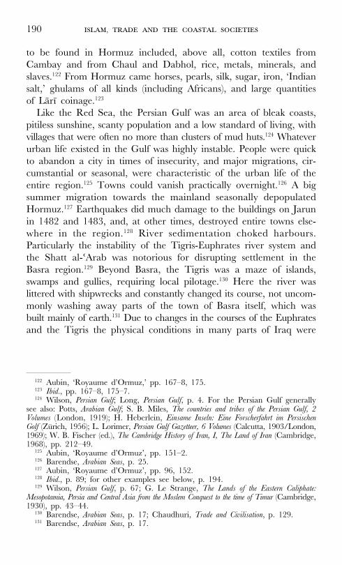
190 ,
to be found in Hormuz included, above all, cotton textiles from
Cambay and from Chaul and Dabhol, rice, metals, minerals, and
slaves.122 From Hormuz came horses, pearls, silk, sugar, iron, ‘Indian
salt,’ ghulams of all kinds (including Africans), and large quantities
of Làrì coinage.123
Like the Red Sea, the Persian Gulf was an area of bleak coasts,
pitiless sunshine, scanty population and a low standard of living, with
villages that were often no more than clusters of mud huts.124 Whatever
urban life existed in the Gulf was highly instable. People were quick
to abandon a city in times of insecurity, and major migrations, cir-
cumstantial or seasonal, were characteristic of the urban life of the
entire region.125 Towns could vanish practically overnight.126 A big
summer migration towards the mainland seasonally depopulated
Hormuz.127 Earthquakes did much damage to the buildings on Jarun
in 1482 and 1483, and, at other times, destroyed entire towns else-
where in the region.128 River sedimentation choked harbours.
Particularly the instability of the Tigris-Euphrates river system and
the Shatt al-'Arab was notorious for disrupting settlement in the
Basra region.129 Beyond Basra, the Tigris was a maze of islands,
swamps and gullies, requiring local pilotage.130 Here the river was
littered with shipwrecks and constantly changed its course, not uncom-
monly washing away parts of the town of Basra itself, which was
built mainly of earth.131 Due to changes in the courses of the Euphrates
and the Tigris the physical conditions in many parts of Iraq were
122 Aubin, ‘Royaume d’Ormuz,’ pp. 167–8, 175.123 Ibid., pp. 167–8, 175–7.124 Wilson, Persian Gulf; Long, Persian Gulf, p. 4. For the Persian Gulf generally
see also: Potts, Arabian Gulf; S. B. Miles, The countries and tribes of the Persian Gulf, 2Volumes (London, 1919); H. Heberlein, Einsame Inseln: Eine Forscherfahrt im PersischenGolf (Zürich, 1956); L. Lorimer, Persian Gulf Gazetteer, 6 Volumes (Calcutta, 1903/London,1969); W. B. Fischer (ed.), The Cambridge History of Iran, I, The Land of Iran (Cambridge,1968), pp. 212–49.
125 Aubin, ‘Royaume d’Ormuz’, pp. 151–2.126 Barendse, Arabian Seas, p. 25.127 Aubin, ‘Royaume d’Ormuz’, pp. 96, 152.128 Ibid., p. 89; for other examples see below, p. 194.129 Wilson, Persian Gulf, p. 67; G. Le Strange, The Lands of the Eastern Caliphate:
Mesopotamia, Persia and Central Asia from the Moslem Conquest to the time of Timur (Cambridge,1930), pp. 43–44.
130 Barendse, Arabian Seas, p. 17; Chaudhuri, Trade and Civilisation, p. 129.131 Barendse, Arabian Seas, p. 17.
, 191
very different from what they are now.132 As late as the sixteenth
century the main channel of the Tigris, about 160 kilometres below
Baghdad, turned off south from what is its present-day course and
flowed down the channel now known as the Shatt al-Hai, past Wasit,
below which it spread out and became lost in the Great Swamp
which reached up to Basra, where the former course of the river
became marked as the ‘Blind Tigris.’133 According to early Arab writ-
ers, ships from Basra reached the open sea at Abadan, which is now
more than 36 kilometres up the estuary.134 Abadan still flourished in
the thirteenth century, but in the fourteenth century the town is
reported by Ibn Battuta to have sunk to the size of a small village
and to have been already five kilometres from the sea.135 Mahrùbàn,
the first port reached by ships bound for India after leaving Basra
and the Tigris estuary, by the fourteenth century was completely
engulfed in the delta of the Hindiyan river (then known as the Shirin),
so that even its site has disappeared, while the connecting town of
Arrajan had fallen to ruins entirely.136 The next port at the head of
the Gulf was Siniz or Shiniz, the ruins of which lie near Bandar
Dilam, about half a league from the open sea.137 It was larger than
Mahruban in the tenth century.138
Hormuz itself was a frontier town without antecedents, of limited
duration, the product of a single and fitful stage of urban evolu-
tion.139 Its predecessor, Old Hormuz, the city on the mainland, was
abandoned in the early fourteenth century, possibly as much on
account of the silting-up of the Minàb river as on account of Mongol
raids.140 The New Hormuz that was founded on the island of Jarùn,
about six kilometres off the mainland, retained its unchallenged posi-
tion in the Persian Gulf until the Portuguese conquest of 1515 AD,
and died with the Safawid conquest of 1622 and the concomitant
creation of Bandar Abbas. For as long as Hormuz lasted, its crucial
advantage was its port.141 But all accounts of Hormuz draw attention
132 Wilson, Persian Gulf, p. 67; and see Chapter I, pp. 10–11.133 Wilson, Persian Gulf, ibid.; Le Strange, Lands, pp. 43–44.134 Wilson, Persian Gulf, p. 68.135 Ibid.136 Ibid., p. 72.137 Ibid.138 Ibid.139 Aubin, ‘Royaume d’Ormuz’, p. 78.140 Ibid., p. 86, note 27.141 Cf. Pires, Suma Oriental, I, p. 20: ‘The city is founded on account of its port.’

192 ,
to the desolation of the site and the great wealth of the city. Drinking
water and almost everything else had to be brought from the main-
land and other islands.142 Fishing was very important, but other than
that the island produced only ‘Indian salt,’ which was used as bal-
last by all ships coming to Hormuz, and sold in many places.143 The
city’s only important fortified place was the royal palace.144 Nonetheless,
in its heyday at the turn of the fifteenth century, it had a popula-
tion of about 40,000 and was the largest agglomeration in the entire
Persian Gulf.145 Fifteenth-century visitors report that ‘Hormuz has
no equal in the world,’ that it was visited by merchants of the whole
world, ‘from Egypt to China,’ and that ‘the people of the country
are all rich.’146
While the customs of the India trade were its principal source of
revenue, Hormuz was not a merchant republic but a monarchy with
South-Arabian origins and political ties to the Iranian world.147 There
was intense competition between the Arab and Iranian portions of
the population in the politics of the city-state throughout the fifteenth
century.148 Of the ten princes that occupied the throne of Hormuz
between 1400 and 1506, five were deposed, four assassinated.149 Its
army consisted to a large degree of Turkish, Làri, Tàrumi, and
Habshi mercenaries and ghulams.150 And in the course of the fifteenth
century, the kings of Hormuz have successively been forced to rec-
ognize the Timurids, the Qara-qoyunlu and the Aq-qoyunlu, even
when they succeeded in maintaining independence and proved capa-
ble of pushing back attempts at conquest.151 What ultimately held
the kingdom of Hormuz together was not a military chain of com-
mand but the network of interests and constraints that governed the
commercial society on the coasts of the Persian Gulf and which con-
tinued to thrive. Socially the city stood wide open. There was no
religious or social segregation in Hormuz, and there were no ethnic
142 Pires, Suma Oriental, I, p. 20; Aubin, ‘Royaume d’Ormuz’, p. 153.143 Duarte Barbosa, I, p. 91.144 Aubin, ‘Royaume d’Ormuz’, p. 90.145 Ibid., p. 150; Al-Hind, II, p. 20.146 Major, India, I, pp. 5–7; Tibbetts, Arab Navigation, p. 224; Mills, Ma Huan, pp.
165–72.147 Aubin, ‘Royaume d’Ormuz’, pp. 140, 145, 148.148 Ibid., pp. 79, 138–9.149 Ibid., p. 129.150 Ibid., p. 132.151 Ibid., pp. 133, 138, 141.

, 193
quarters.152 The Sunni majority tolerated the presence among itself
of a Shi‘ite minority, although the latter held their cultic gatherings
outside the actual town.153 The same was true for the colonies of
Indian ‘kuffàr,’ Gujarati banians and ‘gentiles of Sind,’ whose sacred
cows could roam freely through the city streets but who in all like-
lihood also maintained cultsites outside town.154 And there were Jewish
colonies in all Persian Gulf towns, including Hormuz.155 Religiously
tolerant, Hormuz was also considered ‘the most debauched place in
the world.’156 ‘They hold the creed of Mafamede in great honour.
They indulge themselves greatly, so much so that they keep among
them youths for purposes of abominable wickedness.’157
Hormuz extended its maritime empire to all the islands of the
Persian Gulf.158 Most of these were small, like Tunb, Hindarabì
(‘Arabian Hind’), Satvàr, or the pilot islands of Forùr, Làr, and, at
the end of the Gulf, the frequently visited island of Khàrg (which
has Islamic, Zoroastrian and Christian archaeological remains).159
Some were bigger. The large and fertile island of Qishm, with its
numerous villages and walled gardens, supplied Hormuz with fresh
fruits and vegetables.160 Qays, much reduced and with its old city in
ruins, was still an island with numerous inhabitants, crafts, cultivated
lands, and pearlfisheries.161 And, above all, Uwàl, the largest island
of the Bahrayn archipelago, together with al-Hasà (the Arabian coast),
constituted an economic region of great importance, exporting dates,
horses and pearls to India, and supplying drinking water to mer-
chant ships.162
152 Ibid., pp. 161–2.153 Ibid., p. 95, 161.154 Ibid., pp. 95, 151, 163.155 Ibid., p. 151.156 Ibid., pp. 159–60.157 Duarte Barbosa, I, p. 91.158 Aubin, ‘Royaume d’Ormuz’, p. 97.159 Ibid., pp. 97–98; Hotz, ‘Roobacker’s Scheepsjournaal’, p. 383; Barendse, Arabian
Seas, p. 20; R. Ghirshman, Ile de Kharg (Teheran, 1960). 160 Aubin, ‘Royaume d’Ormuz’, p. 102; Tibbetts, Arab Navigation, p. 221; Duarte
Barbosa, I, p. 80; Barendse, Arabian Seas, p. 23.161 Aubin, ‘Royaume d’Ormuz’, p. 97; Al-Hind, II, p. 19.162 Aubin, ‘Royaume d’Ormuz’, pp. 99–100; Tibbetts, Arab Navigation, pp. 221,
447; Duarte Barbosa, I, pp. 81–82; Pires, Suma Oriental, I, p. 19; J. Th. Bent, ‘TheBahrain Islands in the Persian Gulf ’, Proceedings of the Royal Geographical Society, XII(London, 1892).

194 ,
Equally importantly, the supremacy of Hormuz depended on the
control and development of the ports and littoral of Oman.163 Hormuz
maintained coastal guards along the entire Omani littoral, up to Ra’s
al-Hadd, and denied the Omani shaykhs free access to the sea.164 In
the fourteenth century, the Omani port-city of Qalhàt was almost a
second capital of the kingdom of Hormuz, to be superseded in impor-
tance by Muscat in the fifteenth century, after it had been repeat-
edly devastated by earthquakes, like Sìràf in earlier times.165 Qalhàt
remained a frequently visited city however, and there were other
ports of significance, such as Sùhàr, Khurfakkan and Gulfàr.166 But
Muscat, with seven thousand inhabitants, had become the principal
port of Hormuz on the Omani coast by the late fifteenth century.167
In all cases, these coastal cities of Oman were more than just outposts
of Hormuz on the route to India, the Red Sea and East Africa.168
Their hinterlands had important economic functions that largely
eluded Hormuz. Oman combined seatrade not only with fishing but
also with irrigated agriculture and pastoral nomadism.169 Among its
most important exports were dried fish, cereals and horses. In Oman
about forty different kinds of dates were grown, including the so-
called Ferd, the one which bears best a long period of transport on
board of a ship.170 Oman’s interior was dotted with walled towns,
comprising some forty places which were among the most populated
in all Arabia—cities like Manàh, Nizwa, Bahlà—and the rise of the
Banù Jabr to great power in eastern Arabia in the second half of
the fifteenth century showed that political formations in the interior
of Oman could, at long last, become a threat to Hormuz’s control
of the coast.171
Hormuz further maintained its maritime hegemony by subjecting
the Iranian coast to a system of control that was not less rigorous
than that of the Omani coast, preventing the construction of local
163 P. Risso, Oman & Muscat: An Early Modern History (New York, 1986), p. 4.164 Aubin, ‘Royaume d’Ormuz’, pp. 111–27, 140–1.165 Ibid., pp. 112–5.166 Ibid., p. 116; Barendse, Arabian Seas, p. 26.167 Aubin, ‘Royaume d’Ormuz’, p. 115.168 Ibid., p. 111.169 Ibid., pp. 117–9.170 ‘Die Häfen und Handelsverhältnisse’, p. 201.171 Aubin, ‘Royaume d’Ormuz’, pp. 121–7.
, 195
fleets by an embargo on building materials.172 It kept open the car-
avan posts along the routes from Shiraz, Kirman and Yazd through
the desolate plateaux of the Garmsìràt to Mughistan and Fàrs.173
The city of Làr rose as a result of the development of the new route
from Hormuz to Shiraz, while the princes of Làr unified the inte-
rior polities that lived off the India trade in the fifteenth century.174
These princes extended their power in the districts immediately
behind the littoral chain, on occasion intervening in the ports as
well.175 With the Làrì currency penetrating the Indian Ocean mar-
kets, there was considerable involvement of the merchants and mer-
cenaries of Làr overseas, especially in the Deccan.
In contrast to the ‘coasts and the islands’ of Hormuz, the seaboard
of Gujarat—which Portuguese authors refer to as ‘the noble king-
dom of Cambay’—was ruled by a Muslim king from inland capi-
tals, i. c. Ahmadabad and Champaner. And to a much larger degree
than Hormuz, the seaports of Gujarat also served as outlets for agri-
cultural hinterlands, apart from being transmission points in the
Indian Ocean trade.176 Cambay, on the northern bank of the river
Mahi, had become the main port of Gujarat long before the Muslim
conquest of 1298, and was already then a very rich city, with trad-
ing links to Persia, Arabia and Sofala, as well as Malabar and the
Coromandel. In spite of mudflats becoming an ever bigger threat to
the port, making it inaccessible at low tide, it was to extend its trad-
ing activities even further in the fourteenth and fifteenth centuries,
reaching out as far as Malacca.177 Portuguese authors testified to the
vitality of Jainism in the kingdom of Cambay and held to the view
that the Jains were deprived of their kingdom by the Muslims because
of their pacifism and ‘kindheartedness.’178 The fact is that the Muslims
took over the state, and that they took over much of the trade as
well, but by no means all of it. By the early sixteenth century, the
many seaports of Gujarat, such as Surat, Rander, Diu, Mahim,
172 Ibid., p. 143.173 Ibid., p. 141.174 Ibid., p. 142.175 J. Aubin, ‘Références pour Làr Médiévale’, Journal Asiatique (1955), p. 491.176 Cf. Pires, Suma Oriental, I, pp. 33, 35, 40–41.177 Al-Hind, II, p. 270; Arasaratnam and Ray, Masulipatnam and Cambay, pp. 119–20;
Pires, Suma Oriental, I, p. 35.178 Al-Hind, II, p. 355.
196 ,
Daman, Patan, Gogha, Ghandhàr, Bassein, Thana, and the ‘great
and fair city called Cambaya’ itself had a mixed population of ‘Moors
and Heathen.’179 Together they constituted an Indo-Islamic thalas-
socracy which spanned almost the entire Indian Ocean.
‘Cambay stretches out two arms, with her right arm she reaches out towardsAden and with the other towards Malacca, as the most important placesto sail to . . . And this trade is carried out by ships from Aden and shipsfrom Cambay, many of one and many of the other. And it [Cambay]trades with all the other places I have mentioned, bartering one kind ofmerchandise for another . . . It has all the silks there are in these parts, allthe different kinds of cotton material . . . it has carnelians, indigo . . . etc. . .. a good deal of opium . . . etc. . . . leather . . . wheat, barley, millet, sesame-oil, rice . . . all natural products of Cambay . . . The people of Ormuz bringhorses to Cambay, and silver, gold, silk, alum, vitriol, copperas, and seedpearls. They bring back the products of the country and those broughtthere from Malacca, because they come to Cambay for all the Malaccamerchandise. The people of Ormuz take back rice and food stuffs for themost part, and spice.’180
The fortified island of Diu, off the southcoast of Kathiawar, with
its good harbour and with trading connections that were almost as
extensive as those of Cambay, served as a naval base for a fleet of
at least seven hundred warships that were on active duty on the
Sultan’s behalf throughout the entire coast, as far south as the island
of Mahim (the later Bombay), and beyond.181 Like Hormuz, the
Sultan of Gujarat employed ‘many warriors from outside with whose
assistance they are constantly fighting.’182
Carrying no arms, and divorced from political power, the Jains
of Cambay were by the fifteenth century almost entirely confined to
the trading and financial sector, inland as well as on the coasts, and
to some extent overseas as well.183 These ‘Heathen’ carried on all
their trade with the Muslims, ate no flesh or fish, tried to save the
lives of birds, ants and condemned prisoners, and were known as
‘baniyas.’184 ‘Great idolaters and soft, weak people,’ they inhabited
179 Al-Hind, II, p. 271; Duarte Barbosa, I, pp. 108, 134–53; Pires, Suma Oriental, I,p. 34.
180 Pires, Suma Oriental, I, pp. 42–45.181 Duarte Barbosa, I, pp. 128–30; TA, pp. 214, 216, 246, 259–60, 278; TF, II,
pp. 188, 200–1, 203.182 Pires, Suma Oriental, I, pp. 34, 45.183 Al-Hind, II, pp. 273, 355; Duarte Barbosa, I, p. 113.184 Duarte Barbosa, I, pp. 109–12.
, 197
almost a third part of the kingdom of Cambay.185 Together with a
certain number of brahmans and Pattars they ‘had the cream of the
trade.’186 Muslim traders, however, had been taking over more and
more of the long-distance maritime trade, some of them penetrat-
ing the inland networks as well, albeit to a lesser degree.187 Among
these Muslim merchants we have to distinguish several distinct groups.
There were the great Arab and Persian ship owners and merchants
who built their own mosques and occupied ‘fine mansions,’ and who
had been present in the long-distance maritime trade for centuries
and appear to have become dominant already in the mid-fourteenth
century, after the Muslim conquest of Gujarat.188 Pires mentions such
‘Cairo merchants settled in Cambay, and many Khorasans and
Guilans from Aden and Ormuz, all of whom do a great trade in
the seaport towns of Cambay . . .’189 There were also, within this
group, many Muslim merchants from abroad who did not settle in
Cambay or elsewhere on the Gujarati coast but were sojourners—
Barbosa writes that these ‘are quite white.’190 Then, separate from
these, there were important Ismà'ìlì groups in coastal Gujarat which,
according to tradition, all originated in the reign of Siddharaja
(1094–1143).191 The Ismà'ìlì communities of Bohras and Khojas
became larger in Gujarat than anywhere else in India, largely through
conversion. Thanks to their connections with non-Muslim mercan-
tile groups they were relatively successful in penetrating inland mar-
kets in western India as well, and they made their presence felt in
many parts of the western Indian Ocean littoral. In addition to the
Ismà'ìlìs, there were numerous other Muslim communities that con-
sisted largely of Indian converts or were the product of intermar-
riage, and that expanded over time. The Nàvayats of Rander and
north Canara were one such group, who would trade in their own
ships as far as Malacca.192 But converts were numerically important
in all ‘coastal towns with Moors.’
185 Pires, Suma Oriental, I, pp. 35–42.186 Ibid.187 Cf. Al-Hind, II, p. 274.188 Cf. Arasaratnam and Ray, Masulipatnam and Cambay, pp. 120–1; Al-Hind, I,
pp. 274–5.189 Pires, Suma Oriental, I, pp. 41–42.190 Duarte Barbosa, I, pp. 141–51.191 Al-Hind, II, pp. 274–5.192 Duarte Barbosa, I, pp. 141–51.
198 ,
Another distinct community of the Gujarati coastal world, grow-
ing in importance under the Muslim kings but neither Muslim nor
Hindu itself, were the Parsis.193 The Parsis had settled along the coast
of Gujarat from the eighth century onwards.194 From their original
settlements in Sanjan they spread out north to Cambay, Broach,
Variav, and Surat, and southwards to Thana.195 By the time of the
Muslim conquest, in the last decade of the thirteenth century, the
Parsi community of Gujarat had increased considerably due to con-
tinued immigration from Iran and northern India. What happened
to it under early Muslim rule is not certain. Amir Khusrau writes
that ‘the shores of the sea of Gujarat were full of the blood of the
Gabres,’ an observation which has been taken to mean that they
were persecuted or forced to convert by Muslim rulers.196 The same
author also observes that ‘among those who had become subject to
Islam were the Maghs who delighted in the worship of fire.’197 What
is beyond doubt is that numerous Parsis, possibly the vast majority
of them, did not convert to Islam. Whatever the extent of (forced)
conversion, there were many Parsis who stayed within the ancestral
Zoroastrian tradition and who have been closely associated particu-
larly with the rise of Surat from the end of the fourteenth century
onwards. In 1478 this community sent a scholar to Kirman in order
to fill gaps in its knowledge of Zoroastrian doctrine. Everywhere in
Gujarat, the Parsis appear to have been mostly occupied in ship-
building and trade (including the liquor trade), and to a lesser extent
also in a range of other professions, including agriculture.198 One
author of the seventeenth century calls them ‘the busiest people in
the world.’199 By then their importance had increased further, and
they had started to dress like Hindus, spoke Gujarati, had adopted
Hinduized names, practiced polygamy, child marriage and the seclu-
193 M. Kamerkar, ‘Parsees in Surat from the 16th to middle 19th century: theirsocial, economic and political dynamics’, Journal of the Asiatic Society of Bombay, 70,new series (1995), pp. 71–88; M. Kamerkar, ‘Parsees in Navsari from the 12th tothe 18th Centuries. A Study of Survival and Identity’ (Paper, Second InternationalCongress, 5–8 January 1995, K. R. Cama Oriental Institute, Bombay, pp. 195–220).
194 Al-Hind, I, pp. 104–8.195 Kamerkar, ‘Parsees in Surat’, p. 71.196 Kamerkar, ‘Parsees in Navsari’, pp. 197–9.197 Ibid.198 Kamerkar, ‘Parsees in Surat’, p. 72.199 Mandelslo, quoted in Kamerkar, ‘Parsees in Surat’, p. 72.
, 199
sion of women, while maintaining a high degree of religious exclu-
siveness at the same time.
Numerous contemporary authors have pointed at the existence of
a diaspora of Gujarati merchants far beyond Gujarat, and here too
it is not always clear which of the above groups were actually pre-
sent in this diaspora, and on what basis. Even as early as the twelfth
to fourteenth centuries there is evidence of ‘Indian’ participation in
trade as far as Qays, Aden, Hormuz, and even China.200 These
Indians may have been Jains, Hindus, or Indian Muslims, c.q. Indian
converts to Islam, or a mixture of all these. It is beyond doubt that
in the fifteenth century Jain and/or Hindu merchants from Gujarat
could be encountered in Calicut. Cabral observed that
‘there are great merchants who are called Guzerates who are from a provincewhich is called Combaia. These and the natives are idolaters and adorethe sun and the moon and cows . . . These Guzerate merchants eat noth-ing which receives death, nor do they eat bread or drink wine.’201
According to Barbosa the ‘Heathen merchants’ of Cambay were
present in Calicut, Cochin and Cannanore, and dwelt there ‘in great
houses and streets of their own, as the Jews are wont to dwell in
our land.’202 The Gujaratis used to have large factories in Calicut,
but throughout Malabar they appear to have left the sea trade to
the Muslims. Barbosa writes that ‘the Moors . . . in Malabar . . . hold
all the sea trade and navigation . . .’203 If this was the situation, it
stood in sharp contrast to that in Malacca. In Malacca the ‘Cambay
merchants’ had their chief overseas trading centre, and in this city
there used to be a thousand of them, ‘besides four or five thousand
Gujarat seamen, who came and went.’204 At an even earlier date,
prior to the rise of Malacca, the Gujaratis used to trade with Java
via the Sunda strait, obtaining the products of the Moluccas, Timor
and Banda in Grise.205
There was, according to Pires, ‘no trading place where you do
not see Gujarat merchants.’206 The Gujaratis were outstanding sea-
200 Al-Hind, II, p. 274.201 Brooks Greenlee, Voyages of Pedro Alvares Cabral, p. 81.202 Duarte Barbosa, II, p. 73.203 Ibid., p. 74; and cf. Pires, Suma Oriental, I, p. 45.204 Pires, Suma Oriental, I, pp. 42–47.205 Ibid., pp. 45–46.206 Ibid., p. 45.
200 ,
men and had larger ships than other people on India’s western
seaboard, and more men to man them.207 Both the native Gujaratis
and the foreign Muslim merchants who settled in Cambay sailed
their ships to all ports between Aden and Malacca every year.208
Merchants came to Cambay from Cairo, Aden, Hormuz, Mogadishu
and Kilwa, and virtually all other major ports in the Indian Ocean.209
Unfortunately, we know almost nothing specific about the conditions
in which Jain or Hindu merchants from Gujarat were living in the
Muslim world in the fourteenth and fifteenth centuries. A recent
study of similar Indian diaspora merchants from Multan and else-
where, however, strongly suggests that in the early modern period
most of these were sojourners, who would return home after a stay
of several years abroad, did not settle abroad permanently, and did
not intermarry with the locals.210 It seems very likely that the same
was true for many of the Gujarati Jains and Hindus who came to
the Red Sea, the Persian Gulf, Malacca, Java, and elsewhere, although
it may have been less the case in Malabar. If so, their situation was
radically different from the Muslims of various origins who settled
everywhere along the shores of the Indian Ocean. It has been esti-
mated that in the early modern era, there were about 35,000 heav-
ily capitalized, caste-based agents of Indian family firms scattered in
diaspora communities across Central Asia, Afghanistan, Iran, the
Caucasus, and as far as Moscow and St. Petersburg.211 Abroad, these
Indians normally enjoyed the protection of the state, operating a
cash nexus which extended into the countryside, significantly enhanc-
ing the monetization of their host societies. As agents of extended
family firms, they regularly rotated in and out of the diaspora, estab-
lishing no more than temporary communal residences in caravanserais.
The communities of Indians abroad comprised Indian Muslims as
well, but the vast majority were Hindus, and there were Jains among
them too. Some settled in Turan for longer periods of time and
owned commercial and residential property. Religious ceremonies
were overseen by brahmans and sometimes restricted (as with cre-
207 Ibid.208 Ibid., p. 42.209 Ibid., p. 46.210 S. C. Levi, The Indian Diaspora in Central Asia and its Trade, 1550–1900 (Leiden,
2002).211 Ibid., pp. 261–2.
, 201
mations) but rarely if ever forbidden.212 Most accounts suggest that
Indian merchants lived in diaspora communities in Turan and else-
where for periods of two to three years, after which they would
return to India, while only some stayed much longer. Two to three
years appears to have been the norm among Indian commercial
communities in nineteenth-century Southeast Asia as well. This again
seems to suggest that these communities, everywhere, were almost
exclusively male.
Like Gujarat, the Konkan coast had some of the oldest Muslim set-
tlements in India. A flourishing Arab mercantile culture in the Konkan
can be dated back to the early centuries of Islam, when the coun-
try began to supply teakwood for Arabian shipbuilding.213 By the
tenth century, Saymùr, to the south of present-day Bombay, was an
important port of the Rashtrakuta kingdom, and had perhaps the
largest Muslim settlement on the westcoast, with roots in Arabia and
the Persian Gulf, but already mostly born in al-Hind of Muslim par-
ents.214 The genealogical links of these earliest Muslim communities
to any of the later and better-known categories of Konkani Muslims
are obscure. More particularly, of the Nàvayats, the elite Shàfì'ì
Muslims who rose to great prominence as merchants and state officials
under the Adil Shahis of Bijapur, we know little more than that they
migrated in all likelihood from the Persian Gulf in the thirteenth
century, perhaps from Basra, and it is impossible to make out what
indigenous elements were assimilated within this category and how
exactly they dispersed from their early settlement in Bhatkal along
the Canara and Coromandel coasts.215 There are few inscriptions
and remains of Muslim buildings anywhere on the coasts of the sub-
continent.
The two major empires that competed for the control of the Kon-
kani ports were the Bahmanì Sultanate and Vijayanagara. For the
Bahmanis the control of the Konkan was vital. Its loss precipitated
the disruption of the empire in five successor states in the late fifteenth
century. Unable to rely on the sand-clogged ports of their eastern
212 Ibid., pp. 122–140.213 Al-Hind, I, p. 68.214 Ibid., p. 69.215 Al-Hind, II, pp. 275–6; O. Khalidi, ‘Konkani Muslims: An Introduction’
(Unpublished paper).
202 ,
seaboard, the Bahmanis maintained a considerable navy to protect
the better ports of the Konkan, particularly against Gujarat (with
which they competed for the control of the island of Mahim).216
Having taken possession of Dabhol and Chaul from the beginning,
the first of these became the chief port of the Deccan, where many
of the horses imported to the Bahmani empire were landed.217 Dabhol
had ‘a very good harbour, whither sail many ships of the Moors
from divers lands . . .’218 Goa (the Sindabùr of the Arabs) was another
port where every year many ‘ships of the Moors’ laden with horses
and other goods came from Hormuz, Aden, Cambay and Malabar.
It was intermittently under the control of the Bahmanis and Vijaya-
nagara until Mahmud Gawan was able to bring the local Hindu
chiefs in line by cutting down the surrounding forests in the later
fifteenth century.219 Further to the south, on the Canara coast, the
ports of Mangalore and Cumbola were prized Vijayanagara posses-
sions.220 It was Bhatkal that became the most important port to serve
Vijayanagara with horses. It was ruled by a Canarese ‘Heathen’ chief
whose domain extended a long way inland, but there were ‘Moors
of all nations’ in the city.221
If it was common for the ‘sea-havens’ of the Deccan—Chaul,
Danda, Bankot, Dabhol, Sangameshwar, Kharepatan, Bamba, Goa,
Honawar, Bhatkal, Majandur, Bacanor and Bracalor, Mangalore,
and Cumbola—to be ruled by land-based empires, they at the same
time served both as emporia or transit points in the trade of the
Indian Ocean and as export ports for the agricultural products of
the Deccan hinterland.222 Thus in Chaul could be found the spices
from Malabar but also ‘merchants from inland . . . [who] bring their
goods laden on great droves of trained oxen with pack-saddles.’223
Such goods included grains, rice (including ‘very bad black rice’),
millet, and textiles.224 The other ports exported them as well.225
216 H. K. Sherwani, The Bahmanis of the Deccan (New Delhi, 1985), pp. 8–10; TA,pp. 214, 278.
217 Pires, Suma Oriental, I, pp. 52–53; Duarte Barbosa, I, pp. 165–6.218 Duarte Barbosa, I, pp. 165–6.219 Sherwani, Bahmanis, p. 10; Pires, Suma Oriental, I, p. 54; Duarte Barbosa, I, pp.
169–78.220 Duarte Barbosa, I, pp. 195–7.221 Pires, Suma Oriental, I, pp. 60–62.222 Duarte Barbosa, I, pp. 158–96; Pires, Suma Oriental, I, pp. 48–60.223 Duarte Barbosa, I, pp. 159, 163.224 Ibid., pp. 160–1.225 Duarte Barbosa, I, pp. 164–5, 195–6.
, 203
Bhatkal was the port from which Hormuz got its rice.226 In the inland
and coastal trade of these goods many Hindus were involved. All
ports on the Konkan and Canara coasts were inhabited by ‘Moors
and Heathen.’ But the long-distance overseas trade was, as far as
can be made out, entirely in the hands of Muslims, at least by the
fifteenth century.
It was the same in Malabar. And yet, even here, although by the
end of the fifteenth century this part of the Indian coast was rela-
tively well known in commercial circles in Florence, Venice and
Genoa, the illusion of a Christian India was still alive when Vasco
da Gama set foot in Calicut and did not die until after the return
of Cabral in 1501 AD.227 Pedro Alvares Cabral was the first European
to fully acknowledge that the vast majority of Indians were ‘idol-
aters’ rather than Christians. In his own words:
‘The king [of Calicut] is an idolater, although others have believed thatthey are Christians. . . . Almost all his nobles and the people who serve himare men dark as Moors.’228
It did not take long for these early Portuguese navigators to under-
stand that there had in fact been important Christian communities
in Malabar since ancient times but that their importance had been
steadily diminishing. Pires estimated the total number of Christians
in Malabar to be 15,000, and he was aware that these dated back
to the time of St Thomas the Apostle.229 Barbosa says there were
possibly as many as 12,000 Christian households between Cochin
and Kollam/Quilon alone.230 But in Malabar too, commercial life,
especially that of the coasts and searoutes, from the thirteenth century
onwards had become more and more dominated by foreign or
‘Paradeshi’ Muslims and by the indigenous groups of Muslims known
as ‘Mappillas.’231 Neither of these groups were able to create states.
Political power in Malabar always remained in the hands of Hindu
226 Ibid., p. 187; Pires, Suma Oriental, I, p. 60.227 G. Bouchon, ‘Le sud-ouest de l’Inde dans l’imaginaire européen au début du
XVI siecle: du mythe a la réalité,’ in: D. Lombard and R. Ptak (eds), Asia Maritima:images et réalité, Bilder und Wirklichkeit, 1200–1800 (Wiesbaden, 1994), pp. 3–11.
228 Brooks Greenlee, Voyages of Pedro Alvares Cabral, p. 79.229 Pires, Suma Oriental, I, p. 73.230 Duarte Barbosa, II, pp. 95–101.231 Pires, Suma Oriental, I, p. 73; Al-Hind, I, pp. 67–104.
204 ,
kings even when it depended to a very large degree on the successful
patronage of the ever increasing Muslim trade.
Initially, in the thirteenth century, the rise of the ‘Samudri Raja’
or ‘Ocean King’—the later Zamorin—of Calicut had been made
possible by the commercial victory of the Karimis of Cairo over
their Chinese rivals in Kollam.232 Other city-states followed suit, ally-
ing themselves with other Muslim traders from overseas. All of these
‘Heathen’ kings privileged the Muslims, since trade was essential to
them as much as their authority in the countryside remained lim-
ited.233 The Zamorin’s dominion remained the wealthiest of a string
of city-states along the coast which served both as maritime entre-
pôts and as export harbours for the finest pepper in the world. Even
the Zamorin had no more than a form of suzerainty over the inte-
rior chieftains. Moreover, even though they successfully maintained
powerful navies of Mappillas to safeguard their trade, on land the
same kings and their Nàyar nobilities were in a state of perpetual
warfare with each other.234 ‘[Besides the Zamorin of Calicut] there
are many great Lords in the Land who wish to be called Kings,
which they are not, for they neither coin money, nor roof houses
with tiles . . .’235 Malabar in fact consisted of an extremely fractious
congeries of small harbour monarchies which facilitated and safe-
guarded maritime trade and the export of pepper but were politi-
cally inconsequential. On land the Zamorin could but defer to the
Vijayanagara emperor. As the Timurid envoy Abd ar-Razzaq observed:
‘although the Sameri is not subject to the laws of the king of Bidjanagar
[Vijayanagara], he nevertheless pays him respect, and stands extremely
in fear of him.’236
With the agrarian economy of rice, pepper, coconut, myrobalans,
and ginger production entirely dominated by a Nàyar military caste
and nobility which, together with the Nambutiri brahmans, propped
up small Hindu monarchies, the trade of the few dozen port towns
of Malabar—Calicut, Cannanore, Ponnani, Veleankode, Chetwayi,
Cranganore, Cochin, Kayankulam, Kollam, Travancore, and Comorin
232 Al-Hind, II, p. 276.233 Al-Hind, I, pp. 75–76.234 Pires, Suma Oriental, I, p. 81; Al-Hind, II, p. 278; Major, India, I, p. 19.235 Duarte Barbosa, II, p. 6.236 Major, India, I, pp. 17–19.
, 205
the most important of them—was left in the hands of the Muslims.237
Or nearly so. The exceptions were the Gujarati banias of Calicut,
Cochin and Cannanore,238 the Malàyali caste of the Vyàbàris which
traded mainly inland,239 and the Tamil commercial caste of the
Chettis, ‘great merchants of jewels and of pearls and of gold and
silver.’240 These aside, from at least the mid-fourteenth century the
Muslims continued to dominate the expanding maritime trade of
Malabar, even though the Chinese briefly reduced Calicut to tribu-
tary status in 1406–7—when their great fleet lay anchored there for
some months. After the Chinese gave up their factory in Calicut and
abandoned the city for Malacca two or three decades later, the mer-
chants in Malabar who traded on the sea were almost exclusively
Muslims.241 According to Ludovico di Varthema, ‘the pagans do not
navigate much, but it is the Moors who carry the merchandise; for
in Calicut there are at least fifteen thousand Moors, who are for the
greater part natives of the country.’242 Paradeshi Muslims or ‘Mouros
da Meca’ were also present in very large numbers, either as sea-
sonal sojourners or as permanent residents. These came from any-
where between Mecca and Sumatra, ‘with their wives and sons,’ and
inhabited very fine houses, with numerous servants, and they dressed
themselves ‘in magnificent apparel after the manner of the Arabs,’
while keeping up a luxurious lifestyle ‘in eating, drinking and sleep-
ing.’243 This was the situation not only in Calicut but all over the
Malabar coast.
237 Al-Hind, I, p. 72; Duarte Barbosa, II, pp. 7, 38, 49, 70, 73, 92; Pires, SumaOriental, I, pp. 74–84; Major, India, I, p. 19.
238 See above, pp. 199–200, and Duarte Barbosa, II, p. 73.239 Al-Hind, I, p. 75.240 Brooks Greenlee, Voyages of Alvares Cabral, p. 81; Mills, Ma Huan, p. 138; Duarte
Barbosa, II, pp. 70–71; Al-Hind, I, pp. 71, 75.241 Brooks Greenlee, Voyages of Alvares Cabral, p. 109; see also R. Ptak, ‘Ein müster-
gultiges “Barbarenland”? Kalikut nach chinesischen Quellen der Yuan- und Ming-Zeit’, in: R. Ptak and D. Lombard (eds), Asia Maritima: Images et réalité, Bilder undWirklichkeit 1200–1800 (Wiesbaden, 1994), pp. 79–116; Al-Hind, I, p. 70; Pires, SumaOriental, I, p. 82.
242 Winter Jones, Itinerary of Duovico di Varthema, p. 61; Ma Huan, at an earlierdate, estimated the settled Muslim population in Calicut at 30,000 (Cf. Chapter II,p. 72).
243 Duarte Barbosa, II, pp. 74–78; Brooks Greenlee, Voyages of Alvares Cabral, p. 109;Major, India, I, pp. 13–17; Winter Jones, Itinerary of Ludovico di Varthema, p. 61; Wink,Al-Hind, II, p. 278.
206 ,
‘Moors are so many and rooted in the soil throughout Malabar that itseems . . . they are a fifth part of its people spread over all its kingdomsand provinces. They are rich, and live well, they hold all the sea trade andnavigation in such sort that if the King of Portugal had not discoveredIndia, Malabar would already have been in the hands of the Moors, andwould have had a Moorish king . . .’244
As it was, the Muslims of Calicut merely had a Muslim governor
of their own, and other Muslims of Malabar had their own ‘har-
bour authorities’ (shahbandars) who regulated succession and inher-
itance problems.245 While Muslim notables maintained close relations
with the dominant landholding caste of the Nàyars and took part in
the royal councils, and while they were patronized and protected by
Hindu kings who allowed them the free exercise of their religion,
the Mappillas or ‘Mouros da Terra’ followed the ‘Heathen custom’
in many ways.246 Having multiplied through intermarriage with local
women and keeping ‘heathen concubines of low caste,’ they were
ethnically quite diverse, spoke Malayalam, dressed like the Nayars,
and adopted matrilineality.247 But they always stressed their Arab
roots and their coastal affiliations with other coastal Muslim com-
munities in Arabia, the Persian Gulf, the Coromandel, and the Malay-
Indonesian archipelago, who, like them, adhered to the Shafi'i
madhhab of Islamic law, unlike the more recently converted Turks
and Afghans of the subcontinent.248 Many Malabar Muslims also
came to settle on the ‘very populous’ island of Sri Lanka.249 Here
the most important king was a tributary of the king of Kollam, send-
ing forty elephants per year.250 With its economy of ivory, cinna-
mon, arecanuts, and precious stones, Sri Lanka occupied an important
place in the trade of the Indian Ocean, and a situation developed
which was not unlike that on the Malabar coast, in which the kings
were ‘Heathen’ but, subject to them, there were ‘many Moors’ in
its seaports—in Colombo, Negombo, and Galle, among others.251
The Laccadive islands (known as the Juzur al-Fàl or al-Fàlàt to the
244 Duarte Barbosa, II, pp. 74–78, and see pp. 79–89.245 Ibid., p. 75.246 Ibid. pp. 74–78; Al-Hind, I, p. 74.247 Duarte Barbosa, II, pp. 74–78; Al-Hind, I, p. 75, II, p. 276.248 Al-Hind, I, pp. 76–78.249 Duarte Barbosa, II, p. 111; Pires, Suma Oriental, I, p. 84. 250 Pires, Suma Oriental, I, p. 87.251 Duarte Barbosa, II, pp. 110–3; Pires, Suma Oriental, I, pp. 84–87.
, 207
Arab navigators) were also inhabited by Malabar Muslims and
belonged to the king of Cannanore in the early sixteenth century,
and earlier had been in the possession of the Kolattiri rajas, while
the Chinese also claimed sovereignty over these islands for a while
and sent one or two treasure-ships there.252 A lot of bad black rice
was sent from the Canara coast to the ‘poor Moors’ of both the
Laccadives and Maldives (al-Dìb) in exchange for coir made out of
coconut husks.253 There were no cities or even villages here; the
biggest islands counted about one thousand houses, others five hun-
dred or less, and on many there were five to ten human habita-
tions.254 Some of these islands, however, have been important centres
for shipbuilding (as well as graveyards for ships), and supplied cauries,
ambergris, dried fish, and slaves throughout the Indian Ocean, while
serving as important stopovers on much-traveled searoutes.255 Already
by the thirteenth century they had adopted Sunni Islam and the
Shafi'i madhhab.256
Like those of Malabar, the towns of the Coromandel coast in medieval
times served both as entrepôts of Indian Ocean trade generally and
as ports for their own hinterlands. Among the items that reached
the Red Sea and Cairo from the Coromandel there were many of
Chinese and Indonesian origin, like spices, porcelain and brass and
bronze vessels, but also locally produced cotton products, silk, pearls,
iron and steel, dyeing and varnishing plants, drugs, aromatics, ivory,
rhinoceros horn, and so on.257 Under Rajaraja the Great (985–1014),
the port of Nagapattinam (in the Kaveri delta) replaced Mamallapuram
of Pallava times, while Mahabalipuram became a secondary port of
the Cola empire.258 From here naval expeditions were undertaken in
252 Tibbetts, Arab Navigation, pp. 458–61; Duarte Barbosa, II, pp. 103–4; Mills, MaHuan, pp. 146–51.
253 Duarte Barbosa, I, pp. 196–7.254 M. A. H. Fitzler, ‘Die Maldiven im 16. und 17. Jahrhundert: Ein Kapitel im
16. und 17. Jahrhundert’, Zeitschrift für Indologie und Iranistik, X (1935), p. 221; Mills,Ma Huan, pp. 146–51; R. H. Ellis, A Short Account of the Laccadive Islands and Minicoy(Madras, 1924).
255 Duarte Barbosa, II, pp. 107–108; Pires, Suma Oriental, I, pp. 94–95, 169; Bouchonand Thomaz, Voyage, p. 158; and see Chapter III, p. 99.
256 Al-Hind, II, pp. 283–5.257 Al-Hind, I, p. 334.258 R. Chakravarti, ‘Rulers and Ports: Visakhapattanam and Mottupalli in Early
Medieval Andhra’, in: K. S. Mathew (ed.), Mariners, Merchants and Oceans: Studies inMaritime History (New Delhi, 1995), p. 6; S. Jeyaseela Stephen, The Coromandel Coast
208 ,
the eleventh century to support new commercial and political/diplo-
matic networks converging on Sung China, and the entire Bay of
Bengal was, in effect, turned into a ‘Cola lake.’259 Under the Colas,
Buddhism and Jainism continued to be patronized in the ports, while
the Tamil devotional cult also retained a strong imprint of these het-
erodox religions.260 Donations to Buddhist viharas and Jain shrines
accompanied maritime trading diplomacy. And there were Tamil-
speaking merchants in the Chinese port city of Quanzhou up to at
least the later thirteenth century, just as there were in Sumatra and
other parts of Southeast Asia. These appear to have included Muslims,
Buddhists, as well as Hindus, occupying ‘foreign quarters,’ but in all
likelihood consisted overwhelmingly of sojourners.261 Similarly, the
entire coast south of Nagapattinam and Poduce (Pondicherry) was
frequented by sojourning Chinese merchants until about the mid-
fourteenth century.262 But Chinese visits to the Coromandel coast
appear to have become rare after they had abandoned Calicut in
the thirties and forties of the fifteenth century.263 Chinese sources,
after that date, do not mention the Coromandel.
Muslim settlement, by contrast, steadily gained momentum in the
great age of Cola expansion, from about the eleventh century on,
and continued in subsequent centuries, at the same time that Muslim
merchants from the Red Sea and the Persian Gulf were beginning
to use Coromandel ports as intermediary stations in the China trade
and in the spice trade with Indonesia.264 Conversion to Islam among
and its Hinterland: Economy, Society and Political System (A.D. 1500–1600) (New Delhi,1997), p. 14.
259 Al-Hind, I, pp. 311–34; J. Guy, ‘Tamil merchant guilds and the Quanzhoutrade’, in: A. Schottenhammer (ed.), The Emporium of the World: Maritime Quanzhou,1000–1400 (Leiden, 2000), p. 288; T. Sen, ‘Maritime Contacts between China andthe Cola Kingdom (A.D. 850–1279)’, in: K. S. Mathew (ed.), Mariners, Merchantsand Oceans: Studies in Maritime History (New Delhi, 1995), pp. 28–29.
260 Al-Hind, I, pp. 311–2.261 Guy, ‘Tamil merchant guilds’, pp. 287–8, 290, 293, 295, 298; Sen, ‘Maritime
Contacts’, pp. 32–34.262 Guy, ‘Tamil Guilds’, p. 284; Jeyaseela Stephen, The Coromandel Coast, p. 15;
S. Jeyaseela Stephen, ‘Medieval Trade of the Tamil Coast and its Hinterland, A.D.1280–1500’, The Indian Historical Review, XXV, 2 ( January, 1999), pp. 1–37.
263 H. Ray, ‘Trade between South India and China, 1368–1644’, in: O. Prakashand D. Lombard (eds), Commerce and Culture in the Bay of Bengal, 1500–1800 (NewDelhi, 1999), pp. 38–39; H. Ray, ‘An enquiry into the presence of the Chinese inSouth and South-east Asia after the voyages of Zheng He in the early fifteenthcentury’, in: Mathew, Mariners, Merchants and Oceans, pp. 97–99.
264 Al-Hind, I, p. 78; II, p. 280.
, 209
the local populations of the Coromandel seaboard also appears to
have started relatively early, in any case no later than the thirteenth
century. The Tamil-speaking Muslims of the coast who were known
as ‘Labbai,’ and later came to be called Maraikkàyar or Kayalar,
have always boasted a distinct Arab-Shàfi'ite origin, in order to be
able to distinguish themselves from the rural Tamil Muslims of the
hinterland whom they stigmatized as converts of a later date.265 Like
the Mappillas, the coastal Labbai had few links with the Muslims of
the Karnataka, the Deccan and North India, preferring marriage
connections with non-Tamil Shàfi'ites of Sri Lanka, Malabar and
Indonesia. Physically mobile, their ranks included wealthy maritime
traders and shipping magnates, as well as large numbers of fishermen,
pearl divers and maritime labourers.266 Many Labbai turned to gem
and pearl dealing, controlling networks of trade as far as Java.
By the late fifteenth and early sixteenth century, we read, there
were in the Coromandel seaports ‘many Moors, natives of the land,
who are great merchants and own many ships,’ and who traded with
Malabar, Cambay, Malacca, China and Bengal.267 These coastal
towns had a mixed population of ‘Moors and Heathen’ and were
ruled by Hindu kings who patronized both communities. Among the
Hindu merchants, the Chettis stood out as the most important and
the most widely dispersed. The Chettis were natives of the Coromandel
‘of high standing’ who dealt in precious stones and seed-pearls and
lived ‘throughout India.’268 The ‘very corpulent’ Chettis constituted
probably the majority of the great Kalinga merchants that traded
on a large scale in Malacca.269 The latter appear to have been
sojourners, paying dues of 6% rather than the standard 3% for per-
manent residents.270
Kàyalpatanam or ‘Old Kàyal,’ having become the centre of the
Muslim horse trade as well as the major outlet of the pearl industry
in the thirteenth century, is described in 1530 as ‘the chief place
265 Wink, Al-Hind, I, p. 78, II, pp. 280, 282.266 S. Bayly, ‘Islam in Southern India: “Purist” or “Syncretic”?’, in: C. A. Bayly
and D. H. A. Kolff (eds), Two Colonial Empires: Comparative Essays on the History ofIndia and Indonesia in the Nineteenth Century (Leiden, 1986), p. 37.
267 Duarte Barbosa, II, pp. 124–6.268 Ibid., pp. 123, 125–6.269 Ibid., pp. 172, 177; Pires, Suma Oriental, II, p. 255.270 Pires, Suma Oriental, II, pp. 249, 272–3. Kalinga merchants in Malacca do
appear to have brought their families along, even though they were sojourners (seebelow, p. 219).

210 ,
along the Tamil coast inhabited by Muhammadans.’271 Here, as else-
where, the Labbai were patronized by Hindu kings and were never
isolated from popular Islam and Hindu society as their later traditions
have it. The political situation was in a constant flux. Up to 1439
AD the city was under the authority of Vijayanagara but from the
middle of the fifteenth century it was incorporated in the coastal
domain of the kings of Kollam, hence effectively part of the Malabar
coast.272 The king of Kollam also successfully disputed Vijayanagara’s
authority over Kilakarai, another important centre of the Labbai
horses and pearl trade. Barbosa describes Kilakarai as
‘a land belonging to the king of Coulam [Quilon] and to other lords whoare subject to him . . . wherein are many and great towns of the Heathenand many others with havens on the sea where dwell many Moors, nativesof the land.’273
By contrast, Pulicat was a port that remained under Vijayanagara
authority, exporting an abundance of printed cotton cloths of the
Coromandel to Malacca, Pegu, Sumatra, Gujarat, and Malabar, and
with ‘a very fair sea-haven whither resort ships of the Moors in great
numbers.’274
North of the Coromandel, the development of ports like Visakhapat-
tanam and Mottupalli reflected the growing importance of the Andhra
coast within the context of the expanding trade of the Bay of Bengal
generally.275 Exporting diamonds and textiles from its own hinter-
land, Mottupalli gradually superseded Visakhapattanam from the
1240s, when the Kakatiyas began to show interest in this part of
the coast, which they called ‘Vengi.’ By the later part of the four-
teenth century the port was incorporated in the Vijayanagara empire.
A crucial difference between these ports and the ports of Gujarat,
Malabar and the Coromandel was that they were off the major mar-
itime trading routes and hence had a far more circumscribed and
regional function, while they offered no transshipment facilities.276
Here no significant Muslim presence is recorded. And the same can
271 Quoted in Bayly, ‘Islam in Southern India’, p. 40.272 Duarte Barbosa, II, pp. 122–3, and note 1.273 Ibid., pp. 120–1.274 Ibid., pp. 129–132.275 Chakravarti, ‘Rulers and Ports’, pp. 60–72.276 Ibid., p. 72.

, 211
be seen in Orissa under Gajapati rule, a ‘kingdom [which] extends
far inland and has but few seaports and little trade.’277
Bengal, on the other hand, is described as a wealthy Muslim king-
dom, with ‘wide and thickly peopled lands’ and many towns both
inland and on the coast—Gaur (two days from the mouths of the
Ganges),and Sonàrgaon and Satgaon (near the mouths of the two
principal branches of the Ganges) being the most important ones
until the early sixteenth century—inhabited by ‘Moors and Heathen.’278
The Muslim king of Bengal surrounded himself with ‘white men,’
strangers from many lands, including Arabs, Persians, and Indians,
and he governed his realm through Abyssinians.279 There were many
wealthy Muslim merchants and shipbuilders in the seaports of Bengal,
and Parsis as well, dominating the trade in great and small ships
with many countries.280 Bengal exported ‘goods of many sorts,’ includ-
ing eunuchs, and was among the most important sources of fine
muslins and a broad range of other textiles, large quantities of which
were exported to Malacca and as far east as China, in exchange for
pepper and spices, or opium, and precious metals.281
The conspicuous display of wealth and luxurious lifestyle enjoyed
by the Muslim mercantile elite of Bengal has been graphically described
by Barbosa. ‘The respectable Moors,’ he writes,
‘walk about clad in white cotton smocks, very thin, which come down totheir ankles, and beneath these they have girdles of cloth, and over themsilk scarves, they carry in their girdles daggers garnished with silver andgold, according to the rank of the person who carries them; on their fingersmany rings set with rich jewels, and cotton turbans on their heads. Theyare luxurious, eat well and spend freely, and have many other extrava-gancies as well. . . . Every one has three or four wives or as many as hecan maintain. They keep them carefully shut up, and treat them very well. . . They never go forth from the house save at night to visit one another,at which time they have great festivities and rejoicings, and superfluity of
277 Duarte Barbosa, II, p. 133.278 Ibid., pp. 135, 140, 148; Pires, Suma Oriental, I, pp. 90–91.279 Duarte Barbosa, II, pp. 135, 137, 139; Pires, Suma Oriental, I, p. 86.280 Duarte Barbosa, II, pp. 135, 142.281 Ibid., pp. 145–7; Pires, Suma Oriental, I, pp. 92–93; H. Ray, ‘Bengal’s Textile
Products Involved in Ming Trade during Cheng Ho’s Voyages to the Indian Oceanand Identification of the Hitherto Undeciphered Textiles’, in: R. Ptak and D. Rothermund (eds), Emporia, Commodities and Entrepreneurs in Asian Maritime Trade,c. 1400–1750 (Stuttgart, 1991), pp. 81–93.

212 ,
wines, of which they make many kinds, for the most part from palm-sugar,much whereof is consumed among these women.’282
The native Bengalis are described as ‘sleek, handsome black men,
more sharpwitted than the men of any other known race . . . [and]
very treacherous.’283 There were many great merchants among them
too, with large fortunes.284 And a large number of Bengalis, both
men and women, were found in Malacca, most of them ‘fishers and
sailors.’285 Many of these ‘Heathen’ were converting to Islam, on a
daily basis, ‘to gain the favour of their rulers.’286
The Muslims of Bengal, with their vast resources and trading net-
works, in the fifteenth century appear to have been able to project
their power as far south as Chittagong, and, more fleetingly, onto
the relatively isolated and poor Arakan coast of Burma where they
became instrumental in the foundation and rise to power of the port
of Mrauk-U.287 According to an Arakanese tradition, in 1406 the
reigning Arakanese king of the Laungkrak dynasty was forced to flee
to Bengal when his capital was invaded by Burmese troops sent by
the king of Ava.288 The exiled king, Naramitha, returned to Arakan
in 1428, allegedly with the support of Muslim troops provided by
the Sultan of Bengal.289 Mrauk-U was founded soon afterwards, and
between 1434 and 1481 was able to establish naval control over
other river-based port cities of the Arakan littoral, everywhere south
of Chittagong. This was achieved by raiding and occupation, with-
out penetrating deeply into the hinterland anywhere, while adopting
a compromising policy towards the kings of Ava in Upper Burma
from whom the Arakanese were separated by the Arakan Yoma.290
The king of Mrauk-U was essentially a coastal ruler of no more than
regional significance, a ‘Heathen’ outside the orbit of Muslim trade
282 Duarte Barbosa, II, pp. 147–8.283 Pires, Suma Oriental, I, pp. 86, 93.284 Ibid., p. 86.285 Duarte Barbosa, II, p. 93.286 Ibid., p. 148.287 S. Subrahmanyam, ‘And a River runs through it: The Mrauk-U Kingdom
and its Bay of Bengal Context’, in: J. Gommans and J. Leider (eds), The MaritimeFrontier of Burma: Exploring Political, Cultural and Commercial Interaction in the Indian OceanWorld, 1200–1800 (Leiden, 2002), p. 109; J. Leider, ‘On Arakanese TerritorialExpansion: Origins, Context, Means and Practice,’ ibid., pp. 128–9.
288 Leider, ‘On Arakanese Territorial Expansion’, p. 128.289 Ibid.290 Ibid., pp. 129–43.
, 213
and without a productive hinterland economy.291 By contrast, the
Shan kingdom of Ava, which controlled Upper Burma in the fifteenth
century, was primarily an agrarian realm, abounding in food, but it
was also widely known for its trade in rubies and musk, and did
attract some Muslims and Chettis to its capital who exchanged these
items for copper, quicksilver, or opium.292 In this it was different,
again, from the Burmese kingdom of Taungù or ‘Berma,’ of which
Barbosa says that ‘there are no Moors therein inasmuch as it has
no seaport which they can use for their traffic.’293 Pegu, further to
the south, was a ‘Heathen realm of great fertility and with much
trade by sea in many kinds of goods.’294 It had three or four ports
which were ‘inhabited as well by Moors as by the Heathen who
possess it’ and had trading links with Malacca, Pulicat and Cambay.295
The importance of such overseas trading links within the overall
agrarian economy of Upper and Lower Burma should not be exag-
gerated, however, as in the other states of mainland Southeast Asia.296
None of these states ever abandoned their essentially agrarian under-
pinnings. Foreign Muslim traders were not ‘liked’ here, not even in
Ayudhya [Siam], which conducted more overseas trade, especially
with China (in Chinese ships), than any other mainland state, and
did have a significant Muslim and Chinese presence in its seaports,
all the way down to Tenasserim and Phuket.297 Muslims of these
ports were often not permitted to travel inland, let alone settle there
permanently, and were not permitted to bear arms.
Off the mainland, at least some of the numerous islands of the
Andaman, Nicobar and Mergui archipelagos were known to the Arab
navigators, although not well, and nowhere on these islands, except
on a few of the Mergui archipelago close to the coast of Burma,
is there any evidence of permanent Muslim settlement or native
291 See also Pires, Suma Oriental, I, pp. 95–96; Duarte Barbosa, II, p. 150.292 Duarte Barbosa, II, pp. 159–61.293 Ibid., p. 149.294 Ibid., pp. 152–3.295 Ibid., pp. 153–7; Pires, Suma Oriental, I, pp. 97–101.296 See especially Lieberman, ‘Local Integration and Eurasian Analogies’, pp.
477–80; Michael Aung-Thwin, ‘Lower Burma and Bago in the History of Burma,’in: J. Gommans and J. Leider (eds), The Maritime Frontier of Burma: Exploring Political,Cultural and Commercial Interaction in the Indian Ocean World, 1200–1800 (Leiden, 2002),pp. 25–57.
297 Pires, Suma Oriental, I, pp. 103–14; Duarte Barbosa, II, pp. 162–5.
214 ,
conversion to Islam.298 The Andaman and Nicobar islands together
form a cluster of almost three hundred islands in the eastern Bay
of Bengal, stretched out over a distance of seven hundred kilome-
tres and separated by a ten-degree channel.299 Sulaiman al-Mahrì
divides the Andaman islands into two large ones, with a group of
smaller islands to the south, and one or two scattered islands, while
he describes the Nicobar islands as two groups of islands and two
separate islands, with large straits separating them from the Andamans
in the north and from the islands at the end of northern Sumatra
in the south.300 Other Arab navigators were also unsure about the
general direction of this chain of islands.301 Nicolo Conti mentions
only one island, calling it Andamania, ‘the island of gold,’ which he
held to have had a circumference of thirteen hundred kilometres
and to have been inhabited by cannibals.302 He did not visit any of
the islands, and adds that ‘no travelers touch here unless driven so
to do by bad weather, for when taken they are torn to pieces and
devoured by these cruel savages.’303 Ma Huan, also writing in the
fifteenth century, calls the Andaman and Nicobar islands ‘the coun-
try of the naked people’: ‘The people of those places dwell in caves;
men and women have naked bodies, all without a stitch of cloth-
ing, like the bodies of brute beasts.’304 The tribal islanders were skilled
navigators and fishermen, as well as good hunters and food-gatherers,
and there was some crop cultivation on the Nicobars. Archaeological
evidence from the Andaman islands indicates the importance of large-
scale exploitation of marine shell-fish for food, and over the cen-
turies cauri shells and dried fish have been important exports of
these islands.305 The Nicobars rather than the Andamans afforded
good anchorages for early travelers, especially on the route from Sri
Lanka to China. Barbosa writes:
298 Al-Hind, II, p. 283.299 See L. P. Mathur, History of the Andaman and Nicobar Islands (Delhi, 1968);
G. Whitehead, In the Nicobar Islands (London, 1924).300 Tibbetts, Arab Navigation, p. 473.301 Ibid., p. 474.302 Major, India, II, p. 8.303 Ibid.304 Mills, Ma Huan, pp. 124–9.305 Z. Cooper, ‘Archaeological Evidence of Maritime Contacts: the Andaman
Islands’, in: H. P. Ray and J.-F. Salles (eds), Tradition and Archaeology: Early MaritimeContacts in the Indian Ocean (New Delhi, 1996), pp. 239–46; Al-Hind, II, p. 283;Bouchon and Thomaz, Voyage, p. 347.
, 215
‘Passing the island of Ceylon, and crossing the Gulf before arriving at the[great island of Sumatra there are five or six] isles which have very goodwater and anchorages for shipping, inhabited by poor Heathen; these arecalled Nacabar. The dwellers therein get much ambergris which is takento Malacca and other places.’306
The islands of the Mergui archipelago, with its harbour of Markhì,
which gave the modern name to this archipelago of an alleged four
hundred islands and was renowned for its pearl fisheries, were referred
to as the Juzur at-Tàkwà.307 Tradition has it that in the fifteenth cen-
tury or thereabout the Ava kings made attempts to teach the nomadic
Mawken of this archipelago to read and write Burmese, but appar-
ently without any lasting result.308 There is some Islamic influence
among the Mawken, due largely to intermarriage, and scattered
Malay groups who live in the villages of some islands, professing to
adhere to Islam, but it is not clear when Islam first appeared here.309
It was Malacca that became the most important trading city in the
eastern Indian Ocean. It was founded, around the beginning of the
fifteenth century, by a fugitive prince of Palembang and a boatful
of Orang Laut.310 It soon started to pick up traffic from Samudra-
Pasai or ‘Pase’ and other ports of northeast Sumatra that were silt-
ing up, its ruling house converting to Islam.311 If ever there was a
port to which the three laws of real estate were applicable it was
Malacca: located at a site on a river which was suitable for a large
town, at the narrowest part of the strait between Sumatra and the
Malay peninsula through which went virtually all the trade between
the South China Sea and the Bay of Bengal, it was at the end of
the monsoons from two directions.312 One of Malacca’s kings, Mahmud
Shah,
‘was so proud and unreasonable and presumptuous about this, that he saidthat he alone was strong enough to destroy the world, and that the world
306 Duarte Barbosa, II, p. 181.307 Tibbetts, Arab Navigation, pp. 477–80; White, Sea Gypsies, pp. 26, 36, 169.308 White, Sea Gypsies, p. 19.309 Ibid., pp. 29–30.310 See Chapter III, pp. 117–8; Pires, Suma Oriental, II, pp. 229–289; Sopher, Sea
Nomads, pp. 316–7; C. C. Brown (transl.), Sejarah Melayu or Malay Annals (KualaLumpur, 1970).
311 Pires, Suma Oriental, II, p. 239.312 Ibid., pp. 239, 251.

216 ,
needed his port because it was at the end of the monsoons, and thatMalacca was to be made into Mecca . . .’313
Ayudhya, Java and China all attempted to maintain authority over
the newly founded entrepôt and to subordinate its trading activities
to their own interests. They could barely slow down its meteoric
rise. With the accession of the Ming dynasty in 1368, trade rela-
tions between the emerging Siamese state of Ayudhya and China
expanded dramatically and, backed by powerful Chinese mercantile
interests, Ayudhya was able to extend its control down the Malay
peninsula during the late fourteenth and fifteenth centuries.314 During
the same period, the Ayudhya king constantly despatched comman-
ders to subject other neighbouring countries in the interior: Sukhothai
and Phitsanulok were taken in 1412, and the Khmer capital of
Angkor in 1432.315 Remaining obedient to China, Ayudhya trans-
formed itself into the most powerful and elaborately organized bureau-
cratic state of mainland Southeast Asia, characterized by a unique
system of quantified ranks known as sakdi na.316 It exercised sover-
eignty in Malacca until as late as 1488.
At first, according to the Chinese record, the region where Malacca
was founded was known as the ‘Five Islands’ and was under the
authority of a chief who paid an annual tribute in gold to Hsien Lo
(Siam), ‘and if it were not to pay, the Hsien Lo would send men to
attack it.’317 Then Muhammad Iskandar Shah, the second ruler of
Malacca (1414–1423), sent an embassy to the king of Ayudhya, ask-
ing him ‘to people the land which was his.’318 The king responded
by not only sending people, but food and merchandise as well.319
Subsequent rulers of Malacca strengthened diplomatic ties with the
Thai state, establishing matrimonial connections as well, and pre-
senting elephants to the Thai court, but in the end withdrew all alle-
giance abruptly, refusing even to send ambassadors, and in the ensuing
military confrontation ‘destroyed the Siamese on the open sea.’320
313 Ibid., p. 253.314 Reid, Age of Commerce, II, pp. 204–5.315 Mills, Ma Huan, p. 107; Reid, Age of Commerce, II, p. 205.316 Reid, Age of Commerce, II, p. 205.317 Mills, Ma Huan, p. 108.318 Pires, Suma Oriental, II, p. 238.319 Ibid.320 Ibid., p. 257, and see pp. 242–53.

, 217
Ayudhya continued to claim sovereignty over the entire Malay penin-
sula until 1511, when the Portuguese captured it, and the four Malay
states of Kelanten, Trengganu, Kedah and Perlis continued to acknowl-
edge Thai supremacy until as late as 1909.321 In practical terms,
however, Malacca had been liberated by the sea—decades before
the Portuguese conquest.
The break with Java was achieved around the same time, entirely
through the force of expanding commerce. Malacca’s founders and
Celates-turned-mandarins, and even later rulers like Mansur Shah
(1458?–1477) had been more than eager to marry into the Javanese
nobility, and ambassadors continued to be sent to the island, with
elephants and gifts, but when the Javanese seaports established their
independence from Majapahit and (aided by ‘priests’ sent by Malacca)
turned to Islam, the relationship changed.322 Majapahit was left with
merely the Javanese hinterland and could not make war on Malacca
because it was powerless on the sea, and therefore ‘the king of Java
did not care about Malacca nor about its obedience.’323
China’s role in the rise of Malacca had been crucial from very
early times, probably ever since some Muslim merchants from South
India first brought Malacca to the attention of the Chinese court as
a potentially great commercial centre in 1403.324 China sent six mis-
sions to Malacca between 1403 and 1413, most of them in large
fleets under the grand eunuch Chwang Ho, and the first three rulers
of Malacca made five journeys to China between 1411 and 1434.325
In the seventh year of the Yongle period (1409), Chwang Ho was
ordered to bestow ‘two silver seals, a hat, a girdle and a robe’ upon
the Malacca ruler, and a stone tablet proclaimed ‘Man-la-chia’ to
have city status.326 Malacca soon had a major share in the tributary
trade between Southeast Asia and China, and its allegiance to China
over time only became stronger.327 But when, by 1435, the Ming
321 Mills, Ma Huan, p. 109, note.322 Pires, Suma Oriental, II, p. 253 and see pp. 230–55; Sopher, Sea Nomads, pp.
316–17; Wang Gungwu, ‘The first three rulers of Malacca’, in: Community and Nation:Essays on Southeast Asia and the Chinese (Singapore, 1981), pp. 97–107.
323 Pires, Suma Oriental, II, p. 253.324 Wang Gungwu, ‘The opening of relations between China and Malacca
1403–1405’, in: Community and Nation: Essays on Southeast Asia and the Chinese (Singapore,1981), p. 91; idem, ‘The first three rulers of Malacca.’
325 Reid, Age of Commerce, II, p. 206.326 Mills, Ma Huan, p. 108.327 Pires, Suma Oriental, II, pp. 242–53.
218 ,
emperors withdrew from the Indian Ocean, Malacca had secured
its position as a maritime power and no longer needed their sup-
port.328 Malacca’s obedience to China continued to be proclaimed
but from then on ceased to have any serious political implications
for either side. Meanwhile, trade with China increased considerably
throughout the fifteenth century, especially after 1457, when the ban
on private trade was less rigidly enforced.329
With its independence increasing and its population growing,
Malacca constantly upgraded its port facilities and attracted wealthy
Muslim traders from Pase.330
‘The merchants and sea-traders realised how much difference there was insailing to Malacca [instead of Pase], because they could anchor safely therein all weathers, and could buy from the others when it was convenient.’331
More and more ‘mollahs and priests learned in the sect of
Mohammed’ started pouring into Malacca from Pase.332 These were
‘chiefly Arabs, who are esteemed in these parts for their knowledge
of the said sect.’333 Malacca’s ruler, in all likelihood, converted around
1413, thereby positioning himself to marry into the Pase royal fam-
ily. As a consequence, the septagenarian Sultan Muhammad Iskandar
Shah (1414–23) lived in matrimony with the king of Pase’s daugh-
ter for eight years, ‘surrounded by mollahs.’334 He apparently con-
verted the entire court.
In their turn, Muhammad Iskandar Shah’s successors insisted on
conversion when passing off their daughters to tributary rulers in the
Strait, eastern Sumatra and the Malay peninsula, on which they suc-
cessfully asserted claims of suzerainty.335 It was a general custom in
Malacca that Muslim women could marry ‘heathens’ and thus have
328 Reid, Age of Commerce, II, p. 206.329 A. Reid, ‘The Rise and Fall of Sino-Javanese Shipping’, in: V. J. H. Houben,
H. M. J. Maier and W. van der Molen (eds), Looking in Odd Mirrors: The Java Sea(Leiden, 1992), pp. 179, 194–5.
330 Pires, Suma Oriental, II, pp. 243, 246. The size of the population of Malaccain the fifteenth century is not known. The Sejarah Melayu gives 90,000 and 190,000(Brown, Sejarah Melayu, p. xii).
331 Pires, Suma Oriental, II, p. 246.332 Ibid., p. 240.333 Ibid.334 Ibid., p. 242.335 Ibid., pp. 241–5, 251.
, 219
them convert.336 The reverse was also common. One Malaccan sul-
tan took all the beautiful daughters of the Parsi and Kalinga mer-
chants whom he wanted as concubines, turned them into Muslims,
and then married them off to the sons of his mandarins.337 There
always remained in Malacca an unconverted population of merchants
from China, the Coromandel and elsewhere—most of them sojourn-
ers—but by 1433 Ma Huan reported that ‘the king of the country
and the people of the country all follow the Muslim religion, fast-
ing, doing penance, and chanting liturgies.’338 Already then, the
Malaccan sultans were making sustained attempts to quicken the
conversion of the coastal elites of northern Java by sending religious
emissaries, while drawing them more and more into their commer-
cial orbit at the same time.339
Islamization and commercial growth went hand in hand with the
expansion of Malacca’s tributary relations in its own immediate neigh-
bourhood. Such tributary relations were of vital importance to Malacca
as a means to obtain not only valuable commercial products but
also manpower for its growing naval force. With a mere 1150 farms
in its core area, and with wild forests (themselves a source of ele-
phants) beginning almost immediately beyond the coast, the city-
state at an early stage incorporated a string of small towns and
hamlets on the adjacent shore which produced foodstuffs and whose
inhabitants would peddle up to Malacca’s harbour for, say, some
rice and chicken deliveries.340 There were no settlements here that
were even remotely as large as Malacca itself. If Malacca’s population
became as large as 100,000 (an estimate that may be on the high
side), Muar, the chief place after Malacca, had no more than 2,000
inhabitants.341 But beyond these towns, already the early rulers of
336 Ibid., pp. 243, 268.337 Ibid., p. 249.338 Mills, Ma Huan, p. 110; Pires, Suma Oriental, II, pp. 268, 273, 254, 265; Duarte
Barbosa, II, pp. 176–7. Many Chinese in Malacca appear to have been assimilatedwithin the local Muslim population (L. F. Thomaz, ‘Melaka et ses communautésmarchandes au tournant du 16e siècle’, in: D. Lombard and J. Aubin, Marchands ethommes d’affaires asiatiques dans l’Océan Indien et la Mer de Chine, 13 e–20 e siècles (Paris,1988), p. 39).
339 Pires, Suma Oriental, II, p. 245.340 Ibid., p. 261.341 Ibid. For population estimates of Malacca, see Reid, Age of Commerce, II, p. 69.
220 ,
Malacca were accepted as overlords by several kingdoms of the Malay
peninsula and the islands of the southern Strait. Pahang, which held
Trengganu as tributary, was one of these kingdoms with which
Malacca had to go to war to obtain control of the Singapore chan-
nel and Bintang island.342 Its kings payed a tribute, which was grad-
ually raised, and around the middle of the fifteenth century converted
to Islam while marrying a sister of Muzaffar Shah of Malacca.343
For Malacca it remained an important source of alum, sulphur, gold
and fighting men.344 Other kingdoms of the Malay peninsula that
became tributary to Malacca were Kedah and Selangor, both impor-
tant for their tin deliveries.345 As is reflected in the Sejarah Melayu, in
the course of the fifteenth century Malacca also established territo-
rial claims over the Riau Daratan, comprising the watersheds of the
four important river systems of eastern Sumatra, those of the Rokan,
Kampar, Siak and the Indragiri, with the island of Siantan.346 The
latter three rivers gave access to the Minangkabau highlands, whose
gold supplies (exchanged against Indian cloth) became an important
factor in Malacca’s commercial success.347 Other forest and ocean
products found in the upper reaches of these rivers, such as the
aloeswood of Kampar, or the bezoar stones (found in the stomach
of wild pigs and other animals) of Siak, could be as valuable as pre-
cious metals.348 The Orang Laut of these places also brought in mar-
itime resources and raided the coasts for slaves. Pires’ later account
shows that in the Riau Daratan military campaigns were conducted
with a certain regularity, and that after the middle of the fifteenth
century the kings of Kampar and Indragiri ‘and the people nearest
to them’ converted to Islam, while receiving two daughters of the
Malaccan king’s brother in marriage, and that subsequently the king
of Minangkabau also became a Muslim and married the sister of
Mansur Shah.349 The conversion and tributary subjection of these
three kings appear to have gained the Malaccan ruler Muzaffar Shah
342 Pires, Suma Oriental, II, pp. 244–5, 263.343 Ibid., pp. 244–5, 248–9, 252–3, 263.344 Ibid., p. 263.345 Ibid., pp. 243–4, 248.346 B. W. Andaya, ‘Recreating a Vision: Daratan and Kepulauan in Historical
Context’, Bijdragen tot de Taal-, Land en Volkenkunde, 153, 4 (1997), pp. 483–508.347 Ibid., p. 486.348 Ibid.; and see Pires, Suma Oriental, II, p. 262.349 Pires, Suma Oriental, II, pp. 244–5, 248–9.
, 221
high praise from the rulers of Aden, Hormuz, Cambay, and Bengal,
who all sent him congratulatory messages, and bestowed on him the
title of ‘Sultan’ (which was to replace ‘Raja’), and ‘sent many mer-
chants from their regions to live in Malacca.’350
The Riau Daratan, together with the numerous islands of the
Riau-Lingga archipelago (or Riau Kepulauan), provided the essen-
tial naval strength. The tribute of Rokan consisted entirely of mili-
tary levies, as did that of Rupat, while Purjim provided rowers, and
Tongkal helped Malacca with gold and ‘good men’ for naval service
both.351 The warlike Orang Laut (including the Suku Galang pirates)
of the four large islands of the Riau-Lingga archipelago, and par-
ticularly Bintang, became the most important source of naval fighters
and rowers to serve, without pay, under the admiral (‘Lasemana’) of
Malacca when called upon.352 In this archipelago, however, which
stretches between the Strait of Malacca across the South China Sea
to Kalimantan, we reach the limits of Malacca’s dominion.353 The
three hundred islands which were collectively known as the Pulau
Tujuh were still part of ‘Melaka Kepulauan’ but lacked the personal
ties with the city-state that the other islands had.354 Still, Pulau
Tioman developed into an important stapling and exchange port for
the trade with China.355 And the increased cooperation of the Orang
Laut scattered across Pulau Tujuh was beginning to allow greater
use of these seas, which were notorious for their hidden reefs, through
the Anambas and Natuna islands.356 Some of these islands also began
to yield good hardwoods for shipbuilding.
Malacca, thus, exported from its tributary dominions a broad
range of forest and maritime products, a great deal of tin, and gold,
while importing for its own use slaves, and rice and other foodstuffs,
including meat, from places as far away as Java.357 The city was at
the centre of a regional network in which commercial transactions
were conducted in weights of gold and silver, or in Pase’s gold cur-
350 Ibid., p. 245.351 Ibid., pp. 262–4.352 Ibid., pp. 250, 264; Chou, ‘Contesting the Tenure of Territoriality.’353 Andaya, ‘Recreating a Vision’, p. 483.354 Ibid., p. 485.355 Ibid., p. 487.356 Ibid., p. 487.357 Pires, Suma Oriental, II, p. 260; Mills, Ma Huan, p. 111; Duarte Barbosa, II, pp.
174, 178.
222 ,
rency, in ashrafis from Cambay and Hormuz, and in tin coins if
they were very small.358 But, even more important than Malacca’s
role as a regional trading centre for domestic products was its role
as an Indian Ocean entrepôt serving the exchange of a virtually
infinite number of non-domestic products. In the latter half of the
fifteenth century, Indian and Chinese merchants would trade in
Malacca rather than in Java, Sumatra, or the Maluku islands.359 In
Malacca could be found arms, glassware, copper, woollen cloths, and
quicksilver from Venice, opium, silver and rosewater from West Asia,
cotton and silk textiles from Cambay and the Coromandel, cam-
phor, spices and pepper from Indonesia, porcelain from China, and
thousands of other items valuable enough to be traded over long
distances.360 According to Pires, in the port of Malacca ‘very often
eighty-four languages have been found spoken . . .’361 There were
thousands of Muslim traders (‘Moors’) from every part of the Indian
Ocean, Parsis, Gujaratis and Chettis, as well as Chinese, and local
Malay Muslims as well.362 It is for this reason that by the early six-
teenth century Barbosa could write that ‘this city of Malacca is the
richest seaport with the greatest number of wholesale merchants and
abundance of shipping and trade that can be found in the whole
world.’363
The Javanese state of Majapahit (‘bitter fruit’), established with Mongol
support in the Brantas valley in the last decade of the thirteenth
century, was both an agrarian and a maritime realm.364 Its asso-
ciation with the Javanese wet-rice tradition was critical to its legiti-
macy, as was evident in the annual Caitra festival which was held
at Bubat, Majapahit’s river port, in March or April, soon after the
monsoon had begun to blow from the west, bringing the overseas
traders.365 Majapahit comprised ‘the core lands of Java in the coun-
358 Pires, Suma Oriental, II, pp. 243, 249–50, 274–6.359 Cf. Reid, Age of Commerce, II, p. 208.360 Pires, Suma Oriental, II, pp. 269–70, 272; Duarte Barbosa, II, pp. 172–6.361 Pires, Suma Oriental, II, p. 269.362 Ibid., pp. 268, 273, 254–5, 265; Duarte Barbosa, II, pp. 176–7.363 Duarte Barbosa, II, p. 175.364 See Chapter I, pp. 56–57; for a survey of the history of Majapahit, see Krom,
Hindoe-Javaansche Geschiedenis, pp. 346–467.365 Tarling, Cambridge History of Southeast Asia, I, pp. 219–20.
, 223
try of Hind’ (mùl chàwa az bilàd-i-hind ),366 with the terraced rice fields
of the thickly peopled eastern interior of the island constituting the
backbone of the economy, and effectively ruling almost half of the
island in the fourteenth century.367 The king and lords of Java were
‘revered like gods’ and presided over a profoundly conservative and
hierarchical society, while cultivating an exalted and peerless ideal
of nobility within the context of large, self-sustaining and polyga-
mous households which practiced widow burning.368 Agrarian Java,
wrote Schrieke, ‘cherished no other ideal than to remain as it was,
shunning all change.’369 Emphasizing dynastic continuity, the kings
of Majapahit saw themselves as the custodians of a religiously sanc-
tioned social order which was based on tributary flows from the
periphery to the centre and defined all other movement—outside the
control of the territorial state—as subversive.370 The Nàgarakertàgama,
an epic poem and chronicle composed in 1365 by the Buddhist
monk Prapanca for the glorification of the Majapahit kings, provides
abundant evidence that Mahayana Buddhism was patronized in con-
junction with a variety of indigenous Javanese forms of Shaivism and
Vishnuism right from the beginning of the rule of Kertanagara
(1268–92), the reuniter of the realm, who thereby situated himself
unambiguously within the old tradition of sacral kingship of the ‘dja-
man buda.’371 The Majapahit rulers were thus regarded as incarna-
tions of Vishnu or ‘Shiva-Buddha.’372 Popular traditions of animism
and a deep ritual concern for the dead probably remained of equal
if not greater significance in most parts of the realm.373 But there is
366 J. Von Hammer-Purgstall, Geschichte Wassaf ’s, Persisch herausgegeben und Deutschübersetzt, I Band (Vienna, 1856), text, p. 45.
367 Pigeaud, Java in the Fourteenth Century, IV, pp. 494, 497; Pires, Suma Oriental, I,p. 175.
368 Cf. Lombard, Carrefour Javanais, III, pp. 30–32, 55, 90; Pigeaud, Java in theFourteenth Century, IV, p. 469; Pires, Suma Oriental, I, pp. 174–6.
369 B. Schrieke, Indonesian Sociological Studies, 2 Volumes (The Hague and Bandung,1955–7), II, pp. 77–78, 99.
370 Schrieke, Indonesian Sociological Studies, II, pp. 7 ff.; Lombard, Carrefour Javanais,III, p. 130; Pigeaud, Java in the Fourteenth Century, IV, p. 522.
371 Pigeaud, Java in the Fourteenth Century; K. R. Hall, ‘Ritual Networks and RoyalPower in Majapahit Java’, Archipel, 52 (1996), p. 116; idem, ‘Personal Status andRitualized Exchange in Majapahit Java’, Archipel, 59 (2000), pp. 51–96; Tarling,Cambridge History of Southeast Asia, I, p. 216; Veth, Java, IV, p. 83.
372 Schrieke, Indonesian Sociological Studies, II, p. 10.373 A. Reid, ‘The Islamization of Southeast Asia’, in: M. A. Bakar, A. Kaur and
A. Z. Ghazali (eds), Historia: Essays in Commemoration of the 25th Anniversary of theDepartment of History, University of Malaya (Kuala Lumpur, 1984), p. 16.
224 ,
also evidence that the distance between court and countryside was
becoming smaller from the second half of the fourteenth century
onwards.374 A realm-wide temple network was established in which
local temples became ritually subordinated to temples administered
by royal priests, an innovation that effectively extended the core area
of imperial authority.375
The foundations of Majapahit’s maritime hegemony in the archi-
pelago were laid by the same king, Kertanagara, who as early as
1275 AD sent a naval expedition to Jambi-Malàyu, the Sumatran
port that had also been Shrivijaya’s first conquest.376 In 1286 Kerta-
nagara erected a statue of his father in the same place, apparently
to underscore a Javanese claim of hegemony over the Strait.377 This
new situation then provoked Kublai Khan to intervene, with one
thousand warships, after the demise of Kertanagara, bringing the
latter’s son-in-law to the throne and defeating his local rivals, upon
which the new capital of Majapahit was founded in 1292/3.378 It
took several decades to secure eastern Java. After that Madura, Bali,
and ports to the north and east of Java, as far as the southern
Philippines and Irian Jaya, were subordinated in short order.379
Majapahit maintained a naval force, which was based in ports on
Java’s north coast, and in the second half of the fourteenth century
could exercise significant coercive power as far as Palembang and
Samudra-Pasai as well as in the islands to the east.380 But the over-
seas linkages with no less than ninety-eight different places through-
out Sumatra, the Malay peninsula, Kalimantan, and eastern Indonesia,
appear to have been mostly based on trade and tributary relations.381
Majapahit also sent missions to China, and maintained commercial
relationships with Champa, Siam, Pegu, Vietnam, and Cambodia as
well. Pires could still record a situation which had existed about a
century prior to his time, in which Muslims had not yet taken over
the maritime trade of Majapahit:
374 Hall, ‘Ritual Networks’, p. 116.375 Tarling, Cambridge History of Southeast Asia, I, pp. 224–5.376 Ibid., p. 216.377 Ibid., p. 217.378 Ibid.379 Ibid., p. 218.380 Ibid., pp. 218–9.381 Lombard, Carrefour Javanais, II, p. 40; Reid, ‘Islamization of Southeast Asia’,
p. 27.
, 225
‘They say that the island of Java used to rule as far as the Moluccas(Maluco) on the eastern side and [over] a great part of the west; and thatit had almost all the island of Sumatra under its dominion and all theislands known to the Javanese, and that it had all this for a long time pastuntil about a hundred years ago . . . they affirm that it navigated to Adenand that its chief trade was in Bonuaquelim [Kalinga], Bengal and Pase . . .[and that] all the navigators were heathens . . .’382
But, clearly, already in the fourteenth century these overseas rela-
tions could not have been maintained without at least some Muslim
commercial involvement.383 Some of the states that Majapahit claimed
as tributaries were Muslim, including Aru, Perlak, Samudra-Pasai
and others.384 Majapahit probably mobilized Muslim shipping in
many ports in order to use it further afield.385 This may explain why
there was a short-lived Muslim presence in fourteenth-century Ternate,
and in Brunei and Sulu, a century before the beginning of contin-
uous Islamization in these areas.386 Through tribute and trading mis-
sions, as well as through matrimonial connections with Muslims,
particularly in Champa, Islam gained a foothold even at the court
of Majapahit itself.387 At the same time, Chinese navigators, seamen
and traders who had migrated to local bases in the archipelago may
have blended with the Muslims and Hindu-Javanese traders of the
northeast coast of Java, or have been absorbed in the navies that
Majapahit put together to dominate the east.388
Change could hardly be averted, of course, and with the dramatic
increase of overseas trade in the fourteenth and fifteenth centuries,
Majapahit’s hegemony in and beyond Java was progressively under-
mined. The geography and dispersed settlement pattern of Java had
always impeded lasting unification beyond the core river plains, and
family politics on the part of the rulers had never been an adequate
means to keep the noble apanages under close administrative con-
trol, while Majapahit’s large, unwieldy peasant armies continued to
382 Pires, Suma Oriental, I, p. 174.383 Reid, ‘Islamization of Southeast Asia’, p. 27.384 Ibid.385 Ibid.386 Ibid.387 Ibid., pp. 28–29.388 A. Reid, ‘Flows and Seepages in the Long-term Chinese Interaction with
Southeast Asia’, in: A. Reid (ed.), Sojourners and Settlers: Histories of Southeast Asia andthe Chinese in Honour of Jennifer Cushman (Sydney, 1996), p. 21.

226 ,
be based on soccage and the cavalry remained small.389 If Java was
a ‘sponge country’ for precious metals, its growing commercial pros-
perity led to an increase of monetization on all levels, giving rise to
an increasingly important class of intermediaries—tax-farmers and
the like—who could not be accommodated in the old agrarian hier-
archy.390 The rise of Malacca and Siam, and the aggressive overseas
policies of the Ming first reduced and then destroyed the Hindu-
Javanese state’s control of its outer possessions.391 Already early in
the fifteenth century Majapahit had lost its ascendancy in the Indone-
sian archipelago outside Java, and by 1428 it had lost control over the
western part of Java itself.392 By the middle of the fifteenth century
the Javanese pasisir had slipped out of Majapahit’s hands.393 Thus,
the Hindu-Javanese kraton of the interior had already lost much of
its importance before a coalition of coastal states, under the leader-
ship of Demak, in the course of 1513 or 1514 initiated the final
phase of the conflict.394 This lasted until 1528, when the kraton was
taken and the royal family was forced to flee and take refuge in
Bali—the island which had long been a dependency of Majapahit.395
The crucial factor in the decline of Majapahit, clearly, was the
relentless rise to power of the pasisir states which in the fourteenth
and fifteenth centuries were turning to Islam one by one and repu-
diated the control of the agrarian state. The pasisir was by no means
completely Islamized in the fifteenth century, particularly not in the
west.396 In the later fifteenth and sixteenth centuries it appears that
foreign observers in Java considered the kings of Majapahit and
389 Lombard, Carrefour Javanais, III, pp. 30–32, 100; Pigeaud, Java in the FourteenthCentury, IV, pp. 469, 497, 522; Pires, Suma Oriental, I, p. 176; Schrieke, IndonesianSociological Studies, II, pp. 68–69.
390 Lombard, Carrefour Javanais, III, pp. 32–33; II, pp. 38–39; Pigeaud, Java in theFourteenth Century, IV, pp. 499–500; Tarling, Cambridge History of Southeast Asia, I, p. 226.
391 Schrieke, Indonesian Sociological Studies, II, p. 69.392 Tarling, Cambridge History of Southeast Asia, I, p. 227; J. Noorduyn, ‘Majapahit
in the Fifteenth Century’, Bijdragen tot de Taal-, Land-, en Volkenkunde, 134, 2–3 (1978),p. 255.
393 Noorduyn, ‘Majapahit,’ pp. 254–7.394 Cf. Schrieke, Indonesian Sociological Studies, II, p. 68.395 A. Hobart, U. Ramseyer and A. Leemann, The People of Bali (Oxford and
Cambridge, Mass., 1996), pp. 27–38. 396 Cf. Chapter I, pp. 57–58.
, 227
Pajajaran as the two legitimate rulers of most of the island, the one
in the eastern part, the other in the west or what was called Sunda.397
The city of Pakuwan was the royal residence of the rulers of Pajajaran,
the counterpart in western Java of Majapahit. Pires, in effect, calls
the place ‘Dayo,’ by the same name which he gave the capital of
Majapahit, and which in both cases probably derived from Sundanese
dayeuh, ‘capital.’398 Pakuwan, located near modern Bogor or Buitenzorg,
45 kilometres south of Batavia, was in all likelihood founded as the
capital of Pajajaran in 1433/4.399 Pires describes the kingdom of
Sunda, which he thought took up a little more than a third of the
island, ending at the river Tjimanoek, as a heathen state of chival-
rous, seafaring warriors who practiced widow burning and did not
allow Muslims into it, except a few, for fear that they would do
what they had done in Java and make themselves masters of the
country by their cunning.400 Pires dwells on the importance of the
‘lord captains’ of the Sundanese ports, their aristocratic lifestyle, and
explains that they too were all heathen; only in the easternmost port
of Sunda, that of Tjimanoek, he observes ‘many Moors,’ and this
was apparently the only port which belonged to the Sundanese king
himself.401 The most important merchandise of Sunda was rice, some
of which was taken as far as Malacca in junks, and to Java.402 There
was a voluminous trade in numerous other foodstuffs, as well as pep-
per, fruits, gold, and slaves—the latter from Sunda itself and the
Maldive islands (which could be reached from Sunda in six or seven
days).403 There was a total of six ports of varying significance in the
Sunda lands which specialized in these items.404 Going from west to
east, Bantam (or Banten) was the first, a ‘good city’ on a river, which
was probably already important as a pepper port in the eleventh
and twelfth centuries and under the Sundanese kings was second in
importance, trading with the Maldive islands and Sumatra on the
Panchur side, as well as Malacca.405 A second port, of lesser importance,
397 De Graaf and Pigeaud, Eerste Moslimse Vorstendommen, p. 117.398 Ibid.; see also Veth, Java, I, pp. 278–9.399 De Graaf and Pigeaud, Eerste Moslimse Vorstendommen, p. 117.400 Pires, Suma Oriental, I, pp. 166–8, 173.401 Ibid., p. 173.402 Ibid., p. 169.403 Ibid., p. 169; see also pp. 170–1.404 Ibid., pp. 170–2.405 Al-Hind, II, p. 41; De Graaf and Pigeaud, Eerste Moslimse Vorstendommen, p. 118;
Pires, Suma Oriental, I, p. 170.
228 ,
was Pontang, in the delta of the Pontang river in the easternmost
part of the bay of Bantam, with ‘a great town.’406 Pires identifies a
third port, which he calls the ‘port of Chegujde,’ the location of
which is not certain but is most likely to have been on the Chisadane
river, which enters the sea by five mouths, with ‘a town and a good
one.’407 A fourth port was ‘Tamgara,’ which can also not be located
with certainty; possibly it was thirteen kilometres inland on the
Chisadane, at a place called Tangerang, but it may also have been
Tanara, on the Chidurian, or a place called Tangorra, ten kilome-
tres east of Pontang.408 The most important trading centre in the
western part of the island, in any case, was Sunda Kalapa, at two
days journey downstream from Pakuwan, the residence of the Pajajaran
kings.409 This city had ‘a magnificent port . . . where the trade is
greatest and whither they sail from Sumatra . . . Malacca, Java and
Madura and many other places . . . ’410 Sunda Kalapa was at the
mouth of the Chiliwung river, at the site of modern Batavia or
Jakarta.411 And, finally, the sixth port of Sunda was ‘Tjimanoek,’ at
the mouth of the river with the same name, at a day and a night
sailing with favourable wind from Sunda Kalapa, a port inaccessi-
ble to junks and soon to lose all importance due to silting.412 If this
was the port of the Pajajaran kings in the fifteenth century, it had
probably been the former Indramayu or Dermayu, the port of the
old Sundanese kingdom of ‘Galuh’ of which we read repeatedly in
the Sundanese legends.413
By the early sixteenth century, then, the Tjimanoek river was the
western frontier of Muslim expansion on the island of Java and the
beginning of the properly Javanese, as opposed to Sundanese, pasisir.
It was only later in the sixteenth century that large numbers of
Javanese Muslims would move from the pasisir districts of Middle
Java along the coast to the west and occupy Kapala (which they
renamed ‘Jakarta’ or ‘Jaya-karta’) and Bantam, thereby cutting the
406 Pires, Suma Oriental, I, p. 170.407 Ibid., p. 171.408 Ibid., and note 2.409 Ibid., pp. 168, 172–3; De Graaf and Pigeaud, Eerste Moslimse Vorstendommen,
p. 117.410 Pires, Suma Oriental, I, pp. 172–3.411 De Graaf and Pigeaud, Eerste Moslimse Vorstendommen, p. 109.412 Pires, Suma Oriental, I, p. 173.413 De Graaf and Pigeaud, Eerste Moslimse Vorstendommen, p. 109.
, 229
Sundanese off from the sea.414 Pires explains that the powerful Muslim
lords (‘patis’) who ‘have all the trade’ of the seacoast were actually
not Javanese of long standing but mostly descendants of Chinese,
Parsi, Kalinga and other immigrants, who were ‘slaves and mer-
chants a couple of days ago’ and, being socially insecure, were even
more proud and boastful than the Javanese nobility of the hinter-
land.415 In the fourth decade of the fifteenth century Ma Huan divided
the population of the pasisir trading cities into three groups: the
Muslims from many countries, the Chinese, many of whom were
also Muslims, and the unconverted Javanese.416 Not much is known
about the conversion of the Javanese elements in the population of
these ports.417 Ma Huan would probably have included these in
‘Muslims from many countries.’ But how exactly they converted is
not clear. There is little reason to suppose that mystic brotherhoods
were already active in Java in the fifteenth century.418 According to
Pires, religious teachers only came to Java after Islamic communi-
ties had been formed:
‘At the time when there were heathens along the sea coast of Java, manymerchants used to come, Parsees, Arabs, Gujaratees, Bengalees, Malays andother nationalities, there being many Moors among them. They began totrade in the country and to grow rich. They succeeded in way of [sic]making mosques, and mollahs came from outside, so that they came insuch growing numbers that the sons of these said Moors were alreadyJavanese and rich, for they had been in these parts for about seventy years.In some places the heathen Javanese lords themselves turned Mohamme-dan, and these mollahs and merchant Moors took possession of these places. Others had a way of fortifying the places where they lived, andthey killed the Javanese lords and made themselves lords; and in this waythey made themselves masters of the sea coast and took over trade andpower in Java . . .’419
In Java, as elsewhere in the Malay-Indonesian archipelago, Islam
was brought by traders and became a political factor in the rapidly
rising urban centres of the pasisir when the scale of trade began to
414 Ibid., p. 7.415 Pires, Suma Oriental, I, pp. 182, 199–200; and see M. C. Ricklefs, ‘Six Centuries
of Islamization in Java’, in: N. Levtzion (ed.), Conversion to Islam (New York, 1979),pp. 104–5.
416 Mills, Ma Huan, p. 93.417 Ricklefs, ‘Six Centuries of Islamization’, p. 106.418 De Graaf and Pigeaud, Eerste Moslimse Vorstendommen, p. 29.419 Pires, Suma Oriental, I, p. 182.
230 ,
increase in the late fourteenth century.420 Java’s ports grew rich in
part because the Javanese were involved in the spice trade with the
Moluccas and used these ports as transshipment points. They also
exported increasing amounts of pepper, and rice and other foodstuffs
from their own hinterlands. The demand for spices and pepper had
gone up everywhere, culminating in a veritable ‘spice-orgy,’ partic-
ularly in those parts of the world—Europe, the Middle East, China—
that were recovering from the ravages of the Black Death.421 More
than any other major region, China, under the early Ming dynasty,
saw its population and wealth expand at the end of the fourteenth
century and generated an enormous demand for products of the
Nanyang trade, most of all pepper and sappanwood, which now
became articles of mass consumption for the first time.422 The Ming
dynasty, of course, inherited a long tradition of increasingly close
relations with Southeast Asia that had begun with the Southern Sung
and reached an early peak under the Mongol Yüan in the 1280s
and 90s. The Chinese were trading in Java long before Malacca
existed. They introduced new shipbuilding techniques here, and
Chinese copper cash, called picis, were used in Java as the base
coinage from 1300 AD onwards. But, under the early Ming, there
was again a great increase of Chinese activity in all parts of Southeast
Asia, both official and unofficial, including the unprecedented expe-
ditions of Chwang Ho in the opening decades of the fifteenth cen-
tury, and a stepped up reinforcement of the overseas Chinese
communities.423 The Chinese actively participated in the urbanisa-
tion of all of Southeast Asia in the fourteenth and fifteenth centuries,
in the Javanese pasisir only more so. Chinese traders played major
roles in the rise of Tuban, Gresik, Surabaya, and Demak.424 And,
420 Reid, ‘Islamization of Southeast Asia’, pp. 20, 23; idem, Age of Commerce, II,pp. 12–15.
421 C. H. H. Wake, ‘The Changing Pattern of Europe’s Pepper and Spice Imports,ca 1400–1700’, Journal of European Economic History, 8 (1979), pp. 361–403; Reid,‘Islamization of Southeast Asia’, pp. 20, 23; idem, Age of Commerce, II, pp. 12–15.
422 Reid, Age of Commerce, II, p. 12.423 Wang Gungwu, ‘China and Southeast Asia 1402–1424’, in: Community and
Nation: Essays on Southeast Asia and the Chinese (Singapore, 1981), pp. 58–80; J. V.Mills, ‘Chinese Navigators in Insulinde about A.D. 1500’, Archipel, 18 (1979), pp.69–93; Wang Gungwu, The Chinese Overseas: From Earthbound China to the Quest forAutonomy (Cambridge, Mass., 2000), esp. pp. 17–24; Reid, ‘Flows and Seepages’, pp.17–37.
424 Reid, Age of Commerce, II, p. 207; Lombard, Carrefour Javanais, II, pp. 41–45.

, 231
in spite of Chinese bans on private trade, shipping across the Ryukyu
island kingdom and the South China Sea continued to grow through-
out the fifteenth century, and tribute voyages were at their peak.425
Javanese traditions reflect the infusion of Chinese blood, wealth and
technology into the ruling Muslim dynasties of the pasisir.426 The
Chinese network was much more significant in Java in the fifteenth
century than in Sumatra, and since most of the Chinese of Java
converted to Islam the controversial claim was advanced that Islam
was brought to Java by them.427 In the second half of the fifteenth
and the first half of the sixteenth century, however, with the direct
contact between China and Southeast Asia much reduced, the over-
seas Chinese assimilated more and more within the cosmopolitan
populations of the port cities, and often ceased to be regarded as
Chinese at all.428
In the Javanese pasisir, then, immediately to the east of Sunda,
the first port city dominated by Muslims was Cirebon, a settlement
with up to a thousand inhabitants which was still ‘heathen’ forty
years before Pires wrote, up a river which allowed junks to enter it,
and with a ruler who was subject to the lord of Demak.429 The
founder of the earliest Muslim settlement in Cirebon had been a
Chinese merchant who was sent from Demak at some time in the
fifteenth century before the latter city finally turned to Islam.430
Demak’s early expansionist drive to the west may have aimed at
increased control of the rich rice harvests that could be obtained for
Demak’s trade in the fertile alluvial coasts between Kendal and
Cirebon.431 The original inhabitants of Cirebon, as the name of the
city indicates, were probably Sundanese.432 And, in effect, it appears
425 Reid, Age of Commerce, II, p. 15.426 Reid, ‘Flows and Seepages’, p. 25.427 D. Lombard and C. Salmon, ‘Islam et sinité’, Archipel, 30 (1985), pp. 73–94;
A. L. Kumar, ‘Islam, the Chinese, and Indonesian Historiography—A ReviewArticle’, Journal of Asian Studies, 46, 3 (August, 1987), pp. 603–16; Chen Dasheng,Islamic Inscriptions in Quanzhou (Zaitun) (Yinchuan, 1984); H. J. De Graaf and Th.G. Th. Pigeaud, Chinese Muslims in Java in the Fifteenth and Sixteenth Centuries: The MalayAnnals of Semarang and Cerbon, ed. by M. C. Ricklefs (Melbourne, 1984); A. Reid, ‘Reviewof De Graaf and Pigeaud, Chinese Muslims’, American Historical Review, 94, 2 (1989),pp. 508–9.
428 Reid, ‘Flows and Seepages’, pp. 31, 36–37.429 Pires, Suma Oriental, I, p. 183.430 De Graaf and Pigeaud, Eerste Moslimse Vorstendommen, pp. 109–10.431 Ibid.432 Ibid.
232 ,
likely that the land of Cirebon (together with some areas to the east
of it) had been under the suzerainty of the Hindu-Sundanese kings
of Galuh and Pajajaran.433
There were three more ports between Cirebon and Demak which
were of some importance at the end of the fifteenth century and
appear to have obeyed the lord of Demak.434 First ‘Japura,’ a coun-
try with two thousand inhabitants living in villages, which had a port
on a river—probably the Chisangarung, which debouches at Tanjong
Losari.435 The land of Tegal, with about four thousand inhabitants
living in villages, had a port with about fifteen hundred inhabitants
on a river, ‘where they load quantities of rice and other foodstuffs.’436
And there was Semarang, of about three thousand inhabitants, with
a port, ‘not a very good one,’ and of diminished importance.437
Demak, according to Pires, was a city on a rich river which junks
entered at full tide, of about eight or ten thousand inhabitants, and
larger than any of the other ports of Java and Sunda.438 Demak was
favourably situated for both trade and agriculture, lying on the bank
of a sea arm which separated the Murya mountains from Java.439
In the fifteenth century this waterway was rather broad and well
navigated, with sailing vessels traveling through it from Semarang to
Rembang, a situation which was changing by the seventeenth cen-
tury, when this passage became increasingly difficult to use due to
sedimentation.440 In the fifteenth and sixteenth centuries Demak was
the stapling place for the trade in rice from the districts on both
sides of the shallow sea arm with its tranquil water.441 Juwana, in
the east, was probably an important centre of rice production around
1500.442 And the rulers of Demak could augment the rice supplies
which they needed for their own use and for trade from the Middle-
Javanese districts of Pengging and Pajang once they controlled the
433 Ibid.434 Pires, Suma Oriental, I, pp. 183–4; and cf. De Graaf and Pigeaud, Eerste Moslimse
Vorstendommen, p. 110.435 Pires, Suma Oriental, I, pp. 183–4.436 Ibid., p. 184.437 Ibid.438 Ibid., pp. 184, 186.439 De Graaf and Pigeaud, Eerste Moslimse Vorstendommen, p. 34.440 Ibid.441 Ibid.442 Ibid.
, 233
Serang river which entered the sea between Demak and Japara.443
This river remained navigable until far into the eighteenth century
for smaller vessels, at least up to Godong. Pengging and Pajang are
to the south of the mountains where the Serang river has her sources
and were connected by roads that ran across the low watershed from
the valley of the Serang and the Lusi to the valley of the Solo river,
the latter being the connecting link between Middle-South and East
Java.444 Tapping into these areas, Demak exported large amounts of
rice to Malacca.445 When Malacca grew to pre-eminence in the
fifteenth century, Demak became the residence of the chief pati of
coastal Java, who could collect forty junks from his lands and tens
of thousands of fighting men and who was closley related to the
lords of Java through matrimonial ties.446 Already then he was pow-
erful enough to subjugate Palembang and Jambi, as well as other
islands. Pires reports that the ruler’s grandfather had been a slave
from Gresik, the oldest centre in east Java to have a Muslim ruler.447
According to a Mataramese tradition the first Muslim sovereign of
Demak, Raden Patah, was a son of the last king of Majapahit,
referred to as Bra Wijaya in legends.448 Raden Patah’s mother would,
according to the same tradition, have been a Chinese princess in
the royal zenana of Majapahit.449 Most likely he was a Chinese
Muslim trader.450 The existence of the tradition, however, shows that,
at some level, continuity in dynastic history between Majapahit and
Demak was considered important.451 Whatever his exact origin, Raden
Patah founded Demak, where he ruled from 1477 to 1519. His war-
like successor, Trenggana assumed the title of Sultan about 1524
with authorization from Mecca, destroying the remnants of Majapahit
four years later.452 According to a Portuguese observer who visited
Java in the 1540s ‘his aim is to Islamicise all the surrounding peoples,
443 Ibid., pp. 34–35.444 Ibid.445 Pires, Suma Oriental, I, pp. 185–6.446 Ibid., pp. 184–6.447 De Graaf and Pigeaud, Eerste Moslimse Vorstendommen, pp. 37–38.448 Ibid., p. 37.449 Ibid.450 De Graaf and Pigeaud, Chinese Muslims in Java.451 De Graaf and Pigeaud, Eerste Moslimse Vorstendommen, p. 37; Pires, Suma Oriental,
I, p. 185, note 1.452 De Graaf and Pigeaud, Eerste Moslimse Vorstendommen, pp. 50–51.

234 ,
so that he himself will become another Sultan of Turkey beside
whom [Portuguese] Melaka is nothing.’453
There were two other ports in the immediate vicinity of Demak:
Tadana and Japara.454 Tadana, or in Pires’ version Tidunan, belonged
to a district of two to three thousand men, a few kilometres up the
river Serang. Japara was situated at the foot of the high mountain
of the island of Murya, at the western end of the old sea arm, and
had a beautiful port, favourably situated for large ships and pro-
tected by three small islands, which was probably older than Demak
itself but had risen from insignificance only in the second half of the
fifteenth century.455 Japara soon became the largest naval power of
the Java Sea, but fell under Demak, which had more people and
more land.456 En route to the Moluccas, it was ‘the key to all Java.’457
Juwana was a port at the eastern end of the sea arm which used
to separate the Murya mountains from Java, with a more inland
royal residence at Pati, but apparently losing out in the trade rivalry
with Japara-Demak.458 Further to the east was the land of Rembang,
which apparently served as a port, with about four thousand men
working the land, and, like all pasisir lands ‘at war with the people
of the hinterland.’459 Nothing else is mentioned on the coast to the
east of Rembang until we reach Tuban. This was an old city. It
appears that men from Tuban, possibly fishermen in origin, preyed
on merchant ships on their way to Gresik and Surabaya.460 Already
in the eleventh century Chinese authors refer to Tuban as a port,
and the Mongol-Chinese naval force that came to Java in 1292 went
on shore at Tuban, using it as a springboard.461 A Chinese account
of 1416 also refers to it as an important trading city, with more
than a thousand households, amongst which a large Chinese com-
munity.462 By the early sixteenth century the town, on a plain, was
surrounded by a brick wall, and had about a thousand inhabitants,
453 Mendez Pinto, quoted in Reid, Age of Commerce, II, p. 175.454 Pires, Suma Oriental, I, pp. 186–9.455 Ibid., p. 187; De Graaf and Pigeaud, Eerste Moslimse Vorstendommen, pp. 34, 102.456 Pires, Suma Oriental, I, pp. 188–9; Reid, Age of Commerce, II, p. 174.457 Pires, Suma Oriental, I, pp. 187–9.458 De Graaf and Pigeaud, Eerste Moslimse Vorstendommen, pp. 86–87.459 Pires, Suma Oriental, I, p. 189.460 De Graaf and Pigeaud, Eerste Moslimse Vorstendommen, pp. 130–1.461 Ibid.462 Veth, Java, I, p. 62.
, 235
some with bricked enclosures as well, and still a special quarter for
‘heathens.’463 The surrounding lands of Tuban were well populated,
and were able to produce a fighting force of six or seven thousand
men.464 It produced and exported rice, pepper, cattle, meat, and
dried fish.465 Its port, apparently at some distance from the town,
was also a gateway to the rice lands in the lower basins of the Solo
and the Brantas, to which it was connected by a good road of no
more than twenty kilometres, running through the coastal mountains
to Bubat.466 While Tuban was the nearest port to the Majapahit cap-
ital, the royal family, although Muslim (probably since the middle
of the fifteenth century), was subject and related to the ‘Cafre,’ who
backed it up against its own Muslim rivals on the coast with a force
of ten or twenty thousand men.467 The Pati of Tuban was of Javanese
origin and a third-generation Muslim who, to Pires, did not seem
to be ‘a very firm believer in Muhammad.’468 Among the Tuban
nobility titles were used which were reminiscent of titles in Majapahit.469
Immediately to the east of Tuban was the land of Sidayu, not a
trading country, but with a town surrounded by a wall, with few
inhabitants, a coast bad for landing, and largely ‘heathen.’470 Shielded
in the Strait of Madura, and with its fertile hinterland in the delta
of the Solo river, however, there was Gresik, ‘the great trading port,
the best in all Java, whither the Gujaratees, and [people of ] Calicut,
Bengalees, Siamese, Chinese, and people of Liu-Kiu [Formosa] used
to sail of old.’471
Gresik and its surrounding lands had reached a population of
about six or seven thousand men by the early sixteenth century and
was ruled by a Muslim with origins in the trading world of Malacca.472
Like all coastal rulers of Java, he had many rowing vessels which
were fit for raiding but could not leave the shelter of the land.473
463 Pires, Suma Oriental, I, pp. 190, 192.464 Ibid., p. 192.465 Ibid., pp. 191–2; De Graaf and Pigeaud, Eerste Moslimse Vorstendommen, pp.
130–1.466 De Graaf and Pigeaud, Eerste Moslimse Vorstendommen, ibid.467 Pires, Suma Oriental, I, p. 190.468 Ibid., p. 192.469 De Graaf and Pigeaud, Eerste Moslimse Vorstendommen, pp. 132–3.470 Pires, Suma Oriental, I, p. 192.471 Ibid., pp. 192–3.472 Ibid., p. 193.473 Ibid., p. 194.
236 ,
Gresik, ‘the jewel of Java in trading ports,’474 was not old. According
to Chinese accounts the port was founded in the second half of the
fourteenth century on a deserted beach, and its first inhabitants would
presumably have been Chinese navigators and traders.475 In 1387
Gresik is mentioned as a port belonging to the realm of Majapahit,
and there are indications that there were maritime connections
between Gresik and Blambangan and interim ports already then.476
In 1411 a Chinese notable of Gresik allegedly sent a tributary mis-
sion to China. And the town does not really seem to have flourished
prior to the fifteenth century.
The port of Surabaya is mentioned in fourteenth-century Javanese
writings, such as the Nàgarakertàgama, from which it appears that it
was the capital of Janggala, the core lands of the delta of the Brantas
which had been the domain of important royal families since the
eleventh century.477 It was at the mouth of the Kali Mas, the north-
ernmost branch of the delta. The first Muslim communities were
probably founded in Surabaya in the middle of the fifteenth cen-
tury.478 In Pires’ time its importance as a trading town was less than
that of Gresik.479 Its Muslim ruler was closely related to other Muslim
ruling families of the coast, and he was sometimes allied with but
also at war with Majapahit. More frequently, with his six or seven
thousand fighting men in small ships, the Muslim ruler of Surabaya,
was engaged in raiding the warlike Hindu kings of Blambangan who
dominated the eastern corner of Java as vassals of Majapahit, a coun-
try that was a major producer of male and female slaves and that
still commonly practiced widow burning, and whose economy was
entirely agrarian, without overseas trade.480 About thirty-six kilome-
tres to the south of Surabaya there was only the ‘land of Gamda’—
this was possibly at the mouth at the Kali Brantas, the southernmost
branch of the same delta.481 It was a densely populated and rich
agricultural area but not a trading country either, with a Hindu king,
474 Ibid., p. 193.475 De Graaf and Pigeaud, Eerste Moslimse Vorstendommen, pp. 137–9.476 Ibid.477 Ibid., pp. 156–7.478 Ibid.479 Pires, Suma Oriental, I, pp. 196–7.480 Ibid., pp. 196, 198; De Graaf and Pigeaud, Eerste Moslimse Vorstendommen, pp.
157–9, 192–5.481 Pires, Suma Oriental, I, p. 196.
, 237
a son of the Majapahit ruling house, and the easternmost place which
had been reached, in the early sixteenth century, by the ‘Orang
Slam.’482 ‘From here onwards,’ writes Pires, ‘there are no Moors
except in the Moluccas, and those of Banda.’483
That observation was not quite exact, but the influence of Majapahit
on the Lesser Sunda Islands was apparently not significant, nor was
the influence of the Muslim traders of the Javanese pasisir. Lombok,
Sumbawa, Bima, Flores, Timor, and other islands to the east of Bali
are described by Pires mainly as sources of slaves, horses, sulphur,
sandalwood, and some foodstuffs which were brought to Java and
sometimes to Malacca, but which remained the domains of ‘hea-
then’ kings and ‘robbers’.484 Bima was a port of call on the route
to the Moluccas.485 The mountainous and populous island of Sangeang
had a ‘fair for robbers’ and was another source of slaves.486 Timor,
an island that had been known to the Chinese for some centuries
(under the name of To-men) may have been inhabited by some
Muslims who were there to obtain sandalwood which was highly
valued in Malabar, the Coromandel and Cambay.487
Majapahit clearly had more impact on the island of Kalimantan
in the fourteenth and fifteenth centuries, even though that too was
off the main shipping routes.488 An ‘Indianized’ kingdom, named
Negaradipa, appears to have existed in the hinterland of present-day
Banjarmasin in the mid-fourteenth century and had become a satel-
lite of Majapahit.489 At Amuntai have been found the remains of
brick buildings dating from the fourteenth century, and local tradi-
tions, especially the Hikayat Banjar, mention relations with Java at
this time.490 Immigration from Java led to relatively dense popula-
tion patterns in the basin of the Negara and brought irrigated rice
cultivation, and the products of the Banjar region—wood, rice and
482 Ibid., p. 197; Veth, Java, IV, p. 89.483 Pires, Suma Oriental, I, p. 197.484 Ibid., pp. 200–205.485 Ibid., p. 203.486 Ibid.487 Duarte Barbosa, II, pp. 195–6, and note 3.488 Cf. Chapter I, pp. 58–59; Lombard, Carrefour Javanais, I, p. 15; King, Peoples
of Borneo, pp. 33, 107.489 King, Peoples of Borneo, p. 109.490 Lombard, Carrefour Javanais, I, p. 15.
238 ,
diamonds of Martapura—were exported to Java’s northcoast.491 The
Banjar language which was developing at this time is a variant of
Malay replete with Javanisms. And the settlement of Javanese Muslims
in many parts of Kalimantan dates back to the fourteenth and
fifteenth centuries as well.492 Many of these Muslims later merged
with the Malay population of Kalimantan, which was mostly made
up of indigenous converts and immigrants from other parts of the
archipelago, and lived by trade, fishing and some swamp rice culti-
vation on the coasts, along the main rivers, and in the main ports.493
Except in the Banjar region, Kalimantan never produced agricul-
tural surpluses, but it did export a whole range of forest products,
from camphor, wax and honey to birds’ nests, in addition to allu-
vial gold, which entered the overseas trading channels as luxury prod-
ucts.494 Brunei, in the north of the island, was a port that distinguished
itself in the eyes of the Yongle emperor—not by its strategic loca-
tion but by being the first to send a tribute mission headed by its
own ruler in 1408.495 Chinese support was a major factor in its rise
in the early fifteenth century. Goods for the China market were
exchanged on the route from Manila to Brunei and Malacca.496 The
Bruneians went to Luzon to buy gold. The Luzons and ‘Burneos’
became so closely related that the Portuguese regarded them as
‘almost one people.’497 The Brunei rulers were the first to convert
to Islam, possibly already in the fifteenth century, but certainly no
later than the early sixteenth century.498
The accessibility of the large island of Sulawesi, even more than
Kalimantan, was limited because rocks and corals line its coasts
almost without interruption.499 This explains, to an extent at least,
why there is little evidence of Indianization on the island, and why
it became Islamized at a relatively later date than other large islands
in the archipelago. Trade nevertheless was important for South
Sulawesi, the home of the Bugis and Makassarese.500 From the eleventh
491 Ibid.492 King, Peoples of Borneo, p. 33.493 Ibid., pp. 31–33.494 Ibid., pp. 105–6; Pires, Suma Oriental, I, pp. 132–3.495 Reid, Age of Commerce, II, p. 206.496 Reid, ‘Sojourners and Settlers’, p. 34.497 Ibid., p. 35.498 King, Peoples of Borneo, p. 122.499 Dobby, Southeast Asia, p. 253; and see Chapter I, pp. 61–62.500 Pelras, Bugis, p. 4.
, 239
to the thirteenth century the trade in local mineral and vegetable
products brought increased prosperity to South Sulawesi.501 Via
Shrivijaya and later Malayu, and via the southern Philippines, trade
goods started to arrive from India and China respectively.502 If the
major kingdoms which are named in the Buginese epic La Galigo
actually existed in the thirteenth century, it can be speculated that
their economic pre-eminence was shattered by the changing politi-
cal and economic situation in the wider archipelago, particularly
those associated with the rise of Majapahit, from the last quarter of
the thirteenth century on. In the early fourteenth century, Malayu
apparently continued to trade with South Sulawesi, and with the
Moluccas through the Selayar and Buton straits, but during the reign
of King Hayam Wuruk (1328–89) of Majapahit all trade from the
Moluccas and Sulawesi was intercepted by the Javanese, who were
especially interested in Sulawesi iron.503 Majapahit extended its author-
ity over parts of Sulawesi, including Luwu’, Selayar, Buton, and
Banggai.504 In large part as a consequence of the growing control of
Majapahit, the Chinese spice trade was diverted from the Sulawesi
Sea to the Java routes.505 These developments are likely to have had
significant consequences for the kingdoms of South Sulawesi, although
their exact nature is unclear, especially since they coincided with
major environmental change in the coastal areas, including the silt-
ing-up of waterways and the desiccation of large tracts of land.506 In
the fourteenth and fifteenth centuries, in any case, numerous migra-
tions appear to have occurred, and new agricultural domains were
opened up in the coastal regions of South Sulawesi on an extensive
scale.507 By the fifteenth century its economy of rare exports had
been greatly expanded and transformed into an agricultural one with
vastly different political underpinnings. Trade connections were estab-
lished with Malacca in the fifteenth century, but by then these were
no longer the sole source of prosperity of the ruling elite.508 The
effects of the expansion of trade were probably most pronounced on
501 Ibid., p. 109.502 Ibid.503 Ibid., pp. 107–12.504 Ibid., p. 108.505 Ibid., p. 109.506 Ibid., p. 110.507 Ibid.508 Ibid.
240 ,
the western coast, where the Malay settlements were located. However,
throughout the fifteenth century the South Sulawesi exports were
carried in Malay and Javanese ships, while Bugi and Makassarese
navigation remained insignificant.509 The area did not begin to develop
a strong Islamic identity until the seventeenth century.510
In the Sulu archipelago, by contrast, a major commercial centre
arose in Jolo as early as the thirteenth century, with important links
to China, the central and northern Philippines, Kalimantan and the
western Malay world.511 It is likely that Chinese Muslims were instru-
mental in spreading Islam in these islands already then, to be followed
by others from Sumatra, Malacca, and elsewhere, in the fourteenth
and fifteenth centuries. The small volcanic islands of Sulu produced
or channeled trepang, edible birds’ nests, pearls and mother of pearl
shell, tortoise shell, and forest products such as camphor, wax and
gum; these were exchanged for fine fabrics, gold and pottery from
China.512 In origin, and throughout its history, Sulu was an empo-
rium not only of regular traders from various surrounding areas, but
also a major centre for piratical marauders and slave-raiders.513 Due
to the influx of slaves, the composition of the population of Sulu
became extremely heterogeneous, for there was not an island in the
Philippines that was not visited by these marauders.514 The Tausig
landed and commercial elite which came to be known as ‘the peo-
ple of Jolo’ have been traced to a thirteenth-century bilingual trad-
ing community of Sama-speaking men and of women of the Visayas
(in the Central Philippines).515 These are also the people who are
credited with the establishment of the Sultanate of Jolo in about the
middle of the fifteenth century. By adopting Islam and laying claim
to a greater Islamic purity the Tausig rulers formalized their domi-
nance over the other Sama-speaking peoples of the Sulu archipelago.516
But Sulu was never more than a loosely integrated state, based
509 Ibid., p. 120.510 Ibid., p. 4.511 Cf. Chapter III, p. 107; Saleeby, History of Sulu; Kiefer, ‘Tausig Polity’, p. 21;
Sather, ‘Sea and Shore People’, p. 5; Sather, ‘Sea Nomads’, p. 245.512 A. Kemp Pallesen, Culture Contact and Language Convergence (Manila, 1985),
p. 247.513 Saleeby, History of Sulu, p. 49.514 Ibid.515 Kemp Pallesen, Culture Contact, pp. 246–64.516 Sather, ‘Sea and Shore People’, p. 5; Sather, ‘Sea Nomads’, p. 246; Kiefer,
‘Tausig Polity’, p. 23.
, 241
primarily on a personal alliance network and a system of ethnic
stratification, with weakly developed corporate institutions.517
Further to the east and south, the Molucca and Banda islands
attracted Javanese and Malay traders who introduced Islam and
notions of Islamic statehood in the second half of the fifteenth cen-
tury, shortly after the spice trade had started to grow very significantly
in importance.518 These were the Juzur al-'Aqàqir or ‘Spice Islands’
of the Arab navigators, who knew them—mostly from hearsay—for
their horticultural uniqueness and for their remote location in a ring
of active volcanoes whose periodic eruptions enriched the spice gar-
dens with nutrient-laden dust.519 The five small Moluccan islands of
Ternate, Tidore, Motir, Makian, and Bacan, about 600 kilometres
north of Banda, were the unique source of cloves by the late fifteenth
century.520 The volcanic islands of ‘Maluku’ rose almost vertically
out of the water, being the peaks of very high mountains just off
the coast of the larger island of Halmahera or ‘Gillolo,’ itself only
a site of cloves which were still wild, and entirely ‘heathen’ apart
from its Muslim king.521 The most prominent of the five islands was
Ternate which had a population of up to 2,000, in addition to a
number of foreign merchants, and the only king in the Moluccas
which was entitled Sultan.522 Ternate was at war with its twin island
Tidore, ruled by the Ternate Sultan’s father-in-law, who was also a
Muslim and who, with a subject population of about the same size,
was reckoned to be as powerful.523 Half of the ‘heathen’ island of
Motir, with 600 inhabitants, was also subject to this king; and both
Tidore and Motir brought their cloves in prahus to Makian, an
island with about 3,000 inhabitants, to be sold in a port where larger
ships could anchor.524 Makian also had a Muslim ruler, a first cousin
517 Sather, ‘Sea and Shore People’, p. 4.518 L. Y. Andaya, The World of Maluku: Eastern Indonesia in the Early Modern World
(Honolulu, 1993), pp. 1–2, 5; Reid, Age of Commerce, II, pp. 4–6; Reid, ‘Sojournersand Settlers’, pp. 20–21.
519 Tibbetts, Arab Navigation, pp. 220, 499; Ch. Corn, The Scents of Eden: A Historyof the Spice Trade (New York, 1998), p. xvii; Duarte Barbosa, II, pp. 196–8.
520 Pires, Suma Oriental, I, p. 213; Duarte Barbosa, II, pp. 199–204; Corn, Scents ofEden, p. xviii; Reid, Age of Commerce, II, pp. 3–4.
521 Andaya, Maluku, p. 7; Corn, Scents of Eden, pp. 29–30; Pires, Suma Oriental, I,pp. 213, 221.
522 Pires, Suma Oriental, I, pp. 214, 217.523 Ibid., p. 217.524 Ibid., pp. 214–5, 217.
242 ,
of the king of Tidore, as had the island of Bacan, the most densely
populated of the Moluccas, whose ruler was a half-brother of the
king of Ternate.525 The large island of Seram, with its main port at
Gule Gule at the eastern tip, was still wild and forested, inhabited
by a near-naked population of warrior-cannibals, and almost touched
the Moluccas but was not part of it.526 Neither were the Amboina
islands—Hitu, Haruku, Honimoa, and Nusa Laut—which were nearly
up against the coast of Seram.527 The people of these islands had
‘no merchandise’ and ‘no trade.’528
Continuous Javanese-Islamic influence, to which the Ternatens of
the sixteenth century attributed all the good things they had, includ-
ing their coinage, writing, religion, and law, is in evidence only in
the second half of the fifteenth century.529 According to Pires’ infor-
mation, Islam began in the Moluccas fifty years before he wrote,
and the kings of all the islands were Muslims, ‘but not very involved
in the sect,’ while ‘the heathen are three parts and more out of
four . . . they are at war with one another most of the time . . . [and]
they are almost all related.’530 The early Portuguese accounts of the
Moluccas depict a community which still retained features reflecting
an ancient Austronesian heritage.531 Kinship ties and shared sub-
stances within the mythically defined world of Maluku underpinned
the early Islamic order of the islands and made them more like
Pacific polities rather than Indianized ones as found in the western
parts of the Archipelago.532 To what extent the Muslim rulers of the
Moluccas could extend their rule beyond their own islands is not
very clear. Traditions referring to the subjection of the ‘Papuwah’
islands by Moluccan rulers prior to the sixteenth century actually
refer to the islands to the north and northwest of Irian Jaya, the
Waigeo-Misool archipelago, or to Maba, Weda and Patani on Hal-
mahera, and even the eastern part of the northeast coast of Seram
and the eastcoast of that island.533 Valentijn narrates in his ‘Description
525 Ibid., p. 218.526 Ibid., p. 209; Corn, Scents of Eden, p. 26.527 Pires, Suma Oriental, I, pp. 210–2; Duarte Barbosa, II, p. 199.528 Pires, Suma Oriental, I, p. 212.529 Reid, Age of Commerce, II, p. 6.530 Pires, Suma Oriental, I, p. 213.531 Andaya, Maluku, p. 248 and passim.532 Ibid., p. 249.533 Galis, ‘Geschiedenis’, pp. 4, 6, 17; A. Haga, Nederlandsch Nieuw Guinea en de
, 243
of Amboina’ that the Papuas of Misool of old had settlements on
the northcoast of Seram, from Hatoewé to Hote, while other Papuas
who were settled more to the east and northeast of Hote, especially
those of Weda and Salawatti, were hostile to those of Misool.534 How
early exactly these different groups of Papuas had been established
in these islands and by whom is not known, but but it is possible
that slave raiding by the Sultans of Ternate played a role in it.
The Banda islands were a forested mini-archipelago of tiny volcanic
and coral islands in the Banda Sea, to the south of Seram, with an
early sixteenth-century population of probably no more than 3,000
people, and the unique source of nutmeg and its red filiament mace.535
They appear to have produced little else; food supplies had to come
from neighbouring islands.536 Banda, according to Pires, was ‘some-
thing so small and weak that it is at the mercy of any junk that
goes there, whether it be Javanese or Malayan.’537 Ludovico di
Varthema, the first European who claimed to have set foot there,
speaks of Banda as an ‘isola molto brutta & trista,’ whose inhabi-
tants simply collected nutmegs from wild trees in the forests.538 Muslim
Javanese traders, bringing cloth, had started to appear in Banda even
more recently than in the Moluccas, not until the 1480s according
to Pires.539 There were Muslim merchants on the seacoast, but the
islands had no king and appear to have been ruled by a commer-
cial oligarchy of elders.540
Papoesche Eilanden: Historische Bijdrage, 2 Delen (Batavia and ’s-Gravenhage, 1884), DeelI, p. 17; Pires, Suma Oriental, I, p. 208, note.
534 Haga, Nederlandsch Nieuw Guinea, I, p. 2.535 Corn, Scents of Eden, p. xvii; Duarte Barbosa, II, pp. 196–8; Reid, Age of Commerce,
II, p. 4; Andaya, Maluku, p. 1; Pires, Suma Oriental, I, p. 205.536 Pires, Suma Oriental, I, p. 208.537 Ibid., p. 211.538 Corn, Scents of Eden, p. 25; Reid, Age of Commerce, II, p. 7.539 Pires, Suma Oriental, I, p. 205; Reid, Age of Commerce, II, p. 206.540 Pires, Suma Oriental, I, p. 205; Reid, Age of Commerce, II, p. 208.

CONCLUSION
This third volume of Al-Hind: The Making of the Indo-Islamic World has
taken the reader from the late Mongol invasions to that critical period
of transition between the end of the medieval period in the fifteenth
century and the beginnings of early modern times in the sixteenth
century. The materials on which it is based include a number of
Portuguese sources—most importantly the accounts of Tomé Pires
and Duarte Barbosa—but the subject of Portuguese expansion itself
has received scant attention in it and will be reserved for the sub-
sequent volume.
Essentially, the developments associated with the continued expan-
sion of Islam in India and the lands of the Indian Ocean in the
fourteenth and fifteenth centuries were a culmination of those which
preceded them in the previous centuries. And to an extent, the cur-
rent volume extends and deepens the analysis which has been offered
in the second and first volumes of this work. Like the earlier vol-
umes, this one pays little attention to religion as such. This is a sub-
ject that does not begin to receive extensive coverage in the sources
until the subsequent centuries and will also be dealt with in more
depth in volume IV. The current volume, however, attempts to break
new ground by giving more systematic attention to the role of geog-
raphy in the history of the area.
Whether this attempt to re-introduce geography in the history of
the medieval Indian Ocean world has been at all successful should
be left to the reader to judge. The aim of the book, in any case,
has been to offer a broad new interpretation, while sidestepping
almost entirely the already well-known narratives of military con-
quests, dynasties, and the often complex political events that can be
found in abundance in the chronicles of the period. It develops as
consistently as possible a new picture of India and the Indian Ocean
or ‘Indo-Islamic world’ on the eve of the Portuguese discovery of
the searoute: a world without stable parameters, of pervasive geo-
physical change, inchoate and unstable urbanism, highly volatile and
itinerant elites of nomadic origin, far-flung merchant diasporas, and
a famine- and disease-prone peasantry whose life was a gamble on
the monsoon.
BIBLIOGRAPHY
Abbàsì, M. (ed.), ¸afarnàma of Sharaf ad-Dìn 'Alì Yazdì, Volume II (Teheran, 1336/1957).Ahmad, A., ‘Mongol pressure in an alien land’, Central Asiatic Journal, VI (1961).Ahmad, A., ‘Conversions to Islam in the Valley of Kashmir’, Central Asiatic Journal,
XXIII (1979).Ahmad Khan, S. (ed.), Ta"rì¶-i-Fìroz Shàhì of ¸ìà" ad-Dìn Baranì (Calcutta, 1862). Allchin, B., ‘Early Man and Environment in South Asia, 10.000 B.C.–500 A.D.’,
in: R. H. Grove, V. Damodaran and S. Sangwan (eds), Nature and the Orient: TheEnvironmental History of South and Southeast Asia (Delhi, 1998).
Andaya, B. W., ‘Recreating a Vision: Daratan and Kepulauan in Historical Context’,Bijdragen tot de Taal-, Land- en Volkenkunde, 153, 4 (1997).
Andaya, L. Y., The World of Maluku: Eastern Indonesia in the Early Modern World(Honolulu, 1993).
Arasaratnam, S. and Ray, A., Masulipatnam and Cambay: a history of two port-towns,1500–1800 (New Delhi, 1994).
Archbold, R., ‘Unknown New Guinea’, National Geographic (1941).Arden Wood, W. H., ‘Rivers and man in the Indus-Ganges alluvial plain’, The
Scottish Geographical Magazine, XL (1924).Arnold, D., ‘The Indian Ocean as a Disease Zone, 1500–1950’, South Asia, XIV,
2 (1991).Arunchalam, B., ‘The Heaven-Finding Art in Indian Navigational Tradition and
Cartography’, in: S. Chandra (ed.), The Indian Ocean: explorations in history, commerce,and politics (New Delhi, 1987).
Aubin, J., ‘Références pour Làr Médiévale’, Journal Asiatique (1955).Aubin, J., ‘Le royaume d’Ormuz au début du xvie siècle’, Mare Luso-Indicum, II
(1973).Auden, W. H., The Enchafed Flood or the Romantic Iconography of the Sea (London, 1949).Aung-Thwin, M., ‘Lower Burma and Bago in the History of Burma’, in: J. Gommans
and J. Leider (eds), The Maritime Frontier of Burma: Exploring Political, Cultural andCommercial Interaction in the Indian Ocean World, 1200–1800 (Leiden, 2002).
Ball, V. and Crooke, W. (eds and transl.), Travels in India by Jean-Baptiste Tavernier(1676), 2 Volumes (New Delhi, 1977).
Barendse, R., The Arabian Seas, 1640–1700 (Leiden, 1998).Barnes, R. H., Sea Hunters of Indonesia: Fishers and Weavers of Lamalera (Oxford, 1996).Barnier de Meynar, C. and De Courteille, P. (eds and transl.), Maçoudi: Les Prairies
d’Or, Tome Premier (Paris, 1861).Basham, A. L., ‘Notes on Seafaring in Ancient India’, Art and Letters, The Journal of
the Royal India and Pakistan Society, 23 (1949).Bastiampillai, B. E. S. J., ‘Maritime relations of Sri Lanka (Ceylon) up to the arrival
of the Westerners’, in: K. S. Mathew (ed.), Mariners, Merchants and Oceans: Studiesin Maritime History (New Delhi, 1995).
Bayly, S., ‘Islam in Southern India: “Purist” or “Syncretic”?’, in: C. A. Bayly andD. H. A. Kolff (eds), Two Colonial Empires: Comparative Essays on the History of Indiaand Indonesia in the Nineteenth Century (Leiden, 1986).
Beckingham, C. F., ‘Amba Geshen and Asìrgarh’, Journal of Semitic Studies, II (1957).Benet, F., ‘Sociology Uncertain: The Ideology of the Rural-urban Continuum’,
Comparative Studies in Society and History, 6 (1963–1964).
246
Bent, J. Th., ‘The Bahrain Islands in the Persian Gulf ’, Proceedings of the RoyalGeographical Society, XII (London, 1892).
Bent, Th. and Mabel V. A., Southern Arabia, Soudan and Socotra (London, 1900).Bernier, F., Travels in the Mogul Empire, A.D. 1656–1668 (Sec. revised edition by
V. A. Smith, Delhi, 1989).Bhattacharya, N. D., ‘Changing Courses of the Padma and Human Settlements’,
National Geographic Journal of India, 24, nos. 1 & 2 (1978).Blench, R., ‘The Ethnographic Evidence for Long-Distance Contacts Between Oceania
and East Africa’, in: J. Reade (ed.), The Indian Ocean in Antiquity (London, 1996).Bohlen, C., ‘Archaeologists and Curators Work to Patch up a Ravaged Nation’s
Heritage’, The New York Times, April 15, 2002.Bosworth, C. E., The Islamic Dynasties (Edinburgh, 1967).Bouchon, G., ‘L’évolution de la piraterie sur la côte malabar au cours du xvie
siècle’, in: L’Asie du Sud à l’époque des Grandes Découvertes (London, 1987).Bouchon, G., ‘Le sud-ouest de l’Inde dans l’imaginaire européen au début du XVI
siècle: du mythe à la réalité’, in: D. Lombard and R. Ptak (eds), Asia Maritima:images et réalité, Bilder und Wirklichkeit, 1200–1800 (Wiesbaden, 1994).
Bouchon, G. and Lombard, D., ‘The Indian Ocean in the Fifteenth Century’, in:A. Das Gupta and M. N. Pearson (eds), India and the Indian Ocean, 1500–1800(Delhi, 1987).
Bouchon, G. and Thomaz, L. F., Voyage dans les Deltas du Gange et de l’Irraouaddy.Relation Portugaise Anonyme (1521) (Paris, 1988).
Braudel, F., The Mediterranean and the Mediterranean World in the Age of Philip II, 2Volumes (Or. 1949; London and New York, 1972–73).
Braudel, F., Civilization and Capitalisnm 15th–18th Century, Volume One: The Structures ofEveryday Life, The Limits of the Possible (New York, 1985).
Bronson, B., ‘Exchange at the Upstream and Downstream Ends: Notes toward aFunctional Model of the Coastal State in Southeast Asia’, in: K. L. Hutterer(ed.), Economic Exchange and Social Interaction in Southeast Asia: Perspectives from Prehistory,History, and Ethnography (Ann Arbor, 1977).
Brooks Greenlee, W. (transl.), The Voyage of Pedro Alvares Cabral to Brazil and India.From Contemporary Documents and Narratives (London, 1938).
Brown, C. C. (transl.), Sejarah Melayu or Malay Annals (Kuala Lumpur, 1970).Brown, D. E., Brunei: The Structure and History of a Bornean Malay Sultanate (Brunei,
1970).Bryson, R. A. and Baerreis, D. A., ‘Possibilities of major climatic modification and
their implications: Northwest India, a case for study’, Bulletin of the AmericanMeteorological Society, 48, 3 (1967).
Burton, R. F., Zanzibar: City, Island and Coast (London, 1872).Burton, R. F., Sindh and the Races that inhabit the Valley of the Indus (1851) (Karachi,
1973).Casson, L. (ed. and transl.), The Periplus Maris Erythraei (Princeton, 1989).Chakravarti, R., ‘Horse Trade and Piracy at Tana (Thana, Maharashtra, India):
Gleanings from Marco Polo’, Journal of the Economic and Social History of the Orient,xxxiv (1991).
Chakravarti, R., ‘Rulers and Ports: Visakhapattanam and Mottupalli in EarlyMedieval Andhra’, in: K. S. Mathew (ed.), Mariners, Merchants and Oceans: Studiesin Maritime History (New Delhi, 1995).
Chamberlain, M., Knowledge and Social Practice in Medieval Damascus, 1190–1350(Cambridge, 1994).
Chaudhuri, K. N., ‘Some Reflections on the Town and the Country in MughalIndia’, Modern Asian Studies, 12, 1 (1978).
Chaudhuri, K. N., Trade and Civilisation in the Indian Ocean: An Economic History fromthe Rise of Islam to 1750 (Cambridge, 1985).
247
Chaudhuri, K. N., Asia before Europe: Economy and Civilisation of the Indian Ocean fromthe Rise of Islam to 1750 (Cambridge, 1990).
Chittick, N., ‘Kilwa’, in: M. Posnansky (ed.), Prelude to East African History (London, 1966).Chittick, N., ‘The “Shirazi” Colonization of East Africa’, in: J. D. Fage and R. A.
Oliver (eds), Papers in African Prehistory (London, 1970).Chittick, N., Kilwa: An Islamic Trading City on the East African Coast, Volume I, History
and Archaeology (Nairobi, 1974).Chou, C., ‘Contesting the Tenure of Territoriality: The Orang Suku Laut’, Bijdragen
tot de Taal-, Land- en Volkenkunde, 153, 4 (1997).Clothey, F. W., ‘Pilgrimage Centers in the Tamil Cultus of Murukan’, Journal of the
American Academy of Religion, 40 (1972).Coedès, G., Angkor (Singapore, 1986).Collins, R. O., ‘Eastern Africa,’ in: R. O. Collins (ed.), Eastern African History (New
York, 1990).Connah, G., African Civilizations: Precolonial cities and states in tropical Africa: an archaeo-
logical perspective (Cambridge, 1987).Conrad, J., An Outcast of the Islands (Or. 1896; Middlesex, 1975).Cooper, Z., ‘Archaeological Evidence of Maritime Contacts: the Andaman Islands’,
in: H. P. Ray and J.-F. Salles (eds), Tradition and Archaeology: Early Maritime Contactsin the Indian Ocean (New Delhi, 1996).
Corbin, A., The Lure of the Sea: The Discovery of the Seaside in the Western World,1750–1840 (Cambridge, 1994).
Corn, Ch., The Scents of Eden: A History of the Spice Trade (New York, 1998).Crawford, O. G. S. (ed.), Ethiopian Itineraries, circa 1400–1524 (Cambridge, 1958).Crone, P., Pre-Industrial Societies (Oxford and Cambridge, Mass., 1989).Cronon, W., Nature’s Metropolis: Chicago and the Great West (New York, 1991).Cunningham, A., The Ancient Geography of India (Calcutta, 1924).Dani, A. H., ‘Sindhu-Sauvìra’, in: H. Khuhro (ed.), Sindh through the Centuries (Karachi,
1981).Dasheng, Ch., Islamic Inscriptions in Quanzhou (Zaitun) (Yinchuan, 1984).Daudpota, U. M. (ed.), Ta"rìkh-i-Sind (Poona, 1938).Davis, M., Late Victorian Holocausts: El Nino Famines and the Making of the Third World
(London and New York, 2001).Davy, W. (transl.), Political and Military Institutes of Tamerlane, Recorded by Sharfuddin Ali
Yezdi (Delhi, 1972).De, B. (transl.), The abaqàt-i-Akbarì: A History of India from the Early Musulman Invasions
to the 38th Year of the Reign of Akbar by Khwajah Nizàmuddìn Ahmad (New Delhi, 1990;or. 1939).
De Barros, J., ‘The Founding of Kilwa’, in: R. O. Collins (ed.), Eastern African History(New York, 1990).
De Goeje, M. J., ‘Der Name “Rothes Meer” ’, Orient und Occident, 3, 1 (Göttingen, 1864). Defrémery, C. and Sanguinetti, B. R. (eds and transl.), Voyages d’Ibn Batoutah, 4
Volumes (Paris, 1853–58). De Graaf, H. J. and Th. G. Th. Pigeaud, De Eerste Moslimse Vorstendommen op Java:
Studien over de Staatkundige Geschiedenis van de 15de en 16de Eeuw (’s-Gravenhage, 1974).De Graaf, H. J. and Th. G. Th. Pigeaud, Chinese Muslims in Java in the Fifteenth and
Sixteenth Centuries: The Malay Annals of Semarang and Cerbon, ed. by M. C. Ricklefs(Melbourne, 1984).
Deleury, G., Les Indes Florissantes: Anthologie des Voyageurs Francais (1750–1820) (Paris,1991).
Deloche, J., La Circulation en Inde, Avant la Révolution des Transports, Tome II, La Voied’Eau (Paris, 1980).
Deloche, J., ‘Geographical Considerations in the Localization of Ancient Seaportsof India’, The Indian Economic and Social History Review, 20, 4 (1983).
248
Deloche, J., Transport and Communications in India prior to Steam Locomotion, Volume I:Land Transport (New Delhi, 1993).
Deloche, J., ‘Iconographic Evidence on the Development of Boat and Ship Structuresin India’, in: H. P. Ray and J.-F. Salles (eds), Tradition and Archaeology: Early MaritimeContacts in the Indian Ocean (Delhi, 1996).
De Planhol, X., Le monde islamique: essai de géographie religieuse (Paris, 1957).Deschamps, H., Les pirates à Madagascar (Paris, 1949).Deschamps, H., Histoire de Madagascar (Paris, 1960).‘Die Häfen und Handelsverhältnisse des Persischen Golfs und des Golfs von Oman:
Nach dem Bericht des General-Konsuls der Niederlande zu Buschehr, Baron R. C. Keun de Hoogerwoerd’, Annalen der Hydrographie und Maritimen Meteorologie,17 (1889).
Digby, S., ‘The Maritime Trade of India’, in: T. Raychaudhuri and I. Habib (eds),The Cambridge History of India, Volume I, c. 1200–c. 1750 (Delhi, 1984).
Digby, S., ‘The Sufi Shaikh as a Source of Authority in Medieval India’, in: M.Gaborieau (ed.), Islam et Société en Asie du Sud (Paris, 1986).
Diogenes Laertius, Lives of Eminent Philosophers, 2 Volumes (London, 1980).Dobbin, Islamic Revivalism in a Changing Peasant Economy: Central Sumatra, 1784–1847
(London and Malmö, 1983).Dobby, E. H. G., Southeast Asia (London, 1950).Dobby, E. H. G., Monsoon Asia (London, 1967).Dombrowski, F. A., Ethiopia’s Access to the Sea (Leiden, 1985).Dunn, R. E., The Adventures of Ibn Battuta: A Muslim Traveler of the 14th Century (London
and Sydney, 1986).Eaton, R. M., Sufis of Bijapur, 1300–1700: Social Roles of Sufis in Medieval India (Princeton,
1978).Eaton, R. M., ‘Islam in Bengal’, in: G. Michell (ed.), The Islamic Heritage of Bengal
(Paris, 1984).Eaton, R. M., ‘The rise and collapse of state slavery in the Bengal Sultanate’
(Unpublished paper presented at the Annual Conference on South Asia, Madison,6–8 November, 1992).
Eaton, R. M., The Rise of Islam and the Bengal Frontier, 1204–1760 (Berkeley, LosAngeles and London, 1993).
Eaton, R. M., ‘Multiple Lenses: Differing Perspectives of Fifteenth-century Calicut’,in: L. Sears (ed.), Autonomous Histories, Particular Truths: Essays in Honour of JohnSmail (Madison, 1993).
Eaton, R. M., ‘Temple desecration and Indo-Muslim States’, Journal of Islamic Studies,11, 3 (2002).
Elliot, H. M. and Dowson, J., The History of India as told by its own Historians, 8 vols(London, 1867–77).
Ellis, R. H., A Short Account of the Laccadive Islands and Minicoy (Madras, 1924).Encyclopaedia of Islam (Leiden, 1971).Encyclopaedia of Islam, Volume I (Leiden, 1986).Encyclopaedia of Islam, Volume VII (Leiden, 1993).Epigraphia Indo-Moslemica (Calcutta, 1937–38).Fairley, J., The Lion River: The Indus (New York, 1975).Faridabadi, S. H., Tughluqnàma of Amir Khusrau (Aurangabad, 1933).Fatimi, S. Q., ‘The Twin Ports of Daybul’, in: H. Khuhro (ed.), Sindh through the
Centuries (Karachi, 1981).Ferrand, M. G., Les Musulmans à Madagascar et aux îles Comores, 3 Volumes (Paris,
1893).Ferrand, G., ‘Madagascar et les îles Uaq-Uaq’, Journal Asiatique, 2ième séries, tome
III (1904).Ferrand, G., ‘Les îles Ràmny, Làmery, Wàkwàk, Komor des Géographes Arabes,
et Madagascar’, Journal Asiatique, Deuxième Séries, Tome X (1907).
249
Ferrand, G., ‘Le peuplement de Madagascar’, Revue de Madagascar (February, 1907).First Encyclopaedia of Islam, 1913–36, Volume VII (Leiden, 1987).Fischer, W. B. (ed.), The Cambridge History of Iran, I, The Land of Iran (Cambridge,
1968).Fitzler, M. A. H., ‘Die Maldiven im 16. und 17. Jahrhundert: Ein Kapitel im 16.
und 17. Jahrhundert’, Zeitschrift für Indologie und Iranistik, X (1935).Fox, E. W., History in Geographic Perspective: The Other France (New York, 1971).Fox, R. G., ‘Rurban Settlements and Rajput “Clans” in Northern India’, in: R. G.
Fox (ed.), Urban India: Society, Space and Image (Durham, 1970).Friedmann, J., ‘Cities in Social Transformation’, Comparative Studies in Society and
History, 4 (1961–1962).Frye, R. N., ‘Remarks on Baluchi History’, Central Asiatic Journal, VI (1961).Galis, K. W., ‘Geschiedenis’, in: W. C. Lein (ed.), Nieuw Guinea; De ontwikkeling op
economisch, sociaal en cultureel gebied, in Nederlands en Australisch Nieuw Guinea, Deel I(’s-Gravenhage, 1953).
Gamst, F. C., ‘Peasantries and Elites without Urbanism: The Civilization of Ethiopia’,Comparative Studies in Society and History, 12 (1970).
Gazetteer of the Bombay Presidency, Volume XIII, Part 1, Thana (Bombay, 1882).Geertz, C., Agricultural Involution: The Process of Ecological Change in Indonesia (Berkeley,
Los Angeles and London, 1963).Genovese, E. G. and Hochberg, L. (eds), Geographic Perspectives in History: Essays in
Honor of Edward Whiting Fox (Oxford and Cambridge, Mass., 1989).Gerson Da Cunha, J., History of Chaul and Bassein (Bombay, 1876).Ghirshman, R., Ile de Kharg (Teheran, 1960).Goitein, S. D., A Mediterranean Society: The Jewish Communities of the Arab World as
Portrayed in the Documents of the Cairo Geniza, 5 Volumes (Berkeley, Los Angeles andLondon, 1967–88).
Gommans, J. J. L., ‘The Silent Frontier of South Asia, c. A.D. 1000–1800’, Journalof World History, 9, 1 (1998).
Gommans, J. J. L., ‘The Eurasian Frontier After the First Millennium A.D.: ReflectionsAlong the Fringe of Time and Space’, The Medieval History Journal, 1, 1 (1998).
Gommans, J. J. L., ‘War-horse and gunpowder in India, c. 1000–1850’, in: J. Black(ed.), War in the Early Modern World (London, 1999).
Gould, E., ‘The Islands of the Moon’, Aramco World ( July-August, 1996). Grandidier, A. et al., Collection des ouvrages anciens concernant Madagascar (Paris, 1905).Grant, M. and Kitzinger, R. (eds), Civilization of the Ancient Mediterranean: Greece and
Rome, Volume I (New York, 1988).Grosset-Grange, H., ‘La côte Africaine dans les routiers nautiques arabes au moment
des grandes découvertes’, Azania, 13 (1978).Guha, S., Environment and Ethnicity in India, 1200–1991 (Cambridge, 1999).Gungwu, W., ‘The first three rulers of Malacca’, in: Community and Nation: Essays on
Southeast Asia and the Chinese (Singapore, 1981).Gungwu, W., ‘The opening of relations between China and Malacca 1403–1405’,
in: Community and Nation: Essays on Southeast Asia and the Chinese (Singapore, 1981).Gungwu, W., ‘China and Southeast Asia 1402–1424’, in: Community and Nation: Essays
on Southeast Asia and the Chinese (Singapore, 1981).Gungwu, W., The Chinese Overseas: From Earthbound China to the Quest for Autonomy
(Cambridge, Mass., 2000).Guy, J., ‘Tamil merchant guilds and the Quanzhou trade’, in: A. Schottenhammer
(ed.), The Emporium of the World: Maritime Quanzhou, 1000–1400 (Leiden, 2000).Habib, I., ‘The Geographical Background’, in: T. Raychaudhuri and I. Habib
(eds), The Cambridge Economic History of India, Volume I, c. 1200–c. 1750 (Delhi,1984).
Habibi, Kh., ‘Elusive Encounters: Gazelles of the Farasan Islands’, Aramco World(Nov.-Dec., 1994).

250
Haga, A., Nederlandsch Nieuw Guinea en de Papoesche Eilanden: Historische Bijdrage, 2 Delen(Batavia and ’s-Gravenhage, 1884).
Haig, M. R., The Indus Delta Country (London, 1894).Hall, K. R., ‘Ritual Networks and Royal Power in Majapahit Java’, Archipel, 52
(1996).Hall, K. R., ‘Personal Status and Ritualized Exchange in Majapahit Java’, Archipel,
59 (2000).Hambly, G., ‘A note on the trade in eunuchs in Mughal Bengal’, Journal of the
American Oriental Society, 94.1 (1974).Harley, J. B. and Woodward, D. (eds), The History of Cartography, Volume 2, Book 1:
Cartography in the Traditional Islamic and South Asian Societies (Chicago and London,1992).
Harrison Church, R. J., Africa and the Islands (London, 1971).Healey, Ch., ‘Tribes and States in “Pre-Colonial” Borneo: Structural Contradictions
and the Generation of Piracy’, Social Analysis, 18 (1985).Heberlein, H., Einsame Inseln: Eine Forscherfahrt im Persischen Golf (Zürich, 1956).Heesterman, J. C., ‘Littoral et Intérieur de L’Inde’, in: L. Blussé, H. L. Wesseling
and G. D. Winius (eds), History and Underdevelopment: Essays on Underdevelopment andEuropean Expansion in Asia and Africa (Leiden, 1980).
Heesterman, J. C., ‘The Tides of the Indian Ocean’, (Unpublished paper presentedat UW-Madison, October 11, 1999).
Hidayat Hosaini, M. (ed.), Ta"rì¶-i-Mubàrakshàhì of Ya˙ya bin Ahmad bin 'Abdullàh as-Sirhindì (Calcutta, 1931).
Hidayat Husaini, M. (ed.), Tàrì¶-i-Shàhì (also known as Tàrìkh-i-Salà†ìn-i-Afàghìna) ofA˙mad Yàdgàr (Calcutta, 1939).
Hobart, A., Ramseyer, U., and Leemann, A., The People of Bali (Oxford andCambridge, Mass., 1996).
Hodgson, M. G. S., The Venture of Islam, 3 Volumes (Chicago, 1974).Hogan, D. W., ‘Men of the Sea: Coastal Tribes of South Thailand’s West Coast’,
Journal of the Siam Society, 60, 1 ( January, 1972).Hookhan, H., Tamburlaine the Conqueror (London, 1962).Horden, P. and Purcell, N., The Corrupting Sea: A Study of Mediterranean History (Oxford
and Cambridge, Mass., 2000).Hotz, A., ‘Cornelis Cornelisz Roobacker’s Scheepsjournaal Gamron Basra (1645);
De Eerste Reis der Nederlanders door de Perzische Golf; Uitgegeven, met Inleidingen Noten’, Tijdschrift van het Koninklijk Aardrijkskundig Genootschap, Tweede Serie, DeelXXIV (1907).
Hourani, G. F., Arab Seafaring in the Indian Ocean in Ancient and Early Medieval Times;revised and expanded by John Carswell (Princeton, 1995).
Humphreys, R. S., Islamic History: A Framework for Inquiry (Princeton, 1991).Husain, A. M. (ed.), Futù˙ as-Salà†ìn of 'Ißàmì (Agra, 1938).Imam ad-Dìn, S. M. (ed.), The Tàrì¶-i-Khàn Jahànì wa Makhzan-i-Afghànì of Khwajah
Ni'mat Allah, 2 Volumes (Dacca, 1960–2). Imam al-Din, S. M. (ed. and transl.), The Tàrìkh-i-Sher Shàhì of 'Abbas Khan Sarwànì,
2 Volumes (Dacca, 1964).Inden, R., ‘Orientalist Constructions of India’, Modern Asian Studies, 20, 3 (1986).Inglis, W. A., ‘Some of the problems set us by the rivers of Bengal’, Journal and
Proceedings of the Asiatic Society of Bengal, New series, V (1909).Ingrams, H., Arabia and the Isles (New York, 1966).Jackson, P., ‘The Mongols and the Delhi Sultanate of Muhammad Tughluq
(1325–1351)’, Central Asiatic Journal, XIX (1975).Jackson, P., The Delhi Sultanate: a political and military history (Cambridge, 1999).Jahn, K., ‘A note on Kashmir and the Mongols’, Central Asiatic Journal, II (1956).Jeyaseela Stephen, S., The Coromandel Coast and its Hinterland: Economy, Society and
Political System (A.D. 1500–1600) (New Delhi, 1997).
251
Jeyaseela Stephen, S., ‘Medieval Trade of the Tamil Coast and its Hinterland, A.D.1280–1500’, The Indian Historical Review, XXV, 2 ( January, 1999).
Jones, A. M., Africa and Indonesia: the evidence of the xylophone and other musical and cul-tural factors (Leiden, 1964).
Jones, E. L., The European Miracle: Environments, Economies and Geopolitics in the Historyof Europe and Asia (Cambridge, 1987).
Joshi, P. M., ‘The Raichur Doab in Deccan History—Reinterpretation of a Struggle’,Journal of Indian History, 36, 3 (1958).
Kamerkar, M., ‘Parsees in Surat from the 16th to middle 19th century: their social,economic and political dynamics’, Journal of the Asiatic Society of Bombay, 70, newseries (1995).
Kamerkar, M., ‘Parsees in Navsari from the 12th to the 18th Centuries. A Studyof Survival and Identity’, (Paper, Second International Congress, 5–8 January1995), K. R. Cama Oriental Institute, Bombay).
Kasetsiri, Ch., The Rise of Ayudhya: A History of Siam in the Fourteenth and FifteenthCenturies (Kuala Lumpur, 1976).
Kemp Pallesen, A., Culture Contact and Language Convergence (Manila, 1985).Kent, R., Early Kingdoms in Madagascar, 1500–1700 (New York, 1970).Kent, R. K., ‘The Possibilities of Indonesian Colonies in Africa with Special Reference
to Madagascar’, Mouvements de Populations dans l’Océan Indien (Paris, 1979).Khalidi, O., ‘The African Diaspora in India: the Case of the Habashìs of the
Dakan’, Hamdard Islamicus, XI, 4 (Winter 1988).Khalidi, O., ‘The Shì'ahs of the Deccan: an Introduction’, Hamdard Islamicus, XV,
4 (Winter, 1992).Khalidi, O., ‘Konkani Muslims: An Introduction’ (Unpublished paper).Kiefer, T. M., ‘The Tausig Polity and the Sultanate of Sulu: A Segmentary State
in the Southern Philippines’, Sulu Studies, I (1972).King, V. T., The Peoples of Borneo (Oxford and Cambridge, Mass., 1993).Kinneir, J. M., Geographical Memoir of the Persian Empire (London, 1813).Kipling, R., Kim (Or. 1901; London, 1994).Kirkman, J., ‘The history of the coast of East Africa up to 1700’, in: J. Posnansky
(ed.), Prelude to East African History (London, 1966).Kolff, D. H. A., Naukar, Rajput, and Sepoy: the ethnohistory of the military labour market of
Hindustan, 1450–1850 (Cambridge, 1990).Krom, J. J., Hindoe-Javaansche Geschiedenis (’s-Gravenhage, 1931).Kumar, A. L., ‘Islam, the Chinese, and Indonesian Historiography—A Review
Article’, Journal of Asian Studies, 46, 3 (August, 1987).Lambrick, H. T., Sind: A General Introduction (Hyderabad, 1964).Lal, K. S., History of the Khaljis (1950; revised edition, New Delhi, 1980).Lebar, F. M. (ed.), Ethnic Groups of Insular Southeast Asia, Volume I (New Haven, 1975).Lentz, T. W. and Lowry, G. D., Timur and the Princely Vision: Persian Art and Culture
in the Fifteenth Century (Los Angeles, 1989).Le Strange, G., The Lands of the Eastern Caliphate: Mesopotamia, Persia and Central Asia
from the Moslem Conquest to the time of Timur (Cambridge, 1930).Levi, S. C., The Indian Diaspora in Central Asia and its Trade, 1550–1900 (Leiden,
2002).Lieberman, V., ‘Local Integration and Eurasian Analogies: Structuring Southeast
Asian History, c. 1350–c. 1830’, Modern Asian Studies, 27, 3 (1993).Little, R., ‘An Essay on Coral Reefs as the Cause of Blakan Mati Fever, and of
the Fevers in various Parts of the East’, The Journal of the Indian Archipelago andEastern Asia, II (1848).
Löfgren, A. (ed.), Arabische Texte zur Kenntnis der Stadt Aden im Mittelalter (Uppsala,1936).
Logan, J. R., ‘The Orang Sletar of the Rivers and Creeks of the Old Strait andEstuary of the Johore’, Journal of the Indian Archipelago and Eastern Asia, I (1847).
252
Lombard, D., ‘Pour une histoire des villes du Sud-Est asiatique’, Annales, 25, 4(1970).
Lombard, D., Le Carrefour Javanais: Essai d’Histoire Globale, 3 Volumes (Paris, 1990).Lombard, D. and Salmon, C., ‘Islam et sinité’, Archipel, 30 (1985).Long, D. E., The Persian Gulf: An Introduction to Its Peoples, Politics, and Economics
(Boulder, 1978).Longworth Dames, M. (ed.), The Book of Duarte Barbosa: An account of the countries bor-
dering on the Indian Ocean and their inhabitants, written by Duarte Barbosa and completedabout the year 1518 A.D., 2 Volumes (New Delhi, 1989).
Lopez, S., ‘Afghanistan: Iconoclastic Fury Unleashed Again’, IIAS Newsletter, 27(March, 2002).
Lorimer, L., Persian Gulf Gazetteer, 6 Volumes (Calcutta, 1903/London, 1969).Ludden, D., ‘History outside Civilisation and the Mobility of South Asia’, South Asia,
XVII, 1 (1994).Mackintosh-Smith, T., ‘The Last Place in Yemen’, Aramco World (Sept.-Oct., 1999).Major, R. H. (ed.), India in the Fifteenth Century (Delhi, 1974).Majumdar, R. C. (ed.), The Delhi Sultanate (Bombay, 1980).Malfùzàt-i-amìr tìmùr: BM, Or. 158.Malleret, L., L’archéologie du delta du Mekong, 4 Volumes (Paris, 1959–63).Manz, B. F., The rise and rule of Tamerlane (Cambridge, 1989).Manz, B. F., ‘Temür and the problem of a conqueror’s legacy’, Journal of the Royal
Asiatic Society, 3d series, 8, 1 (April, 1998).Martin, B. G., ‘Arab migrations to East Africa in medieval times’, The International
Journal of African Historical Studies, 7 (1974).Martin, E. B. and Martin, Ch. P., Cargoes of the East: The Ports, Trade and Culture of
the Arabian Seas and Western Indian Ocean (London, 1978).Masson, Ch., Narrative of Various Journeys in Belochistan, Afghanistan and the Panjab,
4 Volumes (orig. London, 1842–44; reprint Karachi, 1974–77).Mate, M. S., A History of Water Management and Hydraulic Technology in India (1500
B.C. to 1800 A.D.) (New Delhi, 1998).Mathew, G., ‘The East African Coast until the Coming of the Portuguese’, in:
R. Oliver and G. Mathew (eds), History of East Africa (Oxford, 1976).Mathur, L. P., History of the Andaman and Nicobar Islands (Delhi, 1968).McDougall, W. A., ‘You can’t argue with geography’, Essay excerpted from a paper
commissioned by the Thomas B. Fordham Foundation as part of the History-Geography Project for publication in the Middle States Yearbook 2002.
Miedeman, J., De Kebar 1855–1980 (Dordrecht, 1984).Miksic, J., ‘Classical Archaeology in Sumatra’, Indonesia, 30 (1980).Miles, S. B., The countries and tribes of the Persian Gulf, 2 Volumes (London, 1919).Mills, J. V. G. (ed. and transl.), Ma Huan, Ying-yai Sheng-lan [The Overall Survey of the
Ocean’s Shores] (Cambridge, 1970).Mills, J. V., ‘Chinese Navigators in Insulinde about A.D. 1500’, Archipel, 18 (1979).Milner, A. C., Kerajaan: Malay Political Culture on the Eve of Colonial Rule (Tucson,
1982).Mirza, M. W. (ed.), ‡azà"ìn al-Futù˙ of Óazrat Amìr Khusrau Dihlawì (Calcutta, 1953).Misra, S. C., The rise of Muslim power in Gujarat: a history of Gujarat from 1298–1442
(Bombay, 1963).Misra, V. N., ‘Human Adaptations to the Changing Landscape of the Indian Arid
Zone During the Quaternary Period’, in: J. M. Kenoyer (ed.), Old Problems andNew Perspectives in the Archaeology of South Asia (Madison, 1989).
Moore, A., ‘The craft of the Red Sea and the Gulf of Aden’, Mariners Mirror, VI(London, 1920).
Moosvi, S. R., ‘The Gujarat Ports and their Hinterland’, in: Indu Banga (ed.), Portsand their Hinterland in India, 1700–1950 (New Delhi, 1992).
253
Mumford, L., The City in History, Its Origins, Its Transformations, and Its Prospects (NewYork, 1961).
Munro-Hay, S. C. H., ‘The foreign trade of the Aksumite port of Adulis’, Azania,17 (1982).
Munro-Hay, S. C. H., ‘Aksumite Overseas Interests’, in: J. Reade (ed.), The IndianOcean in Antiquity (London, 1996).
Murdo, J. M., ‘An Account of the Country of Sindh’, Journal of the Royal AsiaticSociety, 1 (1834).
Murray, G. W., ‘Aidhab’, The Geographical Journal, 68 (1926).Mustafa Shar, G., ‘The Mohanna—An Unknown Life on the Indus River’, Reports
on Field Work Carried out at Mohenjo-Daro: Interim Reports, Volume 2, Pakistan 1983–4by the Ismeo-Aachen University Mission, edited by M. Jansen and G. Urban.
Nambiar, O. K., The Kunjalis: Admirals of Calicut (New York, 1963).Nath, R. and Gwaliari, F., India as seen by Amir Khusrau ( Jaipur, 1981). Naumkin, V. V. and Sedov, A. V., ‘Socotra’, Topoi, 3, 2 (1993).Nelson Wright, H., The Coinage and Metrology of the Sultans of Dehlì (Delhi, 1974).Nigam, S. B. P., Nobility under the Sultans of Delhi, A.D. 1206–1398 (Delhi, 1968).Noorduyn, J., ‘Majapahit in the Fifteenth Century’, Bijdragen tot de Taal-, Land-, en
Volkenkunde, 134, 2–3 (1978). Nurse, D. and Spear, T., The Swahili: Reconstructing the History and Language of an African
Society, 800–1500 (Philadelphia, 1985).O’Brien, P. G., The Ancient Chronology of Thar: The Bhattika, Laukika and Sindh Eras
(Delhi, 1996).Oldham, C. F., ‘Notes on the Lost River of the Indian Desert’, Calcutta Review, 59
(1874).Oldham, R. D., ‘On Probable Changes in the Geography of the Panjab and its
Rivers: A Historical-Geographical Survey’, Journal of the Asiatic Society of Bengal,LV, 2 (1886).
Oliver, R. A. and Mathew, G. A., A History of East Africa, I (Oxford, 1963).Oliver, R., ‘The Problem of Bantu Expansion’, in: J. D. Fage and R. A. Oliver
(eds), Papers in African Prehistory (Cambridge, 1970).Oliver, R. A. and Fage, J. D., A Short History of Africa (New York, 1988).Osborne, M., River Road to China: The Mekong River Expedition 1866–1873 (New York,
1975).Palmieri, R. P., ‘Patterns of Indian Pastoralism’, in: A. G. Noble and A. K. Dutt
(eds), India: Cultural Patterns and Processes (Boulder, 1982).Pandey, A. B., The First Afghan Empire in India (1451–1526) (Calcutta, 1956).Pandit, K. R. (transl.), A Chronicle of Mediaeval Kashmir (Calcutta, 1991).Pankhurst, R., An Introduction to the Economic History of Ethiopia from Early Times to 1800
(London, 1961).Pankhurst, R., ‘The history of Ethiopia’s relations with India prior to the nine-
teenth century’, in: IV Congresso Internazionale di Studi Ethiopici, 1 (1974).Pankhurst, R. B., ‘Some Notes on the Historical and Economic Geography of the
Mesawa-Area’, Journal of Ethiopian Studies, 13, 1 (1975).Parmu, R. K., A History of Muslim Rule in Kashmir, 1320–1819 (Delhi, 1969).Pearce, F. B., Zanzibar, the Island Metropolis of East Africa (London, 1956).Pearson, M. N., Port Cities and Intruders: the Swahili Coast, India and Portugal in the Early
Modern Era (Baltimore and London, 1998).Pelras, Ch., ‘Notes sur Quelques Populations Aquatiques de L’Archipel Nusantarien’,
Archipel, 2 (1972).Pelras, Ch., The Bugis (Oxford and Cambridge, Mass., 1996).Pigeaud, Th. G. Th., Java in the Fourteenth Century, A Study in Cultural History: The
Nàgara-Kertàgama by Rakawi Prapanca of Majapahit, 1365 A.D., 5 Volumes (The Hague,1960).
254
Pirenne, H., Medieval Cities: Their Origins and the Revival of Trade (Princeton, 1925).Pithawalla, ‘Identification and description of some Old Sites in Sind’, The Journal
of the Sind Historical Society, III, 4 (1938).Pottinger, H., Travels in Beloochistan and Sinde; accompanied by a geographical and histori-
cal account of those countries, with a map (London, 1816).Potts, D. T., The Arabian Gulf in Antiquity, 2 Volumes (Oxford, 1990).Poujade, J., La route des Indes et ses navires (Paris, 1947).Ptak, R., ‘Ein müstergultiges “Barbarenland”? Kalikut nach chinesischen Quellen
der Yuan- und Ming-Zeit’, in: R. Ptak and D. Lombard (eds), Asia Maritima:Images et réalité, Bilder und Wirklichkeit 1200–1800 (Wiesbaden, 1994).
Prins, A. H. J., Sailing from Lamu: A Study of Maritime Culture in East Africa (Assen,1965).
Raffiqi, A. Q., Sufism in Kashmir, from the Fourteenth to the Sixteenth Century (Varanasi,1972).
Rashid, A. (ed.), Futu˙àt-i-Fìroz Shàhì (Aligarh, 1949).Rashid, A., Inshà"-i-Màhrù (Lahore, 1965).Raverty, H. R., Ghaznin and its environs: geographical, ethnographical and historical (Or.
1888; Lahore, 1995). Raverty, H. G., The Mihran of Sind and its Tributaries (1892) (Lahore, 1979 reprint).Ray, H., ‘An enquiry into the presence of the Chinese in South and South-east
Asia after the voyages of Zheng He in the early fifteenth century’, in: K. S.Mathew (ed.), Mariners, Merchants and Oceans: Studies in Maritime History (New Delhi,1995).
Ray, H., ‘Bengal’s Textile Products Involved in Ming Trade during Cheng Ho’sVoyages to the Indian Ocean and Identification of the Hitherto UndecipheredTextiles’, in: R. Ptak and D. Rothermund (eds), Emporia, Commodities and Entrepreneursin Asian Maritime Trade, c. 1400–1750 (Stuttgart, 1991).
Ray, H., ‘Trade between South India and China, 1368–1644’, in: O. Prakash and D. Lombard (eds), Commerce and Culture in the Bay of Bengal, 1500–1800 (New Delhi,1999).
Ray, S. C., Early History of Kashmir (New Delhi, 1970).Reid, A., ‘The Structure of Cities in Southeast Asia, Fifteenth to Seventeenth
Centuries’, Journal of Southeast Asian Studies, 11, 2 (Sept. 1980).Reid, A., Slavery, Bondage and Dependency in Southeast Asia (St. Lucia, 1983).Reid, A., ‘The Islamization of Southeast Asia’, in: M. A. Bakar, A. Kaur and A. Z.
Ghazali (eds), Historia: Essays in Commemoration of the 25th Anniversary of the Departmentof History, University of Malaya (Kuala Lumpur, 1984).
Reid, A., ‘Review of De Graaf and Pigeaud, Chinese Muslims in Java’, AmericanHistorical Review, 94, 2 (1989).
Reid, A., ‘The Rise and Fall of Sino-Javanese Shipping’, in: V. J. H. Houben, H. M. J. Maier and W. van der Molen (eds), Looking in Odd Mirrors: The Java Sea(Leiden, 1992).
Reid, A., Southeast Asia in the Age of Commerce, 1450–1680, Volume II: Expansion andCrisis (London and New Haven, 1993).
Reid, A., ‘Flows and Seepages in the Long-term Chinese Interaction with SoutheastAsia’, in: A. Reid (ed.), Sojourners and Settlers: Histories of Southeast Asia and the Chinesein Honour of Jennifer Cushman (Sydney, 1996).
Ricklefs, M. C., ‘Six Centuries of Islamization in Java’, in: N. Levtzion (ed.), Conversionto Islam (New York, 1979).
Risso, P., Oman & Muscat: An Early Modern History (New York, 1986).Risso, P., ‘Muslim identity in the maritime Persian Gulf/Indian Ocean region’,
International Journal of Middle Eastern Studies, 21 (1989).Risso, P., Merchants and Faith: Muslim commerce and culture in the Indian Ocean (Boulder,
1995).
255
Roaf, M., Cultural Atlas of Ancient Mesopotamia and the Ancient Near East (Oxford, 1990).Robson, S. O., ‘Java at the Crossroads’, Bijdragen tot de Taal-, Land- en Volkenkunde,
137 (1981).Rockhill, W. W., ‘Notes on the relations and trade of China with the Eastern
Archipelago and the coast of the Indian Ocean during the fourteenth century,Part I’, T’oung Pao, XV (1914).
Rosenberg, N. and Birdzell, Jr., L. E., How the West Grew Rich: The EconomicTransformation of the Industrial World (New York, 1986).
Ross, D., The Land of the Five Rivers and Sindh (London, 1883).Rostovtzeff, M., The Social and Economic History of the Roman Empire, 2 Volumes (Or.
1926; 2d. revised ed. Oxford, 1957).Rostovtzeff, M., The Social and Economic History of the Hellenistic World, 3 Volumes
(Oxford, 1941).Roy, N. (transl.), Niamatullah’s History of the Afghans, Part I (Calcutta, 1958).Sachau, E. C. (transl.), Alberuni’s India (New Delhi, 1983).Sadhu, S. L. (ed.), Medieval Kashmir: Being a reprint of the Rajataranginis of Jonaraja,
Shrivara and Shuka, as translated into English by J. C. Dutt and published in 1898 A.D.under the title “Kings of Kashmira”, Vol. III (New Delhi, 1993).
Sadiq Ali, S., The African Dispersal in the Deccan (New Delhi, 1996).Saeed, M. M., The Sharqi Sultanate of Jaunpur: A Political & Cultural History (Karachi, 1972).Saleeby, N. M., The History of Sulu (Manila, 1908).Sandin, B., The Sea Dayaks of Borneo before the White Rajah Rule (London, 1967).Sather, C., ‘Sea and Shore People: Ethnicity and Ethnic Interaction in Southeastern
Sabah’, Contributions to Southeast Asian Ethnography, 3 (December, 1984).Sather, C., ‘Boat Crews and Fishing Fleets: the Social Organization of Maritime
Labour among the Bajau Laut of Southeastern Sabah’, Contributions to SoutheastAsian Ethnography, 4 (August, 1985).
Sather, C., ‘Sea Nomads and Rainforest Hunter-Gatherers: Foraging Adaptationsin the Indo-Malaysian Archipelago’, in: P. Bellwood, J. J. Fox and D. Tryon(eds), The Austronesians: Historical and Comparative Perspectives (Canberra, 1995).
Schnitger, F. M., Hindoe-Oudheden aan de Batang Hari (Leiden, 1936).Schoorl, P. (ed.), Besturen in Nederlandsch-Nieuw-Guinea: Ontwikkelingswerk in een periode
van politieke onrust (Leiden, 1996).Schott, G., Geographie des Indischen und Stillen Ozeans (Hamburg, 1935).Schrieke, B., Indonesian Sociological Studies, 2 Volumes (The Hague and Bandung,
1955–7).Schwartz, D., Delta: The Perils, Profits and Politics of Water in South and Southeast Asia
(London, 1997).Scott, J. E., In Famine Land: Observations and Experiences in India during the Great Draught
of 1899–1900 (New York and London, 1904).Sen, S. (ed.), Indian Travels of Thevenot and Careri (New Delhi, 1949).Sen, T., ‘Maritime Contacts between China and the Chola Kingdom (A.D. 850–1279)’,
in: K. S. Mathew (ed.), Mariners, Merchants and Oceans: Studies in Maritime History(New Delhi, 1995).
Sengupta, N., User-Friendly Irrigation Designs (New Delhi, 1993).Sherwani, H. K., History of Medieval Deccan (Hyderabad, 1953).Sherwani, H. K., The Bahmanis of the Deccan (New Delhi, 1985).Sherwani, H. K. and Joshi, P. M. (eds), History of Medieval Deccan (1295–1724),
2 Volumes (Hyderabad, 1973–4).Siddiqi, I. H. and Ahmad, Q. M. (transl.), A Fourteenth Century Arab Account of India
under Sultan Muhammad bin Tughluq (Being an English Translation of the Chapters on Indiafrom Shihab al-Din al-'Umari’s Masalik al-absar fi-mamalik al-amsar) (Aligarh, 1971).
Siddiqi, I. M., ‘Water Works and Irrigation System in India during Pre-MughalTimes’, Journal of the Economic and Social History of the Orient, XXIX, 1 (1986).
256
Siddiqui, I. H., ‘Rise of the Afghan Nobility under the Lodi Sultans (1451–1526)’,Medieval India Quarterly, IV (1961).
Siddiqui, I. H., ‘Nobility under the Khalji Sultans’, Islamic Culture ( January, 1963).Siddiqui, I. H., ‘The Afghans and their emergence in India as ruling elite during
the Delhi Sultanate Period’, Central Asiatic Journal, XXVI (1982).Siddiqui, I. H., ‘Politics and conditions in the territories under the occupation of
Central Asian rulers in North-western India—13th & 14th centuries’, Central AsiaticJournal, XXVII (1983).
Simin, F., ‘Role of Zamindars in Malwa-Gujarat Relations, 15th Century’, IndianHistory Congress, 43d Session (Kurukshetra, 1982).
Sinopoli, C. M., ‘From the Lion Throne: Political and Social Dynamics of theVijayanagara Empire’, Journal of the Economic and Social History of the Orient, 43, 3(August, 2000).
Sontheimer, G. D., Pastoral Deities in Western India (New York, 1989).Sopher, D. E., The Sea Nomads: A Study based on the Literature of the Maritime Boast
People of Southeast Asia (Singapore, 1964). Spate, O. H. K. and Learmonth, A. T. A., India and Pakistan: A General and Regional
Geography (London, 1967).Spear, T., ‘Early Swahili History Reconsidered’, The International Journal of African
Historical Studies, 33, 2 (2000).Spencer, J., ‘Piracy in the Indian Archipelago’, Journal of the Indian Archipelago and
Eastern Asia, III (1849).Spencer Trimingham, J., Islam in East Africa (Oxford, 1964).Squatriti, P., Water and Society in Early Medieval Italy, A.D. 400–1000 (Cambridge,
1998).Stein, B., ‘South India: Some General Considerations of the Region and its Early
History’, in: T. Raychaudhuri and I. Habib (eds), The Cambridge History of India,Volume I, c. 1200–c. 1750 (Delhi, 1984).
Stein, B., Vijayanagara (Cambridge, 1989).Stein, B., A History of India (Oxford, 1998).Stein, M. A., An Archaeological Tour along the Ghaggar-Hakra River (Meerut, 1989).Stewart, Ch. (transl.), The Malfuzat Timury or Autobiographical Memoirs of the Moghul
Emperor Timur, written in the Jagtay Turky Language, turned into Persian by Abu TalibHussyny (Or. 1830; Lahore, 1975).
Strabo, Geography (Cambridge, Mass., 1949).Subbarao, B., The personality of India: a study in the development of material culture of India
and Pakistan (Baroda, 1956).Subrahmanyam, S., ‘And a River runs through it: The Mrauk-U Kingdom and its
Bay of Bengal Context’, in: J. J. L. Gommans and J. Leider (eds), The MaritimeFrontier of Burma: Exploring Political, Cultural and Commercial Interaction in the IndianOcean World, 1200–1800 (Leiden, 2002).
Sufi, G. M. D., Islamic Culture in Kashmir (New Delhi, 1979).Suriano, F. F., Treatise on the Holy Land, transl. from the Italian by Fr. Theophilus Bellorini
and Fr. Eugene Hoade ( Jerusalem, 1949).Talbot, C., Precolonial India in Practice: Society, Region, and Identity in Medieval Andhra
(New Delhi, 2001).Ta"rì¶-i-Firishta (Lucknow, 1864).Ta"rì¶-i-Fìroz Shàhì of Shams-i-Siràj 'Afìf (Calcutta, 1888).Tarling, N., Piracy and Politics in the Malay World: A Study of British Imperialism in
Nineteenth-century South-East Asia (Melbourne, 1963).Tarling, N. (ed.), The Cambridge History of Southeast Asia, Volume I, From Early Times to
c. 1800 (Cambridge, 1992).Terwiel, B. J., ‘Burma in Early Thai Sources: An Essay on Modes of Perception’,
in: J. J. L. Gommans and J. Leider (eds), The maritime frontier of Burma: exploringpolitical, cultural and commercial interaction in the Indian Ocean world (Leiden, 2002).
257
Thackston, W. M. (ed. and transl.), A Century of Princes (Cambridge, Mass., 1989).Thackston, W. M. (transl.), The Baburnama: Memoirs of Babur, Prince and Emperor (New
York, 1996).Thomaz, L. F., ‘Melaka et ses communautés marchandes au tournant du 16e siècle’,
in: D. Lombard and J. Aubin (eds), Marchands et hommes d’affaires asiatiques dans‘Océan Indien et la Mer de Chine, 13e–20e siècles (Paris, 1988).
The Suma Oriental of Tomé Pires: An Account of the East, from the Red Sea to Japan, writ-ten in Malacca and India in 1512–1515, 2 Volumes (New Delhi, 1990).
Thrupp, S., ‘The Creativity of Cities: A Review Article’, Comparative Studies in Societyand History, 4 (1961–1962).
Tibbetts, G. R., ‘Arab Navigation in the Red Sea’, The Geographical Journal, CXXVII,3 (September, 1961).
Tibbetts, G. R. (transl.), Arab Navigation in the Indian Ocean before the Coming of thePortuguese, being a translation of Kitàb al Fawà"id fì usùl al bahr wa’l qawà"id of Ahmadb. Màjid al Najdì, together with an introduction on the history of Arab navigation, notes onthe navigational techniques and the topography of the Indian Ocean, and a glossary of navi-gational terms (London, 1971).
Toer, P., De Stroom uit het Noorden (Original title Arus Balik (1979); Dutch translationby H. Maier, Breda, 1995).
Van Den Berg, L. W. C., Le Hadramout et les Colonies Arabes dans l’Archipel Indien(Batavia, 1886).
Van der Meulen, W. A., ‘Irrigation in the Netherlands Indies’, Bulletin of the ColonialInstitute, III, 3–4 (1940).
Van Krieken, J., ‘A Turn-Around for Afghanistan’s Cultural Heritage?’, IIAS Newsletter,27 (March, 2002).
Van Vuren, L., ‘De handel van Barus, als oudste haven op Sumatra’s Westkustverklaard’, Tijdschrift van het Aardrijkskundig Genootschap, 25 (1908).
Varadarajan, L., ‘Traditions of Indigenous Navigation in Gujarat’, South Asia, n. s.,3, 1 (1981).
Varadarajan, L., ‘Konkan Ports and Medieval Trade’, Indica, 22 (1985).Verin, P., ‘The African Element in Madagascar’, Azania, 11 (1976).Verin, P., The History of Civilisation in North Madagascar (Rotterdam and Boston,
1986).Verma, H. C., Dynamics of Urban Life in Pre-Mughal India (Delhi, 1986).Veth, P. J., Java, Geografisch, Ethnologisch, Historisch, 4 Volumes (Haarlem, 1896–1907).Von Hammer-Purgstall, J., Geschichte Wassaf ’s, Persisch herausgegeben und Deutsch über-
setzt, I Band (Vienna, 1856).Von M≥ik, H., Die Reise des Arabers Ibn Battuta durch Indien und China (14. Jahrhundert)
(Hamburg, 1911).Wadia, D. N., Geology of India (London, 1953).Wagoner, Ph. B., ‘ “Sultan among Hindu Kings”: Dress, Titles, and the Islamicization
of Hindu Culture at Vijayanagara’, Journal of Asian Studies, 55, 4 (November, 1996).Wake, C. H. H., ‘The Changing Pattern of Europe’s Pepper and Spice Imports,
ca 1400–1700’, Journal of European Economic History, 8 (1979).Warren, J. F., The Sulu Zone 1768–1898: The Dynamics of External Trade, Slavery and
Ethnicity in the Transformation of a Southeast Asian Maritime State (Singapore, 1981).Weber, M., The City (New York and London, 1958).Wensinck, A. J., The Ocean in the Literature of the Western Semites (Verhandelingen der
Koninklijke Akademie van Wetenschappen, Afdeeling Letterkunde, nieuwe reeks,deel xix, no. 2) (Amsterdam, 1918).
Werner, L., ‘Forging Plowshares in Eritrea’, Aramco World (Nov.-Dec., 1996).White, W. G., The Sea Gypsies of Malaya, An Account of the Nomadic Mawken People of
the Mergui Archipelago with a Description of their Ways of Living, Customs, Habits, Boats,Occupations (London, 1922).
Whitehead, G., In the Nicobar Islands (London, 1924).

258
Wilford, J. N., ‘Under Centuries of Sand, a Trading Hub’, The New York Times ( July9, 2002).
Wilson, A., The Persian Gulf (London, 1928).Winter Jones, J. (transl.), The Itinerary of Ludovico di Varthema of Bologna from 1502 to
1508 (London, 1928).Wink, A., Al-Hind: The Making of the Indo-Islamic World, Volume I: Early Medieval India
and the Expansion of Islam, 7th–11th Centuries (Leiden, 1990).Wink, A., ‘Islamic Society and Culture in the Deccan’, in: A. L. Dallapicolla and
S. Zingel-Avé Lallemant (eds), Islam and Indian Regions, 2 Volumes (Stuttgart, 1993).Wink, A., Al-Hind: The Making of the Indo-Islamic World, Volume II: The Slave Kings and
the Islamic Conquest, 11th–13th Centuries (Leiden, 1997).Wink, A., ‘India and the Turko-Mongol Frontier’, in: A. M. Khazanov and A. Wink
(eds), Nomads in the Sedentary World (London, 2001).Wink, A., ‘From the Mediterranean to the Indian Ocean: medieval history in geo-
graphic perspective’, Comparative Studies in Society and History, 44 (2002).Wolters, O. W., ‘Studying Srivijaya’, Journal of the Malayan Branch of the Royal Asiatic
Society, 52, 2 (1979).Wranik, W., Sokotra: Mensch und Natur (Wiesbaden, 1999).Wright, H. T. et al., ‘Early Seafarers in the Comoro Islands: the Dembeni Phase
of the IX–X Centuries’, Azania, 19 (1984).Young, G., In Search of Conrad (London, 1991).Yule, H. and Cordier, H. (eds), The Travels of Marco Polo, 2 Volumes (New York,
1992).Zaki, M. (transl.), Tarikh-i-Muhammadi by Muhammad Bihamad Khani (Aligarh, 1972).Zimmermann, F., The Jungle and the Aroma of Meats: An Ecological Theme in Hindu
Medicine (Berkeley, Los Angeles and London, 1987).Zutshi, N. K., Sultan Zain-ul-Abidin of Kashmir: An Age of Enlightenment ( Jammu, 1976).
Abadan, 189, 191Abd ar-Razzaq, 204Abyssinia, 97, 172Abyssinians, 138, 140, 146, 211Acherman, 171Achin, 48, 51, 102adab,
of court life, 158Aden, 104, 117, 172–4, 178–9, 187,
196–7, 199–200, 202, 221Adil Shahis,
of Bijapur, 145, 201Adulis, 21, 176Àfàqìs, 146–7Afghan, 144Afghan and Mongol,
New Muslims, 146Afghan,
borderlands, 89, 92chiefs, 135, 137–8dominion, 140dynasty, 135first empire, 135homeland, 135identity, 161 n. 241king, 137tribesmen, 137language of Pashtu, 128migration, 128presence in Delhi, 138regime, 136rulers in India, 127 n. 37tribal order, 137warrior, 140
Afghanistan, 84, 93, 126–8, 160 n. 241, 200
Afghans, 3, 120, 124, 126–9, 134–8,140, 143, 148, 158, 206
Afridi and Shinwari, 90Ghilzai, 128mountain, 132Niazi and Sur, 136of Roh, 136
'Afìf, 130, 164Africa, 17, 19, 43, 115, 146, 158, 179
East, 3–4, 7, 18, 111, 138, 183, 186, 194
North, 2, 151African,
coast, 186eastcoast, 147, 183interior, 181–2mainland, 186–7market, 179
Africans, 190Agra, 70–71, 74, 74 n. 67ahl al-Hind, 132, 159ahl-i-islàm, 160Ahmad Shàh Bahmanì, 147–8Ahmad Shàhìs of Gujarat, 133Ahmadabad, 74, 143, 195Ahmadnagar, 127, 145Airyo-zarayo, 173Akbar, 7, 74Aksum, 22, 76Aksumite,
pirates, 175Al Mar Roso, 173'Alà" ad-Dìn Husayn Shah, 139'Alà" ad-Dìn Khalajì, 127 n. 37,
129–30, 148, 154–6, 158–9'Alà" ad-Dìn Mujàhid Bahmanì,
147Aleppo, 23Alexandria, 64, 170, 174, 177Al-Hajjàj, 142al-Hàsa, 193al-Hind, 126, 129, 132, 163, 201Aliu Amba, 22Al-Mahra, 180Al-Mas'ùdì, 97Al-Mukhà, 177Al-Qaida, 161 n. 241al-qarauna, 130Alwa, 172amara nàyankara, 166Amarapura, 68ambergris, 179, 182, 186, 207Amboina, 243
islands, 242amìr jadìda, 132Amir Khusrau, 130, 198amìr sadagàn, 132Amuntai, 237
INDEX
260
Anambas and Natuna,islands, 221
Anantapur, 88Anatolia, 93, 126Andaman archipelago, 213Andaman
islands, 214Andamania, 214Andamans, 214–5Andaris, 128Andhra Pradesh, 84, 89Andhra,
coast, 210coastal, 149interior, 150southern interior, 150upland, 149–50Telangana, 149
Angkor, 15, 39, 41–42, 67–68Khmer capital of, 216
Angoya, 182, 185Ankobar, 22Antarved plain, 133Antioch, 64Anuradhapura, 15apostasy, 130, 162Aq-qoyunlu, 192Arab geographers, 97, 127, 180,
186Arab,
mercantile culture, 201merchants, 184navigators, 186, 207, 213–4,
241sailors, 187
Arabia, 21, 42–43, 82, 99, 103–4,116, 132, 137, 148, 158, 178,188–9, 194–5, 201, 206
Arabia Deserta, 111Arabian Gulf, 173Arabian Sea, 173Arabian,
cavalry, 148coast/coasts, 189, 193peninsula, 187shipbuilding, 201
Arabs, 104, 146, 171, 173, 185–7,205, 211, 218
Arab-Shàfi'ite,origin, 209
Arakan, 39, 212coast of Burma, 212littoral, 212Yoma, 212
Arakanese,tradition, 212king, 212
Aravalli mountains, 86Arcat, 114arid zone, 2, 80, 82–83, 87, 89–90,
92–97, 125–6, 150–2armies of Islam, 121Arrajan, 191Aru, 49–50, 114, 118, 225Aryan Sea, 173ashrafis, 222ash-Shihr, 172, 187
Hadramaut port of, 187Asian crops, 186Asiatic mode of production, 5Assab, 179Assam, 31, 39, 139astronomy, 97Athens, 64Atlantic coast, 82Attock, 25, 28at-Tùr, 172, 174–5, 177Austronesian,
heritage, 242Ava,
king of, 212kings, 215Shan kingdom of, 213
Awadh, 133'Aydhàb, 175–7Ayudhya, 14, 31, 40, 114–6, 213,
216–7king, 216Siamese state of, 216
Ba˙r al-A˙mar, 173Ba˙r al-Hind, 97, 173Ba˙r al-Kabìr, 97Ba˙r al-Mu˙ì†, 97Ba˙r al-Qulzum, 97, 173Ba˙r al-Zàbaj, 97Ba˙r aß-Íìn, 97Bab al-Mandab, 174Babalatchi, 108babool trees, 80Babur, 68, 138Bacan, 241–2Bacanor, 202Badakhshan, 124, 132Badé Sumum, 84Baghdad, 191Baghwana, 85Bahlà, 194
261
Bahlùl Lodì, 135–7Bahman,
Persian king, 144Bahmanì, 113, 154
capital of Bidar, 145Deccan, 144dynasty, 133, 144empire, 145, 148, 164, 202rule, 146state, 146Sultanate, 150, 201
Bahmanìs, 143, 145, 151, 156, 156 n. 211, 201
Bahmishir river, 11Bahrayn, 189
archipelago, 193Bajau, 106, 109Bajau Laut, 107–8Bajuus, 107Balangingi, 109Balban, 129, 139Bali, 61, 114, 224Baliem, 63Ballari, 88Baluchis, 90, 92, 104, 120
Nodhaki tribe of, 110Baluchistan, 83–86, 90, 92, 104Bamba, 202banana corridor, 186Banda, 199, 237, 241, 243
islands, 241, 243Banda Sea, 243Bandar, 191Bandar Abbas, 97, 191Bangka Strait, 45Bangla Desh, 31baniyas, 196Banjar,
region, 237–8language, 238
Banjara,bullock trains, 155
Banjàras, 89–90Banjarmasin, 61, 237Bankot, 202Bantam, 227–8
bay of, 228Banten, 115Banù Jabr, 194Barara, 171Barawa, 22, 183Barcelona, 64Barisan, 44–45, 49barr, 93
Baruas, 37, 40Barumun, 49Barus, 52Basra, 11, 97, 189, 191, 201
region, 190Bassein, 38, 195Batak, 48–49
languages, 186Bataks, 50Batiya, 161Bay of Bengal, 37, 98, 208, 210,
214–5Bayt, 111Beas, 26–27bedari, 90Bedouin, 175Begram, 13Beilul, 178Bejas, 176–7, 179Belawan, 50Benametapa,
Kingdom of, 183Bengal, 1, 3, 29–33, 69, 131, 133–4,
138–9, 146, 157, 162, 173, 209,211–2, 225
delta, 139Muslims of, 212Muslim king of, 211seaports of, 211Sultan of, 212
Bengali,eunuchs and paiks, 139Muslim society, 139pàìk footmen, 139paiks, 140
Bengalis, 140, 212Beràr, 144Berau, 59–60Berbera, 22, 177–8, 180Berenike, 176Berma, 213Bernier, 70–71
Francois, 69Bhatkal, 201–3Bhatti, 127 n. 37Bhima, 146Bhojpur, 137Bhotias, 91Bible, 100Bidar, 74, 147Bìdar-Muhammadabad, 144Bihar, 133, 167 n. 285Bijapur, 95, 145Bika, 87
262
Bikanir, 86–87Bima, 237Bìnbàn, 119, 129Bintang, 221
island, 220bìra, 111birds’ nests, 58, 60, 108, 238, 240Black Death, 101, 230black magic, 115black markets, 114, 179Black Sea, 23Blambangan, 236
Hindu kings of, 236blinding, 156Bohras, 197Bolan, 124Bolan pass, 85Bra Wijaya, 233Braboa, 20Bracalor, 202brahman,
influence, 141minister Suha, 141
brahmans, 101, 141–2, 162, 169, 197,201
Nambutiri, 204persecution of, 141
Brahmaputra, 7, 30–32, 139Brahui Khans, 92Brantas, 7, 42, 54–56, 235–6
valley, 222Braudel,
F., 64Broach, 198Brunei, 61, 225, 238
rulers, 238Bubat, 222, 235Buddha, 142Buddhism, 208
Mahayana, 223Buddhists, 101, 142
monk Prapanca, 223viharas, 208
Bugi and Makassarese,navigation, 240
Bugi,epic, 102
Bugis, 62, 107, 238Bukhara, 132Bukit Barisan, 47, 49, 51Buleda, 84Bulungan, 60bureaucracy, 165Burhanpur, 70
Burma, 37–39, 99, 152, 213Upper, 212–3Upper and Lower, 213
Burmans, 152Burton,
Richard, 76Bust, 127Butung and Salayar straits, 62Byàbàris, 205
Cabral,Pedro Alvares, 203
Cairo, 67, 170–1, 173, 175, 178–9,200, 207
merchants settled in Cambay, 197
Caitra,festival, 222
Calicut, 35, 71–72, 72 n. 52, 115,117, 174, 178, 199, 203–5, 205 n. 242, 208, 235
Muslims, 206Caliph, 156Cambay, 14, 35, 94, 115, 173, 190,
196–8, 200, 202, 209, 213, 221–2,237
‘Heathen merchants’ of, 199merchants, 199noble kingdom of, 195
Cambaya, 169, 182, 195Cambodia, 15, 37–41, 67, 80, 116,
224camel,
caravans, 174routes, 175
camels, 171, 179Canara, 110, 149, 162, 197, 201, 203
coast, 207coasts, 202
Canarese,coast, 112‘Heathen’ chief, 202
Canary, 113candi, 52Cannanore, 71, 199, 204
king of, 207cannibals, 214Cape Guardafui, 179capitalism, 65captives,
enslaved, 164Caspian Sea, 147caste society, 150Catalan/s, 170–1

263
Caucasus, 158, 200cauri,
shells, 214cauries, 179, 207cavalries, 154, 166cavalry, 226Celates, 105, 113, 117–8Celates-turned-mandarins, 217cemetery island, 108Central and Inner Asia, 151Central Asia, 82, 89, 92–93, 95, 125,
200Chaaw Bok, 106Chaaw Nam, 106Chaaw Thalee, 106Chaghatay/s, 119–20, 122–4Chambal, 33Champa, 224–5Champaner, 195Champaner-Muhammadabad, 143Chams, 41Chao Phraya, 1, 7, 37–40, 43Charles Masson, 13, 84, 128Chaul, 34, 145, 147, 190, 202Chenab, 26Chetogan, 147Chettis, 205, 209, 213, 222Chetwayi, 204Chiangmai, 39, 152Chicago, 65children, 110, 121, 130, 153, 163–4,
169Chiliwung, 228China, 28, 32, 39–40, 42–43, 46,
50–51, 68, 71, 82, 93, 97, 116, 152,155, 158, 192, 199, 209, 213,215–8, 221–2, 224, 230–1, 236,239–40
market, 238merchants from, 219Sung, 208trade, 208
Chindwin, 38Chinese Muslims, 117Chinese,
overseas, 231Chinese-Muslim network, 116Chingisid,
line, 123puppet king, 123princess, 123
Chingiz Khan, 26, 120, 123, 138, 160descendants of, 148grandson of, 130
son-in-law of, 127Chisadane, 228Chishtis, 160Chitor, 129Chittagong, 33, 112, 212Chittoor, 88cholera, 89, 168Chota Nagpur, 30Chou Ta-kuan, 41Christian,
ally, 172community, 114communities in Malabar, 203emperor in India, 172India, 203influence, 172in Malabar, 203merchants, 172priests, 180ruler of India, 171
Christianity, 180Christians, 172, 179, 203
Nestorian, 180shepherds, 180
Chupao raids, 90Chwang Ho, 46, 117, 217, 230
grand eunuch, 217Cirebon, 58, 231–2cities, 64–68, 77–78, 81, 83 n. 22, 95,
116, 177–8, 184, 194, 207city, 190cloves, 61, 189, 241coastalists, 183coasts,
land of, 189Cochin, 35, 71, 72 n. 58, 97, 199,
203–4coffee, 177–8coinage, 242
Làrì, 190coins,
tin, 222Cola,
empire, 207expansion, 208lake, 208
Colas, 208Colombo, 110, 206Comorin, 204Comoro,
islands, 186Comoros, 187Conrad, 59, 109. See also Joseph
Conrad

264
Constantinople, 64, 170Conti,
Nicolo, 180conversion, 139, 161–2, 197, 221,
229individual, 163local, 184military, 126 n. 36native, 161of slaves and other captives, 163of the coastal elites of northern
Java, 219policy of, 161to Islam, 164, 184, 208, 214
conversions,in Kashmir, 162
convert, 163element, 134Indian, 134Khatri, 143Mongol amirs, 130Mongol military, 130
converting,to Islam, 212, 215
converts, 126Hindu, 127, 146Indian, 138, 148, 197, 199indigenous, 238Khatri, 127military, 126Mongol, 132recent, 127 n. 37
coral reefs, 98, 98 n. 104Cordoba, 64Coromandel, 35, 88, 103, 149, 162,
169, 195, 201, 206–10, 219, 222,237
ports, 208seaboard, 209seaports, 209
corsair,activity, 114vessels, 110
corsairs, 107–8, 112, 117cow,
flesh of a, 163killing a, 163
cows, 179sacred, 193
Cranganore, 14, 34–35, 71, 204crop failure, 168Cuddapah, 83, 88Cumbola, 202Cutch, 87, 111, 142, 161, 179, 183
Dàbhol, 145, 190, 202Dahlak,
al-Kabir, 175archipelago, 175
Dakkanis, 146–8Dalacha, 122Danakil,
depression, 179Danda, 202dàr al-mulk, 131darbar,
Sultan’s, 157darbars, 121dates, 193–4Daulatabad, 75Dayaks, 59–60dayeuh, 227Dayo, 227De Barros, 184Debal, 14Deccan, 3, 33–35, 70, 75, 83–84,
87–91, 130, 133, 138, 140, 144–50,167 n. 285, 189, 202, 209
hinterland, 202Muslims of the, 154Sultanates, 148
Delhi, 30–31, 69, 73, 73 n. 61, 74–75, 81, 83, 95, 120–2, 124, 128, 130–1, 133–5, 137–9, 142–4,146, 154, 157, 163–4, 167 n. 285,168
authority of, 135empire of, 129–30, 133–4, 138King of, 145regimes of, 136sovereignty of, 134throne of, 130
Deli, 50Deli Tua, 50Delo, 50Demak, 58, 115, 226, 230–4demographic,
growth rate, 94pressure, 95
Deogìr, 149Deogìr-Daulatabad, 131desert, 79, 83–87, 96, 99, 123, 171,
175–7African, 86capital, 87Indian, 86Nubian, 146raids, 111
deserts, 82, 86, 89, 151
265
Desh, 87Devagiri, 95Dhaka, 69Dhangars, 91Dhofar, 187dhow, 96dhows, 98–99, 189Dilam, 191Dipalpur, 127 n. 37, 134Diu, 195
fortified island of, 196divine law, 158djaman buda, 223Doab, 81, 131, 135, 137, 167
n. 285Dogra Rajput,
princesses, 162dogs, 105–6Dominican monk, 170Dongola, 170dried fish, 108, 182, 194, 207, 214,
235drought, 167 n. 285, 168–9drought-famines, 168drugs, 189, 207‘dry zone’ of Burma, 94dual citizenship, 160Dundis, 103Durga Devi,
drought-famine, 90, 167 n. 285Dvàrasamudram, 95, 149dynastic continuity, 156
earthquakes, 74 n. 67, 190, 194East India Companies, 75East Indies, 80Egypt, 6–7, 126, 132, 192Egyptian,
middlemen, 171elephants, 9, 141, 144, 156, 166, 186,
206, 217war-, 154, 154 n. 200
Eli, 71Empires,
Indo-Islamic, 125of Delhi, 125land-based, 202post-nomadic, 165regional Indo-Islamic, 138
epidemic disease, 167Eritrea, 1, 21Eritrean Sea, 21, 104Eritrean,
coast, 22
plain, 99port, 176
Eruthra Thalassa, 173Erythraean Sea, 173Etah, 137Ethiopia, 1, 21–22, 76, 146, 170–2
Aksumite, 176Ethiopian,
capital, 171church, 114empire, 146, 179trade, 178
Ethiopians, 146Ethiopic,
graffiti and tombs, 179Eunuchs, 139, 211Euphrates, 1, 7, 23, 25, 190Europe, 93
family firms,Indian, 200
famine, 75, 90, 167, 167 n. 285area, 168Durga Devi, 84relief, 169
famines, 73, 81, 168–9drought-, 167
Fansur, 52Farasàn,
archipelago, 175bank and islands, 175
Farmulis, 137Farra, 128Farrukhabad, 137Fàrs, 195Fartak, 180Fartaque Moors, 180Fàrùqì,
dynasty of Khandesh, 144Ferishta, 69, 87, 131, 140, 144Firuz Khalajì, 129Fìrùz Shàh Tughluq, 14, 28, 31,
127 n. 37, 133, 142, 157, 159–61,163–4, 167 n. 285
Fìrùz Shàh Bahmanì, 147Firuzabad, 74
masjid in, 159fiscal docility, 165fiscal system, 166fish,
dried and salted, 104, 179fishermen, 109fishing communities, 109fitna, 155–6, 158
266
fitna bar fitna, 133Flemish and Dutch,
seascape paintings, 101Florence, 64, 170, 203Flores, 107, 237Foreigners, 126, 132, 146–8forest,
peoples, 81–82, 150population, 80tribes, 162
forests, 80–81, 89, 202, 219fortress,
prison-, 157fortresses, 155, 166Francesco Suriano, 171Freebooting, 112, 115frontier of mobile wealth, 2frontier,
maritime, 2, 94, 96, 108, 114–5nomadic, 2, 80, 94–95, 165
Funan, 41funduks, 170Fungs, 172
Gabres, 198Gajapati,
rule, 211Galle, 206Gamda,
land of, 236Ganges,
-Yamuna Doab, 1Ganges, 7–8, 12, 15, 28–33, 70,
83, 87, 112, 125, 133, 162, 211
Gangetic,plain, 81
Garm Sel, 85Garmsir of Zamindawar, 128Garmsìràt, 195Gaur, 14, 33, 69, 139, 211Gendevelu, 22Genoa, 170, 203Genoese,
merchants, 170Gharìbàn, 147Ghats,
western, 145Ghazna, 13, 85, 126, 128–9, 132Ghaznavid,
times, 135Ghaznavids, 127Ghiyàth ad-Dìn Tughluq, 127 n. 37,
130–1, 139
ghulams, 190Ghùr, 143Ghurid,
campaigns, 128Ghurids, 127Ghùrìs, 3, 126
dynasty of, 143Ghuz, 131Goa, 9, 112, 145, 147, 173, 202God, 108Godavari, 8, 33, 34, 89, 145, 149Goitein,
S. D., 64gold, 19–20, 47–50, 52, 62, 124, 132,
156, 181–3, 186, 205, 214, 220–2,227, 238, 240
alluvial, 238gold currency,
Pase’s, 222gold fields, 181Golkonda, 88, 95, 145–6Gondwàna, 81, 144, 167 n. 285Granada, 132Great Desert of Persia, 84Great Indian Desert, 83, 86Great Island, 186Great Rann of Cutch, 87, 143Greek and Latin,
works, 104Greek,
philosophers, 100writers, 173
Greeks, 6, 97, 180Gresik, 58, 115, 230, 233–6Grise, 199Gujarat, 34–35, 88, 90, 94, 102, 111,
134, 138, 140, 142–6, 160 n. 241,162, 167 n. 285, 179, 183, 189,195, 197, 199–202, 210
dynasty, 127merchants, 200seamen, 199seaports of, 195Sultan of, 196
Gujarati merchants,diaspora of, 199
Gujarati,banians, 184, 193banias of Calicut, 205coast, 197coastal world, 198dynasty, 143Indians, 184Jains and Hindus, 200
267
Gujaratis, 199–200, 222Gulbarga, 74Gulbarga-Ahsanabad, 144Gulf of Aden, 114, 173, 178Gulf of Cambay, 34Gulf of Oman, 187, 189Gulf of Suez, 173Gulf of Zula, 21Gulfàr, 194Gullielmus, Adam, 170Gumti, 133güregen, 123Guwahati, 31guz, 80, Gwalior, 157
Habshi,architectural remains, 147eunuch, 133 n. 78Kot, 147mercenaries and ghulams, 192pirates, 110rule, 139slaves, 139tombs, 147women, 146
Habshis, 126, 132, 138–40, 143–4,146–7
free, 146Haddas, 22Hadramaut, 22, 172, 180, 183,
187sultans of, 180
Haile Selassie, 21Hajj, 104Hakra, 14, 27Halmahera, 61Hampi, 144, 151Hansi, 31Harappa, 7, 27, 66Harappan,
roots, 104harem politics, 158harems, 153
imperial and noble, 127 n. 37Haryana, 31Hayam Wuruk, 239Helmand, 128Henry Pottinger, 25, 84Hephthalite,
invasions, 127Hephthalites, 119Herat, 128, 134heresy, 99
Hijaz, 23Himachal Pradesh, 91Himalayan Terai, 30Himalayan,
foothills, 83Himalayas, 12, 28, 81, 91, 125Hind, 85, 119–20, 124–6, 128, 135–7,
164–5, 167, 169, 181, 223Arabian, 193
Hind and Sind, 167 n. 285Hindiyan, 191Hindu lawmakers, 101Hindu,
chiefs, 120, 202chiefs and kings, 131clans, 127 n. 37convert dynasty, 139dynasties, 149empires, 148kings, 203, 206, 209–10legal scholars, 101majority of population, 160merchants, 199–200, 209monarchies, 204participation in Bengal, 140princes and zamindars, 143prisoners, 159religion, 162rulers or chiefs, 162rulers and notable merchants,
158society, 210untouchables, 103women and children, 164
Hindu-Buddhist,population, 141
Hinduism, 186Hindu-Javanese,
traders, 225state, 226kraton, 226
Hindu-Kush, 3, 119, 124Hindu-ràya-suratràna, 151Hindus, 101, 124, 135, 141, 158,
160, 163–4, 184, 197, 199–200,203, 208
conversion among, 162high-caste, 101, 103of Malabar, 101
Hindùstàn, 129people of, 154
Hindustan, 9, 68, 167 n. 285, 168
darkness of, 161
268
Hindu-Sundanese,kings of Galuh and Pajajaran,
232Hisar, 31holy books, 158Honawar, 202Horace, 100Horden, Peregrine, 64hordes,
peasant, 154Hormuz, 73, 86, 94, 115, 117, 178,
187, 189–96, 199–200, 202–3,221–2
kingdom of, 192, 194kings of, 192New, 191Old, 191realm of, 189Strait of, 189
horse,convoys, 113imports, 151trade, 112, 135, 209
horsemen, 154horses, 111, 114, 121–2, 145, 149,
151, 154, 155 n. 205, 166, 190,193–4, 202, 237
disabled, 153Arabian, 183Indian-bred, 154trade in, 135
horsetraders, 112horsewarrior revolution, 155house power, 77Hoysala,
dynasty, 150–1Hoysalas, 95, 133, 149–50Humayun, 74Husainabad, 74Hyderabad, 76
Ibn Battuta, 13, 74, 74 n. 69, 75, 85, 126, 159, 163, 176, 191
Ibn Majid, 179–80, 187Ibrahim Lodì, 138Ichthyophagoi, 104iconoclasm,
religious, 161 n. 241iconoclastic,
decrees, 160 n. 241orders, 161 n. 241
idols, 160, 160 n. 241iqlìm-i-bàlà, 131
Ilkhanids, 189Ilkhanid,
realm, 123rulers of Tabriz, 183
Ilyas Shahi,dynasty, 133, 139ruler, 139
'Imàd-Shàhìs of Beràr, 145imperial capitals, 161Indian Sea, 171–3Indian,
financiers, 184kuffàr, 193residents, 185
Indo-Islamic,adab, 137chronicles, 160, 168dynasties, 127elites, 158empires, 149, 156, 161harems, 146imperial elite, 131political discourse, 151rulers and nobles, 126states, 150, 160, 165styles, 151thalassocracy, 196
Indonesia, 1, 9, 12, 19, 39, 80, 99,107, 117, 186, 222, 224
Indonesian archipelago, 42–43, 51, 80, 109, 112, 117, 226
Indonesian,seafarers, 186
Indragiri, 46–48, 220Indus, 7–8, 12, 15–16, 25–28, 66, 83,
86, 103, 119, 125Indus Valley civilization, 23industrialization, 65iq†à', 134, 136–7, 164, 166iq†à'dàrs, 164Iran, 82, 89, 93, 95, 120, 123, 126,
168, 189, 198, 200Iranian,
coast, 194territory, 189
Iranun, 109Iraq, 93, 126, 132, 141, 148,
190Irian Jaya, 43, 61–63, 114, 224,
242iron, 190Irrawaddy, 1, 7, 12, 37–38, 43
plain, 152
269
Islamic law, 160island, 176, 186
coral, 185groups, 187
island archipelagoes, 114islands, 106–7, 109, 111–2, 114–5,
175, 186–7, 190, 192, 207, 213–5,221, 225, 240, 242of the Moon, 187
volcanic, 241volcanic and coral, 243
Ismà'ìlì,groups in coastal Gujarat, 197communities, 197
Ismà'ìlìs, 197Italian,
authors, 173merchants, 170republics, 170travelers, 173
Italians, 170–3ivory, 19–20
jaboots, 174Jagat, 111Jahangir, 16Jain, 199–200
shrines, 208Jainism, 99 n. 114, 195, 208Jains, 184, 195, 199–200
of Cambay, 196Jaisalmer, 87Jakarta, 115, 228Jalàl ad-Dìn Khalajì, 130, 159–60Jalalabad, 90, 128Jàm,
kings, 142Jambi, 46–48, 233Jambi-Malàyu, 224James Rennell, 33Jammu, 140, 162
Raja of, 163Janggala, 57, 236Japara, 99, 233–4Japura, 58, 232Jarùn, 189–91Jat, 127 n. 37jatis,
service, 161Jats, 87, 93jauhar, 159 n. 229Jaunpur, 3, 74, 133–4, 136
troops, 140
Java, 12, 14, 37, 42–44, 46, 52–58,60–62, 99, 109, 116, 153, 168, 176,186, 199–200, 216–7, 222–31, 233,235–7
king of, 217lords of, 233
Java Sea, 37, 54, 97, 234Javanese,
Muslims, 228, 238pasisir, 226traditions, 231wet-rice tradition, 222
Jawz al-Hindì, 99Jaya-karta, 228Jazìrat al-'Arab, 22Jesuit missionaries, 103Jewish,
colonies, 193Jews, 199Jhelum, 26, 119Jiddah, 98, 104, 172–5, 177jihàd,
expeditions, 185raiding, 182
jilbas, 174Jodh Rao, 87Jodhpur, 87Johore, 40, 102, 105Jolo, 114, 240
people of, 240Sultanante of, 240
Jonaraja, 122, 141Joseph Conrad, 58. See also ConradJuba, 183Jùd hills, 120Julot, 84jungle, 80–81 jungles, 157, 165Junkceylon, 40junks, 109Juwana, 232, 234Juzur al-'Aqàqir, 241Juzur at-Tàkwà, 215
Kabul, 13, 85, 124, 127–8, 161 n. 241
Kadiri, 56–57Kafiristan, 124Kaithal, 164Kakatiya, 165
capital of Warangal, 150empire, 149polity, 149
270
Kakatiya and Vijayanagara,kings, 166
Kakatiyas, 57, 95, 149–50, 210Kalang, 153Kalapa, 58Kalàt, 92Kali Mas, 236Kalimantan, 43, 58, 60–61, 63, 80,
98, 105–7, 112, 221, 224, 237, 240
Malay population of, 238Kalinga, 225, 229
immigrants, 229merchants, 209, 209 n. 270, 219
kalivarjya,sins, 102
Kalpi, 136Kamaran, 174, 176Kampar, 47–49, 220Kampil, 137Kampili, 150Kanauj, 14Kandahar, 85Kankar, 66Kapala, 228Karachi, 83Karakorum, 81Karimis,
of Cairo, 204Karnataka, 34, 88–89, 149–50, 209Kartasura, 68Kashmir, 16, 122, 138, 140–1, 161–2,
167 n. 285Muslim ruling house of, 162religious transformation of, 162
Kashmiris, 142Katehr, 134Kathiawar, 87, 111, 179, 196Kathìrì Sultans, 172Kaveri, 33–34, 88, 207Kayal, 14, 35Kayalar, 209Kàyalpatanam, 209Kayankulam, 204Kedah, 40, 217, 220Kediri, 55Kelanten, 40, 217Kendal, 231Kerala, 82 n. 18Kertanagara, 223–4Khalaj, 127–8Khalaj Turks, 127Khalajì, 140
dynasty, 131, 143
dynasty of Delhi, 127, 129dynasty of Malwa, 127following, 143homeland, 129officer, 128principality in Bengal, 128tribesmen, 129
Khalajìs, 3, 126–31, 139Khandesh, 90, 138, 142, 144,
167 n. 285kharàjguzàr, 160Kharepatan, 202Kharg, 189khilats, 156Khizr Khan, 134–5Khmer/s, 15, 17, 41Khojas, 197Khurasan, 85, 119, 131–2, 141, 147,
162Khuràsàn, 120, 125–6, 130–1Khurasanian,
immigrants, 140immigrant nobility, 132nobility, 132
Khuràsànians, 126, 132, 138, 147Khurfakkan, 194Khwarazm, 126, 132Khyber, 124Khyber pass, 90Kij Valley, 84Kilakarai, 210Kilwa, 20–21, 77, 181–3, 185, 200
group of islands, 181kingdom of, 182Kirman, 92, 195Kirthar range, 93Kish, 94Koh-i-Jùd, 119, 129, 161Kohistanis, 91Koh-i-Sulayman, 128Kokhars, 120, 131, 135, 161Kol, 133Kolattiri,
rajas, 207Kolhapur, 91Kollam, 203–4
king of, 206, 210Konkan, 9, 34, 81, 82 n. 18, 89, 99,
110–1, 113, 145–6, 162, 201–3coast, 201
Konkani,castes of fishermen, 102Muslims, 201ports, 201
271
Korkai, 35Kosmas Indikopleustes, 22Kota China, 50Kota Jawa, 50Kra Isthmus, 39–40Krishna, 33–34, 88, 144–5, 149Krishna-Tungabhadra,
Doab, 145Kublai Khan, 116, 224Kubràwiya,
order, 162Kuching, 61Kurnool, 83, 88Kurraman, 129Kushana, 127Kushànas, 119
La Galigo, 102Buginese epic, 239
Labbai, 209–10Labile rurbanism, 1, 76Laccadive islands, 206Laccadives, 207Ladakh, 122Lahore, 15–16, 27, 74, 74 n. 68, 125,
131Lake Toba, 50Lamu, 20–21Lamu archipelago, 77, 181Lao, 40Laos, 38, 41–42Làr, 193
city of, 195merchants and mercenaries of,
195princes of, 195
Làri, 192currency, 195
Laungkrak,dynasty, 212
law of Islam, 160Lesser Sunda Islands, 114, 237Levant, 82, 94, 174
market, 189Limpopo, 19Lingayat,
merchants, 90Lingga, 113liquor,
trade, 197Lisbon, 71literature,
Persian and Arabic, 158Locusts, 168
Lodì Sultanate, 136Lodìs, 135, 137–8, 156 n. 211
dynasty of the, 135Lohanis, 137Lombok, 61, 237Loni, 86, 160Luang Prabang, 42Luzon, 238
Ma Huan, 71, 72 n. 58, 116, 205 n. 242, 214, 219, 229
Mà warà" an-nahr, 119–21, 123, 125,141, 148
Ma'bar, 130, 133, 149, 189Machuas, 103Madagascar, 97, 110, 185–7Madhyadesha, 29Madina, 176–7madrasas, 160Madura, 224, 228
Strait of, 235Madurai, 133Mafia, 20, 181, 187
islands, 183Maghreb, 132Maghrib, 126Mahabalipuram, 207Mahanadi, 33 n. 137Maharashtra, 88, 91, 144,
167 n. 285Mahi, 34, 195Mahim, 195
island of, 196, 202Mahmud Gawan, 202Mahmud Khalajì of Malwa, 157Mahmud Shah, 216Mahmud Shah Bahmani, 167
n. 285Mahmud Tughluq, 134Mahra, 104
kingdom, 187Mahrùbàn, 191Majandur, 202Majapahit, 56–57, 62, 68, 68 n. 27,
217, 223–7, 233, 236–7, 239capital, 235influence of, 237Javanese state of, 222kings of, 223kings, 223rulers, 223ruling house, 237
Makassar, 60, 107, 109Makassarese, 62, 238
272
Makian, 241Makran, 25, 83–84, 92, 111Malabar, 34–35, 71, 72 n. 58, 101,
103, 110, 112, 116, 162, 173, 183,189, 195, 199–200, 202–7, 209, 237
coast, 206, 210Muslims, 207Muslims of, 206pirates, 112
Malacca, 37, 40, 46–48, 62, 68, 98, 102, 106, 113–8, 178, 183, 195–7, 199–200, 205, 209, 209 n. 270, 210–3, 215–8, 218 n. 330, 219, 219 n. 338, 220, 220 n. 341, 221–2,226–8, 230, 233, 235, 237–40
first three rulers of, 217ruler, 218Strait of, 45, 104–6, 110, 112,
117, 221Malaccan,
sultans, 219Malagache, 186Malagasy,
language, 186malaria, 14, 45, 51, 168, 177Malay, 105–107, 186, 238
groups, 215Muslims, 222peninsula, 40, 43, 51, 215–7,
219–20, 224people, 105pirates, 110political history, 117settlements, 240states, 104, 117world, 240
Malaya, 37Malayalam, 206Malayan Peninsula, 37Malay-Indonesian archipelago, 68,
98, 104, 114, 116–7, 152, 162, 206,229
Malaysia, 80Malayu, 47, 239Maldive and Laccadive islands,
99Maldive islands, 104, 227Maldives, 207Malik Andil, 139Malik Kafur, 155Malindi, 21, 117, 181, 183–5Maluku, 241
islands, 222world of, 242
Malwa, 33, 83, 87–88, 130, 134, 138, 142–5
army, 143Sultans of, 143
Mamallapuram, 207Mamluk,
control, 170governor, 177rulers of Cairo, 174rulers of Egypt, 170Sultan Barsbay, 177Sultans of Cairo, 172
Mamluks, 131Circassian, 148Egyptian, 172Georgian, 148Qalmuq, 148Turkish, 148
Mamluks and eunuchs,Indian, 130
Manàh, 194Manda, 181Mandalay, 68Mangalore, 202Manila, 238Manipuri, 137Manoek, 54mansab,
system, 138, 156 n. 211mansabs, 156Mansur Shah, 217, 221Mansura, 14, 93Mappillas, 203–4, 206, 209Maraikkàyar, 209Maratha,
country, 149Marathas, 146Marco Polo, 110, 114Mare Indico, 171, 173Mare Roso, 173Mare Rubrum, 173Maria, 171mariners, 109maritime,
castes, 102foragers, 108taboos, 101
Markhì, 215Marseilles, 64, 170Martaban, 38Marx, 5
Karl, 64

273
Mashaykh, 183massacres, 121Massawa, 170, 175, 178Masulipatnam, 35, 70Mataram, 56, 102Mathura, 66Mauritius, 104Mavla, 89mawas, 160 n. 241Mawken, 215
nomadic, 215Mecca, 75, 164, 172–3, 176–7, 184–5,
205, 216, 233Sharifs of, 172, 174
Mekong, 1, 7, 12, 17, 37–38, 40–43Melaka Kepulauan, 221Menna, 171merampas, 113Merapi, 55Merca, 22Mergui archipelago, 106, 213, 215Mesopotamia, 7, 11, 23, 28Mewat, 134Middle East, 92, 230Milan, 67Minàb, 191Minangkabau, 47–49, 221
highlands, 220Ming, 116, 226
dynasty, 216emperors, 218
mints, 165Misool, 243mleccha,
religion of Islam, 102mlecchas, 141mobile wealth, 79Mocambique, 182, 185modernity, 65Moergab, 12Mogadishu, 21–22, 77, 181–3, 185,
200Moghs, 112Mohannas, 103Mohenjodaro, 27, 66Moken, 106, 117Moklen, 106Moluccan,
islands, 241rulers, 242
Moluccas, 57, 61–62, 107, 199, 225,230, 234, 237, 239, 241–3
Muslim rulers of the, 242Mombasa, 21, 181–2, 185
monetization, 80, 200, 226Mongol,
allies, 57amirs, 126amirs and warriors, 126archers, 148army/armies, 3, 56, 122, 124,
154attacks, 122, 131bases, 120bowmen, 148campaigns, 73cavalry, 119combatants, 121commanders, 130converts, 3, 126empire, 123expeditions, 153frontier warden, 129, 131horde/hordes, 120, 153incursions, 94, 152internecine warfare, 121invaders, 121invasion/invasions, 121, 140,
244khanates, 123New Muslims, 144, 148nomads, 119–21occupied Muslim lands, 126officers, 148of Rùm, 131practice, 124pressure, 129Problem, 119raids, 119–20, 191soldiers, 135style, 159support, 222threat, 129troops, 86women and children, 121 n. 11
Mongol and Afghan,new amirs, 133
Mongol-Chinese,naval force, 234
Mongolia, 82Mongols, 2, 119–20, 125, 127 n. 37,
131, 137, 148, 152, 155, 158, 160,162
monsoon/s, 51, 73, 83, 91, 97, 125,152, 166, 167 n. 285, 168, 173, 216, 222
climate, 119, 166rains, 166
274
routes, 181–2winds, 189
monsoon empires, 165Moscow, 200mosques, 162mosquito,
population, 168Mosul, 23Motir, 241Mottupalli, 210mould, 74 n. 69Mount Eli, 112mounted archers, 145, 151, 153mounted archery, 95Mouros da Meca, 205Mouros da Terra, 206Mrauk-U, 212
king of, 212mu"allim,
Indian Ocean, 174Muar, 219Muara Jambi, 47Muara Takus, 48Mucuar, 103mudfortresses, 165mudforts, 142Mudgal, 75, 144, 148Mughalistàn, 120Mughals, 28, 74–75, 156Mughistan, 195Muhammad bin Tughluq, 75,
127 n. 37, 131–3, 154, 157–8, 164,167 n. 285, 168, 216, 218
Muhammad Tor, 27Muhammad,
Prophet, 134Mukkuvan,
caste of fishermen, 103Mukkuvar, 103Mulloh pass, 85Multan, 13, 15, 25, 27, 31, 83, 93,
124–5, 134, 200Mumbai, 9Muscat, 97, 194Musi, 44–46Muslim blood, 160Muslim community, 159Muslims,
Chinese, 240mut'a, 103mutawahhishun, 186mutilation, 159Muwallads, 147Muza, 177
Muzaffar Shah,Malaccan ruler, 221of Malacca, 220
Myanmar, 80Myos Hormos, 176Mysore, 88Mysore plateau, 83
Nagapattinam, 207–8Nàgarakertàgama, 62, 223, 236Naqàda, 171Narmada, 8, 33Nasik, 14naukaràn, 90naval conflict, 115Nàvayats, 197, 201nàyankaramu, 166Nàyar,
military caste and nobility, 204
Nàyars, 103, 206Nechesia, 176Negaradipa, 237Negombo, 206new amìrs, 132–3New Muslims, 121, 126, 130, 158
of Mongol origin, 130Nicobar/s, 213–4Nicolo Conti, 214Nikitin, 126, 147, 166Nile, 6, 25, 170–1, 175–6Nizam Shahi dynasty, 127Nizàm-Shàhìs of Ahmadnagar,
145Nizwa, 194nobility, 126, 129, 138, 143, 146,
162, 223Javanese, 217, 229
nobles, 132–3, 137, 147, 158–9, 169,203
Nögödar, 120Nögödari,
raids, 120nomad,
hordes, 123leaders, 122power, 122ruler, 123
nomadic,boat people, 107caravaneers, 89communities, 91conquerors, 123empires, 153, 165
275
frontier, 2, 80, 94–95, 165incursion, 125origin, 152past, 156penetration, 125peoples, 93, 95population, 90, 93societies, 95warbands, 120world, 93, 151–2
nomadism, 79enclosed, 92long-range, 152pastoral, 92–94, 119, 125, 152,
194nomadization, 93, 126, 152nomads, 80, 82, 89, 92, 95, 104, 111,
119, 123, 125, 180genuine, 121of the sea, 104pastoral, 92, 93, 99, 111, 117,
126–7, 152seafaring, 106
Norman and Saracen,invasions, 101
northwest frontier, 119, 121, 125Nubia, 172nutmeg, 243
Oc Eo, 41ocean, 96, 100–1
as a place of darkness, 100Ohtak, 128Old Kàyal, 209Old-Javanese,
literature, 102Oman, 22, 103–4, 180, 183, 194
ports and littoral of, 194ports of, 189
Omani,littoral, 194coast, 194
Opicino de Canistris, 100opium, 155, 196, 211, 213, 222Orang Kuala, 105 Orang Laut, 46, 60, 106, 108, 114–5,
117, 215, 220–1Orang Mantong, 105Orang Selat, 105Orang Slam, 237Orang Sletar, 105Oriental despotism, 5Orissa, 33 n. 137, 131, 157, 211Ormuz, 183, 196–7
Oroban, 147overtaxation, 131, 140, 167 n. 285Ovid, 100
Pacific,polities, 242
Padang, 51Padang Lawas, 49Pagan, 68Pahang, 220Pajajaran,
Hindu dynasty of, 57Pajajaran, 68 n. 27, 227
kings, 228Pajarakan, 58Pakuwan, 57, 68, 68 n. 27, 227–8palace-fortress, 185Palembang, 44–46, 48, 60, 117, 224,
233fugitive prince of, 215
Palmyra, 23Pamir mountains, 12, 131Panai, 49Panarukan, 58Pandyas, 149Panjab, 1, 13, 26–28, 73 n. 60, 93,
119, 121, 124–5, 134–5, 140, 143,161
Papal,letters, 171–2
Papuas, 243of Misool, 243
Papuwah, 242‘Paradeshi’,
Muslims, 203, 205Paradise Birds, 63Paramcura, 117–8paranoia, 157Pararaton chronicle, 168Parsi, 219, 229Parsis, 198, 211, 222Pasai, 114Pase, 118, 218, 225
royal family, 218Pashtu, 128pasisir, 57, 115–6, 226, 228, 231
Javanese, 230–1, 237oligarchies, 102states, 226trading cities, 229
pastoral,communities, 150lifestyles, 149
pastoralism, 165–6
276
pastoralists, 80–81, 88, 90–92, 95pastoral-nomadic,
lifestyle, 126Patani, 40Pate, 181Patiali, 137Patna, 30, 66, 70Pattars, 197pearls, 108, 175, 190, 193, 205,
207Pedir, 51Pegu, 38, 173, 210, 213, 224Pelsaert,
Francisco, 75Pemba, 182, 187
island of, 186pepper, 47, 51, 58, 72, 170, 176,
189, 204, 211, 222, 227, 230, 235
Perak, 40Periplus Maris Erythraei, 173, 179Perlak, 51, 225Perlis, 217Persia, 28, 42, 84, 99, 116, 132, 137,
187, 189, 195Persian Gulf, 11, 21, 23, 50, 94,
98–99, 104, 111, 115–6, 147, 183,187–92, 200–1, 206, 208
ports, 73towns, 193
Persians, 104, 147–8, 211Peshawar, 90, 140pestilence, 125, 168Philippines, 106, 112, 224, 239–40Phitsanulok, 216Phnom Penh, 40, 42, 115Phuket, 213picis, 230Pierre Loti, 17Pietro Rombulo, 171pigs,
wild, 220pilgrim,
caravan, 177pilgrimage, 173
Islamic, 172pilgrims, 176piracy, 103, 105, 109, 111–5pirate,
fleets, 109–11pirates, 101, 102, 108–15, 179,
189Full-time, 109Suku Galang, 221
piratical,activities, 111activity, 110, 112character, 109habits, 186marauders, 240outbreaks, 109
Pirenne, 64Pisa, 64Piscatorial pursuits, 109Pittacus, 100plague, 89plantations, 185Plato, 100Po, 6Poduce, 208Polonnaruva, 15polygamy, 198Ponnani, 204Pontang, 228Pontiak, 61Pope, 170porcelain, 207
Ming, 183Portugal, 170
King of, 206Portuguese, 173, 178post-nomadic,
armies, 153armies of Hind, 153cavalries, 155elite-formation, 126elites, 125empires, 119, 125, 151–5, 164,
166empires of Hind, 153, 157groups, 138Muslim presence, 134origin, 130people, 153peoples, 119political formations, 149state, 165
post-nomadism, 127, 153condition of, 151
Pottinger, 85powindas, 89, 124Prayàga, 28–29prebends, 166precious metal/s, 181, 211, 220, 226Prester John, 171–2, 178Prianger, 54Propertius, 100Prophet, 172

277
Ptolemy, 173Pulau Tioman, 221Pulau Tujuh, 221Pulicat, 210, 213Purbiya,
dynasty of Habshis, 139Purcell,
Nicholas, 64Purjim, 113, 221Pushkar valley, 86
qaht, 168Qalhàt, 194Qàlij Khàn, 127qanàts, 25Qandahar, 128Qara-qoyunlu, 192Qarauna,
Turk, 140Qarauna Turks, 127 n. 37Qays, 193, 199Qishn, 180Quanzhou, 208Quilon, 210Qulzum,
village of, 173Qur"àn, 164Qus, 171Qusdàr, 85Quseir, 171, 175–6Qutb-Shàhìs of Golkonda, 145
Ra’s al-Hadd, 187, 189, 194Raichur Doab, 144rainforests, 152rainy season, 165–6Raja Ganesh, 139, 162Ràjamahendri, 145Rajaraja the Great, 207Rajasthan, 83, 86Rajasthan Desert, 83Rajput/s, 137, 143, 148, 156,
159 n. 229Rakan, 49Rander, 197Rann of Cutch, 83, 86, 157Ranthanbhur, 159 n. 229Rapri, 133Ras Fartak, 180Rashtrakuta,
kingdom, 201Rasulid Sultans, 172Rathor Rajputs, 87rats, 166
Ravi, 16, 26Rayalsima, 83, 88, 149Red Sea, 9, 22–23, 97–99, 111, 116,
170, 173, 175–9, 183–4, 189–90,194, 200, 207–8
area, 172boats, 174islands, 170ships, 174
religious legitimation, 161religious war, 124Rembang, 99, 232, 234revenue collection, 165revenue systems, 166Rhône, 6Riau archipelago, 114Riau Daratan, 220–1Riau Kepulauan, 221Riau-Lingga and Bantam,
archipelagoes, 105Riau-Lingga archipelago, 112, 221Richard Burton, 15, 26Rigveda, 7Rhine, 12robbers, 108Roh, 137
clans of, 136Rokan, 220–1Roman times, 111Romans, 6Rome, 64, 67Rostovtzeff, 64royal dignity, 158Rub' al-Khàlì, 22rubbàn, 174Rufiji, 20Rukun ad-Din Barbak Shah, 139Rùm, 126, 132Rupat, 114, 221rurban, 67, 67 n. 23Rùs, 131Russia, 158Ryukyu,
island kingdom, 231
Sabaki, 21Sahara, 82Sahfi'i,
madhhab, 206Sahukhail, 137
clan, 138Saidas, 141sakdi na, 216Saltanat-i-Lodìyàn, 136
278
Salween, 38Sama, 106Sama Dilaut, 107Sama-Bajau, 107, 117Samalanga, 51Samana, 164Samarqand, 123–4, 132, 134,
164Sama-speaking,
fishermen, 107men, 240people, 104, 106peoples, 108, 240populations, 107
Sambas, 61sambuks, 174Sàmira, 142Samma,
kings, 143Sammas, 142Samudra-Pasai, 51, 215, 224–5Samudri Raja, 204Sangameshwar, 202Sangeang, 114, 237Sanjan, 198Sannam, 164Saraswati, 7, 27, 66Sard Sel, 85Sarracenes, 172Sarsatti, 164Satgaon, 32, 211sawah, 53, 55sawàhil, 189Sawàhila, 183sawàhil-o-jazàyir, 189Saymùr, 201Sayyid Ali Hamadani, 162Sayyids, 134, 141Sayyids, 142–3, 162, 183Schrieke, 223Sea Bajau, 107sea nomads, 117Sea of India, 114Sea of Oman, 131sedentarization, 162sedition, 99Sejarah Melayu, 218 n. 330, 220Selangor, 220Selates, 105Seljuq,
invasion, 92Semarang, 58, 232Semites,
western, 100
Sena, 19Seneca, 100Seram, 242–3Shafi'i,
jurisprudence, 184madhhab, 207
Shàfi'ites,of Sri Lanka, Malabar andIndonesia, 209
Shah Mìrzà, 140–1Shah Rukh,
Tìmùr’s son, 134Shahab ad-Dìn Ghùrì, 143shahbandars, 206Shahjahanabad, 69Shaivism and Vishnuism,
Javanese forms of, 223Shaka, 127Shàkas, 119Shanga, 181Sharia, 158–9Sharifs, 183Sharqi Sultanate, 140Sharqì,
Sultanate, 133Sultanate of Jaunpur, 137
Sharqìs, 137, 143Shatt al-'Arab, 10, 23, 190shaykhs, 137, 159, 180sheep, 179Shihr,
kings of, 180Shì'ism, 148Shiraz, 86, 195Shirazi,
Arabs, 187chiefs, 187
Shirazis, 187Shiva-Buddha, 223Sholapur, 89Shrivijaya, 15, 44–47Shrivijayan empire, 46Siak, 46–47, 49, 220Siak chronicle, 113Siam, 118, 173, 224, 226Siamese, 217Siantan, 220Sidayu, 235Siddharaja, 197Sikandar Butshikan, 141, 161 n. 241,
162Sikandar Lodi, 74 n. 67, 137silk, 190silver, 132, 205
279
Sinai,peninsula, 177
Sind, 15, 25–26, 76, 83, 85–86, 92,103, 111, 119–20, 125, 130, 134,138, 140, 142, 183
gentiles of, 193Sindabùr, 202Sindians, 161Singapore, 60, 112
channel, 220Singhasari, 57Singkel, 52Siniz, 191Siraf, 94, 174, 194Sirhind, 135Siri, 120Sirkmesk, 147Sironj, 70Sistan, 92Sittang, 38Siwaliks, 12, 125Sìwistàn, 86skulls, 121
turrets of, 159Slave Kings, 127Slave Kings of Delhi, 127 n. 37slave,
girls, 164, 179labourers, 184markets, 164origin, 146raiders, 62, 240raiding, 105, 243raids, 60trade, 186
slave-dealing, 108slavery, 121, 164, 169slaves, 19, 62, 114, 121, 132, 146,
163–4, 169, 182, 185, 190, 207,220–1, 227, 229, 237, 240
male and female, 236Mamluk, 143Turkish, 127 n. 37
smallpox, 89Smith,
Adam, 64smugglers, 101smuggling, 112snakes, 166soccage, 226Socotra, 104, 111, 114,
179–80Sofala, 20, 181–2, 185–6, 195
gold, 181–2
sojourners, 183–4, 197, 200, 208–9,209 n. 270, 219
Solo, 7, 12, 42, 54–55, 235Somalia, 20, 104, 146Sonargaon, 32–33, 139, 211Song-koi, 38sorcery, 114(South) China Sea, 37, 40, 97–98,
215, 221, 231Southeast Asia, 94, 152, 168, 201,
208, 213, 216, 218, 230Southern Ocean,
Goddess of the, 102Spain, 170spice, 196
gardens, 241trade, 58, 208, 230, 239
Spice Islands, 241spice-orgy, 230spices, 57, 61, 186, 189, 202, 207,
211, 222, 230Indian, 174, 183
sponge country, 226Sri Lanka, 15, 34–35, 50, 80, 83, 88,
99, 111, 116–7, 206, 215St. Thomas the Apostle, 203St. Petersburg, 200starvation, 168–9Strabo, 12Strait of Mecca, 173Suakin, 170–2, 177
archipelago, 175offshore islands of, 177
Suez, 82, 94, 99, 173–7Sufi,
orders, 160Sufis, 160, 162sugar, 190Sùhàr, 194Sukhothai, 39, 68, 216Sulawesi, 60–62, 102, 106–7, 238–9
iron, 239Sea, 239South, 238–9
Sultan Butshikan, 141Sultanate of Delhi, 127 n. 37Sultanate of Malwa, 133Sulu, 4, 117, 225, 240
archipelago, 104, 117, 240islands, 107, 109, 112realm, 107
Sulu-Zamboanga region, 106Sumatra, 43, 45–53, 55, 58, 61, 63,
80, 106, 109–10, 113, 115, 186,
280
205, 208, 210, 214–5, 219–20, 222,224–5, 227–8, 231, 240
Sumatra pepper, 51Sumbawa, 237Sùmràs, 142Sunda, 53–54, 57, 68 n. 27, 227,
231–2strait, 199
Sunda Kalapa, 228Sunda Platform, 37Sundanese, 229
king/s, 227ports, 227
Sung,Southern, 230
Surabaya, 56, 58, 230, 234, 236Surakarta, 54, 68Surat, 35, 70, 73, 75–76, 94, 195,
198Sutlej, 26, 28Swahili, 1, 17, 19–21, 115, 184
coast, 181–4, 187coast of Africa, 180culture, 185life, 184merchants, 182middlemen, 184ports, 184settlements, 77speaking inhabitants, 185towns, 181, 184
Swahili-speaking,Africans, 187
Swat, 91, 140Syria, 126, 132Syriam, 38
Tadana, 234Tahirid Sultans, 172Tai, 152
colonization, 152Tai/Sham,
power, 152Tàjìks, 3, 120, 126, 131, 137Tajura, 178Taliban, 161 n. 241Taliban/Al-Qaida, 160 n. 241Tamgara, 228Tamraparni, 35Tana, 20–21Tanah Datar, 48Tanzania, 146Tanzanian,
coast, 181
Tapti, 33valley, 144
Tarmashirin, 120, 123Tarmashirin Khan, 26‘Tartar’,
privilege, 156Tartars, 148Tarum, 54Tàrumi, 192Taungù
Burmese kingdom of, 213Tausig, 107–8
landed and commercial elite, 240rulers, 240
Tavernier, 70Jean-Baptiste, 69
teakwood,Indian, 176
Tegal, 58, 232Telangana, 84, 88, 145, 149,
167 n. 285Telugu,
warriors, 149–50temple-desecration, 161 n. 241Tenasserim, 39–40, 213Terekis, 128Ternate, 225, 241
king of, 242Sultans of, 243
Ternatens, 242Terram, 40Tete, 19textiles, 202, 210–11
cotton and silk, 222Thai, 39, 94, 106, 116
court, 217state, 217supremacy, 217
Thailand, 37–40, 43, 80, 99, 106, 152thalassophobia, 101Thana, 102, 195, 198thanas, 165Thar, 83–84, 86Thar desert, 13, 83Thatta, 15–16, 25–27, 138, 142,
167 n. 285region, 161
Thevenot, 73, 75Thoki, 128Tibet, 40, 91, 140Tibullus, 100Tidore, 241–2Tigris, 1, 7, 23, 25, 190–1
Blind, 191
281
Tigris-Euphrates,river system, 190
Tihama, 23Timor, 199, 237Tìmùr, 3, 13, 23, 25, 73 nn. 60, 61,
75, 122–5, 133–4, 138, 141, 143,145, 154 n. 200, 160, 163–4, 168
Amìr, 122–3Timurids, 192Tirhut, 133Tirmidh, 132Tjimanoek, 12, 54, 57, 227–8Tongkal, 48, 221Tonle Sap, 1, 37–38, 40–43Torajas, 62torture, 159towns, 190transhumance, 91–93Travancore, 204Trebizond, 23trebuchet, 155Trengganu, 217, 220tributaries,
Imperial, 183Tuban, 58, 68 n. 27, 115, 230,
234–5nobility, 235Pati of, 235
tugha, 156Tughluq,
brothers, 130realm, 146tradition, 147
Tughluqid,aristocratic heritage, 147
Tughluqs, 130tumans, 120–2, 130, 132Tungabhadra, 88, 144Turan, 200–1Turk,
Barlàs, 122Turki,
descent, 128language, 147slave of Balban, 131tribe, 128
Turkish Mamlùk,leadership, 125rule, 127, 129
Turkish mamluks, 129Turkish,
relative of Balban, 129ruling elite, 139
Turkistàn, 120, 148, 162
Turko-Mongol,khans, 189peoples, 126tradition, 123
Turks, 3, 119–20, 127, 129–32, 134,139, 147
Ottoman, 170Turushkas,
religion of the, 141
'ulamà", 159, 162Umarkot, 87Umayyads, 175Upper Country, 131ùqiyànùs, 97Urak Lawoi, 106urbanism,
Hindu, 66Indian, 66
Uwàl, 193
Varanasi, 14, 66, 83, 87Varthema, 72, 72 n. 52, 73
Ludovico di, 205, 243Vasco da Gama, 20, 203Veleankode, 204Venetian,
merchandise, 172merchants, 170
Vengi, 210Venice, 64, 118, 170, 203, 222Vientiane, 42Vietnam, 38, 40, 224Vijayanagara, 3, 95, 113, 145, 148,
158, 164, 201–2, 210armies, 154 n. 200authority, 210brahman of, 127empire, 150, 204, 210Hindu kings of, 144kings, 95, 150, 154, 165king’s title, 151kingdom, 150period, 150
Vindhya,mountain range, 144
Virashaivism, 150Visakhapattanam, 210Visayas,
women of the, 240Vishnu, 223volcanic
islands, 61volcanoes, 52, 55, 241
282
Wahhabite,influence, 161 n. 241
Waigeo-Misool archipelago, 242waqa, 186Waqwaq, 186Warangal, 3, 95, 145, 148–9
Hindu state of, 144warhorses, 154Wasit, 191Wayang, 102Webbe Shebeli, 22Weber,
Max, 64, 67widow burning, 223, 227wine, 158witchcraft, 114Wittfogel, 5wives, 164woman,
Jat, 131women, 121, 127 n. 37, 153, 163–4,
212Hadramaut, 183Indian, 127 n. 37, 147intermarriage with local, 206seclusion of, 198–9
Yadavas, 95, 149Yajñavalkya, 101
Yaman, 132Yamuna, 7, 28, 30–31, 133yavanas, 141–2Yazd, 195Yemen, 22, 104, 172, 180, 183Yogyakarta, 68Yüan,
Mongol, 230
Zabaj islands, 186Zafar Khan, 144Zafar Khan Muzaffar, 127, 143Zambezi 1, 6, 19–20, 186zamindars, 137, 142, 165Zamorin, 204Zanj, 20, 103
people, 186slaves, 186
Zanjìs, 147Zanzibar, 111, 146–7, 183, 187Zayn al-'Àbidìn, 141, 167 n. 285Zeila, 22, 177–8, 180Zimbabwe, 19, 181Zojì La, 122Zoroastrian,
tradition, 197doctrine, 197
Zorzi, 173Zurmat, 128