analysis of the stationary conditions and …phdthesis.uaic.ro/phdthesis/piticar, mihai, toader,...
TRANSCRIPT

1
UNIVERSITY ”ALEXANDRU IOAN CUZA” FROM IAȘI FACULTY OF GEOGRAPHY AND GEOLOGY DOCTORAL
SCHOOL OF CHEMISTRY AND OF LIFE SCIENCE AND
OF EARTH
ANALYSIS OF THE STATIONARY CONDITIONS AND THE RECENT EVOLUTION
OF THE FORESTS IN THE DEPRESSIONARY BASIN OF MOLDOVA BETWEEN
THE DEFILE OF SADOVA-POJORÂTA AND PRISACA DORNEI
SUMMARY OF THE DOCTORAL THESIS
Doctoral advisor,
PROF. UNIV. DR. EUGEN RUSU
Doctoral student: MIHAI TOADER PITICAR
IAȘI
2014

2
UNIVERSITY ”ALEXANDRU IOAN CUZA” FROM IAȘI FACULTY OF GEOGRAPHY AND GEOLOGY DOCTORAL
SCHOOL OF CHEMISTRY AND OF LIFE SCIENCE AND
OF EARTH
ANALYSIS OF THE STATIONARY CONDITIONS AND THE RECENT
EVOLUTION OF THE FORESTS IN THE DEPRESSIONARY BASIN OF
MOLDOVA BETWEEN THE DEFILE OF SADOVA-POJORÂTA AND PRISACA
DORNEI
SUMMARY OF THE DOCTORAL THESIS
Doctoral advisor,
PROF. UNIV. DR. EUGEN RUSU
Doctoral student: MIHAI TOADER PITICAR
IAȘI
2014

3
University „Alexandru Ioan Cuza” from Iași Facultyof Geography and Geology Departament of Geography
Mrs/Mr ________________________________________________________ We inform you that on the 19 of December 2014, at 12:30, in room 629, from
Faculty of Geography and Geology of University „Alexandru Ioan Cuza” from Iași, it will
take place the public presentation of the doctoral thesis named “analysis of the stationary
conditions and the recent evolution of the forests in the depressionary basin of moldova
between the defile of Sadova-Pojorâta and Prisaca Dornei”
Writen by the drd. Mihai Toader PITICAR to obtain the scientific title of doctor in
Geography.
The doctoral commission is formed by: President:
Prof. univ. dr. Adrian GROZAVU - University „Alexandru Ioan Cuza” from Iași, Prodean of Faculty of Geography and Geology;
Scientific advisor:
Prof. univ. dr. Eugen RUSU - University „Alexandru Ioan Cuza” from Iași, Faculty of Geography and Geology;
Scientific reviewer:
Prof. univ. dr. Petru URDEA – University of West from Timișoara; Scientific reviewer:
Prof. univ. dr. Ileana Georgeta PĂTRU STUPARIU – University from București; Scientific reviewer:
Conf. univ. dr. Angela LUPAȘCU – University „Alexandru Ioan Cuza” from Iași, Faculty of Geography and Geology.
We send you the summary of the doctoral thesis and invite you to the public presentation.

4
SUMMARY CHAPTER I. INTRODUCTION………………………………………………………………………………...4
1.1. The reason of choosing the theme and the aim of the work ……………………………………………….4
1.2. Presentation of the studied area………………………………………………………………………….4
1.3. Previously research……………………………………………………………………………………….5
Part I. ANALYSYS OF THE STATIONARY CONDITIONS
2.1. Geological structure………………………………………………………………………………………6
2.2. Tectonics………………………………………………………………………………………………………. 7
2.3. Mineral resources…………………………………………………………………………………………8 Chapter III. The relief of depressionary basin between the defile of Sadova-Pojorâta and Prisaca Dornei……… 9
3.1. Paleoevolution of the relief……………………………………………………………………………………9
3.2. Morfometric and morphological caracteristics ……………………………………………………….10
3.3. Genetic types and forms of relief ………………………………………………………………………16 Chapter IV. Climatic aspects of the depressionary basin between the defile of Sadova-Pojorâta and Prisaca Dornei
4.1. Climatic factors …………………………………………………………………………………………20
4.2. Recent climatic changes in the area ……………………………………………………………………22 Chapter V. Hydrographic aspects
5.1. Groundwater ……………………………………………………………………………………………22
5.2. Rivers…………………………………………………………………………………………………….23
5.3. Problems in using of the water ………………………………………………………………………...26 Chapter VI.Vegetation of the depressionary basin between the defile of Sadova-Pojorâta and Prisaca Dornei
6.1. Flora……………………………………………………………………………………………………...26
6.2. Zonal vegetation ………………………………………………………………………………………..27
6.3. Azonal vegetation ………………………………………………………………………………………28
6.4. Natural productivity and the economic importance of the vegetation ………………………………….28 CHAPTER VII. FAUNA
7.1. The role of fauna in the evolution of the forests………………………………………………………29 CHAPTER VIII. The soils of the depressionary basin between Sadova-Pojorâta and Prisaca Dornei
8.1. The taxonomy of soils...............................................................................................................................31
8.2. The spatial distribution and the soil’s characteristics……………………………………………..…32
8.3. Soil classes ………………………………………………………………………………………………32
8.4. The current problems of the soils usage……..……………………………………………………….44
Part 2.THE RECENT EVOLUȚION OF THE WOODS
Chapter IX. Usage of the lands……………………………………………………………………………….44 Chapter. X. The evolution and the structure of the forests …………………………………………………..47
10.1. Types of sylvan stations on the left versant of the depressionary basin.......................................... 47

5
10.2. TTypes of sylvan stations on the right versant of the depressionary basin………………………...51
CONCLUSIONS…………………………………………………………………………………………………58 Bibliography……………………………………………………………………………………………………...60
Key words: stationary conditions, soils, land use, forest exploitation, grassland
6
CHAPTER I. INTRODUCTION
1.1. The reason of choosing the theme and the aim of the work
The work has the scientific role of high lighting the physical and geographical
characteristics of the depressionary basin delimited by defile of Sadova-Pojorâta and Prisaca-
Dornei. The thesis will contain information on the natural elements respectively stationary
operating conditions of forest ecosystems required by the relief, climate, water resources and
phyto-pedological cover. Another direction is about the recent transformation in the forests
structure, and the problems caused by the utilization of the land. By the scientific scope, the
work follows a practical purpose related by the highlightening of the facorable or restrictive
caracteristics of the physic-geographical framework and the the measures required to prevent
land degradation, forest protection, water and soil in this area and generally for maintaining
the natural balance.
1.2. Presentation of the studied areal
This relief unit represents an important zone of the depressionary area separating the
Eastern Carpathians, northern group of the central group.On the one hand, it continues
directly corridor Moldova-Sadova and in this point of view it belongs to Obcinile Bucovinei,
and on the other hand it belongs to the depressionaty area Bârgău-Dorna-Valea Moldovei,
which marks the limit of the Carpathian Mountains of Maramures and Bucovina and the
Moldo-Transilvani Mountains.
The depressionary basin is located in the north-eastern part of Romania and is
delimited by the following coordinates mathematical: 47º 29′ 55′′ and 47º 33′ 25′′ N latitude
and 25º 34′ 20′′ și 25º 39′ 30′′ E longitude. It is crossed by the European road E 576 and the
railway that connects the major cities in Transylvania (Oradea, Cluj-Napoca, Bistrița), with
some from Moldova (Iași, Suceava, Bacău).
This depression has an approximate orientation on the direction of NV-SE and is
placed between two narrower canyonsectors, Cheile Străjii or Cheile Pojorâtei, upstream,
between the peak Muncelu (1302 m) and Măgura Runcului (1176 m), composed of
sandstones and microconglomerates belonging to „sinclinalului marginal extern”, and Cheile
Prisăcii or „Strâmtura Roșie” in the downstream, where the Prisaca sandstone outcrops.
Depression has an elongated shape, covers a distance of about 15 km and preserves the
appearance of a wider sector of the valley flanked by hills and knolls with altitudes around
1000-1200 m.
North branch of the basin is formed by a series of heights coming from the
fragmentation of the southern extremity of crease-scale parallel with asymmetrical transverse
profile (hogback-uri) which belongs to Obcinei Feredeului. Here, under the highest level,
marked by peaks Obcina Feredeului (1364 m), Măgura Deia (1202 m), Tomnaticul (1302 m),
are a part of peaks more and more fragmented and lower, with altitude of 1100 m and in the
nearest plane, even 850-950 m. So, between the corridor of Sadova and the valley Izvorului
Morii it is the peak Higa (905 m); then Runcu-Corlățeni with peak Cocoș (1061 m), between
valleys of Morii and Corlățeni. Follows the peak Butia Deluțului (875 m), between valley
Corlățeni and valley Deia, and next in the southern extremity of peak Prislop (1165 m). Is
fragmented into several knolls between the valleys Deia și Lela.Next, to ESE, between the

7
valley Lela and the one of Hurghiș river, depression frame is formed by a lower ridge parallel
to the general direction of the river Moldova, dominated by the peak Ginaș (950 m). There
fore it seems that depression is closed here, but in reality it continues downstream with a
larger compartment corresponding to the confluence of Hurghiș-Moldova, framed to the north
of Runcu Prisăcii (1141 m) and peak Hăsnaș (1086 m), south and closed at east of the defile
Strâmtura Roșie.
Photo nr.1 Depression of Câmpulung Moldovenesc viwed from peak Măgura (Piticar T.M.)
Depression Campulung Moldovan southern branch is formed by an alignment of sharp knolls,
consisting of marl sandstones associated with (Aptychus), belonging to the sink Mesozoic
marginal (Munceii Rarăului). Followed from Pojorâta to Prisaca Dornei, these are: Măgura
(1176 m), between river Străjii and the valley Mesteacănului; Runcu (1129 m), between river
Mesteacănului and Valea Seacă; Bodea (1073 m) and then Dl. Cucoara (944 m), separated by
Izvorul Alb and then somesofter spurs separated by valleys of Izvorul Malului, Valea Caselor,
Șandru, that link to Stânișoarei Mountains.
1.3. Previously research
Evolution of geographical research that focused in the depression corridor is related to
the study of more extensive areas, while the addressing problems are strictly specialized in
the region above.Geographical literature with direct reference to depressionary basin is vast
and diverse.The contributions of ancestors, even those with an interest collateral, will be
mentioned detailed in every aspect of the natural environment in part, or with direct reference
to a particular paper or by quoting the author.

8
PART I. ANALYSYS OF THE STATIONARY CONDITIONS
2.1. Geological structure
The depressionary basin of valley Moldova Pojorâta and Prisaca Dornei, has a diverse
petrographic composition, but especially with a very complex tectonic, consisting of two main
geological formations „ external marginal syncline” of the Crystalline-Mesozoic area in the
northern part of the Eastern Carpathians and the Carpathian flysch, especially predominating
in the left structure of valley of Moldova in Obcina Feredeului.This "syncline" is known in
literature under the name of „cuveta Rarău” (or Rarău-Breaza). The filling of "syncline"
consists of Mesozoic age deposits and the flanks are made of pre-Alpine metamorphic
deposits.
2.1.1. Alpine metamorphic formations
Formation Tg4 (blasto-detritic cuarţito-filitică), includes epimetamorphic rocks formed
from sedimentary deposits, deposited after the maximum activity of rhyolite volcanism.These
formations belong to the Tulgheş series and participates in the formation of bucovinic canvas
(includes a series of terrigenous formations and volcano-sedimentary, with weak
mineralization, formation of Cambrian-Ordovician lower age.
2.1.2. Marginal synclinal it only reaches the northen extremity of the Câmpulung
Moldovenesc depression and it consist in metamorphic alpine formations of Triassic age,
which appears in the studied area as klippe of larger size, larger, above the career at the
eastern end of the village Pojorâta, on the right of Moldova arise similar limestones, which in
most part were exploited.
Photo no. 2 Reservation "The layers with Aptychus" (the defile Pojorâta-Sadova),
(Piticar T.M.)
9
2.1.2.1. Sandstones and conglomerates from Muncelu
Included in the base sandstones "coarser" with calcareous cement that sometimes
passes into microconglomerates. The upper part of the succession includes conglomerates
with crystalline schist, limestone, marl and sandstone.
2.1.3. The internal flysch
2.1.3.1. The canvas of Ceahlău
On the right side of Câmpulung Moldovenesc depression appears the canvas of Ceahlău
represented by layers from Sinaia and layers from Piscu, with trees, which extends from stream
Mesteacanului and the river Izvorul Malului. This bio-stratigraphic entity comprises two horizons:
the first is marly limestone, the second is highly calcareous sandstone.
2.1.3.2. The canvas of Teleajen (the curbicortical flysch).
Found between the plan of saraj of Ceahlau and Audia, the curbicotical flysch is
composed a rhythmic alternation of pelitic lithic sandstones and clay-marl, micaceous. The
curbicortical flysch canvas has a reduced spreading, with the occurrence in the form of a
narrow band between Şandru and Valea Caselor.
2.1.3.3. The canvas Audia
It is predominantly on the left side of the valley Moldova. Audia lithologic unit is
made up of Cretaceous deposits represented by black shales predominant in the sector and
Eocene deposits, represented by sandstone of Prisaca.
Photo no.3 Versantul stâng al Moldovei – Obcina Feredeului (Piticar T.M.)
The presence of the Hogback relief is the consequence alternation of the layers made by
hard and soft rocks arranged monoclonal. The harsh layers, rigid, although dominated by the
thickness of the politic layers withthey are alternating, opposed to an exaggerated pleating,
breaking as a reverse of inverse faults lines. The normal flank(superior) of each cute, exceeding
by slipping the reverse flank(lower), came into an anormalcontact with the superior flank of the

10
next cute, resulting into a nesting of the normal flanks characteristic to the structure in scales.
2.2. Tectonic
This sector of Moldova valley located near the "marginal synclinal"Rarău, has a
complicated structure due to the superposition of several overthrust canvases.In the area of
crystalline-Mesozoic of the Eastern Carpathians, on the outer edge of which is finds "syncline
Rarău"is possible to define two overlapping canvas systems: a system or the group of lower
canvases in central-eastern Carpathians and the system (or group) of canvases Transylvanian
which is higher (Săndulescu M., 1984).
Central-eastern Carpathian canvases succeed from top to bottom, from bucovinic
canvas through the sub-bucovinic one, to the infrabucovinic. The bucovinic canvans
supports the remains of the transilvanian canvans and it si siriata in the eastern part of the
territory over the canvas of Ceahlau, in the north-eastern of Rarau the canvas of eastern
Carpathian flysch appears, represented by canvas of Ceahlau, canvas of curbicortical flysch
and the one from Audia.(Popescu Gr., Patrulius D., 1964). In Rarău the system central-
eastern of the Carpathian canvases occupy the largest area. With a considerable extending of
the canvas of the front Bucovina corresponding to this system, it is over the Ceahlău canvas.
In the north-eastern (Măgura, Runc, Bodea), is individualized a particular structure
element, known in the specialist literature as “digitatia Sadova”/ It corresponds two scales
cute discharged to the east.
Figure no. 1 Geological map of the depressionary valleys (Source: Geological map of
Romania, 1: 200,000 sheet Radauti)

11
Tectonic of Obcinelor Bucovinei.Obcina Feredeului is grafted, almost in its entirety, on
the Audia unit (black shale unit), the westernmost external flysch unit. Lithology, Audia unit
is made up of Cretaceous deposits represented by black shales, and Eocene deposits,
represented by sandstone from Prisaca-Tomnatic. This separation is justified, as we shall see,
and from the geomorphological point of view. In both subunits, are intensely folded the
layers flakes, discharged to the northeast. The scales are arranged in a longitudinal parallelism
can be followed rigorously and distances of tens of kilometers. Due to the solzare
phenomenon, multiple layers of the different hardness are repeated from west to east. This
structure explains the multitude of narrow ridges extend-directional parallel, so characteristic
of western and central part of Obcina Feredeului.
2.3. Mineral resources
The development to an accelerated rhythm in the industry requires intensified business of
Geological discovery of the new reserves of the useful minerals and rocks. In the past years, in
southwestern, southern and western, on the frame of Rarău, extensive geological works are taken,
geochemical and pedochimice to inventory all areas susceptible to accumulation of useful
minerals. The rocks are the most sought carbonate with local industry uses building materials or in
various other industries of general interest. Triassic dolomites on the walls are today restricted
sinclinalului exploited by industry uses building materials, steel and metallurgy, chemistry and
agriculture. Although dolomite reserves are virtually inexhaustible, widely exploited these
deposits is void as there ornamental varieties used in construction, on the other hand "alter" the
unique natural landsChaptere valence.
Other rocks, such as sandstones and conglomerates were exploited in careers Măgura
and Muncelu near by Pojorâta (sandstones and microconglomerates of Muncelu), limestone to
lime at Sadova (river Plaiul Ioanei), dolomite and dolomitic limestone at Pojorâta. The only
rocks that are in extraction are gravels and sands extracted of ballast, in the valley of
Moldova's most important city area Câmpulung Moldovenesc.
Photo nr. 4 Stone career Măgura – Pojorâta (Piticar T.M.)

12
Chapter III. The relief of depressionary basin between the defile of Sadova-Pojorâta
și Prisaca Dornei
3.1. Paleoevolution of the relief
The studied areal presents two ortographic nodes,the first representing by the high
plateau dominated by the peak Rarău (1651 m), fragmented by saddles and valleys.Its
monotony is broken by the presence of sharp peaks and strongly fragmented, with a complex
morphogenesis as Pietrele Doamnei (1634 m), and peak Tihăraei (1577 m). The second
orographic node is represented by the extended interfluvial ridges, often adapted to the
geological structure type “obcină”, represented by the peak Tomnatic (1302 m), from Obcina
Feredeului (Băcăuanu V., Ungureanu I., 1990).
3.2. Morphometric and morphological characterization
The relief which characterize the area bounded by the defile Pojorâta-Sadova and
ended by the defile Strâmtura Roșie isrepresented by the western slopes of the mountain
Rarău, flanked by large and deep valleys, fragmented by a dense web of valleys, with
different slopes inclined, plus depression Câmpulung Moldovenesc.
Morpho-structural characteristics of the region require analysis of the aspects raised in
the canvas overthrust structure, the folds scale, longitudinal and transverse faults.
Tectonic and structural aspects are materialized in lithological conditions, making it
difficult to assess the the role of the each of the three major factors (structure, tectonics,
lithology), (Rusu C., 2002).
Depending on the resistance of morphostructural units to the action of the modeling agents, they are divided into the following units morphostructural;
• Unit morphostructural calcaro-dolomitic (Rarău)
•Unit morphostructural of sandstone-conglomerate and marls (MăgurileCâmpulungului)
• Unit morphostructural of wildflișului (Pojorâta-Izvorul Alb)
Photo no. 5 Depression of Câmpulung Moldovenesc viwed from măgura Cocoara (Piticar T.M)

13
Overall characteristics of morfography demonstrates the evolution of the relief, effect
of the complexity of lithostratigraphic and tectonic. It shaped as a central region high,
continued by the a mountainous area with average altitudes and lower compartments,with
depressionary character (Ichim I., 1979). We could speak about an arrangement stepped relief
especially to the north and east, which are not checked on the south and west directions.It
appears, as in other mountainous units, a certain proportionality of relief and a group of forms
depending on the specific region. So long interfluvial ridges appear most often adapted to the
geological structure (type “obcină”).
Picture morphographical is completed in its center by depression Câmpulung
Moldovenesc located along the watercourse (Moldova), on the path of the "areas of relative
geographical discontinuity" and the role by the physical and geographical limits (Popescu-
Argeşel I., Iosep I., 1972).
In terms of geomorphology, depression Câmpulung Moldovenesc register as a dual
affiliation drive. On the one hand, it continues directly depression corridor Moldova-Sadova
and from this point of view it belongs to Obcinelor Bucovinei, and on the other hand belongs
to the transverse depression area Bârgău- Dorna-Valea Moldovei.
3.2.1. Altitude of the relief In terms hypsometric area falls between 575 m (defile from Prisaca Dornei) and scored
the highest peak Rarău (1651 m). It follows, therefore, a maximum difference of 1076 m, with an approximately radial-concentric arrangement of the steps of altitude (Figure no. 3).
The
sha
re c
lass
es(%
)
30
25
20
15
10
5
0
Clase
<600,0
27,1 m
600,1-700
700,1-800
17,86 17,6
800,1-900
17,1
900,1-1000
1000,1-1100
1100,1-1200
8,02
1200,1-1300
1300,1-1400
2,4 3,2 2,8
1400,1-1500
1,7 1,45
0,65 0,12
1500,1-1600
>1600
Fig. no. 2 The weight of hypsometric

14
Depressionary basin between defile Sadova-Pojorâta and Prisaca Dornei Hypsometric map
Fig. no. 3

15
3.2.3. Vertical fragmentation of the landsChaptere
Vertical fragmentation of the landsChaptere is a direct consequence of the relation
between morphological stages overall trends of deepening valleys depending on local levels
of erosion and the resistance to erosion of the main stratigraphic entities (Figura nr.5).
Po
nd
erea
cla
selo
r (%
)
Clase
(km/kmp)
50 45,96
<1
45
1,1-2
40
35 2,1-3
30
3,1-4
25
17,8
20 15,63
4,1-5
15
7,08
5,1-6
6,42
10 4,1
3,01
5
>6
0
Fig. no. 4 The weight of the drainage density
The depressionary basin between Sadova-Pojorâta and Prisaca Dornei Map of horizontal fragmentation of the landschaptere
Fig. no. 5
16
The depressionary basin between Sadova-Pojorâta and Prisaca Dornei
Relief energy map
Fig no.6
Po
nd
ere
a c
lase
lor
%
Clase (m/kmp)
25 21,6
<50
50,1-100
20
100,1-150
15 13,2 12,6
150,1-200
200,1-250
10,9
10,8
10
7,01
250,1-300
300,1-350
5,7
5,9 5,8
5
3,9 2,59
350,1-400
400,1-450
0
450,1-500
>500
Fig. no.7

17
The depressionarybasin betweenSadova-Pojorâta and Prisaca Dornei Map of gradient relief
Fig. no. 8 3.2.4. Geodeclivityof the relief
After inclination of slope, which is very different from one sector to another,
depending on the nature of the petrographic substrate rock, we can conclude that we have to
do with some gradient mosaic, especially if we analyze this parameter to a large scale. (Figure no.9).
Po
nd
ere
a c
lase
lor
de p
an
tă (
%)
40 35 30 25 20 15 10
5
0
Clase (grade
sexagesimale)
36,7
32,05
<3
3,1-8
8,1-15
15,1-25
12,45
25,1-35
6,4 5,5
35,1-55
5,15 1,85
>55
Fig. no. 9 Share of slope classes (%)
18
3.3. Genetic types and forms of relief
Diversity, originality and spectacular geomorphological of the studied area are
resulting form a successful combination of genetic types and specific forms of relief, modeled
in time and various environmental conditions. The current appearance of the lands Chaptere is
the result of a long evolution, the action is differentiated morphogenetic factor.
3.3.1. Petrographic and structural relief
Diversity of the structural and petrographic forms of relief is complex and
differentiated, some aspects reflecting the predominant note of the composition of tectonic
structure, other highlighting the lithological particulatiries of the composition.
Slopesare both tectonic and lithologic nature. Lithological slopes are slightly smaller,
marked by fault lines or due to resistance to erosion, highlighted by a series of rocks.
Orographic slopes have a distinct aspect, being frequently associated with the limestone
plateaus or amplified by human intervention in defile Pojorâta-Sadova.
Hog-back-urile and cuestele have spread primarily on the left side, which are quite
common, where different geological layers are tilted and folded, specific to Audia unit.
Obcina Feredeului as a whole appears as a large Hogback, slightly asymmetric, corresponding
to the front, raised and moved eastward.
Structural plateausarenot so impressive in the lands Chaptere. Structural surfaces as
small plates have a small spreading, and in topographically are uneven.Such fragments
appear in the perimeter of the crystalline schists at the top of the blocks detached by
transverse fissures systems.On limestone and dolomites, the frequency of these landforms is
reduced, the shape of which is also a small area of rock levels (Rusu C., 2002).
Structural peaksare difficult to reveal, especially since in most cases they bear the
imprint of evolution by multiple processes. In some cases, structural character is stronger
because of the obvious overlap with major structural lines.
Residual relief and chaos of blocks come through a complex evolution, but keep most
obvious structural character.We discuss here the great masses of limestone and dolomite evolved
in a long time under subaerian. Accordingly, isolated blocks, monolithic tectonic origin, resistant
to chemical alterations were fragmented by mechanical disintegration, generating a residual
relief, sometimes in terms of blocks chaos.
Lotological witnessesremain detached in relief through selective modeling, the result of
a great hardness of rocks and tectonic features of structural. In the latter case, the dominant
feature is the olistolitice blocks, evolved over time from wild flysch mass. Today, almost all
of theseolistolite functions as lithological witnesses diversifying the detailed morphology.
The raport of valleys with structure and lithology, reveals the presence of differentiated
situations, specific types of longitudinal valleys diagonal cross and tectonic contact. Most
inside the mountain valleys crossed the genetic and evolutionary stages characterized by
processes of epigenesis. Because of this there is the possibility that a valley route to include
longitudinalsectors of valley, diagonal cross and of tectonic contact (Rusu C., 2002).
Longitudinal valleys are for a small stretch or correspond to larger valleys area, the
tipical example si the valley of Moldova in depression Câmpulung Moldovenesc (V.
Băcăuanu şi Irina Ungureanu, 1989). In this type shall be entered mostly small valleys,
especially the III and IV orders, in case of higher sizes.

19
Transversal valleysrepresents an important sector in this area, but includes only certain
parts of the valleys of different orders of sizes. Diagonal alleysare well represenated in a rocky region and intense cuted and composed
by different tectono-structural units.
Elementary valleys are considered very small in size.The ones with “V” profie are
somehow symmetrical and correspond to uniform areas in terms of lithology, and the
trapezoidal ones have a lower frequency, being located in the wild flych area. The evolution
of these valleys was achieved by rain erosion processes and chemical erosion.
Structural-lithological valley shoulders are met at different altitudes, both in longitudinal and transfersal valleys.
Valleys of tectonic contactare common especially in small orders of size. The
explanation lies in marking the plans of overtthrust, crowd of crease scales,frequent changes
of litgological facies and the resistance to erosion og the main type of rocks.(Ichim, I.,
Butucă, D., Rădoane Maria, Duma, D., 1989).
3.3.2. Karstic relief
Carstificabile rocks are characterized by a significant share of the soluble component
(60% of the total volume of rock).Overall, the limestones are particularly prevalent in the
southeastern part of the basin White Spring (119.33 ha).The dolomites extend over a large
area in the basin of Valea Caselor (195.89 ha), Rusu C. (1997), p. 30. 3.3.3.1. Endokarstic relief
This type of relief is found present in the southeastern part of the area studied. The
most characteristic forms are caves and avens, other forms as underground riverbeds,
suspended tunnels and caves are found less. Caves present in the area are few. The most
famous is Liliecilor cave wich is located in the Rarau mountain at 1480 m altitude north of
Pastoral Chalet near Pietrele Doamnei (about 900 m north of them).
3.3.3.2. Exokarstic relief
This type of relief is the dominant component of karst in the studied area, although it
does not occupy large areas, the exokarst in the area, by its multitude and spectacular forms of
surface, gives to the area a geomorphological personality.
Photo no. 12 Cave Liliecilor – Mountain Rarău (Source: adone.geonet.ro) (peak Rarău)

20
The clintsare well represented and are found in almost all the masses of limestone. The most important areas occupied by these forms are found in the group of rocks Pietrele Doamnei, Coada Peretelui
Sinkholesreported in the surface area are less developed both as surface and
numerically. Accordingly, sinkholes are found only on the plateau Rarău (near by Cabana
Pastorale).
Karst gorgehave a complex origin by mixed developments, karst and river. Framing
this type of relief is determined by the evolution of this type of relief through development of
gorges through surface and underground karst areas, up to this stage. Representative are the
gorges Moara Dracului, where these phases are evident.
Fossil karstit is hard to guess, because of thestratigraphic presence in the canvas,
making the contact surfaces between different age limestone masses to be masked. On the
other hand, traces of a fossil surface karst have been removed or buried due to the intensity of
the special process Pleistocene periglacial (Rusu C., 1997, p. 32).
3.3.4. Periglacial relief
In the studied area periglacial relief presents a development especially in mountain
Rarău, and Măgurile Câmpulungului. So in thepleistocene, Masivul Rarău was not affected by
glaciations, although the altitude of the central part would justify such a claim. Since the
glaciation during the Pleistocene has not been present, Rarăul was in the periglacial
manifestation area.
Forms of destruction are characterized by slopes and cornices of gelifracţie of
detachment of screes. The evolution of these landforms is mainly due gelifracţiei that the
Pleistocene manifested with particular intensity at higher elevations of 750-850 m (Ichim I.,
1979). The most typical slopes of gelifracţie consist of Pietrele Doamnei.
Gelifracţie troughs are found mostly in Magura Câmpulungului but also strung
Munceii. These landforms are found mostly on a substrate consisting mainly of crystalline
schists, extend slopes and a uniform degree of inclination.
Niches of nivaţie are small depressions, which presents a variety of shapes, created
after stagnation snow. In the area studied these forms are found mainly in the peaks and less
on the slopes. Nivale recesses present in most or elongated circular shapes at times, in most
cases, no leakage and record the unevenness of 3-5 m and diameters of 10-30 m (Rusu C.,
2002).
3.3.6. Relieful fluvial 3.3.6.1. Minor riverbed.
Morphometric peculiarities of minor riverbeds are consistent with the size of the river
and orohidrografice characteristics of the regions they cross.
The banks active evolves due to the lateral erosion of rivers. In the case of basic valleys
(of the order of I and II), these forms are rare and only grows in the rock. The second order
rivers and larger banks are active in both rock and dug in silt.
The morphological and structural system of terraces of Moldovei, between Spring
Giumalău şi pârâul Şandru, includes both the valley bottom terraces and slope terraces. The
first category includes the steps of meadow, with relative altitudes of 0.5 to 1 m, 1.2 m and 2-
3 (4) m and terraces of 4-6 m, 8-10 (12) m and 16 -20 m. the whole succession of terraces
slope can be recognized downstream to Valea Seacă, most suggestive sector being between

21
Izvorul Malului, Valea Caselor. Data from the literature, have shown that there are levels of
the terrace 30-40 m; 50-60 m; 80-90 m; 100-110 m.
3.3.7. Biogenic relief
On small areas meet other minor forms of relief. So, for example, represented by the
biogenic mounds, cattle paths, alveoli from natural or artificial trees uprooted. Such
microforms are found in the lower half of the right side of the valley is covered with meadows
and gardens.
3.3.8. Anthropic relief
Putting studied area in a region quite densely populated and visited gave rise to changes
to the assembly, physical geography, natural consequence of the recovery potential of this
region.
Frequencies deforestation and grubbing of the depression Câmpulung Moldovenesc,
having as final location of industrial construction, utilities, access roads, deposits and residue
materials of a ski slope, added vertical fragmentation of the landsChaptere, the sharp incline
land and high density of the valleys of providing significant quantities of water are factors that
enhance slope processes. Anthropic relief of destruction includes excavations and careers, and
the accumulation dumps, erosion and the build of hydro dams.
Chapter IV. Climatic aspects of the depressionary basin between the defile of Sadova-
Pojorâta and PrisacaDornei
In terms of climate, the study area is located in the north-eastern Central European of
the province with a moderate continental climate temperate mountain climate supports some
continental influences from the east and the subbaltic (boreal) in the north. As in other
regionsthe climate of the area is determined by solar radiation (cosmic factor), the general
circulation of the atmosphere and regional (dynamic factors), the relief and the particular
active area (geographical factors).
In the mountain area is a meteorogical station on mountain Rarău which were recorded
average annual values of solar radiation is below 105 kcal cm²/year, of which about 80 kcal
cm² in the warm semester (IV-IX). Global solar radiation increases towards the high at over
1200m to about 110 kcal cm²/year, before falling back slightly towards the top of the
mountain at about 105 kcal cm² year. Average monthly temperatures are highest in July (12,5
to 14,5 kcal cm²/month) and lowest in December (2-3 kcal cm² month).
At the meteorogical station of Câmpulung Moldovenesc which was located at an
altitude of 642 m, global solar radiation is below 110 kcal cm²/year, with the highest values in
summer. It is lower valleys than peaks due to humidity and cloud cover sharper, frequency
mists keeping them in the shade much of the day.
4.1. Climatogenic factors
4.1.1. Temperature of the air
For determining the average monthly and annual air temperature was -They used data
from meteorological stations located in the study area and in the northern half of the external
sheet of Carpaților Orientali meteorogical station from Câmpulung Moldovenesc and Rarău.
Average annual air temperature ranges from 6,4 ° C to Câmpulung Moldovenesc and

22
2,2°C at Rarău, with a gradient of 0,48 ° C generally 100 m.
The average January temperature shows large differences between the north and south.
The maximum difference in temperature between the two slopes at an altitude of 1000 m
reach almost 2° C. Multi-annual averages vary between +0,8 January ° C and 12,0 ° C in
Campulung Moldovenesc and between – 2,8 ° C and -13,6 ° C to Rarău. The average annual
temperature is almost constantly present on the two slopes, poor dispersion of the points on
the graph demonstrates unity climatogenetice conditions, the main factor modifier remaining
altitude (Fig. no. 10)
4.1.2. Atmospheric precipitations
In this area the annual average quantities are between 693,4 mm at Câmpulung
Moldovenesc and 901,5 mm at Rarău. Average annual values calculated over a period of 50
years; ranging from 1957 to 443,6 mm at the station Rarău and from 493,6 mm in 1961 at
station Câmpulung Moldovenesc and to 1345,7 mm in 1981 and to 969,7 mm in 1955 at
Câmpulung Moldovenesc, situation that highlights the uneven character of the area with the
highest (Apostol L., Rusu C., 1990).
4.1.3. Circulation of the air In the depression Campulung Moldovenesc the wind direction is predominantly western
valuesapproximately 30% due to the orientation of the valley and overlapping on the
mountain wind direction, followed by the East, due to the orientation of the valleys and valley
winds with a share of 9.4% more common in spring and summer, and winds NW and SE.
Pacifying basin occupies a moderate slopes (30-32%) and high enough under the depression
of 42.5% (Erhan E., 1990).
Graph average temperatures annual mean stations annual mean stations Rarău (1965-2000) and Câmpulung
Moldovenesc (1953-2000)
20 16,7 15,9
15,3
15 11,9 11,4 11,2 11,9
9,8
10 6,4 6,5
7,9 7,1
5 3,6
1 1,8
0,7
0 -1,2
-2,2
-4,2 -2,9
-3,9
-5
-5 -7,4 -7,1
-10 I F M A M I I A S O N D
Weather stations
Câmpulung
Moldovenesc
Weather stations Rarău
Fig. no.10 Evolution of the average temperature annual (data from Regional
Meteorological Centre Moldova – Bacău).
We also encountered cases of violent winds (over 20 m/sec.), Especially in spring and
early summer as were those of 1947, 1948, 1953, 1964, 1970, 2002, when large areas of

23
forests were shot down.
4.1.4. Atmospheric humidity
Shows the values of of 78-80% maximum in November and minimum in August.
Relative humidity values show moderate elevated values being amplified by low temperatures
which is reflected in the area of distribution of forest species being favored species as spruce,
fir and beech.
4.2. Recent climate changes in the area Even if in the depression Câmpulung Moldovenesc there are not many polluting units
must be taken into account data from Agenţia de Protecţie a Mediului Suceava shown the
pace of these toxic pollutants that contribute to climate change at the local level as shown in
data from annual reports on the state of the environment in Suceava County. But undoubtedly
the most profound changes in climate and unusual weather phenomena is due mainly due to
the general circulation of the atmosphere, be it the cold air masses and warm air masses, high
speed winds and rainfall from other areas the effect of local microclimate is quite low.
Chapter V. Hydrographic aspects
Climatic conditions have a direct influence on the formation and regeneration of water
resources, intervening in hydrological balance introduced by the contribution of precipitation
and evapotranspiration losses.
5.1. Underground waters
In the area of crystalline schists, are confined ground water particularly in the crust of
weathering, which can provide high instantaneous reserves. On the slopes of the basin,
hydrogeological aspects are particularly complicated structure, tectonic position, lithology and
morphology of the major elements in establishing groundwater features. In Magura
Câmpulungului springs are rare, have inconsistent flow (dry during periods of rainfall deficit)
are located towards the bottom of the slopes. Moldova River and its tributaries on the left side
have a richer mineralization between 240-450 mg/1, 6-7 gg hardness, pH of about 7 (6,5 to
7,4). Confinement of wildfliş groundwater from landfills, lithological formations with a
remarkable Chapteracity cation exchange contribute to their charging state into ionic
substances, predominantly emphasized Ca₂HCO3 (weak calcium and bicarbonate
groundwater.
5.2. Rivers
Principala arteră hidrografică care străbate zona este râul Moldova. Are o suprafaţă
totală a bazinului hidrografic de 4326 km , o lungime a râului de 205 km, străbate regiunea de
studiu pe o distanţă de 16,45 km. Moldova primeşte afluenţi în depresiune atât pe partea
dreaptă pâraiele (Valea Seacă, Izvorul Alb, Izvorul Malului, etc.), cât şi pe stânga, pâraiele
Sadova, Moara, Corlăţeni sau Deia.
5.2.1. Sources of supply
Feeding the rivers in the this area is predominantly superficial (> 60% of rain and
snow), the underground is moderate (20-40%). Between the shallow power sources the largest
share have rains (60-80%) are less abundant snow (20-40%), but more persistent than in other

24
regions Carpathian consequence of longer-term negative temperatures.
5.2.2. Drainage of fluid
It is an essential component of the hydrological balance of the region. Draining
average is around 10 km 1 s (average flow specified) and 300 mm (drain layer). Runoff
coefficient is about 0,30. While at the foot of the slopes and valleys surrounding the
depression, specific average flow is 7-8 ls km height drainage layer is 150-200 mm runoff
coefficient is 0,20. The data are taken from hydrometric station from Prisaca Dornei.
Variation of liquid flow during a year, distinct variations (seasonal, monthly or more frequent
intervals). Draining the constant is abundant in spring (over 40% of the annual flow), when
snowmelt is associated with rains rainfall in this period.
The regime is determined by the leakage of fluid flow, the direct consequence of
climate features, with some changes introduced by morphometry, the type and the structure of
vegetation, the river basins characteristics.
Minimum draining corresponds to the cold season (11,19% -Prisaca Dornei), to around
maintaining the autumn (15,69%) due to atmospheric stability, low rainfall and high
evaporation values quite-transpiration. Maximum Draining is recorded in the summer months
(36,67%), normal in spring (36,45%). It thus draining the spring-summer approaching 75%
(73,12%), which is characteristic hydrological feature of all rivers in the astern of Carpaţii
Orientali (figure no. 12).
Maximum drainingis due to the destructive processes of channel slope and flooding.
For this reason, they quantitatively accurate in space and time, in addition to the scientific
importance, related to accelerated relief modeling (denudation, erosion, silting), has also a
great practical importance for the design of all facilities and hydraulic structures.
Foto no. 13, 14 Tributary flood Moldovei - V. Seacă – 2008 consequences (Source: Monitor of Suceava)
5.2.3. Solid draining
Solid draining is the most appropriate parameter to quantify erosion and at the same
time, high demand in hydraulic structures and other facilities for water
management.Hydrometric data concerning the Moldova River in the study area are extremely
low, and come from a single hydrometric station (Prisaca Dornei) and limited to silts in
suspension.
- Draining annual average of suspended silts is relatively low, it values ranging from
less than 0,5 t ha year in the north-west and 1/t/ha/year, take the eastern outskirts, values
falling below the national average (2/t/ha/year) and below average throughout the basin of
Siret (4,65/t/ha/year).
-Turbidity (which depends on the amount of silt in suspension per unit volume of
water) is also low, ranging between 250-500 g/m³ in the central and north-west.

25
River run off percentage variation of Moldova on seasons
% 40
30
20
10
0
Winter Spring Summer Fall
Fig. no. 11 River run off percentage variation of Moldova on seasons
These data show that the average specific sound leakage and increase turbidity
downstream from the source (corresponding to increasing fluid flow and surface basins), is a
vertical zonality reverse.
On the right side are present erosion resistant rocks (crystalline limestone) and of
afforestation slopes (which favors infiltration and superficial water leaking brake), compared
to rocks on the left side where Paleogene flysch rocks that are less resistant to erosion and
afforestation is lower.
Thus, Moldova valley, suspended silts flow increases from 0.40 kg to Fundu Moldovei
(Q=2,76 m³/s), to 1,20 kg/s at Prisaca Dornei (Q= 5,94 m³/s) The transport of sediments in
suspension and dragged the river constitutes the most dynamic in the current evolution of the
relief (figura nr. 13). Monthly and annual average flows of silt in suspension (kg/s), (1970-
2002) from Moldova at station Prisaca Dornei are shown in Fig. no.13.
Average monthly flow rates silt in suspension of the river Moldova
kg/s on station Prisaca Dornei (1970-2012)
Fig. no. 12
10
9,429 9,46
9
8
7 6,87
6 6,297
5 4,669
4
3 3,18
2
1 1,174
0,105 0,276 0,26 0,143 0,138
I F M A M J J A S N D
26
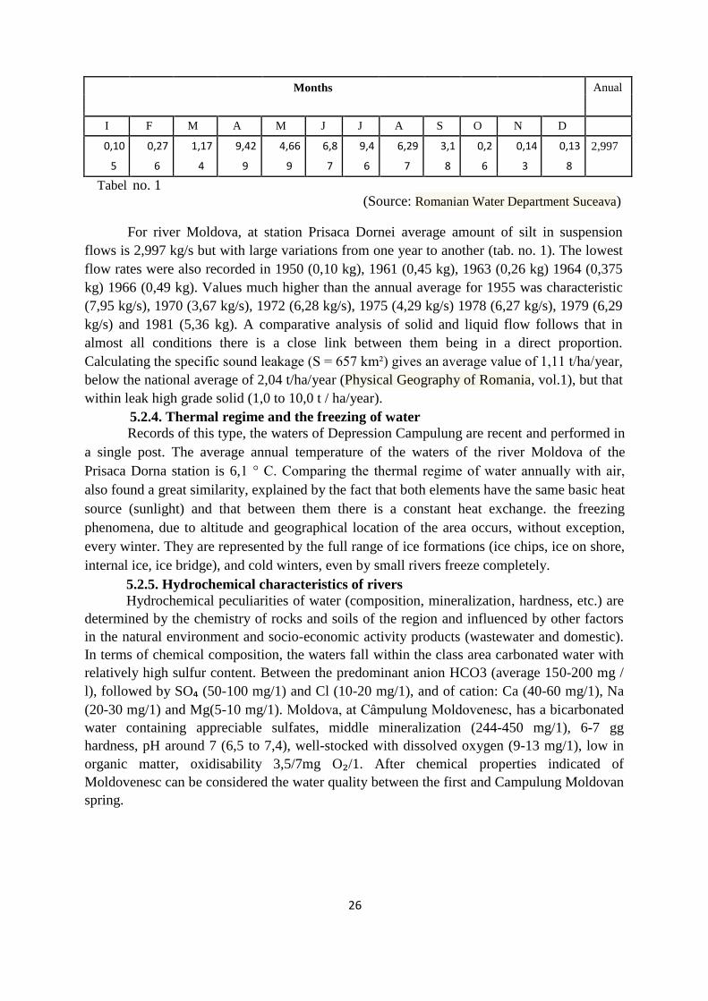
(Source: Romanian Water Department Suceava)
For river Moldova, at station Prisaca Dornei average amount of silt in suspension
flows is 2,997 kg/s but with large variations from one year to another (tab. no. 1). The lowest
flow rates were also recorded in 1950 (0,10 kg), 1961 (0,45 kg), 1963 (0,26 kg) 1964 (0,375
kg) 1966 (0,49 kg). Values much higher than the annual average for 1955 was characteristic
(7,95 kg/s), 1970 (3,67 kg/s), 1972 (6,28 kg/s), 1975 (4,29 kg/s) 1978 (6,27 kg/s), 1979 (6,29
kg/s) and 1981 (5,36 kg). A comparative analysis of solid and liquid flow follows that in
almost all conditions there is a close link between them being in a direct proportion.
Calculating the specific sound leakage (S = 657 km²) gives an average value of 1,11 t/ha/year,
below the national average of 2,04 t/ha/year (Physical Geography of Romania, vol.1), but that
within leak high grade solid (1,0 to 10,0 t / ha/year).
5.2.4. Thermal regime and the freezing of water
Records of this type, the waters of Depression Campulung are recent and performed in
a single post. The average annual temperature of the waters of the river Moldova of the
Prisaca Dorna station is 6,1 ° C. Comparing the thermal regime of water annually with air,
also found a great similarity, explained by the fact that both elements have the same basic heat
source (sunlight) and that between them there is a constant heat exchange. the freezing
phenomena, due to altitude and geographical location of the area occurs, without exception,
every winter. They are represented by the full range of ice formations (ice chips, ice on shore,
internal ice, ice bridge), and cold winters, even by small rivers freeze completely.
5.2.5. Hydrochemical characteristics of rivers
Hydrochemical peculiarities of water (composition, mineralization, hardness, etc.) are
determined by the chemistry of rocks and soils of the region and influenced by other factors
in the natural environment and socio-economic activity products (wastewater and domestic).
In terms of chemical composition, the waters fall within the class area carbonated water with
relatively high sulfur content. Between the predominant anion HCO3 (average 150-200 mg /
l), followed by SO₄ (50-100 mg/1) and Cl (10-20 mg/1), and of cation: Ca (40-60 mg/1), Na
(20-30 mg/1) and Mg(5-10 mg/1). Moldova, at Câmpulung Moldovenesc, has a bicarbonated
water containing appreciable sulfates, middle mineralization (244-450 mg/1), 6-7 gg
hardness, pH around 7 (6,5 to 7,4), well-stocked with dissolved oxygen (9-13 mg/1), low in
organic matter, oxidisability 3,5/7mg O₂/1. After chemical properties indicated of
Moldovenesc can be considered the water quality between the first and Campulung Moldovan
spring.
Months Anual
I F M A M J J A S O N D
0,10 0,27 1,17 9,42 4,66 6,8 9,4 6,29 3,1 0,2 0,14 0,13 2,997
5 6 4 9 9 7 6 7 8 6 3 8
Tabel no. 1

27
5.3. The problems of water use
Water sources are used at present in drinking water and domestic urban and rural settlements;
in providing industrial water requirement for the woodworking industry units which were
extended especially on the lower terraces of rivers and river terraces Moldova, production and
storage of large amounts of waste wood affecting water quality and inhibits the development of
ichthyofauna, food , construction materials. These uses are added and water accumulation in
fish enclosures (of the Prisaca Dorna, Putna Valley). These uses involve a small amount of
water in these rivers largely restored, so that no disturbances occur in the hydrological regime
and water chemistry is felt very least, due to the poor contaminations from specified sources
(some are equipped with wastewater treatment plants) and great opportunities to restore natural
water quality downstream sources by mixing, dilution and self-purification.

28
Chapter VI. Vegetation of the depressionary basin between the defile of Sadova-
Pojorâta și PrisacaDornei
6.1. The flora
6.1.1. Floristic composition
The large number of floral taxonomic units identified in the study area is explained by
the multitude of ecological categories, represented by geological substrate and soil, food
regime, thermal, fluid, etc. After Raclaru P. (1970), are known in the wild flora of this area
cormophyte 1,019 species (to which we add 731 units infraspecific), belonging to 396 genera
and 91 families, which is approx. 28% of wild species known in Romania. 6.1.1.1. Origin and analysis of floristic elements
Great natural diversity of the studied area is amplified and complexity phytogeographic
elements. Elements of northern origin (Holarctic species) – 60,0% are represented by
fitoelemente Eurasian – 28,6%, European – 13,3%, circumpolar – 11,2%, and Central
European – 6,9%; preponderance floristic elements belonging justify northern study area.
Elements of southern origin (Mediterranean and Balkan-Dacian) and eastern (Pontic and
continental) have a much lower representation (with approx. 13,0%). With a remarkable
percentage is present the Alpine origin (4,5%); is also reported the presence of a relatively
high number of endemics (5,6%), among which: Aconitum moldavicum, Campanula
carpatica, Campanula rotundifolia, Cardamine glanduligera, Centaurea melanocalathia,
Chrysanthemum rotundifolium, Festuca carpatica, Melampyrum silvaticum ss. saxosum,
Phyteuma wagneri, Symphytum cordatum,Thymus pukherimus, Achillea schurii, Aquilegia
nigricans, Centaurea prodani, Centaurea trimfett-ssp.pinnatifida, Aconitum lasianthum,
Aconitum toxicum, Dianthus kitaibelii-ssp. Spiculifolius (Ștefan N., 1985).
Also of endemic species present in the study area include: Dianthus tenuifolius,
Eritrichum nanum-ssp. jankae, Heracleum carpaticum, Hesperis matrionalis-ssp.
moniliformis, Scabiosa lucidassp. carpatica, Thymus schurii, Trisetum macrotrichtem, Silene
dubia, Thymus comasus, Thymus bihorense, Ranunculus carpaticus, Phyteuma tetramerum,
Viola jooi, Aconitum firmum-ssp. bucovinense și ssp. romanicum, Erysimum wittmanni,
Hieracium pojoritense, Poa nemoralis-ssp.rehmani, Primula leucophylla, Silene zawadzkii
ș.a. A final category of floral elements is the cosmopolitan species group (4.7%) and
adventitious (1,3%), (Ștefan N., 1985).
6.2. Zonal vegetation 6.2.1. Considerations on current forest vegetation
In historical times, forests occupy large areas in the basin of the depression, so in the
right side of Moldova occupies almost the entire surface of the Massif Rarău, except rocky or
occupy areas, such as the north-eastern slope of Rarau and Pietrele Doamnei klippe or some
isolated limestone. On the left side of the basin lowland areas occupied by forests were as
extensive installation in compact areas. The only areas where the vegetation was present in

29
the base discontinuity Campulung Moldovenesc depression.
Gradually, they created areas of grassland (meadows and pastures), with a
postforestier anthropogenic character. At the top of the landsChaptere, in Pietrele Doamnei,
Piatra Zimbrului, Vârful Rarău and high Pochii Rarăului-Todirescu due to less favorable
environmental conditions (T C = 1.2 ° -2 ° C, 950-1100 mm annual rainfall, strong winds and
shallow skeletal soils) and abusive grazing, has installed subalpine vegetation character
(meadows and thickets), (Rusu C., 2002).
The phenomenon of expansion of grasslands and forest weight decrease deforestation
continues today with isolated trees or clusters of trees to limit grazing grassland and adjacent
forest.
6.2.3. Phytocenologic considerations
Current vegetation appearance is the result of interaction between factors stationary
and prolonged expression of human intervention. Depending on the characteristic vegetation,
the study area is part of the boreal forest, covering three floors altitude, but which are very
difficult to strictly defined: a) The floor of mixed beech forests (mountain) develops from the valley Moldovei (cca.
600 m) and climbs to over 1000 m altitude to interfere with spruce stands. Due to the
vegetation, the floor appears well developed, climbing even under Plaiul Todirescu.
b) Floor of spruce start of the massif, and from northern terraces Moldova
(Campulung Moldovenesc area) and continue until about 1550 m (under The peak Rarău and
Pietrele Doamnei). In Obcina Feredeului spruce floor also starts the first terraces of of
Moldova and continue to the top of Tomnatic 1302 m.
c) Subalpine floor is much underrepresented characteristic peaks being the most
prominent, but at the lower end of the floor, around the northern group of the Eastern
Carpathians. Vegetation is typical subalpine at altitudes between 1550 and 1651 m and
consists of shrubs and meadows, while the upper mountain gap, which gradually widened by
deforestation, is occupied mainly by mountain meadows eith mesophilic secondary character.
6.3. Azonal vegetation
In addition to zonal vegetation in the study area and vegetation is found azonal
vegetation, which is installed in stations with special ecological conditions surrounding
resorts. Encounter rocky vegetation (Saxicola), humid vegetation (mezohigrofilă and
hygrophile), recently deforested land vegetation and vegetation characteristic of weeds
(ruderal).
6.4. Natural productivity and economic importance of vegetation
The main plant formations, forests and meadows, is one of the most valuable natural
resources of the area, with multiple recovery and use. The demographic explosion of the last
century and the industrial revolution required operation in a fast paced of the forest
ecosystems and grassland, which favored the progressive emergence of functional imbalances
that now threaten even the development of certain ecosystems. Certain factors are virtually
uncontrollable imbalance, so hard to avoid (of abiotic factors mentioned wind, drought and
heavy snowfalls, biotic factors - hunting), but anthropogenic element is the one that puts the

30
biggest problems.
Today it is well known role of moderator and balance that possess vegetal cover, the
most dynamic part of the biosphere. Throughout its place the most spectacular accumulation
and exchange streams multiple transformations that produce mechanical energy, chemical and
physical in the spheres of coming into contact with multiple interconnections and
interdependent. While most physical-geographical factors of the territory manifests complex
vegetal cover combines a particularly interesting all these elements, with a clear trend
smoothing in a geographical ansamblaj with their meanings.

31
CHAPTER VII. FAUNA
The fauna is an important element of the stationary conditions of the study area. The
role of biodiversity in the container assembly is in general, keeping biotic balance that gives
him space mountain and depression.
In evolution, fauna followed a very tortuous road, as vegetation through successive
stages according to the climate changes, especially in the Pleistocene and Holocene. The
evolution of current and fauna composition are for the most part of the Carpathians of low
and medium altitude. Altitudinal distribution of the main groups of animals in the area are, in
general, the floors of vegetation, although are numerous species able to live in very different
environmental conditions.The vast majority of species assessed (mammals and birds) can not
be strictly limited in some areas or physio-climatic floors, their mobility is great, but as a
general regularity of distribution can not separate faunal element of morpho-physio-climatic
conditions. In what follows I will make a summary of the groups of vertebrates (mammals,
birds, fish) that contribute to the shaping of the landsChaptere units and actively participate in
the regional economy (hunting and fishing fauna in the lower regions, peripheral and
depressions, mammals represented by several species characteristic: badger (Meles meles),
hedgehog (Erinaceus europaeus), mole (Talpa europaea), mice (Apodentus tauricus) (A.
sylvaticus, Microtus arvalis) etc. The avifauna is composed of numerous sedentary species,
seasonal or passage, between which: small wren (Phyllocopus Collybia), collared flycatcher
(Ficedula albicollis), flycatcher (Ficedula parva) sur tit (Parus palustris), White-backed
Woodpecker (Dendrocopus leucotus) etc.Mixed forest fauna is extremely rich, there are a
number of mammals present some valuable hunting aspect. Most of them have a very wide
spread area, meeting and molidişului floor: deer (Cervus elaphus), wild boar (Sus scrofa),
deer (Chapterreolus Chapterreolus), bear (Ursus arctos), lynx (Lynx lynx), hollow marten
(Martes martes), squirrel (Sciurus vulgaris), wolf (Canis lupus), hare (Lepus europaeus), lynx
(Glis glis) etc. Of these, lynx, wolf and brown bear are in a smaller number of copies,
although the latter two species have increased considerably in recent years (Rusu C., 2002).
7.1. The role of biodiversity in forest development
Insects can cause physiological damage to forest species, in that it threatens the life
and health of trees, for example, by eating leaves, Cetin, roots, bark or other organs orvital
tissues of trees, as damage can occur when production-where insects invades the dry wood
felled trees or standing. In general, forest insect damage are enormous. Secondary pests and techniques in group
includes several families of secondary pests of the order of the Lepidoptera and the
Hymenoptera. They were classified in the first group, after the character and causing damage
after the attacking particularity mostly trees weakened by mayors or other pests such as fire,
wind, factors related to weather or soil conditions. Secondary pests on of trees felled swoop
and storms and the timber exploited recently. Group pests techniques (for example, some
Ipidae, Elateridae, Cerambycidae), most dangerous for woods are: Ipidae, Cerambycidae,
Buprestidae (Arsenescu M., 1960).
Wild animals causes forest damage caused mostly by rodents (mice, rabbits), which are particularly harmful seedlings, saplings by biting young stems, buds, bark-stripping seedlings.

32
Cervids, which in some areas cause damage to trees standing by peeling and remover
and starting from the age of 12-15 years, culminating in the 20-50 years. Bears by peeling and
flaking standing trees, starting at the age of 30 years and for up to 50-60 years.
Grazing of cattle in forests is a harmful practice for the forestry sector. He is damaging
trees, undergrowth, natural regeneration and artificial regeneration works. Also, grazing has
harmful effects such as breaking crops, tearing the leaves, stems and branches of saplings,
shrubs or trees, trees bark injury, prevent seed germination and natural regeneration in forests,
reducing annual growth of trees, weakening force growth and the viability of trees, leading to
their drying and hence to brăcuirea and forest degradation and drying phenomenon intense
destruction undergrowth, creating favorable conditions for mass propagation of insects and
fungi, degradation and promoting soil erosion, prevent development game. Most damage from
occurring in the plantations where grazing animals destroy seedlings in natural or artificial
regeneration, sowing and natural regeneration to achieve solid state, stands located on steep
slopes, which stands hardly vegetate various other causes (insects attacks mushrooms, edaphic
or climatic conditions unsuitable etc. 7.1.1. The positive role of the fauna
The forests character determines the presence of the birds in the forest, insects and other
useful animals.. In relation to the complexity of the ecological environment, increase the
diversity of living organsmelor, biocoenosis and forms complicates the struggle for existence
in it, and harmful organisms are overwhelmed by the relevant forest. Conversely, depletion of
forest biocenosis in vegetative forms weakens the whole constitution of biocenosis, reduce
useful species and lower defense traits of trees. Therefore the main condition to preserve all
bodies is useful in creating and maintaining multi-storey mixed and stands as the most perfect
of biologically. Among the beneficial organisms that are found in forests and preventing the
massive development of insect pests, special attention should be given to birds, insects and
some mammals.
Among insects must be protected especially ants, ant colonies in forests should be
protected, especially red forest ant (Formica rufa), because ants destroy many butterflies
caterpillars and Tenthredinidelor. Predatory insects are very important note: carabidele
(Carabus auratus, Calosoma syncophata, Cicindelele) that feed on caterpillars; Ladybugs
(Coccinella septempunctata) that devours leaf beetles and plant lice; bugs (Syromastes
marginatus), which suck the liquid content of caterpillars; Forficula auricularia pupae
devouring pests; Mantis religiosa destroying insects; spiders, especially cross spider (Spider
diodemata) that catch and kill insect pests in their nets (Flerov S.C., 1952). All these insects in
appreciable numbers have a special role in combating forest pests naturally. Increasing the
number of birds in forests such as the birds that are doing their nests and their chicks out on
the ground (wren), the branches of shrubs (River warbler), or in trees, branches, at their base (
Finch, thrush and others) can be achieved by attracting their guard and giving them
convenient places for nesting and artificial nests. Increase the number of forest insects can be
achieved by creating food database by guarding places that are found in large numbers,
multiplying their artificially and leave them in the trees. Among mammals, species must be

33
protected like the mole and hedgehog who consume larvae of beetles and other insect pests in
the soil; sharp-nosed mice consuming insects litter or soil; bat consuming certain insects,
especially butterflies, reptiles, snakes except viper striped badger, intense consuming insects.
CHAPTER VIII. Soils of the depressionary basin between Sadova-Pojorâta and Prisaca Dornei
In terms of soil essential feature of the basin depression gorge between Sadova-
Pojorâta and Prisaca - Dorna is given by the existence of a relatively diversified soil cover as
a result of various conditions of pedogenesis and varied combination of these conditions on
small areas. Against this background it highlight several features of the distribution of soil
types, topography and geological substrate introduced.
Soil structure, types and their spread in the area are the result of pedogenetic factors
and pedogenetic processes.
8.1. Soil taxonomy
For the presentation of spatial distribution and properties of soils in the study area I
used several sources. Data obtained by opening several soil profiles in the area (E. Rusu and
M. Piticar, 2012), were compared with those in the literature, and with the other authors of
which the most important was C. Rusu, because part of the study area overlaps the area
studied in the work of C. Rusu “Study Rarău Mountain Physical Geography”.
Diagnosis and taxonomic were performed as in accordance withSistemul Românde
Taxonomie a Solurilor (SRTS) Bucharest (2012), dealing with the levels of taxonomic
classification (class, type, subtype), to prepare the soil map sc. 1:25.000. While this was
necessary, even proceeded to introduce subtypes new single or combined, however not
always be found on the map scale, due to limited areas they occupy.
Primary information obtained through field research was completed with the chemical
analysis performed in specialized laboratories ICPA Bucharest. For taxonomic and physico-
chemical characterization of soils were necessary determinations of reaction (potentiometric
method), carbonates (gas-volumetric-calcimetru-Scheibler), humus (wet oxidation and
Walkley-Black titrimetric dosage), the amount of base cation exchange (Kappen method), all
exchange acidity (pH 8,3), calculating the total cation exchange capacity values (T) and the
degree of base saturation (V). Textures were established based on the analysis of particle size
(wet sieving and pipetting method), and for some physical parameters were sampled in
alignment unchanged, using metal cylinders.

34
For main profiles, chemical determinations range widened, realizing complex analysis
on replacement basic cations (Ca, Mg, Na, K), mineral nutrients (total N, P2O5 mobil and K2O
mobile), Fe total and free furniture forms of nitrogen (NO₂, NO3, NH4), Cl, redox potential.
Qualitative analysis of organic matter included determinations of total organic carbon (Ct),
extractable carbon (Cext) himice fractions: humic acids (CAH), fulvic acids (CAF), Human
(CH). For confrontations and comparisons were taken from literature physicochemical data of
some soil profiles made in the Massif Rarău by C. Rusu, 2002 and Obcina Feredeului made
by E. Rusu și M. Piticar în 2012.
8.2. The spatial distribution and the soil’s characteristics
The manifestation differs as sense and intensity of the soil formation factors and
caused different directions in pedogenesis and further, in the evolution of the soils, which has
as result the tessellated aspect of the soil cover. This diversity is ancillary but also dependent
on the position occupied by the depressionary basin between the defile Sadova- Pojorâta and
Prisaca- Dornei in the assembly of the Oriental Carpathians. The soil’s mapping was executed
on basis of the Romanian System of Soil Taxonomy (SRTS) I.C.P.A. Bucharest, 2012, by using
the morphogenetic classification, whose defining elements are the diagnostic horizons and the
specific characteristics (diagnosis). The specific classification criteria have been correlated
with the regional principles of certain elements of the physico- geographic frame. From this
combination resulted the map of the soils from the defile Sadova- Pojorata and Prisaca-
Dornei, being located types and subtypes of soil which belong to the following categories:
cambisols, spodisols, protisols, regosols, aluvisols, anthrisols, hidrosols.
The cambisols occupy most of the researched area and they are represented by:
eutricambosols (EC) and districambosols (DC).
There were identified ordinary eutricambosols (EC ti), rezicalcaric eutricambosols (EC
rk), molic eutricambosols (EC mo), lithic eutricambosols (EC li). They are characterised
through a moderated to very weak acidic (sometimes even neutral) reaction, medium to
extremely high humus reserves (184- 660 t/ha), specific contents of nutritive elements, usually
diminished. They are lingered in the medium and inferior part of the region, until altitudes of
1100- 1200 m. Though, they were observed at higher altitudes too (1310 m), under the spruce
forests. This situation highlights the importance of the lithologic substrate (marnocalcar) well
tipped.
8.3 Soil classes
8.3.1. Cambisols class
This class of soil represents the major ground of the pedologic cover and meets all the
formation conditions in the inferior mountain level and locally, in the medium one. The
cambisols are conditioned by the lithostratigraphic complexes, with a combination of marl,

35
argil and schist characteristics, of the wildflish, but are observed also on the sandy-
conglomerates of Muncelu and Stratele cu Aptychus, and rarely, on the high carbonized
deposits (at high altitude), as well as on the crystalline schists (at the basis of the relief
level).The special frequency in territory of the cambisols approaches a lot Campulung-
Moldovenesc depression to the surrounding mountain units (Obcinele Bucovinei), which
belongs to the eastern- carpathian flish. Also, this soil class occupies more than 50% of the
pedological ground within the Rarau massif, which makes it alike with the surrounding
mountain units (Obcinele Bucovinei) which belong to the eastern- carpathian flish.
The allocation of the soil types which make part of this class is different within the
studied areal, therefore on the right versant of the depressionary basin between the defile
Sadova- Pojorata and Prisaca- Dornei, represented by the versants of the Rarau massif, the
cambisols, the eutricambosol type can reach altitudes of 1400-1500 m, while the
districambosol type can be observed at altitudes of 700- 800 m in comparison with the flish
mountains where is localised, on the superior part of the relief.
The cambisols class occupy the following areals within the defile Sadova- Pojorata
and Prisaca-Dornei, Măgurile Câmpulungului (Runc, Bodea, Magura, Cocorul), the
depressionary basins (Valea Seacă, Izvorul Alb- Limpedea), the high part of the Rarău Massif,
as well as the left versant of Obcina Federeu.
Among the taxonomic units (types), which form this class, in this region the cambisols
are represented by eutricambosol and districambosol, especially through the occupied
surfaces.
The eutricambosols are the most frequently observed in the depressionary basins
Fundu Pojoratei, Valea Seaca and Izvorul Alb, Limpedea, in Magurile Campulungului and in
the eastern part of the territory, between Valea Caselor and Slătioara. The
eutricambosols have an altitudinal disposure mostly influenced by the nature of the parental
material and of the underlying rock, therefore the rocks with a neutral or low alkaline pH
(flishoid rocks and the ones from the rockfill of the Rarau mesozoic synclinal), can reach
altitudes of 1200- 1300 m and isolated can reach altitudes of 1500 m.
The highest frequency is had by the ordinary eutricambosols, such a soil subtype was
localised in Obcina Feredeu, between Deia and Hurghis. It shows the following pedogenetic
conditions: it is localised in an interfluvial peak, in the medium terce at an altitude of 945 m,
with an inclination/grade of 10°/S, it shows a parental material represented by black schists,
with a good global and natural drainage, the hydrostatic level of the phreatic water is < 5 m, is
situated in the wood area (Picea abies, Abies alba), populated with the current vegetation of
spruce forest, with fir (Picea abies, Abies alba, Fagus sylvatica, Rubus idaeus, Luzula
luzulloides, Deschampsia flexuosa, Nardus stricta, Sphagnum, etc.) with a good productivity.

36
The horizon Ao has a thickness of 0- 9 cm, colour 10 YR 6/2, a sandy- loam pattern,
glomerular structure, woody roots, with a reduced biological activity, clear section.
Foto no.16, Profile no.7 Eutricambosols ordinary (Piticar T.M.)
The horizon AB is situated between 9- 31 cm, colour 10 YR 5/3, sandy- loam pattern,
big grainy structure, woody roots, reduced biological activity, gradual section. The horizon Bv
is situated between 31- 49 cm, colour 10 YR 5/3, sandy- loam pattern, skeleton 70%, grainy
structure, woody roots, clear section. The horizon C1 is situated between 49- 92 cm, compact
level of black schists (without samples), clear section, the horizon C2 is situated between 65-
80 cm, colour 10 YR 3/3 and 2,5 Y 3/2, a mixture of argil and clay pattern, skeleton 30%,
unmodified rock fragments, weak prismatic structure.
This soil subtype has a medium acidic reaction on the surface (pH 4,72- 5,12), low
acidic on its profile and in basis. The content of organic material is high (8- 12% in the
horizon A), because of the biologically active soils, with humus of mull type (the C/N ratio in
A ranges between 15- 18), rich in nutritive substances and with a high productivity.
The dynamics on profile of the pH 7
5,45 6,03
5,64
6 5,12
4,72
₂O) 5
4
(H
3
pH
pH
2
1
0
Ao AB Bv C1 C1
The horizons of the soil profile
Fig. no.14. Profile no.7- The ordinary eutricambosol

37
The dynamics on profile of the humus
Fig. no.15, Profile no. 7 The ordinary eutricambosol
The eutricambosols with a standard morphology: Ao- AofBv- Bv- Bv/C- C(R). The
horizon Ao has colours in the tone 10 YR, chrome of 3- 4 and values of 2- 4, thicknesses of
10- 20 cm, medium patterns (LL- LP) and a small grainy and polyhedral structure.
The dynamics on profile of the ratio
nitrogen/ carbon
25
20 18,6 19,2
15,4
15,9
13,6
15
mg·kg⁻¹10 C/N
5
0
Ao AB Bv C1 C1
Horizons of the soil profile
Fig. no. 16: Profile no.7 The ordinary eutricambosol

38
The depressionary basin between the defile Sadova- Pojorâta and Prisaca- Dornei.
The map of the soil
Figure no. 17

39
The dynamics on profile of the mobile phosphorus and potassium
140
121
120
100 87 77
82
⁻¹
75
80
mg
·kg
60
40
20 2,3 0,4 0,8 3,1 0,9
0
Ao AB Bv C1 C1
Fig. no.18, Profile no. 7 The ordinary eutricambosol
PAL (mg•kg-1) K Al (mg•kg-1)

40
Variation main cation exchange sizes
Horizons of the soil profile
Fig. no.19, Profile no. 7 The ordinary eutricambosol
Variation main cation exchange sizes
Horizons of the soil profile
Fig. no.20, Profile no. 7 The ordinary eutricambosol
The values of the humus (mull type), range between 5,44 - 11,84%, afterwards they decrease
constantly on the profile until 2- 3,5% in the superior part of the horizon Bv. It installs on
versants, low to medium inclined, as well as in the regions from the basis of the versants,
shows a high edaphic volume, creating edaphic conditions in favour of the sylvan vegetation.
It shows a favourable trophicity, low to medium acidity, accessible water volume and
equilibrated humidity regime, fostering a superior reliability for spruce, fir and beech, in
natural compositions of normal spruce and fir forests, with mull flora.
The districambosols have a more restrained distribution, being observed in the area of
the crystalline schists, epi- and mezometamorphical, on the versants from the south and east
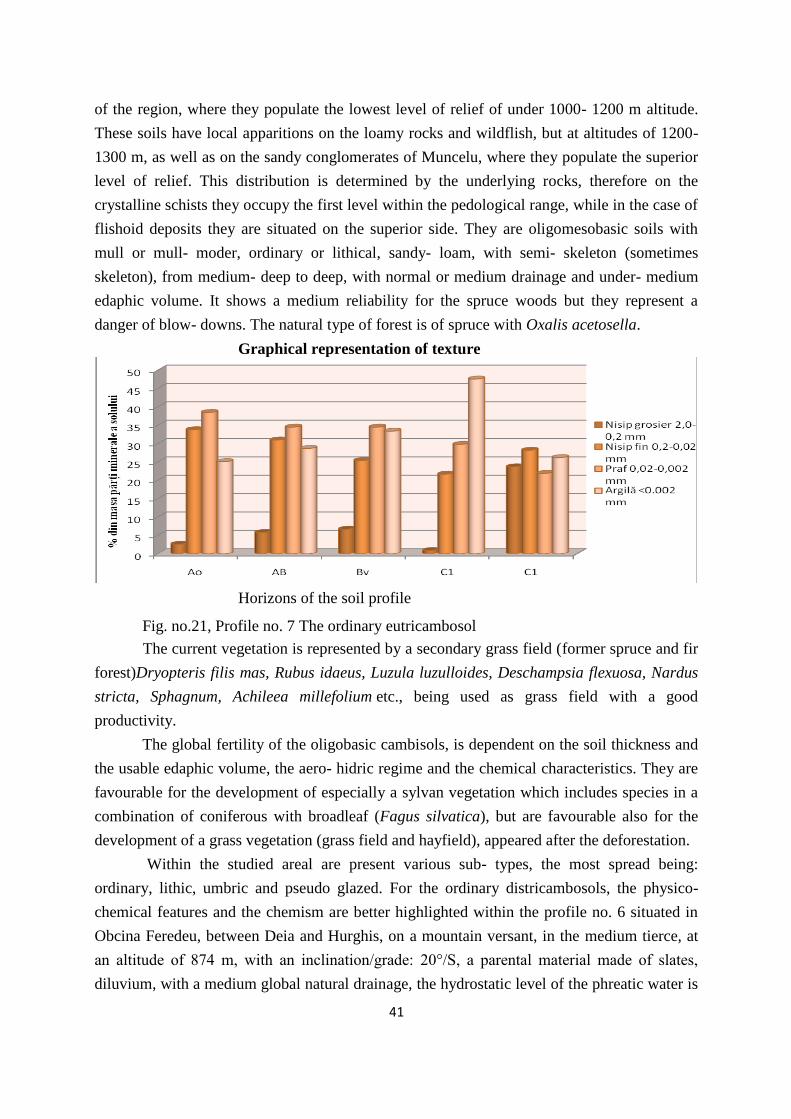
41
of the region, where they populate the lowest level of relief of under 1000- 1200 m altitude.
These soils have local apparitions on the loamy rocks and wildflish, but at altitudes of 1200-
1300 m, as well as on the sandy conglomerates of Muncelu, where they populate the superior
level of relief. This distribution is determined by the underlying rocks, therefore on the
crystalline schists they occupy the first level within the pedological range, while in the case of
flishoid deposits they are situated on the superior side. They are oligomesobasic soils with
mull or mull- moder, ordinary or lithical, sandy- loam, with semi- skeleton (sometimes
skeleton), from medium- deep to deep, with normal or medium drainage and under- medium
edaphic volume. It shows a medium reliability for the spruce woods but they represent a
danger of blow- downs. The natural type of forest is of spruce with Oxalis acetosella.
Graphical representation of texture
Horizons of the soil profile
Fig. no.21, Profile no. 7 The ordinary eutricambosol
The current vegetation is represented by a secondary grass field (former spruce and fir
forest)Dryopteris filis mas, Rubus idaeus, Luzula luzulloides, Deschampsia flexuosa, Nardus
stricta, Sphagnum, Achileea millefolium etc., being used as grass field with a good
productivity.
The global fertility of the oligobasic cambisols, is dependent on the soil thickness and
the usable edaphic volume, the aero- hidric regime and the chemical characteristics. They are
favourable for the development of especially a sylvan vegetation which includes species in a
combination of coniferous with broadleaf (Fagus silvatica), but are favourable also for the
development of a grass vegetation (grass field and hayfield), appeared after the deforestation.
Within the studied areal are present various sub- types, the most spread being:
ordinary, lithic, umbric and pseudo glazed. For the ordinary districambosols, the physico-
chemical features and the chemism are better highlighted within the profile no. 6 situated in
Obcina Feredeu, between Deia and Hurghis, on a mountain versant, in the medium tierce, at
an altitude of 874 m, with an inclination/grade: 20°/S, a parental material made of slates,
diluvium, with a medium global natural drainage, the hydrostatic level of the phreatic water is

42
smaller than 5 m. The profile is situated in the bioclimatic wood region (Picea abies, Abies
alba).
Foto. no. 17. Profile no. 6 The ordinary districambosol (Piticar T.M.)
Morphological characteristics. The horizon A0 has the dimension of 0- 9 cm, colour
10 YR 4/4, with a sandy- loam texture, small grainy structure, shows woody roots remainders,
with a reduced biological activity and a gradual section. The horizon BA is situated between
9- 24 cm, colour 10 YR 5/4, shows a sandy- loam texture, medium grainy structure, with
woody roots remainders, records a reduced biological activity and a gradual section.
5,6 Dynamic pH profile
₂O)
5,4 5,45
5,2
5,33
(H
5,21 pH
pH
5
5,06
4,99
4,8 4,94
4,6
Ao BA Bv1 Bv2 BC1 BC2
Horizons of the soil profile
Fig. no. 22. The ordinary districambosol
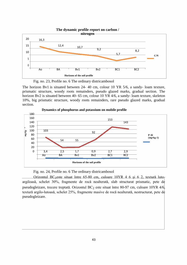
43
The dynamic profile report on carbon /
nitrogen
20 16,3
15 12,4 10,7
9,2
10 8,2
5,7
C/N
5
0
Ao BA Bv1 Bv2 BC1 BC2
Horizons of the soil profile
Fig. no. 23, Profile no. 6 The ordinary districambosol
The horizon Bv1 is situated between 24- 40 cm, colour 10 YR 5/6, a sandy- loam texture,
prismatic structure, woody roots remainders, pseudo glazed marks, gradual section. The
horizon Bv2 is situated between 40- 65 cm, colour 10 YR 4/6, a sandy- loam texture, skeleton
10%, big prismatic structure, woody roots remainders, rare pseudo glazed marks, gradual
section.
Dynamics of phosphorus and potassium on mobile profile 180
160 153
140
143
⁻¹ 120
100 103
mg
·kg
92
80
60 54 55
40
20
0 3,4 2,5 1,7 0,9 2,7 2,9
Ao BA Bv1 Bv2 BC1 BC2
P Al (mg•kg-1)
Horizons of the soil profile
Fig. no. 24, Profile no. 6 The ordinary districambosol
Orizontul BC1este situat între 65-80 cm, culoare 10YR 4 6 și 6 2, textură luto-
argiloasă, schelet 30%, fragmente de rocă nealterată, slab structurat prismatic, pete de
pseudogleizare, trecere treptată. Orizontul BC2 este situat între 80-97 cm, culoare 10YR 4/6,
textură argilo-lutoasă, schelet 25%, fragmente masive de rocă nealterată, nestructurat, pete de
pseudogleizare.

44
Variation main cation exchange sizes Horizons of the soil profile
Fig. no. 26, Profile no. 6 The ordinary districambosol
Variation main cation exchange sizes
Horizons of the soil profile Fig. no. 27, Profile no. 6 The ordinary districambosol
Graphical representation of texture
% d
in m
asa
pă
rți
min
era
le a
solu
lui
50
45
40
35 Coarse sand 2- 0.2 mm
30
Fine sand 0,2-0,02 mm
25
20
Dust from0,02-0,002
mm
15
10
Clay<0.002 mm
5
0
Ao
BA
Bv1
Bv2
BC1
BC2
Horizons of the soil profile
Fig. no. 28, Profile no. 6 The ordinary districambosol

45
Horizon Subcls.
text.
Corse sand Fine sand Dust Clay
2,0- 2,0- 1,0- 0,5- 0.2- 0.2- 0.1- 0.05- 0.02- <0.002 <0.01
0,2 1,0 0.5 0.2 0.02 0.1 0.05 0.02 0.002
Ao 4.6 1.2 1.2 2.2 38.2 4.0 0.1 34.1 35.8 21.4 46.5 LP
BA 5.9 0.7 1.3 3.9 40.0 5.1 0.3 34.6 34.3 19.8 44.4 SS
Bv1 8.6 2.5 2.4 3.7 37.9 4.4 0.2 33.3 32.7 20.8 44.1 LP
Bv2 5.6 1.4 1.4 2.8 36.1 3.9 0.3 31.9 29.8 28.5 49.0 LL
BC1 7.0 2.1 1.9 3.0 25.4 3.0 0.1 22.3 20.9 46.7 62.1 AL
BC2 7.7 2.6 1.9 3.2 24.4 3.2 0.0 21.2 23.5 44.4 61.9 TT
Tabel no. 4
The stagnant districambosols correspond to certain areas with poor drainage, shaded,
parental materials of a marno sandy nature, being situated especially on versants, with a little
inclination, and on plane surfaces. Within the Rarau massif, this subtype of soil can be also
localized at altitudes higher than 1400 m, on Rarau’s upland, within certain small sinkholes
and more frequently within Pochii Raraului. But the most important surfaces are between
Valea Seaca and Izvorul Alb at altitudes higher than 1000 m. The evolution of this soil
subtype is connected to the presence of the soil formation deposits, which present an
imperfect drainage, which determines a stagnancy of the pluvial water. It forms mostly on
basis of the versants, on connecting surfaces where there is a substantial input of adobe
material, on a ground of cretacic wildflish.
Generally, the districambosols have a fertility level which is determined by the
thickness of the pedon and the usable edaphic volume, the aero- hidric volume and the
chemical characteristics.
The productivity of these soils is determined by the relief and the climate, which
intervene through certain processes (surface erosion, earth flow, highly declivities, intense
surface leak), to which are added chemical processes, partially not favourable. Therefore,
within the sylvan station, they present a good and very good productivity, but in the case of
the secondary grass fields, the natural fertility is a lot more reduced.
8.3.2. The Spodisols class
In this area, at the crossing point of the carpathian flish, the representative soils remain
the cambisols, with the crystalline unit of the Oriental Carpathians, where the spodisols form
and develop. These form a distinct pedogenetic unit which constitutes a level superior to the
cambisols from the altitudinal disposure point of view.

46
The Prepodzol class contains the most representative spodisols of the region. They are
specific to the relief level between 1000- 1200 m altitude, from the west and south of the
region. Under these conditions, the prepodzols have a reduced fertility, being used in the
forestry as natural grass fields. Their reliability is medium for the combination of coniferous
and beech, fir and spruce forests, the flora is of type Asperula- Dentaria, Rubus hirtus.
The Podzols (PD) are seen in association with the prepodzols, at altitudes higher than 1300m,
on peaks and versants with a poor- moderated inclination, on periglacial eluvium or hillside
detritic deposits from crystalline schists (many times with siliceous intercalations). The
Podzols show a poor productivity for the grass fields and moderated for the sylvan vegetation
(spruce forests).
8.3.3 The Protisols class
In this class are included soils not related genetically, formed under different
conditions and which evolved different. It contains not developed soils, with incipient
processes of pedogenesis, which is in incipient phases of evolution (aluviosols), or have
resistence for alteration in comparison with the hard rocks (lithosol), conditioned by the
geological erosion (regosols).
The lithosols are situated in restrained areals, on the highly inclined versants from the
central region of the Rarau Massif, on small surfaces from the region of the quarries of
Pojorata or some old stockpiles. The chemical and trophicity properties are in accordance with
the chemico- mineralogical nature of the rocks, the humus content and the altitudinal level.
Within the Rarau massif, the lithosols have formed on limestones and dolomites. Almost
invariable, the lithosols are capitalized by the sylvan vegetation, but with distinct
characteristics (spruce forests in combination with birch, rare spruce forests with bushes of
juniper and mountain pine), these are not distinguished in the pedological assembly, the
spectacular relief being the one which imposes itself- gap, abrupt hillsides, cliffs.
8.3.5. The Regosols class
This soil class shows a reduced distribution within the studied areal, the most
favourable conditions are fulfilled within the wildflish versants affected by a consequent
erosion, as the case of Coasta Prasca, on the versant’s faults, as well as in the regions affected
by the heavy earth flows, in the past, within the basin Izvorul Malului.
The poor productivity within the grass fields which are used sometimes as natural
grass fields, as well as the only correct usage, respectively the sylvan one is given by the
morphological characteristics, as well as by the physico- mechanical characteristics of this
type of soil.
The anthrosols are a soil subtype which within the studied areal shows very reduced
surfaces. The formation conditions are determined by a geological substrate formed by flish or
wildflish where there were created intense erosional processes on the surface. Also, territories
47
where this subtype of soil was observed were localised within the grass fields from the
surroundings of Campulung Moldovenesc town, in the entrance points of the animals on the
cattle runs, such as the case of Izvorul Vitelor, Valea Seacă, Valea Caselor, Izvorul Alb.
The alluvial protosols are situated in the surroundings of the minor riverbeds (grinds,
islets, gravels), but also of the major floodable riverbeds of Moldova or its confluents (Valea
Seaca, Izvorul Alb, Izvorul Malului, Valea Caselor, Sadova, Paraul Morii, Deia, Hurghis).
8.3.6. The intrazonal soils The lithomorphic soils have insular occurences corresponding to the limestones and
dolomites abruptions. Better represented are some appearances on the surface, at the border of
the Rarau synclinal and a few pieces reduced as surface on the left versant of the depression in
Obcina Feredeu.
The main types of soil are the rendzina (with different evolution
stages: protorendzina, ordinary rendzina and black rendzina), the last ones being the
transition stage towards the soils of the correspondent region. Between these soils, the black
rendzina and the black carbonated soils are more represented, with poor acidity and a content
higher in alkalies than the surrounding soils, invaded by a vegetation, mostly regional, while
the ordinary rendzina and especially the protorendzina correspond to the poor soiled rock
material, surrounding the residual cliffs or at the basis of the limestone and dolomite walls,
discontinuously fitted by a vegetation, mostly or exclusively calcifilic. The arbores which are
installed on these skeletic soils are rare, invalid and represented by pine, beech and rarely
spruce or fir.
8.4. The current problems of the soils usage
The productive abilities of the areal between the depressionary basin are differentiated,
with predominant sylvan and pastoral usage. The sylvan stations from the depressionary basin
are the expression of a complex of natural elements, the regional climate and the lithologic
substrate had a major role (indirectly, specifies the trophicity and the hidric capacity of the
soil).
The influence of the regional climate is reflecting in the distribution of the natural
sylvan vegetation, on the soils and implicitly on the stations. As such, within the Rarau massif
were identified sylvan stations belonging to the assortments of coniferous and beech (FM2)
and sylvan stations belonging to the spruce forests level (FM3).
The influence of the lithological substrate is strong as well, on every bioclimatic level
can be separated stations on crystalline schists and stations on limestone, dolomite, calcareous
sandstone and argil.

48
Part 2.The recent evolution of the woods
Chapter IX. Usage of the lands
The current characteristics of the usage of the lands are the result of the interaction
between the station factors and the consequent manifestation of the anthropic intervention.
Depending on the destination, the soils can be: lands with agricultural, sylvan purpose,
lands situated permanently under water, within incorporated area lands, for transports,
reservations, for mining and oiler exploitations, quarries and stockpiles, etc.
The total surface of the area is of 11241, 6 ha. The classification of the usage of the
lands in the region will be approached from the quantitative point of view of the surfaces, as
well an analysis of the evolution in time of the usage manner of the lands.
The lands classification depending on the usage categories is the following: arable 280
ha, grass fields 995 ha, hay fields 3490 ha, woods 6140 ha, 85 ha water and 100 ha cliffs and
damaged lands. From the analysis of the graphic presented in the figure no.29, one may
observe that the first place is occupied by the woods and the sylvan surfaces with a surface of
6140 ha.
The woods, occupy, without exception, the predominant percentage within the non-
agricultural usages, representing over 50% of the territorial fund. From the analysis of the
graphic presented above one may observe that the first place is occupied by the woods and the
sylvan surfaces with a surface of 6140 ha. Regarding the lands with agricultural usage, the
grass fields and hay fields occupy by far the major surfaces (Fig. no. 29). Because of the
limited morphological and climate conditions, the arable lands and the orchards have a
reduced percentage in the structure of the usage of the lands.
Fig. no. 29

49
The hay fields occupy the highest percentage of the agricultural surface (73%), the
grass fields occupy 995 ha (21%). The arable fields occupy between 2,49% from the total
surface of the territorial fund, respectively 6% of the agricultural surface.
The evolution of the wood surfaces from Bucovina, as well as of the quality of these
arbores was influenced and determined in a great measure by the economic and socio-
political factors. The construction of the normal railways, the access to the European wood
outlet, the more requests for wood, determined the increase of the exploitation rate of the
woods and of course the decrease of the surfaces occupied by the woods and it lead to the
modification of its characteristics.
Fig. no. 30
Analysing the figure no.30, one may observe the distribution of the sylvan surfaces
branched as follows: woods with a production role S.U.P. “A” (regular forest), which occupy
4534 ha, woods with special conservation S.U.P. “M” (special conservation) occupy 1357,1
ha, woods with integral guarding S.U.P. “E” (integral guarding), the arbores occupy 248,9
ha.
From the analysis of the territorial fund structure depending on the usage manner, in
2013, results that the bigger surfaces are occupied by woods (54,68%), followed by hay fields
(31,1%), grass fields (8,85%) and arable lands with only 2,49%, very low percentage, due to
the restrictive geographic and physical conditions.

50
The depressionary basin between Pojorâta și Prisaca Dornei
Map of land usage Fig. no. 31

51
Chapter X. The evolution and the structure of the forests
10.1. Types of sylvan stations on the left versant of the depressionary basin
The surface of the left versant of Moldova, downstream of its confluence with the
Sadova gill, at the limit of Obcinele Bucovinei, within the district of the Oriental Carpathians,
more exactly at the southern extremity of Obcina Feredeu until downstream of the confluence
of the Hurghis gill with Moldova. It contains sylvan fund, public property of Campulung
Moldovenesc town, administred by O.S.E. Tomnatic, with a surface of 1084,2 ha. The sylvan
fund which belongs to U.P. VI Tomnatic, 547,2 ha managed by O.S.E. Tomnatic, 282,7 ha
sylvan fund, public property of Sadova township, managed by O.S. Campulung Moldovenesc
and 148,9 ha sylvan fund, public property of the town Frasin managed by O.S.E. Tomnatic, a
total of 2063 ha (The Establishment of the Tomnatec Forest Range, 1983, 1993, 2003, 2013,
The Establishment of Pojorata Forest Range, 1980, 1990, 2000, 2010).
Both the pedo- climatic data as well as the characteristics of the vegetation lead us to
the conclusion that both the left versant and the right versant are situated at the interference of
the two climatic levels: - The mountain level with spruce forests (FM3) with a percentage of
11%; more reduced comparatively with the right versant (15%). The mountain level with
assortments (FM2) has a percentage of 89%, higher with 4% in comparison with the right
versant.
The mountain level with assortments of coniferous with beech (FM2) is the most
representative for the left versant, occupying the majority of the production unit’s surface.
This level is built especially from spruce and fir forests. Ecologic is the level with a big
diversity and complexity. This level occupies in general a well - defined region between the
mountain and pre- mountain level of beech forests (inferior) and the mountain level with
spruce forests (superior). The relief energy within this level is usually high, the versants
occupied by this arbores have the following exposures: 41% sunny, 58% partial sunny, 1%
shadowed and the following hillside categories: 1% on hillsides of under 16 grades, 59% on
hillsides of 16- 30 grades and 40% on hillsides of over 30 grades. The predominant rock is the
flish and this determined the formation of deep medium soils, especially districambosols and
eutricambosols, ordinary or lithic. The temperatures and the precipitations are situated
frequently around the medium values.
The ecological characteristic but limitative factors are: the edaphic volume in many
cases smaller due to the content of skeleton, the reduced nutritional substances, as well as the
minus of heat at his superior limit especially for beech, which represents one of the causes for
the very reduced presence of the beech in the studied arbores, the territory of the studied unit
being situated to the superior limit of this vegetation level. The mountain level of spruce
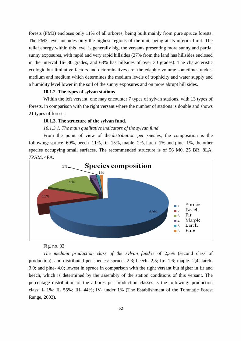
52
forests (FM3) encloses only 11% of all arbores, being built mainly from pure spruce forests.
The FM3 level includes only the highest regions of the unit, being at its inferior limit. The
relief energy within this level is generally big, the versants presenting more sunny and partial
sunny exposures, with rapid and very rapid hillsides (27% from the land has hillsides enclosed
in the interval 16- 30 grades, and 63% has hillsides of over 30 grades). The characteristic
ecologic but limitative factors and determinatives are: the edaphic volume sometimes under-
medium and medium which determines the medium levels of trophicity and water supply and
a humidity level lower in the soil of the sunny exposures and on more abrupt hill sides.
10.1.2. The types of sylvan stations
Within the left versant, one may encounter 7 types of sylvan stations, with 13 types of
forests, in comparison with the right versant where the number of stations is double and shows
21 types of forests.
10.1.3. The structure of the sylvan fund.
10.1.3.1. The main qualitative indicators of the sylvan fund
From the point of view of the distribution per species, the composition is the
following: spruce- 69%, beech- 11%, fir- 15%, maple- 2%, larch- 1% and pine- 1%, the other
species occupying small surfaces. The recommended structure is of 56 M0, 25 BR, 8LA,
7PAM, 4FA.
Fig. no. 32
The medium production class of the sylvan fund is of 2,3% (second class of
production), and distributed per species: spruce- 2,3; beech- 2,5; fir- 1,6; maple- 2,4; larch-
3,0; and pine- 4,0; lowest in spruce in comparison with the right versant but higher in fir and
beech, which is determined by the assembly of the station conditions of this versant. The
percentage distribution of the arbores per production classes is the following: production
class: I- 1%; II- 55%; III- 44%; IV- under 1% (The Establishment of the Tomnatic Forest
Range, 2003).

53
The medium consistency of the sylvan fund is of 0,62 and distributed per species:
spruce- 0,66; fir- 0,63; beech- 0,54; larch- 0,60; maple- 0,70 and pine- 0,60; therefore it was
determined a lower consistency in comparison with the right versant of Moldova.
The structure of the sylvan fund in relation to the regenerating manner. All the arbores
of the unit come from seed; of these only 58% are from natural regenerations and 42% from
plantations.
Fig. no. 33
The structure of the sylvan fund in relation to the regenerating manner. All the arbores
of the unit come from seed; of these only 58% are from natural regenerations and 42% from
plantations.
Fig. no. 44,
There are no arbores of sprouts provenience. The mainly used species in plantations
have been the spruce, sylvan pine, black pine and larch.

54
10.1.4. Quantitative indicators of the sylvan fund.
The medium age (years) of the sylvan fund is of 81 and distributed per species: spruce-
75, younger with approximately 7 years; fir- 86, older with 4 years; beech- 94, older with 9
years; larch- 5, very reduced because the surfaces resulted from recent plantations; maple- 45,
a lot younger as age- 19 years and pine- 45, resulted also as consequence of the plantations,
all this comparisons make reference between the left versant (presented above) and the right
versant of Moldova.
The current increase (m³/year/ha) of the sylvan fund is of 7,0 and distributed per
species: spruce- 8,1; fir- 8,2; beech- 4,6; larch, maple- 1,9; pine- 6,7. Generally, the increase
is smaller, determined by values which are a little lower to all the species.
The medium volume of woody mass of the sylvan fund is of 307 m³/ha, a lot more
reduced in comparison with the right versant, with a difference of over 100 m³/ha, and
distributed per species: spruce- 358 m³/ha, fir- 408 m³/ha, beech- 172 m³/ha, larch, maple- 142
m³/ha and pine- 93 m³/ha (The Establishment of the Tomnatic Forest Range, 1983, 1993,
2003, 2013, The Establishment of Pojorata Forest Range, 1980, 1990, 2000, 2010).
Fig. no. 45, The medium age per species
Fig. no. 46 The current increase (m³/year/ha) of the sylvan fund
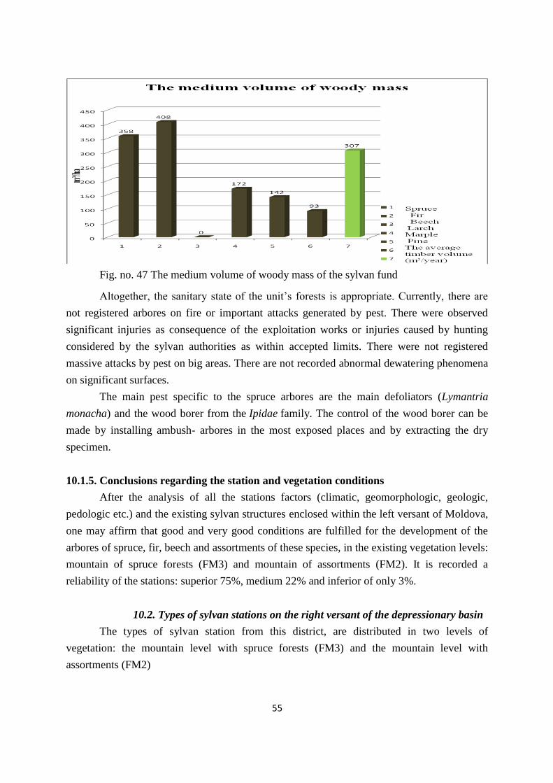
55
Fig. no. 47 The medium volume of woody mass of the sylvan fund
Altogether, the sanitary state of the unit’s forests is appropriate. Currently, there are
not registered arbores on fire or important attacks generated by pest. There were observed
significant injuries as consequence of the exploitation works or injuries caused by hunting
considered by the sylvan authorities as within accepted limits. There were not registered
massive attacks by pest on big areas. There are not recorded abnormal dewatering phenomena
on significant surfaces.
The main pest specific to the spruce arbores are the main defoliators (Lymantria
monacha) and the wood borer from the Ipidae family. The control of the wood borer can be
made by installing ambush- arbores in the most exposed places and by extracting the dry
specimen.
10.1.5. Conclusions regarding the station and vegetation conditions
After the analysis of all the stations factors (climatic, geomorphologic, geologic,
pedologic etc.) and the existing sylvan structures enclosed within the left versant of Moldova,
one may affirm that good and very good conditions are fulfilled for the development of the
arbores of spruce, fir, beech and assortments of these species, in the existing vegetation levels:
mountain of spruce forests (FM3) and mountain of assortments (FM2). It is recorded a
reliability of the stations: superior 75%, medium 22% and inferior of only 3%.
10.2. Types of sylvan stations on the right versant of the depressionary basin
The types of sylvan station from this district, are distributed in two levels of
vegetation: the mountain level with spruce forests (FM3) and the mountain level with
assortments (FM2)

56
The mountain level with spruce forests (FM3) is encountered within the entire areal,
being limited in the superior part of mountain grass fields, with low anthropic altitude,
especially due to the pastoral activities. The level is sometimes broke by the mountain level
with assortments, an important role in this scope being occupied by the exposure. The climatic
factors have a special importance in the distribution way of the spruce forests.
10.2.2. Natural types of forests
In correlation with the stations where there are situated, 93% of the types of forests
have a superior or medium natural productivity. It is observed that the arbores with a basic
natural character occupy 2004,6 ha i.e. 83%. The difference of 17% is occupied by the
artificial arbores (16%) and partially derived and totally derived arbores (1%). The artificial
arbores which are of medium and superior productivity are managed as well as the basic
natural ones situated in the same development frame.
The types of forests from the studied areal are formed in proportion of 63% by
assortments of spruce, fir and beech, which in proportion of 78% have the basic natural
character of medium and superior productivity and 18% are artificial and of medium and
superior productivity.
The pure spruce forests occupy the superior part of the relief, being encountered on
24% of the sylvan surface, of these 68% have a basic natural character of medium and
superior productivity and 11% are artificial, of medium and superior productivity.
The spruce and fir forests occupy 7% of the surface, 87% of these are basic natural of
medium and superior productivity, 11% are artificial with the same productivity.
The pure mountain beech forests occupy 2% of the total surface, all of them being
basic natural of medium and superior productivity.
From the total of the studied surface, 83% are basic natural arbores, 16% are artificial
and 1% partially and total derived. The empty lands, constituted from lands appointed to
sylvan management and lands appointed to forestation, occupy 4% of the total surface of the
sylvan fund.
The current character of the type of forest identified was established depending on the
regeneration manner and the productivity of the main element from the structure of each tree,
taking into account the composition of the arbores. (The Establishment of Pojorata Forest
Range, 1980, 1990, 2000, 2010)

57
Fig. no. 48 The composition per species
10.2.3. The structure of the sylvan fund
10.2.3.1. The main quantitative indicators of the sylvan fund.
From the point of view of the distribution per species, the regional structure is the
following: spruce- 68%, fir- 17%, beech- 12%, larch- 1%, maple- 1% and linden 1%, the
other species occupying small surfaces (Figure no.68). The medium production class of the
sylvan fund is of 2,5 (the second class of production), and distributed per species: spruce- 2,1;
fir- 2,8; beech- 2,7; larch- 2,0; maple- 2,7 and linden- 3,8.
S
Fig. no. 49.

58
Categories consistency of forest (1982) 6% 1%
Consistency 0,1-0,3
Consistency 0,4-0,6 93%
Consistency 0,7-1,0
*Medium consistency 0,77
Fig. no. 50, The consistency categories of the sylvan fund.
The average consistency of the forestry is 0,74, and reported by species: Spruce –
0,74; fir 0,75; Beech – 0,75; larch – 0,68; sycamore 0,76 and lime – 0,62.
Within the figures 50 and 51 is comparatively shown the evolution of the categories
of consistency between 1982-2003. It can be observed the decrease of the areas occupied by
the stands with a high consistency ( 0,7-1) and the increase of the areas occupied by the
stands with a lower consistency, like 0,1-0,3 and 0,4-0,6. Categories consistency of forest (2003)
Fig. no. 51,
V
100
50
0
The average age of the species
82 82 85 82
56 63
Spruce Fir Beech Larch Marple Lime Vârsta medie
pe specii
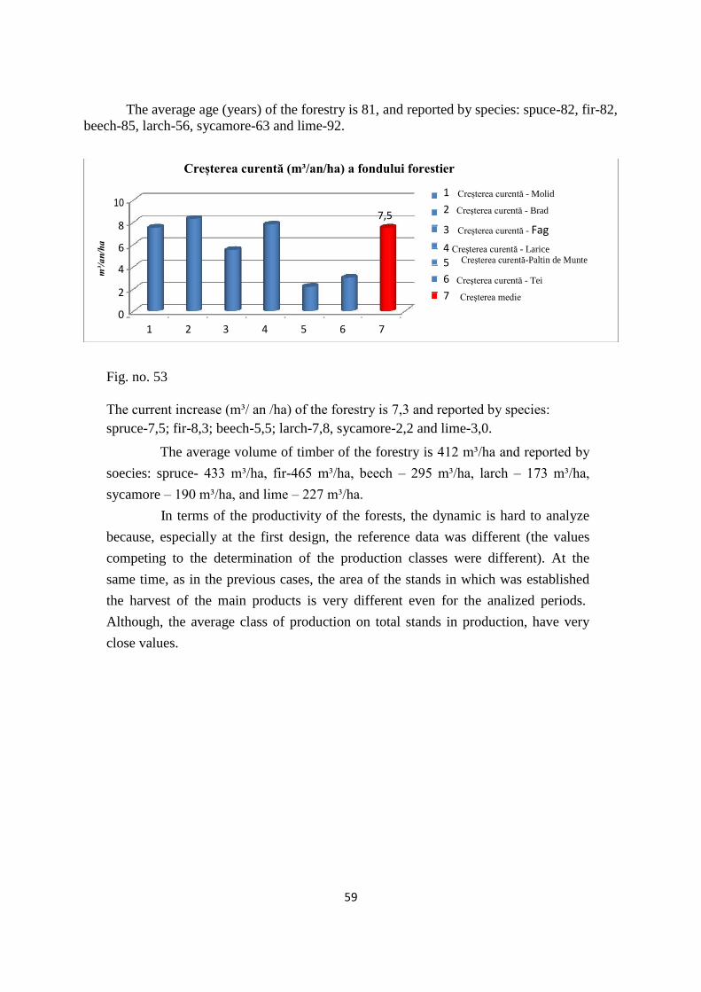
59
The average age (years) of the forestry is 81, and reported by species: spuce-82, fir-82,
beech-85, larch-56, sycamore-63 and lime-92.
Creșterea curentă (m³/an/ha) a fondului forestier
m³/
an
/ha
10
1 Creșterea curentă - Molid
7,5
2 Creșterea curentă - Brad
8
3 Creșterea curentă - Fag
6
4 Creșterea curentă - Larice
4
5 Creșterea curentă-Paltin de Munte
6 Creșterea curentă - Tei
2
7 Creșterea medie
0
1 2 3 4 5 6 7
Fig. no. 53
The current increase (m³/ an /ha) of the forestry is 7,3 and reported by species:
spruce-7,5; fir-8,3; beech-5,5; larch-7,8, sycamore-2,2 and lime-3,0.
The average volume of timber of the forestry is 412 m³/ha and reported by
soecies: spruce- 433 m³/ha, fir-465 m³/ha, beech – 295 m³/ha, larch – 173 m³/ha,
sycamore – 190 m³/ha, and lime – 227 m³/ha.
In terms of the productivity of the forests, the dynamic is hard to analyze
because, especially at the first design, the reference data was different (the values
competing to the determination of the production classes were different). At the
same time, as in the previous cases, the area of the stands in which was established
the harvest of the main products is very different even for the analized periods.
Although, the average class of production on total stands in production, have very
close values.

60
Considering the previously presented, in case that the productive forests, public
property of the state, will not be affected by big surface changes, the situation of the forest
productivity in the next stages will not register important changes.
For all the analyzes performed (the evolution of the age classes, categories of
consistency, composition and forest productivity), the registred situation at the last design
(2003) can not be compared only partially to the previouses (1971, 1982 and 1993), because,
by appling the Laws 18/1991 and 1/2000, were returned, to those entitled, important surfaces
of forest, previoslyhouseholded by forest districts PojoratasiTomnatic (The Arangement of the
Tomnatic Forest District, 1983, 1993, 2003, 2013, The Arangement of the Pojorata Forest
District 1980, 1990, 2000, 2010).
So, the percentage „changes”, positive or negative, registered in every situation for
the forests left in management of R.N.P., do not show an increase, repectively a decrease, but
it is the result of the decrease of the productive forest public property of the state.
Years Classes production (%)
Class production
average
I II III IV V
1982 7 66 26 1 2,2
1993 6 68 25 1 2,2
2003 2 66 31 1 2,3
Table 4. Evidence of forest productivity
Class structure of production forestStructura pe clase de producție a fondului
forestier
66
68
80
66
31
60
2
25
40
6 26 1
7
20
1
0
1 1982
1993
Class I Class II 2003
Class III Class IV
Fig. no. 55,

61
10.2.7.2.1. The evolution of the structure on age classes
In the structure of the age classes appeared some changes due to the ageing of the
stands and to the drops porduced by the wind, some surafces, especially with former stands
from the V th and VI th of age, being naked after the drops and recently afforested so they can
be found todat in the first class of age, this situatin along with the afforestaion of some former
older empty fields, explaining the increase with 5% of the stands share from the first class of
age compared to the situation from the previous design.
The evolution of the structure of age classes has not been influenced by the shave
cuttings or the progressive cuttings of connection metioned in the previous arrangement
works, because in the application period there were not done main products cuttting in the
stands.
The situations presented in tyhe previous arrangement concerning the evolution of the
structure on age classes of all the stands belonging to the former production unit VI
Tomnaticwich included the studied stands, show at every edition of arrangement obvious
imbalances, in the structure of the forests on age classes, due to the contless drops in mass
produced by the wind in 1969-2002, but also to the inconsistency in terms of maintaining a
continuity in time to establish uniform management measures, the productive fund being
consisting initially subunits of regulary forest, then some consecutive decades were built
subunits of gardener forest, with attempts to transform to gardening, so they can return to the
solution of gardener forests in 2003(The Arangement of the Tomnatic Forest District, 1983,
1993, 2003, 2013, The Arangement of the Pojorata Forest District 1980, 1990, 2000, 2010).
At the current arrangement of the fund of production presents a structure on age
classes obviously unbalanced, characterized primarily by the low percentage of young stands,
the total area of stands aged up to 60 years from the first three age classes, being only half of
the normal and well above the optimum proportion of older stands, especially those in classes
IV and VI age.
The significant surplus of the exploitable stands is demostrated by the size of the VI
th class of age wich is almost double to the surface of the normal age class. The application
of the proposed work by the current arrangement will lead to the end of the decade to a
substantial reduction of excess stands from the VI th age class, almost 60% of the current
stands with over 100 years old ages will be crossed in the decade of application with cuts of
definive regeneration or with shaved cuts followed by afforestation and to the substantial
increase of the area with stands from first class of age, to wich will contribute the afforestaion
of the current class of regeneration.

62
10.2.7.2.2. The evolution of the structure on production classes
The structure’s evolution on the productivity of the stands, calculated for all stands of
the studied forest fund, reflects some differences, in order to reduce by 10% the share of the
stands of higher productivity (clases I and II of production) and increase by 10%, the
proportion of the stands with medium productivity. There are no stands in the Vth class of
production, and those in the IV th class are insignificant as share ,representing well below 1%
of all stands.The average class of production o the studied stands decreased from 2,2 to 2,3
current.
The main cause of the negative evolution of structure on categories of productivity in
recent years is the negative influence of the scatters caused by the wind and the ruptures
caused by snow over the studied stands and especially those with large age, the magnitude of
these phenomens being amplified by the fact that almost half of the unit stands are aged over
80 years, assigned to classes V and VI of age.
Another cause of increasing the proportion of middle-productivity stands to the
detriment of the upper class is represented by the substantial increase of stands in first age
class,due to the plantations made in the last six years,on the bare land, mostly have not yet
reached the final success and are conventionally classified as III class of production.
The differences between the two stages of planning, largely justified by the causes
presented above, are due to, in some cases, some subjective elements about appreciation of
differences between the two editions of the management plan, resulted from a possible
overstatement of the stands height and implicitly the production classes at the last fitting in
some stands. It is expected that with the increasing age of the very young stands from the first
class of age, as well as covering the cuts and current regeneration works of the stands with
very low consistencies due to the scatters caused by the wind, the average class production in
the area to grow.
10.2.7.2.3. The evolution of the forest’s composition
Currently there have not been significant changes in the average composition of
studied stands. A positive aspect is the reducement of proportion of spruce with 2% and the
increase of 1% of the fir in the composition of the forest stands, tendence that will have to be
strengthened in the future by applying appropriate management measures, to reap the
stationary conditions of the production unit, to increase the share of the fir, larch and mixed
deciduous species to the detriment of the spruce whose current weight is significantly higher
than optimal.
The significant improvement of the stand’s structure on species can be achieved even
in the next decade,by respecting the forms of afforestation provided in the arrangement of
work of afforestation and additions that will be executed, the quantities such as large
reforestation work will significantly influence the average composition of the unit’s stands;

63
moreover, reducing the share of pure stands of spruce and creating mixed stands is one of the
effective measures to increase the resistance to the destructive action of wind stands. ( The
Arrangement of the Forest District Tomnatic 2013, The Arrangement of the Forest District
Pojorata, 2010).
10.2.7.2.4. The evolution of the stands density
The structure of the stands in the area on consistency categories recorded significant
changes in the last 15 years, in order to reduce the consistency of many stands, the average
composition of the studied forests has decrease from 0,69 in 1993 to 0,63 now. The cause of
the reduction of many stands consistency are the scatters caused by the wind and ruptures
caused by the snow from the period under review, followed in some cases by Ipidae attacks;
extraction of large volumes of incidental products,because of the phenomens mentioned
above,leading to a decrease of the consistency. High proportion of stands with consistency in
the range 0,1 to 0,33 is due to the drastic reduction of consistency of many aged stands
because of accidental releases of products from the scatters, but also to an inadequate density
of some plantations made in previous years on the lands previously bare to wind action. We
note that the evolution of the average consistency of the stands in the former production units
VI Tomnatic from where come the studied forests recorded a continuous decrease from an
arrangement to another, from 0,92 at the arrangement in 1972, to 0,75 in 1982, to 0,69 in 1993
and to 0.66 in 2003, the maine cause being the common scatters produced by the wind and the
ruptures produced vy the snow(The Arrangement of the Forest District Tomnatic 2013, The
Arrangement of the Forest District Pojorata, 2010).
10.2.7.2.5. The distribution of the areas on altitude categories
According to the recorde altitudes, it is found that the tilts of the slopes are generally
moderated to fast. The altitudes and the geographical position favor the development of the
spruce stands and mixed stands, in wich the spruce holds the main share. The slopes tilts can
influence the stands productivity because on the lands with high tilt there are superficial soils
or with a high composition of skeleton, while in the lower areas the quantity of the humus and
the depth of the soils grow, favoring the development of some higher-productivity stands.
10.2.7.2.6. The distribution of the areas on tilt categories
The distribution of the areas on land’s tilt is the following:
- 4% of the unit’s surface has a tilt lower than 16 degrees;
- 54% of the unit’s surface has a tilt between 16 and 30 degrees;
- 42% of the unit’s surface has a tilt between 31 and 40 degrees;
We notice the high share (42%) of the lands with tilts over 30 degrees, in the
producton unit.
10.2.7.2.7. The distribution of the areas on exhibition categories

64
The general exhibition of the forest fund in this area is determined by the relief, it is
sunny (41%) and partly sunny (58%), being dictated by the flow direction of the Moldova
River and the main streams that cross the studied area, but meeting all of the detail
exhibitions determined by the land’s microrelief.
10.2.8. Conclusion regarding the stationary and vegetation conditions
The geological conditions, the geomorphology, the soil, the climate in general – the
previous determined by the geographic and altitude location, favorised the development of a
varied and valuable forest vegetation, corresponding to two floors of vegetation (mountain of
spruce stands and mountain of mixed stands), wich gives to the area a proper specific at the
contact between the depressions specific and the mountain specific.
The varied lithology generated cambodoil soil formation, belonging to cambisoil class,
spodisoil class, protisoil class, regosols class and intra-zone soils( on small areas undeveloped
soils and hydromorphic soils), from weak to excessive skeletal ( which caused the useful
edaphic volume, from large to very small), more of less acidic.
The soils determined the existence of some worthiness upper resorts (60,5%),
middle(34,6%) and only 4,9% lower. In some situations, as limiting factors of productivity
appear: version deficiency of useful minerals, active soil acidity, the deficit of soil water, low
temperatures in soi land around, etc., (Late D. 1997).
The affecting stands factors are particularly important( harmful action of strong winds
and heavy snow or pest attacks followed by drying, hunting, mining works, sometimes
version erosion surface in depth and anthropic factor), as those limiting ( installed on land
stands with rock surface, those affected by water logging, etc.)
The forests of this area are matching, with priority, an important protective role, or an
economic role. Under economic report interest, primarily, the thick and very thick wood for
timber and many other uses. Regarding the role of protection, to some of the area's forests
were assigned various protection fuctions, wich cover the full range of subgroups of
functional categories: water protection, land and soil protection against harmful climatic
factors, functions of recreation and protection/consevation of the forest of scientific interest
and protection of the forest ecofund and genofund.
65
CONCLUSIONS
This paper work aims psysico-geographical presentation of depression basin bouded
by the Sadova-Pojorâta and Prisaca-Dorna gorge. The first part of the thesis contains
information about the natural elements, the stationary operating conditions of the forest
ecosystems imposed by the relief, climate, water resources and phyto-pedological cover. The
second part of the thesis presents the recent changes in forest structure and issues related to
the land use. Besides the proposed scientific purpose, this paper aims a practical scope related
to highlighting the restrictive or favorable features of the psysico-geofraphical framework and
appropriate measures to prevent land degration, forest protection, water and soil in this area
and generally maintain the natural balance.
The forest is an intristic part of the living environment of Moldova depression basin,
has an important role in creating and preserving it. Along with other terestrial ecosystems,
forest is included in terrestrial living environment, in which man lives and develops. The
presence and appearence of the forest prints the characteristic note of many climate zones, and
its massive deforestation can lead to radical changes of climate and tertain, thermal and
hydrological characteristics of those tertitories, soils, to a pronounced change of environment
as a whole. This relates the particularly large role that forest has in the evolution of the relief,
in the formation of the air layers characteristics near the ground and soil and their presevation,
over long periods of time.
The geological features of this area, exercised a great influence on the evolution of
forest by the composition and characteristics of the substrate rocks.
The complexity of the lithostigraphiccomposion of the studied area is given, on the
one hand ,by the Rarău Massive, then by the depression basin between Sadova-Pojorâta and
Prisaca-Dornei gorge and ObcineiFeredeului slope. This formation is the consequence of a
petrographic and mineralogical variety. The diversity of geological formations influence the
types and the caracteristics of the vegetation.
The relief’s role, through his characteristic elements, the landform with its tilt and
exhibition, reprezents a phisical-geographical constituent, with a huge importance for
thespred and the evolution of the forest resorts.
By climatic terms the depression basin is located in the Nord-East extremity of the
central-european province , with a temperate moderat continental mountain climate supports
some influences of the continental climate by East and subbaltic( boreal)by north.
The hydrological factor holds a decisive role in the evolution of forest resorts.
The biotic shell has a well knownrole, of moderance and balance,given by the most
dinamic part of the biosphere. In its contents occur the most spectacular accumulations and
exchanges of energy flows, wich produce multiple mechanic, chemical and physical
transformations on the levels of spheres that have contacts, with multiple interconections and

66
interdependences. If the majority of phisycal and geological factors by land occurs to be
complex, the biotic sheel combines in a very interesting way all this elements, with a clear
tendency of smooting in a geographical ensamble with its own valences.
The pastoral and forest ecosystems resorts have created over time, a series of
succesive adaptions to the enviromental conditions, an optimal model of functioning and
development, resulted in a harmoniously structured plant coating, consistent and cohesive, by
scientific interest and protection of the forestry genofund and ecofound.
The vegetation’s characteristics and the pedo-climatic data lead us to conclude that the
left side and the right side are between two climate floors:
-First floor of mountain spruce forests (FM3) with a share of 11%; lower than the right
side (15%). The mountain floor of mixtures (FM2) accounts for 89%, 4% higher than the right
side. The mountain floor of beech wood blends (FM2) is the most representative of the left
side, occupying most of the area of the production unit. This floor is especially constitue of
species of (spuce-fir). Ecologically, this floor has a large diversity and complexity. This floor
occupies generally a well-defined area between the mountain stage - piemont of beeck (lower)
and the mountain stage of spuce forests (top). Regarding the land use within the depression
Câmpulung Moldovenesc , an analysis of the land use had been realised, quantitative and a
time evolution of the areas occupied by the main categories of lands with various purposes.

67
Bibliography
1. Apostol L., Rusu C., (1990)- Aspects of air temperature from the Rarau
massive, “DimitrieCantemir” Geogr. Semin. Work, no. 9-1988, Univ. "Al. I. Cuza "Iasi
Publishing House.
2. Apostol L., Rusu C., (1990)- Considerations of atmospheric precipitations in
the Rrarau massive, “DimitrieCantemir” Geogr. Semin. Work, no. 9-1988, Univ. "Al. I.
Cuza "Iasi Publishing House.
3. Arsenescu M., (1960)- The work’s technique of forest protection,
Agrosylvicultural Publishing House, Bucharest
4. Arghiriade C., (1977)-The hydrological role of the forest, Ceres Publishing
House, Bucharest, p. 232
5. Bacauanu V., Ungureanu I., (1990)- The relief of the intramountain depression
CampulungMoldovenesc, “DimitrieCantemir” Geogr. Semin. Work, no. 9-1988, Univ. "Al.
I. Cuza "Iasi Publishing House.
6. Bancila I., (1958)- The geology of the Eastern Carpathians, Scientific
Publishing House, Bucharest, p. 368, 9 pl.
7. Barbu N., (1972)-Pedogeographic consideration of Bukovina, Scientific and
Encyclopedic Publishing House, Bucharest .
8. Barbu N., (1976)-Bukovina, Scientific and Encyclopedic Publishing House,
Bucharest.
9. N. Barbu, Ionesi L. (1987)- Bukovina, tour guide, Didactic and Pedagogic
Publishing House, Bucharest.
10. Brânduş C., Grasu C. (1991)- Moldova Valley, Tourism Publishing House,
Bucharest.
11. C. Chirita, Păunescu C., sheath D., (1967) Romanian soils, Agro-silvic
Publishing House, Bucharest.
12. Ciortuz I. (1981)-Silvic ameliorations, Didactic and Pedagogic Publishing
House, Bucharest
13. Ciortuz I., Păcurar V. D., (1996),- Scientific substantiation of the action to
improve degraded forest land through general research and mapping of areas of improvement,
Journal of Forestry, (2) Academic Press, ClujNapoca.
14. Ciortuz I., Păcurar VD (2004), Forest ameliorations, Lux Libris Publishing
House, Braşov.
15. Donisă I. and contrib.,(1973)- The stages of the evolution of the hydrologic
system fron the Eastern Carpathians, Romania’s Achievements in Geography, Scientific
Publishing House, Bucharest, pp. 217-226.

68
16. Drăcea M., (1937)- Considerations on the forestry of Romania. In Marin
Dracea, Selected Works, 2005.Ceres Publishing House, Bucharest, pp. 172-197.
17. Erhan E., (1990),- Meteorological parameters of practical importance for the
city CampulungMoldovenesc, “DimitrieCantemir” Geogr. Semin. Work, no. 9-1988, Univ.
"Al. I. Cuza "Iasi Publishing House.
18. Flerov SC, Ponomareva EN, Cliuşnic, PI (1952) -Forest Protection, State
Publishing House for Scientific Literature Bucharest.
19. N. Florea, Munteanu I. Rapaport C., Chiţu C., Opriş M., (1968),- Romania’s
Soil Geography, Scientific Publishing House, Bucharest.
20. N. Florea, 2010 Pedodiversity and pedocyclicity - Soil in Space and Time,
second edition, Bangalore.
21. Giurcaneanu Cl., (1972),- Anthropogenic changes in the natural landscape in
the Romanian Carpathians, Work. Symposium of Physical Geography of the Carpathians,
Bucharest, pp.395-405.
22. Giurgiu Vc., (2000),- The evolution of the structure of the Romanian forests
after the ownership’s nature, Journal of the forests, no. 1, pp. 1-12.
23. Giurgiu Vc., (2010) -Considerations on the state of the Romanian forests - Part
I: The decline of the forest areas and the marginalization of the afforestation, Forest
Magazine, no. 2/2010.
24. Grasu C., Catania C., Grin D. (1988) – The Carpathian flysch. Petrography and
economic considerations, Technical Publishing House, Bucharest.
25. Geambaşu NM (1984)- Research on soil and forest sites in the Massif Rarău to
optimum use of the silvoproductiv potential. Res. PhD thesis., Brasov.
26. Grăneanu A. et al., (1972) - Improving low productive grasslands with
Nardusstricta and Vacciniumvitis-idaea by the administration of different doses of nitrogen.
The homagial volume “tenth anniversary of the Agricultural Experiment Station
PoduIloaiei".
27. GrecuFlorina (2004) -Natural hazards and risks, Academic Publishig House,
Bucharest, 168 p.
28. Haralamb A., (1938)- Strengthening and enhancement of the degraded land.
ICEF, National Printing.
29. Haralamb A., (1944) The forest and erosion phenomenon. ICEF, National
Printing.
30. Ichim I., (1979)-Stânişoarei Mountains. Geomorphological study, Academic
Publishing House, Bucharest.
31. Ichim I., Butuca, D., Rădoane Maria, Duma D. (1989)-Morphology and
dynamics of riverbeds, Technical Publishing House, Bucharest.

69
32. Ionesi L., (1971) Thepaleogeneflysch from the Moldova Valley's basin,
Academic Publishing House, Bucharest.
33. Mutihac V., (1968)- The geological structure of the external marginal
(sinclinalului) to the north of the Moldova valley, Academic Publishing House, Bucharest.
34. Nedelcu L. (1982)-The tectonic unit of Cyril, a new Bukovina unit of the
Eastern Carpathians, in the region of Mount Giumalău and Puzdra valley, Stud. and
researchers. the Geol. Geophysics. Geogr., Ser. Geogr .. tom XVII, c, Bucharest.
35. Nitu T., (1966)- The soils in Suceava region, The Publishing House of the
Regional Directorate of Land and land improvements, Suceava.
36. Păunescu C., (1975)- The forest Soils, RSR Academy Publishing House,
Bucharest.
37. Popa I., (2006)- The risk's management to the wind drops , Forestry Technical
Publishing House, Bucharest.
38. Popescu Gr., Patrulius D., (1964)- The cretaceous stratigraphy and exotic
klippelor from Rarău, An. Com. Geol., Vol. XXXIV, Part II, Bucharest.
39. N. Smith (1972)- Depressions in the Eastern Carpathians, Terra, 6, Bucharest,
pp. 47-52.
40. Argesel I. Popescu, Iosep., (1972)- Depression Campulung Moldavian.
Geomorphological notice, Communications and geomorphological reports, Suceava.
41. Posea Gr. Et al. (1970)- General Geomorphology, Didactic and Pedagogic
Publishing House, Bucharest, p.230., 5pl.
42. Posea Gr. Et al. (1974)- The relief of Romania, Scientific Publishing House,
Bucharest, p. 483, pl.
43. Puşcaru-SoroceanuEv., (1963)- Meadows and hayfields in RPR Geobotanic
and agro Study, Academy’s Publishing House, Bucharest.
44. Raclaru P., (1970) -Flora and vegetation of the Rarău Mountains, Rez. PhD
thesis., Bucharest.
45. Roșu C., (2002)- General and forestry pedology, University Suceava
Publishing House.
46. Roșu I. and contributor., (1962)-Contributions to the establishment of the
nutritional value of natural grasslands from submountain region (Dărmătești-Bacău) and
alpine region ( Rarău-Suceava), Scientific Paperwork Inst. Agron. Iași
47. Rusu C., (1997)- The Rarău Massive, Helios Publishing House, Iași
48. Rusu C., (2002)- The Rarău Massive, Study of physical geography, Romanian
Academy Publishing House, Bucharest,419p..
49. Sârcu I.,(1964)- A few specifications about quaternary glaciation in the
Romanian Charpatians, Nature Geol-Geogr.,3, Bucharest,pp 24-31.

70
50. Stănescu V., ( 1967)- Types of forest, altitudinal limit, Forests magazine, 82, 9
pp. 453-457.
51. Stănoiu I., ( 1967)- Cotributions to the knowledge of the lias and aalenian of
exotic material associated to the deposits by type wildfliș of Rarău( Eastern Charpatians), D.
S. Of Com. Geol., vol.LIII/1 Bucharest.
52. Ștefan N. and contributor.,(1985)- Contributions to the geobotanic study of
forests from Gemenea basin( Suceava county), An. Muz. Suceava county, vol. VIII, Suceava,
1985.
53. Ștefureac Tr.,(1970)- Relicts and edemisms in natural reserve’s flora of
Bucovina, Stud. and Nature Protection Com. care , Suceava .
54. Târziu D.,(1997)- Pedology and forest resorts, Ceres Publishing House,
Bucharest .
55. Tocan I. BorșeGh.,(1988)- Some considerantions about wood exploitation
correlated with forest roads, Forests Magazine ,103, 2, pp. 95-100
56. Tudose D.,(1974)-Bistrița Mountains. Geomorphological study,Doctoralthesys
summary., Iași.
57. Tufescu V.,(1970)- On Moldova valley , Scientific Pb. House, Bucharest.
58. Turculeț I.,(1959)-Rarău massive, Nature Magazine , no. 2.
59. Turculeț I. (1963)-Contributions to the Cretacicknowlege from Rarău cuvette.
AnaleleȘt. Univ."Al. I. Cuza" vol. IX, s. II, b., Iași.
60. Turculeț I., (1964)- The layers with Alphychus from mesozoic cuvette of
Rarău ( Eastern Charpatians) AnaleleȘt. Univ."Al. I. Cuza" , vol. IX ,s II b., Iași.
61. Turculeț I., (1966)- On the presence of the toarcic and aleanian in Rarău
cuvette, AnaleleȘt. Univ." Al. I. Cuza", vol XII, s II b., Iași.
62. Turculeț I., (1971)- On the average lias from Rarău-Breaza cuvette, Bul. Soc.
Șt. Geol. R. S. R., vol. XIII, Iași.
63. Ungur A., (2008) -Romanian forests, Delavada Publ. House, Bucharest.
64. VasilcuDespina (2007)- Moldova Valley in the Charpatian sector: human
geography study, Suceava Unuversity Publ. House
65. Velcea Valeria (1973)- Rain modelling in Romanian Charpatians, Terra, 1,
pp.27-33.
66. Velcea Valeria, Savu Al., (1982)- Geography of the Romanian Charpatians and
Subcarphatians, Didactical and Pedagogical Publ.House, Bucharest, p.300.
67. Vespreneanu E., (1973)- Problems of leveling surfaces of the pedoment type
and glacis. Achievements in Romanian geography, Scientific Publ. House, Bucharest, p. 43-
54.

71
*** The arrangement of the Silvic District Tomnatic 1983,1993, 2003, 2013, D.S.
Suceava;
***The arrangement of the Silvic District Pojorata 1980, 1990, 2000, 2010, D.S.
Suceava.
***(1983) Romanian geography vol I, Physical geography, Academy Publishing
House, Bucharest, 662p., 4pl.h.
*** (2012) Romanian system of Soil Taxonomy ( SRTS), ICPA, Bucharest, 2012.
***Geological map of R.S.R., Radăuți sheet, 1:200.000, 1968.
***Pedological map a R.S.R., 1:1.000.000, Atlas R.S.R., 1978.
***Pedological map a R.S.R., 1:500.000.1971.

72