analysis of microwave polarization index characteristics
TRANSCRIPT
Analysis of microwave polarization difference index
characteristics about different vegetation types in
northeast of China
Yang-yang Li1, 2
, Kai Zhao1*
, Xing-ming Zheng1, Jian-hua Ren
1, 2
1. Northeast Institute of Geography and Agroecology, Chinese Academy of Sciences, Changchun, China
2. University of Chinese Academy of Sciences, Beijing, China
Abstract—Microwave polarization difference index (MPDI) has
great potential in soil moisture content and biomass inversion.
Passive microwave remote sensing can be used for inversing
surface parameters such as surface temperature, vegetation
water content. Different terrain types have different polarization
effects and radiation characteristics, and also present the
differences by seasons due to its structure, moisture content, and
roughness. Use monthly AMSR-E microwave brightness
temperature data (25Km) under clear sky in 2010 and IGBP
classification standard data (1KM), then analyses the MPDI
characteristics and the MPDI season change rule of different
surface types by choosing relatively pure pixels. Result shows
that, MPDI has relationship with frequency, almost all MPDI of
vegetations, water, bare soils decreased along with the increase
frequency. In addition, MPDI have difference by seasons of
different vegetation types, which has relationship with vegetation
density and canopy characteristic; Snow cover also is a important
factor in Northeast of China.
Keywords-Microwave polarization difference index(MPDI);
vegetation types; AMSR-E;soil moisture content
I. INTRODUCTION
Vegetation index is widely used in optical remote sensing, according to the statistics, there are more than 40 indexes are proposed in visible and infrared remote sensing [1]. With the development of microwave technology, the appearance and the thorough application promoted the further development of microwave remote sensing in surface parameter retrieval [2]. Microwave index is proposed first by Paloscia [3], after that Choudhury, Calvet et al also did many researches about microwave index.[4,5,6] Research results show that different vegetation types have a deep influences on microwave index and also the vegetation water content. That conclusion is wide used in soil moisture retrieval, especially in vegetation covered area. So it is very important to analyze the MPDI characteristics about different vegetation types. This paper based on the analysis expression of MPDI,
II. CONCEPT AND ANALYSIS ABOUT MPDI
Layers of vegetation are an important factor which affects the surface emission, and can be described as a scatter layers above a rough soil. Vegetation has both an attenuation effect and increase effect on surface radiation. MPDI is based on microwave radiation transfer equation. In the perspective of electromagnetic wave propagation, vegetation is composed of
discrete vegetation dielectric materials (leaves, trunk, and fruit, etc) and air [7]. In most of the canopy, the vegetation dielectric material has a nearly size or greater than the wavelength in microwave band which means the canopy is heterogeneous and anisotropic medium. Electromagnetic wave will have absorption and scattering when penetrates this kind of medium
[8].Usually use radiative transfer model to represent the vegetation coverage soil microwave radiation in equation (1):
Tbp () = (1-) (1-e-/
) (1+ e-/
) Tveg + Tsoil e-/
(1)
Where, Tbp () is the brightness temperature in the angle
of p is polarization mode, cosis the optical
thickness, is the single scattering albedo.
If we set the vegetation and soil as an integral, then the emission is polarized. Due to the depolarization effects of vegetation on a single signal launch, MPDI can be used to describe the characterization of vegetation. Usually the MPDI is defined in equation (2) [3]:
( , )bV bH
bV bH
T TMPI
T T
(2)
The equation (1) generation into the equation (2):
1- 1,
1- 1 2 + +
V H soil veg V H
veg V H V H soil
e T e e T R RMPI
e T e R R e T
(3)
For bare soil, while the MPDI can be described in
equation (4):
0,
V H
V H
MPI
(4)
Assume that the temperature of vegetation is equal to the soil,
the relationship of MPDI between bare soil and vegetation
covered surface shows in equation (5):
1 1 1, 0,
2 1 1 1 1 1 1
H V
H V
e eMPI MPI
e e e e
(5)
the MPDI between vegetation covered and bare soil has a
complicated relationship shows the above expression. If the
part energy of downward radiation scattering reflected and then
attenuated by vegetation is not considered, that means e
Rp
can be omitted, then:
, 0,MPI MPI e
(6)
Knowledge Innovation Programs of the Chinese Academy of Sciences, NO.KZCX2-YW-JS30 and National High-tech R&D Program of China (863
Program), NO.2012AA12A305-5-2.
International Conference on Remote Sensing, Environment and Transportation Engineering (RSETE 2013)
© 2013. The authors - Published by Atlantis Press 36

we can know that, MPDI is mainly determined by and
which depends mainly on vegetation water content. In the
equation (5), the emissivity is determined by the dielectric
constant, generally, vegetation materials can be the mixture of
plant corpus and water. The dielectric constant of plant corpus,
can be gained from measurement, ≤r′≤2.0 and r″≤0.1[8],
however the water is about 81, thus vegetation dielectric
constant is mainly affected by water content. Different
vegetations, for the differences of canopy shape, leaf structure,
and plant growth result to a large difference about the
vegetation water content, meanwhile , the soil moisture content
affects the vegetation water content and the optical thickness of
vegetation is influenced by vegetation water content, to some
extent, MPDI can reflect the vegetation water content and then
indirectly reflect the soil moisture content especially in
vegetation covered area.
III. AVAILABLE DATA
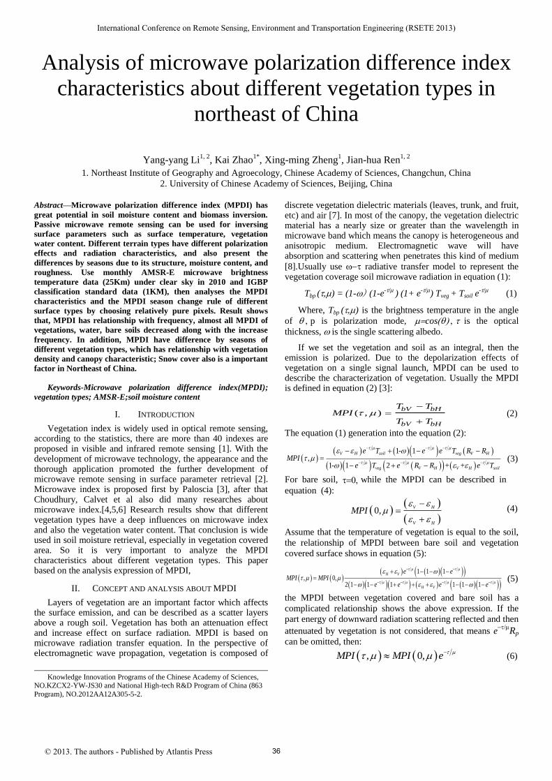
The earth observation satellite Aqua with passive microwave sensor AMSR-E and optical sensor MODIS, which provides a convenient for using multi-source remote sensing data comprehensively. We have synthesis vegetation index products with 16 days. AMSR-E, have 6 bands during 6.9GHz to 89GHz with a resolution of 25Km and two polarization mode. Take northeast of China as an example, in order to carry out the analysis of MPDI with different vegetation types and also reduce the influence of mixed pixels, a combination of the LUCC with a 1Km resolution according to IGBP is used, shows in Fig.1. The percentage on surface type of LUCC is higher than 85% within a AMSR-E pixel will be chose as an pure pixel and then extracted to further analysis. The brightness temperatures of all bands and each month are extracted, and then MPDI is calculated using equation (2):
Figure 1. Classification map of northeast China(2006 IGBP).
IV. RESULTS ANALYSIS
A. Relationship between MPDI and Frequency
Fig.2 shows the MPDI variation trend of 9 types of different
features along with the change of frequency in July 8th
2010.
Vegetation grows the most flourishing in July, and it is benefits
to analyze the vegetation types through MPDI. The horizontal
axis is frequency (GHz) while the vertical is MPDI. Different
surface features have different polarization effect. Generally,
the MPDI is positive, that means V-polarization is higher than
H-polarization, which conforms to the theory analysis. For
each feature show in Fig.2, MPDI decreases with the frequency
increase. The reason is that for vegetation the volume
scattering enhances especially in dense forests while the
frequency increases, and the vegetation scattering is directional,
both of which is depolarization effect, and then the MPDI
decreases. That is why MPDI is lower for needle leaved forest
and broad leaved forest than grass land and savanna, shows in
Fig.1 (f) and (g) with (b) and (c). The surface roughness is also
the important factor which affects microwave radiation, smooth
surface generally has higher MPDI than roughness surface.
Figure 2. MPDI on frequency change of different surface types
B. MPDI Analysis with Time Series
Choose several features with high pixel purity, and then analyze the change rule of MPDI with time series, results show in Fig.3. The horizontal axis is time by month while the vertical is MPDI. The MPDI of each month is extract by a random average data of 7 days in this month at 6.9 GHz. In winter (middle October to March of the following year) the
37
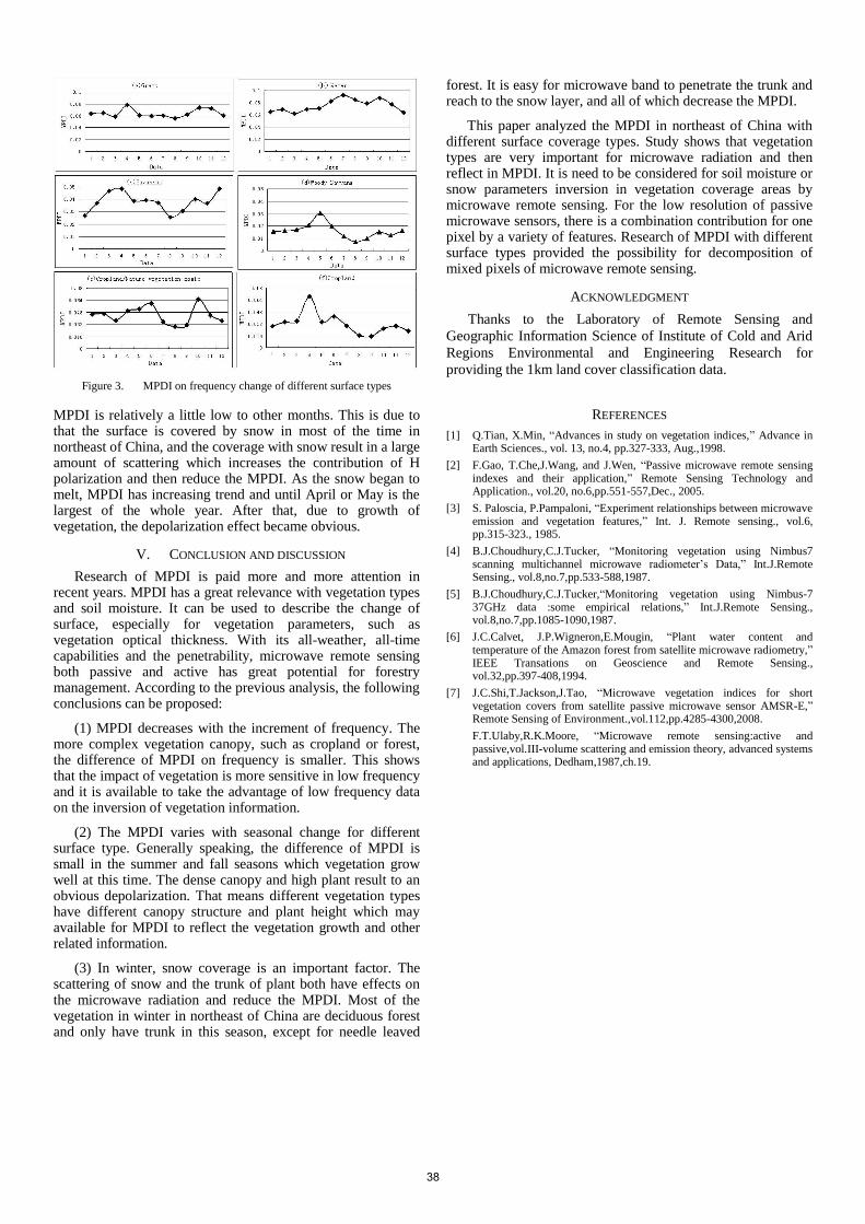
Figure 3. MPDI on frequency change of different surface types
MPDI is relatively a little low to other months. This is due to that the surface is covered by snow in most of the time in northeast of China, and the coverage with snow result in a large amount of scattering which increases the contribution of H polarization and then reduce the MPDI. As the snow began to melt, MPDI has increasing trend and until April or May is the largest of the whole year. After that, due to growth of vegetation, the depolarization effect became obvious.
V. CONCLUSION AND DISCUSSION
Research of MPDI is paid more and more attention in recent years. MPDI has a great relevance with vegetation types and soil moisture. It can be used to describe the change of surface, especially for vegetation parameters, such as vegetation optical thickness. With its all-weather, all-time capabilities and the penetrability, microwave remote sensing both passive and active has great potential for forestry management. According to the previous analysis, the following conclusions can be proposed:
(1) MPDI decreases with the increment of frequency. The more complex vegetation canopy, such as cropland or forest, the difference of MPDI on frequency is smaller. This shows that the impact of vegetation is more sensitive in low frequency and it is available to take the advantage of low frequency data on the inversion of vegetation information.
(2) The MPDI varies with seasonal change for different surface type. Generally speaking, the difference of MPDI is small in the summer and fall seasons which vegetation grow well at this time. The dense canopy and high plant result to an obvious depolarization. That means different vegetation types have different canopy structure and plant height which may available for MPDI to reflect the vegetation growth and other related information.
(3) In winter, snow coverage is an important factor. The scattering of snow and the trunk of plant both have effects on the microwave radiation and reduce the MPDI. Most of the vegetation in winter in northeast of China are deciduous forest and only have trunk in this season, except for needle leaved
forest. It is easy for microwave band to penetrate the trunk and reach to the snow layer, and all of which decrease the MPDI.
This paper analyzed the MPDI in northeast of China with different surface coverage types. Study shows that vegetation types are very important for microwave radiation and then reflect in MPDI. It is need to be considered for soil moisture or snow parameters inversion in vegetation coverage areas by microwave remote sensing. For the low resolution of passive microwave sensors, there is a combination contribution for one pixel by a variety of features. Research of MPDI with different surface types provided the possibility for decomposition of mixed pixels of microwave remote sensing.
ACKNOWLEDGMENT
Thanks to the Laboratory of Remote Sensing and
Geographic Information Science of Institute of Cold and Arid
Regions Environmental and Engineering Research for
providing the 1km land cover classification data.
REFERENCES
[1] Q.Tian, X.Min, “Advances in study on vegetation indices,” Advance in Earth Sciences., vol. 13, no.4, pp.327-333, Aug.,1998.
[2] F.Gao, T.Che,J.Wang, and J.Wen, “Passive microwave remote sensing indexes and their application,” Remote Sensing Technology and Application., vol.20, no.6,pp.551-557,Dec., 2005.
[3] S. Paloscia, P.Pampaloni, “Experiment relationships between microwave emission and vegetation features,” Int. J. Remote sensing., vol.6, pp.315-323., 1985.
[4] B.J.Choudhury,C.J.Tucker, “Monitoring vegetation using Nimbus7 scanning multichannel microwave radiometer’s Data,” Int.J.Remote Sensing., vol.8,no.7,pp.533-588,1987.
[5] B.J.Choudhury,C.J.Tucker,“Monitoring vegetation using Nimbus-7 37GHz data :some empirical relations,” Int.J.Remote Sensing., vol.8,no.7,pp.1085-1090,1987.
[6] J.C.Calvet, J.P.Wigneron,E.Mougin, “Plant water content and temperature of the Amazon forest from satellite microwave radiometry,” IEEE Transations on Geoscience and Remote Sensing., vol.32,pp.397-408,1994.
[7] J.C.Shi,T.Jackson,J.Tao, “Microwave vegetation indices for short vegetation covers from satellite passive microwave sensor AMSR-E,” Remote Sensing of Environment.,vol.112,pp.4285-4300,2008.
F.T.Ulaby,R.K.Moore, “Microwave remote sensing:active and passive,vol.III-volume scattering and emission theory, advanced systems and applications, Dedham,1987,ch.19.
38