an updated list of ichthyological collecting … filecm pieces of white paper probably...
TRANSCRIPT

AN UPDATED LIST OF ICHTHYOLOGICAL COLLECTING STATIONS OF THE THAYER EXPEDITION TO BRAZIL (1865-1866)
By
Horacio Higuchi
© 1996
Abstract: This paper revises a previous attempt (Dick, 1977) to identify the ichthyological collection sites of the Thayer Expedition to Brazil (1865-66), and proposes a standardized database that includes, for each collection site (station): original and current denominations, approximate coordinates, current Brazilian political unit (state) where it is located, collectors and date of collection. A total of 157 collecting stations were determined in northern, eastern and northeastern Brazil.

INTRODUCTION
This study establishes a standardized database for the ichthyological collecting stations of the Thayer Expedition to Brazil (1865-1866) in a format compatible with the MUSE computer program. It arose from the curatorial necessity of properly cataloguing the material collected by that expedition, the major portion of which is deposited in the Museum of Comparative Zoology at Harvard University. It characterizes each of the collection sites in a uniform informational set, following the MUSE locality database template. Its ultimate goal is to provide as much information as possible about the collected material and to facilitate the retrieval of old localities on modern maps. An earlier review of the Thayer Expedition stations (Dick, 1977) detailed the itinerary of the various phases of the expedition, based primarily on the Agassizes' Journey in Brazil (U.S. edition, 1868). However, the geographical index and the maps that constitute the main body of Dick's paper are frustratingly inadequate. Many of the current names for the localities listed in the index are either misspelled or misleading, and the maps are unclear, difficult to follow or even inaccurate. A simplified overview of the general itinerary was published by Lorenz & Peixoto (1980:1524-1525, map 6). An examination of documents relevant to the Thayer Expedition and a detailed comparison of gazetteers and maps of different periods of Brazilian history allowed the clarification of many points left obscure by previous research. Elements of a Standard Locality Database Louis Agassiz's correspondence with his son Alexander, who stayed in Harvard to receive the material that was being continuously shipped from South America, listed the contents of each container sent with mention of locality and collector, and often of collection date. There were also specific instructions in either English or French on how to separate the various lots contained in one given barrel. The following passages from a letter dated 15 February 1866 (MCZ Archives bAg 826.50.2) are a good example: (N.1.-6.) Collected by James & Hunnewell at Obydos in December. Il importera de ne pas meler ces objets d'Obydos avec ceux collectes en Aout, afin de pouvoir comparer la difference. (N.7.-8) Collected at Obydos by Col. Bentos, between the months of Nov. & Dec. Ne pas meler avec les collections de James & Hunnewell. (...) N.32. Porto de Moz. Mr. Vinhas. Coll. in 7br. [=September] N.33. Hyanuary. Collect. by Mr. Naves Jan 10th. Tenir bien separe des autres collections d'Hyanuary, a cause de la date. N.34. Rio Negro at the bottom. Rio Branco in the middle & Santarem above. Coll. by Dexter, Talism. & Ag.

It is presumed that those detailed lists were the basis for the standardized printed labels found in practically all jars containing Thayer Expedition material. Those labels -- 4x2 cm pieces of white paper probably custom-printed under Alexander Agassiz's specifications -- would typically mention the collection site and the collector, as in the following example: Teffe. L. AGASSIZ. Thayer Expedition Received Jan. 1866. Over the years, most of the MCZ Thayer Expedition fishes have been identified and registered by different individuals, who reproduced in the catalog entries the same information contained in the printed labels. By noting down every different combination of locality and collector found in the labels and in the catalog, an initial working database of possible stations was established. Additional station entries were then incorporated when supported by collection lists of individual Expedition members, like those by Orestes St. John, George Sceva and Hartt & Copeland. The database was later amended as probable collection dates were estimated and cross-checked (see below), and duplicate entries eliminated. Station Number All Thayer stations are defined by a combination of the following factors: (a) locality; (b) collector; and (c) collection date. The numbering of those stations is arbitrary and any future additions will not seriously upset the system, contrary to what would happen if a chronological sequence of collection were adopted. All Thayer Expedition material with insufficient data are given the locality number THAYER000. Locality on label The locality name is here given in uppercase letters spelt in the same way as found on the printed labels and other contemporary documents. Alternate spellings documented in the sources consulted are also registered. State To facilitate retrieval of localities on modern maps, names for current states of the Federative Republic of Brazil are given. The Thayer Expedition collected in sites currently located in the states of Amazonas, Roraima Territory, Para , Maranhao, Piaui, Ceara , Rio Grande do Norte, Paraiba, Pernambuco, Alagoas, Bahia, Espirito Santo, Rio de Janeiro, Tocantins, Goias and Minas Gerais, with additional material received from Rio Grande do Sul. When reviewing old literature, it is important to bear in mind that Brazilian state borders have changed radically since imperial times.

Current locality Over the years many towns, rivers and lakes have had their names changed. Some of the changes were superficial, mere adjustments to modernizations in official orthography; in many other cases, however, localities were renamed beyond recognition. A number of places associated with oft-recurrent names have also caused considerable confusion. For instance, there was a Villa de Santa Rita next to a Rio Preto in Bahia state totally unrelated to the village of Santa Rita on the Rio Negro in Rio de Janeiro state: those Santa Ritas are listed on current maps as Ibipetuba and Euclidelandia, respectively. (To further complicate matters, there are dozens of rivers of all sizes called Rio Negro or Rio Preto.) Only by reconstituting the itinerary of each individual member of the Expedition on large-scale maps (1:1,000,000 to 1:500,000) could those names be sorted out and most of homotoponym problems solved. Approximate coordinates Again in order to facilitate quick pinpointing of a locality on a map, approximate latitude and longitude are given. These are useful mainly on common atlases and small-scale charts (1:5,000,000 or smaller) and do not claim for precision beyond 100 km. Most of the coordinates here given were obtained from the U.S. Board on Geographic Names gazetteer (1963). Collectors A list of members of the Thayer Expedition who participated in collection trips is given in Dick (1977). Teams formed by collectors are listed here according to the printed labels, catalog entries and correspondence consulted. The American participants have been fully identified in that source, but Brazilian members have often been reduced to cryptic single nominatives. "Major Coutinho", for instance, refers to Maj. Joao Martins da Silva Coutinho, a geologist and naturalist of the Brazilian Army Corps of Engineers, who had explored the Rio Purus system and northeastern Brazil before being commissioned by Emperor Pedro II to accompany the Expedition as a knowledgeable guide. Coutinho's catch of fishes from Santos, in the coast of Sao Paulo state, was probably obtained either before or after the Expedition; however, it was apparently sent to the MCZ together with the Thayer material and is here considered part of the latter. "Senhor Honorio", whom Agassiz met in Manaus, was in fact Antonio Honorio Ferreira, later Treasury Inspector of the Province of Goyaz; his collection of fishes from that province was gathered in 1867 at Agassiz's written request, and is also included in the Thayer listings. Names of many other Brazilians who participated in or helped the Expedition still remain improperly known: no documentation was uncovered, for instance, on "Senhor Talisman" (a given name, a family name or a nickname?). Participants not mentioned in Dick's paper include Jos, Whitaker, "Senhor Naves" and "Senhor Albuquerque" – the latter responsible for a collection of southern Brazilian fishes ordered by the Emperor en route to the Rio Grande do Sul front of the then incipient war against Paraguay.

Collection date Collection dates were established as accurately as possible based on a number of sources: (a) Elizabeth Cary Agassiz's published journal of the Expedition, summarized in Dick's paper; (b) the aforementioned letters by Louis Agassiz to his son, a correspondence unfortunately not completely recovered; (c) Agassiz's personal notes on the estimated contents of each lot (in terms of numbers of specimens collected), some of which preserved at the MCZ Archives; and, (d) fragmentary notes by other members of the Expedition. In many cases a complete collection date (day/month/year) could be retrieved; in others, a month/year date was reconstituted. By cross-checking the different dates, collectors and sites mentioned, it was possible to reconstruct most of the ichthyological collecting stations with reasonable accuracy.

Alphabetical Index to Thayer Stations Alphabetical Index to Thayer Stations
Verbatim Locality Description Collectors Field Number
ABROLHOS HARTT & COPELAND THAYER001
ACARUSSU, LAGO HONORIO THAYER002
AGUA SALGADA, RIO DE; AT CANNAVIEIRAS HARTT & COPELAND THAYER090
AGUAS QUENTES, SERRA DAS DIETRICH & SCEVA THAYER003
ALEXO, LAGO THAYER THAYER004
AMAZONAS, RIO, AT SANTAREM BOURGET THAYER118
ARARY, LAGO AGASSIZ THAYER005
ARASSUAHY, RIO HARTT & COPELAND THAYER152
AREIA, RIO DE; BELOW CACHOEIRINHA HARTT & COPELAND THAYER092
AREIA, RIO DE; RIO DE AGUA DOCE HARTT & COPELAND THAYER091
BAHIA AGASSIZ THAYER006
BAHIA DEXTER & THAYER THAYER009
BAHIA HARTT & COPELAND THAYER007
BAHIA LACERDA, DEXTER & JAMES THAYER008
BARRA DO PIRAHY HARTT & COPELAND THAYER010
BARRA DO RIO ENCHADAS, RIO JEQUITINHONHA HARTT & COPELAND THAYER011
BARRO DO RIO GRANDE ST. JOHN THAYER012
BETWEEN LINHARES AND LAGOA HARTT & COPELAND THAYER053
BETWEEN LINHARES AND PORTO DO SOUZA HARTT & COPELAND THAYER029
BRANCO, RIO DEXTER, TALISMAN & AGASSIZ THAYER013
BREVES AGASSIZ THAYER014
CACHOEIRA ALLEN THAYER015
CAMAMU HARTT & COPELAND THAYER016
CAMETA AGASSIZ THAYER017
CAMITA AGASSIZ THAYER017
CAMPOS HARTT & COPELAND THAYER018
CANNAVIERAS HARTT & COPELAND THAYER019
CANTAGALLO SCEVA THAYER020
CARANDAHY, RIO ST. JOHN THAYER021
CAXOEIRA ALLEN THAYER015
CEARAA AGASSIZ & BOURGET THAYER022
COARY, LAGO AGASSIZ THAYER023
CUDAJAS AGASSIZ & BOURGET THAYER024
CUDAJAS, LAGO THAYER & BOURGET THAYER025
CURUCAA AGASSIZ THAYER026
CURUCA ON RIO MURIA HARTT & COPELAND THAYER027
CURUPIRA, LAGO COUTINHO THAYER028
DOCE, RIO HARTT & COPELAND THAYER029
DR. JUSTA COUTINHO THAYER086
EGA AGASSIZ THAYER137
EGA, LAGO AGASSIZ THAYER138
ERERE, RIO AGASSIZ THAYER030
ERRERE, RIO AGASSIZ THAYER030
ENCHADAS, RIO, BARRA DO, RIO JEQUITINHONHA HARTT & COPELAND THAYER011

FONTE BOA AGASSIZ THAYER031
FONTEBOA AGASSIZ THAYER031
GEQUITIBA, RIO DAS VELHAS ST. JOHN THAYER032
GOIAS HONORIO THAYER033
GOYAZ HONORIO THAYER033
GRANDE, RIO D. PEDRO II THAYER034
GUARAPARY HARTT & COPELAND THAYER035
GURGUEA, RIO ST. JOHN THAYER036
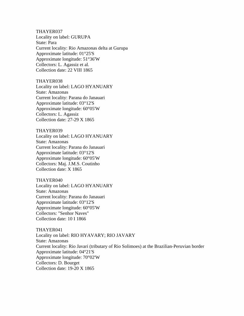
GURUPA AGASSIZ THAYER037
HYANUARY, LAGO AGASSIZ THAYER038
HYANUARY, LAGO COUTINHO THAYER039
HYANUARY, LAGO NAVES THAYER040
HYAVARY, RIO BOURGET THAYER041
HYUTAHY, RIO JAMES & TALISMAN THAYER043
ICA, RIO JAMES & TALISMAN THAYER043
ITABAPUANA HARTT & COPELAND THAYER044
ITAPE-MIRIM HARTT & COPELAND THAYER045
ITAPEMIRIM HARTT & COPELAND THAYER045
JANUARIA ALLEN & ST. JOHN THAYER046
JATUARANA NAVES THAYER047
JAVARY, RIO BOURGET THAYER041
JEQUITINHONHA, RIO, HARTT & COPELAND THAYER048
JEQUITINHONHA, RIO, BARRA DO RIO ENCHADAS HARTT & COPELAND THAYER011
JOSE ASSU, LAGO AGASSIZ THAYER049
JOSE FERNANDES, LAGO COUTINHO THAYER050
JUIZ DE FORA AND PARAHYBA AGASSIZ & WHITAKER THAYER051
JUPARANA, LAGOA HARTT & COPELAND THAYER052
JUPARANA, RIO HARTT & COPELAND THAYER053
JURUMENHA ST. JOHN THAYER054
JURUMINHA, VALLEY GURGUEA ST. JOHN THAYER054
JUTAHY, RIO JAMES, THAYER & TALISMAN THAYER042
LAGO ACARASSU HONORIO THAYER002
LAGO ALEXO THAYER THAYER004
LAGO ARARY AGASSIZ THAYER005
LAGO COARY AGASSIZ THAYER023
LAGO CUDAJAS THAYER & BOURGET THAYER025
LAGO CURUPIRA COUTINHO THAYER028
LAGO EGA AGASSIZ THAYER138
LAGO HYANUARY AGASSIZ THAYER038
LAGO HYANUARY COUTINHO THAYER039
LAGO HYANUARY NAVES THAYER040
LAGO JOSE ASSU AGASSIZ THAYER049
LAGO JOSE FERNANDES COUTINHO THAYER050
LAGO MANACAPOURU JAMES THAYER060
LAGO MANACAPURU JAMES THAYER060
LAGO MAXIMO AGASSIZ THAYER064
LAGO SARACA, SILVA THAYER THAYER131
LAGO TEFFE AGASSIZ THAYER138

LAGO UERANDUBA COUTINHO THAYER141
LAGOA DE PARANAGUA ST. JOHN THAYER088
LAGOA DO MAXIMO AGASSIZ THAYER064
LAGOA JUPARANA HARTT & COPELAND THAYER052
LAGOA SANTA SCEVA THAYER055
LINHARES HARTT & COPELAND THAYER056
LINHARES AND LAGOA, BETWEEN HARTT & COPELAND THAYER053
LINHARES AND PORTO DO SOUZA, BETWEEN HARTT & COPELAND THAYER029
MACACOS, RIO DOS; BELOW FALLS ST. JOHN & WARD THAYER057
MACEIO AGASSIZ THAYER058
MACUCO, RIBEIRAO DO SCEVA THAYER059
MADEIRA, RIO AGASSIZ THAYER153
MANACAPOURU, LAGO JAMES THAYER060
MANACAPURU, LAGO JAMES THAYER060
MANAOS AGASSIZ & BOURGET THAYER061
MARAJO, PARA AND MAGALHAES THAYER082
MARAHAO AGASSIZ & BOURGET THAYER062
MAUHES AGASSIZ THAYER063
MAXIMO, LAGO AGASSIZ THAYER064
MAXIMO, LAGOA DO AGASSIZ THAYER064
MENDES HARTT & COPELAND THAYER065
MENDEZ HARTT & COPELAND THAYER065
MINAS GERAES HARTT & COPELAND THAYER066
MONTALEGRE AGASSIZ THAYER067
MONTE ALEGRE AGASSIZ THAYER067
MUCAJA-TUBA AGASSIZ, COUTINHO & BURKHARDT THAYER068
MUCAJATUBA AGASSIZ, COUTINHO & BURKHARDT THAYER068
MUCURY, RIO HARTT & COPELAND THAYER069
MURIA, RIO; CURUCA HARTT & COPELAND THAYER027
MURIAHE HARTT & COPELAND THAYER070
NAZARETH LACERDA THAYER071
NEGRO, RIO DEXTER, TALISMAN & AGASSIZ THAYER072
NEGRO, RIO; BELOW CANTAGALLO SCEVA THAYER020
NEGRO, RIO; BELOW SANTA RITA SCEVA THAYER116
NEGRO, RIO; NEAR LAGO ALEXO AGASSIZ THAYER073
NEGRO, RIO; NEAR LAGO ALEXO THAYER THAYER074
NEGRO, RIO; PEDREIRA AGASSIZ THAYER095
NEGRO, RIO; SMALL TRIBUTARY OF HARTT & COPELAND THAYER075
OBIDOS AGASSIZ THAYER076
OBIDOS BENTOS THAYER077
OBIDOS JAMES & HUNNEWELL THAYER078
OBYDOS AGASSIZ THAYER076
OBYDOS BENTOS THAYER077
OBYDOS JAMES & HUNNEWELL THAYER078
PARA COLLECTOR UNKNOWN THAYER080A
PARA AGASSIZ THAYER079

PARA AGASSIZ & BOURGET THAYER080
PARA AGASSIZ, BUENO & BOURGET THAYER081
PARA AND MARAJO MAGALHAES THAYER082
PARA, RIO; ILE DE MARAJO AGASSIZ & BOURGET THAYER083
PARAHYBA, RIO AGASSIZ & BOURGET THAYER084
PARAHYBA, RIO HARTT & COPELAND THAYER085
PARAHYBA DO NORTE, RIO COUTINHO & JUSTA THAYER086
PARAHYBA DO SUL, RIO AGASSIZ & WHITAKER THAYER087
PARANAGUA, LAGOA DE ST. JOHN THAYER088
PARANAHYBA, RIO, AT SAN GONCALLO ST. JOHN THAYER124
PARANAHYBA, RIO, BASIN ST. JOHN THAYER089
PARCEL DOS ABROLHOS HARTT & COPELAND THAYER001
PARDO, RIO -RIO DE AGUA SALGADA AT CANNAVIEIRAS HARTT & COPELAND THAYER090
PARDO, RIO -RIO DE AREIA, RIO DE AGUA DOCE HARTT & COPELAND THAYER091
PARDO, RIO -RIO DE AREIA BELOW CACHOEIRINHA HARTT & COPELAND THAYER092
PARDO, RIO -RIO DE PEDRA AT CACHOEIRA DO RIO PARDO HARTT & COPELAND THAYER093
PARDO, RIO -RIO DE PEDRA BELOW CACHOEIRINHA HARTT & COPELAND THAYER094
PEDRA, RIO DE; AT CACHOEIRA DO RIO PARDO HARTT & COPELAND THAYER093
PEDRA, RIO DE, BELOW CACHOEIRINHA HARTT & COPELAND THAYER094
PEDREIRA, RIO NEGRO AGASSIZ THAYER095
PERNAMBUCO AGASSIZ & BOURGET THAYER096
PIRAHY, BARRA DO HARTT & COPELAND THAYER010
PORTO ALEGRE HARTT & COPELAND THAYER098
PORTO DE MOZ AGASSIZ THAYER099
PORTO DE MOZ VINHAS THAYER100
PORTO DO SOUZA HARTT & COPELAND THAYER101
PORTO SEGURO HARTT & COPELAND THAYER102
POSSE TAYLOR THAYER155
PRETO, RIO, AT VILLA DE SANTA RITA ST. JOHN THAYER103
PUTOMAJO, RIO JAMES & TALISMAN THAYER043
PUTUMAYO, RIO JAMES & TALISMAN THAYER043
PUTY, RIO; THEREZINA ST. JOHN THAYER104
QUENDA, RIO BOURGET THAYER156
QUENDU, RIO BOURGET THAYER156
RIBEIRAO DO MACUCO SCEVA THAYER059
RIO AMAZONAS AT SANTAREM BOURGET THAYER118
RIO ARASSUAHY HARTT & COPELAND THAYER152
RIO BRANCO DEXTER, TALISMAN & AGASSIZ THAYER013
RIO CARANDAHY ST. JOHN THAYER021
RIO DAS VELHAS VIANNA THAYER142
RIO DAS VELHAS AT GEQUITIBA ST. JOHN THAYER032
RIO DAS VELHAS BETWEEN FAZENDA DO BOM SUCESSO AND PIRAPORA ST. JOHN THAYER144
RIO DAS VELHAS BETWEEN GEQUITIBA AND FAZENDA DO BOM SUCESSO ST. JOHN THAYER143
RIO DE JANEIRO AGASSIZ THAYER105
RIO DE JANEIRO COUTINHO THAYER106
RIO DE JANEIRO NAGELI THAYER107

RIO DE JANEIRO, RIO PARAHYBA AGASSIZ & BOURGET THAYER084
RIO DOCE HARTT & COPELAND THAYER029
RIO DOS MACACOS BELOW FALLS ST. JOHN & WARD THAYER057
RIO ENCHADAS, BARRA DO, RIO JEQUITINHONHA HARTT & COPELAND THAYER011
RIO ERERE AGASSIZ THAYER030
RIO ERRERE AGASSIZ THAYER030
RIO GRANDE, BARRA DO ST. JOHN THAYER012
RIO GRANDE, SANTA CRUZ DOM PEDRO II - BOURGET THAYER114
RIO GRANDE DO NORTE AGASSIZ THAYER108
RIO GRANDE DO SUL ALBUQUERQUE THAYER109
RIO GRANDE DO SUL DOM PEDRO II THAYER110
RIO GURGUEA ST. JOHN THAYER036
RIO HYAVARY BOURGET THAYER041
RIO HYUTAHY JAMES, THAYER & TALISMAN THAYER042
RIO ICA JAMES & TALISMAN THAYER043
RIO JAVARY BOURGET THAYER041
RIO JEQUITINHONHA HARTT & COPELAND THAYER048
RIO JEQUITINHONHA, BARRA DO RIO ENCHADAS HARTT & COPELAND THAYER011
RIO JUPARANA HARTT & COPELAND THAYER053
RIO JUTAHY JAMES, THAYER & TALISMAN THAYER042
RIO MADEIRA AGASSIZ THAYER153
RIO MUCURY HARTT & COPELAND THAYER069
RIO MUCURY AT SANTA CLARA HARRT & COPELAND THAYER113
RIO MURIA; CURUCA HARTT & COPELAND THAYER027
RIO NEGRO DEXTER, TALISMAN & AGASSIZ THAYER072
RIO NEGRO BELOW CANTAGALLO SCEVA THAYER020
RIO NEGRO BELOW SANTA RITA SCEVA THAYER116
RIO NEGRO NEAR LAGO ALEXO AGASSIZ THAYER073
RIO NEGRO NEAR LAGO ALEXO THAYER THAYER074
RIO NEGRO, PEDREIRA AGASSIZ THAYER095
RIO NEGRO, SMALL TRIBUTARY OF HARTT & COPELAND THAYER075
RIO PARA, ILE DE MARAJO AGASSIZ & BOURGET THAYER083
RIO PARAHYBA AGASSIZ & BOURGET THAYER084
RIO PARAHYBA HARTT & COPELAND THAYER085
RIO PARAHYBA DO NORTE COUTINHO & JUSTA THAYER086
RIO PARAHYBA DO SUL AGASSIZ & WHITAKER THAYER087
RIO PARDO -RIO DE AGUA SALGADA AT CANNAVIEIRAS HARTT & COPELAND THAYER090
RIO PARDO -RIO DE AREIA, RIO DE AGUA DOCE HARTT & COPELAND THAYER091
RIO PARDO -RIO DE AREIA BELOW CACHOEIRINHA HARTT & COPELAND THAYER092 RIO PARDO -RIO DE PEDRA AT CACHOEIRA DO RIO PARDO HARTT & COPELAND THAYER093
RIO PARDO -RIO DE PEDRA BELOW CACHOEIRINHA HARTT & COPELAND THAYER094
RIO PARNAHYBA AT SAN GONCALLO ST. JOHN THAYER124
RIO PARNAHYBA BASIN ST. JOHN THAYER089
RIO PRETO AT VILLA DE SANTA RITA ST. JOHN THAYER103
RIO PUTOMAJO JAMES & TALISMAN THAYER043
RIO PUTUMAYO JAMES & TALISMAN THAYER043
RIO PUTY; THEREZINA ST. JOHN THAYER104
RIO QUENDA BOURGET THAYER156

RIO QUENDU BOURGET THAYER156
RIO SANTO ANTONIO, SANTA ANNA DE FERROS WARD THAYER120
RIO SAO FRANCISCO ALLEN & ST. JOHN THAYER123
RIO SAO FRANCISCO BETWEEN BARRA DO RIO DAS VELHAS AND JANUARIA ALLEN & ST. JOHN THAYER123
RIO TAPAJOS DEXTER, JAMES & TALISMAN THAYER135
RIO TAPAJOS JAMES, THAYER & TALISMAN THAYER136
RIO TAPAJOZ DEXTER, JAMES & TALISMAN THAYER135
RIO TAPAJOZ JAMES, THAYER & TALISMAN THAYER136
RIO TROMBETAS AGASSIZ THAYER154
RIO TROMBETAS JAMES & HUNNEWELL THAYER140
RIO XINGU VINHAS THAYER151
SAMBAIA BOURGET THAYER111
SAN GONCALLO ST. JOHN THAYER124
SAN PAOLO JAMES & TALISMAN THAYER128
SANTA, LAGOA SCEVA THAYER055
SANTA ANNA DOM PEDRO II THAYER112
SANTA ANNA DE FERROS WARD THAYER120
SANTA CLARA, RIO MUCURY HARTT & COPELAND THAYER113
SANTA CRUZ, RIO GRANDE DOM PEDRO II - BOURGET THAYER114
SANTA RITA SCEVA THAYER115
SANTA RITA ST. JOHN THAYER103
SANTA RITA, RIO NEGRO SCEVA THAYER116
SANTA RITA, VILLA DE, RIO PRETO AT ST. JOHN THAYER103
SANTAREM BOURGET THAYER117
SANTAREM DEXTER, TALISMAN, JAMES & AGASSIZ THAYER119
SANTAREM, RIO AMAZONAS AT BOURGET THAYER118
SANTO ANTONIO, RIO; SANTA ANNA DE FERROS WARD THAYER120
SANTOS COUTINHO THAYER121
SAO FIDELIS HARTT & COPELAND THAYER122
SAO FRANCISCO, RIO ALLEN & ST. JOHN THAYER123
SAO FRANCISCO, RIO, BETWEEN BARRA DO RIO DAS VELHAS AND JANUARIA ALLEN & ST. JOHN THAYER123
SAO GONCALLO ST. JOHN THAYER124
SAO MATHEOS HARTT & COPELAND THAYER125
SAO MATHEOS JAMES THAYER126
SAO PAOLO JAMES & TALISMAN THAYER128
SARACA, LAGO THAYER THAYER131
SERPA AGASSIZ THAYER129
SERPA THAYER THAYER130
SERRA DAS AGUAS QUENTES DIETRICH - SCEVA THAYER003
SILVA, LAGO SARACA THAYER THAYER131
SMALL TRIBUTARY OF RIO NEGRO HARTT & COPELAND THAYER075
TABATINGA AGASSIZ THAYER132
TABATINGA BOURGET THAYER133
TAJAPURU AGASSIZ THAYER134
TAJIPURU AGASSIZ THAYER134

TAPAJOS, RIO DEXTER, JAMES & TALISMAN THAYER135
TAPAJOS, RIO JAMES, THAYER & TALISMAN THAYER136
TAPAJOZ, RIO DEXTER, JAMES & TALISMAN THAYER135
TAPAJOZ, RIO JAMES, THAYER & TALISMAN THAYER136
TEFFE AGASSIZ THAYER137
TEFFE LAGO AGASSIZ THAYER138
THEREZINA, RIO PUTY ST. JOHN THAYER104
TONANTINS AGASSIZ THAYER139
TROMBETAS, RIO AGASSIZ THAYER154
TROMBETAS, RIO JAMES & HUNNEWELL THAYER140
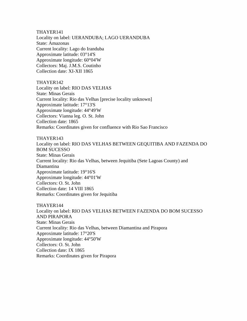
UERANDUBA COUTINHO THAYER141
UERANDUBA, LAGO COUTINHO THAYER141
VELHAS, RIO DAS VIANNA THAYER142
VELHAS, RIO DAS, AT GEQUITIBA ST. JOHN THAYER032
VELHAS, RIO DAS, BETWEEN FAZENDA DO BOM SUCESSO AND PIRAPORA ST. JOHN THAYER144
VELHAS, RIO DAS, BETWEEN GEQUITIBA AND FAZENDA DO BOM SUCESSO ST. JOHN THAYER143
VICTORIA HARTT & COPELAND THAYER145
VIGIA AGASSIZ THAYER146
VILLA BELLA AGASSIZ THAYER147
VILLA BELLA HONARIO THAYER148
VILLA DE BARRA DO RIO GRANDE ST. JOHN THAYER012
VILLA DE SANTA RITA, RIO PRETO ST. JOHN THAYER103
VILLA NOVA HARTT & COPELAND THAYER149
VILLABELLA AGASSIZ THAYER147
VILLABELLA HONORIO THAYER148
VILLANOVA HARTT & COPELAND THAYER149
XINGU, RIO VINHAS THAYER151
XINGU CASCADE VINHAS THAYER150
DUBIOUS STATIONS:
PARA LACERDA
C.F. HARTT STATIONS NOT IN THAYER EXPEDITION:
PARA
PERNAMBUCO
RIO SAO FRANCISCO
ST. THOMAS, W.I. [sic]
Total number of presumably valid stations as of July 1990: 156

NUMERICAL LIST OF THAYER EXPEDITION STATIONS THAYER000 Locality on label: BRAZIL State: [unspecified] Current locality: [unspecified] Collectors: [any member of the Thayer Expedition] Collection date: 1865-1866 Remarks: "Station" designated for all cases where available information is insufficient for placement in any other field number. THAYER001 Locality on label: ABROLHOS; PARCEL DOS ABROLHOS State: Espirito Santo Current locality: Arquipelago dos Abrolhos, off coast at Caravelas Approximate latitude: 17°45'S Approximate longitude: 39°00'W Collectors: C.F. Hartt & E. Copeland Collection date: 1865 Remarks: Marine station THAYER002 Locality on label: LAGO ACARASSU State: Amazonas Current locality: Lago Acara, NW of Codajas Approximate latitude: 03°37'S Approximate longitude: 62°68'W Collectors: "Senhor Honorio" [A.H. Ferreira] Collection date: X 1865 THAYER003 Locality on label: SERRA DAS AGUAS QUENTES State: Rio de Janeiro Current locality: Stream on Serra das Aguas Quentes, on Henrique Kortkamp's fazenda Approximate latitude: Approximate longitude: Collectors: Dietrich leg. G. Sceva Collection date: VII 1865 - IV 1866 Remarks: Cf. Sceva's list; exact date unknown

THAYER004 Locality on label: LAGO ALEXO State: Amazonas Current locality: Lago do Aleixo, on Rio Negro Approximate latitude: 03°05'S Approximate longitude: 59°53'W Collectors: S.V.R. Thayer Collection date: 27 XI - 6 XII 1865 THAYER005 Locality on label: LAGO ARARY State: Para Current locality: Ilha de Marajo, Lago Arari Approximate latitude: 00°20'S Approximate longitude: 49°10'W Collectors: L. Agassiz et al. Collection date: 1-5 III 1866 THAYER006 Locality on label: BAHIA State: Bahia Current locality: Salvador and environs Approximate latitude: 12°58'S Approximate longitude: 38°29'W Collectors: L. Agassiz Collection date: 28-29 VII 1865 Remarks: Some material marine THAYER007 Locality on label: BAHIA State: Bahia Current locality: Salvador and environs Approximate latitude: 12°58'S Approximate longitude: 38°29'W Collectors: C.F. Hartt & E. Copeland Collection date: VI 1866 THAYER008 Locality on label: BAHIA State: Bahia Current locality: Salvador and environs Approximate latitude: 12°58'S Approximate longitude: 38°29'W Collectors: A. de Lacerda, N. Dexter & W. James Collection date: 28-29 VII 1865

THAYER009 Locality on label: BAHIA State: Bahia Current locality: Salvador and environs Approximate latitude: 12°58'S Approximate longitude: 38°29'W Collectors: N. Dexter & S.V.R. Thayer Collection date: 28-29 VII 1865 THAYER010 Locality on label: BARRA DO PIRAHY State: Rio de Janeiro Current locality: Rio Paraiba do Sul at Barra do Pirai Approximate latitude: 22°30'S Approximate longitude: 43°50'W Collectors: C.F. Hartt & E. Copeland Collection date: 1865 THAYER011 Locality on label: BARRA DO RIO ENCHADAS, RIO JEQUITINHONHA State: Minas Gerais Current locality: Rio Jequitinhonha, confluence with Ribeirao Enxadinha Approximate latitude: 16°09'S Approximate longitude: 40°16'W Collectors: C.F. Hartt & E. Copeland Collection date: IV-V 1866 THAYER012 Locality on label: BARRA DO RIO GRANDE; VILLA DA BARRA DO RIO GRANDE State: Bahia Current locality: Rio Grande at Barra, confluence with Rio Sao Francisco Approximate latitude: 11°06'S Approximate longitude: 43°25'W Collectors: O. St. John Collection date: VII-VIII 1865 Remarks: J.A. Allen apparently did not participate in this collection THAYER013 Locality on label: RIO BRANCO State: Roraima Territory Current locality: Rio Branco (tributary of Rio Negro) Approximate latitude: 01°24'S Approximate longitude: 61°51'W Collectors: N. Dexter, "Talisman" & L. Agassiz Collection date: 24 X - 9 XII 1865

THAYER014 Locality on label: BREVES State: Para Current locality: Ilha de Marajo, Breves Approximate latitude: 01°38'S Approximate longitude: 50°25'W Collectors: L. Agassiz Collection date: 20 VIII 1865 THAYER015 Locality on label: CACHOEIRA; CAXOEIRA State: Bahia Current locality: Cachoeira and environs Approximate latitude: 12°35'S Approximate longitude: 38°59'W Collectors: J.A. Allen Collection date: XI 1865 Remarks: Probably in brackish water THAYER016 Locality on label: CAMAMU State: Bahia Current locality: Camamu Approximate latitude: 13°57'S Approximate longitude: 39°11'W Collectors: C.F. Hartt & E. Copeland Collection date: V-VI 1866 THAYER017 Locality on label: CAMETA; CAMITA State: Para Current locality: Rio Tocantins at Cameta Approximate latitude: 02°14'S Approximate longitude: 49°30'W Collectors: L. Agassiz Collection date: II 1866 THAYER018 Locality on label: CAMPOS State: Rio de Janeiro Current locality: Rio Muriae‚ at Campos, 3 mi from town. Approximate latitude: 21°46'S Approximate longitude: 41°21'W Collectors: C.F. Hartt & E. Copeland Collection date: 1865

THAYER019 Locality on label: CANNAVIEIRAS State: Bahia Current locality: Canavieiras and environs Approximate latitude: 15°44'S Approximate longitude: 38°58'W Collectors: C.F. Hartt & E. Copeland Collection date: V 1866 THAYER020 Locality on label: CANTAGALLO State: Rio de Janeiro Current locality: Rio Negro, 1 mile below Cantagalo, near Mr. Dietrich's fazenda. Approximate latitude: 21°58'S Approximate longitude: 42°24'W Collectors: Dietrich leg. G. Sceva Collection date: VII 1865 - IV 1866 Remarks: Cf. Sceva's list; exact date unknown THAYER021 Locality on label: RIO CARANDAHY State: Minas Gerais Current locality: Rio Clarinda (tributary of Rio das Velhas) at Carandai Approximate latitude: 20°55'S Approximate longitude: 43°46'W Collectors: O. St. John Collection date: VI 1865 THAYER022 Locality on label: CEARA State: Ceara Current locality: Fortaleza and environs Approximate latitude: 03°45'S Approximate longitude: 38°35'W Collectors: L. Agassiz & D. Bourget Collection date: 5 VIII 1865 THAYER023 Locality on label: LAGO COARY; LAGO COARI State: Amazonas Current locality: Lago do Coari on Rio Solimoes, at Coari Approximate latitude: 04°08'S Approximate longitude: 63°07'W Collectors: L. Agassiz et al. Collection date: 13 IX 1865

THAYER024 Locality on label: CUDAJAS State: Amazonas Current locality: Rio Solimoes at Codajas, near Ilha Codajas Approximate latitude: 03°55'S Approximate longitude: 62°00'W Collectors: L. Agassiz & D. Bourget Collection date: 12 IX 1865 THAYER025 Locality on label: LAGO CUDAJAS State: Amazonas Current locality: Lago Badajos Approximate latitude: 03°24'S Approximate longitude: 62°38'W Collectors: S.V.R. Thayer & D. Bourget Collection date: 27 XI - 6 XII 1865 THAYER026 Locality on label: CURUCA State: Para Current locality: Ponta Curuca Approximate latitude: 00°43'S Approximate longitude: 47°52'W Collectors: L. Agassiz Collection date: 29 II - 4 III 1866 THAYER027 Locality on label: CURUCA ON RIO MURIA State: Rio de Janeiro Current locality: [exact locality unknown] Approximate latitude: Approximate longitude: Collectors: C.F. Hartt & E. Copeland Collection date: 1865 Remarks: Possibly Itaperuna on Rio Muriae, 21°12'S 41°54'W. THAYER028 Locality on label: LAGO CURUPIRA State: Amazonas Current locality: Lago Curupira Approximate latitude: 03°46'S Approximate longitude: 58°33'W Collectors: Maj. J.M.S. Coutinho Collection date: XI-XII 1865

THAYER029 Locality on label: RIO DOCE State: Espirito Santo Current locality: Rio Doce, between Linhares and Aimores. Approximate latitude: 19°37'S Approximate longitude: 39°49'W Collectors: C.F. Hartt & E. Copeland Collection date: 1865 THAYER030 Locality on label: RIO ERERE; RIO ERRERE State: Para Current locality: Rio Erere (tributary of Rio Maicuru, on Serra do Erere) Approximate latitude: 01°59'S Approximate longitude: 54°10'W Collectors: L. Agassiz Collection date: 24-29 I 1866 THAYER031 Locality on label: FONTEBOA; FONTE BOA State: Amazonas Current locality: Rio Solimoes at Fonte Boa Approximate latitude: 02°33'S Approximate longitude: 65°59'W Collectors: L. Agassiz Collection date: 15 IX 1865 THAYER032 Locality on label: GEQUITIBA; RIO DAS VELHAS AT GEQUITIBA State: Minas Gerais Current locality: Rio das Velhas at Jequitiba Approximate latitude: 19°16'S Approximate longitude: 44°01'W Collectors: O. St. John Collection date: VII 1865

THAYER033 Locality on label: GOYAZ State: Goias/Tocantins Current locality: [exact locality unknown] Approximate latitude: Approximate longitude: Collectors: "Senhor Honorio" [A.H. Ferreira] Collection date: 1867 Remarks: Probably somewhere in the Tocantins-Araguaia system. Collected after the conclusion of the Thayer Expedition, at Agassiz's specific request, for comparison with lower Rio Tocantins specimens (James, 1952:158,172). Isbrucker (1973:174) suggests this locality is "Rio Araguaia drainage, upper course of Rio Vermelho at Goias (15°57'S 50°07'W)", based on the map in Eigenmann & Eigenmann (1890: back page), but this has not been positively confirmed. THAYER034 Locality on label: RIO GRANDE State: Rio de Janeiro Current locality: Rio Grande (tributary of Rio Paraiba do Sul) at Paraiba do Sul Approximate latitude: 22°55'S Approximate longitude: 43°25'W Collectors: Dom Pedro II leg. Collection date: 1865 Remarks: Possibly collected before the arrival of the Thayer Expedition to Brazil, on 22 IV 1865. THAYER035 Locality on label: GUARAPARY State: Espirito Santo Current locality: Guarapari and environs Approximate latitude: 20°39'S Approximate longitude: 40°31'W Collectors: C.F. Hartt & E. Copeland Collection date: 1865 THAYER036 Locality on label: RIO GURGUEA State: Piaui Current locality: Rio Gurgueia Approximate latitude: 06°50'S Approximate longitude: 43°24'W Collectors: O. St. John Collection date: XI 1865
THAYER037 Locality on label: GURUPA State: Para Current locality: Rio Amazonas delta at Gurupa Approximate latitude: 01°25'S Approximate longitude: 51°36'W Collectors: L. Agassiz et al. Collection date: 22 VIII 1865 THAYER038 Locality on label: LAGO HYANUARY State: Amazonas Current locality: Parana do Janauari Approximate latitude: 03°12'S Approximate longitude: 60°05'W Collectors: L. Agassiz Collection date: 27-29 X 1865 THAYER039 Locality on label: LAGO HYANUARY State: Amazonas Current locality: Parana do Janauari Approximate latitude: 03°12'S Approximate longitude: 60°05'W Collectors: Maj. J.M.S. Coutinho Collection date: X 1865 THAYER040 Locality on label: LAGO HYANUARY State: Amazonas Current locality: Parana do Janauari Approximate latitude: 03°12'S Approximate longitude: 60°05'W Collectors: "Senhor Naves" Collection date: 10 I 1866 THAYER041 Locality on label: RIO HYAVARY; RIO JAVARY State: Amazonas Current locality: Rio Javari (tributary of Rio Solimoes) at the Brazilian-Peruvian border Approximate latitude: 04°21'S Approximate longitude: 70°02'W Collectors: D. Bourget Collection date: 19-20 X 1865

THAYER042 Locality on label: RIO HYUTAHY; RIO JUTAHY State: Amazonas Current locality: Rio Jutai (tributary of Rio Solimoes) Approximate latitude: 02°43'S Approximate longitude: 66°57'W Collectors: W. James, S.V.R. Thayer & "Talisman" Collection date: IX-X 1865 THAYER043 Locality on label: RIO ICA; RIO PUTOMAJO State: Amazonas Current locality: Rio Ica (tributary of Rio Solimoes) near the Brazilian-Colombian border Approximate latitude: 03°07'S Approximate longitude: 67°58'W Collectors: W. James & "Talisman" Collection date: IX-X 1865 Remarks: Rio Ica changes its name to Rio Putumayo in Colombian territory THAYER044 Locality on label: ITABAPUANA State: Rio de Janeiro Current locality: Rio Itabapoana at Itabapoana Approximate latitude: 21°17'S Approximate longitude: 40°59'W Collectors: C.F. Hartt & E. Copeland Collection date: 1865 THAYER045 Locality on label: ITAPEMIRIM; ITAPE-MIRIM State: Espirito Santo Current locality: Rio Itapemirim at Itapemirim Approximate latitude: 21°01'S Approximate longitude: 40°48'W Collectors: C.F. Hartt & E. Copeland Collection date: 1865 THAYER046 Locality on label: JANUARIA State: Minas Gerais Current locality: Rio Sao Francisco at Januaria Approximate latitude: 15°28'S Approximate longitude: 44°23'W Collectors: J.A. Allen & O. St. John Collection date: 9-19 IX 1865

THAYER047 Locality on label: JATUARANA State: Amazonas Current locality: [unknown] Approximate latitude: Approximate longitude: Collectors: "Senhor Naves" Collection date: 15 I 1866 Remarks: Probably an igarape‚ or lagoa SW of Parintins, near Barreirinha THAYER048 Locality on label: RIO JEQUITINHONHA State: Minas Gerais/Bahia Current locality: Rio Jequitinhonha, along the Jequitinhonha valley Approximate latitude: 15°51'S Approximate longitude: 38°53'W Collectors: C.F. Hartt & E. Copeland Collection date: IV-V 1866 THAYER049 Locality on label: LAGO JOSE ASSU State: Amazonas Current locality: Igarape Acu on Rio Andira Approximate latitude: 02°54'S Approximate longitude: 57°08'W Collectors: L. Agassiz Collection date: 27-30 VIII 1865 THAYER050 Locality on label: LAGO JOSE FERNANDES State: Amazonas Current locality: [unknown] Approximate latitude: Approximate longitude: Collectors: Maj. J.M.S. Coutinho Collection date: XI-XII 1865 Remarks: Presumably near Manaus THAYER051 Locality on label: JUIZ DE FORA AND PARAHYBA State: Minas Gerais Current locality: Juiz de Fora and environs in the Paraiba valley Approximate latitude: 21°47'S Approximate longitude: 43°23'W Collectors: L. Agassiz & J. Whitaker Collection date: 21-27 VI 1865

THAYER052 Locality on label: LAGOA JUPARANA; LAGOA JUPARANAA State: Espirito Santo Current locality: Lagoa Juparana, near Linhares Approximate latitude: 19°16'S Approximate longitude: 40°12'W Collectors: C.F. Hartt & E. Copeland Collection date: 1865 THAYER053 Locality on label: RIO JUPARANA; RIO JUPARANAA State: Espirito Santo Current locality: Rio Juparana, between Linhares and Lagoa Juparana Approximate latitude: 19°20'S Approximate longitude: 40°08'W Collectors: C.F. Hartt & E. Copeland Collection date: 1865 THAYER054 Locality on label: JURUMENHA; JURUMINHA, VALLEY GURGUEA State: Piaui Current locality: Rio Gurgueia at Jerumenha Approximate latitude: 01°04'S Approximate longitude: 43°30'W Collectors: O. St. John Collection date: XI 1865 THAYER055 Locality on label: LAGOA SANTA State: Minas Gerais Current locality: Lagoa Santa and environs Approximate latitude: 19°38'S Approximate longitude: 43°53.5'W Collectors: G. Sceva Collection date: VII 1865 Remarks: Cf. Sceva's list THAYER056 Locality on label: LINHARES State: Espirito Santo Current locality: Rio Doce at Linhares Approximate latitude: 19°22'S Approximate longitude: 40°04'W Collectors: C.F. Hartt & E. Copeland Collection date: 1865

THAYER057 Locality on label: RIO DOS MACACOS BELOW FALLS State: Minas Gerais Current locality: Ribeirao dos Macacos (tributary of Rio das Velhas) Approximate latitude: 20°02'S Approximate longitude: 43°50'W Collectors: O. St. John & T. Ward Collection date: 1865 THAYER058 Locality on label: MACEIO; MASSEIO State: Alagoas Current locality: Maceio and environs Approximate latitude: 09°40'S Approximate longitude: 35°44'W Collectors: L. Agassiz et al. Collection date: 30 VII 1865 THAYER059 Locality on label: RIBEIRAO DO MACUCO State: Rio de Janeiro Current locality: Rio Macuco at Macuco Approximate latitude: 21°59'S Approximate longitude: 42°16'W Collectors: Dietrich leg. G. Sceva Collection date: VII 1865 - IV 1866 Remarks: Cf. Sceva's list; exact date unknown THAYER060 Locality on label: LAGO MANACAPURU; MANACAPOURU State: Amazonas Current locality: Lago Grande de Manacapuru Approximate latitude: 03°06'S Approximate longitude: 61°30'W Collectors: W. James Collection date: 27 XI-6 XII 1865 THAYER061 Locality on label: MANAOS State: Amazonas Current locality: Manaus and environs (confluence of Rio Amazonas with Rio Negro) Approximate latitude: 03°06'S Approximate longitude: 60°00'W Collectors: L. Agassiz & D. Bourget Collection date: 4-7 IX 1865

THAYER062 Locality on label: MARANHAO State: Maranhao Current locality: Sao Luis and environs Approximate latitude: 02°31'S Approximate longitude: 44°16'W Collectors: L. Agassiz & D. Bourget Collection date: 6 VIII 1865 THAYER063 Locality on label: MAUHES State: Amazonas Current locality: Rio Maues at Maues Approximate latitude: 03°22'S Approximate longitude: 57°38'W Collectors: L. Agassiz Collection date: 10-15 XII 1865 Remarks: This station is not on the Rio Madeira proper, as stated on some labels THAYER064 Locality on label: LAGO MAXIMO; LAGOA DO MAXIMO State: Amazonas Current locality: Lago Maximo (small lake near Parintins) Approximate latitude: 02°40'S Approximate longitude: 56°45'W Collectors: L. Agassiz et al. Collection date: 27 VIII 1865 THAYER065 Locality on label: MENDES; MENDEZ State: Rio de Janeiro Current locality: Rio Paraiba do Sul or a tributary, at Mendes Approximate latitude: 22°32'S Approximate longitude: 43°44'W Collectors: C.F. Hartt & E. Copeland Collection date: 1865 THAYER066 Locality on label: MINAS GERAES State: Minas Gerais Current locality: [exact locality unknown] Approximate latitude: Approximate longitude: Collectors: C.F. Hartt & E. Copeland Collection date: 1865 Remarks: Presumably somewhere in the S or SE of Minas Gerais state

THAYER067 Locality on label: MONTALEGRE; MONTE ALEGRE State: Para Current locality: Rio Parietuba at Monte Alegre Approximate latitude: 02°00'S Approximate longitude: 54°04'W Collectors: L. Agassiz et al. Collection date: 25 VIII 1865 THAYER068 Locality on label: MUCAJATUBA State: Amazonas Current locality: Rio Muriae at Mucaja Approximate latitude: 03°54'S Approximate longitude: 57°29'W Collectors: L. Agassiz, Maj. J.M.S. Coutinho & J. Burkhardt Collection date: 13-15 XII 1865 THAYER069 Locality on label: RIO MUCURY State: Bahia Current locality: Rio Mucuri, from Mucuri to the headwaters Approximate latitude: 18°05'S Approximate longitude: 39°36'W Collectors: C.F. Hartt & E. Copeland Collection date: 1866 THAYER070 Locality on label: MURIAHE State: Rio de Janeiro Current locality: Rio Muriae‚ at Muriae‚ Approximate latitude: 21°08'S Approximate longitude: 42°23'W Collectors: C.F. Hartt & E. Copeland Collection date: 1865 THAYER071 Locality on label: NAZARETH State: Bahia Current locality: Nazare‚ and environs Approximate latitude: 13°00'S Approximate longitude: 39°00'W Collectors: A. de Lacerda Collection date: VII 1865

THAYER072 Locality on label: RIO NEGRO State: Amazonas Current locality: Rio Negro, between Manaus and Moura Approximate latitude: 03°08'S Approximate longitude: 59°55'W Collectors: N. Dexter, "Talisman" & L. Agassiz Collection date: 23 X - 10 XII 1865 THAYER073 Locality on label: RIO NEGRO NEAR LAGO ALEXO State: Amazonas Current locality: Rio Negro, near Lago do Aleixo, E of Manaus Approximate latitude: 03°05'S Approximate longitude: 59°53'W Collectors: L. Agassiz Collection date: 27-29 X 1865 THAYER074 Locality on label: RIO NEGRO NEAR LAGO ALEXO State: Amazonas Current locality: Rio Negro, near Lago do Aleixo, E of Manaus Approximate latitude: 03°05'S Approximate longitude: 59°53'W Collectors: S.V.R. Thayer Collection date: 27 XI - 6 XII 1865 THAYER075 Locality on label: SMALL TRIBUTARY OF RIO NEGRO State: Rio de Janeiro Current locality: [exact locality unknown] Approximate latitude: Approximate longitude: Collectors: C.F. Hartt & E. Copeland Collection date: 1865 THAYER076 Locality on label: OBIDOS; OBYDOS State: Para Current locality: Rio Amazonas at Obidos Approximate latitude: 01°52'S Approximate longitude: 55°30'W Collectors: L. Agassiz et al. Collection date: 26 VIII 1865

THAYER077 Locality on label: OBIDOS; OBYDOS State: Para Current locality: Rio Amazonas at Obidos Approximate latitude: 01°52'S Approximate longitude: 55°30'W Collectors: Col. Bentos Collection date: XI-XII 1865 THAYER078 Locality on label: OBIDOS; OBYDOS State: Para Current locality: Rio Amazonas at Obidos Approximate latitude: 01°52'S Approximate longitude: 55°30'W Collectors: W. James & W. Hunnewell Collection date: XII 1865 THAYER079 Locality on label: PARA State: Para Current locality: Belem and environs Approximate latitude: 01°27'S Approximate longitude: 48°29'W Collectors: L. Agassiz Collection date: 10-18 VIII 1865 THAYER080 Locality on label: PARA State: Para Current locality: Belem and environs Approximate latitude: 01°27'S Approximate longitude: 48°29'W Collectors: L. Agassiz & D. Bourget Collection date: 10-18 VIII 1865 THAYER080A Locality on label: PARA State: Para Current locality: Belem and environs Approximate latitude: 01°27'S Approximate longitude: 48°29'W Collectors: [unknown] Collection date: VIII 1865

THAYER081 Locality on label: PARA State: Para Current locality: Belem and environs Approximate latitude: 01°27'S Approximate longitude: 48°29'W Collectors: L. Agassiz, S.E.P. Bueno & D. Bourget Collection date: 10-18 VIII 1865 THAYER082 Locality on label: PARA AND MARAJO State: Para Current locality: Belem, Rio do Para, Ilha de Marajo and Baia de Marajo Approximate latitude: 01°27'S Approximate longitude: 48°29'W Collectors: J.V. Couto de Magalhaes Collection date: 19-21 VIII 1865 THAYER083 Locality on label: RIO PARA, ILE DE MARAJO State: Para Current locality: Rio do Para (canal between Ilha de Marajo and the mainland) Approximate latitude: 01°00'S Approximate longitude: 49°00'W Collectors: L. Agassiz & D. Bourget Collection date: 20-21 VIII 1865 THAYER084 Locality on label: RIO PARAHYBA State: Rio de Janeiro Current locality: Rio Paraiba do Sul, between Barra do Pirai and Tres Rios (Dom Pedro II Railroad) Approximate latitude: 22°16'S Approximate longitude: 42°45'W Collectors: L. Agassiz & D. Bourget Collection date: IV-V 1865

THAYER085 Locality on label: RIO PARAHYBA State: Rio de Janeiro Current locality: Rio Paraiba do Sul, between Barra do Pirai and Tres Rios (Dom Pedro II Railroad) Approximate latitude: 22°16'S Approximate longitude: 42°45'W Collectors: C.F. Hartt & E. Copeland Collection date: 1865 THAYER086 Locality on label: RIO PARAHYBA DO NORTE State: Paraiba Current locality: Rio Paraiba (do Norte) at Joao Pessoa Approximate latitude: 07°06'S Approximate longitude: 34°53'W Collectors: Maj. J.M.S. Coutinho & Dr. Justa Collection date: 2 VIII 1865 THAYER087 Locality on label: RIO PARAHYBA DO SUL State: Rio de Janeiro Current locality: Rio Paraiba do Sul, between Barra do Pirai and Tres Rios (Dom Pedro II Railroad) Approximate latitude: 22°16'S Approximate longitude: 42°45'W Collectors: L. Agassiz & J. Whitaker Collection date: IV-v 1865 THAYER088 Locality on label: LAGOA DE PARANAGUA State: Piaui Current locality: Lagoa Parnagua on Rio Gurgueia, at Parnagua Approximate latitude: 10°15'S Approximate longitude: 44°40'W Collectors: O. St. John Collection date: X 1865 THAYER089 Locality on label: RIO PARNAHYBA BASIN State: Piaui Current locality: [Rio Parnaiba drainage, exact locality unknown] Approximate latitude: Approximate longitude: Collectors: O. St. John Collection date: XII 1865

THAYER090 Locality on label: RIO PARDO; RIO DE AGUA SALGADA AT CANNAVIEIRAS State: Bahia Current locality: Salt or brackish water stream into Rio Pardo, at Canavieiras Approximate latitude: 15°44'S Approximate longitude: 38°58'W Collectors: C.F. Hartt & E. Copeland Collection date: V 1866 THAYER091 Locality on label: RIO PARDO; RIO DE AREIA, RIO DE AGUA DOCE State: Bahia Current locality: Freshwater stream into Rio Pardo "below first cascade" Approximate latitude: Approximate longitude: Collectors: C.F. Hartt & E. Copeland Collection date: V 1866 THAYER092 Locality on label: RIO PARDO; RIO DE AREIA BELOW CACHOEIRINHA State: Bahia Current locality: Rio Pardo, sandy bed portion below (Rio Pardo?) cascade Approximate latitude: Approximate longitude: Collectors: C.F. Hartt & E. Copeland Collection date: V 1866 THAYER093 Locality on label: RIO PARDO; RIO DE PEDRA AT CACHOEIRA State: Bahia Current locality: Rio Pardo, rocky bed portion at (Rio Pardo?) cascade Approximate latitude: Approximate longitude: Collectors: C.F. Hartt & E. Copeland Collection date: V 1866 THAYER094 Locality on label: RIO PARDO; RIO DE PEDRA BELOW CACHOERINHA State: Bahia Current locality: Rio Pardo, rocky bed portion below (Rio Pardo?) cascade Approximate latitude: Approximate longitude: Collectors: C.F. Hartt & E. Copeland Collection date: V 1866

THAYER095 Locality on label: PEDREIRA, RIO NEGRO State: Amazonas Current locality: Rio Negro at Moura Approximate latitude: 01°32'S Approximate longitude: 61°38'W Collectors: L. Agassiz et al. Collection date: 28 XII 1865 THAYER096 Locality on label: PERNAMBUCO State: Pernambuco Current locality: Recife and environs Approximate latitude: 08°06'S Approximate longitude: 34°53'W Collectors: L. Agassiz & D. Bourget Collection date: 31 VII 1865 THAYER097 Locality on label: RIO PIRAHY State: Rio de Janeiro Current locality: Rio Pirai, Paraiba do Sul drainage Approximate latitude: 22°32'S Approximate longitude: 43°50'W Collectors: L. Agassiz et al. Collection date: IV-V 1865 THAYER098 Locality on label: PORTO ALEGRE State: Bahia Current locality: Mucuri and environs Approximate latitude: 18°05'S Approximate longitude: 39°36'W Collectors: C.F. Hartt & E. Copeland Collection date: 1866 Remarks: Not Porto Alegre in Rio Grande do Sul state THAYER099 Locality on label: PORTO DE MOZ; PORTO DO MOZ State: Para Current locality: Rio Xingu at Porto de Mos Approximate latitude: 01°45'S Approximate longitude: 52°10'W Collectors: L. Agassiz et al. Collection date: 23 VIII 1865

THAYER100 Locality on label: PORTO DE MOZ; PORTO DO MOZ State: Para Current locality: Rio Xingu at Porto de Mos Approximate latitude: 01°45'S Approximate longitude: 52°10'W Collectors: Vinhas Collection date: IX 1865 THAYER101 Locality on label: PORTO DO SOUZA State: Minas Gerais Current locality: probably Aimores Approximate latitude: 19°30'S Approximate longitude: 41°04'W Collectors: C.F. Hartt & E. Copeland Collection date: 1865 THAYER102 Locality on label: PORTO SEGURO State: Bahia Current locality: Porto Seguro Approximate latitude: 16°25'S Approximate longitude: 39°07'W Collectors: C.F. Hartt & E. Copeland Collection date: 1866 THAYER103 Locality on label: RIO PRETO AT VILLA DE SANTA RITA State: Bahia Current locality: Rio Preto (tributary of Rio Grande, Sao Francisco drainage) at Ibipetuba Approximate latitude: 11°00'S Approximate longitude: 44°30'W Collectors: O. St. John Collection date: XI-XII 1865 Remarks: Ibipetuba is also known as Santa Rita de Cassia or Santa Rita do Rio Preto THAYER104 Locality on label: RIO PUTY; THEREZINA State: Piaui Current locality: Rio Poti (tributary of Rio Parnaiba) at Teresina Approximate latitude: 05°05'S Approximate longitude: 42°49'W Collectors: O. St. John Collection date: XII 1865

THAYER105 Locality on label: RIO DE JANEIRO State: Rio de Janeiro Current locality: Rio de Janeiro and environs Approximate latitude: 22°53'S Approximate longitude: 43°17'W Collectors: L. Agassiz et al. Collection date: V 1865 Remarks: Some specimens marine THAYER106 Locality on label: RIO DE JANEIRO State: Rio de Janeiro Current locality: Rio de Janeiro and environs Approximate latitude: 22°53'S Approximate longitude: 43°17'W Collectors: Maj. J.M.S. Coutinho Collection date: V 1865 THAYER107 Locality on label: RIO DE JANEIRO State: Rio de Janeiro Current locality: Rio de Janeiro and environs Approximate latitude: 22°53'S Approximate longitude: 43°17'W Collectors: Dr. Nageli Collection date: V 1865 THAYER108 Locality on label: RIO GRANDE DO NORTE State: Rio Grande do Norte Current locality: Natal and environs Approximate latitude: 05°46'S Approximate longitude: 35°15'W Collectors: L. Agassiz et al. Collection date: VIII 1865

THAYER109 Locality on label: RIO GRANDE DO SUL State: Rio Grande do Sul Current locality: [unknown] Approximate latitude: Approximate longitude: Collectors: "Senhor Albuquerque" for Dom Pedro II Collection date: VIII-XI 1865 Remarks: Marine collection. Probably at Rio Grande seaport or else en route from Rio de Janeiro to Rio Grande do Sul (Orleans, 1936 [fide Reis & Malabarba, pers. comm.]; Malabarba, 1989:116ss). THAYER110 Locality on label: RIO GRANDE DO SUL State: Rio Grande do Sul Current locality: [unknown] Approximate latitude: Approximate longitude: Collectors: Dom Pedro II leg. Collection date: VIII-XI 1865 Remarks: Probably in the Laguna dos Patos system near the coast, possibly around Porto Alegre (Malabarba, 1989:116ss). THAYER111 Locality on label: SAMBAIA State: Rio de Janeiro Current locality: Probably Sambaetiba, E of Porto das Caixas Approximate latitude: 22°41'S Approximate longitude: 42°48'W Collectors: D. Bourget Collection date: V-VI 1865 THAYER112 Locality on label: SANTA ANNA State: Rio de Janeiro Current locality: Japuiba, a.k.a. Santana Approximate latitude: 22°35'S Approximate longitude: 42°42'W Collectors: Dom Pedro II leg. Collection date: IV 1865 Remarks: Probably collected before the arrival of the Thayer Expedition to Brazil, on 22 IV 1865

THAYER113 Locality on label: SANTA CLARA; SANTA CLARA, RIO MUCURY State: Bahia Current locality: Rio Mucuri at Santa Clara Approximate latitude: 17°54'S Approximate longitude: 40°13'W Collectors: C.F. Hartt & E. Copeland Collection date: XII 1865 - IV 1866 Remarks: Exact date unknown THAYER114 Locality on label: SANTA CRUZ, RIO GRANDE State: Rio de Janeiro Current locality: Rio Grande (Arroio Fundo), within urban area of Rio de Janeiro, at the Emperor Pedro II's Fazenda Santa Cruz Approximate latitude: 22°56'S Approximate longitude: 43°12'W Collectors: Dom Pedro II leg. D. Bourget Collection date: IV 1865 Remarks: Probably collected before the arrival of the Thayer Expedition to Brazil, on 22 IV 1865 THAYER115 Locality on label: SANTA RITA State: Rio de Janeiro Current locality: Rio Negro at Euclidelandia (a.k.a. Santa Rita do Rio Negro) Approximate latitude: 21°54'S Approximate longitude: 42°16'W Collectors: G. Sceva Collection date: VII 1865 - IV 1866 Remarks: Cf. Sceva's list; exact date unknown THAYER116 Locality on label: SANTA RITA, RIO NEGRO State: Rio de Janeiro Current locality: Rio Negro, below Euclidelandia, near Dr. Beauclair's fazenda Approximate latitude: 21°54'S Approximate longitude: 42°16'W Collectors: Dietrich leg. G. Sceva Collection date: VII 1865 - IV 1866 Remarks: Cf. Sceva's list; exact date unknown

THAYER117 Locality on label: SANTAREM State: Para Current locality: Santarem and environs Approximate latitude: 02°26'S Approximate longitude: 54°41'W Collectors: D. Bourget Collection date: VIII 1865 THAYER118 Locality on label: SANTAREM State: Para Current locality: Rio Amazonas at Santarem Approximate latitude: 02°26'S Approximate longitude: 54°41'W Collectors: D. Bourget Collection date: XII 1865 THAYER119 Locality on label: SANTAREM State: Para Current locality: Rio Amazonas at Santarem Approximate latitude: 02°26'S Approximate longitude: 54°41'W Collectors: N. Dexter, "Talisman", W. James & L. Agassiz Collection date: 26 VIII 1865 THAYER120 Locality on label: RIO SANTO ANTONIO, SANTA ANNA DE FERROS State: Minas Gerais Current locality: Rio Santo Antonio (tributary of Rio Doce) at Ferros Approximate latitude: 19°17'S Approximate longitude: 43°02'W Collectors: T. Ward Collection date: 1865

THAYER121 Locality on label: SANTOS State: [unknown] Current locality: [unknown] Approximate latitude: Approximate longitude: Collectors: Maj. J.M.S. Coutinho Collection date: 1865? Remarks: Material possibly received from Santos, Sao Paulo state, 23°56'S 46°22'W THAYER122 Locality on label: SAO FIDELIS State: Rio de Janeiro Current locality: Rio Paraiba do Sul at Sao Fidelis Approximate latitude: 21°37'S Approximate longitude: 41°40'W Collectors: C.F. Hartt & E. Copeland Collection date: 1865 THAYER123 Locality on label: RIO SAO FRANCISCO State: Minas Gerais/Bahia Current locality: Rio Sao Francisco, between Guaicui and Januaria Approximate latitude: 17°12'S Approximate longitude: 44°50'W Collectors: J.A. Allen & O. St. John Collection date: 28 VIII - 19 IX 1865 THAYER124 Locality on label: SAO GONCALLO; SAN GONCALLO State: Piaui Current locality: Rio Parnaiba at Amarante (a.k.a. Sao Goncalo do Amarante) Approximate latitude: 06°14'S Approximate longitude: 42°51'W Collectors: O. St. John Collection date: XII 1865 THAYER125 Locality on label: SAO MATHEOS State: Espirito Santo Current locality: Rio Sao Mateus at Sao Mateus Approximate latitude: 18°44'S Approximate longitude: 39°53'W Collectors: C.F. Hartt & E. Copeland Collection date: XI-XII 1865

THAYER126 Locality on label: SAO MATHEOS State: Para? Current locality: [unknown] Approximate latitude: Approximate longitude: Collectors: W. James Collection date: 1865? Remarks: If confirmed for W. James, this station should probably be somewhere in the Rio Trombetas drainage THAYER127 Locality on label: SAO PAULO; SAN PAULO State: Amazonas Current locality: Rio Solimoes at Sao Paulo de Olivenca Approximate latitude: 03°34'S Approximate longitude: 68°55'W Collectors: L. Agassiz et al. Collection date: 17 IX 1865 THAYER128 Locality on label: SAO PAULO; SAN PAULO State: Amazonas Current locality: Rio Solimoes at Sao Paulo de Olivenca Approximate latitude: 03°34'S Approximate longitude: 68°55'W Collectors: W. James & "Talisman" Collection date: 17 IX - 16 X 1865 THAYER129 Locality on label: SERPA State: Amazonas Current locality: Rio Amazonas at Itacoatiara Approximate latitude: 03°06'S Approximate longitude: 58°22'W Collectors: L. Agassiz et al. Collection date: 30 VIII - 2 IX 1865 THAYER130 Locality on label: SERPA State: Amazonas Current locality: Rio Amazonas at Itacoatiara Approximate latitude: 03°06'S Approximate longitude: 58°22'W Collectors: S.V.R. Thayer Collection date: XII 1865

THAYER131 Locality on label: SILVA, LAKE SARACA State: Amazonas Current locality: Lago de Saraca on Ilha de Silves Approximate latitude: 02°53'S Approximate longitude: 58°21'W Collectors: S.V.R. Thayer Collection date: XII 1865 THAYER132 Locality on label: TABATINGA State: Amazonas Current locality: Rio Solimoes at Tabatinga (a.k.a. Sapurara) and environs Approximate latitude: 04°14'S Approximate longitude: 69°44'W Collectors: L. Agassiz Collection date: 19 IX 1865 THAYER133 Locality on label: TABATINGA State: Amazonas Current locality: Rio Solimoes at Tabatinga (a.k.a. Sapurara) and environs Approximate latitude: 04°14'S Approximate longitude: 69°44'W Collectors: D. Bourget Collection date: IX-X 1865 THAYER134 Locality on label: TAJAPURU; TAJIPURU State: Para Current locality: Ilha de Marajo, Furo Tajapuru at Tajapuru Approximate latitude: 01°50'S Approximate longitude: 50°25'W Collectors: L. Agassiz Collection date: 20-21 VIII 1865 THAYER135 Locality on label: RIO TAPAJOS; TAPAJOZ State: Para Current locality: Rio Tapajos, northernmost part Approximate latitude: 02°24'S Approximate longitude: 54°41'W Collectors: N. Dexter, W. James & "Talisman" Collection date: 26 VIII - 7 IX 1865

THAYER136 Locality on label: RIO TAPAJOS; TAPAJOZ State: Para Current locality: Rio Tapajos, northernmost part Approximate latitude: 02°24'S Approximate longitude: 54°41'W Collectors: W. James, S.V.R. Thayer & "Talisman" Collection date: 22-24 I 1866 THAYER137 Locality on label: TEFFE; EGA State: Amazonas Current locality: Rio Solimoes at Tefe‚ and environs Approximate latitude: 03°24'S Approximate longitude: 64°45'W Collectors: L. Agassiz et al. Collection date: IX-X 1865 THAYER138 Locality on label: LAGO TEFFE; EGA State: Amazonas Current locality: Lago de Tefe, at mouth of Rio Tefe‚ into Rio Solimoes Approximate latitude: 03°24'S Approximate longitude: 64°47'W Collectors: L. Agassiz et al. Collection date: 14 IX-22 X 1865 THAYER139 Locality on label: TONANTINS State: Amazonas Current locality: Rio Tonantins at Tonantins, into Rio Solimoes Approximate latitude: 02°46'S Approximate longitude: 67°45'W Collectors: L. Agassiz et al. Collection date: 16 IX 1865 THAYER140 Locality on label: RIO TROMBETAS State: Para Current locality: Rio Trombetas Approximate latitude: 01°55'S Approximate longitude: 55°35'W Collectors: W. James & W. Hunnewell Collection date: XII 1865
THAYER141 Locality on label: UERANDUBA; LAGO UERANDUBA State: Amazonas Current locality: Lago do Iranduba Approximate latitude: 03°14'S Approximate longitude: 60°04'W Collectors: Maj. J.M.S. Coutinho Collection date: XI-XII 1865 THAYER142 Locality on label: RIO DAS VELHAS State: Minas Gerais Current locality: Rio das Velhas [precise locality unknown] Approximate latitude: 17°13'S Approximate longitude: 44°49'W Collectors: Vianna leg. O. St. John Collection date: 1865 Remarks: Coordinates given for confluence with Rio Sao Francisco THAYER143 Locality on label: RIO DAS VELHAS BETWEEN GEQUITIBA AND FAZENDA DO BOM SUCESSO State: Minas Gerais Current locality: Rio das Velhas, between Jequitiba (Sete Lagoas County) and Diamantina Approximate latitude: 19°16'S Approximate longitude: 44°01'W Collectors: O. St. John Collection date: 14 VIII 1865 Remarks: Coordinates given for Jequitiba THAYER144 Locality on label: RIO DAS VELHAS BETWEEN FAZENDA DO BOM SUCESSO AND PIRAPORA State: Minas Gerais Current locality: Rio das Velhas, between Diamantina and Pirapora Approximate latitude: 17°20'S Approximate longitude: 44°50'W Collectors: O. St. John Collection date: IX 1865 Remarks: Coordinates given for Pirapora

THAYER145 Locality on label: VICTORIA State: Espirito Santo Current locality: Vitoria and environs Approximate latitude: 20°19'S Approximate longitude: 40°21'W Collectors: C.F. Hartt & E. Copeland Collection date: 1865 THAYER146 Locality on label: VIGIA State: Para Current locality: Baia de Marajo at Vigia Approximate latitude: 00°50'S Approximate longitude: 48°07'W Collectors: L. Agassiz et al. Collection date: 29 II - 4 III 1866 THAYER147 Locality on label: VILLABELLA; VILLA BELLA State: Amazonas Current locality: Rio Amazonas at Parintins and environs Approximate latitude: 02°38'S Approximate longitude: 56°45'W Collectors: L. Agassiz Collection date: 27 VIII - 2 IX 1865 THAYER148 Locality on label: VILLABELLA; VILLA BELLA State: Amazonas Current locality: Rio Amazonas at Parintins and environs Approximate latitude: 02°38'S Approximate longitude: 56°45'W Collectors: "Senhor Honorio" [A.H. Ferreira] Collection date: 16-17 I 1865 THAYER149 Locality on label: VILLANOVA; VILLA NOVA State: Rio de Janeiro Current locality: Rio de Janeiro, Vila Nova district Approximate latitude: 22°52'S Approximate longitude: 43°26'W Collectors: C.F. Hartt & E. Copeland Collection date: VI-VII 1865

THAYER150 Locality on label: XINGU CASCADE State: Para Current locality: Rio Xingu, cascade region Approximate latitude: 03°10'S Approximate longitude: 51°45'W Collectors: Vinhas Collection date: IX 1865 THAYER151 Locality on label: RIO XINGU State: Para Current locality: Rio Xingu, probably N of cascade region Approximate latitude: 03°05'S Approximate longitude: 51°53'W Collectors: Vinhas Collection date: IX 1865 THAYER152 Locality on label: RIO ARASSUAHY State: Minas Gerais Current locality: Rio Aracauai (tributary of Rio Jequitinhonha) Approximate latitude: 17°00'S Approximate longitude: 42°50'W Collectors: C.F. Hartt & E. Copeland Collection date: IV 1866 THAYER153 Locality on label: RIO MADEIRA State: Amazonas Current locality: Rio Madeira, probably near confluence with Rio Amazonas Approximate latitude: 03°30'S Approximate longitude: 55°00'W Collectors: L. Agassiz et al. Collection date (approximate): 01 IX 1865 THAYER154 Locality on label: RIO TROMBETAS State: Amazonas Current locality: Rio Trombetas Approximate latitude: 01°55'S Approximate longitude: 55°35'W Collectors: L. Agassiz et al. Collection date: XII 1865
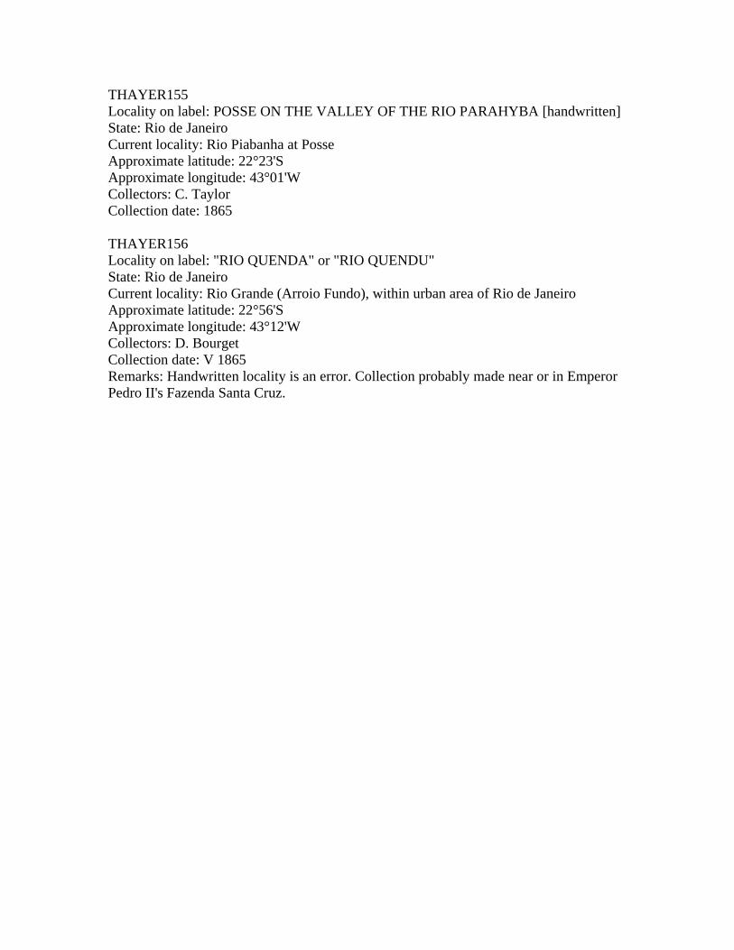
THAYER155 Locality on label: POSSE ON THE VALLEY OF THE RIO PARAHYBA [handwritten] State: Rio de Janeiro Current locality: Rio Piabanha at Posse Approximate latitude: 22°23'S Approximate longitude: 43°01'W Collectors: C. Taylor Collection date: 1865 THAYER156 Locality on label: "RIO QUENDA" or "RIO QUENDU" State: Rio de Janeiro Current locality: Rio Grande (Arroio Fundo), within urban area of Rio de Janeiro Approximate latitude: 22°56'S Approximate longitude: 43°12'W Collectors: D. Bourget Collection date: V 1865 Remarks: Handwritten locality is an error. Collection probably made near or in Emperor Pedro II's Fazenda Santa Cruz.

DOCUMENTS and REFERENCES LIST OF MCZ ARCHIVES DOCUMENTS: Document bAg 15.41.6: Notes for a lecture by Louis Agassiz on Brazilian ichthyofauna,
with some references to collection sites. All the localities mentioned are in the vicinities of Rio de Janeiro, and reference is made also to the then Province of Sao Paulo, not visited by the Expedition.
Document bAg 437.50.1: A catalog of the contents of can n°4, sent from Cannavieiras
(now Canavieiras, Bahia state) by Charles Frederick Hartt and Edward Copeland. With Brazilian popular names of the fish collected, plus detailed description of collection sites.
Document bAg 826.50.1: Miscellaneous notes on the material collected at various
stations, mostly with approximate sizes of each lot. Some dates and individual collectors are mentioned.
Document bAg 826.50.2: Various letters sent by Louis Agassiz to Alexander Agassiz on
the contents of his shipments. The letters are part in French and part in English, written in sheets of various qualities, many extremely flimsy. Some information on individual collectors, dates and collecting conditions. The localities listed here and in bAg 826.50.1 apparently formed the base for the small printed labels later placed with each lot.
Document bMu 2411.50.1: A list of fishes collected by Orestes H. St. John in the Rio das
Velhas, Rio Preto at Villa de Santa Rita (now Ibipetuba, Bahia state), Lagoa de Paranagu (Parnagu ), Rio Gurgu‚a (Gurgu‚ia), Rio Jurumenha (Jerumenha), Rio Paranahyba at Sao Goncaallo (Rio Parnaiba at Amarante, a.k.a. Sao Goncaalo do Amarante, Piaui state). Detailed list with collection dates, precise portion of the rivers surveyed and Brazilian names of the fish caught.
Document bMu 2411.50.2: A list of fishes received by Louis Agassiz at Gurup, Para
state, on 31 January 1866. Fourteen specimens (or lots) of fishes and one shrimp, with their Brazilian popular names. The document is signed by the local Speaker of the House of Representatives, the Police Commissioner and a certain Professor Severianno Bezerra d'Albuquerque, probably not the same as the "Senhor Albuquerque" who collected for the Emperor Dom Pedro II in the south.
Document bMu 2443.42.1: A list of zoological, botanical and mineralogical material
collected by George Sceva at Lagoa Santa and Santa Rita (now Euclidelandia, a.k.a. Santa Rita do Rio Negro), Minas Gerais state. A two-column list with popular names (mostly in Portuguese) of the collected material and some information on collection sites and shipping conditions. The relatively few fishes

are listed under their common Brazilian names -- e.g., "Trahira" [Hoplias], "Cascudo" [Loricariidae], "Mandi" [Pimelodidae], etc.
REFERENCES: Agassiz, L. & E. Cary Agassiz (1868). Journey to Brazil. Boston, Ticknor & Fields,
550pp. -- (1869). Voyage au Br‚sil. Transl. F. Vogeli. Paris, Hachette. [French edition, with an
important map, "Parties du Cours de l'Amazone et de ses grands tributaires visit‚es par M. Agassiz en 1865", not published in the American edition]
Almeida, C.M. de (1868). Atlas do Imp‚rio do Brazil. Rio de Janeiro, Brazil, Instituto
Philomatico, 36pp., 24 maps. Comissao de Desenvolvimento Econ“mico do Estado do Amazonas/Grupo Executivo do
Atlas Geoecon“mico [CODEAMA/GEAGE] (1968). Atlas geoecon“mico do estado do Amazonas. Manaus, Brazil, 376pp., maps.
Dick, M.M. (1977). Stations of the Thayer Expedition to Brazil 1865-1866. Breviora,
444:1-37, 11 figs. Homem de Mello, Baron, and F. Homem de Mello (1909). Atlas do Brazil. Rio de
Janeiro, Brazil, F. Briguiet & Cia., 66 pp., 33 maps. Instituto Brasileiro de Geografia [IBGE] (1963). Carta de Manaus 1x50000. Sheets SA-
20-Z-B-III-4, SA-20-Z-D-VI-2, SA-21-Y-A-I-3. Rio de Janeiro, Brazil -- (1972). Carta do Brasil ao Milion‚simo. Sheets SA-19 (Ica ), SA-20 (Manaus), SA-21
(Santarem ), SA- 22 (Belem), SB-19 (Juru ), SA-20 (Purus), SB-21 (Tapajos), SB-22 (Araguaia). Rio de Janeiro, Brazil.
-- (1985). Atlas Nacional do Brasil. Vol. I. Regiao Nordeste. Rio de Janeiro, Brazil. Isbrücker, I.J.H. (1973). Status of the primary homonymous South American catfish
Loricaria cirrhosa Perugia, 1897, with remarks on some other loricariids (Pisces, Siluriformes, Loricariidae). Annali del Museu Civico di Storia Naturale "Giacomo Doria", 79:172-191.
James, D. (1952). O imperador do Brasil e seus amigos da Nova Inglaterra. Anu rio do
Museu Imperial, 1952. Petropolis, Brazil, Minist‚rio da Educacaao e Sa£de, 284pp., pls.

Lorenz, K.M., and M.I.H. Peixoto (1980). Os itiner rios de seis grandes expedicaoes cientificas realizadas no Brasil. Ciencia e Cultura, 32(11):1518-1525, 6 maps.
Malabarba, L.R. (1989). Historico sistem tico e lista comentada das especies de peixes
de gua doce do sistema da Laguna dos Patos, Rio Grande do Sul, Brasil. Comunicacaoes do Museu de Ciencias da PUC-RS, S‚rie Zoologica, 2(8):107-179, fig 1.
Mello-Leitao, C. de (1941). Historia das expedicaoes cientificas no
Brasil. Sao Paulo, Brazil, Nacional, 364pp. Orleans, G. (1936). Viagem militar ao Rio Grande do Sul (agosto a & novembro de
1865). Sao Paulo, Brazil, Nacional, 270pp. [ref. R.E. Reis & L.R. Malabarba]
United States Board on Geographic Names (1963). Gazetteer 71: Brazil. Office of
Geography, Department of Interior. Washington, D.C., U.S. Government Printing Office, 915pp.
Vanzolini, P.E. and N. Papavero (1968). andice dos top“nimos contidos na carta do
Brasil ao milion‚simo. Sao Paulo, Brazil, Fundacaao de Amparo … Pesquisa do Estado de Sao Paulo [FAPESP], 197pp.