an investigation of unrecorded historical cemeteries … · an investigation of minnesota’s...
TRANSCRIPT

AN INVESTIGATION OF UNRECORDED
HISTORICAL CEMETERIES IN MINNESOTA
FINAL December 2011
Prepared for: Minnesota Historical Society and the
Oversight Board of the Statewide Historical and Archaeological Survey
Prepared by: Two Pines Resource Group, LLC
THIS PROJECT WAS FUNDED BY THE ARTS AND CULTURAL HERITAGE FUND AS PART OF THE
STATEWIDE SURVEY OF HISTORIC AND ARCHAEOLOGICAL SITES

AN INVESTIGATION OF MINNESOTA’S
UNRECORDED HISTORICAL CEMETERIES
TPRG Project No. 11-02 MHS Contract No. 4107216
THIS PROJECT WAS FUNDED BY THE ARTS AND CULTURAL HERITAGE FUND AS PART OF THE
STATEWIDE SURVEY OF HISTORIC AND ARCHAEOLOGICAL SITES
Prepared for: Minnesota Historical Society
and the Oversight Board of the Statewide Historical
and Archaeological Survey 345 Kellogg Boulevard West
St. Paul, Minnesota 55102-1906
Prepared by: Andrea C. Vermeer, Ph.D., RPA
and Michelle M. Terrell, Ph.D., RPA
Principal Investigators
17711 260th Street Shafer, MN 55074
FINAL December 2011

An Investigation of Minnesota’s Unrecorded Historical Cemeteries
In a Disused Graveyard by Robert Frost
The living come with grassy tread
To read the gravestones on the hill; The graveyard draws the living still,
But never anymore the dead.
The verses in it say and say: "The ones who living come today To read the stones and go away
Tomorrow dead will come to stay."
So sure of death the marbles rhyme, Yet can't help marking all the time
How no one dead will seem to come. What is it men are shrinking from?
It would be easy to be clever
And tell the stones: Men hate to die And have stopped dying now forever.
I think they would believe the lie.
An Investigation of Minnesota’s Unrecorded Historical Cemeteries
Page i
ACKNOWLEDGEMENTS
The completion of this project was facilitated by the assistance of a variety of individuals and organizations, as well as the work of past researchers. Two Pines wishes to acknowledge the work of Wiley R. Pope and Sarah Fee, authors of Minnesota Cemetery Locations, which provided an invaluable starting point for our research, as well as the dedicated efforts of the numerous individuals responsible for the data provided by the Minnesota Cemetery Project. We would additionally like to thank the Minnesota Genealogical Society for making this information readily available and free to all researchers with a personal or professional interest in the history contained in our state’s cemeteries. We are grateful for the responsiveness and assistance of the staff of the State’s county historical societies, who enthusiastically took time out of their limited hours to provide us with information. When questions arose regarding Parcel Identification Numbers, or the availability of parcel data, we were greatly aided by the staff of various county recorder and county assessor offices, ensuring that we could complete the initial steps of the study for all counties in the state. Two Pines would also like to acknowledge the assistance of fellow archaeologists and historians, who over the course of this project shared cemetery leads. In particular, we would like to thank Department of Natural Resources Parks Program Manager, David Radford, for providing information on numerous cemeteries both within and proximate to our state’s parks. Last but most certainly not least, we would like to express our gratitude to James Shanley of the Property Tax Division of the Minnesota Department of Revenue. His assistance in providing the parcel data for all of Minnesota’s recorded cemeteries in a useable format greatly facilitated this study.

An Investigation of Minnesota’s Unrecorded Historical Cemeteries
Page ii
ABSTRACT
Two Pines Resource Group, LLC (Two Pines) was contracted by the Minnesota Historical Society to complete an investigation of historical cemeteries in Minnesota. This work is being funded through the Arts and Cultural Heritage Fund of the Clean Water, Land, and Legacy Amendment. A portion of the funding is dedicated to the Statewide Survey of Historical and Archaeological Sites, of which this project is a part. Minnesota Statute (MS) 307.08 governs the treatment of human burials found outside of recorded cemeteries that were interred over 50 years ago, as well as unmarked human burials found within recorded cemeteries, and it charges the State Archaeologist with authenticating such burials. The objectives of the investigation were to summarize available information on unrecorded historical-period cemeteries and burials in Minnesota in order to update the site files and database of the Office of the State Archaeologist (OSA) and to determine the on-the-ground status of unrecorded historical-period cemeteries in selected counties as a means of understanding the range of characteristics and conditions of unrecorded cemeteries and burials throughout the state. The first objective was fulfilled through a review and comparison of multiple source materials and the concurrent creation of a statewide database of unrecorded historical cemeteries and burials. The second objective was fulfilled through a field survey. The fulfillment of the first objective resulted in the completion of a comprehensive database of Minnesota cemeteries, with a particular emphasis on locational information. The database identifies each of the 5,876 cemeteries as either recorded or unrecorded, and for each provides the following information as applicable and as permitted by the source materials reviewed: parcel identification number, cemetery name(s), city or township, legal locations to the quarter-quarter Section, presence or absence on USGS quadrangles, UTM coordinates, acreage, source material citations, cemetery-specific notes, presence or absence in the existing OSA database, and site number. It also includes standard OSA coding fields. The fulfillment of the second objective found that unrecorded historical-period cemeteries and burials in Minnesota embody a wide array of characteristics and conditions, ranging from one burial to hundreds of burials, conscientious upkeep to complete neglect, highly visible to indiscernible, open urban spaces to wooded or agricultural rural lands, and religious association to community association to family association, with some cemeteries having had their last interment decades ago, and others continuing to accommodate interments today. Two Pines recommends that additional research be conducted to confirm or correct existing data, and to identify the more elusive historical cemeteries, particularly those that will only be found through in-depth historical research and/or ground-truthing. It is recommended that research be conducted using additional sources to identify unrecorded cemeteries in the state of Minnesota, and that continued ground-truthing of these cemeteries be performed to locate and define their boundaries. It is further recommended that a quality control review be conducted of the existing OSA burial database to generate any necessary corrections, provide consistency in field formatting, and fully integrate the results of this investigation.

An Investigation of Minnesota’s Unrecorded Historical Cemeteries
Page iii
TABLE OF CONTENTS
ACKNOWLEDGEMENTS .......................................................................................................................... I
ABSTRACT ................................................................................................................................................. II
LIST OF FIGURES.................................................................................................................................... IV
LIST OF TABLES...................................................................................................................................... IV
INTRODUCTION ........................................................................................................................................ 1
PROJECT BACKGROUND ............................................................................................................................. 1 DEFINITIONS............................................................................................................................................... 2 STRUCTURE OF THE REPORT....................................................................................................................... 2
METHODS AND QUALITY OF DATASETS.......................................................................................... 3
TASK 1: IDENTIFICATION OF UNRECORDED CEMETERIES IN MINNESOTA CEMETERY LOCATIONS................ 3 Minnesota Cemetery Locations............................................................................................................. 3 County Recorder/Assessor Lists............................................................................................................ 4 Minnesota Department of Revenue List and Conversion of PINs......................................................... 5 Recent Plat Maps .................................................................................................................................. 6
TASK 2: IDENTIFICATION OF UNRECORDED CEMETERIES THROUGH OTHER SOURCES .............................. 7 Maps ..................................................................................................................................................... 7 Online Resources .................................................................................................................................. 8 County Historical Societies................................................................................................................. 10 County Histories ................................................................................................................................. 11 OSA Database..................................................................................................................................... 11 U.S.-Dakota War Sources ................................................................................................................... 11 Minnesota Archaeologists................................................................................................................... 12
TASK 3: CURRENT CONDITION ASSESSMENT........................................................................................... 12 Current Aerial Photography ............................................................................................................... 12 Field Survey ........................................................................................................................................ 12 Site Forms........................................................................................................................................... 13
TASK 4: DATABASE DEVELOPMENT ........................................................................................................ 13
IDENTIFICATION OF UNRECORDED CEMETERIES - RESULTS ............................................... 14
FIELD SURVEY RESULTS– DAKOTA COUNTY............................................................................... 15
EAST CHRISTIANIA CEMETERY................................................................................................................. 16 FARMINGTON LUTHERAN CEMETERY....................................................................................................... 16 FARMINGTON MIDDLE CREEK HISTORIC CEMETERY ............................................................................... 17 GUARDIAN ANGELS CATHOLIC CEMETERY.............................................................................................. 18 RAVENNA CEMETERY............................................................................................................................... 19 ST. JOHN’S CEMETERY ............................................................................................................................. 19 SALEM KIRCHE CEMETERY ...................................................................................................................... 20 SOLDIERS AND SAILORS CEMETERY......................................................................................................... 21 STATE HOSPITAL CEMETERY.................................................................................................................... 22
FIELD SURVEY RESULTS– REDWOOD COUNTY........................................................................... 24
O’CALLAHAN GRAVES............................................................................................................................. 25 ORANGE C. MARTIN GRAVE .................................................................................................................... 25 ROCK DELL CHURCH CEMETERY ............................................................................................................. 26 ST. CORNELIA’S EPISCOPAL CHURCH/LOWER SIOUX COMMUNITY/BISHOP WHIPPLE CEMETERY ........... 27 ST. JOHN’S CHURCH CEMETERY............................................................................................................... 28 SCHWAHN BURIAL PLOT .......................................................................................................................... 28

An Investigation of Minnesota’s Unrecorded Historical Cemeteries
Page iv
SUNDOWN LUTHERAN CHURCH CEMETERY ............................................................................................. 29 TONAK CEMETERY ................................................................................................................................... 30 TRINITY LUTHERAN CEMETERY ............................................................................................................... 30 GERMANTOWN EVANGELICAL UNITED METHODIST CEMETERY .............................................................. 31
FIELD SURVEY RESULTS– WASHINGTON COUNTY.................................................................... 32
BOUTWELL CEMETERY............................................................................................................................. 33 DANIEL VOLLMER CEMETERY.................................................................................................................. 33 ELIM CEMETERY OVERFLOW ................................................................................................................... 35 FAHLSTROM CEMETERY........................................................................................................................... 35 GREY CLOUD ISLAND CEMETERY ............................................................................................................ 36 GUARDIAN ANGELS CATHOLIC CHURCH CEMETERY ............................................................................... 37 ST. JOHANNES CHURCH CEMETERY ......................................................................................................... 37 ST. JOHN’S LUTHERAN CHURCH CEMETERY ............................................................................................ 38 ST. MARY’S EPISCOPAL CEMETERY ......................................................................................................... 39 ST. PAULUS LUTHERAN CEMETERY ......................................................................................................... 39 ST. PETER’S CHURCH CEMETERY............................................................................................................. 40 SALEM CHURCH CEMETERY..................................................................................................................... 41 UNITED CHURCH OF CHRIST CEMETERY .................................................................................................. 41 WOODBURY UNITED METHODIST CHURCH CEMETERY............................................................................ 42
FINDINGS AND RECOMMENDATIONS ............................................................................................. 43
RECOMMENDATIONS ................................................................................................................................ 44
REFERENCES CITED.............................................................................................................................. 46
APPENDIX A: RESEARCH TRACKING TABLE
APPENDIX B: USGS MAP RESEARCH TABLE
APPENDIX C: SUMMARY OF RESULTS
LIST OF FIGURES
FIGURE 1. LOCATIONS OF SURVEYED DAKOTA COUNTY CEMETERIES.......................................................... 15 FIGURE 2. LOCATIONS OF SURVEYED REDWOOD COUNTY CEMETERIES ....................................................... 24 FIGURE 3. LOCATIONS OF SURVEYED WASHINGTON COUNTY CEMETERIES................................................. 32
LIST OF TABLES
TABLE 1. SAMPLE COMPARISON OF STATE AND COUNTY CEMETERY RECORDS ............................................ 5
An Investigation of Minnesota’s Unrecorded Historical Cemeteries
Page 1
INTRODUCTION
Two Pines Resource Group, LLC (Two Pines) was contracted by the Minnesota Historical Society (MHS) to complete an investigation of historical cemeteries in Minnesota. This work was funded through the Arts and Cultural Heritage Fund of the Clean Water, Land, and Legacy Amendment. A portion of the funding is dedicated to the Statewide Survey of Historical and Archaeological Sites (the Survey), of which this project is a part. The work of the Survey is accomplished through competitive bid contracts focused on the documentation of Minnesota’s sites of historical, archaeological, and cultural significance. These investigations take place under the direction and guidance of the Oversight Board, which is comprised of appointed representatives of the Office of the State Archaeologist (Scott Anfinson, State Archaeologist), the Minnesota Historical Society (Pat Emerson, Head of Archaeology), and the Minnesota Indian Affairs Council (Jim Jones, Cultural Resource Director).
PROJECT BACKGROUND
Minnesota Statutes (MS) 307.08 governs the treatment of human burials found outside of recorded cemeteries that were interred over 50 years ago, as well as unmarked human burials found within recorded cemeteries. As part of this treatment, it charges the State Archaeologist with authenticating such burials. Authentication includes a determination that the burial is human, setting the limits of the burial ground, and attempting to determine the ethnic origin of the burial. Unrecorded burials include burial mounds, non-mound precontact burials, and burials dating to the contact (1680 – 1837) and historical periods (1837 – 1960). The State Archaeologist’s jurisdiction does not extend to federal lands, including Indian trust lands, but includes all private land and non-federal public land in Minnesota.
With the goal of assisting the Office of the State Archaeologist (OSA) in fulfilling its responsibilities under MS 307.08, two main objectives of the investigation of unrecorded historical cemeteries (Cemetery Study) were defined by the Oversight Board: 1) to summarize the information presently available on unrecorded historical-period cemeteries and burials in Minnesota in order to update the site files and database of the OSA and 2) to determine the on-the-ground status of unrecorded historical-period cemeteries and burials in selected counties as a means of understanding the range of characteristics and conditions of unrecorded cemeteries and burials throughout the state. The first objective was fulfilled during this project primarily through a review and comparison of multiple source materials and the concurrent creation of a statewide database of unrecorded historical cemeteries and burials. Although the State Archaeologist’s jurisdiction does not extend to federal lands, because information on land ownership was not consistently available in the resources consulted, all cemeteries that were encountered during the course of the study, including those on federal lands, were entered into the database. The second objective was fulfilled through a field survey. Both objectives are addressed by this report.

An Investigation of Minnesota’s Unrecorded Historical Cemeteries
Page 2
DEFINITIONS
This project is limited to historical-period cemeteries and burials within Minnesota. Borrowing from the field of historical archaeology, historical is defined as dating to the post-contact period for which written records are available. For this project, a cemetery is defined as lands, either marked or unmarked, in which multiple individuals are interred. A burial is the location of an individual interment, either isolated or within a cemetery. As initially defined for this project, a recorded cemetery is a cemetery with a surveyed plat filed in the appropriate County Recorder’s office. As defined during the course of this project, a recorded cemetery is a cemetery for which there exists an official record at the state and/or county level, regardless of whether a surveyed plat has been filed. In either case, the designation of “recorded” includes recorded abandoned or neglected cemeteries, which despite their level of maintenance still fall under the jurisdiction of local governments (MS 306.243 and 306.245). An unrecorded cemetery was initially defined for this project as a cemetery without a surveyed plat filed in the appropriate County Recorder’s office. As defined during the course of this project, an unrecorded cemetery is a cemetery for which an official record is not filed at the state or county level.
STRUCTURE OF THE REPORT
The following report begins in the next chapter by outlining both the proposed and actual methods that were used to achieve the two project objectives, and assessing the quality of the datasets associated with these methods. The subsequent chapter addresses the results of the study with regard to the first objective. The next three chapters address the results of the study with regard to the second objective, with one chapter devoted each to Dakota County, Redwood County, and Washington County. The final chapter summarizes the findings of this study and provides recommendations for future investigations associated with historical cemeteries in Minnesota. Appendix A consists of a research tracking table used to facilitate the current study. Appendix B is a listing of United States Geological Survey (USGS) quadrangles reviewed in the process of identifying unrecorded cemeteries. Appendix C provides a summary of the results of the first objective in a tabular format.

An Investigation of Minnesota’s Unrecorded Historical Cemeteries
Page 3
METHODS AND QUALITY OF DATASETS
Two Pines was charged with four tasks to complete the Cemetery Study. Task 1 was to obtain lists of officially recorded cemeteries from County Recorder or County Assessor offices, then use these lists as a baseline for identifying unrecorded cemeteries in an existing extensive cemeteries study titled Minnesota Cemetery Locations (Pope and Fee 1998). Task 2 was to determine the availability of major record sources not used in Minnesota Cemetery Locations and to review readily available sources of this nature to augment the list of unrecorded cemeteries identified in Task 1. Task 3 was to assess the basic condition of all unrecorded cemeteries in the state through the examination of current aerial photographs and a subsequent field survey in selected counties. Task 4 was to use the results of the first three tasks to construct a comprehensive database of all unrecorded historical cemeteries in the state of Minnesota, with a particular emphasis on locational information, and to complete this report. As the study progressed, the approach to Tasks 1 and 3 shifted as dictated by the results (or lack thereof) obtained through the initially consulted datasets. These shifts will be described along with the specific methods and sources reviewed for each task, which are detailed in the sections below.
TASK 1: IDENTIFICATION OF UNRECORDED CEMETERIES IN MINNESOTA CEMETERY LOCATIONS
The goal of Task 1 was to obtain lists of officially recorded cemeteries from County Recorder or County Assessor offices, then compare those lists to the county lists provided in Minnesota Cemetery Locations (Pope and Fee 1998) to identify unrecorded cemeteries contained within that volume. In order to understand the usefulness of the datasets in Task 1 and in subsequent tasks, a description of Minnesota Cemetery Locations is necessary here.
MINNESOTA CEMETERY LOCATIONS
Minnesota Cemetery Locations (MCL) is the result of a study of cemeteries in Minnesota undertaken between 1981 and 1988 by Wiley Pope, then a librarian at the MHS. Pope was assisted in 1986 by Sarah Fee. The study sought to identify and locate all of Minnesota’s historic period cemeteries, and the resulting volume lists by county approximately 4,400 cemeteries. Each individual cemetery listing contains the name of the city or township in which the cemetery is located, the legal location of the cemetery to the quarter-quarter Section, and the name(s) of the cemetery. In some cases, additional notational information is provided, likely as a result of more source information being available for some counties. For each county, Pope examined USGS maps, the Minnesota Department of Health cemetery inventory at MHS, the 1916 Hixton Plat Book of the State of Minnesota, the 1936 Minnesota Highway Department Sectional Maps Showing Counties by Township, and Work Progress Administration (WPA) unpublished manuscripts on cemeteries available at the MHS. He additionally examined county-specific records at the MHS,

An Investigation of Minnesota’s Unrecorded Historical Cemeteries
Page 4
including plat maps and written records, and he contacted many county historical societies requesting information on cemeteries. Originally published in 1988, MCL was edited 10 years later by Pope’s daughter, Juanita, to make the publication more compact and user-friendly, and to replace or delete invalid information. No additional cemeteries were included in the second edition, which is the edition used for the Cemetery Study. Without any intent to detract from the substantial effort undertaken by Pope and Fee, it must be noted that numerous errors can be found within this volume, primarily with regard to the quarter-quarter Sections in which the cemeteries are located. If these errors were identified during the course of the Cemetery Study, the correct data were entered into the database prepared under Task 4; therefore, discrepancies may exist between the legal locational information for entries listed in the Cemetery Study database and those listed in MCL. Any cemeteries listed in MCL that are not in the Department of Revenue database or official county records are considered unrecorded and were entered into the database as such.
COUNTY RECORDER/ASSESSOR LISTS
Because at the outset of this project, recorded cemeteries were considered to be those that have a surveyed plat filed in the appropriate County Recorder office, Two Pines staff contacted county government offices by telephone to obtain a list of officially recorded cemeteries. During these calls, it became apparent that not all counties maintain such a list. Furthermore, a frequent response to this request was the question of what was meant by “recorded”; several Recorder office staff members noted that often cemetery lands were deeded as cemeteries, but had not been surveyed or had a plat filed. For the purposes, therefore, of this study, the definition of a recorded cemetery shifted from a platted cemetery to any cemetery for which a county has an official record. In the course of speaking to a staff person at the Anoka County Assessor office, Two Pines was informed that the county could generate its list of deeded cemeteries by querying its database for a specific state tax code. It was subsequently determined that this code was universal to all counties, which led to the request for a statewide list from the Department of Revenue (see below). This statewide list eliminated the need to contact the remaining counties for individual lists, and provided a more comprehensive listing than those that had been received from individual county offices. When lists were received from county offices, they varied in the amount and quality of data that they held, ranging from only the names of the cemeteries to the names and legal descriptions down to the quarter-quarter Section. Because some of these lists, however, were not generated by the county using the state tax code, but rather were of platted cemeteries, they were compared to the statewide list. Any cemeteries listed by the county as platted and not contained within the statewide list were added to the database with a corresponding source notation.

An Investigation of Minnesota’s Unrecorded Historical Cemeteries
Page 5
MINNESOTA DEPARTMENT OF REVENUE LIST AND CONVERSION OF PINS
The Minnesota Department of Revenue was contacted on February 1, 2011 to request a database query of all properties in the state coded as tax-exempt cemeteries (public or private). On February 2, 2011, James Shanley of the Property Tax Division of the Minnesota Department of Revenue provided the results of the query to Two Pines as an Excel spreadsheet. The fields of the database provided include for each cemetery the associated county name, city or township name, the parcel identification number (PIN), status as public or private, exempt market value, and acreage. This query returned 4,317 parcels, with some cemeteries consisting of more than one parcel, and occasionally some parcels comprising more than one cemetery. The state’s dataset was last updated in 2010. Comparison of the Department of Revenue list with lists of platted cemeteries provided by some county recorder offices indicates that very few of the cemeteries on the Department of Revenue list, and therefore very few cemeteries within the state, are actually platted (Table 1). Rather, the majority of the cemeteries on the Department of Revenue list are deeded as cemeteries, but a plat for the cemetery has not been filed at the county. Conversely, churchyard cemeteries often are not platted or deeded separately from the church, and therefore, as the associated parcel is not coded as a cemetery, they do not appear in the Department of Revenue list of cemeteries. But, as the Department of Revenue list contains individual surveyed parcels that are identified by the counties as cemeteries, they, together with any information on platted cemeteries received from individual counties, are considered “recorded” for the purposes of this study. These cemeteries therefore provided a baseline for determining which cemeteries encountered in other sources were unrecorded. The majority of the PINs provided by the Department of Revenue could be entered into county online property databases, most of which produced legal locations to the quarter or quarter-quarter Section and the name of the owner of the associated cemetery, and in many cases a geographic information system (GIS) interface depicting the cemetery parcel. The legal location and owner name information could be compared to the legal locations and cemetery names provided in MCL to identify the cemetery represented by a given PIN. If this information was insufficient, the parcel location could frequently be compared with topographic maps or GoogleEarth to obtain a cemetery name. Some county online property databases, however, provide less information than others; for example, some do not provide property owner names or graphical interfaces. In these cases, identification of cemeteries was based on a comparison of legal locations provided in the parcel records with those listed in MCL, with USGS maps available online through ACME Mapper and MyTopo MapPass, and with GoogleEarth.
TABLE 1. SAMPLE COMPARISON OF STATE AND COUNTY CEMETERY RECORDS
County Department of Revenue County Recorder Office Becker 43 cemeteries 16 platted cemeteries (4 not on Dept. of Rev. list) Beltrami 41 cemeteries 30 platted cemeteries (5 not on Dept. of Rev. list) Redwood 43 cemeteries 16 platted cemeteries (4 not on Dept. of Rev. list)

An Investigation of Minnesota’s Unrecorded Historical Cemeteries
Page 6
ACME Mapper (http://mapper.acme.com/) is a website with a free mapping application based on Google Maps. For the purposes of the Cemetery Study, it was extremely useful in that it allows searching by city name or township and county names to zoom a USGS map to that location. The user can then quickly drag the map to view the specific legal locations provided for a cemetery, and if present, drag the cemetery to a crosshair on the screen to obtain UTM coordinates. If the name of the cemetery is not on the USGS, it can often be found on the hybrid aerial/map interface on the site, to which the USGS map can be converted in a single click. MyTopo MapPass (http://map-pass.mytopo.com/) is a subscription-based service that allows the user to enter a Township, Range, and Section to zoom to that location on a graphic interface. It is particularly useful for searching unorganized townships, which the ACME Mapper search cannot recognize, although the interface is not as quick or as user-friendly as that of ACME Mapper. MyTopo MapPass has the added benefit of allowing the user to click to identify the name and year of the USGS quadrangle being viewed. Despite the use of these tools, cases still occurred where a PIN with a legal location applying to more than one cemetery could not be associated with one specific cemetery. In these cases, the PIN was assigned to all potential cemeteries in that location, with a notation made accordingly in the notes field of the database. Many cases also occurred in which the name of a cemetery could not be identified, frequently because MCL lists it as “cemetery” and a name is not provided in any of the online mapping applications. The names of these cemeteries were entered into the database as “Unknown-Cemetery” unless the sources reviewed in Task 2 provided a name. In some county database entries, lot and block descriptions were assigned to specific PINs in lieu of legal locations. These cases required the additional step of reviewing historical atlases or fire insurance maps to obtain the legal locations for the lot and block, which could then be held up to MCL. This step, however, sometimes provided the added benefit of a cemetery name being recorded on the map. Finally, some counties do not currently maintain online property search websites. Two Pines provided the appropriate office for each of these counties with the PINs from the Department of Revenue list for their county, and requested the associated cemetery names and legal locations.
RECENT PLAT MAPS
As initially assigned, Task 1 was also to include a review of a recent plat book for each county to determine whether all of the cemeteries represented in a given county’s plat book are on the list of recorded cemeteries received from the respective county and, conversely, whether any unrecorded cemeteries appear in these sources. Shortly after this task began, it became evident that the plat maps would not reliably convey the locations of cemeteries; for example, in many cases, church cemeteries appeared only as churches on the plat maps, thus many unrecorded church cemeteries would not be identifiable through plat maps. Equally problematic was that recent plats did not depict family plots that were identified through a cursory review of other sources. Given, therefore, that the information return from reviewing all of the recent plats would be minimal, Two Pines

An Investigation of Minnesota’s Unrecorded Historical Cemeteries
Page 7
consulted with the Oversight Board, who agreed that the review of recent plat maps could be eliminated from Task 1.
TASK 2: IDENTIFICATION OF UNRECORDED CEMETERIES THROUGH OTHER
SOURCES
The objective of Task 2 was to identify readily available sources containing information on unrecorded cemeteries which had not been consulted by Pope and Fee, particularly those that have become readily available since MCL was published, and to use these records to add unrecorded burials and cemeteries not listed in MCL to the database prepared under Task 4. In approaching this task, Two Pines gave specific attention to the capture of information on those types of burials and cemeteries that often are under-documented. While the cemeteries of municipalities and religious organizations, even those that are unrecorded, are typically well-known, three types of burials frequently do not appear in documents, official or otherwise: 1) those that pre-date standardized recording methods, 2) those that are isolated or in a small grouping, and 3) those of an expedient nature born of the immediacy of events such as conflict or transient passage through an area. In an attempt to address these three types of burials in addition to typical cemeteries, Two Pines reviewed General Land Office public survey maps, early explorers’ maps, and county histories, which typically note the earliest deaths and burials in an area; online resources, including but not limited to genealogical websites, which have increasingly incorporated rural family plots and individual burials; and data on U.S.-Dakota War burials from primary and secondary sources. Other sources consulted under Task 2 include USGS topographic maps, early plat maps, lists of cemeteries provided by county historical societies, other communications by county historical society staff, communications by Minnesota archaeologists, and the existing OSA database.
MAPS
Maps were among the primary sources consulted for the Cemetery Study. The groups of maps consulted and their usefulness are discussed below.
United States Geological Survey (USGS) Quadrangles
As the USGS maps were a principal dataset for MCL (Pope and Fee 1998:8), Two Pines did not duplicate the efforts of Pope and Fee. Rather, only those topographic maps that had been updated since 1988, i.e., after the completion of MCL, were examined for cemeteries using Maptech’s Terrain Navigator. Any cemeteries present on these maps were then compared to MCL to ascertain whether they were previously captured in that study. The updated maps were also checked to verify whether the cemeteries recorded in MCL were still present. During the course of this task, 199 updated quadrangle maps encompassing portions of 51 counties were reviewed (Appendix B). This review resulted in the identification of 20 cemeteries not listed in MCL. Of the 20 cemeteries not listed in MCL, all but seven were captured during the review of other sources. Of these seven cemeteries, all but one (a

An Investigation of Minnesota’s Unrecorded Historical Cemeteries
Page 8
new cemetery near New Ulm) was previously captured in the existing OSA burial database.
Trygg Maps (Public Land Survey)
A series of maps summarizing the original public land survey data for Minnesota and augmented by information from other documentary sources were compiled by J. William Trygg (1964) during his employment as an appraiser for several tribal communities. These maps were reviewed were reviewed for references to burials. Because the time period (precontact or historical) of the burials could not be ascertained from the map alone, references to mound burials were also noted. Burial locations were subsequently examined on the original General Land Office map available online and compared to other data sets. Of the 20 potential burial features identified on the Trygg composite maps, only five were not previously captured in the existing OSA burial database. Of these five previously unrecorded cemeteries, two were captured during the review of other sources. Three previously unrecorded cemeteries were added to the database from the Trygg survey maps.
Early Plat Maps
As previously noted in the discussion of recent plat books, plat maps are not an entirely reliable source of location information for cemeteries due to the conflation of church cemeteries with church parcels and the absence of family burial plots. Furthermore, a cursory review of some county plat books revealed that the available information on cemeteries was often captured in other data sets consulted. Given, therefore, that the information return from reviewing all of the early plats would be minimal, Two Pines consulted with the Oversight Board, who agreed that the review of early plat maps could be eliminated from the literature search.
ONLINE RESOURCES
Five websites were consulted to assess their usefulness in identifying unrecorded cemeteries that might be otherwise undocumented and to augment the listing of unrecorded cemeteries in the database prepared under Task 4. These websites are the Minnesota Genealogical Society’s Minnesota Cemetery Project (http://mngs.org/ cemetery.htm), MN HomeTownLocator (http://minnesota.hometownlocator.com/), Genealogy Trails (http://genealogytrails.com/minn/), Interment.net Cemetery Records Online (http://interment.net/), and the USGenWeb Project’s Tombstone Transcription Project website (http://www.usgwtombstones.org/minnesota/). For each county, these websites were consulted in the order listed above to determine the level to which information obtained from each website was redundant with the previously consulted websites. A summary of each of these websites is provided below.
Minnesota Cemetery Project
The Minnesota Cemetery Project site contains master lists of cemeteries for 65 of Minnesota’s 87 counties. The 22 missing counties as of 2011 are Benton, Big Stone, Carlton, Chippewa, Dakota, Douglas, Faribault, Goodhue, Hennepin, Kandiyohi, Le Sueur, Mille Lacs, Nicollet, Norman, Redwood, Renville, Roseau, St. Louis, Sherburne, Stevens, Wabasha, and Winona.

An Investigation of Minnesota’s Unrecorded Historical Cemeteries
Page 9
For each cemetery, the fields provided that were relevant to identifying and locating cemeteries include the primary name of the cemetery and any known alternate names, the name of the township or city in which it is located, the street address of the cemetery, the Township, Range, and Section in which it is located, the USGS quadrangle map on which it appears, and driving directions to the cemetery. Other fields include the cemetery’s status as active or inactive, date of establishment, general notes, and transcription information (e.g., date, location of original, title, publisher). The level to which all the fields are filled out varies from county to county. By and large, however, the identification and locational information is present, allowing for comparison to other sources and subsequent entries into the database. It should be noted, however, that in the case of Todd County, the legal locational information was found to be substantially flawed; therefore, information on this county’s cemeteries from the Minnesota Cemetery Project site was not incorporated into the database. The Minnesota Cemetery Project site was found to be excellent for the identification of unrecorded cemeteries beyond those present in MCL, particularly with regard to family plots and individual burials. While the locations for some of these are general, i.e., specific only to the level of Section, many are spelled out with driving directions. The review of this website led to the addition to the database of 479 unrecorded burials and cemeteries beyond those listed in MCL.
MN HomeTownLocator
MN HomeTownLocator is an online gazetteer meant to inform users of the physical, cultural, and civil features of Minnesota counties, cities, and towns. By selecting a county, then “Physical, Cultural & Historic Features,” then “Cemeteries,” the user is presented with a list of the cemeteries within the county. All Minnesota counties contained listings on this website as of 2011. On occasion, these listings include family plots and individual burials, but they are not nearly as comprehensive as those found on the Minnesota Cemetery Project site. For each cemetery, a number associated with a specific USGS quadrangle is provided, as are latitude and longitude, and a street map pinpointing the location of the cemetery, which can be converted to an aerial photograph through a drop-down located in the upper right-hand corner of the map. Based on comparisons with the locations of cemeteries identified through other sources and having accurate locational information, the latitude and longitude coordinates for each cemetery provided on the MN HomeTownLocator site were often, but not always, reliable. The review of this website led to the addition to the database of 15 unrecorded burials and cemeteries beyond those listed in MCL and the Minnesota Cemetery Project website.
Genealogy Trails
The Genealogy Trails “Minnesota Trails” website is a genealogical website that contains lists of cemeteries present in Minnesota counties. As of 2011, cemetery listings were available for only 33 of the 87 counties. Cemetery information varies by county. For some counties, only the cemetery name is provided. For others, latitude and longitude

An Investigation of Minnesota’s Unrecorded Historical Cemeteries
Page 10
coordinates are also provided. Olmsted County’s listing includes street maps pinpointing cemetery locations, which can be converted to an aerial photograph or topographic map by clicking on the appropriate buttons. A limited few cemetery lists include links to transcriptions. Overall, however, this website did not contribute much information to the database that had not already been garnered from other sources. The review of this website led to the addition to the database of 24 unrecorded burials and cemeteries beyond those listed in MCL, the Minnesota Cemetery Project website, and MN HomeTownLocator.
Interment.net Cemetery Records Online
The Interment.net Cemetery Records Online website publishes cemetery transcriptions for researchers. For this reason, only cemeteries for which the website has transcriptions are listed for each county, and these are few, typically between one and five cemeteries per county. A notable exception is Roseau County, which lists 35 cemeteries. As of 2011, only 44 of Minnesota’s 87 counties were represented on this website. Although a benefit of the website is that the cemeteries listed typically have driving directions, most of the cemeteries had been identified and their locations obtained through previous research steps. The review of this website led to the addition to the database of only 5 unrecorded burials and cemeteries beyond those listed in MCL, the Minnesota Cemetery Project website, MN HomeTownLocator, and Genealogy Trails.
Tombstone Transcription Project
The Tombstone Transcription Project website is a genealogical research website. As of 2011, it contained information on cemeteries in all of Minnesota’s counties except Brown, Carver, Chisago, Lincoln, Lyon, Mahnomen, Martin, Pennington, Red Lake, Stevens, Wadena, and Wilkin. The information provided is variable by county. Although the first county examined on this website, Redwood County, provided locational information to the level of Section for each cemetery and resulted in the addition of 31 unrecorded burials and cemeteries to the database, the review of information for additional counties found that often only cemetery transcriptions were provided, thus cemetery listings omitted cemeteries lacking transcriptions. For other counties, cemeteries were listed, but the locational information was vague or would require physically following the directions to the landmarks described therein to determine the legal location. For this reason, this website was not consulted beyond Redwood County. It should be noted, however, that locational information to the quarter-quarter Section is available for Renville County and some cemeteries in Mille Lacs County, and that relatively specific driving directions are available for cemeteries in Faribault County.
COUNTY HISTORICAL SOCIETIES
Two Pines contacted all of Minnesota’s county historical societies by phone or email to request any lists they might have of cemeteries present in their respective counties, and any information they might have received anecdotally or otherwise regarding potential cemeteries not on those lists. Responses were received from 32 county historical societies (see Appendix A). Of the historical societies that responded, four provided links to non-county online sources, while the remainder either provided links to county

An Investigation of Minnesota’s Unrecorded Historical Cemeteries
Page 11
websites containing cemetery listings or mailed information from their archives on the cemeteries in their county. The county historical societies proved to be an excellent resource for identifying unrecorded cemeteries, as the information provided by those that responded added 75 unrecorded burials and cemeteries beyond those identified in MCL and the online databases.
COUNTY HISTORIES
County histories available at the MHS were reviewed for selected counties. Although these were found to contain occasional references to burials or the formation of community cemeteries, locationally specific information is often lacking; therefore, mentioned cemeteries or burials could not be compared with the listing of cemeteries as generated by other sources. Further, the vague locational information provided would not likely assist the State Archaeologist in locating or identifying unrecorded burials. Based, therefore, on the limited information return from these sources, together with the likelihood that information in these volumes was captured in lists of cemeteries provided by county historical societies, no additional county histories were consulted.
OSA DATABASE
At the outset of the Cemetery Study, Two Pines received a copy of a Microsoft Access database containing information on those burials (both mound and non-mound) recorded in the files of the OSA. This database was reviewed after the other datasets for additional locational information relevant to identified cemeteries.
U.S.-DAKOTA WAR SOURCES
During the U.S.-Dakota War of 1862, approximately 600 EuroAmericans and an untold number of Dakota lost their lives. Due to the often expeditious burial of the dead or the lack of recovery of remains, this historical event is a significant source of unmarked burials in Minnesota. Non-Indian deaths occurred in 15 Minnesota counties (Big Stone, Blue Earth, Brown, Jackson, Kandiyohi,1 Lac qui Parle, McLeod, Meeker, Murray, Nicollet, Redwood, Renville, Watonwan, Wright, Yellow Medicine) (Satterlee 1919). While numerous individuals were repatriated to cemeteries after the conclusion of hostilities, the burial locations of an estimated 300 EuroAmericans and countless Dakota remain unmarked (Dahlin 2007:2). For the Cemetery Study, data on burials from the U.S.-Dakota War of 1862 were gathered from secondary sources that provide summaries of death and burial locations, including Authentic List of the Victims of the Indian Massacre and War 1862 to 1865 (Satterlee 1919) and Dakota Uprising Victims: Gravestones & Stories (Dahlin 2007). Cemeteries and burial locations recorded in Dahlin (2007) were compared to the Cemetery Study database. A total of 15 cemeteries/burial locations were added to the database from this source. The majority of these (n = 9) were located in Renville County. Information on burials on the Wood Lake Battlefield gathered in the course of a National Register Nomination study (Terrell 2009)
1 Members of the Broberg family, who resided in Swift County near its border with Kandiyohi County, are enumerated in the sources under Kandiyohi County (Satterlee 1919; Dahlin 2007:67, 68). The burials were reinterred in 1891 within the Lebanon Lutheran Church Cemetery in New London, Kandiyohi County.

An Investigation of Minnesota’s Unrecorded Historical Cemeteries
Page 12
was also added to the database. Future research in primary documents is recommended to identify the locations of additional burial sites resulting from the war.
MINNESOTA ARCHAEOLOGISTS
Two Pines posted a request for information on unrecorded cemeteries on the Council for Minnesota Archaeology e-mail listserv on January 31, 2011. Three archaeologists responded to this request. Two responders provided information on cemeteries that were captured through other research steps. The third responder, David Radford, DNR Parks Program Manager, provided information on burials within and proximate to Minnesota’s state parks. Mr. Radford’s information augmented existing cemetery entries and resulted in the addition of three cemeteries/burials to the database.
TASK 3: CURRENT CONDITION ASSESSMENT
As originally proposed, the intended goal of Task 3 was to assess the basic condition of the unrecorded cemeteries identified in Tasks 1 and 2 through a review of current aerial photographs and a subsequent field survey in selected counties.
CURRENT AERIAL PHOTOGRAPHY
Given that the quality, scale, and type (oblique versus overhead) of current aerial photography available online varies by source, Two Pines began reviewing the first unrecorded cemetery locations on GoogleEarth, Bing Maps, Mapquest, and Acme Mapper to assess which source would be most useful to meet the primary goal of Task 3. It was shortly thereafter determined that no readily available current aerial photographs were of a scale that could accurately inform on the condition of the majority of unrecorded cemeteries, particularly those in heavily wooded or otherwise vegetated areas, but also those consisting of small family or isolated burial plots. For this reason, and given the unanticipated number of unrecorded cemeteries that were identified through Tasks 1 and 2, Two Pines consulted with the Oversight Board, who agreed that the first step of Task 3 should be eliminated, and the second step could instead be used to gain a representative sample of the current conditions of unrecorded cemeteries in Minnesota.
FIELD SURVEY
In consultation between the Oversight Board and Two Pines, Dakota, Redwood, and Washington counties were selected for field survey. This consultation also determined that given the non-specific locational information available for many of the unrecorded cemeteries, the cemetery survey would be limited to those unrecorded cemeteries that appear on USGS maps. The OSA files were reviewed for each of the counties that were field surveyed to determine whether they contained reference to any unrecorded cemeteries that were not identified during previous steps and, if so, whether those cemeteries met the above conditions and could therefore be surveyed. Each cemetery location was examined through a pedestrian survey and photographed. The pedestrian survey was used to assess the overall surface condition and characteristics of the cemetery and to determine the range of burial dates present. The cemetery boundaries were documented using a Trimble GeoXT GPS Unit with sub-meter accuracy.

An Investigation of Minnesota’s Unrecorded Historical Cemeteries
Page 13
SITE FORMS
Site inventory forms were completed for all field-surveyed cemeteries that met the criteria of the OSA. The OSA requests site forms for cemeteries that: 1) are unrecorded; 2) have been field checked, and 3) the boundaries have been determined with some exactness. The State Archaeologist will determine which field-investigated cemeteries will be assigned official site inventory numbers and added to the state’s archaeological site database.
TASK 4: DATABASE DEVELOPMENT
Two Pines developed a Microsoft Access database of all identified cemeteries and burials. The structure of this database conformed to the current burial and site records database maintained by the OSA. For each cemetery, the database provides the following information as applicable and as permitted by the source materials reviewed: cemetery name(s), city or township, USGS quadrangle name, legal locations to the quarter-quarter Section, UTM coordinates, acreage, source material citations, and cemetery-specific notes. Any cemetery for which a name was not provided in any of the sources reviewed was entered into the database as “Unknown-Cemetery.” The database also includes standard OSA coding fields including the site number, date of survey, description, period of association, and the entry date. Fields created specifically for this project, which may be incorporated into the OSA database, include the parcel identification number, multiple name fields, presence or absence on USGS quadrangles, whether the cemetery or burial is recorded or unrecorded, and presence or absence in MCL. A field indicating presence in the OSA database was also incorporated for tracking purposes, but will be omitted from the final submittal.

An Investigation of Minnesota’s Unrecorded Historical Cemeteries
Page 14
IDENTIFICATION OF UNRECORDED CEMETERIES - RESULTS
The review and comparison of sources completed under Tasks 1 and 2 as described in the previous chapter identified 5,876 cemeteries or burials in the state of Minnesota, including Fort Snelling National Cemetery, which is on federal land. It is noted that while Fort Snelling National Cemetery was known to be on federal land, the Cemetery Study did not otherwise investigate land ownership; therefore, others of the remaining 5,875 identified cemeteries or burials may be on federal or tribal land. Summary information regarding these cemeteries by county is provided in a tabular format in Appendix C. The database provided by the Minnesota Department of Revenue contains 4,313 PINs coded as cemeteries. Of these, 51 represent parcels that the subsequent review of county online databases indicated are not associated with cemeteries; rather, they are generally errant numbers either with no parcel counterpart or associated with other property types, such as baseball fields, disposal ponds, or residences. Two of these 51 PINs are associated with mausoleums, and another one is associated with a pet cemetery, neither of which is included in the database. The remaining 4,262 PINs represent 3,290 recorded cemeteries in Minnesota. The review of cemetery lists provided by county recorder or county assessor offices added another 43 recorded cemeteries beyond those in the database. These 43 cemeteries bring the total number of recorded cemeteries in the state to 3,333. The remaining cemeteries or burials identified through the review and comparison of other sources are unrecorded. These 2,542 cemeteries include 1,688 from MCL, 623 from the Minnesota Cemetery Project, MN HomeTown Locator, Genealogy Trails, and Interment.net, and 231 from additional sources as described in the previous chapter.

An Investigation of Minnesota’s Unrecorded Historical Cemeteries
Page 15
FIELD SURVEY RESULTS– DAKOTA COUNTY
Dakota County was selected for survey as a county that would be representative of the conditions of unrecorded cemeteries in metro area counties with increasing development pressures, and one that Tasks 1 and 2 indicated contained a variety of cemetery types. Twenty-seven unrecorded cemeteries were identified during Tasks 1 and 2 of the Cemetery Study. Of these, nine cemeteries could be readily located using USGS maps and their characteristics and condition assessed: East Christiana Cemetery, Farmington Lutheran Cemetery, Farmington Middle Creek Historic Cemetery, Guardian Angels Catholic Cemetery, Ravenna Cemetery, St. John’s Cemetery, Salem Kirche Cemetery, Soldiers and Sailors Cemetery, and State Hospital Cemetery (Figure 1). Of these, five cemeteries (East Christiana, Farmington Lutheran, Farmington Middle Creek Historic, St. John’s, and Salem Kirche) are currently or were formerly associated with churches; one (Guardian Angels Catholic) is integrated with two other cemeteries; one (Soldiers and Sailors) is a veterans’ cemetery; one (State Hospital) is affiliated with the former Hastings State Hospital; and one (Ravenna) is of an indeterminate type.
FIGURE 1. LOCATIONS OF SURVEYED DAKOTA COUNTY CEMETERIES
(RED AREA IS COUNTY SEAT, GREY AREAS ARE INCORPORATED)

An Investigation of Minnesota’s Unrecorded Historical Cemeteries
Page 16
EAST CHRISTIANIA CEMETERY
Location: Eureka Township, T113N, R20W, Section 29, SE-SE Burial Dates: Circa 1872-present Survey Date: May 26, 2011
The East Christiania Cemetery is easily accessible from 267th Street. It is an unfenced but well-maintained cemetery, formerly associated with a church that was present from 1857 to 1957. The oldest legible headstone dates to 1872, but earlier burials may be present. A visitor to the cemetery who has conducted substantial research on Minnesota cemeteries, John Dalby, informed Two Pines that unmarked graves are present on the top of the hill in the center of the cemetery. Location Easting Northing Notes Northwest Corner 480896.774 4934252.765 Northeast Corner 480970.584 4934256.496 Southeast Corner 480980.611 4934163.617 Southwest Corner 480910.232 4934167.668
FARMINGTON LUTHERAN CEMETERY
Location: Eureka Township, T113N, R20W, Section 14, SW-NE Burial Dates: 1910-present Survey Date: May 26, 2011

An Investigation of Minnesota’s Unrecorded Historical Cemeteries
Page 17
The Farmington Lutheran Cemetery is easily accessible from 245th Street, and it is well maintained. The cemetery was formerly associated with St. John’s Danish Lutheran Church, which a commemorative stone marker indicates was built on the property in 1903. It is not known when the church building was removed. The boundaries of the cemetery are clearly marked by a chain-link fence. Location Easting Northing Notes Northwest Corner 485116.574 4938003.601 Tree line Northeast Corner 485205.511 4938003.175 Tree line Southeast Corner 485209.916 4937937.183 Southwest Corner 485108.735 4937935.707
FARMINGTON MIDDLE CREEK HISTORIC CEMETERY
Location: Farmington, T114N, R20W, Section 25, NW-SE Burial Dates: 1859-1906 Survey Date: May 26, 2011

An Investigation of Minnesota’s Unrecorded Historical Cemeteries
Page 18
The Farmington Middle Creek Historic Cemetery is accessible via a maintained walking trail that leads northwest off of Dyers Pass. A sign at the cemetery end of the trail notes:
This Historic Cemetery is one acre of land which was donated by Samuel Osborne to the Trustees of the Farmington Presbyterian Church in July of 1868. The Body of Ada Bacon had already been buried there in 1859. There are about two dozen graves in the cemetery. Over the last 60 years the cemetery has been abandoned.
The sign also lists the names, birth date, and death date of those interred in the cemetery, and associated notes for each entry. Aside from the sign, a displaced headstone and a couple of depressions constitute the only evidence for the presence of the cemetery, which is not maintained. The boundaries of the cemetery are not fenced or marked. Location Easting Northing Notes Visible Stones 487102.972 4944338.158 Stakes 487105.046 4944355.602 Northwest Extent 487105.634 4944357.492 Corner of fence for modern development Southwest Extent 487097.070 4944342.765
GUARDIAN ANGELS CATHOLIC CEMETERY
Location: Hastings, T115N, R17W, Section 34, SW-SW Burial Dates: Because this cemetery is integrated with other cemeteries, an accurate range of burial dates specific to it could not be obtained. Survey Date: June 2, 2011
The Guardian Angels Catholic Cemetery is easily accessible from Cannon Street. This well-maintained cemetery is integrated with two other cemeteries, the St. Elizabeth Ann Seton Cemetery and the St. Boniface Cemetery, which are interconnected through a network of driveways. For this reason, the boundaries of the cemetery are not evident, although its presence is confirmed by a cross-shaped stone monument that bears its name. Location Easting Northing Notes Cross Monument 511762 4951612 UTMs generated using Acme Mapper

An Investigation of Minnesota’s Unrecorded Historical Cemeteries
Page 19
RAVENNA CEMETERY
Location: Ravenna Township, T114N, R16W, Section 16, NW-NW Burial Dates: 1856-present Survey Date: June 2, 2011
The Ravenna Cemetery is accessible via a grassy pedestrian access that extends north off of a residential driveway on the east side of Ravenna Trail/County Road 54. The cemetery is well maintained. A wire fence with a gate marks the southern end of the cemetery and separates it from the residential property. Otherwise, the cemetery is unfenced, and its boundaries are made up of the trees/woods surrounding the other three sides. Location Easting Northing Notes Northwest Corner 519697.371 4948051.028 Post Northeast Corner 519754.011 4948054.394 Post Southeast Corner 519719.070 4947973.206 Vicinity Southwest Corner 519688.626 4947978.657 Vicinity
ST. JOHN’S CEMETERY
Location: Rosemount Township, T115N, R19W, Section 26, SE-NE Burial Dates: 1913-present Survey Date: May 26, 2011

An Investigation of Minnesota’s Unrecorded Historical Cemeteries
Page 20
St. John’s Cemetery is easily accessible from Blaine Avenue East. The cemetery, located on church grounds, is well maintained, and its boundaries are marked on all but the north side with a combination of chain link and wire woven fences. The northern boundary was considered to be the northern extent of the headstones. Location Easting Northing Notes Northwest Corner 495608.673 4954046.335 Vicinity Northeast Corner 495646.916 4954045.037 Southeast Corner 1 495636.072 4953975.255 Southeast Corner 2 495645.253 4953984.155 Southwest Corner 495607.160 4953976.815
SALEM KIRCHE CEMETERY
Location: Inver Grove Heights Township, T28N, R22W, Section 32, SE-SE Burial Dates: Circa 1875-present Survey Date: May 26, 2011
The Salem Kirche Cemetery is easily accessible from County Road 18/Upper 55th Street East/Salem Church Road. This well-maintained cemetery is associated with the Salem Kirche (Church). The earliest legible headstone dates to 1875, but earlier burials may be present. A white iron fence marks the southern boundary of the cemetery, and an intentionally planted row of trees the northeastern line of this triangular, shoreline property. The church property fence runs along the west side of the church and cemetery. Location Easting Northing Notes Northwest Corner 494043.746 4968480.305 Tree line Southeast Corner 494101.658 4968414.683 Intersection of tree line and fenceSouthwest Corner 494040.388 4968423.737 Fence

An Investigation of Minnesota’s Unrecorded Historical Cemeteries
Page 21
SOLDIERS AND SAILORS CEMETERY
Location: Hastings, T115N, R17W, Section 21, SW-SW Burial Dates: 1869(?)-1955 Survey Date: June 2, 2011
The Soldiers and Sailors Cemetery is easily accessible from County Road 42/Nininger Road. Based on the visible headstones, the burials within this well-maintained cemetery are placed haphazardly; however, the Minnesota Department of Veterans Affairs (2010) notes, “The cemetery is a one half acre plot purchased in 1905 by Peller Post 89, Grand Army of the Republic, for the burial of soldiers and sailors of the Spanish American War and the Civil War. Family members are also buried there. Seven burial stones are on site but more burials are known.” Although the cemetery sign indicates that it was established in 1905, one of the headstones indicates a death date of 1869. It is not known whether this early burial was already present when the cemetery was formally established, or whether it was moved after the creation of the cemetery. The boundaries of the cemetery are indicated by an ornamental iron fence. Location Easting Northing Notes Northwest Corner 510306.847 4954720.018 Northeast Corner 510301.317 4954769.901 Southeast Corner 510357.464 4954727.611 Near gate Southwest Corner 510356.772 4954722.439 Near gate

An Investigation of Minnesota’s Unrecorded Historical Cemeteries
Page 22
STATE HOSPITAL CEMETERY
Location: Marshan Township, T114N, R17W, Section 2, SE-NW Burial Dates: 1901 - 1948 (north), 1944 – 1964 (south) Survey Date: June 2, 2011
The State Hospital Cemetery is accessible on foot via a grassy easement that extends from the north end of Thomas Avenue east approximately ¼-mile. At first approach, the cemetery appears as a vacant property, due to the tall grasses that are present. Moving into the grounds, however, row markers and flat headstones become visible. The cemetery is associated with the former Hastings State Hospital (Second State Asylum for the Insane), which operated in a separate location from 1900 to 1978. Although wooden row markers, which also served to mark the borders of the cemetery, were previously present, headstones were not placed at the individual gravesites until a period between 2006 and 2010, the result of a State of Minnesota grant to a coalition of Minnesota disability groups called Remembering With Dignity (Fassett-Carman 2006; findagrave.com 2011a). The State Hospital Cemetery is divided into two sections, delineated by a row of wooden posts, which may also be row markers. The headstones indicate that the earlier burials, dating between 1901 and 1948, were placed in the south section of the cemetery, and the later burials, dating between 1944 and 1964, in the north section. The row markers

An Investigation of Minnesota’s Unrecorded Historical Cemeteries
Page 23
indicate the boundaries of the cemetery, as do a series of concrete-filled pipes with concrete spheres mounted on top at the northern end of the cemetery. Location Easting Northing Notes Northwest Corner 513835.440 4950849.228 Offset slightly to west
of corner post due to large pine
Northeast Corner 513926.838 4950849.608 Corner post Southeast Corner 513900.525 4950728.702 Row 16 marker Southern Boundary 513844.603 4950692.124 Point along southern
boundary at Row 5 Southwest Corner 513824.362 4950691.740 Southeast Corner or North Section 513906.752 4950800.573 Southwest Corner of North Section 513836.180 4950802.428

An Investigation of Minnesota’s Unrecorded Historical Cemeteries
Page 24
FIELD SURVEY RESULTS– REDWOOD COUNTY
Redwood County was selected for survey as a county that would be representative of the conditions of unrecorded cemeteries in rural counties, that had the potential for expedient burials associated with the U.S./Dakota War, and that Tasks 1 and 2 indicated contained numerous family plots. Fifty-eight unrecorded cemeteries or burials were identified during Tasks 1 and 2. Of these, nine could be readily located using USGS maps and their characteristics and condition assessed: O’Callahan Grave(s), Orange C. Martin Grave, Rock Dell Church Cemetery, St. Cornelia’s Episcopal Church/Lower Sioux Community/Bishop Whipple Cemetery, St. John’s Church Cemetery, Schwahn Burial Plot, Sundown Lutheran Church Cemetery, Tonak Cemetery, and Trinity Lutheran Cemetery (Figure 2). Of these, five cemeteries (Rock Dell Church, St. Cornelia’s Epsicopal Church, St. John’s Church, Sundown Lutheran Church, and Trinity Lutheran) are currently or were formerly associated with churches; three (O’Callahan, Schwahn, and Tonak) are family plots; and one (Orange C. Martin) is an isolated burial. A tenth cemetery, Germantown Evangelical United Methodist Cemetery, was also surveyed but subsequently determined to be recorded. The results for this cemetery are provided at the end of this chapter.
FIGURE 2. LOCATIONS OF SURVEYED REDWOOD COUNTY CEMETERIES
(RED AREA IS COUNTY SEAT, GREY AREAS ARE INCORPORATED)

An Investigation of Minnesota’s Unrecorded Historical Cemeteries
Page 25
O’CALLAHAN GRAVES
Location: Sundown Township, T110N, R35W, Section 18, SW-SE Burial Dates: As no headstones are present, no burial dates could be obtained in the field. Survey Date: April 22, 2011
The reported location of the O’Callahan grave(s) is easily accessible from County Road 4. This location is currently occupied by agricultural fields, and no evidence of the grave(s) is visible. The location marked “Graves” on the USGS map was used to generate the UTMs for the cemetery location. Location Easting Northing Notes “Graves” on USGS 332849 4910176 UTMs generated using Acme Mapper
ORANGE C. MARTIN GRAVE
Location: Redwood Falls Township, T112N, R36W, Section 10, SW-NW Burial Date: 1884 Survey Date: April 22, 2011

An Investigation of Minnesota’s Unrecorded Historical Cemeteries
Page 26
The Orange C. Martin Grave is easily accessible from 325th Street. It is located in a lightly wooded area, and although it does not appear to be purposefully maintained, the surrounding vegetation is sparse enough that the headstone is readily evident from the road. Location Easting Northing Notes Gravestone 327930.575 4932111.432
ROCK DELL CHURCH CEMETERY
Location: Swedes Forest Township, T114N, R37W, Section 28, SW-NE Burial Dates: Circa 1877-present Survey Date: April 22, 2011
The Rock Dell Church Cemetery is easily accessible by driving north from 410th Street on a long driveway that leads to a farmstead and Rock Dell Church, the cemetery being in the churchyard. The cemetery is well maintained. The oldest legible headstone dates to 1877, but earlier burials may be present. The churchyard is fenced with wooden posts and wire, and the fence marks the north, east, and south boundaries of the cemetery. On the west, the boundary is defined by the extent of the headstones. Location Easting Northing Notes Northeast Corner 1 317175.700 4946788.032 Northeast Inner Corner 317166.008 4946794.347 Northeast Corner 2 317166.45 4946815.012 Northwest Corner 317110.317 4946815.045 Extent of graves to west Southeast Corner 317174.400 4946721.855 Southwest Corner 1 317110.911 4946774.754 Extent of graves to west Southwest Inner Corner 317145.465 4946772.347 Southwest Corner 2 317145.801 4946721.611 Northwest Corner 3 317069.377 4946815.231 Extent of churchyard to west Southwest Corner 3 317067.318 4946773.548 Extent of churchyard to west

An Investigation of Minnesota’s Unrecorded Historical Cemeteries
Page 27
ST. CORNELIA’S EPISCOPAL CHURCH/LOWER SIOUX COMMUNITY/BISHOP
WHIPPLE CEMETERY
Location: Paxton Township, T112N, R35W, Section 1, NW-SE Burial Dates: 1888-present Survey Date: April 22, 2011
The St. Cornelia’s Episcopal Church Cemetery is easily accessible from Reservation Highway 101. The cemetery is well maintained. According to the website findagrave.com (2011b), the cemetery is associated with St. Cornelia’s Episcopal Church:
Formerly known as the Birch Coulee Mission or Bishop Whipple Mission, the original mission church was destroyed by fire during the Dakota War of 1862. During his later years, Andrew Good Thunder donated a portion of his land for the rebuilding of the Episcopal mission. The mission was then given the name "St. Cornelia's Church" in honor of Bishop Whipple's first wife, Cornelia Wright Whipple. Since 1891, the historic St. Cornelia's Episcopal Church has been serving the Lower Sioux Indian Community, Redwood and Renville counties.
The cemetery boundaries are Reservation Highway 1 on the west and Reservation Highway 101 on the south and east. On the north, the cemetery boundary is constituted by woods and a fence that separates the St. Cornelia’s Episcopal Church Cemetery from a separate Mdewakanton Sioux repatriation burial site. Location Easting Northing Notes Northwest Corner 341367 4933173 UTMs generated using Acme Mapper Northeast Corner 341455 4933167 UTMs generated using Acme Mapper Southeast Corner 341490 4933003 UTMs generated using Acme Mapper Southwest Corner 341365 4933008 UTMs generated using Acme Mapper

An Investigation of Minnesota’s Unrecorded Historical Cemeteries
Page 28
ST. JOHN’S CHURCH CEMETERY
Location: Sheridan Township, T112N, R37W, Section 5, SE-SE Burial Dates: 1891-present Survey Date: April 22, 2011
The St. John’s Church Cemetery is easily accessible from Harvest Avenue. It is a well-maintained cemetery formerly associated with the recently removed St. John’s Church building. An intentionally planted row of trees marks the boundaries of the cemetery on all sides. Location Easting Northing Notes Northwest Corner 316346.924 4933453.021 Northeast Corner 316405.909 4933448.862 Southeast Corner 316402.435 4933385.339 Southwest Corner 316343.996 4933388.707
SCHWAHN BURIAL PLOT
Location: Waterbury Township, T110N, R37W, Section 3, SW-NW Burial Dates: As close access to the burial plot was not attained, no burial dates could be obtained in the field. Survey Date: April 22, 2011

An Investigation of Minnesota’s Unrecorded Historical Cemeteries
Page 29
The Schwahn Burial Plot can be fairly easily accessed by walking approximately 200 feet east from Hunter Avenue through an agricultural field. Although this family plot was not accessed during the field survey due to a lack of landowner permission, a stone monument was clearly visible from the road. The plot does not appear to be well maintained in the sense of being manicured, but agricultural activities avoid the area of the burials, which is marked by a few trees. The location marked “Cem” on the USGS map was used to generate the UTMs for the cemetery location. Location Easting Northing Notes “Cem” on USGS 317700 4914893 UTMs generated using Acme Mapper
SUNDOWN LUTHERAN CHURCH CEMETERY
Location: Sundown Township, T110N, R35W, Section 28, W-NW Burial Dates: 1880-present Survey Date: April 22, 2011
The Sundown Lutheran Church Cemetery is easily accessible from Nature Avenue. The cemetery is well maintained, and burials are present on the north and south sides of the associated Sundown Lutheran Church. An ornamental metal and wire fence marks the east side of the churchyard, and thus the eastern boundary of the cemetery, along with an intentionally planted row of trees. An intentional row of trees also marks the northern and western boundaries of the cemetery, while the southern boundary is marked by woods that are present to the south of the cemetery. Location Easting Northing Notes Northwest Corner 335120.473 4908119.718 Northeast Corner 335229.188 4908119.313 Southeast Corner 335227.330 4908062.272 Southwest Corner 335119.507 4908061.456

An Investigation of Minnesota’s Unrecorded Historical Cemeteries
Page 30
TONAK CEMETERY
Location: Sundown Township, T110N, R35W, Section 18, SE-SE Burial Dates: As no headstones were present, no burial dates could be obtained in the field. Survey Date: April 22, 2011
The reported location of the Tonak Cemetery is easily accessible from Midway Avenue. This location is currently occupied by agricultural fields, and no evidence of the grave(s) is visible, although a slight rise in the field suggests that the cemetery may be located there. The location marked “Cem” on the USGS map was used to generate the UTMs for the cemetery location. Location Easting Northing Notes “Cem” on USGS 333568 4910277 UTMs generated using Acme Mapper
TRINITY LUTHERAN CEMETERY
Location: Willow Lake Township, T110N, R36W, Section 10, NE-SE and SE-NE Burial Dates: 1890-present Survey Date: April 22, 2011

An Investigation of Minnesota’s Unrecorded Historical Cemeteries
Page 31
The Trinity Lutheran Cemetery is easily accessible from Laser Avenue. The boundaries of this well-maintained cemetery are marked on the north and west by intentionally planted rows of trees, on the south by where the manicured landscape stops and the adjacent agricultural field begins, and on the east by Laser Avenue. Location Easting Northing Notes Northwest Corner 328793.691 4912737.957 Field edge Northeast Corner 328848.070 4912740.141 Field edge Southeast Corner 328845.119 4912603.788 Southwest Corner 328781.703 4912606.331
GERMANTOWN EVANGELICAL UNITED METHODIST CEMETERY
Location: Charlestown Township, T109N, R36W, Section 32, SW-SE and SE-SW Burial Dates: 1886-1976 Survey Date: April 22, 2011
The Germantown Evangelical United Methodist Cemetery is easily accessible from 100th Street. This rural cemetery is well-maintained, and its boundaries are indicated by a chain-link fence on all sides. Location Easting Northing Notes Northwest Corner 324155.824 4895954.902 Northeast Corner 324247.250 4895952.310 Southeast Corner 324246.085 4895924.281 Southwest Corner 324156.273 4895926.517

An Investigation of Minnesota’s Unrecorded Historical Cemeteries
Page 32
FIELD SURVEY RESULTS– WASHINGTON COUNTY
Washington County was selected for survey as a county that was opened up to EuroAmerican settlement by 1837 treaties and hence would have relatively early cemeteries. Like Dakota County, Washington County is representative of the conditions of unrecorded cemeteries in metro area counties with increasing development pressures. Thirty-six unrecorded cemeteries or burials were identified during Tasks 1 and 2. Of these, 14 could be readily located using USGS maps and their characteristics and condition assessed: Boutwell Cemetery, Daniel Vollmer Cemetery, Elim Cemetery Overflow, Fahlstrom Cemetery, Grey Cloud Island Cemetery, Guardian Angels Catholic Church Cemetery, St. Johannes Church Cemetery, St. John’s Lutheran Church Cemetery, St. Mary’s Episcopal Cemetery, St. Paulus Lutheran Cemetery, St. Peter’s Church Cemetery, Salem Church Cemetery, United Church of Christ Cemetery, and Woodbury United Methodist Church Cemetery (Figure 3). Of these, eight cemeteries (Elim
FIGURE 3. LOCATIONS OF SURVEYED WASHINGTON COUNTY CEMETERIES
(RED AREA IS COUNTY SEAT, GREY AREAS ARE INCORPORATED)

An Investigation of Minnesota’s Unrecorded Historical Cemeteries
Page 33
Overflow, Guardian Angels Catholic Church, St. Johannes Church, St. John’s Lutheran, St. Mary’s Episcopal, St. Peter’s Church, Salem Church, and Woodbury United Methodist Church) are currently or were formerly associated with churches; three (Boutwell, Daniel Vollmer, Fahlstrom) are family cemeteries; one (Grey Cloud Island) is a community cemetery; and two (St. Paulus, United Church of Christ), although religiously affiliated, are indeterminate as to type.
BOUTWELL CEMETERY
Location: Stillwater Township, T30N, R20W, Section 30, NW-NE Burial Dates: 1851-1890 Survey Date: June 11, 2011
The Boutwell Cemetery is accessible by walking an approximately 500-foot-long path south from 80th Street North. This small cemetery is on the homestead site of William Boutwell, and the individuals buried there include William and members of his family. The cemetery is not well maintained, in that it is not manicured, but it is fenced off. The iron fence that extends around all four sides of the cemetery marks its boundaries. Location Easting Northing Notes Northwest Corner 511726.090 4990014.333 Northeast Corner 511731.659 4990013.503 Southeast Corner 511731.876 4990004.559 Southwest Corner 511724.843 4990005.441
DANIEL VOLLMER CEMETERY
Location: West Lakeland Township, T29N, R20W, Section 31, NE-SE Burial Dates: As no headstones were present, no burial dates were obtained in the field. An internet search, however, found the following information posted on the GenForum website (http://www.genforum.familytreemaker.com/vollmer/messages/231.html):
There is a small 4-grave cemetery in Washington Co., MN identified as the "Vollmer Cemetery." The four burials include: Anna Catherina (SCHAEFFER) VOLLMER, b. 10 Nov 1823 in Germany and married to Johann Daniel VOLLMER on 13 Sep 180 in Germany.

An Investigation of Minnesota’s Unrecorded Historical Cemeteries
Page 34
Anna Catherine VOLLMER died 21 Jul 1856 in Lakeland, Washington Co., MN. Johann Daniel VOLLMER was born 17 Aug 1810 in Germany and died 19 Feb 1896 in Lakeland Twp., Washington Co., MN. Anna Catherina died in childbirth and is buried with her last infant son George VOLLMER in this Vollmer Cemetery. Anna's nephew is Daniel DERSCH b. 23 Jan 1841 in Niedersaphe, Hessen, Germany and died 19 Sep 1864 in Lakeland Twp., Washington Co., Minnesota. Daniel is the son of Anna Elizabeth VOLLMER b. 4 Sep 1807 in Germany. Daniel married Catherina SCHAEFER who died in Lakeland, Washington Co., Minnesota. Daniel and Catherina DERSCH are also buried in this Vollmer Cemetery in Washington Co., MN.
A subsequent posting in the thread credited this information to the Minnesota Genealogist 21(3). Survey Date: June 8, 2011
The Daniel Vollmer Cemetery is difficult to access relative to other cemeteries surveyed for the current project. From Neal Avenue North, one must walk west approximately 1/10th of a mile, traversing the edge of a wetland then navigating thick underbrush to the cemetery. The cemetery is not maintained, and because it is in a wooded area, its wrought-iron fencing blends in with its surroundings. A GPS unit was therefore found to assist tremendously in locating the cemetery. The owner of the cemetery property informed Two Pines that hearsay places two burials inside and three outside of the fence. Although possible grave depressions were observed outside of and in proximity to the fence, no headstones are present on either side of the fence. The boundaries, therefore, of this cemetery could not be determined. Location Easting Northing Notes Northwest Corner 512242.637 4977831.022 Fenced enclosure Northeast Corner 512244.976 4977832.846 Fenced enclosure Southeast Corner 512245.098 4977830.196 Fenced enclosure Southwest Corner 512242.534 4977829.875 Fenced enclosure Depression Outside Fenced Enclosure 512245.187 4977834.913

An Investigation of Minnesota’s Unrecorded Historical Cemeteries
Page 35
ELIM CEMETERY OVERFLOW
Location: New Scandia Township, T32N, R20W, Section 23, SW-NW Burial Dates: 1883-present Survey Date: June 3, 2011
The Elim Cemetery Overflow is easily accessible from Olinda Trail North. It is located approximately ½-mile south-southwest from its parent cemetery, which is recorded, and both are associated with Elim Lutheran Church. The boundaries of the Elim Cemetery Overflow are marked by a chain-link fence that partially marks the south end, an intentionally planted row of trees on the north and east, and a grove of trees on the west. Location Easting Northing Notes Northwest Corner 514630.129 5010659.432 Northeast Corner 514767.861 5010665.360 Southeast Corner 514682.978 5010545.049 Southwest Corner 514633.100 5010588.718
FAHLSTROM CEMETERY
Location: Afton Township, T28N, R20W, Section 5, NW-SE Burial Dates: 1859-1991 Survey Date: June 8, 2011

An Investigation of Minnesota’s Unrecorded Historical Cemeteries
Page 36
The Fahlstrom Cemetery is accessed via a marked walking path leading uphill from Fahlstrom Place South. Despite its somewhat hidden location, the cemetery is well maintained. The Fahlstrom Cemetery is located on the homestead of Jacob Fahlstrom and holds at least 18 burials. Information retrieved online indicates that the burials of Jacob, who died in 1859, and his wife, Margaret, who died in 1880, are unmarked (Wikipeida 2011); it was confirmed during the survey that none of the legible headstones bear either of their names. Headstones, however, bearing the name of other Fahlstrom family members are present. The cemetery boundaries are demarcated by a chain-link fence on the north, east, and south, and an iron fence on the west. Location Easting Northing Notes Northwest Corner 513203.750 4976339.635 Northeast Corner 513227.177 4976338.620 Southeast Corner 513226.417 4976309.243 Southwest Corner 513202.711 4976309.078
GREY CLOUD ISLAND CEMETERY
Location: Grey Cloud Island, T27N, R22W, Section 25, NE-NW Burial Dates: 1873 (known)-present Survey Date: June 8, 2011
The Grey Cloud Island Cemetery is accessible via a driveway that extends north from Pioneer Road South. The cemetery is well maintained, although it has suffered episodes of vandalism over the years, resulting in some damaged or missing headstones. The boundaries of the cemetery are marked by a chain-link fence on all four sides, with an iron gate at the south entrance. A 2010 article notes that pre-1873 burials may have occurred within the cemetery and that older graves “whose wooden markers have long since rotted away” are present; therefore, “part of the cemetery is kept vacant because the number of graves there is not known.” (Spooner 2010). Location Easting Northing Notes Northwest Corner 500419.284 4961092.543 Northeast Corner 500478.823 4961089.926 Southeast Corner 500479.070 4961012.458 Southwest Corner 500420.050 4961014.316

An Investigation of Minnesota’s Unrecorded Historical Cemeteries
Page 37
GUARDIAN ANGELS CATHOLIC CHURCH CEMETERY
Location: Oakdale Township, T29N, R21W, Section 33, SW-SW Burial Dates: Circa 1871-present Survey Date: June 2, 2011
The Guardian Angels Catholic Church Cemetery is easily accessible via driveways extending south off of 4th Street North. The cemetery is well maintained. The oldest legible headstone dates to 1871, but earlier burials may be present. An iron fence marks the southern boundary of the cemetery, while the other boundaries are demarcated by intentionally planted rows of trees. Location Easting Northing Notes Northwest Corner 504679.978 4977571.398 Extent of active portion of cemetery Northeast Corner 1 504710.580 4977569.733 Extent of active portion of cemetery Northeast Corner 2 504751.195 4977453.018 Outer corner Southeast Corner 504753.961 4977289.222 Southwest Corner 504684.951 4977288.047
ST. JOHANNES CHURCH CEMETERY
Location: Baytown Township, T29N, R20W, Section 6, SW-SW Burial Dates: 1855-present Survey Date: June 11, 2011

An Investigation of Minnesota’s Unrecorded Historical Cemeteries
Page 38
The St. Johannes Church Cemetery is easily accessible from Highway 5 (Stillwater Boulevard North). The boundaries of this well-maintained cemetery correspond to the edge of the manicured landscape; no other form of delineation is present. Location Easting Northing Notes Northwest Corner 511143.205 4985747.033 Northeast Corner 511196.139 4985742.387 Southeast Corner 511189.005 4985669.435 Southwest Corner 511137.107 4985676.265
ST. JOHN’S LUTHERAN CHURCH CEMETERY
Location: Woodbury Township, T28N, R21W, Section 11, SW-NE Burial Dates: 1871-present Survey Date: June 8, 2011
The St. John’s Lutheran Church Cemetery is easily accessible from St. Johns Drive. It is well maintained, and its boundaries are marked by woven-wire fencing on the north and south, and by trees on all four sides. Location Easting Northing Notes Northwest Corner 508507.723 4974963.430 Fence Northeast Corner 508548.749 4974965.835 Fence Southeast Corner 508544.455 4974861.588 Visible extent of graves Southwest Corner 508513.619 4974866.782 Visible extent of graves

An Investigation of Minnesota’s Unrecorded Historical Cemeteries
Page 39
ST. MARY’S EPISCOPAL CEMETERY
Location: Basswood Grove, T27N, R20W, Section 15, SW-NW Burial Dates: Circa1860-present Survey Date: June 8, 2011
St. Mary’s Episcopal Cemetery is easily accessible from County Road 21. The cemetery is well maintained. The oldest legible headstone dates to 1860, but earlier burials may be present. An ornamental iron fence is present along the west boundary of the cemetery, while barbed-wire fencing marks the south and east boundaries. The buildings of St. Mary’s Episcopal Church serve as the northern boundary of the cemetery. Location Easting Northing Notes Northwest Corner 515870.448 4963751.696 Northeast Corner 515936.433 4963741.613 Visible extent of graves Southeast Point 515904.660 4963677.369 Fence Southwest Point 515926.499 4963698.865
ST. PAULUS LUTHERAN CEMETERY
Location: Afton Township, T28N, R20W, Section 22, NE-NE Burial Dates: Circa 1886-1963 Survey Date: June 8, 2011

An Investigation of Minnesota’s Unrecorded Historical Cemeteries
Page 40
The St. Paulus Lutheran Cemetery is accessible by walking a few steps west from the end of a driveway that extends west off of St. Croix Trail South/County Road 21 and serves a local pottery. Although in a fairly natural setting, the cemetery appears to be well maintained. The oldest legible headstone dates to 1886, but earlier burials may be present. The cemetery boundaries are defined on all four sides by trees. Location Easting Northing Notes Northwest Corner 517023.236 4972461.499 Northeast Corner 517052.770 4972461.429 Southeast Corner 517051.477 4972419.118 Southwest Corner 517017.917 4972423.774
ST. PETER’S CHURCH CEMETERY
Location: Afton Township, T28N, R20W, Section 6, SE-SE Burial Dates: Circa 1872-present Survey Date: June 8, 2011
St. Peter’s Church Cemetery is easily accessible from Neal Avenue South. It is a large, well-maintained cemetery associated with St. Peter’s Lutheran Church. The boundaries of the cemetery are defined by intentionally planted rows of trees on all four sides. Location Easting Northing Notes Northwest Corner 512292.241 4975800.572 Northeast Corner 512343.397 4975799.478 Southeast Corner 1 512344.879 4975735.516 Southeast Corner (Inner) 512334.148 4975733.816 Southeast Corner 2 512333.101 4975704.221 Southwest Corner 512294.807 4975706.935

An Investigation of Minnesota’s Unrecorded Historical Cemeteries
Page 41
SALEM CHURCH CEMETERY
Location: Woodbury Township, T28N, R21W, Section 27, NW-NW Burial dates: 1871-present Survey Date: June 8, 2011
The Salem Church Cemetery is easily accessible from Afton Road. It is a well-maintained cemetery formerly associated with the Salem Evangelical Lutheran Church. According to a sign at the cemetery, the former church building was built in 1876 and razed in 1997. The boundaries of the Salem Church Cemetery are defined by a tree line on the south and west, Afton Road on the north, and a residential property on the east. Location Easting Northing Notes Northwest Corner 506298.094 4970807.045 Fence post Northeast Corner 506375.247 4970814.389 Visible extent of graves Southeast Corner 506368.841 4970741.053 Visible extent of graves Southwest Corner 506311.976 4970735.384 Tree line
UNITED CHURCH OF CHRIST CEMETERY
Location: Cottage Grove, T27N, R21W, Section 12, NW-NW Burial Dates: Circa 1885-present Survey Date: June 8, 2011

An Investigation of Minnesota’s Unrecorded Historical Cemeteries
Page 42
The United Church of Christ Cemetery is easily accessible from 70th Street South. Although within a fairly natural setting, it appears to be well maintained. The oldest legible headstone dates to 1885, but earlier burials may be present. Trees mark the boundaries of the cemetery on all sides but the north, which is marked by the road. Location Easting Northing Notes Northwest Corner 509280.089 4966058.300 Northeast Corner 509315.537 4966056.162 Vicinity Southeast Corner 509310.491 4966012.702 Visible extent of graves Southwest Point 1 509290.873 4966013.287 Southwest Point 2 509283.240 4966020.800
WOODBURY UNITED METHODIST CHURCH CEMETERY
Location: Woodbury Township, T28N, R21W, Section 17, NW-NE Burial Dates: Circa 1859-present Survey Date: June 2, 2011
The Woodbury United Methodist Church Cemetery is easily accessible from Steepleview Road. The cemetery is well maintained. The oldest legible headstone dates to 1859, but earlier burials may be present. The boundaries of the cemetery grounds are demarcated on all sides by trees that separate it from adjacent residential development and Steepleview Road. Currently, burials do not extend throughout the cemetery grounds, i.e. a portion of the grounds remains in reserve. Location Easting Northing Notes Northwest Corner 503608.613 4973973.896 Northeast Corner 503705.544 4973974.499 Southeast Corner 503704.649 4973872.580 Visible extent of graves – more
land present to south and east Southwest Corner 503606.083 4973820.716 Fence
An Investigation of Minnesota’s Unrecorded Historical Cemeteries
Page 43
FINDINGS AND RECOMMENDATIONS
The Cemetery Study identified 5,876 cemeteries or burials in the state of Minnesota, including 3,333 recorded cemeteries or burials, 2,542 unrecorded cemeteries or burials, and the Fort Snelling National Cemetery, which is on federal land. It is noted that while Fort Snelling National Cemetery was known to be on federal land, the Cemetery Study did not otherwise investigate land ownership; therefore, other identified cemeteries or burials may be on federal or tribal land, but are not called out as such. In the process of identifying these cemeteries and burials, it was determined that while massive amounts of data pertinent to Minnesota cemeteries are available from a variety of sources, these data must be critically analyzed to ensure that they are reliable and accurate. Extensive and thorough studies, such as MCL and the Minnesota Cemetery Project, are the result of careful research, and they contain much good information. Frequently, however, errors in locational information are present in these and other sources, thus legal locations or coordinates should be cross-checked with other sources or on the ground before presuming that a cemetery or burial is or is not present in a given place. Currently, online mapping applications provide a good way, under certain conditions, to achieve such cross-checking. USGS maps and current aerial photographs are easily accessible online and can be viewed at such a scale that in cemeteries that are not heavily obscured by vegetation or other hindrances, tree-lined boundaries or other similar elements that define cemetery locations can be discerned, and in some cases individual headstones within cemeteries. These applications, however, are generally of minimal to no use where vegetation or other visual hindrances are present, or in the cases of isolated burials or small cemeteries. Other sources, including online databases other than the Minnesota Cemetery Project and historical maps, were also found to be of limited use in the identification of cemeteries. Online genealogical and cemetery transcription databases tend to be fairly redundant with MCL and the Minnesota Cemetery Project, but do provide an occasional new cemetery lead that make it worth checking these resources for a given area, particularly in those counties for which the Minnesota Cemetery Project does not yet provide coverage. Currently, however, most online databases are only searchable to the county level, after which individual cemeteries can be selected and their more specific locational information viewed, making it somewhat time-consuming to find any burials within an area of concern. Cemetery information contained on public land survey maps as summarized by Trygg and on the original GLO maps is limited. Statewide coverage resulted in the addition of three previously unrecorded cemeteries to the database. Historical plat maps, as well as recent plat maps, are problematic for the identification of cemetery locations, particularly unrecorded cemeteries, because church cemeteries, family plots, and individual burials appear to be largely not depicted. County historical society staffs are and will remain a good source for the identification of unrecorded cemeteries and burials, particularly because they often are the first to hear

An Investigation of Minnesota’s Unrecorded Historical Cemeteries
Page 44
from patrons researching such cemeteries or the first to run across mention of such cemeteries while conducting historical research. The information provided by the county historical societies during the Cemetery Study indicates that the historical societies are diligent in recording the reports and mentions of burials that come to their attention. Further, the staffs of county historical societies are often familiar with the work of researchers whose focus is cemeteries, and can either point one directly to that work or put one in touch with the researcher. The field survey found that unrecorded historical-period cemeteries and burials in Minnesota embody a wide array of characteristics and conditions, ranging from one burial to hundreds of burials, conscientious upkeep to complete neglect, highly visible to indiscernible, open urban spaces to wooded or agricultural rural lands, and religious association to community association to family association, with some cemeteries having had their last interment decades ago, and others continuing to accommodate interments today. It also determined that some are so neglected that they are in danger of being lost or have been lost to view, so that written records provide the only above-ground evidence of their existence.
RECOMMENDATIONS
Despite the quantity of readily available data related to historical cemeteries in Minnesota, much work still needs to be accomplished to confirm or correct these data, and to identify the more elusive historical cemeteries, particularly those that will only be found through in-depth historical research and/or ground-truthing. With regard to Chisago County, for example, Two Pines received information indicating that a pioneer cemetery from the 1850s is reportedly located within Wild River State Park, the park crossing two townships. Former park naturalist, Dave Crawford, has seen a photograph of the cemetery marked with white wooden crosses and “situated on a cliff overlooking the river,” but the exact location of the cemetery is unknown (Valois n.d.). This cemetery was not captured in any of the reviewed sources, thus it could not be identified without examining historical accounts and/or a field survey using the photograph as a guide. With regard to historical research, two regionally specific recommendations are made here, one for the Iron Range, and one for southern Minnesota. Pertaining to the Iron Range, during the course of another project, Two Pines staff was alerted to a cemetery near Mountain Iron that was not captured in any of the sources reviewed for the Cemetery Study. This cemetery appears on a map of the Wacootah Mine created in 1943 (Wheeling Steel Corporation 1943), which is available online in the Department of Natural Resources Underground Mine Mapping database (http://www.dnr.state.mn.us/ lands_minerals/ underground/maps.html). Two Pines recommends that the maps in this database be reviewed for potential information on additional cemeteries in the Iron Range. Pertaining to southern Minnesota, while some information readily available in secondary sources on U.S.-Dakota War burials was incorporated into the database, the number of sources consulted was limited. While numerous individuals were repatriated to cemeteries after the conclusion of hostilities, the burial locations of an estimated 300

An Investigation of Minnesota’s Unrecorded Historical Cemeteries
Page 45
EuroAmericans and countless Dakota remain unmarked (Dahlin 2007:2). As the war is a significant source of unmarked burials in Minnesota, future research in primary documents is recommended to determine where the deaths of both EuroAmerican and Dakota victims occurred, to gather information on the nature of associated burials, and to record any evidence for repatriation. The locations of related burials, such as those of individuals who died at the Fort Snelling internment camp over the winter of 1862-63, should be documented as well. Documentary research efforts should be followed by ground-truthing of burial locations. Another line of inquiry for which additional primary documentary research is recommended is the identification of early cemeteries that pre-date standardized recording methods. Semi-permanent and permanent locations occupied for multiple seasons or years, such as fur posts, missions, forts, and military encampments, are likely to have related burial grounds. Primary documents associated with known contact-period installations should be reviewed for references to burial locations. Primary documentary research should also be conducted with regard to institutional cemeteries, such as poor farms and state hospitals. Many of these cemeteries have poorly defined boundaries, largely because in many cases, individual graves were not marked. Although organizations such as Remembering With Dignity have begun the process of identifying and marking individual graves at state institutional cemeteries, many remain unmarked (Advocating Change Together 2011). A review of available institution records may assist in identifying interment locations and in boundary delineation. Two Pines further recommends a full review of the OSA cemetery files and of cemetery-related site leads (alpha sites) to determine whether the cemeteries or potential cemeteries described therein are contained within the database. Although presumably information on any cemeteries contained within these files is already in the OSA database, any massive amount of data that has been compiled over the course of several decades by multiple individuals is subject to error. In addition, as some redundancies and errors were encountered in the existing OSA cemetery database during the course of the Cemetery Study, Two Pines similarly recommends that a quality control review be conducted of the database to generate any necessary corrections and provide consistency in field formatting. Finally, and perhaps most importantly, it is recommended that continued ground-truthing of unrecorded cemeteries occur. As unrecorded cemeteries are increasingly threatened by development pressures, the loss of individuals with information on more obscure burial places, vandalism, and other forces, it will be important to accurately locate and define the boundaries of these resting places to protect them and the individuals who lie therein.

An Investigation of Minnesota’s Unrecorded Historical Cemeteries
Page 46
REFERENCES CITED
Advocating Change Together 2011 Remembering With Dignity. Available online at http://www.selfadvocacy.org/
programs/rwd/index.htm. Dahlin, C. A.
2007 Dakota Uprising Victims: Gravestones & Stories. Beaver’s Pond Press, Edina. Fassett-Carman, J.
2006 Coalition Seeks Lost Cemetery. Access Press. 10 November. findagrave.com
2011a Hastings State Hospital Cemetery. Available online at http://www.findagrave. com/cgi-bin/fg.cgi?page=cr&CRid=83641.
2011b Saint Cornelias Episcopal Church Cemetery. Available online at http://www.
findagrave.com/cgi-bin/fg.cgi?page=cr&CRid=2169606&CScnty=1373&. Larpenteur, A.
1901 Recollections of the City and People of St. Paul, 1843-1898. Collections of the Minnesota Historical Society (10):363-394.
Minnesota Department of Veterans Affairs
2010 Hastings Veteran Memorials. Available online at http://www.mdva.state.mn. us/memorials/hastings.htm.
Minnesota Genealogical Journal
1996 Burial Records Contained in WPA Files. Part 9: Stevens through Yellow Medicine Counties. Minnesota Genealogical Journal, 16:116-122 (Washington County).
Pope, W. R. and S. Fee
1998 Minnesota Cemetery Locations (2nd ed.). Minnesota Family Trees, St. Paul. Radford, D. S. and D. C. George
1991 Minnesota State Park Cultural Resource Management Program – Annual Report 1990. Minnesota Department of Natural Resources, Division of Parks and Recreation and the Minnesota Historical Society, St. Paul.
Rosenow, Diane
1993 Meeker County, Minnesota, Cemeteries Volume 1. Park Genealogical Books, Brooklyn Park.

An Investigation of Minnesota’s Unrecorded Historical Cemeteries
Page 47
Satterlee, M. P. 1919 Authentic List of the Victims of the Indian Massacre and War 1862 to 1865.
Minnesota State Historical Society, Minneapolis.
Spooner, J. 2010 Taking care of ‘family’. South Washington County Bulletin. 29 September.
Terrell, M. M.
2009 A Cultural Resource Survey and National Register Nomination for the Wood Lake Battlefield, Yellow Medicine County, Minnesota. Two Pines Resource Group. Prepared for the Wood Lake Battlefield Preservation Association.
Trygg, J. W.
1964 Composite Map of the United States Land Surveyor’s Original Plats and Field Notes. Sheets 1-23. J. Wm. Trygg, Ely, Minnesota.
Valois, R.
n.d. Grave Situations. http://www.thehistorychannelclub.com/articles/articletype/ articleview/articleid/190/grave-situation
Wheeling Steel Corporation
1943 Map of the Wacootah Mine and Vicinity. http://files.dnr.state.mn.us/ land_minerals/mines/mines_maps/wacootah.pdf
Wikipedia
2011 Jacob Fahlstrӧm. Available online at http://en.wikipedia.org/wiki/Jacob_ Fahlstrom.

An Investigation of Minnesota’s Unrecorded Historical Cemeteries
APPENDIX A
RESEARCH TRACKING TABLE
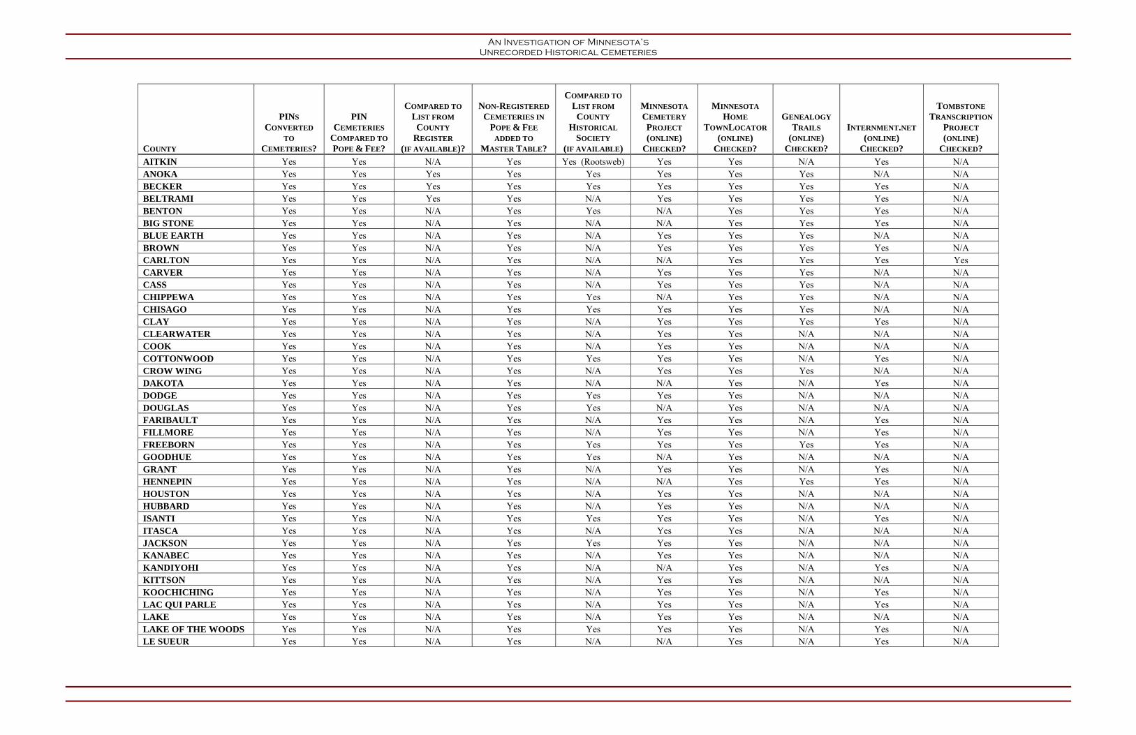
An Investigation of Minnesota’s Unrecorded Historical Cemeteries
COUNTY
PINS
CONVERTED
TO
CEMETERIES?
PIN
CEMETERIES
COMPARED TO
POPE & FEE?
COMPARED TO
LIST FROM
COUNTY
REGISTER
(IF AVAILABLE)?
NON-REGISTERED
CEMETERIES IN
POPE & FEE
ADDED TO
MASTER TABLE?
COMPARED TO
LIST FROM
COUNTY
HISTORICAL
SOCIETY
(IF AVAILABLE)
MINNESOTA
CEMETERY
PROJECT
(ONLINE)
CHECKED?
MINNESOTA
HOME
TOWNLOCATOR
(ONLINE)
CHECKED?
GENEALOGY
TRAILS
(ONLINE)
CHECKED?
INTERNMENT.NET
(ONLINE)
CHECKED?
TOMBSTONE
TRANSCRIPTION
PROJECT
(ONLINE)
CHECKED?
AITKIN Yes Yes N/A Yes Yes (Rootsweb) Yes Yes N/A Yes N/A ANOKA Yes Yes Yes Yes Yes Yes Yes Yes N/A N/A BECKER Yes Yes Yes Yes Yes Yes Yes Yes Yes N/A BELTRAMI Yes Yes Yes Yes N/A Yes Yes Yes Yes N/A BENTON Yes Yes N/A Yes Yes N/A Yes Yes Yes N/A BIG STONE Yes Yes N/A Yes N/A N/A Yes Yes Yes N/A BLUE EARTH Yes Yes N/A Yes N/A Yes Yes Yes N/A N/A BROWN Yes Yes N/A Yes N/A Yes Yes Yes Yes N/A CARLTON Yes Yes N/A Yes N/A N/A Yes Yes Yes Yes CARVER Yes Yes N/A Yes N/A Yes Yes Yes N/A N/A CASS Yes Yes N/A Yes N/A Yes Yes Yes N/A N/A CHIPPEWA Yes Yes N/A Yes Yes N/A Yes Yes N/A N/A CHISAGO Yes Yes N/A Yes Yes Yes Yes Yes N/A N/A CLAY Yes Yes N/A Yes N/A Yes Yes Yes Yes N/A CLEARWATER Yes Yes N/A Yes N/A Yes Yes N/A N/A N/A COOK Yes Yes N/A Yes N/A Yes Yes N/A N/A N/A COTTONWOOD Yes Yes N/A Yes Yes Yes Yes N/A Yes N/A CROW WING Yes Yes N/A Yes N/A Yes Yes Yes N/A N/A DAKOTA Yes Yes N/A Yes N/A N/A Yes N/A Yes N/A DODGE Yes Yes N/A Yes Yes Yes Yes N/A N/A N/A DOUGLAS Yes Yes N/A Yes Yes N/A Yes N/A N/A N/A FARIBAULT Yes Yes N/A Yes N/A Yes Yes N/A Yes N/A FILLMORE Yes Yes N/A Yes N/A Yes Yes N/A Yes N/A FREEBORN Yes Yes N/A Yes Yes Yes Yes Yes Yes N/A GOODHUE Yes Yes N/A Yes Yes N/A Yes N/A N/A N/A GRANT Yes Yes N/A Yes N/A Yes Yes N/A Yes N/A HENNEPIN Yes Yes N/A Yes N/A N/A Yes Yes Yes N/A HOUSTON Yes Yes N/A Yes N/A Yes Yes N/A N/A N/A HUBBARD Yes Yes N/A Yes N/A Yes Yes N/A N/A N/A ISANTI Yes Yes N/A Yes Yes Yes Yes N/A Yes N/A ITASCA Yes Yes N/A Yes N/A Yes Yes N/A N/A N/A JACKSON Yes Yes N/A Yes Yes Yes Yes N/A N/A N/A KANABEC Yes Yes N/A Yes N/A Yes Yes N/A N/A N/A KANDIYOHI Yes Yes N/A Yes N/A N/A Yes N/A Yes N/A KITTSON Yes Yes N/A Yes N/A Yes Yes N/A N/A N/A KOOCHICHING Yes Yes N/A Yes N/A Yes Yes N/A Yes N/A LAC QUI PARLE Yes Yes N/A Yes N/A Yes Yes N/A Yes N/A LAKE Yes Yes N/A Yes N/A Yes Yes N/A N/A N/A LAKE OF THE WOODS Yes Yes N/A Yes Yes Yes Yes N/A Yes N/A LE SUEUR Yes Yes N/A Yes N/A N/A Yes N/A Yes N/A

An Investigation of Minnesota’s Unrecorded Historical Cemeteries
COUNTY
PINS
CONVERTED
TO
CEMETERIES?
PIN
CEMETERIES
COMPARED TO
POPE & FEE?
COMPARED TO
LIST FROM
COUNTY
REGISTER
(IF AVAILABLE)?
NON-REGISTERED
CEMETERIES IN
POPE & FEE
ADDED TO
MASTER TABLE?
COMPARED TO
LIST FROM
COUNTY
HISTORICAL
SOCIETY
(IF AVAILABLE)
MINNESOTA
CEMETERY
PROJECT
(ONLINE)
CHECKED?
MINNESOTA
HOME
TOWNLOCATOR
(ONLINE)
CHECKED?
GENEALOGY
TRAILS
(ONLINE)
CHECKED?
INTERNMENT.NET
(ONLINE)
CHECKED?
TOMBSTONE
TRANSCRIPTION
PROJECT
(ONLINE)
CHECKED?
LINCOLN Yes Yes N/A Yes N/A Yes Yes Yes N/A N/A LYON Yes Yes N/A Yes N/A N/A Yes N/A N/A N/A MCLEOD Yes Yes N/A Yes N/A Yes Yes N/A Yes N/A MAHNOMEN Yes Yes N/A Yes N/A Yes Yes N/A N/A N/A MARSHALL Yes Yes N/A Yes N/A Yes Yes N/A Yes N/A MARTIN Yes Yes N/A Yes Yes Yes Yes N/A Yes N/A
MEEKER Yes Yes Yes Yes
Yes (Rosenow 1993: Meeker
County Cemeteries: Volume 1) N/A Yes N/A Yes N/A
MILLE LACS Yes Yes Yes Yes Yes N/A Yes N/A N/A N/A MORRISON Yes Yes Yes Yes Yes Yes Yes Yes Yes N/A MOWER Yes Yes N/A Yes Yes Yes Yes Yes Yes N/A MURRAY Yes Yes Yes Yes Yes Yes Yes N/A N/A N/A NICOLLET Yes Yes N/A Yes N/A N/A Yes Yes Yes N/A NOBLES Yes Yes Yes Yes Yes Yes Yes Yes Yes N/A NORMAN Yes Yes Yes Yes N/A Yes Yes N/A N/A N/A OLMSTED Yes Yes N/A Yes N/A Yes Yes Yes Yes N/A OTTERTAIL Yes Yes N/A Yes N/A Yes Yes Yes N/A N/A PENNINGTON Yes Yes Yes Yes N/A Yes Yes Yes N/A N/A PINE Yes Yes N/A Yes N/A Yes Yes N/A N/A N/A PIPESTONE Yes Yes N/A Yes N/A Yes Yes Yes N/A N/A POLK Yes Yes N/A Yes N/A Yes Yes N/A Yes N/A POPE Yes Yes Yes Yes N/A N/A Yes Yes Yes N/A RAMSEY Yes Yes N/A Yes N/A Yes Yes N/A Yes N/A RED LAKE Yes Yes Yes Yes N/A Yes Yes N/A N/A N/A REDWOOD Yes Yes Yes Yes N/A N/A Yes Yes N/A Yes RENVILLE Yes Yes Yes Yes N/A N/A Yes N/A N/A N/A RICE Yes Yes Yes Yes N/A Yes Yes N/A Yes N/A ROCK Yes Yes Yes Yes N/A Yes Yes Yes Yes N/A ROUSEAU Yes Yes N/A Yes N/A Yes Yes N/A Yes N/A SCOTT Yes Yes N/A Yes N/A Yes Yes N/A Yes N/A SHERBURNE Yes Yes N/A Yes Yes Yes Yes N/A N/A N/A SIBLEY Yes Yes N/A Yes N/A Yes Yes N/A N/A N/A ST LOUIS Yes Yes N/A Yes N/A N/A Yes Yes Yes N/A STEARNS Yes Yes N/A Yes Yes N/A Yes Yes Yes N/A STEELE Yes Yes N/A Yes N/A Yes Yes N/A Yes N/A STEVENS Yes Yes N/A Yes N/A N/A Yes N/A N/A N/A SWIFT Yes Yes N/A Yes N/A Yes Yes N/A Yes N/A

An Investigation of Minnesota’s Unrecorded Historical Cemeteries
COUNTY
PINS
CONVERTED
TO
CEMETERIES?
PIN
CEMETERIES
COMPARED TO
POPE & FEE?
COMPARED TO
LIST FROM
COUNTY
REGISTER
(IF AVAILABLE)?
NON-REGISTERED
CEMETERIES IN
POPE & FEE
ADDED TO
MASTER TABLE?
COMPARED TO
LIST FROM
COUNTY
HISTORICAL
SOCIETY
(IF AVAILABLE)
MINNESOTA
CEMETERY
PROJECT
(ONLINE)
CHECKED?
MINNESOTA
HOME
TOWNLOCATOR
(ONLINE)
CHECKED?
GENEALOGY
TRAILS
(ONLINE)
CHECKED?
INTERNMENT.NET
(ONLINE)
CHECKED?
TOMBSTONE
TRANSCRIPTION
PROJECT
(ONLINE)
CHECKED?
TODD Yes Yes N/A Yes N/A N/A
(see report) Yes N/A N/A N/A TRAVERSE Yes Yes N/A Yes N/A Yes Yes Yes N/A N/A WABASHA Yes Yes N/A Yes N/A N/A Yes N/A N/A N/A WADENA Yes Yes N/A Yes N/A Yes Yes N/A N/A N/A WASECA Yes Yes N/A Yes Yes Yes Yes N/A Yes N/A WASHINGTON Yes Yes N/A Yes Yes Yes Yes Yes N/A N/A WATONWAN Yes Yes N/A Yes Yes Yes Yes Yes Yes N/A WILKIN Yes Yes N/A Yes N/A Yes Yes N/A N/A N/A WINONA Yes Yes N/A Yes N/A N/A Yes N/A N/A N/A WRIGHT Yes Yes N/A Yes N/A Yes Yes N/A Yes N/A YELLOW MEDICINE Yes Yes N/A Yes N/A Yes Yes N/A N/A N/A

An Investigation of Minnesota’s Unrecorded Historical Cemeteries
APPENDIX B
USGS Map Research Table

An Investigation of Minnesota’s Unrecorded Historical Cemeteries
USGS MAPS EXAMINED DURING TASK 2 OF THE CEMETERY STUDY
Counties USGS Map Name Year of Map Aitkin Shingle Mill Lake 1996 Aitkin Shovel Lake 1996 Anoka Anoka 1967 [Revised 1993] Anoka Cedar 1974 [Revised 1993] Anoka Centerville 1967 [Revised 1993] Anoka Circle Pines 1967 [Revised 1993] Anoka Coon Lake Beach 1974 [Revised 1993] Anoka Coon Rapids 1967 [Revised 1993] Anoka Elk River 1961[Revised 1993] Anoka Lake Fremont 1991 Anoka Linwood 1974 [Revised 1993] Anoka Minneapolis North 1967 [Revised 1993] Anoka New Brighton 1997 Anoka Nowthen 1974 [Revised 1993] Anoka Rogers 1981 [Revised 1993] Anoka White Bear Lake West 1967 [Revised 1993] Beltrami Andrusia Lake 1996 Beltrami Bemidji East 1968 [Revised 1994] Beltrami Bemidji West 1968 [Revised 1994] Beltrami Blackduck 1996 Beltrami Cass Lake 1996 Beltrami Decker Lake 1996 Beltrami Gimmer Lake 1996 Beltrami Pennington 1996 Beltrami Peterson Lake 1972 [Revised 1994] Beltrami Pimushe Lake 1996 Beltrami Tenstrike 1996 Beltrami Turtle River 1972 [Revised 1994] Beltrami Turtle River Lake 1996 Benton Cable 1974 [Revised 1993] Benton Little Rock Lake 1974 [Revised 1993] Benton St. Cloud 1974 [Revised 1993] Blue Earth Mankato East 1974 [Revised 1993] Blue Earth Mankato West 1974 [Revised 1993] Brown New Ulm 1992 Carlton Adolph 1953 [Revised 1993] Carlton Cloquet 1954 [Revised 1993] Carlton Esko 1954 [Revised 1993] Carver Excelsior 1997 Carver Mound 1958 [Revised 1993] Carver Shakopee 1958 [Revised 1993] Carver Victoria 1958 [Revised 1993] Carver Waconia 1981 [Revised 1993] Carver Watertown 1981 [Revised 1993] Cass Akeley 1996 Cass Andrusia Lake 1996 Cass Ball Club 1996 Cass Baxter 1954 [Revised 1994] Cass Bena 1996 Cass Bena NW 1996

An Investigation of Minnesota’s Unrecorded Historical Cemeteries
Counties USGS Map Name Year of Map Cass Benedict 1996 Cass Boy River 1996 Cass Cass Lake 1996 Cass Crystal Lake 1996 Cass Deer River 1996 Cass Federal Dam 1996 Cass Goose Lake 1996 Cass Gull Lake 1973 [Revised 1994] Cass Hackensack 1996 Cass Jack Lake 1996 Cass Jenkins 1959 [Revised 1994] Cass Laura Lake 1996 Cass Little Winnibigoshish Lake 1996 Cass Longville 1996 Cass Nisswa 1959 [Revised 1994] Cass Nushka Lake 1996 Cass Ottertail Point 1996 Cass Pennington 1996 Cass Pike Bay 1996 Cass Pine River 1959 [Revised 1994] Cass Portage Lake 1996 Cass Raven Lake 1996 Cass Remer 1996 Cass Shingle Mill Lake 1996 Cass Shovel Lake 1996 Cass Steamboat Bay 1996 Cass Suckers Lake 1996 Cass Sugar Lake 1996 Cass Sugar Point 1996 Cass Thunder Lake 1996 Cass Tobique 1996 Cass Town Line Lake 1996 Cass Walker 1996 Cass Webb Lake 1996 Cass Whipholt 1996 Cass Wilson Bay 1973 [Revised 1994] Cass Woman Lake 1996 Chippewa Montevideo 1965 [Revised 1994] Chisago Osceola 1978 [Revised 1993] Chisago Forest Lake 1974 [Revised 1993] Chisago Linwood 1974 [Revised 1993] Chisago Scandia 1974 [Revised 1993] Clay Fargo North 1959 [Revised 1993] Clay Fargo South 1959 [Revised 1993] Crow Wing Baxter 1954 [Revised 1994] Crow Wing Brainerd 1973 [Revised 1994] Crow Wing Cross Lake 1960 [Revised 1994] Crow Wing Emily 1973 [Revised 1994] Crow Wing Gull Lake 1973 [Revised 1994] Crow Wing Jenkins 1959 [Revised 1994] Crow Wing Lower Whitefish Lake 1959 [Revised 1994] Crow Wing Merrifield 1973 [Revised 1994]

An Investigation of Minnesota’s Unrecorded Historical Cemeteries
Counties USGS Map Name Year of Map Crow Wing Nisswa 1959 [Revised 1994] Crow Wing Pelican Lake 1959 [Revised 1994] Dakota Bloomington 1997 Dakota Coates 1974 [Revised 1993] Dakota Farmington 1974 [Revised 1993] Dakota Diamond Bluff West 1992 Dakota Hastings 1974 [Revised 1993] Dakota Inver Grove Heights 1967 [Revised 1993] Dakota Northfield 1991 Dakota Orchard Lake 1974 [Revised 1993] Dakota Prescott 1967 [Revised 1993] Dakota St. Paul East 1967 [Revised 1993] Dakota St. Paul Park 1967 [Revised 1993] Dakota St. Paul SW 1967 [Revised 1993] Dakota St. Paul W 1967 [Revised 1993] Dakota Vermillion 1974 [Revised 1993] Goodhue Bay City 1974 [Revised 1994] Goodhue Hastings 1974 [Revised 1993] Goodhue Red Wing 1974 [Revised 1994] Goodhue Welch 1991 Hennepin Anoka 1967 [Revised 1993] Hennepin Bloomington 1997 Hennepin Coon Rapids 1967 [Revised 1993] Hennepin Eden Prairie 1967 [Revised 1993] Hennepin Excelsior 1997 Hennepin Hamel 1981 [Revised 1993] Hennepin Hopkins 1967 [Revised 1993] Hennepin Minneapolis North 1967 [Revised 1993] Hennepin Minneapolis South 1967 [Revised 1993] Hennepin Mound 1958 [Revised 1993] Hennepin New Brighton 1997 Hennepin Osseo 1967 [Revised 1993] Hennepin Rockford 1981 [Revised 1993] Hennepin Rogers 1981 [Revised 1993] Hennepin St. Michael 1991 Hennepin St. Paul SW 1967 [Revised 1993] Hennepin St. Paul W 1967 [Revised 1993] Hennepin Shakopee 1958 [Revised 1993] Hennepin Watertown 1981 [Revised 1993] Hubbard Akeley 1996 Hubbard Andrusia Lake 1996 Hubbard Bemidji East 1968 [Revised 1994] Hubbard Bemidji West 1968 [Revised 1994] Hubbard Benedict 1996 Hubbard Crystal Lake 1996 Houston La Crescent 1991 Isanti Lake Fremont 1991 Itasca Alvwood 1996 Itasca Ball Club 1996 Itasca Balsam Lake 1996 Itasca Bena NW 1996 Itasca Big Fork 1996

An Investigation of Minnesota’s Unrecorded Historical Cemeteries
Counties USGS Map Name Year of Map Itasca Bowstring Lake 1996 Itasca Clubhouse Lake 1996 Itasca Coddington Lake 1996 Itasca Coon Lake 1996 Itasca Decker Lake 1996 Itasca Deer River 1996 Itasca Deer River NE 1996 Itasca Dixon Lake 1996 Itasca Dora Lake 1996 Itasca Elmwood Island 1996 Itasca Gimmer Lake 1996 Itasca Jessie Lake 1996 Itasca Lawrence Lake West 1996 Itasca Little Ball Club Lake 1996 Itasca Little Bowstring Lake 1996 Itasca Little Winnibigoshish Lake 1996 Itasca Marcell 1996 Itasca Max 1996 Itasca Northome South 1996 Itasca Nushka Lake 1996 Itasca Pennington 1996 Itasca Pigeon Dam Lake 1996 Itasca Pomroy 1996 Itasca Raven Lake 1996 Itasca Shingle Mill Lake 1996 Itasca Spring Lake 1996 Itasca Squaw Lake 1996 Itasca Sugar Lake 1996 Itasca Wabana Lake 1996 Itasca Wildwood SE 1996 Itasca Wirt 1996 Kandiyohi Solomon Lake 1958 [Revised 1994] Kandiyohi Willmar 1958 [Revised 1994] Koochiching Coddington Lake 1996 Koochiching Elmwood Island 1996 Koochiching Northome South 1996 Koochiching Pomroy 1996 Koochiching Wildwood SE 1996 Lac qui Parle Montevideo 1965 [Revised 1994] Lake Castle Danger 1992 Lake Knife River 1992 Lake Two Harbors 1992 Lake of the Woods Warroad 1967 [Revised 1994] Le Sueur Mankato East 1974 [Revised 1993] Le Sueur Mankato West 1974 [Revised 1993] Le Sueur St. Peter 1991 Le Sueur Waseca 1991 Lyon Marshall 1963 [Revised 1994] Martin Fairmont 1992 McLeod Hutchinson East 1982 [Revised 1994] McLeod Hutchinson West 1982 [Revised 1994] Meeker Hutchinson East 1982 [Revised 1994]
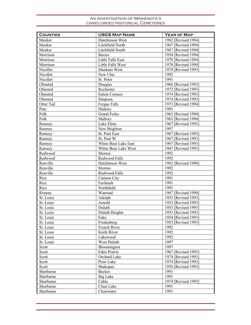
An Investigation of Minnesota’s Unrecorded Historical Cemeteries
Counties USGS Map Name Year of Map Meeker Hutchinson West 1982 [Revised 1994] Meeker Litchfield North 1967 [Revised 1994] Meeker Litchfield South 1967 [Revised 1994] Morrison Baxter 1954 [Revised 1994] Morrison Little Falls East 1978 [Revised 1994] Morrison Little Falls West 1978 [Revised 1994] Nicollet Mankato West 1974 [Revised 1993] Nicollet New Ulm 1992 Nicollet St. Peter 1991 Olmsted Douglas 1966 [Revised 1993] Olmsted Rochester 1972 [Revised 1993] Olmsted Salem Corners 1974 [Revised 1993] Olmsted Simpson 1974 [Revised 1993] Otter Tail Fergus Falls 1973 [Revised 1994] Pine Hinkley 1991 Polk Grand Forks 1963 [Revised 1994] Polk Mallory 1963 [Revised 1994] Ramsey Lake Elmo 1967 [Revised 1993] Ramsey New Brighton 1997 Ramsey St. Paul East 1967 [Revised 1993] Ramsey St. Paul W 1967 [Revised 1993] Ramsey White Bear Lake East 1967 [Revised 1993] Ramsey White Bear Lake West 1967 [Revised 1993] Redwood Morton 1992 Redwood Redwood Falls 1992 Renville Hutchinson West 1982 [Revised 1994] Renville Morton 1992 Renville Redwood Falls 1992 Rice Cannon City 1991 Rice Faribault 1991 Rice Northfield 1991 Roseau Warroad 1967 [Revised 1994] St. Louis Adolph 1953 [Revised 1993] St. Louis Arnold 1953 [Revised 1993] St. Louis Duluth 1953 [Revised 1993] St. Louis Duluth Heights 1953 [Revised 1993] St. Louis Esko 1954 [Revised 1993] St. Louis Fredenberg 1953 [Revised 1993] St. Louis French River 1992 St. Louis Knife River 1992 St. Louis Lakewood 1992 St. Louis West Duluth 1997 Scott Bloomington 1997 Scott Eden Prairie 1967 [Revised 1993] Scott Orchard Lake 1974 [Revised 1993] Scott Prior Lake 1974 [Revised 1993] Scott Shakopee 1958 [Revised 1993] Sherburne Becker 1991 Sherburne Big Lake 1991 Sherburne Cable 1974 [Revised 1993] Sherburne Clear Lake 1991 Sherburne Clearwater 1991

An Investigation of Minnesota’s Unrecorded Historical Cemeteries
Counties USGS Map Name Year of Map Sherburne Elk River 1961[Revised 1993] Sherburne Lake Fremont 1991 Sherburne Monticello 1991 Sherburne Orrock 1991 Sherburne Rogers 1981 [Revised 1993] Sherburne St. Cloud 1974 [Revised 1993] Sherburne Silver Creek 1991 Stearns Clearwater 1991 Stearns Little Rock Lake 1974 [Revised 1993] Stearns St. Cloud 1974 [Revised 1993] Stearns St. Joseph 1965[Revised 1993] Steele Meriden 1992 Steele Saco 1991 Waseca Meriden 1992 Waseca Waseca 1991 Washington Centerville 1967 [Revised 1993] Washington Forest Lake 1974 [Revised 1993] Washington Hudson 1967 [Revised 1993] Washington Hugo 1967 [Revised 1993] Washington Inver Grove Heights 1967 [Revised 1993] Washington Lake Elmo 1967 [Revised 1993] Washington Linwood 1974 [Revised 1993] Washington Marine on St. Croix 1967 [Revised 1993] Washington Prescott 1967 [Revised 1993] Washington St. Paul East 1967 [Revised 1993] Washington St. Paul Park 1967 [Revised 1993] Washington Scandia 1974 [Revised 1993] Washington Stillwater 1967 [Revised 1993] Washington White Bear Lake West 1967 [Revised 1993] Winona La Crescent 1991
Winona Rollingstone 1972 [Revised 1993] Winona Winona East 1972 [Revised 1993] Winona Winona West 1972 [Revised 1993] Wright Big Lake 1991 Wright Clear Lake 1991 Wright Clearwater 1991 Wright Elk River 1961[Revised 1993] Wright Hutchinson East 1982 [Revised 1994] Wright Monticello 1991 Wright Rogers 1981 [Revised 1993] Wright St. Michael 1991 Wright Silver Creek 1991 Wright Watertown 1981 [Revised 1993] Yellow Medicine Montevideo 1965 [Revised 1994]

An Investigation of Minnesota’s Unrecorded Historical Cemeteries
APPENDIX C
SUMMARY OF RESULTS

An Investigation of Minnesota’s Unrecorded Historical Cemeteries
County
Parcels in Department of Revenue Database
Recorded Cemeteries
Represented by Revenue
Database
Additional Recorded
Cemeteries-County
Recorder/ Assessor
Total Recorded
Cemeteries
MCL Entries
Unrecorded Cemeteries-
MCL
Unrecorded Cemeteries-
Task 2 Online Sources
Task 2 Online Sources Without County Data
Additional Sources Consulted
Unrecorded Cemeteries-Additional
Sources
Total Unrecorded Cemeteries
Notes
Aitkin 52 38 N/A 38 61 21 40 Genealogy Trails Aitkin County Rootsweb 2 63 One PIN (430010301) in the Department of Revenue file does not correspond to an Aitkin County parcel.
Anoka 41 19 1 20 42 21 5 Interment.net Anoka County Cemeteries “Monuments to Life Tour”
(online)
0 26 One PIN (033024320106) in the Department of Revenue file corresponds to a non-cemetery parcel.
Becker 48 43 4 47 80 37 0 0 37
Beltrami 53 41 5 46 74 40 15 Beltrami County GIS Online “Find Cemetery”
search option
7 62 One PIN (010012300) was not for a cemetery, but was found to be just one digit off of the PIN (010012301) and have the same acreage as one of the Island Lake Cemetery parcels; a corrected PIN was entered into the project database. One PIN (360002300) does not correspond to a Beltrami County parcel.
Benton 34 22 N/A 22 29 9 0 Minnesota Cemetery Project Benton County Historical Society
5 14 Two PINs (010019902, 010020001) do not correspond to Benton County parcels.
Big Stone 26 23 N/A 23 33 9 0 Minnesota Cemetery Project 0 9 One PIN (130155000) does not correspond to a Big Stone County cemetery.
Blue Earth 57 39 N/A 39 72 29 5 Interment.net Site visited by Two Pines 1 35 A site visited by Two Pines in 2007 provided information on a potential unrecorded cemetery beyond those identified in MCL.
Brown 47 33 N/A 33 39 8 1 USGS quadrangle 1 10
Carlton 42 36 N/A 36 48 11 1 Minnesota Cemetery Project C. Rakes - DNR Cloquet Office (15 October 2001);
Trygg Sheet 14
2 14 One MCL cemetery (Synod Cemetery in Kettle River) was not included in the project database for lack of location and source information.
Carver 43 36 N/A 36 59 20 12 Interment.net 0 32
Cass 54 46 N/A 46 63 28 25 Interment.net J. Tarbell – DNR Deer River Office (10 May 1995)
1 54
Chippewa 32 24 N/A 24 51 27 1 Minnesota Cemetery Project Interment.net
Chippewa County Historical Society; findagrave.com;
David Radford, DNR State Parks Archaeologist
10 38
Chisago 51 33 N/A 33 48 14 10 Interment.net 0 24
Clay 27 25 N/A 25 84 49 1 0 50
Clearwater 29 28 N/A 28 49 28 1 Genealogy Trails Interment.net
0 29
Cook 12 11 N/A 11 17 5 0 Genealogy Trails Interment.net
Trygg Sheet 16; David Radford – DNR State Parks
Archaeologist
2 7

An Investigation of Minnesota’s Unrecorded Historical Cemeteries
County
Parcels in Department of Revenue Database
Recorded Cemeteries
Represented by Revenue
Database
Additional Recorded
Cemeteries-County
Recorder/ Assessor
Total Recorded
Cemeteries
MCL Entries
Unrecorded Cemeteries-
MCL
Unrecorded Cemeteries-
Task 2 Online Sources
Task 2 Online Sources Without County Data
Additional Sources Consulted
Unrecorded Cemeteries-Additional
Sources
Total Unrecorded Cemeteries
Notes
Cottonwood 29 24 N/A 24 29 10 7 Genealogy Trails Cottonwood County Historical Society
4 21
Crow Wing 62 37 N/A 37 48 14 40 Interment.net 0 54 Two PINs (590211200AB0009, 280122400000000) do not correspond to a Crow Wing County parcel.
Dakota 87 49 N/A 49 74 27 0 Minnesota Cemetery Project Genealogy Trails
0 27
Dodge 17 13 N/A 13 19 7 2 Genealogy Trails Interment.net
Dodge County Historical Society
1 10
Douglas 69 57 N/A 57 60 6 0 Minnesota Cemetery Project Genealogy Trails
Interment.net
Douglas County Historical Society
21 27 Two PINs (540148000, 720275000) do not correspond to Douglas County cemeteries but to mausoleums.
Faribault 45 38 0 38 54 14 1 Genealogy Trails 0 15
Fillmore 85 76 N/A 76 142 52 8 Genealogy Trails Fillmore County Historical Society
6 66 Three PINs (080342010, 140054010, 170009010) do not correspond to Fillmore County parcels. One PIN (270044020) does not correspond to a Fillmore County cemetery but to a baseball field.
Freeborn 66 45 N/A 45 71 24 0 0 24
Goodhue 106 67 N/A 67 113 49 0 Minnesota Cemetery Project Genealogy Trails
Interment.net
2 51
Grant 41 34 N/A 34 49 11 6 Genealogy Trails 0 17
Hennepin 101 66 N/A 66 127 50 0 Minnesota Cemetery Project 0 50 One PIN (1412023420011) does not correspond to a Hennepin County cemetery, but to a cemetery driveway; count does not include Fort Snelling National Cemetery.
Houston 49 37 N/A 37 152 115 2 Genealogy Trails Interment.net
V. Green – DNR Caledonia Office (22 February 1999)
1 118
Hubbard 40 34 N/A 34 30 4 3 Genealogy Trails Interment.net
0 7
Isanti 38 36 N/A 36 41 8 3 Genealogy Trails 0 11
Itasca 73 40 N/A 40 42 18 15 Genealogy Trails Interment.net
USGS Quadrangle; OSA Database
3 36
Jackson 29 28 N/A 28 39 10 2 Genealogy Trails Interment.net
Dahlin 2007; Jackson County Historical Society
2 14
Kanabec 14 13 0 13 16 2 0 Genealogy Trails Interment.net
0 2 One PIN (100065500) is for Indian Mounds Park (21KA22)

An Investigation of Minnesota’s Unrecorded Historical Cemeteries
County
Parcels in Department of Revenue Database
Recorded Cemeteries
Represented by Revenue
Database
Additional Recorded
Cemeteries-County
Recorder/ Assessor
Total Recorded
Cemeteries
MCL Entries
Unrecorded Cemeteries-
MCL
Unrecorded Cemeteries-
Task 2 Online Sources
Task 2 Online Sources Without County Data
Additional Sources Consulted
Unrecorded Cemeteries-Additional
Sources
Total Unrecorded Cemeteries
Notes
Kandiyohi 71 64 N/A 64 82 15 0 Minnesota Cemetery Project Genealogy Trails
Dahlin 2007 2 17 Three PINS (160250042, 250010100, 300050021) do not correspond to
Kandiyohi County parcels
Kittson 30 31 0 31 37 9 33 Genealogy Trails Interment.net
Radford and George 1991 0 42
Koochiching 31 24 N/A 24 35 13 2 Genealogy Trails Koochiching County Cemetery Database
(provided by Pat Emerson, MHS); D. Tillma – DNR
Littlefork Office (6 October 2000)
40 55
Lac qui Parle 54 43 N/A 43 43 2 11 Genealogy Trails 0 13 Three PINs (100085000, 440058000, and 540566902) do not correspond to Lac qui Parle County cemeteries, but agricultural lands
Lake 1 1 N/A 1 10 9 3 Genealogy Trails Interment.net
0 12
Lake of the Woods
17 14 N/A 14 22 9 2 Genealogy trails Red Lake Wildlife Management Area “Land
Utilization Project”, “LUP,” Properties spreadsheet
(provided by Pat Emerson, MHS); Lake of the Woods County Historical Society; David Radford, DNR State
Parks Archaeologist
10 21 One PIN (62181202E) does not correspond to a Lake of the Woods County parcel.
Le Sueur 49 44 N/A 44 71 27 0 Minnesota Cemetery Project Genealogy Trails
0 27
Lincoln 30 22 N/A 22 27 7 7 Interment.net 0 14
Lyon 33 28 N/A 28 39 11 0 Minnesota Cemetery Project Genealogy Trails
Interment.net
0 11
McLeod 47 34 N/A 34 57 25 11 Genealogy Trails 0 36
Mahnomen 21 19 0 19 24 6 5 Genealogy Trails Interment.net
0 11
Marshall 86 78 N/A 78 147 71 37 Genealogy Trails 0 108 Three MCL entries were not entered into project database because they had no locational information.
Martin 41 38 N/A 38 54 14 5 Genealogy Trails 0 19
Meeker 41 34 8 42 43 7 0 Minnesota Cemetery Project Genealogy Trails
Rosenow 1993 (provided by Meeker County Historical
Society)
31 38 One PIN (130918001) does not correspond to a Meeker County parcel

An Investigation of Minnesota’s Unrecorded Historical Cemeteries
County
Parcels in Department of Revenue Database
Recorded Cemeteries
Represented by Revenue
Database
Additional Recorded
Cemeteries-County
Recorder/ Assessor
Total Recorded
Cemeteries
MCL Entries
Unrecorded Cemeteries-
MCL
Unrecorded Cemeteries-
Task 2 Online Sources
Task 2 Online Sources Without County Data
Additional Sources Consulted
Unrecorded Cemeteries-Additional
Sources
Total Unrecorded Cemeteries
Notes
Mille Lacs 43 31 4 35 35 3 0 Minnesota Cemetery Project Genealogy Trails
Interment.net
Mille Lacs County Rootsweb.com
2 5
Morrison 56 48 2 50 63 20 26 Morrison County Historical Society
1 47 One PIN (230125002) does not correspond to a Morrison County cemetery, but to a residential property.
Mower 35 29 0 29 52 23 0 0 23
Murray 24 23 7 30 38 8 4 Genealogy Trails Interment.net
Dahlin 2007; Murray County Historical Society
0 12
Nicollet 31 30 2 32 52 21 2 Minnesota Cemetery Project Dahlin 2007; David Radford, DNR State Parks
Archaeologist
3 26
Nobles 36 33 0 33 35 2 6 Nobles County Historical Society
2 10
Norman 42 34 0 34 78 43 2 Genealogy Trails Interment.net
0 45
Olmsted 59 39 N/A 39 55 20 9 0 29 Two PINs (743632047056, 743633011243) do not correspond to Olmsted County cemeteries, but to a residential property and a building.
Otter Tail 177 156 N/A 156 237 81 78 Interment.net 0 159
Pennington 31 27 0 27 34 9 3 Interment.net 0 12
Pine 71 47 N/A 47 67 22 9 Genealogy Trails Interment.net
0 31
Pipestone 22 18 N/A 18 20 2 0 Interment.net 0 2 One PIN (090280650) does not correspond to a Pipestone County parcel.
Polk 116 99 0 99 125 30 17 Genealogy Trails 0 47 One PIN (360010301) does not correspond to a Polk County parcel; another PIN (400021001) is for a pet cemetery.
Pope 49 38 2 40 49 12 1 Minnesota Cemetery Project 0 13
Ramsey 38 22 N/A 22 35 12 3 Genealogy Trails Larpenteur, August L. 1901 Recollections of the
City and People of St. Paul, 1843-1898. Collections of the Minnesota Historical
Society, Vol. IX (1901):363-394.
0 15 Three PINs (012922420039, 262923130163, 262923130164) do not correspond to a Ramsey County cemetery, but to residential and other property types.
Red Lake 21 20 1 21 20 1 0 Genealogy Trails Interment.net
0 1 One PIN (109005000) does not correspond to a Red Lake County cemetery, but to a monument at a church.

An Investigation of Minnesota’s Unrecorded Historical Cemeteries
County
Parcels in Department of Revenue Database
Recorded Cemeteries
Represented by Revenue
Database
Additional Recorded
Cemeteries-County
Recorder/ Assessor
Total Recorded
Cemeteries
MCL Entries
Unrecorded Cemeteries-
MCL
Unrecorded Cemeteries-
Task 2 Online Sources
Task 2 Online Sources Without County Data
Additional Sources Consulted
Unrecorded Cemeteries-Additional
Sources
Total Unrecorded Cemeteries
Notes
Redwood 53 43 4 47 51 6 20 Minnesota Cemetery Project Interment.net
Dahlin 2007; findagrave.com; Redwood
County Genealogical Society
32 58 Two PINs (599950060; 869950060), based on their legal locations and a review of USGS maps and aerial photographs, appear to not correspond to cemeteries.
Renville 52 49 0 49 79 30 5 Minnesota Cemetery Project Genealogy Trails
Interment.net
Dahlin 2007 9 44 One PIN (040051000) does not correspond to a Renville County cemetery, but to
disposal ponds.
Rice 47 42 3 45 69 24 3 Genealogy Trails 0 27
Rock 27 23 0 23 25 2 3 0 5
Roseau 58 46 N/A 46 66 20 16 Genealogy Trails Red Lake Wildlife Management Area “Land
Utilization Project”, “LUP,” Properties spreadsheet
(provided by Pat Emerson, MHS)
14 50 One PIN (163001300) does not correspond to a Roseau County cemetery, but to a church.
St. Louis 220 84 N/A 84 98 25 3 Minnesota Cemetery Project M. Manguson – DNR Tower Office; B. J.
Glesener – DNR Littelfork Office; Wheeling Steel
Corporation 1943
3 31 One PIN (450001001170) does not correspond to a St. Louis County cemetery, but to vacant land, possibly for a former church.
Scott 35 20 N/A 20 31 12 1 Genealogy Trails 0 13
Sherburne 30 24 N/A 24 26 3 4 Genealogy Trails Interment.net
Dahlin 2007; OSA database 1 8
Sibley 53 44 N/A 44 50 10 0 Genealogy Trails Interment.net
0 10
Stearns 76 57 N/A 57 106 46 1 Minnesota Cemetery Project Dahlin 2007 1 48 Six PINs (15083040500, 36236720505, 66364140000, 84534580000, 84537970900, 84534580005) do not correspond to a Stearns County parcel, and one PIN (84534600000) is for a residential property.
Steele 49 43 N/A 43 54 9 3 Genealogy Trails 0 12
Stevens 17 14 N/A 14 18 4 0 Minnesota Cemetery Project Genealogy Trails
Interment.net
0 4
Swift 30 26 N/A 26 45 22 8 Genealogy Trails 0 30
Todd 84 62 N/A 62 72 20 0 Genealogy Trails Interment.net
0 20 Minnesota Cemetery Project data is flawed and was not entered into project database
Traverse 23 23 N/A 23 21 2 2 Interment.net 0 4

An Investigation of Minnesota’s Unrecorded Historical Cemeteries
County
Parcels in Department of Revenue Database
Recorded Cemeteries
Represented by Revenue
Database
Additional Recorded
Cemeteries-County
Recorder/ Assessor
Total Recorded
Cemeteries
MCL Entries
Unrecorded Cemeteries-
MCL
Unrecorded Cemeteries-
Task 2 Online Sources
Task 2 Online Sources Without County Data
Additional Sources Consulted
Unrecorded Cemeteries-Additional
Sources
Total Unrecorded Cemeteries
Notes
Wabasha 57 36 N/A 36 51 18 0 Minnesota Cemetery Project Genealogy Trails
Interment.net
0 18
Wadena 40 27 N/A 27 35 8 11 Genealogy Trails Interment.net
0 19 One PIN (150052025) appears to be for a cemetery-associated property, perhaps a parking lot, but not a cemetery.
Waseca 30 28 N/A 28 47 19 1 Genealogy Trails 0 20
Washington 56 32 N/A 32 60 28 5 Interment.net Minnesota Genealogical Journal (16) – Washington County; OSA files; OSA
database
3 36 Three PINs (2303220120012, 2303220210005, 03303020410028) are for properties containing buildings and not cemeteries.
Watonwan 34 28 N/A 28 29 3 2 0 5
Wilkin 24 22 N/A 22 26 5 10 Genealogy Trails Interment.net
0 15
Winona 84 57 N/A 57 67 17 0 Minnesota Cemetery Project Genealogy Trails
Interment.net
0 17 Two PINs (070002080, 270000760) are for churches and not cemeteries.
Wright 97 72 N/A 72 99 29 13 Genealogy Trails OSA files 3 45 An additional two entries under Wright County in MCL are for Stearns County cemeteries.
Yellow Medicine
35 33 N/A 33 48 15 30 Genealogy Trails Interment.net
OSA files; Two Pines field visit; David Radford, DNR State Parks Archaeologist;
Terrell 2009
3 48
TOTALa 4313 3294b 43 3337b 4914 1688 623 231 2542 a
Totals do not include Fort Snelling National Cemetery, which is on federal land. b Total includes four cemeteries that were counted twice because they straddle two different counties. The actual number of recorded cemeteries in the Department of Revenue database is 3,290, and in the state is 3333.