an exploration of the commercial use of drones in
TRANSCRIPT

AN EXPLORATION OF THE COMMERCIAL USE OF DRONES IN AGRIBUSINESS, INFRASTRUCTURE AND MINING
An Exploration of the Commercial Use of Drones in Agribusiness, Infrastructure and Mining
WELCOME
1

AN EXPLORATION OF THE COMMERCIAL USE OF DRONES IN AGRIBUSINESS, INFRASTRUCTURE AND MINING
Session 1 - Drones 101 – Adding Value to Agribusiness and Other Enterprises
Thad Lightfoot, Partner Dorsey & Whitney LLP Minneapolis, MN
David White, COO Juniper Unmanned Denver, CO

AN EXPLORATION OF THE COMMERCIAL USE OF DRONES IN AGRIBUSINESS, INFRASTRUCTURE AND MINING
National Airspace System (NAS)
• Any aircraft operations • in the national airspace require • a certified and registered aircraft, • a licensed pilot, • and operational approval • NAS Regulated by Classes—Even at Low Altitudes
3

AN EXPLORATION OF THE COMMERCIAL USE OF DRONES IN AGRIBUSINESS, INFRASTRUCTURE AND MINING
• Legal Authorities for the NAS – Air Commerce Act of 1926 – United States v. Causby, 328 U.S. 256 (1946) – 49 USC § 40103
4

AN EXPLORATION OF THE COMMERCIAL USE OF DRONES IN AGRIBUSINESS, INFRASTRUCTURE AND MINING
National Airspace System
5

AN EXPLORATION OF THE COMMERCIAL USE OF DRONES IN AGRIBUSINESS, INFRASTRUCTURE AND MINING
Hobby Aircraft
6

AN EXPLORATION OF THE COMMERCIAL USE OF DRONES IN AGRIBUSINESS, INFRASTRUCTURE AND MINING
No Tail Numbers for Hobby Aircraft
• Taylor v. Huerta, No. 15-1495 (D.C. Cir. May 19, 2017) – Invalidated tail numbers for hobbyist drones – 2012 FAA Modernization and Reform Act states FAA “may not
promulgate any rule or regulation regarding a model aircraft” – FAA considering options – Tension between recreational use and commercial use not
addressed
7

AN EXPLORATION OF THE COMMERCIAL USE OF DRONES IN AGRIBUSINESS, INFRASTRUCTURE AND MINING
Section 333 Waiver Process FAA Modernization & Reform Act
– Identify a Pilot – Submit an Application – Wait – Apply for a Registration Number – Fly
8

AN EXPLORATION OF THE COMMERCIAL USE OF DRONES IN AGRIBUSINESS, INFRASTRUCTURE AND MINING 9
AN EXPLORATION OF THE COMMERCIAL USE OF DRONES IN AGRIBUSINESS, INFRASTRUCTURE AND MINING
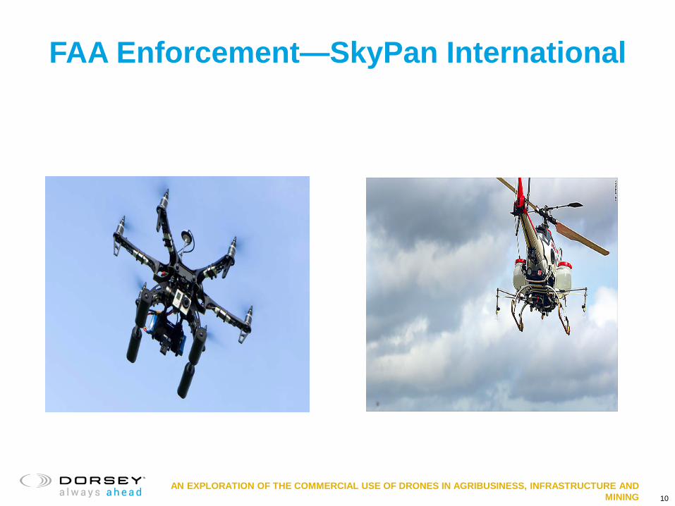
FAA Enforcement—SkyPan International
10

AN EXPLORATION OF THE COMMERCIAL USE OF DRONES IN AGRIBUSINESS, INFRASTRUCTURE AND MINING
Cecil the Lion- $55,000 Fine
11
AN EXPLORATION OF THE COMMERCIAL USE OF DRONES IN AGRIBUSINESS, INFRASTRUCTURE AND MINING
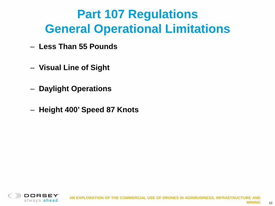
Part 107 Regulations General Operational Limitations
– Less Than 55 Pounds
– Visual Line of Sight
– Daylight Operations
– Height 400’ Speed 87 Knots
12
AN EXPLORATION OF THE COMMERCIAL USE OF DRONES IN AGRIBUSINESS, INFRASTRUCTURE AND MINING
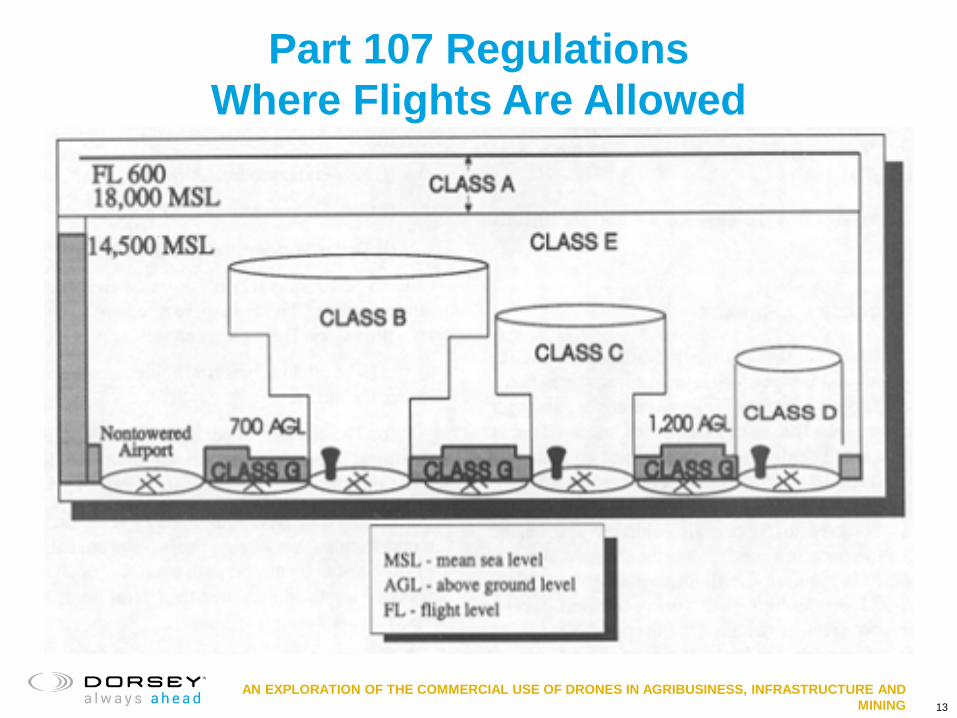
Part 107 Regulations Where Flights Are Allowed
13

AN EXPLORATION OF THE COMMERCIAL USE OF DRONES IN AGRIBUSINESS, INFRASTRUCTURE AND MINING 14

AN EXPLORATION OF THE COMMERCIAL USE OF DRONES IN AGRIBUSINESS, INFRASTRUCTURE AND MINING
Part 107 Regulations Remote Pilot in Command
• Required Qualifications
• Part 61 Pilot Certificate Holders
• Foreign Certified UAS Pilots
15

AN EXPLORATION OF THE COMMERCIAL USE OF DRONES IN AGRIBUSINESS, INFRASTRUCTURE AND MINING
Part 107 Regulations Other Considerations
• Additional Important Operational Limits
• Part 107 Waiver Process
• Section 333 Exemption Process
16

AN EXPLORATION OF THE COMMERCIAL USE OF DRONES IN AGRIBUSINESS, INFRASTRUCTURE AND MINING
Part 107 Ag Operations
17

AN EXPLORATION OF THE COMMERCIAL USE OF DRONES IN AGRIBUSINESS, INFRASTRUCTURE AND MINING
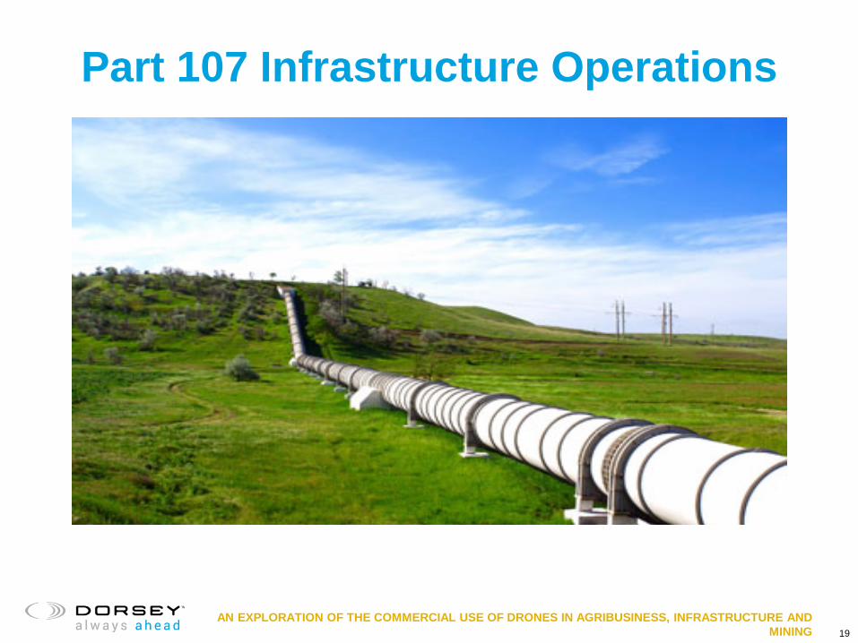
Part 107 Infrastructure Operations
18
AN EXPLORATION OF THE COMMERCIAL USE OF DRONES IN AGRIBUSINESS, INFRASTRUCTURE AND MINING
Part 107 Infrastructure Operations
19

AN EXPLORATION OF THE COMMERCIAL USE OF DRONES IN AGRIBUSINESS, INFRASTRUCTURE AND MINING
Part 107 Mining Operations
20
AN EXPLORATION OF THE COMMERCIAL USE OF DRONES IN AGRIBUSINESS, INFRASTRUCTURE AND MINING
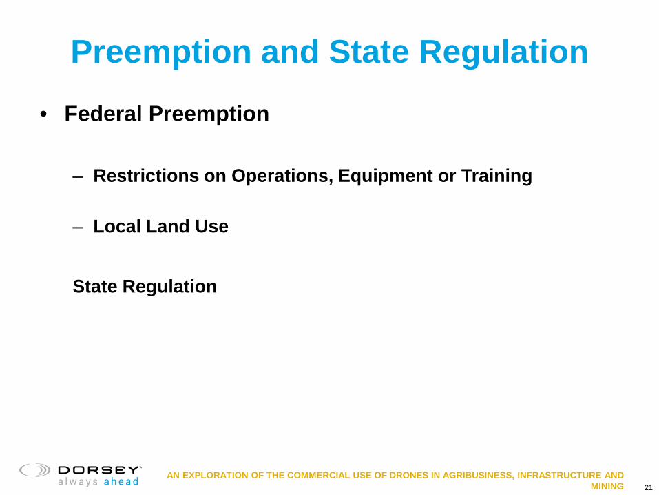
Preemption and State Regulation
• Federal Preemption – Restrictions on Operations, Equipment or Training
– Local Land Use
State Regulation
21

AN EXPLORATION OF THE COMMERCIAL USE OF DRONES IN AGRIBUSINESS, INFRASTRUCTURE AND MINING
Common Law Issues
• Trespass and Nuisance
• Invasion of Privacy
• Negligence
• Strict Liability
• Damage to a UAS
22

AN EXPLORATION OF THE COMMERCIAL USE OF DRONES IN AGRIBUSINESS, INFRASTRUCTURE AND MINING 23
AN EXPLORATION OF THE COMMERCIAL USE OF DRONES IN AGRIBUSINESS, INFRASTRUCTURE AND MINING
New York CLE Code
We have some NY lawyers participating remotely today. In accordance with NY CLE Rules, the New York Verification Code for this program is _______________.
24

+
Overview of Unmanned Aircraft Systems (UAS) in Agriculture, Mining and Infrastructure
Parts of the UAS System

+ David White Professional Experience
- Juniper Unmanned – COO & Director of Business Development - Ariel Technologies Inc. – Director Technical Solutions - Alacer Gold Corp. – M & A support team - Dataroom Developer - HS International – Mining - Sr Technical Recruiter
UAS Consulting - Solution Design and integration - Program Design – decision quality data - Workflow development and integration - Development R&D testing and training facilities
Education B.S. Mining Engineering, Colorado School of Mines
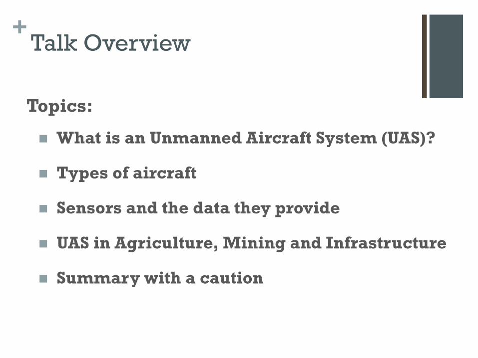
+ Talk Overview
Topics:
What is an Unmanned Aircraft System (UAS)?
Types of aircraft
Sensors and the data they provide
UAS in Agriculture, Mining and Infrastructure
Summary with a caution

+ Unmanned Aircraft Systems (UAS)
“What word should I use… Drone/UAV/UAS?”
“What can a UAS do?” Almost anything
Aircraft types are varied… so, it depends…
“What is the best UAS?” Again, it depends…
Not every UAS is well suited for all applications
Source: Trimble.com

+ Unmanned Aircraft Systems (UAS)
What makes up an Unmanned Aircraft System - UAS?
Multiple discrete elements
Each elements performs a specific and unique function
The elements work together to create a system
Source: http://www.mavinci.de/en

+ Elements of a UAS
Unmanned System
Human Element
Command and Control Links
C2
Unmanned Aircraft
Communication /Data Link
Sensor or Payload
Launch and Recovery Element

+ Unmanned Aircraft
Three basic types of UAV platforms
Fixed-wing Aircraft
Transitioning Aircraft
Vertical Takeoff and Landing (VTOL) Aircraft
Multi-rotor Copters
Single rotor - Helicopters
Ducted Fan Aircraft
(Source: 3DR.com)

+ Unmanned Aircraft Types Fixed-wing sUAVs:
Delta wing - Trimble - UX-5 (Source: Trimble .com)
Delair Tech - DT 26 (Source: Delair-tech.com)
PrecisionHawk – Lancaster (Source: PrecissionHawk.com)

+ Unmanned Aircraft Types
Transitioning UAV’s ALTi – Transition
VTOL take-off and landing – Electric
Fixed wing flight – Fueled

+ Unmanned Aircraft Types
Multi-Rotor VTOL UAV’s
Multi-rotor – Copters Quadcopter DJI - Phantom 4 Pro
Hexicopter DJI Matrice 600 Pro
Source: DJI.com

+ Unmanned Aircraft Types
Single-rotor VTOL UAV’s
Single rotor – Helicopters Pulse Aerospace – Vapor 55
Source: Pulse Aerospace - www.pulseaero.com

+ Unmanned Aircraft Types
Ducted Fan VTOL UAVs
Honeywell RQ-16A T-Hawk
(Source: Honeywell RQ-16A T-Hawk)
Reference Technologies –Hummingbird 24” ducted fan, 6 external rotors
(Source: Referencetek.com)

+ UAS Capabilities
Weight (GTW)
Physical size
Power Source
Range
Endurance
Wind Tolerance
Operational Flight Ceiling
Cruise Speed
C2 Range
Sensor types
Sensor capacity
Data link range
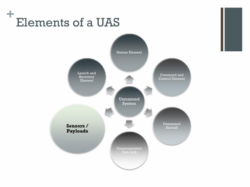
+ Elements of a UAS
Unmanned System
Human Element
Command and Control Element
Unmanned Aircraft
Communication Data Link
Sensors / Payloads
Launch and Recovery Element
+ UAS Sensors
UAS Mission - Sensor types
UAVs may be equipped with a variety of sensors
Different types of sensors perform different tasks and deliver different types of data
UAV’s may be fitted with a single or multiple sensors
Mission sensors ultimately determine the flight path, flight speed and operational altitude (AGL) of the UAV

+ UAS Sensors
High Resolution Digital Camera Provides multiple functions…
Photogrammetry = the science
of making measurements from
photographs Multiple highly overlapping images
Images are post-processed with other flight data resulting in and single large image called a photomosaic
In addition post-processing produces a dense points cloud
Points are connected with a mesh generating a 3-D surface or digital surface model or DSM

+ UAS Sensors
UAS photogrammetry –
Delivers spacial accuracies of 2-5 cm in the x,y, and z dimensions
Can fly and process in a day or two, what used to take weeks, and with accuracies that were previously unthinkable.
At left - progression from images, to colorized point cloud, to DSM to topographic map.
Source: TopCon Positioning Systems ( http://www.topconpositioning.com/products/aerial-mapping/sirius-pro )
+ UAS Sensors
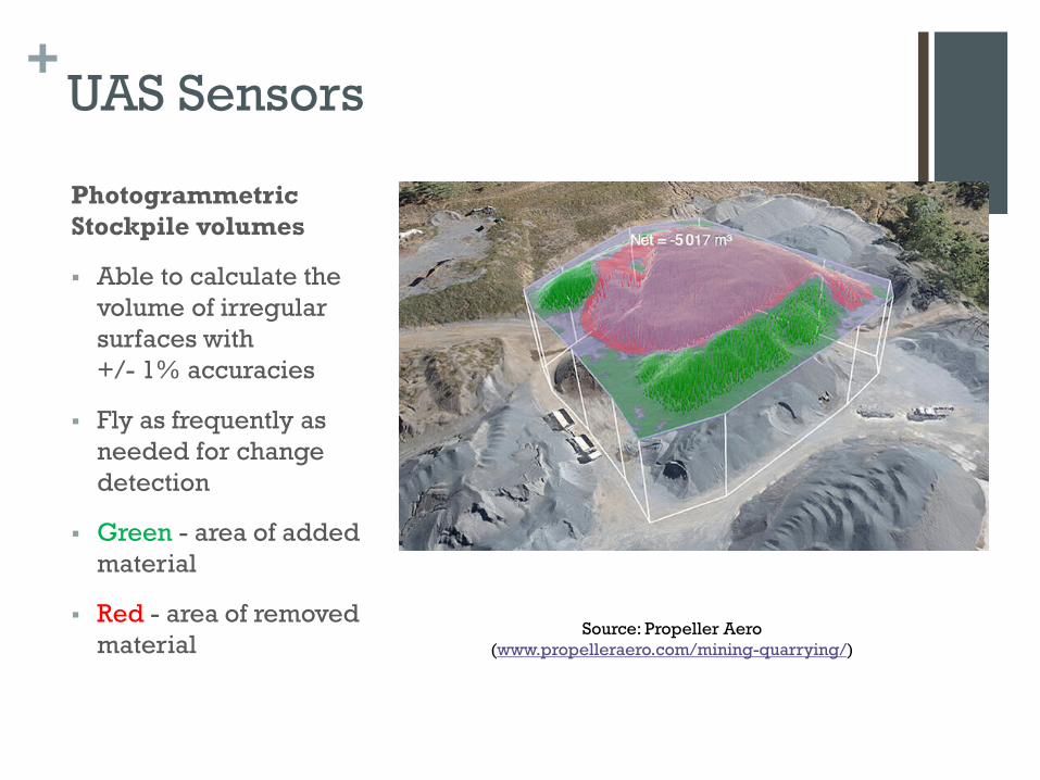
Photogrammetric Stockpile volumes
Able to calculate the volume of irregular surfaces with +/- 1% accuracies
Fly as frequently as needed for change detection
Green - area of added material
Red - area of removed material
Source: Propeller Aero (www.propelleraero.com/mining-quarrying/)

+ UAS Sensors
Multispectral Imagery
NDVI - the normalized difference vegetation index
NDVI - measure of the reflectance of a plant in multiple wave lengths
Is a good measure of plant health and plant stress
(Source: Agribotix.com)
(Source: MicaSense.com)


+ UAS Sensors Hyperspectral Imagery (HSI)
(Source: https://bcal.boisestate.edu/blog/hyperspectral-uav-sensing-for-dryland-vegetation-monitoring/)
Light reflected from objects is dispersed into its spectra and then the intensities of certain precise spectral bands are measured.
The intensity values are unique and characteristic and create a unique Spectral Signature.
The Spectral Signature – is like a unique “fingerprint”

+ UAS Sensors EO/IR Imagery EO/ IR - Live video streaming Observation of a dynamic environments Common sensors for UAS systems
Search and Rescue
Fire fighting
Emergency Response
Security
Situational awareness
Source: SPi infrafed http://www.x20.org/shop/industrial-infrared-cameras/m1-d-micro-ptz-infrared-camera/

+ UAS Sensors LiDAR point clouds LIDAR -- Light Detection and Ranging,
is a remote sensing method that uses light in the form of a pulsed laser to measure ranges (variable distances) from the sensor to the Earth.
The laser pulses generate precise, and highly spatially accurate three-dimensional point clouds of the shapes of objects being scanned.
YellowScan Surveyor LiDAR Source: YellowScan.com

+ UAS Sensors
Corona Camera Imagery
Corona Cameras are able to detect arcing on high-voltage equipment prior to system breakdown and failure
UAS inspect high-voltage power lines, substations and power installations efficiently and quickly
UAS removes people from close proximity to live high-voltage equipment, increasing inspection speed and crew safety
Ofil Systems ROMpact 300i 3.3lb, L 9.88”x W4.96”x H3.03”
Source: http://www.ofilsystems.com/produ
cts/rompact.html
+ UAS System Integration Putting it together - System Integration
Aircraft, Sensors and other elements – all work together and form the UAS
Not all sensors are suitable for all platforms Weight & Size Power consumption Vibration sensitivity Data gathering duration Flight velocity Operational distance
Key: design with the end goal in mind…
The unique operational environment
The Type and Quality of data needed to make decisions

+ UAS Benefits in Agriculture, Mining and Infrastructure
General Benefits a) Safety b) Minimize operational disruption c) Temporal frequency d) Flexibility – variety of data types e) Responsiveness – changing conditions f) Perspective and Innovation g) Analytics - create actionable results
Major impact - productivity, cost and efficiency
+ UAS Applications in Agriculture
Real-time crop monitoring &
scouting
Crop progress and health
Soil/moisture monitoring
Security/intruded reports
Damage assessment - storms
Field mapping – drainage
Soil profile analysis
Nutrient & Irrigation Mgmt.
Environmental monitoring
Warning & Alerts: Pest,
weed, drowned outs,
bacterial fungal infections,
spoilage
Automated planting
Spraying: pesticides, fertilizers
& water
Critical growth phase
Temporal frequency
Livestock tracking

+ UAS Applications in Mining
Security – perimeter
Exploration – geological
Geophysical
Mine planning – S,M, L
Mapping & Surveying
Automated Navigation
Stockpile volumetrics
inventory/reconciliation
Haul-road optimization
Delivery – parts, tools…
Pre-blast “all clear”
Undetonated explosives
Blast fragmentation analysis
Tailing dam monitoring
Leach pad - design, mgmt.
Baseline studies
Environmental reporting
Remediation compliance
Heritage site mapping
Slope stability
(By Reinhard Jahn - Own work, CC BY-SA 2.0 de, https://commons.wikimedia.org/w/index.php?curid=351497)

+ UAS Applications in Infrastructure
Site planning
Inventory management
Project management
Mapping & surveying
As-built documentation
Asset auditing & management
Monitoring and Inspection:
pipeline, transmission line,
tower, turbine, flare stack…
Fugitive emission detection
Easement monitoring
Security
Vegetation encroachment
monitoring mapping
Infrastructure assessment
Emergency assessment and
management
Railway safety inspection
Wind Turbine Inspection
Bulk materials auditing

+ UAS in Agriculture, Mining and Infrastructure Conclusions
UAS are significantly impacting each of the industry sectors
UAS technology is evolving rapidly
The use of UAS will only increase in the future
CAUTION: Acquiring quality data in challenging
operational environments is harder than UAS marketing
hype leads you to believe
Professional services – allow you to determine UAS
cost/benefit

+ UAS in Agriculture, Mining and Infrastructure
After all, you never want to be… “that Person”
“In the South Bay, police are looking for a drone pilot who they say caused a large power outage that plunged 1,600 customers into darkness for hours.” (7 News, San Francisco, CA, June 9th, 2017) (Courtesy of the Mount View Police Department)

+ UAS in Agriculture, Mining and Infrastructure
Thank you
Questions

AN EXPLORATION OF THE COMMERCIAL USE OF DRONES IN AGRIBUSINESS, INFRASTRUCTURE AND MINING
This program will resume at 10:00 a.m. MT

AN EXPLORATION OF THE COMMERCIAL USE OF DRONES IN AGRIBUSINESS, INFRASTRUCTURE AND MINING
Session 2 - Privacy and Intellectual Property Issues in Precision Agriculture, Infrastructure, and Mining
Jamie Nafziger, Partner Dorsey & Whitney LLP Minneapolis, MN

AN EXPLORATION OF THE COMMERCIAL USE OF DRONES IN AGRIBUSINESS, INFRASTRUCTURE AND MINING
What is Precision Agriculture?
• Use of technology to collect and process real-time, site-specific data and inform farming decisions
• Seed choices • Pesticides and fertilizer
application • Smart farms: connecting
weather predictions to irrigation systems
• Complex ecosystem where software providers, hardware providers, farm equipment providers, and agronomists all working with growers
60

AN EXPLORATION OF THE COMMERCIAL USE OF DRONES IN AGRIBUSINESS, INFRASTRUCTURE AND MINING
From Drone to Tractor
61

AN EXPLORATION OF THE COMMERCIAL USE OF DRONES IN AGRIBUSINESS, INFRASTRUCTURE AND MINING
From Drone to Tracking a Herd
• Smart ear tags on animals • Thermal imaging
62

AN EXPLORATION OF THE COMMERCIAL USE OF DRONES IN AGRIBUSINESS, INFRASTRUCTURE AND MINING
Types of Farm Data
Different legal protections/issues for each type
63
Grower’s/landowner’s knowledge of land
and conditions
Historical records of field, seed, inputs,
etc. and performance
Information from sensors – drones
Grower’s/landowner’s personal information

AN EXPLORATION OF THE COMMERCIAL USE OF DRONES IN AGRIBUSINESS, INFRASTRUCTURE AND MINING
Using Drones For Infrastructure
• Maintenance inspections (distribution lines, wind turbines, solar)
• Storm damage assessments • Surveying construction • Security
64

AN EXPLORATION OF THE COMMERCIAL USE OF DRONES IN AGRIBUSINESS, INFRASTRUCTURE AND MINING
Using Drones for Infrastructure
65

AN EXPLORATION OF THE COMMERCIAL USE OF DRONES IN AGRIBUSINESS, INFRASTRUCTURE AND MINING
Using Drones in Mining
• Planning • Water flow mapping • Measuring volume of stockpiles and extraction pits • Safety checks before blasting • Construction quality control • Exploration • Environmental management • Incident evidence collection • Security
66

AN EXPLORATION OF THE COMMERCIAL USE OF DRONES IN AGRIBUSINESS, INFRASTRUCTURE AND MINING
Key Legal Issues
• Intellectual Property • Privacy • Licensing • Regulations • State and Federal Drone-Specific Laws
67

AN EXPLORATION OF THE COMMERCIAL USE OF DRONES IN AGRIBUSINESS, INFRASTRUCTURE AND MINING
Fundamental: Is Sharing Drone-Collected Data Freely Problem or Opportunity?
• For some analysis, may only get best value of data if individual data aggregated into larger dataset (big data) – Research benefits – Benchmarking
• Difficulty and cost of negotiating licenses individually between each grower/ranch operator and each vendor
68

AN EXPLORATION OF THE COMMERCIAL USE OF DRONES IN AGRIBUSINESS, INFRASTRUCTURE AND MINING
Intellectual Property: Legal Standards
• Is data collected from farms protectable intellectual property?
• Trade secret protection • Defend Trade Secrets Act (DTSA) defines
trade secret as: – information, including a formula, pattern, compilation,
program, device, method, technique, process, etc.; – that derives independent economic value, actual or potential,
from not being generally known to, and not being readily ascertainable through proper means by, another person who can obtain economic value from its disclosure or use; and
– owner has taken reasonable measures to keep such information secret
• Some farm data may qualify; info collected by drones may not
69
Grower’s/landowner’s knowledge of land and
conditions
Historical records of field, seed, inputs, etc.
and performance
Information from sensors – drones
Grower’s/landowner’s personal information

AN EXPLORATION OF THE COMMERCIAL USE OF DRONES IN AGRIBUSINESS, INFRASTRUCTURE AND MINING
Other Relevant Legal Standards
• Real Property – How far up does ownership extend if you own the land?
• FAA claims right to regulate National Airspace System (NAS) from ground to near space
• Some courts have used arbitrary 500 foot mark • Causby 328 U.S. 256 (1946): land owner owns at least as much
space above the ground as he can occupy or use • Even if you own space, do you have rights in data collected
from it?
70

AN EXPLORATION OF THE COMMERCIAL USE OF DRONES IN AGRIBUSINESS, INFRASTRUCTURE AND MINING
Trespass/Nuisance
• Trespass – Knowingly entering another person’s property without
permission – Damages – not ownership
• Nuisance – Use and enjoyment of land is interfered with
substantially and unreasonably through thing or activity
– Damages – not ownership
• Looking on from adjacent parcel • Practical reality: UAS can fly at heights
where difficult to detect
71

AN EXPLORATION OF THE COMMERCIAL USE OF DRONES IN AGRIBUSINESS, INFRASTRUCTURE AND MINING
Intellectual Property: Practical Solutions
• Licensing (key for infrastructure and mining uses as well) – Different categories of data?
• Agreements between growers (or infrastructure or mine owners), software and hardware vendors, service providers, agronomists/consultants
• Agreements between software and hardware providers – Who can use data? – What can they do with it?
• Ag Data Transparency Evaluator (American Farm Bureau Federation)
• Standards/Interoperability – AgGateway – Standardized Precision Ag Data Exchange (SPADE) and
Precision Ag Irrigation Leadership (PAIL) – Open Ag Data Alliance (OADA) – Large technology providers: Deere acquisition of Precision Planting
(connecting Deere hardware to Climate Corp. software system); Monsanto has platform
• Data repositories
72

AN EXPLORATION OF THE COMMERCIAL USE OF DRONES IN AGRIBUSINESS, INFRASTRUCTURE AND MINING
New York CLE Code
We have some NY lawyers participating remotely today. In accordance with NY CLE Rules, the New York Verification Code for this program is _______________.
73

AN EXPLORATION OF THE COMMERCIAL USE OF DRONES IN AGRIBUSINESS, INFRASTRUCTURE AND MINING
Privacy: Legal Standards
• Legal and regulatory framework • Barriers to understanding and compliance • Due diligence required to get information needed for
assurances requested by growers, privacy policies, and legal compliance
74

AN EXPLORATION OF THE COMMERCIAL USE OF DRONES IN AGRIBUSINESS, INFRASTRUCTURE AND MINING
Legal Framework: Privacy Overview
• No federal comprehensive privacy law (instead specific areas: financial, health, etc.)
• State laws – Violations of reasonable
expectation of privacy • Federal Trade Commission
– Deceptive or unfair acts – Individual person and his or
her device – Collecting, using and
sharing of personal information
– Privacy policies – notice & consent
Grower’s/landowner’s knowledge of land and
conditions
Historical records of field, seed, inputs, etc.
and performance
Information from sensors – drones
Grower’s/landowner’s personal information
75

AN EXPLORATION OF THE COMMERCIAL USE OF DRONES IN AGRIBUSINESS, INFRASTRUCTURE AND MINING
Drone Privacy Law – Not Passed by House
• Passed by Senate in April 2016 as part of FAA Reauthorization Act
• Final bill passed in July 2016 did not contain these provisions – Commercial drone operators must disclose if collecting
personal information about individual, including using facial recognition
– Disclose how using personal information, including use for advertising or marketing
– Disclose when personal information would be destroyed • Final bill did contain
– FAA shall convene industry to develop standards for remotely identifying operators and owners of UAS
• Remote Identification Aviation Rulemaking Committee (March 2017)
76

AN EXPLORATION OF THE COMMERCIAL USE OF DRONES IN AGRIBUSINESS, INFRASTRUCTURE AND MINING
Recent Legislative Attempts • Drone Aircraft Privacy &Transparency Act (introduced
March 2017) – FAA would collect
• Data collection statement • Data minimization statement
– Violations • FTC • State Attorneys General • Private right of action • $1,000 per violation
• Drone Federalism Act (introduced May 2017) – State, local and tribal government authority may issue
restrictions on time, manner and place of drone operations within 200 feet of ground or structure
• Trump Administration – National Defense Authorization Act – Gov’t may destroy drones that pose threat to safety/security; respect privacy, civil liberties
77

AN EXPLORATION OF THE COMMERCIAL USE OF DRONES IN AGRIBUSINESS, INFRASTRUCTURE AND MINING
Recent Legislative Actions, cont.
• Example of recent state legislation: Indiana S.B. 299 – Sex offender UAV offense – Public safety remote aerial interference (using drones to
interfere with first responders’ operations) – Remote aerial voyeurism – Remote aerial harassment
78

AN EXPLORATION OF THE COMMERCIAL USE OF DRONES IN AGRIBUSINESS, INFRASTRUCTURE AND MINING
Recent Litigation • EPIC case against FAA regarding lack of privacy
regulation • Boggs v. Merideth (W.D. Kentucky 2017)
– D shot P’s drone down with shotgun – P alleged trespass to chattels – P sought declaratory judgment
• Unmanned aircraft is “aircraft” under fed. law • P was operating drone in navigable airspace rather than on D’s
property • P did not violate D’s reasonable expectation of privacy • Prop owner cannot shoot at unmanned aircraft in navigable
airspace when operating like P’s drone was – Fed. court dismissed for lack of subject matter jurisdiction – Q whether drone flying on D’s property or in fed. airspace not
enough to give juris. • Anticipatory defense not necessary to trespass to chattels claim • Dispute between two parties not significant to fed. system
79

AN EXPLORATION OF THE COMMERCIAL USE OF DRONES IN AGRIBUSINESS, INFRASTRUCTURE AND MINING
Recent Litigation, cont. • Huerta v. Haughwout (D. Conn. 2016)
– FAA sought enforcement of subpoenas to defendants – Defendants allegedly operated drone to fire handgun and
flame thrower – Dicta: court expressed skepticism about whether flying
drones on own property subject to FAA regulation • Blanton v. Deloach (S.D. Ga. 2015)
– P alleged police violated privacy by following him with drone
– Dicta: traditionally, watching or observing person in public place not intrusion upon privacy
• State v. Davis (N.M. 2015) – Aerial surveillance from helicopter unwarranted search – Partially turned on helicopter noise; court declined to
consider quiet drones since not raised by facts of case
80

AN EXPLORATION OF THE COMMERCIAL USE OF DRONES IN AGRIBUSINESS, INFRASTRUCTURE AND MINING
Fourth Amendment Analogy: Search & Seizure
• Dow Chemical v. U.S. (1986): aerial photographer hired by EPA photographed facility from 1,200, 3,000 and 12,000 feet – search constitutional – land open to view and observation does not trigger 4th Amendment protection – open area around facility more like an open field than curtilage of home
• California v. Ciraolo (1986): from small plane 1000 feet over fenced-in backyard, police photographed marijuana plants. Supreme Ct. – no reasonable expectation of privacy in things that can be seen from location where public has right to be
81
AN EXPLORATION OF THE COMMERCIAL USE OF DRONES IN AGRIBUSINESS, INFRASTRUCTURE AND MINING
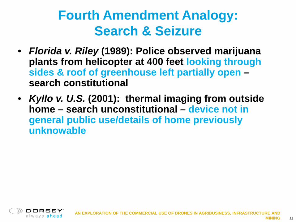
Fourth Amendment Analogy: Search & Seizure
• Florida v. Riley (1989): Police observed marijuana plants from helicopter at 400 feet looking through sides & roof of greenhouse left partially open – search constitutional
• Kyllo v. U.S. (2001): thermal imaging from outside home – search unconstitutional – device not in general public use/details of home previously unknowable
82
AN EXPLORATION OF THE COMMERCIAL USE OF DRONES IN AGRIBUSINESS, INFRASTRUCTURE AND MINING
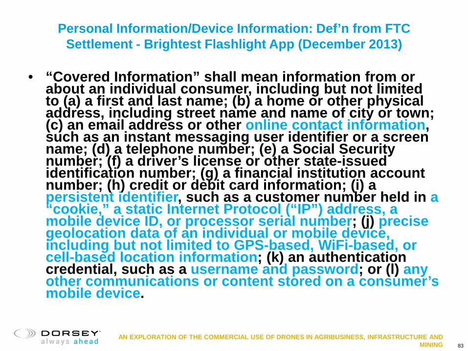
Personal Information/Device Information: Def’n from FTC Settlement - Brightest Flashlight App (December 2013)
• “Covered Information” shall mean information from or about an individual consumer, including but not limited to (a) a first and last name; (b) a home or other physical address, including street name and name of city or town; (c) an email address or other online contact information, such as an instant messaging user identifier or a screen name; (d) a telephone number; (e) a Social Security number; (f) a driver’s license or other state-issued identification number; (g) a financial institution account number; (h) credit or debit card information; (i) a persistent identifier, such as a customer number held in a “cookie,” a static Internet Protocol (“IP”) address, a mobile device ID, or processor serial number; (j) precise geolocation data of an individual or mobile device, including but not limited to GPS-based, WiFi-based, or cell-based location information; (k) an authentication credential, such as a username and password; or (l) any other communications or content stored on a consumer’s mobile device.
83
AN EXPLORATION OF THE COMMERCIAL USE OF DRONES IN AGRIBUSINESS, INFRASTRUCTURE AND MINING
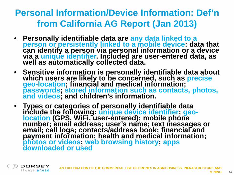
Personal Information/Device Information: Def’n from California AG Report (Jan 2013)
• Personally identifiable data are any data linked to a person or persistently linked to a mobile device: data that can identify a person via personal information or a device via a unique identifier. Included are user-entered data, as well as automatically collected data.
• Sensitive information is personally identifiable data about which users are likely to be concerned, such as precise geo-location; financial and medical information; passwords; stored information such as contacts, photos, and videos; and children’s information.
• Types or categories of personally identifiable data include the following: unique device identifier; geo-location (GPS, WiFi, user-entered); mobile phone number; email address; user’s name; text messages or email; call logs; contacts/address book; financial and payment information; health and medical information; photos or videos; web browsing history; apps downloaded or used
84

AN EXPLORATION OF THE COMMERCIAL USE OF DRONES IN AGRIBUSINESS, INFRASTRUCTURE AND MINING
Farm, Infrastructure, and Mining Data
• Examples: elements of farm data that could be considered personal information – Grower and owner contact information – Geolocation of person or device – Image or video of person – Device identifiers – Credit card info – Financial information
• Examples: elements of infrastructure or mining data that could be considered personal information – Geolocation of person or device – Image or video of person
85

AN EXPLORATION OF THE COMMERCIAL USE OF DRONES IN AGRIBUSINESS, INFRASTRUCTURE AND MINING
Barriers to Understanding and Compliance
• Privacy policy • Barriers to understanding/
minimizing personal information collection – Out-of-date/inconsistent definitions
of “personal information” make due diligence difficult
– Inadequate disclosures by third parties – Lack of understanding by developers
86

AN EXPLORATION OF THE COMMERCIAL USE OF DRONES IN AGRIBUSINESS, INFRASTRUCTURE AND MINING
Privacy: Due Diligence on Third Parties
• Software providers/hardware providers • Database/repository providers • Analytics providers • App platforms • Connections between apps • Cookies and other trackers
87

AN EXPLORATION OF THE COMMERCIAL USE OF DRONES IN AGRIBUSINESS, INFRASTRUCTURE AND MINING
In the face of uncertainty…
• Change law / new law • Self-regulation • Agreements
– Who can access and use data? – What can they do with it?
• Disputes
88

AN EXPLORATION OF THE COMMERCIAL USE OF DRONES IN AGRIBUSINESS, INFRASTRUCTURE AND MINING
Change Law / New Law • Amend trade secret law to include farm data? Proposed by
witness in House Committee on Agriculture hearing October 28, 2015 http://agriculture.house.gov/uploadedfiles/10.28.15_ferrell_testimony.pdf
• Over 45 states have considered or enacted drone legislation • Concepts in Some Proposed/Enacted State Laws
– Identification of drone owner or operator on device – Registration with state – Prohibit municipalities from regulating drones – Tenants need written permission from landowner to use UAS on property – Louisiana – farm data collected through UAS belongs to legal owner of
property where collected (La. R.S. 3:41-47) – Texas – misdemeanor to capture, disclose, display, distribute “image” of
individual or privately owned real property (narrow exceptions); Ch. 423 of Government Code
– Utah – misdemeanor to chase, disturb, harm livestock through UAS use – No use over critical infrastructure facilities
89

AN EXPLORATION OF THE COMMERCIAL USE OF DRONES IN AGRIBUSINESS, INFRASTRUCTURE AND MINING
Self-Regulation
• American Farm Bureau Federation – Privacy and Security Principles for Farm Data (November
13, 2014; updated May 5, 2015)
• Open Ag Data Alliance (OADA) http://openag.io/about-us/principals-use-cases/
• AgGateway data privacy and use white paper http://www.aggateway.org/WorkingGroups/Committees/DataPrivacySecurity.aspx
90

AN EXPLORATION OF THE COMMERCIAL USE OF DRONES IN AGRIBUSINESS, INFRASTRUCTURE AND MINING
NTIA Voluntary Best Practices for UAS Privacy, Transparency, and Accountability
• National Telecommunications and Information Administration
• https://www.ntia.doc.gov/files/ntia/publications/uas_privacy_best_practices_6-21-16.pdf
• Released in May 2016; updated June 2016 when new FAA drone regulation released
• Five voluntary best practices
91

AN EXPLORATION OF THE COMMERCIAL USE OF DRONES IN AGRIBUSINESS, INFRASTRUCTURE AND MINING
NTIA Voluntary Best Practices for UAS Privacy, Transparency, and Accountability
1. Inform others of your use of UAS – Reasonable effort to provide prior notice to individuals of
general timeframe and area where UAS will be intentionally collecting data.
– If UAS operator anticipates collection of covered data, operator should provide privacy policy for data.
• Covered data: “information collected by a UAS that identifies a particular person. If data collected by UAS likely will not be linked to an individual’s name or other personally identifiable information, or if the data is altered so that a specific person is not recognizable, it is not covered data.”
• Privacy policy should be in place no later than time of collection and made publically available.
– Purpose for which UAS will collect covered data – Kinds of covered data UAS will collect – Information regarding any data retention/de-identification practices – Examples of types of entities with whom covered data will be shared – How to submit privacy and security complaints/concerns – Information describing practices in responding to law enforcement
requests
92

AN EXPLORATION OF THE COMMERCIAL USE OF DRONES IN AGRIBUSINESS, INFRASTRUCTURE AND MINING
NTIA Voluntary Best Practices for UAS Privacy, Transparency, and Accountability
2. Show care when operating UAS or collecting and storing covered data
– Without compelling need or consent of data subjects, avoid using UAS to intentionally collect covered data where operator knows data subject has reasonable expectation of privacy
– Avoid using UAS for purpose of persistent and continuous collection of covered data about individuals
– Make reasonable efforts to minimize UAS operations over or within private property without consent of property owner or without appropriate legal authority
– Make a reasonable effort to avoid knowingly retaining data longer than reasonably necessary to fulfill specified purposes
– Establish a process to receive privacy or security concerns for covered data
93

AN EXPLORATION OF THE COMMERCIAL USE OF DRONES IN AGRIBUSINESS, INFRASTRUCTURE AND MINING
NTIA Voluntary Best Practices for UAS Privacy, Transparency, and Accountability
3. Limit Use and Sharing of Covered Data – Receive consent if covered data is used for employment
eligibility, promotion, or retention; credit eligibility; or health care treatment eligibility
– Avoid using or sharing covered data for purpose not included in privacy policy covering UAS data
– Regarding publicly disclosed covered data, make reasonable effort to obfuscate or de-identify covered data prior to disclosure
– Make reasonable effort to avoid using or sharing covered data for marketing purposes
94

AN EXPLORATION OF THE COMMERCIAL USE OF DRONES IN AGRIBUSINESS, INFRASTRUCTURE AND MINING
NTIA Voluntary Best Practices for UAS Privacy, Transparency, and Accountability
4. Secure Covered Data • Provide adequate program with administrative, technical, and
physical safeguards appropriate to operator’s size and complexity
• Model security programs after NIST Cybersecurity Framework 5. Monitor and Comply with Evolving Federal, State, and Local UAS laws
95

AN EXPLORATION OF THE COMMERCIAL USE OF DRONES IN AGRIBUSINESS, INFRASTRUCTURE AND MINING
NTIA Voluntary Best Practices for UAS Privacy, Transparency, and Accountability
• Supported by: – Amazon, Association for Unmanned Vehicle Systems
International (AUVSI), Center for Democracy and Technology, Commercial Drone Alliance, Consumer Technology Association, CTIA, Future of Privacy Forum, Intel, New America’s Open Technology Institute, PrecisionHawk, X (Formerly Google [x]), Small UAV Coalition, Online Trust Alliance (OTA), News Media Coalition, Newspaper Association of America (NAA), National Association of Broadcasters (NAB), Radio Television Digital News Association (RTDNA), Digital Content Next (DCN), Software & Information Industry Association (SIIA), NetChoice, U.S. Chamber of Commerce
96

AN EXPLORATION OF THE COMMERCIAL USE OF DRONES IN AGRIBUSINESS, INFRASTRUCTURE AND MINING
Reducing Privacy Risks for Infrastructure and Mining Users of UAS
• Fly over own land or own right of way
• Technological solutions – https://fpf.org/wp-
content/uploads/2016/08/Drones_and_Privacy_by_Design_FPF_Intel_PrecisionHawk.pdf
• Provide notice • Create privacy policy • Special care if releasing to
public • Persistent and continuous
uses may pose highest risk (security monitoring)
97

AN EXPLORATION OF THE COMMERCIAL USE OF DRONES IN AGRIBUSINESS, INFRASTRUCTURE AND MINING
Conclusions • Both intellectual property and privacy issues regarding
data collected by UAS uncertain • Due diligence required to answer producer questions
about their data or required to draft privacy policies challenging in complex technology ecosystem
• For tech providers – getting grip on your data flows may become table stakes in precision ag and infrastructure
• Participation in standards development and legislative action likely helpful
• Focus on user agreements key • Notice, privacy policies and following best practices
reduce risk
98

AN EXPLORATION OF THE COMMERCIAL USE OF DRONES IN AGRIBUSINESS, INFRASTRUCTURE AND MINING
Thank You
Jamie Nafziger Dorsey & Whitney LLP [email protected] (612) 343-7922 Twitter: @JamieNafziger
99

AN EXPLORATION OF THE COMMERCIAL USE OF DRONES IN AGRIBUSINESS, INFRASTRUCTURE AND MINING
This program will resume at 11:00 a.m. MT

AN EXPLORATION OF THE COMMERCIAL USE OF DRONES IN AGRIBUSINESS, INFRASTRUCTURE AND MINING
Session 3 – Business Plan Discussion
Robert Hensley, Partner Dorsey & Whitney LLP Denver, CO
Aaron Lessig CEO and Chairman Pulse Aerospace, Inc.
Eileen Lockhart Unmanned Aircraft System (UAS) Program Manager Xcel Energy

June 20, 2017
Xcel Energy UAS Program Overview

DIVERSE OPERATING AREAS
103
NSP-Wisconsin (NSPW) 2,300 miles Distribution Main 3 miles Transmission 2,403 miles Electric T-Line 9,747 miles Electric D-Line
NSP-Minnesota (NSPM) 9,843 miles Distribution Main 100 miles Gas Transmission 4,942 miles Electric T-Line 26,700 miles Electric D-Line
Public Service Co. of Colorado (PSCo) 22,000 miles Distribution Main 2,000 miles Transmission 4,602 miles Electric T-Line 22,000 miles Electric D-Line Operate in 8 States
Customers 3.5 million electric 2.0 million natural gas
NSPM = 1.5 million NSPW = 272,330 PSCo = 1.7 million SPS = 363,559 (Electric only)
Southwestern Public Service (SPS) *No residential gas customers 19 miles Transmission 6,839 miles Electric T-Line 15,689 miles Electric D-Line

TECHNOLOGY IS CHANGING
• Xcel Energy views UAS technology as transformational and believes it will redefine traditional working methods.
– Started experimenting with UAV’s indoors in 2013
– Developed a small internal UAS team in 2014 – Researched sUAS technology capability – Developed use cases – Shared vision with our internal stakeholders
and federal legislators – Partnered with several organizations including:
• EEI, EPRI, INL, IEEE, NPTS & more – Received a Section 333 exemption & blanket
COA in May 2015
• Summer of 2015 – Mission planning and mission execution
began… 104
Transmission
Energy Supply
Distribution
Gas Ops

UAS MISSION APPROACH
105
Proof of Concept Missions
Execute POC missions and understand feasibility
and lessons learned
Beyond Visual Line of Sight
Partner with outside organizations for beyond the line of sight operations
Visual Line of Sight
UAS Program Office
Dedicated resources to manage VLOS and
BVLOS operations
Apply learnings and enable employees to
use as a tool

POC MISSIONS COMPLETED August 2015 – February 2016
Completed POC missions in 2015-2016 • Data collection of five energized substations • Transmission line inspections • Volumetric survey of ash storage facility • Wind turbine blade inspection • Transmission high pressure gas pipeline & leak
detection • Distribution gas pipeline bridge inspections
February 3, 2016: Xcel Energy became the first electric utility in the United States to complete an FAA-approved beyond-visual-line-of-site research mission. – Completed condition assessment of a 69kV
over head transmission line (OHTL) using two different UAS (helicopter and fixed wing).
106

POST STORM ASSESMENT
The UAS Program Office & Team partnered with ND stakeholders and submitted a $1M + joint grant proposal August 2016-May 2017 Project Objectives • Assess high / low altitude UAS
capabilities to enhance post-event damage and restoration efforts
• Apply UAS capabilities to support reconnaissance/ restoration functions for electric distribution infrastructure
• Develop a UAS Natural Disaster strategy in collaboration with emergency management
• Assess feasibility of utilizing UAS for post-event reconnaissance and restoration activities
107
Mayville

PARALLEL STEPS
108
1
2
3
4
5
Wind Turbine Inspection Cooling Pond Soil / Cement Inspection
Aerial Wildlife & Habitat Inspections Storm Water Waste management
Bird/Bat & Migration Studies Cross Business Unit Applications
Insurance Claims Volumetric Surveys
Objective Data Collection GIS Mapping and facility verification
Security / Protection Vegetation Management
Sighting and Land-rights Transmission High Pressure Gas
Tank, Pipe & Storage leaks /Inspections Energy Supply & Nuclear (indoor & outdoor) Security for Generation & Nuclear Facilities
Facility/Plant Boiler & Equipment Inspections Electric Transmission & Distribution Asset Inspection/ Asset Inventory
Pre/Post construction surveys Enhanced Security for Remote Substations
Fault Location in Remote Areas LiDAR analysis for new line construction Post-Storm / Post-Disaster Assessment Aerial communications,media,marketing
Live streaming/public safety
INTEGRATE MORE MISSIONS
REGULATORY
BUSINESS CASE
DATA INTEGRATION & ABSORPTION
COMMUNCIATIONS
OPERATING POLICES & PROCEDURES

AN EXPLORATION OF THE COMMERCIAL USE OF DRONES IN AGRIBUSINESS, INFRASTRUCTURE AND MINING
New York CLE Code
We have some NY lawyers participating remotely today. In accordance with NY CLE Rules, the New York Verification Code for this program is _______________.
109

Overview Presentation 2017
Performance High-value Data Precision

Pulse Overview
2
• Provider of leading commercial / military-grade unmanned aerial systems (“UAS” or “drones”) with flight control and optimization technology, branded HeliSynthTM
• Pulse’s founders have been leaders in the design and automation of UAS for 12+ years
• Pulse’s HeliSynthTM technology, coupled with its UAS design expertise, results in a UAS platform with unparalleled precision flight, endurance and payload capacity
• Pulse’s HeliSynthTM architecture enables advanced UAS capabilities and high-value enterprise solutions including data networking, precise data collection, onboard processing, machine learning and dynamic retasking – all tied to the Flight Control System
• HeliSynthTM software architecture enables modular, home-grown and third party enterprise solution development integrated with advanced UAS automation
• Company is based in Lawrence, KS; with roots in the world-class University of Kansas Aerospace Engineering program
Massive Addressable Markets
Size Opportunities Annualized Growth Rate Commercial (1)
$127Bn by 2020
• Mining • Survey • Inspection • Agriculture • Logistics
100%+
Military (2)
$71Bn by 2020
• Reconnaissance • Lethal support • Casualty
assistance • Logistics • Public safety
100%+
Notes 1. Commercial trends and market size from PwC report dated May 2016. value of drone powered solutions 2. Commercial trends and military global addressable market size from Goldman Sachs report dated March 2016, value of UAS

© 2016 Pulse Aerospace, Inc. Proprietary. Not for Redistribution
without written consent.
Projects that have Developed Pulse’s Technologies
• Aerospace Engineering Firm – 15 Years Experience in UAS Automation and Development
• Automation and Optimization of Complex UAS Systems - Helicopters
• Department of Defense, Special Forces / SOCOM, Skunkworks, DOE, DOI, BLM, Spawar, Numerous Defense Contractors
• 30+ Research Universities • UAS Platforms Ranging from 30 – 1,200 Pounds
• Antarctica • Greenland • Australian Outback • Death Valley • Kansas!
• Fixed Wing and Helicopter UAS

HeliSynthTM Technical Building Blocks
8
DATA & ANALYTICS
Application Specific Data
Analysis and Usage
AUTONOMY
Selection and Characterization
Physical Integration and Vibration Isolation
Automated re-tasking
Payload driven guidance
Automated Safety mechanisms
Real-time data / guidance interaction
Electrical and Operational Integration
Data Quality Verification
PAYLOAD
FULL AUTHORITY DIGITAL FLIGHT CONTROL SYSTEM DEVELOPMENT
Dynamic Model Development
Frequency domain Control Bandwidth Prescription development
Multivariable Controller Synthesis
Decoupled Controller Development
Flight Envelope Validation
AIRCRAFT DESIGN
Conceptual & Configuration Design
Aerospace Structural & Composites Design Optimization
Aircraft Aerodynamics and Performance
Propulsion and Thermodynamics
CONOPS Development & Regulatory Compliance Strategy
Segment Interaction Factors
Human Factors
PULSE-MARKET SEGMENT SPECIFIC
INCUMBENT TO MARKET SEGMENT
CORE PULSE
HeliSynthTM
Mar
ket w
ill d
eman
d m
ore
com
plex
UAS
te
chno
logy
and
cap
abili
ties
over
tim
e
Commercial Customer
Enterprise Customer

• HeliSynthTM technology creates a robust platform carving out a new niche for payload and endurance – Pulse platforms are
optimized for Commercial/Enterprise uses as well as certain military and government applications
– Pulse precision flight control capabilities far exceed competitors, particularly fixed wing UAS
– HeliSynthTM technology can be applied to third party airframes
1
2
4
8
16
32
1 10 100 1,000
Pulse Capability
16
Capability versus Competition Normalized for Max. Gross Takeoff Weight (1)
Hrs
Payload
End
uran
ce
Lbs 0
Note 1. Positions are approximate
1 2
3
5
6
4
UAS Price (000) Configuration Main Markets
(1) DJI Phantom III Professional
~$1 Quadcopter Consumer
(2) DJI Inspire 1 ~$5 Quadcopter Consumer
(3) PrecisionHawk Lancaster
~$22 Fixed Wing Commercial
(4) Pulse Vapor 55E ~$95 HelicopterCommercial/
Enterprise Military/Gov't
(5) Pulse Vapor 55G ~$175 HelicopterCommercial/
Enterprise Military/Gov't
(6) ScanEagle ~$800 Fixed Wing Military/Gov't
(7) MQ-9 Reaper ~$64,200 Fixed Wing Military/Gov't
UAS Comparison
1
4
2
3
5
6
7
7
© 2016 Pulse Aerospace, Inc. Proprietary. Not for Redistribution
without written consent.
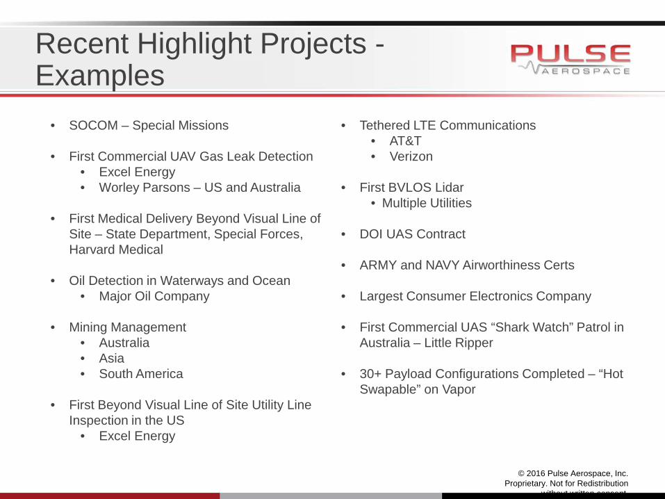
Recent Highlight Projects - Examples
• SOCOM – Special Missions • First Commercial UAV Gas Leak Detection
• Excel Energy • Worley Parsons – US and Australia
• First Medical Delivery Beyond Visual Line of
Site – State Department, Special Forces, Harvard Medical
• Oil Detection in Waterways and Ocean • Major Oil Company
• Mining Management
• Australia • Asia • South America
• First Beyond Visual Line of Site Utility Line
Inspection in the US • Excel Energy
• Tethered LTE Communications
• AT&T • Verizon
• First BVLOS Lidar
• Multiple Utilities
• DOI UAS Contract
• ARMY and NAVY Airworthiness Certs
• Largest Consumer Electronics Company • First Commercial UAS “Shark Watch” Patrol in
Australia – Little Ripper
• 30+ Payload Configurations Completed – “Hot Swapable” on Vapor
VAPOR 55
© 2016 Pulse Aerospace, Inc. Proprietary. Not for Redistribution
without written consent.
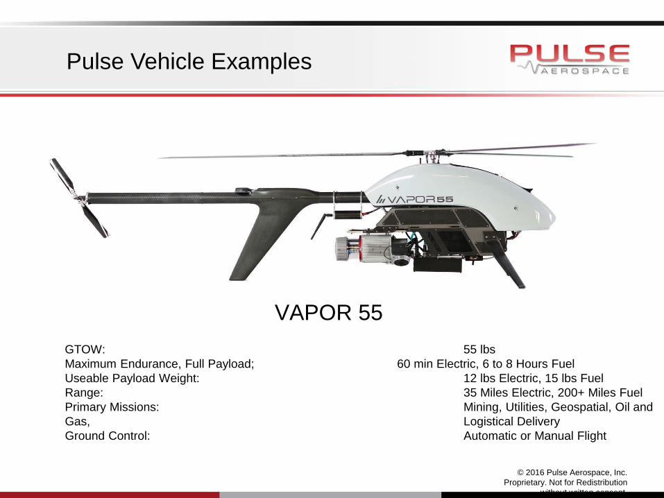
Pulse Vehicle Examples
GTOW: 55 lbs Maximum Endurance, Full Payload; 60 min Electric, 6 to 8 Hours Fuel Useable Payload Weight: 12 lbs Electric, 15 lbs Fuel Range: 35 Miles Electric, 200+ Miles Fuel Primary Missions: Mining, Utilities, Geospatial, Oil and Gas, Logistical Delivery Ground Control: Automatic or Manual Flight

© 2016 Pulse Aerospace, Inc. Proprietary. Not for Redistribution
without written consent.
Vapor 55 – Sample of Integrated Payloads

© 2016 Pulse Aerospace, Inc. Proprietary. Not for Redistribution
without written consent.
Recent Highlight Projects – Gas Leak Detection, Shark Watch

© 2016 Pulse Aerospace, Inc. Proprietary. Not for Redistribution
without written consent.
Recent Highlight Projects – Utility (lidar, Inspection, Line Pulling, Ash Dam)

Recent Highlight Projects – DOS Roof Top Medical Delivery (12 Pounds, 16 miles BVLOS, Fully Automatic)
© 2016 Pulse Aerospace, Inc. Proprietary. Not for Redistribution
without written consent.
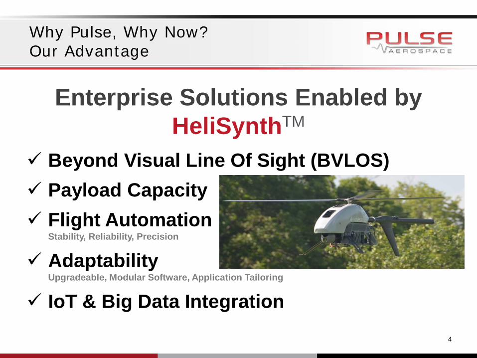
Why Pulse, Why Now? Our Advantage
Beyond Visual Line Of Sight (BVLOS) Payload Capacity Flight Automation
Stability, Reliability, Precision
Adaptability Upgradeable, Modular Software, Application Tailoring
IoT & Big Data Integration
Enterprise Solutions Enabled by HeliSynthTM
4

AN EXPLORATION OF THE COMMERCIAL USE OF DRONES IN AGRIBUSINESS, INFRASTRUCTURE AND MINING
Questions Thank you for joining us today. If you have any questions, please don’t hesitate to contact the speakers below.
122
Thad Lightfoot, Partner Dorsey & Whitney LLP 612.492.6532 [email protected]
David R. White COO Juniper Unmanned 303.668.9860 [email protected]
Jamie Nafziger, Partner Dorsey & Whitney LLP 612.343.7922 [email protected]
Robert Hensley, Partner Dorsey & Whitney LLP 303.352.1172 [email protected]
Aaron Lessig CEO and Chairman Pulse Aerospace, Inc. 303.619.6330 [email protected]
Eileen Lockhart Unmanned Aircraft System (UAS) Program Manager Xcel Energy [email protected]

AN EXPLORATION OF THE COMMERCIAL USE OF DRONES IN AGRIBUSINESS, INFRASTRUCTURE AND MINING
Dorsey & Whitney’s Industry Groups
For more information on the Dorsey & Whitney Food, Beverage & Agribusiness Industry Group, the
Energy Industry Group and the Mining Industry Group, please visit our website at
https://www.dorsey.com/services
Thank you again for joining our drone program today!
123