an empirically-derived taxonomy of interaction primitives ... · turning to the design and...
TRANSCRIPT

1077-2626/13/$31.00 © 2013 IEEE Published by the IEEE Computer Society
Accepted for publication by IEEE. ©2013 IEEE. Personal use of this material is permitted. Permission from IEEE must be obtained for all other uses, in any current or future media, including reprinting/republishing this material for advertising or promotional purposes, creating new collective works, for resale or redistribution to servers or lists, or reuse of any copyrighted component of this work in other works.
An Empirically-Derived Taxonomy of Interaction Primitives for
Interactive Cartography and Geovisualization
Robert E. Roth
Abstract—Proposals to establish a “science of interaction” have been forwarded from Information Visualization and Visual
Analytics, as well as Cartography, Geovisualization, and GIScience. This paper reports on two studies to contribute to this call for
an interaction science, with the goal of developing a functional taxonomy of interaction primitives for map-based visualization. A
semi-structured interview study first was conducted with 21 expert interactive map users to understand the way in which map-based
visualizations currently are employed. The interviews were transcribed and coded to identify statements representative of either the
task the user wished to accomplish (i.e., objective primitives) or the interactive functionality included in the visualization to achieve
this task (i.e., operator primitives). A card sorting study then was conducted with 15 expert interactive map designers to organize
these example statements into logical structures based on their experience translating client requests into interaction designs.
Example statements were supplemented with primitive definitions in the literature and were separated into two sorting exercises:
objectives and operators. The objective sort suggested five objectives that increase in cognitive sophistication (identify, compare,
rank, associate, & delineate), but exhibited a large amount of variation across participants due to consideration of broader user
goals (procure, predict, & prescribe) and interaction operands (space-alone, attributes-in-space, & space-in-time; elementary &
general). The operator sort suggested five enabling operators (import, export, save, edit, & annotate) and twelve work operators
(reexpress, arrange, sequence, resymbolize, overlay, pan, zoom, reproject, search, filter, retrieve, & calculate). This taxonomy
offers an empirically-derived and ecologically-valid structure to inform future research and design on interaction.
Index Terms—Science of interaction, interaction primitives, interactive maps, geovisualization, interaction techniques
1 INTRODUCTION
Information visualization involves both representation and interaction [1-3]. An information visualization professional must be skillful at the design and execution of graphic representations that legibly and engagingly encode information about real-world phenomena, as well as the design and implementation of graphic interfaces that effectively and efficiently enable users to manipulate these representations. Luckily, the professional can draw from decades of scientific insights on visual perception, visual cognition, and visual semiotics to inform the design and execution of the representation [4]. Among the most important breakthroughs regarding the science of representation was establishment of the visual variables, or basic building blocks of a graphic representation that altogether constitute the graphic language [5]. Such a taxonomy of representation primitives not only exposed the dimensions across which a graphic can vary to encode information, but also provided a theoretical structure for developing a deeper understanding of representation through scientific experimentation [6].
The information visualization professional is less lucky when turning to the design and implementation of the interface. There exist several formative works on interaction design [7-9] and a growing number of synthesis resources within Information Visualization that treat equally the topics of representation and interaction [10-12]. Yet, much work remains regarding the science of interaction [13], with establishment of a broadly applicable taxonomy of interaction
primitives—or basic building blocks of interactivity—considered the “grand challenge” of this nascent interaction science [14]. That is not to say that a functional taxonomy of interaction primitives has yet to be offered; as described below, there are many and they vary widely. One limitation of extant taxonomies potentially contributing to this variation is that few are empirically-derived; see the work of Amar et al. [15] and Yi et al. [2] for recent exceptions.
The research reported here takes an empirical approach to
establishing an interaction primitive taxonomy that is specific to interactive maps, or visualizations representing the two-dimensional data type [16, 17]. Geovisualization is a well-established research thrust within Information Visualization, drawing upon and contributing to research on Cartography and GIScience [18-20]. Proposals for a science of “cartographic” interaction from Interactive Cartography and Geovisualization mirror those in Information Visualization [21-24]. While the proximate goal of this research is establishment of an empirically-derived and ecologically-valid taxonomy of cartographic interaction primitives, the research was designed to contribute to interaction science broadly.
The paper is organized into five additional sections. In the next section, background is provided on two published frameworks regarding the science of cartographic interaction [25, 26]; the purpose of the background section is not to duplicate these literature review efforts, but to introduce and define core concepts from these reviews that informed the research reported here. The third section describes the design of two empirical studies leveraging professionals in Interactive Cartography and Geovisualization. Semi-structured interviews were completed with 21 expert interactive map users to elicit example statements indicating either user tasks (i.e., objectives) or interactive functionality (i.e., operators). A card sorting study including two sorting exercises (objectives vs. operators) was completed by 15 expert interactive map designers to organize these statements into logical structures. The fourth and fifth sections provide results for and discussion of the objective and operator sorting exercises, respectively. Limitations and future directions are provided in the sixth and final conclusion section.
2 BACKGROUND
2.1 Fundamental Questions for Interaction Science
The scope of interaction science has been addressed by a range of scholars, as indicated above [7-14]. Drawing from these reviews, Roth [25] proposed a research agenda for cartographic interaction science organized according to six fundamental questions: (1) what? is cartographic interaction, (2) why? provide cartographic interaction, (3) when? should cartographic interaction be provided, (4) who? should be provided cartographic interaction, (5) where? should
Robert E. Roth is an Assistant Professor at the University of Wisconsin-
Madison. E-mail: [email protected].
Manuscript received 31 March 2013; accepted 1 August 2013; posted online
13 October 2013; mailed on 4 October 2013.
For information on obtaining reprints of this article, please send
e-mail to: [email protected].

cartographic interaction be provided, and (6) how? should cartographic interaction be provided.
Each of these questions relates to key themes within Interactive Cartography and Geovisualization specifically, and Information Visualization and Visual Analytics broadly. The what? question grapples with the definition of interaction, accepting a distinction between interaction (user experience design) and interface (user interface design) [27]. The interaction includes three components: (1) the human (resulting in a user-centered perspective), (2) the visualization (interface-centered), and (3) a mediating computing device (technology-centered). The why? question approaches the value of interaction, relating to broad discussions on distributed cognition [28], visual thinking [29], and insight generation [30] as well as specific sets of user goals, such as DiBiase’s [31] stages of science or Pirolli & Card’s [32] sensemaking loops.
The when?, who?, and where? questions provide context for the interaction from interface-centered, user-centered, and technology-centered perspectives, respectively. The when? question addresses the times interaction supports work or play, connecting with research on productivity [33] and work vs. enabling interactions [34]; the when? question often is a matter of how much? interface to provide, linking to discussions on flexibility vs. constraint [35] and usability vs. utility [36]. The who? question investigates how interaction differs across variation in user ability [37], user expertise [38], and user motivation [39] and relates to research on universal usability [40], user-centered design [8], computer supported cooperative work [41], and geocollaboration [42]. The where? question examines the constraints imposed by the computing technology, including input capabilities [43], bandwidth & processing power (together impacting system response time [44]), and display capabilities [11].
Finally, the how? question approaches both the process of a user interaction—or how individual interaction exchanges accrue into larger interaction strategies—as well as the process of designing interfaces that support these interactions. The how? question of representation was enlightened by identification and articulation of the visual variables [5]; similarly, it is the how? question of interaction that requires the identification and articulation of a taxonomy of interaction primitives, as such a taxonomy exposes the dimensions across which an interaction may vary (and thus allows for diagnosis of suboptimal interaction strategies) as well as provides a theoretical structure for approaching all six of the fundamental questions through scientific experimentation.
2.2 Primitives Taxonomies and Stages of (Inter)action
Many scholars have contributed taxonomies of interaction primitives to inform the how? question of an interaction science, but the nature of these taxonomies varies considerably. Roth [26] demonstrated that much of this variation is explained when considering Norman’s [8] stages of (inter)action model. The stages of interaction model considers the way in which humans interact with physical or virtual objects—described as the interaction operand—and separates a single interaction exchange into seven observable stages: (1) forming the goal (identifying an ill-defined task, or goal, motivating use of the visualization), (2) forming the intention (identifying a well-defined task, or objective, that can support the goal), (3) specifying the action (identifying a system function, or operator, that may support the objective), (4) executing the action (evoking the operator on the operand), (5) perceiving the state of the system (seeing the change to the operand caused by the operator), (6) interpreting the state of the system (understanding the meaning of this change), and (7) evaluating the outcome (comparing this new meaning to the initial goal to see if the goal has been achieved).
Most extant taxonomies compartmentalize interaction according to objectives, operators, and/or operands, although theoretically a taxonomy of interaction primitives may be formulated at any of the stages of interaction. Objective taxonomies parse interaction according to the user's intention in employing the interface (Stage #2) and represent the user’s input into the interaction exchange; alternative terminology for objectives include “operations” [45-48],
“intents” [2], and “tasks” [15, 49-51]. Operator taxonomies parse interaction according to the functionality constituting an interface (Stage #3) and describe the generic kinds of methods for manipulating a visualization [52, 53]; alternative terminology for operators include “behaviors” [54, 55], “interaction forms” [47, 56], “interaction kinds” [57], “interaction modes” [58], “interaction techniques” [17], “manipulations” [1], “operations” [59], and “tasks” [16]. Finally, operand taxonomies parse interaction according to the recipient of the operator and describe characteristics of the visualization that impact the interaction exchange [53]; most operand taxonomies emphasize the “state” of the visualization [52, 60-62] or the “type” of visualized information [16, 17, 46, 48, 51, 63].
While the stages of interaction model reconciles the underlying nature of extant interaction primitive taxonomies, the primitives included within each group of objective, operator, or operand taxonomies still vary considerably. Further, different terms commonly are used to describe the same interaction primitive, or the same term is used to describe different primitives (as with the varied use of the terms “operations” and “task” to mean either objectives or operators). The research reported here was designed to provide insight for explaining and resolving this variation in primitive content and terminology at each stage of interaction.
3 METHODS
A pair of studies was conducted to elicit feedback from expert professionals whose work required daily engagement with the design or use of map-based visualizations. The mixed method, empirical approach was adopted to leverage expert knowledge for both the generation and organization of interaction primitives: (1) an interview study was conducted to generate ecologically-valid example statements representative of primitives and (2) a card sorting study with two sorting exercises was conducted to organize these statements into a practically-functional taxonomy of interaction primitives. Because the operand was assumed to be fixed in the context of map-based visualization (e.g., the two-dimensional data type from [16, 17]), the studies were designed to establish a taxonomy of objectives-by-operators only. The objective card sort also revealed insights into goals and operands, an indication that a “task” comprises a goal+objective+operand combination.
3.1 Interview Study Design
An interview study was conducted with 21 expert interactive map users to generate example statements of interaction primitives that reflect real-world applications of map-based visualization. Participants were recruited from one of seven application domains that make use of map-based visualizations: (1) Emergency Response & Crisis Management, (2) Environmental Science & Human-Environment Geography, (3) Epidemiology & Public Health, (4) History & Historical Geography, (5) Intelligence Analysis, (6) News & New Media, and (7) Resource Management. Between two and four participants were interviewed from each of the seven domains to ensure that each was well represented. All participants (21 of 21) had earned at a Bachelor's degree in the given application domain and the majority (17 of 21) of participants had earned a graduate degree.
The interview protocol followed a semi-structured approach [64]. Questioning proceeded in three sections, each aimed at digging deeper into the participant’s use of map-based visualizations. In the first section, participants were asked to describe their daily work tasks and characteristics of the geographic information they visualize to support these tasks; no explicit reference was made to objectives or operators in this section to elicit example statements without prompting. In the second section, participants were asked to demonstrate and discuss the map-based visualizations they use in their daily work. In the final section, participants were provided background on the six fundamental questions reviewed above and asked directly about objectives and operators. Interview sessions lasted between 60 and 90 minutes and were conducted at the participant’s work location in a private room.

Fig. 1. The WebSort Card Sorting Interface (websort.net)
3.2 Interview Analysis and Card Sets
The interviews were audio-recorded and subsequently transcribed for qualitative data analysis [65]. Two independent coders with training in Interactive Cartography and Geovisualization were hired to identify statements in the transcripts that exemplified either an objective or operator; coders were trained on an example transcript and discussion was held to clarify disagreements. Across the 21 transcripts, the pair of independent coders identified 545 statements representative of objectives and 823 statements representative of operators, which subsequently were filtered to 138 and 155 statements for inclusion in the card sorting study. Four criteria were used to filter the statements: (1) the statement must be identified as an objective or operator by both coders, (2) the statement indicating an objective or operator could not be repeated exactly within a single interview session (only one of a set of duplicates was included), (3) statements describing examples of objectives or operators must have a clear referent, and (4) the statements must identify objectives that are geographic in nature or operators that are cartographic in nature.
These two sets of primitives then were supplemented by definitions of primitives included in extant objective taxonomies [2, 15, 45-49, 51, 66] or operator taxonomies [1, 16, 17, 47, 52-59]. The taxonomies reviewed above include 55 objective primitives and 72 operator primitives; this set was filtered to 40 and 51, respectively, based on two criteria: (1) a complete definition must be provided for every primitive in the taxonomy; and (2) if the taxonomy is based on a prior taxonomy, the taxonomy must extend or revise the original. The combination of statements from interviews and definitions from the literature resulted in 178 objective statements and 206 operator statements for inclusion in the card sorting study (Table 1), frequencies near the recommended maximum of 200 cards [67]. The complete sets of objective and operator statements are available as supplementary materials.
Table 1. Original versus Final Card Frequency
Sort Interviews Literature Total
orig. final orig. final orig. final
Objectives 545 138 55 40 600 178
Operators 823 155 72 51 895 206
3.3 Card Sorting Study Design
A card sorting study was conducted with 15 expert interactive map designers to organize the objective and operator cards into logical structures using their real-world experience translating client requests into interaction designs. Card sorting requires participants to organize a set of cards into internally-homogenous categories based on similarity along an identified sorting criterion [68]. The card sorting study included different sorting exercises for objectives and operators; all 15 participants completed both card sorting exercises. The sample size (n=15) meets recommendations for the card sorting method to balance between explanatory power and project resources [69]. All participants (15 of 15) had earned at a Bachelor's degree in a discipline related to information science (e.g., GIS) and the majority (13 of 15) of participants had earned a graduate degree.
Both card sorting exercises followed the guided sorting approach in which the cards and sorting criterion are provided, but the categories into which the cards must be sorted are created and named by the participants [70]. Before starting each card sorting exercise, participants reviewed a written description of the sorting criterion for the given exercise (i.e., the concept of objectives or operators). Participants were not given example categories to avoid biasing the sort and were instructed to avoid sorting the cards according to the seven application domains (i.e., participants were asked to make connection across domains, rather than sort according to domain).
Both card sorting studies were administered online using the WebSort card sorting tool [71]. WebSort uses a tabletop metaphor for card sorting, providing a drag-and-drop interface solution for moving the cards from the left card stack to the central workspace
(Fig. 1). Participants were instructed to create a ‘Discard’ category for cards that were not examples of an objective or operator as well as an ‘Other’ category for cards that were clearly objectives or operators, but did not fit cleanly into the participant’s classification. Once all cards were sorted, participants were instructed to refine their structure by reviewing the category contents and making modifications where appropriate. Before submitting their sorting structure, participants were required to provide a name for each created category and an explanation about their sorting approach using the ‘Leave a comment’ tab. Most participants completed the pair of card sorting exercises within 150 minutes, with a maximum of 180 minutes; participants were compensated $50 for their time.
3.4 Card Sorting Analysis
The primary metric used to interpret guided card sorts is pairwise (card-vs-card) agreement, defined as the percentage of participants that rated a given pair of cards as members of the same category [72]. The sorts were analyzed statistically by applying average link hierarchical clustering on pairwise agreement scores [73]. While hierarchical clustering exposes consolidated groupings of similar cards and key areas of confusion across the sorting strategies, it does not prescribe the optimal number of clusters. A pair of statistical information graphics was generated for each card sorting exercise to facilitate interpretation of the hierarchical clustering results: (1) an interactive dendogram, with cards ordered according to the clustering results, and (2) a pairwise agreement matrix, with cards ordered by the clustering results and matrix cells shaded by pairwise agreement. The objective and operator matrices are shown in Fig. 2 and Fig. 3, respectively; only one half of the symmetrical matrices are shown for space. The final clusters—and thus the primitives included in the taxonomy—were identified through a combination of the hierarchical clustering results, the pair of information graphics, and the qualitative feedback provided through the ‘Leave a comment’ tab; the 16 clusters (Fig. 2: A-P) identified from the objective sort are discussed in Section 4 while the 17 clusters (Fig 3: A-Q) identified from the operator sort are discussed in Section 5.
The reliability of the clusters was evaluated by examining their stability within subsets of participant sorts [74, 75]. For each card sorting exercise, the set of 15 sorts was divided into three groups of n=5 (sample A, B, and C), with these samples then combined to produce three composite samples of n=10 (A+B, A+C, B+C) such that each individual participant sorting strategy was included in two of the three composite samples [76]. The pairwise agreement matrix for each sample was compared against the identified clusters from the overall pairwise agreement matrix (i.e., the baseline) to identify the pairs of cards that were categorized differently in the given sample compared to the baseline. The number of card pairs categorized similarly in the sample and baseline was tallied and

divided by the total number of card-by-card pairs in the baseline, resulting in a similarity percentage. The three objective samples shared on average 63.0% similarity with the overall objective clusters while the three operator samples shared on average 83.3% similarity with the overall operator structure. The distinction between reliability measures indicates that participant sorting strategies varied much more for the objective card sorting study compared to the operator card sorting study. Discussion of the variation in the objective sorting exercise is provided in Section 4.
4 RESULTS AND D ISCUSSION: OBJECTIVES
4.1 Participant Agreement on Objectives
Structures elicited from participants in the objective card sorting exercise exhibited a large amount of variation, as indicated by the similarity score of only 63.0% for the objective card sorts. Participant comments provided through the ‘Leave a comment’ tab explicated much of the observed variation across participant sorting strategies. While the order of cards resulting from the hierarchical clustering primarily reflects the provided objective criterion, participants applied at least three competing criteria while sorting. In other words, many participants used additional salient qualities within the objective card set to subdivide the initial objective categories further. Two of these criteria are related to the interaction operand (Section 4.2) while the third suggests a potential set of user goals (Section 4.3). Five objective primitives were identified after controlling for operands and user goals (Section 4.4).
4.2 Operand Primitives
As stated above, an individual card sorting exercise was not included for operand primitives due to the emphasis on map-based visualizations. However, many of the objective cards included the operand as part of the statement. While the identification of operand primitives was an unplanned benefit of the objective sort, not all participants applied the operand sorting criterion in their sorting strategies, as they were not instructed to do so. The inconsistent application of the two operand sorting criteria explains much of the variation across participant sorts.
Both of the competing operand sorting criteria closely match dimensions from the Andrienko et al. [48] operational task taxonomy. The most influential operand sorting criterion was the search target, which includes location, time, and objects as operand primitives [63]. Many participants maintained an emphasis on the spatial/geographic search target in their category names, resulting in a three-part operand taxonomy that is explicitly cartographic:
(1) Space-Alone: The space-alone operand describes interactions with the geographic component of the visualization only.
(2) Attributes-in-Space: The attributes-in-space operand describes interactions with the mapped attributes to understand how characteristics or qualities of geographic phenomena vary in space.
(3) Space-in-Time: The space-in-time operand describes interactions with the temporal component of the map to understand how geographic phenomena change over time.
When participants applied this three-part operand distinction, it was to differentiate within the five objectives. Three objectives were composed of two smaller clusters discriminated by the space-alone vs. attributes-in-space operands; compare (Figs. 2K & 2A), rank (Figs. 2L & 2M), and delineate (Figs. 2H & 2G). Cards exemplifying the space-in-time operand were contained in a single cluster regardless of objective (Fig. 2I), with the exception of space-in-time instances of the associate objective (Fig. 2B), which primarily include objectives regarding trends and cause/effect relationships over time. Table 2 provides example cards for each objective and operand combination.
The second applied operand sorting criterion relates to Andrienko et al.’s [48] search level, or the percentage of all map features under consideration. Andrienko et al. simplify Bertin’s [5] levels of map
reading to include only two search levels: elementary (one map feature) and general (several-to-all map features). The pairwise agreement matrix reflects participant sorting on both search target and search level within the identify objective only, resulting in four clusters: (1) attributes-in-space at the general level (Fig. 2J), (2) space-alone at the general level (Fig. 2N), (3) attributes-in-space at the elementary level (Fig. 2O), and (4) space-alone at the general level (Fig. 2P). Participants were less inclined to sort according to search level within the other objective primitives, perhaps because there were less total instances of the other objectives in the objective sorting exercise. Other characteristics of the interaction operand, such as the state of the visualization [52, 60, 61] or the type of visualized information [17, 46, 51], did not appear to influence sorting.
4.3 Interaction Goals
The majority of participants isolated a small set of cards according to the “cognitive involvement” of the objective, a distinction related to user goals introduced in Section 2. Most of the included objective cards provide examples of basic information retrieval from the map. However, roughly two dozen of the cards required what participants described as a “broader assessment” or “advanced decision making.” The objective pairwise agreement matrix indicates that participants generally separated these cards from the rest of the set, resulting in two clusters. The objective card sorting exercise therefore identified three broad user goals motivating use of the visualization:
(1) Procure: The procure goal describes interactions that are performed to retrieve information about the represented geographic phenomena. Approximately 150 of the 176 cards included in the objective sort exemplify this user goal, indicating that procure perhaps is the most common goal motivating use of visualizations (or the easiest to articulate).
(2) Predict: The predict goal describes interactions that are performed to forecast what may occur in the future based on current conditions (Fig. 2F). The predict goal is an order of magnitude more complex cognitively than procure, as the user must combine the insight procured interactively from the visualization with their domain knowledge and past experience to estimate what may occur at a later date.
(3) Prescribe: The prescribe goal describes interactions that are performed to decide what should occur in the future based on current conditions and future predictions (Fig. 2E). The prescribe goal is the most complex cognitively of the three goals, as it requires prediction of what is likely to happen in the future with an additional intervention step to alter the future course towards one deemed optimal.
4.4 Objective Primitives
The objective card sorting study revealed five objective primitives once resolving the competing sort criteria. The clusters associated with each objective are proximate in the pairwise agreement matrix, with the exception of compare (Fig. 2A & 2K). Such overall proximity of clusters indicates that the concept of objectives remained the most influential criterion on participant sorts, with the operand and goal criteria applied to refine the categories further.
There is disagreement in the literature if objective ‘primitives’ must be on the same semantic level of meaning. Yi et al. [2] argued against inclusion of primitives that vary in their level of meaning; they did not include the compare objective because it was considered a composite of two identify objectives. In contrast, Crampton [51] purposefully included objective primitives that increase in sophistication along a continuum from basic to complex. Most participants accepted such a continuum in their objective sort; one participant stated that the sort followed a “progression from simple objectives to complex” while a second stated that the categories varied from “simple geographic non-computational questions [and] actions” to “complex geographic inquiries.” The five objective primitives increase in sophistication in the following order:

Table 2. Examples of Each Objective and Operand Combination
(1) Identify: The identify objective describes interactions that examine an individual map feature. The identify objective is included in a majority of extant taxonomies [45-50], and describes a geographic search (i.e., ‘find in space’) with regard to the space-alone operand (Figs. 2P & 2N) and an attribute search (i.e., ‘find attribute value’) with regard to the attributes-in-space operand (Figs. 2O & 2J). This difference is synonymous with the distinction between spatial search and thematic search in GIS [77] and is related to the inclusion of a locate primitive in some objective taxonomies [46, 49] to discriminate between identify in space (locate) versus attribute (identify generally). When applied to the space-in-time operand primitive, the identify objective describes a temporal search (i.e., ‘find in time’) or a spatial search with time a constraint (Fig. 2I).
(2) Compare: The compare objective describes interactions that determine the similarities and differences between two map features. The compare primitive also is included in the majority of extant taxonomies [45-51]. Regarding the space-alone operand, the compare objective examines the difference in bearings or distances of two map features to a reference point as well as the difference in the distributions (e.g., extent or shape) of two kinds of geographic phenomena (Fig. 2K). When the compare objective is applied to the attributes-in-space operand, the compare objective evaluates the difference between attribute values of two map features (numerical) or determines if the map features are members of the same or different feature type (categorical) (Fig. 2A). Finally, the compare objective applied to the space-in-time operand examines the time between two geographic events or the difference between geographic patterns exhibited at different time periods, temporal composites, or temporal resolutions (Fig. 2I).
(3) Rank: The rank objective describes interactions to determine the order or relative position of three or more map features. The rank objective is included in several extant taxonomies [46, 49] and relates to Amar et al.'s [15] find anomalies and find extremum (outliers) objectives. When applied to the space-alone operand, the rank objective orders map features by spatial proximity to a reference point (i.e., ‘nearest’ or ‘farthest’) (Fig. 2L); map features also can be ranked according to bearing and size, although no statements were elicited indicating this use of rank. Regarding the attributes-in-space operand, the rank objective orders map features according to a numerical (i.e., ‘most’ or ‘least’) or ordinal (e.g., ‘best’ or ‘worst’) attribute (Fig. 2M). Finally, the rank
objective applied to the space-in-time operand orders map features according to temporal proximity (i.e., ‘first’ or ‘last’) or other temporal characteristics, such as their temporal extent or position in cyclical time (Fig. 2I).
(4) Associate: The associate objective describes interactions to characterize the relationship among multiple map features. The associate objective is included in several extant taxonomies [46, 49]. When applied to the space-alone operand, the associate objective describes the strength of spatial connectedness (Fig. 2D). Interestingly, the associate in space-alone cluster also included cards describing routes between locations and topology among regions, instances that are not the prototypical example of associate but do characterize relationships in space nonetheless. Regarding the attributes-in-space operand, the associate objective is synonymous with the more specific correlate primitive included in several objective taxonomies [15, 46, 49], in which two variables are characterized according to their dependency on one another (Fig. 2C). When applied to the space-in-time operand, the associate objective includes determining trends over time as well as cause and effect relationships. As noted above, associate is the only objective with a cluster specific to the space-in-time operand (Fig. 2B), indicating the salience of temporal trends in the cards.
(5) Delineate: The delineate objective describes interactions that are performed to organize map features into a logical structure. The delineate objective encapsulates the categorize and cluster objectives included in extant taxonomies [46, 49]. When applied to the space-alone operand, the delineate objective divides map features into internally homogenous and externally identifiable geographic neighborhoods or regions (Fig. 2H). Regarding the attributes-in-space operand, the delineate objective divides map features into internally homogenous and externally identifiable groups according to feature characteristics (Fig. 2G). Finally, the delineate objective applied to the space-in-time operand divides map features into internally homogenous and externally identifiable eras; the delineate by space-in-time cluster also included cards describing the delineation of spikes and troughs in dynamic geographic phenomena (Fig. 2I).
Table 2 provides an example card for each objective-operand combination. The salient nature of goals, objectives, and operands in the card set suggests that a “task” is only meaningful and achievable when the goal, objective, and operand are articulated. Therefore, examples of all relevant goal+objective+operand task combinations should be included in task protocols when evaluating visualizations.
Objective Space-Alone Attributes-in-space Space-in-time
Identify find in space (where?) find attribute value (what? or who?) find in time (when?)
identify your house based on an aerial image
in Google Earth
what explosives materials are known to be
inside a building that is on fire?
how many hotels were in the town in the late
1800s?
Compare difference between bearings, distances,
extents, or shapes
difference between values (numerical); same
or different type (categorical)
difference in time lengths, composites, or
resolutions; change
compare the distribution of patients over 65
years old to the distribution of patients not
treated with radiation
discern between two types of policies on the
map
compare the historic vegetation to the
current vegetation
Rank order by nearest/farthest order by most/least, best/worst order by first/last
where are the nearest schools to the toxic
chemical release?
which county has the highest mesothelioma
mortality rate?
have any apprehensions occurred in the last
seven days in this area?
Associate strength of connectedness; routing/topology correlation between variables trend across time; cause/effect
this small town community is connected to
which major urban systems?
is socioeconomic status correlated spatially
to gonorrhea rates?
see if the remediation procedure resulted in
reducing the geographic extent of the
chemical
Delineate division into distinct regions;
clustered/disperse
division into distinct types according to
attribute values division into distinct periods; spikes/troughs
where are the high risk clusters of disease
morbidity?
find clusters of similar attribute values
within a set of map features
look into a spike of disorderly conduct cases
in an area
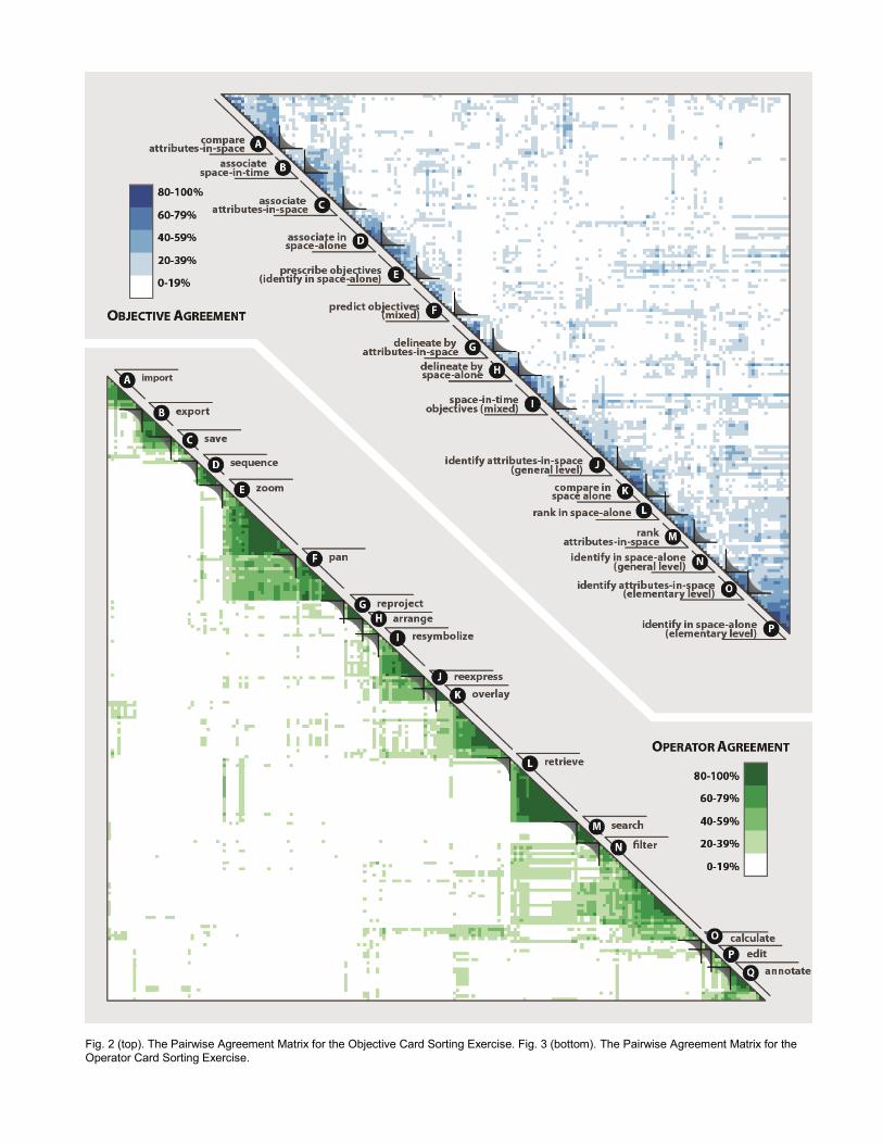
Fig. 2 (top). The Pairwise Agreement Matrix for the Objective Card Sorting Exercise. Fig. 3 (bottom). The Pairwise Agreement Matrix for the
Operator Card Sorting Exercise.

5 RESULTS AND D ISCUSSION: OPERATORS
5.1 Participant Agreement on Operators
Unlike the objective sort, structures elicited during the operator card sorting exercise exhibited a high degree of similarity, as indicated by a similarity score of 83.3%. The consistency across participants is illustrated by the Fig. 3 pairwise agreement matrix, which shows clusters as triangular-shaped subsets of card pairs along the diagonal axis. Interestingly, participants appeared to isolate work operators, which accomplish the desired objective, from enabling operators, which are required to prepare for or clean up from work operators [34]. Several extant operator taxonomies also distinguish enabling and work operators [2, 16, 52]. Section 5.2 and Section 5.3 discuss clusters indicating enabling and work operators, respectively.
5.2 Enabling Operator Primitives
Enabling operators are isolated at both ends of the diagonal in Fig 3, while work operators are grouped in the center. Approximately 25% (50 of 206 cards) describe enabling interactions, illustrating the importance of considering enabling operators when conceptualizing and designing visualizations. Analysis of the operator sort indicated five enabling operators:
(1) Import: The import operator describes interactions that load a dataset or previously generated map (Fig. 3A). The import operator is applied primarily at the beginning of an interaction session to initialize the visualization, but can be performed throughout the session if additional datasets are needed. The import cluster also included cards describing dynamic loading of real-time data feeds from web services.
(2) Export: The export operator describes interactions that extract a generated map or the geographic information underlying the map for future use outside of the visualization (Fig. 3B). The export operator is the conceptual opposite of the import operator and generally is performed when moving to a different map use setting in order to clean up from prior work interactions within the current setting. The new setting may support analog map use only, such as printing a hardcopy of the map or generating a text-based report.
(3) Save: The save operator describes interactions that store the generated map, the geographic information underlying the map, or the system status for future use within the visualization (Fig. 3C). The save and export operators are conceptually similar, with the primary difference being the future setting of map use (internal versus external). The save operator supports undo and redo interactions, a pair of enabling interactions related to history [16]; participants did not distinguish between save and undo/redo in their sorting approaches, given their reliance on each other.
(4) Edit: The edit operator describes interactions that manipulate the geographic information underlying the map, which then alters all subsequent representations of that information (Fig. 3P). The edit operator reinforces state-based operand taxonomies [52, 60, 61], distinguishing operators applied to the data-state (edit) from those applied to the visualization-state (work interactions). Based on participant card sorting, all enabling interactions (e.g., add, create, delete, join, and manipulate objects) listed by Chuah & Roth [52] fall within the scope of the edit operator.
(5) Annotate: The annotate operator describes interactions that add graphic markings and textual notes to the visualization (Fig 3Q). Annotation relates to the use of maps in support of distributed cognition [28], with the annotate operator explicitly facilitating visual thinking by allowing the user to externalize insights directly onto the map as they interact with it [29]. Therefore, the annotate operator is less an enabling interaction applied to prepare for or clean up from work interactions, but instead an enabling interaction that enhances the analytical value of work interactions.
5.3 Work Operator Primitives
The operator card sorting study revealed a diverse set of 12 work operators that are distinct from the enabling operators reviewed above. Interestingly, neither brushing nor linking—two of the three most common operator primitives found in extant taxonomies [26]—were separated into a cluster. Statements in the ‘Leave a comment’ tab described brushing as a two-step process in which the direct manipulation interface style is used to assign an operator to one or more map features of interest (brushing+operator), with linking then a coordination to other views (brushing+operator+linking). As one participant stated, “operators that happen when a user brushes the display could be in several different categories...all methods for extracting information are treated together, whether that is by brushing, clicking, or the identify tool.”
The 12 work operators span across four broad and overlapping categories: (1) operators that manipulate the kind, layout, and order of maps (reexpress, arrange, & sequence respectively); (2) operators that manipulate the design of the map (resymbolize, overlay, & reproject); (3) operators that manipulate the user’s viewpoint to the map (pan & zoom); and (4) operators that further examine features within the map (filter, search, retrieve, & calculate). The grouping of operator primitives in Fig. 3 generally reflects these four categories, with several exceptions (e.g., sequence is located next to the enabling operators import, export, & save; reproject is located next to pan & zoom). Work operators include:
(1) Reexpress: The reexpress operator describes interactions that change the visual isomorph [35, 78] (Fig. 3J). The term “dynamic reexpression” originates from Tukey [79] and is included in several operator taxonomies [54, 55]. Cartographically, the reexpress operator describes a change to the kind of map displayed (choropleth, proportional symbol, dot density, etc.), an operator primitive alternatively described as altering representation type [56], encode data [52], and same data, changing representation [57]. Cards included in the reexpress cluster also include transformations to the original geographic information that produces a new visual isomorph, which can be based on attributes in the dataset (e.g., switching between linear and logarithmic) or the temporal component of the dataset (e.g., switching between linear and composite representations of time).
(2) Arrange: The arrange operator describes interactions that manipulate the layout of views in a coordinated visualization (Fig. 3H), an operator included by Buja et al. [1]. Interestingly, the small subset of cards referencing linking were sorted by participants into the broader arrange operator.
(3) Sequence: The sequence operator describes interactions that generate an ordered set of related maps (Fig. 3D), an operator included in several taxonomies [47, 58]. The generated set of maps shows only a subset of the geographic information (rather than a visual isomorph of equivalent information content), as in the case of static small multiples or dynamic animations. While all cards in the sequence cluster described temporal animations (the space-in-time operand), the sequence operator also may generate an animation according to the geographic or attribute information components.
(4) Resymbolize: The resymbolize operator describes interactions that change the design parameters of a map type without changing the map type itself (Fig. 3I). Parameters of the resymbolize operator are specific to the map type, with cards describing interactions with the classification scheme (all graduated map types), the color scheme (choropleth or hypsometric tinting of isoline), the dot value (dot density), the contour interval (isoline), the scaling ratio (proportional symbol), and the basemap styling (reference maps). The resymbolize operator is described alternatively in extant taxonomies as altering symbolization [56], colormap manipulation [47, 58], same representation, changing parameters [57], and set-graphical-value [52].

(5) Overlay: The overlay operator describes interactions that adjust the feature types included in the map (Fig. 3K). Cards included in the overlay cluster describe adding or removing context layers in reference mapping (i.e., toggle visibility [56]) and changing the mapped attribute in thematic mapping (i.e., assignment [47, 58]). The overlay operator differs from reexpress in that information is either added or removed from the map (i.e., the new map is not a visual isomorph).
(6) Reproject: The reproject operator describes interactions that change the map projection translating coordinates on the curved Earth to a flat plane (Fig. 3G). The reproject operator is synonymous with Edsall et al.’s [56] re-projection operator, but different than Keim’s [17] dynamic projection operator, which primarily applies to the assignment of variables to the axes of a multivariate representation.
(7) Pan: The pan operator describes interactions that change the geographic center of the map and is used when a portion of the map is off screen (Fig. 3F). The pan operator is included in one extant taxonomy [56] and is described as observer motion [54, 55] or viewpoint manipulation [47, 58] when combined with zoom. Interestingly, participants included cards describing changes to the viewing angle as part of the pan operator, rather than splitting this subset of interactions into a separate operator, such as object rotation [54, 55].
(8) Zoom: The zoom operator describes interactions that change the scale and/or resolution of the map (Fig. 3E). Cards included in this cluster describe magnification or reduction of the map (i.e., a change in map scale) as well as increase or decrease in detail without changing scale (i.e., a change in map resolution); this latter use of zoom operator relates to the initial definition of focusing [1]. Zoom is included as an operator primitive in several operator taxonomies [16, 17, 56] and is combined with pan in descriptions of observer motion [54, 55] and viewpoint manipulation [47, 58].
(9) Filter: The filter operator describes interactions that identify map features meeting one or a set of user-defined conditions (Fig. 3N). The filter operator is included in several taxonomies [16, 17] and is synonymous with some uses of focusing [47, 58] and conditioning [56]; see Roth [26] for a discussion on the varied use of the term focusing in the literature. Application of the filter operator often results in removal of the map features that do not meet user-defined criteria (i.e., delete), but also may emphasize the matching map features (highlight), deemphasize non-matching map features (shadow highlight), or add labels to the matching map features (label) [59]; this similarity between filter and Becker & Cleveland’s “brushing operations” perhaps explains why participants grouped cards denoting instances of brushing multiple map features within the filter cluster.
(10) Search: The search operator describes interactions that identify a particular location or map feature of interest (Fig. 3M). The search operator is conceptually similar to the filter operator and can result in a similar user experience. A key difference is that the search operator looks for a direct match on a single identifier (typically the name, address, or timestamp of the feature), while the filter operator looks for matches within a subset of values (for categorical variables) or across a range of values (for numerical variables) in one or more facets of the dataset. Thus, search directly enters the map to locate a feature of interest that is already known, while filter iteratively refines the map to identify potential features of interest. The majority of participants isolated a set of seven cards that denote the search objective from the larger set of cards constituting the filter operator, indicating that there is a salient difference between the two operators.
(11) Retrieve: The retrieve operator describes interactions that request specific details about a map feature or map features of interest (Fig. 3L). The retrieve operator is synonymous with uses of accessing extra information [57], accessing
exact information [56], and details-on-demand [16]. The retrieve operator commonly is implemented using the direct manipulation interface style, perhaps explaining why most card examples illustrating brushing of a single map feature were sorted by participants into the retrieve cluster; retrieve is not specific to a single interface style—like all primitives identified through the operator card sorting study—and can be implemented through other, non-direct interface styles.
(12) Calculate: Finally, the calculate operator describes interactions that derive new information about map features of interest (Fig. 5O). The calculate operator can generate simple spatial measurements and descriptive statistics as well as steer complex spatial models and geocomputational routines. The calculate operator is important to the call in Visual Analytics for a tighter integration between visualization and computation [14]; that there are only three cards in the calculate cluster is an indication that such integration between visualization and computation is inadequate in Interactive Cartography and Geovisualization.
Table 3 provides an example card for each enabling and work operator identified from the operator card sorting exercise.
Table 3. Examples of Each Enabling and Work Operator
Operator Card Example
Enabling Operators
Import get started by loading a stock map design of the world
Export export the maps as a .pdf
Save save the map so that you can come back later to make a
modification
Edit select a point to change the attribute data
Annotate mark up the map to show where to send resources
Work Operators
Reexpress switch among multiple map representation strategies
Arrange arrange a large number of maps for simultaneous
comparison
Sequence display one time slice after another on the map
Resymbolize change the relative sizing of circular proportional symbols
Overlay click on the layer panel to show layers of different types of
crimes
Reproject project the map using the Albers equal area conic
projection
Pan pan the map to a different location
Zoom zoom in to see what is around the point source
Filter perform a query that specifies the range of contaminant
concentration levels
Search enter search words into Google Maps to find target
communities in Pittsburgh
Retrieve brush over the first district of California to see how people
voted
Calculate select two cities and calculate the distance between them
6 CONCLUSION AND OUTLOOK
This paper reports on two studies that contribute to the “grand challenge” facing a science of interaction: establishing a taxonomy of interaction primitives [14]. The empirical approach described here focused on map-based visualization, leveraging expert knowledge from interactive map users to generate statements exemplifying interaction primitives and expert knowledge from interactive map designers to organize these examples into logical structures. The pair of studies resulted in a taxonomy of cartographic interaction primitives with four dimensions matching four stages in Norman’s [8] stages of interaction model:
(1) Goals (Stage #1): procure, predict, & prescribe; (2) Objectives (Stage #2): identify, compare, rank, associate, &
delineate (increasing in sophistication); (3) Operators (Stage #3): import, export, save, edit, & annotate
(enabling); reexpress, arrange, sequence, resymbolize,

overlay, reproject, pan, zoom, filter, search, retrieve, & calculate (work);
(4) Operands (the Object): space-alone, attributes-in-space, & space-in-time (search target); elementary & general (search level).
There are several limitations of the reported pair of studies, and therefore the resulting taxonomy, requiring clarification through future research. First, the experimental design was specific to map-based visualization, potentially limiting the generalizability across Information Visualization, particularly for the operands. However, nearly all of the goal, objective, and operator primitives derived from map-based statements have precedent in the Information Visualization literature, as indicated in the Sections 4 and 5 discussion; thus, cartographers and GIScientists should be drawing from and contributing to research on interaction in Information Visualization and Visual Analytics, rather than working in isolation. Second, the objective card sorting exercise exhibited a large amount of variation across participants. While the competing sort criteria of goals and operands explained much of this variation, a follow-up series of closed card sorting (i.e., with the primitive categories given before starting the sort) could validate and refine the taxonomy of interaction primitives. Finally, the taxonomy includes primitives at only four of Norman’s [8] stages of interaction. Additional research is needed to explore if and how interaction can be parsed at the remaining stages, producing a robust eight-dimensional (seven stages plus the operand) taxonomy of interaction primitives.
The reported taxonomy of interaction primitives holds several distinct advantages over other extant taxonomies, despite the aforementioned limitations. First, it is one of the few interaction primitive taxonomies that is empirically-derived and thus ecologically-valid, calibrating the included primitives according to how visualizations are both designed and used in practice. Second, the taxonomy may be described as a “composite” taxonomy, as the card sorting study incorporated the primitives—and thus the underlying ideas about the nature interaction—of other taxonomies. Such a “composite” taxonomy has the added benefit of lexically aligning extant taxonomies, resolving overlap and ambiguity of primitive terminology across taxonomies; the discussion in Sections 4 and 5 therefore serve as a look-up table for translating terminology across taxonomies. Finally, the four-dimensional nature of the taxonomy based (although not accounting for all Norman’s [8] stages of interaction) shifts the focus of a science of interaction away from user interface design and towards user experience design, emphasizing the two-way communication between user and visualization instead of the set of digital tools provided to the user. Perhaps the largest surprise of the reported research was the inability to delimit objective from operand primitives, indicating that a focus on user experience is essential for interaction science and revealing a new way to conceptualize a “task” in Information Visualization (i.e., a goal+objective+operand combination)
The ultimate promise of a taxonomy of interaction primitives, and the associated how? question of a science of interaction, is the generation of interaction design and use guidelines. Future scientific experimentation—informed by the taxonomy of interaction primitives described here—is needed to diagnose suboptimal operator strategies given the task (goal+objective+operand), and thus to promote optimal interaction strategies. Such a science of interaction is a necessary way forward if we hope to improve our understanding of interaction to the existing level of representation. The information visualization professional should be so lucky.
ACKNOWLEDGMENTS
The author wishes to thank Alan MacEachren, Cindy Brewer, and Alex Klippel for feedback on an early draft of this paper. The author also wishes to thank Tom Auer and Paulo Raposo for coding the interview transcripts.
REFERENCES
[1] A. Buja, D. Cook, and D. F. Swayne, "Interactive high-dimension data visualization," Journal of Computational and Graphical Statistics, vol.
5, no. 1, pp. 78-99, 1996.
[2] J. S. Yi, Y. Kang, J. T. Stasko, and J. A. Jacko, "Toward a deeper understanding of the role of interaction in information visualization,"
Transactions on Visualization and Computer Graphics, vol. 13, no. 6,
pp. 1224-1231, 2007. [3] R. E. Roth, "Interacting with Maps: The science and practice of
cartographic interaction," PhD, Geography, The Pennsylvania State
University, University Park, PA, 2011. [4] C. Ware, Information Visualization: Perception for Design, 2nd ed. San
Francisco, CA: Morgan Kaufmann, 2004.
[5] J. Bertin, Semiology of Graphics: Diagrams, Networks, Maps. Madison, WI: University of Wisconsin Press, 1983.
[6] A. M. MacEachren, How Maps Work. New York, NY, USA: The
Guilford Press, 1995. [7] S. K. Card, T. P. Moran, and A. Newell, The Psychology of Human-
Computer Interaction. Hillsdale, NJ: L. Erlbaum Associates, 1983.
[8] D. A. Norman, The Design of Everyday Things. New York, NY: Basic Books, 1988.
[9] J. Nielsen, Usability Engineering. San Francisco, CA: Morgan
Kaufmann, 1993. [10] M. Ward, G. Grinstein, and D. Keim, Interactive data visualization:
Foundations, techniques, and applications. Natick, MA: A. K. Peters,
2010. [11] B. Shneiderman and C. Plaisant, Designing the User Interface:
Strategies for Effective Human-Computer Interaction, 5th ed. Boston,
MA: Addison-Wesley, 2010. [12] S. K. Card, J. D. Mackinlay, and B. Shneiderman, Information
Visualization: Using Vision to Think. San Francisco, California:
Morgan-Kaufmann, 1999. [13] W. A. Pike, J. T. Stasko, R. Chang, and T. A. O'Connell, "The science
of interaction," Information Visualization, vol. 8, no. 4, pp. 263-274,
2009. [14] J. J. Thomas and K. A. Cook, Illuminating the Path: The Research and
Development Agenda for Visual Analytics. Los Alametos, CA: IEEE CS
Press, 2005. [15] R. Amar, J. Eagan, and J. Stasko, "Low-level components of analytic
activity in information visualization," in Proceedings of Information Visualization, pp. 111-117, 2005.
[16] B. Shneiderman, "The eyes have it: A task by data type taxonomy for
information visualization," in Conference on Visual Languages, Boulder, CO, pp. 336-343, 1996.
[17] D. A. Keim, "Information visualization and visual data mining,"
Transactions on Visualization and Computer Graphics, vol. 7, no. 1, pp. 100-107, 2002.
[18] H. M. Hearnshaw and D. J. Unwin, Visualization in Geographical
Information Systems. New York, NY: John Wiley & Sons, 1994. [19] A. M. MacEachren and D. R. F. Taylor, Visualization in Modern
Cartography. Oxford, England: Pergamon, 1994.
[20] J. Dykes, "Facilitating interaction for geovisualization," in Exploring Geovisualization, J. Dykes, A. M. MacEachren, and M.-J. Kraak, Eds.,
Amsterdam, The Netherlands: Elsevier Science, pp. 265-291, 2005.
[21] A. M. MacEachren and M.-J. Kraak, "Exploratory cartographic visualization: Advancing the agenda," Computers & Geosciences, vol.
23, no. 4, pp. 335-343, 1997.
[22] W. Cartwright, J. Crampton, G. Gartner, S. Miller, K. Mitchell, E. Siekierska, and J. Wood, "Geospatial information visualization user
interface issues," Cartography and Geographic Information Science,
vol. 28, no. 1, pp. 45-60, 2001. [23] A. M. MacEachren and M.-J. Kraak, "Research challenges in
geovisualization," Cartography and Geographic Information Science,
vol. 28, no. 1, pp. 3-12, 2001.
[24] A. M. MacEachren, "An evolving cognitive-semiotic approach to
geographic visualization and knowledge construction," Information
Design Journal, vol. 10, pp. 26-31, 2001. [25] R. E. Roth, "Cartographic interaction: What we know and what we need
to know," The Journal of Spatial Information Science, vol. 6, pp. 59-
115, 2013. [26] R. E. Roth, "Cartographic interaction primitives: Framework and
synthesis," The Cartographic Journal, vol. 49, no. 4, pp. 376-395, 2012.
[27] M. Beaudouin-Lafon, "Designing interaction, not interfaces," in Proceedings of Advanced Visual Interfaces, pp. 15-22, 2004.

[28] E. L. Hutchins, "How a cockpit remembers its speed," Cognitive
Science, vol. 19, no. 3, pp. 265-288, 1995. [29] R. Arnheim, Visual Thinking. Berkeley, CA: University of California
Press, 1969.
[30] P. Saraiya, C. North, and K. A. Duca, "An insight-based methodology for evaluating bioinformatics visualizations," Transactions on
Visualization and Computer Graphics, vol. 11, no. 4, pp. 443-456,
2005. [31] D. DiBiase, "Visualization in the Earth Sciences," Bulletin of the
College of Earth and Mineral Sciences, vol. 59, no. 4, pp. 13-18, 1990.
[32] P. Pirolli and S. Card, "The sensemaking process and leverage points for analyst technology as identified through cognitive task analysis," in
Proceedings of International Conference on Intelligence Analysis, 2005.
[33] T. K. Landauer, The Trouble with Computers: Usefulness, Usability, and Productivity. Cambridge, MA: MIT Press, 1995.
[34] A. Whitefield, A. Escgate, I. Denley, and P. Byerley, "On distinguishing
work tasks and enabling tasks," Interacting with Computers, vol. 5, no. 3, pp. 333-347, 1993.
[35] W. Dou, C. Ziemkiewicz, L. Harrison, D. H. Jeong, R. Ryan, W.
Ribarsky, X. Wang, and R. Chang, "Comparing different levels of interaction constraints for deriving visual problem isomorphs," in
Proceedings of Visual Analytics Science & Technology, 2010.
[36] G. Grinstein, A. Kobsa, C. Plaisant, B. Shneiderman, and J. T. Stasko, "Which comes first, usability or utility?," in Proceedings of
Visualization, pp. 605-606, 2003.
[37] A. M. MacEachren and J. H. Ganter, "A pattern identification approach to cartographic visualization," Cartographica, vol. 27, no. 2, pp. 64-81,
1990.
[38] B. Shneiderman, "Promoting universal usability with multi-layer interface design," in Conference on Usability, 2003.
[39] S. Greif, "The role of German work psychology in the design of
artefacts," in Designing Interaction: Psychology at the Human-Computer Interface, J. M. Carroll, Ed., Cambridge, MA: Cambridge
University Press, pp. 203-226, 1991.
[40] B. Shneiderman, "Universal usability," Communications of the ACM, vol. 43, no. 5, pp. 84-91, 2000.
[41] C. A. Ellis, S. J. Gibbs, and G. L. Rein, "Groupware: Some issues and
experiences," Communications of the ACM, vol. 34, pp. 38-58, no. 1, 1991.
[42] A. M. MacEachren, "Cartography and GIS: Facilitating collaboration,"
Progress in Human Geography, vol. 24, no. 3, pp. 445-456, 2000.
[43] S. K. Card, T. P. Moran, and A. Newell, "The keystroke-level model for
user performance time with interactive systems," Communications of
the ACM, vol. 23, no. 7, pp. 396-410, 1980. [44] R. B. Miller, "Response time in man-computer conversational
transactions," in Fall Joint Computer Conference, pp. 267-277, 1968.
[45] S. Wehrend and C. Lewis, "A problem-oriented classification of visualization techniques," in Proceedings of Visualization, pp. 139-143,
1990.
[46] S. Wehrend, "Appendix B: Taxonomy of visualization goals," in Visual Cues: Practical Data Visualization, R. P. Keller and M. M. Keller, Eds.,
Los Alamitos, CA: IEEE Computer Society Press, pp. 187-199, 1993. [47] A. M. MacEachren, M. Wachowicz, R. Edsall, D. Haug, and R.
Masters, "Constructing knowledge from multivariate spatiotemporal
data: Integrating geographical visualization with knowledge discovery in database methods," International Journal of Geographical
Information Science, vol. 13, no. 4, pp. 311-334, 1999.
[48] N. Andrienko, G. Andrienko, and P. Gatalsky, "Exploratory spatio-temporal visualization: An analytical review," Journal of Visual
Languages and Computing, vol. 14, pp. 503-541, 2003.
[49] M. X. Zhou and S. K. Feiner, "Visual task characterization for automated visual discourse synthesis," in CHI '98, pp. 392-399, 1998.
[50] C. Blok, B. Kobben, T. Cheng, and A. A. Kuterema, "Visualization in
relationships between spatial patterns in time by cartographic animation," Cartography and Geographic Information Science, vol. 26,
no. 2, pp. 139-151, 1999.
[51] J. W. Crampton, "Interactivity types in geographic visualization," Cartography and Geographic Information Science, vol. 29, no. 2, pp.
85-98, 2002.
[52] M. C. Chuah and S. F. Roth, "On the semantics of interactive visualizations," in Proceedings of Information Visualization, pp. 29-36,
1996.
[53] M. Ward and J. Yang, "Interaction spaces in data and information visualization," in Proceedings of EuroVis, 2003.
[54] I. D. H. Shepherd, "Putting time on the map: Dynamic displays in data
visualization and GIS," in Innovations in GIS 2, P. F. Fisher, Ed., London, UK: Taylor & Francis, 1995.
[55] J. A. Dykes, "Exploring spatial data representation with dynamic
graphics," Computers & Geosciences, vol. 23, no. 4, pp. 345-370, 1997. [56] R. Edsall, G. Andrienko, N. Andrienko, and B. Buttenfield, "Interactive
maps for exploring spatial data," in Manual of Geographic Information
Systems, M. Madden, Ed., Bethesda, MD: ASPRS, pp. 837-858, 2008. [57] A. Dix and G. Ellis, "Starting simple - Adding value to static
visualisation through simple interaction" in Working Conference on
Advanced Visual Interfaces, 1998. [58] R. Masters and R. Edsall, "Interaction tools to support knowledge
discovery: A case study using Data Explorer and Tcl/Tk," in
Proceedings of Visualization Development Environments, 2000. [59] R. A. Becker and W. S. Cleveland, "Brushing scatterplots,"
Technometrics, vol. 29, no. 2, pp. 127-142, 1987.
[60] R. B. Haber and D. A. McNabb, "Visualization Idioms: A conceptual model for scientific visualization systems," in Visualization in Scientific
Computing, pp. 74-93, 1990.
[61] E. H. Chi and J. T. Riedl, "An operator interaction framework for visualization systems," in Proceedings of Information Visualization, pp.
63-70, 1998.
[62] E. H. Chi, "A taxonomy of visualization techniques using the data state reference model," in Proceedings of Information Visualization, pp. 69-
75, 2000.
[63] D. J. Peuquet, "It’s about time: A conceptual framework for the representation of temporal dynamics in geographic information
systems," Annals of the Association of American Geographers, vol. 84,
no. 3, pp. 441-461, 1994. [64] A. C. Robinson, "Needs assessment for the design of information
synthesis visual analytics tools," in Proceedings of EuroVis, pp. 353-
360, 2009. [65] M. B. Miles and A. M. Huberman, Qualitative Data Analysis: An
Expanded Sourcebook. Thousand Oaks, CA: Sage Publications, 1994.
[66] C. Blok, "Monitoring Change: Characteristics of dynamic geo-spatial phenomena for visual exploration," in Spatial Cognition II, C. Freksa,
C. Habel, W. Brauer, and K. F. Wender, Eds., Berlin, Germany:
Springer-Verlag, pp. 16-30, 2000. [67] D. Maurer and T. Warfel, Card Sorting: A Definitive Guide, Published
Online (Accessed 4 September 2010)..
[68] D. Spencer, Card Sorting: Designing Usable Categories. Brooklyn,
NY: Rosenfield Media, 2009.
[69] J. Nielsen, Card Sorting: How Many Users to Test, Published Online
(Accessed 2 September 2010). [70] R. E. Roth, B. G. Finch, J. I. Blanford, A. Klippel, A. C. Robinson, and
A. M. MacEachren, "Card sorting for cartographic research and
practice," Cartography and Geographic Information Science, vol. 38, no. 2, pp. 89-99, 2011.
[71] B. S. Chaparro, V. D. Hinkle, and S. K. Riley, "The usability of
computerized card sorting: A comparison of three applications by researchers and end users," Journal of Usability Studies, vol. 4, no. 1,
pp. 31-48, 2008. [72] G. Rugg and P. McGeorge, "The sorting techniques: A tutorial paper on
card sorts, picture sorts, and item sorts," Expert Systems, vol. 22, no. 3,
pp. 94-107, 2005. [73] B. S. Everitt, Cluster Analysis. London, England: Arnold, 2001.
[74] A. J. Kos and C. Psenicka, "Measuring cluster similarity across
methods," Psychological Reports, vol. 86, pp. 858-862, 2000. [75] J. Clatworthy, D. Buick, M. Hankins, J. Weinman, and R. Horne, "The
use and reporting of cluster analysis in health psychology: A review,"
British Journal of Health Psychology, vol. 10, pp. 329-358, 2005. [76] A. Klippel, "Topologically characterized movement patterns: A
cognitive assessment," Spatial Cognition and Computation, vol. 9, no.
4, pp. 233-261, 2009. [77] J. Albrecht, "Universal analytical GIS operations: A task-oriented
systematization of data structure-independent GIS functionality," in
Geographic Information Research: Transatlantic Perspectives, M. Craglia and H. Onsrud, Eds., London, UK: Taylor & Francis, pp. 577-
591, 1997.
[78] P. Hanrahan, "Keynote Address: Systems of thought," in Proceedings of EuroVis, 2009.
[79] J. W. Tukey, Exploratory Data Analysis. Reading, MA: Addison-
Wesley, 1977.