an educator’s guide to the russell family farm hinesburg ... · an educator’s guide to the...
TRANSCRIPT

An Educator’s Guide to the Russell Family Farm
Hinesburg, Vermont
The PLACE Program Spring 2006
Britt Haselton and Delia Delongchamp

2
Acknowledgements............................................................................................................3
I. Background.....................................................................................................................4
II. Exploring Landscapes: The PLACE Approach.........................................................5
III. The Physical Landscape .............................................................................................6
Climate.....................................................................................................................6
Topography..............................................................................................................6
Bedrock....................................................................................................................7
SurficialDeposits......................................................................................................9
Soils........................................................................................................................10
IV. The Cultural Landscape…………….......................................................................13
The Past.................................................................................................................13
The Present............................................................................................................15
V. The Ecological Landscape…………..........................................................................17
Pieces, Patterns, Processes....................................................................................17
Vegetation..............................................................................................................17
Wildlife...................................................................................................................22
VI. The Future……………………..................................................................................24
Appendices
Appendix A: Preliminary Species List........................................................................25
Appendix B: Activity Ideas for Educators..................................................................26
Sources & Suggested Readings.......................................................................................27

3
Acknowledgements
We extend our gratitude to the PLACE Program’s generous sponsors: the University of
Vermont, Shelburne Farms, the Canaday Family Trus t, and the Lintilhac Foundation.
Many people contributed to this project. We would of course like to thank the Russell and
Donegan families for allowing us to explore their wonderful farm. Special thanks to Joe
and Anne for historical information, and to James for helping out on the field trips.
Suzanne Richard and Andrea Morgante were terrific in coordinating community
involvement. Hinesburg is lucky to have them! More thanks go to all of the Hinesburg
Community School teachers and students who participated in our spring field trips. Also,
thanks to Bob Linck at the Vermont Land Trust for helping out with GIS data layers.
Finally, thanks to Walter Poleman for creating this opportunity and serving as a valuable
mentor over the course of the semester.

4
I. Background
PLACE—Place-based Landscape Analysis and Community Education—is a program
developed in partnership with the University of Vermont and Shelburne Farms. The
PLACE Program’s mission is to help communities explore, understand, honor, and
conserve the natural and cultural features of their landscapes. One of PLACE’s primary
goals is to provide local educators with information and strategies for creating place-
based learning opportunities for their students.
The PLACE Program approach includes showcasing specific locations within town
landscapes in order to tell the story of the larger landscape. Hinesburg was selected as a
featured town for 2006 PLACE Program opportunities because of its unique and
informative landscape and its strong sense of community. An opportunity for the
program arose at a place in Hinesburg that serves as a microcosm of these town-wide
traits: the Russell Family Farm (“the Farm”). A long-standing centerpiece of the Village,
the 105-acre Farm is unique in two significant ways. First, it contains an array of cultural
and natural features that make it an exciting place for all ages to explore. Its rocky
hilltops, stonewalls, past and present farmland, and traditional maple sugaring operation
offer a broad spectrum of material that enhances one’s understanding of the larger
landscapes of Hinesburg and Vermont. Second, the Farm is a very short walk from
Hinesburg Community School (HCS) grounds, making it an ideal destination for short
field trips.
This resource guide aims to provide HCS educators and other community members with
background information on the landscape features of the Farm. The intent is not to
supply a definitive, all-encompassing resource, but rather to create a living document that
can be added to and enhanced over time. Our hope is to provoke further study of the
Farm’s landscape and encourage continued educational opportunities at a very special
place in Hinesburg.

5
II. Exploring Landscapes: The PLACE Approach
The present-day state of any particular landscape is inextricably tied with its natural and
cultural histories. Therefore, it is important to explore these histories when looking at the
current features of a landscape. This guide provides narratives on the different
components, or layers, of the Farm’s natural and cultural histories.
Landscapes are complex systems with many parts. The PLACE Program begins looking
at landscapes by dividing them into three main focal areas: the physical landscape , the
cultural landscape , and the ecological landscape . This intuitive framework will be used
in this guide, but it is important to remember that these three landscape layers are very
much interconnected. For example, the underlying physical aspects of a landscape
greatly influence historical and present agricultural use; in turn, agricultural use impacts
plant cover and associated wildlife habitat. In learning about the Farm, a goal should be
to look for the stories and processes that demonstrate the connectedness of its layers.
(A note on organization: this guide includes three main sections on the physical,
ecological, and cultural landscapes. Within each section, there are several narratives that
discuss the different layers of these landscapes.)

6
III. The Physical Landscape
The physical landscape has a tremendous impact on distributions of plants, animals, and
people, and therefore is a logical starting point for exploring the Farm. The layers of the
physical landscape have been shaped and influenced by geologic forces over millions of
years, and include climate, topography, bedrock, surficial sediments, and soils. These
components set the stage for the ecological and cultural layers of the landscape.
Climate
The Farm is situated on the eastern edge of the Champlain Valley biophysical region.
This region is characterized by flat-to-rolling topography, occasional calcareous bedrock
outcrops and steep slopes, and glacial surficial deposits including clays, silts, and sand
(Thompson and Sorenson, 2000). The climate of the Champlain Valley is generally
warm and dry relative to the rest of Vermont, mostly due to lower elevations and the
temperature regulating effect of Lake Champlain. Its relatively long growing season
helps to make the Champlain Valley an important agricultural region in the state.
Topography
The Farm, along with the rest of Hinesburg Village, lies on the boundary of two very
different landscapes. To the east of the property lie the foothills of the Green Mountains,
while to the west lie flat, rolling agricultural lands that stretch to the shores of Lake
Champlain. The Farm is bordered to the south, southwest, and northwest by developed
portions of the Village and Route 116, and to the north, east, and south by undeveloped
and rural residential areas. The property lies entirely within the LaPlatte River Watershed
(see Map #2: Landscape Context). This watershed drains an area of approximately 53
square miles in the towns of Shelburne, Charlotte, Richmond, Williston, St. George, and
Hinesburg. A tributary of the LaPlatte runs along the northeastern border of the Farm.

7
The Farm is characterized by a rugged topography that greatly impacts the property’s
soils, vegetation, and human use. The property includes three hills surrounded by lower
areas (see Map #1: Base Map). The hills are rocky and forested, with many bedrock
outcroppings and sharp elevation changes. Meanwhile, the lower areas are generally
cleared for agriculture. Figure 1 depicts the characteristic topography at the Farm.
Figure 1. A characteristic landscape scene at the Russell Family Farm, as seen from the family’s
sugarhouse (March 2006).
Bedrock
Bedrock geology refers to the origin and composition of the rocks that underlie the
landscape (Austin et al. 2004). Vermont’s geologic history is complex, and is rooted in
an oceanic past and the movement of continental plates over millions of years. This
narrative will discuss the bedrock formations underlying the Farm; for more complete
readings on Vermont’s geologic history, see Johnson (1998) and Thompson and Sorenson
(2000).
There are three bedrock formations mapped beneath the Farm: Clarendon Springs,
Danby, and Winooski Dolostone (see Figure 2). All three formed between 540 - 443
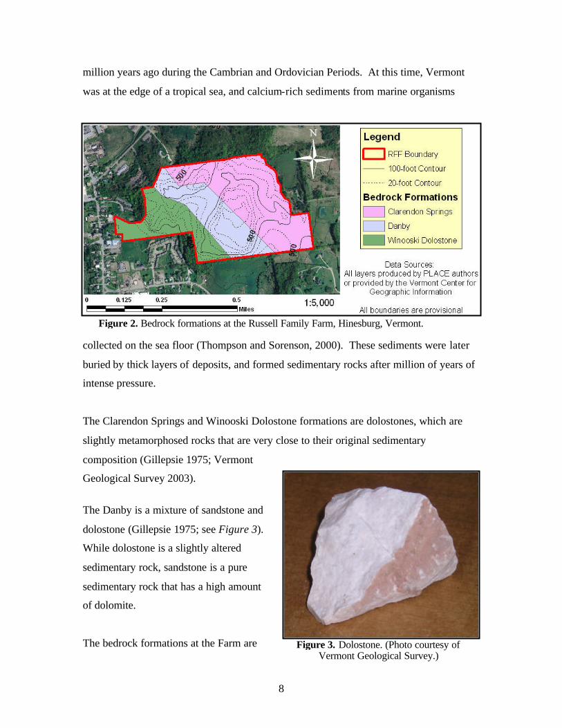
8
million years ago during the Cambrian and Ordovician Periods. At this time, Vermont
was at the edge of a tropical sea, and calcium-rich sediments from marine organisms
collected on the sea floor (Thompson and Sorenson, 2000). These sediments were later
buried by thick layers of deposits, and formed sedimentary rocks after million of years of
intense pressure.
The Clarendon Springs and Winooski Dolostone formations are dolostones, which are
slightly metamorphosed rocks that are very close to their original sedimentary
composition (Gillepsie 1975; Vermont
Geological Survey 2003).
The Danby is a mixture of sandstone and
dolostone (Gillepsie 1975; see Figure 3).
While dolostone is a slightly altered
sedimentary rock, sandstone is a pure
sedimentary rock that has a high amount
of dolomite.
The bedrock formations at the Farm are
Figure 2. Bedrock formations at the Russell Family Farm, Hinesburg, Vermont.
Figure 3. Dolostone. (Photo courtesy of Vermont Geological Survey.)

9
especially important landscape features in the hillier sections of the property. In these
areas, there are relatively thin layers of soil and surficial deposits (to be discussed
shortly), and the chemical composition of the bedrock therefore can influence soil
chemistry. Dolostones are primarily composed of the mineral dolomite, a calcium and
magnesium carbonate, which can be weathered from the bedrock (Vermont Geological
Survey 2003). This weathering releases calcium and magnesium into the surrounding
and overlying soils, therefore raising the fertility (the nutrient s available in the soils for
uptake by plants) of many parts of the Farm. Furthermore, the carbonates are alkaline in
reaction: they buffer acidity in the soil (i.e. raise the pH), which creates favorable
conditions for nutrient uptake by plants (Thompson and Sorenson, 2000). This affects
which species occur in different parts of the Farm, as will be discussed in Section V.
Surficial Deposits
The natural history of the Farm, and the greater Champlain Valley, is inextricably tied to
glaciation. Around two million years ago, a changing global climate caused ice to begin
spreading over northern North America. This was the first of several successive glacial
periods. The most recent wave of glaciation, the Laurentide Ice Sheet, began about
100,000 years ago. At its peak around 20,000 years ago, the ice sheet buried all of
Vermont under one to two miles of ice. Then, by 13,500 years ago, the ice sheet had
retreated north of the state.
The region’s glacial past is evidenced by surficial deposits. As the Laurentide Ice Sheet
advanced into Vermont, glaciers scoured and plucked bedrock into blocks and pieces,
which were taken up by the moving ice. These sediments ranged in size from large
boulders and rocks to fine particles like sand, silt, and clay. Collectively known as
glacial till, the sediments were eventually exposed on the landscape as the glaciers
melted. Most of Vermont is covered in till to varying thicknesses; it is usually deeper in
valleys and thinner on hilltops (where it is often only bare bedrock).

10
As the ice sheet receded, melting ice fed into streams and rivers which flowed into the
Champlain basin. 1 Till sediments were picked up by the flowing water, carried
downstream, and deposited in accordance with stream speed. First, the larger pieces of
till—rocks and cobbles—were dropped out along the streambed. Then, as the streams hit
Lake Vermont and slowed down, sand particles were dropped out.2 Finally, the finest
particles—the clays—stayed in the water column, eventually settling out on the lake
bottom (what is presently the rich fertile lowlands of the Champlain Valley).
In the past, the Farm was covered by glaciers and Lake Vermont. Therefore, the Farm
contains various sediments, including clays, silts, and rocky till. These sediments, along
with bedrock and topography, have a large influence on the soils present at the Farm.
Soils
Soils are an extremely important landscape component, and greatly influence the
vegetation and human use of a particular area. Soils are complex, with varying
proportions of four main ingredients: inorganic rock particles (ranging in size from small
to large: clay, silt, sand); organic material (insects, bacteria, fungi, and decomposing
plant material); air; and water.
Soils are greatly influenced by other layers of the landscape, including topography,
surficial deposits, bedrock (where it is not covered by thick layers of surficial deposits),
hydrology (the effects of water on the landscape), and cultural history. Because of these
influences, soils va ry from place to place across a landscape.
1 The Champlain Basin was originally filled by Glacial Lake Vermont, a large freshwater lake filled with water from the melting ice sheet. The weight of the Laurentide ice sheet, however, had depressed (lowered) the continental plate beneath it to elevations below sea level; therefore, when the ice receded past the St. Lawrence River valley, the North Atlantic Ocean was able to flow into Lake Vermont and create the saltwater Champlain Sea. This sea existed from around 13,500 years ago until 11,000 years ago; as the continental plate rebounded from the weight of the glacier, the Champlain Basin once again flowed out to the sea. The remnants of this marine past include the fossils of marine animals (including the famous Charlotte whale). 2 Evidence of this is apparent today: due to ice blockage farther to the north, the ancient Winooski River once flowed through Hinesburg Hollow and met with Lake Vermont where, today, there is an extractive operation for sand and gravel.

11
Soils differ from each other in their proportions of clay, silt, and sand, yielding a range of
soil textures. Loamy soils are those with a relatively even mixture of these three particle
sizes. Clayey soils, made up of the smallest particles, are thick and dense, and therefore
have high capacities for holding water. Sandy soils, on the other hand, are made up of
the larger particles, and are generally very porous and well-drained (they do no retain
water for very long).
Another way in which soils differ from each other is in their profiles: the sequence of
layers, or horizons, which extend from the surface down to the bedrock. Using
differences in profiles, soil scientists classify soils into series. Then, based on differences
of characteristics such as texture, slope, and stoniness, soil series are further classified
into phases. The Soil Survey of Chittenden County (conducted by the U.S. Natural
Resources Conservation Service) depicts six soil types (based on series and phases) at the
Farm (see Map #3: Soils). These soils can be placed into two groups: water-deposited
soils and till-derived soils (these groups are based upon those described in the original
Soil Survey).
Water-deposited soils formed in sediments dropped out from glacial meltwater and Lake
Vermont. Their compositions include high amounts of clay, silt, and/or sand, and are
generally found on the lower, gentler slopes in the eastern and western portions of the
Farm. Generally, areas of the Farm with these soils are better-suited for agriculture.
Water-deposited soils:
• Hartland very fine sandy loams are generally deep to bedrock, well-drained, and loamy. They have high natural fertility.
• Munson and Raynham silt loams are generally deep to bedrock and somewhat
poorly drained. They have high natural fertility.
• Covington silty clay is deep to bedrock, poorly drained, and clayey. It has a very high natural fertility.

12
Till-derived soils formed in the jumble of rocks left behind by receding glaciers. Their
compositions are stony or extremely stony, and areas with these soils are characterized by
bedrock outcrops. Till-derived soils are found at the center of the Farm, especially on the
hillier sections. The bedrock formations that served as the parent material of the till were
mostly limestones and other carbonate-bearing rocks. Therefore, in combination with the
underlying dolostone bedrock, these soils have relatively high natural fertilities (see
Bedrock narrative).
Till-derived soils:
• Farmington extremely rocky loams are shallow to bedrock, somewhat excessively drained, and loamy with many rocks. They have medium natural fertility.
• Georgia stony loam is deep to bedrock, moderately well-drained, and loamy with
many stones. It has a high natural fertility.
• Stockbridge and Nellis extremely stony loams are deep to bedrock, well drained, and loamy with many rocks and stones. They have high natural fertility.
Soils make up a very important component of the Farm’s landscape. Just as surficial
sediments, topography, and bedrock have influenced soils, soils influence human uses
and plant and wildlife distributions across the landscape. This is readily apparent when
looking at the Farm’s cultural history.

13
IV. The Cultural Landscape Vermont has a rich cultural history. From the time of the earliest Native American
inhabitants to the present, this history has left many human features on the landscape.
Some of these features are remnants that speak of a long-ago past, and others are
evidence of our present influence on the land. The Farm is an excellent place to explore
Vermont’s agricultural roots following European settlement; it is also an exciting place to
learn about present agricultural activities.
The Past
Presettlement: 12,000 Years Before Present – Late 18th Century
In the period between glacial retreat and European settlement, Native American
populations in the Champlain Valley concentrated their activities near lakes and rivers.
Therefore, any intensive use in the property’s vicinity would have coincided with the
higher water levels of Lake Vermont and the Champlain Sea. As water levels dropped to
present-day elevations, it is likely that the Farm would have been used on a more limited
basis. According to members of the Russell family, no one can recall the discovery of
evidence of Native American activity at the Farm.
Post-settlement Land-use: Late 18th Century – Present
In 1763, after around sixty-five years of fighting, the British claimed victory over the
French in the French and Indian War. This began a dramatic period of settlement in
Vermont. From 1763 to 1791 (the year in which Vermont received statehood) Vermont’s
population grew from about 300 to 85,000. By 1810, the population had reached 218,000
(Johnson 1998).
The U.S. demand for wool was at a peak in 1840, and Vermont’s sheep farming was the
state’s primary agricultural activity. Deforestation reached its peak in the state at this
time. In general, steeper and rockier slopes were put into pasture while richer lowlands

14
were cultivated for crops. Beginning in the 1850s, Vermont’s economic growth began to
decline due in part to poor farming and logging practices. Agricultural operations
decreased, and forests began to reclaim the fields (Johnson 1998).
This history is evident at the Farm. A network of stonewalls runs throughout the
property, indicating that the entire area was used as pastureland. The property was most
likely a sheep farm through the 1840s, and then became a dairy farm with some sheep
from the 1850s and on.
The Russell family traces its Hinesburg
roots back to 1795, when Charles
Russell bought a 1,500 acre farm. It is
said that the Russells were the fifth
family to arrive to the town.
The family’s livestock operations were
supplemented by maple sugaring, and
the evidence of this activity is obvious
today. The original structure of the
family’s sugarhouse, which is still in
use, is believed to have been built in the
1850s. Furthermore, the species
composition of the forest tells much
of its use for sugaring. Over the
generations, the family has managed
for sugar maples by cutting back other species, and therefore maples are extremely
abundant throughout the forested parts of the property.
The current pattern of forests and fields on the Farm is directly connected with its
physical features. The higher portions of the property were initially cleared for sheep and
cow pastures. However, the thinner soils, bedrock outcrops, and steep terrain of these
areas made them poorly-suited for agriculture, and therefore they were the first places
Figure 4. A stonewall (located on the hill to the east of the sugarhouse) at the Russell Family
Farm (March 2006).

15
that were allowed to revert to forest. Meanwhile, the lower portions of the Farm, with
deeper and more clayey soils, were kept in agriculture.
In 1983, Howard Russell, the patriarch of the family, passed away in a barnyard accident.
The dairy operation, which had seen up to 50 milking head, came to an end shortly after
his death. Since this time, additional cleared areas of the Farm have begun to revert to
forest.
The Present
Through the generations, the Russell’s have continued sugaring operations at the Farm.
The family gathers sap in the traditional fashion, using buckets, horses, a wagon, and a
sled. They have about 1,350 taps, and make about 300 gallons of syrup in a typical
season. This involves a tremendous amount of work, and the spring sugaring season
brings the extended family and many community members up the hill to help. The
original sugarhouse structure is still in place, having been renovated in 2001.
Figure 5. The sugarhouse at the Russell Family Farm,
pictured with Joe Donegan (left) and Harry Russell (March 2006).

16
Since Howard Russell’s death, the activity at the Farm was mostly limited to sugaring. In
the past year, however, a flurry of activity has descended upon the Farm. The Russell
Family Trust is working with the Hinesburg Land Trust and Vermont Land Trust to place
a conservation easement on 63 acres of the Farm’s forests and fields. This will prevent
the land from being developed, and officially open up over two miles of trails for public
use. Furthermore, the Trust has purchased an adjacent 15-acre parcel of farmland,
increasing the Farm’s acreage to approximately 105. The youngest generation of the
Russell family—James, Joe, and Kevin Donegan—have used this parcel to restart
traditional agricultural operations at the Farm. They have planted organic garden beds,
and will be selling vegetables at local farmer’s markets and through a community-
supported agriculture (CSA) operation. Also, Joe Donegan is bringing dairy back to the
Farm with the recent purchase of some cows. He has fenced in some pastures, and the
cows are often seen out grazing. Other agricultural efforts include raising poultry and
participating in a community compost program.
The Russell family is an integral layer of the Farm’s landscape. As such, they are
interconnected with the other elements in the landscape. This is perhaps most evident
when examining the ecological features of the property, where the relationships between
plants, animals, and people are readily seen.

17
V. The Ecological Landscape
The ecological landscape of the Farm includes the vegetation and wildlife that occur
there. In many ways, the ecological landscape serves to connect all of the landscape
layers present at the Farm. When reading about the vegetation and wildlife, think about
how these elements are inseparable from the geologic features and human activities that
occur there.
Pieces, Patterns, and Processes
Ecology is the study of relationships between organisms and their environments. The
PLACE program emphasizes a “pieces, patterns, and processes” approach to
understanding the ecology of a particular landscape. The “pieces” of a landscape include
the plant and animal species that are present (as well as abiotic landscape components
such as bedrock and soils), while “patterns” describe the distribution or arrangement of
these pieces. “Processes” are the forces that dictate these patterns, including natural
disturbances (e.g. wind and ice), soil and bedrock chemistry, and human use. This
section will first look at the pieces, patterns, and processes involved in the vegetative
cover of the Farm; then, it will briefly discuss how the patterns of vegetation impact the
wildlife species present at the Farm.
Vegetation
Vegetation is often the most evident landscape component, and can be very important in
instilling a community’s sense of place. The traditional image of Vermont’s landscape
involves a matrix of forests filled with trees such as maples, oaks, and pines, intertwined
with a patchwork of hay and corn fields. This scene is represented at the Farm; more
than half of the property is covered in forest dominated by hardwood species,3 and the
3 Hardwood species include maples, oaks, beech, birches, and other most other deciduous trees—those that drop their leaves in the fall and grow new ones in the spring. Softwood, or coniferous, species mostly include evergreens like pine, hemlock, and spruce.

18
rest is comprised by fields and wetlands. The vegetation seen at the Farm today reflects
both its physical and cultural landscapes.
Plant species vary in their tolerance of environmental conditions such as soils, bedrock,
moisture level, slope, and climate (Thompson and Sorenson, 2000). Some species, such
as red maple, are tolerant of a range of conditions and can therefore occur in a number of
different habitats. Other species, such as maidenhair fern, have narrower tolerances and
occur only when specific environmental conditions are present. Furthermore, based on
similarities in tolerance levels, plant species tend to occur in natural groupings within a
certain area. These groupings, called plant communities, also respond to past human use
of the landscape. Therefore, by looking at patterns of plant distributions across a
landscape, one can learn a great deal about the natural and cultural history of a particular
place.
An important ecological concept to keep in mind when examining plant communities is
succession: the change, over time, of the plant species that occur at a particular place.
Plant communities are not static, but instead are in a slow but constant flux caused by
natural and human disturbances, as well as the capacity of plants themselves to alter
environmental conditions. With the concept of succession in mind, this narrative will
examine the current distribution of plant communities (current cover types) at the Farm
and also its potential natural communities types: the groupings of plants that might
occur there if natural processes were allowed to take their course with minimal human
alteration.
Current Cover Types
The Farm is currently a mix of hardwood forest, cleared agricultural fields, brush (old
fields reverting back to forest), and wetlands. The property is located in a transitional
zone between two forest formations: the Northern Hardwood Forest Formation, which is
characterized by colder temperatures and dominated by sugar maple, American Beech,
and yellow birch; and the Transition Hardwood Forest Formation, which is characterized

19
by warmer temperatures and the mixing of Northern Hardwood species with more
southern species like oaks and hickories. Over the generations, the Farm’s forests have
been heavily managed for sugar maple, and this is by far the dominant tree species.
Other common tree species include northern red oak, American beech, northern white
cedar, hophornbeam, and Scotch pine, which occur in plantations in the eastern portion of
the property.
It is clear that the calcareous
(carbonate-bearing) nature of the
bedrock and till found at the Farm
influence the species found there. In
many of the forested areas of the
property, the ground is carpeted in
herbaceous species that indicate soil
richness (i.e. those that only grow in
areas with higher nutrient levels).
For example, Figure 6 shows
Dutchman’s breeches, an indicator
species of rich, fertile sites that is
very common at the Farm.
The non-forested areas of the property consist of cleared agricultural fields, brush, and
wetlands (the boundaries between these three cover types are sometimes indistinct). The
cleared agricultural fields, such as the “Eight-Acre Field” in the southeastern portion of
the property (Figure 7), are used primarily for pasture by the Farm’s cows.
Figure 6. Dutchman’s breeches (white flowers)
and Stinking Benjamin (purple flower) photographed in the northwestern section of the
Russell Family Farm (April 2006).

20
The Farm also contains many areas of brush, which are old agricultural fields that have
only recently (within the last 20 years) been allowed to revert to forest. Depending on
the stage of succession, these areas may be dominated by herbaceous grasses and
flowering plants, or woody tree and shrub species such as eastern red cedar and common
juniper. Figure 8 depicts an old field that the Russell family calls “Giroux’s Pass”, which
is in an early stage of succession.
Figure 8. An old agricultural field called “Giroux’s Pass” near the eastern border of the Russell Family Farm (April
2006).
Figure 7. “Eight-Acre Field” at the Russell Family Farm. (Photo courtesy of Jeannette Armell, Spring
2006).

21
Finally, there are two main emergent wetland communities located at the Farm. One
occurs in the center of the property, just east of the sugarhouse, while the other occurs in
the northeast corner. These areas are dominated by herbaceous plants such as grasses,
sedges, and common cattail. These plants depend on moist to saturated soils that are
seasonally inundated with water.
Natural Community Types
Thompson and Sorenson (2000) define a natural community as “an interacting
assemblage of organisms, their physical environment, and the natural processes that
affect them” (p. 58). Essentially, natural communities describe patterns of species
distribution according to the environmental conditions (e.g. soil and bedrock types) and
natural disturbance regimes (e.g. flooding) of particular places. A fundamental objective
of the natural community concept is to predict successional pathways in the absence of
human alteration; that is, trying to figure out what might naturally occur in a given place.
The Farm is an excellent place to begin thinking about natural communities. It is also a
difficult one, in some ways, because it has such a rich cultural history. The property has
been used in different ways for hundreds of years, and this affects everything presently
seen at the Farm. However, with some knowledge of the physical components and
current cover types of the landscape, it is a useful exercise to predict the natural
community types of the Farm. (A note: the book Wetland, Woodland, Wildland: A
Guide to the Natural Communities of Vermont, by Thompson and Sorenson (2000), is an
excellent resource for studying this topic. The book serves as the source for the Farm’s
potential natural community types listed below.)
Keeping the physical landscape of the Farm in mind (in particular, the high nutrient
levels of the underlying bedrock and till, the shallow soils of the higher sections, and the
silt and clay sediments in the deeper soils of the lower sections) the following is a list of
potential natural community types of the Farm. The first two are possible dominant

22
community types, while the rest would probably occur as smaller pockets interspersed
throughout the property.
Potential Natural Community Types:
• Northern Hardwood Limestone Forest, a variant of the Rich Northern Hardwood
Forest* • Transition Hardwoods Limestone Forest, a variant of the Mesic Maple-Ash-Hickory-
Oak Forest* • Rich Northern Hardwood Forest • Sugar Maple-White Ash-Jack- in-the-pulpit Northern Hardwood Forest • Sugar Maple-Hophornbeam Forest, a variant of Dry Oak-Hickory-Hophornbeam
Forest • Mesic Maple-Ash-Hickory-Oak Forest • Northern Hardwood Forest • Mesic Red Oak-Northern Hardwood Forest • Valley Clayplain Forest • Temperate Calcareous Outcrop • Temperate Calcareous Cliff • Cattail Marsh • Shallow Emergent Marsh • Limestone Forest variant of Mesic Maple-Ash-Hickory-Oak Forest (* Denotes potentially dominant natural community.)
Wildlife
Wildlife species, like plant communities, have varying tolerances for environmental
conditions. Most wildlife species have adapted to particular habitats, and therefore
different species can be found in different types of places. For example, some bird
species are found in older forests, some are found in younger forests, and others are
found in open grasslands. As a result of these different habitat needs, many wildlife
populations are directly affected by changes in vegetation and human use.
Over time, Vermont’s wildlife populations have responded to human impacts on the
landscape. In the 1800s, when much of the state was cleared of forests, many species

23
were extirpated from the state, including white-tailed deer, beaver, wild turkey, and
fisher. These species, with some help from conservationists, eventually returned as the
forest grew back beginning in the 1850s.
The Farm’s wildlife inhabitants have responded to changes in its vegetation and human
use over the generations. Today, there is ample habitat present at the farm. There are
open fields, brushy areas, rocky outcrops, wetlands, conifer stands, and hardwood forests
of varying ages. In all, the Farm is well-suited for a wide-variety of wildlife species. In
compiling information for this guide, untrained eyes were able to observe several species
either directly or through signs on the land, including white-tailed deer, red fox, gray
squirrel, white- footed mouse, and numerous bird species (such as ruffed grouse, wild
turkey, American robin, black-capped chickadee, downy and pileated woodpecker,
Northern cardinal, red-winged blackbird, cedar waxwing, and red-tailed hawk). For a list
of just some of the species occurring at the Farm, please see Appendix A.

24
VI. The Future All of the landscape layers at the Russell Family Farm are intertwined in a story that
reaches far into the past. This exciting story includes fantastical elements like ancient
seas and massive ice sheets, and less dramatic—but equally influential—characters such
as forests, fields, and farmers.
The Farm’s present and future are just as exciting. The recent resurgence of crop and
dairy farming, the conservation of a large section of the property, and the traditional
sugaring season that marks each spring all help to make the Farm an ideal place to learn
about Vermont’s cultural heritage. These features also demonstrate some of the forces
that are helping to shape Vermont’s future landscape. When visiting the Farm, look for
clues about its natural and cultural history, but also look for signs of the future.

25
Appendix A: Preliminary Species List Mammals White-tailed deer Red fox Deer mouse White-footed mouse Woodland jumping mouse Chipmunk Gray squirrel Eastern cottontail Meadow vole Striped skunk Porcupine Red squirrel Birds Northern cardinal Cedar waxwing American robin Black-capped chickadee Ruffed grouse Wild turkey Pileated woodpecker Downy woodpecker Red-tailed hawk Amphibians Wood frog

26
Appendix B: Activity Ideas for Educators
The Farm is a terrific destination to learn about a number of topics, including maple
sugaring, soils, farming, cultural history, and plants.
Activity ideas (organized by focal group) might include: The Physical Landscape:
• Dig a soil pit to examine soil horizons and learn about geological processes.
• Explore the Farm’s topography, paying particular attention the bedrock outcroppings
found throughout the property.
The Ecological Landscape:
• Learn to identify the common plant species present at the Farm, especially trees and
spring ephemeral flowers.
• Map natural communities at the Farm.
The Cultural Landscape:
• Make a cultural features map by using GPS units to map specific points.
• Explore the Farm’s history by looking for old fields and stonewalls.
• Explore the Farm’s present and future by learning about its vegetable gardens, dairy
operation, and sugaring season.
• Try a “clue quest” or “scavenger hunt” that integrates history lessons.
• Explore records from the Town of Hinesburg and the Census of Agriculture.
Check out Shelburne Farm’s educator activity workbook, Project Seasons, for more great
ideas on how to integrate outdoor learning into your classroom!

27
Sources and Suggested Readings
Austin, John et al. 2004. Conserving Vermont’s Natural Heritage: A Guide to Community-Based Planning for the Conservation of Vermont’s Fish, Wildlife, and Natural Diversity. Vermont Fish & Wildlife Department & Agency of Natural Resources: Waterbury, VT. Gillepsie, Richard. 1975. “Structure and stratigraphy along the Hinesburg Thrust, Hinesburg, Vermont.” M.S. Thesis, University of Vermont. Johnson, Charles. 1998. The Nature of Vermont, 2nd Ed. University Press of New England: Hanover, NH. Thompson, Elizabeth and Eric Sorenson. 2000. Wetland, Woodland, Wildland : A Guide to the Natural Communities of Vermont. University Press of New England: Hanover, NH. United States Natural Resources Conservation Service. 1989. Soil Survey of Chittenden County, Vermont. Vermont Geological Survey. “Rock Kits Page.” Retrieved 5/15/06 from http://www.anr.state.vt.us/dec/geo/rockkits.htm.
And, of course, the PLACE Program website! Available at http://www.uvm.edu/place