an approach in determining the baseline data on the
TRANSCRIPT
PH0800001
PHJLlP.PlME HUDLEAR RESEARCH INSTJTUTESCIENTIFIC LIBRARY AND DOCUMENTATION CENTER
AN APPROACH IN DETERMINING THE BASELINE DATA ON THE|S(£TURAL BACKGROUND RADIOACTIVITY OF BATANES
PROVINCE, ITS IMPLICATIONS TO NATIONAL SECURITY
A Thesis Submitted to the
Graduate Facu^y of theNATIONAL DEFENSE COLLEGE OF THE PHILIPPINES
In partial fulfillment of theRequirements for the Degree in
MASTER IN NATIONAL SECURITYADMINISTRATION
Submitted by:
Engr. Rolando Y. Reyes, MSRegular Class 40
NATIONAL DEFENSE COLLEGE OF THE PHILIPPINESCamp General Emilio Aguinaldo, Quezon City
2005
11
AN APPROACH IN DETERMINING THE BASELINE DATA ON THENATURAL BACKGROUND RADIOACTIVITY' OF B,>TA^-:
PROVINCE, ITS IMPLICATIONS TO NATIONAL SECuRu V
by
ENGR ROLANDO Y. REYES, EM, MS
This paper is an official document of the National Defense College of the
Philippines. Citations, quotations, abstractions from or reproduction of any part
hereof or its entirety is prohibited and not authorized without the specific
permission or authority of the author or the President of the National Defense
College of the Philippines.
The position taken, opinions and conclusions expressed herein are solely
those of the author and do not necessarily express and represent the views of
either the National Defense College of the Philippines or any government agency
or its officials.
Reference to this work must include the following statement:
NATIONAL DEFENSE COLLEGE OF THE; P^UI.l^PINI::Camp General En»ii.io:,Agiiinaldq.
Quezon City, Philippines2005
©COPYRIGHT/ALL RIGHTS RESERVED, QUEZON CITY, PHILIPPINES

REPUBLIC OF THE PHILIPPINESDEPARTMENT OF NATIONAL DEFENSE
NATIONAL DEFENSE COLLEGE OF THE PHILIPPINESCamp General Emilio Aguimiklo, Quezon Cily
ENDORSEMENT AND CERTIFICATION
In partial fulfillment of the requirements for the degree of Master in
National Security Administration (MNSA), Fortieth Regular Course, National
Defense College of the Philippines, this thesis entitled "AN APPROACH IN
DETERMINING THE BASELINE DATA ON THE NATURAL BACKGROUND
RADIOACTIVITY OF BATANES PROVINCE, ITS IMPLICATIONS TO
NATIONAL SECURITY" was prepared, submitted and successfully defended
before a duly constituted panel by ENGINEER ROLANDO Y. REYES, the
acceptance of which is hereby endorsed
This is to certify that all comments, suggestions and observations made by
the members of the panel during the oral presentation thereof on 09 August,
2005 have been incorporated accordingly.
ALUMANDA Ml DELA ROSA, Ph.D.Adviser
REPUBLIC OFTHK PHILIPPINESDEPARTMENT OF NATIONAL DEFENSE
NATIONAL DEFENSE COLLEGE OF THE PHILIPPINESCamp General Emilio Aguinnldo, Quezon City
DEFENSE PANEL APPROVAL
This is to certify that ENGINEER ROLANDO Y. REYES has successfully
defended his thesis entitled "AN APPROACH IN DETERMINING THE
BASELINE DATA QWyTHE.:-NATURAL B^CKG^OUNO iml^dnCTsvn V OF-
BATANES PROVINCE, ITS IWSPLlCATSGhiS TO NATIONAL SECURITY" and
has complied with all the comments, suggestions and recommendations of the
thesis defense panel given during the oral defense on 09 August 2005. This
thesis is hereby approved for acceptance.
C. ANCChairman
DR. LEOPOLDO K LAZATIN, MNSA ENGR NELSON M. DE LEON, MNSAMEMBER MEMBER
V
ACKNOWLEDGEMENT
This study forms part of the research output of the Nuclear MaterialsResearch Group (NMRG) of the Philippine Nuclear Research Institute (PNRI)that provided the financial and logistical support in the conduct of the fieldsurveys in Batan Island, Batanes Province
I .w ish l o e x p r e s s rny s i n c e i o s l ' thanks a n d Qraiilud-.'s 10 ovi.sy<>iio wn-'i in
one way or the other contributed to the very successful implementation of thefield surveys in Batanes Province. Among them are:
The Honorable Vicente S. Gato, Governor of Batanes Province and hisstaff particularly Mr. Bernardo H. Hornedo, Provincial General Services Officer,for their help, assistance and hospitality;
Mr. Patrocinio C. Lechuga, Officer-in-Charge of the Philippine Science andTechnology Center, DOST-Region II, Basco, Batanes for allowing the PNRI fieldparty to stay in the Center and in administering the awareness survey;
Mr. Danilo Boniao, the ever reliable person who always made all tfoenecessary arrangements whenever the PNRI field party was on fieldwork inBatanes;
PNRI Director Alumanda M. Dela Rosa, PNRI Deputy Director Corazon C.Bernido, PNRI-NMRG Head Engr. Christina A. Petrache, and PNRl-AccountingServices Unit Head Ms. Esperanza Cancio for their unending support andbelieving in the study; and
The members of the PNRIfield survey team Ms. Estrellita U. Tabora andMessrs. Mikhail Jethro L. Montes and Ireneo D. Gerilla for being dependable,hardworking and cooperative in the conduct of field surveys.
I am also deeply indebted to everybody who contributed to the realizationof this thesis and these are: Dr. Alumanda Dela Rosa, my thesis adviser; Dr.Amelia C. Ancog, chairperson, thesis defense panel; and Dr. Leopoldo H. Lazatinand Engr. Nelson M. De Leon, thesis defense panel members, for their valuablecomments and suggestions to improve the thesis;
A million thanks to Engr. Aida Maria A. Talavera, COA Director III, MNSA,who unselfishly shared her knowledge and was always available forconsultations;
Mr. Anthony D. Tabora for patiently repairing my computer that boggeddown and was able to retrieve all my thesis files prior to the submission of thedraft thesis;
VI
My classmates Mansur, Teng, Don, Pearl, Romy E., Carol, Vlad, Ati Fili,Boy, Jules, Love, Buboy, Tony, Cris, Tino, Ed, Gary, Danny U., Ram and Roily A.for the happy moments and camaraderie; and
The many NDCP staffs who later became friends for their help andassistance.
I dedicate this thesis to my wife Precy, my kids Patrick, Lorenze andKristen, my Dad and Mom, and most especially my BUDDY - The OmnipotentOne.
Rolando
Vl l
ABSTRACT
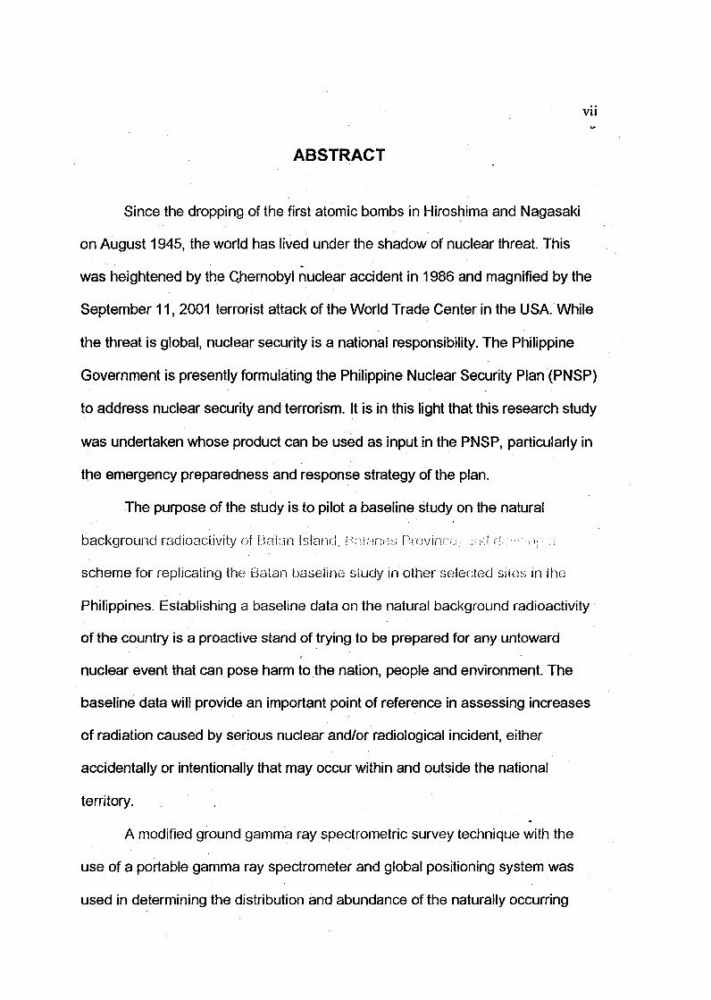
Since the dropping of the first atomic bombs in Hiroshima and Nagasaki
on August 1945, the world has lived under the shadow of nuclear threat. This
was heightened by the Chernobyl nuclear accident in 1986 and magnified by the
September 11, 2001 terrorist attack of the World Trade Center in the USA. While
the threat is global, nuclear security is a national responsibility. The Philippine
Government is presently formulating the Philippine Nuclear Security Plan (PNSP)
to address nuclear security and terrorism. It is in this light that this research study
was undertaken whose product can be used as input in the PNSP, particularly in
the emergency preparedness and response strategy of the plan.
The purpose of the study is to pilot a baseline study on the natural
background radioactivity of Rnian island, HrsW-ines Province.. ;U.J =!v :< if- ;;
scheme for replicating the Batan baseline study in other selected sites in the
Philippines. Establishing a baseline data on the natural background radioactivity
of the country is a proactive stand of trying to be prepared for any untoward
nuclear event that can pose harm to the nation, people and environment. The
baseline data will provide an important point of reference in assessing increases
of radiation caused by serious nuclear and/or radiological incident, either
accidentally or intentionally that may occur within and outside the national
territory.
A modified ground gamma ray spectrometric survey technique with the
use of a portable gamma ray spectrometer and global positioning system was
used in determining the distribution and abundance of the naturally occurring

V1H
radioelements potassium (K), uranium (U), thorium (Th) and total natural
radiation (TNR) of Batan Island. Prior to the field survey, a thorough calibration of
the portable gamma ray instrument was instituted that converted the measured
gamma-ray count data into ground concentrations of K, U and Th, This allowed
the systematic measurement of 73 sampling/data stations for the whole Batan
Island and additional of 5 to 15 measurements that are within the one (1)
kilometer radius of each town and barangay. This resulted in the prr.di 'cHon of
computer-generated color-contoured maps of the individual radioelornonts as
well as the TNR expressed in terms of exposure rate and absorbed dose rate.
Results of the survey showed that the distribution of K ranged from
0.025% to 1.84%, for U from 0.18 ppm to 5.62 ppm, and for Th from 3.28 ppm to
22.45 ppm. Total natural radioactivity in terms of exposure rate ranged from 1.35
uR/h to 12.74 uR/h and in terms of absorbed dose rate, ranged from 11.7 nGy/h
to 110.6 nGy/h. From these values, the averages of K, U, Th and TNR were
determined for the whole Batan Island as well as for each town and barangay.
This constituted the baseline data on the natural background radioactivity of
Batan Island. This baseline will be crucial for the assessment of any future
radioactive contamination on Batan Island.
Maps showing the distribution and abundance of the naturally occurring
radioelements and total natural radioactivity closely reflect the underlying geology
of Batan Island. The K, U and Th averages are comparable with the world's
established averages. The determined TRN averages for Batan Island are
IX
similarly comparable to the estimated world average terrestrial outdoor-absorbed
dose rate in air.
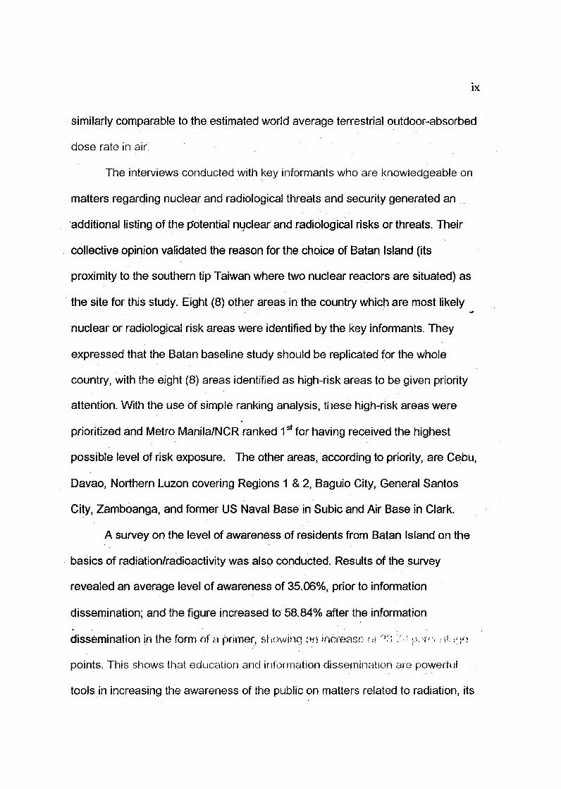
The interviews conducted with key informants who are knowledgeable on
matters regarding nuclear and radiological threats and security generated an
additional listing of the potential nuclear and radiological risks or threats. Their
collective opinion validated the reason for the choice of Batan Island (its
proximity to the southern tip Taiwan where two nuclear reactors are situated) as
the site for this study. Eight (8) other areas in the country which are most likely
nuclear or radiological risk areas were identified by the key informants. They
expressed that the Batan baseline study should be replicated for the whole
country, with the eight (8) areas identified as high-risk areas to be given priority
attention. With the use of simple ranking analysis, these high-risk areas were
prioritized and Metro Manila/NCR ranked 1s t for having received the highest
possible level of risk exposure. The other areas, according to priority, are Cebu,
Davao, Northern Luzon covering Regions 1 & 2, Baguio City, General Santos
City, Zamboanga, and former US Naval Base in Subic and Air Base in Clark.
A survey on the level of awareness of residents from Batan Island on the
basics of radiation/radioactivity was also conducted. Results of the survey
revealed an average level of awareness of 35.06%, prior to information
dissemination; and the figure increased to 58.84% after the information
dissemination in the form of a primer, showing :->n increase- <.•:>. •':;'/.: ,.,.•.,-,-.,:-,(.-.jjn
points. This shows that education and information dissemination are powerful
tools in increasing the awareness of the public on matters related to radiation, its

beneficial and harmful effects, and more importantly after this study, the basic
responses and courses of action in the event of a radiological or nuclear
incident/disaster.
Overall, the study showed a sample of a method for obtaining, through
measurement, and presentation of baseline data on radioactivity. This was the
first time that a systematic approach to determine the distribution and abundance
of the radioelement potassium, uranium and thorium for baseline study by ground
gamma ray spectrometric technique was conducted in the country. This
approach offers a practical alternative to the costly airborne and carborne survey
techniques that is within the financial capabilities of developing countries like the
Philippines. The scheme for replicating the performance of baseline studies in
other areas of the country will follow the methods adopted in the study, with
improvements, depending on the environmental and security situation of the
survey area.

XI
000
. 00000000
CHAPTER1.11.1.11.21.3
Title PageCopyright PageEndorsement and Certification SheetDefense Panel ApprovalAcknowledgementAbstractTable of ContentsList of AcronymsList of TablesList of FiguresList of Appendices
1 - THE PROBLEMintroductionBackground and rationaleStatement of the problemSianificance of the studv
TABLE OF CONTENTS
Page
iiiiiiivvviixixiiixiiixivxv
3911
1.4 Scope and limitations 13Chapter end notes 13
CHAPTER 2 - REVIEW OF RELATED LITERATURE 1616161617181921222425
31313233363839
2.12.1.12.1.22.1.32.22.32.42.52.6
CHAPTER3.13.23.33.43.5
Foreign sourcesPre-Chernobyl situationPost ChernobylBaseline survey techniques usedLocal sourcesNuclear threats and risksThe Philippine Nuclear Security PlanConceptual frameworkDefinition of termsChapter end notes
3 - METHODOLOGYResearch designSamplingInstrumentData gatheringData analysis and map productionChapter end notes

Xll
TABLE OF CONTENTS
CHAPTER 4 - PRESENTATION AND ANALYSIS OF DATA 40.1 Generalized geology of Batan Island 40.2 Natural radioelement survey of Batan Island 43.2.1 Potassium 45.2.2 Uranium AI.2.3 Thorium • 49.2.4 Total natural radioactivity 49.2.4.1 Exposure rate 51.2.4.1 Absorbed dose rate in air 51.2.5 Baseline data on natural radioactivity 54.3 Results of interview 58.3.1 On the potential nuclear and radiological risks or threats 58.3.2 On the nuclear or radiological risks to which Batan Island, 60
Batanes Province may be exposed to.3.3 On the other areas in the Philippines that may be exposed to 60
possible nuclear and radiological risks or threats.3.4 On which of the identified nuclear risk areas the Batan 65
baseline study may be replicated -.4 Awareness level on the basics of radiation among the 68
residents of Batan Island.4.1 Characteristics of the sampling population (respondents) 68.4.2 Awareness level on the basics of radiation 71
Chapter end notes 73
CHAPTER 5 - SUMMARY, CONCLUSIONS AND RFCOMMENDATIONS 75.1 Summary 75.2 Conclusions '" 78.3 Recommendations 81.4 Implications to national security 85
Chapter end notes 86
ibliography 87ppendices 95[esearcher's curriculum vitae 118

Kill
LIST OF ACRONYMS
IAEA International Atomic Energy AgencyPNRI Philippine Nuclear Research InstituteTNR Total Natural RadiationGPS Global Positioning SystemPNSP Philippine Nuclear Security PlanARS Acute Radiation SicknessGRS Gamina Ray SpectrometryNPTC National Plan to Address Terrorism and Its ConsequencesRADPLAN National Radiological Emergency Preparedness and
ResponseSQ1 Survey Questionnaire No. 1SQ2 Survey Questionnaire No. 2
LIST OF TABLES
Number Title Page1 Form used in data collection of natural 38
radioactivity2 Conversion factors to calculate exposure rate 45
and absorbed dose rate in air3 Averages of ground concentrations, exposure 54
rate and absorbed dose rate in air frompotassium, uranium and thorium for Batan Island
4 Comparison of measured values of Batan and 55the World's values
5 Nuclear or radiological risk level of exposure of 60Batan Island, Batanes Province as indicated bykey informants.
6 Identified areas in the country that are most 61 - 63likely be exposed to nuclear and radiologicalihreaf: • :y i!w koy n\\c.•MY:rwii-'
7 Pilont:..;;.! ..ifv.u.ii; whore Vae Gaiciii study may bo u-ireplicated based on the experts' opinion
XIV
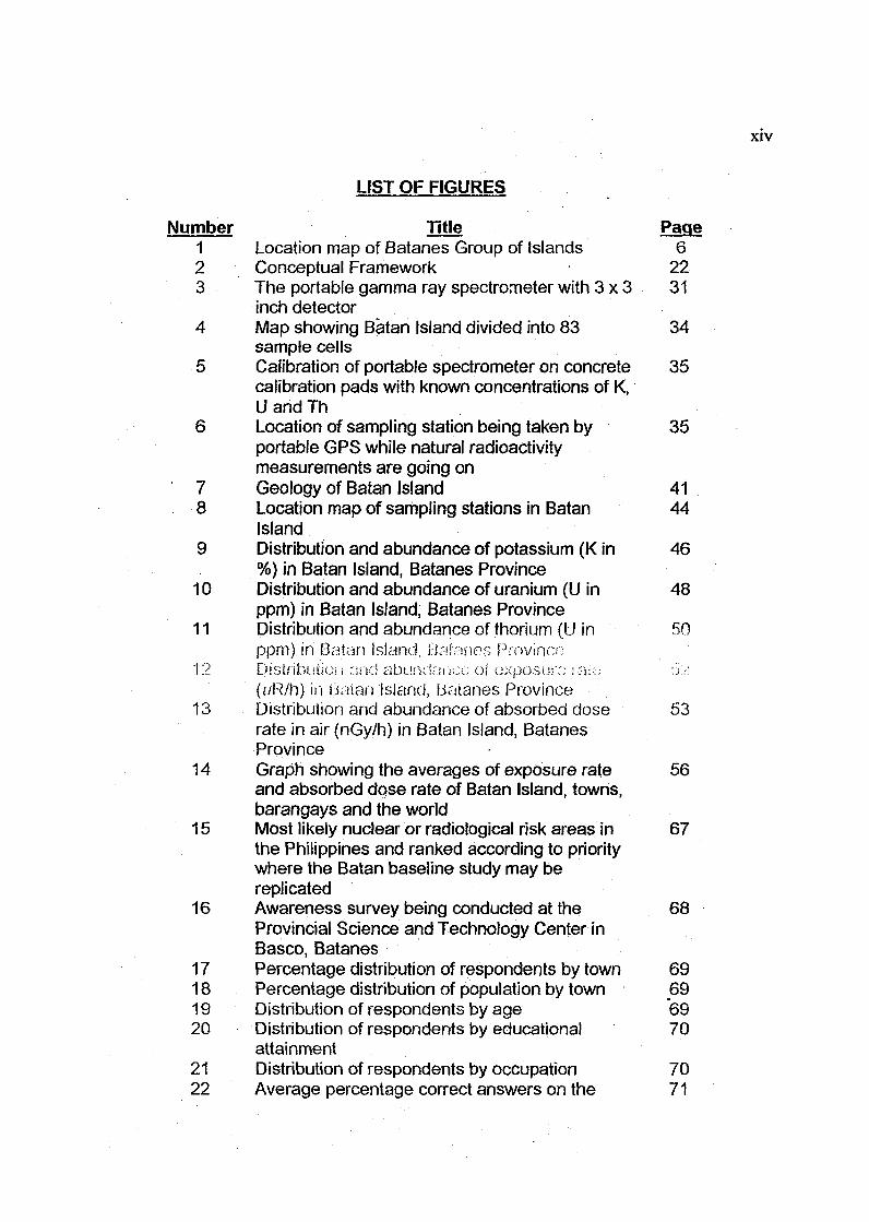
LIST OF FIGURES
Number Title Page1 Location map of Batanes Group of Islands 62 Conceptual Framework 223 The portable gamma ray spectrometer with 3 x 3 31
inch detector4 Map showing Batan Island divided into 83 34
sample cells5 Calibration of portable spectrometer on concrete 35
calibration pads with known concentrations of K,U and Th
6 Location of sampling station being taken by 35portable GPS while natural radioactivitymeasurements are going on
7 Geology of Batan Island 418 Location map of sampling stations in Batan 44
Island9 Distribution and abundance of potassium (K in 46
%) in Batan Island, Batanes Province10 Distribution and abundance of uranium (U in 48
ppm) in Batan Island, Batanes Province11 Distribution and abundance of thorium (U in 50
ppm). in Batan island, Balanes Province12 Distribution cmd abu.'uianco oi exposure ia-c; ix/.
(i/R/h) in LJaian Island, Balanes Province13 Distribution and abundance of absorbed dose 53
rate in air (nGy/h) in Batan Island, BatanesProvince
14 Graph showing the averages of exposure rate 56and absorbed dqse rate of Batan Island, towns,barangays and the world
15 Most likely nuclear or radiological risk areas in 67the Philippines and ranked according to prioritywhere the Batan baseline study may bereplicated
16 Awareness survey being conducted at the 68Provincial Science and Technology Center inBasco, Batanes
17 Percentage distribution of respondents by town 6918 Percentage distribution of population by town 6919 Distribution of respondents by age 6920 Distribution of respondents by educational 70
attainment21 Distribution of respondents by occupation 7022 Average percentage correct answers on the 71
XV
different subjects on radiation prior to handoutreading
23 Average percentage correct answers on the 72different subjects on radiation prior to handoutreading
24 Average percentage increase in correct answers 73after reading the handout
LIST OF APPENDICES
Letter ]J>)/^ 'J..-H'.:.A Basic h iiorrnation Aboui Radiation vi>B Survey Questionnaire SQ1 101C Survey Questionnaire SQ2 107D Interview guide questionnaire 113E Profile of experts 116
CHAPTER 1
THE PROBLEM
1.1 Introduction
A technology is developed for the improvement of the quality of life of
mankind. Sad to note is that the same technology can also be the cause of the
destruction of humanity. One such technology is nuclear technology. The
peaceful uses of nuclear technology can improve food security, help ensure
health security, enhance industrial productivity, protect the environment and
contribute to energy security, among others. However, for the past six decades
since the bombing (with the use of nuclear bombs) of Nagasaki and Hiroshima in
Japan, the world has always lived under the shadow of a nuclear threat. The
Chernobyl accident in 1986, considered so far the worst nuclear reactor accident
whose resulting nuclear fallout enveloped many parts of Europe, increased the
concern and threat posed by nuclear radiation. The September 11, 2001 event
(911 attack), although there was nothing nuclear or radiological in the terrorist
attack, heightened the potential nuclear threat by acts of terrorism that may
involve nuclear and other radioactive materials.
Not spared from nuclear threat is the Philippines since this threat is global.
The existence of a nuclear threat anywhere is a threat everywhere. As such,
even prior to the 911 attack, the Philippines ihrbuQh ihe Philippine iUu.\..>i<>
Research Institute established ihe National Radiological Emergency
Preparedness and Response Plan (RADPLAN). This Plan was prepared to have

an emergency response capability for timely, coordinated action of the Philippine
authorities in a peacetime radiological incident or emergency (PNRI, 2000).
The Nuclear Non-Proliferation Treaty and Comprehensive Nuclear Test
Ban Treaty did not stop the spread of nuclear weapons technology, including
nuclear bomb testing to the third world. Countries like India, Pakistan, Israel, and
possibly North Korea and Iran have nuclear weapons or could possibly assemble
them quickly (Clavejo, L.A., 2005). With these events and aggravated by the
threat of nuclear terrorism after the 911 attack, many countries in the world have
instituted nuclear security programs to respond to all forms of possible nuclear
and radiological threats (ElBaradei, M., 2004). Since nuclear security is a
national responsibility, the Philippine government is now in the process of
formulating the Philippine Nuclear Security Plan (PNSP). It is in this light that this
research study is undertaken whose product may be used as input in the PNSP,
possibly in the response (emergency response and preparedness) strategy of the
Plan. Establishing a baseline data on the natural background radioactivity of iho
country is a proactive stand oi trying to be prepared for any untowaicl nuclear
event that can pose harm to Ihe nation, people and environment. The baseline
data will provide an important point of reference in determining increases of
external radiation (radioactivity) arising from nuclear accidents, nuclear bomb
testing, nuclear terrorism and nuclear-armed conflicts from those that are not
inherent from the natural environment of an area. The unnatural (artificial or man-
made) increases in radioactivity produced by such nuclear disasters can be
hazardous to humans and to the environment.
1.1.1 Background and Rationale
The major source of radiation exposure to man is the natural environment,
which is characterized mainly by its underlying rocks and soils, or geological
make up. Rocks and soils contain naturally occurring radioactive elements
(radioelements) of whiclrthe three principal sources are potassium (K), uranium
(U) and thorium (Th). Different rock and soil types contain varying amount of
these radioactive elements. Thus, the level of natural background radiation varies
from place to place. When these radioelements undergo radioactive decay, they
emit three forms of radiation and these are the alpha particles, beta particles and
g a m m a rays . H i g h leve ls of e m i s s i o n of t he so forrsv of raa i ; - ! i o i ! cw; ^ • M: ••..-
harmful effects to humans and other living things, the extreme effect could be
death. Since the levels of radiation of different rock and soil types are in their
natural or background levels, these levels have no harmful effects. Basic
information about radiation is given in Appendix A.
Man's quest for development in order to have a better quality of life had
contributed much to the changes of the environment where he lives. Continuing
development in the nuclear industry all over the world has caused a growing
public awareness on the increases of radiation and radioactive contamination
that can pose health risks to the populace. These increases, aside from those
mentioned earlier, are due to generation of electricity through nuclear energy and
loss of radioactive sources. Today; there is an increasing public concern on the
protection of the environment.
As a consequence of the 1986 Chernobyl nuclear accident, many parts of
the world, especially Europe were affected by the releases of radiation caused by
the accident. The nuclear disaster resulted in a release of 50 million curries of
radioactive particles into the atmosphere. To put this in perspective, this was the
equivalent of 300 nuclear bombs just like the ones dropped on Hiroshima anu
Nagasaki contaminating the air with radiation (Mclnnis, K., 2000).
The prevailing winds at the time of the accident carried the radioactivity
northwest from the plant at Ukraine across into Belarus and then to Poland and
Sweden. Subsequently, the wind patterns shifted so that the bulk of radioactivity
was carried more directly north and northeast, over Belarus and southwestern
Russia. By most measures, the country most seriously affected by the
radioactive fallout as a result of the accident is Belarus. Almost 20 percent of the
republic's farmland were removed from production during the years immediately
after the accident. Half of the vast 27,850-sq km (10,750-sq mi) area described
as being "seriously contaminated" by the nuclear fallout (with levels of radioactive
cesium in topsoil exceeding 5 curies) is in Belarus/The regions commonly
identified as experiencing the greatest contamination include the oblasts
(regions) of Homyel', Mahilyow, and Brest in southern and eastern Belarus; Kyiv,
Zhytomyr, and Chemihiv in northern Ukraine; and Bryansk in southwestern
Russia (Bond, R.A., 2005).
The immediate impact of the accident was on the health of the people.
Around 200,000 people were exposed to average doses of radiation resulting in
severe skin burns and blisters. 237 people were diagnosed with acute radiation
sickness (ARS). ARS symptoms include nausea, vomiting, hair loss, ulcers of
the esophagus, diarrhea, and open sores of the skin in addition to the severe
skin burn seen by all the others exposed to the radiation. Of those 237 people,
twenty-eight died within the first three months. Two more died of non-radiation
causes shortly after. This brought the total number of deaths to thirty in just the
first few months of exposure. By 1996, fourteen more people had died as a result
of the accident. Thyroid cancer incidence increased greatly after the accident as
well. In the five-year period before the disaster, the thyroid cancer rate was
between four and six incidences per million people. In the ten years after the
accident, the rate had risen to 45 incidences per million people (NIB Paper 22,
2004).
The Chernobyl catastrophe had occurred in Ukraine, and the irreversible
losses caused by the accident came to some $120-130 billion. In Belarus, while
more than 130,000 persons had been resettled from contaminated areas to the
clean regions, the total damage to the country as a result of the catastrophe had
been estimated at a total of $235 billion (Mclnnis, K, 2000).
Most Filipinos think that just because there are no nuclear plants in the
Philippines (the Bataan nHCio,-!? piant has oovor been ope^iiu'naiy IK -.'•• >; no
nuclear danger io the Philippines, They do not realize that two nuclear reactors
located at the southern tip of Taiwan are only about 150 to 200 kilometers away
from the Island Province of Batanes, or less than 400 kilometers from the main
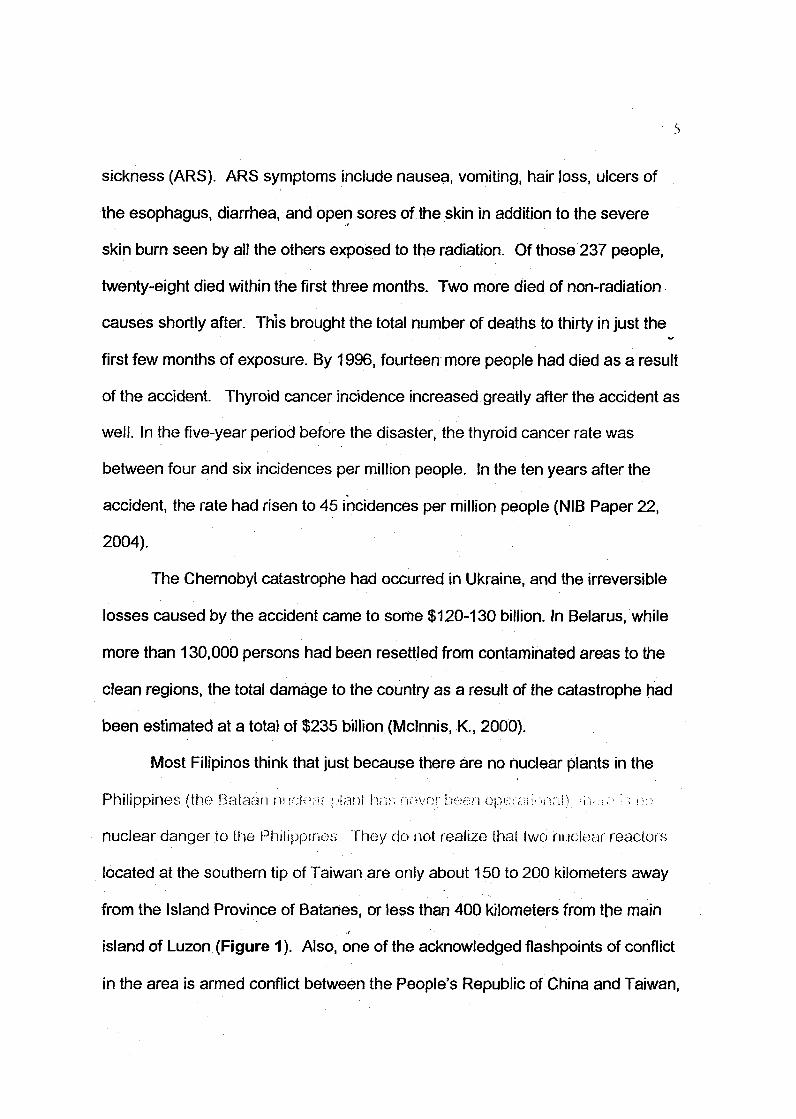
island of Luzon (Figure 1). Also, one of the acknowledged flashpoints of conflict
in the area is armed conflict between the People's Republic of China and Taiwan,

23
8
AIWAN
ftiaanshan 1 & 2Pressurized Water Reactorstocated at Herng Chuen, Taiwanwith 890 Mwe net output each
TREATY LIMITS OF THE PHILIPPINES
Bate oup of islands• : U)
0 Baton
SOUTHPHILIPPINE
SEA
PP.FNES
Fig. 1. Location map of the Batanes group of islands.
PHILIPPINE NUCLEAR * £ ^ H I N S T ^ —SCIENTIFIC LIBRARY AND DOCUMENTATION b tn ^
if the latter declares independence. Such a conflict could involve the use of
tactical nuclear weapons. While the International Crisis Group, Asia Report No.
54 (2003b: 9-10) asserts that China's resulting to nuclear weapons against
Taiwan is extremely remote, including the very distant possibility of a nuclear
reactor disaster to occur, preparations in our country for such eventualities no
matter how remote the possibilities are, must not be discounted. Nuclear fallout
may reach parts of the country, especially the Island Province oi ft::!;, \v--,_ u is in
this light that a baseline data on the naturally occurring radioactive elements is
importantly needed. The natural radiation due to naturally occurring
radioelements is referred to as the standard for comparing additional sources of
man-made or artificial sources of radiation resulting from the fallout. To evaluate
the significance or amount of the additional man-made or artificial radiation, the
levels of natural background radiation must be known. This will thus provide an
important point of comparison in evaluating increases of radiation that are due to
radioactive fallout vis-a-vis the natural radioelements.
The Province of Batanes is composed of ten (10) small islands with a total
land area of about 210 sq kms. The larger and only habitated are Itbayat (93 sq
kms), Batan (75 sq kms) and Sabtang (40 sq kms) islands. As of May 1, 2000,
the population of Batanes was 16,467 and the greater majority are Ivatans. It has
six municipalities, four of which are within the bounds of Batan Island, including
Basco, the capital town. The principal base of the economy is agriculture with
garlic and cattle as the leading exports to other parts of the country
(Demographic Characteristics of Batanes, n.d.). Batanes is in the verge of being

declared a world natural and cultural heritage site. It will be the 6th to be inscribed
in the UNESCO World Heritage List and 1"' in the country to be declared both a
natural and cultural heritage. It has a distinct floristic, faunistic and geological
composition from the rest of the country. There are several authentic Ivatan
stone houses that need to be preserved. Being in the World Heritage List is
considered an honor since it includes only sites of "outstanding universal value"
that must be preserved for all mankind. It promotes these areas and helps
generate revenue for tourism (Solano, Ma. L.A., n.d.). Batanes, which is still
considered to be in its pristine stage, may be imperiled in case of a nuclear
disaster in Taiwan. A nuclear accident, which is similar to the Chernobyl
catastrophe that contaminated neighboring Belarus and southwestern Russia by
nuclear fallout of 5 curies (185 x 109 Becquerels) would likely result in the
destruction of important agricultural farmland and grazing land of catties in
Batanes. This could also cost a considerable amount of resources in the
decontamination of the infrastructure, particularly the Ivatan stone houses that
are considered to be part of the cultural heritage of Batanes. The nuclear fallout
that will spread radioactive particles in Batanes could cause acute radiation
sickness to the population. Aside from these, the radioactive particles could seep
into the ecosystem affecting the distinct flora and fauna of Batanes.
To what extent therefore have nuclear risks been factored into Philippine
national security policy? As lar as ihe milila;/ dimension goes, ilk-:;v:'k: no (\ur-.cA
military threat. Yet, the real environmental risks are tremendous, and can lead to
possible destruction of lives and properties.

Although environmental radioactive monitoring has been an activity of the
Philippine Nuclear Research Institute (PNRI) since the 70's, there has been a
dearth of the baseline data as bases for determining fluctuations, for more
accurate decisions. Without reliable baseline information on background
radioactivity, radiation-related studies and monitoring of the environment may be
distorted.
The terrorist attack on the Twin Towers on September 11, 2001 has
heightened the significance of the potential threat of terrorism involving nuclear
and other radioactive materials. In response to the recognition of this new level of
vulnerability, the government has initiated the formulation of the Philippine
Nuclear Security Plan. Although still in its draft stage, the Operative Plan
involves four (4) strategies: Prevention, Detection, Response, and Support
Infrastructure. As the public is both, the group at risk, the source of vital
information, and the resource base which the Government may tap for any
contingency, public information and education is an imporhin! GOI-ip-vK .oi ^i \U^
Plan (Dela Rosa, A.M., r u t ;
It is deemed timely that while the planning for the Philippine Nuclear
Security Plan is on-going, this study will be conducted to pilot the development of
baseline data on the natural background radioactivity and determine the utility
value of the data on the various programs/strategies embodied in the Plan, with
the end in view of recommending improvements thereto.

10
1.2 STATEMENT OF THE PROBLEM
One field of knowledge where current information is inadequate concerns
the distribution of the natural chemical elements in the earth's surface material.
These elements, both radioactive and non-radioactive are part of the natural
environment. The main reason why a number of regulations are judged too strict
and disproportionate to the risks that might be caused by some human activities
is the lack of information on the earth's natural surficial composition, from which
environmental regulations should be based. Through the use of reliable baseline
information, the definition of limits of levels of contaminants- on the surface
environment can be suitably s&L Thus, rei=o;.;i ones on ihe pwi^ii i iai ;,•:>.; :U::.
caused by variations in these elements or substances to living organisms,
including humans can be carried out with better perspective.
The naturally occurring radioactive elements potassium, uranium and
thorium form part of the natural environment. Knowledge about the natural
abundance of radioelement in the environment is very vital to have meaningful
interpretation of radioactivity-related studies and monitoring of radioactivity-
related environmental pollution. Without reliable baseline information on this
natural radioactivity, radiation-related studies and monitoring of the environment
may be distorted.
In general, this study aims to pilot a baseline study on the natural
background radioactivity of Batan Island, Batanes Province, and develop a
scheme for replicating the Batan baseline study in other selected sites in the
11
Philippine Archipelago. To this end, the study will answer the following
questions:
1. What is the distribution and abundance of potassium (K), uranium (U),
thorium (Th) and the total •natural radiation (TNF:' • K •> U ^ "Hip
2. How such distribution and abundance, in spatial forms, be identified,
shown and presented?
3. What are the averages of K, U, Th and TNR in each barangay and
municipality, including for the whole of Batan Island?
4. How are these averages compared with the internationally established
background values (averages)?
5. What are the different scenarios or conditions that may classify as
nuclear or radiological risks/threats?
6. What areas in the Philippines are most likely nuclear risk areas?
7. In which nuclear risk areas the Batan baseline study may be
replicated?
8. What is the level of awareness of residents from Batan Island, Batanes
Province regarding radiation, natural radioactivity, and the benefits and
detrimental effects of radiation?
1.3 Significance of the Study
It is expected that the study would benefit or contribute to the follpwing:
• To the understanding of national leaders, decision-makers and policy-
makers that the need for establishing baseline ii^r-Mai!;;:: o;> ;h-
12
natural radiation of the entire nation has become essential.
• The concerned government agencies and instrumentalities that are
involved in protecting the health of the public and the environment. The
baseline data can be used as a reference to detect and determine the
amount and extent of any possible future variations in the radioactivity,
level resulting from nuclear disasters/accidents, nuclear bomb testing,
nuclear terrorism as well as nuclear armed conflicts and radiological
contamination. Increases in radiation may pose health hazards not
only to humans, but also the terrestrial and atmospheric environment
of an area or the entire country as well. The baseline data will provide
an important point of comparison in evaluating increases of radiation
that are due to man-made activities in the event an environmental
problem arises from nuclear accidents/fallout. Protecting the health of
the population in case of a nuclear disaster is essentially a social
priority and a matter of national concern.
• The public at large who are increasingly becoming concerned and
apprehensive about any source of radioactivity or any possible
O x ' p i . i S U l ' O i O ! < : ( • ' l i M I " •••'; : '- i ' !OS.rl;. i LX : ;•.;<.. ::X.ji..:.\."iU:;iy U ' l l O f i i 'h" ; i . i . I i i: :i : : i I'>•..';
reason why it is important that the baseline data and spatial distribution
of the naturally occurring radioelements should be made familiar to the
public through information dissemination and education facilities.
• The formulators of the Philippine Nuclear Security Plan as the study is
intended to contribute to the formulation of the Plan, which in effect will
1-3
enhance national security as it will provide some shield to the
Philippines from radiological and nuclear risks or threats.
• Other researchers, particularly those whose interests are in the
geological and environmental field, since the study can be used as a
model in future similar studies that may be conducted anywhere in the
country or for the entire Philippines as well.
1.4 Scope and Limitations
This study will focus on establishing baseline information of the radioactive
elements K, U, Th and TNR of Batan Island using scientific precision field
equipment. The study limits its scope on Batan Island, Province of Batanes since
it is the nearest and most populated island in ihe country who-re nndonr Irscililies
are situated. Batan Island is only about 180 kilometers away from ihe southern
tip of Taiwan where two nuclear power reactors are located.
Key informants to be interviewed are persons knowledgeable on matters
regarding nuclear threats and security with relevant training, education and
experience in nuclear science and technology. However, in the course of the
study, it was very difficult to find persons outside of the Philippine Nuclear
Research Institute that could classify as key informant based on the needed
qualifications. Seven (7) key informants were interviewed and only one was not
connected with PNRI.

14
CHAPTER ENDNOTES:
Lecture Handout (Printout of Powerpoint slides)
Dela Rosa, A.M. (n.d.). Powerpoint slides entitled Philippine nuclear security
plan.
Report
Clavejo, L.A. (2005). The worldwide nuclear, biological and chemical warfare
threat. Briefing on Bioterrorism: \ssxu: : zuvi Develop;nonis, i •:.;;'!..>;:. •;
Defense College or the Philippines.
ElBaradei, M. (2004). Nuclear proliferation and the potential threat of nuclear
terrorism. Keynote Address: Asia-Pacific Conference on Nuclear
Safeguards and Security, Sydney, Australia.
ICG, (2003b). Taiwan Strait II: The Risk of War, International Crisis Group, ICG
Asia Report No 54, June 6, 2003. ICG
Beijing/Taipei/Washington/Brussels.
PNRI, (2000). National Radiological Emergency Preparedness and Response
Plan (RADPLAN).
Internet
Bond, R.A., (2005). "Chernobyl'Accident," Microsoft® Encarta® Online
Encyclopedia 2005. Retrieved March 05, 2005, from
http://encarta.msn.com.
Demographic Characteristics ofBatanes, (n.d.). Retrieved March 29, 2005, from
http://www.uyuganbatanes.com
15
Mclnnis, K., (2000). Effects of the Chernobyl Accident. Rauioved iVImch fi ' l
2005, from http://www.elon.edu/stident/kmcinnis/kim'spaqe.hlml.
Nuclear Issues Briefing Paper 22, (2004). Chernobyl Accident. Retrieved March
05, 2005, from http://www.uic.com.au/nip22.htm.
Solano, Ma. LA., (n.d.).'Batanes may be declared a world natural and
cultural heritage site. Retrieved March 29, 2005, from
http://mobilemediaph.com/projectE/Batanes/batanes_unesco.html
16
Chapter 2
REVIEW OF RELATED LITERATURE
2.1 Foreign Sources
2.1.1 Pre-Chernobyl Situation
Prior to the Chernobyl accident in 1986, the information on the earth's
surface radioactivity at the world's level is poor to very poor according to the
International Atomic Energy Agency (IAEA, 1990). Only a small percentage of
countries in the world have good information on the natural background
radioactivities of their country like Canada (Grasty, R. L, et al., 1984) and the
United States of America (Shaklette, H. T. and Boerngen, J. G., 1984). Even
available information that are somewhat related to natural background
radioactivity mapping were products of surveys carried out all over the world for
mineral exploration, uranium in particular (Darnley, A.G., 1993).
2.1.2 Post Chernobyl
The nuclear reactor accident at Chernobyl in the USSR in April 1986 and
the confusion in the public mind over the nature and extent of the resulting fallout
brought out the need for a widespread awareness of the natural radiation
background in places where people live (IAEA, 2003). This prompted several
nations not only in Europe but also other countries in the world to assess their
territories for possible radioactive contamination, including the production of
baseline information on natural radioactivity. In Europe, the countries that
17
conducted radioactivity or radiometric surveys to assess the natural radioactivity
level and/or nuclear fallout within their national boundaries were the Czech
Republic (Matolin, M., 1997), Hungary (Odor, L, etal., 1997), Belarus
(Guermentchuck, M.G., et al., 1997), Poland (Strzelecki, R., et al., 1997), Finland
(Bourgeois, C, et al., 1997), Germany (Barthel, F., et al., 1997), Spain (Suarez
Mahou, E. and Fernandez Amigot, J.A., 1995), Portugal (Torres, L. M. and
Grasty, R. L, 1995), Slovenia (Andjelov, M., et al., 1995), Switzerland (Schward,
G.F., 1995) and Sweden (IAEA, 1991).
Other countries that similarly conducted baseline studies on the natural
b a c k g r o u n d r a d i o a c t i v i t y i n I h a i r c o u n s r y vv -o i e \ h e I s l a m i c R e p u b i k ; •.>> -.,;.;;
(Soleimani, G. and Yegani, F.S., 1997), Jordan (Daoud, M. N., 1997) and Israel
(Vulkan, D. and Shirav, H., 1997) in the Middle East, Venezuela and Argentina
(Grasty, R.L. and Cox, J.R., 1996), in South America, and Malaysia (Tauchid, M
and Grasty, R. L, 2000) and Thailand (Angsuwathana, P. and Chotikanatis, P.,
1997) in Southeast Asia.
2.1.3 Baseline Survey Techniques Used
Most of the baseline surveys conducted in Europe and other countries
used the airborne survey technique composed of an aircraft, the equipment
'gamma ray spectrometer' (GRS) that measures the radioactivity and a global
positioning system (GPS) that measures longitude and latitude, which
characterize the location (position anywhere on the earth's surface) where
radioactivity is measured. In Venezuela and Argentina however, the carbome

18
survey technique composed of a land-based vehicle, GRS and GPS was utilized.
Both the airborne and carborne survey techniques are rapid but costly. Hence,
the development of a large spacing ground or footborne survey technique was
successfully demonstrated in the Poland and Slovenia si rrveys. Tho footborne
survey technique uses a portable GRS and radioactivity measurements are taken
at every equal sampling interval or spacing as measured by a meter tape and
compass. In Poland, radioactivity was measured every 2 kms sampling interval
while in Slovenia every 2.5 kms. This survey technique is tedious and slow
especially in the conduct of measuring the sampling interval prior to radioactivity
measurement.
This study made use also of the footborne survey technique, however,
innovations were made by having a closer sampling interval every 1 km and the
location or sample location/data station/sampling station where the radioactivity
measurements were taken was determined by a portable GPS. A closer
sampling interval will result in more radioactive measurements and a better
representation of the survey area. The GPS allowed easier and faster
determination of the sample locations.
2.2 Local Sources
In the Philippines, most of the radioactivity related surveys were likewise
geared towards the exploration of uranium (Huntings Geophysics Ltd., 1954;
Cameron, J., 1965; Hernandez, E. C, et al., 1976; and Reyes, R. Y., et al.,
1991). The Health Physics Research Group of the Philippine Nuclear Research

10
Institute (PNRI) attempted to assess the sources and levels of radiation exposure
in the Philippines (Duran, E. B., et al., 1996). They were able to come up with
levels of natural radiation of the Philippines based on 1600 measurements.
Considering the geological complexity of the Philippines, the seemingly
insufficient data measurements may not be enough to adequately define the
natural background radiation of the country. The underlying geology (different
rock types/formations), which is the main component of the environment, is the
major source of natural radiation.
2.3 Nuclear and Radiological Risks or Threats
The Chernobyl incident is a nuclear disaster involving an accident of a
fixed nuclear facility, a nuclear reactor. There are, however, other nuclear threats
that may likely occur in the future. The National Radiological Emergency
Response Plan (PNRI, 2000) listed some of these nuclear threats that may
contaminate any area in the country requiring radiological emergency measures:
1. Accidents from fixed nuclear or radiation facilities such as nuclear
research reactors, industrial or medical facilities licensed to use, possess, or
import radioactive material.-. <M ociuipnieni: oontoining radioriaivo n;--i-••=;,• •!<•;. .is.-I
all other facilities or establishme-nis using or possessing radioactive materials,
2. Accidents occurring in the transport of radioactive materials or wastes
being transported by land, sea or air inside Philippine territories, including lost or
stolen radiation sources,
20
3. Nuclear fallout of foreign sources having environmental impact on
Philippine territories. Radiation from a foreign source that poses as actual,
potential, or perceived threat to any area within the territorial limits of the
Philippines. The source of radiation may be from an accident from a foreign
nuclear power plant, radioactive waste repositories, fuel processing plants, or
from the testing of nuclear weapons,
4. A satellite or spacecraft with nuclear materials as components would
land within the territory of the Country. An example of this was in 1978 when a
nuclear powered Russian satellite re-entered the earth's atmosphere and
scattered nuclear debris over thousands of square kilometers in the Northwest
Territories of Canada (IAEA, 2003), and
5. Accidents involving radioactive materials or waste from nuclear
powered seacraft, including nuclear submarines occurring wiihin UUJ huMioiy uf
the Philippines.
The aftermath of the 11 September 2001 terrorist attack at the twin towers
of the World Trade Center in the U.S.A. altered the international security
landscape so drastically that it compelled a fundamental revaluation of security
strategies, including the Philippines on the potential threat of terrorism, nuclear
terrorism in particular. The nuclear risks posed by nuclear terrorism ace
categorized as follows (Potter, W. C, 2004):
1. The dispersal of radioactive materials by conventional explosives or
other means,
21
2. The radiological hazards caused by an attack against or sabotage of
nuclear facilities, or transport vehicles,
3. Theft or purchase of nuclear materials leading to the fabrication and
detonation of a crude nuclear weapon, and
4. Theft and detonation of an intact nuclear weapon.
2.4 The Philippine Nuclear Security Pkm
All nuclear and radiological threats are real, all merit the attention of our
government, and all require the expenditure of significant resources to reduce the
likelihood and impact of their occurrence. The 911 attack took on a heightened
significance the potential threat of terrorism involving nuclear and other
radioactive materials. The State bears the responsibility for the security and
safety of nuclear and other radioactive materials, as mandated in the constitution
of ensuring the safety and well-being of its citizens. The vulnerability of the
country therefore depends on the level of security existing for these materials.
Thus, to enable the State to prevent and combat acts of nuclear terrorism,
concerned government instrumentalities are now presently formulating the
Philippine Nuclear Security Plan. This Plan will be a great contribution to the
National Plan to Address Terrorism and Its Consequence, which in turn is part of
the National Internal Security Plan.

22
2.5 Conceptual Framework
Inputs Process Outputs
• Basic information on thenatural radiationenvironment
• Fundamentals ofradioactivity
• Review of all possiblenuclear risks
• Opinion of keyinformants
• Consequences and impact IIof radioactive fallout •—"A
• Important information '—.ryabout Batanes Province I
• Ivatans' level of Iawareness about radiation I
Outcome
• Field 1measurements IIofK,UandTh IIin Batan Island ||^
• Develop maps I - ^using Surfer IIcomputer 1software II
— - - — — — 1 |• Baseline I]Data 1• Maps 11showing the. lu\spatial L_ydistribution of IIK,U,Thand IITNR II
— — — — ^ J |
Dataconsolidationand analysis
• SchemereplicatingBatan baselinestudy
• Policyadvocacy oninformationdissemination
• Awarenesssurvey
• ImprovedPhilippineNuclearSecurityPlan
• EnhancednationalSecurity
Figure 2. Conceptual Framework
In the above schematic diagram, the relevant information on the natural
radiation environment and fundamentals of radiation will be the guiding inputs in
the conduct of field measurements. These measurements will lead to the
establishment of the baseline data and development of spatial distribution maps.
The baseline data and maps will form part of the response strategy of the PNSP
in drawing up responses to an emergency nuclear situation.
The review of all possible nuclear fitts, oi threats and iho ot.-snk.ii i •..(
persons who are knowledgeable in the areas of nuclear risks and security will
serve as valuable inputs in determining the nuclear threats that have or are
23
expected to have significant radiological effect within the Philippine territory. The
opinion of these persons will be the vital information needed to determine
possible nuclear risk areas in the country and the level of risk in coming up with-a
scheme wherein the Batan study may be replicated. This scheme will also form
part of the response strategy of the PNSP.
The awareness level of the Ivatans, local residents of Batanes Province,
will be determined on their factual knowledge about radiation, natural
radioactivity, and the benefits and detrimental effects that can be derived from
radiation. These will determine how informed is the populace, which may help in
the response strategy of the PNSP to lessen the impact on the hazards posed by
radiation to the public and environment in case of an emergency nuclear
situation. The level of awareness may also assist in making policy advocacies on
information dissemination and community involvement in the PNSP.
The product of this study may be used as input in the PNSP, particularly in
the response (under the emergency response and preparedness and advocacy
and awareness programs) sualogy of the \'Lm. The PNSP, whicn b ix.jmj
formulated primarily to address nuclear security and terrorism will greatly
contribute to the National Plan to Address Terrorism and Its Consequence
(NPTC). The NPTC provides the overall framework for the Government's action
against terrorism. The NPTC is embedded as an annex in the National Internal
Security Plan, which is mandated to overcome insurgency nationwide.

24
2.6 Definition of Terms
Baseline - conditions that would prevail if no actions were taken.
Baseline data/information - used for a survey of the environmental conditions
and organisms existing in a region prior to unnatural disturbances.
Batan Island - refers to'an island belonging to the Batanes Group of Islands that
comprise the Batanes Province. It is where Basco, the capital town of
Batanes Province is situated, which is the seat of the Provincial
Government.
Naturally occurring radioactive elements - radioactive elements that are
inherently present in rock, soil, air, wafer, etc. Thesf> oiomoi -.r... w<-
potassium-40, uranium and thorium.
Nuclear fallout, radioactive fallout or fallout - is the contamination of the earth's
surface by man-made radionuclides. The nuclides are transported in the
air over considerable distances and deposited on the earth's surface by
rain (IAEA, 2003).
Nuclear risk - a risk connected to the functioning of nuclear power plants, by the
storage or transportation of radioactive materials and involving the release
of potentially dangerous levels of radioactive materials into the
environment (Retrieved from
http: //www. e 10net. eu. int/gemet/concept?cp=12816)
Nuclear Terrorism - the use of a nuclear device by a terrorist organization to
cause massive devastation or the use (or threat of use) of fissionable
radioactive materials; "assaults on nuclear power plants is one form of

25
nuclear terrorism". (Retrieved from
http://www.Thefreedictionarv.com/nuclear%20terrorism. 15 February
2005)
Radioactive elements (radioelements) - unstable elements that emit radioactivity.
Radioactivity rete'rs to {he disintegration of ihe atomic nuclei!;;
CHAPTER ENDNOTES:
Bulletin
Grasty, R.L., Carson, J.M., Charbonneau, B.W. and Holman, P.B., (1984).
Natural Background Radiation of Canada, Geological Survey of Canada,
Bulletin 360, 39p.
Tauchid, M. and Grasty, R.L, (2000). Natural background radioactivity of the
Earth's surface - Essential information for environmental impact studies.
IAEA-SM/362-25.
Journals
Reyes, R.Y., Santos, Jr., G.P., Magsambol, W.N. and Ramos, A.F, (1991).
Reconnaissance geochemical exploration for uranium in Northern
Palawan, Philippines. Philippines Nuclear Journal, v. 8, pp. 55-68.
Keynote Address
Potter, W. C , (2004). Meeting the challenge of nuclear terrorism: Potential
threats in Asia and the Pacific, Keynote address delivered at the Asia-
Pacific Conference on Nuclear Safeguards and Security, Ministerial
Meeting, Sydney, Australia.
Proceedings
Andjelov, M., Tomsic, J. and Pecnik, M., (1995). Natural background
radioactivities and geochemical map of Slovenia: In Proceedings of a
Technical Committee Meeting; Application of Uranium Exploration Data
and Techniques in Environmental Studies, IAEA-TECDOC-827, Vienna,
Austria, pp. 217-230.
Angsuwathanan, P. and Chotikanatis, P., (1997). Background radiation map of
Thailand: In Proceedings ol a Technical Committee Meeting, Uranium
Exploration Data Applied to the Preparation of Radioelement Maps,
IAEA-TECDOC-980, Vienna, Austria, pp. 44-52.
Barthel, F., Thoste, V. and Borsdorf, K.H., (1997). The distribution of
radionuclides in the upper soil horizons in Lower Saxony, Saxony and
Thuringia, Germany: In Proceedings of a Technical Committee Meeting,
Uranium Exploration Data Applied to the Preparation of Radioelement
Maps, IAEA-TECDOC-980, Vienna, Austria, pp. 319-336.
Bourgeois, C, Bresson, J., Chastel, R./Chiffot, T., Guillot/L, Krunjilch. J. and
B e r g e y , C , Y I 9 9 7 ) . i.>:-•..•; u i iU re t ju i i s o l i he ae r ia l g a i r u n a n K i ^ p i u y ; 5 ysk : f i i
during the international exercise RESUME 95 in Finland: In Proceedings
of a Technical Committee Meeting, Uranium Exploration Data Applied to
the Preparation of Radioelement Maps, IAEA-TECDOC-980, Vienna,
Austria, pp. 173-180.
27
Daoud, M.N., (1997). Natural background radiation of Jordan: In Proceedings of
a Technical Committee Meeting, Uranium Exploration Data Applied to the
Preparation of Radioelement Maps, IAEA-TECDOC-980, Vienna, Austria,
pp. 91-118.
Darnley, A.G., (1995), Uranium exploration data, international geochemical
mapping and the environment. In Proceedings of a Technical Committee
Meeting; Application of Uranium Exploration Data and Techniques in
Environmental Studies, IAEA-TECDOC-827, Vienna, pp. 9-23.
Duran, E.B., De Vera, CM., Dela Cruz, F.M., Enriquez, E.B., Garcia, T.Y.,
Palad, L.H., Enriquez, S.O., Eduardo, J.M., and Asada Jr., A.A., (1996).
Sources and levels of radioactivity in the Philippine environment: In
Proceedings of the Second Philippine Nuclear Congress. Challenges of
Nuclear Technology for the 21st Century, Philippines :>00p.
Guermentchuck, M.G., Zhukova, O.M., Shagalova, E.D. and h/latveenko, 1.1.,
(1997). Radioecological mapping of the territory of Belarus on the base
information of radiation monitoring: In Proceedings of a Technical
Committee Meeting, Uranium Exploration Data Applied to the Preparation
of Radioelement Maps, IAEA-TECDOC-980, Vienna, Austria, pp. 153-
162.
Matolin, M., (1997). Terrestrial gamma dose rate map, their compilation and
verification - radiometric map of the Czech Republic: In Proceedings of a
Technical Committee Meeting, Uranium Exploration Data Applied to the

28
Preparation of Radioelement Maps, IAEA-TECDOC-980, Vienna, Austria,
pp. 53-58.
Odor, L, Horvath, I., Fugedi, H., and Renner, J., (1997). Distribution of Natural
(U, Th and K) and artificial (Cs-137) Radioelements in the flood plain
deposits of Northern Hungary: In Proceedings of a Technical Committee
Meeting, Uranium Exploration Data Applied to the Preparation of
Radioelement Maps, IAEA-TECDOC-980, Vienna, Austria, pp. 125-134.
Schwarz, G.F., Klingele, E.K., and Rytach, L., (1996). Airborne rad.t .•;;:< UK;
mapping in Switzerland: In Proceedings of a Technical Committee
Meeting; Application of Uranium Exploration Data and Techniques in
Environmental Studies, IAEA7TECDOC-827, Vienna, Austria, pp. 61-70.
Shacklette, H.T. and Boemgen, J.G., (1984). Elemental concentrations in soils
and other surficial materials of the Conterminous United States. U.S.
Geological Survey Professional Paper 1270, United States Government
Printing Office, Washington.
Soleimani, G. and Yegani, F.S., (1997). Airborne gamma ray spectrometry in
certain areas of the Islamic Republic of Iran and its results - correlation to
other usages: In Proceedings of a Technical Committee Meeting,
Uranium Exploration Data Applied to the Preparation of Radioelement
Maps, IAEA-TECDOC-980, Vienna, Austria, pp. 67-76.
Strzelecki, R., Wolkowickz, S. and Lewandowski, P., (1997). Mapping of post-
Chernobyl environmental pollution in Poland: In Proceedings of a
Technical Committee Meeting, Uranium Exploration Data Applied to the
29
Preparation of Radioelement Maps, IAEA-TECDOC-980, Vienna, Austria,
pp. 163-172.
Suarez Mahou, E. and Fernandez Amigol, J.A., (1995). Use ol uranium
airborne survey data in the preparation of a radiometric map of Spain: In
Proceedings of a Technical Committee Meeting; Application of Uranium
Exploration Data and Techniques in Environmental Studies, IAEA-
TECDOC-827, Vienna, Austria, pp. 109-126.
Torres, L.M. and Grasty, R.L., (1995). The Natural Radioactivity Map of
Portugal: In Proceedings of a Technical Committee Meeting; Application -
of Uranium Exploration Data and Techniques in Environmental Studies,
IAEA-TECDOC-827, Vienna, Austria, pp. 127-134.
Vulkan, D. and Shirav, H., (1997). Radiometric maps of Israel - partial
contribution to the understanding of potential radon emanations: In
Proceedings of a Technical Committee Meeting, Uranium Exploration
Data Applied to the Preparation of Radioelement Maps, IAEA-TECDOC-
980, Vienna, Austria, pp. 119-124.
Reports
Cameron, J., (1965). Prospection and evaluation of nuclear raw materials:
Report to the Government of the Philippines. IAEA TA Report No 175,
International Atomic Energy Agency, Vienna, Austria.
Grasty, R.L. and Cox, J.R., (1996). A carborne gamma-ray spectrometer system
for natural radioactivity niappiruj and environmental moiiiiofiM;.
30
Presented at the seminar oh Exercise Resume95, Copenhagen,
Denmark, 17-19th January, 1996.
Huntings Geophysics, Ltd., (1954). Report on the airborne radiometric survey of
six areas in the Republic of the Philippines. Report submitted to the
USAEC with contract No AT(30-1 )-1611.
International Atomic Energy Agency, (1991). Mapping of Chernobyl fallout in
Sweden: In Airborne Gamma Ray Spectrometer Surveying, IAEA-
Technical Report Series No* 323, Vienna, Austria, pp. 57-60.
Technical Documents
International Atomic Energy Agency, (1990). The Use of Gamma Ray Data to
Define the Natural Radiation Environment, IAEA-TECDOC-566, IAEA,
Vienna, 97p.
International Atomic Energy Agency, (2003). Guidelines for Radioelement
Mapping Using Gamma Ray SpectrometryData, IAEA-TECDOC-1363,
Vienna, 173p.
Thesis
Hernandez, E.G., (1976) Distribution of laclioelements at the Submnkin Massive
Sulfide Deposits, Paracale, Camarines Norte: M.S. thesis, University of
the Philippines.
31
Chapter 3
METHODOLOGY
This chapter describes the research design, sampling procedure, instruments
ted, data gathering procedure and data analysis techniques.
1. Research Design
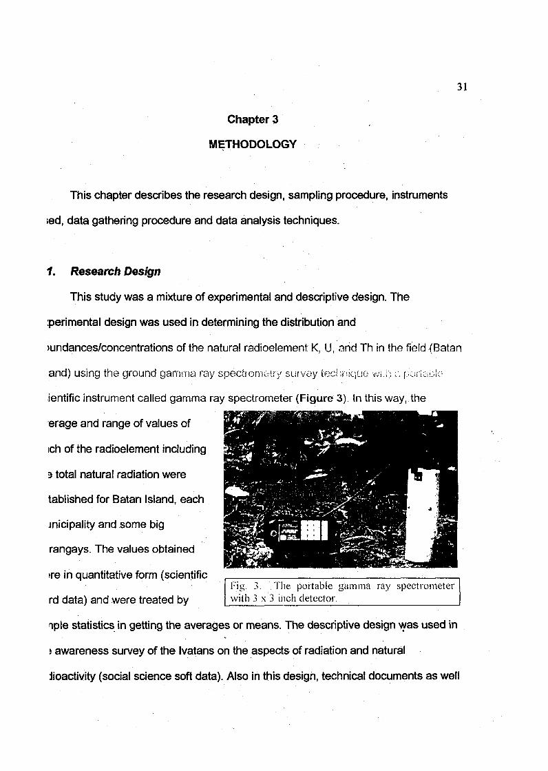
This study was a mixture of experimental and descriptive design. The
perimental design was used in determining the distribution and
>undances/concentrations of the natural radioelement K, U, and Th in the field (Batan
and) using the ground gamma ray specltomouy survey technique wiv, •,:. poruibio
ientific instrument called gamma ray spectrometer (Figure 3). In this way, the
erage and range of values of
ich of the radioelement including
3 total natural radiation were
tablished for Batan Island, each
jnicipality and some big
rangays. The values obtained
>re in quantitative form (scientific
rd data) and were treated byFig. 3. The portable gamma ray spectrometerwith 3 x 3 inch detector.
nple statistics in getting the averages or means. The descriptive design was used in
i awareness survey of the Ivatans on the aspects of radiation and natural
Jioactivity (social science soft data). Also in this design, technical documents as well
32
s information from the key informants (soft data) were used in determining the
assification of areas as nuclear risks. The priority areas where the Batan baseline
udy may be replicated were similarly evaluated from the opinion of key informants
sing the simple ranking analysis.
2 Sampling
The field survey conducted that determined the distribution and levels of natural
idioactivity in the different parts (surficial areas) of Batan Island in Batanes followed
le purposive sampling design. This is in consideration of the large size and extent
ariability of the study population, which is the whole island of Batan. As previously
ated, the level of natural radioactivity (concentrations of the radioelements K, U and
i) varies from place to place depending to a greater extent on the underlying
3ological formations or rock/soil types. With the large size of the study population, i.e.
atan Island, and to have a good sampling representation of radioactivity
easurements, Batan Island was purposively divided into square cells of 1 square
lometer or 1 x 1 kilometer grid. With the use of a 1:50,000 topographic map of Batan
land, an arbitrary point in the middle of the island was determined. Vertical and
>rizontal lines were drawn from this arbitrary point and 1 x 1 kilometer grid going
>rth-south and east-west were drawn to cover the whole island. This 1 x 1 kilometer
id is called a 'sample cell1 in which within this sample cell, measurements of K, U and
l were taken using the portable gamma ray spectrometer.
The quantitative/numerical outputs of the portable GRS represent the amount or
•ncentration of K, U and Th at the point of measurement in the field. The unit of
surement for potassium is percent (%) while for uranium and thorium is parts per
3n (ppm). The location or sampling location/sampling station or the point where the
and Th were measured was as much as possible taken at the center of the
pie cell. This will ensure a sampling interval of 1 kilometer. A total of 83 sample
were drawn for the whole'island of Batan (Figure 4). All the quantitative/numerical
ut representing the varying concentrations of K, U and Th as measured in Batan
id constitute scientific hard data.
The awareness level survey, the Ivatans being the respondents, and the opinion
view of key informants followed the random purposive sampling procedure. The
onses from the perception survey and interview constitute soft data in social
nces.
instruments
The survey of Batan Island utilized a portable scientific instrument GR-256
ma ray spectrometer equipped with a 3" x 3" [Nal(TI)] detector in taking
surements at the sampling location within each sample cell. Prior to full execution
e survey, the portable gamma-ray spectrometer was calibrated to convert its
surements in counts per unit of time into concentrations in parts per million or
ent. The calibration of the portable ttystom WHS ar-hievatf from nieosi'misioHtv. mi
;rete blocks (calibration pads) with known concentrations of K, U and Th (Figure 5)
inform to internationally accepted standard measurement. A portable global
tioning system (Magellan NavPro 5000) was used to record the location (longitude
latitude or easting and northing coordinates in UTM coordinates) of each sampling

34
2266000
__2265O00_
2264000
263QQQ_.
2262000
LEGENDSample cell tliat is 1 x I kinin area within which a samplelocation will be selectedwhere natural radioactivitywill be measured.
,'v Contour lines with 100 in intervalA Peak ofactive volcano•> > Peaks of other mountains• Municipality capital of Balanes
Province• i Other municipalitiesD Baranggay/Silio
226)000
2260000
2259000
225S000
22S7O0O
a
Fig. 4. Map showing Batan Island divided into 83 sample cells wherein naturalradioactivity were measured. Grid numbers are eastings and northingsin UTM coordinates.

35
Dcation (Figure 6). A GPS is a navigation tool which allows a user to determine its
acation anywhere in the world at any time of the day. The system uses a network of
• &$ satellites to establish the position at which the user
is situated (Manuel, C. P., 2004).
The survey questionnaires were used to
gather information on the awareness level of the
Ivatans, local residents of Batanes that formed the
basis for po!;ry advocacy on inform.".lii- /•n
dissemination and possible community involvement
I Fig. 5. Calibration oT portables p c c t r o i n e i c r o n c o n i r c i o a i l i h r . i i i o u
p a d s w i l l i k n o w : : <.\-.!-:./i.MiiiMlicii'-. >.i' i%
U and Th.
l the PNSP. These questionnaires were pre-tested
n selected employees from the Philippine Nuclear
Research Institute. The suggestions and other
lputs in the pre-test were evaluated and
Drresponding improvements were made in the
nal questionnaire format (Appendices B and C).
total of twenty-three (23) very technical questions
n matters related to radiation and radioactivity
»rmed the questionnaires. The questions were categorized into four (4) subjects:
) fundamentals of radiation, (2) basic concepts of natural radioactivity, (3) benefits
iat can be derived from radiation, and (4) detrimental effects of radiation.
Interviews were personally conducted in gathering the views of the-key
formants on: (1) the potential nuclear and radiological risks or threats, (2) the nuclear
1 radiological risks to which Batan Island may be exposed to, (3) the other areas in the
Fig. 6. Location of sampling stationbeing taken by a portable GPS whilenatural radioactivity measurements aregoing on.

36
lilippines that may be exposed to possible nuclear and radiological risks or threats,
d (4) which of the identified nuclear risk areas the Batan baseline study may be
plicated. The opinions and perceptions of the respondents were solid i.eu busea on
3 prepared questionnaire guide (Appendix D).
t Data Gathering •
The airborne and carbome survey techniques are the more commonly used
rvey techniques particularly by developed countries. They are rapid and could cover
arge area in as little time as possible. However, they are costly and beyond the „
pabilities of developing countries like the Philippines. The carborne survey
ihnique, although less costly than the airborne survey is limited to the road network
the survey area. Batan Island has very few road networks. Therefore, the footborne
rvey technique was adopted in the present survey as this is the least costly among
? survey techniques. With the advent of GPS, the survey technique was modified that
stead of using meter tape and compass, the GPS was used in locating the point
ampling location) where radioactivity measurements were taken. Sampling was faster
ice the tedious process of locating the sampling location was eliminated and this
\y be considered as a pioneering work in the country.
Vital to the establishment of a baseline data and production of spatial
itribution maps of K, U, Th and TNR is to have sufficient data points that are
jularly spaced and represent adequately the survey area, i.e., Batan Island. The
sign for g a t h e r i n g d a t a w a s f i rst , B a t a n i s l a n d '::•, d i v i u o d i-nic ^aiiiph.:- ;:;••;-:, i ..-,• , ! >•: 1
Dmeter grid. Second, within each sample cell, natural radioactivity measurements
37
T the use of the calibrated portable gamma ray spectrometer were taken, whenever
ssible at the middle of each sample cell whose location is determined by the GPS.
wever, there were several cases when field conditions (e.g. dangerous topographic
tures that would endanger the lives of survey personnel) did not warrant sampling at
center of the sample cell.* In these cases, radioactivity measurements were taken
/where within the sample cell and the location at which the natural radioactivity were
asured was obtained by the GPS. Third, at the sampling location/sampling station
thin the sample cell) in the field, five (5) measurements were obtained each for K, U
d Th within each sample cell. The five measurements were taken at - one at the
itral point and four points at the north, east, south and west, located at five meters
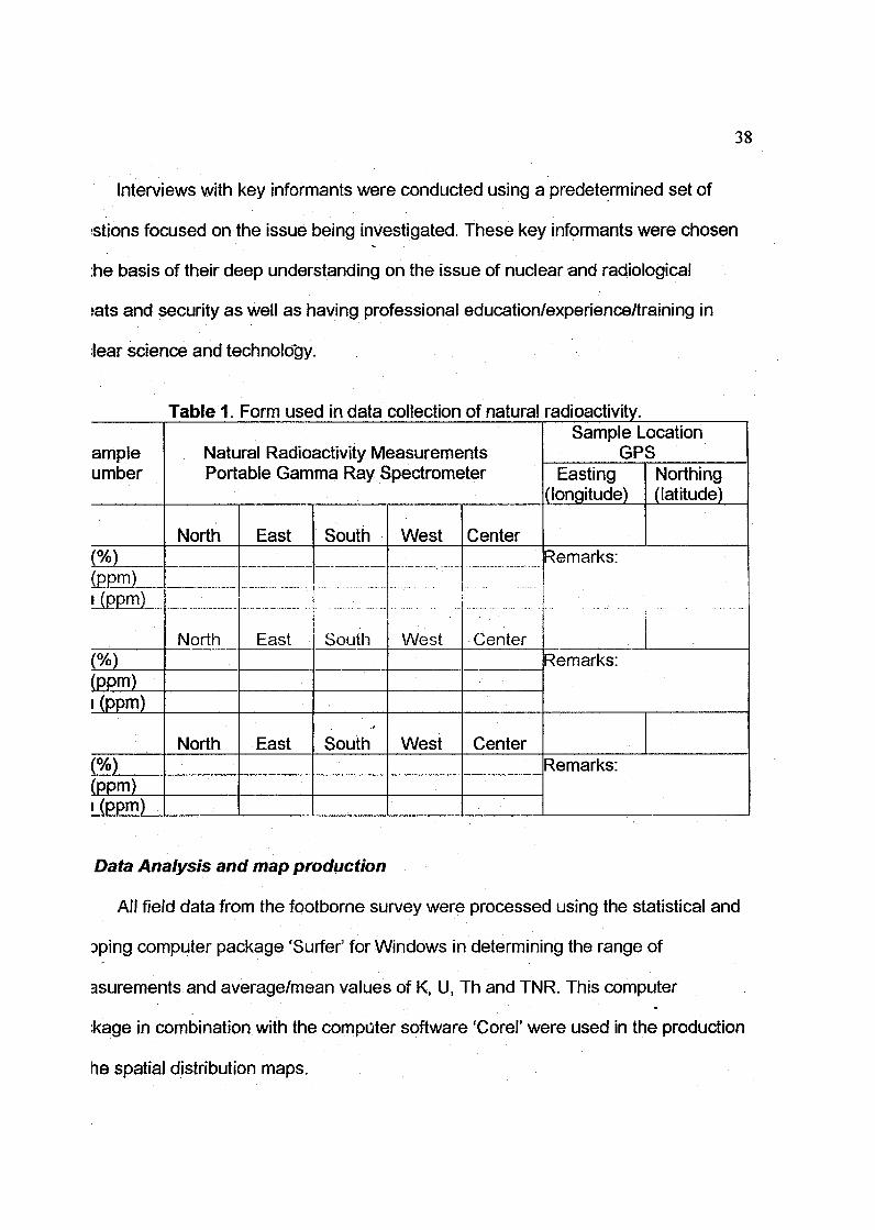
m the central point. The form used to record the measured data is shown in Table 1.
The awareness level survey of Ivatans on the basics of radiation was
termined using the pre-tested survey questionnaires. The survey was partly
iducted during a seminar being conducted by the PHIVOLCS on emergency
sparedness in case of earthquakes at the Provincial Hall of Batanes. A total of 18
rticipants in the seminar corning from different municipalities and bnmnijay^ in Rntan
and constituted part of ihe [osponumUs. The intention is to determine the level of
areness by measuring ihe gap between the answers to Survey Questionnaire No. 1 .
31) and Survey Questionnaire No. 2 (SQ2). The procedure was that, first the
>pondents answered SQL After which, the respondents were allowed to read a
ndout on the Basic Information About Radiation. Then, the respondents answered
12. SQ1 and SQ2 have the same questions. Similar incorrect answers were inserted
th in SQ1 and SQ2 to determine guesswork.
38
Interviews with key informants were conducted using a predetermined set of
istions focused on the issue being investigated. These key informants were chosen
:he basis of their deep understanding on the issue of nuclear and radiological
>ats and security as well as having professional education/experience/training in
Jear science and technology.
ampleumber
(%)(ppm)»(ppm)
(%)(PPm)i (ppm)
(%)(ppm)i (ppm)
Table! Form used in data collection of natural
Natural Radioactivity MeasurementsPortable Gamma Ray Spectrometer
North
North
North
East
East
East
South
South
South
West
West
West
Center
Center
Center
radioactivity.Sample Location
GPSEasting
(longitude)Northing(latitude)
Remarks:
Remarks:
Remarks:
Data Analysis and map production
All field data from the footbome survey were processed using the statistical and
Dping computer package 'Surfer' for Windows in determining the range of
asurements and average/mean values of K, U, Th and TNR. This computer
:kage in combination with the computer software 'Corel' were used in the production
he spatial distribution maps.
39
The simple ranking analysis was employed from the opinion of experts in
ermining the priority nuclear risks areas where the Batan study may be replicated. A
p showing the areas in the Philippines that are most likely nuclear risk areas was
o produced.
In the awareness survey, the respondents' level of awareness is laken as the
centage of correct answers to SQL The gap or difference between SQ'i and S02 is
en as the percentage increase in the level of awareness after information
semination.
IAPTER ENDNOTES:
nuel, C.P., (2004). An Application of Global Positioning System (GPS) - Based
Automatic Vehicle Location System in Law Enforcement and Public Safety at
Central Police District, An Assessment. MNSA thesis, National Defense College
of the Philippines.

10
Chapter 4
PRESENTATION AND ANALYSIS OF DATA
This section presents a description of the geology of Batan Island as a
take-off point for a better understanding of the data generated from the
radioactivity measurements conducted on the study site, the results of the
interviews with key informants who are knowledgeable in related field of study,
and the results of the awareness survey.
4.1 Generalized Geology of Batan Island
The generalized geological description of Batan Island presented here is
taken mostly from the works of Richard et al. (1986) and Sajona et al. (2000).
Batan Island exhibits a 20 km long NNE-SSW trending dumbbell-shaped
configuration and is located approximately 480 kilometers north of Metro Manila.
Its land area of about 75 sq km is mostly mountainous of low to high relief.
Figure 7 shows the geology of Batan Island, which is adopted from Richard et al.
(1986).
Batan Island was developed from at least three successive volcanic
periods during the Late Miocene to Pliocene and Quaternary. The Batan lavas
that formed the island are related to the subduction of the Middle Miocene portion
of the South China Sea basin along the Manila trench. The southern portion and
122 00
-2025
12S"
INDEX AND LOCATION MAT
>:rrs OF CH»A. (>f THE PHILIPPINES
; PHILIPPINE
O<—l SEA
AREAr, SHOWN t
••••:••: : r p i \ i s /
Legend
Explosive eruption. Nuee ardente deposits, mainlybask andeslte.Explosive eruption. Nuee trdente deposits, mainlyMh-fatt and pumtce-fall deposits. (470AO)
. Eftushe eruptions. Add atldic andesifit flows withI - — ' basaltic flows, nuee ardenle with minor lava flows.
(2.3 to 0.4 Ua)
H | Reeflmestone
(. . Mainly basaltic flows' vrith andes)rj(L — I deposits and tuffttes. (6.0-1.7 Ma)
itMainly andesltic with minor basaltic lava flows, andpyrodastic breccia wKh dikes and plugs. (10-7 Ma)
Umitofstratjgraphlcunit
Fault
Buries or covered fauK
Calderarim
Fig. 7. Generalized geological map of BatanIsland, Batanes Province (modifiedfrom Richard etal., 1986)

42
the northern tip of the island correspond to two composite volcanoes, the
Pliocene Mount Matarem and the Quaternary Mount Iraya, respectively.
However, Mount Iraya have rocks ranging from basalt to acid andesite while Mt.
Matarem is characterized mostly by basaltic rocks. Mahatao Volcano, which is a
Strombolian type andesific volcano, partly occupies the central isthmus area.
The oldest rock in the island, the Late Miocene ( 1 0 - 7 Ma) Mahatao
volcanic basement is composed of andesitic and basaltic lava flows, pyroclastics
and breccia with dikes and plugs. They are observed outcropping within the
central isthmus of the island and are capped by Pliocene to Pleistocene (1.8 Ma)
coral reef limestone. This coral reef limestone varies from a few meters to about
40 meters in thickness. During the Early Pleistocene, a general uplift of the
central part of the island occurred, exposing the limestone and the overlaid
Mahatao volcanic rocks forming a horst.
The volcanic period of Mount Mahatao was followed by the Pliocene to
Early Pleistocene (6.0 - 1.7 Ma) volcanic events of Mount Matarem. The
Matarem volcanic rocks are composed mostly of basaltic to minor andesitic
flows, lahar deposits and tuffites.
Mount Iraya started its volcanism on 2.3 Ma to 470 AD. Effusive eruptions
of the volcano deposited the Mount Iraya Volcanics composed of acid andesitic
flows, basaltic flows and nuee ardente deposits (ash flows) with minor lava flows.
At around < 1 Ma, the effusive activity of the volcano changed into an explosive
activity leaving behind deposits of ash falls and nuee ardente. These last
eruptions of Mount Iraya overlaid the Goral reefs found within the central isthmus.

43
4.2 Natural Radioelement Survey of Batan Island
From the population of 83, only 73 sample cells were measured for K, U
and Th by the ground gamma ray specirornew ic suivey technique. Ton (if)}
sample cells were not measured due to the very steep and dangerous
topography of Mount Iraya. However, most of the. sample cells within the
periphery of Iraya Volcano were measured. Similarly, the desired sampling at the
middle of each sample cell was mostly not followed due to the rugged
topographic feature of Batan Island. Additional five (5) measurements were taken
within each municipality and big barangay.
In Basco, the capital town, fifteen (15) additional sites where measured
since it is the most populous area relative to the other towns. Figure 8 shows
the locations of sites within each sample cell where natural radioactivity were
measured. Contoured colored maps were generated for K (%), U (ppm), Th
(ppm), and TNR in terms of exposure rate (uRIh) and absorbed dose rate
(nGy/h).
Exposure rate is the total gamma radiation that is emitted at a given area
by the ground and/or the environment measured in terms of microRoentgent per
hour. Absorbed dose rate is the total gamma radiation that one would be able to
absorb in a certain area measured in terms of nanogray per hour or nGy/h.
Basically, what is being emitted in an area is what one may absorb. In geological
work, the exposure rate is preferred while in health physics the absorbed dose
rate is normally used.

44
LEGEND• Location of gamma ray measure-
ments.• Location of gamma ray measure'
ments within populated areas.^ Contour lines with 100 m interval
Peak of active volcanoPeaks of other mountainsMunicipality capital of Batancs
Province• Other municipalitiesa Barcmggay/Sitio
Fig. 8. Location map of sampling stations in Batan Island, Batanes Province.Grid numbers are eastings and northings in UTM coordinates.

45
The exposure rates and absorbed dose rates were calculated from the
ground concentrations of K, U and Th using the conversion factors in Table 2.
Table 2. Conversion factors to calculate exposure rate andabsorbed dose rate in air
1%of potassium
Source: IAEA, 1990
For the purpose of generating the baseline data for each municipality and
barangay, the average of the values taken within a 1 km radius from the center of
the municipality/barangay was computed. Tho baseline data for baianyays lisrit
fall within the 1 km radius of their municipality were those of the municipality.
4.2.1 Potassium (K)
The distribution and abundance of potassium (also called K signature in
technical terms) in Batan Island is shown in Figure 9. As measured, the range
of values is from 0.025% to 1.84%.
The variances show the results of the three successive volcanic periods
that formed Batan Island which were characterized by almost distinct K
signatures. The rocks formed at the southern portion of the island during the
volcanism event of Mount Matarem gave the lowest values of K. Range of values
is from 0.025% to <1.0%. Exhibiting high K values (>1.0% to <1.9%) are the
rocks formed during the volcanic events of Mount Iraya at the northern portion of
46
Figure 9. Distribution and abundance of potassium (K in %)in Batan Island, Batanes Province
47
Batan Island. The central isthmus area developed during the Mount Mahatao
volcanism showed intermediate values of K ranging from 1.0% to 1.4%. A single
low K value of 0.26% found within the central isthmus area located southeast of
Basco was measured over the coral reef limestone that capped some portions of
the Mahatao volcanic rocks. The above pattern merely shows that K signature is
a function of geological formations.
4.2.2 Uranium (U)
Figure 10 shows the distribution and abundance of uranium (also called U
signature in technical terms) in Batan Island having a range of value of 0.18 to
5.62 ppm. The uranium signature follows the pattern exhibited by the measured
K signature.
Low uranium values (0.18 to <2.40 ppm) delineate the southern portion of
Batan Island characterized by the Matarem volcanic rocks, intermediate values
(2.4 to <4.5 ppm) by the Mahatao volcanic basement rocks within the central
isthmus area and high values (2.70 to 5.62 ppm) by the Mount Iraya volcanic
rocks occupying the northern portion. The coral reef limestone, as with K
signature, gave the lowest uranium value of 0.18 ppm.
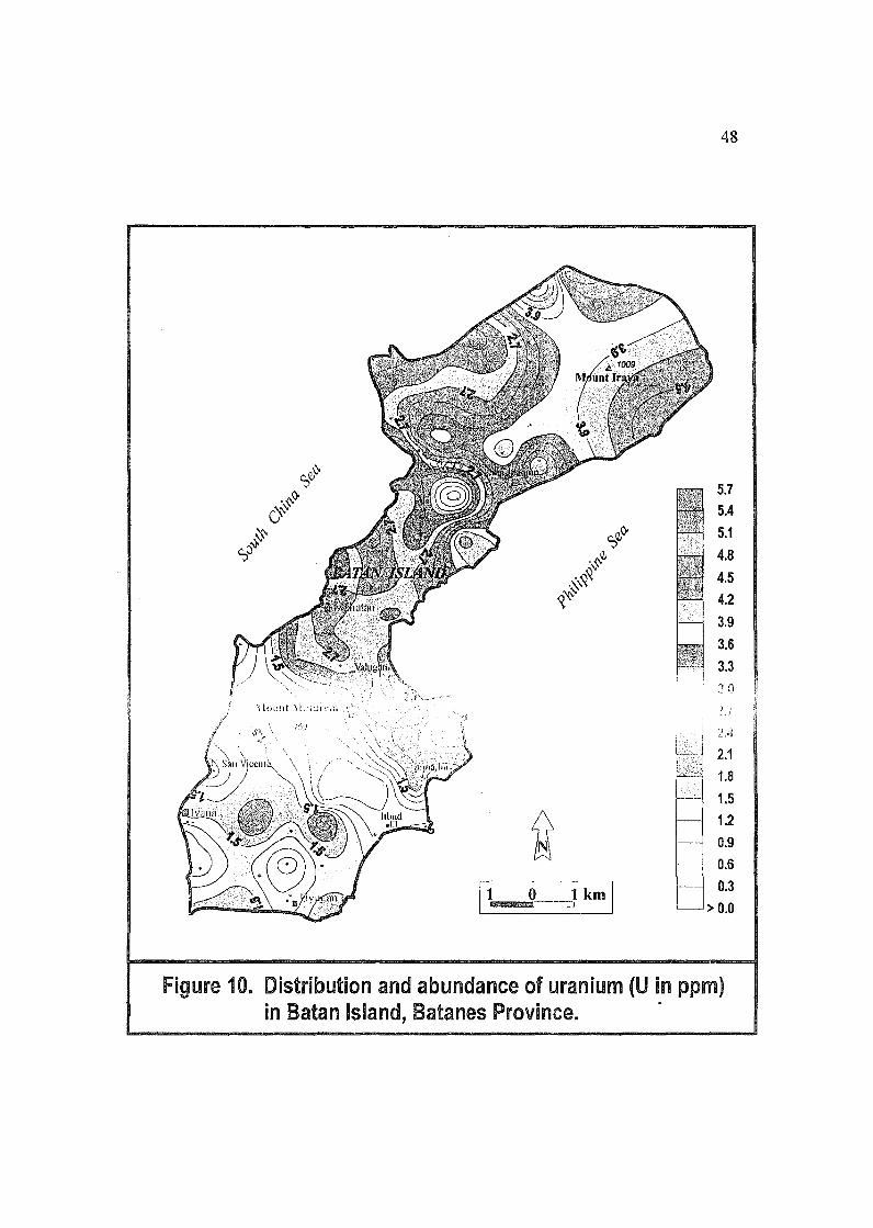
48
Figure 10. Distribution and abundance of uranium (U in ppm)in Batan Island, Batanes Province.
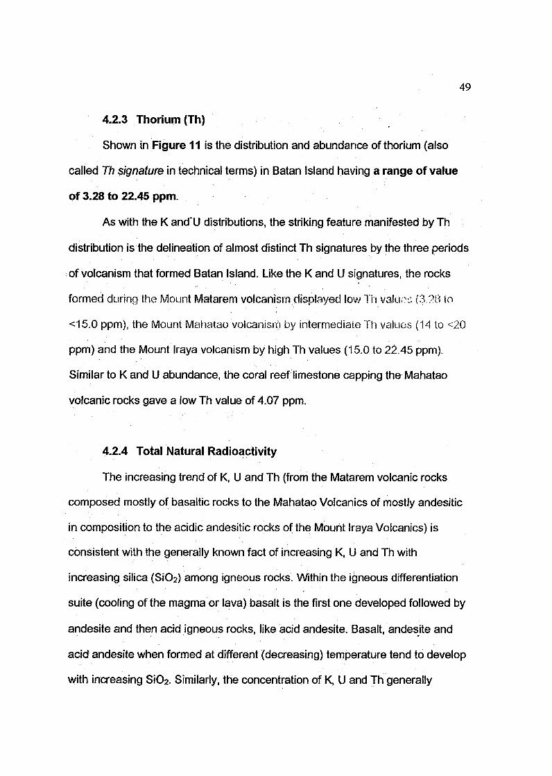
49
4.2.3 Thorium (Th)
Shown in Figure 11 is the distribution and abundance of thorium (also
called Th signature in technical terms) in Batan Island having a range of value
of 3.28 to 22.45 ppm.
As with the K and'U distributions, the striking feature manifested by Th
distribution is the delineation of almost distinct Th signatures by the three periods
of volcanism that formed Batan Island. Like the K and U signatures, the rocks
formed during the Mount Matarem volcanism displayed low Ti i valuoc (8 ?8 to
<15.0 ppm), the Mount Mahatao volcanism by intermediate Th values (14 to <20
ppm) and the Mount Iraya volcanism by high Th values (15.0 to 22.45 ppm).
Similar to K and U abundance, the coral reef limestone capping the Mahatao
volcanic rocks gave a low Th value of 4.07 ppm.
4.2.4 Total Natural Radioactivity
The increasing trend of K, U and Th (from the Matarem volcanic rocks
composed mostly of basaltic rocks to the Mahatao Volcanics of mostly andesitic
in composition to the acidic andesitic rocks of the Mount Iraya Volcanics) is
consistent with the generally known fact of increasing K, U and Th with
increasing silica (SiC>2) among igneous rocks. Within the igneous differentiation
suite (cooling of the magma or lava) basalt is the first one developed followed by
andesite and then acid igneous rocks, like acid andesite. Basalt, andesite and
acid andesite when formed at different (decreasing) temperature tend to develop
with increasing SiO2. Similarly, the concentration of K, U and Th generally
50
Figure 11. Distribution and abundance of thorium (Th in ppm)in Batan Island, Batenes Province.

51
increases at the later stages of the cooling of the magma. This is, due to the
incompatible behavior of K, U and Th in normal rock-forming minerals because of
their large ionic radius and high charge.
Since potassium, uranium and thorium are the fundamental sources of
natural radioactivity of rocks and soils, they constitute the major component of
the total natural radiation of the environment.
4.2.4.1 Exposure Rate (uR/h)
Shown in Figure 12 is the distribution of exposure rate in Batan
Island with values ranging from 1.35 to 12.74 uR/h with an average
value of 6.48 uR/h. The highest levels of radioactivity are found in the
northern part of Batan Island and are generally related to the Mount Iraya
volcanic rocks. The lowest levels are generally associated with the Mount
Matarem volcanic rocks and coral reef limestone.
The world's average is 6.33 uR/h (IAEA, 2003). The Batan
average is therefore just a little bit higher than the world's average.
4.2.4.2 Absorbed Dose Rare u\ $:* (rtGy/h)
The distribution of absorbed dose rate is shown in Figure 13.
Range of values is from 11.7 to 110.6 nGy/h with an average value of
56.2 nGy/h. As with exposure rate, the Mount Iraya volcanic rocks
manifested the highest radioactivity, the lowest with the Mount Matarem
volcanic rocks and coral reef limestone.
The world's average is 55 nGy/h (UNSCEAR, 1988). The Batan
average is therefore just a little bit higher than the world's average.
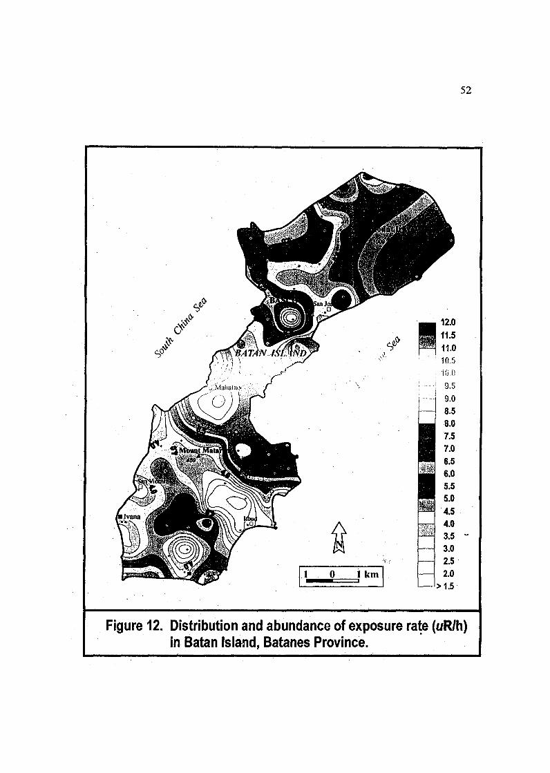
52
Figure 12. Distribution and abundance of exposure rate (uR/h)in Batan Island, Batanes Province.
53
Figure 13. Distribution and abundance of dose rate in air (nGy/h)in Batan Island, Batanes Province.
4.2.5 Baseline Data on Natural Radioactivity
The baseline data are the measured values in terms of average:
• Potassium (in %)
• Uranium (in ppm)
• Thorium (in ppm)
• Total natural radioactivity [in Exposure Rate (uR/h) and
Absorbed Dose Rate in Air (nGy/h))
Table 3 below shows the baseline data for Batan Island.
Table 3. Averages of ground concentiations, exposure ratesand absorbed dose rates in air from potassium,uranium and thorium for Batan Island
TOWN/Barangay
BASCO
MAHATAO
IVANA
UYUGAN
Imnajbu
Itbud
San Vicente
San Joaquin
Valugan
BATANISLAND
Population
6,717
1,293
1,895
1,268
11,173
K(%)
1.06 ±0.22
1.07 ±0.08
0.55 ±0.05
0.58 ±0.08
0.68 ±0.04
0.63 ±0.05
0.57 + 0.08
U(ppm)
3.16 ±0.74
3.12 ±0.23
0.72 ±0.08
0.82 ±0.30
0.52 ±0.20
0.60 ±0.13
0.50 + 0.18
1.15 ±0.10 I 3.25.i 0.86
1.03 ±0.05
0.86 ±0.35
3.47 ±0.84
2.18 ±1.16
Th(ppm)
13.94 ±2.82
14.22 ±0.91
5.72 ±1.00
7.43 ±1.16
5.30 ±0.87
5.50 ±0.46
3.90 + 0.64
15.94 + 0.S6
12.32 + 0.91
13.10 ±4.74
Exposure rate(uR/h)
7.65 ±1.50
7.72 ±0.31
2.94 ±0.24
3.54 ±0.39
189 ±0.36
2.93 ±0.19
2.30 ±0.13
8.43 !. 0.43
7.35 ±0.39
6.48 ±2.52
Dose Rate(nGy/h)
66.47 ±13.04
67.04 ± 2 7 1
25.50 ±210
30.78 ±3.35
25.08 ±3.15
25.39 ±1.67
19.97 + 1.14
73.25 + 4.22
63.86 ±3.39
56.23 ±21.87
The averages of the natural radioelement K, U and Th for Batan
Island are 0.86%, 2.18 ppm and 13.1 ppm, respectively. These averages

55
are almost comparable to the earth's crustal average established by
Clarke et a!. (1966) of 2.1% K, 3.0 ppm U and 12.0 ppm Th. Batan's
averages for K and U are slightly lower while Th is slightly higher than
Clarke's averages. However, the ranges of values of Batan Island for K
(0.025 to 1.84%), 0 (0.18 to 5.62 ppm) and Th (3.28 to 22.45 ppm) are
well within Clarke's established range of values of K (0.5 to 2.5%), U (0.2
to 7.0 ppm) and Th (0.5 to 20 ppm) for volcanic rocks of basaltic to
andesitic in composition. The underlying rocks of Batan Island are mostly
of basaltic to andesitic volcanic rocks.
The comparison of the values are shown in Table 4 below,.
Table 4. Comparison of Measured Values of Batan
and the World's Values
Description
K averages
U averages
Th averages
K range of values
U range of values
Th range of values
Batan's
0.86%
2.18 ppm
13.1 ppm
0.025 to 1.84%
' 0.18 to 5.62 ppm
3.28 to 22.45 ppm
| World's
2.1%
3.0 ppm
12.0 ppm Th
0.5 to 2.5%
0.2 to 7.0 ppm
0.5 to 20 ppm
The averages of total natural radioactivity, in terms of exposure rate^
and absorbed dose rate, of Batan Island are similarly shown in Table 3.
Figure 14 is the graph showing the comparison of the levels of
radioactivity among the towns/barangays in Batan Island, including that for

7 maximum recommended radiation dose (5,mSv/y) that may be received by any individual (UNSCEAR, 1977)/equivalent to 0.7 inSv/y (accumulated radiation dose from HSUM excluding cosmic radiation)
Basco Ivana Itbnd San Vicente San J quin PHILIPPINESMahatao Uyugan Imnajbn Valugan BATAN WORLD
2era>
o
ft
I-
Fig. 14. Graph showing the averages of exposure(rate and absorbed dose rate of Bafan Island, towns, barangays and the world
57
the whole Batan Island vis-a-vis the world. The graph also shows the three
levels of radioactivity as shown by the exposure rate and absorbed dose
rate distribution maps in Figures 12 arid 13. The lowest level;; oi
radioactivity were manifested within the towns of Ivana and Uyugan as
well as in the barahgays of San Vicente, Itbud and Imnajbu. These areas
are all situated at the southern portion of Batan and underlain by the
Mount Matarem volcanic rocks. Barangay San Joaquin exhibited the
highest level of radioactivity. The increased radiation in San Joaquin is
due to its proximity to the relatively more radioactive area underlain by the
Mount Iraya volcanic rocks. Lying within the central isthmus area are the
towns of Basco and Mahatao, including Barangay Valugan. These areas
gave intermediate levels of radioactivity whose underlying rocks belong to
the Mahatao volcanic rocks.
For the whole of Batan Island, the average exposure rate is 6.48
uR/hr and the average absorbed dose rate in air is 56.23 nGy/h.
Based on the year 2000 population statistics of Batan, the
population weighted average exposure and absorbed dose rates are 6.65
uR/h and 57.78 nGy/h, respectively. Batan's average radiation levels are
comparable, although very slightly higher than the estimated world
average terrestrial outdoor-absorbed dose rate in air of 55 nGy/h
(UNSCEAR, 1988), which is equivalent to an exposure rate of 6."33 uR/h
(1uR/h = 8.69 nGy/h (IAEA, 2003)): Taking the highest recorded exposure
rate of 12.74 uR/hr, this is equivalent to 106 mrems/y (millirems/year) or

58
1.06 mSv/y (millisievert/year) using the conversion factor of 1 uR/hr = 8.33
mrems/y or 0.0833 mSv/y (IAEA, 1979). Rems and sievert are the units of
radiation dose (dose equivalent) received by people. These values,
however, did not exceed the recommended radiation dose of 500
mrems/y or 5.0 niSv/y by the International Commission on Radiological
Commission, which may be received by any individual from all natural and
artificial sources of radiation (IAEA, 1979; Grasty, R.L., et al., 1991).
4.3 Results of Interview
This section discusses the important information gathered from the
interviews with key informants who have deeper understanding, knowledge and
experience on the issues and concerns of this study (The profile of these key
informants is given in Appendix E).
4.3.1 On the potential nuclear and radiological risks or threats
Following is a list o\ ihe pofeniial nucM'V iincl radiological risks ;;< li,reals
contributed by the key informants:
(1) Release of radioactive substance (fallout) from foreign nuclear reactors
due to seismic causes. Taiwan, which has six (6) nuclear reactors, is
situated within the Circum-Pacific mobile belt. The Manila Trench that
passes through the western shore of Taiwan is a major earthquake
generator.
59
(2) Accidents involving smuggled nuclear/radiological materials or devices
trans-shipped through the Philippines. Similar to these as suggested is
the illicit trafficking of radioactive materials (RAM) as transit point
including interim storage. If drugs can be easily smuggled in the
country, so do RAMs that can only be detected by special radiometric
devices/detectors.
(3) Unregulated dumping of nuclear waste from foreign sources.
(4) Detonation of nuclear weapons by acts of war. This has something to
do with Peoples Republic of China and Taiwan conflict.
(5) A powerful radioactive source hidden in a public place, such as a trash
receptacle in a busy train or bus station. People pnssincj cioso In fhfi
source might get significant dose of radiation.
(6) Naturally occurring radioactive materials or technologically enhanced
naturally occurring radioactive materials (TENORM) wastes and/or
products. Man-made sources of radiation do not only imply artificially
generated radioactive elements but also natural radioactive materials
concentrated or relocated by human activities. Coal mining activities
and the use of coal for energy purposes give rise to a concentration of
naturally occurring radioactive elements in coal ashes. Similarly,
potassium and phosphate fertilizers can increase soil radioactivity.

60
4.3.2 On the nuclear or radiological risks to which Batan Island,
Batanes Province may be exposed
Table 5 shows the nuclear risk exposure level for each corresponding risk
or threat that the key informants identified for Batan Island.
The range of expo'sure level used was from 1 to 10, with 1 being the
lowest risk exposure and 10 being the higher tisk level. l\\o aticiacir faHoni of
foreign sources having environmental impact on the Philippines obtained the
highest risk level from among the nuclear risks identified. This validates the
choice of Batan Island as the pilot area for the baseline measurement (its
nearness to the southern tip of Taiwan where two nuclear reactors are situated
and the China-Taiwan conflict where the use of nuclear weapons is not
discounted) used in this study.
4.3.3 On the other areas in the Philippines that may be exposed to
possible nuclear and radiological risks or threats
Table 6 shows the other areas in the Philippines that may be exposed to
potential nuclear and/or radiological risks including their corresponding risk level
of exposure. This table also indicates the scoring made by the key informants on
the level of exposure. Listed in this table are areas that were identified by at least
two of the key informants, i.e., areas with scores from only one key informant
were not included. All the key informants identified Metro Manila or the National
Capital Region (NCR) primarily on threats emanating from nuclear accidents
(threats A, B, and C) and the threat of nuclear terrorism posed by the dispersal
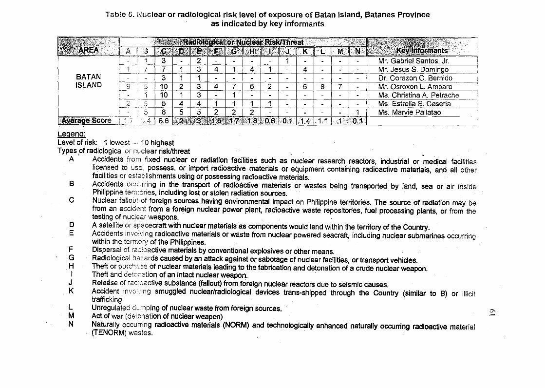
Table 5. Nuclear or radiological risk level of exposure of Batan Island, Batanes Provinceas indicated by key informants
A f B •
- ! 11 7
BATAN [__!ISLAND j 9 5
- ; 12 : 5
li$iKiIe>Score L_l-7 3 I 1 J
$m,373101058
6.6
-112145
Irtinlr
set2313345
pit
-4-4-12
let
1-7112
SIHft-4-6-12
PIS-1-2-1-
mm
1------
aimK-4-6---
;;--:.:v
•/ L ;
-
-
-
8---
1.1
Wl----7---
• • • • . , 1 S
mm
-----1
mm
Mr. Gabriel Santos, Jr.Mr. Jesus S. DomingoDr. Corazon C. BernidoMr. Osroxon L. AmparoMs. Christina A. PetracheMs. Estrella S. CaseriaMs. Marvie Pallatao
Legena:Level of risk: 1 lowest — 10 highestTypesof radiological or nuclear risk/threat
B
DE
FGHI
JK
LMN
Accidents from fixed nuclear or radiation facilities such as nuclear research reactors, industrial or medical facilitieslicensed to use, possess, or import radioactive materials or equipment containing radioactive materials, and all otherfacilities or establishments using or possessing radioactive materials.Accidents occurring in the transport of radioactive materials or wastes being transported by land, sea or air insidePhilippine territories, including lost or stolen radiation sources.Nuclear fallout of foreign sources having environmental impact on Philippine territories. The source of radiation may befrom an accident from a foreign nuclear power plant, radioactive waste repositories, fuel processing plants, or from thetesting of nuclear weapons. •A satellite or spacecraft with nuclear materials as components would land within the territory of the Country.Accidents involving radioactive materials or waste from nuclear powered seacraft, including nuclear submarines occurringwithin the territory of the Philippines. •Dispersal of radioactive materials by conventional explosives or other means.Radiological hazards caused by an attack against or sabotage of nuclear facilities, or transport vehicles.Theft or purchase of nuclear materials leading to the fabrication and detonation of a crude nuclear weapon.Theft and detonation of an intact nuclear weapon.Release of radioactive substance (fallout) from foreign nuclear reactors due to seismic causes.Accident involving smuggled nuclear/radiological devices trans-shipped through the Country (similar to B) or illicittrafficking.Unregulated dumping of nuclear waste from foreign sources.Act of war (detonation of nuclear weapon)Naturally occurring radioactive materials (NORM) and technologically enhanced naturally occurring radioactive material(TENORM) wastes.

62
Table 6. Identified areas in the country that are most likely be exposed tonuclear and radiological threats by the key informants. Numbersare scores corresponding to the level of exposures in each typeof nuclear/radiological risks.
ISP
MetroManila(NCR)
erage
>RTHERNJZONOREGIONS
1 & 2
erage
CEBU
erage
DAVAO
erage
ENERALANTOSCITY
jrage
mm2149
10
58
5.6
8
26
2.3
147
10
5
ii3.8i;
144
10
5
3.4
1
0.1
15481
58
4.6
5
56
ffC<i16
3
10
58
4.7
10
58
2.3 M
548
1
5
547
1
5
3.1
5
5
1.4
6
3
10
5
x;,3.4:+
6
10
5
3
6
0.8
-1
6
1
4
1.7
2
4
0.8
1
4
1
4
1.4
1
3
1
4
1.3
1
0.1
22
5
1
4
2
3
451.7
2
1....„_.
1
2
1
4
1
2
5
1
223.-10
5
46
4.6
4
15
1.43238
5
4
;;3;6;;i
234 -
5
4
2.632
7
H
52
5
4
46
3.7
7
1
1.1
2
2
4
1.1
2
1
0.4
2
0.3
3471
2
16
3.4
6
15
1.7
471
i
1
2
47
1
1
1.8
.4
0.6
1
1
1
0.4
2
1
0.4
1
AI
1
0.4
1
1
1
0.4
1
0.1
63
10
2.7
8
1.1
639
2.6
636
2.1
6
7
1.8
5
0.7
8
1.1
7
1
6
0.8
7
1
10
1.4
7
1
10
1.4
•&NW
10.1
10.1
SSIMr. Gabriel Santos, Jr.
Mr. Jesus S.Domingo
Dr. Corazon C. Bernido
Mr. Osroxon L AmparoMs. Christina A.PetracheMs. Estrella S. CaseriaMs. Marvie Pallatao
Mr. Gabriel Santos, Jr.
Mr. Jesus S.Domingo
Dr. Corazon C. Bemido
Mr. Osroxon L Amparo
Ms. Christina A.PetracheMs. Estrella S. Caseria
Ms. Marvie Pallatao
Mr. Gabriel Santos, Jr.
Mr. Jesus S.Domingo
Dr. Corazon C. BemidoMr. Osroxon L. Amparo
Ms. OisiinaA.PefraclieMs. Estrella S. CaseriaMs. Marvie Pallatao
Mr. Gabriel Santos, Jr.Mr. Jesus S. Domingo ,
Dr. Corazon C. BemidoMr. Osroxon L AmparoMs. Christina A.Petrache
Ms. Estrella S. Caseria
Ms. Marvie Pallatao
Mr. Gabriel Santos, Jr.Mr. Jesus S. Domingo
Dr. Corazon C. Bemido
Mr. Osroxon L AmparoMs. Christina A.Petrache
Ms. Estrella S. Caseria
Ms. Marvie Pallatao
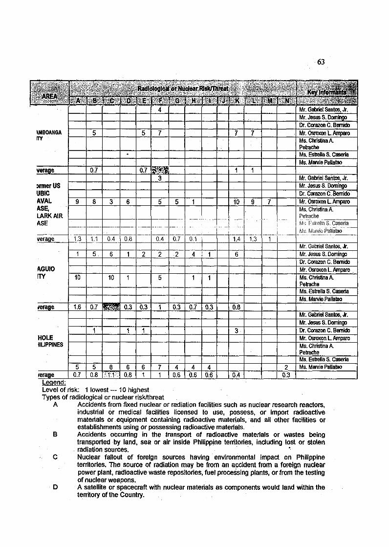
63
\MBOANGATY
Mr. Jesus S.DomingoDr. Corazon C. BernidoMr. Osroxon L AmparoMs. Christina A.PetracheMs. Estrelta S. CaseriaMs.MarviePallatao
verage 0.7 0.7Mr. Gabriel Santos, Jr.
jrmer USJBICAVALASE,LARK AIRASE
Mr. Jesus S.Domingo
Dr. Corazon C. Bernido10 Mr. Osroxon L Amparo
Ms. Christina A.Peirache
verage 1.3 1.1 0.4 0.8 0.4 0.7 0.1 14 1.3
Ms r-Islrella S. Caseria
Ms. M;nviePaliatao
Mr. Gabriel Santos, Jr.
Mr. Jesus S. Domingo
Dr. Corazon C. BemidoA6UI0ITY
Mr. Osroxon L Amparo10 10 Ms. Christina A.
PetracheMs. Estrella S. CaseriaMs.MarviePallatao
/erage 1.6 0.3 0.3 0.7 0.3 0.8Mr. Gabriel Santos, Jr.
Mr. Jesus S.Domingo
Dr. Corazon C. Bernido
HOLE1ILIPPINES
Mr. Osroxon L AmparoMs. Christina A.PetracheMs. Estrella S. Caseria
8 Ms. Marvie Pallatao
rerage 0.7 0.8 0.8 1 1 0.6 0.6 0.6 0.4 0.3Legend:Level of risk: 1 lowest--10 highestTypes of radiological or nuclear risk/threat
A Accidents from fixed nuclear or radiation facilities such as nuclear research reactors,industrial or medical facilities licensed to use, possess, or import radioactivematerials or equipment containing radioactive materials, and all other facilities orestablishments using or possessing radioactive materials.
B Accidents occurring in the transport of radioactive materials or wastes beingtransported by land, sea or air inside Philippine territories, including lost or stolenradiation sources. '
C Nuclear fallout of foreign sources having environmental impact on Philippineterritories. The source of radiation may be from an accident from a foreign nuclearpower plant, radioactive waste repositories, fuel processing plants, or from the testingof nuclear weapons.
D A satellite or spacecraft with nuclear materials as components would land within theterritory of the Country.
64
E Accidents involving radioactive materials or waste from nuclear powered seacraft,including nuclear submarines occurring within the territory of the Philippines.
F Dispersal of radioactive materials by conventional explosives or other means.G Radiological hazards caused by an attack against or sabotage of nuclear facilities, or
transport vehicles.H Theft or purchase of nuclear materials leading to the fabrication arid detonation of a
crude nuclear weapon.I Theft and detonation of an intact nuclear weapon.
J Release of radioactive substance (fallout) from foreign nuclear reactors due toseismic causes.
K Accident involving smuggled nuclear/radiological devices trans-shipped through theCountry (similar to B) or illicit trafficking.
L Unregulated dumping of nuclear waste from foreign sources.M Act of war (detonation of nuclear weapon)N Naturally occurring radioactive materials (NORM) and technologically enhanced
naturally occurring radioactive material (TENORM) wastes.
of radioactive materials by conventional materials (threat F) or the so-called "dirty
bombs".
Six (6) of the seven (7) key informants identified Cebu and five (5)
recognized Davao as nuclear/radiological risk areas.
Situated in NCR is a nuclear reactor (although non-operational), an
irradiation facility and a repository 6f low level radiological wastes. NCR, Cebu
and Davao have several medical and industrial facilities that are licensed to use
radioactive materials in their operations. All these three areas have experienced
spate of bombings by terrorists and these terrorists resorting to the use of "dirty
bombs" is always a possibility. Northern Luzon covering Regions 1 and 2 was
identified by three (3) informants and the highest nuclear threat is posed by its
proximity to Taiwan, similar to that of Batan Island. Areas identified by at least
two of the informants are General Santos City, Baguio City, Zamboanga and the
two former US military bases Subic and Clark. Other areas identified by one (1)
of the key informants are international air and sea ports, major military camps,
65
Calabarzone, Boracay, Central Visayas, Western Visayas, Palawan, Southern
Tagalog and Bicol Region. Practically all areas in the Country were identified.
Two (2) key informants considered the whole country as a possible risk area.
4.3.4 On which of the identified nuclear risk areas the Batan
baseline study should be replicated
The key informants were asked where in the country a baseline study
similar to the one initiated in Batan Island should be conducted and all agreed
that it should be done for the whole country. However, because this will be a
huge task, it was suggested that areas to be covered must first be prioritized.
Using the simple ranking analysis, the areas identified by the key informants
were ranked on the basis of the average scores on level of risk given by the key
informants (Table 6 in page 61) for each nuclear or radiological threat. Thus,
prioritization of the areas was based on the average score for any one threat.
The higher the average score for any one threat the higher the priority. Table 7
shows the ranking.
Table 7. Prioritization of areas where the Batan study maybe replicated based on key informants' opinion
Priority Area
Metro Manila (NCR)CebuDavaoNorthern Luzon (Regions 1 and 2)BaguioCityGeneral Santos CityZamboangaSBMA/CLARK (Former US military bases)
Radiological or Nuclear Threat /Highest Risk Level
A / 5.6A / 3.8A / 3.4C / 3.3C / 2.3K / 1.8F / 1.6K / 1.4
Rank
1234567
66
The NCR with the highest risk level on threat A: Accidents from fixed
nuclear or radiation facilities such as nuclear research reactors, industrial or
medical facilities licensed to use, possess, or import radioactive materials or
equipment containing radioactive materials, and all other facilities on
establishments using or possessing radioactive materials is ranked 1st. Cebu
and Davao are ranked 2nd and 3rd, respectively, for the same threat. For having
high-risk level on threat C: Nuclear fallout of foreign sources having
environmental impact on Philippine territories, Northern Luzon and Baguio City
ranked 4th and 5th, due to their proximity to Taiwan. General Santos City and the
two former US military bases are ranked 6th and 8th, respectively on the account
of threat K: Illicit trafficking of nuclear and/or radiological materials. These areas
have international seaports and airports where radioactive materials can be
smuggled or transshipped. Zamboanga City is ranked 7th on the basis of risk F:
Dispersal of radioactive materials by conventional explosives (dirty bombs) or
other means. This city has also been victimized by terroristic activities. All these
areas are shown in the Philippine map (Figure 15).
Based on Table 5 for Batan, the highest score is 6.6 (for threat C), which
is even higher than the value for the NCR.
The preceding observations manifest that the specific location and
conditions prevailing in an area determine the nuclear and/or radiological
threat(s) such area will be at risk.

67
cmimmmmm
/ Apern j
MJndoroi y r
. Pa/?ay
Batan baseline study
1'rioniy area no. <•;
I 'iio;iiy ;ii(:a iiO. b
Clark/Subic (formerUS bases)Priority area no. 8
Metro Manila (NCR)Priority area no. 1
Cebu CityPriority area no. 2
Zamboanga CityPriority area no. 7
Davao CityPriority area no. 3Gen. Santos CityPriority area no. 6
Fig. 15. Most likely nuclear or radiological risk areas in the Philippines. Theseareas were ranked according to priority where the Batan baseline studymay be replicated.
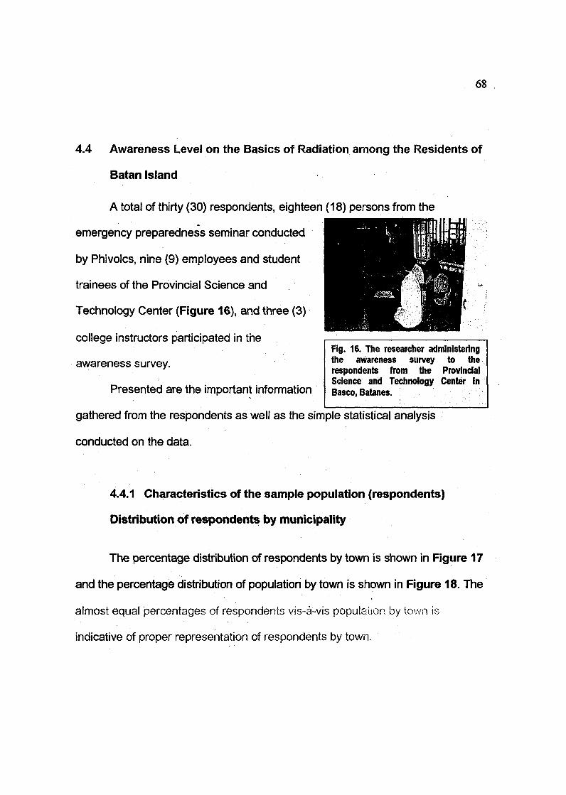
68
4.4 Awareness Level on the Basics of Radiation among the Residents of
Batan Island
A total of thirty (30) respondents, eighteen (18) persons from the
emergency preparedness seminar conducted
by Phivolcs, nine (9) employees and student
trainees of the Provincial Science and
Technology Center (Figure 16), and three (3)
college instructors participated in the
awareness survey.
Presented are the important information
Fig. 16. The researcher administeringthe awareness survey to therespondents from the ProvincialScience and Technology Center inBasco, Batanes.
gathered from the respondents as well as the simple statistical analysis
conducted on the data.
4.4.1 Characteristics of the sample population (respondents)
Distribution of respondents by municipality
The percentage distribution of respondents by town is shown in Figure 17
and the percentage distribution of population by town is shown in Figure 18. The
almost equal percentages of respondents vis-a-vis population by town is
indicative of proper representation of respondents by town.
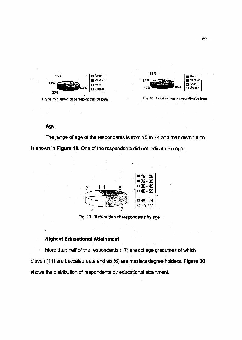
69
13%
13%
20%54%
GjBascoB Mahatao• Ivaria• Uyugan
Fig. 17. % distribution of respondents by town
11%
60%
Fig. 18. % distribution of population by town
Age
The range of age of the respondents is from 15 to 74 and their distribution
is shown in Figure 19. One of the respondents did not indicate his age.
= 15-25• 26-35Q36-45• 46-55
• 66-74i a N9 a n s !
6 7 "' " 'Fig. 19. Distribution of respondents by age.
Highest Educational Attainment
More than half of the respondents (17) are college graduates of which
eleven (11) are baccalaureate and six (6) are masters degree holders. Figure 20
shows the distribution of respondents by educational attainment.

B Mastersdegree
• Collegegraduate
° Collegen High school
• vocational
Fig. 20. Distribution of respondent by educational attainment
Occupation
Figure 21 shows the distribution of respondents by occupation.
• 1• 2
• 5115
D Employee
0 Casual
D Barangay Official
D Businessman
• Student
0 No answer
Fig. 21. Distribution of respondents by occupation.
Majority (17) of the respondents are employees, 15 regular and 2 casual.
Five (5) are officials of the local government, two (2) of whom are Barangay
Captains, two (2) are Barangay Councilors, and one (1) a Barangay Secretary.
Included among the respondents are two (2) businessmen and five (5) students
(incoming college freshmen). One respondent gave no answer.
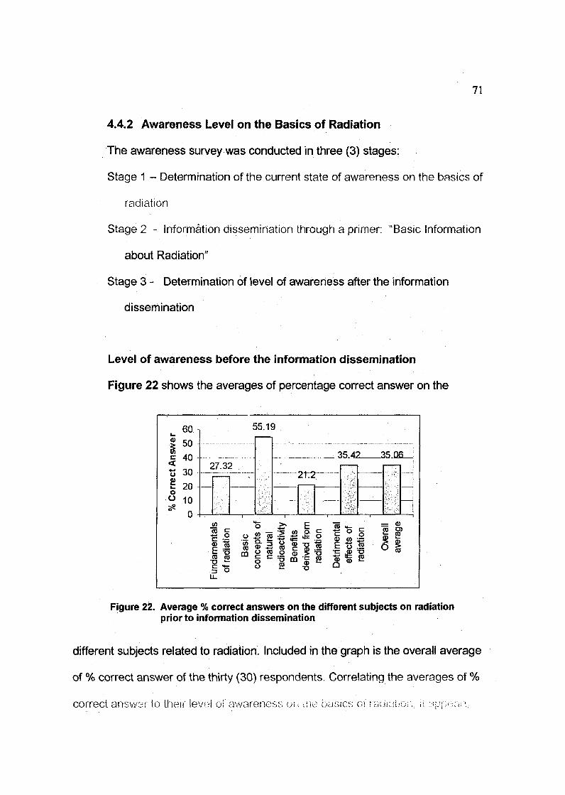
71
4.4.2 Awareness Level on the Basics of Radiation
The awareness survey was conducted in three (3) stages:
Stage 1 - Determination of the current state of awareness on the basics of
radiation
Stage 2 - Information dissemination through a primer: "Basic Information
about Radiation"
Stage 3 - Determination of level of awareness after the information
dissemination
Level of awareness before the information dissemination
Figure 22 shows the averages of percentage correct answer on the
Figure 22. Average % correct answers on the different subjects on radiationprior to information dissemination
different subjects related to radiation. Included in the graph is the overall average
of % correct answer of the thirty (30) respondents. Correlating the averages of %
correct answer to their level oi'awareness on ;i>e basics o\ radiator;, it ^..'p^nr'.-

72
that the overall average awareness of residents of Batan Island on radiation is
35.06%. Their awareness is highest at 55.19% on the subject on the basic
concepts of natural radioactivity while their lowest at 21.2% is on the benefits of
radiation.
Level of awareness after information dissemination
Figure 23 shows the averages in the % correct answer after having read
the handout, while Figure 24 shows the increases in the levels of awareness for
specific subject categories in the survey (compared with the values in Figure 22).
80 i». 70
I 60£ 50•3 40£ 30o 20* 10
0
69.8
-ttry
mm
o £
56.63
2 oo 0) fi E
.;'.V:.-: :K.;t,'
sit
o I
The overall average awareness level after information dissemination is
58.84%. The awareness level is highest at 69.8% on the subject on the basic
concepts of natural radioactivity while the lowest at 48.13% is on the
fundamentals of radiation, the most technical aspect.

73
C
ra
Sin£oc
454035302520151050
—2<X81—n^5i-
'Mi
39.6
?1 54
If
>3:78—
ft<0To c•E °
C
I stiff if p| ! |i
Figure 24. Average % increase in correct answers afterinformation dissemination
A marked increase in the level of awareness among the respondents after
having been given the basic reading material and information on radiation was
noted. The levels of awareness increased by 13.51% (lowest) on ihe basic
concepts of natural radioactivity up to 39.6% (highest) on the bencitls that can
de derived from radiation. The overall increase in awareness is 23.78%, from
35.06% to 58.84%. This shows the importance of education and information
dissemination in informing the public on matters related to radiation, natural
radioactivity, its benefits and detrimental effects.
CHAPTER ENDNOTES:
Clark , S.P., Peterman, Z.E. and Heier, K.S., (1966). Abundances of Uranium,
Thorium and Potassium, Handbook of Physical Constants, Geol. S o c
Am. Mem. 47.
Grasty, R.L., Holman, P.B. and Blanchard, Y.B., 1991. Transportable calibration
pads for ground and airborne gamma ray spectrometers. Geological
74
Survey of Canada Paper 90-23, 25p.
International Atomic Energy Agency, 1979. Gamma ray surveys in uranium
exploration. Technical Report Series No. 186, IAEA, Vienna, 90p.
International Atomic Energy Agency, (1990). The use of gamma ray data to
define the natural radiation environment. IAEA-TECDOC-566, Vienna,
48p.
International Atomic Eneroy /v^ney, (2003). iJtuUeiHios Hot 'Ui+Cikx&'-.ii^r,*
Mapping Using Gamma Ray Spectrometry Data, IAEA-TECDOC-1363,
Vienna, 173p.
Richard M., Maury, R.C., Prouteau,. Bellon, H., Stephan, J.F., Bairat, J.M., and
Calderon, A., (1986b). Geology of Mt. Iraya Volcano and Batan Island,
Northern Philippines, Philippine Bulletin of Volcanology, 3: 1-27.
Sajona, F.G., Maury, R.C., Prouteau, G., Cotton, J., Schiano, P., Bellon, H., and
Fontaine, L, (2000). S/ab melt as metasomatic agent in island arc magma
mantle sources, Negros and Batan, (Philippines). The Island Arc, 9: 472-
486.
UNSCEAR, 1988. Sources, effects and risks of ionizing radiation: United Nations
Scientific Committee on the Effects of Atomic Radiation 1988 Report to
the General Assembly, with annexes.

75
Chapter 5
SUMMARY, CONCLUSIONS AND RECOMMENDATIONS
5.1 Summary
The distribution and abundance of the naturally occurring radioactive
elements potassium, uranium and thorium of Batan Island, Batanes Province
were determined through a ground gamma ray spectrometric method of survey.
This involved a thorough calibration of the portable gamma ray instrument that ~
converted the measured gamma-ray count data into ground concentrations of K,
U and Th. The ground gamma ray survey procedure was modified with the use of
global positioning system in locating the sample locations instead of the usual
meter-tape and compass. Computer-generated color-contoured maps were
produced on the individual radioactive elements including the total natural
radioactivity expressed in exposure rate and absorbed dose rate in air.
Batan Island's geological history involved at least three successive
\zo\can\c periods, Late Miocene to Pliocene and Quaternary. The oldest volcanic
period that formed the Late Miocene Mahatao volcanic basement is composed of
andesitic and basaltic lava flows, pyroclastics and breccia with dikes and plugs.
This was followed by the Pliocene to Early Pleistocene volcanic events forming
the Matarern volcanic rocks ai Ihe southern portion of the island. The Matarem
V o l C a n i C S !:•.-. C O ! i i p O : - : , i : ; i ! u : H i t ; ••.,-|y j ; ; . j S i i l l k . i u u i l i i O i : ' . i n d t ? S i { i . O f i i . - W : . ' . , . i ; - ! ^ ; ! ; . ; . . : [ M ' , : . ; . 1 U . ;
and tuffites. An uplift of the central part of the island took place during the Early
Pleistocene exposing the Mahatao volcanic rocks forming a horst. After which,
76
the volcanic event of Mount Iraya occurred forming the Quaternary Mount Iraya
volcanic rocks composed of acid andesitic flows, basaltic flows and nuee ardente
deposits (ash flows) with minor lava flows.
Results of the ground gamma ray spectrometric survey revealed that the
distribution and abundance of the three elements measured were:
• Potassium (K) - values ranged from 0.025% to 1.84% with an average
of 0.86%
• Uranium (U) - values ranged from 0.18 ppm to 5.62 ppm with an
average of 2.18 ppm
• Thorium (Th) - values ranged from 3.28 ppm to 22.45 ppm with an
average of 13.1 ppm
• Total natural radioactivity:
- in terms of exposure rate: values ranged from 1.35 wR/h to
12.74 t/R/h with an average of 6.48 uR/h
i n ' ; • " • ? ! " ! r : S '•::•' • • . : ! • • ' • • < • ! • ! > • • \ I t / i ".".•• >.:'itC\ v n h i O C ; ' 3 i ;..•;.:•: i ' ; . . > r : '• '•• ' / ' : ) • ' l y / h
\o i : . ; < ; . : . . • / ' • . vv Mi i ,.ii i ^.vxA'uge of 5 6 . 2 n C y / i i
Compared lo ihe eslabhshed averages of the world, K and U values of
Batan are much lower and the Th value is slightly higher. As regards the range
of values, the Batan figures are within the world's ranges of values.
The interviews conducted with key informants who are knowledgeable on
matters regarding nuclear and radiological threats and security gave the following
results:

77
• A list of the potential nuclear and radiological risks or threats was
generated
• Nuclear fallout of foreign sources having environmental impact on the
Philippines was indicated as the highest level of nuclear threat to which
Batan Island may be exposed. Other nuclear or radiological risks to
which the Island may be exposed were also identified, but with lower
scores.
• Others areas that may be exposed to possible nuclear and radiological
risks were identified and NCR was considered as the highest-risk area,
. bai-.e«;i on (ho foilijv.'i.'.yi'itreais:
(1) Accidents from fixed ritidtiar or ina'ictiiort facilities such as unclear rescind)reactors, industrial or medical facilities licensed to use, possess, or importradioactive materials or equipment containing radioactive materials, and all otherfacilities or establishments using or possessing radioactive materials.
(2) Accidents occurring in the transport of radioactive materials or wastes beingtransported by land, sea or air inside Philippine territories, including lost or stolenradiation sources. '
(3) Nuclear fallout of foreign sources having environmental impact on Philippineterritories. The source of radiation may be from an accident from a foreignnuclear power plant, radioactive waste repositories, fuel processing plants, orfrom the testing of nuclear weapons.
(4) Dispersal of radioactive materials by conventional explosives or other means.
• Prioritization of the other areas in the country where the Batan baseline-
study should be replicated was made and NCR again, ranked first.
Eight (8) areas in the country that have high probability of being
exposed to possible nuclear risks or threats were identified. All the key
informants were in agreement that a baseline study for the whole
country should be conducted.
The awareness survey on the basics of radiation/radioactivity revealed an
average level of awareness of 35.1%, prior to information dissemination; and the
78
gure increased to 58.8% after the information dissemination in the form of a
rimer, showing an increase of 23.8 percentage points.
.2 Conclusions
Following are the answer:; to the Speciiic Research Guofsiion:-:.
(1) The distribution of potassium, uranium, thorium of Batan Island,
letermined through the use of a modified ground gamma ray spectrometric
;urvey, ranged from 0.025% to 1.84% for Potassium (K); from 0.18 ppm to 5.62
>pm for Uranium (U), and from 3.28 ppm to 22.45 ppm for Thorium (Th). Total
latural radioactivity in terms of exposure rate ranged from 1.35 uR/h to 12.74
/R/h and in terms of absorbed dose rate, ranged from 11.7 nGy/h to 110.6
lGy/h.
(2) The distribution and abundance of K, U, Th and TNR expressed in
exposure rate and absorbed dose rate of Batan Island are presented as color-
contoured maps. From these maps, the distribution and abundance of the
laturally occurring radioelements and total natural radioactivity of Batan Island
closely reflect its underlying geology.
(3) The averages of K, U, Th and TRN in each barangay and municipality
vere determined and shown in Table 3 in page 53. They varied depending on
he underlying rocks and soils.
(4) The K, U and Th averages are comparable with the world's established
averages. The TNR, exposure rate and absorbed dose rate, which are
dependent on the values of K, U and Th similarly gave varied averages
depending on the underlying geology. The determined TRN averages for Batan
Island are similarly comparable to the estimated world average terrestrial
outdoor-absorbed dose rate in air.
(5) The key informants considered the following as potential nuclear and
radiological risks or threats other than those previously identified by the
RADPLAN (PNRI, 2000) and Potter (2004):
• accidental release from nuclear power reactors due to earthquakes;
• accidents during illicit trafficking of radiological materials;
• illegal dumping of nuclear and radiological wastes;
• war-related detonation of nuclear weapons;
» a publicly hidden high source of radioactive material causing significant
radiation dose to passerby; and
• technologically enhanced naturally occurring radioactive materials.
The opinion of the key informants validated the reasons for the choice of
Batan Island (its proximity to the southern tip Taiwan where two nuclear reactors
are situated and the China-Taiwan conflict where the use of nuclear weapons is
not discounted) as the site for this study.
(6) The key informants identified oinht (8) other areas in Ihe country which
are most iii«>iy MUCIUUI ot !••.•..•,.•,;•=..M; usw MI-MS. Ivu-Jtro Manila (NC'i;), :^<:',ya
Davao, Northern Luzon covenng Regions I & 2, Genera! Sanlos City, former US
Naval Base in Subic and Air Base in Clark, Baguio City and Zamboanga. The
establishment of a baseline data en the natural background radioactivity of the
entire country is also essential, according to the key informants.
80
(7) The key informants expressed that the Batan baseline study should be
replicated for the whole country, with the eight (8) areas identified as high-risk
areas to be given priority attention. The simple ranking analysis was used to
prioritize the areas and Metro Manila/NCR ranked 1st for having received the
highest possible level of risk exposure. The other areas, according to priority,
are Cebu, Davao, Northern Luzon covering Regions 1 & 2, Baguio City, General
Santos City, Zamboanga, and former US Naval Base in Subic and Air Base in
Clark.
(8) The level of awareness of residents from Batan Island on the basics of
radiation/radioactivity revealed an average level of awareness of 35.06%, prior to
information dissemination; and the figure increased to 58.84% after the
information dissemination in the form of a primer, showing an increase of 23.78
percentage poinls.
The levels of awareni.-s;-; •:>;] the !o<i< subjects of the survey pociinent to
radiation: (1) fundamentals of radiation, (2) basic concepts of natural
radioactivity, (3) benefits derived from radiation, and (4) detrimental effects of
radiation varied from 2 1 % to 55%. The awareness level increased to 48% to 69%
after the information dissemination in the form of a primer.
This shows that education and information dissemination are powerful
tools in increasing the awareness of the public on matters related to radiation, its
beneficial and harmful effects, and more importantly after this study, the basic
responses and courses of action in the event of a radiological or nuclear
incident/disaster.

81
Overall, the study showed a sample of a method for obtaining, through
measurement, and presentation of baseline data on radioactivity. This was the
first time that a systematic approach to determine the distribution and abundance
of the radioelement potassium, uranium and thorium for baseline study by ground
gamma ray spectrometric'technique was conducted in the country.
In the course of the study, the researcher also observed that the
radioactivity survey technique used was easier to conduct in combination with the
g l o b a l p o s i t i o n i n g s y s t e m h i ^ k - . u l o f i h e U h O v - -:•,:' f v ; : ; i o r - l a ; -.: : : ; i ' , : - . • : :-.•• .•;•••••.
procedure. This approach oilers a practical alternative to the costly airborne and
carbome survey techniques that is within the financial capabilities of developing
countries like the Philippines.
The scheme for replicating the performance of baseline studies in other
areas of the country will follow the methods adopted in the study, with
improvements, depending on the environmental and security situation of the
subject area. These other areas have already been identified and prioritized.
Performance of the baseline study for the rest of the country may adopt the same
factor and procedures.
5.3 Recommendations
Following are the researcher's recommendations:
(1) A mechanism for monitoring variances in the natural background
radioactivity of Batan Island, using the baseline data established by the
researcher, be developed and implemented by the PNRI;
82
(2) A plan for replication of the Batan Island study be developed and
implemented by the PNRI, to consider the radiological risk areas identified
by the key informants h\ ihis study. However, it is suggested \hin iiie ivi/o
other island municipalities of Batanes Province, the Itbayat and Sabtang
Islands be surveyed first to complete the study of the whole Batanes
Province. Itbayat Island having a population of 3,616 as of year 2000 is
even much closer to Taiwan than Batan Island. The oldest, more
numerous and preserved stone houses of the Ivatans are located in
Sabtang Island that has a population of 1,678. The whole of Batanes
Province and not Batan Island only, is the one on the verge of being
declared a world natural and cultural heritage site by UNESCO;
(3) The mechanism for monitoring and the actions, to be piloted in Batan
Island, be likewise replicated in other areas;
(4) Study the possibility of undertaking other survey techniques used for
radiation baseline studies, particularly the carbome method of survey
since most of the priority areas are highly urbanized with many road
networks. It would be much easier and faster to conduct the carbome
survey and more areas can be covered rather than the ground survey
technique. However, it would be more costly and instrumentation is more
difficult to maintain;
(5) An information dissemination program be developed and implemented by
t h e l : ) ^ ; . i ; ; ! ! i i ! ' i ( - : : ! ' i i o i ; - . > . ; . i ' . . ; ; ' ; < . : < : ; - . : i i r ! i o c i i ; k . - i o t j y . ; u ( ) i i I ) ; - i i i t . ; \ ' ' N - , .!. •.•-,
coordination with involved authorities (legislators, local government units
83
and other instrumentalities of government), so as to optimize public
support (as a major resource) in the implementation of any proactive or
reactive program relating to nuclear security plan.
(6) During the conduct of a baseline survey, especially in remote areas such
as Batanes, a person trained in information dissemination must be
included (or the baseline survey members be trained in information
dissemination) in making the public more aware on the basic facts about
radiation and the basic responses and courses of actions that are
necessary to be undertaken in the unlikely event of radiological or nuclear
contamination;
(7) A mechanism for the actions to be taken in the event that the radioactivity
levels will put the people in the area at risk, be developed and
institutionalized by the PNRI, to involve other concerned authorities (e.g.
National Disaster Coordinating Council and its local counterparts, local
government units, the general public)
(8) The conduct'of a t>:.ifjo'K»o shirty on-.tiv! natural background mrhortclivily,
monitonoy oi Vsi.un. . „•. ,I.-HI insuttiiiunalizalion of the actions to be lakon
in the event that the level of radioactivity is beyond the allowable, be
included as an integral part of the Philippine Nuclear Security Plan
(PNSP), particularly under the emergency and preparedness program of
the response strategy of the Plan. In this way, the response strategy may
be more proactive rather than reactive in knowing beforehand the natural
radiation level in an area, which is crucial in determining the external

84
radioactive contamination caused by an accidental or intentional nuclear
disaster. The maps of background radiation will provide the means to
measure the risk to health and a baseline against which man-made
contamination can be measured.
(9) Consider the inclusion of the relevant data in the PNSP in the NISP. This
may require a refocusing of the NISP since its current mandate is on
overcoming insurgency nationwide. The National Plan to Address
Terrorism and Its Consequences (NPTC), although an Annex to the NISP,
is specific to anti-terrorism, i.e., the NISP is silent on anything pertinent to
radiological/nuclear threats.
(10) In parallel to Hie PNSP. ihfc DOS I sii.>ftk! i.»mulate ?i N;ili<»n.••'. * .-s. <t<\
and Technology Security Plan to tackle the threats posed by chemical,
biological and cyber terrorism.
(11) Share the information gathered on the baseline data/information on the
natural background radioactivity of each area surveyed via the internet
and to interested parties such as the academe, public and private
agencies/companies, civil societies and non-government organizations.
Since the study is inclined towards geological research, the radioelement
K, U and Th data can be used for geological mapping and mineral
resource assessment. In terms of environmental research, the data can be
used for researches on the potential hazards caused by variations in these
elements or substances to living organisms, including humans, and other
radioactivity-related environmental studies and monitoring.

85
5.4 Implications to National Security
National security is the foremost strength of a nation. It is what a nation
has and is capable of doing in protecting and improving the well being of its
people. As Shelia R. Ronis stated, "National Security is societal strength,
encompassing the economy, the health of the industrial base, stable government
and diplomacy, educaiion, si.iu.iy societal >.j-na iiiurai cocies, iiu; juic; ^i ;-.\<
health care and environmental sustainability" (Street, M., 2005).
As a country consisting of several thousand islands and kilometers of
coastlines, these natural conditions of the Philippines offer a formidable problem
to our national leaders and policy makers in safeguarding our people and
national territory against possible nuclear and radiological threats. The problem
has become even more serious with the added threat involving nuclear and
radiological terrorism. Hence, the Philippine Nuclear Security Plan (PNSP) is
perhaps a timely answer to the problem at hand.
One of the objectives of the PNSP is to strengthen the country's
radiological emergency preparedness and response capabilities. The
development of baseline information on natural radioactivity of the country is
crucial to the attainment of this objective. The baseline data play a critical role in
assessing increases of radiation caused by serious radiological and/or nuclear
incident, either accidentally or intentionally (acts of nuclear or radiological
terrorism), that could cause significant hazard to the environment and/or the
public.
86
The next step however, is for the insiituiionaiization of ihe bnst;iin«j tiatu
jathering so as to have a set of national baseline data to be used as basis for
nonitoring radiation-related incidents, whether accidental or intentional that may
>ccur within and outside the national'territory.
If national security is what a nation has and is capable of doing in
protecting and improving the well-being of its people, a PNSP that has the
capacity to address all possible nuclear and radiological risks or threats, or at
east minimize the adverse impact of any radiological or nuclear disaster, should
occur, spells national security.
Chapter Endnotes:
Street, M., (2005). National Security by Shelia R. Ronis, in National Security
goes beyond military might. Retrieved July 15, 2005, from
http:/by21fd.bay21.hotmail.msn.com/cgi-bin/getmsg
Potter, W. C, (2004). Meeting the challenge of nuclear terrorism: Potential
threats in Asia and the Pacific, Keynote address delivered at the Asia-
Pacific Conference on Nuclear Safeguards and Security, Ministerial
Meeting, Sydney, Australia.
PNRI, (2000). National Radiological Emergency Preparedness and Response
Han (\<A()\'\ Ar';

87
Bibliography
3ook
Ulark , S.P., Peterman, Z.E. and Heier, K.S., (1966). Abundances of Uranium,
Thorium and Potassium, Handbook of Physical Constants, Geol. Soc. Am.
Mem. 47.
3ulletin
3rasty, R.L, Carson, J.M., Charbonneau, B.W. and Holman, P.B., (1984).
Natural Background Radiation of Canada, Geological Survey of Canada,
Bulletin 360, 39p.
3rasty, R.L, Holman, P.B. and Blanchard, Y.B., 1991. Transportable calibration
pads for ground and airborne gamma ray spectrometers. Geological
Survey of Canada Paper 90-23, 25p
Fauchid, M. and Grasty, R.L, (2000). Natural background radioactivity of the
Earth's surface - Essential information for environmental impact studies.
I AEA- i jM / :H . i 2 .•;.•.':••
Journals
Reyes, R.Y., Santos, Jr., G.P., Magsambol, W.N. and Ramos, A.F, (1991).
Reconnaissance geochemical exploration for uranium in Northern
Palawan, Philippines. Philippines Nuclear Journal, v. 8, pp. 55-68.
Richard M., Maury, R.C., Prouteau, G., Bellon, H., Stephan, J.F., Bairat, J.M.,
and Calderon, A., (1986). Geology of Mt. Iraya Volcano and Batan Island, ̂
Northern Philippines, Philippine Bulletin of Volcanology, v. 3, pp. 1-27.

88
Sajona, F.G., Maury, R.C., Prouteau, G., Cotton, J., Schiano, P., Bellon, H., and
Fontaine, L, (2000). Slab melt as metasomatic agent in island arc magma
mantle sources, Negros and Batan, (Philippines). The Island Arc, v. 9, pp.
472-486.
Keynote Address
Potter, W. C, (2004). Meeting the challenge of nuclear terrorism: Potential
threats in Asia and the Pacific, Keynote address delivered at the Asia-
Pacific Conference on Nuclear Safeguards and Security, Ministerial
Meeting, Sydney, Australia
Lecture Handout (Printout ot Powerpoint slides)
Dela Rosa, A.M. (n.d.). Powerpoint slides entitled Philippine nuclear security
plan.
Proceedings
Andjelov, M., Tomsic, J. and Pecnik, M., (1995). Natural background
radioactivities and geochemical map of Slovenia: In Proceedings of a
Technical Committee Meeting; Application of Uranium Exploration Data
and Techniques in Environmental Studies, IAEA-TECDOC-827, Vienna,
Austria, pp..217-230.
Angsuwathanan, P. and Chotikanatis, P., (1997). Background radiation map of
Thailand: In Proceedings of a Technical Committee Meeting, Uranium
Exploration Data Applied to the Preparation of Radioelement Maps,
lAEA-TECDOC-980, Vienna, Austria, pp. 44-52.

89
Barthel, F., Thoste, V. and Borsdorf, K.H., (1997). The distribution of
radionuclides in the upper soil horizons in Lower Saxony, Saxony and
Thuringia, Germany: In Proceedings of a Technical Committee Meeting,
Uranium Exploration Dcita Applied to iiiy> Proparanoj) <>i fiaUr.-i.-ion^ini
Maps, IAEA-TECDOC-980, Vienna, Austria, pp. 319-336.
Bourgeois, C, Bresson, J., Chastel, R., Chiffot, T., Guillot, L, Kruajitch, J. and
Bergey, C, (1997). Use and. results of the aerial gamma mapping system
during the international exercise RESUME 95 in Finland: In Proceedings
of a Technical Committee Meeting, Uranium Exploration Data Applied to
the Preparation of Radioelement Maps, IAEA-TECDOC-980, Vienna,
Austria, pp. 173-180.
Daoud, M.N., (1997). Natural background radiation of Jordan: In Proceedings of
a Technical Committee Meeting, Uranium Exploration Data Applied to the
Preparation of Radioelement Maps, IAEA-TECDOC-980, Vienna, Austria,
pp. 91-118.
Darnley, A.G., (1995). Uranium exploration data, international geochemical
mapping and the environment. In Proceedings of a Technical Committee
Meeting; Application of Uranium Exploration Data and Techniques in
Environmental Studies, IAEA-TECDOC-827, Vienna, pp. 9-23.
Duran, E.B., De Vera, CM., Dela Cruz, F.M., Enriquez, E.B., Garcia, T.Y.,
Palad, L.H., Enriquez, S.O., Eduardo, J.M., and Asada Jr., A.A., (1996).
Sources and levels of radioactivity in the Philippine environment: In

90
Proceedings of the Second Philippine Nuclear Congress. Challenges of
Nuclear Technology for the 21st Century, Philippines, 200p.
3uermentchuck, M.G., Zhukova, O.M., Shagalova, E.D. and Matveenko, 1.1.,
(1997). Radioecological mapping of the territory of Belarus on the base
information of radiation monitoring: In Proceedings of a Technical
Committee Meeting, Uranium Exploration Data Applied to the Preparation
of Radioelement Maps, IAEA-TECDOC-980, Vienna, Austria, pp. 153-
162.
Vlatolin, M., (1997). Terrestrial gamma dose rate map, their compilation and
verification - radiometric map of the Czech Republic: In Proceedings of a
Technical Committee Meeting, Uranium Exploration Data Applied to the
Preparation of Radioelement Maps, IAEA-TECDOC-980, Vienna, Austria,
pp. 53-58.
Odor, L, Horvath, I., Fugedi, H., and Renner, J., (1997). Distribution of Natural
(U, Th and K) and artificial (Cs-137) Radioelements in the flood plain
deposits of Northern Hungary: In Proceedings of a Technical Committee
Meeting, Uranium F-<fii-n';<tinn Dftir; Applied to the Preparation of
Schwarz, G.F., Klingeie, E.K., and Rybach, L., (1995). Airborne radiometric
mapping in Switzerland: In Proceedings of a Technical Committee
Meeting; Application of Uranium Exploration Data and Techniques in
Environmental Studies, IAEA-TECDOC-827, Vienna, Austria, pp. 61-70.
91
Shacklette, H.T. and Boerngen, J.G., (1984). Elemental concentrations in soils
and other surficial materials of the Conterminous United States. U.S.
Geological Survey Professional Paper 1270, United States Government
Printing Office, Washington.
Soleimani, G. and Yegani* F.S., (1997). Airborne gamma ray spectrometry in
certain areas of the Islamic Republic of Iran and its results - correlation to
other usages: In Proceedings of a Technical Committee Meeting,
Uranium Exploration Data Applied to the Preparation of Radioelement
Maps, IAEA-TECDOC-980, Vienna, Austria, pp. 67-76.
Strzelecki, R., Wolkowickz, S. and Lewandowski, P., (1997). Mapping of post-
Chernobyl environmental pollution in Poland: In Proceedings of a
Technical Committee) Meeting, Uranium Fxpioiaiion Da;:) Apnh^ohi ?/;;>
Preparation of Radioeiement Maps, IAEA-TECDOC-98U, Vienna, Austria,
pp. 163-172.
Suarez Mahou, E. and Fernandez Amigot, J.A., (1995). Use of uranium
airborne survey data in the preparation of a radiometric map of Spain: In
Proceedings of a Technical Committee Meeting; Application of Uranium
Exploration Data and Techniques in Environmental Studies, IAEA-
TECDOC-827, Vienna, Austria, pp. 109-126.
Torres, L.M. and Grasty, R.L, (1995). The Natural Radioactivity Map of
Portugal: In Proceedings of a Technical Committee Meeting; Application
of Uranium Exploration Data and Techniques in Environmental Studies,
IAEA-TECDOC-827, Vienna, Austria, pp. 127-134.
92
Vulkan, D. and Shirav, H., (1997). Radiometric maps of Israel - partial
contribution to the understanding of potential radon emanations: In
Proceedings of a Technical Committee Meeting, Uranium Exploration
Data Applied to the Preparation of Radioelement Maps, IAEA-TECDOC-
980, Vienna, Austria, pp. 119-124.
Reports
Cameron, J., {1965). Prospaction WKJevulmui^n vf-Unclear mw tiuito(h;i:>.
Report to the Government of the Philippines. IAEA TA Report No 175,
International Atomic Energy Agency, Vienna, Austria.
Clavejo, L.A. (2005). The worldwide nuclear, biological and chemical warfare
threat. Briefing on Bioterrorism: Issues and Developments, National
Defense College of the Philippines.
ElBaradei, M. (2004). Nuclear proliferation and the potential threat of nuclear
terrorism. Keynote Address: Asia-Pacific Conference on Nuclear
Safeguards and Security, Sydney, Australia.
Grasty, R.L and Cox, J.R., (1996). A carborne gamma-ray spectrometer system
for natural radioactivity mapping and environmental monitoring.
Presented at the seminar on Exercise Resume95, Copenhagen,
Denmark, 17-19th January, 1996.
Huntings Geophysics, Ltd., (1954). Report on the airborne radiometric survey of
six areas in the Republic of the Philippines. Report submitted to the
USAEC with contract No AT(30-1 )-1611.
93
:G, (2003b). Taiwan Strait II: The Risk of War, international Crisis Group, ICG
Asia Report No 54, June 6, 2003, ICG
Beijing/Taipei/Washington/Brussels.
"itemational Atomic Energy Agency, (1991). Mapping of Chernobyl fallout in
Sweden: In Airborne Gamma Ray Spectrometer Surveying, IAEA-
Technical Report Series No. 323, Vienna, Austria, pp. 57-60.
JNSCEAR, 1988. Sources, effects and risks of ionizing radiation: United Nations
Scientific Committee on the Effects of Atomic Radiation 1988 Report to
the General Assembly, with annexes.
Technical Documents
nternational Atomic Energy Agency, 1979. Gamma ray surveys in uranium
exploration. Technical Report Series No. 186, IAEA, Vienna, 90p.
nternational Atomic Energy Agency, (1990). The Use of Gamma Ray Data to
Define the Natural Radiation Environment, IAEA-TECDOC-566, IAEA,
Vienna, 97p.
nternational Atomic Energy Agency, (2003). Guidelines for Radioelement
Mapping Using Gamma Ray SpectrometryData, IAEA-TECDOC-1363,
Vienna, 173p.
Thesis
Hernandez. H C . (1976) lytsUihitliot) of /ariiaelemenls at the rtiibnwkin Mn
Sulfide Deposits, Paracule. Camannes Norte: M.S. thesis, University o!
the Philippines.
94
Manuel, C.P., (2004). An Application of Global Positioning System (GPS) -
Based Automatic Vehicle Location System in Law Enforcement and Public
Safety at Central Police District, An Assessment MNSA thesis, National
Defense College of the Philippines.
i/Veb documents
Bond, R.A., (2005). "Chernobyl' Accident," Microsoft® Encarta® Online
Encyclopedia 2005. Retrieved March 05, 2005, from
http://encarta.msn.com.
Demographic Characteristics of Batanes, (n.d.). Retrieved March 29, 2005, from
http://www.uyuganbatanes.com
Mclnnis, K., (2000). Effects of the Chernobyl Accident. Retrieved March 05,
2005, from http://www.elon.edu/student/kmcinnis/kirrrspage.html.
Nuclear Issues Briefing Paper 22, (2004). Chernobyl Accident. Retrieved March
05, 2005, from http://www.uic.com.au/nip22.htm.
Solano, Ma. I...A., (n.d.). Rrnr-nn;-; may bo dednred a world nntuml and
cultural lit;fi!c.iiji:: ii-11-".- -;./'hr;v<:;d M.ikJi 29, 2005, from
http://mobilemedtaph.com/projectE/Batanes/batanes_unesco.html
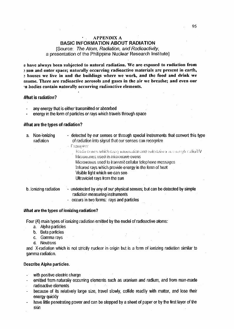
95
APPENDIX ABASIC INFORMATION ABOUT RADIATION
[Source: The Atom, Radiation, and Radioactivity,a presentation of the Philippine Nuclear Research Institute]
e have always been subjected to natural radiation. We are exposed to radiation fromj sun and outer space; naturally occurring radioactive materials are present in earth,t houses we live in and the buildings where we work, and the food and drink wensume. There are radioactive aerosols and gases in the air we breathe; and even our'n bodies contain naturally occurring radioactive elements.
What is radiation?
- any energy that is either transmitted or absorbed
- energy in the form of particles or rays which travels through space
i/Vhat are the types of radiation?
a. Non-ionizing - detected by our senses or through special instruments that convert this type
radiation of radiation into signal that our senses can recognize• Examples:
ka;i:u vwavi/s vj'wlcn c;a;vy iiiioii'iu-iiion and t:iUi'.-ilai!ii;ii m '•iVou:}!'! Kidio/IV
Microwaves used in microwave ovensMicrowaves used to transmit cellular telephone messagesInfrared rays which provide energy in the form of heatVisible light which we can seeUltraviolet rays from the sun
b. Ionizing radiation - undetected by any of our physical senses; but can be detected by simpleradiation measuring instruments
- occurs in two forms: rays and particles
What are the types of ionizing radiation?
Four (4) main types of ionizing radiation emitted by the nuclei of radioactive atoms:a. Alpha particlesb. Beta particlesc. Gamma raysd. Neutrons
and X-radiation which is not strictly nuclear in origin but is a form of ionizing radiation similar togamma radiation.
Describe Alpha particles.
- with positive electric charge- emitted from naturally occurring elements such as uranium and radium, and from man-made
radioactive elements- because of its relatively large size, travel slowly, collide readily with matter, and lose their
energy quickly- have little penetrating power and can be stopped by a sheet of paper or by the first layer of the
skin

96
- thus, present no external hazard- if taken in the body (by breathing or swallowing) can inflict more biological damage than other
kinds of radiation because they give up their energy over a relatively short distance
Describe Beta particles.
- with negative electric charge- much smaller, lighter and more penetrating than alpha particles (can pass through 1 to 2
centimeters of water and human flesh)- slight external hazard depending on their energy
can be stopped by a sheet of aluminum a few rniiiiiis&tefs Uiick, window ylass, wood <« a shoetof metal
- hazardous if taken into the body- examples: natural radioactivity coming from potassium-40 in soil, rocks, and minerals, and
tritium which is an isotope of hydrogen
Describe Gamma rays.
- electromagnetic waves of very short wavelength and traveling with the speed of light- emitted from the nuclei of some radioactive atoms (like uranium - 238) when they decay- very penetrating and can pass through the human body- can be used in hospitals to diagnose and treat cancer or in industrial operations to detect
defects in welds or pipes- dense materials such as lead and concrete are excellent barriers against gamma rays
. What are the sources of radiation according to origin?
a. Naturally-occurring sources of radiation or what is referred to as natural background radiation- exist anywhere and everywhere, varying in intensity from place to place- represents about 80% of all the radiation to which we are exposed
b. Artificial or man-made sources of radiation- only about 20% of man's radiation.exposure comes from artificial or man-made radioactive
sources- they are in principle fully controllable, unlike natural sources
. What are the natural background radiation?
a. Cosmic Radiation- high sub-atomic particles and gamma rays coming from the sun and outer space- most of it is blocked by the earth's atmosphere; only a fraction reaches the ground
b. Earth's Crust- made up of materials that are naturaily radioactive like Uranium (dispersed throughout rocks
and soil mostly at very low concentrations),Thorium, and Potassium-40- nearly all emit gamma rays, which irradiate the whole body more or less uniformly- since building materials are extracted from the earth, they can be slightly radioactive, and
people are irradiated indoors as well as out of doors- the irradiation dose vary according to the rocks and soils of the area and the building materials
usedc. Radon
- a radioactive yas thai naiuraiiy comes from radium.

07
- emitted from rocks or soil at-tiie earth's surface and disperses in the atmosphofe, ii ii oniers abuilding, the concentration can build up.
- decays to form other radioactive atoms, which when inhaled can lodge in the lung andirradiate tissue.
- its decay products are the biggest source of natural radiation in the world,d. Internal radiation (food and drink)
- since radioactive materials occur everywhere in nature it is inevitable that they get intodrinking water and food.
- Potassium-40 in particular is a major source of internal radiation, but there are others.- the element potassium is essential to man, plants and animals.- from plants, potassium finds its way through food chains into man where it is built up in body
tissue, particularly muscle.
What are the artificial or man-made sources of radiation?
a. Equipment used in Nuclear Medical applications- Radiation is used in medicine in 2 distinct ways: (1) to diagnose disease or injury using x-ray
or gamma rays, (2) to kill cancerous cellsa.1. Nuclear Medicine- X-rays are passed through the patient to produce an image, and this indicates whether the
tissue is healthy or provides information on the nature and extent of the disease.a.2. Radiotherapy- For treating cancerous conditions- Uses beams of high energy x-rays or gamma rays from cobalt-60 or similar sources, carefully
aimed to kill the diseased tissue, often from several different directions to reduce the dose tosurrounding healthy tissue
b. Nuclear Fallout- Radioactive fall-out from nuclear weapons test carried out in the atmosphere is the most
widespread environmental contaminantc. Nuclear and other industries
- In the course of normal operation of nuclear installations, small quantities of radioactivematerials can be released to the environment
- Radioisotopes (such as cobalt-60) are used in industry to sterilize products such as cosmeticsand medical supplies
- Other isotopes are used in nuclear gauges to determine the thickness of materials such aspaper products, plastic films and metal sheets
- Radiation is also utilized to manure liquid levels in large storage tanks and to determine thequaliiy of wdris in :;lu<c;f!i!i-> :u--i< ;is bikhjc;; /mil builtfinor.
d. Non-Nucleai ln.iuv.iiK;:.- Also produce radiociclivc (!:;;(:!.•;in)c;:;
- Radiation closes are very low- Include the processing of ores containing radioactive materials as well as elements for which
the ore is processed- Examples: •
1. Phosphorous ores contain traces.of radium, which can find its way into the by-products orwastes.
2. Generation of electricity by coal-fired power stations results in the release of naturallyoccurring radioactive materials from coal.
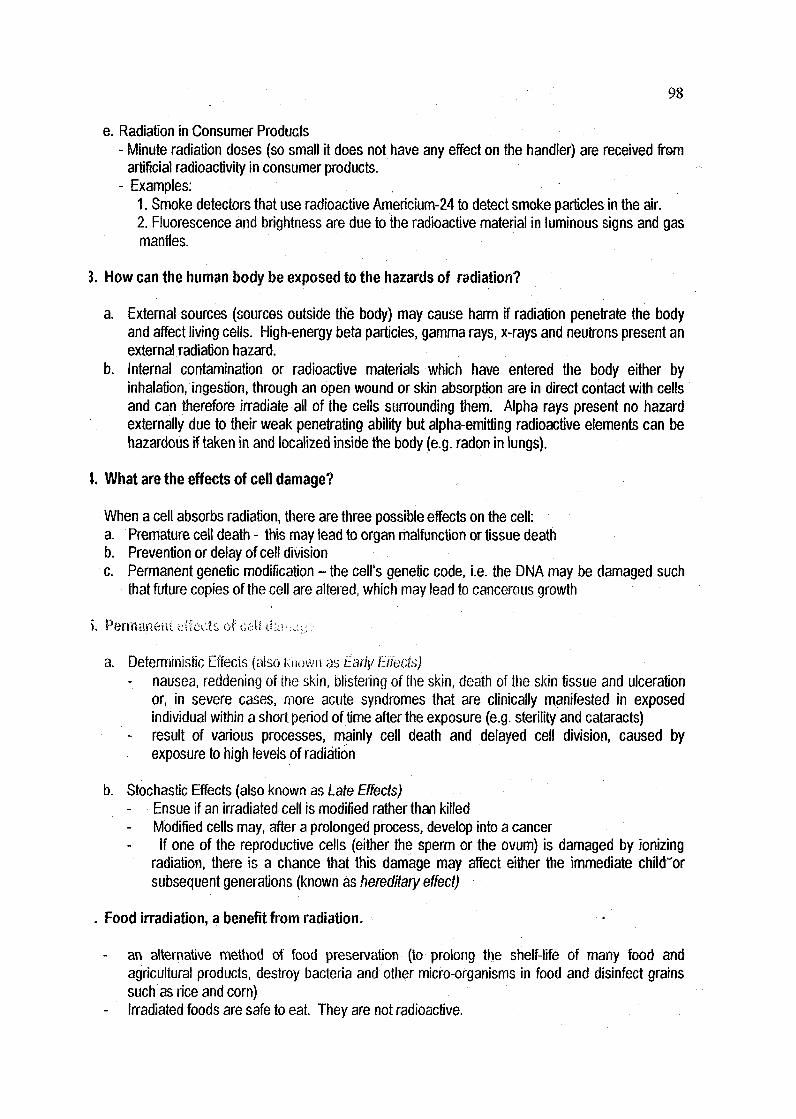
98
e. Radiation in Consumer Products- Minute radiation doses (so small it does not have any effect on the handler) are received from
artificial radioactivity in consumer products.- Examples:
1. Smoke detectors that use radioactive Americium-24 to detect smoke particles in the air.2. Fluorescence and brightness are due to the radioactive material in luminous signs and gasmanfJes.
3. How can the human body be exposed to the hazards of radiation?
a. External sources (sources outside the body) may cause harm if radiation penetrate the bodyand affect living cells. High-energy beta particles, gamma rays, x-rays and neutrons present anexternal radiation hazard.
b. Internal contamination or radioactive materials which have entered the body either byinhalation, ingestion, through an open wound or skin absorption are in direct contact with cellsand can therefore irradiate all of the cells surrounding them. Alpha rays present no hazardexternally due to their weak penetrating ability but alpha-emitting radioactive elements can behazardous if taken in and localized inside the body (e.g. radon in lungs).
1. What are the effects of cell damage?
When a cell absorbs radiation, there are three possible effects on the cell:a. Premature cell death - this may lead to organ malfunction or tissue deathb. Prevention or delay of cell divisionc. Permanent genetic modification - the cell's genetic code, i.e. the DNA may be damaged such
that future copies of the cell are altered, which may lead to cancerous growth
>. Permanent euects or c,e\i d;v: -:^^-:-
a. Deterministic Effecis (also krio-wiias-t'a/r/)/BfedsJ)- nausea, reddening of the skin, blistering of the skin, death of the skin tissue and uJceration
or, in severe cases, more acute syndromes that are clinically manifested in exposedindividual within a short period of time after the exposure (e.g. sterility and cataracts)
- result of various processes, mainly cell death and delayed cell division, caused byexposure to high levels of radiation
b. Stochastic Effects (also known as Late Effects)Ensue if an irradiated cell is modified rather than killedModified cells may, after a prolonged process, develop into a cancerIf one of the reproductive cells (either the sperm or the ovum) is damaged by ionizing
radiation, there is a chance that this damage may affect either the immediate child"orsubsequent generations (known as hereditary effect)
. Food irradiation, a benefit from radiation.
an alternative method of food preservation (to prolong the shelf-life of many food andagricultural products, destroy bacteria and other micro-organisms in food and disinfect grainssuch as rice and com)
- Irradiated foods are safe to eat. They are not radioactive.
99
Mutation breeding for crop improvement a benefit from radiation.
- a type of plant breeding which improves a crop variety by using mutagens such as radiation- radiation can induce hereditary changes (mutations) in the parent crop from.which mutants with
desirable attributes will be selected and will be developed as new varieties- achieves desirable properties: increased yield, increased disease resistance, improved lodging
resistance, changed maturing time, improved economic characters, improved seedcharacteristics (nutritional value, baking and melting properties, reduction in cooking time)
Nuclear techniques for efficient use of fertilizers, a benefit from radiation.
- nuclear techniques used to study efficient use of fertilizers in crops such as rice and mungbean
Animal productivity, a benefit from radiation.
a. Improved feeding methodsb. Improved breeding of aninwits
Insect/Pest Control, a benefit from radiation
- Through the sterile insect technique (SIT)
Diagnosing diseases, a benefit from radiation
a. In-Vivo Diagnostic Pharmaceuticals
- Radioisotope is ingested or injected to the vein of the patient to trace a specific biologicalprocess in the body, or to investigate the functioning of a specific organ
b. In-vltro Diagnostic Methods- Allows clinical analysis without the patient being exposed to radiation (e.g., blood sample 4s
sent to the laboratory and examined through nuclear techniques such as radioimmunoassay(RIA), or immunoradiometric assay (IRMA) or radionuclide-based molecular methods
Treating diseases, a benefit from radiation
a. Teletherapy .- a radiation treatment where the radiation source is not in direct contact with the tumor to be
treated; an external beam of gamma radiation from a radioactive source (such as cobalt-60) is only directed at the target area (cancer site)
b. Brachytherapy- A radiation treatment where the radiation source is in direct contact with the tumor; an
encapsulated radioactive source that emits gamma or beta radiation is temporarilyimplanted or brought into close contact (up to a few centimeters) with the target area
c. Radiophanmaceutical Therapya treatment wherein the patient takes in a radioisotope in a suitable chemical form so that itwill concentrate in the target area
Reducing pain, a benefit from radiation.
- radiotherapy administered to reduce pain
100
Better nutrition and health, a benefit from radiation
- isotopes are used to treat the "hidden hunger" of vitamin and mineral deficiencies, measureiron deficiency in infants, and the health impact of iron supplementation
Sterilizing medieai equipment, a i>aȣ-fitirom ra&Stoi!
- gamma rays from cobalt - 60 are used to sterilize instruments that cannot be sanitized throughother methods, and at a much lower health risk
Radioisotopes in industry, benefits from radiation
Radioisotopes as tracers- Tracing oil flow in pipeline- Determination of thoroughness in mixing of powders, fluids, slurries, gases- Radioactive Iodine -131 for detecting leaks in water- Measuring of wear of machine cutting tools- Determination of wearing quality of floor waxes- "Moving marker" to trace pirate colors to prevent the so-called color soiling in multicolor -
textile printing operations- Study of wear caused by corrosion rather than friction- Tracking sewage dispersion- Measuring extent of termite infestation
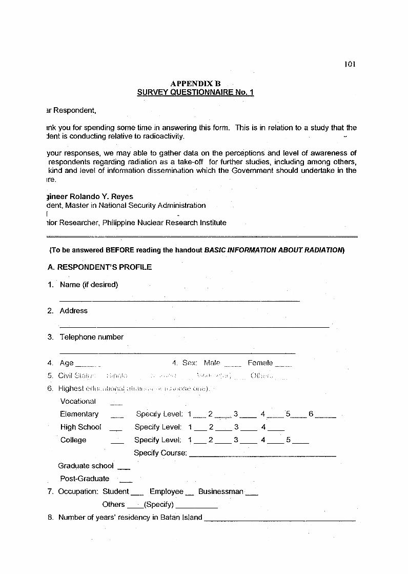
101
APPENDIX BSURVEY QUESTIONNAIRE No. 1
ar Respondent,
ink you for spending some time in answering this form. This is in relation to a study that thedent is conducting relative to radioactivity. . • -
your responses, we may able to gather data on the perceptions and level of awareness ofrespondents regarding radiation as a take-off for further studies, including among others,kind and level of information dissemination which the Government should undertake in theire.
}ineer Rolando Y. Reyesdent, Master in National Security AdministrationIlior Researcher, Philippine Nuclear Research Institute
(To be answered BEFORE reading the handout BASIC INFORMATION ABOUT RADIATION)
A. RESPONDENT'S PROFILE
1. Name (if desired)
2. Address
3. Telephone number
4. Age
5. CivilSlf.il.-. ::;.fH;!-;
6. Highest Gclue ;.aiona!,.
Vocational
Elementary
Hiqh School
Colleqe
Graduate school
Post-Graduate
7. Occupation: Student
Others
4 Sex:
U(, ill : i ; ii : '1 ii .i !- lOSi:.1 ul'i<
Specify Level: 1
Specify Level: 1
Specify Level: 1
Specify Course:
Male
2
2
2
Female
3 4 5
3 4
3 4 5
Employee Businessman
(Specify)
8. Number of years' residency in Batan Island
6
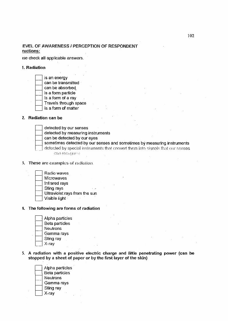
102
EVEL OF AWARENESS / PERCEPTION OF RESPONDENTructions:
ise check all applicable answers.
1. Radiation
is an energycan be transmittedcan be absorbedis a form particleIs a form of a rayTravels through spaceIs a form of matter
2. Radiation can be
detected by our sensesdetected by measuring instrumentscan be detected by our eyessometimes detected by our senses and sometimes by measuring instrumentsdetected by special instruments thai convert them into sinnalfi thai our senses
can recGGi !(:>;•.;
3. These are examples of radiation
Radio wavesMicrowavesInfrared raysSting raysUltraviolet rays from the sunVisible light
\. The following are forms of radiation
Alpha particlesBeta particlesNeutronsGamma raysSting rayX-ray
5. A radiation with a positive electric charge and little penetrating power (can bestopped by a sheet of paper or by the first layer of the skin)
Alpha particlesBeta particlesNeutronsGamma raysSting rayX-ray
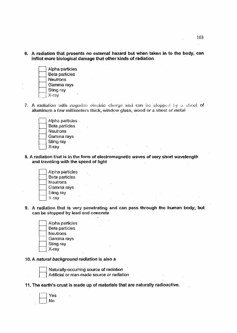
103
6. A radiation that presents no external hazard but when taken in to the body, caninflict more biological damage that other kinds of radiation
Alpha particlesBeta particlesNeutronsGamma raysSting rayX-ray
7. A radiation with negative electric charge and can be stopped by a sh«::e£ ofaluminum a few millimeters thick, window glass, wood or a sheet or metal
Alpha particlesBeta particlesNeutronsGamma raysSting rayX-ray
8. A radiation that is in the form of electromagnetic waves of very short wavelengthand traveling with the speed of light
Alpha particlesBe;ta particlesNeutronsGamma raysSting rayX-ray
9. A radiation that is very penetrating and can pass through the human body; butcan be stopped by lead and concrete
Alpha particlesBeta particlesNeutronsGamma raysSting rayX-ray
10. A natural background radiation is also a
Naturally-occurring source of radiationArtificial or man-made source or radiation
11. The earth's crust is made up of materials that are naturally radioactive.
YesNo
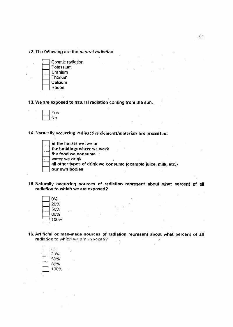
104
12. The following are the natural radiation
Cosmic radiationPotassiumUraniumThoriumCalciumRadon
13. We are exposed to natural radiation coming from the sun.
YesNo
14. Naturally occurring radioactive elements/materials are present in:
in the houses we live inthe buildings where we workthe food we consume -water we drinkall other types of drink we consume (example juice, milk, etc.)our own bodies
15. Naturally occurring sources of radiation represent about what percent of allradiation to which we are exposed?
0%20%50%80%100%
16. Artificial or man-made sources of radiation represent about what percent of allradiation to which we am exposed?
20%50%80%100%

105
7. The biggest source of natural radiation in the world
UraniumThoriumPotassiumRadon
8. Dp you think that naturally occurring radioactive materials can cause healthproblems to humans? *
YesNo
9. The following are the artificial or man-made sources of radiation
Nuclear ReactorsNuclear processing plantsFallout from nuclear bomb testingHydroelectric power plantsCoal-fired power plantsSome medical equipment used for treating cancer
:0. How can the human body be exposed to the hazards of radiation?
~] PenetrationinhalationIngesiion Through ;.a op^n woundThrough body tluuJsSkin absorptionEatingDrinking
1. What are the effects of radiation on living cells?
Changes in the chemical structure of the moleculesInterference with normal cellular processesBreakage of chemical bonds between carbon atoms in the DNA moleculesDamage to enzymesDamage to membranesImmediate multiplication of cellsPremature cell deathPrevention or delay or cell divisionPermanent genetic modificationNoneI don't know
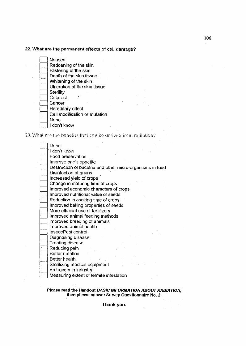
106
22. What are the permanent effects of cell damage?
NauseaReddening of the skinBlistering of the skinDeath of the skin tissueWhitening of the skinUlceration of the skin tissueSterilityCataractCancerHereditary effectCell modification or mutationNoneI don't know
23. What are the benefits ihai can he derived from radiation?
NoneI don't knowFood preservationImprove one's appetiteDestruction of bacteria and other micro-organisms in foodDisinfection of grainsIncreased yield of cropsChange in maturing time of cropsImproved economic characters of cropsImproved nutritional value of seedsReduction in cooking time of cropsImproved baking properties of seedsMore efficient use of fertilizersImproved animal feeding methodsImproved breeding of animalsImproved animal healthInsect/Pest controlDiagnosing diseaseTreating diseaseReducing painBetter nutritionBetter health -Sterilizing medical equipmentAs tracers in industryMeasuring extent of termite infestation
Please read the Handout BASIC INFORMATION ABOUT RADIATION,then please answer Survey Questionnaire No. 2.
Thank you.
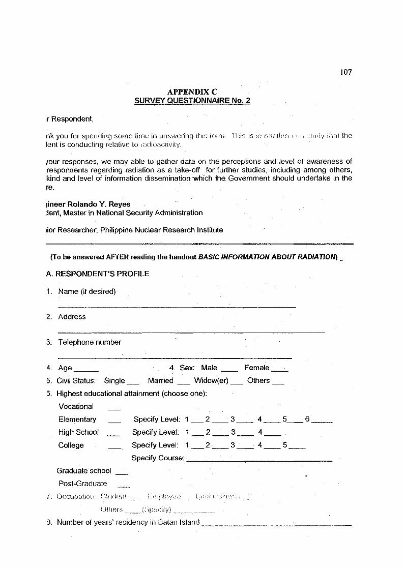
107
APPENDIX CSURVEY QUESTIONNAIRE No. 2
ir Respondent,
n k y o u f o r s p e n d i n g s o m e l i m e i n a n s w e r i n g t h i s lorn-, T h i s i s ir; r e l . i f u i i i <>; r; - n u i l y i h n l ( h elent is conducting relative lo radioaciivity.
/our responses, we may able to gather data on the perceptions and level of awareness ofrespondents regarding radiation as a take-off for further studies, including among others,kind and level of information dissemination which the. Government should undertake in there.
lineer Rolando Y. Reyestent, Master in National Security Administration
iior Researcher, Philippine Nuclear Research Institute
(To be answered AFTER reading the handout BASIC INFORMATION ABOUT RADIATION)
A. RESPONDENT'S PROFILE
1. Name (if desired)
2.
3.
4.
5.
3.
Address
Telephone number
Age 4. Sex: Male
Civil Status: Single Married Widow(er)
Highest educational attainment (choose one):
Vocational
Elementary Specify Level: 1 2 3
Hiqh School
College
Graduate school
Post-Graduate
Specify Level: 1 2 3
Specify Level: 1 2 3
Specify Course:
Female
Others
4 5
4
4 5
6
•
7. Occupation: Siudeivi F.iiijiioyei-: Liu-VM:-
Olhers (Gpocily)
3. Number of years' residency in Batan Island

108
EVEL OF AWARENESS / PERCEPTION OF RESPONDENTuctions:
se check all applicable answers.
. Radiation
is an energycan be transmittedcan be absorbed,is a form particleIs a form of a rayTravels through spaceIs a form a matter
Radiation can be
detected by our sensesdetected by measuring instrumentscan be detected by our eyessometimes detected by our senses and sometimes by measuring instrumentsdetected by special instruments that convert them into signals that our senses
can recognize
I. These are examples of radiation
Radio wavesMicrowavesInfrared raysSting raysUltraviolet rays from the sunVisible light
\. The following are forms of radiation
A i - J) •-• • p ; - i f i : f . ! i -
l..kl;'i:.i j i : :i \'''-c •'
NeuironsGamma raysSting rayX-ray
>. A radiation with a positive electric charge and little penetrating power (can bestopped by a sheet of paper or by the first layer of the skin)
Alpha particlesBeta particlesNeutronsGamma raysSting rayX-ray
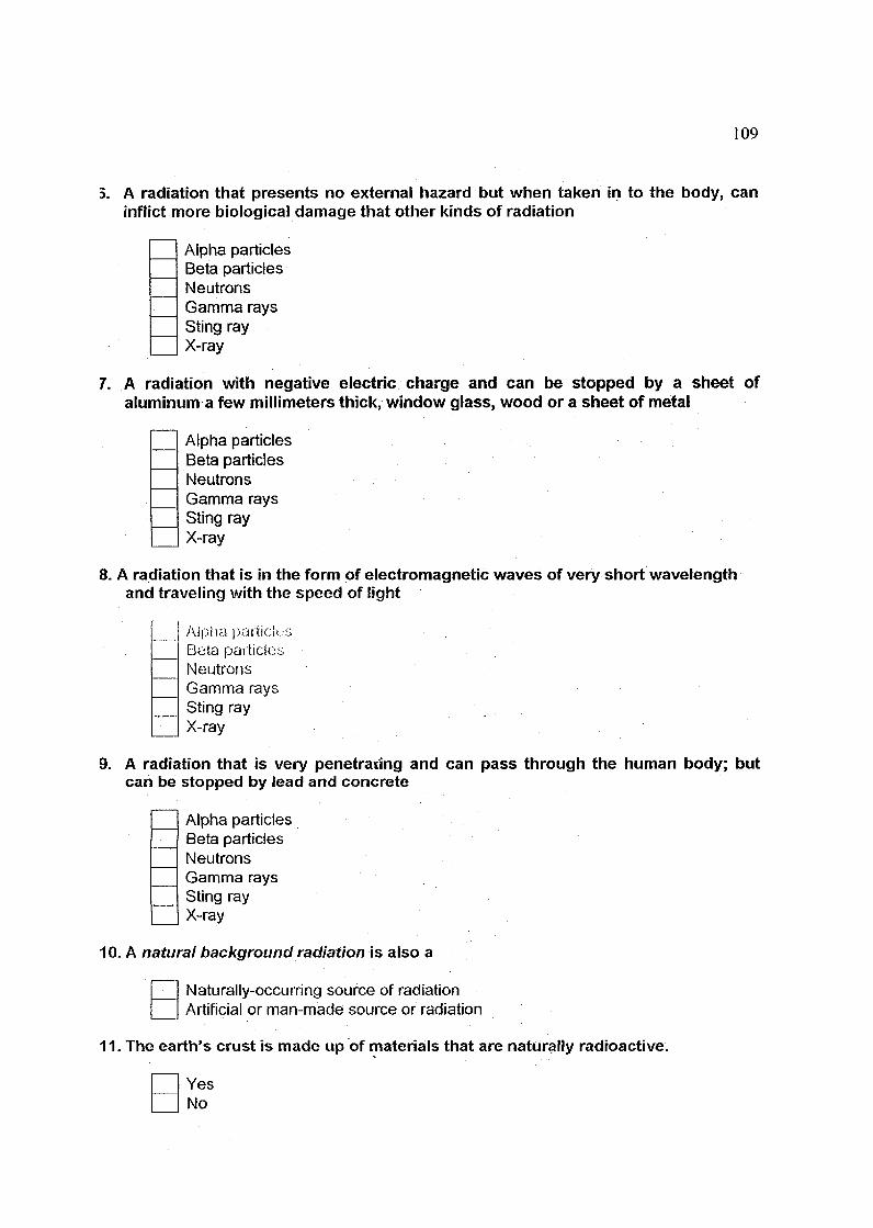
109
3. A radiation that presents no external hazard but when taken in to the body, caninflict more biological damage that other kinds of radiation
Alpha particlesBeta particlesNeutronsGamma raysSting rayX-ray
7. A radiation with negative electric charge and can be stopped by a sheet ofaluminum a few millimeters thick, window glass, wood or a sheet of metal
Alpha particlesBeta particlesNeutronsGamma raysSting rayX-ray
8. A radiation that is in the form of electromagnetic waves of very short wavelengthand traveling with the speed of light
Alpha pacticit;;Beta particlesNeutronsGamma raysSting rayX-ray
9. A radiation that is very penetrating and can pass through the human body; butcan be stopped by lead and concrete
Alpha particlesBeta particlesNeutronsGamma raysSting rayX-ray
10. A natural background radiation is also a
Naturally-occurring source of radiationArtificial or man-made source or radiation
11. The earth's crust is made up of materials that are naturally radioactive.
YesNo

110
12. The following are the natural radiation
Cosmic radiationPotassiumUraniumThoriumCalciumRadon
13. We are exposed to natural radiation coming from the sun.
YesNo
14. Naturally occurring radioactive materials arc present in Hie houses we live in andthe buildings where we work.
YesNo
15. The food and drink we consume contain naturally occurring radioactive materials.
YesNo
16. Our own bodies contain naturally occurring radioactive materials.
YesNo
17. Naturally occurring sources of radiation represent about what percent of allradiation to which we are exposed?
0%20%50%80%100%
18. Artificial or man-made sources of radiation represent about what percent of allradiation to which we are exposed?
0%20%50%80%100%

I l l
9. The biggest source of natural radiation in the world
UraniumThoriumPotassiumRadon
>0. Do you think that naturally occurring radioactive materials can cause healthproblems to humans?
YesNo
21. The following are the artificial or man-made sources of radiation
Nuclear ReactorsNuclear processing plantsFallout from nuclear bomb testingSome medical equipment used for treating cancerCoal-fired power plantsHydroelectric power plants
22. How can the human body be exposed to the hazards of radiation?
PenetrationInhalationIngestion through an open woundThrough body fluidsSkin absorptionEatingDrinking
23. What are the effects of radiation on living cells?
Changes in the chemical structure of the moleculesInterference with normal cellular processesBreakage of chemical bonds between carbon atoms in the DNA moleculesDamage to enzymesDamage to membranesImmediate multiplication of cellsPremature cell deathPrevention or delay or cell divisionPermanent genetic modificationNoneI don't know
24. What are the permanent effects of cell damage?
NauseaReddening of the skin

112
Blistering of the skinDeath of the skin tissueUlceration of the skin tissueWhitening of the skinSterilityCataractCancerHereditary effectCell modification or mutationNoneI don't know
25. What are the benefits that can be derived from radiation?
NoneI don't knowFood preservationImprove one's appetiteDestruction of bacteria and other micro-organisms in foodDisinfection of grainsIncreased yield of cropsChange in maturing time of cropsImproved economic characters of cropsImproved nutritional value of seedsReduction in cooking time of cropsImproved baking properties of seedsMore efficient use of fertilizersImproved animal feeding methodsImproved breeding of animalsImproved animal healthInsectyPest controlDiagnosing diseaseTreating diseaseReducing painBetter nutritionBetter healthSterilizing medical equipmentAs tracers in industryMeasuring extent of termite infestation
Thank you.
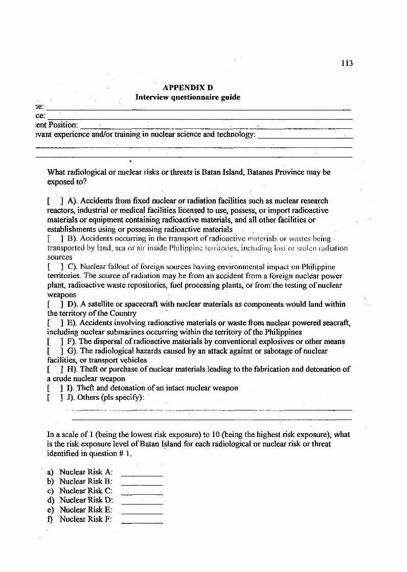
113
APPENDIX DInterview questionnaire guide
ce:lent Position:lent Position:want experience and/or training in nuclear science and technology:
What radiological or nuclear risks or threats is Batan Island, Batanes Province may beexposed to?
[ ] A). Accidents from fixed nuclear or radiation facilities such as nuclear researchreactors, industrial or medical facilities licensed to use, possess, or import radioactivematerials or equipment containing radioactive materials, and all other facilities orestablishments using or possessing radioactive materials[ ] B). Accidents occurring in the transport of radioactive materials or wastes beingtransported by land, sea or air inside Philippine territories, including iosi or stolen radiationsources[ ] C). Nuclear fallout of foreign sources having environmental impact on Philippineterritories. The source of radiation may be from an accident from a foreign nuclear powerplant, radioactive waste repositories, fuel processing plants, or fromthe testing of nuclearweapons[ ] D). A satellite or spacecraft with nuclear materials as components would land withinthe territory of the Country[ ] E). Accidents involving radioactive materials or waste from nuclear powered seacraft,including nuclear submarines occurring within the territory of the Philippines[ ] F). The dispersal of radioactive materials by conventional explosives or other means[ ] G). The radiological hazards caused by an attack against or sabotage of nuclearfacilities, or transport vehicles[ ] H). Theft or purchase of nuclear materials leading to the fabrication and detonation ofa crude nuclear weapon[ ] I). Theft and detonation of an intact nuclear weapon[ ] J). Others (pis specify):
In a scale of 1 (being the lowest risk exposure) to 10 (being the highest risk exposure), whatis the risk exposure level of Batan Island for each radiological or nuclear risk or threatidentified in question # 1.
a)b)c)d)e)f>
Nuclear RiskNuclear RiskNuclear RiskNuclear RiskNuclear RiskNuclear Risk
A:B:C:D:E:F:
114
Nuclear Risk G:Nuclear Risk H:Nuclear Risk I:Nuclear Risk J:
3t are the other areas in the Philippines that may be exposed to possible nuclear risks orats? Please indicate the nature of possible nuclear risks or threats as identified instion number 1. In a scale of 1 (being the lowest risk exposure) to 10 (being the highestexposure), please indicate the nuclear risk exposure level for each area for eachesponding nuclear risk or threat identified in question number 1.
[
I
AREA
NATURE ORCLASSIFICATION OFNUCLEAR RISK OR
' THREAT(check only)
a.b.c.d.e.f.g-h.i.
Ja.
b.c.
d.e.
f.g-h.i.
j -a.b.c.d.e.f.g-h.i.
j -
NUCLEAR RISK ORTHREAT
EXPOSURE LEVEL(scale is 1 to 10)
— • • • • - -
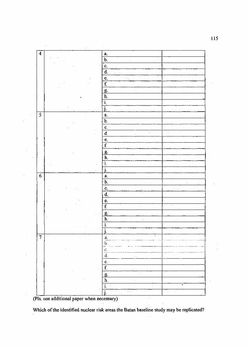
115
4
5
6
7
a.b.c.d.e.f.
g-h.i.
j -a.b.c.d.e.f.
g-h.i.
j -a.b.c.d.e.fg-h.i.
j -a.b.c.d.e.f.g-h.i.
j -
•
(Pis. use additional paper when necessary)
Which of the identified nuclear risk areas the Batan baseline study may be replicated?
116-
APPENDIX E
PROFILE OF EXPERTS
1. Name: Mr. Gabriel P. Santos, Jr.Present Job/Occupation: Geological ConsultantEducational Attainment: BS Geology, BS Chemistry, Masters in National Security
AdministrationRelevant experience and training in nuclear science and technology: More than 30
years experience and/or training in the applications of nuclear science andtechnology.
2. Name: Mr. Jesus S. DomingoEducational Attainment: BS Foreign Service, MA Philippine Studies, LLB LawPresent Job/Occupation: Director - DFA, OPC of UN & International Orgs,
Division V (Int. Political, Legal & Strategic AffairsRelevant experience and training in nuclear science and technology: Participated and
attended several seminars and trainings in conducted by UN, OPCW, DFA-PSI, etc.in nuclear science and technology.
3. Name: Dr. Corazon C. BernidoPresent Job/Occupation: Deputy Director, Philippine Nuclear Research InstituteEducational Attainment: Ph.D. in Nuclear ChemistryRelevant experience and training in nuclear science and technology: More than 30
years experience and/or training in the applications of nuclear science andtechnology.
4. Name: Mr. Osroxon L. AmparoPresent Job/Occupation: Head - Standards Development / OIC - Inspection and
EnforcementEducational Attainment: Masters in National Security AdministrationRelevant experience and training in nuclear science and technology: Systems
Operation - Nuclear Power Plants, Physical Protection of Nuclear Power Plants &Materials, Nuclear Safety, Nuclear Licensing and Regulations.
5. Name: Ms. Christina A. PetrachePresent Job/Occupation: Head - Nuclear Materials Research GroupEducational Attainment: Masters of Science in Nuclear EngineeringRelevant experience and training in nuclear science and technology: More than 24
years experience in nuclear materials processing, participated and attended severalseminars, workshops, on-the-job training, training courses in nuclear science andtechnology such as nuclear safety, nuclear power plant containment testing, etc.

117
6. Name: Ms. Estrella S. CaseriaPresent Job/Occupation: OIC - Radiation Protection ServicesEducational Attainment:Relevant experience and training in nuclear science and technology: More than 24
years experience in nuclear materials processing, participated and attended severalseminars, workshops, scientific visits, on-the-job training, training courses innuclear science and technology with emphasis on nuclear waste management
7. Name: Ms. Marvie PallataoPresent Job/Occupation: Senior Researcher - Radiological Risk AssessmentEducational Attainment:Relevant experience and training in nuclear science and technology: More limn 24
years experience in nuclear materials processing, participated and attended severalseminars, workshops, scientific visits, on-thc-job training, training courses innuclear science and technology with emphasis on nuclear and radiological risksassessment.
CURRICULUM VITAE
PERSONAL DETAILS
NAME : ROLANDO Y. KEYES
ADDRESS : 573 BLOCK 6 - BRGY. SAN JOSETARLAC CITY, PHILIPPINES
MAILING AND . PHILIPPINE NUCLEAR RESEARCH INSTITUTEOFFICIAL ADDRESS COMMONWEALTH AVE., DELIMAN,
QUEZON CITY 1101PHILIPPINES
PHONE : Office: 63-2-9296011 ext 252/296Fax: 63-2-9201646/9208765Telex: 66804 PNRIPN Cellphone: +63-9192491640
EMAIL ADDRESS • [email protected]
DATE OF BIRTH : MARCH 8, 1955
NATIONALITY : FILIPINO
MARITAL STATUS : MARRIED
EDUCATIONAL : BS MINING ENGINEERINGQUALIFICATIONS UNIVERSITY OF THE PHILIPPINES
: MS GEOLOGY (Specialization in geophysics and economicgeology)
NATIONAL INSTITUTE OF GEOLOGICAL SCIENCESUNIVERSITY OF THE PHILIPPINES
: MASTERS IN NATIONAL SECURITY ADMINISTRATIONNATIONAL DEFENSE COLLEGE OF THE PHILIPPINES
: MINING ENGINEERING BOARDELIGIBILITIES E D p PROFESSIONAL (PD 1408)
PROFESSIONAL EXPERIENCE
PLACE OF EMPLOYMENT : October 24, 1977 - present
EMPLOYER . PHILIPPINE NUCLEAR RESEARCH INSTITUTECommonwealth Avenue, Diliman, Quezon CityPhilippines
Present position : Senior Researcher, May 1990 - present

119
Present project involvement:
«1). Survey for Nuclear and Other Industrial Minerals.2). Nuclear Fuel Cycle and Nuclear Power Plant Siting Studies3). Use of nuclear techniques in environmental studies and monitoring
Completed cooperative/technical assistance projects (local and international):
1. Uranium Exploration Data Bank, an International Atomic Energy Agencytechnically assisted project (IAEA TC Project PHI/3/007), as project counterpart.1987-1989.
2. Reconnaissance Rare Earth Geochemical Exploration in Northern Palawan, atechnical cooperation project with funding support from the Philippine Council forAdvance Science and Technology Research and Development, as project leader.1991-1992.
3. Assessment of Radioactive Contamination in the Former US Airforce Base inClark, Angeles City, in cooperation with the Clark Development Corporation. 1997.
4. Assessment of radioactive contamination in the former US Naval Base in Subic,Olongapo City in cooperation with the Subic Bay Metropolitan Authority. 1998.
Participation in international conferences, workshops, seminars, symposia,researches and training courses
1. International Symposium on Uranium Production & Rmv Materials for theNuclear Fuels Cycle - Supply and Demand) Economics, the Environment andEnergy Security. International Atomic Energy Agency, Vienna, Austria, 20 - 24June 2005.
2. OSI (On-Site Inspection) Field Testing and Training Curriculum DevelopmentActivity for Continuation Period Geophysical Techniques. PreparatoryCommission for the Comprehensive Nuclear-Test-Ban Treaty Organization,Leicester, United Kingdom, 26 July ~ 06 August 2004.
3. IAEA RCA Regional Training Course on Application of Nuclear and IsotopicTechniques to Identify the Source and Distribution of Contaminants in HeavilyPolluted Coastal Regions. Philippine Nuclear Research Institute, CommonwealthAvenue, Diliman, Quezon City, Philippines, January 1 2 - 2 1 , 2004 (As observer).
4. Seventh On-Site Inspection Introductory Course. Comprehensive Nuclear-Test-Ban Treaty Organization, Vienna International Center, Vienna, Austria, March 31-April 4, 2003.
5. International Nuclear Conference 2002. Putra World Trade Center, KualaLumpur, Malaysia, October 14 - 18, 2002.
120
6. IAEA RCA Regional Workshop on Advanced Information Technology and E-Learning. Philippine Nuclear Research Institute, Diliman, Quezon City,Philippines, December 3 - 7 , 2001. (As observer).
7. Regional Training Workshop on Nuclear Power Plant Siting. Educational andTraining Center of National Atomic Energy Agency (BATAN), Jakarta,Indonesia. April 3 - 14, 2000.
8. On-the-job Training in Prospecting of Nuclear Raw Material Deposits whichincludes the calibration and testing of a carborne gamma ray spectrometric system,processing and analysis of data, and computer generation of maps. GeologicalSurvey of Canada, Ottawa, Canada and Instituto Geologico e Mineiro, Lisbon,Portugal. April 11-July 09, 1994.
9. Workshop on Technical Co-Operation Project Counterparts in the Field ofUranium Raw Material Prospection and Development in the Asia and PacificRegion. Bureau of Geology of China National Nuclear Corporation, Beijing,People's Republic of China. October 27 - November 09, 1991.
10. Exchange Scientist Program. Science and Technology, Japan. Research Theme:Uranium Exploration, Tests and Analysis. Power Reactor and Nuclear Fuels Cycle,Chubu Works, Toki, Gifii-Kcn, Japan. September 25 - December 23, 1989.
11. On-the-job Training on Computer Data Processing and Analysis of GeochemicalExploration Data. Queens University, Kingston, Ontario, Canada. July 17, 1986-July 17, 1987.
12. United Nations Interregional Seminar on the Applications of Electronic DataProcessing Methods in Mineral Exploration arid Development. Center in Miningand Mineral Exploration Research, Laurentian University, Sudbury, Ontario,Canada. October 13-24, 1986
13. Interregional Training Course on Uranium and Thorium Exploration andEvaluation. Geoloski Zavod Ljubljana, Ljubljana, Yugoslavia. September 07 -~October 08,1983.
Publications and other written reports
1. Reyes, R.Y., Tabora, E.U., Garcia, T.Y., 2005. Regional Exploration for Uraniumby Gamma Ray Spectrometric Technique in Marinduque Island, the Philippines,Extended Synopsis, International Symposium on Uranium Production & RawMaterials for the Nuclear Fuel .Cycle - Supply and Demand, Economics, theEnvironment and Energy Security, (IAEA-CN-128) International Atomic EnergyAgency, Vienna, Austria, pp. 275-278.
2. Petrache, C.A., Santos, Jr., G.P., Fernandez, L.G., Castillo, M.K., Tabora, E.U.,Intoy, S.P., and Reves, R.Y.. 2004. "Recovery of Rare Earth Elements fromBeach Sand in Palawan", The Nucleus, pp. 21 -28.
3. Reves. R.Y.. Petrache, C.A., Garcia, N.Q., Tabora, E.U., Juson, J.G., Garcia, T.Y.,Nato, Jr., A.Q., 2002. The Application of Gamma Ray Spectrometry inEnvironmental Radioactivity Survey and Monitoring: Examples from thePhilippines; Environment, Waste and Safety, Proceedings of the InternationalNuclear Conference 2002, Kuala, Lumpur, Malaysia, INC'02, pp. 17-26.
4. Santos, Jr., G.P., Reyes, R.Y.. Magsambol, W.N., Ramos, A.F., Petrache, C.A.,Fernandez, L.G., Castillo, M.K., Almoneda, R.V., Tabora, E.U., 1998. Semi-Detailed Geochemical Exploration for Rare Earths in San Vicente-Roxas,Northern Palawan, Philippines Nuclear Journal, vol. 12, pp. 25-33.
5. Reyes, R.Y., Santos, Jr., G., Magsambol, W.N., Ramos, A..F!, Petrache, C.A.,Tabora E.U., 1992. Heavy Mineral Survey for Rare Earths in the Northern Partof Palawan, Philippines Nuclear Journal, vol. 9, pp. 25-44.
6. Reves. R.Y.. Santos, Jr., G., Magsambol, W.N., Ramos, A.F., 1991.Reconnaissance Geochemical Exploration for Uranium in Northern Palawan,Philippines, Philippines Nuclear Journal, vol. 8, pp. 55-68.
7. Reyes, R.Y., Ramos, A.F., Magsambol, W.N., Fernandez, L.G., Marcelo, E.A.,Almoneda, R.V., Castillo, M.K., 1990. Geochemical Exploration for Nuclear andIndustrial Minerals in Western Tarlac, Philippines Nuclear Journal, vol. 7, pp. 59-79.
8- Reves. R.Y., Ramos, A.F., Magsambol, W.N. and Hernandez, B.C., 1989.Reconnaissance Geochemical Survey for Uranium and Related IndustrialMinerals in Cebu Island. PNRI Technical Report No. PNRI B(EA)8900 ].
9. Hernandez, E.C., Magsambol, W.N., Reves, R.Y., Ramos, A.F. and Bernido, C.C.,1988. Reconnaissance Geochemical Survey for Uranium in Bohol, Philippines,Uranium Deposits in Asia and the Pacific: Geology and Exploration, Proceedings ofa Technical Committee Meeting, Jakarta, Indonesia, International Atomic EnergyAgency, Vienna, IAEA-TC-543/18, pp. 239-258.
10. Hernandez, E C , Magsambol, W.N., Reyes. R.Y., Marcelo, F.V., Ramos, A.F.,Tolentino H.E. and Talens, M.A., 1983. Detailed Survey for Uranium in SanNicolas, Sarrat, Mabaleng and Sto. Tomas Areas, Docos Norte, PAEC TechnicalReport No. PAEC0IB83OO9.
11. Hernandez, E.C., Magsambol, W.N., Reves. R.Y.. Marcelo, F.V. and Ramos, A.F.,1982, Semi-Detailed Geochemical Survey for Uranium in Ambalanga River Area,Benguet, PAEC Technical Report No. PAEC©IB82009.
12. Hernandez, E.C., Magsambol, W.N., Reves, R.Y. and Marcelo, F.V., 1979,Orientation Geochemical Survey for Uranium Deposits in Northwestern Luzon, 2vols., PAEC Technical Report.

Papers/Posters/Reports Presented'
1. Rolando Y. Reyes, Estrellita U. Tabora, Teofilo Y. Garcia, "Regional Explorationfor Uranium by Gamma Ray Spectrometric Technique in Marinduque Island, thePhilippines". Presented at the International Symposium on Uranium Production &Raw Materials for the Nuclear Fuel Cycle - Supply and Demand, Economics, theEnvironment and Energy Security, International Atomic Energy Agency,Vienna, Austria, 20 - 24 June 2005.
2. Petrache, Christina A., Gabriel P. Santos, Jr., Ix>urdes G. Fernandez, Marilyn K.Castillo, Estrellita U. Tabora/Socorro P. Intoy and Rolando Y. Reyes " Recoveryof Rare Earth Elements from Beach Sand in Palawan". Technical posterpresented during the National Academy of Science and Technology 26th AnnualScientific Meeting, Manila Hotel, Philippines, July 14-15, 2004.
3. Reyes, Rolando Y., Christina A. Petrache, Estrellita U. Tabora, Socorro P. Intoy,Teofilo Y. Garcia, Alejandro Q. Nato, Jr. "Gamma Ray Surveys for GeologicalStudies and Environmental Monitoring: Experiences at the Philippine NuclearResearch Institute". Technical poster (traditional poster and eposter) presentedduring the National Academy of Science and Technology 25<h Annual ScientificMeeting, Manila Hotel, Philippines, July 9-10, 2003.
4. Reyes, Rolando Y., Christina A. Petrache, Nardo Q. Garcia, Estrellita U. Tabora,Julie G. Juson, Teofilo Y. Garcia, Alejandro Q. Nato, Jr. "The Application ofGamma Ray Spectrometry in Environmental Radioactivity Survey andMonitoring: Examples from the Philippines" Paper presented at the InternationalNuclear Conference 2002, Putra World Trade Center, Kuala Lumpur, Malaysia,14 - 18 October 2002.
5. Reyes, Rolando Y. "Gamma Ray Spectrometric Surveys of Marinduque Islandand the San Antonio Porphyry Copper Deposit, Marinduque, Luzon,Philippines". Paper presented at the 4th Regional and National S&T Fora andCompetitions in Industry and Energy Research and Development, PhilippineCouncil for Industry and Energy Research and Development, Department ofScience and Technology, Bicutan, Taguig, Metro Manila, March 4-5, 2002.
6. Reyes, Rolando Y. and Graciano P. Yimuil, Jr. "Gamma Ray SpectrometricSurvey of a Porphyry Copper Deposit: The Sun Antonio Copper Deposit, Sta.Cruz, Marinduque, Philippines". Paper presented at the GEOCON2001(Geological Convention 2001), Mapua Institute of Technology, Muralla St.Intramuros, Metro Manila, Philippines, 5 - 7 December 2001.
7. Reyes, Rolando Y. and Graciano P. Yumul, Jr. "U-Th-K Radiometric Survey as aGeological Tool: Example from Marinduque Island". Paper presented at theSymposium on Geological Research Application for Social Progress, DENR-MGB Region 1, Baguio City, Philippines, 28 April 2001.
8. Reyes, Rolando Y. and Graciano P. Yumul, Jr. "Assessing the Uranium, Thoriumand Potassium Mineral Resources of Marinduque Province by Gamma RaySpectrometric Survey". Paper presented at the NIGS2000 Research Symposium,