an appraisal of real property in an appraisal report
TRANSCRIPT
AN APPRAISAL OF REAL PROPERTY IN AN APPRAISAL REPORT
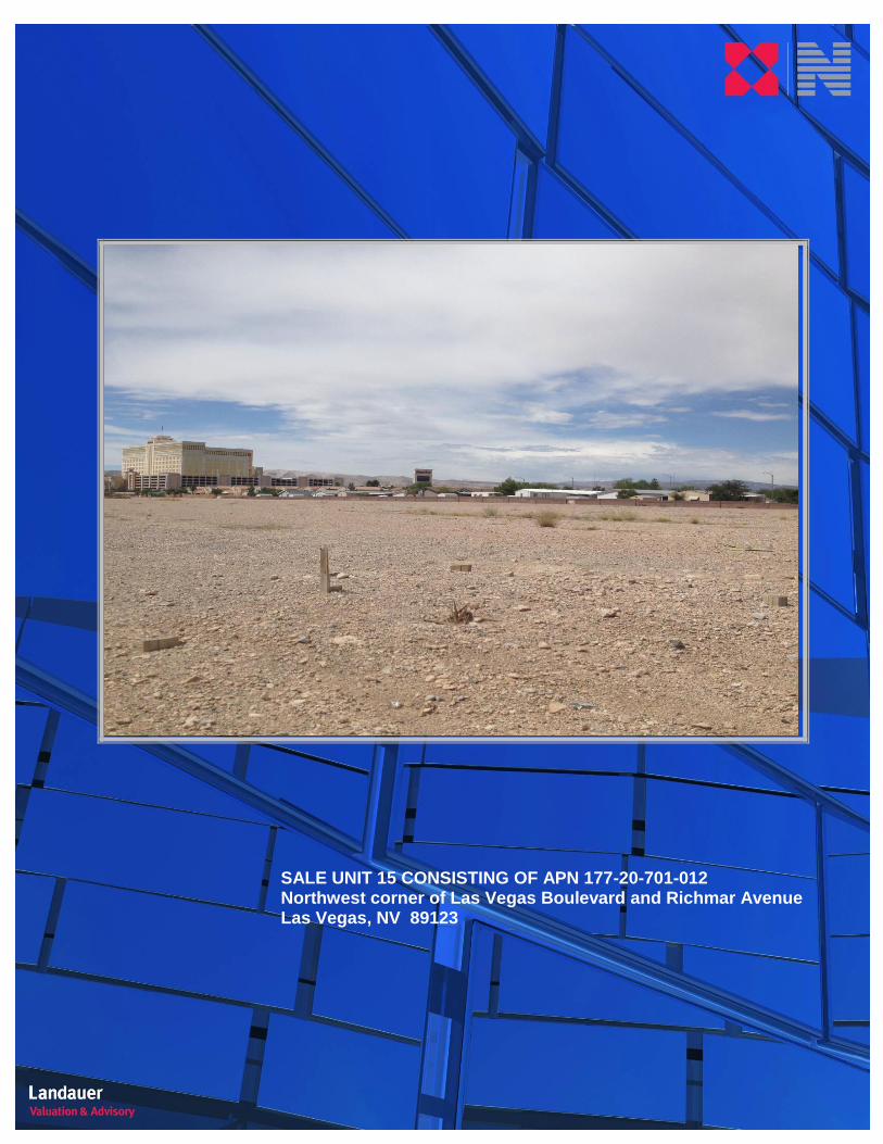
SALE UNIT 15 CONSISTING OF APN 177-20-701-012 Northwest corner of Las Vegas Boulevard and Richmar Avenue Las Vegas, NV 89123 Landauer Job No.: 14-2642-0120 Client Reference No.: Sale Unit 15 consisting of APN 177-20-701-012
PERTINENT DATES: “As Is” Valuation Date: August 20, 2014 Report Date: August 25, 2014 PREPARED FOR: Ms. Temple Mullen Clark County Department of Real Property Management P.O. Box 551825 Las Vegas, NV 89155
PREPARED BY:
Landauer Valuation & Advisory A division of Newmark Grubb Knight Frank 3930 Howard Hughes Pkwy Las Vegas, NV 89169
SALE UNIT 15 CONSISTING OF APN 177-20-701-012 Northwest corner of Las Vegas Boulevard and Richmar Avenue Las Vegas, NV 89123
LANDAUER VALUATION & ADVISORY, A DIVISION OF NEWMARK GRUBB KNIGHT FRANK 3930 Howard Hughes Pkwy | Las Vegas, NV 89169
PHONE: 702.733.7500 | WEB: www.ngkf.com
August 25, 2014
Ms. Temple Mullen
Clark County Department of Real Property Management
P.O. Box 551825
Las Vegas, NV 89155
RE: An Appraisal of Real Property
Sale Unit 15 consisting of APN 177-20-701-012
Northwest corner of Las Vegas Boulevard and Richmar Avenue
Las Vegas, NV 89123
Landauer Job No.: 14-2642-0120 Client Reference No.: Sale Unit 15 consisting of APN 177-20-701-012
Dear Ms. Temple Mullen,
At the request and authorization of Clark County Department of Real Property Management, Landauer Valuation &
Advisory (“Landauer”) has prepared an appraisal to determine an opinion of market value of the referenced property
and presented our analysis in the following Appraisal Report. Based on the intended use and in consideration of the
subject’s physical and economic characteristics, we have prepared an appropriate scope of work that will provide for
a credible market value opinion.
The significant elements of the scope of work include: i) an observation of the subject and its surroundings; ii) a
collection, verification and analysis of sales and; iii) completion of the appropriate approaches to value.
The subject property is located at the northwest corner of Las Vegas Boulevard and Richmar Avenue, Las Vegas,
NV 89123. The subject is vacant land and contains 8.1 acres or 352,836 square feet. The subject site is zoned H-1
(Limited Resort and Apartment) by the Clark County Planning and Zoning Department. The highest and best use for
the subject is for future tourist commercial development.
Data, information, and calculations leading to the value conclusion(s) are incorporated in the report following this
letter. The report, in its entirety, including all assumptions and limiting conditions, is an integral part of, and
inseparable from, this letter.
Based on the analysis contained in the following report, and after considering the extraordinary assumptions and
hypothetical conditions listed in the Executive Summary section of this report, the opinion of value for the subject is
concluded as follows:
LANDAUER VALUATION & ADVISORY, A DIVISION OF NEWMARK GRUBB KNIGHT FRANK 3930 Howard Hughes Pkwy | Las Vegas, NV 89169
PHONE: 702.733.7500 | WEB: www.ngkf.com
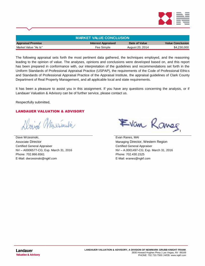
Appraisal Premise Interest Appraised Date of Value Value Conclusion
Market Value "As Is" Fee Simple August 20, 2014 $4,230,000
MARKET VALUE CONCLUSION
The following appraisal sets forth the most pertinent data gathered, the techniques employed, and the reasoning
leading to the opinion of value. The analyses, opinions and conclusions were developed based on, and this report
has been prepared in conformance with, our interpretation of the guidelines and recommendations set forth in the
Uniform Standards of Professional Appraisal Practice (USPAP), the requirements of the Code of Professional Ethics
and Standards of Professional Appraisal Practice of the Appraisal Institute, the appraisal guidelines of Clark County
Department of Real Property Management, and all applicable local and state requirements.
It has been a pleasure to assist you in this assignment. If you have any questions concerning the analysis, or if
Landauer Valuation & Advisory can be of further service, please contact us.
Respectfully submitted,
LANDAUER VALUATION & ADVISORY
Dave Wrzesinski, Evan Ranes, MAI
Associate Director Managing Director, Western Region
Certified General Appraiser Certified General Appraiser
NV – A0006577-CG; Exp. March 31, 2016 NV – A.0001497-CG; Exp. March 31, 2016
Phone: 702.866.6561 Phone: 702.430.1525
E-Mail: [email protected] E-Mail: [email protected]
CERTIFICATION
SALE UNIT 15 CONSISTING OF APN 177-20-701-012
CERTIFICATION
CERTIFICATION
We certify to the best of our knowledge and belief:
1. The statements of fact contained in this report are true and correct.
2. The reported analyses, opinions, and conclusions are limited only by the reported assumptions and limiting
conditions and are our personal, impartial and unbiased professional analyses, opinions, and conclusions.
3. We have no present or prospective interest in the property that is the subject of this report and have no personal
interest with respect to the parties involved.
4. We have no bias with respect to the property that is the subject of this report or to the parties involved with this
assignment.
5. Our engagement in this assignment was not contingent upon developing or reporting predetermined results.
6. Our compensation for completing this assignment is not contingent upon the development or reporting of a
predetermined value or direction in value that favors the cause of the Client, the amount of the value opinion, the
attainment of a stipulated result, or the occurrence of a subsequent event directly related to the intended use of
this appraisal.
7. The reported analyses, opinions, and conclusions were developed, and this report has been prepared, in
conformity with the Code of Professional Ethics and Standards of Professional Appraisal Practice of the
Appraisal Institute.
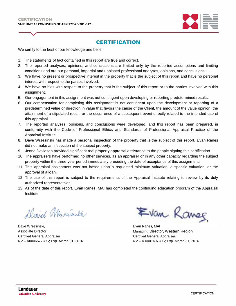
8. Dave Wrzesinski has made a personal inspection of the property that is the subject of this report. Evan Ranes
did not make an inspection of the subject property.
9. Jenna Davidson provided significant real property appraisal assistance to the people signing this certification.
10. The appraisers have performed no other services, as an appraiser or in any other capacity regarding the subject
property within the three year period immediately preceding the date of acceptance of this assignment.
11. This appraisal assignment was not based upon a requested minimum valuation, a specific valuation, or the
approval of a loan.
12. The use of this report is subject to the requirements of the Appraisal Institute relating to review by its duly
authorized representatives.
13. As of the date of this report, Evan Ranes, MAI has completed the continuing education program of the Appraisal
Institute.
Dave Wrzesinski, Evan Ranes, MAI
Associate Director Managing Director, Western Region
Certified General Appraiser Certified General Appraiser
NV – A0006577-CG; Exp. March 31, 2016 NV – A.0001497-CG; Exp. March 31, 2016
SUBJECT PHOTOGRAPHS
SALE UNIT 15 CONSISTING OF APN 177-20-701-012
SUBJECT PHOTOGRAPHS
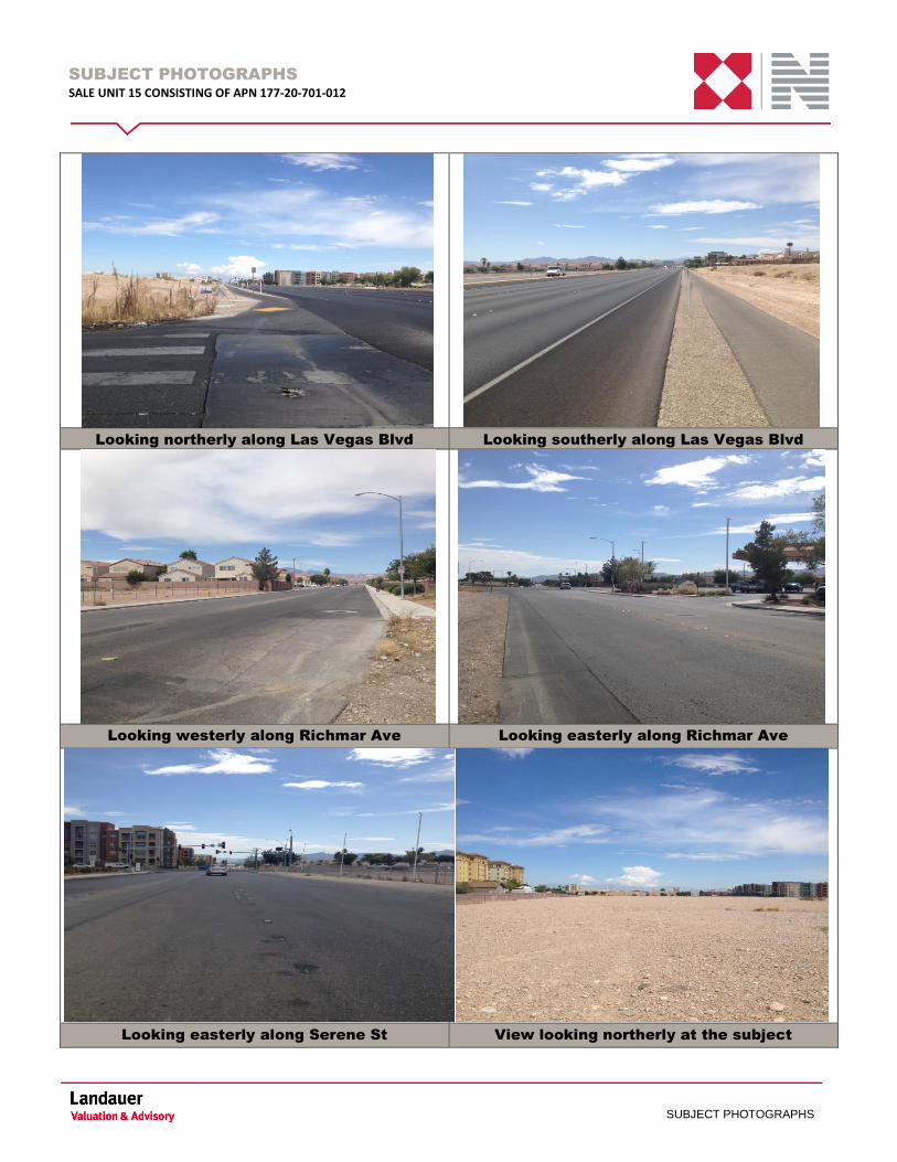
Looking northerly along Las Vegas Blvd Looking southerly along Las Vegas Blvd
Looking westerly along Richmar Ave Looking easterly along Richmar Ave
Looking easterly along Serene St View looking northerly at the subject

SUBJECT PHOTOGRAPHS
SALE UNIT 15 CONSISTING OF APN 177-20-701-012
SUBJECT PHOTOGRAPHS
Looking northeasterly at the subject Looking easterly at the subject
Looking southerly at the subject Looking southerly at the subject
Looking southwesterly at the subject View of grade separation at Las Vegas Blvd
SUBJECT PHOTOGRAPHS
SALE UNIT 15 CONSISTING OF APN 177-20-701-012
SUBJECT PHOTOGRAPHS
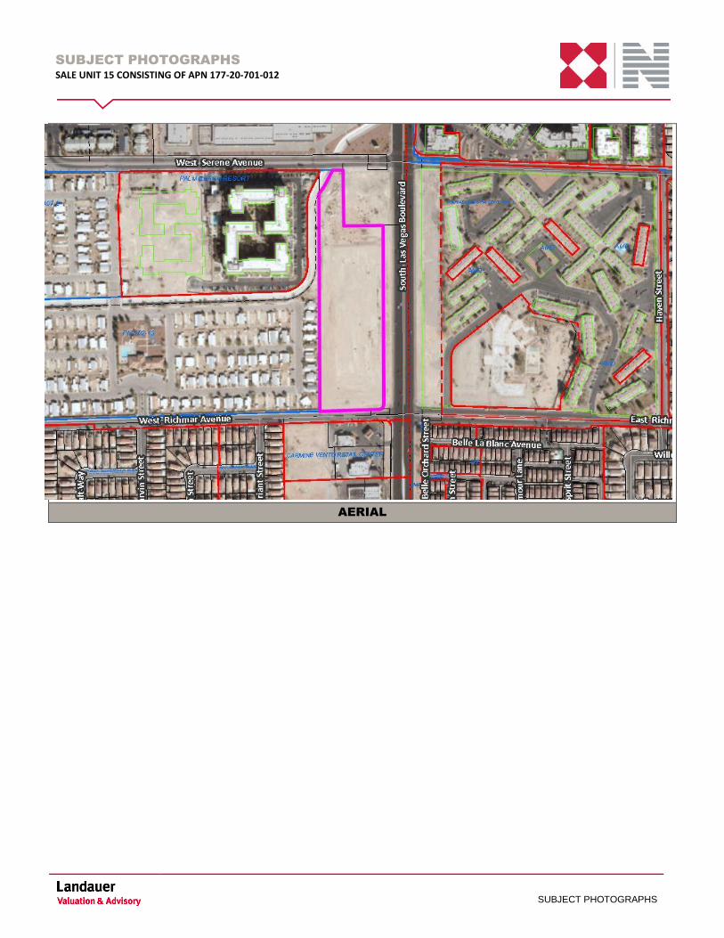
AERIAL
EXECUTIVE SUMMARY
SALE UNIT 15 CONSISTING OF APN 177-20-701-012
EXECUTIVE SUMMARY
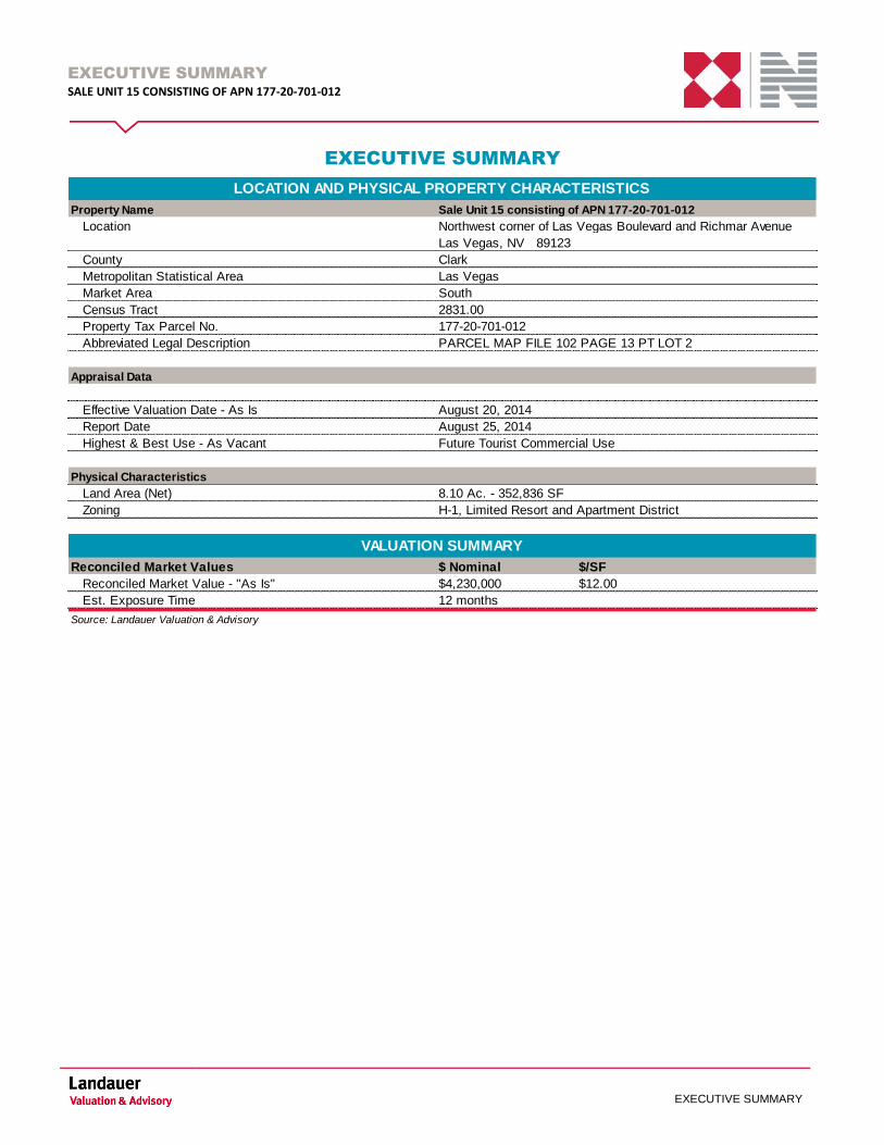
EXECUTIVE SUMMARY
Property Name
Location
County
Metropolitan Statistical Area
Market Area South
Census Tract
Property Tax Parcel No.
Abbreviated Legal Description
Appraisal Data
Effective Valuation Date - As Is
Report Date
Highest & Best Use - As Vacant Future Tourist Commercial Use
Physical Characteristics
Land Area (Net)
Zoning H-1, Limited Resort and Apartment District
Reconciled Market Values $ Nominal $/SF
Reconciled Market Value - "As Is" $4,230,000 $12.00
Est. Exposure Time 12 months
Source: Landauer Valuation & Advisory
VALUATION SUMMARY
LOCATION AND PHYSICAL PROPERTY CHARACTERISTICS
August 20, 2014
August 25, 2014
8.10 Ac. - 352,836 SF
177-20-701-012
Sale Unit 15 consisting of APN 177-20-701-012
Northwest corner of Las Vegas Boulevard and Richmar Avenue
Las Vegas, NV 89123
Clark
Las Vegas
2831.00
PARCEL MAP FILE 102 PAGE 13 PT LOT 2
EXECUTIVE SUMMARY
SALE UNIT 15 CONSISTING OF APN 177-20-701-012
EXECUTIVE SUMMARY
VALUATION HIGHLIGHT
The subject property is located at the northwest corner of Las Vegas Boulevard and Richmar Avenue, Las Vegas,
NV 89123. The subject is vacant land and contains 8.1 acres or 352,836 square feet. The subject site is zoned H-1
(Limited Resort and Apartment) by the Clark County Planning and Zoning Department. The highest and best use for
the subject is for future tourist commercial development.
EXTRAORDINARY ASSUMPTIONS AND HYPOTHETICAL CONDITIONS
Extraordinary Assumptions
Extraordinary assumptions are defined in the Uniform Standards of Professional Appraisal Practice as
“...an assumption, directly related to a specific assignment, which, if found to be false, could alter the appraiser’s
opinions or conclusions.”
Extraordinary assumptions presume as fact otherwise uncertain information about physical, legal or economic
characteristics of the subject property; or about conditions external to the property, such as market conditions or
trends; or about the integrity of data used in an analysis. The use of extraordinary assumptions can have an effect on
the concluded values presented herein.
This appraisal employs the following extraordinary assumptions:
The appraisers were not provided with an ALTA survey that indicated land area. We did not make measurements in
the field and have relied on information provided and available through the Clark County Assessor’s Office. We
assume this information to be accurate as we have relied upon it herein. Should information become available in the
future indicating a land area different from that presented and analyzed herein, we reserve the right to modify our
value conclusions.
Hypothetical Conditions
Hypothetical conditions are defined in the Uniform Standards of Professional Appraisal Practice as
“...that which is contrary to what exists but is supposed for the purpose of analysis.”
Hypothetical conditions assume conditions contrary to known facts about physical, legal, or economic characteristics
of the subject property; or about conditions external to the property, such as market conditions or trends; or about the
integrity of data used in the analysis.
This appraisal employs the following hypothetical conditions: None
The use of Extraordinary Assumptions and/or Hypothetical Conditions may affect assignment results.
TABLE OF CONTENTS
SALE UNIT 15 CONSISTING OF APN 177-20-701-012
TABLE OF CONTENTS
TABLE OF CONTENTS
INTRODUCTION ................................................................................................................................................................................ 1
REGIONAL ANALYSIS ...................................................................................................................................................................... 5
NEIGHBORHOOD ANALYSIS ......................................................................................................................................................... 10
LAS VEGAS LOCAL HOTEL/CASINO MARKET ANALYSIS .......................................................................................................... 14
SITE ANALYSIS ............................................................................................................................................................................... 20
ZONING ........................................................................................................................................................................................... 24
MUD OVERLAY ............................................................................................................................................................................... 26
FUTURE PLANNED LAND USE ...................................................................................................................................................... 28
ASSESSMENT & TAXES ................................................................................................................................................................ 29
HIGHEST & BEST USE ................................................................................................................................................................... 30
APPRAISAL METHODOLOGY ........................................................................................................................................................ 32
LAND VALUE ................................................................................................................................................................................... 33
RECONCILIATION ........................................................................................................................................................................... 43
DEFINITIONS .................................................................................................................................................................................. 45
ADDENDA
Addendum A: Definitions
Addendum B: Comparable Summaries
Addendum C: Appraisers Qualifications
Addendum D: Client Correspondence
Addendum E: Property Information
INTRODUCTION
SALE UNIT 15 CONSISTING OF APN 177-20-701-012
Page | 1
INTRODUCTION
In the following section, we identify the subject property and ownership, the intended use and user(s) of the
appraisal, the property rights appraised, dates of value, definition of market value, scope of work, and estimate of
exposure and marketing time.
IDENTIFICATION OF THE PROPERTY
The subject is briefly described as follows:
Component Detail
Property Name Sale Unit 15 consisting of APN 177-20-701-012
Address
Northwest corner of Las Vegas Boulevard and
Richmar Avenue
Las Vegas, NV, 89123
County Clark
MSA Las Vegas
Market South
Census Tract 2831
Tax Identification Number(s) 177-20-701-012
Abbreviated Legal Description
Source: Landauer Valuation & Advisory
PARCEL MAP FILE 102 PAGE 13 PT LOT 2
SUBJECT IDENTIFICATION
CURRENT OWNERSHIP AND HISTORY
According to the Clark County Recorder’s Office, the subject is currently under the ownership of County of Clark
(Aviation). There have been no other transfers of title in the past three years. The subject is not currently listed for
sale and is not subject to a purchase agreement or purchase option.
INTENDED USE AND USERS OF THE APPRAISAL
This appraisal is to be used by the Client, Clark County Department of Real Property Management to assist in sales
of the identified property rights. The intended user is Clark County Department of Real Property Management.
RESTRICTIVE COVENANT AND RESERVATION OF AVIGATION & CLEARANCE
EASEMENT
Included in the addenda of this report is a Restrictive Covenant And Reservation Of Avigation & Clearance
Easement. This easement generally outlines the compatible Uses and restrictions for future development of the
subject site. Based on our understanding of the easement the restrictions would not be overly restrictive for future
single-family residential development. The Restrictive Covenant And Reservation Of Avigation & Clearance
Easement would be reserved upon conveyance of the property. The reader is referred to the addenda of this report
for a copy of the easement.
INTRODUCTION
SALE UNIT 15 CONSISTING OF APN 177-20-701-012
Page | 2
ACCESS EASEMENT
According to documentation provided, there is an access agreement at the subject’s northerly boundary. The
access agreement generally will provide for vehicular and pedestrian access to Assessor’s Parcel Number 177-20-
701-002 which is located at the immediate southwest corner of Serene Avenue and Las Vegas Boulevard. No
adverse affect is noted for the access easement. The access agreement would be reserved upon conveyance of the
property. A copy of the draft for the access easement is provided in the addenda of this report for the reader’s
perusal.
PROPERTY RIGHTS APPRAISED
We have appraised the fee simple interest of the subject property.
The following definition is from the Dictionary of Real Estate Appraisal, Fifth Edition (2010), published by the
Appraisal Institute.
Fee Simple Interest: Absolute ownership unencumbered by any other interest or estate, subject only to the limitations
imposed by the governmental powers of taxation, eminent domain, police power, and escheat.
Additional appraisal definitions applicable to the analysis presented herein are presented in the Addenda.
RELEVANT DATES
The date of inspection of the subject property was August 20, 2014. The date of the report is August 25, 2014.
Relevant dates are summarized in the subsequent table.
Premise Interest Appraised Date of Value
Market Value "As Is" Fee Simple August 20, 2014
Source: Landauer Valuation & Advisory
DATE OF VALUES SUMMARY
DEFINITION OF MARKET VALUE
As defined by the Office of the Comptroller of the Currency under 12 CFR, Part 34, Sub-part C – Appraisals, 34.42
Definitions (g), market value is defined as:
“The most probable price which a property should bring in a competitive and open market under all conditions
requisite to a fair sale, the buyer and seller each acting prudently and knowledgeably, and assuming the price is not
affected by undue stimulus. Implicit in this definition is the consummation of a sale as of a specified date and the
passing of title from seller to buyer under conditions whereby:
Buyer and seller are typically motivated;
Both parties are well informed or well advised, and acting in what they consider their own best interests;
A reasonable time is allowed for exposure in the open market;
INTRODUCTION
SALE UNIT 15 CONSISTING OF APN 177-20-701-012
Page | 3
Payment is made in terms of cash in U.S. dollars or in terms of financial arrangements comparable thereto;
and,
The price represents the normal consideration for the property sold unaffected by special or creative
financing or sales concessions granted by anyone associated with the sale.”
This definition of market value is generally accepted by agencies regulating financial institutions in the United States.
SCOPE OF WORK
The scope of work refers to the type and extent of research and analyses employed in the appraisal assignment and
presented in the appraisal report.
This is an Appraisal Report as defined by Uniform Standards of Professional Appraisal Practice under Standards
Rule 2-2(a). This format provides a narrative of the appraisal process, subject, market data and valuation analyses.
The Extent to Which the Property was Identified
The subject is identified via the postal address, real estate tax parcel number(s) and legal description.
The Extent to Which the Property was Inspected
The subject property and surrounding neighborhood was inspected on August 20, 2014.
The Type and Extent of Data Researched
We physically observed the micro and/or macro market environments with respect to physical and economic factors
relevant to the valuation process; expanded this knowledge through interviews with regional and/or local market
participants, and available published data and other various resources. To this extent, we conducted all applicable
regional and/or local research with respect to:
Exposure and marking time;
Neighborhood and land use trends;
Demographic trends;
Market trends relative to the subject property type;
Flood zone status;
Zoning requirements and compliance;
Real estate tax data;
Comparable listing and sales data;
The data has been analyzed and confirmed with sources assumed to be reliable.
The Type and Extent of Analyses Applied
We analyzed the property and market data gathered through the use of accepted market-derived methods and
procedures, employed the appropriate approaches to value, and correlated and reconciled the results into an
estimate of market value, as defined within the appraisal report.
INTRODUCTION
SALE UNIT 15 CONSISTING OF APN 177-20-701-012
Page | 4
SIGNIFICANT APPRAISAL ASSISTANCE OR CONTRIBUTION
Jenna Davidson has provided significant real property appraisal assistance to the persons signing this report in the
form of property inspection, research and general report preparation.
EXPOSURE AND MARKETING TIME
Current appraisal guidelines require an estimate of a reasonable time period in which the subject property could be
brought to market and sold. This reasonable time frame can either be examined historically or prospectively. In a
historic analysis, this is referred to as exposure time. Exposure time always precedes the date of value with the
underlying premise being the time a property would have been on the market prior to the date of value, such that it
would sell at its appraised value as of the date of value. On a prospective basis, the term marketing time is most
often used. The exposure / marketing time is a function of price, time, and use. It is not an isolated estimate of time
alone. It is different for various types of real estate and under various market conditions.
In estimating an appropriate exposure / marketing time for the subject property, we considered the following:
Comparable sales (exposure time);
Interviews with market participants (exposure and marketing times).
Based on this analysis, we have concluded an exposure/marketing time of 12 months or less would be considered
reasonable for the subject property. This exposure/marketing time reflects current economic conditions, current real
estate investment market conditions, the terms and availability of financing for real estate acquisitions, and property
and market-specific factors. It assumes that the subject property is (or has been) actively and professionally
marketed. The exposure/marketing time would apply to all valuation premises included in this report.
REGIONAL ANALYSIS
SALE UNIT 15 CONSISTING OF APN 177-20-701-012
Page | 5
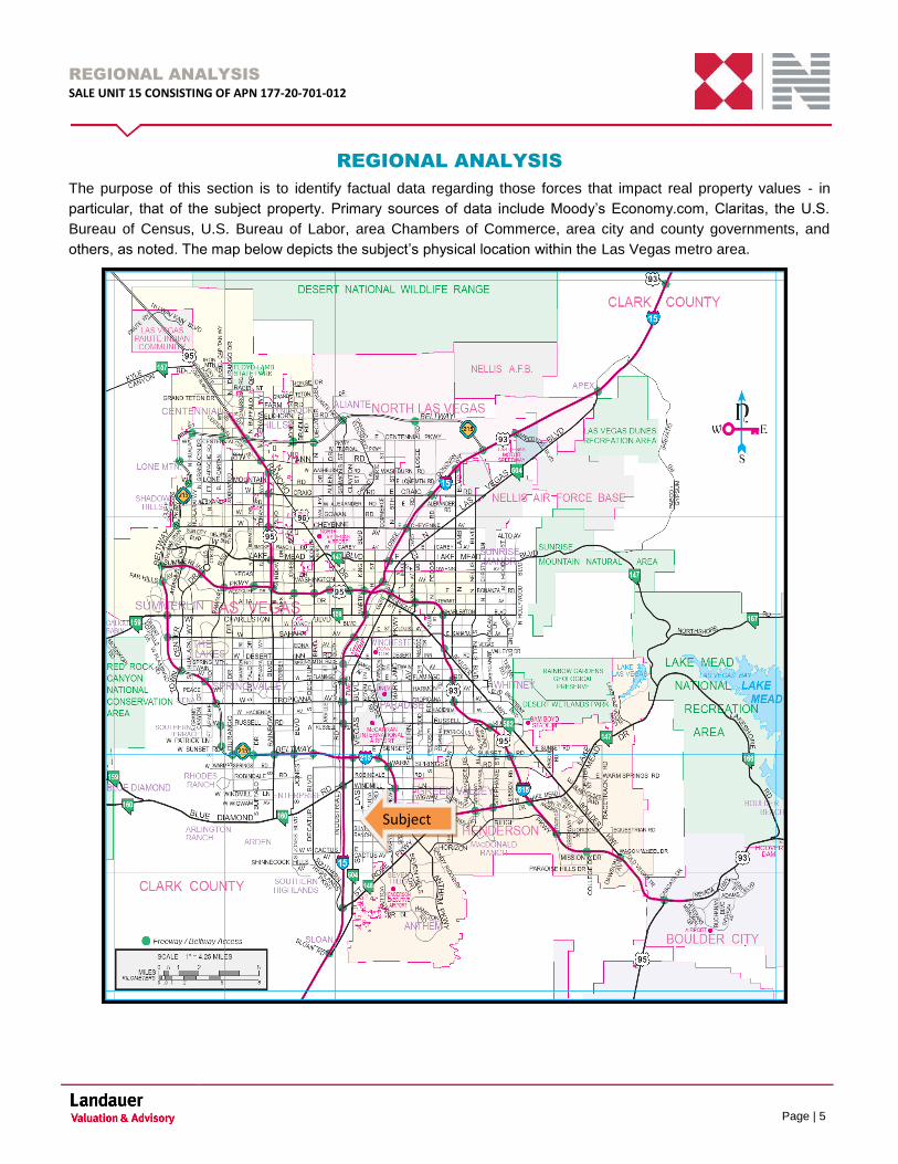
REGIONAL ANALYSIS
The purpose of this section is to identify factual data regarding those forces that impact real property values - in
particular, that of the subject property. Primary sources of data include Moody’s Economy.com, Claritas, the U.S.
Bureau of Census, U.S. Bureau of Labor, area Chambers of Commerce, area city and county governments, and
others, as noted. The map below depicts the subject’s physical location within the Las Vegas metro area.
Subject
Subject
REGIONAL ANALYSIS
SALE UNIT 15 CONSISTING OF APN 177-20-701-012
Page | 6
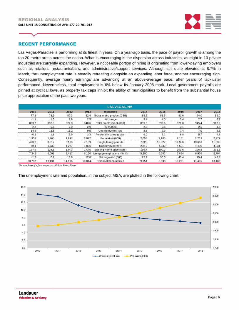
RECENT PERFORMANCE
Las Vegas-Paradise is performing at its finest in years. On a year-ago basis, the pace of payroll growth is among the
top 20 metro areas across the nation. What is encouraging is the dispersion across industries, as eight in 10 private
industries are currently expanding. However, a noticeable portion of hiring is originating from lower-paying employers
such as retailers, restaurants/bars, and administrative/support services. Although still quite elevated at 8.7% in
March, the unemployment rate is steadily retreating alongside an expanding labor force, another encouraging sign.
Consequently, average hourly earnings are advancing at an above-average pace, after years of lackluster
performance. Nevertheless, total employment is 6% below its January 2008 mark. Local government payrolls are
pinned at cyclical lows, as property tax caps inhibit the ability of municipalities to benefit from the substantial house
price appreciation of the past two years.
The unemployment rate and population, in the subject MSA, are plotted in the following chart:
2010 2011 2012 2013 Indicators 2014 2015 2016 2017 2018
77.8 78.9 80.3 82.4 Gross metro product (C$B) 85.2 88.5 91.6 94.0 96.0
-1.1 1.5 1.8 2.5 % change 3.4 4.0 3.4 2.7 2.1
803.7 808.3 824.8 848.6 Total employment (000) 869.5 893.6 921.0 945.4 962.0
-2.8 0.6 2.0 2.9 % change 2.5 2.8 3.1 2.6 1.8
14.2 13.5 11.2 9.5 Unemployment rate 8.5 7.9 7.4 7.0 6.6
-0.1 1.8 3.9 3.3 Personal income growth 6.0 7.1 6.8 5.7 4.3
1,953 1,966 1,997 2,022 Population (000) 2,058 2,105 2,161 2,219 2,277
4,623 3,817 6,108 7,159 Single-family permits 7,825 12,027 14,306 13,666 11,635
851 1,330 1,267 1,826 Multifamily permits 2,810 4,033 4,521 4,400 4,231
137.9 124.8 134.3 173.5 Existing-home price ($ths) 186.7 190.2 191.6 196.8 201.3
7,342 6,003 9,417 6,156 Mortgage originations ($mil) 5,300 6,503 6,894 6,976 8,794
-1.2 0.7 18.8 12.8 Net migration (000) 22.9 35.0 43.4 45.4 46.3
23,737 19,431 14,106 10,814 Personal bankruptcies 9,951 9,638 10,231 11,495 13,483
Source: Moody's Economy.com - Précis Metro Report
LAS VEGAS, NV
REGIONAL ANALYSIS
SALE UNIT 15 CONSISTING OF APN 177-20-701-012
Page | 7
EMPLOYMENT & INDUSTRY
Top employers in the subject MSA are listed in the following chart:
HOUSING
Despite healthy job growth, improving wages/salaries, and climbing house prices, residential construction is almost
nonexistent. The present pace of permitting is only one-third what it was in 2000, whereas the U.S. average is nearly
two-thirds. Headwinds include an above-average share of vacant housing stock, scarce supply of desirable land, and
a noticeable number of homeowners delinquent on their mortgage. Also, affordability is becoming an issue; the
median price for a new home has risen to nearly $300,000, up 36% on a year-ago basis.
REGIONAL ANALYSIS
SALE UNIT 15 CONSISTING OF APN 177-20-701-012
Page | 8
POPULATION
The latest population estimates have prompted a downgrade to the outlook. At midyear 2013, LAS grew by 1.5%,
identical to its 2012 pace, though less than anticipated. Younger households are not migrating to LAS nearly as
much as they did 10 years ago, and existing households appear not to be starting or expanding families. The lack of
promising job opportunities is likely driving this phenomenon. Nevertheless, population will grow at an above-average
pace, as the general shift of the population to the West, which was interrupted by the Great Recession, resumes.
TOURISM
With several large-scale openings, leisure and hospitality hiring will be steady in the near term. Several resorts and
attractions are expected to debut this year, including The Linq, SLS Las Vegas, and Delano Las Vegas, sustaining
the metro area’s leading economic engine. Yet, more visitors will be crucial, given that the overall Las Vegas hotel
occupancy rate persists at a low level. After three years of recovery, the number of visitors who came to LAS in 2013
was unchanged from the year prior. Some of this pause could be attributed to temporary factors such as the
expiration of the payroll tax holiday, which dampened disposable incomes. However, as more jobs are created, the
U.S. labor market should tighten, boosting wage growth and unleashing demand for many consumer products,
including recreational services. The latest visitor data signal that this might already be happening; through the first
three months of 2014, visitor volumes have advanced by 5% compared with the first three months of last year.

REGIONAL ANALYSIS
SALE UNIT 15 CONSISTING OF APN 177-20-701-012
Page | 9
CONSUMER SPENDING
If the slow pace of tourists visiting the metro area persists, the burden to sustain consumer spending will be on
residents, who are gradually recuperating. A much improved labor market has pushed the average weekly wage to
its highest in four years, while extraordinary house price appreciation has lifted many homeowners from negative
equity. However, many households are still nowhere back to normal, as evident in Nevada real median household
income resting at a three-decade low in 2012. Additionally, house prices have skyrocketed due to strong investor
demand and very little inventory, raising doubts that homeowners would actually realize current prices if multitudes
put their houses up for sale. Finally, LAS has a considerably below-average share of residents with a credit score of
700 or better, limiting prospects for growth via credit, unless consumer lending standards ease.
HEALTHCARE
Many factors hint at strong hiring from healthcare providers over the next few years. First, in 2013, there were
approximately 29 residents for every healthcare worker, one of the highest metro area ratios, indicating, if anything,
there is room for more workers. Second, though historically a younger state, the metro area’s 65 and over population
grew by a cumulative 10% from 2010 to 2012, considerably above average. Finally, population growth is expected to
accelerate over the medium term, which will bolster demand for all types of private services, including healthcare.
CONCLUSION
Las Vegas-Paradise’s recovery will gain and remain above average, as an increasing number of migrants and
tourists drive robust private service demand. Longer term, the metro area’s unparalleled tourism assets and strong
appeal as a retirement destination will ensure above-average job growth.

NEIGHBORHOOD ANALYSIS
SALE UNIT 15 CONSISTING OF APN 177-20-701-012
Page | 10
NEIGHBORHOOD ANALYSIS
The subject neighborhood is defined by the boundaries presented in the following table:
DIRECTION BOUNDARY
North Interstate 215
South: Volunteer Boulevard
East: Interstate 215 / Maryland Parkway
West: Jones Boulevard
The aerial map below depicts the subject’s physical location within the neighborhood.
LOCATION
The subject property is located in Las Vegas, Nevada within Clark County in the southern region of the valley. It is
located approximately two miles south of the 215 beltway and less than half a mile east of Interstate 15, on the west
side of South Las Vegas Boulevard, south of West Serene Avenue. The subject neighborhood is about 10 miles
south of the central business district and the downtown corridor and roughly two miles south of McCarran
International Airport.
SUBJECT
NEIGHBORHOOD ANALYSIS
SALE UNIT 15 CONSISTING OF APN 177-20-701-012
Page | 11
ACCESS
Primary access to the subject neighborhood is provided by a combination of highway thoroughfares and commercial
arterials. The I-215 Beltway is the primary highway linkage in the area, which envelopes three quarters of the Las
Vegas Valley. In the subject neighborhood, the I-215 Beltway is in the western portion of Las Vegas and extends in a
southeast to northwest direction. It provides connections to most of the primary east/west arterial roads. Access to
the subject property from the I-215 Beltway is obtained via the Las Vegas Boulevard exit.
Interstate 15 is the primary north south highway in the subject’s neighborhood. The city of Las Vegas is served by
Interstate 15, which extends from the south beginning in Primm, to northeast crossing the border with Arizona in
Mesquite. Interstate 15 extends along the west side of the Las Vegas Strip corridor and just west of downtown Las
Vegas before its exchange with Interstate 515 and U.S. Route 95. The subject can be accessed from Interstate 15
via Blue Diamond Road.
The subject is located along the west side of South Las Vegas Boulevard, a major roadway that extends the length of
the Las Vegas metropolitan area. It is mainly known for its Las Vegas strip portion and casino frontage. Blue
Diamond Road, also known as State Route 160 is another primary arterial in the area. It provides four lanes of traffic
in each direction and connects the southern Las Vegas Valley west to the City of Pahrump.
Other major non-highway thoroughfares providing either direct or indirect access to the subject include north south
arterials Jones Boulevard, Decatur Boulevard and Maryland Parkway. The major east west arterials include Warm
Springs Road, Silverado Ranch Boulevard, Windmill Lane and St. Rose Parkway.
LAND USE PATTERNS AND TRENDS
The dominant land use in the neighborhood is residential (single and multifamily) with complimenting retail and
institutional uses. The subject property is along the west side of South Las Vegas Boulevard, south of West Serene
Avenue. There is an ample amount of vacant land available for new construction in the subject’s immediate area.
This is visually depicted as follows:
Land Use Percent
Single Family Residential 30%
Multifamily Residential 20%
Office 10%
Retail 10%
Industrial 5%
Park / Open Space 5%
Vacant Land 20%
Source: Landauer Valuation & Advisory
NEIGHBORHOOD LAND USE DISTRIBUTION
The subject is located along the west side of South Las Vegas Boulevard, which has been improved with various
retail, office and hotel uses. Nearby uses include a mix of single family and multifamily residential developments with
the closest being Boca Raton Condominiums located directly west of the subject. There are also a few large master
NEIGHBORHOOD ANALYSIS
SALE UNIT 15 CONSISTING OF APN 177-20-701-012
Page | 12
planned communities in the area including Southern Highlands and Silverado Ranch. Immediately north of the
subject at the northwest corner of South Las Vegas Boulevard and West Serene Avenue is the Vegas Pointe Plaza
shopping center anchored by Stoney’s Antique Mall of America. Approximately one mile north of the subject along
the east side of South Las Vegas Boulevard is another large shopping center anchored by Food 4 Less and
containing in line and pad buildings with a CVS Pharmacy, Chase Bank and various other small retailers and
restaurants. About two miles north of the subject is the Las Vegas South Premium Outlets, a large outlet mall with
140 stores located at the southeast corner of Warm Springs Road and South Las Vegas Boulevard.
South Point Hotel, Casino and Spa is located at the southwest corner of South Las Vegas Boulevard and West
Silverado Ranch Boulevard. The resort sits on 60 acres of land and contains 2,163 rooms, 80,000 square feet of
gaming space, a 16 screen movie theater, a 4,400 seat equestrian arena, eight restaurants and a 64 lane bowling
alley. It also features 160,000 square feet of meeting and convention space, the largest amount of any hotel in Las
Vegas that is not located on the strip.
The M Resort is located approximately three miles south of the subject on the east side of South Las Vegas
Boulevard. This hotel and casino is owned and operated by Penn National Gaming and is one of the newest
hotel/casinos in Las Vegas, with its opening in 2009. The property sits on 90 acres of land and has 92,000 square
feet of gaming space and 390 rooms. It also features seven restaurants, six bars, a 100,000 square foot pool and
entertainment piazza, 60,000 square feet of convention space and a 25,000 square foot events pavilion.
The Silverton Hotel and Casino is located at the southwest corner of Blue Diamond Road and Interstate 15. The
property sits on an 80 acre site and contains 300 hotel rooms/suites and has 60,000 square feet of casino space.
The hotel also includes a 165,000 square foot Bass Pro Shop, various restaurants and a 117,000 gallon aquarium.
IMMEDIATE SUBJECT SURROUNDINGS
The subject’s immediate surrounding area is considered to extend for about a block in any direction from the subject.
The following table summarizes our findings for this immediate surrounding area.
Direction Land Use
North Outlet Mall
South Retail
East Condominiums
West Mobile Home Park/Condominiums
ADJACENT LAND USES
DEMOGRAPHIC PROFILE
The following table summarizes the select neighborhood demographics in the one-, three- and five-mile concentric
circles from the subject as well as the metro area.

NEIGHBORHOOD ANALYSIS
SALE UNIT 15 CONSISTING OF APN 177-20-701-012
Page | 13
1-Mile
Radius
3-Mile
Radius
5-Mile
Radius 89123 Clark NV Las Vegas
Population Census 2010 14,203 112,235 226,733 57,780 1,951,269 2,700,551 1,951,269
Population 2014 15,118 120,755 245,485 59,679 2,043,870 2,815,039 2,043,870
Population 2019 16,464 130,900 266,244 63,025 2,175,978 2,979,656 2,175,978
Projected Annual Growth % 1.7% 1.6% 1.6% 1.1% 1.3% 1.1% 1.3%
Households Census 2010 6,559 42,633 86,066 23,541 715,365 1,006,250 715,365
Households 2014 6,948 45,540 92,206 24,311 745,051 1,044,316 745,051
Households 2019 7,541 49,183 99,506 25,695 791,830 1,104,017 791,830
Projected Annual Growth % 1.7% 1.6% 1.5% 1.1% 1.2% 1.1% 1.2%
Median Household Income 2014 $51,041 $58,586 $60,494 $57,073 $50,717 $50,791 $50,717
Average Household Income 2014 $59,499 $72,857 $76,887 $70,860 $66,725 $66,980 $66,725
Per Capita Income 2014 $27,281 $27,490 $28,983 $28,893 $24,567 $25,118 $24,567
Average Household Size 2014 2.2 2.7 2.7 2.5 2.7 2.7 2.7
% Owner-Occupied Housing 36.0% 55.9% 60.0% 53.0% 54.3% 56.0% 54.3%
% Renter-Occupied Housing 64.0% 44.1% 40.0% 47.0% 45.7% 44.0% 45.7%
DEMOGRAPHIC ANALYSIS
Source: ESRI
As presented, the one-, three-, and five-mile radii have experienced faster population and household growth relative
to the metro area as a whole. Income levels are higher than those of the MSA as a whole.
CONCLUSION
As shown above, the population within a one-, three- and five-mile radius has generally shown slight positive trends
since 2010. This is common in suburban communities within Clark County. The neighborhood currently has a middle-
income demographic profile. Further, there are several strong demand generators in the neighborhood including Las
Vegas Premium Outlets, the South Point Hotel and Casino, and The M Resort, as well as excellent transportation
access. The subject neighborhood is described as a stable residential community. All told, the neighborhood should
see nominal to increasing growth typical of a growing community with an adequate amount of available land and the
outlook for the neighborhood and subject—overall—appears to be somewhat favorable in both the near and long
term due to high barriers to entry.
MARKET ANALYSIS
SALE UNIT 15 CONSISTING OF APN 177-20-701-012
Page | 14
LAS VEGAS LOCAL HOTEL/CASINO MARKET ANALYSIS
The following paragraphs summarize the key aspect/elements for gaming demand for the greater Las Vegas casino
market. As reported by NGKF’s Global Gaming Group, the growth/decline in the Las Vegas locals’ gaming market is
a result of a combination of many related factors. Tourism, home prices and employment trends all influence gaming
demand to some extent. The following section presents these trends and the rates of correlation from which we have
estimated gaming demand.
HISTORICAL LAS VEGAS HOTEL AND GAMING STATISTICS
Visitation and spending trends in Las Vegas are important, because much of its economy and jobs are driven by
tourism. To the extent that tourism trends are improving or declining, the local economy tends to follow. Visitor
volume reached a high in 2012 with 39,727,022 visitors and only decline slightly in 2013. Room inventory has
constantly increased over the past ten years and occupancy rates have varied with a high of 90.4% in 2007 and a
low of 80.4% in 2010. Occupancy increased to 84.3% in 2013. The amount of both airline passengers and
automobile traffic has varied over the past ten years, but has been steadily increasing over the past four years. Clark
County gaming revenue was at a high of over $10 billion in 2006 and 2007. Revenue declined from 2008 to 2010, but
has shown increasing numbers over the past three years.
Depicted in the graph below are visitor and gaming trends for the overall Las Vegas market over the past ten years.
VISITOR VOLUME
The strength of the Las Vegas market is reflective of the rise in visitor volume over time, which has grown at a rate of
3.5% from April, 2013 to April, 2014. According to the Las Vegas Visitor and Convention Authority (LVCVA), April,
2013 visitor volume in Las Vegas reached a total of 3,339,657. One year later in April, 2014 the visitor count
increased to 3,456,703. In April, 2013, the year to date visitor volume reached a total of 13,037,268 Las Vegas
visitors. Year to date visitor volume for 2014 is currently at 13,664,661, indicating a 4.8% increase from the previous
year.
Year Visitor Volume Room Inventory Occupany Airline Passengers Auto Traffic
Clark County Gaming
Revenue
2003 35,540,126 130,482 85.0% 36,265,932 38,074 $7,830,856,000
2004 37,388,781 131,503 88.6% 41,441,531 38,799 $8,711,426,000
2005 38,566,717 133,186 89.2% 44,267,370 39,649 $9,717,322,000
2006 38,914,889 132,605 89.7% 46,304,376 40,373 $10,630,387,000
2007 39,196,761 132,947 90.4% 47,729,527 39,808 $10,868,464,000
2008 37,481,552 140,529 86.0% 44,074,642 37,686 $9,796,749,000
2009 36,351,469 148,941 81.5% 40,469,012 39,199 $8,838,261,000
2010 37,335,436 148,935 80.4% 39,757,359 40,213 $8,908,574,000
2011 38,928,708 150,161 83.8% 41,481,204 40,344 $9,222,677,000
2012 39,727,022 150,481 84.4% 41,667,596 42,143 $9,399,845,000
2013 39,668,221 150,593 84.3% 41,857,059 42,485 $9,676,458,000
Source: LVCVA
HISTORICAL LAS VEGAS HOTEL AND GAMING STATISTICS
MARKET ANALYSIS
SALE UNIT 15 CONSISTING OF APN 177-20-701-012
Page | 15
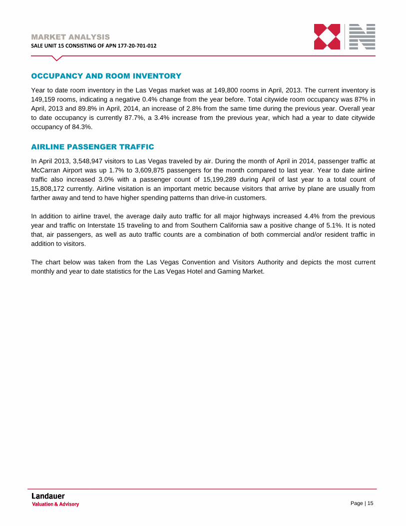
OCCUPANCY AND ROOM INVENTORY
Year to date room inventory in the Las Vegas market was at 149,800 rooms in April, 2013. The current inventory is
149,159 rooms, indicating a negative 0.4% change from the year before. Total citywide room occupancy was 87% in
April, 2013 and 89.8% in April, 2014, an increase of 2.8% from the same time during the previous year. Overall year
to date occupancy is currently 87.7%, a 3.4% increase from the previous year, which had a year to date citywide
occupancy of 84.3%.
AIRLINE PASSENGER TRAFFIC
In April 2013, 3,548,947 visitors to Las Vegas traveled by air. During the month of April in 2014, passenger traffic at
McCarran Airport was up 1.7% to 3,609,875 passengers for the month compared to last year. Year to date airline
traffic also increased 3.0% with a passenger count of 15,199,289 during April of last year to a total count of
15,808,172 currently. Airline visitation is an important metric because visitors that arrive by plane are usually from
farther away and tend to have higher spending patterns than drive-in customers.
In addition to airline travel, the average daily auto traffic for all major highways increased 4.4% from the previous
year and traffic on Interstate 15 traveling to and from Southern California saw a positive change of 5.1%. It is noted
that, air passengers, as well as auto traffic counts are a combination of both commercial and/or resident traffic in
addition to visitors.
The chart below was taken from the Las Vegas Convention and Visitors Authority and depicts the most current
monthly and year to date statistics for the Las Vegas Hotel and Gaming Market.
MARKET ANALYSIS
SALE UNIT 15 CONSISTING OF APN 177-20-701-012
Page | 16
Source: LVCVA
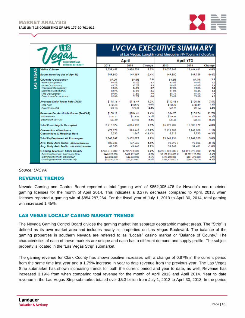
REVENUE TRENDS
Nevada Gaming and Control Board reported a total “gaming win” of $852,005,476 for Nevada’s non-restricted
gaming licenses for the month of April 2014. This indicates a 0.27% decrease compared to April, 2013, when
licenses reported a gaming win of $854,287,264. For the fiscal year of July 1, 2013 to April 30, 2014, total gaming
win increased 1.45%.
LAS VEGAS LOCALS’ CASINO MARKET TRENDS
The Nevada Gaming Control Board divides the gaming market into separate geographic market areas. The “Strip” is
defined as its own market area-and includes nearly all properties on Las Vegas Boulevard. The balance of the
gaming properties in southern Nevada are referred to as “Locals” casino market or “Balance of County.” The
characteristics of each of these markets are unique and each has a different demand and supply profile. The subject
property is located in the “Las Vegas Strip” submarket.
The gaming revenue for Clark County has shown positive increases with a change of 0.87% in the current period
from the same time last year and a 1.79% increase in year to date revenue from the previous year. The Las Vegas
Strip submarket has shown increasing trends for both the current period and year to date, as well. Revenue has
increased 3.19% from when comparing total revenue for the month of April 2013 and April 2014. Year to date
revenue in the Las Vegas Strip submarket totaled over $5.3 billion from July 1, 2012 to April 30, 2013. In the period

MARKET ANALYSIS
SALE UNIT 15 CONSISTING OF APN 177-20-701-012
Page | 17
from July 1, 2013 to April 30, 2014, fiscal year to date revenue reached over $5.4 billion, indicating a 2.66% increase
from the previous year.
The Balance of Clark County submarket or the “locals” casino market had a negative 2.30% decrease between
revenue in the current period of 2014 compared to the same monthly period in the previous year. However, fiscal
year to date revenue in the Balance of County submarket increased 2.02% from the previous year. The chart below
depicts the most recent changes in gaming revenue among the Clark County submarkets.
Source: Nevada Gaming Control Board

MARKET ANALYSIS
SALE UNIT 15 CONSISTING OF APN 177-20-701-012
Page | 18
LAS VEGAS LOCALS’ GAMING REVENUE ANALYSIS
Month Over Month Year to Date
April, 2013 April, 2014 April, 2013 April, 2014
Las Vegas Locals Market Win $187,329 $182,895 $735,127 $719,014
% Change -2.4% -2.2%
Locals Market # of Positions $56,803 $53,897 $56,797 $54,329
% Change -5.1% -4.3%
Win / Position / Day $110 $113 $108 $110
% Change 2.9% 2.3%
Locals Market Table Games Win $16,058 $15,955 $65,568 $66,719
% Change -0.6% 1.8%
Locals Market Poker Win $1,937 $1,977 $8,338 $8,273
% Change 2.1% -0.8%
Locals Market Race & Sports, Bingo, Keno Win $5,055 $5,127 $31,558 $25,822
% Change 1.4% -18.2%
Locals Market Slots Win $164,279 $159,836 $629,663 $618,200
% Change -2.7% -1.8%
Locals Market # of Table Games $776 $761 $781 $760
% Change -1.9% -7.0%
Locals Market # of Poker $175 $158 $173 $161
% Change -9.7% -18.6%
Locals Market # Race & Sports, Bingo, Keno $110 $113 $111 $112
% Change 2.7% -16.8%
Locals Market # of Slots $50,987 $48,270 $50,959 $48,690
% Change -5.3% -11.4%
Win / Table Games / Day $690 $699 $699 $731
% Change 1.3% 4.6%
Win / Poker Table / Day $369 $417 $401 $428
% Change 13.0% 6.8%
Win / Slot / Day $107 $110 $103 $106
% Change 2.8% 2.8%1.0000
Source: CBRE Global Gaming Group
LAS VEGAS LOCALS MARKET GAMING REVENUE ANALYSIS

MARKET ANALYSIS
SALE UNIT 15 CONSISTING OF APN 177-20-701-012
Page | 19
CONCLUSION
Overall the gaming and tourism industry has increased over the last 12 months. Positive trends are anticipated to
continue as economic conditions in the Las Vegas Valley are increasing. The Las Vegas Strip has increased slightly
over past year; however this is anticipated to reverse as tourism and gaming trends increase in Clark County, overall
trends for the Las Vegas Strip should increase.
SITE ANALYSIS
SALE UNIT 15 CONSISTING OF APN 177-20-701-012
Page | 20
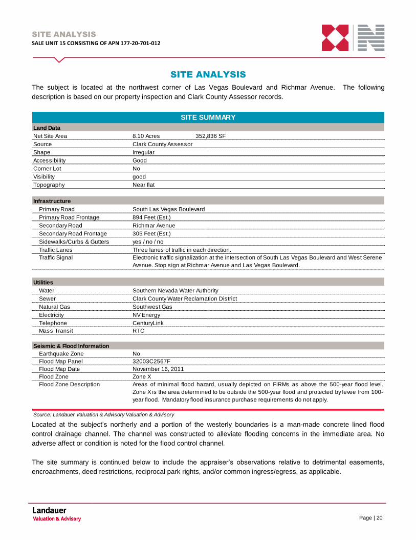
SITE ANALYSIS
The subject is located at the northwest corner of Las Vegas Boulevard and Richmar Avenue. The following
description is based on our property inspection and Clark County Assessor records.
Land Data
Net Site Area 8.10 Acres 352,836 SF
Source Clark County Assessor
Shape Irregular
Accessibility Good
Corner Lot No
Visibility good
Topography Near flat
Infrastructure
Primary Road South Las Vegas Boulevard
Primary Road Frontage
Secondary Road Richmar Avenue
Secondary Road Frontage
Sidewalks/Curbs & Gutters yes / no / no
Traffic Lanes
Traffic Signal
Utilities
Water Southern Nevada Water Authority
Sewer Clark County Water Reclamation District
Natural Gas Southwest Gas
Electricity NV Energy
Telephone CenturyLink
Mass Transit RTC
Seismic & Flood Information
Earthquake Zone No
Flood Map Panel 32003C2567F
Flood Map Date
Flood Zone Zone X
Flood Zone Description
Source: Landauer Valuation & Advisory Valuation & Advisory
November 16, 2011
Areas of minimal flood hazard, usually depicted on FIRMs as above the 500-year flood level.
Zone X is the area determined to be outside the 500-year flood and protected by levee from 100-
year flood. Mandatory flood insurance purchase requirements do not apply.
SITE SUMMARY
894 Feet (Est.)
305 Feet (Est.)
Three lanes of traffic in each direction.
Electronic traffic signalization at the intersection of South Las Vegas Boulevard and West Serene
Avenue. Stop sign at Richmar Avenue and Las Vegas Boulevard.
Located at the subject’s northerly and a portion of the westerly boundaries is a man-made concrete lined flood
control drainage channel. The channel was constructed to alleviate flooding concerns in the immediate area. No
adverse affect or condition is noted for the flood control channel.
The site summary is continued below to include the appraiser’s observations relative to detrimental easements,
encroachments, deed restrictions, reciprocal park rights, and/or common ingress/egress, as applicable.
SITE ANALYSIS
SALE UNIT 15 CONSISTING OF APN 177-20-701-012
Page | 21
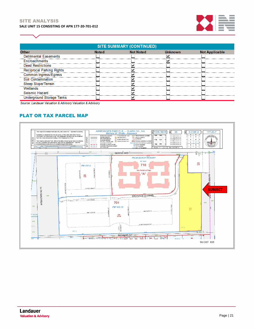
PLAT OR TAX PARCEL MAP
SUBJECT

SITE ANALYSIS
SALE UNIT 15 CONSISTING OF APN 177-20-701-012
Page | 22
LEGAL DESCRIPTION PARCEL MAP FILE 102 PAGE 13 PT LOT 2
SITE SHAPE AND LAND
AREA:
The site is irregular in shape and contains 8.10 usable acres or 352,836
usable square feet. The land area is based on the Clark County Assessor. It
is noted that we relied on this information and assume that it is accurate.
We reserve the right to amend the land area should this assumption be
determined to be incorrect.
FRONTAGE, ACCESS AND
VISIBILITY:
In the vicinity of the subject, South Las Vegas Boulevard is a paved public
street with three lanes of travel in each direction and a median divider.
Serene Avenue and Richmar Avenue area paved public streets with one
lane of traffic in each direction and a center turn lane. The subject site has
good visibility from all three bordering streets.
TOPOGRAPHY AND
DRAINAGE:
The site is generally near flat and is elevated at Las Vegas Boulevard and
Richmar Avenue. The topography of the site is not seen as an impediment
to the development of the property. During our inspection of the site, we
observed no drainage problems and assume that none exist.
UTILITIES: All utilities are available to the site in adequate quality and quantity to
service the highest and best use as vacant.
SOIL CONDITIONS: A soil report was not provided for use in this appraisal. We are not qualified
to render a technical opinion regarding soil conditions. Further,
representatives of ownership indicate that no significant detrimental
conditions existed at the subject as of the date of inspection. Therefore, it is
assumed that the load-bearing capacity is sufficient to support any
reasonably probable improvements. If the Client is concerned about this
issue, we recommend a study by a qualified soils engineer.
WETLANDS: Although we were not provided with a Wetlands survey, it does not appear
that wetlands are present on the subject site. With the exception of minor
areas of landscaping, the subject site consists entirely of impervious surface
area.
SEISMIC HAZARD: It should be noted that all properties in Clark County could suffer damage
from ground movement during seismic activity. If the client is concerned
about this issue, we recommend a geotechnical assessment by a qualified
engineer.
HAZARDOUS
SUBSTANCES:
We have not observed the existence of potentially hazardous material or
underground storage tanks that may be present on or near the site.
However, it is noted that we did not conduct an extensive search for said
items, and are not qualified to detect such materials or underground storage

SITE ANALYSIS
SALE UNIT 15 CONSISTING OF APN 177-20-701-012
Page | 23
tanks. The existence of hazardous materials or underground storage tanks
may have an effect on the value of the property. Therefore, for the purpose
of this appraisal, we specifically assume that the property is not affected by
any hazardous materials and/or underground storage tanks that may be
present on or near the property.
CONCLUSION
The subject site is irregular in shape with adequate frontage along South Las Vegas Boulevard and Richmar Avenue.
The site is typical and appears well suited for tourist commercial development similar to that found in Las Vegas.
There are no known detrimental uses in the immediate vicinity. Further, the site is located in an area of minimal flood
risk and does not suffer from any known environmental conditions. Based upon the foregoing, we are not aware of
any physical issues with the subject site that would prevent it from being developed with its highest and best use, as
vacant.
ZONING
SALE UNIT 15 CONSISTING OF APN 177-20-701-012
Page | 24
ZONING
The applicable zoning information for the subject is summarized as follows:
Component Detail
Zoning Code H-1
Zoning Name Limited Resort and Apartment District
Zoning Jurisdiction Clark County
Zoning Description The H-1 Limited Resort and Apartment District is established to provide
for the development of gaming enterprises, compatible commercial,
and mixed commercial and residential uses, and to prohibit the
development of incompatible uses that are detrimental to gaming
enterprises. The H-1 District, per Chapter 463 of the Nevada Revised
Statutes, is designated as the Gaming Enterprise District as shown on
the Gaming Enterprise Map. An approved special use permit for a
resort hotel establishes the ability to have live gaming. Applications to
expand the Gaming Enterprise District shall not be accepted for
property within 500 feet of residential development or 1,500 feet of a
school or church.
Use Vacant Land
Legally Conforming The subject property is a legal and conforming use
Zoning Change A zoning change is unlikely
ZONING SUMMARY
The appraisers are not experts in the interpretation of complex zoning ordinances but the subject property appears to
be a conforming use based on a review of public information. Please note that the determination of compliance is
beyond the scope of a real estate appraisal. It is recommended that local planning and zoning personnel be
contacted regarding more specific information that might be applicable to the subject.
According to a preliminary title report prepared by Chicago Title of Nevada, Inc there is no apparent detrimental
easements, deed restrictions, etc. There are typical utility easements, road dedications, flood control dedications etc.
on the property; however are not considered to hamper the overall development potential of the site. A copy of the
preliminary title report is included in the addenda of this report for the reader’s perusal.
ZONING
SALE UNIT 15 CONSISTING OF APN 177-20-701-012
Page | 25
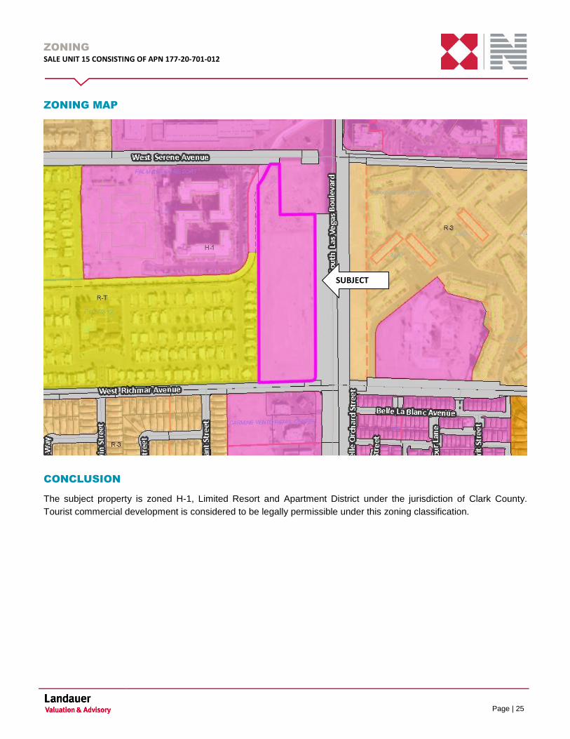
ZONING MAP
CONCLUSION
The subject property is zoned H-1, Limited Resort and Apartment District under the jurisdiction of Clark County.
Tourist commercial development is considered to be legally permissible under this zoning classification.
SUBJECT
ZONING
SALE UNIT 15 CONSISTING OF APN 177-20-701-012
Page | 26
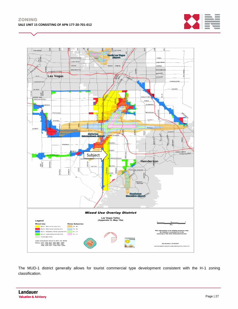
MUD OVERLAY
The subject property is located in a MUD (Mixed Use Development) district. Specifically the subject is located in an
MUD-1 district which is the most intense urban form district. The following exhibit identifies the MUD overlay:
ZONING
SALE UNIT 15 CONSISTING OF APN 177-20-701-012
Page | 27
The MUD-1 district generally allows for tourist commercial type development consistent with the H-1 zoning
classification.
Subject
ZONING
SALE UNIT 15 CONSISTING OF APN 177-20-701-012
Page | 28
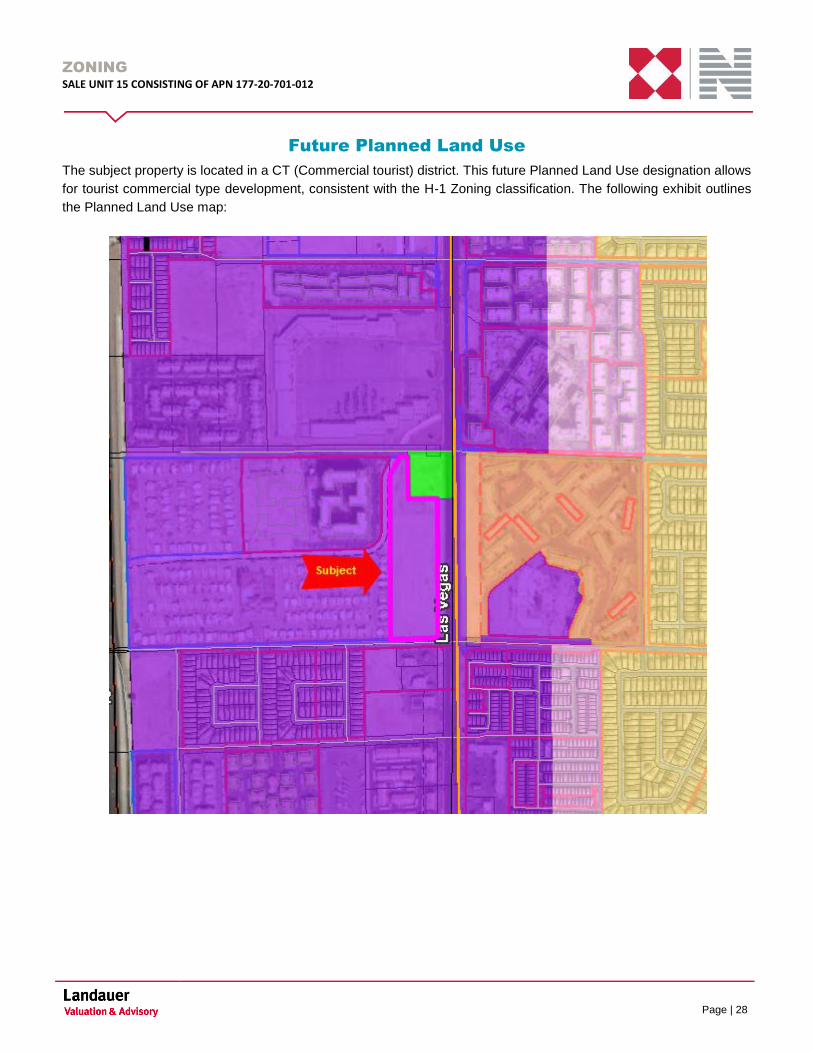
Future Planned Land Use
The subject property is located in a CT (Commercial tourist) district. This future Planned Land Use designation allows
for tourist commercial type development, consistent with the H-1 Zoning classification. The following exhibit outlines
the Planned Land Use map:

ASSESSMENT & TAXES
SALE UNIT 15 CONSISTING OF APN 177-20-701-012
Page | 29
ASSESSMENT & TAXES
INTRODUCTION
Real estate tax assessments are administered by the Clark County Assessor’s Office. The subject property is within
tax district number 635 (Enterprise Fire Artesian Library 911 Manpower).
TAX PROCESS
Assessed values are based on a current conversion ratio of 35% of assessor’s estimated market value. However, a
state law was passed during the 2005 State Legislation Hearings that set Nevada real estate taxes to a base year
(2004) with annual increases limited to 3% for owner-occupied residences and 8% for all other properties. The 2011
legislative session lowered the “all other properties” cap to 6.3%. In Clark County, the annual tax period begins July
1st and ends June 30
th of each year, the last day for payment without penalty.
The taxable value for properties in Nevada is based on the current land value plus the replacement cost of the
improvements less depreciation. Depreciation is calculated at 1.5% per year up to a maximum of 75% over time.
Should a property sell, the assessor does not give any consideration to the sales price for future assessments as the
taxable value is derived by the cost approach. Year-to-year differences in values are typically due to changes in land
prices and/or construction costs. A property owner may appeal the taxable value once per year by providing an
appraisal and other market data. As an appeal does not guarantee a change in valuation, the current and/or
projected taxes provided by Clark County have been utilized in our analysis.
SUBJECT TAXATION
According to the Clark County Treasurer there are no assessed values for the subject and no taxes have been
levied.

HIGHEST & BEST USE
SALE UNIT 15 CONSISTING OF APN 177-20-701-012
Page | 30
HIGHEST & BEST USE
In appraisal practice, the concept of highest and best use represents the premise upon which value is based. The
four criteria the highest and best use must meet are:
Legally permissible;
Physically possible;
Financially feasible; and
Maximum profitability
Highest and best use analysis involves assessing the subject as vacant.
AS VACANT
Legally Permissible
The subject site is zoned H-1, Limited Resort and Apartment District under the jurisdiction of Clark County. Legally
permissible uses within this zoning district include tourist commercial developments such as hotels, casinos, etc. We
were not provided with a complete title policy in the preparation of this appraisal report and assume the property to
be absent of any adverse deed restrictions. Further, we are unaware of any protests of the subject with respect to a
tourist commercial use. Given prevailing land use patterns in the area, only tourist commercial uses are given further
consideration in determining the highest and best use of the site, as vacant.
Physically Possible
The subject is adequately served by utilities, has an adequate shape and size, sufficient access, etc., to be a
separately developable site. The subject site would support a site layout for any of the legally probable uses, which
include tourist commercial uses. There are no known physical reasons why the subject site would not support any of
these legally probable developments.
Financially Feasible
The determination of financial feasibility is dependent primarily on the relationship of supply and demand for the
legally permissible and physically possible land uses versus the cost to create the uses. As discussed in the Market
Analysis section of this report, the subject’s immediate trade area is showing increases in overall gaming revenue,
increase visitor volume higher hotel occupancy rates, etc. However demand for additional hotel/casino development
is not in demand at the subject’s location at this time and it appears that tourist commercial development would have
a value only marginally commensurate with its cost. Notwithstanding, an economic recovery is expected, whereby a
rise in property values will be realized to level to justify construction. We anticipate tourist commercial development to
be financially feasible in the future.
Maximum Profitability
The final test of highest and best use of the site as though vacant is that the use be maximally productive, yielding
the highest returns to the land. In the case of the subject as vacant, the analysis has indicated that holding the site
for future tourist commercial development would be most appropriate.
HIGHEST & BEST USE
SALE UNIT 15 CONSISTING OF APN 177-20-701-012
Page | 31
CONCLUSION: HIGHEST AND BEST USE AS VACANT
Based on the information presented above and upon information contained in the market and neighborhood analysis,
we conclude that the highest and best use of the subject as vacant is for future tourist commercial development when
market conditions improve.
APPRAISAL METHODOGY
SALE UNIT 15 CONSISTING OF APN 177-20-701-012
Page | 32
APPRAISAL METHODOLOGY
In appraisal practice, an approach to value is included or omitted based on its applicability to the property type being
valued and the quality and quantity of information available.
COST APPROACH
The cost approach is based upon the proposition that the informed purchaser would pay no more for the subject than
the cost to produce a substitute property with equivalent utility. This approach is particularly applicable when the
property being appraised involves relatively new improvements that represent the highest and best use of the land,
or when relatively unique or specialized improvements are located on the site and for which there exist few sales or
leases of comparable properties.
SALES COMPARISON APPROACH
The sales comparison approach utilizes sales of comparable properties, adjusted for differences, to indicate a value
for the subject. Valuation is typically accomplished using physical units of comparison such as price per square foot,
price per unit, price per floor, etc., or economic units of comparison such as gross rent multiplier. Adjustments are
applied to the physical units of comparison derived from the comparable sale. The unit of comparison chosen for the
subject is then used to yield a total value. Economic units of comparison are not adjusted, but rather analyzed as to
relevant differences, with the final estimate derived based on the general comparisons.
INCOME CAPITALIZATION APPROACH
The income capitalization approach reflects the subject’s income-producing capabilities. This approach is based on
the assumption that value is created by the expectation of benefits to be derived in the future. Specifically estimated
is the amount an investor would be willing to pay to receive an income stream plus reversion value from a property
over a period of time. The two common valuation techniques associated with the income capitalization approach are
direct capitalization and the discounted cash flow (DCF) analysis.
METHODOLOGY APPLICABLE TO THE SUBJECT
In valuing the subject, the sales comparison to vacant land is the most applicable method and has been utilized. The
cost and income approaches typically apply to improved properties and not vacant land. Since the subject is vacant
land a typical buyer/investor would carefully consider similar land sales in like locations in their due diligence.
LAND VALUE
SALE UNIT 15 CONSISTING OF APN 177-20-701-012
Page | 33
LAND VALUE
In the valuation of the subject’s fee simple interest, the (land) sales comparison approach is used to establish prices
being paid for similar parcels. The most widely used and market oriented unit of comparison for Tourist commercial
Land with similar characteristics as the subject is the sale price per square foot. All transactions used in this analysis
are computed on this basis.
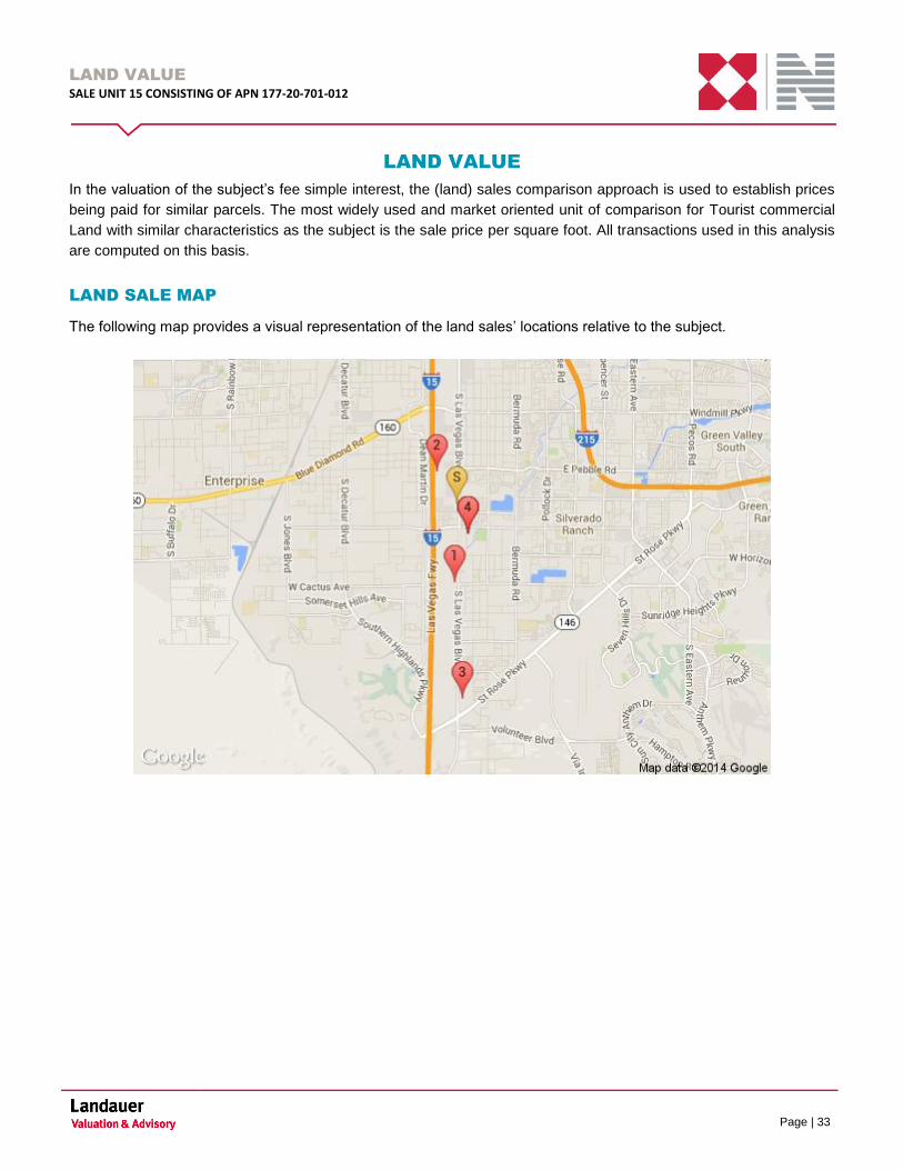
LAND SALE MAP
The following map provides a visual representation of the land sales’ locations relative to the subject.
LAND VALUE
SALE UNIT 15 CONSISTING OF APN 177-20-701-012
Page | 34
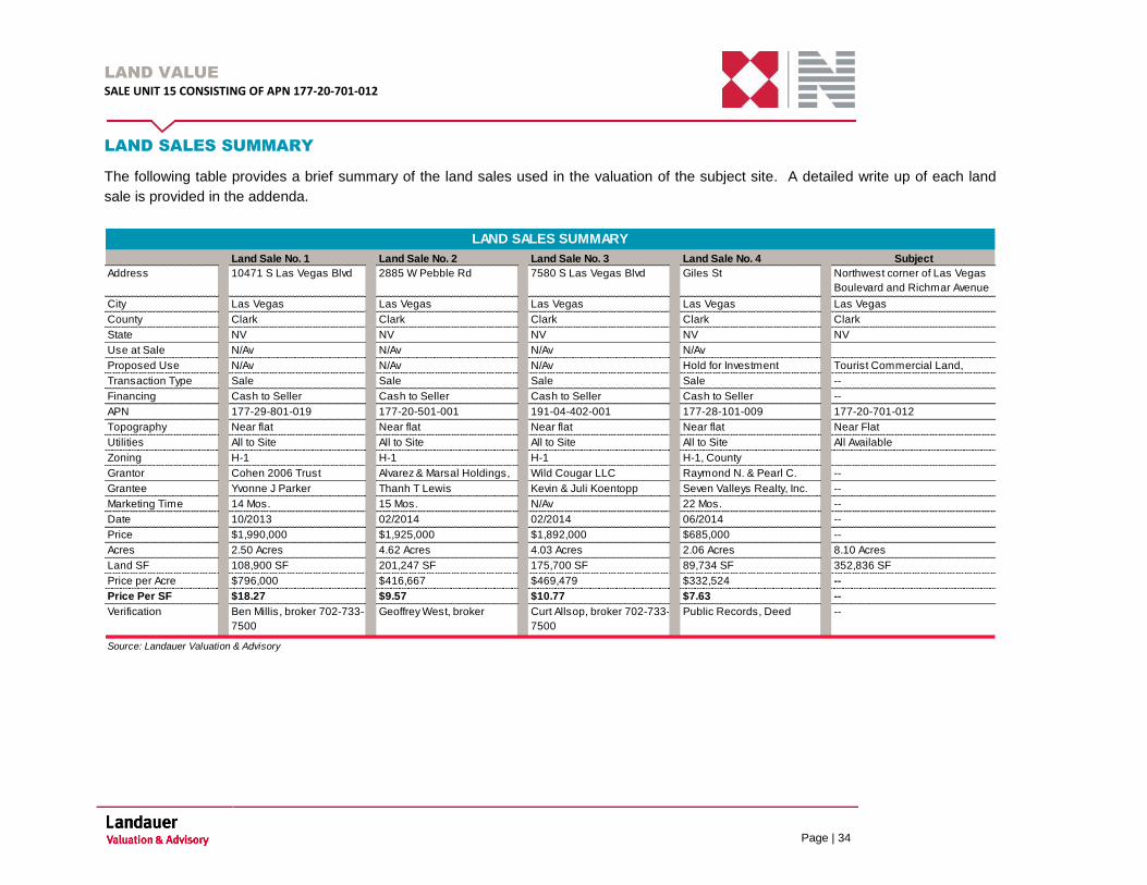
LAND SALES SUMMARY
The following table provides a brief summary of the land sales used in the valuation of the subject site. A detailed write up of each land
sale is provided in the addenda.
Address
City
County
State NV
Use at Sale
Proposed Use
Transaction Type
Financing
APN
Topography
Utilities
Zoning
Grantor
Grantee
Marketing Time
Date
Price
Acres
Land SF
Price per Acre --
Price Per SF --
Verification
Source: Landauer Valuation & Advisory
N/Av N/Av
--
Near Flat
--
--
N/Av N/Av N/Av
Near flat
All to Site
H-1
Near flat
All to Site
H-1, County
Hold for Investment
N/Av
N/Av
Clark
2885 W Pebble Rd 7580 S Las Vegas Blvd Giles St Northwest corner of Las Vegas
Boulevard and Richmar Avenue
LAND SALES SUMMARY
Land Sale No. 1 Land Sale No. 2 Land Sale No. 3 Land Sale No. 4
NV NV NV NV
Subject
Las Vegas
Clark Clark Clark Clark
Las Vegas Las Vegas Las Vegas Las Vegas
10471 S Las Vegas Blvd
Cash to Seller
--
177-29-801-019 177-20-501-001 191-04-402-001 177-28-101-009 177-20-701-012
Sale Sale Sale Sale
Cash to Seller Cash to Seller Cash to Seller
Yvonne J Parker Thanh T Lewis Kevin & Juli Koentopp Seven Valleys Realty, Inc.
Cohen 2006 Trust Alvarez & Marsal Holdings, Wild Cougar LLC Raymond N. & Pearl C.
22 Mos.
--
All Available
$1,990,000 $1,925,000 $1,892,000 $685,000
--
10/2013 02/2014 02/2014 06/2014 --
14 Mos. 15 Mos. N/Av
Ben Millis, broker 702-733-
7500
Geoffrey West, broker Curt Allsop, broker 702-733-
7500
Public Records, Deed
$18.27 $9.57 $10.77 $7.63
$796,000 $416,667 $469,479 $332,524
--
Near flat
All to Site
Tourist Commercial Land,
H-1
Near flat
All to Site
H-1
2.50 Acres
108,900 SF
4.62 Acres
201,247 SF
4.03 Acres
175,700 SF
8.10 Acres
352,836 SF
2.06 Acres
89,734 SF
LAND VALUE
SALE UNIT 15 CONSISTING OF APN 177-20-701-012
Page | 35
LAND SALES DISCUSSION
Land Sale 1
This comparable property is located on the west side of Las Vegas Boulevard, north of Cactus Avenue. The property
sold in October 2013 at a price of $1,990,000. The site contains 108,900 square feet which indicates a unit price paid
of $18.27 per square foot of land area. Zoned H-1 the overall highest and best use characteristics are for tourist
commercial development. According to the broker Mr. Ben Millis there were no unusual sale conditions.
Land Sale 2
This comparable property is located at the southeast corner of Pebble Road and I-15. The property sold in February
2014 at a price of $1,925,000. The site contains 201,247 square feet which indicates a unit price paid of $9.57 per
square foot of land area. Zoned H-1 the overall highest and best use characteristics would be for tourist commercial
development. According to the broker Mr. Geoffrey West there were two billboards on this site and income is derived
from these billboard sign sites. For confidentiality reasons Mr. West did not disclose the rental rates. There were no
unusual sale conditions.
Land Sale 3
This comparable property is located at the northeast corner of Las Vegas Boulevard and Bruner Street. The property
sold in February 2014 at a price of $1,892,000. The site contains 175,700 square feet which indicates a unit price
paid of $10.77 per square foot of land area. Zoned H-1 the overall highest and best use characteristics would be for
tourist commercial development. According to the broker Mr. Curt Allsop there were no unusual sale conditions and it
was acquired as a speculative investment.
Land Sale 4
This comparable property is located at the northwest corner of Giles Street and Landberg Avenue. The property sold
in June 2014 at a price of $685,000. The site contains 89,734 square feet which indicates a unit price paid of $7.63
per square foot of land area. Zoned H-1 the overall highest and best use characteristics would be for tourist
commercial development.
ADJUSTMENT PROCESS
Due to the imperfect nature of real estate markets, we have analyzed the comparables through the application of
adjustments based on qualitative comparison. The adjustments made are subjective and are based on market
evidence as well the appraiser’s research, judgment and experience. The adjustments are not based on a
quantitative analysis tool such as “paired sales” due to the lack of paired sales data; or on multiple regression
analysis, due to the lack of enough comparable sales to constitute a statistically valid sample. Therefore, the
percentage adjustments summarized on the following grid should be viewed as conveying the degree of subjective
adjustment applied, and not the result of a quantitative analysis. Finally, the percentage adjustments applied are
reflective of different base numbers, to avoid distortion.
In our final rating of the comparable sales we have considered the following items of comparability in forming our
opinion of land value for the subject.
LAND VALUE
SALE UNIT 15 CONSISTING OF APN 177-20-701-012
Page | 36
Property Rights Conveyed
This adjustment reflects the transfer of property rights which are different from those being appraised, such as
differences between properties owned in fee simple and leased fee estate. Adjustments must be made to reflect the
difference between properties leased at market rent and those leased at rent either below or above market levels.
All of the sales utilized in this analysis involved the transfer of the fee simple interest. No adjustment for property
rights has been made.
Financial Terms
The transaction price of one property may differ from that of an identical property due to different financing
arrangements. For example, the purchaser of a comparable property may have assumed an existing mortgage at a
favorable interest rate. In another case, a developer or seller may have arranged a buy-down, paying cash to the
lender so that a mortgage with a below-market interest rate could be offered. In both cases, the buyer probably paid
a higher price to obtain below market financing.
All of the land sales sold with terms that were either all cash or typical conventional financing. No adjustments for
financing have been made.
Conditions of Sale
Adjustments for conditions of sale usually reflect the motivations of the buyer and the seller. In many situations the
conditions of sale may significantly affect transaction prices.
All of the sales used in this analysis are considered to be "arms-length" market transactions between both
knowledgeable buyers and sellers on the open market. Therefore, no adjustments were required.
Expenditures After Purchase
This adjustment accounts for the anticipated costs that are incurred by the buyer immediately after the purchase of a
property. The costs include, but are not limited to any number of immediate expenditures such as: demolition or
removal of improvements and remediation of environmental contamination. It is necessary to account for these costs
as they have an effect on the purchase price.
None of the land sales required significant alterations after the sale and thus no adjustment has been made.
Market Conditions
This factor considers the differences in market conditions between the time of the comparable sale and the subject’s
date of value. For example, a comparable property which sold during a time of better market conditions would be
superior to the subject as of the date of value.
The sales included in this analysis date between October 2013 and June 2014. The market has remained generally
consistent over this time period, with no adjustment required for improving or declining market conditions.
LAND VALUE
SALE UNIT 15 CONSISTING OF APN 177-20-701-012
Page | 37
Location
An adjustment for location is required when the location characteristics of a comparable property are different from
those of the subject property. This category considers general location factors such as an area’s reputation, the
quality and desirability of surrounding improvements, proximity to employment centers or housing, distance from
local and regional transportation arteries, etc. It also considers local characteristics such as access, corner visibility,
frontage, views etc.
The subject is located at the northwest corner of Las Vegas Boulevard and Richmar Avenue. The overall
characteristics of the location are considered good for the subject property.
Land Sale No. 1 is considered similar to the subject in terms of the location and no adjustments have been made.
Land Sale Nos. 2, 3 and 4 are considered to have inferior locations when compared to the subject and we have
made upward adjustments. Land Sale No. 2 does not include direct frontage on Las Vegas Boulevard which is
inferior to the subject and a positive 15% upward adjustment was made. This property includes visibility from I-15
which is a favorable factor.
Land Sale No. 3 is located further south of the subject and further from major development. It is recognized that this
sale is located to the north of the M Resort; however very little tourist commercial development is located in the
immediate area which is inferior to the subject and a positive 10% adjustment was made to this comparable property.
Land Sale No. 4 does not include direct frontage on Las Vegas Boulevard which is inferior to the subject and a
positive 25% adjustment was made.
Size
The size adjustment generally reflects the inverse relationship expressed between unit price and lot size. Smaller lots
tend to sell for higher unit prices than larger lots, and vice versa. Hence, positive adjustments were made to larger
land parcels, and negative adjustments were made to smaller land parcels when deemed appropriate.
The subject consists of 8.10 useable acres or 352,836 square feet. All of the land sales included herein are smaller
than the subject and negative adjustments were made. Land Sale Nos. 1 and 4 were adjusted down 10% and Land
Sale Nos. 2 and 3 were adjusted down 5% for the smaller size.
Topography
The topographical features of a site can influence the sales price. A property that will require extensive site
preparation would likely command a lower price than a similar but typical property.
The subject site is generally near flat. All of the land sales are generally similar to the subject in terms of topography
and no adjustments have been made.

LAND VALUE
SALE UNIT 15 CONSISTING OF APN 177-20-701-012
Page | 38
Shape
The shape adjustment takes into consideration the development potential of a site based on its shape. Parcels that
are square or rectangular are easier to develop than irregular shaped parcels and thus can command a higher price.
The subject is irregular in shape however it is not considered detrimental to development of the site. All of the land
sales are considered similar to the subject and no adjustments have been made.
Utilities to Site
Properties that have utilities to the site generally sell for more than properties that require the extension of utilities to
the site.
The subject has utilities available at the site. All of the land sales had full access to public utilities at the time of sale;
therefore, no adjustments for this characteristic were required.
Zoning
Zoning is one of the primary factors in determining the highest and best use of a property. Generally, zoning serves
as the test of a legal permissible use. As a result, zoning is a primary criterion in the selection of market data. When
comparable properties with the same zoning as the subject are lacking or scarce, parcels with slightly different
zoning that have a similar highest and best use may be used as comparables. These comparables must be adjusted
for the difference in utility if the market indicates this to be appropriate.
The subject is zoned H-1, Limited Resort and Apartment District under the jurisdiction of Clark County. All of the land
sales are considered to have similar zoning compared to the subject and required no adjustments.
SUMMARY OF ADJUSTMENTS
Based on the comparative analysis, the following table summarizes the adjustments warranted to each land sale.
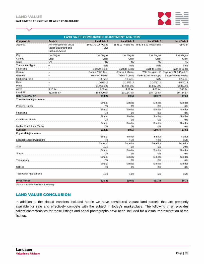
LAND VALUE
SALE UNIT 15 CONSISTING OF APN 177-20-701-012
Page | 39
Comparable Subject Land Sale 1 Land Sale 2 Land Sale 3 Land Sale 4
Address Northwest corner of Las
Vegas Boulevard and
Richmar Avenue
10471 S Las Vegas
Blvd
2885 W Pebble Rd 7580 S Las Vegas Blvd Giles St
City Las Vegas Las Vegas Las Vegas Las Vegas Las Vegas
County Clark Clark Clark Clark Clark
State NV NV NV NV NV
Transaction Type -- Sale Sale Sale Sale
Financing -- Cash to Seller Cash to Seller Cash to Seller Cash to Seller
Grantor -- Cohen 2006 Trust Alvarez & Marsal
Holdings, LLC
Wild Cougar LLC Raymond N. & Pearl C.
KimGrantee -- Yvonne J Parker Thanh T Lewis Kevin & Juli Koentopp Seven Valleys Realty,
Inc.Marketing Time -- 14 mos. 15 mos. N/Av 22 mos.
Date -- 10/2/2013 2/12/2014 2/20/2014 6/6/2014
Price -- $1,990,000 $1,925,000 $1,892,000 $685,000
Acres 8.10 Ac. 2.50 Ac. 4.62 Ac. 4.03 Ac. 2.06 Ac.
Land SF 352,836 SF 108,900 SF 201,247 SF 175,700 SF 89,734 SF
Sale Price Per SF $18.27 $9.57 $10.77 $7.63
Transaction Adjustments
Similar Similar Similar Similar
Property Rights 0% 0% 0% 0%
Similar Similar Similar Similar
Financing 0% 0% 0% 0%
Similar Similar Similar Similar
Conditions of Sale 0% 0% 0% 0%
Similar Similar Similar Similar
Market Conditions (Time) 0% 0% 0% 0%
Subtotal $18.27 $9.57 $10.77 $7.63
Physical Adjustments
Similar Inferior Inferior Inferior
Location/Access/Exposure 0% 15% 10% 25%
Superior Superior Superior Superior
Size -10% -5% -5% -10%
Similar Similar Similar Similar
Shape 0% 0% 0% 0%
Similar Similar Similar Similar
Topography 0% 0% 0% 0%
Similar Similar Similar Similar
Utilities 0% 0% 0% 0%
Total Other Adjustments -10% 10% 5% 15%
Price Per SF $16.45 $10.52 $11.31 $8.78
Source: Landauer Valuation & Advisory
LAND SALES COMPARISON ADJUSTMENT ANALYSIS
LAND VALUE CONCLUSION
In addition to the closed transfers included herein we have considered vacant land parcels that are presently
available for sale and effectively compete with the subject in today’s marketplace. The following chart provides
salient characteristics for these listings and aerial photographs have been included for a visual representation of the
listings:
LAND VALUE
SALE UNIT 15 CONSISTING OF APN 177-20-701-012
Page | 40
Land Listing No. 1 Land Listing No. 2 Land Listing No. 3
Address/Location 11601 Las Vegas Blvd 10070 Las Vegas Blvd 9585 Las Vegas Blvd
City Las Vegas Las Vegas Las Vegas
County Clark Clark Clark
State NV NV NV
Parcel ID 191-05-601-021 177-28-201-015 & -016 177-20-802-008, -014, -015, -016
Topography Level, At Street Grade Level, At Street Grade Level At Street Grade
Shape Rectangular Rectangular Irregular
Utilities All Available All Available All Available
Zoning H-1 H-1 H-1
DOM 356 343 1270
Usuable Land Area 526,057 185,836 819,442
Asking Price $6,795,369 $3,000,000 25000000
Asking Price Per SF $12.92 $16.14 $30.51
Land Listing Summary
LAND VALUE
SALE UNIT 15 CONSISTING OF APN 177-20-701-012
Page | 41
Land Listing No 1 Aerial Land Listing No 2 Aerial
Land Listing No 3 Aerial
The three listings of land parcels suitable for tourist commercial development range in asking unit prices from a low
of $12.92 to a high of $30.51 per square foot.
Downward considerations would be warranted for all of the listings for potential future negotiations that likely would
occur due to current market conditions. According to interviews with land brokers in the Las Vegas area, current
asking prices are being negotiated down in the 5% to 20% range at this time. Again these are asking prices and
represent seller’s expectations for what their properties would sell for in today’s marketplace. Further these listings
have been on the market for over one year indicating the asking prices are higher than what the market would bear.
The location of land listings 1, 2 and 3 are similar to the subject as they include direct frontage and access from Las
Vegas Boulevard.
These listings have been considered as supportive evidence in our final market value opinion of the subject property.

LAND VALUE
SALE UNIT 15 CONSISTING OF APN 177-20-701-012
Page | 42
Prior to adjustments the closed land sales had unit prices ranging from $7.63 to $18.27 per square foot with a mean
of $11.56 per square foot. After adjustments, the land sales reflect unit prices ranging from $8.78 to $16.45 per
square foot with an average of $11.76 per square foot. After carefully analyzing all of the similarities and differences
that exist from sale to sale and placing primary consideration on Land Sale Nos. 1 and 3 as they include direct
frontage on Las Vegas boulevard, we conclude an indicated land value opinion of $12.00 per square foot for the
subject site. The following table summarizes the subject’s concluded value on a price per square foot basis.
Low High Average
$7.63 $18.27 $11.56
$8.78 $16.45 $11.76
$12.00
Source: Landauer Valuation & Advisory
Unadjusted Range
Adjusted Range
Concluded Land Sale Indication ($/SF)
LAND ADJUSTMENT ANALYSIS AND METRICS
LAND VALUE CONCLUSION
Based upon our analysis of the land sales and knowledge of the local real estate market, we conclude that the
indicated fee simple value (rounded) as of the effective date of value by the (land) sales comparison approach is
$4,230,000.
Indicators
Subject Land Area - Square Feet 352,836 SF
Reconciled Value / Square Foot $12.00
Reconciled Land Value (Rd) $4,230,000
Source: Landauer Valuation & Advisory
LAND VALUE CONCLUSION

RECONCILIATION
SALE UNIT 15 CONSISTING OF APN 177-20-701-012
Page | 43
RECONCILIATION
In the sales comparison approach, the subject is compared to similar properties that have been sold recently or for
which listing prices or offers are known. The sales used in this analysis are considered the most directly comparable
to the subject. In addition, market participants are currently analyzing purchase prices on investment properties as
they relate to available substitutes in the market. The market value opinion of the subject is summarized as follows:
Appraisal Premise Interest Appraised Date of Value Value Conclusion
Market Value "As Is" Fee Simple August 20, 2014 $4,230,000
MARKET VALUE CONCLUSION
ADDENDUM A
SALE UNIT 15 CONSISTING OF APN 177-20-701-012
ADDENDUM
ADDENDUM A
DEFINITIONS
ADDENDUM A
SALE UNIT 15 CONSISTING OF APN 177-20-701-012
ADDENDUM
DEFINITIONS
The following definitions are derived from The Dictionary of Real Estate Appraisal, Fifth Edition, published by the
Appraisal Institute.
Absorption Period: The actual or expected period required from the time a property, group of properties, or commodity is
initially offered for lease, purchase, or use by its eventual users until all portions have been sold or stabilized occupancy has
been achieved.
Absorption Rate: The rate at which properties for sale or lease have been or are expected to be successfully marketed,
sold, or leased in a given area over a duration of time.
Ad Valorem Tax: A tax levied in proportion to the value of the thing(s) being taxes; generally refers only to property taxes,
although technically the term is applicable to income taxes, ad valorem tariffs, special property taxes, etc. Exclusive of
exemptions, use value assessment provisions, and the like, the property tax is an ad valorem tax. (IAAO)
Assessed Value: The value of a property according to the tax rolls in ad valorem taxation; may be higher or lower than
market value, or based on an assessment ratio that is a percentage of market value.
Cash Equivalency: An analytical process in which the sale price of a transaction with nonmarket financing or financing with
unusual conditions or incentives is converted into a price expressed in terms of cash.
Contract Rent: The actual rental income specified in a lease.
Disposition Value: The most probable price that a specified interest in real property should bring under all of the following
conditions: 1) Consummation of a sale will occur within a future exposure time specified by the client; 2) The property is
subjected to market conditions prevailing as of the date of valuation; 3) Both the buyer and seller are acting prudently and
knowledgeably; 4) The seller is under compulsion to sell; 5) The buyer is typically motivated; 6) Both parties are acting in
what they consider their best interests; 7) An adequate marketing effort will be made during the exposure time specified by
the client; 8) Payment will be made in cash in U.S. dollars or in terms of financial arrangements comparable thereto; and 9)
The price represents the normal consideration for the property sold, unaffected by special or creative financing or sales
concessions granted by anyone associated with the sale.
Effective Rent: The rental rate net of financial concessions such as periods of no rent during the lease term and above- or
below-market tenant improvements.
Excess Land: Land that is not needed to serve or support the existing improvement. The highest and best use of the
excess land may or may not be the same as the highest and best use of the improved parcel. Excess land may have the
potential to be sold separately and is valued separately.
Excess Rent: The amount by which contract rent exceeds market rent at the time of the appraisal; created by a lease
favorable to the landlord (lessor) and may reflect unusual management, unknowledgeable parties, a lease execution in an
earlier, stronger rental market, or an agreement of the parties. Due to the higher risk inherent in the receipt of excess rent, it
may be calculated separately and capitalized at a higher rate in the income capitalization approach.
Exposure Time: 1) The time a property remains on the market. 2) The estimated length of time the property interest being
appraised would have been offered on the market prior to the hypothetical consummation of a sale at market value on the
effective date of the appraisal; a retrospective estimate based on an analysis of past events assuming a competitive and open
market.
Extraordinary Assumption: An assumption, directly related to a specific assignment, which, if found to be false, could alter
the appraiser’s opinions or conclusions. Extraordinary assumptions presume as fact otherwise uncertain information about
physical, legal, or economic characteristics of the subject property; or about conditions external to the property such as
market conditions or trends; or about the integrity of data used in an analysis. (USPAP 2010-2011 ed.)
ADDENDUM A
SALE UNIT 15 CONSISTING OF APN 177-20-701-012
ADDENDUM
Fee Simple Estate: Absolute ownership unencumbered by any other interest or estate, subject only to the limitations
imposed by the governmental powers of taxation, eminent domain, police power, and escheat.
Floor Area Ratio (FAR): The relationship between the above-ground floor area of a building, as described by the building
code, and the area of the plot on which it stands; in planning and zoning, often expressed as a decimal, e.g., a ratio of 2.0
indicates that the permissible floor area of a building is twice the total land area.
Fractional Vacancy: The amount of vacant space need in a market for its orderly operation. In a stabilized market, where
supply and demand are in balance, fractional vacancy allows for move-in and move-outs. In markets for income-producing
property, fractional vacancy measures the lost rental income as leases roll over and expire.
Full Service Lease: See gross lease.
General Vacancy: A method of calculating any remaining vacancy and collection loss considerations when using discounted
cash flow (DCF) analysis, where turnover vacancy has been used as part of the income estimate. The combined effects of
turnover vacancy and general vacancy relate to total vacancy and collection loss.
Going Concern Value: 1) The market value of all the tangible and intangible assets of an established and operating
business with an indefinite life, as if sold in aggregate; more accurately termed the market value of the going concern. 2) The
value of an operating business enterprise. Goodwill may be separately measured but is an integral component of going-
concern value when it exists and is recognizable.
Gross Building Area (GBA): The total floor area of a building, excluding unenclosed areas, measured from the exterior of
the walls of the above-grade area. This includes mezzanines and basements if and when typically included in the region.
Gross Lease: A lease in which the landlord receives stipulated rent and is obligated to pay all of the property’s operating and
fixed expenses; also called full-service lease.
Hypothetical Condition: That which is contrary to what exists but is supposed for the purpose of analysis. Hypothetical
conditions assume conditions contrary to known facts about physical, legal, or economic characteristics of the subject
property; or about conditions external to the property, such as market conditions or trends; or about the integrity of data used
in an analysis. (USPAP, 2010-2011 ed.)
Investment Value: The value of a property interest to a particular investor or class of investors based on the investor’s
specific requirements. Investment value may be different from market value because it depends on a set of investment
criteria that are not necessarily typical of the market.
Land-to-Building Ratio: The proportion of land area to gross building area; one of the factors determining comparability of
properties.
Lease: A contract in which the rights to use and occupy land or structures are transferred by the owner to another for a
specified period of time in return for a specified rent.
Leased Fee Interest: A freehold (ownership interest) where the possessory interest has been granted to another party by
creation of a contractual landlord relationship.
Leasehold Interest: The tenant’s possessory interest created by a lease.
Lessee: One who has the right to occupancy and use of the property of another for a period of time according to a lease
agreement.
Lessor: One who conveys the rights of occupancy and use to others under a lease agreement.
Liquidation Value: The most probable price which a specified interest in real property should bring under all of the following
conditions: 1) Consummation of a sale within a short time period; 2) The property is subjected to market conditions prevailing
as of the date of valuation; 3) Both the buyer is acting prudently and knowledgeably; 4) The seller is under extreme
compulsion to sell; 5) The buyer is typically motivated; 6) Both parties are acting in what they considers to be their best
interests; 7) A normal marketing effort is not possible due to the brief exposure time; 8) Payment will be made in cash in U.S.

ADDENDUM A
SALE UNIT 15 CONSISTING OF APN 177-20-701-012
ADDENDUM
dollars or in terms of financial arrangements comparable thereto; and 9) The price represents the normal consideration for the
property sold, unaffected by special or creative financing or sales concessions granted by anyone associated with the sale.
Market Rent: The most probable rent that a property should bring in a competitive and open market reflecting all conditions
and restrictions of the specified lease agreement, including permitted uses, use restrictions, expense obligations,
concessions, renewal and purchase options, and tenant improvements (TIs).
Market Value: See body of report for market value definition used in this appraisal.
Marketing Time: An opinion of the amount of time it might take to sell a real or personal property interest at the concluded
market value level during the period immediately after the effective date of an appraisal. Marketing time differs from exposure
time, which is always presumed to precede the effective date of an appraisal. (Advisory Opinion 7 of the Appraisal Standards
Board of The Appraisal Foundation and Statement on Appraisal Standards No. 6, “Reasonable Exposure Time in Real
Property and Personal Property Market Value Opinions” address the determination of reasonable exposure and marketing
time.)
Net Lease: A lease in which the landlord passes on all expenses to the tenant.
Net Net Net Lease: A lease in which the tenant assumes all expenses (fixed and variable) of operating a property except
that the landlord is responsible for structural maintenance, building reserves, and management. Also called NNN, triple net
lease or fully net lease.
Occupancy Rate: 1) The relationship or ratio between the income received from the rented units in a property and the
income that would be received if all the units were occupied. 2) The ratio of occupied space to total rentable space in the
building.
Overage Rent The percentage rent paid over and above the guaranteed minimum rent or base rent; calculated as a
percentage of sales in excess of a specified breakpoint sales volume
Prospective Opinion of Value: A value opinion effective as of a specified future date. The term does not define a type of
value. Instead, it identifies a value opinion as being effective at some specific future date. An opinion of value as of a
prospective date is frequently sought in connection with projects that are proposed, under construction, or under conversion
to a new use, or those that have not yet achieved sellout or stabilized level of long-term occupancy.
Rentable Area: For office buildings, the tenant’s pro rata portion of the entire office floor, excluding elements of the building
that penetrate through the floor to the areas below. The rentable area of a floor is computed by measuring to the inside
finished surface of the dominant portion of the permanent building walls, excluding any major vertical penetrations of the floor.
Alternatively, the amount of space on which rent is based; calculated according to local practice.
Retrospective Value Opinion: A value opinion effective as of a specified historical date. The term does not define a type of
value. The term does not define a type of value. Instead, it identifies a value opinion as being effective at some specific prior
date. Value as of a historical date is frequently sought in connection with property tax appeals, damage models, lease
renegotiation, deficiency judgments, estate tax, and condemnation. Inclusion of the type of value with this term is
appropriate, e.g., “retrospective market value opinion.
Shell Rent: The typical rent paid for retail, office, or industrial tenant space based on minimal “shell” interior finishes (called
vanilla finish in some areas). Usually the landlord delivers the main building shell space or some minimum level of interior
build-out, and the tenant completes the interior finish, which can include wall, ceiling, and floor finishes; mechanical systems,
interior electric, and plumbing. Typically these are long-term leases with tenants paying all or most property expenses.
Surplus Land: Land that is not currently needed to support the existing improvements but cannot be separated from the
property and sold off. Surplus land does not have an independent highest and best use and may or may not contribute value
to the improved parcel.
Turnover Vacancy: A method of calculating vacancy allowance that is estimated or considered as part of the potential
income estimate when using discounted cash flow (DCF) analysis. As units or suites turn over and are available for re-
ADDENDUM A
SALE UNIT 15 CONSISTING OF APN 177-20-701-012
ADDENDUM
leasing, the periodic vacancy time frame (vacancy window) to re-lease the space is considered. Accordingly the income
estimate reflects a component of vacancy and is not true potential gross income but some level of effective gross income.
Usable Area: 1) For office buildings, the actual occupied area of a floor or an office space; computed by measuring from the
finished surface or the office side of corridor and other permanent walls, to the center of partitions that separate the office
from adjoining usable areas, and to the inside finished surface of the dominant portion of the permanent outer building walls.
Sometimes called net building area or net floor area. 2) The area that is actually used by the tenants measured from the
inside of the exterior walls to the inside of walls separating the space from hallways and common areas.
Value In Use: The value of a property assuming a specific use, which may or may not be the property’s highest and best use
on the effective date of appraisal. Value in use may or may not be equal to market value but is different conceptually.
Value Indication: An opinion of value derived through application of the appraisal process.

ADDENDUM B
SALE UNIT 15 CONSISTING OF APN 177-20-701-012
ADDENDUM
ADDENDUM B COMPARABLE SUMMARIES
ADDENDUM B
SALE UNIT 15 CONSISTING OF APN 177-20-701-012
ADDENDUM
Landauer
Valuation & Advisory
10471 S Las Vegas Blvd
Location Data
ID 73397
Location
Las Vegas, NV 89183
Market Las Vegas
Submarket South Las Vegas
County Clark
APN
Physical Data
Property Type Land
Property Sub Type Tourist Commercial
Acres 2.50 Acres Sale Data
Land SF 108,900 SF Transaction Type Sale
Useable Acres 2.50 Acres Date October 2, 2013
Land SF 108,900 SF Marketing Time 14 mos.
Frontage 187 Feet Grantor Cohen 2006 Trust
Depth 538 Feet Grantee Yvonne J Parker
Topography Near flat Document No 13100202718
Shape Rectangular Price $1,990,000
Corner or Interior location Interior Property Rights Fee Simple
Flood Zone X Financing Cash to SellerEncumbrance or
Easement None Noted Conditions of Sale Typical
Environmental Issues None Noted Req Capital Cost N/Av
Utilities All to Site
Offsite/Onsite Costs N/Av
Zoning H-1
Zoned Density H-1
Allow able Bldg Area N/Av
Land Units N/Av
Proposed Use N/Av Analysis
Price per Land Unit N/Av
Price per Acre $796,000
Price per Land SF $18.27
Verif ication
LAND COMPARABLE 1
10471 S Las Vegas Blvd
177-29-801-019
Ben Millis, broker 702-733-7500
Comments
This comparable property is located on the west side of Las Vegas Boulevard, north of Cactus Avenue. The property
sold in October 2013 at a price of $1,990,000. The site contains 108,900 square feet which indicates a unit price paid
of $18.27 per square foot of land area. Zoned H-1 the overall highest and best use characteristics are for tourist
commercial development. According to the broker Mr. Ben Millis there were no unusual sale conditions.

ADDENDUM B
SALE UNIT 15 CONSISTING OF APN 177-20-701-012
ADDENDUM
Landauer
Valuation & Advisory
Development Site with Billboards
Location Data
ID 73398
Location
Las Vegas, NV 89123
Market Las Vegas
Submarket South Las Vegas
County Clark
APN
Physical Data
Property Type Land
Property Sub Type Tourist Commercial
Acres 4.62 Acres Sale Data
Land SF 201,247 SF Transaction Type Sale
Useable Acres N/Av Date February 12, 2014
Land SF 201,247 SF Marketing Time 15 mos.
Frontage 333 Feet Grantor Alvarez & Marsal Holdings, LLC
Depth 670 Feet Grantee Thanh T Lewis
Topography Near flat Document No 14021203502
Shape Rectangular Price $1,925,000
Corner or Interior location Interior Property Rights Fee Simple
Flood Zone X Financing Cash to SellerEncumbrance or
Easement None Noted Conditions of Sale Typical
Environmental Issues None Noted Req Capital Cost N/Av
Utilities All to Site
Offsite/Onsite Costs N/Av
Zoning H-1
Zoned Density H-1
Allow able Bldg Area N/Av
Land Units N/Av
Analysis
Price per Land Unit N/Av
Price per Acre $416,667
Price per Land SF $9.57
Verif ication
LAND COMPARABLE 2
2885 W Pebble Rd
177-20-501-001
Geoffrey West, broker
Comments
This comparable property is located at the southeast corner of Pebble Road and I-15. The property sold in February
2014 at a price of $1,925,000. The site contains 201,247 square feet which indicates a unit price paid of $9.57 per
square foot of land area. Zoned H-1 the overall highest and best use characteristics would be for tourist commercial
development. According to the broker Mr. Geoffrey West there were two billboards on this site and income is derived
from these billboard sign sites. For confidentiality reasons Mr. West did not disclose the rental rates. There were no
unusual sale conditions.
ADDENDUM B
SALE UNIT 15 CONSISTING OF APN 177-20-701-012
ADDENDUM
Landauer
Valuation & Advisory
H-2 Zoned Acreage
Location Data
ID 73399
Location
Las Vegas, NV 89123
Market Las Vegas
Submarket South Las Vegas
County Clark
APN
Physical Data
Property Type Land
Property Sub Type Tourist Commercial
Acres 4.03 Acres Sale Data
Land SF 175,700 SF Transaction Type Sale
Useable Acres N/Av Date February 20, 2014
Land SF 175,700 SF Marketing Time N/Av
Frontage 338 Feet Grantor Wild Cougar LLC
Depth 665 Feet Grantee Kevin & Juli Koentopp
Topography Near flat Document No 14022002422
Shape Rectangular Price $1,892,000
Corner or Interior location Corner Property Rights Fee Simple
Flood Zone X Financing Cash to SellerEncumbrance or
Easement None Noted Conditions of Sale Typical
Environmental Issues None Noted Req Capital Cost N/Av
Utilities All to Site
Offsite/Onsite Costs N/Av
Zoning H-1
Zoned Density H-1
Allow able Bldg Area N/Av
Land Units N/Av
Analysis
Price per Land Unit N/Av
Price per Acre $469,479
Price per Land SF $10.77
Verif ication
LAND COMPARABLE 3
7580 S Las Vegas Blvd
191-04-402-001
Curt Allsop, broker 702-733-7500
Comments
This comparable property is located at the northeast corner of Las Vegas Boulevard and Bruner Street. The property
sold in February 2014 at a price of $1,892,000. The site contains 175,700 square feet which indicates a unit price
paid of $10.77 per square foot of land area. Zoned H-1 the overall highest and best use characteristics would be for
tourist commercial development. According to the broker Mr. Curt Allsop there were no unusual sale conditions and it
was acquired as a speculative investment.

ADDENDUM B
SALE UNIT 15 CONSISTING OF APN 177-20-701-012
ADDENDUM
Landauer
Valuation & Advisory
Giles
Location Data
ID 73400
Location
Las Vegas, NV 89123
Market Las Vegas
Submarket South Las Vegas
County Clark
APN
Physical Data
Property Type Land
Property Sub Type Tourist Commercial
Acres 2.06 Acres Sale Data
Land SF 89,734 SF Transaction Type Sale
Useable Acres 2.07 Acres Date June 6, 2014
Land SF 89,734 SF Marketing Time 22 mos.
Frontage 288 Feet Grantor Raymond N. & Pearl C. Kim
Depth Adequate Grantee Seven Valleys Realty, Inc.
Topography Near flat Document No 14060602802
Shape Square Price $685,000
Corner or Interior location Corner Property Rights Fee Simple
Flood Zone X Financing Cash to SellerEncumbrance or
Easement None Noted Conditions of Sale Typical
Environmental Issues None Noted Req Capital Cost N/Av
Utilities All to Site
Offsite/Onsite Costs N/Av
Zoning H-1, County
Zoned Density H-1, County
Allow able Bldg Area N/Av
Land Units N/Av
Analysis
Price per Land Unit N/Av
Price per Acre $332,524
Price per Land SF $7.63
Verif ication
Giles St
177-28-101-009
Public Records, Deed
Comments
This comparable property is located at the northwest corner of Giles Street and Landberg Avenue. The property sold
in June 2014 at a price of $685,000. The site contains 89,734 square feet which indicates a unit price paid of $7.63
per square foot of land area. Zoned H-1 the overall highest and best use characteristics would be for tourist
commercial development.
LAND COMPARABLE 4
ADDENDUM C
SALE UNIT 15 CONSISTING OF APN 177-20-701-012
ADDENDUM
ADDENDUM C APPRAISERS QUALIFICATIONS
ADDENDUM C
SALE UNIT 15 CONSISTING OF APN 177-20-701-012
ADDENDUM
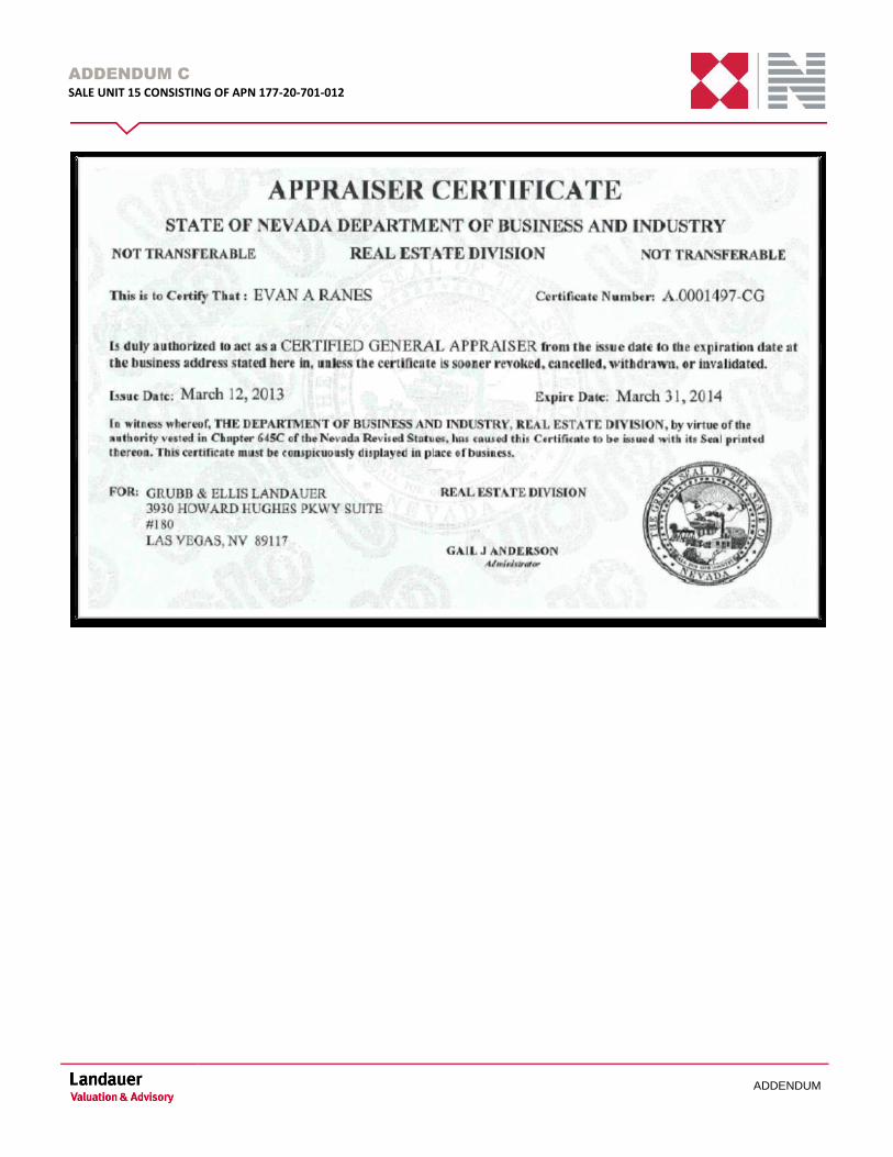
ADDENDUM C
SALE UNIT 15 CONSISTING OF APN 177-20-701-012
ADDENDUM

ADDENDUM C
SALE UNIT 15 CONSISTING OF APN 177-20-701-012
ADDENDUM
DAVID WRZESINSKI
Associate Director
Landauer Valuation & Advisory
a division of Newmark Grubb
Knight Frank
3930 Howard Hughes Parkway
Suite 180
Las Vegas, NV 89169
T 702.866.6561
M 702.283.2961
F 702.862.8242
Years of Experience
Over 10 Years
Areas of Specialization
Appraisal Valuation
Estate Valuation
Consulting
Professional Background
As an Associate Director, Mr. Wrzesinski has joined Landauer Valuation
& Advisory Las Vegas office, which provides valuation and consulting
services for the acquisition, disposition, and financing of investment
grade real estate.
Mr. Wrzesinski has valued and consulted on real estate matters for over
10 years. In 2003 he began his appraisal internship with Anderson
Valuation Group. In 2012 he joined Lubawy & Associates as a senior
appraiser. In 2013, Mr. Wrzesinski joined Grubb & Ellis Landauer
Valuation & Advisory Services as an Associate Director.
Mr. Wrzesinskis’ experience extends over numerous property types:
Industrial (warehouse, self storage, business parks)
Office (condominium, garden, mid-rise)
Retail (strip, neighborhood, big box)
Apartment (investment grade, smaller concerns)
Litigation (acquisitions, condemnation, right-of-way)
Land (raw, finished lots)
Special Purpose/Use (worship facilities, car washes, child care facilities,
construction yards)
Proposed Properties (retail, office, apartments, industrial, special
purpose/use)
Professional Activities and Affiliations
Nevada – State Certified General (No. A.0006577-CG)
Education
National USPAP Course Practice of Real Estate Appraisal Appraisal of Residential Property Writing the Narrative Report Highest & Best Use Analysis Income Capitalization Techniques I Introduction to Business Enterprise Appraisal Small Residential Income Properties Introduction to Commercial Applied Residential Appraisal Techniques Review Appraising Income Valuation of Small Mixed Use Properties The Appraiser as an Expert Witness: Preparation and Testimony How to Analyze and Value Income Properties
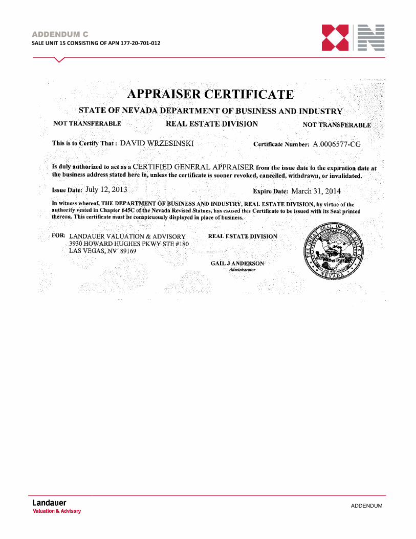
ADDENDUM C
SALE UNIT 15 CONSISTING OF APN 177-20-701-012
ADDENDUM
ADDENDUM D
SALE UNIT 15 CONSISTING OF APN 177-20-701-012
ADDENDUM
ADDENDUM D CLIENT CORRESPONDENCE
Clark County June 12, 2014
Group G Department of Aviation
Surplus Land Sale 2014 -4th QTR
STATEMENT OF WORK Department of Real Property Management
Appraiser Instructions: 1. Prior to purchase order issuance, submit all questions in writing by either
Email: [email protected] Fax: 702-455-4055
2. Submit your proposal for this appraisal assignment to the above referenced addresses (Email or
FAX). 3. The contact information for the property owner and the Department of Real Property Management
(RPM) for this appraisal assignment is included in the Statement of Work (SOW). Project Overview:
Sale Unit Sale Parcels Land Size (ac)
Property Type
15 177-20-701-012 8.21 Land Comments: The Group G appraisal report for the Department of Aviation (DOA) Surplus Land Sale 2014-4th QTR contains one (1) Sale Parcel(s) to be appraised and sold as one (1) Sale Unit(s) indicated above.
Statement of Work Page 1 of 14
Clark County June 12, 2014
Group G Department of Aviation
Surplus Land Sale 2014 -4th QTR
SECTION 1 – Subject Identification & General Information
Identification Name: Clark County DOA Surplus Land Sale Parcels – Group G
Location: Clark County, Nevada
Acreage: See Project Overview
Property Type: Desert Lands
Use: Sales
Client Clark County, Department of Real Property Management Intended Users The appraisal report will be used by the RPM on behalf of Clark County DOA.
Use of the report by others is not intended. Intended Use The appraisal reports and value conclusions set forth will be used by RPM to
assist in sales of the identified property rights. The appraisal reports are not intended for any other use.
Property Description There are one (1) Sale Parcel(s) to be appraised and sold as one (1) Sale Unit(s). See Sales Matrix attached in the Addendum of this SOW. The properties are located in the Las Vegas Metropolitan Area, Clark County, Nevada. Legal Description See Title Report and Sales Matrix attached in the Addendum of this SOW. Purpose of Appraisal and Property Interest to be Appraised The purpose of the appraisal is to form current opinions of market values for the Fee Simple Estates of the one (1) Sale Unit(s), based on the requirements detailed in this Statement of Work (SOW), regulatory requirements, and the definition of market value provided, considering all applicable encumbrances and reservations. By definition, a Fee Simple Estate is the absolute ownership of realty unencumbered by any other interest, subject only to the limitations imposed by governmental powers. The appraiser must immediately notify RPM of any indications of rights contrary to the rights described in this SOW, as any significant differences may result in amended instructions or constitute a new appraisal assignment. Outstanding Rights See Title Report and Sales Matrix for Reservations/Encumbrances in the Addendum of this SOW. Subject to Restrictive Covenant and Reservation of Avigation & Clearance Easement attached hereto. Statement of Work Page 2 of 14
Clark County June 12, 2014
Group G Department of Aviation
Surplus Land Sale 2014 -4th QTR
If the appraiser discovers any recorded or unrecorded documents, conditions, agreements, easements and/or encumbrances during the appraisal process that were not presented in this SOW, then the appraiser must immediately report such findings to RPM. Reservations Reservations, exceptions and provisions contained in land patents from the United States of America may include, but is not limited to, the following: The United States of America is reserving the following rights associated with the Sale Parcels.
• A right-of-way for ditches or canals by the authority of the United States pursuant to the Act of August 30, 1890 (43 U.S.C. 945); and
• All mineral deposits in the land so patented, and to it, or persons authorized by it, the right to
prospect for, mine, and remove such deposits from the same under applicable law and regulations to be established by the Secretary of the Interior.
It is the responsibility of the appraiser to verify the existence of any such reservations associated with the Sales Parcels. Personal Property
• None Property Access
• There is legal access to the Sale Parcels. Water Rights
• There are no water resources that are being transferred with the subject lands. Ownership/Occupant
• Clark County Department of Aviation Leases
• None Known
Statement of Work Page 3 of 14
Clark County June 12, 2014
Group G Department of Aviation
Surplus Land Sale 2014 -4th QTR
PROJECT CONTACT INFORMATION
Department of Aviation Surplus Land Sale 2014 – 4th QTR – Group G
RPM Contact Temple Mullen Property Acquisition Administrator PO Box 551825 Las Vegas, NV 89155 702-455-6731 (office phone) [email protected] DOA Contact Sundaylee Cabrera Airport Property Manager PO Box 11005 Las Vegas, NV 89111 702-261-3241 (office phone) [email protected] Property Owner Clark County Department of Aviation
Statement of Work Page 4 of 14

Clark County June 12, 2014
Group G Department of Aviation
Surplus Land Sale 2014 -4th QTR
At a minimum, the following Subject Property Exhibits will be provided as attachments to this SOW: 1. DOA Surplus Land Sale 2014-4th QTR Map 2. Sales Matrix 3. Assessor Tax Parcel Maps 4. Title Reports 5. AEOD map 6. Restrictive Covenant and Reservation of Avigation & Clearance Easement
Statement of Work Page 5 of 14
Clark County June 12, 2014
Group G Department of Aviation
Surplus Land Sale 2014 -4th QTR
SECTION 2 – Appraisal Requirements and Instructions
Appraisal Standards and Other Requirements
1. Uniform Standards of Professional Appraisal Practice (USPAP) 2. The Code of Professional Ethics and Standards of Professional Appraisal Practice of the
Appraisal Institute 3. FIRREA Standards 4. Additional Requirements stated herein this SOW.
Market Value For this assignment, use this Market Value definition: “The most probable price which a property should bring in a competitive and open market under all conditions requisite to a fair sale, the buyer and seller each acting prudently and knowledgeably, and assuming the price is not affected by undue stimulus. Implicit in this definition are the consummation of a sale as of a specified date and the passing of title from seller to buyer under conditions whereby: 1. buyer and seller are typically motivated; 2. both parties are well informed or well advised and acting in what they consider their own best
interests; 3. a reasonable time is allowed for exposure in the open market; 4. payment is made in terms of cash in U.S. dollars or in terms of financial arrangements comparable
thereto; and 5. the price represents normal consideration for the property sold unaffected by special or creative
financing or sales concessions granted by anyone associated with the sale.” (This Market Value definition is from regulations published by federal regulatory agencies pursuant to Title XI of the Financial Institutions Reform Recovery, and Enforcement Act (FIRREA) of 1989 between July 5, 1990 & August 24, 1990, by the Federal Reserve System (FRS), National Credit Union Administration (NCUA), Federal Deposit Insurance Corporation (FDIC), the Office of Thrift Supervision (OTS) & the Office of Comptroller of the Currency (OCC). This definition is also referenced in regulations jointly published by the OCC< OTS, FRS, and FDIC on June 7, 1994, and in the Interagency Appraisal and Evaluation Guidelines, dated October 27, 1994.) Date of Value The date of value is typically the date of the last property inspection, which must be no later than 30 calendar days prior to the submission of the completed appraisal report, unless other conditions are approved in writing by RPM. Extraordinary Assumptions
No extraordinary assumptions have been identified. If the appraiser determines that extraordinary assumptions are necessary for this assignment, the appraiser must contact RPM for prior written approval.
Statement of Work Page 6 of 14
Clark County June 12, 2014
Group G Department of Aviation
Surplus Land Sale 2014 -4th QTR
Hypothetical Conditions No hypothetical conditions have been identified as being necessary for this assignment. If the appraiser determines that hypothetical conditions are necessary, the appraiser must contact RPM and obtain prior written approval to employ such conditions. Jurisdictional Exceptions No Jurisdictional Exceptions are considered necessary. If the appraiser determines that a Jurisdictional Exception is necessary, the Appraiser must contact RPM to obtain prior written approval. Reporting Extraordinary Assumptions, Hypothetical Conditions, and Jurisdictional Exceptions All Extraordinary Assumptions, Hypothetical Conditions, and Jurisdictional Exceptions, when authorized by RPM, must be clearly identified, labeled and communicated wherever the final value conclusions are stated. At a minimum this will include the Letter of Transmittal and the Summary of Salient Facts. In addition, these same items must be communicated with General Assumptions and Limiting Conditions within the body of the report. Property Inspection To the extent possible, the appraiser must make a personal inspection of the subject properties and all of the comparable market properties used in the analysis, unless specific arrangements to the contrary have been approved in writing by RPM. The appraiser must give the property owner and/or the owner’s designated representative (Clark County RPM primary contact), an opportunity to accompany the appraiser during the property inspection. The appraiser must certify in the report that an offer was extended. Pre-Appraisal Meeting The appraiser may be required to attend a pre-appraisal meeting with RPM, DOA and other interested parties. The date, time and place of the meeting (if required) will be coordinated by RPM. If any significant items of concern are observed during the property inspection, or from aerial photographs, or other materials researched during the appraisal process that were not discussed in the pre-appraisal meeting, then the appraiser must contact RPM before continuing with the appraisal assignment. Controversies/Issues None are known at this time. Should the appraiser identify any controversies or issues during the course of assignment, then the appraiser must immediately notify RPM before proceeding with the assignment. Legal Instructions
None
Statement of Work Page 7 of 14
Clark County June 12, 2014
Group G Department of Aviation
Surplus Land Sale 2014 -4th QTR
Special Appraisal Instructions
1. Even though communication is encouraged with the property owner and the client agency, only RPM, can modify appraisal instructions. Any contract modifications must be in writing.
2. The appraiser may not communicate assignment results to any party except the RPM and DOA
primary contacts, until authorized to do so in writing by RPM. 3. Any communication (verbal or written) transmitted to DOA by the Appraiser shall include a copy to
RPM.
General Appraisal Requirements & Instructions
1. The appraiser must hold a valid license as a Certified General Appraiser for the jurisdiction in which the subject property is located. (Valid credentials include those obtained directly from the jurisdiction, those issued under a reciprocity agreement, and/or those characterized as “temporary” under the jurisdiction’s licensing and certification statutes.)
2. Statement of Work, Clark County purchase order and other assignment instructions must be included
as addenda to the appraisal report.
3. The written appraisal report must be prepared as defined and detailed within USPAP Standard 2 reporting requirements for the Appraisal Report option.
4. The appraiser must appraise the subject properties in the conditions in which they will be sold, unless
authorized in writing by RPM to do otherwise.
5. Color photographs and maps of comparable properties shall be included in the appraisal reports. Aerial photographs for comparable properties will be accepted unless the aerial photographs do not accurately represent the property as it physically existed on the date of inspection. Any unusual property features must be photographed from ground level.
6. The appraisal reports will be reviewed for conformance with the terms and conditions of this SOW
and all cited standards, including USPAP Standard 1: Real Property Appraisal, Development and Standard and USPAP Standard 2: Real Property Appraisal, Reporting. Any findings of inadequacy will require clarification and/or corrections to the appraisal report.
7. The appraiser’s conclusion of highest and best use must be an economic use. A non-economic highest
and best use, such as conservation, natural lands, preservation or any us that requires the property to be withheld from economic production in perpetuity, is not a valid use upon which to estimate market value.
8. The opinions of current market value may not be predicated upon potential highest and best uses that
are speculative or conjectural. A proposed highest and best use requires showing reasonable probability that the land is both physically adaptable for such use and there is an economic need or demand for such use in the reasonably near future. Reminding reference is made to USPAP Standard Rule 1-3 and Chapter 12 “Highest and Best Use Analysis” of The Appraisal of Real Estate, 13th Edition with the four steps/tests expected to be applied and supported within the appraisal report as defined in the definition provided at the bottom of page 278 as follows: “Highest and Best Use is the reasonably probable and legal use of vacant land or improved property that is 1.) legally permissible
Statement of Work Page 8 of 14
Clark County June 12, 2014
Group G Department of Aviation
Surplus Land Sale 2014 -4th QTR
2) physically possible 3) financially feasible and 4) the maximally productive use of the property under appraisal.”
9. The preferred method of adjusting comparable sales is through supported quantitative adjustments
(percentage, $/acre, etc.); qualitative adjustments (similar, inferior, or superior) are to be used only when the market variables cannot be quantified. Quantitative adjustments without support are unacceptable. When the appraiser must resort to qualitative analysis, support that is more extensive and discussion of the appraiser’s reasoning why a comparable sale is similar, inferior or superior to the subject property is required. All adjustments must be supported by clear, appropriate, and credible analysis based on documented market research. Mere references to undisclosed “trends” or reliance on the appraiser’s “opinion” or “judgment” without market support are unacceptable practices. Market support includes discussions with buyers/sellers, potential investors, brokers, etc. The appraiser must also recognize that variances in sale prices may be caused by multiple factors and should not over adjust a comparable by double-counting overlapping items.
10. Appraisers without a complete understanding of fundamental statistical concepts must not rely on
regression analysis techniques to extract adjustments for the sales comparison approach. Without a discussion of how each comparable sale property relates to the subject property and a statistical interpretation of the validity of the results, applying a regression analysis to a large sample data set is not acceptable. No regression analysis may be employed in the appraisal without prior discussion with, and written concurrence of, RPM.
11. Comparable Data Sheets – Well researched and documented Comparable Sale Sheets, Comparable
Rental Sheets, Rate of Return and/or other Market Data utilized in the appraisal is expected. For instance, “Comparable Sale Write-ups” are expected to include a description of all relevant physical, legal and economic factors such as parties to the transaction (Buyer & Seller), source and method of financing, and verification by a party involved in the transaction (Preferably the buyer; however, the seller and/or broker are also acceptable). A check list of minimally expected elements in a Sale Write-up Sheet include: Date of Sale; Buyer & Seller Recording information; Terms of Sale, confirmed with name and phone number, legal description, location access, physical description, zoning; Buyer’s Motivation/Planned Use of Property, appraiser highest and best use; Plat Map, Photograph, Aerial and/or other useful data.
12. If sales to governmental entities, including sales to non-profit entities with the intention of
transferring the sale property to a governmental entity later, are included in the appraisal report, they are subject to extraordinary verification and treatments insuring that these government related sales represent credible, arms-length transactions.
13. The appraisal reports and all Clark County internal documents furnished to the appraiser are to be
considered confidential. All requests for information concerning the appraisal process must be referred to RPM.
14. RPM will not normally accept custody of confidential information. If the appraiser finds it necessary
to rely on confidential information, then the appraiser must contact RPM for assignment instructions. RPM will review the information and provide further instructions to the appraiser regarding handling and storage of the confidential information.
15. While the general public is not an intended user of the appraisal reports, the Freedom of Information
Act (FOIA), NRS Chapter 239 and Clark County policy may result in the release of all or part of the appraisal reports to others.
Statement of Work Page 9 of 14
Clark County June 12, 2014
Group G Department of Aviation
Surplus Land Sale 2014 -4th QTR
16. When the appraiser has performed any services regarding the subject properties within the three prior
years, then the appraiser must appropriately disclose this information following the direction of the USPAP Ethics Rule, Conduct Section. This disclosure must be made with the proposal and in the completed appraisal report.
17. The appraiser may not reserve the right to change an appraisal report once the appraisal report has
been submitted to RPM, and no such language may be included in the appraisal report suggesting the same. Any required changes to an appraisal report, or the analyses contained therein, as a result of subsequent information discovered that is substantially different than the information contained in this SOW, may constitute a new appraisal assignment.
18. The appraiser’s scope of work used in this assignment must be sufficient to produce credible appraisal
assignment results for the intended use of the appraisal reports. The results must meet or exceed both market participant expectations and the appraiser’s peer’s actions in the same or similar assignments.
Statement of Work Page 10 of 14
Clark County June 12, 2014
Group G Department of Aviation
Surplus Land Sale 2014 -4th QTR
SECTION 3 – Contracting, Performance & Payment
Contracting Any questions regarding appraisal instructions and/or technical requirements for the appraisals should be directed to RPM. The proposal should be submitted on the attached form identified and included in this SOW as Exhibit A – Appraisal Cost and Delivery Date Proposal, supplemented as necessary. The proposals must be submitted via E-mail or Fax to the RPM Contact. The appraisal contractor must be able to provide the appraisal services within the performance period specified in this SOW. The appraisal contractor must have extensive working knowledge of USPAP. The appraisal contractor must have previous experience in appraising similar properties in the geographical area as described in this SOW that adhered to USPAP. The appraisal contractor must be a Certified General Appraiser or must obtain a temporary general certification in the State of assignment, if not licensed in the State of Nevada. The appraisal contractor must provide work experience and qualifications with the proposal. The appraisal contractor must indicate in the proposal what specific roles, if any, associates or subcontractors will play in the assignment. This does not include office support. If any associates or subcontractors are contemplated, then their qualifications must be included with the proposal. The specific contribution(s) to the appraisal of any or all individuals, other than the signer(s), must be detailed in the appraisal report. If the appraisal contractor does not list anyone else as providing assistance, then the proposal is assumed to be based upon the appraisal contractor doing 100 percent of the research, analysis and writing. Performance The due date for delivery of the initial appraisal report to RPM for review is 14 calendar days from the date the Notice to Proceed (NTP) is issued. Contractors must provide the appraisal services as stipulated in this SOW within the performance period specified; or, with justification for the change, state an alternate period of performance that is appropriate for the stated appraisal fee. The initial submitted appraisal report will be reviewed for compliance with the terms of this SOW and USPAP. Findings of inadequacy, if any, will require clarification and/or correction. Review comments and suggestions, if any, will be provided to the appraisal contractor to address. Upon acceptance of the appraised values and approval of the appraisal report by Clark County, the 2 hard copies and an electronic copy of the final report and will be delivered to RPM.
Statement of Work Page 11 of 14

Clark County June 12, 2014
Group G Department of Aviation
Surplus Land Sale 2014 -4th QTR
Deliverable/Task Schedule
REQUIRED DELIVERABLES DELIVERY DATE Pre-Work Meeting If applicable, as close to the date of the property
inspection as possible. Initial Appraisal Reports Target delivery date of initial reports is 14 days
after NTP. Submit one copy of each appraisal report for review. Electronic copies are acceptable.
Review Period & Comments Provided to Appraiser Target date is 10 days after receipt of appraisal report.
Final Appraisal Reports Target date is 10 days after receipt of review comments. Appraiser should submit two (2) final hard-copy appraisal reports and one (1) electronic copy of the appraisal report on a CD.
Payment The appraisal contractor will have a contract (purchase order) with Clark County, Nevada to perform the work that is explained in this SOW. The contract (purchase order) must appear in the addendum of the appraisal report with the SOW. The appraisal contract will be with and all invoices submitted to: Temple Mullen, Property Acquisition Administrator Clark County Department of Real Property Management P.O. Box 551825 Las Vegas, NV 89155-1825 Office: (702)455-6731 Fax: (702)455-4055 [email protected]
Statement of Work Page 12 of 14
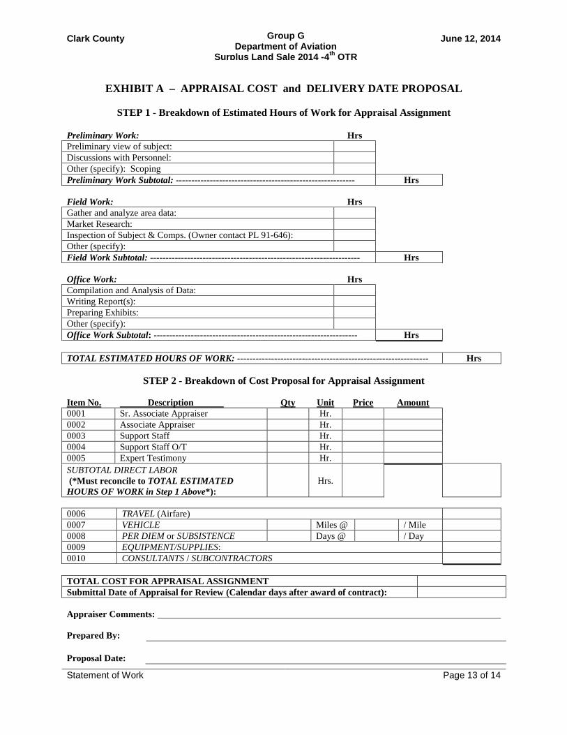
Clark County June 12, 2014
Group G Department of Aviation
Surplus Land Sale 2014 -4th QTR
EXHIBIT A – APPRAISAL COST and DELIVERY DATE PROPOSAL
STEP 1 - Breakdown of Estimated Hours of Work for Appraisal Assignment
Preliminary Work: Hrs Preliminary view of subject: Discussions with Personnel: Other (specify): Scoping Preliminary Work Subtotal: ---------------------------------------------------------- Hrs Field Work: Hrs Gather and analyze area data: Market Research: Inspection of Subject & Comps. (Owner contact PL 91-646): Other (specify): Field Work Subtotal: -------------------------------------------------------------------- Hrs Office Work: Hrs Compilation and Analysis of Data: Writing Report(s): Preparing Exhibits: Other (specify): Office Work Subtotal: ------------------------------------------------------------------ Hrs TOTAL ESTIMATED HOURS OF WORK: -------------------------------------------------------------- Hrs
STEP 2 - Breakdown of Cost Proposal for Appraisal Assignment Item No. Description Qty Unit Price Amount 0001 Sr. Associate Appraiser Hr. 0002 Associate Appraiser Hr. 0003 Support Staff Hr. 0004 Support Staff O/T Hr. 0005 Expert Testimony Hr. SUBTOTAL DIRECT LABOR (*Must reconcile to TOTAL ESTIMATED HOURS OF WORK in Step 1 Above*):
Hrs.
0006 TRAVEL (Airfare) 0007 VEHICLE Miles @ / Mile 0008 PER DIEM or SUBSISTENCE Days @ / Day 0009 EQUIPMENT/SUPPLIES: 0010 CONSULTANTS / SUBCONTRACTORS TOTAL COST FOR APPRAISAL ASSIGNMENT Submittal Date of Appraisal for Review (Calendar days after award of contract): Appraiser Comments: Prepared By:
Proposal Date:
Statement of Work Page 13 of 14
Clark County June 12, 2014
Group G Department of Aviation
Surplus Land Sale 2014 -4th QTR
See attachments of the following Exhibits:
1. DOA Surplus Land Sale 2014-4th QTR Map 2. Sales Matrix 3. Assessor Tax Parcel Maps 4. Title Reports 5. AEOD map 6. Restrictive Covenant and Reservation of Avigation & Clearance Easement 7. Access Easement Agreement (DRAFT)
Statement of Work Page 14 of 14
ADDENDUM E
SALE UNIT 15 CONSISTING OF APN 177-20-701-012
ADDENDUM
ADDENDUM E PROPERTY INFORMATION
Chicago Title of Nevada, Inc.
Chicago Title of Nevada, Inc.
9075 W. Diablo Drive, Ste. 100
Las Vegas, NV 89148
Phone: (702) 836-8000
72C101 (6/06) ALTA Commitment – 2006 Page 1
Copyright American Land Title Association. All rights reserved. The use of this Form is restricted to ALTA licensees and ALTA members in good standing as of the date of use. All other uses are prohibited. Reprinted under license from the American Land Title Association.
CCOOMMMMIITTMMEENNTT FFOORR TTIITTLLEE IINNSSUURRAANNCCEE Issued by
Chicago Title Insurance Company
Chicago Title Insurance Company, a Nebraska corporation (“Company”), for a valuable consideration, commits to
issue its policy or policies of title insurance, as identified in Schedule A, in favor of the Proposed Insured named in
Schedule A, as owner or mortgagee of the estate or interest in the land described or referred to in Schedule A, upon
payment of the premiums and charges and compliance with the Requirements; all subject to the provisions of
Schedules A and B and to the Conditions of this Commitment.
This Commitment shall be effective only when the identity of the Proposed Insured and the amount of the policy or
policies committed for have been inserted in Schedule A by the Company.
All liability and obligation under this Commitment shall cease and terminate 6 months after the Effective Date or
when the policy or policies committed for shall issue, whichever first occurs, provided that the failure to issue the
policy or policies is not the fault of the Company.
The Company will provide a sample of the policy form upon request.
IN WITNESS WHEREOF, Chicago Title Insurance Company has caused its corporate name and seal to be affixed
by its duly authorized officers on the date shown in Schedule A.
Countersigned:
By:
Authorized Officer or Agent

72C101 (6/06) ALTA Commitment – 2006 Page 2
Copyright American Land Title Association. All rights reserved. The use of this Form is restricted to ALTA licensees and ALTA members in good standing as of the date of use. All other uses are prohibited. Reprinted under license from the American Land Title Association.
Chicago Title Insurance Company
SCHEDULE A
Name and Address of Title Insurance Company: Chicago Title of Nevada, Inc.
9075 W. Diablo Drive, #100
Las Vegas, NV 89148
Order No.: 14017228-086-JR
Escrow Officer: Jennifer Reinink Title Officer: Bonnie L. Blackburn
1. Effective Date: September 2, 2014
2. Policy or Policies to be issued:
a. TBD
Proposed Insured: TBD
Liability: $TBD
3. The estate or interest in the land described or referred to in this Commitment is:
Fee Simple
4. Title to the estate or interest in the land is at the Effective Date vested in:
County of Clark, a political subdivision of the State of Nevada
5. The land referred to in this Commitment is described as follows:
See Exhibit A attached hereto and made a part hereof.
Order No.: 14017228-086-JR
72C101 (6/06) ALTA Commitment – 2006 Page 3
Copyright American Land Title Association. All rights reserved. The use of this Form is restricted to ALTA licensees and ALTA members in good standing as of the date of use. All other uses are prohibited. Reprinted under license from the American Land Title Association.
EXHIBIT A
LEGAL DESCRIPTION
THE LAND REFERRED TO HEREIN BELOW IS SITUATED IN THE COUNTY OF CLARK, STATE OF
NEVADA, AND IS DESCRIBED AS FOLLOWS:
That portion of the Northeast Quarter (NE 1/4) o the Southeast Quarter (SE 1/4) of Section 20, Township 22
South, Range 61 East M.D.M. described as follows:
That portion of Parcel Two (2) lying Southeasterly of the Flood Control Channel as shown on that certain
Parcel Map on file in File102 of Parcel Maps, Page 13, in the Office of the County Recorder of Clark County,
Nevada.
APN: 177-20-701-012
Order No.: 14017228-086-JR
72C101 (6/06) ALTA Commitment – 2006 Page 4
Copyright American Land Title Association. All rights reserved. The use of this Form is restricted to ALTA licensees and ALTA members in good standing as of the date of use. All other uses are prohibited. Reprinted under license from the American Land Title Association.
SCHEDULE B – SECTION I
REQUIREMENTS
The following are requirements to be complied with:
1. Instrument creating the estate or interest to be insured must be executed and filed for record, to wit:
TBD
2. Pay the full consideration to, or for the account of, the grantors or mortgagors.
3. Pay all taxes, charges, assessments, levied and assessed against subject premises, which are due and
payable.
4. Satisfactory evidence should be had that improvements and/or repairs or alterations thereto are completed;
that contractor, sub-contractors, labor and materialmen are all paid; and have released of record all liens or
notice of intent to perfect a lien for labor or material.
5. Our search in the public record did not disclose any open Deed of Trust on the herein described
property. Please confirm with your seller/borrower that there are no liens or encumbrances
affecting the herein described property other than those shown on the Report.
6. Payment of all fees due the Company at the time of closing.
7. Additional requirements will be made when the Company is provided with the complete name and status of
the proposed Buyer/Lender.
8. If Extended Owners Coverage is requested, this Company will require an ALTA/ACSM LAND TITLE
SURVEY. If the owner of the Land the subject of this transaction is in possession of a current
ALTA/ACSM LAND TITLE SURVEY, the Company will require that said survey be submitted for review
and approval; otherwise, a new survey, satisfactory to the Company, must be prepared by a licensed land
surveyor and supplied to the Company prior to the close of escrow.
The Company reserves the right to add additional items or make further requirements after review of the
requested documentation.
9. If Extended Coverage is requested, an inspection of said Land will be ordered; upon its completion the
Company reserves the right to except additional items and/or make additional requirements.
10. The transaction contemplated in connection with this Report is subject to the review and approval of the
Company’s Corporate Underwriting Department. The Company reserves the right to add additional items
or make further requirements after such review.
11. EFFECTIVE JULY 1, 2003, ALL DOCUMENTS, EXCEPT MAPS, SUBMITTED FOR RECORDING
WITH THE OFFICE OF THE CLARK/NYE COUNTY RECORDER, MUST COMPLY WITH NRS
247.110, AS FOLLOWS:
(a) Be on 20# paper that is 8 ½ inches by 11 inches in size;
(b) Have a margin of 1 inch on the left and right sides and at the top and bottom of each page;
Order No.: 14017228-086-JR
SCHEDULE B – Section I (Continued)
72C101 (6/06) ALTA Commitment – 2006 Page 5
Copyright American Land Title Association. All rights reserved. The use of this Form is restricted to ALTA licensees and ALTA members in good standing as of the date of use. All other uses are prohibited. Reprinted under license from the American Land Title Association.
(c) Have a space of 3 inches by 3 inches at the upper right corner of the first page and have a margin
of 1 inch at the top of each succeeding page;
(d) Not contain printed material on more than one side of each page;
(e) Print that is NO smaller than 10 point Times New Roman font and contains no more than 9 lines
of text per vertical inch; and
(f) MUST NOT be printed in any ink other than black.
ANY DOCUMENT NOT COMPLYING WITH THESE GUIDELINES WILL BE SUBJECT TO AN
ADDITIONAL, MINIMUM COUNTY NON-CONFORMING RECORDING CHARGE OF $25.00 PER
DOCUMENT.
12 PEASE CONTACT THE ESCROW OFFICE FOR WIRING INSTRUCTIONS.
Escrow No.: 14017228-086-JR
Escrow Branch Address: 9075 W. Diablo Drive, #100, Las Vegas, NV 89148
Escrow Branch Phone: (702) 836-8000
13. Any documents being executed in conjunction with this transaction must be signed in the presence of an
authorized Company employee, an authorized employee of an agent, an authorized employee of the insured
lender, or by using Bancserv or other approved third-party service. If the above requirement cannot be met,
please call the Company at the number provided in this report.
14. Your application for title insurance was placed by reference to only a street address or tax identification
number. Based on our records, we believe that the legal description in this report covers the parcel(s) of
Land that you requested. If the legal description is incorrect, the seller/borrower must notify the Company
and/or the settlement company in order to prevent errors and to be certain that the correct parcel(s) of Land
will appear on any documents to be recorded in connection with this transaction and on the policy of title
insurance.
15. The last conveyance(s) affecting said Land, are as follows:
Recording Date: April 18, 1997
Recording No: Book 970418, Instrument No. 00847, of Official Records
and Recording Date: August 10, 1998
and Recording No: Book 980810, Instrument No. 01161, of Official Records
END OF SCHEDULE B – SECTION I
Order No.: 14017228-086-JR
72C101 (6/06) ALTA Commitment – 2006 Page 6
Copyright American Land Title Association. All rights reserved. The use of this Form is restricted to ALTA licensees and ALTA members in good standing as of the date of use. All other uses are prohibited. Reprinted under license from the American Land Title Association.
SCHEDULE B – SECTION II
EXCEPTIONS
Schedule B of the policy or policies to be issued will contain exceptions to the following matters unless the same are
disposed of to the satisfaction of the Company:
1. (a) Taxes or assessments that are not shown as existing liens by the records of any taxing authority that
levies taxes or assessments on real property or by the Public Records; (b) proceedings by a public agency
that may result in taxes or assessments, or notices of such proceedings, whether or not shown by the
records of such agency or by the Public Records.
2. Any facts, rights, interests, or claims that are not shown by the Public Records but that could be ascertained
by an inspection of the Land or that may be asserted by persons in possession of the Land.
3. Easements, liens or encumbrances, or claims thereof, not shown by the Public Records.
4. Discrepancies, conflicts in boundary lines, shortage in area, encroachments or any other facts which a
correct survey would disclose, and which are not shown by the Public Records.
5. (a) Unpatented mining claims; (b) reservations or exceptions in patents or in Acts authorizing the issuance
thereof; (c) water rights, claims or title to water, whether or not the matters excepted under (a), (b) or (c)
are shown by the Public Records.
6. Any lien or right to a lien for services, labor of material not shown by the Public Records.
7. General and special State, County and/or City property taxes, including any personal property taxes and
any assessments collected with taxes, are exempt. However, upon the conveyance to a non-exempt entity,
taxes for the remainder of the fiscal year will become due.
Assessor’s Parcel No. 177-20-701-006 (New APN 177-20-701-012)
Affects a portion of said land
8. General and special State, County and/or City property taxes, including any personal property taxes and
any assessments collected with taxes, are exempt. However, upon the conveyance to a non-exempt entity,
taxes for the remainder of the fiscal year will become due.
Assessor’s Parcel No. 177-20-701-007 (New APN 177-20-701-012)
Affects a portion of said land
9. Any taxes that may be due, but not assessed, for new construction which can be assessed on the unsecured
property rolls, in the Office of the Clark County Assessor, per Nevada Statute 361.260.
10. Water rights, claims or title to water, whether or not shown by the public record.
11. Mineral rights, reservations, easements and exclusions in patent from the United States of America.
Recorded : April 18, 1997 in Book 970418
Document No. : 00847, Official Records.
And recorded : August 10, 1998 in Book 980810
Document No. : 01161, Official Records.
Order No.: 14017228-086-JR
SCHEDULE B – Section II (Continued)
72C101 (6/06) ALTA Commitment – 2006 Page 7
Copyright American Land Title Association. All rights reserved. The use of this Form is restricted to ALTA licensees and ALTA members in good standing as of the date of use. All other uses are prohibited. Reprinted under license from the American Land Title Association.
12. The terms, provisions and easements as contained in an instrument, entitled "Resolution of Relinquishment"
Recorded : January 21, 1982 in Book 1513
Document No. : 1472121, Official Records.
13. Any public Utility Easements which may exist within that portion of U.S. Highway 91-466 (State Route 604)
abandoned by Resolution of Abandonment
Executed By : The state of Nevada, Department of Transportation
Recorded : January 21, 1982 in Book 1513
Document No. : 1472122, Official Records.
14. An Easement affecting a portion of said land for the purpose stated herein, and incidental purposes
In Favor of : Clark County
For : road and public utilities
Recorded : January 14, 1992 in Book 920114
Document No. : 00681, Official Records.
15. Any rights, interest, or claims which may exist or arise by reason of a Record of Survey
File : 83, of Surveys, Page 2
Recorded : June 18, 1996 in Book 960618
Document No. : 00817, Official Records.
The Map shown above was amended by Certificate of Amendment
Recorded : July 08, 1997 in Book 970708
Document No. : 01014, Official Records.
16. An Easement affecting a portion of said land for the purposes stated herein, and incidental purposes
In Favor of : Southwest Gas Corporation
For : gas pipelines and appurtenances
Recorded : September 12, 1996 in Book 960912
Document No. : 01800, Official Records.
17. The terms, covenants, conditions, and provisions as contained in an instrument entitled "Restrictive Covenants
Running with the Land"
Recorded : December 11, 2001 in Book 20011211
Document No. : 01118, Official Records.
18. Dedications and Easements as indicated or delineated on the Plat of said Parcel Map on file in File 102 of Parcel
Maps, Page 13, Official Records.
19. An Easement affecting a portion of said land for the purposes stated herein, and incidental purposes
In Favor of : Nevada Power Company
For : power lines
Recorded : July 05, 2002 in Book 20020705
Document No. : 00535, Official Records.
20. The terms, provisions and easements as contained in an instrument, entitled "Resolution of Relinquishment of a
portion of State Highway Right of Way"
Recorded : January 11, 2007 in Book 20070111
Document No. : 0003775, Official Records.

Order No.: 14017228-086-JR
SCHEDULE B – Section II (Continued)
72C101 (6/06) ALTA Commitment – 2006 Page 8
Copyright American Land Title Association. All rights reserved. The use of this Form is restricted to ALTA licensees and ALTA members in good standing as of the date of use. All other uses are prohibited. Reprinted under license from the American Land Title Association.
Terms, provisions and conditions as contained in an instrument
Entitled: Corrective Resolution of Relinquishment of a portion of State Highway Right of
Way
Recording Date: January 03, 2012
Recording No.: Instrument No. 201201030000287, of Official Records
21. Easement(s) and rights incidental thereto as shown and disclosed by survey
Entitled: 168 of Surveys, Page 77
Recording Date: October 04, 2007 in Book 20071004
Recording No.: 0002201 Official Records
22. Easement(s) and rights incidental thereto as shown and disclosed by survey
Entitled: 178 of Surveys, Page 33
Recording Date: May 27, 2009 in Book 20090527
Recording No.: 0002178 Official Records
23. Rights and claims of parties in possession by reason of unrecorded leases, if any, that would be disclosed by an
inquiry of the parties, or by an inspection of said land.
24. Any encroachment, encumbrance, violation, variation, or adverse circumstance affecting the Title that would be
disclosed by an accurate and complete land survey of the Land.
25. Any facts, rights, interests, or claims that are not shown by the Public Records but that could be ascertained by
an inspection of the Land or that may be asserted by persons in possession of the Land.
END OF SCHEDULE B – SECTION II
Order No.: 14017228-086-JR
72C101 (6/06) ALTA Commitment – 2006 Page 9
Copyright American Land Title Association. All rights reserved. The use of this Form is restricted to ALTA licensees and ALTA members in good standing as of the date of use. All other uses are prohibited. Reprinted under license from the American Land Title Association.
CONDITIONS
1. The term mortgage, when used herein, shall include deed of trust, trust deed, or other security instrument.
2. If the proposed Insured has or acquired actual knowledge of any defect, lien, encumbrance, adverse claim
or other matter affecting the estate or interest or mortgage thereon covered by this Commitment other than
those shown in Schedule B hereof, and shall fail to disclose such knowledge to the Company in writing, the
Company shall be relieved from liability for any loss or damage resulting from any act of reliance hereon to
the extent the Company is prejudiced by failure to so disclose such knowledge. If the proposed Insured
shall disclose such knowledge to the Company, or if the Company otherwise acquires actual knowledge of
any such defect, lien, encumbrance, adverse claim or other matter, the Company at its option may amend
Schedule B of this Commitment accordingly, but such amendment shall not relieve the Company from
liability previously incurred pursuant to paragraph 3 of these Conditions.
3. Liability of the Company under this Commitment shall be only to the named proposed Insured and such
parties included under the definition of Insured in the form of policy or policies committed for and only for
actual loss incurred in reliance hereon in undertaking in good faith (a) to comply with the requirements
hereof, or (b) to eliminate exceptions shown in Schedule B, or (c) to acquire or create the estate or interest
or mortgage thereon covered by this Commitment. In no event shall such liability exceed the amount stated
in Schedule A for the policy or policies committed for and such liability is subject to the insuring
provisions and Conditions and the Exclusions from Coverage of the form of policy or policies committed
for in favor of the proposed Insured which are hereby incorporated by reference and are made a part of this
Commitment except as expressly modified herein.
4. This Commitment is a contract to issue one or more title insurance policies and is not an abstract of title or
a report of the condition of title. Any action or actions or rights of action that the proposed Insured may
have or may bring against the Company arising out of the status of the title to the estate or interest or the
status of the mortgage thereon covered by this Commitment must be based on and are subject to the
provisions of this Commitment.
5. The policy to be issued contains an arbitration clause. All arbitrable matters when the Amount of Insurance
is $2,000,000 or less shall be arbitrated at the option of either the Company or the Insured as the exclusive
remedy of the parties. You may review a copy of the arbitration rules at <http://www.alta.org/>.
Privacy Notice Effective: January 24, 2014
FIDELITY NATIONAL FINANCIAL
PRIVACY NOTICE
Fidelity National Financial, Inc. and its majority-owned subsidiary
companies providing real estate- and loan-related services (collectively,
“FNF”, “our” or “we”) respect and are committed to protecting your
privacy. This Privacy Notice lets you know how and for what purposes
your Personal Information (as defined herein) is being collected,
processed and used by FNF. We pledge that we will take reasonable
steps to ensure that your Personal Information will only be used in ways
that are in compliance with this Privacy Notice.
This Privacy Notice is only in effect for any generic information and
Personal Information collected and/or owned by FNF, including
collection through any FNF website and any online features, services
and/or programs offered by FNF (collectively, the “Website”). This
Privacy Notice is not applicable to any other web pages, mobile
applications, social media sites, email lists, generic information or
Personal Information collected and/or owned by any entity other than
FNF.
Collection and Use of Information
The types of personal information FNF collects may include, among
other things (collectively, “Personal Information”): (1) contact
information (e.g., name, address, phone number, email address); (2)
demographic information (e.g., date of birth, gender marital status); (3)
Internet protocol (or IP) address or device ID/UDID; (4) social security
number (SSN), student ID (SIN), driver’s license, passport, and other
government ID numbers; (5) financial account information; and (6)
information related to offenses or criminal convictions.
In the course of our business, we may collect Personal Information
about you from the following sources:
• Applications or other forms we receive from you or your
authorized representative;
• Information we receive from you through the Website;
• Information about your transactions with or services performed by
us, our affiliates, or others; and
• From consumer or other reporting agencies and public records
maintained by governmental entities that we either obtain directly
from those entities, or from our affiliates or others.
Information collected by FNF is used for three main purposes:
• To provide products and services to you or one or more third party
service providers (collectively, “Third Parties”) who are obtaining
services on your behalf or in connection with a transaction
involving you.
• To improve our products and services that we perform for you or
for Third Parties.
• To communicate with you and to inform you about FNF’s, FNF’s
affiliates and third parties’ products and services.
Additional Ways Information is Collected Through the Website
Browser Log Files. Our servers automatically log each visitor to
the Website and collect and record certain information about each
visitor. This information may include IP address, browser language,
browser type, operating system, domain names, browsing history
(including time spent at a domain, time and date of your visit),
referring/exit web pages and URLs, and number of clicks. The domain
name and IP address reveal nothing personal about the user other than
the IP address from which the user has accessed the Website.
Cookies. From time to time, FNF or other third parties may send a
“cookie” to your computer. A cookie is a small piece of data that is sent
to your Internet browser from a web server and stored on your
computer’s hard drive and that can be re-sent to the serving website on
subsequent visits. A cookie, by itself, cannot read other data from your
hard disk or read other cookie files already on your computer. A cookie,
by itself, does not damage your system. We, our advertisers and other
third parties may use cookies to identify and keep track of, among other
things, those areas of the Website and third party websites that you have
visited in the past in order to enhance your next visit to the Website.
You can choose whether or not to accept cookies by changing the
settings of your Internet browser, but some functionality of the Website
may be impaired or not function as intended. See the Third Party Opt
Out section below.
Web Beacons. Some of our web pages and electronic
communications may contain images, which may or may not be visible
to you, known as Web Beacons (sometimes referred to as “clear gifs”).
Web Beacons collect only limited information that includes a cookie
number; time and date of a page view; and a description of the page on
which the Web Beacon resides. We may also carry Web Beacons placed
by third party advertisers. These Web Beacons do not carry any Personal
Information and are only used to track usage of the Website and
activities associated with the Website. See the Third Party Opt Out
section below.
Unique Identifier. We may assign you a unique internal identifier
to help keep track of your future visits. We may use this information to
gather aggregate demographic information about our visitors, and we
may use it to personalize the information you see on the Website and
some of the electronic communications you receive from us. We keep
this information for our internal use, and this information is not shared
with others.
Third Party Opt Out. Although we do not presently, in the future
we may allow third-party companies to serve advertisements and/or
collect certain anonymous information when you visit the Website.
These companies may use non-personally identifiable information (e.g.,
click stream information, browser type, time and date, subject of
advertisements clicked or scrolled over) during your visits to the
Website in order to provide advertisements about products and services
likely to be of greater interest to you. These companies typically use a
cookie or third party Web Beacon to collect this information, as further
described above. Through these technologies, the third party may have
access to and use non-personalized information about your online usage
activity.
You can opt-out of online behavioral services through any one of the
ways described below. After you opt-out, you may continue to receive
advertisements, but those advertisements will no longer be as relevant to
you.
• You can opt-out via the Network Advertising Initiative industry
opt-out at http://www.networkadvertising.org/.
• You can opt-out via the Consumer Choice Page at
www.aboutads.info.
• For those in the U.K., you can opt-out via the IAB UK's industry
opt-out at www.youronlinechoices.com.
• You can configure your web browser (Chrome, Firefox, Internet
Explorer, Safari, etc.) to delete and/or control the use of cookies.
More information can be found in the Help system of your browser.
Note: If you opt-out as described above, you should not delete your
cookies. If you delete your cookies, you will need to opt-out again.
When Information Is Disclosed By FNF
We may provide your Personal Information (excluding information we
receive from consumer or other credit reporting agencies) to various
individuals and companies, as permitted by law, without obtaining your
prior authorization. Such laws do not allow consumers to restrict these
disclosures. Disclosures may include, without limitation, the following:
• To agents, brokers, representatives, or others to provide you with
services you have requested, and to enable us to detect or prevent
criminal activity, fraud, material misrepresentation, or
nondisclosure in connection with an insurance transaction;
Privacy Notice Effective: January 24, 2014
• To third-party contractors or service providers who provide
services or perform marketing services or other functions on our
behalf;
• To law enforcement or other governmental authority in connection
with an investigation, or civil or criminal subpoenas or court
orders; and/or
• To lenders, lien holders, judgment creditors, or other parties
claiming an encumbrance or an interest in title whose claim or
interest must be determined, settled, paid or released prior to a title
or escrow closing.
In addition to the other times when we might disclose information about
you, we might also disclose information when required by law or in the
good-faith belief that such disclosure is necessary to: (1) comply with a
legal process or applicable laws; (2) enforce this Privacy Notice; (3)
respond to claims that any materials, documents, images, graphics,
logos, designs, audio, video and any other information provided by you
violates the rights of third parties; or (4) protect the rights, property or
personal safety of FNF, its users or the public.
We maintain reasonable safeguards to keep the Personal Information
that is disclosed to us secure. We provide Personal Information and non-
Personal Information to our subsidiaries, affiliated companies, and other
businesses or persons for the purposes of processing such information
on our behalf and promoting the services of our trusted business
partners, some or all of which may store your information on servers
outside of the United States. We require that these parties agree to
process such information in compliance with our Privacy Notice or in a
similar, industry-standard manner, and we use reasonable efforts to limit
their use of such information and to use other appropriate confidentiality
and security measures. The use of your information by one of our trusted
business partners may be subject to that party’s own Privacy Notice. We
do not, however, disclose information we collect from consumer or
credit reporting agencies with our affiliates or others without your
consent, in conformity with applicable law, unless such disclosure is
otherwise permitted by law.
We also reserve the right to disclose Personal Information and/or non-
Personal Information to take precautions against liability, investigate
and defend against any third-party claims or allegations, assist
government enforcement agencies, protect the security or integrity of the
Website, and protect the rights, property, or personal safety of FNF, our
users or others.
We reserve the right to transfer your Personal Information, as well as
any other information, in connection with the sale or other disposition of
all or part of the FNF business and/or assets. We also cannot make any
representations regarding the use or transfer of your Personal
Information or other information that we may have in the event of our
bankruptcy, reorganization, insolvency, receivership or an assignment
for the benefit of creditors, and you expressly agree and consent to the
use and/or transfer of your Personal Information or other information in
connection with a sale or transfer of some or all of our assets in any of
the above described proceedings. Furthermore, we cannot and will not
be responsible for any breach of security by any third parties or for any
actions of any third parties that receive any of the information that is
disclosed to us.
Information from Children
We do not collect Personal Information from any person that we know
to be under the age of thirteen (13). Specifically, the Website is not
intended or designed to attract children under the age of thirteen (13).
You affirm that you are either more than 18 years of age, or an
emancipated minor, or possess legal parental or guardian consent, and
are fully able and competent to enter into the terms, conditions,
obligations, affirmations, representations, and warranties set forth in this
Privacy Notice, and to abide by and comply with this Privacy Notice. In
any case, you affirm that you are over the age of 13, as THE WEBSITE
IS NOT INTENDED FOR CHILDREN UNDER 13 THAT ARE
UNACCOMPANIED BY HIS OR HER PARENT OR LEGAL
GUARDIAN.
Parents should be aware that FNF’s Privacy Notice will govern our use
of Personal Information, but also that information that is voluntarily
given by children – or others – in email exchanges, bulletin boards or
the like may be used by other parties to generate unsolicited
communications. FNF encourages all parents to instruct their children in
the safe and responsible use of their Personal Information while using
the Internet.
Privacy Outside the Website
The Website may contain various links to other websites, including links
to various third party service providers. FNF is not and cannot be
responsible for the privacy practices or the content of any of those other
websites. Other than under agreements with certain reputable
organizations and companies, and except for third party service
providers whose services either we use or you voluntarily elect to
utilize, we do not share any of the Personal Information that you provide
to us with any of the websites to which the Website links, although we
may share aggregate, non-Personal Information with those other third
parties. Please check with those websites in order to determine their
privacy policies and your rights under them.
European Union Users
If you are a citizen of the European Union, please note that we may
transfer your Personal Information outside the European Union for use
for any of the purposes described in this Privacy Notice. By providing
FNF with your Personal Information, you consent to both our collection
and such transfer of your Personal Information in accordance with this
Privacy Notice.
Choices with Your Personal Information
Whether you submit Personal Information to FNF is entirely up to you.
You may decide not to submit Personal Information, in which case FNF
may not be able to provide certain services or products to you.
You may choose to prevent FNF from disclosing or using your Personal
Information under certain circumstances (“opt out”). You may opt out of
any disclosure or use of your Personal Information for purposes that are
incompatible with the purpose(s) for which it was originally collected or
for which you subsequently gave authorization by notifying us by one of
the methods at the end of this Privacy Notice. Furthermore, even where
your Personal Information is to be disclosed and used in accordance
with the stated purposes in this Privacy Notice, you may elect to opt out
of such disclosure to and use by a third party that is not acting as an
agent of FNF. As described above, there are some uses from which you
cannot opt-out.
Please note that opting out of the disclosure and use of your Personal
Information as a prospective employee may prevent you from being
hired as an employee by FNF to the extent that provision of your
Personal Information is required to apply for an open position.
If FNF collects Personal Information from you, such information will
not be disclosed or used by FNF for purposes that are incompatible with
the purpose(s) for which it was originally collected or for which you
subsequently gave authorization unless you affirmatively consent to
such disclosure and use.
You may opt out of online behavioral advertising by following the
instructions set forth above under the above section “Additional Ways
That Information Is Collected Through the Website,” subsection “Third
Party Opt Out.”

Privacy Notice Effective: January 24, 2014
Access and Correction
To access your Personal Information in the possession of FNF and
correct inaccuracies of that information in our records, please contact us
in the manner specified at the end of this Privacy Notice. We ask
individuals to identify themselves and the information requested to be
accessed and amended before processing such requests, and we may
decline to process requests in limited circumstances as permitted by
applicable privacy legislation.
Your California Privacy Rights
Under California’s “Shine the Light” law, California residents who
provide certain personally identifiable information in connection with
obtaining products or services for personal, family or household use are
entitled to request and obtain from us once a calendar year information
about the customer information we shared, if any, with other businesses
for their own direct marketing uses. If applicable, this information
would include the categories of customer information and the names and
addresses of those businesses with which we shared customer
information for the immediately prior calendar year (e.g., requests made
in 2013 will receive information regarding 2012 sharing activities).
To obtain this information on behalf of FNF, please send an email
message to [email protected] with “Request for California Privacy
Information” in the subject line and in the body of your message. We
will provide the requested information to you at your email address in
response.
Please be aware that not all information sharing is covered by the “Shine
the Light” requirements and only information on covered sharing will be
included in our response.
Additionally, because we may collect your Personal Information from
time to time, California’s Online Privacy Protection Act requires us to
disclose how we respond to “do not track” requests and other similar
mechanisms. Currently, our policy is that we do not recognize “do not
track” requests from Internet browsers and similar devices.
Your Consent to This Privacy Notice
By submitting Personal Information to FNF, you consent to the
collection and use of information by us as specified above or as we
otherwise see fit, in compliance with this Privacy Notice, unless you
inform us otherwise by means of the procedure identified below. If we
decide to change this Privacy Notice, we will make an effort to post
those changes on the Website. Each time we collect information from
you following any amendment of this Privacy Notice will signify your
assent to and acceptance of its revised terms for all previously collected
information and information collected from you in the future. We may
use comments, information or feedback that you may submit in any
manner that we may choose without notice or compensation to you.
If you have additional questions or comments, please let us know by
sending your comments or requests to:
Fidelity National Financial, Inc.
601 Riverside Avenue
Jacksonville, Florida 32204
Attn: Chief Privacy Officer
(888) 934-3354
Copyright © 2014. Fidelity National Financial, Inc. All Rights
Reserved.
EFFECTIVE AS OF: JANUARY 24, 2014
LAST UPDATED: JANUARY 24, 2014
Note: Notice of Available Title Insurance and Escrow Discounts
Your transaction may qualify for one of the discounts shown below. In order to receive these discounts, you will need to contact your
escrow officer or a company representative to determine if you qualify and to request the discount. Your escrow officer or company
representative will provide a full description of the terms, conditions and requirements associated with each discount.
Available Title Insurance Discounts (These discounts will apply to all transactions where the company is issuing a policy of
title insurance, including such transactions where the company is not providing escrow closing services.
CREDIT FOR PRELIMINARY TITLE REPORTS AND/OR COMMITMENT CANCELLATION CHARGES ON
SUBSEQUENT POLICIES
Where an order was cancelled and no major change in the title has occurred since the issuance of the original report or commitment,
and the order is reopened within 24 - 36 months, all or a portion of the charge previously paid upon the cancellation of the report or
commitment may be credited on a subsequent policy charge.
SHORT TERM RATE
The Short Term Rate is a reduction of the applicable insurance rate which is allowable only when the current order is placed within 60
months from the date of issuance of a prior policy of title insurance to the vested owner or an assignee of the interest insured. The
short term rate is 80% of the Basic Rate. Unless otherwise stated, the reduction only applies to policies priced at 80% or greater of the
basic rate. This reduction does not apply to Short Sale transactions or to any surcharge calculated on the basic rate.
PRIOR POLICY DISCOUNT (APPLICABLE TO ZONE 2, DIRECT OPERATIONS ONLY)
The Prior Policy Discount will apply when a seller or borrower provides a copy of their owner’s policy upon opening escrow. The
prior policy rate is 70% of the applicable owner’s title premium. This discount may not be used in combination with any other
discount and can only be used in transactions involving property located in Zone 2 (Zone 2 includes all Nevada counties except Clark,
Lincoln and Nye) that are handled by a direct operation of the FNF Family of Companies.
CHURCHES OR CHARITABLE NON-PROFIT ORGANIZATIONS
On properties used as a church or for charitable purposes within the scope of the normal activities of such entities the charge for a
policy shall be 50% to 70% of the appropriate title insurance rate, depending on the type of coverage selected. This discount shall not
apply to charges for loan policies issued concurrently with an owner’s policy.
EMPLOYEE RATE
No charge shall be made to employees of the Company, its subsidiary or affiliated companies (including employees on approved
retirement) for policies issued in connection with financing, refinancing, sale or purchase of the employee’s bonafide home property.
Waiver of such charges is authorized only in connection with those costs which the employee would be obligated to pay, by
established custom, as a party to the transaction.
INVESTOR RATE
This rate is available for individuals, groups of individuals or entities customarily engaged in real estate investments. The parties must
provide reasonable proof that they currently hold title to or have transferred title to three (3) or more investment properties in the State
of Nevada within the past twelve (12) months to qualify for this rate. On a sale transaction, the investor rate is 70% of the basic rate.
This reduction does not apply to any surcharge calculated on the basic rate. On a refinance transaction or where the investor is
obtaining a loan subsequent to a purchase, the rate shall be 85% of the applicable rate with a minimum charge of $385.00. The loan
discount shall only apply to transactions priced under Section 5.1 B (1b) of the title insurance rate manual. This rate is available upon
request only.
Available Escrow Discounts These discounts will apply only to the escrow fee portion of your settlement charges, and the
discounts will apply only if the company is issuing a policy of title insurance in conjunction with providing escrow services.
SENIOR CITIZEN RATE
If a valid identification is provided, principals to a given transaction who qualify as Senior Citizens (55 year of age and over) shall be
charged 70% of their portion of the escrow fee wherein a valid identification is provided. This discount shall only apply on residential
resale transactions wherein the principal resides in the subject property. This discount may not be used in combination with any other
escrow rate discount. This rate is available upon request only.
MILITARY DISCOUNT
Any person on active military duty or a Veteran of the U.S. Armed Forces shall be charged 80% of their portion of the escrow fee. A
copy of a current military identification card or a copy of the DD-214 (Certificate of Release or Discharge from Active Duty) must be
provided. This discount may not be used in combination with any other discount. This rate is for sale transaction and it is available
upon request only.
FIRST TIME HOMEBUYER RATE (APPLICABLE TO ZONE 2 ONLY)
A first time homebuyer of an owner-occupied residential property shall be charged 75% of their portion of the escrow fee, provided
reasonable evidence is presented that this is their first home. Applies to all counties except Clark, Lincoln and Nye. This discount may
not be used in combination with any other discount. This rate is for sale transactions and it is available upon request only.

Attachment One (2-17-14)
© California Land Title Association. All rights reserved. The use of this Form is restricted to CLTA subscribers in good standing as of the date of use. All other uses are prohibited. Reprinted under license or express permission from the California Land Title Association.
EMPLOYEE RATES
An employee will not be charged an escrow fee for the purchase, sale or refinance of the employee's primary residence. The employee
must be a principal to the transaction and the request for waiver of fees must be submitted to Management prior to approval.
INVESTOR RATE
This rate is available for individuals, groups of individuals or entities customarily engaged in real estate transactions. The parties must
provide reasonable proof that they currently hold title to or have transferred title to three (3) or more investment properties within the
State of Nevada within the past twelve (12) months to qualify for this rate. The charge is 70% of their portion of the escrow fee. This
discount may not be used in combination with any other discount. This rate is for sale transactions and it is available upon request,
only.

Attachment One (2-17-14)
© California Land Title Association. All rights reserved. The use of this Form is restricted to CLTA subscribers in good standing as of the date of use. All other uses are prohibited. Reprinted under license or express permission from the California Land Title Association.
Attachment One (Revised 02-07-14)
CALIFORNIA LAND TITLE ASSOCIATION
STANDARD COVERAGE POLICY – 1990
EXCLUSIONS FROM COVERAGE
The following matters are expressly excluded from the coverage of this policy and the Company will not pay loss or damage, costs, attorneys' fees or expenses
which arise by reason of:
1. (a) Any law, ordinance or governmental regulation (including but not limited to building or zoning laws, ordinances, or regulations) restricting, regulating,
prohibiting or relating (i) the occupancy, use, or enjoyment of the land; (ii) the character, dimensions or location of any improvement now or hereafter
erected on the land; (iii) a separation in ownership or a change in the dimensions or area of the land or any parcel of which the land is or was a part; or (iv) environmental protection, or the effect of any violation of these laws, ordinances or governmental regulations, except to the extent that a notice of the
enforcement thereof or a notice of a defect, lien, or encumbrance resulting from a violation or alleged violation affecting the land has been recorded in the
public records at Date of Policy.
(b) Any governmental police power not excluded by (a) above, except to the extent that a notice of the exercise thereof or notice of a defect, lien or
encumbrance resulting from a violation or alleged violation affecting the land has been recorded in the public records at Date of Policy.
2. Rights of eminent domain unless notice of the exercise thereof has been recorded in the public records at Date of Policy, but not excluding from coverage any
taking which has occurred prior to Date of Policy which would be binding on the rights of a purchaser for value without knowledge.
3. Defects, liens, encumbrances, adverse claims or other matters:
(a) whether or not recorded in the public records at Date of Policy, but created, suffered, assumed or agreed to by the insured claimant;
(b) not known to the Company, not recorded in the public records at Date of Policy, but known to the insured claimant and not disclosed in writing to the Company by the insured claimant prior to the date the insured claimant became an insured under this policy;
(c) resulting in no loss or damage to the insured claimant;
(d) attaching or created subsequent to Date of Policy; or
(e) resulting in loss or damage which would not have been sustained if the insured claimant had paid value for the insured mortgage or for the estate or interest
insured by this policy.
4. Unenforceability of the lien of the insured mortgage because of the inability or failure of the insured at Date of Policy, or the inability or failure of any subsequent
owner of the indebtedness, to comply with the applicable doing business laws of the state in which the land is situated.
5. Invalidity or unenforceability of the lien of the insured mortgage, or claim thereof, which arises out of the transaction evidenced by the insured mortgage and is
based upon usury or any consumer credit protection or truth in lending law.
6. Any claim, which arises out of the transaction vesting in the insured the estate of interest insured by this policy or the transaction creating the interest of the
insured lender, by reason of the operation of federal bankruptcy, state insolvency or similar creditors' rights laws.
EXCEPTIONS FROM COVERAGE - SCHEDULE B, PART I
This policy does not insure against loss or damage (and the Company will not pay costs, attorneys' fees or expenses) which arise by reason of:
1. Taxes or assessments which are not shown as existing liens by the records of any taxing authority that levies taxes or assessments on real property or by the public
records.
Proceedings by a public agency which may result in taxes or assessments, or notices of such proceedings, whether or not shown by the records of such
agency or by the public records.
2. Any facts, rights, interests, or claims which are not shown by the public records but which could be ascertained by an inspection of the land or which may be
asserted by persons in possession thereof.
3. Easements, liens or encumbrances, or claims thereof, not shown by the public records.
4. Discrepancies, conflicts in boundary lines, shortage in area, encroachments, or any other facts which a correct survey would disclose, and which are not shown by
the public records.
5. (a) Unpatented mining claims; (b) reservations or exceptions in patents or in Acts authorizing the issuance thereof; (c) water rights, claims or title to water,
whether or not the matters excepted under (a), (b) or (c) are shown by the public records.
6. Any lien or right to a lien for services, labor or material not shown by the public records.
Attachment One (2-17-14)
© California Land Title Association. All rights reserved. The use of this Form is restricted to CLTA subscribers in good standing as of the date of use. All other uses are prohibited. Reprinted under license or express permission from the California Land Title Association.
CLTA HOMEOWNER'S POLICY OF TITLE INSURANCE (12-02-13)
ALTA HOMEOWNER'S POLICY OF TITLE INSURANCE
EXCLUSIONS
In addition to the Exceptions in Schedule B, You are not insured against loss, costs, attorneys' fees, and expenses resulting from:
1. Governmental police power, and the existence or violation of those portions of any law or government regulation concerning:
a. building;
b. zoning;
c. land use; d. improvements on the Land;
e. land division; and f. environmental protection.
This Exclusion does not limit the coverage described in Covered Risk 8.a., 14, 15, 16, 18, 19, 20, 23 or 27.
2. The failure of Your existing structures, or any part of them, to be constructed in accordance with applicable building codes. This Exclusion does not limit the
coverage described in Covered Risk 14 or 15.
3. The right to take the Land by condemning it. This Exclusion does not limit the coverage described in Covered Risk 17.
4. Risks:
a. that are created, allowed, or agreed to by You, whether or not they are recorded in the Public Records; b. that are Known to You at the Policy Date, but not to Us, unless they are recorded in the Public Records at the Policy Date;
c. that result in no loss to You; or
d. that first occur after the Policy Date - this does not limit the coverage described in Covered Risk 7, 8.e., 25, 26, 27 or 28.
5. Failure to pay value for Your Title.
6. Lack of a right:
a. to any land outside the area specifically described and referred to in paragraph 3 of Schedule A; and
b. in streets, alleys, or waterways that touch the Land.
This Exclusion does not limit the coverage described in Covered Risk 11 or 21.
7. The transfer of the Title to You is invalid as a preferential transfer or as a fraudulent transfer or conveyance under federal bankruptcy, state insolvency, or similar
creditors’ rights laws.
8. Contamination, explosion, fire, flooding, vibration, fracturing, earthquake, or subsidence.
9. Negligence by a person or an Entity exercising a right to extract or develop minerals, water, or any other substances.
LIMITATIONS ON COVERED RISKS
Your insurance for the following Covered Risks is limited on the Owner’s Coverage Statement as follows:
For Covered Risk 16, 18, 19, and 21 Your Deductible Amount and Our Maximum Dollar Limit of Liability shown in Schedule A.
The deductible amounts and maximum dollar limits shown on Schedule A are as follows:
Your Deductible Amount
Our Maximum Dollar Limit of Liability
Covered Risk 16: % of Policy Amount Shown in Schedule A or $______ $ _____ (whichever is less)
Covered Risk 18: % of Policy Amount Shown in Schedule A or $______ $ _____
(whichever is less)
Covered Risk 19: % of Policy Amount Shown in Schedule A or $______ $ _____ (whichever is less)
Covered Risk 21: % of Policy Amount Shown in Schedule A or $______ $ _____
(whichever is less)
Attachment One (2-17-14)
© California Land Title Association. All rights reserved. The use of this Form is restricted to CLTA subscribers in good standing as of the date of use. All other uses are prohibited. Reprinted under license or express permission from the California Land Title Association.
2006 ALTA LOAN POLICY (06-17-06)
EXCLUSIONS FROM COVERAGE
The following matters are expressly excluded from the coverage of this policy, and the Company will not pay loss or damage, costs, attorneys' fees, or expenses
that arise by reason of:
1. (a) Any law, ordinance, permit, or governmental regulation (including those relating to building and zoning) restricting, regulating, prohibiting, or relating to
(i) the occupancy, use, or enjoyment of the Land; (ii) the character, dimensions, or location of any improvement erected on the Land;
(iii) the subdivision of land; or
(iv) environmental protection;
or the effect of any violation of these laws, ordinances, or governmental regulations. This Exclusion 1(a) does not modify or limit the coverage
provided under Covered Risk 5.
(b) Any governmental police power. This Exclusion 1(b) does not modify or limit the coverage provided under Covered Risk 6.
2. Rights of eminent domain. This Exclusion does not modify or limit the coverage provided under Covered Risk 7 or 8.
3. Defects, liens, encumbrances, adverse claims, or other matters
(a) created, suffered, assumed, or agreed to by the Insured Claimant;
(b) not Known to the Company, not recorded in the Public Records at Date of Policy, but Known to the Insured Claimant and not disclosed in writing to the Company by the Insured Claimant prior to the date the Insured Claimant became an Insured under this policy;
(c) resulting in no loss or damage to the Insured Claimant; (d) attaching or created subsequent to Date of Policy (however, this does not modify or limit the coverage provided under Covered Risk 11, 13 or 14); or
(e) resulting in loss or damage that would not have been sustained if the Insured Claimant had paid value for the Insured Mortgage.
4. Unenforceability of the lien of the Insured Mortgage because of the inability or failure of an Insured to comply with applicable doing-business laws of the state
where the Land is situated.
5. Invalidity or unenforceability in whole or in part of the lien of the Insured Mortgage that arises out of the transaction evidenced by the Insured Mortgage and is
based upon usury or any consumer credit protection or truth-in-lending law.
6. Any claim, by reason of the operation of federal bankruptcy, state insolvency, or similar creditors’ rights laws, that the transaction creating the lien of the Insured
Mortgage, is
(a) a fraudulent conveyance or fraudulent transfer, or
(b) a preferential transfer for any reason not stated in Covered Risk 13(b) of this policy.
7. Any lien on the Title for real estate taxes or assessments imposed by governmental authority and created or attaching between Date of Policy and the date of
recording of the Insured Mortgage in the Public Records. This Exclusion does not modify or limit the coverage provided under Covered Risk 11(b).
The above policy form may be issued to afford either Standard Coverage or Extended Coverage. In addition to the above Exclusions from Coverage, the
Exceptions from Coverage in a Standard Coverage policy will also include the following Exceptions from Coverage:
EXCEPTIONS FROM COVERAGE
This policy does not insure against loss or damage (and the Company will not pay costs, attorneys’ fees or expenses) that arise by reason of:
1. (a) Taxes or assessments that are not shown as existing liens by the records of any taxing authority that levies taxes or assessments on real property or by the
Public Records; (b) proceedings by a public agency that may result in taxes or assessments, or notices of such proceedings, whether or not shown by the records
of such agency or by the Public Records.
2. Any facts, rights, interests, or claims that are not shown by the Public Records but that could be ascertained by an inspection of the Land or that may be asserted
by persons in possession of the Land.
3. Easements, liens or encumbrances, or claims thereof, not shown by the Public Records.
4. Any encroachment, encumbrance, violation, variation, or adverse circumstance affecting the Title that would be disclosed by an accurate and complete land
survey of the Land and not shown by the Public Records.
5. (a) Unpatented mining claims; (b) reservations or exceptions in patents or in Acts authorizing the issuance thereof; (c) water rights, claims or title to water,
whether or not the matters excepted under (a), (b), or (c) are shown by the Public Records.
6. Any lien or right to a lien for services, labor or material not shown by the public records.

Attachment One (2-17-14)
© California Land Title Association. All rights reserved. The use of this Form is restricted to CLTA subscribers in good standing as of the date of use. All other uses are prohibited. Reprinted under license or express permission from the California Land Title Association.
2006 ALTA OWNER’S POLICY (06-17-06)
EXCLUSIONS FROM COVERAGE
The following matters are expressly excluded from the coverage of this policy, and the Company will not pay loss or damage, costs, attorneys' fees, or expenses
that arise by reason of:
1. (a) Any law, ordinance, permit, or governmental regulation (including those relating to building and zoning) restricting, regulating, prohibiting, or relating to
(i) the occupancy, use, or enjoyment of the Land;
(ii) the character, dimensions, or location of any improvement erected on the Land; (iii) the subdivision of land; or
(iv) environmental protection;
or the effect of any violation of these laws, ordinances, or governmental regulations. This Exclusion 1(a) does not modify or limit the coverage provided under Covered Risk 5.
(b) Any governmental police power. This Exclusion 1(b) does not modify or limit the coverage provided under Covered Risk 6.
2. Rights of eminent domain. This Exclusion does not modify or limit the coverage provided under Covered Risk 7 or 8.
3. Defects, liens, encumbrances, adverse claims, or other matters
(a) created, suffered, assumed, or agreed to by the Insured Claimant;
(b) not Known to the Company, not recorded in the Public Records at Date of Policy, but Known to the Insured Claimant and not disclosed in writing to the Company by the Insured Claimant prior to the date the Insured Claimant became an Insured under this policy;
(c) resulting in no loss or damage to the Insured Claimant;
(d) attaching or created subsequent to Date of Policy (however, this does not modify or limit the coverage provided under Covered Risk 9 and 10); or
(e) resulting in loss or damage that would not have been sustained if the Insured Claimant had paid value for the Title.
4. Any claim, by reason of the operation of federal bankruptcy, state insolvency, or similar creditors’ rights laws, that the transaction vesting the Title as shown in
Schedule A, is
(a) a fraudulent conveyance or fraudulent transfer; or
(b) a preferential transfer for any reason not stated in Covered Risk 9 of this policy.
5. Any lien on the Title for real estate taxes or assessments imposed by governmental authority and created or attaching between Date of Policy and the date of recording of the deed or other instrument of transfer in the Public Records that vests Title as shown in Schedule A.
The above policy form may be issued to afford either Standard Coverage or Extended Coverage. In addition to the above Exclusions from Coverage, the
Exceptions from Coverage in a Standard Coverage policy will also include the following Exceptions from Coverage:
EXCEPTIONS FROM COVERAGE
This policy does not insure against loss or damage (and the Company will not pay costs, attorneys’ fees or expenses) that arise by reason of:
1. (a) Taxes or assessments that are not shown as existing liens by the records of any taxing authority that levies taxes or assessments on real property or by the
Public Records; (b) proceedings by a public agency that may result in taxes or assessments, or notices of such proceedings, whether or not shown by the records of such agency or by the Public Records.
2. Any facts, rights, interests, or claims that are not shown in the Public Records but that could be ascertained by an inspection of the Land or that may be asserted by
persons in possession of the Land.
3. Easements, liens or encumbrances, or claims thereof, not shown by the Public Records.
4. Any encroachment, encumbrance, violation, variation, or adverse circumstance affecting the Title that would be disclosed by an accurate and complete land survey of the Land and that are not shown by the Public Records.
5. (a) Unpatented mining claims; (b) reservations or exceptions in patents or in Acts authorizing the issuance thereof; (c) water rights, claims or title to water,
whether or not the matters excepted under (a), (b), or (c) are shown by the Public Records.
6. Any lien or right to a lien for services, labor or material not shown by the public records.
Attachment One (2-17-14)
© California Land Title Association. All rights reserved. The use of this Form is restricted to CLTA subscribers in good standing as of the date of use. All other uses are prohibited. Reprinted under license or express permission from the California Land Title Association.
ALTA EXPANDED COVERAGE RESIDENTIAL LOAN POLICY (12-02-13)
EXCLUSIONS FROM COVERAGE
The following matters are expressly excluded from the coverage of this policy and the Company will not pay loss or damage, costs, attorneys’ fees or expenses
which arise by reason of:
1. (a) Any law, ordinance, permit, or governmental regulation (including those relating to building and zoning) restricting, regulating, prohibiting, or relating to
(i) the occupancy, use, or enjoyment of the Land;
(ii) the character, dimensions, or location of any improvement erected on the Land;
(iii) the subdivision of land; or
(iv) environmental protection;
or the effect of any violation of these laws, ordinances, or governmental regulations. This Exclusion 1(a) does not modify or limit the coverage provided under Covered Risk 5, 6, 13(c), 13(d), 14 or 16.
(b) Any governmental police power. This Exclusion 1(b) does not modify or limit the coverage provided under Covered Risk 5, 6, 13(c), 13(d), 14 or 16.
2. Rights of eminent domain. This Exclusion does not modify or limit the coverage provided under Covered Risk 7 or 8.
3. Defects, liens, encumbrances, adverse claims, or other matters
(a) created, suffered, assumed, or agreed to by the Insured Claimant;
(b) not Known to the Company, not recorded in the Public Records at Date of Policy, but Known to the Insured Claimant and not disclosed in writing to the Company by the Insured Claimant prior to the date the Insured Claimant became an Insured under this policy;
(c) resulting in no loss or damage to the Insured Claimant;
(d) attaching or created subsequent to Date of Policy (however, this does not modify or limit the coverage provided under Covered Risk 11, 16, 17, 18, 19, 20, 21, 22, 23, 24, 27 or 28); or
(e) resulting in loss or damage that would not have been sustained if the Insured Claimant had paid value for the Insured Mortgage.
4. Unenforceability of the lien of the Insured Mortgage because of the inability or failure of an Insured to comply with applicable doing-business laws of the state where the Land is situated.
5. Invalidity or unenforceability in whole or in part of the lien of the Insured Mortgage that arises out of the transaction evidenced by the Insured Mortgage and is based upon usury, or any consumer credit protection or truth-in-lending law. This Exclusion does not modify or limit the coverage provided in Covered Risk 26.
6. Any claim of invalidity, unenforceability or lack of priority of the lien of the Insured Mortgage as to Advances or modifications made after the Insured has
Knowledge that the vestee shown in Schedule A is no longer the owner of the estate or interest covered by this policy. This Exclusion does not modify or limit the coverage provided in Covered Risk 11.
7. Any lien on the Title for real estate taxes or assessments imposed by governmental authority and created or attaching subsequent to Date of Policy. This Exclusion
does not modify or limit the coverage provided in Covered Risk 11(b) or 25.
8. The failure of the residential structure, or any portion of it, to have been constructed before, on or after Date of Policy in accordance with applicable building
codes. This Exclusion does not modify or limit the coverage provided in Covered Risk 5 or 6.
9. Any claim, by reason of the operation of federal bankruptcy, state insolvency, or similar creditors’ rights laws, that the transaction creating the lien of the Insured Mortgage, is
(a) a fraudulent conveyance or fraudulent transfer, or
(b) a preferential transfer for any reason not stated in Covered Risk 27(b) of this policy.
10. Contamination, explosion, fire, flooding, vibration, fracturing, earthquake, or subsidence.
11. Negligence by a person or an Entity exercising a right to extract or develop minerals, water, or any other substances.
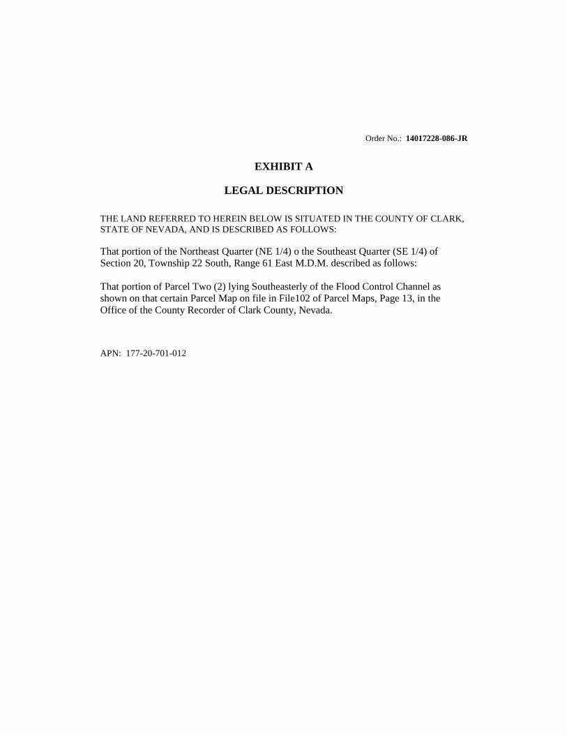
Order No.: 14017228-086-JR
EXHIBIT A
LEGAL DESCRIPTION
THE LAND REFERRED TO HEREIN BELOW IS SITUATED IN THE COUNTY OF CLARK,
STATE OF NEVADA, AND IS DESCRIBED AS FOLLOWS:
That portion of the Northeast Quarter (NE 1/4) o the Southeast Quarter (SE 1/4) of
Section 20, Township 22 South, Range 61 East M.D.M. described as follows:
That portion of Parcel Two (2) lying Southeasterly of the Flood Control Channel as
shown on that certain Parcel Map on file in File102 of Parcel Maps, Page 13, in the
Office of the County Recorder of Clark County, Nevada.
APN: 177-20-701-012
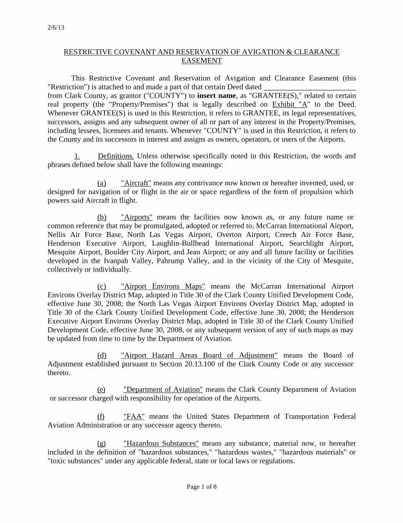
2/6/13
Page 1 of 8
RESTRICTIVE COVENANT AND RESERVATION OF AVIGATION & CLEARANCE
EASEMENT
This Restrictive Covenant and Reservation of Avigation and Clearance Easement (this
"Restriction") is attached to and made a part of that certain Deed dated
from Clark County, as grantor ("COUNTY") to insert name, as "GRANTEE(S)," related to certain
real property (the "Property/Premises") that is legally described on Exhibit "A" to the Deed.
Whenever GRANTEE(S) is used in this Restriction, it refers to GRANTEE, its legal representatives,
successors, assigns and any subsequent owner of all or part of any interest in the Property/Premises,
including lessees, licensees and tenants. Whenever "COUNTY" is used in this Restriction, it refers to
the County and its successors in interest and assigns as owners, operators, or users of the Airports.
1. Definitions. Unless otherwise specifically noted in this Restriction, the words and
phrases defined below shall have the following meanings:
(a) "Aircraft" means any contrivance now known or hereafter invented, used, or
designed for navigation of or flight in the air or space regardless of the form of propulsion which
powers said Aircraft in flight.
(b) "Airports" means the facilities now known as, or any future name or
common reference that may be promulgated, adopted or referred to, McCarran International Airport,
Nellis Air Force Base, North Las Vegas Airport, Overton Airport, Creech Air Force Base,
Henderson Executive Airport, Laughlin-Bullhead International Airport, Searchlight Airport,
Mesquite Airport, Boulder City Airport, and Jean Airport; or any and all future facility or facilities
developed in the Ivanpah Valley, Pahrump Valley, and in the vicinity of the City of Mesquite,
collectively or individually.
(c) "Airport Environs Maps" means the McCarran International Airport
Environs Overlay District Map, adopted in Title 30 of the Clark County Unified Development Code,
effective June 30, 2008; the North Las Vegas Airport Environs Overlay District Map, adopted in
Title 30 of the Clark County Unified Development Code, effective June 30, 2008; the Henderson
Executive Airport Environs Overlay District Map, adopted in Title 30 of the Clark County Unified
Development Code, effective June 30, 2008, or any subsequent version of any of such maps as may
be updated from time to time by the Department of Aviation.
(d) "Airport Hazard Areas Board of Adjustment" means the Board of
Adjustment established pursuant to Section 20.13.100 of the Clark County Code or any successor
thereto.
(e) "Department of Aviation" means the Clark County Department of Aviation
or successor charged with responsibility for operation of the Airports.
(f) "FAA" means the United States Department of Transportation Federal
Aviation Administration or any successor agency thereto.
(g) "Hazardous Substances" means any substance, material now, or hereafter
included in the definition of "hazardous substances," "hazardous wastes," "hazardous materials" or
"toxic substances" under any applicable federal, state or local laws or regulations.
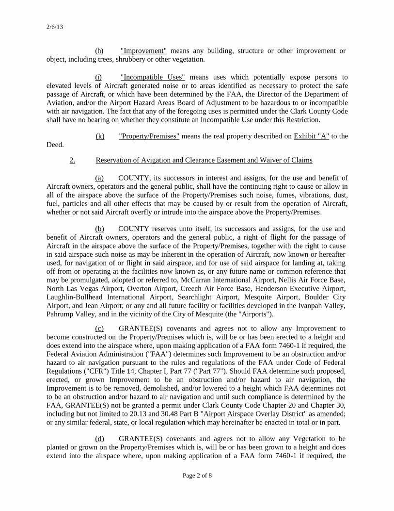
2/6/13
Page 2 of 8
(h) "Improvement" means any building, structure or other improvement or
object, including trees, shrubbery or other vegetation.
(i) "Incompatible Uses" means uses which potentially expose persons to
elevated levels of Aircraft generated noise or to areas identified as necessary to protect the safe
passage of Aircraft, or which have been determined by the FAA, the Director of the Department of
Aviation, and/or the Airport Hazard Areas Board of Adjustment to be hazardous to or incompatible
with air navigation. The fact that any of the foregoing uses is permitted under the Clark County Code
shall have no bearing on whether they constitute an Incompatible Use under this Restriction.
(k) "Property/Premises" means the real property described on Exhibit "A" to the
Deed.
2. Reservation of Avigation and Clearance Easement and Waiver of Claims
(a) COUNTY, its successors in interest and assigns, for the use and benefit of
Aircraft owners, operators and the general public, shall have the continuing right to cause or allow in
all of the airspace above the surface of the Property/Premises such noise, fumes, vibrations, dust,
fuel, particles and all other effects that may be caused by or result from the operation of Aircraft,
whether or not said Aircraft overfly or intrude into the airspace above the Property/Premises.
(b) COUNTY reserves unto itself, its successors and assigns, for the use and
benefit of Aircraft owners, operators and the general public, a right of flight for the passage of
Aircraft in the airspace above the surface of the Property/Premises, together with the right to cause
in said airspace such noise as may be inherent in the operation of Aircraft, now known or hereafter
used, for navigation of or flight in said airspace, and for use of said airspace for landing at, taking
off from or operating at the facilities now known as, or any future name or common reference that
may be promulgated, adopted or referred to, McCarran International Airport, Nellis Air Force Base,
North Las Vegas Airport, Overton Airport, Creech Air Force Base, Henderson Executive Airport,
Laughlin-Bullhead International Airport, Searchlight Airport, Mesquite Airport, Boulder City
Airport, and Jean Airport; or any and all future facility or facilities developed in the Ivanpah Valley,
Pahrump Valley, and in the vicinity of the City of Mesquite (the "Airports").
(c) GRANTEE(S) covenants and agrees not to allow any Improvement to
become constructed on the Property/Premises which is, will be or has been erected to a height and
does extend into the airspace where, upon making application of a FAA form 7460-1 if required, the
Federal Aviation Administration ("FAA") determines such Improvement to be an obstruction and/or
hazard to air navigation pursuant to the rules and regulations of the FAA under Code of Federal
Regulations ("CFR") Title 14, Chapter I, Part 77 ("Part 77"). Should FAA determine such proposed,
erected, or grown Improvement to be an obstruction and/or hazard to air navigation, the
Improvement is to be removed, demolished, and/or lowered to a height which FAA determines not
to be an obstruction and/or hazard to air navigation and until such compliance is determined by the
FAA, GRANTEE(S) not be granted a permit under Clark County Code Chapter 20 and Chapter 30,
including but not limited to 20.13 and 30.48 Part B "Airport Airspace Overlay District" as amended;
or any similar federal, state, or local regulation which may hereinafter be enacted in total or in part.
(d) GRANTEE(S) covenants and agrees not to allow any Vegetation to be
planted or grown on the Property/Premises which is, will be or has been grown to a height and does
extend into the airspace where, upon making application of a FAA form 7460-1 if required, the
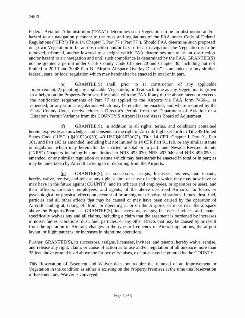
2/6/13
Page 3 of 8
Federal Aviation Administration ("FAA") determines such Vegetation to be an obstruction and/or
hazard to air navigation pursuant to the rules and regulations of the FAA under Code of Federal
Regulations ("CFR") Title 14, Chapter I, Part 77 ("Part 77"). Should FAA determine such proposed
or grown Vegetation to be an obstruction and/or hazard to air navigation, the Vegetation is to be
removed, trimmed, and/or lowered to a height which FAA determines not to be an obstruction
and/or hazard to air navigation and until such compliance is determined by the FAA, GRANTEE(S)
not be granted a permit under Clark County Code Chapter 20 and Chapter 30, including but not
limited to 20.13 and 30.48 Part B "Airport Airspace Overlay District" as amended; or any similar
federal, state, or local regulation which may hereinafter be enacted in total or in part.
(e) GRANTEE(S) shall, prior to 1) construction of any applicable
Improvement; 2) planting any applicable Vegetation; or 3) at such time as any Vegetation is grown
to a height on the Property/Premises; file notice with the FAA if any of the above meets or exceeds
the notification requirements of Part 77 as applied to the Airports via FAA form 7460-1, as
amended, or any similar regulations which may hereinafter be enacted, and where required by the
Clark County Code, receive either a Director's Permit from the Department of Aviation or a
Director's Permit Variance from the COUNTY'S Airport Hazard Areas Board of Adjustment.
(f) GRANTEE(S), in addition to all rights, terms, and conditions contained
herein, expressly acknowledges and consents to the right of Aircraft flight set forth in Title 49 United
States Code ("USC") §40102(a)(30), 49 USC§40103(a)(2), Title 14 CFR, Chapter I, Part 91, Part
101, and Part 103 as amended, including but not limited to 14 CFR Part 91.119, or any similar statute
or regulation which may hereinafter be enacted in total or in part; and Nevada Revised Statute
("NRS") Chapters including but not limited to NRS 493.030, NRS 493.040 and NRS 493.050 as
amended, or any similar regulation or statute which may hereinafter be enacted in total or in part; as
may be undertaken by Aircraft arriving to or departing from the Airports.
(g) GRANTEE(S), its successors, assigns, licensees, invitees, and tenants,
hereby waive, remise, and release any right, claim, or cause of action which they may now have or
may have in the future against COUNTY, and its officers and employees, or operators or users, and
their officers, directors, employees, and agents, of the above described Airports, for losses or
psychological or physical effects on account of or arising out of noise, vibrations, fumes, dust, fuel,
particles and all other effects that may be caused or may have been caused by the operation of
Aircraft landing at, taking off from, or operating at or on the Airports, or in or near the airspace
above the Property/Premises. GRANTEE(S), its successors, assigns, licensees, invitees, and tenants
specifically waives any and all claims, including a claim that the easement is burdened by increases
in noise, fumes, vibrations, dust, fuel, particles, or any other effects that may be caused by or result
from the operation of Aircraft; changes in the type or frequency of Aircraft operations, the airport
layout, or flight patterns; or increases in nighttime operations.
Further, GRANTEE(S), its successors, assigns, licensees, invitees, and tenants, hereby waive, remise,
and release any right, claim, or cause of action as to use and/or regulation of all airspace more than
35 feet above ground level above the Property/Premises, except as may be granted by the COUNTY.
This Reservation of Easement and Waiver does not require the removal of an Improvement or
Vegetation in the condition as either is existing on the Property/Premises at the time this Reservation
of Easement and Waiver is conveyed.

2/6/13
Page 4 of 8
3. Use Restrictions. To ensure that the Property/Premises is developed and used in a
manner that is compatible with the Airports and does not interfere with or inhibit operations or
growth of the Airports, GRANTEE(S) covenants and agrees as follows:
(a) The Property/Premises shall only be used in a manner that is compatible
with uses of the Airports, and must comply with applicable federal, state or local laws or
regulations, including zoning and land use restrictions and conditions. The Property/Premises shall
not be used for Incompatible Uses.
(b) With respect to any Improvement located, to become constructed or to be
located on the Property/Premises, prior to the time, if ever, that all of the Airports shall be abandoned
and shall cease to be used for public airport purposes, GRANTEE(S) covenants and agrees:
(i) to submit to the COUNTY plans showing exterior building finishes,
including but not limited to glass surfaces and exterior lighting, which potentially may make it
difficult for Aircraft pilots to distinguish between airport lights and other lights, produce glare or
reflection which would impair Aircraft pilots landing or taking off at the Airports, impair visibility in
the vicinity of the Airport, or otherwise endanger the landing, take off, or maneuvering of Aircraft.
GRANTEE(S) shall not use, permit or suffer the use of the Property/Premises in such a manner as to
create electrical interference with radio communications to or from any Aircraft or between any
airport installation or navigational aid ("NAVAID") and any Aircraft.
(ii) not to allow any Improvement to become constructed or Vegetation
to be grown on the Property/Premises which encroaches upon or extends into the areas where the
FAA would determine such Improvement or Vegetation would be an obstruction and/or hazardous to
or incompatible with air navigation pursuant to the rules and regulations of the FAA under Code of
Federal Regulations ("CFR") Title 14, Chapter I, Part 77 ("Part 77") and be prohibited or not granted
a permit under Clark County Code Chapter 20 and Chapter 30, including but not limited to 20.13 and
30.48 Part B "Airport Airspace Overlay District" as amended; or any similar federal, state, or local
regulation which may hereinafter be enacted in total or in part.
(iii) not to authorize the construction of any Improvement on the
Property/Premises that attracts or results in the concentration of birds or other wildlife which would
interfere with the safe operation of Aircraft in flight.
(iv) that prior to construction or erection of any applicable Improvement
or Vegetation on the Property/Premises, file notice with the FAA in accordance with the
requirements of Part 77 as applied to the Airports via FAA form 7460-1, as amended, or any similar
regulations which may hereinafter be enacted and, where required by the Clark County Code, receive
either a Director's Permit from the Department of Aviation or a Director's Permit Variance from the
COUNTY'S Airport Hazard Areas Board of Adjustment.
4. Indemnity. To the maximum extent permitted by Nevada law, GRANTEE(S) shall
indemnify, save harmless, and defend the COUNTY, its officers and employees, individually and
collectively, from all damages, fines, liens, suits, claims, demands, actions, reasonable costs of
investigation and litigation, reasonable attorneys' fees and expenses, reasonable consultants' fees and
expenses, and reasonable expert witnesses' fees and expenses, judgments or liability of any kind
arising out of or in any way connected with the use of the Property/Premises, including, without
2/6/13
Page 5 of 8
limitation, (i) the installation, construction, operation, maintenance, or condition of any Improvement
on the Property/Premises and (ii) releases or threatened releases of Hazardous Substances from the
Property/Premises or by GRANTEE(S) on, into, or under land, property and other interests of the
COUNTY.
5. Non-Waiver. No waiver by the COUNTY at any time of any of GRANTEE(S)
obligations under this Restriction shall be deemed or taken as a waiver at any time thereafter of the
same or any other obligation or of the strict and prompt performance thereof. No waiver shall be
valid against the COUNTY unless reduced to writing and authorized by the Board of County
Commissioners, the Airport Hazards Area Board of Adjustment or the Director of the Department of
Aviation.
6. Default. If GRANTEE(S) defaults in or violates the obligations set forth in this
Restriction and fails reasonably to cure such default or violation following reasonable written notice
from the COUNTY, then the COUNTY shall be entitled to exercise any rights or remedies available
at law or in equity or under the express terms of the Deed or this Restriction including injunctive
relief as provided below.
7. Damages Inadequate. GRANTEE(S) acknowledges and agrees that damages as a
result of any default in or violation of any obligation of GRANTEE(S) set forth in this Restriction
are not readily ascertainable, that money damages or other legal relief will not adequately
compensate the COUNTY for any such breach, and, in addition to any entitlement to monetary
damages, that the COUNTY is entitled to injunctive relief compelling the specific performance of
those obligations under the Deed and this Restriction. GRANTEE(S) further acknowledges that the
breach of any of the provisions of the Deed or this Restriction would constitute irreparable harm to
the COUNTY, and GRANTEE(S) hereby waives any defenses to the grant of a temporary
restraining order related to any such breach based on the adequacy of legal remedies.
8. Remedies Cumulative. GRANTEE(S) agrees that COUNTY may pursue all
remedies now or hereafter existing at law or in equity and to enforce the performance and
observance of any obligation of GRANTEE(S) under the Deed or this Restriction. All remedies shall
be cumulative and not exclusive of one another or of statutory remedies not specifically referenced
herein. The exercise of any one or more remedies described above, or of any one or more remedies
existing at law, in equity or by statute, shall not constitute a waiver or election with respect to any
other available remedy. COUNTY'S failure to exercise its remedies reserved herein shall not be
construed to waive any rights COUNTY may have to enforce GRANTEE(S) obligations through
any and all rights and remedies which COUNTY or its successors and assigns may have at law or in
equity for the enforcement of covenants. No delay or omission to exercise any right or power
accruing upon any default shall impair that right or power or shall be construed to be waiver thereof,
but any such right and power may be exercised from time to time and as often as may be deemed
expedient.
9. Changed Circumstances. GRANTEE(S) acknowledges that changes in
circumstances shall not forgive compliance with the terms of this Restriction, except as otherwise
provided in paragraphs 2(a) and 3(b) above with respect to the abandonment and non-use of the
Airports.
10. Termination by GRANTEE(S). The COUNTY may terminate this Restriction or any
specific provision hereof by recording a release in recordable form with directions for delivery of

2/6/13
Page 6 of 8
same to GRANTEE(S) at its last address given pursuant hereto whereupon the obligations described
in such release shall terminate, except for any liabilities incurred prior to the date of such release. For
convenience such instrument may run to "the owner or owners and parties interested" in the
Property/Premises.
11. Severability. In the event any one or more of the provisions contained in the Deed
or this Restriction shall for any reason be held to be invalid, illegal or unenforceable in any respect,
such invalidity, illegality or unenforceability shall not affect any other provision of the Deed or this
Restriction but the Deed and this Restriction shall be construed as if such invalid, illegal or
unenforceable provision had never been contained herein or therein.
12. Covenants Running with the Property/Premises. GRANTEE(S) acknowledges that
the restrictions, easements and reservations contained herein shall be binding on itself, its legal
representatives, assigns and any subsequent owner of all or part of any interest in the
Property/Premises, and shall attach to and run with the Property/Premises. The obligations and
burdens set forth in the foregoing restrictions and reservations shall be enforceable by the COUNTY
against GRANTEE(S) and any future owner(s) of the Property/Premises or any part thereof or
interest therein, including, but not limited to, any lessee, licensee or tenant of the Property/Premises
or any part thereof. The acceptance of the Deed by GRANTEE(S) shall constitute acceptance of the
foregoing restrictions and reservations. GRANTEE(S) expressly agrees that the restrictions and
reservations described herein or attached to the Deed shall be inserted in full in all future deeds of all
or part of the Property/Premises.
13. Captions. The paragraph headings and titles are inserted only as a matter of
convenience and for reference, and in no way define, limit or describe the scope or the intent of any
provision thereof.
14. No Third Party Beneficiaries. The provisions of this Restriction are for the
exclusive benefit of the COUNTY, except as otherwise provided in paragraph 3 with respect to the
FAA, and no person not included within the definition of the term "GRANTEE(S)" or "COUNTY"
(other than the FAA as aforesaid) shall be entitled to the rights and benefits hereof.
15. GRANTEE(S) Certification. The person(s) signing below on behalf of the
GRANTEE(S) hereby certifies, under penalty of perjury, that he or she has been duly authorized to
sign this Restriction on behalf of the GRANTEE(S).

2/6/13
Page 7 of 8
IN WITNESS WHEREOF, the parties hereto have executed this Restriction on the date set
forth beneath their respective signatures below.
GRANTEE:
(insert name) STATE OF NEVADA )
)ss.
COUNTY OF CLARK) BY: _________________________________
On this ____ day of _______________ , 2014 TITLE:
before me, ________________________ a
Notary Public in and for said state, personally
appeared _______________________________
personally known to me to be the person(s) who BY: _________________________________
executed the above instrument, and acknowledged TITLE:
that _________________________________ executed
the same for purposes herein stated.
Notary Public
Notary Statement and/or Seal
2/6/13
Page 8 of 8
COUNTY OF CLARK, A POLITICAL SUBDIVISION OF THE STATE OF NEVADA:
BY: ROSEMARY A. VASSILIADIS
Director of Aviation
APPROVED AS TO FORM:
Steven B. Wolfson
DISTRICT ATTORNEY
BY: E. LEE THOMSON, Chief Deputy
District Attorney
STATE OF NEVADA ) )ss.
COUNTY OF CLARK)
On this ____ day of _______________ , 2014
before me, ________________________ a
Notary Public in and for said state, personally
appeared _______________________________
personally known to me to be the person who
executed the above instrument, and acknowledged
that _________________________________ executed
the same for purposes herein stated.
Notary Public
Notary Statement and/or Seal
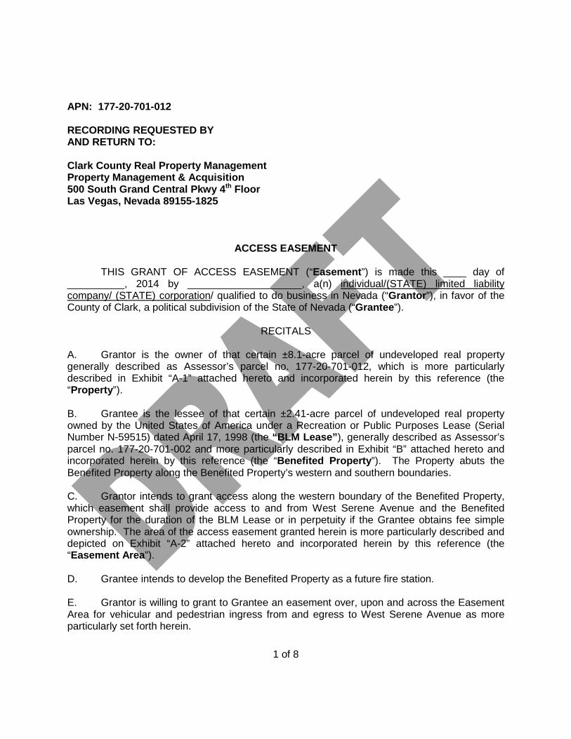
APN: 177-20-701-012
RECORDING REQUESTED BY AND RETURN TO: Clark County Real Property Management Property Management & Acquisition 500 South Grand Central Pkwy 4th Floor Las Vegas, Nevada 89155-1825
ACCESS EASEMENT
THIS GRANT OF ACCESS EASEMENT (“Easement”) is made this ____ day of __________, 2014 by ____________________, a(n) individual/(STATE) limited liability company/ (STATE) corporation/ qualified to do business in Nevada (“Grantor”), in favor of the County of Clark, a political subdivision of the State of Nevada (“Grantee”).
RECITALS
A. Grantor is the owner of that certain ±8.1-acre parcel of undeveloped real property generally described as Assessor’s parcel no. 177-20-701-012, which is more particularly described in Exhibit “A-1” attached hereto and incorporated herein by this reference (the “Property”). B. Grantee is the lessee of that certain ±2.41-acre parcel of undeveloped real property owned by the United States of America under a Recreation or Public Purposes Lease (Serial Number N-59515) dated April 17, 1998 (the “BLM Lease”), generally described as Assessor’s parcel no. 177-20-701-002 and more particularly described in Exhibit “B” attached hereto and incorporated herein by this reference (the “Benefited Property”). The Property abuts the Benefited Property along the Benefited Property’s western and southern boundaries. C. Grantor intends to grant access along the western boundary of the Benefited Property, which easement shall provide access to and from West Serene Avenue and the Benefited Property for the duration of the BLM Lease or in perpetuity if the Grantee obtains fee simple ownership. The area of the access easement granted herein is more particularly described and depicted on Exhibit “A-2” attached hereto and incorporated herein by this reference (the “Easement Area”). D. Grantee intends to develop the Benefited Property as a future fire station. E. Grantor is willing to grant to Grantee an easement over, upon and across the Easement Area for vehicular and pedestrian ingress from and egress to West Serene Avenue as more particularly set forth herein.
1 of 8
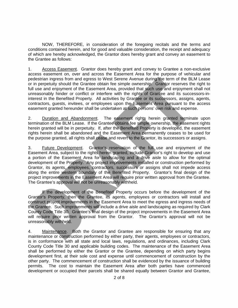
NOW, THEREFORE, in consideration of the foregoing recitals and the terms and conditions contained herein, and for good and valuable consideration, the receipt and adequacy of which are hereby acknowledged, the Grantor does hereby grant and convey an easement to the Grantee as follows: 1. Access Easement. Grantor does hereby grant and convey to Grantee a non-exclusive access easement on, over and across the Easement Area for the purpose of vehicular and pedestrian ingress from and egress to West Serene Avenue during the term of the BLM Lease or in perpetuity should the Grantee obtain fee simple ownership. Grantor reserves the right to full use and enjoyment of the Easement Area, provided that such use and enjoyment shall not unreasonably hinder or conflict or interfere with the rights of Grantee and its successors-in-interest in the Benefited Property. All activities by Grantee or its successors, assigns, agents, contractors, guests, invitees, or employees upon the Easement Area pursuant to the access easement granted hereunder shall be undertaken at such persons’ own risk and expense. 2. Duration and Abandonment. The easement rights herein granted terminate upon termination of the BLM Lease. If the Grantee obtains fee simple ownership, the easement rights herein granted will be in perpetuity. If, after the Benefited Property is developed, the easement rights herein shall be abandoned and the Easement Area permanently ceases to be used for the purpose granted, all rights shall cease and revert to the Grantor, its successors or assigns. 3. Future Development. Grantor’s reservation of the full use and enjoyment of the Easement Area, subject to the rights herein granted, include Grantor’s right to develop and use a portion of the Easement Area for landscaping and a drive aisle to allow for the optimal development of the Property. Any project improvements installed or construction performed by Grantor, its agents, employees, contractors, successors or assigns shall not impede access along the entire western boundary of the Benefited Property. Grantor’s final design of the project improvements in the Easement Area will require prior written approval from the Grantee. The Grantee’s approval will not be unreasonably withheld. If the development of the Benefited Property occurs before the development of the Grantor’s Property, then the Grantee, its agents, employees or contractors will install and construct project improvements in the Easement Area to meet the egress and ingress needs of the Grantee. Such improvements will include a drive aisle and landscaping as required by Clark County Code Title 30. Grantee’s final design of the project improvements in the Easement Area will require prior written approval from the Grantor. The Grantor’s approval will not be unreasonably withheld. 4. Maintenance. Both the Grantor and Grantee are responsible for ensuring that any maintenance or construction performed by either party, their agents, employees or contractors, is in conformance with all state and local laws, regulations, and ordinances, including Clark County Code Title 30 and applicable building codes. The maintenance of the Easement Area shall be performed by either the Grantor or the Grantee, depending on which party begins development first, at their sole cost and expense until commencement of construction by the other party. The commencement of construction shall be evidenced by the issuance of building permits. The cost to maintain the Easement Area after both parties have commenced development or occupied their parcels shall be shared equally between Grantor and Grantee,
2 of 8

subject to limitations in the Local Government Budget and Finance Act, NRS sections 354.470 et seq. and 244.230. 5. Miscellaneous. a. No Public Right or Dedication. Nothing contained in this Easement shall be deemed to be a gift or dedication of all or any part of the Property to the public, or for any public use. b. Successors and Assigns. This Easement shall bind and inure to the benefit of the parties and their respective successors and assigns; and the benefits, covenants, and obligations of the parties contained in this Easement shall be covenants running with the land, benefitting and burdening, as applicable, the Property. c. Exhibits. Each exhibit referred to herein and attached hereto is an integral part of this Easement and is incorporated herein by this reference.
d. Notices. Any notices, consents, offers, acceptances, elections, demands and other communication required or provided by this Easement shall be in writing and shall be deemed to have been made or given only as follows: (a) when hand delivered, (b) one (1) business day after delivery to a nationally recognized overnight courier service for next business day delivery, or (c) when received by confirmed facsimile transmission, in all cases addressed to the parties at their respective addresses as follows:
Grantor: Grantee: Clark County Department of Real Property Management Attn: Jerome A. Stueve, Director 500 S. Grand Central Pkwy, 4th Floor, Las Vegas, NV 89155-1825 The address of each of the Parties shall for all purposes be as set for above, unless otherwise changed by the applicable party by notice to the other as provided herein pursuant to this Section 4(d).
3 of 8
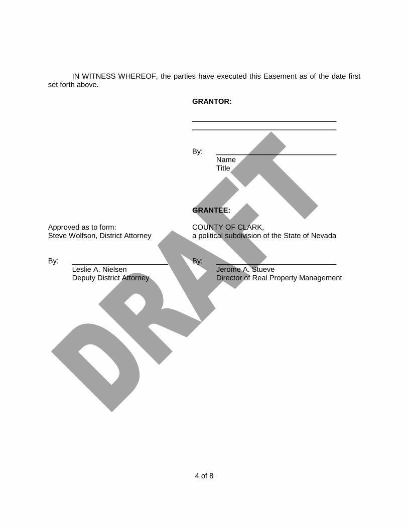
IN WITNESS WHEREOF, the parties have executed this Easement as of the date first set forth above.
GRANTOR:
By:
Name Title
GRANTEE: Approved as to form: COUNTY OF CLARK, Steve Wolfson, District Attorney a political subdivision of the State of Nevada By: By:
Leslie A. Nielsen Jerome A. Stueve Deputy District Attorney Director of Real Property Management
4 of 8
STATE OF ) ) COUNTY OF ) On this day of , 20 , before me appeared , to me known to be the person described in and who executed the foregoing instrument, as the of , and acknowledged that he/she executed the same as the free act and deed of said and is acting for and on behalf of said . IN TESTIMONY WHEREOF, I have hereunto set my hand and affixed my official seal in the County and State aforesaid on the day and year first above written. Printed Name: Notary Public in and for said State My commission expires: STATE OF NEVADA ) ) COUNTY OF CLARK ) On this day of , 20 , before me appeared Jerome A. Stueve, to me known to be the person described in and who executed the foregoing instrument, as the Director of Real Property Management for the County of Clark, a political subdivision of the State of Nevada, and acknowledged that he executed the same as the free act and deed and on behalf of said County. IN TESTIMONY WHEREOF, I have hereunto set my hand and affixed my official seal in the County and State aforesaid on the day and year first above written. Printed Name: Notary Public in and for said State My commission expires:
5 of 8

EXHIBIT “A-1”
Description of the Property
(See Attached)
6 of 8
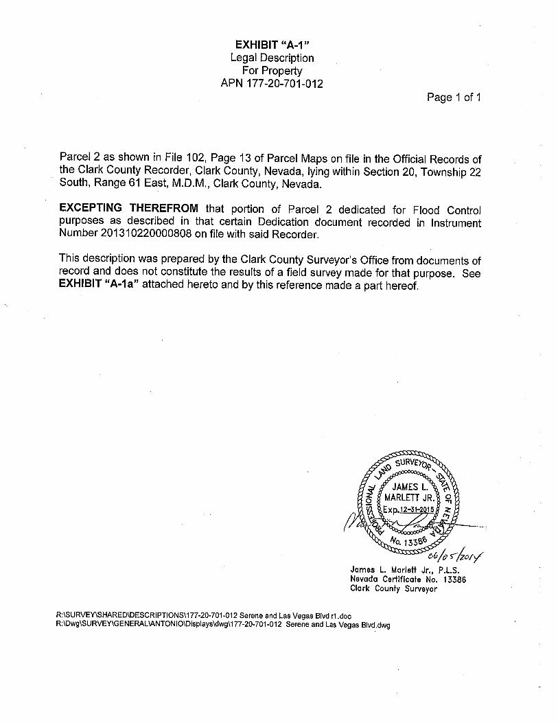

EXHIBIT “A-2”
Description of the Easement Area
(See Attached)
7 of 8

EXHIBIT “B”
Description of the Benefited Property
THE LAND REFERRED TO HEREIN BELOW IS SITUATED IN THE COUNTY OF CLARK, STATE OF NEVADA, AND IS DESCRIBED AS FOLLOWS: The Northeast Quarter (NE 1/4) of the Northeast Quarter (NE 1/4) of Northeast Quarter (NE 1/4) of the Southeast Quarter (SE 1/4) of Section 20, Township 22 South, Range 61 East M.D.M. Assessor’s Parcel Number: 177-20-701-002
8 of 8

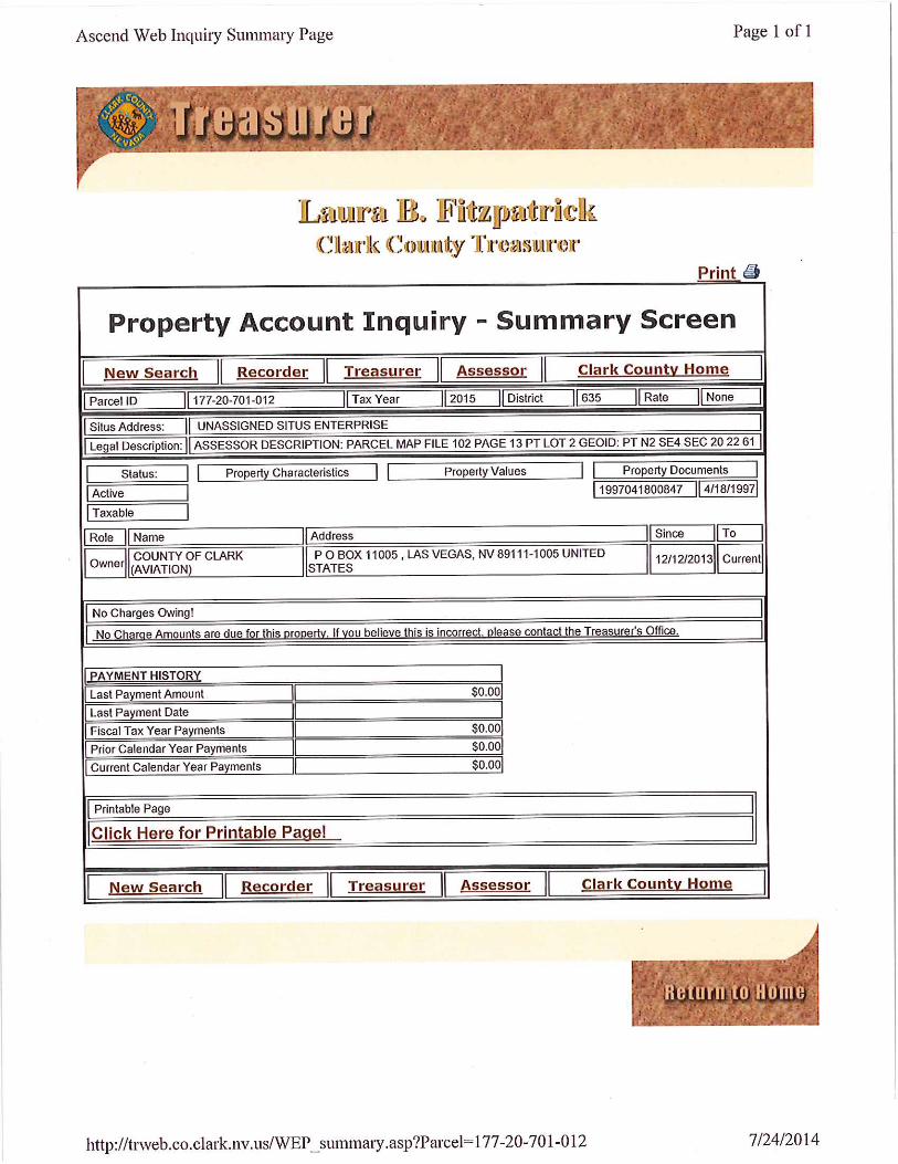
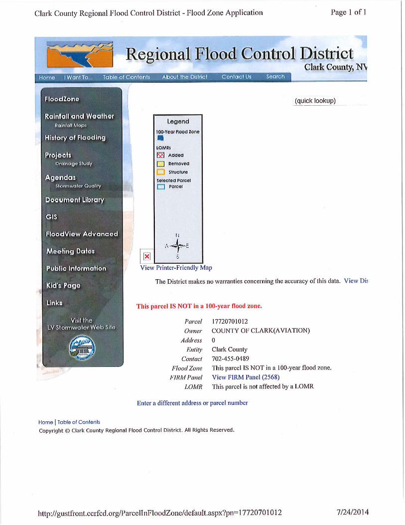

ADDENDUM E
SALE UNIT 15 CONSISTING OF APN 177-20-701-012
ADDENDUM