an aerial survey of caribou on - environment … aerial survey of caribou on western victoria island...
TRANSCRIPT

AN AERIAL SURVEY OF CARIBOU ON
WESTERN VICTORIA ISLAND (5–17 JUNE 1994)
JOHN S. NISHI
AND
LAURIE BUCKLAND
DEPARTMENT OF RESOURCES, WILDLIFE, AND ECONOMIC DEVELOPMENT
GOVERNMENT OF THE NORTHWEST TERRITORIES
1KUGLUKTUK, NT. X0E 0E0
2YELLOWKNIFE, NT. X1A 3S8
2000
FILE REPORT NO. 128

iii
ABSTRACT
Concerns over the sharp decline in numbers of the Minto Inlet caribou herd on northwest Victoria Island and increased hunting pressure on the Dolphin and Union caribou herd on southwestern Victoria Island prompted a survey of western Victoria Island. We used two fixed-wing aircraft and flew a systematic strip transect survey of western Victoria Island in June 1994. Our objectives were two-fold: 1) to determine the abundance of caribou in northwest Victoria Island (Minto Inlet calving area), and 2) to delineate the calving distribution of caribou on southwestern Victoria Island (Dolphin and Union calving area), re-survey any high density areas, and estimate population size based on the calving ground survey. We conducted the survey from 5–16 June 1994. The area surveyed was 138 185 km² in size and accounted for ca. 63% of the entire land area of Victoria Island. We estimated a total of 14 539 ± 1015 (SE) caribou on western Victoria Island at an overall density of 0.11 caribou / km2. Although our survey area included the entire known seasonal range of the Minto Inlet herd, we only observed 4 caribou on-transect in that area. Our results corroborated previous aerial surveys (March 1992, March 1993 and June 1993) where few caribou were observed and added confirmation to the decline of the Minto Inlet herd. We were unable to delineate the entire calving distribution of the Dolphin and Union herd. Calves and caribou were dispersed over a large, extensive area on south central Victoria Island. Unsystematic surveys and opportunistic observations of radio-collared caribou cows on 17 June 1994, confirmed that caribou were also extensively distributed throughout eastern Victoria Island. Given the large area and uniformly low densities of animals on the calving grounds of the Dolphin and Union herd, we suggest that the calving ground survey technique is not a logistically practical method of determining abundance of caribou on Victoria Island. An alternative survey technique to consider is an aerial survey of the fall rut distribution when all age and sex classes are intermixed and caribou aggregate into relatively higher densities along the southern coastline prior to their fall migration to the mainland.

v
TABLE OF CONTENTS
ABSTRACT.........................................................................................................iii
LIST OF FIGURES ............................................................................................vii
LIST OF TABLES............................................................................................... ix
INTRODUCTION ................................................................................................ 1
STUDY AREA................................................................................................... 11
METHODS........................................................................................................ 16
RESULTS ......................................................................................................... 26
DISCUSSION.................................................................................................... 42
ACKNOWLEDGEMENTS ................................................................................. 55
PERSONAL COMMUNICATIONS.................................................................... 56
LITERATURE CITED........................................................................................ 57
APPENDIX A. Chronology of Victoria Island caribou management issues, 1987-1994..........................................................................................63
APPENDIX B. Daily flight log of Cessna 185 on wheel skis, Victoria Island, June 1994..........................................................................................66
APPENDIX C. Daily flight log of Helio-Courier H-295 on tundra tires, Victoria Island, June 1994. .................................................................... 67
APPENDIX D. Summary of transects flown and caribou observed during an aerial survey of Victoria Island, 5–17 June 1994. ..................... 69
APPENDIX E. Daily weather conditions for aerial survey of Victoria Island, June 1994..........................................................................................70

vi
APPENDIX F. Caribou observed on transect during an aerial survey of western Victoria Island, 5–16 June 1994................................................ 71
APPENDIX G. Caribou observed off transect during an aerial survey of western Victoria Island, 5–16 June 1994................................................ 79
APPENDIX H. Observations of caribou during low-level reconnaissance flights of eastern Victoria Island, 17 June 1994....................................... 86

vii
LIST OF FIGURES
Figure 1. Place names and locations on Victoria Island, Canada ................... 12
Figure 2. Stratum boundaries and transect lines for an aerial survey of western Victoria Island, 5–14 June 1994....................................................... 17
Figure 3. Caribou observed on transect during an aerial survey of western Victoria Island, 5–14 June 1994....................................................... 21
Figure 4. Caribou observed off transect during an aerial survey of western Victoria Island, 5–14 June 1994....................................................... 22
Figure 5. Strata and transect lines for an aerial survey of the Shaler Mountains, on northern Victoria Island, 15–16 June 1994 ................................. 23
Figure 6. Observed densities of caribou (> 1 year old) from a systematic survey of western Victoria Island, 5–14 June 1994 ..................................... 28
Figure 7. Observed densities of caribou (> 1 year old) from a systematic survey of the Shaler Mountains on Victoria Island, 15–16 June 1994......... 31
Figure 8. Kruskal Wallis one-way analysis of variance between on-transect observations of calf caribou and associated densities of non-calf caribou............................................................................................. 32
Figure 9. Frequency distribution of caribou group size during aerial surveys of Victoria Island in June 1994............................................................. 33
Figure 10. Antlered caribou cows with and without newborn calves observed during an unsystematic reconnaissance survey of eastern Victoria Island, 17 June 1994 ....................................................................... 38
Figure 11. Antlerless caribou cows with calves observed during an unsystematic reconnaissance survey of eastern Victoria Island, 17 June 1994 .... 39
Figure 12. Antlerless caribou cows observed during an unsystematic reconnaissance survey of eastern Victoria Island, 17 June 1994 .... 40

viii
Figure 13. Bulls and yearling caribou observed during an unsystematic reconnaissance survey of eastern Victoria Island, 17 June 1994 .... 41
Figure 14. Flight lines and locations of seven radio-collared caribou cows on Victoria Island, 17 and 18 June 1994............................................... 50

ix
LIST OF TABLES
Table 1. Summary of field studies on arctic-island caribou, Victoria Island, 1994 – 1999................................................................................................ 8
Table 2. General climatic characteristics of Victoria Island (from Maxwell 1980 and 1981)......................................................................................... 15
Table 3. Analysis of data from an aerial survey of caribou (Rangifer tarandus) on western Victoria Island, 5–16 June 1994 ......................................... 27
Table 4. Calf and non-calf caribou observed during aerial surveys of Victoria Island, 5–17 June 1994. .................................................................. 30
Table 5. Comparisons between left and right observers using a two-tailed Wilcoxon signed ranks test. ............................................................. 34
Table 6. Sex and age composition of Victoria Island caribou observed during a low-level reconnaissance flight of eastern Victoria Island, 17 June 1994.................................................................................................36
Table 7. Observations of radio-collared female caribou, Victoria Island, June 1994.................................................................................................49

1
INTRODUCTION
Arctic-island caribou (Rangifer tarandus) on northwest Victoria Island (i.e.
the Minto Inlet herd) declined sharply in the early 1990s (Heard 1992, Gunn in
prep.), and in April 1993, the Olokhaktomiut Hunters and Trappers Committee
(OHTC) in Holman self-imposed a 5-year hunting moratorium for the area north
of Minto Inlet (see Appendix A). Because of the hunting moratorium, there was
concern that Holman hunters would shift their efforts to the south, thereby
increasing the harvest of the Dolphin and Union caribou herd (as defined by
Gunn and Fournier’s (2000) satellite telemetry).
By 1991, arctic-island caribou on Victoria Island had been classified as
“threatened” by the Committee on the Status of Endangered Wildlife in Canada
(COSEWIC). This classification was based on concerns (see Miller 1990) about
the level of harvesting compared to the only available population estimate at the
time (Jakimchuk and Carruthers 1980). Furthermore, Dolphin and Union caribou
were resuming a traditional migration across Coronation Gulf and Dease Strait to
overwinter on the mainland (Gunn et al. 1997a) and were becoming more
accessible to hunters from Kugluktuk, Umingmaktok and Bathurst Inlet.
Concomitant with the concern of increased hunting was a concern over
increased mortality of Dolphin and Union caribou associated with drownings
during the fall migration to the mainland and the potential effects of proposed
ship traffic through he Dolphin and Union Strait (Nunavut Planning Commission
1998).

2
Population estimates for the Minto Inlet herd and the Dolphin and Union
herd were required to evaluate the hunting moratorium on the former, and the
estimated harvest of the latter1. Concerns about the extent of decline in the
Minto Inlet herd prompted the OHTC and the Wildlife Management Advisory
Council-NWT (WMAC) to request an aerial survey of its entire annual range
(Appendix A). The potential for increased hunting and mortality of Dolphin and
Union caribou, combined with an outdated population estimate, prompted the
Department of Renewable Resources (DRR)2 to extend the survey, proposed for
June 1994, to include southwestern Victoria Island. Objectives for the June 1994
survey were:
1) to determine abundance of caribou in northwest Victoria Island by
covering the calving area and known annual distribution of the Minto
Inlet herd; and
2) to delineate the calving distribution of Dolphin and Union caribou on
southwestern Victoria Island, re-survey any high density areas, and
estimate population size based on the calving ground survey.
1 A fundamental part of the strategy for managing the harvest of caribou in Nunavut and the Northwest Territories is to monitor trend of herd size and ascribe harvest mortalities to those individual herds (see Graf and Heard 1990, Gunn 1998). 2 DRR is now the Department of Resources, Wildlife and Economic Development.

3
Review of Caribou Surveys on Victoria Island
The earliest recorded information on Victoria Island caribou dates back to
observations by explorers in the early 1850s and again in the early 1900s (see
review in Manning 1960, pp. 7–11). Those early observations suggested that
there was a migratory and a resident population of caribou on Victoria Island.
Manning (1960) referred to the former as the Dolphin and Union Strait herd and
guessed that 100 000 caribou was a reasonable estimate for that herd; he
predicated this estimate on explorers’ observations of caribou densities during
spring and fall migrations and extrapolated to the size of Victoria Island.
Manning (1960, p.9) also speculated that approximately 8000–9000 caribou were
resident on Victoria Island. Using various anthropological and wildlife sources
(i.e. elders and hunters), Gunn (1991) sketched a tenable picture of a nadir in
abundance of Victoria Island caribou and muskoxen between the 1920s and
1930s and a subsequent recovery in the 1970s (Gunn et al. 1997a). Although
Manning (1960) argued strongly that over-hunting was the cause of the decline
and near extirpation of the Dolphin and Union Strait herd, Gunn (1991) has
suggested that severe winters may have also played an important role.
The first attempt at compiling observations of caribou and muskoxen on
Victoria Island using an aircraft was co-ordinated by Macpherson (1961) in
conjunction with a geological airborne survey of the western Arctic Islands in the
summers of 1958–59 (Thorsteinsson and Tozer 1962). Macpherson (1961)
compiled observations by geologists on Victoria Island and estimated 670

4
caribou from observed caribou densities on 18 500 km of transects. Macpherson
(1961) reported an average transect width of 540 m, with most of the individual
flights occurring at elevations of between 30 and 150 m above ground level.
After Macpherson’s (1961) initial efforts, Spencer (1976) and Boxer (1979,
1980) recorded observations of caribou while conducting reconnaissance
surveys for muskoxen in the vicinity of Holman and Cambridge Bay in the 1970s.
However, it was not until August 1980 that Jakimchuk and Carruthers (1980)
used a DHC-2 Turbo Beaver to fly the first systematic aerial survey of Victoria
Island to determine distribution and abundance of caribou and muskoxen on an
island-wide basis. Jakimchuk and Carruthers (1980) flew the survey as part of
an environmental assessment for the proposed Polar Gas Project. They divided
Victoria Island into four strata: three strata in the west were flown at 6.25%
coverage and a stratum in the southeast was surveyed at 3.13% coverage.
Because of inclement weather, they did not fly northeast Victoria Island
(Storkerson Peninsula). Jakimchuk and Carruthers (1980) estimated a total of
7936 ∀ 1118 (Standard Error) caribou on Victoria Island.
Subsequent survey efforts then shifted to describe pre-calving and calving
distributions. In response to potential shipping activities and the possibility that
there was an inter-island population of caribou that calved and summered on
eastern Banks Island and then wintered on northwest Victoria Island, Miller
(1986) conducted unsystematic helicopter flights in March 1985 to determine
whether caribou migrated across the sea ice of Prince of Wales Strait. Miller

5
(1986) did not observe conclusive evidence to suggest an inter-island migration,
and extended his search inland on Victoria Island (and Banks Island) to locate
calving caribou. On Victoria Island, Miller (1986) found a coastal concentration of
caribou (mostly bulls, juveniles, and yearlings) centered on the Deans Dundas
Bay area, but was unable to find evidence for a caribou calving ground within his
search area of northwest Victoria Island (i.e. Prince Albert and Diamond Jenness
peninsulas). He proposed three possible explanations: 1) the breeding females
he observed in the “Jesse Bay calving area” on Banks Island were the missing
female segment of the northwestern Victoria Island caribou herd; 2) the calving
area for northwestern Victoria Island caribou was actually further east or south on
Victoria Island; or 3) his limited search effort was not adequate and he failed to
find the calving area (Miller 1986, p. 18).
From 1987–89, Gunn and Fournier (2000) conducted a study to determine
the number of caribou herds on Victoria Island and their pattern of seasonal
movements. They used ten satellite transmitters to locate areas used by adult
cows during calving and rutting, and flew aerial surveys to visually confirm
whether collared cows had calved. From this work, Gunn and Fournier (2000)
showed that there were two distinct areas of calving and rutting on western
Victoria Island. One calving area was found north of Minto Inlet and the other
was located south and east of Prince Albert Sound. Collared cows used similarly
discrete rutting areas. This corroborated local knowledge of hunters in Holman
and Cambridge Bay and suggested that there were two separate herds on

6
western Victoria Island. An aerial survey of northwest Victoria Island in June
1987 resulted in an estimate of 643 ∀ 132 (SE) but delineation of the southern
and northern extent of the calving area was incomplete (Gunn and Fournier
2000). A subsequent survey in June 1988 was hampered by inclement weather
and was not completed (Gunn and Fournier 2000).
Aerial surveys of northwest Victoria Island were flown again in March 1992,
March 1993, and June 1993 (Heard 1992, Gunn in prep.). The rationale for the
March 1992 survey (Heard 1992) was twofold. First, the community of Holman
was concerned that caribou were scarce in the previous two winters and second,
an evaluation of muskox distribution was needed to plan and monitor the effects
of a proposed commercial muskox harvest. From 24–27 March 1992, Heard
(1992) surveyed an area that included the area surrounding the eastern two
thirds of Minto Inlet; the southern extent was the north shore of Prince Albert
Sound and the northern extent was approximately 72 degrees north. From his
observations of 26 caribou in 8 groups, Heard (1992) estimated 170 ∀ 54
caribou. In 1993, Gunn (in prep.) repeated the survey on 18–20 March using
similar methodology to her June 1987 survey and estimated 144 ∀ 22 caribou.
Three months later (13–15 June), Morrison (Gunn in prep.) flew an extensive
survey of Prince Albert Peninsula that included the known seasonal distribution of
caribou in northwest Victoria Island and counted only 15 caribou and 1 calf on
2114 km of transects. Those aerial surveys confirmed the rapid decline of
caribou on northwest Victoria Island (Gunn in prep.).

7
Although the impetus for the June 1994 survey was a request by the OHTC
and WMAC to re-evaluate distribution and abundance of caribou in northwest
Victoria Island, the aerial survey of western Victoria Island was also designed as
part of a larger research program, conceived jointly by DRR and WMAC in
October 1993. The research program (DRR 1993) principally consisted of
determining population trend through aerial surveys and estimating hunter-kills
through a caribou harvest study.
An effective technique of estimating herd size is a prerequisite for
determining population trend; the research program was based on the premise
that the calving ground survey technique could be effectively used to monitor
trends of Dolphin and Union caribou. As a result, a radio-collaring project was
also initiated in 1994 to improve our knowledge of calving grounds on Victoria
Island (Nishi 2000).
In this report, we present results from the systematic aerial survey of
caribou (Rangifer tarandus) on western Victoria Island in June 1994. Although 6
years have passed since completion of this survey, results have been presented
and discussed with wildlife management boards and Hunters and Trappers
Committees / Organizations. We also recognise that additional studies have
occurred during this time (Table 1) and refer to them in the discussion.

8
Table 1. Summary of field studies on arctic-island caribou, Victoria Island, 1994 – 1999.
Timing Researcher Survey area Type
Jun. 1994
Nishi & Buckland (this report)
Caribou on western Victoria Island
Systematic aerial survey
Apr. 1994-Oct. 1997
Nishi (2000)
Dolphin & Union caribou on Victoria Island
VHF radio telemetry (20 cows collared April 1994)
Jul. 1996-1998
WMC International Ltd. (unpubl. data)
Caribou in the Shaler Mountains
Satellite telemetry (4 cows collared July 1996)
Oct. 1997
Nishi and Gunn (in prep)
Dolphin & Union caribou during the rut
Stratified systematic aerial survey
Jul. 1998
Nagy (unpubl. data)
Northwest Victoria Island
Systematic aerial survey
Oct. 1999 & ongoing
Patterson (pers. comm.)
Seasonal movements and mortality of Dolphin and Union caribou
Satellite telemetry (25 cows collared Oct. 1999)
Rationale for Design of Caribou Surveys
Effective survey techniques for caribou are based on a good understanding
of the life history and seasonal migration patterns of the herd of interest. With
insular herds where ingress and egress are assumed to be minimal, as on
Banks, Southampton, and Coats islands, the approach has been to conduct
aerial surveys of the entire island (Gates et al. 1986, Nagy et al. 1996, Heard and
Ouellet 1994). With Peary and arctic-island caribou herds that migrate between
islands, i.e. the Western Queen Elizabeth Islands and the Prince of Wales Island-
Somerset Island-Boothia Peninsula Complex, biologists have surveyed entire
island complexes (Miller et al. 1977, Gunn and Dragon 1998). With mainland

9
herds of barren-ground caribou, the technique of choice has been aerial
photographic surveys of calving grounds (Heard 1985, Williams 1994) or
alternatively post-calving aggregations (Valkenburg et al. 1985, Russell et al.
1996). The prevailing theme in the design of these surveys is an integration of
technical and biological considerations that improve the precision and accuracy
of the estimate. Stratification of survey effort (Siniff and Skoog 1964, Heard
1987) and aerial photography (Russell et al. 1996) are two technical tools
frequently used to improve precision and accuracy of caribou surveys,
respectively.
Our knowledge of traditional calving grounds (Gunn and Miller 1986) has
been a useful model, at a broad landscape level, for describing the likelihood of
pregnant female caribou using the same areas for calving (Heard and Stenhouse
1992, but see Valkenburg and Davis 1986). This conceptual model of fidelity of
parturient cows to a calving area also provides our current rationale for ascribing
herd identity (Kelsall 1968, Thomas 1969). It is a good example of how our
biological understanding has led to an efficient and repeatable survey technique
for estimating numbers of breeding females on an annual calving ground (Heard
1985).
Similarly, the observed response of barren-ground caribou to biting insects
has allowed biologists to design aerial photographic surveys of post-calving
aggregations in summer (Valkenburg et al. 1985, Russell et al. 1996). Although
there is debate on the merits of the two census methods (Thomas 1998), an
10
understanding of seasonal movements and behaviour of caribou is a prerequisite
for both survey techniques. Most recently, biologists have used radio collars
(satellite and/or VHF transmitters) to improve the design and execution of aerial
photo-censuses of annual calving grounds (Gunn et al. 1997b) and post-calving
aggregations (Valkenburg et al. 1985, Russell et al. 1996, Nagy pers. comm.).

11
STUDY AREA
Victoria Island is the third largest island in the Canadian Arctic and has a
total land area of ca. 220 574 km2 (Figure 1). Owing to its size, there are regional
patterns in geology (Fyles 1963, Thorsteinsson and Tozer 1962), vegetation
(Bliss 1981, Edlund 1983), and climate (Maxwell 1981) on Victoria Island.
Vegetation
Edlund (1983) described three broad arctic ecosystems (Low, Mid, and High
Arctic) that occur on western Victoria Island. She described the progression from
Low to High Arctic ecosystems as characterized by a decrease in species
diversity and percent plant cover, and by major changes in the life form of the
plant communities, i.e. from erect and semi-erect shrubs to recumbent dwarf
shrubs.
Edlund (1983) characterized the northern coast and higher elevations in the
Shaler Mountains, Prince Albert Peninsula, and Diamond Jenness Peninsula as
inclusive to the High Arctic ecosystem. She found flora of this ecosystem to be
the least diverse (less than 100 vascular species); continuous plant cover was
limited by moisture and consequently restricted to lower slopes and wetlands.
Excluding lower wet areas, vascular plant communities were dominated by dwarf
shrubs (less than 25% cover): mountain avens (Dryas integrifolia) were

68°
69°
70°
71°
72°
73°
105°110°115°
km 10 0 100 km
Figure 1. Place names and locations on Victoria Island, Canada.
Lambert Conformal Conic Projection
Dolphin and Union Strait
P A R R Y C H A N N E L
Cape Copenhagen
NORTHWESTTERRITORIES
NUNAVUT
12

13
dominant, with Arctic willow (Salix arctica) being common. Wet sedge meadows
were relatively low in graminoid abundance and general diversity.
Edlund (1983) described the Mid Arctic ecosystem as occurring on central
Prince Albert Peninsula, at moderate elevations in the Shaler Mountains and on
Diamond Jenness Peninsula, and in a small area of northern Wollaston
Peninsula. The Mid Arctic ecosystem was intermediate in plant species diversity
with less than 150 species described (Edlund 1983). Dwarf shrubs, particularly
Dryas spp., dominated all but the wettest areas. The woody component of
wetlands consisted of prostate shrubs, mostly Salix arctica. However, Cassiope
spp. was found in sheltered sites.
Edlund (1983) described the Low Arctic ecosystem on Wollaston Peninsula
and northwards along the coast to southern Prince Albert Peninsula. The flora
was richest in diversity with up to 200 vascular species identified. Dryas spp.
was a major component of communities that had nearly continuous ground
cover. Arctic willow was a common dwarf shrub associate, with herbaceous
associates including a variety of legumes, forbs, and graminoids. The shrub
component of wetlands included several dwarf shrub species as well as thickets
of erect shrubs, commonly willows. Dwarf birch (Betula spp.) also occured in
sheltered locations. The presence of sites with tree-sized willows (Salix spp.)
ranging from 1–5 m high (depending on species) in the Minto Inlet area was a
unique and unusual feature of this Low Arctic ecosystem (Edlund 1983, p.77).

14
Climate
In her comprehensive review of climate of the Canadian Arctic Islands,
Maxwell (1981) identified five climatic regions and showed that Victoria Island
was covered by three of those five regions. Climatic characteristics in northern
Victoria Island are influenced predominantly by the Arctic Ocean (Table 2).
However, as Parry and M’Clintock Channels are dominated by multi-year ice, the
maritime effect is reduced to the extent that mean annual temperature range is
still very high (38-40°C) (Maxwell 1981).
The climate in central and eastern Victoria Island possesses many
characteristics of the continental regime of the adjacent mainland. This is due to
the massive size and proximity of adjacent land areas and the fact that inter-
island waterways are narrow and shallow (Maxwell 1981). This region of the
island has very low precipitation amounts with a large mean annual temperature
range (42-45°C) (Maxwell 1981).
The climate in western Victoria Island is mainly influenced by maritime air
masses moving into the Mackenzie Valley and southern Beaufort Sea from the
west (Maxwell 1981). Although northwest Victoria Island is considered a polar
semi-desert (Bliss 1981), the southwest coast of Victoria Island receives
increased amounts of net radiation with more precipitation and cloudiness due to
the maritime influences (Maxwell 1981). The mean annual temperature range is
36°C and summer conditions are relatively warmer (Table 2).

15
Table 2. General climatic characteristics of Victoria Island (from Maxwell 1980 and 1981).
Region Wintera (B: Begins E: Ends)
Mean annualbthawing
degree-days
Mean annualc growing
degree-days Northwestern – Western Parry Channel (Ia)
B: Aug 20-25 E: June 10-25
400-600 50-100
South-central – Victoria Island-Boothia Peninsula (IIa)
B: Aug 25- Sep 15 E: June 5-15
500-600+ 100-200+
Western (III) B: Aug 30- Sept 5
E: May25 500-600 100-200
a Winter is defined as time when mean daily temperature is below 0°C. b Mean annual totals of degree-days above 0°C based on the period 1941-1970. A degree-day is defined as a unit of measurement equal to a difference of one degree between the mean outdoor temperature on a certain day and a reference temperature. c Mean annual totals of degree-days above 5°C based on the period 1941-1970 (an indicator of total heat available for plants in the growing season).
16
METHODS
A Systematic Survey of Western Victoria Island
We largely based our survey design on available summaries of the 1987–88
satellite telemetry data since Gunn and Fournier’s (2000) aerial survey results
from June 1987 and 1988 were unavailable to us prior to the survey (A. Gunn
was away from Canada). We delineated western Victoria Island into five strata
(Figure 2) based on general topography of the island and expected distribution of
calving caribou. Stratum II included the calving area south and southeast of
Prince Albert Sound (Figure 4 in Gunn and Fournier 2000). Stratum IV was
delineated to include the calving area and known annual range of the Minto Inlet
herd (Gunn and Fournier 2000). We used Universal Transverse Mercator (UTM)
gridlines to space transects at 10-km intervals, which was 10% coverage of the
survey area, and we applied uniform coverage in all strata. To reduce sampling
bias, we oriented transects such that they were perpendicular to major rivers and
drainage valleys.
The large size of the survey area necessitated the use of two aircraft: a
Helio-Courier H-295 on tundra tires and a Cessna 185 on wheel-skis. For both
aircraft, we used a total strip width of 1000 m (500 m per side). Survey altitude
and speed were 120 m above ground level and 140–160 km per hour (km/h),
respectively. We positioned transect markers on the aircraft using the method
outlined by Norton-Griffiths (1978). On the Helio-Courier, we attached a length

17
CambridgeBay
Holman
69°
70°
71°
72°
73°
105°110°115°
km 10 0 100 kmLambert Conformal Conic Projection 68°
31292725232119171533312927252321191733
3 5 7 9 1113
15 171
1
3
57
911
1315
17
19
21
13
5
79
13
15
19
11
17
21
2725 312725 33
1 3
57 9 11 13 15
1
3 5 7 9 11 13 15 17 19 21 23 3529
STRATUM IV
STRATUM II
STRATUM III
STRATUM I
STRATUM V
Figure 2. Stratum boundaries and transect lines for an aerial survey of western Victoria Island, 5-14 June 1994 (note: only odd-numbered transects are labelled for display here).

18
of nylon cord from an eyebolt on the underside of each wing to a bracket on the
fuselage behind and below the rear doors. A short length of black tape was
wrapped around each cord to visually delineate the outer boundary of the strip
transect. On the Cessna 185, we marked the outer transect boundaries with a
30-cm length of wooden doweling (7-mm diameter) attached to each of the wing
struts. We verified strip width from the air using the runway at the Kugluktuk and
Holman airports by positioning a half-ton truck or empty fuel drum 500 m from
one end of the runway. We checked the transect markers against the known
distance on the ground by flying perpendicularly to the runway axis at survey
altitude.
In the Helio-Courier, all observations of caribou and muskoxen were plotted
on 1:250 000 scale maps by the pilot-navigator, and recorded on data sheets by
the right observer. Observers in the Cessna called out their observations into the
intercom system and micro-cassette recorders. The navigator plotted all muskox
and caribou observations on 1:250 000 scale maps, and recorded those
observations on data sheets. At the end of each day, cassette recordings were
played back to verify hand-recorded data. Distribution and abundance of
muskoxen will be described in a separate report.
Both crews left Kugluktuk on 5 June to start surveying their respective strata
(Appendices B and C). The survey crew in the Helio-Courier consisted of a pilot-
navigator (P. Linton), right observer (L. Buckland), and left observer (J.
Kuneyuna). That crew surveyed northwest Victoria Island (strata III, IV, and V)

19
(Figure 2) and was based out of Holman and a cabin at Wynniatt Bay (DRR,
Polar Bear Project). The general order of strata flown by the Helio-Courier was
stratum IV, V, and then III (Appendix D). Variable weather (Appendix E) in the
survey area required that transects 16–20 in stratum IV and transects 13–17 in
stratum V be flown in western and eastern portions.
The second survey crew used the Cessna 185 to survey the southwest
region of the island (strata I, II, and III) (Figure 2). Crewmembers included a pilot
(K. Williams), navigator (J. Nishi), right observer (K. Niptanatiak with J. Nishi as
alternate), and left observer (P. Panegyuk). That crew was based out of
Kugluktuk and an outpost camp at Read Island (Figure 1). The general order of
surveying was stratum II, I, and then the eastern portion of stratum III (Appendix
D). Because of variable weather (Appendix E) and poor visibility on transects 17,
18, and 30 in stratum II, those transects were re-flown in subsequent days. To
extend the survey area and better delineate the eastern distribution of calving
caribou in the southern strata, we added two and four additional transect lines to
strata I (transects 16 & 17) and II (transects 30–33), respectively (Figure 2).
Upon completion of strata I and II, and transects 27–35 in stratum III, the Cessna
crew worked out of Holman to assist the Helio-Courier crew in the completion of
stratum III.
Strata I–V were completed on 14 June and both aircraft subsequently flew
to Kugluktuk, with the Cessna 185 then returning to Norman Wells. Upon
completion of those five strata, our initial assessment of survey observations

20
showed a clumped distribution of caribou and the presence of calves in the
Shaler Mountains. Observations also suggested that there was a break in
distribution of caribou south of the Kuujjua River in the northern portion of
stratum III (Figures 3 and 4).
To sample this distribution of cows and calves and to improve precision of
the estimate, we delineated and surveyed two additional strata, VI and VII
(Figure 5), in the Shaler Mountains within stratum V. We surveyed those two
additional strata on 15 and 16 June with the Helio-Courier and a three-person
crew: pilot-navigator (P. Linton), left observer (L. Buckland), and right observer
(J. Nishi). We spaced the transects at 3-km intervals and flew at an airspeed of
140–160 km/h at 120 m above ground level. Transect width was 1000 m (500 m
per side).
Unsystematic Reconnaissance of Eastern Victoria Island
After finishing the survey of the Shaler Mountains, we allocated remaining
budgeted hours on the Helio-Courier to conduct an unsystematic reconnaissance
flight of eastern Victoria Island. We flew the unsystematic survey flight to
determine whether calving caribou were distributed along the eastern part of
Victoria Island. We classified caribou into the following age and sex classes:
bulls, yearlings, antlered cows, antlerless cows, calves, and unknown. We flew
from the Shaler Mountains towards the southern extent of Hadley Bay. Survey
altitude was variable, from 80 m to 120 m above ground,

21
CambridgeBay
Holman
69°
70°
71°
72°
73°
105°110°115°
km 10 0 100 kmLambert Conformal Conic Projection 68°
Group Size12 - 56 - 1011+
Kur
uj a ju Rive
Figure 3. Caribou observed on transect during an aerial survey of western Victoria Island, 5-14 June 1994 (surveyed area shown in grey).

22
CambridgeBay
Holman
69°
70°
71°
72°
73°
105°110°115°
km 10 0 100 kmLambert Conformal Conic Projection 68°
Group Size12 - 56 - 1011+
Kur
uj a ju Rive
Figure 4. Caribou observed off transect during an aerial survey of western Victoria Island, 5-14 June 1994 (surveyed area shown in grey).

23
71° 30'
72° 00'
72° 30'
108°110°112°114°
STRATUM V
135791113
13579
STRATUM VIISTRATUM VI
WynniattBay
RichardCollinsonInlet
HadleyBay
KuujjuaRiver
S h a l e r
M o u n t a i
n s
Figure 5. Strata and transects lines for an aerial survey of the Shaler Mountains on northern Victoria Island, 15-16 June 1994.
24
with an air speed of 130–160 km/h. Following a refuelling stop at Hadley Bay,
we then flew east towards Cape Copenhagen and then south along the east
coast to Collinson Peninsula with Cambridge Bay as our final destination.
Data Analyses
We used Jolly’s (1969) Method 2 (strata I–V) and Method 1 (strata VI and
VII) to calculate population estimates of caribou from observations on transect
(Krebs 1992, Program 3.5 – Program Aerial). All mean values are presented
with a standard error (SE) unless otherwise indicated.
Differences between left and right observers were tested using a two-tailed
Wilcoxon signed ranks test. We adjusted sample sizes for occurrences when
there was no difference between left and right observers, and we used the large
sample test statistic adjusted for tied ranks (Siegel and Castellan 1988, pp. 91–
94). Significant differences are reported at p < 0.05.
In compiling all on-transect observations of caribou group size during the
systematic survey, we treated simultaneous observations by left and right
observers as separate samples. However, in 89 cases where observers called
out the number of caribou both on and off transect in a single observation, we
recorded group size as the sum for that occurrence. We used a Kruskal Wallis
one-way ANOVA on ranks to compare median group size of caribou observed
during the systematic survey versus the low-level unsystematic reconnaissance.
For geographic analysis of survey data from strata I–VII, we used the
25
SPANS GIS software package (SPANS version 6.0, TYDAC 1997). We
determined caribou densities along each transect by summing all on-transect
observations at 10-km intervals. Since strip width was 1 km, density estimates
were calculated for contiguous quadrats of 10 km2 along a transect. Because
total transect length was not evenly divisible into 10-km lengths, we used density
samples from quadrats that were 10 ∀ 0.5 km2; this range allowed for ∀ 5%
variability in area. Based on this criterion, the number of density samples used in
analysis of data in strata I–V was reduced from 1481 to 1262. We show
densities from strata I–V separately from the data of strata VI and VII because
they were surveyed at different sampling intensities, i.e. 10% versus 30%
coverage.

26
RESULTS
Systematic Survey of Western Victoria Island, June 1994
Between the two survey aircraft, we flew 157.5 hours from 5–16 June 1994
to complete the systematic survey of western Victoria Island (Appendices B and
C). An additional 39.8 hours were used to ferry aircraft between communities
and/or field camps. In total, we flew 14 673 km of strip transects and counted
1563 caribou (excluding 50 calves) on transect (Appendix F). Our estimate for
the entire survey area was 14 539 ∀ 1015 non-calf caribou (Table 3).
The highest densities of caribou (0.39 caribou / km2) occurred on southern
Victoria Island in stratum I (Table 3, Figure 6). Relative to other strata in the
survey area, we observed a higher proportion of bulls (recognized by velvet
antlers) in the immediate area of the Richardson Islands and more generally
within about 100 km of the southern coastline. Caribou density was lower in the
western portions of stratum II and III and declined north from stratum II (0.19
caribou / km2) to III (0.05 caribou / km2) (Figure 6). Along the northern end of
stratum III, there was a break in the distribution of caribou associated with the
Kuujjua River drainage (Figure 6). On north-central Victoria Island (stratum V,
Figure 3), 66% of the caribou were found in the Shaler Mountains (stratum VI
and VII, Figure 4). Caribou densities in stratum VI (0.13 caribou / km2) and VII
(0.11 caribou / km2) were considerably higher than in the rest of

Table 3. Analysis of data from an aerial survey of caribou (Rangifer tarandus) on western Victoria Island, 5–16 June 1994. (Areas calculated using a 1: 8 000 000 scale base map on SPANS EXPLORERJ) Strata I II III IV V VI VII Total Maximum number of transects (N)
170 325 376 208 158 43 33
Number of transects surveyed (n)
17 33 35 22 22 13 10
Stratum area, km2 (Z) 12 515 37 063 36 165 26 992 21 220 2580 1650 Transect area, km2 (z) 1261 3705 3611 2738 2078 780 500 Number of caribou counted (y)
496 685 193 4 26 104 55
Caribou density, caribou / km2 (R)
0.393 0.185 0.053 0.002 0.013 0.133 0.110
Population estimate (Y) 4923 6852 1933 39 266 344 182 14 539 Population variance (Var Y)
249 300 604 457 170 739 775 3716 1517 611 1 031 115
Standard error (SE Y) 499 777 413 28 61 39 25 1015 Coefficient of 0.101 0.113 0.214 0.706 0.23 0.113 0.137 0.070variation (CV) 95% Confidence interval 1 059 1 584 840 58 127 85 56 % Coverage 10.1 10.0 10.0 10.1 9.8 30.2 30.3

Calves on transect1
Calves off transect12
68°
69°
70°
71°
72°
73°
105°110°115°
km 10 0 100 km
Figure 6. Observed densities of caribou ( 1 year old) from a systematic survey of western Victoria Island, 5-14 June 1994. Densities were calculated from observations of caribou within a 1-km-wide strip transect sectioned at 10-km intervals. Portions adjacent to the coast or another stratum may be 10 km2. All observations of calves are shown with reference made to whether they were on or off transect.
>
<
Lambert Conformal Conic Projection
Caribou / 10 km2
012 -56 -1011+
28

29
stratum V (0.01 caribou / km2) (Table 3). We recorded fewest caribou in stratum
IV, the northwest portion of Victoria Island (Figure 6).
During the systematic survey, we first observed newborn calves on 9 June
in stratum II (Table 4a, Appendix D). Over the next five days, we continued to
see more calves, with the highest proportions on 15 and 16 June in strata VI and
VII (Table 4a, Appendix D), where most of the cows with calves still had antlers.
During the first stage of the survey, we saw no calves in either stratum I or
IV (Table 4b) and calves observed in strata II, III and V were concentrated in two
areas. Of the 27 calves observed on transect, 21 (78%) occurred in the eastern
portions of strata II and III over an extensive area east of Prince Albert Sound
(Figure 6, Table 4b). The other 6 (22%) calves were observed north of the
Kuujjua River and in the Shaler Mountains area (Figure 6). During the
subsequent survey of strata VI and VII in the Shaler Mountains, we observed an
additional 16 and 7 calves, respectively (Figure 7, Table 4b). This translated into
the highest proportion of calves observed for all strata surveyed (Table 4b).
There were no significant differences in caribou density associated with the
presence or observed abundance of newborn calves (Figure 8). Caribou density
was not a good indicator for the presence of calves, and parturient females did
not gather into high-density aggregations.
Observed group sizes of caribou on transect were not normally distributed
(Kolmogorov-Smirnov Distance =0.269; p<0.001). Group size ranged from 1 to
12 (Figure 9). For comparative purposes we present the mean and median

30
Table 4. Calf and non-calf caribou observed during aerial surveys of Victoria Island, 5–17 June 1994. a) Observations of caribou summarized by date.
Date Survey type Calves Caribou % calves 5-Jun-94 Strip transect 0 37 0 6-Jun-94 Strip transect 0 83 0 7-Jun-94 Strip transect 0 421 0 8-Jun-94 Strip transect 0 79 0 9-Jun-94 Strip transect 3 278 1 10-Jun-94 Strip transect 3 153 2 11-Jun-94 Strip transect 4 76 5 12-Jun-94 Strip transect 11 219 5 13-Jun-94 Strip transect 3 80 4 14-Jun-94 Strip transect 3 46 7 15-Jun-94 Strip transect 5 23 22 16-Jun-94 Strip transect 18 136 13 17-Jun-94 Low-level reconnaissance 76 282 27
SUM 126 1913 b) Observations of caribou summarized by survey stratum. Stratum Survey dates Survey type Calves Caribou % calves
I 7,8, 11 June Strip transect 0 496 0 II 5,6,9-12 June Strip transect 14 685 2 III 7,11-14 June Strip transect 10 193 5 IV 5-8,10 June Strip transect 0 4 0 V 6,10,12,13 June Strip transect 3 94 3 VI 15,16 June Strip transect 16 104 15 VII 16 June Strip transect 7 55 13 -- 17 June Low-level
reconnaissance76 282 27
SUM 126 1913

31
Caribou / 10 km2
012 -56 -10
Calves on transect1
Calves off transect12
110°111°112°113°114°
0 10 kmLambert Conformal Conic Projection
71 50'o
72 10'o
72 00'o
71 40'o
71 30'o
71 20'o
Kuujj
ua
River
M
n s
o u n t a i
S h a l e r
Figure 7. Observed densities of caribou (> 1 year old) from a systematic survey of the Shaler Mountains on Victoria Island, 15-16 June 1994. Densities were calculated from observations of caribou within a 1-km-wide transect sectioned at 10-km intervals. Portions at ends of transect lines may be < 10 km2. All observations of calves are shown with reference to whether they were on or off transect.

32
Calves / 10 km2
0 1 2
0
5
10
15
20n = 427
n = 40
n = 5
Non
-cal
f car
ibou
/ 10
km
2
Figure 8. Kruskal Wallis one-way analysis of variance between on-transect observations of calf caribou and associated densities of non-calf caribou (n=472, H=1.499, P=0.473, df = 2). Observations paired within 10-km segments of an aerial survey transect (10 km long x 1 km wide). Sample size restricted to 472 10 km2 contiguous quadrats along a transect in which at least one non-calf caribou was observed (see Figures 6 and 7). Mean quadrat size = 10.0 km2 ( 0.01 SE), range = 7.5 10.2 km2.

33
Pro
porti
onal
freq
uenc
y
0 3 5 76 81 4 1210 112 90.0
0.3
0.5
0.1
0.4
0.2
Observed group size
Observations from a strip transectsurvey (n = 939)
Observations from a low-levelreconnaissance flight (n = 128)
Figure 9. Frequency distribution of caribou group size during aerial surveys of Victoria Island in June 1994. Transect data were collected during a systematic survey of western Victoria Island, 5-16 June 1994. Transect width for right and left observers was 500 m. Survey altitude was 120 m above ground and airspeed was 140-160 km/h. Observations of caribou during the low-level reconnaissance flight of eastern Victoria Island were recorded on 17 June 1994. Airspeed was 140-160 km/h with height above ground varying from 60-100 m.
34
values of observed group size as 2.0 ∀ 1.5 (SD) and 1.0, respectively (n = 939).
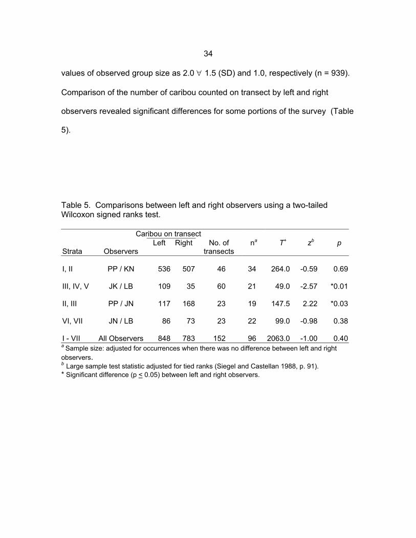
Comparison of the number of caribou counted on transect by left and right
observers revealed significant differences for some portions of the survey (Table
5).
Table 5. Comparisons between left and right observers using a two-tailed Wilcoxon signed ranks test.
Caribou on transect Strata
Observers
Left Right No. of transects
na T+ zb p
I, II PP / KN 536 507 46 34 264.0 -0.59 0.69 III, IV, V JK / LB 109 35 60 21 49.0 -2.57 *0.01 II, III PP / JN 117 168 23 19 147.5 2.22 *0.03 VI, VII JN / LB 86 73 23 22 99.0 -0.98 0.38 I - VII All Observers 848 783 152 96 2063.0 -1.00 0.40 a Sample size: adjusted for occurrences when there was no difference between left and right observers. b Large sample test statistic adjusted for tied ranks (Siegel and Castellan 1988, p. 91). * Significant difference (p < 0.05) between left and right observers.

35
Weather conditions that may have affected visibility of caribou against a
patchy snow-covered background were variable (Appendix E). We occasionally
had to delay or re-fly portions of transects because of low fog, isolated snow
showers and freezing drizzle. In the northern portion of Victoria Island (strata IV
and V), snow cover was patchy and ranged from 50% to 100%. The higher
elevation of the Shaler Mountains made it difficult to survey because of snow
showers and consistently low ceilings. There was less snow cover on southern
Victoria Island (strata I, II, and the east portion of III) than in the northern strata.
In the southern portion of the survey area (strata I–III), the area along the
coastline was essentially snow-free. This snow-free band extended inward from
the coast for approximately 20–30 km. Snow cover over the rest of the inland
area varied between 10%–50%.
Observer fatigue may have also affected survey results. In order to
complete the survey within a 2-week period, we flew some long days in both the
Cessna 185 (5 days >9.0 hrs) and the Helio-Courier (7 days >9.0 hrs)
(Appendix E).
Unsystematic Reconnaissance of Eastern Victoria Island
On 17 June 1994, we left the Wynniatt Bay research cabin and flew 7.6
hours in the Helio-Courier during an unsystematic low-level reconnaissance of
eastern Victoria Island. Flying was restricted to fog free areas in the southern
part of Storkerson Peninsula. The northern area was enveloped in heavy fog;

36
fog was thick (visibility less than 150–200 m) and patchy in distribution and the
ceiling ranged from 60–100 m above sea level. Weather conditions improved as
we continued south; visibility became excellent as cloud and fog dissipated.
We observed a total of 382 caribou occurring in 128 separate groups, and
classified 358 animals according to six age/sex categories (Table 6, Appendix H).
Observed group size of caribou ranged from 1 to 9 and was not normally
distributed (KS Distance = 0.247; p < 0.001) (Figure 9). Mean and median group
size observed during the reconnaissance flight were 2.4 ± 1.7 (SD) and 2.0,
respectively. This was significantly different than the median group size of 1
observed during the systematic survey (H=9.218, df=1, p=0.002).
Table 6. Sex and age composition of Victoria Island caribou observed during a low-level reconnaissance flight of eastern Victoria Island, 17 June 1994.
Cows Antlered no calf
Antlered with calf
Antlerless with calf
Antlerless no calf
Bulls
Yearlings
Unknowna
7 7 69 110 56 33 24
a Caribou identified as “Unknown” were those animals that were too far away from the aircraft to be classified.

37
During the reconnaissance flight, we observed eight caribou on the west
side of Hadley Bay, with the remaining animals found along the flight path from
southeast Hadley Bay, across Storkerson Peninsula, and southeast along the
coast to Collinson Peninsula (Figures 10 to 13). There was no apparent spatial
segregation by age and sex classes along the flightline. However, most antlered
cows (with and without calves) were observed on the flight across Storkerson
Peninsula (Figure 10). Similarly, antlerless cows accompanied by calves were
mostly distributed across the base of Storkerson Peninsula and on Collinson
Peninsula (Figure 11). Distribution of antlerless cows, bulls, and yearlings
followed a similar pattern (Figures 12 and 13).

38
69°
70°
71°
72°
73°
110° 105°
km 10 0 100 kmLambert Conformal Conic Projection
CambridgeBay
Flight path
Wynniatt Bay
Hadley Bay
M'Clintock Channel
S lha er ou
Mnt
insa
cabin
AlbertEdwardBay
Wellington Bay
STEFANSSON ISLAND
STORKERSON PENINSULA
COLLINSONPENINSULA
Antlered cow1
Antlered cow & calf1
Figure 10. Antlered caribou cows with and without newborn calves observed during an unsystematic reconnaissance survey of eastern Victoria Island, 17 June 1994.

39
69°
70°
71°
72°
73°
110° 105°
km 10 0 100 kmLambert Conformal Conic Projection
CambridgeBay
Flight path
Wynniatt Bay
Hadley Bay
M'Clintock Channel
S lha er ou
Mnt
insa
cabin
AlbertEdwardBay
Wellington Bay
STEFANSSON ISLAND
STORKERSON PENINSULA
COLLINSONPENINSULA
Antlerless cow & calf
1
2
3-4
Figure 11. Antlerless caribou cows with calves observed during an unsystematic reconnaissance survey of eastern Victoria Island, 17 June 1994.

40
69°
70°
71°
72°
73°
110° 105°
km 10 0 100 kmLambert Conformal Conic Projection
CambridgeBay
Flight path
Wynniatt Bay
Hadley Bay
M'Clintock Channel
S lha er ou
Mnt
insa
cabin
AlbertEdwardBay
Wellington Bay
STEFANSSON ISLAND
STORKERSON PENINSULA
COLLINSONPENINSULA
Figure 12. Antlerless caribou cows observed during an unsystematic reconnaissance survey of eastern Victoria Island, 17 June 1994.

41
69°
70°
71°
72°
73°
110° 105°
km 10 0 100 kmLambert Conformal Conic Projection
CambridgeBay
Flight path
Wynniatt Bay
Hadley Bay
M'Clintock Channel
S lha er ou
Mnt
insa
cabin
AlbertEdwardBay
Wellington Bay
STEFANSSON ISLAND
STORKERSON PENINSULA
COLLINSONPENINSULA
Figure 13. Bull and yearling caribou observed during an unsystematic reconnaissance survey of eastern Victoria Island, 17 June 1994.
42
DISCUSSION Population Estimate
We only observed 4 caribou on 2738 km of transects within the known
seasonal range of the Minto Inlet herd. Consequently, the main implication of
this survey pointed to a continued conservative approach of minimizing the
harvest of Minto Inlet caribou in northwest Victoria Island. Although we did
observe caribou on north central Victoria Island – the Shaler Mountains area –
the total estimate for strata V, VI, and VII, was only 792 ± 76. The suggestion
that those caribou represented an eastward range shift of the Minto Inlet herd
was speculative.
Our total estimate of 14 539 (∀ 1015) caribou on western Victoria Island
was precise, but not accurate. Observer bias usually results in animals being
missed (Caughley 1974, Norton-Griffiths 1978), but more importantly, the
distribution of caribou was not sampled adequately to generate a population
estimate. Our intention was to determine the size of the Dolphin and Union herd
by extrapolation from a calving ground survey. Since the distribution of caribou
and calves extended east beyond our survey area and we did not have enough
flight hours to adequately sample the eastern distribution, we missed an
unknown yet substantial number of caribou. The non-systematic survey clearly
showed that caribou and calves were also present on Storkerson and Collinson
peninsulas.
Our total survey area of western Victoria Island was 138 185 km2, which

43
was approximately 63% of the entire island. Given that we did not survey the
other 37% of the island (i.e. 82 389 km2), it was not possible to accurately
estimate the total number of caribou on Victoria Island. Nevertheless, survey
results underscored the continued need to conservatively manage the harvest of
Dolphin and Union caribou.
Following the survey, extensive consultation took place (Appendix A) to
discuss survey results and management options. Consensus was reached on
the following recommendations:
1) Two caribou management areas within the Inuvialuit Settlement Region
(ISR) were established. One area was in the northwest part (Minto Inlet area)
and the other was in the southwest part of Victoria Island (Prince Albert Sound
area).
2) No one, including ISR beneficiaries, would be allowed to hunt caribou in
the Minto Inlet area.
3) ISR beneficiaries would be able to hunt Dolphin and Union caribou in the
Prince Albert Sound area in summer and fall (1 July – 15 November).
4) The summer/fall season would also apply to residents hunting Dolphin
and Union caribou in the Prince Albert Sound area.
5) There would be no trophy hunts (NR/NRA) of Dolphin and Union caribou
in the Prince Albert Sound area.
6) Commercial quotas for Dolphin and Union caribou on Victoria Island
would be eliminated.
44
7) Wildlife management zone boundaries would be amended in the
Cambridge Bay area to protect Dolphin and Union caribou that wintered on Kent
Peninsula and Melbourne Island from commercial harvesting.
In addition to legislative changes, the Ekaluktutiak Hunters and Trappers
Association (EHTA) undertook two additional measures to further reduce the
harvest of Dolphin and Union caribou. The first was a voluntary reduction of their
number of caribou sport hunts on Victoria Island. The second was to halt the
commercial harvest of Dolphin and Union caribou wintering on the mainland.
Despite elimination of the commercial harvest of caribou on Victoria Island
and extension of wildlife management areas to protect Dolphin and Union caribou
wintering on Kent Peninsula and Melbourne Island, a majority of the 289 tags
used for Cambridge Bay=s commercial quota for Bathurst caribou were still used
to harvest Dolphin and Union caribou on the mainland during winter in the mid
1990s (G. Corey pers. comm.). In the interest of halting the commercial harvest
of Dolphin and Union caribou, the EHTA recommended that commercial hunters
travel further inland to harvest barren-ground caribou. In fall 1997, the EHTA
stopped distributing commercial caribou tags until a hunt could be organized in a
mainland location that would ensure only barren-ground caribou were being
harvested (see Gunn et al. 2000).

45
Location of Calving Grounds
We were unable to find caribou on an annual calving ground on northwest
Victoria Island. The fact that we only observed 4 caribou on transects in stratum
IV (Figure 6) strongly suggested that caribou were virtually absent from within the
known seasonal range of the Minto Inlet herd as determined by satellite telemetry
studies in the late 1980s (Gunn and Fournier 2000). Our findings corroborated
previous surveys (Heard 1992, Gunn in prep.) where very few caribou were
observed within the seasonal distribution of caribou in northwest Victoria Island
and added further credence to the observed decline of the Minto Inlet herd3.
Our observations of caribou calving in the Shaler Mountains area suggested
an extension of what was known as the traditional caribou calving grounds of
Dolphin and Union caribou (Gunn and Fournier 2000). This was the most
parsimonious explanation, although the strength of this inference was weakened
by our subjective assessment of the timing of calving and a lack of current data
(in 1994) on seasonal distribution and movements of caribou in north-central
Victoria Island4. However, given the clumped distribution of cows
and calves in the higher elevations of the Shaler Mountains and the break in
3 An aerial survey of northwest Victoria Island was subsequently flown in summer 1998, and the result was an estimate between 433 and 583 non-calf caribou (J. Nagy, unpub. data). 4 In July 1996, WMC International Limited (in cooperation with DRR), deployed 4 satellite collars on caribou cows in the Shaler Mountains, an area within WMC International Ltd.’s mineral exploration area. Those collared cows confirmed that the Shaler Mountains were part of the annual range of Dolphin and Union caribou (WMC International Limited unpublished data).
46
distribution of caribou associated with the Kuujjua River valley (Figures 3 and 6),
we could not reject possible alternate explanations: 1) this calving ground and
herd had not yet been described; or 2) this observation represented an eastward
shift of the annual calving ground of the Minto Inlet herd.
Within the survey area, we observed the main distribution of caribou and
newborn calves on south-central Victoria Island around the eastern arm of Prince
Albert Sound. The calving area was extensive with caribou dispersed throughout
the central and southern portions of the survey area. Our southern distribution of
calving was generally consistent with Gunn and Fournier’s (2000) results, which
showed a calving area that extended south and east of Prince Albert Sound.
However, we observed a calving distribution that extended further north than
what Gunn and Fournier (2000) described in the late 1980s. The northern extent
of the large continuous distribution of caribou appeared to occur south of the
Kuujjua River (Figure 6). The northern extent slipped southward as the survey of
central Victoria Island progressed eastward. However, we were unable to
delineate the eastern boundary of the Dolphin and Union calving ground with
confidence, as there was still a calf observed on the eastern-most transect (#33)
in stratum II (Figures 3 and 6, Appendix F).
Our difficulty in delineating the annual calving ground for the Dolphin and
Union herd was a function of the relatively low densities of caribou and newborn
calves dispersed over a large geographic area. This difficulty was complicated
by the time required to cover the survey area, and by the fact that our

47
observations on the timing of calving were confounded by spatial and temporal
sampling issues5.
We found that pregnant caribou on Victoria Island did not aggregate within a
distinct annual calving ground; cows and calves were dispersed throughout much
of the surveyed area. We also observed bulls and yearlings interspersed
throughout the study area. Unlike barren-ground caribou (see Heard and
Jackson 1990, Gunn et al. 1997b), caribou calving grounds on Victoria Island
(identified by the presence of newborn calves) were not associated with a density
gradient. Calving areas on Victoria Island (defined roughly as the survey areas
within the bounds of calf observations in strata II and III and strata VI and VII)
were not characterized by discernible increases in caribou density.
Gunn and Fournier (2000) showed that there were two caribou calving
grounds on Victoria Island and suggested that eastern Victoria Island (Collinson
Peninsula) may represent a third calving area. Our non-systematic observations
of calving caribou on Collinson and Storkerson Peninsulas extended the known
calving distribution and also supported the observations of calving on Collinson
Peninsula in 1987–88 (Gunn and Fournier 2000).
5 Our aerial survey was not an appropriate method to determine timing of calving because observations varied in both space and time; an accurate method would control for spatial variability. This would require sampling only a portion of the calving ground and observing mature cows repeatedly during the calving season (see Caughley and Caughley 1974).

48
Monitoring Flights for Radio-collared Caribou Cows
During the June 1994 aerial survey, we equipped the Cessna 185 with
radio-tracking equipment and used the survey as an opportunity to monitor radio-
collar Dolphin and Union caribou6 in the southwest region of Victoria Island. We
monitored collar frequencies during all survey flights of transects in strata I and II,
and transects 23–35 in stratum III, and attempted to get visual confirmations of
any active collars. We obtained observations of six radio-collared cows after
detecting their radio signals during the aerial survey (Table 7, Figure 14). We
were not able to locate one collar (#50) despite a seemingly strong radio-signal.
Immediately following the low-level reconnaissance flight on 17 June, we
flew back to Collinson Peninsula to monitor radio-collar frequencies. On the
following day (18 June) we monitored collar frequencies during flights from
Cambridge Bay to the Wynniatt Bay cabin and southeast over the Shaler
Mountains before returning to Kugluktuk (Figure 14, Appendix C). We were able
to acquire visual relocations of an additional five radio-collared cows, and radio
signals from two cows (Table 7, Figure 14). The cows were distributed over an
extensive area from Collinson Peninsula midway up Storkerson Peninsula.
6 In late April 1994, 20 Victoria Island caribou cows were captured and fitted with VHF radio collars in the area south of Cambridge Bay (Kent Peninsula, Melbourne and Minto islands, and southeast Victoria Island). Deployment of those 20 collars was part of a project to determine where Victoria Island caribou go to calve. Nishi (2000) reports complete results from radio-telemetry work (1994–1997).

49
Table 7. Observations of radio-collared female caribou, Victoria Island, June 1994.
Collar ID Date Observed Observation Type Comments 60 10 June visual antlered no calf at heel 50 11 June radio signal only stratum III, transect 35, 70 13 June visual bald no calf at heel 30 15 June visual antlered with calf at heel
130 15 June visual antlered with calf at heel 150 15 June visual antlered no calf at heel 120 17 June visual antlerless with calf at heel 110 17 June radio signal only Cape Adelaide 192 18 June visual antlerless with calf at heel 160 18 June visual antlerless with calf at heel 180 18 June visual antlerless with calf at heel 170 18 June visual antlerless with calf at heel 140 18 June radio signal only no observation

50
Holman
Cambridge Bay
Kugluktuk
km 10 0 100 km
105°110°115°
68°
69°
70°
71°
72°
73°
Lambert Conformal Conic Projection
cabin
Umingmaktok
120190
170150130
60
70
50
140
160
180
30
18 June
17 June110c
cc
c
c
18 June
c
c
antlered cow + calf
antlerless cow, no calf
antlerless cow + calf
antlered cow, no calfcc
radio signal only
Figure 14. Flight lines and locations of seven radio-collared caribou cows on Victoria Island, 17 and 18 June 1994. The six collared cows not on the flight path were located during a systematic aerial survey of Victoria Island, 10-15 June 1994.

51
All five cows observed were antlerless and accompanied by newborn calves.
Those observations confirmed that Dolphin and Union caribou were also calving
east outside of the survey area.
Timing of Calving
We suggested that the peak of calving (i.e. the date when > 50% of calves
are born) likely occurred between the 11 and 17 June 1994. We based our
consideration on: 1) observations of calves throughout the survey (Tables 4a); 2)
proportion of radio-collared cows (observed on the 17 and 18 June) that had lost
their hard antlers and had a calf at heel (Table 7); and 3) the following crude
estimate of the proportion of calves born. A comparison of the proportion of
calves to non-calf caribou observed during the non-systematic survey on 17 June
suggested that of the 358 caribou identified, 21.2% were calves (Table 6).
Adjusting for the missing male segment of the population (given the assumption
that a reasonable split between the sexes of 1+ -year-old animals in a caribou
population is 40:60 or 66.7 males : 100 females (see Miller 1997, p. 46)), the
proportion of calves was further reduced to 17.5%. Relative to the theoretical
maximum of 30% newborn calves in a barren-ground caribou population
(Bergerud 1980) and assuming minimal early calf mortality, the non-systematic
data implied that calving was already 58% complete by 17 June 1994.

52
Research Implications
An aerial survey is a snapshot in time of the abundance and distribution of
animals in a defined space. The challenges in executing an aerial census of an
annual caribou calving ground are to define the spatial (geographic) extent of
pregnant cows and conduct a systematic survey of that area within a narrow
temporal window at the peak of calving. There are at least three important
factors that limit effectiveness of a calving ground survey technique on Victoria
Island. First, the geographic area in which calving caribou are found during the
calving season is large and extensive. Second, the temporal envelope of the
calving season limits survey time and consequently limits spatial extent of the
survey area. And third, caribou density – the most repeatable measure obtained
from an aerial survey under standardised conditions – does not seem to be a
useful field correlate for defining an annual calving ground. Thus, when
considering the dynamic nature of a geographically extensive calving ground with
relatively uniform density, such as on Victoria Island, the practical utility of the
calving ground census technique is marginal.
Gunn and Fournier (2000) showed that there were two caribou calving
grounds and two discrete caribou herds on Victoria Island – the Minto Inlet herd
and the Dolphin and Union herd. Based on data from one satellite-collared cow
and hunters’ observations, they also suggested that eastern Victoria Island (i.e.
Collinson Peninsula) represented a third calving area. Our observations of
calving caribou and radio-collared cows on Collinson and Storkerson peninsulas

53
confirmed Gunn and Founier’s preliminary results, and extended the known
calving distribution to eastern Victoria Island.
One alternative to a calving ground survey is to survey the entire island, but
the costs and logistics would be prohibitive. The option of a whole-island survey
gives little consideration to sampling discrete populations and would not enable
managers to understand the trends and dynamics of individual herds. This would
be akin to surveying two or more herds of caribou and assessing overall trend on
the pooled survey results. The resultant estimate would be ambiguous, as it
would be difficult to determine herd discreteness and herd-specific trends.
Improved design of aerial surveys for Dolphin and Union caribou requires
further confirmation of seasonal movements and additional work on describing
herd discreteness. Based on our survey results (this report), hunters’
observations (D. Kaomayok, and G. Angohiatok pers. comm.), and Gunn and
Fournier’s (2000) earlier telemetry studies, we knew that caribou calved on
eastern Victoria Island. Whether the distribution of caribou between south-
central and southeast Victoria Island was continuous remains an important
question with implications to future survey design and understanding herd
discreteness (see Nishi 2000).
Another alternative is to survey Dolphin and Union caribou during their fall
rut distribution when all age and sex classes are intermixed and when caribou
aggregate along the southern coastline prior to their fall migration to the
mainland. As the distribution of collared cows during October 1987, 1988 (Gunn

54
and Fournier 2000), 1994 and 1996 (Nishi 2000) was mostly along the southern
coastline, Nishi and Gunn (in prep) used this approach in October 1997 and
estimated 27 786 + 3366 (SE) caribou. The fall rut survey technique will require
further confirmation on the proportion of the Dolphin and Union herd that is
present along the coastline in fall.
Caribou calving grounds are dynamic over several spatial and temporal
scales (Russell et al. 1993, Sutherland and Gunn 1996, Gunn and Sutherland
1997, Gunn 1999, Wolfe et al.1999, Nagy unpublished data on Bluenose
caribou). Our survey results point out the need for additional research7 as it will
take many more years of data to describe and understand the spatial and
temporal variability of calving grounds on Victoria Island. This need is highlighted
by the ‘Caribou Protection Measures’ proposed to guide industrial activity in the
West Kitikmeot (Nunavut Planning Commission 1998). We suggest that those
‘protection measures’ will require ongoing research and revision to reflect our
increasing understanding of the dynamics that are characteristic of caribou
calving grounds on Victoria Island.
7 In October 1999, 25 satellite collars were deployed on Dolphin and Union cows along the southern coastline of Victoria Island to address ongoing concerns of harvest sustainability (B. Patterson, pers. com.).
55
ACKNOWLEDGEMENTS
Funding for this survey was provided by the Inuvialuit Settlement Region
through their Wildlife Management Advisory Council (NWT), the Nunavut Wildlife
Management Board, and the Department of Renewable Resources, Government
of the Northwest Territories. We also acknowledge the Department of
Sustainable Development, Government of Nunavut for supplemental funding to
help with the write-up of this report.
Perry Linton of North-Wright Air (Norman Wells, NT) flew the Helio-Courier,
and Ken Williams of Williams Aero (Norman Wells, NT) piloted the Cessna 185
for us. Joe Kuneyuna (RRO I, Holman), Kevin Niptanatiak (Kugluktuk Angoniatit
Association, Kugluktuk), and Paul Panegyuk (DRR, Yellowknife) endured long
days in cramped quarters of survey aircraft. John Stevenson, Ron Morrison, and
Alex ‘Sandy’ Buchan provided excellent support throughout various aspects of
the fieldwork and ensuing community consultations.
A special thank-you to Jack and Naomi Atatahak for their hospitality and use
of their cabin at Read Island. Mitch Taylor (DRR, Yellowknife) granted us the
use of the Polar Bear Project Research Cabin (DRR) at Wynniatt Bay.
Dave Taylor provided excellent training and assistance with the SPANS
software and digitizing survey data. Mika Sutherland helped in preparation of
figures and numerous edits of various drafts. Anne Gunn and Ray Case
provided helpful comments on a previous version of the manuscript.

56
PERSONAL COMMUNICATIONS
Angohiatok, G. Board Member, Ekaluktutiak Hunters and Trappers’ Association, Cambridge Bay, NU.
Corey, G. Renewable Resource Officer, Department of Sustainable
Development, Government of Nunavut, Kitikmeot Region, Cambridge Bay, NU.
Kaomayok, D. Renewable Resource Officer I (retired), Department of
Renewable Resources (now Nunavut Department of Sustainable Development), Kitikmeot Region, Cambridge Bay, NU.
Nagy, J. Supervisor, Wildlife Management, Department of Resources, Wildlife
and Economic Development, Inuvik, NT. Patterson, B. Regional Biologist, Department of Sustainable Development,
Government of Nunavut, Kitikmeot Region, Kugluktuk, NU.

57
LITERATURE CITED
Bergerud, A.T. 1980. A review of the population dynamics of caribou and wild reindeer in North America. Pages 556-681 In: E. Reimers, E. Gaare and S. Skjenneberg (eds.) Proceedings of the 2nd International Reindeer/ Caribou Symposium, Røros, Norway, 1979. Direktoratet for vilt og ferskvannsfisk, Trondheim, Norway.
Boxer, D. 1979. Report on: Muskox survey – Cambridge Bay area, Central
Arctic. Prepared for Superintendent , Wildlife Service, Department of Renewable Resources, Government of the Northwest Territories. 12 pp. + maps.
Boxer, D. 1980. Central Arctic muskox surveys 1979. Northwest Territories
Wildlife Service unpublished report. 22 pp. Bliss, L.C. 1981. North American and Scandinavian tundras and polar deserts.
Pages 8-24 In: L.C. Bliss, O.W. Heal, and J.J. Moore (eds.) Tundra Ecosystems: a comparative analysis. Cambridge University Press, London, UK.
Caughley, G. 1974. Bias in aerial survey. Journal of Wildlife Management
38:921-933. Caughley, G. and J. Caughley. 1974. Estimating median date of birth. Journal
of Wildlife Management 38: 552-556. Department of Renewable Resources. 1993. Victoria Island caribou: a
research program. Northwest Territories Department of Renewable Resources unpublished proposal. 8 pp.
Edlund, S.A. 1983. Reconnaissance vegetation studies on western Victoria
Island, Canadian Arctic Archipelago. Pages 75-81 In: Current research, Part B, Geological Survey of Canada, Paper 83-1B.
Fyles, J.G. 1963. Surficial geology of Victoria and Stefansson Islands, District
of Franklin. Geological Survey of Canada, Bulletin 101. 38 pp. Gates, C.C., J. Adamczewski and R. Mulders. 1986. Population dynamics,
winter ecology and social organization of Coats Island caribou. Arctic 39: 216-222.

58
Graf, R. and D.C. Heard. 1990. Spreadsheet models for the Beverly Kaminuriak herds, NWT. Department of Renewable Resources, Government of the Northwest Territories. File Report No. 94. 26 pp.
Gunn, A. 1991. The decline and recovery of caribou and muskoxen on Victoria
Island. Pages 590-607 In: C.R. Harrington (ed). Canada’s Missing Dimension: Science and History in the Canadian Arctic Islands (Volume II). Canadian Museum of Nature, Ottawa, ON.
Gunn, A. 1998. Caribou and muskox harvesting in the Northwest Territories.
Pages 314-330 In: E.J. Milner-Gulland and R. Mace (eds). Conservation of Biological Resources. Blackwell Science Ltd., Oxford, UK.
Gunn, A. 1999. Caribou calving grounds - dogma and diversity. Paper
presented at 8th North American Caribou Workshop April 20-24, 1998, Whitehorse, YT.
Gunn, A. (in prep.) The decline of caribou on northwest Victoria Island: a
review. Department of Resources, Wildlife and Economic Development, Government of the Northwest Territories, File Report.
Gunn, A. and J. Dragon. 1998. Status of caribou and muskox populations
within the Prince of Wales Island–Somerset Island–Boothia Peninsula complex, NWT, July-August 1995. Department of Resources, Wildlife and Economic Development, Government of the Northwest Territories, File Report No. 122. 47 pp.
Gunn, A. and B. Fournier. 2000. Seasonal movements and distribution of
satellite collared caribou on Victoria Island, 1987-88. Department of Resources, Wildlife and Economic Development, Government of the Northwest Territories, File Report No. 124. 72 pp.
Gunn, A. and F. Miller. 1986. Traditional behaviour and fidelity to caribou
calving grounds by barren-ground caribou. Rangifer Special Issue No. 1: 151-158.
Gunn, A. and M. Sutherland. 1997. Surveys of the Beverly caribou calving
grounds, 1957-1994. Department of Resources, Wildlife and Economic Development, Government of the Northwest Territories, File Report No. 120. 119 pp.

59
Gunn, A., A. Buchan, B. Fournier and J. Nishi. 1997a. Victoria Island caribou migrations across Dolphin and Union Strait and Coronation Gulf from the mainland coast, 1976-94 Department of Resources, Wildlife and Economic Development, Government of the Northwest Territories, Manuscript Report No. 94. 74 pp.
Gunn, A., J. Dragon and J. Nishi. 1997b. Bathurst calving ground survey. Department of Resources, Wildlife and Economic Development, Government of the Northwest Territories, File Report No. 119. 70 pp.
Gunn, A., B. Fournier, and J. Nishi. 2000. Abundance and distribution of the
Queen Maud Gulf caribou herd, 1986-98. Department of Resources, Wildlife and Economic Development, Government of the Northwest Territories, File Report No. 126. 75 pp.
Heard, D.C. 1985. Caribou census methods used in the Northwest Territories.
In: Proceedings of the 2nd North American Caribou Workshop. McGill Subarctic Research Paper No. 40: 229-238.
Heard, D.C. 1987. Allocation of survey effort in a stratified survey design.
Department of Renewable Resources, Government of the Northwest Territories, Manuscript Report. 9 pp.
Heard, D.C. 1992. Distribution and abundance of caribou and muskoxen on
northwestern Victoria Island. Department of Renewable Resources, Government of the Northwest Territories, Manuscript Report No. 60. 13 pp.
Heard, D.C. and F.J. Jackson. 1990. Kaminuriak calving ground survey, 5-17
June 1988. Department of Renewable Resources, Government of the Northwest Territories, File Report No. 84. 23 pp.
Heard, D.C. and J.P. Ouellet. 1994. Population dynamics of an introduced
caribou population in the Arctic. Arctic. 47:88-95 Heard, D.C. and G.B. Stenhouse. 1992. Herd identity and calving ground
fidelity of caribou in the Keewatin District of the Northwest Territories. Department of Renewable Resources, Government of the Northwest Territories, File Report No. 101. 34 pp.
Jakimchuk, R.D. and D.R. Carruthers. 1980. Caribou and muskoxen on
Victoria Island, N.W.T. Report prepared for Polar Gas Project by R.D. Jakimchuk Management Associates Ltd. Sidney, B.C. 93 pp.
60
Jolly, G.M. 1969. Sampling methods for aerial censuses of wildlife populations. East African Agriculture and Forestry Journal Special Issue 34:46-49.
Kelsall, J.P. 1968. The migratory barren-ground caribou of Canada. Canadian
Wildlife Service Monograph No. 3. 339 pp. Krebs, C.J. 1992. Version 3.0 FORTRAN Programs for “Ecological
Methodology” Exeter Software, Setauket, NY. 156 pp. Macpherson, A.H. 1961. On the abundance and distribution of certain
mammals in the Western Canadian Arctic Islands in 1958-59. The Arctic Circular 14:1-17.
Manning, T.H. 1960. The relationship of the peary and barren-ground caribou.
Arctic Institute of North America Technical Paper No. 4. 52 pp. Maxwell, J.B. 1980. The climate of the Canadian Arctic Islands and adjacent
waters. Vol. 1. Climatological Studies 30. Atmospheric Environment Service, Toronto. 531. pp.
Maxwell, J.B. 1981. Climatic regions of the Canadian Arctic Islands. Arctic 34:
225-240. Miller, F.L. 1986. Inter-island movements of Peary caribou across Prince of
Wales Strait between Banks and Victoria Islands. Northern Oil and Gas Program A13-1, Indian and Northern Affairs, Yellowknife, NT. 43 pp.
Miller, F.L. 1990. Peary caribou status report. Environment Canada, Canadian
Wildlife Service Western & Northern Region, Edmonton, Alberta. 64 pp. Miller, F.L. 1997. Peary caribou conservation studies, Bathurst Island Complex,
Northw3est Territories, April – August 1994 and June – July 1995. Canadian Wildlife Service Technical Report Series No. 295. 155 pp.
Miller, F.L., R.H. Russell and A. Gunn. 1977. Distributions, movements and
numbers of Peary caribou and muskoxen on western Queen Elizabeth Islands, Northwest Territories, 1972-74. Canadian Wildlife Service Report Series No. 40. 55 pp.
Nagy, J.A., N.C. Larter and V.P. Fraser. 1996. Population demography of
Peary caribou and muskox on Banks Island, N.W.T., 1982-1992. Rangifer Special Issue No. 9: 213-222.
61
Nishi, J.S. 2000. Calving and rutting distribution of the Dolphin and Union caribou herd based on radio telemetry, Victoria Island (1994–1997). Department of Resources, Wildlife and Economic Development, Government of the Northwest Territories,. No. 127. 65 pp.
Nishi, J.S. and A. Gunn. (in prep.) An estimate of herd size for the Dolphin and
Union caribou herd during the rut, October 1997. Department of Resources, Wildlife and Economic Development, Government of the Northwest Territories, Manuscript Report.
Norton-Griffiths, M. 1978. Counting animals. Hand Book No. 1. African
Wildlife Leadership Foundation, Kenya. 139 pp. Nunavut Planning Commission. 1998. West Kitikmeot Regional Land Use Plan.
Final Draft submitted for Board review, Wager Bay, NT, 11-13 August 1998. 199 pp.
Russell, D.E., A.M. Martell, and W.A.C. Nixon. 1993. Range ecology of the
Porcupine caribou herd in Canada. Rangifer Special Issue No. 8. 167 pp. Russell, J., S. Couturier, L.G. Sopuck, and K. Ovaska. 1996. Post-calving
photo-census of the RiviΠre George caribou herd in July 1993. Rangifer Special Issue No. 9:319-330.
Siegel, S. and N.J. Castellan Jr. 1988. Nonparametric statistics for the
behavioral sciences. 2nd edition. McGraw-Hill, New York. 399 pp. Siniff, D.B. and R.O. Skoog. 1964. Aerial censusing of caribou using stratified
random sampling. Journal of Wildlife Management 28:391-401. Spencer, W. 1976. Muskox (Ovibos moschatus) surveys, central western
Arctic. Revised 1980. Northwest Territories Wildlife Service unpublished report. 11 pp.
Sutherland, M. and A. Gunn. 1996. Bathurst calving ground surveys, 1965 –
1996. Department of Resources, Wildlife and Economic Development, Government of the Northwest Territories, File Report No. 118. 97 pp.
Thomas, D.C. 1969. Population estimates and distribution of barren-ground
caribou in Mackenzie District, N.W.T., Saskatchewan, and Alberta–March to May, 1967. Canadian Wildlife Service Report Series No. 9. 43 pp.
Thomas, D.C. 1998. Needed: less counting of caribou and more ecology.
Rangifer Special Issue No. 10:15-23.

62
Thorsteinsson, R. and E.T. Tozer. 1962. Banks, Victoria and Stefansson Islands, Arctic Archipelago. Geological Survey of Canada, Memoir 330. 83 pp.
Valkenburg, P., D.A. Anderson, J.L. Davis, and D.J. Reed. 1985. Evaluation of
an aerial photocensus technique for caribou based on radio-telemetry. In: Proceedings of the 2nd North American Caribou Workshop. McGill Subarctic Research Paper No. 40:287-299.
Valkenburg, P. and J.L. Davis. 1986. Calving distribution of Alaska’s Steese-
Fortymile caribou herd: a case of infidelity? Rangifer Special Issue No. 1:315-323.
Williams, T.M. 1994. Manual for conducting photographic calving ground
surveys in the N.W.T. Department of Renewable Resources, Government of the Northwest Territories,. unpublished report. 15 pp.
Wolfe, S.A., B. Griffith, R.D. Cameron, R.G. White and S.M. Murphy. 1999.
Habitat selection by calving caribou of the Central Arctic Herd, 1980-1995. Paper presented at 10th Arctic Ungulate Conference 9 th - 12 th August 1999 Tromsø, Norway.

63
APPENDIX A. Chronology of Victoria Island caribou management issues, 1987-1994. 1987-1989: herd delimitation and seasonal movements of caribou on Victoria Island using satellite telemetry (Gunn and Fournier 2000). 1991: Arctic-island caribou classified as “threatened” by COSEWIC. March 1992: 170 caribou estimated in northwest Victoria Island (Heard 1992) March 1993: 144 caribou estimated in northwest Victoria Island (Gunn in prep.) April 1993: Holman self-imposed a ban on hunting of caribou in northwest Victoria Island. 13-15 June 1993: Aerial survey by Morrison (Gunn in prep.) confirmed lack of caribou in northwest Victoria Island. 14-16 June 1993: WMAC meeting
- Discussed the status of Holman's self-imposed ban on hunting of Minto Inlet caribou. Recommendation by OHTC and WMAC to conduct another survey of northwest Victoria Island.
Fall 1993:
- A. Gunn submitted draft file report entitled "The decline of caribou on northwest Victoria Island: A review" (Gunn in prep.)
- Critique of Gunn's draft file report: DRR Inuvik Region use a harvest model to argue hunting may have been a more important factor in decline of Minto Inlet caribou.
October 1993: Research Proposal drafted for 5-year study on Victoria Island caribou (DRR 1993). 12 - 14 October 1993: KHTA Meeting in Cambridge Bay to discuss research proposal. December 1993: Inuvialuit Harvest Study from July to November 1993 shows that Holman residents killed 74 caribou of which 73 were considered Peary-type. 20 December 1993: WMAC meeting
- motion: The WMAC (NWT) shall recommend to the community of Holman that they voluntarily cease all hunting of Minto Inlet “Peary” caribou until further notice.

64
- motion: The WMAC (NWT) shall recommend to the Minister of DRR that he request the communities of Kugluktuk and Cambridge Bay to cease all hunting of Peary-type (Minto Inlet) caribou on Victoria Island until further notice.
13 January 1994: DRR conference call regarding communities' (Holman, Cambridge Bay, and Kugluktuk) support of hunting ban on Minto Inlet “Peary” caribou.
- reviewed plans for community consultation on WMAC's recommendations
- planned a meeting with OHTC in February 1994 to discuss caribou management
2 February 1994: Public Meeting at Holman to discuss ban on hunting Minto Inlet “Peary” caribou.
- poor turnout, decision to reconvene on 4 March 1994, to ensure greater turnout and awareness of management concerns.
13 February 1994: Public meeting in Cambridge Bay to discuss caribou management (poor turnout). 4 March 1994: Public Meeting at Holman to discuss ban on hunting Minto Inlet “Peary” caribou. - decision to be made by OHTC on 16 April 1994 28 March 1994: Public Meeting in Cambridge Bay to discuss caribou management on Victoria Island (poor turnout). 16 April 1994: OHTC decides to ban all hunting of caribou by Holman until survey completed in June 1994. 23-28 April 1994: 20 radio collars deployed on Victoria Island caribou (Kent Peninsula, Melbourne and Minto Islands, and southeast of Cambridge Bay) 1 June 1994: Funding request and presentation made at NWMB meeting. NWMB agreed to partially fund survey. 5-18 June 1994: Extensive survey of western Victoria Island. Surveyed area was about 63% of total land area. Estimate a total of 14 539 + 1015 caribou on western Victoria Island. 10 radio collars relocated. 29 June 1994: DRR Meeting in Yellowknife to discuss survey results and management options.

65
8 July 1994: DRR teleconference with WMAC to discuss management options for Victoria Island caribou with general consensus on recommendations. 11-12 July 1994: KHTA Annual General Meeting: support for all recommendations 18 July 1994: Cambridge Bay HTA and Public Meeting: support for all recommendations. 21 July 1994: Holman HTC and Public Meeting. Request summer hunting season extended into fall (15 November). 29 July 1994: Letter to NWMB regarding management recommendations for Victoria Island caribou.

66
APPENDIX B. Daily flight log of Cessna 185 on wheel skis, Victoria Island, June 1994.
Date Purpose
Hours flown
3 June
Ferrya: YVQb - YCO
2.7
4 June
Ferry: YCO - Read Island - YCO
2.9
5 June
Ferry: YCO - Read Island Systematic surveyc: Read Island
1.2 6.4
6 June
Systematic survey: Read Island
9.8
7 June
Systematic survey: Read Island
9.9
8 June
Systematic survey: Read Island
4.6
9 June
Systematic survey: Read Island
9.1
10 June
Systematic survey: Read Island Ferry: Read Island - YCO
6.8 0.9
11 June
Ferry: YCO - Read Island Systematic survey: Read Island
1.2 5.8
12 June
Systematic survey: Read Island
13.4
13 June
Ferry: Read Island - YHI Survey: YHI Survey: YHI
1.0 6.3 5.1
14 June
Ferry: YHI - Read Island Ferry: Read Island - YCO Ferry: YCO - YVQ
1.2 1.0 3.2
TOTAL
Ferry: 16.3
Systematic survey: 76.2
92.5 a ”Ferry” time includes placement of aircraft between communities and/or field camps (fuel caches). b Canadian Location Identifiers: YHI is Holman, YCO is Kugluktuk, YCB is Cambridge Bay, and YVQ is Norman Wells. c "Survey" time includes: a) time on transect, b) ferry time between transects, and c) ferry time between field camps and transects.

67
APPENDIX C. Daily flight log of Helio-Courier H-295 on tundra tires, Victoria Island, June 1994.
Date
Purpose
Hours flown
4 June
Ferrya: YVQb to YCO
3.5
5 June
Ferry: YCO to YHI Systematic surveyc: YHI to Walker Bay Ferry: Walker Bay - YHI
2.5 5.8 0.7
6 June
Systematic survey: YHI - Wynniatt Bay Ferry: Lake - YHI
7.1 2.8
7 June
Systematic survey: YHI - NW Victoria Island
6.9 3.3
8 June
Systematic survey: YHI - NW Victoria Island
5.4 3.3
9 June
Ferry: YHI - Wynniatt Bay (fuel cache)
1.8 1.6
10 June
Systematic survey: YHI - Wynniatt Bay
4.4
11 June
Ferry: Wynniatt Bay (move fuel cache)
1.2
12 June
Systematic survey: Wynniatt Bay Systematic survey: Wynniatt Bay
4.7 5.7
13 June
Systematic survey: Wynniatt Bay Systematic survey: Wynniatt Bay Ferry: Wynniatt Bay - YHI
2.7 5.5 1.8
14 June
Survey: YHI - Kuuk River Survey: Kuuk River - YHI Ferry: YHI - YCO
7.1 3.0 2.0
15 June
Ferry: YCO - Wynniatt Bay High-altitude radio telemetry (HART): Survey: Wynniatt Bay - Shaler Mtns
1.0 3.3 5.3
16 June
Systematic survey: Wynniatt Bay - Shaler Mtns. Systematic survey: Wynniatt Bay - Shaler Mtns.
5.8 3.7
17 June
Unsystematic recon: Wynniatt Bay - Hadley Bay Unsystematic recon: Hadley Bay - Albert Edward Bay High-altitude radio telemetry (HART): Albert Edward Bay - YCB
1.5
6.1
2.7

68
Appendix C. continued
Date
Purpose
Hours flown
18 June
High-altitude radio telemetry (HART): YCB - Shaler Mtns. / Wynniatt Bay HART: Wynniatt Bay - Fort Ross Ferry: Fort Ross - YCO
7.2
3.7 1.1
19 June
Ferry: YCO - YVQ
3.0
TOTAL
Ferry: 21.4
Systematic survey: 81.3 Unsystematic reconnaissance: 7.6 High-altitude radio-tracking: 16.9
127.2 a “Ferry” time includes placement of aircraft between communities and/or field camps (fuel caches). b Canadian Location Identifiers: YHI is Holman, YCO is Kugluktuk, YCB is Cambridge Bay, and YVQ is Norman Wells. c "Survey" time includes: a) time on transect, b) ferry time between transects, and c) ferry time between field camps and transects.

69
APPENDIX D. Summary of transects flown and caribou observed during an aerial survey of Victoria Island, 5–17 June 1994.
Date Aircrafta Stratum: Transects Caribou Calves
5 June C185 II: 1–10 37 05 June HC IV: 1–6 0 06 June C185 II: 11–16 78 06 June HC IV: 7-9, V: 1–6 5 07 June C185 II: 17, 18, I: 4–15 418 07 June HC IV: 16–22, III: 1–4 3 08 June C185 I: 1–3, 16, II: 30,17 79 08 June HC IV: 10–15, 16–19 0 09 June C185 II: 21–26, 29, 30 278 310 June C185 II: 27–28,17–20 153 310 June HC IV: 16–20, V: 16 0 011June C185 I: 17, II: 31, III: 34–35 76 412June C185 II: 32–33, III: 7–33 146 812June HC V: 18–21 73 313June C185 III: 23–26, 8–13 63 313June HC V: 7–12,13–17, 22 17 014June HC III: 5–7, 14–22 46 315June HC VI: 1–3 23 516June HC VI: 4–13, VII: 1–10 136 1817June HC Unsystematic reconnaissance 282 76SUM 1913 126
a C185 is a Cessna 185; HC is a Helio-Courier H-295.

70
APPENDIX E. Daily weather conditions for aerial survey of Victoria Island, June 1994.
Date
Total hours
flowna
Cloudsb, visibility, light & contrast, temperature
3 June
C185: 2.7h
Clear, high scattered
4 June
C185: 2.9h HC: 3.5h
Broken, est. 1000' with variable fog patches; 5°C
5 June
C185: 7.6h HC: 9.0h
Scattered, est. 5000'; fog in morning; 10°C Scattered, est. 1000'; good visibility; 8°C
6 June
C185: 9.8h HC: 9.9h
Fog until afternoon; Variable ceiling, scattered est. 1000'; 2°C Broken, est. 7000';clear, sunny with good visibility; 7°C
7 June
C185: 9.9h HC: 10.2h
Broken-overcast, est. 1000'; 12°C Scattered, est. 2000' and variable; occasional fog; 6°C
8 June
C185: 4.6h HC: 8.7h
Overcast, light rain and fog; 8°C Scattered-broken, est. 2000' and occasional fog at 500', 6°C
9 June
C185: 9.1h HC: 3.4h
Overcast, est. 1000 -2000'; visibility excellent, contrast fair; 2°C Overcast-fog patches
10 June
C185: 7.7h HC: 4.4h
Overcast, est. 2000'; visibility excellent, contrast fair; 2°C Broken-overcast, and patches of low fog; -1°C
11 June
C185: 7.0h HC: 1.2h
Variable broken 1000 - 2500', patches of freezing rain; 0°C Broken-overcast, low fog
12 June
C185:13.4h HC:10.4h
Scattered, est. 2000 - 3000'; intermittent snow showers, Scattered, 2°C
13 June
C185:12.4h HC:10.0h
Scattered, est. 2000'; excellent visibility; 5°C Overcast; light rain; 0°C
14 June
C185: 5.4h HC:12.1h
Scattered and bright, est. 5000', 8°C Clear; 5°C
15 June
HC: 6.3h
Clear - high scattered; excellent visibility; 5°C
16 June
HC: 9.6h
Scattered, est. 5000'; excellent visibility; 5°C
17 June
HC: 9.4h
Overcast, est. 2000', variable with fog; 5°C
18 June
HC: 12.0h
Overcast with variable fog patches; 6°C
19 June
HC: 3.0h
Scattered
a C185 is a Cessna 185; HC is a Helio-Courier H-295. b We report estimated ceiling heights to the nearest 1000 feet as this is still the standard format used by Transport Canada for their Aviation Routine Weather Report (METAR) and International Aerodrome Forecast (TAF).

71
APPENDIX F. Caribou observed on transect during an aerial survey of western Victoria Island, 5–16 June 1994. S TRATUM I (7– 8, and 11 June 1994)
No. of caribou observed on transect Left observer Right observer Total Transect
no. Transect
area (km2)
Non-calf Calf Non-calf Calf Non-calf Calf
1 57 9 0 1 0 10 02 72 0 0 16 0 16 03 82 12 0 14 0 26 04 83 5 0 10 0 15 05 81 28 0 13 0 41 06 79 8 0 13 0 21 07 78 13 0 12 0 25 08 76 7 0 7 0 14 09 76 28 0 7 0 35 010 78 11 0 20 0 31 011 84 30 0 29 0 59 012 84 16 0 35 0 51 013 68 25 0 23 0 48 014 68 12 0 14 0 26 015 67 18 0 10 0 28 016 66 11 0 16 0 27 017 62 8 0 15 0 23 0
SUM 1261 241 0 255 0 496 0

72
Appendix F. continued S TRATUM II (5–6, and 9–12 June 1994)
No. of caribou observed on transect Left observer Right observer Total Transect
no. Transect
area (km2)
Non-calf Calf Non-calf Calf Non-calf Calf
1 29 0 0 0 0 0 02 48 0 0 0 0 0 03 63 0 0 0 0 0 04 86 0 0 0 0 0 05 94 1 0 1 0 2 06 104 5 0 0 0 5 07 107 2 0 6 0 8 08 110 6 0 5 0 11 09 113 0 0 0 0 0 010 114 6 0 5 0 11 011 115 2 0 10 0 12 012 116 7 0 4 0 11 013 119 4 0 5 0 9 014 118 12 0 9 0 21 015 118 14 0 11 0 25 016 119 16 0 8 0 24 017 116 6 0 3 0 9 018 113 14 1 11 0 25 119 109 13 0 14 1 27 120 115 9 1 9 0 18 121 125 12 0 10 0 22 022 124 20 0 7 1 27 123 130 17 1 14 0 31 124 130 4 0 4 0 8 025 130 15 0 19 0 34 026 130 23 0 23 0 46 027 130 13 0 13 0 26 028 130 18 0 30 0 48 029 130 36 1 18 0 54 130 130 28 0 28 0 56 031 130 16 2 35 2 51 432 130 21 2 20 1 41 333 130 9 1 14 0 23 1
SUM 3705 349 9 336 5 685 14

73
Appendix F. continued S TRATUM III (7, 11–14 June 1994)
No. of caribou observed on transect Left observer Right observer Total Transect
no. Transect
area (km2)
Non-calf Calf Non-calf Calf Non-calf Calf
1 27 0 0 0 0 0 02 44 0 0 0 0 0 03 63 0 0 0 0 0 04 65 0 0 0 0 0 05 69 0 0 0 0 0 06 72 0 0 0 0 0 07 77 0 0 0 0 0 08 86 0 0 0 0 0 09 95 0 0 0 0 0 010 103 0 0 0 0 0 011 99 0 0 0 0 0 012 106 0 0 3 0 3 013 103 0 0 1 0 1 014 101 0 0 2 0 2 015 97 0 0 2 1 2 116 93 0 0 0 0 0 017 95 0 0 3 0 3 018 97 4 1 6 1 10 219 103 6 0 0 0 6 020 109 4 0 0 0 4 021 113 6 0 0 0 6 022 115 11 0 2 0 13 023 119 4 0 11 1 15 124 130 4 0 5 1 9 125 130 7 0 9 0 16 026 130 15 1 4 0 19 127 130 9 0 22 1 31 128 130 9 2 11 0 20 229 130 8 0 7 1 15 130 130 4 0 2 0 6 031 130 1 0 6 0 7 032 130 1 0 0 0 1 033 130 0 0 2 0 2 034 130 0 0 1 0 1 035 130 1 0 0 0 1 0
SUM 3611 94 4 99 6 193 10
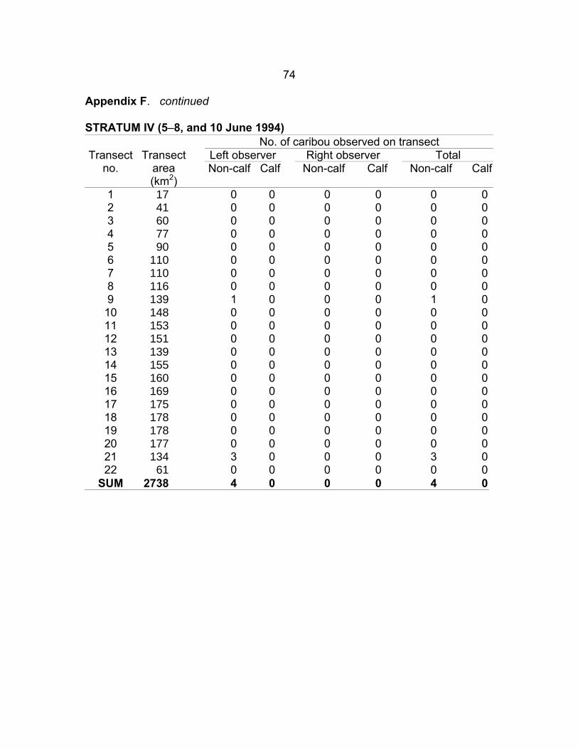
74
Appendix F. continued S TRATUM IV (5–8, and 10 June 1994)
No. of caribou observed on transect Left observer Right observer Total Transect
no. Transect
area (km2)
Non-calf Calf Non-calf Calf Non-calf Calf
1 17 0 0 0 0 0 02 41 0 0 0 0 0 03 60 0 0 0 0 0 04 77 0 0 0 0 0 05 90 0 0 0 0 0 06 110 0 0 0 0 0 07 110 0 0 0 0 0 08 116 0 0 0 0 0 09 139 1 0 0 0 1 010 148 0 0 0 0 0 011 153 0 0 0 0 0 012 151 0 0 0 0 0 013 139 0 0 0 0 0 014 155 0 0 0 0 0 015 160 0 0 0 0 0 016 169 0 0 0 0 0 017 175 0 0 0 0 0 018 178 0 0 0 0 0 019 178 0 0 0 0 0 020 177 0 0 0 0 0 021 134 3 0 0 0 3 022 61 0 0 0 0 0 0
SUM 2738 4 0 0 0 4 0
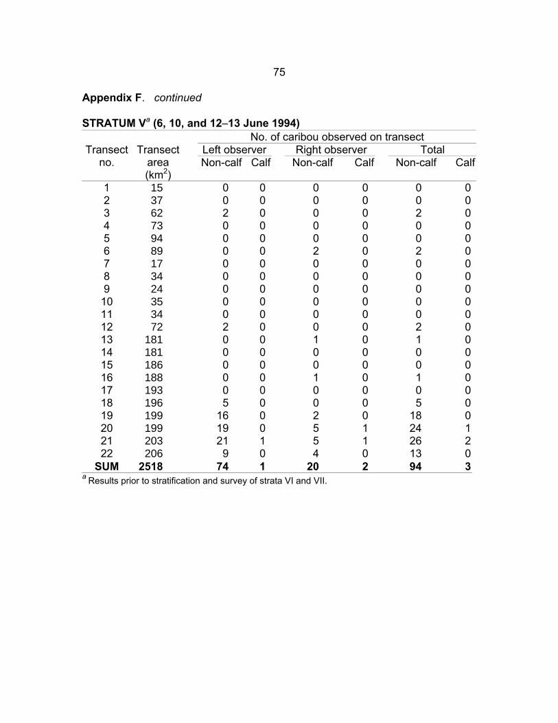
75
Appendix F. continued S TRATUM Va (6, 10, and 12–13 June 1994)
No. of caribou observed on transect Left observer Right observer Total Transect
no. Transect
area (km2)
Non-calf Calf Non-calf Calf Non-calf Calf
1 15 0 0 0 0 0 02 37 0 0 0 0 0 03 62 2 0 0 0 2 04 73 0 0 0 0 0 05 94 0 0 0 0 0 06 89 0 0 2 0 2 07 17 0 0 0 0 0 08 34 0 0 0 0 0 09 24 0 0 0 0 0 010 35 0 0 0 0 0 011 34 0 0 0 0 0 012 72 2 0 0 0 2 013 181 0 0 1 0 1 014 181 0 0 0 0 0 015 186 0 0 0 0 0 016 188 0 0 1 0 1 017 193 0 0 0 0 0 018 196 5 0 0 0 5 019 199 16 0 2 0 18 020 199 19 0 5 1 24 121 203 21 1 5 1 26 222 206 9 0 4 0 13 0
SUM 2518 74 1 20 2 94 3 a Results prior to stratification and survey of strata VI and VII.

76
Appendix F. continued STRATUM Va (6, 10, and 12–13 June 1994)
No. of caribou observed on transect Left observer Right observer Total Transect
no. Transect
area (km2)
Non-calf Calf Non-calf Calf Non-calf Calf
1 15 0 0 0 0 0 02 37 0 0 0 0 0 03 62 2 0 0 0 2 04 73 0 0 0 0 0 05 94 0 0 0 0 0 06 89 0 0 2 0 2 07 17 0 0 0 0 0 08 34 0 0 0 0 0 09 24 0 0 0 0 0 010 35 0 0 0 0 0 011 34 0 0 0 0 0 012 72 2 0 0 0 2 013 181 0 0 1 0 1 014 181 0 0 0 0 0 015 186 0 0 0 0 0 016 188 0 0 1 0 1 017 193 0 0 0 0 0 018 196 5 0 0 0 5 019 89 4 0 0 0 4 020 89 1 0 0 0 1 021 93 4 0 3 1 7 122 96 0 0 1 0 1 0
SUM 2078 18 0 8 1 26 1 a Results following stratification and survey of strata VI and VII. These results were used in the final survey analyses.
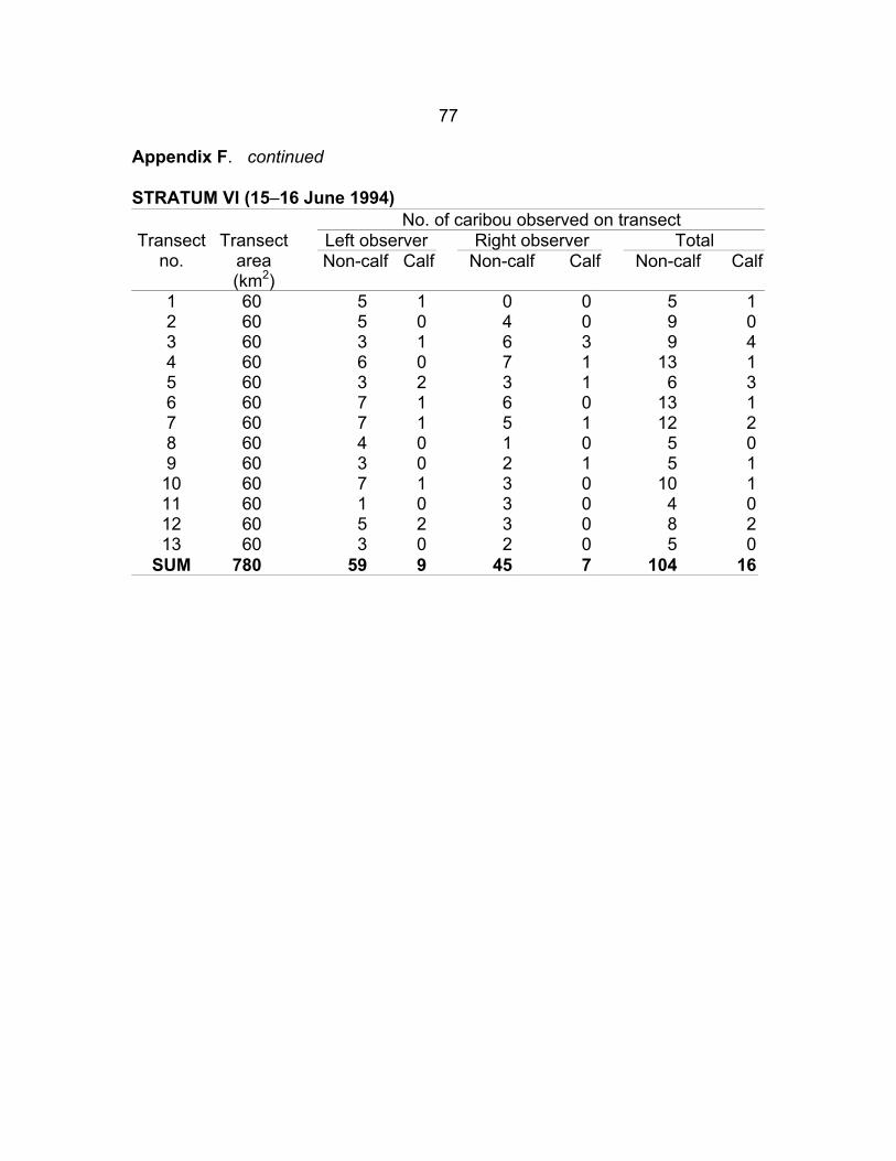
77
Appendix F. continued S TRATUM VI (15–16 June 1994)
No. of caribou observed on transect Left observer Right observer Total Transect
no. Transect
area (km2)
Non-calf Calf Non-calf Calf Non-calf Calf
1 60 5 1 0 0 5 12 60 5 0 4 0 9 03 60 3 1 6 3 9 44 60 6 0 7 1 13 15 60 3 2 3 1 6 36 60 7 1 6 0 13 17 60 7 1 5 1 12 28 60 4 0 1 0 5 09 60 3 0 2 1 5 110 60 7 1 3 0 10 111 60 1 0 3 0 4 012 60 5 2 3 0 8 213 60 3 0 2 0 5 0
SUM 780 59 9 45 7 104 16
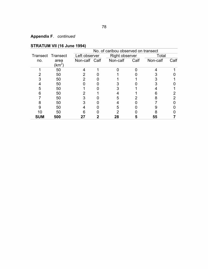
78
Appendix F. continued S TRATUM VII (16 June 1994)
No. of caribou observed on transect Left observer Right observer Total Transect
no. Transect
area (km2)
Non-calf Calf Non-calf Calf Non-calf Calf
1 50 4 1 0 0 4 12 50 2 0 1 0 3 03 50 2 0 1 1 3 14 50 0 0 3 0 3 05 50 1 0 3 1 4 16 50 2 1 4 1 6 27 50 3 0 5 2 8 28 50 3 0 4 0 7 09 50 4 0 5 0 9 010 50 6 0 2 0 8 0
SUM 500 27 2 28 5 55 7

79
APPENDIX G. Caribou observed off transect during an aerial survey of western Victoria Island, 5–16 June 1994. S TRATUM I (7–8, and 11 June 1994)
No. of caribou observed off transect Left observer Right observer Total Transect
no. Transect
area (km2)
Non-calf Calf Non-calf Calf Non-calf Calf
1 57 6 0 3 0 9 02 72 1 0 15 0 16 03 82 3 0 0 0 3 04 83 0 0 6 0 6 05 81 8 0 1 0 9 06 79 7 0 34 0 41 07 78 12 0 3 0 15 08 76 2 0 23 0 25 09 76 32 0 2 0 34 010 78 2 0 20 0 22 011 84 26 0 19 0 45 012 84 17 0 119 0 136 013 68 44 0 41 0 85 014 68 14 0 33 0 47 015 67 14 0 2 0 16 016 66 5 0 23 0 28 017 62 3 0 8 0 11 0
SUM 1261 196 0 352 0 548 0

80
Appendix G. continued S TRATUM II (5–6, and 9–12 June 1994)
No. of caribou observed off transect Left observer Right observer Total Transect
no. Transect
area (km ) 2
Non-calf Calf Non-calf Calf Non-calf Calf
1 29 0 0 0 0 0 02 48 0 0 0 0 0 03 63 0 0 0 0 0 04 86 2 0 0 0 2 05 94 0 0 0 0 0 06 104 0 0 0 0 0 07 107 0 0 1 0 1 08 110 3 0 0 0 3 09 113 3 0 3 0 6 010 114 0 0 0 0 0 011 115 0 0 0 0 0 012 116 2 0 0 0 2 013 119 3 0 7 0 10 014 118 0 0 15 0 15 015 118 8 0 4 0 12 016 119 4 0 22 0 26 017 116 3 0 4 0 7 018 113 4 0 5 0 9 019 109 19 0 3 0 22 020 115 5 0 10 0 15 021 125 1 0 8 0 9 022 124 12 0 0 0 12 023 130 24 0 18 0 42 024 130 4 0 9 0 13 025 130 7 0 21 0 28 026 130 16 0 21 0 37 027 130 6 0 33 0 39 028 130 28 0 13 0 41 029 130 33 0 14 0 47 030 130 8 0 53 0 61 031 130 15 0 11 0 26 032 130 10 0 20 0 30 033 130 17 0 24 0 41 0
SUM 3705 237 0 319 0 556 0

81
Appendix G. continued STRATUM III (7, 11–14 June 1994)
No. of caribou observed off transect Left observer Right observer Total Transect
no. Transect
area (km2)
Non-calf Calf Non-calf Calf Non-calf Calf
1 27 0 0 0 0 0 02 44 0 0 0 0 0 03 63 0 0 0 0 0 04 65 0 0 0 0 0 05 69 0 0 0 0 0 06 72 0 0 0 0 0 07 77 0 0 0 0 0 08 86 0 0 0 0 0 09 95 0 0 0 0 0 010 103 0 0 0 0 0 011 99 0 0 0 0 0 012 106 0 0 0 0 0 013 103 0 0 0 0 0 014 101 0 0 0 0 0 015 97 0 0 0 0 0 016 93 0 0 0 0 0 017 95 3 0 0 0 3 018 97 7 0 0 0 7 019 103 1 0 0 0 1 020 109 15 0 0 0 15 021 113 0 0 2 0 2 022 115 45 0 4 0 49 023 119 7 0 4 0 11 024 130 6 0 8 1 14 125 130 4 0 6 1 10 126 130 2 0 6 0 8 027 130 11 0 16 2 27 228 130 17 1 10 0 27 129 130 1 0 14 3 15 330 130 5 0 4 0 9 031 130 2 0 0 0 2 032 130 0 0 1 0 1 033 130 0 0 0 0 0 034 130 0 0 0 0 0 035 130 0 0 0 0 0 0
SUM 3611 126 1 75 7 201 8

82
Appendix G. continued S TRATUM IV (5–8, and 10 June 1994)
No. of caribou observed off transect Left observer Right observer Total Transect
no. Transect
area (km2)
Non-calf Calf Non-calf Calf Non-calf Calf
1 17 0 0 0 0 0 02 41 0 0 0 0 0 03 60 0 0 0 0 0 04 77 0 0 0 0 0 05 90 0 0 0 0 0 06 110 0 0 0 0 0 07 110 0 0 0 0 0 08 116 0 0 0 0 0 09 139 0 0 0 0 0 010 148 0 0 0 0 0 011 153 0 0 0 0 0 012 151 0 0 0 0 0 013 139 0 0 0 0 0 014 155 0 0 0 0 0 015 160 0 0 0 0 0 016 169 0 0 0 0 0 017 175 0 0 0 0 0 018 178 0 0 0 0 0 019 178 0 0 0 0 0 020 177 0 0 0 0 0 021 134 0 0 0 0 0 022 61 0 0 0 0 0 0
SUM 2738 0 0 0 0 0 0
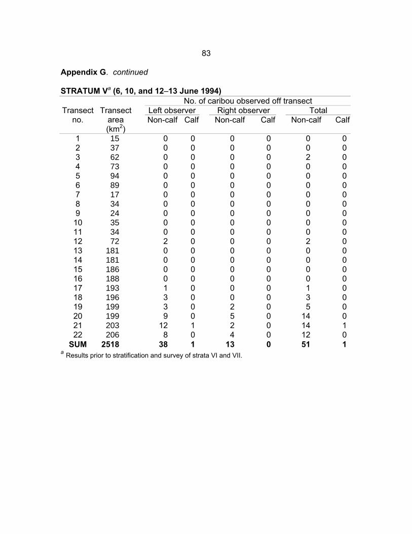
83
Appendix G. continued
STRATUM Va (6, 10, and 12–13 June 1994)
a Results prior to stratification and survey of strata VI and VII.
No. of caribou observed off transect Left observer Right observer Total Transect
no. Transect
area (km2)
Non-calf Calf Non-calf Calf Non-calf Calf
1 15 0 0 0 0 0 02 37 0 0 0 0 0 03 62 0 04
0 0 2 073 0 0 0 0 0 0
5 94 0 0 0 0 0 06 89 0 0 0 0 0 07 17 0 0 0 0 0 08 34 0 0 0 0 0 09 24 0 0 0 0 0 010 35 0 0 0 0 0 011 34 0 0 0 0 0 012 72 2 0 0 0 2 013 181 0 0 0 0 0 014 181 0 0 0 0 0 015 186 0 0 0 0 0 016 188 0 0 0 0 0 017 193 1 0 0 0 1 018 196 3 0 0 0 3 019 199 3 0 2 0 5 020 199 9 0 5 0 14 021 203 12 1 2 0 14 122 206 8 0 4 0 12 0
SUM 2518 38 1 13 0 51 1

84
Appendix G. continued S TRATUM VI (15–16 June 1994)
No. of caribou observed off transect Left observer Right observer Total Transect
no. Transect
area (km
Non-calf Non-calf 2)
Calf Non-calf Calf Calf
1 60 10 0 2 0 12 02 60 4 0 11
60 14 60
2 7 23 4 1 2 0 6
8 0 6 2 14 25 60 14 2 8 3 22 56 60 1 1 4 0 5 17 60 3 0 0 0 3 08 60 0 0 7 2 7 29 60 9 0 2 0 11 010 60 1 0 6 0 7 011 60 2 0 1 0 3 012 60 1 0 0 0 1 013 60 2 0 4 0 6 0
SUM 780 59 6 49 7 108 13

85
Appendix G. continued
S TRATUM VII (16 June 1994) No. of caribou observed off transect
Left observer Right observer Total Transect no.
Transect area (km2)
Non-calf Non-calf Calf Non-calf Calf Calf
1 50 10 6 0 4 0 02 50 3
5 11 16 5 15
15 32
53 1 4 0 0
10
1 6 0 9 13 50 0 0 04 50 0 10 0 05 50 2 0 18 26 50 10 0 0 12 07 50 1 4 0 9 18 50 2 0 29 50 0 0 0 0
50 3 0 2 0 5 0SUM 500 55 6 43 0 98 6

86
Long Yrl
APPENDIX H. Observations of caribou during low-level reconnaissance flights of eastern Victoria Island, 17 June 1994.
Obs. no. Time Lat Ant_Cw Bld_Cw Calf Bull Unk depa 7218 1030 11205 Wynniatt Bay Research Cabin wptb 1050 7214 11043
7213 1 10936
1
wpt 1131
7202 1 10814 107451074510730
7 1 1308
7150 10655
1
12 10636 1
22 7152 1 1
7151 10435
1406 1
27 10448
wpt 1054 7212 11024 wpt 1101 10948
1103 7210 1MX 2 1113 7309 10843 1 1 3 1118 7212 10838 1 2 1 1
1120 7213 10823 wpt 7208 10825 3b 1136 10826 1 wpt 1144 7150 arrvc 1158 7142 Hadley Bay (71Ε42.71’ 107Ε44.79’) for fuel and lunch dep 1242 7142 Hadley Bay 4 1244 7143 1 5 1246 7143 10727 1 6 1255 7151 10714 1
1302 7156 10655 1 8 7154 10646 1 1 9 1309 10657 1 1 9b 1310 7149 1 1 2 wpt 1313 7147 10645 10 1314 7145 10643 1 1 11 1315 7143 10637 1
1317 7143 1 13 1321 7140 10622 1 14 1326 7143 10604 1 15 1331 7145 10542 1 1 1 16 1333 7144 10537 1 1 1 17 1334 7143 10533 1 1 18 1338 7147 10510 3 3 1 2 19 1341 7147 10517 2 1 20 1344 7147 10509 1 21 1348 7151 10457 2 1
1349 10453 1 23 1355 10445 1 1 24 1401 7145 2 25 7139 10441 26 1408 7140 10448 1
1409 7141 2 2 1 28 1411 7143 10457 1 1 29 1412 7144 10456 1 30 1413 7143 10501 1 1 31 1414 7144 10505 1 2 1 1 32 1420 7144 10523 4 33 1423 7142 10529 1 34 1429 7136 10512 1 2 1 35 1432 7135 10501 1
a Departure; b Waypoint; c Arrival

87
Appendix H. continued
No. Time Lat Long Ant_Cw Bld_Cw Calf Yrl Bull Unk 36 1434 7134 10457 1 37 1435 7134 10450 1 1 2 38 1436 7134 10445 2 1 39 1437 7135 10443 1 1 2 40 1440 7133 10437 4 1 41 1441 7134 10435 1 2 1 1 42 1442 7133 10429 3 43 1445 7130 10425 1
1445 7127 1
46 1449 10431 1451
10456
1
3 1 44 7129 10424 2 45 1448 10429
7126 1 1 47 7124 10437 1 48 1456 7119 10453 2 1 1 49 1457 7119 1 1 50 1459 7117 10458 1 51 1500 7117 10457 4 4 1 52 1503 7115 10510 2 1 1 2 53 1504 7115 10514 2 2 54 1508 7115 10521 1 55 1511 7115 10520 2 2 1 56 1518 7107 10535 2 1 57 1523 7103 10541 2 2 58 1525 7106 10546 1 59 1526 7059 10543 1 2 60 1529 7059 10552 1 2 60b 1530 7058 10552 6 2 1 2 61 1534 7053 10551 1 1 62 1542 7048 10524 1 1 2 63 1544 7049 10519 2 1 64 1548 7048 10505 65 1551 7047 10440 1 1 66 1554 7048 10432 1 1 67 1556 7047 10428 1 1 1 68 1605 7045 10358 6 69 1606 7043 10346 1 2 3 70 1607 7043 10345 1 1 71 1609 7041 10342 2 72 1610 7040 10340 2 1 1 73 1611 7039 10337 7 74 1614 7035 10330 2 1 75 1616 7033 10322 1 1 76 1617 7033 10310 1 1 77 1625 7027 10252 1 1 78 1627 7028 10243 1 1 3 79 1630 7025 10232 1 80 1634 7026 10230 1 1 81 1636 7023 10226 1 82 1638 7021 10217 1

88
Bld_Cw Bull
Appendix H. continued
No. Time Lat Long Ant_Cw Calf Yrl Unk 83 1639 7018 10206 1 84 1642
7016 4
7018 10201 3 85 1644 10158 1 86 1645 7015 10152 6 87 1649 7014 10143 2 88 1650 7013 10142 2 2 1 89 1651 7010 10138 1 90 1653 7008 10135 2 91 1654 7006 10132 4 92 1700 7706 10118 2 1 93 1704 7004 10104 6 4 94 1705 7006 10104 4 3 95 1710 7005 10059 1 1 96 1714 7001 10054 5 2 97 1717 6957 10857 1 98 1722 6949 10058 2 1 99 1724 6947 10056 1 100 1731 6943 10116 2 101 1735 6949 10127 1 102 1736 6950 10133 1 103 1743 6952 10156 2 2 104 1745 6953 10151 2 1 105 1746 6953 10148 2 1 106 1748 6954 10140 2 1 107 1749 6955 10137 3 1 108 1749 6955 10137 1 1 109 1750 6959 10135 1 110 1752 7001 10132 1 110b 1753 7003 10129 2 1 111 1755 7005 10126 1 112 1758 7006 10134 4 2 113 1759 7006 10137 2 1 114 1801 7006 10141 1 115 1803 7006 10151 1 115 1803 7006 10151 1 116 1805 7006 10200 3 1 117 1806 7006 10204 2 2 118 1808 7007 10205 2 2 119 1815 7003 10218 1 5 5 120 1819 6958 10221 1 1 121 1820 6956 10224 1 122 1824 6952 10626 1 123 1826 6951 10227 1 124 1826 6950 10227 1 1 125 1833 6943 10444 2 1 126 1834 6942 10245 1 End 1846 6932 10320 2 SUM 14 179 76 33 56 24