amg reference points added · amg reference points added •-.... president and directors. mount...
TRANSCRIPT

AMG REFERENCE POINTS ADDED
-.•...President and Directors.Mount Costigan Mines Limited.30 The Driveway.Ottawa 4. Ontario •
Gentlemen:
218002
IMICRO FILMED 1
•
•
.,-
Herewith is ll\Y" engineering assessment of your King Island Projectto date March 15. 1966.
GENERAL
The figures quoted herein for financial requirements and operatingcosts are. at this stage. a rrquestimaterr based on:
(1) The borehole results received from the explorationdrilling on the property along with the results ofthe previous work carried out by the Department ofMines.
(2) The conclusions reached by l~. J.E.F. Marshall. A.C.S.M.,Mount Costigan Mines Consulting Metallurgist based onpreliminary metallurgical studies on the available sands.
(3) The costing of a preliminary fiowsheet supplied byMr. Marshall.
(4) Investigation of sales contracts.
(5) A study of available literature pertaining to therecovery of economic minerals from Australian beachsands.
The writer has not visited the site but has had at his disposal veryadequate maps and photographs on which to base this preliminary engineeringassessment.
PROPERTY
Mount Costigan Mines holds by options or directly, the licenses orpermits on approximately 12.813 acres lying between the Sea Elephant River and
, the Fraser River and including the valley of the Fraser River some five milesinland and the off shore rights to a distance of 660 feet between the mouth ofthe Fraser River and Cowper Point.
Detailed exploration has been carried out on approximately sixty acreslocated between the Fraser River and the Sea Beach and extending from the mouthof the Fraser River to a point some 3500 feet north. This is in the vicinityof the townsite of Naracoopa.
This study deals with the development
218003- 2 -
The principal settlement on King Island is the Town of Currie locatedon the west coast of the island. Currie has adequate air service connectingwith Melbourne, Australia, 155 miles to the north and ll'ynyard, Tasmania, 123 milesto the southeast. The settlement of Naracoopa, where the property is located,lies some 16 miles due east of Currie and is connected with it by a good road.Neither Currie nor Naracoopa have, at present, adequate harbour facilities foreven lIledium tonnage vessels.
r---'---'---~---~---~._-'.'--------~-----"--------_._------.-.--------------I·"-,-~-----~~--~--·.. -~~---~----·----- .. -- - - - - ------
I(;;;:,(;;;:,~ i ACCESS
I
II•
GEOLOGY ( Naracoopa Area)
•
Folded mudstones and sandstones, possibly PreCambrian era, are visiblein the bed of the Fraser River. These are overlain to the south of the riverby Cambrian lavas which in turn are visible as bold cliffs extending many milessouth from Naracoopa.
North of the Fraser River the bedrock is concealed by a sequence ofdunes and beach sands paralleling the shore. These dunes probably range in agefrom early Pleistocene to Recent.
The oldest dunes are moderately consolidated quartz aeolianite andcover practically all the land area within a mile or two of the shoreline.
The second stage of dunes extends to one and a half miles inland fromSea Elephant Bay. They are slightly lower in elevation than stage one dunes.
Stage one and stage two dunes were truncated by stage three or theLanherne dunes. The Lanherne dunes appear as a series of parrallel ridges somesix miles to the south. They rise twenty to thirty feet above sea level. Itwas the erosion of the Lanherne dunes that formed the narrow strip of unconsolidated beach sands. These beach sands were later uplifted. A number ofridges on the beach testify to several phases of beach development. They nowform a distinctive raised beach in the Fraser River area (Milford Beach) thatis some five feet above H.vl.M. and 150 to 200 feet wide. This beach has producedthe only tin mined to date in the area around the mouth of the Fraser River.
• The presentnortheasterly storms.a fourth set of dunesare being eroded.
cycle is one of erosion of the 11ilford Beach during theThis storm action brought about, in its earliest stages,
in the vicinity of Cowper Point. Now in turn these dunes
The present-day beach sands contain heavy minerals derived from theMilford Beach. Near the Fraser River the present beach sand is nearly black.
NATURE ORIGIN AND METALUC 1{INERAIS OF THE SANDS
•There appears to be little definite information on the orJ.gm of the
original sands. The Fraser River heavy minerals are presumed to be derived fromthe Fraser River catchment, an area of some twenty-five square miles. Gabbrooutcrops in the southern part and could be the source of the ilmenite. Graniteis said to have been reported in the western section of the basin.

To date, }!arch 15, some 349 auger holes totalling approximately5100 feet of drilling have been completed during the present exploration program.In addition, 24 holes totalling approximately 250 feet of drilling were completed under the direction of the Tasmanian Department of Mines.
•
• INDICATED RESERVES
- 3 --.- ..--.------- .---- -----·----1
T. R. CLt,RKE lv. !\SC;GCII\TrS iCON'''' nN" U;<."" , '" I
218004 I
The following chart shows the indicated tonnages and grades of theavailable sands calculated from the drill results. The average grades andtonnages were calculated by Mr. Sadlier-Brown, J.lount Costigan Mines geologistand checked by}lr. G. C. Campbell of T. R. Clarke and Associates.
Average Estimated Percentdepth tons Rutile Zircon
8.5 119.226 4.1 4.5
11.7 204,000 8.0 8.411.3 87.320 8.0 8.4
9.5 91.850 13.9 12.5
DrilledBEACH length
Sea· 3600
• Milford 3600" 1050
*Previous 2250
Sea andMilford
Lanherne 2500
Total
22.1
493.396
1.818.751 2.0
8.2
1.8
Tin
0.010.05
0.02
•if This previous drilling was carried out by the Department of lunes, Tasll'.aniaalong the western edge of the Yrl.lford Beach against the Lanherne Beach and tothe immediate west of the present drilling program.
All beaches are still open on the Northward extension. To date onlyabout 60 acres of the company holdings of some 12,000 acres have been exploredby systematic drilling. Reconnaisance exploration has been carried out on muchof the remaining ground with encouraging results. Statistically it is interesting to note that the development program to date indicates a tonnage potentialof approximately 40,000 tons of sands to the acre. It must also be noted thatthe remaining acreage to be explored will be largely of the Lanherne Beach typeof deposit.
An estimate of the tin values are carried for part of the HilfordBeach area. The tin occurs in pockets along the beach and does not have thesame even distribution of the rutile and zircon minerals. The better gradematerial generally lies along the west of the Milford Beach within 1000 feet ofthe Fraser River.
1--- - _.._~--~--_. __ .. _-,i
STATE OF THE PROJECT
- 4 -
218005
Exploration drilling has been carried out on some sixty acres of theCompany holdings and reconnaissance prospecting on a good part of the remainingground. The results of this program indicate:
(a) Sufficient tonnage and grade to warrant productionplanning.
(b) Adequate grade and sufficient eventual potential tocome within the economic range of other Australianoperations.
Mr. J. E. F. Marshall has carried out preliminary metallurgical studiesand
•(a) States that the economic 'minerals contained in the
sands i.e., rutile, zircon and tin, are recoverable.
(b) States that, with minor variations, the sands areamenable to standard beach sand milling practices andgood recoveries may be expected.
(c) Has provided a preliminary flowsheet on which tobase an estimate of financial requirements andoperating costs.
•
Investigations into sales markets have been carried out. Theseinvestigations indictaeL
(a) A good market for the products.
(b) An indicated value of the products F.O.B. a plant onKing Island.
It must be understood that the investigations to date, except for theexploration program, are of a preliminary nature and additional studies will berequired before firm and final figures can be presented.
PRODUCTION PLANS
GENERAL
It is proposed to construct a dry milling plant capable of processing84,000 tons of heavy mineral concentrate per year.
Should it become necessary to operate on grades similar to thethen additional mining and wet milling equipment must be added inBeach
To supply the dry mill feed a mining and wet heaV'J mineral concentratingplant having a single shift capacity of 200,000 tons a year will be required.During the early years of the operation this plant will be used to mine the highgrade sands of the Milford and Sea Beaches on a single shift basis. If fieldexploration fails to turn up additional high grade beaches then the plant will beoperated on a two or three shift basis on the lower grade beaches in order tosupply the necessary tonnage of heavy mineral concentrate to the dry mill. I) ~"iFv~ .
Lanherneorder to
•
However this assessment is based on the known reserve and for the purposeof the study cannot assume additional potential.
It is again pointed out that exploration and drilling will be continuedon the Milford, Sea and Lanherne Beaches. There is every reason to 'expectgreatly increased tonnages both on the low grade Lanherne Beach and higher gradeMilford and Sea Beaches.
218006- 5 -
,
i,
i
II supply sufficient feed to the dry plant.
I
!
MINING
•The Milford and Sea Beaches are wet, i.e., the water table is a matter
of inches below the present surface. The present plan calls for mining the sandswith an Acrow Jetlift Dredger, Series Eight, which is capable of deliveringseventy-two tons of material per hour up to a distance of 1000 feet. The sandswill be delivered to a wet milling plant to be located on top of the LanherneBeach. Tailing disposal will be by gravity back to the dredge pond. Fresh watersupply is available on the upper Fraser River.
MILLING
•
On the basis of his preliminary metallurgical tests, Mr. J .E.F.If..arshall,A.C.S.M., Mineral Processing Consultant of Truro, Cornwall, England, has outlined a basic flowsheet for the recovery of the rutile and zircon mineral.Mr. Marshall calls for a wet milling circuit consisting of an attrition mill towash and polish the sands followed by Humphrey Spirals. The Humphrey Spiral orHeavy Mineral concentrate will then be dried and treated in high tension and highintensity separators and phneumatic tables to separate rutile, zircon and tinconcentrates. This proposed flowsheet follows normal milling practices forbeach sands. Hr. Harshall advises that from the results of his preliminary testshe foresees no difficulties in following normal practice•
Mr. Marshall, other than to state that there is every reason to expectgood recoveries, has not established as yet firm recovery figures. For thepurpose of this study we are using a figure of 90% recovery of rutile and zirconand 70% recovery of tin•
•

- 6 -
FINANCIAL REQUIREHENTS218007
CAPITAL COSTS
Buildings Equipment Total
Service Bldgs., AccommodationsVehicles, Tractors, Loaders $ .35,000 $ 55,000 $ 90,000
Mining Plant
Dredger, Pumps, Pipelines 1,000 75,000 76,000
•viet. Mill
Washers and Spiral Circuits 7,500 122,500 1.30,000
Dry Hill
Inventories
Working Capital
TOTAL FINANCIAL ~UIREl-!ENT
TOTAL CAPITAL COST
~O,OOO
225,000
87,500
210,000
$ 550,000 $ 611,000
55,000 61.100
$ 605,000 $ 672,100
65,000
75,000
$ 812,100
25,000
75,000
$ 912,100
15,000
2,500
$ 61,000
t6tlOO
$ 67,100
10%
Separators, tables, bagging,handling, tai;Lings
Contingency
Power, Water Supply,Fire Protection, Distribution
Engineering and DesignFees and Travel
Preproduction o/Hand Expense
•
•
r--"-'-'._~_."--~---"--~--'"---'--'--- "'~-"--'-_.'-'--'------- ~-_._-,
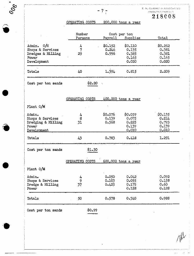
OPERATING COSTS
NumberPersons
- 7 -I
200,000 tons a year
Cost per tonPayroll Supplies
218C08
Total
Admin. o/HShops & ServicesDredges &¥~lling
PowerDevelopment
Totals
47
29
40
$0,1520.2460,996
,1.394
$0.1100,1350,3850.1650.020
0.815
$0.2620.3810.3810.1650.020
2.209
•Cost per ton sands
Plant oj'A
$2.20
OPERATING COSTS 400,000 tons a year
Admin.Shops &ServicesDredging &HillingPowerDevelopment
Totals
48
31
43
$0.0760.1390.568
$0.059 $0.1350.075 0.2140.225 0.7930.139 0.1390.010 0.010
0.418 1.291
Cost per ton sands $1.30
• OPERATING COSTS 600.000 tons a year
Plant oIMAdmin. 4 0.050 0.042 0.092Shops &Services 9 0.103 0.055 0.158Dredge & Milling 37 0.425 0.175 0.60Power 0.128 0.128
Totals 50 0.578 0.340 0.988
Cost per ton sands $0.99
'.
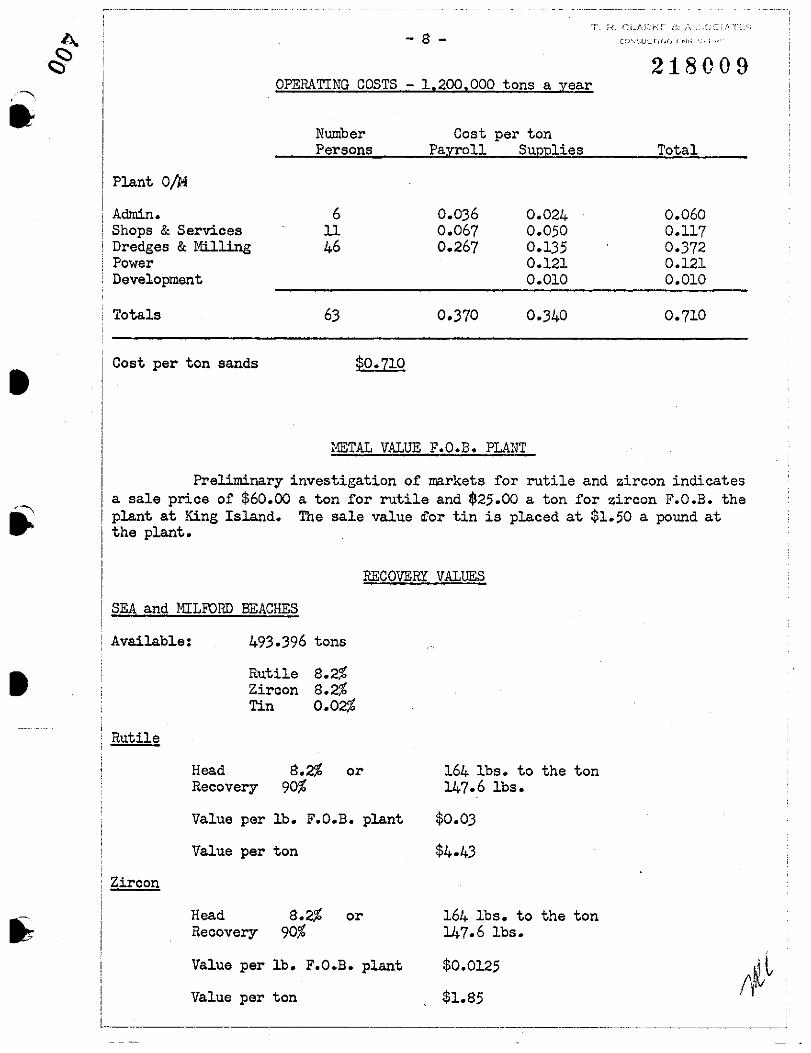
218009OPERATING COSTS - 1,200,000 tons a year
TotalCost per ton
Payroll SuppliesNumberPersons
- 8 -
, .-....."..Plant 01N
•
Admin.Shops &ServicesDredges &MillingPowerDevelopment
Totals
Cost per ton sands
61146
63
$0.710
0.0360.0670.267
0.370
0.024 0.0600.050 0.1170.135 0.3720.121 0,1210.010 0,010
0.340 0,710
METAL VALUE F,O,E, PLANT
Preliminary investigation of markets for rutile and zircon indicatesa sale price of $60.00 a ton for rutile and $25.00 a ton for zircon F,O,E, theplant at King Island. The sale value If.'or tin is placed at $1.50 a pound atthe plant.
RECOVERY VALUES
SEA and MILFORD BEACHES
493.396 tons
•Available:
RutileZirconTin
8.2%8.2%0.02%
Rutile
Head 8.2% or 164 Ibs. to the tonRecovery 90% 147.6 Ibs,
Value per lb. F,O.B. plant $0.03
Value per ton $4.43
Zircon
Head 8.2% or 164 Ibs. to the tonRecovery 90% 147.6 Ibs.
Value per lb. F,O.B. plant $0,0125
Value per ton $1.85

.. HeadRecovery
0.02%70%
or .4 lbs. to the ton.28 lbs.
218010
Value per lb. F.O.B. plant
Value per ton
$1.50
0.42
Value per ton F.O.B. plant Sea & 11:ilford Beach Sands
Value per lb. F.O.B. plant
Value per ton F.O.B. plant
•RutileZirconTin
Total
LANHERNE BEACH
Rutile
Head 2.0%Recovery~'90%
$4.431.850.42
$6.70
oror
40 lbs.36 lbs.
$0.03
$1.08
Value per ton F.O.B. plant
Value per lb. F.O.B. plant•Zircon
HeadRecovery
1.8%90%
oror
36 lbs.32.4 lbs.
$0.0125
0.405
Value per ton F.O.B. plant Lanherne Beach sands
RutileZircon
Total
$1.08.405
Use $1.49
- 10
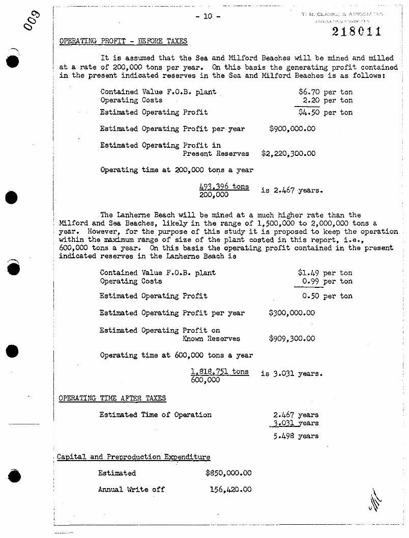
218C11OPERATING PROFIT - BEFORE TAXES
It is assumed that the Sea and Milford Beaches will be mined and milledat a rate of 200,000 tons per year. On this basis the generating profit containedin the present indicated reserves in the Sea and Milford Beaches is as follows:
Contained Value F.O.B. plantOperating Costs
Estimated Operating Profit
$6.70 per ton2.20 per ton
$4.50 per ton
•
Estimated Operating Profit per· year $900,000.00
Estimated Operating Profit inPresent Reserves $2,220,300.00
Operating time at 200,000 tons a year
493.396 tons is 2.467 years •200,000
The Lanherne Beach will be mined at a much higher rate than theMilford and Sea Beaches, likely in the range of 1,500,000 to 2,000,000 tons ayear. However, for the purpose of this study it is proposed to keep the operationwithin the maximum range of size of the plant costed in this report, i.e.,600,000 tons a year. On this basis the operating profit contained in the presentindicated reserves in the Lanherne Beach is
•
Contained Value F.O.B. plantOperating Costs
Estimated Operating Profit
Estimated Operating Profit per year
Estimated Operating Profit onKnown Reserves
Operating time at 600,000 tons a year
$1.49 per ton0.99 per ton
0.50 per ton
$300,000.00
$909,300.00
1,818.751 tons is 3.031 years.600,000
OPERATING TIME AFTER TAXES
Estimated Time of Operation 2.467 years3.031 years
5.498 years
Capital and Preproduction Exp~nditure
• Estimated
Annual Write off
$850,000.00
156,420.00

i------
-11-
DEPLETION ALLOWANCE
20% of Operating Profit
o- $12,500. is 32.5% or $4,062.50
$12,501.- $25,000. is 37.5% or $4,687.50
$25,000. up is 42.5%
FIRST YEAR
218012
•
•
Gross Operating Profit
Less Capital W.O.
Less Depletion W.O•
Taxable Income
Taxes
Net Income First Year
Net Income Second Year
THIRD YEAR
Gross Operating Profit
Less Capital W.O.
Less Depletion
Taxable Income
Taxes
Net Income Third Year
FOUR'IH YEAR
Gross Operating Pl>ofit
Less Capital W.O.
Less Depletion
Taxable Income
:taxes
Net Income Fourth Year
Net Income Fifth Year
$156,420.
_~180.000.
$156,420.
:1>116.040.
$156,420.
$ 60.000.
$900,000.
~336.420.
$564,580.
$580,200.
$272.460.
$307,740•
$300,000.
$216.420
$ 83,580.
$900,000.
$238.071.
$661,929.
$661,929.
$580,200.
$124,664.
$455,536.
$300,000
$ 34,148.
$265,852.
$265,852.
T. I:. ~;i ,',.
AccumulativeNet Income
$661,929.
2,311,098.
1,323,B5B.
1,779,394.
2,045,246.
- 12 -
455,536.
265,852.
265,B52.
NetIncome
$661,929.
661,929.
2,311~09B
Estimated Profit End of Five Years $2.311.09B
•
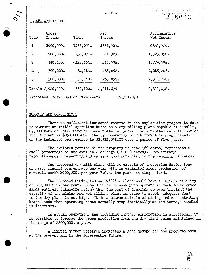
~c::::> RECAP. NET INCOME
""" .• GrossYear Income Taxes
1 $900,000. $23B,071.
2 900,000. 23B,071.
3 5BO,200. ' l24,664.
4 300,000. 34,148.
5 300,000. 34,14B.
Totals 2,900,200. 669,102.
•SUMl1ARY A~'D CONCLUSIONS
There is sufficient indicated reserve in the exploration program to dateto warrant an initial operation based on a dry milling plant capable of handlingB4,000 tons of heavy mineral concentrate per year. The estimated capital cost ofsuch a plant is $B50,000.00. The net operating profit from this plant based 'on the indicated ore reserve is $2,311,098.00 over a period of five years.
The explored portion of the property to date (60 acres) represents asmall percentage of the available acreage (12,000 acres). Preliminaryreconnaissance prospecting indicates a good potential in the remaining acreage.
•The proposed dry mill plant will be capable of processing 84,000 tons
of heavy mineral concentrate per year with an estimated gross production ofminerals worth $900,000. per year F.O.B. the plant on King Island•
The proposed mining and wet milling plant would have a I!'.aximum capacityof 600,000 tons per year. Should it be necessary to operate in much lower gradesands entirely (Lanherne Beach) then the cost of doubling or even tripling thecapacity of the mining and wet milling plant in order to supply adequate feedto the dry plant is not high. It is a characteristic of mining and concentratingbeach sands that operating costs normally drop drastically as the tonnage handled
, is increased.
In actual operation, and providing further exploration is successful, itis possible to foresee the gross production from the dry plant being maintained inthe range of $800,000. a year. .
•A limited market research indicates a good demand for the products both
at the present and in the foreseeable future •
,.\.j~

•- 13 -
218014PRESENT PLANS
1. Continue exploration drilling on Sea and l1ilford Beaches.
2. Produce sample concentrates for further sales market assessment.
3. Continue equipment investigation for mining and milling plant.
Respectfully submitted,
•
•
OTTAWAApril 8, 1966.
~----------
;:Ijl'J"itt-~e &Associates,T. R. Clarke, P.Eng., B.Eng.

..~•
•'.
•
•
,-- ._--_._-_.__ ._- ---. --_....--_ .._-_._._----
iI
218015CERTIFICATE
I, Thomas Roy Clarke, residing at 128 Heddington Avenue, Toronto,
Ontario certifY that
(1) I am a graduate of McGill University and hold a Degree of
Bachelor of Engineering in ~!ining.
(2) I a~ a registered Professional Engineer in the Province of
Ontario and have practiced my profession for over thirty years.
(3) I have not visited the'King Island project but have based
my assessment on the exploration data available on the project to date; on
the literature and reports available on the Australian beach sands operations;
and on my experience in the mine operating field.
(4) I have no interest directly or indirectly in the properties
or securities of Mount Costigan ~!ines Limited nor expect to receive any interest
directly or indirectly in the properties or securities of the company.
T. R. Clarke, B.Eng., P. Eng.
ottawa, OntarioApril 18, 1966•

N
218016
8 ASS
STRAIT
FRASER RIVERDEPOSITS
SEA AND MILFORD BEACH"'~~LANHERNE BEACH
~ ~mlltlSCALE
LEGENDProperty boundary., , ~
Road ===Aug., d,lII.d a'.a --..Tin,Rutil., Zi,con p,osp.ct a,.o.://~
o,
~~UNT COSTIGAN MINES LIMITED
KING ISLAND -AUSTRALIA-TIN-RUTILE-ZIRCON-
•
••
AUSTRALIASydney
Melbourne
5cm
KING ISLAND ~ ~
MTASMANIA
LOCATION MAP VAMG REFERENCE POINTS ADDED l""t,' I", I